Embed Size (px)
Citation preview
PREPAREDNESS AND EMERGENCY RESPONSE FOR VOLCANIC TOXIC GAS,
A CASE STUDY OF DIENG PLATEAU, CENTRAL JAVA, INDONESIA
Thesis Proposal
Double Degree M.Sc Programme, Gadjah Mada University and ITC - University of
Twente in partial fulfillment of the requirement for the degree of Master of Science in
Geo-Information for Spatial Planning and Disaster Risk Management
By :
Arief Dwi Bimonugroho
UGM : 13/357423/PMU/08062
ITC : s6013589
Supervisors :
1. Dr. Danang Sri Hadmoko, Associate Professor, Geography and Environmental
Science, Gadjah Mada University
2. M.C.J. Damen, M.Sc, Lecturer, Earth Systems Analysis, ITC – University of Twente
DOUBLE DEGREE M.Sc. PROGRAMME
GADJAH MADA UNIVERSITY
ITC – UNIVERSITY OF TWENTE
2014
THESIS PROPOSAL
PREPAREDNESS AND EMERGENCY RESPONSE FOR VOLCANIC TOXIC GAS,
A CASE STUDY OF DIENG PLATEAU, CENTRAL JAVA, INDONESIA
By :
Arief Dwi Bimonugroho
UGM : 13/357423/PMU/08062
ITC : s6013589
Has been assessed by:
Thesis Proposal Assessment Board
Chairman
Prof. Dr. V. G. Jetten
Examiner 1
Prof. Dr. Junun Sartohadi, M.Sc
Examiner 2
M.C.J. Damen, M.Sc
Certified by:
Program director of Geo-Information for Spatial Planning and Disaster Risk Management,
Graduate School Gadjah Mada University
Prof. Dr. H. A. Sudibyakto M.S.
Page 1
TITLE
Preparedness and Emergency Response for Volcanic Toxic Gas, a Case Study of Dieng
Plateau, Central Java, Indonesia
CANDIDATE
Full name: Arief Dwi Bimonugroho
Student number: s6013589
ITC E-mail address: a.d.bimonugroho@[email protected]
Course: AES-MSc, 2013-2015, Natural Hazard and Disaster Risk Management
SUPERVISORS
1. Dr. Danang Sri Hadmoko, Associate Professor, Geography and Environmental Science,
Gadjah Mada University
2. M.C.J. Damen, M.Sc, Lecturer, Earth Systems Analysis, University of Twente
SCIENTIFIC SUMMARY
The aim of this study is to understand the process of preparedness and emergency response
due to volcanic toxic gas in Dieng Plateau and make suggestion to it using modern geo-
information techniques. Evacuation scenarios will also be made to simulate the evacuation
process after suggestions are implemented. This research also inventories the volcanic toxic
gas events from recorded history.
The main method to achieve the objectives is by conducting interview to at least 40
institution stakeholders related to volcanic toxic gas event in Dieng. The respondents are
chosen based on expert sampling technique to make sure that the respondents are expert
in this field. While interviewing people affected to disaster, snowball-sampling technique is
used.
Keywords: Evacuation, Dieng Plateau, volcanic toxic gas, preparedness, emergency
response, network analysis, stakeholder response-chains
DESCRIPTION OF THE PROPOSED RESEARCH
1. Introduction
Background
Gas bursts from volcanic craters and crater lakes pose a serious threat to human life
(U.S. Geological Survey, 2010). One of the infamous events, which attracted worldwide
attention, is the Lake Nyos (Cameroon) incident in 1986. It is believed that concentrated
CO2 gases from Lake Nyos resulting more than 1,700 people asphyxiated (Nasr, 2009).
Dieng Plateau, which is located in Central Java, Indonesia, also has had similar tragedy
that took more than 140 lives (Allard, Dajlevic, & Delarue, 1989). Dieng has eight active
craters while three of them potentially have toxic gases (Center of Volcanology and
Geological Disaster Mitigation, 2012). They are Sikendang Crater, Sinila Crater and
Timbang Crater. However, the toxic gas is not only come from the craters, but also from
the fissures near the crater. Between Sinila Crater and Timbang Crater, there is village
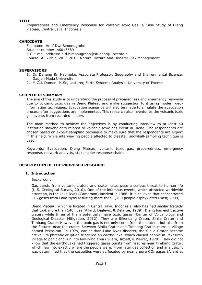
named Pekasiran. In 1979, earlier than Lake Nyos disaster, the Sinila Crater became
active. Its phreatic eruption triggered an earthquake, which caused people in Pekasiran
Village to panic and run into low-lying area (Guern, Tazieff, & Pierret, 1979). They did not
know that the earthquake had triggered gases bursts from fissures near Timbang Crater,
which flew into exactly where the people were. From later gas collection and analysis, it
was determined that the casualties were suffocated by nearly pure CO2 gases (Allard et
Page 2
al., 1989).
Figure 1. Location of accident in 1979 (Adapted from Guern et al., 1979)
Table 1. Volcanic toxic gas burst events in Dieng Plateau DATE OF EVENT SITE PRECURSORS AFTERMATH
13 May 1928 Timbang Crater Felt seismicity, fissure near crater opened -
13 October 1939 Timbang Crater Felt seismicity, fissure near crater opened -
20 February 1979 Timbang Crater Felt seismicity, fissure near crater opened 149 killed,
17,000
evacuated
18 March 1992 Sikidang Crater - 1 killed
28 May 2011 Timbang Crater Felt seismicity 1,300
evacuated
11 March 2013 Timbang Crater Tectonic earthquake 5,000
evacuated
27 March 2014 Timbang Crater Felt seismicity -
(Adapted from Allard et al., 1989; Aryono, 2013; Center of Volcanology and Geological
Disaster Mitigation, 2012; Hidayat, 2011; PVMBG, 2014; Seach, 2010)
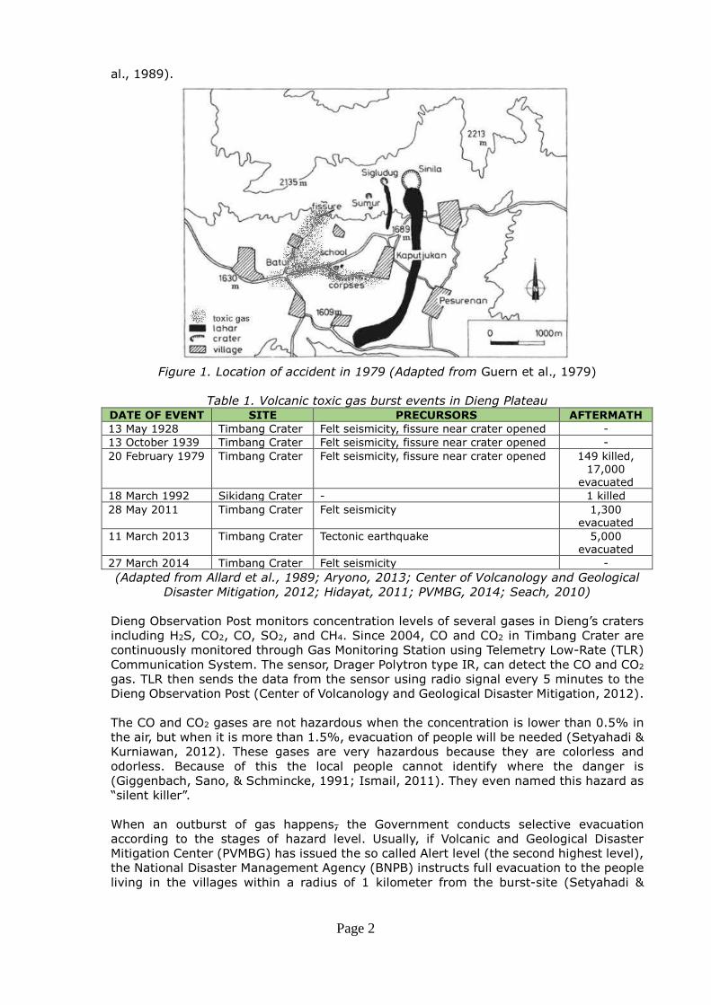
Dieng Observation Post monitors concentration levels of several gases in Dieng’s craters including H2S, CO2, CO, SO2, and CH4. Since 2004, CO and CO2 in Timbang Crater are
continuously monitored through Gas Monitoring Station using Telemetry Low-Rate (TLR)
Communication System. The sensor, Drager Polytron type IR, can detect the CO and CO2
gas. TLR then sends the data from the sensor using radio signal every 5 minutes to the
Dieng Observation Post (Center of Volcanology and Geological Disaster Mitigation, 2012).
The CO and CO2 gases are not hazardous when the concentration is lower than 0.5% in
the air, but when it is more than 1.5%, evacuation of people will be needed (Setyahadi &
Kurniawan, 2012). These gases are very hazardous because they are colorless and
odorless. Because of this the local people cannot identify where the danger is
(Giggenbach, Sano, & Schmincke, 1991; Ismail, 2011). They even named this hazard as
“silent killer”.
When an outburst of gas happens, the Government conducts selective evacuation
according to the stages of hazard level. Usually, if Volcanic and Geological Disaster
Mitigation Center (PVMBG) has issued the so called Alert level (the second highest level),
the National Disaster Management Agency (BNPB) instructs full evacuation to the people
living in the villages within a radius of 1 kilometer from the burst-site (Setyahadi &
Page 3
Kurniawan, 2012).
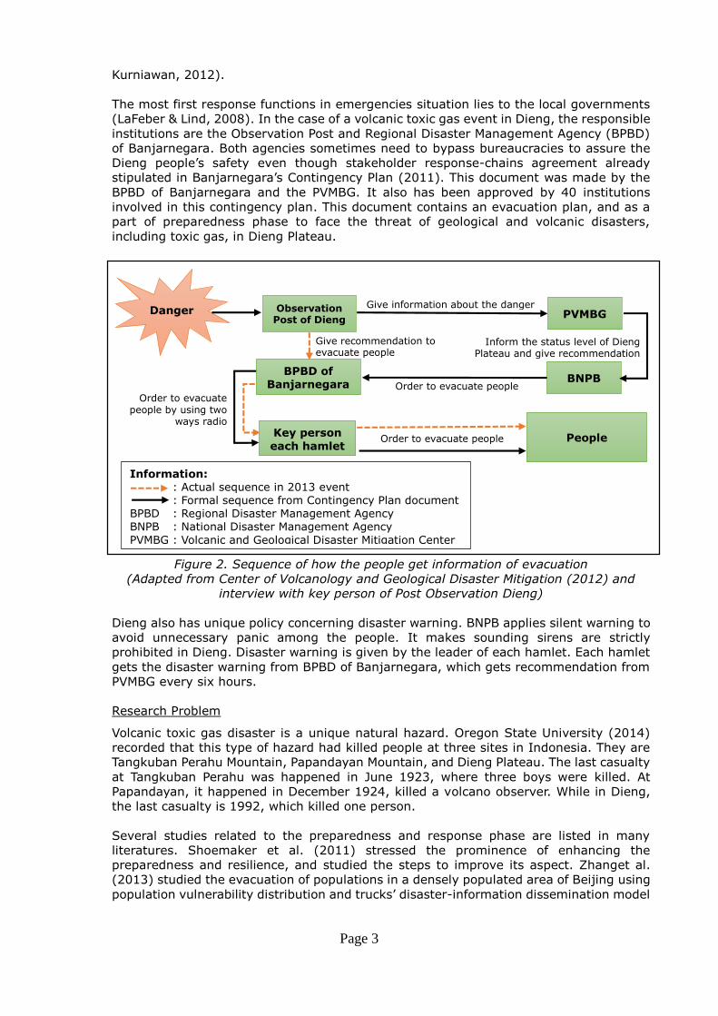
The most first response functions in emergencies situation lies to the local governments
(LaFeber & Lind, 2008). In the case of a volcanic toxic gas event in Dieng, the responsible
institutions are the Observation Post and Regional Disaster Management Agency (BPBD)
of Banjarnegara. Both agencies sometimes need to bypass bureaucracies to assure the
Dieng people’s safety even though stakeholder response-chains agreement already
stipulated in Banjarnegara’s Contingency Plan (2011). This document was made by the
BPBD of Banjarnegara and the PVMBG. It also has been approved by 40 institutions
involved in this contingency plan. This document contains an evacuation plan, and as a
part of preparedness phase to face the threat of geological and volcanic disasters,
including toxic gas, in Dieng Plateau.
Figure 2. Sequence of how the people get information of evacuation
(Adapted from Center of Volcanology and Geological Disaster Mitigation (2012) and
interview with key person of Post Observation Dieng)
Dieng also has unique policy concerning disaster warning. BNPB applies silent warning to
avoid unnecessary panic among the people. It makes sounding sirens are strictly
prohibited in Dieng. Disaster warning is given by the leader of each hamlet. Each hamlet
gets the disaster warning from BPBD of Banjarnegara, which gets recommendation from
PVMBG every six hours.
Research Problem
Volcanic toxic gas disaster is a unique natural hazard. Oregon State University (2014)
recorded that this type of hazard had killed people at three sites in Indonesia. They are
Tangkuban Perahu Mountain, Papandayan Mountain, and Dieng Plateau. The last casualty
at Tangkuban Perahu was happened in June 1923, where three boys were killed. At
Papandayan, it happened in December 1924, killed a volcano observer. While in Dieng,
the last casualty is 1992, which killed one person.
Several studies related to the preparedness and response phase are listed in many
literatures. Shoemaker et al. (2011) stressed the prominence of enhancing the
preparedness and resilience, and studied the steps to improve its aspect. Zhanget al.
(2013) studied the evacuation of populations in a densely populated area of Beijing using
population vulnerability distribution and trucks’ disaster-information dissemination model
Give information about the danger
Inform the status level of Dieng Plateau and give recommendation
Order to evacuate people
Order to evacuate people by using two
ways radio
Order to evacuate people
Give recommendation to evacuate people
BNPB
PVMBG
People Key person
each hamlet
BPBD of Banjarnegara
Observation Post of Dieng
Danger
Information: : Actual sequence in 2013 event
: Formal sequence from Contingency Plan document
BPBD : Regional Disaster Management Agency
BNPB : National Disaster Management Agency
PVMBG : Volcanic and Geological Disaster Mitigation Center
Page 4
as a consideration. Rifwan (2012) evaluated the effectiveness evacuation route in
potential zones that affected to tsunami disaster in Padang. From disaster management
perspective of Indonesia, a study has conducted by IRG & Tetra Tech Joint Venture
(2007). It concluded that the current system capacity for disaster in Indonesia still lacks
of development. For example in early warning category, warning dissemination system of
Indonesia got only 1 score of maximum 4. The comprehension and legitimacy of warning
and the clarity of decision making also got 1 score.
Previous studies that are mentioned above show that study about preparedness and
response phase of volcanic toxic gas has not been discussed yet. It is maybe because the
danger of volcanic toxic gas in Dieng is still underestimated comparing to another disaster
such as earthquake, flood, volcanic eruption or tsunami. The location of Dieng, which is
in the rural area also make the data acquisition for any research in this area more difficult.
Because of the uniqueness of the type of the hazard, the silent warning policy from
government, numerous number of stakeholders involved, and the rareness of data, in-
depth study of the process of preparedness and emergency response for volcanic toxic
gas in Dieng Plateau is taken as a case study and is necessary to be done.
2. Objectives and research questions
The main objective of this research is to analyze the past and present chain of warnings
and evacuations for toxic gas events in the Dieng volcanic area, Central Java and to come
up with improvements using modern geo-information techniques.
The specific objectives are:
1. To identify the different stakeholders involved in volcanic toxic gas disaster
preparedness and the evacuation process;
2. To critically assess the past volcanic toxic gas eruptions and the evacuation process
in each event;
3. To come up with recommendations for improvement of the individual elements of the
response chain and the existing preparedness plan with emphasis on the use of
modern geo-information techniques;
4. To design a number of evacuation scenarios in which the suggestions are
implemented.
In order to achieve the objectives, several research questions are addressed:
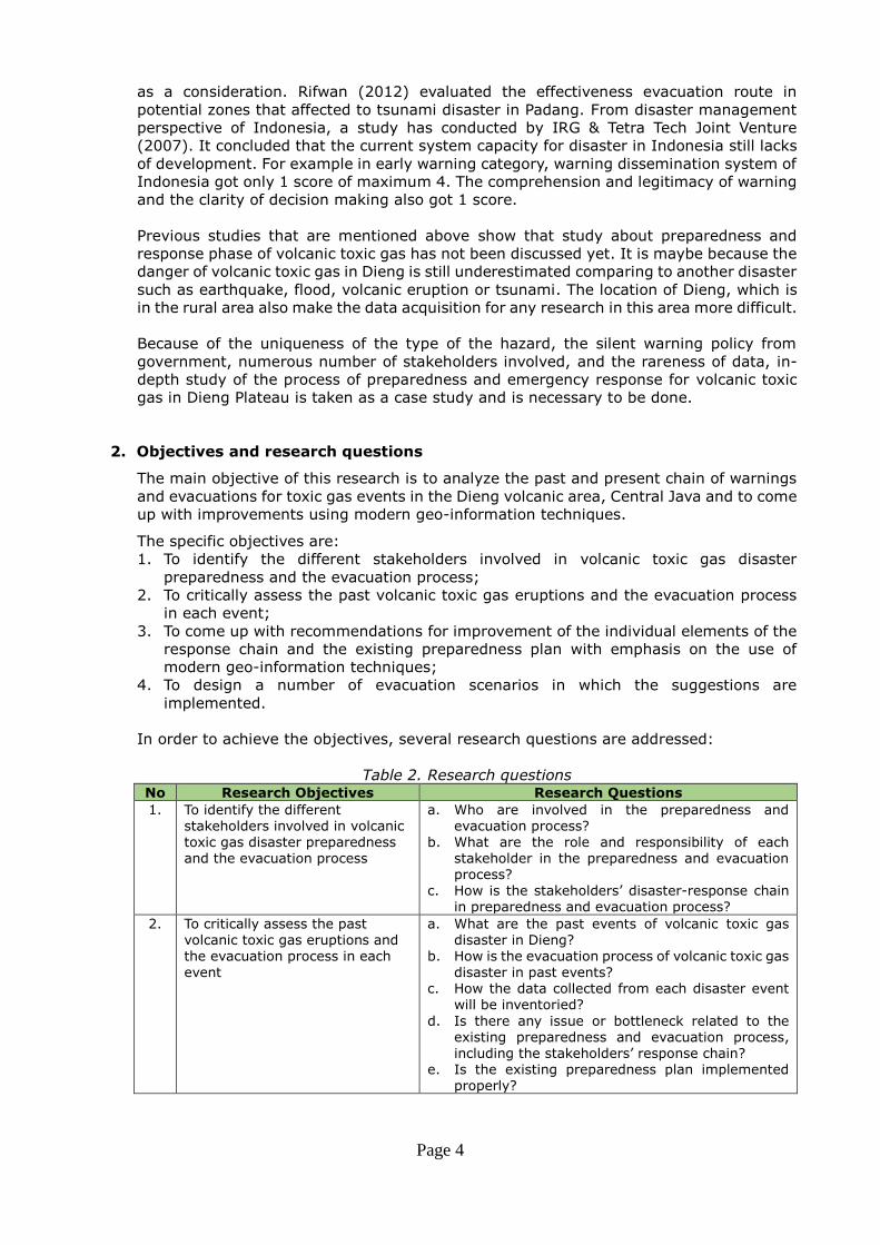
Table 2. Research questions No Research Objectives Research Questions
1. To identify the different
stakeholders involved in volcanic
toxic gas disaster preparedness
and the evacuation process
a. Who are involved in the preparedness and
evacuation process?
b. What are the role and responsibility of each
stakeholder in the preparedness and evacuation
process?
c. How is the stakeholders’ disaster-response chain
in preparedness and evacuation process?
2. To critically assess the past
volcanic toxic gas eruptions and
the evacuation process in each
event
a. What are the past events of volcanic toxic gas
disaster in Dieng?
b. How is the evacuation process of volcanic toxic gas
disaster in past events?
c. How the data collected from each disaster event
will be inventoried?
d. Is there any issue or bottleneck related to the
existing preparedness and evacuation process,
including the stakeholders’ response chain?
e. Is the existing preparedness plan implemented
properly?
Page 5
No Research Objectives Research Questions
3. To come up with
recommendations for
improvement of the individual
elements of the response chain
and the existing preparedness
plan with emphasis on the use of
modern geo-information
techniques
What are geo-information techniques that can be
implemented to improve evacuation process in Dieng?
4. To design a number of evacuation
scenarios in which the
suggestions are implemented
What aspects are needed in the evacuation scenarios?
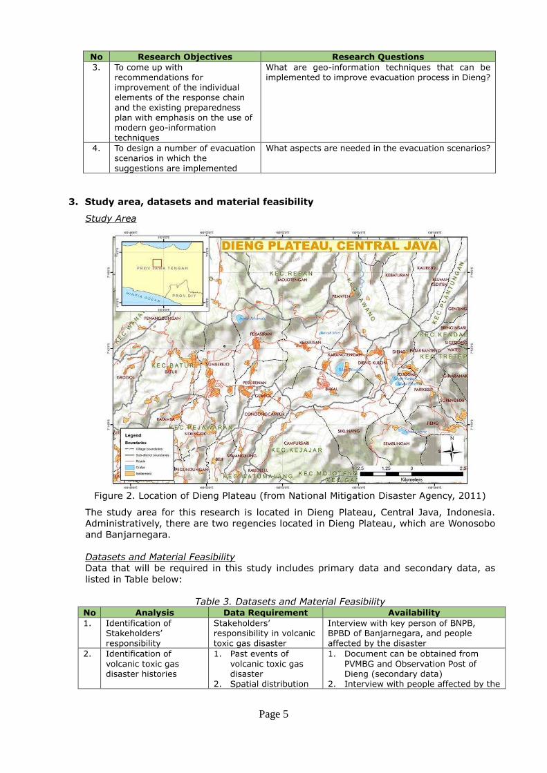
3. Study area, datasets and material feasibility
Study Area
Figure 2. Location of Dieng Plateau (from National Mitigation Disaster Agency, 2011)
The study area for this research is located in Dieng Plateau, Central Java, Indonesia.
Administratively, there are two regencies located in Dieng Plateau, which are Wonosobo
and Banjarnegara.
Datasets and Material Feasibility
Data that will be required in this study includes primary data and secondary data, as
listed in Table below:
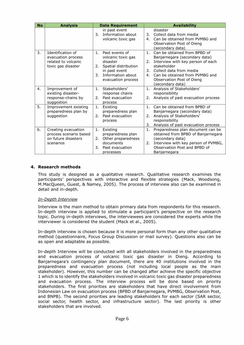
Table 3. Datasets and Material Feasibility No Analysis Data Requirement Availability
1. Identification of
Stakeholders’ responsibility
Stakeholders’ responsibility in volcanic
toxic gas disaster
Interview with key person of BNPB,
BPBD of Banjarnegara, and people
affected by the disaster
2. Identification of
volcanic toxic gas
disaster histories
1. Past events of
volcanic toxic gas
disaster
2. Spatial distribution
1. Document can be obtained from
PVMBG and Observation Post of
Dieng (secondary data)
2. Interview with people affected by the
Page 6
No Analysis Data Requirement Availability
in past event
3. Information about
volcanic toxic gas
disaster
3. Collect data from media
4. Can be obtained from PVMBG and
Observation Post of Dieng
(secondary data)
3. Identification of
evacuation process
related to volcanic
toxic gas disaster
1. Past events of
volcanic toxic gas
disaster
2. Spatial distribution
in past event
3. Information about
evacuation process
1. Can be obtained from BPBD of
Banjarnegara (secondary data)
2. Interview with key person of each
stakeholder
3. Collect data from media
4. Can be obtained from PVMBG and
Observation Post of Dieng
(secondary data)
4. Improvement of
existing disaster-
response-chains by
suggestion
1. Stakeholders’ response chains
2. Past evacuation
process
1. Analysis of Stakeholders’ responsibility
2. Analysis of past evacuation process
5. Improvement existing
preparedness plan by
suggestion
1. Existing
preparedness plan
2. Past evacuation
process
1. Can be obtained from BPBD of
Banjarnegara (secondary data)
2. Analysis of Stakeholders’ responsibility
3. Analysis of past evacuation process
6. Creating evacuation
process scenario based
on future disasters
scenarios
1. Existing
preparedness plan
2. Other preparedness
documents
3. Past evacuation
processes
1. Preparedness plan document can be
obtained from BPBD of Banjarnegara
(secondary data)
2. Interview with key person of PVMBG,
Observation Post and BPBD of
Banjarnegara
4. Research methods
This study is designed as a qualitative research. Qualitative research examines the
participants’ perspectives with interactive and flexible strategies (Mack, Woodsong,
M.MacQueen, Guest, & Namey, 2005). The process of interview also can be examined in
detail and in-depth.
In-Depth Interview
Interview is the main method to obtain primary data from respondents for this research.
In-depth interview is applied to stimulate a participant’s perspective on the research
topic. During in-depth interviews, the interviewees are considered the experts while the
interviewer is considered the student (Mack et al., 2005).
In-depth interview is chosen because it is more personal form than any other qualitative
method (questionnaire, Focus Group Discussion or mail survey). Questions also can be
as open and adaptable as possible.
In-depth Interview will be conducted with all stakeholders involved in the preparedness
and evacuation process of volcanic toxic gas disaster in Dieng. According to
Banjarnegara’s contingency plan document, there are 40 institutions involved in the
preparedness and evacuation process (not including local people as the main
stakeholder). However, this number can be changed after achieve the specific objective
1 which is to identify the stakeholders involved in volcanic toxic gas disaster preparedness
and evacuation process. The interview process will be done based on priority
stakeholders. The first priorities are stakeholders that have direct involvement from
Indonesian Law on evacuation process (BPBD of Banjarnegara, PVMBG, Observation Post,
and BNPB). The second priorities are leading stakeholders for each sector (SAR sector,
social sector, health sector, and infrastructure sector). The last priority is other
stakeholders that are involved.
Page 7
Sampling Technique
Expert sampling technique will be implemented while choosing the sample in
institutional stakeholders. This type of purposive sampling technique is used to collect
knowledge from individuals that have particular expertise (Lund Research Ltd, 2012).
For example, when interviewing PVMBG, the chosen sample is key persons of PVMBG
who directly involved in the last event of volcanic toxic gas evacuation process in
Dieng. This technique is chosen to assure that the interviewee’s are expert in volcanic
toxic gas event and have experience about the preparedness and response process in
Dieng.
Snowball sampling technique (chain sampling) will be implemented while choosing
the sample of people affected to toxic gas disaster. Snowball sampling is chosen
because the respondent should be familiar with the toxic gas event, or experienced
the toxic gas disaster. For example, to assess volcanic toxic gas disaster happened in
1979, the first respondent is the community leader (Mr. A) in village affected by
disaster. Mr. A then informs that his friend, Mr. X, has a father that experienced the
1979 event. Then, we follow the information to the father of Mr. X, which is Mr. Y.
After information is obtained from Mr. Y we also asked who else have experienced
about 1979 event, and so on, until the answer of the interview resulting similar
pattern.
Questionnaire
Because the interview will be done by in-depth, the questionnaire will be developed as
flexible as possible. It will consist of key questions that lead to the specific objective.
During the process of the interview, it will be recorded by voice recorder while the points
of the answers are noted in the questionnaire by interviewer. Interview also will be
requested for their sign in the answer sheet by the end of the interview.
Data Inventory
To achieve specific objective 2 (to study the past volcanic toxic gas events and the
evacuation process in each disaster event), an inventory need to be made. The data
inventory will be contained: disaster events: It will be displayed with a map including the time of disasters, the
locations of volcanic toxic gas burst (craters or fissures), and the impact of disaster
(how many casualties and how many people need to be evacuated); evacuation process: including the stakeholders involved, responsibility of each
stakeholder, the disaster-response-chain, the early warning given, evacuation
response time, response from different categories of local people, transportations to
evacuate people, the shelters location, the condition of shelters, logistic available in
shelters, and how many days evacuee stay in the shelters; and problems or bottlenecks in each evacuation process of disaster event.
Stakeholders’ Network Map
Stakeholders network map is chosen to display the relation between each stakeholder
involved in the preparedness phase and the evacuation phase. Stakeholders’ network map is made in order to answer the research question 3 in specific objective 1 (how is
the stakeholders’ disaster-response chain in preparedness and evacuation process?).
Page 8
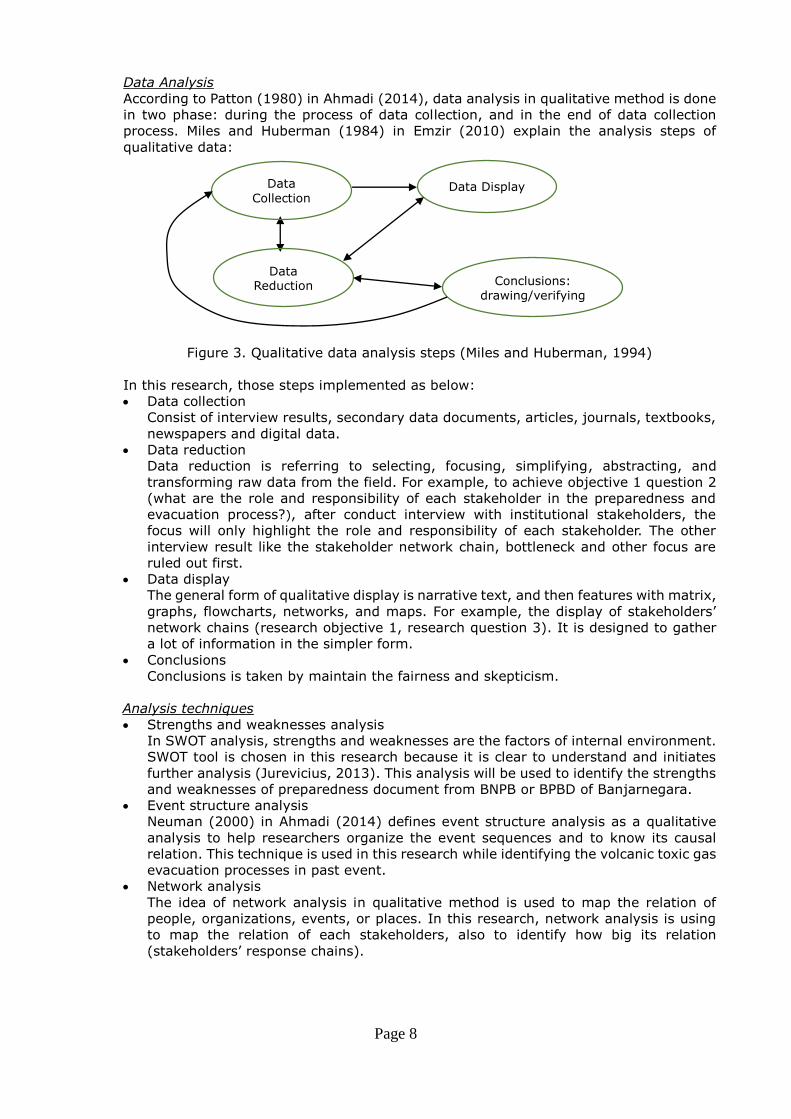
Data Analysis
According to Patton (1980) in Ahmadi (2014), data analysis in qualitative method is done
in two phase: during the process of data collection, and in the end of data collection
process. Miles and Huberman (1984) in Emzir (2010) explain the analysis steps of
qualitative data:
Figure 3. Qualitative data analysis steps (Miles and Huberman, 1994)
In this research, those steps implemented as below: Data collection
Consist of interview results, secondary data documents, articles, journals, textbooks,
newspapers and digital data. Data reduction
Data reduction is referring to selecting, focusing, simplifying, abstracting, and
transforming raw data from the field. For example, to achieve objective 1 question 2
(what are the role and responsibility of each stakeholder in the preparedness and
evacuation process?), after conduct interview with institutional stakeholders, the
focus will only highlight the role and responsibility of each stakeholder. The other
interview result like the stakeholder network chain, bottleneck and other focus are
ruled out first. Data display
The general form of qualitative display is narrative text, and then features with matrix,
graphs, flowcharts, networks, and maps. For example, the display of stakeholders’ network chains (research objective 1, research question 3). It is designed to gather
a lot of information in the simpler form. Conclusions
Conclusions is taken by maintain the fairness and skepticism.
Analysis techniques Strengths and weaknesses analysis
In SWOT analysis, strengths and weaknesses are the factors of internal environment.
SWOT tool is chosen in this research because it is clear to understand and initiates
further analysis (Jurevicius, 2013). This analysis will be used to identify the strengths
and weaknesses of preparedness document from BNPB or BPBD of Banjarnegara. Event structure analysis
Neuman (2000) in Ahmadi (2014) defines event structure analysis as a qualitative
analysis to help researchers organize the event sequences and to know its causal
relation. This technique is used in this research while identifying the volcanic toxic gas
evacuation processes in past event. Network analysis
The idea of network analysis in qualitative method is used to map the relation of
people, organizations, events, or places. In this research, network analysis is using
to map the relation of each stakeholders, also to identify how big its relation
(stakeholders’ response chains).
Data
Collection Data Display
Data Reduction Conclusions:
drawing/verifying
Page 9
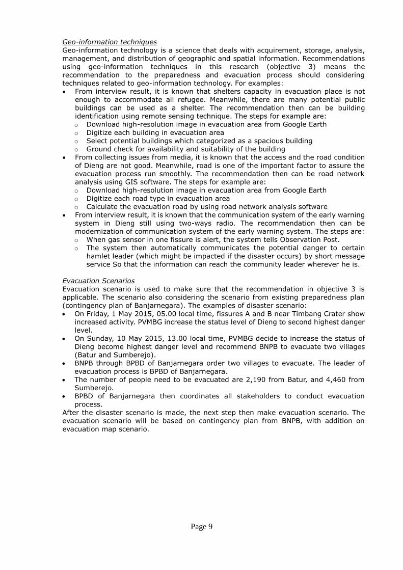
Geo-information techniques
Geo-information technology is a science that deals with acquirement, storage, analysis,
management, and distribution of geographic and spatial information. Recommendations
using geo-information techniques in this research (objective 3) means the
recommendation to the preparedness and evacuation process should considering
techniques related to geo-information technology. For examples: From interview result, it is known that shelters capacity in evacuation place is not
enough to accommodate all refugee. Meanwhile, there are many potential public
buildings can be used as a shelter. The recommendation then can be building
identification using remote sensing technique. The steps for example are:
o Download high-resolution image in evacuation area from Google Earth
o Digitize each building in evacuation area
o Select potential buildings which categorized as a spacious building
o Ground check for availability and suitability of the building From collecting issues from media, it is known that the access and the road condition
of Dieng are not good. Meanwhile, road is one of the important factor to assure the
evacuation process run smoothly. The recommendation then can be road network
analysis using GIS software. The steps for example are:
o Download high-resolution image in evacuation area from Google Earth
o Digitize each road type in evacuation area
o Calculate the evacuation road by using road network analysis software From interview result, it is known that the communication system of the early warning
system in Dieng still using two-ways radio. The recommendation then can be
modernization of communication system of the early warning system. The steps are:
o When gas sensor in one fissure is alert, the system tells Observation Post.
o The system then automatically communicates the potential danger to certain
hamlet leader (which might be impacted if the disaster occurs) by short message
service So that the information can reach the community leader wherever he is.
Evacuation Scenarios
Evacuation scenario is used to make sure that the recommendation in objective 3 is
applicable. The scenario also considering the scenario from existing preparedness plan
(contingency plan of Banjarnegara). The examples of disaster scenario: On Friday, 1 May 2015, 05.00 local time, fissures A and B near Timbang Crater show
increased activity. PVMBG increase the status level of Dieng to second highest danger
level. On Sunday, 10 May 2015, 13.00 local time, PVMBG decide to increase the status of
Dieng become highest danger level and recommend BNPB to evacuate two villages
(Batur and Sumberejo). BNPB through BPBD of Banjarnegara order two villages to evacuate. The leader of
evacuation process is BPBD of Banjarnegara. The number of people need to be evacuated are 2,190 from Batur, and 4,460 from
Sumberejo. BPBD of Banjarnegara then coordinates all stakeholders to conduct evacuation
process.
After the disaster scenario is made, the next step then make evacuation scenario. The
evacuation scenario will be based on contingency plan from BNPB, with addition on
evacuation map scenario.
Page 10
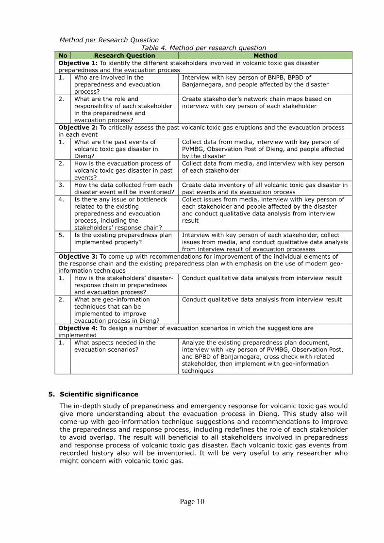
Method per Research Question
Table 4. Method per research question No Research Question Method
Objective 1: To identify the different stakeholders involved in volcanic toxic gas disaster
preparedness and the evacuation process
1. Who are involved in the
preparedness and evacuation
process?
Interview with key person of BNPB, BPBD of
Banjarnegara, and people affected by the disaster
2. What are the role and
responsibility of each stakeholder
in the preparedness and
evacuation process?
Create stakeholder’s network chain maps based on
interview with key person of each stakeholder
Objective 2: To critically assess the past volcanic toxic gas eruptions and the evacuation process
in each event
1. What are the past events of
volcanic toxic gas disaster in
Dieng?
Collect data from media, interview with key person of
PVMBG, Observation Post of Dieng, and people affected
by the disaster
2. How is the evacuation process of
volcanic toxic gas disaster in past
events?
Collect data from media, and interview with key person
of each stakeholder
3. How the data collected from each
disaster event will be inventoried?
Create data inventory of all volcanic toxic gas disaster in
past events and its evacuation process
4. Is there any issue or bottleneck
related to the existing
preparedness and evacuation
process, including the
stakeholders’ response chain?
Collect issues from media, interview with key person of
each stakeholder and people affected by the disaster
and conduct qualitative data analysis from interview
result
5. Is the existing preparedness plan
implemented properly?
Interview with key person of each stakeholder, collect
issues from media, and conduct qualitative data analysis
from interview result of evacuation processes
Objective 3: To come up with recommendations for improvement of the individual elements of
the response chain and the existing preparedness plan with emphasis on the use of modern geo-
information techniques
1. How is the stakeholders’ disaster-response chain in preparedness
and evacuation process?
Conduct qualitative data analysis from interview result
2. What are geo-information
techniques that can be
implemented to improve
evacuation process in Dieng?
Conduct qualitative data analysis from interview result
Objective 4: To design a number of evacuation scenarios in which the suggestions are
implemented
1. What aspects needed in the
evacuation scenarios?
Analyze the existing preparedness plan document,
interview with key person of PVMBG, Observation Post,
and BPBD of Banjarnegara, cross check with related
stakeholder, then implement with geo-information
techniques
5. Scientific significance
The in-depth study of preparedness and emergency response for volcanic toxic gas would
give more understanding about the evacuation process in Dieng. This study also will
come-up with geo-information technique suggestions and recommendations to improve
the preparedness and response process, including redefines the role of each stakeholder
to avoid overlap. The result will beneficial to all stakeholders involved in preparedness
and response process of volcanic toxic gas disaster. Each volcanic toxic gas events from
recorded history also will be inventoried. It will be very useful to any researcher who
might concern with volcanic toxic gas.
Page 11
REFERENCES
Ahmadi, R. (2014). Metodologi Penelitian Kualitatif. Yogyakarta: Ar-Ruzz Media.
Allard, P., Dajlevic, D., & Delarue, C. (1989). Origin of carbon dioxide emanation from the
1979 Dieng eruption, Indonesia: Implications for the origin of the 1986 Nyos catastrophe.
Journal of Volcanology and Geothermal Research, 39(2-3), 195–206. doi:10.1016/0377-0273(89)90058-9
Aryono, A. M. (Solopos). (2013). Ratusan Warga Dieng Kembali Datangi Tempat Pengungsian -
datangi tempat pengungsian kawah timbang update siaga dieng warga -News. Retrieved
August 16, 2014, from http://www.solopos.com/2013/04/20/update-siaga-dieng-ratusan-warga-dieng-kembali-datangi-tempat-pengungsian-398766
Center of Volcanology and Geological Disaster Mitigation. (2012). Dokumen Penyusunan
Rencana Kontijensi Bencana Geologi (Bencana G. Dieng) Kabupaten Banjarnegara Provinsi Jawa Tengah 2012.
Emzir. (2010). Metodologi Penelitian Kualitatif Analisis Data. Jakarta: Rajawali Pers.
Giggenbach, W. F., Sano, Y., & Schmincke, H. U. (1991). CO2-rich gases from Lakes Nyos and
Monoun, Cameroon; Laacher See, Germany; Dieng, Indonesia, and Mt. Gambier,
Australia—variations on a common theme. Journal of Volcanology and Geothermal Research, 45(3-4), 311–323. doi:10.1016/0377-0273(91)90065-8
Guern, F. L. E., Tazieff, H., & Pierret, R. F. (1979). An Example of Health Hazard: People Killed
by Gas during a Phreatic Eruption: Di~ng Plateau (Java, Indonesia), February 20th 1979,
45, 2–5.
Hidayat, T. com. (2011). Hindari Gas Beracun Dieng, PMI Evakuasi Ribuan Warga :: Okezone News. Retrieved August 21, 2014, from
http://news.okezone.com/read/2011/05/29/340/462128/hindari-gas-beracun-dieng-pmi-evakuasi-ribuan-warga
IRG & Tetra Tech Joint Venture. (2007). Review of Policies and Institutional Capacity for Early
Warning and Disaster Management in Indonesia.
Ismail, R. (detikNews). (2011). Tak Berbau & Tak Berwarna, Gas Beracun di Dieng Sangat
Bahaya. Retrieved August 25, 2014, from http://news.detik.com/read/2011/06/01/180418/1652125/10/
Jurevicius, O. (2013). SWOT Analysis. Retrieved September 16, 2014, from http://www.strategicmanagementinsight.com/tools/swot-analysis-how-to-do-it.html
LaFeber, P., & Lind, N. S. (2008). Disaster Management and Intergovernmental Relations. In J.
Pinkowski (Ed.), Disaster Management Handbook.
Lund Research Ltd. (2012). Purposive sampling | Laerd Dissertation. Retrieved August 25, 2014, from http://dissertation.laerd.com/purposive-sampling.php
Mack, N., Woodsong, C., M.MacQueen, K., Guest, G., & Namey, E. (2005). Qualitative
Research Methods: A Data Collector’s Field Guide (Vol. 36). North Carolina: U.S. Agency for International Development (USAID). doi:10.1108/eb020723
Page 12
Nasr, S. L. (2009). How did Lake Nyos suddenly kill 1,700 people? Retrieved June 02, 2014,
from http://science.howstuffworks.com/environmental/earth/geophysics/lake-nyos1.htm
Oregon State University. (2014). Deadly Gases | Volcano World. Retrieved August 24, 2014, from http://volcano.oregonstate.edu/deadly-gases
PVMBG. (2014). Penurunan Status G. Dieng dari WASPADA menjadi NORMAL, 11 Agustus
2014. Retrieved August 23, 2014, from
http://pvmbg.bgl.esdm.go.id/index.php/gunungapi/aktivitas-gunungapi/599-penurunan-
status-g-dieng-dari-waspada-menjadi-normal-11-agustus-2014
Rifwan, F. (2012). Studi Evaluasi Efektifitas Penggunaan Jalur Evakuasi pada Zona Berpotensial Terkena Bencana Tsunami di Kota Padang.
Seach, J. (2010). Dieng Volcano, Indonesia. Retrieved May 24, 2014, from http://www.volcanolive.com/dieng.html
Setyahadi, A., & Kurniawan, A. B. (2012). Ancaman Senyap Kaldera Dieng - Cincin Api.
Retrieved August 22, 2014, from
http://ekspedisi.kompas.com/cincinapi/index.php/detail/articles/2012/02/24/07510499/Ancaman.Senyap.Kaldera.Dieng
Shoemaker, Z., Eaton, L., Petit, F., Fisher, R., & Collins, M. (2011). Assessing Community and
Region Emergency-Services Capabilities. Disaster Management and Human Health Risk, 99–110.
U.S. Geological Survey. (2010). Volcanic Gases and Their Effects. Retrieved May 24, 2014,
from http://volcanoes.usgs.gov/hazards/gas/index.php
Zhang, N., Huang, H., Su, B., & Zhang, H. (2013). Population evacuation analysis: considering
dynamic population vulnerability distribution and disaster information dissemination. Natural Hazards, 69(3), 1629–1646. doi:10.1007/s11069-013-0767-y
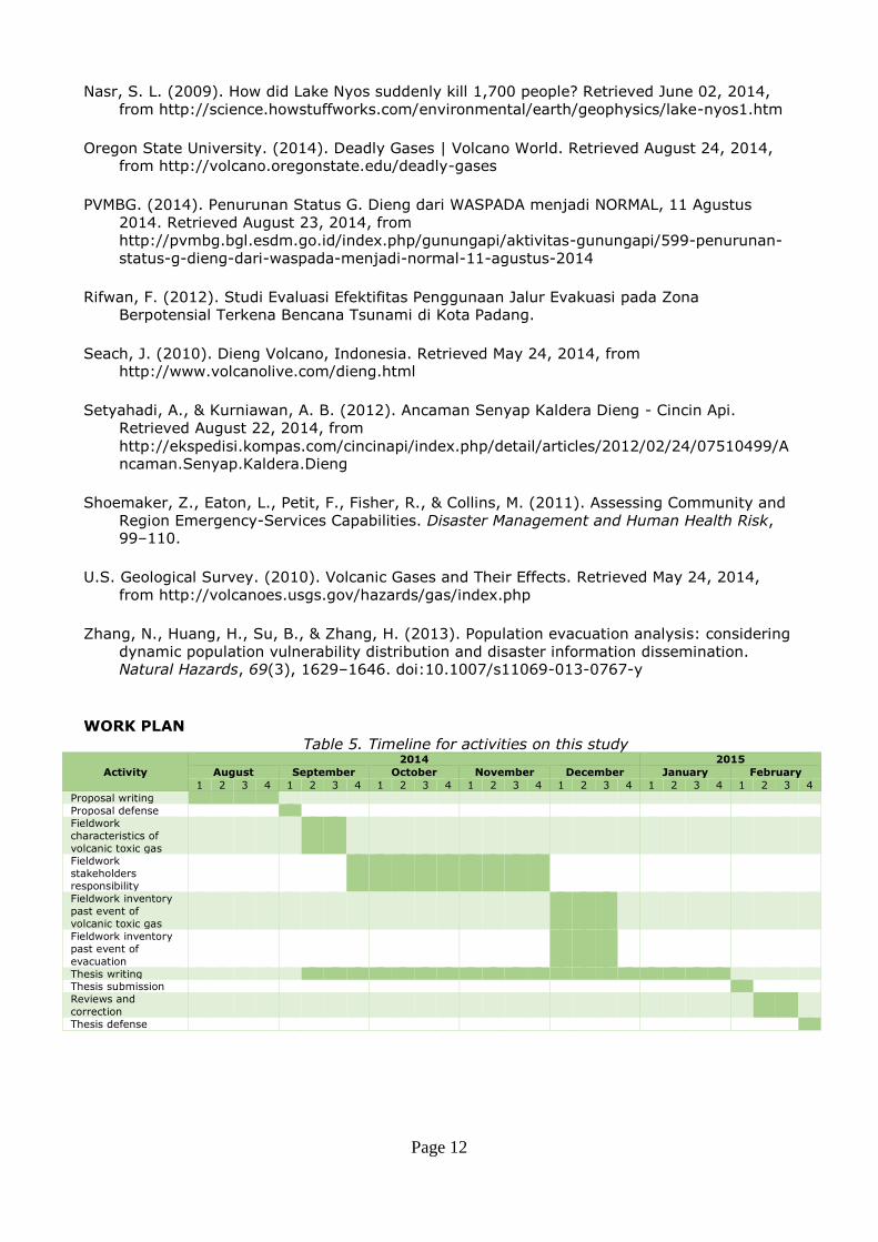
WORK PLAN
Table 5. Timeline for activities on this study
Activity
2014 2015
August September October November December January February
1 2 3 4 1 2 3 4 1 2 3 4 1 2 3 4 1 2 3 4 1 2 3 4 1 2 3 4
Proposal writing
Proposal defense
Fieldwork
characteristics of
volcanic toxic gas
Fieldwork
stakeholders
responsibility
Fieldwork inventory
past event of
volcanic toxic gas
Fieldwork inventory
past event of
evacuation
Thesis writing Thesis submission
Reviews and
correction
Thesis defense
Page 13
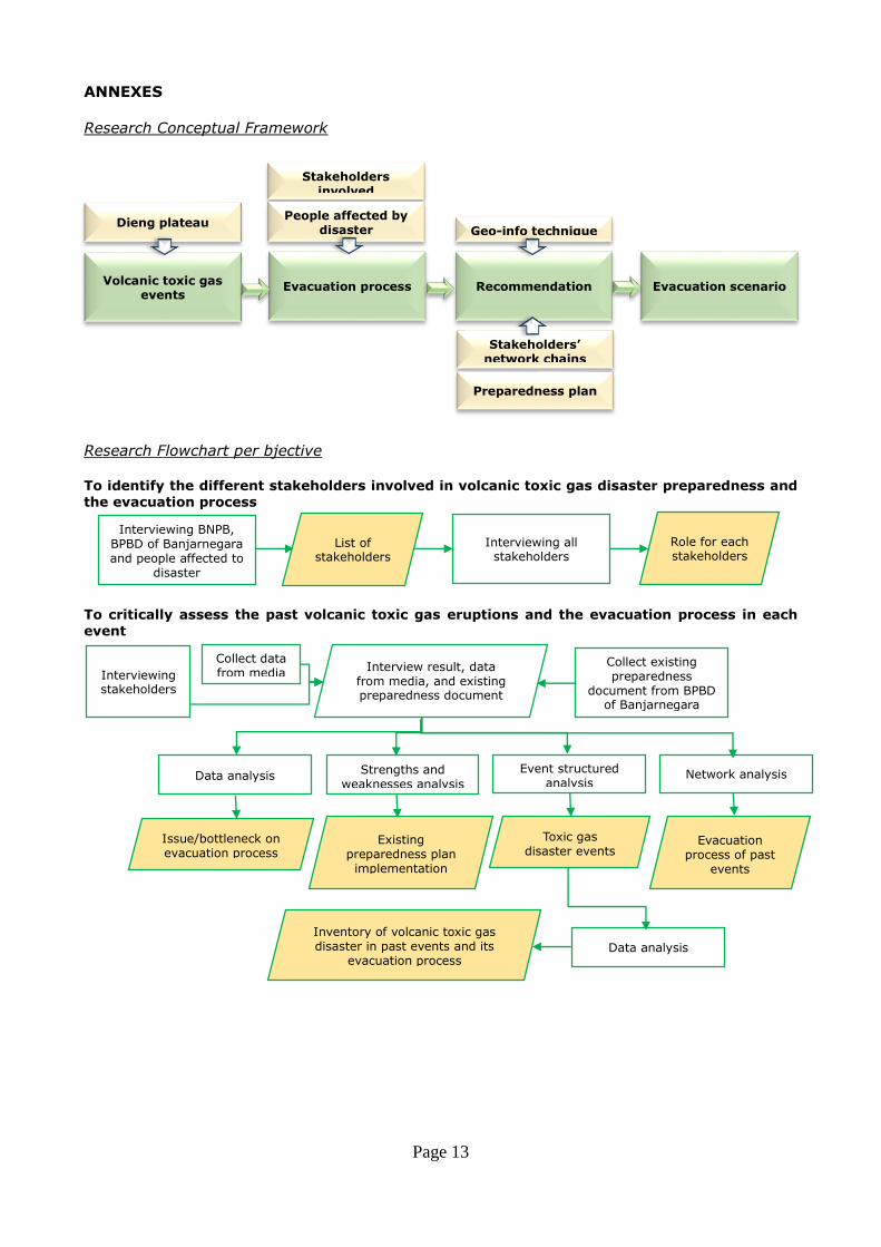
ANNEXES
Research Conceptual Framework
Research Flowchart per bjective
To identify the different stakeholders involved in volcanic toxic gas disaster preparedness and
the evacuation process
To critically assess the past volcanic toxic gas eruptions and the evacuation process in each
event
Interviewing BNPB, BPBD of Banjarnegara and people affected to
disaster
List of stakeholders
Interviewing all stakeholders
Role for each stakeholders
Collect data from media Interviewing
stakeholders
Interview result, data from media, and existing preparedness document
Event structured analysis
Evacuation process of past
events
Strengths and weaknesses analysis
Issue/bottleneck on evacuation process
Network analysis
Toxic gas disaster events
Collect existing preparedness
document from BPBD of Banjarnegara
Data analysis
Existing preparedness plan implementation
Data analysis
Inventory of volcanic toxic gas disaster in past events and its
evacuation process
Volcanic toxic gas events
Dieng plateau
Evacuation process
Stakeholders involved
People affected by disaster
Recommendation Evacuation scenario
Geo-info technique
Stakeholders’ network chains
Preparedness plan
Page 14
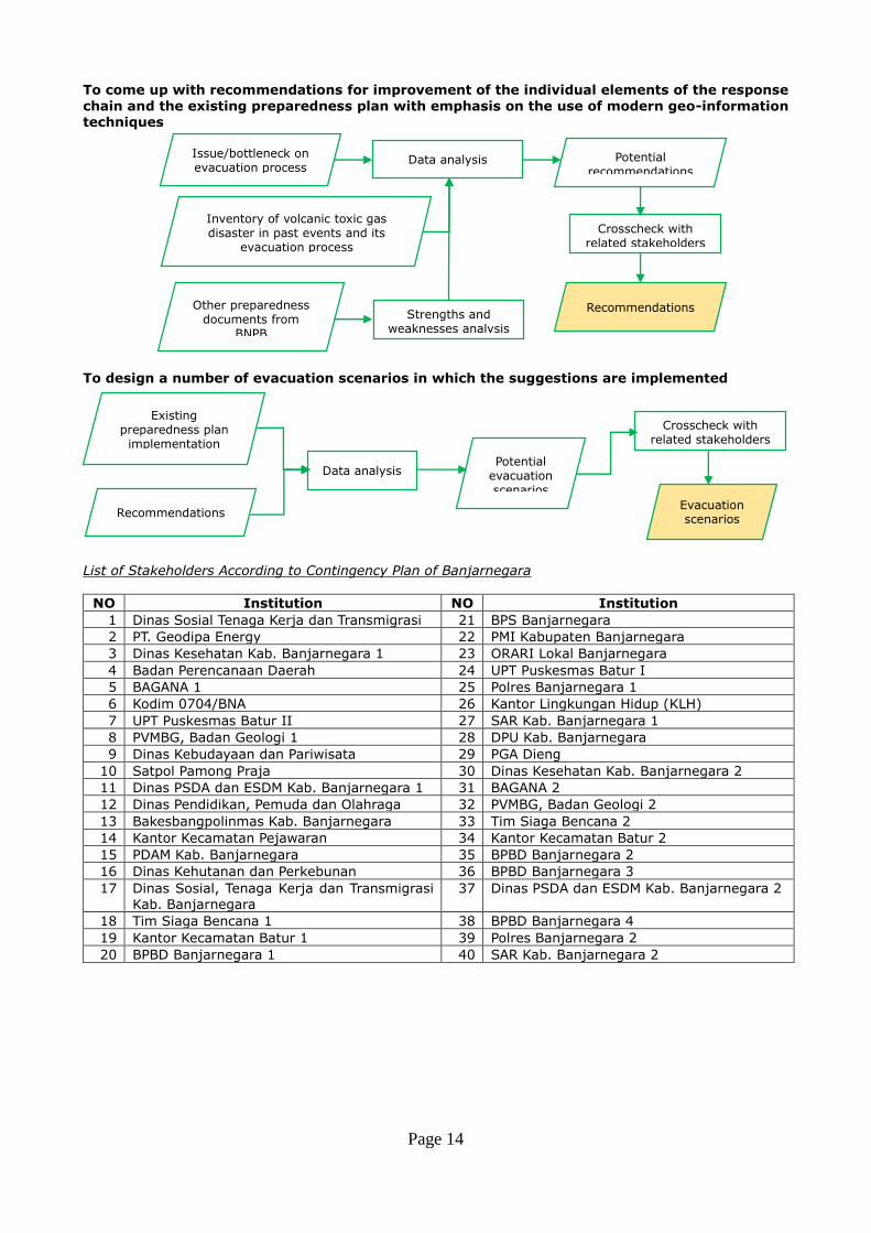
To come up with recommendations for improvement of the individual elements of the response
chain and the existing preparedness plan with emphasis on the use of modern geo-information techniques
To design a number of evacuation scenarios in which the suggestions are implemented
List of Stakeholders According to Contingency Plan of Banjarnegara
NO Institution NO Institution
1 Dinas Sosial Tenaga Kerja dan Transmigrasi 21 BPS Banjarnegara
2 PT. Geodipa Energy 22 PMI Kabupaten Banjarnegara
3 Dinas Kesehatan Kab. Banjarnegara 1 23 ORARI Lokal Banjarnegara
4 Badan Perencanaan Daerah 24 UPT Puskesmas Batur I
5 BAGANA 1 25 Polres Banjarnegara 1
6 Kodim 0704/BNA 26 Kantor Lingkungan Hidup (KLH)
7 UPT Puskesmas Batur II 27 SAR Kab. Banjarnegara 1
8 PVMBG, Badan Geologi 1 28 DPU Kab. Banjarnegara
9 Dinas Kebudayaan dan Pariwisata 29 PGA Dieng
10 Satpol Pamong Praja 30 Dinas Kesehatan Kab. Banjarnegara 2
11 Dinas PSDA dan ESDM Kab. Banjarnegara 1 31 BAGANA 2
12 Dinas Pendidikan, Pemuda dan Olahraga 32 PVMBG, Badan Geologi 2
13 Bakesbangpolinmas Kab. Banjarnegara 33 Tim Siaga Bencana 2
14 Kantor Kecamatan Pejawaran 34 Kantor Kecamatan Batur 2
15 PDAM Kab. Banjarnegara 35 BPBD Banjarnegara 2
16 Dinas Kehutanan dan Perkebunan 36 BPBD Banjarnegara 3
17 Dinas Sosial, Tenaga Kerja dan Transmigrasi
Kab. Banjarnegara
37 Dinas PSDA dan ESDM Kab. Banjarnegara 2
18 Tim Siaga Bencana 1 38 BPBD Banjarnegara 4
19 Kantor Kecamatan Batur 1 39 Polres Banjarnegara 2
20 BPBD Banjarnegara 1 40 SAR Kab. Banjarnegara 2
Issue/bottleneck on evacuation process
Strengths and weaknesses analysis
Other preparedness documents from
BNPB
Data analysis Potential recommendations
Crosscheck with related stakeholders
Inventory of volcanic toxic gas disaster in past events and its
evacuation process
Recommendations
Existing preparedness plan implementation
Recommendations
Data analysis Potential
evacuation scenarios
Crosscheck with related stakeholders
Evacuation scenarios
Page 15
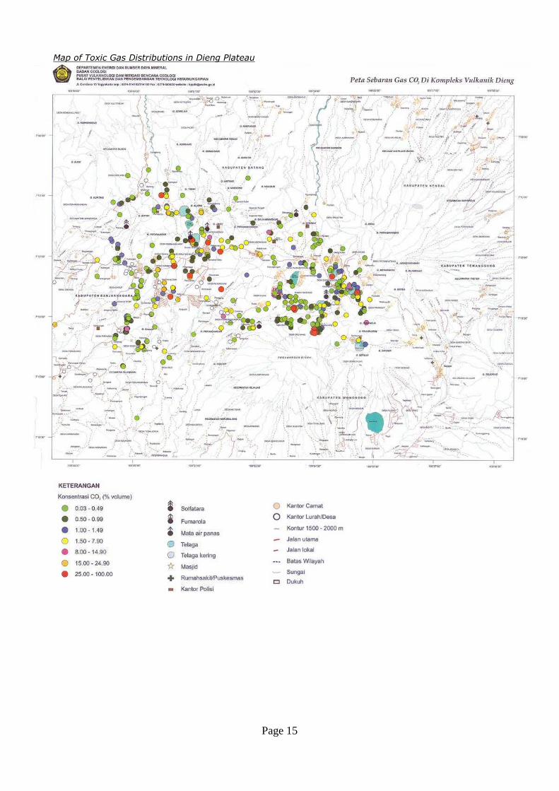
Map of Toxic Gas Distributions in Dieng Plateau

Page 16
In-Depth Interview’s Questionnaire
For BNPB and BPBD of Banjarnegara
Institution’s name :
Respondent’s name :
Position :
Handphone :
E-mail :
Date of interview :
Key questions for identification of stakeholders’ responsibility
1. What are the stakeholders involved in the preparedness and evacuation process in Dieng?
2. Could you please explain the role of each stakeholders in Dieng?
Key questions for identification of evacuation process
1. Could you please explain the events of evacuation process you were involved?
2. Could you please explain how the evacuation process was?
3. Could you please explain how your institution’s role in the evacuation process was?
4. Could you please explain the issues/bottlenecks related to evacuation process?
Key question for improvement of evacuation process
1. What do you think about existing preparedness plan?
2. What is your suggestion to improve existing preparedness plan?
3. What do you think about existing stakeholders’ network chains?
4. What is your suggestion to improve existing stakeholders’ network chains?
Key question to make evacuation scenario
1. What aspects needed in the evacuation scenarios?
For PVMBG and Observation Post
Institution’s name :
Respondent’s name :
Position :
Handphone :
E-mail :
Date of interview :
Key questions for identification of volcanic toxic gas in past events
1. Could you please explain the volcanic toxic gas event in each past event?
Key questions for identification of evacuation process
1. Could you please explain the events of evacuation process you were involved?
2. Could you please explain how the evacuation process was?
3. Could you please explain how your institution’s role in the evacuation process was?
4. Could you please explain the issues/bottlenecks related to evacuation process?
Key question for improvement of evacuation process
1. What do you think about existing preparedness plan?
2. What is your suggestion to improve existing preparedness plan?
3. What do you think about existing stakeholders’ network chains?
4. What is your suggestion to improve existing stakeholders’ network chains?
Key question to make evacuation scenario
1. What aspects needed in the evacuation scenarios?
Page 17
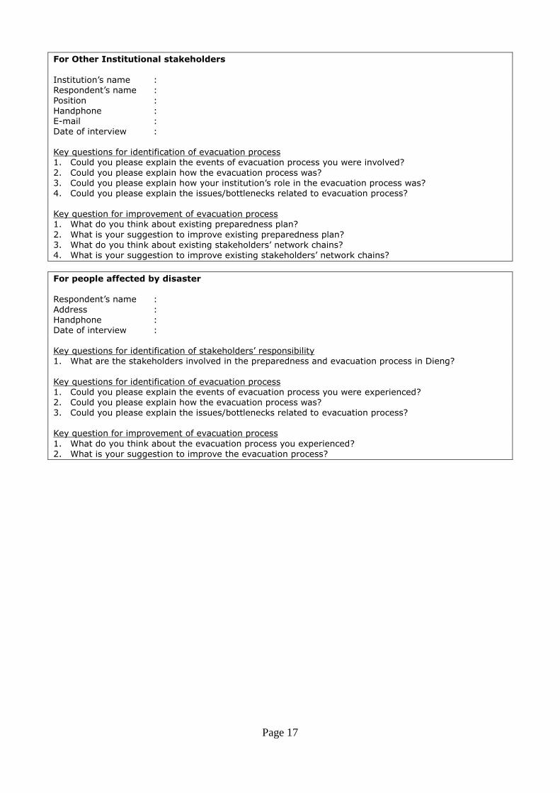
For Other Institutional stakeholders
Institution’s name :
Respondent’s name :
Position :
Handphone :
E-mail :
Date of interview :
Key questions for identification of evacuation process
1. Could you please explain the events of evacuation process you were involved?
2. Could you please explain how the evacuation process was?
3. Could you please explain how your institution’s role in the evacuation process was?
4. Could you please explain the issues/bottlenecks related to evacuation process?
Key question for improvement of evacuation process
1. What do you think about existing preparedness plan?
2. What is your suggestion to improve existing preparedness plan?
3. What do you think about existing stakeholders’ network chains?
4. What is your suggestion to improve existing stakeholders’ network chains?
For people affected by disaster Respondent’s name :
Address :
Handphone :
Date of interview :
Key questions for identification of stakeholders’ responsibility
1. What are the stakeholders involved in the preparedness and evacuation process in Dieng?
Key questions for identification of evacuation process
1. Could you please explain the events of evacuation process you were experienced?
2. Could you please explain how the evacuation process was?
3. Could you please explain the issues/bottlenecks related to evacuation process?
Key question for improvement of evacuation process
1. What do you think about the evacuation process you experienced?
2. What is your suggestion to improve the evacuation process?