Embed Size (px)
Citation preview
Journal of Environment and Earth Science www.iiste.org
ISSN 2224-3216 (Paper) ISSN 2225-0948 (Online)
Vol.5, No.2, 2015
165
Petrography and Paleoenvironmental Interpretation of Taloka
and Dukamaje Formations, Southern Gadon Mata, Goronyo,
Sokoto Basin-Nigeria
Yelwa N. A. 1*, Abdullahi I. M.
1, Nabage N.A.
2, Kasim S. A.
3
1Department of Geology, Usmanu Danfodiyo University, P.M.B. 2346, Sokoto-Nigeria
2Department of Applied Geology, Abubakar Tafawa Balewa, P.M.B. 0248, Bauchi-Nigeria
3Centre for Energy Research and Training, Ahmadu Bello University, P.M.B.1096, Zaria-Nigeria
* E-mail of the corresponding author: [email protected]
Abstract
Petrographic study of the various rock units from Gadon Mata area of Goronyo in Sokoto Basin was carried out.
Sedimentary structures were used for Paleoenvironmental Interpretation of Taloka and Dukamaje Formations
from Sokoto Basin-Nigeria. The two formations which forms part of Rabah Sheet 11NE lies in the southeastern
sector of the Iullemmeden Basin. The study area is bounded by latitudes 13018'38"N to 13
021'58"N and
longitudes 5047'47"E to 5
050'35"E covering 30Km
2. The mapping exercise was carried out using a topographic
base map on the scale of 1:30,000.
The area is made up of Maastrichtian sediments-Taloka and Dukamaje Formations. Taloka Formation is of
deltaic/brackish water environment and is made up of white, grey, brown siltstones, friable sandstones,
claystones and biogenic structures. It is of tidal flat depositional environment as confirmed by sedimentary
structures like abundant bioturbation, rhythmic bedding and the wavy beddings. The Dukamaje Formation is of
marginal marine environment comprising of shales, limestones and mudstones with vertebrate fragments. The
abundance of mudcrack can be useful in the interpretation of paleoclimate as they are common in warmer
climates. Similarly, while the calcite crystals exhibiting spherulitic texture observed in the thin section implies
deposition in shallow agitated marine water of the Dukamaje Formation.
Keywords: Petrographic, Sedimentary structures, Paleoenvironmental, Taloka, Dukamaje, Formation,
Iullemmeden.
1. Introduction
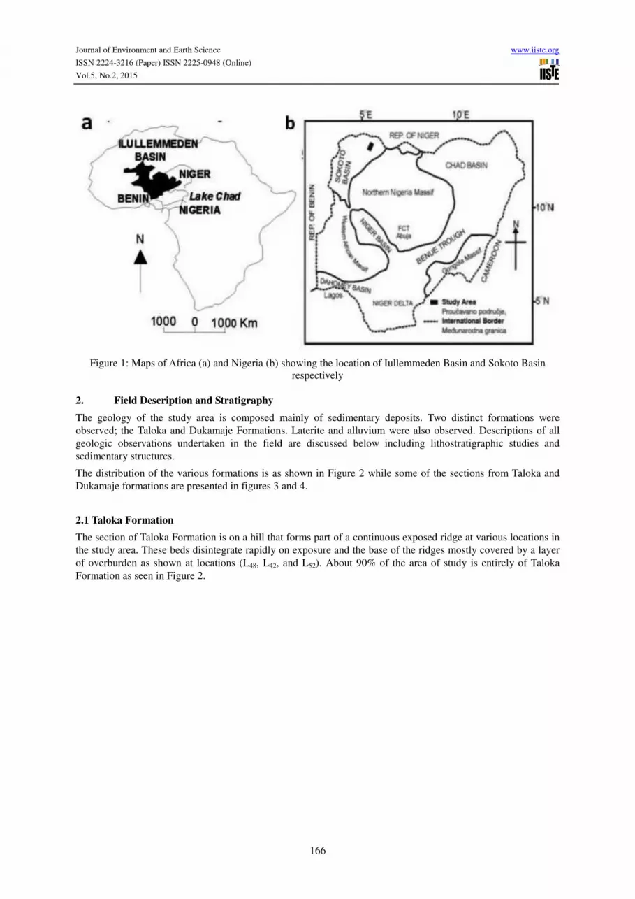
The Iullemmeden Basin is entirely a cratonic basin created by tectonic epirogenic movements or stretching and
rifting of tectonically stabilized crust during the Palaeozoic (Bertrand-Safarti, 1977). These movements become
evident from the beginning of Palaeozoic and continued until the Upper Cretaceous when the opening of the Goa
Trench was achieved (Faure, H., 1996). The basin located in central West Africa is a sedimentary basin shared
over about 95% of its surface area located in the semi arid environments of the three contiguous countries –
Nigeria, Niger and Mali (Fig. 1). It covers an area of 620,000 km2 and consists of Sedimentary deposits. The
Iullemmeden Basin is one of three important sub-Saharan inland basins consisting of a broad syncline with
gently dipping flanks. The overlying sedimentary sequences become progressively younger from the northeast to
the southwest, indicating the directions of successive Cretaceous marine transgressions (Kogbe, 1991). The
Iullemmeden basin in north western Nigeria is known locally as the Sokoto basin where about 63,000km2 of it
occurs, which covers the States of Kebbi, Sokoto, Zamfara and parts of Katsina and lies between longitudes
3o40’E and 8
oE and latitudes 10
o30’N and 14
oN. Studies based on the outcrops as well as some borehole material
(Kogbe 1972, 1976b Kogbe et al., 1976; Petters, 1979) have led to the erection of its Cretaceous and Tertiary
Stratigraphy. Although the Sokoto Basin of Nigeria appears extensive in area extent, it only represents about one-
tenth of the entire Iullemmeden Basin of West Africa (Greigert 1961). Overlying the Precambrian basement
unconformably, the Illo and Gundumi Formations lies overlain unconformably by the Maastrichtian Rima Group,
separated by fossiliferous shally Dukamaje Formation. The Paleocene Dange and Gamba Formation (mainly
shales) are separated by calcareous Kalambaina Formation. The overlying Gwandu Formation (Continental
Terminal) is of Tertiary age. These sediments dip gently and thicken gradually towards the north-west, with a
maximum thickness of over 1,000 meters near the frontier of the Nigeria-Niger Republic (Kogbe, 1976). Thus
the detailed geology and Stratigraphy of the Sokoto Basin (Figure 1) are well documented in the works of Kogbe
(1972, 1974, 1979); Adeleye (1975); Okosun (1989, 1995); Haynes and Nwabuafo-ene (1998) and Obiosio et al.
(1998).
Journal of Environment and Earth Science www.iiste.org
ISSN 2224-3216 (Paper) ISSN 2225-0948 (Online)
Vol.5, No.2, 2015
166
Figure 1: Maps of Africa (a) and Nigeria (b) showing the location of Iullemmeden Basin and Sokoto Basin
respectively
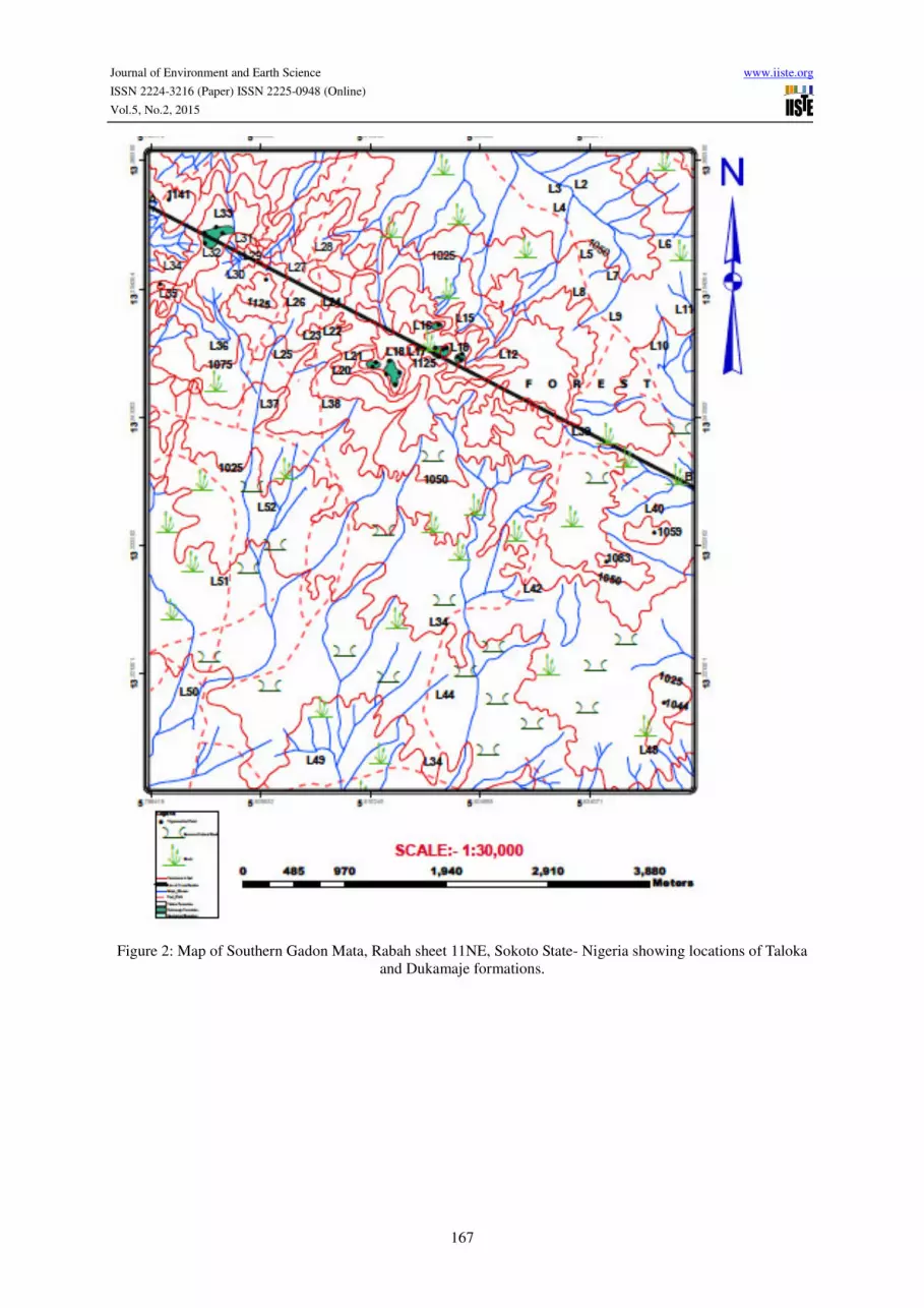
2. Field Description and Stratigraphy
The geology of the study area is composed mainly of sedimentary deposits. Two distinct formations were
observed; the Taloka and Dukamaje Formations. Laterite and alluvium were also observed. Descriptions of all
geologic observations undertaken in the field are discussed below including lithostratigraphic studies and
sedimentary structures.
The distribution of the various formations is as shown in Figure 2 while some of the sections from Taloka and
Dukamaje formations are presented in figures 3 and 4.
2.1 Taloka Formation
The section of Taloka Formation is on a hill that forms part of a continuous exposed ridge at various locations in
the study area. These beds disintegrate rapidly on exposure and the base of the ridges mostly covered by a layer
of overburden as shown at locations (L48, L42, and L52). About 90% of the area of study is entirely of Taloka
Formation as seen in Figure 2.
Journal of Environment and Earth Science www.iiste.org
ISSN 2224-3216 (Paper) ISSN 2225-0948 (Online)
Vol.5, No.2, 2015
167
Figure 2: Map of Southern Gadon Mata, Rabah sheet 11NE, Sokoto State- Nigeria showing locations of Taloka
and Dukamaje formations.
Journal of Environment and Earth Science www.iiste.org
ISSN 2224-3216 (Paper) ISSN 2225-0948 (Online)
Vol.5, No.2, 2015
168
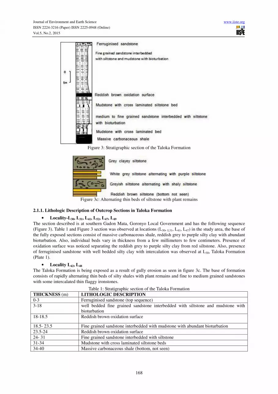
Figure 3: Stratigraphic section of the Taloka Formation
Figure 3c: Alternating thin beds of siltstone with plant remains
2.1.1. Lithologic Description of Outcrop Sections in Taloka Formation
• Locality-L30, L31, L41, L52, L47, L49
The section described is at southern Gadon Mata, Goronyo Local Government and has the following sequence
(Figure 3). Table 1 and Figure 3 section was observed at locations (L30, L31, L41, L47) in the study area, the base of
the fully exposed sections consist of massive carbonaceous shale, reddish grey to purple silty clay with abundant
bioturbation. Also, individual beds vary in thickness from a few millimeters to few centimeters. Presence of
oxidation surface was noticed separating the reddish grey to purple silty clay from red siltstone. Also, presence
of ferruginised sandstone with well bedded silty clay with intercalation was observed at L30, Taloka Formation
(Plate 1).
• Locality L42, L48
The Taloka Formation is being exposed as a result of gully erosion as seen in figure 3c. The base of formation
consists of rapidly alternating thin beds of silty shales with plant remains and fine to medium grained sandstones
with some intercalated thin flaggy ironstones.
Table 1: Stratigraphic section of the Taloka Formation
THICKNESS (m) LITHOLOGIC DESCRIPTION
0-3 Ferruginised sandstone (top sequence)
3-18 well bedded fine grained sandstone interbedded with siltstone and mudstone with
bioturbation
18-18.5 Reddish brown oxidation surface
18.5- 23.5 Fine grained sandstone interbedded with mudstone with abundant bioturbation
23.5-24 Reddish brown oxidation surface
24- 31 Fine grained sandstone interbedded with siltstone
31-34 Mudstone with cross laminated siltstone beds
34-40 Massive carbonaceous shale (bottom, not seen)

Journal of Environment and Earth Science www.iiste.org
ISSN 2224-3216 (Paper) ISSN 2225-0948 (Online)
Vol.5, No.2, 2015
169
Thus the lithofacies recognized in Taloka Formation can broadly be described in two groups; macroscopically
and microscopically as follows;
i) Sandstone
Hand specimen: It appears light brown to grayish with alternating of yellow to brownish claystone. It ranges
from medium to fine grained with average diameter of 1/16mm to 2mm. It exhibits reverse grading. It does not
contain fossils because the energetic environments where sand beds form do not favour their preservation.
Thin Section: The grains appear equigranular. The interstitial cement seen is quartz (SiO2). Minerals present
include quartz, muscovite. Accessory mineral is zircon. Also, grains are well sorted as observed in Plate 4.
a) Quartz: The quartz occurs as colorless anhedral crystal with no alteration. It has wavy extinction with
no cleavage. About 58% of the sandstone is quartz.
b) Feldspar: Orthoclase feldspar was seen which occurs as dark green under plane polarized light with
high interference color of pink to bluish under crossed polarized light. It makes up of about 40% of the
rock sample.
c) Zircon: Zircon is dark under plane and crossed polarized light (Isotropic) and it makes up of about 2%
rock sample (Plate 4).
ii) Siltstone
It appears grayish with white patches. It is gritty and occurs as thin lamination. The field test for siltstone is that
individual grain sizes are invisible but you can feel them by rubbing on the hand. It is fine grained as observed in
figure 3, 3c, Plate 1 and 2.
iii) Mudstone
It appears grayish brown in color. It is gritty and formed as a result of consolidation of clayey particles (Plate 2).
Plate1: Bedded silty clay with intercalation of yellowish siltstone with abundant bioturbation at Taloka
Formation
Plate 2: Mudstone with cross laminated grayish with white patches siltstone beds at Taloka Formation
Journal of Environment and Earth Science www.iiste.org
ISSN 2224-3216 (Paper) ISSN 2225-0948 (Online)
Vol.5, No.2, 2015
170
iv) Oxidation surfaces
It appears reddish brown which is intercalated between well bedded silty clay and siltstone. A band of oxidation
surface, 0.30m thick is seen at location (L30) and figure 3.
v) Shale
It has fine grained texture with grey to brownish color. It is formed largely by the hardening of clay size and silt
size particles occurring as massive carbonaceous shale of 7m as seen at locations (L30, L49) of figure 3, table 1.
vi) Ferruginised Sandstone
Hand specimen: The Ferruginised sandstone sample is coarse grained. Ooids are clearly visible, appearing
reddish brown.
Thin section: The ferruginous oolites are spherical in shape. The concentric shells consist of nucleus at the
centre having quartz materials, fragments of pre-existing oolites. The iron content type seen is goethite. Also, the
oolites are embedded in a matrix of silty clay impregnated by iron oxide (Plate 4).
vii) Taloka Lignite Occurrence and its Palaeoenvironmental Significance
Lignite beds were observed in Gilbedi, upper beds of Taloka Formation ranging in thickness up to 1m extending
laterally to considerable dimension. Lignite presence is of special environmental significance as it confirms the
paralic nature of the depositional environments during the Maastrichtian in the Iullemmeden basin. During the
upper Maastrichtian, the sea encroached the Iullemmeden basin and the Taloka Formation represents the coastal
plain sands and clays of the encroaching Maastrichtian Sea.
Plate 3: Photomicrograph of oolitic ironstone (concentric) under plane polarized light at location L23, Taloka
Formation. Minerals present are mostly Haematite (H) and quartz (Q). Magnification X 30
Plate 4: Photomicrograph of sandstone (equigranular) under crossed polarized light location L42. Minerals are
mostly quartz (Q), Feldspar (F) and zircon (accessory mineral).
viii) Superficial deposit
It was observed at the southern portion of the study area at locations (L43, L5) along river channels. It consists of
top layer of brown to yellow silt clays, a middle horizon of grey or white silty clays. It usually forms as a result
of erosion and weathering of the Taloka Formation.
Journal of Environment and Earth Science www.iiste.org
ISSN 2224-3216 (Paper) ISSN 2225-0948 (Online)
Vol.5, No.2, 2015
171
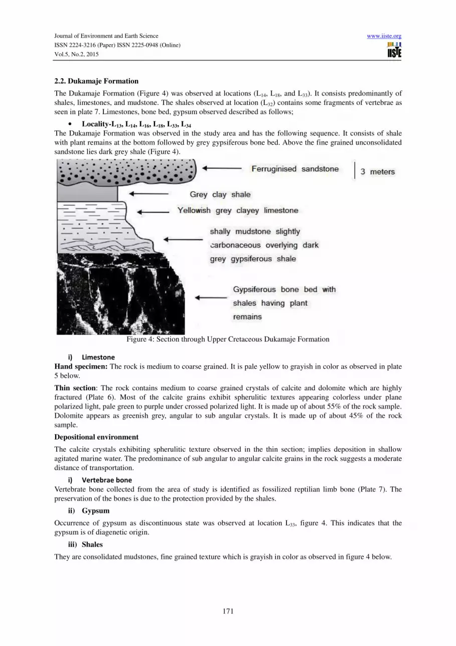
2.2. Dukamaje Formation
The Dukamaje Formation (Figure 4) was observed at locations (L14, L18, and L33). It consists predominantly of
shales, limestones, and mudstone. The shales observed at location (L32) contains some fragments of vertebrae as
seen in plate 7. Limestones, bone bed, gypsum observed described as follows;
• Locality-L13, L14, L16, L18, L33, L34
The Dukamaje Formation was observed in the study area and has the following sequence. It consists of shale
with plant remains at the bottom followed by grey gypsiferous bone bed. Above the fine grained unconsolidated
sandstone lies dark grey shale (Figure 4).
Figure 4: Section through Upper Cretaceous Dukamaje Formation
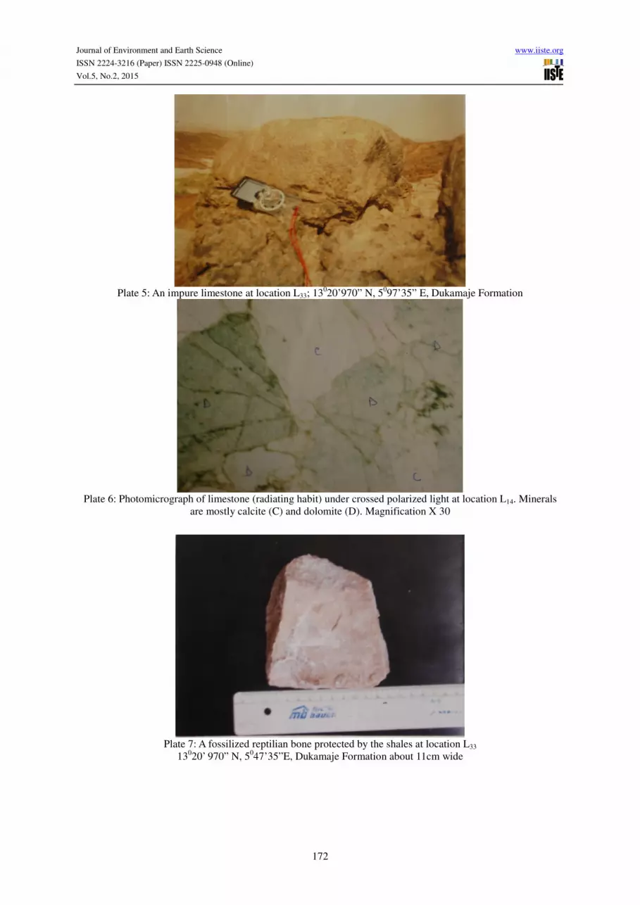
i) Limestone
Hand specimen: The rock is medium to coarse grained. It is pale yellow to grayish in color as observed in plate
5 below.
Thin section: The rock contains medium to coarse grained crystals of calcite and dolomite which are highly
fractured (Plate 6). Most of the calcite grains exhibit spherulitic textures appearing colorless under plane
polarized light, pale green to purple under crossed polarized light. It is made up of about 55% of the rock sample.
Dolomite appears as greenish grey, angular to sub angular crystals. It is made up of about 45% of the rock
sample.
Depositional environment
The calcite crystals exhibiting spherulitic texture observed in the thin section; implies deposition in shallow
agitated marine water. The predominance of sub angular to angular calcite grains in the rock suggests a moderate
distance of transportation.
i) Vertebrae bone
Vertebrate bone collected from the area of study is identified as fossilized reptilian limb bone (Plate 7). The
preservation of the bones is due to the protection provided by the shales.
ii) Gypsum
Occurrence of gypsum as discontinuous state was observed at location L33, figure 4. This indicates that the
gypsum is of diagenetic origin.
iii) Shales
They are consolidated mudstones, fine grained texture which is grayish in color as observed in figure 4 below.
Journal of Environment and Earth Science www.iiste.org
ISSN 2224-3216 (Paper) ISSN 2225-0948 (Online)
Vol.5, No.2, 2015
172
Plate 5: An impure limestone at location L33; 13
020’970” N, 5
097’35” E, Dukamaje Formation
Plate 6: Photomicrograph of limestone (radiating habit) under crossed polarized light at location L14. Minerals
are mostly calcite (C) and dolomite (D). Magnification X 30
Plate 7: A fossilized reptilian bone protected by the shales at location L33
13020’ 970” N, 5
047’35”E, Dukamaje Formation about 11cm wide
Journal of Environment and Earth Science www.iiste.org
ISSN 2224-3216 (Paper) ISSN 2225-0948 (Online)
Vol.5, No.2, 2015
173
Plate 8: Ferruginised sandstone at location L13 at Dukamaje Formation affected by bioturbation burrows
Plate 9: Mudcrack at location L34 covering about 50 meters of the Dukamaje Formation
3. Sedimentary Structures and Paleoenvironmental Interpretation
Sedimentary Structures: Sedimentary structures were observed in well exposed outcrops of Taloka and
Dukamaje formations. They have been found to provide information about their sedimentary history.
• Bedding: This is a term signifying the existence of layering in the sedimentary rocks. They are common
in the various locations of the mapped area.
• Reverse Grading: This is a gradational decline in grain size downwards. In other words coarse grains
appear at the top, and then medium grained and finally fine grained below (coarsening upwards). They
are most common in the sandstone.
• Rhythmic Bedding: This is a definite cyclic type of sedimentation. It consists of alternations of
repeated clay-siltstones and siltstone. In several outcrops the cyclic sedimentation is most pronounced
by the ferruginisation of the siltstone layers as observed in Figure 3c above.
• Wavy bedding: This type of bedding is very common in the outcrop of Taloka Formation at locations
(L21, L30, and L25). The wavy bedding is due to alternation of clay and siltstone layers, which are linked
to form continuous layer. The mud layer almost completely fills the ripple trough and makes a thin
cover over the ripple crest. The ripple bedded sand layers of wavy bedding are vertically discontinuous
and isolated.
• Bioturbation structures: This is a burrowing structure formed as a result of burrowing activities of
biological organisms (Plate 1, 2, 8).
• Mudcrack: These are some sort of vertical shrinkage cracks formed as a result of contraction of
cohesive muddy sediments which are usually preserved by infilling of different sediments. They are
common structures found at locations (L14, L16, L18, and L34). The erosion of mud cracks produces clay
balls. The abundance of mud crack can be useful in the interpretation of paleoclimate as they are
common in warmer climates (Plate 9).
• Clay galls: Are found above the carbonaceous layers layer of the Taloka Formation as observed at
location (L42, L52, and L5).
Journal of Environment and Earth Science www.iiste.org
ISSN 2224-3216 (Paper) ISSN 2225-0948 (Online)
Vol.5, No.2, 2015
174
4. Conclusions
It can be concluded that two distinct formations were studied from the Gadon Mata area of the Sokoto Basin.
These are the Taloka and Dukamaje formations. It was observed from the above that the sedimentary structures
are indicative of a specific environment. The abundance of bioturbation burrows, wavy bedding, and rhythmic
bedding of Taloka Formation indicates tidal flat deposition environment. Similarly, presence of mud crack at
Dukamaje Formation shows evidence of marginal marine environment.
In terms of petroleum significance, the abundance of carbonaceous dark shales within the Taloka and Dukamaje
Formations could possibly constitute potential source rocks and the sandstone facies in the Taloka Formation
will constitute a good reservoir rocks in the subsurface.
References
Adeleye DR (1975). Nigerian late Cretaceous stratigraphy and paleogeography. Bull. Am. Assoc. Petrol. Geol.
59: 2302-2313.
Bertrand-Safarti, J. Moussine-Pouchkine, A. and Fabre, J. (1977): Geodynamique desaires sedimentaires
cratoniques: quelques examples sahariens, Bull. Centres Reh. Expir, Elf Aquitaine, 1, 1, 217-231.
Faure, H. (1996): Report de fin d champagne 1956. Less formation sedimentaires du SE et de I’est de I’air
(Niger). Arch. Dir. Fr. Mine et Geology, Dakar.
Greigert, J. (1961) Carte geologique de reconnaissance du Bassin de Iullemmeden: Republique du Niger ì
Direction Federale de Mines, scale 1:1,000,000.
Haynes J, Nwabufo-ene K (1998). Foraminifera from the Paleocene phosphate beds, Sokoto, Nigeria. Revista
Espariola de Micropaleon. 30: 51-76.
Kogbe CA (1972). Geology of the Upper Cretaceous and Lower Tertiary sediments of the Nigerian sector of the
Iullemmeden Basin (West Africa), Geologische Rundschan, Stuttgart. 62: 197-211.
Kogbe, CA (1974). Paleoecologic significance of vertebrate fossils in the Dukamaje and Dange formations
(Maastrichtian and Paleocene) of north western Nigeria. J. Min. Geol. 8: 49-55.
Kogbe, C. A. (1976a): Outline of the geology of the Iullemmeden Basin in North-Western Nigeria. In: Geology
of Nigeria, (Ed. C. A Kogbe). Elizabethan Pub. Co. Lagos Nigeria, 331-343.
Kogbe, C. A. (1976b): Paleogeographic history of Nigeria from Albian times. Geology of Nigeria (Ed. C. A.
Kogbe). Elizabethan pub. Co., Lagos, 237-252.
Kogbe, CA (1979). Geology of the southeastern (Sokoto) sector of the Iullemmeden Basin. Bulletin Department
of Geology, Ahmadu Bello University, Zaria, Nigeria.2, 420p.
Kogbe, C. A. (1976) Paleogeographic history of Nigeria from Albian times. In: Kogbe CA (ed), Geology of
Nigeria. Elizabethan Publishers, Lagos, pp 15–35
Kogbe, C.A., (1989) Cretaceous and Tertiary of the Iullemmeden Basin in Nigeria In: C.A. Kogbe (eds.),
Geology of Nigeria, 377-421. Jos, Rock View Publ. Co.
Obiosio EO, Obaje NG, Okosun EA (1998). Foraminiferal Paleoecology of the Kalambaina limestone south east
sector of Iullemmeden basin, Sokoto, Nigeria. 34: 19-25.
Okosun EA (1989). A review of the stratigraphy of Dange Formation (Paleocene), Northwestern Nigeria.
Newsletter Stratigraphy Berlin. Stuttgart. 21: 39-47.
Okosun EA (1995). Paleocene Ostracods from Sokoto Basin, Northwestern Nigeria. J. Min. Geol. 31: 123-133.
Petters, S. W. (1976): The marine Maastrichtian and Paleocene sediments of Northwestern Nigeria. The
Dukamaje Formation and the Sokoto Group. Geological guide to some Nigeria Cretaceous-Recent localities. 7th
AfricanMicropal. Coll. Ile-Ife, Nigeria, pp. 75-87.

The IISTE is a pioneer in the Open-Access hosting service and academic event management.
The aim of the firm is Accelerating Global Knowledge Sharing.
More information about the firm can be found on the homepage:
http://www.iiste.org
CALL FOR JOURNAL PAPERS
There are more than 30 peer-reviewed academic journals hosted under the hosting platform.
Prospective authors of journals can find the submission instruction on the following
page: http://www.iiste.org/journals/ All the journals articles are available online to the
readers all over the world without financial, legal, or technical barriers other than those
inseparable from gaining access to the internet itself. Paper version of the journals is also
available upon request of readers and authors.
MORE RESOURCES
Book publication information: http://www.iiste.org/book/
Academic conference: http://www.iiste.org/conference/upcoming-conferences-call-for-paper/
IISTE Knowledge Sharing Partners
EBSCO, Index Copernicus, Ulrich's Periodicals Directory, JournalTOCS, PKP Open
Archives Harvester, Bielefeld Academic Search Engine, Elektronische Zeitschriftenbibliothek
EZB, Open J-Gate, OCLC WorldCat, Universe Digtial Library , NewJour, Google Scholar