Embed Size (px)
Citation preview

Seediscussions,stats,andauthorprofilesforthispublicationat:https://www.researchgate.net/publication/236162699
ThePermianMoradiFormationofnorthernNiger:Paleosolmorphology,petrographyandmineralogy[J]
ARTICLEinPALAEOGEOGRAPHYPALAEOCLIMATOLOGYPALAEOECOLOGY·NOVEMBER2010
ImpactFactor:2.34·DOI:10.1016/j.palaeo.2010.11.002
CITATIONS
15
READS
160
6AUTHORS,INCLUDING:
NeilTabor
SouthernMethodistUniversity
79PUBLICATIONS2,154CITATIONS
SEEPROFILE
RogerMalcolmHarrisSmith
IzikoSouthAfricanMuseum
95PUBLICATIONS2,939CITATIONS
SEEPROFILE
J.SébastienSteyer
FrenchNationalCentreforScientificResea…
84PUBLICATIONS627CITATIONS
SEEPROFILE
ChristopherJPoulsen
UniversityofMichigan
112PUBLICATIONS2,371CITATIONS
SEEPROFILE
Availablefrom:J.SébastienSteyer
Retrievedon:16January2016

Palaeogeography, Palaeoclimatology, Palaeoecology 299 (2011) 200–213
Contents lists available at ScienceDirect
Palaeogeography, Palaeoclimatology, Palaeoecology
j ourna l homepage: www.e lsev ie r.com/ locate /pa laeo
The Permian Moradi Formation of northern Niger: Paleosol morphology, petrographyand mineralogy
Neil J. Tabor a,⁎, Roger M.H. Smith b, J. Sébastien Steyer c, Christian A. Sidor d, Christopher J. Poulsen e
a Roy M. Huffington Department of Earth Sciences, 3225 Daniel Avenue, Dallas, TX 75275-0395, United Statesb Division of Earth Sciences, Iziko: South African Museum, Cape Town 8000, South Africac CNRS UMR7207, Muséum national d'Histoire naturelle, Département Histoire de la Terre, CP38, 8 rue Buffon, F-75005 Paris cedex 05, Franced Burke Museum and Department of Biology, University of Washington, Seattle, WA 98195-1800, United Statese Department of Geological Sciences, University of Michigan, Ann Arbor, MI 48109, United States
⁎ Corresponding author.E-mail addresses: [email protected] (N.J. Tabor)
(R.M.H. Smith), [email protected] (J.S. Steyer), casidor@[email protected] (C.J. Poulsen).
0031-0182/$ – see front matter © 2010 Elsevier B.V. Adoi:10.1016/j.palaeo.2010.11.002
a b s t r a c t
a r t i c l e i n f oArticle history:Received 20 April 2010Received in revised form 11 October 2010Accepted 1 November 2010Available online 4 November 2010
Keywords:PaleosolsClay mineralogyPaleoclimatePermianMoradi FormationNigerAfrica
Three basic paleosol morphologies, named Type A, Type B and Type C, are described from the middle–upperPermian strata of the Moradi Formation, Tim Mersoi Basin, northern Niger. The Moradi Formation is a typicalalluvial redbed succession dominated by redmudrocks with fine to coarse-grained pebbly channel sandstonesand matrix-breccias. Type A paleosols are hosted by well-sorted fine to medium grained trough cross beddedand massive sandstones and preserve abundant vertical to horizontal micritic and microspar calcite tubules,interpreted as rhizoliths. Lateral variability of rhizoliths in Type A paleosols, and their close association withfluvial channel-fill sediments suggests they are the roots of grove stands of phreatophytic vegetation thatgrew within unstable anabranching stream systems. Type B paleosols are hosted by mudrocks and preservewell-developed ped structure, abundant micritic calcite nodules and vertically-stacked micritic calcitenodular bodies, as well as rare calcite with satin-spar texture interpreted as a pseudomorphic replacement ofpedogenic gypsum. The morphology of Type B paleosols suggests they were formed in well-drainedfloodplain deposits on stable landforms. Type C paleosols are similar to Type B but preserve pedogenicstructures indicative of soil volume expansion and contraction, as well as more abundant Stage II pedogeniccarbonate nodules. The morphology of Type C paleosols suggests that they developed periodically rather thanseasonally in poorly-drained deposits that nevertheless occupied a relatively stable part of the landscape suchas the plains flanking ephemeral lakes or sabkhas.X-ray diffraction analysis of the b2 μm fraction from the Moradi Formation strata indicates that paleosolphyllosilicates are composed of illite, smectite, and occasionally kaolinite and talc. Illite is likely a detritalmineral, whereas smectite and kaolinite are likely pedogenic weathering products. The presence of talc in theMoradi Formation paleosols is unusual. It is limited to paleosol horizons that also preserve evidence forpedogenic gypsum accumulation and is therefore most likely related to a pedogenic weathering process. It ispossible that this talc is a relatively low-temperature (~50–100 °C) diagenetic alteration product of pedogenicMg–phyllosilicates such as sepiolite.The range of morphologies, petrographic textures and mineralogy of the paleosol profiles indicates semi-aridto hyper-arid climatic setting. This paleoclimatic reconstruction is in agreement with Middle and LatePermian conceptual paleoclimate models and quantitative general circulation models. Nevertheless, and inspite of an arid climate, Moradi paleosols and their host strata also indicate a relatively shallow groundwatertable. Importantly, this shallow groundwater resource undoubtedly helped to support the moderately diversefossil vertebrate assemblage and large-stature macrophytes preserved in the Moradi Formation.
, [email protected] (C.A. Sidor),
ll rights reserved.
© 2010 Elsevier B.V. All rights reserved.
1. Introduction
The past few decades have seen significant advances in under-standing of Permian terrestrial climate evolution across northernmid-
latitude (Newell et al., 1999; Rees et al., 2002; Yakimenko et al., 2004),equatorial (e.g. DiMichele et al., 2009; Nairn and Smithwich, 1976;Parrish, 1982, 1993; Schneider et al., 2006; Steel, 1974; Tabor et al.,2007; Tramp et al., 2004; Ziegler et al., 1997, 2003) and extremesouthern mid-latitude and polar landscapes (Fielding et al., 2008;Isbell et al., 2003; Retallack et al., 2003; Smith, 1990; Wopfner, 2002;Wopfner and Kreuser, 1986). Permian climate history from south-central Pangean regions, including sub-Saharan Africa and northernSouth America (Fig. 1A), remains especially poorly known (e.g., Rees
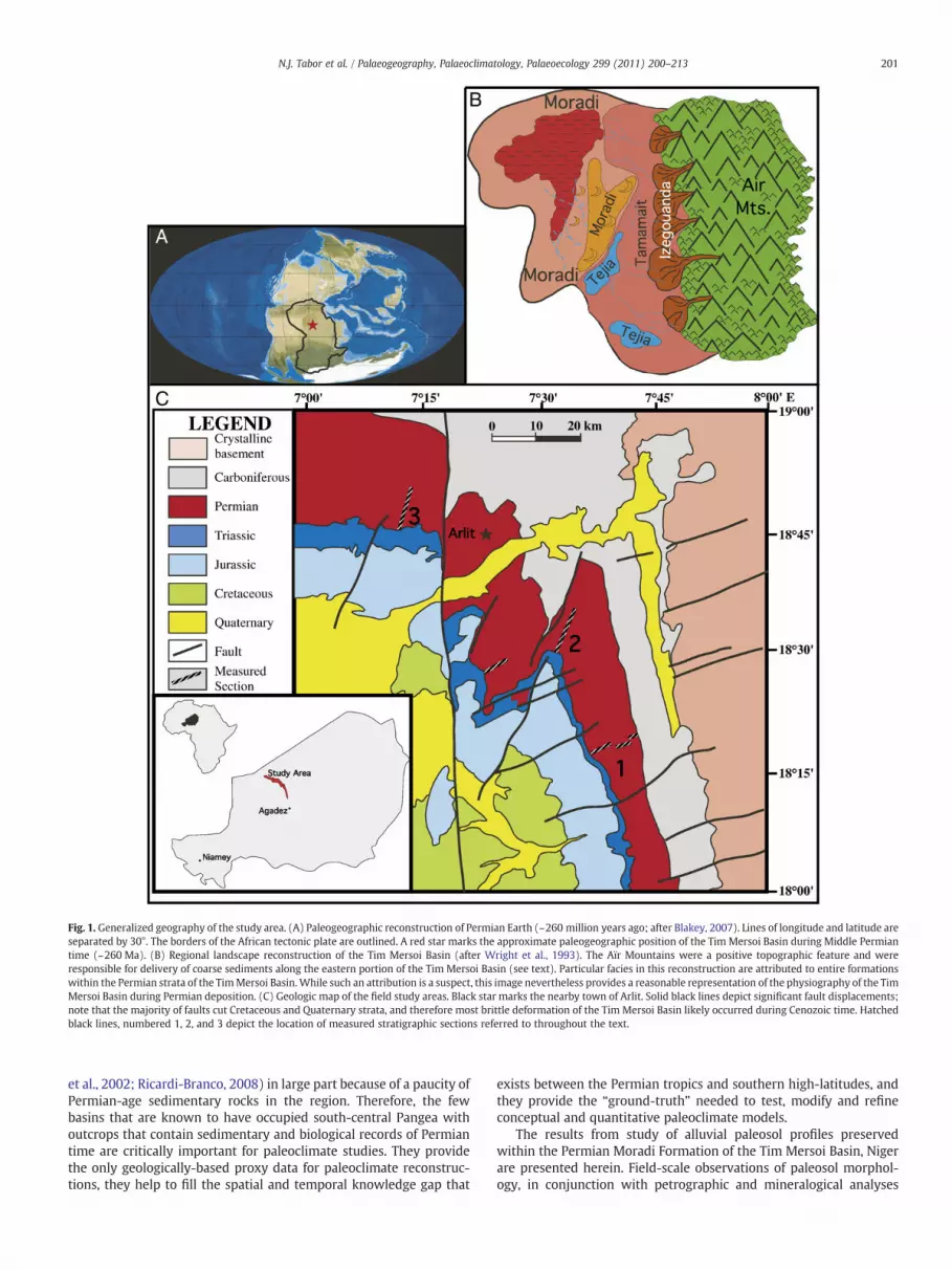
Fig. 1. Generalized geography of the study area. (A) Paleogeographic reconstruction of Permian Earth (~260 million years ago; after Blakey, 2007). Lines of longitude and latitude areseparated by 30°. The borders of the African tectonic plate are outlined. A red star marks the approximate paleogeographic position of the Tim Mersoi Basin during Middle Permiantime (~260 Ma). (B) Regional landscape reconstruction of the Tim Mersoi Basin (after Wright et al., 1993). The Aïr Mountains were a positive topographic feature and wereresponsible for delivery of coarse sediments along the eastern portion of the Tim Mersoi Basin (see text). Particular facies in this reconstruction are attributed to entire formationswithin the Permian strata of the TimMersoi Basin.While such an attribution is a suspect, this image nevertheless provides a reasonable representation of the physiography of the TimMersoi Basin during Permian deposition. (C) Geologic map of the field study areas. Black star marks the nearby town of Arlit. Solid black lines depict significant fault displacements;note that the majority of faults cut Cretaceous and Quaternary strata, and therefore most brittle deformation of the Tim Mersoi Basin likely occurred during Cenozoic time. Hatchedblack lines, numbered 1, 2, and 3 depict the location of measured stratigraphic sections referred to throughout the text.
201N.J. Tabor et al. / Palaeogeography, Palaeoclimatology, Palaeoecology 299 (2011) 200–213
et al., 2002; Ricardi-Branco, 2008) in large part because of a paucity ofPermian-age sedimentary rocks in the region. Therefore, the fewbasins that are known to have occupied south-central Pangea withoutcrops that contain sedimentary and biological records of Permiantime are critically important for paleoclimate studies. They providethe only geologically-based proxy data for paleoclimate reconstruc-tions, they help to fill the spatial and temporal knowledge gap that
exists between the Permian tropics and southern high-latitudes, andthey provide the “ground-truth” needed to test, modify and refineconceptual and quantitative paleoclimate models.
The results from study of alluvial paleosol profiles preservedwithin the Permian Moradi Formation of the Tim Mersoi Basin, Nigerare presented herein. Field-scale observations of paleosol morphol-ogy, in conjunction with petrographic and mineralogical analyses
202 N.J. Tabor et al. / Palaeogeography, Palaeoclimatology, Palaeoecology 299 (2011) 200–213
provide, for the first time, geologically-based proxy data forpaleoclimate from south-central Pangea.
2. Geological background
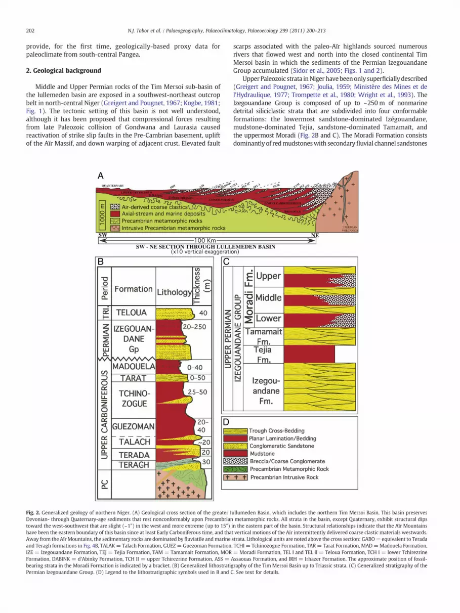
Middle and Upper Permian rocks of the Tim Mersoi sub-basin ofthe Iullemeden basin are exposed in a southwest-northeast outcropbelt in north-central Niger (Greigert and Pougnet, 1967; Kogbe, 1981;Fig. 1). The tectonic setting of this basin is not well understood,although it has been proposed that compressional forces resultingfrom late Paleozoic collision of Gondwana and Laurasia causedreactivation of strike slip faults in the Pre-Cambrian basement, upliftof the Aïr Massif, and down warping of adjacent crust. Elevated fault
SW
SW - NE SECTION THROUGH LULL
A
B C
D
Fig. 2. Generalized geology of northern Niger. (A) Geological cross section of the greater IDevonian- through Quaternary-age sediments that rest nonconformably upon Precambriantoward the west-southwest that are slight (~1°) in the west and more extreme (up to 15°)have been the eastern boundary of this basin since at least Early Carboniferous time, and thaAway from the Aïr Mountains, the sedimentary rocks are dominated by fluviatile andmarineand Teragh formations in Fig. 4B, TALAK= Talach Formation, GUEZ= Guezoman FormationIZE = Izegouandane Formation, TEJ = Tejia Formation, TAM = Tamamait Formation, MORFormation, DABINK = d'Abinky Formation, TCH II = upper Tchirezrine Formation, ASS = Abearing strata in the Moradi Formation is indicated by a bracket. (B) Generalized lithostratigPermian Izegouandane Group. (D) Legend to the lithostratigraphic symbols used in B and C
scarps associated with the paleo-Aïr highlands sourced numerousrivers that flowed west and north into the closed continental TimMersoi basin in which the sediments of the Permian IzegouandaneGroup accumulated (Sidor et al., 2005; Figs. 1 and 2).
UpperPaleozoic strata inNigerhavebeenonly superficially described(Greigert and Pougnet, 1967; Joulia, 1959; Ministère des Mines et del'Hydraulique, 1977; Trompette et al., 1980; Wright et al., 1993). TheIzegouandane Group is composed of up to ~250m of nonmarinedetrital siliciclastic strata that are subdivided into four conformableformations: the lowermost sandstone-dominated Izégouandane,mudstone-dominated Tejia, sandstone-dominated Tamamaït, andthe uppermost Moradi (Fig. 2B and C). The Moradi Formation consistsdominantly of redmudstoneswith secondaryfluvial channel sandstones
NE
EMEDEN BASIN
ullumeden Basin, which includes the northern Tim Mersoi Basin. This basin preservesmetamorphic rocks. All strata in the basin, except Quaternary, exhibit structural dips
in the eastern part of the basin. Structural relationships indicate that the Aïr Mountainst vertical motions of the Aïr intermittently delivered coarse clastic materials westwards.strata. Lithological units are noted above the cross section: GABO=equivalent to Terada, TCHI = Tchinozogue Formation, TAR= Tarat Formation, MAD=Madouela Formation,= Moradi Formation, TEL I and TEL II = Teloua Formation, TCH I = lower Tchirezrinessaouas Formation, and IRH = Irhazer Formation. The approximate position of fossil-raphy of the Tim Mersoi Basin up to Triassic strata. (C) Generalized stratigraphy of the. See text for details.

203N.J. Tabor et al. / Palaeogeography, Palaeoclimatology, Palaeoecology 299 (2011) 200–213
and conglomeratic sandstones as well as rare coarse breccias(Fig. 2C). Previousworkers in theMoradi Formation have interpretedfive depositional facies as (1) minor coarse-grained alluvial fandeposits, (2) common fluvial sandstones deposited in axial streams,(3) common fine-grained overbank/floodplain mudstones, (4) rarefine-grained sabkha mudstones and carbonates and (5) rare eoliansand dunes (Joulia, 1959; Wright et al., 1993). A Middle or LatePermian age of deposition for Izegouandane Group strata is basedprimarily upon biostratigraphic correlations of fossil vertebrates inthe Moradi Formation with Upper Permian vertebrate fossil assem-blages in Russia and South Africa (Lucas, 2004; Sidor et al., 2005;
Fig. 3. Schematics of measured stratigraphic sections in the Moradi Formation. Section 1, Sectto the vertical scale for measured sandstone and conglomerate (yellow), mudstone (red), andareas represent covered sections in the Moradi strata; the numbers next to the vertical linedelimit the boundaries between the Permian Tamamäit Formation, the lower, middle and upside of each stratigraphic column denotes the location of paleosol profiles in the Moradi Formnumber, or number series, after the hyphen indicates the name(s) of sample(s) collected fr
Taquet, 1969) as well as by the inferred ages of the underlyingCarboniferous and overlying Triassic strata within the Tim Mersoibasin (Ministère des Mines et de l'Hydraulique, 1977; Taquet, 1972).At the time of infilling, this basin was moving northward from ~30 to~10°S (Scotese et al., 1999), and remained at least 2000 km from thenearest open ocean (Fig. 1).
This work focuses on profile descriptions and sample analyses ofpaleosols from outcrops comprising lower, middle, and upper parts ofthe Moradi Formation (Figs. 1C and 3) with a view to gaining furtherinsight into the palaeoclimate that prevailed in continental centralPangea in the Mid to Late Permian.
ion 2, and Section 3 are marked in Fig. 1. The scale bar (=10 m) above Section 2 appliesvery poorly exposed (stippled) strata. The thin vertical lines connecting yellow and red
s indicate the thickness (in m) of strata that is covered in the section. Thick black linesper Moradi Formation, and the overlying Triassic Teloua Formation. The text on the rightation stratigraphy. The first letter indicates paleosol type at that location, whereas theom that site.

204 N.J. Tabor et al. / Palaeogeography, Palaeoclimatology, Palaeoecology 299 (2011) 200–213
3. Methods
3.1. Field
Although there is very little vegetative cover in the study area, acombination of low-lying topography, low regional dip (b2°) and amodern regolith mantle often exceeding 400 mm thick contributes toa poor quality of surface exposures of Moradi rocks. As a result, themeasured stratigraphic sections of the Moradi Formation includenumerous covered intervals (Fig. 3), and many parts of thestratigraphy were described from excavation pits up to 1.5 m deep.Moreover, accurate stratigraphic correlation cannot be made betweenthe measured sections (see Fig. 1C). However, a regionally persistentinterval of channel sandstones in the middle part of the MoradiFormation (the middle Moradi sands; Fig. 2C) permits generalassignment of measured sections to the lower, middle or upperMoradi Formation (Figs. 1C and 3).
Paleopedogenically modified strata were logged and described indetail according to previously defined methods (Tabor andMontañez,2004; Tabor et al., 2006). The top of each paleosol profile wasidentified on the basis of a marked change in grain size and color, aswell as preservation of primary sedimentary structures. Profile baseswere delineated at the re-appearance of unaltered parent material.Paleosol matrix was sampled at 0.1–0.2 m intervals from the top andrhizoliths and paleosol nodules were sampled where present. Whilemodern soil classification schemes have been applied to paleosolprofiles (e.g., Blodgett, 1988; Retallack et al., 2003; Tabor andMontañez, 2004), the paleosol classification scheme of Mack et al.(1993) is employed here because it utilizes morphological featuresthat are likely preserved through burial, diagenesis and lithification ofa soil profile and is based upon readily observable field properties. Thestratigraphic positions and host lithologies of collected samples, areshown in Fig. 3.
3.2. Laboratory
Paleosol matrix samples were disaggregated by ultrasonic agita-tion in a dilute Na2CO3 solution for 45 min. Thin sections (n=32) ofrepresentative samples were examined for their micromorphologyand mineralogy and described according to the approaches andterminology of Brewer (1976) and Wright (1990).
Whole-rock paleosol matrix and nodule samples were ground in acorundum mortar and pestle and loaded as randomly orientedpowder mounts for continuous scan X-ray diffraction analyses usinga Rigaku Ultima III X-ray diffractometer with Cu-Kα radiation at ascanning speed of 1° 2θ/min. Carbonate and matrix mineralogy wasdetermined by comparison of X-ray spectra with JCPDS-ICDDstandards (1980).
X-ray diffraction of the b2 μm size fraction was carried out foridentification of minerals in the clay-size fraction following themethods outlined by Moore and Reynolds (1997). Samples wereexchange saturated with K+ or Mg2+ on filter membranes andtransferred to glass slides as oriented aggregates. A split of the Mg2+-saturated clays was also treated with glycerol. Oriented aggregates ofall Mg2+-treated samples were analyzed at 25 °C. K+-treated sampleswere analyzed at 25 °C and 500 °C after 2 h of initial heating at theirrespective temperatures. All X-ray scans of b2 μm samples wereperformed on a Rigaku Ultima III X-ray diffractometer with CuKαradiation between 2 and 30° 2θ with a step size of 0.04° 2θ and a 1 scount time.
4. Results
Paleosol profiles were subdivided into horizons on the basis ofdown-profile changes in macro- and micromorphological features(Figs. 4 and 5). Three major types of paleosol morphologies (Types A,
B and C) exist in theMoradi strata based on the presence of distinctivecharacteristics that include soil structure, accumulation of carbonateand gypsum, slickensides, fossil root traces and color (Figs. 4 and 5).Later, we first describe the morphology, mineralogy (Fig. 6) andpetrography (Fig. 7) of the paleosol profiles. We then discuss themorphological variability among paleosol types, as well as theirstratigraphic and lateral distribution within the study area.
4.1. Description of Type A paleosols
Type A paleosols exhibit rooting structures and partial to completeobliteration of original depositional features (Figs. 3, 4A,B, and 5).These paleosols exist primarily as pale yellow (Munsell colors 5Y 7/2to 5Y 8/6), occasionally weak red (Munsell colors 10R 4/3 to 10R 5/4),profiles of well-sorted sandstone, and range from 50 to 250 cm thick.All Type A paleosol profiles exhibit massive structure and/or relictsedimentary structures (e.g., Figs. 4A and 5). The majority of thesepaleosols preserve tubular gray carbonate concretions ranging from~1 mm to 100 mm in diameter, and from ~10 mm to 3.7 m in length(Fig. 5A and B). The tubules exhibit a full range of orientations fromhorizontal to vertical, although all of the tubules within an individualhorizon tend to share similar orientations (Fig. 4A). In lateralexposures of Type A paleosols the profiles can be traced in excess of1.5 km without any significant changes in their overall morphology.However, the abundance of carbonate tubules varies significantlyalong strike. Laterally extensive outcrops (~10–40 m) preservetubular carbonate structures that make up to 20–25% of the uppermeter in the paleosol profile. These areas of concentrated tubularcarbonate are separated by outcrops of 10s to 100s of meters alongstrike with very few (b2% by volume), or no, carbonate tubules. TypeA paleosols have been described in both the middle and upper MoradiFormation; they are limited to very fine to medium sandstones, andare especially common within the upper 1–2 m of thick sandstonesthat preserve trough cross-strata (Fig. 5).
Petrographic inspection of the sand-rich profiles reveals thatType A paleosols consist of sub-equal amounts of rounded (1) quartzand (2) feldspar grains as well as (3) rounded mud-ball rip-up clastswith disorthic and septarian cracks cemented by sparry carbonate upto 5 mm in diameter, and rounded and elongate clasts of micritic tomicrospar carbonate (Fig. 7A). In addition, petrographic inspection ofthe calcareous tubules reveals that they consist primarily of clottedmicrite cements organized into a laminar fabric that is intercalatedwith lenticular domains of microspar to spar cement (Fig. 7B).
X-ray powder diffraction spectra of the sand-rich and muddysandstone Type A paleosol profiles include major peaks at ~6.4 Å,3.34 Å and 3.03 Å,which confirms the presence of feldspar, quartz, andlow-Mg calcite, respectively (Fig. 6A). In addition, low and broad peaksbetween~3 and10° 2θ indicate the presence of phyllosilicateminerals.
4.2. Description of Type B paleosols
Type B paleosol profiles consist of layers of weak red to red(Munsell colors 10R 4/4 to 10R 5/8) mudstones ranging from 0.9 to3.5 m thick with a fine to coarse blocky ped structure. The upper 50 to300 mm of these profiles is typically noncalcareous. However, themost obvious feature of these paleosol profiles is an abundance ofdiscrete carbonate nodules, vertically stacked carbonate nodules(sensu Blodgett, 1988) and vertically and horizontally orientatedcarbonate tubules (Fig. 4C). In addition, micro-crystalline calcite isprecipitated onto the exterior surfaces of mudstone blocks within theprofiles (Fig. 4C) and, in three separate instances, in layers directlybeneath nodular carbonate horizons (LMOR1-7, UMOR1-7, MW30-31;Fig. 3), calcareous cements with satin-spar macroscopic fabric line theinterstices between mudstone blocks.
Carbonate nodules range from a few mm to ~50 mm in diameterand tend to be concentrated in the lower half of Type B profiles.
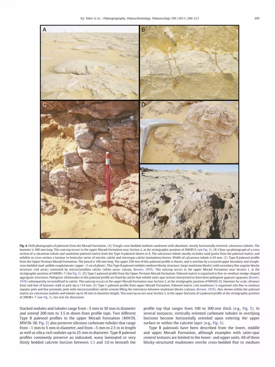
Fig. 4. Field photographs of paleosols from the Moradi Formation. (A) Trough-cross bedded medium sandstone with abundant, mostly horizontally oriented, calcareous tubules. Thehammer is 300 mm long. This outcrop occurs in the upper Moradi Formation near Section 2, at the stratigraphic position of 2MOR15 (see Fig. 3). (B) Close-up photograph of a crosssection of a calcareous tubule and sandstone paleosol matrix from the Type A paleosol shown in A. The calcareous tubule mostly excludes sand grains from the paleosol matrix, andexhibits in cross section a laminar to lenticular series of micritic calcite and microspar calcite laminations/lenses. Width of calcareous tubule is 63 mm. (C) Type B paleosol profilefrom the Upper Permian Moradi Formation. The pencil is 140 mm long. The upper 250 mm of this paleosol profile is shown, and is overlain by a scoured upper boundary and trough-cross beddedmud–pebble conglomerate (upper ~5 cm of photo). This Type B paleosol exhibits medium blocky structure (largemudstone blocks) with secondary fine angular blockystructure (red areas) cemented by microcrystalline calcite (white areas; calcans, Brewer, 1976). This outcrop occurs in the upper Moradi Formation near Section 1, at thestratigraphic position of UMOR1-7 (See Fig. 3). (D) Type C paleosol profile from the Upper PermianMoradi Formation. Paleosol matrix is organized in fine-to-mediumwedge-shapedaggregrate structures. Pedogenic slickensides in this paleosol profile are lined by calcite that exhibit satin-spar texture interpreted to have been pedogenic gypsum (gypsans; Brewer,1976) subsequently recrystallized to calcite. This outcrop occurs in the upper Moradi Formation near Section 3, at the stratigraphic position of MW20-25. Hammer for scale; distancefrom mid-line of hammer stalk to pick-tip is 114 mm. (E) Type C paleosol profile from upper Moradi Formation. Paleosol matrix (red mudstone) is organized into fine to mediumangular peds and fine prismatic peds with microcrystalline calcite cement filling the interstices between mudstone blocks (calcans; Brewer, 1976). Also shown within the paleosolmatrix are calcareous nodules and tubules up to 38 mm in diameter/length. This outcrop occurs near Section 3, in the upper horizons of a paleosol profile at the stratigraphic positionof 2MOR1-7 (see Fig. 3). See text for discussion.
205N.J. Tabor et al. / Palaeogeography, Palaeoclimatology, Palaeoecology 299 (2011) 200–213
Stacked nodules and tubules range from ~5 mm to 30 mm in diameterand extend 200 mm to 3.5 m down from profile tops. Two differentType B paleosol profiles in the upper Moradi Formation (MW39,MW36-38; Fig. 3) also preserve siliceous carbonate tubules that rangefrom ~1 mm to 5 mm in diameter, and from ~5 mm to 2.5 m in lengthas well as silica-rich nodules up to 25 mm in diameter. Type B paleosolprofiles commonly preserve an indurated, wavy laminated or verythinly bedded calcrete horizon between 1.1 and 3.0 m beneath the
profile top that ranges from 100 to 300 mm thick (e.g., Fig. 5). Inseveral instances, vertically oriented carbonate tubules in overlyinghorizons become horizontally oriented upon entering the uppersurface or within the calcrete layer (e.g., Fig. 5).
Type B paleosols have been described from the lower, middleand upper Moradi Formation, although examples with satin-sparcement textures are limited to the lower- and upper units. All of theseblocky-structured mudstones overlie cross-bedded fine to medium

Fig. 5. Diagrams of paleosol types described from the upper Moradi Formation. Drawn here are: a Type A paleosol profile from Section 2 (stratigraphic position of 2MOR16, 17), aType B paleosol profile from Section 1 (stratigraphic position of UMOR1-7), and a Type C paleosol profile Section 3 (stratigraphic position of MW20-25). Refer to Fig. 3 for thestratigraphic position of these profiles. Legend explains the icons and codes used to represent sedimentary and pedogenic structures, lithology and paleosol horizons. See text forfurther discussion.
206 N.J. Tabor et al. / Palaeogeography, Palaeoclimatology, Palaeoecology 299 (2011) 200–213
sandstones, finely laminated siltstones or laminated mudstones andare overlain by either (1) bedded conglomeratic mudstones that donot appear to have scoured the upper surface of the paleosol profile or(2) trough cross-bedded sandstones which locally scour the uppersurface of the profile (Figs. 3 and 5). Type B paleosols have been tracedlaterally for distances up to 0.9 km without any significant change intheir overall morphology.
Petrographic inspection of Type B paleosol matrix reveals thatmicritic and microspar carbonate cements are concentrated upon thesurfaces of fine to very fine mudstone blocks (e.g., Fig. 7D), but thatmicrite cement also becomes more diffuse toward the centers of theblocks. Carbonate nodules and tubules are composed of clotted, darkbrown concentric rings of micritic calcite, some of which containcalcite-spar-filled septarian cracks. Silicic calcareous tubules andnodules are composed of length-slow chalcedony that has isomor-phically replaced sparry calcite crystals (Fig. 7C). In addition,calcareous structures with satin-spar fabric are composed of fibrouscarbonate bisected by a medial scar. In polarized light, the mudstoneblocks are composed primarily of opaque clay-size material and silt-size quartz and feldspar grains that preserve Fe-oxide-rich crustsupon their exteriors (Fig. 7D).
X-ray powder diffraction peaks near 3.03 Å indicate that allcarbonate in Type B paleosols is low-Mg calcite (e.g., Fig. 6B). X-ray
diffraction spectra of oriented aggregates from the b2 μm fraction of allthese mud-rich paleosol profiles include 10 Å peaks in all treatments,which corresponds to the d(001) peak of Illite (e.g., Fig. 6E). In addition,there is a 12 Å peak observed in b2 μm fraction samples after K+
saturation at 25 °C which collapses to 10 Å after 2 h heating at 500 °Cand a ~14.5 Å peak after Mg2+ saturation that expands to ~18 Å afterglycerol solvation (e.g., Fig. 6E). This behaviour indicates that the peakcorresponds to the d(001) of smectite. One sample from the upper layerof a Type B paleosol (MW 30; Fig. 3) exhibits a broad and low ~7.2 ÅpeakwithK+ saturation that collapses after 2 h heating at 500 °C,whichindicates thepresence of kaolinite. Finally, a ~9.35 Åpeak that is presentin all treatments (Fig. 6E), which indicates the presence of talc(Mg3Si4O10(OH)2), occurs only in those Type B paleosols which alsopreserve satin-spar carbonate texture. However, the occurrence of talcwithin these profiles appears to be limited to discrete layers within theprofiles, for example, 22–30 cmbeneath the topof profile LMOR1-7, andin the upper 1.15 m of profile UMOR1-7 (Table 1).
4.3. Description of Type C paleosol morphology
Type C paleosols consist of 0.9 to 2.1 m thick weak red to red(Munsell Colors 10R4/3 to 10R 5/6) mudstone units that exhibitwedge-shape aggregate structures (Fig. 5) within layers interpreted

Fig. 6. X-ray diffractograms from paleosol samples collected in the Moradi Formation. (A) X-ray spectrum of a powder mount from a sandstone-dominated Type A paleosol that wassampled from Section 3, in the middle Moradi Formation, at the stratigraphic level of MW9 (see Fig. 3). (B) X-ray spectrum of a powder mount from a mudstone-dominated Type Bpaleosol that was sampled from Section 1, in the upper Moradi Formation, at the stratigraphic level of UMOR1-7 (see Fig. 3). (C) X-ray spectra from the b2 μm e.s.d. fraction of aType B paleosol from Section 1, in the lower Moradi Formation, at the stratigraphic position of LMOR1-7. (D) X-ray spectra from the b2 μm e.s.d. fraction of a Type C paleosol fromSection 2, in the upper Moradi Formation, at the stratigraphic position of 2MOR1-7. (E) X-ray spectra from the b2 μm e.s.d. fraction of a Type C paleosol from Section 3, in the upperMoradi Formation, at the stratigraphic position of MW30,31. For C–E, black line corresponds to Mg2+-saturated samples, green line corresponds to Mg2+-saturated and glycerol-solvated samples, orange line corresponds to K+-saturated samples analyzed after drying at 25 °C, and red line corresponds to K+-saturated samples analyzed after heating at 500 °Cfor 2 h. See text for discussion.
207N.J. Tabor et al. / Palaeogeography, Palaeoclimatology, Palaeoecology 299 (2011) 200–213
to have been subsurface B horizons. These wedge-shape aggregatesare up to 300 mm wide and are bound by slickensides that define awavy upper boundary within the soil profile. The mudstones abovethe wavy boundary are composed of medium and fine (5–20 mm)angular blocks and medium-sized (20–50 mm) prismatic blocks withsecondary medium-sized angular blocky structure (Fig. 5). Inaddition, the upper blocky layers commonly exhibit verticallyoriented silt- and sand-filled dikes that are as much as 40 mm wideat the top and taper downward to approximately 400 mm depth(Fig. 5). While the upper 150 to 300 mm of these profiles isnoncalcareous, carbonate nodules and concretions ranging from afew mm to ~50 mm in diameter are common (5–20% by volume) toabundant (N20%) in lower layers, and they generally become larger
downward. Two examples of Type C (2MOR1-7, MW21-25; Fig. 3)paleosols preserve calcareous cements with satin-spar fabric (similarto that observed in some Type B paleosols) along slickenplanes(Fig. 4D) and around platy structures beneath the horizons withslickensides. Type C paleosols are limited to upper Moradi Formationstrata. They occur only within red mudstones and are commonlyoverlain by sandstones and conglomerates (e.g., Figs. 3 and 5) andhave been traced laterally for distances up to 0.9 km without anysignificant change in their overall morphology.
Petrographic inspection of Type C paleosol matrix reveals thepresence of carbonate-filled circumgranular cracks (Fig. 7D). Carbon-ate nodules are primarily composed of micrite, but also includemicrospar- and sparite-filled veins. Calcareous structures with satin-

Fig. 7. Photomicrographs of Moradi Formation paleosols. (A) Photomicrograph of a rip-up mud-ball aggregate imaged with crossed nichols polarization from Section 2, in the middleMoradi Formation, at the stratigraphic level of 2MOR13 (see Fig. 3). (B) Plane-light photomicrograph of a calcareous tubule sampled from a Type A paleosol in Section 2, in the upperMoradi Formation, at the stratigraphic level of 2MOR15 (see Fig. 3). (C) Photomicrograph with crossed nichols polarization of length-slow chalcedony that has replaced pre-existingcalcite spar in a calcareous tubule from a Type B paleosol in Section 3, in the upper Moradi Formation, at the stratigraphic level of MW39 (see Fig. 3). (D) Photomicrograph ofmicrospar cements under crossed nichols polarization from a Type B paleosol in Section 1, in the upper Moradi Formation, at the stratigraphic level of UMOR1-7. See text fordiscussion.
Table 1Mineralogy of b2 μm equivialent spherical diameter (e.s.d.) fraction from paleosols inthe Moradi Fm.
Sample Section Position instratigraphy
Level(m)
Paleosol type Mineralogya
LMOR2 1 Lower N/A B Sm, IlLMOR3 1 Upper N/A B Sm, IlLMOR4 1 Upper N/A B Sm, IlLMOR5 1 Upper N/A B Sm, IlLMOR7 1 Upper N/A B Tal, Il, SmLMOR8 1 Upper N/A B Sm, IlUMOR2 1 Upper 14.5 B Sm, IlUMOR3 1 Upper 14.8 B Sm, Il, TalUMOR4 1 Upper 14.9 B Sm, Il, TalUMOR6 1 Upper 15.1 B Sm, Il, TalUMOR7 1 Upper 15.25 B Sm, Il, Tal2MOR1 1 Upper 0.1 C Sm, Il2MOR2 1 Upper 0.25 C Sm, Il2MOR3 2 Upper 0.35 C Sm, Il2MOR5 2 Upper 0.5 C Sm, Il2MOR6 2 Upper 0.7 C Sm, Il, Tal, KFossil1 3 Upper 40.1 B Sm, IlMW17 3 Upper 50.1 B Sm, IlMW21 3 Upper 64.3 C Sm, IlMW22 3 Upper 64.5 C Sm, IlMW23 3 Upper 64.6 C Sm, IlMW25 3 Upper 64.7 C Tal, Sm, Il, KMW30 3 Upper 81 B Tal, Sm, K
a Sm= Smectite, Il = Illite; mica-like mineral, K = kaolinite, Tal = talc. The order ofthe reported clay minerals corresponds to decreasing values of area under thebackground subtracted X-ray diffraction peak for the d(001) reflection angle of theparticular mineral, which is considered to be an approximation of relative amounts ofthe mineral within the sample.
208 N.J. Tabor et al. / Palaeogeography, Palaeoclimatology, Palaeoecology 299 (2011) 200–213
spar fabric are composed of fibrous carbonate bisected by a medialscar. In polarized light, the mudstone blocks are composed primarilyof opaque clay-size material and silt-size quartz and feldspar grainsthat preserve Fe-oxide-rich crusts upon their exteriors (Fig. 7D). X-raypowder diffraction peaks near 3.03 Å indicate that all carbonates inType B paleosols are low-mg calcite (e.g., Fig. 6B). X-ray diffractionspectra of oriented aggregates from the b2 μm fraction of all thesemud-rich paleosol profiles include 10 Å peaks in all treatments, whichcorresponds to the d(001) peak of Illite (e.g., Fig. 7B). In addition,there is a ~12 Å peak with K+ saturation at 25 °C which collapses to10 Å after 2 h at 500 °C and a ~14.5 Å peak with Mg2+ saturationwhich expands to ~18 Å with Mg2+ saturation and glycerol solvation(e.g., Fig. 7B) in all samples. This behavior indicates the presence ofsmectite in all Type C paleosols. Two samples (2MOR6, MW25), bothfrom the upper 10 cm of Type C paleosols (Fig. 3) exhibit broad andlow ~7.2 Å peaks with K + saturation that collapses after 2 h heatingat 500 °C, which indicates the presence of kaolinite. Finally, the sametwo samples that contain kaolinite (2MOR6, MW25) also exhibit a~9.35 Å peak in all treatments, which indicates the presence of talc.
5. Paleosol interpretation
Paleosol morphologies, mineralogy, petrographic textures andfabrics among the three different types of paleosols are used to classifyeach type of paleosol according to the paleosol taxonomy of Macket al. (1993). For each paleosol type we also consider the closestestimated soil taxon within the context of the USDA Soil ClassificationSystem (Soil Survey Staff, 1975, 1996). Paleosols assigned to each
209N.J. Tabor et al. / Palaeogeography, Palaeoclimatology, Palaeoecology 299 (2011) 200–213
Order are interpreted as being the product of similar soil-formingenvironments in which local and regional processes combined toproduce a distinctive weathering profile.
5.1. Paleosol morphology and petrography
The calcareous tubules observed in Type A, and calcareous tubulesand vertically stacked nodules observed in Type B paleosol profiles,are interpreted to be rhizoliths. This interpretation reflects theirmorphological and mineralogical similarity to rhizoliths describedfrommodern soils and paleosol occurrences elsewhere (e.g., Blodgett,1988; Klappa, 1979, 1980; Loope, 1980; Smith, 1990). The discretecalcareous nodules and concretions that occur rarely in Type A,and commonly to abundantly in Type B and Type C paleosols, areinterpreted to be equivalent to Machette's (1985) Stage II pedogeniccarbonate accumulations resulting from translocation of Ca2+ ionthrough the soil to the depth of wetting (Machette, 1985; McFaddenand Tinsley, 1985). The sharp boundary between the carbonatecements and siliciclastic-rich paleosolmatrix surrounding the nodulesand concretions may arise from (1) fracturing of a pre-existingcalcareous rhizolith in the soil and/or (3) reworking of the calcitecements through wetting–drying, and shrink–swell cycles, in the soilprofiles (e.g., Brewer, 1976). Given that silica in the calcareous tubulesand nodules from some Type B paleosols appears to isomorphicallyreplace sparry calcite, and that sparry calcite is not typical ofpedogenic carbonate (e.g., Deutz et al., 2001, 2002; Klappa, 1980;Wright, 1990), but rather appears to more commonly result fromrecrystallization of finer material after burial, we interpret the silica inthese tubules to have replaced sparry calcite at some time after burial,and therefore the occurrence of silica within these paleosols offers noinsights to Permian pedogenesis in the Tim Mersoi Basin.
Themassive structure to highly disturbed sedimentary structure inType A paleosols probably reflects its well-sorted sand parentlithology. Soil profiles dominated by detrital sands seldom exhibitsoil structures because they lack the finely crystalline material,shrink–swell capacity, and cohesivity that is necessary to form well-developed peds (e.g., Buol et al., 1997). Pedogenesis in these sandysoil profiles characteristically obliterates primary sedimentary struc-tures and develops the “single-grain structure” (Buol et al., 1997) or“massive” structure (Boggs, 2001). It is important to note, however,that single grain structure need not imply a short duration ofpedogenesis (e.g., Choudhari, 2008; Hugget, 1998; Lichter, 1998),nor is what sedimentologists refer to asmassive structure only formedby pedogenesis. The large volumes of pedogenic calcite that are locallyconcentrated in some Type A paleosol profiles suggests thatpedogenesis may have persisted for hundreds or thousands of years(e.g., Gile, 1966; Machette, 1985). The blocky and prismaticmudstones in Type B and Type C paleosol profiles are interpreted tobe pedogenically-produced structures that result from episodicwetting-and-drying, and corresponding volume changes of soilmaterial under low confining pressure, whereas the wedge-shapeaggregate structures, and slickenplanes defining them, are interpretedto have formed by repeated moisture-induced shrink–swell cyclesunder higher confining pressures (Buol et al., 1997; Schaetzel andAnderson, 2005).
Microcrystalline and microspar carbonate coatings of the pedsurfaces are interpreted to be accumulations of calcite that formedduring Permian soil formation. Similar structures, named “calcans” or“calcitans” (e.g., Brewer, 1976), form in modern soils with torric toaridic soil moistures regimes via translocation of Ca2+ ion through thesoil fromweathering of primaryminerals and dissolution of carbonateminerals in overlying horizons (McFadden and Tinsley, 1985). Torricand aridic soil moisture regimes correspond to soil profiles with a soilmoisture control section (texturally dependent) that are (1) dry in allparts for more than half of the cumulative days per year when the soiltemperature at depth of 50 cm from soil surface is above 5 °C; and
(2) moist in some or all parts for less than 90 consecutive days whenthe soil temperature at a depth of 50 cm is above 8 °C (USDA SoilTaxonomy, 1975, 1996). Although petrography and XRD analysis ofthe carbonates with satin-spar texture in some Type B and Type Cpaleosols do not indicate the presence of gypsum, this fabric is one thatis so characteristic of gypsum (e.g., Collins, 1984) that we interpretthem to have been pedogenic gypsum that accumulated upon thesurface of soil peds (gypsans; Brewer, 1976) and was subsequentlyisomorphically replaced by calcite some time after burial.
5.2. Clay mineralogy of Moradi Formation paleosol profiles
Moradi Formation paleosols contain the phyllosilicate mineralsillite, smectite, kaolinite and talc. Illite is a common detrital mineral insedimentary strata and is particularly common in soil profilesdeveloped in alluvium (Southard and Miller, 1966; Yemane et al.,1996). Therefore, the illite in all the paleosol samples (Table 1) isprobably inherited from the soil parent material. It is also possible forsmectite to be inherited from the parent material (Southard andMiller, 1966; Wilson, 1999), but in this case it probably representseither a weathering product that formed from hydrolytic breakdownof primary minerals in the watershed or a pedogenic mineral thatformed in-situ. Either way, the presence of smectite in MoradiFormation paleosol profiles is interpreted as indicative of poorlydrained lowlands in the Tim Mersoi Basin under seasonal monsoonalclimate. Smectite derived from weathering would indicate anenvironment with relatively low water:rock ratios and base-richreactants which leads to favorable chemical conditions for smectitecrystallization being high pH, high silica activity and an abundance ofbasic cations in solution.
Kaolinite may also be present in soil profiles as a result ofinheritance from parent material (Southard and Miller, 1966).However, where present in the Moradi Formation, the kaolinite islimited only to the upper 30 cm of paleosol profiles, suggesting that itis somehow related to a pedogenic process. Soil profiles that aredominated by kaolinte in the phyllosilicate mineral fraction aretypically associated with environments characterized by intensechemical weathering of soil materials in stable landscapes underwarm, humid conditions (Wilson, 1999). Nevertheless, kaolinite mayoccur as an auxiliary phyllosilicate in the most intensively weatheredupper layers of well-drained soil profiles in most climatic settings(Tabor et al., 2002; Yemane et al., 1996). Therefore, the occurrence ofkaolinite in the horizons of Type B and Type C paleosols in the MoradiFormation is not surprising, and indicates well-drained conditions insome of the soils across some parts of the Tim Mersoi Basin duringPermian time.
The occurrence of talc in these paleosols is unusual, as this mineralis typically associated with greenschist facies metamorphic terranesand hydrothermal alteration products along shear zones that developin carbonate rocks (Friedman, 1965). Fluid inclusion studies indicatebrine migration through parts of the Carboniferous strata in the TimMersoi Basin at temperatures ranging from 85 to 175 °C (Pagel et al.,2005), much lower than conditions necessary for greenschist-faciesmetamorphism. In addition, talc may occur as a detrital mineral in soilprofiles (Léveillé et al., 2000; Singer, 1979). This possibility seems areasonable explanation for the Moradi Formation paleosols, consid-ering that the Aïr Mountains, a regional source of sediments for theTim Masoi Basin, contains both talc and pyrophyllite (Davis, 1999).However, talc in the Moradi Formation is limited only to paleosolhorizons with evidence for gypsum accumulation (as indicated by thepresence of calcite with satin-spar texture) and its stratigraphic andspatial distribution in the Moradi Formation is too restricted tosupport a detrital origin. Therefore, we suspect the rare presence oftalc in Moradi paleosols must be somehow related to pedogenesis.
Talc has never been demonstrated to be a direct product ofpedogenesis (e.g., Wilson, 1999; but see also Noack et al., 1986). In
210 N.J. Tabor et al. / Palaeogeography, Palaeoclimatology, Palaeoecology 299 (2011) 200–213
fact, stratiform talc occurrences are typically no younger thanPaleozoic (Noack et al., 1986; but see also Bradley, 1964). Severalspectroscopic and oxygen isotope studies of ancient stratiform talcindicate a low temperature (as low as 30–100 °C) origin that derivesfrom diagenetic alteration of pre-existing Mg-rich phyllosilicateminerals (Bradley, 1964; Noack et al., 1986) such as sepiolite(Mg4Si6O15(OH)2•6H2O), stevensite ((Ca,Mg)XMg6Si8O20(OH)4•nH2O),saponite (Na0.3Mg3(SiAl4O10(OH)2•nH2O)) or possibly palygorskite(Mg,Al)5(Si,Al)8O20(OH)2•8H2O, all of which have been reported asauthigenic minerals in modern aridosols characterized by highly salinesoil solutions with a pH N8.5 (e.g., Calvo et al., 1999; Wilson, 1999). Wethink this scenario best explains the occurrence of talc in the MoradiFormation paleosol profiles, because (1) the co-occurrence of talc withsatin-spar calcite textures, a likely replacement of original pedogenicgypsum, is suggestive of saline soil solutions and (2) pedogenic calcitein the profiles indicates alkaline solution pH (N8) that likely wouldhave been conducive to crystallization of Mg-rich phyllosilicates, which(3) encountered appropriate burial temperatures for diagenetic trans-formation to talc. Therefore, we interpret talc in the Moradi Formationpaleosol profiles to be a diagenetic alteration product of a Mg-richphyllosilicate (probably sepiolite). Furthermore, considering the distri-bution ofmodern soils that containMg-richphyllosilicates,we interpretthose Type B and Type C paleosol profiles that contain talc to haveundergone pedogenesis in an arid to hyper-arid climate.
5.3. Type A paleosol classification and environmental interpretation
Considering their lack of soil structure and evidence for pedogeniccarbonate accumulation around rooting structures, Type A paleosolprofiles are classified as calcic Protosols (Mack et al., 1993) androughly correspond to the range of characteristics observed in theUSDA Soil Taxonomy soil orders Entisols and some suborders ofInceptisols and Aridisols (Soil Survey Staff, 1996). The distribution ofProtosols in the Moradi Formation indicates that sedimentationwithin these parts of the basin ceased long enough for colonizationby terrestrial flora (Buol et al., 1997). This terrestrial flora presumablyallowed, in turn, for colonization by a tetrapod fauna (e.g., Sidor et al.,2005).
The close association of the calcic Protosols with well-sorted,trough-cross bedded sandstone (e.g., Figs. 3 and 4A) suggests thatthese soils developed within abandoned or ephemeral fluvialchannels which may have been subject to scour and burial duringinfrequent flash-flood episodes. This “flashy” flow hypothesis is alsosuggested by the taphonomy of the Moradi fauna: fifteen disarticu-lated skeletons of large herbivourous reptiles (belonging to theendemic pareiasaur Bunostegos) dip gently towards a channel axis andmay have been deposited with sediments from an ephemeral flashflood (Smith et al., 2009).
Soil development in such unstable parts of the landscape has beendocumented in ephemeral, anabranching river systems inmodern-daynortheastern semi-arid (Fielding and Alexander, 2001), and centralarid (Tooth and Nanson, 2000) regions of Australia. In both instances,strongly seasonal distribution of precipitation causes extreme varia-tions in river flow. Extended periods of minimal flow permitspecialized woody trees to colonize and mature within the channelas clusters or groves. This life habit (1) enhances the ability of the groveto withstand periodic inundation by high-energy flows (2) permitsphreatophytes in extremely arid climates to take advantage of themost readily available, and often most shallow, source of fresh waterthat flows through the sandy channel-fill sediments (Camporealeet al., 2006; Laity, 2007), and (3) when the river is aggrading its bed, itenhances the preservation potential of root systems. Similar paleosolprofiles that preserve calcareous rhizoliths in fluvial channel sand-stones and siltstones have been described from Lower and UpperPermian strata of Australia (Fielding and Alexander, 2001), LowerPermian strata of Utah (Tabor et al., 2007), and Upper Triassic strata of
Argentina (Tabor et al., 2006). Based upon analogousmodern soils, weherein interpret calcic Protosols in the Moradi Formation to representsoil formation within the channels of an ephemeral fluvial systemcharacterized by long-term low-flow conditions.
5.4. Type B paleosol classification and environmental interpretation
The abundance of carbonate in Type B paleosols, in conjunctionwith well-developed pedogenic structure, indicates they are Calcisols,whereas profiles that also preserve satin-spar gypsum texturesbetween peds are classified as gypsic Calcisols (Mack et al., 1993).Similarmorphologies in the USDA Soil Taxonomy occurwithin the soilOrders Inceptisols, Mollisols and Aridisols (Soil Survey Staff, 1996).The most important pedogenic process in the formation of Type Bpaleosols is the accumulation of carbonate minerals, which occurswhen meteoric precipitation which percolates through the soil issubstantially less than soil moisture removed via evapotranspiration(e.g., Arkley, 1963; Jenny, 1941), and is typical of regions character-ized by low annual rainfall. For example, carbonate is not commonlyprecipitated in soil profiles with mean annual rainfall in excess of~750 mm/year (Royer, 1999), whereas gypsum is not retained in thesoil profile if rainfall exceeds ~300 mm/year (Watson, 1992).
The position of the laminated- to thinly-bedded calcrete horizonsnear the base of some Type B paleosol profiles (e.g., Fig. 5), inconjunction with a change in the orientation of rhizoliths fromvertical above, to horizontal upon or within, the calcrete horizonssuggests that these calcretes accumulated along the boundary of thephreatic and vadose environments. We interpret these basal calcretehorizons to provide an approximate position of the groundwater tablefor most of the year, and therefore conclude that the local to regionalgroundwater was quite shallow, commonly less than a meter beneaththe land surface, over large areas of the Tim Mersoi Basin during Midto Late Permian times. Modern soils of Australia and southern Africaforming in arid climates with a relatively shallow water table (b5 m)develop a similar calcareous B horizon (e.g. Semeniuk, 1981, 1985;Watson, 1992).
Calcisols and their modern soil equivalents represent relativelylong intervals of stability upon the landscape, because significantamounts of time are required to translocate Ca2+ ion, and accumulatecarbonate, in silicate-hosted soils (e.g., Gile, 1966; Machette, 1985).The presence of nodular calcite in these paleosols suggests longperiods of pedogenesis (between 1000 and 10,000 years) in areas ofthe flood plain removed from frequent overbank deposition (Gileet al., 1981). As such, Type B paleosols are interpreted to representrelatively old soils that were spatially removed from the depositionaleffects of major rivers and streams. In addition, the morphology ofthese profiles, in conjunction with mineralogical evidence forpedogenic Mg-phyllosilicates within them, suggests that they likelyformed under semi-arid or hyper-arid climatic conditions, within awell-drained part of the basin yet with a relatively shallow ground-water system such as may be found on the slightly elevated inter-fluves that ran parallel to the major river channels.
5.5. Type C paleosol classification and environmental interpretation
The abundance of shrink–swell and desiccation features, inconjunction with the presence of calcite nodules in the subsurfacehorizons of Type C paleosols indicates they are calcic Vertisols (Macket al., 1993). Alternatively, the profile that also preserved evidence forgypsum accumulation may be classified as gypsic calcic Vertisols(Mack et al., 1993). Similar morphologies in the USDA Soil Taxonomyoccur within the soil Order Vertisols. In spite of the specificclassification used for these paleosols, the dominant pedogenicprocess in the formation of Vertisols is shrinking and swelling ofexpansible 2:1 phyllosilicate clays (i.e., smectite) through repeatedwetting and drying cycles in climates with seasonal precipitation and/
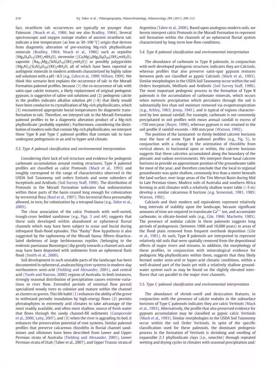
Fig. 8. Plot of rainfall (blue lines) and temperature (red lines) versus month overnorthern Niger as predicted from recently published results from recent generalcirculation models for Permian time (Poulsen et al., 2007; Peyser and Poulsen, 2008;solid lines) and historical synoptic data (dashed lines). This comparison shows thatmodern northern Niger receives substantially greater annual rainfall than thatpredicted for Permian time. This comparison also highlights differences in theseasonality of rainfall and temperature between modern and Permian northernNiger, which is attributed primarily to the paleogeographic position, ~20° south of thepaleoequator, during Permian time. Model-based estimates of Permian precipitation–evapotraspiration suggest this region was among the most arid upon Permian Earth.See Text.
211N.J. Tabor et al. / Palaeogeography, Palaeoclimatology, Palaeoecology 299 (2011) 200–213
or fluctuating water table (Wilding and Tessier, 1988). Therefore, it islikely that Type C paleosols underwent seasonal episodic wetting anddrying from flooding and/or heavy precipitation.
While pedogenic carbonate accumulation in most soil typescorresponds to relatively low mean annual rainfall (e.g., ~750 mm/year; Royer, 1999), Vertisols appear to retain carbonate in the soilprofile under considerably greater mean annual rainfall (~1500 mm/year; Nordt et al., 2006) due to the very high concentration of basecations, and Ca2+ in particular, in these profiles. Furthermore, thepresence of nodular calcite in these paleosols suggests long periods ofpedogenesis (between 1000 and 10,000 years) in areas of the floodplain removed from frequent overbank or eolian deposition (Gileet al., 1981) such as on the plains surrounding playas or sabkhas. Inaddition, given the presence of calcite nodules, the possibility ofpedogenic gypsum accumulation and mineralogical evidence forpedogenic mg-phyllosilicate in the upper layers of these paleosols,we interpret these profiles to have likely formed under semi-arid tohyperarid climatic conditions characterized by strongly seasonalmonsoonal rainfall.
6. Summary and conclusions
Paleosol profiles in the Middle–Upper Permian Moradi Formationof the Tim Mersoi Basin, Niger include (1) calcic Protosols, (2)Calcisols and gypsic Calcisols, and (3) calcic Vertisols and gypsic calcicVertisols. As mentioned earlier, each of these paleosol morphologies,and their mineralogy, provide persuasive evidence for pedogenesisunder dry, semi-arid to hyper-arid climate. Comparison of thepedogenic gypsum and mg-phyllosilcates within the Moradi paleosolprofiles with similarmodern soil profiles in arid zones of Australia andsouthern Africa indicate precipitation was likely less than 300 mm/year (e.g., Calvo et al., 1999; Watson, 1992). Furthermore, based uponthe spatial and stratigraphic distribution of paleosol profiles, there islittle evidence for any significant shifts from “arid” in the overallclimate history of the Moradi succession.
Significantly, the paleogeographic position upon which the TimMersoi Basin resided during Permian time is suspected to have beenamong the driest on the Pangean landmass as a result of a powerfulsouthern-hemisphere monsoon circulation (the “Megamonsoon”;Kutzbach and Gallimore, 1989; Parrish, 1993; Peyser and Poulsen,2008). General circulation models also predict that Permian climateover the Tim Mersoi Basin was characterized by extreme seasonalityin rainfall (Gibbs et al., 2002; Patzkowsy et al., 1991), and was amongthe driest (b100 mm/year precipitation) and hottest (30–35 °C meanannual temperature) landscapes on Pangea (Peyser and Poulsen,2008; Poulsen et al., 2007; see also Fig. 8). Our paleoclimaticinterpretation of Moradi paleosols is generally consistent withenvironmental predictions from these conceptual and quantitativeclimate models. However, the current database of climate-sensitivelithologies and paleosol morphologies from the Moradi Formationpresented herein is qualitative, and we are not able to quantify withprecision from these indicators just how dry the landscapes of the TimMersoi Basin were in the Mid- to Late Permian.
Morphological variability of soils across the arid Moradi landscapeare most likely attributed to conditions other than regional climatechange, such as differences in lithology of the alluvium, and depth ofthe groundwater table beneath the surface. Both these factors areinfluenced by position in the basin and proximity to the axial drainagesystem.
Sedimentary facies within theMoradi Formation include (1)minorcoarse-grained pebbly sandstones, conglomerates and breccias de-posited on alluvial fans, (2) common fluvial channel sandstonesdeposited in axial rivers, (3) commonmudrock-dominated floodplainand crevasse splay sequences (4) rare playa mudstones withlaminated carbonates and (5) rare eolian sand dunes (Joulia, 1959;Wright et al., 1993). Our recent fieldwork suggests that only facies
(1) through (4) are represented among the three stratigraphicsections, and only facies (1) through (3) preserve paleosol profiles.
Based upon the sporadic distribution of calcareous root structuresand their preferred vertical orientation in the upper horizons of theType A calcic Protosols which are closely associated with well-sortedtrough cross-bedded sandstone, these rhizolith concentrations areinterpreted to represent groves of phreatophytic trees and shrubs thatgrew within anabranching ephemeral stream channels. We considerthese paleosols and their host channels to have been the main, albeitephemeral, conduits of hydrological flow and sediment transportthrough the Tim Mersoi Basin during the Permian.
Type B Calcisols and gypsic Calcisols developed within fine-grained sediments, and development of angular blocky to prismaticstructure, calcans, gypsans, and stacked carbonate nodules indicatethese paleosols were mature, well-drained, soils that were distantfrom depocenters such as the ephemeral streams and lakes. Weconsider these paleosols and their host deposits to have developedupon slightly elevated interfluvial plains that were above the directinfluence of the regional water table. However, the evidence forgroundwater calcretes at the bases of some of these Type B paleosolssuggests that groundwater was at times quite shallow; between 1 and2.5 m beneath the soil surfaces.
Type C calcic Vertisols and gypsic calcic Vertisols developed withinfine-grained sediments as well, but abundant evidence for shrink–swell structures in these paleosol profiles suggests that they were, atleast seasonally, more poorly drained than Calcisols and gypsicCalcisols forming within the same basin. We consider this differencein paleosol structure, and the perceived difference in drainage, toindicate that Vertisols occupied a lower, more poorly drained positionon the landscape including interfluvial plains proximal to ephemeralstreams and areas surrounding ephemeral water bodies such as playasand possibly sabkhas.
A remarkable aspect of the paleosol profiles from the MoradiFormation is that, in spite of abundant proxy data for an arid climate,there is also a significant amount of proxy data to indicate that waterwas available in abundance, at least intermittently, in ephemeral

212 N.J. Tabor et al. / Palaeogeography, Palaeoclimatology, Palaeoecology 299 (2011) 200–213
streams, shallow groundwater reservoirs and ephemeral lakes. Fossilamphibians from the Moradi Formation (e.g., the temnospondylsSaharastega and Nigerpeton) likely colonized these ephemeral watersources, as they depended on water for reproduction, as do modernfrogs living in northern (arid) Niger today (e.g., Rödel, 2000).
These conditions are similar to those of the “wet desert” depositsin the Permian northern hemisphere in Europe (Brookfield, 2000;Frederiksen et al., 1998). It is reassuring that like the work presentedherein, Brookfield (2000) also used the modern environments ofDeath Valley, California as a close modern analogue to support thatstudy's interpretation of a Permian “wet desert” in Scotland.
Acknowledgements
We are indebted to the Niger Ministry of Mines and Energy(Niamey, Niger) for access to the field sites and permitting thecollection of samples for laboratory analysis. We thank StephanieThomas (SMU) for assistance in the field. Mary Milleson (SMU)helped with X-ray diffraction analyses of clay samples. Professor FinnSurlyk served as editor for this manuscript, and Professors StevenDriese (Baylor University) and Paul McCarthy (University of AlaskaFairbanks) reviewed an earlier version of this manuscript. This projectwas supported by the National Science Foundation grant NSF-EAR0617250 to N.J. Tabor and C.A. Sidor as well as NSF-EAR 0545654 to N.J.Tabor and C.J. Poulsen.
References
Arkley, R.J., 1963. Calculation of carbonate and water movement in soil from climaticdata. Soil Science 96, 239–248.
Blakey, R.C., 2007. Carboniferous–Permian palaeogeography of the Assembly of Pangae.In: Wong, Th.E. (Ed.), Proceedings of the XVth International Congress onCarboniferous and Permian Stratigraphy. Utrecht, 10–16 August 2003. RoyalDutch Academy of Arts and Sciences, (Amsterdam), pp. 443–456.
Blodgett, R.H., 1988. Calcareous paleosols in the Triassic Dolores Formation,southwestern Colorado. Geological Society of America Special Paper 216, 103–121.
Boggs Jr., S., 2001. Principles of Sedimentology and Stratigraphy, 3rd Ed. Prentice Hall,New Jersey, U.S.A.. 726 pp.
Bradley, W.H., 1964. Lazurite, talc and chlorite in the Green River Formation ofWyoming. American Mineralogist 49, 881–887.
Brewer, R., 1976. Fabric and Mineral Analysis of Soils. Krieger, New York. 482 pp.Brookfield, M.E., 2000. Temporary desert lake deposits, Lower Permian (Rotliegendes)
Southern Scotland, U.K. In: Gierlowski-Kordesch, E.H., Kelts, K.R. (Eds.), Lake BasinsThrough Space and Time: AAPG Studies in Geology, 46, pp. 67–74.
Buol, S.W., Hole, F.D., McCracken, R.J., Southard, R.J., 1997. Soil Genesis andClassification. Iowa State University Press, Ames, IA. 527 pp.
Calvo, J.P., Blanc-Valleron, M.M., Rodriguez-Arandia, J.P., Rouchy, J.M., Sanz, M.E., 1999.Authigenic clay minerals in continental evaporitic environments. Special Publica-tions of the International Association of Sedimentologists 27, 129–151.
Camporeale, C., Perona, P., Ridolfi, L., 2006. Hydrological and geomorphologicalsignificance of riparian vegetation in arid lands. In: Odorico, P.D., Porporato, A.(Eds.), Dryland Ecohydrology, pp. 161–179.
Choudhari, J.S., 2008. Relationship between pedogenetic manifestations in some aridsoil and age of the landforms. Journal of Earth System Science 96, 203–210.
Collins, E.W., 1984. Styles of Deformation in Permian strata, Texas Panhandle. Bureau ofEconomic Geology Geological Circular 84-4, Austin, U.S.A. 32 pp.
Davis, E.A., 1999. Metamorphosis in the culture market of Niger. AmericanAnthropologist 101, 485–501.
Deutz, P., Montañez, I.P., Monger, H.C., Morrison, J., 2001. Derivation of a palaeoenvir-onmental record from pedogenic carbonates in buried and relict Quaternary soils,Rio Grande Rift, New Mexico. Palaeogeography, Palaeoclimatology, Palaeoecology166, 293–317.
Deutz, P., Montañez, I.P., Monger, H.C., 2002. Morphology and stable and radiogenicisotope composition of pedogenic carbonate in late Quaternary relict soils, NewMexico: an integrated record of pedogenic overprinting. Journal of SedimentaryResearch 72, 809–822.
DiMichele, W.A., Montanez, I.P., Poulsen, C.J., Tabor, N.J., 2009. Climate and vegetationalregime shifts in the late Paleozoic ice age earth. Geobiology 7, 200–226.
Fielding, C.R., Alexander, J., 2001. Fossil trees in ancient fluvial channel deposits:evidence of seasonal and longer-term climatic stability. Palaeogeography, Palaeo-climatology, Palaeoecology 170, 59–80.
Fielding, C.R., Frank, T.D., Birgenheier, L.P., Rygel, M.C., Jones, A.T., Roberts, J., 2008.Stratigraphic imprint of the Late Palaeozoic ice age in eastern Australia: a record ofalternating glacial and nonglacial climate regime. Journal of the Geological Societyof London 165, 129–140.
Frederiksen, K.S., Clemmensen, L.B., Lawaetz, H.S., 1998. Sequential architecture andcyclicity in Permian desert deposits, Brodick Beds, Arran, Scotland. Journal of theGeological Society 155, 677–683.
Friedman, G.M., 1965. Occurrence of talc as a clay mineral in sedimentary rocks. Nature207, 283–284.
Gibbs, M.T., Rees, P.M., Kutzbach, J.E., Ziegler, A.M., Behling, P.J., Rowley, D.B., 2002.Simulations of Permian climate and comparisons with climate-sensitive sediments.Journal of Geology 110, 33–55.
Gile, L.H., 1966. Morphological and genetic sequences of carbonate accumulation indesert soils. Soil Science 101, 347–360.
Gile, L.H., Hawley, J.W., Grossman, R.B., 1981. Soils and geomorphology in the Basin andRange area of southern NewMexico. Guidebook to the Desert Project: NewMexicoBureau of Mines and Mineral Resources Memoir 39. 222 pp.
Greigert, J., Pougnet, R., 1967. Essai de description des formations géologiques de laRépublique du Niger. Editions du Bureau de Recherches Géologiques et Minières,Paris. 273 pp.
Hugget, R.J., 1998. Soil chronosequences, soil development, and soil evolution: a criticalreview. Catena 32, 155–172.
Isbell, J.L., Miller, M.F., Wolfe, K.L., Lenaker, P.A., 2003. Timing of the late Palaeozoicglaciation in Gondwana: was glaciation responsible for the development ofnorthern hemisphere cyclothems? In: Chan, M.A., Archer, A.W. (Eds.), ExtremeDepositional Environments: Mega End Members in Geologic Time: GeologicalSociety of America Special Paper, vol. 370, pp. 5–24.
JCPDS International Centre for Diffraction Data, 1980. Mineral Powder Diffraction FileData Book. JCPDS, Swarthmore, Pennsylvania USA. 1168 pp.
Jenny,H., 1941. Factors of Soil Formation. Dover Publications,Minneola, NewYork. 281 pp.Joulia, F., 1959. Les Séries primaires au N et au NW de l'Aïr (Sahara central).
Discordances observées. Bulletin de la Societe Geologique de France 7, 192–196.Klappa, C.F., 1979. Calcified filaments in Quaternary calcretes; organo-mineral
interactions in the subaerial vadose environment. Journal of Sedimentary Research49, 955–968.
Klappa, C.F., 1980. Rhizoliths in terrestrial carbonates: classification, recognition,genesis and significance. Sedimentology 27, 613–629.
Kogbe, C.A., 1981. Cretaceous and Tertiary of the Iullemeden Basin in Niger (WestAfrica). Cretaceous Research 2, 129–186.
Kutzbach, J.E., Gallimore, R.G., 1989. Pangean climates: megamonsoons of themegacontinent. Journal of Geophysical Research 94, 3341–3357.
Laity, J., 2007. Aeolian destabilization along the Mojave River, Mojave desert, California:linkages among fluvial, groundwater, and aeolian systems. Physical Geography 24,196–221.
Léveillé, R.J., Fyfe, W.S., Longstaffe, F.J., 2000. Unusual secondary Ca–Mg–Carbonate–Kerolite deposits in basaltic caves, Kauai, Hawaii. Journal of Geology 108, 613–621.
Lichter, J., 1998. Rates of weathering and chemical depletion in soils across achronosequence of Lake Michigan sand dunes. Geoderma 85, 255–282.
Loope, D.B., 1980. Evidence for soil-forming episodes during deposition of the PermianCedar Mesa Sandstone of Utah. Geological Society of America Abstracts withProgram 12, 278.
Lucas, S.G., 2004. A global hiatus in the Middle Permian tetrapod fossil record.Stratigraphy 1, 47–64.
Nairn, A.E.M., Smithwick, M.E., 1976. Permian palaeogeography and climatology. In:Falke, H. (Ed.), The Continental Permian in Central,West, and South Europe. D.Reidel, Boston, pp. 283–312.
Machette, M.N., 1985. Calcic soils the Southwestern United States. Geological Society ofAmerica Special Paper 203, 1–22.
Mack, G.H., James, W.C., Monger, H.C., 1993. Classification of paleosols. GeologicalSociety of America Bulletin 105, 129–136.
McFadden, L.D., Tinsley, J.C., 1985. Rate and depth of pedogenic–carbonate accumu-lation in soils: formulation and testing of a compartment model. Geological Societyof America Special Paper 203, 23–42.
Ministère des Mines et de l'Hydraulique, Direction des Mines et de la Géologie. 1977.Afasto, Carte Géologique Echelle 1:200,000 Notice Explicative.
Moore, R.C., Reynolds, R.J., 1997. X-ray Diffraction and the Identification and Analysis ofClay Minerals. Oxford University Press. 296 pp.
Newell, A.J., Tverokhlebov, V.P., Benton, M.J., 1999. Interplay of tectonics and climate ona transverse fluvial system, Upper Permian, Southern Uralian Foreland Basin,Russia. Sedimentary Geology 127, 11–29.
Noack, Y., Decarreau, A., Manceau, A., 1986. Spectroscopic and oxygen isotopic evidencefor low and high-temperature origin of talc. Bulletin of Mineralogy 109, 253–263.
Nordt, L., Orosz, M., Driese, S., Tubbs, J., 2006. Vertisol carbonate properties in relation tomean annual precipitation: implications for paleoprecipitation estimates. Journalof Geology 114, 501–510.
Pagel,M., Cavellec, S., Forbes, P., Gerbaud,O., Vergely, P.,Wagani, I., 2005.Uraniumdepositsin the Arlit area (Niger). In: Mao, J., Bierlein, M.P. (Eds.), Mineral Deposit Research,Meeting the Global Challenge, Proceedings of the 8th SGA Meeting in Beijing, China.Society for Geology Applied to Mineral Deposits, Switzerland, pp. 303–305.
Parrish, 1982. Upwelling and petroleum source beds, with reference to the Palaeozoic.Bull. Am. Assoc. Pet. Geol. 66, 750–774.
Parrish, J.T., 1993. Climate of the supercontinent Pangaea. J. Geol. 101, 215–233.Patzkowsy, M.E., Smith, L.H., Markwick, P.J., Engberts, C.J., Gyllenhaal, E.D., 1991.
Application of the Fujita–Ziegler Palaeoclimate Model: Early Permian and LateCretaceous examples. Palaeogeography, Palaeoclimatology, Palaeoecology 86, 67–85.
Peyser, C.E., Poulsen, C.J., 2008. Controls on Permo-Carboniferous precipitation overtropical Pangaea: a GCM sensitivity study. Palaeogeography, Palaeoclimatology,Palaeoecology 268, 181–192.
Poulsen, C.J., Pollard, D., Montañez, I.P., Rowley, D., 2007. Late Palaeozoic tropicalclimate response to Gondwana deglaciation. Geology 35, 771–774.
213N.J. Tabor et al. / Palaeogeography, Palaeoclimatology, Palaeoecology 299 (2011) 200–213
Rees, P.M., Ziegler, A.M., Gibbs, M.T., Kutzbach, J.E., Behling, P.J., Rowley, D.B., 2002.Phytogeographic patterns and climate data/model comparisons. Journal of Geology110, 1–31.
Retallack, G.J., Smith, R.M.H., Ward, P.D., 2003. Vertebrate extinction across Permian–Triassic boundary in Karoo Basin, South Africa. Geological Society of AmericaBulletin 115, 1133–1152.
Ricardi-Branco, F., 2008. Venezuelan paleoflora of the Pennsylvanian–Early Permian:paleobiogeographical relationships to central and western equatorial Pangea.Gondwana Research 14, 297–305.
Rödel, M.O., 2000. Herptofauna of West Africa, Volume 1: Amphibians of the WestAfrican Savana. Chimaira, Frankfurt. 335 pp.
Royer, D.L., 1999. Depth to pedogenic carbonate horizon as a paleoprecipitationindicator? Geology 27, 1123–1126.
Schaetzel, R.J., Anderson, S., 2005. Soils; Genesis and Geomorphology. CambridgeUniversity Press, New York. 817 pp.
Schneider, J.W., Korner, F., Roscher, M., Kroner, U., 2006. Permian climate developmentin the northern peri-Tehys area—Lodève basin, French Masif Central, compared in aEuropean and Global context. Palaeogeography, Palaeoclimatology, Palaeoecology243, 92–117.
Scotese, C.R., Boucot, A.J., McKerrow, W.S., 1999. Gondwanan palaeogeography andpalaeoclimatology. Journal of African Earth Sciences 28, 99–114.
Semeniuk, V., 1981. Calcrete in Quaternary coastal dunes in southwestern Australia: acapillary-rise phenomenon associated with plants. Journal of SedimentaryPetrology 51, 47–68.
Semeniuk, V., 1985. Distribution of calcrete in Holocene coastal sands in relationship toclimate, southwestern Australia. Journal of Sedimentary Petrology 55, 86–95.
Sidor, C.A., O'Keefe, F.R., Damiani, R., Steyer, J.S., Smith, R.M.H., Larson, H.C.E., Sereno, P.C.,Ide, O., Maga, A., 2005. Permian tetrapods from the Sahara show climate-controlledendemism in Pangea. Nature 434, 886–889.
Singer, A., 1979. Palygorskite in sediments: detrital, diagenetic and neoformed — acritical review. Geologische Rundschau 68, 996–1008.
Smith, R.M.H., 1990. Alluvial paleosols and pedofacies sequences in the Permian LowerBeaufort of the southwestern Karoo basin, South Africa. Journal of SedimentaryResearch 60, 258–276.
Smith, R.M.H., Sidor, C.A., Tabor, N.J., Steyer, J.S., Chaney, D.S., 2009. Vertebratetaphonomy and ichnology of a Permian ‘wet desert’ in central Pangea.Palaeontologia Africana 44, 179–183.
Soil Survey Staff, 1975. Soil Taxonomy. US Department of Agriculture Handbook, p. 436.754 pp.
Soil Survey Staff, 1996. Keys to Soil Taxonomy, 7th Ed. USDA, Natural ResourcesConservation Service, Washington, DC. 332 pp.
Southard, A.R., Miller, R.W., 1966. Parent material–clay relations in some northern Utahsoils. Proceedings — Soil Science Society of America Journal 30, 97–101.
Steel, R.J., 1974. Cornstone (fossil caliche) — its origin, stratigraphic, and sedimento-logical importance in the New Red Sandstone, Western Scotland. Journal ofGeology 82, 351–369.
Tabor, N.J., Montañez, I.P., 2004. Permo-Pennsylvanian alluvial paleosols (north-centralTexas): high-resolution proxy records of the evolution of early Pangeanpaleoclimate. Sedimentology 51, 851–884.
Tabor, N.J., Montanez, I.P., Southard, R.J., 2002. Paleoenvironmental reconstruction fromchemical and isotopic compositions of Permo-Pennsylvanian pedogenic minerals.Geochimica et Cosmochimica Acta 66, 3093–3107.
Tabor, N.J., Montanez, I.P., Kelso, K.A., Currie, B.S., Shippman, T.A., 2006. A Late Triassicsoil catena: landscape controls on paleosol morphology across the Carnian-Age
Ischigualasto-Villa Union Basin, Northwestern Argentina. In: Alonso-Zarza, A.M.,Tanner, L.H. (Eds.), Paleoenvironmental Record and Applications of Calcretes andPalustrine Carbonates: Geological Society of America Special Paper, 416, pp. 17–41.
Tabor, N.J., Montanez, I.P., Steiner, M., Schwindt, D., 2007. The δ13C values of Permo-Triassic carbonates from South Africa reflect a stinking, sulfurous swamp, notatmospheric conditions: Palaeogeography, Palaeoclimatology, Palaeoecology 252,370–381.
Taquet, P., 1969. Première découverte en Afrique d'un reptile captorhinomorphe(coylosaurien). Comptes Rendus de l'Académie des Science, Paris, Série D 268,779–781.
Taquet, P., 1972. Un exemple de datation et de corrélation stratigraphique basé sur lesCaptorhinomorphes (Reptiles cotylosauriens). Mémoirs du Bureau de RecherchesGéologiques et Minières 77, 407–409.
Tooth, S., Nanson, G.C., 2000. The role of vegetation in the formation of anabranchingchannels in an ephemeral river, northern plains, arid central Australia. HydrologicalProcesses 14, 3099–3117.
Tramp, K.L., Soreghan, G.S., Elmore, R.D., 2004. Palaeoclimatic inferences frompalaeopedology and magnetism of the Permian Maroon Formation loessite,Colorado, USA. Geological Society of America Bulletin 116, 671–686.
Trompette, R., Affaton, P., Joulia, F., Marchand, J., 1980. Stratigraphic and structuralcontrols of late Precambrian phosphate deposits of the northern Volta Basin in theupper Volta, Niger, and Benin, West Africa. Economic Geology 75, 62–70.
Watson, A., 1992. Desert soils. Developments in Earth Surface Processes, vol. 2. Elsevier,New York, pp. 225–260.
Wilding, L.P., Tessier, D., 1988. Genesis of vertisols: shrink-swell phenomena. In:Wilding, L.P., Puentes, R. (Eds.), Vertisols: Their Distribution, Properties, Classifi-cation and Management. Texas A&M University Publishing Center, College Station,TX, pp. 55–81.
Wilson, M.J., 1999. The origin and formation of clay minerals in soils: past, present andfuture perspectives. Clay Minerals 34, 7–25.
Wopfner, H., 2002. Tectonic and climatic events controlling deposition in TanzanianKaroo basins. Journal of African Earth Sciences 34, 167–177.
Wopfner, H., Kreuser, T., 1986. Evidence for Late Palaeozoic glaciation in southernTanzania. Palaeogeography, Palaeoclimatology, Palaeoecology 56, 275–295.
Wright, V.P., 1990. A micromorphological classification of fossil and recent calcic andpetrocalcic microstructures. In: Douglas, L.A. (Ed.), Soil Micromorphology: A Basicand Applied Science. Elsevier, Amsterdam, pp. 401–407.
Wright, L.I., Branchet, M., Alisso, I., 1993. Notice explicative de la Carte Géologique au1/50.000 du basin Houiller D'Anou-Araren/Solomi. Ministère des Mines et del'Energie, République du Niger. 20 pp.
Yakimenko, E., Inozemtsev, S., Naugolnykh, S., 2004. Upper Permian paleosols(Salarevskian Formation) in the central part of the Russian Platform: paleoecologyand paleoenvironment. Revista Mexicana de Ciencias Geologicas 21, 110–119.
Yemane, K., Kahr, G., Kelts, K., 1996. Imprints of postglacial climates and paleogeog-raphy in the detrital claymineral assemblages of an Upper Permian fluviolacustrineGondwana deposit from north-central Malawi. Palaeogeography, Palaeoclimatol-ogy, Palaeoecology 125, 27–49.
Ziegler, A.M., Hulver, M.L., Rowley, D.B., 1997. Permian world topography and climate.In: Martini, I.P. (Ed.), Late Glacial and Post-Glacial Environmental Changes —
Quaternary, Carboniferous–Permian and Proterozoic. Oxford University Press,Oxford, pp. 111–146.
Ziegler, A.M., Eshel, G., Rees, P.McA., Rothfus, T.A., Rowley, D.B., Sunderlin, D., 2003.Tracing the tropics across land and sea: Permian to present. Lethaia 36, 227–254.


