Embed Size (px)
Citation preview
S:\ExWork\API_DAI_Workshop_Developmental\DOCUMENTS\Interpretation Examples for API Course.doc Page 1 of 21
Interpretation Examples for API Course Prepared by Scott Taylor Land Assessment Unit
Scientific Services Division, DECCW Grafton
Contents Interpretation Examples for API Course ........................................................................................................................................... 1
Introduction........................................................................................................................................................................................ 1
API Attribute terms .......................................................................................................................................................................... 2
Examples ............................................................................................................................................................................................. 4
Post clearing management: ............................................................................................................................................................... 5
Floodplain drainage, terrain and cropping .................................................................................................................................... 6
Age of tree replantings ...................................................................................................................................................................... 7
Terrain and vegetation ...................................................................................................................................................................... 8
Regeneration, senescence and shadow ........................................................................................................................................... 9
Pasture variation and woody regeneration ..................................................................................................................................10
Clearing, “underscrubbing”, Pasture establishment ...................................................................................................................11
Forest types.......................................................................................................................................................................................12
Plantation Forests and Volunteer regeneration ..........................................................................................................................13
Plantations, treelots, windbreaks ...................................................................................................................................................14
Pasture renovation & forest regrowth ..........................................................................................................................................15
Pasture stages ...................................................................................................................................................................................16
Recent clearing .................................................................................................................................................................................17
Heath .................................................................................................................................................................................................18
Estuarine areas & development patterns .....................................................................................................................................19
Conclusion ........................................................................................................................................................................................20
References cited ...........................................................................................................................................................................21
This document contains “anaglyph” 1 images of several land cover features with descriptions highlighting the use of API attribute terms to effectively interpret the land management and groundcover characteristics of each site.
Introduction This document arose from comments and suggestions raised during introductory Airphoto Interpretation (API) training courses run during 2009/10. It addresses the need of beginners to see examples of aerial imagery and the type of description that can be made of them utilising the appropriate API characteristic terms, colour, texture, shadow, scale, shape, size, pattern, tone or hue, site and association. Definitions of these terms are set out below. Use of appropriate terms is highlighted in the descriptive text. In the long term, the only established method of building up knowledge of what aerial photograph patterns represent, is to undertake field work and relate the aerial photograph pattern to the feature on the ground. The limitations of API to be fully descriptive of areas without field knowledge should be recognised, however, the power of API to determine a great deal about the landscape without being physically present should also be evident.
1 An “anaglyph” is a stereoscopically viewable image utilising colour to present different views of a scene allowing a perspective to be optically produced. The use of red/cyan lensed eyeglasses is necessary to view the images correctly.
S:\ExWork\API_DAI_Workshop_Developmental\DOCUMENTS\Interpretation Examples for API Course.doc Page 2 of 21
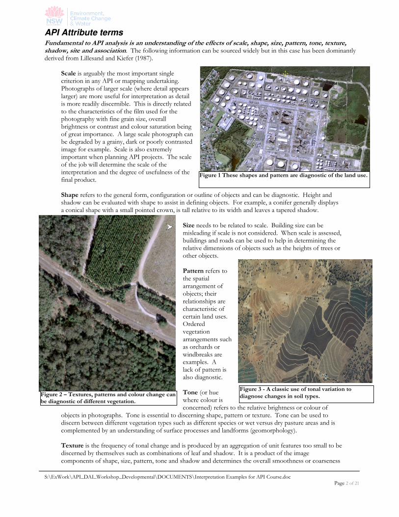
Figure 1 These shapes and pattern are diagnostic of the land use.
API Attribute terms Fundamental to API analysis is an understanding of the effects of scale, shape, size, pattern, tone, texture, shadow, site and association. The following information can be sourced widely but in this case has been dominantly derived from Lillesand and Kiefer (1987).
Scale is arguably the most important single criterion in any API or mapping undertaking. Photographs of larger scale (where detail appears larger) are more useful for interpretation as detail is more readily discernible. This is directly related to the characteristics of the film used for the photography with fine grain size, overall brightness or contrast and colour saturation being of great importance. A large scale photograph can be degraded by a grainy, dark or poorly contrasted image for example. Scale is also extremely important when planning API projects. The scale of the job will determine the scale of the interpretation and the degree of usefulness of the final product. Shape refers to the general form, configuration or outline of objects and can be diagnostic. Height and shadow can be evaluated with shape to assist in defining objects. For example, a conifer generally displays a conical shape with a small pointed crown, is tall relative to its width and leaves a tapered shadow.
Size needs to be related to scale. Building size can be misleading if scale is not considered. When scale is assessed, buildings and roads can be used to help in determining the relative dimensions of objects such as the heights of trees or other objects. Pattern refers to the spatial arrangement of objects; their relationships are characteristic of certain land uses. Ordered vegetation arrangements such as orchards or windbreaks are examples. A lack of pattern is also diagnostic. Tone (or hue where colour is concerned) refers to the relative brightness or colour of
objects in photographs. Tone is essential to discerning shape, pattern or texture. Tone can be used to discern between different vegetation types such as different species or wet versus dry pasture areas and is complemented by an understanding of surface processes and landforms (geomorphology). Texture is the frequency of tonal change and is produced by an aggregation of unit features too small to be discerned by themselves such as combinations of leaf and shadow. It is a product of the image components of shape, size, pattern, tone and shadow and determines the overall smoothness or coarseness
Figure 3 - A classic use of tonal variation to diagnose changes in soil types. Figure 2 – Textures, patterns and colour change can
be diagnostic of different vegetation.
S:\ExWork\API_DAI_Workshop_Developmental\DOCUMENTS\Interpretation Examples for API Course.doc Page 3 of 21
of image features. As scale decreases (detail gets smaller) the texture becomes finer and more difficult to assess.
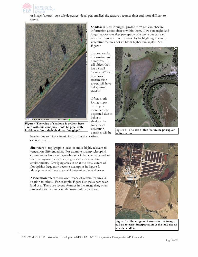
Shadow is used to suggest profile form but can obscure information about objects within them. Low sun angles and long shadows can alter perception of a scene but can also assist in diagnostic interpretation by highlighting terrain or vegetative features not visible at higher sun angles. See Figure 4. Shadow can be informative and deceptive. A tall object that has a small “footprint” such as a power transmission tower, will have a diagnostic shadow. Often south facing slopes can appear more densely vegetated due to being in shadow. In some cases vegetation densities will be
heavier due to microclimatic factors but this is often overestimated. Site refers to topographic location and is highly relevant to vegetation differentiation. For example swamp sclerophyll communities have a recognisable set of characteristics and are also synonymous with low-lying wet areas and certain environments. Low lying areas in or at the distal extent of floodplains frequently become swamps as in Figure 5. Management of these areas will determine the land cover.
Association refers to the occurrence of certain features in relation to others. For example, Figure 6 shows a particular land use. There are several features in the image that, when assessed together, indicate the nature of the land use.
Figure 4 The value of shadows is evident here. Trees with thin canopies would be practically invisible without their shadows. (anaglyph) Figure 5 - The site of this feature helps explain
its formation.
Figure 6 – The range of features in this image add up to assist interpretation of the land use as a cattle feedlot.
S:\ExWork\API_DAI_Workshop_Developmental\DOCUMENTS\Interpretation Examples for API Course.doc Page 4 of 21
Examples The following pages illustrate examples of API descriptions of various features using the above attributes. Be aware that for example, what confirms a woody plant as a tree is that it has a certain colour, shape, size etc. and that these attributes are consistent with those of a tree based upon your knowledge, training and experience. Without cross referencing observed characteristics in these terms it is just a green blob on an image! NOTE:
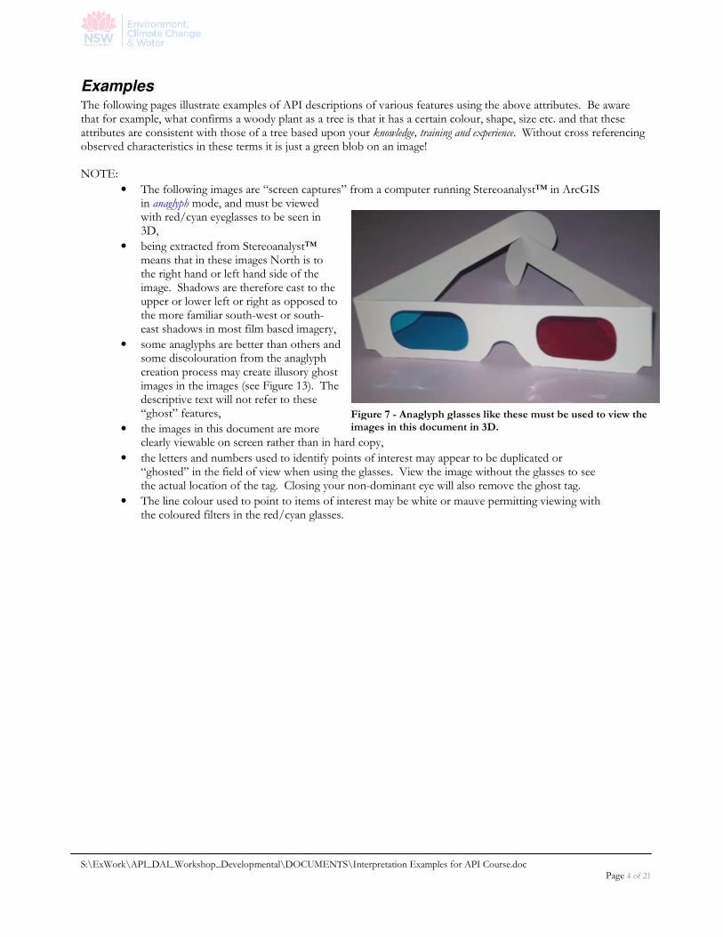
• The following images are “screen captures” from a computer running Stereoanalyst™ in ArcGIS in anaglyph mode, and must be viewed with red/cyan eyeglasses to be seen in 3D,
• being extracted from Stereoanalyst™ means that in these images North is to the right hand or left hand side of the image. Shadows are therefore cast to the upper or lower left or right as opposed to the more familiar south-west or south-east shadows in most film based imagery,
• some anaglyphs are better than others and some discolouration from the anaglyph creation process may create illusory ghost images in the images (see Figure 13). The descriptive text will not refer to these “ghost” features,
• the images in this document are more clearly viewable on screen rather than in hard copy,
• the letters and numbers used to identify points of interest may appear to be duplicated or “ghosted” in the field of view when using the glasses. View the image without the glasses to see the actual location of the tag. Closing your non-dominant eye will also remove the ghost tag.
• The line colour used to point to items of interest may be white or mauve permitting viewing with the coloured filters in the red/cyan glasses.
Figure 7 - Anaglyph glasses like these must be used to view the images in this document in 3D.
S:\ExWork\API_DAI_Workshop_Developmental\DOCUMENTS\Interpretation Examples for API Course.doc Page 5 of 21
Post clearing management:
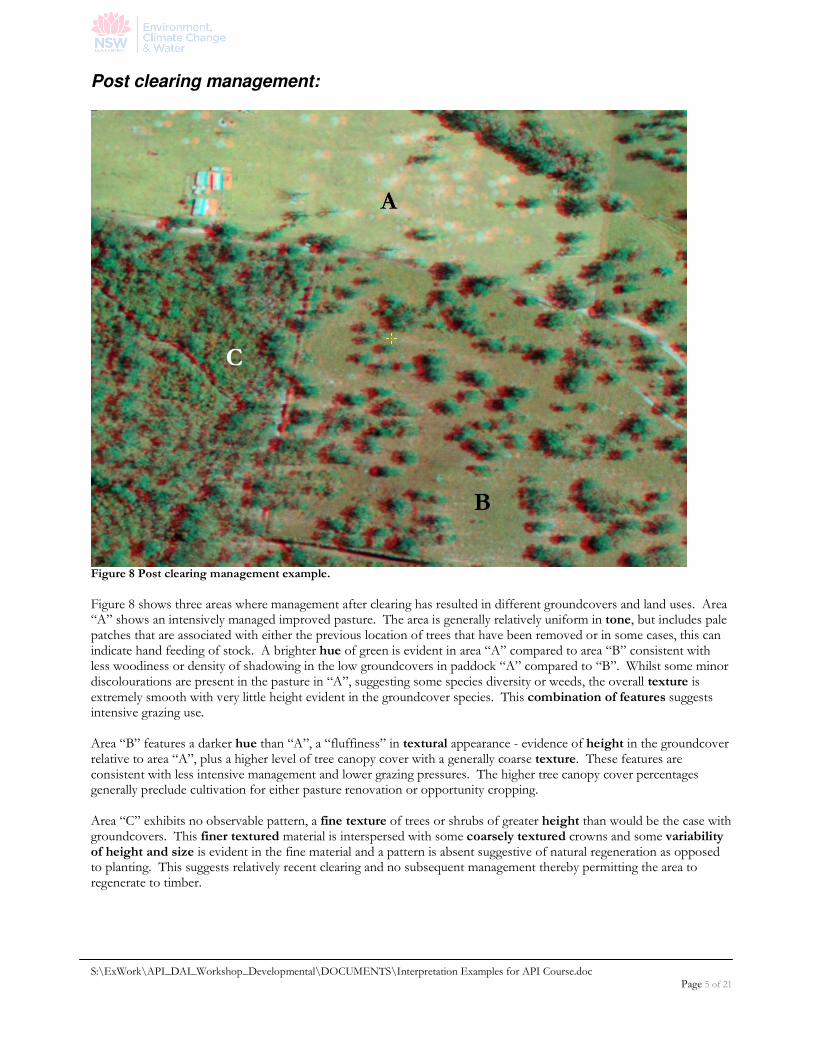
Figure 8 Post clearing management example.
Figure 8 shows three areas where management after clearing has resulted in different groundcovers and land uses. Area “A” shows an intensively managed improved pasture. The area is generally relatively uniform in tone, but includes pale patches that are associated with either the previous location of trees that have been removed or in some cases, this can indicate hand feeding of stock. A brighter hue of green is evident in area “A” compared to area “B” consistent with less woodiness or density of shadowing in the low groundcovers in paddock “A” compared to “B”. Whilst some minor discolourations are present in the pasture in “A”, suggesting some species diversity or weeds, the overall texture is extremely smooth with very little height evident in the groundcover species. This combination of features suggests intensive grazing use. Area “B” features a darker hue than “A”, a “fluffiness” in textural appearance - evidence of height in the groundcover relative to area “A”, plus a higher level of tree canopy cover with a generally coarse texture. These features are consistent with less intensive management and lower grazing pressures. The higher tree canopy cover percentages generally preclude cultivation for either pasture renovation or opportunity cropping. Area “C” exhibits no observable pattern, a fine texture of trees or shrubs of greater height than would be the case with groundcovers. This finer textured material is interspersed with some coarsely textured crowns and some variability of height and size is evident in the fine material and a pattern is absent suggestive of natural regeneration as opposed to planting. This suggests relatively recent clearing and no subsequent management thereby permitting the area to regenerate to timber.
S:\ExWork\API_DAI_Workshop_Developmental\DOCUMENTS\Interpretation Examples for API Course.doc Page 6 of 21
Floodplain drainage, terrain and cropping
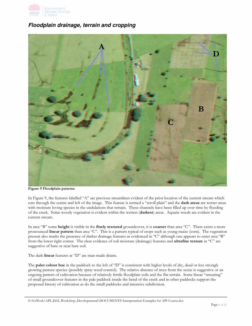
Figure 9 Floodplain patterns
In Figure 9, the features labelled “A” are previous streamlines evident of the prior location of the current stream which cuts through the centre and left of the image. This feature is termed a “scroll plain” and the dark areas are wetter areas with moisture loving species in the undulations that remain. These channels have been filled up over time by flooding of the creek. Some woody vegetation is evident within the wettest (darkest) areas. Aquatic weeds are evident in the current stream. In area “B” some height is visible in the finely textured groundcover, it is coarser than area “C”. There exists a more pronounced linear pattern than area “C”. This is a pattern typical of crops such as young maize (corn). The vegetation present also masks the presence of darker drainage features as evidenced in “C” although one appears to enter area “B” from the lower right corner. The clear evidence of soil moisture (drainage) features and ultrafine texture in “C” are suggestive of bare or near bare soil. The dark linear features at “D” are man-made drains. The paler colour hue in the paddock to the left of “D” is consistent with higher levels of dry, dead or less strongly growing pasture species (possibly spray weed control). The relative absence of trees from the scene is suggestive or an ongoing pattern of cultivation because of relatively fertile floodplain soils and the flat terrain. Some linear “smearing” of small groundcover features in the pale paddock inside the bend of the creek and in other paddocks support the proposed history of cultivation as do the small paddocks and intensive subdivision.
S:\ExWork\API_DAI_Workshop_Developmental\DOCUMENTS\Interpretation Examples for API Course.doc Page 7 of 21
Age of tree replantings
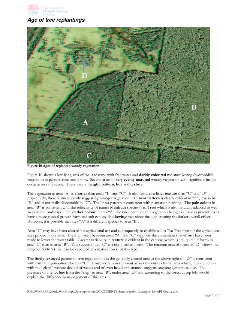
Figure 10 Ages of replanted woody vegetation.
Figure 10 shows a low lying area of the landscape with free water and darkly coloured moisture loving (hydrophilic) vegetation in pasture areas and drains. Several areas of very evenly textured woody vegetation with significant height occur across the scene. These vary in height, pattern, hue and texture. The vegetation in area “A” is shorter than areas “B” and “C”. It also features a finer texture than “C” and “B” respectively, these features jointly suggesting younger vegetation. A linear pattern is clearly evident in “A”, less so in “B” and is not really discernable in “C”. The linear pattern is consistent with plantation planting. The pale colour in area “B” is consistent with the reflectivity of nature Melaleuca species (Tea Tree) which is also naturally adapted to wet areas in the landscape. The darker colour in area “A” does not preclude the vegetation being Tea Tree as juvenile trees have a more conical growth form and sub canopy shadowing may show through creating the darker overall effect. However, it is possible that area “A” is a different species to area “B”. Area “C” may have been cleared for agricultural use and subsequently re-established to Tea Tree forest if the agricultural uses proved non viable. The drain seen between areas “A” and “C” supports the contention that efforts have been made to lower the water table. Greater variability in texture is evident in the canopy (which is still quite uniform) in area “C” than in area “B”. This suggests that “C” is a non planted forest. The remnant area of forest at “D” shows the range of textures that can be expected in a mature forest of this type. The finely textured pattern of tree regeneration in the generally cleared area to the above right of “D” is consistent with natural regeneration like area “C”. However, it is not present across the entire cleared area which, in conjunction with the “clean” pasture devoid of weeds and of even hued appearance, suggests ongoing agricultural use. The presence of a fence line from the “step” in area “B”, under area “D” and extending to the forest at top left, would explain the difference in management of this area.
S:\ExWork\API_DAI_Workshop_Developmental\DOCUMENTS\Interpretation Examples for API Course.doc Page 8 of 21
Terrain and vegetation
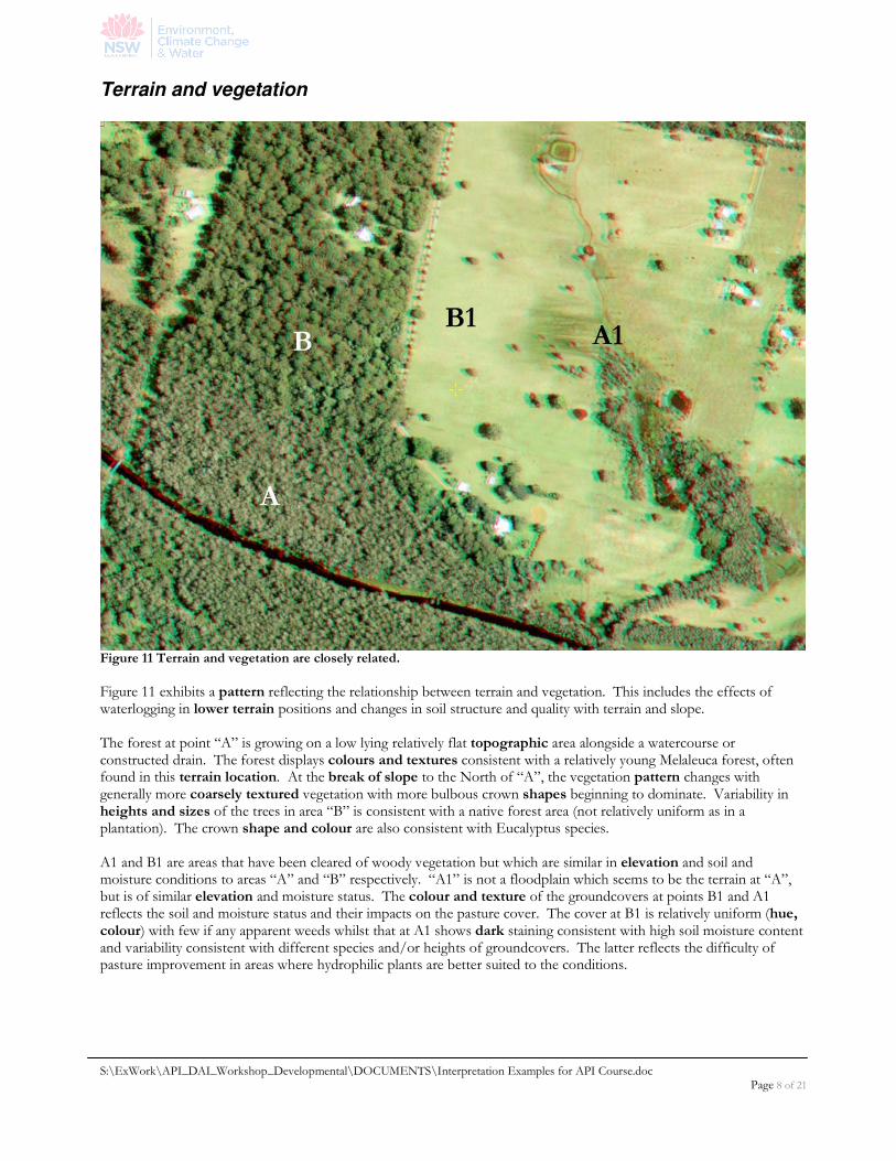
Figure 11 Terrain and vegetation are closely related.
Figure 11 exhibits a pattern reflecting the relationship between terrain and vegetation. This includes the effects of waterlogging in lower terrain positions and changes in soil structure and quality with terrain and slope. The forest at point “A” is growing on a low lying relatively flat topographic area alongside a watercourse or constructed drain. The forest displays colours and textures consistent with a relatively young Melaleuca forest, often found in this terrain location. At the break of slope to the North of “A”, the vegetation pattern changes with generally more coarsely textured vegetation with more bulbous crown shapes beginning to dominate. Variability in heights and sizes of the trees in area “B” is consistent with a native forest area (not relatively uniform as in a plantation). The crown shape and colour are also consistent with Eucalyptus species. A1 and B1 are areas that have been cleared of woody vegetation but which are similar in elevation and soil and moisture conditions to areas “A” and “B” respectively. “A1” is not a floodplain which seems to be the terrain at “A”, but is of similar elevation and moisture status. The colour and texture of the groundcovers at points B1 and A1 reflects the soil and moisture status and their impacts on the pasture cover. The cover at B1 is relatively uniform (hue, colour) with few if any apparent weeds whilst that at A1 shows dark staining consistent with high soil moisture content and variability consistent with different species and/or heights of groundcovers. The latter reflects the difficulty of pasture improvement in areas where hydrophilic plants are better suited to the conditions.
S:\ExWork\API_DAI_Workshop_Developmental\DOCUMENTS\Interpretation Examples for API Course.doc Page 9 of 21
Regeneration, senescence and shadow
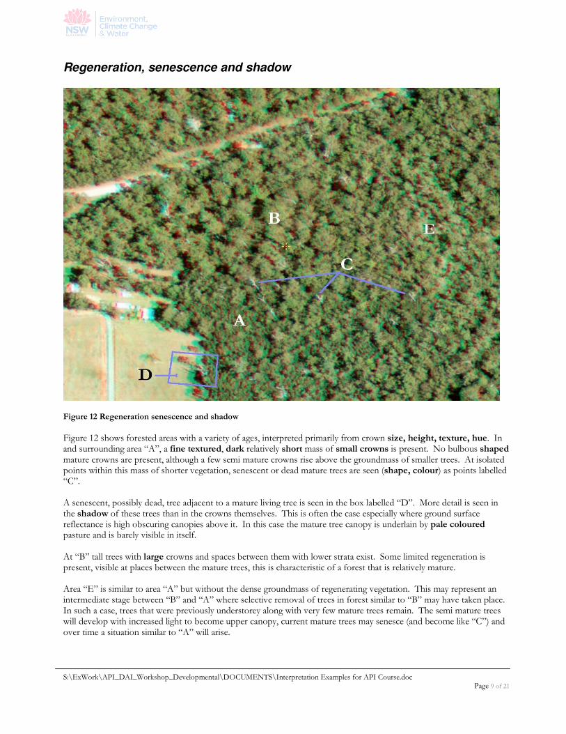
Figure 12 Regeneration senescence and shadow
Figure 12 shows forested areas with a variety of ages, interpreted primarily from crown size, height, texture, hue. In and surrounding area “A”, a fine textured, dark relatively short mass of small crowns is present. No bulbous shaped mature crowns are present, although a few semi mature crowns rise above the groundmass of smaller trees. At isolated points within this mass of shorter vegetation, senescent or dead mature trees are seen (shape, colour) as points labelled “C”. A senescent, possibly dead, tree adjacent to a mature living tree is seen in the box labelled “D”. More detail is seen in the shadow of these trees than in the crowns themselves. This is often the case especially where ground surface reflectance is high obscuring canopies above it. In this case the mature tree canopy is underlain by pale coloured pasture and is barely visible in itself. At “B” tall trees with large crowns and spaces between them with lower strata exist. Some limited regeneration is present, visible at places between the mature trees, this is characteristic of a forest that is relatively mature. Area “E” is similar to area “A” but without the dense groundmass of regenerating vegetation. This may represent an intermediate stage between “B” and “A” where selective removal of trees in forest similar to “B” may have taken place. In such a case, trees that were previously understorey along with very few mature trees remain. The semi mature trees will develop with increased light to become upper canopy, current mature trees may senesce (and become like “C”) and over time a situation similar to “A” will arise.
S:\ExWork\API_DAI_Workshop_Developmental\DOCUMENTS\Interpretation Examples for API Course.doc Page 10 of 21
Pasture variation and woody regeneration
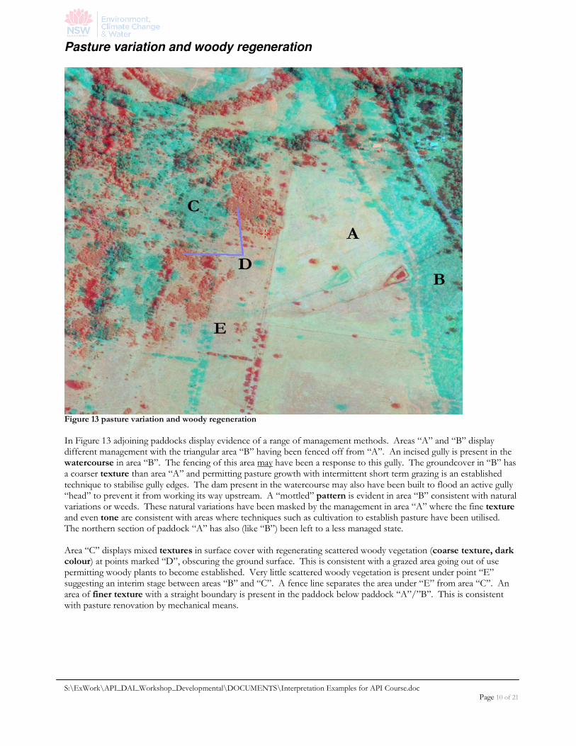
Figure 13 pasture variation and woody regeneration
In Figure 13 adjoining paddocks display evidence of a range of management methods. Areas “A” and “B” display different management with the triangular area “B” having been fenced off from “A”. An incised gully is present in the watercourse in area “B”. The fencing of this area may have been a response to this gully. The groundcover in “B” has a coarser texture than area “A” and permitting pasture growth with intermittent short term grazing is an established technique to stabilise gully edges. The dam present in the watercourse may also have been built to flood an active gully “head” to prevent it from working its way upstream. A “mottled” pattern is evident in area “B” consistent with natural variations or weeds. These natural variations have been masked by the management in area “A” where the fine texture and even tone are consistent with areas where techniques such as cultivation to establish pasture have been utilised. The northern section of paddock “A” has also (like “B”) been left to a less managed state. Area “C” displays mixed textures in surface cover with regenerating scattered woody vegetation (coarse texture, dark colour) at points marked “D”, obscuring the ground surface. This is consistent with a grazed area going out of use permitting woody plants to become established. Very little scattered woody vegetation is present under point “E” suggesting an interim stage between areas “B” and “C”. A fence line separates the area under “E” from area “C”. An area of finer texture with a straight boundary is present in the paddock below paddock “A”/”B”. This is consistent with pasture renovation by mechanical means.
S:\ExWork\API_DAI_Workshop_Developmental\DOCUMENTS\Interpretation Examples for API Course.doc Page 11 of 21
Clearing, “underscrubbing”, Pasture establishment
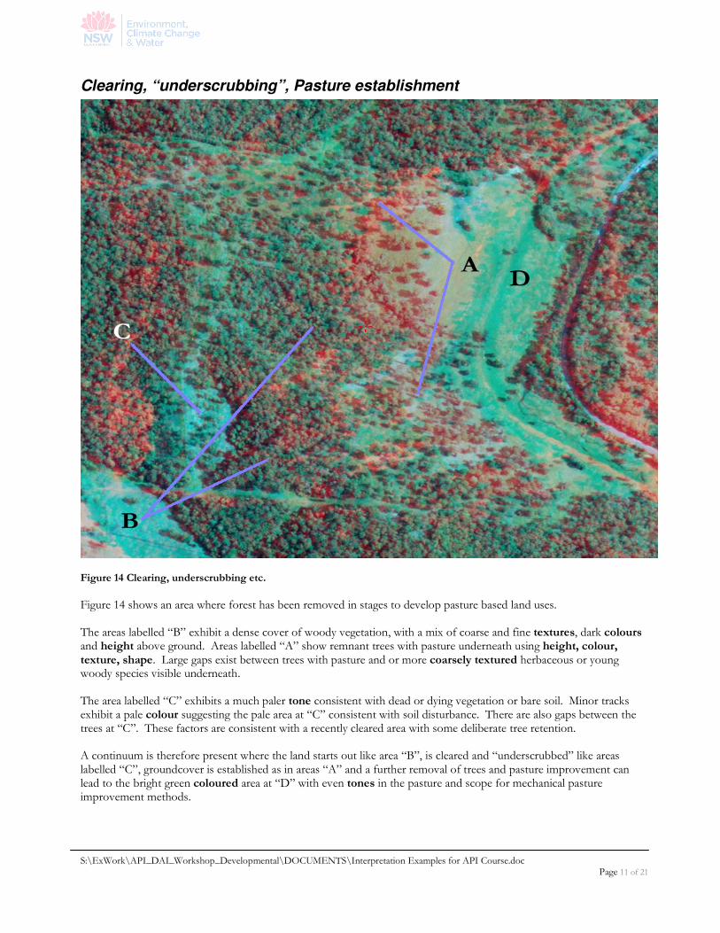
Figure 14 Clearing, underscrubbing etc.
Figure 14 shows an area where forest has been removed in stages to develop pasture based land uses. The areas labelled “B” exhibit a dense cover of woody vegetation, with a mix of coarse and fine textures, dark colours and height above ground. Areas labelled “A” show remnant trees with pasture underneath using height, colour, texture, shape. Large gaps exist between trees with pasture and or more coarsely textured herbaceous or young woody species visible underneath. The area labelled “C” exhibits a much paler tone consistent with dead or dying vegetation or bare soil. Minor tracks exhibit a pale colour suggesting the pale area at “C” consistent with soil disturbance. There are also gaps between the trees at “C”. These factors are consistent with a recently cleared area with some deliberate tree retention. A continuum is therefore present where the land starts out like area “B”, is cleared and “underscrubbed” like areas labelled “C”, groundcover is established as in areas “A” and a further removal of trees and pasture improvement can lead to the bright green coloured area at “D” with even tones in the pasture and scope for mechanical pasture improvement methods.
S:\ExWork\API_DAI_Workshop_Developmental\DOCUMENTS\Interpretation Examples for API Course.doc Page 12 of 21
Forest types
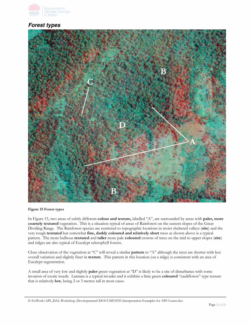
Figure 15 Forest types
In Figure 15, two areas of subtly different colour and texture, labelled “A”, are surrounded by areas with paler, more coarsely textured vegetation. This is a situation typical of areas of Rainforest on the eastern slopes of the Great Dividing Range. The Rainforest species are restricted to topographic locations in moist sheltered valleys (site) and the very rough textured but somewhat fine, darkly coloured and relatively short trees as shown above is a typical pattern. The more bulbous textured and taller more pale coloured crowns of trees on the mid to upper slopes (site) and ridges are also typical of Eucalypt sclerophyll forests. Close observation of the vegetation at “C” will reveal a similar pattern to “A” although the trees are shorter with less overall variation and slightly finer in texture. This pattern in this location (on a ridge) is consistent with an area of Eucalypt regeneration. A small area of very low and slightly paler green vegetation at “D” is likely to be a site of disturbance with some invasion of exotic weeds. Lantana is a typical invader and it exhibits a lime green coloured “cauliflower” type texture that is relatively low, being 2 or 3 metres tall in most cases.
S:\ExWork\API_DAI_Workshop_Developmental\DOCUMENTS\Interpretation Examples for API Course.doc Page 13 of 21
Figure 17 Pine plantation
Plantation Forests and Volunteer regeneration
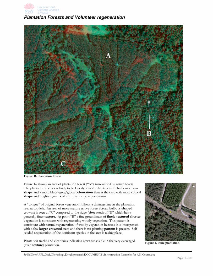
Figure 16 Plantation Forest
Figure 16 shows an area of plantation forest (“A”) surrounded by native forest. The plantation species is likely to be Eucalypt as it exhibits a more bulbous crown shape and a more bluey/grey/green colouration than is the case with more conical shape and brighter green colour of exotic pine plantations. A “tongue” of original forest vegetation follows a drainage line in the plantation area at top left. An area of more mature native forest (broad bulbous shaped crowns) is seen at “C” compared to the ridge (site) south of “B” which has a generally finer texture. At point “B” a fine groundmass of finely textured shorter vegetation is consistent with regenerating woody vegetation. This pattern is consistent with natural regeneration of woody vegetation because it is interspersed with a few larger crowned trees and there is no planting pattern is present. Self seeded regeneration of the dominant species in the area is taking place. Plantation tracks and clear lines indicating rows are visible in the very even aged (even texture) plantation.
S:\ExWork\API_DAI_Workshop_Developmental\DOCUMENTS\Interpretation Examples for API Course.doc Page 14 of 21
Plantations, treelots, windbreaks
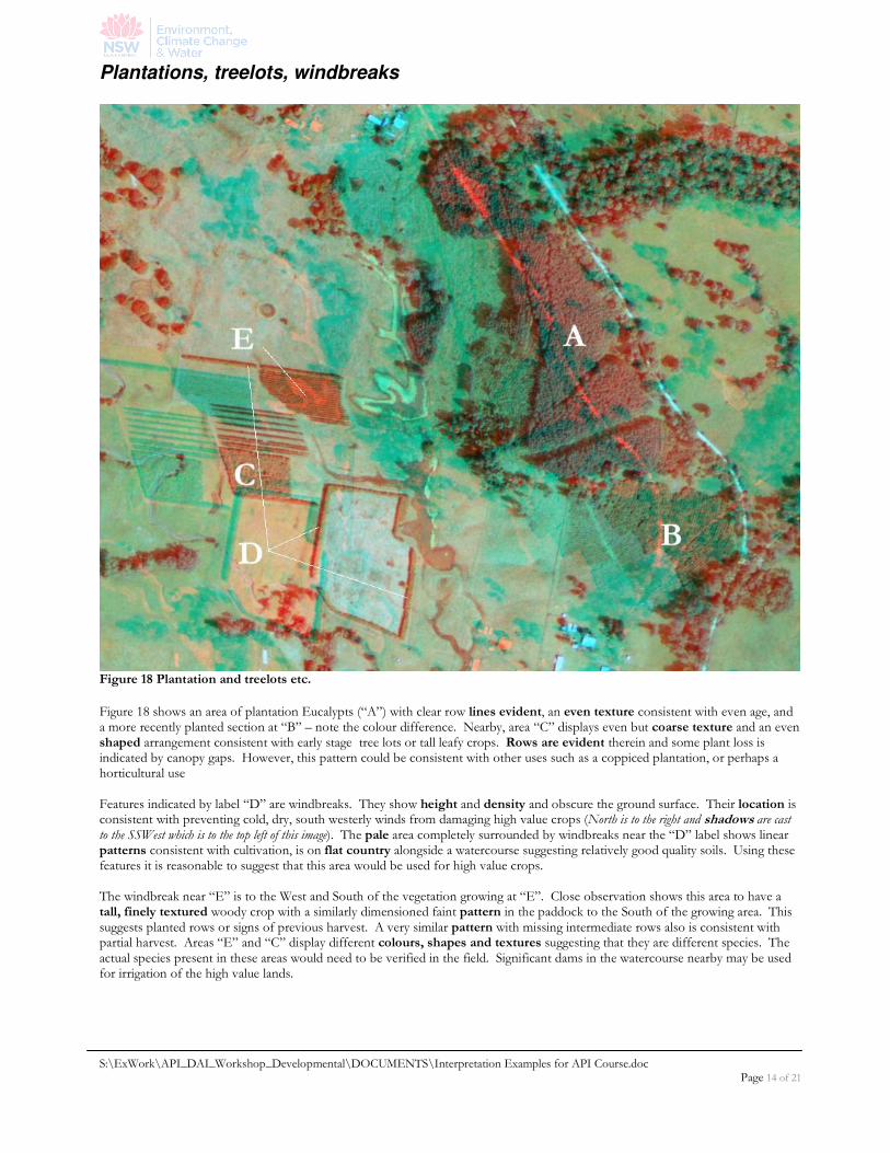
Figure 18 Plantation and treelots etc.
Figure 18 shows an area of plantation Eucalypts (“A”) with clear row lines evident, an even texture consistent with even age, and a more recently planted section at “B” – note the colour difference. Nearby, area “C” displays even but coarse texture and an even shaped arrangement consistent with early stage tree lots or tall leafy crops. Rows are evident therein and some plant loss is indicated by canopy gaps. However, this pattern could be consistent with other uses such as a coppiced plantation, or perhaps a horticultural use Features indicated by label “D” are windbreaks. They show height and density and obscure the ground surface. Their location is consistent with preventing cold, dry, south westerly winds from damaging high value crops (North is to the right and shadows are cast to the SSWest which is to the top left of this image). The pale area completely surrounded by windbreaks near the “D” label shows linear patterns consistent with cultivation, is on flat country alongside a watercourse suggesting relatively good quality soils. Using these features it is reasonable to suggest that this area would be used for high value crops. The windbreak near “E” is to the West and South of the vegetation growing at “E”. Close observation shows this area to have a tall, finely textured woody crop with a similarly dimensioned faint pattern in the paddock to the South of the growing area. This suggests planted rows or signs of previous harvest. A very similar pattern with missing intermediate rows also is consistent with partial harvest. Areas “E” and “C” display different colours, shapes and textures suggesting that they are different species. The actual species present in these areas would need to be verified in the field. Significant dams in the watercourse nearby may be used for irrigation of the high value lands.
S:\ExWork\API_DAI_Workshop_Developmental\DOCUMENTS\Interpretation Examples for API Course.doc Page 15 of 21
Pasture renovation & forest regrowth
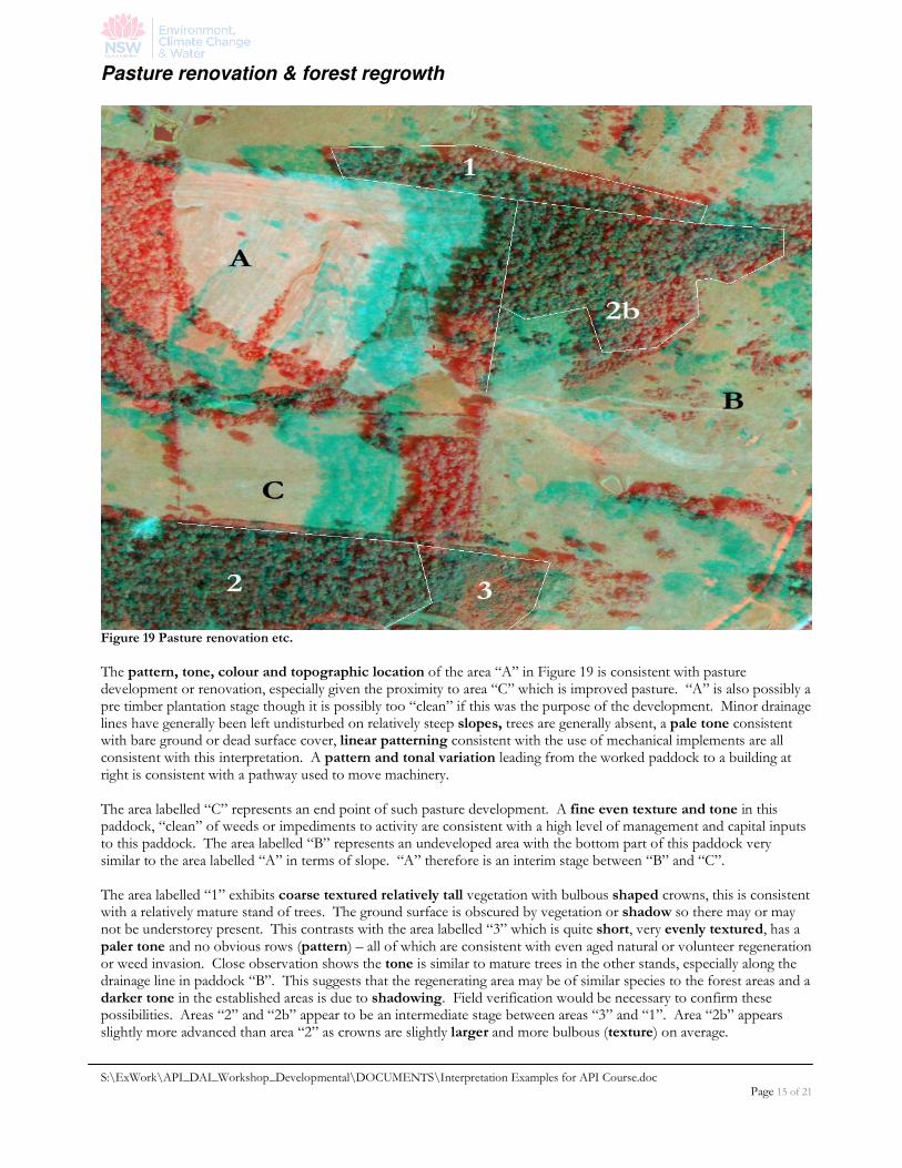
Figure 19 Pasture renovation etc.
The pattern, tone, colour and topographic location of the area “A” in Figure 19 is consistent with pasture development or renovation, especially given the proximity to area “C” which is improved pasture. “A” is also possibly a pre timber plantation stage though it is possibly too “clean” if this was the purpose of the development. Minor drainage lines have generally been left undisturbed on relatively steep slopes, trees are generally absent, a pale tone consistent with bare ground or dead surface cover, linear patterning consistent with the use of mechanical implements are all consistent with this interpretation. A pattern and tonal variation leading from the worked paddock to a building at right is consistent with a pathway used to move machinery. The area labelled “C” represents an end point of such pasture development. A fine even texture and tone in this paddock, “clean” of weeds or impediments to activity are consistent with a high level of management and capital inputs to this paddock. The area labelled “B” represents an undeveloped area with the bottom part of this paddock very similar to the area labelled “A” in terms of slope. “A” therefore is an interim stage between “B” and “C”. The area labelled “1” exhibits coarse textured relatively tall vegetation with bulbous shaped crowns, this is consistent with a relatively mature stand of trees. The ground surface is obscured by vegetation or shadow so there may or may not be understorey present. This contrasts with the area labelled “3” which is quite short, very evenly textured, has a paler tone and no obvious rows (pattern) – all of which are consistent with even aged natural or volunteer regeneration or weed invasion. Close observation shows the tone is similar to mature trees in the other stands, especially along the drainage line in paddock “B”. This suggests that the regenerating area may be of similar species to the forest areas and a darker tone in the established areas is due to shadowing. Field verification would be necessary to confirm these possibilities. Areas “2” and “2b” appear to be an intermediate stage between areas “3” and “1”. Area “2b” appears slightly more advanced than area “2” as crowns are slightly larger and more bulbous (texture) on average.
S:\ExWork\API_DAI_Workshop_Developmental\DOCUMENTS\Interpretation Examples for API Course.doc Page 16 of 21
Pasture stages
Figure 20 Pasture development stages
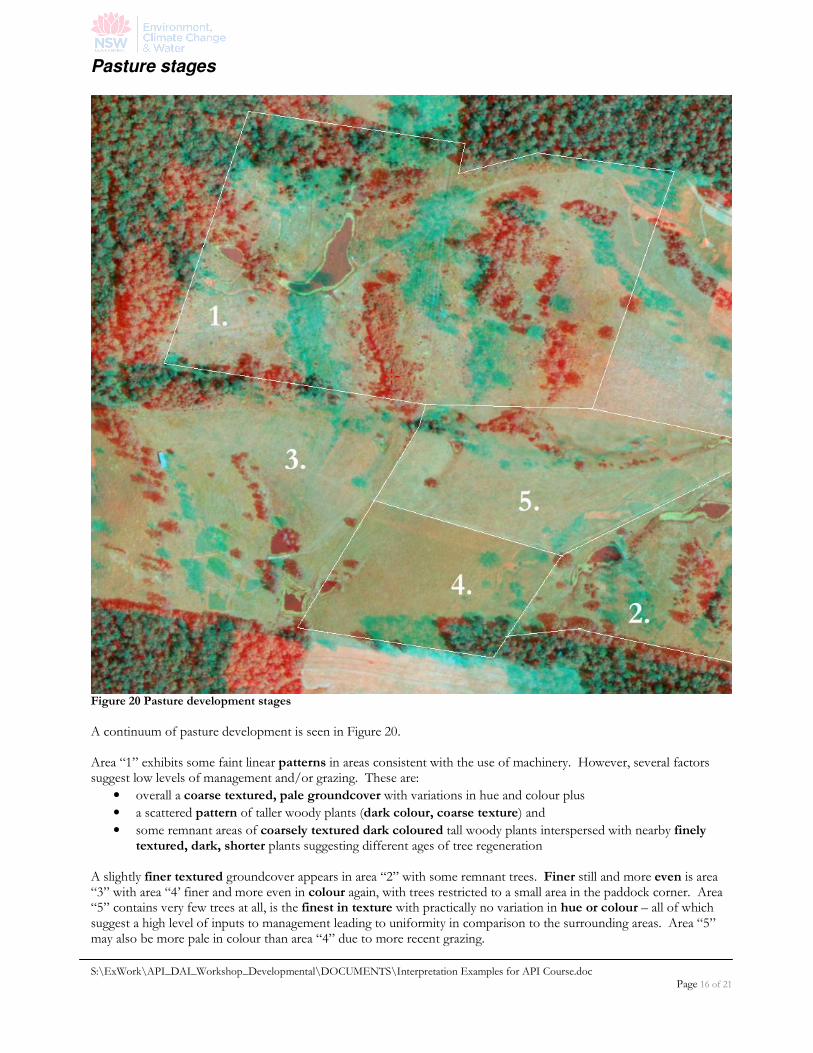
A continuum of pasture development is seen in Figure 20. Area “1” exhibits some faint linear patterns in areas consistent with the use of machinery. However, several factors suggest low levels of management and/or grazing. These are:
• overall a coarse textured, pale groundcover with variations in hue and colour plus
• a scattered pattern of taller woody plants (dark colour, coarse texture) and
• some remnant areas of coarsely textured dark coloured tall woody plants interspersed with nearby finely textured, dark, shorter plants suggesting different ages of tree regeneration
A slightly finer textured groundcover appears in area “2” with some remnant trees. Finer still and more even is area “3” with area “4’ finer and more even in colour again, with trees restricted to a small area in the paddock corner. Area “5” contains very few trees at all, is the finest in texture with practically no variation in hue or colour – all of which suggest a high level of inputs to management leading to uniformity in comparison to the surrounding areas. Area “5” may also be more pale in colour than area “4” due to more recent grazing.
S:\ExWork\API_DAI_Workshop_Developmental\DOCUMENTS\Interpretation Examples for API Course.doc Page 17 of 21
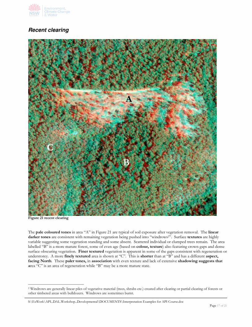
Recent clearing
Figure 21 recent clearing
The pale coloured tones in area “A” in Figure 21 are typical of soil exposure after vegetation removal. The linear darker tones are consistent with remaining vegetation being pushed into “windrows2”. Surface textures are highly variable suggesting some vegetation standing and some absent. Scattered individual or clumped trees remain. The area labelled “B” is a more mature forest, some of even age (based on colour, texture) also featuring crown gaps and dense surface obscuring vegetation. Finer textured vegetation is apparent in some of the gaps consistent with regeneration or understorey. A more finely textured area is shown at “C”. This is shorter than at “B” and has a different aspect, facing North. These paler tones, in association with even texture and lack of extensive shadowing suggests that area “C” is an area of regeneration while “B” may be a more mature state.
2 Windrows are generally linear piles of vegetative material (trees, shrubs etc.) created after clearing or partial clearing of forests or other timbered areas with bulldozers. Windrows are sometimes burnt.
S:\ExWork\API_DAI_Workshop_Developmental\DOCUMENTS\Interpretation Examples for API Course.doc Page 18 of 21
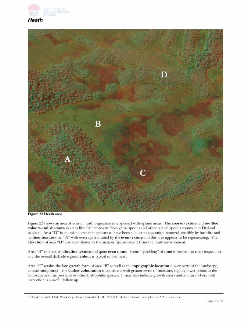
Heath
Figure 22 Heath area
Figure 22 shows an area of coastal heath vegetation interspersed with upland areas. The coarse texture and mottled colours and shadows in areas like “A” represent Eucalyptus species and other related species common in Dryland habitats. Area “D” is an upland area that appears to have been subject to vegetation removal, possibly by bushfire and its finer texture than “A” with even age indicated by the even texture and this area appears to be regenerating. The elevation of area “D” also contributes to the analysis that isolates it from the heath environment. Area “B” exhibits an ultrafine texture and quite even tones. Some “speckling” of tone is present on close inspection and the overall dark olive green colour is typical of low heath. Area “C” retains the low growth form of area “B” as well as the topographic location (lower parts of the landscape, coastal sandplains) – the darker colouration is consistent with greater levels of moisture, slightly lower points in the landscape and the presence of other hydrophilic species. It may also indicate growth stress and is a case where field inspection is a useful follow up.
S:\ExWork\API_DAI_Workshop_Developmental\DOCUMENTS\Interpretation Examples for API Course.doc Page 19 of 21
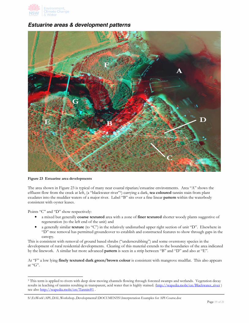
Estuarine areas & development patterns
Figure 23 Estuarine area developments
The area shown in Figure 23 is typical of many near coastal riparian/estuarine environments. Area “A” shows the effluent flow from the creek at left, (a “blackwater river”3) carrying a dark, tea coloured tannin stain from plant exudates into the muddier waters of a major river. Label “B” sits over a fine linear pattern within the waterbody consistent with oyster leases. Points “C” and “D” show respectively:
• a mixed but generally coarse textured area with a zone of finer textured shorter woody plants suggestive of regeneration (to the left end of the unit) and
• a generally similar texture (to “C”) in the relatively undisturbed upper right section of unit “D”. Elsewhere in “D” tree removal has permitted groundcover to establish and constructed features to show through gaps in the canopy.
This is consistent with removal of ground based shrubs (“underscrubbing”) and some overstorey species in the development of rural residential developments. Clearing of this material extends to the boundaries of the area indicated by the linework. A similar but more advanced pattern is seen in a strip between “B” and “D” and also at “E”. At “F” a low lying finely textured dark green/brown colour is consistent with mangrove mudflat. This also appears at “G”.
3 This term is applied to rivers with deep slow moving channels flowing through forested swamps and wetlands. Vegetation decay results in leaching of tannins resulting in transparent, acid water that is highly stained. (http://wapedia.mobi/en/Blackwater_river ) see also http://wapedia.mobi/en/Tannin#1 .

S:\ExWork\API_DAI_Workshop_Developmental\DOCUMENTS\Interpretation Examples for API Course.doc Page 20 of 21
Conclusion The above examples show a range of environments where various different attributes have been used to assist interpretation. The use of the descriptors mentioned in the introduction in association with the interpreters knowledge, training and experience enables experienced personnel to report on findings from API in a manner that will withstand scrutiny and underpin the ability to give evidence in court cases as expert witnesses. This ability has been established by precedent and represents the only situation where a witness can state an opinion rather than a fact or direct observation in court. This emphasises the importance of using the appropriate terminology and definitions thereof in the correct context and combining this with knowledge of landscape processes. It is also important to be aware of the limits of API. In some cases a view is obstructed by tree canopies or the absence of imagery of a necessary date (in a time series analysis). In these cases, where other clues n the imagery cannot conclusively permit the viewer to come to a conclusion, field checking of the site is essential. Finally, be aware of these limitations, do not overstep your ability to determine what is happening in the imagery by assuming things. Observe, interpret and suggest but do not assume.

S:\ExWork\API_DAI_Workshop_Developmental\DOCUMENTS\Interpretation Examples for API Course.doc Page 21 of 21
References cited Lillesand, T.M & Kiefer, R.W., (1987), Remote Sensing and Image Interpretation. Second Edition, Wiley, Singapore.
oooOOOooo


