Embed Size (px)
Citation preview

Creag Riabhach Wind Farm 132 kV Grid Connection: Environmental Impact Assessment Report
Appendix 10.2: Peat Landslide Hazard Risk Assessment (PLHRA) February 2020
APPENDIX 10.2: PEAT LANDSLIDE HAZARD RISK ASSESSMENT (PLHRA)
APPENDIX 10.2
PEAT LANDSLIDE HAZARD AND RISK ASSESSMENT
Creag Riabhach Grid Connection
Prepared for: Scottish Hydro Electric Transmission Plc
Technical Appendix 10.2 SLR Ref: 428.04707.00008 Version No: v1 January 2020


Scottish and Southern Electricity Networks Creag Riabhach Wind Farm Grid Connection Peat Landslide and Hazard Risk Assessment
Page 1 SLR Ref No: 428.04707.00008
February 2020
.
BASIS OF REPORT
This document has been prepared by SLR Consulting Limited with reasonable skill, care and diligence, and taking account of the manpower, timescales and resources devoted to it by agreement with Scottish Hydro Electric Transmission plc as part or all of the services it has been appointed by the Client to carry out. It is subject to the terms and conditions of that appointment.
SLR shall not be liable for the use of or reliance on any information, advice, recommendations and opinions in this document for any purpose by any person other than the Client. Reliance may be granted to a third party only in the event that SLR and the third party have executed a reliance agreement or collateral warranty.
Information reported herein may be based on the interpretation of public domain data collected by SLR, and/or information supplied by the Client and/or its other advisors and associates. These data have been accepted in good faith as being accurate and valid.
The copyright and intellectual property in all drawings, reports, specifications, bills of quantities, calculations and other information set out in this report remain vested in SLR unless the terms of appointment state otherwise.
This document may contain information of a specialised and/or highly technical nature and the Client is advised to seek clarification on any elements which may be unclear to it.
Information, advice, recommendations and opinions in this document should only be relied upon in the context of the whole document and any documents referenced explicitly herein and should then only be used within the context of the appointment.
Scottish and Southern Electricity Networks Creag Riabhach Wind Farm Grid Connection Peat Landslide and Hazard Risk Assessment
Page 2 SLR Ref No: 428.04707.00008
February 2020
CONTENTS
INTRODUCTION ........................................................................................................ 5
1.1 Background ........................................................................................................................ 5
1.2 Methodology ..................................................................................................................... 6
1.2.1 Desk Study ................................................................................................................................................................ 6
1.2.2 Site Visits .................................................................................................................................................................. 6
1.3 Site Location and Description ............................................................................................ 6
1.4 Scope of Report ................................................................................................................. 7
1.4.1 Topographic Surveys ............................................................................................................................................... 7
1.4.2 Aerial Photo Interpretation ..................................................................................................................................... 7
1.4.3 Peat Landslide Hazard and Risk Assessment .......................................................................................................... 8
1.5 Geological Setting .............................................................................................................. 9
1.5.1 Superficial Geology .................................................................................................................................................. 9
1.5.2 Bedrock Geology ...................................................................................................................................................... 9
1.5.3 Mining and Quarrying .............................................................................................................................................. 9
1.5.4 Hydrogeology ........................................................................................................................................................... 9
SITE WORK ............................................................................................................. 10
2.1 Peat Depth Surveys .......................................................................................................... 10
2.1.1 Peat Depth Analysis ............................................................................................................................................... 10
2.1.2 Peat Coring ............................................................................................................................................................. 10
2.1.3 Peat Survey Methodology ..................................................................................................................................... 11
2.1.4 Peat Characteristics ............................................................................................................................................... 11
PEAT INSTABILITY ................................................................................................... 12
3.1 Background Information Regarding Peat ......................................................................... 12
3.1.1 Peat Shear Strength ............................................................................................................................................... 13
3.1.2 Peat Stability – Factors to be Considered............................................................................................................. 13
3.2 Peat Mass Stability ........................................................................................................... 14
3.2.1 Types of Failure ...................................................................................................................................................... 15
3.2.2 Bog Bursts .............................................................................................................................................................. 15
3.2.3 Peat Slides .............................................................................................................................................................. 15
3.2.4 Bog Slides ............................................................................................................................................................... 16
3.2.5 Natural Instability .................................................................................................................................................. 16
SLOPE STABILITY / GROUND CONDITIONS ............................................................... 17
4.1 Shear Strength ................................................................................................................. 17
4.2 Stability Risk Assessment ................................................................................................. 17
PEAT CONDITION RESULTS ...................................................................................... 18
5.1.1 Peat / Peaty Soils ................................................................................................................................................... 18
5.1.2 Substrate ................................................................................................................................................................ 19
Scottish and Southern Electricity Networks Creag Riabhach Wind Farm Grid Connection Peat Landslide and Hazard Risk Assessment
Page 3 SLR Ref No: 428.04707.00008
February 2020
.
PEAT LANDSLIDE HAZARD AND RISK ASSESSMENT ................................................... 20
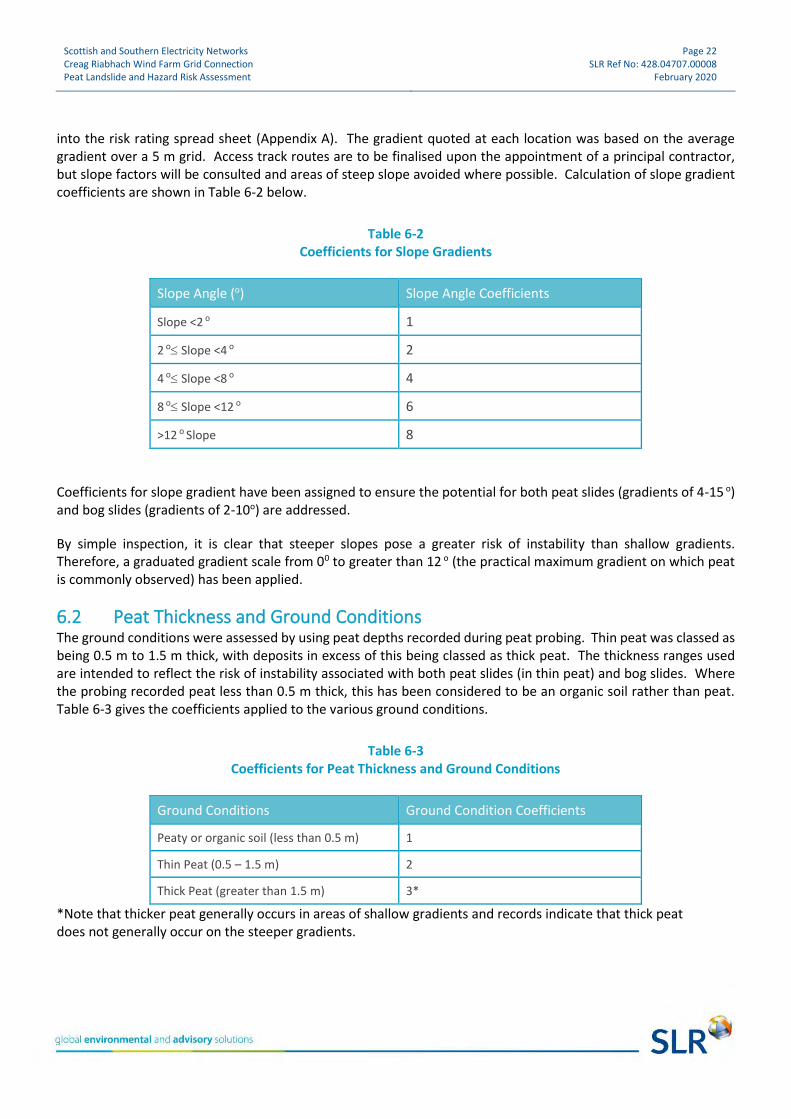
6.1 Slope Gradients ............................................................................................................... 21
6.2 Peat Thickness and Ground Conditions ........................................................................... 22
6.3 Substrate ......................................................................................................................... 23
6.4 Risk Rating ....................................................................................................................... 23
6.5 OHL Pole Sites .................................................................................................................. 25
CONSTRUCTION ISSUES AND MITIGATION MEASURES ............................................. 26
7.1 General ............................................................................................................................ 26
7.2 Drainage Measures .......................................................................................................... 27
7.3 Construction Recommendations ..................................................................................... 27
7.4 Grid Connection Route .................................................................................................... 27
7.4.1 OHL Pole Location .................................................................................................................................................. 27
7.4.2 Underground Cable Section .................................................................................................................................. 28
7.5 Access Tracks ................................................................................................................... 28
7.6 Crossing Watercourses .................................................................................................... 29
7.7 Further Work ................................................................................................................... 29
CONCLUSION .......................................................................................................... 30
DOCUMENT REFERENCES
TABLES Table 5-1 Peat Probing Data ............................................................................................................... 18
Table 6-1 Risk versus Hazard .............................................................................................................. 20
Table 6-2 Coefficients for Slope Gradients ......................................................................................... 22
Table 6-3 Coefficients for Peat Thickness and Ground Conditions .................................................... 22
Table 6-4 Coefficients for Substrate ................................................................................................... 23
Table 6-5 Risk Rating .......................................................................................................................... 24
FIGURES
Figure 1: Site Location Figure 2: Site Layout Figure 3: Superficial Geology Plan Figure 4: Bedrock Geology Plan Figure 5: Peat Depth Plan Figure 6: Peat Depth Greater Than 0.5m Plan Figure 7: Slope Plan

Scottish and Southern Electricity Networks Creag Riabhach Wind Farm Grid Connection Peat Landslide and Hazard Risk Assessment
Page 4 SLR Ref No: 428.04707.00008
February 2020
Figure 8: Peat Slide Risk Plan Figure 9: Aerial Plan with Geomorphological Interpretation
APPENDICES
Appendix A: Peat Risk Data
Scottish and Southern Electricity Networks Creag Riabhach Wind Farm Grid Connection Peat Landslide and Hazard Risk Assessment
Page 5 SLR Ref No: 428.04707.00008
February 2020
Introduction
SLR Consulting Ltd (SLR) was commissioned by Scottish Hydro Electric Transmission plc (the Applicant) to undertake a peat landslide hazard and risk assessment (PLHRA) at the proposed Creag Riabhach Wind Farm Grid Connection, starting approximately 5 km north of Lairg, and finishing approximately 10 km south of Altnaharra, identified in Figure 1: Site Location.
The Proposed Development is to install approximately 22 km of overhead line (OHL) Creag Riabhach Wind Farm and the Dalchork Substation, as described in Chapter 3 of the EIA Report. The purpose of this report is to consider the potential risk of peat landslides occurring at the development site such that suitable controls and appropriate methodologies can be employed during the construction and commissioning of the OHL to mitigate against these risks. This report presents the findings of the PLHRA based on the data obtained by peat depth surveys which were undertaken by Energyline in April and July 2018, with a second survey conducted in October 2019 to account for the change in the OHL route as described in Chapter 2 of the EIA Report. SLR Consulting conducted a site walkover in August 2018, as well as two hydrological visits in May and September 2019. A peat investigation project was carried out in October 2019 to determine the nature of the peat present on site. The work has been undertaken by a team of hydrogeologists and geologists, with over 15 years’ experience in undertaking peat assessments. The team was led by an Engineering Geologist (EG) with 35 years’ experience in geology (B.Sc.) and engineering (M.Sc.) and over 15 years in renewable energy. The EG has managed and undertaken geotechnical risk registers and peat landslide and hazard risk assessments for wind farms, electricity infrastructure and overhead and cabling routes, and successfully completed over 25 PLHRAs under the original guidance (2005) and recent guidance (2017). The EG was supported by engineering geologists, geotechnical engineers and hydrogeologists who were utilised to compile the data. The methods adopted for the assessment follow the best practice guidance1 issued by the Scottish Government for investigation, assessment and reporting for Proposed Electricity Generation Developments in peat areas.
1.1 Background The purpose of this report is to demonstrate that there has been a systematic assessment of the presence of peat that would be excavated during the construction of the Proposed Development and the potential for construction activity to create instability. This PHLRA will be further developed during the detailed design process and will form part of the appointed Principal Contractor’s Construction Environmental Management Plan (CEMP) for the Proposed Development. The importance of assessing the stability of peat deposits in relation to proposed electricity generation developments came to the fore as a result of catastrophic peat slides during the construction of Derrybrien2 Wind Farm in Ireland in 2003. Although no fatalities were associated with these failures, there was a significant environmental impact. Electricity generation infrastructure, such as wind farms and OHLs, tend to be constructed
1 Peat Landslide Hazard and Risk Assessment (Scottish Government, Second Edition April 2017) 2 Lindsay, R.A. and Bragg, O., (2004), ‘Windfarm and Blanket Peat, The Bog Slide of 16th October 2003 at Derrybrien, Co. Galway, Ireland’. University of East London

Scottish and Southern Electricity Networks Creag Riabhach Wind Farm Grid Connection Peat Landslide and Hazard Risk Assessment
Page 6 SLR Ref No: 428.04707.00008
February 2020
in high moorland areas which are primarily associated with significant peat deposits (typically blanket bogs). There is a potential for peat instability to occur, particularly where deposits are in excess of 1.0 m deep. Peat instability is influenced by many factors, including, but not limited to, peat thickness, hill slope gradient, underlying geology and subsurface hydrology.
1.2 Methodology
1.2.1 Desk Study The desk study consisted of a review of the information regarding the Proposed Development, principally involving an examination of the Proposed Development’s route alignment and the extent of peat along this route, based on geological plans, aerial photographs, topography, geomorphology, hydrogeology and hydrology of the corridor using publicly available and purchased maps, records and BGS memoirs.
1.2.2 Site Visits The original peat surveys were carried out in April and July 2018 by Energyline, who conducted the first phase of peat probing, covering the proposed route, where accessible, at 50 m spacing intervals. An SLR engineer conducted a route walkover in August 2018 to gain a preliminary understanding of the development site, verify survey data and review areas of concern, such as watercourse crossings, deep peat where identified, and potential spur road locations. Hydrologists from SLR conducted a site visit in May 2019, and in September 2019, hydrologists and land quality engineers from SLR both revisited the Site due to changes in route alignment. Energyline conducted a second phase of peat probing in October 2019 to allow for the amended route and to complete the peat probing survey in areas that were previously forested.
1.3 Site Location and Description The proposed Creag Riabhach Wind Farm Grid Connection OHL is located between Altnaharra and Lairg, running parallel to the A836. The start of the OHL is approximately 5 km north of Lairg, and finishes approximately 10 km south of Altnaharra, identified in Figure 1: Site Location. The development site comprises of gently undulating hillside generally sloping to the west. The land was predominantly forested, however most of this has now been felled and the freshly exposed peatland is undergoing partial restoration. The route ranges from approximately 250 m Above Ordnance Datum (AOD) to 100 m AOD. The Proposed Development site is to be accessed from the south via the A836, north of Lairg. The 22 km of OHL is anticipated to convey electricity produced at the Creag Riabhach Wind Farm to the National Grid at Dalchork Substation, north of Lairg. The proposed OHL includes the following:
• 240 pairs of suspension poles, for straight sections of the OHL;
• 66 pairs of angle poles to be used either in-line, where there is a need to terminate the conductors, and / or where there is a need to change the orientation of the OHL; and
• 2 terminal poles where the OHL line is terminated to an underground cable.

Scottish and Southern Electricity Networks Creag Riabhach Wind Farm Grid Connection Peat Landslide and Hazard Risk Assessment
Page 7 SLR Ref No: 428.04707.00008
February 2020
1.4 Scope of Report The scope of this report is primarily concerned with the influence of peat on the design, construction and operation of the Proposed Development and secondly to minimise the disturbance of peat, where present. The principle objective was to assess the extent of organic peat (greater than 0.5 m deep) and peaty soils (less than 0.5 m deep) on the Site, with the purpose of identifying areas of stability at the development site, areas of potential concern and any mitigation measures required to ensure the maintenance of peat stability before, during and after construction. All aspects of construction would be based on ensuring minimum disruption to peat areas, by avoidance of deeper peat in the first instance during the initial layout design process for the Proposed Development, and secondly, if peat cannot be avoided, minimising disturbance through good construction practice. The objectives were achieved by completion of the following:
• Review of geological, hydrological and topographical information;
• Geomorphological mapping of the development site to identify the prevailing conditions influencing the potential for, or any evidence of, active, incipient or relict peat instability, including a photographic record and identification of their location and report on the potential risk of future instability, describing the likely causes and contributory factors;
• Identifying potential controls to be imposed on the Principal Contractor to minimise the risk of peat instability occurring at the development site; and
• Provide recommendations for further work or specific construction methodologies to suit the ground conditions at the Proposed Development to mitigate any unacceptable risk of potential peat instability.
1.4.1 Topographic Surveys All of the surveys were based on 5 m Digital Terrain Model (DTM) data, which was used to determine gradients across the development site and to determine slope coefficient (score) factors at each probe hole location. The development site has been characterised into slope classes and a plan produced to identify areas where potential gradients are more or less susceptible to slope failure mechanisms.
1.4.2 Aerial Photo Interpretation The aerial photography reviewed indicates changes in forestation on the ground, and it is also possible to identify stream courses, ditches, and roads / tracks. The aerial photographs were used in conjunction with the Site DTM data to identify the major geomorphological features such as the breaks of slope and landslips. These were inspected where identified during site visits when more detailed assessment of the site was undertaken. Interpretation of available aerial photographs was undertaken to assess and identify evidence of historic peat instability. The photographs were examined to highlight features of interest, including:
• possible extension and / or compression features;
• areas of historic failure scars and debris;
• areas with apparently poor drainage;
• areas with concentrations of surface drainage networks; and
• steeply incised stream cuttings within peat deposits.

Scottish and Southern Electricity Networks Creag Riabhach Wind Farm Grid Connection Peat Landslide and Hazard Risk Assessment
Page 8 SLR Ref No: 428.04707.00008
February 2020
From the aerial photograph and topographic survey interpretation no significant features or obvious evidence of concern were identified that indicate evidence of peat instability which warranted further attention. Only limited aerial photography was available, dating back to 2004, with photos present from 2007, 2012, 2013 and 2016. One significant feature that was identified in aerial photo interpretation was the presence of Loch Dubh at NC 57950 11961. It is present on Ordnance Survey (OS) maps dating back to 1888; however, it is no longer present on modern OS maps. This indicates that it has either been drained or naturally filled. The planned OHL route has been diverted around the location of the historic loch.
1.4.3 Peat Landslide Hazard and Risk Assessment The purpose of a PLHRA is to identify those parts of the development site that are naturally susceptible to a higher risk of instability so that they can be avoided or accommodated. It should be noted that all peat slopes have a risk of instability and the vast majority of peat slope failures occur naturally. Construction of an OHL would only increase the risk of peat slope instability if good geotechnical construction practice is ignored and it is a requirement of all OHL developments to follow a very carefully worded and designed CEMP which uses many of the recommendations of the PLHRA. Without the guidance contained in a Construction Method Statement or CEMP, the following factors would increase the risk of instability:
• Construction of access tracks;
• Excavation and stockpiling for pole foundations; and
• Blocking of natural drainage, inappropriate new drainage or drainage discharge.
It is important to note that peat instability and the impacts of any instability are not constrained by artificial site or ownership boundaries but by topographic and geomorphologic boundaries. It is therefore important to ensure that the breadth of scope of any assessment adequately covers the areal extent of possible impact. The risk assessment is based on ground models developed using a Geographical Information System (GIS) specifically for this site. A numerical analysis was undertaken in which coefficients were allocated for each of the factors influencing peat stability and their impact on possible receptors. This aspect is described in greater detail in Section 6.0. The conceptual layout of the OHL route and the findings from the peat probing, sampling and analysis were used by the design team to optimise the route to avoid or mitigate areas of unacceptable peat slide risk. The layout presented in the figures represents the final iteration of the OHL route. The system outlined above was developed in accordance with the guidelines on PLHRA by the Scottish Government3 (SG) for the investigation, assessment and reporting for proposed electricity generation developments in peat areas. The analysis and interpretation are based upon the results obtained from this process as well as previous experience and the results of case studies elsewhere. Where deviations from this guidance have occurred, this is highlighted and explained in the text.
3 Peat Landslide Hazard and Risk Assessment (Scottish Government, Second Edition April 2017)
Scottish and Southern Electricity Networks Creag Riabhach Wind Farm Grid Connection Peat Landslide and Hazard Risk Assessment
Page 9 SLR Ref No: 428.04707.00008
February 2020
1.5 Geological Setting
1.5.1 Superficial Geology The extent of the superficial geology underlying the development site is sourced from the 1:50,000 Solid and Drift Geology Edition, Sheet 102E for Lairg and Sheet 108E for Loch Naver, published by the British Geological Survey in 2000 and 2004 respectively. The superficial geology on the site, where present, comprises peat overlying glacial till. The peat is generally present on the flatter slopes, with till present draped over most of the area, excluding the higher areas which are dominated by shallow bedrock. The superficial geology of the development site is detailed in Figure 3: Superficial Geology Plan.
1.5.2 Bedrock Geology The extent of the bedrock geology underlying the development site is shown on the 1:50.000 Solid Geology Edition, Sheet 102E for Lairg and Sheet 108E for Loch Naver, published by the British Geological Survey in 2000 and 2004 respectively. In the vicinity of the development site, the underlying bedrock comprises rocks of the Neoproterozoic age Altnaharra Psammite Formation which belongs to the Morar Group. This has been intruded by the Archaean aged Lewisian Gneiss and Orthogneiss (Mafic) Complex. The bedrock geology of the Site is detailed in Figure 4: Bedrock Geology Plan.
1.5.3 Mining and Quarrying There are no current or previously recorded mining or quarrying activities within, or in the immediate vicinity of, the Proposed Development, with the exception of borrow pits used for forestry tracks locally.
1.5.4 Hydrogeology The bedrock geology underlying the site is classified as a very low to low productivity aquifer, where flow is virtually through fractures. Small amounts of groundwater may be present in the near surface weathered zone and within secondary fractures.
Scottish and Southern Electricity Networks Creag Riabhach Wind Farm Grid Connection Peat Landslide and Hazard Risk Assessment
Page 10 SLR Ref No: 428.04707.00008
February 2020
Site Work
2.1 Peat Depth Surveys Peat depth surveys were conducted by both Energyline and SLR. Energyline conducted the majority of the peat probing surveys, where they obtained most of the peat depth data. SLR conducted probing on a minor scale in conjunction with site walkover visits. SLR also undertook a peat coring visit to determine the nature of the peat present across the development site. The surveys carried out by SLR followed best practice guidance for developments on peatland4,5.
2.1.1 Peat Depth Analysis A detailed peat depth survey was undertaken by Energyline in April 2018 and July 2018 within the Proposed Development area, with a second survey conducted in October 2019 to accommodate route alignment alterations as described in Chapter 2 of the EIA Report. Probing was completed at 50 m intervals along the proposed OHL route and proposed track routes. The aim of the survey was to characterise the peat depth within the Limit of Deviation (LOD), generally 200 m in width but restricted in places to account for other environmental constraints as described within the EIA Report. The peat depth data obtained by Energyline was provided to SLR and uploaded into various figures and analysis assessments included within this report.
2.1.2 Peat Coring Peat coring was undertaken by SLR, as discussed within the Peat Investigation report dated October 2019, found in Technical Appendix 10.3 of the EIA. The following methods were employed:
• A core was taken at five locations using a Russian Auger6;
• The full depth of peat was cored at each location in 50 cm sample depth intervals; and
• A photographic record and description of the peat was recorded for each core sample.
Two of the sample locations, GW01 and GW02 were sampled in the southern section of the route and have shown that the peat is disturbed or reworked due to the locations being situated in an area of restored peatland. Below the peat in GW01 and GW02 granular material was recorded which was inferred to be weathered bedrock. Shallow fibrous peat is also recorded above amorphous peat in both GW01 and GW02.
The remaining sample locations GW03, 04 and 05 were located further north along the route. All confirmed the transition between fibrous peat (grades H1 – H3 on the Von Post scale) and amorphous peat (H7 – H8). Beneath the peat at these locations, either granular substrate (which may represent weathered bedrock) or bedrock was recorded.
A full record of peat core data, including photographs is included within 10.3 of the EIA Report.
4 Scottish Renewables & SEPA (2012) ‘Developments on Peatland Guidance on the Assessment of Peat Volumes, Reuse of Excavated Peat and the Minimisation of Waste’. 5 Scottish Natural Heritage (SNH), SEPA, Scottish Government & James Hutton Institute. (2014)’ Peat Survey Guidance; Developments on Peatland: Site Surveys’ 6 The Russian Auger sampler allows for an undisturbed section of peat to be obtained for analysis, at any selected depth.
Scottish and Southern Electricity Networks Creag Riabhach Wind Farm Grid Connection Peat Landslide and Hazard Risk Assessment
Page 11 SLR Ref No: 428.04707.00008
February 2020
2.1.3 Peat Survey Methodology The thickness of the peat was assessed using a graduated peat probe, approximately 6 mm diameter and capable of probing in excess of 10 m. This was pushed vertically into the peat to refusal and the depth recorded, together with a unique location number and the co-ordinates from a handheld Global Positioning System (GPS) instrument. The accuracy of the GPS was quoted as ±5 m, which was considered sufficiently accurate for this survey. All data was uploaded into a GIS database for incorporation into various figures and analysis assessments. Where the peat probing met refusal on a hard substrate, the ‘feel’ of the refusal can provide an insight into the nature of the substrate. The following criteria were used to assess likely material:
• Solid and abrupt refusal – rock;
• Solid but less abrupt refusal with grinding or crunching sound – sand or gravel or weathered rock;
• Rapid and firm refusal – clay; or
• Gradual refusal – dense peat or soft clay.
An assessment of the substrate was made and recorded at each probe hole. The relative stiffness of the peat was also assessed from the resistance to penetration of the probe and to the effort required to extract the probes (retrieval of the probe was often impossible for one person). Some areas, especially on slopes, were a little drier, resulting in the peat being stiffer and more difficult to fully penetrate. In all instances refusal was met on obstructions allowing identification of subsurface geology. There was no cohesive substrate material identified on the site, based on 1,978 peat probes.
2.1.4 Peat Characteristics The peat was found to vary across the development site in terms of thickness, surface slopes and apparent natural characteristics, such as moisture content. Peat thickness varies from zero to 4.1 m deep along the route. Accumulations of peat less than 0.5 m thick are too thin to be classified as true peat deposits and are often classified as organic soils or peaty soils. The peat thickness was examined by review of the probe information from the investigation and is discussed below. The geomorphology of the peat areas varied between some flat expanses of apparently thick peat with high moisture content and smaller areas of thinner drier deposits blanketing the flanks of the hills. The peat thickness at each location was recorded and the data used to draw the peat contour plans, presented as Figure 5: Peat Depth Plan and Figure 6: Peat Depth Greater Than 0.5 m Plan. The colour scale was selected to aid the identification of areas of similar peat thickness and the profile indicates thickness of peat from ground level. No clay or cohesive horizons were encountered and evidence from the site walkovers did not encounter cohesive soils on the site.
Scottish and Southern Electricity Networks Creag Riabhach Wind Farm Grid Connection Peat Landslide and Hazard Risk Assessment
Page 12 SLR Ref No: 428.04707.00008
February 2020
Peat Instability
This section reviews the nature of peat and how current and past activities can influence stability. The factors which are likely to influence the potential for peat instability are:
• Significant peat depths over impermeable bedrock or minimal soil;
• The presence of slope gradients greater than 4o (approximately) and general topography;
• Natural drainage paths;
• Evidence of past failures, including soil creep;
• Drainage features at the base of slopes which could lead to undercutting;
• Forestry plantations and artificial drainage; and
• Recent climate patterns.
It should be noted that peat instability is not a recent phenomenon and there is documentary evidence of peat landslides dating back over 500 years7. Many landslides that involve peat have no human interference that could be considered as a trigger and this should be borne in mind when considering the susceptibility of a site to potential instability.
3.1 Background Information Regarding Peat Peat is found in extensive areas in the upland and lowland regions of the UK and is defined as the partly decomposed plant remains that have accumulated in-situ, rather than being deposited by sedimentation. When peat forming plants die, they do not decay completely as their remains become water-logged due to regular rainfall. The effect of water logging is to exclude air and hence limit the degree of decomposition. Consequently, instead of decaying to carbon dioxide and water, the partially decomposed material is incorporated into the underlying material and the peat ‘grows’ in-situ. Peat is characterised by low density, high moisture content, high compressibility and low shear strength, all of which are related to the degree of decomposition and hence residual plant fabric and structure. To some extent, it is this structure that affects the retention or expulsion of water in the system and differentiates one peat from another. Lindsay8 defined two main types of peat bog, raised bog and blanket bog, which are prevalent on the west coast of Europe along the Atlantic seaboard. In Britain, the dominant peat land is blanket bog which occurs on the gentle slopes of upland plateaux, ridges and benches and is predominantly supplied with water and nutrients in the form of precipitation. Blanket peat is usually considered to be hydrologically disconnected from the underlying mineral layer. There are two distinct layers within a peat bog, the upper acrotelm and the lower catotelm. The acrotelm is the fibrous surface to the peat bog9, typically less than 0.5 m thick, which exists between the growing bog surface and the lowest position of the water table in dry summers. Below this are various stages of decomposition of the vegetation as it slowly becomes assimilated into the body of the peat.
7 Smith, L.T., (Ed) (1910), ‘The literary of John Leland in or about the years 1535-1543.’ Vol.5, Part IX. London: AF Bell and Sons. 8 Lindsay, R.A., (1995), ‘Bogs: The ecology, classification and conservation of Ombrotrophic Mires.’ Scottish Natural Heritage, Perth 9 Ingram, H.A.P., (1978), ‘Soil layers in mires: function and terminology’. Journal of Soil Science, 29, 224-227.

Scottish and Southern Electricity Networks Creag Riabhach Wind Farm Grid Connection Peat Landslide and Hazard Risk Assessment
Page 13 SLR Ref No: 428.04707.00008
February 2020
For geotechnical purposes the degree of decomposition (humification) can be estimated in the field by applying the ‘squeezing test’ proposed by von Post and Grunland10 (1926). The humification value ranges from H1 (no decomposition) to H10 (highly decomposed). The extended system set out by Hobbs11 provides a means of correlating the types of peat with their physical, chemical and structural properties. The relative position of the water table within the peat controls the balance between accumulation and decomposition and therefore its stability, hence artificial adjustment of the water table by drainage requires careful consideration.
3.1.1 Peat Shear Strength In geotechnical terms, the shear strength of a soil is the physical characteristic that provides stability and coherence to a body of soil. For mineral soils such as clays or sands, such strength is variously given by an inter-particle friction value and cohesion. Depending whether the mineral soil is predominantly cohesive (clay) or non-cohesive (sand) governs which of the components of strength control the behaviour of the soil. For peat soils, where the major constituent is organic and there is likely to be little or no mineral component, the geotechnical definition of shear strength does not strictly apply. At present there is no real alternative method for defining the shear strength of peat, therefore the geotechnical definition is generally adopted, in the knowledge that it should be used with great caution. As noted before, the acrotelm or near surface peat comprises a tangle of fresh and slightly rotted roots and vegetable fibres. These roots and fibres impart a tensile shear strength capacity to the material which provides it with a significant load carrying capacity. The acrotelm is, in effect, a fibre reinforced soil. In the more decomposed catotelm, the tensile shear strength is reduced as the roots and fibres become more rotted. However, the loss in strength due to decomposition is offset, to a limited degree, by a gain in strength due to the overburden pressure. In geotechnical engineering there is an established relationship for recently deposited soils, between the shear strength of a sample and the thickness of overburden above it. Consequently, it is almost impossible to predict a shear strength profile in peat and attempts to measure the shear strength using normal geotechnical methods can be misleading. Typical values of shear strength from hand shear vanes would be in the range 20-60 kilopascal (kPa) although values over 100 kPa have been recorded in peat elsewhere. The higher strengths are almost certainly the influence of roots or other non-decomposed material. It is believed that the strength of peat should be quoted as a cohesion value as there are few, if any, discrete particles to give the material a significant frictional resistance. It should be noted, however, that any quotation of shear strength for peat should be treated with extreme caution.
3.1.2 Peat Stability – Factors to be Considered There is considerable observational information relating to debris and peat flows although the actual mechanisms involved in peat instability are not fully understood. The main influences on slope stability are;
• Geological;
• Geotechnical;
• Geomorphic;
10 Von Post, L. and Grunland, E., (1926), ‘Sodra Sveriges torvillganger 1’ Sverges Geol. Unders. Avh., C335, 1-127. 11 Hobbs, N.B., (1986), ‘Mire morphology and the properties and behaviour of some British and foreign peats.’ Quarterly Journal of Engineering Geology, London, 19, 7-80.
Scottish and Southern Electricity Networks Creag Riabhach Wind Farm Grid Connection Peat Landslide and Hazard Risk Assessment
Page 14 SLR Ref No: 428.04707.00008
February 2020
• Hydrological;
• Topographic;
• Climatic;
• Agricultural; and
• Human influences such as drainage and construction activity.
Peat is affected to a degree by changes in any of the above list and it is vital to appreciate that changes to the existing equilibrium would affect the level of slope stability during construction and operation of the scheme. Some of the contributory factors to peat instability are summarised below:
• The geographical limits which could be affected by potential instability are not confined to the artificial boundaries imposed by land ownership; landslip occurring above a site could affect the site and property down slope or downstream of the site for several kilometres;
• Agriculture and grazing have a substantial effect on peat areas, and this can be compounded in areas that have been managed to improve grazing. Grazing compacts the peat surface reducing the rainwater infiltration and the additional nutrients change the ecological balance of the original peat bog. Agricultural management can include surface drainage and periodic burning, both of which can leave the surface of the peat bare for a period of time resulting in temporary desiccation of the surface. Subsequent wetting of the peat and resumption of peat accumulation results in the former desiccated and possibly ash covered surface being incorporated into the body of the peat which introduces a weak discontinuity in the profile; this in turn becomes another unknown factor in the stability assessment;
• Forestry has a substantial effect on slope stability particularly in the early stages as the creation of a forest involves disruption of the natural equilibrium and drainage of the slopes and the installation of artificial drains by deep ploughing. The construction of access tracks further disrupts the drainage and concentrates groundwater flow into narrow, fast flowing erosive streams. The work by Winter el al12 noted that forest tracks can act to retard or concentrate the down slope flow of water and thus aid its penetration into the slope below. Such a mechanism has been observed at a number of recent landslips that have affected the road network in Scotland;
• Natural Drainage – some of the precipitation falling onto a natural upland peat bog would be absorbed into the low permeability catotelm peat. However, most of the water would run-off as sheet flow through upper, high permeability acrotelm. Thus, the water is transmitted to the lower slopes in a reasonably controlled manner through a range of interconnections that operate at different scales and speed. Failure to understand this and to disrupt the transmission process for the groundwater could result in instability; and
• Artificial Drainage – where agricultural drainage has been used to improve the quality of the grazing or to promote forestry it reduces the overall volume of water entering the bog and transfers this water to the edges more rapidly. This can result in ditches and streams becoming enlarged, causing increased erosion and a greater silt burden in the stream water.
3.2 Peat Mass Stability The principal surface indicator of peat slide potential is cracking of the peat land surface and it is the identification of crack patterns in the field and the attendant causes of the cracking that is fundamental to a peat stability assessment.
12 Winter, M.R., Macgregor, F. and Shackman, L. (2005a), ‘Scottish tracks networks landslide study’ Trunk tracks: network management division, published report series. The Scottish Government.
Scottish and Southern Electricity Networks Creag Riabhach Wind Farm Grid Connection Peat Landslide and Hazard Risk Assessment
Page 15 SLR Ref No: 428.04707.00008
February 2020
Sites that have exhibited natural instability in the past are likely to be more susceptible to future instability during and following construction of an OHL, therefore, it is important to identify such instability as part of the Peat Stability Assessment.
3.2.1 Types of Failure The result of instability in peat is the down-slope mass movement of the material; there are a number of definitions of peat instability which are used to characterise the type of failure. A brief description is given below:
• Bog Bursts or Bog Flows – the emergence of a fluid form of well humified, amorphous peat from the surface of a bog, followed by the settling of the residual peat, in-situ13;
• Peat Slides – the failure of the peat at or below the peat / substratum interface leading to translational sliding of detached blocks of surface vegetation together with the whole underlying peat stratum12; and
• Bog Slide – an intermediate form of instability where failure occurs on a surface within the peat mass with rafts of surface vegetation being carried by the movement of a mass of liquid peat.
3.2.2 Bog Bursts Accounts of bog bursts are generally associated with very wet climates or areas which have received storm rainfall events. Bog bursts can be associated with particularly wet peat landscapes; therefore, it is possible to identify broad regions of a higher susceptibility to these failures. The constraints used to identify the areas of higher susceptibility to bog burst failure are given below:
• Peat thickness in excess of 1.5 m with no upper limit;
• Shallow gradients from 2o to 10o (peat thicker than 1.5 m is generally not observed on slopes steeper than 10o, also moisture content is generally reduced on steeper slopes due to drainage);
• Ground which is annually waterlogged to within the upper 1.0 m below ground level, (the groundwater level may rise above this but rarely falls below)14;
• Greater humification of the lower catotelm within the waterlogged ground; and
• Lower surface tensile strength of the fibrous peat and vegetation.
The humified mass can be considered as analogous to a heavy liquid and the stability of this mass is maintained by the strength of the surface or acrotelm peat. Should the surface become weakened through erosion or desiccation or the construction of a surface drainage ditch for agricultural or forestry reasons or through turbary (peat cutting), failure is made more likely.
3.2.3 Peat Slides Peat slides tend to be translational failures with a defined shear surface at or close to the interface with the substrate. The factors generally considered to influence susceptibility to peat slide failures are listed below:
• Peat depth up to 2.0 m;
13 Dykes, A.P and Kirk, K.J., (2001), ‘Initiation of a multiple peat slide on Cuilcagh Mountain, Northern Ireland.’ Earth Surface Processes and Landforms, 26, 395-408. 14 Crisp, D.T., Dawes, M. & Welch, D. (1964), ‘A Pennine Peat Slide’, The Geographical Journal, Vol 130, No4, pp519-524.

Scottish and Southern Electricity Networks Creag Riabhach Wind Farm Grid Connection Peat Landslide and Hazard Risk Assessment
Page 16 SLR Ref No: 428.04707.00008
February 2020
• Slope gradients between 5o and 15o;
• Natural or artificial drainage cut into the surrounding peat landscape;
• Greater humification of the lower catotelm within the waterlogged ground; and
• Lower surface tensile strength of the fibrous peat and vegetation.
It should be noted that some of the factors causing instability are common to both bog bursts and peat slides. The peat – substrate interface is the primary zone of failure and is enhanced by elevated water content at this boundary and softening or weathering of the lower mineral surface. For this reason, any investigation or probing should try to distinguish the nature of the lower mineral substrate.
3.2.4 Bog Slides A variation on a peat slide where part of the peat mass is subject to movement, usually on an internal layer of material, which may be more prone to movement, such as an interface between the acrotelmic and catotelmic layer.
3.2.5 Natural Instability The stability of a peat mass is maintained by a complex interrelationship of many factors, some of which may not be immediately obvious. Key factors include sloping rock head and proximity to a water body. Rainfall often acts as the trigger after the slope has already been conditioned to fail by natural processes. It should also be remembered that peat bogs are growing environments and that there would come a time, on sloping ground, where the forces causing instability, i.e. the weight of the bog, can no longer be resisted by the internal strength of the peat and its interface with the underlying mineral surface. At this point, failure would occur. The weight of the peat bog or any soils mantling steep hill slopes would be increased during periods of very heavy rain and it is common to see landslips occurring following extreme rain events. This may be a concern for future developments where one of the predicted effects of global warming will be a greater frequency of extreme weather, intense storms being one element.
Scottish and Southern Electricity Networks Creag Riabhach Wind Farm Grid Connection Peat Landslide and Hazard Risk Assessment
Page 17 SLR Ref No: 428.04707.00008
February 2020
Slope Stability / Ground Conditions
The stability of slopes is dependent upon the shear strength of the soil to resist the disturbing forces due to the weight of the soil, the effects of the groundwater and other disturbing influencing forces. The level of stability of a slope is normally assessed by reference to the factor of safety which is expressed, numerically, as the degree of confidence that exists, for a given set of conditions, against a particular failure mechanism occurring. It is commonly expressed as the ratio of the load or action which would cause failure against the actual load or actions likely to be applied during service. This is readily determined for some types of analysis (e.g. limit equilibrium slope stability analyses).).
4.1 Shear Strength The strength of the peat in the upper acrotelm is significantly influenced by the root and fibres that are abundant in this layer. There are many influences on the stability of the peat and observing or measuring high shear strength should not be used to assume a high degree of stability.
4.2 Stability Risk Assessment It is apparent that the stability of peat is complex and the numerous inter-relationships that affect the stability are not fully understood. The problem with a quantitative assessment is that it requires a numerical input and the analysis cannot account for the unquantifiable input required for a comprehensive peat stability assessment. For this reason, a purely quantitative assessment should only be considered as a guide and that a qualitative assessment of stability should be used to provide the final recommendations. A stability risk assessment was undertaken to evaluate the risk of instability occurring associated with the construction of the OHL and access tracks at the proposed Creag Riabhach Wind Farm Grid Connection OHL.
Scottish and Southern Electricity Networks Creag Riabhach Wind Farm Grid Connection Peat Landslide and Hazard Risk Assessment
Page 18 SLR Ref No: 428.04707.00008
February 2020
Peat Condition Results
The results of the coring exercise are detailed in the SLR report dated October 2019 found in 10.3 of the EIA Report. The peat depths obtained during probing visits on site are shown in Figure 5: Peat Depth Plan.
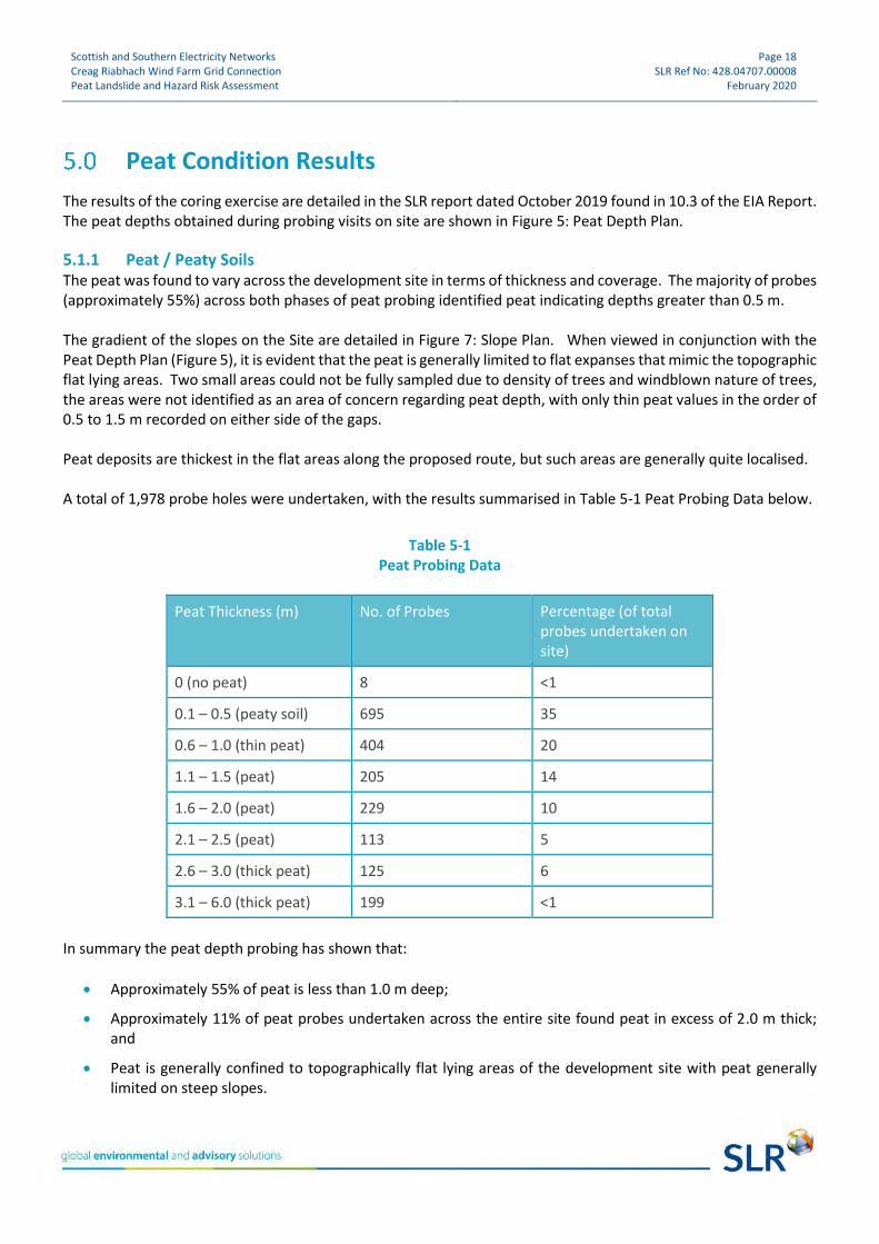
5.1.1 Peat / Peaty Soils The peat was found to vary across the development site in terms of thickness and coverage. The majority of probes (approximately 55%) across both phases of peat probing identified peat indicating depths greater than 0.5 m. The gradient of the slopes on the Site are detailed in Figure 7: Slope Plan. When viewed in conjunction with the Peat Depth Plan (Figure 5), it is evident that the peat is generally limited to flat expanses that mimic the topographic flat lying areas. Two small areas could not be fully sampled due to density of trees and windblown nature of trees, the areas were not identified as an area of concern regarding peat depth, with only thin peat values in the order of 0.5 to 1.5 m recorded on either side of the gaps. Peat deposits are thickest in the flat areas along the proposed route, but such areas are generally quite localised. A total of 1,978 probe holes were undertaken, with the results summarised in Table 5-1 Peat Probing Data below.
Table 5-1 Peat Probing Data
Peat Thickness (m) No. of Probes Percentage (of total probes undertaken on site)
0 (no peat) 8 <1
0.1 – 0.5 (peaty soil) 695 35
0.6 – 1.0 (thin peat) 404 20
1.1 – 1.5 (peat) 205 14
1.6 – 2.0 (peat) 229 10
2.1 – 2.5 (peat) 113 5
2.6 – 3.0 (thick peat) 125 6
3.1 – 6.0 (thick peat) 199 <1
In summary the peat depth probing has shown that:
• Approximately 55% of peat is less than 1.0 m deep;
• Approximately 11% of peat probes undertaken across the entire site found peat in excess of 2.0 m thick; and
• Peat is generally confined to topographically flat lying areas of the development site with peat generally limited on steep slopes.

Scottish and Southern Electricity Networks Creag Riabhach Wind Farm Grid Connection Peat Landslide and Hazard Risk Assessment
Page 19 SLR Ref No: 428.04707.00008
February 2020
The underlying soil / peat thickness at each location was recorded and the data used to draw the interpreted peat thickness map, presented as Figure 5: Peat Depth Plan and Figure 6: Peat Greater Than 0.5 m Plan.
5.1.2 Substrate The assessment of the underlying substrate from the probing and coring data was limited with an interpretation only made from the core locations, peat probing and limited outcrop. A silty, sandy gravel layer (very granular) underlying the peat was identified at all but five locations, where the substrate was deemed to be rock. Based on review of historical borehole data provided by the British Geological Survey, it is likely that the underlying substrate comprises glacial till, of varying composition (silt, sand, cobbles).

Scottish and Southern Electricity Networks Creag Riabhach Wind Farm Grid Connection Peat Landslide and Hazard Risk Assessment
Page 20 SLR Ref No: 428.04707.00008
February 2020
Peat Landslide Hazard and Risk Assessment
A preliminary peat risk assessment has been undertaken for the development site. Following all phases of peat probing and sampling and all site visits by experienced SLR specialists, and appraisal of the data, the potential for a peat slide occurring at the site was initially assessed as low. This was based on the fact that, although there are significant thicknesses of peat present on site, the OHL infrastructure has avoided the thickest areas and there are no areas with thick peat on significant slopes. Figure 9: Aerial Plan with Geomorphological Interpretation shows the main slope areas and areas of deeper peat. Following the Site reconnaissance visit and appraisal of the available data, the potential for a peat slide occurring at the development site was initially assessed as negligible to low. This was based on the fact that there was:
• no evidence of historical or current peat slide activity at the site (having reviewed historical (2004, 2007, 2012 and 2013) and current photographs (2016));
• shallow to moderate gradients (up to 8o) where the majority of OHL poles overlying peat are proposed;
• conclusions of a detailed site walkover and results from initial site probing;
• avoidance of the vast majority of very deep peat with a depth of greater than 2 m by most of the Proposed Development’s infrastructure (i.e. OHL poles,) and ancillary infrastructure (e.g. tracks, Horizontal Directional Drill (HDD) compounds, etc.); and
• temporary floating access tracks for equipment has been considered in deeper peat areas (greater than 1 m).
To further quantify this initial assessment, analysis of the terrain at the site utilising GIS has been undertaken to analyse slopes and gradients, Figure 7: Slope Plan shows that the majority of slopes within key infrastructure areas are < 10 o. The site-specific slope data has been combined with site specific peat depth data and using Scottish Government guidance for the assessment of the risk of instability in peat, an assessment of peat slide risk has been completed.
The method of risk and hazard assessment has been developed with reference to the Scottish Guidance15. Key factors which may have an effect on the stability of the peat deposits have been identified leading to an assessment of the Risk of instability. The potential impact of any instability, the Hazard, was then considered for identified potential receptors. Scores were attributed to the key factors that have the greatest influence on peat stability. Risk scores were determined which, when combined with an assessment of vulnerability of potential targets, were developed into an assessment of the hazard.
In order to differentiate between risk and hazard, the following nomenclature has been adopted (Table 6-1).
Table 6-1 Risk versus Hazard
Risk Hazard
Negligible Insignificant
Low Significant
Medium Substantial
15 Peat Landslide Hazard and Risk Assessment (Scottish Government, Second Edition April 2017)

Scottish and Southern Electricity Networks Creag Riabhach Wind Farm Grid Connection Peat Landslide and Hazard Risk Assessment
Page 21 SLR Ref No: 428.04707.00008
February 2020
Risk Hazard
High Serious
This section outlines the approach taken and the scores allocated for various factors relevant to peat stability.
At this stage in the Proposed Development, the objective is to determine the peat areas that would have an effect on the Proposed Development and to set out the mitigation that could be adopted and incorporated into the overall development plan to ensure that due cognisance is taken in this regard.
The level of slope is normally assessed by reference to the factor of safety which is expressed, numerically, as the degree of confidence that exists, for a given set of conditions, against a particular failure mechanism occurring. It is commonly expressed as the ratio of the load or action which would cause failure against the actual load or actions likely to be applied during service. This is readily determined for some types of analysis (e.g. limit equilibrium slope stability analyses). The following sections present a brief discussion on some of the issues relating to stability and risk assessment.
The stability of peat is a complex subject and there are numerous inter-relationships that affect the stability.
A quantitative assessment requires a numerical input and such an analysis cannot account for the unquantifiable input required for a comprehensive peat stability assessment. For this reason, a purely quantitative assessment should only be considered as a guide and a qualitative assessment of stability should be used to inform the final recommendations.
The characteristics of the peat failure phenomena have been incorporated in a stability risk assessment to evaluate the risk of instability occurring within the peat areas. The main factors controlling the stability of the peat mass are the surface gradients, the depth and condition of the peat at each location and the type of substrate.
The natural moisture content and undrained shear strength of the peat are important; however, it is generally accepted that where present, the peat would be saturated and have a very low strength. It is believed to be unrealistic to rely on specific values of shear strength to maintain stability when back analysis of failed slopes indicates that there is often a significant discrepancy between measured strength in peat and stability. Therefore, shear strength has been assumed to be constant and worst case throughout this assessment. It has also been assumed, as a worst case, that the groundwater level is coincident with the ground surface.
The key factors identified as being critical to stability and the development of a risk rating system is:
• A – Slope gradient;
• B – Peat thickness;
• C – Substrate type or condition; and
• D – Historic instability.
The risk scores are multiplied together to generate a risk rating which is a measure of the likelihood of peat instability.
6.1 Slope Gradients The slope gradients were assessed by reference to the mapping and particularly the DTM which was used to generate a gradient map (Figure 7) from which the gradient at each probe location could be determined and input
Scottish and Southern Electricity Networks Creag Riabhach Wind Farm Grid Connection Peat Landslide and Hazard Risk Assessment
Page 22 SLR Ref No: 428.04707.00008
February 2020
into the risk rating spread sheet (Appendix A). The gradient quoted at each location was based on the average gradient over a 5 m grid. Access track routes are to be finalised upon the appointment of a principal contractor, but slope factors will be consulted and areas of steep slope avoided where possible. Calculation of slope gradient coefficients are shown in Table 6-2 below.
Table 6-2 Coefficients for Slope Gradients
Slope Angle (o) Slope Angle Coefficients
Slope <2 o 1
2 o Slope <4 o 2
4 o Slope <8 o 4
8 o Slope <12 o 6
>12 o Slope 8
Coefficients for slope gradient have been assigned to ensure the potential for both peat slides (gradients of 4-15 o) and bog slides (gradients of 2-10o) are addressed.
By simple inspection, it is clear that steeper slopes pose a greater risk of instability than shallow gradients. Therefore, a graduated gradient scale from 00 to greater than 12 o (the practical maximum gradient on which peat is commonly observed) has been applied.
6.2 Peat Thickness and Ground Conditions The ground conditions were assessed by using peat depths recorded during peat probing. Thin peat was classed as being 0.5 m to 1.5 m thick, with deposits in excess of this being classed as thick peat. The thickness ranges used are intended to reflect the risk of instability associated with both peat slides (in thin peat) and bog slides. Where the probing recorded peat less than 0.5 m thick, this has been considered to be an organic soil rather than peat. Table 6-3 gives the coefficients applied to the various ground conditions.
Table 6-3 Coefficients for Peat Thickness and Ground Conditions
Ground Conditions Ground Condition Coefficients
Peaty or organic soil (less than 0.5 m) 1
Thin Peat (0.5 – 1.5 m) 2
Thick Peat (greater than 1.5 m) 3*
*Note that thicker peat generally occurs in areas of shallow gradients and records indicate that thick peat does not generally occur on the steeper gradients.
Scottish and Southern Electricity Networks Creag Riabhach Wind Farm Grid Connection Peat Landslide and Hazard Risk Assessment
Page 23 SLR Ref No: 428.04707.00008
February 2020
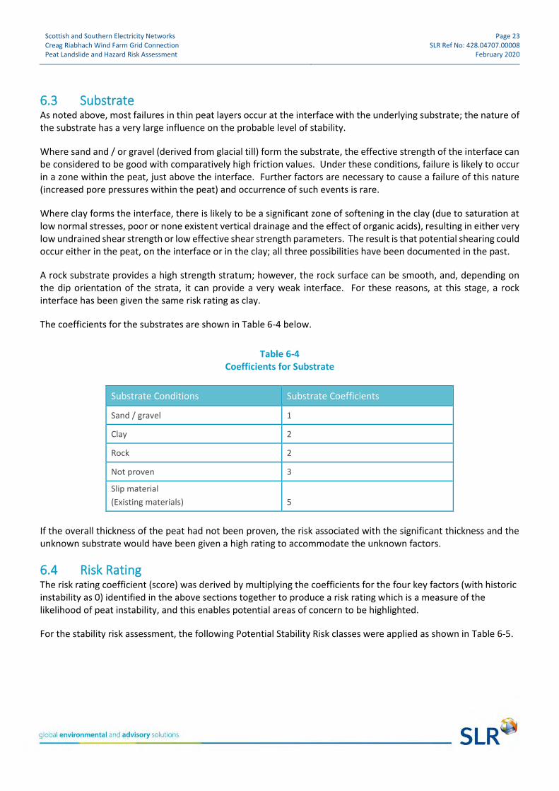
6.3 Substrate As noted above, most failures in thin peat layers occur at the interface with the underlying substrate; the nature of the substrate has a very large influence on the probable level of stability.
Where sand and / or gravel (derived from glacial till) form the substrate, the effective strength of the interface can be considered to be good with comparatively high friction values. Under these conditions, failure is likely to occur in a zone within the peat, just above the interface. Further factors are necessary to cause a failure of this nature (increased pore pressures within the peat) and occurrence of such events is rare.
Where clay forms the interface, there is likely to be a significant zone of softening in the clay (due to saturation at low normal stresses, poor or none existent vertical drainage and the effect of organic acids), resulting in either very low undrained shear strength or low effective shear strength parameters. The result is that potential shearing could occur either in the peat, on the interface or in the clay; all three possibilities have been documented in the past.
A rock substrate provides a high strength stratum; however, the rock surface can be smooth, and, depending on the dip orientation of the strata, it can provide a very weak interface. For these reasons, at this stage, a rock interface has been given the same risk rating as clay.
The coefficients for the substrates are shown in Table 6-4 below.
Table 6-4 Coefficients for Substrate
Substrate Conditions Substrate Coefficients
Sand / gravel 1
Clay 2
Rock 2
Not proven 3
Slip material
(Existing materials) 5
If the overall thickness of the peat had not been proven, the risk associated with the significant thickness and the unknown substrate would have been given a high rating to accommodate the unknown factors.
6.4 Risk Rating The risk rating coefficient (score) was derived by multiplying the coefficients for the four key factors (with historic instability as 0) identified in the above sections together to produce a risk rating which is a measure of the likelihood of peat instability, and this enables potential areas of concern to be highlighted.
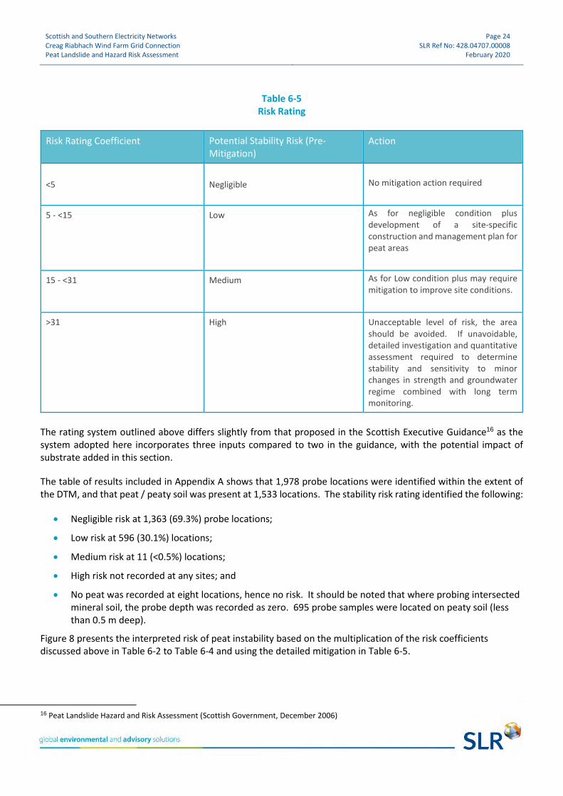
For the stability risk assessment, the following Potential Stability Risk classes were applied as shown in Table 6-5.
Scottish and Southern Electricity Networks Creag Riabhach Wind Farm Grid Connection Peat Landslide and Hazard Risk Assessment
Page 24 SLR Ref No: 428.04707.00008
February 2020
Table 6-5 Risk Rating
Risk Rating Coefficient Potential Stability Risk (Pre-Mitigation)
Action
<5
Negligible
No mitigation action required
5 - <15 Low As for negligible condition plus development of a site-specific construction and management plan for peat areas
15 - <31 Medium As for Low condition plus may require mitigation to improve site conditions.
>31 High Unacceptable level of risk, the area should be avoided. If unavoidable, detailed investigation and quantitative assessment required to determine stability and sensitivity to minor changes in strength and groundwater regime combined with long term monitoring.
The rating system outlined above differs slightly from that proposed in the Scottish Executive Guidance16 as the system adopted here incorporates three inputs compared to two in the guidance, with the potential impact of substrate added in this section.
The table of results included in Appendix A shows that 1,978 probe locations were identified within the extent of the DTM, and that peat / peaty soil was present at 1,533 locations. The stability risk rating identified the following:
• Negligible risk at 1,363 (69.3%) probe locations;
• Low risk at 596 (30.1%) locations;
• Medium risk at 11 (<0.5%) locations;
• High risk not recorded at any sites; and
• No peat was recorded at eight locations, hence no risk. It should be noted that where probing intersected mineral soil, the probe depth was recorded as zero. 695 probe samples were located on peaty soil (less than 0.5 m deep).
Figure 8 presents the interpreted risk of peat instability based on the multiplication of the risk coefficients discussed above in Table 6-2 to Table 6-4 and using the detailed mitigation in Table 6-5.
16 Peat Landslide Hazard and Risk Assessment (Scottish Government, December 2006)

Scottish and Southern Electricity Networks Creag Riabhach Wind Farm Grid Connection Peat Landslide and Hazard Risk Assessment
Page 25 SLR Ref No: 428.04707.00008
February 2020
As there are only eight areas where the risk of instability has been classed as ‘medium’ and as they are not at OHL pole locations, or likely to impact on the Proposed Development, no further investigation is required as the potential for risk has been eliminated through the avoidance of these locations.
6.5 OHL Pole Sites Peat slide risk calculations can be seen in Appendix A which illustrates that the OHL route is located on the flat lying land resulting in all pole locations having a peat slide risk rating of negligible or low. Of the 309 poles, 136 have a rating of low, meaning that 57% (173 No.) of the pole locations present a negligible risk. The table of results shows that the following potential stability risks exist at the OHL pole locations:
• Negligible risk at 173 locations;
• Low at 136 locations;
• No Medium risk locations identified; and
• No High risk locations were identified.
The HDD compounds and access tracks are to be located on areas with no or limited peat with no risk of instability. No areas of Medium potential risk of instability are located within the LOD.

Scottish and Southern Electricity Networks Creag Riabhach Wind Farm Grid Connection Peat Landslide and Hazard Risk Assessment
Page 26 SLR Ref No: 428.04707.00008
February 2020
Construction Issues and Mitigation Measures
It has been shown that excavation, drainage and general construction activities can have a destabilising influence on peat and that design should allow for the delicate and susceptible condition of the peat. There is no extensive evidence for past peat instability on site; however, appropriate good practice measures and mitigation should be employed to minimise the risk of adverse effects on peat and hydrological receptors. The following sections highlight the construction issues that should be considered for each general area of construction. Many of the issues raised should be incorporated into the CEMP and construction method statement for the development site. The following is a list of controls that should be considered for incorporation into the development of construction methodologies for the works in all areas of peat during detailed design stage:
• Careful micro-siting of OHL pole locations to minimise effects on the prevailing hydrology;
• Although the risk of a peat slide is considered to be low for the majority of the Proposed Development, it is recommended that methodologies should be developed as a contingency to minimise the effects to watercourses in the unlikely event of peat instability (outlined in Section 7.2); and
• Use of temporary floating track across areas of deep peat.
Notwithstanding any of the above comments, detailed design and construction practices would need to consider the particular ground conditions and the specific works at each location throughout the construction period. The following list of mitigation measures are designed to minimise the risk of potentially inducing peat landslides during construction of the Proposed Development.
7.1 General • Raise health and safety awareness of the peat environment at the Proposed Development for construction
staff by incorporating the issue into the site induction. Include peat slide risk assessment information (e.g. peat instability indicators, best practice and emergency procedures) in toolbox talks with relevant operatives e.g. plant drivers;
• Introduce a ‘Peat Hazard Emergency Plan’ to provide instructions for site staff in the event of a peat slide or discovery of peat instability indicators;
• For sections of track that require track side cuttings into peat, suitable support measures including upgradient drainage, suitable slope angles and if necessary geotextile to minimise movement would need to be designed to maintain the stability of the adjacent peat terrain;
• Refine / optimise the design through the pre-construction phase following completion of a detailed ground investigation; and
• Develop methodologies to ensure that accelerated degradation and erosion of exposed peat deposits does not occur as the break-up of the peat top mat has significant implications for the morphology, and thus hydrology, of the peat (e.g. minimise off-track plant movements within areas of peat). These are outlined in the Peat Management Plan, Technical Appendix 10.1.

Scottish and Southern Electricity Networks Creag Riabhach Wind Farm Grid Connection Peat Landslide and Hazard Risk Assessment
Page 27 SLR Ref No: 428.04707.00008
February 2020
7.2 Drainage Measures Drainage design for the Proposed Development is a critical mitigation measure in maintaining the hydrological conditions. In order to maintain hydrological conditions, the following requirements of the drainage measures should to be met;
• Development of drainage systems that would not create areas of concentrated flow or cause over-, or under-, saturation of peat habitats;
• Development of robust drainage systems that would require minimal maintenance;
• A robust design of drainage systems and associated measures (i.e. silt traps, check dams and silt netting at or close to water courses etc.) to minimise sedimentation into natural watercourses. Method statements should be prepared in advance to mitigate against a slide occurring and should include, but not be limited to, the use of check dams and erosion protection to limit flows and prevent contamination of watercourses; and
• Measures shall be put in place to ensure drainage systems are well maintained, to include the identification and demarcation of zones of sensitive drainage or hydrology in areas of construction, e.g. inclusion of maintenance regimes for drainage systems into a construction management plan or similar.
7.3 Construction Recommendations A summary of recommendations for site specific infrastructure is provided in the following sections. The complexity of peat stability has been discussed in this report and by Lindsay and Bragg2, amongst others. Following a review of published work and the observation and analysis undertaken for the Proposed Development, there would be a negligible hazard from peat instability if the recommendations contained in this report are adopted. Suitable guidance and documentation in the form of a construction method statement / CEMP would be established before work commences to ensure good construction practices. Due to the complex inter-reactions affecting peat stability it is proposed that the recommendations given below are used as a set of guidelines to generate a detailed design concept. The concept should include the range of potential risks discussed in this report and the design should be sufficiently flexible to allow for continual modification and up-dating as construction progresses.
7.4 Grid Connection Route
7.4.1 OHL Pole Location It is proposed that construction of the OHL pole foundations will require excavation of peat and subsoil to create a suitable area for the foundation of the base. It is the objective of this assessment to consider the potential risk from peat instability and to recommend solutions and mitigation measures to eliminate, or at least reduce the risk to a manageable level. Risk reduction can best be achieved by minimising the effect of any construction works and an appropriate CEMP / construction method statement is an integral element in ensuring that all parties understand and acknowledge the potential consequences of a peat slide. In general, the bearing stresses imposed by an OHL pole are relatively low, with suspension poles designed to support the OHL along straight sections of the route. Angle poles are being utilised where the OHL route changes direction or there is a need to terminate the conductors. Where there is a requirement to terminate the OHL on to an underground cable, terminal poles will be installed.

Scottish and Southern Electricity Networks Creag Riabhach Wind Farm Grid Connection Peat Landslide and Hazard Risk Assessment
Page 28 SLR Ref No: 428.04707.00008
February 2020
The excavations for OHL poles should be kept to a minimum where possible with predetermined dimensions being used. A pit measuring 2.0 m by 4.0 m will be dug at each pole location, to a depth of 2.5 m if glacial till is reached. If glacial till is not reached at 2.5 m, then the pit will be further excavated to the base of the peat and then back-filled with gravel to 2.5 m. Foundation excavation would produce large volumes of peat and this should be reused locally across the development site in an environmentally acceptable manner for restoration. Peat would not be used to back fill the excavation void within the footprint of the foundation as it would have a very low strength. Peat could be used as backfill outside the foundation footprint and also to dress verges to tracks and around OHL pole bases, in line with current Waste Management guidance17. Management of the water in the peat, by maintaining existing drainage during excavation, is essential to avoid creating conditions likely to increase the risk of a peat slide.
7.4.2 Underground Cable Section The general principles regarding the construction of the cable trenches in peat that minimises the risk of instability and environmental effects are discussed below. In order to maintain the current level or improve the stability of the peat mass on the slopes around the cable route, it is necessary to ensure that the construction methods do not seriously disrupt the established drainage and that no areas are surcharged, either by water discharge or spoil. The majority of the cable route would be likely located within areas of shallow peat.
7.5 Access Tracks The precise route of the access tracks is to be finalised upon the appointment of a principal contractor. However, it can be assumed that existing tracks will be utilised where possible, with some tracks and roads requiring minor upgrades. In areas with peat greater than 1.0 m, the use of low pressure tracked vehicles and temporary access panels would be used to ensure hydrological connectivity is maintained and avoid compaction of the peat or substrate below. Short sections of permanent new stone access tracks are required to be constructed due to commitments made to landowners. Improvement or establishment of new bellmouths off the public road would also be required. Although access track plans are yet to be finalised, the general principles regarding the construction of the access tracks in peat that minimises the risk of instability and environmental effects are discussed below. In order to maintain the current level or improve the stability of the peat mass on the slopes around the access track, it is necessary to ensure that the construction methods do not seriously disrupt the established drainage and that no areas are surcharged, either by water discharge or spoil. Wherever possible, the following principles should be adopted:
• Maintenance of existing drainage is critical, therefore all existing drainage tracks must be maintained and, where necessary, channelled below the proposed track construction. Upslope side drainage ditches to the track would be required on side-long ground; the ditches should be constructed with small dams and cross drains where necessary so that:
17 Scottish Renewables and SEPA, Developments on Peatland: Guidance on the Assessment of Peat Volumes, Reuse of Excavated Peat and the Minimisation of Waste, 2012.

Scottish and Southern Electricity Networks Creag Riabhach Wind Farm Grid Connection Peat Landslide and Hazard Risk Assessment
Page 29 SLR Ref No: 428.04707.00008
February 2020
o Water can pass below the track at regular intervals; and
o Scour and erosion are avoided in the side ditches due the limited volume and velocity;
o Concentrated discharges to the peat on the down slope side of the track are to be avoided;
o The camber of the track should encourage surface water to drain to the up-slope side drainage ditch;
o Identify and mark all existing drainage features within the access track corridors; these drainage features should be maintained (not enhanced) during the construction and operational phases of the Proposed Development;
o Install cross drains at regular intervals to maintain interstitial groundwater flow through the peat mass below the tracks where track settlement could reduce the natural permeability;
o Install additional drainage in areas up-slope to any track to prevent ponding and possible instability;
o Install small dams at regular intervals along the track side drains to prevent significant water velocities in the side drains causing deep erosion in the peat;
• Where track construction is required over peat areas in excess of 1 m deep, this may be undertaken with a floating track construction, where the integrity of the peat allows; and
• Cut and fill should be avoided in peat greater than 1.0 m deep if possible; if not, the following requirements on side long ground (across contours) should be adopted;
o Excavate to a sound stratum;
o The majority of construction surfaces to be essentially horizontal with a slight fall to aid drainage;
o Where the depth of cut is deemed unstable, employ a stepped or benched surface with the intention of minimising the exposed surface of the up-slope cut face;
o Protect all exposed peat surfaces from erosion and desiccation, by ensuring the integrity and moisture content of the peat is maintained; and
o The top of cut slopes should be provided with a small bund to retain the peat to prevent desiccation and maintain the local stability of the peat.
7.6 Crossing Watercourses The access track routes will have to take into consideration any possible watercourses that may need crossed and particular care would be required to ensure conformity in the settlement characteristics between the crossing structure and the approaches to avoid undue settlement.
7.7 Further Work This report should be considered as the first stage in the development of a fundamental understanding of the various inter-relationships that govern and control the peat lands at the development site. More detailed ground investigations may be required to facilitate the geotechnical design of the various foundations and access track.

Scottish and Southern Electricity Networks Creag Riabhach Wind Farm Grid Connection Peat Landslide and Hazard Risk Assessment
Page 30 SLR Ref No: 428.04707.00008
February 2020
Conclusion
The development site has been assessed for potential hazards associated with peat instability. The assessment has been based on:
• A walkover survey by a geologist of 30 years’ experience;
• A thorough inspection of the digital terrain map at a scale of 1:25,000;
• Review of historical and geological maps and publications and aerial photography; and
• Review of peat depth and peat core data.
A detailed geotechnical probing exercise at 1,978 locations was conducted in areas of identified peaty soil / peat to determine the thickness thereof, and the overall conclusion regarding peat stability is that there is a negligible to low risk of peat instability over most of the site, with some limited areas of medium risk identified. As none of the medium risk areas are situated on the OHL route they are considered to be of no significant risk to the Proposed Development. The areas of thick peat are generally located on flat lying areas of the route. The steeper slopes have significantly less peat and in general comprise mainly peaty soils (less than 0.5 m deep). The OHL route has been located along the areas of thinner peat and shallower slopes to minimise the overall risk to the Proposed Development. Further developments within the project, such as HDD construction compounds and access tracks, are to be designed upon the appointment of a principal contractor. Consideration of all aspects covered in this report should be applied to any design to continue to limit and mitigate risks to the Proposed Development.

FIGURES
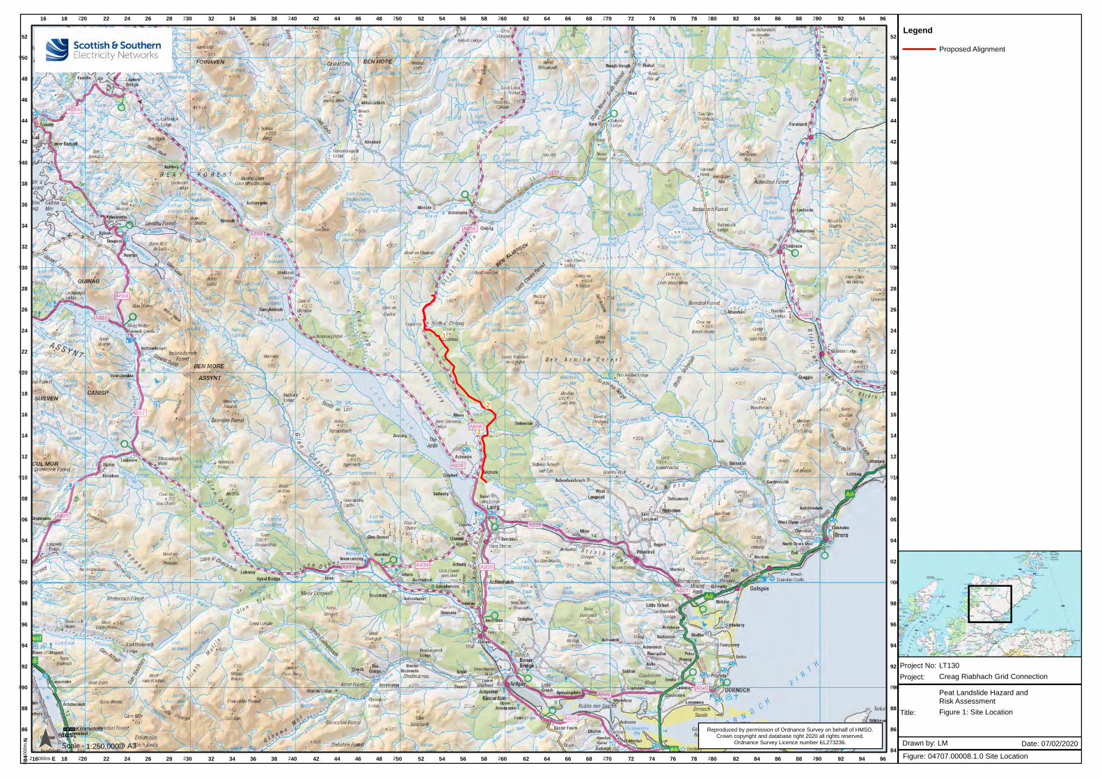
2
3
1
16
216000m.E
18
18
220
220
22
22
24
24
26
26
28
28
230
230
32
32
34
34
36
36
38
38
240
240
42
42
44
44
46
46
48
48
250
250
52
52
54
54
56
56
58
58
260
260
62
62
64
64
66
66
68
68
270
270
72
72
74
74
76
76
78
78
280
280
82
82
84
84
86
86
88
88
290
290
92
92
94
94
96
96
884
000
m. N
84
86 86
88 88
890 890
92 92
94 94
96 96
98 98
900 900
02 02
04 04
06 06
08 08
910 910
12 12
14 14
16 16
18 18
920 920
22 22
24 24
26 26
28 28
930 930
32 32
34 34
36 36
38 38
940 940
42 42
44 44
46 46
48 48
950 950
52 52
Reproduced by permission of Ordnance Survey on behalf of HMSO.Crown copyright and database right 2020 all rights reserved.
Ordnance Survey Licence number EL273236.
00.510.25Kilometers
1:250,000Scale - @ A3
LegendProposed Alignment
Creag Riabhach Grid Connection
Project No: LT130
Title:
Project:
Figure: 04707.00008.1.0 Site Location
Drawn by: LM Date: 07/02/2020
Figure 1: Site Location
Peat Landslide Hazard andRisk Assessment

!( !( !(
!(
!(
!(
!(
!(
!(
!(!(
!(!(
!(!(
!(
!(!(!(!(!(!(
!(!(
!(
!(
!(
!(
!(
!(
!(
!(
!(
!(
!(
!(
!(
!(
!(
!(!( !(
!(!(
!(!(
!(!(
!(
!(
!(
!(!(
!( !(!(
!(
!(
!(
!(!(!(!(
!(
!(!(
!(
!(
!(
!(!(
!(!(!(!(!(
!(
!(
!(
!(
!(!(
!(
!(
!(
!(
!(
!(
!(
!(
!(
!(!(!(!(!(
1
250
250000m. E
52
52
54
54
56
56
922
00
0m
. N
22
24 24
26 26
28 28
Reproduced by permission of Ordnance Survey on behalf of HMSO.
Crown copyright and database right 2020 all rights reserved.Ordnance Survey Licence number EL273236.¯ 0 0.5 10.25
Kilometers
1:25,000Scale - @ A3
LegendProposed OHL
100m Limit of Deviation - OHL
Proposed Cable
100m Limit of Deviation - Cable
!( Pole Location
Spur Road
Spur Road 20m Buffer
Access Track
Access Track 20m Buffer
HDD Compound (50x50m)
Creag Riabhach Grid Connection
Project No: LT130
Title:
Project:
Figure: 04707.00008.2.0 Site Layout
Drawn by: LM Date: 07/02/2020
Figure 2: Site Layout
Peat Landslide Hazard andRisk Assessment
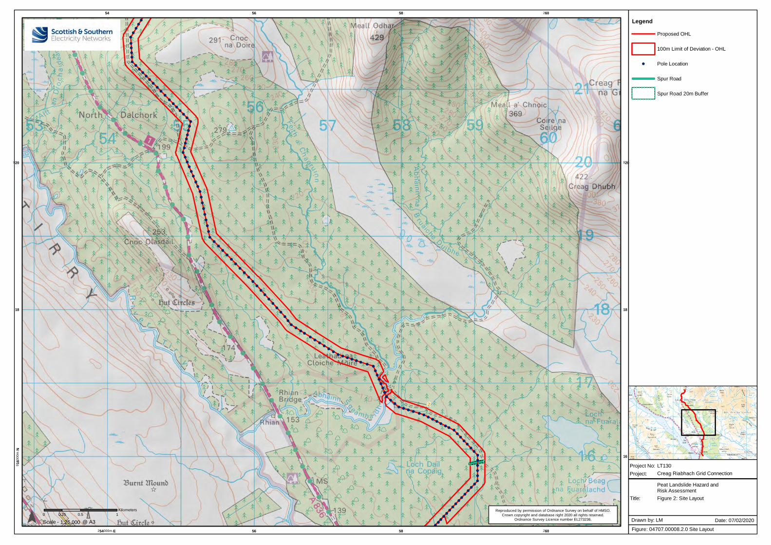
!(
!(!(
!(
!(
!(
!(
!(
!(
!(
!(
!(
!(!(!(!(!(!(!(
!(!(
!(
!(!(!(!(!(!(!(
!(
!(
!(
!(
!(
!(
!(
!(
!(
!(
!(
!(
!(
!(
!(
!(
!(
!(
!(
!(
!(
!(
!(
!(
!(
!(
!(
!(
!(
!(
!(
!(
!(
!(
!(
!(
!(
!(
!(
!(
!(
!(
!(!(
!(!(
!(!(
!(!(
!(!(
!( !( !( !( !( !(!(
!(
!(
!(
!(
!(
!(
!(
!(!(
!(!( !( !( !(
!( !(!(
!(!(
!(!(!(
!(!(!(!(!(!(!(!(
!(
!(
!(
!(
!(!(
!(!(
!(!(
!(!(
!(!(
!(!(
!(!(
!(!(
!(!(
!(
2
54
254000m. E
56
56
58
58
260
260
916
00
0m
. N
16
18 18
920 920
Reproduced by permission of Ordnance Survey on behalf of HMSO.
Crown copyright and database right 2020 all rights reserved.Ordnance Survey Licence number EL273236.¯ 0 0.5 10.25
Kilometers
1:25,000Scale - @ A3
LegendProposed OHL
100m Limit of Deviation - OHL
!( Pole Location
Spur Road
Spur Road 20m Buffer
Creag Riabhach Grid Connection
Project No: LT130
Title:
Project:
Figure: 04707.00008.2.0 Site Layout
Drawn by: LM Date: 07/02/2020
Figure 2: Site Layout
Peat Landslide Hazard andRisk Assessment
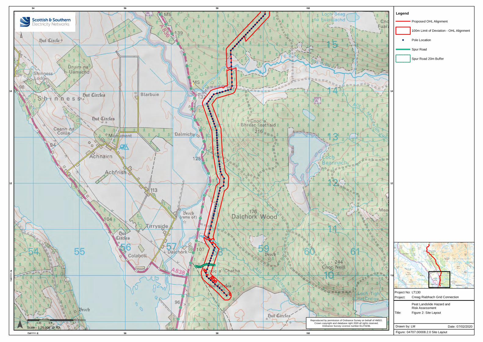
!(
!(
!(!(
!(!(
!(!(
!(!(
!(!(
!(!(
!(!(
!(!(
!(!(
!(
!(
!(
!(
!(
!(
!(
!(
!(
!(
!(!(!(!(!(!(!(!(
!(!(
!(
!(!(
!(
!(!(
!(!(
!(
!(
!(
!(!(
!(
!(!(!(!(!(
!(
!(
!(
!(!(!(
!(
!(
!(
!(
!(!(
!(
!(
!(
!(!(
!(!(!(
!(
!(!(!(
!(
!(
!(
!(
!(
!(
!(
!(
!(
!(
!(
!(
!(!(!(
!(
!(
!(!(!(!(!(!(!(!(
!(
!(
3
54
254000m. E
56
56
58
58
260
260
910
00
0m
. N
910
12 12
14 14
Reproduced by permission of Ordnance Survey on behalf of HMSO.
Crown copyright and database right 2020 all rights reserved.Ordnance Survey Licence number EL273236.¯ 0 0.5 10.25
Kilometers
1:25,000Scale - @ A3
LegendProposed OHL Alignment
100m Limit of Deviation - OHL Alignment
!( Pole Location
Spur Road
Spur Road 20m Buffer
Creag Riabhach Grid Connection
Project No: LT130
Title:
Project:
Figure: 04707.00008.2.0 Site Layout
Drawn by: LM Date: 07/02/2020
Figure 2: Site Layout
Peat Landslide Hazard andRisk Assessment
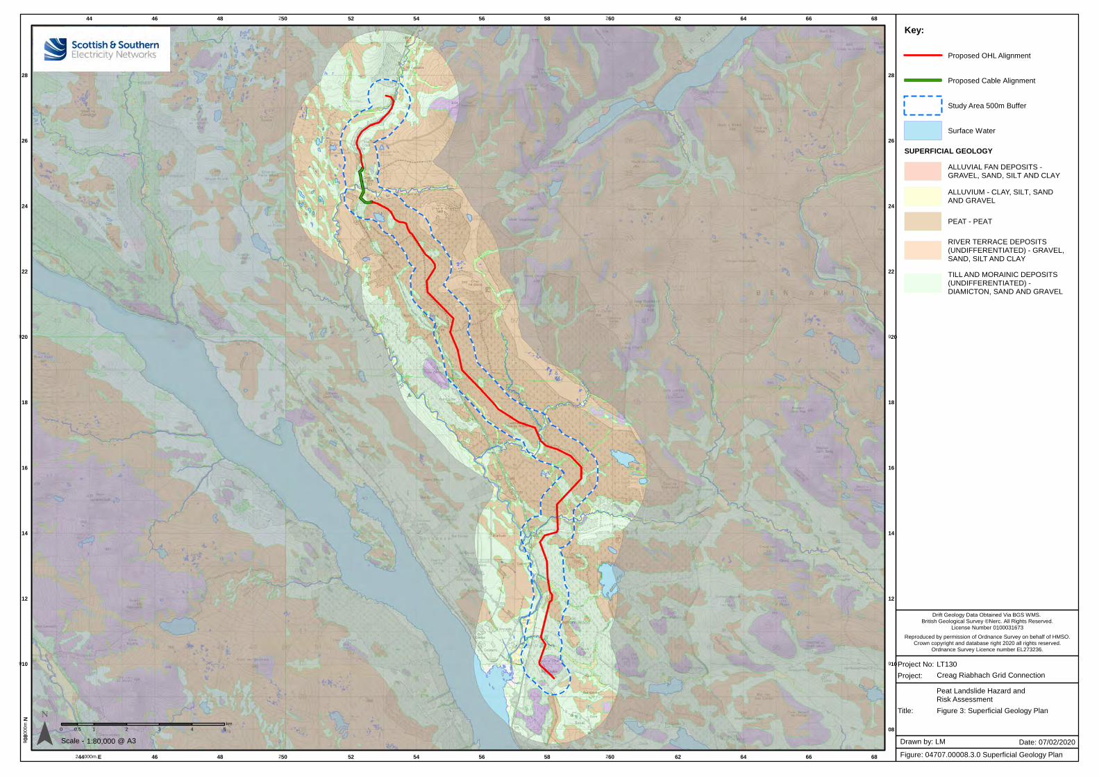
Creag Riabhach Grid Connection
44
244000m.E
46
46
48
48
250
250
52
52
54
54
56
56
58
58
260
260
62
62
64
64
66
66
68
68
908
000
m. N
08
910 910
12 12
14 14
16 16
18 18
920 920
22 22
24 24
26 26
28 28
0 1 2 3 4 50.5km
1:80,000Scale -
Project No: LT130
Title:
Project:
Figure: 04707.00008.3.0 Superficial Geology Plan
Drawn by: LM Date: 07/02/2020@ A3
Key:
Proposed OHL Alignment
Proposed Cable Alignment
Study Area 500m Buffer
Surface Water
SUPERFICIAL GEOLOGYALLUVIAL FAN DEPOSITS -GRAVEL, SAND, SILT AND CLAY
ALLUVIUM - CLAY, SILT, SANDAND GRAVEL
PEAT - PEAT
RIVER TERRACE DEPOSITS(UNDIFFERENTIATED) - GRAVEL,SAND, SILT AND CLAY
TILL AND MORAINIC DEPOSITS(UNDIFFERENTIATED) -DIAMICTON, SAND AND GRAVEL
Figure 3: Superficial Geology Plan
Reproduced by permission of Ordnance Survey on behalf of HMSO.Crown copyright and database right 2020 all rights reserved.
Ordnance Survey Licence number EL273236.
Drift Geology Data Obtained Via BGS WMS. British Geological Survey ©Nerc. All Rights Reserved.
License Number 0100031673
Peat Landslide Hazard andRisk Assessment
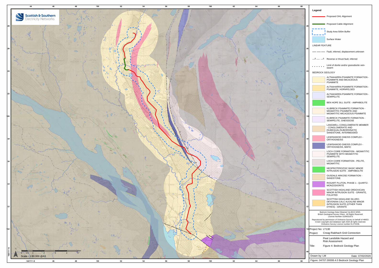
44
244000m.E
46
46
48
48
250
250
52
52
54
54
56
56
58
58
260
260
62
62
64
64
66
66
68
68
908
000
m. N
08
910 910
12 12
14 14
16 16
18 18
920 920
22 22
24 24
26 26
28 28
0 1 2 3 4 50.5km
LegendProposed OHL Alignment
Proposed Cable Alignment
Study Area 500m Buffer
Surface Water
LINEAR FEATURE
Fault, inferred, displacement unknown
Reverse or thrust fault, inferred
Limit of diorite and/or granodiorite vein-swarm
BEDROCK GEOLOGY
ALTNAHARRA PSAMMITE FORMATION -PSAMMITE AND MICACEOUSPSAMMITE
ALTNAHARRA PSAMMITE FORMATION -PSAMMITE, HORNFELSED
ALTNAHARRA PSAMMITE FORMATION -SEMIPELITE
BEN HOPE SILL SUITE - AMPHIBOLITE
KLIBRECK PSAMMITE FORMATION -MIGMATITIC PSAMMITE ANDMIGMATITIC-MICACEOUS PSAMMITE
KLIBRECK PSAMMITE FORMATION -SEMIPELITE, GNEISSOSE
LANGWELL CONGLOMERATE MEMBER- CONGLOMERATE AND[SUBEQUAL/SUBORDINATE]SANDSTONE, INTERBEDDED
LEWISIANOID GNEISS COMPLEX -ORTHOGNEISS
LEWISIANOID GNEISS COMPLEX -ORTHOGNEISS, MAFIC
LOCH COIRE FORMATION - MIGMATITICPSAMMITE WITH MIGMATITICSEMIPELITE
LOCH COIRE FORMATION - PELITE,MIGMATITIC
NEOPROTEROZOIC BASIC MINORINTRUSION SUITE - AMPHIBOLITE
OUSDALE ARKOSE FORMATION -SANDSTONE
ROGART PLUTON, PHASE 1 - QUARTZ-MONZODIORITE
SCOTTISH HIGHLAND ORDOVICIANMINOR INTRUSION SUITE - GRANITE,FOLIATED
SCOTTISH HIGHLAND SILURO-DEVONIAN CALC-ALKALINE MINORINTRUSION SUITE (OTHER THANDYKES) - GRANITE
Scale - 1:80,000 @A3
Bedrock Geology Data Obtained Via BGS WMS. British Geological Survey ©Nerc. All Rights Reserved.
License Number 0100031673
Creag Riabhach Grid Connection
Project No: LT130
Title:
Project:
Figure: 04707.00008.4.0 Bedrock Geology Plan
Drawn by: LM Date: 07/02/2020
Figure 4: Bedrock Geology Plan
Reproduced by permission of Ordnance Survey on behalf of HMSO.Crown copyright and database right 2020 all rights reserved.
Ordnance Survey Licence number EL273236.
Peat Landslide Hazard andRisk Assessment
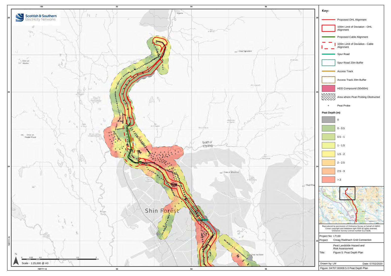
Creag Riabhach Grid Connection
Reproduced by permission of Ordnance Survey on behalf of HMSO.
Crown copyright and database right 2020 all rights reserved.Ordnance Survey Licence number EL273236.
E EEEEEEEEEEEE
EE
E EEEEEE
EE
E
E
EEE
EE
EE
EEEEE
EEEEEE EE
EEE
EEEEEEEE E
EEEEE
EEEEEE
EE EE EE
EEEEE E
EEE
E EEE
EEEEEE E
E
EEEEEE
EE
EE
EEE
EEE
E
EE E
E
EE
EE
EEE
E
EE
EE
E EE
EE
EEE
EE
EEEE
EEE
EEE
EE
EEE
EEE
EE
EE
EE
EEE
EEE
EEE E
EE E
EEE
EEEEEEEEEEE
E
EE E
EEEEEE
EEE
EEEEEE EEE
EEE EE
EEE E E
EEEE EE
EEE
E E EEEEE
EEEEEE
E
EE E
EEE
EEEE
E EEE
E
EEEEEEE
E
EE
EE
E
EEEEEE
EEEEEEE
EE
EEEEEEE
E EE EEEEE
EE
EEEEEEEEEEEEEE
EEEEE E E E E EE
EE E EEEEE
EE
E
EE
E EEEEEEE
EEE
EE E
E EE
E E
EEE
EEE
EE E E
EEE E E EE E EE
EEEE
EE
EE
EE E
E
EEEEEE
EEE
EEEEEEEEEEEEE E
E EEE
EEE
E EEE
EEEEEEE EEEEEEEEEEEEEEEEEE EEEEEEEEEEEEEEE
EEEE
E EE
E
EEEEE
EEEEEEEEE
EE
EE
EEEE
E
EEEEEEEEEEE
EEEE
EE EE
EEEEEEEE
EEEEEE EE
EE EE
EEE
EE
EEE
E
EEEEE
E EE
EE E
EEEE
EE
EEEEEEEEEEEEEEEEEEEEEEEEEE
EEEE
EEEEEEEE E EE
EEEEEE
EE
EE
EE
EE
EEEEEE E
EEE
EEEEEEEEEEE
E
EE
E
E
EE
EEE
EE EE
E
E
EEE EEEE
E EEEE
EE
EEE
EE
EEEEE E E
E
E
EEE
E
EE E
EE E
EE
EE
EE
E EEEEEEEE E
EEEEE EEE
EEEE
E E
E
E
E
E
EEEEEEEEEEEE
EEEEEE E
EE
E
EEEE
EEEEE
EEEEEEEEE
E
EEEEE
EEE
EEEEEEEEEE E
EEEEEE
EEEEEE E
EEEE
E
EEE EEE
EEE
EEE
EEEE
EE EE
EEEE
EEEE
EEEEEE
EEEEEE
EE
EEEEE
EEEE
EEEEE
EEE
EEEEE
EEEE
EEEEE
EEE
EEE
EEEEE
EEEEE
EE
E EEEEE
EEEE
EE
EEE
EEEE
EEEEE
EE E
EEEE
EEEEEEEEE
E EEEE
EEEE EEEE E
EEEEEE EE
EE
EEEE
EEEE EEEE
EEEEEEE
EEEE
EEEEEEEEE
EEEE
EEEEEEEE EE
EE
EEEEEEEEEEEEE
EE EEEE
EEEEEEEEEEEEE
EEEEEEEEE
EE EE
EEEEEEEE
E EEEEE
EEEEE
EE EE
EE
EEE
E
EEEE EEEEEEEEE
E EEE
EEEEE
EEEEEEE
EEEEE
EEEEEE
EEEEEEE
EEEE
EEEEEEEE
EEEEEEEEEE
EEEE
EEEE
EEEEE
EEEEE
EE
E
EEEEEEE
EEE
EEE
EEE
EEE
EEEEEEEEEE
EEEEEEEEEEEEEEEE
EEEEEE
EEEEEEEEEEEEEEEEEE
EEEEEE
EEEEEEEEE
EEEEEEEEEEEEEEEEE
EE
EEEEEEEEEEEEEE
EEEE
EEE
EEE
EEE
EEEE
EEE
EEEEEEEE
EEEEEEE
E
E EEE
E
EEE
EEEE
EE
E EEE
EE
EE
E EE
EEE
EE
E
EEEE
EE EE
EE
EEE EE
EEEEE
EE
E
EEE
EE
EEEE
E
E
EEE
EE
E EEEEEEE
E EEEEE
E
EE
EEEEE
E EEE
EE E
E
EEEEEEEE
EE EEEE
EEEEE
EE EE
EE
EE
EEEE
EEEE
EE
EEEEE
EE
EEEEE
EEE
E EEEE
EEEEE
EE EEEEEEE
EE E E E
EE
E EE E EEEE
EEE
E EEEEEEEE
EEEE E
EE
EE
EEEEE
EE
EEE
EEE
E EEEE
EE
EEEE
EEEEE
EE E E E E EEE
EE
EEE
EEE
EEE
EEEEEEEE
E E E EE
E EE
EE
E EEEEEEEE
EEEEEEEEEEE
E
E
EE
EEEEEE
EE
EEEEE
EE E
EEEEE
EE
EE
EEEEEEEEEEEEE
EEE
EEE
EE
EEEEEE
EE EE
EE
EEEEE
EE EE
EE E
EEE
EE
E
E
E
E EEE
E EE
EEE EE E E
EE
E
EE
EEEE
E
E
E E
EEE
EEEEEEEE E
EEEEE EE
EEE
EEEE
EEEEE
EEEEEE
EE
EEE
E
EEEE
EEEEEEEE
EEEE
EEEE
EEEE
EE
EE
EE
E
E
E
E
EE
EEE
EEEEEEEEEEEEE
EE
EE
EE
EE
EEEEEE
EEE EEEE
EEEE
EE
EEEE
EE
E
E
E
E
EEEE E
EEE
E EE EE
EEEEEE
EE
EE E
EE
EE
E
E EEE E E E
EEE EEE
E EE
E
E
EEE
EE E
EEE E
EEEE
E
E EEEE
EEEE
E
EE
EEE
E E EEEE
EE
EE E
EEEE E
EEEEEE
EEE
E
E EEEEE
EEEE
E EE
E
250
250000m. E
52
52
54
54
56
56
922
00
0m
. N
22
24 24
26 26
28 28
¯ 0 0.5 1 1.5 20.25km
1:25,000Scale -
Project No: LT130
Title:
Project:
Figure: 04707.00008.5.0 Peat Depth Plan
Drawn by: LM Date: 07/02/2020@ A3
Key:
Proposed OHL Alignment
100m Limit of Deviation - OHLAlignment
Proposed Cable Alignment
100m Limit of Deviation - Cable
Alignment
Spur Road
Spur Road 20m Buffer
Access Track
Access Track 20m Buffer
HDD Compound (50x50m)
Area where Peat Probing Obstructed
E Peat Probe
Peat Depth (m)
0
0 - 0.5
0.5 - 1
1 - 1.5
1.5 - 2
2 - 2.5
2.5 - 3
> 3
Figure 5: Peat Depth Plan
Peat Landslide Hazard andRisk Assessment
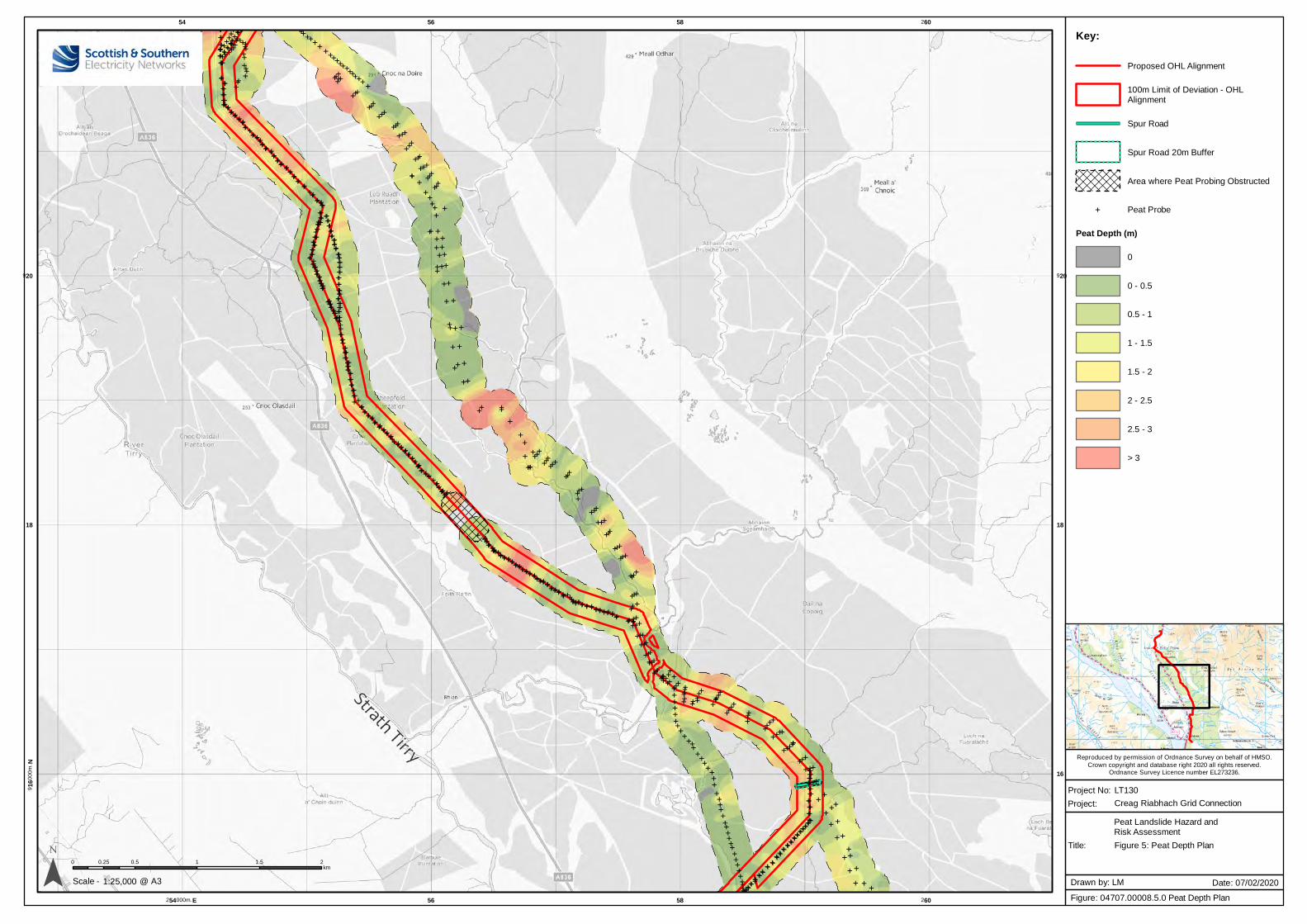
Creag Riabhach Grid Connection
Reproduced by permission of Ordnance Survey on behalf of HMSO.
Crown copyright and database right 2020 all rights reserved.Ordnance Survey Licence number EL273236.
E EEEEEEEEEEEE
EE
E EEEEEE
EE
E
EEEE
EE
EE
EEEEE
EEEEEE EE
EEE
EEEEEEEE E
EEEEE
EEEEEE
EE EE EE
EEEEE E
EEE
E EEE
EEEEEE E
E
EEEEEE
EE
EE
EEEE EE
E
EE E
E
EE
EE
EEE
E
EE
EE
E EE
EE
EEE
EE
EEEE
EEE
EEE
EE
EEE
EEE
EE
EE
EE
EEE
EEE
EEE E
EE E
EEE
EEEEEEEEEEE
E
EE E
EEEEEE
EEE
EEEEEE EEE
EEE EE
EEE E E
EEEE EE
EEE
E E EEEEE
EEEEEE
E
EE E
EEE
EEEE
E EEE
E
EEEEEEE
E
EE
EE
E
EEEEEE
EEEEEEE
EE
EEEEEEE
E EE EEEEE
EE
EEEEEEEEEEEEEE
EEEEE E E E E EE
EE E EEEEE
EE
E
EEE E
EEEEEE
EEE
EE E
E EE
E E
EEE
EEE
EE E E
EEE E E EE E EE
EEEE
EEEE
EE E
E
EEEEEE
EEE
EEEEEEEEEEEEE E
E EEE
EEE
EEE
E
EEEEEEE EEEEEEEEEEEEEEEEEE EEEEEEEEEEEEEEE
EEEE
E EEE
EEEEE
EEEEEEEEE
EE
EE
EEEE
E
EEEEEEEEEEEEE
EE
EE EE
EEEEEEEE
EEEEEE EE
EE EE
EEE
EE
EE E
E
EEEEE
E EE
EE E
EEEE
EE
EEEEEEEEEEEEEEEEEEEEEEEEEE
EEEE
EEEEEEEE E EE
EEEEEE
EE
EE
EE
EE
EEEEEE E
EEE
EEEEEEEEEEE
EE
E
E
E
EE
EEE
EE EE
E
E
EEE EEEE
E EEEE
EE
EEE
EE
EEEEE
E EE
E
EEE
E
EE E
EE E
EEEE
EE
E E
E
EEEEEE E
EEEEE EEE
EEEE
E E
E
E
E
E
EEEEEEEEEEEE
EEEEEE E
EE
E
EEEE
EEEEE
EEEEEEEEE
E
EEEEE
EEE
EEEEEEEEEE E
EEE
EEE
EEEEEE E
EEEE
E
EEE EEE
EEE
EEE
EEE
EEE E
E
EEEE
EEEE
EEEEEE
EEEEEE
EE
EEEEE
EEEE
EEEEE
EEE
EEEEEEE
EE
EEEEE
EEE
EEE
EEEEE
EEEEE
EE
E EEEEE
EEEE
EE
EEE
EEEE
EEEEE
EE E
EEEE
EEEEEEEEE
E EEEE
EEEE EEEE E
EEEEEE EE
EE
EEEE
EEEE EE
EE
EEEEEEE
EEEE
EEEEEEEEE
EEEE
EEEEEEEE EE
EE
EEEEEEEEEEEEE
EE EEEE
EEEEEEEEEEEEE
EEEEEEEEE
EE EE
EEEEEEEE
E EEEEE
EEEEE
EE EE
EE
EEE
E
EEEE EEEEEEEEE
E EEE
EEEEE
EEEEEEE
EEEEE
EEEEEE
EEEEEEE
EEEE
EEEEEEEE
EEEEEEEEEE
EEEE
EEEE
EEEEE
EEEEE
EE
E
EEEEEEE
EEE
EEE
EEE
EEE
EEEEEEEEEE
EEEEEEEE
EEEEEEEEEEEEEE
EEEEEEEEEE
EEEEEEEEEEE
EEEEEEEEEEEE
EEE
EEEEEEEEEEEEEE
EE
EEEEEEEEEEEEEE
EEEE
EEE
EEE
EEE
EEEE
EEE
EEEEEEEE
EEE
EEEE
E
E EEE
E
EEE
EEEE
EE
E EEE
EE
EE
E EE
EEE
EE
E
EEEE
EE EE
EE
EEE EE
EEEEE
EE
E
EEE
EE
EEEE
E
E
EEE
EE
E EEEEEEE
E EEEEE
E
EE
EEEEE
EEEE
EE E
E
EEEEEEEE
EE EEEE
EEEEE
EE EE
EE
EE
EEEE
EEEE
EE
EEEEE
EE
EEEEE
EEE
E EEEE
EEEEE
EE EEEEEEE
EE E E E
EE
E E
E E EEEE
EEE
E EEEEEEEE
EEEE E
EE
EE
EEEEE
EEEEE
EEE
E EEEE
EE
EEEE
EEEEE
EE E E E E EEE
EE
EEE
EEE
EEE
EEEEEEEE
E E E EE
E EE
EE
E EEEEEEEE
EEEEEEEEEEE
E
E
EE
EEEEEE
EE
EEEEE
EE E
EEEEEEE
EEEE
EEEEEEEEEEE
EEE
EEE
EE
EEEEEE
EE EE
EE
EEEEE
EE EE
EE E
EEE
EE
E
E
E
E EEE
E EE
EEE EE
E EEE
E
EE
EEEE
E
E
E E
EEE
EEE EEEEE E
EEEEE EE
EEE
EEEE
EEEEE
EEEEEE
EE
EEE
E
EEEE
EEEEEEEE
EEEE
EEEE
EEEE
EE
EE
EE
E
E
E
E
EE
EEE
EEEEEEEEEEEEE
EE
EE
EE
EE
EEEEEE
EEE EEEE
EEEE
EE
EEEE
EE
E
E
E
E
EEEE E
EEE
E EE EE
EEEEEE
EE
EE E
E E
EE
E
E EEE E E E
EEEE
EE
E EE
E
E
EEE
EE E
EEE E
EEEE
E
E EEEE
EEEE
E
EE
EEE
E E EEEE
EEEE E
EEEE E
EEEEEE
EEE
E
E EEEEE
EEEE
E EE
E
54
254000m. E
56
56
58
58
260
260
916
00
0m
. N
16
18 18
920 920
¯ 0 0.5 1 1.5 20.25km
1:25,000Scale -
Project No: LT130
Title:
Project:
Figure: 04707.00008.5.0 Peat Depth Plan
Drawn by: LM Date: 07/02/2020@ A3
Key:
Proposed OHL Alignment
100m Limit of Deviation - OHLAlignment
Spur Road
Spur Road 20m Buffer
Area where Peat Probing Obstructed
E Peat Probe
Peat Depth (m)
0
0 - 0.5
0.5 - 1
1 - 1.5
1.5 - 2
2 - 2.5
2.5 - 3
> 3
Figure 5: Peat Depth Plan
Peat Landslide Hazard andRisk Assessment
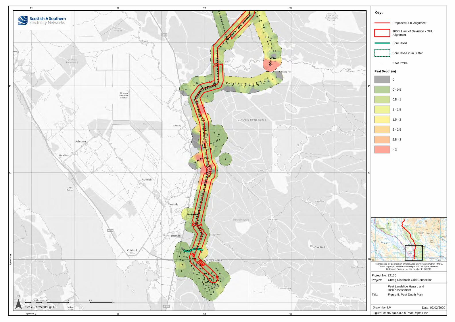
Creag Riabhach Grid Connection
Reproduced by permission of Ordnance Survey on behalf of HMSO.
Crown copyright and database right 2020 all rights reserved.Ordnance Survey Licence number EL273236.
E EEEEEEEEEEEE
EE
E EEEEEE
EE
E
EEEE
EE
EE
EEEEE
EEEEEE EE
EEE
EEEEEEEE E
EEEEE
EEEEEE
EE EE EE
EEEEE E
EEE
E EEE
EEEEEE E
E
EEEEEE
EE
EE
EEE
EEE
E
EE E
E
EE
EE
EEE
E
EE
EE
E EE
EE
EEE
EE
EEEE
EEE
EEE
EE
EEE
EEE
EE
EE
EE
EEE
EEE
EEE E
EE E
EEE
EEEEEEEEEEE
E
EE E
EEEEEE
EEE
EEEEEE EEE
EEE EE
EEE E E
EEEE EE
EEE
E E EEEEE
EEEEEE
E
EE E
EEE
EEEE
E EEE
E
EEEEEEE
E
EE
EE
E
EEEEEE
EEEEEEE
EE
EEEEEEE
E EE EEEEE
EE
EEEEEEEEEEEEEE
EEEEE E E E E EE
EE E EEEEE
EE
E
EEE E
EEEEEE
EEE
EE E
E EE
E E
EEE
EEE
EE E E
EEE E E EE E EE
EEEE
EE
EE
EE E
E
EEEEEE
EEE
EEEEEEEEEEEEE E
E EEE
EEE
EEE
E
EEEEEEE EEEEEEEEEEEEEEEEEE EEEEEEEEEEEEEEE
EEEE
E EE
E
EEEEE
EEEEEEEEE
EE
EE
EEEE
E
EEEEEEEEEEE
EEEE
EE EE
EEEEEEEE
EEEEEE EE
EE EE
EEE
EE
EE E
E
EEEEE
E EE
EE E
EEEE
EE
EEEEEEEEEEEEEEEEEEEEEEEEEE
EEEE
EEEEEEEE E EE
EEEEEE
EE
EE
EE
EE
EEEEEE E
EEE
EEEEEEEEEEE
E
EE
E
E
EE
EEE
EE EE
E
E
EEE EEEE
E EEEE
EE
EEE
EE
EEEEE
E EE
E
EEE
E
EE E
EE E
EE
EE
EE
E E
E
EEEEEE E
EEEEE EEE
EEEE
E E
E
E
E
E
EEEEEEEEEEEE
EEEEEE E
EE
E
EEEE
EEEEE
EEE
EEEEEE
E
EEEEE
EEE
EEEEEEEEEE E
EEEEEE
EEEEEE E
EEEE
E
EEE EEE
EEE
EEE
EEEE
EE EE
EEEE
EEEE
EEEEEE
EEEEEE
EE
EEEEE
EEEE
EEEEE
EEE
EEE
EEEEEE
EEEEE
EEE
EEE
EEEEE
EEEEE
EE
E EEEEE
EEEE
EE
EEE
EEEE
EEEEE
EE E
EEEE
EEEEEEEEE
E EEEE
EEEE EEEE E
EEEEEE EE
EE
EEEE
EEEE EEEE
EEEEEEE
EEEE
EEEEEEEEE
EEEE
EEEEEEEE EE
EE
EEEEEEEEEEEEE
EE EEEE
EEEEEEEEEEEEE
EEEEEEEEE
EE EE
EEEEEEEE
E EEEEE
EEEEE
EE EE
EE
EEE
E
EEEE EEEEEEEEE
E EEE
EEEEE
EEEEEEE
EEEEE
EEEEEE
EEEEEEE
EEEE
EEEEEEEE
EEEEEEEEEE
EEEE
EEEE
EEEEE
EEEEE
EE
E
EEEEEEE
EEE
EEE
EEE
EEE
EEEEEEEEEE
EEEEEEEEEEEEEEEE
EEEEEE
EEEEEEEEEE
EEEEEEEEEEE
EEEEEEEEEEEE
EEE
EEEEEEEEEEEEEE
EE
EEEEEEEEEE
EEEE
EEEE
EEE
EEE
EEE
EEEE
EEE
EEEEEEEE
EEEEEEE
E
E EEE
E
EEE
EEEE
EE
E EEE
EE
EE
E EE
EEE
EE
E
EEEE
EE EE
EE
EEE EE
EEEEE
EE
E
EEE
EE
EEEE
E
E
EEE
EE
E EEEEEEE
E EEEEE
E
EE
EEEEE
EEEE
EE E
E
EEEEEEEE
EE EEEE
EEEEE
EE EE
EE
EE
EEEE
EEEE
EE
EEEEE
EE
EEEEE
EEE
E EEEE
EEEEE
EE EEEEEEE
EE E E E
EE
E EE E EEEE
EEE
E EEEEEEEE
EEEE E
EE
EE
EEEEE
EEEEE
EEE
E EEEE
EE
EEEE
EEEEE
EE E E E E EEE
EE
EEE
EEE
EE
E
EEEEEEEE
E E E EE
E EE
EE
E EEEEEEEE
EEEEEEEEEEE
E
E
EE
EEEEEE
EE
EEEEE
EE E
EEEEE
EE
EE
EE
EEEEEEEEEEE
EEE
EEE
EE
EEEEEE
EE EE
EE
EEEEE
EE EE
EE E
EEE
EE
E
E
E
E EEE
E EE
EEE EE E E
EE
E
EE
EEEE
E
E
E E
EEE
EEE EEEEE E
EEEEE EE
EEE
EEEE
EEEEE
EEEEEE
EE
EEE
E
EEEE
EEEEEEEE
EEEE
EEEE
EEEE
EE
EE
EE
E
E
E
E
EE
EEE
EEEEEEEEEEEEE
EE
EE
EE
EE
EEEEEE
EEE EEEE
EEEE
EE
EEEE
EE
E
E
E
E
EEEE E
EEE
E EE EE
EEEE EE
EE
EE E
E E
EE
E
E EEE E E E
EEE EEE
E EE
E
E
EEE
EE E
EEE E
EEEE
E
E EEEE
EEEE
E
EE
EEE
E E EEEE
EE
EE E
EEEE E
EEEEEE
EEE
E
E EEEEE
EEEE
E EE
E
54
254000m. E
56
56
58
58
260
260
910
00
0m
. N
910
12 12
14 14
¯ 0 0.5 1 1.5 20.25km
1:25,000Scale -
Project No: LT130
Title:
Project:
Figure: 04707.00008.5.0 Peat Depth Plan
Drawn by: LM Date: 07/02/2020@ A3
Key:
Proposed OHL Alignment
100m Limit of Deviation - OHLAlignment
Spur Road
Spur Road 20m Buffer
E Peat Probe
Peat Depth (m)
0
0 - 0.5
0.5 - 1
1 - 1.5
1.5 - 2
2 - 2.5
2.5 - 3
> 3
Figure 5: Peat Depth Plan
Peat Landslide Hazard andRisk Assessment
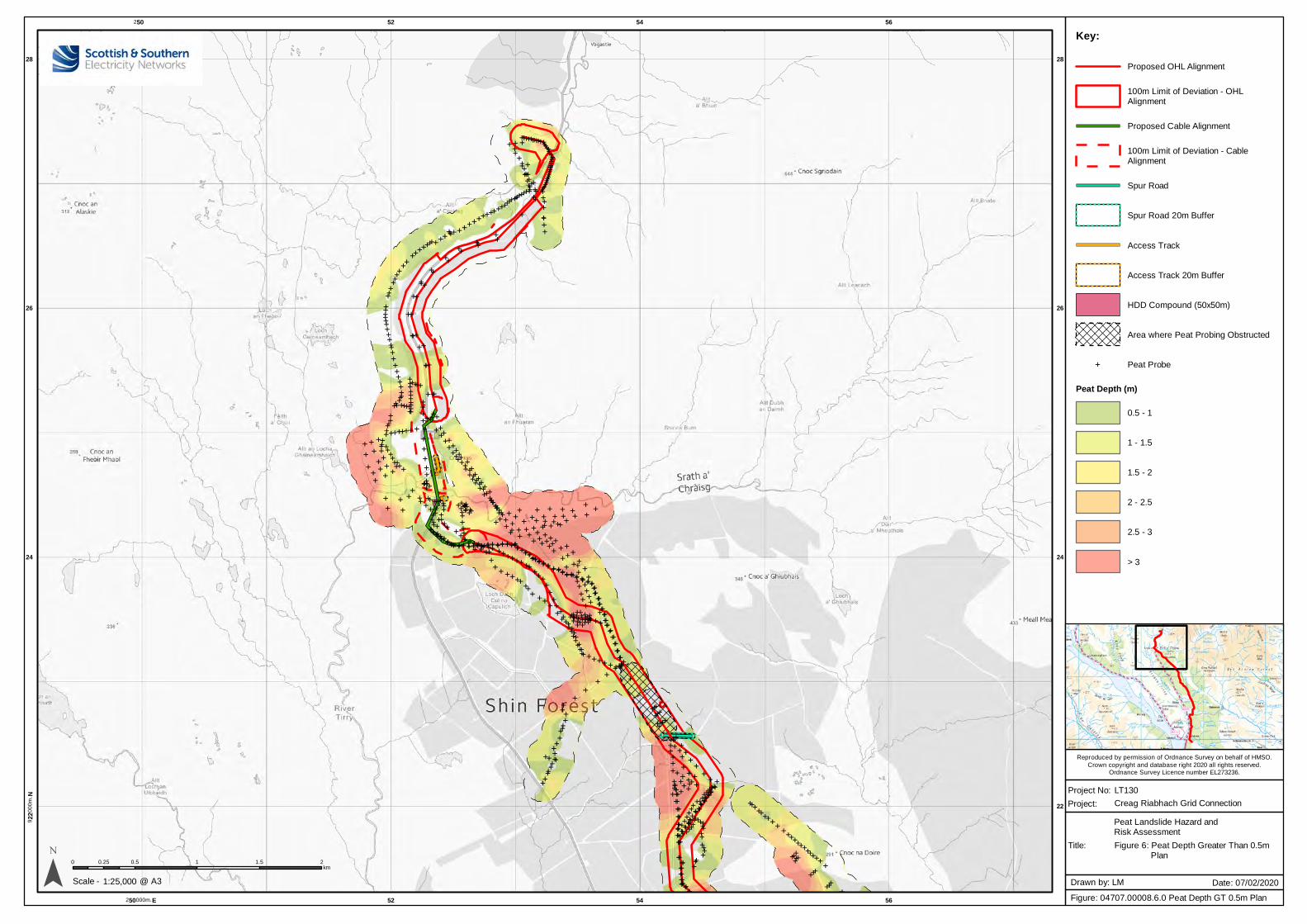
Creag Riabhach Grid Connection
Reproduced by permission of Ordnance Survey on behalf of HMSO.
Crown copyright and database right 2020 all rights reserved.Ordnance Survey Licence number EL273236.
E EEEEEEEEEEEE
EE
E EEEEEE
EE
E
E
EEE
EE
EE
EEEEE
EEEEEE EE
EEE
EEEEEEEE E
EEEEE
EEEEEE
EE EE EE
EEEEE E
EEE
E EEE
EEEEEE E
E
EEEEEE
EE
EE
EEE
EEE
E
EE E
E
EE
EE
EEE
E
EE
EE
E EE
EE
EEE
EE
EEEE
EEE
EEE
EE
EEE
EEE
EE
EE
EE
EEE
EEE
EEE E
EE E
EEE
EEEEEEEEEEE
E
EE E
EEEEEE
EEE
EEEEEE EEE
EEE EE
EEE E E
EEEE EE
EEE
E E EEEEE
EEEEEE
E
EE E
EEE
EEEE
E EEE
E
EEEEEEE
E
EE
EE
E
EEEEEE
EEEEEEE
EE
EEEEEEE
E EE EEEEE
EE
EEEEEEEEEEEEEE
EEEEE E E E E EE
EE E EEEEE
EE
E
EE
E EEEEEEE
EEE
EE E
E EE
E E
EEE
EEE
EE E E
EEE E E EE E EE
EEEE
EE
EE
EE E
E
EEEEEE
EEE
EEEEEEEEEEEEE E
E EEE
EEE
E EEE
EEEEEEE EEEEEEEEEEEEEEEEEE EEEEEEEEEEEEEEE
EEEE
E EE
E
EEEEE
EEEEEEEEE
EE
EE
EEEE
E
EEEEEEEEEEE
EEEE
EE EE
EEEEEEEE
EEEEEE EE
EE EE
EEE
EE
EEE
E
EEEEE
E EE
EE E
EEEE
EE
EEEEEEEEEEEEEEEEEEEEEEEEEE
EEEE
EEEEEEEE E EE
EEEEEE
EE
EE
EE
EE
EEEEEE E
EEE
EEEEEEEEEEE
E
EE
E
E
EE
EEE
EE EE
E
E
EEE EEEE
E EEEE
EE
EEE
EE
EEEEE E E
E
E
EEE
E
EE E
EE E
EE
EE
EE
E EEEEEEEE E
EEEEE EEE
EEEE
E E
E
E
E
E
EEEEEEEEEEEE
EEEEEE E
EE
E
EEEE
EEEEE
EEEEEEEEE
E
EEEEE
EEE
EEEEEEEEEE E
EEEEEE
EEEEEE E
EEEE
E
EEE EEE
EEE
EEE
EEEE
EE EE
EEEE
EEEE
EEEEEE
EEEEEE
EE
EEEEE
EEEE
EEEEE
EEE
EEEEE
EEEE
EEEEE
EEE
EEE
EEEEE
EEEEE
EE
E EEEEE
EEEE
EE
EEE
EEEE
EEEEE
EE E
EEEE
EEEEEEEEE
E EEEE
EEEE EEEE E
EEEEEE EE
EE
EEEE
EEEE EEEE
EEEEEEE
EEEE
EEEEEEEEE
EEEE
EEEEEEEE EE
EE
EEEEEEEEEEEEE
EE EEEE
EEEEEEEEEEEEE
EEEEEEEEE
EE EE
EEEEEEEE
E EEEEE
EEEEE
EE EE
EE
EEE
E
EEEE EEEEEEEEE
E EEE
EEEEE
EEEEEEE
EEEEE
EEEEEE
EEEEEEE
EEEE
EEEEEEEE
EEEEEEEEEE
EEEE
EEEE
EEEEE
EEEEE
EE
E
EEEEEEE
EEE
EEE
EEE
EEE
EEEEEEEEEE
EEEEEEEEEEEEEEEE
EEEEEE
EEEEEEEEEEEEEEEEEE
EEEEEE
EEEEEEEEE
EEEEEEEEEEEEEEEEE
EE
EEEEEEEEEEEEEE
EEEE
EEE
EEE
EEE
EEEE
EEE
EEEEEEEE
EEEEEEE
E
E EEE
E
EEE
EEEE
EE
E EEE
EE
EE
E EE
EEE
EE
E
EEEE
EE EE
EE
EEE EE
EEEEE
EE
E
EEE
EE
EEEE
E
E
EEE
EE
E EEEEEEE
E EEEEE
E
EE
EEEEE
E EEE
EE E
E
EEEEEEEE
EE EEEE
EEEEE
EE EE
EE
EE
EEEE
EEEE
EE
EEEEE
EE
EEEEE
EEE
E EEEE
EEEEE
EE EEEEEEE
EE E E E
EE
E EE E EEEE
EEE
E EEEEEEEE
EEEE E
EE
EE
EEEEE
EE
EEE
EEE
E EEEE
EE
EEEE
EEEEE
EE E E E E EEE
EE
EEE
EEE
EEE
EEEEEEEE
E E E EE
E EE
EE
E EEEEEEEE
EEEEEEEEEEE
E
E
EE
EEEEEE
EE
EEEEE
EE E
EEEEE
EE
EE
EEEEEEEEEEEEE
EEE
EEE
EE
EEEEEE
EE EE
EE
EEEEE
EE EE
EE E
EEE
EE
E
E
E
E EEE
E EE
EEE EE E E
EE
E
EE
EEEE
E
E
E E
EEE
EEEEEEEE E
EEEEE EE
EEE
EEEE
EEEEE
EEEEEE
EE
EEE
E
EEEE
EEEEEEEE
EEEE
EEEE
EEEE
EE
EE
EE
E
E
E
E
EE
EEE
EEEEEEEEEEEEE
EE
EE
EE
EE
EEEEEE
EEE EEEE
EEEE
EE
EEEE
EE
E
E
E
E
EEEE E
EEE
E EE EE
EEEEEE
EE
EE E
EE
EE
E
E EEE E E E
EEE EEE
E EE
E
E
EEE
EE E
EEE E
EEEE
E
E EEEE
EEEE
E
EE
EEE
E E EEEE
EE
EE E
EEEE E
EEEEEE
EEE
E
E EEEEE
EEEE
E EE
E
250
250000m. E
52
52
54
54
56
56
922
00
0m
. N
22
24 24
26 26
28 28
¯ 0 0.5 1 1.5 20.25km
1:25,000Scale -
Project No: LT130
Title:
Project:
Figure: 04707.00008.6.0 Peat Depth GT 0.5m Plan
Drawn by: LM Date: 07/02/2020@ A3
Key:
Proposed OHL Alignment
100m Limit of Deviation - OHLAlignment
Proposed Cable Alignment
100m Limit of Deviation - CableAlignment
Spur Road
Spur Road 20m Buffer
Access Track
Access Track 20m Buffer
HDD Compound (50x50m)
Area where Peat Probing Obstructed
E Peat Probe
Peat Depth (m)
0.5 - 1
1 - 1.5
1.5 - 2
2 - 2.5
2.5 - 3
> 3
Figure 6: Peat Depth Greater Than 0.5m Plan
Peat Landslide Hazard andRisk Assessment
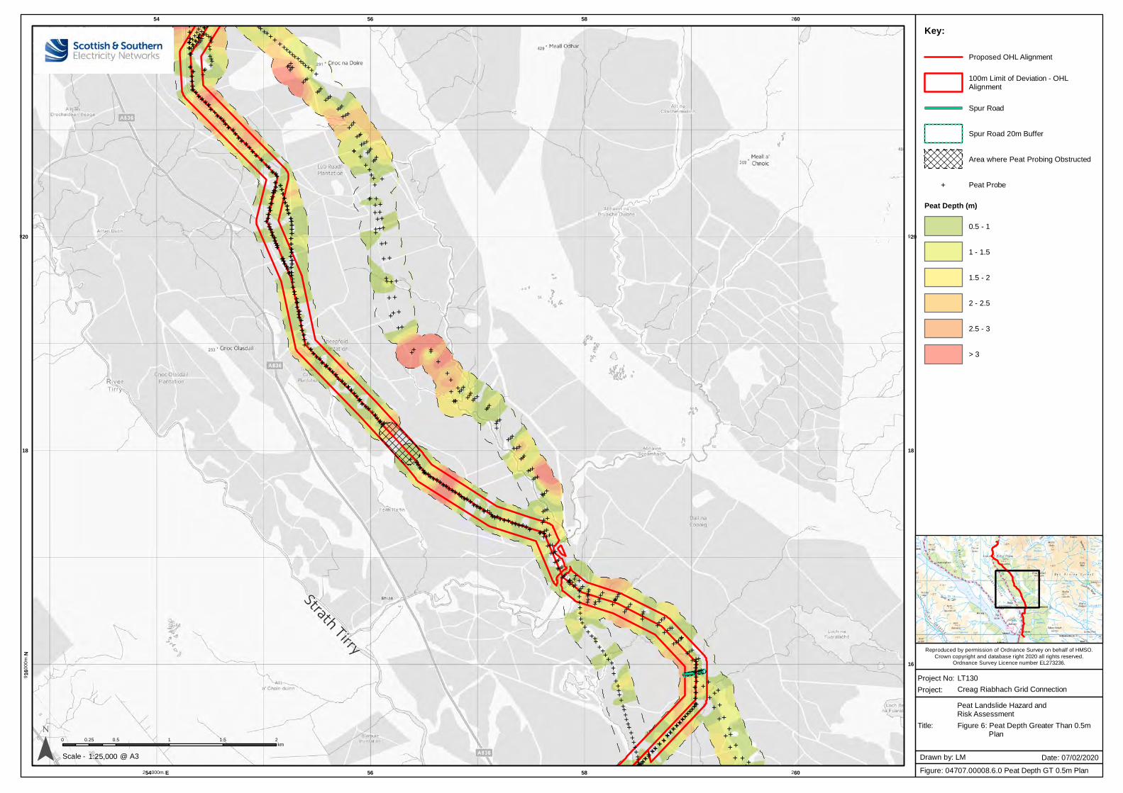
Creag Riabhach Grid Connection
Reproduced by permission of Ordnance Survey on behalf of HMSO.
Crown copyright and database right 2020 all rights reserved.Ordnance Survey Licence number EL273236.
E EEEEEEEEEEEE
EE
E EEEEEE
EE
E
EEEE
EE
EE
EEEEE
EEEEEE EE
EEE
EEEEEEEE E
EEEEE
EEEEEE
EE EE EE
EEEEE E
EEE
E EEE
EEEEEE E
E
EEEEEE
EE
EE
EEEE EE
E
EE E
E
EE
EE
EEE
E
EE
EE
E EE
EE
EEE
EE
EEEE
EEE
EEE
EE
EEE
EEE
EE
EE
EE
EEE
EEE
EEE E
EE E
EEE
EEEEEEEEEEE
E
EE E
EEEEEE
EEE
EEEEEE EEE
EEE EE
EEE E E
EEEE EE
EEE
E E EEEEE
EEEEEE
E
EE E
EEE
EEEE
E EEE
E
EEEEEEE
E
EE
EE
E
EEEEEE
EEEEEEE
EE
EEEEEEE
E EE EEEEE
EE
EEEEEEEEEEEEEE
EEEEE E E E E EE
EE E EEEEE
EE
E
EEE E
EEEEEE
EEE
EE E
E EE
E E
EEE
EEE
EE E E
EEE E E EE E EE
EEEE
EEEE
EE E
E
EEEEEE
EEE
EEEEEEEEEEEEE E
E EEE
EEE
EEE
E
EEEEEEE EEEEEEEEEEEEEEEEEE EEEEEEEEEEEEEEE
EEEE
E EEE
EEEEE
EEEEEEEEE
EE
EE
EEEE
E
EEEEEEEEEEEEE
EE
EE EE
EEEEEEEE
EEEEEE EE
EE EE
EEE
EE
EE E
E
EEEEE
E EE
EE E
EEEE
EE
EEEEEEEEEEEEEEEEEEEEEEEEEE
EEEE
EEEEEEEE E EE
EEEEEE
EE
EE
EE
EE
EEEEEE E
EEE
EEEEEEEEEEE
EE
E
E
E
EE
EEE
EE EE
E
E
EEE EEEE
E EEEE
EE
EEE
EE
EEEEE
E EE
E
EEE
E
EE E
EE E
EEEE
EE
E E
E
EEEEEE E
EEEEE EEE
EEEE
E E
E
E
E
E
EEEEEEEEEEEE
EEEEEE E
EE
E
EEEE
EEEEE
EEEEEEEEE
E
EEEEE
EEE
EEEEEEEEEE E
EEE
EEE
EEEEEE E
EEEE
E
EEE EEE
EEE
EEE
EEE
EEE E
E
EEEE
EEEE
EEEEEE
EEEEEE
EE
EEEEE
EEEE
EEEEE
EEE
EEEEEEE
EE
EEEEE
EEE
EEE
EEEEE
EEEEE
EE
E EEEEE
EEEE
EE
EEE
EEEE
EEEEE
EE E
EEEE
EEEEEEEEE
E EEEE
EEEE EEEE E
EEEEEE EE
EE
EEEE
EEEE EE
EE
EEEEEEE
EEEE
EEEEEEEEE
EEEE
EEEEEEEE EE
EE
EEEEEEEEEEEEE
EE EEEE
EEEEEEEEEEEEE
EEEEEEEEE
EE EE
EEEEEEEE
E EEEEE
EEEEE
EE EE
EE
EEE
E
EEEE EEEEEEEEE
E EEE
EEEEE
EEEEEEE
EEEEE
EEEEEE
EEEEEEE
EEEE
EEEEEEEE
EEEEEEEEEE
EEEE
EEEE
EEEEE
EEEEE
EE
E
EEEEEEE
EEE
EEE
EEE
EEE
EEEEEEEEEE
EEEEEEEE
EEEEEEEEEEEEEE
EEEEEEEEEE
EEEEEEEEEEE
EEEEEEEEEEEE
EEE
EEEEEEEEEEEEEE
EE
EEEEEEEEEEEEEE
EEEE
EEE
EEE
EEE
EEEE
EEE
EEEEEEEE
EEE
EEEE
E
E EEE
E
EEE
EEEE
EE
E EEE
EE
EE
E EE
EEE
EE
E
EEEE
EE EE
EE
EEE EE
EEEEE
EE
E
EEE
EE
EEEE
E
E
EEE
EE
E EEEEEEE
E EEEEE
E
EE
EEEEE
EEEE
EE E
E
EEEEEEEE
EE EEEE
EEEEE
EE EE
EE
EE
EEEE
EEEE
EE
EEEEE
EE
EEEEE
EEE
E EEEE
EEEEE
EE EEEEEEE
EE E E E
EE
E E
E E EEEE
EEE
E EEEEEEEE
EEEE E
EE
EE
EEEEE
EEEEE
EEE
E EEEE
EE
EEEE
EEEEE
EE E E E E EEE
EE
EEE
EEE
EEE
EEEEEEEE
E E E EE
E EE
EE
E EEEEEEEE
EEEEEEEEEEE
E
E
EE
EEEEEE
EE
EEEEE
EE E
EEEEEEE
EEEE
EEEEEEEEEEE
EEE
EEE
EE
EEEEEE
EE EE
EE
EEEEE
EE EE
EE E
EEE
EE
E
E
E
E EEE
E EE
EEE EE
E EEE
E
EE
EEEE
E
E
E E
EEE
EEE EEEEE E
EEEEE EE
EEE
EEEE
EEEEE
EEEEEE
EE
EEE
E
EEEE
EEEEEEEE
EEEE
EEEE
EEEE
EE
EE
EE
E
E
E
E
EE
EEE
EEEEEEEEEEEEE
EE
EE
EE
EE
EEEEEE
EEE EEEE
EEEE
EE
EEEE
EE
E
E
E
E
EEEE E
EEE
E EE EE
EEEEEE
EE
EE E
E E
EE
E
E EEE E E E
EEEE
EE
E EE
E
E
EEE
EE E
EEE E
EEEE
E
E EEEE
EEEE
E
EE
EEE
E E EEEE
EEEE E
EEEE E
EEEEEE
EEE
E
E EEEEE
EEEE
E EE
E
54
254000m. E
56
56
58
58
260
260
916
00
0m
. N
16
18 18
920 920
¯ 0 0.5 1 1.5 20.25km
1:25,000Scale -
Project No: LT130
Title:
Project:
Figure: 04707.00008.6.0 Peat Depth GT 0.5m Plan
Drawn by: LM Date: 07/02/2020@ A3
Key:
Proposed OHL Alignment
100m Limit of Deviation - OHLAlignment
Spur Road
Spur Road 20m Buffer
Area where Peat Probing Obstructed
E Peat Probe
Peat Depth (m)
0.5 - 1
1 - 1.5
1.5 - 2
2 - 2.5
2.5 - 3
> 3
Figure 6: Peat Depth Greater Than 0.5m Plan
Peat Landslide Hazard andRisk Assessment
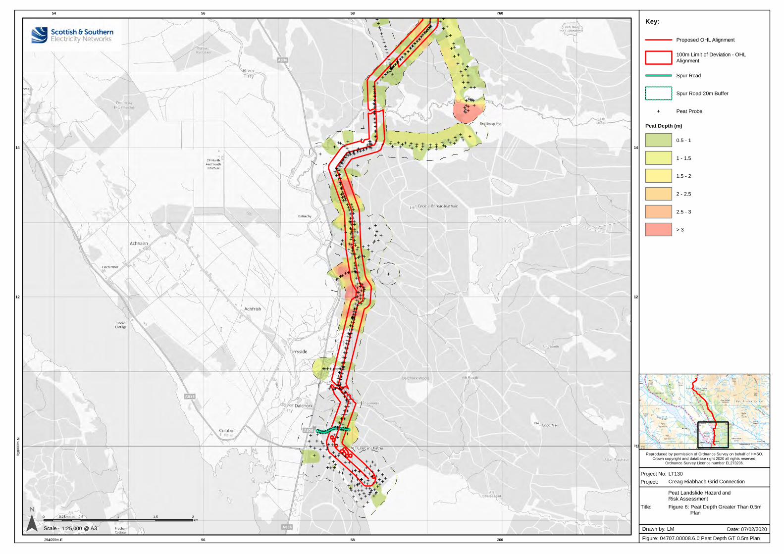
Creag Riabhach Grid Connection
Reproduced by permission of Ordnance Survey on behalf of HMSO.
Crown copyright and database right 2020 all rights reserved.Ordnance Survey Licence number EL273236.
E EEEEEEEEEEEE
EE
E EEEEEE
EE
E
EEEE
EE
EE
EEEEE
EEEEEE EE
EEE
EEEEEEEE E
EEEEE
EEEEEE
EE EE EE
EEEEE E
EEE
E EEE
EEEEEE E
E
EEEEEE
EE
EE
EEE
EEE
E
EE E
E
EE
EE
EEE
E
EE
EE
E EE
EE
EEE
EE
EEEE
EEE
EEE
EE
EEE
EEE
EE
EE
EE
EEE
EEE
EEE E
EE E
EEE
EEEEEEEEEEE
E
EE E
EEEEEE
EEE
EEEEEE EEE
EEE EE
EEE E E
EEEE EE
EEE
E E EEEEE
EEEEEE
E
EE E
EEE
EEEE
E EEE
E
EEEEEEE
E
EE
EE
E
EEEEEE
EEEEEEE
EE
EEEEEEE
E EE EEEEE
EE
EEEEEEEEEEEEEE
EEEEE E E E E EE
EE E EEEEE
EE
E
EEE E
EEEEEE
EEE
EE E
E EE
E E
EEE
EEE
EE E E
EEE E E EE E EE
EEEE
EE
EE
EE E
E
EEEEEE
EEE
EEEEEEEEEEEEE E
E EEE
EEE
EEE
E
EEEEEEE EEEEEEEEEEEEEEEEEE EEEEEEEEEEEEEEE
EEEE
E EE
E
EEEEE
EEEEEEEEE
EE
EE
EEEE
E
EEEEEEEEEEE
EEEE
EE EE
EEEEEEEE
EEEEEE EE
EE EE
EEE
EE
EE E
E
EEEEE
E EE
EE E
EEEE
EE
EEEEEEEEEEEEEEEEEEEEEEEEEE
EEEE
EEEEEEEE E EE
EEEEEE
EE
EE
EE
EE
EEEEEE E
EEE
EEEEEEEEEEE
E
EE
E
E
EE
EEE
EE EE
E
E
EEE EEEE
E EEEE
EE
EEE
EE
EEEEE
E EE
E
EEE
E
EE E
EE E
EE
EE
EE
E E
E
EEEEEE E
EEEEE EEE
EEEE
E E
E
E
E
E
EEEEEEEEEEEE
EEEEEE E
EE
E
EEEE
EEEEE
EEE
EEEEEE
E
EEEEE
EEE
EEEEEEEEEE E
EEEEEE
EEEEEE E
EEEE
E
EEE EEE
EEE
EEE
EEEE
EE EE
EEEE
EEEE
EEEEEE
EEEEEE
EE
EEEEE
EEEE
EEEEE
EEE
EEE
EEEEEE
EEEEE
EEE
EEE
EEEEE
EEEEE
EE
E EEEEE
EEEE
EE
EEE
EEEE
EEEEE
EE E
EEEE
EEEEEEEEE
E EEEE
EEEE EEEE E
EEEEEE EE
EE
EEEE
EEEE EEEE
EEEEEEE
EEEE
EEEEEEEEE
EEEE
EEEEEEEE EE
EE
EEEEEEEEEEEEE
EE EEEE
EEEEEEEEEEEEE
EEEEEEEEE
EE EE
EEEEEEEE
E EEEEE
EEEEE
EE EE
EE
EEE
E
EEEE EEEEEEEEE
E EEE
EEEEE
EEEEEEE
EEEEE
EEEEEE
EEEEEEE
EEEE
EEEEEEEE
EEEEEEEEEE
EEEE
EEEE
EEEEE
EEEEE
EE
E
EEEEEEE
EEE
EEE
EEE
EEE
EEEEEEEEEE
EEEEEEEEEEEEEEEE
EEEEEE
EEEEEEEEEE
EEEEEEEEEEE
EEEEEEEEEEEE
EEE
EEEEEEEEEEEEEE
EE
EEEEEEEEEE
EEEE
EEEE
EEE
EEE
EEE
EEEE
EEE
EEEEEEEE
EEEEEEE
E
E EEE
E
EEE
EEEE
EE
E EEE
EE
EE
E EE
EEE
EE
E
EEEE
EE EE
EE
EEE EE
EEEEE
EE
E
EEE
EE
EEEE
E
E
EEE
EE
E EEEEEEE
E EEEEE
E
EE
EEEEE
EEEE
EE E
E
EEEEEEEE
EE EEEE
EEEEE
EE EE
EE
EE
EEEE
EEEE
EE
EEEEE
EE
EEEEE
EEE
E EEEE
EEEEE
EE EEEEEEE
EE E E E
EE
E EE E EEEE
EEE
E EEEEEEEE
EEEE E
EE
EE
EEEEE
EEEEE
EEE
E EEEE
EE
EEEE
EEEEE
EE E E E E EEE
EE
EEE
EEE
EE
E
EEEEEEEE
E E E EE
E EE
EE
E EEEEEEEE
EEEEEEEEEEE
E
E
EE
EEEEEE
EE
EEEEE
EE E
EEEEE
EE
EE
EE
EEEEEEEEEEE
EEE
EEE
EE
EEEEEE
EE EE
EE
EEEEE
EE EE
EE E
EEE
EE
E
E
E
E EEE
E EE
EEE EE E E
EE
E
EE
EEEE
E
E
E E
EEE
EEE EEEEE E
EEEEE EE
EEE
EEEE
EEEEE
EEEEEE
EE
EEE
E
EEEE
EEEEEEEE
EEEE
EEEE
EEEE
EE
EE
EE
E
E
E
E
EE
EEE
EEEEEEEEEEEEE
EE
EE
EE
EE
EEEEEE
EEE EEEE
EEEE
EE
EEEE
EE
E
E
E
E
EEEE E
EEE
E EE EE
EEEE EE
EE
EE E
E E
EE
E
E EEE E E E
EEE EEE
E EE
E
E
EEE
EE E
EEE E
EEEE
E
E EEEE
EEEE
E
EE
EEE
E E EEEE
EE
EE E
EEEE E
EEEEEE
EEE
E
E EEEEE
EEEE
E EE
E
54
254000m. E
56
56
58
58
260
260
910
00
0m
. N
910
12 12
14 14
¯ 0 0.5 1 1.5 20.25km
1:25,000Scale -
Project No: LT130
Title:
Project:
Figure: 04707.00008.6.0 Peat Depth GT 0.5m Plan
Drawn by: LM Date: 07/02/2020@ A3
Key:
Proposed OHL Alignment
100m Limit of Deviation - OHL
Alignment
Spur Road
Spur Road 20m Buffer
E Peat Probe
Peat Depth (m)
0.5 - 1
1 - 1.5
1.5 - 2
2 - 2.5
2.5 - 3
> 3
Figure 6: Peat Depth Greater Than 0.5m Plan
Peat Landslide Hazard andRisk Assessment
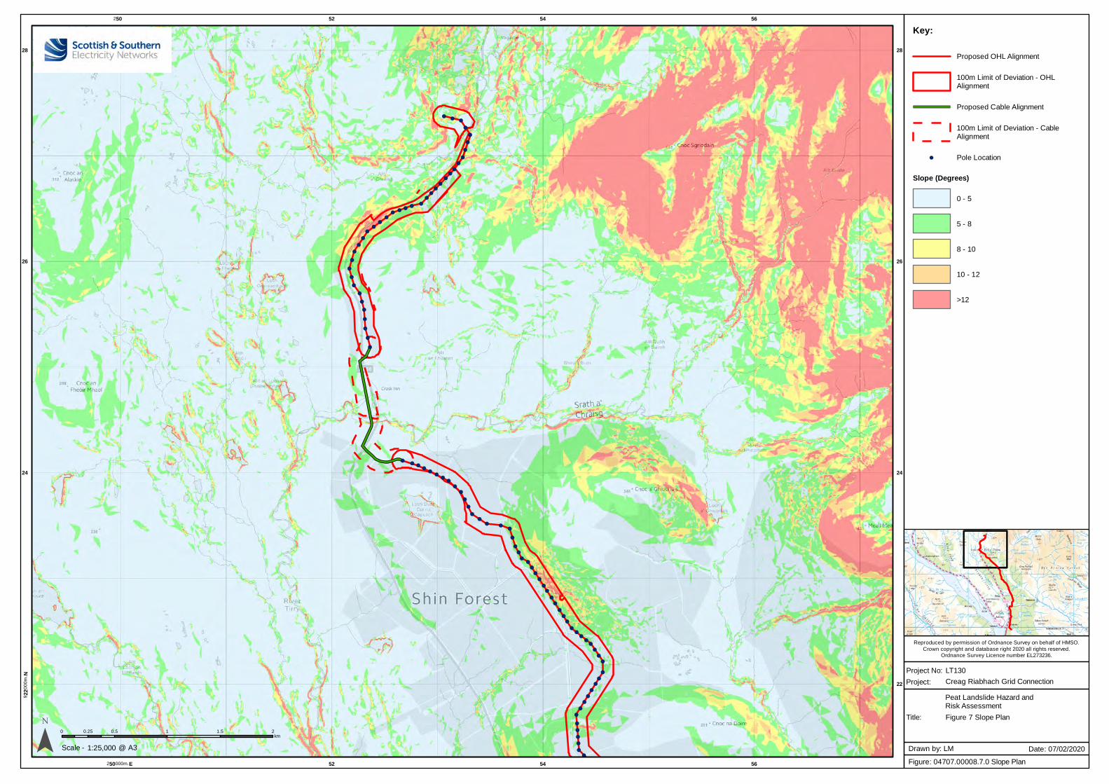
Creag Riabhach Grid Connection
Reproduced by permission of Ordnance Survey on behalf of HMSO.
Crown copyright and database right 2020 all rights reserved.Ordnance Survey Licence number EL273236.
!( !( !(
!(
!(
!(
!(
!(
!(
!(!(
!(!(
!(!(
!(
!(!(!(!(!(!(
!(!(
!(
!(
!(
!(
!(
!(
!(
!(
!(
!(
!(
!(
!(
!(
!(
!(!( !(
!(!(
!(!(
!(!(
!(
!(
!(
!(!(
!( !(!(
!(
!(
!(
!(!(!(!(
!(
!(!(
!(
!(
!(
!(!(
!(!(!(!(!(
!(
!(
!(
!(
!(!(
!(
!(
!(
!(
!(
!(
!(
!(
!(
!(!(!(!(!(
250
250000m. E
52
52
54
54
56
56
922
00
0m
. N
22
24 24
26 26
28 28
¯ 0 0.5 1 1.5 20.25km
1:25,000Scale -
Project No: LT130
Title:
Project:
Figure: 04707.00008.7.0 Slope Plan
Drawn by: LM Date: 07/02/2020@ A3
Key:
Proposed OHL Alignment
100m Limit of Deviation - OHLAlignment
Proposed Cable Alignment
100m Limit of Deviation - CableAlignment
!( Pole Location
Slope (Degrees)
0 - 5
5 - 8
8 - 10
10 - 12
>12
Figure 7 Slope Plan
Peat Landslide Hazard andRisk Assessment
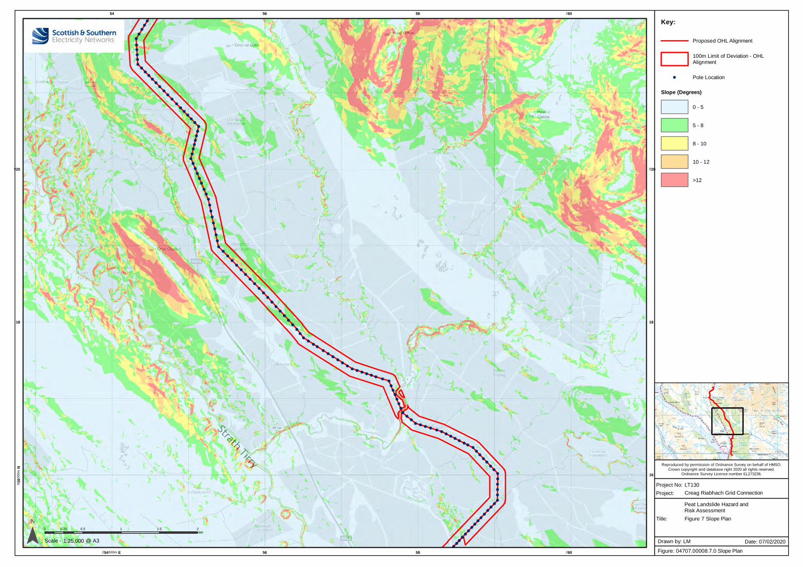
Creag Riabhach Grid Connection
Reproduced by permission of Ordnance Survey on behalf of HMSO.
Crown copyright and database right 2020 all rights reserved.Ordnance Survey Licence number EL273236.
!(
!(!(
!(
!(
!(
!(
!(
!(
!(
!(
!(
!(!(!(!(!(!(!(
!(!(
!(
!(!(!(!(!(!(!(
!(
!(
!(
!(
!(
!(
!(
!(
!(
!(
!(
!(
!(
!(
!(
!(
!(
!(
!(
!(
!(
!(
!(
!(
!(
!(
!(
!(
!(
!(
!(
!(
!(
!(
!(
!(
!(
!(
!(
!(
!(
!(
!(!(
!(!(
!(!(
!(!(
!(!(
!( !( !( !( !( !(!(
!(
!(
!(
!(
!(
!(
!(
!(!(
!(!( !( !( !(
!( !(!(
!(!(
!(!(!(
!(!(!(!(!(!(!(!(
!(
!(
!(
!(
!(!(
!(!(
!(!(
!(!(
!(!(
!(!(
!(!(
!(!(
!(!(
!(
54
254000m. E
56
56
58
58
260
260
916
00
0m
. N
16
18 18
920 920
¯ 0 0.5 1 1.5 20.25km
1:25,000Scale -
Project No: LT130
Title:
Project:
Figure: 04707.00008.7.0 Slope Plan
Drawn by: LM Date: 07/02/2020@ A3
Key:
Proposed OHL Alignment
100m Limit of Deviation - OHLAlignment
!( Pole Location
Slope (Degrees)
0 - 5
5 - 8
8 - 10
10 - 12
>12
Figure 7 Slope Plan
Peat Landslide Hazard andRisk Assessment
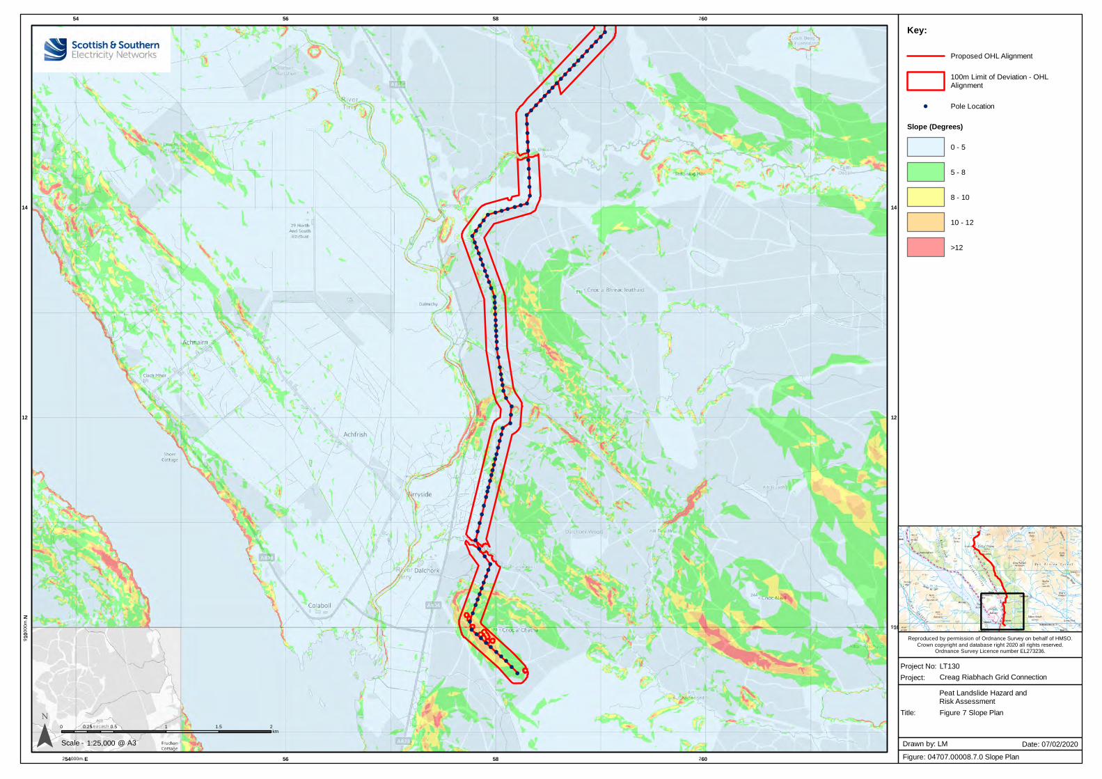
Creag Riabhach Grid Connection
Reproduced by permission of Ordnance Survey on behalf of HMSO.
Crown copyright and database right 2020 all rights reserved.Ordnance Survey Licence number EL273236.
!(
!(
!(!(
!(!(
!(!(
!(!(
!(!(
!(!(
!(!(
!(!(
!(!(
!(
!(
!(
!(
!(
!(
!(
!(
!(
!(
!(!(!(!(!(!(!(!(
!(!(
!(
!(!(
!(
!(!(
!(!(
!(
!(
!(
!(!(
!(
!(!(!(!(!(
!(
!(
!(
!(!(!(
!(
!(
!(
!(
!(!(
!(
!(
!(
!(!(
!(!(!(
!(
!(!(!(
!(
!(
!(
!(
!(
!(
!(
!(
!(
!(
!(
!(
!(!(!(
!(
!(
!(!(!(!(!(!(!(!(
!(
!(
54
254000m. E
56
56
58
58
260
260
910
00
0m
. N
910
12 12
14 14
¯ 0 0.5 1 1.5 20.25km
1:25,000Scale -
Project No: LT130
Title:
Project:
Figure: 04707.00008.7.0 Slope Plan
Drawn by: LM Date: 07/02/2020@ A3
Key:
Proposed OHL Alignment
100m Limit of Deviation - OHLAlignment
!( Pole Location
Slope (Degrees)
0 - 5
5 - 8
8 - 10
10 - 12
>12
Figure 7 Slope Plan
Peat Landslide Hazard andRisk Assessment
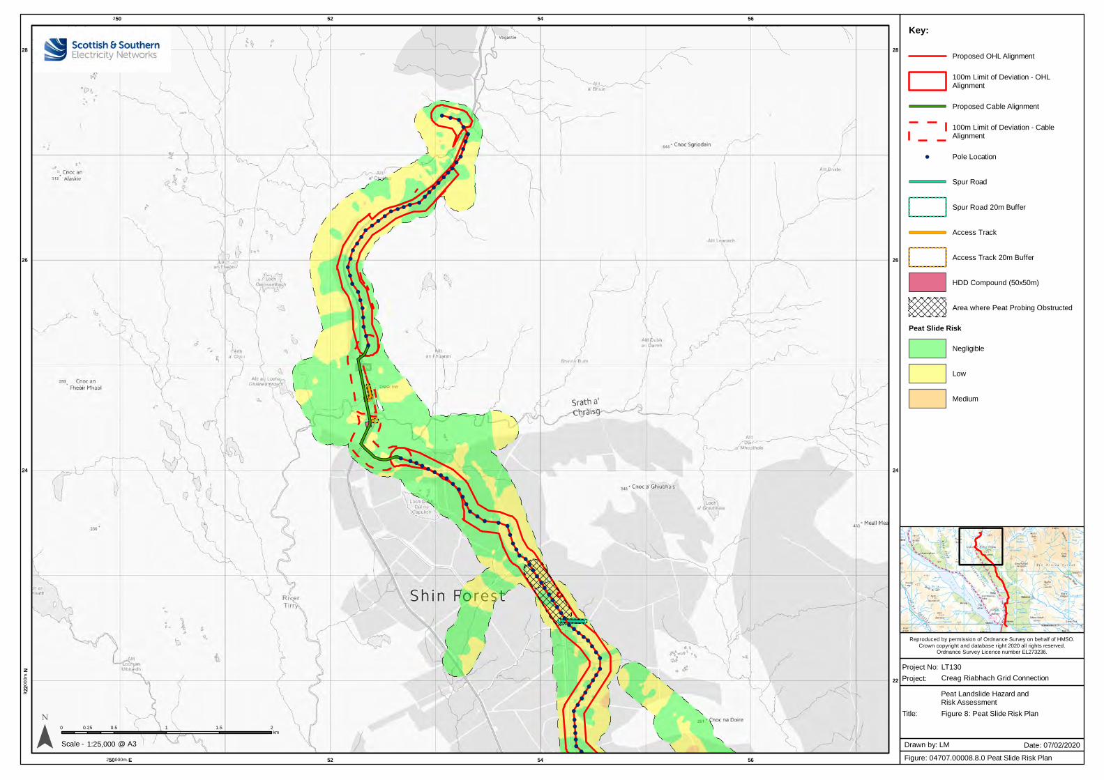
Creag Riabhach Grid Connection
Reproduced by permission of Ordnance Survey on behalf of HMSO.
Crown copyright and database right 2020 all rights reserved.Ordnance Survey Licence number EL273236.
!( !( !(
!(
!(
!(
!(
!(
!(
!(!(
!(!(
!(!(
!(
!(!(!(!(!(!(
!(!(
!(
!(
!(
!(
!(
!(
!(
!(
!(
!(
!(
!(
!(
!(
!(
!(!( !(
!(!(
!(!(
!(!(
!(
!(
!(
!(!(
!( !(!(
!(
!(
!(
!(!(!(!(
!(
!(!(
!(
!(
!(
!(!(
!(!(!(!(!(
!(
!(
!(
!(
!(!(
!(
!(
!(
!(
!(
!(
!(
!(
!(
!(!(!(!(!(
250
250000m. E
52
52
54
54
56
56
922
00
0m
. N
22
24 24
26 26
28 28
¯ 0 0.5 1 1.5 20.25km
1:25,000Scale -
Project No: LT130
Title:
Project:
Figure: 04707.00008.8.0 Peat Slide Risk Plan
Drawn by: LM Date: 07/02/2020@ A3
Key:
Proposed OHL Alignment
100m Limit of Deviation - OHLAlignment
Proposed Cable Alignment
100m Limit of Deviation - CableAlignment
!( Pole Location
Spur Road
Spur Road 20m Buffer
Access Track
Access Track 20m Buffer
HDD Compound (50x50m)
Area where Peat Probing Obstructed
Peat Slide Risk
Negligible
Low
Medium
Figure 8: Peat Slide Risk Plan
Peat Landslide Hazard andRisk Assessment
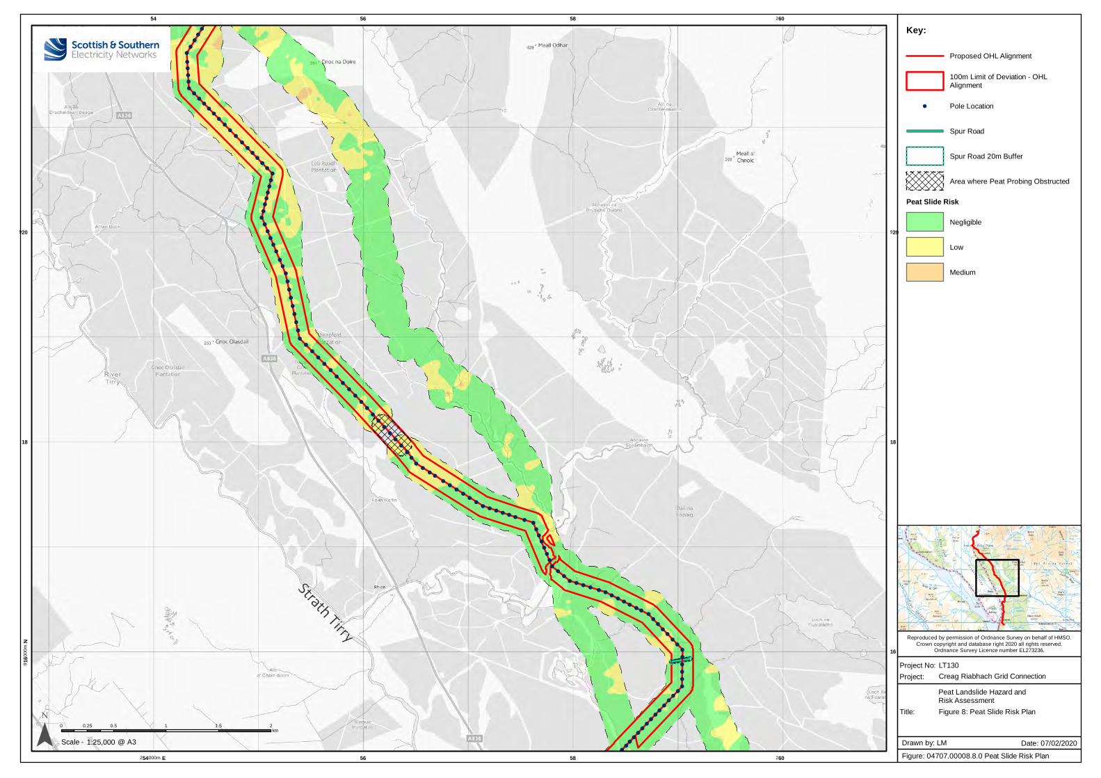
Creag Riabhach Grid Connection
Reproduced by permission of Ordnance Survey on behalf of HMSO.
Crown copyright and database right 2020 all rights reserved.Ordnance Survey Licence number EL273236.
!(
!(!(
!(
!(
!(
!(
!(
!(
!(
!(
!(
!(!(!(!(!(!(!(
!(!(
!(
!(!(!(!(!(!(!(
!(
!(
!(
!(
!(
!(
!(
!(
!(
!(
!(
!(
!(
!(
!(
!(
!(
!(
!(
!(
!(
!(
!(
!(
!(
!(
!(
!(
!(
!(
!(
!(
!(
!(
!(
!(
!(
!(
!(
!(
!(
!(
!(!(
!(!(
!(!(
!(!(
!(!(
!( !( !( !( !( !(!(
!(
!(
!(
!(
!(
!(
!(
!(!(
!(!( !( !( !(
!( !(!(
!(!(
!(!(!(
!(!(!(!(!(!(!(!(
!(
!(
!(
!(
!(!(
!(!(
!(!(
!(!(
!(!(
!(!(
!(!(
!(!(
!(!(
!(
54
254000m. E
56
56
58
58
260
260
916
00
0m
. N
16
18 18
920 920
¯ 0 0.5 1 1.5 20.25km
1:25,000Scale -
Project No: LT130
Title:
Project:
Figure: 04707.00008.8.0 Peat Slide Risk Plan
Drawn by: LM Date: 07/02/2020@ A3
Key:
Proposed OHL Alignment
100m Limit of Deviation - OHLAlignment
!( Pole Location
Spur Road
Spur Road 20m Buffer
Area where Peat Probing Obstructed
Peat Slide Risk
Negligible
Low
Medium
Figure 8: Peat Slide Risk Plan
Peat Landslide Hazard andRisk Assessment
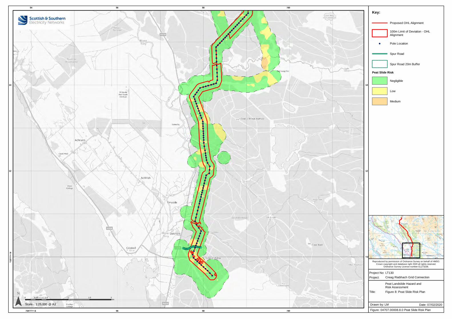
Creag Riabhach Grid Connection
Reproduced by permission of Ordnance Survey on behalf of HMSO.
Crown copyright and database right 2020 all rights reserved.Ordnance Survey Licence number EL273236.
!(
!(
!(!(
!(!(
!(!(
!(!(
!(!(
!(!(
!(!(
!(!(
!(!(
!(
!(
!(
!(
!(
!(
!(
!(
!(
!(
!(!(!(!(!(!(!(!(
!(!(
!(
!(!(
!(
!(!(
!(!(
!(
!(
!(
!(!(
!(
!(!(!(!(!(
!(
!(
!(
!(!(!(
!(
!(
!(
!(
!(!(
!(
!(
!(
!(!(
!(!(!(
!(
!(!(!(
!(
!(
!(
!(
!(
!(
!(
!(
!(
!(
!(
!(
!(!(!(
!(
!(
!(!(!(!(!(!(!(!(
!(
!(
54
254000m. E
56
56
58
58
260
260
910
00
0m
. N
910
12 12
14 14
¯ 0 0.5 1 1.5 20.25km
1:25,000Scale -
Project No: LT130
Title:
Project:
Figure: 04707.00008.8.0 Peat Slide Risk Plan
Drawn by: LM Date: 07/02/2020@ A3
Key:
Proposed OHL Alignment
100m Limit of Deviation - OHLAlignment
!( Pole Location
Spur Road
Spur Road 20m Buffer
Peat Slide Risk
Negligible
Low
Medium
Figure 8: Peat Slide Risk Plan
Peat Landslide Hazard andRisk Assessment
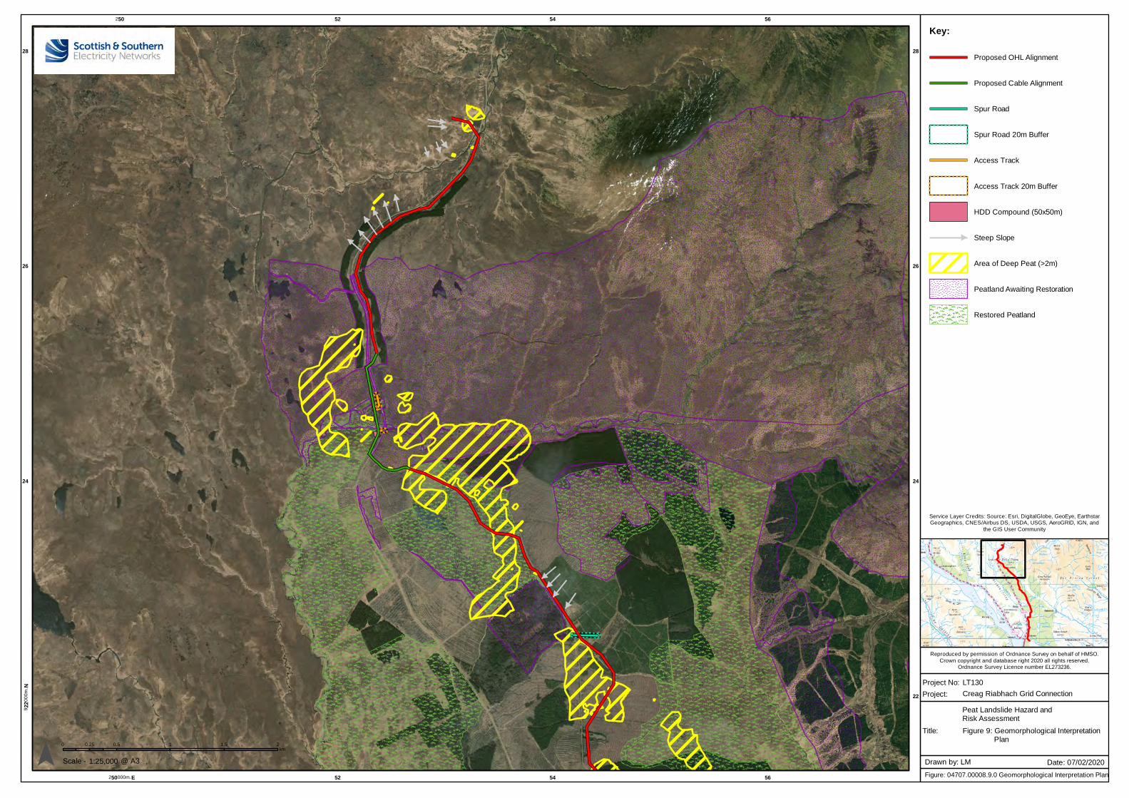
Creag Riabhach Grid Connection
250
250000m. E
52
52
54
54
56
56
922
00
0m
. N
22
24 24
26 26
28 28
¯ 0 0.5 1 1.5 20.25km
1:25,000Scale -
Project No: LT130
Title:
Project:
Figure: 04707.00008.9.0 Geomorphological Interpretation Plan
Drawn by: LM Date: 07/02/2020@ A3
Key:
Proposed OHL Alignment
Proposed Cable Alignment
Spur Road
Spur Road 20m Buffer
Access Track
Access Track 20m Buffer
HDD Compound (50x50m)
Steep Slope
Area of Deep Peat (>2m)
Peatland Awaiting Restoration
Restored Peatland
Figure 9: Geomorphological Interpretation Plan
Service Layer Credits: Source: Esri, DigitalGlobe, GeoEye, EarthstarGeographics, CNES/Airbus DS, USDA, USGS, AeroGRID, IGN, and
the GIS User Community
Reproduced by permission of Ordnance Survey on behalf of HMSO.
Crown copyright and database right 2020 all rights reserved.Ordnance Survey Licence number EL273236.
Peat Landslide Hazard andRisk Assessment
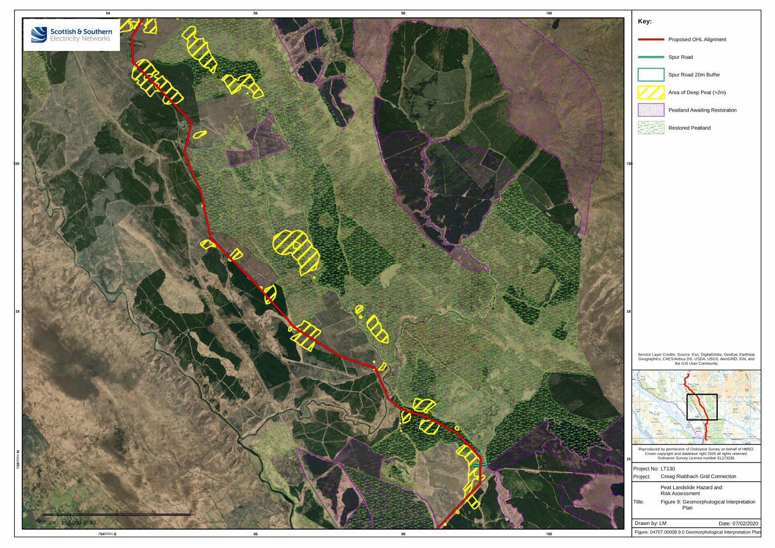
Creag Riabhach Grid Connection
54
254000m. E
56
56
58
58
260
260
916
00
0m
. N
16
18 18
920 920
¯ 0 0.5 1 1.5 20.25km
1:25,000Scale -
Project No: LT130
Title:
Project:
Figure: 04707.00008.9.0 Geomorphological Interpretation Plan
Drawn by: LM Date: 07/02/2020@ A3
Key:
Proposed OHL Alignment
Spur Road
Spur Road 20m Buffer
Area of Deep Peat (>2m)
Peatland Awaiting Restoration
Restored Peatland
Figure 9: Geomorphological Interpretation Plan
Service Layer Credits: Source: Esri, DigitalGlobe, GeoEye, EarthstarGeographics, CNES/Airbus DS, USDA, USGS, AeroGRID, IGN, and
the GIS User Community
Reproduced by permission of Ordnance Survey on behalf of HMSO.
Crown copyright and database right 2020 all rights reserved.Ordnance Survey Licence number EL273236.
Peat Landslide Hazard andRisk Assessment
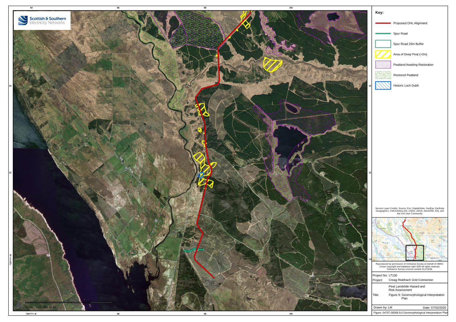
Creag Riabhach Grid Connection
54
254000m. E
56
56
58
58
260
260
910
00
0m
. N
910
12 12
14 14
¯ 0 0.5 1 1.5 20.25km
1:25,000Scale -
Project No: LT130
Title:
Project:
Figure: 04707.00008.9.0 Geomorphological Interpretation Plan
Drawn by: LM Date: 07/02/2020@ A3
Key:
Proposed OHL Alignment
Spur Road
Spur Road 20m Buffer
Area of Deep Peat (>2m)
Peatland Awaiting Restoration
Restored Peatland
Historic Loch Dubh
Figure 9: Geomorphological Interpretation Plan
Service Layer Credits: Source: Esri, DigitalGlobe, GeoEye, EarthstarGeographics, CNES/Airbus DS, USDA, USGS, AeroGRID, IGN, and
the GIS User Community
Reproduced by permission of Ordnance Survey on behalf of HMSO.
Crown copyright and database right 2020 all rights reserved.Ordnance Survey Licence number EL273236.
Peat Landslide Hazard andRisk Assessment
APPENDIX A
PEAT RISK DATA
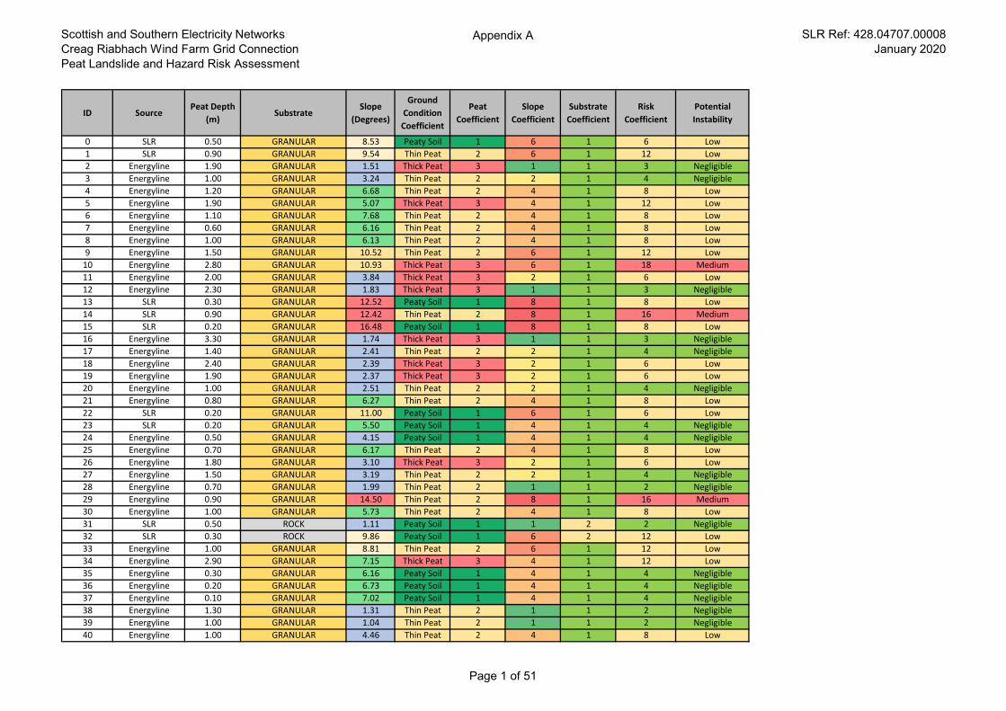
Scottish and Southern Electricity Networks
Creag Riabhach Wind Farm Grid Connection
Peat Landslide and Hazard Risk Assessment
Appendix A SLR Ref: 428.04707.00008
January 2020
ID SourcePeat Depth
(m)Substrate
Slope
(Degrees)
Ground
Condition
Coefficient
Peat
Coefficient
Slope
Coefficient
Substrate
Coefficient
Risk
Coefficient
Potential
Instability
0 SLR 0.50 GRANULAR 8.53 Peaty Soil 1 6 1 6 Low
1 SLR 0.90 GRANULAR 9.54 Thin Peat 2 6 1 12 Low
2 Energyline 1.90 GRANULAR 1.51 Thick Peat 3 1 1 3 Negligible
3 Energyline 1.00 GRANULAR 3.24 Thin Peat 2 2 1 4 Negligible
4 Energyline 1.20 GRANULAR 6.68 Thin Peat 2 4 1 8 Low
5 Energyline 1.90 GRANULAR 5.07 Thick Peat 3 4 1 12 Low
6 Energyline 1.10 GRANULAR 7.68 Thin Peat 2 4 1 8 Low
7 Energyline 0.60 GRANULAR 6.16 Thin Peat 2 4 1 8 Low
8 Energyline 1.00 GRANULAR 6.13 Thin Peat 2 4 1 8 Low
9 Energyline 1.50 GRANULAR 10.52 Thin Peat 2 6 1 12 Low
10 Energyline 2.80 GRANULAR 10.93 Thick Peat 3 6 1 18 Medium
11 Energyline 2.00 GRANULAR 3.84 Thick Peat 3 2 1 6 Low
12 Energyline 2.30 GRANULAR 1.83 Thick Peat 3 1 1 3 Negligible
13 SLR 0.30 GRANULAR 12.52 Peaty Soil 1 8 1 8 Low
14 SLR 0.90 GRANULAR 12.42 Thin Peat 2 8 1 16 Medium
15 SLR 0.20 GRANULAR 16.48 Peaty Soil 1 8 1 8 Low
16 Energyline 3.30 GRANULAR 1.74 Thick Peat 3 1 1 3 Negligible
17 Energyline 1.40 GRANULAR 2.41 Thin Peat 2 2 1 4 Negligible
18 Energyline 2.40 GRANULAR 2.39 Thick Peat 3 2 1 6 Low
19 Energyline 1.90 GRANULAR 2.37 Thick Peat 3 2 1 6 Low
20 Energyline 1.00 GRANULAR 2.51 Thin Peat 2 2 1 4 Negligible
21 Energyline 0.80 GRANULAR 6.27 Thin Peat 2 4 1 8 Low
22 SLR 0.20 GRANULAR 11.00 Peaty Soil 1 6 1 6 Low
23 SLR 0.20 GRANULAR 5.50 Peaty Soil 1 4 1 4 Negligible
24 Energyline 0.50 GRANULAR 4.15 Peaty Soil 1 4 1 4 Negligible
25 Energyline 0.70 GRANULAR 6.17 Thin Peat 2 4 1 8 Low
26 Energyline 1.80 GRANULAR 3.10 Thick Peat 3 2 1 6 Low
27 Energyline 1.50 GRANULAR 3.19 Thin Peat 2 2 1 4 Negligible
28 Energyline 0.70 GRANULAR 1.99 Thin Peat 2 1 1 2 Negligible
29 Energyline 0.90 GRANULAR 14.50 Thin Peat 2 8 1 16 Medium
30 Energyline 1.00 GRANULAR 5.73 Thin Peat 2 4 1 8 Low
31 SLR 0.50 ROCK 1.11 Peaty Soil 1 1 2 2 Negligible
32 SLR 0.30 ROCK 9.86 Peaty Soil 1 6 2 12 Low
33 Energyline 1.00 GRANULAR 8.81 Thin Peat 2 6 1 12 Low
34 Energyline 2.90 GRANULAR 7.15 Thick Peat 3 4 1 12 Low
35 Energyline 0.30 GRANULAR 6.16 Peaty Soil 1 4 1 4 Negligible
36 Energyline 0.20 GRANULAR 6.73 Peaty Soil 1 4 1 4 Negligible
37 Energyline 0.10 GRANULAR 7.02 Peaty Soil 1 4 1 4 Negligible
38 Energyline 1.30 GRANULAR 1.31 Thin Peat 2 1 1 2 Negligible
39 Energyline 1.00 GRANULAR 1.04 Thin Peat 2 1 1 2 Negligible
40 Energyline 1.00 GRANULAR 4.46 Thin Peat 2 4 1 8 Low
Page 1 of 51
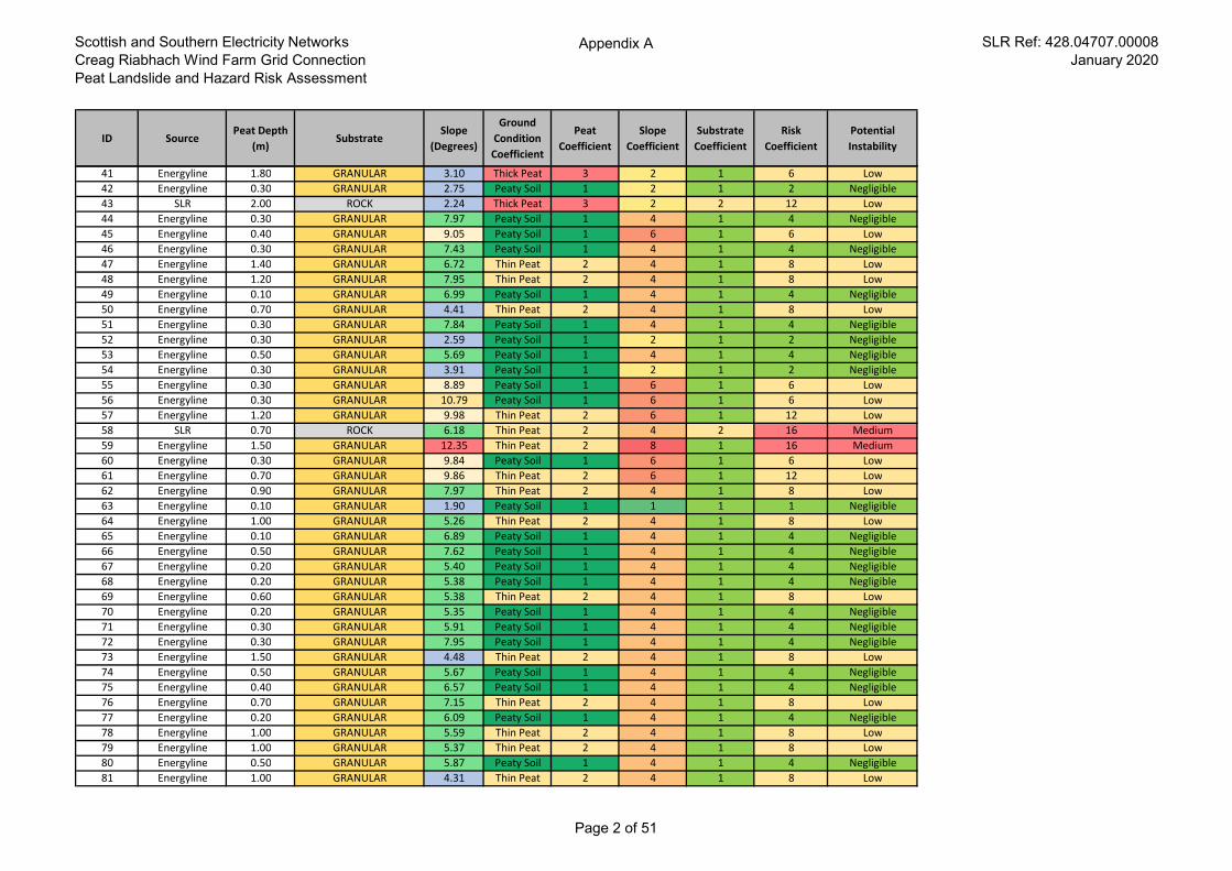
Scottish and Southern Electricity Networks
Creag Riabhach Wind Farm Grid Connection
Peat Landslide and Hazard Risk Assessment
Appendix A SLR Ref: 428.04707.00008
January 2020
ID SourcePeat Depth
(m)Substrate
Slope
(Degrees)
Ground
Condition
Coefficient
Peat
Coefficient
Slope
Coefficient
Substrate
Coefficient
Risk
Coefficient
Potential
Instability
41 Energyline 1.80 GRANULAR 3.10 Thick Peat 3 2 1 6 Low
42 Energyline 0.30 GRANULAR 2.75 Peaty Soil 1 2 1 2 Negligible
43 SLR 2.00 ROCK 2.24 Thick Peat 3 2 2 12 Low
44 Energyline 0.30 GRANULAR 7.97 Peaty Soil 1 4 1 4 Negligible
45 Energyline 0.40 GRANULAR 9.05 Peaty Soil 1 6 1 6 Low
46 Energyline 0.30 GRANULAR 7.43 Peaty Soil 1 4 1 4 Negligible
47 Energyline 1.40 GRANULAR 6.72 Thin Peat 2 4 1 8 Low
48 Energyline 1.20 GRANULAR 7.95 Thin Peat 2 4 1 8 Low
49 Energyline 0.10 GRANULAR 6.99 Peaty Soil 1 4 1 4 Negligible
50 Energyline 0.70 GRANULAR 4.41 Thin Peat 2 4 1 8 Low
51 Energyline 0.30 GRANULAR 7.84 Peaty Soil 1 4 1 4 Negligible
52 Energyline 0.30 GRANULAR 2.59 Peaty Soil 1 2 1 2 Negligible
53 Energyline 0.50 GRANULAR 5.69 Peaty Soil 1 4 1 4 Negligible
54 Energyline 0.30 GRANULAR 3.91 Peaty Soil 1 2 1 2 Negligible
55 Energyline 0.30 GRANULAR 8.89 Peaty Soil 1 6 1 6 Low
56 Energyline 0.30 GRANULAR 10.79 Peaty Soil 1 6 1 6 Low
57 Energyline 1.20 GRANULAR 9.98 Thin Peat 2 6 1 12 Low
58 SLR 0.70 ROCK 6.18 Thin Peat 2 4 2 16 Medium
59 Energyline 1.50 GRANULAR 12.35 Thin Peat 2 8 1 16 Medium
60 Energyline 0.30 GRANULAR 9.84 Peaty Soil 1 6 1 6 Low
61 Energyline 0.70 GRANULAR 9.86 Thin Peat 2 6 1 12 Low
62 Energyline 0.90 GRANULAR 7.97 Thin Peat 2 4 1 8 Low
63 Energyline 0.10 GRANULAR 1.90 Peaty Soil 1 1 1 1 Negligible
64 Energyline 1.00 GRANULAR 5.26 Thin Peat 2 4 1 8 Low
65 Energyline 0.10 GRANULAR 6.89 Peaty Soil 1 4 1 4 Negligible
66 Energyline 0.50 GRANULAR 7.62 Peaty Soil 1 4 1 4 Negligible
67 Energyline 0.20 GRANULAR 5.40 Peaty Soil 1 4 1 4 Negligible
68 Energyline 0.20 GRANULAR 5.38 Peaty Soil 1 4 1 4 Negligible
69 Energyline 0.60 GRANULAR 5.38 Thin Peat 2 4 1 8 Low
70 Energyline 0.20 GRANULAR 5.35 Peaty Soil 1 4 1 4 Negligible
71 Energyline 0.30 GRANULAR 5.91 Peaty Soil 1 4 1 4 Negligible
72 Energyline 0.30 GRANULAR 7.95 Peaty Soil 1 4 1 4 Negligible
73 Energyline 1.50 GRANULAR 4.48 Thin Peat 2 4 1 8 Low
74 Energyline 0.50 GRANULAR 5.67 Peaty Soil 1 4 1 4 Negligible
75 Energyline 0.40 GRANULAR 6.57 Peaty Soil 1 4 1 4 Negligible
76 Energyline 0.70 GRANULAR 7.15 Thin Peat 2 4 1 8 Low
77 Energyline 0.20 GRANULAR 6.09 Peaty Soil 1 4 1 4 Negligible
78 Energyline 1.00 GRANULAR 5.59 Thin Peat 2 4 1 8 Low
79 Energyline 1.00 GRANULAR 5.37 Thin Peat 2 4 1 8 Low
80 Energyline 0.50 GRANULAR 5.87 Peaty Soil 1 4 1 4 Negligible
81 Energyline 1.00 GRANULAR 4.31 Thin Peat 2 4 1 8 Low
Page 2 of 51
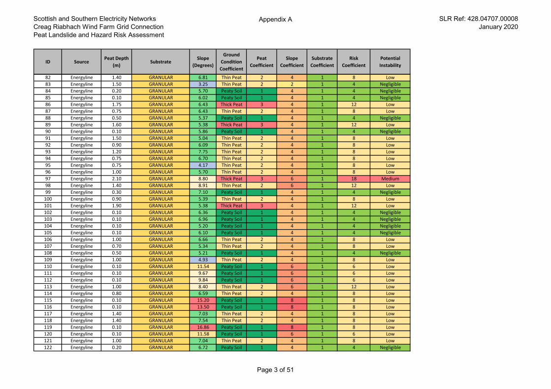
Scottish and Southern Electricity Networks
Creag Riabhach Wind Farm Grid Connection
Peat Landslide and Hazard Risk Assessment
Appendix A SLR Ref: 428.04707.00008
January 2020
ID SourcePeat Depth
(m)Substrate
Slope
(Degrees)
Ground
Condition
Coefficient
Peat
Coefficient
Slope
Coefficient
Substrate
Coefficient
Risk
Coefficient
Potential
Instability
82 Energyline 1.40 GRANULAR 6.81 Thin Peat 2 4 1 8 Low
83 Energyline 1.50 GRANULAR 3.25 Thin Peat 2 2 1 4 Negligible
84 Energyline 0.20 GRANULAR 5.70 Peaty Soil 1 4 1 4 Negligible
85 Energyline 0.10 GRANULAR 6.02 Peaty Soil 1 4 1 4 Negligible
86 Energyline 1.75 GRANULAR 6.43 Thick Peat 3 4 1 12 Low
87 Energyline 0.75 GRANULAR 6.43 Thin Peat 2 4 1 8 Low
88 Energyline 0.50 GRANULAR 5.37 Peaty Soil 1 4 1 4 Negligible
89 Energyline 1.60 GRANULAR 5.38 Thick Peat 3 4 1 12 Low
90 Energyline 0.10 GRANULAR 5.86 Peaty Soil 1 4 1 4 Negligible
91 Energyline 1.50 GRANULAR 5.04 Thin Peat 2 4 1 8 Low
92 Energyline 0.90 GRANULAR 6.09 Thin Peat 2 4 1 8 Low
93 Energyline 1.20 GRANULAR 7.75 Thin Peat 2 4 1 8 Low
94 Energyline 0.75 GRANULAR 6.70 Thin Peat 2 4 1 8 Low
95 Energyline 0.75 GRANULAR 4.17 Thin Peat 2 4 1 8 Low
96 Energyline 1.00 GRANULAR 5.70 Thin Peat 2 4 1 8 Low
97 Energyline 2.10 GRANULAR 8.80 Thick Peat 3 6 1 18 Medium
98 Energyline 1.40 GRANULAR 8.91 Thin Peat 2 6 1 12 Low
99 Energyline 0.30 GRANULAR 7.10 Peaty Soil 1 4 1 4 Negligible
100 Energyline 0.90 GRANULAR 5.39 Thin Peat 2 4 1 8 Low
101 Energyline 1.90 GRANULAR 5.38 Thick Peat 3 4 1 12 Low
102 Energyline 0.10 GRANULAR 6.36 Peaty Soil 1 4 1 4 Negligible
103 Energyline 0.10 GRANULAR 6.96 Peaty Soil 1 4 1 4 Negligible
104 Energyline 0.10 GRANULAR 5.20 Peaty Soil 1 4 1 4 Negligible
105 Energyline 0.10 GRANULAR 6.10 Peaty Soil 1 4 1 4 Negligible
106 Energyline 1.00 GRANULAR 6.66 Thin Peat 2 4 1 8 Low
107 Energyline 0.70 GRANULAR 5.34 Thin Peat 2 4 1 8 Low
108 Energyline 0.50 GRANULAR 5.21 Peaty Soil 1 4 1 4 Negligible
109 Energyline 1.00 GRANULAR 4.93 Thin Peat 2 4 1 8 Low
110 Energyline 0.10 GRANULAR 11.54 Peaty Soil 1 6 1 6 Low
111 Energyline 0.10 GRANULAR 9.67 Peaty Soil 1 6 1 6 Low
112 Energyline 0.10 GRANULAR 9.84 Peaty Soil 1 6 1 6 Low
113 Energyline 1.00 GRANULAR 8.40 Thin Peat 2 6 1 12 Low
114 Energyline 0.80 GRANULAR 6.59 Thin Peat 2 4 1 8 Low
115 Energyline 0.10 GRANULAR 15.20 Peaty Soil 1 8 1 8 Low
116 Energyline 0.10 GRANULAR 13.50 Peaty Soil 1 8 1 8 Low
117 Energyline 1.40 GRANULAR 7.03 Thin Peat 2 4 1 8 Low
118 Energyline 1.40 GRANULAR 7.54 Thin Peat 2 4 1 8 Low
119 Energyline 0.10 GRANULAR 16.86 Peaty Soil 1 8 1 8 Low
120 Energyline 0.10 GRANULAR 11.58 Peaty Soil 1 6 1 6 Low
121 Energyline 1.00 GRANULAR 7.04 Thin Peat 2 4 1 8 Low
122 Energyline 0.20 GRANULAR 6.72 Peaty Soil 1 4 1 4 Negligible
Page 3 of 51
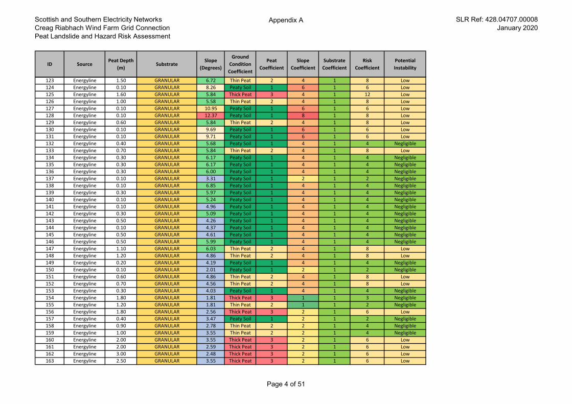
Scottish and Southern Electricity Networks
Creag Riabhach Wind Farm Grid Connection
Peat Landslide and Hazard Risk Assessment
Appendix A SLR Ref: 428.04707.00008
January 2020
ID SourcePeat Depth
(m)Substrate
Slope
(Degrees)
Ground
Condition
Coefficient
Peat
Coefficient
Slope
Coefficient
Substrate
Coefficient
Risk
Coefficient
Potential
Instability
123 Energyline 1.50 GRANULAR 6.72 Thin Peat 2 4 1 8 Low
124 Energyline 0.10 GRANULAR 8.26 Peaty Soil 1 6 1 6 Low
125 Energyline 1.60 GRANULAR 5.84 Thick Peat 3 4 1 12 Low
126 Energyline 1.00 GRANULAR 5.58 Thin Peat 2 4 1 8 Low
127 Energyline 0.10 GRANULAR 10.95 Peaty Soil 1 6 1 6 Low
128 Energyline 0.10 GRANULAR 12.37 Peaty Soil 1 8 1 8 Low
129 Energyline 0.60 GRANULAR 5.84 Thin Peat 2 4 1 8 Low
130 Energyline 0.10 GRANULAR 9.69 Peaty Soil 1 6 1 6 Low
131 Energyline 0.10 GRANULAR 9.71 Peaty Soil 1 6 1 6 Low
132 Energyline 0.40 GRANULAR 5.68 Peaty Soil 1 4 1 4 Negligible
133 Energyline 0.70 GRANULAR 5.84 Thin Peat 2 4 1 8 Low
134 Energyline 0.30 GRANULAR 6.17 Peaty Soil 1 4 1 4 Negligible
135 Energyline 0.30 GRANULAR 6.17 Peaty Soil 1 4 1 4 Negligible
136 Energyline 0.30 GRANULAR 6.00 Peaty Soil 1 4 1 4 Negligible
137 Energyline 0.10 GRANULAR 3.31 Peaty Soil 1 2 1 2 Negligible
138 Energyline 0.10 GRANULAR 6.85 Peaty Soil 1 4 1 4 Negligible
139 Energyline 0.30 GRANULAR 5.97 Peaty Soil 1 4 1 4 Negligible
140 Energyline 0.10 GRANULAR 5.24 Peaty Soil 1 4 1 4 Negligible
141 Energyline 0.10 GRANULAR 4.96 Peaty Soil 1 4 1 4 Negligible
142 Energyline 0.30 GRANULAR 5.09 Peaty Soil 1 4 1 4 Negligible
143 Energyline 0.50 GRANULAR 4.26 Peaty Soil 1 4 1 4 Negligible
144 Energyline 0.10 GRANULAR 4.37 Peaty Soil 1 4 1 4 Negligible
145 Energyline 0.50 GRANULAR 4.61 Peaty Soil 1 4 1 4 Negligible
146 Energyline 0.50 GRANULAR 5.99 Peaty Soil 1 4 1 4 Negligible
147 Energyline 1.10 GRANULAR 6.03 Thin Peat 2 4 1 8 Low
148 Energyline 1.20 GRANULAR 4.86 Thin Peat 2 4 1 8 Low
149 Energyline 0.20 GRANULAR 4.19 Peaty Soil 1 4 1 4 Negligible
150 Energyline 0.10 GRANULAR 2.01 Peaty Soil 1 2 1 2 Negligible
151 Energyline 0.60 GRANULAR 4.86 Thin Peat 2 4 1 8 Low
152 Energyline 0.70 GRANULAR 4.56 Thin Peat 2 4 1 8 Low
153 Energyline 0.30 GRANULAR 4.03 Peaty Soil 1 4 1 4 Negligible
154 Energyline 1.80 GRANULAR 1.81 Thick Peat 3 1 1 3 Negligible
155 Energyline 1.20 GRANULAR 1.81 Thin Peat 2 1 1 2 Negligible
156 Energyline 1.80 GRANULAR 2.56 Thick Peat 3 2 1 6 Low
157 Energyline 0.40 GRANULAR 3.47 Peaty Soil 1 2 1 2 Negligible
158 Energyline 0.90 GRANULAR 2.78 Thin Peat 2 2 1 4 Negligible
159 Energyline 1.00 GRANULAR 3.55 Thin Peat 2 2 1 4 Negligible
160 Energyline 2.00 GRANULAR 3.55 Thick Peat 3 2 1 6 Low
161 Energyline 2.00 GRANULAR 2.59 Thick Peat 3 2 1 6 Low
162 Energyline 3.00 GRANULAR 2.48 Thick Peat 3 2 1 6 Low
163 Energyline 2.50 GRANULAR 3.55 Thick Peat 3 2 1 6 Low
Page 4 of 51
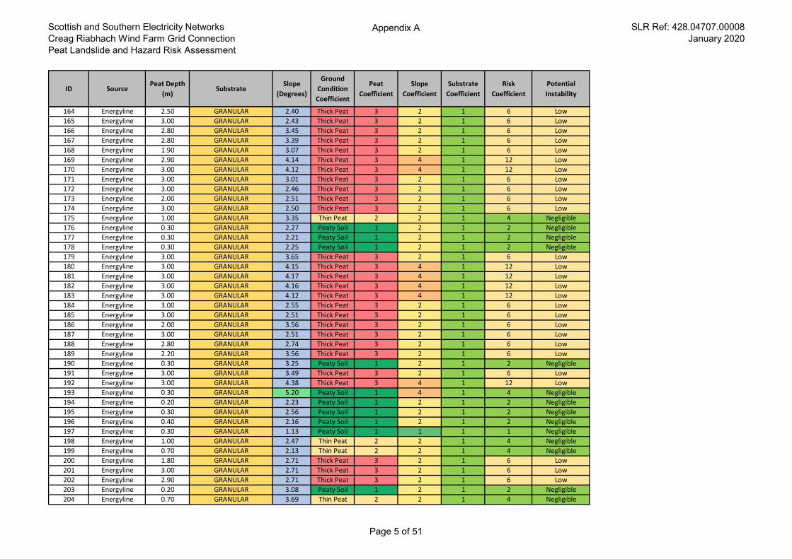
Scottish and Southern Electricity Networks
Creag Riabhach Wind Farm Grid Connection
Peat Landslide and Hazard Risk Assessment
Appendix A SLR Ref: 428.04707.00008
January 2020
ID SourcePeat Depth
(m)Substrate
Slope
(Degrees)
Ground
Condition
Coefficient
Peat
Coefficient
Slope
Coefficient
Substrate
Coefficient
Risk
Coefficient
Potential
Instability
164 Energyline 2.50 GRANULAR 2.40 Thick Peat 3 2 1 6 Low
165 Energyline 3.00 GRANULAR 2.43 Thick Peat 3 2 1 6 Low
166 Energyline 2.80 GRANULAR 3.45 Thick Peat 3 2 1 6 Low
167 Energyline 2.80 GRANULAR 3.39 Thick Peat 3 2 1 6 Low
168 Energyline 1.90 GRANULAR 3.07 Thick Peat 3 2 1 6 Low
169 Energyline 2.90 GRANULAR 4.14 Thick Peat 3 4 1 12 Low
170 Energyline 3.00 GRANULAR 4.12 Thick Peat 3 4 1 12 Low
171 Energyline 3.00 GRANULAR 3.01 Thick Peat 3 2 1 6 Low
172 Energyline 3.00 GRANULAR 2.46 Thick Peat 3 2 1 6 Low
173 Energyline 2.00 GRANULAR 2.51 Thick Peat 3 2 1 6 Low
174 Energyline 3.00 GRANULAR 2.50 Thick Peat 3 2 1 6 Low
175 Energyline 1.00 GRANULAR 3.35 Thin Peat 2 2 1 4 Negligible
176 Energyline 0.30 GRANULAR 2.27 Peaty Soil 1 2 1 2 Negligible
177 Energyline 0.30 GRANULAR 2.21 Peaty Soil 1 2 1 2 Negligible
178 Energyline 0.30 GRANULAR 2.25 Peaty Soil 1 2 1 2 Negligible
179 Energyline 3.00 GRANULAR 3.65 Thick Peat 3 2 1 6 Low
180 Energyline 3.00 GRANULAR 4.15 Thick Peat 3 4 1 12 Low
181 Energyline 3.00 GRANULAR 4.17 Thick Peat 3 4 1 12 Low
182 Energyline 3.00 GRANULAR 4.16 Thick Peat 3 4 1 12 Low
183 Energyline 3.00 GRANULAR 4.12 Thick Peat 3 4 1 12 Low
184 Energyline 3.00 GRANULAR 2.55 Thick Peat 3 2 1 6 Low
185 Energyline 3.00 GRANULAR 2.51 Thick Peat 3 2 1 6 Low
186 Energyline 2.00 GRANULAR 3.56 Thick Peat 3 2 1 6 Low
187 Energyline 3.00 GRANULAR 2.51 Thick Peat 3 2 1 6 Low
188 Energyline 2.80 GRANULAR 2.74 Thick Peat 3 2 1 6 Low
189 Energyline 2.20 GRANULAR 3.56 Thick Peat 3 2 1 6 Low
190 Energyline 0.30 GRANULAR 3.25 Peaty Soil 1 2 1 2 Negligible
191 Energyline 3.00 GRANULAR 3.49 Thick Peat 3 2 1 6 Low
192 Energyline 3.00 GRANULAR 4.38 Thick Peat 3 4 1 12 Low
193 Energyline 0.30 GRANULAR 5.20 Peaty Soil 1 4 1 4 Negligible
194 Energyline 0.20 GRANULAR 2.23 Peaty Soil 1 2 1 2 Negligible
195 Energyline 0.30 GRANULAR 2.56 Peaty Soil 1 2 1 2 Negligible
196 Energyline 0.40 GRANULAR 2.16 Peaty Soil 1 2 1 2 Negligible
197 Energyline 0.30 GRANULAR 1.13 Peaty Soil 1 1 1 1 Negligible
198 Energyline 1.00 GRANULAR 2.47 Thin Peat 2 2 1 4 Negligible
199 Energyline 0.70 GRANULAR 2.13 Thin Peat 2 2 1 4 Negligible
200 Energyline 1.80 GRANULAR 2.71 Thick Peat 3 2 1 6 Low
201 Energyline 3.00 GRANULAR 2.71 Thick Peat 3 2 1 6 Low
202 Energyline 2.90 GRANULAR 2.71 Thick Peat 3 2 1 6 Low
203 Energyline 0.20 GRANULAR 3.08 Peaty Soil 1 2 1 2 Negligible
204 Energyline 0.70 GRANULAR 3.69 Thin Peat 2 2 1 4 Negligible
Page 5 of 51
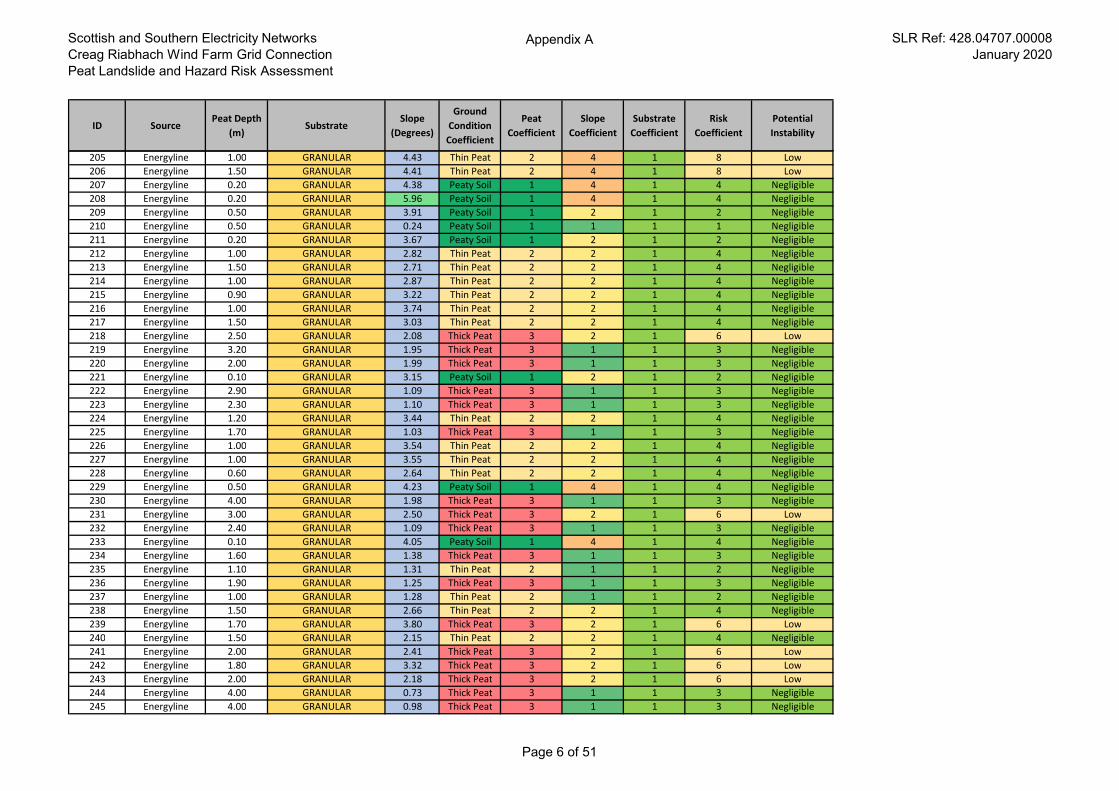
Scottish and Southern Electricity Networks
Creag Riabhach Wind Farm Grid Connection
Peat Landslide and Hazard Risk Assessment
Appendix A SLR Ref: 428.04707.00008
January 2020
ID SourcePeat Depth
(m)Substrate
Slope
(Degrees)
Ground
Condition
Coefficient
Peat
Coefficient
Slope
Coefficient
Substrate
Coefficient
Risk
Coefficient
Potential
Instability
205 Energyline 1.00 GRANULAR 4.43 Thin Peat 2 4 1 8 Low
206 Energyline 1.50 GRANULAR 4.41 Thin Peat 2 4 1 8 Low
207 Energyline 0.20 GRANULAR 4.38 Peaty Soil 1 4 1 4 Negligible
208 Energyline 0.20 GRANULAR 5.96 Peaty Soil 1 4 1 4 Negligible
209 Energyline 0.50 GRANULAR 3.91 Peaty Soil 1 2 1 2 Negligible
210 Energyline 0.50 GRANULAR 0.24 Peaty Soil 1 1 1 1 Negligible
211 Energyline 0.20 GRANULAR 3.67 Peaty Soil 1 2 1 2 Negligible
212 Energyline 1.00 GRANULAR 2.82 Thin Peat 2 2 1 4 Negligible
213 Energyline 1.50 GRANULAR 2.71 Thin Peat 2 2 1 4 Negligible
214 Energyline 1.00 GRANULAR 2.87 Thin Peat 2 2 1 4 Negligible
215 Energyline 0.90 GRANULAR 3.22 Thin Peat 2 2 1 4 Negligible
216 Energyline 1.00 GRANULAR 3.74 Thin Peat 2 2 1 4 Negligible
217 Energyline 1.50 GRANULAR 3.03 Thin Peat 2 2 1 4 Negligible
218 Energyline 2.50 GRANULAR 2.08 Thick Peat 3 2 1 6 Low
219 Energyline 3.20 GRANULAR 1.95 Thick Peat 3 1 1 3 Negligible
220 Energyline 2.00 GRANULAR 1.99 Thick Peat 3 1 1 3 Negligible
221 Energyline 0.10 GRANULAR 3.15 Peaty Soil 1 2 1 2 Negligible
222 Energyline 2.90 GRANULAR 1.09 Thick Peat 3 1 1 3 Negligible
223 Energyline 2.30 GRANULAR 1.10 Thick Peat 3 1 1 3 Negligible
224 Energyline 1.20 GRANULAR 3.44 Thin Peat 2 2 1 4 Negligible
225 Energyline 1.70 GRANULAR 1.03 Thick Peat 3 1 1 3 Negligible
226 Energyline 1.00 GRANULAR 3.54 Thin Peat 2 2 1 4 Negligible
227 Energyline 1.00 GRANULAR 3.55 Thin Peat 2 2 1 4 Negligible
228 Energyline 0.60 GRANULAR 2.64 Thin Peat 2 2 1 4 Negligible
229 Energyline 0.50 GRANULAR 4.23 Peaty Soil 1 4 1 4 Negligible
230 Energyline 4.00 GRANULAR 1.98 Thick Peat 3 1 1 3 Negligible
231 Energyline 3.00 GRANULAR 2.50 Thick Peat 3 2 1 6 Low
232 Energyline 2.40 GRANULAR 1.09 Thick Peat 3 1 1 3 Negligible
233 Energyline 0.10 GRANULAR 4.05 Peaty Soil 1 4 1 4 Negligible
234 Energyline 1.60 GRANULAR 1.38 Thick Peat 3 1 1 3 Negligible
235 Energyline 1.10 GRANULAR 1.31 Thin Peat 2 1 1 2 Negligible
236 Energyline 1.90 GRANULAR 1.25 Thick Peat 3 1 1 3 Negligible
237 Energyline 1.00 GRANULAR 1.28 Thin Peat 2 1 1 2 Negligible
238 Energyline 1.50 GRANULAR 2.66 Thin Peat 2 2 1 4 Negligible
239 Energyline 1.70 GRANULAR 3.80 Thick Peat 3 2 1 6 Low
240 Energyline 1.50 GRANULAR 2.15 Thin Peat 2 2 1 4 Negligible
241 Energyline 2.00 GRANULAR 2.41 Thick Peat 3 2 1 6 Low
242 Energyline 1.80 GRANULAR 3.32 Thick Peat 3 2 1 6 Low
243 Energyline 2.00 GRANULAR 2.18 Thick Peat 3 2 1 6 Low
244 Energyline 4.00 GRANULAR 0.73 Thick Peat 3 1 1 3 Negligible
245 Energyline 4.00 GRANULAR 0.98 Thick Peat 3 1 1 3 Negligible
Page 6 of 51
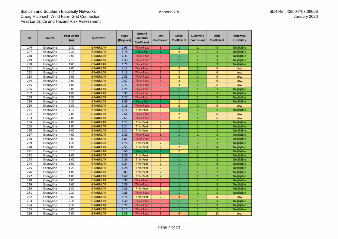
Scottish and Southern Electricity Networks
Creag Riabhach Wind Farm Grid Connection
Peat Landslide and Hazard Risk Assessment
Appendix A SLR Ref: 428.04707.00008
January 2020
ID SourcePeat Depth
(m)Substrate
Slope
(Degrees)
Ground
Condition
Coefficient
Peat
Coefficient
Slope
Coefficient
Substrate
Coefficient
Risk
Coefficient
Potential
Instability
246 Energyline 2.80 GRANULAR 0.96 Thick Peat 3 1 1 3 Negligible
247 Energyline 0.20 GRANULAR 3.78 Peaty Soil 1 2 1 2 Negligible
248 Energyline 3.00 GRANULAR 1.27 Thick Peat 3 1 1 3 Negligible
249 Energyline 2.10 GRANULAR 1.40 Thick Peat 3 1 1 3 Negligible
250 Energyline 1.80 GRANULAR 1.76 Thick Peat 3 1 1 3 Negligible
251 Energyline 2.00 GRANULAR 2.11 Thick Peat 3 2 1 6 Low
252 Energyline 2.10 GRANULAR 2.16 Thick Peat 3 2 1 6 Low
253 Energyline 2.00 GRANULAR 2.53 Thick Peat 3 2 1 6 Low
254 Energyline 2.00 GRANULAR 2.57 Thick Peat 3 2 1 6 Low
255 Energyline 4.00 GRANULAR 2.77 Thick Peat 3 2 1 6 Low
256 Energyline 3.00 GRANULAR 1.21 Thick Peat 3 1 1 3 Negligible
257 Energyline 1.80 GRANULAR 0.97 Thick Peat 3 1 1 3 Negligible
258 Energyline 1.80 GRANULAR 1.25 Thick Peat 3 1 1 3 Negligible
259 Energyline 0.30 GRANULAR 3.69 Peaty Soil 1 2 1 2 Negligible
260 Energyline 2.50 GRANULAR 2.19 Thick Peat 3 2 1 6 Low
261 Energyline 1.10 GRANULAR 1.71 Thin Peat 2 1 1 2 Negligible
262 Energyline 2.00 GRANULAR 2.54 Thick Peat 3 2 1 6 Low
263 Energyline 2.00 GRANULAR 2.63 Thick Peat 3 2 1 6 Low
264 Energyline 1.00 GRANULAR 1.23 Thin Peat 2 1 1 2 Negligible
265 Energyline 1.00 GRANULAR 1.24 Thin Peat 2 1 1 2 Negligible
266 Energyline 1.00 GRANULAR 1.24 Thin Peat 2 1 1 2 Negligible
267 Energyline 4.00 GRANULAR 1.89 Thick Peat 3 1 1 3 Negligible
268 Energyline 4.00 GRANULAR 1.87 Thick Peat 3 1 1 3 Negligible
269 Energyline 1.30 GRANULAR 1.72 Thin Peat 2 1 1 2 Negligible
270 Energyline 1.00 GRANULAR 2.55 Thin Peat 2 2 1 4 Negligible
271 Energyline 0.15 GRANULAR 3.66 Peaty Soil 1 2 1 2 Negligible
272 Energyline 1.00 GRANULAR 1.30 Thin Peat 2 1 1 2 Negligible
273 Energyline 1.00 GRANULAR 1.38 Thin Peat 2 1 1 2 Negligible
274 Energyline 1.00 GRANULAR 1.24 Thin Peat 2 1 1 2 Negligible
275 Energyline 1.20 GRANULAR 1.28 Thin Peat 2 1 1 2 Negligible
276 Energyline 1.00 GRANULAR 0.83 Thin Peat 2 1 1 2 Negligible
277 Energyline 1.00 GRANULAR 1.49 Thin Peat 2 1 1 2 Negligible
278 Energyline 4.00 GRANULAR 0.90 Thick Peat 3 1 1 3 Negligible
279 Energyline 2.60 GRANULAR 0.86 Thick Peat 3 1 1 3 Negligible
280 Energyline 1.50 GRANULAR 0.86 Thin Peat 2 1 1 2 Negligible
281 Energyline 2.30 GRANULAR 0.86 Thick Peat 3 1 1 3 Negligible
282 Energyline 0.80 GRANULAR 4.74 Thin Peat 2 4 1 8 Low
283 Energyline 2.30 GRANULAR 1.40 Thick Peat 3 1 1 3 Negligible
284 Energyline 2.30 GRANULAR 0.71 Thick Peat 3 1 1 3 Negligible
285 Energyline 2.00 GRANULAR 1.11 Thick Peat 3 1 1 3 Negligible
286 Energyline 2.00 GRANULAR 6.36 Thick Peat 3 4 1 12 Low
Page 7 of 51
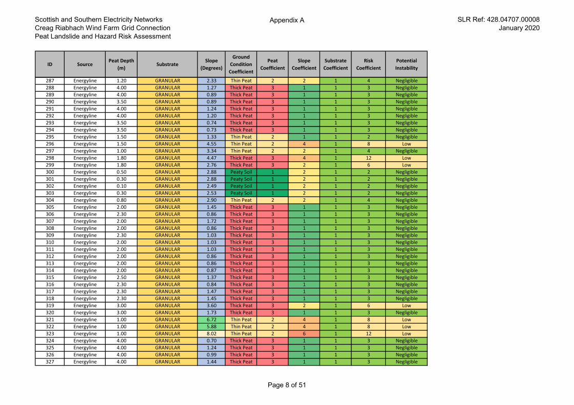
Scottish and Southern Electricity Networks
Creag Riabhach Wind Farm Grid Connection
Peat Landslide and Hazard Risk Assessment
Appendix A SLR Ref: 428.04707.00008
January 2020
ID SourcePeat Depth
(m)Substrate
Slope
(Degrees)
Ground
Condition
Coefficient
Peat
Coefficient
Slope
Coefficient
Substrate
Coefficient
Risk
Coefficient
Potential
Instability
287 Energyline 1.20 GRANULAR 2.33 Thin Peat 2 2 1 4 Negligible
288 Energyline 4.00 GRANULAR 1.27 Thick Peat 3 1 1 3 Negligible
289 Energyline 4.00 GRANULAR 0.89 Thick Peat 3 1 1 3 Negligible
290 Energyline 3.50 GRANULAR 0.89 Thick Peat 3 1 1 3 Negligible
291 Energyline 4.00 GRANULAR 1.24 Thick Peat 3 1 1 3 Negligible
292 Energyline 4.00 GRANULAR 1.20 Thick Peat 3 1 1 3 Negligible
293 Energyline 3.50 GRANULAR 0.74 Thick Peat 3 1 1 3 Negligible
294 Energyline 3.50 GRANULAR 0.73 Thick Peat 3 1 1 3 Negligible
295 Energyline 1.50 GRANULAR 1.33 Thin Peat 2 1 1 2 Negligible
296 Energyline 1.50 GRANULAR 4.55 Thin Peat 2 4 1 8 Low
297 Energyline 1.00 GRANULAR 3.34 Thin Peat 2 2 1 4 Negligible
298 Energyline 1.80 GRANULAR 4.47 Thick Peat 3 4 1 12 Low
299 Energyline 1.80 GRANULAR 2.76 Thick Peat 3 2 1 6 Low
300 Energyline 0.50 GRANULAR 2.88 Peaty Soil 1 2 1 2 Negligible
301 Energyline 0.30 GRANULAR 2.88 Peaty Soil 1 2 1 2 Negligible
302 Energyline 0.10 GRANULAR 2.49 Peaty Soil 1 2 1 2 Negligible
303 Energyline 0.30 GRANULAR 2.53 Peaty Soil 1 2 1 2 Negligible
304 Energyline 0.80 GRANULAR 2.90 Thin Peat 2 2 1 4 Negligible
305 Energyline 2.00 GRANULAR 1.45 Thick Peat 3 1 1 3 Negligible
306 Energyline 2.30 GRANULAR 0.86 Thick Peat 3 1 1 3 Negligible
307 Energyline 2.00 GRANULAR 1.72 Thick Peat 3 1 1 3 Negligible
308 Energyline 2.00 GRANULAR 0.86 Thick Peat 3 1 1 3 Negligible
309 Energyline 2.30 GRANULAR 1.03 Thick Peat 3 1 1 3 Negligible
310 Energyline 2.00 GRANULAR 1.03 Thick Peat 3 1 1 3 Negligible
311 Energyline 2.00 GRANULAR 1.03 Thick Peat 3 1 1 3 Negligible
312 Energyline 2.00 GRANULAR 0.86 Thick Peat 3 1 1 3 Negligible
313 Energyline 2.00 GRANULAR 0.86 Thick Peat 3 1 1 3 Negligible
314 Energyline 2.00 GRANULAR 0.87 Thick Peat 3 1 1 3 Negligible
315 Energyline 2.50 GRANULAR 1.37 Thick Peat 3 1 1 3 Negligible
316 Energyline 2.30 GRANULAR 0.84 Thick Peat 3 1 1 3 Negligible
317 Energyline 2.30 GRANULAR 1.47 Thick Peat 3 1 1 3 Negligible
318 Energyline 2.30 GRANULAR 1.45 Thick Peat 3 1 1 3 Negligible
319 Energyline 3.00 GRANULAR 3.60 Thick Peat 3 2 1 6 Low
320 Energyline 3.00 GRANULAR 1.73 Thick Peat 3 1 1 3 Negligible
321 Energyline 1.00 GRANULAR 6.72 Thin Peat 2 4 1 8 Low
322 Energyline 1.00 GRANULAR 5.88 Thin Peat 2 4 1 8 Low
323 Energyline 1.00 GRANULAR 8.02 Thin Peat 2 6 1 12 Low
324 Energyline 4.00 GRANULAR 0.70 Thick Peat 3 1 1 3 Negligible
325 Energyline 4.00 GRANULAR 1.24 Thick Peat 3 1 1 3 Negligible
326 Energyline 4.00 GRANULAR 0.99 Thick Peat 3 1 1 3 Negligible
327 Energyline 4.00 GRANULAR 1.44 Thick Peat 3 1 1 3 Negligible
Page 8 of 51
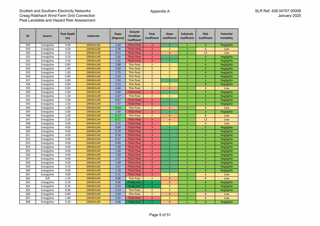
Scottish and Southern Electricity Networks
Creag Riabhach Wind Farm Grid Connection
Peat Landslide and Hazard Risk Assessment
Appendix A SLR Ref: 428.04707.00008
January 2020
ID SourcePeat Depth
(m)Substrate
Slope
(Degrees)
Ground
Condition
Coefficient
Peat
Coefficient
Slope
Coefficient
Substrate
Coefficient
Risk
Coefficient
Potential
Instability
328 Energyline 4.00 GRANULAR 1.44 Thick Peat 3 1 1 3 Negligible
329 Energyline 4.00 GRANULAR 2.36 Thick Peat 3 2 1 6 Low
330 Energyline 3.50 GRANULAR 4.51 Thick Peat 3 4 1 12 Low
331 Energyline 3.20 GRANULAR 1.60 Thick Peat 3 1 1 3 Negligible
332 Energyline 2.00 GRANULAR 1.61 Thick Peat 3 1 1 3 Negligible
333 Energyline 0.80 GRANULAR 2.88 Thin Peat 2 2 1 4 Negligible
334 Energyline 1.00 GRANULAR 2.83 Thin Peat 2 2 1 4 Negligible
335 Energyline 1.00 GRANULAR 2.79 Thin Peat 2 2 1 4 Negligible
336 Energyline 0.80 GRANULAR 2.52 Thin Peat 2 2 1 4 Negligible
337 Energyline 0.80 GRANULAR 1.94 Thin Peat 2 1 1 2 Negligible
338 Energyline 0.80 GRANULAR 3.23 Thin Peat 2 2 1 4 Negligible
339 Energyline 0.60 GRANULAR 4.66 Thin Peat 2 4 1 8 Low
340 Energyline 2.00 GRANULAR 0.89 Thick Peat 3 1 1 3 Negligible
341 Energyline 1.30 GRANULAR 3.67 Thin Peat 2 2 1 4 Negligible
342 Energyline 2.00 GRANULAR 0.87 Thick Peat 3 1 1 3 Negligible
343 Energyline 2.50 GRANULAR 1.47 Thick Peat 3 1 1 3 Negligible
344 Energyline 1.00 GRANULAR 6.54 Thin Peat 2 4 1 8 Low
345 Energyline 3.00 GRANULAR 1.69 Thick Peat 3 1 1 3 Negligible
346 Energyline 1.00 GRANULAR 6.17 Thin Peat 2 4 1 8 Low
347 Energyline 3.50 GRANULAR 6.71 Thick Peat 3 4 1 12 Low
348 Energyline 3.00 GRANULAR 2.21 Thick Peat 3 2 1 6 Low
349 Energyline 4.00 GRANULAR 0.68 Thick Peat 3 1 1 3 Negligible
350 Energyline 4.00 GRANULAR 0.70 Thick Peat 3 1 1 3 Negligible
351 Energyline 4.00 GRANULAR 0.76 Thick Peat 3 1 1 3 Negligible
352 Energyline 4.00 GRANULAR 0.37 Thick Peat 3 1 1 3 Negligible
353 Energyline 4.00 GRANULAR 0.99 Thick Peat 3 1 1 3 Negligible
354 Energyline 4.00 GRANULAR 1.39 Thick Peat 3 1 1 3 Negligible
355 Energyline 4.00 GRANULAR 1.30 Thick Peat 3 1 1 3 Negligible
356 Energyline 4.00 GRANULAR 1.58 Thick Peat 3 1 1 3 Negligible
357 Energyline 4.00 GRANULAR 1.47 Thick Peat 3 1 1 3 Negligible
358 Energyline 4.00 GRANULAR 1.49 Thick Peat 3 1 1 3 Negligible
359 Energyline 3.50 GRANULAR 1.47 Thick Peat 3 1 1 3 Negligible
360 Energyline 3.00 GRANULAR 1.18 Thick Peat 3 1 1 3 Negligible
361 Energyline 4.00 GRANULAR 2.31 Thick Peat 3 2 1 6 Low
362 SLR 1.50 GRANULAR 4.06 Thin Peat 2 4 1 8 Low
363 Energyline 0.30 GRANULAR 4.36 Peaty Soil 1 4 1 4 Negligible
364 Energyline 0.30 GRANULAR 3.52 Peaty Soil 1 2 1 2 Negligible
365 Energyline 0.90 GRANULAR 2.14 Thin Peat 2 2 1 4 Negligible
366 Energyline 0.80 GRANULAR 4.94 Thin Peat 2 4 1 8 Low
367 Energyline 1.80 GRANULAR 2.92 Thick Peat 3 2 1 6 Low
368 Energyline 0.20 GRANULAR 4.66 Peaty Soil 1 4 1 4 Negligible
Page 9 of 51
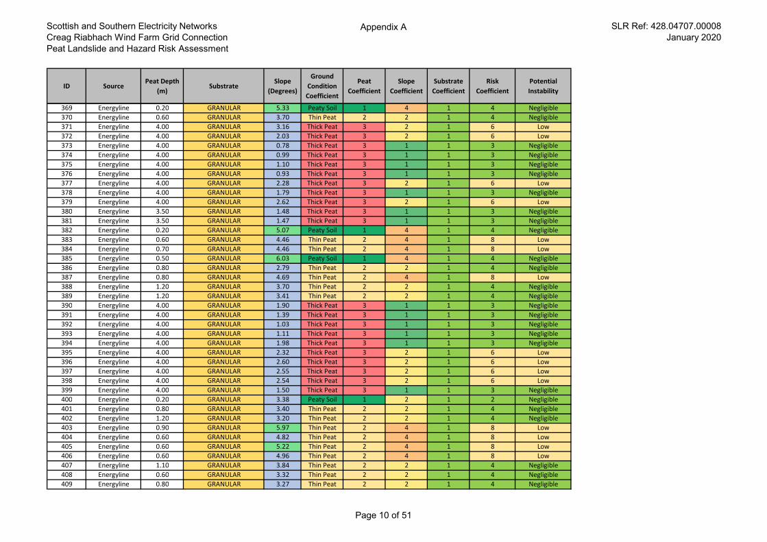
Scottish and Southern Electricity Networks
Creag Riabhach Wind Farm Grid Connection
Peat Landslide and Hazard Risk Assessment
Appendix A SLR Ref: 428.04707.00008
January 2020
ID SourcePeat Depth
(m)Substrate
Slope
(Degrees)
Ground
Condition
Coefficient
Peat
Coefficient
Slope
Coefficient
Substrate
Coefficient
Risk
Coefficient
Potential
Instability
369 Energyline 0.20 GRANULAR 5.33 Peaty Soil 1 4 1 4 Negligible
370 Energyline 0.60 GRANULAR 3.70 Thin Peat 2 2 1 4 Negligible
371 Energyline 4.00 GRANULAR 3.16 Thick Peat 3 2 1 6 Low
372 Energyline 4.00 GRANULAR 2.03 Thick Peat 3 2 1 6 Low
373 Energyline 4.00 GRANULAR 0.78 Thick Peat 3 1 1 3 Negligible
374 Energyline 4.00 GRANULAR 0.99 Thick Peat 3 1 1 3 Negligible
375 Energyline 4.00 GRANULAR 1.10 Thick Peat 3 1 1 3 Negligible
376 Energyline 4.00 GRANULAR 0.93 Thick Peat 3 1 1 3 Negligible
377 Energyline 4.00 GRANULAR 2.28 Thick Peat 3 2 1 6 Low
378 Energyline 4.00 GRANULAR 1.79 Thick Peat 3 1 1 3 Negligible
379 Energyline 4.00 GRANULAR 2.62 Thick Peat 3 2 1 6 Low
380 Energyline 3.50 GRANULAR 1.48 Thick Peat 3 1 1 3 Negligible
381 Energyline 3.50 GRANULAR 1.47 Thick Peat 3 1 1 3 Negligible
382 Energyline 0.20 GRANULAR 5.07 Peaty Soil 1 4 1 4 Negligible
383 Energyline 0.60 GRANULAR 4.46 Thin Peat 2 4 1 8 Low
384 Energyline 0.70 GRANULAR 4.46 Thin Peat 2 4 1 8 Low
385 Energyline 0.50 GRANULAR 6.03 Peaty Soil 1 4 1 4 Negligible
386 Energyline 0.80 GRANULAR 2.79 Thin Peat 2 2 1 4 Negligible
387 Energyline 0.80 GRANULAR 4.69 Thin Peat 2 4 1 8 Low
388 Energyline 1.20 GRANULAR 3.70 Thin Peat 2 2 1 4 Negligible
389 Energyline 1.20 GRANULAR 3.41 Thin Peat 2 2 1 4 Negligible
390 Energyline 4.00 GRANULAR 1.90 Thick Peat 3 1 1 3 Negligible
391 Energyline 4.00 GRANULAR 1.39 Thick Peat 3 1 1 3 Negligible
392 Energyline 4.00 GRANULAR 1.03 Thick Peat 3 1 1 3 Negligible
393 Energyline 4.00 GRANULAR 1.11 Thick Peat 3 1 1 3 Negligible
394 Energyline 4.00 GRANULAR 1.98 Thick Peat 3 1 1 3 Negligible
395 Energyline 4.00 GRANULAR 2.32 Thick Peat 3 2 1 6 Low
396 Energyline 4.00 GRANULAR 2.60 Thick Peat 3 2 1 6 Low
397 Energyline 4.00 GRANULAR 2.55 Thick Peat 3 2 1 6 Low
398 Energyline 4.00 GRANULAR 2.54 Thick Peat 3 2 1 6 Low
399 Energyline 4.00 GRANULAR 1.50 Thick Peat 3 1 1 3 Negligible
400 Energyline 0.20 GRANULAR 3.38 Peaty Soil 1 2 1 2 Negligible
401 Energyline 0.80 GRANULAR 3.40 Thin Peat 2 2 1 4 Negligible
402 Energyline 1.20 GRANULAR 3.20 Thin Peat 2 2 1 4 Negligible
403 Energyline 0.90 GRANULAR 5.97 Thin Peat 2 4 1 8 Low
404 Energyline 0.60 GRANULAR 4.82 Thin Peat 2 4 1 8 Low
405 Energyline 0.60 GRANULAR 5.22 Thin Peat 2 4 1 8 Low
406 Energyline 0.60 GRANULAR 4.96 Thin Peat 2 4 1 8 Low
407 Energyline 1.10 GRANULAR 3.84 Thin Peat 2 2 1 4 Negligible
408 Energyline 0.60 GRANULAR 3.32 Thin Peat 2 2 1 4 Negligible
409 Energyline 0.80 GRANULAR 3.27 Thin Peat 2 2 1 4 Negligible
Page 10 of 51
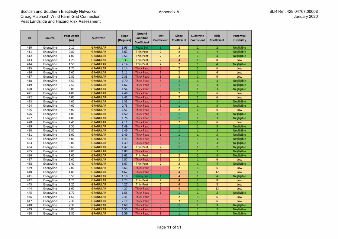
Scottish and Southern Electricity Networks
Creag Riabhach Wind Farm Grid Connection
Peat Landslide and Hazard Risk Assessment
Appendix A SLR Ref: 428.04707.00008
January 2020
ID SourcePeat Depth
(m)Substrate
Slope
(Degrees)
Ground
Condition
Coefficient
Peat
Coefficient
Slope
Coefficient
Substrate
Coefficient
Risk
Coefficient
Potential
Instability
410 Energyline 0.10 GRANULAR 3.95 Peaty Soil 1 2 1 2 Negligible
411 Energyline 0.80 GRANULAR 3.67 Thin Peat 2 2 1 4 Negligible
412 Energyline 1.00 GRANULAR 3.53 Thin Peat 2 2 1 4 Negligible
413 Energyline 1.20 GRANULAR 5.33 Thin Peat 2 4 1 8 Low
414 Energyline 1.50 GRANULAR 2.14 Thin Peat 2 2 1 4 Negligible
415 Energyline 1.70 GRANULAR 2.14 Thick Peat 3 2 1 6 Low
416 Energyline 2.00 GRANULAR 2.11 Thick Peat 3 2 1 6 Low
417 Energyline 2.80 GRANULAR 2.33 Thick Peat 3 2 1 6 Low
418 Energyline 3.50 GRANULAR 1.70 Thick Peat 3 1 1 3 Negligible
419 Energyline 2.50 GRANULAR 1.62 Thick Peat 3 1 1 3 Negligible
420 Energyline 3.00 GRANULAR 1.54 Thick Peat 3 1 1 3 Negligible
421 Energyline 4.00 GRANULAR 2.48 Thick Peat 3 2 1 6 Low
422 Energyline 4.00 GRANULAR 2.41 Thick Peat 3 2 1 6 Low
423 Energyline 4.00 GRANULAR 1.35 Thick Peat 3 1 1 3 Negligible
424 Energyline 4.00 GRANULAR 0.73 Thick Peat 3 1 1 3 Negligible
425 Energyline 4.00 GRANULAR 2.51 Thick Peat 3 2 1 6 Low
426 Energyline 4.00 GRANULAR 1.50 Thick Peat 3 1 1 3 Negligible
427 Energyline 4.00 GRANULAR 1.76 Thick Peat 3 1 1 3 Negligible
428 Energyline 2.40 GRANULAR 2.11 Thick Peat 3 2 1 6 Low
429 Energyline 2.50 GRANULAR 1.49 Thick Peat 3 1 1 3 Negligible
430 Energyline 2.50 GRANULAR 1.49 Thick Peat 3 1 1 3 Negligible
431 Energyline 3.00 GRANULAR 1.49 Thick Peat 3 1 1 3 Negligible
432 Energyline 4.00 GRANULAR 1.49 Thick Peat 3 1 1 3 Negligible
433 Energyline 3.00 GRANULAR 1.49 Thick Peat 3 1 1 3 Negligible
434 Energyline 0.60 GRANULAR 1.47 Thin Peat 2 1 1 2 Negligible
435 Energyline 2.00 GRANULAR 1.89 Thick Peat 3 1 1 3 Negligible
436 Energyline 1.00 GRANULAR 2.61 Thin Peat 2 2 1 4 Negligible
437 Energyline 2.00 GRANULAR 2.57 Thick Peat 3 2 1 6 Low
438 Energyline 1.40 GRANULAR 3.67 Thin Peat 2 2 1 4 Negligible
439 Energyline 2.00 GRANULAR 3.63 Thick Peat 3 2 1 6 Low
440 Energyline 1.80 GRANULAR 4.62 Thick Peat 3 4 1 12 Low
441 Energyline 0.50 GRANULAR 4.18 Peaty Soil 1 4 1 4 Negligible
442 Energyline 1.20 GRANULAR 4.23 Thin Peat 2 4 1 8 Low
443 Energyline 1.20 GRANULAR 4.27 Thin Peat 2 4 1 8 Low
444 Energyline 1.60 GRANULAR 4.27 Thick Peat 3 4 1 12 Low
445 Energyline 1.70 GRANULAR 1.55 Thick Peat 3 1 1 3 Negligible
446 Energyline 1.60 GRANULAR 2.41 Thick Peat 3 2 1 6 Low
447 Energyline 2.30 GRANULAR 2.11 Thick Peat 3 2 1 6 Low
448 Energyline 2.30 GRANULAR 1.69 Thick Peat 3 1 1 3 Negligible
449 Energyline 3.80 GRANULAR 1.55 Thick Peat 3 1 1 3 Negligible
450 Energyline 3.80 GRANULAR 1.56 Thick Peat 3 1 1 3 Negligible
Page 11 of 51
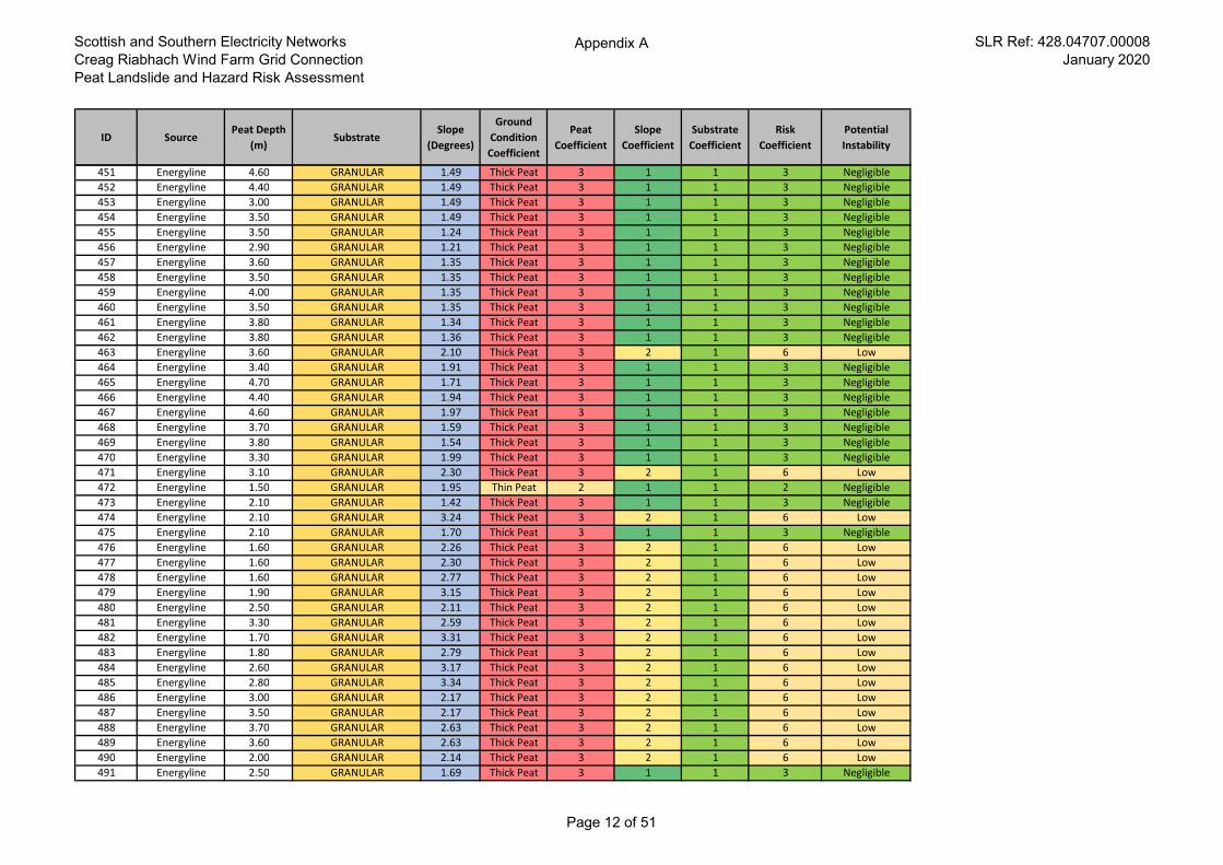
Scottish and Southern Electricity Networks
Creag Riabhach Wind Farm Grid Connection
Peat Landslide and Hazard Risk Assessment
Appendix A SLR Ref: 428.04707.00008
January 2020
ID SourcePeat Depth
(m)Substrate
Slope
(Degrees)
Ground
Condition
Coefficient
Peat
Coefficient
Slope
Coefficient
Substrate
Coefficient
Risk
Coefficient
Potential
Instability
451 Energyline 4.60 GRANULAR 1.49 Thick Peat 3 1 1 3 Negligible
452 Energyline 4.40 GRANULAR 1.49 Thick Peat 3 1 1 3 Negligible
453 Energyline 3.00 GRANULAR 1.49 Thick Peat 3 1 1 3 Negligible
454 Energyline 3.50 GRANULAR 1.49 Thick Peat 3 1 1 3 Negligible
455 Energyline 3.50 GRANULAR 1.24 Thick Peat 3 1 1 3 Negligible
456 Energyline 2.90 GRANULAR 1.21 Thick Peat 3 1 1 3 Negligible
457 Energyline 3.60 GRANULAR 1.35 Thick Peat 3 1 1 3 Negligible
458 Energyline 3.50 GRANULAR 1.35 Thick Peat 3 1 1 3 Negligible
459 Energyline 4.00 GRANULAR 1.35 Thick Peat 3 1 1 3 Negligible
460 Energyline 3.50 GRANULAR 1.35 Thick Peat 3 1 1 3 Negligible
461 Energyline 3.80 GRANULAR 1.34 Thick Peat 3 1 1 3 Negligible
462 Energyline 3.80 GRANULAR 1.36 Thick Peat 3 1 1 3 Negligible
463 Energyline 3.60 GRANULAR 2.10 Thick Peat 3 2 1 6 Low
464 Energyline 3.40 GRANULAR 1.91 Thick Peat 3 1 1 3 Negligible
465 Energyline 4.70 GRANULAR 1.71 Thick Peat 3 1 1 3 Negligible
466 Energyline 4.40 GRANULAR 1.94 Thick Peat 3 1 1 3 Negligible
467 Energyline 4.60 GRANULAR 1.97 Thick Peat 3 1 1 3 Negligible
468 Energyline 3.70 GRANULAR 1.59 Thick Peat 3 1 1 3 Negligible
469 Energyline 3.80 GRANULAR 1.54 Thick Peat 3 1 1 3 Negligible
470 Energyline 3.30 GRANULAR 1.99 Thick Peat 3 1 1 3 Negligible
471 Energyline 3.10 GRANULAR 2.30 Thick Peat 3 2 1 6 Low
472 Energyline 1.50 GRANULAR 1.95 Thin Peat 2 1 1 2 Negligible
473 Energyline 2.10 GRANULAR 1.42 Thick Peat 3 1 1 3 Negligible
474 Energyline 2.10 GRANULAR 3.24 Thick Peat 3 2 1 6 Low
475 Energyline 2.10 GRANULAR 1.70 Thick Peat 3 1 1 3 Negligible
476 Energyline 1.60 GRANULAR 2.26 Thick Peat 3 2 1 6 Low
477 Energyline 1.60 GRANULAR 2.30 Thick Peat 3 2 1 6 Low
478 Energyline 1.60 GRANULAR 2.77 Thick Peat 3 2 1 6 Low
479 Energyline 1.90 GRANULAR 3.15 Thick Peat 3 2 1 6 Low
480 Energyline 2.50 GRANULAR 2.11 Thick Peat 3 2 1 6 Low
481 Energyline 3.30 GRANULAR 2.59 Thick Peat 3 2 1 6 Low
482 Energyline 1.70 GRANULAR 3.31 Thick Peat 3 2 1 6 Low
483 Energyline 1.80 GRANULAR 2.79 Thick Peat 3 2 1 6 Low
484 Energyline 2.60 GRANULAR 3.17 Thick Peat 3 2 1 6 Low
485 Energyline 2.80 GRANULAR 3.34 Thick Peat 3 2 1 6 Low
486 Energyline 3.00 GRANULAR 2.17 Thick Peat 3 2 1 6 Low
487 Energyline 3.50 GRANULAR 2.17 Thick Peat 3 2 1 6 Low
488 Energyline 3.70 GRANULAR 2.63 Thick Peat 3 2 1 6 Low
489 Energyline 3.60 GRANULAR 2.63 Thick Peat 3 2 1 6 Low
490 Energyline 2.00 GRANULAR 2.14 Thick Peat 3 2 1 6 Low
491 Energyline 2.50 GRANULAR 1.69 Thick Peat 3 1 1 3 Negligible
Page 12 of 51
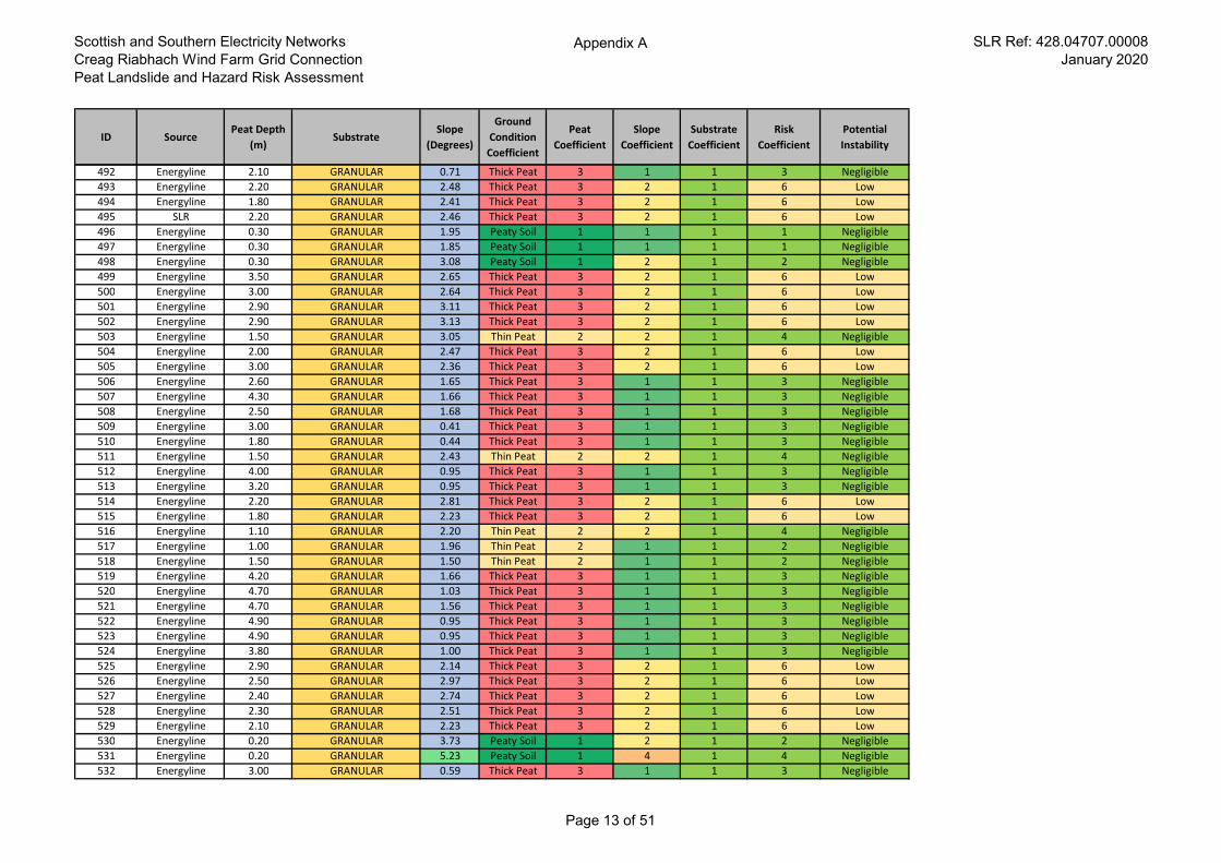
Scottish and Southern Electricity Networks
Creag Riabhach Wind Farm Grid Connection
Peat Landslide and Hazard Risk Assessment
Appendix A SLR Ref: 428.04707.00008
January 2020
ID SourcePeat Depth
(m)Substrate
Slope
(Degrees)
Ground
Condition
Coefficient
Peat
Coefficient
Slope
Coefficient
Substrate
Coefficient
Risk
Coefficient
Potential
Instability
492 Energyline 2.10 GRANULAR 0.71 Thick Peat 3 1 1 3 Negligible
493 Energyline 2.20 GRANULAR 2.48 Thick Peat 3 2 1 6 Low
494 Energyline 1.80 GRANULAR 2.41 Thick Peat 3 2 1 6 Low
495 SLR 2.20 GRANULAR 2.46 Thick Peat 3 2 1 6 Low
496 Energyline 0.30 GRANULAR 1.95 Peaty Soil 1 1 1 1 Negligible
497 Energyline 0.30 GRANULAR 1.85 Peaty Soil 1 1 1 1 Negligible
498 Energyline 0.30 GRANULAR 3.08 Peaty Soil 1 2 1 2 Negligible
499 Energyline 3.50 GRANULAR 2.65 Thick Peat 3 2 1 6 Low
500 Energyline 3.00 GRANULAR 2.64 Thick Peat 3 2 1 6 Low
501 Energyline 2.90 GRANULAR 3.11 Thick Peat 3 2 1 6 Low
502 Energyline 2.90 GRANULAR 3.13 Thick Peat 3 2 1 6 Low
503 Energyline 1.50 GRANULAR 3.05 Thin Peat 2 2 1 4 Negligible
504 Energyline 2.00 GRANULAR 2.47 Thick Peat 3 2 1 6 Low
505 Energyline 3.00 GRANULAR 2.36 Thick Peat 3 2 1 6 Low
506 Energyline 2.60 GRANULAR 1.65 Thick Peat 3 1 1 3 Negligible
507 Energyline 4.30 GRANULAR 1.66 Thick Peat 3 1 1 3 Negligible
508 Energyline 2.50 GRANULAR 1.68 Thick Peat 3 1 1 3 Negligible
509 Energyline 3.00 GRANULAR 0.41 Thick Peat 3 1 1 3 Negligible
510 Energyline 1.80 GRANULAR 0.44 Thick Peat 3 1 1 3 Negligible
511 Energyline 1.50 GRANULAR 2.43 Thin Peat 2 2 1 4 Negligible
512 Energyline 4.00 GRANULAR 0.95 Thick Peat 3 1 1 3 Negligible
513 Energyline 3.20 GRANULAR 0.95 Thick Peat 3 1 1 3 Negligible
514 Energyline 2.20 GRANULAR 2.81 Thick Peat 3 2 1 6 Low
515 Energyline 1.80 GRANULAR 2.23 Thick Peat 3 2 1 6 Low
516 Energyline 1.10 GRANULAR 2.20 Thin Peat 2 2 1 4 Negligible
517 Energyline 1.00 GRANULAR 1.96 Thin Peat 2 1 1 2 Negligible
518 Energyline 1.50 GRANULAR 1.50 Thin Peat 2 1 1 2 Negligible
519 Energyline 4.20 GRANULAR 1.66 Thick Peat 3 1 1 3 Negligible
520 Energyline 4.70 GRANULAR 1.03 Thick Peat 3 1 1 3 Negligible
521 Energyline 4.70 GRANULAR 1.56 Thick Peat 3 1 1 3 Negligible
522 Energyline 4.90 GRANULAR 0.95 Thick Peat 3 1 1 3 Negligible
523 Energyline 4.90 GRANULAR 0.95 Thick Peat 3 1 1 3 Negligible
524 Energyline 3.80 GRANULAR 1.00 Thick Peat 3 1 1 3 Negligible
525 Energyline 2.90 GRANULAR 2.14 Thick Peat 3 2 1 6 Low
526 Energyline 2.50 GRANULAR 2.97 Thick Peat 3 2 1 6 Low
527 Energyline 2.40 GRANULAR 2.74 Thick Peat 3 2 1 6 Low
528 Energyline 2.30 GRANULAR 2.51 Thick Peat 3 2 1 6 Low
529 Energyline 2.10 GRANULAR 2.23 Thick Peat 3 2 1 6 Low
530 Energyline 0.20 GRANULAR 3.73 Peaty Soil 1 2 1 2 Negligible
531 Energyline 0.20 GRANULAR 5.23 Peaty Soil 1 4 1 4 Negligible
532 Energyline 3.00 GRANULAR 0.59 Thick Peat 3 1 1 3 Negligible
Page 13 of 51
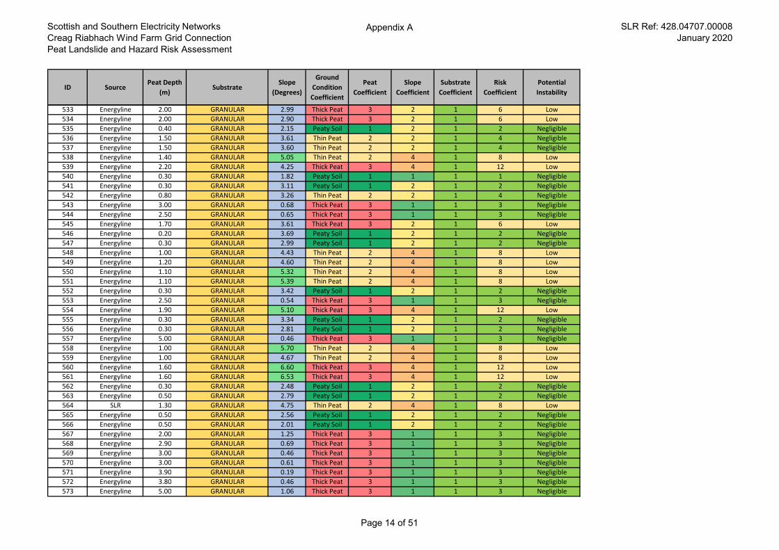
Scottish and Southern Electricity Networks
Creag Riabhach Wind Farm Grid Connection
Peat Landslide and Hazard Risk Assessment
Appendix A SLR Ref: 428.04707.00008
January 2020
ID SourcePeat Depth
(m)Substrate
Slope
(Degrees)
Ground
Condition
Coefficient
Peat
Coefficient
Slope
Coefficient
Substrate
Coefficient
Risk
Coefficient
Potential
Instability
533 Energyline 2.00 GRANULAR 2.99 Thick Peat 3 2 1 6 Low
534 Energyline 2.00 GRANULAR 2.90 Thick Peat 3 2 1 6 Low
535 Energyline 0.40 GRANULAR 2.15 Peaty Soil 1 2 1 2 Negligible
536 Energyline 1.50 GRANULAR 3.61 Thin Peat 2 2 1 4 Negligible
537 Energyline 1.50 GRANULAR 3.60 Thin Peat 2 2 1 4 Negligible
538 Energyline 1.40 GRANULAR 5.05 Thin Peat 2 4 1 8 Low
539 Energyline 2.20 GRANULAR 4.25 Thick Peat 3 4 1 12 Low
540 Energyline 0.30 GRANULAR 1.82 Peaty Soil 1 1 1 1 Negligible
541 Energyline 0.30 GRANULAR 3.11 Peaty Soil 1 2 1 2 Negligible
542 Energyline 0.80 GRANULAR 3.26 Thin Peat 2 2 1 4 Negligible
543 Energyline 3.00 GRANULAR 0.68 Thick Peat 3 1 1 3 Negligible
544 Energyline 2.50 GRANULAR 0.65 Thick Peat 3 1 1 3 Negligible
545 Energyline 1.70 GRANULAR 3.61 Thick Peat 3 2 1 6 Low
546 Energyline 0.20 GRANULAR 3.69 Peaty Soil 1 2 1 2 Negligible
547 Energyline 0.30 GRANULAR 2.99 Peaty Soil 1 2 1 2 Negligible
548 Energyline 1.00 GRANULAR 4.43 Thin Peat 2 4 1 8 Low
549 Energyline 1.20 GRANULAR 4.60 Thin Peat 2 4 1 8 Low
550 Energyline 1.10 GRANULAR 5.32 Thin Peat 2 4 1 8 Low
551 Energyline 1.10 GRANULAR 5.39 Thin Peat 2 4 1 8 Low
552 Energyline 0.30 GRANULAR 3.42 Peaty Soil 1 2 1 2 Negligible
553 Energyline 2.50 GRANULAR 0.54 Thick Peat 3 1 1 3 Negligible
554 Energyline 1.90 GRANULAR 5.10 Thick Peat 3 4 1 12 Low
555 Energyline 0.30 GRANULAR 3.34 Peaty Soil 1 2 1 2 Negligible
556 Energyline 0.30 GRANULAR 2.81 Peaty Soil 1 2 1 2 Negligible
557 Energyline 5.00 GRANULAR 0.46 Thick Peat 3 1 1 3 Negligible
558 Energyline 1.00 GRANULAR 5.70 Thin Peat 2 4 1 8 Low
559 Energyline 1.00 GRANULAR 4.67 Thin Peat 2 4 1 8 Low
560 Energyline 1.60 GRANULAR 6.60 Thick Peat 3 4 1 12 Low
561 Energyline 1.60 GRANULAR 6.53 Thick Peat 3 4 1 12 Low
562 Energyline 0.30 GRANULAR 2.48 Peaty Soil 1 2 1 2 Negligible
563 Energyline 0.50 GRANULAR 2.79 Peaty Soil 1 2 1 2 Negligible
564 SLR 1.30 GRANULAR 4.75 Thin Peat 2 4 1 8 Low
565 Energyline 0.50 GRANULAR 2.56 Peaty Soil 1 2 1 2 Negligible
566 Energyline 0.50 GRANULAR 2.01 Peaty Soil 1 2 1 2 Negligible
567 Energyline 2.00 GRANULAR 1.25 Thick Peat 3 1 1 3 Negligible
568 Energyline 2.90 GRANULAR 0.69 Thick Peat 3 1 1 3 Negligible
569 Energyline 3.00 GRANULAR 0.46 Thick Peat 3 1 1 3 Negligible
570 Energyline 3.00 GRANULAR 0.61 Thick Peat 3 1 1 3 Negligible
571 Energyline 3.90 GRANULAR 0.19 Thick Peat 3 1 1 3 Negligible
572 Energyline 3.80 GRANULAR 0.46 Thick Peat 3 1 1 3 Negligible
573 Energyline 5.00 GRANULAR 1.06 Thick Peat 3 1 1 3 Negligible
Page 14 of 51
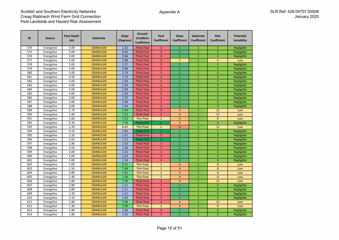
Scottish and Southern Electricity Networks
Creag Riabhach Wind Farm Grid Connection
Peat Landslide and Hazard Risk Assessment
Appendix A SLR Ref: 428.04707.00008
January 2020
ID SourcePeat Depth
(m)Substrate
Slope
(Degrees)
Ground
Condition
Coefficient
Peat
Coefficient
Slope
Coefficient
Substrate
Coefficient
Risk
Coefficient
Potential
Instability
574 Energyline 5.00 GRANULAR 1.31 Thick Peat 3 1 1 3 Negligible
575 Energyline 5.00 GRANULAR 0.45 Thick Peat 3 1 1 3 Negligible
576 Energyline 5.00 GRANULAR 0.46 Thick Peat 3 1 1 3 Negligible
577 Energyline 5.00 GRANULAR 2.08 Thick Peat 3 2 1 6 Low
578 Energyline 5.00 GRANULAR 1.57 Thick Peat 3 1 1 3 Negligible
579 Energyline 5.00 GRANULAR 0.98 Thick Peat 3 1 1 3 Negligible
580 Energyline 5.00 GRANULAR 1.79 Thick Peat 3 1 1 3 Negligible
581 Energyline 4.50 GRANULAR 1.72 Thick Peat 3 1 1 3 Negligible
582 Energyline 5.00 GRANULAR 1.50 Thick Peat 3 1 1 3 Negligible
583 Energyline 5.00 GRANULAR 1.54 Thick Peat 3 1 1 3 Negligible
584 Energyline 5.00 GRANULAR 1.69 Thick Peat 3 1 1 3 Negligible
585 Energyline 4.00 GRANULAR 1.03 Thick Peat 3 1 1 3 Negligible
586 Energyline 5.00 GRANULAR 1.75 Thick Peat 3 1 1 3 Negligible
587 Energyline 3.80 GRANULAR 1.60 Thick Peat 3 1 1 3 Negligible
588 Energyline 3.00 GRANULAR 1.54 Thick Peat 3 1 1 3 Negligible
589 Energyline 1.70 GRANULAR 5.99 Thick Peat 3 4 1 12 Low
590 Energyline 1.90 GRANULAR 7.15 Thick Peat 3 4 1 12 Low
591 Energyline 1.00 GRANULAR 7.13 Thin Peat 2 4 1 8 Low
592 Energyline 0.30 GRANULAR 7.59 Peaty Soil 1 4 1 4 Negligible
593 Energyline 1.20 GRANULAR 8.83 Thin Peat 2 6 1 12 Low
594 Energyline 0.50 GRANULAR 1.82 Peaty Soil 1 1 1 1 Negligible
595 Energyline 2.20 GRANULAR 1.51 Thick Peat 3 1 1 3 Negligible
596 Energyline 0.50 GRANULAR 1.51 Peaty Soil 1 1 1 1 Negligible
597 Energyline 1.80 GRANULAR 1.53 Thick Peat 3 1 1 3 Negligible
598 Energyline 4.50 GRANULAR 1.28 Thick Peat 3 1 1 3 Negligible
599 Energyline 5.00 GRANULAR 1.31 Thick Peat 3 1 1 3 Negligible
600 Energyline 5.00 GRANULAR 1.23 Thick Peat 3 1 1 3 Negligible
601 Energyline 5.00 GRANULAR 1.54 Thick Peat 3 1 1 3 Negligible
602 Energyline 1.00 GRANULAR 5.31 Thin Peat 2 4 1 8 Low
603 Energyline 1.50 GRANULAR 7.48 Thin Peat 2 4 1 8 Low
604 Energyline 0.80 GRANULAR 7.91 Thin Peat 2 4 1 8 Low
605 Energyline 1.40 GRANULAR 7.28 Thin Peat 2 4 1 8 Low
606 Energyline 1.80 GRANULAR 7.29 Thick Peat 3 4 1 12 Low
607 Energyline 2.80 GRANULAR 1.51 Thick Peat 3 1 1 3 Negligible
608 Energyline 2.80 GRANULAR 1.51 Thick Peat 3 1 1 3 Negligible
609 Energyline 2.30 GRANULAR 1.51 Thick Peat 3 1 1 3 Negligible
610 Energyline 2.10 GRANULAR 1.62 Thick Peat 3 1 1 3 Negligible
611 Energyline 1.80 GRANULAR 7.09 Thick Peat 3 4 1 12 Low
612 Energyline 1.30 GRANULAR 7.09 Thin Peat 2 4 1 8 Low
613 Energyline 1.80 GRANULAR 1.66 Thick Peat 3 1 1 3 Negligible
614 Energyline 1.80 GRANULAR 1.52 Thick Peat 3 1 1 3 Negligible
Page 15 of 51
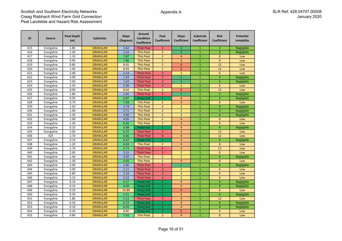
Scottish and Southern Electricity Networks
Creag Riabhach Wind Farm Grid Connection
Peat Landslide and Hazard Risk Assessment
Appendix A SLR Ref: 428.04707.00008
January 2020
ID SourcePeat Depth
(m)Substrate
Slope
(Degrees)
Ground
Condition
Coefficient
Peat
Coefficient
Slope
Coefficient
Substrate
Coefficient
Risk
Coefficient
Potential
Instability
615 Energyline 1.80 GRANULAR 1.62 Thick Peat 3 1 1 3 Negligible
616 Energyline 1.20 GRANULAR 1.52 Thin Peat 2 1 1 2 Negligible
617 Energyline 1.10 GRANULAR 7.87 Thin Peat 2 4 1 8 Low
618 Energyline 0.90 GRANULAR 7.86 Thin Peat 2 4 1 8 Low
619 Energyline 0.80 GRANULAR 8.05 Thin Peat 2 6 1 12 Low
620 Energyline 1.40 GRANULAR 8.83 Thin Peat 2 6 1 12 Low
621 Energyline 2.00 GRANULAR 2.14 Thick Peat 3 2 1 6 Low
622 Energyline 3.00 GRANULAR 1.43 Thick Peat 3 1 1 3 Negligible
623 Energyline 2.00 GRANULAR 1.63 Thick Peat 3 1 1 3 Negligible
624 Energyline 2.50 GRANULAR 2.36 Thick Peat 3 2 1 6 Low
625 Energyline 0.90 GRANULAR 8.04 Thin Peat 2 6 1 12 Low
626 Energyline 1.80 GRANULAR 1.65 Thick Peat 3 1 1 3 Negligible
627 Energyline 0.50 GRANULAR 6.87 Peaty Soil 1 4 1 4 Negligible
628 Energyline 0.70 GRANULAR 7.58 Thin Peat 2 4 1 8 Low
629 Energyline 1.50 GRANULAR 2.74 Thin Peat 2 2 1 4 Negligible
630 Energyline 1.00 GRANULAR 2.71 Thin Peat 2 2 1 4 Negligible
631 Energyline 1.30 GRANULAR 3.30 Thin Peat 2 2 1 4 Negligible
632 Energyline 1.00 GRANULAR 4.05 Thin Peat 2 4 1 8 Low
633 Energyline 1.30 GRANULAR 6.65 Thin Peat 2 4 1 8 Low
634 Energyline 0.10 GRANULAR 6.88 Peaty Soil 1 4 1 4 Negligible
635 Energyline 2.00 GRANULAR 6.72 Thick Peat 3 4 1 12 Low
636 SLR 1.70 GRANULAR 6.66 Thick Peat 3 4 1 12 Low
637 Energyline 0.10 GRANULAR 6.47 Peaty Soil 1 4 1 4 Negligible
638 Energyline 1.20 GRANULAR 6.63 Thin Peat 2 4 1 8 Low
639 Energyline 2.70 GRANULAR 6.73 Thick Peat 3 4 1 12 Low
640 Energyline 2.00 GRANULAR 3.15 Thick Peat 3 2 1 6 Low
641 Energyline 1.40 GRANULAR 2.92 Thin Peat 2 2 1 4 Negligible
642 Energyline 1.30 GRANULAR 6.65 Thin Peat 2 4 1 8 Low
643 Energyline 2.00 GRANULAR 1.06 Thick Peat 3 1 1 3 Negligible
644 Energyline 3.00 GRANULAR 2.11 Thick Peat 3 2 1 6 Low
645 Energyline 2.80 GRANULAR 2.19 Thick Peat 3 2 1 6 Low
646 Energyline 3.10 GRANULAR 2.12 Thick Peat 3 2 1 6 Low
647 Energyline 0.10 GRANULAR 6.27 Peaty Soil 1 4 1 4 Negligible
648 Energyline 0.10 GRANULAR 6.69 Peaty Soil 1 4 1 4 Negligible
649 Energyline 0.10 GRANULAR 10.89 Peaty Soil 1 6 1 6 Low
650 Energyline 0.30 GRANULAR 5.51 Peaty Soil 1 4 1 4 Negligible
651 Energyline 1.80 GRANULAR 5.11 Thick Peat 3 4 1 12 Low
652 Energyline 0.10 GRANULAR 6.72 Peaty Soil 1 4 1 4 Negligible
653 Energyline 0.10 GRANULAR 6.55 Peaty Soil 1 4 1 4 Negligible
654 Energyline 0.10 GRANULAR 8.90 Peaty Soil 1 6 1 6 Low
655 Energyline 0.80 GRANULAR 7.42 Thin Peat 2 4 1 8 Low
Page 16 of 51
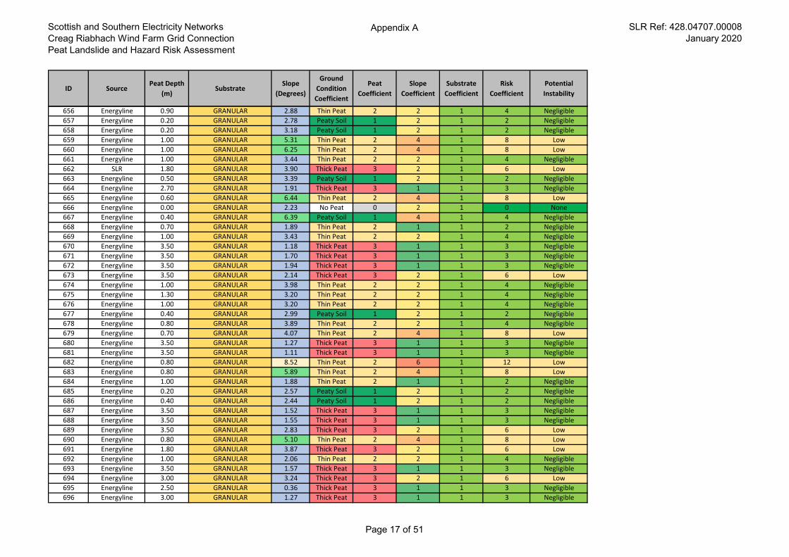
Scottish and Southern Electricity Networks
Creag Riabhach Wind Farm Grid Connection
Peat Landslide and Hazard Risk Assessment
Appendix A SLR Ref: 428.04707.00008
January 2020
ID SourcePeat Depth
(m)Substrate
Slope
(Degrees)
Ground
Condition
Coefficient
Peat
Coefficient
Slope
Coefficient
Substrate
Coefficient
Risk
Coefficient
Potential
Instability
656 Energyline 0.90 GRANULAR 2.88 Thin Peat 2 2 1 4 Negligible
657 Energyline 0.20 GRANULAR 2.78 Peaty Soil 1 2 1 2 Negligible
658 Energyline 0.20 GRANULAR 3.18 Peaty Soil 1 2 1 2 Negligible
659 Energyline 1.00 GRANULAR 5.31 Thin Peat 2 4 1 8 Low
660 Energyline 1.00 GRANULAR 6.25 Thin Peat 2 4 1 8 Low
661 Energyline 1.00 GRANULAR 3.44 Thin Peat 2 2 1 4 Negligible
662 SLR 1.80 GRANULAR 3.90 Thick Peat 3 2 1 6 Low
663 Energyline 0.50 GRANULAR 3.39 Peaty Soil 1 2 1 2 Negligible
664 Energyline 2.70 GRANULAR 1.91 Thick Peat 3 1 1 3 Negligible
665 Energyline 0.60 GRANULAR 6.44 Thin Peat 2 4 1 8 Low
666 Energyline 0.00 GRANULAR 2.23 No Peat 0 2 1 0 None
667 Energyline 0.40 GRANULAR 6.39 Peaty Soil 1 4 1 4 Negligible
668 Energyline 0.70 GRANULAR 1.89 Thin Peat 2 1 1 2 Negligible
669 Energyline 1.00 GRANULAR 3.43 Thin Peat 2 2 1 4 Negligible
670 Energyline 3.50 GRANULAR 1.18 Thick Peat 3 1 1 3 Negligible
671 Energyline 3.50 GRANULAR 1.70 Thick Peat 3 1 1 3 Negligible
672 Energyline 3.50 GRANULAR 1.94 Thick Peat 3 1 1 3 Negligible
673 Energyline 3.50 GRANULAR 2.14 Thick Peat 3 2 1 6 Low
674 Energyline 1.00 GRANULAR 3.98 Thin Peat 2 2 1 4 Negligible
675 Energyline 1.30 GRANULAR 3.20 Thin Peat 2 2 1 4 Negligible
676 Energyline 1.00 GRANULAR 3.20 Thin Peat 2 2 1 4 Negligible
677 Energyline 0.40 GRANULAR 2.99 Peaty Soil 1 2 1 2 Negligible
678 Energyline 0.80 GRANULAR 3.89 Thin Peat 2 2 1 4 Negligible
679 Energyline 0.70 GRANULAR 4.07 Thin Peat 2 4 1 8 Low
680 Energyline 3.50 GRANULAR 1.27 Thick Peat 3 1 1 3 Negligible
681 Energyline 3.50 GRANULAR 1.11 Thick Peat 3 1 1 3 Negligible
682 Energyline 0.80 GRANULAR 8.52 Thin Peat 2 6 1 12 Low
683 Energyline 0.80 GRANULAR 5.89 Thin Peat 2 4 1 8 Low
684 Energyline 1.00 GRANULAR 1.88 Thin Peat 2 1 1 2 Negligible
685 Energyline 0.20 GRANULAR 2.57 Peaty Soil 1 2 1 2 Negligible
686 Energyline 0.40 GRANULAR 2.44 Peaty Soil 1 2 1 2 Negligible
687 Energyline 3.50 GRANULAR 1.52 Thick Peat 3 1 1 3 Negligible
688 Energyline 3.50 GRANULAR 1.55 Thick Peat 3 1 1 3 Negligible
689 Energyline 3.50 GRANULAR 2.83 Thick Peat 3 2 1 6 Low
690 Energyline 0.80 GRANULAR 5.10 Thin Peat 2 4 1 8 Low
691 Energyline 1.80 GRANULAR 3.87 Thick Peat 3 2 1 6 Low
692 Energyline 1.00 GRANULAR 2.06 Thin Peat 2 2 1 4 Negligible
693 Energyline 3.50 GRANULAR 1.57 Thick Peat 3 1 1 3 Negligible
694 Energyline 3.00 GRANULAR 3.24 Thick Peat 3 2 1 6 Low
695 Energyline 2.50 GRANULAR 0.36 Thick Peat 3 1 1 3 Negligible
696 Energyline 3.00 GRANULAR 1.27 Thick Peat 3 1 1 3 Negligible
Page 17 of 51
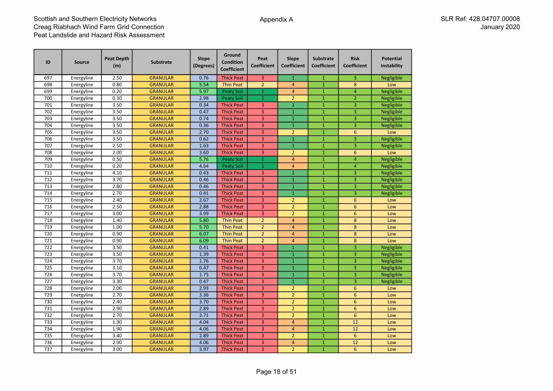
Scottish and Southern Electricity Networks
Creag Riabhach Wind Farm Grid Connection
Peat Landslide and Hazard Risk Assessment
Appendix A SLR Ref: 428.04707.00008
January 2020
ID SourcePeat Depth
(m)Substrate
Slope
(Degrees)
Ground
Condition
Coefficient
Peat
Coefficient
Slope
Coefficient
Substrate
Coefficient
Risk
Coefficient
Potential
Instability
697 Energyline 2.50 GRANULAR 0.76 Thick Peat 3 1 1 3 Negligible
698 Energyline 0.80 GRANULAR 5.54 Thin Peat 2 4 1 8 Low
699 Energyline 0.20 GRANULAR 5.97 Peaty Soil 1 4 1 4 Negligible
700 Energyline 0.30 GRANULAR 2.98 Peaty Soil 1 2 1 2 Negligible
701 Energyline 3.50 GRANULAR 0.34 Thick Peat 3 1 1 3 Negligible
702 Energyline 3.50 GRANULAR 0.47 Thick Peat 3 1 1 3 Negligible
703 Energyline 3.50 GRANULAR 0.74 Thick Peat 3 1 1 3 Negligible
704 Energyline 3.50 GRANULAR 0.36 Thick Peat 3 1 1 3 Negligible
705 Energyline 3.50 GRANULAR 2.70 Thick Peat 3 2 1 6 Low
706 Energyline 3.50 GRANULAR 0.62 Thick Peat 3 1 1 3 Negligible
707 Energyline 2.50 GRANULAR 1.63 Thick Peat 3 1 1 3 Negligible
708 Energyline 2.00 GRANULAR 3.60 Thick Peat 3 2 1 6 Low
709 Energyline 0.50 GRANULAR 5.76 Peaty Soil 1 4 1 4 Negligible
710 Energyline 0.20 GRANULAR 4.64 Peaty Soil 1 4 1 4 Negligible
711 Energyline 4.10 GRANULAR 0.43 Thick Peat 3 1 1 3 Negligible
712 Energyline 3.70 GRANULAR 0.46 Thick Peat 3 1 1 3 Negligible
713 Energyline 2.80 GRANULAR 0.46 Thick Peat 3 1 1 3 Negligible
714 Energyline 2.70 GRANULAR 0.41 Thick Peat 3 1 1 3 Negligible
715 Energyline 2.40 GRANULAR 2.67 Thick Peat 3 2 1 6 Low
716 Energyline 2.50 GRANULAR 2.88 Thick Peat 3 2 1 6 Low
717 Energyline 3.00 GRANULAR 3.99 Thick Peat 3 2 1 6 Low
718 Energyline 1.40 GRANULAR 5.80 Thin Peat 2 4 1 8 Low
719 Energyline 1.00 GRANULAR 5.70 Thin Peat 2 4 1 8 Low
720 Energyline 0.90 GRANULAR 6.07 Thin Peat 2 4 1 8 Low
721 Energyline 0.90 GRANULAR 6.09 Thin Peat 2 4 1 8 Low
722 Energyline 3.50 GRANULAR 0.41 Thick Peat 3 1 1 3 Negligible
723 Energyline 3.50 GRANULAR 1.39 Thick Peat 3 1 1 3 Negligible
724 Energyline 3.70 GRANULAR 1.76 Thick Peat 3 1 1 3 Negligible
725 Energyline 3.10 GRANULAR 0.47 Thick Peat 3 1 1 3 Negligible
726 Energyline 3.70 GRANULAR 1.75 Thick Peat 3 1 1 3 Negligible
727 Energyline 3.30 GRANULAR 0.47 Thick Peat 3 1 1 3 Negligible
728 Energyline 2.00 GRANULAR 2.93 Thick Peat 3 2 1 6 Low
729 Energyline 2.70 GRANULAR 3.36 Thick Peat 3 2 1 6 Low
730 Energyline 2.40 GRANULAR 3.70 Thick Peat 3 2 1 6 Low
731 Energyline 2.90 GRANULAR 2.89 Thick Peat 3 2 1 6 Low
732 Energyline 2.70 GRANULAR 3.71 Thick Peat 3 2 1 6 Low
733 Energyline 1.90 GRANULAR 4.04 Thick Peat 3 4 1 12 Low
734 Energyline 1.90 GRANULAR 4.06 Thick Peat 3 4 1 12 Low
735 Energyline 3.40 GRANULAR 2.89 Thick Peat 3 2 1 6 Low
736 Energyline 2.90 GRANULAR 4.06 Thick Peat 3 4 1 12 Low
737 Energyline 3.00 GRANULAR 3.97 Thick Peat 3 2 1 6 Low
Page 18 of 51
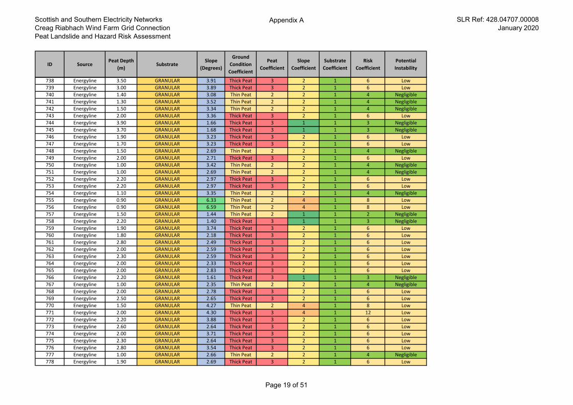
Scottish and Southern Electricity Networks
Creag Riabhach Wind Farm Grid Connection
Peat Landslide and Hazard Risk Assessment
Appendix A SLR Ref: 428.04707.00008
January 2020
ID SourcePeat Depth
(m)Substrate
Slope
(Degrees)
Ground
Condition
Coefficient
Peat
Coefficient
Slope
Coefficient
Substrate
Coefficient
Risk
Coefficient
Potential
Instability
738 Energyline 3.50 GRANULAR 3.91 Thick Peat 3 2 1 6 Low
739 Energyline 3.00 GRANULAR 3.89 Thick Peat 3 2 1 6 Low
740 Energyline 1.40 GRANULAR 3.08 Thin Peat 2 2 1 4 Negligible
741 Energyline 1.30 GRANULAR 3.52 Thin Peat 2 2 1 4 Negligible
742 Energyline 1.50 GRANULAR 3.34 Thin Peat 2 2 1 4 Negligible
743 Energyline 2.00 GRANULAR 3.36 Thick Peat 3 2 1 6 Low
744 Energyline 3.90 GRANULAR 1.66 Thick Peat 3 1 1 3 Negligible
745 Energyline 3.70 GRANULAR 1.68 Thick Peat 3 1 1 3 Negligible
746 Energyline 1.90 GRANULAR 3.23 Thick Peat 3 2 1 6 Low
747 Energyline 1.70 GRANULAR 3.23 Thick Peat 3 2 1 6 Low
748 Energyline 1.50 GRANULAR 2.69 Thin Peat 2 2 1 4 Negligible
749 Energyline 2.00 GRANULAR 2.71 Thick Peat 3 2 1 6 Low
750 Energyline 1.00 GRANULAR 3.42 Thin Peat 2 2 1 4 Negligible
751 Energyline 1.00 GRANULAR 2.69 Thin Peat 2 2 1 4 Negligible
752 Energyline 2.20 GRANULAR 2.97 Thick Peat 3 2 1 6 Low
753 Energyline 2.20 GRANULAR 2.97 Thick Peat 3 2 1 6 Low
754 Energyline 1.10 GRANULAR 3.35 Thin Peat 2 2 1 4 Negligible
755 Energyline 0.90 GRANULAR 6.33 Thin Peat 2 4 1 8 Low
756 Energyline 0.90 GRANULAR 6.59 Thin Peat 2 4 1 8 Low
757 Energyline 1.50 GRANULAR 1.44 Thin Peat 2 1 1 2 Negligible
758 Energyline 2.20 GRANULAR 1.40 Thick Peat 3 1 1 3 Negligible
759 Energyline 1.90 GRANULAR 3.74 Thick Peat 3 2 1 6 Low
760 Energyline 1.80 GRANULAR 2.18 Thick Peat 3 2 1 6 Low
761 Energyline 2.80 GRANULAR 2.49 Thick Peat 3 2 1 6 Low
762 Energyline 2.00 GRANULAR 2.59 Thick Peat 3 2 1 6 Low
763 Energyline 2.30 GRANULAR 2.59 Thick Peat 3 2 1 6 Low
764 Energyline 2.00 GRANULAR 2.33 Thick Peat 3 2 1 6 Low
765 Energyline 2.00 GRANULAR 2.83 Thick Peat 3 2 1 6 Low
766 Energyline 2.20 GRANULAR 1.61 Thick Peat 3 1 1 3 Negligible
767 Energyline 1.00 GRANULAR 2.35 Thin Peat 2 2 1 4 Negligible
768 Energyline 2.00 GRANULAR 2.78 Thick Peat 3 2 1 6 Low
769 Energyline 2.50 GRANULAR 2.65 Thick Peat 3 2 1 6 Low
770 Energyline 1.50 GRANULAR 4.27 Thin Peat 2 4 1 8 Low
771 Energyline 2.00 GRANULAR 4.30 Thick Peat 3 4 1 12 Low
772 Energyline 2.20 GRANULAR 3.88 Thick Peat 3 2 1 6 Low
773 Energyline 2.60 GRANULAR 2.64 Thick Peat 3 2 1 6 Low
774 Energyline 2.00 GRANULAR 3.71 Thick Peat 3 2 1 6 Low
775 Energyline 2.30 GRANULAR 2.64 Thick Peat 3 2 1 6 Low
776 Energyline 2.80 GRANULAR 3.54 Thick Peat 3 2 1 6 Low
777 Energyline 1.00 GRANULAR 2.66 Thin Peat 2 2 1 4 Negligible
778 Energyline 1.90 GRANULAR 2.69 Thick Peat 3 2 1 6 Low
Page 19 of 51
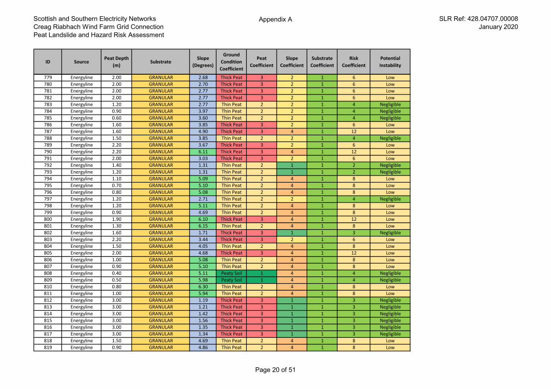
Scottish and Southern Electricity Networks
Creag Riabhach Wind Farm Grid Connection
Peat Landslide and Hazard Risk Assessment
Appendix A SLR Ref: 428.04707.00008
January 2020
ID SourcePeat Depth
(m)Substrate
Slope
(Degrees)
Ground
Condition
Coefficient
Peat
Coefficient
Slope
Coefficient
Substrate
Coefficient
Risk
Coefficient
Potential
Instability
779 Energyline 2.00 GRANULAR 2.68 Thick Peat 3 2 1 6 Low
780 Energyline 2.00 GRANULAR 2.70 Thick Peat 3 2 1 6 Low
781 Energyline 2.00 GRANULAR 2.77 Thick Peat 3 2 1 6 Low
782 Energyline 2.00 GRANULAR 2.77 Thick Peat 3 2 1 6 Low
783 Energyline 1.20 GRANULAR 2.77 Thin Peat 2 2 1 4 Negligible
784 Energyline 0.90 GRANULAR 3.97 Thin Peat 2 2 1 4 Negligible
785 Energyline 0.60 GRANULAR 3.60 Thin Peat 2 2 1 4 Negligible
786 Energyline 1.60 GRANULAR 3.85 Thick Peat 3 2 1 6 Low
787 Energyline 1.60 GRANULAR 4.90 Thick Peat 3 4 1 12 Low
788 Energyline 1.50 GRANULAR 3.85 Thin Peat 2 2 1 4 Negligible
789 Energyline 2.20 GRANULAR 3.67 Thick Peat 3 2 1 6 Low
790 Energyline 2.20 GRANULAR 6.11 Thick Peat 3 4 1 12 Low
791 Energyline 2.00 GRANULAR 3.03 Thick Peat 3 2 1 6 Low
792 Energyline 1.40 GRANULAR 1.31 Thin Peat 2 1 1 2 Negligible
793 Energyline 1.20 GRANULAR 1.31 Thin Peat 2 1 1 2 Negligible
794 Energyline 1.10 GRANULAR 5.09 Thin Peat 2 4 1 8 Low
795 Energyline 0.70 GRANULAR 5.10 Thin Peat 2 4 1 8 Low
796 Energyline 0.80 GRANULAR 5.08 Thin Peat 2 4 1 8 Low
797 Energyline 1.20 GRANULAR 2.71 Thin Peat 2 2 1 4 Negligible
798 Energyline 1.20 GRANULAR 5.11 Thin Peat 2 4 1 8 Low
799 Energyline 0.90 GRANULAR 4.69 Thin Peat 2 4 1 8 Low
800 Energyline 1.90 GRANULAR 6.10 Thick Peat 3 4 1 12 Low
801 Energyline 1.30 GRANULAR 6.15 Thin Peat 2 4 1 8 Low
802 Energyline 1.60 GRANULAR 1.71 Thick Peat 3 1 1 3 Negligible
803 Energyline 2.20 GRANULAR 3.44 Thick Peat 3 2 1 6 Low
804 Energyline 1.50 GRANULAR 4.05 Thin Peat 2 4 1 8 Low
805 Energyline 2.00 GRANULAR 4.68 Thick Peat 3 4 1 12 Low
806 Energyline 1.00 GRANULAR 5.08 Thin Peat 2 4 1 8 Low
807 Energyline 0.90 GRANULAR 5.10 Thin Peat 2 4 1 8 Low
808 Energyline 0.40 GRANULAR 5.11 Peaty Soil 1 4 1 4 Negligible
809 Energyline 0.50 GRANULAR 5.98 Peaty Soil 1 4 1 4 Negligible
810 Energyline 0.80 GRANULAR 6.30 Thin Peat 2 4 1 8 Low
811 Energyline 1.00 GRANULAR 5.94 Thin Peat 2 4 1 8 Low
812 Energyline 3.00 GRANULAR 1.19 Thick Peat 3 1 1 3 Negligible
813 Energyline 3.00 GRANULAR 1.21 Thick Peat 3 1 1 3 Negligible
814 Energyline 3.00 GRANULAR 1.42 Thick Peat 3 1 1 3 Negligible
815 Energyline 3.00 GRANULAR 1.56 Thick Peat 3 1 1 3 Negligible
816 Energyline 3.00 GRANULAR 1.35 Thick Peat 3 1 1 3 Negligible
817 Energyline 3.00 GRANULAR 1.34 Thick Peat 3 1 1 3 Negligible
818 Energyline 1.50 GRANULAR 4.69 Thin Peat 2 4 1 8 Low
819 Energyline 0.90 GRANULAR 4.86 Thin Peat 2 4 1 8 Low
Page 20 of 51
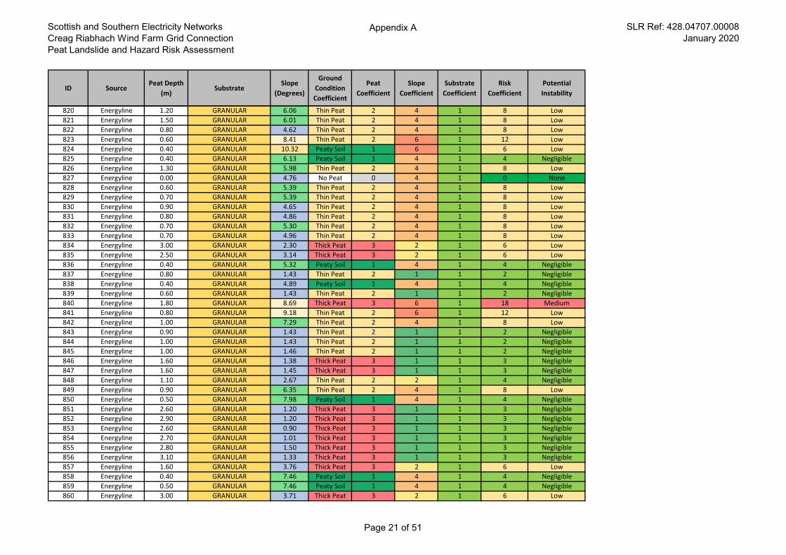
Scottish and Southern Electricity Networks
Creag Riabhach Wind Farm Grid Connection
Peat Landslide and Hazard Risk Assessment
Appendix A SLR Ref: 428.04707.00008
January 2020
ID SourcePeat Depth
(m)Substrate
Slope
(Degrees)
Ground
Condition
Coefficient
Peat
Coefficient
Slope
Coefficient
Substrate
Coefficient
Risk
Coefficient
Potential
Instability
820 Energyline 1.20 GRANULAR 6.06 Thin Peat 2 4 1 8 Low
821 Energyline 1.50 GRANULAR 6.01 Thin Peat 2 4 1 8 Low
822 Energyline 0.80 GRANULAR 4.62 Thin Peat 2 4 1 8 Low
823 Energyline 0.60 GRANULAR 8.41 Thin Peat 2 6 1 12 Low
824 Energyline 0.40 GRANULAR 10.32 Peaty Soil 1 6 1 6 Low
825 Energyline 0.40 GRANULAR 6.13 Peaty Soil 1 4 1 4 Negligible
826 Energyline 1.30 GRANULAR 5.98 Thin Peat 2 4 1 8 Low
827 Energyline 0.00 GRANULAR 4.76 No Peat 0 4 1 0 None
828 Energyline 0.60 GRANULAR 5.39 Thin Peat 2 4 1 8 Low
829 Energyline 0.70 GRANULAR 5.39 Thin Peat 2 4 1 8 Low
830 Energyline 0.90 GRANULAR 4.65 Thin Peat 2 4 1 8 Low
831 Energyline 0.80 GRANULAR 4.86 Thin Peat 2 4 1 8 Low
832 Energyline 0.70 GRANULAR 5.30 Thin Peat 2 4 1 8 Low
833 Energyline 0.70 GRANULAR 4.96 Thin Peat 2 4 1 8 Low
834 Energyline 3.00 GRANULAR 2.30 Thick Peat 3 2 1 6 Low
835 Energyline 2.50 GRANULAR 3.14 Thick Peat 3 2 1 6 Low
836 Energyline 0.40 GRANULAR 5.32 Peaty Soil 1 4 1 4 Negligible
837 Energyline 0.80 GRANULAR 1.43 Thin Peat 2 1 1 2 Negligible
838 Energyline 0.40 GRANULAR 4.89 Peaty Soil 1 4 1 4 Negligible
839 Energyline 0.60 GRANULAR 1.43 Thin Peat 2 1 1 2 Negligible
840 Energyline 1.80 GRANULAR 8.69 Thick Peat 3 6 1 18 Medium
841 Energyline 0.80 GRANULAR 9.18 Thin Peat 2 6 1 12 Low
842 Energyline 1.00 GRANULAR 7.29 Thin Peat 2 4 1 8 Low
843 Energyline 0.90 GRANULAR 1.43 Thin Peat 2 1 1 2 Negligible
844 Energyline 1.00 GRANULAR 1.43 Thin Peat 2 1 1 2 Negligible
845 Energyline 1.00 GRANULAR 1.46 Thin Peat 2 1 1 2 Negligible
846 Energyline 1.60 GRANULAR 1.38 Thick Peat 3 1 1 3 Negligible
847 Energyline 1.60 GRANULAR 1.45 Thick Peat 3 1 1 3 Negligible
848 Energyline 1.10 GRANULAR 2.67 Thin Peat 2 2 1 4 Negligible
849 Energyline 0.90 GRANULAR 6.35 Thin Peat 2 4 1 8 Low
850 Energyline 0.50 GRANULAR 7.98 Peaty Soil 1 4 1 4 Negligible
851 Energyline 2.60 GRANULAR 1.20 Thick Peat 3 1 1 3 Negligible
852 Energyline 2.90 GRANULAR 1.20 Thick Peat 3 1 1 3 Negligible
853 Energyline 2.60 GRANULAR 0.90 Thick Peat 3 1 1 3 Negligible
854 Energyline 2.70 GRANULAR 1.01 Thick Peat 3 1 1 3 Negligible
855 Energyline 2.80 GRANULAR 1.50 Thick Peat 3 1 1 3 Negligible
856 Energyline 3.10 GRANULAR 1.33 Thick Peat 3 1 1 3 Negligible
857 Energyline 1.60 GRANULAR 3.76 Thick Peat 3 2 1 6 Low
858 Energyline 0.40 GRANULAR 7.46 Peaty Soil 1 4 1 4 Negligible
859 Energyline 0.50 GRANULAR 7.46 Peaty Soil 1 4 1 4 Negligible
860 Energyline 3.00 GRANULAR 3.71 Thick Peat 3 2 1 6 Low
Page 21 of 51
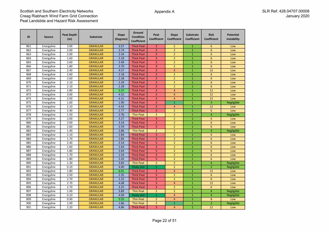
Scottish and Southern Electricity Networks
Creag Riabhach Wind Farm Grid Connection
Peat Landslide and Hazard Risk Assessment
Appendix A SLR Ref: 428.04707.00008
January 2020
ID SourcePeat Depth
(m)Substrate
Slope
(Degrees)
Ground
Condition
Coefficient
Peat
Coefficient
Slope
Coefficient
Substrate
Coefficient
Risk
Coefficient
Potential
Instability
861 Energyline 3.00 GRANULAR 3.57 Thick Peat 3 2 1 6 Low
862 Energyline 2.00 GRANULAR 2.74 Thick Peat 3 2 1 6 Low
863 Energyline 2.00 GRANULAR 2.34 Thick Peat 3 2 1 6 Low
864 Energyline 1.60 GRANULAR 2.18 Thick Peat 3 2 1 6 Low
865 Energyline 2.60 GRANULAR 3.49 Thick Peat 3 2 1 6 Low
866 Energyline 1.80 GRANULAR 3.70 Thick Peat 3 2 1 6 Low
867 Energyline 2.40 GRANULAR 4.57 Thick Peat 3 4 1 12 Low
868 Energyline 2.60 GRANULAR 2.18 Thick Peat 3 2 1 6 Low
869 Energyline 2.60 GRANULAR 2.18 Thick Peat 3 2 1 6 Low
870 Energyline 2.10 GRANULAR 2.29 Thick Peat 3 2 1 6 Low
871 Energyline 2.10 GRANULAR 2.28 Thick Peat 3 2 1 6 Low
872 Energyline 2.80 GRANULAR 5.37 Thick Peat 3 4 1 12 Low
873 Energyline 3.00 GRANULAR 4.32 Thick Peat 3 4 1 12 Low
874 Energyline 2.00 GRANULAR 4.31 Thick Peat 3 4 1 12 Low
875 Energyline 1.60 GRANULAR 1.90 Thick Peat 3 1 1 3 Negligible
876 Energyline 2.10 GRANULAR 4.42 Thick Peat 3 4 1 12 Low
877 Energyline 2.40 GRANULAR 2.77 Thick Peat 3 2 1 6 Low
878 Energyline 1.50 GRANULAR 2.76 Thin Peat 2 2 1 4 Negligible
879 Energyline 2.00 GRANULAR 3.27 Thick Peat 3 2 1 6 Low
880 Energyline 2.00 GRANULAR 3.24 Thick Peat 3 2 1 6 Low
881 Energyline 2.60 GRANULAR 2.59 Thick Peat 3 2 1 6 Low
882 Energyline 1.40 GRANULAR 2.86 Thin Peat 2 2 1 4 Negligible
883 Energyline 2.10 GRANULAR 2.84 Thick Peat 3 2 1 6 Low
884 Energyline 1.70 GRANULAR 2.84 Thick Peat 3 2 1 6 Low
885 Energyline 2.40 GRANULAR 2.54 Thick Peat 3 2 1 6 Low
886 Energyline 1.60 GRANULAR 2.64 Thick Peat 3 2 1 6 Low
887 Energyline 1.80 GRANULAR 2.64 Thick Peat 3 2 1 6 Low
888 Energyline 1.70 GRANULAR 2.33 Thick Peat 3 2 1 6 Low
889 Energyline 1.80 GRANULAR 2.42 Thick Peat 3 2 1 6 Low
890 Energyline 1.30 GRANULAR 3.82 Thin Peat 2 2 1 4 Negligible
891 Energyline 0.10 GRANULAR 4.00 Peaty Soil 1 2 1 2 Negligible
892 Energyline 1.80 GRANULAR 6.01 Thick Peat 3 4 1 12 Low
893 Energyline 2.50 GRANULAR 2.35 Thick Peat 3 2 1 6 Low
894 Energyline 2.70 GRANULAR 2.32 Thick Peat 3 2 1 6 Low
895 Energyline 2.70 GRANULAR 4.08 Thick Peat 3 4 1 12 Low
896 Energyline 2.70 GRANULAR 3.25 Thick Peat 3 2 1 6 Low
897 Energyline 1.00 GRANULAR 3.89 Thin Peat 2 2 1 4 Negligible
898 Energyline 0.10 GRANULAR 4.09 Peaty Soil 1 4 1 4 Negligible
899 Energyline 0.90 GRANULAR 5.55 Thin Peat 2 4 1 8 Low
900 Energyline 1.00 GRANULAR 1.86 Thin Peat 2 1 1 2 Negligible
901 Energyline 2.20 GRANULAR 4.86 Thick Peat 3 4 1 12 Low
Page 22 of 51
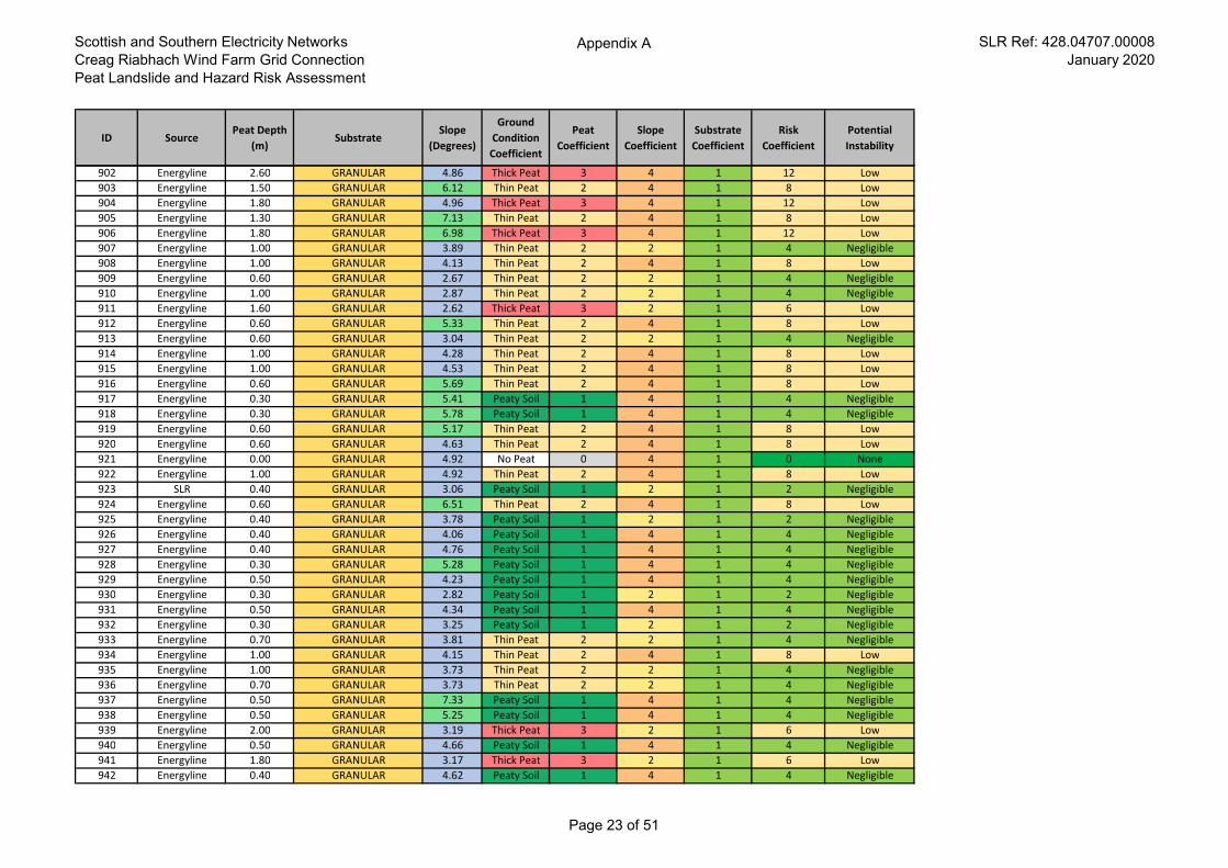
Scottish and Southern Electricity Networks
Creag Riabhach Wind Farm Grid Connection
Peat Landslide and Hazard Risk Assessment
Appendix A SLR Ref: 428.04707.00008
January 2020
ID SourcePeat Depth
(m)Substrate
Slope
(Degrees)
Ground
Condition
Coefficient
Peat
Coefficient
Slope
Coefficient
Substrate
Coefficient
Risk
Coefficient
Potential
Instability
902 Energyline 2.60 GRANULAR 4.86 Thick Peat 3 4 1 12 Low
903 Energyline 1.50 GRANULAR 6.12 Thin Peat 2 4 1 8 Low
904 Energyline 1.80 GRANULAR 4.96 Thick Peat 3 4 1 12 Low
905 Energyline 1.30 GRANULAR 7.13 Thin Peat 2 4 1 8 Low
906 Energyline 1.80 GRANULAR 6.98 Thick Peat 3 4 1 12 Low
907 Energyline 1.00 GRANULAR 3.89 Thin Peat 2 2 1 4 Negligible
908 Energyline 1.00 GRANULAR 4.13 Thin Peat 2 4 1 8 Low
909 Energyline 0.60 GRANULAR 2.67 Thin Peat 2 2 1 4 Negligible
910 Energyline 1.00 GRANULAR 2.87 Thin Peat 2 2 1 4 Negligible
911 Energyline 1.60 GRANULAR 2.62 Thick Peat 3 2 1 6 Low
912 Energyline 0.60 GRANULAR 5.33 Thin Peat 2 4 1 8 Low
913 Energyline 0.60 GRANULAR 3.04 Thin Peat 2 2 1 4 Negligible
914 Energyline 1.00 GRANULAR 4.28 Thin Peat 2 4 1 8 Low
915 Energyline 1.00 GRANULAR 4.53 Thin Peat 2 4 1 8 Low
916 Energyline 0.60 GRANULAR 5.69 Thin Peat 2 4 1 8 Low
917 Energyline 0.30 GRANULAR 5.41 Peaty Soil 1 4 1 4 Negligible
918 Energyline 0.30 GRANULAR 5.78 Peaty Soil 1 4 1 4 Negligible
919 Energyline 0.60 GRANULAR 5.17 Thin Peat 2 4 1 8 Low
920 Energyline 0.60 GRANULAR 4.63 Thin Peat 2 4 1 8 Low
921 Energyline 0.00 GRANULAR 4.92 No Peat 0 4 1 0 None
922 Energyline 1.00 GRANULAR 4.92 Thin Peat 2 4 1 8 Low
923 SLR 0.40 GRANULAR 3.06 Peaty Soil 1 2 1 2 Negligible
924 Energyline 0.60 GRANULAR 6.51 Thin Peat 2 4 1 8 Low
925 Energyline 0.40 GRANULAR 3.78 Peaty Soil 1 2 1 2 Negligible
926 Energyline 0.40 GRANULAR 4.06 Peaty Soil 1 4 1 4 Negligible
927 Energyline 0.40 GRANULAR 4.76 Peaty Soil 1 4 1 4 Negligible
928 Energyline 0.30 GRANULAR 5.28 Peaty Soil 1 4 1 4 Negligible
929 Energyline 0.50 GRANULAR 4.23 Peaty Soil 1 4 1 4 Negligible
930 Energyline 0.30 GRANULAR 2.82 Peaty Soil 1 2 1 2 Negligible
931 Energyline 0.50 GRANULAR 4.34 Peaty Soil 1 4 1 4 Negligible
932 Energyline 0.30 GRANULAR 3.25 Peaty Soil 1 2 1 2 Negligible
933 Energyline 0.70 GRANULAR 3.81 Thin Peat 2 2 1 4 Negligible
934 Energyline 1.00 GRANULAR 4.15 Thin Peat 2 4 1 8 Low
935 Energyline 1.00 GRANULAR 3.73 Thin Peat 2 2 1 4 Negligible
936 Energyline 0.70 GRANULAR 3.73 Thin Peat 2 2 1 4 Negligible
937 Energyline 0.50 GRANULAR 7.33 Peaty Soil 1 4 1 4 Negligible
938 Energyline 0.50 GRANULAR 5.25 Peaty Soil 1 4 1 4 Negligible
939 Energyline 2.00 GRANULAR 3.19 Thick Peat 3 2 1 6 Low
940 Energyline 0.50 GRANULAR 4.66 Peaty Soil 1 4 1 4 Negligible
941 Energyline 1.80 GRANULAR 3.17 Thick Peat 3 2 1 6 Low
942 Energyline 0.40 GRANULAR 4.62 Peaty Soil 1 4 1 4 Negligible
Page 23 of 51
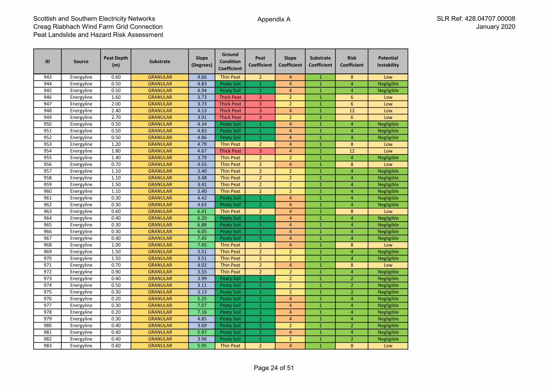
Scottish and Southern Electricity Networks
Creag Riabhach Wind Farm Grid Connection
Peat Landslide and Hazard Risk Assessment
Appendix A SLR Ref: 428.04707.00008
January 2020
ID SourcePeat Depth
(m)Substrate
Slope
(Degrees)
Ground
Condition
Coefficient
Peat
Coefficient
Slope
Coefficient
Substrate
Coefficient
Risk
Coefficient
Potential
Instability
943 Energyline 0.60 GRANULAR 4.66 Thin Peat 2 4 1 8 Low
944 Energyline 0.50 GRANULAR 4.83 Peaty Soil 1 4 1 4 Negligible
945 Energyline 0.50 GRANULAR 4.94 Peaty Soil 1 4 1 4 Negligible
946 Energyline 1.60 GRANULAR 3.73 Thick Peat 3 2 1 6 Low
947 Energyline 2.00 GRANULAR 3.73 Thick Peat 3 2 1 6 Low
948 Energyline 2.40 GRANULAR 4.13 Thick Peat 3 4 1 12 Low
949 Energyline 2.70 GRANULAR 3.91 Thick Peat 3 2 1 6 Low
950 Energyline 0.50 GRANULAR 4.34 Peaty Soil 1 4 1 4 Negligible
951 Energyline 0.50 GRANULAR 4.83 Peaty Soil 1 4 1 4 Negligible
952 Energyline 0.50 GRANULAR 4.86 Peaty Soil 1 4 1 4 Negligible
953 Energyline 1.20 GRANULAR 4.79 Thin Peat 2 4 1 8 Low
954 Energyline 1.80 GRANULAR 4.67 Thick Peat 3 4 1 12 Low
955 Energyline 1.40 GRANULAR 3.79 Thin Peat 2 2 1 4 Negligible
956 Energyline 0.70 GRANULAR 4.55 Thin Peat 2 4 1 8 Low
957 Energyline 1.10 GRANULAR 3.40 Thin Peat 2 2 1 4 Negligible
958 Energyline 1.10 GRANULAR 3.48 Thin Peat 2 2 1 4 Negligible
959 Energyline 1.50 GRANULAR 3.41 Thin Peat 2 2 1 4 Negligible
960 Energyline 1.10 GRANULAR 3.40 Thin Peat 2 2 1 4 Negligible
961 Energyline 0.30 GRANULAR 4.42 Peaty Soil 1 4 1 4 Negligible
962 Energyline 0.30 GRANULAR 4.63 Peaty Soil 1 4 1 4 Negligible
963 Energyline 0.60 GRANULAR 6.41 Thin Peat 2 4 1 8 Low
964 Energyline 0.40 GRANULAR 6.20 Peaty Soil 1 4 1 4 Negligible
965 Energyline 0.30 GRANULAR 6.88 Peaty Soil 1 4 1 4 Negligible
966 Energyline 0.30 GRANULAR 6.05 Peaty Soil 1 4 1 4 Negligible
967 Energyline 0.40 GRANULAR 7.45 Peaty Soil 1 4 1 4 Negligible
968 Energyline 1.00 GRANULAR 7.45 Thin Peat 2 4 1 8 Low
969 Energyline 1.50 GRANULAR 3.51 Thin Peat 2 2 1 4 Negligible
970 Energyline 1.50 GRANULAR 3.51 Thin Peat 2 2 1 4 Negligible
971 Energyline 0.70 GRANULAR 4.02 Thin Peat 2 4 1 8 Low
972 Energyline 0.90 GRANULAR 3.55 Thin Peat 2 2 1 4 Negligible
973 Energyline 0.40 GRANULAR 3.99 Peaty Soil 1 2 1 2 Negligible
974 Energyline 0.50 GRANULAR 3.11 Peaty Soil 1 2 1 2 Negligible
975 Energyline 0.30 GRANULAR 3.13 Peaty Soil 1 2 1 2 Negligible
976 Energyline 0.20 GRANULAR 5.25 Peaty Soil 1 4 1 4 Negligible
977 Energyline 0.30 GRANULAR 7.07 Peaty Soil 1 4 1 4 Negligible
978 Energyline 0.20 GRANULAR 7.16 Peaty Soil 1 4 1 4 Negligible
979 Energyline 0.30 GRANULAR 4.85 Peaty Soil 1 4 1 4 Negligible
980 Energyline 0.40 GRANULAR 3.69 Peaty Soil 1 2 1 2 Negligible
981 Energyline 0.40 GRANULAR 5.97 Peaty Soil 1 4 1 4 Negligible
982 Energyline 0.40 GRANULAR 3.96 Peaty Soil 1 2 1 2 Negligible
983 Energyline 0.60 GRANULAR 5.95 Thin Peat 2 4 1 8 Low
Page 24 of 51
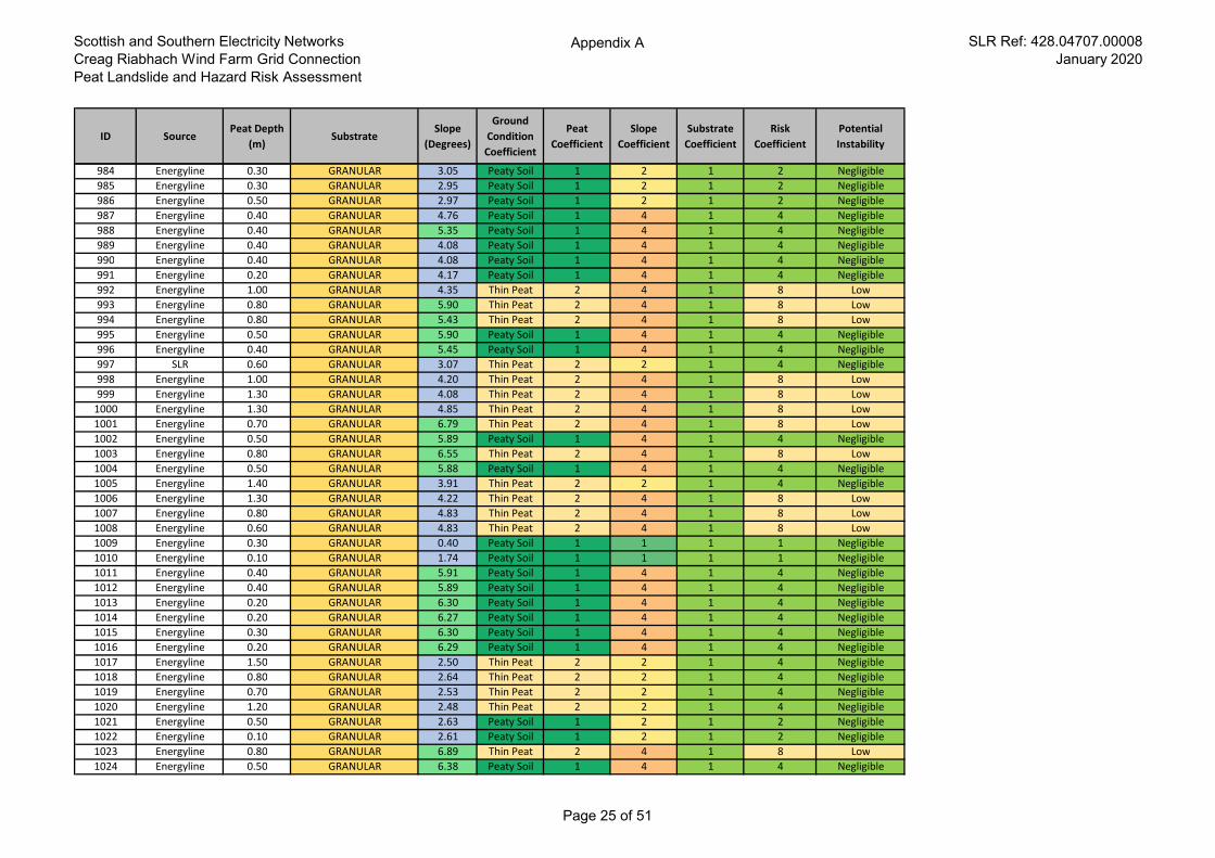
Scottish and Southern Electricity Networks
Creag Riabhach Wind Farm Grid Connection
Peat Landslide and Hazard Risk Assessment
Appendix A SLR Ref: 428.04707.00008
January 2020
ID SourcePeat Depth
(m)Substrate
Slope
(Degrees)
Ground
Condition
Coefficient
Peat
Coefficient
Slope
Coefficient
Substrate
Coefficient
Risk
Coefficient
Potential
Instability
984 Energyline 0.30 GRANULAR 3.05 Peaty Soil 1 2 1 2 Negligible
985 Energyline 0.30 GRANULAR 2.95 Peaty Soil 1 2 1 2 Negligible
986 Energyline 0.50 GRANULAR 2.97 Peaty Soil 1 2 1 2 Negligible
987 Energyline 0.40 GRANULAR 4.76 Peaty Soil 1 4 1 4 Negligible
988 Energyline 0.40 GRANULAR 5.35 Peaty Soil 1 4 1 4 Negligible
989 Energyline 0.40 GRANULAR 4.08 Peaty Soil 1 4 1 4 Negligible
990 Energyline 0.40 GRANULAR 4.08 Peaty Soil 1 4 1 4 Negligible
991 Energyline 0.20 GRANULAR 4.17 Peaty Soil 1 4 1 4 Negligible
992 Energyline 1.00 GRANULAR 4.35 Thin Peat 2 4 1 8 Low
993 Energyline 0.80 GRANULAR 5.90 Thin Peat 2 4 1 8 Low
994 Energyline 0.80 GRANULAR 5.43 Thin Peat 2 4 1 8 Low
995 Energyline 0.50 GRANULAR 5.90 Peaty Soil 1 4 1 4 Negligible
996 Energyline 0.40 GRANULAR 5.45 Peaty Soil 1 4 1 4 Negligible
997 SLR 0.60 GRANULAR 3.07 Thin Peat 2 2 1 4 Negligible
998 Energyline 1.00 GRANULAR 4.20 Thin Peat 2 4 1 8 Low
999 Energyline 1.30 GRANULAR 4.08 Thin Peat 2 4 1 8 Low
1000 Energyline 1.30 GRANULAR 4.85 Thin Peat 2 4 1 8 Low
1001 Energyline 0.70 GRANULAR 6.79 Thin Peat 2 4 1 8 Low
1002 Energyline 0.50 GRANULAR 5.89 Peaty Soil 1 4 1 4 Negligible
1003 Energyline 0.80 GRANULAR 6.55 Thin Peat 2 4 1 8 Low
1004 Energyline 0.50 GRANULAR 5.88 Peaty Soil 1 4 1 4 Negligible
1005 Energyline 1.40 GRANULAR 3.91 Thin Peat 2 2 1 4 Negligible
1006 Energyline 1.30 GRANULAR 4.22 Thin Peat 2 4 1 8 Low
1007 Energyline 0.80 GRANULAR 4.83 Thin Peat 2 4 1 8 Low
1008 Energyline 0.60 GRANULAR 4.83 Thin Peat 2 4 1 8 Low
1009 Energyline 0.30 GRANULAR 0.40 Peaty Soil 1 1 1 1 Negligible
1010 Energyline 0.10 GRANULAR 1.74 Peaty Soil 1 1 1 1 Negligible
1011 Energyline 0.40 GRANULAR 5.91 Peaty Soil 1 4 1 4 Negligible
1012 Energyline 0.40 GRANULAR 5.89 Peaty Soil 1 4 1 4 Negligible
1013 Energyline 0.20 GRANULAR 6.30 Peaty Soil 1 4 1 4 Negligible
1014 Energyline 0.20 GRANULAR 6.27 Peaty Soil 1 4 1 4 Negligible
1015 Energyline 0.30 GRANULAR 6.30 Peaty Soil 1 4 1 4 Negligible
1016 Energyline 0.20 GRANULAR 6.29 Peaty Soil 1 4 1 4 Negligible
1017 Energyline 1.50 GRANULAR 2.50 Thin Peat 2 2 1 4 Negligible
1018 Energyline 0.80 GRANULAR 2.64 Thin Peat 2 2 1 4 Negligible
1019 Energyline 0.70 GRANULAR 2.53 Thin Peat 2 2 1 4 Negligible
1020 Energyline 1.20 GRANULAR 2.48 Thin Peat 2 2 1 4 Negligible
1021 Energyline 0.50 GRANULAR 2.63 Peaty Soil 1 2 1 2 Negligible
1022 Energyline 0.10 GRANULAR 2.61 Peaty Soil 1 2 1 2 Negligible
1023 Energyline 0.80 GRANULAR 6.89 Thin Peat 2 4 1 8 Low
1024 Energyline 0.50 GRANULAR 6.38 Peaty Soil 1 4 1 4 Negligible
Page 25 of 51
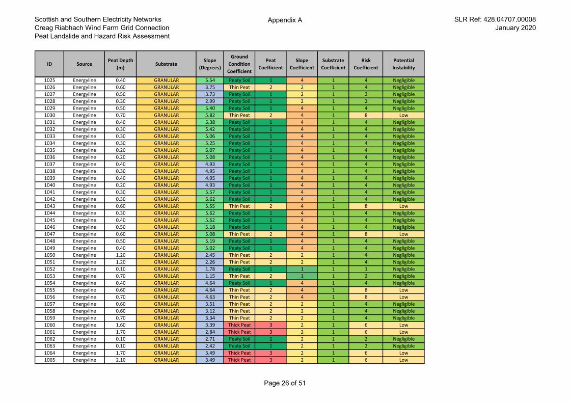
Scottish and Southern Electricity Networks
Creag Riabhach Wind Farm Grid Connection
Peat Landslide and Hazard Risk Assessment
Appendix A SLR Ref: 428.04707.00008
January 2020
ID SourcePeat Depth
(m)Substrate
Slope
(Degrees)
Ground
Condition
Coefficient
Peat
Coefficient
Slope
Coefficient
Substrate
Coefficient
Risk
Coefficient
Potential
Instability
1025 Energyline 0.40 GRANULAR 5.54 Peaty Soil 1 4 1 4 Negligible
1026 Energyline 0.60 GRANULAR 3.75 Thin Peat 2 2 1 4 Negligible
1027 Energyline 0.50 GRANULAR 3.73 Peaty Soil 1 2 1 2 Negligible
1028 Energyline 0.30 GRANULAR 2.99 Peaty Soil 1 2 1 2 Negligible
1029 Energyline 0.50 GRANULAR 5.40 Peaty Soil 1 4 1 4 Negligible
1030 Energyline 0.70 GRANULAR 5.82 Thin Peat 2 4 1 8 Low
1031 Energyline 0.40 GRANULAR 5.38 Peaty Soil 1 4 1 4 Negligible
1032 Energyline 0.30 GRANULAR 5.42 Peaty Soil 1 4 1 4 Negligible
1033 Energyline 0.30 GRANULAR 5.06 Peaty Soil 1 4 1 4 Negligible
1034 Energyline 0.30 GRANULAR 5.25 Peaty Soil 1 4 1 4 Negligible
1035 Energyline 0.20 GRANULAR 5.07 Peaty Soil 1 4 1 4 Negligible
1036 Energyline 0.20 GRANULAR 5.08 Peaty Soil 1 4 1 4 Negligible
1037 Energyline 0.40 GRANULAR 4.93 Peaty Soil 1 4 1 4 Negligible
1038 Energyline 0.30 GRANULAR 4.95 Peaty Soil 1 4 1 4 Negligible
1039 Energyline 0.40 GRANULAR 4.95 Peaty Soil 1 4 1 4 Negligible
1040 Energyline 0.20 GRANULAR 4.93 Peaty Soil 1 4 1 4 Negligible
1041 Energyline 0.30 GRANULAR 5.57 Peaty Soil 1 4 1 4 Negligible
1042 Energyline 0.30 GRANULAR 5.62 Peaty Soil 1 4 1 4 Negligible
1043 Energyline 0.60 GRANULAR 5.55 Thin Peat 2 4 1 8 Low
1044 Energyline 0.30 GRANULAR 5.62 Peaty Soil 1 4 1 4 Negligible
1045 Energyline 0.40 GRANULAR 5.62 Peaty Soil 1 4 1 4 Negligible
1046 Energyline 0.50 GRANULAR 5.18 Peaty Soil 1 4 1 4 Negligible
1047 Energyline 0.60 GRANULAR 5.08 Thin Peat 2 4 1 8 Low
1048 Energyline 0.50 GRANULAR 5.19 Peaty Soil 1 4 1 4 Negligible
1049 Energyline 0.40 GRANULAR 5.02 Peaty Soil 1 4 1 4 Negligible
1050 Energyline 1.20 GRANULAR 2.45 Thin Peat 2 2 1 4 Negligible
1051 Energyline 1.20 GRANULAR 2.26 Thin Peat 2 2 1 4 Negligible
1052 Energyline 0.10 GRANULAR 1.78 Peaty Soil 1 1 1 1 Negligible
1053 Energyline 0.70 GRANULAR 1.15 Thin Peat 2 1 1 2 Negligible
1054 Energyline 0.40 GRANULAR 4.64 Peaty Soil 1 4 1 4 Negligible
1055 Energyline 0.60 GRANULAR 4.64 Thin Peat 2 4 1 8 Low
1056 Energyline 0.70 GRANULAR 4.63 Thin Peat 2 4 1 8 Low
1057 Energyline 0.60 GRANULAR 3.51 Thin Peat 2 2 1 4 Negligible
1058 Energyline 0.60 GRANULAR 3.12 Thin Peat 2 2 1 4 Negligible
1059 Energyline 0.70 GRANULAR 3.34 Thin Peat 2 2 1 4 Negligible
1060 Energyline 1.60 GRANULAR 3.39 Thick Peat 3 2 1 6 Low
1061 Energyline 1.70 GRANULAR 2.84 Thick Peat 3 2 1 6 Low
1062 Energyline 0.10 GRANULAR 2.71 Peaty Soil 1 2 1 2 Negligible
1063 Energyline 0.10 GRANULAR 2.42 Peaty Soil 1 2 1 2 Negligible
1064 Energyline 1.70 GRANULAR 3.49 Thick Peat 3 2 1 6 Low
1065 Energyline 2.10 GRANULAR 3.49 Thick Peat 3 2 1 6 Low
Page 26 of 51
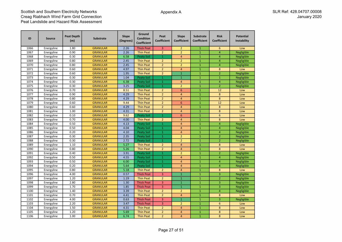
Scottish and Southern Electricity Networks
Creag Riabhach Wind Farm Grid Connection
Peat Landslide and Hazard Risk Assessment
Appendix A SLR Ref: 428.04707.00008
January 2020
ID SourcePeat Depth
(m)Substrate
Slope
(Degrees)
Ground
Condition
Coefficient
Peat
Coefficient
Slope
Coefficient
Substrate
Coefficient
Risk
Coefficient
Potential
Instability
1066 Energyline 1.80 GRANULAR 2.26 Thick Peat 3 2 1 6 Low
1067 Energyline 0.90 GRANULAR 2.26 Thin Peat 2 2 1 4 Negligible
1068 Energyline 0.30 GRANULAR 6.58 Peaty Soil 1 4 1 4 Negligible
1069 Energyline 0.80 GRANULAR 2.45 Thin Peat 2 2 1 4 Negligible
1070 Energyline 0.80 GRANULAR 2.45 Thin Peat 2 2 1 4 Negligible
1071 Energyline 0.60 GRANULAR 4.97 Thin Peat 2 4 1 8 Low
1072 Energyline 0.60 GRANULAR 1.95 Thin Peat 2 1 1 2 Negligible
1073 Energyline 0.30 GRANULAR 1.04 Peaty Soil 1 1 1 1 Negligible
1074 Energyline 0.30 GRANULAR 6.38 Peaty Soil 1 4 1 4 Negligible
1075 Energyline 0.30 GRANULAR 3.25 Peaty Soil 1 2 1 2 Negligible
1076 Energyline 0.70 GRANULAR 8.51 Thin Peat 2 6 1 12 Low
1077 Energyline 0.90 GRANULAR 4.29 Thin Peat 2 4 1 8 Low
1078 Energyline 0.80 GRANULAR 4.29 Thin Peat 2 4 1 8 Low
1079 Energyline 0.60 GRANULAR 9.44 Thin Peat 2 6 1 12 Low
1080 Energyline 0.60 GRANULAR 4.29 Thin Peat 2 4 1 8 Low
1081 Energyline 1.00 GRANULAR 4.31 Thin Peat 2 4 1 8 Low
1082 Energyline 0.10 GRANULAR 9.62 Peaty Soil 1 6 1 6 Low
1083 Energyline 0.70 GRANULAR 4.00 Thin Peat 2 4 1 8 Low
1084 Energyline 0.50 GRANULAR 4.13 Peaty Soil 1 4 1 4 Negligible
1085 Energyline 0.50 GRANULAR 4.04 Peaty Soil 1 4 1 4 Negligible
1086 Energyline 0.20 GRANULAR 4.10 Peaty Soil 1 4 1 4 Negligible
1087 Energyline 0.30 GRANULAR 2.35 Peaty Soil 1 2 1 2 Negligible
1088 Energyline 0.30 GRANULAR 2.72 Peaty Soil 1 2 1 2 Negligible
1089 Energyline 1.10 GRANULAR 5.27 Thin Peat 2 4 1 8 Low
1090 Energyline 0.80 GRANULAR 5.26 Thin Peat 2 4 1 8 Low
1091 Energyline 0.40 GRANULAR 3.91 Peaty Soil 1 2 1 2 Negligible
1092 Energyline 0.50 GRANULAR 4.55 Peaty Soil 1 4 1 4 Negligible
1093 Energyline 0.50 GRANULAR 6.00 Peaty Soil 1 4 1 4 Negligible
1094 Energyline 0.20 GRANULAR 5.64 Peaty Soil 1 4 1 4 Negligible
1095 Energyline 0.80 GRANULAR 5.18 Thin Peat 2 4 1 8 Low
1096 Energyline 4.00 GRANULAR 0.57 Thick Peat 3 1 1 3 Negligible
1097 Energyline 1.20 GRANULAR 1.19 Thin Peat 2 1 1 2 Negligible
1098 Energyline 2.80 GRANULAR 1.30 Thick Peat 3 1 1 3 Negligible
1099 Energyline 1.70 GRANULAR 1.85 Thick Peat 3 1 1 3 Negligible
1100 Energyline 1.40 GRANULAR 3.39 Thin Peat 2 2 1 4 Negligible
1101 Energyline 0.70 GRANULAR 4.41 Thin Peat 2 4 1 8 Low
1102 Energyline 4.00 GRANULAR 0.63 Thick Peat 3 1 1 3 Negligible
1103 Energyline 2.20 GRANULAR 3.47 Thick Peat 3 2 1 6 Low
1104 Energyline 1.50 GRANULAR 4.31 Thin Peat 2 4 1 8 Low
1105 Energyline 1.20 GRANULAR 5.69 Thin Peat 2 4 1 8 Low
1106 Energyline 1.00 GRANULAR 6.74 Thin Peat 2 4 1 8 Low
Page 27 of 51
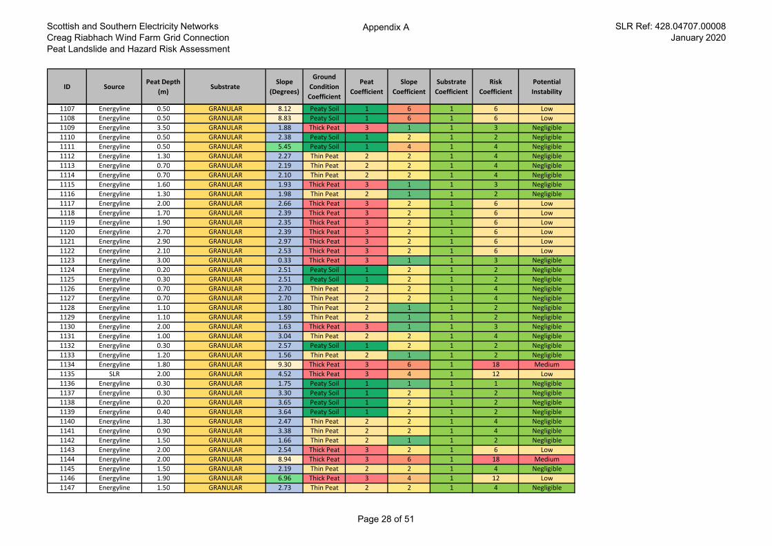
Scottish and Southern Electricity Networks
Creag Riabhach Wind Farm Grid Connection
Peat Landslide and Hazard Risk Assessment
Appendix A SLR Ref: 428.04707.00008
January 2020
ID SourcePeat Depth
(m)Substrate
Slope
(Degrees)
Ground
Condition
Coefficient
Peat
Coefficient
Slope
Coefficient
Substrate
Coefficient
Risk
Coefficient
Potential
Instability
1107 Energyline 0.50 GRANULAR 8.12 Peaty Soil 1 6 1 6 Low
1108 Energyline 0.50 GRANULAR 8.83 Peaty Soil 1 6 1 6 Low
1109 Energyline 3.50 GRANULAR 1.88 Thick Peat 3 1 1 3 Negligible
1110 Energyline 0.50 GRANULAR 2.38 Peaty Soil 1 2 1 2 Negligible
1111 Energyline 0.50 GRANULAR 5.45 Peaty Soil 1 4 1 4 Negligible
1112 Energyline 1.30 GRANULAR 2.27 Thin Peat 2 2 1 4 Negligible
1113 Energyline 0.70 GRANULAR 2.19 Thin Peat 2 2 1 4 Negligible
1114 Energyline 0.70 GRANULAR 2.10 Thin Peat 2 2 1 4 Negligible
1115 Energyline 1.60 GRANULAR 1.93 Thick Peat 3 1 1 3 Negligible
1116 Energyline 1.30 GRANULAR 1.98 Thin Peat 2 1 1 2 Negligible
1117 Energyline 2.00 GRANULAR 2.66 Thick Peat 3 2 1 6 Low
1118 Energyline 1.70 GRANULAR 2.39 Thick Peat 3 2 1 6 Low
1119 Energyline 1.90 GRANULAR 2.35 Thick Peat 3 2 1 6 Low
1120 Energyline 2.70 GRANULAR 2.39 Thick Peat 3 2 1 6 Low
1121 Energyline 2.90 GRANULAR 2.97 Thick Peat 3 2 1 6 Low
1122 Energyline 2.10 GRANULAR 2.53 Thick Peat 3 2 1 6 Low
1123 Energyline 3.00 GRANULAR 0.33 Thick Peat 3 1 1 3 Negligible
1124 Energyline 0.20 GRANULAR 2.51 Peaty Soil 1 2 1 2 Negligible
1125 Energyline 0.30 GRANULAR 2.51 Peaty Soil 1 2 1 2 Negligible
1126 Energyline 0.70 GRANULAR 2.70 Thin Peat 2 2 1 4 Negligible
1127 Energyline 0.70 GRANULAR 2.70 Thin Peat 2 2 1 4 Negligible
1128 Energyline 1.10 GRANULAR 1.80 Thin Peat 2 1 1 2 Negligible
1129 Energyline 1.10 GRANULAR 1.59 Thin Peat 2 1 1 2 Negligible
1130 Energyline 2.00 GRANULAR 1.63 Thick Peat 3 1 1 3 Negligible
1131 Energyline 1.00 GRANULAR 3.04 Thin Peat 2 2 1 4 Negligible
1132 Energyline 0.30 GRANULAR 2.57 Peaty Soil 1 2 1 2 Negligible
1133 Energyline 1.20 GRANULAR 1.56 Thin Peat 2 1 1 2 Negligible
1134 Energyline 1.80 GRANULAR 9.30 Thick Peat 3 6 1 18 Medium
1135 SLR 2.00 GRANULAR 4.52 Thick Peat 3 4 1 12 Low
1136 Energyline 0.30 GRANULAR 1.75 Peaty Soil 1 1 1 1 Negligible
1137 Energyline 0.30 GRANULAR 3.30 Peaty Soil 1 2 1 2 Negligible
1138 Energyline 0.20 GRANULAR 3.65 Peaty Soil 1 2 1 2 Negligible
1139 Energyline 0.40 GRANULAR 3.64 Peaty Soil 1 2 1 2 Negligible
1140 Energyline 1.30 GRANULAR 2.47 Thin Peat 2 2 1 4 Negligible
1141 Energyline 0.90 GRANULAR 3.38 Thin Peat 2 2 1 4 Negligible
1142 Energyline 1.50 GRANULAR 1.66 Thin Peat 2 1 1 2 Negligible
1143 Energyline 2.00 GRANULAR 2.54 Thick Peat 3 2 1 6 Low
1144 Energyline 2.00 GRANULAR 8.94 Thick Peat 3 6 1 18 Medium
1145 Energyline 1.50 GRANULAR 2.19 Thin Peat 2 2 1 4 Negligible
1146 Energyline 1.90 GRANULAR 6.96 Thick Peat 3 4 1 12 Low
1147 Energyline 1.50 GRANULAR 2.73 Thin Peat 2 2 1 4 Negligible
Page 28 of 51
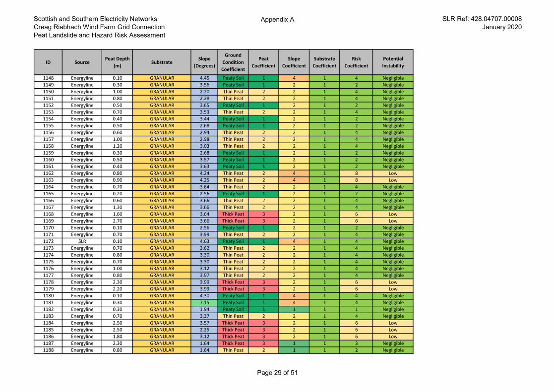
Scottish and Southern Electricity Networks
Creag Riabhach Wind Farm Grid Connection
Peat Landslide and Hazard Risk Assessment
Appendix A SLR Ref: 428.04707.00008
January 2020
ID SourcePeat Depth
(m)Substrate
Slope
(Degrees)
Ground
Condition
Coefficient
Peat
Coefficient
Slope
Coefficient
Substrate
Coefficient
Risk
Coefficient
Potential
Instability
1148 Energyline 0.10 GRANULAR 4.45 Peaty Soil 1 4 1 4 Negligible
1149 Energyline 0.30 GRANULAR 3.56 Peaty Soil 1 2 1 2 Negligible
1150 Energyline 1.00 GRANULAR 2.20 Thin Peat 2 2 1 4 Negligible
1151 Energyline 0.80 GRANULAR 2.28 Thin Peat 2 2 1 4 Negligible
1152 Energyline 0.50 GRANULAR 3.65 Peaty Soil 1 2 1 2 Negligible
1153 Energyline 0.70 GRANULAR 3.53 Thin Peat 2 2 1 4 Negligible
1154 Energyline 0.40 GRANULAR 3.44 Peaty Soil 1 2 1 2 Negligible
1155 Energyline 0.50 GRANULAR 2.68 Peaty Soil 1 2 1 2 Negligible
1156 Energyline 0.60 GRANULAR 2.94 Thin Peat 2 2 1 4 Negligible
1157 Energyline 1.00 GRANULAR 2.98 Thin Peat 2 2 1 4 Negligible
1158 Energyline 1.20 GRANULAR 3.03 Thin Peat 2 2 1 4 Negligible
1159 Energyline 0.30 GRANULAR 2.68 Peaty Soil 1 2 1 2 Negligible
1160 Energyline 0.50 GRANULAR 3.57 Peaty Soil 1 2 1 2 Negligible
1161 Energyline 0.40 GRANULAR 3.63 Peaty Soil 1 2 1 2 Negligible
1162 Energyline 0.80 GRANULAR 4.24 Thin Peat 2 4 1 8 Low
1163 Energyline 0.90 GRANULAR 4.25 Thin Peat 2 4 1 8 Low
1164 Energyline 0.70 GRANULAR 3.64 Thin Peat 2 2 1 4 Negligible
1165 Energyline 0.20 GRANULAR 2.56 Peaty Soil 1 2 1 2 Negligible
1166 Energyline 0.60 GRANULAR 3.66 Thin Peat 2 2 1 4 Negligible
1167 Energyline 1.30 GRANULAR 3.66 Thin Peat 2 2 1 4 Negligible
1168 Energyline 1.60 GRANULAR 3.64 Thick Peat 3 2 1 6 Low
1169 Energyline 2.70 GRANULAR 3.66 Thick Peat 3 2 1 6 Low
1170 Energyline 0.10 GRANULAR 2.56 Peaty Soil 1 2 1 2 Negligible
1171 Energyline 0.70 GRANULAR 3.99 Thin Peat 2 2 1 4 Negligible
1172 SLR 0.10 GRANULAR 4.63 Peaty Soil 1 4 1 4 Negligible
1173 Energyline 0.70 GRANULAR 3.62 Thin Peat 2 2 1 4 Negligible
1174 Energyline 0.80 GRANULAR 3.30 Thin Peat 2 2 1 4 Negligible
1175 Energyline 0.70 GRANULAR 3.30 Thin Peat 2 2 1 4 Negligible
1176 Energyline 1.00 GRANULAR 3.12 Thin Peat 2 2 1 4 Negligible
1177 Energyline 0.80 GRANULAR 3.97 Thin Peat 2 2 1 4 Negligible
1178 Energyline 2.30 GRANULAR 3.99 Thick Peat 3 2 1 6 Low
1179 Energyline 2.20 GRANULAR 3.99 Thick Peat 3 2 1 6 Low
1180 Energyline 0.10 GRANULAR 4.30 Peaty Soil 1 4 1 4 Negligible
1181 Energyline 0.30 GRANULAR 7.15 Peaty Soil 1 4 1 4 Negligible
1182 Energyline 0.30 GRANULAR 1.94 Peaty Soil 1 1 1 1 Negligible
1183 Energyline 0.70 GRANULAR 3.37 Thin Peat 2 2 1 4 Negligible
1184 Energyline 2.50 GRANULAR 3.57 Thick Peat 3 2 1 6 Low
1185 Energyline 2.50 GRANULAR 2.25 Thick Peat 3 2 1 6 Low
1186 Energyline 1.80 GRANULAR 3.12 Thick Peat 3 2 1 6 Low
1187 Energyline 2.30 GRANULAR 1.64 Thick Peat 3 1 1 3 Negligible
1188 Energyline 0.80 GRANULAR 1.64 Thin Peat 2 1 1 2 Negligible
Page 29 of 51
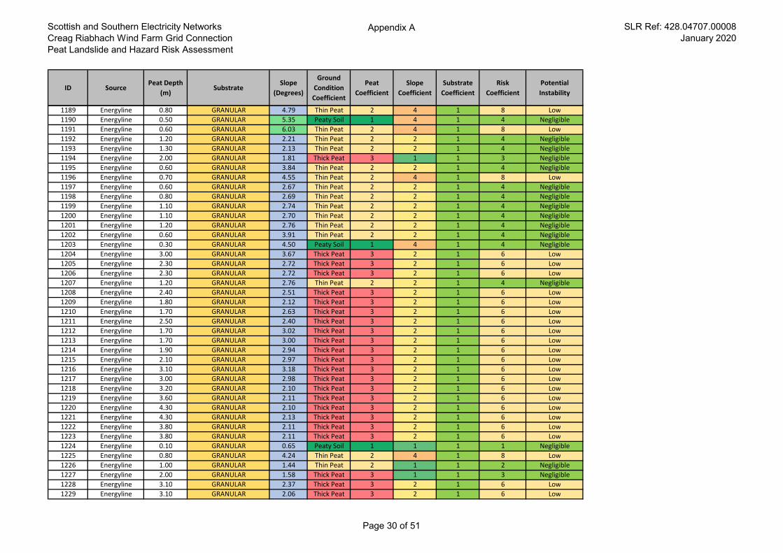
Scottish and Southern Electricity Networks
Creag Riabhach Wind Farm Grid Connection
Peat Landslide and Hazard Risk Assessment
Appendix A SLR Ref: 428.04707.00008
January 2020
ID SourcePeat Depth
(m)Substrate
Slope
(Degrees)
Ground
Condition
Coefficient
Peat
Coefficient
Slope
Coefficient
Substrate
Coefficient
Risk
Coefficient
Potential
Instability
1189 Energyline 0.80 GRANULAR 4.79 Thin Peat 2 4 1 8 Low
1190 Energyline 0.50 GRANULAR 5.35 Peaty Soil 1 4 1 4 Negligible
1191 Energyline 0.60 GRANULAR 6.03 Thin Peat 2 4 1 8 Low
1192 Energyline 1.20 GRANULAR 2.21 Thin Peat 2 2 1 4 Negligible
1193 Energyline 1.30 GRANULAR 2.13 Thin Peat 2 2 1 4 Negligible
1194 Energyline 2.00 GRANULAR 1.81 Thick Peat 3 1 1 3 Negligible
1195 Energyline 0.60 GRANULAR 3.84 Thin Peat 2 2 1 4 Negligible
1196 Energyline 0.70 GRANULAR 4.55 Thin Peat 2 4 1 8 Low
1197 Energyline 0.60 GRANULAR 2.67 Thin Peat 2 2 1 4 Negligible
1198 Energyline 0.80 GRANULAR 2.69 Thin Peat 2 2 1 4 Negligible
1199 Energyline 1.10 GRANULAR 2.74 Thin Peat 2 2 1 4 Negligible
1200 Energyline 1.10 GRANULAR 2.70 Thin Peat 2 2 1 4 Negligible
1201 Energyline 1.20 GRANULAR 2.76 Thin Peat 2 2 1 4 Negligible
1202 Energyline 0.60 GRANULAR 3.91 Thin Peat 2 2 1 4 Negligible
1203 Energyline 0.30 GRANULAR 4.50 Peaty Soil 1 4 1 4 Negligible
1204 Energyline 3.00 GRANULAR 3.67 Thick Peat 3 2 1 6 Low
1205 Energyline 2.30 GRANULAR 2.72 Thick Peat 3 2 1 6 Low
1206 Energyline 2.30 GRANULAR 2.72 Thick Peat 3 2 1 6 Low
1207 Energyline 1.20 GRANULAR 2.76 Thin Peat 2 2 1 4 Negligible
1208 Energyline 2.40 GRANULAR 2.51 Thick Peat 3 2 1 6 Low
1209 Energyline 1.80 GRANULAR 2.12 Thick Peat 3 2 1 6 Low
1210 Energyline 1.70 GRANULAR 2.63 Thick Peat 3 2 1 6 Low
1211 Energyline 2.50 GRANULAR 2.40 Thick Peat 3 2 1 6 Low
1212 Energyline 1.70 GRANULAR 3.02 Thick Peat 3 2 1 6 Low
1213 Energyline 1.70 GRANULAR 3.00 Thick Peat 3 2 1 6 Low
1214 Energyline 1.90 GRANULAR 2.94 Thick Peat 3 2 1 6 Low
1215 Energyline 2.10 GRANULAR 2.97 Thick Peat 3 2 1 6 Low
1216 Energyline 3.10 GRANULAR 3.18 Thick Peat 3 2 1 6 Low
1217 Energyline 3.00 GRANULAR 2.98 Thick Peat 3 2 1 6 Low
1218 Energyline 3.20 GRANULAR 2.10 Thick Peat 3 2 1 6 Low
1219 Energyline 3.60 GRANULAR 2.11 Thick Peat 3 2 1 6 Low
1220 Energyline 4.30 GRANULAR 2.10 Thick Peat 3 2 1 6 Low
1221 Energyline 4.30 GRANULAR 2.13 Thick Peat 3 2 1 6 Low
1222 Energyline 3.80 GRANULAR 2.11 Thick Peat 3 2 1 6 Low
1223 Energyline 3.80 GRANULAR 2.11 Thick Peat 3 2 1 6 Low
1224 Energyline 0.10 GRANULAR 0.65 Peaty Soil 1 1 1 1 Negligible
1225 Energyline 0.80 GRANULAR 4.24 Thin Peat 2 4 1 8 Low
1226 Energyline 1.00 GRANULAR 1.44 Thin Peat 2 1 1 2 Negligible
1227 Energyline 2.00 GRANULAR 1.58 Thick Peat 3 1 1 3 Negligible
1228 Energyline 3.10 GRANULAR 2.37 Thick Peat 3 2 1 6 Low
1229 Energyline 3.10 GRANULAR 2.06 Thick Peat 3 2 1 6 Low
Page 30 of 51
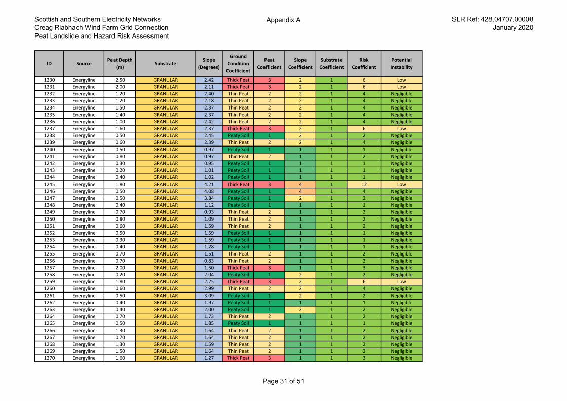
Scottish and Southern Electricity Networks
Creag Riabhach Wind Farm Grid Connection
Peat Landslide and Hazard Risk Assessment
Appendix A SLR Ref: 428.04707.00008
January 2020
ID SourcePeat Depth
(m)Substrate
Slope
(Degrees)
Ground
Condition
Coefficient
Peat
Coefficient
Slope
Coefficient
Substrate
Coefficient
Risk
Coefficient
Potential
Instability
1230 Energyline 2.50 GRANULAR 2.42 Thick Peat 3 2 1 6 Low
1231 Energyline 2.00 GRANULAR 2.11 Thick Peat 3 2 1 6 Low
1232 Energyline 1.20 GRANULAR 2.40 Thin Peat 2 2 1 4 Negligible
1233 Energyline 1.20 GRANULAR 2.18 Thin Peat 2 2 1 4 Negligible
1234 Energyline 1.50 GRANULAR 2.37 Thin Peat 2 2 1 4 Negligible
1235 Energyline 1.40 GRANULAR 2.37 Thin Peat 2 2 1 4 Negligible
1236 Energyline 1.00 GRANULAR 2.42 Thin Peat 2 2 1 4 Negligible
1237 Energyline 1.60 GRANULAR 2.37 Thick Peat 3 2 1 6 Low
1238 Energyline 0.50 GRANULAR 2.45 Peaty Soil 1 2 1 2 Negligible
1239 Energyline 0.60 GRANULAR 2.39 Thin Peat 2 2 1 4 Negligible
1240 Energyline 0.50 GRANULAR 0.97 Peaty Soil 1 1 1 1 Negligible
1241 Energyline 0.80 GRANULAR 0.97 Thin Peat 2 1 1 2 Negligible
1242 Energyline 0.30 GRANULAR 0.95 Peaty Soil 1 1 1 1 Negligible
1243 Energyline 0.20 GRANULAR 1.01 Peaty Soil 1 1 1 1 Negligible
1244 Energyline 0.40 GRANULAR 1.02 Peaty Soil 1 1 1 1 Negligible
1245 Energyline 1.80 GRANULAR 4.21 Thick Peat 3 4 1 12 Low
1246 Energyline 0.50 GRANULAR 4.08 Peaty Soil 1 4 1 4 Negligible
1247 Energyline 0.50 GRANULAR 3.84 Peaty Soil 1 2 1 2 Negligible
1248 Energyline 0.40 GRANULAR 1.12 Peaty Soil 1 1 1 1 Negligible
1249 Energyline 0.70 GRANULAR 0.93 Thin Peat 2 1 1 2 Negligible
1250 Energyline 0.80 GRANULAR 1.09 Thin Peat 2 1 1 2 Negligible
1251 Energyline 0.60 GRANULAR 1.59 Thin Peat 2 1 1 2 Negligible
1252 Energyline 0.50 GRANULAR 1.59 Peaty Soil 1 1 1 1 Negligible
1253 Energyline 0.30 GRANULAR 1.59 Peaty Soil 1 1 1 1 Negligible
1254 Energyline 0.40 GRANULAR 1.28 Peaty Soil 1 1 1 1 Negligible
1255 Energyline 0.70 GRANULAR 1.51 Thin Peat 2 1 1 2 Negligible
1256 Energyline 0.70 GRANULAR 0.83 Thin Peat 2 1 1 2 Negligible
1257 Energyline 2.00 GRANULAR 1.50 Thick Peat 3 1 1 3 Negligible
1258 Energyline 0.20 GRANULAR 2.04 Peaty Soil 1 2 1 2 Negligible
1259 Energyline 1.80 GRANULAR 2.25 Thick Peat 3 2 1 6 Low
1260 Energyline 0.60 GRANULAR 2.99 Thin Peat 2 2 1 4 Negligible
1261 Energyline 0.50 GRANULAR 3.09 Peaty Soil 1 2 1 2 Negligible
1262 Energyline 0.40 GRANULAR 1.97 Peaty Soil 1 1 1 1 Negligible
1263 Energyline 0.40 GRANULAR 2.00 Peaty Soil 1 2 1 2 Negligible
1264 Energyline 0.70 GRANULAR 1.73 Thin Peat 2 1 1 2 Negligible
1265 Energyline 0.50 GRANULAR 1.85 Peaty Soil 1 1 1 1 Negligible
1266 Energyline 1.30 GRANULAR 1.64 Thin Peat 2 1 1 2 Negligible
1267 Energyline 0.70 GRANULAR 1.64 Thin Peat 2 1 1 2 Negligible
1268 Energyline 1.30 GRANULAR 1.59 Thin Peat 2 1 1 2 Negligible
1269 Energyline 1.50 GRANULAR 1.64 Thin Peat 2 1 1 2 Negligible
1270 Energyline 1.60 GRANULAR 1.27 Thick Peat 3 1 1 3 Negligible
Page 31 of 51
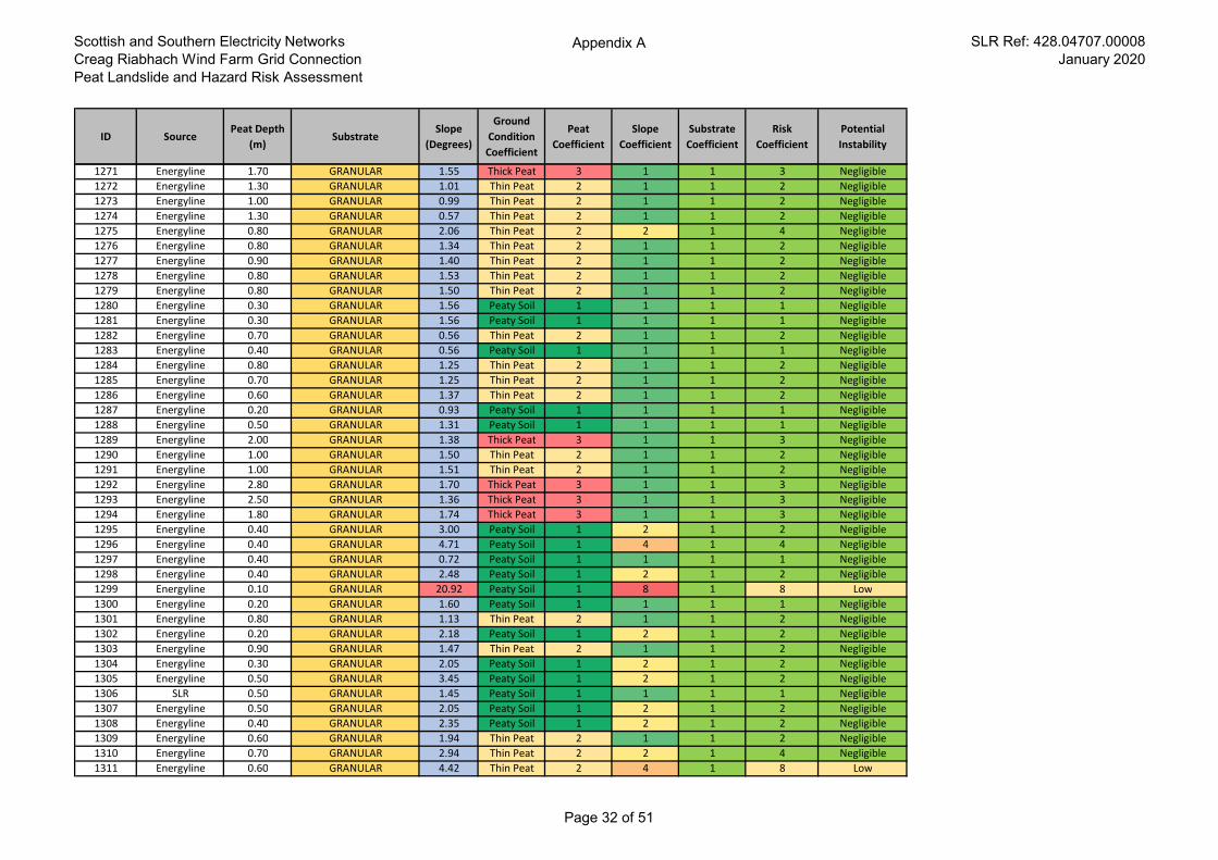
Scottish and Southern Electricity Networks
Creag Riabhach Wind Farm Grid Connection
Peat Landslide and Hazard Risk Assessment
Appendix A SLR Ref: 428.04707.00008
January 2020
ID SourcePeat Depth
(m)Substrate
Slope
(Degrees)
Ground
Condition
Coefficient
Peat
Coefficient
Slope
Coefficient
Substrate
Coefficient
Risk
Coefficient
Potential
Instability
1271 Energyline 1.70 GRANULAR 1.55 Thick Peat 3 1 1 3 Negligible
1272 Energyline 1.30 GRANULAR 1.01 Thin Peat 2 1 1 2 Negligible
1273 Energyline 1.00 GRANULAR 0.99 Thin Peat 2 1 1 2 Negligible
1274 Energyline 1.30 GRANULAR 0.57 Thin Peat 2 1 1 2 Negligible
1275 Energyline 0.80 GRANULAR 2.06 Thin Peat 2 2 1 4 Negligible
1276 Energyline 0.80 GRANULAR 1.34 Thin Peat 2 1 1 2 Negligible
1277 Energyline 0.90 GRANULAR 1.40 Thin Peat 2 1 1 2 Negligible
1278 Energyline 0.80 GRANULAR 1.53 Thin Peat 2 1 1 2 Negligible
1279 Energyline 0.80 GRANULAR 1.50 Thin Peat 2 1 1 2 Negligible
1280 Energyline 0.30 GRANULAR 1.56 Peaty Soil 1 1 1 1 Negligible
1281 Energyline 0.30 GRANULAR 1.56 Peaty Soil 1 1 1 1 Negligible
1282 Energyline 0.70 GRANULAR 0.56 Thin Peat 2 1 1 2 Negligible
1283 Energyline 0.40 GRANULAR 0.56 Peaty Soil 1 1 1 1 Negligible
1284 Energyline 0.80 GRANULAR 1.25 Thin Peat 2 1 1 2 Negligible
1285 Energyline 0.70 GRANULAR 1.25 Thin Peat 2 1 1 2 Negligible
1286 Energyline 0.60 GRANULAR 1.37 Thin Peat 2 1 1 2 Negligible
1287 Energyline 0.20 GRANULAR 0.93 Peaty Soil 1 1 1 1 Negligible
1288 Energyline 0.50 GRANULAR 1.31 Peaty Soil 1 1 1 1 Negligible
1289 Energyline 2.00 GRANULAR 1.38 Thick Peat 3 1 1 3 Negligible
1290 Energyline 1.00 GRANULAR 1.50 Thin Peat 2 1 1 2 Negligible
1291 Energyline 1.00 GRANULAR 1.51 Thin Peat 2 1 1 2 Negligible
1292 Energyline 2.80 GRANULAR 1.70 Thick Peat 3 1 1 3 Negligible
1293 Energyline 2.50 GRANULAR 1.36 Thick Peat 3 1 1 3 Negligible
1294 Energyline 1.80 GRANULAR 1.74 Thick Peat 3 1 1 3 Negligible
1295 Energyline 0.40 GRANULAR 3.00 Peaty Soil 1 2 1 2 Negligible
1296 Energyline 0.40 GRANULAR 4.71 Peaty Soil 1 4 1 4 Negligible
1297 Energyline 0.40 GRANULAR 0.72 Peaty Soil 1 1 1 1 Negligible
1298 Energyline 0.40 GRANULAR 2.48 Peaty Soil 1 2 1 2 Negligible
1299 Energyline 0.10 GRANULAR 20.92 Peaty Soil 1 8 1 8 Low
1300 Energyline 0.20 GRANULAR 1.60 Peaty Soil 1 1 1 1 Negligible
1301 Energyline 0.80 GRANULAR 1.13 Thin Peat 2 1 1 2 Negligible
1302 Energyline 0.20 GRANULAR 2.18 Peaty Soil 1 2 1 2 Negligible
1303 Energyline 0.90 GRANULAR 1.47 Thin Peat 2 1 1 2 Negligible
1304 Energyline 0.30 GRANULAR 2.05 Peaty Soil 1 2 1 2 Negligible
1305 Energyline 0.50 GRANULAR 3.45 Peaty Soil 1 2 1 2 Negligible
1306 SLR 0.50 GRANULAR 1.45 Peaty Soil 1 1 1 1 Negligible
1307 Energyline 0.50 GRANULAR 2.05 Peaty Soil 1 2 1 2 Negligible
1308 Energyline 0.40 GRANULAR 2.35 Peaty Soil 1 2 1 2 Negligible
1309 Energyline 0.60 GRANULAR 1.94 Thin Peat 2 1 1 2 Negligible
1310 Energyline 0.70 GRANULAR 2.94 Thin Peat 2 2 1 4 Negligible
1311 Energyline 0.60 GRANULAR 4.42 Thin Peat 2 4 1 8 Low
Page 32 of 51
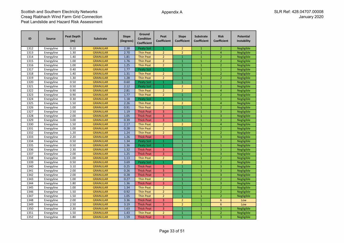
Scottish and Southern Electricity Networks
Creag Riabhach Wind Farm Grid Connection
Peat Landslide and Hazard Risk Assessment
Appendix A SLR Ref: 428.04707.00008
January 2020
ID SourcePeat Depth
(m)Substrate
Slope
(Degrees)
Ground
Condition
Coefficient
Peat
Coefficient
Slope
Coefficient
Substrate
Coefficient
Risk
Coefficient
Potential
Instability
1312 Energyline 0.10 GRANULAR 2.38 Peaty Soil 1 2 1 2 Negligible
1313 Energyline 1.30 GRANULAR 2.70 Thin Peat 2 2 1 4 Negligible
1314 Energyline 1.40 GRANULAR 1.81 Thin Peat 2 1 1 2 Negligible
1315 Energyline 1.00 GRANULAR 1.76 Thin Peat 2 1 1 2 Negligible
1316 Energyline 1.00 GRANULAR 1.25 Thin Peat 2 1 1 2 Negligible
1317 Energyline 0.40 GRANULAR 1.77 Peaty Soil 1 1 1 1 Negligible
1318 Energyline 1.40 GRANULAR 1.31 Thin Peat 2 1 1 2 Negligible
1319 Energyline 1.30 GRANULAR 1.28 Thin Peat 2 1 1 2 Negligible
1320 Energyline 0.50 GRANULAR 0.60 Peaty Soil 1 1 1 1 Negligible
1321 Energyline 0.50 GRANULAR 2.12 Peaty Soil 1 2 1 2 Negligible
1322 Energyline 0.90 GRANULAR 2.81 Thin Peat 2 2 1 4 Negligible
1323 Energyline 0.90 GRANULAR 1.77 Thin Peat 2 1 1 2 Negligible
1324 Energyline 0.30 GRANULAR 1.18 Peaty Soil 1 1 1 1 Negligible
1325 Energyline 1.50 GRANULAR 2.26 Thin Peat 2 2 1 4 Negligible
1326 Energyline 1.00 GRANULAR 0.91 Thin Peat 2 1 1 2 Negligible
1327 Energyline 2.50 GRANULAR 1.19 Thick Peat 3 1 1 3 Negligible
1328 Energyline 2.00 GRANULAR 1.05 Thick Peat 3 1 1 3 Negligible
1329 Energyline 3.00 GRANULAR 0.39 Thick Peat 3 1 1 3 Negligible
1330 Energyline 1.50 GRANULAR 2.17 Thin Peat 2 2 1 4 Negligible
1331 Energyline 1.00 GRANULAR 0.28 Thin Peat 2 1 1 2 Negligible
1332 Energyline 1.20 GRANULAR 1.24 Thin Peat 2 1 1 2 Negligible
1333 Energyline 2.20 GRANULAR 1.26 Thick Peat 3 1 1 3 Negligible
1334 Energyline 0.50 GRANULAR 1.34 Peaty Soil 1 1 1 1 Negligible
1335 Energyline 0.50 GRANULAR 1.36 Peaty Soil 1 1 1 1 Negligible
1336 Energyline 2.30 GRANULAR 1.32 Thick Peat 3 1 1 3 Negligible
1337 Energyline 2.00 GRANULAR 1.25 Thick Peat 3 1 1 3 Negligible
1338 Energyline 1.00 GRANULAR 1.13 Thin Peat 2 1 1 2 Negligible
1339 Energyline 0.50 GRANULAR 3.69 Peaty Soil 1 2 1 2 Negligible
1340 Energyline 3.10 GRANULAR 0.25 Thick Peat 3 1 1 3 Negligible
1341 Energyline 2.00 GRANULAR 0.26 Thick Peat 3 1 1 3 Negligible
1342 Energyline 2.00 GRANULAR 0.28 Thick Peat 3 1 1 3 Negligible
1343 Energyline 1.00 GRANULAR 0.27 Thin Peat 2 1 1 2 Negligible
1344 Energyline 1.80 GRANULAR 1.36 Thick Peat 3 1 1 3 Negligible
1345 Energyline 1.00 GRANULAR 1.34 Thin Peat 2 1 1 2 Negligible
1346 Energyline 1.50 GRANULAR 0.92 Thin Peat 2 1 1 2 Negligible
1347 Energyline 1.50 GRANULAR 1.05 Thin Peat 2 1 1 2 Negligible
1348 Energyline 2.00 GRANULAR 3.36 Thick Peat 3 2 1 6 Low
1349 Energyline 2.50 GRANULAR 3.19 Thick Peat 3 2 1 6 Low
1350 Energyline 2.30 GRANULAR 1.63 Thick Peat 3 1 1 3 Negligible
1351 Energyline 1.50 GRANULAR 1.43 Thin Peat 2 1 1 2 Negligible
1352 Energyline 1.80 GRANULAR 1.59 Thick Peat 3 1 1 3 Negligible
Page 33 of 51
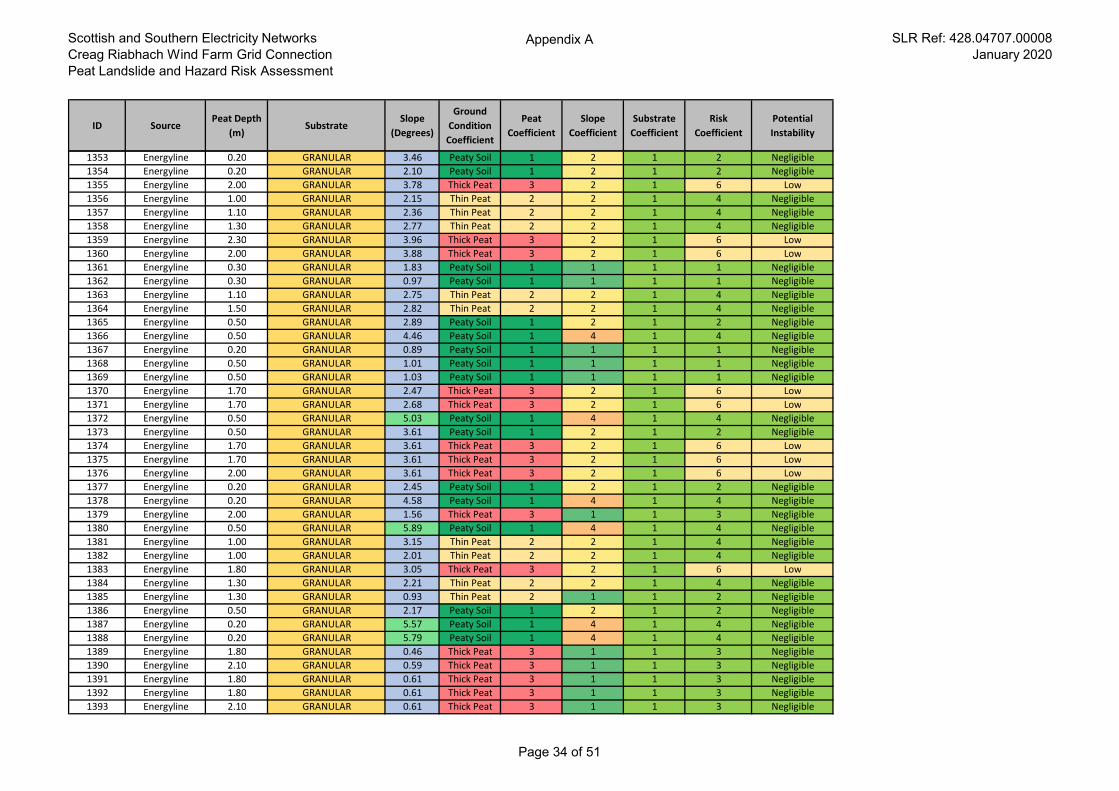
Scottish and Southern Electricity Networks
Creag Riabhach Wind Farm Grid Connection
Peat Landslide and Hazard Risk Assessment
Appendix A SLR Ref: 428.04707.00008
January 2020
ID SourcePeat Depth
(m)Substrate
Slope
(Degrees)
Ground
Condition
Coefficient
Peat
Coefficient
Slope
Coefficient
Substrate
Coefficient
Risk
Coefficient
Potential
Instability
1353 Energyline 0.20 GRANULAR 3.46 Peaty Soil 1 2 1 2 Negligible
1354 Energyline 0.20 GRANULAR 2.10 Peaty Soil 1 2 1 2 Negligible
1355 Energyline 2.00 GRANULAR 3.78 Thick Peat 3 2 1 6 Low
1356 Energyline 1.00 GRANULAR 2.15 Thin Peat 2 2 1 4 Negligible
1357 Energyline 1.10 GRANULAR 2.36 Thin Peat 2 2 1 4 Negligible
1358 Energyline 1.30 GRANULAR 2.77 Thin Peat 2 2 1 4 Negligible
1359 Energyline 2.30 GRANULAR 3.96 Thick Peat 3 2 1 6 Low
1360 Energyline 2.00 GRANULAR 3.88 Thick Peat 3 2 1 6 Low
1361 Energyline 0.30 GRANULAR 1.83 Peaty Soil 1 1 1 1 Negligible
1362 Energyline 0.30 GRANULAR 0.97 Peaty Soil 1 1 1 1 Negligible
1363 Energyline 1.10 GRANULAR 2.75 Thin Peat 2 2 1 4 Negligible
1364 Energyline 1.50 GRANULAR 2.82 Thin Peat 2 2 1 4 Negligible
1365 Energyline 0.50 GRANULAR 2.89 Peaty Soil 1 2 1 2 Negligible
1366 Energyline 0.50 GRANULAR 4.46 Peaty Soil 1 4 1 4 Negligible
1367 Energyline 0.20 GRANULAR 0.89 Peaty Soil 1 1 1 1 Negligible
1368 Energyline 0.50 GRANULAR 1.01 Peaty Soil 1 1 1 1 Negligible
1369 Energyline 0.50 GRANULAR 1.03 Peaty Soil 1 1 1 1 Negligible
1370 Energyline 1.70 GRANULAR 2.47 Thick Peat 3 2 1 6 Low
1371 Energyline 1.70 GRANULAR 2.68 Thick Peat 3 2 1 6 Low
1372 Energyline 0.50 GRANULAR 5.03 Peaty Soil 1 4 1 4 Negligible
1373 Energyline 0.50 GRANULAR 3.61 Peaty Soil 1 2 1 2 Negligible
1374 Energyline 1.70 GRANULAR 3.61 Thick Peat 3 2 1 6 Low
1375 Energyline 1.70 GRANULAR 3.61 Thick Peat 3 2 1 6 Low
1376 Energyline 2.00 GRANULAR 3.61 Thick Peat 3 2 1 6 Low
1377 Energyline 0.20 GRANULAR 2.45 Peaty Soil 1 2 1 2 Negligible
1378 Energyline 0.20 GRANULAR 4.58 Peaty Soil 1 4 1 4 Negligible
1379 Energyline 2.00 GRANULAR 1.56 Thick Peat 3 1 1 3 Negligible
1380 Energyline 0.50 GRANULAR 5.89 Peaty Soil 1 4 1 4 Negligible
1381 Energyline 1.00 GRANULAR 3.15 Thin Peat 2 2 1 4 Negligible
1382 Energyline 1.00 GRANULAR 2.01 Thin Peat 2 2 1 4 Negligible
1383 Energyline 1.80 GRANULAR 3.05 Thick Peat 3 2 1 6 Low
1384 Energyline 1.30 GRANULAR 2.21 Thin Peat 2 2 1 4 Negligible
1385 Energyline 1.30 GRANULAR 0.93 Thin Peat 2 1 1 2 Negligible
1386 Energyline 0.50 GRANULAR 2.17 Peaty Soil 1 2 1 2 Negligible
1387 Energyline 0.20 GRANULAR 5.57 Peaty Soil 1 4 1 4 Negligible
1388 Energyline 0.20 GRANULAR 5.79 Peaty Soil 1 4 1 4 Negligible
1389 Energyline 1.80 GRANULAR 0.46 Thick Peat 3 1 1 3 Negligible
1390 Energyline 2.10 GRANULAR 0.59 Thick Peat 3 1 1 3 Negligible
1391 Energyline 1.80 GRANULAR 0.61 Thick Peat 3 1 1 3 Negligible
1392 Energyline 1.80 GRANULAR 0.61 Thick Peat 3 1 1 3 Negligible
1393 Energyline 2.10 GRANULAR 0.61 Thick Peat 3 1 1 3 Negligible
Page 34 of 51
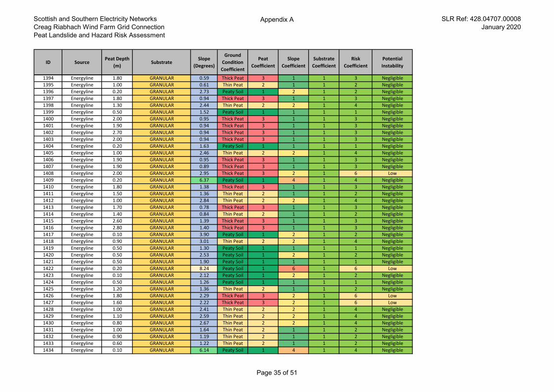
Scottish and Southern Electricity Networks
Creag Riabhach Wind Farm Grid Connection
Peat Landslide and Hazard Risk Assessment
Appendix A SLR Ref: 428.04707.00008
January 2020
ID SourcePeat Depth
(m)Substrate
Slope
(Degrees)
Ground
Condition
Coefficient
Peat
Coefficient
Slope
Coefficient
Substrate
Coefficient
Risk
Coefficient
Potential
Instability
1394 Energyline 1.80 GRANULAR 0.59 Thick Peat 3 1 1 3 Negligible
1395 Energyline 1.00 GRANULAR 0.61 Thin Peat 2 1 1 2 Negligible
1396 Energyline 0.20 GRANULAR 2.73 Peaty Soil 1 2 1 2 Negligible
1397 Energyline 1.80 GRANULAR 0.94 Thick Peat 3 1 1 3 Negligible
1398 Energyline 1.30 GRANULAR 2.44 Thin Peat 2 2 1 4 Negligible
1399 Energyline 0.50 GRANULAR 1.52 Peaty Soil 1 1 1 1 Negligible
1400 Energyline 2.00 GRANULAR 0.95 Thick Peat 3 1 1 3 Negligible
1401 Energyline 1.90 GRANULAR 0.94 Thick Peat 3 1 1 3 Negligible
1402 Energyline 2.70 GRANULAR 0.94 Thick Peat 3 1 1 3 Negligible
1403 Energyline 2.00 GRANULAR 0.94 Thick Peat 3 1 1 3 Negligible
1404 Energyline 0.20 GRANULAR 1.63 Peaty Soil 1 1 1 1 Negligible
1405 Energyline 1.00 GRANULAR 2.46 Thin Peat 2 2 1 4 Negligible
1406 Energyline 1.90 GRANULAR 0.95 Thick Peat 3 1 1 3 Negligible
1407 Energyline 1.90 GRANULAR 0.89 Thick Peat 3 1 1 3 Negligible
1408 Energyline 2.00 GRANULAR 2.95 Thick Peat 3 2 1 6 Low
1409 Energyline 0.20 GRANULAR 6.37 Peaty Soil 1 4 1 4 Negligible
1410 Energyline 1.80 GRANULAR 1.38 Thick Peat 3 1 1 3 Negligible
1411 Energyline 1.50 GRANULAR 1.36 Thin Peat 2 1 1 2 Negligible
1412 Energyline 1.00 GRANULAR 2.84 Thin Peat 2 2 1 4 Negligible
1413 Energyline 1.70 GRANULAR 0.78 Thick Peat 3 1 1 3 Negligible
1414 Energyline 1.40 GRANULAR 0.84 Thin Peat 2 1 1 2 Negligible
1415 Energyline 2.60 GRANULAR 1.39 Thick Peat 3 1 1 3 Negligible
1416 Energyline 2.80 GRANULAR 1.40 Thick Peat 3 1 1 3 Negligible
1417 Energyline 0.10 GRANULAR 3.90 Peaty Soil 1 2 1 2 Negligible
1418 Energyline 0.90 GRANULAR 3.01 Thin Peat 2 2 1 4 Negligible
1419 Energyline 0.50 GRANULAR 1.30 Peaty Soil 1 1 1 1 Negligible
1420 Energyline 0.50 GRANULAR 2.53 Peaty Soil 1 2 1 2 Negligible
1421 Energyline 0.50 GRANULAR 1.90 Peaty Soil 1 1 1 1 Negligible
1422 Energyline 0.20 GRANULAR 8.24 Peaty Soil 1 6 1 6 Low
1423 Energyline 0.10 GRANULAR 2.12 Peaty Soil 1 2 1 2 Negligible
1424 Energyline 0.50 GRANULAR 1.26 Peaty Soil 1 1 1 1 Negligible
1425 Energyline 1.20 GRANULAR 1.36 Thin Peat 2 1 1 2 Negligible
1426 Energyline 1.80 GRANULAR 2.29 Thick Peat 3 2 1 6 Low
1427 Energyline 1.60 GRANULAR 2.22 Thick Peat 3 2 1 6 Low
1428 Energyline 1.00 GRANULAR 2.41 Thin Peat 2 2 1 4 Negligible
1429 Energyline 1.10 GRANULAR 2.59 Thin Peat 2 2 1 4 Negligible
1430 Energyline 0.80 GRANULAR 2.67 Thin Peat 2 2 1 4 Negligible
1431 Energyline 1.00 GRANULAR 1.64 Thin Peat 2 1 1 2 Negligible
1432 Energyline 0.90 GRANULAR 1.19 Thin Peat 2 1 1 2 Negligible
1433 Energyline 0.60 GRANULAR 1.22 Thin Peat 2 1 1 2 Negligible
1434 Energyline 0.10 GRANULAR 6.14 Peaty Soil 1 4 1 4 Negligible
Page 35 of 51
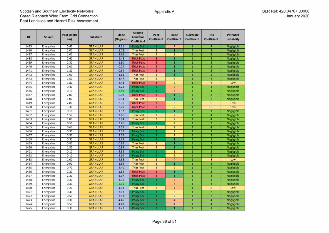
Scottish and Southern Electricity Networks
Creag Riabhach Wind Farm Grid Connection
Peat Landslide and Hazard Risk Assessment
Appendix A SLR Ref: 428.04707.00008
January 2020
ID SourcePeat Depth
(m)Substrate
Slope
(Degrees)
Ground
Condition
Coefficient
Peat
Coefficient
Slope
Coefficient
Substrate
Coefficient
Risk
Coefficient
Potential
Instability
1435 Energyline 0.40 GRANULAR 4.21 Peaty Soil 1 4 1 4 Negligible
1436 Energyline 1.00 GRANULAR 1.72 Thin Peat 2 1 1 2 Negligible
1437 Energyline 1.00 GRANULAR 2.62 Thin Peat 2 2 1 4 Negligible
1438 Energyline 2.60 GRANULAR 1.48 Thick Peat 3 1 1 3 Negligible
1439 Energyline 2.30 GRANULAR 1.90 Thick Peat 3 1 1 3 Negligible
1440 Energyline 2.00 GRANULAR 0.74 Thick Peat 3 1 1 3 Negligible
1441 Energyline 1.80 GRANULAR 0.64 Thick Peat 3 1 1 3 Negligible
1442 Energyline 1.00 GRANULAR 1.92 Thin Peat 2 1 1 2 Negligible
1443 Energyline 1.50 GRANULAR 3.47 Thin Peat 2 2 1 4 Negligible
1444 Energyline 1.80 GRANULAR 2.43 Thick Peat 3 2 1 6 Low
1445 Energyline 0.40 GRANULAR 4.21 Peaty Soil 1 4 1 4 Negligible
1446 Energyline 0.10 GRANULAR 5.49 Peaty Soil 1 4 1 4 Negligible
1447 Energyline 2.00 GRANULAR 0.98 Thick Peat 3 1 1 3 Negligible
1448 Energyline 1.00 GRANULAR 0.94 Thin Peat 2 1 1 2 Negligible
1449 Energyline 2.80 GRANULAR 2.30 Thick Peat 3 2 1 6 Low
1450 Energyline 3.30 GRANULAR 2.29 Thick Peat 3 2 1 6 Low
1451 Energyline 0.10 GRANULAR 1.32 Peaty Soil 1 1 1 1 Negligible
1452 Energyline 1.50 GRANULAR 3.66 Thin Peat 2 2 1 4 Negligible
1453 Energyline 1.00 GRANULAR 3.14 Thin Peat 2 2 1 4 Negligible
1454 Energyline 0.50 GRANULAR 3.26 Peaty Soil 1 2 1 2 Negligible
1455 Energyline 0.60 GRANULAR 2.19 Thin Peat 2 2 1 4 Negligible
1456 Energyline 0.30 GRANULAR 2.19 Peaty Soil 1 2 1 2 Negligible
1457 Energyline 0.30 GRANULAR 2.59 Peaty Soil 1 2 1 2 Negligible
1458 Energyline 0.30 GRANULAR 1.39 Peaty Soil 1 1 1 1 Negligible
1459 Energyline 0.80 GRANULAR 0.89 Thin Peat 2 1 1 2 Negligible
1460 Energyline 1.30 GRANULAR 0.89 Thin Peat 2 1 1 2 Negligible
1461 Energyline 0.10 GRANULAR 3.82 Peaty Soil 1 2 1 2 Negligible
1462 Energyline 0.10 GRANULAR 3.94 Peaty Soil 1 2 1 2 Negligible
1463 Energyline 1.00 GRANULAR 4.33 Thin Peat 2 4 1 8 Low
1464 Energyline 0.90 GRANULAR 1.89 Thin Peat 2 1 1 2 Negligible
1465 Energyline 0.70 GRANULAR 2.40 Thin Peat 2 2 1 4 Negligible
1466 Energyline 2.30 GRANULAR 1.84 Thick Peat 3 1 1 3 Negligible
1467 Energyline 2.30 GRANULAR 1.97 Thick Peat 3 1 1 3 Negligible
1468 Energyline 0.30 GRANULAR 4.35 Peaty Soil 1 4 1 4 Negligible
1469 Energyline 0.30 GRANULAR 5.35 Peaty Soil 1 4 1 4 Negligible
1470 Energyline 1.20 GRANULAR 4.51 Thin Peat 2 4 1 8 Low
1471 Energyline 0.40 GRANULAR 3.13 Peaty Soil 1 2 1 2 Negligible
1472 Energyline 0.50 GRANULAR 3.13 Peaty Soil 1 2 1 2 Negligible
1473 Energyline 0.30 GRANULAR 4.45 Peaty Soil 1 4 1 4 Negligible
1474 Energyline 0.50 GRANULAR 4.41 Peaty Soil 1 4 1 4 Negligible
1475 Energyline 0.30 GRANULAR 1.23 Peaty Soil 1 1 1 1 Negligible
Page 36 of 51
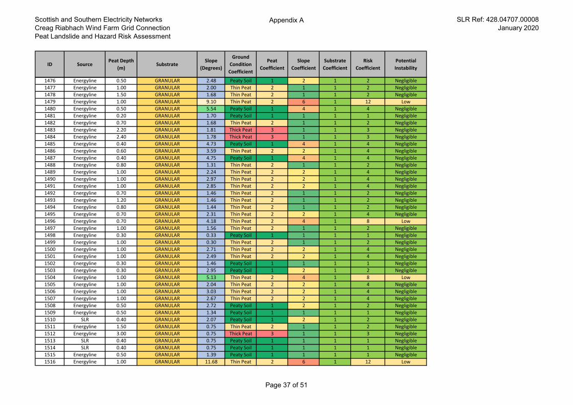
Scottish and Southern Electricity Networks
Creag Riabhach Wind Farm Grid Connection
Peat Landslide and Hazard Risk Assessment
Appendix A SLR Ref: 428.04707.00008
January 2020
ID SourcePeat Depth
(m)Substrate
Slope
(Degrees)
Ground
Condition
Coefficient
Peat
Coefficient
Slope
Coefficient
Substrate
Coefficient
Risk
Coefficient
Potential
Instability
1476 Energyline 0.50 GRANULAR 2.48 Peaty Soil 1 2 1 2 Negligible
1477 Energyline 1.00 GRANULAR 2.00 Thin Peat 2 1 1 2 Negligible
1478 Energyline 1.50 GRANULAR 1.68 Thin Peat 2 1 1 2 Negligible
1479 Energyline 1.00 GRANULAR 9.10 Thin Peat 2 6 1 12 Low
1480 Energyline 0.50 GRANULAR 5.54 Peaty Soil 1 4 1 4 Negligible
1481 Energyline 0.20 GRANULAR 1.70 Peaty Soil 1 1 1 1 Negligible
1482 Energyline 0.70 GRANULAR 1.68 Thin Peat 2 1 1 2 Negligible
1483 Energyline 2.20 GRANULAR 1.81 Thick Peat 3 1 1 3 Negligible
1484 Energyline 2.40 GRANULAR 1.78 Thick Peat 3 1 1 3 Negligible
1485 Energyline 0.40 GRANULAR 4.73 Peaty Soil 1 4 1 4 Negligible
1486 Energyline 0.60 GRANULAR 3.59 Thin Peat 2 2 1 4 Negligible
1487 Energyline 0.40 GRANULAR 4.75 Peaty Soil 1 4 1 4 Negligible
1488 Energyline 0.80 GRANULAR 1.31 Thin Peat 2 1 1 2 Negligible
1489 Energyline 1.00 GRANULAR 2.24 Thin Peat 2 2 1 4 Negligible
1490 Energyline 1.00 GRANULAR 2.97 Thin Peat 2 2 1 4 Negligible
1491 Energyline 1.00 GRANULAR 2.85 Thin Peat 2 2 1 4 Negligible
1492 Energyline 0.70 GRANULAR 1.46 Thin Peat 2 1 1 2 Negligible
1493 Energyline 1.20 GRANULAR 1.46 Thin Peat 2 1 1 2 Negligible
1494 Energyline 0.80 GRANULAR 1.44 Thin Peat 2 1 1 2 Negligible
1495 Energyline 0.70 GRANULAR 2.31 Thin Peat 2 2 1 4 Negligible
1496 Energyline 0.70 GRANULAR 4.18 Thin Peat 2 4 1 8 Low
1497 Energyline 1.00 GRANULAR 1.56 Thin Peat 2 1 1 2 Negligible
1498 Energyline 0.30 GRANULAR 0.33 Peaty Soil 1 1 1 1 Negligible
1499 Energyline 1.00 GRANULAR 0.30 Thin Peat 2 1 1 2 Negligible
1500 Energyline 1.00 GRANULAR 2.71 Thin Peat 2 2 1 4 Negligible
1501 Energyline 1.00 GRANULAR 2.49 Thin Peat 2 2 1 4 Negligible
1502 Energyline 0.30 GRANULAR 1.46 Peaty Soil 1 1 1 1 Negligible
1503 Energyline 0.30 GRANULAR 2.95 Peaty Soil 1 2 1 2 Negligible
1504 Energyline 1.00 GRANULAR 5.13 Thin Peat 2 4 1 8 Low
1505 Energyline 1.00 GRANULAR 2.04 Thin Peat 2 2 1 4 Negligible
1506 Energyline 1.00 GRANULAR 3.03 Thin Peat 2 2 1 4 Negligible
1507 Energyline 1.00 GRANULAR 2.67 Thin Peat 2 2 1 4 Negligible
1508 Energyline 0.50 GRANULAR 2.72 Peaty Soil 1 2 1 2 Negligible
1509 Energyline 0.50 GRANULAR 1.34 Peaty Soil 1 1 1 1 Negligible
1510 SLR 0.40 GRANULAR 2.07 Peaty Soil 1 2 1 2 Negligible
1511 Energyline 1.50 GRANULAR 0.75 Thin Peat 2 1 1 2 Negligible
1512 Energyline 3.00 GRANULAR 0.75 Thick Peat 3 1 1 3 Negligible
1513 SLR 0.40 GRANULAR 0.75 Peaty Soil 1 1 1 1 Negligible
1514 SLR 0.40 GRANULAR 0.75 Peaty Soil 1 1 1 1 Negligible
1515 Energyline 0.50 GRANULAR 1.39 Peaty Soil 1 1 1 1 Negligible
1516 Energyline 1.00 GRANULAR 11.68 Thin Peat 2 6 1 12 Low
Page 37 of 51
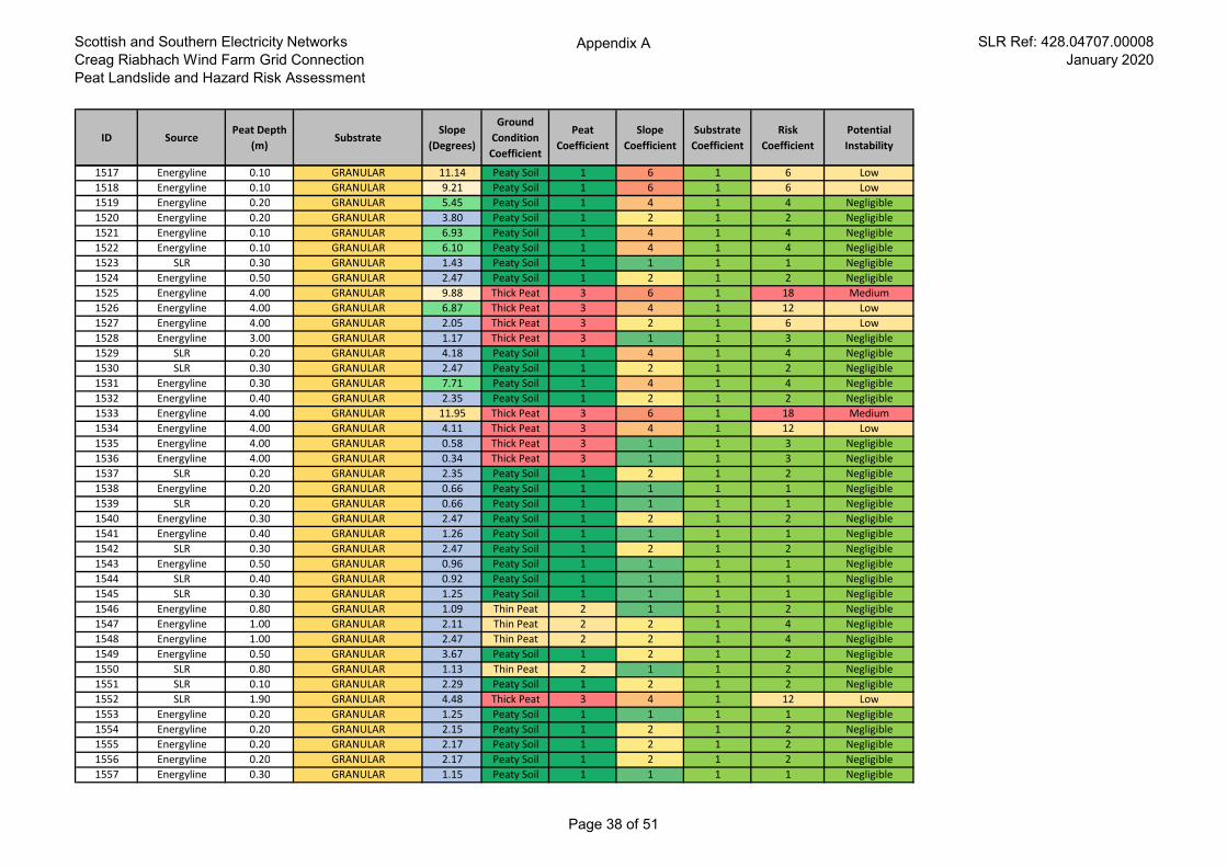
Scottish and Southern Electricity Networks
Creag Riabhach Wind Farm Grid Connection
Peat Landslide and Hazard Risk Assessment
Appendix A SLR Ref: 428.04707.00008
January 2020
ID SourcePeat Depth
(m)Substrate
Slope
(Degrees)
Ground
Condition
Coefficient
Peat
Coefficient
Slope
Coefficient
Substrate
Coefficient
Risk
Coefficient
Potential
Instability
1517 Energyline 0.10 GRANULAR 11.14 Peaty Soil 1 6 1 6 Low
1518 Energyline 0.10 GRANULAR 9.21 Peaty Soil 1 6 1 6 Low
1519 Energyline 0.20 GRANULAR 5.45 Peaty Soil 1 4 1 4 Negligible
1520 Energyline 0.20 GRANULAR 3.80 Peaty Soil 1 2 1 2 Negligible
1521 Energyline 0.10 GRANULAR 6.93 Peaty Soil 1 4 1 4 Negligible
1522 Energyline 0.10 GRANULAR 6.10 Peaty Soil 1 4 1 4 Negligible
1523 SLR 0.30 GRANULAR 1.43 Peaty Soil 1 1 1 1 Negligible
1524 Energyline 0.50 GRANULAR 2.47 Peaty Soil 1 2 1 2 Negligible
1525 Energyline 4.00 GRANULAR 9.88 Thick Peat 3 6 1 18 Medium
1526 Energyline 4.00 GRANULAR 6.87 Thick Peat 3 4 1 12 Low
1527 Energyline 4.00 GRANULAR 2.05 Thick Peat 3 2 1 6 Low
1528 Energyline 3.00 GRANULAR 1.17 Thick Peat 3 1 1 3 Negligible
1529 SLR 0.20 GRANULAR 4.18 Peaty Soil 1 4 1 4 Negligible
1530 SLR 0.30 GRANULAR 2.47 Peaty Soil 1 2 1 2 Negligible
1531 Energyline 0.30 GRANULAR 7.71 Peaty Soil 1 4 1 4 Negligible
1532 Energyline 0.40 GRANULAR 2.35 Peaty Soil 1 2 1 2 Negligible
1533 Energyline 4.00 GRANULAR 11.95 Thick Peat 3 6 1 18 Medium
1534 Energyline 4.00 GRANULAR 4.11 Thick Peat 3 4 1 12 Low
1535 Energyline 4.00 GRANULAR 0.58 Thick Peat 3 1 1 3 Negligible
1536 Energyline 4.00 GRANULAR 0.34 Thick Peat 3 1 1 3 Negligible
1537 SLR 0.20 GRANULAR 2.35 Peaty Soil 1 2 1 2 Negligible
1538 Energyline 0.20 GRANULAR 0.66 Peaty Soil 1 1 1 1 Negligible
1539 SLR 0.20 GRANULAR 0.66 Peaty Soil 1 1 1 1 Negligible
1540 Energyline 0.30 GRANULAR 2.47 Peaty Soil 1 2 1 2 Negligible
1541 Energyline 0.40 GRANULAR 1.26 Peaty Soil 1 1 1 1 Negligible
1542 SLR 0.30 GRANULAR 2.47 Peaty Soil 1 2 1 2 Negligible
1543 Energyline 0.50 GRANULAR 0.96 Peaty Soil 1 1 1 1 Negligible
1544 SLR 0.40 GRANULAR 0.92 Peaty Soil 1 1 1 1 Negligible
1545 SLR 0.30 GRANULAR 1.25 Peaty Soil 1 1 1 1 Negligible
1546 Energyline 0.80 GRANULAR 1.09 Thin Peat 2 1 1 2 Negligible
1547 Energyline 1.00 GRANULAR 2.11 Thin Peat 2 2 1 4 Negligible
1548 Energyline 1.00 GRANULAR 2.47 Thin Peat 2 2 1 4 Negligible
1549 Energyline 0.50 GRANULAR 3.67 Peaty Soil 1 2 1 2 Negligible
1550 SLR 0.80 GRANULAR 1.13 Thin Peat 2 1 1 2 Negligible
1551 SLR 0.10 GRANULAR 2.29 Peaty Soil 1 2 1 2 Negligible
1552 SLR 1.90 GRANULAR 4.48 Thick Peat 3 4 1 12 Low
1553 Energyline 0.20 GRANULAR 1.25 Peaty Soil 1 1 1 1 Negligible
1554 Energyline 0.20 GRANULAR 2.15 Peaty Soil 1 2 1 2 Negligible
1555 Energyline 0.20 GRANULAR 2.17 Peaty Soil 1 2 1 2 Negligible
1556 Energyline 0.20 GRANULAR 2.17 Peaty Soil 1 2 1 2 Negligible
1557 Energyline 0.30 GRANULAR 1.15 Peaty Soil 1 1 1 1 Negligible
Page 38 of 51
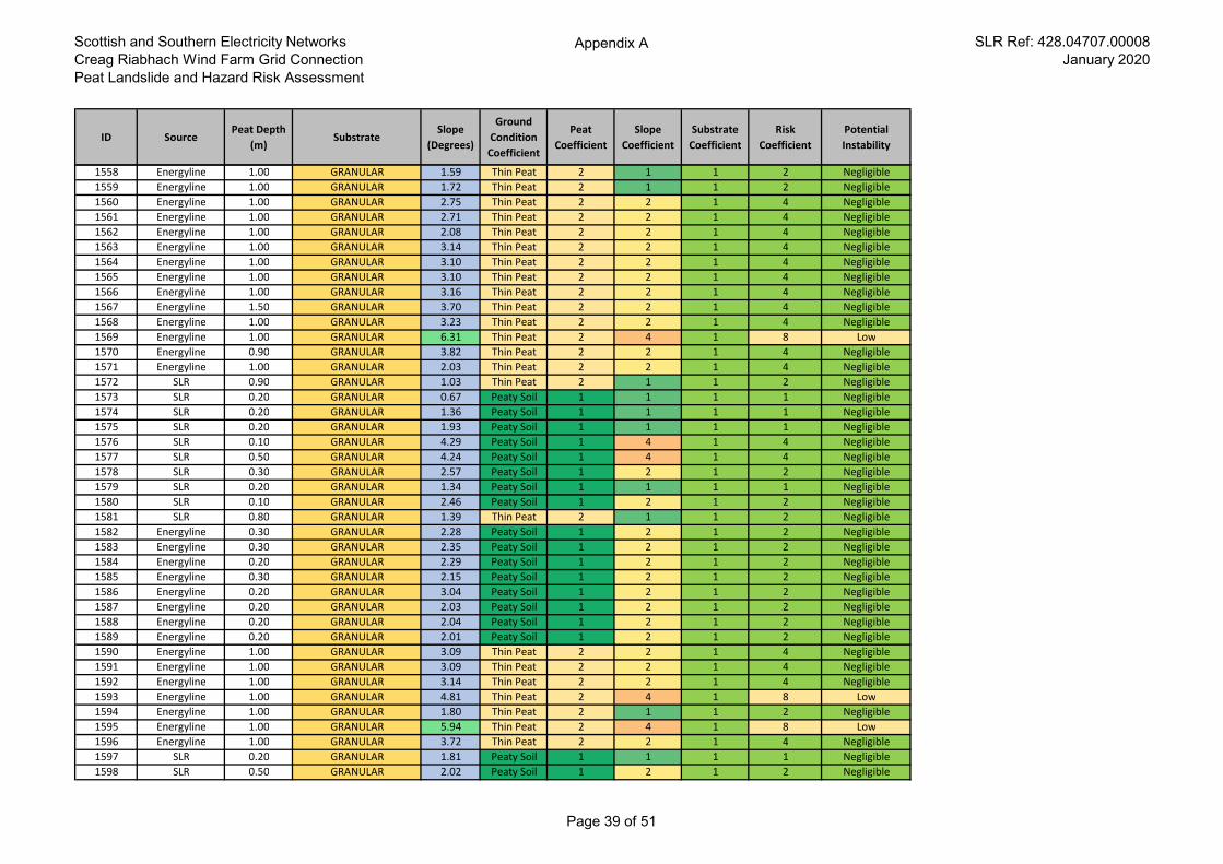
Scottish and Southern Electricity Networks
Creag Riabhach Wind Farm Grid Connection
Peat Landslide and Hazard Risk Assessment
Appendix A SLR Ref: 428.04707.00008
January 2020
ID SourcePeat Depth
(m)Substrate
Slope
(Degrees)
Ground
Condition
Coefficient
Peat
Coefficient
Slope
Coefficient
Substrate
Coefficient
Risk
Coefficient
Potential
Instability
1558 Energyline 1.00 GRANULAR 1.59 Thin Peat 2 1 1 2 Negligible
1559 Energyline 1.00 GRANULAR 1.72 Thin Peat 2 1 1 2 Negligible
1560 Energyline 1.00 GRANULAR 2.75 Thin Peat 2 2 1 4 Negligible
1561 Energyline 1.00 GRANULAR 2.71 Thin Peat 2 2 1 4 Negligible
1562 Energyline 1.00 GRANULAR 2.08 Thin Peat 2 2 1 4 Negligible
1563 Energyline 1.00 GRANULAR 3.14 Thin Peat 2 2 1 4 Negligible
1564 Energyline 1.00 GRANULAR 3.10 Thin Peat 2 2 1 4 Negligible
1565 Energyline 1.00 GRANULAR 3.10 Thin Peat 2 2 1 4 Negligible
1566 Energyline 1.00 GRANULAR 3.16 Thin Peat 2 2 1 4 Negligible
1567 Energyline 1.50 GRANULAR 3.70 Thin Peat 2 2 1 4 Negligible
1568 Energyline 1.00 GRANULAR 3.23 Thin Peat 2 2 1 4 Negligible
1569 Energyline 1.00 GRANULAR 6.31 Thin Peat 2 4 1 8 Low
1570 Energyline 0.90 GRANULAR 3.82 Thin Peat 2 2 1 4 Negligible
1571 Energyline 1.00 GRANULAR 2.03 Thin Peat 2 2 1 4 Negligible
1572 SLR 0.90 GRANULAR 1.03 Thin Peat 2 1 1 2 Negligible
1573 SLR 0.20 GRANULAR 0.67 Peaty Soil 1 1 1 1 Negligible
1574 SLR 0.20 GRANULAR 1.36 Peaty Soil 1 1 1 1 Negligible
1575 SLR 0.20 GRANULAR 1.93 Peaty Soil 1 1 1 1 Negligible
1576 SLR 0.10 GRANULAR 4.29 Peaty Soil 1 4 1 4 Negligible
1577 SLR 0.50 GRANULAR 4.24 Peaty Soil 1 4 1 4 Negligible
1578 SLR 0.30 GRANULAR 2.57 Peaty Soil 1 2 1 2 Negligible
1579 SLR 0.20 GRANULAR 1.34 Peaty Soil 1 1 1 1 Negligible
1580 SLR 0.10 GRANULAR 2.46 Peaty Soil 1 2 1 2 Negligible
1581 SLR 0.80 GRANULAR 1.39 Thin Peat 2 1 1 2 Negligible
1582 Energyline 0.30 GRANULAR 2.28 Peaty Soil 1 2 1 2 Negligible
1583 Energyline 0.30 GRANULAR 2.35 Peaty Soil 1 2 1 2 Negligible
1584 Energyline 0.20 GRANULAR 2.29 Peaty Soil 1 2 1 2 Negligible
1585 Energyline 0.30 GRANULAR 2.15 Peaty Soil 1 2 1 2 Negligible
1586 Energyline 0.20 GRANULAR 3.04 Peaty Soil 1 2 1 2 Negligible
1587 Energyline 0.20 GRANULAR 2.03 Peaty Soil 1 2 1 2 Negligible
1588 Energyline 0.20 GRANULAR 2.04 Peaty Soil 1 2 1 2 Negligible
1589 Energyline 0.20 GRANULAR 2.01 Peaty Soil 1 2 1 2 Negligible
1590 Energyline 1.00 GRANULAR 3.09 Thin Peat 2 2 1 4 Negligible
1591 Energyline 1.00 GRANULAR 3.09 Thin Peat 2 2 1 4 Negligible
1592 Energyline 1.00 GRANULAR 3.14 Thin Peat 2 2 1 4 Negligible
1593 Energyline 1.00 GRANULAR 4.81 Thin Peat 2 4 1 8 Low
1594 Energyline 1.00 GRANULAR 1.80 Thin Peat 2 1 1 2 Negligible
1595 Energyline 1.00 GRANULAR 5.94 Thin Peat 2 4 1 8 Low
1596 Energyline 1.00 GRANULAR 3.72 Thin Peat 2 2 1 4 Negligible
1597 SLR 0.20 GRANULAR 1.81 Peaty Soil 1 1 1 1 Negligible
1598 SLR 0.50 GRANULAR 2.02 Peaty Soil 1 2 1 2 Negligible
Page 39 of 51
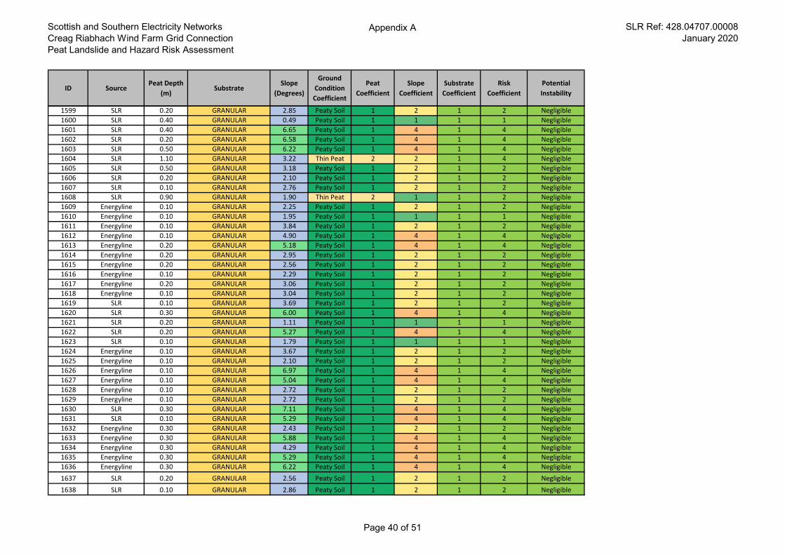
Scottish and Southern Electricity Networks
Creag Riabhach Wind Farm Grid Connection
Peat Landslide and Hazard Risk Assessment
Appendix A SLR Ref: 428.04707.00008
January 2020
ID SourcePeat Depth
(m)Substrate
Slope
(Degrees)
Ground
Condition
Coefficient
Peat
Coefficient
Slope
Coefficient
Substrate
Coefficient
Risk
Coefficient
Potential
Instability
1599 SLR 0.20 GRANULAR 2.85 Peaty Soil 1 2 1 2 Negligible
1600 SLR 0.40 GRANULAR 0.49 Peaty Soil 1 1 1 1 Negligible
1601 SLR 0.40 GRANULAR 6.65 Peaty Soil 1 4 1 4 Negligible
1602 SLR 0.20 GRANULAR 6.58 Peaty Soil 1 4 1 4 Negligible
1603 SLR 0.50 GRANULAR 6.22 Peaty Soil 1 4 1 4 Negligible
1604 SLR 1.10 GRANULAR 3.22 Thin Peat 2 2 1 4 Negligible
1605 SLR 0.50 GRANULAR 3.18 Peaty Soil 1 2 1 2 Negligible
1606 SLR 0.20 GRANULAR 2.10 Peaty Soil 1 2 1 2 Negligible
1607 SLR 0.10 GRANULAR 2.76 Peaty Soil 1 2 1 2 Negligible
1608 SLR 0.90 GRANULAR 1.90 Thin Peat 2 1 1 2 Negligible
1609 Energyline 0.10 GRANULAR 2.25 Peaty Soil 1 2 1 2 Negligible
1610 Energyline 0.10 GRANULAR 1.95 Peaty Soil 1 1 1 1 Negligible
1611 Energyline 0.10 GRANULAR 3.84 Peaty Soil 1 2 1 2 Negligible
1612 Energyline 0.10 GRANULAR 4.90 Peaty Soil 1 4 1 4 Negligible
1613 Energyline 0.20 GRANULAR 5.18 Peaty Soil 1 4 1 4 Negligible
1614 Energyline 0.20 GRANULAR 2.95 Peaty Soil 1 2 1 2 Negligible
1615 Energyline 0.20 GRANULAR 2.56 Peaty Soil 1 2 1 2 Negligible
1616 Energyline 0.10 GRANULAR 2.29 Peaty Soil 1 2 1 2 Negligible
1617 Energyline 0.20 GRANULAR 3.06 Peaty Soil 1 2 1 2 Negligible
1618 Energyline 0.10 GRANULAR 3.04 Peaty Soil 1 2 1 2 Negligible
1619 SLR 0.10 GRANULAR 3.69 Peaty Soil 1 2 1 2 Negligible
1620 SLR 0.30 GRANULAR 6.00 Peaty Soil 1 4 1 4 Negligible
1621 SLR 0.20 GRANULAR 1.11 Peaty Soil 1 1 1 1 Negligible
1622 SLR 0.20 GRANULAR 5.27 Peaty Soil 1 4 1 4 Negligible
1623 SLR 0.10 GRANULAR 1.79 Peaty Soil 1 1 1 1 Negligible
1624 Energyline 0.10 GRANULAR 3.67 Peaty Soil 1 2 1 2 Negligible
1625 Energyline 0.10 GRANULAR 2.10 Peaty Soil 1 2 1 2 Negligible
1626 Energyline 0.10 GRANULAR 6.97 Peaty Soil 1 4 1 4 Negligible
1627 Energyline 0.10 GRANULAR 5.04 Peaty Soil 1 4 1 4 Negligible
1628 Energyline 0.10 GRANULAR 2.72 Peaty Soil 1 2 1 2 Negligible
1629 Energyline 0.10 GRANULAR 2.72 Peaty Soil 1 2 1 2 Negligible
1630 SLR 0.30 GRANULAR 7.11 Peaty Soil 1 4 1 4 Negligible
1631 SLR 0.10 GRANULAR 5.29 Peaty Soil 1 4 1 4 Negligible
1632 Energyline 0.30 GRANULAR 2.43 Peaty Soil 1 2 1 2 Negligible
1633 Energyline 0.30 GRANULAR 5.88 Peaty Soil 1 4 1 4 Negligible
1634 Energyline 0.30 GRANULAR 4.29 Peaty Soil 1 4 1 4 Negligible
1635 Energyline 0.30 GRANULAR 5.29 Peaty Soil 1 4 1 4 Negligible
1636 Energyline 0.30 GRANULAR 6.22 Peaty Soil 1 4 1 4 Negligible
1637 SLR 0.20 GRANULAR 2.56 Peaty Soil 1 2 1 2 Negligible
1638 SLR 0.10 GRANULAR 2.86 Peaty Soil 1 2 1 2 Negligible
Page 40 of 51
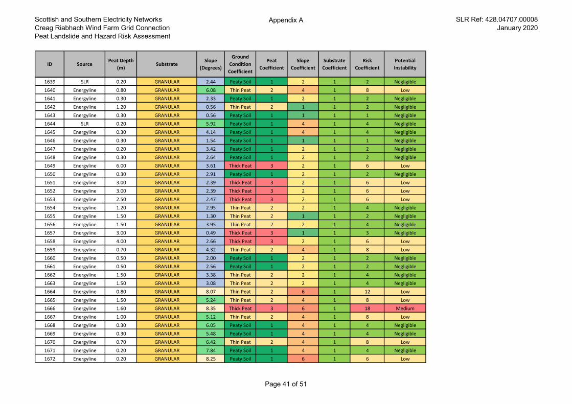
Scottish and Southern Electricity Networks
Creag Riabhach Wind Farm Grid Connection
Peat Landslide and Hazard Risk Assessment
Appendix A SLR Ref: 428.04707.00008
January 2020
ID SourcePeat Depth
(m)Substrate
Slope
(Degrees)
Ground
Condition
Coefficient
Peat
Coefficient
Slope
Coefficient
Substrate
Coefficient
Risk
Coefficient
Potential
Instability
1639 SLR 0.20 GRANULAR 2.44 Peaty Soil 1 2 1 2 Negligible
1640 Energyline 0.80 GRANULAR 6.08 Thin Peat 2 4 1 8 Low
1641 Energyline 0.30 GRANULAR 2.33 Peaty Soil 1 2 1 2 Negligible
1642 Energyline 1.20 GRANULAR 0.56 Thin Peat 2 1 1 2 Negligible
1643 Energyline 0.30 GRANULAR 0.56 Peaty Soil 1 1 1 1 Negligible
1644 SLR 0.20 GRANULAR 5.92 Peaty Soil 1 4 1 4 Negligible
1645 Energyline 0.30 GRANULAR 4.14 Peaty Soil 1 4 1 4 Negligible
1646 Energyline 0.30 GRANULAR 1.54 Peaty Soil 1 1 1 1 Negligible
1647 Energyline 0.20 GRANULAR 3.42 Peaty Soil 1 2 1 2 Negligible
1648 Energyline 0.30 GRANULAR 2.64 Peaty Soil 1 2 1 2 Negligible
1649 Energyline 6.00 GRANULAR 3.61 Thick Peat 3 2 1 6 Low
1650 Energyline 0.30 GRANULAR 2.91 Peaty Soil 1 2 1 2 Negligible
1651 Energyline 3.00 GRANULAR 2.39 Thick Peat 3 2 1 6 Low
1652 Energyline 3.00 GRANULAR 2.39 Thick Peat 3 2 1 6 Low
1653 Energyline 2.50 GRANULAR 2.47 Thick Peat 3 2 1 6 Low
1654 Energyline 1.20 GRANULAR 2.95 Thin Peat 2 2 1 4 Negligible
1655 Energyline 1.50 GRANULAR 1.30 Thin Peat 2 1 1 2 Negligible
1656 Energyline 1.50 GRANULAR 3.95 Thin Peat 2 2 1 4 Negligible
1657 Energyline 3.00 GRANULAR 0.49 Thick Peat 3 1 1 3 Negligible
1658 Energyline 4.00 GRANULAR 2.66 Thick Peat 3 2 1 6 Low
1659 Energyline 0.70 GRANULAR 4.32 Thin Peat 2 4 1 8 Low
1660 Energyline 0.50 GRANULAR 2.00 Peaty Soil 1 2 1 2 Negligible
1661 Energyline 0.50 GRANULAR 2.56 Peaty Soil 1 2 1 2 Negligible
1662 Energyline 1.50 GRANULAR 3.38 Thin Peat 2 2 1 4 Negligible
1663 Energyline 1.50 GRANULAR 3.08 Thin Peat 2 2 1 4 Negligible
1664 Energyline 0.80 GRANULAR 8.07 Thin Peat 2 6 1 12 Low
1665 Energyline 1.50 GRANULAR 5.24 Thin Peat 2 4 1 8 Low
1666 Energyline 1.60 GRANULAR 8.35 Thick Peat 3 6 1 18 Medium
1667 Energyline 1.00 GRANULAR 5.12 Thin Peat 2 4 1 8 Low
1668 Energyline 0.30 GRANULAR 6.05 Peaty Soil 1 4 1 4 Negligible
1669 Energyline 0.30 GRANULAR 5.48 Peaty Soil 1 4 1 4 Negligible
1670 Energyline 0.70 GRANULAR 6.42 Thin Peat 2 4 1 8 Low
1671 Energyline 0.20 GRANULAR 7.84 Peaty Soil 1 4 1 4 Negligible
1672 Energyline 0.20 GRANULAR 8.25 Peaty Soil 1 6 1 6 Low
Page 41 of 51
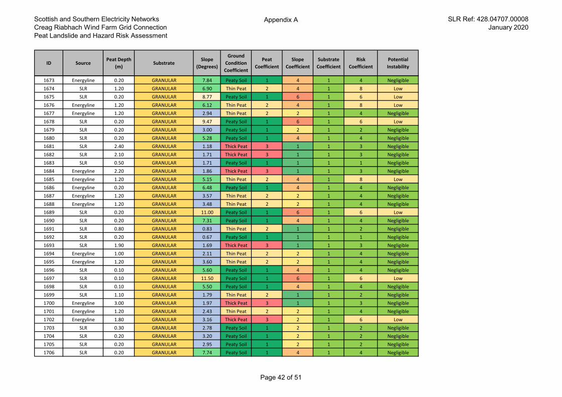
Scottish and Southern Electricity Networks
Creag Riabhach Wind Farm Grid Connection
Peat Landslide and Hazard Risk Assessment
Appendix A SLR Ref: 428.04707.00008
January 2020
ID SourcePeat Depth
(m)Substrate
Slope
(Degrees)
Ground
Condition
Coefficient
Peat
Coefficient
Slope
Coefficient
Substrate
Coefficient
Risk
Coefficient
Potential
Instability
1673 Energyline 0.20 GRANULAR 7.84 Peaty Soil 1 4 1 4 Negligible
1674 SLR 1.20 GRANULAR 6.90 Thin Peat 2 4 1 8 Low
1675 SLR 0.20 GRANULAR 8.77 Peaty Soil 1 6 1 6 Low
1676 Energyline 1.20 GRANULAR 6.12 Thin Peat 2 4 1 8 Low
1677 Energyline 1.20 GRANULAR 2.94 Thin Peat 2 2 1 4 Negligible
1678 SLR 0.20 GRANULAR 9.47 Peaty Soil 1 6 1 6 Low
1679 SLR 0.20 GRANULAR 3.00 Peaty Soil 1 2 1 2 Negligible
1680 SLR 0.20 GRANULAR 5.28 Peaty Soil 1 4 1 4 Negligible
1681 SLR 2.40 GRANULAR 1.18 Thick Peat 3 1 1 3 Negligible
1682 SLR 2.10 GRANULAR 1.71 Thick Peat 3 1 1 3 Negligible
1683 SLR 0.50 GRANULAR 1.71 Peaty Soil 1 1 1 1 Negligible
1684 Energyline 2.20 GRANULAR 1.86 Thick Peat 3 1 1 3 Negligible
1685 Energyline 1.20 GRANULAR 5.15 Thin Peat 2 4 1 8 Low
1686 Energyline 0.20 GRANULAR 6.48 Peaty Soil 1 4 1 4 Negligible
1687 Energyline 1.20 GRANULAR 3.57 Thin Peat 2 2 1 4 Negligible
1688 Energyline 1.20 GRANULAR 3.48 Thin Peat 2 2 1 4 Negligible
1689 SLR 0.20 GRANULAR 11.00 Peaty Soil 1 6 1 6 Low
1690 SLR 0.20 GRANULAR 7.31 Peaty Soil 1 4 1 4 Negligible
1691 SLR 0.80 GRANULAR 0.83 Thin Peat 2 1 1 2 Negligible
1692 SLR 0.20 GRANULAR 0.67 Peaty Soil 1 1 1 1 Negligible
1693 SLR 1.90 GRANULAR 1.69 Thick Peat 3 1 1 3 Negligible
1694 Energyline 1.00 GRANULAR 2.11 Thin Peat 2 2 1 4 Negligible
1695 Energyline 1.20 GRANULAR 3.60 Thin Peat 2 2 1 4 Negligible
1696 SLR 0.10 GRANULAR 5.60 Peaty Soil 1 4 1 4 Negligible
1697 SLR 0.10 GRANULAR 11.50 Peaty Soil 1 6 1 6 Low
1698 SLR 0.10 GRANULAR 5.50 Peaty Soil 1 4 1 4 Negligible
1699 SLR 1.10 GRANULAR 1.79 Thin Peat 2 1 1 2 Negligible
1700 Energyline 3.00 GRANULAR 1.97 Thick Peat 3 1 1 3 Negligible
1701 Energyline 1.20 GRANULAR 2.43 Thin Peat 2 2 1 4 Negligible
1702 Energyline 1.80 GRANULAR 3.16 Thick Peat 3 2 1 6 Low
1703 SLR 0.30 GRANULAR 2.78 Peaty Soil 1 2 1 2 Negligible
1704 SLR 0.20 GRANULAR 3.20 Peaty Soil 1 2 1 2 Negligible
1705 SLR 0.20 GRANULAR 2.95 Peaty Soil 1 2 1 2 Negligible
1706 SLR 0.20 GRANULAR 7.74 Peaty Soil 1 4 1 4 Negligible
Page 42 of 51
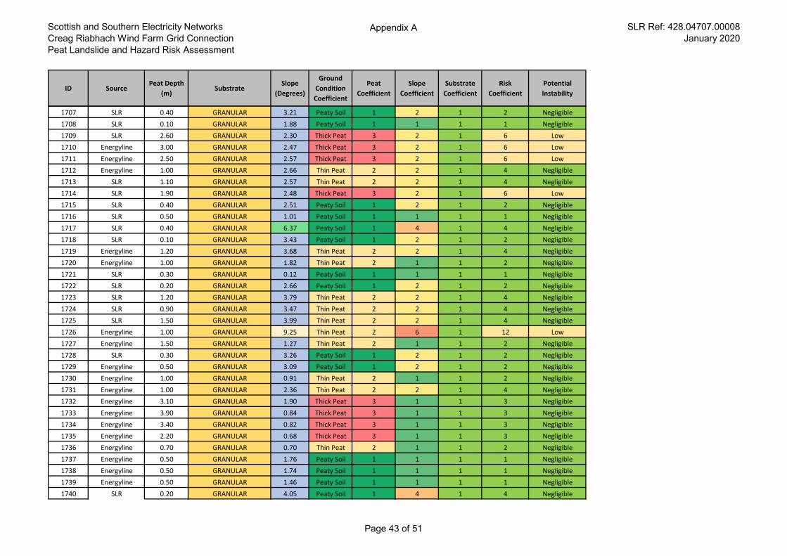
Scottish and Southern Electricity Networks
Creag Riabhach Wind Farm Grid Connection
Peat Landslide and Hazard Risk Assessment
Appendix A SLR Ref: 428.04707.00008
January 2020
ID SourcePeat Depth
(m)Substrate
Slope
(Degrees)
Ground
Condition
Coefficient
Peat
Coefficient
Slope
Coefficient
Substrate
Coefficient
Risk
Coefficient
Potential
Instability
1707 SLR 0.40 GRANULAR 3.21 Peaty Soil 1 2 1 2 Negligible
1708 SLR 0.10 GRANULAR 1.88 Peaty Soil 1 1 1 1 Negligible
1709 SLR 2.60 GRANULAR 2.30 Thick Peat 3 2 1 6 Low
1710 Energyline 3.00 GRANULAR 2.47 Thick Peat 3 2 1 6 Low
1711 Energyline 2.50 GRANULAR 2.57 Thick Peat 3 2 1 6 Low
1712 Energyline 1.00 GRANULAR 2.66 Thin Peat 2 2 1 4 Negligible
1713 SLR 1.10 GRANULAR 2.57 Thin Peat 2 2 1 4 Negligible
1714 SLR 1.90 GRANULAR 2.48 Thick Peat 3 2 1 6 Low
1715 SLR 0.40 GRANULAR 2.51 Peaty Soil 1 2 1 2 Negligible
1716 SLR 0.50 GRANULAR 1.01 Peaty Soil 1 1 1 1 Negligible
1717 SLR 0.40 GRANULAR 6.37 Peaty Soil 1 4 1 4 Negligible
1718 SLR 0.10 GRANULAR 3.43 Peaty Soil 1 2 1 2 Negligible
1719 Energyline 1.20 GRANULAR 3.68 Thin Peat 2 2 1 4 Negligible
1720 Energyline 1.00 GRANULAR 1.82 Thin Peat 2 1 1 2 Negligible
1721 SLR 0.30 GRANULAR 0.12 Peaty Soil 1 1 1 1 Negligible
1722 SLR 0.20 GRANULAR 2.66 Peaty Soil 1 2 1 2 Negligible
1723 SLR 1.20 GRANULAR 3.79 Thin Peat 2 2 1 4 Negligible
1724 SLR 0.90 GRANULAR 3.47 Thin Peat 2 2 1 4 Negligible
1725 SLR 1.50 GRANULAR 3.99 Thin Peat 2 2 1 4 Negligible
1726 Energyline 1.00 GRANULAR 9.25 Thin Peat 2 6 1 12 Low
1727 Energyline 1.50 GRANULAR 1.27 Thin Peat 2 1 1 2 Negligible
1728 SLR 0.30 GRANULAR 3.26 Peaty Soil 1 2 1 2 Negligible
1729 Energyline 0.50 GRANULAR 3.09 Peaty Soil 1 2 1 2 Negligible
1730 Energyline 1.00 GRANULAR 0.91 Thin Peat 2 1 1 2 Negligible
1731 Energyline 1.00 GRANULAR 2.36 Thin Peat 2 2 1 4 Negligible
1732 Energyline 3.10 GRANULAR 1.90 Thick Peat 3 1 1 3 Negligible
1733 Energyline 3.90 GRANULAR 0.84 Thick Peat 3 1 1 3 Negligible
1734 Energyline 3.40 GRANULAR 0.82 Thick Peat 3 1 1 3 Negligible
1735 Energyline 2.20 GRANULAR 0.68 Thick Peat 3 1 1 3 Negligible
1736 Energyline 0.70 GRANULAR 0.70 Thin Peat 2 1 1 2 Negligible
1737 Energyline 0.50 GRANULAR 1.76 Peaty Soil 1 1 1 1 Negligible
1738 Energyline 0.50 GRANULAR 1.74 Peaty Soil 1 1 1 1 Negligible
1739 Energyline 0.50 GRANULAR 1.46 Peaty Soil 1 1 1 1 Negligible
1740 SLR 0.20 GRANULAR 4.05 Peaty Soil 1 4 1 4 Negligible
Page 43 of 51
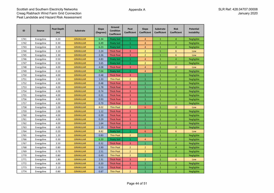
Scottish and Southern Electricity Networks
Creag Riabhach Wind Farm Grid Connection
Peat Landslide and Hazard Risk Assessment
Appendix A SLR Ref: 428.04707.00008
January 2020
ID SourcePeat Depth
(m)Substrate
Slope
(Degrees)
Ground
Condition
Coefficient
Peat
Coefficient
Slope
Coefficient
Substrate
Coefficient
Risk
Coefficient
Potential
Instability
1741 Energyline 0.20 GRANULAR 6.34 Peaty Soil 1 4 1 4 Negligible
1742 Energyline 0.30 GRANULAR 6.49 Peaty Soil 1 4 1 4 Negligible
1743 Energyline 0.30 GRANULAR 6.23 Peaty Soil 1 4 1 4 Negligible
1744 Energyline 3.10 GRANULAR 2.24 Thick Peat 3 2 1 6 Low
1745 Energyline 2.30 GRANULAR 2.26 Thick Peat 3 2 1 6 Low
1746 Energyline 0.50 GRANULAR 4.83 Peaty Soil 1 4 1 4 Negligible
1747 Energyline 0.50 GRANULAR 3.65 Peaty Soil 1 2 1 2 Negligible
1748 Energyline 4.00 GRANULAR 4.08 Thick Peat 3 4 1 12 Low
1749 Energyline 0.10 GRANULAR 7.04 Peaty Soil 1 4 1 4 Negligible
1750 Energyline 4.00 GRANULAR 0.48 Thick Peat 3 1 1 3 Negligible
1751 Energyline 1.50 GRANULAR 1.33 Thin Peat 2 1 1 2 Negligible
1752 Energyline 4.00 GRANULAR 0.48 Thick Peat 3 1 1 3 Negligible
1753 Energyline 4.00 GRANULAR 1.78 Thick Peat 3 1 1 3 Negligible
1754 Energyline 4.00 GRANULAR 0.74 Thick Peat 3 1 1 3 Negligible
1755 Energyline 4.00 GRANULAR 0.31 Thick Peat 3 1 1 3 Negligible
1756 Energyline 4.00 GRANULAR 0.93 Thick Peat 3 1 1 3 Negligible
1757 Energyline 4.00 GRANULAR 0.79 Thick Peat 3 1 1 3 Negligible
1758 Energyline 1.00 GRANULAR 8.02 Thin Peat 2 6 1 12 Low
1759 Energyline 2.00 GRANULAR 1.12 Thick Peat 3 1 1 3 Negligible
1760 Energyline 4.00 GRANULAR 0.39 Thick Peat 3 1 1 3 Negligible
1761 Energyline 4.00 GRANULAR 0.29 Thick Peat 3 1 1 3 Negligible
1762 Energyline 4.00 GRANULAR 1.64 Thick Peat 3 1 1 3 Negligible
1763 Energyline 4.00 GRANULAR 1.19 Thick Peat 3 1 1 3 Negligible
1764 Energyline 0.20 GRANULAR 8.82 Peaty Soil 1 6 1 6 Low
1765 Energyline 1.20 GRANULAR 0.83 Thin Peat 2 1 1 2 Negligible
1766 Energyline 0.30 GRANULAR 6.20 Peaty Soil 1 4 1 4 Negligible
1767 Energyline 3.50 GRANULAR 0.32 Thick Peat 3 1 1 3 Negligible
1768 Energyline 0.80 GRANULAR 3.90 Thin Peat 2 2 1 4 Negligible
1769 Energyline 0.70 GRANULAR 2.51 Thin Peat 2 2 1 4 Negligible
1770 Energyline 0.80 GRANULAR 0.43 Thin Peat 2 1 1 2 Negligible
1771 Energyline 1.80 GRANULAR 2.31 Thick Peat 3 2 1 6 Low
1772 Energyline 4.00 GRANULAR 0.20 Thick Peat 3 1 1 3 Negligible
1773 Energyline 2.10 GRANULAR 0.53 Thick Peat 3 1 1 3 Negligible
1774 Energyline 0.80 GRANULAR 0.87 Thin Peat 2 1 1 2 Negligible
Page 44 of 51
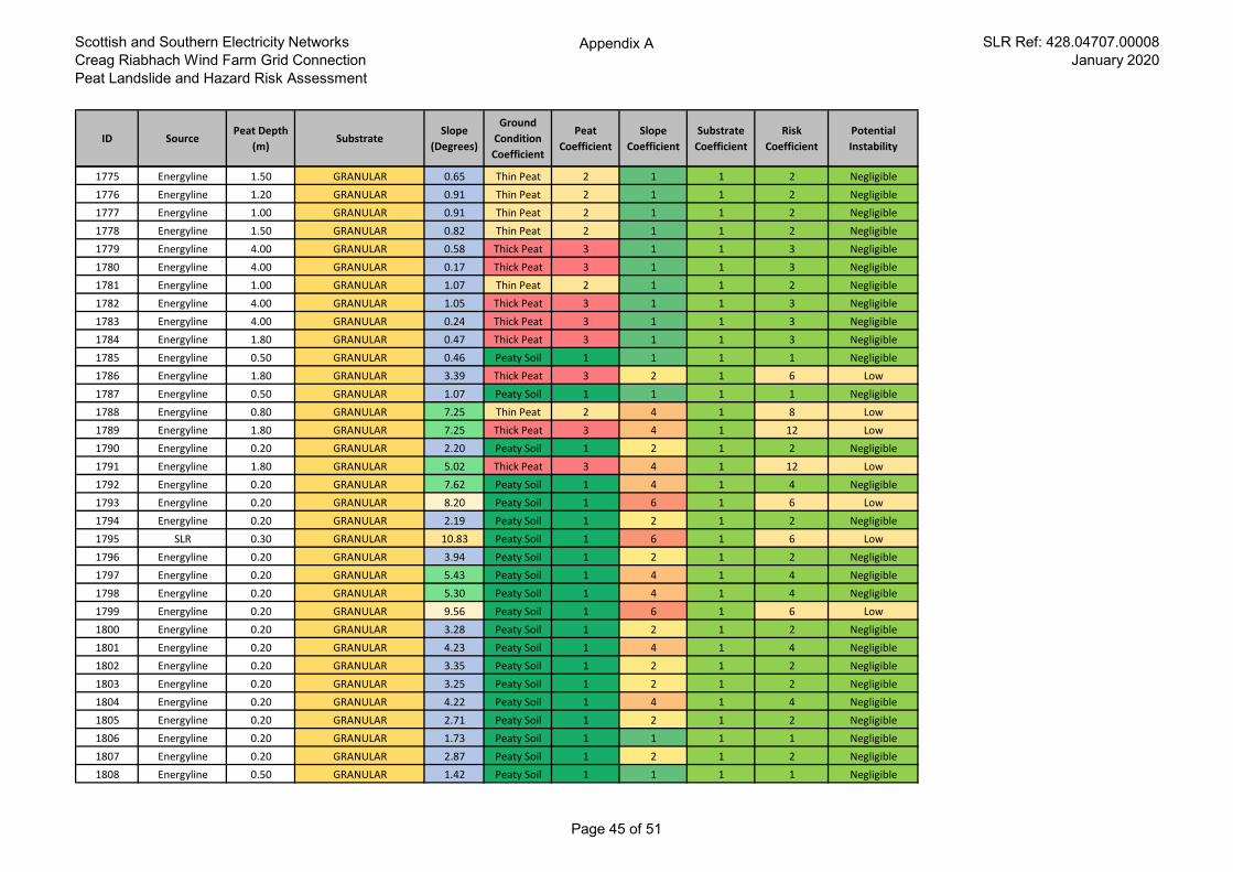
Scottish and Southern Electricity Networks
Creag Riabhach Wind Farm Grid Connection
Peat Landslide and Hazard Risk Assessment
Appendix A SLR Ref: 428.04707.00008
January 2020
ID SourcePeat Depth
(m)Substrate
Slope
(Degrees)
Ground
Condition
Coefficient
Peat
Coefficient
Slope
Coefficient
Substrate
Coefficient
Risk
Coefficient
Potential
Instability
1775 Energyline 1.50 GRANULAR 0.65 Thin Peat 2 1 1 2 Negligible
1776 Energyline 1.20 GRANULAR 0.91 Thin Peat 2 1 1 2 Negligible
1777 Energyline 1.00 GRANULAR 0.91 Thin Peat 2 1 1 2 Negligible
1778 Energyline 1.50 GRANULAR 0.82 Thin Peat 2 1 1 2 Negligible
1779 Energyline 4.00 GRANULAR 0.58 Thick Peat 3 1 1 3 Negligible
1780 Energyline 4.00 GRANULAR 0.17 Thick Peat 3 1 1 3 Negligible
1781 Energyline 1.00 GRANULAR 1.07 Thin Peat 2 1 1 2 Negligible
1782 Energyline 4.00 GRANULAR 1.05 Thick Peat 3 1 1 3 Negligible
1783 Energyline 4.00 GRANULAR 0.24 Thick Peat 3 1 1 3 Negligible
1784 Energyline 1.80 GRANULAR 0.47 Thick Peat 3 1 1 3 Negligible
1785 Energyline 0.50 GRANULAR 0.46 Peaty Soil 1 1 1 1 Negligible
1786 Energyline 1.80 GRANULAR 3.39 Thick Peat 3 2 1 6 Low
1787 Energyline 0.50 GRANULAR 1.07 Peaty Soil 1 1 1 1 Negligible
1788 Energyline 0.80 GRANULAR 7.25 Thin Peat 2 4 1 8 Low
1789 Energyline 1.80 GRANULAR 7.25 Thick Peat 3 4 1 12 Low
1790 Energyline 0.20 GRANULAR 2.20 Peaty Soil 1 2 1 2 Negligible
1791 Energyline 1.80 GRANULAR 5.02 Thick Peat 3 4 1 12 Low
1792 Energyline 0.20 GRANULAR 7.62 Peaty Soil 1 4 1 4 Negligible
1793 Energyline 0.20 GRANULAR 8.20 Peaty Soil 1 6 1 6 Low
1794 Energyline 0.20 GRANULAR 2.19 Peaty Soil 1 2 1 2 Negligible
1795 SLR 0.30 GRANULAR 10.83 Peaty Soil 1 6 1 6 Low
1796 Energyline 0.20 GRANULAR 3.94 Peaty Soil 1 2 1 2 Negligible
1797 Energyline 0.20 GRANULAR 5.43 Peaty Soil 1 4 1 4 Negligible
1798 Energyline 0.20 GRANULAR 5.30 Peaty Soil 1 4 1 4 Negligible
1799 Energyline 0.20 GRANULAR 9.56 Peaty Soil 1 6 1 6 Low
1800 Energyline 0.20 GRANULAR 3.28 Peaty Soil 1 2 1 2 Negligible
1801 Energyline 0.20 GRANULAR 4.23 Peaty Soil 1 4 1 4 Negligible
1802 Energyline 0.20 GRANULAR 3.35 Peaty Soil 1 2 1 2 Negligible
1803 Energyline 0.20 GRANULAR 3.25 Peaty Soil 1 2 1 2 Negligible
1804 Energyline 0.20 GRANULAR 4.22 Peaty Soil 1 4 1 4 Negligible
1805 Energyline 0.20 GRANULAR 2.71 Peaty Soil 1 2 1 2 Negligible
1806 Energyline 0.20 GRANULAR 1.73 Peaty Soil 1 1 1 1 Negligible
1807 Energyline 0.20 GRANULAR 2.87 Peaty Soil 1 2 1 2 Negligible
1808 Energyline 0.50 GRANULAR 1.42 Peaty Soil 1 1 1 1 Negligible
Page 45 of 51
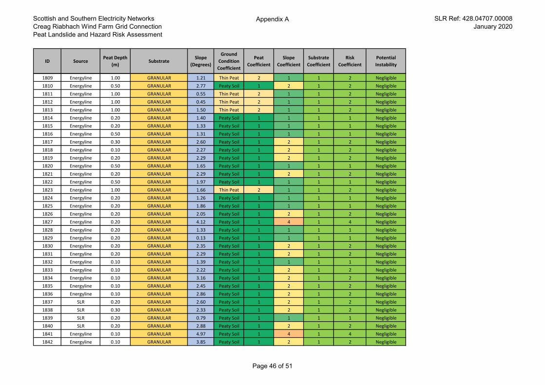
Scottish and Southern Electricity Networks
Creag Riabhach Wind Farm Grid Connection
Peat Landslide and Hazard Risk Assessment
Appendix A SLR Ref: 428.04707.00008
January 2020
ID SourcePeat Depth
(m)Substrate
Slope
(Degrees)
Ground
Condition
Coefficient
Peat
Coefficient
Slope
Coefficient
Substrate
Coefficient
Risk
Coefficient
Potential
Instability
1809 Energyline 1.00 GRANULAR 1.21 Thin Peat 2 1 1 2 Negligible
1810 Energyline 0.50 GRANULAR 2.77 Peaty Soil 1 2 1 2 Negligible
1811 Energyline 1.00 GRANULAR 0.55 Thin Peat 2 1 1 2 Negligible
1812 Energyline 1.00 GRANULAR 0.45 Thin Peat 2 1 1 2 Negligible
1813 Energyline 1.00 GRANULAR 1.50 Thin Peat 2 1 1 2 Negligible
1814 Energyline 0.20 GRANULAR 1.40 Peaty Soil 1 1 1 1 Negligible
1815 Energyline 0.20 GRANULAR 1.33 Peaty Soil 1 1 1 1 Negligible
1816 Energyline 0.50 GRANULAR 1.31 Peaty Soil 1 1 1 1 Negligible
1817 Energyline 0.30 GRANULAR 2.60 Peaty Soil 1 2 1 2 Negligible
1818 Energyline 0.10 GRANULAR 2.27 Peaty Soil 1 2 1 2 Negligible
1819 Energyline 0.20 GRANULAR 2.29 Peaty Soil 1 2 1 2 Negligible
1820 Energyline 0.50 GRANULAR 1.65 Peaty Soil 1 1 1 1 Negligible
1821 Energyline 0.20 GRANULAR 2.29 Peaty Soil 1 2 1 2 Negligible
1822 Energyline 0.50 GRANULAR 1.97 Peaty Soil 1 1 1 1 Negligible
1823 Energyline 1.00 GRANULAR 1.66 Thin Peat 2 1 1 2 Negligible
1824 Energyline 0.20 GRANULAR 1.26 Peaty Soil 1 1 1 1 Negligible
1825 Energyline 0.20 GRANULAR 1.86 Peaty Soil 1 1 1 1 Negligible
1826 Energyline 0.20 GRANULAR 2.05 Peaty Soil 1 2 1 2 Negligible
1827 Energyline 0.20 GRANULAR 4.12 Peaty Soil 1 4 1 4 Negligible
1828 Energyline 0.20 GRANULAR 1.33 Peaty Soil 1 1 1 1 Negligible
1829 Energyline 0.20 GRANULAR 0.13 Peaty Soil 1 1 1 1 Negligible
1830 Energyline 0.20 GRANULAR 2.35 Peaty Soil 1 2 1 2 Negligible
1831 Energyline 0.20 GRANULAR 2.29 Peaty Soil 1 2 1 2 Negligible
1832 Energyline 0.10 GRANULAR 1.39 Peaty Soil 1 1 1 1 Negligible
1833 Energyline 0.10 GRANULAR 2.22 Peaty Soil 1 2 1 2 Negligible
1834 Energyline 0.10 GRANULAR 3.16 Peaty Soil 1 2 1 2 Negligible
1835 Energyline 0.10 GRANULAR 2.45 Peaty Soil 1 2 1 2 Negligible
1836 Energyline 0.10 GRANULAR 2.86 Peaty Soil 1 2 1 2 Negligible
1837 SLR 0.20 GRANULAR 2.60 Peaty Soil 1 2 1 2 Negligible
1838 SLR 0.30 GRANULAR 2.33 Peaty Soil 1 2 1 2 Negligible
1839 SLR 0.20 GRANULAR 0.79 Peaty Soil 1 1 1 1 Negligible
1840 SLR 0.20 GRANULAR 2.88 Peaty Soil 1 2 1 2 Negligible
1841 Energyline 0.10 GRANULAR 4.97 Peaty Soil 1 4 1 4 Negligible
1842 Energyline 0.10 GRANULAR 3.85 Peaty Soil 1 2 1 2 Negligible
Page 46 of 51
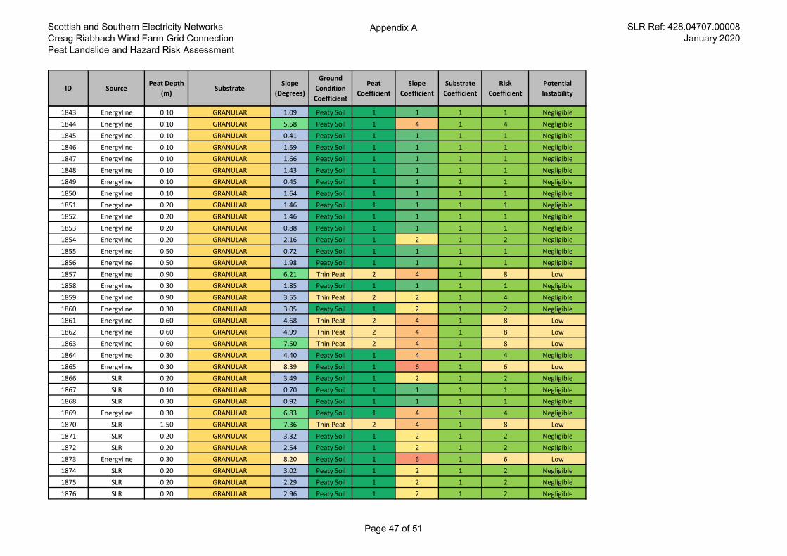
Scottish and Southern Electricity Networks
Creag Riabhach Wind Farm Grid Connection
Peat Landslide and Hazard Risk Assessment
Appendix A SLR Ref: 428.04707.00008
January 2020
ID SourcePeat Depth
(m)Substrate
Slope
(Degrees)
Ground
Condition
Coefficient
Peat
Coefficient
Slope
Coefficient
Substrate
Coefficient
Risk
Coefficient
Potential
Instability
1843 Energyline 0.10 GRANULAR 1.09 Peaty Soil 1 1 1 1 Negligible
1844 Energyline 0.10 GRANULAR 5.58 Peaty Soil 1 4 1 4 Negligible
1845 Energyline 0.10 GRANULAR 0.41 Peaty Soil 1 1 1 1 Negligible
1846 Energyline 0.10 GRANULAR 1.59 Peaty Soil 1 1 1 1 Negligible
1847 Energyline 0.10 GRANULAR 1.66 Peaty Soil 1 1 1 1 Negligible
1848 Energyline 0.10 GRANULAR 1.43 Peaty Soil 1 1 1 1 Negligible
1849 Energyline 0.10 GRANULAR 0.45 Peaty Soil 1 1 1 1 Negligible
1850 Energyline 0.10 GRANULAR 1.64 Peaty Soil 1 1 1 1 Negligible
1851 Energyline 0.20 GRANULAR 1.46 Peaty Soil 1 1 1 1 Negligible
1852 Energyline 0.20 GRANULAR 1.46 Peaty Soil 1 1 1 1 Negligible
1853 Energyline 0.20 GRANULAR 0.88 Peaty Soil 1 1 1 1 Negligible
1854 Energyline 0.20 GRANULAR 2.16 Peaty Soil 1 2 1 2 Negligible
1855 Energyline 0.50 GRANULAR 0.72 Peaty Soil 1 1 1 1 Negligible
1856 Energyline 0.50 GRANULAR 1.98 Peaty Soil 1 1 1 1 Negligible
1857 Energyline 0.90 GRANULAR 6.21 Thin Peat 2 4 1 8 Low
1858 Energyline 0.30 GRANULAR 1.85 Peaty Soil 1 1 1 1 Negligible
1859 Energyline 0.90 GRANULAR 3.55 Thin Peat 2 2 1 4 Negligible
1860 Energyline 0.30 GRANULAR 3.05 Peaty Soil 1 2 1 2 Negligible
1861 Energyline 0.60 GRANULAR 4.68 Thin Peat 2 4 1 8 Low
1862 Energyline 0.60 GRANULAR 4.99 Thin Peat 2 4 1 8 Low
1863 Energyline 0.60 GRANULAR 7.50 Thin Peat 2 4 1 8 Low
1864 Energyline 0.30 GRANULAR 4.40 Peaty Soil 1 4 1 4 Negligible
1865 Energyline 0.30 GRANULAR 8.39 Peaty Soil 1 6 1 6 Low
1866 SLR 0.20 GRANULAR 3.49 Peaty Soil 1 2 1 2 Negligible
1867 SLR 0.10 GRANULAR 0.70 Peaty Soil 1 1 1 1 Negligible
1868 SLR 0.30 GRANULAR 0.92 Peaty Soil 1 1 1 1 Negligible
1869 Energyline 0.30 GRANULAR 6.83 Peaty Soil 1 4 1 4 Negligible
1870 SLR 1.50 GRANULAR 7.36 Thin Peat 2 4 1 8 Low
1871 SLR 0.20 GRANULAR 3.32 Peaty Soil 1 2 1 2 Negligible
1872 SLR 0.20 GRANULAR 2.54 Peaty Soil 1 2 1 2 Negligible
1873 Energyline 0.30 GRANULAR 8.20 Peaty Soil 1 6 1 6 Low
1874 SLR 0.20 GRANULAR 3.02 Peaty Soil 1 2 1 2 Negligible
1875 SLR 0.20 GRANULAR 2.29 Peaty Soil 1 2 1 2 Negligible
1876 SLR 0.20 GRANULAR 2.96 Peaty Soil 1 2 1 2 Negligible
Page 47 of 51
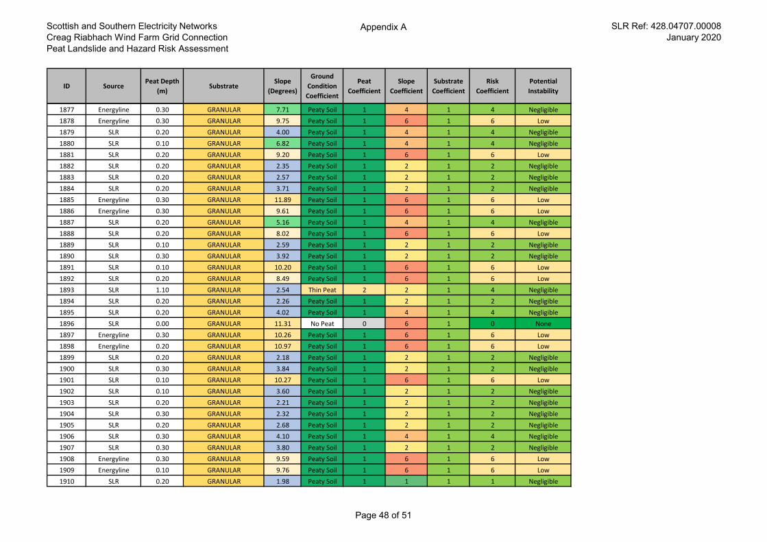
Scottish and Southern Electricity Networks
Creag Riabhach Wind Farm Grid Connection
Peat Landslide and Hazard Risk Assessment
Appendix A SLR Ref: 428.04707.00008
January 2020
ID SourcePeat Depth
(m)Substrate
Slope
(Degrees)
Ground
Condition
Coefficient
Peat
Coefficient
Slope
Coefficient
Substrate
Coefficient
Risk
Coefficient
Potential
Instability
1877 Energyline 0.30 GRANULAR 7.71 Peaty Soil 1 4 1 4 Negligible
1878 Energyline 0.30 GRANULAR 9.75 Peaty Soil 1 6 1 6 Low
1879 SLR 0.20 GRANULAR 4.00 Peaty Soil 1 4 1 4 Negligible
1880 SLR 0.10 GRANULAR 6.82 Peaty Soil 1 4 1 4 Negligible
1881 SLR 0.20 GRANULAR 9.20 Peaty Soil 1 6 1 6 Low
1882 SLR 0.20 GRANULAR 2.35 Peaty Soil 1 2 1 2 Negligible
1883 SLR 0.20 GRANULAR 2.57 Peaty Soil 1 2 1 2 Negligible
1884 SLR 0.20 GRANULAR 3.71 Peaty Soil 1 2 1 2 Negligible
1885 Energyline 0.30 GRANULAR 11.89 Peaty Soil 1 6 1 6 Low
1886 Energyline 0.30 GRANULAR 9.61 Peaty Soil 1 6 1 6 Low
1887 SLR 0.20 GRANULAR 5.16 Peaty Soil 1 4 1 4 Negligible
1888 SLR 0.20 GRANULAR 8.02 Peaty Soil 1 6 1 6 Low
1889 SLR 0.10 GRANULAR 2.59 Peaty Soil 1 2 1 2 Negligible
1890 SLR 0.30 GRANULAR 3.92 Peaty Soil 1 2 1 2 Negligible
1891 SLR 0.10 GRANULAR 10.20 Peaty Soil 1 6 1 6 Low
1892 SLR 0.20 GRANULAR 8.49 Peaty Soil 1 6 1 6 Low
1893 SLR 1.10 GRANULAR 2.54 Thin Peat 2 2 1 4 Negligible
1894 SLR 0.20 GRANULAR 2.26 Peaty Soil 1 2 1 2 Negligible
1895 SLR 0.20 GRANULAR 4.02 Peaty Soil 1 4 1 4 Negligible
1896 SLR 0.00 GRANULAR 11.31 No Peat 0 6 1 0 None
1897 Energyline 0.30 GRANULAR 10.26 Peaty Soil 1 6 1 6 Low
1898 Energyline 0.20 GRANULAR 10.97 Peaty Soil 1 6 1 6 Low
1899 SLR 0.20 GRANULAR 2.18 Peaty Soil 1 2 1 2 Negligible
1900 SLR 0.30 GRANULAR 3.84 Peaty Soil 1 2 1 2 Negligible
1901 SLR 0.10 GRANULAR 10.27 Peaty Soil 1 6 1 6 Low
1902 SLR 0.10 GRANULAR 3.60 Peaty Soil 1 2 1 2 Negligible
1903 SLR 0.20 GRANULAR 2.21 Peaty Soil 1 2 1 2 Negligible
1904 SLR 0.30 GRANULAR 2.32 Peaty Soil 1 2 1 2 Negligible
1905 SLR 0.20 GRANULAR 2.68 Peaty Soil 1 2 1 2 Negligible
1906 SLR 0.30 GRANULAR 4.10 Peaty Soil 1 4 1 4 Negligible
1907 SLR 0.30 GRANULAR 3.80 Peaty Soil 1 2 1 2 Negligible
1908 Energyline 0.30 GRANULAR 9.59 Peaty Soil 1 6 1 6 Low
1909 Energyline 0.10 GRANULAR 9.76 Peaty Soil 1 6 1 6 Low
1910 SLR 0.20 GRANULAR 1.98 Peaty Soil 1 1 1 1 Negligible
Page 48 of 51
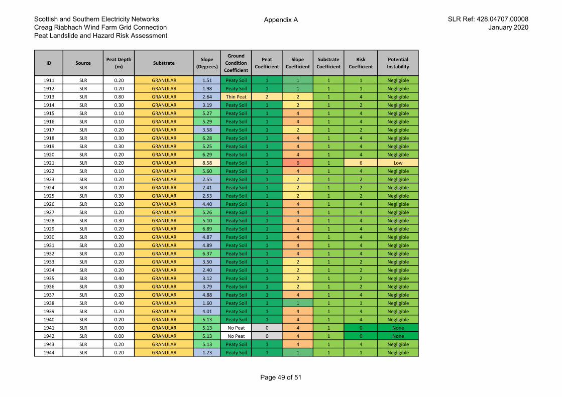
Scottish and Southern Electricity Networks
Creag Riabhach Wind Farm Grid Connection
Peat Landslide and Hazard Risk Assessment
Appendix A SLR Ref: 428.04707.00008
January 2020
ID SourcePeat Depth
(m)Substrate
Slope
(Degrees)
Ground
Condition
Coefficient
Peat
Coefficient
Slope
Coefficient
Substrate
Coefficient
Risk
Coefficient
Potential
Instability
1911 SLR 0.20 GRANULAR 1.51 Peaty Soil 1 1 1 1 Negligible
1912 SLR 0.20 GRANULAR 1.98 Peaty Soil 1 1 1 1 Negligible
1913 SLR 0.80 GRANULAR 2.64 Thin Peat 2 2 1 4 Negligible
1914 SLR 0.30 GRANULAR 3.19 Peaty Soil 1 2 1 2 Negligible
1915 SLR 0.10 GRANULAR 5.27 Peaty Soil 1 4 1 4 Negligible
1916 SLR 0.10 GRANULAR 5.29 Peaty Soil 1 4 1 4 Negligible
1917 SLR 0.20 GRANULAR 3.58 Peaty Soil 1 2 1 2 Negligible
1918 SLR 0.30 GRANULAR 6.28 Peaty Soil 1 4 1 4 Negligible
1919 SLR 0.30 GRANULAR 5.25 Peaty Soil 1 4 1 4 Negligible
1920 SLR 0.20 GRANULAR 6.29 Peaty Soil 1 4 1 4 Negligible
1921 SLR 0.20 GRANULAR 8.58 Peaty Soil 1 6 1 6 Low
1922 SLR 0.10 GRANULAR 5.60 Peaty Soil 1 4 1 4 Negligible
1923 SLR 0.20 GRANULAR 2.55 Peaty Soil 1 2 1 2 Negligible
1924 SLR 0.20 GRANULAR 2.41 Peaty Soil 1 2 1 2 Negligible
1925 SLR 0.30 GRANULAR 2.53 Peaty Soil 1 2 1 2 Negligible
1926 SLR 0.20 GRANULAR 4.40 Peaty Soil 1 4 1 4 Negligible
1927 SLR 0.20 GRANULAR 5.26 Peaty Soil 1 4 1 4 Negligible
1928 SLR 0.30 GRANULAR 5.10 Peaty Soil 1 4 1 4 Negligible
1929 SLR 0.20 GRANULAR 6.89 Peaty Soil 1 4 1 4 Negligible
1930 SLR 0.20 GRANULAR 4.87 Peaty Soil 1 4 1 4 Negligible
1931 SLR 0.20 GRANULAR 4.89 Peaty Soil 1 4 1 4 Negligible
1932 SLR 0.20 GRANULAR 6.37 Peaty Soil 1 4 1 4 Negligible
1933 SLR 0.20 GRANULAR 3.50 Peaty Soil 1 2 1 2 Negligible
1934 SLR 0.20 GRANULAR 2.40 Peaty Soil 1 2 1 2 Negligible
1935 SLR 0.40 GRANULAR 3.12 Peaty Soil 1 2 1 2 Negligible
1936 SLR 0.30 GRANULAR 3.79 Peaty Soil 1 2 1 2 Negligible
1937 SLR 0.20 GRANULAR 4.88 Peaty Soil 1 4 1 4 Negligible
1938 SLR 0.40 GRANULAR 1.60 Peaty Soil 1 1 1 1 Negligible
1939 SLR 0.20 GRANULAR 4.01 Peaty Soil 1 4 1 4 Negligible
1940 SLR 0.20 GRANULAR 5.13 Peaty Soil 1 4 1 4 Negligible
1941 SLR 0.00 GRANULAR 5.13 No Peat 0 4 1 0 None
1942 SLR 0.00 GRANULAR 5.13 No Peat 0 4 1 0 None
1943 SLR 0.20 GRANULAR 5.13 Peaty Soil 1 4 1 4 Negligible
1944 SLR 0.20 GRANULAR 1.23 Peaty Soil 1 1 1 1 Negligible
Page 49 of 51
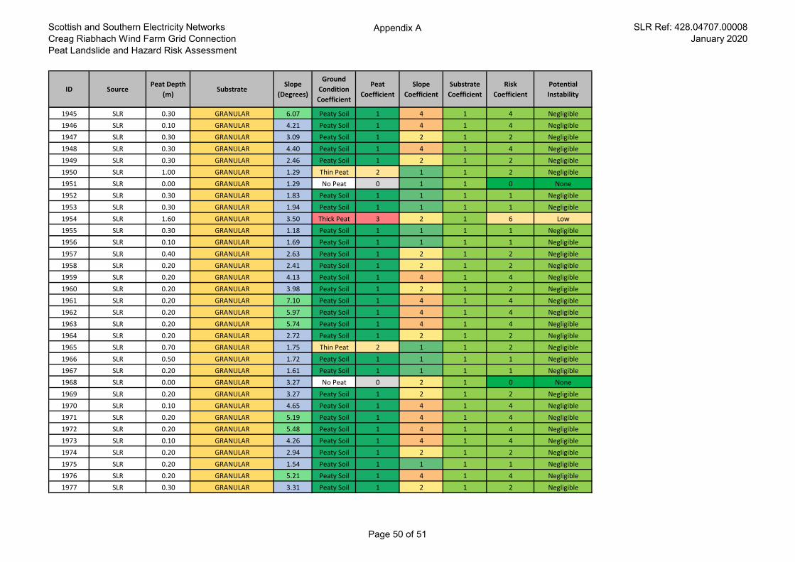
Scottish and Southern Electricity Networks
Creag Riabhach Wind Farm Grid Connection
Peat Landslide and Hazard Risk Assessment
Appendix A SLR Ref: 428.04707.00008
January 2020
ID SourcePeat Depth
(m)Substrate
Slope
(Degrees)
Ground
Condition
Coefficient
Peat
Coefficient
Slope
Coefficient
Substrate
Coefficient
Risk
Coefficient
Potential
Instability
1945 SLR 0.30 GRANULAR 6.07 Peaty Soil 1 4 1 4 Negligible
1946 SLR 0.10 GRANULAR 4.21 Peaty Soil 1 4 1 4 Negligible
1947 SLR 0.30 GRANULAR 3.09 Peaty Soil 1 2 1 2 Negligible
1948 SLR 0.30 GRANULAR 4.40 Peaty Soil 1 4 1 4 Negligible
1949 SLR 0.30 GRANULAR 2.46 Peaty Soil 1 2 1 2 Negligible
1950 SLR 1.00 GRANULAR 1.29 Thin Peat 2 1 1 2 Negligible
1951 SLR 0.00 GRANULAR 1.29 No Peat 0 1 1 0 None
1952 SLR 0.30 GRANULAR 1.83 Peaty Soil 1 1 1 1 Negligible
1953 SLR 0.30 GRANULAR 1.94 Peaty Soil 1 1 1 1 Negligible
1954 SLR 1.60 GRANULAR 3.50 Thick Peat 3 2 1 6 Low
1955 SLR 0.30 GRANULAR 1.18 Peaty Soil 1 1 1 1 Negligible
1956 SLR 0.10 GRANULAR 1.69 Peaty Soil 1 1 1 1 Negligible
1957 SLR 0.40 GRANULAR 2.63 Peaty Soil 1 2 1 2 Negligible
1958 SLR 0.20 GRANULAR 2.41 Peaty Soil 1 2 1 2 Negligible
1959 SLR 0.20 GRANULAR 4.13 Peaty Soil 1 4 1 4 Negligible
1960 SLR 0.20 GRANULAR 3.98 Peaty Soil 1 2 1 2 Negligible
1961 SLR 0.20 GRANULAR 7.10 Peaty Soil 1 4 1 4 Negligible
1962 SLR 0.20 GRANULAR 5.97 Peaty Soil 1 4 1 4 Negligible
1963 SLR 0.20 GRANULAR 5.74 Peaty Soil 1 4 1 4 Negligible
1964 SLR 0.20 GRANULAR 2.72 Peaty Soil 1 2 1 2 Negligible
1965 SLR 0.70 GRANULAR 1.75 Thin Peat 2 1 1 2 Negligible
1966 SLR 0.50 GRANULAR 1.72 Peaty Soil 1 1 1 1 Negligible
1967 SLR 0.20 GRANULAR 1.61 Peaty Soil 1 1 1 1 Negligible
1968 SLR 0.00 GRANULAR 3.27 No Peat 0 2 1 0 None
1969 SLR 0.20 GRANULAR 3.27 Peaty Soil 1 2 1 2 Negligible
1970 SLR 0.10 GRANULAR 4.65 Peaty Soil 1 4 1 4 Negligible
1971 SLR 0.20 GRANULAR 5.19 Peaty Soil 1 4 1 4 Negligible
1972 SLR 0.20 GRANULAR 5.48 Peaty Soil 1 4 1 4 Negligible
1973 SLR 0.10 GRANULAR 4.26 Peaty Soil 1 4 1 4 Negligible
1974 SLR 0.20 GRANULAR 2.94 Peaty Soil 1 2 1 2 Negligible
1975 SLR 0.20 GRANULAR 1.54 Peaty Soil 1 1 1 1 Negligible
1976 SLR 0.20 GRANULAR 5.21 Peaty Soil 1 4 1 4 Negligible
1977 SLR 0.30 GRANULAR 3.31 Peaty Soil 1 2 1 2 Negligible
Page 50 of 51
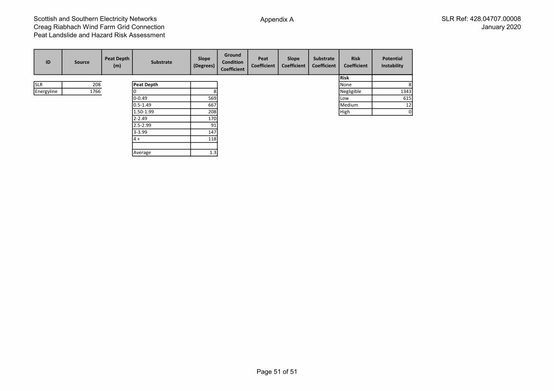
Scottish and Southern Electricity Networks
Creag Riabhach Wind Farm Grid Connection
Peat Landslide and Hazard Risk Assessment
Appendix A SLR Ref: 428.04707.00008
January 2020
ID SourcePeat Depth
(m)Substrate
Slope
(Degrees)
Ground
Condition
Coefficient
Peat
Coefficient
Slope
Coefficient
Substrate
Coefficient
Risk
Coefficient
Potential
Instability
Risk
SLR 208 Peat Depth None 8
Energyline 1766 0 8 Negligible 1343
0-0.49 569 Low 615
0.5-1.49 667 Medium 12
1.50-1.99 208 High 0
2-2.49 170
2.5-2.99 91
3-3.99 147
4 + 118
Average 1.3
Page 51 of 51

33
EUROPEAN OFFICES United Kingdom
AYLESBURY T: +44 (0)1844 337380 BELFAST T: +44 (0)28 9073 2493 BRADFORD-ON-AVON T: +44 (0)1225 309400 BRISTOL T: +44 (0)117 906 4280 CAMBRIDGE T: + 44 (0)1223 813805 CARDIFF T: +44 (0)29 2049 1010 CHELMSFORD T: +44 (0)1245 392170 EDINBURGH T: +44 (0)131 335 6830 EXETER T: + 44 (0)1392 490152 GLASGOW T: +44 (0)141 353 5037 GUILDFORD T: +44 (0)1483 889800
Ireland
DUBLIN T: + 353 (0)1 296 4667
.
LEEDS T: +44 (0)113 258 0650 LONDON T: +44 (0)203 691 5810 MAIDSTONE T: +44 (0)1622 609242 MANCHESTER T: +44 (0)161 872 7564 NEWCASTLE UPON TYNE T: +44 (0)191 261 1966 NOTTINGHAM T: +44 (0)115 964 7280 SHEFFIELD T: +44 (0)114 2455153 SHREWSBURY T: +44 (0)1743 23 9250 STAFFORD T: +44 (0)1785 241755 STIRLING T: +44 (0)1786 239900 WORCESTER T: +44 (0)1905 751310
France
GRENOBLE T: +33 (0)4 76 70 93 41