Embed Size (px)
Citation preview

Soil Dynamics and Earthquake Engineering 48 (2013) 25–34
Contents lists available at SciVerse ScienceDirect
Soil Dynamics and Earthquake Engineering
0267-72
http://d
n Corr
E-m
khamec
mahdav
capolon
journal homepage: www.elsevier.com/locate/soildyn
A time probabilistic approach to seismic landslide hazard estimates in Iran
Ali. M. Rajabi a,n, M. Khamehchiyan b, M.R. Mahdavifar c, V. Del Gaudio d, D. Capolongo d
a Civil Engineering Department, Qom University, P.O. Box 14115-175, Qom, Iranb Department of Engineering Geology, Faculty of Science, Tarbiat Modares University, Tehran, Iranc Geotechnical Engineering Research Center, International Institute of Earthquake Engineering and Seismology (IIEES), Tehran, Irand Dipartimento di Scienze della Terra e Geoambientali, Universit �a degli Studi di Bari ‘‘Aldo AMoro’’, Campus, via E.Orabona 4, 70125 Bari, Italy
a r t i c l e i n f o
Article history:
Received 30 November 2011
Received in revised form
28 August 2012
Accepted 9 September 2012Available online 28 February 2013
61/$ - see front matter & 2012 Elsevier Ltd. A
x.doi.org/10.1016/j.soildyn.2012.09.005
esponding author.
ail addresses: [email protected], amrajabi@
[email protected] (M. Khamehchiyan),
[email protected] (M.R. Mahdavifar), [email protected]
[email protected] (D. Capolongo).
a b s t r a c t
Understanding where seismically induced landslides are most likely to occur is crucial in land use
planning and civil protection actions aimed at reducing property damage and loss of life in future
earthquakes. For this purpose an approach proposed by Del Gaudio et al. [1] has been applied to the
whole Iranian territory to provide the basis to assess location and temporal recurrence of conditions of
seismic activation of slope failures, according to the Newmark’s model [2]. Following this approach,
occurrence probabilities for different levels of seismic shaking in a time interval of interest (50 years)
were first obtained through a standard hazard estimate procedure. Then, empirical formulae in the
form proposed by Jibson et al. [3] and calibrated for the main seismogenic Iranian regions were used to
evaluate the slope critical acceleration (Ac)x for which a prefixed probability exists that, under seismic
shakings, Newmark’s displacement DN exceeds a threshold� corresponding to landslide triggering
conditions. The obtained (Ac)x values represent the minimum slope resistance required to limit the
probability of landslide seismic triggering within the prefixed value. A map reporting the spatial
distribution of these values gives comparative indications on regional different exposure of slopes to
shaking capable of inducing failures and provides a reference for hazard estimate at local scale. The
obtained results show that the exposure to landslide seismic induction is maximum in the Alborz
Mountains region, where critical accelerations up to �0.1 g are required to limit the probability of
seismic triggering of coherent type landslides within 10% in 50 years.
& 2012 Elsevier Ltd. All rights reserved.
1. Introduction
Some of the most severe effects of earthquakes are related tothe triggering of ground-failure phenomena. The most common ofsuch phenomena are landslides that, on occasion of strong earth-quakes, can impact on property, and infrastructures, leading tolarge economic losses and fatalities. In addition, diffuse land-sliding causes interruption of roads and lifelines, which makemore problematic rescue operations and emergency managementin the earthquake aftermath.
This problem is particularly serious in areas where activeseismicity is combined with rough topographic relief as in someregion of Iran. In the recent years, several earthquakes causedmany fatalities and damages to civil facilities, e.g. the Manjil(1990), Avaj (2002), Bam (2003) and Firuzabad-e-Kojur (2004)earthquakes. In all these events a noticeable contribution to
ll rights reserved.
ymail.com (A.M. Rajabi),
niba.it (V. Del Gaudio),
damaging derived from the mobilization of a large number oflandslides. For instance, the Manjil Earthquake (Ms¼7.7) in 1999triggered catastrophic landslides that buried Fatalak village, killedmore than 130 people and cut many important road and otherlifelines, resulting in major economic disruption [4].
To improve preparedness to future earthquakes and to miti-gate their effects, land use planning should take into accountwhere slopes are likely to fail, to take measures reducing theexposure of buildings and critical facilities to the effects oflandslides (choosing properly the location of designed structuresand/or increasing slope resistance where slope failure can threa-ten the safety of existing structures).
This has motivated the development of methods for regionalscale assessment of seismically induced landslide hazard, adopt-ing simplified model, like Newmark’s model [2], to representconditions of landslide triggering in an extended area. Some ofthese methods evaluate spatial distribution of hazard for ascenario event (cf. Jibson et al. [3]), others (Del Gaudio et al. [1],Saygili and Rathje [5]) are focused on probabilistic evaluation ofrecurrence time of landslide triggering under seismic shaking.
In particular, the method proposed by Del Gaudio et al. [1]provides at regional scale the basic elements needed for local

A.M. Rajabi et al. / Soil Dynamics and Earthquake Engineering 48 (2013) 25–3426
assessment of temporal probability of earthquake induced land-slides. This technique estimates the slope resistance demand fordefined failure probability, taking into account the characteristicsof seismicity affecting the study area. Here we report an applica-tion of this technique to the Iranian area, first briefly discussingthe seismotectonic characteristics of the region and describingthe method implementation in such a context, through the use ofregional empirical formulae to predict seismic ground motion andthe consequent displacement along potential sliding surfaces. Theresulting map of slope resistance demand is then providedtogether with an example of its application to hazard estimatesfor the area of the 1990 Manjil earthquake.
2. Seismotectonic province of Iran
The Iranian plateau is characterized by the presence of activefaults, recent volcanic activity and high surface elevation alongthe Alpine earthquake belt. Tectonic studies indicate that theIranian plateau has a very high density of active and recent faults.Indeed, it is located in a tectonically active belt between twomajor plates: the Arabian plate, including Saudi Arabia, PersianGulf and the Zagros Ranges of Iran, and the Eurasian plate thatincorporates Europe, Central and East Asia, as well as the interiorIran. The tectonic activity is forced by the convergent movementsbetween these two plates, with the Arabian plate subductingbeneath the Eurasia at a rate of 3 mm/yr [6]. The collision front islocated in the region of the Zagros Mountains (Fig. 1), a NW-SEelongated belt located in the Western and South-Western part ofIran. Along its north-eastern margin the Zagros thrust fault zonerepresents the main geological frontier, separating the ArabianPlate and the Zagros Mountains from the central Iran microplate.
Earthquake data show that most activity is concentrated alongthe Zagros fold thrust belt, but intense seismicity affects also themost internal part of the country like the Central Iran plateau andthe Alborz Mountains to the north. The Zagros seismic history
Fig. 1. Map of the Iranian territory with the location of main tectonic reg
includes more frequent earthquakes but with relatively lowerseverity (magnitude up to 6) than Alborz and Central Iran, wherethe earthquakes are less frequent but with higher magnitude (upto 7.8). Thus, several regions are vulnerable to destructiveearthquakes.
The seismotectonic provinces of Iran are defined as areasbounded by geological features which mark a difference inseismic characteristics of neighboring provinces. Each provincehas a homogeneous seismic potential and uniform geologicalstructure and trends. The seismotectonic structure of Iran wasstudied by several investigators in the past. Some authors (e.g.Refs. [8–10], have suggested simplified divisions consisting ofonly nine or four regions. A more elaborated division, consistingof 23 seismotectonic provinces was suggested by Nowroozi [11].In 1996 Tavakoli [12] proposed a new model of seismotectonicprovinces based on a modified and updated catalog of large anddamaging Iranian earthquakes. It was used to assess seismichazard of the Iranian territory [13] and has been adopted in thepresent work as well.
3. Hazard evaluation
To evaluate the exposure of a region to seismic landsliding, apreliminary step consists in examining the maximum Ariasintensity Ia estimated for past earthquakes reported in seismiccatalogs, in order to verify where a deeper hazard analysis isworthwhile. These values can be compared with Ia thresholdswhich are considered dangerous for slope stability. In particular,Keefer and Wilson [14] and Harp and Wilson [15] found that 0.11and 0.32 m/s can be considered median estimates of Ia valuescapable of triggering incoherent landslides (falls, disrupted slides,and rock avalanches) and coherent landslides (slump, block slides,and slow earth flows), respectively.
The earthquake catalog of the Iranian International Institute ofEarthquake Engineering and Seismology (IIEES) was used to
ions: Zagros thrust fault zone, Alborz Mountains and Central Iran [7].

Fig. 2. Maximum Arias intensities estimated for historical earthquakes. Black circles mark the location of main towns in the area. Polygons represent the boundaries of the
seismogenic zones according to [13].
A.M. Rajabi et al. / Soil Dynamics and Earthquake Engineering 48 (2013) 25–34 27
estimate maximum Arias Intensity for Iran territory. This catalogincludes earthquakes occurred from 1900 to 2007 with magni-tude (Ms) between 3.1 and 7.7, the maximum corresponding tothe Manjil (1990) earthquakes. The Ia values were calculated byapplying two distinct attenuation relationships for the Alborz–Central Iran and Zagros regions:
logIa ¼�3:880þ0:810M�log R�0:002R ð1Þ
Alborz–Central Iran [16]
logIa ¼�2:660þ0:601M�log R�0:011R ð2Þ
Zagros [17](with M¼magnitude and R¼epicentral distance in km).The map of maximum Ia estimated for Iran (Fig. 2) shows that
almost the entire Iranian territory experienced values larger thanthe Keefer and Wilson threshold for incoherent landslides. Themaximum (3.5 m/sec) was in the Alborz region near the town ofRasht, and is related to the 1990 Manjil earthquake (Ms¼7.7).
A map like that in Fig. 3 does not provides information on thetime recurrence of events capable of triggering landslides. Thiscan be evaluated by applying the Cornell [18] method to Ariasintensity to calculate the probability that Ia values exceed Keeferand Wilson [14] landslide triggering thresholds. For this purposewe used:
1.
the Iran seismogenic zonation defined by [13]; 2. the seismicity rate of each zone derived by the same authors; 3. the attenuation relationships (1) and (2) reported above.The code SEISRISK III [19] was used to calculate the probabilitythat Ia exceed 0.32 and 0.11 m/sec in 50 yr.
The results obtained (Fig. 3) show that the consideration of theevent time recurrence leads to a hazard spatial distributiondifferent from that based on historical maximum shaking alone.
The highest probabilities of exceedance of landslide triggeringthresholds are in the Alborz region, which generates moreenergetic events than the Zagros region. Apart from some
southern coastal regions, probability exceeds 10% in most partof the country.
The maps of probability of Ia threshold exceedance, like thosein Fig. 3, are a rather rough representation of seismic-landslidehazard because the Ia thresholds considered are expressed bymedian values of shaking level causing slope failures: in the caseof a specific slope the actual triggering threshold depends onslope characteristics, but the relation between such characteris-tics and the Ia triggering threshold has not been explicitly defined.Instead conditions for slope failure triggering have been proposedin terms of a different parameter, the Newmark displacement DN,representing the permanent displacement expected along apotential slide surface, for which relations connecting it both toshaking level and slope characteristic were reported in literature.Thus, a more immediate evaluation of the connection betweenseismic shaking and its effects on slope stability can be obtainedby using such relations. Indeed this was the approach followed bya method proposed by Del Gaudio et al. [1]. It is based on theNewmark [2] model, which provides an estimate of permanentdisplacement (‘‘Newmark Displacement’’ DN) along a potentialsliding surface, and assumes the hypothesis that the exceedanceof critical values of DN defines conditions for landslide triggering.In particular, according to [20], critical values for coherent andincoherent landslides are 10 cm and 2 cm, respectively.
The method proposed by Del Gaudio et al. [1], calculates thecritical acceleration (Ac)x required for a slope to limit within aprefixed threshold (e.g. 10% in 50 years) the probability that DN
exceeds a critical values x under the action of the seismicity of thesurrounding regions. This critical acceleration is thus representa-tive of the maximum slope resistance demand required by theregional seismicity to keep seismic failures within the selectedprobability limit. The procedure to calculate (Ac)x consists in thesteps described below:
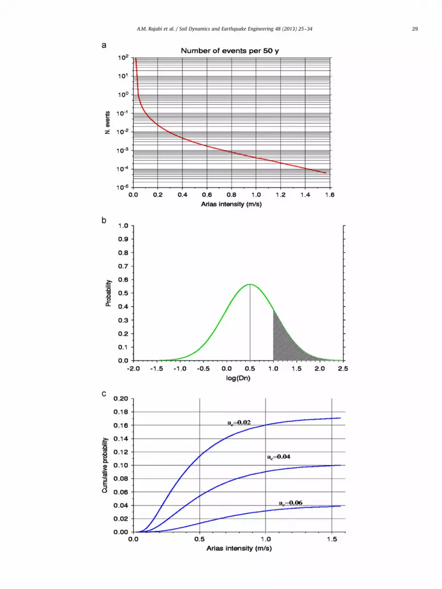
Through the Cornell [18] method, probabilities are calculatedthat shakings of any possible value of Ia occur in 50 years at agiven site (Fig. 4a).
Through relations linking DN to Ia and to critical acceleration ac
(see [3]), probability that DN exceeds a critical threshold x

Fig. 3. Probability that in 50 yr Arias intensities exceed 0.32 (a) and 0.11 m/s (b). These values correspond to the critical thresholds for the triggering of coherent (slumps,
block slides, slow earth flows) and incoherent landslides (falls, disrupted slides, avalanches), respectively, according to [14].
A.M. Rajabi et al. / Soil Dynamics and Earthquake Engineering 48 (2013) 25–3428
(e.g. 10 cm for coherent landslides) is calculated for any Ia valueand for a fixed ac. For the study area we used:
logDN ¼ 1:087logIa�7:176acþ1:39870:397 ð3Þ
(for Alborz-Central Iran, [16])
logDN ¼ 1202logIa�1:585logac�1:45470:358 ð4Þ
Fig. 4. Steps in the evaluation of (Ac)x: (a) calculation of the number of events expected t
exceeds a critical threshold (e.g. 10 cm) for a fixed combination of critical acceleration an
median provided by empirical relations; (c) calculation of the cumulative probability th
iteration of this calculation for different fixed ac values, until the value is found that ma
(for Zagros region, [21])where DN is the Newmark displace-ment in centimeter, Ia is the Arias intensity in m/s, and ac is thecritical acceleration, in gram unit (Fig. 4b).
The probability of exceedance of critical DN thresholds aresummed for all the possible Ia expected at the given site. Thiscalculation is repeated for different ac until the value (Ac)x isfound for which the total exceedance probability is the pre-fixedone (e.g. 10%) (Fig. 4c)
o cause different values of Ia at a given site; (b) calculation of the probability that DN
d Ia value, assuming that log(DN) real values follow a normal distribution around the
at DN exceeds a critical threshold, taking into account all the possible Ia values, and
kes the DN exceedance probability equal to a target value (e.g. 10% in 50 years).
A.M. Rajabi et al. / Soil Dynamics and Earthquake Engineering 48 (2013) 25–34 29

Fig. 5. Values of (Ac)10 (a) and (Ac)2, (b) for which 10% probability in 50 yr exists that DN exceeds 10 cm and 2 cm, respectively. The thick quadrangle shows the study area
discussed in Section 4.
A.M. Rajabi et al. / Soil Dynamics and Earthquake Engineering 48 (2013) 25–3430
Fig. 5 shows the spatial distribution obtained for (Ac)10 and(Ac)2 for a 10% probability of DN threshold exceedance in 50 yr(i.e. the same probability value commonly adopted in interna-tional building codes as reference for hazard estimates and asdesign ground acceleration: e.g. see Eurocode 8). These criticalacceleration values provide, in each point, the slope resistancerequired by regional seismicity for a slope not to fail with thedefined probability, according to the Newmark model, for the caseof coherent (DN410 cm) and incoherent (DN42 cm) landslides,respectively.
Considering Fig. 5, many areas show (Ac)x values less than0.05 g. Wilson and Keefer [20], proposed 0.05 g as a minimumthreshold of critical acceleration to characterize slopes
susceptible to seismic landsliding because lower values of criticalacceleration would imply such an unstable condition that anactivation of landslides by other more frequent non-seismiccauses is more probable. On this base, examining Fig. 5, whereasmost of the Iranian territory appears exposed to seismic condi-tions that can determine seismic triggering of incoherent land-slides (Fig. 5b), the hazard of seismically induced landslides ofcoherent type seems to concern only the northernmost part of thecountry (Fig. 5a).
However it should be taken into account that the criticalacceleration 0.05 g threshold proposed by Wilson and Keefer isbased on observations mainly carried out in California and maynot be valid elsewhere. For instance Del Gaudio and Wasowski

A.M. Rajabi et al. / Soil Dynamics and Earthquake Engineering 48 (2013) 25–34 31
[22] examining data for an area of southern Italy (Irpinia) foundthat a considerable number of marginally stable slopes, withcritical acceleration less than 0.05 g, appear to have failed asconsequence of relatively weak seismic shaking. This can dependon particular local hydrogeological and climatic conditions. Forinstance one can expect that in arid area, where slopes are lessfrequently exposed to significant meteoric events; numerousslopes close to instability conditions can survive failures forlong time.
4. Application to a case study
The spatial distribution of the calculated (Ac)x values can becompared with the actual in situ ac values of specific slopes toestimate whether these slopes have a significant probability offailing under seismic action in the future. As example of applica-tion of large scale (Ac)x mapping to local estimates of seismiclandslide hazard and as validation test, we used an area affectedby the 1990 Manjil earthquake. (Fig. 6) shows the intensity mapof the 1990 Manjil earthquake (Ms¼7.7). This earthquakeoccurred on 20 June, 1990 (time origin 21:00:09) in the easternpart of the Alborz mountains (epicentral coordinates 36.961N,49.141E) at a hypocentral depth of 18 km (data derived from theUSGS web site [23]). The Manjil earthquake induced 120 largelandslides and many rock-falls in the epicentral area and in thevicinity of the earthquake fault [24]. Documented landslides aremostly those large enough to be located, and the inventory of rockfalls and small slides triggered by this earthquake is likely to beincomplete. To test the hazard estimate approach, we selected theCholkasar and Chaharmahal quadrangles (including 51 land-slides), which cover southeastern part of the area affected bythe Manjil earthquake. The inventoried landslides have sizeranging between 0.30 and 1.40 km2 and their average depth is3.5 m.
Being the adopted approached based on the Newmark model,the critical acceleration ac of potential sliding surface needs to beestimated at each point of the studied area. It can be determinedfrom the static factor of safety and from the slope geometry,
Fig. 6. Intensity map of Manjil earthquake [10]; the star shows the epice
assuming planar slip with sliding surfaces approximately parallelto local slope [25]. If loss in shear resistance during shaking can beneglected, the critical acceleration ac, expressed in gravity unit,can be derived from
ac ¼ Fs�1ð Þgsin a ð5Þ
where Fs is the static factor of safety, and a (thrust angle) is theangle between the slip direction of the center of mass and thehorizontal [26]. For the simplest model of an infinite slope, thestatic factor of safety can be expressed as:
FS ¼c0
gtsin aþ 1�m
gW
g
� �tan j0
tan að6Þ
where c0 is the effective cohesion, j0 is the effective angle ofinternal friction, g is the material unit weight, t is the slope-normal thickness of the failure slab, and m is the proportion of t
that is saturated [3].The used data include, (1) an inventory of triggered landslides
during Manjil earthquake [4], (2) geotechnical parameters ofgeologic units (including cohesion and friction angle), (3) detailed(1:25,000-scale) geological mapping of the region, (4) high-resolution digital elevation models of the topography. All of thesedata sets have been digitized and rasterized at 30 m grid spacingusing ARC/INFO geographic information system. Digital geologicalmaps of the study area overlaid by inventory of triggered land-slides are illustrated in Fig. 7.
The slope map was produced by applying a simple algorithmto the DEM that compares the elevations of adjacent cells andcomputes the maximum slope (Fig. 8).
Representative shear strength values for geological units havebeen selected based on the work by Mahdavifar [4]: he estimatedgeotechnical parameters for the region using the GeologicalStrength Index (GSI), extending the results of estimates to similargeological units (such as [3,27,28]. Table 1 shows cohesion,friction angle and unit weight values for the study area. Forsimplicity, m and t (see Eq. (6)) are taken to be 0 and 3.5,respectively, i.e. dry conditions were assumed and depth ofpotential sliding surfaces were uniformed to the average value
nter of the earthquake; the thick quadrangle shows the study area.

Fig. 7. Geological units overlaid with the landslide inventory of the study area (see Table 1 for unit definition and properties).
Fig. 8. Slope map derived from DEM overlaid with the landslide inventory of the study area.
A.M. Rajabi et al. / Soil Dynamics and Earthquake Engineering 48 (2013) 25–3432
of those observed for the area of the Alborz Mountains andCentral Iran [29].
Finally, combining in the GIS the information reported by thelayer of strength and slope angle parameters and using Eqs.(5) and (6) the critical acceleration (ac) at each pixel of the studyarea was calculated.
Since the majority of landslides in study area are of coherenttype, the attention was focused on the threshold of these land-slides. Then we compared the (Ac)10 values obtained by probabil-istic approach for this area (the thick quadrangle illustrated inFig. 5a) with actual in-situ ac values of slopes in the same region.According to Fig. 5a the (Ac)10 maximum values for this area is

A.M. Rajabi et al. / Soil Dynamics and Earthquake Engineering 48 (2013) 25–34 33
0.11 g. The location of slopes with aco0.11 g (red areas in Fig. 9)was then compared with the spatial distribution of major land-slides of coherent type triggered by the Manjil earthquake (greenareas in Fig. 9).
In this comparison one should consider that (Ac)10 does notprovide predictions for a single event but allows to estimate slopebehavior on mid-long term. Despite the ‘‘red area’’ represents asmall percentage of total areas (�7.5%), a much larger percentageof Manjil earthquake landslides have their detachment zones inthe red areas (�35%).
It should be however noted that a considerable number oflandslides occurred also outside the ‘‘red zone’’, especially oneslocated in the north-western corner of map (Fig. 9). These land-slides were triggered by the Manjil earthquake despite the factthat slope critical acceleration provided by the GIS is quite high sothat a priori evaluation would have evaluated such areas notparticularly prone to seismic landslide hazard. The most ofgeological units affected in this area are quaternary deposits(Fig. 8 and Table 1) and slope angles have a maximum value of
Table 1Shear strength assigned to geologic units in the two quadrangles of study area [4].
Label Geologic unit C0 (Kpa) j1 g (g/cm3)
An Andesitic-Basaltic subvolcanic masses 150 52 2.6
Eat Dasit-Andesitic tuffs and conglomerate(?) 20 17 2.6
Ec Conglomerate 70 39 2.5
Ect Dasit-Andesitic tuffs 20 20 2.6
El Gray limestone and tuffs 100 44 2.5
Evp Dasit-Andesitic tuffs 20 17 2.2
gb Gabbro, Olivine Gabbro 250 59 2.8
Jkl Fossiliferous limestone 300 48 2.5
Jvt Andesit-Basaltic volcanics and tuffs 50 31 2.6
Kl1 Limestone 300 48 2.7
Km-2 Altered limestone, marl, sandstone 30 22 2.7
Pl-r Gray,thick to medium bedded limestone 30 22 2.5
Ps-d Shale and sandstone 30 22 2.2
Qt Young terrace and alluvium 20 34 1.96
TRjsh-s Shale and sandstone 70 39 2.4
Fig. 9. Distribution of landslides triggered by Manjil earthquake. Red areas shows whe
figure, the reader is referred to the web version of this article.)
491. Relative cohesion and friction angle for quaternary depositsin the region are 20 Kpa and 341, respectively.
For this area hazard appear to be underestimated by theadopted procedure. Factors that could be responsible for suchunderestimation are: (i) errors in geotechnical parameter values,(ii) inadequacy of Newmark model for local particular conditionsand (iii) missing consideration of site amplification effects.
The uncertainties affecting the geotechnical parameters are apotential major cause of errors when hazard estimations at basinscale are carried out (see Refs. [30,31,32]). The problem of represen-tativeness of geotechnical parameters and of their spatial variability,which is present even modeling the response of a specific slope toseismic shaking, is exacerbated in basin scale studies when a singlevalue of each parameter needs to be assigned to each classifiedgeologic unit. A probabilistic treatment of uncertainties can mitigateerrors [30], but when a comparison with real data points out ananomaly in hazard estimate, this should suggest a revision of basicinput data to evaluate their adequacy to represent local conditions,modifying them if it is the case.
An epistemic uncertainty is involved instead when conditionsoccur that are not well represented by the Newmark model as incase of deep seated landslides or of failures caused by theliquefaction of thin interbedded layers. Where a potential of suchkind of conditions is recognized, site specific investigation shouldbe conducted and the results of more adequate numericalsimulation should replace the results of hazard estimate obtainedthrough the simplified Newmark model.
Finally, with regard to the possible influence of site amplifica-tion, it was observed that it can considerably influence the slopesusceptibility to seismic failures [32]. These effects can be takeninto account increasing properly the employed shaking parameterby an amplification factors. Some methods have been proposed tocalculate such a factor within a GIS for the case of topographicamplification [33,34], whereas a simplified method accounting forstratigraphic amplification is not available yet and, if its occur-rence is suspected, site specific numerical simulation should becarried out to determine local amplification factors. In any casesthe use of Newmark model should be considered just as a
re actual ac is smaller than (Ac)10. (For interpretation of references to color in this

A.M. Rajabi et al. / Soil Dynamics and Earthquake Engineering 48 (2013) 25–3434
preliminary screening approach that can be applied to very largescale: the comparison between the distribution of landslidetriggered by recent earthquakes and the areas that, according tothe Newmark model, are exposed to significant seismic landslidehazard can be useful to draw the attention on areas where may bedifferent slope failure mechanisms operate and that require to bemore investigated for a reliable hazard assessment.
5. Conclusions
The representation of expected seismic shaking through aparameter such as (Ac)x gives a reference for a direct comparisonwith slope critical acceleration (which is a common measure oftheir stability). The application of this method to Iran indicatesthat the highest levels of seismic-landslide hazard is in thenorthern part of the country, which is particularly exposed tothe effects of the less frequent but more energetic seismic activityof the Alborz zone: here ac values up to �0.1 g are required tocontain the probability of occurrence of seismically inducedlandslides within the limits (10% in 50 years) considered accep-table in seismic risk assessment related to ordinary buildingdamaging.
For an area affected by the 1990 Manjil earthquake, thecalculation of critical acceleration ac of slopes through GIS toolsshowed that a small area (less than 10%) where ac is less than thelocal (Ac)10 value includes more than 1/3 of all the coherent typelandslides triggered by that earthquake. However, the observationof numerous landslides occurred also outside the zones marked asprone to seismic landsliding points out some problems of methodapplication at regional scale hazard assessment, i.e.: (1) theadequacy of representation of spatial variability of geotechnicalparameters; (2) the presence of landslide triggering mechanisms(e.g. liquefaction phenomena) on low angle slopes that cannot beadequately represented by the Newmark model; and (3) thepossible occurrence of site amplification effects.
Thus a comparison of regional hazard maps based on New-mark models with landslide distribution of recent earthquakescan be useful to focus the attention on areas affected by particularconditions, both in terms of slope material properties and offailure mechanisms, which need to be investigated at local scalefor a more reliable hazard assessment.
Acknowledgment
The authors would like to thank Dr. J. Wasowski for theinsightful comments and useful suggestions.
References
[1] Del Gaudio V, Wasowski J, Pierri P. An approach to time probabilisticevaluation of seismically-induced landslide hazard. Bulletin of the Seismolo-gical Society of America 2003;93:557–69.
[2] Newmark NM. Effects of earthquakes on dams and embankments. Geotech-nique 1965;15:139–60.
[3] Jibson RW, Harp EL, Michael JA. A method for producing digital probabilisticseismic landslide hazard maps: an example from the Los Angeles, California,area. Golden, Colorado: U.S. Geological Survey Open-File Report; 1998. p.98–113, [17 p.].
[4] Mahdavifar MR. Analytical evaluation and design of the system (GIS) forseismic landslides hazard management in Iran. PhD thesis. InternationalInstitute of Earthquake Engineering and Seismology; 2006 [in Persian].
[5] Saygili G, Rathje EM. Probabilistically based seismic landslide hazard maps:an application in Southern California. Engineering Geology 2009;109:183–94.
[6] De Mets C, Gordon RG, Argus DF, Stein S. Current plate motions. GeophysicalJournal International 1990;101:425–78.
[7] Sinaiean F. A study on the strong ground motions in Iran (from catalog toattenuation relationship). PhD thesis. International Institute of EarthquakeEngineering and Seismology; 2006.
[8] Stocklin J. Structural history and tectonics of Iran, a review. Bulletin of theAmerican Association of Petroleum Geologists 1968;52:1229–58.
[9] Takin M. Iranian geology and continental drift in the Middle East. Nature1972;235(5334):147–50.
[10] Berberian M. Contribution to the seismotectonic of Iran (Part II). GeologicalSurvey of Iran 1976;39:570 Rep. NO.
[11] Nowroozi A. Seismotectonic provinces of Iran. Bulletin of the SeismologicalSociety of America 1976;66:1249–76.
[12] Tavakoli B. Major seismotectonic provinces of Iran. Internal report. IranianInternational Institute of Earthquake Engineering and Seismology (IIEES); 1996.
[13] Tavakoli B, Ghafory-Ashtiany M. Seismic hazard assessment of Iran. Annali DiGeofisica 1999;42(6):1013–21.
[14] Keefer DK, Wilson RC. Predicting earthquake-induced landslides, withemphasis on arid and semi-arid environments. In: Sadler PM, Morton DM,editors. Landslides in a Semi-Arid Environment, 2. Inland Geological Society;1989. p. 118–49.
[15] Harp EL, Wilson RC. Shaking intensity thresholds for rock falls andslides—evidence from 1987 Whittier Narrows and superstition hills earth-quake strong-motion records. Bulletin of the Seismological Society ofAmerica 1995;85:1739–57.
[16] Mahdavifar MR, Jafari MK, Zolfaghari MR. The attenuation of Arias intensityin Alborz and Central Iran. In: Proceedings of the 5th international con-ference on seismology and earthquake engineering. Tehran, Iran; 2007.
[17] Rajabi A, Khamechian M, Mahdavifar MR, Del Gaudio V. Attenuation relationsof Arias intensity for Zagros Mountains Region (Iran). Soil Dynamics andEarthquake Engineering 2010;2010(30):110–8.
[18] Cornell CA. Engineering seismic risk analysis. Bulletin of the SeismologicalSociety of America 1968;58:1583–606.
[19] Bender B, Perkins DM. SEISRISK III: a computer program for seismic hazardestimation, U.S. Geological Survey, Bulletin 1772;1987:48.
[20] Wilson RC, Keefer DK. Predicting the areal limits of earthquake-inducedlandsliding. In: Ziony JI, editor. Evaluating Earthquake Hazards in the LosAngeles Region—An Earth Science Perspective.U.S. Geological Survey Profes-sionsl Paper, 1360; 1985. p. 316–45.
[21] Rajabi AM, Mahdavifar MR, Khamehchiyan M, Del Gaudio V. A new empiricalestimator of coseismic landslide displacement for Zagros Mountains Region(Iran). Natural Hazards 2011;59:1189–203.
[22] Del Gaudio V, Wasowski J. Time probabilistic evaluation of seismicallyinduced landslide hazard in Irpinia (Southern Italy). Soil Dynamic andEarthquake Engineering 2004;24:915–28.
[23] USGS Homepage. Earthquake Hazard Program, Earthquake Center. /http://neic.usgs.gov/neis/epic/epic.htmlS.
[24] Komak Panah A, Hafezimoghadas N. Landslides hazard zonation in Iran.International Institute of Earthquake Engineering and Seismology (IIEES)1995;2:10–7.
[25] Jibson RW. Predicting earthquake-induced landslide displacement using New-mark’s sliding block analysis, transportation research record 1411. Washing-ton, D.C.: Transportation Research Board, National Research Council; 1993.
[26] Miles SB, Ho CL. Rigorous landslide hazard zonation using Newmark’smethod and stochastic ground motion simulation. Soil Dynamics and Earth-quake Engineering 1999;18(4):305–23.
[27] Wilson RC, Keefer DK. Dynamic analysis of a slope failure from the 1979Coyote Lake, California earthquake. Seismological Society of America Bulletin1983;73(3):863–77.
[28] Yassaghi A, Salari-Rad H, Kanani-Moghadam H. Geomechanical evaluation ofKaraj Tuffs for rock tunneling in Tehran-Shomal Freeway, Iran. EngineeringGeology 2005;77:83–98.
[29] Landslide Investigation Group (LIG). Landslides database of Iran, forest,range, and watershed management organization. Jihade-Keshavarzi Ministryof Iran; 2008.
[30] Mankelow JM, Murphy W. Using GIS in the probabilistic assessment ofearthquake: triggered landslide hazards. Journal of Earthquake Engineering1998;2(4):593–623.
[31] Refice A, Capolongo D. Probabilistic modeling of uncertainties in earthquake-induced landslide hazard assessment. Computers & Geosciences 2002;28(6):735–49.
[32] Capolongo D, Refice A, Mankelow J. Evaluating earthquake-triggered land-slide hazards at basin scale. The example of the upper Sele river valley.Surveys in Geophysics 2002;23:595–625.
[33] Del Gaudio V, Wasowski J. Advances and problems in understanding theseismic response of potentially unstable slopes. Engineering Geology2011;122:73–83.
[34] Lee CT, Huang CC, Lee JF, Pan KL, Lin ML, Dong JJ. Statistical approach toearthquake induced landslide susceptibility. Engineering Geology 2008;100:43–58.