Embed Size (px)
Citation preview
J. Mt. Sci. (2014) 11(5): 1308-1325 e-mail: [email protected] http://jms.imde.ac.cn DOI: 10.1007/s11629-012-2618-9
1308
Abstract: Landslides are the most common natural disaster in hilly terrain which causes changes in landscape and damage to life and property. The main objective of the present study was to carry out landslide hazard zonation mapping on 1:50,000 scale along ghat road section of Kolli hills using a Landslide Hazard Evaluation Factor (LHEF) rating scheme. The landslide hazard zonation map has been prepared by overlaying the terrain evaluation maps with facet map of the study area. The terrain evaluation maps include lithology, structure, slope morphometry, relative relief, land use and land cover and hydrogeological condition. The LHEF rating scheme and the Total Estimated Hazard (TEHD) were calculated as per the Bureau of Indian Standard (BIS) guidelines (IS: 14496 (Part-2) 1998) for the purpose of preparation of Landslide Hazard Zonation (LHZ) map in mountainous terrains. The correction due to triggering factors such as seismicity, rainfall and anthropogenic activities were also incorporated with Total Estimated Hazard to get final corrected TEHD. The landslide hazard zonation map was classified as the high, moderate and low hazard zones along the ghat road section based on corrected TEHD. Keywords: Landslide hazard zonation (LHZ); Kolli Hills; Mountainous terrain; LHEF rating scheme; Bureau of Indian Standard (BIS); TEHD
Introduction
Landslides are the downward movement of slope materials such as rocks, debris or soils due to gravitational pull. The term landslides includes varieties of movement viz. flowing, sliding, toppling or falling and combination of two or more types, which results in a complex type of slope failure (Varnes 1984). Landslide is one of the important natural disasters in the world, which causes loss of life, injuries, and damage to the properties in every year (Aleotti and Chowdhury 1999). The Government organizations and several research institutions in the world have spent considerable resources to evaluate the landslide hazards and their spatial distribution (Guzzetti et al. 1999). The landslide hazard evaluation is an important task for various interest groups such as geoscientists, planners and local administrations, essentially due to an increased awareness and the socio-economic importance of landslides (Devoli et al. 2007).
In mountainous terrain, the occurrence of landslides are influenced by various causative factors and triggered by several external factors, such as intense rainfall, earthquake shaking, water level change, storm waves and rapid stream erosion Received: 3 December 2012
Accepted: 21 March 2014
Landslide Hazard Zonation Mapping in Ghat Road Section of Kolli Hills, India
Siddan ANBAZHAGAN*, Veerappan RAMESH
Centre for Geoinformatics and Planetary Studies, Department of Geology, Periyar University, Salem – 636 011, Tamil Nadu, India
* Corresponding author, e-mail: [email protected]; Phone: +91-427-2346203; Special Field of Interests: Remote Sensing, GIS, Disaster Mapping, Groundwater exploration, Planetary Remote Sensing
Second author, e-mail: [email protected]; Special Field of Interests: Remote Sensing, GIS, Landslide Mapping and Mitigation
Citation: Anbazhagan S, Ramesh V (2014) Landslide hazard zonation mapping in Ghat road section of Kolli Hills, India. Journal of Mountain Science 11(5). DOI: 10.1007/s11629-012-2618-9
© Science Press and Institute of Mountain Hazards and Environment, CAS and Springer-Verlag Berlin Heidelberg 2014
J. Mt. Sci. (2014) 11: 1308-1325
1309
etc., (Naranjo et al. 1994; Dai et al. 2002). In addition, the human intervention on hill slope for construction of roads, urban expansion, deforestation, and rapid changes on land use practice contribute to slope instability (Das et al. 2011). Landslide susceptibility refers to the probability of occurrence of landslide in an area based on the correlation between causative factors and spatial distribution of landslides (Brabb 1984). Landslide susceptibility mapping involves the classification and spatial distribution of past and probable landslides in the study area and describes the distance and intensity of the existing or probable landsliding to assess the potential areas for future landsliding, but the frequency or timing will not be specified (AGS 2007; Anderson and Holcombe 2013). Landslide hazard is the probability of a landslide occurrence of a certain type and magnitude occurring at a specified location within a given period of time. Landslide hazard zonation mapping involves the demarcation of homogeneous areas of varying hazard levels and ranking of those areas based on degrees of actual or potential damage (Varnes 1984). Landslide hazard zonation map depicts stable and unstable areas of landslide incidence, which can be used for developmental activities and exploitation of natural resources in an area (Varnes 1981). It serves as a base for better land use planning and the development of suitable remedial measures (Bhandari 1987).
A number of methods and techniques have been proposed for landslide hazard zonation mapping. The choice of type and scale of the map depends on the requirements of the end user and the purpose of the investigation. Landslide hazard mapping may be qualitative or quantitative, and direct or indirect (Guzzetti et al. 1999). Qualitative methods are subjective, and they depict the hazard levels in descriptive terms, whereas, the quantitative methods generate numerical evaluation of the occurrence of landslide phenomena. In direct method, mapping of landslides involves field studies, interpretation of aerial photographs and other methods (Verstappen 1983). The expert uses the knowledge and experiences to map actual or potential landslide hazard. Indirect method involves the recognition and mapping of landslides and the identification of factors, which are directly or indirectly influencing
the slope instability in a region. This method then evaluates the relative contribution of instability factors in the occurrence of slope failure and the classification of an area into zones of varying hazard potential (Hansen 1984).
The distribution analysis is a direct mapping of landslide features resulting in a map, which provides information only for those sites where landslides have occurred in the past (Wieczorrk 1984; van Westen 2000). Qualitative analysis is a direct or semi-direct method, in which the geomorphological map is re-numbered into a hazard map, or in which a number of terrain maps are combined to produce hazard map using subjective knowledge of the earth scientist (Kienholz et al. 1984; McKean et al. 1991; Yesilnacar and Suzen 2006). Statistical analysis uses indirect methods to obtain predictions of the relative landslide hazard maps from a numerical parameter maps (Yin and Yan 1988; Gupta and Joshi 1990; Carrara et al. 1991; Wang and Unwin 1992; Pachauri and Pant 1992; Sarkar et al. 1995; Mark and Ellen 1995; Chung and Fabbri 1999; Lee et al. 2002; Ayalew et al. 2004). The statistical approach is based on the supposition that future landslides will be more likely to occur under conditions similar to those of past landslides (Varnes 1984; Brabb 1984). The deterministic approach uses indirect methods, in which parameter maps are combined in slope stability calculations to produce absolute hazard maps (Skempton and Delory 1957; Okimura 1982; Okimura and Kawatani 1986; Mostyn and Fell 1997). Numerical analyses were carried out for landslide assessment by several workers (Singh et al. 2012; Ahmad et al. 2013). The empirical hazard is evaluated from past and active landslide data by investigating relationships between slope angle and relief (Zika et al. 1988). The monitored and empirical hazards require continuous, long-term data on the landslides and their causative factors under similar environmental conditions. These data are often unavailable (Dhakal et al. 2000).
To overcome the limitations of subjectivity in qualitative approaches and more objectivity in statistical approaches, distribution-free methods such as Fuzzy Set based approaches (Lee 2007; Srivastava et al. 2010), Artificial Neural Network (ANN) approaches (Arora et al. 2004; Yilmaz 2009) and combined neural and fuzzy approaches
J. Mt. Sci. (2014) 11: 1308-1325
1310
(Kanungo et al. 2006) have been used to prepare landslide susceptibility maps (Kanungo et al. 2009). In contrast to methods based on the information derived from remote sensing data and the available maps of topography, geology, etc., a more refined landslide susceptibility mapping method based on extensive field studies can be meaningfully applied to a reasonably small area (Sarkar and Anbalagan 2008). Anbalagan (1992) proposed a quantitative approach developed mainly based on conventional field surveys on the basis of major causative factors of slope instability at Himalaya, adopting a LHEF rating scheme.
Many researchers have carried out the landslide hazard zonation mapping on the basis of LHEF rating scheme on different scales using rating of number of parameters with some revision for different terrains (BIS 1998). Macro-zonation of landslide hazard is generated for Chamba District of Himachal Pradesh based on the numerical weightage to the prime causative factors of slope instability viz. lithology, structure, slope morphometry, relative relief, land use and groundwater conditions as per the scheme approved by Bureau of Indian standard (Sharma 2008). Regional landslide hazard zonation maps of Srinagar-Rudraprayag area of Garhwal Himalaya in the state of Uttarakhand prepared using subjective and objective approaches and compared to the macro level LHZ map prepared using LHEF rating scheme (Sarkar and Anbalagan 2008). Regional scale LHZ mapping technique has been adopted to include more detailed aspects of inherent causative factors and also incorporates effects of external causative factors such as rainfall and seismicity as correction ratings (Anbalagan et al. 2008). Macro-zonation map of landslide susceptibility is also generated for Garamaura-Swarghat section of National Highway-21, India on 1:50,000 scale (Sharma and Mehta 2012). Similar kind of studies were carried out for ghat section of Yercaud hill slopes (Saranathan et al. 2010), Bodi-Bodimettu ghat section (Kannan et al. 2011), and Kodaikanal hills (Saranathan et al. 2012) in the state of Tamil Nadu, India. Based on the integration of qualitative and quantified weightages given to each factor at each grid, a micro-hazard zonation map of the area has been prepared for guiding the remedial actions required for preventing the landslides (Kishor Kumar et al.
2012). In the present study, the scientific guidelines
provided by Bureau of Indian Standards (BIS) for landslide hazard zonation mapping in mountainous terrain at medium scale (1:50,000) were used (BIS 1998). The guidelines were originally proposed by Anbalagan (1992), which suggest indirect heuristic (knowledge-driven) method to landslide hazard zonation mapping. The guidelines provide specified ratings to a set of pre-defined factors. Those ratings are called LHEF ratings. The LHEF rating scheme is based on subjective knowledge specified by a group of experts in landslide research (Anbalagan 1992). The LHEF rating scheme applicable irrespective of variations in terrain conditions and is determined without directly considering the existing landslide inventory maps (Ghosh 2011). The Kolli hills ghat road section covers small aerial extent, where the BIS technique is more relevant to assess the causative factors by conventional field manual surveys. The LHEF rating has taken care of most of the causative factors which controls the landslide occurrences in the study area. Moreover, for macro-landslide hazard zonation mapping (small scale), LHEF is the appropriate method to deal most of the terrain parameters. However, LHEF rating scheme may have limitation for large scale mapping where additional input may be required. Similarly, it is difficult to establish the geological, structural measurements in a highly rugged terrain, where an alternative approach may be required. The present landslide hazard zonation mapping for Kolli hills is the first scientific procedure adopted for this ghat road section. The main purpose of the study is to assess the landslide hazard along the ghat road section and it will be useful for the planners and decision makers.
1 Study Area
Kolli hills is one of the important tourist spots in Tamil Nadu situated in the tail end of the Eastern Ghats in Namakkal district of Tamil Nadu, India. The Kolli hills cover an area of 283 km2 with an elevation ranges between 1000 m to 1390 m above mean sea level (MSL). It has mild climate and the place is known for herbal cultivation. The region of Kolli hills became taluk (administrative
J. Mt. Sci. (2014) 11: 1308-1325
1311
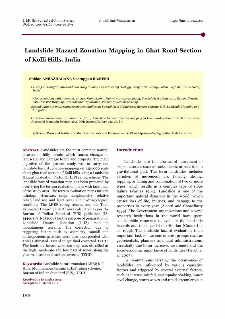
boundary) recently and the total population during 2001 was 63,888, in 14 villages located on the hills (Francis et al. 2011). The temperature is varying from 13°C to 30°C. The average annual rainfall in the study area is 1497 mm, out of which NE monsoon (Oct-Dec) contributes 619 mm rainfall. The ghat road with length of 20 km across 70 hairpin bends, connects the foot hills at Karavallikkombai to Sholaikkadu at top of the hill is considered for the present study (Figure 1). Naturally, this requires a number of cut slopes along the hilly terrain. The area fall in between 11°18'29.72"N and 11°19'50.38"N latitudes and 78°19'30.99" E and 78°21'6.49"E longitudes. The Survey of India (SOI) topographical map 58 I/7 cover the study area. This ghat road is the main route at present to reach the Kolli hills and it is aligned in the western slope of Kolli hills.
The major cause for slope instability is the heavy rainfall, particularly during NE monsoon period. Anbazhagan et al. (2008) observed that developments of fractures and land subsidence in
the south-eastern part of Kolli hills due to modification of natural slope and drainage for cultivation indicating the frequent slope failure. The landform, rainfall, weathering processes, deforestation, soil erosion, cut slope, structure, human intervention in the form of construction and widening of roads and leveling of lands for cultivation are the common causative and triggering factors for slope failures. Landslips, rock fall and debris slide are the common type of slope failures in the ghat road section.
1.1 Geological setting
The Charnockite group, consists of charnockites, pyroxene granulite, banded quartz-magnetite granulite, Banded Magnetite Quartzite and pink quartzo-felspathic granulites are widely developed in the north-eastern part of Tamil Nadu state. These groups of rocks are well exposed in many prominent hill ranges such as Pallavaram-Chengleput, Javadi, Shevaroy, Chitteri, Kalrayan,
Figure 1 Location map of Kolli hills ghat road section, embedded over IRS P6 LISS IV Satellite Data.
J. Mt. Sci. (2014) 11: 1308-1325
1312
Kollimalai (Kolli hills), Pachchaimalai and Nilgiri. Kolli hills is a residual plateau topped by charnockitic hill situated in the central part of the state of Tamil Nadu surrounded by pediments and pediplains. Mafic dykes are trending ENE-WSW and NE-SW directions and transecting the charnockites and migmatites in Kolli hills. Smaller bands of iron ore are identified in Kolli hills. Laterite associated with reddish brown ferruginous clayey soil caps on the crystalline rocks at high altitude of Kolli hills. Irregular lenses and pockets of bauxite and lateritic bauxite are occurring in the high level laterite cappings over charnockites at 1148-1386 m altitudes. The laterite is derived by the sub aerial weathering of charnockites and exposed as patches on the Kolli hills (GSI 2006).
The ghat road was constructed along the existing natural slope condition in the western direction. However, most of the hairpin bends are associated with vertical slope cut. The profiles of vertical cut slope are exposed to weathering and erosion over a period of time. The major rock types along this ghat road are charnockites and gneisses. The gneisses and charnockites are mostly fractured and highly weathered in nature except few sections of facets.
1.2 Landslide event
The landslide inventory is the most important factor comprising the information about the existing landslides in the area and useful to validate the landslide hazard map. An understanding of conditions and processes which controls past landslide event and their evidences is the most important factor in the prediction of future landslides (Yilmaz et al. 2012). Point feature in Geographical Information System (GIS) does not represent the landslide affected area, and can only be used when the areal extent of a landslide cannot be demarcated due to the scale of the map (Yilmaz 2009). In BIS method, landslide inventory data are not incorporated, even though a map showing distribution of landslides was prepared for the purpose of validation of the results. In the present study, inventory mapping has been carried out by collection of existing data from State Highways department, press coverage and local enquiry. The previous landslide locations were plotted as point feature along the ghat road section digitized from
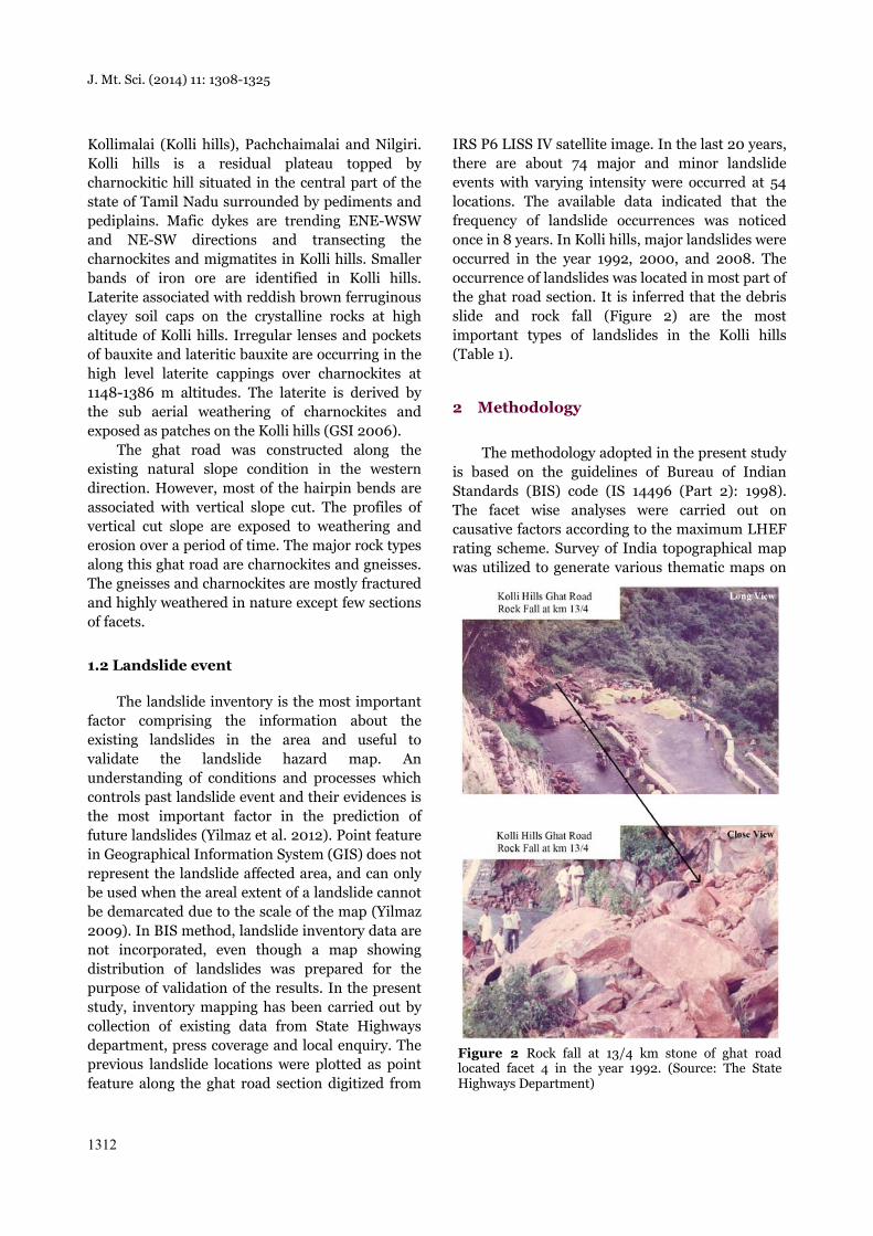
IRS P6 LISS IV satellite image. In the last 20 years, there are about 74 major and minor landslide events with varying intensity were occurred at 54 locations. The available data indicated that the frequency of landslide occurrences was noticed once in 8 years. In Kolli hills, major landslides were occurred in the year 1992, 2000, and 2008. The occurrence of landslides was located in most part of the ghat road section. It is inferred that the debris slide and rock fall (Figure 2) are the most important types of landslides in the Kolli hills (Table 1).
2 Methodology
The methodology adopted in the present study is based on the guidelines of Bureau of Indian Standards (BIS) code (IS 14496 (Part 2): 1998). The facet wise analyses were carried out on causative factors according to the maximum LHEF rating scheme. Survey of India topographical map was utilized to generate various thematic maps on
Figure 2 Rock fall at 13/4 km stone of ghat road located facet 4 in the year 1992. (Source: The State Highways Department)
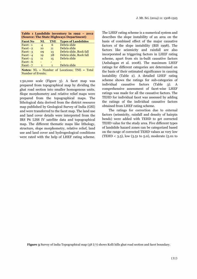
1:50,000 prepared frghat road Slope morpprepared lithologicalmap publisand were trand land cIRS P6 LImap. The structure, suse and lanwere rated
Table 1 L(Source: TFacet No Facet - 1 Facet - 2 Facet - 3 Facet - 4 Facet - 5 Facet - 6 Facet - 7
Notes: NNumber of
Figure
scale (Figufrom topograsection into phometry anfrom the
l data deriveshed by Geolransferred tocover detailsISS IV satelldifferent thslope morphnd cover and
d with the he
Landslide inThe State Hi
NL TN 4 6 10 11 09 1319 2811 15- - 1 1
L = Numberf Events;
e 3 Survey of
re 3). A faphical map
smaller homnd relative r
topographiced from the dlogical Surveo the facet ms were interplite data anematic map
hometry, relad hydrogeoloelp of LHEF
nventory inighways Dep
NE Types ofDebris slDebris sl
3 Debris sl8 Debris sl5 Debris sl
- Debris sl
r of Location
India Topogra
facet map by dividing
mogenous unrelief maps wcal maps. district resouey of India (Gap. The landpreted from d topograph
ps like litholative relief, logical conditiF rating sche
n 1992 – 20partment)f Landslideslide lide lide, Rock falllide, Rock falllide
lide
s; TNE = To
aphical map (5
was the nits. were The urce GSI)
d use the
hical ogy, land ions
eme.
Thedesbasfactfactincosch(Anratithe instschindcomratiTEHthe obt
factbenTEHof lon (TE
012
otal
58 I/7) shows
e LHEF ratinscribes the ssis of combitors of the tors like sorporated as
heme, apart nbalagan et ings for diffe
basis of thetability (Tab
heme shows dividual caumprehensive ings was maHD for indiv
ratings oftained from L
The ratingtors (seismicnds) were adHD value forlandslide hazthe range of
EHD < 3.5),
Kolli hills gha
J. Mt
ng scheme is slope instabiined effect oslope instab
seismicity as triggering from six inal. 2008).
erent categoeir estimatedble 2). A
the ratingsusative fac
assessmentade for all thvidual facet wf the indiviLHEF rating gs for correcity, rainfall dded with Tr the study azard zones caf corrected Tlow (3.51 to
at road section
t. Sci. (2014) 1
a numerical ility of an aof the majobility (BIS
and rainfallfactors in L
n-built causaThe maxim
ories are deted significance
detailed LHs for sub-cactors (Tablt of facet-we causative fwas assessedidual causatscheme.
ection due and density
TEHD to gearea. Five diffan be categoEHD values 5.0), moder
n and facet bou
11: 1308-1325
1313
system and area on the or causative
1998). The l are also
LHEF rating ative factorsmum LHEF ermined on e in causing HEF rating ategories of le 3). A wise LHEF factors. The d by adding tive factors
to external y of hairpin et corrected fferent types orized based
as very low rate (5.01 to
undary.
J. Mt. Sci. (2014) 11: 1308-1325
1314
6.5), high (6.51 to 8.0) and very high (TEHD > 8.01) hazard zones (Table 4).
2.1 Facet mapping
The slope facet is a smallest component or division taken for the analysis of landslide hazard evaluation factor. It is a part of hill slope, showing regular slope direction and inclination. The topographical map is divided into smaller homogeneous slope facets on the basis of ridges, spurs, gullies and drainages. For the present study, the ghat road section of Kolli hills is divided into 7 slope facets based on slope and slope aspect for assessment of individual causative factors which influences the slope instability. The individual facet represents homogenous terrain condition.
2.2 Lithology
The resistance of rocks to the weathering and erosion process is the important aspect in controlling the slope stability. Out of six causative factors, maximum rating 2 is assigned to lithology. In the case of rock cut slope, three different types of lithology with correction factor for weathering are included in LHEF rating scheme. In the case of cut slopes along with soil and debris profile, the ratings were awarded on the basis of genesis
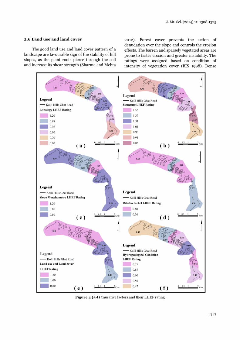
(colluvial or alluvial) and age (older or younger) of the profile. Older well compacted alluvial soil is characterized by high shear strength compared to the younger colluvial soil, which is loose or incompact in nature. The ratings for lithology were awarded on the basis of fresh rock type, weathering conditions and soil types observed along the cut slope. Charnockites and gneisses are the main lithological units in the study area. However, the assignment of rating to the lithology is varies for different facets by considering the weathering condition of rocks. The charnockites and gneisses are grouped into Type –I category as per BIS guidelines and ratings were awarded as 0.3 and 0.4 respectively. The cut slopes along soil profiles are covered by overburden, which are generally older well compacted (rating 1.2) and sandy soil (rating 1.4). The rating of fresh rock is multiplied by correction factor for weathering condition as highly weathered (4), moderately weathered (3) and slightly weathered (2). In the study area, Facet 1 was assigned with the highest rating of 1.20 for lithology and subsequently 0.70, 0.98, 0.90, 0.96, 0.90, and 0.60 ratings were assigned for successive facets from facet 2 to facet 7 (Figure 4a).
2.3 Structure
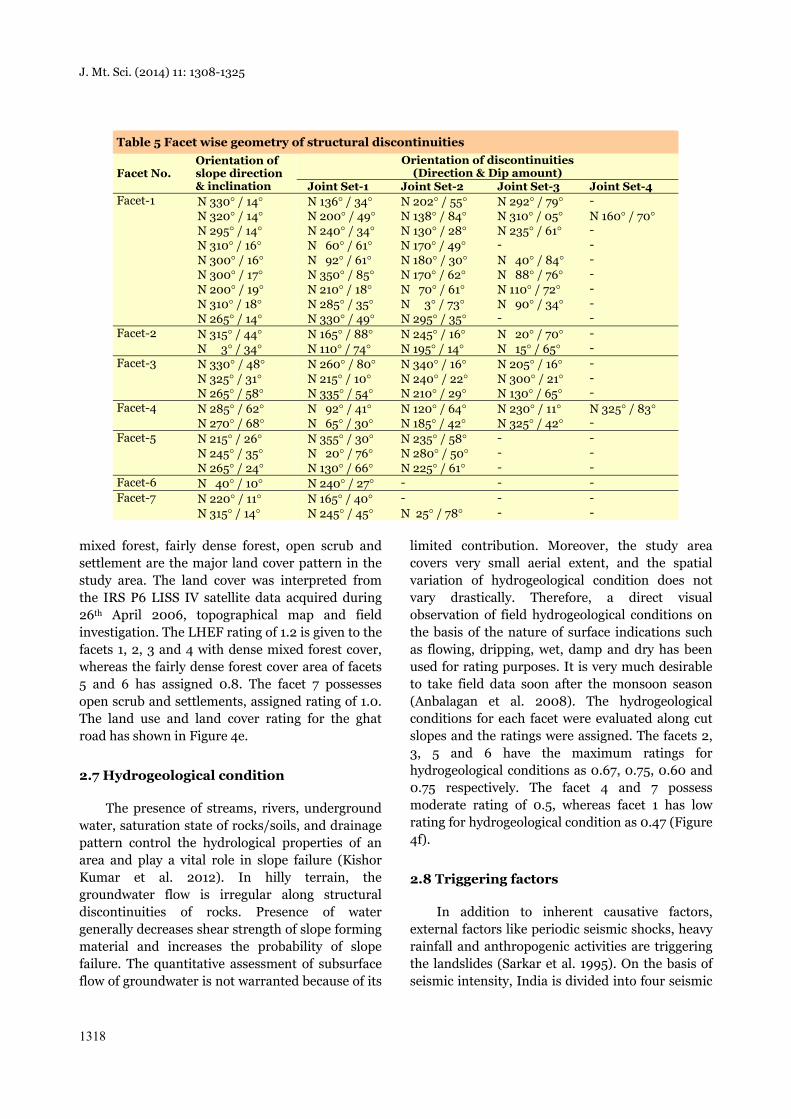
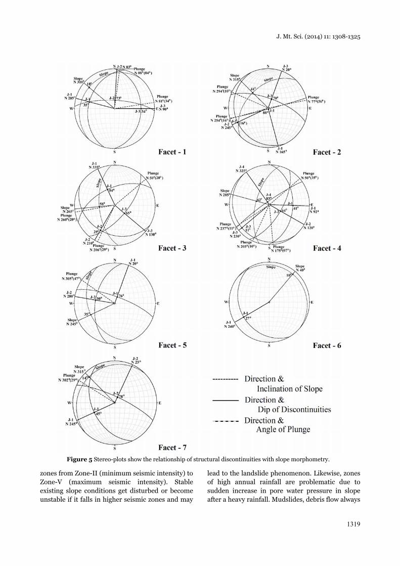
Geological structures play a major role in the occurrence of landslides. Bedding planes, joints, foliations, faults and thrusts are the discontinuities associated with the insitu rocks over hill slopes. These structural discontinuities in relation to the slope inclination have greater influence on slope instability. The relationships are (i) parallelism between the direction of slope and the discontinuity, (ii) dip of discontinuity and inclination of slope, (iii) dip of discontinuity. The LHEF ratings for the rock structures were derived from the structural relationships of discontinuities with slope. Maximum of 2 LHEF rating is assigned to structure in the rating scheme. In case of soil and debris slopes, the ratings were awarded based on the depth of soil and overburden. The thickness of soil and overburden are measured along soil profiles at cut slopes. The structural elements collected from the field (Table 5) were plotted in the stereo-net to evaluate the structural relationships of the discontinuity with the slope
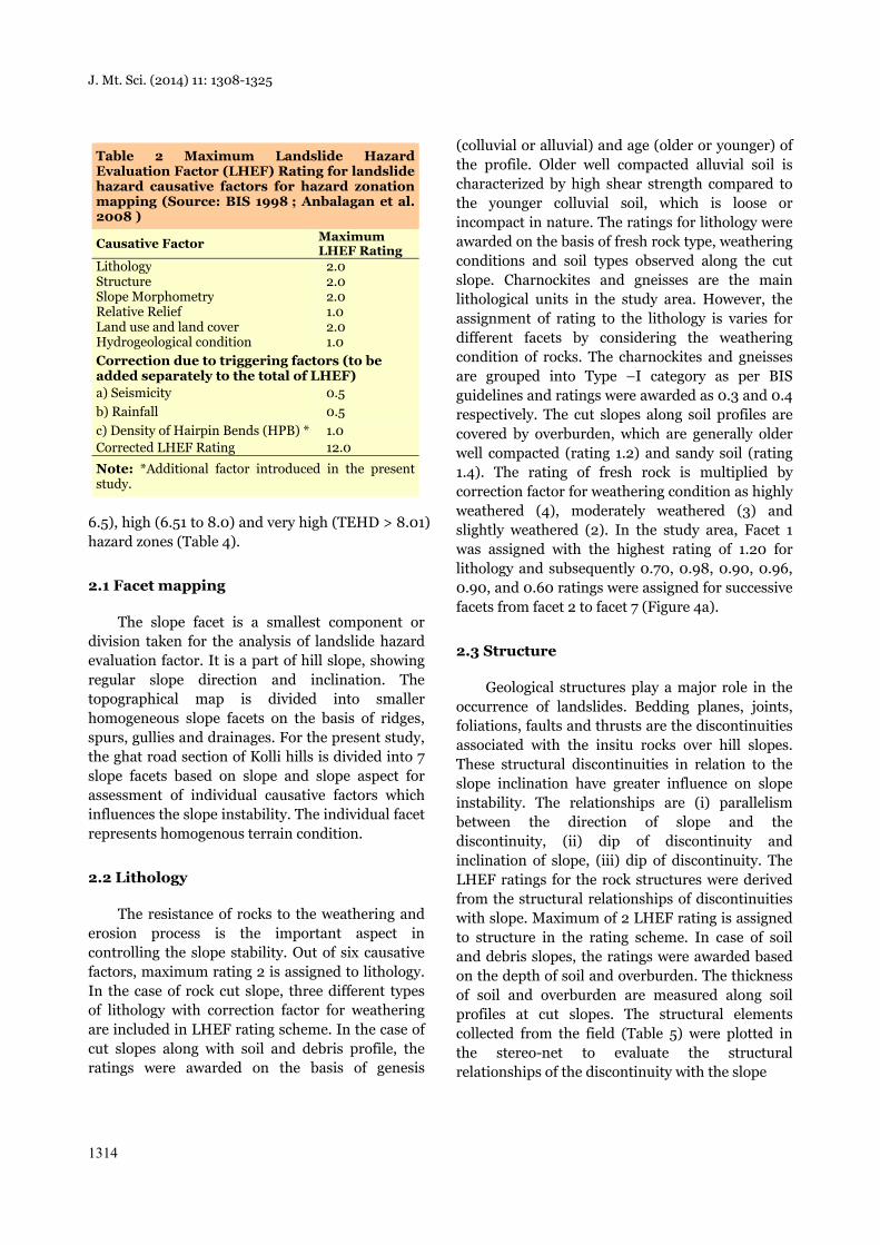
Table 2 Maximum Landslide Hazard Evaluation Factor (LHEF) Rating for landslide hazard causative factors for hazard zonation mapping (Source: BIS 1998 ; Anbalagan et al. 2008 )
Causative Factor Maximum LHEF Rating
Lithology 2.0 Structure 2.0 Slope Morphometry 2.0 Relative Relief 1.0 Land use and land cover 2.0 Hydrogeological condition 1.0 Correction due to triggering factors (to be added separately to the total of LHEF) a) Seismicity 0.5 b) Rainfall 0.5 c) Density of Hairpin Bends (HPB) * 1.0 Corrected LHEF Rating 12.0
Note: *Additional factor introduced in the present study.
J. Mt. Sci. (2014) 11: 1308-1325
1315
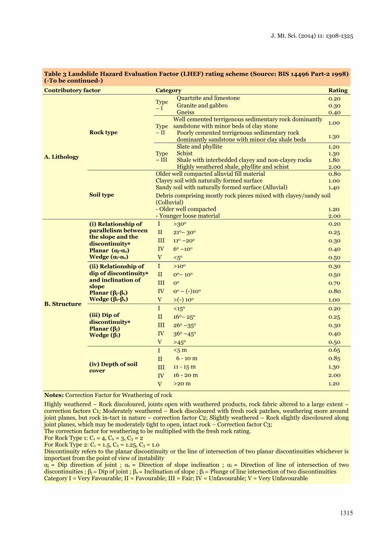
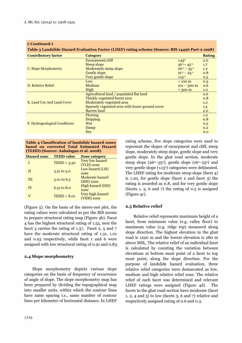
Table 3 Landslide Hazard Evaluation Factor (LHEF) rating scheme (Source: BIS 14496 Part-2 1998) (-To be continued-)
Contributory factor Category Rating
A. Lithology
Rock type
Type – I
Quartzite and limestone 0.20 Granite and gabbro 0.30Gneiss 0.40
Type – II
Well cemented terrigenous sedimentary rock dominantly sandstone with minor beds of clay stone 1.00
Poorly cemented terrigenous sedimentary rock dominantly sandstone with minor clay shale beds 1.30
Type – III
Slate and phyllite 1.20Schist 1.30Shale with interbedded clayey and non-clayey rocks 1.80Highly weathered shale, phyllite and schist 2.00
Soil type
Older well compacted alluvial fill material 0.80Clayey soil with naturally formed surface 1.00Sandy soil with naturally formed surface (Alluvial) 1.40Debris comprising mostly rock pieces mixed with clayey/sandy soil (Colluvial) - Older well compacted 1.20- Younger loose material 2.00
B. Structure
(i) Relationship of parallelism between the slope and the discontinuity* Planar (αj-αs) Wedge (αi-αs)
I >30ο 0.20 II 21ο– 30ο 0.25 III 11ο –20ο 0.30 IV 6ο –10ο 0.40 V <5ο 0.50
(ii) Relationship of dip of discontinuity* and inclination of slope Planar (βj-βs) Wedge (βi-βs)
I >10ο 0.30 II 0ο– 10ο 0.50 III 0ο 0.70 IV 0ο – (-)10ο 0.80 V >(-) 10ο 1.00
(iii) Dip of discontinuity* Planar (βj) Wedge (βi)
I <15ο 0.20 II 16ο– 25ο 0.25 III 26ο –35ο 0.30 IV 36ο –45ο 0.40 V >45ο 0.50
(iv) Depth of soil cover
I <5 m 0.65II 6 - 10 m 0.85III 11 - 15 m 1.30IV 16 - 20 m 2.00V >20 m 1.20
Notes: Correction Factor for Weathering of rock Highly weathered – Rock discoloured, joints open with weathered products, rock fabric altered to a large extent – correction factors C1; Moderately weathered – Rock discoloured with fresh rock patches, weathering more around joint planes, but rock in-tact in nature – correction factor C2; Slightly weathered – Rock slightly discoloured along joint planes, which may be moderately tight to open, intact rock – Correction factor C3; The correction factor for weathering to be multiplied with the fresh rock rating. For Rock Type 1: C1 = 4, C2 = 3, C3 = 2 For Rock Type 2: C1 = 1.5, C2 = 1.25, C3 = 1.0 Discontinuity refers to the planar discontinuity or the line of intersection of two planar discontinuities whichever is important from the point of view of instability αj = Dip direction of joint ; αs = Direction of slope inclination ; αi = Direction of line of intersection of two discontinuities ; βj = Dip of joint ; βs = Inclination of slope ; βi = Plunge of line intersection of two discontinuities Category I = Very Favourable; II = Favourable; III = Fair; IV = Unfavourable; V = Very Unfavourable
J. Mt. Sci. (2014) 11: 1308-1325
1316
(Figure 5). On the basis of the stereo-net plot, the rating values were calculated as per the BIS norms to prepare structural rating map (Figure 4b). Facet 4 has the highest structural rating of 1.55, next the facet 3 carries the rating of 1.37, Facet 2, 5 and 7 have the moderate structural rating of 1.31, 1.01 and 0.93 respectively, while facet 1 and 6 were assigned with low structural rating of 0.91 and 0.83.
2.4 Slope morphometry
Slope morphometry depicts various slope categories on the basis of frequency of occurrence of angle of slope. The slope morphometry map has been prepared by dividing the topographical map into smaller units, within which the contour lines have same spacing i.e., same number of contour lines per kilometre of horizontal distance. In LHEF
rating scheme, five slope categories were used to represent the slopes of escarpment and cliff, steep slope, moderately steep slope, gentle slope and very gentle slope. In the ghat road section, moderate steep slope (26ο–35ο), gentle slope (16ο–25ο) and very gentle slope (≤15ο) categories were delineated. The LHEF rating for moderate steep slope (facet 4) is 1.20, for gentle slope (facet 2 and facet 3) the rating is awarded as 0.8, and for very gentle slope (facets 1, 5, 6 and 7) the rating of 0.5 is assigned (Figure 4c).
2.5 Relative relief
Relative relief represents maximum height of a facet, from minimum value (e.g. valley floor) to maximum value (e.g. ridge top) measured along slope direction. The highest elevation in the ghat road is 1220 m and the lowest elevation is 280 m above MSL. The relative relief of an individual facet is calculated by counting the variation between elevations at bottom most point of a facet to top most point, along the slope direction. For the purpose of landslide hazard evaluation, three relative relief categories were demarcated as low, medium and high relative relief zone. The relative relief of each facet was determined and relevant LHEF ratings were assigned (Figure 4d). The facets in the ghat road section have moderate (facet 1, 2, 4 and 5) to low (facets 3, 6 and 7) relative and respectively assigned rating of 0.6 and 0.3.
(-Continued-) Table 3 Landslide Hazard Evaluation Factor (LHEF) rating scheme (Source: BIS 14496 Part-2 1998)Contributory factor Category Rating
C. Slope Morphometry
Escarpment/cliff ≥45ο 2.0Steep slope 36 ο– 45 ο 1.7Moderately steep slope 26 ο – 35 ο 1.2Gentle slope 16 ο – 25 ο 0.8Very gentle slope ≤15 ο 0.5
D. Relative Relief Low < 100 m 0.3Medium 101 – 300 m 0.6High > 300 m 1.0
E. Land Use And Land Cover
Agricultural land / populated flat land 0.6Thickly vegetated forest area 0.8Moderately vegetated area 1.2Sparsely vegetated area with lesser ground cover 1.5Barren land 2.0
F. Hydrogeological Conditions
Flowing 1.0Dripping 0.8Wet 0.5Damp 0.2Dry 0.0
Table 4 Classification of landslide hazard zones based on corrected Total Estimated Hazard (TEHD) (Source: Anbalagan et al. 2008) Hazard zone TEHD value Zone category
I TEHD < 3.50 Very low hazard (VLH) zone
II 3.51 to 5.0 Low hazard (LH) zone
III 5.01 to 6.5 Moderate hazard (MH) zone
IV 6.51 to 8.0 High hazard (HH) zone
V TEHD > 8.01 Very high hazard (VHH) zone
J. Mt. Sci. (2014) 11: 1308-1325
1317
2.6 Land use and land cover
The good land use and land cover pattern of a landscape are favourable sign of the stability of hill slopes, as the plant roots pierce through the soil and increase its shear strength (Sharma and Mehta
2012). Forest cover prevents the action of denudation over the slope and controls the erosion effects. The barren and sparsely vegetated areas are prone to faster erosion and greater instability. The ratings were assigned based on condition of intensity of vegetation cover (BIS 1998). Dense
Figure 4 (a-f) Causative factors and their LHEF rating.
J. Mt. Sci. (2014) 11: 1308-1325
1318
mixed forest, fairly dense forest, open scrub and settlement are the major land cover pattern in the study area. The land cover was interpreted from the IRS P6 LISS IV satellite data acquired during 26th April 2006, topographical map and field investigation. The LHEF rating of 1.2 is given to the facets 1, 2, 3 and 4 with dense mixed forest cover, whereas the fairly dense forest cover area of facets 5 and 6 has assigned 0.8. The facet 7 possesses open scrub and settlements, assigned rating of 1.0. The land use and land cover rating for the ghat road has shown in Figure 4e.
2.7 Hydrogeological condition
The presence of streams, rivers, underground water, saturation state of rocks/soils, and drainage pattern control the hydrological properties of an area and play a vital role in slope failure (Kishor Kumar et al. 2012). In hilly terrain, the groundwater flow is irregular along structural discontinuities of rocks. Presence of water generally decreases shear strength of slope forming material and increases the probability of slope failure. The quantitative assessment of subsurface flow of groundwater is not warranted because of its
limited contribution. Moreover, the study area covers very small aerial extent, and the spatial variation of hydrogeological condition does not vary drastically. Therefore, a direct visual observation of field hydrogeological conditions on the basis of the nature of surface indications such as flowing, dripping, wet, damp and dry has been used for rating purposes. It is very much desirable to take field data soon after the monsoon season (Anbalagan et al. 2008). The hydrogeological conditions for each facet were evaluated along cut slopes and the ratings were assigned. The facets 2, 3, 5 and 6 have the maximum ratings for hydrogeological conditions as 0.67, 0.75, 0.60 and 0.75 respectively. The facet 4 and 7 possess moderate rating of 0.5, whereas facet 1 has low rating for hydrogeological condition as 0.47 (Figure 4f).
2.8 Triggering factors
In addition to inherent causative factors, external factors like periodic seismic shocks, heavy rainfall and anthropogenic activities are triggering the landslides (Sarkar et al. 1995). On the basis of seismic intensity, India is divided into four seismic
Table 5 Facet wise geometry of structural discontinuities
Facet No. Orientation of slope direction & inclination
Orientation of discontinuities (Direction & Dip amount)
Joint Set-1 Joint Set-2 Joint Set-3 Joint Set-4 Facet-1 N 330° / 14° N 136° / 34° N 202° / 55° N 292° / 79° -
N 320° / 14° N 200° / 49° N 138° / 84° N 310° / 05° N 160° / 70° N 295° / 14° N 240° / 34° N 130° / 28° N 235° / 61° - N 310° / 16° N 60° / 61° N 170° / 49° - - N 300° / 16° N 92° / 61° N 180° / 30° N 40° / 84° - N 300° / 17° N 350° / 85° N 170° / 62° N 88° / 76° - N 200° / 19° N 210° / 18° N 70° / 61° N 110° / 72° - N 310° / 18° N 285° / 35° N 3° / 73° N 90° / 34° - N 265° / 14° N 330° / 49° N 295° / 35° - -
Facet-2 N 315° / 44° N 165° / 88° N 245° / 16° N 20° / 70° - N 3° / 34° N 110° / 74° N 195° / 14° N 15° / 65° -
Facet-3 N 330° / 48° N 260° / 80° N 340° / 16° N 205° / 16° - N 325° / 31° N 215° / 10° N 240° / 22° N 300° / 21° - N 265° / 58° N 335° / 54° N 210° / 29° N 130° / 65° -
Facet-4 N 285° / 62° N 92° / 41° N 120° / 64° N 230° / 11° N 325° / 83° N 270° / 68° N 65° / 30° N 185° / 42° N 325° / 42° -
Facet-5 N 215° / 26° N 355° / 30° N 235° / 58° - - N 245° / 35° N 20° / 76° N 280° / 50° - - N 265° / 24° N 130° / 66° N 225° / 61° - -
Facet-6 N 40° / 10° N 240° / 27° - - - Facet-7 N 220° / 11° N 165° / 40° - - -
N 315° / 14° N 245° / 45° N 25° / 78° - -
J. Mt. Sci. (2014) 11: 1308-1325
1319
zones from Zone-II (minimum seismic intensity) to Zone-V (maximum seismic intensity). Stable existing slope conditions get disturbed or become unstable if it falls in higher seismic zones and may
lead to the landslide phenomenon. Likewise, zones of high annual rainfall are problematic due to sudden increase in pore water pressure in slope after a heavy rainfall. Mudslides, debris flow always
Figure 5 Stereo-plots show the relationship of structural discontinuities with slope morphometry.
J. Mt. Sci. (2014) 11: 1308-1325
1320
get associated with high instantaneous rainfall. Ratings for the seismicity and rainfall are given separately and added to the TEHD values as a correction parameter (Anbalagan et al. 2008). Seismically the area falls in seismic zone-II, the rating of 0.2 was assigned for the entire facet. The average annual rainfall in the study area is 149.7 cm, hence the rating of 0.4 has awarded for all facets. Though the ratings were uniformly assigned to all facets, on the whole it increases the value of total estimated hazard and accordingly facets were classified.
The anthropogenic activity along the natural slope is one of the important triggering factors. In the present study, the density of hairpin bends (HPB) was considered and the ratings were added to TEHD as correction factor. The maximum rating for density of HPB is assigned as 1.0. The density of the HPB was determined by considering the number of hairpin bends constructed along with particular individual slope facet. Overall, the facets 3 and 4 have maximum HPB respectively 13 and 21 were constructed within 300 m contour interval. Facets 1, 2, & 5 were considered as moderate density of HPB with 11, 8, and 14 hairpin bends respectively. The facet 6 has 3 hairpin bends and facet 7 without any hairpin bend fall in the uppermost stretch of the road. The facet wise
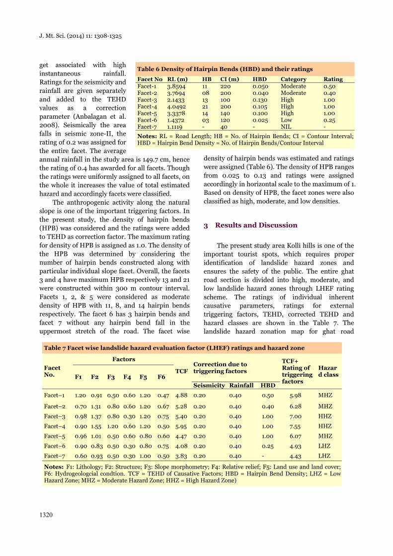
density of hairpin bends was estimated and ratings were assigned (Table 6). The density of HPB ranges from 0.025 to 0.13 and ratings were assigned accordingly in horizontal scale to the maximum of 1. Based on density of HPB, the facet zones were also classified as high, moderate, and low densities.
3 Results and Discussion
The present study area Kolli hills is one of the important tourist spots, which requires proper identification of landslide hazard zones and ensures the safety of the public. The entire ghat road section is divided into high, moderate, and low landslide hazard zones through LHEF rating scheme. The ratings of individual inherent causative parameters, ratings for external triggering factors, TEHD, corrected TEHD and hazard classes are shown in the Table 7. The landslide hazard zonation map for ghat road
Table 6 Density of Hairpin Bends (HBD) and their ratings
Facet No RL (m) HB CI (m) HBD Category RatingFacet-1 3.8594 11 220 0.050 Moderate 0.50Facet-2 3.7694 08 200 0.040 Moderate 0.40Facet-3 2.1433 13 100 0.130 High 1.00Facet-4 4.0492 21 200 0.105 High 1.00Facet-5 3.3378 14 140 0.100 High 1.00Facet-6 1.4372 03 120 0.025 Low 0.25Facet-7 1.1119 - 40 - NIL -
Notes: RL = Road Length; HB = No. of Hairpin Bends; CI = Contour Interval; HBD = Hairpin Bend Density = No. of Hairpin Bends/Contour Interval
Table 7 Facet wise landslide hazard evaluation factor (LHEF) ratings and hazard zone
Facet No.
Factors
TCFCorrection due to triggering factors
TCF+ Rating of triggering factors
Hazard classF1 F2 F3 F4 F5 F6
Seismicity Rainfall HBD
Facet–1 1.20 0.91 0.50 0.60 1.20 0.47 4.88 0.20 0.40 0.50 5.98 MHZ
Facet–2 0.70 1.31 0.80 0.60 1.20 0.67 5.28 0.20 0.40 0.40 6.28 MHZ
Facet–3 0.98 1.37 0.80 0.30 1.20 0.75 5.40 0.20 0.40 1.00 7.00 HHZ
Facet–4 0.90 1.55 1.20 0.60 1.20 0.50 5.95 0.20 0.40 1.00 7.55 HHZ
Facet–5 0.96 1.01 0.50 0.60 0.80 0.60 4.47 0.20 0.40 1.00 6.07 MHZ
Facet–6 0.90 0.83 0.50 0.30 0.80 0.75 4.08 0.20 0.40 0.25 4.93 LHZ
Facet–7 0.60 0.93 0.50 0.30 1.00 0.50 3.83 0.20 0.40 - 4.43 LHZ
Notes: F1: Lithology; F2: Structure; F3: Slope morphometry; F4: Relative relief; F5: Land use and land cover; F6: Hydrogeologcial condtion. TCF = TEHD of Causative Factors; HBD = Hairpin Bend Density; LHZ = Low Hazard Zone; MHZ = Moderate Hazard Zone; HHZ = High Hazard Zone)
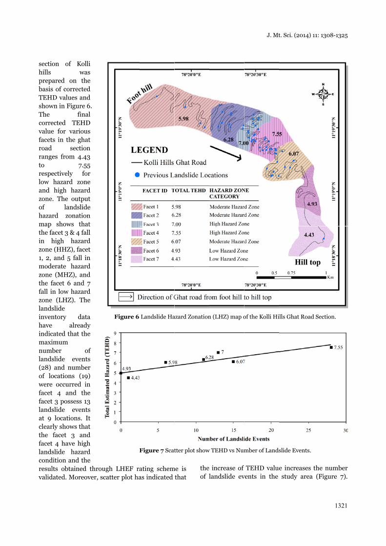
section ofhills prepared obasis of coTEHD valushown in FThe corrected value for vfacets in throad ranges fromto respectivelylow hazardand high zone. The of lanhazard zomap showthe facet 3 in high zone (HHZ1, 2, and 5moderate zone (MHZthe facet 6fall in low zone (LHZlandslide inventory have aindicated tmaximum number landslide (28) and nof locationwere occurfacet 4 anfacet 3 poslandslide at 9 locaticlearly showthe facet facet 4 havlandslide condition aresults obtvalidated. M
f Kolli was
on the rrected
ues and Figure 6.
final TEHD
various he ghat section m 4.43
7.55 y for d zone hazard output
ndslide onation
ws that & 4 fall hazard
Z), facet 5 fall in
hazard Z), and 6 and 7
hazard Z). The
data already hat the
of events
number ns (19) rred in nd the ssess 13
events ions. It ws that 3 and
ve high hazard
and the tained throuMoreover, sc
ugh LHEF racatter plot ha
Figure 6
F
ating schemas indicated
Landslide Ha
Figure 7 Scat
me is that
the of l
azard Zonation
tter plot show
increase of landslide ev
n (LHZ) map o
w TEHD vs Num
J. Mt
TEHD valuevents in the
of the Kolli Hi
mber of Lands
t. Sci. (2014) 1
e increases tstudy area
ills Ghat Road
slide Events.
11: 1308-1325
1321
the number (Figure 7).
d Section.
J. Mt. Sci. (2014) 11: 1308-1325
1322
Then the landslide density for individual facet, which is the ratio of the number of landslides to area of the facet, was calculated. The value of landslide density for high hazard class is 80.97 and that for the low hazard class is 2.50, indicating that the landslide density values increases as the degree of hazard class increases (Table 8). This stretch starts from 7.63 km to 13.82 km along the ghat road section. The facet 1, 2 & 5 have significant number of landslide occurrences respectively 6, 11, & 15. Similarly, the low landslide hazard zone facets 6 and 7 have negligible landslide occurrences. The personnel discussion with the engineers and the village administrative officers have highlighted the types of landslides along the ghat road are mostly landslips and debris slide, particularly during northeast monsoon in the months of October to December. Though a number of landslides had occurred, there is no major report on loss of life. The major damage occurred for roads and properties and it affects the transport along the ghat road.
The TEHD for various facets along the ghat road section comprises of nine landslide hazard evaluation factors (LHEF) such as lithology, structure, slope morphometry, relative relief, land use and land cover, hydrogeological condition, density of hairpin bend, rainfall, and seismicity. The occurrence of landslide along the ghat road section is influenced by the combined effect of causative and triggering factors. However, an individual factor may influence more than the other factors in different section. Structure is one of the important causative factors in the study area for occurrence of landslides in the ghat road section. As per LHEF rating scheme, maximum of 2 rating has assigned for structure. In the ghat road section, minimum of 0.83 and maximum of 1.55 ratings were assigned respectively to facets 6 and 4. There are three set of joints observed and measured at most of the facets. The facet 3 and 4 carry high structural rating, because of the highly
fractured rock cut slopes and increase of rating by direction and dip of discontinuities. The result has indicated that, the recurrence of landslide events in facet 3 and 4 has mainly influenced by structure and slope morphometry. Irrespective of that, the overall value of TEHD is higher for such high hazard zones, which indicates that the role of other terrain parameters cannot be ignored. The role of structure is less significant in moderate and low hazard zones. Apart from slope and structural factor, the density of hairpin bends, land use and land cover, and lithology are the successive order of influencing factors along the ghat road section.
In addition to 6 inherent causative factors in LHEF rating scheme, the correction due to triggering factors such as seismicity, rainfall and anthropogenic activity was included and added with the TEHD value. The rating for seismicity and rainfall were already considered in the previous study by Anbalagan et al. (2008). Rainfall is one of the important triggering factors in the study area, particularly during NE monsoon. Though the seismicity is not an important triggering factor in the study area, the low intensity tremors are not ruled out, hence a nominal rating is assigned for seismicity. These values were assigned uniformly to all the facets in the ghat road section. Though there is no meaning in addition of uniform rating for entire section, however, it increases the TEHD value for a section of road. In anthropogenic activities, we have considered the density of hairpin bends as triggering factor and maximum of rating 1.0 was assigned depending upon the number of hairpin bends with respect to contour interval. The ghat road section is covered by significant number of hairpin bends with short distance of 20 km along with narrow contour interval of 940 m. The facet wise contour interval and respective number of hairpin bends were considered to derive the density of hairpin bends in the facet area. The density of HPB varies from 0.025 (facet 6) to 0.13 (facet 4). Accordingly, ratings were assigned in horizontal scale with a minimum of 0.25 (facet 6) to maximum of 1.0 (facet 3, 4, & 5). The density of hairpin bends and the number of previous landslide occurrences are directly proportional to each other. It means that, the increases in the number hairpin bends along with narrow contour interval, the occurrence of landslides are increased. Among 54 previous
Table 8 Density of the landslides in each hazard class Hazard class
Area (Km2)
Number of landslides
Landslide density
Low 0.40 1 2.50 Moderate 1.12 25 22.38High 0.35 28 80.97
J. Mt. Sci. (2014) 11: 1308-1325
1323
landslide locations, 28 locations fall in high density HPB, 25 locations fall in moderate density HPB.
In the present case, structure and slope morphometry are the natural factors influencing more towards landslide occurrence. Similarly, in terms of man-made parameter the density of hairpin bends plays major role in occurrence of landslides, particularly in facets 3 and 4. It is necessary to address the influencing factors to reduce the failures. Channeling the surface water through lined concrete ditches could minimize the infiltration of rain water and reduce the pore water pressure particularly during monsoon. Flattening the slope angle at the top of the hill along the critical slope can stabilize the landslide prone slopes. The removal of slide mass is generally undertaken from the crown portion downwards and in this process, benches can be created at appropriate interval (NDMG, 2009). The rock cut slopes influenced by structure can be protected by nailing and grouting with cement. The loose blocks of rocks can be anchored with competent bedrock through bolts and long metal rods.
4 Conclusions
Landslide hazard zonation mapping was done for ghat road section of Kolli hills using LHEF rating scheme as per the guidelines BIS (1998). The LHZ map indicates that, out of 7 slope facets the facet 3 and facet 4 with 6.19 km stretch ghat road from 19 to 52 hairpin bends classified as high hazard zone. The hairpin bends 1 to 18 (facet 1 & 2) and 53 to 66 & 68 hairpin bends (facet 5) with 10.97 km stretch categorized as moderate hazard zone and the remaining 2.55 km stretch of ghat road along with 67 & from 69 hairpin bend to
Sholaikkadu village (facet 6 & 7) fall under low hazard zone. Low hazard zones characterized by stable slopes compared to moderate hazard zones, with unstable condition, which may fail either due to the individual or combination of causative factors. The high hazard zone mostly consists of unstable slopes, which may active at present. The high hazard zone (HHZ) warranted careful developmental activities such as widening of roads, slope cut and constructions. This zone needs frequent preventive maintenance activities. Due attention may be given to the structural aspect, as this causative factor contributes maximum rating to LHEF. The results obtained from LHEF rating scheme and the previous landslide data have shown appreciable matching and the method adopted in the present study is validated. The landslide assessment study is conducted for the first time for this Kolli hills ghat road section. The results and findings are more useful for the planners, and decision makers, particularly for State Highways department and District collectorate. The procedures and field investigations adopted in the study are more useful in academic interest.
Acknowledgement
The authors acknowledge the Natural Resources Data Management System (NRDMS), Department of Science and Technology, New Delhi, to sponsor the project. The authors also thank the State Highways and Horticulture departments for providing landslide event and rainfall data. The authors thank anonymous reviewers for their comments and suggestions to improve the quality of the research article.
References
AGS (2007) Guideline for landslide susceptibility, hazard and risk zoning for land use planning. Australian Geomechanics 42: 13-36.
Ahmad M, Umrao RK, Ansari M, et al. (2013) Assessment of rockfall hazard along the road cut slopes of state highway-72, Maharashtra, India. Geomaterials 3(1):15–23. DOI: 10.4236/gm.2013.31002.
Aleotti P, Chowdhury R (1999) Landslide hazard assessment: summary review and new perspectives. Bulletin of Engineering Geology and the Environment 58: 21- 44. DOI: 10.1007/s100640050066.
Anbalagan R (1992) Landslide Hazard Evaluation and Zonation Mapping in Mountainous Terrain. Engineering Geology 32: 269-277. DOI: 10.1016/0013-7952(92)90053-2.
Anbalagan R, Chakraborty D, Kohli A (2008) Landslide hazard zonation (LHZ) mapping on meso-scale for systematic town planning in mountainous terrain. Journal of Scientific & Industrial Research 67: 486-497.
Anbazhagan S, Neelakantan S, Arivazhagan S, et al. (2008) Developments of Fractures and Land Subsidence at Kolli Hills, Tamil Nadu. Journal of Geological Society of India 72: 348-352.

J. Mt. Sci. (2014) 11: 1308-1325
1324
Anderson MG, Holcombe E (2013) Community-Based Landslide Risk Reduction–Managing Disasters in Small Steps. Library of Congress Cataloging-in-Publication Data. The World Bank. Washington, DC.
Arora MK, Das AS, Gupta RP (2004) An artificial neural network approach for landslide hazard zonation in the Bhagirathi (Ganga) Valley, Himalayas. International Journal of Remote Sensing 25(3): 559-572. DOI: 10.1080/ 0143116031000156819.
Ayalew L, Yamagishi H, Ugawa N (2004) Landslide susceptibility mapping using GIS based weighted linear combination, the case in Tsugawa area of Agano River, Niigata Prefecture, Japan. Landslides 1: 73-81. DOI: 10.1007/ s10346-003-0006-9.
Bhandari RK (1987) Slope stability in the fragile Himalaya and strategy for development. Ninth IGS Lecture. Journal of the IGE 17(1): 1-78.
Brabb EE (1984) Innovative approaches to landslide hazard and risk mapping. In: Proceedings of 4th International Symposium on Landslides, Totonto, Canada. Volume 1. Vancouver, Canada: BiTech Publishers. pp 307-324.
Bureau of Indian Standard (1998) IS: 14496, Preparation of Landslide Hazard Zonation Maps in Mountainous terrains – Guidelines, Part 2 Macro-zonation, BIS, New Delhi.
Carrara A, Cardinali M, Detti R, et al. (1991) GIS technique and statistical models in evaluating landslide hazard. Earth Surface Process and Land Forms 16: 427-445. DOI: 10.1002/esp.3290160505.
Chung C-JF, Fabbri AG (1999) Probabilistic prediction models for landslide hazard mapping. Photogrammetric Engineering and Remote Sensing 65: 1389-1399.
Dai FC, Lee CF, Ngai YY (2002) Landslide risk assessment and management: an overview. Engineering Geology 64(1): 65-87. DOI: 10.1016/S0013-7952(01)00093-X.
Das I, Stein A, Kerle N, et al. (2011) Probabilistic landslide hazard assessment using homogeneous susceptible units (HSU) along a national highway corridor in the northern Himalayas, India. Landslides 8: 293-308. DOI: 10.1007/ s10346-011-0257-9.
Devoli G, Morales A, Hoeg K (2007) Historical landslides in Nicaragua—collection and analysis of data. Landslides 4(1): 5-18. DOI: 10.1007/s10346-006-0048-x.
Dhakal AS, Amada T, Aniya, M (2000) Landslide Hazard Mapping and its Evaluation Using GIS: An Investigation of Sampling Schemes for a Grid-Cell Based Quantitative Method. Photogrammetric Engineering & Remote Sensing 66(8): 981-989.
Francis Xavier T, Freeda Rose A, Dhivyaa M (2011) Ethnomedcinal survey of malayali tribes in Kolli hills of eastern ghats of Tamil Nadu, India. Indian Journal of Traditional Knowledge 10(3): 559-562.
Ghosh S (2011) Knowledge Guided Empirical Prediction of Landslide Hazard. PhD thesis, University of Twente, The Netherlands. pp 13.
GSI Report (2006) Geology and Mineral Resources of The States of India. Part IV-Tamil Nadu and Pondicherry.
Gupta RP, Joshi BC (1990) Landslide hazard zoning using the GIs approach-A case study from the Ramganga catchment, Himalayas. Engineering Geology 28: 119-131. DOI: 10.1016/ 0013-7952(90)90037-2.
Guzzetti F, Carrara A, Cardinalli M, et al. (1999) Landslide hazard evaluation: a review of current techniques and their application in a multi-case study, central Italy. Geomorphology 31: 181-216. DOI: 10.1016/S0169-555X(99) 00078-1.
Hansen A (1984) Landslide hazard analysis. In: Brunsden D, Prior DB (Eds.), Slope Instability. John Wiley and Sons, New York. pp 523-602.
Kannan M, Saranathan E, Anbalagan R (2011) Macro Landslide Hazard Zonation Mapping – Case study from Bodi – BodimettuGhat section, Theni District, Tamil Nadu – India. Journal of Indian Society of Remote Sensing 39(4): 485-496.
DOI: 10.1007/s12524-011-0112-4. Kanungo DP, Arora MK, Sarkar S, et al. (2006) A comparative
study of conventional, ANN black box, fuzzy and combined neural and fuzzy weighting procedures for landslide susceptibility zonation in Darjeeling Himalayas. Engineering Geology 85: 347-366. DOI: 10.1016/j.enggeo.2006.03.004.
Kanungo DP, Arora MK, Sarkar S, et al. (2009) Landslide Susceptibility Zonation (LSZ) Mapping – A Review. Journal of South Asia Disaster Studies 2(1): 81-105.
Kienholz H, Schneider G, Bichsel M, et al. (1984) Mapping of mountain hazards and slope stability. Mountain Research and Development 4(3): 247-266.
Kumar K, Devrani R, Kathait A, Aggarwal N (2012) Micro-Hazard Evaluation and validation of landslide in a part of North Western Garhwal Lesser Himalaya, India. International Journal of Geomatics and Geosciences 2(3): 878-891.
Lee S (2007) Application and verification of fuzzy algebraic operators to landslide susceptibility mapping. Environmental Geology 52:615-623. DOI: 10.1007/s00254-006-0491-y.
Lee S, Choi J, Min K (2002) Landslide susceptibility analysis and verification using the Bayesian probability model. Environmental Geology 43: 120-131. DOI: 10.1007/s00254-002-0616-x.
Mark RK, Ellen SD (1995) Statistical and simulation models for mapping debris-flow hazard, Geographical Information Systems in Assessing Natural Hazards In: Carrara A, Guzzetti F (eds.), Kluwer Academic Publishers, Dordrecht. pp 93-106.
McKean J, Buechel S, Gaydos L (1991) Remote sensing and landslide hazard assessment. Photogrammetric Engineering and Remote sensing 57(9):1185-1193.
Mostyn GR, Fell R (1997) Quantitative and semiquantitative estimation of the probability of landslides in Landslide Risk Assessment In: Cruden D, Fell R (eds.), Balkema, Rotterdam, Brookfield. pp 297-315.
National Disaster Management Guidelines - Management of landslides and snow avalanches (2009) A publication of the National Disaster Management Authority, Government of India. June 2009, New Delhi.
Naranjo JL, van Westen CJ, Soeters R (1994) Evaluating the use of training areas in bivariate statistical landslide hazard analysis – a case study in Columbia. ITC Journal 3.
Okimura T (1982) Situation of surficial slope failure based on the distribution of soil layer, Shin-sabo, 35: 9-18 (in Japanese with English abstract).
Okimura T, Kawatani T (1986) Mapping of the potential surface-failure sites on granite mountain slopes. In: Gardiner V (ed.), International Geomorphology. Part I, Wiley and Sons, New York. pp 121-138.
Pachauri AK, Pant M, (1992) Landslide hazard mapping based on geological attributes. Engineering Geology 32: 81-100. DOI: 10.1016/0013-7952(92)90020-Y.
Saranathan E, Rajesh Kumar, Kannan M, et al. (2010) Landslide Macro Hazard Zonation of the Yercaud Hill slopes ghat sections – km 10/4 to 29/6, Indian Landslides 3(1): 9-16.
Saranathan E, Kannan M, Victor Rajamanickam G (2012) Assessment of landslide hazard zonation mapping in Kodaikanal, Tamil Nadu – India. Disaster Advances 5(4): 42-50.
Sarkar S, Anbalagan R (2008) Landslide Hazard Zonation Mapping and Comparative Analysis of Hazard Zonation Maps. Journal of Mountain Science 5: 232-240. DOI: 10.1007/ s11629-008-0172-2.
Sarkar S, Kanungo DP, Mehrotra GS (1995) Landslide hazard zonation: A case study in Garhwal Himalaya, India. Mountain Research and Development 15(4): 301-309. DOI: 10.2307/3673806.
Sharma RK, Mehta BS (2012) Macro-zonation of landslide susceptibility in Garamaura-Swarghat-Gambhar section of national highway 21, Bilaspur District, Himachal Pradesh (India). Natural Hazards 60: 671-688. DOI: 10.1007/s11069-011-0041-0.
J. Mt. Sci. (2014) 11: 1308-1325
1325
Sharma VK (2008) Macro-zonation of Landslide Hazard in the Environs of Baira Dam Project, Chamba District, Himachal Pradesh. Journal of the Geological Society of India 71(3): 425-432.
Singh R, Umrao RK, Singh TN (2012) Probabilistic analysis of slope in Amiyan landslide area, Uttarakhand. Geomatics, Natural Hazards and Risk 4(1): 13-29. DOI: 10.1080/ 19475705.2012.661796.
Skempton AW, Delory EA (1957) Stability of natural slopes in London clay. In: Proceedings of 4 & International Conference on Soil Mechanics and Foundation Engineering 4: 379-381.
Srivastava V, Srivastava HB, Lakhera RC (2010) Fuzzy gamma based geomatic modeling for landslide hazard susceptibility in a part of Tons river valley, northwest Himalaya, India. Geomatics, Natural Hazards and Risk 1(3): 225-242. DOI: 10.1080/19475705.2010.490103.
van Westen CJ (2000) Digital geomorphological landslide hazard mapping of Alpago, Italy. International Journal of Applied Earth Observation and Geoinformation 2(1): 51-60. DOI: 10.1016/S0303-2434(00)85026-6.
Varnes DJ (1981) Slope stability problems of the circum Pacific region as related to mineral and energy resource. Energy resources of the Pacific region, In: Halbouty MT (eds.), American Association of Petroleum Geologist. Tulsa, Okla. pp 489-505.
Varnes DJ (1984) Landslide hazard zonation: A review of principles and practice. International Association of Engineering Geology. UNESCO. Paris. pp 1-63.
Verstappen HT (1983) Applied Geomorphology: Geomorphological Surveys for Environmental Development. Elsevier Science Publishers, Amsterdam. p 437.
Wieczorek GF (1984) Preparing a detailed landslide-inventory map for hazard evaluation and reduction. Bulletin Association Engineering Geology 21: 337-342.
Wang SQ, Unwin DJ (1992) Modeling landslide distribution on loess soils in China: An investigation. International Journal of Geographical Information Systems 6: 391-405. DOI: 10.1080/ 02693799208901922.
Yasilnacar E, Suzen ML (2006) A land-cover classification for landslide susceptibility mapping by using feature components. International Journal of Remote Sensing 27(2): 253-275. DOI: 10.1080/0143116050030042.
Yilmaz I, Marschalko M, Bednarik M (2012) Comments on “Landslide susceptibility zonation study using remote sensing and GIS technology in the Ken-Betwa River Link area, India” by Avtar R, Singh CK, Singh G, Verma RL, Mukherjee S, Sawada H in Bulletin of Engineering Geology and the Environment (doi:10.1007/s10064-011-0368-5). pp 803-804. Bulletin of Engineering Geology and the Environment 71:803-805. DOI: 10.1007/s10064-011-0406-3.
Yilmaz I (2009) A case study from Koyulhisar (Sivas-Turkey) for landslide susceptibility mapping by artificial neural networks. Bulletin of Engineering Geology and the Environment 68:297-306. DOI: 10.1007/s10064-009-0185-2.
Yin KL, Yan TZ (1988) Statistical prediction model for slope instability of metamorphosed rocks. In: Proceedings of the 5th International Symposium on Landslides, Lausanne. pp 1269-1272.
Zika P, Rubar J, Kudma Z (1988) Empirical approach to the evaluation of the stability on high slopes. In: Proceedings of the 5th International Symposium on Landslides, Lausanne. pp 1273-1275.


