Embed Size (px)
Citation preview
Natural Hazards 12: 139-151, 1995. 139 © 1995 Kluwer Academic Publishers. Printed in the Netherlands.
Probabilistic Seismic Hazard Zonation of Syria
A B D A L L A H I. H U S E I N M A L K A W Ü , R O B E R T Y. L I A N G 2, J A M A L H. N U S A I R A T 1, and A Z M S. A L - H O M O U D 1 1Civil Engineering Department, Jordan University of Science and Technology, PO Box 3030, Irbid, Jordan ZThe University of Akron, Akron, OH 44325-3905, U.S.A.
(Received: 6 June 1994; in final form: 14 March 1995)
Abstract, Earthquake hazard maps for Syria are presented in this paper. The Peak Ground Acceleration (PGA) and the Modified Mercalli Intensity (MMI) on bedrock, both with 90% probability of not being exceeded dufing a life time of 50, 100 and 200 years, respectively are developed. The probabilistic PGA and MMI values are evaluated assuming linear sources (faults) as potential sources of future earthquakes. A new attenuation relationship for this region is developed. Ten distinctive faults of potential earthquakes are identified in and around Syria. The pertinent parameters of each fault, such as the b-parameter in the Gutenberg-Richter formula, the annual rate A4 and the upper bound magnitude ml are determined from two sets of seismic data: the historical earthquakes and the instrumentally recorded earthquake data (AD 1900-1992). The seismic hazard maps developed are intended for preliminary analysis of new designs and seismic check of existing civil engineering struc- tures.
Key words, probabilistic seismic hazard, zonation, Syria, intensity attenuation, earthquakes.
1. Introduction
The Middle East, particularly Syrian territories, are considered amongst the few places in the world where evidence of ancient earthquake events are still kept in documents or still showing some traces of destructions. Some of the destructive earthquake events that occurred during the last 2000 years, caused many causalities and destruction in properties over a large area in the Mediterranean region. Therefore, seismic hazard assessment should receive particular attention as it plays an important role in the pre-construction planning stage. This is why various civil engineering projects, such as dams, buildings, etc. nowadays include seismic hazard assessment in the planning stage.
The main objective of this paper is to present probabilistic seismic hazard maps for the territories of Syria, utilizing the probabilistic approach introduced by Cornell (1968). The Peak Ground Acceleration (PGA) and the Modified Mercalli Intensity (MMI) will be selected as measure earthquake ground severity and the observed damage, respectively.
2. Tectonics of Syria
Syria lies on the northern slope of the Arabian plate. This southmost part of the region under study includes the northern fringe of the Arabian-Nubian shield.
140 A B D A L L A H I. H U S E I N M A L K A W I ET AL.
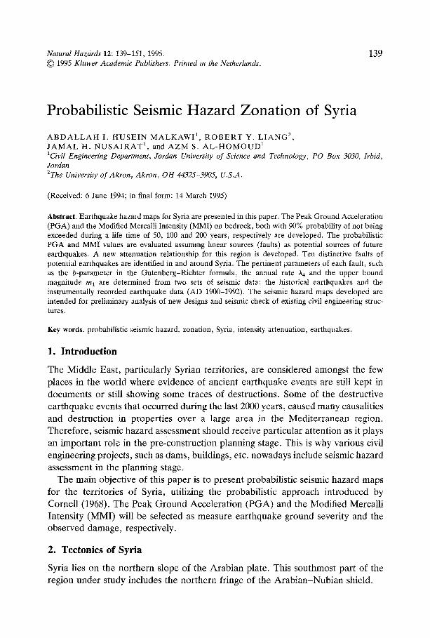
When studying the Middle East, researchers should, in the first place, pay attention to the two main active faults: the north Anatolian-Zagros and the Levant-East Anatolian. The later is represented by the N-S Levant and the N-E trending East-Anatolian zones. These two faults conjugate near Antioch, east of the Iskandaronna Gulf in Turkey. The Levant rift system includes many rift zones, one of which is called N-W Syria rift zones, which originates from the Red Sea riff in the Gulf of Aqaba, then bending at the southern end of Yamouneh fault making an 'S'-shaped bending trending East (Figure 1), then it goes up north till it reaches the southern part of Turkey. These faults are characterized by irregular shape, direction, terrain structure and land folds. It is noticed that rhomb-graben emerges where faults bend to the left but when bending to the right compressional structures are evident as small depressions and hilly areas. Both unusual character- istics show left lateral movement along the rift system.
3. Seismic Hazard Analysis
The present approach of determining probabilistic seismic assessment for a region comprises all the available information on seismicity, geo-tectonics setting, attenu- ation characteristics of Peak Ground Acceleration and the adaptation of a proba- bilistic model able to estimate the probability of occurrence of forthcoming seismic events. In this paper, the probabilistic hazard zonation for the territory of Syria will follow four steps (Shah and Dong, 1984).
(1) Identification of future earthquake sources: (2) Development of Magnitude-Frequency relationships; (3) Determination and/or selection of attenuation relationships; (4) Probabilistic estimate of Modified Mercalli Intensity and of Peak Ground
Acceleration as a measure of ground motion intensity.
4. Identification of Seismic Sources
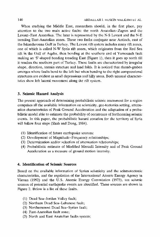
Based on the available information of Syrian seismicity and the seismotectonic characteristics, and the regulation of the International Atomic Energy Agency in Vienna (1992) and the U.S. Atomic Energy Commission (1973), ten seismic sources of potential earthquake events are identified. These sources are shown in Figure 2. Below is a list of these faults.
(1) Dead Sea-Jordan Valley fault; (2) Northern Dead Sea-Lebanese fault; (3) Northernmost Dead Sea-Syrian fault; (4) East-Anatolian fault zone; (5) North and East Anatolian faults system;
PROBABILISTIC SEISMIC HAZARD ZONATION OF SYRIA 141
~NTR J~L, St/,/.
SHEAR ZONE
YA I,~/,4UN £ H' FAUbT .~
0.~~.~ FAULT
OF.AD SEA
FOtO BELT
ALEPPO PLATEAU .....
,~ ~ FRUTBAH UPL{FT
/
B CENOZOIC
VOLC~NICS %
• 8AS~LT ~,', '* 01X£$
RED SE'*.
N
~ O KM
Fig. 1. Main tectonic features in the Middle Eäst and Eastern Mediterranean region (Barazangi, 1983).
(6) The Cyprus fault; (7) Euphrates Graben fault system; (8) The North-Western Mosul fault; (9) The North-Eastern fault;
(10) The Druz fault.
142 A B D A L L A H I. HUSEIN M A L K A W I ET AL.
Fig. 2.
38
36
34
32
4
3 v ~
. . . . . . . . . . . . . ! . . . . . . . . . . . . . . . . . . . . . . . . . . . . . . . . . . .
~o
30 v 34 36 38 40 42 44
Longitude(deg) 10 faults used to assess the seismic hazard in the Syrian region.
5. Estimation of Seismic Hazard Parameters
Earthquake activities recorded in and around the area of study covers a time span of almost 2000 years, and bounded between the Latitudes 31.0°-40.0 ° N and Longitudes 30.0°-44.0 ° E.
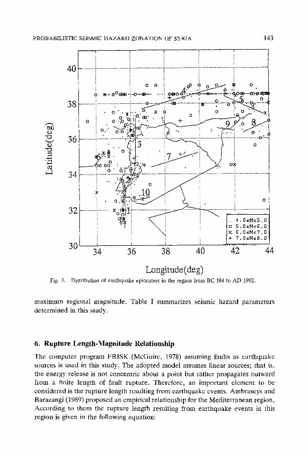
In Syria, seismic activities have been collected by several researehers (Plassard and Kogaj, 1981; Ben-Menahem, 1979). Later an updated earthquake catalogue covering up to 1989 was compiled by Hariri (1991). This catalogue was updated in this study to cover all the events that have occurred until AD 1992. Figure 3 presents all the epicenters of earthquake events in the region since BC 184 to AD 1992.
Based on the recently compiled earthquake catalogue, seismic hazard para- meters are estimated. The method developed by Kijko and Sellevoll (1992) incor- porated into a computer program is used in order to evaluate seismic hazard parameters symbolized by b, A, mo and tal, here b (/3 = loglob) is the parameter in Gutenberg-Richter relationship (Gutenberg and Richter, 1965), A is the annual activity rate of earthquakes, mo is the assumed threshold magnitude and ma is the
PROBABILISTIC SEISMIC H A Z A R D Z O N A T I O N OF SYRIA 143
~o
ù ¢ - a
Fig. 3.
40
o
~- e°c~ .~-~.-e-..
8 ................ ; ............................
o
o,."
6 ............................................
34 ............................ 9.....i ...«
X .'~
o.i
32 .................................. ~....c o<
30 34
0 "X?," • 0
o o la'i°: «
o
x o
Q... .~ ........................ +., ............
o o
• o %
. . . . . . . . . . . . . . . . . . . . . . . . . . . . . . . . . . . . . . . . . . . . . . . . . . . . . . . . ' , , i
, o
OX
ù.
!~.: 0
0
• 4.0~M<5.0
o 5.0~M<6.0
x 6.0«M<7.0
+ 7.0sM~8.0
36 38 40 42 44
L o n g i t u d e ( d e g ) Distribution of earthquake epicenters in the region from BC 184 to AD 1992.
maximum regional magnitude. Table I summarizes seismic hazard parameters determined in this study.
6. Rupture Length-Magnitude Relationship
The computer program FRISK (McGuire, 1978) assuming faults as earthquake sources is used in this study. The adopted model assumes linear sources; that is, the energy release is not concentric about a point but rather propagates outward from a finite length of fault rupture. Therefore, an important element to be considered is the rupture length resulting from earthquake events. Ambraseys and Barazangi (1989) proposed an empirical relationship for the Mediterranean region, According to them the rupture length resulting from earthquake events in this region is given in the following equation:
144 ABD A LLA H I. HUSEIN MALKAWI ET AL.
Table I. Summary of seismic hazard parameters determined in this study
Zone Name b-value /3-value A4 (yearly) mo ml Focal depth (km)
1 Dead Sea-Jordan Valley fault 0.89 2.06 0.31 - 0.07 4.0 7.50 15
2 Northern Dead Sea- Lebanese fault 0.30 0.70 0.197 ± 0.03 4.0 6.50 27
3 Northernmost Dead Sea- Syrian fault 0,32 0.72 0.156 ± 0.04 4.0 7.90 32
4 East-Anatolian fault zone 0,33 0.76 0,765 ± 0.08 4.0 7.50 41 5 North and East Anatolian
faults system 0.27 0.62 0.670 z 0.06 4.0 7.00 34 6 The Cyprus fault 0.57 1.31 0.79 ± 0.12 4.0 7.50 30 7 Euphrates Graben
fault system 0.38 0.86 0,149 ± 0.04 4.0 7.55 35 8 The North-Western
Mosul fault 0.40 0.90 0.140 ± 0.03 4.0 6.70 36 9 The North-Eastern fault 0.46 1.07 0.097 ± 0.03 4.0 6.90 34
10 The Druz fault 0.43 0.99 0.159 ± 0.04 4.0 7.00 36
Table II. List of constants for most commonly used attenuation equations
Reference Region C 1 C 2 C 3 r 0 IT 1
Donovan, 1973 Worldwide 1090 0.50 -1.32 25 0.70 Esteva, 1974 West coast of the USA 5600 0.80 -2.00 40 0.64 McGuire, 1976 Worldwide 1320 0.58 -1.52 25 0.94 Ben-Menahem, et al., 1982 Israel 58.7 1.21 -1.64 25 * Husein, Malkawi and Fahmi, 1995 Jordan and the Middle East 837.0 0.89 -1.73 25 *
* Not determined.
Ms = 4.63 + 1.43 loglo(L)
where M~ is the surfacewave magnitude, L is the rupture length (km).
(1)
7. Determination of Attenuation Relationship for PGA and Intensity
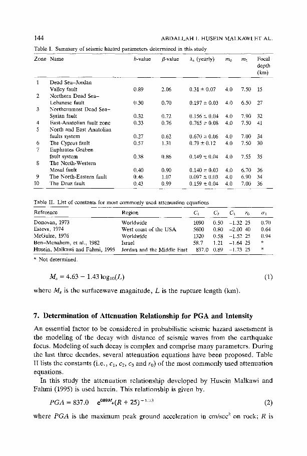
An essential factor to be considered in probabilistic seismic hazard assessment is the modeling of the decay with distance of seismic waves from the earthquake focus. Modeling of such decay is complex and comprise many parameters. During the last three decades, several attenuation equations have been proposed. Table II lists the constants (i.e., cl, c2, c3 and to) of the most commonly used attenuation equations.
In this study the attenuation relationship developed by Husein Malkawi and Fahmi (1995) is used herein. This relationship is given by.
PGA = 837.0 e°Sgmù(R "k- 25) -1"73 (2)
where PGA is the maximum peak ground acceleration in cm/sec 2 on rock; R is
PROBABILISTIC SEISMIC H A Z A R D ZONATION OF SYRIA
Cq O I11
E o
c- O
k.ù
o o < r-"
0
(.9 o
n
Fig. 4.
145 1000
. . . . . Donovan, 1973 - - Esteva, 1 9 7 4
McGu[re, 1976 - ' " ' . . . . . .. ~ ~ - - - B e n - M e n a h e m , 1 9 8 2
" ' " , : , " \"~,~ - Husein Malkawi and Fahmi, 199~
100 " ' " " : :'" • :::::
~~--a.0 "-.. ."~.. '..:-.'-.~~:~'°
10 ~ " , l ~ " " , , 10 1 O0 1000
H y p o c e n t r a l D i s t a n c e , R ( k m )
Comparison of attenuation relationships for Ma = 5.0 and 7.0.
3 7 .................... i ................................. i ...............
3 4 : .............................................. i. .....................
3 3
3 6 3 8 4 0 4 2
L o n g i t u d e ( d e g )
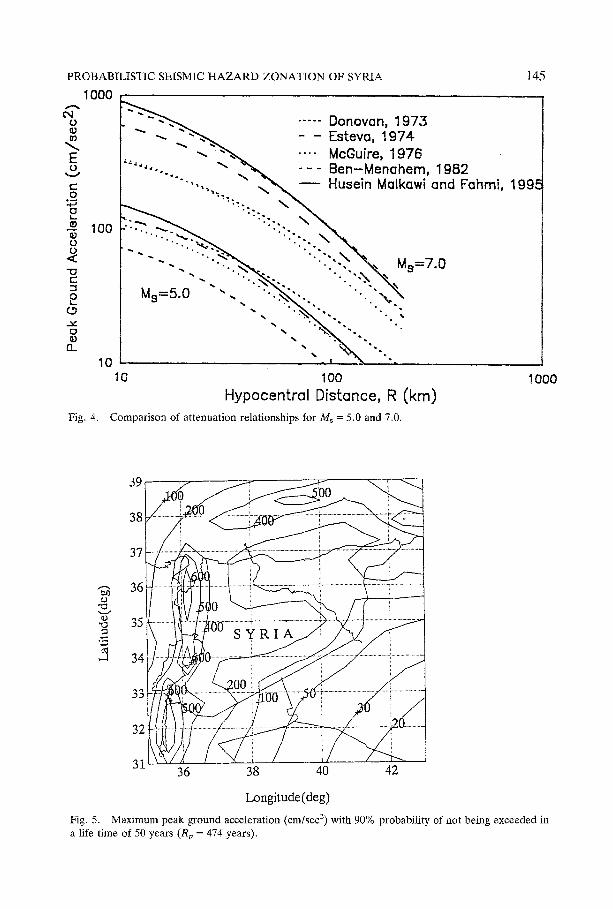
Fig. 5. Maximum peak ground acceleration (cm/sec 2) with 90% probability of not being exceeded in a life time of 50 years (Rp = 474 years).
146 A B D A L L A H I. HUSEIN MALKAWI ET AL.
tal3
'x3
39
38
37
36
35
34
33
32
31 36 38 40 42
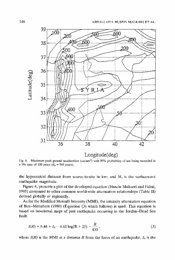
Longitude(deg) Fig. 6. Maximum peak ground acceleration (cm/sec ~) with 90% probability of not being exceeded in a life time of 100 years (Rp = 949 years).
the hypocentral distance from source-to-site in km; and Ms is the surfacewave earthquake magnitude.
Figure 4, presents a plot of the developed equation (Husein Malkawi and Falmi, 1995) compared to other common world-wide attenuation relationships (Table II) derived globally or regionally.
As for the Modified Mercalli Intensity (MMI), the intensity attenuation equation of B e n - M e n a h e m (1980) (Equation (3) which follows) is used. This equation is based on isoseismal maps of past earthquake occurring in the Jo rd an -D ead Sea fault.
I(R) --- 6.44 + I0 - 4.61 log(R + 25) - - - R
830 ' (3)
where I(R) is the MMI at a distance R from the focus of an earthquake, Io is the
PROBABILISTIC SEISMIC HAZARD ZONATION OF SYRIA
39
147
38
37
~- 36
-~ 35 0~,,~
B 34
33
32
31 36 38 40 42
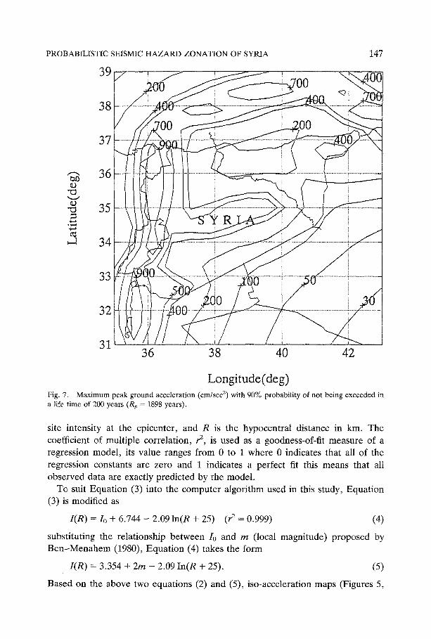
Longitude(deg) Fig. 7. Maximum peak ground acceleration (cm/sec 2) with 90% probability of not being exceeded in a life time of 200 years (Rp = 1898 years).
site intensity at the epicenter, and R is the hypocentral distance in km. The coefficient of multiple correlation, r 2, is used as a goodness-of-fit measure of a regression model, its value ranges from 0 to 1 where 0 indicates that all of the regression constants are zero and 1 indicates a perfect fit this means that all observed data are exactly predicted by the model.
To suit Equation (3) into the computer algorithm used in this study, Equation (3) is modified as
I (R) = Io + 6.744 - 2.09 ln(R + 25) (P = 0.999) (4)
substituting the relationship between Io and m (local magnitude) proposed by Ben -Menahem (1980), Equation (4) takes the form
I (R) = 3.354 + 2m - 2.09 In(R + 25). (5)
Based on the above two equations (2) and (5), iso-acceleration maps (Figures 5,
148 A B D A L L A H I. HUSEIN MALKAWI ET AL.
39
38
37
--- 36
-o 35
34
33
32
31 36 38 40 4 2
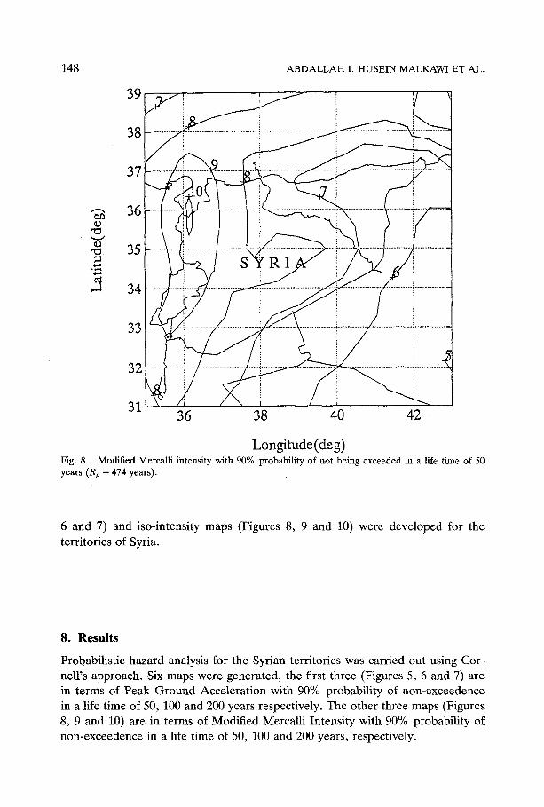
Longitude(deg) Fig. 8. Modified Mercalli intensity with 90% probability of not being exceeded in a life time of 50 years (Rp = 474 years).
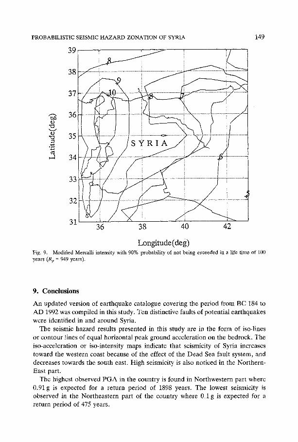
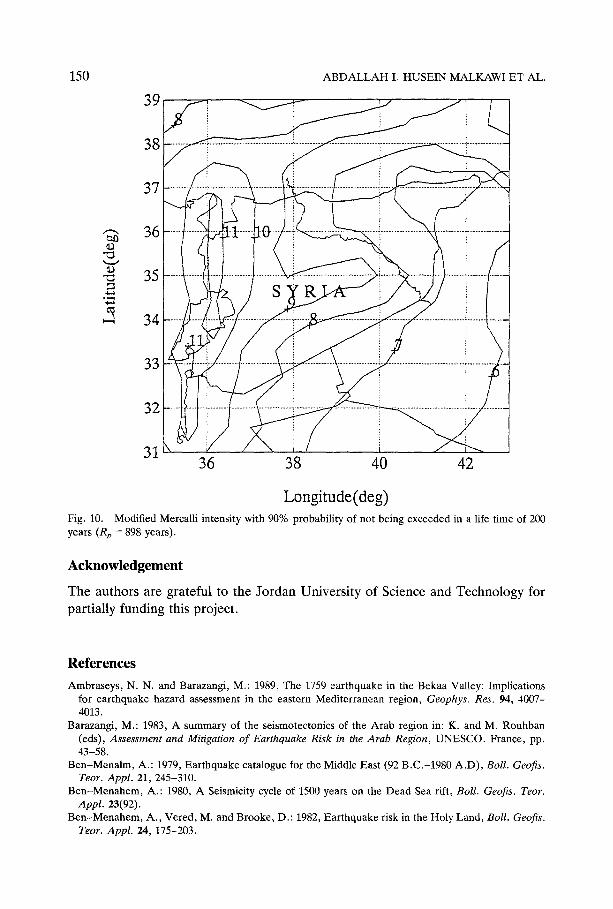
6 and 7) and iso-intensity maps (Figures 8, 9 and 10) were developed for the territories of Syria.
8. Results
Probabilistic hazard analysis for the Syrian territories was carried out using Cor- nell's approach. Six maps were generated, the first three (Figures 5, 6 and 7) are in terms of Peak Ground Acceleration with 90% probability of non-exceedence in a life time of 50, 100 and 200 years respectively. The other three maps (Figures 8, 9 and 10) are in terms of Modified Mercalli Intensity with 90% probability of non-exceedence in a life time of 50, 100 and 200 years, respectively.
PROBABILISTIC SEISMIC H A Z A R D ZONATION OF SYRIA
39
149
38
37
,-', 36 em
ùo 35
34
33
32
31 36 38 40 42
Longitude(deg) Fig. 9. Modified Mercalli intensity with 90% probability of not being exceeded in a life time of 100 years (Rp = 949 years).
9. Conclusions
An updated version of earthquake catalogue covering the period from BC 184 to AD 1992 was compiled in this study. Ten distinctive faults of potential earthquakes were identified in and around Syria.
The seismic hazard results presented in this study are in the form of iso-lines or contour lines of equal horizontal peak ground acceleration on the bedrock. The iso-acceleration or iso-intensity maps indicate that seismicity of Syria increases toward the western coast because of the effect of the Dead Sea fault system, and decreases towards the south east. High seismicity is also noticed in the Northern- East part.
The highest observed PGA in the country is found in Northwestern part where 0.91 g is expected for a return period of 1898 years. The lowest seismicity is observed in the Northeastern part of the country where 0.1 g is expected for a return period of 475 years.
150 ABDALLAH I. HUSEIN MALKAWI ET AL.
39
38
37
, - ~ 36 ~0
35
34
33
32
31 36 38 40 42
Longitude(deg) Fig. 10. Modified Mercalli intensity with 90% probability of not being exceeded in a liIe time of 200 years (Rp = 898 years).
Acknowledgement
The authors are grateful to the Jordan University of Science and Technology for partially funding this project.
References
Ambraseys, N. N. and Barazangi, M.: 1989, The 1759 earthquake in the Bekaa Valley: Impli¢ations for earthquake hazard assessment in the eastern Mediterranean region, Geophys. Res. 94, 4007- 4013.
Barazangi, M.: 1983, A summary of the seismotectonics of the Arab region in: K. and M. Rouhban (eds), Assessment and Mitigation of Earthquake Risk in the Arab Region, UNESCO. Fran¢e, pp. 43-58.
Ben-Menalm, A.: 1979, Earthquake catalogue for the Middle East (92 B.C.-1980 A,D), Boll. Geofis. Teor. Appl. 21,245-310.
Ben-Menahem, A.: 1980, A Seismicity cycle of 1500 years on the Dead Sea rift, Boll. Geofis. Teor. Appl. 23(92).
Ben-Menahem, A., Vered, M. and Brooke, D.: 1982, Earthquake risk in the Holy Land, Boll. Geofis. Teor. Appl. 24, 175-203.
PROBABILISTIC SEISMIC HAZARD ZONATION OF SYRIA 151
Cornell, C.A.: 1968, Engineering seismic risk analysis, Bull. Seis. Soc. Am. 58, 1583-1606. Donovan, N. C.: 1973, A statistical evaluation of strong motion data including the 9th February, 1971,
San Fernando Earthquake, Proc. 5th World Conf. Earthq. Eng. 11, 1252-1261. Esteva, L.: 1974, Geology and probability in the assessment of seismic risk, Proc. 2nd Int. Cong. Int.
Assoc. Engineering Geologist, Sao Paolo, p. 14. Gutenberg, B. and Richter, C. F.: 1965, Seismicity of the Earth, Hafner, New York and London, 310
Pp. Hariri, A.: 1991, Seismotectonic study, seismic hazard assessment and zonation of the Syrian Arab
Republic, M.S. Thesis, Institute of Earthquake Engineering and Engineering Seismology University 'Kiril and Metodij' Skopje, Macedonia.
Husein Malkawi, A. I. and Fahmi, Kb.: 1995, Empirically derived earthquake ground motion attenu- ation relations for Jordan and conterminous areas, Int. J. Eng. Geol., in press.
International Atomic Energy Agency: 1972, Earthquake guidelines for reactor siting, Tech. Reports, Ser. No. 139, Vienna, 25 pp.
Kijko, A. and Sellevoll, M. A.: 1992, Estimation of earthquake hazard parameters from incomplete data files, Part II. Incorporation of magnitude heterogeneity, Bull. Seis. Soc. Am. 82, 120-134.
McGuire, R. K.: 1976, Fortran computer program for seismic risk analysis, U.S. Dept. of Interior, Geological Survey, Open-File Report 76-67, Denver, CO, 90 pp.
McGuire, R. K.: 1978, FRISK, A Computer Program for Seismic Risk Analysis, U.S. Dept. of Interior, Geological Survey: Open File Report, 78-1007, Denver, CO, 90 pp.
Plassard, J. and Kogaj, B. : 1981, Seismicity of Lebanon, A Catalogue of felt earthquakes (in French, Observatoire de Ksara (Lebanon) Annals, Memoirs, Tore. IV, Cahier 1, Conseil National de la Recherche Scientiflque, Beirut, Lebanon.
Shah, H. C. and Dong, W. M.: 1984, A re-evaluation of the current seismic hazard assessment methodologies, Proc. 8th. World Co@ on Earthq. Eng., Sah Francisco 1,247-254.
U.S. Atomic Energy Commission: 1973, Seismic and geologic siting criteria for nuclear power plants, Federal Register, No. 38, p. 218.


