Embed Size (px)
Citation preview

ForS, 10-300 UNITED STATES DEPA
(July 1969) NATIONAL
NATIONAL REGI
INVENTOR
(Type all entries — complete applicable sections)
Missouri
St. Francois
FOR NFS USE ONLY
11. NAME
Bonne Terre Mine
Highway 47 (Office) *
Bonne Terre
Missouri 63628
St. Joseph Lead Mine at Bonne Terre
St. Francois
OWNERSHIP
Public Acqui»it>on:
Q In Procen
Q Being Considered
STATUS
Occupied
D Unoccupied
D P'eservotion work
in progress
ACCESSIBLE
TO THE PUBLIC
Yes:
E Restricted
Q Unrestricted
D N.
D Park
D Private Residence
D Religious
D Scientific
O Transportation
Q Other fSpec/tyj
St. Joseph Minerals Corporation
Missouri 63628
Recorder of Deeds
St. Francois County Courthouse
FarmingtonREPRESgNTAtlON IK EXISTING SURVEYS ; i;.
Missouri 63640 29
TITLE OF SURVEY:
Missouri State Historical Survey
1973 D Federal County
Missouri State Park Board
STREET AND NUMBER:
Box, #176, 1204 Jefferson BuildingCITY OR TOWN
Jefferson City Missouri 65101 29
Congressional District #10: The Hon. Bill D. Burlison

fc DESCRIPTION
CONDITION
QQ Excellent D Good Q Fair
(Check One;
Q Altered E Unaltered
f Check One>
3 Deteriorated Q Ruins Q Unexposed
(Check OneJ
Q Moved (XI Original Site
The Bonne Terre Mine is located below the city of Bonne Terre, in St. Fran cois County, Missouri. The mine is approximately.sixty miles south-south west of St. Louis and is about one-half mile west of the junction of U.S. 67 and Missouri Route 47. The Bonne Terre Mine is an abandoned lead mine which has not been worked since 1962. However, this particular mine has been cleared of debris and facilities for guided tours have been establish ed. The property remains in the ownership of the St. Joseph Minerals Cor poration, but the rights of occupancy have been leased to the Bonne Terre Mine Company, this nomination includes only that portion of the St. Joseph Lead Company mine at Bonne Terre which has been opened and maintained for tourist use as of January, 1973. (See exact boundaries on topographic map).
That portion of the mine included in this nomination is approximately 400 feet below the ground surface at the lowest point, but at certain points the ceiling of the mine ("the back") is merely a few feet below the ground level. There are at least three levels of occupancy within the mine, and mining operations were formerly conducted at all levels simultaneously. There have been several entrances to the Bonne Terre Mine during the many years of active mining, but the major access today is through the "mule entrance," where raw ore was removed from the mine by mule-drawn carts. The Bonne Terre Mine Company has improved this entrance shaft and today it provides the only access for tourists.
Upon entering the Bonne Terre Mine through a series of concrete stairways in the "mule entrance," the visitor descends to the upper mining level, 55 feet below the surface. This is the oldest level of mining activity and was solid rock before mining commenced. The lead occurred in veins laced through this bedrock, and all of the debris were loosened and removed by hand. The rock was so stratified that as mining increased the cavernous volumn of the mine, the ceiling and floor surfaces remained relatively level. Rock pillars were allowed to remain at regular intervals in the mine to provide support for the ceiling. Passageways to lower mining levels occur at various places. Ore was originally removed from the mine by carting it up the "mule entrance," but as various areas were worked, the ore was dropped from higher to lower levels, and was removed directly to the refining mill on the surface. Ore and mining equipment were moved about within the mine by narrow-gage railroad. At the time of the closing of the mine in 1962, nearly 30 miles of track were in use in the Bonne Terre Mine.
At a certain point on the ceiling of the upper level, a five-by-five foot wooden covering is observed. This is the point at which the first shaft into Bonne Terre Mine was dug in 1870, and it is reportedly the first lead mining shaft sunk in the United States. Prior to that time, lead mining had been primarily confine'd to strip mining seams which were accessible from the surface. However, with the innovation of the diamond drill, used first by the St. Joseph Lead Company in 1869, subsurface lead mining .be came practical. At numerous points in the mine, various ladders, cables,
•SICNIFICANCE
RIOO (Cnecfc One or More Appropriate)
Q Pre-Celumbion! D )6tn Century
CD 15th Century D I7'h Century
Q i8lh Century
QS 19th Century
20th Century
(It Applicable end Kn> 1664-1962
Aboriginal
P P.-«h.i.or,c
P Historic
Q Agriculture
Q Afchit»>ctui'»»
a A,,[53 Commerce
Q Communications
Q Conservation
k On* or Mof« *• Appnprlmtm)
D Educotlon Q Poll
D Engineering . Q R.|,
O Industry | o
Q invention Q Sei«
Q Landscape Q] Sco)
Architstctur* (~1 Soci
Q UHrotur* ;,
D Militory Q Th«,
Q Music Q Tr<m
I
col
on/Phi.
ophy
D Urban Planning
OS Other (Speclly)
Mining___
z
o
u
UJ
u
Lead mining commenced in Missouri's "lead-belt" during the period of French occupancy. Lead has been mined in the immediate vicinity of Bonne Terre and St. Francois County since at least 1720. During that year. Mine LaMotte was established by a Frenchman named Renault and a mineralogist, LaMotte. This first lead mine was operated under a French patent and pri marily produced shot for use by the French army- Lead mining is probably the earliest commercial Industry in Missouri, and flourished in the vici nity of present-day St. Francois County prior-to the founding of permanent white settlements in towns such as Ste. Genevieve and St. Louis. John Law's Company, operating under French license, worked Mine LaMotte (20 miles south of Bonne Terre) and various mines near.Potosi, in Washington County, Missouri.
The St. Joseph Lead Company was organized in 1864 in order to exploit the lead ore at Bonne Terre. .The tract which the new company acquired was a recognized lead-producing tract known as "La Grave Mines." It was opera ted by Anthony La Grave of St. Louis.2 La Grave conveyed his property to the St. Joseph Lead Company with two outstanding mortgages which he had concealed from the new purchasers. As a result, work progressed slowly and there were no profits from the mining until demands by the Union army stimulated sales. In the autumn of 1865, General Price's troops raided the mine and destroyed the operation, causing a delay of several months before the resumption of production.3 In September, 1865, the mining oper ations were expanded and improved, and a number of permanent residences, stores, and furnaces were established at Bonne Terre. Ore was dtscovered in abundance at a level of four to eight feet below the surface in hori zontal sheets of six to eight inches in thickness. Initially, the miners exposed the lead veins by strip mining, blasted the ore into useable blocks, and hauled the material to a smelting mill for processing. The ore was pulverized in mechanical rollers and the lead was separated from the useless "chat" waste. By heating and stirring the melted lead parti cles, impurities were removed and the lead was cast into ingots for ship ping. Profits, however, were severely limited because of the expense and inefficiency of this method'of'production. 'In wet weather, for example, mining ceased entirely because the cuts were filled with water, and in dry months, too little water was available to crush or wash the ore. There fore, production could occur only during six months of each year. Average
annual output was about 6,000 pigs, or 240 tons during these early years.

I 9". MAJOR BIBLIOGRAPHICAL REFERENCES
: 1. Austin, Moses, "A Summary Description of the Lead Mines in Upper loui-: siana...," n.p., 1804, (issued as Document No. 3, accompanying a messagei from the President of the United States, November 8, 1804).
: 2. Jones, J. Wyman, A History of the St. Joseph Lead Company. New York:I 1892.
3. Kemp, James F., Notes on Lead Smelting in Southeast Missouri. New York- ___Columbia University, 1888.———————
10. GEOGRAPHICAL DATA
CORNER LATITUDE
Degree* Minutes Seconds
NW 37° 55' 27"
ME 37° 55 1 25' SE 37° 55' 17" sw 37° <;<;• 19-
—————————————— [ -
F
i ———————————— "LONGITUDE
Degrees Minutes Seconds
90° 33' 18" 90 ° 32 • 57 " 90 ° 32 • 58 " Qn « 11' IQ-
LATITUDE LONGITUDE
Degrees Minutes Seconds Degrees Minutes Seconds
O o '
APPROXIMATE ACREAGE OF NOMINATED PROPERTY. aDDrOX. 10.45aCr6S
STATE:
STATE:
STATE:
STATE:
CODE
CODE
CODE
CODE
COUNTY ' CODE
COUNTY: CODE
COUNTY: CODE
COUN TY : CODE
Ml. FORM PREPARED BY . ".; : '••-. '?.{•* ?.S '; " ' .ffiv: 'f. '. ' ;.NAME AND TITLE:
Stephen J. Raiche, Chief Research Historian
ORSAN.ZAT,™ Missouri State Historical Survey & Planning VnHi is 1Q7^ OffiVp. Missouri St.at.P Part Rnarri 3 AP n ' IB ' ly/J
P.O. Box #176, 1204 Jefferson Building
CITY OR TOWN:
Jefferson City
[12. STATE LIAISON OFFICER CERTIFICATION ;: r
As the designated State Liaison Officer for the Na
tional Historic Preservation Act of 1966 (Public Law
89r665), I hereby nominate this property for inclusion
in the National Register and certify that it has been
forth by the National Park Service. The recommended
level of significance of this nomination is:
National Q State QQ Local Q
U'
Title Director, Missouri State Park
Board and Missouri State Liaison
Ca, e /o - in - >n 0fflcer
STATE CODE
Missouri 65101 29
NATIONAL REGISTER VERIFICATION
I hereby certify that this property is included in the
National Register.
Chief, Office of Archeology and Historic Preservation
Date
ATTEST:
Keeper of The National Register
Date
GP 0 9 0 I .0 A 7

F»™ 10-300o (July I9W
UNITED STATES DEPARTMENT OF THE INTERIOR NATIONAL PARK SERVICE
NATIONAL REGISTER OF HISTORIC PLACES
INVENTORY • NOMINATION FORM
(Continuation Sheet)
Missouri
St. Francois
FOR NFS USE ONLY
ENTRY NUMBER
ibfr mil en<r(e«J
7. #1
BONNE TERRE MINE
mining carts, and section of railroad track are visible remains of the acti vity which flourished at one time. The Bonne Terre Mine Company will attem^ pt to preserve this surviving equipment and illuminate those sections for visitor enjoyment.
The Bonne Terre Mine Company is attempting to interpret various aspects of lead mining in Missouri by explaining fully the several functions of differ ent parts of the mine. For example, the "changeover barn" where mules were quartered and refreshed has been opened for inspection. Many of the most unusual pillars, including several reinforced with steel cable, have been lighted and are included on the tour. The "mule entrance" itself is an attraction. It was created by accident when a blasting operation on the ceiling inadvertently blew out a large portion of someone's backyard. From that day in the 1920's, it has served as the main entrance to the mine.
In the many years of mining activity in the St. Francois County "lead-belt," several shafts were sunk by many companies. The existence of lead under St. Francois County was found to be so abundant that mining operations continued steadily for about 200 years in the vicinity. Lead mining was so intensive in the region that eventually the various mines became interconnected as rival companies expanded into adjacent mines. During the later years of mining in the Missouri "lead-belt," a mere artificial underground boundary separated the domains of the various companies. It is reported that there are at least three hundred continuous miles of subterranean mines under St. Francois County. (St. Louis Post-Dispatch, May 24, 1970). Obviously it is not practical to provide historic recognition for the entire complex. Therefore the1 problem of delineating a certain portion involves an arbitrary decision. It was determined by the State Liaison Office, however, that a certain portion of this significant network of mines should be preserved and recognition should be afforded particularly to that portion which has been made accessible to the public through the improvements by the Bonne Terre Mine Company.
This nomination does not include any surface structures located within the boundaries of the Bonne Terre Mine. Although there is a recreated "mining town" adjacent to the'mule entrance," this facility is a tourist attraction and was built as an interpretive and entertainment center. Furthermore, there are no surviving buildings, sites, or fixed objects situated on the surface within the boundaries of Bonne Terre Mine which relate to the opera tion of the mine and possess a significant level of integrity to be included in this nomination.
CPO 921-724

1 Form 10-300o
JJuly 1969)
UNITED STATES DEPARTMENT OF THE INTERIOR
NATIONAL PARK SERVICE
NATIONAL REGISTER OF HISTORIC PLACES
INVENTORY • NOMINATION FORM
(Continuation Sheet)
Missouri
St. Francois
FOR NPS USE ONLY
ENTRY MUMBER
BONNE TERRE MINE
In 1869, the St. Louis Lead Company began using a diamond drill to locate lead ore. This method had never previously been used in lead detection before the experiment at Bonne Terre, but the process had been successfully adapted to locating granite and marble seams in Vermont and New York. Because of the insufficient funds in the company treasury, the innovation of the diamond drill was financed through the personal resources of the President and Trea surer of the Company. The drill, however, located lead ore about 120 feet below the surface, and a shaft was sunk at that location (described in item #7). Today the shaft entrance is sealed, but it may still be observed from within the Bonne Terre Mine. After 1870, lead mining was confined to under ground operations and the practice of surface mining was generally abandoned in the Missouri "lead-belt." As a result of the subsurface mining, lead pro duction increased to 605 pigs per month in 1869, and 2,500 per month by the end of 1873. By May, 1874, an additional four shafts had been sunk. By the end of 1874, the company had paid its first dividend.*
By May, 1880, the capacity of the smelting mill had nearly been doubled, and a narrow-gage rail connection had been made to the St. Louis, Iron Mountain, and Southern line, at a point 13 miles west of Bonne Terre. After the com pletion of the rail line, it became possible to remove the "chat" to points outside of Bonne Terre and dump it in more remote areas. As a result of this method of waste removal, the large and numerous "chat dumps" which today a- bound on the St. Francois County landscape began to be formed. In addition, chat could be shipped to distant points. There is some indication that this waste mining material was used for street improvement in St. Louis.5
In February, 1883, a fire destroyed the old smelting mill, and production was temporarily halted until a new facility was erected. Completed in July, 1883 the new facility enabled the company to attempt several new innovative smelt ing techniques and production increased proportionately. 6 In July, 1886, the company purchased an additional 3, 218 acres adjacent to the mine, which had previously been worked by a competitor.
The major impediment to higher profits was transportation of the product to customers. The most econimical form of mobility for bulk ore and finished pigs was, of course, over water. But in order to ship to the Mississippi River the company had to buy passage over the Iron Mountain Railroad to St. Louis. In 1887 it was decided to construct a company-owned rail line to the Mississippi River at a point below St. Louis. The line, the "Mississippi River and Bonne Terre," was completed in 1890.7 Certain sections of the roadbed are visible today in parts of St. Francois and Jefferson counties. Passenger traffic was encouraged, and the mine railroad helped open the lands along the route for farming. With the completion of the company road, it was determined more feasible to ship raw ore to the Mississippi River and to stneV

Form 10-300o UNITED STATES DEPARTMENT OF THE INTERIOR
(July 19o9) NATIONAL PARK SERVICE
NATIONAL REGISTER OF HISTORIC PLACES
INVENTORY - NOMINATION FORM
(Continuation Sheet)
(Number •!! »nttt*m)
8. #2
BONNE TERRE MINE
it at the railhead. Accordingly, a smelting plant laneum, in Jefferson County, and this enterprise pi source for the community. Sand and water were abur shipment of coke to Herculaneura was much cheaper tl 1890, the mining operations had become so extensive numerous farms and stores near Bonne Terre to supp miners.
Production at Bonne Terre continued throughout the eth century, and "lead-belt" production became esse of armaments during two world wars. From 1870 to Mine at Bonne Terre yielded a product valued at $3C closing of the mine in 1962, 35 million tons of lef duction was discontinued at the Bonne Terre mine pi had been nearly depleted and it was becoming too e> existing raw material. The St. Joseph Minerals Cot mining extensively in various locations to the sou Other mines in the old "lead-belt" have been abande water. The last producing mine in the "lead-belt" •ber 1, 1972.
FOOTNOTES
1. J. Wyman Jones, (President St. Joseph Lead ( St. Joseph Lead Company, 1892, pp. 5,7. Uni
STATE
Missouri
COUNTY
St. Francois
FOR NPS USE ONLY
was established at Hercu- •ovided the major income dantly available, and the an to Bonne Terre. By
• that the company operated y the daily needs of the
early years of the twenti- 'ntial to the manufacture 943, 'the St. Joseph Lead
10 million, and before the id had been removed. Pro- -imarily because the ore (pensive to retrieve the •poration is currently :h and west of Bonne Terre. >ned and are filling with ceased operations on Octo-
;ompany), A History of theted States War Department,
Report from the Secretary of War in Relation to Lead and Lead Mines inthe United States, 1828. Moses Austin, "A Summary Description of theLead Mines in Upper Louisiana...", issued as Document No. 3, accompany ing a message from the President of the United States, November 8, 1804
2. Wyman, A History of the St. Joseph Lead Company, 1892, p. 7.
3. War of the Rebellion: A Compilation of theUnion and Confederate Armies, 1893, Series
Official Records of the[, Volumn 41, part 1, p. 456
4. Wyman, A History of the St. Joseph Lead Company, 1892, p. 7.
5. "Minute Book of the Board of Improvements for Lafayette Park, 1851- 1876," (Unpublished, St. Louis Public Library archives), pp. 13-14.
6. Wyman, A History of the St. Joseph Lead Company, 1892, p. 25.
7. Wyman, A History of the St. Joseph Lead Company, 1892, pp. 30-32.
GP 0 921-72*

Form 10-300=
(July 1969)
UNITED STATES DEPARTMENT OF THE INTERIOR
NATIONAL PARK SERVICE
NATIONAL REGISTER OF HISTORIC PLACES
INVENTORY • NOMINATION FORM
(Continuation Sheet)
Missouri
St. Francois
FOR NPS USE ONLY
9. #1
BONNE TERRE MINE
4. School craft, Henry R., A View of the Lead Mines of Missouri.... New York: C. Wiley and Sons, 1819.
5. Stockett, N.A., Mining Practices of the St. Joseph Lead Company in South east Missouri. New York:American Institute of Mining and Metallurgical Engineers, 1943.
6. Thompson, Henry Clay II, The County Historian. Farmington, Mo. (?),: Stewart Publishing Company, ca. 1936.
7. United States War Department, Report from the Secretary of War in Rela tion to Lead and Lead Mines in Missouri, April 8, 1828. Washington, D.C. Duff Green, 1828.———————————
8. War of the Rebellion: A Compilation of the Official Records of the Union and Confederate Armies.Washington, D.C., Government Printing Office, 1893.Series I, Volume 41, part 1, p. 456.

Fora. 10-301
(juir me)UNITED STATES DEPARTMENT OF THE INTERIOR
NATIONAL PARK SERVICE
NATIONAL REGISTER OF HISTORIC PLACES
PROPERTY MAP FORM
(Type all entries - attach to of enclose with map)
COMMON
Bonne Terre Mine
AND/ON HISTORIC
St. Joseph Lead Mine at Bonne Terre .
NUMERIC CODE (A»»tgnwl try NFS)
2. LOCATION
• TATC
Missouri
Highway 47 (Office)
3. MAP REFERENCE
•OUKCE
City map of Bonne Terre,
Mo.
COUNTY
St. Francois '
DATE
1968
TOWN
Bonne Terre
SCALE
Relative
6PO »3 2-010

WELCOME TO BONNE TERRE, MO. 1968
Court*!?
CITY OF BONNE TERRE

Form 10-301
(July 1968)UNITED STATES DEPARTMENT OF THE INTERIOR
NATIONAL PARK SERVICE
NATIOKAL REGISTER OF HISTORIC PLACES
PROPERTY MAP FORM
(Type alt entries - attach to or enclose with map)
COMMON
Bonne Terre Mine
2. LOCATION
STATE
Missouri
AND/OR HISTORIC , ...
St. Joseph Lead
Mine at Bonne Terre
COUNTY
St. FrancoisTOWN _
Bonne Terre
Highway 47 (Office)
3. MAP REFERENCE
SOURCE
U.S.G.S. 7.5' Bonne Terre Quadrangle
DATE
1958
SCALE
1:24,000
REQUIREMENTS: PRQPER-TY BOUNDARIES, WHERE REQUIRED. AND_NORTH ARROW
GPO 932.010

U.S.G.S.
7.5'
Quadrangle
"Bonne Terre"
(1958)
Scale:
1:34,000
Bonne Terre Mine
Lat.
Long
. 90° 33'
18"
90° 32'
57"
90° 32
' 58"
90° 33
' 19
"
NE 37° 55
' 25"
SE 37° 55
' 17"
SW 37° 55'
19"
GPO 932-009
UNITED STATES DEPARTMENT OF THE INTERIOR NATIONAL PARK SERVICE
NATIONAL REGISTER OF HISTORIC PLACES
PROPERTY PHOTOGRAPH FORM
(Type all entries - attach to or enclose with photograph)
COMMON
Bonne Terre Mine
2, LOCATION
STATE
Missouri
ANO/OR HISTORIC
St. Joseph Lead Mine at Bonne Terre •
COUNTY
St. FrancoisTOWN
Bonne Terre
STREET AND NUMBER
Highway 47 (Office)
3. PHOTO REFERENCE
PHOTO CREDIT
Stephen J Mo. State
Raiche Park Board
DATe
November 10, 1972Mo. State Jefferson
Park City
Board, Mo.
, Bx. 65101
176
4. IDENTIFICATION
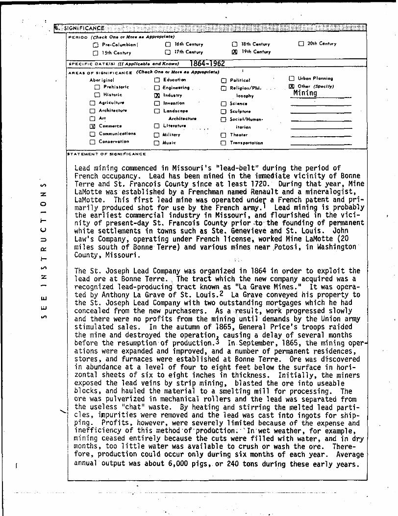
General view of interior of mine, along lighted visitor trail. North facingsouth.


UNITED STATES DEPARTMENT OF THE INTERIOR
NATIONAL PARK SERVICE
NATIONAL REGISTER OF HISTORIC PLACES
PROPERTY PHOTOGRAPH FORM
(Type all entries - attach to or en close with photograph)
Bonne Terre Mine
AND/OR HISTORIC
St. Joseph Lead Mine at Bonne Terre
2. LOCATION
STATE
MissouriCOUNTY
St. Francois[TOWN
1 Bonne Terre
Highway 47 (Office)
3. PHOTO REFERENCE
PHOTO CREDIT
Stephen J. Raiche Mo. State Park Board
4. IDENTIFICATION
DATE
November 10, 1972
Mo. State Park Board Jefferson City, Mo.
, Bx. 176 65101
General view of mine shaft, looking from interior toward "mule entrance." West facing east.


UNITED STATES DEPARTMENT OF THE INTERIOR
NATIONAL PARK SERVICE
NATIONAL REGISTER Of HISTORIC PLACES
PROPERTY PHOTOGRAPH FORM
(Type all entries • attach to or en close with photograph)
1. NAME
COMMON
Bonne Terre Mine
2. LOCATION
STATE 1
Missouri
Highway 47 (Office)3. PHOTO REFERENCE
PHOTO CREDIT
Stephen J. Raiche Mo. State Park Board
4. IDENTIFICATION
.NO/0. H..TO.,. st _ Joseph
Lead Mine at Bonne Terre
COUNTY
St. Francois
DATE
November 10, 1972
TOWN
Bonne Terre
Mo. State Park Board, Bx. 176 Jefferson City, Mo. 65101
General view of interior of mine, showing sections of the ceiling ("back") which have been removed for mining. Note improvements to facilitate visitor use. North'facing south.

;:L<-"-V - : '\/• r:^

UNITED STATES DEPARTMENT OF THE INTERIOR
NATIONAL PARK SERVICE
NATIONAL REGISTER OF HISTORIC PLACES
PROPERTY PHOTOGRAPH FORM
(Typq all entries - attach to or en close with photograph)
COMMON
Bonne Terre Mine
2. LOCATION
STATE
Missouri
AND/OR HISTORIC
St. Joseph Lead Mine at Bonne Terre
COUNTY
St. FrancoisTOWN _
Bonne Terre
STREET AND NUMBER
Highway 47 (Office)
3. PHOTO REFERENCE
PHOTO CREDIT
Stephen J Mo. State
4. IDENTIFICATION
. Raiche Park Board
DATE
November 10, 1972
NEGATIVE FILED
Mo. State Jefferson
Park City
Board , Ho.
, Bx. 176 65101
Interior of Bonne Terre Mine, near "mule entrance," showing surviving mining cart and equipment. Note illumination and visitor paths provided by Bonne Terre Mine Company. North facing south.


![Kvalitet i praktik Sygeplejerskeuddannelsen · Uenig (1) Baggrundsspørgsmål Q15. Mit [praktiksted/klinisk uddannelsessted] var i: Regionalt regi Kommunalt regi Privat regi Andet](https://img.dokumen.tips/doc/110x75/6004bbdcda3fa17330386dce/kvalitet-i-praktik-sygeplejerskeuddannelsen-uenig-1-baggrundssprgsml-q15.jpg)