Embed Size (px)
Citation preview
INDIAN JOURNAL OF SCIENCE AND TECHNOLOGY
SYSTEMATIC REVIEW
OPEN ACCESS
Received: 16-06-2020Accepted: 20-07-2020Published: 10-09-2020
Editor: Dr. Natarajan Gajendran
Citation:Majid NA, Taha MR,Selamat SN (2020) Historicallandslide events in Malaysia1993-2019. Indian Journal ofScience and Technology 13(33):3387-3399. https://doi.org/10.17485/IJST/v13i33.884∗Corresponding author.Tel: [email protected]
Funding:Ministry Higher Education,Malaysia, grant numberNEWTON/1/2018/TK01/UKM/2
Competing Interests: None
Copyright: © 2020 Majid et al. Thisis an open access article distributedunder the terms of the CreativeCommons Attribution License, whichpermits unrestricted use,distribution, and reproduction inany medium, provided the originalauthor and source are credited.
Published By Indian Society forEducation and Environment (iSee)
ISSNPrint: 0974-6846Electronic: 0974-5645
Historical landslide events in Malaysia1993-2019
N Abd Majid1∗, M R Taha2, S N Selamat1
1 Institute for Environment and Development (LESTARI), Universiti Kebangsaan Malaysia(UKM), UKM Bangi, 43600, Selangor, Malaysia. Tel.: +6-03-8921-76392 Department of Civil Engineering, Faculty of Engineering and Built Environment, UniversitiKebangsaan Malaysia, UKM Bangi, 43600, Selangor, Malaysia
AbstractBackground: To review historical landslide events in Malaysia. The increasingnumber of landslide in Malaysia is closely linked to the development ofnew infrastructures of the economic and social progress. Methods: Theresearch was a review study utilizing secondary data as the primary sourcefrom National Slope Master Plan 2009-2023 and some additional study bythe researchers. This study thoroughly examined landslide in Malaysia andfound many landslide occurred in the area of Selangor due to increaseddevelopment. There are several historical landslide events in Malaysia thathave been extensively reviewed from the year 1993 to the year 2019. Findings:This disaster has resulted in substantial numbers of casualties, destruction ofproperties losses and direct and indirect economic implications. The summaryof this study found that the number of landslides and injuries were reported toincrease between 1993 and 2019. Some major landslide also occurred alongthe main highway without fatalities but serious traffic congestion occurred.Novelty of the study: This paper focus on clarify the historical events thathad an impact on the physical and socio-economic conditions in Malaysia. Insummary, this study has highlighted the summary of major landslide eventsin Selangor and Kuala Lumpur, and generally, this tragedy occurred causesof slope instability and human error. Recommendations: It is suggested tofurther restrict any development on a high land area to limit environmentalimpact. In addition, awareness and knowledge about on the dangers oflandslides should be communicated to the public during the planning andmanagement process. Susceptibility analysesmay also provide important inputduring overall design, analisis and planning of development in hilly terrain.
Keywords: Landslide; historical; Malayasia; hazard
1 IntroductionMalaysia is located in the tropical climate of South East Asia and characterized by heavyrain almost all year round particularly from October to February. Malaysia has
https://www.indjst.org/ 3387
Majid et al. / Indian Journal of Science and Technology 2020;13(33):3387–3399
experienced multiple natural disasters, such as landslides, mudslides and floods due to heavy rainfall, especially in these fewmonths. Landslides are frequent in the region, particularly during this monsoon season due to high rainfall up to 700 mmper month. Landslide is frequently caused by heavy rainfall in Malaysia particularly during the summer monsoon, duringthe Southwest Monsoon season from end of May to September and during the North-Eastern monsoon from November toMarch (1). Landslides resulted in environmental and socio-economic damage such as loss of life, harm to properties and facilities,the social strain on families, land boundary conflicts and land degradation. Malaysia has seen quite a few major landslides andcasualties. The collapse of the Highland Towers in 1993 has been an eye-opener on the need for proper policies for public anddecision-makers, technical organizations, help staff for emergency services and remedial steps for landslide and preventionaction (2), With an average of 100 cases per year (estimation of reported and unreported cases) and over 600 deaths recordedsince 1961, people have also been warned and told to expect for the worst (3).
In Malaysia, the increase in landslide events are closely linked to the development of new infrastructures such as highways,road network, dams and the demand for housing in the housing sector has been increasing so that it has to build in the highterrain (3). Landslides affecting the residential areas are frequently recorded in Bukit Antarabangsa because the residential estatewas developed in the hills and indirectly leads to high-risk landslides. In addition, landslides on the highway were occurredin Malaysia, where involving the North-South Expressway at Gua Tempurung. Hill development was a significant trigger forlandslide events in Malaysia involving highlands. It is often the result of technical flaws that are part of human activities likeinsufficiency in design, failing in construction or wretched maintenance (4).
Slope failures continue to be popular from year after year in Malaysia (5). Rainfall-induced slope failures occur as a shallowslope collapse, with slip surfaces oriented parallel to the slope surface, especially in areas of Hulu Kelang where the residualsoil profile has been formed over the bedrock interface (6). One of Malaysia’s sectoral report (7)documented 49 landslides out ofwhich 88% effect on human-made slopes. Approximately all the landslide events at Malaysia that occurred in the hilly areas arecaused by the slope cutting involving developmental activities. As a consequence, a combination of poor design and constructionerror, geological features or poor maintenance also play a significant contribution to the common occurrence of landslides (8).
Malaysia has experienced many natural disasters, mostly due to heavy precipitation. Landslides during the monsoon seasonhave been frequent due to high rainfall. Although typically landslides in Malaysia rarely exceed 500 meter in length or width,the rate of loss due to landslide disasters is rather high and worrying (9–11). Other than a rainfall-related landslide, hurricanes,seismic events, shifts in climate, disruptions and slope profile adjustments, or variations of these causes, are also possible reasonsfor landslide induced events. In addition to human and rainfall factors as mentioned above, the other main contributing factorsto trigger landslides are geological features and ground conditions (area hydrology and morphology) (12). High temperaturesand humidity result in chemical processes that degrade the rock and create very dense soils, often reaching a thickness of upto 100 meters from the surface (13). Although dense, these residual soils are easily disturbed and prone to slide especially whendeposited or folded at an angle.
Globally, landslides cause approximately 1,000 deaths per year and property damage of about US 4 billion (5). Moreover,from 1973 to 2007, the overall economic loss due to landslides in Malaysia was calculated at about US$ 1 billion (14). The eventof many incidents of landslides caused by overdevelopment, most of which have fatal consequences, is evidence of harmfulenvironmental exploitation (15–17). A total death due to landslide from 1993 until 2011 is more than 600 (18). These include thecollapse of the Highland Towers luxury condominium in 1993, which claimed 49 lives; the Genting Highland landslide tragedyin July 1995 which killed 20 people and wounded 23 others; the 60 landslides in Penang in September 1995; in August 1996in Pos Dipang, Perak which claimed 44 people; May 2011 in Hulu Langat which claimed 15 children and a caretaker of theorphanage which caused by heavy rains and recently in October 2017 in Tanjung Bungah, Penang Island which claimed 11construction workers of slope hill project. Pulau Pinang is an area frequently affected by landslides, it is one of the locationsthat often causes loss, death and loss of property (19).
In Malaysia, trees are logged for economic benefit. The unsustainable opening or growth of forests has triggeredenvironmental issues, such as soil erosion, landslides and floods. A deforestation is an act of logging, mining or the clearanceof urban areas. This behaviour triggers changes in climate, vegetation and animal ecology. The deforestation of the highlandsfor construction activities such as roads and housing often leads to landslides. Deforestation was an important process for anyconstruction at the hilly area that made this area more vulnerable to landslides (20). Typically landslide in Malaysia has occurredat hilly area due to ecosystem changes in an environment. It applies to the felling of trees intended for development activities (21).Due to extreme construction in hills, landslide events are triggered by the process of cutting slope and removing soil from thehill. Hence, the loss of roots and the strengthening they provide will significantly increase the risk of a slope failure (22).
The consequences of the landslide tragedy have led to environmental and socio-economic damages, destruction of propertyand infrastructure, social pressure on communities, conflicts on the land borders and degradation of the land. This paper wasfocused on landslide tragedy in order to understand the occurrence of landslides in and around Malaysia. The purpose of
https://www.indjst.org/ 3388
Majid et al. / Indian Journal of Science and Technology 2020;13(33):3387–3399
this paper was to clarify the historical events that had an impact on the physical and socio-economic conditions in Malaysia.Therefore, this study also suggests a solution to this phenomenon that governments and state authorities can deal with.
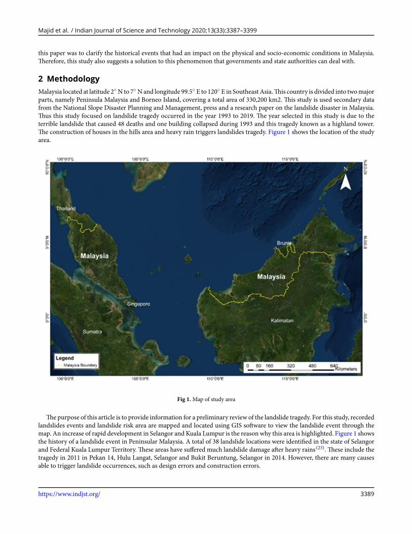
2 MethodologyMalaysia located at latitude 2◦ N to 7◦ Nand longitude 99.5◦ E to 120◦ E in Southeast Asia.This country is divided into twomajorparts, namely Peninsula Malaysia and Borneo Island, covering a total area of 330,200 km2. This study is used secondary datafrom the National Slope Disaster Planning and Management, press and a research paper on the landslide disaster in Malaysia.Thus this study focused on landslide tragedy occurred in the year 1993 to 2019. The year selected in this study is due to theterrible landslide that caused 48 deaths and one building collapsed during 1993 and this tragedy known as a highland tower.The construction of houses in the hills area and heavy rain triggers landslides tragedy. Figure 1 shows the location of the studyarea.
Fig 1.Map of study area
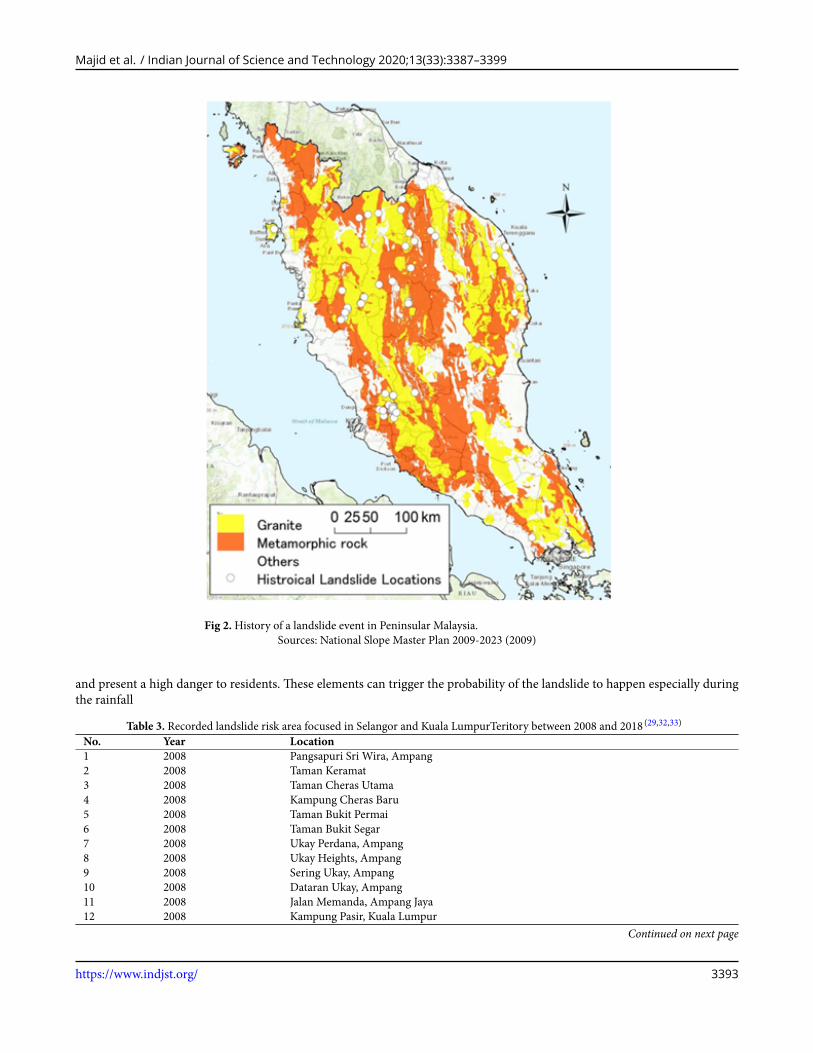
Thepurpose of this article is to provide information for a preliminary review of the landslide tragedy. For this study, recordedlandslides events and landslide risk area are mapped and located using GIS software to view the landslide event through themap. An increase of rapid development in Selangor and Kuala Lumpur is the reason why this area is highlighted. Figure 1 showsthe history of a landslide event in Peninsular Malaysia. A total of 38 landslide locations were identified in the state of Selangorand Federal Kuala Lumpur Territory. These areas have suffered much landslide damage after heavy rains (23). These include thetragedy in 2011 in Pekan 14, Hulu Langat, Selangor and Bukit Beruntung, Selangor in 2014. However, there are many causesable to trigger landslide occurrences, such as design errors and construction errors.
https://www.indjst.org/ 3389
Majid et al. / Indian Journal of Science and Technology 2020;13(33):3387–3399
The landslide risk area plot in their position based on secondary data obtained from papers, reports, articles, relevant sourcesand internet sources. Landslide risk area is defined as hazardous when 30 degrees terrain elevation of more than 500 meters,which can be worse during precipitation (24). This identified landslide risk area can trigger landslides after rainfall and anotherfactor like a gradient of hillslopes which had poor angles (13). Landslide is also correlated with steep slopes, permeable rocks,groundwater, soil and human activity. The trigger is single occurrence that quickly began the landslide.
3 Results and DiscussionGenerally, there had been 21,000 landslide-prone areas across the country, of which 16,000 or 76% are in Peninsular Malaysia,while around 3,000 are in Sabah and 2,000 are in Sarawak (25). The most frequent types of landslides in Malaysia are shallowslides where the slide surface is typically less than 4 m deep and occurs during or directly after heavy rainfall (9). Annual rainfallin Malaysia may reach as high as 4500 mm. Coupled with year-long high average temperatures, triggers extreme chemicalweathering and the development of residual soil profiles that can exceed 100 m in depth in some sites.
The landslide statistics recorded in Malaysia actively show the dominance of inadequate engineering design. For the 49cases slope failures, 29 cases contributed to design weakness, as shown in Table 1. In addition to faulty design, incompetence,casualness, insufficient raw input data often lead to this regular event of landslides (25). These cases are linked to the cases inSelangor, as shown in Table 1. For example, Taman Zooview (2006) case occurred at the back of a row of terrace houses locatedon top of the slope. In this incidence, slope stability analysis shows that the factor of safety for localized slope failure and failurecan be expected to happen at any time, especially with incessant rainfall and weak drainage system (9).
Furthermore, the reasons for landslides may well be related to misuse of prescriptive techniques, ineffective research ofprevious occurrences, design errors, and inadequate location-specific land inspection. The Malaysian government has initiatedto pay more attention to the landslide phenomena. Figure 2 shows the history of a landslide event in Peninsular Malaysia.
Table 1. Reported cases of landslides in Malaysia (9)
Causes Of Landslides Number of Cases Percentage (%)Design errors 29 60Constructions errors 4 8Design and Constructions errors 10 20Geological features 3 6Maintenance 3 6Total 49 100
Based on Table 2 , 27 landslides were reported in Selangor with a total loss ofmore than 85 lives from 1993 to 2019. Some fatallandslides have been recorded in Ulu Klang area after the Highland Towers disaster in 1993, followed by a landslide in TamanHillview in 2002. Subsequently, landslides recorded in Taman Zoo View in 2006 and Taman Bukit Mewah in 2008. Thus, UluKlang region is very vulnerable to landslides.This area is located near the Kuala Lumpur boundary and urban growth, includingthe development of residential and commercial centres, has presented numerous threats to the region. The Ulu Klang regionhas experienced many deadly landslides triggered by rainfall. Since 1984, 28 massive landslides reported as rainfall-inducedlandslides. The Highland Towers collapse is among the most devastating accidents causing 48 fatalities owing to the failure ofthe tower following many days of rainfall in 1993 (26,27). However, investigations reveal the collapse is linked to folding andshearing of rail piles that were triggered by the motion of the earth. Retrogressive landslides behind Block 1 of the towers wascrucial for the growth of soil failures. The critical factor is not only insufficient drainage but also the ineffective constructionon the hill. Generally, in Malaysia, the high-risk areas with a history of landslides include Ulu Klang, Selangor which claimedmany casualties and losses.
Table 2.The landslide record in Malaysia between 1993 and 2019 (28–30)
No. Year Location Consequences1 1993 Highland Tower, Ulu Klang, Selangor 48 deaths and 2 Injuries. 1 build-
ing collapsed2 1993 Pinggiran Bukit Segar, Kuala Lumpur One family evacuate their house3 1993 Pantai Remis, Perak No record4 1994 Taman Puchong Perdana, Puchong, Selangor 10 families evacuated5 1995 Taman Keramat Permai, Ampang, Selangor No damage record
Continued on next page
https://www.indjst.org/ 3390
Majid et al. / Indian Journal of Science and Technology 2020;13(33):3387–3399
Table 2 continued6 1995 Kuala Lumpur – Karak Highway 20 deaths, 22 injuries and 10 car
damaged7 1996 North–South Expressway (NSE) near Gua Tempurung,
PerakNo record
8 1996 Pos Dipang, Kampar, Perak 44 people were killed9 1996 Ampang Jaya, Selangor No record10 1999 Puncak Athenaeum Condominium, Ampang, Selangor Minor landslide, road access to
hilly residential area affected11 1999 Mutiara Condominium, Ampang, Selangor No record12 1999 North South Expressway, Kuang, Selangor Thousands of vehicles stranded. 1
day of road closure13 2000 Jalan Bukit Antarabangsa, Ampang, Selangor No record14 2001 Kampung Sungai Chinchin, Gombak, Selangor A house partly destroyed15 2002 Jalan Ipoh, Kuala Lumpur Covering three-lane road leading
to Rawang from Selayang.16 2002 Taman Hillview, Ampang, Selangor 8 deaths and 5 injuries17 2003 Taman Bukit Jaya, Ampang, Selangor No fatalities18 2004 Taman Melati, Gombak, Selangor 1 deaths19 2004 Jalan Seri Penchala 1, Kuala Lumpur 24 houses evacuated20 2006 Taman Zooview, Ampang, Selangor 4 deaths21 2006 Taman Bukit Serdang, Seri Kembangan, Selangor Damaged section of the roadmea-
sured 50m by 25 meter22 2006 Bukit Tunku, Kuala Lumpur No record23 2006 Taman Esplanad, Kuala Lumpur 2 houses damaged24 2008 Taman Bukit Mewah, Ampang, Selangor 4 deaths25 2008 Ulu Kelang, Selangor 4 deaths and 15 injuries26 2008 Kuala Kubu Bharu, Batang Kali, Selangor Two sisterswere buried alivewhen
landslide hit bungalow27 2008 Kemensah Heights, Ampang, Selangor No fatalities28 2008 Bukit Ceylon, Kuala Lumpur 1 worker deaths29 2008 Pantai Dalam, Kuala Lumpur 1 killed, 4 injured and 19 families
evacuated30 2009 Taman Cheras Awana, Cheras, Selangor Destroyed three cars and a motor-
cycle, 10 families evacuated31 2010 Ukay Perdana, Ampang, Selangor No fatalities32 2010 Taman Bukit Mulia, Ampang, Selangor No fatalities33 2011 Puncak Setiawangsa, Kuala Lumpur 88 residents of bungalows, shop
houses and double-story terracehouses order to move out
34 2011 Jalan Semantan, Kuala Lumpur 6 cars were buried 5 vehicles weredamaged
35 2011 Pekan Batu 14 Hulu Langat, Selangor 16 deaths36 2011 Kampung Tengah, Puchong, Selangor 5 house affected37 2012 Taman Desa Sentosa, Hulu Langat, Selangor Endangered four occupants of the
Perkid Welfare Home for girls.38 2012 Taman Mulia Jaya, Ampang, Selangor Water seeping through the sewer-
age system.”39 2013 Putra Heights, Subang Jaya, Selangor Several vehicles submerged in
mud40 2015 KM 52.4 of the Kuala Lumpur-Karak Expressway between
Lentang and Bukit Tinggi, Pahang and Gombak-Bentongold roads
Lentang-Bukit Tinggi stretch ofthe expressway was closed to traf-fic
41 2016 Karak Highway Blocked all lanes in both directionon the highway and four vehiclesthat were trapped in the landslide,
Continued on next page
https://www.indjst.org/ 3391
Majid et al. / Indian Journal of Science and Technology 2020;13(33):3387–3399
Table 2 continued42 2016 Bau-Puncak Borneo, Sarawak Comprising mainly Bidayuh set-
tlements and Padawan Ring Roadcritically affected
43 2017 Tanjung Bungah, Penang Island Killed 11 construction workers44 2018 Jalan Bukit Kukus, Georgetown, Penang Island Killed nine construction workers45 2019 Taman Batu Permai No record46 2019 Jalan Lee Woon, Ampang, Selangor A house evacuated47 2019 Genting Highland, Pahang Affected a portion of the Jalan
Genting-Amber Court slip roadand no access to the resort
In Selangor, landslideswere recorded in Bukit Antarabangsa,UkayHeights, TamanHillview,DataranUkay, TamanMelawati,Ukay Perdana, Taman Kemensah, Bukit Teratai, Bukit Permai, Taman Saga, Taman Mega and Bukit Segar (30). Some incidentsare shown in Figure 2. Overall, most landslides happened in Ulu Klang area since this place has become a public place andurban sprawl as previously mentioned. With the comprehensive record of events or accidents in Selangor, especially in UluKlang, landslides are known to be a severe and the only natural disaster. After a series of tragedies, most residents, not onlythose who reside in Ulu Klang, are aware of the probability and implications of landslides occurring in this area. However, stillfew people in the neighbourhood have relocated to a safer spot. Only those closely associated with past landslide incidents willtake appropriate steps to depart the area voluntarily, not just because of the order of the authorities.
Table 3 shows the landslides recorded in Malaysia, in Kuala Lumpur, 10 major landslides occurred between 1993 and 2019;however, the most catastrophic event happened at Puncak Setiawangsa in 2011. In this incident, 88 residents of bungalows,shops and double-story terrace houses were forced to move out due to land movement. The 60-metre high retaining wall andthe rear section of the building fell. The building was subsequently destroyed to reduce the strain on the hillside (31,32). Theprimary factor for this landslide is the inadequate form of slope safety used by the hill residents.
Furthermore, the shotcrete of the wall failed to block the water from penetrating the wall, and the groundwater pressurebuilds up and breaks through the wall, causing the landslip (32). As with other landslides, the possible reason of the PuncakSetiawangsa landslide was the design of inaccuracies in which a shotcrete wall was constructed on a metamorphic rock to keepthe water from penetrating the soil, which is not appropriate due to a lack ofmetamorphic rock strength.This case has indicatedthat the causes of landslides inMalaysia have occurred in Puncak Setiawangsa due to design errors which is contributed asmuch60% of the landslides shown in Table 1 .
Furthermore, the shotcrete of the wall failed to block the water from penetrating the wall, and the groundwater pressurebuilds up and breaks through the wall, causing the landslip (33). Kuala Lumpur Territory suffers from frequent landslides,throughout the sequence of the affected elements at threat, a significantmajority of the affected elements are linked to residentialinfrastructure and business buildings.
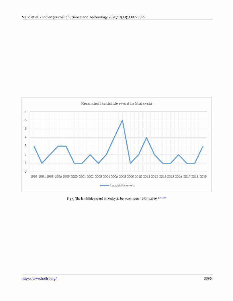
The frequency of landslide cases is shown in Figure 4 and follows no specific trend but happened almost every year. Themost number of landslides occurred in 2006 (4 landslides) and 2008 (6 landslides). These tend to be mostly failures triggeredby localized rainfall. Associated inherent weaknesses of the rock or soil combined with human activity such as extensivecondominium construction and poor drainage management contributed to the disaster. Most landslides happened in UluKlang nearby residential areas and very often crashing condominiums were blamed for both losses of life and economy (9).In addition, hilly land areas in these locations are extremely fragile and prone to human alterations (water stream diversions,cut off vegetative cover) for development to take place.
Slope failure is complicated to be accurately predicted, and usually slope failure risk is made for planning. Table 3 showsthe recorded landslide risk area in Selangor and Kuala Lumpur between 2008 and 2018. Based on Table 3, there is a 44 risklandslide area that is recorded in Selangor, Kuala Lumpur and Pahang from 2008 to 2018. Even though this landslide riskremains increasing, Selangor has not received any funds from the government for slope repair works, however, since 2012Selangor has received fund about RM 3 billion from the federal government to repair their roads every year, including to carryout slope repair works (30).
The general geology of Kuala Lumpur and its surrounding areas in Selangor are well known. The bedrock of the KennyHill formation (sedimentary rock) dominates the centre of the region. On the Kenny Hill formation, it is noted that roughtopography, extreme nomadic rainfall and deep tropical weather have led to the collapse of themany slopes (31).Based onTable 3,the number of risk area in Kuala Lumpur is quite worrying. This is because the neighbouring regions of Kuala Lumpur have asignificantly crucial role in the economic and social growth of the region. Some incidents are shown in Figure 5, which happenedin Kuala Lumpur Territory. Unfortunately, these areas are also plagued bymassive flooding and storms that threaten hilly slopes
https://www.indjst.org/ 3392
Majid et al. / Indian Journal of Science and Technology 2020;13(33):3387–3399
Fig 2.History of a landslide event in Peninsular Malaysia.Sources: National Slope Master Plan 2009-2023 (2009)
and present a high danger to residents. These elements can trigger the probability of the landslide to happen especially duringthe rainfall
Table 3. Recorded landslide risk area focused in Selangor and Kuala LumpurTeritory between 2008 and 2018 (29,32,33)
No. Year Location1 2008 Pangsapuri Sri Wira, Ampang2 2008 Taman Keramat3 2008 Taman Cheras Utama4 2008 Kampung Cheras Baru5 2008 Taman Bukit Permai6 2008 Taman Bukit Segar7 2008 Ukay Perdana, Ampang8 2008 Ukay Heights, Ampang9 2008 Sering Ukay, Ampang10 2008 Dataran Ukay, Ampang11 2008 Jalan Memanda, Ampang Jaya12 2008 Kampung Pasir, Kuala Lumpur
Continued on next page
https://www.indjst.org/ 3393
Majid et al. / Indian Journal of Science and Technology 2020;13(33):3387–3399
Table 3 continued13 2008 Bukit Sungai Seputih, Kuala Lumpur14 2011 Taman Keramat Permai15 2011 Taman Muda16 2011 Jalan Saga 21, Taman Bukit Teratai, Ampang17 2011 Jalan Teratai 2/7b, Taman Bukit Teratai, Ampang18 2011 Taman Mega Jaya19 2011 Cemerlang Heights20 2011 Jalan Wangsa 5, Wangsa Heights21 2011 Beverly Heights, Ampang22 2011 Taman Sri Ukay, Ampang23 2011 MRR2 – Villa Sri Ukay24 2011 Bukit Utama, Petaling Jaya25 2011 Taman Sri Watan, Ampang26 2011 Taman Bukit Ampang, Ampang Jaya27 2011 Taman Mulia Jaya, Ampang28 2011 Taman Permai Jaya, Ampang29 2011 Kampung Lembah Jaya Selatan, Ampang30 2011 Taman Bukit Indah, Ampang Jaya31 2011 Kampung Warisan, Ampang Jaya32 2011 Taman Koperasi Uda, Hulu Langat33 2011 Taman Melati, Kuala Lumpur34 2011 Desa Melawati, Kuala Lumpur35 2011 Wangsa Maju, Kuala Lumpur36 2011 Setapak, Kuala Lumpur37 2011 Setiawangsa, Kuala Lumpur38 2011 Kolej Tengku Abdul Rahman, Kuala Lumpur39 2011 Gombak Setia, Kuala Lumpur40 2011 Kampung Setia Jaya, Kuala Lumpur41 2011 Taman Melur, Ampang42 2017 Tanjung Bungah, Georgetown, Penang Island43 2018 Ukay Perdana, Ampang44 2019 Genting Highlands, Pahang
Alongwith the details, the recent report by ExpactGo (34) confirms that a total of 1,740 slopes in Kuala Lumpur are vulnerableto landslides. Among the 1,740 hill slopes, at least 620 were classified as very high risk while the rest were high risk. Besides that,the Segambut parliamentary constituency recorded the highest number of hill slopes at 713, of which 219 are very high-riskareas and 494 high risks, followed by Lembah Pantai with 315 hill slopes, Bandar Tun Razak (183), Seputeh (132), Setiawangsa(125), Bukit Bintang (90), Kepong (70), Wangsa Maju (56), Cheras (45) and Batu (11) (35).
https://www.indjst.org/ 3394
Majid et al. / Indian Journal of Science and Technology 2020;13(33):3387–3399
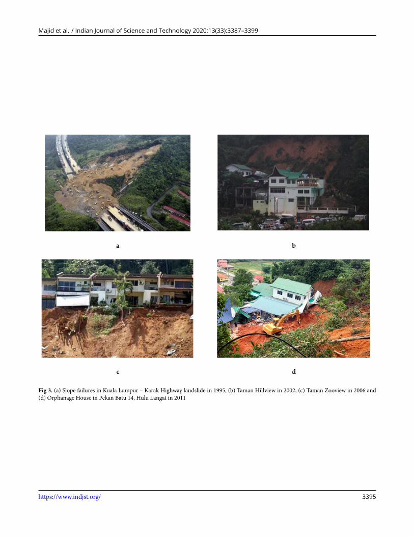
Fig 3. (a) Slope failures in Kuala Lumpur – Karak Highway landslide in 1995, (b) Taman Hillview in 2002, (c) Taman Zooview in 2006 and(d) Orphanage House in Pekan Batu 14, Hulu Langat in 2011
https://www.indjst.org/ 3395
Majid et al. / Indian Journal of Science and Technology 2020;13(33):3387–3399
Fig 4.The landslide record in Malaysia between years 1993 to2019 (28–30)
https://www.indjst.org/ 3396
Majid et al. / Indian Journal of Science and Technology 2020;13(33):3387–3399
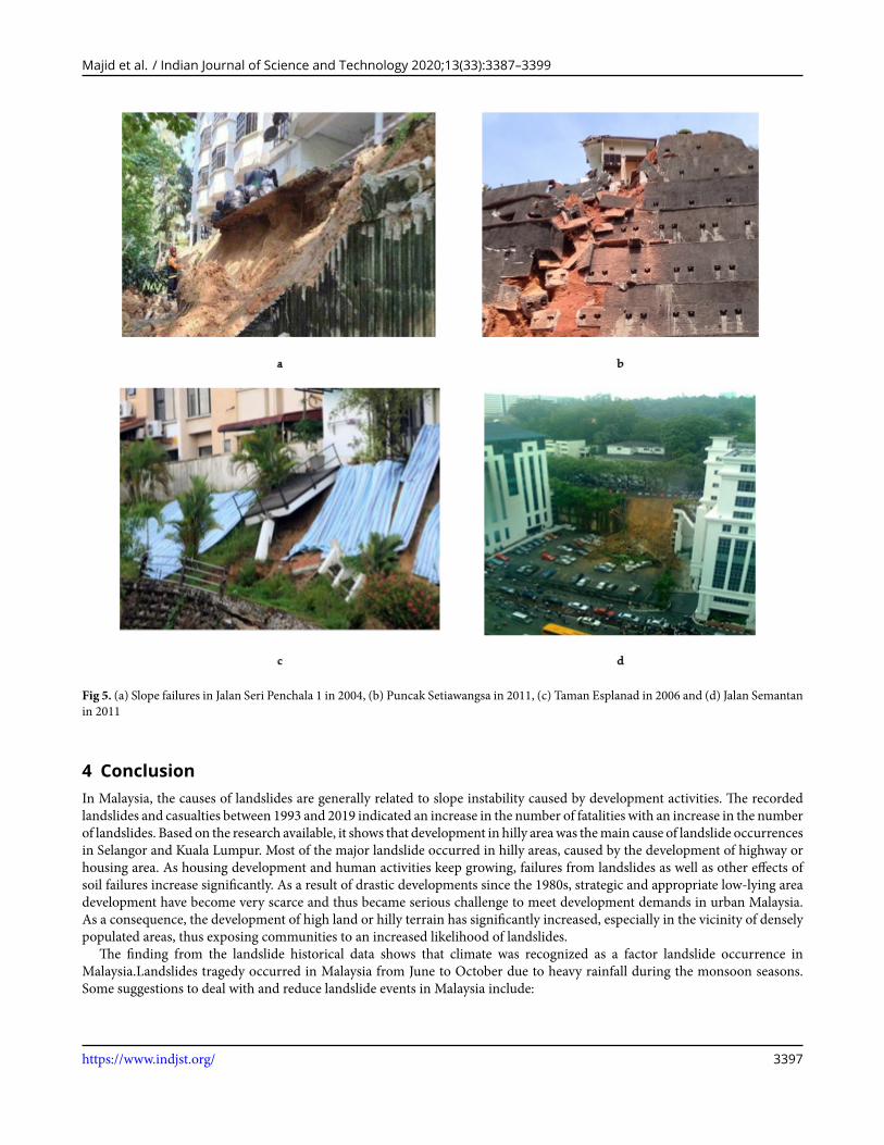
Fig 5. (a) Slope failures in Jalan Seri Penchala 1 in 2004, (b) Puncak Setiawangsa in 2011, (c) Taman Esplanad in 2006 and (d) Jalan Semantanin 2011
4 ConclusionIn Malaysia, the causes of landslides are generally related to slope instability caused by development activities. The recordedlandslides and casualties between 1993 and 2019 indicated an increase in the number of fatalities with an increase in the numberof landslides. Based on the research available, it shows that development in hilly areawas themain cause of landslide occurrencesin Selangor and Kuala Lumpur. Most of the major landslide occurred in hilly areas, caused by the development of highway orhousing area. As housing development and human activities keep growing, failures from landslides as well as other effects ofsoil failures increase significantly. As a result of drastic developments since the 1980s, strategic and appropriate low-lying areadevelopment have become very scarce and thus became serious challenge to meet development demands in urban Malaysia.As a consequence, the development of high land or hilly terrain has significantly increased, especially in the vicinity of denselypopulated areas, thus exposing communities to an increased likelihood of landslides.
The finding from the landslide historical data shows that climate was recognized as a factor landslide occurrence inMalaysia.Landslides tragedy occurred in Malaysia from June to October due to heavy rainfall during the monsoon seasons.Some suggestions to deal with and reduce landslide events in Malaysia include:
https://www.indjst.org/ 3397
Majid et al. / Indian Journal of Science and Technology 2020;13(33):3387–3399
1. Integrated landslide risk, preparedness policy and framework for any development activities particularly for developmentinvolving high terrain
2. Susceptibility studies should be performed to reduce the tragedy of landslide and these findings useful for planning anddecision making
3. Any development project should be appropriately designed with proper planning, construction, and maintenance toprevent landslide tragedy.
4. Conduct awareness program among agencies to highlight the risk of landslides tragedy. Awareness and knowledge aboutthe danger of landslides should be implemented during the planning and management processes.
Acknowledgement
This research was funded by Ministry Higher Education, Malaysia, grant number NEWTON/1/2018/TK01/UKM/2. Thanks toour part-time research assistant for the help in preparing this manuscript, Izzuddin Ismail.
References1) Majid A, Rainis N, R, Ibrahim W, Wmm. Spatial Modeling Various Types of Slope Failure Using Artificial Neural Network (Ann) In Pulau Pinang.
Malaysia Jurnal Teknologi;2018(4):135–146.2) Gul FA, Islam MR, Rahman W. The tragic story of Malaysia. International Journal For Research In Social Science And Humanities. 2017;3:10–19. Available
from: https://gnpublication.org/index.php/ssh/article/view/321.3) AzmiASM, SallehWARWM,NawawiAH. Cognitive behaviour of residents toward living in landslide ProneArea. Procedia-Social and Behavioral Sciences.
2013;101:379–393. Available from: https://doi.org/10.1016/j.sbspro.2013.07.212.4) Jamaluddin T. Human factors and slope failures in Malaysia. Bulletin of the Geological Society of Malaysia. 2006;52:75–84. Available from: https:
//doi.org/10.7186/bgsm52200611.5) El-RahmanHA. The Effect ofMagnetic Force andMagneticWater on Behavior and Population of Tetranychus urticae and Amblyseius gossipi on Soybean
in the Laboratory and Field. Journal of Plant Protection and Pathology. 2017;8:619–623. Available from: https://dx.doi.org/10.21608/jppp.2017.46928.6) Jamaluddin TA, Komoo I, Dlm, Hood S, Ibrahim K, Mazlan O, et al. Human factors and slope failures in Malaysia. Bulletin of the Geological Society of
Malaysia. 2003;52:75–84.7) Saadatkhah N, Kassim A, Lee LM. Hulu Kelang, Malaysia regional mapping of rainfall-induced landslides using TRIGRS model. Arabian Journal of
Geosciences. 2015;8(5):3183–3194. Available from: https://dx.doi.org/10.1007/s12517-014-1410-2.8) JKR, JKRFI. JKR, J.K.R.F.I. Report Investigation of Slope Failure at TamanBukitMewah, BukitAntarabangsaHuluKlang Salengor. CawanganKejuruteraan
Cerun, Jabatan Kerja Raya Malaysia. 2009.9) See-Sew, G.; Tan, Y.-C. Landslides: Abuses of the Prescriptive Method. 2006.
10) Lim CS, Jamaluddin TA, and IK. Tanah runtuh cetusan manusia di Bukit Antarabangsa, Hulu Kelang, Selangor. Bulletin of the Geological Society. 2019.11) Raya JK. National slope master plan; Sectoral report research and development: Malaysia. 2009.12) Hussin H, Ghani SAA, Jamaluddin TA, and MKAAR. Tanah Runtuh Di Malaysia:“Geobencana” Atau “Geobahaya”. Jurnal Teknologi. 2015.13) Lee S, PradhanB. Landslide hazardmapping at Selangor,Malaysia using frequency ratio and logistic regressionmodels. Landslides. 2007;4:33–41. Available
from: https://dx.doi.org/10.1007/s10346-006-0047-y.14) Chan NW. Responding to landslide hazards in rapidly developing Malaysia: a case of economics versus environmental protection. Disaster Prevention
and Management: An International Journal . 1998.15) Abdullah C. Landslide risk management in Malaysia. Management of Natural Disasters. 2016;92.16) Pham BT, Bui DT, Pourghasemi HR, Indra P, Dholakia M. Landslide susceptibility assessment in the Uttarakhand area (India) using GIS: a comparison
study of prediction capability of naive Bayes, multilayer perceptron neural networks, and functional trees methods. Theoretical and Applied Climatology.2017;128:255–273.
17) Choi Y, Baek J, Park S. Review of GIS-Based Applications forMining: Planning, Operation, and EnvironmentalManagement. Applied Sciences. 2020;10(7).Available from: https://dx.doi.org/10.3390/app10072266.
18) Why study landslides. 2020. Available from: https://www.usgs.gov/faqs/why-study-landslides?qt-news_science_products=0#qt-news_science_products.19) Majid NA, Rainis R. Application of Geographical Information Systems (GIS) and Discriminant Analysis in Modelling Slope Failure Incidence in Pulau
Pinang. Sains Malaysiana. 2019;48:1367–1381.20) Alamgir M, Campbell JM, Sloan S, Engert J, Word J, Laurance FW. Emerging challenges for sustainable development and forest conservation in Sarawak,
Borneo. PLOS ONE. 2020;15(3). Available from: https://dx.doi.org/10.1371/journal.pone.0229614.21) Chuang YC, Shiu YS. Relationship between landslides and mountain development-Integrating geospatial statistics and a new long-term database. Science
of the total environment. 2018;622:1265–1276.22) Forbes K, Broadhead J. Forests and landslides: The role of trees and forests in the prevention of landslides and rehabilitation of landslide-affected areas in
Asia. Rap Publication. 2013.23) OthmanAN, NaimWM,Noraini S, . GIS BasedMulti-Criteria DecisionMaking for Landslide Hazard Zonation. Procedia - Social and Behavioral Sciences.
2012;35:595–602. Available from: https://dx.doi.org/10.1016/j.sbspro.2012.02.126.24) A Total of 1,740 Slopes in KL Are Prone to Landslides. 2015.25) Huat BKB, Ali FH, Rajoo RSK. Stability Analysis and Stability Chart for Unsaturated Residual Soil Slope. American Journal of Environmental Sciences.
2006;2(4):154–160. Available from: https://dx.doi.org/10.3844/ajessp.2006.154.160.26) Gue SS, Tan YC. Mitigating the risk of landslide on hill-site development inMalaysia. In: Proceedings of Special Lecture 2ndWorld Engineering Congress,
IEM Kuching Branch, Kuching, Sarawak,. .27) Meikeng Y, Kong L, Aziz F. 14 more hillside areas at risk of landslides. The Star. 2008.
https://www.indjst.org/ 3398

Majid et al. / Indian Journal of Science and Technology 2020;13(33):3387–3399
28) Saadatkhah N, Kassim A, Lee M. Spatial patterns of precipitation, altitude and monsoon directions in Hulu Kelang area. Malaysia EJGE C. 2014;19:521–534.
29) Akter A, NoorMJMM,GotoM, Khanam S, Parvez A, RasheduzzamanM. LandslideDisaster inMalaysia: AnOverview. International Journal of InnovativeResearch and Development. 2019;8(6):292–302. Available from: https://dx.doi.org/10.24940/ijird/2019/v8/i6/jun19058.
30) ’Shotcrete’ caused collapse. 2012.31) Tharanta A. 20 slopes in Selangor identified at critical risk of landslide. 2017.32) Mohamed Z, Rafek A, Komoo I. Characterisation and classification of the physical deterioration of tropically weathered Kenny hill rock for civil works.
Electronic Journal of Geotechnical Engineering. 2007;12.33) 58 Residential Areas Face Landslide Risk. 2020. Available from: https://www.malaysia-today.net/2011/05/28/58-residential-areas-face-landslide-risk/.34) Jusid H. Tg Bungah dikenal pasti berisiko tanah runtuh sejak 5 tahun lalu. In malaysiakini, malaysiakini. 2017.35) Sham NS. Terdapat risiko berlaku tanah runtuh susulan di Genting Highlands. Awani . 2019.
https://www.indjst.org/ 3399