Embed Size (px)
Citation preview
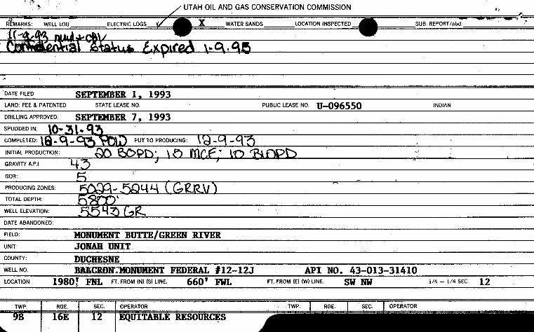
DATE FILED SHER 1, 1993LAND:FEE & PATENTED STATE LEASENO. PUBLICLEASE NO U-096550 INDIAN
DRILLINGAPPROVED: SEPWER 7, 1993SPUDDED IN: a $Le
COMPLETED: . PUT TO PRODUCING:
INITIALPRODUCTION:
GRAVITY A.P.I
GOR:
PRODUCINGZONES:
TOTALDEPTH:
WELLELEVATION:
DATEABANDONED:
FIELD: MONUMENTBUTTE/GREEN RIVERUNIT: JONAH UNITCOUNTY: DUCHESNEWELLNO BREURDHTMONUMENTFEDERAL #12-12J API NO. 43-013-31410LOCATION 1980) FNL FT. FROM (N) (S) UNE. 660* FWL FT FROM (E) (W) LINE. gg 1/4 - 1/4 SEC
TWP. RGE. SEC. OPERATOR TWP. RGE. SEC. OPERATOR
9B 16E 12 EQUITABLE
EQU\TABLERESOURCESENERGYCOMPANYBALCRON OIL DIVISION1601 Lewis Avenue Office: (406) 259-7860
P.O. Box 21017 ,FAX: (406) 245-1365 LJ
Billings, MT 59104 FAX: (406) 245-1361 Ñ
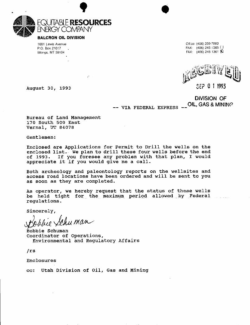
August 30, 1993 $ËŸÛÍ 693
DIVISIONOF-- VIA FEDERAL EXPRESS --OIL, GAS& MINING
Bureau of Land Management170 South 500 EastVernal, UT 84078
Gentlemen:
Enclosed are Applications for Permit to Drill the wells on theenclosed list. We plan to drill these four wells before the endof 1993. If you foresee any problem with that plan, I wouldappreciate it if you would give me a call.
Both archeology and paleontology reports on the wellsites andaccess road locations have been ordered and will be sent to youas soon as they are completed.
As operator, we hereby request that the status of these wellsbe held tight for the maximum period allowed by Federalregulations.
S y
Bobbie SchumanCoordinator of operations,
Environmental and Regulatory Affairs
/rs
Enclosures
cc: Utah Division of Oil, Gas and
EQU\TABLERESOURCESENERGYCOMPANYBALCRON OIL DIVISION1601 Lewis Avenue Office: (406) 259-7860
P.O. Box 21017 ,FAX: (406) 245-1365 LJ
Billings, MT 59104 FAX: (406) 245-1361 Ñ
August 30, 1993 $ËŸÛÍ 693
DIVISIONOF-- VIA FEDERAL EXPRESS --OIL, GAS& MINING
Bureau of Land Management170 South 500 EastVernal, UT 84078
Gentlemen:
Enclosed are Applications for Permit to Drill the wells on theenclosed list. We plan to drill these four wells before the endof 1993. If you foresee any problem with that plan, I wouldappreciate it if you would give me a call.
Both archeology and paleontology reports on the wellsites andaccess road locations have been ordered and will be sent to youas soon as they are completed.
As operator, we hereby request that the status of these wellsbe held tight for the maximum period allowed by Federalregulations.
S y
Bobbie SchumanCoordinator of operations,
Environmental and Regulatory Affairs
/rs
Enclosures
cc: Utah Division of Oil, Gas and
9 eà EQUITABLERESOURCES
ENERGYCOMPANYBALCRON OIL DIVISION1601 Lewis Avenue Office: (406) 259-7860
IM21
04
SEP0 1 1993
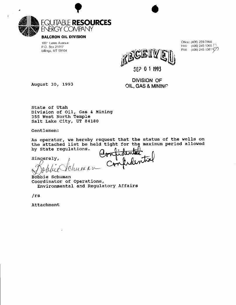
DIVISIONOFAugust 30, 1993 OIL, GAS&MINING
State of UtahDivision of Oil, Gas & Mining355 West North TempleSalt Lake City, UT 84180
Gentlemen:
As operator, we hereby request that the status of the wells onthe attached list be held tight for the maximum period allowedby State regulations.
Sincerely,
B bie SchumanCoordinator of Operations,
Environmental and Regulatory Affairs
/rs
9 eà EQUITABLERESOURCES
ENERGYCOMPANYBALCRON OIL DIVISION1601 Lewis Avenue Office: (406) 259-7860
IM21
04
SEP0 1 1993
DIVISIONOFAugust 30, 1993 OIL, GAS&MINING
State of UtahDivision of Oil, Gas & Mining355 West North TempleSalt Lake City, UT 84180
Gentlemen:
As operator, we hereby request that the status of the wells onthe attached list be held tight for the maximum period allowedby State regulations.
Sincerely,
B bie SchumanCoordinator of Operations,
Environmental and Regulatory Affairs
/rs

Balcron Monument Federal #41-14JNE NE Section 14, T9S, R16EDuchesne County, Utah363.3' FNL, 600' FELFLS #U-096550
Balcron Monument Federal #12-12JSW NW Section 12, T9S, R16EDuchesne County, Utah1980' FNL, 660' FWLFLS #U-096550
Balcron Monument Federal #14-12JSW SW Section 12, T9S, R16EDuchesne County, Utah660' FSL, 660' FWLFLS #U-035521-A
Balcron Monument Federal #24-12JSE SW Section 12, T9S, R16EDuchesne County, Utah539' FSL, 1777' FWLFLS #U-035521-A
SEP \
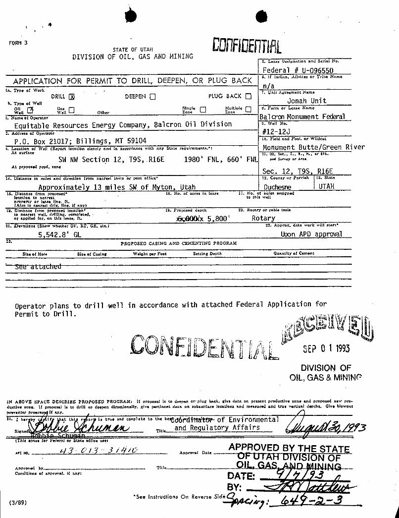
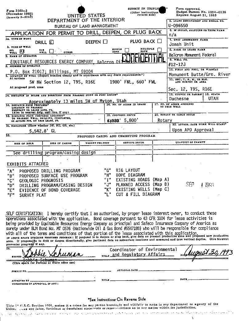
FORM3STATE OF UTAH
DIVISION OF OIL, GAS AND MINING5. Lease Designation and Serial No.
Federal # U-096550
APPLICATION FOR PERMITTO DRILL,DEEPEN, OR PLUG BACK "'"'"""°^""" °'""" °
n/aIA. Type of Work . 7. Unit Agreement Name
DRILI. DEEPEN Pl.UG BACK .
a. ty,..t w.a Jonah UnitOil Gas Singele Multiple 3. Farm or Lense NameWell Well Other Zone Zone
. un..or op.rator Bal cron Monument FederalEquitable Resources Energy Company, Balcron Oil Division u· wen No·
· Address of Operator ÑÎ -12JP.O. Box 21017; Billings, MT 59104 us.ri,taanarool.orwaacat
4. Location of Well (Report location clonrly and in accordance with any State requirements.*> Monument Butte/Green RiverAt surface 11. QQ. Sec., T., R., H., or Blk.
SWNWSection 12, T9S, R16E 1980' FNL, 660' FWL as-•r•r^••At pr.oposed prod, zone
Sec. 12, T9S, R16E14. Distance in miles and direction from nearent town or pose office• 12. County or Pnrrish la. State
Approximately 13 miles SWof Myton, Utah Duchesne UTAH15. Distance from proposed' 16. No. of acres in lease li. No. <f acres assigned
location to nearest to this wenproperty or lease line, ft.(Also to nenrest drir. line, if any)
LU. Distance from proposed location• 19. Proposed depch 20. Rotary or cable toolsto nearest avell. drilling, comnieted,or ann.« <or... e :-.. rt· >SQB(Wx5,800 ' Rotary
21. Elevations (Shorv whether DF. RT. GR. etc.) 22. Appro.s. date work will start•
5,542.8' GL Upon APD approval23. PROPOSED CASING AND CEMENTING PROCRAM
Size of Hole Size of Casing Weight per Foot Setting Depth Quantity of Cement
See ¿LLached
Operator plans to drill well in accordance with attached Federal Application forPermit to Drill.
CONDDENTIAL=°'
DIVISIONOFOIL, GAS &MININ
IN ABOVE SPACS DESCRIBE PROPOSED FROGRAM: If proposal is to deepen or plur back. give data on present productive zone and proposed nerv pro-
ductive zone. It proposal is to drill or deepen directionally, give pertinent duca on subaurface locations and measured and true vertical douchs. Give blotvoutpreventer progra if any.
n. I a., a,e ta :2 tro. and co" '*t• t 66• 6•¾abrdittaltW· of Environmentalsi and Regulator.y Affairs /ýf)uned ... .............................................. TJtl e.................. ....- ..........-............,..........--...............
In uman {(This space for ¥ederni or State office usel
...&/..TO /3 3 / O APPROVED BY THE STATEAFI NO. .................-.. ..........................-...........-..-..............-........-....... A normva i D a te ....-..-...-..-... FU I AHD IVIS IONOFAnoroved by........-............-................-..-....-.....-..-...-.--..-- Tit!•t.-.-....---..-..--.-----.••---•·--- - -• •-••-
Conditions of noproval. If any: DATE• n
See Instructions On Reverse
Form 3160-•3 SUBMIT IN TRIPI.I • Form approved.
('November 198 (Other instructions Budget Bureau No. 1004-0136
(tonneely 9-3315> UNITED STATES r•«•r=•©lde) Expires August 31, 1985
DEPARTMENT OF THE INTERIOR 0. LEASE DESECNATION AND BERIAL NO.
BUREAU OF LAND MANAGEMENT U-096550
APPLICATION FOR PERMITTO DRILL,DEEPEN,OR PLUG BACK UNIMAN,AROWEBORTRIBENAME
la. TTra or wonK
DRILLO DEEPENO PLUGBACK O 7. UNIT AGEMEMENT NAME
b. TTraorwar.r,Jonah Unit
°w'.",,,, 9 °.12. O o ...
U"NGZ
OUNLTHLEO 6· - -
2. NAME Or OPERATOR.
Balcron nment FederalEQUITABLERESOURCESENERGYCOMPANY,Ra loron ni .
9. WRIsla NO.
3. ADDamas or OPERATOR#12-12J
P.0. Box 21017; Billings, MT 59104 10. FIELD AND POOL, OR WILDCAT
4. LocarroN or war,I. (Report location clearly and in accordance with any State requirements.') Monument Butte/Grn. RiverAt nurface
SWNWSection 12, T9S, R16E 1980' FNL, 660' FWL11. meD SÒ&ET ÒB
At proposed prod, sone Sec. 12, T9S, R16E14. DIBTANCE IN MILES AND DIRECTION FROM NBARxsz TowN On POBT Orr1CE* 12. COUNTY OB PARIBX 13. BTATE
Approxiinately 13 miles SW of Myton, Utah . Duchesne UTAH10. DISTANCE FROM rBOPOBED* 10. NO. OF AC2EB IN LEASE 17. NO. OF ACRES ASSIGNED
LOCATION TO NEAREST TO THIS WELL
PROPERTY 08 LEAga LINE, FT.(Also to nearest drig, unit line, if any)
18. DISTANCE FRO&t PROPOSED LOCATION* 19. PROPOSED DEPTH 20. ROTART OE CABLE TOOLS
TO NEAREST WELL, DRILLING, COMPLETED,OR AFFLIED rox, ON THIB LEAnz, FT·
° 8;SSS' 5,800 Rotary21. zz.xvATzoNs (Show whether DF, RT, GR, etc.) 22. APPaox. DATE w0xK WILL START*
5,542.8' GL | Upon APD Approval23. PROPOSED CASING AND CEMENTING PROGRAM
82EE OF NOLE SIZE OF CASING WaloitT PER FOOT BETTING DEPTIK QUANTITT OF Cr.htgNT
See drilling program/casing design
EXHIBITS ATTACFED
"A" PROPOSED DRILLING PROGRAM "G" RIG LAYOUT"B" PROPOSED SURFACEUSE PROGRAM "H" BOPEDIAGRAM"C" GEOLOGICPROGNOSIS "I" EXISTING ROADS(Map A)"D" DRILLINGPROGRAM/CASINGDESIGN "J" PLANNEDACCESS (Map B) 50 g gg;"E" EVIDENCEOF BONDCOVERAGE "K" EXISTING WELLS(Map C)"F" SURVEYPLAT "L" CUT & FILL DIAGRAM
.SELFCERTIFICATION:I herebycertify that I amauthorized,by proper lease interest owner,to conducttheseoperationsassociatedwith the application. Bondcoveragepursuant to 43 CFR3104for lease activities isbeing provided by Equitable Resources EnergyCopany as principal and Safeco Insurance Copanyof Amrica assuretyunderBudBondNo.MT0576 (NationwideOil &GasBond//5547188)whowill be responsible for copliancewithall of the tems and conditionsof that portion of.the lease associated with this apolication.IN ABOVE SPACE DESCRIBE PROPOBED PROGRAM : If proposal is to deepen or plug back, give data on present productive done and proposed new productive
sone. It proposal a to drill or deepen directionally, give pertinent data on subsurface locations and measured and true vertical depths. Glye blowout
preventN
COordine r of Env nrmentalDA
D:tt i C:t(This space for Federal or State onice use)
PYR3tfTNO APPpoyqy pay†
AFPROYED BY TITI T DATM
CONDITIONE OF APPROVAE., 17 ANT:
*SeeInstructionsOn ReverseSideTI:!e :* \!.S.C. Section 1001, makes it a crime for any person knowinyty and willfully to make to any department or agency of theUnitet. .
-.es any false, fictitious or fraudulent stateronts or repre•:.•••tutions as to any matter within its

IT9S, R16E,S.L.B.& M. EOUlTABLERESOURCESENERGYCO.
LL
BASISOFBEARINGS N 89°59' W (GLO) WELLLOCATION,BALCRONMONUMENTFEDERAL12-12J, LOCATEDASSHOWNIN THESW1/4
NW1/4 OF SECTION12, T9S,R16E,S.LB. & M,DUCHESNECOUNTYUTAH.
12BALCRONMONUMENTFEDERAL#12-12JWELLLOCATION z°ELEVUNGRADEDzGROUND5542.8' THISIS TOCERTIFYTHATTHEABOVEPLATWAS
PREPAREDFROMFIELD ALSURVEYSMADEBY MEOR UN ANDTHATTHESAMEARETR Ët? BESTOFMYKNOWLEDGEA F. gg .
I -
REGl RE ' NDSURVE * ËRECIS TI "STATE .........
OFIII
I i
N 89°56 W (GLO)
WEATHER:CLEAR& HOTDATE:8/4/93 T I-STATE
. X = SECTIONCORNERSLOCATED SCALE:1" = 1000' Im sumnNc.inc.BASISOF BEARINGS;G.LO.PLAT1911 SURVEYEDBY: SS ZD """ """'"
lOH8HSO1BASISOFELEV;U.S.C.S.7-1/2 min QUAD(MYTONSE) FILE:ME
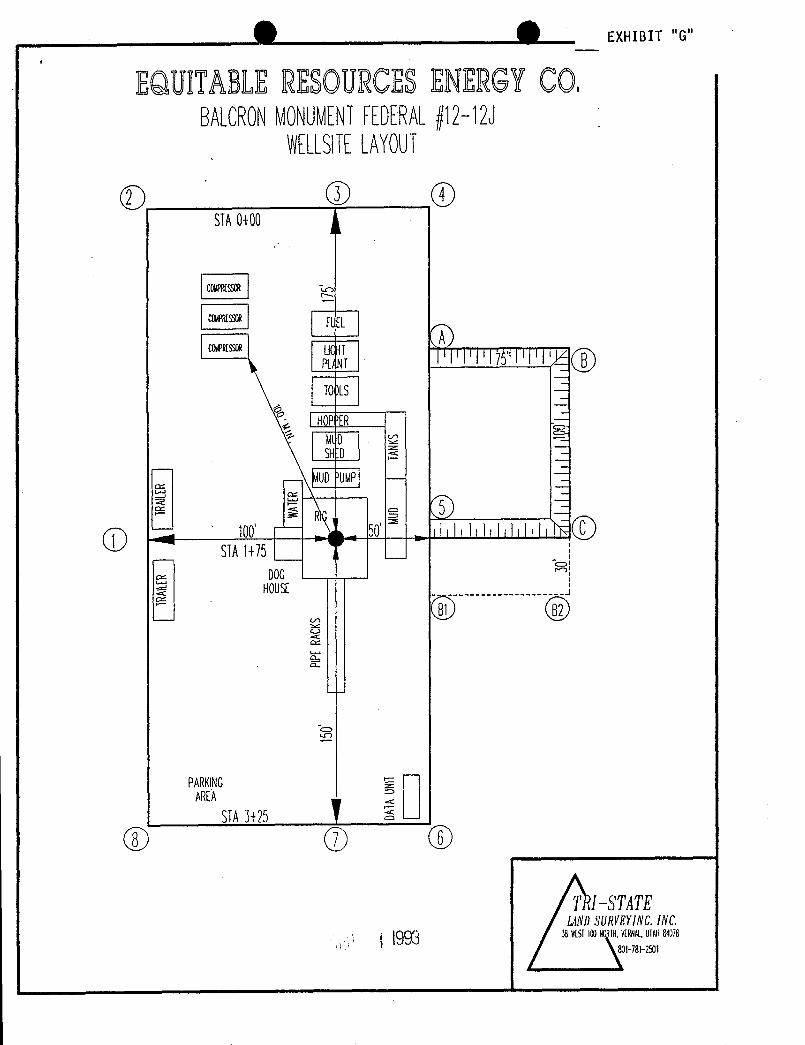
O O EXHIBIT "G"
EQUITABLERESOURCESENERGYCO.BALCRONMONUMENTFEDERAL#12-12J
WELLSlTELAYOUT
(DSIA0+00
celelsseR
coletsson LIGTpay
'lllllllfl I!\f('y)Tots
| HOP'ER -
MlD\ SHD I
- MUDUMP -
SIA1+75DOG
HOUSE
PARKING gi¯
AREASTA3+25
TRI--STATElANDSURVEYlNC.INC.
38MSI100N IN.mAt. UIANama
O O EXHIBIT "G"
EQUITABLERESOURCESENERGYCO.BALCRONMONUMENTFEDERAL#12-12J
WELLSlTELAYOUT
(DSIA0+00
celelsseR
coletsson LIGTpay
'lllllllfl I!\f('y)Tots
| HOP'ER -
MlD\ SHD I
- MUDUMP -
SIA1+75DOG
HOUSE
PARKING gi¯
AREASTA3+25
TRI--STATElANDSURVEYlNC.INC.
38MSI100N IN.mAt. UIANama
O O EXHIBIT "G"
EQUITABLERESOURCESENERGYCO.BALCRONMONUMENTFEDERAL#12-12J
WELLSlTELAYOUT
(DSIA0+00
celelsseR
coletsson LIGTpay
'lllllllfl I!\f('y)Tots
| HOP'ER -
MlD\ SHD I
- MUDUMP -
SIA1+75DOG
HOUSE
PARKING gi¯
AREASTA3+25
TRI--STATElANDSURVEYlNC.INC.
38MSI100N IN.mAt. UIANama
. Mr. t,t.LUNIONDRILLINGRIG #17 ·
·
rerr.uoa..Ñt-BD..
Box..Caost.
e)
½oooBufooSw. PL
3 Go r,t. Lumt..
e
.9os...Cwn<s...
3000....... T.LK.K.
. Mr. t,t.LUNIONDRILLINGRIG #17 ·
·
rerr.uoa..Ñt-BD..
Box..Caost.
e)
½oooBufooSw. PL
3 Go r,t. Lumt..
e
.9os...Cwn<s...
3000....... T.LK.K.
. Mr. t,t.LUNIONDRILLINGRIG #17 ·
·
rerr.uoa..Ñt-BD..
Box..Caost.
e)
½oooBufooSw. PL
3 Go r,t. Lumt..
e
.9os...Cwn<s...
3000....... T.LK.K.
EX IB
E UITABLERESOURCESENERGYCO. 7g_ggy993 MONUMENTEEDERAL{\22J
EX IB
E UITABLERESOURCESENERGYCO. 7g_ggy993 MONUMENTEEDERAL{\22J
EX IB
E UITABLERESOURCESENERGYCO. 7g_ggy993 MONUMENTEEDERAL{\22J
Status=0Status=0Status=0
e 4EXHIBIT 'A"Proposed Drilling ProgramPage 1
EQUITABLE RESOURCES ENERGY COMPANYBalcron Oil Division
Balcron Monument Federal #12-12JSW NW Section 12-T9S-R16E
Duchesne County, Utah
In accordance with requirements outlined in 43 CFR 3162-3.1 (d):
1. ESTIMATED IMPORTANT GEOLOGICAL MARKERS:
See Geologic Prognosis (EXHIBIT "C")
2. ESTIMATED DEPTHS OF ANTICIPATED OIL, GAS OR WATER:
See Geologic Prognosis (EXHIBIT "C)
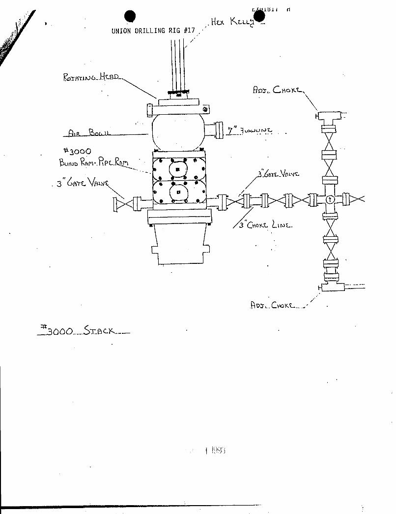
3. OPERATOR'S MINIMUM SPECIFICATIONS FOR PRESSURE CONTROL:
a. EXHIBIT "H" is a schematic of the BOP equipment and chokemanifold. A 2M system will be used. The BOPE will beinstalled after setting 8-5/8" casing at 260'. The blind ramsand pipe rams will be tested to 1500 psi. Pipe rams will beoperationally checked each 24-hour period and blind rams eachtime pipe is pulled out of the hole.
b. The BOPE will be tested to 1500 psi when initially installed,whenever any seal subject to test pressure is broken, andfollowing related repairs. The pipe and blind rams will beactivated at least weekly and on every trip the pipe and blindrams will be activated.
c. An accumulator of sufficient capacity to open thehydraulically-controlled choke valve lines (if so equipped),close all rams, and retain a minimum of 200 psi above prechargeon the closing manifold without the use of the closing unitpumps will be installed during the drilling of this well.
d. An upper kelly cock will be used during the drilling of thiswell.
e. Visual mud monitoring equipment will be used to detect volumechanges indicating loss or gain in circulating fluid volume.
f. Sufficient quantities of mud materials will be maintained orreadily accessible for the purpose of assuring well control.
SEP ¡
e 4EXHIBIT 'A"Proposed Drilling ProgramPage 1
EQUITABLE RESOURCES ENERGY COMPANYBalcron Oil Division
Balcron Monument Federal #12-12JSW NW Section 12-T9S-R16E
Duchesne County, Utah
In accordance with requirements outlined in 43 CFR 3162-3.1 (d):
1. ESTIMATED IMPORTANT GEOLOGICAL MARKERS:
See Geologic Prognosis (EXHIBIT "C")
2. ESTIMATED DEPTHS OF ANTICIPATED OIL, GAS OR WATER:
See Geologic Prognosis (EXHIBIT "C)
3. OPERATOR'S MINIMUM SPECIFICATIONS FOR PRESSURE CONTROL:
a. EXHIBIT "H" is a schematic of the BOP equipment and chokemanifold. A 2M system will be used. The BOPE will beinstalled after setting 8-5/8" casing at 260'. The blind ramsand pipe rams will be tested to 1500 psi. Pipe rams will beoperationally checked each 24-hour period and blind rams eachtime pipe is pulled out of the hole.
b. The BOPE will be tested to 1500 psi when initially installed,whenever any seal subject to test pressure is broken, andfollowing related repairs. The pipe and blind rams will beactivated at least weekly and on every trip the pipe and blindrams will be activated.
c. An accumulator of sufficient capacity to open thehydraulically-controlled choke valve lines (if so equipped),close all rams, and retain a minimum of 200 psi above prechargeon the closing manifold without the use of the closing unitpumps will be installed during the drilling of this well.
d. An upper kelly cock will be used during the drilling of thiswell.
e. Visual mud monitoring equipment will be used to detect volumechanges indicating loss or gain in circulating fluid volume.
f. Sufficient quantities of mud materials will be maintained orreadily accessible for the purpose of assuring well control.
SEP ¡
EXHIBI A"Proposed Drilling ProgramPage 2
4. PROPOSED CASING AND CEMENTING PROGRAM:
a. Surface casing will be set in the Uinta formation toapproximately 260' and cemented to surface.
b. All potentially productive hydrocarbon zones will be isolated.
c. Casing designs are based on factors of burst: 1.25, collapse:1.125, and joint strength: 1.8.
d. All casing strings will be pressure tested to 0.22 psi/ft. ofcasing string length or 1500 psi whichever is greater (not toexceed 70% of yield).
E. For details of casing, cement program, drilling fluid program,and proposed mud program, see the following two attachments:
Drilling Program/Casing Design (EXHIBIT "D")Geologic Prognosis (EXHIBIT "C")
5. HAZARDOUS PRESSURESr TEMPERATURES, FLUIDSfGASSES EXPECTED:
a. Expected bottom hole temperature is 125 degrees F. Expectedbottom hole pressure is 1500 psi.
b. No abnormal pressures or temperatures have been noted orreported in wells drilled to the Green River formation in thisarea.
c. No dangerous levels of hydrogen sulfide, hazardous fluids, orgasses have been found, reported, or known to exist at thedepth to be drilled in this well, in this area.
6. ANTICIPATED STARTING DATE AND DURATION OF OPERATIONS:
a. The drilling operations for this well will begin prior toSeptember 30, 1993.
b. These drilling operations should be completed within 12 daysafter spudding the well depending on weather and holeconditions.
c. If the well is productive, a sundry notice and plat showingexact installed facilities will be submitted.
d. If this well is non-productive, a sundry notice will be filedwith the BLM District Office within 30 days followingcompletion of the well for abandonment.
SEP
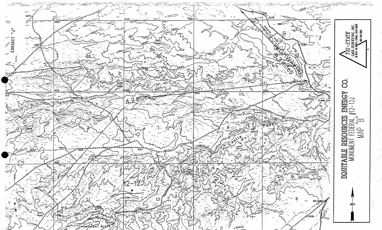
O OL
EXHIBIT "B"
Multi-Point Surface Use and Operations Plan
EQUITABLE RESOURCES ENERGY COMPANYBALCRON OIL DIVISION
BALCRON FEDERAL #12-12JSW NW SECTION 12, T9S, R16E
DUCHESNE COUNTY, UTAH
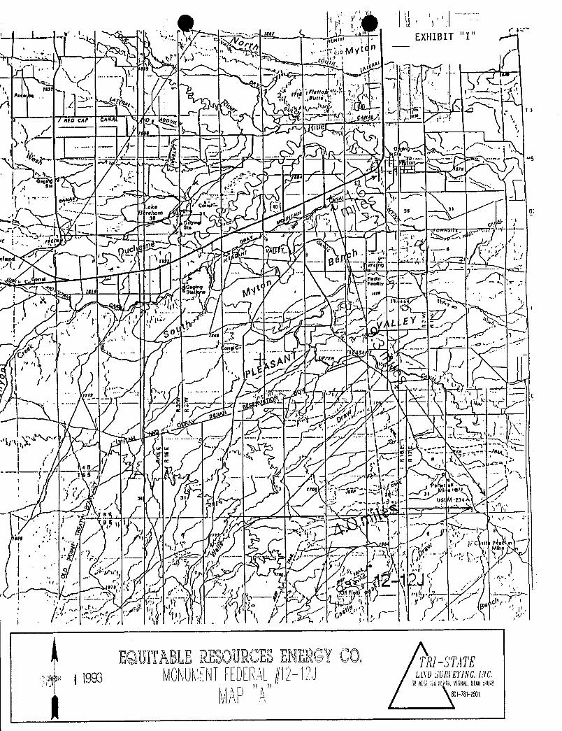
1. Existing Roads: Refer to Maps "A" & "B" (shown in RED)
A. The proposed well site is staked and four referencestakes are present. 150' & 200' North and 200' & 250'West.
B. The Federal #12-12J is located 13 miles Southwest ofMyton Utah in the SW1/4 NW1/4 Section 12, T9S, R16E,SLB&M, Duchesne County, Utah. To reach the 12-12J, proceedWest from Myton, Utah along U.S. Highway 40 for 1.6 milesto the junction of this highway and Sand Wash road;Proceed South along the Sand Wash road approximately 9.3miles to an intersection with the Momnument Butte gasplant road, turn right and continue 4.0 miles to roadintersection; turn left and proceed 0.2 miles to roadintersection. Turn left and continue 0.9 mile to proposedaccess road sign. Follow flags 200 feet to location.
C. Access roads - refer to Maps "A" and "B".
D. Access roads within a one-mile radius - refer to map "B".
E. The existing roads will be maintained in the same orbetter condition as existed prior to the commencement ofoperations and said maintenance will continue until finalabandonment and reclamation of the well location.
2. Planned Access Roads: Refer to Map "B" (shown in GREEN)
Approximately 200 feet of new road construction will berequired for access to the proposed well location.
A. Width - maximum 30-foot overall right-of-way with an 18-foot road running surface, crowned & ditched and/or slopedand dipped.
SEP \ l993
Page
O OL
EXHIBIT "B"
Multi-Point Surface Use and Operations Plan
EQUITABLE RESOURCES ENERGY COMPANYBALCRON OIL DIVISION
BALCRON FEDERAL #12-12JSW NW SECTION 12, T9S, R16E
DUCHESNE COUNTY, UTAH
1. Existing Roads: Refer to Maps "A" & "B" (shown in RED)
A. The proposed well site is staked and four referencestakes are present. 150' & 200' North and 200' & 250'West.
B. The Federal #12-12J is located 13 miles Southwest ofMyton Utah in the SW1/4 NW1/4 Section 12, T9S, R16E,SLB&M, Duchesne County, Utah. To reach the 12-12J, proceedWest from Myton, Utah along U.S. Highway 40 for 1.6 milesto the junction of this highway and Sand Wash road;Proceed South along the Sand Wash road approximately 9.3miles to an intersection with the Momnument Butte gasplant road, turn right and continue 4.0 miles to roadintersection; turn left and proceed 0.2 miles to roadintersection. Turn left and continue 0.9 mile to proposedaccess road sign. Follow flags 200 feet to location.
C. Access roads - refer to Maps "A" and "B".
D. Access roads within a one-mile radius - refer to map "B".
E. The existing roads will be maintained in the same orbetter condition as existed prior to the commencement ofoperations and said maintenance will continue until finalabandonment and reclamation of the well location.
2. Planned Access Roads: Refer to Map "B" (shown in GREEN)
Approximately 200 feet of new road construction will berequired for access to the proposed well location.
A. Width - maximum 30-foot overall right-of-way with an 18-foot road running surface, crowned & ditched and/or slopedand dipped.
SEP \ l993
Page

O O
B. Construction standard - the access road will beconstructed so as to conform to the standards outlined inthe Bureau of Land Management and Forest Servicepublication: Surface Operating Standards for Oil and GasExploration and Development. (1989)
The road will be constructed to meet the standards of theanticipated traffic flow and all-weather requirements.Construction will include ditching, draining, crowning,and capping or sloping and dipping the roadbed asnecessary to provide a well constructed and safe road.Prior to construction/upgrading, the roadway shall becleared of any snow cover and allowed to dry completely.Traveling off of the thirty (30) foot right-of-way willnot be allowed.
Road drainage crossings shall be of the typical dry creekdrainage crossing type. Crossing shall be designed sothey will not cause siltation or the accumulation ofdebris in the drainage crossing nor shall the drainages beblocked by the roadbed. Erosion of drainage ditches byrunoff water shall be prevented by diverting water off atfrequent intervals by means of cutouts.
Upgrading shall not be allowed during muddy conditions.
Should mud holes develop, they shall be filled in anddetours around them avoided.
C. Maximum grade - Less than 8%
D. Turnouts - no turnouts will be required on this accessroad.
E. Drainage design - the access road will be crowned andditched or sloped and dipped, and water turnouts installedas necessary to provide for proper drainage along theaccess road route.
F. Culverts, cuts and fills - no culverts will be required.There are no major cuts and/or fills on/along the proposedaccess road route.
G. Surface materials - all construction materials will benative material taken from onsite.
H. Gates, cattleguards or fence cuts - none required.
I. Road maintenance - during both the drilling andproduction phase of operations, the road surface andshoulders will be kept in a safe and useable condition and
Page (2)
SEP \
Owill be maintained in accordance with the originalconstruction standards. All drainage ditches and culvertswill be kept clear and free-flowing, and will also bemaintained in accordance with the original constructionstandards.. The access road right-of-way will be kept freeof trash during operations.
J. The proposed access road has been centerline flagged.
K. If a right-of-way is required please consider this APDthe application for said right-of-way.
3. Location of.Existing Wells Within a One-Mile Radius:
Please Refer to Map "C"
A. Water wells - none known.B. Abandoned wells - see Map "C"C. Temporarily abandoned wells - none known.D. Disposal wells - none known.E. Drilling wells - none known.F. Producing wells - see Map "C".G. Shut-in wells - none known.H. Injection wells - none known.I. Monitoring wells - none known.
4. Location of Existing and/or Proposed Facilities Owned byEquitable Resources Energy Company Within a One-Mile Radius:
A. Existing
1. Tank batteries - see Map "C".2. Production facilities - see Map "C".3. Oil gathering lines - none.4. Gas gathering lines - see Map "C".
B. New Facilities Contemplated
1. All production facilities will be located on thedisturbed portion of the well pad and at a minimum oftwenty-five (25) feet from the toe of the backslope ortoe of the fill slope.
2. The production facilities will consist primarily of apumping unit, Two tanks and an emergency pit. A diagramshowing the proposed production facility layout will besubmitted to the Authorized Officer via "Sundry Notice"(Form 3160-5) for approval of subsequent installationoperations.
3. Production facilities will be accommodated on the
Page (3)
SEP \

O O
existing well pad. Construction materials required forinstallation of the production facilities will beobtained from the site; any additional materialsrequired will be purchased from a local supplier havinga permitted (private) source of materials within thearea..
A dike will be constructed completely around thoseproduction facilities which contain fluids (i.e.production tanks, produced water tanks and/or heatertreater). These dikes will be constructed of compactedsubsoil, be impervious, hold 100% of the capacity ofthe largest tank, and be independent of the back cut.
4. All permanent (onsite for six months or longer) abovethe ground structures constructed or installedincluding pumping units) will be painted Desert Brown.All production facilities will be painted within six(6) months of installation. Facilities required tocomply with Occupational Health and Safety Act Rulesand Regulations will be excluded from this paintingrequirement.
C. The production (emergency) pit will be 12'x12' and willbe fenced. Said fence will be maintained in goodcondition.
D. During drilling and subsequent operations, all equipmentand vehicles will be confined to the access road right-of-way and any additional areas as specified in the approvedApplication for Permit to Drill.
E. Reclamation of disturbed areas no longer needed foroperation will accomplished by grading, leveling andseeding as recommended by the Bureau of Land Management.
For Pipeline:
F. Any proposed pipelines will be submitted to theauthorized officer Via Sundry Notice for approval ofsubsequent operations.
G. Equitable Resources Energy Company shall be responsiblefor road maintenance from the beginning to completion ofoperations.
5. Location and Type of Water Supply
A. Water to be used for the drilling of these wells will be
Page (4)
SEP \

hauled by truck over the roads described in item #1 anditem #2, from a well owned by Owen Dale Anderson of VernalUtah or from a spring owned by Joe Shields· Source wiTI bedetermined closer to beginning drilling operations.
B. No water well will be drilled on this location.
6. Source of Construction Materials
A. No construction materials are needed for drillingoperations. In.the event of production, the small amountof gravel needed for facilities will be hauled in by truckfrom a local gravel pit over existing access roads to thearea. No special access other than for drilling operationsand pipeline construction is needed.
B. All access roads crossing Federal land are describedunder item #2, and shown on Map #A.
All construction material for these location sites andaccess roads shall be borrowed material accumulated duringthe construction of the location sites and access roads.No additional construction material from other sources isanticipated at this time, if in the future it is requiredthe appropriate actions will be taken to acquire it fromprivate sources.
C. All surface disturbance area is on B.L.M. lands.
D. There are no trees on this location.
7. Methods of Handling Waste Materials:
A. Cuttings - the cuttings will be deposited in the reservepit.
B. Drilling fluids - including salts and chemicals will becontained in the reserve pit. Upon termination ofdrilling and completion operations, the liquid contents ofthe reserve pit will be removed and disposed of at anapproved waste disposal facility within ninety (90) daysafter termination of drilling and completion activities.
In the event adverse weather conditions prevent removal ofthe fluids from the reserve pit within this time period,an extension may be granted by the Authorized Officer uponreceipt of a written request from Equitable ResourcesEnergy Company.
The reserve pit will be constructed so as not to leak,break, or allow discharge. The reserve pit will be linedwith a 12 mil plastic reinforced liner.
Page (5)
SEP l

O O
C. Produced fluids - liquid hydrocarbons produced duringcompletion operations will be placed in test tanks on thelocation. Produced waste water will be confined to alined pit (reserve pit) or storage tank for a period notto exceed ninety (90) days after initial production.During the ninety (90) day period, in accordance with NTL-2B, an application for approval of a permanent disposalmethod and location, along with the required wateranalysis, shall be submitted for the Authorized Officer'sapproval. Failure to file an application within the timeframe allowed will be considered an incidence ofnoncompliance.
Any spills of oil, gas, salt water or other noxious fluidswill be immediately cleaned up and removed to an approveddisposal site.
D. Sewage - self-contained, chemical toilets will beprovided for human waste disposal. Upon completion ofoperations, or as needed, the toilet holding tanks will bepumped and the contents thereof disposed of in thenearest, approved, sewage disposal facility.
E. Garbage and other waste material - garbage, trash andother waste materials will be collected in a portable,self-contained and fully-enclosed trash cage duringdrilling and completion operations. Upon completion ofoperations (or as needed) the accumulated trash will bedisposed of at an authorized sanitary landfill. No trashwill be burned on location or placed in the reserve pit.
F. Immediately after removal of the drilling rig, all debrisand other waste materials not contained in the trash cagewill be cleaned up and removed from the well location. Noadverse materials will be left on the location. Any openpits will be fenced during the drilling operation and thefencing will be maintained until such time as the pits arebackfilled.
G. The reserve and/or production pit will be constructed onthe existing location and will not be located in naturaldrainages where a flood hazard exists or surface runoffwill destroy or damage the pit walls. All pits will beconstructed so as not to leak, break, or allow thedischarge of liquids therefrom.
8. Ancillary Facilities:
None anticipated.
9. Wellsite Layout:
Page (6)
SEP \
O OA. Plat #1 shows the drill site layout as staked. Cross
sections have been drafted to visualize the planned cutsand fills across the location. An average minimum of six(6) inches of topsoil will be stripped from the location(including areas of cut, fill, and/or subsoil storage) andstockpil.ed for future reclamation of the well site. Referto Figure #1 for the location of the topsoil and subsoilstockpiles.
B. Plat #2 is a diagram showing the rig layout. No permanentliving facilitios are planned. There will be three (3)trailers on location during drilling operation.
C. A diagram showing the proposed production facility layoutwill be submitted to the Authorized Officer via SundryNotice (Form 3160-5) for approval of subsequentoperations.
D. The reserve pit will be constructed so as to be capableof holding 12,000 bbls. of fluid. The flare pit will belocated downwind of the prevailing wind between corner #4and corner "A". Access will be from the West near corner#7.
The reserve pit will be lined with a 12 mil plastic liner,it will be torn and perforated after the pit dries andbefore backfilling of the reserve pit.
E. Prior to the commencement of drilling operations, thereserve pit will be fenced on three (3) sides using 39-inch net wire with one strand of barbed wire on top of thenet wire. The net wire will be no more than two inchesabove the ground. the barbed wire will be three inchesabove the net wire. total height of the fence will be atleast 42-inches.
1. Corner posts shall be cemented and/or braced in such amanner to keep the fence tight at all times.
2. Standard steel, wood, or pipe posts shall be usedbetween the corner braces. The maximum distancebetween any two (2) posts shall be no greater thansixteen (16) feet.
3. All wire shall be stretched, by using a stretchingdevice, before it is attached to the corner posts.
The fourth side of the reserve pit will be fencedimmediately upon removal of the drilling rig and thefencing will be maintained until the pit is backfilled.
Page (7)
SEp
O O
A. Plat #1 shows the drill site layout as staked. Crosssections have been drafted to visualize the planned cutsand fills across the location. An average minimum of six(6) inches of topsoil will be stripped from the location(including areas of cut, fill, and/or subsoil storage) andstockpil.ed for future reclamation of the well site. Referto Figure #1 for the location of the topsoil and subsoilstockpiles.
B. Plat #2 is a diagram showing the rig layout. No permanentliving facilitios are planned. There will be three (3)trailers on location during drilling operation.
C. A diagram showing the proposed production facility layoutwill be submitted to the Authorized Officer via SundryNotice (Form 3160-5) for approval of subsequentoperations.
D. The reserve pit will be constructed so as to be capableof holding 12,000 bbls. of fluid. The flare pit will belocated downwind of the prevailing wind between corner #4and corner "A". Access will be from the West near corner#7.
The reserve pit will be lined with a 12 mil plastic liner,it will be torn and perforated after the pit dries andbefore backfilling of the reserve pit.
E. Prior to the commencement of drilling operations, thereserve pit will be fenced on three (3) sides using 39-inch net wire with one strand of barbed wire on top of thenet wire. The net wire will be no more than two inchesabove the ground. the barbed wire will be three inchesabove the net wire. total height of the fence will be atleast 42-inches.
1. Corner posts shall be cemented and/or braced in such amanner to keep the fence tight at all times.
2. Standard steel, wood, or pipe posts shall be usedbetween the corner braces. The maximum distancebetween any two (2) posts shall be no greater thansixteen (16) feet.
3. All wire shall be stretched, by using a stretchingdevice, before it is attached to the corner posts.
The fourth side of the reserve pit will be fencedimmediately upon removal of the drilling rig and thefencing will be maintained until the pit is backfilled.
Page (7)
SEp
e eF. Any hydrocarbons on the pit will l>e removed from the pit
as soon as possible after drilling operations arecompleted.
10. Plans for Reclamation of the Surface:
The B.L.M. will be contacted prior to commencement of anyreclamation operations.
A. Production
1. Immediately upon well completion, the well locationand surrounding area(s) will be cleared of all debris,materials, trash and junk not required for production.
2. Immediately upon well completion, any hydrocarbons onthe pit shall be removed in accordance with 43 CFR3162.7-1.
3. The plastic pit liner shall be torn and perforatedbefore backfilling of the reserve pit.
4. Before any dirt work to restore the location takesplace, the reserve pit will be completely dry and allcans, barrels, pipe, etc. will be removed.
Other waste and spoil materials will be disposed ofimmediately upon completion of drilling and workoveractivities.
5. The reserve pit and that portion of the location andaccess road not needed for productionfacilities/operations will be reclaimed within onehundred twenty (120) days from the date of wellcompletion, weather permitting.
6. If the well is a producer, Equitable Resources EnergyCompany will, upgrade and maintain access roads asnecessary to prevent soil erosion, and accommodate yearround traffic. Reshape areas unnecessary tooperations, distribute topsoil, disk and seed alldisturbed areas outside the work area according to therecommended seed mixture. Perennial vegetation must beestablished. Additional work shall be required in caseof seeding failures, etc.
If the well is abandoned/dry hole, Equitable ResourcesEnergy Company will, restore the access road andlocation to approximately the original contours.During reclamation of the site, push the fill materialinto cuts and up over the backslope. Leave no
Page (8)
SEP \

O
depressions that will trap water or form ponds.Distribute topsoil evenly over the location, and seedaccording to the above seed mixture. The access roadand location shall be ripped or dished prior toseeding. Perennial vegetation must be established.Addit.ional work shall be required in case of seedingfailures, etc.
Seedbed will be prepared by disking, then rollerpacking follpwing the natural contours. Seed will bedrilled on contours at a depth no greater than one-halfinch (1/2"). In areas that cannot be drilled, seedwill be broadcast at double the seeding rate andharrowed into soil. Certified seed will be usedwhenever available.
Fall seeding will be completed after September 1 andprior to prolonged ground frost. Spring seeding, to beeffective, will be completed after the frost has leftthe ground and prior to May 15th.
7. Upon completion of backfilling, leveling andrecontouring, the stockpiled topsoil will be evenlyspread over the reclaimed area(s). Prior to reseeding,all disturbed surfaces will be scarified and left witha rough surface. No depressions will be left thatwould trap water and form ponds. All disturbed surfaceswill be reseeded with the seed mixture stipulated bythe B.L.M.
Seed will be drilled on the contour to a approximatedepth of one-half (1/2) inch. All seeding will beconducted after September 1 and prior to ground frost.Spring seeding will be done after the frost leaves theground and no later than May 15. If the seeding isunsuccessful, Equitable Resources may be required tomake subsequent seedings.
B. Dry Hole/Abandoned Location
1. On lands administered by the Bureau of LandManagement, abandoned well sites, roads, or otherdisturbed areas will be restored to near their originalcondition. This procedure will include:
(c) ensuring revegetation of the disturbed areas to thespecifications of the Bureau of Land Management atthe time of abandonment.
2. All disturbed surfaces will be recontoured to theapproximate natural contours and reseeded according to
Page (9)
ggp i
O O
BLM specifications. Reclamation of the well pad andaccess road will be performed as soon as practicalafter final abandonment and reseeding operations willbe performed in the fall or spring following completionof reclamation operations.
11. Surface Ownership:
The well site and proposed access road are situated onsurface lands administered by
Bureau of Land ManagementVernal District Office
Vernal, Utah
12. Other Information:
A. Topographic and geologic features of the area (referenceTopographic Map #A) are:
The proposed drill site is located in the Monument Butteoil field, which lies in a large basin formed by the UintaMountains to the North and the Bookcliff Mountains to theSouth. The site is located approximately 15 milesNorthwest of the Green River,which is the major drainagefor this area, and approximately 13 miles Southwest ofMyton Utah.
This basin floor is interlaced with numerous canyons andridges formed by the non-perennial streams of the area.The sides of these canyons are steep and ledges formed insandstone, conglomerate deposits and shale are common inthis area.
The geologic structures that are visible in the area areof the Uinta formation (Eocene Epoch) tertiary period andthe cobblestone and younger alluvial deposits from theQuaternary period.
The soils in the semi-arid area of the Williams ForkFormation (Upper Cretaceous) and Wasatch Formation(Eocene) consist of light brownish gray clay (OL) to sandsoil (SM-ML) type with poorly graded gravels.
Outcrops of sandstone ledges, conglomerate deposits andshale are common in this area.
The topsoils in the area range from a sandy clay (SM-ML)type soil to a clayey (OL) soil.
Page (10)
S ? \
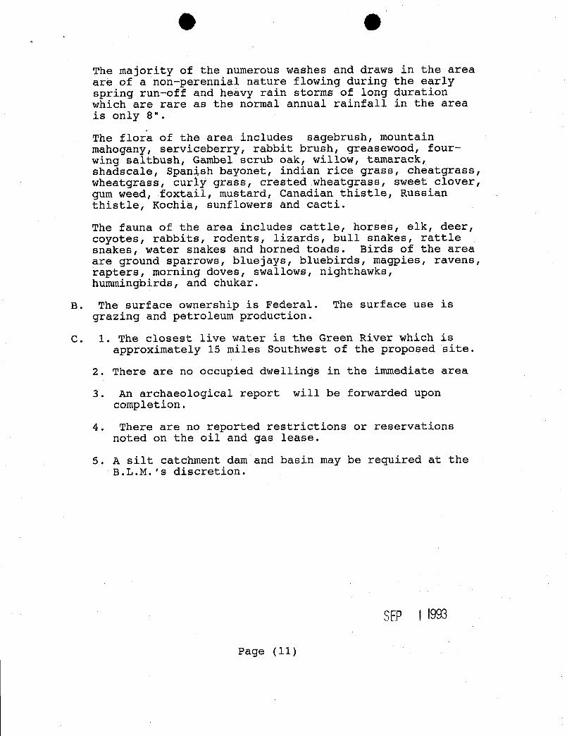
O O
The majority of the numerous washes and draws in the areaare of a non-perennial nature flowing during the earlyspring run-off and heavy rain storms of long durationwhich are rare as the normal annual rainfall in the areais only 8".
The flora of the area includes sagebrush, mountainmahogany, serviceberry, rabbit brush, greasewood, four-wing saltbush, Gambel scrub oak, willow, tamarack,shadscale, Spanish bayonet, indian rice grass, cheatgrass,wheatgrass, curly grass, crested wheatgrass, sweet clover,gum weed, foxtail, mustard, Canadian thistle, Russianthistle, Kochia, sunflowers and cacti.
The fauna of the area includes cattle, horses, elk, deer,coyotes, rabbits, rodents, lizards, bull snakes, rattlesnakes, water snakes and horned toads. Birds of the areaare ground sparrows, bluejays, bluebirds, magpies, ravens,rapters, morning doves, swallows, nighthawks,hummingbirds, and chukar.
B. The surface ownership is Federal. The surface use isgrazing and petroleum production.
C. 1. The closest live water is the Green River which isapproximately 15 miles Southwest of the proposed site.
2. There are no occupied dwellings in the immediate area
3. An archaeological report will be forwarded uponcompletion.
4. There are no reported restrictions or reservationsnoted on the oil and gas lease.
5. A silt catchment dam and basin may be required at theB.L.M.'s discretion.
SEP \ l993
Page
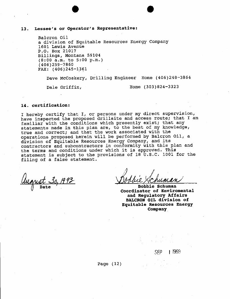
O O
13. Lessee's or Operator's Representative:
Balcron Oila division of Equitable Resources Energy Company1601 Lewis AvenueP.O. BoX 21017Billings, Montana 59104(8:00 a.m. to 5:00 p.m.)(406)259-7860FAX: (406)245-1361
Dave McCoskery, Drilling Engineer Home (406)248-3864
Dale Griffin, Home (303)824-3323
14. Certification:
I hereby certify that I, or persons under my direct supervision,have inspected the proposed drillsite and access route; that I amfamiliar with the conditions which presently exist; that anystatements made in this plan are, to the best of my knowledge,true and correct; and that the work associated with theoperations proposed herein will be performed by Balcron Oil, adivision of Equitable Resources Energy Company, and itscontractors and subcontractors in conformity with this plan andthe terms and conditions under which it is approved. Thisstatement is subject to the provisions of 18 U.S.C. 1001 for thefiling of a false statement.
Date Bobbie SchumanCoordinator of Enviromental
and Regulatory AffairsBALCRON OIL division of
Equitable Resources EnergyCompany
SEP \\993
Page
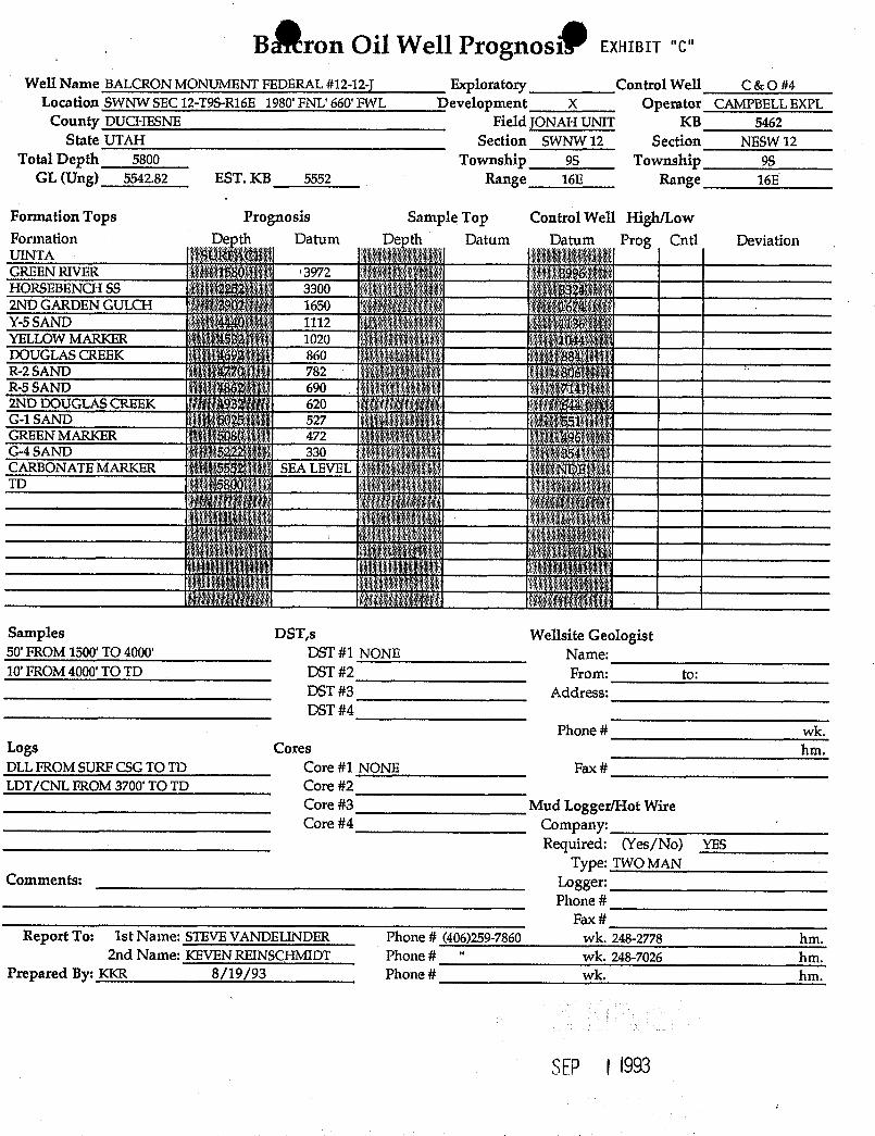
BÊronOil Well Prognosi EXHIBIT "C"
Well Name BALCRON MONUMENT FEDERAL #12-12-} Exploratory Control Well C & O #4Location SWNW SEC 12-T9S-R16E 1980' FNL' 660' FWL Development X Operator CAMPBELL EXPL
County DUCHESNE Field JONAH UNIT KB 5462State UTAH Section SwNW 12 Section NESW 12
Total Depth 5800 Township 9S Township 98GL (Ung) 5542.82 EST. KB 5552 Range 16E Range 16E
Formation Tops Prognosis Sample Top Control Well High/LowFormation Depth Datum Depth Datum Datum Prog Cntl DeviationUINTA SURFACEGREEN RIVER 1580 3972 3996HORSEBENCH SS i 2252 3300 39242ND GARDEN GULCH 3902 1650 1674Y-5SAND 4440 1112 1136YELLOW MARKER 4532 1020 1044 1
DOUGLASCREEK 4692 860 884 -
R-2 SAND 4770 782 806R-5 SAND 4862 690 714 >
2ND DOUGLASCREEK 4932 620 644 ' *
G-1 SAND 5025 - 527 551GREEN MARKER 5080 , 472 ' 496G-4 SAND 5222 330 354CARBONATE MARKER * 5552 SEA LEVEL NDETD 5800
Samples DST,s Wellsite Geologist50' FROM 1500' TO 4000' DST #1 NONE Name:10' FROM4000' TO TD DST #2 From: to:
DST#3 Address:DST #4
Phone # wk.Logs Cores hm.DLL FROM SURF CSGTO TD Core #1 NONE Fax #LDT/CNL FROM 3700' TO TD Core #2
Core #3 Mud Logger/Hot WireCore #4 Company:
Required: (Yes/No) YESType: TWO MAN
Comments: Logger:Phone #
Fax #Report To: 1st Name: STEVE VANDELINDER Phone # (406)259-7860 wk. 248-2778 hm.
2nd Name: KEVEN REINSCHMIDT Phone # " wk. 248-7026 hm.Prepared By: KKR 8/19/93 Phone # wk. hm.
SEP I
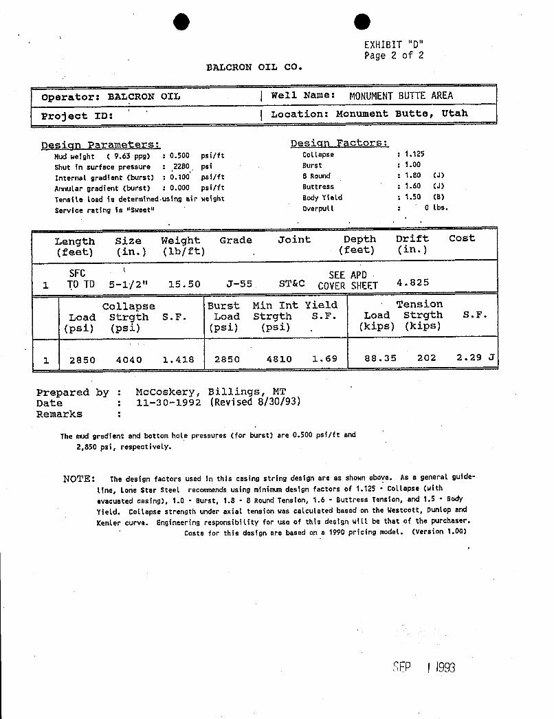
EXHIBIT "D"Page 2 of 2
BALCRON OIL CO.
operator: BALCRON oIL | well Name: MONUMENTBUTTEAREA
Project ID:'
( Location: Monument Butte, Utah
Design Parameters: Design Factors:Mud weight ( 9.63 ppg) : 0.500 psi/ft Cottapse : 1.125Shut in surface pressure : .2280 psi Burst : 1.00
Internal gredient (burst) : 0.100 psi/ft 8 Round : 1.80 (J)
Annutar gradient (burst) : 0.000 psi/ft Buttress : 1.60 (J)
Tensite load is determined-using air weight Body Yield : 1.50 (B)
Service rating is "Sweetil Overpult : 0 lbs.
Length Size Weight Grade Joint Depth Drift Cost(feet) (in.) (1b/ft) .
(feet) (in.)
SFC SEE APD1 TO TD 5-1/2" 15.50 J-55 ST&C COVER SHEET 4.825
Collapse Burst Min Int Yield · TensionLoad Strgth S.F. Load Strgth S.F. Load Strgth S.F.
(psi) (psi) (psi) (psi).
(kips) (kips)
1 2850 4040 1.418 2850 4810 1.69 88.35 202 2.29 J
Prepared by : McCoskery, Billings, MTDate : 11-30-1992 (Revised 8/30/93)Remarks :
The mud gredient and bottom hole pressures (for burst) are 0.500 psi/ft and
2,850 psi, respectively.
NOTE: The design factors used in this casing string design are as shown above. As a general guide-
line, Lone Star steet recomends using minimum design factors of 1.125 - Collapse (withevacuated casing), 1.0 - Burst, 1.8 • 8 Round Tension, 1.6 - Buttress Tension, and 1.5 - Body
Yield. Collapse strength under axial tension was calculated based on the Westcott, Dunlop and
Kemler curve. Engineering responsibility for use of this design will be that of the purchaser.Costs for this design are based on a 1990 pricing model. (Version 1.0G)
SEP f
EXHIBIT "D"Page 2 of 2
BALCRON OIL CO.
operator: BALCRON oIL | well Name: MONUMENTBUTTEAREA
Project ID:'
( Location: Monument Butte, Utah
Design Parameters: Design Factors:Mud weight ( 9.63 ppg) : 0.500 psi/ft Cottapse : 1.125
Shut in surface pressure : .2280 psi Burst : 1.00
Internal gredient (burst) : 0.100 psi/ft 8 Round : 1.80 (J)
Annutar gradient (burst) : 0.000 psi/ft Buttress : 1.60 (J)
Tensite load is determined-using air weight Body Yield : 1.50 (B)
Service rating is "Sweetil Overpult : 0 lbs.
Length Size Weight Grade Joint Depth Drift Cost(feet) (in.) (1b/ft) .
(feet) (in.)
SFC SEE APD1 TO TD 5-1/2" 15.50 J-55 ST&C COVER SHEET 4.825
Collapse Burst Min Int Yield · TensionLoad Strgth S.F. Load Strgth S.F. Load Strgth S.F.
(psi) (psi) (psi) (psi).
(kips) (kips)
1 2850 4040 1.418 2850 4810 1.69 88.35 202 2.29 J
Prepared by : McCoskery, Billings, MTDate : 11-30-1992 (Revised 8/30/93)Remarks :
The mud gredient and bottom hole pressures (for burst) are 0.500 psi/ft and
2,850 psi, respectively.
NOTE: The design factors used in this casing string design are as shown above. As a general guide-
line, Lone Star steet recomends using minimum design factors of 1.125 - Collapse (withevacuated casing), 1.0 - Burst, 1.8 • 8 Round Tension, 1.6 - Buttress Tension, and 1.5 - Body
Yield. Collapse strength under axial tension was calculated based on the Westcott, Dunlop and
Kemler curve. Engineering responsibility for use of this design will be that of the purchaser.Costs for this design are based on a 1990 pricing model. (Version 1.0G)
SEP f
XHIBIT "D"age 1 of 2
Equitable Resources Energy CompanyBaloron Oil Division
DRILLING PROGRAM
WELL NAME: Monument Butte Area PROSPECT/FIELD: Monument ButteLOCATION: Twn.98 Rge.16E & 17ECOUNTY: Duchesne STATE: Utah
TOTAL DEPTH: SEE APD COVERSHEET
HOLE SIZE INTERVAL
12 1/4" O to 260'7 7/8" 260 to T.D.
CASING INTERVAL CASING
STRING TYPE FROM TO SIZE WEIGHT GRADE---------C-a-s
Production Casing 0 T.D. 5 1/2" 15.50#|Ft J-55(All Casing will be new, ST&C)
CEMENT PROGRAM
Surface 150 sacks 75% Class "G" 25% Poz with 2% CaC1 and1/4 #|Sk Flocele.( Cement will be circulated to surface.)
Production 250 sacks Thifty Lite and 400 sacks 50-50 Pozmix.
PRELIMINARYDRILLING FLUID PROGRAM
PLAS. YIELDTYPE FROM TO WEIGHT VIS POINT
Air and air mist 0 260 N.A. N.A. N.A.Air/Air Mist|KCl Water 260 T.D. 8.7-8.9 N.A. N.A.
depending on the drilling contractor either:a.) Drilling will be with air from surface to as deep as hcúmditions
allow. 2% KCl fluid will be used for the remainder of the hole.b.) Drilling will be done using 2% KCl water and gel.
COMMENTS
1.) No cores or DST's are planned.
SEP \\993
• pl or ,
a oÊ4 a
'.'\
United States Departrnent of the Interior.
mmmemmenmms
/ApßUREAU OF l.AND
MANAGENIEN°i ,sa.men n
% a e MONTANA STATE OFFICKmz m
222 NORTIl 32ND STREETmur.rt.Y m.
P.O. 13OX30800 ETN 12619-A et allift.I.INGS, AIONTANA 59107-0800 BLM BOMD NO. MTO576
(922.31)April 25, 1989
NOT I CE
Equitable Resources Energy,Company
P. O. Box 21017 OIL AND GAS
Billings, Montana 59104CORPORATE MERGER RECOGUIZED
RIDER TO MATIORWIDE BORD ACCEPTED
,
Acceptable ev.idence has been filed in this office concerning the merger
of Balcron Oil Company into Equitable Resources Energy Company, the
surviving corporation. Information provided shows that Baleron 011
Company merged into Equitable Resources Energy Company, changing the
former entiby's name to Balcron Oil, a Division of Equitable Resources
ßnergy Company. Please note that Divisions cannot hold leases,
therefore, after consultation with Balcron 011, this office is
recognizing only the merger action.
A cider was Eiled on April 20, 1989, to be made a part of $150,000Nationwide Oil and Gas Bond No. 5547188 (BLM Bond Mo. MTOS76) with
Balcron 011 Company as principal and Safeco Insurance Company of America
as surety. By means of this rider, the sucety consents to changing the
name on the bond from Balcron 011 Company to Equitable Resources Energy
Company. The rider is accepted effective April 20, 1989.
For our purposes, the mer3er is recognized effective April 20, 1989.
The oil and gas lease files and communitization agreement files
identified on the enclosed Exhibit A have been noted as to the mersec.
Other lease interests will be transferred by.assignments from Ballard & '
Cronoble to Equitable Resources Energy Company.
.
Cyn/þ ia L. Embrotson, chiefF ds Adjudication Section
1 Enclosure -
1-Exhibit A
cc: (w/encl.)AFS Denver (1) -
A_1 DMs (1 ea.)gM_OSection (1)Bâå-i.onal Forester, Lakewood (2)gegional Forester, Missoula (2)Buceau of Reclamation (1)
SEP l
/ -'BO O. 5547188
m 3104-8 UNITED STATESy 1984)
.DEPARTMENT OF THE INTERIORBUREAU OF LAND MANAGEMENT · - -
- STATE, NATIONWlDE, OR NATIONAL PETROLEUMRESERYE
.
1N ALASKAOIL AHD GAS BOND .
Act of February 25, 1920 (30 U.S.C. Sec. 181)
.Act of August 7, 1947 (30 U.S.C. Sec..311) . '•\ - - -
. Department of the interior appropriationsAct, Fiscal Year 1981 (P.L. 96-114)' Other Oil and Gas Leasing Authorities as Applicable . "Iritan nu
OW ALL MEN BY THESE PRESENTS, That we
BALCRON OIL COMPANY1601 Lewis Avenue, Billings, MT 591Q4
principal, andSAFECO INSURANCE COP.PANY OF AMERICA111 Presidential Blvd., Suite 231, Bala Cynwyd, PA 19004
surety, are held and firmly bound unto the United States of America in the sum of ONE HUNDRED FIFTY •
THOUSAND AND O0 /10 0------------------ dollars (S 15 0 , OOO . OO ), in lawful money
the United States, which sum may be increased or decreased by a rider hereto executed in the same manner as this bond, for
a use and benefit of (1) the United States; (2) the owner of any of the land subject to the coverage of this bond, who has;a--
atutory.right to compensation in connection with a reservation of the oil and gas deposits to the United States; ant) (3) any
snee or permittee under a lease or permit issued by the United States prior to the issuance of an oil and gas lease for the
me land subject to this bond, covering the use of the_sutface or the prospecting for, or development of, other mineral deposits
any portion of such land, to be paid to the United States, For such payment, well and truly to be made, we bind ourselves,
d each of our heirs, executors, administrators, and successors, jointly and severally.
The coverage of this bond shall extend to all of the principal's holdings of feder.al oil and gas leases in the United States,
including Alaska, issued or acquired under the Acts cited in Schedule A. .
.The coverage of this bond extends only to the principal's holdings of federal oil and gas leases issued or acquired under
the Acts cited and in the States named in Schedule A and to any other State or States that may be named in a rider attached
hereto by the lessor with the consent of the surety.
The coverage of this bond extends only to the principal's holdings of federal oil and gas leases within the NationalPetro-
1eum Reserve in A.laska.
.. SCHEDULEA
ineral Leasing Act of February 25, 1920 (30 U.S.C. Sec. 181), Acquired Lands Leasing Act of August 7, 1947 (30 U.S.C. Sec. 351), and
her oli and gas leasing authorities as applicable.
•• NAuss or STATes
ALL STATES
SEP i .1993
Che conditions of the foregÃngbl ations are such that, tract, remove, and dispose of oil and gas deposits in or
theteas the said principal has an interest in oil and gas under the lands covered by the leases, operating agreements
eases issued under the Acts cited in this bond: (1) as . or designations and is obligated to comply with certain
essee; (2) as, the approved holder of operating rights in covenants and agreements set forth in such instruments; and
:11 or part of the lands covered by such leases under operat-ng agreements with the lessees; or (3) as designated oper-Itar or agent under such Leases pending approval of anassignment or operating agreement; and
• \VHEREAS the principal and surety agree that without notice
to the surety the coverage of this bond, in addition to thepresent holdings of the principal, shall extend to and
itEREAS 'he p:Incipal is authorized to drill for, mine,ex- include: ..
ETY RIDER SAFEC URANCE COMPANYOFAMERICA
GENER SURANCE COMPANY OF AMERICA
' FIRST N IONAL INSURANCE COMPANY
· SAFECOOF AMERICA
HOME OFFICE: SAFECO PLAZASEATTLE, WASHINGTON 88185
a be attached to and form a part of
Type of Rnnd, Nationwidè Oil and Gas Lease Bond
BondNo.5547188 (BLM Bond No. MTO576)
dated effective(MONTH.DAY,YEAR)
evenuted by BALCRON OIL COMPANY as Principal
(PAINCIPAL)
and by SAFECO INSURANCE COMPANY OF AMERICA as Surety
(SURETY)
in favor of UNITED STATES DEPARTMENT OF THE INTERIOR, BUREAU OF LAND :
(OBl.IGEE) MANAGEMENT
n consideration of the mutual agreements herein contained the Principal and the Surety hereby consent to changing
The name of the Principal
From. BALCRON OIL COMPANY
To· EQUITABLE RESOURCES ENERGY COMPANY
Nothing herein contained shall vary, after or extend any provision or condition of this bond except as herein expressly stated.
This rider h effective 1/1/8 9(MONTH, DAY,YEAR)
Signed and SealedMONTH, DAY,YEAR)
E UITABLE RESOURCES ENERGY COMPANYPRINCIPAL
Ry'
SAFF 7 UMNCR CP PANY OF AMERICATITLE
,
R/.' Qeoi-ge Voin t ..
ATTORNEY-IN.FACT •
SEP i 1993
443 n17 i /An
PRINNO IN VP
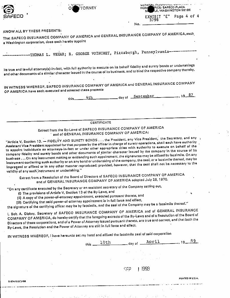
O ORNEY HO FICE: SAFECO PLAZAS LE, WASHINGTON 98185
SAPECO EXHIBIT "E" Page 4 of 43798
No.
KNOW ALL BY THESE PRESENTS:
That SAFECO INSURANCE COMPANY OF AMERICA and GENERAL INSURANCE COMPANY OF AMERICA,each
a Washington corporation, does each hereby appoint
------------THOMAS L. VEHAR; R. GEORGEVOINCHET, Pittsbu,rgh,Pennsylvania----------
its true and lawful attorney(s)-in-fact, with full aµthority to execute on its behalf fidelity and surety bonds or undertakings
and other documents of a similar character issued in the course of its business, and to bind the respective company thereby.
IN WITNESS WHEREOF, SAFECO INSURANCE COMPANY OF AMERICA and GENERAL INSURANCE COMPANY
OF AMERICA have each executed and attested these presents
this Ath day of September , 19 87,
CEftTTFICATE
Extract from the By-Laws of SAFECO INSURANCE COMPANY OF AMERICA
and of GENERAL INSURANCE COMPANY OF AMERICA:
"Article V, Section 13. -- FIDELITYAND SURETYBONDS . . . the President, any Vice President, the Secretary, and any.
Assistant Vice President appointed for that purpose by the officer in charge of surety operations, shall each have authority
to appoint Individuals as attorneys-In-fact or uncler other appropriate titles with authority to execute on behalf of the
company fidelity and surety bonds and other documents of similar character issued by the company in the course of its
business ... On any instrument making or evidencing such appointment, the signatures may be affixed by facsimile. On any
instrument conferring such authority or on any bond or undertaking of the company, the seal, or a facsimile thereof, rnay be
impressed or affixed or in any other manner reproduced; provided, however, that the seal shall not be necessary to the
validity of any such.instrument or undertaking."
Extract from a Resolution of the Board of Directors of SAFECO INSURANCE COMPANY OF AMERICA
and of GENERAL INSURANCE COMPANY OF AMERICA adopted July 28, 1970.
"On any certificate executed by the Secretary or an assistant secretary of the Company setting out,
(!)The provisions of Article V, Section 13 of the By-Laws, and
(ii) A copy of the power-of-attorney appointment, executed pursuant thereto, and
(iii) Certifying that said power-of-attorney appointmentis In full force and effect,
the signature of the certifying officer may be by facsimile, and the seal of the Company may be a facsimile thereof."
I, Bob A. Dickey, Secretary of SAFECO INSURANCE COMPANY OF AMERICA and of GENERAL INSURANCE
ÇOMPANY OF AMER1CA, do hereby certify that the foregoing extracts of the By-Laws and of a Resolution of the Board of
Directors of these corporations, and of a Power of Attorney issued pursuant thereto, are true and correct, and that both the
By-Laws, the Resolution and the Power of Attorney are still in full force and effect.
IN WITNESS WHEREOF, I have hereunto set my hand and affixed the facsimile seal of said corporation
this 10th day of 19
SFP i 1993
$•974 RIO 3/80Pit1NTIOIN
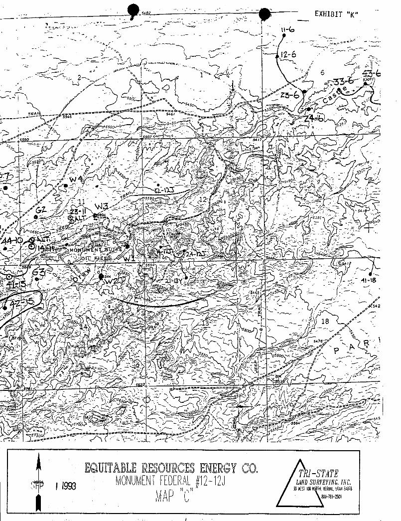
EXHIBIT "g"
-6
EQUITABLERESOLJRCESENERGYCO, 7MONUMENTEEDERAL0292J answ n.ac.)) )) Ë AN Ñ Al,
EXHIBIT "g"
-6
EQUITABLERESOLJRCESENERGYCO, 7MONUMENTEEDERAL0292J answ n.ac.)) )) Ë AN Ñ Al,
EXHIBIT "g"
-6
EQUITABLERESOLJRCESENERGYCO, 7MONUMENTEEDERAL0292J answ n.ac.)) )) Ë AN Ñ Al,
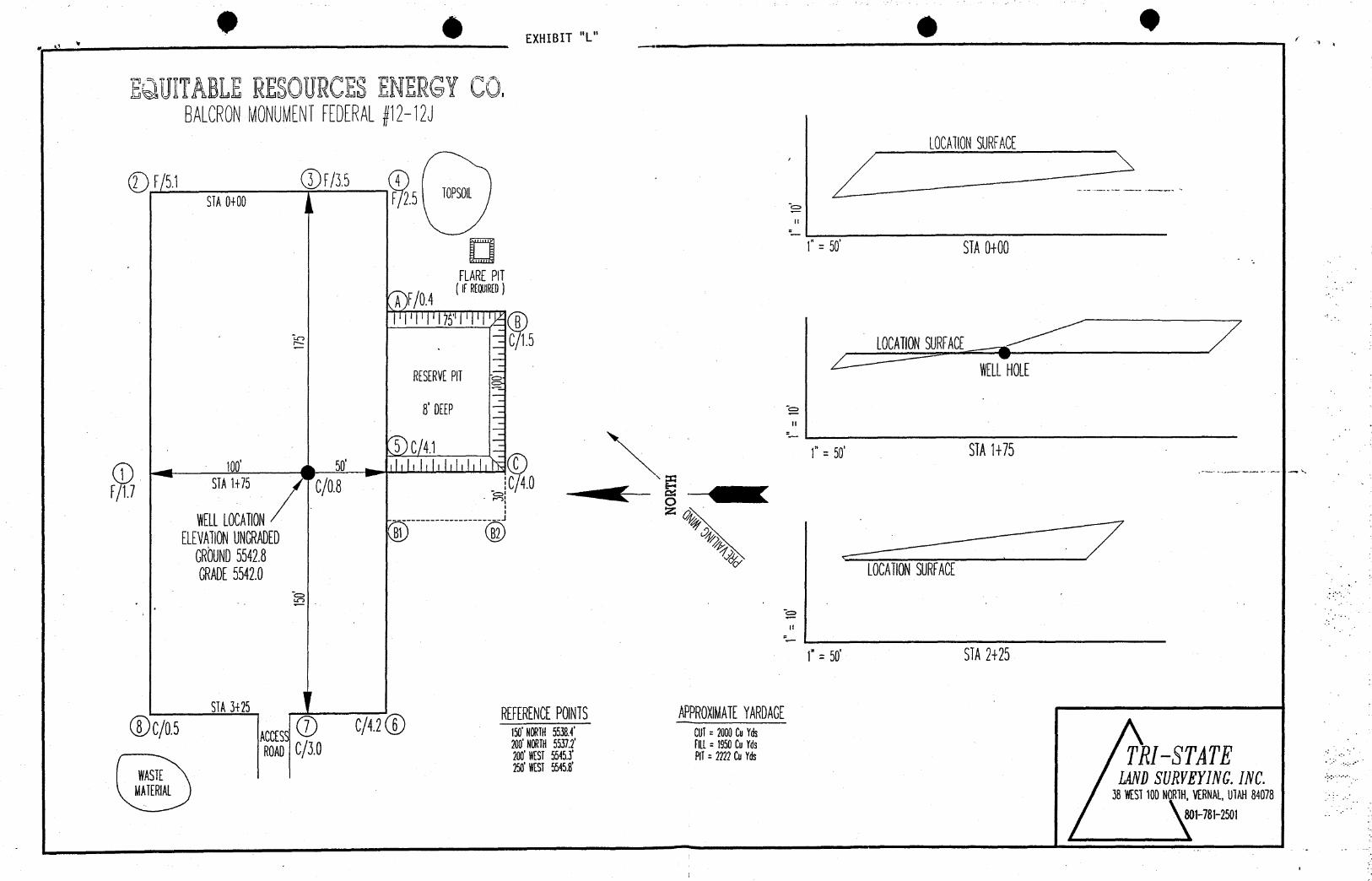
EXHIBIT "L"
MUITABLERESOURCESENERGYCO.BALCRONMONUMENTFEDERALDJ
STA0+00 5 TOPSOIL
il
1"= 50' STA0+00FLAREPIT
)F/0.4(ma)
LOCAll0NSURFACE
RESERVEPll HOLE
8 DEEP
1"= 50' STA1+75
STA1+75 QQ.8 C4.0 '/1.7
WELLLOCAll0N * *
GRADE5542.0 LOCAll0NSURFACE
il
1"= 50' STA2+25
STA3+25 REFERENCEPOINTS APPROXIMATEYARDAGEC/0.5 AccEss C/ iso·min55381 cui= 2000envas
200'- 5537.2' ritt= 1950enydsROAD 2ee si sssÔ 81=m2ceYds TRI-STATEWASTE IANDSURVEYING.INC.MATERIAL 38WEST100NORTH,VERNAL,UTAH84078
801-781-2501
WORKSHEETAPPLICATION FOR PERMIT TO DRILL
DATE RECEIVED: 09/01/93
OPERATOR: EQUITABLE RESOURCES OPERATOR ACCT NO: N- g/gCyp
WELL NAME: BALCRON MONUMENT FED. 12-12J
API NO. ASSIGNED: L(ÿ -p¡ - 3-CONFIDENTIALLEASE TYPE: FED LEASE NO: ((- 06/617(0LOCATION: SWNW 12 - TO9S - R16E DUCHESNE COUNTYFIELD: MONUMENT BUTTE 105 FIELD CODE: (p§
RECEIVED AND/OR REVIEWED: LOCATION AND SITING:
V Plat y/ R649-2-3. Unit: J'pµ4// (fg/¿YBond
(Number /'£7) §:¿y gr/ /4/6) R649-3-2. General.4 Potash (Y/N)g/ Oil shale (Y/N)
__
R649-3-3. Exception.Water permit
(Number ) Drilling Unit.g_ RDCC Review (Y/N) Board Cause no:
(Date: ) Date:
COMMENTS: Ld/47/FA Sg//¿V To ifri //07tofd! (IV 96//Vf/4V ??;/0/77o 5 fun
CONFIDENTIALPEnlOD
EXPIRED
WORKSHEETAPPLICATION FOR PERMIT TO DRILL
DATE RECEIVED: 09/01/93
OPERATOR: EQUITABLE RESOURCES OPERATOR ACCT NO: N- g/gCyp
WELL NAME: BALCRON MONUMENT FED. 12-12J
API NO. ASSIGNED: L(ÿ -p¡ - 3-CONFIDENTIALLEASE TYPE: FED LEASE NO: ((- 06/617(0LOCATION: SWNW 12 - TO9S - R16E DUCHESNE COUNTYFIELD: MONUMENT BUTTE 105 FIELD CODE: (p§
RECEIVED AND/OR REVIEWED: LOCATION AND SITING:
V Plat y/ R649-2-3. Unit: J'pµ4// (fg/¿YBond
(Number /'£7) §:¿y gr/ /4/6) R649-3-2. General.4 Potash (Y/N)g/ Oil shale (Y/N)
__
R649-3-3. Exception.Water permit
(Number ) Drilling Unit.g_ RDCC Review (Y/N) Board Cause no:
(Date: ) Date:
COMMENTS: Ld/47/FA Sg//¿V To ifri //07tofd! (IV 96//Vf/4V ??;/0/7
7o 5 funCONFIDENTIAL
PEnlODEXPIRED

EQUITABLERESOURCESENERGYCOMPANYBALCRON OIL DIVISION1601 Lewis Avenue Office: (406) 259-7860
P.O. Box 21017 FAX: (406) 245-1365
Billings, MT 59104 FAX: (406) 245-1361
September 2, 1993
SEP0 3 1993
DIVISIONOFOIL,GAS&MINING
Bureau of Land Management170 South 500 EastVernal, UT 84078
Gentlemen:
Enclosed are archeology reports which are to be added as partof our Applications for Permit to Drill the wells on theattached list.
Sincerely,
Bobbie SchumanCoordinator of Operations,
Environmental and Regulatory Affairs
/rs
Enclosures
cc: Utah Division of Oil, Gas and
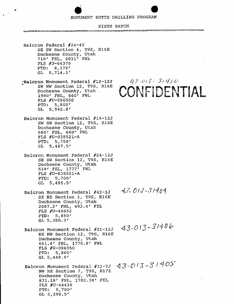
MONUMENT BUTTE DRILLING PROGRAM
SIXTH BATCH
Balcron Federal #24-4YSE SW Section 4, T9S, R16EDuchesne County, Utah710' FSL, 2031' FWLFLS #U-64379PTD: 6,175'GL 5,714.3'
alcron Monument Federal #12-12J /// O//- // fjÛch sn n UW
, R16E CONFIDENTIALFLS #U-096550PTD: 5,800'GL 5,542.8'
Balcron Monument Federal #14-12JSW SW Section 12, T9S, R16EDuchesne County, Utah660' FSL, 660' FWLFLS #U-035521-APTD: 5,750'GL 5,487.5'
Balcron Monument Federal #24-12JSE SW Section 12, T9S, R16EDuchesne County, Utah539' FSL, 1777' FWLFLS #U-035521-APTD: 5,700'GL 5,495.5'
Balcron Monument Federal #42-1J -
SE NE Section 1, T9S, R16EDuchesne County, Utah2087.2' FNL, 692.4' FELFLS #U-40652PTD: 5,850'GL 5,380.3'
Balcron Monument Federal #21-12J 43-0 13- 140 6NE NW Section 12, T9S, R16EDuchesne County, Utah661.4' FNL, 1779.8' FWLFLS #U-096550PTD: 5,800'GL 5,448.9'
Balcron Monument Federal #31-7J ¿p 13 -27 4 OSNW NE Section 7, T9S, R17EDuchesne County, Utah831.18' FNL, 1782.38' FELFLS #U-44426PTD: 5,700'GL
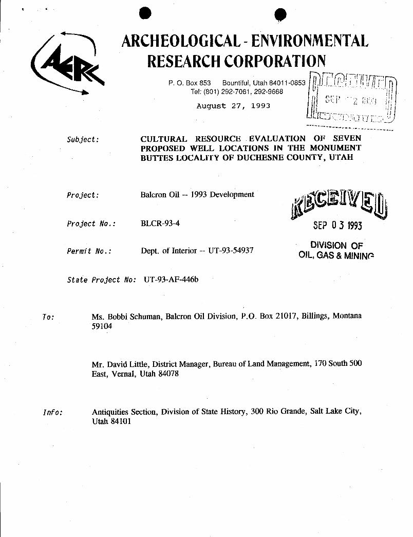
ARCHEOLOGICAL- ENVIRONMENTALRESEARCHCORPORATION
P. O. Box 853 Bountiful, Utah 84011-0853Tel: (801) 292-7061, 292-9668
August 27, 1993
Subject: CULTURAL RESOURCE EVALUATION OF SEVENPROPOSED WELL LOCATIONS IN THE MONUMENTBUTTES LOCALITY OF DUCHESNE COUNTY, UTAH
Project: Balcron Oil -- 1993 Development
Project Ho.: BLCR-93-4 SEP0 3 1993
DIVISIONOFPe rmi t No . : Dept. of Interior -- UT-93-54937OIL,GAS&MINING
State Project Ho: UT-93-AF-446b
To: Ms. Bobbi Schuman, Balcron Oil Division, P.O. Box 21017, Billings, Montana59104
Mr. David Little, District Manager, Bureau of Land Management, 170 South 500East, Vernal, Utah 84078
Info: Antiquities Section, Division of State History, 300 Rio Grande, Salt Lake City,Utah
CULTURAL RESOURCE EVALUATION
OF SEVEN PROPOSED WELL LOCATIONS
IN THE MONUMENT BUTTES
LOCALITY OF DUCHESNE COUNTY, UTAH
Report Prepared for Balcron Oil Company
Dept. of Interior Permit No.: UT-93-54937AERC Project 1395 (BLCR-93-4)
Utah State Project No.: UT-93-AF-446b
Principal InvestigatorF. Richard Hauck, Ph.D.
Author of the ReportGlade V Hadden
ARCHEOLOGICAL-ENVIRONMENTAL RESEARCHCORPORATION (AERC)
181 North 200 West, Suite 5P.O. Box 853
Bountiful, Utah 84011-0853
August 27,
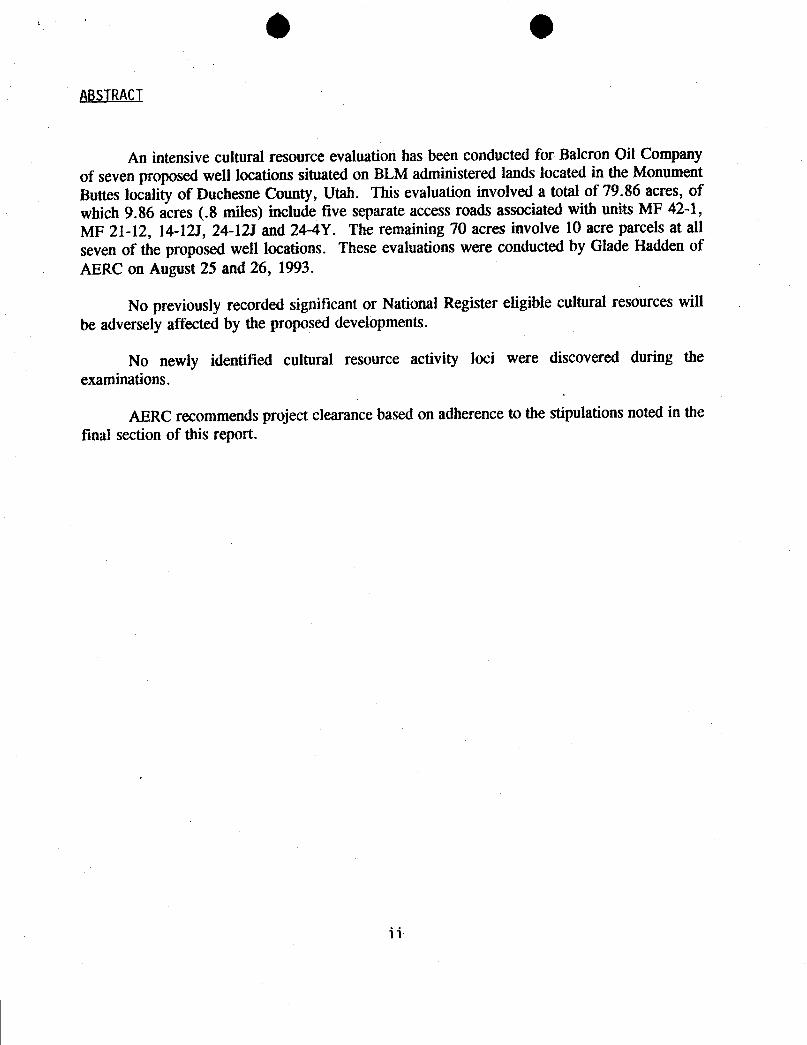
O
ABSTRACT
An intensive cultural resource evaluation has been conducted for Balcron Oil Companyof seven proposed well locations situated on BLM administered lands located in the MonumentButtes locality of Duchesne County, Utah. This evaluation involved a total of 79.86 acres, ofwhich 9.86 acres (.8 miles) include five separate access roads associatedwith units MF 42-1,MF 21-12, 14-12J, 24-12J and 24-4Y. The remaining 70 acres involve 10 acre parcels at allseven of the proposed well locations. These evaluationswere conductedby Glade Hadden ofAERC on August 25 and 26, 1993.
No previously recorded significant or National Register eligible cultural resources willbe adversely affected by the proposed developments.
No newly identified cultural resource activity loci were discovered during theexaminations.
AERC recommends project clearance based on adherence to the stipulations noted in thefinal section of this
O eTABLEOF CONTENTS
page
Abstract . . . . . . . . . 11
Table of Contents . . . . . . . . iii
List of Maps of the Project Area . . . . . . iv
General Information . . . . . . . . I
Project Location . . . . . . . 1
Environmental Description . . . . . . 5
Previous Research in the Locality . . . . . . 5
File Search . . . . . . . . 5
Prehistory and History of the Project Area . . . . 6
Site Potential in the Project Development Zone . . . 6
Field Evaluations . . . . . . . . 7
Methodology . . . . . . . , 7
Site Significance Criteria . . . . . . 7
Results of the Inventory . . . . . . 8
Artifact Sketches . . . . . . . 9
Conclusion and Recommendations . . . . . . 10
References . . . . . . . . . 11
6 OUST OF MAPSOF THEPROJECTAREA
page
MAP 1: Cultural Resource Inventory ofProposed Balcron Well Unit 24-4Yin the Monument Buttes Locality of Duchesne County, Utah . . 2
MAP 2: Cultural Resource Inventory ofProposed Balcron Well Units 12-12J14-12J and 24-121, Monument Buttes Locality . . . . 3
MAP 3: Cultural Resource Inventory ofProposed Balcron Well Units 42-1,31-7 and 21-12, Monument Buttes Locality . . . . 4

O
GENERALINFORMATION
On August 25 and 26, 1993, AERC archaeologist Glade Hadden conducted an intensivecultural resource evaluation for Balcron Oil Company of Billings, Montana. This examination
involved seven proposed well locations and associated access routes located in the Monument
Buttes area southof Myton, Utah. Some .8 miles of access routes (9.86 acres) and seven - 10
acre well pads were examined. This project is situated in the Monument Buttes locality of
Duchesne County, Utah. The entireproject area is situatedon federal lands administered by theBureau of Land Management, Vernal District Office, Diamond Mountain Resource Area.
The purpose of the field study and this report is to identify and document cultural sitepresence and assess National Register potential significance relative to establishedcriteria (cf.,Title 36 CFR 60.6). The proposed developments on these well locations require archaeologicalevaluations in compliancewith U.C.A. 9-8-404, the Federal Antiquities Act of 1906, theReservoir Salvage Act of 1960-as amended by P.L. 93-291, Section 106 of the National HistoricPreservation Act of 1966-as amended, the National Environmental Policy Act of 1969, the
Federal Land Policy and Management Act of 1979, the Archaeological Resources Protection Act
of 1979, the Native American Religious Freedom Act of 1978, the Historic Preservation Act of1980, and Executive Order 11593.
In additionto documenting cultural identity andsignificance, mitigationrecommendationsrelative to the preservation of cultural data and materials can be directed to the Bureau of LandManagement Vernal District Office, and to the Utah State Antiquities Section. This work wasdone under U.S. Department of Interior Permit for Utah UT-93-54937 which expireson January31, 1994.
Project Location
The project location is in the Monument Buttes locality of Duchesne County, Utah. It
is situated on the Myton SE and Myton SW 7.5 minute topographicquads.
Unit 24-4Y is situated in the SE - SW quarter of Section 4, Township 9 South, Range
16 East. Its access route extends ca. .25 mi. north from an existing well location (Balcron Unit21-9Y) (See Map 1).
Unit 12-123is in the SW - NW quarter of Section 12, Township 9 South, Range 16 East.
This unit is accessiblevia an existing road which extends westerly from the main Monument
Buttes road (See Map 2). The well location is directly adjacent this road, so no separate accessroute is necessary.

O g
T. 9 South MAP 1 Legend:Cultural Resource Inventory
R. 16 EastWell Center
of Proposed Well Unit Stake AMeridion: SL 24-4Y in the Monument 1.0 Acre WellQuad: Myton SW Pad
Utah Buttes Locality, Duchesne 0.¯¯¯
Access Route s
Project Scale: 1:24,000 Existing' BLOR-93-4 , Road
Series: Uinta BasinOote: 8/30/93
.

547
5 o
Al61
Unit 12-12J '
ses
1
' Unit 2 -12
'~ Unit 1 -12J
1595Gfri
B x1
T. 9 South MAP 2 Legend:Cultural Resource Inventory Well Center
R, 16 East Stakeof Proposed Well UnitsMeridian: SL 10 A12-12J, 14-12J and 24-12J cre
uad: Myton SE Well PadUtah Monument Buttes Locality ,Access
BLCR-93Snle: 1:24,000 ing
N.
Uinta Basin IsolatedDate. 8/30/93 - Artif'act (
547
5 o
Al61
Unit 12-12J '
ses
1
'Unit 2 -12
'~ Unit 1 -12J
1595Gfri
B x1
T. 9 South MAP 2 Legend:Cultural Resource Inventory Well Center
R, 16 East Stakeof Proposed Well UnitsMeridian: SL 10 A12-12J, 14-12J and 24-12J cre
uad: Myton SE Well PadUtah Monument Buttes Locality ,Access
BLCR-93Snle: 1:24,000 ing
N.
Uinta Basin IsolatedDate. 8/30/93 - Artif'act (

e e547
nit 42-1
Unit i
nit 21-12
12
s
.-
••o 18 ,s'
T. 9 South MAP 3 Legend •
Cultural Resource Inventory Well OenterAR. 16 / 17 East StakeMeridian.yt
n SE4
-Pro seda21 n the Ac
dUtah Monument Buttes Locality Access Route ;
'
Existing Road /Project: Scale: 1:24,000
BIDR-93-4.Series:
N vinta BasinDate:
8/30/93 ·
4
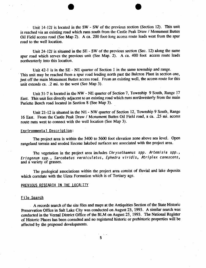
O O
Unit 14-12J is located in the SW - SW of the previous section (Section 12). This unitis reached via an existing road which runs south from the Castle Peak Draw / Monument ButtesOil Field access road (See Map 2). A ca. 200 foot-long access route leads west from the spurroad to the well location.
Unit 24-12J is situated in the SE - SW of the previous section (Sec. 12) along the samespur road which serves the previous unit (See Map. 2). A ca. 400 foot access route leadsnortheasterly into this location.
Unit 42-1 is in the SE - NE quarter of Section 1 in the same township and range.This unit may be reached from a spur road leading north past the Balcron Plant in section one,just off the main Monument Buttes access road. From an existing well, the access route for thisunit extends ca. .2 mi. to the west (See Map 3).
Unit 31-7 is located in the NW - NE quarter of Section 7, Township 9 South, Range 17East. This unit lies directly adjacent to an existing road which runs northwesterly from the mainPariette Bench road located in Section 8 (See Map 3).
Unit 21-12 is situated in the NE - NW quarter of Section 12, Township 9 South, Range16 East. From the Castle Peak Draw / Monument Buttes Oil Field road, a ca. .25 mi. accessroute runs west to connect with the well location (See Map 3).
EnvironmentalDescription:
The project area is within the 5400 to 5600 foot elevation zone above sea level. Openrangeland terrain and eroded Eocene lakebed surfaces are associated with the project area.
The vegetation in the project area includes Chrysothamnus spp. Artemisia spp.,Eriogonum spp., Sarcobatus vermiculatus, Ephedra viridis, Atriplex canescens,and a variety of grasses.
The geological associations within the project area consist of fluvial and lake depositswhich correlate with the Uinta Formation which is of Tertiary age.
PREVIOUSRESEARCHIN THELOCALITY
File Search
A records searchof the site files and maps at the Antiquities Section of the State HistoricPreservation Office in Salt Lake City was conducted on August 23, 1993. A similar search wasconducted in the Vernal District Office of the BLM on August 25, 1993. The National Registerof Historic Places has been consulted and no registered historic or prehistoric properties will beaffected by the proposed developments.
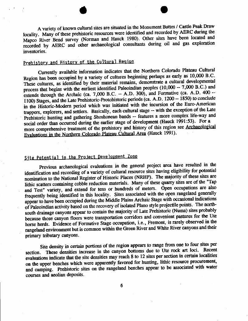
0
A variety of known cultural sites are situated in the Monument Buttes / Castle Peak Draw
locality. Many of theseprehistoric resources were identified and recorded by AERC during theMapco River Bend survey (Norman and Hauck 1980). Other sites have been located andrecorded by AERC and other archaeological consultants during oil and gas explorationinventories.
Prehistorv and History of the Cultural Region
Currently available information indicates that the Northern Colorado Plateau CulturalRegion has been occupiedby a variety of cultures beginning perhaps as early as 10,000 B.C.
These cultures, as identified by their material remains, demonstrate a cultural developmental
process that begins with the earliest identified Paleoindian peoples (10,000 - 7,000 B.C.) and
extends through the Archaic (ca. 7,000 B.C. -- A.D. 300), and Formative (ca. A.D. 400 --
1100) Stages, and the Late Prehistoric-Protohistoric periods (ca. A.D. 1200 -- 1850) to conclude
in the Historic-Modern period which was initiated with the incursion of the Euro-American
trappers, explorers,and settlers. Basically, each cultural stage -- withthe exception of the Late
Prehistoric hunting and gathering Shoshonean bands - features a more complex life-way and
socialorder than occurred during the earlier stage of development(Hauck 1991:53). For amore comprehensivetreatmentof the prehistory and history of this region see Archaeological
Evaluations in the Northern Colorado Plateau Cultural Area (Hauck 1991).
Site Potential in the Pro.iect Development Zone
Previous archaeologicalevaluations in the general project area have resulted in the
identification and recording of a variety of cultural resource sites having eligibilityfor potential
nomination to the National Register of Historic Places (NRHP). The majorityof these sitesarelithic scatters containing cobblereduction materials. Many of thesequarry sitesare of the "Tap
and Test" variety, and extend for tens or hundreds of meters. Open occupations are also
frequently being identified in this locality. Sites associated with the open rangelandgenerally
appearto have beenoccupied during the Middle Plains Archaic Stage withoccasionalindications
of Paleoindian activitybased on the recovery of isolated Plano styleprojectile points. The north-
south drainage canyons appearto contain the majorityof Late Prehistoric (Numa) sitesprobably
because those canyon floors were transportationcorridors and convenientpastures for the Ute
horse herds. Evidence of Formative Stage occupation, i.e., Fremont, is rarely observed in therangeland environment but is common within the Green River and White River canyonsand theirprimary tributarycanyons.
Site density in certainportions of the regionappearsto range from one to four sitesper
section. These densities increase in the canyon bottoms due to Ute rock art loci. Recent
evaluationsindicate that the site densities may reach 8 to 12 sitesper sectionin certain localities
on the upper benches which were apparentlyfavored for hunting, lithic resource procurement,
and camping. Prehistoric sites on the rangeland benches appear to be associated with water
courses and aeoliandeposits.
FIELD EVALUATIONS
Methodology
Intensive evaluationsconsisted of the archaeologistwalking a series of 10 to 15 meterwide transects over a ten acre pad around each well location center stake. In addition, eachaccess route was inventoried by the archaeologist walking a pair of 10 - 15 meter transects oneach side of the flagged accessroute. Thus, a 35 meter-wide or 100 foot-wide corridor(ca. 9.86acres) was examined for the total ca. .8 mile length of proposed accessroutes.
Observation of cultural materials results in intensive examinations to determine thenatureof the resource (isolate or activity locus). The analysisof each specific cultural site results inits subsequently being sketched, photographed, and appropriatelyrecorded on standardIMACSforms. Cultural sites are then evaluated for significance utilizing the standards described belowand mitigation recommendations are consideredas a meansof preserving significantresourceswhich may be situatedwithin the development zone.
Site Significance Criteria
Prehistoric and historic cultural siteswhich can be considered as eligible for nominationto the National Register of Historic Places have been outlined as follows in the NationalRegister's Criteria for Evaluation as established in Title 36 CFR 60.6:
The quality of significance in American ... archaeology... and culture ispresent in ... sites ... that possess integrity of location, design, setting, materials,workmanship, feeling, and association and:a. That are associatedwith events that have madea significant contributionto thebroad patterns of our history; orb. that are associatedwith the lives of persons significant in our past; orc. that embody the distinctive characteristicsof a type, period, or method ofconstruction ... ; ord. that have yielded, or may be likely to yield, information important inprehistory or history.
In addition to satisfyingone or more of these general conditions,a significantculturalresource site in Utah will generally be considered as being eligible for inclusion in the NationalRegister if it should advance our current state of knowledge relating to chronology,culturalrelationships, origins, and cultural life ways of prehistoric or historic groups in the area.
In a final review of any site's cultural significance, the site must possessintegrity and atleast one of the abovecriteria to be considered eligiblefor nominationto the National Recordof Historic Places.

Results of the Inventory:
No prehistoric cultural resource activity loci were observed or recorded during thearchaeologicalevaluations. No diagnostic tools or buried deposits were found within this site.
No previously recorded sites are located within the proposeddevelopment zones.
No significantor National Register sites were noted or recorded during the survey.
A number of isolated artifacts were observed or collected during the survey. A singlecorner notchedprojectile point (1395B/x1) was recovered by BLM archaeologistBlaine Phillipsfrom near the well center stake of unit 14-12J during the initial reconnaissance of the welllocation. No other artifacts were noted at this location. At well unit 24-12J, an isolatedexhaustedcore (1395Glx1) was observed on the ridge overlookingthe well location. No otherartifacts were noted in the vicinity. Two additional isolated artifacts were noted in the accessroad to unit 42-1. These finds consisted of two pieces of lithic debitage from a similarmaterialsource. Since both flakes were found in the bottomof an ephemeral drainage channel,and sinceno other artifacts could be located nearby, it is probably that these flakes are in a disturbedsecondary context, having been transportedto their present positionby water action.
No paleontological loci were observedor recorded during the evaluations.
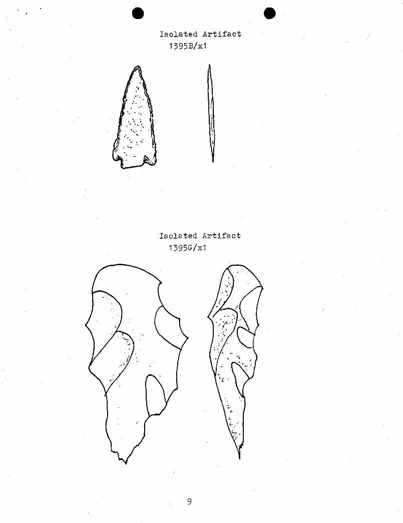
e eIsolated Artifact
1395B/x1
Isolated Artifact
1395G|x1
C
C
e eIsolated Artifact
1395B/x1
Isolated Artifact
1395G|x1
C
C
e eIsolated Artifact
1395B/x1
Isolated Artifact
1395G|x1
C
C
CONCLUSIONANDRECOMMENDATIONS
No known significant cultural or paleontological resources will be adversely impactedduring the developmentand operation of the Balcron Oil Company well locations evaluatedduring this project.
AERC recommends that a cultural resource clearance be granted to Balcron Oil Companyrelative to the developments proposed on these well locations based upon adherence to thefollowing stipulations:
1. All vehicular traffic, personnel movement, construction and restorationoperationsshould be confined to the flagged areas and corridors examined as referenced in thisreport, and to the existing roadways and/or evaluated access routes.
2. All personnel should refrain from collecting artifacts and from disturbing anysignificant cultural resources in the area.
3. The authorized official should be consulted should cultural remains from subsurfacedeposits be exposed during construction work or if the need arises to relocate orotherwisealter the location of the exp oration area.
F. Richard auck, Ph.D.President and Principal
Investigator
GladeV HaddenField Supervisor
REFERENCES
Hauck, F. Richard
1991 Archaeological Evaluations on the Northern Colorado Plateau CulturalArea, AERC Paper No, 45. Archeological-Environmental ResearchCorporation, Bountiful.
Norman, V. Garth and F.R. Hauck
1980 Final Report on the Mapco River Bend Cultural Mitigation Study. AERÇPaper No. 18. of the Archeological-Environmental Research Corporation,Bountiful.
O OO State of UtahDEPARTMENT OF NATURAL RESOURCESDIVISION OF OIL, GAS AND MINING355 West North Temple
Michael O. LeavittGovernor 3 Triad Center, Suite 350
Ted Stewart Salt Lake City, Utah 84180-1203
Executive Director 801-538 5340
James W. Carter 801-359 3940 (Fax)
Division Director 801-538 5319 (TDD)
September 7, 1993
Equitable Resources Energy CompanyP.O. Box 21017Billings, Montana 59104
Re: Balcron Monument Federaf #12-12J Well, 1980' FNL, 660' FWL, SW NW, Sec. 12,T. 9 S., R. 16 E., Duchesne County, Utah
Gentlemen:
Pursuant to Utah Code Ann. §40-6-18, (1953, as amended), Utah Admin. R. 649-2-3, Application of Rules to Unit Agreements and R. 649-3-4, Permitting of Wells to beDrilled, Deepened or Plugged-Back, approval to drill the referenced well is herebygranted.
In addition, the following specific actions are necessary to fully comply with thisapproval:
1. Compliance with the requirements of Utah Admin. R. 649-1 et seq., Oil andGas Conservation General Rules.
2. Notification within 24 hours after commencing drilling operations.
3. Submittal of Entity Action Form, Form 6, within five working days followingcommencement of drilling operations and whenever a change in operationsor interests necessitates an entity status change.
4. Submittal of the Report of Water Encountered During Drilling, Form 7.
5. Prompt notification prior to commencing operations, if necessary, to plugand abandon the well. Notify Frank R. Matthews, Petroleum Engineer,(Office) (801)538-5340, (Home) (801)476-8613, or R.J. Firth, AssociateDirector, (Home)
O OPage 2Equitable Resources Energy CompanyBalcron Monument Federal #12-12J WellSeptember 7, 1993
6. Compliance with the requirements of Utah Admin. R. 649-3-20, Gas Flaringor Venting, if the well is completed for production.
Trash and sanitary waste should be properly contained and transported toapproved disposal locations, not retained in or disposed of in pits on location ordownhole. Prior to the commencement of drilling operations, the operator should consultthe local/county sanitarian and/or the Department of Environmental Quality, Division ofDrinking Water/Sanitation, regarding appropriate disposal of sanitary waste.
This approval shall expire one year after date of issuance unless substantial andcontinuous operation is underway or a request for an extension is made prior to theapproval expiration date. The API number assigned to this well is 43-013-31410.
Sincerely,
Associate Director, Oil and Gas
IdcEnclosurescc: Duchesne County Assessor
Bureau of Land Management, VernalJim Thompson, Field Inspection Supervisor
O O
Page 2Equitable Resources Energy CompanyBalcron Monument Federal #12-12J WellSeptember 7, 1993
6. Compliance with the requirements of Utah Admin. R. 649-3-20, Gas Flaringor Venting, if the well is completed for production.
Trash and sanitary waste should be properly contained and transported toapproved disposal locations, not retained in or disposed of in pits on location ordownhole. Prior to the commencement of drilling operations, the operator should consultthe local/county sanitarian and/or the Department of Environmental Quality, Division ofDrinking Water/Sanitation, regarding appropriate disposal of sanitary waste.
This approval shall expire one year after date of issuance unless substantial andcontinuous operation is underway or a request for an extension is made prior to theapproval expiration date. The API number assigned to this well is 43-013-31410.
Sincerely,
Associate Director, Oil and Gas
IdcEnclosurescc: Duchesne County Assessor
Bureau of Land Management, VernalJim Thompson, Field Inspection Supervisor
Departme f the Interior Authoriza n No .U.9.3.A.F.4.4.6.b. .
Bureau of Land ManagementUtah State Office Report Acceptable Yes
__No
=.
(AERC FORMAT)Mitigation Acceptable Yes No
Summary Report of Comments:Inspection for Cultural Resources
SEVEN .WELL LOC A T I ONS I N THE
MONUMENT BUTTES LOC A L I TY1. Report Title . . . . . . . . . . . . . . . . . . . . . . . . . . . . . .
Balcron Oil Company (BLCR-93-4)3. Development Company
O 8 2 7 1 9 9 3 UT-92-549373, Report Dgte . . . . . . . . 4. Antiqqities Permit No.
AERC BLCR9 3 - 4 Ð me5. ResponsibleInstitution . . . . . . . . . . . . . . . . County
6. Fieldworg 9 S 1 7 E O 7Logatipp: TWN . . .
.-. RNG . . . . . Section. . . . . .\. . . . . .)
7. Resource 9 S 1 6 E O 1 0 4 1 2Area TWN . . . . . RNG . . . . . Section. . . . . . . . . . . .
.S M.
8. Descript,ion of Examin4tipp Procedures: The archeologist,Glade VHaddenintensively examined the proposed well locations by walking a series of 10to 20 meter-wide transects acress the ten acre study areas associated witheach well pad and by walking paiored 10 to 20 meter transects in a 100 foot-wide corridor centered on the flagged center-line stakes for each accessroute.
I9. Linear Miles Surveyed . . . . . . . . 10. Inventory Type . .
and/orDefinable Acres Surveyed . . . . . . . R = Reconnaissance
and/or I = IntensiveLegally Undefinable 7 9 . 8 6 S = Statistical Sample
Acres Surveyed . . . . . . .
11. Description of Findings: 12, Number ßiges Found .0. . . . .
No significant or non-significant - (No sites = 0)archaeological sites were identifiedor recorded during this survey. 13. Colleption• .Y.Three sets of isolated artifacts were Y = Yes, N = No)observed, of which one was collected.
14. Actupl/Potential National Register Propertipp Affected:The National Register of Historic Places (NRHP) has been consulted and noregistered properties will be affected by the proposed development.
15. Literature Search. Location/ Date: Utah SHPO 8-23-93 Vernal BLM 8-25-93
16. Conclusion/ Recommendations:AERC recommends that a cultural resource clearance be granted to Balcron Oil
Company for this proposed development based on the following stipulations:(see
IIþ (ilEQUITABLERESOURCESENERGYCOMPAN¾BALCRON OIL DIVISION1601 Lewis Avenue Office: (406) 259-7860
P.O. Box 21017 FAX: (406) 245-1365 OBillings, MT 59104 FAX: (406) 245-1361
DIVISIONOFSeptember 27, 1993 OIL,GAS& MINING
-- VIA FEDERAL EXPRESS --
Bureau of Land Management170 South 500 EastVernal, UT 84078
Gentlemen: tiF\]ENTILRE: Paleontology Reports
Enclosed are Paleontology Reports for the following wellsites andaccess roads:
Balcron Monument Federal #12-12J -7-Ô ÎJ-.IÍ /Ú ftC /ABalcron Monument Federal #14-12J </f- O /f- f/ / / $6C flBalcron Monument Federal #14-15 g g- b/f... ‡ / yg rf gy /† † §§ A/ÁBalcron Monument Federal #21-12J 4 f. p //. y/4 ep gg.c /a 7· gg /bfBalcron Monument Federal #24-12J </7, C/J- 2/40 ý J'e.g /.1 Tyf 4 JháBalcron Monument Federal #31-7J g. O jf_ J/4 0.5- RC 7 TŸ£ UÑBalcron Monument Federal #42-1J 4f.. Ô/f. //fog .kc. / T'7T 4 /GEBalcron Federal #24-4Y «j f. gj ff g /g Jeg fŸÍ Ê 74 E
Also enclosed are the Monitoring Reports submitted by thepaleontologist for the following wellsites:
Balcron Federal #21-9Y ff'44Balcron Monument Federal #13-5 41- 047-222 6 /
Si ,
Bobbie SchumanCoordinator of Operations,
Environmental and Regulatory Affairs
/rs
Enclosures
cc: Utah Division of Oil, Gas and
IIþ (ilEQUITABLERESOURCESENERGYCOMPAN¾BALCRON OIL DIVISION1601 Lewis Avenue Office: (406) 259-7860
P.O. Box 21017 FAX: (406) 245-1365 OBillings, MT 59104 FAX: (406) 245-1361
DIVISIONOFSeptember 27, 1993 OIL,GAS& MINING
-- VIA FEDERAL EXPRESS --
Bureau of Land Management170 South 500 EastVernal, UT 84078
Gentlemen: tiF\]ENTILRE: Paleontology Reports
Enclosed are Paleontology Reports for the following wellsites andaccess roads:
Balcron Monument Federal #12-12J -7-Ô ÎJ-.IÍ /Ú ftC /ABalcron Monument Federal #14-12J </f- O /f- f/ / / $6C flBalcron Monument Federal #14-15 g g- b/f... ‡ / yg rf gy /† † §§ A/ÁBalcron Monument Federal #21-12J 4 f. p //. y/4 ep gg.c /a 7· gg /bfBalcron Monument Federal #24-12J </7, C/J- 2/40 ý J'e.g /.1 Tyf 4 Jhá
Balcron Monument Federal #31-7J g. O jf_ J/4 0.5- RC 7 TŸ£ UÑBalcron Monument Federal #42-1J 4f.. Ô/f. //fog .kc. / T'7T 4 /GEBalcron Federal #24-4Y «j f. gj ff g /g Jeg fŸÍ Ê 74 E
Also enclosed are the Monitoring Reports submitted by thepaleontologist for the following wellsites:
Balcron Federal #21-9Y ff'44Balcron Monument Federal #13-5 41- 047-222 6 /
Si ,
Bobbie SchumanCoordinator of Operations,
Environmental and Regulatory Affairs
/rs
Enclosures
cc: Utah Division of Oil, Gas and
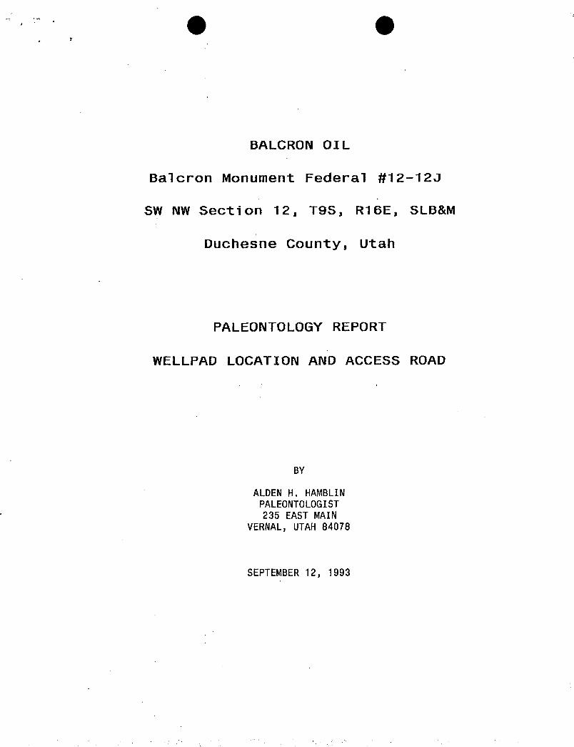
BALCRON OI L
Balcron Monument Federal #12-123
SW NW Section 12, T9S, R16E, SLB&M
Duchesne County, Utah
PALEONTOLOGY REPORT
WELLPAD LOCATION AND ACCESS ROAD
BY
ALDEN H. HAMBLINPALEONTOLOGIST235 EAST MAIN
VERNAL,UTAH84078
SEPTEMBER12,
BALCRON OI L
Balcron Monument Federal #12-123
SW NW Section 12, T9S, R16E, SLB&M
Duchesne County, Utah
PALEONTOLOGY REPORT
WELLPAD LOCATION AND ACCESS ROAD
BY
ALDEN H. HAMBLINPALEONTOLOGIST235 EAST MAIN
VERNAL,UTAH84078
SEPTEMBER12,
BALCRON OI L
Balcron Monument Federal #12-123
SW NW Section 12, T9S, R16E, SLB&M
Duchesne County, Utah
PALEONTOLOGY REPORT
WELLPAD LOCATION AND ACCESS ROAD
BY
ALDEN H. HAMBLINPALEONTOLOGIST235 EAST MAIN
VERNAL,UTAH84078
SEPTEMBER12,
RESULTS OF PALEONTOLOGYSURVEY AT BALCRONMONUMENT BUTTE FEDERAL #12-123
Description of Geology and Topography-
This well location is on the bench approximately 1/4 mile north of Castle PeakDraw, 10 miles south and1/2 miles west of Myton, Utah.. The area slopes gentlyto the northeast with draining into a side canyon which runs a mile east-northeast to Castle Pe Peak Draw. The access road enters the wellpad locationfrom the west with about 200 feet of new road construction.
All rock outcrops in the area are of the Upper Eocene Uinta Formation, knownfor its fossil vertebrate fauna of mammals, turtles, crocodilians, andoccasional fish remains.
Rocks in the immediate area of the proposed wellpad are composed ofinterbedded sandy limestone, limy sandstone, shale, and sandstone. Some chertis associated with this material also. Probably represents shallow lacustrine(lake) and fluvial (stream) deposits.
Paleontological material found -
No fossil vertebrate material was found on the wellpad location or accessroad.
Some of the pieces of dark brown chert found on the surface with limestonefragments appear to have ostracods (fresh water crustaceans) in them. This isa small invertebrate shelled animals common in some layers of the UintaFormation is this area. Because ostracods are small and so common in theserocks, construction of wellpads and access road poses no threat to thatpaleontological resource.
Recommendations-
No other recommendations are made for this
Form 3160-3SUBMIT IN TRIPIJe TE' Form approved.
(November 1983) (Other instruett Budget Bureau No. 1004-0136
(fonnerly st-aaic> UN) , D STATES rev•r=••ts• Expires August 31, 1985
DEPARTMENT OF THE INTERIOR G. LEAam DBalGNATION AND BERIAL NO.
BUREAU OF LAND MANAGEMENT U-096550
APPLICATION FOR PERMITTO DRILL,DEEPEN,OR PLUG BACK O.IFINDIAN,ALLOTTERORTRIBENiMB
n/a1a. Trra or wonK
DRILLO DEEPENO PLUG BACKO 7. UNE AGH MENT NAME
b. tyra or war.r,JOnah Uni t
°w't... 8 °w^.".= O 42...S"NO OUNLTIP" O •· =^== •= -
2. NAxa or orzaAzoa • Balcron MonuœntFederal
EQUITABLERESOURCESENERGYCOMPANYRalcron Oi .
' """ "°·
3. ADDREBB OF OPERATOR2-12Q
P.O. Box 21017; Billings, MT 59104 10. FIELD AND POOL, OE WILDCAT
4. LocATroN or wmLL (Iteport location clearly and in accordance with any State requirementa.*) MOnument BUtte/Grn. RiVerAt nuriate
SW NWSection 12, T9S, R16E 1980' FNL, 660' FWL11. g..x.... x. oa-.ma.
At proposed prod. sone Î- Q .7-2/ /p Sec. 12, T9S, R16E14. DISTANCE IN MILES AND DIRECTION FROM NEAREST TOWN OB POST OrrlCE* 12. COUNTY OR PARIBX 13. BTATE
Approximately 13 miles SN of Myton, Utah Duchesne UTAH10. DISTANCE TROM PROPoazo* 16, NO. OF ACBER IN LEASE 17. NO. OF ACass ASSIGNED
LOCATION TO NEAREST TO THIS WELL
PROPERTY 08 LEASE LINE, FT.(Also to nearest drig, unit line, if any)
18. DISTANCE PROM PROPOSED LOCATION* 19. PROPOSED Dartu 20. actAar ou cAata Tool.a·
TO NEAREST WELL, DRILLINO, COMPLETED,o. AFPMED TOR, ON THIS I.xABE, Tr-
° 84888' 5,800' Rotary21. EIEVATrosa (Show whether DF, RT, GR, etc.) 22. Arraox, DATE woaE WII.I. araaT•
5,542.8' GL \ Upon APD Approval23. PROPOSED CASING AND CEMENTING PROGRAM
sizE OF HOLE BIzz OF CABINO WEIGHT PER FOOT BETTING DEPTlf QUANTITT OF CEMENT
See drilung program/casing design
EXHIBITS ATTACLED COT RECF'"A" PROPOSEDDRILLING PROGRAM "G" RIG LAYOUT"B" PROPOSEDSURFACEUSE PROGRAM "H" B0PE DIAGRAM AUG3 1 1993"C" GEOLOGICPROGNOSIS "I" EXISTINGROADS(Map A)"D" DRILLING PROGRAM/CASINGDESIGN "J" PLANNEDACCESS (Map B)"E" EVIDENCEOF BONDCOVERAGE "K" EXISTING WELLS(Map C)"F" SURVEYPLAT "L" CUT & FILL DIAGRAM
.SELFCERTIFICATION:I herebycertify that I amauthorized, by proper lease interest ownedto conducttheseoperations associated with the application. Bondcoveragepursuant to 43 CFR3104for lease activities isbeing providedby Equitable Resources EnergyCœpany as principal andSafeco InsuranceCœpanyof kerica assurety under BLMBondNo. MT0576 (NationwideOil &GasBond#5547188)whowill be responsible for cœpliancewithall of the tennsand conditionsof that portion of the lease associatedwith this application.IN ABOVE BPACE DESCRIBE PROPOSED PROosAM : If proposal is to deepen or plug back, give data on present productive zone and proposed new productive
zone. Il proposa a to drill or deepen directionally, give pertinent data on subaurface locationa and measured and true vertical depths. Give blowout
entNer oC d at orf E nmental
DA
D:tt ":I(This space for Federal or State odice use)
NOTICEOF APPROVAL e*SeeinstructionrOn ReverseSide
T::h• '" ti.S.C. Section 1001, makes it a crime for any person knowinyty and willfully to make to any department or agency of theUnite-<.
.-.es any false. fictitious or fraudulent staterents or repree.•••tatíons as to any matter within its
Form 3160-3SUBMIT IN TRIPIJe TE' Form approved.
(November 1983)(Other instruett Budget Bureau No. 1004-0136
(fonnerly st-aaic> UN) , D STATES rev•r=••ts• Expires August 31, 1985
DEPARTMENT OF THE INTERIOR G. LEAam DBalGNATION AND BERIAL NO.
BUREAU OF LAND MANAGEMENT U-096550
APPLICATION FOR PERMITTO DRILL,DEEPEN,OR PLUG BACK O.IFINDIAN,ALLOTTERORTRIBENiMB
n/a1a. Trra or wonK
DRILLO DEEPENO PLUG BACKO 7. UNE AGH MENT NAME
b. tyra or war.r,JOnah Uni t
°w't... 8 °w^.".= O 42...S"NO OUNLTIP" O •· =^== •= -
2. NAxa or orzaAzoa • Balcron MonuœntFederal
EQUITABLERESOURCESENERGYCOMPANYRalcron Oi .
' """ "°·
3. ADDREBB OF OPERATOR2-12Q
P.O. Box 21017; Billings, MT 59104 10. FIELD AND POOL, OE WILDCAT
4. LocATroN or wmLL (Iteport location clearly and in accordance with any State requirementa.*) MOnument BUtte/Grn. RiVerAt nuriate
SW NWSection 12, T9S, R16E 1980' FNL, 660' FWL11. g..x.... x. oa-.ma.
At proposed prod. sone Î- Q .7-2/ /p Sec. 12, T9S, R16E14. DISTANCE IN MILES AND DIRECTION FROM NEAREST TOWN OB POST OrrlCE* 12. COUNTY OR PARIBX 13. BTATE
Approximately 13 miles SN of Myton, Utah Duchesne UTAH10. DISTANCE TROM PROPoazo* 16, NO. OF ACBER IN LEASE 17. NO. OF ACass ASSIGNED
LOCATION TO NEAREST TO THIS WELL
PROPERTY 08 LEASE LINE, FT.(Also to nearest drig, unit line, if any)
18. DISTANCE PROM PROPOSED LOCATION* 19. PROPOSED Dartu 20. actAar ou cAata Tool.a·
TO NEAREST WELL, DRILLINO, COMPLETED,o. AFPMED TOR, ON THIS I.xABE, Tr-
° 84888' 5,800' Rotary21. EIEVATrosa (Show whether DF, RT, GR, etc.) 22. Arraox, DATE woaE WII.I. araaT•
5,542.8' GL \ Upon APD Approval23. PROPOSED CASING AND CEMENTING PROGRAM
sizE OF HOLE BIzz OF CABINO WEIGHT PER FOOT BETTING DEPTlf QUANTITT OF CEMENT
See drilung program/casing design
EXHIBITS ATTACLED COT RECF'"A" PROPOSEDDRILLING PROGRAM "G" RIG LAYOUT"B" PROPOSEDSURFACEUSE PROGRAM "H" B0PE DIAGRAM AUG3 1 1993"C" GEOLOGICPROGNOSIS "I" EXISTINGROADS(Map A)"D" DRILLING PROGRAM/CASINGDESIGN "J" PLANNEDACCESS (Map B)"E" EVIDENCEOF BONDCOVERAGE "K" EXISTING WELLS(Map C)"F" SURVEYPLAT "L" CUT & FILL DIAGRAM
.SELFCERTIFICATION:I herebycertify that I amauthorized, by proper lease interest ownedto conducttheseoperations associated with the application. Bondcoveragepursuant to 43 CFR3104for lease activities isbeing providedby Equitable Resources EnergyCœpany as principal andSafeco InsuranceCœpanyof kerica assurety under BLMBondNo. MT0576 (NationwideOil &GasBond#5547188)whowill be responsible for cœpliancewithall of the tennsand conditionsof that portion of the lease associatedwith this application.IN ABOVE BPACE DESCRIBE PROPOSED PROosAM : If proposal is to deepen or plug back, give data on present productive zone and proposed new productive
zone. Il proposa a to drill or deepen directionally, give pertinent data on subaurface locationa and measured and true vertical depths. Give blowout
entNer oC d at orf E nmental
DA
D:tt ":I(This space for Federal or State odice use)
NOTICEOF APPROVAL e*SeeinstructionrOn ReverseSide
T::h• '" ti.S.C. Section 1001, makes it a crime for any person knowinyty and willfully to make to any department or agency of theUnite-<.
.-.es any false. fictitious or fraudulent staterents or repree.•••tatíons as to any matter within its
O OWELLLOCATIONINFORMATION
Company/Operator: Equitable Resources Energy Company
API Number 43-013-31410
Well Name & Number: 12-12J
Lease Number: U-096550
Location: SWNW Sec. 12 T.9 S R.16 E
Surface Ownership: Federal
Date NOS Received
Date APD Received Auqust 31, 1993
NOTIFICATIONREQUIREMENTS
Location Construction - at least forty-eight (48) hours prior to constructionof location and accessroads.
Location Completion - priorto movingon the drillingrig.
Spud Notice - at least twenty-four(24) hours prior to spuddingthe well.
Casing String and - at least twenty-four(24) hours prior to running casing and cementing allCementing casing strings.
BOP and Related - at least twenty-four(24) hours priorto initiatingpressure tests.Equipment Tests
First Production - withinfive (5) business days afternew wellbegins or production resumes afterNotice well has been offproduction for more than ninety(90) days.
For more specificdetails on notificationrequirements,please check the Conditionsof Approval for Noticeto Drilland Surface Use
O O
CONDITIONS OF APPROVAL FOR NOTICE TO DRILL
Company Equitable Resources Energy Company Well No. Balcron Federal 12-12J
Location SWNW Section 12, T95, R16E Lease No.U - 096550
Approval of this application does not warrant or certify that the applicantholds legal or equitable title to those rights in the subject lease whichwould entitle the applicant to conduct operations thereon.
All lease and/or unit operations will be conducted in such a manner thatfull compliance is made with applicable laws, regulations (43 CFR 3100),Onshore Oil and Gas Orders, and the approved plan of operations. Theoperator is fully responsible for the actions of his subcontractors. A copyof these conditions will be furnished the field representative to insurecompliance.
Be aware fire restrictions may be in effect when location is beingconstructed and/or when well is being drilled. Contact the appropriateSurface Management Agency for information.
A. DRILLING PROGRAM.
1. Estimated Depth at Which Oil, Gas, Water, or other Mineral BearingZones are Expected to be Encountered
Report ALL water shows and water-bearing sands to Tim Ingwell of thisoffice. Copies of State of Utah form OGC-8-X are acceptable. Ifnoticeable water flows are detected, submit samples to this officealong with any water analyses conducted.
All usable water and prospectively valuable minerals (as described byBLM at onsite) encountered during drilling, will be recorded by depthand adequately protected. All oil and gas shows will be tested todetermine commercial potential.
2. Pressure Control Equipment
The BOP and related equipment shall meet the minimum requirements ofOnshore Oil and Gas Order No. 2 for equipment and testingrequirements, procedures, etc., for a 2M system and individualcomponents shall be operable as designed. Chart recorders shall beused for all pressure tests.
Test charts, with individual test results identified, shall bemaintained on location while drilling and shall be made available toa BLM representative upon request.
The Vernal District Office shall be notified, at least 24 hours priorto initiating the pressure tests, in order to have a BLMrepresentative on location during pressure
O O
3. Casing Program and Auxiliarv Equipment
Surface casing shall have centralizers on the bottom three joints,with a minimum of one centralizer per joint.
As a minimum, the usable water and oil shale resources shall beisolated and/or protected by having a cement top for the productioncasing at least 200 ft. above the base of the usable water zone,identified at + 1,407 ft. If gilsonite is encountered while drilling,it shall be isolated and/or protected via the cementing program.
The Vernal District office shall be notified at least 24 hours priorto the running and cementing of all casing strings, in order to havea BLM representative on location while running and cementing allcasing strings.
4. Mud Program and Circulating Medium
Hazardous substances specifically listed by the EPA as a hazardouswaste or demonstrating a characteristic of a hazardous waste will notbe used in drilling, testing, or completion operations.
No chromate additives will be used in the mud system on Federal andIndian lands without prior BLM approval to ensure adequate protectionof fresh water aquifers.
5. Coring, Loqqinq and Testing Program
Daily drilling and completion progress reports shall be submitted tothis office on a weekly basis.
All Drill Stem tests (DST) shall be accomplished during daylighthours, unless specific approval to start during other hours isobtained from the AO. However, DSTs may be allowed to continue atnight if the test was initiated during daylight hours and the rate offlow is stabilized and if adequate lighting is available (i.e.,lighting which is adequate for visibility and vaporproof for safeoperations). Packers can be released, but tripping should not beginbefore daylight unless prior approval is obtained from the AO.
A cement bond log (CBL) will be run from the production casing shoeto + 1,207 ft. and shall be utilized to determine the bond qualityfor the production casing. Submit a field copy of the CBL to this
O O
Whether the well is completed as a dry hole or as a producer, "WellCompletion and Recompletion Report and Log" (Form 3160-4) will besubmitted not later than 30 days after completion of the well orafter completion of operations being performed, in accordance with 43CFR 3164. Two copies of all logs, core descriptions, core analyses,well-test data, geologic summaries, sample description, and all othersurveys or data obtained and compiled during the drilling, workover,and/or completion operations, will be filed with Form 3160-4.samples (cuttings, fluids, and/or gases) will be submitted whenrequested by the AO.
6. Notifications of Operations
No location will be constructed or moved, no well will be plugged,and no drilling or workover equipment will be removed from a well tobe placed in a suspended status without prior approval of the AO. Ifoperations are to be suspended, prior approval of the AO will beobtained and notification given before resumption of operations.
The vernal District Office shall be notified, during regular workhours (7:45 a.m.-4:30 p.m., Monday through Friday except holidays),at least 24 hours prior to spudding the well.
Operator shall report production data to MMS pursuant to 30 CFR 216.5using form MMS/3160.
Immediate Report: Spills, blowouts, fires, leaks, accidents, or anyother unusual occurrences shall be promptly reported in accordancewith the requirements of NTL-3A or its revision.
If a replacement rig is contemplated for completion operations, a"Sundry Notice" (Form 3160-5) to that effect will be filed, for priorapproval of the AO, and all conditions of this approved plan areapplicable during all operations conducted with the replacement rig.
The date on which production is commenced or resumed will beconstrued for oil wells as the date on which liquid hydrocarbons arefirst sold or shipped from a temporary storage facility, such as atest tank, and for which a run ticket is required to be generated or,the date on which liquid hydrocarbons are first produced into apermanent storage facility, whichever first occurs; and, for gaswells as the date on which associated liquid hydrocarbons are firstsold or shipped from a temporary storage facility, such as a testtank, and for which a run ticket is required to be generated or, thedate on which gas is first measured through permanent meteringfacilities, whichever first occurs.
Should the well be successfully completed for production, the AO willbe notified when the well is placed in a producing status. Suchnotification will be sent by telegram or other written communication,not later than five (5) days following the date on which the well isplaced on
O O
Gas produced from this well may not be vented or flared beyond aninitial authorized test period of 30 days or 50 MMCF following itscompletion, whichever occurs first, without the prior writtenapproval of the Authorized Officer. Should gas be vented or flaredwithout approval beyond the authorized test period, the operator maybe directed to shut-in the well until the gas can be captured orapproval to continue venting or flaring as uneconomic is granted andthe operator shall be required to compensate the lessor for thatportion of the gas vented or flared without approval which isdetermined to have been avoidably lost.
A schematic facilities diagram as required by 43 CFR 3162.7-2,3162.7-3, and 3162.7-4 shall be submitted to the appropriate DistrictOffice within thirty (30) days of installation or first production,whichever occurs first. All site security regulations as-specifiedin Onshore Oil & Gas Order No. 3 shall be adhered to. All productlines entering and leaving hydrocarbon storage tanks will beeffectively sealed in accordance with 43 CFR 3162.7-4.
No well abandonment operations will be commenced without the priorapproval of the AO. In the case of newly drilled dry holes orfailures, and in emergency situations, oral approval will be obtainedfrom the AO. A "Subsequent Report of Abandonment" Form 3160-5, willbe filed with the AO within thirty (30) days following completion ofthe well for abandonment. This report will indicate where plugs wereplaced and the current status of surface restoration. Finalabandonment will not be approved until the surface reclamation workrequired by the approved APD or approved abandonment notice has beencompleted to the satisfaction of the AO or his representative, or theappropriate Surface Managing Agency.
7. Other Information
All loading lines will be placed inside the berm surrounding the tankbattery.
All off-lease storage, off-lease measurement, or commingling onleaseor off-lease will have prior written approval from the AO.
Gas meter runs for each well will be located within 500 feet of thewellhead. The gas flowline will be buried or anchored down from thewellhead to the meter and within 500 feet downstream of the meter runor any production facilities. Meter runs will be housed and/or

O O
The oil and gas measurement facilities will be installed on the welllocation. The oil and gas meters will be calibrated in place priorto any deliveries. Tests for meter accuracy will be conductedmonthly for the first three months on new meter installations and atleast quarterly thereafter. The Ao will be provided with a date andtime for the initial meter calibration and all future meter provingschedules. A copy of the meter calibration reports will be submittedto the Vernal District Office. All meter measurement facilities willconform with Onshore Oil & Gas Order No. 4 for liquid hydrocarbonsand Onshore Oil & Gas Order No. 5 for natural gas measurement.
The use of materials under BLM jurisdiction will conform to 43 CFR3610.2-3.
There will be no deviation from the proposed drilling and/or workoverprogram without prior approval from the AO. Safe drilling andoperating practices must be observed. All wells, whether drilling,producing, suspended, or abandoned will be identified in accordancewith 43 CFR 3162.
"Sundry Notice and Report on Wells" (Form 3160-5) will be filed forapproval for all changes of plans and other operations in accordancewith 43 CFR 3162.3-2.
Section 102(b)(3) of the Federal Oil and Gas Royalty Management Actof 1982, as implemented by the applicable provisions of the operatingregulations at Title 43 CFR 3162.4-1(c), requires that "not laterthan the 5th business day after any well begins production on whichroyalty is due anywhere on a lease site or allocated to a lease site,or resumes production in the case of a well which has been offproduction for more than 90 days, the operator shall notify theauthorized officer by letter or sundry notice, Form 3160-5, or orallyto be followed by a letter or sundry notice, of the date on whichsuch production has begun or resumed."
If you fail to comply with this requirement in the manner and timeallowed, you shall be liable for a civil penalty of up to $10,000 perviolation for each day such violation continues, not to exceed amaximum of 20 days. See Section 109(c)(3) of the Federal Oil and GasRoyalty Management Act of 1982 and the implementing regulations atTitle 43 CFR 3162.4-1(b)(5)(ii).
APD approval is valid for a period of one (1) year from the signaturedate. An extension period may be granted, if requested, prior to theexpiration of the original approval
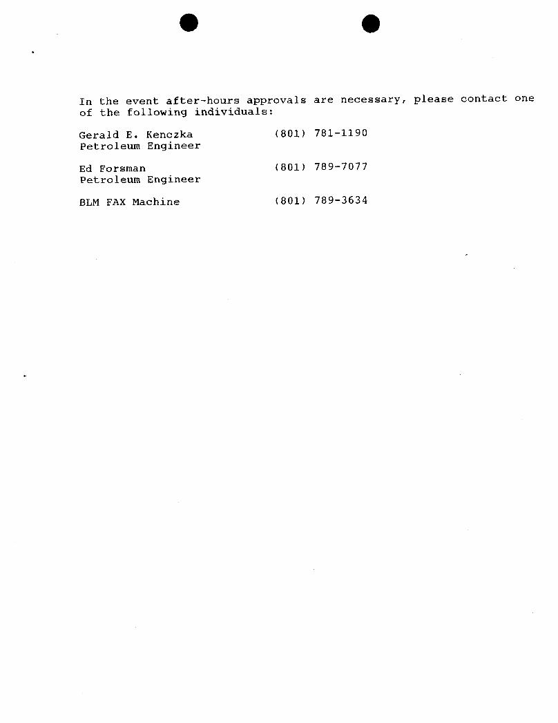
O
In the event after-hours approvals are necessary, please contact one
of the following individuals:
Gerald E. Kenczka (801) 781-1190Petroleum Engineer
Ed Forsman (801) 789-7077Petroleum Engineer
BLM FAX Machine (801)
O
In the event after-hours approvals are necessary, please contact one
of the following individuals:
Gerald E. Kenczka (801) 781-1190Petroleum Engineer
Ed Forsman (801) 789-7077Petroleum Engineer
BLM FAX Machine (801)
O
In the event after-hours approvals are necessary, please contact one
of the following individuals:
Gerald E. Kenczka (801) 781-1190Petroleum Engineer
Ed Forsman (801) 789-7077Petroleum Engineer
BLM FAX Machine (801)
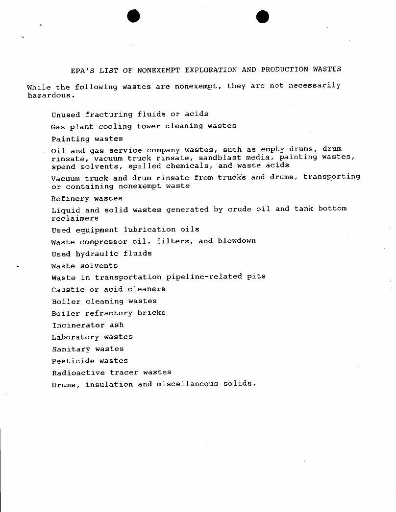
O O
EPA'S LIST OF NONEXEMPT EXPLORATION AND PRODUCTION WASTES
While the following wastes are nonexempt, they are not necessarilyhazardous.
Unused fracturing fluids or acids
Gas plant cooling tower cleaning wastes
Painting wastes
Oil and gas service company wastes, such as empty drums, drumrinsate, vacuum truck rinsate, sandblast media, painting wastes,spend solvents, spilled chemicals, and waste acids
Vacuum truck and drum rinsate from trucks and drums, transp.ortingor containing nonexempt waste
Refinery wastes
Liquid and solid wastes generated by crude oil and tank bottomreclaimers
Used equipment lubrication oils
Waste compressor oil, filters, and blowdown
Used hydraulic fluids- Waste solvents
Waste in transportation pipeline-related pits
Caustic or acid cleaners
Boiler cleaning wastes
Boiler refractory bricks
Incinerator ash
Laboratory wastes
sanitary wastes
Pesticide wastes
Radioactive tracer wastes
Drums, insulation and miscellaneous
O OSURFACE USE PIANOF OPERATIONS
The reserve pit shallbe lined witha reinforcedlinerwithsufficientbedding (eitherstrawor dirt) to coveranyrocks. The liner willoverlapthe pitwallsand be covered withdirt and/or rocks to hold it in place. No trash,scrap pipe, etc., that could puncture the linerwillbe disposed of in the pit.
Additional Surface Stlpulations
Prior to reclaimingof any disturbed areas, the operator willcontact the AuthorizedOfficerof the BLMto determine the most desirable site specificseed mixturefor reclamation.Seeding willbe done between September 15 and whenthe ground freezes, unless otherwiseapproved by the A.O.
A complete copy of the approved APD and ROW grant, if applicable, shall be on location duringconstruction of the location and drillingactivities.
The requested emergency pit is hereby approvedunder NTL-28, Sectio VI, subject to the followingConditions of Approval:
1. If emergency use occurs, the emergency pit shall be emptied and the llquids dispos of inaccordance with applicable State and/or Federal regulations within 48 hours following its use,unless such time is extended by the authorizedofficer.
2. As much as practicable, the emergency pit shall be located on level ground, and away fromdrainage pattems and unstable ground.
3. The emergency pitshallbe fenced and thefence maintainedfor safety,and to prevent livestock andwildlifeentry. The pit shall be fenced according to the same minimumstandards listed for thedrilling reserve pit underPoint 9E of the Multi-pointSurface Use and Operation Plan. The fenceshallbe maintainedin a taut condition.Fences shall not be built on berms.
4. Produced water drain lines shallnot go to the emergency pit.
5. The pit shall be bermed or otherwiseconstructed and maintainedto prevent entrance of surfacewater.
6. Turn downs shallbe put on the ends of pipes to direct fluids downward instead of against the wallof the pit.
7. The pit shall be kept free of trash.
Balcron shall contract a Utah BLMcertifiedpaleontologist to sunreythe location and access road priortosurface disturbance to determine the presence of paleontological resources. Ifhistoric, archaeological,orpaleontological resources are uncovered during ground disturbing activities,Balcron will suspend alloperations that would further disturb such materialsand immediately contact the BLMAuthorized

1 406 245 1361OCT 12 '93 09:37AM ON OIL DIV P.3/3
Page 1 of 1Baleron Oil
DAILY OPERATING REPORTDATE: 10/12/93
HJONAR UNIT PARTNERB' REPORT**
BALCRON HONWNENTFEDERAL #12-12,7 Operator: BREC/BaloronBOD WI: 79.78%Location: SW NW Section 12, TBS, Ri6E
Duchesne County, 'ItahProspoot: Jonah Unit / Honument ButtePTD: 5,800' Green River Oil - Dev.
10-9-93 Well apud w|a dry-hole spudder (Leon Ross) on 10-9-9) @ 10 a.m.
BALCRON MONUMENT FEDERAL #14-53 Operator: EREC/BaloronBOD WIt 79.78%Locationt BW BW Section 5, 198, R17E
---TIGHT EOLE--- Duchesne County, ItahProspect: Jonah Unit/Monument Butte
10-12-93 TD: 5,700' (200') Day 9Formation: Wasatch TongueMW 8.4 VIS 26 pH 9.2Present Operation: LoggingDrill, rig service, & survey. Trip for hole in brill pipe &cracked drill collar. Trip back in w/bit #2. Drill to TD $ 12:30midnight. TOH to log, logging w/Schlumberger.DC: $6,772 CC: $113,343
BALCRONMONUMENT_FEDERAL #32-1½ Operator: Ba1eron/ERECBOD WII 1004Location: SW NE Section 15, T98, R162
---TIGHT NOLE--- Duchesne County, UtahProspect: Monument ButtePTD: $610' Green River Gil - Dev.
10-12-93 TD; 3,300' (1,107') Day 3Formation: Green RiverMW air & foamPresent Operation: DrillingDrill, survey, & rig service.DC: $15,185 CC: $78,000
BALCRON MONUMENTFEDERAL #41-15¥ Operatort EREC/BaloronBOD WII 79.78%Location: NE NE Section 15, 298, R16B
---TIGHT HOLE--- Duchesne County, UtahProspect: Jonah Unit / Montment Butte
10-11-93 CompletionDress up location. Set rig anchors. Run Bond log cn well.DC:
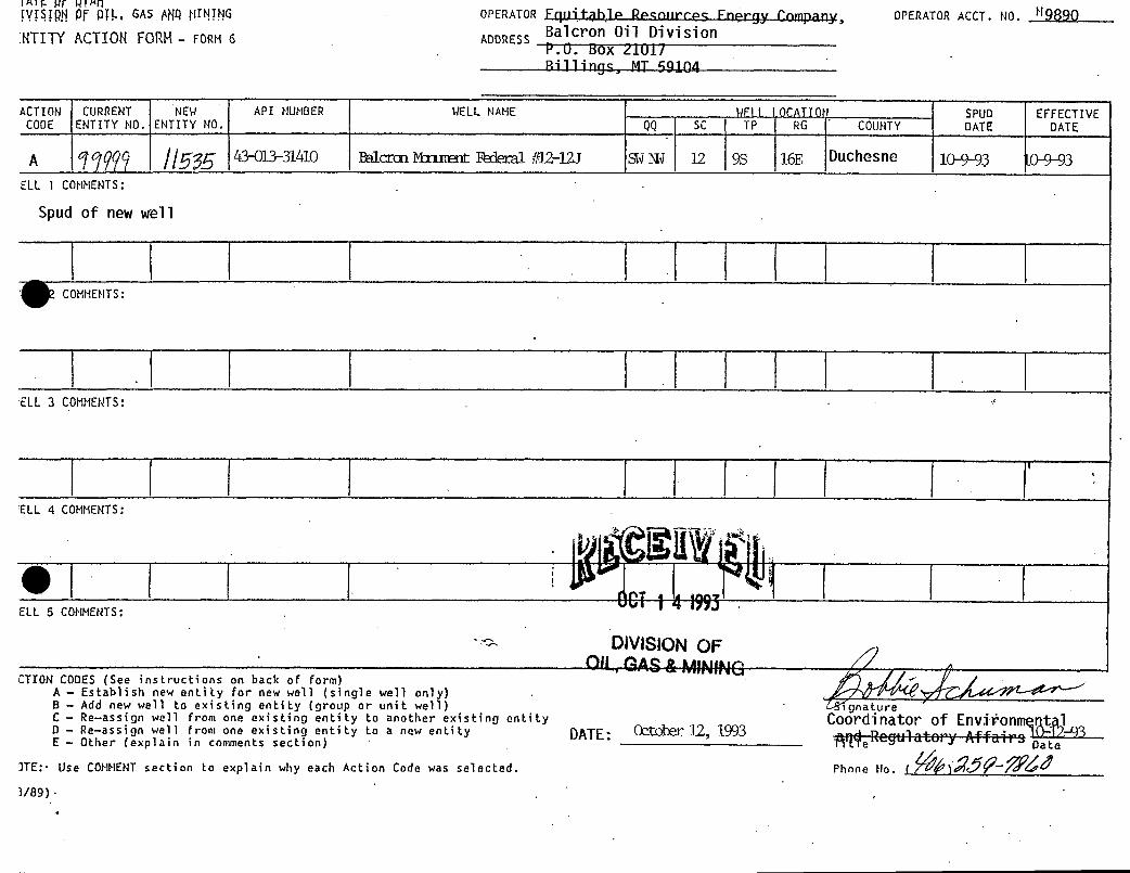
lA WT W!ANIVfSÏ9.N 0.F pg, GAS MQ glINING OPERATOR Fquitable Ree:nnrres Fnergy ('ompany, OPERATOR ACCT. NO. Hgggg
.HTITY ACTIOH FORH- FORM 6 ADDRESS Balcron Oil DivisionP.O. box ¿101/Rillings, MT 69104
ACTION CURRENT NEW API NUMBER WELL NAHE WFII \ OCATION SPUD EFFECTIVECODE ENTITY NO. ENTITY NO. QQ SC TP RG COUHTY DATE DATE
A ggg 43-013-31410 Balcran Mnxœnt Faleral #l2-12J SWNJ 12 9S 16E Duchesne 1(MH)3 0-9-93
ELL 1 COMHENTS:
Spud of new well
COHHENTS:
ELL 3 COMMENTS:I
E 4 COMMENTS:
ELL 5 COMHENTS:
DIVISIONOFll , AAS&MININO
CTION CODES (See instructions on back of form)A - Establish new entity for new well (single well only)8 - Add new well to e×isting entity (group or unit well) gnatureC - Re-assign well from one existing entity to another existing entity COOrdinator of Envifonmq tlDE
0asrsi n weal ro
on n otity to a new entity DATE: October 12, 1993
Date3TE:. Use COMMENTsection to explain why each Action Code was selected. Phone No. (3/89)
lA WT W!ANIVfSÏ9.N 0.F pg, GAS MQ glINING OPERATOR Fquitable Ree:nnrres Fnergy ('ompany, OPERATOR ACCT. NO. Hgggg
.HTITY ACTIOH FORH- FORM 6 ADDRESS Balcron Oil DivisionP.O. box ¿101/Rillings, MT 69104
ACTION CURRENT NEW API NUMBER WELL NAHE WFII \ OCATION SPUD EFFECTIVECODE ENTITY NO. ENTITY NO. QQ SC TP RG COUHTY DATE DATE
A ggg 43-013-31410 Balcran Mnxœnt Faleral #l2-12J SWNJ 12 9S 16E Duchesne 1(MH)3 0-9-93
ELL 1 COMHENTS:
Spud of new well
COHHENTS:
ELL 3 COMMENTS:I
E 4 COMMENTS:
ELL 5 COMHENTS:
DIVISIONOFll , AAS&MININO
CTION CODES (See instructions on back of form)A - Establish new entity for new well (single well only)8 - Add new well to e×isting entity (group or unit well) gnatureC - Re-assign well from one existing entity to another existing entity COOrdinator of Envifonmq tlDE
0asrsi n weal ro
on n otity to a new entity DATE: October 12, 1993
Date
3TE:. Use COMMENTsection to explain why each Action Code was selected. Phone No. (3/89)
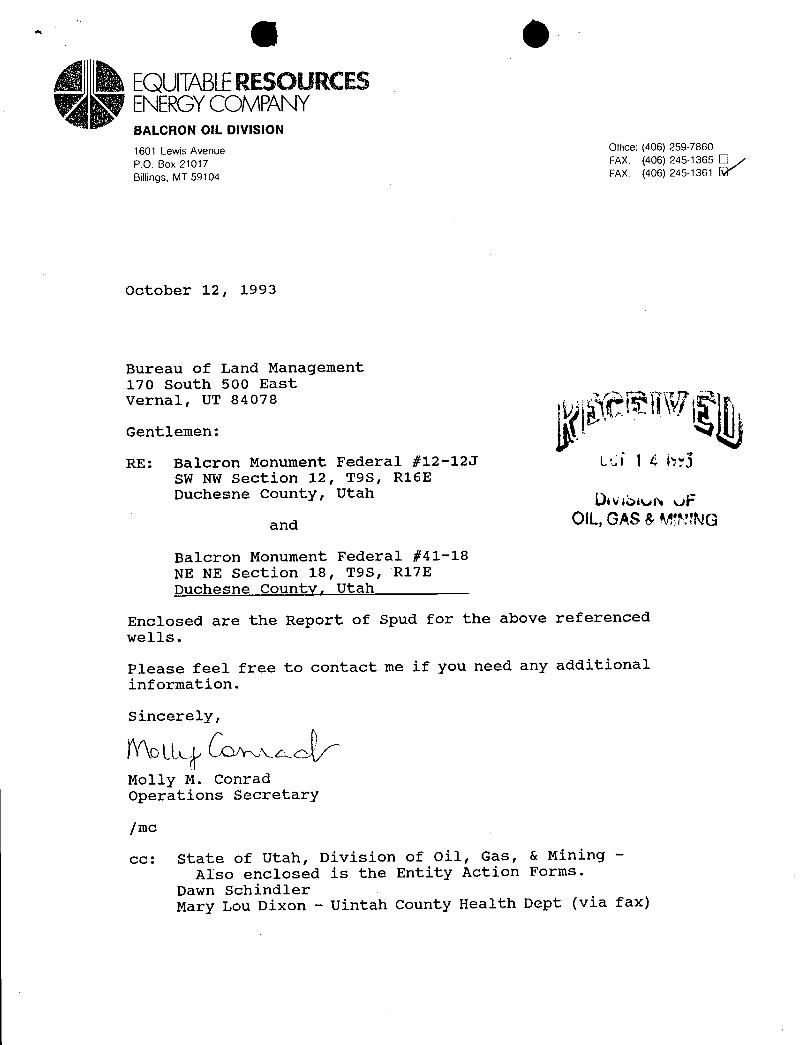
(il tiEQUlTABLERESOURCESENERGYCOMPANYBALCRON OIL DIVISION
1601 Lewis Avenue Office: (406) 259-7860
P.O. Box 21017 FAX: (406) 245-1365 l¯l
Billings, MT 59104 FAX: (406) 245-1361 Y
October 12, 1993
Bureau of Land Management
nUh 580400
Gentlemen:
RE: Balcron Monument Federal #12-12J LCÍ l 4 by3SW NW Section 12, T9S, R16EDuchesne County, Utah Dog ey:
and OIL,GAS &MENG
Balcron Monument Federal #41-18NE NE Section 18, T9S, R17EDuchesne County, Utah
Enclosed are the Report of spud for the above referencedwells.
Please feel free to contact me if you need any additionalinformation.
Molly M. ConradOperations Secretary
|mc
cc: State of Utah, Division of Oil, Gas, & Mining -
Also enclosed is the Entity Action Forms.Dawn SchindlerMary Lou Dixon - Uintah County Health Dept (via
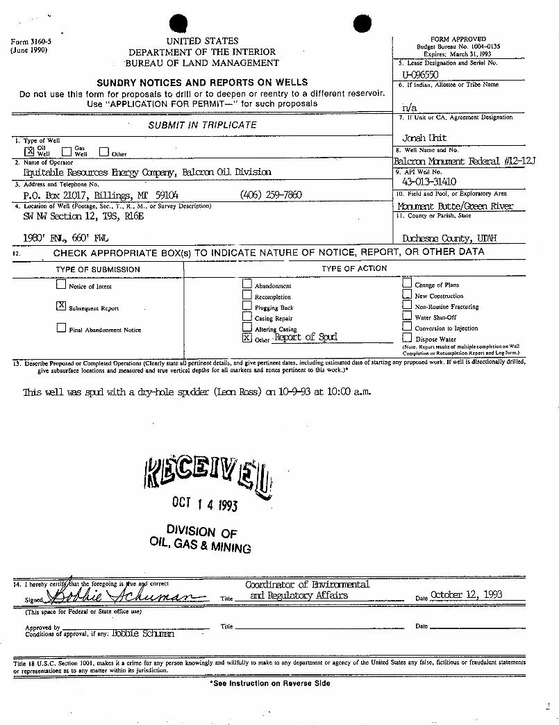
. O OForm 3160-5 UNITED STATES FORM APPROVED
(June 1990) DEPARTMENT OF THE INTERIORBudExeptire
:
aNo. 1004 135
BUREAU OF LAND MANAGEMENT 5. Lease Designation and Serial No.U-096550
SUNDRY NOTICES AND REPORTS ON WELLS 6. If Indian, Allottee or Tribe Name
Do not use this form for proposals to drill or to deepen or reentry to a different reservoir.Use "APPLICATION FOR PERMIT-" for such proposals n/a
SUBMIT IN TRIPLICA TE7. If Unit or CA, Agreement Designation
I. Type of Well JOŒlh IIIitOW
11Waesli
O her 8. Well Name and No.
2. Name of Operator Ë61¾ ÈÍCE]LUsit Ii'¾ #12-12table ROSOLIECOS R38Cg , ËâÎCCŒl Ûil DiViSion 9. API Well No.
3. Address and Telephone No. 43-013-31410P.O. BæE 21017, Billings, MI' 5910'+ (406) 259-7 10. Field and Pool, or Exploratory Area
4. Location of Well (Footage, Sec., T., R., M., or Survey Description) híctuœnt Butte/Green RiverSWm Sectian 12, ISS, R16E 11. County or Parish, State
1980' RL, 660' FEL Duchesne County, Ural12. CHECK APPROPRIATE BOX(s) TO INDICATE NATURE OF NOTICE, REPORT, OR OTHER DATA
TYPE OF SUBMISSION TYPE OF ACTION
O Notice of Intent Abandonment Change of Plans
Recompletion New Construction
Subsequent Report Plugging Back Non-Routine Fracturing
Casing Repair Water Shut-Off
Final Abandonment Notice Altering Casing Conversion to Injection
Other R Of Dispose Water(Note: Reportresultsof multiplecompletiononWellCompletion or Recompletion Report and Log form.)
13. Describe Proposed or Completed Operations (Clearly state a 1 pertinent details, and give pertinent dates, including estimated date of starting any proposed work. If well is directionally drilled,give subsurface locations and measured and true vertical depths for all markers and zones pertinent to this work.)*
'Ihis æll ms sptd with a dry-bole spedder (I.ean Ross) au 10-9-93 at 10:00 a.m.
OCI i 4 1993
DIVISIONOFOIL,GAS&MINING
14. I hereby certi hat the foregoing is e a correct COOktΠOf MtalTitle d tOg S Date
(This space for Federal or State office use)
Approved by Title DateConditions of approval, if any: MS M
Title 18 U.S.C. Section 1001, makes it a crime for any person knowingly and willfully to make to any department or agency of the United States any false, fictitious or fraudulent statementsor representations as to any matter within its jurisdiction.
*See Instruction on Reverse
. O OForm 3160-5 UNITED STATES FORM APPROVED
(June 1990) DEPARTMENT OF THE INTERIORBudExeptire
:
aNo. 1004 135
BUREAU OF LAND MANAGEMENT 5. Lease Designation and Serial No.
U-096550SUNDRY NOTICES AND REPORTS ON WELLS 6. If Indian, Allottee or Tribe Name
Do not use this form for proposals to drill or to deepen or reentry to a different reservoir.Use "APPLICATION FOR PERMIT-" for such proposals n/a
SUBMIT IN TRIPLICA TE7. If Unit or CA, Agreement Designation
I. Type of Well JOŒlh IIIitOW
11Waesli
O her 8. Well Name and No.
2. Name of Operator Ë61¾ ÈÍCE]LUsit Ii'¾ #12-12table ROSOLIECOS R38Cg , ËâÎCCŒl Ûil DiViSion 9. API Well No.
3. Address and Telephone No. 43-013-31410P.O. BæE 21017, Billings, MI' 5910'+ (406) 259-7 10. Field and Pool, or Exploratory Area
4. Location of Well (Footage, Sec., T., R., M., or Survey Description) híctuœnt Butte/Green RiverSWm Sectian 12, ISS, R16E 11. County or Parish, State
1980' RL, 660' FEL Duchesne County, Ural12. CHECK APPROPRIATE BOX(s) TO INDICATE NATURE OF NOTICE, REPORT, OR OTHER DATA
TYPE OF SUBMISSION TYPE OF ACTION
O Notice of Intent Abandonment Change of Plans
Recompletion New Construction
Subsequent Report Plugging Back Non-Routine Fracturing
Casing Repair Water Shut-Off
Final Abandonment Notice Altering Casing Conversion to Injection
Other R Of Dispose Water(Note: Reportresultsof multiplecompletiononWellCompletion or Recompletion Report and Log form.)
13. Describe Proposed or Completed Operations (Clearly state a 1 pertinent details, and give pertinent dates, including estimated date of starting any proposed work. If well is directionally drilled,give subsurface locations and measured and true vertical depths for all markers and zones pertinent to this work.)*
'Ihis æll ms sptd with a dry-bole spedder (I.ean Ross) au 10-9-93 at 10:00 a.m.
OCI i 4 1993
DIVISIONOFOIL,GAS&MINING
14. I hereby certi hat the foregoing is e a correct COOktΠOf MtalTitle d tOg S Date
(This space for Federal or State office use)
Approved by Title DateConditions of approval, if any: MS M
Title 18 U.S.C. Section 1001, makes it a crime for any person knowingly and willfully to make to any department or agency of the United States any false, fictitious or fraudulent statementsor representations as to any matter within its jurisdiction.
*See Instruction on Reverse
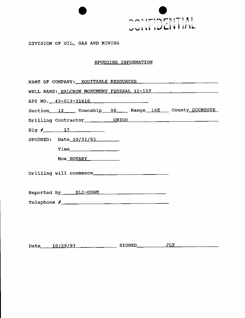
O O
DIVISION OF OIL, GAS AND MINING
SPUDDING INFORMATION
NAME OF COMPANY: EOUITABLE RESOURCES
WELL NAME: BALCRON MONUMENT FEDERAL 12-12J
API NO. 43-013-31410
Section 12 Township 9S Range 16E County DUCHESNE
Drilling Contractor UNION
Rig # 17
SPUDDED: Date 10/31/93
Time
How ROTARY
Drilling will commence
Reported by DLI-DOGM
Telephone #
Date 10/29/93 SIGNED
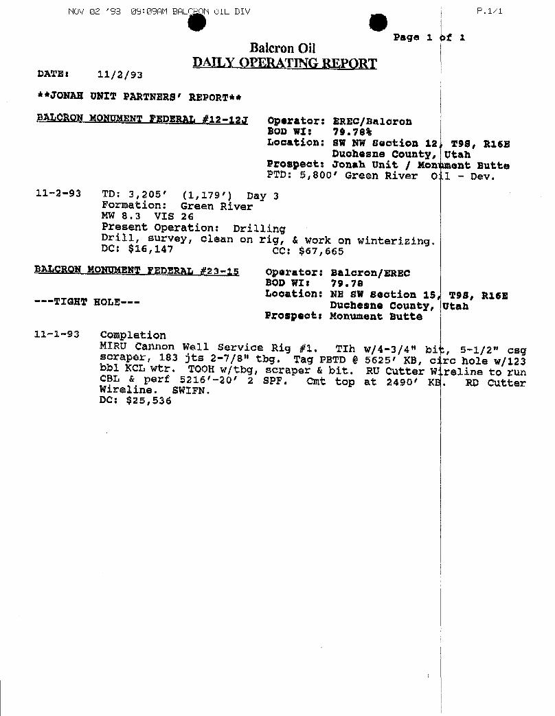
NOV 02 '93 09:09AM BAU 4 OIL DIk/
Page 1 >f 1
P.1/1
Balcron OilDAILY OPERATING REPORT
DATEI 11/2/93
**JONAR UNIT PARTNERS' REPORT**
BALORON MONUMENTFEDERAL #12-12J Operator: BREC/BaloronSOD WI: 79.78%Location: BW NW section 12 298, R16B
Duchesne County, UtahProspect: Jonah Unit / Monument ButtePTD: 5,800' Green River O .1
- Dev.11-2-93 TD: 3,205' (1,179') Day 3
Formation: Green RiverMW 8.3 VIS 26Present Operation: DrillingDrill, survey, clean on rig, & work on winterising.DC: $16,147 CC: $67,665
BALCRON MONUMENTFEDERAL #23-î5 Operator: Baleron/ERECSOD WII 79.78Location: NE SW section 15 TSB, RI6E---TIGHT NOLE--- Duchesne County, UtahProspects Monument Butte
11-1-93 CompletionMIRU Cannon Well Service Rig #1. TIh w/4-3/4" bi:, 5-1/2" cagscraper, 183 jts 2-7/8" thg. Tag PETD $ $625' KB, circ hole w/123bbl KCL wtr. TOOH w/tbg, scraper & bit. RU Cutter W:.reline to runCBL & perf 5216'-20' 2 SPF. Cmt top at 2490/ KE. RD CutterWireline. SWIFN.DC: $25,536
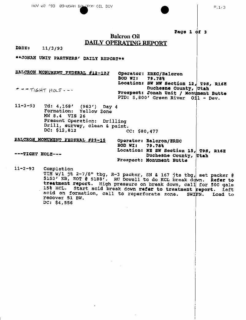
NOV 03 '93 09:09AM B ON OIL DIV P.1/3
Page i of 3Balcron Oil
DAILY OPERATINGREPORTDATE: 11/3/93
**JONAH UNIT PARTNERB' DAILY REPORT**
BALCRON MONUMENT.FEDERAL #12-12J Operator: BREC/BaloronBOD WI: 79.78%Location: SW NW Bection 12, 998, Ri6E
Duchesne County, Utah* * *- flú EVE RDL Prospect: Jonah Unit / Mont ment ButtePTD: 5,800' Green River 011 - Dev.
11-3-93 Td: 4,168' (963') Day 4Formation: Yellow ZoneMW 8.4 VIS 26Present operation: DrillingDrill, survey, clean & paint.DC: $12,812 CC: $80,477
BALCROM NONUMENT FEDERAL #23-15 Operators Baloron/ERECBOD WI; 79.784Location: NE SW Beation 15, T98, R16E---TIGHT HOLE--- Duchesne county, UtahProspect: Nonument Butte
11-2-93 CompletionTIH w/1 jt 2-7/8" tbg, R-3 packer, SN & 167 Jts tbg, set packer §5153* KB, EOT $ 5188'. RU Dowell to do KCL break dcwn. Refer totreatment report. High pressure on break down, call for 500 gals15% HCL. Start acid break down refer to treatment report. Leftacid on formation, call to reperforate zone. SWIFN. Load torecover 51 BW.DC:

NOV 04 '93 10: 10AM ON OIL DIV P. 1/2
Page 1 of 2Balcron Oil
DAILY OPERATINGREPORTDATE: 11/4/93
**JONAH UNIT PARTNERS' DAILY REPORT**
SALCRON MONUNENTFEDERAL #12-12J Operator: EREC/BaloronBOD WIt 79.78%Locatient BW NW Section 12, TSB, R16B
Duchesne county, UtahProspect: Jonah Unit / Monument Butte
11-4-93 TD: 5,071' (903') Day 5Formation: Green zoneMW 8.3 VIS 26Present operation: DrillingDC: $12,416 CC: $92,893
BALCRONMONUMENTTEDERAL #23-15 operators Saloron/ERECBOD WII 79.78%Location: NE BW section 15, 298, R16E
--•TIGHT NOLE--- Duchesne county, UtahProspooti Nonument Butte
11-3-93 CompletionCP - 850 psi. Pump for injection rate 2450 pai, 2.L BPM 2% KCL,TOOH w|tby & packer. RU Cutter Wireline to perf 5212'-22' 4 SPF.RD Cutter Wireline. Pump for injection rate 2200 psi @ 2.75 BPM,ISIP - 2000#. TIH w/1 jt 2-7/8" tbg, 5-1/2" packer, SN, & 2-7/8"tbg. Set packer 0 5153' KB. EOT @ $188' KB. RU Dowoll to do acidbreak down refer to treatment report. RU Dowell to trac down tog.Total sand used 20,700# 16-30, screened out when 7# got to perfs.SWIFN,DC:
iIiI
i CONRDI1i
Discoverynergy inc.
Iscovery
I nergy no.
I gi Discovery
Energy Inc.I
iIiI
i CONRDI1i
Discoverynergy inc.
Iscovery
I nergy no.
I gi Discovery
Energy Inc.I
iIiI
i CONRDI1i
Discoverynergy inc.
Iscovery
I nergy no.
I gi Discovery
Energy Inc.I
GEOLOGIC AND DRILLING REPORT
BALCRON OILMONUMENT BUTTE FEDERAL NO. 12-12]
SWNW Section 12-T98-R 4EDUCHESNE COUNTY, U AH
Ii
Ii
Ii
BALCRON OILP.O. BOX21017Billings, Montana 59104
i
GEOLOGIC AND DRILLING REPORT
BALCRON OILMONUMENT BUTTE FEDERAL NO. 12-12]
SWNW Section 12-T98-R 4EDUCHESNE COUNTY, U AH
Ii
Ii
Ii
BALCRON OILP.O. BOX21017Billings, Montana 59104
i
GEOLOGIC AND DRILLING REPORT
BALCRON OILMONUMENT BUTTE FEDERAL NO. 12-12]
SWNW Section 12-T98-R 4EDUCHESNE COUNTY, U AH
Ii
Ii
Ii
BALCRON OILP.O. BOX21017Billings, Montana 59104
i
l
MONUMENT BUTTE FEDERAGNO. 12-12J
Well Summary-------------- I
PenetrationRecord--------- 2
Daily Mud Check----------- 3
Mud Additives--------------- 3
Bit Record------------------- 4
Deviation Record----------- 4
ShowReport---------------- 5
FormationData------------ 6
SampleDescription---------- 7
StripLog--------------- Pocket
Prepared by:
M.K.JonesP.O.Box 21194Billings,MT 59104(406)
Ii
ii
OPERATOR: Balcron Oil
i LEASE AND WELL NAME: Monument Butte Federal No.12-12JLOCATION: 1980' fn, 660' fw (SWNW) Section 12-T9S-R16E
DuchesneCountý, UtahELEVATION: 5542 Ground, 5352 K.B.SPUD DATE: 10:00 AM, October 9, 1993COMPLETION DATE: Ran 5 1/2" Production Casing November 6, 1993CASING POINT, DATE: November 5, 1993TOTAL DEPTH: 5800' Driller Depth, 5814' Logger DepthWELL STATUS: Awaiting Completion as Oil Well
i DRILLING CONTRACTOR: Union Drilling, Inc.RIG NO.: 17HOLE SIZE: Surface; 12 1/4" to 275'
Main Hole; 7 7/8" to Total DepthSURFACE CASING: 6 Jts 8 5/8", 24# J-55 @ 276.69 K.B.;
w/150sx class "G" + 3% CaCl, + 1/4#lsk Celloseal
i MUD PROGRAM: Drill w/ air & mist to 5800; Load Hole wlFresh Wtr,KCL & Polymer
LOGS: HaliburtonLogging Services - DLL-MSFL,
i Spectral Density, Dual spaced Neutron LogCORES: NoneDRILL STEM TESTS: NoneSAMPLE QUALITY: Good
- SAMPLE DISPOSITION: Utah GeologicalSamplc LibraryPRODUCTION CASING: 5 1/2", 15.5# @Total Depth
iDRILLING EQUIPMENT: BLOW OUT PREVENTER:
I RIO: Draw Works Cabot-FranksRocket Make Schaeffer. Model 10"- 900Mast Make Cabot Height ß.2' Type Hvdrauljc Dbl RamPower Caterpillar 343 Diesel Drill Pipe Size 4 1/2"Thread XH16,6#
Drill Collars: NO,18. LengthThread 4"_H-90.ID 2 1/2",OD.§"
PUMP: NO. I Make Model 200 FX.Stroke Length .LC
i Liner ID 5 1/2".Power Twin 671 Detroit Diesels
I 3
FAILY DEPTH AT 6;00 A.Wl.
Monument Butte Federal 12-12]
PENETRATION TlMEDISTRIBUTlOÑDATE DEPTH FOOTAGE DRILLING REPAIRS OTHER DAY WORK REMARKS
10/09/93 - - - - - - Spud @ 10:00 AM10/10/93 275 275 - - - - Run & Cmt 8 5/8" Csg
10/30/93 275 - - - - - Move on Union #1710/31/93 645 370 8 - 16 - Move In; Rig Up11/01/93 2026 1381 21 1/2 - 2 1/2 - Drill w/Air & Mist11/02/93 3205 1179 21 1/2 - 2 1/2 - -
11/03/93 4168 963 21 1/4 - 2 3/4 - -
11/O‡/93 5071 903 19 - 5 - -
11/05/93 5800 729 16 - 8 5 1/2 Load Hole flLogging -11/06/93 5800 - - - 24 24 Logging; Lay dwn DP
Run 5 1/2" CasingCmt 5 /12" Cag,Rig Dwn
11/07/93 5800 - - - I 1 Rig Released 7:00 AM
iIi
TIME DISTRIBUTION SI)MMARY
IRotatingHours--------------- 117 1/4HoursDays on Location----------------- 6 DaysRig Repair----------------- - Hour gDayWode---------------- 30 1/2 Hours
iii
2

I
i Monument Butte Federal No. 12-12]
IDATE DEPTH WT. VIS. Pl_I Jyl CAKE SALT KCI %
10/31/93 Air and Mist - - - - - - 1850 CFM11/01/93 Air and Mist - - - - L - - 1850 CFM11/02/93 Air and Mist - - - - - - 1850 CFM11/03/93 Air and Mist - - - - - - 1850 CFM11/04/93 Air and Mist - - - - - - -
11/05/93 Load Hole w/KCI Water - - - - - -
5800 8.0 26 - - - 10,500 L6 %
iIii Mud Additives
KCL--------------- 125 sx Detergent------------- 12 cans
IiIiiii 3
l
Monument Butte Federal No. 12-12J
SIZE MAKE TYPE O_IK FEET g_RS WEIGHT BPM SPM PRESS R.EV
1 7 7/8" HT C ATJ-55A Open 5800 5524 107 1/4 10-30 50 Air & Mist 2 1/2
Deviation Record
DEPTH ANGLE DEPTH ANGLE
289 3/4° 3240 1 1/2°800 1° 3740 2 1/2°1300 1° 4240 1 3/4°
g1807 1° 4752 2 1/4° E2243 1 1/4 5250 2 1/2°2743 3°
Monument Butte Federal 12-12]
Ro Depth Drill I ate, Min/ft Total Gas fir.on atographFrom-To Before During After Before Peak After Cl C2 C3 C4
1 3650-3750 1.0 1.0 1.0 5 5 5 9.0 1.0 - -
I C- 2 4206-4218 0.6 1.4 0.9 11 11 11 15.0 1.0 - -
3 4636-4640 0.7 1.5 0.6 12 12 12 17.0 2.0 - -
B- 4 5006-50 12 1.3 0.6 0.9 17 160 65 65.0 9.0 13.0 2 0
i 5 4738-4745 1.0 0.7 1.5 14 14 14 13.0 2.0 - -
A- 6 5205-5214 0.5 1.2 1.4 25 270 135 200 80 30 8.07 5536-5542 0.75 1.5 0.75 55 55 55 35 16.0 8.0 4.08 5562-5566 1.5 2.0 1.5 55 55 55 35 16.0 8 0 4.09 5664-5668 1.0 0.75 1.0 55 55 55 35 16.0 8.0 4.0
10 5734-5750 0.75 1.25 1.0 40 40 40 25 12.0 6.0 4.0
iii
Remarks
1. SS - It gy, brn, vfg, ang, pr por, brn oil stn, slow strmg ct, no fluor.C-2. SS - brn, It gy, vf-fg, sb ang-rnd, calc, fri, pr por, no fluor, instant strng strmg ct,
hole making oil while driling.3. Ls - brn, tn, mic, ostracodal, poor por, sli gld fluor, brn oil stn, quick strong strmg ct.
B-4. SS - It gy, dk brn, calc, tite to pr por, no visible show, hole making tarry oil whiledrilling with mist.
5. SS - wh, it gy, vfg, fri, slty, unconsol, dull yell fluor, inilky ct.
I A-6. SS - It gy, tn, vf-fg, sb ang, calc, loose grns, brn oilstn, dullyell fluor, quick strngstrmg ct.
7. Sltst - oil stn, no fluor, fast, strng, strmr ct (uphole contam?)8. SS - It gy, brn, vf-fg, pr-fr por, brn oil stn, no fluor, milkycut.9. SS - wh, fg, fri, spty stn, &fluor, mod fst strmg ct.
10. SS - It gy, vf-fg, fri, slty, brn o stn, spty fluor, slw strmg ct.
NOTE: *A,B,C,D DENOTESRELATIVE STRENGTHOF SHOW
l
Monument Butte Federal 12-12]
Ro Depth Drill I ate, Min/ft Total Gas fir.on atographFrom-To Before During After Before Peak After Cl C2 C3 C4
1 3650-3750 1.0 1.0 1.0 5 5 5 9.0 1.0 - -
IC- 2 4206-4218 0.6 1.4 0.9 11 11 11 15.0 1.0 - -
3 4636-4640 0.7 1.5 0.6 12 12 12 17.0 2.0 - -
B- 4 5006-50 12 1.3 0.6 0.9 17 160 65 65.0 9.0 13.0 2 0
i 5 4738-4745 1.0 0.7 1.5 14 14 14 13.0 2.0 - -
A- 6 5205-5214 0.5 1.2 1.4 25 270 135 200 80 30 8.07 5536-5542 0.75 1.5 0.75 55 55 55 35 16.0 8.0 4.08 5562-5566 1.5 2.0 1.5 55 55 55 35 16.0 8 0 4.09 5664-5668 1.0 0.75 1.0 55 55 55 35 16.0 8.0 4.0
10 5734-5750 0.75 1.25 1.0 40 40 40 25 12.0 6.0 4.0
iii
Remarks
1. SS - It gy, brn, vfg, ang, pr por, brn oil stn, slow strmg ct, no fluor.C-2. SS - brn, It gy, vf-fg, sb ang-rnd, calc, fri, pr por, no fluor, instant strng strmg ct,
hole making oil while driling.3. Ls - brn, tn, mic, ostracodal, poor por, sli gld fluor, brn oil stn, quick strong strmg ct.
B-4. SS - It gy, dk brn, calc, tite to pr por, no visible show, hole making tarry oil whiledrilling with mist.
5. SS - wh, it gy, vfg, fri, slty, unconsol, dull yell fluor, inilky ct.
I A-6. SS - It gy, tn, vf-fg, sb ang, calc, loose grns, brn oilstn, dullyell fluor, quick strngstrmg ct.
7. Sltst - oil stn, no fluor, fast, strng, strmr ct (uphole contam?)8. SS - It gy, brn, vf-fg, pr-fr por, brn oil stn, no fluor, milkycut.9. SS - wh, fg, fri, spty stn, &fluor, mod fst strmg ct.
10. SS - It gy, vf-fg, fri, slty, brn o stn, spty fluor, slw strmg ct.
NOTE: *A,B,C,D DENOTESRELATIVE STRENGTHOF SHOW
l

l
Monument Butte Federal 12-12]
Sample Tops
ELEVATIONS 5542 GL 5552 K.B. STRUCTURALRELATIONSHIP
FORMATION DEPTH ELEVATION TlflCKNESS HIGH/LOW
TERTIARY
Uintah Surface 5542 1586 92' High
'ch 2 316 ow
2nd Garden Gulch 3905 1647 204 27' LawYellow I Sandstone 4109 1443 73 33' LowYellow 3 Sandstone 4182 1370 260 26' LowYellow 5 Sandstone 4442 1110 97 26' LowYellow Marker 4539 1013 159 31' Low
Douglas Creek 4698 854 80 30' LowRed 2 Sandstone 4778 774 99 39' LowRed 5 Sandstone 4877 675 61 40' Low
2nd Dou *las Creck 4938 614 88 30' LowGreen 1 Sandstone 5026 526 57 25' LowGreen Marker 5083 469 140 26' LowGreen 4 Sandstone 5223 329 329 26' Low
Wasatch Tongue 5552 Sea Level 262+ Not Reachedin Cornp Well
TOTAL DEPTH 5814'
REFERENCE WELL : Campbell ExplorationGovernment C & O No. 4(SE Diagonal 40 Acre Offset)
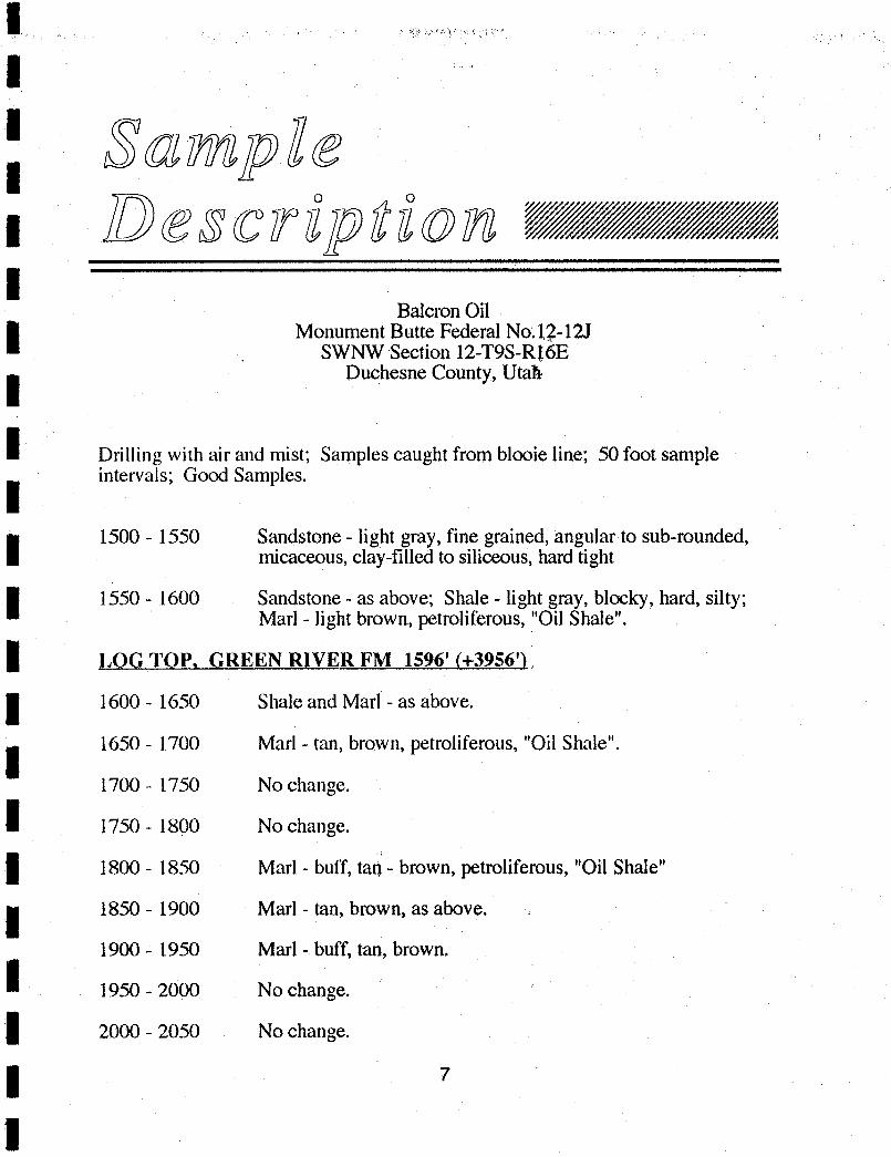
Sampleescription -
BalcronOilMonument Butte Federal No.12-12J
SWNW Section 12-T9S-RI6E
I Duchesne County, Utah
Drilling with air and mist; Samples caught from blooie line; 50 foot sampleintervals; Good Samples.
1500 - 1550 Sandstone - light gray, fine grained, angular to sub-rounded,micaceous, clay-filled to siliceous, hard tight
1550 - 1600 Sandstone - as above; Shale - light gray, blocky, hard, silty;Marl - light brown, petroliferous,"Oil Shale".
LOG TOP, GREEN RIVER FM 1596' (+3956')
1600 - 1650 Shale and Marl - as above.
1650 - 1700 Marl - tan, brown, petroliferous, "Oil Shale".
1700 - 1750 No change.
1750 - 1800 No change.
1800 - 1850 Marl - buff, ta0 - brown, petroliferous, "Oil Shale"
1850 - 1900 Marl - tan, brown, as above.
1900 - 1950 Marl - buff, tan,brown
1950 - 2000 No change.
2000 - 2050 No change.
7
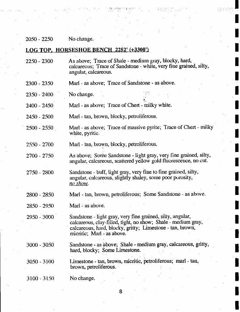
2050 - 2250 No change.
LOGTOP, HORSESHOE BENÇH 2252' (+3300')
2250 - 2300 As above; Trace of Shale - medium gray, blocky, hard,calcareous; Trace of Sandstone - white, very fine grained, silty,angular, calcareous.
2300 - 2350 Marl - as above; Trace of Sandstone - as above.
2350 - 2400 No change.
2400 - 2450 Marl - as above; Trace of Chert - milky white.
2450 - 2500 Marl - tan, brown, blocky, petroliferous.
2500 - 2550 Marl - as above; Trace of massive pyrite; Trace of Chert - milkywhite, pyritic.
2550 - 2700 Marl - tan, brown, blocky, petroliferous.
2700 - 2750 As above; Sorne Sandstone - light gray, very fine grained, silty,angular, calcareous, scattered yellow gold fluorescence, no cut.
2750 - 2800 Sandstone - buff, light gray,very fine to fine grained, silty,angular, calcareous, slightly shaley, some poor porosity,no show.
2800 - 2850 Marl - tan, brown, petroliferous; Some Sandstone - as alxwe.
2850 - 2950 Marl - as above.
2950 - 3000 Sandstone- light gray, very fine grained, silty, angular, gcalcareous, clay-filled, tight, no show; Shale - medium gray, Ecalcareous, hard, blocky, gritty; Limestone- tan, brown,micritic; Marl - as above.
3000 - 3050 Sandstone - as above;Shale - mediumgray, calcareous, gritty,hard, blocky; SomeLimestone.
3050 - 3100 Limestone - tan, brown, micritic, þetroliferous;marl - tan,brown, petroliferous.
3100 - 3150 No change.

I 3150 - 3200 Shale - light gray, calcareous, silty, hard, blocky; Limestone -
buff, tan, hard, silty; Siltstone - light gray, calcareous, hard,shaley; Trace of Sandstone - light gray, very fine grained,angular, silty,calcareous, hard, tight.
I 3200 - 3250 Sandstone - light gray, very fine grained, silty, angular,calcareous, speckledAarkbrownoil stain slowweakstreamercg; Siltstone and Shale - as above; SomeLimestone.
3250 - 3300 Marl - tan, brown, blocky, petroliferous; Limestone - buff, tan,
I brown, micritic,argillaceous; Shale - light to medium gray, silty,calcareous, hard, blocky.
3300 - 3350 No change.
I 3350 - 3450 Increasing amount of gray shale.
3450 - 3500 Limestone - tan, brown, fragmental to micritic, argillaceous;Some Marl and Shale - as before.
3500 - 3550 Sandstone - light gray, very fine grained, silty, angular,calcareous, tight, no show; Limestone - as above.
3550 - 3600 Shale - light gray, calcareous, hard, blocky, gritty to silty;Limestone - as before; Some Sandstone.
3600 - 3650 As above; Siltstone - light gray, shaley.
3650 - 3700 Sandstone - light gray, tan, very fine grained, silty, angular,friable, calcarebus, tight, spotty brown asphaltic oil stain, nofluorescence, slow strong streaming cut; Shale and Limestone -
as above.
3700 - 3750 Shale and Limestone - as above; Much Sandstone -as above.
3750 - 3800 Limestone - tan to brown, micritic; Shale - medium gray,calcareous, hard, blocky.
3800 - 3850 Shale - as above; SomeLimestone - as above.
3850 - 3900 Siltstone - light gray,very sandy, calcareous, hard; Shale - asabove; Some Limestone.
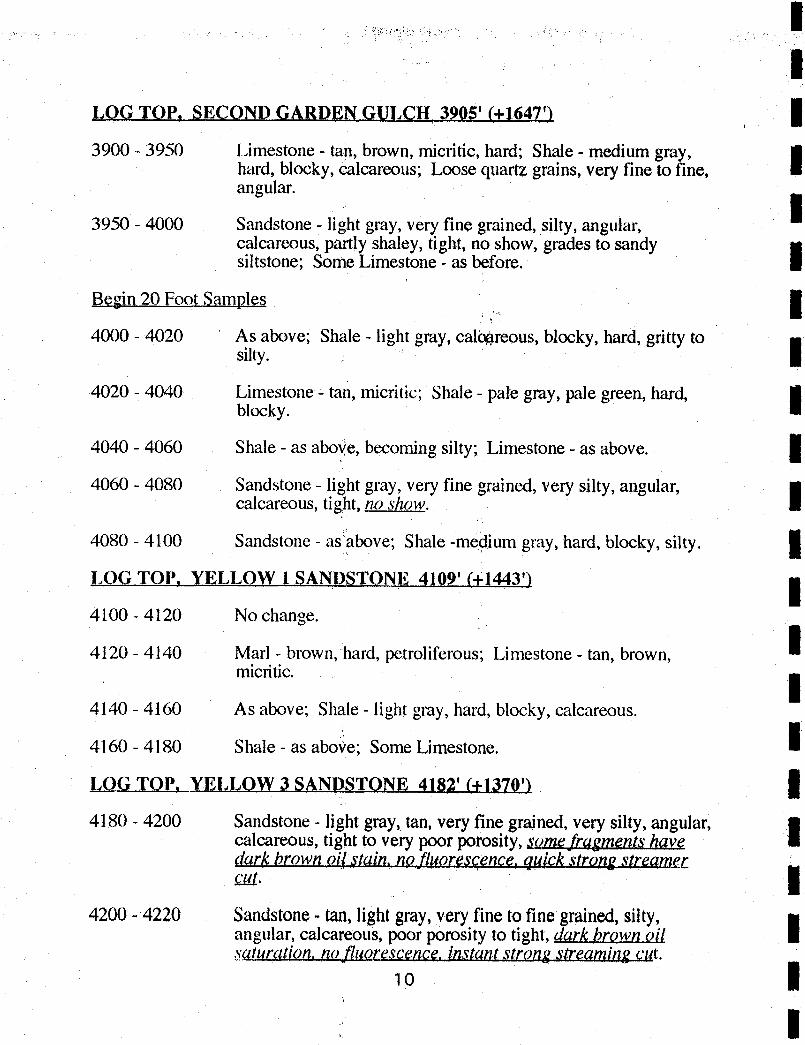
LOG TOP, SECOND GARDEN GULCH 3905' (+1647')
3900 - 3950 Limestone - tan, brown, micritic, hard; Shale - medium gray,hard, blocky, ëalcareous; Loose quartz grains, very fine to fine, aangular.
I3950 - 4000 Sandstone - light gray, very fine grained, silty, angular,calcareous, partly shaley, tight, no show, grades to sandy gsiltstone; Some Limestone - as before.
Begin 20 Foot Samples
4000 - 4020 As above; Shale - light gray, calagreous, blocky, hard, gritty tosilty.
4020 - 4040 Limestone - tan, micritic; Shale - pale gray, pale green, hard,blocky.
4040 - 4060 Shale - as aboye, becoming silty; Limestone - as above.
4060 - 4080 Sandstone - light gray, very fine grained, very silty, angular,calcareous, tight, no show.
4080 - 4100 Sandstone - as bove; Shale -m ium gray, hard, blocky, silty.
LOG TOP, YELLOW 1 SANDSTONE 4109' (+1443')4100 - 4120 No change.
4120 - 4140 Marl - brown, hard, petroliferous; Limestone - tan, brown,micatic.
4140 - 4160 As above; Shale - light gray, hard, blocky, calcareous.
4160 - 4180 Shale - as aboÝe; Some Limestone.
LOG TOP, YELLOW 3 SANßSTONE 4183' (+1370')
4180 - 4200 Sandstone - light gray, tan, very fine grained, very silty, angular,calcareous, tight to very poor porosity, somefragmentshavedark brown oil stain, nofluorescence.quickstrong streamer
4200 - 4220 Sandstone- tan, lightgray,yery fine to fine grained,silty,angular, calcareous, poor porosity to tight, dark brownoilsaturation. no.Muorescence.instant strong streaming cut.
10
LOG TOP, SECOND GARDEN GULCH 3905' (+1647')
3900 - 3950 Limestone - tan, brown, micritic, hard; Shale - medium gray,hard, blocky, ëalcareous; Loose quartz grains, very fine to fine, aangular.
I3950 - 4000 Sandstone - light gray, very fine grained, silty, angular,calcareous, partly shaley, tight, no show, grades to sandy gsiltstone; Some Limestone - as before.
Begin 20 Foot Samples
4000 - 4020 As above; Shale - light gray, calagreous, blocky, hard, gritty tosilty.
4020 - 4040 Limestone - tan, micritic; Shale - pale gray, pale green, hard,blocky.
4040 - 4060 Shale - as aboye, becoming silty; Limestone - as above.
4060 - 4080 Sandstone - light gray, very fine grained, very silty, angular,calcareous, tight, no show.
4080 - 4100 Sandstone - as bove; Shale -m ium gray, hard, blocky, silty.
LOG TOP, YELLOW 1 SANDSTONE 4109' (+1443')
4100 - 4120 No change.
4120 - 4140 Marl - brown, hard, petroliferous; Limestone - tan, brown,micatic.
4140 - 4160 As above; Shale - light gray, hard, blocky, calcareous.
4160 - 4180 Shale - as aboÝe; Some Limestone.
LOG TOP, YELLOW 3 SANßSTONE 4183' (+1370')
4180 - 4200 Sandstone - light gray, tan, very fine grained, very silty, angular,calcareous, tight to very poor porosity, somefragmentshavedark brown oil stain, nofluorescence.quickstrong streamer
4200 - 4220 Sandstone- tan, lightgray,yery fine to fine grained,silty,angular, calcareous, poor porosity to tight, dark brownoilsaturation. no.Muorescence.instant strong streaming cut.
10
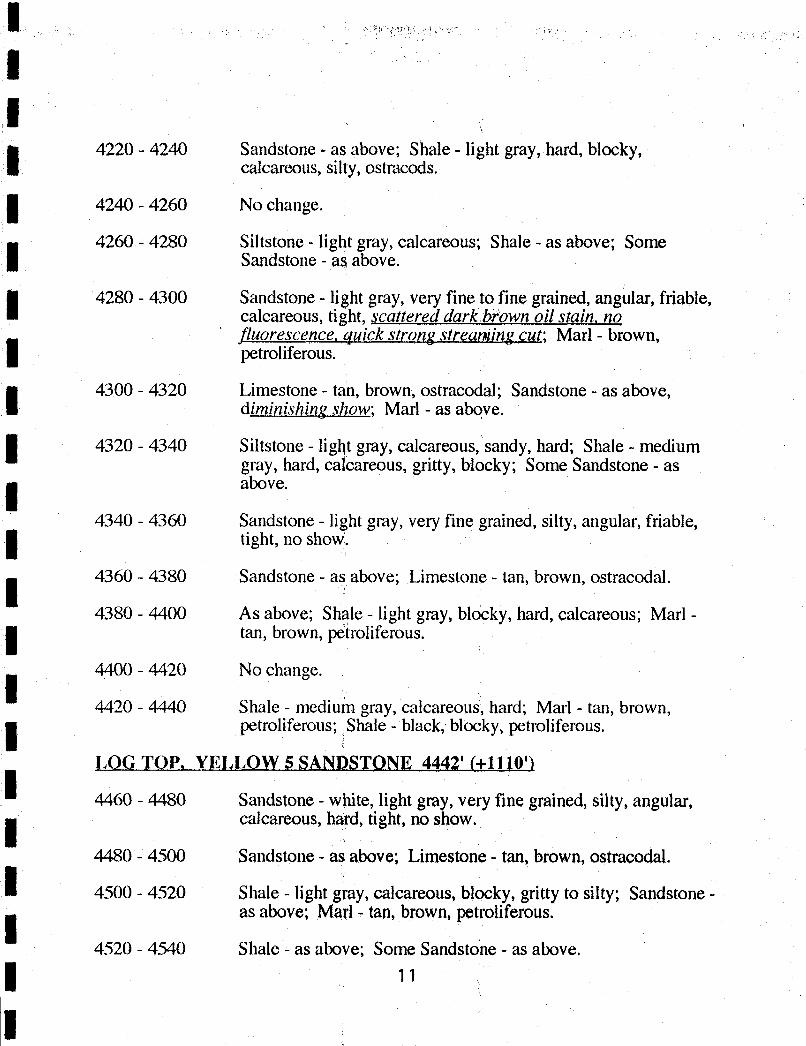
4220 - 4240 Sandstone - as above; Shale - light gray, hard, blocky,calcareous, silty, ostracods.
4240 - 4260 No change.
4260 - 4280 Siltstone - light gray, calcareous; Shale - as above; SomeSandstone - as above.
4280 - 4300 Sandstone - light gray, very fine to fine grained, angular, friable,calcareous, tight, scattered darkkown oil stain, nofluorescence,quick strong strearning cut; Marl - brown,petroliferous,
i 4300 - 4320 Limestone - tan, brown, ostracodal; Sandstone - as above,diminishing show; Marl - as above.
4320 - 4340 Siltstone - light gray, calcareous, sandy, hard; Shale - mediumgray, hard, cabareous, gritty, blocky; Some Sandstone - asabove.
4340 - 4360 Sandstone - light gray, very fine grained, silty, angular, friable,tight, no show.
4360 - 4380 Sandstone - as above; Limestone - tan, brown, ostracodal.
4380 - 4400 As above; Shale - light gmy, blocky, hard, calcareous; Marl -
tan, brown, petroliferous.
4400 - 4420 No change.
4420 - 4440 Shale - medium gray, calcareous, hard; Marl - tan, brown,petroliferous; Shale - black, blocky, petroliferous.
LOG TOP, YELLOW 5 SANDSTONE 4442' (+1110')
4460 - 4480 Sandstone - white, light gray, very fine grained, silty, angular,calcareous, hard, tight, no show.
4480 - 4500 Sandstone - as above; Limestone- tan, brown, ostracodal.
4500 - 4520 Shale - light g ay, calcareous, blocky, gritty to silty; Sandstone -
as above; Mail - tan, brown, petroliferous.
4520 - 4540 Shale - as above; Some Sandstone - as

I
iLOG TOP, VELLOW MARKER 4539' (+1013')
4540 - 4560 As above; Shale - black, blocky, petroliferous; Limestone - tan,fragmental.
4560 - 4580 Shale - light gray, hard, calcareous, blocky; Siltstone - light gray,calcareous, sandy; Some Shale - black, blocky.
4580 - 4600 Sandstone - light gray, very fine grained, silty, angular, friable,mostly loose giains; Shale - as before.
4600 - 4620 Shale - light gray, calcareous, hard; blocky.
4620 - 4640 As above; Limestone - tan, ostracodal.
4640 - 4660 As above; Limestone has spots of brown oil stain, faint goldenfluorescence, slow streaming cut.
4660 - 4680 Shale - light gray, calcareous, blocky, hard; Siltstone - light gray,calcareous, sandy.
4680 - 4700 No change.
LOG TOP, DOUGLAS ÇREEK 4698' (+854')
4700 - 4720 No change.
4720 - 4740 Shale - as abov ; Marl - brown, troliferous.
4740 - 4760 Sandstone - mostly loose quarty grains,very finetofine,silty, gfaintgoldenfluorescence, slow milkycut; slight light brown ioil stain; Shale - as above; Liméstone - tan, brown, micritic.
4760 - 4780 Decrease in Sandstone.
LOG TOP, RED 2 SANDSTOÑ&4778' (+774)4780 - 4800 As above, no show.
4800 - 4820 Shale - light grdy, calcareous, hard, blocky, gritty; Siltstone-
light gray, calcareous, sandy.
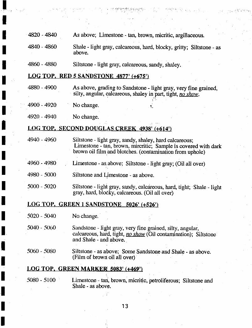
4820 - 4840 As above; Limestone - tan, brown, micritic, argillaceous.
4840 - 4860 Shale - light gray, calcareous, hard, blocky, gritty; Siltstone - asabove.
4860 - 4880 Siltstone - light gray, calcareous, sandy, shaley.
LOGTOP, RED 5 SANDSTOlNE 487T (+675')
4880 - 4900 As above, grading to Sandstone - light gray, very fine grained,silty, angular, calcareous, shaley in part, tight, no show.
4900 - 4920 No change.
4920 - 4940 No change.
LOG TOP, SECOND DOUGLAS CREEK 4930(+614')
4940 - 4960 Siltstone - light gray, sandy, shaley, hard calcareous;Limestone - tan, brown, mircritic; Sample is covered with darkbrown oil film and blotches. (contaminationfrom uphole)
4960 - 4980 Limestone - as above; Siltstone - light gray; (Oil all over)
4980 - 5000 Siltstone and Limestone- as above.
5000 - 5020 Siltstone - lighi gray, sandy, calcèreous, hard, tight; Shale - lightgray, hard, blooky, calcareous. (Oil all over)
LOG TOP, GREEN l SANDSTONE 5026' (+526')
5020 - 5040 No change.
I 5040 - 5060 Sandstone - lig,htgray, very fine grained, silty, angular,calcareous, hafd, tight, no show (Oil contamination); Siltstoneand Shale - anó above.
5060 - 5080 Siltstone- as above; Some Sandstoneand Shale - as above.(Film of browitoil all over)
LOG TOP, GREEN MARKER 5083' (+469'l
5080 - 5100 Limestone - ta , brown, micritic, þetroliferous;Siltstone andShale - as above.
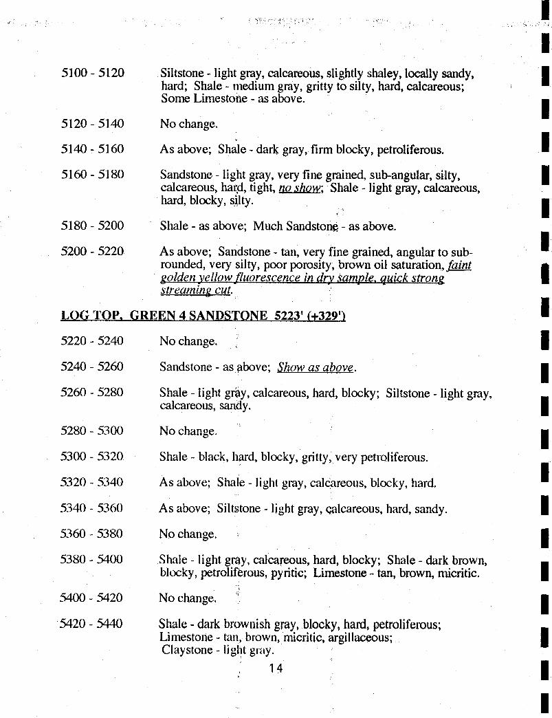
l
5100 - 5120 Siltstone - light gray, calcareous, slightly shaley, locally sandy,hard; Shale - medium gray, gritty to silty, hard, calcareous;Some Limestone - as above.
5120 - 5140 No change.
5140 - 5160 As above; Sh le - dark gray, firm blocky, petroliferous.
5160 - 5180 Sandstone - light gray, very fine grained, sub-angular, silty,calcareous, har,d,tight, no show; Shale - light gray, calcareous,hard, blocky, silty.
5180 - 5200 Shale - as above; Much Sandstoñ¢ - as above.
5200 - 5220 As above; Sandstone - tan, very fine grained, angular to sub-rounded, very silty, poor porosity, brown oil saturation, f_aalggolden yellowfluorescencein dry sample, quick strong istreaming cut.
LOG TOP, GREEN 4 SANDSTONE 5223' (+329')
5220 - 5240 No change.
5240 - 5260 Sandstone - as pbove;Showas above.
5260 - 5280 Shale - light gray, calcareous, hard, blocky; Siltstone - light gray,calcareous, sandy.
5280 - 5300 No change.
5300 - 5320 Shale - black, hard, blocky, gritty, very petroliferous.
5320 - 5340 As above; Shale - light gray, calcareous, blocky, hard.
5340 - 5360 As above; Silt tone - light gray, e lcareous, hard, sandy.
5360 - 5380 No change.
5380 - 5400 Shale - light gray, calcareous, hard, blocky; Shale - dark brown,blocky, petroliforous,pyritic; Limestone - tan, brown, micritic.
5400 - 5420 No change.
5420 - 5440 Shale - dark brownish gray,blocky, hard, petroliferous;Limestone - tan, brown, micritic, argillaceous;Claystone - light gray.
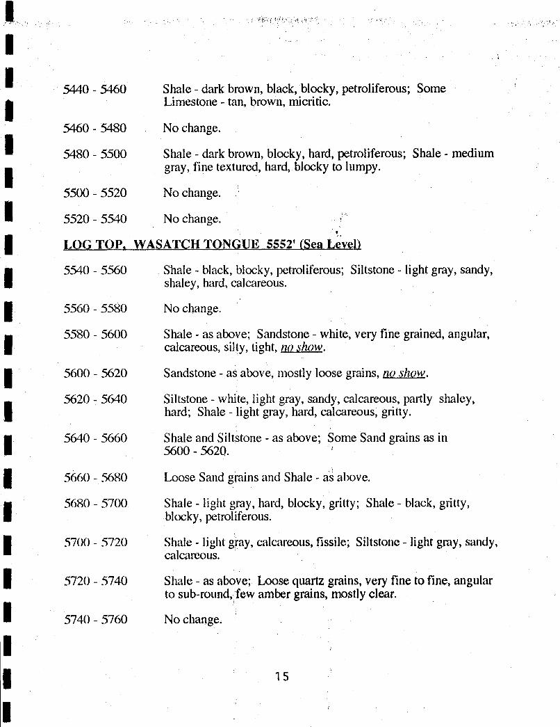
5440 - 5460 Shale - dark brown, black, blocky, petroliferous; SomeLimestone - tan, brown, micritic.
5460 - 5480 No change.
5480 - 5500 Shale - dark brown, blocky, hard, petroliferous; Shale - mediumgray, fine textured, hard, blocky to lumpy.
5500 - 5520 No change.
5520 - 5540 No change.
LOG TOP, WASATÇH TONGUE 5552'ÍSeaL vel)
5540 - 5560 Shale - black, blocky, petroliferous; Siltstone - light gray, sandy,shaley, hard, calcareous.
5560 - 5580 No change.
5580 - 5600 Shale - as above; Sandstone - white, very fine grained, angular,calcareous, silty, tight, no show.
5600 - 5620 Sandstone - as above, mostly loose grains, no show.
5620 - 5640 Siltstone - white, light gray, sandy, calcareous, partly shaley,hard; Shale - light gray, hard, calcareous, gritty.
5640 - 5660 Shale and Siltstone - as above; Some Sand grains as in5600 - 5620.
5660 - 5680 Loose Sand grains and Shale - aÀabove.
5680 - 5700 Shale - light gray, hard, blocky, gritty; Shale - black, gritty,blocky, petroliferous.
I 5700 - 5720 Shale - light gray, calcareous, fissile; Siltstone - light gray, sandy,calcareous.
5720 - 5740 Shale - as above; Loose quartz grains, very fine to fine, angularto sub-round, few amber grains, mostly clear.
5740 - 5760 No change.
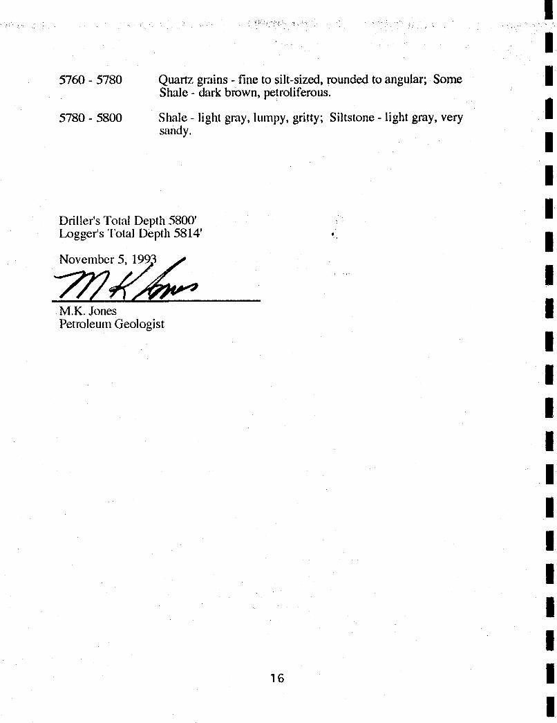
lI
5760 - 5780 Quartzgrains - fine to silt-sized, rounded to angular; SomeShale - dark brown, petroliferous.
5780 - 5800 Shale - light gray, lumpy, gritty; Siltstone - light gray, verysandy. I
IDriller's Total Depth 5800'Logger's Total Depth 5814'
M.K. JonesPetroleum Geologist
iiIiI
iIi
lI
5760 - 5780 Quartzgrains - fine to silt-sized, rounded to angular; SomeShale - dark brown, petroliferous.
5780 - 5800 Shale - light gray, lumpy, gritty; Siltstone - light gray, verysandy. I
IDriller's Total Depth 5800'Logger's Total Depth 5814'
M.K. JonesPetroleum Geologist
iiIiI
iIi
lI
5760 - 5780 Quartzgrains - fine to silt-sized, rounded to angular; SomeShale - dark brown, petroliferous.
5780 - 5800 Shale - light gray, lumpy, gritty; Siltstone - light gray, verysandy. I
IDriller's Total Depth 5800'Logger's Total Depth 5814'
M.K. JonesPetroleum Geologist
iiIiI
iIi
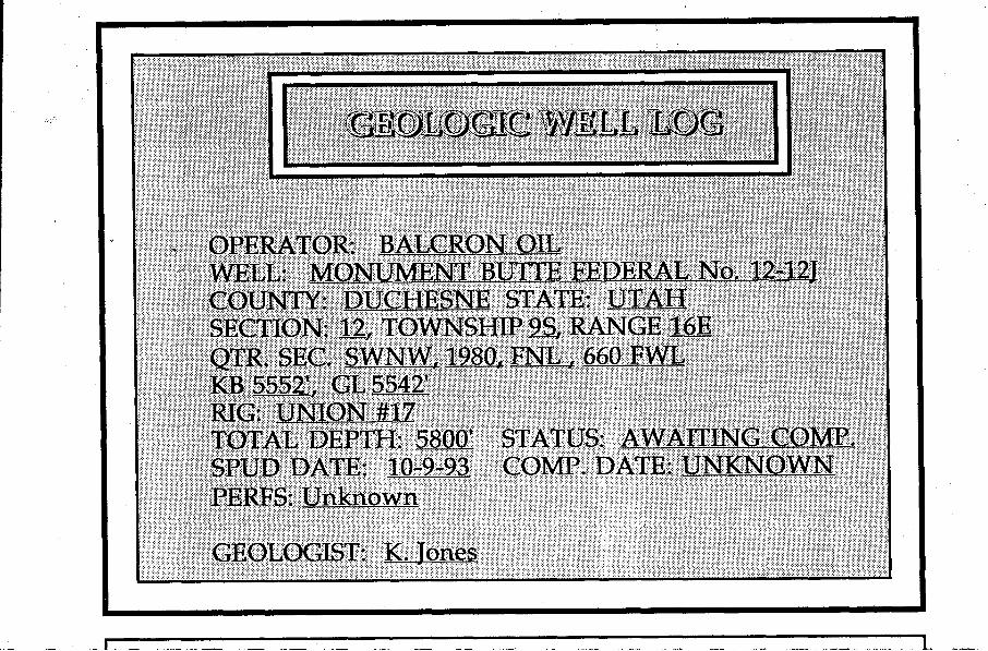
OPERATOR: BALCRON OILWELL: MONUMENT BUTTE FEDERAL No. 12-12JCOUNTY: DUCHESNE STATE: UTAHSECTION: 12, TOWNSHIP 9_S,RANGE 16EQTR, SEC. SWNW, 1980, FNL , 660 FWLKB 5552', GL 5542'RIG: UNION #17TOTAL DEPTH: 5800' STATUS: AWAITING COMP.SPUD DATE: 10-9-93 COMP. DATE: UNKNOWNPERFS: Unknown
GEOLOGIST: K. Jones
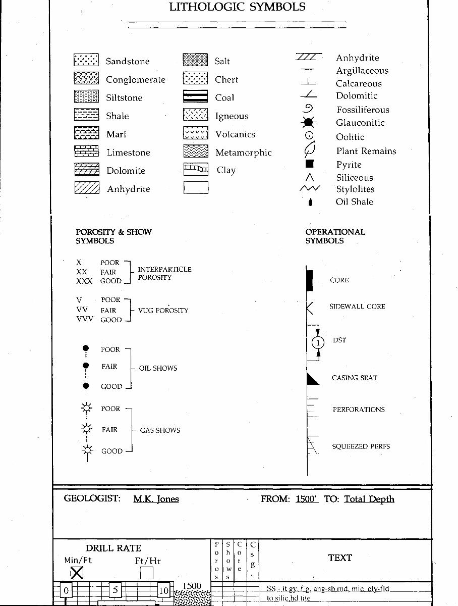
LITHOLOGIC SYMBOLS
..... /// AnhydriteSandstone Salt-- Argillaceous
Conglomerate Chert I Calcareous.....- / DolomiticSiltstone - Coal
FossiliferousShale Igneous
¯¯ GlauconiticMarl Volcanics Oolitic
Limestone Metamorphic PlantRemains
Dolomite Clay E Pyrite/\ Siliceous
Anhydrite M Stylolitesi Oil Shale
POROSITY &cSHOW OPERATIONALSYMBOLS SYMBOLS
X POOR -
XX FAIR _
INTERPARTICLE
XXX GOOD POROSITY CORE
V POOR --
/ SIDEWALL COREVV FAIR - VUG POROSITY \VVV GOOD --
POOR --
1 DST
FAIR- OIL SHOWS
CASING SEAT
POOR --
¯
PERFORATIONS
FAIR - GAS SHOWS
SQUEEZED PERFSGOOD ·-
GEOLOGIST: M.K. Jones FROM: 1500' TO: Total Depth
DRILL RATE F s c C
Min/Ft Ft/Hr

Bit No 1ATT-55A
GREEN RIVER FM 1596'
1600-'.-- - Marl - lt brn. petrol "Oil Shale"
Sh - It gy, bky, hd, slty..L -L
..L J. -L ..a...A. .LJ.A ..L A J. ..i. J.
a .i .i .! I r
- -'Í-' Marl - tn, brn, petrolL .A.
-LA.L
1700LIIIIII
.A. ..L .A. -A. -A. -A. ..
..L ..L ..L -1. ..L ..L..i. ..8. ..L ..L ..L -L -
A. .J. ..L ..L ..L ..LJ. J. -L -i.. .i. -LJ
l 800J. .6 ..L ..L .J. ..L
-i. J. -L -L .L -
I
Marl - bf, tn, brn..L ..L ..L. -L .I.. -L
-A ..L ..L ..L ..L -
J. .i. J. ..L ..L ..L
1900Mari - bf, tn, brn
.L ..I ..I. ..L ..L -L ..
Min/Ft
0 5 102000
.L ..i. ..L ..L ..
.J. A. .a.. ..L ..L
-A. .A. -L. .i. ..L -i. ..
210011 til
-L .A. -L .L .
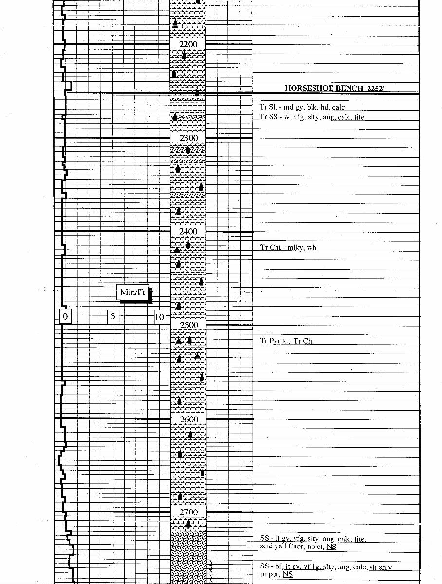
.A. A -L .L .Lwi. .L .A. .A. «L .A.
.J. .A. A .& .A. .a.
111111
2200
..L .L .L -L -L .A..A. ..A. -L -L -I
HORSESHOE BENCH 2252'
Tr Sh - md gy, blk, hd, calcTr SS - w, vfg, slty, ang, calc, tite
3 ()
..L .A. -L ..L a-i. -L -L .J
..L ..L ..A. -L -L .L ----
liitti.I
2400
Tr Cht - mlkv, wh.A. J. .J. .a. -L
..L -L ..L -L .A. -1.
Min/Ft
. |0 5 102500
Tr Pyrite, Tr Cht
2600
-L -L ..L ..&. -L ..L
.A. -2. -L ..L
2700
.J. .J. A ..L ..L .t.
-- $$U"NS$$ SS - lt av. vfe. sitv. ang cale tite- gggg.·2g sctd yeÏlfluor,
nát,¯
.·-. x i SS - bf. It ev. vf-fs sltv ano cale sti shlv---- pr por,
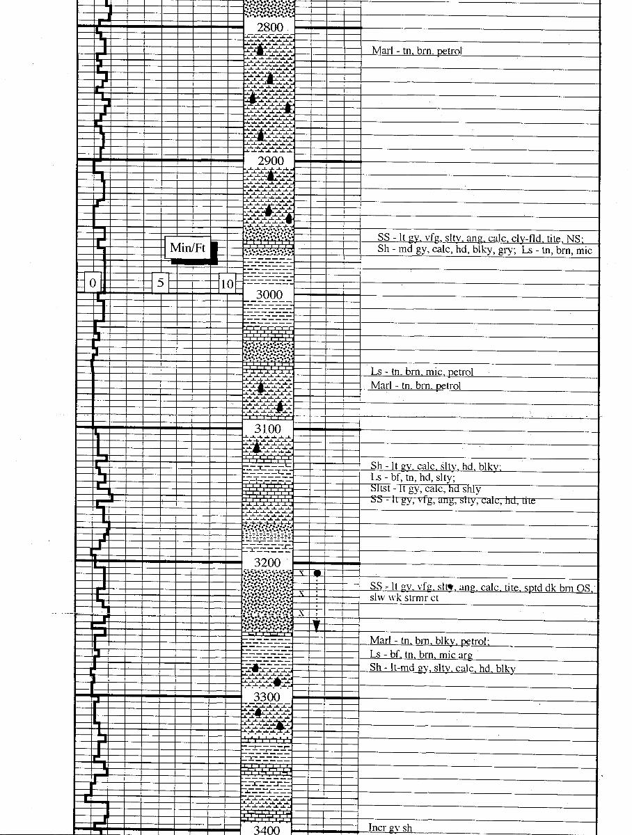
2800
Marl - tn, brn, petrol
2900
SS - It gv, vfg, sltv, ang, calc, clv-fld, tite, NS:Min/Ft s............... - -- Sh - md gy, calc, hd, blky, gry; Ls - tn, brn, mic
0 5 10¯
3000
Ili li ti
Ls - tn, brn, mic, petrol-' Marl - tn, brn, petrol..L .A. -L -L -
3100
-_ ---
_
Sh - lt gy, calc, slty, hd, blky;--_-- _--_- Ls - bf, tn, hd, slty;
Sltst - It gy, calc, hd shlySS - It gy, vfg, ang, slty, cale, hd, tite
3200
SS - lt gv, vfg, sltw, ang. calc. tite. sptd dk brn OSslw wk strmr et
-- - Marl - tn, brn, blky, petrol:-- --- Ls - bf, tn, brn, mic arg
-¯ --¯¯-
Sh - It-md gv, slty. calc. hd. blky
3300.A. .L -2. ..A. -L -L .
!! 111
..A. .$...A..L .-- --- ---- ---
J. ..L -A. ..L
..L .L -L J. .J
IIlllll
3400 Incr av

| I I i 1 °¯.7 " ·¯ ·¯
-.--r---
Min/Ft -¯-T~-2------- Ls - tn, brn, frag, mic, arg
0 5 103500
--.:..:...:...:.....-.:... -- - SS - lt gy, vf g, slty, ang, cale, tite, NS
Sh - It gy, calc, hd, blkv, artv-sltv
SS - lt gy, tn, vfg, slty, ang, fn, calc, tite,. sptv brn stn, strmg et
- - 3700
Ls - tn, brn, mic;-r---- Sh - md gy, calc, hd, blky
- 3800
Sltst - lt av. vv sdv. calc. hd
900 SECOND GARDEN GULCH 3905'
Ls - tn, brn, mic, hd;Sh - md gy, hd, blky, calc|
-2-2-- - - SS - lt gy, vfg, slty, ang, calc, prtly shly, tite, N_S
io
i r
Depth Scale Change5" = 100'
Min/Ft
0 5 104000
Sh - It gv, calc, blky, hd, grty-slty
Ls - tn, mic; Sh - pl gy, pl gn, hd, blky
-enemos SS - It gy, vtg, vy slty, ang, calc, tite, _NS
--¯-----
Sh - md gy, hd, b1ky, slty4100
§§9§§§¯ --------¯-¯
- YELLOW 1 SANDSTÕNË4109'
Marl - brn. hd. petrol:¯ Ls - tn, brn, mic
--- - Sh - lt av. hd. blkv. calc
--r---L- I
UNNNN YELLOW 3 SANDSTONE 4182'
SS - lt gv, tn, vfg, vv sltv ans, calc, tite-vv pr por4200 fw frags, dk brn, no fluor, quick strng
...........:.. strmr et.:..:..:..: : : 3 SS - tn, lt av,vf-fe, sltv, ans, calc, pr
Sh - lt gy, hd, blky, calc, slty, ostracods
-¯-¯-----¯-
Sltst - Itgy , calc
SS - lt gy, vf-fg, ang, fri, calc, tite, setd dk brn O_Sno fluor, quick strng strmr et
¯ Marl - brn, petrol0 Ls - tn, brn, ostracodal
.A. .J..i..J. i.
Sltst - It qv, calc, sdv, hd; Sh - md ev, hd, calc,grty, blky
SS - It gy, vfg, slty, ang, fri, tite, i
Ls - tn, brn, ostracodal
Sh - It qv, blkv, hd, calc; Marl - tn, brn, petrol
4400
I I I
Sh - md gy, calc, hd: Marl - tn, brn, petrol
Sh - blk, blkv, petrol
--
i SS - whl, lt gy, vfg, slty, ang, calc, hd, tite, NS

Ft
0 5 10 Ls - tn, brn, ostracodal4500
Sh - It gy, calc, b1ky, grty-slty:Marl - tn, brn, petrol
Ls - tn, frag- - Sh - blk, blkv, petrol
YELLOW MARKER 4539'
Sh - It gv, hd, cale, biky; Sitst - It.
SS - It gv, vf-fe, fri. mstlv 1sc ens
- 4600--------¯ --
Sh - It gv, calc, hd, blky
----- -- --- Ls - tn, ostracods, spty brn O__Sì,fnt gld fluor,slw strmr ct
- - - I I
-¯
Sh - It av, calc, blkv, hd:-¯
- --- Sltst - li gy, calc, say
‡ï‡ï‡ï‡ï‡ï‡ï DOUGLAS CREEK 4698'
IIIIIII
Marl - brn, petrol
SS - mstlv lse ans, vf-fe, sltv, fnt eld fluor,milky ct, sli lt 6rnstn
I I I
Ls - tn. brn. mic
RED 2 SANDSTONE 4778'
4800÷:÷:÷z÷z÷z÷ Ls - tn, brn, mic, are
... L L.
Sh - It gv, calc, hd, biky, grty;Sltst - lt gy, calc, sdy
Sltst - lt gy, calc, sdy, shly
RED 5 SANDSTONE 4877'
SS - It gv, vf-fy, vv sltv, ang. cale, shlv in pt,tite, N__S
Ls - tn, brn, mic
SECOND DOUGLAS CREEK 4938'Sitst - lt gv, sdv, shiv, hd, cale
Oil on pits, all over samples, N_Sm
Min/Ft
0 5 105000
--- - Sltst - It av, sdv calc hd: Sh - It ev. hd blkv
-1-3-1-2¯
GREEN 1 SANDSTONE 5024'
-'--, SS - lt gy, vfy, slty, ang, cale, hd, tite, B
i‡ï‡i‡ï‡ï‡ï‡ GREEN MARKER 5083'Illlll
Ls - tn, bra, mic, petrol
5100
Sltst - lt gy, calc, sli shly, Icly sdy, hd;-------- Sh - md gy, grty-slty, hd, calc
Sh - dk gy, frm, blkv, petrol
SS - It gy, vfg, sb-ang, slty, calc, hd, tite, _N_S
¯¯-¯5¯-
Sh - lt gy, calc, hd, slty, 61ky
-
¯-
I
5200SS - tn, vfg, ang-sb rnd, vy slty, pr por,brn OS ,
fnt gld yel fluor, quick strag strmr
999995xGREEN 4 SANDSTONE 5223'
Sh - lt gy, calc, hd, blky; S1tst - It gy, calc, sdy
5300
Sh - blk, hd, blky, arty,vy petrol
i i i---¯r¯ -¯-¯ Sh - lt gy, calc, hd, sdv
l I -
+---¯--
---
¯ Sh - dk brn, blky, petrol, py
Sh - lt gy, calc, hd, blky
5400
Sh - dk brnsh gy, blky, hd, petrol
-- Ls - tn, brn, mic, arg: Clyst - lt gy
--i Sh - dk bra, b1k,'blky,
-w--.........
Min/Ft¯¯
¯¯-¯¯g Sh - dk brn, blkv, petrol
0 5 10---
··¯
¯¯ Sh - md gy, fn txt, hd, blky-lmpy
5500
S1tst - It av, sdv, shlv, hd, calc
¯¯-
- Sh - blk, blkv, petrol-I- -3- - WASATCH TONGUE 5552'
..·. SS - wh, vfg, ang, calc, sltv, tite, NSI .
i : -:: - :
5600
mstly lse gns
a
--- -- Sltst - wh, It gy, sdy, calc, prtly shly, hd
¯ ¯ Sh - lt av, hd, calc, grty
- - - Sh - lt gy, hd, blky, grty
¯-¯-- ¯-¯
- -- Sh - blk, grty, blky, petrol
. ... ..L -
570 0
S1tst - It gy, sdy, calc; Sh - It gy, calc,
Lse qtz ens, vf-f, ang-sb rnd, fw ambr ens
I
I
tz ans, vf-slt szd, rnd-ane
¯¯¯¯¯¯¯¯
Sh - lt gv, Impy, grtv
Sltst - lt gy, vy sdy
DRILLER'S DEPTH 5800'LOGGER'S DEPTH
Lse qtz ens, vf-f, ang-sb rnd, fw ambr ens
I
I
tz ans, vf-slt szd, rnd-ane
¯¯¯¯¯¯¯¯
Sh - lt gv, Impy, grtv
Sltst - lt gy, vy sdy
DRILLER'S DEPTH 5800'LOGGER'S DEPTH
Lse qtz ens, vf-f, ang-sb rnd, fw ambr ens
I
I
tz ans, vf-slt szd, rnd-ane
¯¯¯¯¯¯¯¯
Sh - lt gv, Impy, grtv
Sltst - lt gy, vy sdy
DRILLER'S DEPTH 5800'LOGGER'S DEPTH
DATE: 11/8/93
**JONAR UNIT PARTNERS' DAILY REPORT**
BALCRON MONUMENTFEDERAL.#12-12J Operator: EREC/BaloronBOD WII 79.78%Location: BW NW Bootion 12, T98, RißE---TIGHT ROLE--- Duchesne county, UtahProspect: Jonah Unit / Nontment Butte
11-6-93 TD: 5,800' (0') Day 7Formation: Green RiverPresent operation: RDMOFinish TOH, RU Halliburton logging & log well. TIH & LO drill piþe &collars. RU casers & run 5-1/2" esq. Ciro, cmt by Halliburton. Setslips, ND BOP, & clean mud tanks. Csq as follows:Guide Shoe
.60'
1 jt 5-1/2" shoe jt 43.19'Float collar 1.10'132 jts 5-1/2" 15.5#, K-55 5723.70'Land jt 9.007Csg set 8 5777.59'PBTD - 5732', 20 centralizers.Omt by Halliburton w/220 sxs Hyfill & tail w/290 exs 50-50 POZ. Plugdown 0 1:30 a.m. 11-6-93. Rig released 0 5:30 a.m. 11-6-93.Dc: $64,054 CC: $170,039
BALCRON.MONUMENT FEDERAL #42-1J Operator: BREC/BaloronBOD WI: 19.78%Location: SE NE Section 1, T9s, 168---TIGHT HOLE--- Duchesne County, UtahProspect: Jonah Unit / Montment ButtePTD: 5,850' Green River Cil - Dav.
10-11/18-93 Building location.10-19-93 MIRU Leon Ross & start surface hole.10-20-93 Leon Ross broke down.
10-21-93 Finish surface hole.DC: $18,796 CC: $18,796
10-22-93 Ran surface esg & cmt by Dowell as follows:Guide shoe
.65'
1 jt 8-5/8" 24# shoe jt 44.65'Baffel plate ------
7 Jts 8-5/8" 24#, J-55 cag 314.107Rubber top plug 359.40' ICsq set © 356' GLUnion Drilling KB (107) 366' KB, 3 centralizers.Omt w/180 sxs "G" w/2% CCl & 1/4#|sx celof1ake. 5 bbis cmt back topit. Plug down @ 1 p.m. on 10-22-93.DC: $11,622 CC:

iiIiIi WELL SITE GEOLOGY
WELL LOGGINGCONSULTING
IiIiIi Final Reporti
BALCRON OIL
I BALCRON MONUMENTFEDERAL #12-12-J(SW/NW) SECTION 12, T9S, R16E
DUCHESNE COUNTY, UTAH
Ii
2913 HERMOSA CT.. GRAND JUNCTION, COLORADO81504 . (303)
iiIiIi WELL SITE GEOLOGY
WELL LOGGINGCONSULTING
IiIiIi Final Reporti
BALCRON OIL
I BALCRON MONUMENTFEDERAL #12-12-J(SW/NW) SECTION 12, T9S, R16E
DUCHESNE COUNTY, UTAH
Ii
2913 HERMOSA CT.. GRAND JUNCTION, COLORADO81504 . (303)
iiIiIi WELL SITE GEOLOGY
WELL LOGGINGCONSULTING
IiIiIi Final Reporti
BALCRON OIL
I BALCRON MONUMENTFEDERAL #12-12-J(SW/NW) SECTION 12, T9S, R16E
DUCHESNE COUNTY, UTAH
Ii
2913 HERMOSA CT.. GRAND JUNCTION, COLORADO81504 . (303)
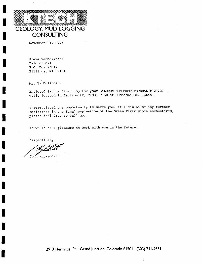
GEOLOGY, MUD LOGGINGCONSULTING
November 11, 1993
ii Steve VanDelinder
Balcron OilP.O. Box 21017Billings, MT 59104
Mr. VanDelinder:
Enclosed is the final log for your BALCRON MONUMENT FEDERAL #12-12J
well, located in Section 12, T195, R16E of Duchesne Co., Utah.
I I appreciated the opportunity to serve you. If I can be of any furtherassistance in the final evaluation of the Green River sands encountered,please feel free to call me.
I It would be a pleasure to work with you in the future.
Jo Kuykendall
IiIiIi
2913 Hermosa Ct. · Grand Junction,Colorado 81504 · (303)
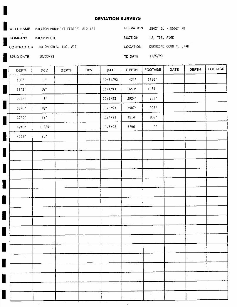
IIDEVIATION SURVEYS
WELL NAME BALCRONMONUMENTFEDERAL#12-12J ELEVATION 5542' GL - 5552' KB
COMPANY BALCRONOIL SECTION 12, T95, R16E
CONTRACTOR UNION DRLG. INC. #17 LOCATION DUCHESNECOUNTY, UTAH
SPUD DATE 10/30/93 TD DATE 11/5/93
DEPTH DEV. DEPTH DEV. DATE DEPTH FOOTAGE DATE DEPTH FOOTAGE
1807' 1° 10/31/93 424' 1226'
2243' 1%° 11/1/93 1650' 1274'
2743' 3° 11/2/93 2924' 983'
3240' l½° 11/3/93 3907' 907'
3740' 2½° 11/4/93 4814' 982'
4240' l 3/4 11/5/93 5796' 4'
4752' 24°
lIliIIIIIIIIIIi

IBIT RECORD
WELL NAME BALCRONMONUMENTFEDERAL#12-12J ELEVATION 5542' GL - 5552' KB
COMPANY BALCRONOIL SECT10N 12, T95, R16E
CONTRACTOR UNIONDRLG. INC. #17 LOCATION DUCHESNECOUNTY, UTAH
SPUD DATE 10/30/93 TD DATE 11/5/93
BIT # SIZE MAKE TYPE DEPTH IN DEPTH OUT FOOTAGE HOURS FT/HR
NB #1 7 7/8" HTC ATJ-55A 276' 5800' 5524' 80.00 69.1
iI
iI
iI
iIi
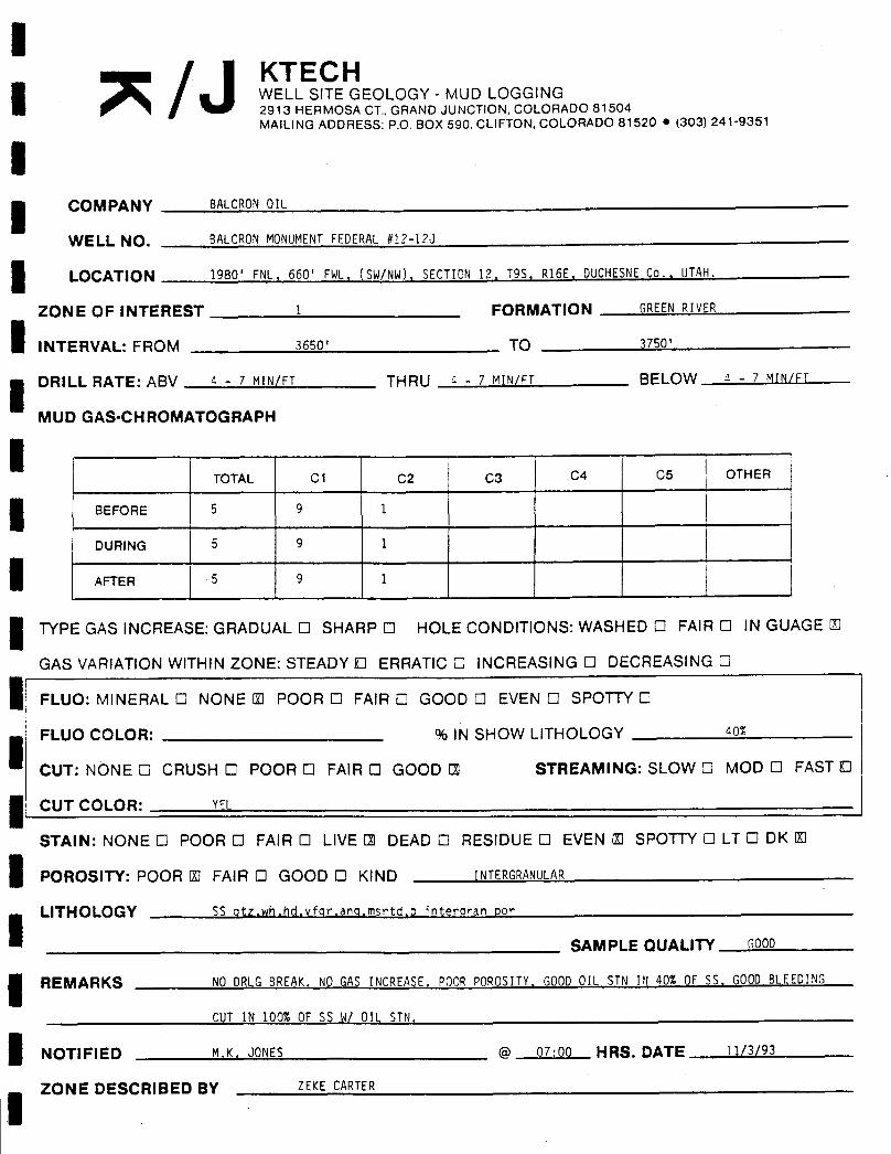
l/ KTECH
I WELL SITE GEOLOGY - MUD LOGGING2913 HERMOSA CT., GRAND JUNCTION, COLORADO 81504MAILINGADDRESS: P.O. BOX 590. CLIFTON, COLORADO 81520 • (303) 241-9351
ICOMPANY BALCRONOIL
WELL NO. BALCRONMONUMENTFEDERAL #12-12J
1OCATION 1980' FNL, 660' FWL, (SW/NW), SECTION 12. T95. R16E. DUCHESNECo., UTAH.
ZONE OF INTEREST 1 FORMATION GREENRIvER
INTERVAL: FROM 3650' TO 3750'
DRILL RATE: ABV 4 - 7 MIN/FT THRU a - 7 MIN/FT BELOW s - 7 MIN/FT
MUD GAS-CHROMATOGRAPH
TOTAL C1 C2 C3 C4 C5 OTHER
BEFORE 5 9 1
DURING 5 9 1
AFTER 5 9 1
TYPE GAS INCREASE: GRADUAL O SHARP O HOLE CONDITIONS: WASHED O FAIR O IN GUAGE U
GAS VARIATIONWITHIN ZONE: STEADY D ERRATIC O INCREASING O DECREASING O
FLUO: MINERAL O NONE U POOR O FAIR O GOOD O EVEN O SPOTTY O
FLUO COLOR: % IN SHOW LITHOLOGY so%
CUT: NONE O CRUSH O POOR O FAIR O GOOD ΠSTREAMING: SLOW O MOD O FAST O
CUT COLOR: YEL
STAIN: NONE O POOR O FAIR O LIVE E DEAD O RESIDUE O EVEN U SPOTTY O LT O DK U
POROSITY: POOR U FAIR O GOOD O KIND INTERGRANULAR
LITHOLOGY SS atz,wh,hd,vfgr,ang,msetd,p interoran por
SAMPLE QUALITY GOOD
REMARKS NO DRLGBREAK. NO GAS INCREASE. POOR POROSITY, GOODOIL STN IN 40% OF 55, GOODBLEEDING
CUT IN 100% OF SS W/ OIL STN.
NOTIFIED M.K. JONES @ 07:00 HRS. DATE 11/3/93
ZONE DESCRIBED BY ZEKE
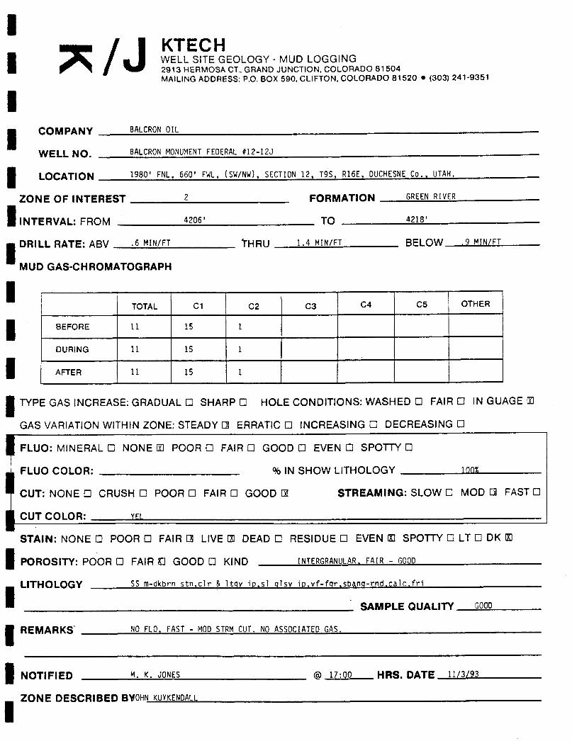
IJ/ KTECH
I WELL SITE GEOLOGY - MUD LOGGING2913 HERMOSA CT., GRAND JUNCTlON, COLORADO 81504MAILINGADDRESS: P.O. BOX 590, CLIFTON, COLORADO 81520 • (303) 241-9351
ICOMPANY BALCRONOIL
WELL NO. BALCRONMONUMENTFEDERAL#12-12J
LOCATION 1980' FNL, 660' FWL, (SW/NW), SECTION12, T9S, R16E, DUCHESNECo., UTAH.
ZONE OF INTEREST 2 FORMATION GREENRIVER
INTERVAL: FROM 4206' TO 4218'
DRILL RATE: ABV .6 MIN/FT THRU 1.4 MIN/FT BELOW 9 MIN/FT
MUD GAS-CHROMATOGRAPH
TOTAL C1 C2 C3 C4 C5 OTHER
BEFORE 11 15 1
DURING 11 15 1
AFTER 11 15 1
TYPE GAS INCREASE: GRADUAL O SHARP O HOLE CONDITIONS: WASHED O FAIR O IN GUAGE U
GAS VARIATION WITHIN ZONE: STEADY O ERRATIC O INCREASING O DECREASING O
FLUO: MINERAL O NONE U POOR O FAIR O GOOD O EVEN O SPOTTY O
FLUO COLOR: % IN SHOW LITHOLOGY 100%
CUT: NONE O CRUSH O POOR O FAIR O GOOD E STREAMING: SLOW O MOD O FAST O
CUT COLOR: YFI
STAIN: NONE O POOR O FAIR O LIVE ΠDEAD O RESIDUE O EVEN U SPOTTY O LT O DK U
POROSITY: POOR O FAIR O GOOD O KIND INTERGRANULAR,FAIR - GOOD
LITHOLOGY SS m-dkbrn stnic1r & 1tqy ip,s] qlsv io,vf-for,sbang-rnd,calc,fri
SAMPLE QUALITY GOOD
REMARKS' NO FLO, FAST - MODSTRMCUT. NO ASSOCIATEDGAS.
NOTIFIED M. K. JONES @ 17:00 HRS. DATE 11/3/93
ZONE DESCRIBED SVOHN
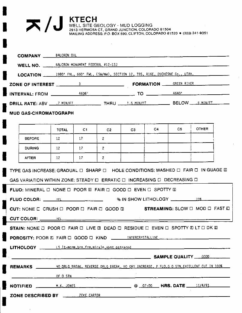
lJ/ KTECH
I WELL SITE GEOLOGY - MUD LOGGING2913 HERMOSA CT., GRAND JUNCTION, COLORADO 81504MA1LING ADDRESS: P.O. BOX 590, CLIFTON, COLORADO 81520 • (303) 241-9351
ICOMPANY BALCRONOIL
WFI i NO BALcRON MONUMENTFEDERAL#12-123
I OCATION 1980' FNL, 660' FWL, (SW/NW), SECTION 12, T95, R16E, DUCHESNECo., UTAH.
ZONE OF INTEREST 3 FORMATION GREENRIVER
INTERVAL: FROM 4636' TO 4640'
i DRILL RATE: ABV .7 MIN/FT THRU 1.5 MIN/FT BELOW 6 MIN/FT
MUD GAS-CHROMATOGRAPH
ITOTAL C1 C2 C3 C4 C5 OTHER
BEFORE 12 17 2
RERNG 12 1177 2
TYPE GAS INCREASE: GRADUAL O SHARP O HOLE CONDITIONS: WASHED O FAIR O IN GUAGE O
GAS VARIATIONWITHIN ZONE: STEADY D ERRATIC O INCREASING O DECREASING O
FLUO: MINERAL O NONE O POOR U FAIR O GOOD O EVEN O SPOTTY U
FLUO COLOR: vr! % IN SHOW LITHOLOGY any
i CUT: NONE C CRUSH O POOR O FAIR O GOOD E STREAMING: SLOW O MOD O FAST D
CUT CO1OR: vri
STAIN: NONE O POOR O FAIR O LIVE Ð DEAD O RESIDUE O EVEN O SPOTTY 00 LT O DK U
POROSITY: POOR U FAIR O GOOD O KIND INTERCRYSTALLINE
LITHOLOGY LS lt-merm,brn,frm,micx1n,abnt ostracod
SAMPLE QUALITY GOOD
REMARKS NODRLGBREAK,REVERSEDRLGBREAK,NO GAS INCREASE, P FLO,G 0 STN,EXCELLENTCUT IN 100%
OF 0 STN
NOTIFIED M.K, JONES @ 07:00 HRS. DATE 11/4/93
ZONE DESCRIBED BY ZEKE

IJ/ KTECH
I WELL SITE GEOLOGY - MUD LOGGING2913 HERMOSA CT., GRAND JUNCTION, COLORADO 81504MAILINGADDRESS: P.O. BOX 590, CLIFTON, COLORADO 81520 • (303) 241-9351
ICOMPANY BALCRONOIL
WELL NO,, BALCRONMONUMENTFEDERAL #12-12J
I OCATION 1980' FNL, 660' FWL, (SW/NW), SECTION 12. T9S. R16E, DUCHESNECo., UTAH.
ZONE OF INTEREST 5 FORMATION GREENRlvER
INTERVAL: FROM 4738' TO 4745'
DRILL RATE: ABV 1,0 MIN/FT THRU 7 MIN/FT BELOW ) 5 MIN/FT
MUD GAS-CHROMATOGRAPH
TOTAL C1 C2 C3 C4 C5 OTHER
BEFORE 14 13 2
G 2
TYPE GAS INCREASE: GRADUAL O SHARP O HOLE CONDITIONS: WASHED O FAIR O IN GUAGE O
GAS VARIATIONWITHIN ZONE: STEADY U ERRATIC O INCREASING O DECREASING O
FLUO: MINERAL O NONE O POOR O FAIR O GOOD 0 EVEN O SPOTTY O
FLUO COLOR: VOULLYEL % IN SHOW LITHOLOGY 50%
CUT: NONE O CRUSH O POOR O FAIR Ð GOOD O STREAMING: SLOW U MOD O FAST O
CUT COLOR: YFl
STAIN: NONE O POOR O FAIR Ð LIVE U DEAD O RESIDUE O EVEN 10 SPOTTY O LT D DK O
POROSITY: POOR O FAIR O GOOD Ð KIND INTFRGRANUIAR
LITHOLOGY SS qty,wh,1tqy,frm,mfri,vfgr sbang msrtd vslty & uncon
i SAMPLE QUALITY GOOD
REMARKS VDUI.\ YFI FI 0, SI OWMtKY CUT
NOTIFIED M, K, J0tiFS @ 07,00 HRS. DATE 11/4/93
ZONE DESCRIBED BY JOHN

i/ KTECH
I WELL SITE GEOLOGY - MUD LOGGING2913 HERMOSA CT., GRAND JUNCTION, COLORADO 81504MAILING ADDRESS: P.O. BOX 590, CLIFTON, COLORADO 81520 • (303) 241-9351
ICOMPANY BALCRONOIL
WFI I N BALCRONMONUMENTFEDERAL #12-12J
IOCATION 1980' FNL, 660' FWL, (SW/NW), SECTION12, T95, R16E, DUCHESNECo., UTAH.
ZONE OF INTEREST 4 FORMATION GREENRIVER
INTERVAL: FROM 5006' TO 5012·
DRILL RATE: ABV 1.3 MIN/FT THRU .6 MIN/FT BELOW 9 MIN/FT
MUD GAS-CHROMATOGRAPH
TOTAL C1 C2 C3 C4 C5 OTHER
BEFORE 17 17 1
DURING 160 65 9 13 2
AFTER 65 22 9 6 2
TYPE GAS INCREASE: GRADUAL O SHARP O HOLE CONDITIONS: WASHED O FAIR O IN GUAGE E
GAS VARIATIONWITHIN ZONE: STEADY O ERRATIC O INCREASING O DECREASING O
FLUO: MINERAL O NONE O POOR O FAIR O GOOD O EVEN O SPOTTY O
FLUO COLOR: % IN SHOW LITHOLOGY
CUT: NONE D CRUSH O POOR O FAIR O GOOD O STREAMING: SLOW O MOD O FAST O
CUT COLOR:
STAIN: NONE U POOR O FAIR O LIVE O DEAD O RESIDUE O EVEN O SPOTTY O LT O DK O
POROSITY: POOR ΠFAIR O GOOD O KIND INTFRGRANillAR
LITHOLOGY SS lt-mov,dkbrn,s] bent io,tr pyr socs.calc,p1ty-b1ky.frm
SAMPLE QUALITY GOOD
REMARKS GASAPPEARSTO BE FROMPRODUCEDZONE, NOTAS MUCHCl & C2 AS EXPECTED.NOOIL FOUNDIN
SAND,ßllT01\ F0llND IN SAMPIF BillKFT & FDIj OWINGSAMPjFS
NOTIFIED M,K, JONFS @ 07;15 HRS. DATE 11/4/93
ZONE DESCRIBED BY JOHN
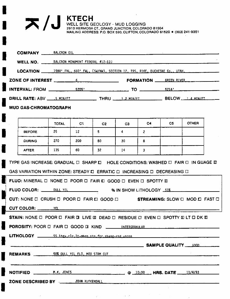
IJ/ KTECH
I WELL SITE GEOLOGY - MUD LOGGING2913 HERMOSA CT., GRAND JUNCTION, COLORADO 81504MAILINGADDRESS: P.O. BOX 590, CLIFTON, COLORADO 81520 e (303) 241-9351
ICOMPANY BALCRONOIL
WELL NO. BALCRONMONUMENTFEDERAL#12-123
LOCATION 1980' FNL, 660' FWL, (SW/NW), SECTION12. T95, R16E. DUCHESNECo , IITAH,
ZONE OF INTEREST 6 FORMATION 6RFFNRTYFP
INTERVAL: FROM 5205' TO SP14'
DRILL RATE: ABV ,5 MIN/FT THRU 1.2 MIN/FT BELOW 1.4 MIN/FT
MUD GAS-CHROMATOGRAPH
TOTAL C1 C2 C3 C4 C5 OTHER
BEFORE 25 12 5 4 2
DURING 270 200 80 30 8
AFTER 135 60 32 14 3
TYPE GAS INCREASE: GRADUAL O SHARP D HOLE CONDITIONS: WASHED O FAIR 0 IN GUAGE U
GAS VARIATIONWITHIN ZONE: STEADY D ERRATICO INCREASING O DECREASING O
FLUO: MINERAL O NONE O POOR O FAIR O GOOD 0 EVEN O SPOTTY U
i FLUO COLOR: DUll YEL % IN SHOW LITHOLOGY 50%
CUT: NONE O CRUSH O POOR O FAIR D GOOD O STREAMING: SLOW O MOD D FAST O
CilT Col OR: YFI
STAIN: NONE O POOR O FAIR O LIVE Ð DEAD O RESIDUE O EVEN O SPOTTY U LT 0 DK U
POROSITY: POOR O FAIR O GOOD O KIND INTFPGPANillAP
LITHOLOGY SS ltav.clr.lt-mbrn etn.far.thann-rnd unrnn
SAMPLE QUALITY noon
REMARKS 50% DULLYEL FLO, MODSTRMCUT
NOTIFIED M.K. JONES @ 10:00 HRS. DATE 11/4/93
ZONE DESCRIBED BY , JOHN

li
KTECHWELL SITE GEOLOGY - MUD LOGGING2913 HERMOSA CT., GRAND JUNCTION, COLORADO 81504MAILINGADDRESS: P.O. BOX 590, CLIFTON, COLORADO 81520 • (303) 241-9351
COMPANY BALCRONOIL
WELL NO. BALCRONMONUMENTFEDERAL#12-12J
LOCATION 1980' FNL, 660' FWL, (SW/NW), SECTION12, T95, R16E, DUCHESNECo., UTAH,
ZONE OF INTEREST 7 FORMATION GREENRIVER
INTERVAL: FROM 5536' TO 5542'
DRILL RATE: ABV 75 MTÑ/FT THRU 14 MIN/FT BELOW .75 MIN/FT
MUD GAS-CHROMATOGRAPH
TOTAL C1 C2 C3 C4 C5 OTHER
BEFORE 55 35 16 8 4
DURING 55 35 16 8 4
AFTER 55 35 16 8 4
TYPE GAS INCREASE: GRADUAL 0 SHARP O HOLE CONDITIONS: WASHED O FAIR 0 IN GUAGE O
GAS VARIATION WITHIN ZONE: STEADY D ERRATICO INCREASING O DECREASING O
FLUO: MINERAL O NONE U POOR O FAIR O GOOD O EVEN O SPOTTY O
FLUO COLOR: % IN SHOW LITHOLOGY
CUT: NONE O CRUSH O POOR O FAIR O GOOD E STREAMING: SLOW O MOD O FAST D
CUT COLOR: GNYFL
STAIN: NONE O POOR O FAIR O LIVE B DEAD 0 RESIDUE O EVEN O SPOTTY O LT 0 DK U
POROSITY: POOR U FAIR O GOOD O KIND INTERGRANULAR
LITHOLOGY St TST qtt,itqy oft,com mica.COM 0 STN N FLO G FAST STRMCUT
SAMPLE QUALITY G99D
REMARKS N 6AS INCRFASF SI DR!6 RATF INCR (HARDFRROCK) Ñ Fl O COM0 STN G CUT
NOTIFIED Mr .inNFS @ 07,00 HRS. DATE 11/5/93
iZONE DESCRIBED BY 7Fy¶

I/ KTECH
I WELL SITE GEOLOGY - MUD LOGGING2913 HERMOSA CT., GRAND JUNCTION, COLORADO 81504MAILINGADDRESS: P.O. BOX 590, CLIFTON, COLORADO 81520 e (303) 241-9351
ii COMPANY BALCRONOIL
WF1 I NO, BALCRONMONUMENTFEDERAL#12-12J
LOCATION 1980' FNL, 660' FWL, (SW/NW), SECTION12, T9S, R16E, DUCHESNECo., UTAH.
ZONE OF INTEREST 8 FORMATION PRFFNRIVFP
INTERVAL: FROM 5562' TO 5566'
DRILL RATE: ABV 1.5 MIN/FT THRU 2 MIN/FT BELOW 1.5 MIN/FT
MUD GAS-CHROMATOGRAPH
TOTAL C1 C2 C3 C4 C5 OTHER
BEFORE 55 35 16 8 4
DURING 55 35 16 8 4
AFTER 55 35 16 8 4
TYPE GAS INCREASE: GRADUAL O SHARP O HOLE CONDITIONS: WASHED 0 FAIR O IN GUAGE O
GAS VARIATIONWITHIN ZONE: STEADY E ERRATICO INCREASING O DECREASING O
FLUO: MINERAL O NONE O POOR O FAIR O GOOD O EVEN O SPOTTY 0
FLUO COLOR: % IN SHOW LITHOLOGY
CUT: NONE O CRUSH 0 POOR 0 FAIR O GOOD U STREAMING: SLOW O MOD 0 FAST D
CilT COI DR: CN YFl
STAIN: NONE O POOR O FAIR O LIVE ΠDEAD O RESIDUE O EVEN O SPOTTY El LT O DK U
POROSITY: POOR O FAIR D GOOD O KIND INTFPrBNillAP
LITHOLOGY SS gt7 wh-1tnvhrn unenn-frm vf-for thrnd m-nsrtd.m slfv.n-f nor.COM 0 STN. N FLO.G MKY
SAMPLE QUALITY 9000
REMARKS N GAS INCREASE,N FLO, P-F POR,COM0 STN, G MKYCUT,
NOTIFIED M,K, JONES @ 07:00 HRS. DATE 11/5/93
ZONE DESCRIBED BY ZEKE

lJ/ ' KTECH
I WELL SITE GEOLOGY - MUD LOGGING2913 HERMOSA CT. GRAND JUNCTION COLORADO 81504MAILINGADDRESS: P.O. BOX 590, CLIFTON, COLORADO 81520 e (303) 241-9351
COMPANY BALCRONOIL
WELL NO. BALCRONMONUMENTFEDERAL#12-123
LOCATION 1980' FNL. 660' FWL. (SW/NW). SECTION12. T9S, R16E. DUCHESNECo., UTAH.
ZONE OF INTEREST 9 FORMATION GREENRIVER
INTERVAL: FROM 5664' TO 5668'
DRILL RATE: ABV l MIN/FT THRU ,75 MIN/FT BELOW l MIN/FT
MUD GAS-CHROMATOGRAPH
I TOTAL C1 C2 C3 C4 C5 OTHER
BEFORE 55 35 16 8 4
D RNG 5555 335 16 88 44
TYPE GAS INCREASE: GRADUAL O SHARP O HOLE CONDITIONS: WASHED 0 FAIR O IN GUAGE O
GAS VARIATIONWITHIN ZONE: STEADY G ERRATIC O INCREASING O DECREASING O
FLUO: MINERAL O NONE O POOR U FAIR O GOOD O EVEN O SPOTTY U
FLUO COLOR: YFi % IN SHOW LITHOLOGY 5%
CUT: NONE O CRUSH O POOR O FAIR G GOOD O STREAMING: SLOW O MOD ΠFAST O
CUT COLOR: GN YFI
STAIN: NONE O POOR 0 FAIR 0 LIVE Ð DEAD 0 RESIDUE O EVEN O SPOTTY U LT 0 DK U
POROSITY: POOR O FAIR 0 GOOD D KIND INTERGRANULAR
LITHOLOGY SS atr whsft vfri fqr Shang m-wsrtd oce mica, q por.0CC 0 STNi OCC YEL FLO, OCC FAIR MOD-
FASTSTPMcilT SAMPLE OUALITY GOOD
REMARKS N GAS INCP 4' 70NF? 6 POR OCCFI 0 OCC0 STN. OCC FAIR CUT
NOTIFIED My anNFS @ GT·00 HRS. DATE 11/5/93
ZONE DESCRIBED BY ZEKECARTER

iJ/ KTECH
I WELL SITE GEOLOGY - MUD LOGGING2913 HERMOSA CT., GRAND JUNCTION, COLORADO 81504MAILING ADDRESS: P.O. BOX 590. CLIFTON, COLORADO 81520 e (303) 241·9351
ICOMPANY BALCRONOIL
WEL 1 NO. BALCRONMONUMENTFEDERAL #12-12J
LOCATION 1980' FNl , 660' FWL, (SW/NW). SECTION12. T95. R16E. DUCHESNECo., UTAH.
ZONE OF INTEREST 10 FORMATION GREENRIVER
INTERVAL: FROM 5734' TO 5750'
DRILL RATE: ABV 75 MIN/FT THRU R MIN/FT BELOW 1 MIN/FT
MUD GAS-CHROMATOGRAPH
TOTAL C1 C2 C3 C4 C5 OTHER
BEFORE 40 25 12 6 4
DURING 40 25 12 6 4
AFTER 40 25 12 6 4
TYPE GAS INCREASE: GRADUAL O SHARP O HOLE CONDITIONS:WASHED O FAIR O IN GUAGE O
GAS VARIATIONWITHIN ZONE: STEADY ΠERRATIC O INCREASING O DECREASING O
FLUO: MINERAL O NONE O POOR O FAIR C GOOD O EVEN O SPOTTY O
NCOONLEORO
CRUS
N YFIPOOR
O FAIR ΠGOO
% IN SHOW L HRE
M NG: SLOW O MOD ΠFAST 0
CUT COI OR: YR
STAIN: NONE O POOR 0 FAIR O L1VEU DEAD 0 RESIDUE O EVEN O SPOTTY O LT 0 DK ©
POROSITY: POOR 0 FAIR O GOOD O KIND INTERGRANULAR
LITHOLOGY SS Atr 1tqy oft vfri vfgr oce for sbrnd,m-psrtd,vs1ty,ardg to s1tst ip,p-f por,COM 0 STN,
nrr GNYFl FI 0 000 FAIR MOD-FASTSTRM CUT SAMPLE QUALITY GOOD
REMARKS N GAS INCPFASF PnOR-FAIR POR SI TY. COMO STN OCC FLO, FAIR CUT
NOTIFIED Mr ,inNFS @ 07·00 HRS. DATE 11/5/93
ZONE DESCRIBED BY 7EKE CARTER
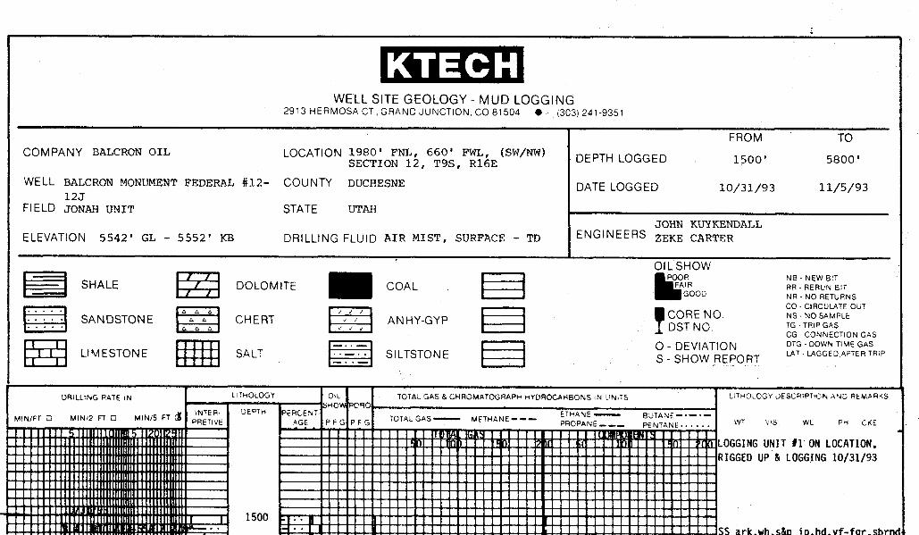
KTECHWELL SITE GEOLOGY - MUD LOGGING
2913 HERMOSA CT, GRAND JUNCTION. CO 81504 e (303) 241-9351
FROM TOCOMPANY BALCRON OIL LOCATION ' FNI 6 F
6E(SW/NW) DEPTH LOGGED 1500' 5800'
WELL BALCRON MONUMENT FEDERAL #12- COUNTY DUCHESNE DATE LOGGED 10/31/93 11/5/9312J
FIELD JONAH UNIT STATE UTAHJOHN KUYKENDALL
ELEVATION 5542' GL - 5552' KB DRILLING FLUID AIR MIST, SURFACE - TD ENGINEERS ZEKE CARTER
SHALE DOLOMITE COALN RE U NS
CO - CIRCULATE OUTCORE NO. NS-NOSAMPLESANDSTONE CHERT ANHY-GYPDST NO. TG -TRIPGASs a
CG-CONNECTIONGAS
LIMESTONE SALT SILTSTONESDHEVIAT
E ORT-
GW DTRRP
DRILLINGRATEIN LlfHOLOGY OL TOTAL GAS & CHROMATOGRAPH HYDROCARBONS iN UN Ts LITHOLOGY DESCRIPTION AND AEMARKS
MIN/FT O MIN/2 FT O MIN/5 FT $ NETER P6RCENTPF PF TOTAL GAS---- METHANE---
P P WT VIS WL PH CKE
LOGGINGUNIT #1 ON LOCATION,RIGGEDUP & LOGGING10/31/93
1500 . ..
•• SR ark wh can in.hd.vf-for
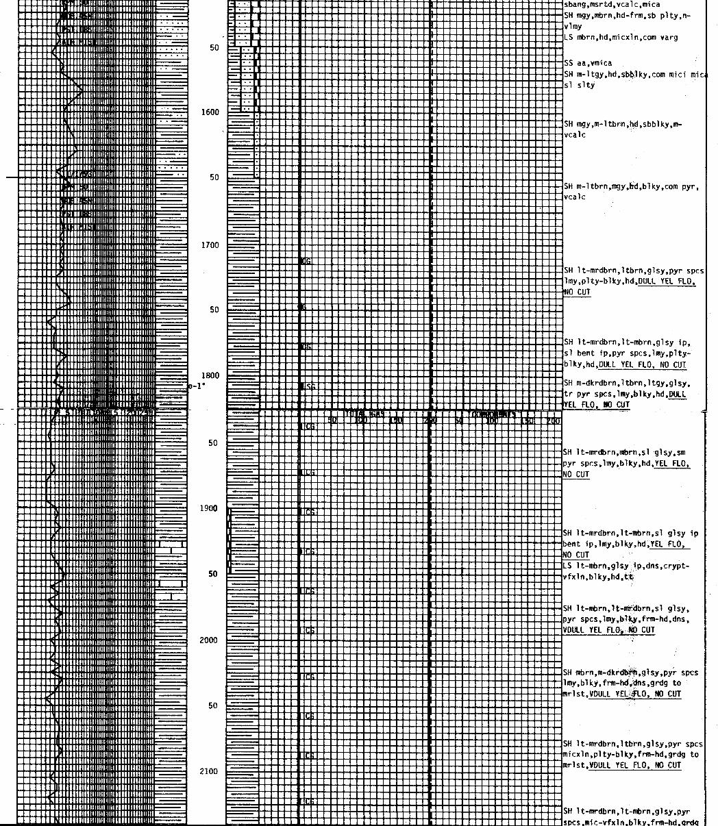
------ sbang,msrtd,vcale,mica- --- SH mgy,mbrn,hd-frm,sb p1ty,n-
vimyLS mbrn,hd,micx1n,com varg
50 -- ..
-- · SS aa,vmicaSH m-ltgy,hd,shbiky,com mici mics1 s1ty
1600.
SH mgy,m-Itbon,bd,sbblky,m-vcalc
--- 50SH m-ltbrn,mgy,68,b1ky,com pyr,
----- ---- vc a lc
------ 1700 -
SH lt-mrdbrn,1tbrn,glsy,pyr spes1my,p1ty-blky.hd,DULL YEL FLO,
------ ------
NO CUT
.. 50m---- ---mmm
------ ------ SH lt-mrdbrn,lt-mbrn,g1sy ip,------ ------ sl bent ip,pyr spcs,1my,plty-...... ...---. b1ky,hd,DULL YEL FLO, NOCUT
1800------
,·¯¯¯¯-
SH m-dkodbrn,1tbrn,1tgy,glsy,.-----
a-1------ tr pyr spcs,1my,blky,hd,DULL
. .. 50 ......
SH 1t-mrdbrn,mbrn,s1 glsy,sa¯¯¯ ^¯¯
pyr spcs,1my,blky,hd,YEL FLO,-"" •¯¯¯ NO CUT
------ 1900
SH lt-mrdbrn,1tumbrn,sl glsy ipbent ip,1my,blky,hd,YEL FLO,
¯¯¯¯
NO CUT---- ------ Ü51t-mbrn,glsy ip,dns,crypt-
. 50 ___. vfx1n,blky,hd,t
SH lt-mbrn,ltad dbrn,s] g1sy,pyr spcs,1my,41 y,frm-hd,dns,
-- --- 2000
¯¯¯¯¯¯ ^¯¯¯¯¯
SH mbrn,m-dkrdh ,glsy,pyi spcs------ ------ 1my,b1ky,frm-hd ns,grdg to
mrlst,VDULL YEL LO, NOCUT.._,__ 50
_....
SH lt-mrdbrn,lth n,glsy,pyr spcsmicxln,plty-blky,frm-hd,grdg to
·~¯¯¯¯ °¯¯¯¯¯
mrlst,VDULL YEL FLO, NOCUT.._.._. ,
2100, ....
SH lt-ordbrn,1t-mbrn,g1sy,pyr
to mrlst,DULL YEL FLO, FAST50 ·¯¯¯¯~
STRMCUT IP
2200
SK lt-mredbrn,ltbrngglsyltr pyrspecs,Tmy,pity-blky,hd,grdg
-----
arlst,V DULYELFLOR,N CUT
o-14°- --
50. . SS lt-m gy,S1 s&p,glsy,vf-fgr
sbang,calc.frm,tt
mmmmmm. •
2300 ------ SH redbrn rngy,bl,hd,sb p1ty,---- v calc,t yr
50 ..... -.
2400 - -
5H redbrn,btngy,bd-frm,biky,v calc
---- -
3CC CHTalkywk,x hd
50 - - - in gybra ed hd,blky,v calc,.----.
>cc pyr, oce aa
2500 "¯¯¯¯¯
iH redbrn,gybrn,bd,blky,v calc------ >cc pyr
50 ------
an.mmumme
m.m.mmmanum
2600 ¯¯¯¯¯¯
SH redbrngy.hd,b1ky,com micmica------ v calc,oc Rygitt carb lam
50 ------
SH dkredbrn,ltbrn,wh,1tgy,hd,b1kysb pitygikalc,rr pyr
2700 ---.. .
. SS qtz,wh,frm,v f gr,sb ang,m----- • srtd,SCAT DULWNFLOR,N CUT
o-3° °¯¯¯¯
50SS qtz,wh,bd il fri,v f gr,sbangsm satd,abut mica,v
. . .
2800 ¯¯¯¯
SH m gy,m red((Ñ,1tbrn,hd,brit---- pity,m calc ko pyr
50
e
2900SH lt gy,m-1tbÑhhd-frm,b1ky,
¯¯¯¯¯
m s1ty,com mica
50
SS c1r,1tgy,s&p,vf-fgr,sbrnd-rnd,calc,fri-frm
3000
SS ltgy,ltbrn,c1r,s&p,g1sy,vf-fgr,sbang-rnd,calc,fri-frm,sìtt
SH mbrn,dkb1gro,pyr spcs,slty50 ip,calc-sil,blky,frm-hd
SH 1t-mbrn,lt dbrn,glsy,tr pyrspcs,calc-1my lgy-blky,frm-hd,grdg to mrlst,YEL FLO, MODSTRM
--
CUT IP3100
------ SH lt-mbrn,m-d dbrn,ltcrm,glsy.. -----. cryptxln ip,( r spcs,calc,
..1my ip,p1ty-blky frm-hd,grdg to
. . . 50 ____ ..
mrlst,VDULL YEL FLO IP, NO CUT.. SS 1tgy,c1r,51 S&p,sl glsy,Vf-
°¯¯¯ fgr,sbang-rnd,cy)c,fri-frm,sl---- tt,TR DULLYEL LO, NOCUT
3200 .
SS clr,1tgy,tr s&p,vf-fgr,sbang-.. .- rnd,calc,fri-frm
50LS wh,mic-vfxln,sndy ip,plty-blky,sft-frmSH m-dkbrn,m-dkrdbrn,glsy,crypt-x1n,p1ty-blky,frm-hd,grdg tomrlst,DULL YEL FLO, NO CUT
3300
SH lt-dk brn,m gy,glsy,cepx1,trpyr spec,calc-lmy,plty-biky,frm-hd,V DUL YEL FLOR,SLOWSTRMCUT50IPLS ltcrm,offwh,sls1ty,crp-vfx1,plty-blky,sft-frm,V DULYEL FLORIP,N
...... Jeuu SH m-lt gy,m-lt brn,1tb1gy,frm,sb blky,sl-m calcLS aa,RR BRI YEL FLOR,G STRMCUT
¯¯¯¯¯
50 LS wh-1tcrmbrn ft-frm,micgran,·¯¯¯¯' micrit,sl arg ,CDMDULWH&ORNG----- FLOR,N CUT
. 3500 .. SLTST qtziwh,fgn
--mm-
e•
m---- e
50 SH dk-1t gy,m-li brn,hd-frm,sbblky-sb plty
3600
. 50 . . . SS qtz,clr,h4 (1 fri,v f gr,angm srtd,occ þyr,ABNT 0 STN,N FLDR
------ G_(Lg(DINg itTip intgran por
ommmmm
3700
55ptt, TP,hd,sT fri,vfgr,ang,-- -- -• • msrtd,occ pyr,ABNT 0 STN, N FLO,
G BLEEDINGCUT
soSH m-1tgy,frm,sft,sb blky,micxlnip,m calcS m-ltcrm,brn,wh,frm-sit,n-sl
arg,micxin,micrit ip,COM DULL3800
..
• WH, FLORN CUT
SS gtz,wh,frm,sì fri,vfgr,ang,------ . . . msrtd,p por .
50 °.
-----• • SH m-1tb1gy,m-Ityy,frm-sft,sb-----. . .
pity,slty ip,m calcLS ltcrm,sl glsy,crypt-micxln,
- · •• - • p1ty-blky,ftm,ÒÙLL YELFLO, NOCUT
¯¯¯¯
3900 .
ÑH lt-mblgrn,slty ip,glsy,calc-lmy,p1ty-biky,frm-hd
. ... 50- SS ltgy,clr,sÍ3sy,vfgr,sbang-
rnd,calc,fri,
SH lt-mgrngy,sl ‡lty,tr pyr,spescalc,p1ty-blky,sft-frm
4000 .. NOTESCALECHANGEFROM2"=100'... TO5"=100'
SH 1tgy.mbrn,sì bent,pyr
...... Jeuu SH m-lt gy,m-lt brn,1tb1gy,frm,sb blky,sl-m calcLS aa,RR BRI YEL FLOR,G STRMCUT
¯¯¯¯¯
50 LS wh-1tcrmbrn ft-frm,micgran,·¯¯¯¯' micrit,sl arg ,CDMDULWH&ORNG----- FLOR,N CUT
. 3500 .. SLTST qtziwh,fgn
--mm-
e•
m---- e
50 SH dk-1t gy,m-li brn,hd-frm,sbblky-sb plty
3600
. 50 . . . SS qtz,clr,h4 (1 fri,v f gr,angm srtd,occ þyr,ABNT 0 STN,N FLDR
------ G_(Lg(DINg itTip intgran por
ommmmm
3700
55ptt, TP,hd,sT fri,vfgr,ang,-- -- -• • msrtd,occ pyr,ABNT 0 STN, N FLO,
G BLEEDINGCUT
soSH m-1tgy,frm,sft,sb blky,micxlnip,m calcS m-ltcrm,brn,wh,frm-sit,n-sl
arg,micxin,micrit ip,COM DULL3800
..
• WH, FLORN CUT
SS gtz,wh,frm,sì fri,vfgr,ang,------ . . . msrtd,p por .
50 °.
-----• • SH m-1tb1gy,m-Ityy,frm-sft,sb
-----. . .pity,slty ip,m calcLS ltcrm,sl glsy,crypt-micxln,
- · •• - • p1ty-blky,ftm,ÒÙLL YELFLO, NOCUT
¯¯¯¯
3900 .
ÑH lt-mblgrn,slty ip,glsy,calc-lmy,p1ty-biky,frm-hd
. ... 50- SS ltgy,clr,sÍ3sy,vfgr,sbang-
rnd,calc,fri,
SH lt-mgrngy,sl ‡lty,tr pyr,spescalc,p1ty-blky,sft-frm
4000 .. NOTESCALECHANGEFROM2"=100'... TO5"=100'
SH 1tgy.mbrn,sì bent,pyr
SS ltgy,c r,si Isy,vÄ-fgr,sbangrnd,calc,fri,s) (t
20
S lt-mrderm,crypt-vfxln,s] g1syip,splnty-b1ky a
40SH ltbrn,ltgy,sl bent,tr pyrspcs,calc,sp1nty-b1ky,frm
LS 1t-mrdcrm,crypt-micxin,p1ty-blky,frm,TR DULLYEL FLO, NO CUT
60 .
SS ltgy,c1r,tr s&p,sl glsy,vf-fgr,sbang-rnd,calc,fri
80 SS ltgy,c1r,tr s&p,s1 glsy,vfgrsbang-rnd,cal ,f i
SH lt-mgrngy,mgÿ s1 bent,tr pyrspcs,calc,pfty blky,frm
4100
SS ltgy,c1r,tr $p,vfgr,ang-sbrnd,cale,fri
20
LS 1t-mrdcrm,¢rypt-micxln,pity-blky,frm,VDULL ŸÉL FLO, NO CUTSH m-dkbrn,mgy,il bent,s1 g1sy,cale-lmy,pity-biky,frm
40
SH mbrn,mgy,tr pyr spcs,s1 bentcalc,p1ty-blky,sit-frm
60
SH lt-mgy,1t-mgrngy,sl bent,calcplty-blky,sft-frm
80
SS 1tgy,clr,mbra stn,s1 glsy,vfgr,sbang-rnd,calc,fri,s1 tt,NOFLO, MODSTRMCUT
4200 .
-2 -
SS m-dkbrn stn.c1r & ltgy ip,s1glsy ip,vf-fgr,sbang-rnd,calc,fri,NO FLO, FAST-MODSTRMCUT
20
SS m-dkbrn stn,c1r & 1tgy ip,vf-fgr,sbang rád,calc,fri,NO_FLOFAST - MODSikM CUT
3- 401 3/4
SH mgy,mgrngyis bent,tr pyr,calc,plty-biky it-frmSS ltgy.cir,1)bgh stn ip,glsy,vf-fge,sbang-rndicalc,fri-frm,si tt,NO FLO,AAST - MODSTRM
60 . "'
¯~~¯ 2. SS ltgy,cfr,gTey,tr s&p,vf-fgr,---- •• sbang-rnd,calc,fti,sì tt
¯¯¯¯¯¯
80 .
.. ... . . SS c1r,ltgy,f-cgr,sbang-rnd,calcfri & uncon
SH m-dkbrn,mgy,bent,s1 slty,calc- • plty-blky,sft-frm
. . . 4300------ SS ltgy,cir,si glsy,vf-fgr,sbang
. .rnd,calc,fri-frm,s] tt
LS lt-mrdcrm,glsy,crypt-micxln.. p1ty-blky,frm
------
20SH lt-mgy,dkben ip,s1 bent,trgyr spcs,calc,spinty-biky,sft-fr i
40. ..
SS c1r,1tgy,vf-fgr,sbang-rd,• · · - -- incons,sl calc,fri
. 60 SS c1r,1tgy,vfefgr,sbrd-rd,cale..... . . fri
80 SH mgy,m-dkbrn,sl bent,pyr specs~¯TT¯ calc,pTty-biky,ftm
..... SS itgy,cir,ltbigstn,gtsy,f-mgrsbang-sbrd,calcifrm,tt,TR YELFLOR,FR FAST STRACUT
.....
4400•¯¯¯¯¯ LS m-ltcrmbrn,frm,brit,micx1
. . . ..
20------ SH m-ltgy,m-ltbrn,frm-sit,m calc
------ SS qtz,wh,frm,vfgr,sbrd,m srtdgrdg SLTST
••- ... 40- SLTST qtz,wh,frm,s1 sdy-v f gr
··-- - sb rd
60 - ... - SS qtz,wh,frm,m fri,v f gr,sb¯~¯¯
_ 1 °. .°
rd,m srtd,v slty
80 ·· .-
SH lt-mgy,m-dkredbra,sft,sbp1tya calc
-----
SH lt-mgy,m-dkredbrn,sft,sbp1tygrdgSLYST,COMhÚL ORNGFLOR,N
.1 CUT,m calc4500 -- • ••
SS Qtz,wh,frm,mfri,vfgr,sbrd,m-- . . srtd,grdgSLTSI
·· ·
SH
miepyr,scat blk specs
40LS wh,ltcrabrn,syt-fpa,)micrit
I-- · crpxl,CDM DULORUGFLOR,N CUTI •
SH dk-ltgy,m-ltermbrn,frm-sit sb-- plty,sltyip,COM DULORNGFLOR
--- N CUT60
SH a-ltgy,1tblgý,sft,sbplty,slty ,
- • ip,com micpyr.oce blk,specam •
80.
4600SS gtz,wh,fna) fri,vfgr,sbrd,
- . a srts,grdgSLT5es
20. . LS 1t-m crmbrn 191: micxl abnt
. ostracod,DUL YÊ FCOR,ABAT0 STN" °
G BLEEDINS&$78 $UT
40- SH m-1tgy,frm,biky-sb p1ty,grdg
SLTST ip,occ pyr,m calc
60 SS qtz,wh,frm à fri,vfgr,sbang,msrtd,grdg SLTŠ¶ÊCom mica,oce pyrm calt
80 - SH m-ltgy,ltblgy,wh,frm-sft,sbplty,grdgSLTST ip,com mica,occpyr,m celt
4700 SS qtz, 1pg m-sit,m fri,vfgsb ang,m s i 1ty,grdgSLTSTcom mica,a (9
20 -- LS 1t-dk crm rm,sl brit,crpx1,dul,sl g ip
I
I
40 - • SS qtz,wh- 4 m,m fri,vfgr,sb. . ang,m srtd,v ,grdgSLTSf,com
ica,m cale stn,VDULL YELo-2½° FLO, SLOWML UT
60 -- SH lt-mgy,m-d N

80
SS qtz,wh-ltgy,ftm,iner pyr,frm,fri,vfgr,sbang,msrtd,vslty,
grdg to sltst,com mica,m calc4800 .
SH m-ltgy,1tblgy,mbrn,frm,b1ky,plty,grdg to sltst ip
20
40SH mgy,mgtngy,81 bent,tr pyr,spcs,calc,plty-biky,frm
SS lt-mgy,clr si s&p,vf-fgr,sbang-sbrnd.calgifri-frm,tt
60..
•• SS ltgy.c1r,sl g)sy,vf- fgr,ang-.. sbrnd,calc,fri i m,tt
80 ..
SH 1t-mgy.mgrngy ip,sT bent,trpyr spcs,calc,plty-blky,frm
4900- SS 1tgy,c1r,glsy,tr arg mtx,vf-
fgr,sbang-rnd,tgic,frm,tt
SH mgy,mgrngy,s1 bent,tr pyr20 ...
spcs,calc,p1ty-b1ky,frm-hd
SS itgy,t1r ip,tr s&p,glsy,vfgrsbang-rnd,calc,fri-frm,tt
40SH 1t-mbrn,mgy,sl bent ip,tr pyrspcs,calc,plty-blky,sft-frm
SS ltgy.c1r,tr s&p,sl g1sy,vfgr,
60sbang-sbrnd,cale,fri-frm,tt
LS lt-mrderm,crypt-micx1n,p1ty-blky,frm-Ad
80 SH m-dkbrn,lt y,bent ip,trpyr spcs,calc, ty-blky,frmSH 1t-mgy,r dk e,bent ip,tr pyrspcs,calc,blty ky,frmSS ltgy.c1r fp sy,yfgr,sbang-rnd,calc,fti-f it
5000.
SS lt-mgy,tr s glsy,vf-fgr,sbang-rnd,cale m,ttOIL IN SAMPLE
49. re-myyeuaurvspasuntra rµgar
20.. pyr spcs,calc,pity-blky,frm
HOLEMAKINGOIL
-- SH lt-mbrn,1toegy,s1 bent ip,tr¯¯¯
pyr spcs,calc,p?ty-blky,frm-hd40 .....
SS ltgy,clr,gtsy,vigr,sbang-rndcalc,frm,tt
60 .
SH mgy,mbrn,sì bent,tr pyr spcscalc,plty-biky,frm-hdSS ltgy.c1r,vf-fgr,sbang-rnd,calc,fri-frm,sì tt
90
.S mrdcrm,cryptneicxln,plty-blkyfrm,grdg to mrlst,DULL YEL FLO,FAST STRM CUTSH dkbrn,mgy sl ent,tr pyr spcscalc,p1ty-blky,frm
5100 .
SS 1tgy,clr,sl 1sy,vfgr,sbang-sbrnd,calc,frf-frm,tt
20 . .. ..
- - - · SS 1t-mgy,glsy,gf-fgr,sbang-sbrnd,calc,frigffm,tt
40 -
SH m-dkbrn,ag i slty ip,sìbent ip,cale ,frm
60
SS 1tgy.clr.lth sin ip,glsy,tr s&p,vf-fgr gbáng-rnd,calc,
- - fri VDULLYEL FÔ0IP POORFAST. : STRMCUTso .
SS ltgy,c1r,tr 1 ben stn,glsy,vf-fgr,sbang-rádicalc,fri,VDULLYEL FLO LÈ,POORMOD-FASTSTRMCUT
5200 --~¯~¯¯¯
SS ltgy,c1r,vf far,sbrnd-rnd,calc,fri,tt,VDULL YEL FLO IP,POORFAST STRR CUT
20 SS ltgy,cle,1t-mbrn stn,fgr,sbang-rnd,uncon,0ULL YEL FLO,MODSTRMCUT
40. SS it-mbrn stn,cir,vf-fgr,sbrad-
rnd,calc,fri,DULL YEL FLO, FAST-
60 SH mgy,mgrngy ip,sì bent,tr pyr

-- ---- SS 1t-mbrn stng Tr,vf-fgr,sbrnd-80 . .. rnd,uncon,VDULL EL FLO, FAIR
FAST STRMCÜT
SH lt-mgy,sT be t,calc,plty-blky----- sft-frm
5300.
SH dk-1tgy,fra ft,plty-sb p1ty,mealc
20 .
SH dk-ltgy,frm it,sb plty,comltgy,slty In,GCú pyr
. 40 . SS wh-1tgy,sft,gfri,vfgr,sbrnd,srtd,grdg to sitst
• t
60 ......
SH lt-dkgy,frm-hd,plty,sl-mcalc,com 1tgy,sity zn
mmmmmm i
80
------ SH It-dkgy,m-1tórm,m-ltbrn,..... . ltb1gy,frm-sft,sh p1ty.oce slty
zn,m calc
5400 ... ....
SH dkgybrn,lt-dkgy,m-ltcrmbrn,¯¯¯¯¯
com pyr,m calc,ABNT O STN, DULL------ GNYELFLO, G FAST STRM CUT
20 .........
----- SH dkgybrn,m-1tcrmbrn,1t-dkgy,------ com pyr,m calc,ABNT 0 STN, DULL
GNYELFLO, G PA T STRMCUT
40•t
SH pred dkgy gy,m-ltermbrn,"----- I frm,sb pity, yr mic lam,
------ m calc•E
-----. ;
60 ....
. . SH aa,0CC CAL BNDW/ 0 STN, GFAST MKYCUTmummmme
i------ -e
80 .............
¯¯¯¯¯¯
SH dk-ltgy,fn pity.com mic------ pyr,COM CALCBNDW/ 0 STN, G
FAST MKYCUTI
5500 ......
.I SLTST qtz,1tgy t,com.mica,COM..mm-m.. ------
0 STN, 11 FLO, 8 AST STRMCUT
---mmm
CU ---m me
ammmo
40 - .
SLTST qtz,ltgy,sft.com mica,CDM
60 . . .
SS qtz,wh-Itgybrn,uncon-frm,vf-fgr,sbrnd,psrtd,m slty,p-f por,
¯¯" COM0 STN,N FLO,G MKYCUT
80 ....
--- SR lt-dkgy,1tc Šrn,frm,sbpity,---- .. abnt mic pyr (gg)
5600 . . . .
SS qtz,wh,sftyvf 1,vf-fgr,msrtd,sl slty,com ràc fair por,0CC0 STN,N FLO,0CC STRMCUT
20SH lt-mgy,dkgib ,sft,sb p1ty,si slty,0cc pýr
--- SS qtz,wh,sft,¾ i,vfgr,sbrnd,.... msrtd,m slty,occ mica,grdg to---. 2. sitst
40 . .. ..
60SS qtz,wh,sft,vfri,fgr,sbang,m-wsrtd,oce mica,g por,0CC 0 STN,OCC YEL FLO, 004 FAIR ÞOD-FASTSTRMCUT
90SH lt-dkgy,dkbrngy,fra,sb pity,
-vslty,occ pyr,COM 0 STN
5700SH lt-mgy,wh,oce dkgybrn,frm-sftsb p1ty-sb blky,sl-vslty,grdgto sltst ip,con pyr
------ SS qtz,1tgy,sft,vfri,vfgr,occ20
_. .. fgr,sbrnd,m-psrtd,vslty,grdg tosltst,p-f por,COM 0 STN, OCCGNYELFLO, DCCFAIR MOD-FAST
40
SH lt-mgy,dkgyb n,com wh & blÑspcs.sb plty,4 ty,grdg to sltst
60 com mic pyr opecom
CU ---m me
ammmo
40 - .
SLTST qtz,ltgy,sft.com mica,CDM
60 . . .
SS qtz,wh-Itgybrn,uncon-frm,vf-fgr,sbrnd,psrtd,m slty,p-f por,
¯¯" COM0 STN,N FLO,G MKYCUT
80 ....
--- SR lt-dkgy,1tc Šrn,frm,sbpity,---- .. abnt mic pyr (gg)
5600 . . . .
SS qtz,wh,sftyvf 1,vf-fgr,msrtd,sl slty,com ràc fair por,0CC0 STN,N FLO,0CC STRMCUT
20SH lt-mgy,dkgib ,sft,sb p1ty,si slty,0cc pýr
--- SS qtz,wh,sft,¾ i,vfgr,sbrnd,
.... msrtd,m slty,occ mica,grdg to---. 2. sitst
40 . .. ..
60SS qtz,wh,sft,vfri,fgr,sbang,m-wsrtd,oce mica,g por,0CC 0 STN,OCC YEL FLO, 004 FAIR ÞOD-FASTSTRMCUT
90SH lt-dkgy,dkbrngy,fra,sb pity,
-vslty,occ pyr,COM 0 STN
5700SH lt-mgy,wh,oce dkgybrn,frm-sftsb p1ty-sb blky,sl-vslty,grdgto sltst ip,con pyr
------ SS qtz,1tgy,sft,vfri,vfgr,occ20
_. .. fgr,sbrnd,m-psrtd,vslty,grdg tosltst,p-f por,COM 0 STN, OCCGNYELFLO, DCCFAIR MOD-FAST
40
SH lt-mgy,dkgyb n,com wh & blÑspcs.sb plty,4 ty,grdg to sltst
60 com mic pyr opecom
80-
sbang,wsrtd, po ,
..
FLO, N CUT
SS qtz,wh,sft,wfgr,sbrnd,msrtd,vslty,grdg to sitst,p-f pðr, y
5800 0 STN,COMGNYELFLO,NCUT
DRILLERSTO 5800'
LOGGINGUNIT #1 RELEASED11/5/93
ON1N1W'S SY¿O
80-
sbang,wsrtd, po ,
..
FLO, N CUT
SS qtz,wh,sft,wfgr,sbrnd,msrtd,vslty,grdg to sitst,p-f pðr, y
5800 0 STN,COMGNYELFLO,NCUT
DRILLERSTO 5800'
LOGGINGUNIT #1 RELEASED11/5/93
ON1N1W'S SY¿O
80-
sbang,wsrtd, po ,
..
FLO, N CUT
SS qtz,wh,sft,wfgr,sbrnd,msrtd,vslty,grdg to sitst,p-f pðr, y
5800 0 STN,COMGNYELFLO,NCUT
DRILLERSTO 5800'
LOGGINGUNIT #1 RELEASED11/5/93
ON1N1W'S SY¿O

EQUITABLERESOURCESENERGYCOMPANYBALCRON OIL DIVISION1601 Lewis Avenue Office: (406) 259-7860
P.O. Box 21017 em s FAX: (406) 245-1365
Billings, MT 59104 FAX: (406) 245-1361
NOV12 1993November 9, 1993
DMSIONOFBureau of Land Management OIL, GAS & MINING170 South 500 EastVernal, UT 84078
Gentlemen:
RE: Balcron Monument Federal #12-12JSW NW Section 12, T9S, R16EDuchesne County, Utah
Enclosed is our sundry reporting a change in rig on thesubject well.
Please feel free to contact me if you need any additionalinformation.
Sincerely,
Molly M. ConradOperations Secretary
/mc
cc: State of Utah, Division of Oil, Gas, &
O OForm 3160-5
.UNITED STATES FORM APPROVED
(June 1990) DEPARTMENT OF THE INTERIOR"" ,°,'ir :r
a cÌ31 93m
BURËAU OF LAND MANAGEMENT s. Lease oesignationand serialNo.
U-096550SUNDRY NOTICES AND REPORTS ON WELLS 6. uinalan,Anonce or Tribe Name
Do not use this form for proposals to drill or to deepen or reentry to a different reservoir.Use "APPLICATION FOR PERMIT--" for such proposals
.n/a
1. Type of Well
SUBMIT IN TRIPLICATE7. is r agreementDesignation
& O w"n O om., a- w•llN==• « No·
2. Nameor operator . Balcran Murœnt Federal #12-12JRJuitable Resources Berg¶ Ocmpany, Ihlcran Oil Division 9. API Weu No.
3. Address and Telephone No- 4¾13-31410P.O. Bar 21017, Billing, MI' 5910's (406) 259-7860 10. Field and Pool, or Exploratory Area
4. Location of Well (Footage, Sec., T., R., M., or Survey Description) t gge giggySW1¾ Sectian 12, .T9S, R16E 198D' liNL, 660' BK, ii. countyor Parisa, state
Duchesne County, Utah
12. CHECK APPROPRIATE BOX(s)TO INDICATE NATURE OF NOTICE, REPORT, OR OTHER DATA
TYPE OF SUBMISSION . TYPE OF ACTION,
Noticeof Intent' ' O Abandonment Change of Plans
O accompicuo. O newco..22,«o.Subsequent Repon O Plugging Back O no..aoutin,Fr.eturing
O c.in, a...i, O Water Shut-Off
O Final Abandonment Notice Ahering Cuing Conversion to Injecdon
Other ÛRg _in Tig, Dispose Water(Note:ReportresulttoftnultipiccompletiononWellCompletion or Recompletion Report and Log form.)
13. Describe Proposed or Completed Operations (Clearly state a 1pertinent details, and give pertinent dates, including estimated date of starting any proposed work. If well is directionally drilled,give subsurface locations and measured and true venical depths for all markers and zones pertinent to this work.)*
Operator WLil be USÌ g a CŒpletiCD Tig tO CQ1plete this æll.
NOY\ 2 1995
DMSiON OFOIL, GAS & MINING
14. I hereby certify that the foregoin is e and correct ÛOOrdiB8tQC Of RIVÍTOtIŒDtB1 SErl
S¡gg/ Tide Og S Date 11¾3(This space for Fe eraÏor t'aŸoffice use)
Approved bY TitleConditions of approval, if any:
Date
Title IS U.S.C. Section 1001, makes it a crime for any person knowingly and willfully to make to any department or a8ency of the United States any false, fictitious or fraudutent statements
or representations as to any matter within its jurisdiction.*See Instruction on Reverse
NOV 15 '93 10: 52AM ON OIL DIV i P. 1/3
Balcron Oil vage 1 org)DAILY_OPERATINGREPORT
DATEL 11/13/93
**JONAH UNIT PARTNERS' DAILY REPORT**
BALCRON MONUMENTFEDERAL #12-12J Operator: EREC/BaloronBOD WI: 79.78%Locations SW NW Section 12, T98, Ri6E---TIGHT NOLE•-- Duchesne county, JtahProspect: Jonah Unit / Monument Butte
11-13-93 CompletionMIRU, RU tanks & pump.DC: $755
BALCRONMONUMENTEEDERAL #21-12J operator: EREC/BaloronBOD WII 79.78%Location: NE NW Section 12, TSS, R16E---TIGHT HOLE--- Duchesne County, JtahProspect: Jonah Unit / Monument ButtePTD: 5,8007 Green River Gil - Dev.
10-10/21-93 Work on & finish location.10-25-93 MIRU Leon Ross Air Drilling & spud @ 9:45 a.m. Drill 270' hole.10-26-93 Run 6 jts 8-5/8" esg & cmt as follows:
Guide Shoe .65'
1 jt 8-5/8" shoe jt 44.90*Insert Float -----
5 jts 8-5/8" J-55 24# 224.86'Set 0 268' GL.Omt w/150 sxs Class "G" w/2% CCK & 1/4#|sx celoflake, 5 bble omtback to pit. Plug down § 1 p.m. 10-26-93.DC: $10,575 CC: $30,618
11-15-93 Present Operation: NURD, MI mud, RU. Did not break tower. Had to get blade to fix road& help winch trucks.DC: $1,200 CC: $31,818
3ALORON MONUMENTFEDERAL #42-1J Operator:

1 405 245 1561NOV 16 '93 10:07AM BA JN ,OIL DIV
'.
P.Ê/2 ' '
O EOUITABLERESOURCES TREA'MENT REPORTENERGY COMPANY --
BAtakoN oli, DIVISfoN1401Law meRO, ter 21kirgs, MT 9100-1011 - A
Date ofTreatmentWellNome N'A SEC. 4 TWN. -5 RNG /A$Reld Ñw County Ñ«eÀ>ra .State
Formation/Perforations tÅb?. A M - 3 y
Treatment iype: IfU- // Pse<-W TotalNumber of Holts: 4
Sand Chcrocterlstica
Volume Ruld Conc. Size ½\ume
GotGol.Gal.Onl.
Gol / #
TOTALFLUIDPUMPED: '.got % Acid
--- Oct ,. fluid
TOTALSANDVOL, : Ibs. |__. sand. \bs. / sand
ibs. / sand\bs. / bauxite
Rushed wenwith got ofball seolerswere pumped. Wasball action seen?
Borrelsof Load to Recover BLTR.Avg. Treating Pressure = -.-- pst mox SR psi, min a psLAvg. Treating Rate = __ bpm, mo× =
.
bpm, min a bpm.181P= psi, 5 min - psi, 10min.= psL 15mir . pstWedwlube shut infor hrs. before bringingback fMd.REMARKS A/: AT _ß
47 ÑÑV
O O
EOUITABLERESOURCESENERGY COMPANY TREATMENT REPORBALCitoN Ott DIVISI N1 I taa ÀverweeP.O. oga11019Buites.M1 60104 1011
Date of Treaimoni:Well Name /-2 SEC. /2-
- TWN. RNG. /AField.Ânt
.. Counly - MA .State tt
Formation/Perforatlons: 28 7 A Ÿ ~ 3,.7
.
Treatment type: /G A Sfid Ñ 2/. Total Number of Holes: /Sand Chorocterisiics
Volume Fluid Conc. Slze \blume
Gal. ..
Gol.Gal. ..
Gal /Gal. (
Gal. /Gal. /
._Gal. /Gal. /Gal. ....... ..... /Gal .. /
TOTALFLUIDPUMPED: gal. --.-
.%
..
Acld----
001 fluidk
TOTALSAND VOL. : abs. |__. ....._.sand
Ibs. ]_ sand.Ibs. /_.......... sand
.
Ibs. ...... _ / _....__bauxlie
Flushed vyell with gal. ofØ ball sealers were pumped. Was ball ocilon seen7
Barrelsof Load to Recover .._,....._. _
BlJR.
Avg. Treating Pressure =,....
psi, mox =...//NU psl, min = pAvg. Treating Rote =
_.._bpm, max = bpm, min = . bpr
ISlP= psi. 5 min. =_
psi. 10 min. = psi, 15 min. = pWell wlltbe shut in for his. before bilnging back fluld.
REMARKS://V/D.g;(fâÆd~g /'fi' 47' SPA/, d' N ff
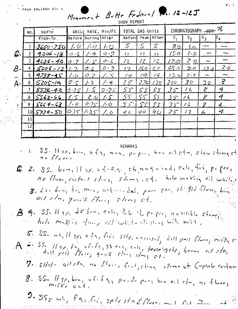
r<0N BIN.Cf<0N ÚlL 1
.A þÑ, (Ja,,,/ ., /Z-/L.7LHOWREPORT
o. DRIL RATE, Min/Ft. TOTALGASUnits CHROMATOGRAPH.-pptil-
I From-To. Before Ouring Af ter Befor Peak After C C2 3 4
/.U/.( S5S
L i2£d.&.. . /.±.. _o.: 2_ Jr.......i L..] J_ J'..E? _.L -
3 (dg¢- d'o o '? / y od /2 /2 72 /7,0 ? o -
4 50Œf -/Z /, 3 o' d O' ? 17 /40 ( s £9.0 3.0 /.7.6 2.05. ¶g 45 / o 7 /, 7-9 /9 /* / 3. o P . o - --
6 Szo ¶ (9 C' y /, 2 / 4 2 2 7o / Poo 3 C' Jp1 STymf-2. p..?7 /-5 0-?T 5 57 Sy yr /4 2' 48 TSO-GC. /'.T 2.0 /·¾ S TO SÏ .3'
74 ? 99 .¶Ç<‡-<g /. o PT /, o
.fy 3. / 6 2 410 57]V Eb o·2 f / 3.¶ /' o yo 90 470 2 y / 2 &1112
RENARKSi. 3S H jy, l'
. vT -s, e, p.--,
4- on rd ,rio c4
. Z, 3S. Gr ! oy, v .-.9. 74,9 1. ,d, e,le, 4'
Ilo / vor / >Á·/ r/ 7 1 .ed,N'N' ***'
r) o viil(/
r / J til y-a / A/Orore WrA; 4 / //nyell -/ r r/~'I of ,
I k"r e
.5ply,rfo g, '/.row, . I f.] 1,.-

NOV 16 3 B- OTAM DR RON OIL DIV P. 1/2
IkilcronOilDAILY OPERATINGREPORT
DATE: 11/16/93
**JONAH UNIT PARTNERS' DAILY REPORT**
BALCRON MONUMENT FEDERAL #21-12J Operatort EREC/BaloronBOD WI: 79.78%Location: NE NW Bootion 12, TOS, RidE
---TIGHT HOLE--- Duchesne County, UtahProspect: Jonah Unit / Monument ButtePTD: 5800' Green River Oil - Dev.
10-10/21-93 Work on & finish location.
10-25-93 MIRU Leon Ross Air Drilling & spud @ 9:45 a.m. Drill 270' hole.
10-26-93 Run 6 jts 8-5/8" csq & cmt as follows:Guide Shoe .65'
1 Jt 8-5/8" shoe jt 44.90'Insert Float -----
5 jts 8-5/8" J-55 24# 224.86'Set 0 268' GL.Omt w/150 exs Class "G" w/2% CCK & 1/4#|sz celoflakE. 5 bble omtback to pit. Plug down 8 1 p.m. 10-26-93.DC: $10,575 QC: $30,618
11-15-93 Present Operation: NORD, MI mud, RU. Did not break tower. Had to get blade to fix road& help winch trucks.DC: $1,200 CC: $31,818
11-16-93 TD: 1,001' (723') Day 1Formation: UintahMW 8.3 VIS 26Present operation: DrillingNU BOP. Test BOP & manifold to 2000# - OK. Test StrfaCO piþG to1500# - OK, Cut drill line, drill emt, survey, change air headrubber, drill, & survey.DC: $10,538 CC: $42,356
BALCRON MONUMENT FEDERAL #12-12J Operator: EREC/BaleronBOD WI:79.78%
Locations SW NW Section 12, TSS, RI6E---TIGHT HOLE--- Duchesne County, ttah
Prospect: Jonah Unit / Monument Butte
11-15-93 CompletionTIH w/4-3/4" bit, 5-1/2" scraper & 176 jts 2-7/8" tbg, EUE J-55 Brd6.5#. Tag PBTD @ 5727' KB. CIrc well w/125 bble of 2% KCL wtr.TOOH w|tby & BHA. RU Schlumberger to perf 5024'-33' (4 holes),$225'-29' (4 holes), & 5237'-44' (7 holes). RD Schltmberger. TIHW/RBP, retrieving head, 1 jt 2-7/8" thy, 5-1/2" HD packer, SN & 163ts 2-7/8" tbg, set BP @ 5064' KB, set packer @ 49ti2' KB, EOT @5003' KB. RU Western to do KCL break down refer to treatmentreport. No break, packer started leaking. Run starding Valve totest tbg to 4000 psi - OK. Fish standing valve. SVIFN.DC:

Flull BHLt l'Ulf ui' I
c'fcE CES ..TREATMEN EPOR1BALCRON OIL DivlSION1W1 toamilAvantePO. 9m 2101)St.rg.MI ôV104•lgil
Date of Treatment:
WellName Â/ SEC../_ TWN. 5 RNGÁ£/
Fleid Âmvov ¾ Couniy rCr .Staie /<Xl
Formation/Perforatlons: JF dht
Treatment iype: A't 'R Pr. .. .
Total Number of Holes: NSand Characteristics
Volume Fluid Conc. S V>lume
Gal.Gal. .
Gal.Gal. ....
/.... Ga 1. .
.-.. . ... -......... /Ga I. /Ga i. .
/Gol. . ..
.. .. . ... . ../
Gal. ...
/Ga 1. .... ..
..
../
... Ga l. .- .. ..
.... ..... /
TOTALFLUIDPUMPED: ....s N' gal. ......... / % RCÁ Acld-..
gol. .....-..-fluid
TOTALSAND VOL. : _...
.......ibs.
.....__ | ...
sand.... ..
lbs.__
¿._ sand........lbs. __.....__/ ......
sand-... . _
lbs. .._..._] .
bauxlie
RusheÇiwell with ....-__gal, of .
/ b ball seoleis were pumped. Was ball action seen'? / / 2'/¢'-
Barrels of Load io Recover f.F5 ..._.BLTR.
Avg. Treoting Pressure =-l 'ŸËf ..... psi, mo× = 1//"..._
psi, min = 70'd' pAvg. Treating Rate = J'S'...._ _
bpm, max = //eÚ. bpm, mln = ,2 A - bpr
ISlP=. /SPO psl. 5 min. =...... psi, 10 min. = psi, 15 mln. = p.- Wellwillbe shut in for- Û his. before bilnging back fluld.
REMARKS:jy/NWNO/T ///NU fiÍ /)7~J Ñ/'AÄÑ/Adi'It'
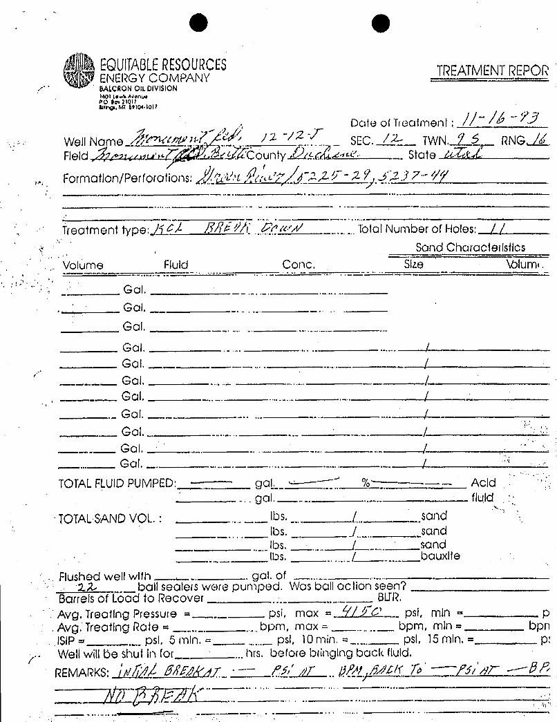
O O
OEQUITABLERESOURCES TREATMENTREPORENERGYCOMPANYBALCRONOlt. DIVISION1601 Lewa Ann.sePO Ogx21017swrg, MT 69104.1017
Date of Trealment :
Well Name. /2 ~ß
SEC. TWN. Ÿ$ RNGAFleid Ñœr <.a ÒountyË. State ATfr/Formation/Perforations
_
2,2.. -,2 Ÿ 2 y 7··- ////
Treatment type: /1 / />///A/_ .......
Total Number of Holes: / /Sand Characietlstics
. Volume Fluid Conc. Size \blum•.
Gal.. Gal.
Gal.Ga l. .. .. ... ...... /Gal, . .. /Ga1. .. .. /Gol. /
. Gal. ... /._ Gal. . /
Gal.Gol . /
TOTALFLUIDPUMPED:....
goL._ --~¯~~ % ----- Acid... gol-----. ..-.. fluld
TOTALSANDVOL.: .... __lbs.... sondIbs. /.._., sand
. ._lbs.
..... /_ _....sand
.. _lbs.
...... / ....__bauxlfe
. Flushed well with ... .
gal. of22.-
._ball seolets were pumped. Was ball oction seen7
Borrelsof Load to Recover ..._ ..._._BlJR.
Avg. Treating Pressure =_.....
psi, mox = Ú'/ psi, min = pAvg. Treating Rote =
_.._......bpm,
ma×=......_
bpm, min = bpnISIP=
....psl, 5 min. =
,...._psi, 10min. =
....psi, 15 min.= p:
- Welt willbe shut In for__ ...hrs, before bringing back fluld.
REMARKS: /#7 //Á&Ÿf///r'd ¯¯ O' /N'..
Q&/ /ßh' Ñ fit a Ñ
O O
OEQUITABLERESOURCES TREATMENTREPORENERGYCOMPANYBALCRONOlt. DIVISION1601 Lewa Ann.sePO Ogx21017swrg, MT 69104.1017
Date of Trealment :
Well Name. /2 ~ß
SEC. TWN. Ÿ$ RNGAFleid Ñœr <.a ÒountyË. State ATfr/Formation/Perforations
_
2,2.. -,2 Ÿ 2 y 7··- ////
Treatment type: /1 / />///A/_ .......
Total Number of Holes: / /Sand Characietlstics
. Volume Fluid Conc. Size \blum•.
Gal.. Gal.
Gal.
Ga l. .. .. ... ...... /Gal, . .. /Ga1. .. .. /Gol. /
. Gal. ... /._ Gal. . /
Gal.Gol . /
TOTALFLUIDPUMPED:....
goL._ --~¯~~ % ----- Acid... gol-----. ..-.. fluld
TOTALSANDVOL.: .... __lbs.... sondIbs. /.._., sand
. ._lbs.
..... /_ _....sand
.. _lbs.
...... / ....__bauxlfe
. Flushed well with ... .
gal. of22.-
._ball seolets were pumped. Was ball oction seen7
Borrelsof Load to Recover ..._ ..._._BlJR.
Avg. Treating Pressure =_.....
psi, mox = Ú'/ psi, min = pAvg. Treating Rote =
_.._......bpm,
ma×=......_
bpm, min = bpnISIP=
....psl, 5 min. =
,...._psi, 10min. =
....psi, 15 min.= p:
- Welt willbe shut In for__ ...hrs, before bringing back fluld.
REMARKS: /#7 //Á&Ÿf///r'd ¯¯ O' /N'..
Q&/ /ßh' Ñ fit a Ñ
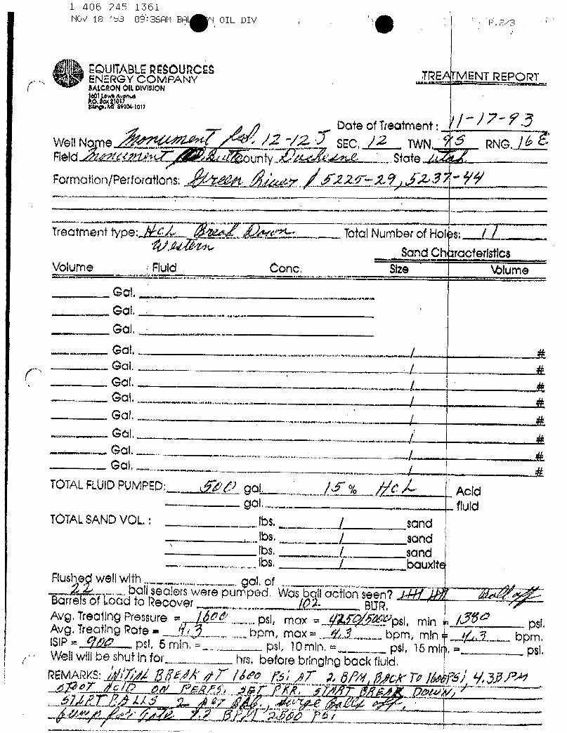
1 406 245 1361NOV 18 '93 OŠ:36AM BA N OIL DIV P.2/3
E GY CMPÔAUNY ...BEATMENT REPORT
caonomowmo
Dote of TreatmentWellN e SEC, /2 Ig 6 RNG.INRAlri #xdP1A unty VA
. State /AFormation/Perforatons .22Æ'- Ÿ fåi
freatment iype: «_c TotalNumber of Holes: /Sand Characteristica
Volume Flud Conc. Slze'
Wume
GaL. ..... .
GaLGa l,
I
Go l................- Ga L
Got.,.
., /..
TOTALFLUIDPUMPED: aÑ goL % Acidgo fluld
TÖTALSANDVOL.: Ibs. / sand, iba.
... / sandIbs. I sand
. _Ibs. / bauxite
Flushed wellwith- ...,........ gal. of$ L._.-ball sealers were pumped. Was bqllactk>nseen7 A/·//.M' /ABarrelsof Load to Recover (A BLTR,Avg. Treating Pressure , os
, psi, max = //Af(VN' psi, min a /paAvg. Treating Rote . 6
. .. bpm, max = ‡',L..._ bpm, min e bpm,ISIP= ffP pst 5 min pst 10mln, = pst 15 mln, psLWellwillbe shut in for. hra. before bringing back fluid.
rdMANS: 7þl $3dk /7' /M /47¯
A /96 77 /Af4,# 7 AND a* ?« 15 NR, NAf T
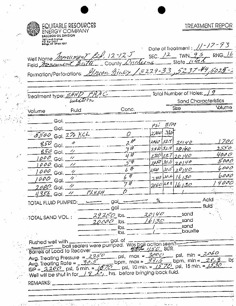
g g.
EQUlTABLERESOURCESENERGY COMPANY
TREATMENTREPORBALCRONOILDIVISIONIt01 towli AvonoÞO Sar2\011Bary. MI 69108-1017
Date of Ticoimeni :
Well Name M'rugn SEC. TWN. Ÿ RNG /Field,hntwa ... County .!
' †~.4..... .State RE
Formation/Perforat ons: An.,' .Z,2 Ÿ-33 ~2 y,7- d'p; -
Treatment type:. .. .._
ToÑlNumber of Holes; / 9Sand Characteristics
Volume Fluid Conc. Size Wlume
Gol.
.Gal.
5/ 6/
//V eol. // Zusa o . 7
TOTALFLUIDPUMPED: gal. Acid -
- -. ga! ---- ....
Iluid
TOTALSANDVOL. ; 2 Ÿ2 Ibs. RJ'/ sand -.
2dodd lbs. /JJ3 sand... .. _
lbs. ./ ... ..sand
....
......lbs.
......_/_. ....
bauxlie
flushed well with .......gol. of
ball sealers were pumped. Was I acilon seen7-----
Borrelsof Load to Recover r¿yp' alIR.
Avg. Treating Pressure = .Z..B .psi, max = Ñ©U psl, min = 2.¾
.
Avg. Treatlng Rote = 94.. .
bpm, mox = NY/ bpm. min = ? ? by
ISIP= ,2'1£Çì. psi, 5 min. =_ jf pst, 10 min. = /d psi, 15 min, = Aff
Wellwillbe shut in for / ¶ .J..f.; hrs. before bringing back fluid.
REMARKS: .... .........
....
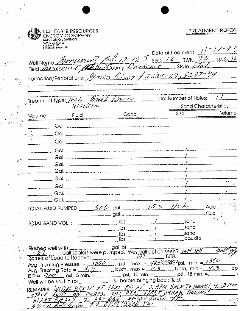
O e
@MUlTABLERESOURCES TREATMENT REPOR,. .
ENERG Y COMPANY.------ .......,
BALCRONOILDIVISiONItOl Low¾ AvenaPO.God1011bu.y.Mt 69104-1011 //-77-7
Date of Trealment :
Well No e SEC. /2 TWN. ÝØ RNG
Field & ^.W1.Un «¾unty.. n-<'....
Siate /¾
Formation/Perforailons takt 22//- JA f
Treatment type: Ñt.~Á-.c
.
Total Number of Holes:. .]
Sond Characterlsilcs
Volume Fluid Conc. Size V:>lume
Gal.- Gal.
Gol.Gol. ......... .... ... . .. .... ................/
..Gal. /Gal. /Gal. /Gal. . /Goi, /
.-Gal. .. .. . ... /
.._ Ga l. ...../
TOTALFLUIDPUMPED: ·, Ñ' gal....
% C Acid-_
got (fuld
TOTALSAND VOL.: ___-.lbs.sond
'
..lbs..
.._ _/
sondlbs. ..... _._
sand......... .. ..
Ibs. / bauxite
Flushe well with .. . .............._ ._.gal. of _.
.....ball seolets were pumped. Was ball acilon seen7 J-/H /Ñ/ /d
13orrelsof Lood to Recover ........._ _
/01 Bl_TR.Avg. Treating Pressure = J'
.... psi, mox =(ÑfQATU''psi, min = /Â$" |
Avg. Treatlng Rote = 'fr..... ..._
bpm, ma× = //, 1._.,...._bpm, mln = //,, 9 bpISlP = 960 psI, 5 min. = psi, 10 min. =
.pal, 15 min. = ¡
Wellwlllbe shut in for his. before bringing back fluid.
REMARKS: V,';yZ [IlitAN /// /a'e /3; AT 2, 8/N',/1/CA' R/ //ws/w/,a/
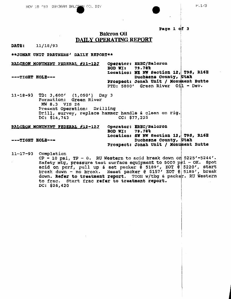
NOV 1e '93 09:36AM BALC OIL DIV P.1/3
Page 1 ef 3Baleron Oil
DAILYOPERATING REPQRTDATE: 11/18/93
**JONAR UNIT PARTNERS' DAILY REPORT**I
BALORON HONUMENT FEDERAL #21-12J operator: BREC/BaleronBOD WIs 79.78%Locations NE W Section 12, 298, R16E
---TIGHT HOLE--- Duchíane county, UtahProspoott Jonah Unit / Nonument ButtePTO: 5800' Green River 011 - Dev.
11-18-93 TD: 3,600' (1,050') Day 3Formation: Green River
MW 8.3 VIs 26Present operation: DrillingDrill, survey, replace hammer handle & clean on rig.DC: $14,743 CC: $77,225
BALCRON MONUMENT FEDERAL #12-12J operator: EREC/BaloronBOD WI: 79.78%Locations BW NW Beation 12, TSS, Ri6E
---TIGHT HOL2--- Duchesne County, UtahProspect: Jonah Unit / Monument Butte
11-17-93 CompletionCP - 10 psi, TP - 0. RU Western to acid break down or 5225'-5244'.safety mtg, pressure test surface equipment to 5000 pai - OK. Spotacid on perf, pull up & set packer @ 5189', EOT @ 5220', startbreak down - no break. Reset packer @ 5157' EOT @ 5189', breakdown. Refer to treatment report. TooH w|tbg & packek. RU Westernto frac. Start frac refer to treatment report.DC:

1 406 245 1561NOV 22 '93 10:51AM B ON OIL DIV P.2/2
SALCRON HONUMENT ršDERAL #12-12Jonerator:EREC/BaleronBOD WII 79.78%Locationt SW NW Section 12, 298, Ri68---TIGHT NOLE--- Duchesne County, UtahProspecti Jonah Unit | Nontaent Butte
11-19-93 CompletionCP - 10 psi, TP - 10 pai. TOOH w|tby, packer & BP. RIHw/production string:
Length De tL KB1 jt tbg 2-7/8" EUE J-55 Brd 6.5# 31.30 5309.88'1 perf sub 2-7/8" x 3' 3.20 5278.58'1 seat nipple 1.10 5275.38'171 jt 2-7/8" EVE J-55 Brd 6.5# 5264.28 5274.28'KB 10.00ND BOP, NU wellhead. TIH w/production rod string: :.BHP 2-1/2" x1-1/2" X 16' RWAXw/PA plunger (Trico), 209 3/4" x 20' plain rods,one 3/4" x 8' pony; one 3/4" x 47 pony; one 1-1/4" x :12' polish rodSM. Clamp rods off. Pressure test to 1000# - OK. SWI.DC: $1,742
BALORON MONUMENWFEDERAL #42-17 Operator: EREC/BaloronBOD WI:79.78%
Location: SE NE Bootion 1, TSS, 16E---TIGHT NOLE--- Duchesne county, UtahProspect: Jonah Unit | Montment Butte
11-19-93 CompletionMIRU Cannon Well Service Rig #2, RU esg tools to lownr 5-1/2" esg.SDFN.DC: $206
11-20-93 CompletionPulled 120,000# on 5-1/2" cag, could not pull out of alips. Cut 5-1/2" ceg & weld bell nipple on. NU flange, NU BOP, TIN w/5-1/2"eng scraper, bit & 185 ite 2-7/8¤ tbg. Tag 98TD 8 5 44; KB. Cirohole clean w/130 bbla 2% KCL wtr. Pressure test ceg & SOP to 1000psi - OK. TOOh w/tby scraper & bit. SWI.DC:
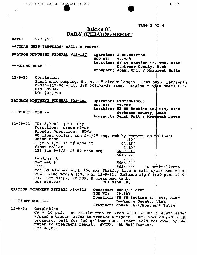
DEC 10 '93 10:01AM BA CRON OIL DIV P.1/3
Page 1 of 4Balcron Oil
DAILY OPERATING REPORTDATE: 12/10/93
**JONAH UNIT PARTNERS' DAILY REPORT**
BALCRON RONUMENT FEDERAL #12-123 Operator: BREC/BalorenBOD WII 79.70%Locations BW NW Section it, 290, R162
---TIGHW HOLE--- Duchesne County, UtahProspeat: Jonah Unit / Monument Butte
12-9-93 Completionstart unit pumping, 5 SPM, 86" stroke length. Beam ptmp, Bethleham0-320-212-86 unit, S/N 30617E-31 3665. Engine - Ajax model E-42S/N 68203.DC: $33,790
BALCRON MONUMENT FEDERAL #24-12J Operators EREC/BalaronBOD WII 19.78%Locations 88 BW Beation 12, TSS, R16E
---TIGHT HOLE--- Duchesne county, UtahProspect: Jonah Unit / Monument Butte
12-10-93 TD: 5,700' (0') Day 7Formation. Green RiverPresent operation: RDMOWO float collar, run 5-1/2" esg, omt by Western as follows:Guide shoe .60'
1 St 5-1/2" 15.5# shoe it 44.18'float collar 2.10'128 Jts 5-1/2" 15.5# K-55 csg 5629.34'
5676.22'Landing jt 9.00'Csg set © 5685.22'
5636.34' 20 centralisersCmt by Western with 204 sxs Thrifty lite & tail w/tis exs 50-50POZ. Plug down § 1:30 p.m. 12-9-93. Release rig 0 Br30 p.m. 12-9-93, Set slips, ND BOP, & clean mud tank.DC: $48,035 CC: $168,393
BALORON MONUNENWFEDERAL #14-12J Operator: BREC/BaloronBOD WII 79.78%Location: BW BW Bootion 12, T98, R16E
---TIGHT HOLE--- Duchesne County, UtahProspects Jonah Unit/Nonument Butte
12-9-93 CompletionCP - 10 psi. RU Halliburton to frac 4299'-4308' A 4097'-4104'w/sand & tracer refer to treatment report. Shut down on pad, highpressure, call for 500 gallons HCL. Start acid foLlowed by padrefer to treatment report. SWIFN. RD Halliburton.DC:
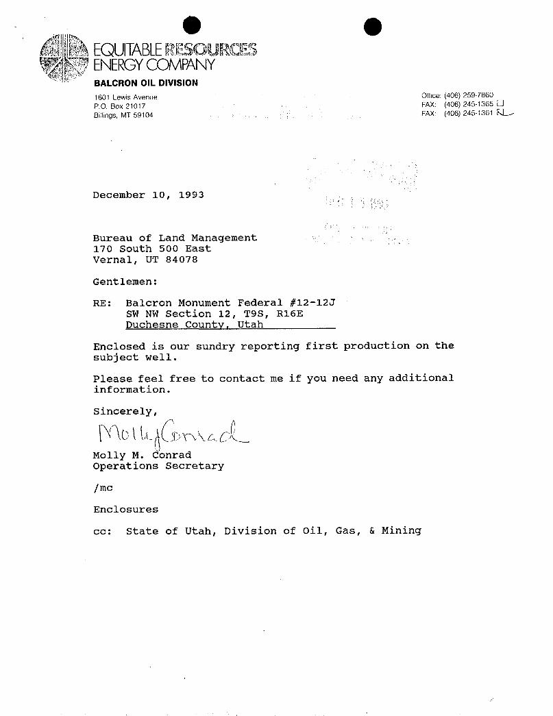
eEQUITABLERESOURCESENERGYCOMPANYBALCRON OIL DIVISION1601 Lewis Avenue Office: (406) 259-7860
P.O. Box 21017 FAX: (406) 245-1365 OBillings. MT 59104 FAX: (406) 245-1361 EL
December 10, 1993
Bureau of Land Management170 South 500 EastVernal, UT 84078
Gentlemen:
RE: Balcron Monument Federal #12-12JSW NW Section 12, T9S, R16EDuchesne County, Utah
Enclosed is our sundry reporting first production on thesubject well.
Please feel free to contact me if you need any additionalinformation.
Molly M. ConradOperations Secretary
/mc
Enclosures
cc: State of Utah, Division of Oil, Gas, &
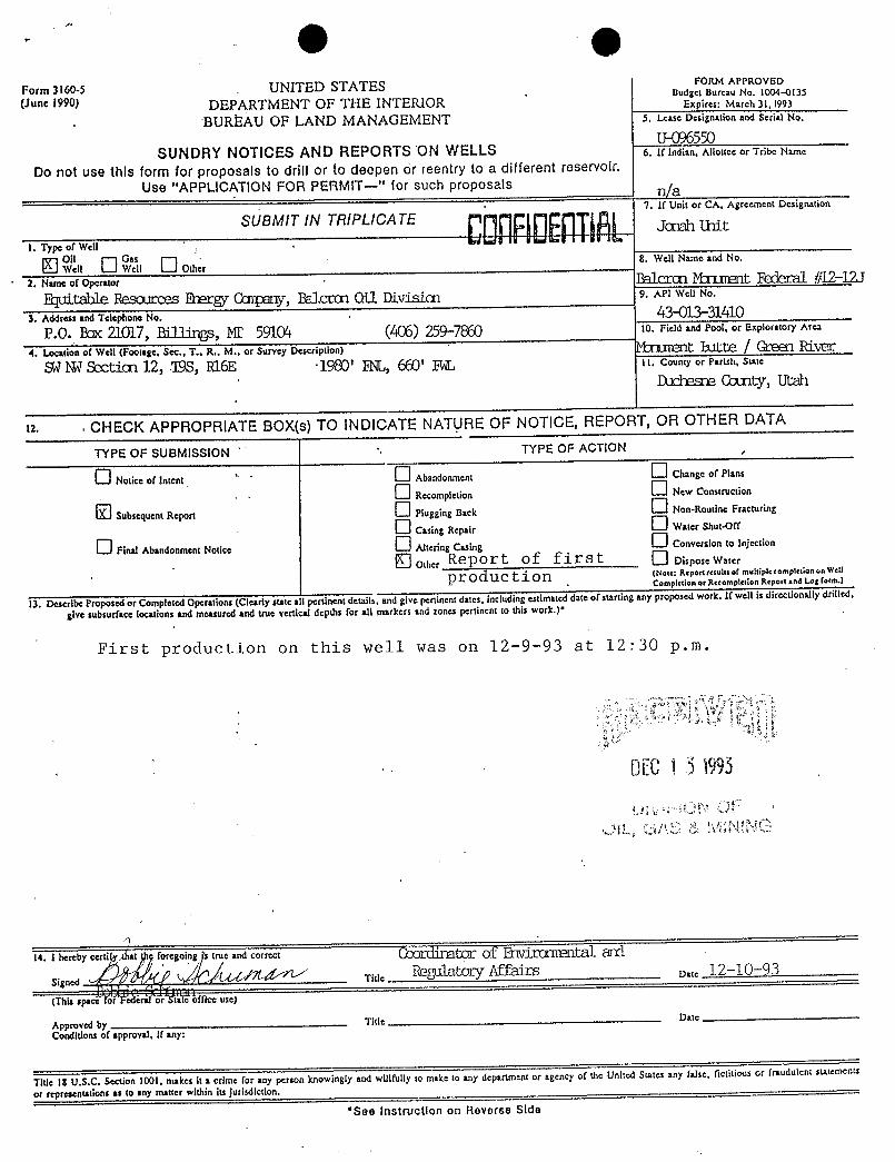
.
^
. O gForm 3160-5
.UNITED STATES FORM APPROVED
(June 1990) DEPARTMENT OF THE INTERIOR xp'ire:aNo.310&O3135
BUREAU OF LAND MANAGEMENT 5. I.case Dcsignation and Serial No.
U-096550SUNDRY NOTICES AND REPORTS ON WELLS 6. If indian, Allouce or Tribe Name
Do not use this form for proposals to drill or to deepen or reentry to a different reservoir.Use "APPLICATION FOR PERMIT-" for such proposals n/a
1. Type of Well
SUBMIT IN TRIPLICA TE otAgreement Designauon
6 Ëlt wu Ü OÙr 8. Well Name and No.
2. Nameof Operator ËaÎCCŒ Mt B #12-121ffflitShie ËOSŒlfCOS RECg CCII¶Elr1y, Eelccæ Oil Divisiæ 9. API Well No.
3. Address and Telephone No. -
43-013-31410P.O. Par 21017, Billings, MI' 5910'4 (406) 259-7 10. Field and Pool, or Exploratory Area
4. lAcation of Well (Footage. Sec., T.. R., M., or Survey Description) Mt B.ltte | Greetl RivecShi1¾ Section 12, 'ISS, R16E ·1980' RL, 660' y 11. conmyor rarisa,sure
Duchesne County, Utah
12. . CHECK APPROPRIATE BOX(s)TO INDICATENATURE OF NOTICE, REPORT, OR OTHER DATA
TYPE OF SUSMISSION . TYPE OF ACTION
Noticeof' Abandonment Chnge of Plans
O a«..,icuo. O s,w cons,s.co.
Subsequent Repon Plugging Back Non-Routine Fracturing
O c.sta, a=,.., O Watcr Shut•Off
O Final Abandonment Notico Ahenng Cuing O conver....to ingo.
Other Report of first O oisposew.terpro du ct i on m•••=a•r•n--as•r ==mele=••r!«•••••**"
Comptction or Recompission Report and Log form.)
lÏ. Descri ProÑcdirCompleted Operations (Clearly state a I pertinent details, and give pertinent dates, including estimated date of starting any proposed work. If well is directionally drilled,
give subsurface locations and measured and true vertical depths for all markers and tones pertinent to this work.)*
First production on this well was on 12-9-93 at 12:30 p.m.
OEC1 3 1995
14. I hereby certi foregoing true and correct (Q
Signnri Title Date12-10-93
(This space Ëòfficeuse)
Approved by Title Dato
Conditlons of approval, if any:
Title 18 U.S.C. Section 1001, makes it a crime for any person knowingly and willfully to make to any department or agency of the United States any false, fictitious or fraudulent statements
or representations as to any matter within its jurisdiction.*See Instruction on Reverse
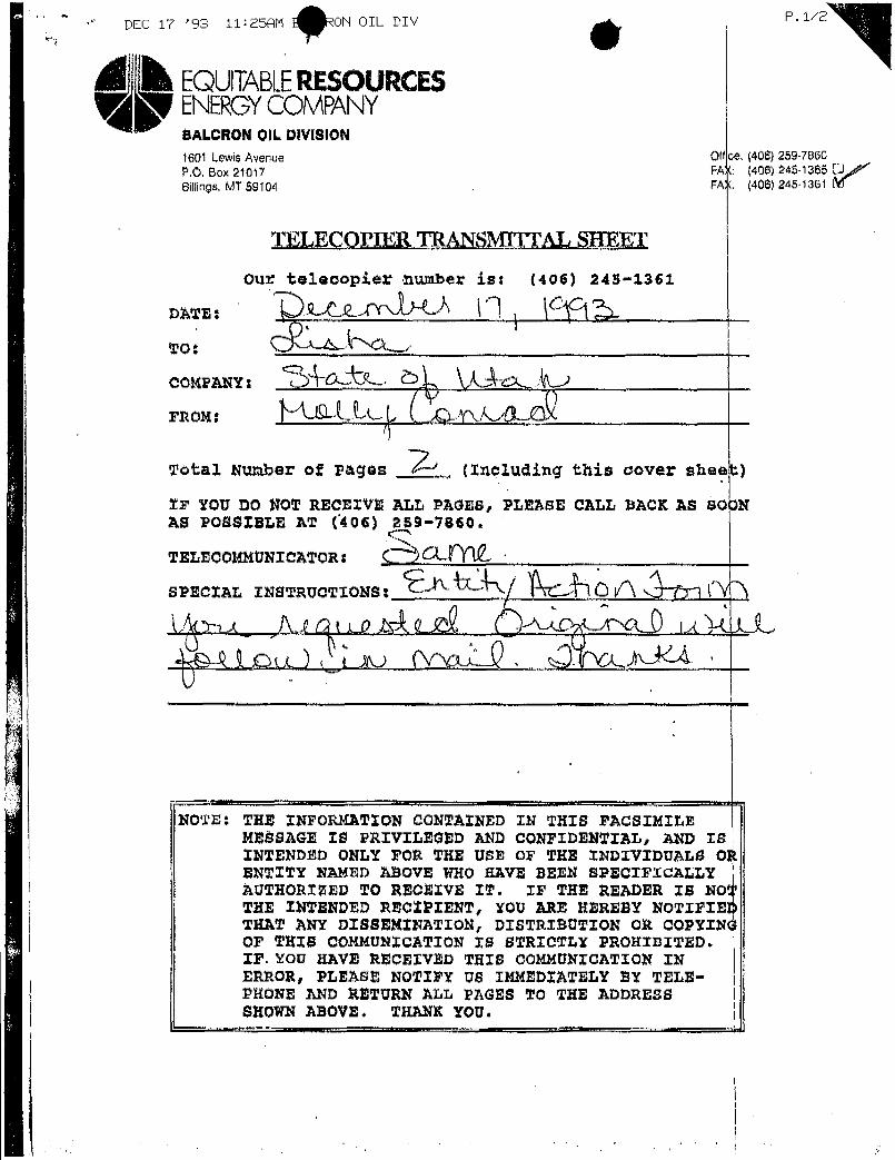
DEC 17 '93 11:25AM ON OIL DIV P.1/2
&EQUITABLERESOURCESENERGYCOMPANYBALCRON OIL DIVISION1601 LewisAvenue Offce (406) 259-7860
P.O. Box 21017 FAX: (406) 245-1365 JBillings, MT$9104 FAT (406) 245-1361 m
TELECOPIER TRANSMTITAL SHEET
Our telecopier number ist (406) 245-1361
Total Number of Pages (Including this cover sheet)
IF YOU DO NOT RECEIVE ALL PAGES, PLEASE CALL BACK AS SO3NAS POSSIBLE AT (406) 259-7860.
TELECOMMUNICATOR:
SPECIAL INSTRUCTIONS:
NOTE: THE INFORKATION CONTAINED IN THIS FACSIMILEMEBBAGE 10 PRIVILEGED AND CONFIDENTIAL, AND ISINTENDED ONLY FOR THE USE OF THE INDIVIDUALS OÀENTITY NAMED ABOVE WHO HAVE BEEN SPECIFICALLYAUTHORISED TO RECEÏVE IT. IF THE READER IS NOTHE INTENDED RECTPIENT, YOU ARE HEREBY NOTIFIETHAT ANY DISSEMINATION, DISTRIBUTION OR COPYINOF TRIS COMMUNICATION 18 STRICTLY PROHIBITED.IF.YOU KAVE RECEIVED THIS COMMUNICATION INERROR, PLEASE NOTIFY US IMMEDIATELY B¥ TELE-PHONE AND RETURN ALL PAGES TO THE ADDRESSSHOWN ABOVE. TRANK
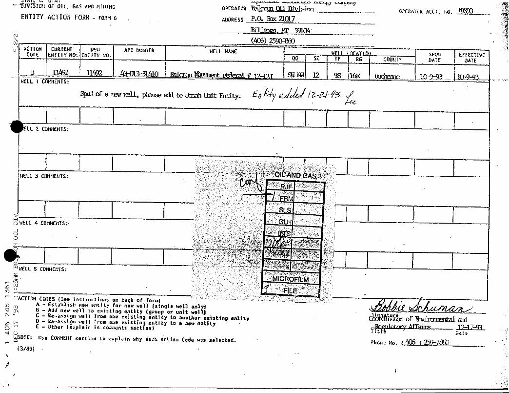
ÏŸfšIDM Of OIL GASANDMI>IING OPERATORht1ÇXŒl AVisla2 OPEllATORACCI. NO.ENTITY ACTION FORM- FûRM 6 . ADDRESS Ë•O. N
RUliry, ME 59LO'06) 2590m)
ACTl0N CunftENT NEN API 80: ER WELL NAME VFi l ( KATION .. SPUD EFFECTIVECODE ENTETY NŒ. ENTITY NO. QQ SE TP RG COUNTY DATE DATE
B 11492 11Å92 43-013-31410 Balctqu Amn:nt.Ibler:al.] p-py f¾ W 12 95 16E Ikziesne___ _ Q±93.LÏEÜL.1 COMMENfS:
spx1of a mmu, p1mse «R to Jtoh lMt IN-Hy. Eh S'
ELL 2 CONMENTS:
OILANDGÀbMELL3 CONFtENTS:
AJF
FRMSLS
LHWELL 4 COMMEllTS:
Se
ELL 5 COMMENTS:
MICROF LMFILE
ACTION CDDES (See instnuctions on back of form).A - Estab3ish new entity for new well (stogle wel3 only)B - Add new well to existing entity (group or unit well) Si tureC - Re-assign well from one existing eat,ity to another existing entityD - Re-assign well from one existing entity to a nw entity ilmtrrv Aff im 17-17-93E - Other (explain in.comments section) Titre "
Date4 OlglOTE: Use CûMNENTsection ho explain why each Actîon Code was selected. '
Phone no. 1406 ) 259-7860r-i M
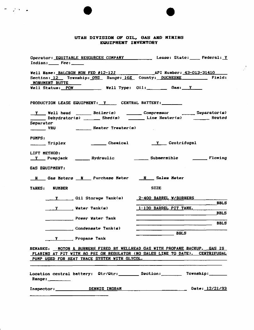
UTAH DIVISION OF OIL, GAS AND NININGFA21BIPMENT INVENTIntY
Operator: EQUITABLE RESOURCES CONPANY Lease: State: Federal: YIndian: Fee:
Well Name: BALCRON NON FED #12-12J API Number: 43-013-31410
Section: 12 Township: OSS Range: 16E County: DUCHESNE Field:HONUMENT BUTTE
Well Status: POW Well Type: 011: Gas: Y
PRODUCTION LEASE EQUIPNENT: Y CENTRAL BATTERY:
Y Well head Boiler(s) Compressor Separator(s)Dehydrator(s) Shed(s) Line Hester(s) Heated
SeparatorVRU Heater Treater(s)
PUNPS:Triplex Chemical Y Centrifugal
LIFT NETHOD:Y Pumpjack Hydraulic Submersible Flowing
GAS EOUIPHENT:
N Gas Neters N Purchase Neter N Sales Neter
TANKS: NUMBER SI2E
Y Oil Storage Tank(s) 2-400 BARREL W/BURNERSBBLS
Y Water Tank(s) 1-130 BARREL PIT TANK.BBLS
Power Water TankBBLS
Condensate Tank(s)BBLS
Y Propane Tank
RENARKS: NOTOR & BURNERS FIRED BY WELLHEAD GAS WITH PROPANE BACKUP. GAS ISFLARING AT PIT WITH 80 PSI ON REGULATOR (NO SALES LINE TO DATE). CENTRIFUGALPUNP USED FOR HEAT TRACE SYSTEN WITH GLYCOL.
Location central battery: Otr/Gtr: Section: Township:Range:
Inspector: DENNIS INGRAN Date:
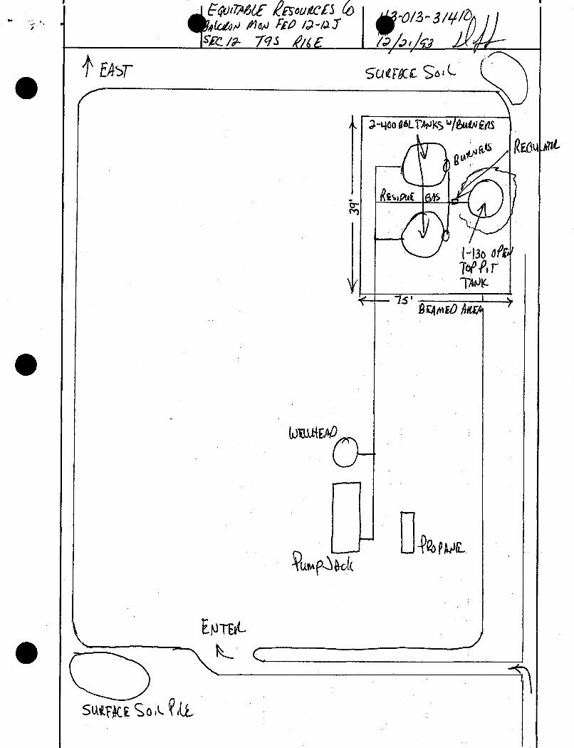
ˇJ@ðŒ ÊEroukc£5My /14µ Frp la-i.J
R /> M //tg / & /O
EASF ça ryg OL
46ogeLTMKS'*/6
L
. ÑSLAf 4o-
M3e000'Te/M
IC
âg mo he
bm 0
NTFAe -
sutig SoA
ˇJ@ðŒ ÊEroukc£5My /14µ Frp la-i.J
R /> M //tg / & /O
EASF ça ryg OL
46ogeLTMKS'*/6
L
. ÑSLAf 4o-
M3e000'Te/M
IC
âg mo he
bm 0
NTFAe -
sutig SoA
ˇJ@ðŒ ÊEroukc£5My /14µ Frp la-i.J
R /> M //tg / & /O
EASF ça ryg OL
46ogeLTMKS'*/6
L
. ÑSLAf 4o-
M3e000'Te/M
IC
âg mo he
bm 0
NTFAe -
sutig SoA
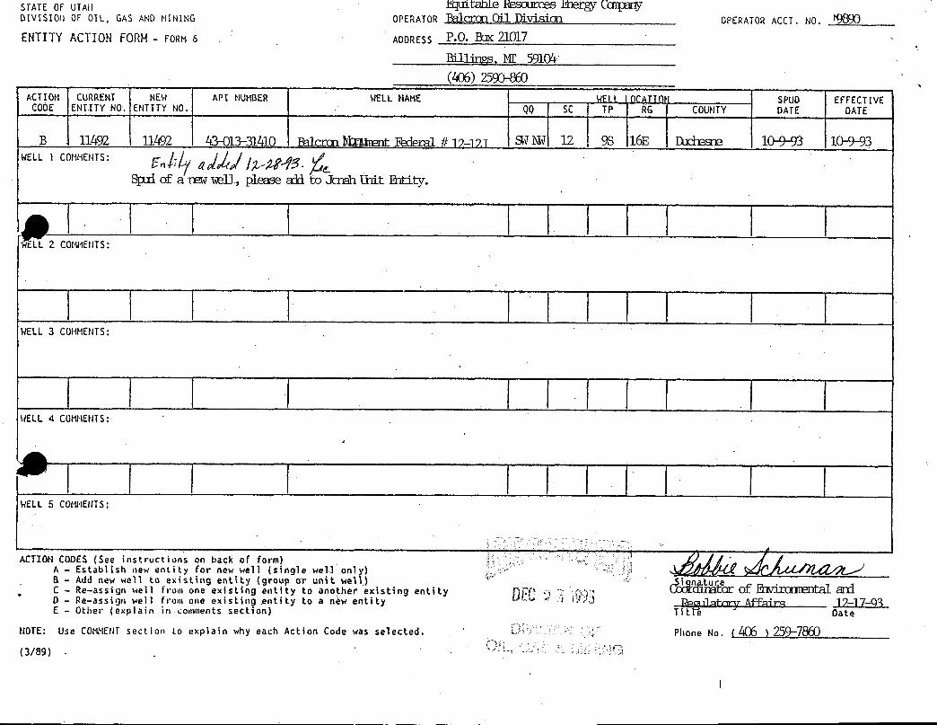
STATE OF UTAll Fquide ROSOurces E0etg{ CCIIiçanyDIVISION OF OIL, GAS AND NINING OPERATOR BalcDOD Cil EdvisiCD OPERATORACCT. NO. 9890ENTITY ACTION FORH - FORM6 . ADDRESS P.O. Bar 21017
mllity, M 5910'-V
(406) 2590-860
ACTION CURRENT NEW API NUMBER WELL NAME WFil 10CATION SPUD EFFECTIVECODE ENTITY NO. ENTITY NO. QQ SC TP RG COUHTY DATE DATE
B 11492 11492 43-013-31410 Pelecan MRimnt Federal # 12-17.T SWl\lW 12 9S 16E Duchesne 10¾3 10-9-93WELL1 COMNENTS:
Spad of a riewm11, please add to Jenah Unit Ritity.
tLL 2 COMMENTS:
ELL 3 COHMENTS:
ELL 4 COMMENTS:
WELL 5 CONNENTS:
ACTION CODES (See instructions on back of form)A - Establish new entity for new well (single well only) /4GÚC e a sg n
eee y o a ot er xisting entity
n reoc of R1virauœntal B'D - Re-assign well from one existing entity to a nëw entity Roonlatarv Affair 12-17-93E - Other (explain in comments section) Titte " Date
NOTE: Use COMMENTsection to explain why each Action Code was selected. Phone No. (406 )259-7860
(3/89)
STATE OF UTAll Fquide ROSOurces E0etg{ CCIIiçanyDIVISION OF OIL, GAS AND NINING OPERATOR BalcDOD Cil EdvisiCD OPERATORACCT. NO. 9890ENTITY ACTION FORH - FORM6 . ADDRESS P.O. Bar 21017
mllity, M 5910'-V
(406) 2590-860
ACTION CURRENT NEW API NUMBER WELL NAME WFil 10CATION SPUD EFFECTIVECODE ENTITY NO. ENTITY NO. QQ SC TP RG COUHTY DATE DATE
B 11492 11492 43-013-31410 Pelecan MRimnt Federal # 12-17.T SWl\lW 12 9S 16E Duchesne 10¾3 10-9-93WELL1 COMNENTS:
Spad of a riewm11, please add to Jenah Unit Ritity.
tLL 2 COMMENTS:
ELL 3 COHMENTS:
ELL 4 COMMENTS:
WELL 5 CONNENTS:
ACTION CODES (See instructions on back of form)A - Establish new entity for new well (single well only) /4GÚC e a sg n
eee y o a ot er xisting entity
n reoc of R1virauœntal B'D - Re-assign well from one existing entity to a nëw entity Roonlatarv Affair 12-17-93E - Other (explain in comments section) Titte "
Date
NOTE: Use COMMENTsection to explain why each Action Code was selected. Phone No. (406 )259-7860
(3/89)
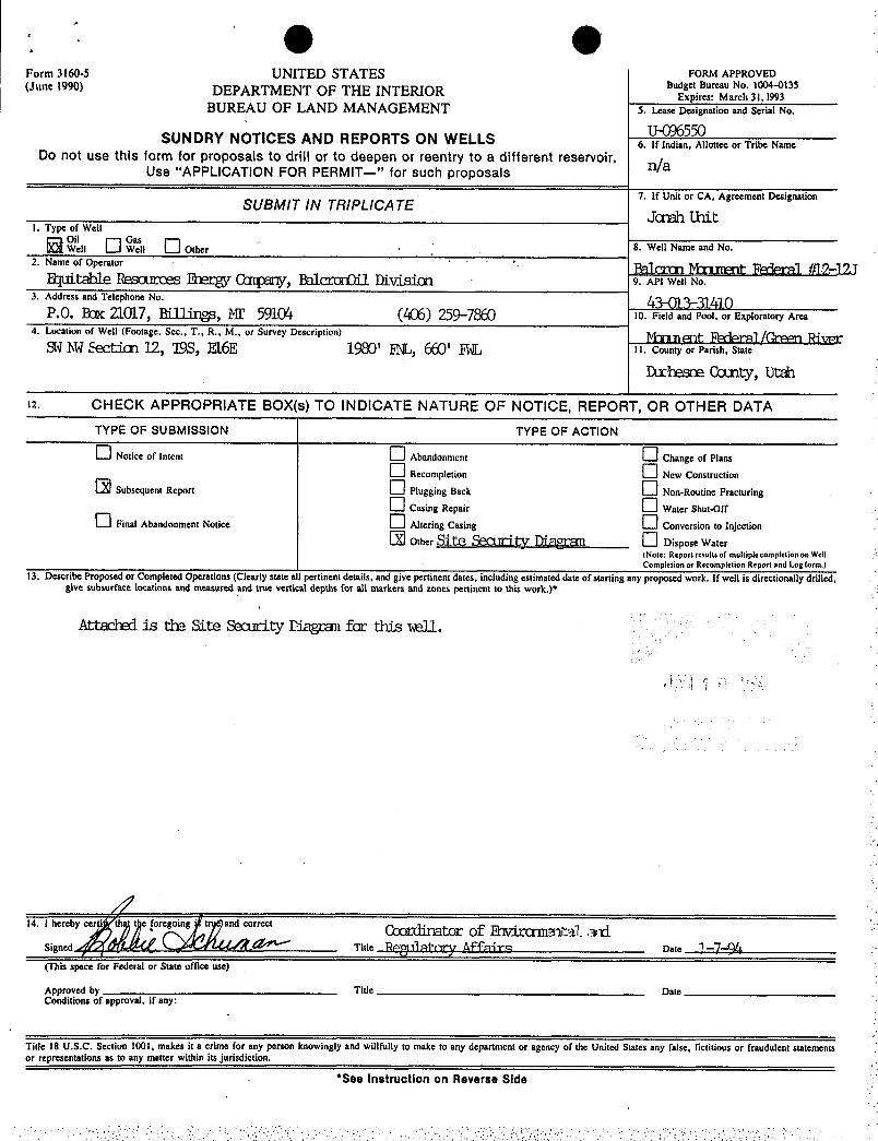
g gForm 3160-5 UNITED STATES FORM APPROVED(June 1990) DEPARTMENT OF THE INTERIOR ""
'ire :
aNo 10 135
BUREAU OF LAND MANAGEMENT 5. Mse Designation and Serial No.
U47J6550SUNDRY NOTICES AND REPORTS ON WELLS 6. If Indian, Allottee or Tribe NameDo not use this form for proposals to drift or to deepen or reentry to a different reservoir. n/aUse "APPLICATION FOR PERMIT--" for such proposals
7. If Unit or CA, Agreement DesignationSUBMIT IN TRIPLICATE
Janah UnitI. Type of Well6öl°w"nO GWae
l Oder.
.
8. Well Name and No.2. Name of Operator galg ggt gi j 2-
table Rescorces Baerg M, BalcrarDil DivisiaEl 9. API Well No.3. Address and Telephone No.
P.O. Bar 21017, Billirige, Mt 5910'+ (406) 259-7 10. Field and Pool, or Exploratory Area4. Location of Well (Footage. Sec.. T., R., M., or Survey Description)
S $€Ctiati 12, '19S, Il16E 1%' K, ' M 11. County or Parish, State
Duchesne Cout1ty,Utah
12. CHECK APPROPRIATE BOX(s) TO INDICATE NATURE OF NOTICE, REPORT, OR OTHER DATATYPE OF SUBMISSION TYPE OF ACTION
O Notice of Intent Abandonment Change of PlansO accompreso. O New Construcdon
Subsequent Report Plugging Back Non-Roudne FracmringCasing Repair Water Shut-Off
O Final Abandonment Notice Ahering Cuing Conversion to InjecdonÐ Other Si.te Sect.lci,tyDig Dispose Water
(Note: Reportresullsof multiplecompletiononWellCompletion or Recompletion Report and Log form.)
13. Describe Proposed or Completed Operations (Clearly state a l pertinent details, and give pertinent dates, including estimated date of starting any proposed work. If well is directionally drilled,give subsurface locations and measured and true vertical depths for all markers and zones pertinent to this work.)*
Attached is the Site Security Diagcan far this wll..
14. I hereby ce e foregoing t and correct
(This space for Federal or State office use)
Approved by Title DateConditions of approval, if any:
Title 18 U.S.C. Section 1001, makes it a crime for any person knowingly and willfully to make to any department or agency of the United States any false, fictitious or fraudulent statementsor representations as to any matter within its jurisdiction.
*See Instruction on Reverse
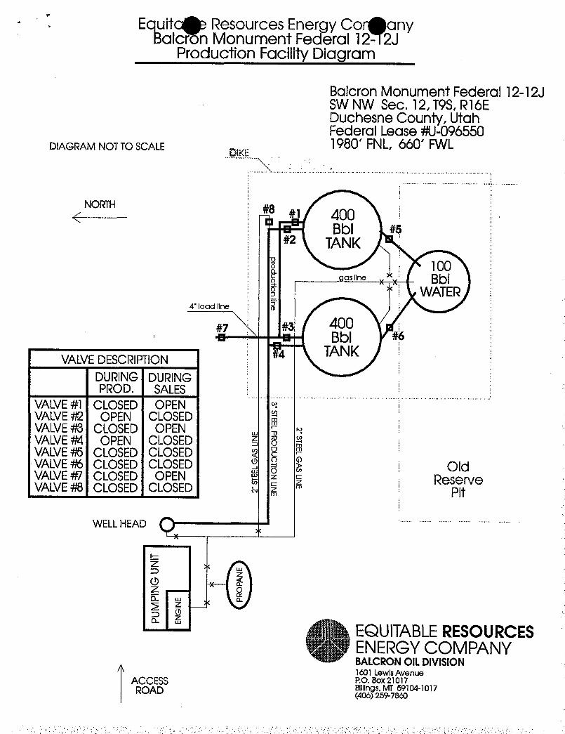
. Equitg Resources Energy Co anyBalcron Monument Federal 12- 2J
Production Facility Diagram
Balcron Monument Federal 12-12JSW NW Sec. 12, T9S,R16EDuchesne County, UtahFederal Lease 4/U-096550
DIAGRAMNOTTO SCALE 1980' FNL, 660' FWL
NORTH#1 400
Bbl #5#2 TANK
oastine yx BblWATER
4" load line
47 #a 400- - m- Bbl
TANKVALVEDESCRIPTIONDURING DURINGPROD. SALES
VALVE#1 CLOSED OPENVALVE#2 OPEN CLOSED EVALVE4/3 CLOSED OPEN , 2 eVALVE#4 OPEN CLOSED E 6 iVALVE4/5 CLOSED CLOSED T 2VALVE4/6 CLOSED CLOSED $ =° Ë OldVALVE#7 CLOSED OPEN $ Ñ E ReserveVALVE4/8 CLOSED CLOSED a ¯z =
WELLHEAD
EQUITABLERESOURCESENERGYCOMPANYBALCRONOILDIVISION
/\ 1601 LewisAvenueACCESS P°· 8°×21017
Billl s, MT 59104-1017ROAD (40

orm 3160-5 UNITED STATES (i FORM APPROVED
lune 1990) DEPARTMENT OF THE IN p'ire : Ma e110¾ 135
BUREAU OF LAND MANAGEMENT 5. Lease Designation and Serial No.U-096550
SUNDRY NOTICES AND REPORTS ON WELLS 6. If Indian, Allottee or Tribe Name
Do not use this form for proposals to drill or to deepen or reentry to a different reservoir.Use "APPLICATION FOR PERMIT--" for such proposals Ña
7. If Unit or CA. Agreement DesignationSUBMIT IN TRIPLICATE '
JcnahUnit1. Type of Welt
O °'.1, O Other °
.
. 8. Well Name and No.
2. Name of Operator Bala at FM (Q-Rluitable Resources Bety Copany, Balctæ OIl Divisiæ
'9. ^PI wen No·
3. Address and Telephone No. /4P.O. Eax 21.017,Rillig, MI' 5910'+ (406) 259-7 10. Field and Pool, or Exploratory Area
4. Location of Well (Footage. Sec., T., R., M., or Survey Description) Kl11mnt BOtte/GrFm RiWrr
ShfWSectiæl2, T9S, R16E 1980' EL, 660' EL li.couaryorrarish.state
Duchesœ County, Utah
12. CHECK APPROPRIATE BOX(s) TO INDICATE NATURE OF NOTICE, REPORT, OR OTHER DATA
TYPE OF SUBMISSION TYPE OF ACTION
Notice of Intent Abandonment Change of Plam
O a....,s.a.. O New Comtnicdon
Subsequent Repun O ri.,,s., a.ca O Non-Rwüne Fracturing
O Cuang Repair Water Shut·Off
O Anal Abandonment Nodce O a.,i., c.s., O c.......2.1.3.«...Other Û]Share. Wrf O o.sposewater
(Note: Repontesullsof multipiccompletiononWc11
Completion or Recompletion Rcport and Log form.)
13. Describe Proposed or Completed Operations (Clearly state a 1pertinent details, and give pertinent dates, including estimated date of starting any proposed work. If well is directionally drilled,Sive subsurface locations and measured and true vertical depths for all markers and zones pertinent to this work.)*
Any mtec produced by this all will be held in a produced mter tank and trucked to a camercialdisposal fari lity. 'Jhe pcinaty facility to be used is the R.N. Irr1ustries produced mter disposalfacility located in Sectim 9, '125, R2Win Dechesne County,.Utah. A copy of the State-issued petmi.tfor that facility is o file at the Vetnal Bureau of land Rinagsœnt. If fac sale reason theoperatar is unable to use this ptinary disposal facility, the peoritrwi mtec will be trucked toanother Statempproved disposal facility. If applicable, Operatar has received approved Right-of-khy access to this all locatiæ fac the Vernal Bureau of land Hinagamat.
14. I hereby cor foregoing i truc and correct
tigneri Title Reeelatory Affairs Dat• 1-7-%
(This s for Federal or State office use)
Approved by Title DateConditionsof approval, if any:
Title 18 U.S.C. Section 1001, makesit a crime for any person knowingly and willfully to make to any department or agency of the United States any false, fictitious or fraudulentstatements
or representations as to any matter within its jurisdiction.*See Instruction on Reverse

STATEOF UTAHDIVISION OF OIL, GASAND MINING
REPORTOF HATERENCOUNTEREDDURINGDRILLING - roRN 7 (itas)
1. Wel1 name and number: Palcro MXuœnt Fedem1 #1.2-121
API number : 4>01>31410
2. Well location: QQŒW section _12 township _9)_ range l_GLcounty Duchesne
3. Well operator: Fquitable Resources Recgy Campany, Balccæ Oil DivisiæAddress: P.O. Ear 21017, phone: (406) 259-7860
Billity>, ME 59104
4. Drilling contractor: UniæDrill.imAddress:. Draer 40 phone: (304) 472-410
Buckbannan, W 26201
5. Water encountered (continue on reverse side if necessary)
Depth Volume Qualityfrom to (flow rate or head) (fresh or salty)
No measurable water reportal ducirdrilling operatians.
6. Formation tops: See Geologic Report pamtely.
If an analysis has been made of the water encountered, please attach a copy of thereport to this form.
I certify that this report is true and complete to the best of my knowledge.
Name Eobbie Schmm Si gnatureTi tl e Coordinator öf Ihvirammtal ard Date 1-7-94
EC2ulatory !£faica · -
(Novernber 1983) ED STATES """>IT '" " gg. Budget Bureau No. 1004-0137
.(formerly 9-330) sther in-
Expires August 31, 1985
DEP A RTM TOFTHE INTER IOR.
n¿..,, ,,,..,.. ,,,,,,,..,,,,, su a, ., o.
BUREAU OF LAND MANAGEMENT U-0965500, tr INUíAN, ALI.DTTNE On TRIUM NAbtú
WELLCOMPLET1OÑR RECOMPLETION REPORTAND LOG *
n/ta, †YPE or Wet,t.: uit, nas
b. TYPE OF OMPa c O ,', O O ,
2. NAbsU Or OPERATOR
Fquitable Resources Ebety Canpany, Palcræ Qil IRvisiæ . no.
3. Anpassa OF UPERATOR
P.O. BaK 21017, W11iligs, MI.' 5910' n 199 °oa.. .. wn.oca
4. I,ocarloN or w¾i.I. (Report location olcerly and in i ËoidTisRith any State requiremer is) 1tfÞ En fAt surface (gt i § 11. ni:(•.. T., n.. M., on ut.ocK AND austvE
un AREA
At top prod. Interval reported below W Rdœ 12 T95, R16EAt total depth
14. PERatiT NU. DATE 1884'ED 12. COtiNTY OR 13. BTATEPARISIE43-013-31410 9-7-93 Drhesne UlAH
$Ô. DATE 3PCDDED 30. DATE T.D. REACHED 1Î. DATW COhirL. (Restly to prod.) 18. EI.NVAztuNa (UT. RKB, AT, 08. ETC.). 19. St.EY. CAgrNOHEAD
10-9-93 11-6·93 12-9-93 5542.82' GE, .,·
20. TOTAi, DEPTH, MD A TVD 21. FLUO, BACK T.D., MD A TVD 22. IP att I.Tirl.E CUMPI... 23, INTWRVAI.a ROTARY TOOLS CAst.S TOOI.8liow AIANr• DILILt.ED ItT
5800' 5732' . n/a a i Sfc -'TD24. PRODUCINO 1MTERTAL(3). OF THIS COMl*LETION-TOP, DOTTOM, NAbiß (htD AND TVD)* 20. WAN ÞiRECTIONAL
SURVET MADM
502.9'-52A4' Green Rivec Ab20. TYPa si.scTalc AND ornsa Loos nun 27. WAa wst.t. conno
IIL - SEL - Im - GR 12.-EIR3 g>28. CARING RECORD (Report an stringa set in torti)
castNo aitE WRIGHT, LB.frT. DEFTIE RET (MD) !!411.8 8155 t'EMENTINt: RECORD AAIOUNT PULLED
8-5/8" 2A# 276.69' KB 12-1/4" 150 sxs "G" + allitives n/a5-1/2" 15.5 5777.59' 7-7/8" 220 sxs Hvfill <Trl 290 m 10-50 n/9
FY29. LINER RECORD 30. TIIDING RECORD
azza Tor (MD) aoTToK (Mo) sACKB CEMENT* SCREEN (AID) 31EE REPTH SET (MD) PACKER SET (MD
n/a 2-7/8" Sam' .n/9
$1. PsaronATioN ascono (Interval, sisc and num cr) 32. ACID, SHOT. FRACTURE. CEMENT SQUEEZE. ETC.
4 MieSXzm) DEPTH INTERVAK, (MD) AMOUNT ARD KIND OF MÅTExtA1. USED
5225'-29' (4holes) 5029'- 5033' 12 ftils 15¶¾,5237',44' (7 holes) 5225'-52A4' 12 bbla 15%R
5029'-52A4' 29,250( 20/40 sprd and 20,000// 16/30sard in 450bb1s 2'/ ICL water,
83.• PRODUCTIONDATE FIRST PRODUCTION PRODUCTION METHOD (Flosoing, pas ifft, pumping-size and type of pump) wsLL sTAzus (Producing er
shut4n)12-9-93 1-1/2" Insect Rup Produciqq
DATE OF TEST it00RS TESTED CHOKE BISE PROD'N. FOR Oth--BBL. 4AS-Mcy. WATER-BBL. MAS•OlL RATIOTEST PERIOD i i12-12-93 2A n/a i | 20 j 15 10 5
FloW. TUmlNG FREUS. CABING PREBBURD CAI.CULATED Olf.•-Bul.. GAS-•MCr. WATER--RBL. OIL GRAftTT•API (CORE.)24•H0t1R RATE
n/a n/a 20 15 10 4334. D387088TION or oAs (ßeld, used for/Mel, vented, etc.) TasT wlTNasazo at
Used fac fuel. Ible Griff.in35, t.lar or ATTAcuxENTa
30. I bereby certi that the for and attached Information is complete and correct aa determined from all avaltable records
minNRn. TITLE llAMTV AffFrITA DATE 1-7-
*(Seelustructionsand SpacesferAdditional Data on ReverseSide)litte 18 U.S.C. Section 1001, makes it a crime for any person knowingly and willfully to make to any department or agency of theUnited States any (alse, ii.:titious or troudalent stutements or regne,aunt.ations as to any inatter wtthin its
i
SUM
MA
RYO
FPO
RO
US
ZON
ES:
(Sho
wal
lim
porta
ntzo
nes
ofpo
rosi
tyan
dco
nten
tsth
ereo
f;co
red
inte
rval
s;an
dal
l
drill
-ste
m,
test
s,in
clud
ing
dept
hin
terv
alte
sted
,cu
shio
nus
ed,
time
tool
open
,flo
win
gan
dsh
ut-in
pres
sure
s,an
d38
.G
EOLO
GIC
MA
RK
ERS
reco
verie
s):
FOR
MA
TIO
NTO
PB
OTT
OM
DES
CR
IPTI
ON
,C
ON
TEN
TS,
ETC
.Tt
PN
AM
SM
EAS.
DEP
THTR
UE
IV
ERT.
DEP
TH
R>Œ
Œs
un.
See
Coo
logi
:Rep
ort
subr
i.tte
dsep
arat
ely.
i
SUM
MA
RYO
FPO
RO
US
ZON
ES:
(Sho
wal
lim
porta
ntzo
nes
ofpo
rosi
tyan
dco
nten
tsth
ereo
f;co
red
inte
rval
s;an
dal
l
drill
-ste
m,
test
s,in
clud
ing
dept
hin
terv
alte
sted
,cu
shio
nus
ed,
time
tool
open
,flo
win
gan
dsh
ut-in
pres
sure
s,an
d38
.G
EOLO
GIC
MA
RK
ERS
reco
verie
s):
FOR
MA
TIO
NTO
PB
OTT
OM
DES
CR
IPTI
ON
,C
ON
TEN
TS,
ETC
.Tt
PN
AM
SM
EAS.
DEP
THTR
UE
IV
ERT.
DEP
TH
R>Œ
Œs
un.
See
Coo
logi
:R
epor
tsu
bri.t
teds
epar
atel
y.
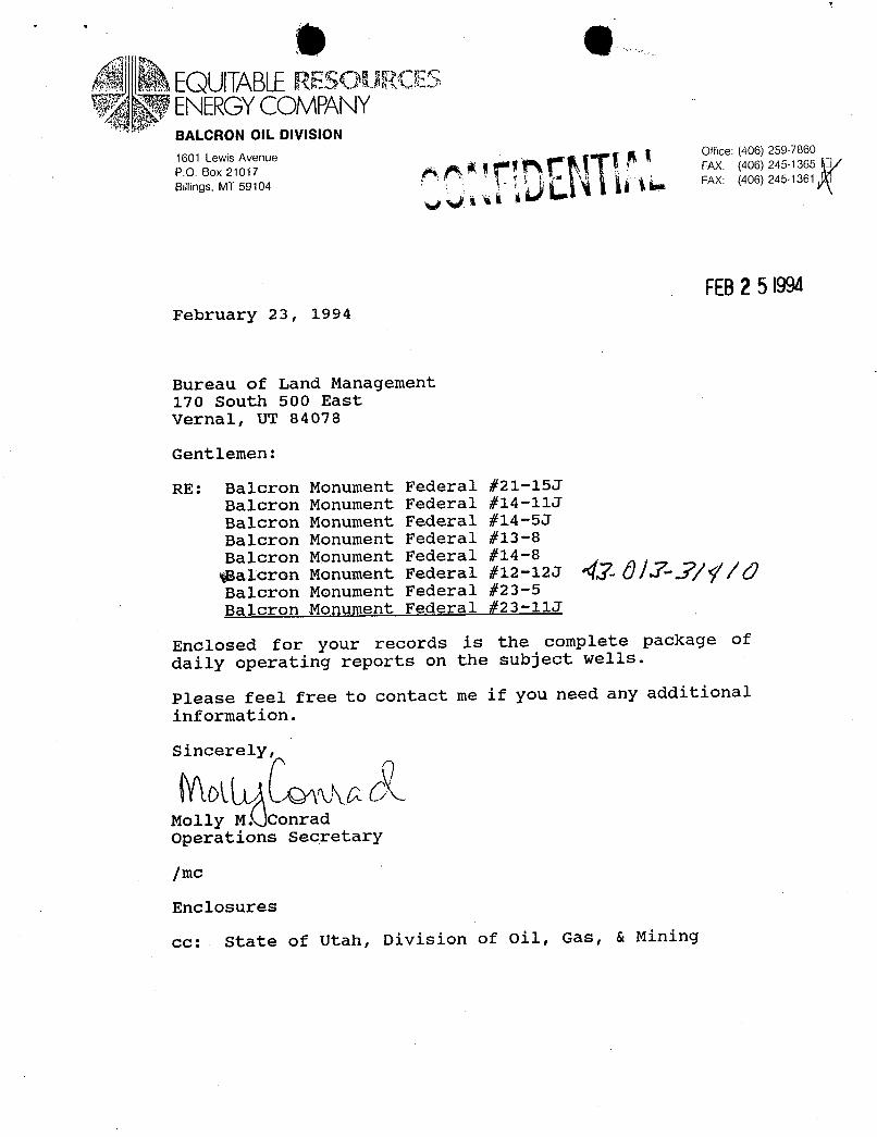
Ñ EQUITABLERESOURŒSvg ENERGYCOMPANYBALCRON OIL DIVISION
1601 Lewis Avenue Ottice: (406) 259-7860
P.O. Box 21017 FAX: (406) 245·1365
Billings, MT 59104 FAX: (406) 245-1361
FEB25\9WFebruary 23, 1994
Bureau of Land Management170 South 500 EastVernal, UT 84078
Gentlemen:
RE: Balcron Monument Federal #21-15JBalcron Monument Federal #14-11J
Balcron Monument Federal #14-5J
Balcron Monument Federal #13-8Balcron Monument Federal #14-8
1Balcron Monument Federal #12-12J Öff-//g/dBalcron Monument Federal #23-5Balcron Monument Federal #23-11J
Enclosed for your records is the complete package ofdaily operating reports on the subject wells.
Please feel free to contact me if you need any additionalinformation.
S cer y
Molly M. ConradOperations Secretary
/mc
Enclosures
cc: State of Utah, Division of Oil, Gas, &
(Iþ (IþFEB15 1994
1
DAILY OPERATING REPORT
BALCRON MONUMENT FEDERAL #12-12JLocation: SW NW Beation 12, T98, R16E
Duchesne County, Utah1980' FNL 660' FWLPTD: 5,800' Formation: Green RiverProspect: JONAH UNIT, Monument Butte FieldElevations: 5,542.82' GLContractor: Union Drilling #17 (10' KB)Operðtor: Balcron/EREC
. Spud: 10-9-93 O 10 a.m. (Dry-Hole)Casing: 8-5/8" 24# J-55 O 276.69' KB
5-1/2" 15.5# K-55 G 5777.59'Tubing:
.
2-7/8" 6.5# J-55 @ 5309.88' KB
10-9-93 Well spud w|a dry-hole spudder (Leon Ross) on 10-9-93 @ 10 a.m.
ÀOy7-93 Stubbs started building location.
10-8293 . Building location.
10-9-93 Digging pits on location, Leon Ross Air Drilling RU & spudded @ 10a.m.. Drilling 12-1/4" hole to 275', TD @ 8 p.m.
10-10-93 Ran 6 jts 24#, J-55 Newport 8-5/8" csg 266.69', set @ 276.69 KB.Omt w/150 sxs "G" w|additives. Run wood top plug.
10-31-93 TD: 645' (369') Day 1.,
Formation: UintahMW 8.3 VIS 26Present Operation: DrillingMIRU, NU. Test BOP & manifold to 2000# - OK. Test csg to 1500# -
OK. Drill cmt & shoe & survey. Change air head rubber & drill.Change time back 2 hr - 25 hrs drilling.DC: $11,881 CC: $33,303
11-1-93 TD: 2,026' (1,381') Day 2Formation: Green RiverMW 8.3 VIS 26 -
Present Operation: Drilling'Drill, survey, & clean on rig.DC: $18,215 CC: $51,518
11-2-93 TD: 3,205' (1,1797) Day 3Formation: Green RiverMW 8.3 VIS 26 'Present Operation: Drilling '
Drill, survey, clean on rig, & work on winterizing.DC: $16,147 CC:
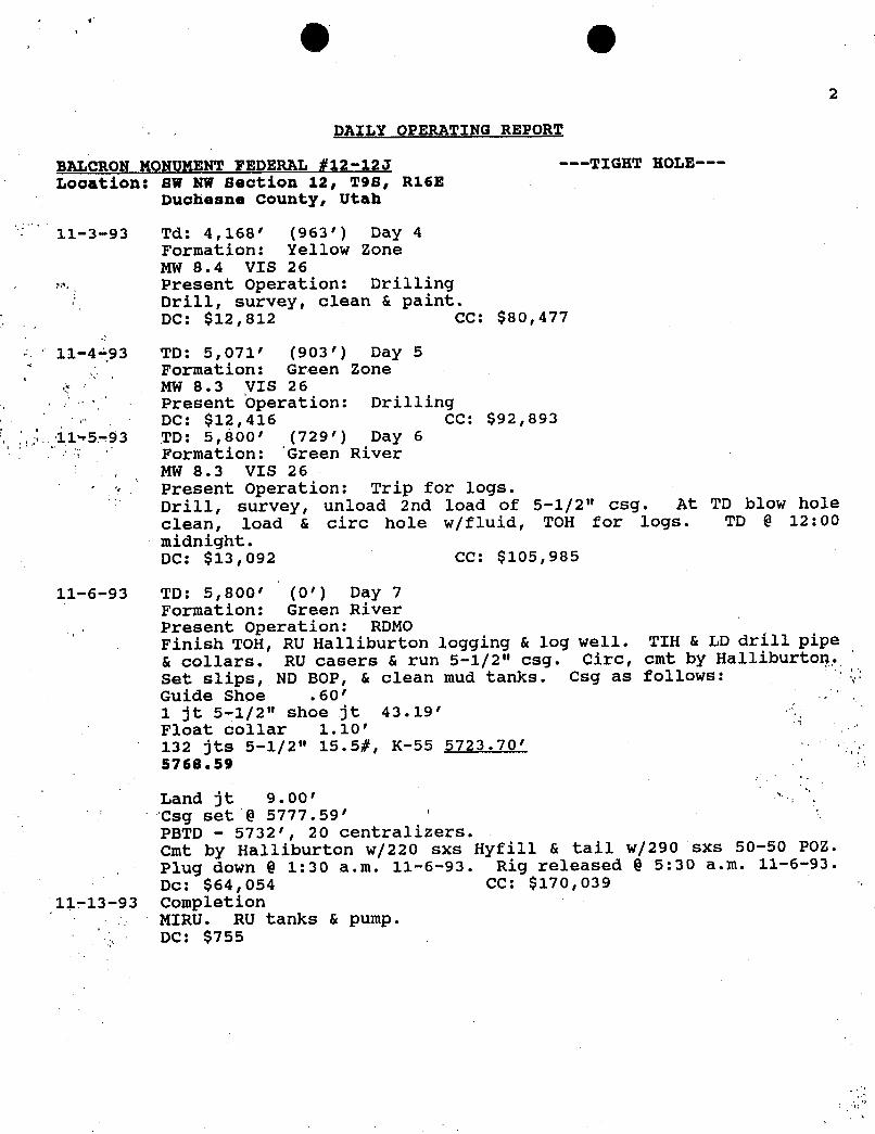
O O2
DAILY OPERATING REPORT
BALCRON MONUMENT FEDERAL #12-12J ---TIGHT HOLE---
Location: BW NW Beation 12, T98, R16EDuchesne County, Utah
11-3-93 Td: 4,168' (963') Day 4Formation: Yellow ZoneMW 8.4 VIS 26Present Operation: DrillingDrill, surveY, clean & paint.DC: $12,812 CC: $80,477
11-4-93 TD: 5,071' (903') Day 5Formation: Green ZoneMW 8.3 VIS 26Present Operation: DrillingDC: $12,416 CC: $92,893
11 5-93 TD: 5,800' (729') Day 6Formation: Green River
. MW 8.3 VIS 26Present Operation: Trip for logs.Drill, survey, unload 2nd load of 5-1/2" csg. At TD blow holeclean, load & circ hole w/fluid, TOH for logs. TD @ 12:00midnight.DC: $13,092 CC: $105,985
11-6-93 TD: 5,800' (0') Day 7Formation: Green RiverPresent Operation: RDMOFinish TOH, RU Halliburton logging & log well. TIH & LD drill pipe& collars. RU casers & run 5-1/2" csg. Circ, cmt by Halliburton.Set slips, ND BOP, & clean mud tanks. Csq as follows:Guide Shoe .60' , .
1 jt 5-1/2" shoe jt 43.19'Float collar 1.10'132 jts 5-1/2" 15.5#, K-55 5723.70'5768.59
Land jt 9.00'Csg set @ 5777.59'PBTD - 5732', 20 centralizers.Cmt by Halliburton w/220 sxs Hyfill & tail w/290 sxs 50-50 POZ.Plug down @ 1:30 a.m. 11-6-93. Rig released @ 5:30 a.m. 11-6-93.
Dc: $64,054 CC: $170,03911-13-93 Completion
MIRU. RU tanks & pump.DC:
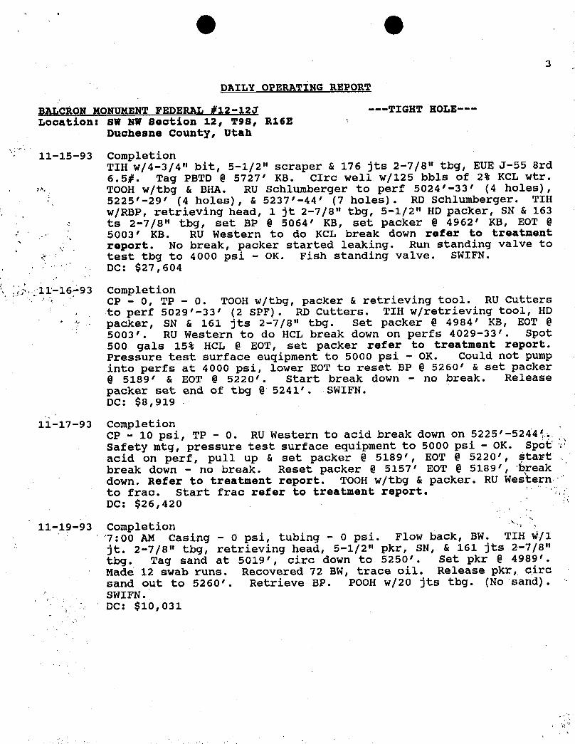
(il (iþ3
DAILY OPERATING REPORT
BALCRON MONUMENT FEDERAL #12-12J ---TIGHT HOLE---
Location: SW NW Bection 12, T98, R16E :
Ducheane County, Utah
11-15-93 CompletionTIH w/4-3/4" bit, 5-1/2" scraper & 176 jts 2-7/8" tbg, EUE J-55 8rd6.5#. Tag PBTD @ 5727' KB. CIrc well w/125 bbls of 2% KCL wtr.TOOH w|tbg & BHA. RU Schlumberger to perf 5024'-33' (4 holes),5225'-29' (4 holes), & 5237'-44' (7 holes). RD Schlumberger. TIHw/RBP, retrieving head, 1 jt 2-7/8" tbg, 5-1/2" HD packer, SN & 163ts 2-7/8" tbg, set BP @ 5064' KB, set packer @ 4962' KB, EOT @5003' KB. RU Western to do KCL break down refer to treatmentreport. No break, packer started leaking. Run standing valve totest tbg to 4000 psi - OK. Fish standing valve. SWIFN.DC: $27,604
11-16 93 CompletionCP - 0, TP - 0. TOOH w|tbg, packer & retrieving tool. RU Cuttersia> perf 5029'-33' (2 SPF). RD Cutters. TIH w|retrieving tool, HDpacker, SN & 161 jts 2-7/8" tbg. Set packer @ 4984' KB, EOT @5003'. RU Western to do HCL break down on perfs 4029-33'. Spot500 gals 15% HCL @ EOT, set packer refer to treatment report.Pressure test surface euqipment to 5000 psi - OK. Could not pumpinto perfs at 4000 psi, lower EOT to reset BP @ 5260' & set packer@ 5189' & EOT @ 5220'. Start break down - no break. Releasepacker set end of tbg @ 5241'. SWIFN.DC: $8,919 -
11-17-93 CompletionCP - 10 psi, TP - 0. RU Western to acid break down on 5225'-52441.Safety mtg, pressure test surface equipment to 5000 psi - OK. Spoiacid on perf, pull up & set packer @ 5189', EOT @ 5220', startbreak down - no break. Reset packer @ 5157' EOT @ 5189', 'breakdown. Refer to treatment report. TooH w/tbg & packer. RU WeÑternto frac. Start frac refer to treatment report.DC: $26,420
11-19-93 Completion7:00 AM Casing - O psi, tubing - O psi. Flow back, BW. TIH w/1jt. 2-7/8" tbg, retrieving head, 5-1/2" pkr, SN, & 161 jts 2-7/8"tbg. Tag sand at 5019', circ down to 5250'. Set pkr @ 4989'.Made 12 swab runs. Recovered 72 BW, trace oil. Release pkr, circsand out to 5260'. Retrieve BP. POOH w/20 jts tbg. (No sand).
'. SWIFN.
DC:

4
DAILY OPERATING REPORT
BALCRON MONUMENT FEDERAL #12-12J ---TIGHT BOLE---
Location: BW NW Bection 12, T98, R16EDuchesne County, Utah
11-19-93 CompletionCP - 10 psi, TP - 10 psi. TOOH w/tbg, packer & BP. RIHw/production string:
Length Depth KB1 jt tbg 2-7/8" EUE J-55 8rd 6.5# 31.30 5309.88'1 perf sub 2-7/8" x 3' 3.20 5278.58'1 seat nipple 1.10 5275.38'171 jt 2-7/8" EUE J-55 Brd 6.5# 5264.28 5274,28'KB 10.00ND BOP, NU wellhead. TIH w/production rod string: 1 BHP 2-1/2" x1-1/2" x 16' RWAXw/PA plunger (Trico), 209 3/4" x 25' plain rods,one 3/4" x 8' pony; one 3/4" x 4' pony; one 1-1/4" x 22' polish rodSM. Clamp rods off. Pressure test to 1000# - OK. SWI.DC: $1,742
12- -É'3 CompletionStart unit pumping, 5 SPM, 86" stroke length. Beam pump, BethlehamC-320-212-86 unit, S/N 30617E-31 3665. Engine - Ajax model E-42
S/N 68203.DC:
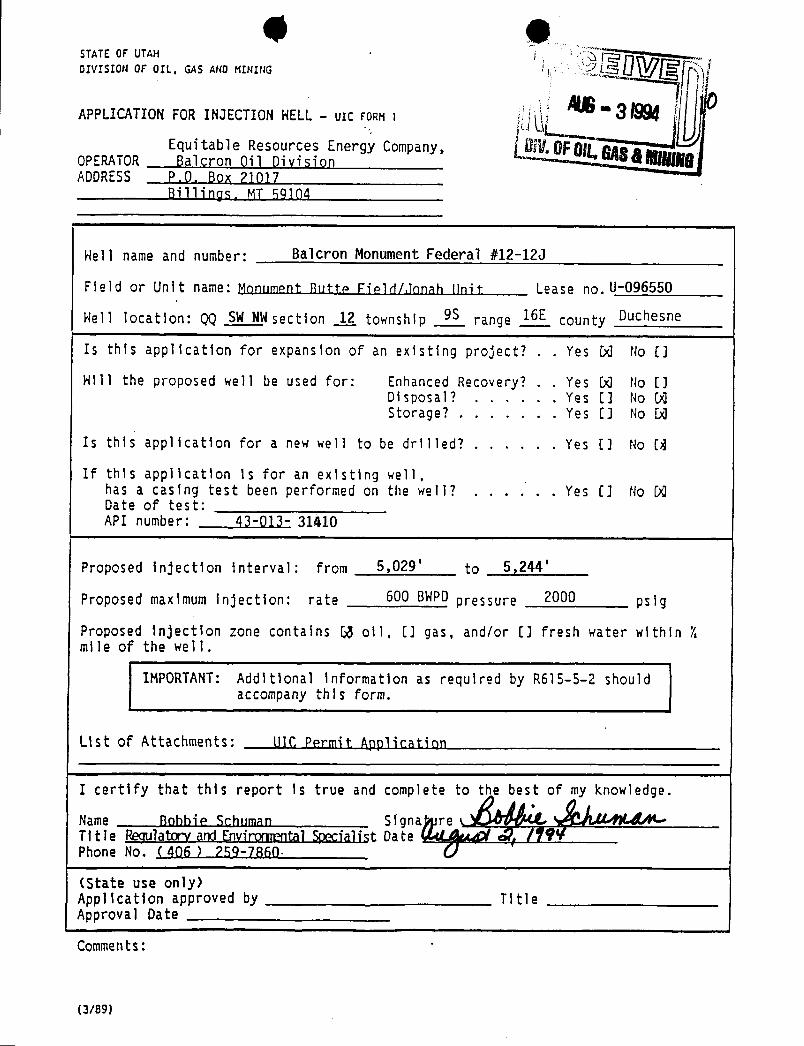
© 9STATEOF UTAH iDIVISION OF OIL. GASAND HIFIIIIG
APPLICATIONFOR INJECTION HELL - ulc FORM i
Equitable Resources Energy Company, Dif.0F0g ggOPERATOR Salçron Oil Division HADDRESS P,0, Box 71017
Billings MT59104
Hell name and number: Balcron Monument Federal #12-120
Field or Unit name: Monument Rutte Field/Jonah linit Lease no.U-096550
Hell location: QQ SWNWsection _1_2_ township 9S range 16E county Duchesne
Is this application for expansion of an existing project? . . Yes 50 No []
Hill the proposed well be used for: Enhanced Recovery? . . Yes 50 No []Disposal? . . , . . . Yes [] No DQStorage? . . . . . . . Yes [J No DQ
Is this application for a new well to be drilled? . . . . . . Yes [] No [8
If this application is for an existing well,has a casing test been performed on the well? . . . . . . Yes EJ No 90Date of test:API number: 43-013- 31410
Proposed injection interval: from 5,029' to 5,244'
Proposed maximum injection: rate 600 BWPDpressure 2000 psig
Proposed injection zone contains 53 oil, EJ gas, and/or EJ fresh water within Xmile of the well.
IMPORTANT: Additional Information as required by R615-5-2 shouldaccompany this form.
List of Attachments: UTC Permit Application
I certify that this report 1s true and complete to the best of my knowledge.
Name Robbie Schuman Signa re aTitle Regulatory andEnviromental Specialist Date Ñ /ŸŸVPhone No. (406 ) 259-7860·
(State use only)Application approved by TitleApproval Date
I
Comments: '
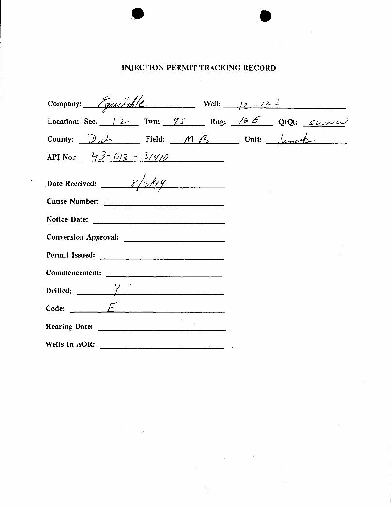
e
INJECTION PERMIT TRACKING RECORD
Company: gr C Well: 7 - / L A
Location: Sec. / > Twn: 21 Rng: /G QtQt: T
County: Field: /Y) . 6 Unit:
API No.: Of i - À(q'/p
Date Received: 57 ŸCause Number:
Notice Date:
Conversion Approval:
Permit Issued:
Commencement:
Drilled:
Code:
Hearing Date:
Wells In
e
INJECTION PERMIT TRACKING RECORD
Company: gr C Well: 7 - / L A
Location: Sec. / > Twn: 21 Rng: /G QtQt: T
County: Field: /Y) . 6 Unit:
API No.: Of i - À(q'/p
Date Received: 57 ŸCause Number:
Notice Date:
Conversion Approval:
Permit Issued:
Commencement:
Drilled:
Code:
Hearing Date:
Wells In
e
INJECTION PERMIT TRACKING RECORD
Company: gr C Well: 7 - / L A
Location: Sec. / > Twn: 21 Rng: /G QtQt: T
County: Field: /Y) . 6 Unit:
API No.: Of i - À(q'/p
Date Received: 57 ŸCause Number:
Notice Date:
Conversion Approval:
Permit Issued:
Commencement:
Drilled:
Code:
Hearing Date:
Wells In
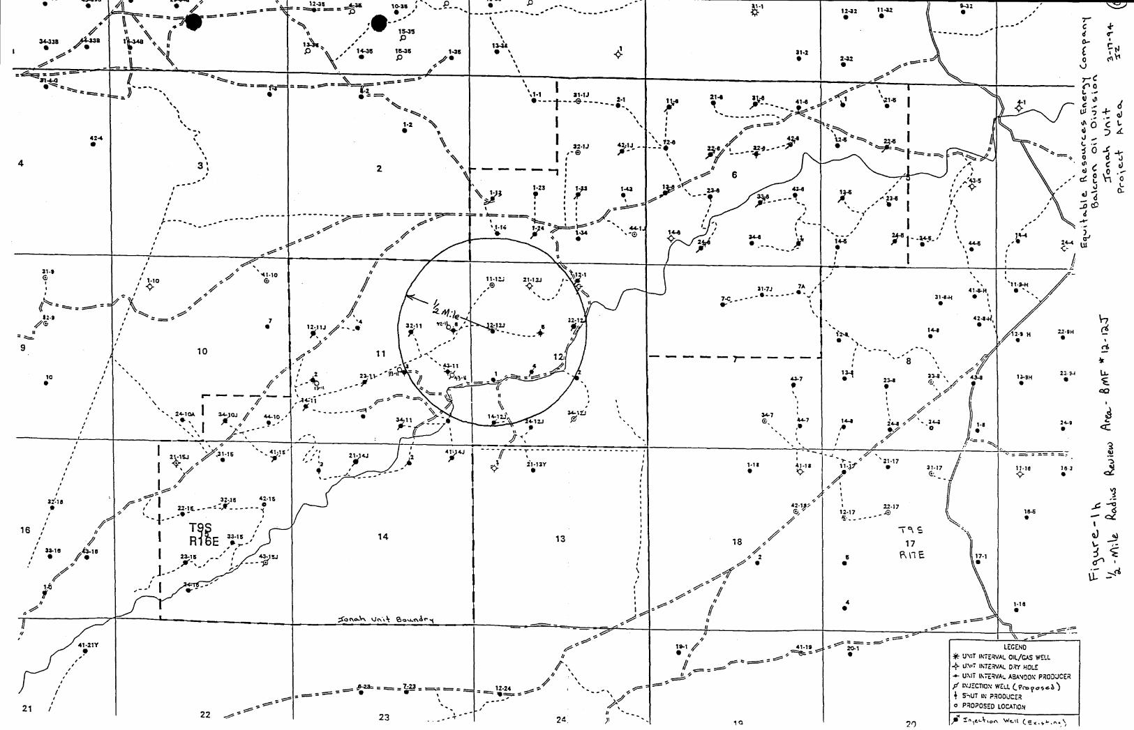
..-.
-
MI s'e ' // 1145 10-38
-- '- -.-'
1242 1142 e ,#
------ oct42 \ -'
4 3 2 ' ""6
.s
,
-2:
s r, , i, 1 -1
31•$ s 1-10 11-1 21•12J
31-7J- - -
31414-H
1J 3 112.
12 5 H 21-9H
-----r--- ''810 1 SH
2 34
-15 '- 2 4J 24 4J
118 182117
i.;
3 -JS 42 1542-1g i 22 17
i -5
3f·18
6, 12-17
T16 h
RE10 15
1-18
//
41-19 LEGEHO41-21Y
UN T INTERVALOIL/CAS WELLp=~-UN I INTERVAL DRY HOLE,'
UNii IN'ERVAt.ASANDONPRODUCERf INJECTION WELL(ProposeÙ= ==== = - 1 '
. ,-
¼5,UT IN P.RODUCER/
..
o PROPOSED LOCATION21 / -~'~-'~' ' - "-> f L'e-4,o^ *-u Cexy -\
22 w-23 ...--« 24 y , so
stateof UtahDEPARTMENT OF NATURAL RESOURCESDIVISION OF OIL, GAS AND MINING
Michael O. Leavitt355 West North Temple
Governor 3 Triad Center, Suite 350
Ted Stewart Salt Lake city.Utah 84180-1203
Executive Director 801-538-5340
James W. Carter 801-359-3940 (Fax)Division Director 801-538-5319 (TDD)
September 1, 1994
Uintah Basin Standard268 South 200 EastRoosevelt, Utah 84066
Gentlemen:
Re: Notice of Agency Action - Cause No. UIC-152
Enclosed is a copy of the referenced Notice of Agency Action. Please publish theNotice, once only, as soon as possible. Please send proof of publication and billing tothe Division of Oil, Gas and Mining, 355 West North Temple, 3 Triad Center, Suite 350,Salt Lake City, Utah 84180-1203.
Sincerely,
Lisa D. ClementAdministrative Secretary
Enclosure

0 eO State of Utah
DEPARTMENT OF NATURAL RESOURCESDIVISION OF OIL, GAS AND MINING355 West North Temple
Michael O. LeavittGovernor 3 Triad Center, Suite 350
Ted Stewart Salt Lake City. Utah 84180-1203
Executive Director 801-538-5340
James W. Carter 801-359-3940 (Fax)Division Director 801-538-5319 (TDO)
September 1, 1994
Newspaper Agency CorporationLegal Advertising157 Regent StreetSalt Lake City, Utah 84110
Gentlemen:
Re: Notice of Agency Action - Cause No. UIC-152
Enclosed is a copy of the referenced Notice of Agency Action. Please publish theNotice, once only, as soon as possible. Please send proof of publication and billing tothe Division of Oil, Gas and Mining, 355 West North Temple, 3 Triad Center, Suite 350,Salt Lake City, Utah 84180-1203.
Sincerely,
Lisa D. ClementAdministrative Secretary
Enclosure
O O
Equitable Resources Energy Company44-1J, 34-10J, 34-11, 12-11], 14-11J,23-11J,32-11J, 43-11], 12-12J, 14-12J,32-121,
C & O Government #4, 21-14J, 41-14], 23-15], 32-15], and 41-15] WellsCause No. UIC-152
Publication Notices were sent to the following:
Newspaper Agency CorporationLegal Advertising157 Regent StreetSalt Lake City, Utah 84110
Uintah Basin Standard268 South 200 EastRoosevelt, Utah 84066
Bureau of Land ManagementVernal District Office170 South 500 EastVernal, Utah 84078
Equitable Resources Energy CompanyP.O. Box 21017Billings, Montana 59104
Dan JacksonU.S. Environmental Protection AgencyRegion VIII999 18th StreetDenver, Colorado 80202-2466
Ed BonnerState Lands and Forestry3 Triad Center, Suite 400Salt Lake City, Utah 84180-1204
Lisd D. ClementAdministrative SecretarySeptember 1,
O OBEFORE THE DIVISION OF OIL, GAS AND MINING
DEPARTMENT OF NATURAL RESOURCESSTATE OF UTAH
---00000---
IN THE MATTER OF THE APPLICATION : NOTICE OF AGENCY ACTIONOF EQUITABLE RESOURCES ENERGYCOMPANY FOR ADMINISTRATIVE : CAUSE NO. UIC-152APPROVAL TO CONVERT THE 44-1J, 34-10J,34-11, 12-11J, 14-11J, 23-11J, 32-11J, 43-11J, 12-12J, :14-12J, 32-12J, C & O GOVERNMENT #4,21-14J, 41-14J, 23-15J, 32-15J, AND 41-15J WELLS, :LOCATED IN SECTIONS 1, 10, 11, 12, 14, & 15,TOWNSHIP 9 SOUTH, RANGE 16 EAST, S.L.M., :DUCHESNE COUNTY, UTAH, TO CLASS IIINJECTION WELLS :
---00000---
THE STATE OF UTAH TO ALL PERSONS INTERESTED IN THE ABOVE ENTITLED MATTER.
Notice is hereby given that the Division is commencing an informal adjudicative proceeding to consider theapplication of Equitable Resources Energy Company ("Equitable") for administrative approval to convert the 44-1J,34-10J, 34-11, 12-11J, 14-11J, 23-11J, 32-11J, 43-11J, 12-12J, 14-12J, 32-12J, C & O Government #4, 21-14J, 41-14J,23-15J, 32-15J, and 41-15J Wells, located in Sections 1, 10, 11, 12, 14 & 15, Township 9 South, Range 16 East,Duchesne County, Utah, to Class II injection wells. The proceeding will be conducted in accordance with UtahAdmin. R.649-10, Administrative Procedures.
Equitable proposes to inject water into the captioned wells in the Green River Formation interval atapproximately 4590 - 5614 feet, for the purpose of secondary recovery operations. Equitable is requesting amaximum injection pressure of 2000 psig and estimates the injection volume to be approximately 600 barrels ofwater per day for each well.
Any person desiring to object to the application or otherwise intervene in the proceeding, must file awritten protest or notice of intervention with the Division within fifteen days of the date of publication of thisnotice. If such a protest or notice of intervention is received, a hearing may be scheduled before the Board of Oil,Gas and Mining. Protestants and/or intervenors should be prepared to demonstrate at the hearing how this matteraffects their interests.
DATED this 1st day of September, 1994.
STATE OF UTAHDIVISION OF OIL, GAS AND MINING
R.J. Firth AAssociate Director, Oil and Gas
Newspaper Agency Corporation143SO HMAI3Ns tÑtikþfegtnutte DESE EWS CUSTOMER'S
SALT LAKE CITY, UTAH 84145 COPYFED. TAX I.D. # 87-0117663 LEGAL ADVERTISING INVOICE
CUSTOMER NAME AND ADDRESS ACCOUNT NUMBER BILLING DATE
DIV OF OIL, GAS & MINING LE-5385340 09/13/94355 WEST NORTH TEMPLE3 TRIAD CENTER #350 FOR BILLING INFORMATIONSLC, UT 84180 CALL (801) 237-2822
AFFIDAVIT OF PUBLICATION
AS NEWSPAPER AGENCY CORPORATION LEGAL BOOKKEEPER, I CERTIFY THAT THE ATTACHEDADVERTISEMENT OF NOTTCE OF AGRMCY ACTTONCAITRE NO. UTC-15?BEFOR FOR
DTV OF OTT,, GAS 2, MTNTNG WAS PUBLISHED BY THE NEWSPAPER AGENCYCORPORATION, AGENT FOR THE SALT BUNE AND DESERET NEWS,DAILY NEWSPAPERSPRINTED IN THE ENGLISH LANGUAGE GENERAL CIRCURATION IN UTAH,AND PUBLISHED
ITY, SALT LAKE CO IN THE STATE OF UTAH.
at o1$ ACCOUNT NAME TELEPHONEmin for od. AIMid, 14emnon MINING 801-538 -5340
ance SCHEDULE AD NUMBER
987102802
. CAPTION MISC. CHARGES
NOTICE OF AGENCY ACTIONCAUSENO. UIC-152BEFOR.00
TIMES RATE AD CHARGEheBoardofoil, a
COLUMN 1 1.64 160.72N RECEIPT OF THIS INVOICE
160.72THANK YOU FOR USING LEGAL ADVERTISING.
PLEASE RETURN THIS PORTION LEGAL ADVO6-NT
WITH YOUR PAYMENT IN THE ENCLOSED ENVELOPE ADVERTISING
ACCOUNT NUÏlEER AD NUMBER - -BILLING DATE PAY THIS ADOUNT
to LE-¶38 340 98710280 09/13/94 160.72LEGAL ADVERTISING MAKE CHECKS PAYABLE TO:
NEWSPAPER AGENCY CORPORATION
DIV OF OIL, GAS & MININGNEWSPAPER AGENCY CORPORATION 355 WEST NORTHTEMPLE
SALTLAKELCO. BOXUT 3884145-0838 SL'PRIAD CE 3
L
IJJ-JO.
07 7170676102801 000160726 000160726

DIVISION OF OIL, GAS AND MININGUNDERGROUND INJECTION CONTROL PROGRAM
PERM1TDECISION DOCUMENT
Applicant: Balcron Oil Location: Jonah Unit
Wells: Federal 34-10,12-11,14-11,23-11,32-11,34-11,43-11,C&O Govt. #4,12-12,14-12,32-12,21-14,41-14,23-15,32-15,41-15 and 44-1
Ownership Issues: The proposed wells are located in sections 1,10,11,12,14 and 15township 9 south, range 16 east, Duchesne County, Utah. Surface ownership withinthe1/2 mile area is held by the BLM and the State of Utah. All of the wells are located onFederal land. Mineral interests are held by private individuals, the State of Utah, and thefederal government. Balcron Oil has submitted an affidavitstating that a copy of UIC form1 was sent as notice to all surface owners and operators withina 1/2 mile radius of eachof the proposed injection wells.
Well Integrity: The seventeen wells proposed for conversion to injection all have surfacecasing set at approximately 300 feet ± 30 feet, and were all cemented to surface.Production casing was set at a depth of approximately 5600 feet - 5800 feet, and wereall cemented above the injection zone. Cement bond logs are on file with the Divisionand verify reported cement tops. The interval from 4590-5614 feet (Green RiverFormation) has been perforated for water injection. A 2 7/8 inch tubing witha packer willbe set above the perforations for injection of water. There are 27 producing wells, 17injection wells and 5 plugged and abandonded wells in the 1/2 mile area of review. Allwells in the AOR have sufficientcement behind the production string and have adequatesurface casing to prevent migration of fluid up the hole. At the time of conversion thecasing will be pressure tested. Casing/tubing annulus pressure willbe monitored on adaily basis and reported on a monthly basis thereafter. Additional casing pressure testsshall be run every five years or whenever the tubing and packer assemblies are pulledfor workover purposes.
Ground Water Protection: The base of moderately saline water in the area of the projectis at a depth of approximately 300-500 feet. Each of the injection wells and offsetproducing wells have adequate surface casing and sufficient cement on the productioncasing to protect fresh water. The submitted fracture pressure for the field is .861 psi/ftresulting in a maximum allowed surface pressure of 2000 psi. Injection pressures foreach of the injectors will be maintained below the fracture pressure so as not to initiatefractures in the overlying strata. The confining intervals above and below the injectionzone consists of tight shales, siltstones and limestones of the Green River Formation.Water analysis indicate that the TDS of injection zone is greater than 10,000
O OOil/Gas & Other Mineral Resources Protection: Balcron is the operator of the JonahUnit. A unit agreement was previously formed, correlative rights issues were addressedbefore the Board of Oil, Gas and Mining when the matter was heard.
Bonding: Balcron is the operator of all wells within the project and is bonded by theFederal Government.
Actions Taken and Further Approvals Needed: These applications are for wells in anexisting waterflood unit, previously supplied data and information along with newlysubmitted data supports a decision to approve the wells for conversion to injection. Apublic notice has been published in both the Salt Lake Tribune and the Uinta BasinStandard. The applications for the injection wells are technicallycomplete.. A casingpressure test needs to be conducted when the well is converted and a casing\tubingpressure test run prior to injection. The casing tubing annulas needs to be pressured to1000 psi and not 500 psi as stated in the permit. Following the 15 day comment periodif no objections are received it is recommended to issue both an approval to convert thewells and an injection permit. There are no special conditions or stipulations and thepermit should be granted in accordance with the conditions set forth in the application.
DJJ 09-30-94Reviewers
Form 3160-5 · UNITED STATES I FORM APPROVED'June 1990) DEPARTMENT OF THE INTERIOR
• BudExeBureau No. 10 135
. BUREAU OF LAND MANAGEMENT 3. i.cuc Designation and Serial No.
SUNDRY NOTICES AND REPORTS ON WELLS di n lo rTnkiS ng
Do not use this form for proposals to dr111or todeepen or reentry to a different reservoir. n/aUse "APPLICATION FOR PERMIT-" for such proposals7..If Unitor CA, Agreement Designation
SUBMIT IN TRIPLICATE .Jonah Um t1. Type of Well .
e11 WH OŒer 8. Weu Nm a 4 No.
1. Nameor operator See attached l i sti ngEquitable Resources Energy Company, Balcron Oil Division 9·^rtwenN=·
3. AddressandTelephoneNo. - See attached listingP.O. Box21017; Billings, MT 59104 (406) 259-7860 10.FieldandPool.orExploratoryArea
4. Location of Well (Footage, Sec., T., R., M., or Survey Description) MOnument Butte/Green R$VOP11. County or Parish, State
See attached listingDuchesne County, UTAH
:2. CHECK APPROPRIATE BOX(s) TO INDICATENATUREOF NOTICE, REPORT, OR OTHER DATA
TYPE OF SUSMISSION • TYPE OF ACTION
Notice of Intent O Abandonant O Change of Plans
O a--sic,... O s,w c..rucio.O Subsequent Repon O eleggi.,a..e O Non-Routine Fracturing
O c.,,,, a...., O Water Shut-Off
O Final Abandonment Notice O sacri., c..., Ð c...........inace..O o..,
·
· O oisposew.ser(Note:ReponsessinoimultiplecomplctionenWcliCompletioner Recomptction Report and Lot form.I
13. Describe Proposed or Completed Operations (Clearly state a 1pertinent detaih. and give peninent dates, including estimated date of staning any proposed work. If wc11 is directionally drilled,give subsurface locations and measured and true vertical depths for all markers and zones peninent to this work.)*
Operator intends to convert the wells on the attached listing to water injectionin accordance with the attached injection well completion diagrams. Water willbe injected at a rate of 5-6 STBWPDper foot of pay (average 180-200 STBWPD).The proposed conversion and water injection will commence as soon as Utah StateUIC permits are approved.
5. I hereby certi¶)hat the foregoing ' e and conect RegUl atory andsignea Ly /)?Ñ// ña, Fnvironmental Specialist onte /Â(This sp or deraTËr see use)
1Approved by Titir DateConditions of approval, if any:
Tide 18 U.S.C. Section 1001, makes it a crime for any person knowingly and willfully to make to anydepartment or agency of the United States any false, lictitious or fraudulent statementsor representations as to any matter within its
WELLNAME FIELD QTR/QTR SEC. TWP.RANGE COUNTY ZONE LEASENO. API NUMBER FOOTAGES UNIT
Balcron Monument Fed. #32-15 Monument Butte SW NE 15 9S 16E Duchesne Green River U-017985 43-013-31368 1868' FNL, 1993' FEL JonahBalcron Monument Fed. #23-15 Monument Butte NESW 15 9S 16E Duchesne Green River U-017985 43-013-31373 1724' FSL, 2078' FWL JonahBalcron Monument Fed. #41-15 MonumentButte NENE 15 9S 16E Duchesne Green River U-017985 43-013-31367 460' FNL,500' FEL JonahBalcron Monument Fed. #34-10J Monument Butte SW SE 10 9S 16E Duchesne Green River U-017985 43-013-31416 592' FSL, 1979.2' FEL Jonah
Balcron Monument Fed. #32-12J Monument Butte SW NE 12 9S 16E Duchesne Green River U-035521 43-013-31419 1804.8' FNL,2138.6'FEL Jonah
C&O Gov't #4 Monument Butte NE SW 12 9S 16E Duchesne Green River U-035521-A 43-013-30742 2140' FSL, 1820' FWL JonahBalcon Monument Fed. #14-12J Monument Butte SWSW 12 9S 16E Duchesne Green River U-035521-A 43413-31411 660' FSL, 660' FWL Jonah
BalcronMonumentFed. #14-11 MonumentButte SWSW 11 9S 16E Duchesne Green River U-096547 43-013-31374 1048' FSL,448' FWL JonahBalcron MonumentFed. #21-14J MonumentButte NE NW 14 9S 16E Duchesne GreenRiver U-096547 43-013-31421 517.8'FNL, 1850.2'FWL Jonah
BalcronMonumentFed. #12-11J MonumentButte SW NW 11 9S 16E Duchesne Green River U-096550 43-013-31417 2128' FNL,689' FWL JonahBalcron Monument Fed. #43-11J Monument Butte NE SE 11 9S 16E Duchesne Green River U-096550 43-013-31002 2126.9'FSL, 692.8'FEL JonahWaltonFederal #34-11 MonumentButte SWSE 11 9S 16E Duchesne Green River U-096550 43-013-31003 537 FSL,2092' FEL JonahBalcron MonumentFed. #23-11 Monument Butte NE SW 11 9S 16E Duchesne Green River U·096550 43-013-31369 1787 FSL, 2147 FWL JonahBalcron MonumentFed. #32-11 MonumentButte SW NE 11 9S 16E Duchesne Green River U-096550 43-013-31386 2059' FNL, 1763' FEL JonahBalcron Monument Fed. #41-14J Monument Butte NE NE 14 9S 16E Duchesne Green River U-096550 43-013-31408 363.3'FNL, 600' FEL JonahBalcron Monument Fed. #12-12J Monument Butte SW NW 12 9S 16E Duchesne Green River U-096550 43-013-31410 738.6'FNL, 648.2'FWL Jonah
Balcron Monument Fed. #44-1J Monument Butte SE SE 1 9S 16E Duchesne Green River U-44426 43-013-31415 859' FSL, 338' FEL
BALCRONMONUMENTFEDERAL#12-12J BALCRONOILJonah Unit/MonumentButteField 7-5-94/ksLease No.U-096550SW NWSection 12, TBS,R16E Proposed InjectionWellCompletionDiagramDuchesne County,Utah
Elev.GR@5542'Elev.KB@5552' KB(10' KB)
SURFACECASING
8-5/8", 24#, J-55 <-27T KBLength@ 266.69'Depth1.anded@2T/' KBCementedw/150sxs Class "G"w/2%CaCI,1/4WsxCeloflakes.
Cemented tosurface.Holesize@12-1/4".
PRODUCTIONCASING '- UintahFormation@ Surfaceto 1400'-
5-112",15.5#, [email protected]'DepthLanded@ 5T/7.59' KB.Cemented w/220sxs Hyfillandtailedw/290sxs 50-50 POZ.
Cement top@ 4,185' fromCBL •
Holesize 7-7/8".
TUBING------ -- Green RiverFormation@ 1400'to4100' -
2 7/8", 6.5#, J-55 <--- Top of Cement@4185' from CBLSN @2-7/8"x 1.1'(2.25"ID)SN Landed@4926' KB
RetrievableCsgTension PackerModel:ArrowSet-1Landed@4930' KB Ñ Ñ <--- RetrievableCsgTensionPacker@4930' KB
PERFORATION RECORDProposed InjectionHorizons ----------------- ------
5029'-5033'(4')4 shots GREEN15029'- 5033'(4')4 shots GREEN1 5225'-5229'(4')4 shots GREEN45225'- 5229'(4')4 shots GREEN4 5237- 5244'(T) 7 shots GREEN4523T- 5244'(T) 7 shots GREEN4
- DouglasCreek Member@4100' to5350'-
PBTD@5732'KBTD@5800'KB
- Wasatch FormationTransition@5350' to6000'-- Wasatch Formation@6000'
e eEQUlTABLERESOURCESENERGYCOMPANYBALCRON OIL DIVISION1601 Lewis Avenue Office: (406) 259-7860P.O. Box 21017 FAX: (406) 245-1365Billings, MT 59104 FAX: (406) 245-1361
SEPI 3September 12, 1994
Bureau of Land Management Ë$LCRQg 0 AIMGNT 76/Ve n
T580400East fLC /Q 7~Ÿf & /Of4 - 0/17///O
Gentlemen:
Enclosed are Notices of Intent to convert the seventeen wellson the enclosed list to water injection.
If you have any questions or need additional information, pleaselet me know.
Sincerely,
Bobbie SchumanRegulatory and Environmental Specialist
/hs
Enclosures
cc: Dan Jarvis, Utah Division of Oil, Gas and
e eEQUlTABLERESOURCESENERGYCOMPANYBALCRON OIL DIVISION1601 Lewis Avenue Office: (406) 259-7860P.O. Box 21017 FAX: (406) 245-1365Billings, MT 59104 FAX: (406) 245-1361
SEPI 3September 12, 1994
Bureau of Land Management Ë$LCRQg 0 AIMGNT 76/
Ve nT580400East fLC /Q 7~Ÿf & /Of
4 - 0/17///OGentlemen:
Enclosed are Notices of Intent to convert the seventeen wellson the enclosed list to water injection.
If you have any questions or need additional information, pleaselet me know.
Sincerely,
Bobbie SchumanRegulatory and Environmental Specialist
/hs
Enclosures
cc: Dan Jarvis, Utah Division of Oil, Gas and
e eState of UtahDEPARTMENT OF NATURAL RESOURCESDIVISION OF OIL, GAS AND MINING355 West North Temple
Michael O. LeavittGovernor 3 Triad Center, Suite 350
Ted Stewart Salt Lake City, Utah 84180-1203
Executive Director 801-538-5340
James W. Carter 801-359.3940 (Fax)Division Director 801-538-5319 (TDD)
UNDERGROUND INJECTION CONTROL PERMIT
Cause No. UIC-152
operator: Equitable Resources Energy Company
Wells: Monument Butte Federal 34-10, 12-11, 14-11, 23-11,32-11, 34-11, 43-11, 12-12, 14-12, 32-12, 21-14,41-14, 23-15, 32-15, 41-15, 44-1 and C&O Govt.#4
Location: Sections 1, 10, 11, 12, 14 and 15, Township 9 s,Range 16 E,Duchesne County
Well Type: Enhanced Recovery (waterflood)
Stipulations of Permit Approval
1. Approval for conversion to Injection Wells issued onOctober 4, 1994.
2. Maximum Allowable Injection Pressure: 2000 psig
3. Maximum Allowable Injection Rate: 600 bb1s per day/well
Approved by:
R.J. Firt DateAssociate Director, Oil and
O State of UtahDEPARTMENT OF NATURAL RESOURCESDIVISION OF OIL, GAS AND MINING355 West North Temple
Michael O. LeavittGovernor 3 Triad Center, Suite 350
Ted Stewart Salt Lake city,Utah 84180-1203
Executive Director 801-538.5340
James W. Carter 801-359-3940 (Fax)Division Director 801-538-5319 (TOD)
October 4, 1994
Equitable Resources Energy CompanyBalcron Oil Division1601 Lewis AvenueBillings, Montana 59104
Re: . Monument Butte Federal 34-10, 12-11, 14-11, 23-11, 32-11, 34-11, 43-11, 12-12, 14-12, 32-12, 21-14, 41-14, 23-15, 32-15, 41-15, 44-1 and CßcO Govt.#4 Wells Locatedin Sections 1, 10, 11, 12, 14 and 15, Township 9 South, Range 16 East, DuchesneCounty, Utah
Gentlemen:
In accordance with Utah Admin. Code R.649-5-3-3, the Division of Oil, Gas andMining (the "Division") issues its administrative approval for conversion of the referencedwells to Class II injection wells.
The following stipulations shall apply for compliance with this approval:
1. Full compliance with all applicable requirements regarding operation,maintenance and reporting for Underground Injection Control ("UIC") ClassII injection wells pursuant to Utah Admin. Code R.649-1 et seq.
2. Conformance with all conditions and requirements of the enclosedUnderground Injection Control Permit and the application submitted byEquitable Resources Energy Company.
If you have any questions regarding this approval or the necessary requirements,please contact Dan Jarvis at this office.
Associate Directorcc: Dan Jackson, EPA
Bureau of Land Management,
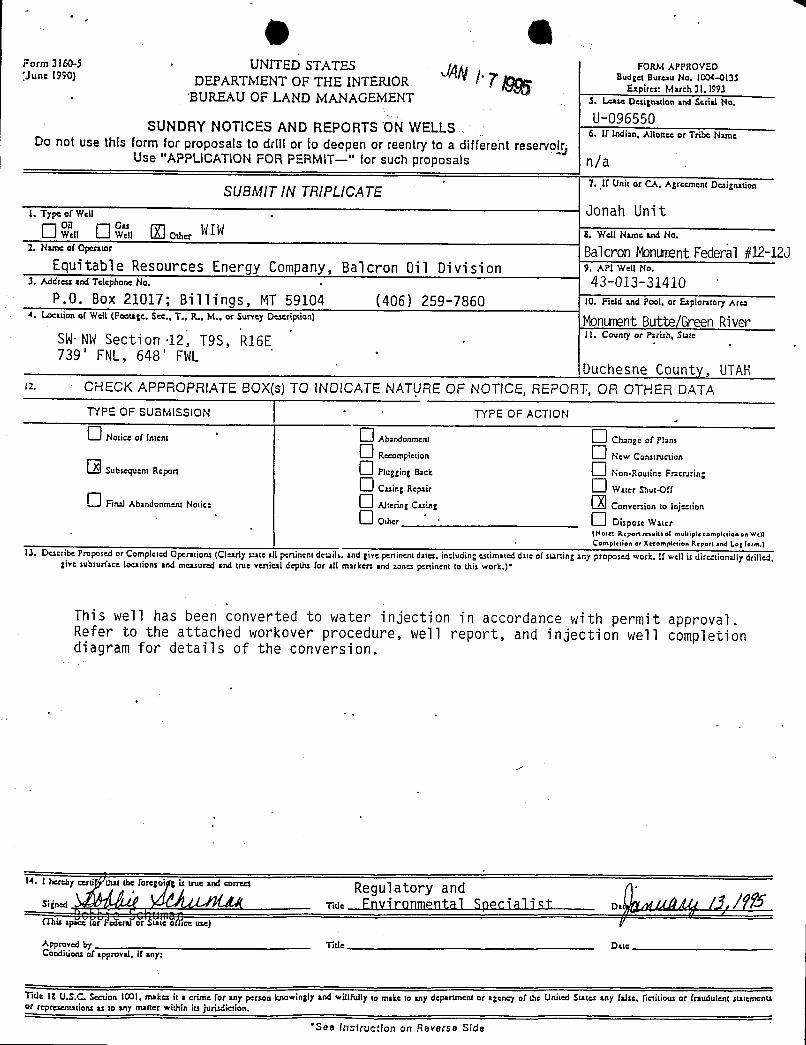
-
g gForm 3160-5 · UNITED STATES FORM ^PPROVED'June 1990) DEPARTMENT OF THE INTERIOR BudE
i a 3 3. BUREAU OF LAND MANAGEMENT 3. t.case oesignauonand serialNo.
U-096550SUNDRY NOTICES AN D REPORTS ON WELLS 6. If indian, Allottee or Tribe NameDo not use this form for proposals to drlli or todeepen or reentry to a different reservok)
Use "APPLICATION FOR PERMIT-" for such proposals n/a
SUBMIT IN TRIPLICATE. 7..it uniror ca, Agreement
oexiga.uin-
1. Type a(Well . Ü0nah UnitO °".a O °"a U os, WI W a. wenu.....« so.
2· "'"= °'°P="'=' Balcron MonurœntFederal #12-12JEquitable Resources Energy Company, Balcron Oil Division 9.AP1WeßNo.
.1. Addren and Telephone No. • 43-013-31410P.O. Box 21017; Bill ings, MT 59104 (406) 259-7860 10. Field and Pool, or Exploratory Arca
4. Lo:nion er wentrootage,see.,T.. a.. M.. or smey oescripsi°") MonurœntButte/Green RiverSW NWSecti on ·12, T9S, R16E n. conmyor ruus, sw.
739' FNL, 648' FWLDuchesne County, UTAH
12. CHECK APPROPRIATE BOX(s) TO INDICATE NATURE OF NOTICE, REPORT, OR OTHER DATATYPE OF SUSMISSION TYPE OF ACTION
O s.ac..n...., · O a 22...... O es2.,. or n...O a-si.ao. O s,w c.-...
Subsequent Repon Plugging Back Non-Routine Fr2cruringO c22,,,a=,.i, O w..., s,...ox
O Final Abandonment Notice Altering Casing Conymian to InynonO o,»
·
· O os,... w.(Note: Reponrrsuksol muhiplecornpirdononWellCompiction or Recompittion Report and I.og form.)
13. Describe Proposed or Completed Operations (Clearly state all pertinent detaih. and give peninent dates, including estimated date of st2ning any proposed work. If well is directiona1|y drilled,give subsurface locations and measured and true venical depths for all markers and zones peninent to this work.)•
This well has been converted to water injection in accordance with permit approval.Refer to the attached workover procedure, well report, and injection well completiondiagram for details of the conversion.
E. I eby ceni eut the toregoi , is une .na °°= ' Regul atory andsignea Ad AAJX.4 ·r.rie Fnvironmental Specialist os wuAg /4,/ffS(This spk ŸaiFederaf Jr faie 6Tisceuse)
Approved by 'title DateConditions of approval, if any:
Title 18 U.S.C. Section 1001, rnakes it a crime for any person knowingly and willfully to make to any department or agency of the United Sutes any false, fictitious or fraudulent statementsor representations as to any matter within its jurisdiction.
See lastructiort on Reverse
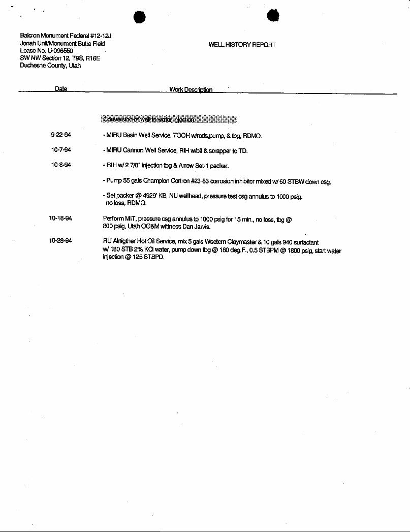
Balcron Monument Federal #12-12JJonah Unit/MonumentButte Field WELLHISTORYREPORTLease No. U-096550SW NW Section12, T9S,R16EDuchesne County,Utah
Dgg WorkDescriptien
Conversionofwelltowater injectiert
9-22-94 - MIRUBasinWellService,TOOHw/rods,pump,&1bg,RDMO.
10-7-94 - MIRUCannon WellService,RIHwhit &scrappertoTD.
10-8-94 - RIHw/2 7/8" injectionibg &ArrowSet-1packer.
- Pump 55 gals ChampionCortron#23-83corrosioninhibitormixedw/60 STBW downcsg.
- Set packer @4929' KB,NUwellhead, pressure testcsg annulusto 1000 psig.no loss, RDMO.
10-18-94 PerformMIT,pressure csg annulusto1000 psigfor15 min.,no loss, ibg @800 psig,UtahOG&MwittnessDanJarvis.
10-28-94 RUAlnigtherHotOilService,mix5 gals WseternClaymaster& 10 gals940 surfactantw/ 130STB2% KCIwater,[email protected].,0.5 STBPM@1800 psig,startwaterinjection@ 125

Balcon MonumentFederal#12-12J BALCRONOILSW NW Section12, T9S, R16E 1-11-94 JZ737' FNL&648' FWLLease No. U-096550 Injg¢tionWell Completion DiagramJonah Unit/Monument Butte FieldDuchesne County,Utah
Elev.GR @5542' UTAHCAUSE NO.: UIC-152Elev.KB@5552' KB (10' KB)
SURFACECASING
58" 24 J-55 <-277' KBLength @266.69'Depth Landed @277' KBCementedw/150 sxs Class "G"w/2%CaCI, 1/4#/sx Celoflakes.
Cementedtosurface.Holesize@ 12-1/4".
PRODUCTIONCASING - UintahFormation@Surfaceto1400'
5-1/2", 15.5#, [email protected]'Depth Landed @5777.59' KB.Cementedw/220 sxs Hyfillandtailedw/29Dsxs 50-50 POZ.
Cementtop@4,185' from CBL.Holesize 7-7/8".
TUBING/INJECflON STRING...-.......n
ngt SettingDepth - Green River Formation @1400' to 4100'Equipment &Size FT. FT.(w/10'KB)
KB 10.00 <-- Top ofCement@4185' from CBL1) 159jnts 27/8" tbg 4911.20 4921.202) 2 7/8" SN (2.25" ID) 1.10 4922.303) 2 7/8"x 2 3/8" X-Over 0.60 4922.904) 5.5" Anw Set-1 Pkr 6.20 4929.10
End ofTubing 4929.10
i i <-Anow Set-1 Packer @4929' KBInjection Packem Set 10-14-94 By MtnStates.Anm Set-1 Pkr 5 1 "x2 3/8"27/8" SN [email protected]". 25% PERFORATIONRECORDArrowSet-1 Pkrset w/ 16"Tension. ------ ------- ------ --------
Packerfluid- 55 gals ChampionColiron#23-83 5029'- 5033'(4') 4 shols GREEN 1w/60 STBW. 12% 5225'- 5229'(4') 4 shots GREEN 4
523T- 5244'(7) 7 shots GREEN 4
Injection Horizons
5029'- 5033'(4') GREEN 1 - Douglas CreekMember @4100'to 5350'5225'-5229'(4') GREEN45237'-5244'(7) GREEN4
Tracer Surveyran 12-19-94. PBTD@5732'KBTD@5800'KB
- Wasatch Fomiation Transilion @5350'to 6000'- Wasatch Fomiation
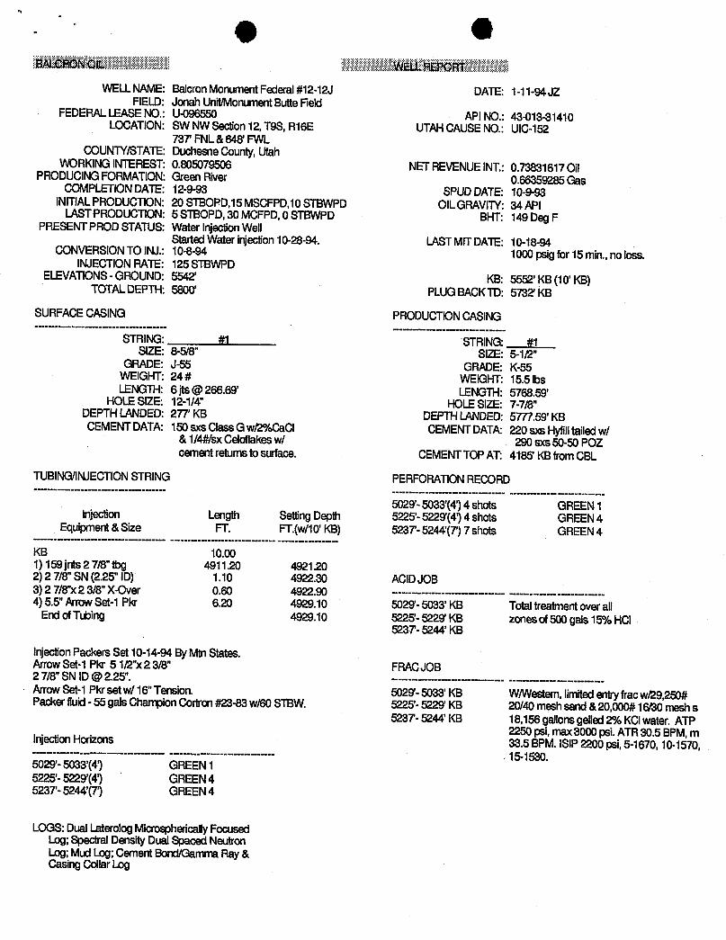
g eBALCRONCIL WELLREPOAT
WELLNAME: Balcron MonumentFederal #12-12J DATE: 1-11-94 JZFIELD: Jonah Unit/MonumentButte Field
FEDERALLEASENO.: U-096550 APINO.: 43-013-31410LOCATION: SW NWSection12, T9S,R16E UTAHCAUSENO.: UIC-152
73T FNL&648' FWLCOUNTY/STATE:DuchesneCounty,Utah
WORKINGINTEREST:0.805079506 NETREVENUEINT.:0.73831617OilPRODUCINGFORMATION:GreenRiver 0.66359285GasCOMPLETIONDATE: 12-9-93 SPUDDATE: 10-9-93INITIALPRODUCTION:20 STEOPD,15MSCFPD,10STBWPD OILGRAVITY:34 API
LASTPRODUCTION:5 STBOPD,30 MCFPD, 0 STBWPD BHT: 149 DegFPRESENTPROD STATUS: Water InjectionWell
StartedWater injection10-28-94. LASTMITDATE: 10-18-94CONVERSION TOINJ.: 10-8-94 1000 psigfor15 min.,no loss.
INJECTION RATE: 125 STBWPDELEVATIONS- GROUND: 5542' KB: 5552' KB(10' KB)
TOTALDEPTH: 5800' PLUGBACKTD: 5732'KB
SURFACECASING PRODUCTIONCASING
STRING: #1 STRING: #1SIZE: 8-5/8" SIZE: 5-1/2"
GRADE: J-55 GRADE: K-55WEIGHT:24 # WEIGHT:15.5 lbsLENGTH:6 [email protected]' LENGTH:5768.59'
HOLESIZE: 12-1/4" HOLESIZE: 7-7Æ"DEPTHLANDED:277 KB DEPTHLANDED:5T/7.59' KBCEMENTDATA: 150 sxs Class Gwf2%CaCI CEMENTDATA:220 axs Hyfilltailedw/
&1/4#lsx Celoflakesw/ 290 sxs50-50POZcementretums tosurface. CEMENTTOPAT: 4185' KBfromCBL
TUBING/INJECTIONSTRING PERFORATIONRECORD
5029'-5033'(4')4 shots GREEN1Injection Length SettingDepth 5225'-5229'(4') 4 shots GREEN 4Equipment &Size FT. FT.(w/10'KB) 523T- 5244'(7')7 shots GREEN 4
KB 10.001) 159 jnts2 7Æ"1bg 4911.20 4921.202) 2 7/8"SN (2.25" ID) 1.10 4922.30 ACIDJOB3) 2 7/8"x 2 3/8"X-Over 0.60 4922.90 -------------
-----------
4) 5.5"ArrowSet-1 Pkr 6.20 4929.10 5029'-5033' KB TotaltreatmentoverallEndofTtbing 4929.10 5225'-5229' KB zones of500 gals 15% HCI5237- 5244' KB
InjectionPackers Set 10-14-94 ByMtnStates.ArrowSet-1 Pkr 5 1/2"x2 3/8" FRACJOB2 7/8" SN [email protected]". -------------- ------------
ArrowSet-1Pkrset w/ 16"Tension. 5029'-5033'KB W/Westem,limitedentryfracw)29,250#Packer fluid- 55 gals ChampionCortron#23-83w/60STBW. 5225'- 5229' KB 20/40 meshsand &20,000#16ß0 mesh s5237- 5244'KB 18,156 gallonsgelled2% KCIwater. ATP
2250 psi, max3000 psi.ATR30.5 BPM,mInjectionHorizons 33.5 BPM.ISIP2200 psi,5-1670,10-1570,---------------- ------------
,15-1530.
5029'-5033'(4') GREEN15225'-5229'(4') GREEN45237'-5244'(7) GREEN4
LOGS:DualLaterolog MicrosphericallyFocusedLog; SpecIral Density Dual Spaced NeutronLog; MudLog; Cement Bond/GammaRay&Casing Collar
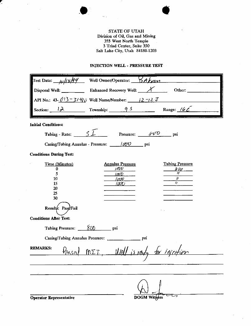
eSTATE OF UTAH
Division of Oil, Gas and Mining355 West North Temple
3 Triad Center, Suite 350Salt Lake City, Utah 84180-1203
INJECTION WELL - PRESSURE TEST
Test Date: // # Well Owner/Operator: S/9Disposal Well: Enhanced Recovery Well: Other:
API No.: 43- Ú ~1/ Ÿ|p WeH Name/Number: 1-/ 2
Section: IÀ Township: A Range: l'é d
Initial Conditions:
Tubing - Rate: Ši/
Pressure: E' psi
CasingfTubing Annulus - Pressure: /pc~O psi
Conditions During Test:
Time (Minutes) Annulus Pressure Tubing Pressure0 / Erp;5 ¡ppp //
10 /ppd F15 //FO //
202530
Result all
Conditions After Test:
Tubing Pressure: þ() psi
asing/Tubing Annulus Pressure:
Operator Representative DOGM WitÁ
EQUITABLERESOURCESENERGYCOMPANYBALCRON OIL DIVISION
Office: (406) 259-78601601 Lewis Avenue FAX: (406) 245-1365Billings, MT 59102 FAX: (406) 245-1361
MAR2 0 1995
March 16, 1995 LDIVOF OiL, GAS & MiN NGi
Mr . Dan JarvisState of UtahDivision of Oil, Gas & Mining355 West North TempleSalt Lake City, UT 84180
Dear Mr. Jarvis:
Attached are copies of the injection profile reports for ourenhanced recovery wells in the Jonah Unit.
If you have any questions, please call John Zellitti at (406)259-7860.
Sincerely,
Bobbie SchumanRegulatory and Environmental Specialist
/hs
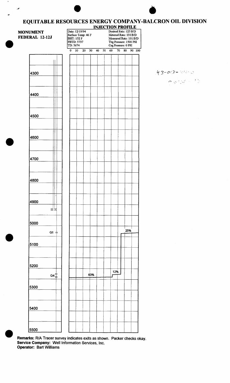
O èEQUITABLE RESOURCES ENERGY COMPANY-BALCRON OIL DIVISION
INJECTION PROFILEMONUMENT Date: 12/19/94 Desired Rate: 125 B/D
Surface Temp: 46 F Metered Rate: 131B/DFEDERAL 12-12J BHT: 152 F Measured Rate: 101B/D
O PBTD: 5737 Tbg Pressure: 1500 PSITD: 5674 Csg Pressure: 0 PSI
0 10 20 30 40 50 60 70 80 90 100
4300
4400
4500
4600
4700
4800
4900
5000
25%Gi e
O5100
520012¾
G4 3% -
5300
5400
5500O Remarks: R/A Tracer survey indicates exits as shown. Packer checks okay.Service Company: Well InformationServices, Inc.Operator: Bart
EQUITABLE• • RCESENERGYCOMPANYBALCRON OIL DIVISION
Office: (406) 259-78601601 Lewis Avenue FAX: (406) 245-1365 OBillings, MT 59102 FAX: (406) 245-1361
April 1, 1996
Mr . Dan JarvisUtah Division of Oil, Gas and MiningUIC Program355 West North TempleSalt Lake City, UT 84180
Dear Dan:
Effective April 1, 1996, our name will change from Equitable ResourcesEnergy Company, Balcron Oil Division to Equitable Resources EnergyCompany. Attached is a listing of permits which we have with yourAgency. This change will apply to those. If you note that I havemissed some or if you have any questions, please do not hesitate to giveme a call at (406) 259-7860, extension 240 to discuss this.
This change affects only our company name. The physical locations ofour offices and the personnel remain the same.
If you have any questions, please do not hesitate to give me a call.
Bobbie SchumanRegulatory and
Environmental Specialist
/hs

UTAH UIC PERMITS ,
Balcron Oil Monument Butte Jonah UnitWaterflood (new name)Formerly Monument Butte Area-A Waterflood) Approved 12/22/92Area Permit No. UT2642-00000
AllenFederal #22-6 UT2642-03729 (AREA PERMITUT2642-00000)AIIen Federal #13-6 UT2642-03730 (AREA PERMITUT2642-00000)AIIen Federal #31-6 UT2642-03731 (AREA PERMITUT2642-00000)(State #UIC-142)AIIen Federal #1-6 UT2642-03732 (AREAPERMITUT2642-00000)AIIen Federal #1A-5 UT2642-03733(AREA PERMITUT2642-00000)
NOTE: Never converted to UIC- put back on productionBalcron Monument Fed. #11-6 UT2642-03734 (AREAPERMITUT2642-00000)Balcron Monument Fed. #24-6 UT2642-03735 (AREA PERMITUT2642-00000)BalcronMonument Fed. #33-6 UT2642-03736(AREAPERMITUT2642-00000)BalcronMonument Fed. #42-6 UT2642-03737 (AREA PERMIT UT2642-00000)BalcronMonument Fed. #13-5J UT2642-04208(AREAPERMITUT2642-00000)(State #UIC-149)BalcronMonument Fed. #22-5J UT2642-04209(AREA PERMITUT2642-00000)(State #UIC-149)Balcron Monument Fed. #24-5 UT2642-04210 (AREA PERMIT U'12642-00000)(State #UIC-149)BaloronMonumentFed. #31-7J UT2642-04211 (AREA PERMIT UT2642-00000) (State #UIC-149)MonumentButte #1-33 State #UIC-151MonumentButte #1-24 State #UIC-151MonumentButte #1-13 State #UIC-151BalcronMonument Fed. #42-1J State #UIC-151Getty #12-1 State #UIC-151BalcronMonument Fed. #41-15 State #UIC-152BalcronMonument Fed. #32-15 State #UIC-152BalcronMonumentFed, #23-15 State #UIC-152BalcronMonument Fed. #41-14J State #UIC-152BalcronMonumentFed. #21-14J State #UIC-152BalcronMonument Fed. #32-12J State #UIC-152C & O Gov't#4 State #UIC-152Balcron Monument Fed. #14-12J State #UIC-152Balcron Monument Fedb#12-12J State #UIC-152Balcron Monument Fed. #43-11J State #UIC-152Balcron Monument Fed. #32-11 State #UIC-152
Page
UTAH UIC PERMITS,
Balcron Oil Monument Butte Jonah UnitWaterflood (new name)Formerly Monument Butte Area-A Waterflood) Approved 12/22/92Area Permit No. UT2642-00000
AllenFederal #22-6 UT2642-03729 (AREA PERMITUT2642-00000)AIIen Federal #13-6 UT2642-03730 (AREA PERMITUT2642-00000)AIIen Federal #31-6 UT2642-03731 (AREA PERMITUT2642-00000)(State #UIC-142)AIIen Federal #1-6 UT2642-03732 (AREAPERMITUT2642-00000)AIIen Federal #1A-5 UT2642-03733(AREA PERMITUT2642-00000)
NOTE: Never converted to UIC- put back on productionBalcron Monument Fed. #11-6 UT2642-03734 (AREAPERMITUT2642-00000)Balcron Monument Fed. #24-6 UT2642-03735 (AREA PERMITUT2642-00000)BalcronMonument Fed. #33-6 UT2642-03736(AREAPERMITUT2642-00000)BalcronMonument Fed. #42-6 UT2642-03737 (AREA PERMIT UT2642-00000)BalcronMonument Fed. #13-5J UT2642-04208(AREAPERMITUT2642-00000)(State #UIC-149)BalcronMonument Fed. #22-5J UT2642-04209(AREA PERMITUT2642-00000)(State #UIC-149)Balcron Monument Fed. #24-5 UT2642-04210 (AREA PERMIT U'12642-00000)(State #UIC-149)BaloronMonumentFed. #31-7J UT2642-04211 (AREA PERMIT UT2642-00000) (State #UIC-149)MonumentButte #1-33 State #UIC-151MonumentButte #1-24 State #UIC-151MonumentButte #1-13 State #UIC-151BalcronMonument Fed. #42-1J State #UIC-151Getty #12-1 State #UIC-151BalcronMonument Fed. #41-15 State #UIC-152BalcronMonument Fed. #32-15 State #UIC-152BalcronMonumentFed, #23-15 State #UIC-152BalcronMonument Fed. #41-14J State #UIC-152BalcronMonumentFed. #21-14J State #UIC-152BalcronMonument Fed. #32-12J State #UIC-152C & O Gov't#4 State #UIC-152Balcron Monument Fed. #14-12J State #UIC-152Balcron Monument Fedb#12-12J State #UIC-152Balcron Monument Fed. #43-11J State #UIC-152Balcron Monument Fed. #32-11 State #UIC-152
Page
d a EQUMBU·̄ • RŒS
ENERGYCOMPANYBALCRON OIL DIVISION Office: (406) 259-78601601 Lewis Avenue FAX: (406) 245-1365 OBillings, MT 59102 FAX: (406) 245-1361 (
Utah Division of Oil, Gas and Mining355 West North TempleSalt Lake City, UT 84180 ONOF OIL,GAS
Gentlemen:
Effective April 1, 1996, our name will change from Equitable Resources
Energy Company, Balcron Oil Division to Equitable Resources EnergyCompany. Attached is a sundry notice reflecting that change. To
simplify paperwork, I have done one sundry notice with copies for eachof the wells. To this letter I have attached a list of our wells foryour ease in filing the sundry notices in the well files. This shouldbe sufficient for your purposes.
I have the listings on a spreadsheet so if it would be easier for you tohave them sorted differently (for example, the Montana Board of Oil andGas prefers them sorted by API number), please give me a call at (406)259-7860, extension 240 and I would be glad to provide a list to yourspecifications.
This change affects only our:company name. The physical locations ofour offices and the personnel remain the same. We will be changing ourwell signs and ask for your patience and cooperation as this will bedone as soon as possible but may take some time since we do have so many
properties at which to make the change.
If you have any questions, please do not hesitate to give me a call.
Sincerely,
Bobbie SchumanRegulatory and
Environmental Specialist
/hs
d a EQUMBU·̄ • RŒS
ENERGYCOMPANYBALCRON OIL DIVISION Office: (406) 259-78601601 Lewis Avenue FAX: (406) 245-1365 OBillings, MT 59102 FAX: (406) 245-1361 (
Utah Division of Oil, Gas and Mining355 West North TempleSalt Lake City, UT 84180 ONOF OIL,GAS
Gentlemen:
Effective April 1, 1996, our name will change from Equitable Resources
Energy Company, Balcron Oil Division to Equitable Resources Energy
Company. Attached is a sundry notice reflecting that change. To
simplify paperwork, I have done one sundry notice with copies for eachof the wells. To this letter I have attached a list of our wells foryour ease in filing the sundry notices in the well files. This shouldbe sufficient for your purposes.
I have the listings on a spreadsheet so if it would be easier for you tohave them sorted differently (for example, the Montana Board of Oil andGas prefers them sorted by API number), please give me a call at (406)259-7860, extension 240 and I would be glad to provide a list to yourspecifications.
This change affects only our:company name. The physical locations ofour offices and the personnel remain the same. We will be changing ourwell signs and ask for your patience and cooperation as this will bedone as soon as possible but may take some time since we do have so many
properties at which to make the change.
If you have any questions, please do not hesitate to give me a call.
Sincerely,
Bobbie SchumanRegulatory and
Environmental Specialist
/hs
FORM o E OF UTAH
DIVISION O IL, GAS AND MINING5. Lease Designation and Serial Number:
See attached listing0. if Indian, Allottee or Tribe Name:
SUNDRY NOTICES AND REPORTS ON WELLS n/a7. Unit Agreement Name:
Do not use this form for proposals to drillnew wells, deepen existingwells, or to reenter plugged and abandoned wells See attached 1i sti ngUse APPUCATION FOR PERMiT TO DAILLOR DEEPEN formfor such proposals.
8. Well Name and Number:1. Type of Well: OILO GAS O OTHER: .See attached listing See attached listing2. Name af Operator. 9. API WellNumber:
See attached listingEquitable Resources Energy Cornpany, ßalcron Oil Division3. Addmss and Telephone Number: 10. Field and Pool, or Wildcat:
1601 Lewis Avenue Avenue; Billings, MT 59102 (406) 259-7860 See attached listing4. Locationof Well
Footages: See attached listing county: See attached listoo.s.o..T.x,u.: st.t.: UTAH
" CHECK APPROPRIATE BOXES TO INDICATE NATURE OF NOTICE, REPORT, OR OTHER DATANOTICE OF INTENT SUBSEQUENT REPORT
(Submit in Duplicate) (Submit Original Form Only)
O Abandon O New Con6tfUCtlon O Abandon O New Construction
O Repair casing O Pull or Alter casing O Repair casing O Pull or Alter Casing
O Change of Plans O Recomplete O Change of Plans O ReperforateO convertto injection O Reperforat• O convertto injection O Vent or Flare
O Fracture Treat or Acidize O ventor Flare O Fracture Treat or Acidize O watershut-offO Multiplecompletion O Water Shut-Off g Other Operator name changeO Other
Date of work completion
Approximate date work will start Report results of Muldple Completione and Recompletions todifferent reservolts on WELLCOMPLETlON OR RECOMPLETION REPORT AND LOG form.
* Must be accompanled by a cement verification report.
12. DESCRIBEPAOPOSED OR COMPLETED OPERATIONS (Clearty state all pertinent detalls, and give pertinent dates. If well is directionally drilled, give subsurface locations and measured and truevertical depths for all markers and zones pertinent to this work.)
Effective April. 1, 1996, operator will change its name from Equitable ResourcesEnergy Company, Balcron Oil Division TO: Equitable Resources Energy Company.Physical location.of the operator remains as: 1601 Lewis Avenue; Billings, MT 59102(406) 259-7860, FAX: (406) 145-1361. This is to report the operator name change 'only. It affects the wells on the attached listing.
Regulatory andName&Signatum: Hie: Environmental Spedalist Date: March 27 1996Bobby Schuman
(This spoos for State use only)
(4\94) (See instructions on Reverse

Page No. 4 STATE OF UTAH03/07/96 INVENTORY OF INJECTION WELLS
OPERATOR API NO. WELL TNS RGE SE WELLTYPE INDIAN COUNT*****kkk,**** ************ ************ *** *** ** ******** **kkk*******
CROSS CREEK 43-037-20117 NAVAJO A #1 41S 26E 5 INJD YCROSS CREEK 43-037-20164 NAVAJO A #3 41S 26E 5 INJI YENSERCH EXPL 43-013-31240 FEDERAL 43-3 OSS 16E 33 INJW NENSERCH EXPL 43-013-31269 FEDERAL 34-3 08S 16E 33 INJW NENSERCH EXPL 43-013-31229 FEDERAL 14-3 OSS 16E 33 INJW NENSERCH EXPL 43-613-31225 FEDERAL 14-3 08S 16E 34 INJW NENSERCH EXPL 43-013-31272 FEDERAL 21-4 09S 16E 4 INJW NENSERCH EXPL 43-013-30670 FEDERAL 32-5 09S 16E 5 INJW NENSERCH EXPL 43-013-31205 FEDERAL 41-5 09S 16E 5 INJW' NENSERCH EXPL 43-047-32248 1-26B 09S 19E 26 INJG NENSERCH EXPL 43-013-30913 44-5H 09S 17E 5 INJW NENSERCH EXPL 43-013-30678 42-8H 098 17E 8 INJW NENSERCH EXPL 43-013-31457 22-8H 09S 17E 8 INJW NENSERCH EXPL 43-013-30679 31-8H 095 17E 8 INJW NENSERCH EXPL 43-013-31049 22-9H 09S 17E 9 INJW NENSERCH EXPL 43-013-30682 24-9H 09S 17E 9 INJW NENSERCH EXPL 43-013-30887 11-9H 09S 17E 9 INJW NENSERCH EXPL 43-013-31108 33-9H 09S 17E 9 INJW NENSERCH EXPL 43-013-30656 13-9H 09S 17E 9 INJW NEQUITABLE RE 43-013-31362 FEDERAL 11-6 09S 17E 6 INJW YEQUITABLE RE 43-013-31361 FEDERAL 33-6 09S 17E 6 INJW YEQUITABLE RE 43-013-31363 FEDERAL 24-6 09S 17E 6 INJW YEQUITABLE RE 43-013-31364 FEDERAL 42-6 09S 17E 6 INJW YEQUITABLE RE 43-013-30919 FEDERAL 22-6 09S 17E 6 INJW YEQUITABLE RE 43-013-15779 FEÐERAL 1-6 09S 17E 6 INJW YEQUITABLE RE 43-013-30918 FEDERAL 13-6 09S 17E 6 INJW YEQUITABLE RE 43-047-15681 PARIETTE BEN 09S 19E 7 INJD YEQUITABLE RE 43-013-31404 42-1J 09S 16E 1 INJW YEQUITABLE RE 43-013-31415 44-1J 09S 16E 1 INJW YEQUITABLE RE 43-013-30702 FEDERAL 1-13 09S 16E 1 INJW NEQUITABLE RE 43-013-30735 FEDERAL 1-33 09S 16E 1 INJW N .
EQUITABLE RE 43-013-30701 1-24 09S 16E 1 INJW NEQUITABLE RE 43-013-31384 22-5 09S -LGB- 5 INJW YEQUITABLE RE 43-013-31416 34-10J 09S 16E 10 INJW NEQUITABLE RE 43-013-31002 43-11J 09S 16E 11 INJW NEQUITABLE RE 43-013-31369 23-11J 095 16E 11 INJW NEQUITABLE RE 43-013-31417 12-11J 09S 16E 11 INJW NEQUITABLE RE 43-013-31386 32-11J 09S 16E 11 INJW NEQUITABLE RE 43-013-31003 FEDERAL 34-1 09S 16E 11 INJW NEQUITABLE RE 43-013-31374 14-11J 09S 16E 11 INJW NEQUITABLE RE 43-013-31410 12-12J 09S 16E 12 INJW NEQUITABLE RE 43-013-31411 14-12J 09S 16E 12 INJW NEQUITABLE RE 43-013-30742 GOVT C&O #4 09S 16E 12 INJW NEQUITABLE RE 43-013-31419 32-12J 09S 16E 12 INJW NEQUITABLE RE 43-013-31408 41-14J 09S 16E 14 INJW NEQUITABLE RE 43-013-31421 21-14J 09S 16E 14 INJW NEQUITABLE RE 43-013-31367 41-15J 09S 16E 15 INJW NEQUITABLE RE 43-013-31373 23-15J 09S 16E 15 INJW NEQUITABLE RE 43-013-31368 32-15J 09S 16E 15 INJW NEQUITABLE RE 43-013-31375 24-5 09S 17E 5 INJW YEQUITABLE RE 43-013-31370 FEDERAL 13-5 09S 17E 5 INJW YEQUITABLE RE 43-013-31195 ALLEN FEDERA 09S 17E 6 INJW NEQUITABLE RE 43-013-31405 31-7J 09S 17E 7 INJW
Page No. 5 STATE OF UTAE06/16/97 INVENTORY OF INJECTION WELLS
OPERATOR API NO. WELL TNS RGE SE WELLTYPE INDIAN COUNT**kkk******* ********kkk* **********kk *** *** ** ******** ***
EQUITABLE RE Á3-Ol3 314107 12-12J 09S 16E 12 INJW NEQUITABLE RE *"43-013 314081 41-14J 09S 16E 14 INJW NEQUITABLE RE EØi3 3M239 21-14J 09S 16E 14 INJW NEQUITABLE RE 43-013±318239 23-15J 09S 16E 15 INJW NEQUITABLE RE 43 013-31368 32-15J 09S 16E 15 INJW NEQUITABLE RE g(34013 31362 41-15J 09S 16E 15 INJW NEQUITABLE RE *(35013eßi390 FEDERAL 13-5 09S 17E 5 INJW YEQUITABLE RE kŠ3 013 31375 24-5 09S 17E 5 INJW YEQUITABLE RE 645 013 313Úf 22-5 09S 17E 5 INJW YEQUITABLE RE >¾3 013-ShkÐS ALLEN FEDERA 09S 17E 6 INJW NEQUITABLE RE 043-013-32492 11-7J 09S 17E 7 INJW YEQUITABLE RE uf3 013431405 31-7J 09S 17E 7 INJW YEQUITABLE RE '43-047-20252 E. RED WASH OSS 25E 5 INJW NEQUITABLE RE 143-047-20261 ERW 4-6 08S 25E 6 INJW YEQUITABLE RE 43-047-32346 42-6X OSS 25E 6 INJW NEQUITABLE RE 43-047-20245 AMERADA GUIN 08S 25E 7 INJW YEQUITABLE RE 43-013-30666 44-7 09S 17E 7 INJW YEQUITABLE RE 43-013-31382 13-8 09S 17E 8 INJW YEQUITABLE RE 43-013-31429 33-8 09S 17E 8 INJW YEQUITABLE RE 43-013-30675 24-8 09S 17E 8 INJW YEQUITABLE RE 43-013-30648 44-8-17B 09S 17E 8 INJW YEQUITABLE RE 43-013-31580 13-16-9-17B 09S 17E 16 INJW YEQUITABLE RE 43-013-30616 11-16-9-17B 09S 17E 16 INJW YEQUITABLE RE 43-013-31145 22-16-9-17B 09S 17E 16 INJW YEQUITABLE RE 43-013-30518 11-17 09S 17E 17 INJW YEQUITABLE RE 43-013-30499 POMCO 5 09S 17E 17 INJW YEQUITABLE RE 43-013-30516 11-17 09S 17E 17 INJW YEQUITABLE RE 43-013 31428 31-17 09S 17E 17 INJW YEQUITABLE RE 43-013-31581 33-17-9-17B 09S 17E 17 INJW YEQUITABLE RE 43-013-31429 22-17 09S 17E 17 INJW YEQUITABLE RE 43-013-31467 42-17 09S 17E 17 INJW YEQUITABLE RE 43-047-32610 22-2 09S 17E 2 INJW YEQUITABLE RE 43-013-31425 14-2 09S 17E 2 .IIKRV YGIANT EXPLOR 43-037-15042 GOTHIC MESA 41S 23E 16 INJD YGIANT EXPLOR 43-037-20292 SENTINEL PEA 41S 26E 27 INJD YGIANT EXPLOR 43-037-16452 9-24 41S 23E 9 INJI YHAY HOT OIL 43-037-30521 MCCRAKEN PT 40S 23E 19 INJI NINLAND PRODU 43-013-30843 MONUMENT BUT 08S 16E 34 INJW YINLAND PRODU 43-013-31559 15-25 08S 16E 25 INJW NINLAND PRODU 43-013-30693 FEDERAL 3-33 08S 16E 33 INJW NINLAND PRODU 43-013-30808 FED 1-34 08S 16E 34 INJW NINLAND PRODU 43-013-30686 FEDERAL 5-35 08S 16E 35 INJW NINLAND PRODU 43-013-30606 MONUMENT BUT OSS 16E 35 INJW NINLAND PRODU 43-013-30745 MONUMENT BUT OSS 16E 35 INJW NINLAND PRODU 43-013-31514 1A-35 08S 16E 35 INJW YINLAND PRODU 43-013-30605 MONUMENT BUT 08S 16E 35 INJW NINLAND PRODU 43-013-31264 MONUMENT FED 08S 16E 35 INJW NINLAND PRODU 43-013-30608 MONUMENT BUT 08S 16E 35 INJW NINLAND PRODU 43-013-30624 STATE 5-36 08S 16E 36 INJW NINLAND PRODU 43-013-30592 STATE 1-36 08S 16E 36 INJW NINLAND PRODU 43-013-30787 12-32 08S 17E 32 INJW YINLAND PRODU 43-013-30779 FED 15-28 08S 16E 28 INJW NINLAND PRODU 43-013-31372 14A-28 08S 16E 28 INJW

; , Injection wells
injection Wells for inland Change of OperatorWELL NAME LOCATION COUNTY ST FIELD NAME API NUMBER LEASE NO. AGREEMENT NO.
AMERADAGUINAND#1 SWNW 7 8S 25Ë UINTAH UT COYOTE BASIN 43-047-20245-00 UTUO16271V UTU72085AOYOTE BASIN#42-6X SENE 6 8S 25E UINTA UT COYOTE BASIN 43-047-32346-00 UTUO17439B UTU72085A
EþST RED WASH FED. #4-6 SWSE 6 8S 25E UINTAH UT COYOTE BASIN 43-047-20261-00 UTUO20309D UTU72085AÉAST RED WASH #2-5 NWNW 5 8S 25É U\NTA UT COYOTE BASlN 43-047-20252-00 UTUO63597A UTU72085A
J.LEN FEDERAL#1 ÉiE 9 ifË ÒÜÕÑEŠÑE ÜÌ ÏÃÕÑÜÑ\EÑÌ5UTTE (J) 43-013-15779-00 UTUO20252A UTU72086A19.LEN FEDERAL#13-6 \N¾ 6¾
1¯ŸËÕÜ6I·ÏËŠÑËÜ ÑÕÑUE¯ÏfšÚÏÌ˯43-013-30918-00 UTUO20252A UTU72086A
ALLEN EEDERAL#22±6 SENW 6 9S 17E DUCHESNE LÏT MONUMENTBUTTE (J) 43-013-30919-00 UTUO20252A UTU72086A
O ALLEN FEDERÄL#31-6 LOT2 6 9S 1ÝE DUCHESNE UT MONUMENT BUTTE (J) 43-013-31195-00 UTUO20252A UTU72086A$/lONUMENTBUTTE FED. #f1-6 NWNW 6 ÖS iÌE DUCHESNE UT MONUMENT BUTTE (J) 43-013-31362-00 UTUO20252A UTU72086A 'JA
LNÕÑÜÑËÑT ËËÕËÑÃLitii-?Ï ÑWÑWiëš 1ÌÈ DUCHESNE UT MONUMENTBUTTE (J) 43-013-31492-00 UTU44426 UTU72086Av19).ONUMENTBUTTE #13-5 NWSW 5 9S 1_7E DUCHESNE UT MONUMENTBUTTE (J) 43-013-31370-00 _ UTU72086A61910NUMENTBUTTE #22-5 SENW 5 9S 17E DUCHESNE UT MONUMENTBUTTE (J) 43-013-31384-00 UTUO20252 UTU72086A
L $ONUMENT BUTTE #24-5 SESW 5 9S 17E DUCHESNE UT MONUMENTBUTTE (J) 43-013-31375-00 UTUO20252 UTU72086AÑÜÑËÑÏ5ÜÌÌËÌEÒÃ2Ä6 ŠW 5 5Š 7 DÙCHgŠfÑÈÜ ÑOÑÜMÈÑÌlÏU¯ÏÌ˯J) Ã_Š3-3]¾65 0 ÏÜÕžÕgžÄ UTU72086A
MONUMENTBUTTE #31-7 NWNE 7 9S 17E DUCHESNE UT MONUMENTBUTTE (J) 43-013-31405-00 UTU72106 UTU72086AMONUMENTBUTTE FED. #33-6 NWSE 6 9S 17E DUCHEŠÑE ÙT MÖNUMERÏBUÌÌË(J) 4Š-0
Ï3-31361¯-6ÕÏÜÖžÒ25žÁ UTU72086A
MONUMENTBUTTE FED. #42-6 SENE 6 9S 17E DUCHESNE UT MONUMENTBUTTE (J) 43-013-31364-00 UTUO20252A UTU72086AMONUMENT BUTTE FED. #12-1T SWNW 119S 16E DUCHESNE UT MONUMENT BUTTE (J) 43-013-31417-00 UTUO96550 UTU72086AMONUMENTBUTTE FED. #14-11 SWSW 119S 16E DUCHESNE UT MONUMENTBUTTE (J) 43-013-31374-00 UTUO96547 UTU72086AMQNUMENTBUTTE#12-12J SWNW 129S 16E DUCHESNE UT MONUMENTBUTTE (J) 43-013-31410-00 UTUO96550 UTU72086A1VIONUMENTBUTTE #14-12 SWSW 129S 16E DUCHESNE UT MONUMENTBUTTE (J) 43-013-31411-00 UTU72086AMONUMENTBUTTE #21-14 NENW 149S 16E DUCHESNE UT MONUMENTBUTTE (J) 43-013-31421-00 UTU72086AMONUMENTBUTTE#23-11 NESW ii9S 16E DUCHESNE UT MONUMENTBUTTE ( 43-013-31369-00 UTUO96550 UTU72086AMONUMENTBUTTE FED. #23-15 NESW 159S 17E DUCHESNE UT MONUMENTBUTTE (J) 43-013-31373-00 UTUO17985 UTU72086AMONUMENTBUTTE #32-11 SWNE 119S 16E DUCHESNE UT MONUMENTBUTTE (J) 43-013-31386-00 UTU72086ATVIONUMENTBUTTE#32-12 SWNE 129S 16E DUCHESNE UT MONUMENTBUTTE (J) 43-013-31419-00 UTU72086A
O -ivloNUMENT BUTTE #41-14 NENE 149S 16E DUCHESNE UT MONUMENTBUTTE (J) 43-013-31408-00 UTUO96550 UTU72086A61VIONUMENTBUTTE#43-11 NESE 1195 16E DUCHESNE UT MONUMENTBUTTE (J) 43-013-31002-00 UTUO96550 UTU72086A
1910NUMENTBUTTE FED. #32-15 SWNE 159S 16E |DUCHESNE UT MONUMENTBUTTE (J) 43-013-31368-00 UTUO17985 UTU72086Al¢ONUMENT BUTTE FED.#34-10 SWSE 109S 16E )DUCHESNE UT MONUMENTBÙTTE (J) 43-013-31416-00 UTUO17985 UTU72086A1VIONUMENTBUTTE FED. #41-15 NENE 159S 16E DUCHESNE UT MONUMENTBUTTE (J) 43-013-31367-00 UTUO17985 UTU72086AMONUMENTBUTTE FED. #42-1 SENE 1 9S 16E DUCHESNE UT UNUMENT BUTTE (J) 43-013-31404-00 UTU40652 UTU72086AMONUMENTBUTTE FED.#44-1J ISESE 1 98 16E \DUCHESNE UT ÑONUMENT BUTTE (J) 43-013-31415-00 UTU44426 UTU72086A
L C&O GOV'T #4 NESW 129S 16E DUCHESNE UT MONUMENTBUTTE (J) 43-013-30742-00 UTUO35521A UTU72086Ao MONUMENTBUTTE FED. #1-13 NWSW 1 9S 16E
_
DUCHESNE UT MONUMENTBUTTE (J) 43-013-30702-00 UTU18399 UTU72086AMONUMENTBUTTE FED. #1-33 NWSE 1 9S 16E DUCHESNE UT MONUMENTBUTTE (J) 43-013-30735-00 UTU52013 UTU72086AMONUMENTBUTTE #1-24 SESW 1 9S 16E DUCHESNE UT MONUMENTBUTTE (J) 43-013-30701-00 UTU18399
¯UTU72086A
INALTON FEDERAL#34-11 SWSE 119S 16E DUCHESNE UT MONUMENTBUTTE (J) 43-013-31003-00 UTUO96550 UTU72086AMONUMENTSTATE #11-2-9-17CD NW NW 2 9S 17E |DUCHESNE UT MONUMENTBUTTE (CD) 43-013-42685 ML45555
Page
UTAH - ALL
BatcronCoyote Fed. #42-6X Coyote Basin SE NE 6 85 25E Uintah UT OSI Green River U-017439-B 43-047-32346 1987' FNL,682' FEL Vemal Coyote BasinBalcronCoyote Fed. #44-6 Coyote Basin SE SE 6 SS 25E Uintah UT PND Green River U-0174398 43-047-32421 560' FSL, 760' FEL Vemal Coyote BasinBalcronFederal #12-20Y 8 MileFlat N. SW NW 20 9S 18E Uintah UT Oil Green River U-64917 43-047-32617 1980' FNL, 660° FWL VemalBalcron rederal#12-22Y 8 MileFlat N. SW NW 22 8S 17E Duchense UT Oil Green River U-66191 43-013-31476 2105' FNL, 660' FWL VemaWPriv.sfc.BalcronFederal #21-13Y Monument Butte NE NW 13 SS 16E Duchesne UT Oil Green River U-64805 43-013-31400 703' FNL, 1831' FWL VemalBalcron Federal #21-25Y MonumentButte NE NW 25 9S 16E Duchesne UT Oil Green River 044380 43-013-31994 500' FNL,1980' FWL VemalBalcron Federal #21-9Y Monument Butte NE NW 9 9S 16E Duchesne UT Oil Green River U-65207 43-013-31396 476' FNL,2051' FWL VemalBalcron Federal #22-10Y MonumentButte SE NW 10 9S 17E Duchesne UT Oil Green River U-65210 43-013-31395 1980' FNL,1980' FWL VemalBalcronFederal #24-3Y MonumentButte SE SW 3 SS 17E Duchesne UT Oil Green River U-64381 43-013-31397 562' FSL, 1887' FWL VemalBalcron Federal #31-14Y Undesignated NWNE 14 9S 19E Uintah UT PND WASATCH 046193 500' FNL,2740' FWL Vemal/Priv.sfc.Balcron Federal #31-19Y 8 MileFlat N. NWNE 19 SS 18E Duchesne UT Oil Green River U-65635 (43-047-32614 660' FNL,1880' FEL VemalBalcronFederal #31-5Y 8 MileFlat N. NWNE 5 9S 18E Uintah UT Oil Green River U-65970 43-047-32503 660' FNL,1980' FEL VemalBalcronFederal #32-19Y 8 MileFlat N. SW NE 19 98 18E Uintah UT Oil Green River U.65635 43-047-32615 1980' FNL,1980' FEL VemalBalcronFederal -19Y MonumentButte NE NE 19 9S 17E Duchesne UT Oil Green River U-65967 43-047-32504 660' FSL, 660' FEL VemalO Balcon Federal #41-21Y MonumentButte NE NE 21 9S 16E Duchesne UT Oil Green River U-64379 43-013-31392 970' FNL,894' FEL VerÑIBalcronFederal #42-19Y 8 MileFlat N. SE NE 19 9S 18E Uintah UT Oil Green River U-65635 43-047-32616 2100' FNL, 500' FEL VemalBalcron FederÄ#44-14Y MonumentButte SE SE 14 9S 17E Uintah UT Oil Green River U-84806 43-047-32438 1008' FSL, 832' FEL VemalBalcron Federal #44-4Y 8 MileFlat N. SE SE 4 9S 17E Duchesne UT Oil Green River U-65635 43-013-31452 660' FNL,6ð0' FEL VemalBalcronMonur ent Fed, #11-10-9-17Y NWNW 10 98 17E Duchesne UT PND Green River VemalBalcron MonumentFed. #11-20-9-18Y Monument Butte NWNW 20 SS 18E Uintah UT OtL Green River U-64917 43-047-32712 500' FNI,500' FWL VernalBalcron Monument Fed. #11-22-8-17Y MonumentButte NWNW 22 SS 17E Duchesne UT OIL Green River U-66191 43-013-31539 635' FNL,658' FWL VemalBalcron MonumentFed. #11-25 MonumentButte NWNW 25 8S 17E Uintah UT Oil Green River UA7845 43-047-32455 739' FNL,648' FWL VemalBalcron MonumentFed. #11-6 Monument Butte NWNW 6 9S 17E Duchesne UT WIW Green River U-020252-A 43-013-31362 804' FNL,696' FWL Vemal JonahBalcronMonumentFed. #11-7J Monument Butte NWNW 7 9S 17E Duchesne UT COMPL-WIWGreen River U-44426 43-013-31492 681' FNL,447' FWL Vemal JonahBalcronMonumentFed. #12-10-9-17Y MonumentButte SW NW 10 9S 17E Duchesne UT COMPL Green River U-65210 43-013-31536 1994' FNL,618' FWL VemalBalcronMonumentFed. #12-11J MonumentButte SW NW 11 9S 16E Duchesne UT WIW Green River U-096550 43-013-31417 2128' FNL,689' FWL Vemal JonahBalcronMonumentMA13-12J MonumentButte SW NW 12 9S 16E Duchesne UT WIW Green River U-096550 43-013-31410 739' FNL,648' FWL Vemal JonahBalcron MonumentFed. #12-14J MonumentButte SW NW 14 9S 16E Duchesne UT PND Green River U-096547 43-013-31488 2004' FNL,658' FWL Vemal JonahBalcron Monument Fed. #12-17 MonumentButte SW NW 17 9S 17E Duchesne UT Oil Green River UTU-72106 43-013-31431 1980° FNL,660' FWL Vemal BelugaBalcronMonumentFed. #12-25 Undesignated SW NW 25 8S 17E Uintah UT Oil Green River U-67845 43-047-32526 1486'FNL,875.7' FWL VemalBalcron Monument Fed. #12-7J MonumentButte SW NW 7 9S 17E Duchesne UT Oil Green River U-44426 43-013-31493 1965' FNL,620' FWL Vemal JonahBalcron MonumentFed. #13-11J MonumentButte NWSW 11 SS 16E Duchesne UT Oil Green River U-096547 43-013-15790 1819' FSL, 658' FWL Vemal JonahBalcron MonumËntFed. #13-5 MonumentButte NWSW 5 9S 17E Duchesne UT WIW Green River UA)20252 43-013-31370 1980' FSL, 660' FWL Vemal JonahBalcron Monument Fed. #13-8 Monument Butte NWSW 8 GS 17E Duchesne UT Oil Green River UTU-74108 43-013-31382 2060' FSL, 694' FWL Vemal BelugaBalcron MonumentFed. #14-11 MonumentButte SW SW 11 9S 16E Duchesne UT WIW Green River U-096547 43-013-31374 1048' FSL, 446' FWL Vemal Jonah
Page
. IIP (IPDivision of Gil, Gas and MiriingOPERATORCHANGEHORKSHEÈT
l -SJ p/Attach all documentation received by the division regarding this change. 2 8-FILInitial each listed item when completed. Write N/A if item is not applicable. 3 GI
4O Change of Operator (well sold) O Designation of Agent 5O Designation of Operator RIÐGymmKNMlameL£haligëngutig
The operator of the well(s) listed below has changed (EFFECTIVE DATE: 4-1-96 )
TO (new operator) EQUITABLE RESOURCES ENERGY COEROM(former operator) EQUITABLE RESOURCES ENERGY CC(address) 1601 LEWIS AVE (address) BALCRONOIL DIVISION
BILLINGS Mr 59102-4126 1601 LEWIS AVEBILLINGS MT 59102-4126
phone (406 >259-7860 phone (406 )259-7860account no. N9890 Icount no. N9890
Hell(S) (attach additional page if needed)
Name:**SEE ATTACHED** API: Entity: Sec Twp Rng Lease Type:Name: API: Entity: Sec Twp
_Rng
_Lease Type:Name: API: Entity: Sec_ _Twp _Rng_ Lease Type:Name: API: Entity: Sec Twp Rng_ Lease Type:Name: API: Entit.y: Sec Twp
_Rng___ Lease Type:Name: API: Entity: Sec Twp
_Rng__ Lease Type:Name: API: Entity: Sec__ Twp Rng
__Lease Type:
OPERATORCHANGEDOCUMENTATION
1. (Rule R615-8-10) Sundry or other legal docume tation has been received from formeroperator (Attach to this form). (g//ý'y,g if't-fb2. (Rtle R615-8-10) Sundry or other legal documentation has been received from newoperator
(Attach to this form).
3. The Department of Commerce has been contacted if the new operator above is not currentlyoperating any wells in Utah. Is company registered with the state? (yes/no) Ifyes, show company file number: .
4. (For Indian and Federal Hells ONLY) The BLM has been contacted regarding this change(attach Telephone Documentation Form to this report). Make note of BLM status incomments section of this form. Management review of Federal and Indian well operatorchanges should take place prior to completion of steps 5 through 9 below.
5. Changes have been entered in the Öil and Gas Information System (Nang/IBM)d4F-49œ¾-Ne+1
6. Cardex file has been updated for each well listed above.fjíl/-Ýá)7. Hell file labels have been updated for each well listed above. (§//Af8. Changes have been included on the monthly "Operator, Address and Account Changes" memo
for distribution to State Lands and the Tax Commission. (t||p-f
9. A folder has been set up for the Operator Change file, and a copy of this page has beenplaced there for reference during routing and processing of the original documents.
- OVER
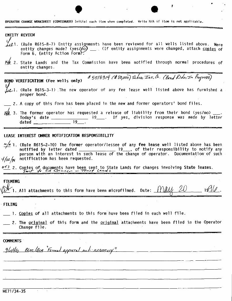
(il (14 '
OPERAf0R CHANGEWORKSHEET(CONTINUED) Initial each item when completed. Write N/A if item is not applicable.
REVeEHR615-8-7)
Entity assi nments have been reviewed for all wells listed above. Wereentity changes made? (yes/ o (If entity assignments were changed, attach go-Difi ofForm 6, Entity Action Formr.
2. State Lands and the Tax Commission have been notified through normal procedures ofentity changes.
BO D VERIFICATION (Fee wells only)
J. (Rule R615-3 1) The new operator of any fee lease well listed above has furnished aproper bond.
2. A copy of this form has been placed in the new and former operators' bond files.
A L 3. The former operator has requested a release of liability from their bond (yes/no) .
Today's date 19___ . If yes, division response was made by letterdated 19_ .
LEASE INTEREST OHNERNOTIFICATION RESPONSIBILITY
1. (Rule R615-2-10) The former operator/lessee of any fee lease well listed above has beennotified by letter dated 19___, of their responsibility to notify anyperson with an interest in such lease of the change of operator. Documentation of suchnotification has been requested.
2. Co le o do um nts futve beg sent to4State Lands for changes involving State leases.
1IN
All attachments to this form have been microfilmed. Date: 19 .
FILING
1. Copies of all attachments to this form have been filed in each well file.
2. The original of this form and the original attachments have been filed in the OperatorChange file.
COMMENTS
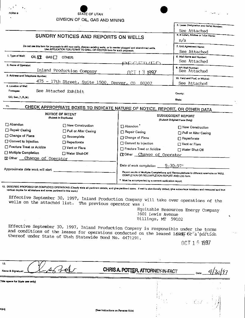
O O -.
FORM o STATE OF UTAH
DIVISIONOF OIL, GAS AND MINING5. Lease Dosignation and Sedal Number:
See Attached6. Il Indian, Allottoe of Tribe NameSUNDRY NOTICES AND REPORTS ON WELLS n/a7. Unit Agroomont Name:Do not use this form for proposals to drill new wells, deepen existing wells, or to foonter plugged and wous.Use AÞPUCAllON FOR PERMIT TO DRil.L OA DEEPEN form for such proposals. See Attached8. Wolf Name and Number:1. Typ. of wen: OIL GAs O OTHER:
See Attached2. Name of Operator:
0. API Well Number:Inland Production Company ( 3 1987 See Attached
3. Address and Telephone Number:10. Field and Pool, or Wildcat:
475 -- 17th Street, Suite 1500, Denver, CO 80202 See Attached4. Locanon of Well
Footages: See Attached Exhibit county:OQ, Soc..T.,R..M.:
State:
1· CHECK APPROPRIATE BOXES TO INDICATE NATURE OF NOTICE, REPORT, OR OTHER DATANOTICE OF INTENT SUBSEQUENT REPORT(Submit in Dupueste)
(Submit Original Form Only)
O Abandon O New Construction O Abandon O New ConstructionO Repair casing O Pull or After casing O Repair casing O Pull or After CasingO Change of Plans O Recomplete Change of Plans O ReperforateO convertto injection O Reperforate O convertto injection O Vent or FlareO Fracture Treat or Acidizo O Vent or Flare O Fracture Treat or Acidize O Water Shut-OffO MultipleCompletion O Water Shut-Off [IOther Change of Operatorg other Change of Operator
Date of work completion 9-30-97'Approximate date work will start
Report results of Multiple Completions and Recompletione to different reservoirs on WELLCOMPLEnoN OR RECOMPLERON REPORT ANDLOG form.
* Must t>eaccompanied by a cement vedlication report.
12. DESCRIBE PAOPOSED OR COMPLETED OPERATIONS (Cleady state all pertinent detalla, and give pertinent dates. tf well is directionally drilled, give subsurface locations and measured and truevertical depths for aff markers and zones pertinent to this work.)
Effective September 30, 1997, Inland Production Company will take over operations of thewells on the attachèd list. The previous operator was :
Equitable Resources Energy Company1601 Lewis AvenueBillings, MT 59102
Effective September 30, 1997, Inland Production Company is responsible under the termsand conditions of the leases for operations conducted on the leased 1 6rTþóftiinthereof under State of Utah Statewide Bond No. 4471291.OCT1 0 1997
a senato.: y CHRISA.POTER,ATTORNEY-lN-FACT os 3d 7ns. spoo. for st.t. u•• only)
(194) (See Instructions on Reverse
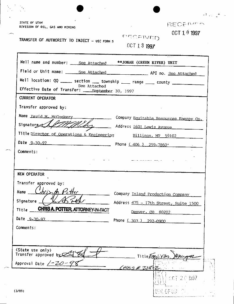
(Iþ (ISTATE OF UTAN proDIVISION OF OIL, GAS AND MINING
.
OCEF1 0 1997TRANSFEROF AUTHORITYTO INJECT - UTCronn 5
0CT 1 3 1997
Hell name and number: See Attached **JONAH (GREEN RIVER) UNIT
Fleid or Unit name: see Attached API no. See Attached
Nell location: QQ section___
township range countySee Attached
Effective Date of Transfer: September 30, 1997
CURRENTOPERATOR
Transfer approved by:
atur A Te re r
es Energy Co.
Title Director of Operations & Engineering Billingsr MT 59102
Date 9-30-97 Phone ( 406 ) 259-7860'
Comments:
NEHOPERATOR
Transfer approved by:
Name rf 46 /237er Company Inland Production Company
Signature Address 475 - 17th Street, Suite 1500
Titie CHRISAPOTTER,ATTORNEWN-FACTDepver, ÇO 80202
Date 9-30-97 Phone ( 303 ) 292-0900
Comments:
anfetts
p d by Title dApproval Date /~¾~
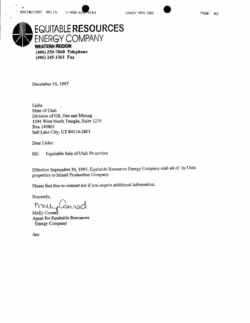
03/10/1997 05: 15 1--406-62 4164 CRAZY MTN O&G PAGE 02
0 EQUITABLERESOURCESENERGYCOMPANYWESTERNREGION(406) 259-7860 Telephone(406) 245-1361 Fax
December 10, 1997
LishaState of UtahDivision of Oil, Gas and Mining1594 West North Temple, Suite 1210Box 145801Salt Lake City, UT 84114-5801
Dear Lisha:
RE: Equitable Sale of Utah Properties
Effective September 30, 1997, Equitable Resources Energy Company sold all of its Utah
properties to Inland Production Company.
Please feel free to contact me if you require additional information.
Sincerely,
Molly ConradAgent for Equitable Resources
Energy Company
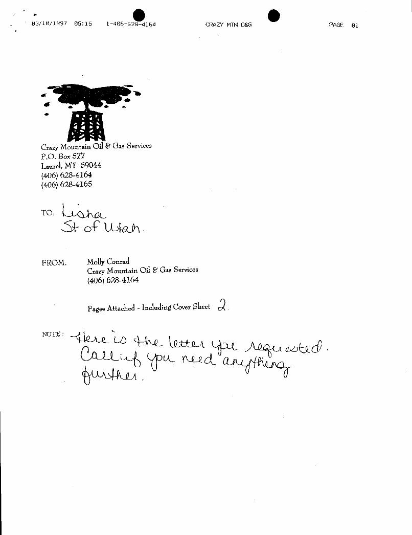
O O03/10/1997 05: 15 1-406-628-4164 CRAZY MTN Ogé PAGE 01
Crazy Mountain Oil Gas ServicesP.O. Box577Laurel,MT 59044(406) 628-4164(406) 628-4165
TO:
FROM. MollyConradCrazyMountain Oil & Gas Services(406) 628-4164
PagesAttached - Including CoversheetQ.
NOTE
O O03/10/1997 05: 15 1-406-628-4164 CRAZY MTN Ogé PAGE 01
Crazy Mountain Oil Gas ServicesP.O. Box577Laurel,MT 59044(406) 628-4164(406) 628-4165
TO:
FROM. MollyConradCrazyMountain Oil & Gas Services(406) 628-4164
PagesAttached - Including CoversheetQ.
NOTE
O O03/10/1997 05: 15 1-406-628-4164 CRAZY MTN Ogé PAGE 01
Crazy Mountain Oil Gas ServicesP.O. Box577Laurel,MT 59044(406) 628-4164(406) 628-4165
TO:
FROM. MollyConradCrazyMountain Oil & Gas Services(406) 628-4164
PagesAttached - Including CoversheetQ.
NOTE

O OUnited States Department of the Interior
· BUREAU OF LAND MANAGEMENTUtah State OfficeP.O. Box 45155
Salt Lake City, UT 84145-0155
IN REPLY REFER TOUT-931
January 13, 1998inland Production Company475 17th Street, Suite 1500Denver, Colorado 80202
Re: Jonah (Green River) UnitDuchesne County, Utah
Gentlemen:
On January 13, 1998, we received an indenture dated November 17, 1997, wherebyEquitable Resources Energy Company resigned as Unit Operator and inland ProductionCompany was designated as Successor Unit Operator for the Jonah (Green River) Unit,Duchesne County, Utah.
This indenture was executed by all required parties and the signatory parties have compliedwith Sections 5 and 6 of the unit agreement. The instrurnent is hereby approved effectiveJanuary 13, 1998. In approving this designation, the Authorized Officer neither warrantsnor certifies that the designated party has obtained all required approval that would entitleit to conduct operations under Jonah (Green River) Unit Agreement.
Your statewide (Utah) oil and gas bond No. 0056 will be used to cover all operationswithin the Jonah (Green River) Unit.
It is requested that you notify all interested parties of the change in unit operator. Copiesof the approved instruments are being distributed to the appropriate federal offices, withone copy returned herewith.
Sincerely,
Is/ Robert A. Henricks
Robert A. HenricksChief, Branch of Fluid Minerals
Enclosurebcc: District Manager - Vernal (wlenclosure)
Sigisioatofwji asy&tMiningaMinerals Adjudication Group U-932File - Jonah (Green River) Unit (wlenclosure)MMS - Data Management DivisionAgr. Sec. ChronFluid Chron

(Ill (IllPage No. 101/13/98
WELLSTATUS REPORTSUTAH STATE OFFICE
INSPECTION ITEM API NO. WELL QTOT SEC TWN RNG WELL LEASE NAME OPERATORNUMBER STATUS
** INSPECTIONITEM UTU72086A JONAH(GR) SECONDARYRECOVERYUNITUTU72086A 43013151110051 1 NWSW 12 9S 16E POW UTUO35521A EQUITABLE RESOURCES ENERGUTU72086A 43013157800081 1 NWNW 5 9S 17E POW UTUO20252 EQUITABLERESOURCES ENERGUTU72086A 43013157790051 1 SESE 6 9s 17E WIW UTUO20252A EQUITABLE RESOURCES ENERGUTU72086A 43013157890051 1 SESW 11 9S 16E POW UTUO96547 EQUITABLE RESOURCES ENERGUTU72086A 43013157920051 1 SESE 11 98 16E POW UTUO96550 EQUITABLERESOURCES ENERGUTU72086A 43013307020081 1-13 NWSW 1 98 16E WIW UTul8399 EQUITABLE RESOURCES ENERGUTU72086A 43013307030081 1-14 SWSW 1 9s 16E POW UTU18399 EQUITABLE RESOURCES ENERGUTU72086A 43013306460051 1-23 NESW 1 9S 16E POW UTU18399 EQUITABLE-RESOURCES ENERGUTU72086A 43013307010081 1-24 SESW 1 9S 16E WIW UTU18399 EQUITABLE RESOURCES ENERGUTU72086A 43013307350081 1-33 NWSE 1 9S 16E WIW UTU52013 EQUITABLE RESOURCES ENERGUTU72086A 43013307360081 1-34 SWSE 1 9S 16E POW UTU52013 EQUITABLE RESOURCES ENERGUTU72086A 43013307340081 1-43 NESE 1 9S 16E POW UTUS2013 EQUITABLE RESOURCES ENERGUTU72086A 43013313620081 11-6 L4 6 9S 17E WIW UTUO20252A EQUITABLERESOURCES ENERGUTU72086A 43013314920081 11-7J NWNW 7 9S 17E WIW UTU44426 EQUITABLE RESOURCES ENERGUTU72086A 43013308890081 12-1 NWNE 12 9S 16E POW UTU44426 EQUITABLE RESOURCES ENERGUTU72086A 43013314170081 12-11J SWNW 11 9S 16E WIW UTUO96550 EQUITABLERESOURCES ENERGUTU72086A 43013314100081 12-12J SWNW12 9S 16E WIW UTUO96550 EQUITABLE RESOURCES ENERGUTU72086A 43013306110081 12-5 SWNW 5 9S 17E POW UTUO20252 EQUITABLE RESOURCES ENERGUTU72086A 43013305820081 12-6 SWNW 6 9S 17E POW UTUO20252A EQUITABLERESOURCES ENERGUTU72086A 43013314930081 12-7J SWNW 7 9S 17E POW UTU44426 EQUITABLE RESOURCES ENERGUTU72086A 43013157900081 13-11J NWSW 11 9S 16E POW UTUO96547 EQUITABLE RESOURCES ENERGUTU72086A 43013313700081 13-5 NWSW 5 9S 17E WLW UTUO20252 EQUITABLE RESOURCES ENERGUTU72086A 43013309180081 13-6 NWSW 6 9s 17E WlW UTUO20252A EQUITABLE RESOURCES ENERGUTU72086A 43013313740081 14-11 SWSW 11 9S 16E WIW UTUO96547 EQUITABLE RESOURCES ENERGUTU72086A 43013314110081 14-12J SWSW 12 98 16E WIW UTUO35521A EQUITABLE RESOURCES ENERGUTU72086A 43013313850081 14-5 SWSW 5 98 17E POW UTUO20252 EQUITABLE RESDURCES ENERGUTU72086A 43013151120081 2 NWSE 12 9S 16E POW UTUO35521 EQUITABLE RESOURCES ENERGUTU72086A 43013157930081 2 NWNE 14 9S 16E POW UTUO96550 EQUITABLERESOURCES ENERGUTU72086A 43013306030081 2-1 L1 1 9S 16E POW UTU33992 EQUITABLE RESOURCES ENERG
UTU72086A 43013314210081 21-14J NENW 14 9S 16E WIW UTUO96547 EQUITABLE RESOURCES ENERG
UTU72086A 43013306120081 21-5 NENW 5 98 17E POW UTUO20252 EQUITABLE RESOURCES ENERGUTU72086A 43013305840081 21-6 L3 6 9S 17E POW UTUO20252A EQUITABLERESOURCESENERGUTU72086A 43013157960082 22-12J SENW 12 9S 16E PoW UTUO96550 EQUITABLE RESOURCES ENERGUTU72086A 43013306340081 22-15 SENW 15 9S 16E POW UTUO17985 EQUITABLERESOURCES ENERGUTU72086A 43013313840081 22-5 SENW 5 9S 17E WIW UTUO20252 EQUITABLE RESOURCES ENERGUTU72086A 43013309190051 22-6 SENW 6 9S 17E WIW UTUO20252A EQUITABLE RESOURCES ENERGUTU72086A 43013313690081 23-11 NESW 11 9S 16E WIW UTUO96550 EQUITABLERESOURCES ENERGUTU72086A 43013313730051 23-15 NESW 15 9S 16E WIW UTUO17985 EQUITABLERESOURCES ENERGUTU72086A 43013313830051 23-5 NESW 5 9s 17E POW UTUO20252 EQUITABLE RESOURCES ENERGUTU72086A 43013305580081 23-6 NESW 6 9S 17E POW UTUO20252A EQUITABLE RESOURCES ENERGUTU72086A 43013314090081 24-12J SESW 12 9S 16E POW UTUO35521A EQUITABLE RESOURCES ENERGUTU72086A 43013306310081 24-15 SESW 15 9S 16E POW UTU017985 EQUITABLE RESOURCES ENERGUTU72086A 43013313750081 24-5 SESW 5 9S 17E WIW UTUO20252 EQUITABLERESOURCES ENERGUTU72086A 43013313630081 24-6 SESW 6 9S 17E WIW UTUO20252A EQUITABLERESOURCES ENERGUTU72086A 43013157910081 3 NWNW14 9S 16E POW UTUO96547 EQUITABLE RESOURCES ENERGUTU72086A 43013306130081 31-15 NWNE 15 9S 16E POW UTUO17985 EQUITABLERESOURCES
(Ill (IllPage No. 101/13/98
WELLSTATUS REPORTS
UTAH STATE OFFICE
INSPECTION ITEM API NO. WELL QTOT SEC TWN RNG WELL LEASE NAME OPERATORNUMBER STATUS
** INSPECTIONITEM UTU72086A JONAH(GR) SECONDARYRECOVERYUNITUTU72086A 43013151110051 1 NWSW 12 9S 16E POW UTUO35521A EQUITABLE RESOURCES ENERGUTU72086A 43013157800081 1 NWNW 5 9S 17E POW UTUO20252 EQUITABLERESOURCES ENERGUTU72086A 43013157790051 1 SESE 6 9s 17E WIW UTUO20252A EQUITABLE RESOURCES ENERGUTU72086A 43013157890051 1 SESW 11 9S 16E POW UTUO96547 EQUITABLE RESOURCES ENERGUTU72086A 43013157920051 1 SESE 11 98 16E POW UTUO96550 EQUITABLERESOURCES ENERGUTU72086A 43013307020081 1-13 NWSW 1 98 16E WIW UTul8399 EQUITABLE RESOURCES ENERGUTU72086A 43013307030081 1-14 SWSW 1 9s 16E POW UTU18399 EQUITABLE RESOURCES ENERGUTU72086A 43013306460051 1-23 NESW 1 9S 16E POW UTU18399 EQUITABLE-RESOURCES ENERGUTU72086A 43013307010081 1-24 SESW 1 9S 16E WIW UTU18399 EQUITABLE RESOURCES ENERGUTU72086A 43013307350081 1-33 NWSE 1 9S 16E WIW UTU52013 EQUITABLE RESOURCES ENERGUTU72086A 43013307360081 1-34 SWSE 1 9S 16E POW UTU52013 EQUITABLE RESOURCES ENERGUTU72086A 43013307340081 1-43 NESE 1 9S 16E POW UTUS2013 EQUITABLE RESOURCES ENERGUTU72086A 43013313620081 11-6 L4 6 9S 17E WIW UTUO20252A EQUITABLERESOURCES ENERGUTU72086A 43013314920081 11-7J NWNW 7 9S 17E WIW UTU44426 EQUITABLE RESOURCES ENERGUTU72086A 43013308890081 12-1 NWNE 12 9S 16E POW UTU44426 EQUITABLE RESOURCES ENERGUTU72086A 43013314170081 12-11J SWNW 11 9S 16E WIW UTUO96550 EQUITABLERESOURCES ENERGUTU72086A 43013314100081 12-12J SWNW12 9S 16E WIW UTUO96550 EQUITABLE RESOURCES ENERGUTU72086A 43013306110081 12-5 SWNW 5 9S 17E POW UTUO20252 EQUITABLE RESOURCES ENERGUTU72086A 43013305820081 12-6 SWNW 6 9S 17E POW UTUO20252A EQUITABLERESOURCES ENERGUTU72086A 43013314930081 12-7J SWNW 7 9S 17E POW UTU44426 EQUITABLE RESOURCES ENERGUTU72086A 43013157900081 13-11J NWSW 11 9S 16E POW UTUO96547 EQUITABLE RESOURCES ENERGUTU72086A 43013313700081 13-5 NWSW 5 9S 17E WLW UTUO20252 EQUITABLE RESOURCES ENERGUTU72086A 43013309180081 13-6 NWSW 6 9s 17E WlW UTUO20252A EQUITABLE RESOURCES ENERGUTU72086A 43013313740081 14-11 SWSW 11 9S 16E WIW UTUO96547 EQUITABLE RESOURCES ENERGUTU72086A 43013314110081 14-12J SWSW 12 98 16E WIW UTUO35521A EQUITABLE RESOURCES ENERGUTU72086A 43013313850081 14-5 SWSW 5 98 17E POW UTUO20252 EQUITABLE RESDURCES ENERGUTU72086A 43013151120081 2 NWSE 12 9S 16E POW UTUO35521 EQUITABLE RESOURCES ENERGUTU72086A 43013157930081 2 NWNE 14 9S 16E POW UTUO96550 EQUITABLERESOURCES ENERGUTU72086A 43013306030081 2-1 L1 1 9S 16E POW UTU33992 EQUITABLE RESOURCES ENERG
UTU72086A 43013314210081 21-14J NENW 14 9S 16E WIW UTUO96547 EQUITABLE RESOURCES ENERG
UTU72086A 43013306120081 21-5 NENW 5 98 17E POW UTUO20252 EQUITABLE RESOURCES ENERGUTU72086A 43013305840081 21-6 L3 6 9S 17E POW UTUO20252A EQUITABLERESOURCESENERGUTU72086A 43013157960082 22-12J SENW 12 9S 16E PoW UTUO96550 EQUITABLE RESOURCES ENERGUTU72086A 43013306340081 22-15 SENW 15 9S 16E POW UTUO17985 EQUITABLERESOURCES ENERGUTU72086A 43013313840081 22-5 SENW 5 9S 17E WIW UTUO20252 EQUITABLE RESOURCES ENERGUTU72086A 43013309190051 22-6 SENW 6 9S 17E WIW UTUO20252A EQUITABLE RESOURCES ENERGUTU72086A 43013313690081 23-11 NESW 11 9S 16E WIW UTUO96550 EQUITABLERESOURCES ENERGUTU72086A 43013313730051 23-15 NESW 15 9S 16E WIW UTUO17985 EQUITABLERESOURCES ENERGUTU72086A 43013313830051 23-5 NESW 5 9s 17E POW UTUO20252 EQUITABLE RESOURCES ENERGUTU72086A 43013305580081 23-6 NESW 6 9S 17E POW UTUO20252A EQUITABLE RESOURCES ENERGUTU72086A 43013314090081 24-12J SESW 12 9S 16E POW UTUO35521A EQUITABLE RESOURCES ENERGUTU72086A 43013306310081 24-15 SESW 15 9S 16E POW UTU017985 EQUITABLE RESOURCES ENERGUTU72086A 43013313750081 24-5 SESW 5 9S 17E WIW UTUO20252 EQUITABLERESOURCES ENERGUTU72086A 43013313630081 24-6 SESW 6 9S 17E WIW UTUO20252A EQUITABLERESOURCES ENERGUTU72086A 43013157910081 3 NWNW14 9S 16E POW UTUO96547 EQUITABLE RESOURCES ENERGUTU72086A 43013306130081 31-15 NWNE 15 9S 16E POW UTUO17985 EQUITABLERESOURCES
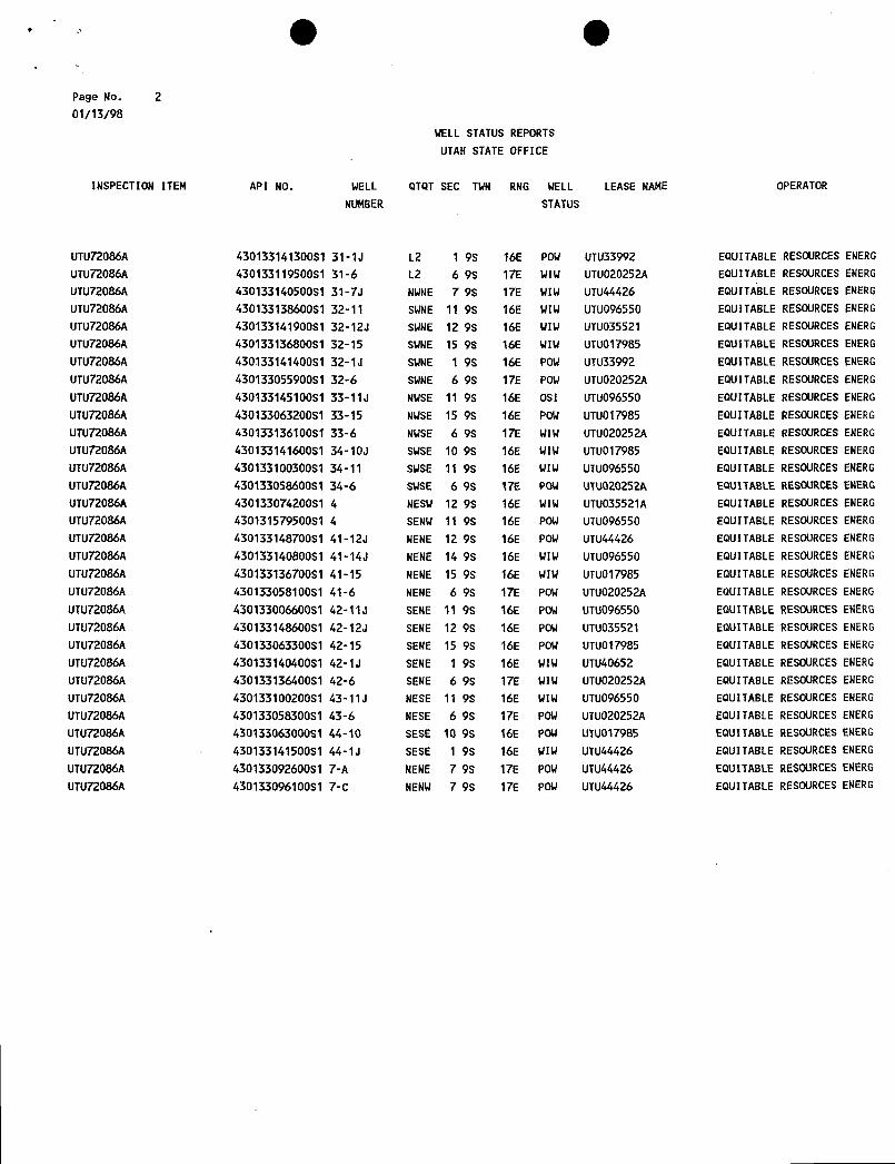
lilt IIII
Page No. 201/13/98
WELL STATUS REPORTS
UTAH STATEOFFICE
INSPECTION ITEM API NO. WELL QTOT SEC TWN RNG WELL LEASE NAME OPERATOR
NUMBER STATUS
UTU72086A 43013314130081 31-1J L2 1 9S 16E POW UTU33992 EQUITABLE RESOURCES ENERG
UTU72086A 43013311950081 31-6 L2 6 98 17E WIW UTUO20252A EQUITABLE RESOURCES ENERG
UTU72086A 43013314050081 31-7J NWNE 7 9S 17E WIW UTU44426 EQUITABLE RESOURCES ENERG
UTU72086A 43013313860081 32-11 SWNE 11 98 16E WIW UTUO96550 EQUITABLE RESOURCES ENERG
UTU72086A 43013314190051 32-12J SWNE 12 9S 16E WIW UTUO35521 EQUITABLE RESOURCES ENERG
UTU72086A 43013313680081 32-15 SWNE 15 9S 16E WIW UTU017985 EQUITABLE RESOURCES ENERG
UTU72086A 43013314140051 32-1J SWNE 1 98 16E POW UTU33992 EQUITABLERESOURCESENERG
UTU72086A 43013305590081 32-6 SWNE 6 98 17E POW UTUO20252A EQUITABLE RESOURCES ENERG
UTU72086A 43013314510081 33-11J NWSE 11 9S 16E OSI UTUO96550 EQUITABLE RESOURCES ENERG
UTU72086A 43013306320081 33-15 NWSE 15 9S 16E POW UTUO17985 EQUITABLE RESOURCESENERG
UTU72086A 43013313610081 33-6 NWSE 6 98 17E WIW UTUO20252A EQUITABLE RESOURCES ENERG
UTU72086A 43013314160081 34-10J SWSE 10 98 16E WIW UTU017985 EQUITABLE RESOURCES ENERG
UTU72086A 43013310030081 34-11 SWSE 11 9S 16E WIW UTUO96550 EQUITABLE RESOURCES ENERG
UTU72086A 43013305860081 34-6 SWSE 6 98 17E POW UTUO20252A EQUITABLE RESOURCES ENERG
UTU72086A 43013307420081 4 NESW 12 9S 16E WIW UTUO35521A EQUITABLE RESOURCES ENERG
UTU72086A 430131579500S1 4 SENW 11 98 16E POW UTUO96550 EQUITABLE RESOURCES ENERG
UTU72086A 43013314870081 41-12J NENE 12 9S 16E POW UTU44426 EQUITABLE RESOURCES ENERG
UTU72086A 43013314080081 41-14J NENE 14 9S 16E WIW UTUO96550 EQUITABLE RESOURCES ENERG
UTU72086A 43013313670081 41-15 NENE 15 9S 16E WIW UTUOl7985 EQUITABLE RESOURCES ENERG
UTU72086A 43013305810081 41-6 NENE 6 9S 17E POW UTUO20252A EQUITABLE RESOURCES ENERG
UTU72086A 43013300660081 42-11J SENE 11 9S 16E POW UTUO96550 EQUITABLERESOURCES ENERG
UTU72086A 43013314860081 42-12J SENE 12 9S 16E POW UTUO35521 EQUITABLE RESOURCES ENERG
UTU72086A 43013306330081 42-15 SENE 15 9S 16E POW UTUO17985 EQUITABLE RESDURCES ENERG
UTU72086A 43013314040051 42-1J SENE 1 9S 16E WIW UTU40652 EQUITABLE RESOURCES ENERG
UTU72086A 43013313640081 42-6 SENE 6 98 17E WIW UTUO20252A EQUITABLE RESOURCES ENERG
UTU72086A 43013310020081 43-11J NESE 11 9S 16E WIW UTU096550 EQUITABLE RESOURCES ENERG
UTU72086A 43013305830081 43-6 NESE 6 9S 17E POW UTUO20252A EQUITABLE RESOURCES ENERG
UTU72086A 43013306300081 44-10 SESE 10 9S 16E POW UTU017985 EQUITABLE RESOURCES ENERG
UTU72086A 43013314150081 44-1J SESE 1 9S 16E WIW UTU44426 EQUITABLE RESOURCES ENERG
UTU72086A 43013309260081 7-A NENE 7 98 17E POW UTU44426 EQUITABLE RESOURCES ENERG
UTU72086A 43013309610051 7-C NENW 7 98 17E POW UTUA4426 EQUITABLE RESDURCES
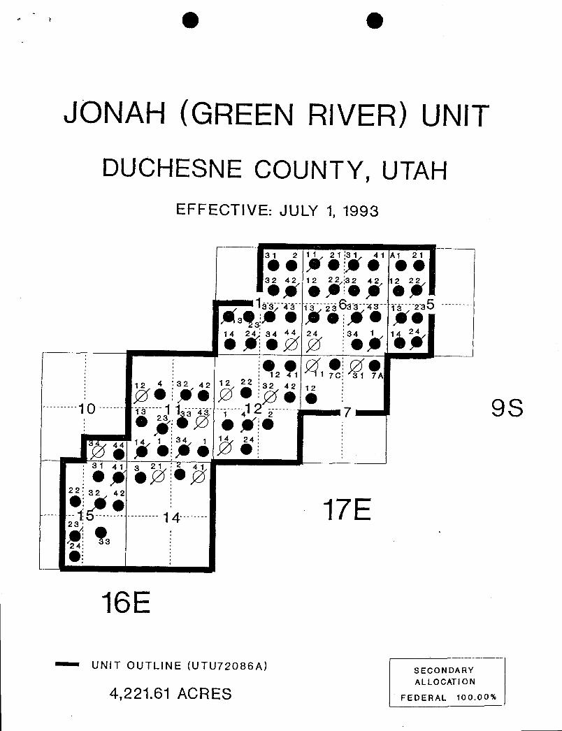
JONAH (GREEN RIVER) UNIT
DUCHESNE COUNTY, UTAHEFFECTIVE: JULY 1, 1993
81 2 11 21:31 41 A1 21eeNeige ee32 42 12 22 32 42 12 22og e*:e y of
áá o iä3622--42-- ys---225
Asq * e * eye ye14 24' 84 44 24 :34 1 1 24
eAeøø ieg &¾eggeøe
12 1 1 7C 31 7A12 4 :32 42 12 22 32 42 12e!*e Øe e 9S10 - vi-- 1 1 4 4 2 7e gâØ e ye
31 41 3 21 41e e22 32 42•/ • 17E-1 -- - -- 14
24:el
16E
- UNIT OUTLINE (UTU72086A) SECONDARYALLOCATION
4,221.61 ACRES FEDERAL

Division of Oil, Gas and Mining Routin
ÒPERATOR CHANGE WORKSHEET 1 (I
Attach all documentation received by the division regarding this change. 3-DT R-SgInitial each listed item when completed. Write N/A if item is not applicable. 4-VI n 9-Fr .E
141 Change of Operator (well sold) O Designation of AgentO Designation of Operator O Operator Name Change Only
The operator of the well(s) listed below has changed, effective: 9-30-97
TO: (new operator) INLAND PRODUCTION COMPANY FROM: (old operator) EQUITABLE RESOURCES ENERGY(address) Po Box 1446 (address) Po Box 577
ROOSEVELT UT 84066 LAUREL MT 59044c/O CRAZY HTN O&G SYS
Phone: (801)722-5103 Phone: (406)628-4164Account no. N5160 Account no. N9890 .
WELL(S) attach additional page if needed: *JONAH (GREER RIVER) UNIT
Name: **SEE ATTACHED** API: $~Ù ) () Entity: S T R Lease:Name: API: Entity: S T R Lease:Name: API: Entity: S T R Lease:Name: API: Entity: S T R Lease:Name: API: Entity: S T R Lease:Name: API: Entity: S T R Lease:Name: API: Entity:
_S T R Lease:
OPERATOR CHANGE DOCUMENTATION
e 1. (r649-8-10) Sundryor other legaldocumentation has been received from the FORMER operator (attach to thisform)- ( h/c /2-lod7)
e 2. (r649-8-10) Sundry or other legal documentation has been received from the NEW operator (Attach to this
3. The Department of Commerce has been contacted if the new operator above is not currently operating anywells in Utah. Is the company registered with the state? (yes/no) If yes, show company file number:
C 4. FOR INDIAN AND FEDERAL WELLS ONLY. The BLM has been contacted regarding this change. Makenote of BLM status in comments section of this form. BLM approval of Federal and Indian well operatorchanges should ordinarily take place prior to the division's approval, and before the completion of steps Sthrough 9 below.
8 5. Changeghave been entered in the Oil and Gas Information System (3270) for each well listed above.
6. Cardex file has been updated for each well listed above.
C 7. Well file labels have been updated for each well listed above.
8. Changes have been included on the monthly "Operator,Address, and Account Changes" memo for distributionto Trust Lands, Sovereign Lands, UGS, Tax Commission,etc. //-/‡†9)
C 9. A folder has been set up for the Operator Change file, and a copy of this page has been placed there forreference during routing and processing of the original documents.
dons\wpdocs\forms\operchng- OVER
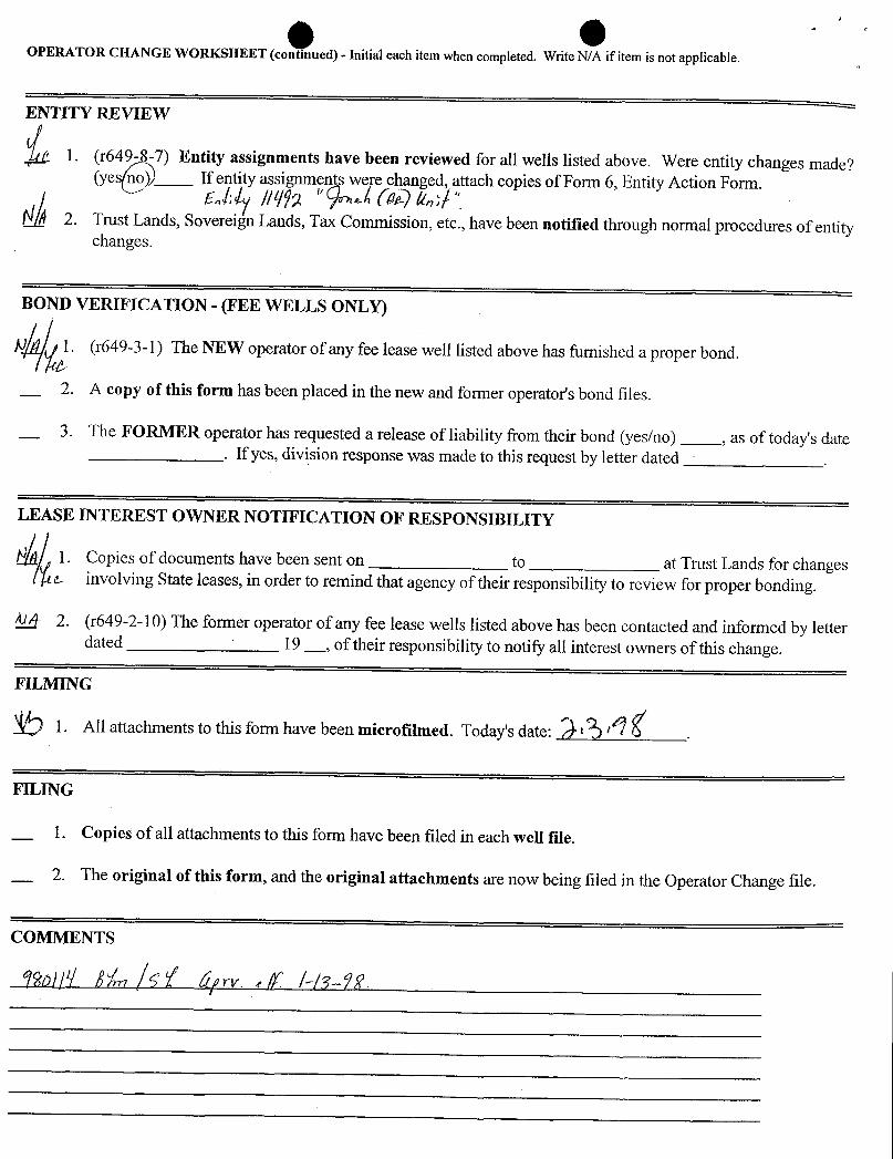
OPERATOR CHANGE WORKSHEET (continued) - Initial each item when completed. Write N/A if item is not applicable.
E TITY REVIE
Entity assignments have been reviewed for all wells listed above. Were entity changes made?(yes If entity assignments were changed, attach copies of Form 6, Entity Action Form.
Ñ 2. Trust Lands, Sovereign Lands, Tax Commission, etc., have been notified through normal procedures of entitychanges.
BOND VERIFICATION - (FEE WELLS ONLY)
Al 1. (r649-3-1) The NEW operator of any fee lease well listed above has furnished a proper bond.
2. A copy of this form has been placed in the new and former operator's bond files.
3. The FORMER operator has requested a release of liability from their bond (yes/no) , as of today's date. If yes, division response was made to this request by letter dated
LEASE INTEREST OWNER NOTIFICATION OF RESPONSIBILITY
N 1. Copies of documents have been sent on to at Trust Lands for changese involving State leases, in order to remind that agency of their responsibility to review for proper bonding.
4 2. (r649-2-10) The former operator of any fee lease wells listed above has been contacted and informed by letterdated 19
_,of their responsibility to notify all interest owners of this change.
FILMING
1. All attachments to this form have been microfilmed. Today's date: S6 .
FILING
1. Copies of all attachments to this form have been filed in each well file.
2. The original of this form, and the original attachments are now being filed in the Operator Change file.

. g gDOGM Fonn 5
May5,1987
STATE OF UTAHDEPARTMENT OF NATURAL RESOURCES
DIVISION OF OIL, GAS, AND MINING 5. LEASE DESIGNATION AND SERIALNO.U-096550
2. SUNDRY NOTICES AND REPORTS ON WELLS 6. IFINDIAN.ALLOTTEEORTRIBALNAME
(Donot use this form for proposals to drill or to deepen or plug back to a different reservoir. N/AUse "APPLICATION FOR PERMIT-" ihr such proposals.)
O7. UNIT AGREEMENT NAME
OIL GASWELL WELL OTHER JONAH
2. NAME OF OPERATOR 8. FARM OR LEASENAMEINLAND PRODUCTION COMPANY MONUMENT FEDERAL 12-12J
3. ADDRESS OF OPERATOR 9. WELL NO.Route 3, Box 3630, Myton Utah 84052 MONUMENT FEDERAL 12-12J(435-646-3711)
4. LOCATION OF WELL (Report location clearly and in accordance with any State requirements.* 10 FIELD ANDPOOL.OR WILDCATSee also space 17 below.)At surface MONUMENT BUTTE
SWINW 1980 FNL 0660 FWL11 SEC.,T.,R.,M.,ORBLK.AND
SURVEY OR AREA
SW/NW Section 12, TO9SR16E
14 API NUMBER 15. ELEVATIONS (Show whether DF, RT, GR, etc.) 12 COUNTY OR PARISH 13 STATE43-013-31410 5543 GR DUCHESNE UT
16. Check Appropriate Box To Indicate Nature of Notice, Report, or Other DataNOTICE OF INTENTION TO: SUBSEQUENT REPORT OF:
TEST WATER SHUT-OFF PULL OR ALTERCASING WATER SHUT-OFF REPAIRINGWELL
FRACTURETREAT MULTIPLE COMPLETE FRACTURE TREATMENT ALTERINGCASING
SHOOTOR ACIDIZE ABANDON* SHOOTINGOR ACIDIZING ABANDONMENT*
REPAIR WELL (OTHER) Perforrrt 5 year MIT
(OTHER) (Note: Report results of multiple completion on Well
Completion or Recompletion Report and Log form.)17 DESCRIBE PROPOSED OR COMPLETED OPERATIONS. (Clearly state all pertinent details,and give pertinent dates, including estimated date of starting any
proposed work. If well is diæetionally drilled, give subsurface locations and measund and true vertical depths for all markers and zones pertinent to this work.)*
The MIT was conducted on the subject well to satisfy the five year MIT. On 6-7-00 the casing was pressured up to 1125 psi andcharted for thirty minutes with no leak off. Mr. Dennis Ingram with the DOGM was in attendance and approved the test.
Accepted by theUtah Division of
Oil, Gas and Mining
SIGNED TITLE Production Foreman DATE 6/7/00
(This space ihr Federal or State allice use)
APPROVED BY TITLE DATECONDITIONSOF APPROVAL, IF ANY:
RECEIVED* See Instructions On Reverse Side
JUNOg2000DIVISION OF
OIL,GAS AND
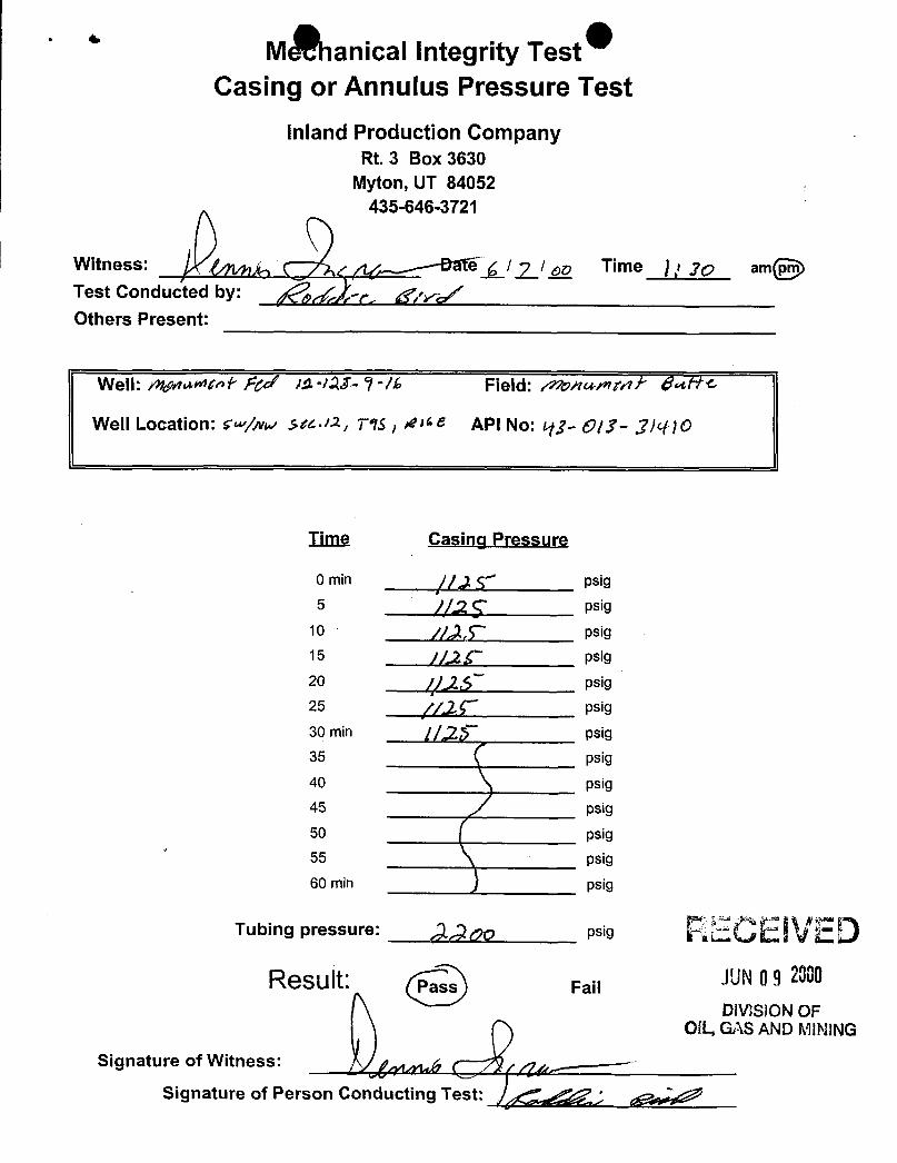
MËanicalIntegrity TestCasing or Annulus Pressure Test
Inland Production CompanyRt. 3 Box 3630
Myton, UT 84052435-646-3721
Witness: Ig/ Time jr jo amTest Conducted by:
,y/
Others Present:
Well: µ;µ><ni- Fy/ JA IM- 9-/h Field: monwnrd $«NC
Well Location: tw/ww .sts-12 T o API No: tij- Ð/J- .7/<-RO
Time Casing Pressure
0 min psig5 // psig
10 psig15 psig
20 psig25 psig
30 min psig35 psig
40 psig45 psig
50 psig55 psig
60 min psig
Tubing pressure: o psig RECE IVEDResult: Fail
DIVISlONOFOIL,GAS AND MINING
Signature of Witness:
Signature of Person Conducting Test:
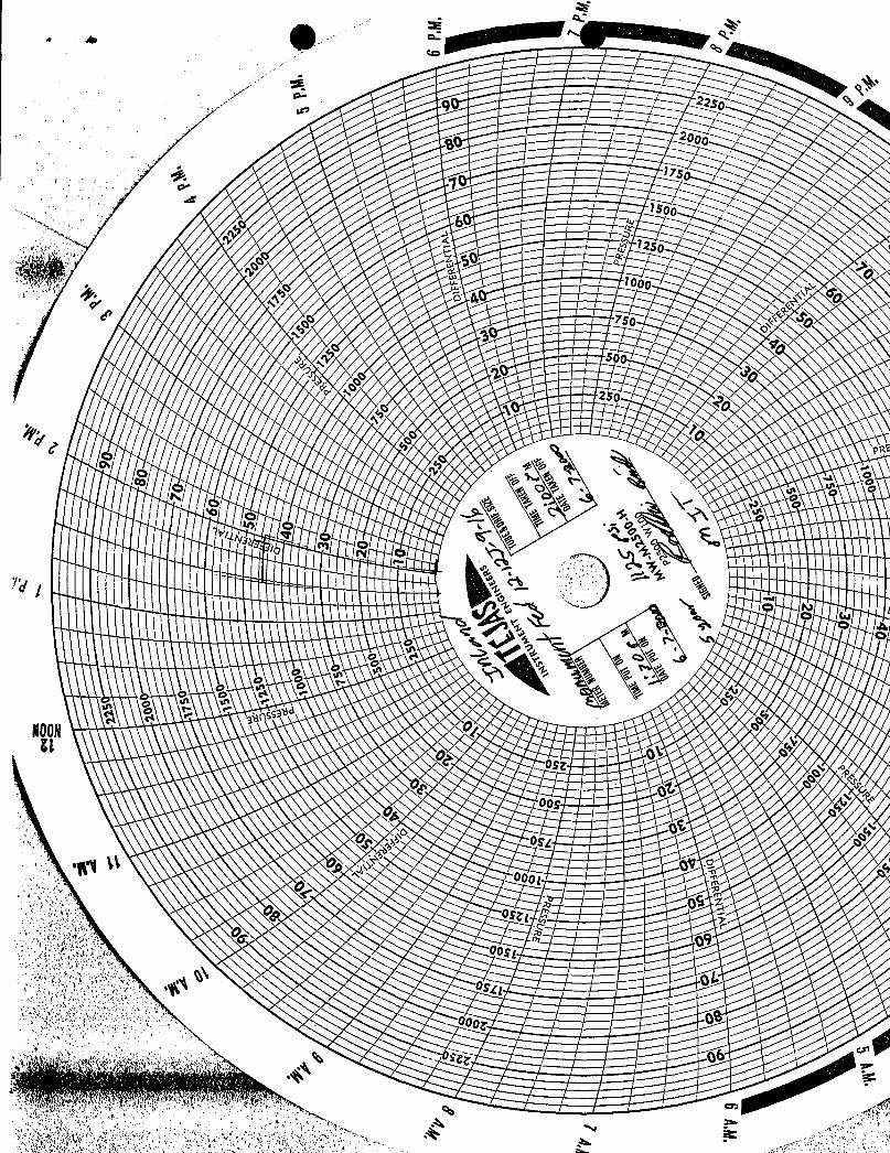
22so a
e 2°•¤
-. 17se- 1
6O 12sos e
loog
/ o
\ \L \s a °s.. 's
\\\ o e e A ,
44
\ \ $ U ~ abass3NOON Ut
o or o
oo
orov :
o 09
oos 09
og 0 I-
oog,
sie
22so a
e 2°•¤
-. 17se- 1
6O 12so
s eloog
/ o
\ \L \s a °s.. 's
\\\ o e e A ,
44
\ \ $ U ~ abass3NOON Ut
o or o
oo
orov :
o 09
oos 09
og 0 I-
oog,
sie
22so a
e 2°•¤
-. 17se- 1
6O 12so
s eloog
/ o
\ \L \s a °s.. 's
\\\ o e e A ,
44
\ \ $ U ~ abass3NOON Ut
o or o
oo
orov :
o 09
oos 09
og 0 I-
oog,
sie
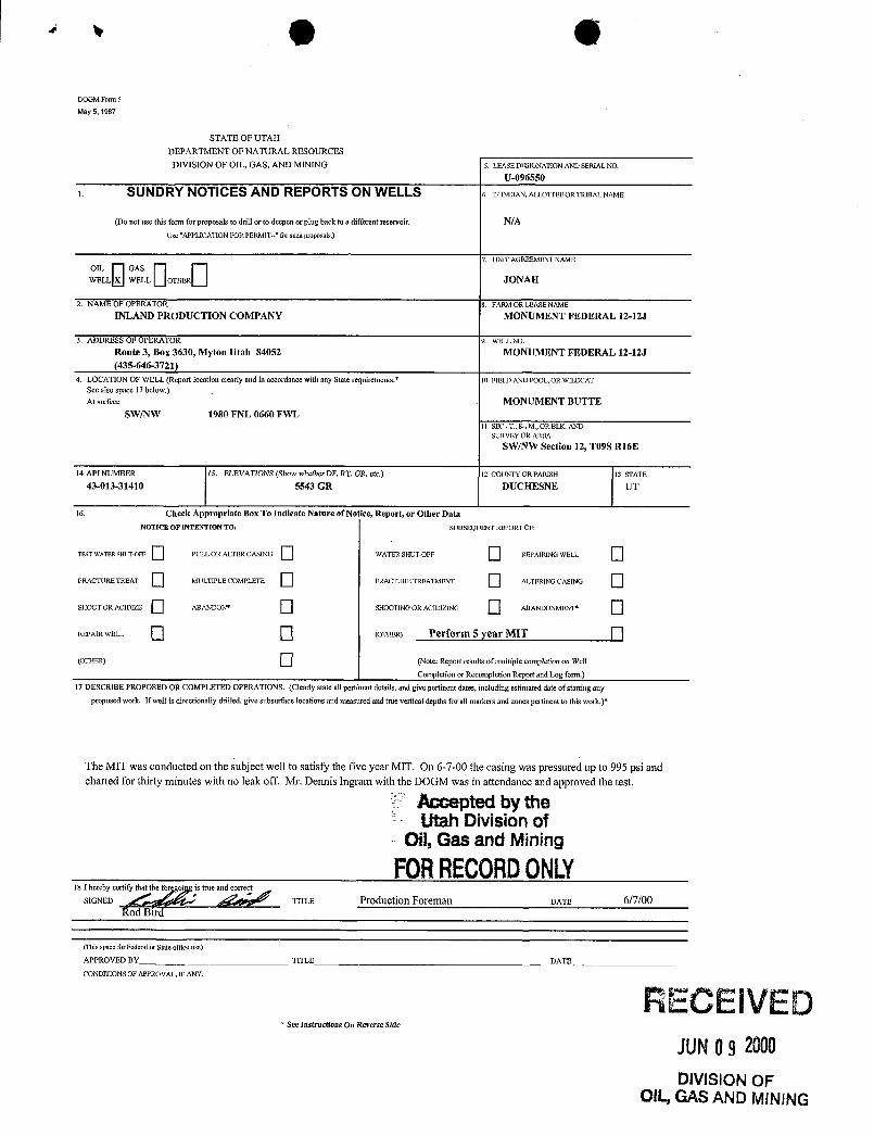
O ODOGM Form 5
May 5, 1987
STATE OF UTAHDEPARTMENT OF NATURAL RESOURCES
DIVISION OF OIL, GAS, AND MINING 5. LEASEDESIONATIONAND SERIALNO.U-096550
1. SUNDRY NOTICES AND REPORTS ON WELLS 6. IFINDIAN.ALLOTTEEORTRIBALNAME
(Do not use this fomi for proposals to drill or to deepen or plug back to a different reservoir. N/AUse "APPLICATION FOR PERMIT--" for such proposals.)
ELLL GWAESLL
OTHER
7. UNIT AGREEHMENTNAME
2. NAME OF OPERATOR 8. FARM OR LEASENAME
INLAND PRODUCTION COMPANY MONUMENT FEDERAL 12-12J
3. ADDRESS OF OPERATOR 9. WELLNO.
Route 3, Box 3630, Myton Utah 84052 MONUMENT FEDERAL 12-12J(435-646-3721)
4. LOCATION OF WELL (Report location clearly and in acconlance with any State requirements.* 10 FIELD AND POOL OR WILDCATSee also space 17 below.)At surface MONUMENT BUTTE
SW/NW 1980 FNL 0660 FWL1I SEC.,T.,R.,M.,ORBLK.AND
SURVEYOR AREASWINW Section 12, T09S R16E
14 API NUMBER I5. ELEVATIONS (Show whether DF, RT, GR, etc.) 12 COUNTY OR PARISH 13 STATE43-013-31410 5543 GR DUCHESNE UT
16. Check Appropriate Box To Indicate Nature of Notice, Report, or Other DataNOTICE OF INTENTION TO: SUBSEQUENT REPORT OF:
TEST WATER SHUT-OFF PULL OR ALTER CASING WATER SHUT-OFF REPAIRINGWELL
FRACTURE TREAT MULTIPLE COMPLETE FRACTURE TREATMENT ALTERINGCASING
SHOOT OR ACIDIZE ABANDON* SHOOTINGOR ACIDIZING ABANDONMENT*
REPAIR WELL (OTHER) Perform 5 year MIT
(OTHER) (Note: Report results ofmultiple cornpletionon Well
Completion or Recompletion Report and Log form.)17 DESCRIBE PROPOSED OR COMPLETED OPERATIONS. (Clearly state all pertinent details, and give pertinent dates, including estimated date of starting any
proposed work. If well is directionally drilled,give subsurface locations and measuredand true vertical depths for all markers and zones pertinent to this work.)*
The MIT was conducted on the subject well to satisfy the five year MIT. On 6-7-00 the casing was pressured up to 995 psi andcharted for thirty minutes with no leak off. Mr. Dennis Ingram with the DOGM was in attendance and approved the test.
Accepted by theUtah Division of
Oil, Gas and Mining
FORRECORDONLY18 ISherebEyDcertify s true a
TITLE Production Foreman DATE 6/7/00Rod Bird
(This space for Federal or Stateollice use)
APPROVED BY TITLE DATE
CONDITIONSOF APPROVAL, IF ANY:
RECEIVED* See Instructions On Reverse Side
JUNOg2000DIVISION OF
OIL,GAS AND
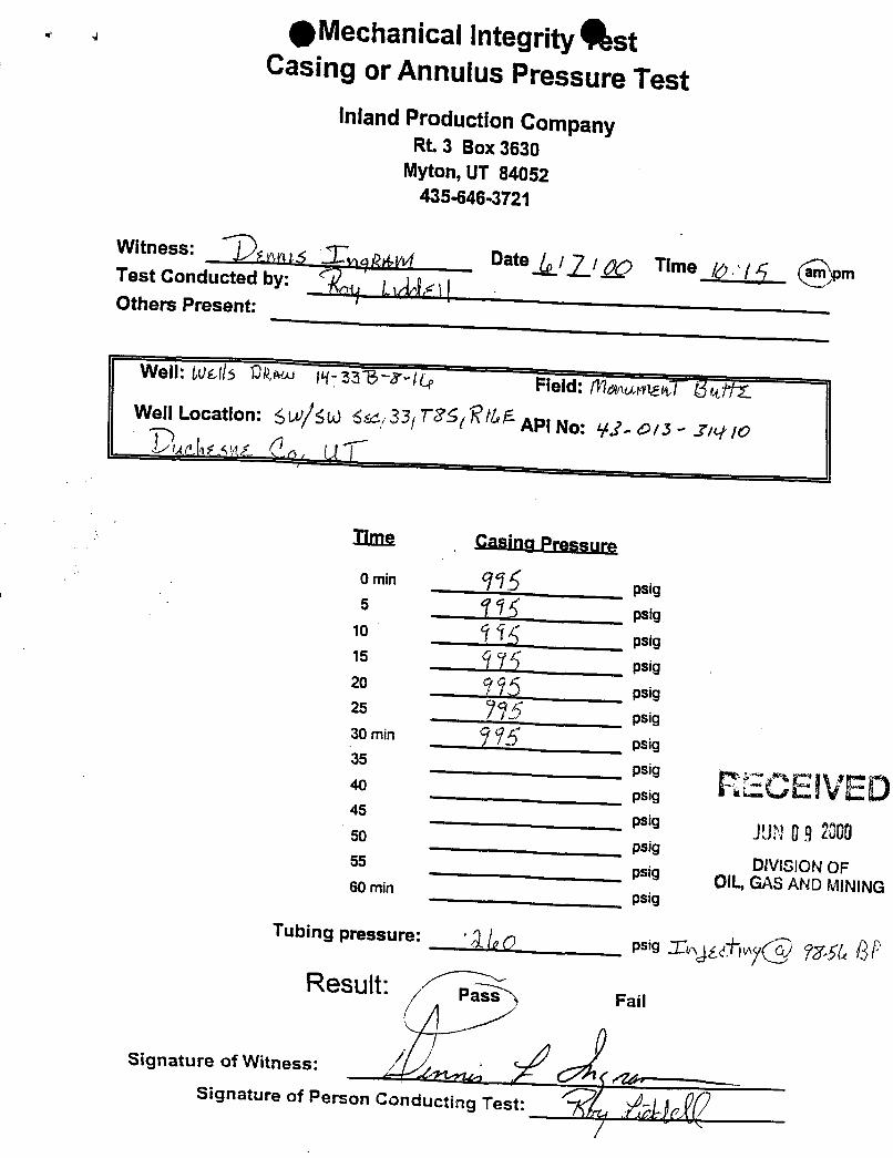
g Mechanical Integrity AstCasing or Annulus Pressure Test
inland Production CompanyRt. 3 Box 3630
Myton, UT 84052435-646-3721
Witness: egg i gg Date ll/ g Time /¿> / 4 mTest Conducted by:Others Present:
Well: 0001/5 94** N-33W-7 ILe Field: 17/mummT MiftWell Location: 5ty L 6433 TRE R/65API No: 91- Di3 - 1410
Ilma Casina Pressure
0 min psig5 †¾ psig
10 ŸM psig15 97 psig20 995 psie25 795 psia30 min ŸÑ psig35 psig
RECEIVED40 psig45 psig pygg ggg50 psig
DIVISION OF55psig OIL,GAS AND MINING60 minpsig
Tubing pressure:psig I fy
Result: !=ail
Signature of Witness:
Signature of Person Conducting
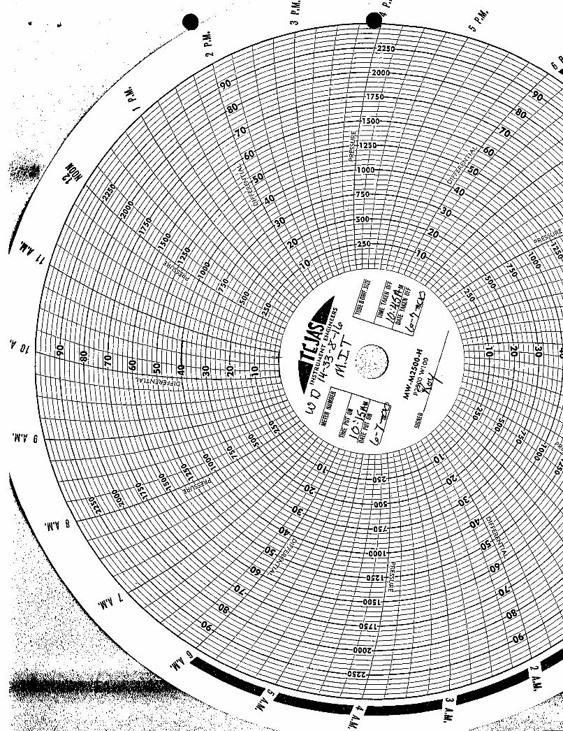
cm
225
200
9175
150y
125 60
1000
500
o "oDi
TV 6
OSL
Sp0;
oset
SL
cm
225
200
9175
150y
125 60
1000
500
o "oDi
TV 6
OSL
Sp0;
oset
SL
cm
225
200
9175
150y
125 60
1000
500
o "oDi
TV 6
OSL
Sp0;
oset
SL

Unit States Department of the erior
BUREAU OF LAND MANAGEMENT pyggg•Utah State Office IN (MCAP.O. Box 45155
Salt Lake City, UT 84145-0155http://www.blm.gov
IN REPLY REFER TO:3106(UT-924)
September 16, 2004
Memorandum
To: Vernal Field Office
From: Acting Chief, Branch of Fluid Minerals
Subject: Merger Approval
Attached is an approved copy of the name change recognized by the Utah State Office. We haveupdated our records to reflect the merger from Inland Production Company into NewfieldProduction Company on September 2, 2004.
Michael CoulthardActing Chief, Branch ofFluid Minerals
Enclosure1. State of Texas Certificate of Registration
ec: MMS, Reference Data Branch, James Sykes, PO Box 25165, Denver CO 80225State of Utah, DOGM, Attn: Earlene Russell, PO Box 145801, SLC UT 84114Teresa ThompsonJoe IncardineConnie
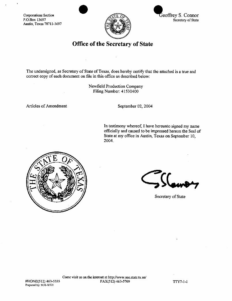
O OCorporationsSection E og Teoffrey S. ConnorP.O.Box 13697 Secretaryof StateAustin, Texas 78711-3697
Office of the Secretary of State
The undersigned, as Secretary of State of Texas, doeshereby certify that the attached is a true andcorrect copy of each document on file in this office as describedbelow:
Newfield Production CompanyFiling Number: 41530400
Articles of Amendment September02, 2004
In testimonywhereof, I have hereunto signed my nameofficially and causedto be impressed hereon the Seal ofState at my office in Austin, Texas on September 10,2004.
Secretary of State
Comevisit us on the intemet at http://www.sos.state.tx.us/PHONE(512) 463-5555 FAX(512) 463-5709 TTY7-1-1Prepared by:
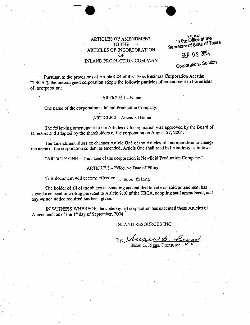
ARTICLES OF AMENDMENT \n the gŠ oftheTO THE Secretary ofState ofTexat
ARTICLES OF INCORPORATIONOF Û2 ËË
INLAND PRODUCTION COMPAN YCorpotaúorg Secti00
' Pursuantje the provisionsof Article 4.04 of the TexasBusinessCorporation Act (the"TB0A"), the underaigned corporationadoptsthe following articles of amendmentto the articlesof incorporation:
'
ARTICLE 1- Name
The name of the corporation is Inland Production Company.
ARTICLE 2 - Amended Name
The following amendment to the Articles of Incorporation was approved by the Board ofDirectors and adoptedby the shareholdersof the corporation on August 27, 2004.
The amendment alters or changes Article Onë of the Articles of Incorporation to changethe name of the corporation so that, as amended,Article One shall read in its entirety as follows:
"ARTl,CLE ONE - The name of the corporation is Newfield Production Company."
ARTICLE 3 - Effective Date of Filing
This document will become effective upon filing.
The holder of all of the shares outstanding and entitled to vote on said amendment hassigned a consent in writingpursuantto Article 9.10 of the TBCA, adopting said amendment,andany written notice required has been given.
IN WITNESSWHEREOF, the undersigned corporation has executed these Articles ofAmendment as of the 1" day of September, 2004.
INLAND RESOURCES INC.
By:Susan G. Riggs,

O O
UTSI- 15855 61052 73088 76561071572A 16535 62848 73089 76787065914 16539 63073B 73520A 76808
16544 63073D 74108 7681317036 63073E 74805 76954 63073X17424 630730 74806 76956 63098A18048 64917 74807 77233 68528AUlfU- 18399 64379 74808 77234 72086A19267 64380 74389 77235 72613A
02458 26026A 64381 74390 77337 73520X03563 30096 64805 74391 77338 74477X03563A 30103 64806 74392 77339 75023X04493 31260 64917 74393 77357 76189X05843 33992 65207 74398 77359 76331)(07978 34173 65210 74399 77365 76788X09803 34346 65635 74400 77369 77098X017439B 36442 65967 74404 77370 77107)£017985 36846 65969 74405 77546 77236X017991 38411 65970 74406 77553 77376X017992 38428 66184 74411 77554 78560]E018073 38429 66185 74805 78022 79485X019222 38431 66191 74806 79013 79641X020252 39713 67168 74826 79014 80207X020252A 39714 67170 74827 79015 81307X020254 40026 67208 74835 79016020255 40652 67549 74868 79017020309D 40894 67586 74869 79831022684A 41377 67845 74870 79832027345 44210 68105 74872 79833'034217A 44426 68548 74970 79831035521 44430 68618 75036 79834035521A 45431 69060 75037 80450038797 47171 69061 75038 80915058149 49092 69744 75039 81000063597A 49430 70821 75075075174 49950 72103 75078096547 50376 72104 75089096550 50385 72105 75090
50376 72106 7523450750 72107 75238
10760 51081 72108 7623911385 52013 73086 7624013905 52018 73087 7624115392 58546 73807
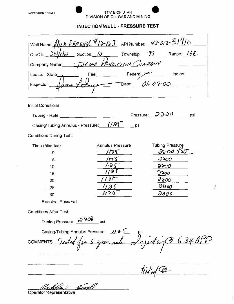
INSPECTION FORM 6 STATE OF UTAHDIVISION OF OlL GAS AND MINING
INJECTION WELL - PRESSURE TEST
Well Name: ph Ëjell/ API Number: Û/3
Qtr/Qtr: Section: / Township: Range: / 6
Company Name: ANÊ y ) (TigÑ )
\LnesapsetorState atFederal Indian
Initial Conditions:
Tubing - Rate: Pressure: psi
Casing/Tubing Annulus - Pressure: psi
Conditions During Test:
Time (Minutes) Annulus Pressure Tubing Pressur
o //af hob Ts¶,5 (P 3300
10 NO15 910020 | Ë OkOG25 / 900so //>E Jada
Results: Pass/Fail
Conditions After Test:
Tubing Pressure: psi
Casing/Tubing Annulus Pressure: // psi
COMMENTS: &
Operator
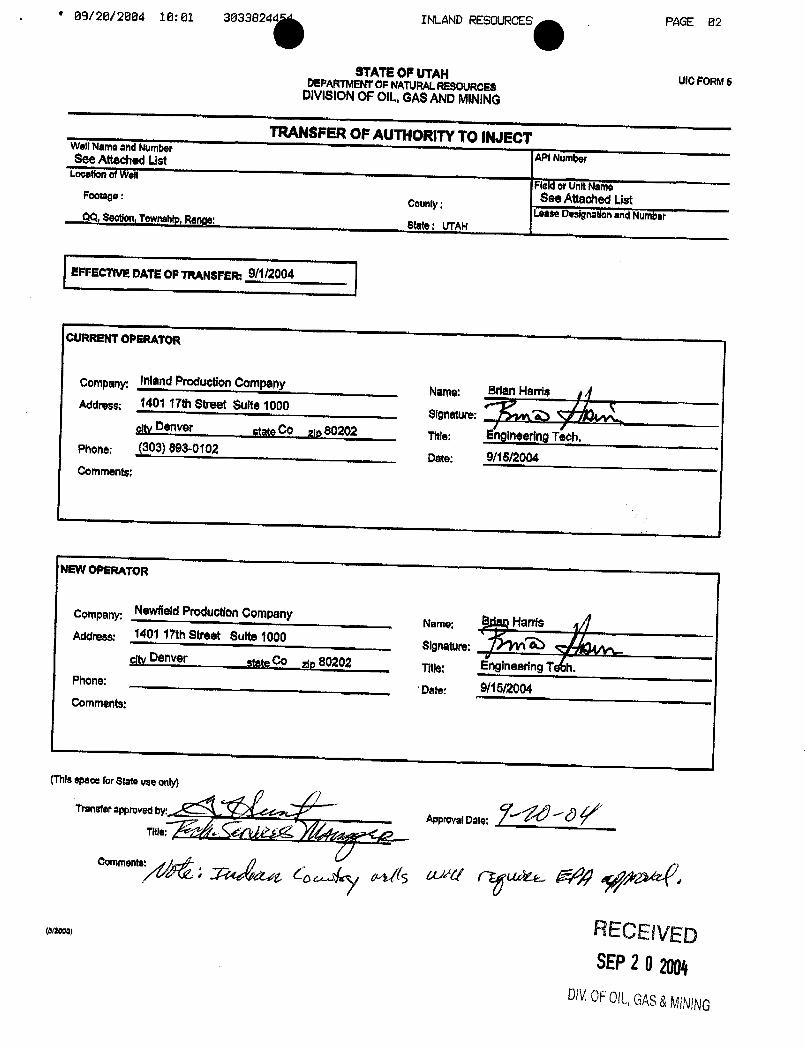
09/20/2004 10:01 3033824 INLAND RESOURCES PAGE 82
STATEOP UTAH uloFolm 5DEPARTMENTOF NATURALRESOURCESDIVISIONOF OIL,GASANDMINING
TRANSFEROP AUTHORITYTO INJECTWell Name and Number
API NumberSee Attached ListLocationof Well
Fle¾ orUnitNameSee AttachedListFootage :
County :Lesse Designadonand Number00, Geotion,Township,Range: State: UTAR
EFFECTIVEDATEOP TRANSFER: 9/1/2004
CURRENTOPERATOR
Company InlandProduction ComponYName: Brian Harris
Address: 1401 17th Street Suite 1000 Signature: OcityDenver stateCo gp 80202 T¡tle: EngineeringTe¢h.
Phone: (303) 893-0102Date: 9/15/2004
Commente:
NEWOPliRATOR
Company: NewfieldProduction CompanyName: B Harris
AddreBS: 1401 17thStreet Suite 1000Signatult:
cityDenver stateCO zip 80202 Title: EngineeringT h.Phone:
Date: 9/15/2004Comments:
(Thisspace forState use only)
Transferapproved byApprovalDate:
RECElVED(0/2000)
SEP2 O2004DiVOFOlL,GAS&
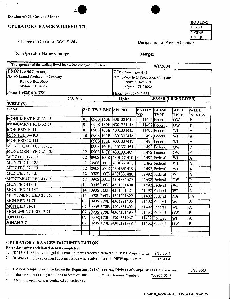
O ODivision of Oil, Gas and Mining
ROUTINGOPERATOR CHANGE WORKSHEET 1. GLH
2. CDW3. FILE
Change of Operator (Well Sold) Designation of Agent/Operator
X Operator Name Change Merger
The operator of the well(s) listed below has changed, effective: 9/1/2004FROM: (Old Operator): TO: ( New Operator):N5160-Inland Production Company N2695-Newfield Production Company
Route 3 Box 3630 Route 3 Box 3630Myton, UT 84052 Myton, UT 84052
Phone: 1-(435) 646-3721 Phone: 1-(435) 646-3721
CA No. Unit: JONAH (GREEN RIVER)WELL(S)NAME SEC TWN RNG API NO ENTITY LEASE WELL WELL
NO TYPE TYPE STATUSMONUMENT FED 31-lJ 01 090S 160E 4301331413 11492 Federal OW PMONUMENT FED 32-lJ 01 090S 160E 4301331414 11492 Federal OW PMON FED 44-lJ 01 090S 160E 4301331415 11492 Federal WI AMON FED 34-10J 10 090S 160E 4301331416 11492 Federal WI AMON FED 12-11J 11 090S 160E 4301331417 11492 Federal WI AMONUMENT FED 33-11J 11 090S 160E 4301331451 11492 Federal OW PMONUMENT FED 24-12J 12 0908 160E 4301331409 11492 Federal OW PMON FED 12-12J 12 090S 160E 4301331410 1 11492 Federal WI AMON FED 14-12J 12 090S 160E 4301331411 11492 Federal WI AMON FED 32-12J 12 090S 160E 4301331419 11492 Federal WI AMON FED 42-12J 12 090S 160E 4301331486 11492 Federal WI AMONUMENT FED 41-12J 12 090S 160E 4301331487 11492 Federal OW PMON FED 41-14J 14 090S 160E 4301331408 11492 Federal WI AMON FED 21-14J 14 090S 160E 4301331421 11492 Federal WI AMONUMENT FED 21-15J 15 090S 160E 4301331422 11492 Federal NA PAMON FED 31-7J 07 090S 170E 4301331405 11492 Federal WI AMON FED 11-7J 07 090S 170E 4301331492 11492 Federal WI AMONUMENT FED 12-7J 07 090S 170E 4301331493 11492 Federal OW PJONAH 6-7 07 090S 170E 4301331987 11492 Federal WI AJONAH 7-7 07 090S 170E 4301331988 11492 Federal OW P
OPERATOR CHANGES DOCUMENTATIONEnter date after each listed item is completed1. (R649-8-10) Sundry or legal documentation was received from the FORMER operator on: 9/15/20042. (R649-8-10) Sundry or legal documentation was received from the NEW operator on: 9/15/2004
3. The new company was checked on the Department of Commerce, Division of Corporations Database on: 2/23/20054. Is the new operator registered in the State of Utah: YES Business Number: 755627-01435. If NO, the operator was contacted contacted on:
Newfield Jonah GR 4 FORM 4B.xls

g g6a. (R649-9-2)Waste Management Plan has been received on: IN PLACE6b. Inspections of LA PA state/fee well sites complete on: waived
7. Federal and Indian Lease Wells: The BLM and or the BIA has approved the merger, name change,or operator change for all wells listed on Federal or Indian leases on: BLM BIA
8. Federal and Indian Units:The BLM or BIA has approved the successor of unit operator for wells listed on: n/a
9. Federal and Indian Communization Agreements ("CA"):The BLM or BIA has approved the operator for all wells listed within a CA on: na/
10. Underground Injection Control ("UIC") The Division has approved UIC Form 5, Transfer of Authority toInject, for the enhanced/secondary recovery unit/project for the water disposal well(s) listed on: 2/23/2005
DATA ENTRY:1. Changes entered in the Oil and Gas Database on: 2/28/2005
2. Changes have been entered on the Monthly Operator Change Spread Sheet on: 2/28/2005
3. Bond information entered in RBDMS on: 2/28/2005
4. Fee/State wells attached to bond in RBDMS on: 2/28/2005
5. Injection Projects to new operator in RBDMS on: 2/28/2005
6. Receipt of Acceptance of Drilling Procedures for APD/New on: waived
FEDERAL WELL(S) BOND VERIFICATION:1. Federal well(s) covered by Bond Number: UT 0056
INDIAN WELL(S) BOND VERIFICATION:1. Indian well(s) covered by Bond Number: 61BSBDH2912
FEE & STATE WELL(S) BOND VERIFICATION:1. (R649-3-1) The NEW operator of any fee well(s) listed covered by Bond Number 61BSBDH2919
2. The FORMER operator has requested a release of liability from their bond on: n/a*
The Division sent response by letter on: n/a
LEASE INTEREST OWNER NOTIFICATION:3. (R649-2-10) The FORMER operator of the fee wells has been contacted and informed by a letter from the Division
of their responsibility to notify all interest owners of this change on: n/a
COMMENTS:*Bond rider changed operator name from Inland Production Company to Newfield Production Company - received 2/23/05
Newfield_Jonah GR4 FORM_4B.xis
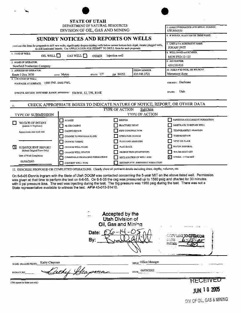
STATE OF UTAHDEPARTMENT OF NATURAL RESOURCES
5. LEASEDESIGNATION AND SERIAL NUMBER:
DIVISION OF OIL, GAS AND MINING UTUO965SO
SUNDRY NOTICES AND REPORTS ON WELLS6. IFINDIAN,ALLOTTEEORTRIBENAME:
a not use this form for proposals to drillnew wells, significantly deepenexisting wells below current bottom-holedepth,reenter plugged wells, 7. UNIT or CA AGREEMENT NAME:
to drill horizontal laterals. Use APPLICATION FOR PERMIT TO DRILL formfor suchproposals. JONAHUNIT
l. TYPE OF WELL: 8. WELLNAME and NUMBER:
OIL WELL O GASWELL O OTHER Injection well MON FED 12-12J
2. NAME OF OPERATOR 9. API NUMBER:
Newfield Production Company 4301331410
3. ADDRESSOF OPERATOR: PHONE NUMBER 10. FIELD AND POOL, OR WILDCAT:
Route 3 Box 3630 crry Myton STATE UT ZIP 84052 435.646.3721 Monument Butte
4. LOCATION OF WELL:
FOOTAGESAT SURFACE: 1980 FNL 0660 FWL COUNTY: Duchesne
OTRIOTR.SECTION.TOWNSHIP. RANGE. MERIDIAN: SW/NW, 12, T9S, Rl6E STATE: Utah
11. CHECK APPROPRIATE BOXES TO INDICATE NATURE OF NOTICE, REPORT, OR OTHER DATATYPE OF ACTION SubDate
TYPE OF SUBMISSION TYPE OF ACTION
O ACI DIZE DEEPEN REPERFORATECURRENT FORMATION
O NOTICE OF INTENT(Submit in Duplicate) ALTER CASING FRACTURE TREAT SIDETRACK TO REPAIR WELL
Approximate date workwill CASING REPAIR NEW CONSTRUCTION TEMPORARITLY ABANDON
O CHANGE TOPREVIOUSPLANS OPERATOR CHANGE TUBINGREPAIR
O CHANGE TUBING PLUGAND ABANDON VENT OR FLAIR
Ð SUBSEQUENTREPORT CHANGE WELL NAME PLUGBACK WATER DISPOSAL
(SubmitOriginalForm Only) O CHANGE WELL STATUS PRODUCTION (START/STOP) WATER SHUT-OFF
Date of Work Completion:
O COMMINGLE PRODUCíNG FORMATIONS RECLAMATION OF WELL SITE OTHER: - 5 Year MIT
06/06/2005CONVERT WELL TYPE RECOMPLETE - DIFFERENT FORMATION
12. DESCRIBE PROPOSED OR COMPLETED OPERATIONS.Clearly show all pertinent details including dates,depths, volumes, etc.
On 6-6-05 Dennis ingram with the State of Utah DOGMwas contacted concerning the 5-year MITon the above listed well. Permissionwas given at that timeto perform the test on 6-6-05. On 6-6-05 the csg was pressured up to 1580 psig and charted for 30 minuteswith 0 psi pressure loss. The well was injecting during the test. The tbg pressure was 1980 psig during the test. There was not aState representative available to witness the test. APl#43-013-31410.
Accepted by theUtah Division of
ASE PRINT) K a DATLEE
0
ger
(Thisspace for State use only) HECEiVED
JUN1O2005
DMOF0\L,GAS&
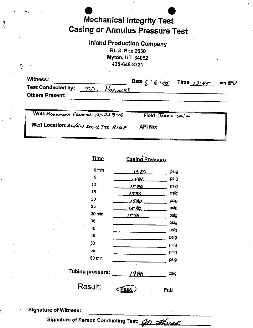
e OMechanical Integrity Test
Casing or Annulus Pressure Testinland Production Company
Rt. 3 Box 3630Myton, UT 84052
435-646-3721
Witness: Date gl g/ Time g;4ty- am gjÇTest Conducted by: 7-7)
. |-/cey.gOthers Present:
Well:Monamw+ Fak as 12-12.>-9-/6 Field: "Unaa un:†-
Well Location:s*Áfwlsec.12795 RM.E API No:
Time Casincf Pressure
0 min p psig5 psig
10 psig15 psig20 psig25 psig30 min y g psig35 psig40 psig45 psig50 psig55 psig60 min psig
Tubing pressure: ¿qq psig
Result: <P-a~sD. Fan
Signature of Witness:
Signature of Person Conducting

3e3e3e

. OSTATE OF UTAH
DEPARTMENT OF NATURAL RESOURCES5. LEASE DESIGNATION AND SERIAL NUMBER:
DIVISION OF OIL, GAS AND MINING USAUTU-096550
SUNDRY NOTICES AND REPORTS ON WELLS6. IFINDIAN,ALLOTTEEORTRIBENAME:
Do not use this fonn for proposals to drill new wells, significantlydeepen existing wells below current bottom-holedepth, reenter plugged7. UNIT or CA AGREEMENT NAME:
wells, or to drill horizontal laterals. Use APPLICATION FOR PERMIT TO DRILL fonn for such proposals. GMBU
l. TYPE OF WELL: 8. WELL NAME and NUMBER:
OIL WELL GAS WELL OTHER MON FED 12-12J
2. NAME OF OPERATOR: 9. API NUMBER:
NEWFlELD PRODUCTION COMPANY 43013314103. ADDRESSOF OPERATOR: PHONENUMBER 10. FIELD AND POOL, OR WILDCAT:
Route 3 Box 3630 CITY Myton STATE UT ZIP 84052 435.646.3721 GREATERMB UNIT4. LOCATION OF WELL:
FOOTAGESAT SURFACE: 1980 FNL 660 FWL COUNTY: DUCHESNE
OTR/OTR. SECTION. TOWNSHIP. RANGE. MERIDIAN: SWNW, 12, T9S, Rl6E STATE: UT
o. CHECK APPROPRIATE BOXES TO INDICATE NATURE OF NOTICE, REPORT, OR OTHER DATATYPE OF SUBMISSION TYPE OF ACTION
O ACIDIZE DEEPEN REPERFORATE CURRENTFORMATIONO NOTICE OF INTENT(Submit in Duplicate) ALTER CASING FRACTURE TREAT SIDETRACK TO REPAIRWELL
Approximate date work will CASING REPAIR NEW CONSTRUCTION TEMPORARITLY ABANDON
O CHANGETO PREVIOUSPLANS OPERATORCHANGE TUBINGREPAIR
O CHANGE TUBING PLUG AND ABANDON VENT OR FLAIR
SUBSEOUENT REPORT CHANGE WELL NAME PLUGBACK WATER DISPOSAL(Submit OriginalForm Only)
CHANGE WELL STATUS PRODUCTION (START/STOP) WATER SHUT-OFF
Date of Work Completion: O COMMINGLEPRODUCINGFORMATIONS RECLAMATIONOF WELL SITE OTHER: - Five Year MIT
04/29/20 10 Q CONVERT WELL TYPE RECOMPLETE - DIFFERENT FORMATION
12. DESCRIBEPROPOSED OR COMPLETED OPERATIONS. Clearly show all pertinent details includingdates, depths, volumes, etc.
On 04/26/2010 Dennis Ingram with the State of Utah DOGM was contacted concerning the 5 Year MITon the above listed well.Permission was given at that time to perform the test on 04/26/2010. On 04/29/2010 the casing was pressured up to 1150 psig andcharted for 30 minutes with no pressure loss. The well was not injecting during the test . The tubingpressure was 1904 psig duringthe test. There was not a State representative available to witness the test.
APl# 43-013-31410
NAME (PLEASE PRINT) Lucy Chavez-Naupoto TITLE Administrative Assistant
SIGNATURE DATE 05/03/2010
(This space for State use only)
RECEIVED
DIV.0FOlt,GAS&
Mechanical Integrity TestCasing or Annulus Pressure Test
Newfield Production CompanyRt. 3 Box 3630
Myton, UT 84052435-646-3721
Witness: Dateil gi g Time 1000 )pm
Test Conducted by: NaÆetSUPlardOthers Present:
Field:MONRMEh/Guff6Well:lioNMWRJeg91AO%
Well Location:$U/Ѿee.12,TiS 816£ API No:¶-013-11%0
_T_im_e Casinq Pressure
0 min - 50 psig
5 psig10 psig
15 psig
20 psig25 psig
30 min'
psig35 psig
40 psig
45 psig50 psig55 psig
60 min psig
Tubing pressure: psig
Result: Fail
Signature of Witness:
Signature of Person Conducting TestRECEIVEDMAY0 > 2010
DN.0FOIL,GAS&
sf6
r \" .ÿ
Wd
sf6
r \" .ÿ
Wd
sf6
r \" .ÿ
Wd
RECEIVED: Mar. 30, 2015
STATE OF UTAHDEPARTMENT OF NATURAL RESOURCES
DIVISION OF OIL, GAS, AND MINING
FORM 9
5.LEASE DESIGNATION AND SERIAL NUMBER: UTU-096550
SUNDRY NOTICES AND REPORTS ON WELLS
Do not use this form for proposals to drill new wells, significantly deepen existing wells belowcurrent bottom-hole depth, reenter plugged wells, or to drill horizontal laterals. Use APPLICATIONFOR PERMIT TO DRILL form for such proposals.
6. IF INDIAN, ALLOTTEE OR TRIBE NAME:
7.UNIT or CA AGREEMENT NAME: GMBU (GRRV)
1. TYPE OF WELL Water Injection Well
8. WELL NAME and NUMBER: MON FED 12-12J
2. NAME OF OPERATOR: NEWFIELD PRODUCTION COMPANY
9. API NUMBER: 43013314100000
3. ADDRESS OF OPERATOR: PHONE NUMBER: Rt 3 Box 3630 , Myton, UT, 84052 435 646-4825 Ext
9. FIELD and POOL or WILDCAT: MONUMENT BUTTE
4. LOCATION OF WELL FOOTAGES AT SURFACE: 1980 FNL 0660 FWL QTR/QTR, SECTION, TOWNSHIP, RANGE, MERIDIAN: Qtr/Qtr: SWNW Section: 12 Township: 09.0S Range: 16.0E Meridian: S
COUNTY: DUCHESNE
STATE: UTAH
11.
CHECK APPROPRIATE BOXES TO INDICATE NATURE OF NOTICE, REPORT, OR OTHER DATA
TYPE OF SUBMISSION TYPE OF ACTION
NOTICE OF INTENTApproximate date work will start:
SUBSEQUENT REPORTDate of Work Completion:
3 /26 /2015
SPUD REPORTDate of Spud:
DRILLING REPORTReport Date:
ACIDIZE ALTER CASING CASING REPAIR
CHANGE TO PREVIOUS PLANS CHANGE TUBING CHANGE WELL NAME
CHANGE WELL STATUS COMMINGLE PRODUCING FORMATIONS CONVERT WELL TYPE
DEEPEN FRACTURE TREAT NEW CONSTRUCTION
OPERATOR CHANGE PLUG AND ABANDON PLUG BACK
PRODUCTION START OR RESUME RECLAMATION OF WELL SITE RECOMPLETE DIFFERENT FORMATION
REPERFORATE CURRENT FORMATION SIDETRACK TO REPAIR WELL TEMPORARY ABANDON
TUBING REPAIR VENT OR FLARE WATER DISPOSAL
WATER SHUTOFF SI TA STATUS EXTENSION APD EXTENSION
WILDCAT WELL DETERMINATION OTHER OTHER: 5 YR MIT
12. DESCRIBE PROPOSED OR COMPLETED OPERATIONS. Clearly show all pertinent details including dates, depths, volumes, etc.
On 03/23/2015 Richard Powell with the State of Utah DOGM wascontacted concerning the 5 Year MIT on the above listed well. On
03/26/2015 the casing was pressured up to 1263 psig and charted for30 minutes with no pressure loss. The well was not injecting during thetest. The tubing pressure was 1512 psig during the test. There was a
State representative available to witness the test - Mark Jones.
NAME (PLEASE PRINT) PHONE NUMBER Lucy Chavez-Naupoto 435 646-4874
TITLE Water Services Technician
SIGNATURE N/A
DATE 3 /30 /2015
March 30, 2015
Sundry Number: 61895 API Well Number: 43013314100000Sundry Number: 61895 API Well Number: 43013314100000
FORM 9STATE OF UTAH
DEPARTMENTOF NATURALRESOURCES5.LEASE DESIGNATION AND SERIAL NUMBER:DIVISION OF OIL, GAS, AND MINING UTU-096550
SUNDRY NOTICES AND REPORTS ON WELLS 6. IF INDIAN, ALLOTTEE OR TRIBE NAME:
Do not use this form for proposals to drill new wells, significantly deepen existing wells belowcurrent bottom-hole depth, reenter plugged wells, or to drill horizontal laterals. Use APPLICATION 7.UNITor CA AGREEMENT NAME:
FOR PERMIT TO DRILL form for such proposals. GMBU (GRRV)
1. TYPE OF WELL 8. WELL NAME and NUMBER:Water Injection Well MON FED 12-12J
2. NAME OF OPERATOR: 9. API NUMBER:NEWFIELD PRODUCTION COMPANY 43013314100000
3. ADDRESS OF OPERATOR: PHONE NUMBER: 9. FIELD and POOL or WILDCAT:Rt 3 Box 3630 , Myton, UT, 84052 435 646-4825 Ext MONUMENT BUTTE
4. LOCATION OF WELL COUNTY:FOOTAGES AT SURFACE: DUCHESNE
1980 FNL 0660 FWLQTRIQTR, SECTION, TOWNSHIP, RANGE, MERIDIAN: STATE:
QtrlQtr: SWNW Section: 12 Township: 09.0S Range: 16.0E Meridian: S UTAH
CHECK APPROPRIATE BOXES TO INDICATENATURE OF NOTICE, REPORT, OR OTHER DATA
TYPE OF SUBMISSION TYPE OF ACTION
ACI DIZE ALTER CASING CASING REPAIR
NOTICE OF INTENT CHANGE TO PREVIOUS PLANS CHANGE TUBING CHANGE WELL NAMEApproximate date work will start:
CHANGE WELL STATUS COMMINGLE PRODUCING FORMATIONS CONVERT WELL TYPE
SUBSEQUENT REPORTDate of Work Completion: DEEPEN FRACTURE TREAT NEW CONSTRUCTION
3/26/2015OPERATOR CHANGE PLUG AND ABANDON PLUG BACK
SPUD REPORT PRODUCTION START OR RESUME RECLAMATION OF WELL SITE RECOMPLETE DIFFERENT FORMATIONDate of Spud:
REPERFORATE CURRENT FORMATION SIDETRACK TO REPAIR WELL TEMPORARY ABANDON
TUBING REPAIR VENT OR FLARE WATER DISPOSAL
DRILLING REPORTReport Date: WATER SHUTOFF SI TA STATUS EXTENSION APD EXTENSION
WILDCATWELLDETERMINATION OTHER OTHER: 5YRMIT
12. DESCRIBE PROPOSED OR COMPLETED OPERATIONS. Clearly show all pertinent details including dates, depths, volumes, etc.
On 03/23/2015 Richard Powell with the State of Utah DOGM was Accepted by thecontacted concerning the 5 Year MIT on the above listed well. On Utah Division of
03/26/2015 the casing was pressured up to 1263 psig and charted for Oil, Gas and Mining
30 minutes with no pressure loss. The well was not injecting during the FOR RECORD ONLYtest. The tubing pressure was 1512 psig during the test. There was a March 30, 2015
State representative available to witness the test - Mark Jones.
NAME (PLEASE PRINT) PHONE NUMBER TITLELucy Chavez-Naupoto 435 646-4874 Water Services Technician
SIGNATURE DATEN/A 3/30/2015
RECEIVED: Mar. 30,
Sundry Number: 61895 API Well Number: 43013314100000
FORM 9STATE OF UTAH
DEPARTMENTOF NATURALRESOURCES5.LEASE DESIGNATION AND SERIAL NUMBER:DIVISION OF OIL, GAS, AND MINING UTU-096550
SUNDRY NOTICES AND REPORTS ON WELLS 6. IF INDIAN, ALLOTTEE OR TRIBE NAME:
Do not use this form for proposals to drill new wells, significantly deepen existing wells belowcurrent bottom-hole depth, reenter plugged wells, or to drill horizontal laterals. Use APPLICATION 7.UNITor CA AGREEMENT NAME:
FOR PERMIT TO DRILL form for such proposals. GMBU (GRRV)
1. TYPE OF WELL 8. WELL NAME and NUMBER:Water Injection Well MON FED 12-12J
2. NAME OF OPERATOR: 9. API NUMBER:NEWFIELD PRODUCTION COMPANY 43013314100000
3. ADDRESS OF OPERATOR: PHONE NUMBER: 9. FIELD and POOL or WILDCAT:Rt 3 Box 3630 , Myton, UT, 84052 435 646-4825 Ext MONUMENT BUTTE
4. LOCATION OF WELL COUNTY:FOOTAGES AT SURFACE: DUCHESNE
1980 FNL 0660 FWLQTRIQTR, SECTION, TOWNSHIP, RANGE, MERIDIAN: STATE:
QtrlQtr: SWNW Section: 12 Township: 09.0S Range: 16.0E Meridian: S UTAH
CHECK APPROPRIATE BOXES TO INDICATENATURE OF NOTICE, REPORT, OR OTHER DATA
TYPE OF SUBMISSION TYPE OF ACTION
ACI DIZE ALTER CASING CASING REPAIR
NOTICE OF INTENT CHANGE TO PREVIOUS PLANS CHANGE TUBING CHANGE WELL NAMEApproximate date work will start:
CHANGE WELL STATUS COMMINGLE PRODUCING FORMATIONS CONVERT WELL TYPE
SUBSEQUENT REPORTDate of Work Completion: DEEPEN FRACTURE TREAT NEW CONSTRUCTION
3/26/2015OPERATOR CHANGE PLUG AND ABANDON PLUG BACK
SPUD REPORT PRODUCTION START OR RESUME RECLAMATION OF WELL SITE RECOMPLETE DIFFERENT FORMATIONDate of Spud:
REPERFORATE CURRENT FORMATION SIDETRACK TO REPAIR WELL TEMPORARY ABANDON
TUBING REPAIR VENT OR FLARE WATER DISPOSAL
DRILLING REPORTReport Date: WATER SHUTOFF SI TA STATUS EXTENSION APD EXTENSION
WILDCATWELLDETERMINATION OTHER OTHER: 5YRMIT
12. DESCRIBE PROPOSED OR COMPLETED OPERATIONS. Clearly show all pertinent details including dates, depths, volumes, etc.
On 03/23/2015 Richard Powell with the State of Utah DOGM was Accepted by thecontacted concerning the 5 Year MIT on the above listed well. On Utah Division of
03/26/2015 the casing was pressured up to 1263 psig and charted for Oil, Gas and Mining
30 minutes with no pressure loss. The well was not injecting during the FOR RECORD ONLYtest. The tubing pressure was 1512 psig during the test. There was a March 30, 2015
State representative available to witness the test - Mark Jones.
NAME (PLEASE PRINT) PHONE NUMBER TITLELucy Chavez-Naupoto 435 646-4874 Water Services Technician
SIGNATURE DATEN/A 3/30/2015
RECEIVED: Mar. 30,

RECEIVED: Mar. 30, 2015
Sundry Number: 61895 API Well Number: 43013314100000Sundry Number: 61895 API Well Number: 43013314100000
Mechanical Integrity TestCasing or Annulus Pressure Test
Newfield Production CompanyRt. 3 Box 3630
Myton, UT 84052435-646-3721
Witness: /Vlare 2 4 es Date _3 i gi j Time ( / diibpmTest Conducted by: g gg 44Others Present:
Well Location: API No: 43-of 3-344 to
Ti_rtme Casing Pressure
0 min Rfo3 . psig5 (161. G psig
10 i 2. & 2. . 6 psig15 ( 1 5 3 . O psig20 j ? G 2. . Y psig25 lg to1. . 2. psig30 min L1. á g , ( psig35 psig40 psig45 psig50 psig55 psig60 min psig
Tubing pressure: I5 \ 1.- psig
Result: Fail
Signature of Witness: 6 & MSignature of Person Conducting
Sundry Number: 61895 API Well Number: 43013314100000
Mechanical Integrity TestCasing or Annulus Pressure Test
Newfield Production CompanyRt. 3 Box 3630
Myton, UT 84052435-646-3721
Witness: /Vlare 2 4 es Date _3 i gi j Time ( / diibpmTest Conducted by: g gg 44Others Present:
Well Location: API No: 43-of 3-344 to
Ti_rtme Casing Pressure
0 min Rfo3 . psig5 (161. G psig
10 i 2. & 2. . 6 psig15 ( 1 5 3 . O psig20 j ? G 2. . Y psig25 lg to1. . 2. psig30 min L1. á g , ( psig35 psig40 psig45 psig50 psig55 psig60 min psig
Tubing pressure: I5 \ 1.- psig
Result: Fail
Signature of Witness: 6 & MSignature of Person Conducting
RECEIVED: Mar. 30, 2015
Sundry Number: 61895 API Well Number: 43013314100000
MO
NU
MEN
TFE
DER
AL
12-1
2J-9
-16
(5Y
EAR
M.I.
T.3-
26-2
015)
3/26
/201
511
:W46
AM
2000
Lege
nd19
00-
P234
4018
00/
Abs
olut
ePr
essu
re.
1700
1600
1500
-
1400
1300
e12
00Q
.11
00-
1000
1
<l'
9001
o
800
700
600
-i
o
500
400
300-
200
100- 0-
:40:
00A
M11
:46:
40A
M11
:53:
20A
M12
:00:
00PM
12:0
6:40
PM12
:13:
20PM
/26/
2015
3/26
/201
53/
26/2
015
3/26
/201
53/
26/2
015
3/26
/201
5-0
6:00
-06:
00-0
6:00
-06:
00-0
6:00
Spud Oat~ : 10099.1 Monument Federal 12-121-9-16 Put on Production: 12 09 ~ .1
Put on Injectioll: 10128 lJ4
GL: 5542' KB: 555~'
SURFACE CASING
csa SIZE: 8-5 S"
GRADE: J-55
WEIGIIT: ~·I"
LENGTH: 6 its. (~~4 . S6·)
IlI'PTIII.ANDED: ~77' KB
HOLESIZE : I~- 14 "
CEME~T OAT}\ : 150 s:(s Class "G" eml. c:st 5 hhls em! to surf.
PRODUCTION CASING CSG SIZE: 5-1 ~"
GRADE: K-55
WEIGHT: 15.5-
LENGTH: L12its. (S7~UO' )
DEPTH LANDED: 5777.5')'
HOLE SIZI:: 7-7 S"
CE~I ENT DATA: 2~0 s" Hiron & ~90 ." SO SO POZ.
CnIE:O;TTOPAT: 4I RS' per CBL
TUBING
SIZE GRA DE WT . ~-7 8" J-55 6.5.
NO. OF JOI:-lTS: 159 its ( 4 9~I.~O' )
SEA nNG :O;II'PLE: 2-7 8" (1 . 10' )
SN LANDED AT : 4Q~2"\0' KB
2 7 8" ;( :;! 3 8" cross 0\ cr
PACKER: 49~9 . 1O· KB
TOTAl. STRING l.ENGTH: EOT 'lI 4930'
MOllument Fed, 12-12J-9-16 1980' FNL & 660' FWL
SWNW Section 12-T9S-RI6E Duchesne Co, Utah
API #·13-013 -31 -1 10; Lease #U-O'.l6550
Ct:JUt:nl
Inj<::e tion Wcllborc Diagram
Top CI "1 85 '
III III
::
::
::
Packer tI '"
EQT 'lI 49.1
9:!9'
0'
FRACJOB
"1793 50~'-5244 '
I! OQ 93
10'1894
4-29-1 0
::: 5024 '-50.1 3' B2 sds
;: 5:!~5 ' ·5~2 Q' A3 sds
~;: 5~.'7 ' -5~4 4' A3 sds
S!\'fd Il):!:! '
IlllTD III 573 TO '/I 5800'
Initial Production: 20 BOPD, 15 MCFD, 10 BWPD
Frae zone a.~ (ollol\~:
29.25011 20.·10 sand .... 20.00011 16 30 s,1nd in 4.\:! bbls ffac.: fluid, Trc:ued Cl
iJ\'g press or :!:!50 psi \\ :l\'g rate of -'0.5 BPM. lSI P ~~oo psi . Col<. nush: 5025 gal. Actual flush: ~1)56 gal.
IJut on Produc tion
Put on Injection
S)r MIT
PERFORATION RECORD
" IS 93 50~4',503J ' I JSPF ~ hoI"
" IS 93 5:!:!5°·52:!9 ' I JSPF 4 holes
" IS 93 5231'·52014' I JSP!' 7 hol~"S
1 (' 1 il l- lit-III
s,,co.,,,coss, Monument Federal 12-12J-9-16Put on Production: 1209 93 initial Production: 20 BOPD,Put on lujection: 10 28 94
Injection Wellbore 15 MCFD, 10 BWPDGL: 5542' KB: 5552' Diagram
SURFACE CASING FRAC JOBCSG SIZE: 8-5 8" 11 17 93 5029 -524 Frac zone as follons:
GRADE:1-551 29,250 20 40 sand 6 20.000" 16 30
sand in 432 bbis frac fluid Treated aWiilGilT: 244 avg press of2250 psi w avg rateof 30.5LENGTH:6 jts. (224.86 ) BPM. ISlP 2200 psi Cale flush: 5025
DFFill f.ANDED: 27T KBgal. Actual flush;4956 gal
!2 09 93 Put on Production11OLE SIZE:12-I 4 10 28 94 Put on injectionCEMENT DATA: 150 sxs Class "G" cmt.cst 5 bbls cmt to surf 4.29-10 5 yr MIT
PRODUCTION CASINGCSG SIZE: 5-1 2"
GRADE: K-55
WElGHT L5 Se
LENGTH: 112 jts. (5723.70')
DEPTH LANDED: 5777.59'
HOLE SIZli: 7-7 3"
CEMENT DATA. 220 sxs Hifill& 290 sxs 50 50 POZ.
CEMENTTOPAT:4ISS perCBL
TUBINGSI2E GRADE WT.: 2-7 8" J-55 6.5¤
NO. OF JOINTS: 159 jts (4921 20')
SEAf1NGNIPPLli:2-78"(l.10')
SN LANDED AT: 4922.30 KB
2 7 8" x 2 3 8" cross oterCement Top a 4185
PACKER: 4929.10' KB
TOTAL STRING LENGTH EOT w 4930'
Packcr a 4929'
EOT w 4930
PERFORATION RECORDI I IS 93 5024 -5033 1 JSPF 4 holes
5024 -5033 82 sds 11 15 93 5225 -5229 1 JSPE 4 holesI l 15 93 523T-5244 1 JSPF 7 holes
5225 -5229 A3 sds
5237 -5244 A3 sds
NEWFIELD swa svar
Monument Fed. 12-12J-9-161980' FNL & 660 FWL
SWNW Section 12-T9S-RI6EDuchesne Co. Utab
API #43-Ol3-31410, Lease #U-096550

RECEIVED: Mar. 02, 2020
STATE OF UTAHDEPARTMENT OF NATURAL RESOURCES
DIVISION OF OIL, GAS, AND MINING
FORM 9
5.LEASE DESIGNATION AND SERIAL NUMBER: UTU-096550
SUNDRY NOTICES AND REPORTS ON WELLSDo not use this form for proposals to drill new wells, significantly deepen existing wellsbelow current bottom-hole depth, reenter plugged wells, or to drill horizontal laterals.Use APPLICATION FOR PERMIT TO DRILL form for such proposals.
6. IF INDIAN, ALLOTTEE OR TRIBE NAME:
7.UNIT or CA AGREEMENT NAME: Greater Monument Butte
1. TYPE OF WELL Water Injection Well
8. WELL NAME and NUMBER: Mon Fed 12-12J
2. NAME OF OPERATOR: Newfield Production Company
9. API NUMBER: 43013314100000
3. ADDRESS OF OPERATOR: PHONE NUMBER: 4 Waterway Square Place, Suite 100 , The Woodlands, TX, 77380 435-646-4802
9. FIELD and POOL or WILDCAT: MONUMENT BUTTE
4. LOCATION OF WELL FOOTAGES AT SURFACE: 1980 FNL 660 FWL QTR/QTR, SECTION, TOWNSHIP, RANGE, MERIDIAN: Qtr/Qtr: SWNW Section: 12 Township: 9S Range: 16E Meridian: S
COUNTY: DUCHESNE
STATE: UTAH
11.CHECK APPROPRIATE BOXES TO INDICATE NATURE OF NOTICE, REPORT, OR OTHER DATA
TYPE OFSUBMISSION TYPE OF ACTION
NOTICE OF INTENTApproximate date work will start:
SUBSEQUENT REPORTDate of Work Completion:
2/27/2020
SPUD REPORTDate of Spud:
DRILLING REPORTReport Date:
ACIDIZE ALTER CASING CASING REPAIR
CHANGE TO PREVIOUS PLANS CHANGE TUBING CHANGE WELL NAME
CHANGE WELL STATUS COMMINGLE PRODUCING FORMATIONS CONVERT WELL TYPE
DEEPEN FRACTURE TREAT NEW CONSTRUCTION
OPERATOR CHANGE PLUG AND ABANDON PLUG BACK
PRODUCTION START OR RESUME RECLAMATION OF WELL SITE RECOMPLETE DIFFERENT FORMATION
REPERFORATE CURRENT FORMATION SIDETRACK TO REPAIR WELL TEMPORARY ABANDON
TUBING REPAIR VENT OR FLARE WATER DISPOSAL
WATER SHUTOFF SI TA STATUS EXTENSION APD EXTENSION
WILDCAT WELL DETERMINATION OTHER OTHER: MIT
12. DESCRIBE PROPOSED OR COMPLETED OPERATIONS. Clearly show all pertinent details including dates, depths, volumes, etc. On 02/24/2020 Mark Reinbold with the State of Utah DOGM was contactedconcerning the 5 Year MIT on the above listed well. On 02/27/2020 the casing waspressured up to 1476 psig and charted for 15 minutes with no pressure loss. Thewell was not injecting during the test. The tubing pressure was 1199 psig duringthe test. There was a State representative available to witness the test – MarkReinbold.
NAME (PLEASE PRINT) PHONE NUMBER Lucy Chavez-Naupoto 435 646-4874
TITLE Field Production Assistant
SIGNATURE N/A
DATE 3/2/2020
March 25, 2020
Sundry Number: 102701 API Well Number: 43013314100000

RECEIVED: Mar. 02, 2020
Sundry Number: 102701 API Well Number: 43013314100000
RECEIVED: Mar. 02, 2020
Sundry Number: 102701 API Well Number: 43013314100000
Division of Oil, Gas and Mining
Operator Change/Name Change Worksheet-for State use only
Effective Date : 112412020 -, FORMER OPERATOR: NEW OPERA TOR: Newfield Production Company Ovintiv Production, Inc.
Groups: Greater MOIIUIDeIIlBulle , ~:<,
WELL INFORMATION: WeU Name See Attached List
Total Well Count: OPERATOR CHANGES DOCUMENTATION: I. Sundry or legal documentation was received from the FORMER operator on : 2. Sundry or legal documentation was received from the NEW operator on: 3. New operator Division of Corporations Business Number:
REVIEW: Receipt of Acceptance of Drilling Procedures for APD on: Reports current for Production/Disposition & Sundries: OPS/SIIT A well(s) reviewed for fuU cost bonding: Approved by Dustin
UIC5 on all disposaVinjection/storage well(s) Approved on: Approved by Dayne Surface Facility(s) included in operator change: State 11-32 Pipetine
Monument Butte St 10-36 GB Fed 13-20-8-17 Call1l8Sback Fed 1-22-8-17 Ashley Fed 8-14-9-15 PIpeline
NEW OPERATOR BOND VERIFICATION: State/fee well(s) covered by Bond Number(s):
DATA ENTRY: Well(s) update in the RBDMS on: Group(s) update in RDBMS on: Surface Facilities update in RBDMS on: Entities Updated in RBDMS on:
COMMENTS:
west Iateral4C SIus Catcher (2-5-3-3) West latent Phase 5 Slug Catcher Bar F SIua Catcher Dart SIui CetdIer Mullins SIu& CatdIer Temporary PnIducecI Water Conditioning Site
Dart Temporary Produced w.rter FacUity EariT ra waterJreatment aclllty
1/1412021 111412021 1/1412021
755627-0143
3/1612020 ____ .... 3/1612020
.--=-=:-__ 91212020 111412021 1212112020 312512020
I
I
Status
2/23/2021

STATE OF UTAH DEPARTMENT OF NATURAL RESOURCES
DIVISION OF OIL, GAS AND MINING
SUNDRY NOTICES AND REPORTS ON WELLS
Do not use this lonn lor proposals to drill new wells, significantly deepen existing wells below current bottom-hole depth, reenter plugged wells, or to drill horizontsl lstersls. Use APPLICA nON FOR PERMIT TO DRILL form for such proposals.
1. TYPE OF WELl. OIL WELL 0 GAS WELL 0 OTHER ______________________ __
2 . NAM E OF OPERATOR:
Newfield Production Company 3. ADDRESS OF OPERATOR:
4 Waterway Square Place Sl CIT'! The Woodlands SiME TX 21P 77380 4. LOCATION OF WELL
FOOTAGES AT SURFACE:
QTR/OTR, SECTION, TOWNSHIP, RANGE, MERIDIAN:
FORM 9
5. LEASE DESIGNATION AND SERIAL NUMBER'
see attached list 6. IF INDIAN, ALLOTTEE OR TRIBE NAME:
see attached 7 UNIT or CA AGREEMENT NAME'
8. 'Mi:LL NAME and NUMBER '
see attached 9 API NUMBER:
attached 10. FIELD AND POOL, OR WILDCAT:
attached
COUNTY'
STATE:
UTAH
11 . CHECK APPROPRIATE BOXES TO INDICATE NATURE OF NOTICE, REPORT, OR OTHER DATA
TYPE OF SUBMISSION TYPE OF ACTION
Q] 0 ACIDIZE 0 DEEPEN 0 REPERFORATE CURRENT FORMATION NOTICE OF INTENT
(Submit in fluplir.ate) 0 ALTER CASING 0 fRACTURE TREAT 0 SIDETRACK 1'0 REPAIR WELL
ApproxllTlatA cjijte wOlk Will staft 0 CASING REPAIR 0 NEW CONSTRUCTION 0 TEMPORARIL Y ABANDON
D CHANGE TO PREVIOUS f'LANS fZl OPERATOR CHANGE 0 fUSING Rt:PAIf<
0 CHANGE TUBING 0 PLUG AND ABANDON 0 VENT OR FI.ARE
[ J SUBSEQUENT REPORT 0 GrIANGE WELL NAME 0 PLUG SACK 0 WATER DISPOSAL (Submit Original Form Only)
0 0 0 CHANGE WELL STATUS PRODUCTION (START/RESUME) WATER SHIJT -OFF Datn of work completion
0 0 0 COMMINGLE PRODUCING FORMATIONS RECLAMATION OF WELL SITE OTHER
0 CONVERT WELL TYPE 0 RECOMPLETE - DIFFERENT FORMATION
12 DESCRIBE PROPOSED OR COMPLETED OPERATIONS, Clearly show all pertinent details including dates , depths, VOlumes, etc,
This sundry is serve as notification of the formal corporate name change of Newfield Production Company to Ovintiv Production Inc, Attached is a list of all wells wells that will be operated under Ovintiv Production Inc effective January 24, 2020,
PREVIOUS NAME: Newfield Producion Company 4 Waterway Square Place Suite 100 The Woodlands, TX 77380 (435)646-4825
(This space ror State U5. only)
(ti/2000)
NEW NAME: Ovintiv Production Inc, 4 Waterway Square Place Suite 100 The Woodlands, TX 77380 (435)646-4825
flT l E Regulatory Manager, Rockies
DATE 3/16/2020
STATE OF UTAH DEPARTMENT OF NATURAL RESOURCES
DIVISION OF OIL, GAS AND MINING
SUNDRY NOTICES AND REPORTS ON WELLS
Do not use this form lor proposals 10 drill new wells. significantly deepen existing wells below current bottom-hal. depth, reenter plugged wells, or to drill horizontal laterals. Use APPLICATION FOR PERMIT TO DRILL form for such proposals.
1. TYPE OF WEll. OIL WELL 0 GAS WELL 0 OTHER ______________________ __
2. NAME OF OPERATOR:
Newfield Production Company 3. ADDRESS OF OPERATOR:
4 Waterway Square Place SL CIT" The Woodlands smE TX 2iP 77380 4. LOCATION OF WELL
FOOTAGES AT SURFACE:
OTR/OTR. SECTION, TOWNSHIP, RANGE, MERIDIAN:
FORM 9
5. LEASE DESIGNATION AND SERIAL NUMBER
see attached list 6. IF INDIAN. ALLOTTEE OR TRIBE NAME:
see attached 7 UNIT or CA AGREEMENT NAME'
8. V',ELL NAME and NUMBER'
see attached 9 API NUMBER:
attached 10. FIELD AND POOL, OR 'M'-DCAT:
attached
COUNTY'
STATE: UTAH
11 . CHECK APPROPRIATE BOXES TO INDICATE NATURE OF NOTICE, REPORT, OR OTHER DATA
TYPE OF SUBMISSION TYPE OF ACTION
121 0 ACIDIZE 0 DEEPEN 0 REPERFORATE CURRENT FORMATION NOTICE OF INTENT
(Submit in Duplicate) 0 ALTER CASING 0 FRACTURE TREAT 0 SIDETRACK 1'0 REPAIR WELL
ApproXimate elale work will start: 0 CASING REPAIR 0 NEW CONSTRUCTION 0 TEMPORARIL Y ABANDON
0 CHANGE TO PREVIOUS PLANS 121 OPF.RATOR CHANGE 0 rUSING REPAlil
0 CHANGE TUBING [J PUJG AND ABANDON D VENT OR FLARE
[J SUBSEQUENT REPORT D OIANGE WELL NAME 0 PLUG BACK 0 WATER DISPOSAL (Submit Original Form Only)
D D 0 CHANGE WELL STATUS PRODUCTION (START/RESUME) WATER SHtH .oF" Of:lln of work completion
0 0 0 COMMINGLE PRODUCING FORMATIONS RECLAMATION OF WEl.L SITE OTHER.
0 CONVERT WELL TYPE 0 RECOMPLETE· DIFFERENT FORMATION
t2 DESCRIBE PROPOSED OR COMPLETED OPERATIONS. Clearly show all pertinent details including dates, depths, volumes, etc.
This sundry is serve as notification of the formal corporate name change of Newfield Production Company to Ovintiv Production Inc. Attached is a list of all wells wells that will be operated under Ovintiv Production Inc effective January 24, 2020.
PREVIOUS NAME: Newfield Producion Company 4 Waterway Square Place Suite 100 The Woodlands, TX 77380 (435)646-4825
(This space 1M State us. only)
(tiI2000)
NEW NAME: Ovintiv Production Inc. 4 Waterway Square Place Suite 100 The Woodlands, TX 77380 (435)646-4825
TITLE Regulatory Manager, Rockies
DArE 3/16/2020
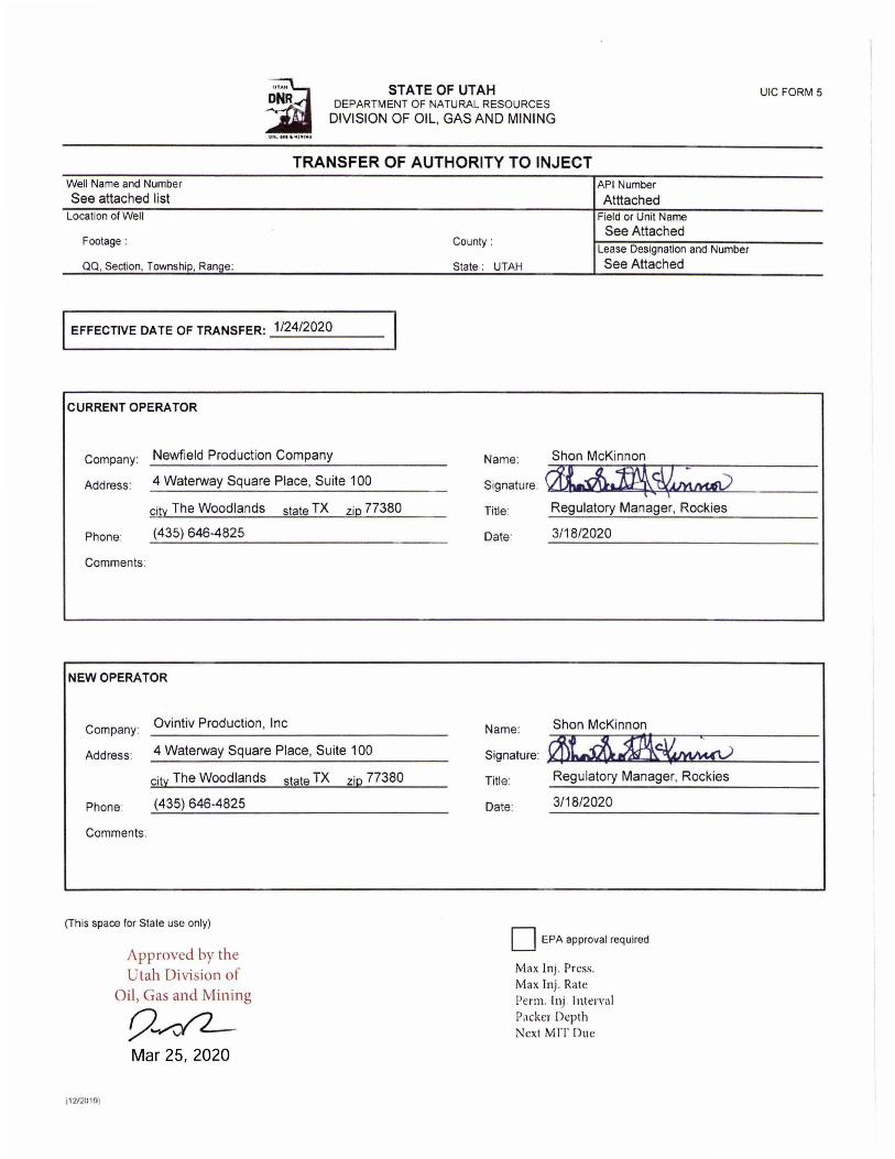
STATE OF UTAH DEPARTMENT OF NATURAL RESOURCES
DIVISION OF OIL, GAS AND MINING
TRANSFER OF AUTHORITY TO INJECT Well Name and Number
See attached list Location of Well
Footage:
QQ, Section, Township, Range:
I EFFECTIVE DATE OF TRANSFER: 1/24/2020
CURRENT OPERATOR
Company: Newfield Production Company
Address: 4 Waterway Square Place, Suite 100
city The Woodlands state TX zip 77380
Phone: (435) 646-4825
Comments:
NEW OPERATOR
Company: Ovintiv Production , Inc
Address: 4 Waterway Square Place, Suite 100
citl: The Woodlands
Phone: (435) 646-4825
Comments:
(This space for State use only)
\ 2/21110)
Approved by the Utah Division of
Oil, Gas and Mining
9--42-Mar 25, 2020
state TX zip 77380
County :
API Number
Atttached Field or Unit Name
See Attached
State : UTAH
Lease Designation and Number
See Attached
Name: Shon McKinnon
Signature: ~,~~ Title Regulatory Manager, Rockies
Date' 3/18/2020
Name: Shon McKinnon
~~ Signature:
Title: Regulatory Manager, Rockies
Date: 3/18/2020
D EPA approval required
Max lnj . Press. Max Inj . Rate Perm. Inj. Inter\'al Packer Depth [ ext MIT Due
UIC FORM 5
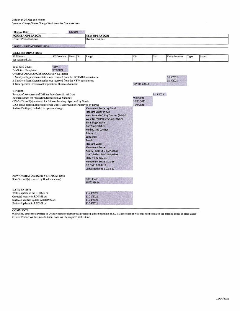
Division of Oil, Gas and Mining
Operator Change/Name Change Worksheet-for State use only
Effecti ve Date' 7/112021 FORMER OPERATOR: NEW OPERATOR: Ovintiv Production, Inc. Ovintiv USA, Inc.
Gro~ Greater Monument Butte .". r,; ,,'.
WELL INFORMATION: Well Name See Attached List
Total Well Count : Pre-Notice Completed:
OPERATOR CHANGES DOCUMENTATION: I . Sundry or legal documentation was received from the FORMER operator on: 2. Sundry or legal documentation was received from the NEW operator on : 3. New operator Division of Corporations Business Number:
REVIEW: Receipt of Acceptance of Drilling Procedures for APD on: Reports current for ProductioniDisposition & Sundries: OPS/SIfT A well(s) reviewed for full cost bonding: Approved by Dustin UIC5 on all di sposal/injection/storage well(s) Approved on: Approved by\.,,;;D.;;ayn= e;..... ___ _
Surface Facility(s) included in operator change: Monuml!nt Butte Uq. Condo Pleasant Valley (New)
NEW OPERATOR BOND VERIFICATION: State/fee well(s) covered by Bond Number(s):
DATA ENTRY: Well(s) update in the RBDMS on: Group(s) update in ROBMS on: Surface Facilities update in RBDMS on: Entities Updated in RBDMS on:
COMMENTS:
West lateral4C Slug Catcher (2-5-3-3)
West lateral Phase 5 Slug Catcher
Bar F Slug Catcher Dart Slug Catcher
Mullins Slug Catcher
Ashley
Sundance Ranch
Pleasant Valley
Monument Butte Ashley Fed 8-14-9-15 Pipeline Ute TribaI4-l3-4-2W Pipeline
State 11-32 Pipeline
Monument Butte St 10-36 GB Fed 13-20-8-17 Canvasba~ Fed -22-8-17 __ ..... ~_
8001834-8 107238142A __ .... ______ ..
1112412021 1112112021 1112412021 1112412021
5053175"()143
912212021 1012512021 10/412021
,9/ 1512021
9/ 1512021 9/1512021
912212021 , Since the Newfield to Ovintiv operator change was processed at the beginning of2021 , Name change will only need to match the existing bonds in place under Ovintiv Production, Inc; no additiaonl bond will be required at this time.
I
I
Status
11/24/2021
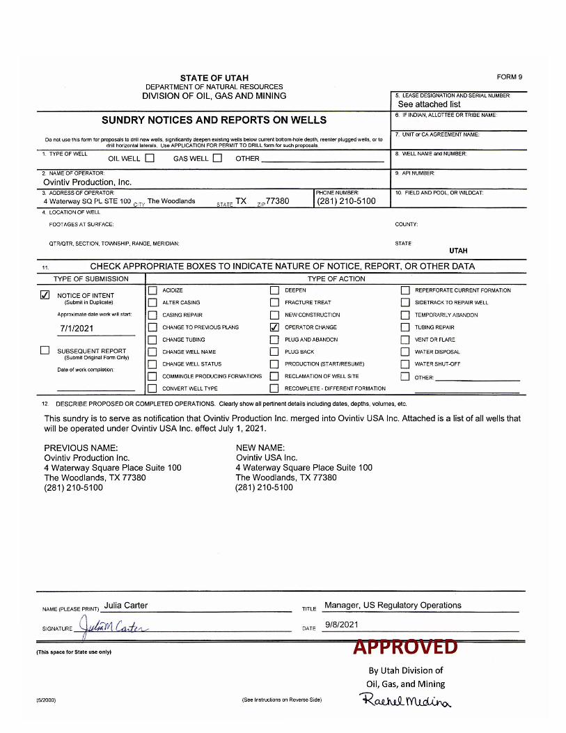
FORM 9 STATE OF UTAH DEPART MENT O F NATURAL RESOURCES
DIVISION OF OIL, GAS AND MINING 5. LEASE DESIGNA liON AND SERIAL NUMBER:
SUNDRY NOTICES AND REPORTS ON WELLS
Do not use this form for proposals to drill new wells, significantty deepen existing wells below current bottom·hole depth, reenler plugged wells, or (0 drill horizontal laterals, Use APPLICA nON FOR PERMIT TO DRilL form for such proposals.
1. TYPE OF WELL OIL WELL 0 GASWELL 0 OTHER ______________________ __
2 . NAME OF OPERATOR:
Ovintiv Production, Inc.
srAr E TX ZIP 77380 I PHONE NUMBER:
(281) 210-5100 3. ADDRESS OF OPERATOR:
4 Waterway sa P L STE 100 CiTY The Woodlands
4. LOCATION OF WELL
FOOTAGES AT SURFACE:
OTR/OTR. SECTION. TOWNSHIP. RANGE. MERIDIAN:
See attached list 6. IF INDIAN. ALLOTTEE OR TRIBE NAME:
7. UNIT or CA AGREEMENT NAME:
B. WELL NAME and NUMBER:
9. API NUMBER:
10. FIELD AND POOL. OR VIIILDCAT:
COUNTY:
STATE :
UTAH
11 . CHECK APPROPRIATE BOXES TO INDICATE NATURE OF NOTICE, REPORT, OR OTHER DATA
TYPE OF SUBMISSION TYPE OF ACTION
Q] 0 ACIDIZE 0 DEEPEN 0 REPERFORATE CURRENT FORMATION NOTICE OF INTENT
(Submit in Duplicate) 0 ALTER CASING 0 FRACTURE TREAT 0 SIDETRACK TO REPAIR WELL
Approximate date work wiQ start: 0 CASING REPAIR 0 NEW CONSTRUCTION 0 TEMPORARILY ABANDON
7/1/2021 0 CHANGE TO PREVIOUS PLANS Q] OPERATOR CHANGE 0 TUBING REPAIR
0 CHANGE TUBING 0 PLUG AND ABANDON 0 VENT OR FLARE
0 SUBSEQUENT REPORT 0 CHANGE WELL NAME 0 PLUG BACK 0 WATER DISPOSAL (Submit Original Form Only)
0 0 0 CHANGE WELL STATUS PRODUCTION (STARTIRESUME) WATER SHUT·OFF Dale of work completion:
0 COMMINGLE PRODUCING FORMATIONS 0 RECLAMATION OF WELL SITE 0 OTHER:
0 CONVERT WELL TYPE 0 RECOMPLETE· DIFFERENT FORMATION
12 DESCRIBE PROPOSED OR COMPLETED OPERATIONS. Clearly show all pertinent deta ils including dates, depths, volumes, etc.
This sundry is to serve as notification that Ovintiv Production Inc. merged into Ovintiv USA Inc. Attached is a list of all wells that will be operated under Ovintiv USA Inc. effect July 1, 2021 .
PREVIOUS NAME: Ovintiv Production Inc. 4 Waterway Square Place Suite 100 The Woodlands, TX 77380 (281) 210-5100
NEW NAME: Ovintiv USA Inc. 4 Waterway Square Place Suite 100 The Woodlands, TX 77380 (281) 210-5100
TITLE Manager, US Regulatory Operations NAME (PLEASE PRINT) Julia Carter ------------------------------------SIGNATURE ~~==__'__''''''''''4_'~O:::''''---------------- DATE
(This space lor State use only)
(512000) (See InstNeUons on Reverse Side)
9/8/2021
By Utah Division of
Oil, Gas, and Mining
1<.ru.hl~
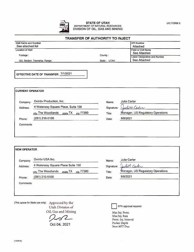
Well Name and Number See attached list
Location of Well
Footage :
QQ . Section. Township. Range:
STATE OF UTAH DEPARTMENT OF NATURAL RESOURCES
DIVISION OF OIL, GAS AND MINING
TRANSFER OF AUTHORITY TO INJECT
County :
State : UTAH
I EFFECTIVE DATE OF TRANSFER: _7_/1_/2_0_2_1 __ _
API Number
Attached Field or Unit Name
See Attached Lease DeSignation and Number
See Attached
Company: Ovintiv Production, Inc. Name: Julia Carter
Address: 4 Waterway Square Place, Suite 100
UIC FORM 5
city The Woodlands state TX zip 77380 anager, US Regulatory Operations
Signature:
Title:
Phone: (281) 210-5100
Comments:
NEW OPERATOR
Company: Ovintiv USA Inc.
Address: 4 Waterway Square Place Suite 100
city The Woodlands state TX
Phone: (281) 210-5100
Comments:
(This space for State use only) Approved by the Utah Division of
Oil, Gas and Mining
9~ Oct 04, 2021
(1212019)
zip 77380
Date: 9/8/2021
Name: Julia Carter
Signature: rkfY1. i!f!,dlA/ Title: anager, US Regulatory Operations
Date: 9/8/2021
D EPA approval required
Max. Inj. Press. Max Inj. Rate Perm. Inj . Interval Packer Depth Next MIT Due


