Embed Size (px)
Citation preview
www.elsevier.com/locate/enggeo
Engineering Geology 7
Landslide inventory of northwestern Anatolia, Turkey
Tamer Y. Dumana, Tolga Canb,*, Omer Emrea, Mustafa Kecera, Ahmet Dogana,
Xerafettin AteYa, Serap Durmaza
aGeneral Directorate of Mineral Research and Exploration, Department of Geological Research, 06520 Ankara, TurkeybCukurova University, Department of Geological Engineering, 01330 Balcali, Adana, Turkey
Received 10 February 2004; accepted 26 August 2004
Available online 12 October 2004
Abstract
Turkey is heavily exposed to natural hazards such as earthquakes, landslides and floods. The total loss caused by landslides
in terms of affected buildings, in a period of 35 years between 1959 and 1994, constitutes 27% of the entire loss from all natural
hazards and is second after earthquakes. There are no other available data on either direct or indirect losses due to landslides on
a national scale.
The General Directorate of Mineral Research and Exploration (MTA) started the dTurkish Landslide Inventory Mapping
ProjectT in 1997 to improve understanding of regional and national landslide processes. The purpose of the project is to establish
landslide inventory maps at medium (1:25,000), regional (1:100,000) and national (1:500,000) scales. Existing landslides are
mapped on 1:25,000 scale topographic base maps by interpretation of aerial photographs and field investigations. The base
maps are then digitized and stored in a geographic information system (GIS) database by the Geological Research Department
of MTA. Hence, regional- and national-scale landslide maps will be available as well, as the work progresses. Landslides are
classified as fall, topple, slide and flow and are broadly characterized as active or inactive. The landslides are also classified
according to their relative depths, as shallow (depth b 5 m) and deep-seated (depth N 5 m). The present paper will attempt to
describe the project standards and its application to the area of 1:500,000 scale Zonguldak quadrangle. The study area extends
to 39,081 km2, and 7.1% of the area was found to be affected by landslides. A total 10,007 landslides (392 shallow-seated, 8020
deep-seated active and 1595 deep-seated inactive) were mapped in the area covering 2768 km2. Cretaceous flysch, Paleocene–
Eocene flysch and Paleocene–Middle Miocene volcanics are the most landslide-prone units and constitute 27.8%, 29.9% and
7.2% of the all landslides, respectively.
D 2004 Elsevier B.V. All rights reserved.
Keywords: Landslide; Landslide inventory mapping; Turkey; Zonguldak
0013-7952/$ - see front matter D 2004 Elsevier B.V. All rights reserved.
doi:10.1016/j.enggeo.2004.08.005
* Corresponding Author. Tel.: +90 322 3387058; fax: +90 322
3386126.
E-mail addresses: [email protected] (T.Y. Duman)8
[email protected] (T. Can)8 [email protected] (O. Emre).
1. Introduction
Landslides, either alone or in association with
the earthquakes, volcanic eruptions, wildfires and
major rainstorms that may trigger landslides, are a
7 (2005) 99–114
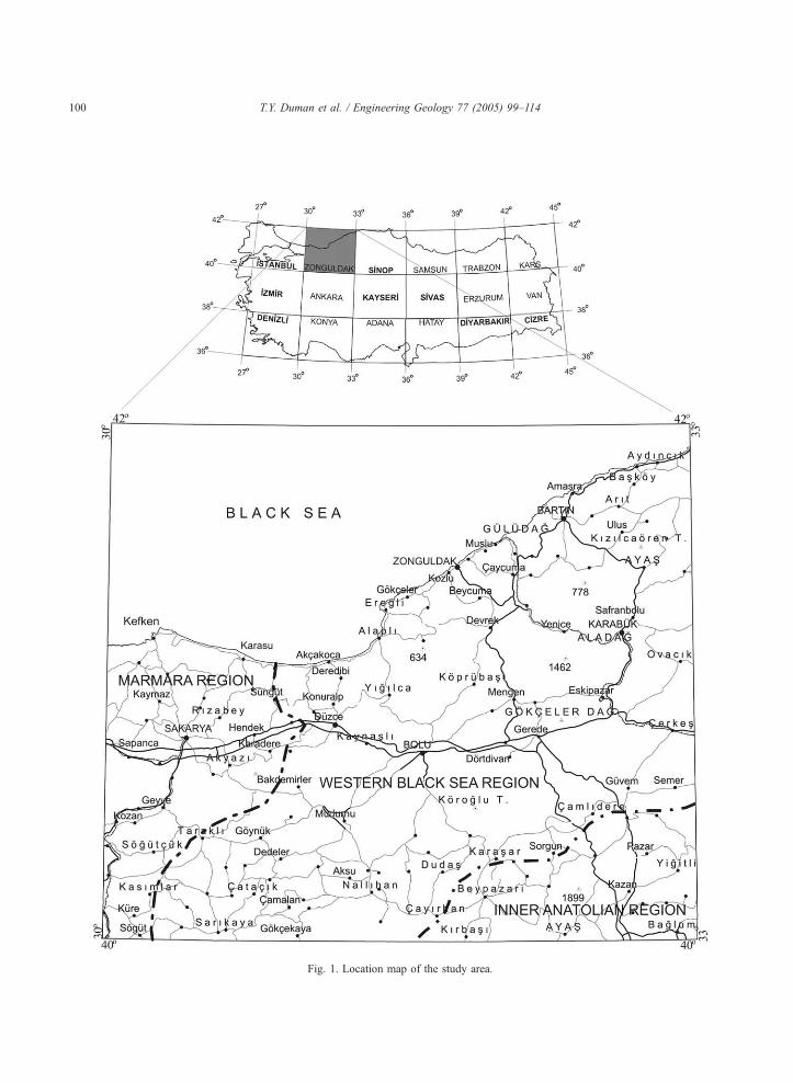
Fig. 1. Location map of the study area.
T.Y. Duman et al. / Engineering Geology 77 (2005) 99–114100
T.Y. Duman et al. / Engineering Geology 77 (2005) 99–114 101
major cause of loss of life, injury and property
damage around the world (Cruden and Fell, 1997).
In many countries, socioeconomic losses due to
landslides are great and apparently growing as
human development expands into unstable hillslope
areas under the pressures of increasing populations
(Schuster, 1996). A reliable landslide inventory
defining the type and activity of all landslides, as
well as their spatial distribution, is essential before
any analysis of the occurrence of landslides and
their relationship to environmental conditions under-
taken (Soeters and Van Westen, 1996). However,
landslide inventories are not yet very common,
despite the ease with which they are prepared and
their immediateness (Guzzetti et al., 2000). Inven-
tory maps are available in only a few countries and
mostly for limited areas (Brabb and Harrod, 1989;
Brabb, 1993).
Turkey is exposed to natural hazards such as
earthquakes, landslides and floods. Loss of buildings
due to landslides between 1959 and 1994 constitutes
27% of the entire loss due to all natural hazards and is
second after earthquakes (IldVr, 1995). There are no
other available data on other direct or indirect impact
of landslides at the national scale. The bTurkishLandslide Inventory Mapping ProjectQ was started by
the Natural Hazards and Environmental Geology
division of the General Directorate of Mineral
Research and Exploration (MTA) in 1997 to achieve
a better understanding of the regional and national
landslide processes.
In this paper, we attempt to describe the project
standards and its application to the area of the
1:500,000 scale Zonguldak quadrangle in northern
Turkey (Fig. 1). The Zonguldak quadrangle, cover-
ing an area of 39,081 km2, is located into three
geographic region of Turkey, namely, the western
Black Sea to the north, the central Anatolia to the
southeast and the Marmara to the west (Fig. 1). The
study area presents diverse geological, tectonic,
geomorphologic and climatic conditions which
control the extent and geographical distribution of
landslides. Landslides of different type and activity
cover 7.1% of the entire region. According to the
geological setting, landslides are most abundant in
flysch rock units. These units cover 28% of the
study area and encompass 58% of all the landslides
in area.
2. Settings of the area
2.1. Geological setting
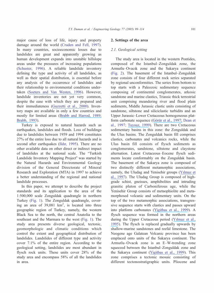
The study area is located in the western Pontides,
composed of the Istanbul–Zonguldak zone, the
Armutlu–OvacVk zone and the Sakarya continent
(Fig. 2). The basement of the Istanbul–Zonguldak
zone consists of four different rock series separated
by regional unconformities. The series from bottom to
top starts with a Paleozoic sedimentary sequence
composing of continental conglomerates, arkosic
sandstone and marine clastics, Triassic thick terrestrial
unit comprising meandering river and flood plain
sediments, Middle Jurassic clastic units consisting of
sandstone, siltstone and siliciclastic turbidits and an
Upper Jurassic–Lower Cretaceous homogeneous plat-
form carbonate sequence (Gorur et al., 1997; Dean et
al., 1997; Tuysuz, 1999). There are two Cretaceous
sedimentary basins in this zone: the Zonguldak and
the Ulus basins. The Zonguldak basin fill comprises
clastics, carbonates and volcanics rocks, while the
Ulus basin fill consists of flysch sediments as
conglomerates, sandstone, siltstone and claystone
alternation. Latest Cretaceous–Eocene flysch sedi-
ments locate conformably on the Zonguldak basin.
The basement of the Sakarya zone is composed of
two distinctly different metamorphic associations,
namely, the Uludag and Yenisehir groups (YVlmaz et
al., 1997). The Uludag Group is composed of high-
grade schist, gneisses, amphibolites and intruding
granitic pluton of Carboniferous age, while the
Yenisehir Group consists of metaophiolite and meta-
morphosed volcanic and sedimentary units. On the
top of the two metamorphic associations, transgres-
sive sequence starts with clastics and passes upward
into platform carbonates (Yigitbas et al., 1999). A
flysch sequence was formed in the northern areas
during the Upper Cretaceous period (YVlmaz et al.,
1995). The flysch is replaced gradually upwards by
shallow-marine sandstones and reefal limestone. The
Neogene age Galatean Volcanic province has been
emplaced onto units of the Sakarya continent. The
Armutlu–OvacVk zone is an E–W-trending zone
squeezed between the Istanbul–Zonguldak zone and
the Sakarya continent (Yigitbas et al., 1999). This
zone comprises a tectonic mosaic consisting of
different tectonostratigraphic units. Pliocene and
Fig. 2. (a) Major tectonic units (from Yigitbas et al., 1999) and (b) simplified geological map (after MTA, 2003) of the study area.
T.Y. Duman et al. / Engineering Geology 77 (2005) 99–114102
T.Y. Duman et al. / Engineering Geology 77 (2005) 99–114 103
younger sediments unconformably overlie the older
units in the study area.
2.2. Tectonics and seismicity
The Anatolian plate is being squeezed westward
away from the collision zone between the Arab–
African and Eurasian plates along the north Anatolian
and east Anatolian fault systems that formed in the
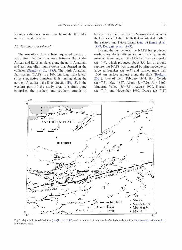
collision (Sengor et al., 1985). The north Anatolian
fault system (NAFS) is a 1600-km long, right-lateral
strike–slip, active transform fault running along the
northern Anatolia in the E–W direction (Fig. 3). In the
western part of the study area, the fault zone
comprises the northern and southern strands in
Fig. 3. Major faults (modified from Xaroglu et al., 1992) and earthquake epi
in the study area.
between Bolu and the Sea of Marmara and includes
the Hendek and Cilimli faults that are situated north of
the Sakarya and Duzce basins (Fig. 3) (Emre et al.,
1998; Kocyigit et al., 1999).
During the last century, the NAFS has produced
earthquakes along different sections in a systematic
manner. Beginning with the 1939 Erzincan earthquake
(M =7.9), which produced about 350 km of ground
rupture, the NAFS was ruptured by nine moderate to
large earthquakes (M N 6.7) and formed more than
1000 km surface rupture along the fault (Bozkurt,
2001). Five of them [February 1944, Bolu–Gerede
(M =7.3); May 1957, Abant (M =7.0); July 1967,
Mudurnu Valley (M =7.1); August 1999, Kocaeli
(M =7.4); and November 1999, Duzce (M =7.2)]
centers withMWN5 (data adapted from http://www.koeri.boun.edu.tr)
T.Y. Duman et al. / Engineering Geology 77 (2005) 99–114104
occurred in the study area. The Orta earthquake
(M =6.0) occurred at the eastern boundary of the
study area on June 6, 2000. Although the area is
affected by several large earthquakes, historical
information on earthquake-induced landslides for the
region and even for the other parts of Turkey is not
present. However, some of the landslides in the study
area, particularly along the NAFS, might have been
triggered by the historical earthquakes.
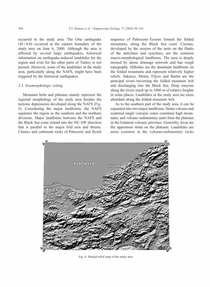
2.3. Geomorphologic setting
Mountain belts and plateaus mainly represent the
regional morphology of the study area besides the
tectonic depressions developed along the NAFS (Fig.
4). Considering the major landforms, the NAFS
separates the region as the southern and the northern
divisions. Major landforms between the NAFS and
the Black Sea coast extend into the NE–SW direction
that is parallel to the major fold axis and thrusts.
Clastics and carbonate rocks of Paleozoic and flysch
Fig. 4. Shaded relief map
sequence of Paleocene–Eocene formed the folded
mountains, along the Black Sea coast. Cuestas,
developed by the erosion of the units on the flanks
of the anticlines and synclines, are the common
macro-morphological landforms. The area is deeply
incised by dense drainage network and has rough
topography. Hillsides are the dominant landforms on
the folded mountains and represent relatively higher
reliefs. Sakarya, Melen, Filyos and Bartin are the
principal rivers traversing the folded mountain belt
and discharging into the Black Sea. Deep canyons
along the rivers reach up to 1000 m of relative heights
in some places. Landslides in the study area are more
abundant along the folded mountain belt.
As to the southern part of the study area, it can be
separated into two major landforms. Strata volcano and
scattered single volcanic cones constitute high moun-
tains, and volcano sedimentary units form the plateaus
in the Galatean volcanic province. Generally, lavas are
the uppermost strata on the plateaus. Landslides are
more common in the volcano-sedimentary rocks
of the study area.
T.Y. Duman et al. / Engineering Geology 77 (2005) 99–114 105
beneath the volcanic units along the deep valleys.
Another folded mountain belt, trending in the E–W
direction, is situated at the southwest part of the area. In
general, the region is represented by the plateau named
Mudurnu–Yenipazar, incised by the tributaries of the
Sakarya and Mudurnu Rivers. Cuestas are the rough-
nesses rising on the erosional surfaces formed after
erosion of the E–W-trending folds.
Tectonic landforms are distinctive along the NAFS
in the study area. Linear valleys, throughs and pull-
apart basins are the macro-morphologic features
developed in the strike–slip morphology. Offsets
alternate from several meters to 60–70 km. (Xengor,
1979, Hubert-Ferrari et al., 2002).
2.4. Climate
There are two main climatic regions in the study
area, namely, the Black Sea climatic region to the
north and the continental inner Anatolian climatic
region to the southeast. The Black Sea climatic region
covers the northern part of the Anatolian peninsula,
and its southern boundary follows the upper part of
the southern flanks of the northern Anatolian Moun-
tains extending roughly in the E–W direction. The
elevation between valley floor and upper part of the
mountains attain more than 1000 m. Maritime climate
conditions prevail on the coastal belt of the Black Sea,
and the region receives rainfall throughout the year.
The mean annual precipitation exceeds 1000 mm and
reaches up to 2300 mm in the eastern part of the Black
Sea. The northern slopes of the coastal mountain belt
receive abundant precipitation due to interception of
the fronts coming from the north, and landslides are
more abundant in this region. Precipitation decreases
to 500 mm in the southern part of the region.
Continental semiarid climate prevails in the inner
Anatolian region. The mean annual precipitation
ranges from 400 mm in the plain to 600 mm in the
plateau and mountainous areas. The rainiest period
takes place during the spring, notably in April and
May (Atalay, 2002).
3. Landslide inventory
Vertical black-and-white aerial photographs of
medium scale (1:35,000) and large scale (1:10,000)
were used to identify the landslides. A single set of
2551 large-scale aerial photographs, dated from 1974
to 1976, were interpreted mainly for the north
Anatolian fault zone. A total of 5570 medium-scale
aerial photographs taken between 1940 and 1957 were
used for the rest of the area. As the dates of available
photos were not recent, detailed field checks and
investigations were evaluated. Photo interpretations
were conducted with SOKKISHA MS27 mirror
stereoscopes of 1.8� and 3� magnifications. Land-
slides were manually mapped onto the medium-scale
(1:25,000) topographic maps. Accuracies of landslide
locations obtained by this process are estimated to be
better than 50 m in areas of gentle slopes and to better
than 25 m in areas of steep slopes. This study was
carried out between 1997 and 1998. Eight months of
field studies were conducted during the summer
seasons of 1997 and 1998. The digitized version of
the inventory map was accomplished by the end of
2000. About 12 staff people participated for photo
interpretation and field study, and an additional 3
people accomplished the digitizing processes.
Mass movements were classified according to the
main types of Varnes (1978), i.e., flows, falls and
slides. The landslides are also classified according to
their relative depths, as shallow- (depthb5 m) and
deep-seated (depthN5 m). For simplicity, their activ-
ities are classified into two groups as active and
inactive. Active landslides are defined as those
currently moving, whereas inactive ones are as relict
according to WP/WLI, 1993. Shallow landslides are
classified as active because of their ongoing observed
movements. Onscreen method of digitization is used
for landslide data input and storage in Arc/Info
geographic information system (GIS). The base maps
were scanned with 100 dpi resolution and georefer-
enced to the UTM coordinate system. The total root
mean square (RMS) errors were kept less than 0.005
in. = 0.127 mm which is equivalent to 3.175 m ground
resolution at 1:25,000 scale. Landslides were stored as
polygons and landslide type, and depth and state of
the activity were built in attribute tables.
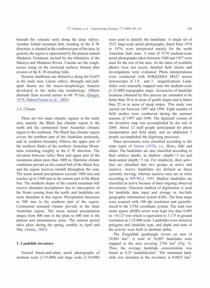
The Zonguldak quadrangle covers an area of
39,081 km2. A total of 10,007 landslides were
mapped in the area covering 2768 km2 (Fig. 5).
Thus, the average landslide concentration was
found as 0.25 landslides/km2. The minimum land-
slide size included in the inventory is 0.0025 km2.
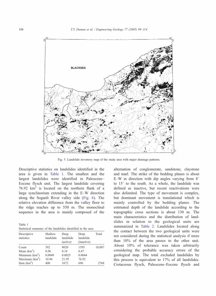
Fig. 5. Landslide inventory map of the study area with major drainage patterns.
T.Y. Duman et al. / Engineering Geology 77 (2005) 99–114106
Descriptive statistics on landslides identified in the
area is given in Table 1. The smallest and the
largest landslides were identified in Paleocene–
Eocene flysch unit. The largest landslide covering
76.92 km2 is located on the northern flank of a
large synclinorium extending in the E–W direction
along the Soganli River valley side (Fig. 6). The
relative elevation difference from the valley floor to
the ridge reaches up to 550 m. The monoclinal
sequence in the area is mainly composed of the
Table 1
Statistical summary of the landslides identified in the area
Descriptive
statistics
Shallow
landslide
Deep
landslide
(active)
Deep
landslide
(inactive)
Total
Count 392 8020 1595 10,007
Mean (km2) 0.96 0.18 0.47
Minimum (km2) 0.0049 0.0025 0.0044
Maximum (km2) 10.96 21.95 76.92
Sum (km2) 400 1672 696 2768
alternation of conglomerate, sandstone, claystone
and marl. The strike of the bedding planes is about
E–W in direction with dip angles varying from 88to 158 to the south. As a whole, the landslide was
defined as inactive, but recent reactivations were
also delimited. The type of movement is complex,
but dominant movement is translational which is
mainly controlled by the bedding planes. The
estimated depth of the landslide according to the
topographic cross sections is about 130 m. The
main characteristics and the distribution of land-
slides in relation to the geological units are
summarized in Table 2. Landslides located along
the contact between the two geological units were
not considered during the statistical analysis if more
than 10% of the area passes to the other unit.
About 10% of tolerance was taken arbitrarily
considering the probable accuracy errors of the
geological map. The total excluded landslides by
this process is equivalent to 17% of all landslides.
Cretaceous flysch, Paleocene–Eocene flysch and
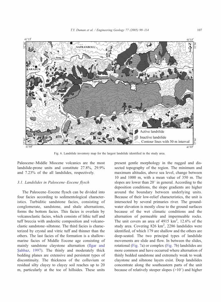
Fig. 6. Landslide inventory map for the largest landslide identified in the study area.
T.Y. Duman et al. / Engineering Geology 77 (2005) 99–114 107
Paleocene–Middle Miocene volcanics are the most
landslide-prone units and constitute 27.8%, 29.9%
and 7.23% of the all landslides, respectively.
3.1. Landslides in Paleocene–Eocene flysch
The Paleocene–Eocene flysch can be divided into
four facies according to sedimentological character-
istics. Turbiditic sandstone facies, consisting of
conglomerate, sandstone, and shale alternations,
forms the bottom facies. This facies is overlain by
volcanoclastic facies, which consists of lithic tuff and
tuff breccia with andesitic composition and volcano-
clastic sandstone–siltstone. The third facies is charac-
terized by crystal and vitric tuff and thinner than the
others. The last facies of the formation is a shallow-
marine facies of Middle Eocene age consisting of
mainly sandstone claystone alternation (Ilgar and
Xahbaz, 1997). The thinly and moderately thick
bedding planes are extensive and persistent types of
discontinuity. The thickness of the colluvium or
residual silty clayey to clayey soil reaches up to 20
m, particularly at the toe of hillsides. These units
present gentle morphology in the rugged and dis-
sected topography of the region. The minimum and
maximum altitudes, above sea level, change between
10 and 1000 m, with a mean value of 350 m. The
slopes are lower than 208 in general. According to the
deposition conditions, the slope gradients are higher
around the boundary between underlying units.
Because of their low-relief characteristics, the unit is
intersected by several primaries river. The ground-
water elevation is mostly close to the ground surfaces
because of the wet climatic conditions and the
alternation of permeable and impermeable rocks.
The unit covers an area of 4915 km2, 12.6% of the
study area. Covering 826 km2, 2286 landslides were
identified, of which 179 are shallow and the others are
deep-seated. The two principal types of landslide
movements are slide and flow. In between the slides,
rotational (Fig. 7a) or complex (Fig. 7b) landslides are
more common and have occurred where alternation of
thinly bedded sandstone and extremely weak to weak
claystone and siltstone layers exist. Deep landslides
concentrate along the southeastern parts of the unit
because of relatively steeper slopes (N108) and higher
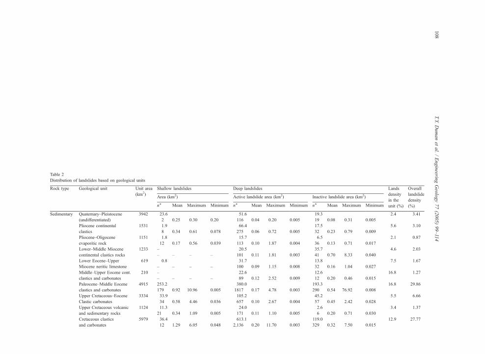
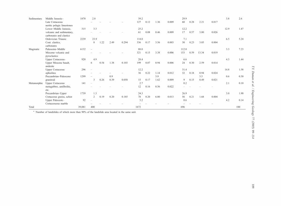
Table 2
Distribution of landslides based on geological units
Rock type Geological unit Unit area
(km2)
Shallow landslides Deep landslides Lands
density
in the
unit (%)
Overall
landslide
density
(%)
Area (km2) Active landslide area (km2) Inactive andslide area (km2)
na Mean Maximum Minimum na Mean Maximum Minimum na ean Maximum Minimum
Sedimentary Quaternary–Pleistocene
(undifferentiated)
3942 23.6 51.6 19.3 2.4 3.41
2 0.25 0.30 0.20 116 0.04 0.20 0.005 19 .08 0.31 0.005
Pliocene continental
clastics
1531 1.9 66.4 17.5 5.6 3.10
8 0.34 0.61 0.078 275 0.06 0.72 0.005 32 .23 0.79 0.009
Pliocene–Oligocene
evaporitic rock
1151 1.8 15.7 6.5 2.1 0.87
12 0.17 0.56 0.039 113 0.10 1.87 0.004 36 .13 0.71 0.017
Lower–Middle Miocene
continental clastics rocks
1233 – 20.5 35.7 4.6 2.03
– – – – 101 0.11 1.81 0.003 41 .70 8.33 0.040
Lower Eocene–Upper
Miocene neritic limestone
619 0.8 31.7 13.8 7.5 1.67
– – – – 100 0.09 1.15 0.008 32 .16 1.04 0.027
Middle–Upper Eocene cont.
clastics and carbonates
210 – 22.6 12.6 16.8 1.27
– – – – 89 0.12 2.52 0.009 12 .20 0.46 0.015
Paleocene–Middle Eocene
clastics and carbonates
4915 253.2 380.0 193.3 16.8 29.86
179 0.92 10.96 0.005 1817 0.17 4.78 0.003 290 .54 76.92 0.008
Upper Cretaceous–Eocene
Clastic carbonates
3334 33.9 105.2 45.2 5.5 6.66
34 0.58 4.46 0.036 657 0.10 2.67 0.004 57 .45 2.42 0.028
Upper Cretaceous volcanic
and sedimentary rocks
1124 11.3 24.0 2.6 3.4 1.37
21 0.34 1.09 0.005 171 0.11 1.10 0.005 6 .20 0.71 0.030
Cretaceous clastics
and carbonates
5979 36.4 613.1 119.0 12.9 27.77
12 1.29 6.05 0.048 2,136 0.20 11.70 0.003 329 .32 7.50 0.015
T.Y.Dumanet
al./Engineerin
gGeology77(2005)99–114
108
l
M
0
0
0
0
0
0
0
0
0
0
Sedimentary Middle Jurassic–
Late Cretaceous
neritic pelagic limestones
1870 2.8 39.2 29.9 3.8 2.6
– – – – 127 0.12 1.36 0.009 60 0.28 2.21 0.017
Lower–Middle Jurassic,
volcanic and sedimentary,
carbonates and clastics
315 3.3 25.2 12.2 12.9 1.47
– – – – 61 0.08 0.46 0.009 17 0.57 3.80 0.026
Ordovician Triassic
Cont. clastics,
carbonates
2239 23.9 114.0 7.1 6.5 5.24
8 1.22 2.49 0.294 336 0.17 3.56 0.003 30 0.23 3.05 0.004
Magmatic Paleocene–Middle
Miocene volcanic and
pyroclastics
6132 – 88.0 112.0 3.3 7.23
– – – – 321 0.15 3.38 0.006 153 0.59 13.34 0.019
Upper Cretaceous–
Upper Miocene basalt,
andesite
920 4.9 28.4 6.6 4.3 1.44
6 0.54 1.38 0.103 199 0.07 0.94 0.006 24 0.30 2.59 0.014
Upper Cretaceous
ophiolites
296 – 12.2 31.4 14.8 1.58
– – – – 36 0.22 1.14 0.012 32 0.18 0.94 0.024
Precambrian–Paleocene
granitoid
1299 – 0.9 3.9 3.5 0.6 0.30
3 0.26 0.39 0.058 15 0.17 1.62 0.009 9 0.15 0.49 0.021
Metamorphic Upper Cretaceous
metagabbro, amfibolite,
etc.
141 – 2.7 0.2 2.1 0.10
– – – – 12 0.16 0.56 0.022 – – – –
Precambrian–Upper
Cretaceous gneiss, schist
1739 1.3 24.3 26.9 3.0 1.90
2 0.19 0.20 0.185 78 0.20 6.80 0.013 56 0.21 1.68 0.004
Upper Paleozoic–
Cretaceouous marble
92 – 3.2 0.6 4.2 0.14
– – – – – – – – – – – –
Total 39,081 400 1672 696 100
a Number of landslides of which more than 90% of the landslide area located in the same unit.
T.Y.Dumanet
al./Engineerin
gGeology77(2005)99–114
109
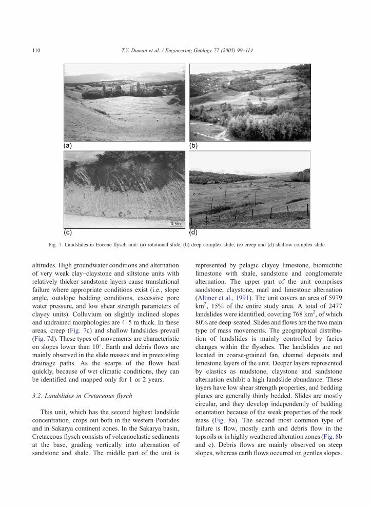
Fig. 7. Landslides in Eocene flysch unit: (a) rotational slide, (b) deep complex slide, (c) creep and (d) shallow complex slide.
T.Y. Duman et al. / Engineering Geology 77 (2005) 99–114110
altitudes. High groundwater conditions and alternation
of very weak clay–claystone and siltstone units with
relatively thicker sandstone layers cause translational
failure where appropriate conditions exist (i.e., slope
angle, outslope bedding conditions, excessive pore
water pressure, and low shear strength parameters of
clayey units). Colluvium on slightly inclined slopes
and undrained morphologies are 4–5 m thick. In these
areas, creep (Fig. 7c) and shallow landslides prevail
(Fig. 7d). These types of movements are characteristic
on slopes lower than 108. Earth and debris flows are
mainly observed in the slide masses and in preexisting
drainage paths. As the scarps of the flows heal
quickly, because of wet climatic conditions, they can
be identified and mapped only for 1 or 2 years.
3.2. Landslides in Cretaceous flysch
This unit, which has the second highest landslide
concentration, crops out both in the western Pontides
and in Sakarya continent zones. In the Sakarya basin,
Cretaceous flysch consists of volcanoclastic sediments
at the base, grading vertically into alternation of
sandstone and shale. The middle part of the unit is
represented by pelagic clayey limestone, biomictitic
limestone with shale, sandstone and conglomerate
alternation. The upper part of the unit comprises
sandstone, claystone, marl and limestone alternation
(AltVner et al., 1991). The unit covers an area of 5979
km2, 15% of the entire study area. A total of 2477
landslides were identified, covering 768 km2, of which
80% are deep-seated. Slides and flows are the two main
type of mass movements. The geographical distribu-
tion of landslides is mainly controlled by facies
changes within the flysches. The landslides are not
located in coarse-grained fan, channel deposits and
limestone layers of the unit. Deeper layers represented
by clastics as mudstone, claystone and sandstone
alternation exhibit a high landslide abundance. These
layers have low shear strength properties, and bedding
planes are generally thinly bedded. Slides are mostly
circular, and they develop independently of bedding
orientation because of the weak properties of the rock
mass (Fig. 8a). The second most common type of
failure is flow, mostly earth and debris flow in the
topsoils or in highly weathered alteration zones (Fig. 8b
and c). Debris flows are mainly observed on steep
slopes, whereas earth flows occurred on gentles slopes.
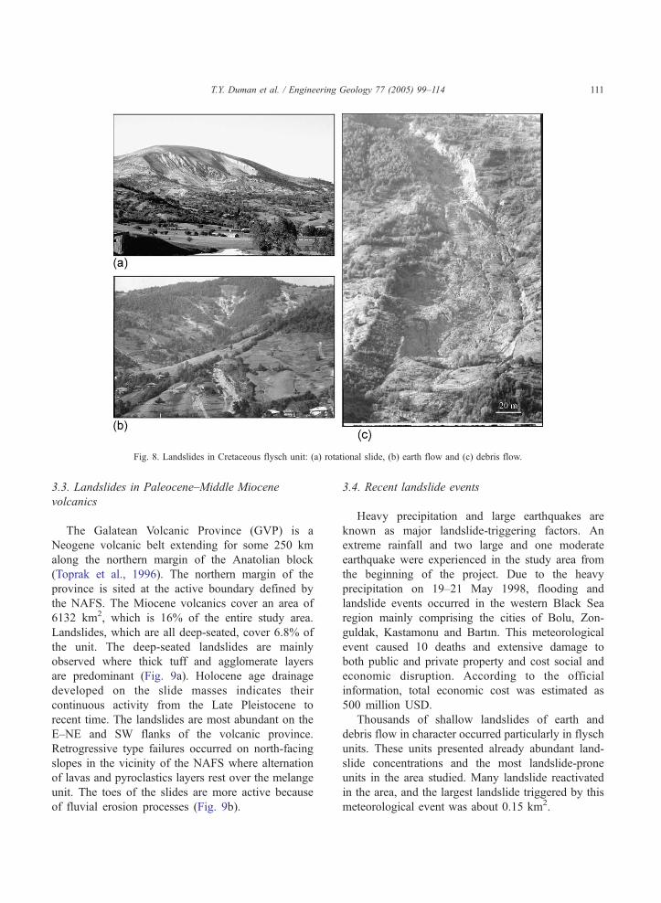
Fig. 8. Landslides in Cretaceous flysch unit: (a) rotational slide, (b) earth flow and (c) debris flow.
T.Y. Duman et al. / Engineering Geology 77 (2005) 99–114 111
3.3. Landslides in Paleocene–Middle Miocene
volcanics
The Galatean Volcanic Province (GVP) is a
Neogene volcanic belt extending for some 250 km
along the northern margin of the Anatolian block
(Toprak et al., 1996). The northern margin of the
province is sited at the active boundary defined by
the NAFS. The Miocene volcanics cover an area of
6132 km2, which is 16% of the entire study area.
Landslides, which are all deep-seated, cover 6.8% of
the unit. The deep-seated landslides are mainly
observed where thick tuff and agglomerate layers
are predominant (Fig. 9a). Holocene age drainage
developed on the slide masses indicates their
continuous activity from the Late Pleistocene to
recent time. The landslides are most abundant on the
E–NE and SW flanks of the volcanic province.
Retrogressive type failures occurred on north-facing
slopes in the vicinity of the NAFS where alternation
of lavas and pyroclastics layers rest over the melange
unit. The toes of the slides are more active because
of fluvial erosion processes (Fig. 9b).
3.4. Recent landslide events
Heavy precipitation and large earthquakes are
known as major landslide-triggering factors. An
extreme rainfall and two large and one moderate
earthquake were experienced in the study area from
the beginning of the project. Due to the heavy
precipitation on 19–21 May 1998, flooding and
landslide events occurred in the western Black Sea
region mainly comprising the cities of Bolu, Zon-
guldak, Kastamonu and BartVn. This meteorological
event caused 10 deaths and extensive damage to
both public and private property and cost social and
economic disruption. According to the official
information, total economic cost was estimated as
500 million USD.
Thousands of shallow landslides of earth and
debris flow in character occurred particularly in flysch
units. These units presented already abundant land-
slide concentrations and the most landslide-prone
units in the area studied. Many landslide reactivated
in the area, and the largest landslide triggered by this
meteorological event was about 0.15 km2.
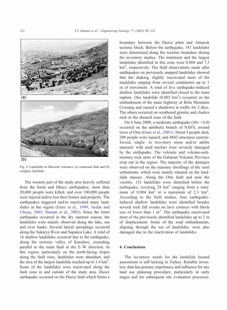
Fig. 9. Landslides in Miocene volcanics: (a) rotational slide and (b)
complex landslide.
T.Y. Duman et al. / Engineering Geology 77 (2005) 99–114112
The western part of the study area heavily suffered
from the Izmit and Duzce earthquakes; more than
20,000 people were killed, and over 100,000 people
were injured and/or lost their homes and property. The
earthquakes triggered and/or reactivated many land-
slides in the region (Emre et al., 1999; Aydan and
Ulusay, 2002; Duman et al., 2003). Since the Izmit
earthquake occurred in the dry summer season, the
landslides were mainly observed along the lake, sea
and river banks. Several lateral spreadings occurred
along the Sakarya River and Sapanca Lake. A total of
16 shallow landslides occurred due to the earthquake,
along the tectonic valley of Karadere, extending
parallel to the main fault in the E–W direction. In
this region, particularly on the north-facing slopes
along the fault zone, landslides were abundant, and
the area of the largest landslide reached up to 1.4 km2.
Some of the landslides were reactivated along the
fault zone in and outside of the study area. Duzce
earthquake occurred on the Duzce fault which forms a
boundary between the Duzce plain and AlmacVk
tectonic block. Before the earthquake, 181 landslides
were determined along the tectonic boundary during
the inventory studies. The minimum and the largest
landslides identified in this zone were 0.004 and 7.5
km2, respectively. The field observations made after
earthquakes on previously mapped landslides showed
that the shaking slightly reactivated most of the
landslides ranging from several centimeters up to 1
m of movement. A total of five earthquake-induced
shallow landslides were identified closed to the main
rupture. One landslide (0.002 km2) occurred on the
embankment of the main highway at Bolu Mountain
Crossing and caused a shutdown in traffic for 2 days.
The others occurred on weathered granitic and clastics
rock in the sheared zone of the fault.
On 6 June 2000, a moderate earthquake (Mw =6.0)
occurred on the antithetic branch of NAFS, around
town of Orta (Emre et al., 2001). About 3 people died,
200 people were injured, and 4842 structures (unrein-
forced, single- to two-story stone and/or adobe
masonry with mud mortar) were severely damaged
by the earthquake. The volcanic and volcano-sedi-
mentary rock units of the Galatean Volcanic Province
crop out in the region. The majority of the damages
were observed on the masonry dwellings of the rural
settlements, which were mainly situated on the land-
slide masses. Along the Orta fault and near the
vicinity, 152 landslides were identified before the
earthquake, covering 29 km2 ranging from a mini-
mum of 0.004 km2 to a maximum of 2.3 km2.
According to the field studies, four earthquake-
induced shallow landslides were identified besides
several rock fall events on lava cornices with block
size of lower than 1 m3. The earthquake reactivated
most of the previously identified landslides up to 2 m
of displacement. Some of the road embankments,
aligning through the toe of landslides, were also
damaged due to the reactivation of landslides.
4. Conclusions
The inventory needs for the landslide hazard
assessment is still lacking in Turkey. Reliable inven-
tory data has primary importance and influence for any
land use planning procedure, particularly in early
stages and for subsequent site evaluation processes.
T.Y. Duman et al. / Engineering Geology 77 (2005) 99–114 113
The inventory maps produced by this project will
compensate for the basic deficiencies on the regional
and national landslide processes. The landslide inven-
tory map for the 1:500,000 scale Zonguldak quad-
rangle is presented in this article. In addition to the
available facilities, the total cost of the operation,
including the human and technical resources used for
this study, is about US$190,000. The study area
extended to 39,081 km2, and 7.1% of the area was
found to be affected by landslides. Diverse geological,
tectonic, geomorphologic and climatic conditions
control the extent and geographical distribution of
landslides. According to the geological setting, land-
slides are most abundant in Cretaceous and Paleocene–
Eocene flysch units. These units crop out in 28% of the
study area and host 58% of the mapped landslides.
Investigations completed after the 1999 Izmit and
Kocaeli and the 2000 Orta earthquakes indicate that
seismic activity related to the NAFS triggered and/or
reactivated some of the landslides. Due to the lack of
the historical data, additional research is needed to
identify earthquake-induced landslides in the study
area. As the northern slopes of the Black Sea coastal
belt mountains receive high precipitation, landslide
density is higher in this region. As all the data are
digitized and stored in GIS database, this will provide
the basic input needed to generate the regional
landslide susceptibility assessments.
Acknowledgement
This work is done as a part of dThe Turkish
Landslide Inventory Mapping ProjectT supported by
the General Directorate of Mineral Research and
Exploration (MTA). The authors gratefully acknowl-
edge MTA for the support provided.
References
AltVner, D., Kocyigit, A., Farrinacci, A., Nicosia, U., Conti, M.A.,
1991. Jurassic–Lower Cretaceous stratigraphy and paleogeo-
graphic evolution of the southern part of north-western Anatolia
(Turkey). In: Farrinacci, A., Ager, D.V., Nicosia, U.Geology and
Paleontology of Western Pontides, Turkey, vol. 27. Geologica
Romana, pp. 13–80.
Atalay, I., 2002. Turkiye’nin ekolojik bolgeleri. Orman Bakanligi
yayinlari 163 Izmir, 266 p. (in Turkish).
Aydan, O., Ulusay, R., 2002. Back analysis of a seismically induced
highway embankment failure during the 1999 Duzce earth-
quake. Environ. Geol. 42 (6) 621–631.
Bozkurt, E., 2001. Neotectonics of Turkey—A synthesis. Geodin.
Acta 14 3–30.
Brabb, E.E., 1993. Proposal for worldwide landslide hazard maps.
In: Novosad, S., Wagner, P. (Eds.), Proceedings of 7th Interna-
tional Conference and Workshop on Landslides. Balkema,
Rotterdam, pp. 15–27.
Brabb, E.E., Harrod, B.L., 1989. Landslides: Extent and Economic
Significance. AA Balkema, Rotterdam. 385 pp.
Cruden, D.M., Fell, R., 1997. Preface. In: Proc. of the Int.
Workshop on Landslide risk assessment. A.A. Balkema,
Rotterdam, pp. IX–XI.
Dean, W.T., Martin, F., Monod, O., Demir, O., Rickards, R.B.,
Bultynck, P., Bozdogan, N., 1997. Lower Paleozoic stratig-
raphy, Karadere–Zirze area, Central Pontides. In: Goncuoglu,
M.C., Derman, A.S. (Eds.), Early Palaeozoic Evolution in NW
Gondwana, pp. 32–38.
Duman, T.Y., Awata, Y., Yoshioka, T., Emre, O., Dogan, A.,
ve Ozalp, S., 2003. Detailed maps and inventories of the
1999 Izmit surface rupture: surface ruptures associated
with the August 17, 1999 Izmit earthquake. Emre, O.,
Awatave Y., Duman T.Y. (Eds.), MTA Special Publications,
vol. 1, pp. 23–28. Ankara.
Emre, O., Erkal, T., Tchepalyga, A., KazancV, N., Kecer, M., Unay,
E., 1998. Neogene–Quaternary evolution of the eastern Mar-
mara region, nortwest Turkey. Mineral Res. Expl. Bull. 120
119–145.
Emre, O., AteY, X., Duman, T.Y., Kecer, M., Erkal, T., Dogan, A.,
Durmaz, S., Osmancelebioglu, R., Karakaya, F., ve Ozalp, S.,
Kocyigit, A., Goncuoglu, M.C., Toprak, V., Bozkurt, E., Dirik,
K., Rojay, B., YVlmaz, I.O., Teksoz, B., Cihan, M., ve Ozacar,
A., 1999. 17 Agustos 1999 Golcuk-Arifiye (Kuzeydogu Mar-
mara) depremleri sonrasV Sakarya ili ve ona baglV yerleYkeler
icin yeni yersecimi alanlarV araYtVrma raporu. ODTU-MTA
Genel Mudurlugu-TUBITAK Ortak AraYtVrma Proje Raporu,
MTA Rapor No 10273, Ankara (in Turkish).
Emre, O., Duman, T.Y., Dogan, A. ve Ozalp, S., 2001. 06 Haziran
2000 Orta (CankVrV) Depremi: kaynak fay ve hasar dagVlVmVna
etki eden jeolojik faktorler. 54. Turkiye Jeoloji KurultayV, 7–10
MayVs 2001, Bildiriler CD’si, Bildiri No 54–57, Ankara (in
Turkish).
Gorur, N., Monod, O., Okay, A.I., Sengor, A.M.C., Tuysuz, O.,
Yigitbas, E., SakVnc, M., Akkok, R., 1997. Palaeogeographic
and tectonic position of the Carboniferous rocks of the western
Pontides (Turkey) in frame of the Variscan belt. Bull. Soc. Geol.
France 168 197–205.
Guzzetti, F., Cardinali, M., Reichenbach, P., Carrara, A., 2000.
Comparing landslide maps: a case study in the upper Tiber
River Basin, Central Italy. Environ. Manage. 25 (3) 247–263.
Hubert-Ferrari A., Armijo, R., Barka, A., 2002. Morphology,
displacement, and slip rates along the north Anatolian fault,
Turkey. J. Geophys. Res. 107-0, .1029/2001JB000393, 2002.
IldVr, B., 1995. Turkiyede heyelanlarin dagilimi ve afetler yasasi ile
ilgili uygulamalar. In: Proc. 2nd National Landslide Symposium
of Turkey, Sakarya University, pp. 1–9. (in Turkish).
T.Y. Duman et al. / Engineering Geology 77 (2005) 99–114114
Ilgar, A., Xahbaz, A., 1997. Kusuri Formasyonu’nun fasiyes
topluluklarV (BatV Pontidler; Paleojen, Turkiye). Yerbilimleri
19 1–16. (in Turkish).
Kocyigit, A., Bozkurt, E., Cihan, M., Ozacar, A., Teksoz, B., 1999.
Neotectonics frame of Turkey: a special emphasis on the 17
August 1999 Golcuk-Arifiye earthquake (NE Marmara,Turkey).
In: Int. Conference on Earthquake Hazard Risk in the
Mediterrenean Region, 18–22 October 1999, Near East Uni-
versity, Proceedings, pp. 1–11.
MTA, 2003. 1/500 000 Olcekli Turkiye Jeoloji HaritasV, Zonguldak
paftasV, MTA Genel Mudurlugu, Ankara (in Turkish).
Xaroglu, F., Emre, O., KuYcu, I., 1992. Active fault map of Turkey.
2 sheets, scale 1:2,000,000. Publication of General Directorate
of Mineral Research and Exploration (MTA), Ankara.
Schuster, R.L., 1996. Socio-economic significance of landslides. In:
Turner, A.K., Schuster, R.L. (Eds.), Landslides: investigation
and mitigation, Transportation Research Board–National
Research Council Special Report 247, pp. 12–35.
Xengor, A.M.C., 1979. The North Anatolian transform fault: its
age, offset and tectonic significance. J. Geol. Soc. Lond. 136
269–282.
Xengor, A.M.C., Gorur, N., Xaroglu, F., 1985. Strike–slip faulting
and related basin formation in zones of tectonic escape: Turkey
as a case study. In: ve Biddle, K.T., Christi-Blick, N. (Eds.),
Strike–slip deformation, basin formation and sedimentation,
Soc. Econ. Paleontol. Min. Spec. Pub. 37, pp. 227–264.
Soeters, R., Van Westen, C.J., 1996. Slope stability: recognition,
analysis and zonation. In: Turner, A.K., Schuster, R.L. (Eds.),
Landslides: investigation and mitigation, Transportation
Research Board–National Research Council Special Report
247, pp. 129–177.
Toprak, V., SavascVn, Y., Gulec, Tankut, A., 1996. Structure of
the Galatean Volcanic Province, Turkey. Int. Geol. Rev. 38
747–758.
Tuysuz, O., 1999. Geology of the Cretaceous sedimentary basins of
the western Pontides. Geol. J. 34 75–93.
Varnes, D.J., 1978. Landslides types and processes. In: Eckel, E.B.
(Ed.), Landslides and Engineering Practice, Highway Research
Board Special Report 29, pp. 20–47.
Working Party on World Landslide Inventory, 1993. A suggested
method for describing the activity of a landslide. Bull. Int.
Assoc. Eng. Geol. 47 53–57.
Yigitbas, E., Elmas, A., YVlmaz, Y., 1999. Pre-Cenozoic tectonos-
tratigraphic components of western Pontides and their geo-
logical evolution. Geol. J. 34 55–74.
YVlmaz, Y., Genc, X.C., Yigitbas, E., Bozcu, M., YVlmaz, K.,
1995. Geological evoluation of the Late Mesozoic continental
margin of the northwestern Anatolia. Tectonophysics 243
155–172.
YVlmaz, Y., Tuysuz, O., Yigitbas, E., Genc, X.C., Xengor,
A.M.C., 1997. Geology and tectonic evolution of the Pontides.
In: Robinson, A.G. (Ed.), Regional and Petroleum Geology of
the Black Sea and Surrounding Region, AAPG Memoir, vol. 68,
pp. 183–226.