Embed Size (px)
Citation preview

747Y. Yamada et al. (eds.), Submarine Mass Movements and Their Consequences, Advances in Natural and Technological Hazards Research 31, DOI 10.1007/978-94-007-2162-3_66, © Springer Science+Business Media B.V. 2012
Abstract Relatively recent, shallow landslides are imaged both on swath bathymetry, sub-bottom and multichannel seismic reflection (MCS) data from the upper-middle continental slope on the Storfjorden and Kveithola Trough Mouth Fans, NW Barents Sea margin. Giant paleo-landslide deposits, detected only by MCS pro-files, are characterized by chaotic acoustic units up to about 250 m thick on the lower continental slope. The thickest, oldest landslide, dated between 1 and 0.8 Ma,
M. Rebesco (*Istituto Nazionale di Oceanografia e di Geofisica Sperimentale - OGS, Borgo Grotta Gigante 42/C 34010, Sgonico (TS), Italye-mail: [email protected]
M.T. PedrosaDepartament d’Estratigrafia Paleontologia i Geociències Marines, Facultat de Geologia, Universitat de Barcelona, C/ Martí i Franquès, s/n, E-08028 Barcelona, Spain
A. CamerlenghiDepartament d’Estratigrafia Paleontologia i Geociències Marines, Facultat de Geologia, Universitat de Barcelona, C/ Martí i Franquès, s/n, E-08028 Barcelona, Spain
ICREA, Istitució Catalana de Recerca i Estudis Avançats, Barcelona, Spain
R.G. LucchiIstituto Nazionale di Oceanografia e di Geofisica Sperimentale - OGS, Borgo Grotta Gigante 42/C 34010, Sgonico (TS), Italy
Departament d’Estratigrafia Paleontologia i Geociències Marines, Facultat de Geologia, Universitat de Barcelona, C/ Martí i Franquès, s/n, E-08028 Barcelona, Spain
B. De MolDept. Estratigrafia, Paleontologia i Geociències Marines, Facultat de Geologia, Universitat de Barcelona, c/ Martí i Franquès s/n 08028, Barcelona, Catalonia, Spain
Parc Científic de Barcelona, c/ Adolf Florensa 8 08028, Barcelona, Catalonia, Spain
R. UrgelesInstitut de Ciències del Mar (CSIC), Passeig Marítim de la Barceloneta, 37-49, 08003 Barcelona, Catalonia, Spain
Chapter 66One Million Years of Climatic Generated Landslide Events on the Northwestern Barents Sea Continental Margin
Michele Rebesco, Maria T. Pedrosa, Angelo Camerlenghi, Renata G. Lucchi, Chiara Sauli, Ben De Mol, Gianni Madrussani, Roger Urgeles, Giuliana Rossi, and Gualtiero Böhm
748 M. Rebesco et al.
took place just after the large-scale intensification of glaciation in the Barents Sea. The apparent spatial coincidence of landslides and channels with the boundary between the two fan systems, that are generated due to huge quantities of sedi-ments transported to the continental slope by paleo-ice streams, suggests a com-mon controlling climatic process for their development. Most probably the slides are related to the abundance of basal meltwater beneath the ice sheet, which in addition to determining ice stream motion and lubrication also influences the behavior of mass wasting processes.
Keywords
66.1 Introduction
Sedimentation on the Storfjorden and Kveithola Trough Mouth Fans (TMFs) on the NW Barents Sea continental margin (Fig. 66.1) has been influenced by the presence of ice during the late Cenozoic. Beside the common sedimentary processes operating at low latitudes (as transport and deposition by contour currents and mass-wasting), high latitudes are affected by glacial processes, which characterizes the nature and rates of all sedimentary processes (Dowdeswell et al. 2002). Major periods of margin progra-dation are associated with relatively short time intervals of ice terminating at the shelf break during glacial maxima. Fleets of icebergs and associated Ice Rafted Debris (IRD), cascades of meltwater and large quantities of suspended sediments (plumes), and unsorted debris, concentrate at the mouths of fast-flowing ice streams occupying cross-shelf troughs (Solheim et al. 1998). These sediments are efficiently reworked and delivered into the basins by Glacigenic Debris Flows (GDFs). Contrary to low-latitude fans that are fed by rivers through a channel levee complex, glacier-fed TMFs, receive their main sedimentary input from a glacier margin at the shelf break. As a result, high-latitude depocenters are mostly elongated across the upper slope, whereas low-latitude deep-sea fans lie on the middle slope (Laberg and Vorren 1996).
New seismic and morphobathymetric data from the NW Barents Sea are used in this paper to examine a sequence of landslides and to shed light on the importance of the sedimentological control for continental slope instability at high latitude con-tinental margins.
66.1.1 Regional Geology
A landslide off Kveithola Trough (Fig. 66.1) was firstly recognized, along with the adjacent INBIS channel, in GLORIA long-range side-scan sonar and 3.5 kHz data acquired in summer 1994 (Vorren et al. 1998). However, the data did not sufficiently resolve this area of instability and lacked the sedimentological calibration to

74966 One Million Years of Climatic Generated Landslide Events…
characterize the channel system. Nevertheless, the continental slope off Kveithola Trough is one of the major areas of instability of the Norwegian-Barents Sea-Svalbard margin along with Hinlopen, Bjørnøya, Andøya, Trænadjupet and Storegga landslides (Fig. 66.1).
Channel systems are extremely unusual along this >2,000 km long continental margin and are confined to the INBIS and Lofoten channels (Fig. 66.1). The Lofoten Channel has been directly fed by subglacial-debris, in addition to turbid subglacial meltwater plumes. Canyon preservation and continued development can be attributed
Fig. 66.1 Location map of study area (red square). Major TMF (KF = Kongsfjorden, IS = Isfjorden, BE = Bellsund, ST = Storfjorden, KV = Kveithola, BJ = Bjørnøya), landslides (Hls = Hinlopen, Kls = Kveithola, Bls = Bjørnøyrenna, Als = Andøya, Tls = Trænadjupet, Sls = Storegga) and channels (INBIS and Lofoten) are shown
750 M. Rebesco et al.
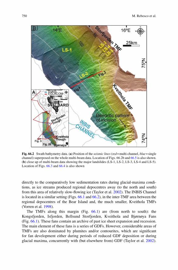
directly to the comparatively low sedimentation rates during glacial-maxima condi-tions, as ice streams produced regional depocentres away (to the north and south) from this area of relatively slow-flowing ice (Taylor et al. 2002). The INBIS Channel is located in a similar setting (Figs. 66.1 and 66.2), in the inter-TMF area between the regional depocentres of the Bear Island and, the much smaller, Kveithola TMFs (Vorren et al. 1998).
The TMFs along this margin (Fig. 66.1) are (from north to south): the Kongsfjorden, Isfjorden, Bellsund Storfjorden, Kveithola and Bjørnøya Fans (Fig. 66.1). These fans contain an archive of past ice sheet expansion and recession. The main element of these fans is a series of GDFs. However, considerable areas of TMFs are also dominated by plumites and/or contourites, which are significant for fan development either during periods of reduced GDF deposition or during glacial maxima, concurrently with (but elsewhere from) GDF (Taylor et al. 2002).
Fig. 66.2 Swath bathymetry data. (a) Position of the seismic lines (red = multi-channel, blue = single channel) superposed on the whole multi-beam data. Location of Figs. 66.2b and 66.5 is also shown. (b) close up of multi-beam data showing the major landslides (LS-1, LS-2, LS-3, LS-4 and LS-5). Location of Figs. 66.3 and 66.4 is also shown

75166 One Million Years of Climatic Generated Landslide Events…
In contrary, in areas between ice streams, where slower ice reached the shelf break and TMF are not present, the continental slope is characterized by large-scale sedi-ment landslides and canyon systems (Vorren et al. 1998; Dowdeswell et al. 2002; Taylor et al. 2002).
66.1.2 Data and Methods
The data presented in this paper were acquired during two research cruises carried out within the International Polar Year (IPY). The Spanish SVAIS cruise (BIO Hespérides, summer 2007) and the Italian EGLACOM cruise (R/V OGS-Explora, summer 2008), both contributed to IPY Activity 367 NICE-STREAMS, aiming at understanding erosion and depositional systems associated with ice streams. Data acquisition focused on the Storfjorden and Kveithola TMFs (Fig. 66.2a) and included collection of multi- and single-channel seismic profiles, swath bathymetry and sub-bottom profiler data.
For deep and shallow water multi-beam echo-sounding respectively, the BIO Hespérides employed a Simrad EM120 (mean frequency of 12 kHz) and a EM1002S (mean frequency of 95 kHz), while the R/V OGS-Explora employed a Reson MB8150 (mean frequency of 12 kHz) and a MB8111 (operating at a mean frequency of 100 kHz). The joint multi-beam bathymetric survey area covered by both cruises is about 15,340 km2. For sub-bottom profiling, the Kongsberg TOPAS PS 18 hull-mounted parametric sub-bottom profiler was used on the BIO Hespérides, while the hull-mounted Benthos CAP-6600 sub-bottom chirp profiler was used on the R/V OGS-Explora. The total length of acquired sub-bottom profiler data is nearly 9,500 km.
The acquisition of the MCS data was performed on board R/V OGS-Explora with a 1,200 m long digital streamer with 96 channels (spaced 12.5 m) and a 160 cubic inches array of sleeve guns. Fold coverage was 24, shot interval 25 m and sampling rate 1 ms. Finally, an integrated interpretation of all data has been performed using the Kingdom Suite software provided by Seismic Micro-Technology. The total length of acquired MCS profiles is 1,071 km.
The acquisition of the single-channel seismic data was performed on board the BIO Hespérides with a 10-m ministreamer with 10 hydrophones and a 3,44 l G.I. gun. Shot interval was 6 s (15.5 m at 5 kt), sampling rate 0.5 ms and record length 5 s. The total length of acquired single-channels seismic profiles is 518 km.
66.2 Results
Both surface and buried landslides identified on the basis of our multi-beam and seismic reflection data lie in a restricted part of the continental slope (about 50 km wide) between the southern part of the Storfjorden TMF and the Kveithola TMF. The previous described Kveithola landslide observed in the GLORIA data would

752 M. Rebesco et al.
correspond to one of these landslides. Only relatively minor landslides are identified in the multi-beam data from the northern Storfjorden TMF, and in the seismic data that crosses the Isfjorden and Bellsund TMFs (Figs. 66.1, 66.2a) further north. At the southern flank of the Bear Island TMF, immediately south of Kveithola TMFs, the seabed is characterized by a dendritic pattern of deep, V-shaped incisions (Fig. 66.2b), similar to those on non-glacial continental margins. It is most likely that these incisions converge, outside our bathymetric coverage, into a major channel on the lower continental slope, which ultimately merges with the previously reported INBIS channel system (Vorren et al. 1998).
Numerous shallow, relatively recent landslides detected on the swath bathymetry, and giant buried paleo-landslides identified on seismic data almost coincide in space. This series of sediment instabilities includes composite head walls (recogniz-able in the modern morphology) that are indicative of a multi-phase origin.
Landslide 1 (LS-1, Fig. 66.2b), the largest shallow landslide is fan-shaped and is bounded by 35–40 m high side- and head-walls which are sloping 5–7° (and locally up to over 10°). Minor scars complicate the morphology of the sidewalls. The transla-tional domain of the landslide (between the main head wall and the landward edge of the depositional area) covers an area of about 1,100 km2 in our data. However, it is clear that the landslide continues further downslope, with the depositional domain not imaged by our data. The minimum volume of sediments removed by this landslide (the part within our surveys) is approximately 33 km3, assuming that the slope between the side- and headwalls was continuous before failure. The slope gradient, both within the landslide and in the surrounding continental slope, ranges between 1° and 2°.
Southeast of LS-1, other bowl-shaped depressions (landslides LS-2, LS-3, LS-4, LS-5 and minor others not labeled in Fig. 66.2b) have been identified on the upper continental slope (Pedrosa et al. 2011). The depression of Landslide 2 (LS-2) is narrow and elongated, only slightly widening downslope and with a moderately broader headwall area at c. 1,300 m water depth (Figs. 66.2b and 66.3). The depres-sion is about 20 km long and about 2 km wide, hence enclosing an area of nearly 50 km2. The side- and head walls are nearly 30 m high and hence the volume of sediments removed is < 2 km3.
A more modest but larger secondary head wall is present about 4 km landward of the main head wall of the landslide, and is apparently generated by a series of suc-cessive and adjacent, minor landslides. The translational domain of LS-2 is about 15 km long, hence with the deposition initiating already within the terminal part of the imaged depressed area. The depositional domain of LS-2 is about 15 km long (Fig. 66.4), hence indicating a total run-out of nearly 30 km for this landslide.
Beneath, and for a distance of up to 13 km landward of the main head wall of LS-2, a paleo-landslide (PLS-2) is observed in the MCS data (Figs. 66.4 and 66.5). The slide debrite is about 200 ms (twt) thick. The glide plane of this slide is step-vise shallowing up-slope indicating a backstepping nature of this slide event. This paleo-landslide is interpreted as a multi-phase predecessor of LS-2. The glide-plane of PLS-2 corresponds with Reflector R1 (Fig. 66.3) in the stratigraphic framework as established by Faleide et al. (1996). Reflector R1 has an age of about 0.2 Ma (Butt et al. 2000) and provides the maximum age of this landslide. The seismic data indicate a run-out of at least 100 km for this slide event.

75366 One Million Years of Climatic Generated Landslide Events…
An older slide debrite (PLS-1, Fig. 66.5) is more than 250 ms (twt) thick (about 250 m using the nearly 2,000 ms−1 stack velocity). The glide plan of this slide event corresponds to Reflector R4 (Faleide et al. 1996), which has an age of about 1 Ma (Butt et al. 2000). Thus, this is the maximum age for this landslide. The minimum age is provided by Reflector R3 (Faleide et al. 1996), that has an approximate age of 0.8 Ma (Butt et al. 2000). PLS-1 likely moved downslope, hence not along profile EG-08B, as suggested by the abrupt eastward termination of PLS-1 (Fig. 66.5). Moreover, it is located in correspondence of the downslope prolongation of the SL-1, at a distance of about 100 km from its head wall. We hence infer that this giant paleo landslide is likely a predecessor of SL-1, and that its head wall (not crossed by our seismic profiles that are oblique to the slope) is likely located on the upper
Fig. 66.3 Multi-channel seismic profile EG-08 showing the head wall of LS-2 and PLS-2
Fig. 66.4 Multi-channel seismic profile EG-08B showing the deposits of LS-2 and PLS-2

754 M. Rebesco et al.
slope. If our inferences are correct, the minimum run-out of PLS-1 is at least 100 km, comparable with that of PLS-2.
66.3 Discussion and Conclusions
The location on the Storfjorden and Kveithola TMFs and the presence of GDF deposits interbedded with high water-content, low shear strength plumites (Lucchi et al. 2012), suggest a glacial (climatic) control on the landslides occurrence and frequency. Similarly to the scenario developed for the Storegga landslide (Haflidason et al. 2005), it is the climatically-controlled cyclic deposition of different sediment types that determines in situ conditions on the continental slope, which favor slope instability (Lucchi et al. 2012). The analysis of sub-bottom profiles suggests that the base of the surface landslides is the base of laminated sediments interpreted as plu-mites deposited from meltwater flows produced during the pen-ultimate deglacia-tion (MIS 3; Pedrosa et al. 2011; Lucchi et al. 2012). Such plumites constitute a laterally extensive homogenous layer of high clay and water content sediments with low shear strength that may develop excess pore pressure and subsequent reduced effective stress in response to rapid loading by GDF during some glacial periods (Haflidason et al. 2005).
The landslides described in this paper lie in a restricted part of the continental slope at the boundary between the adjacent Storfjorden and Kveithola TMFs, whereas the INBIS Channel lies in the inter-TMF area between the Kveithola and Bjørnøya TMFs. The location of the INBIS Channel is consistent with the model of
Fig. 66.5 MCS profile EG-08B showing the deposits of PLS-1 and-2 and other smaller ones in between

75566 One Million Years of Climatic Generated Landslide Events…
Dowdeswell et al. (2002), which suggests that TMF progradation occurs mainly by GDF stacking in front of ice streams, whereas canyon systems occur at the margin areas between ice streams where slower moving ice reached the shelf break and the delivery of sediments is significantly lower. That model suggested also that large-scale sediment landslides occur in areas of intermediate rates of ice-sheet delivery of sediment, at the periphery of TMFs. This may also be the case of the landslides that we described, but in addition we suggest that water-rich, clayey sediments with low shear strength deposited by meltwater during deglaciation (plumites) play as well an essential role. The landslides in fact occur just in front of the Kveithola Trough, which is an area of recognized production of meltwater plumes (Fohrmann et al. 1998; Sarnthein et al. 2003). In the area of the landslides, the thickness of the GDF deposits (and possibly hence the rate of glacial sediment delivery) is lower than in the northern part of the Storfjorden TMF, but the thickness of the plumites is larger (Lucchi et al. 2012). The first fact may hence be consistent with the model of Dowdeswell et al. (2002), but the second fact seems to us a more significant control-ling factor.
The stratigraphic position of the major paleo-landslides identified suggests a cli-matic control on their origin. The presence of some discontinuous reflectors with chaotic features above R7 (2.3 Ma) in the Storfjorden TMF (Hjelstuen et al. 1996) and complex reflection pattern with large imbricated blocks above R5 (1.4 Ma) in the Bjørnøya TMF (Fiedler and Faleide 1996) were already interpreted to represent mass movements resulting from increasing sediment transport to the margin, associ-ated respectively to the onset and intensification of glaciations. The giant paleo landslide that we indentified (PLS-1), dated between 1 and 0.8 Ma, took place just after the large-scale intensification of glaciation in the Barents Sea, with expansion of the ice sheet beyond the shelf edge, which occurred at about 1.0 Ma (Knies et al. 2009). The exceptional thickness of this landslide and the absence of comparable landslides in the underlying sedimentary succession (Fig. 66.5) suggest to us that this slope failure was produced by the first major expansion of the ice sheet in the Barents Sea and consequent sudden increase of the sediment delivery to the margin. The relatively small dimension of the subsequent failures (between R3 and R1) would be due to the relatively minor amount of clastic sediments at disposal on the continental shelf after the first major expansion of the ice sheet and consequent sedi-ment delivery to the continental slope. Conversely, the reoccurrence of a very large paleo landslide above the 0.2 Ma R1 reflector (PLS-2) may be related to the increased expansion of the water-rich, clayey sediments with low shear strength deposited by melt water plumes and contour currents, more effective in the last 0.2 Ma (Hjelstuen et al. 1996).
Acknowledgments This work was conducted within the International Polar Year (IPY) Activity 367 (Neogene ice streams and sedimentary processes on high-latitude continental margins — NICE STREAMS). Support for this study has been provided by the Italian EGLACOM and MELTSTORM projects, Spanish project SVAIS (POL2006-07390/CGL), DEGLABAR (CTM2010-17386) and NICE STREAMS-Spain (CTM2009-06370-E). We also thank the review-ers Associate Prof. B. Hjelstuen and Dr. C. Escutia Dotti for critical suggestions and improvements to this manuscript.

756 M. Rebesco et al.
References
Butt FA, Elverhøi A, Solheim A, Forsberg CF (2000) Deciphering late Cenozoic evolution of the western Svalbard margin based of ODP Site 986 results. Mar Geo 169:373–390
Dowdeswell JA, Ó Cofaigh C, Taylor J, Kenyon NH, Mienert J, Wilken M (2002) On the architec-ture of highlatitude continental margins: the influence of ice-sheet and sea-ice processes in the Polar North Atlantic. In: Dowdeswell JA, Ó Cofaigh C (eds) Glacier-influenced sedimentation on high-latitude continental margins. Geological Soceity, London, Special Publication 203, pp 33–54
Faleide JI, Solheim A, Fiedler A, Hjelstuen BO, Andersen ES, Vanneste K (1996) Late Cenozoic evolution of the western Barents Sea-Svalbard continental margin. Glob Planet Change 12:53–74
Fiedler A, Faleide JI (1996) Cenozoic sedimentation along the southwestern Barents Sea margin in relation to uplift and erosion of the shelf. Glob Planet Change 12:75–93
Fohrmann H, Backhaus JO, Blaume F, Rumohr J (1998) Sediments in bottom-arrested gravity plumes: numerical case studies. J Phys Oceanogr 28:2250–2274
Haflidason H, Lien R, Sejrup HP, Forsberg CF, Bryn P (2005) The dating and morphometry of the Storegga Slide. Mar Petrol Geol 22:123–136
Hjelstuen BO, Elverhøi A, Faleide JI (1996) Cenozoic erosion and sediment yield in the drainage area of the Storfjorden Fan. Glob Planet Change 12:95–117
Knies J, Matthiessen J, Vogt C, Laberg JS, Hjelstuem BO, Smelror M, Larsen E, Andreassen K, Eidvin T, Vorren TO (2009) The Plio-Pleistocene glaciations of the Barents Sea-Svalbard region: a new model based on revised chronostratigraphy. Quat Sci Rev 28:812–829
Laberg JS, Vorren TO (1996) The glacier-fed fan at the mouth of Storfjorden Trough, western Barents Sea: a comparative study. Geol Rundsch 85:338–349
Lucchi RG, Pedrosa MT, Camerlenghi A, Urgeles R, De Mol B, Rebesco M (2012) Recent subma-rine landslides on the continental slope of Storfjorden and Kveitehola Trough-Mouth Fans (north west Barents Sea). In: Yamada Y et al (eds) Submarine mass movements and their con-sequences, vol. 31, Advances in natural and technological hazards research. Springer, Dordrecht pp 735–745
Pedrosa MT, Camerlenghi A, De Mol B, Urgeles R, Rebesco M, Lucchi RG, SVAIS, EGLACOM Cruises shipboard parties (2011) Seabed morphology and shallow sedimentary structure of the Storfjorden and Kveitehola Trough-Mouth Fans (north west Barents Sea). Mar Geol 286:65–81
Sarnthein M, van Kreveld S, Erlenkeuser H, Grootes PM, Kucera M, Pflaumann U, Schulz M (2003) Centennial-to-millennial-scale periodicities of Holocene climate and sediment injec-tions off the western Barents shelf, 75°N. Boreas 32:447–461
Solheim A, Faleide JI, Andersen ES, Elverhøi A, Forsberg CF, Vanneste K, Uenzelmann-Neben G, Channell JET (1998) Late Cenozoic seismic stratigraphy and glacial geological development of the East Greenland and Svalbard-Barents Sea continental margins. Quat Sci Rev 17:155–184
Taylor J, Dowdeswell JA, Kenyon NH, O´ Cofaigh C (2002) Late Quaternary compositional archi-tecture of trough mouth fans: debris flows and suspended sediments on the Norwegian Sea margin. In: Dowdeswell JA, O´ Cofaigh C (eds) Glacier-influenced sedimentation on high-latitude continental margins. Geological Society, London, Special Publication 203, pp 55–71
Vorren TO, Laberg JS, Blaumme F, Dowdeswell JA, Kenyon NH, Mienert J, Rumohr J, Werner F (1998) The Norwegian-Greenland Sea continental margins: morphology and late quaternary sedimentary processes and environment. Quat Sci Rev 17:273–302