Embed Size (px)
Citation preview
VOL. 23, NO. 1
COMMONWEALTH OF PENNSYLVANIA Robert P. Casey, Governor
DEPARTMENT OF ENVIRONMENTAL RESOURCES Arthur A. Davis, Secretary
OFFICE OF PARKS AND FORESTRY James R. Grace, Deputy Secretary
TOPOGRAPHIC AND GEOLOGIC SURVEY Donald M. Hoskins, Director
CONTENTS
Pennsylvania Geology returns . . . . . . . . . . . . . . . . . . . . . . . . . . . . . . . 1 In memoriam-John Peter Wilshusen, 1930-1991 . . . . . . . . . . . . . . . 2 Geology and industrialization of the "Powder Hole" . . . . . . . . . . . . 3 New publications . . . . . . . . . . . . . . . . . . . . . . . . . . . . . . . . . . . . . . . . . . 9 Benedum Hail-a celebration of geology ...................... 12 Announcements . . . . . . . . . . . . . . . . . . . . . . . . . . . . . . . . . . . . . . . . . . . . 16
ON THE COVER
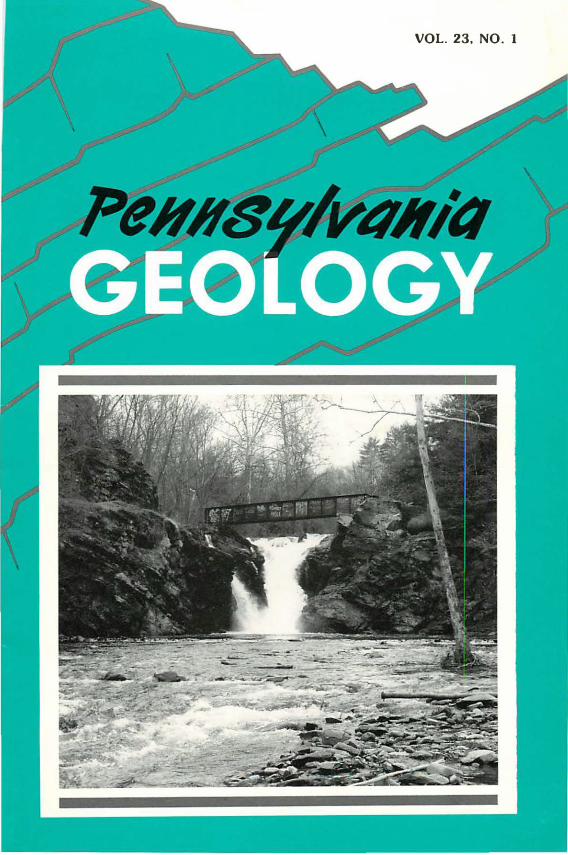
The Lower Falls of Wapwallopen Creek at the "Powder Hole," near Wapwallopen, Luzerne County. This was the source of water power for the Wapwallopen mills (1859-1912) of the DuPont black powder company. The notch on the cliff to the left of the falls held a wooden flume that carried water to several industrial buildings on the east bank of the creek. On the right, an iron penstock led down to a turbine in the power house. The creek here cuts through a resistant rib of gray siltstone of the Trimmers Rock Formation that projects westward into a drift-filled preglacial valley. Photograph by Jon D. lnners.
PENNSYLVANIA GEOLOGY
PENNSYLVANIA GEOLOGY is published quarterly by the Bureau of Topographic and
Geologic Survey, Pennsylvania Department of Environmental Resources, P. 0. Box
2357, Harrisburg, PA 17105-2357. Editors, Christine M. Dodge and Donald M. Hoskins.
Contributed articles are welcome; for further information and guidelines for manuscript
preparation, contact D. M. Hoskins at the address listed above.
Articles may be reprinted from this magazine if credit is given to the Bureau of Topo·
graphic and Geologic Survey.
VOL. 23, NO. 1 SPRING 1992
STATE GEOLOGIST'S EDITORIAL
Pennsylvania Geology Returns
With this issue of Pennsylvania Geology, we return to a regular schedule of publication. In the scale of geologic time, the past year during which we temporarily suspended publication is but a microsecond and would hardly be noticed. Some of you, however, have noticed and have written, inquiring of our plans. We thank you! It is to you, and the more than 2,000 others who responded to our notice of publication cessation, that we address these comments and the contents of this and future issues.
You will notice some changes. Our new cover design allows use of geological photography that would not have easily fit in the prior design. We have also redesigned the inside covers and outside back cover as well as the text format. The map of groundwater levels previously printed on the back cover will no longer run in each issue, but will be supplanted by other informational and timely maps. The annual listing of ongoing geological research in Pennsylvania and recently published geological reports will no longer be printed in Pennsylvania Geology because it is directed to only a limited number of our readers. A newsletter, jointly sponsored by Pennsylvania's geological societies, will take the place of the former research issue of Pennsylvania Geology.
For the next year or two, we will follow the seasons and have four issues per year. If there is sufficient interest and sufficient quality material for publication, we will consider returning to a bimonthly schedule at a later date. We remind our readers that Pennsylvania Geology is not solely intended as an outlet for Survey staff writers. We solicit your assistance through timely, interesting, and quality articles on geological subjects that you may wish to submit. You may also participate in the future of Pennsylvania Geology through submission of high-quality photographs of geological subjects. A geologically oriented photograph with sharp focus and good contrast, and a 50-word description of the subject, including location and scale, will be considered for cover or text publication.
library
Topographic and GeJ\ogic 3�.an�ey
Harrisburg, P A Donald M. Hoskins State Geologist
IN MEMORIAM
John Peter Wilshusen 1930-1991
Peter Wilshusen, retired chief of the Environmental Geology Division of the Pennsylvania Geological Survey, died at his home on September 23, 1991, after a prolonged battle with cancer. The fa�t that Pete lived as long as he d1d after contracting the illness is a tribute to both his positive attitude and the deep love given to him by his family and many friends.
Pete, a graduate of the New Mexico Institute of Mining and Technology and the South Dakota School of Mines, was a geologist with the Survey for 25 years. His accomplishments with the Survey were previously reviewed (Pennsylvania Geology, v. 21, no. 5, p. 1), but his guide entitled Geology of the Appalachian Trail in Pennsyl
vania is mentioned here because in a sense it is emblematic of Pete. Pete was a geologist. He loved nature and outdoor activity with their inherent challenges. He was an avid hiker and bicycler. His desire to share his enthusiasm and knowledge with others led him to prepare the Appalachian Trail guide. He not only knew the geology of the Trail in Pennsylvania, he hiked the Trail and helped to maintain a section of it. His contribution will continue to bring pleasure
to others for years to come. So it was with all of Pete's life.
Probably the greatest legacy left by Pete is his family, which is imbued with the same love for nature and preservation of the environment that epitomized Pete's life. We who knew and loved Pete can pay tribute to him by reflecting upon words he knew and I ived by.
EARTH PRAYER by Chief Seattle
This earth we know. The earth does not belong to u s;
we belong to the earth.
This we know.
All things are connected like the blood which unites one family.
All things are connected.
-W. D. Sevon
2
E. I. DuPont de Nemours and Company on the Wapwallopen:
GEOLOGY AND INDUSTRIALIZATION OF THE "POWDER HOLE"
by Jon D. lnners, Pennsylvania Geological Survey; Duane D. Braun, Bloomsburg University; Robert A. Janosov, Luzerne County Community College; and David S. Miller, The Johns Hopkins University
INTRODUCTION. William Silver had a knack for applied geology. He demonstrated that knack in the mid-1850's, when he chose the lower end of the Wapwallopen Creek valley in southwestern Luzerne County as the site for his new water-powered powder works (Figure 1). Here, confined for 2 miles within a narrow valley 200 to 300 feet deep, the Wapwallopen drops a total of 210 feet and cascades over three falls, each more than 25 feet high. Below the Lower and Middle Falls, relatively flat, wooded floodplains of sufficient width to accommodate large buildings extend for long distances downstream. At various places along the valley sides are outcrops of hard gray and greenish-gray
Figure 1. Location of the Powder Hole on Wapwallopen Creek in southwestern Luzerne County.
3
rock, ideal for rough dimension stone. And on the opposite bank of the North Branch Susquehanna lay the North Branch Canal (completed in 1831) and the Lackawanna and Bloomsburg Railroad (completed in 1856), vital lifelines for an operation dependent on the import of raw materials (especially saltpeter and sulfur) and the export of a finished product to market.
Silver erected a mill at the Lower Falls in 1856, soon selling part ownership to G. P. Parrish of Wilkes-Barre. Unfortunately, the same landscape features that made the lower Wapwallopen a perfect site for a water-powered mill rendered it prone to devastating floods. Early in 1859, a freshet (and a subsequent explosion) wreaked havoc in the gorge (Miller, 1979). The Silver-Parrish company went bankrupt, and E. I. Du Pont de Nemours and Company, a firm with far more capital and experience, bought the site in April of that year. Herein lies our story, for the rock outcroppings, waterfalls, and gaunt ruins along the lower Wapwallopen are a compelling reminder of the geologic factors that can significantly influence industrial development.
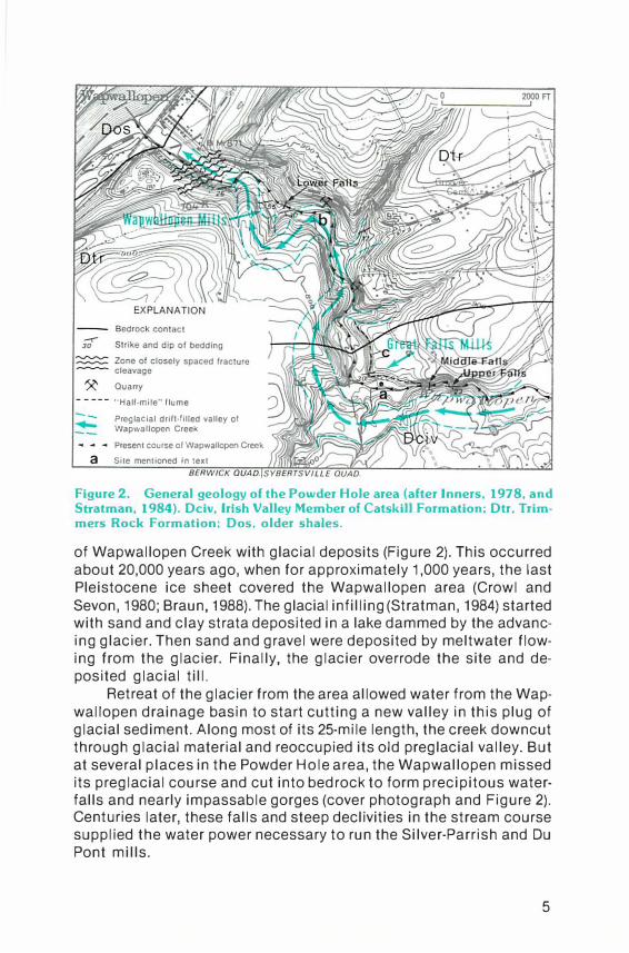
GEOLOGY OF THE "POWDER HOLE." Figure 2 shows the geology at the Wapwallopen site. (A few of the more important industrial features are also indicated on the map.)
The bedrock foundation of the area consists of two rock units of Late Devonian age, dating from about 380 million years ago when the Catskill delta built out into the Appalachian seaway. The Trimmers Rock Formation, which underlies the northern three fourths of the area, is a wholly marine sequence of gray siltstone, shale, and sandstone. Relatively coarser beds in this unit cap the Lower Falls (cover photograph). The Irish Valley Member of the Catskill Formation in the southern part of the Powder Hole consists of interbedded greenish-gray marine sandstones, siltstones, and shales and grayish-red nonmarine claystones. Thick-bedded sandstones and siltstones in the Irish Valley form the caprock of the Middle and Upper Falls. Throughout the Powder Hole, well-defined bedding partings dip to the southeast (Figure 2). Steeply inclined, planar fractures (joints) spaced 6 inches to several feet apart also transect most outcrops. The blocks formed by the intersection of these joints with bedding partings facilitated removal of stone from the several quarries opened in the walls of the gorge. At the northern end of the site, however, a zone of closely spaced, north-dipping fracture cleavage makes some of the lower beds of the Trimmers Rock unusable for building stone (see Figure 2). A precursor of today's Wapwallopen Creek probably began eroding a valley in these bedded, jointed, and cleaved rocks several million years ago.
The geologic event that most directly lead to the industrial development of the Powder Hole was the filling of the original valley
4
Quarry
- ---- "Half-mile" flume
Preglacial drift-filled valley ol Wapwallopen Creek
� ,. -4 Present course of Wapwallopen Creek )]��E��rt a Site mentioned In text
Figure 2. General geology of the Powder Hole area (after lnners, 1978, and Stratman, 1984). Dciv, Irish Valley Member of Catskill Formation; Dtr, Trimmers Rock Formation; Dos, older shales.
of Wapwallopen Creek with glacial deposits (Figure 2). This occurred about 20,000 years ago, when for approximately 1,000 years, the last Pleistocene ice sheet covered the Wapwallopen area (Crowl and Sevon, 1980; Braun, 1988). The glacial infilling (Stratman, 1984) started with sand and clay strata deposited in a lake dammed by the advancing glacier. Then sand and gravel were deposited by meltwater flowing from the glacier. Finally, the glacier overrode the site and deposited glacial till.
Retreat of the glacier from the area allowed water from the Wapwallopen drainage basin to start cutting a new valley in this plug of glacial sediment. Along most of its 25-mile length, the creek downcut through glacial material and reoccupied its old preglacial valley. But at several places in the Powder Hole area, the Wapwallopen missed its preglacial course and cut into bedrock to form precipitous waterfalls and nearly impassable gorges (cover photograph and Figure 2). Centuries later, these falls and steep declivities in the stream course supplied the water power necessary to run the Silver-Parrish and Du Pont mills.
5
THE MANUFACTURE OF
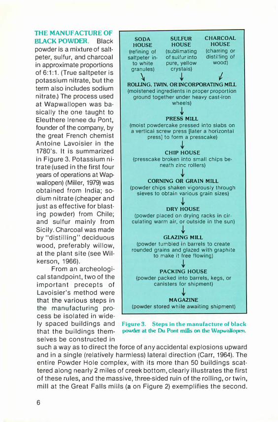
BlACK POWDER. Black powder is a mixture of saltpeter, sulfur, and charcoal in approximate proportions of 6:1:1. (True saltpeter is potassium nitrate, but the term also includes sodium nitrate.) The process used at Wapwallopen was basically the one taught to Eleuthere lrenee du Pont, founder of the company, by the great French chemist Antoine Lavoisier in the 1780's. It is summarized in Figure 3. Potassium nitrate (used in the first four years of operations at Wapwallopen) (Miller, 1979) was obtained from India; sodium nitrate (cheaper and just as effective for blasting powder) from Chile; and sulfur mainly from Sicily. Charcoal was made by "distilling" deciduous wood, preferably willow, at the plant site (see Wilkerson, 1966).
From an archeological standpoint, two of the important precepts of Lavoisier's method were
SODA HOUSE
(refining of saltpeter in·
to white granules)
\
SULFUR HOUSE
(sublimating of sulfur into pure, yellow
crystals)
�
CHARCOAL HOUSE
(charring or distilling of
wood)
ROlliNG. TWIN. OR INCORPORATING Mill (moistened ingredients in proper proportion
ground together under heavy cast-iron wheels)
� PRESS MILL
(moist powdercake pressed Into slabs on a vertical screw press (later a horizontal
press] to form a presscake)
� CHIP HOUSE
(presscake broken into small chips be· neath zinc rollers)
� CORNING OR GRAIN MILL
(powder chips shaken vigorously through sieves to obtain various grain sizes)
� DRY HOUSE
(powder placed on drying racks in cir· culating warm air, or outside in the sun)
� GLAZING MILL
(powder tumbled in barrels to create rounded grains and glazed with graphite
to make it free flowing)
� PACKING HOUSE
(powder packed into barrels, kegs, or canisters for shipment)
� that the various steps in MAGAZINE
the manufacturing pro- (powder stored while awaiting shipment)
cess be isolated in wide-ly spaced buildings and Figure 3. Steps in the manufacture of black
that the buildings them- powder at the DuPont mills on the Wapwallopen.
selves be constructed in such a way as to direct the force of any accidental explosions upward and in a single (relatively harmless) lateral direction (Carr, 1964). The entire Powder Hole complex, with its more than 50 buildings scattered along nearly 2 miles of creek bottom, clearly illustrates the first of these rules, and the massive, three-sided ruin of the rolling, or twin, mill at the Great Falls mills (a on Figure 2) exemplifies the second.
6
HISTORY AND ARCHEOLOGY OF THE DUPONT POWDER WORKS.
For more than 50 years after it began manufacturing black powder, E. I. Du Pont de Nemours and Company confined its activities to the valley of Brandywine Creek near Wilmington, Delaware (Carr, 1964). But by the mid-1850's, the company realized that continued expansion depended on getting closer to the markets-and where better to start than in the burgeoning anthracite district of northeastern Pennsylvania (Van Gelder and Schlatter, 1927). Fortuitously, the failure of the early operations on the Wapwallopen occurred soon after Lammot Du Pont, grandson of the founder, had invented a new and cheaper method of manufacturing an effective blasting powder (Wilkerson, 1984). With these incentives, the Du Ponts set to work rebuilding the old SilverParrish powder works.
Du Pont operations on the Wapwallopen lasted from 1859 to 1912. Important milestones (Bloss, 1976a, 1976b; Miller, 1979) were the opening of the Wapwallopen mills at the Lower Falls in July of 1859; the change from potassium nitrate to sodium nitrate in April of 1863; construction of the Great Falls mills below the Middle Falls in 1869; and the closing of the combined Wapwallopen·Great Falls mills in 1912. During these 50 years, fatal explosions ripped through the powder works about once every 8 years (Bloss, 1976a), and floods destroyed roads, dams, and flumes on numerous occasions (see Miller, 1979).
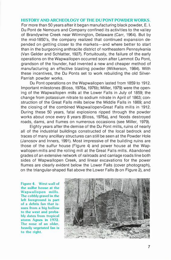
Eighty years after the demise of the Du Pont mills, ruins of nearly all of the industrial buildings constructed of the local bedrock and traces of many ancillary structures can still be seen at the Powder Hole (Janosov and lnners, 1991). Most impressive of the building ruins are those of the sulfur house (Figure 4) and power house at the Wapwallopen mills and the rolling mill at the Great Falls mills. Abandoned grades of an extensive network of railroads and carriage roads line both sides of Wapwallopen Creek, and linear excavations for the power flumes are clearly evident below the Lower Falls (cover photograph), on the triangular-shaped flat above the Lower Falls (bon Figure 2), and
Figure 4. West wall of the sulfur house at the Wapwallopen mills. The cobbly gravel in the left foreground is part of a debris fan that issues from a big hollow to the west and proba· bly dates from tropical storm Agnes in 1972. The nose of an older, heavily vegetated fan Is to the right.
7
on the steep slope downstream from the M iddle Falls (the great "halfmile flume") (c on Figure 2). But floods, landslides, debris flows (Figure 4), and other processes of erosion and mass wasting are gradually taking a toll at the Powder Hole (Janosov and lnners, 1991}. As more is lost with each passing year, accurate documentation of this most interesting industrial site will become increasingly difficult.
CONCLUSION. What are the lessons to be learned from the rocks and ruins at the Powder Hole? One is certainly that the causes of industrial development cannot be divorced from geologic history. The powder works on the Wapwallopen came into existence in large part because a series of events taking place over millions of years culminated in geographic conditions favorable to sustaining an industry dependent on water power. Blasting powder rather than some other product was manufactured at the Powder Hole because of the readily available markets in the nearby anthracite fields. A second lesson is that history is as much contingency as cause-and-effect (Gould, 1989). For if the Wapwallopen valley had not been so completely buried by glacial drift, the postglacial stream would have simply reoccupied its previous course and cleaned out the original broad, gently sloped valley. Then there would have been few rock outcroppings and no falls, no water power, and no powder mills on Wapwallopen Creek.
REFERENCES
Braun, D. D. (1988), Glacial geology of the Anthracite and North Branch Susquehan· na lowland regions, in lnners, J. D., ed., Bedrock and glacial geology of the North Branch Susquehanna lowland and the Eastern Middle Anthracite field, northeastern Pennsylvania, Annual Field Conference of Pennsylvania Geologists, 53rd, Hazleton, Pa., Guidebook, p. 3-25.
Bloss, Marvin (1976a), History, legend and facts of Hobbie, the Switze, and the Du Pont powder mills, Berwick, Keystone Publishing Company, 52 p.
___ (1976b), Gleanings of the Switze, making of powder by Du Pont, favorite poems, and nonsensical nonsense, Berwick, Keystone Publishing Company, 74 p.
Carr, W. H. A. (1964), The du Ponts of Delaware, New York, Dodd, Mead and Company, 368 p.
Crowl, G. H., and Sevon, W. D. (1980), Glacial border deposits of late Wisconsinan age in northeastern Pennsylvania, Pennsylvania Geological Survey, 4th ser., General Geology Report 71, 68 p.
Gould, S. J. (1989), Wonderful life-the Burgess Shale and the nature of history, New York, W. W. Norton and Company, 347 p.
lnners, J. D. {1978), Geology and mineral resources of the Berwick quadrangle, Luzerne and Columbia Counties, Pennsylvania, Pennsylvania Geological Survey, 4th ser., Atlas 174c, 34 p.
Janosov, R. A., and lnners, J. D. (1991), The DuPont powder works at Wapwallopen, Pennsylvania: industrial archeology, geology, and historical geography, unpublished field trip guidebook, Society for Industrial Archeology, Susquehanna Chapter, 20 p.
Miller, D. S. (1979), The development and facilities of the DuPont Wapwallopen mills, 1859-1863, University Park, Pennsylvania State University, senior honors thesis, 20 p.
Stratman, P. (1984), Mappin{/ of the buried valley in Wapwallopen Creek, Bloomsburg, Pa., Bloomsburg Univers1ty, senior thesis, 26 p. and appendices.
Van Gelder, A. P., and Schlatter, Hugo (1927), History of the explosives Industry in America, New York, Columbia University Press, 1,132 p.
Wilkerson, N. B. (1966), Explosives in America, Wilmington, Del., The Hagley Museum, 63 p.
--,-,.......,....- (1984), Lam mot du Pont and the American explosives industry, 1850-1884,
University Press of Virginia, 332 p.
8
NEW PUBLICATIONS
Geology and Mineral Resources of Pike County 0
Geology and Mineral Resources of Pike County, Pennsylvania has been published by the Pennsylvania Geological Survey. This report contains detailed descriptions of the surficial and bedrock geology, discussions of the geologic history, and evaluations of the mineral resources of Pennsylvania's fastest growing county, which had a population increase of 99.5 percent from 1960 to 1980. County Report 52, by W. D. Sevon,
Thomas M. Berg, Lane D. Schultz, and the late George H. Crowl, consists of a 141-page book and bedrock and surficial geologic maps at a scale of 1:50,000. It is available for $22.50, plus 6 percent state sales tax for Pennsylvania residents, from the Sfate Book Store, 1825 Stanley Drive, Harrisburg, PA 17103. Orders must be prepaid; please make checks payable to Commonwealth of Pennsylvania.
Guide to White Clay Creek Preserve
The Pennsylvania Geological Survey has prepared and published Park Guide 20, White Clay Creek Preserve, Chester County, Pennsylvania; New Castle Coun
ty, Delaware-A Scenic Valley and the Arc Corner, by Rodger T. Faill, in cooperation with the Pennsylvania Bureau of State Parks, the Delaware Geological Survey, and the Delaware Department of Natural Resources and Environmental Control, Division of Parks and Recreation. Part of the Trail of Geology series, this 12-page booklet is designed to make a visit to the Preserve more interest-
ing, educational, and understandable to the general public. Brief discussions of the early settlement of the area, the unique (and at one time controversial) arcuate boundary between Pennsylvania and Delaware, and the creation of the Preserve complement the geologic discussions of the history of the metamorphic rocks and White Clay Creek valley. Park Guide 20 is available at no charge from the park office at White Clay Creek Preserve or from the Pennsylvania Geological Survey, P. 0. Box 2357, Harrisburg, PA 17105-2357, telephone 717-787-2169.
9
Rocks and Minerals of Pennsylvania
For many years, Educational Series 1, Common Rocks and Min
erals of Pennsylvania, was among the more popular publications of the Pennsylvania Geological Survey. First published in 1962, ES 1 was recently rewritten by John H. Barnes and published as Rocks and Minerals of Pennsylvania. This 30-page, heavily illustrated booklet includes discussions of basic concepts of petrology and mineralogy and how these apply to the forma-
tion of rock types that are found in Pennsylvania. Emphasis is placed on the lithologic cycle as a form of natural recycling. Practical applications of rocks and minerals in everyday life are also discussed. The booklet is aimed at students at the middle-school level and at inquiring adults. It may be obtained free of charge from the Pennsylvania Geological Survey, P. 0. Box 2357, Harrisburg, PA 17105-2357, telephone 717-787-2169.
Geology and Mineral Resources of
the Blandburg, Tipton, Altoona, and
Bellwood Quadrangles
The Pennsylvania Geological Survey announces the availability of a new publication, Geology and Mineral Resources of the Blandburg, Tipton, Altoona, and Bellwood Quadrangles, Blair, Cambria, Clearfield, and Centre Counties,
Pennsylvania. This report contains detailed descriptions of the bedrock and surficial geology, discussions of the geologic history, and evaluations of the mineral resources of the region, including coal, stone, metallic minerals, and gas. The report consists of a 209-page book and 10 plates. Among the plates are a bedrock geologic map and cross section at a scale
10
of 1 :24,000, a 1 :48,000-scale map of surficial geology, logs of drill holes, and six 1 :48,000-scale resource maps showing the thickness, crop lines, and extent of known mining of major coal beds. Atlas 86, by Rodger T. Fa ill and Albert D. Glover of the Pennsylvania Geological Survey and John H. Way of Lock Haven University, is available for $35.00, plus 6 percent state sales tax for Pennsylvania residents, from the State Book Store, 1825 Stanley Drive, Harrisburg, PA 17103. Orders must be prepaid; please make checks payable to Commonwealth of Pennsylvania.
Groundwater Resources in and
near the Anthracite Basins of
Schuylkill and Adjacent Counties
The latest in the Pennsylvania Geological Survey's series of Water Resource Reports, Ground· water Resources in and near the Anthracite Basins of Schuylkill and Adjacent Counties, Penn· sylvania, has recently been pub·
lished. It was prepared by Albert E. Becher of the U.S. Geological Survey as a part of the continuing cooperative effort of the State and Federal Surveys to study and evaluate the groundwater resources of the Commonwealth. This report contains descriptions of the flow systems and quality
of groundwater in an area in which these characteristics have been greatly modified by anthracite mining. The 59-page book includes extensive tables of waterquality measurements, well records, and other data. Water Re· source Report 64 is available for $11.75, plus 6 percent state sales tax for Pennsylvania residents, from the State Book Store, 1825 Stanley Drive, Harrisburg, PA 17103. Orders must be prepaid; please make checks payable to Commonwealth of Pennsylvania.
Indiana County Coal Maps
on Open File
A new open-file report, Coal Resources of Indiana County, Pennsylvania-Part 1, Coal Crop Lines, Mined-Out Areas, and Structure Contours, is available for inspection at the Pennsylvania Geological Survey. Two types of maps are presented for each 7.5-minute quadrangle in Indiana County. One map for each of the principal coal seams shows the outcrop pattern, or crop line, and the extent of known mining of the seam. One additional map per quadrangle shows the outcrop
patterns of all major coal seams, structure contours, and fold axes. Of use to environmental-protection specialists and land use planners as well as those in the coal industry, this report by William A. Bragonier of the Rochester and Pittsburgh Coal Company and Albert D. Glover of the Pennsylvania Geological Survey can be seen at 101 South Second Street, Room 912, in Harrisburg. Please telephone Albert D. Glover, 717-787-6029, for more information.
11
BENEDUM HALL-A CELEBRATION
OF GEOLOGY
by John A. Harper, Pennsylvania Geological Survey; and Mary R. Dawson, Carnegie Museum of Natural History
In October 1988, the Carnegie Museum of Natural History in Pittsburgh opened its new Benedum "Hall of Geology." Benedum Hall is a celebration of geology, an enticing and visually stimulating place to visit and study. It is, above all, a tribute to the vital role that Pennsylvania has had, and continues to have, in the history of geology and the development of geological concepts.
Pennsylvania's claim to fame in the annals of earth science is second to none. No geology textbook is complete without a detailed recounting of the complex history of the formation of the Appalachian Mountains, which curve through the central part of the state. No history of economic geology is sufficient without the story of Drake's oil well, drilled in 1859 near Titusville in Crawford County. This famous well marked the beginning of the world's oil industry. By the same token, the story of economic geology would not be complete without mention of the role that Pennsylvania coals played in the nation's industrial development. Even the geologic time scale contains a tribute to the rocks of the state, for the interval between 286 and 320 million years ago bears the name "Pennsylvanian" in honor of the extraordinary occurrence of the sedimentary rocks of that age-the sandstones, shales, limestones, and coals-here in the Commonwealth (see also "A Missed Centennial" on page 16 of this issue).
When the staff of the Carnegie Museum began to plan the construction of a new geology hall, they faced the challenge of using the familiar rocks and geologic structures that are common parts of the Pennsylvania landscape to present the most modern ideas and details of the earth sciences. With that challenge in mind, the Museum acquired funding from the Philip M. McKenna Foundation a'hd the Claude Worthington Benedum Foundation to begin the project. Carnegie Museum employed Gerard Hilferty and Associates, an exhibit design firm of Athens, Ohio, to design a geology display that would be entertaining, educational, and, above all, visually captivating. The design that Gerard Hilferty and Associates created was eventually brought to life by Visual Communications Inc. of Philadelphia. The design is based on a series of hemispherical domes that repre-
12
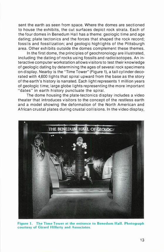
sent the earth as seen from space. Where the domes are sectioned to house the exhibits, the cut surfaces depict rock strata. Each of the four domes in Benedum Hall has a theme: geologic time and age dating; plate tectonics and the forces that shaped the rock record; fossils and fossilization; and geologic highlights of the Pittsburgh area. Other exhibits outside the domes complement these themes.
In the first dome, the principles of geochronology are illustrated, including the dating of rocks using fossils and radioisotopes. An interactive computer workstation allows visitors to test their knowledge of geologic dating by determining the ages of several rock specimens on display. Nearby is the "Time Tower" (Figure 1), a tall cylinder decorated with 4,600 lights that spiral upward from thE7 base as the story of the earth's history is narrated. Each light represents 1 million years of geologic time; large globe lights representing the more important "dates" in earth history punctuate the spiral.
The dome housing the plate-tectonics display includes a video theater that introduces visitors to the concept of the restless earth and a model showing the deformation of the North American and African crustal plates during crustal collisions. In the video display,
Figure 1. The Time Tower at the entrance to Benedum Hall. Photograph courtesy of Girard Hilferty and Associates.
13
the Pittsburgh area is used as an example of a piece of the earth that has undergone drastic changes, and visitors are challenged on their knowledge of Pittsburgh's geologic past. The "Mountain Builder" is an active model that allows the visitor to create the Appalachian Mountains by turning a wheel that drives Africa and North America into collision. The exhibit shows how at least three intervals of plate interactions occurred during the Paleozoic Era. Each interaction created mountains that were eventually eroded, shedding great quantities of sediment into adjacent seas. These sediments were, in turn, uplifted, deformed, and eroded by later mountain-building events.
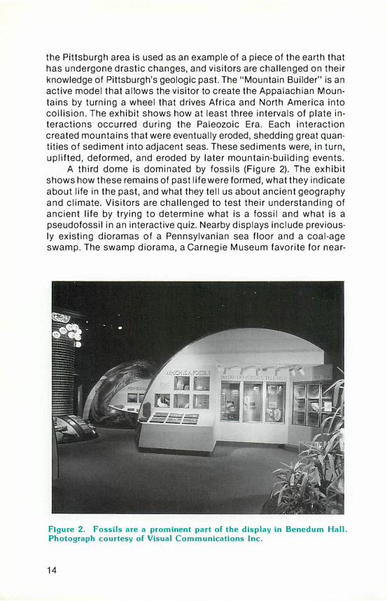
A third dome is dominated by fossils (Figure 2). The exhibit shows how these remains of past life were formed, what they indicate about life in the past, and what they tell us about ancient geography and climate. Visitors are challenged to test their understanding of ancient life by trying to determine what is a fossil and what is a pseudofossil in an interactive quiz. Nearby displays include previously existing dioramas of a Pennsylvanian sea floor and a coal-age swamp. The swamp diorama, a Carnegie Museum favorite for near-
Figure 2. Fossils are a prominent part of the display in Benedum Hall. Photograph courtesy of Visual Communications Inc.
14

ly 50 years, received a facelift for the exhibit; the plants and animals were cleaned, and new plants and animals were added to expand the scene out into the exhibit hall. The new part will not be behind glass, so visitors can get a close-up view of what much of Pennsylvania looked like 300 million years ago. A novel exhibit, containing actual living relatives of the Paleozoic scouring rushes, cycads, and other plants, provides a nice continuity between past and present.
A close look at the geology of the Pittsburgh area is provided by the fourth dome. An interactive video exhibit displays various areas in southwestern Pennsylvania on command, illustrating rock formations and fossil-collecting localities. Coal, oil, and natural gas, the fossil fuels that have contributed so much to the economic importance of western Pennsylvania, are highlighted in a display on economic geology. Examples of bituminous and anthracite coals, and various Pennsylvania Grade crude oils, are exhibited along with explanations of their origins and how they are extracted. The "Stratavat or" is a truly unique exhibit, offering the educational advantages of a video display and the excitement of an amusement park ride. This exhibit is a simulated elevator ride, complete with a moving cab that gives a remarkably eerie sensation of vertical movement to a depth of 16,000 feet beneath the floor of Benedum Hall. Upon entering the cab of the "Stratavator," visitors meet their tour guide, a miner appropriately named Rocky, seen through the cab's "window" (a video screen). The ride stops at several formations, ending at the metamorphic rocks of the crystalline basement. Between stops, the intervening rock strata whiz by the "window" while a counter measures the depth and the geologic age of the passing rocks.
Pennsylvania's complex geology is recorded in the geologic map, a visually outstanding exhibit that dominates the south wall of the hall. The map is a photographically enlarged version of the Geologic Map of Pennsylvania that has been mounted on a large block. The original map, donated by the Pennsylvania Geological Survey, included a set of cross sections on a separate sheet; in the enlarged reproduction, the map and block have been cut along the lines of these sections and the cross sections mounted on the sides of the block to show the three-dimensional aspects of Pennsylvania geology.
The creation of Benedum Hall was an interdisciplinary effort on the part of many people from the Carnegie Museum, academia, industry, and the Pennsylvania Geological Survey. Besides donating the use of the originals of the Geologic Map of Pennsylvania, the Survey also provided display samples and technical advice. Readers are encouraged to visit the Benedum Hall of Geology while in the Pittsburgh area. Earth science teachers will find Benedum Hall a worthwhile teaching aid and a great place for field trips.
15
ANNOUNCEMENTS
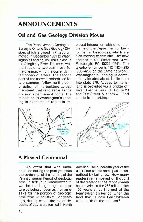
Oil and Gas Geology Division Moves
The Pennsylvania Geological Survey's Oil and Gas Geology Division, which is based in Pittsburgh, moved in December 1991 to Washington's Landing, on Herrs Island in the Allegheny River. The move was the first of a two-part move for the division, which is currently in temporary quarters. The second part of the move is scheduled for late summer, following the construction of the building across the street that is to serve as the division's permanent home. The relocation to Washington's Landing is expected to result in im-
A Missed Centennial
An event that was unannounced during the past year was the centennial of the naming of the Pennsylvanian Period of geologic time. In 1891, our Commonwealth was honored in geological literature by being chosen as the namesake for the portion of geologic time from 320 to 286 million years ago, during which the major deposits of coal were formed in North
16
proved integration with other programs of the Department of Environmental Resources, which are also moving to this site. The new address is 400 Waterfront Drive, Pittsburgh, PA 15222-4745. The telephone number is 412-442-4235 (636-4235 on the State network). Washington's Landing is conveniently located about 1 mile from Interstate 279. Access to the island is provided via a bridge off River Avenue near Pa. Route 28 and 31st Street. Visitors will find ample free parking.
America. The hundredth year of the use of our state's name passed unnoticed by but a few. How many readers remembered or thought of the distance that Pennsylvania has traveled in the 286 million plus 100 years since the end of the Pennsylvanian Period, when the land that is now Pennsylvania was south of the equator?
PENNSYLVANIA GEOLOGICAL SURVEY STAFF
Donald M. Hoskins, Bureau Director
DIRECTOR'S OFFICE 717-787-2169
Administrative Services and Library Shirley J. Barner, Clerical Supervisor Sandra D. Blust, Librarian Janet L. Wotring, Administrative
Assistant Connie A. Zimmerman, Clerk Typist
Geologic Reports Section Christine M. Dodge, Section Chief John H. Barnes, Geologist James H. Dolimpio, Cartographic Draftsman John G. Kuchinski, Cartographic Supervisor Caron E. O'Neil, Geologist
ENVIRONMENTAL GEOLOGY DIVISION 717-787-5828
Samuel W. Berkheiser, Jr., Division Chief
Geotechnical Section Helen L. Delano, Geologist William E. Kochanov, Geologist Water Well Inventory/Licensing Section Donna M. Snyder, Section Chief Mari G. Barnhart, Clerk
Groundwater Geology Section Michael E. Moore, Section Chief Thomas A. McElroy, Hydrogeologist Dawna S. Yannacci, Hydrogeologist
GEOLOGIC MAPPING DIVISION 717-787-6029
Jon D. lnners, Division Chief Jody R. Smith, Clerk Typist
Eastern Regional Section
Rodger T. Faill, Section Chief David B. MacLachlan, Geologist William D. Sevon, Geologist
Western Regional Section Albert D. Glover, Section Chief Clifford H. Dodge, Geologist Leonard J. Lentz, Geologist James R. Shaulis, Geologist Viktoras W. Skema, Geologist Thomas G. Whitfield, Geologist
MINERAL RESOURCES DIVISION 717-787-5897
Robert C. Smith, II, Division Chief
Leslie T. Chubb, Laboratory Technician
OIL AND GAS GEOLOGY DIVISION 400 Waterfront Drive, Pittsburgh, PA 15222-4745
412-442-4235 John A. Harper, Division Chief
Lajos J. Balogh, Cartographic Draftsman Cheryl L. Cozart, Descriptive Statistician Kathy J. Flaherty, Geologist Joseph E. Kunz, Clerk Typist
Christopher D. Laughrey, Geologist Antonette K. Markowski, Geologist
(Harrisburg Office) John G. Petro, Cartographic Draftsman
IN COOPERATION WITH THE U.S. GEOLOGICAL SURVEY
TOPOGRAPHIC MAPPING
GROUNDWATER-RESOURCE MAPPING
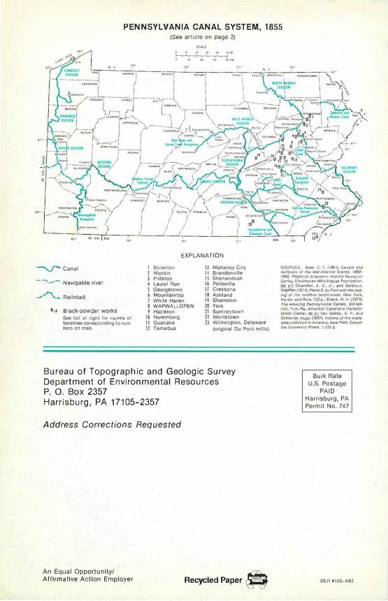
PENNSYLVANIA CANAL SYSTEM, 1855 (See article on page 2)
EXPLANATION
---...J" Canal
--"'\-- Navigable river
� Railroad
5" Black-powder works Soe list at right for names of b:allties corresponding to num· bcrs on map.
I Scranton 2 Moosic 3 Pittston -4 Laurol Run S Georgetown 6 Mountaintop 1 Whho Haven 8 WAPWALLOPEN 9 Hazleton
10 Nuremberg II Quakake 12 Tamaqua
13 Mahanoy City I! Brandonvllle IS Shenandoah 16 Pottsville 11 Cressona 18 Ashland 19 Shamokin 20 York 71 Sumneytown 72 Norristown 23 Wilmington, Oelawaro
(original Du Pont mills)
Bureau of Topographic and Geologic Survey Department of Environmental Resources
P. 0. Box 2357 Harrisburg, PA 17105-2357
Address Corrections Requested
An Equal Opportunity/ Affirmative Action Employer Recycled Paper �
SOURCES; a... C r {111181). C.M/s and ralltfnds ol m• MidArt.tUIC Stltas.. laiOO· rMO. �tonal Economk: History Aeaurch Centet, EHtuthOI'Ian Mllls-Hagt.y Foundation,
(80 p.J: Chandler, A. 0, Jr, and S.lsbury, SIOQhen (1971 .. Pt«r• S. du Pottt attd rna malt· lng ol llr• modatn corp<KitiOII, New YOf� H11pe1 and Row, 722 p,; Shank., W U (1973), Tha amazing Pantuyf'lan/t Cana/1, 3td ecJI 1� York, Pa .. Amorlcan C&naland Transpor·
tatk>n Center. 80 p.; Van Gekler. A. P, and Schlan•. Hugo (191'1), HJ,(N'fol ,,. ,,p�oslw.JindusrryM Am«lea, NewYor11. �um tMa University Pr.-s., 1,132 p
Bulk Rate u.s. Postage
PAID
Harrisburg, PA
Permit No. 747
OER r103·4/92