Embed Size (px)
Citation preview
ARCHITECTURE+DESIGN mar=Apr 1994 17
POST-EARTHQUAKE
Reconstruction in Marathwada
Aromar Revi and Kamal Kishore
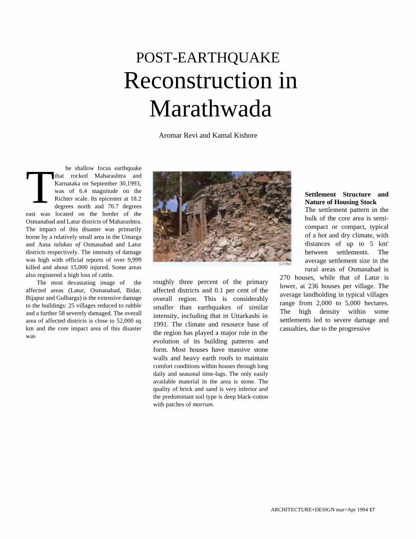
he shallow focus earthquake that rocked Maharashtra and Karnataka on September 30,1993, was of 6.4 magnitude on the Richter scale. Its epicenter at 18.2 degrees north and 76.7 degrees
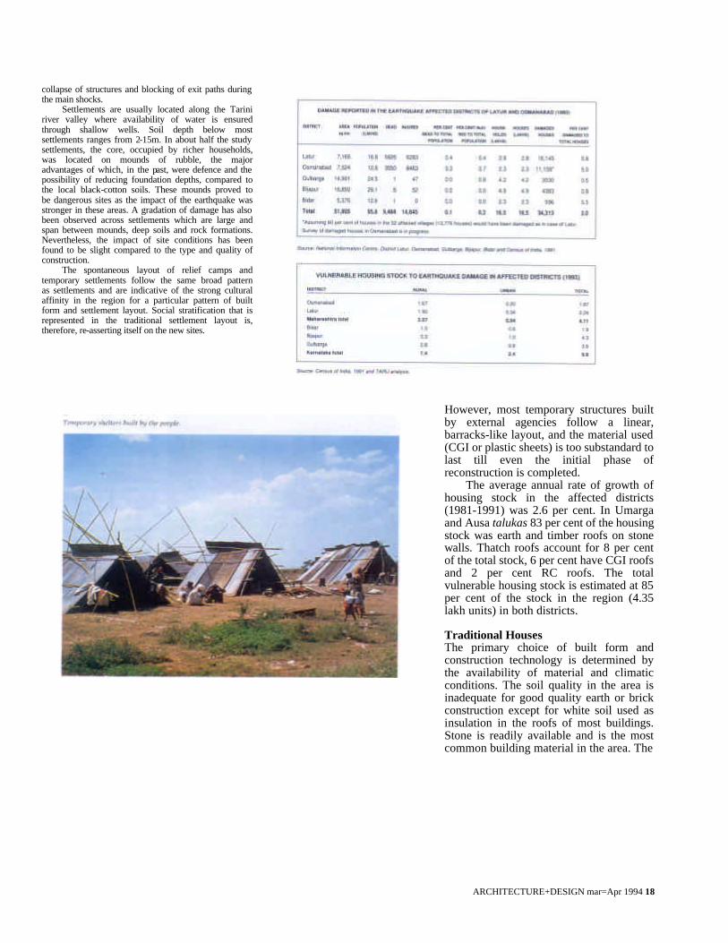
east was located on the border of the Osmanabad and Latur districts of Maharashtra. The impact of this disaster was primarily borne by a relatively small area in the Umarga and Ausa talukas of Osmanabad and Latur districts respectively. The intensity of damage was high with official reports of over 9,999 killed and about 15,000 injured. Some areas also registered a high loss of cattle.
The most devastating image of the affected areas (Latur, Osmanabad, Bidar, Bijapur and Gulbarga) is the extensive damage to the buildings: 25 villages reduced to rubble and a further 58 severely damaged. The overall area of affected districts is close to 52,000 sq km and the core impact area of this disaster was
roughly three percent of the primary affected districts and 0.1 per cent of the overall region. This is considerably smaller than earthquakes of similar intensity, including that in Uttarkashi in 1991. The climate and resource base of the region has played a major role in the evolution of its building patterns and form. Most houses have massive stone walls and heavy earth roofs to maintain comfort conditions within houses through long daily and seasonal time-lags. The only easily available material in the area is stone. The quality of brick and sand is very inferior and the predominant soil type is deep black-cotton with patches of morrum.
Settlement Structure and Nature of Housing Stock The settlement pattern in the bulk of the core area is semi-compact or compact, typical of a hot and dry climate, with distances of up to 5 km' between settlements. The average settlement size in the rural areas of Osmanabad is
270 houses, while that of Latur is lower, at 236 houses per village. The average landholding in typical villages range from 2,000 to 5,000 hectares. The high density within some settlements led to severe damage and casualties, due to the progressive
T
ARCHITECTURE+DESIGN mar=Apr 1994 18
collapse of structures and blocking of exit paths during the main shocks.
Settlements are usually located along the Tarini river valley where availability of water is ensured through shallow wells. Soil depth below most settlements ranges from 2-15m. In about half the study settlements, the core, occupied by richer households, was located on mounds of rubble, the major advantages of which, in the past, were defence and the possibility of reducing foundation depths, compared to the local black-cotton soils. These mounds proved to be dangerous sites as the impact of the earthquake was stronger in these areas. A gradation of damage has also been observed across settlements which are large and span between mounds, deep soils and rock formations. Nevertheless, the impact of site conditions has been found to be slight compared to the type and quality of construction.
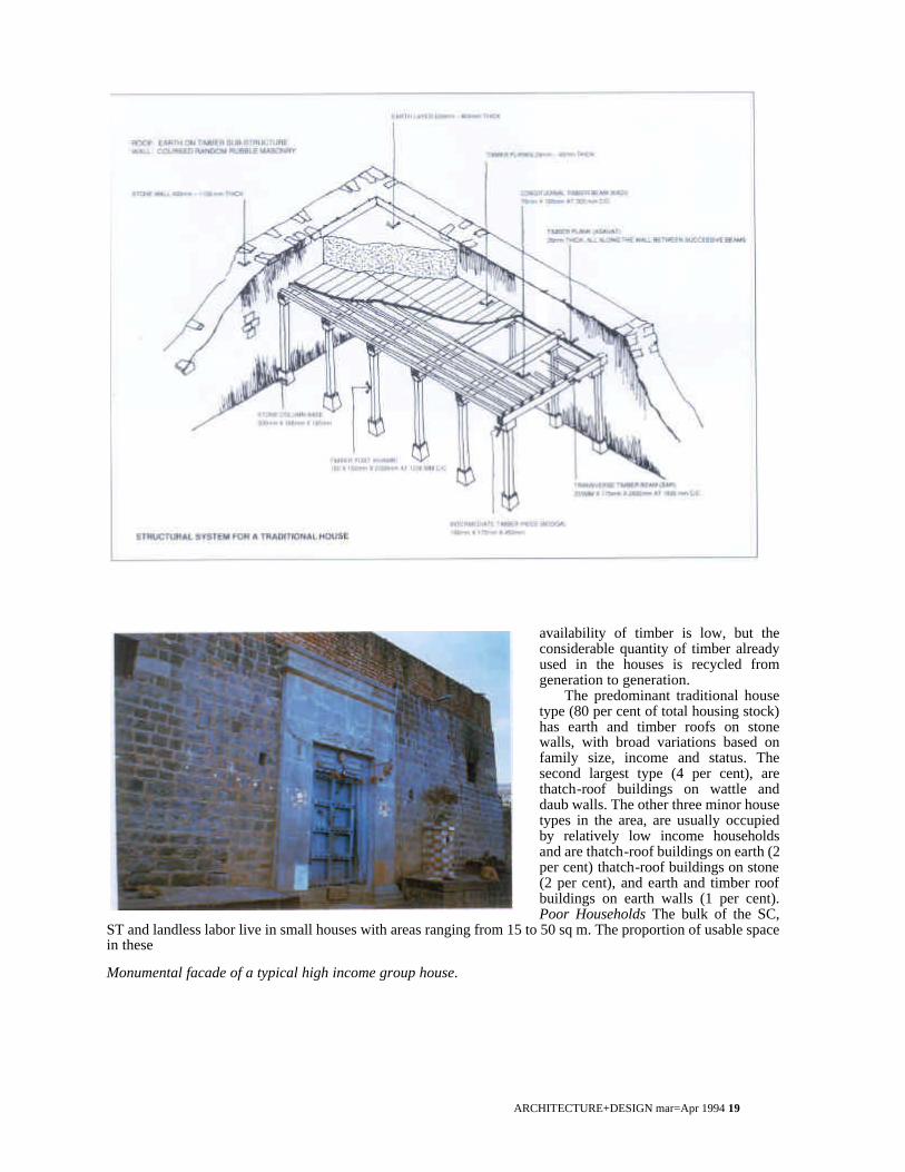
The spontaneous layout of relief camps and temporary settlements follow the same broad pattern as settlements and are indicative of the strong cultural affinity in the region for a particular pattern of built form and settlement layout. Social stratification that is represented in the traditional settlement layout is, therefore, re-asserting itself on the new sites.
However, most temporary structures built by external agencies follow a linear, barracks-like layout, and the material used (CGI or plastic sheets) is too substandard to last till even the initial phase of reconstruction is completed.
The average annual rate of growth of housing stock in the affected districts (1981-1991) was 2.6 per cent. In Umarga and Ausa talukas 83 per cent of the housing stock was earth and timber roofs on stone walls. Thatch roofs account for 8 per cent of the total stock, 6 per cent have CGI roofs and 2 per cent RC roofs. The total vulnerable housing stock is estimated at 85 per cent of the stock in the region (4.35 lakh units) in both districts.
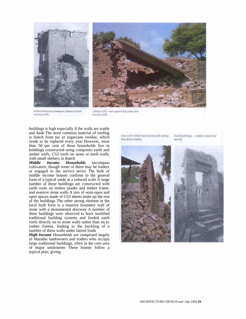
Traditional Houses The primary choice of built form and construction technology is determined by the availability of material and climatic conditions. The soil quality in the area is inadequate for good quality earth or brick construction except for white soil used as insulation in the roofs of most buildings. Stone is readily available and is the most common building material in the area. The
ARCHITECTURE+DESIGN mar=Apr 1994 19
availability of timber is low, but the considerable quantity of timber already used in the houses is recycled from generation to generation.
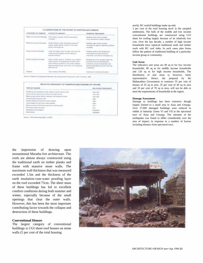
The predominant traditional house type (80 per cent of total housing stock) has earth and timber roofs on stone walls, with broad variations based on family size, income and status. The second largest type (4 per cent), are thatch-roof buildings on wattle and daub walls. The other three minor house types in the area, are usually occupied by relatively low income households and are thatch-roof buildings on earth (2 per cent) thatch-roof buildings on stone (2 per cent), and earth and timber roof buildings on earth walls (1 per cent). Poor Households The bulk of the SC,
ST and landless labor live in small houses with areas ranging from 15 to 50 sq m. The proportion of usable space in these
Monumental facade of a typical high income group house.
ARCHITECTURE+DESIGN mar=Apr 1994 20
buildings is high especially if the walls are wattle and daub The most common material of roofing is thatch from tur or sugarcane residue, which needs to be replaced every year However, more than 50 per cent of these households live in buildings constructed using composite earth and timber roofs, CGI roofs on stone or earth walls, with small shelters in thatch Middle Income Households encompass cultivators, though some of them may be traders or engaged in the service sector The bulk of middle income houses conform to the general form of a typical wada at a reduced scale A large number of these buildings are constructed with earth roofs on timber planks and timber frame, and massive stone walls A mix of semi-open and open spaces made of CGI sheets make up the rest of the buildings The other strong element in the local built form is a massive boundary wall of stone with a monumental doorway A number of these buildings were observed to have modified traditional building systems and loaded earth roofs directly on to stone walls rather than on to timber frames, leading to the buckling of a number of these walls under lateral loads High Income Households are comprised largely of Maratha landowners and traders who occupy large traditional buildings, often in the core area of major settlements These houses follow a typical plan, giving
ARCHITECTURE+DESIGN mar=Apr 1994 21
stock). RC roofed buildings make up only 3 per cent of the total housing stock in the sampled settlements. The bulk of the middle and low income conventional buildings are constructed using CGI sheet for roofing largely because of its relatively low cost. Over the last decade, a number of high income households have replaced traditional earth and timber roofs with RC roof slabs. In such cases plan forms follow the pattern of traditional building of a particular income group or community.
Unit Areas The indicative unit areas are 40 sq m for low income households, 80 sq m for middle income households and 120 sq m for high income households. The distribution of unit areas is, however, fairly representative. Hence, the proposal by the Maharashtra Government to construct 55 per cent of houses of 25 sq m area, 35 per cent of 40 sq m area and 10 per cent of 70 sq m area, will not be able to meet the requirements of households in the region.
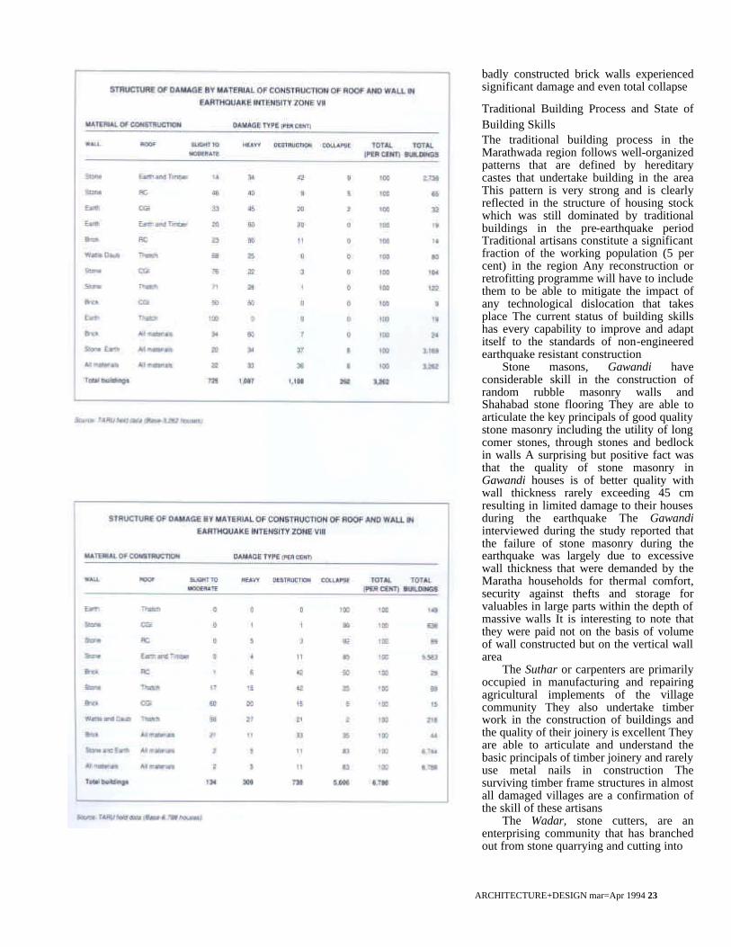
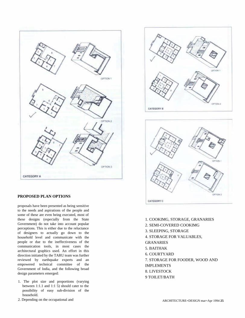
Damage Assessment Damage to buildings has been extensive though largely limited to a small area in Ausa and Umarga. Over 27,000 damaged buildings were reduced to rubble in Intensity Zones VI and VII in the epicentral tract of Ausa and Umarga. The intensity of the earthquake was found to differ considerably over the area of impact; in response to a number of factors including distance from epicentral tract,
the impression of drawing upon monumental Maratha fort architecture. The roofs are almost always constructed using the traditional earth on timber planks and frame with massive stone walls. The maximum wall thickness that was measured exceeded 1.5m and the thickness of the earth insulation-cum-water proofing layer on the roof exceeded 75cm. The sheer mass of these buildings has led to excellent comfort conditions during both summer and winter, especially because of the small openings that clear the outer walls. However, this has been the most important contributing factor towards the collapse and destruction of these buildings.
Conventional Houses The largest category of conventional buildings is CGI sheet-roof houses on stone walls (5 per cent of the total housing
ARCHITECTURE+DESIGN mar=Apr 1994 22
the geology of the region, and most important, type and quality of construction Scattered damage was reported in other areas of Latur and Osmanabad districts in Maharashtra, and Bidar, Bijapur and Gulbarga districts of Karnataka and up to ten other districts in Maharashtra This assessment of building damage is limited to the study areas in the core area in Latur and Osmanabad districts
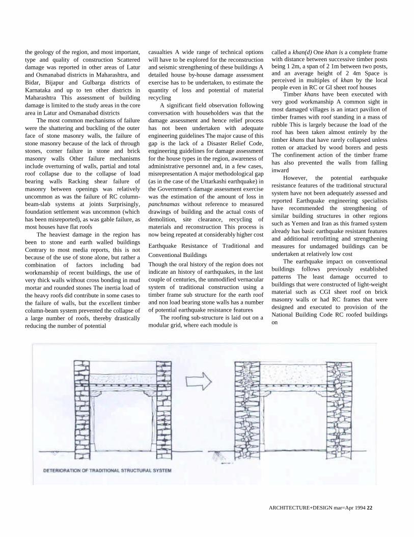
The most common mechanisms of failure were the shattering and buckling of the outer face of stone masonry walls, the failure of stone masonry because of the lack of through stones, corner failure in stone and brick masonry walls Other failure mechanisms include overturning of walls, partial and total roof collapse due to the collapse of load bearing walls Racking shear failure of masonry between openings was relatively uncommon as was the failure of RC column-beam-slab systems at joints Surprisingly, foundation settlement was uncommon (which has been misreported), as was gable failure, as most houses have flat roofs
The heaviest damage in the region has been to stone and earth walled buildings Contrary to most media reports, this is not because of the use of stone alone, but rather a combination of factors including bad workmanship of recent buildings, the use of very thick walls without cross bonding in mud mortar and rounded stones The inertia load of the heavy roofs did contribute in some cases to the failure of walls, but the excellent timber column-beam system prevented the collapse of a large number of roofs, thereby drastically reducing the number of potential
casualties A wide range of technical options will have to be explored for the reconstruction and seismic strengthening of these buildings A detailed house by-house damage assessment exercise has to be undertaken, to estimate the quantity of loss and potential of material recycling
A significant field observation following conversation with householders was that the damage assessment and hence relief process has not been undertaken with adequate engineering guidelines The major cause of this gap is the lack of a Disaster Relief Code, engineering guidelines for damage assessment for the house types in the region, awareness of administrative personnel and, in a few cases, misrepresentation A major methodological gap (as in the case of the Uttarkashi earthquake) in the Government's damage assessment exercise was the estimation of the amount of loss in panchnamas without reference to measured drawings of building and the actual costs of demolition, site clearance, recycling of materials and reconstruction This process is now being repeated at considerably higher cost
Earthquake Resistance of Traditional and
Conventional Buildings
Though the oral history of the region does not indicate an history of earthquakes, in the last couple of centuries, the unmodified vernacular system of traditional construction using a timber frame sub structure for the earth roof and non load bearing stone walls has a number of potential earthquake resistance features
The roofing sub-structure is laid out on a modular grid, where each module is
called a khan(d) One khan is a complete frame with distance between successive timber posts being 1 2m, a span of 2 1m between two posts, and an average height of 2 4m Space is perceived in multiples of khan by the local people even in RC or GI sheet roof houses
Timber khans have been executed with very good workmanship A common sight in most damaged villages is an intact pavilion of timber frames with roof standing in a mass of rubble This is largely because the load of the roof has been taken almost entirely by the timber khans that have rarely collapsed unless rotten or attacked by wood borers and pests The confinement action of the timber frame has also prevented the walls from falling inward
However, the potential earthquake resistance features of the traditional structural system have not been adequately assessed and reported Earthquake engineering specialists have recommended the strengthening of similar building structures in other regions such as Yemen and Iran as this framed system already has basic earthquake resistant features and additional retrofitting and strengthening measures for undamaged buildings can be undertaken at relatively low cost
The earthquake impact on conventional buildings follows previously established patterns The least damage occurred to buildings that were constructed of light-weight material such as CGI sheet roof on brick masonry walls or had RC frames that were designed and executed to provision of the National Building Code RC roofed buildings on
ARCHITECTURE+DESIGN mar=Apr 1994 23
badly constructed brick walls experienced significant damage and even total collapse
Traditional Building Process and State of Building Skills The traditional building process in the Marathwada region follows well-organized patterns that are defined by hereditary castes that undertake building in the area This pattern is very strong and is clearly reflected in the structure of housing stock which was still dominated by traditional buildings in the pre-earthquake period Traditional artisans constitute a significant fraction of the working population (5 per cent) in the region Any reconstruction or retrofitting programme will have to include them to be able to mitigate the impact of any technological dislocation that takes place The current status of building skills has every capability to improve and adapt itself to the standards of non-engineered earthquake resistant construction
Stone masons, Gawandi have considerable skill in the construction of random rubble masonry walls and Shahabad stone flooring They are able to articulate the key principals of good quality stone masonry including the utility of long comer stones, through stones and bedlock in walls A surprising but positive fact was that the quality of stone masonry in Gawandi houses is of better quality with wall thickness rarely exceeding 45 cm resulting in limited damage to their houses during the earthquake The Gawandi interviewed during the study reported that the failure of stone masonry during the earthquake was largely due to excessive wall thickness that were demanded by the Maratha households for thermal comfort, security against thefts and storage for valuables in large parts within the depth of massive walls It is interesting to note that they were paid not on the basis of volume of wall constructed but on the vertical wall area
The Suthar or carpenters are primarily occupied in manufacturing and repairing agricultural implements of the village community They also undertake timber work in the construction of buildings and the quality of their joinery is excellent They are able to articulate and understand the basic principals of timber joinery and rarely use metal nails in construction The surviving timber frame structures in almost all damaged villages are a confirmation of the skill of these artisans
The Wadar, stone cutters, are an enterprising community that has branched out from stone quarrying and cutting into

ARCHITECTURE+DESIGN mar=Apr 1994 24
stone masonry and Shahabad stone roofing which had so far, been specialized activities of the Gawandi. They are also increasingly taking up turn-key petty contractorship for both government and private agencies for stone quarrying and stone breaking jobs.
The integration of all the three communities into the reconstruction and retrofitting process in the area is critical not only because it will provide employment to them, but also because this grass roots production system will continue to exist after all external agencies have pulled out. The quality of construction on which seismic resistance is
determined can be sustainably maintained only by these artisans.
People and the Built Form The primary occupation of most people in this region is agriculture. Enough open space for storing wood and fodder, penning livestock and keeping agricultural implements is an integral part of their houses. Food grain is stored in large baskets of about 1.0 to 1.5m height and about 0.6 to 1.0 m diameter. These baskets are installed on raised stone pedestals and occupy considerable area in the covered and semi-covered spaces of a house.
Most day-time activities are performed in open and semi- covered spaces. Traditional Marathwada houses are characterized by a smooth transition of spaces from open to semi-covered to covered spaces. The semi-covered spaces cater to multiple usage including cooking, eating, and sleeping. A completely evolved house exhibits an introverted plan with rooms, arranged around a central courtyard, preceded by a wide veranda all around.
The enclosed court forms an important part of day to day living. Typically characterized by the sacred tulsi planter in the centre, it is the space most used by the household women in all seasons. Besides being a major source of light and ventilation, the enclosed courtyard provides a comfortable level of privacy from guests and outsiders.
The entrance is marked by a dehlaj, sitting room, with built-in platforms on both sides of a main passage, where guests and outsiders are entertained. Although a dehlaj is typical of mainly the high and middle-income households, it has been seen that low-income households also aspire for such an intermediate space. In such cases the evolution of a house through various phases of construction progresses towards achieving an enclosed courtyard and a dehlaj. Independent entry to individual rooms through the common veranda facilitates an easy subdivision of the household that might take place in the course of time.
A toilet within the premises of a house is almost a completely alien concept. However, an ablutionary space called nahani, primarily used for bathing is always tucked away in one corner of the open space. A nahani is defined by about 1.5m high stone walls and is accompanied by an in-situ arrangement for water heating.
Interaction with people reveals that a square plot with proportions ranging from 1:1 to 1:1.4, is preferred to a longish plot because it facilitates an easy subdivision of spaces as the growing household splits into two or more units.
Design Guidelines for Reconstruction
A clear set of design guidelines for reconstruction and retrofitting need to be delineated for the area taking into account the life-style of the largely agrarian population, the desire for continuity of pre-existing built form, earthquake resistance and post-earthquake investment potential. While a number of design
ARCHITECTURE+DESIGN mar=Apr 1994 25
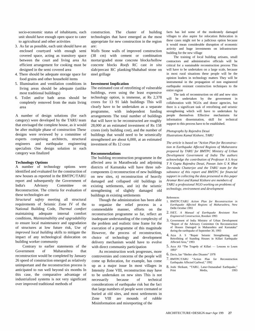
PROPOSED PLAN OPTIONS
proposals have been presented as being sensitive to the needs and aspirations of the people and some of these are even being executed, most of these designs (especially from the State Government) do not take into account popular perceptions. This is either due to the reluctance of designers to actually go down to the household level and communicate with the people or due to the ineffectiveness of the communication tools, in most cases the architectural graphics used. An effort in this direction initiated by the TARU team was further reviewed by earthquake experts and an empowered technical committee of the Government of India, and the following broad design parameters emerged:
1. The plot size and proportions (varying between 1:1.1 and 1:1 5) should cater to the possibility of easy sub-division of the household.
2. Depending on the occupational and
1. COOKIMG, STORAGE, GRANARIES
2. SEMI-COVERED COOKIMG
3. SLEEPING, STORAGE
4. STORAGE FOR VALUABLES,
GRANARIES
5. BAITHAK
6. COURTYARD
7. STORAGE FOR FOODER, WOOD AND
IMPLEMENTS
8. LIVESTOCK
9 TOILET/BATH
ARCHITECTURE+DESIGN mar=Apr 199 27
socio-economic status of inhabitants, each unit should have enough open space to cater to agricultural and other activities
3. As far as possible, each unit should have an enclosed courtyard with enough semi covered space, acting as transitory space between the court and living area An efficient arrangement for cooking must be designed in the semi covered area
4. There should be adequate storage space for food grains and other household items
5. Illumination and ventilation conditions in living areas should be adequate (unlike most traditional buildings)
6. Toilet and/or bath areas should be completely removed from the main living area
A number of design solutions (for each category) were developed by the TARU team that envisaged the complete house, as it would be after multiple phase of construction These designs were reviewed by a committee of experts comprising architects, structural engineers and earthquake engineering specialists One design solution in each category was finalized
Technology Options A number of technology options were identified and evaluated for the construction of new houses as reported in the BMTPC/TARU report and subsequently the Government of India's Advisory Committee on Reconstruction. The criteria for evaluation of these technologies are Structural safety meeting all structural requirements of Seismic Zone IV of the National Building Code, Thermal comfort maintaining adequate internal comfort conditions, Maintainability and upgradability to ensure local maintenance and upgradation of structures at low future risk, Use of improved local building skills to mitigate the impact of any technological dislocation on building worker community
Contrary to earlier statements of the Government of Maharashtra that reconstruction would be completed by January 26 speed of construction emerged as relatively unimportant and the reconstruction process is anticipated to run well beyond six months In this case, the comparative advantage of industrialized systems is not very significant over improved traditional methods of
construction. The cluster of building technologies that have emerged as the most appropriate for new construction in the region are: Walls Stone walls of improved construction (38 cm) with cement or combination mortar/graded stone concrete blocks/hollow concrete blocks Roofs RC cast in situ slab/precast RC planking/Shahabad stone on steel grillage
Investment Implication The estimated cost of retrofitting of vulnerable buildings, even using the least expensive technology option, is immense, at Rs 2,378 crores for 13 91 lakh buildings This will clearly have to be undertaken as a separate programme, with independent funding arrangements The total number of buildings that will have to be reconstructed are roughly 28,000 at an estimated investment of Rs 158 crores (only building cost), and the number of buildings that would need to be seismically strengthened are about 6,000, at an estimated investment of Rs 12 crore
Recommendations The building reconstruction programme in the affected area in Marathwada and adjoining districts of Karnataka will have three sub-components i) reconstruction of new buildings on new sites, n) reconstruction of heavily damaged and collapsed old buildings in existing settlements, and in) the seismic strengthening of slightly damaged old buildings m existing settlements
Though the administration has been able to organize the relief process in a commendable manner, efforts on the reconstruction programme so far, reflect an inadequate understanding of the complexity of the problem and realistic time frame for the execution of a programme of this magnitude However, the process of reconstruction, choice of technology and development delivery mechanism would have to evolve with direct community participation
As reconstruction work progresses, more controversies and concerns of the people will come up Relocation, for example, has come up as a major issue In most villages in Intensity Zone VIII, reconstruction may have to be undertaken on new sites This is not necessarily because of technical considerations of earthquake risk but the fact that large numbers of people were cremated or buried at old sites, and most settlements in Zone VIII are mounds of rubble Misinformation and misreporting of the
facts has led some of the moderately damaged villages to also aspire for relocation Relocation in these cases might not be a judicious option because it would mean considerable disruption of economic activity and huge investments on infrastructure building for the new village
The training of local building artisans, small contractors and administrative officials will be critical for a sustainable reconstruction process This will have to be undertaken on a large scale, because in most rural situations these people will be the opinion leaders in technology matters They will be instrumental in the propagation of non engineered earthquake resistant construction techniques to the entire region
The task of reconstruction on old and new sites will be undertaken by the government in collaboration with NGOs and donor agencies, but there is a significant task of retrofitting and seismic strengthening which will have to undertaken by people themselves Effective mechanisms for information dissemmation, skill for technical support to this process have to be established.
Photographs by Rajendra Desai Illustrations Kamal Kishore, TARU
The article is based on "Action Plan for Reconstruc-tion m Earthquake Affected Regions of Maharastra prepared by TARU for BMTPC Ministry of Urban Development Government of India The authors acknowledge the contribution of Professor A S Arya T N Gupta Rajendra Desai, Pawan Jain G K Bhat Devnanda Chatterjee and the TARU team for the substance of this report and BMTPC for financial support in collecting the data presented m this paper Aromar Revi and Kamal Kishore are members of TARU a professional NGO working on problems of technology, environment and development
References 1. BMTPC/TARU Action Plan for Reconstruction in
Earthquake Affected Regions of Maharashtra, New Delhi October 1993
2. ISET, A Manual of Earthquake Resistant Non Engineered Construction, Roorkee 1993
3. Government of India Ministry of Urban Development “Report of the Advisory Committee On Reconstruction of Houses Damaged in Maharashtra and Karnataka” during the earthquake of September 30, 1993
4. Arya A S “Repair Seismic Strengthening, and Retrofitting of Standing Houses in Killari Earthquake Affected Area,” 1993
5. Arya AS “The Tragedy of Killari — Lessons to Learn 1993”
6. Davis, Ian “Shelter after Disaster” 1978 7. BMTPC/TARU “Action Plan for Reconstruction
Earthquake Affected Garhwal,” 1992 8. Joshi Shrikant, “TARU, Latur-Osmanabad Earthquake,”
Print Media, 1993