Embed Size (px)
Citation preview

University of Huddersfield Repository
Unver, Ertu and Taylor, Andrew
Virtual Stonehenge Reconstruction
Original Citation
Unver, Ertu and Taylor, Andrew (2012) Virtual Stonehenge Reconstruction. In: Progress in Cultural Heritage Preservation. Proceedings: Lecture Notes in Computer Science Subseries: Information Systems and Applications, incl. Internet/Web, and HCI , 7616 (XXV). Springer, pp. 449-460. ISBN 978-3-642-34234-9
This version is available at http://eprints.hud.ac.uk/16131/
The University Repository is a digital collection of the research output of theUniversity, available on Open Access. Copyright and Moral Rights for the itemson this site are retained by the individual author and/or other copyright owners.Users may access full items free of charge; copies of full text items generallycan be reproduced, displayed or performed and given to third parties in anyformat or medium for personal research or study, educational or not-for-profitpurposes without prior permission or charge, provided:
• The authors, title and full bibliographic details is credited in any copy;• A hyperlink and/or URL is included for the original metadata page; and• The content is not changed in any way.
For more information, including our policy and submission procedure, pleasecontact the Repository Team at: [email protected].
http://eprints.hud.ac.uk/

Virtual Stonehenge Reconstruction
E. Unver and A. Taylor
University of Huddersfield, School of Art, Design & Architecture, HD1 3DH, Huddersfield, UK
Abstract. Visual and spatial technologies are increasingly revolutionising how archaeology and many other disciplines understand the past in relation to the contemporary world. From digital objects to landscapes, through geophysics, geographical imaging systems and the creation of virtual worlds, new technology provides alternative
routes to seeing and understanding both past and present [1]. This research paper describes an interdisciplinary art
and design approach to rebuilding and visualising phase 3vi of the Stonehenge site for interactive cultural heritage applications in the 21st Century. A 3D digital research team based at the School of Art, Design & Architecture collaborated with music technologists, sculptors and game designers to gather, interpret, re-imagine and digitally re-model historical and contemporary data on Stonehenge to create a virtual 3D reconstruction of Stonehenge phase 3vi. The researchers discuss the range of digital data, tools, methods used in this phase of the Virtual Stonehenge reconstruction project.
Keywords: Stonehenge, 3D, digital, interdisciplinary, art, design, virtual, heritage.
1 Introduction
This research paper presents an interdisciplinary
art, design & music technology collaboration, and
through this discusses the diverse range of
technologies, approaches and methods used within
it to re-create the final constructed phase 3vi of the
Stonehenge site as a prototype for an interactive
educational 3D virtual reinterpretation for cultural
heritage. This paper will also demonstrate how
designers approach the practical, conceptual and
theoretical problems and propose solutions which
may contribute to further experimental
archaeological research and mobile and real world
interactive virtual heritage experiences.
This latest phase of the research originally evolved
out from earlier work in the Acoustics and Music of
British Prehistory Research Network [2]. Design
researchers from University of Huddersfield 3D
digital design group were invited to collaborate
with Dr. Rupert Till to create a ‘structurally
complete’ and ‘accurate as possible’ 3D model of
Stonehenge phase 3vi for acoustic modelling in a
virtual experimental software spaces. Earlier phases
in the research project have been presented at TAG
2010, Conference of the Theoretical Archaeology
Group; and at Palaeophonics 2011: a live
multimedia performance event. Participation at
these interdisciplinary archaeology forums has
enabled the team to share experiences across
disciplines and to demonstrate the interpretative
approaches to 3D visualisation of the Stonehenge
data.
Photogrammetric recorded digital files of the
remaining standing and fallen stones, digital
formatted archive maps, drawings, engravings and
photographs of the site were sourced and
permission for use was granted from the English
Heritage and its monument archives [3]. The
collective range of artefacts gathered were
invaluable to the project in order to retain the
authentic conceptual and analytical understanding
of the past historical phases of activities at the site
and to support the team’s integrated collaborative
practice based approach to the project.
The researchers applied technologies frequently
used in product design, engineering, game design
and music technology. The evolving project also
required sourcing of new technologies, tools and
methods which are presented in the paper in an
attempt to highlight the potential of these tools and
the benefits of interdisciplinary practice through
digital media to cultural heritage practitioners and
experimental archaeologists. In particular the main
contribution of paper focuses on the three
dimensional digital technologies, powerful
modelling and aesthetic surface texturing and
environmental properties that may be adapted by
archaeological and cultural heritage teams to
communicate, augment and enhance traditional
media approaches for seeing, thinking, recording,
analysing and presenting artefacts and historically
interpretative experiences at museums, monuments
and heritage sites.
2 Contextual Review
Computer graphics can present a deeper and more
richly rewarding history by giving a 3D solidity to
past places and representation of events, and at the
same time act as a repository for the images, words,
and objects that together define who we are and
how we got here [4]. Use of 3D technologies can
also extend and further represent a way to augment
the past through alternative interfaces for looking,
listening and feeling at heritage sites. Digital
models and digital tools are now extensively used
to re-create myriad new forms of visual knowledge
in scientific research and have increasingly become
important tools in a wide range of archaeological
project applications, including virtual assembly of
relic fragments, virtual collaborative environments,
online games used in analysis of economic and
political contexts, reconstructions of large-scale
spaces, as well as the recording and digital
preservation of cultural heritage sites [5].
Digital cultural heritage, cyber archaeology and
serious gaming research groups are sharing and
combining extensive professional experience with
through experimental use of 3D scanning,
architectural modelling, crowd modelling,
advanced rendering, interactive and augmented
reality tools as this approach offers opportunities
for bridging the gaps between conservation, digital
curation and metric survey by anthropologists,
curators, and museum visitors,[6],[7],[8]. Using
technology tools and techniques adapted from the
video game and entertainment industries
archaeologists are now boosting their imaginations
and insights through developing virtual worlds [9].
Arnold [10] pragmatically suggests that, “..the big
challenge is to deal with the world of cultural
heritage and the world of technology. And that...to
make documentation in 3D a practical reality you
have to make the technologies work better and you
have to make practical propositions for normal
situations, normal museums, normal archaeological
sites and so on”. Barrett [11] holds with importance
of these shared experiences by reminding us that
the remains of ancient monuments are architectural
fragments which can; ‘…allow (researchers) to
think through the orientation of the practices which
both created that architecture and which were
staged within it,’as, something that is aided by a
moving, animated, phenomenological, experiential
or embodied approach in order to be truly
successful, something that is becoming more
common both within archaeology, and in other
academic disciplines.
Investigations over the centuries have recorded,
mapped, modelled and visualised on, in and around
Stonehenge and its connected sites. The English
Heritage Photogrammetric Unit digitally mapped
all the visible external faces of the stones remaining
at the monument. Bryan and Clowes [12] discuss
their experience of the research process and
methods of gathering and processing 3D scan data
of individual stones on the site through
photogrammetry. In more recent exploratory
experiments using 3D digital scanning
technologies, Goskar [13] and Wessex Archaeology
created a fly through animation for the exhibition
titled; Making History: Antiquaries in Britain.
Goskar’s work uses LIDAR (Light Image Detection
and Ranging) data to show ‘the subtle features
where people once 'worked' the ground into burial
mounds, pathways, fields. Community based
Heritage Key, and Second life Stonehenge 3D
have encouraged virtual communities through
immersive experiences that enable public users to
choose their own avatar character and virtually visit
the monument and its surrounding immersive 3D
landscape.
English Heritage [14], have recently commissioned
Greenhatch group together with Atkins Mapping
and Archaeo-Environment Ltd to acquire a variety
of 3D models of stones and landscape which can be
manipulated and customised to simulate virtual fly
over views of the monument from different
perspectives for new galleries of the proposed
visitor centre. The Stonehenge Hidden Landscapes
Project, aims to place the site and its development
through time within a landscape context using fast
and accurate ground-based geophysical techniques
to virtually recreate the Stonehenge monument
within its surroundings as it was more than 4000
years ago. Gaffney et al [15] describe details of
how the project has mapped, visualized and
interpreted landscape-scale data. The data are
interpreted within a data rich three-dimensional
data cube that has provided new insights regarding
the apparent blank areas surrounding Stonehenge.
When processed, the millions of measurements will
be analysed and incorporated into 2D and 3D
gaming technology.

3 Data Gathering and Modelling
The digital design methods that were involved in
re-imagining and re-constructing a 3D model of
Stonehenge are outlined in this section. The
modelling phase of the project began with a
research site visit to Stonehenge in September
2009. English Heritage granted the team permission
to investigate the Stone Circle to record the site for
educational research. Digital photographs of each
stone were shot at vertical/horizontal alignment to
each stone surface to ensure accurate planes when
measuring and mapping during 3D surfacing and
modelling. The site was re-visited for a second day
as English Heritage visitors to experience and
record the site from the wider perspectives and also
to evaluate the complementary audio tour hearing
loop as educational heritage media. The significant
areas around the Stonehenge site including the
Cursus, Woodhenge and Durrington Walls were
walked, experienced and recorded with video and
drawings for future modelling and pre-visualisation
research development work.
English Heritage’s National Archives kindly
donated and granted permission for the
photogrammetric 3D point cloud data files to be
used for 3D modelling of Stonehenge in this
project. The archived data received included 91
CAD files with each individual stone separated into
four separate surface files of raw point cloud data
on a CD. Historical drawings and survey plans of
Stonehenge were also sourced from the English
Heritage Monuments Archive database. The maps
and drawings have been invaluable and used to
accurately locate and assess the correct position of
all stones and how each stone needed to be placed
where in 3D space.
Fig. 1. Processing the point cloud data
Preparation of the sourced photogrammetric scan
data required many hours of intensive sequences of
careful processing of cloud data using 3D scanning
software. To re-create each complete stone, four or
more scanned surfaces had to be aligned and
merged together into a single surface. Filling the
holes, cleaning and optimising each stone’s surface
was carried out using 3D cloud data editing
software tools as shown in Figure 1. The surface
data of each individual stone is then exported to the
3D modelling software. The English Heritage
archive survey plans were used in combination with
Google satellite maps to accurately position each of
the stones onto the correct locations.
Fig. 2. Modelling phase of the stones
Figure 2 shows polygonal data of each stone being
positioned in the correct location using the archive
reference data. The polygon count for all the stones
was optimised so that standard desktop computer
hardware can easily handle the modelling and
rendering processing of files. Primitive objects such
as the cube shown were used as a simple method
for scaling the stones to the archaeological
measurements.
Measurements of the site were recorded from
Google Earth in the early stages to evaluate and
measure the site area where a rough model created
to position the stones. Then the project team
decided that accurate land data would lead to a
realistic experience for the model therefore an area
of land on which the stones could be positioned to
generate accurately topographical 3D surfaces of
the land around Stonehenge LIDAR survey data
was sourced from Geomatics group.
Aerial LIDAR is an optical remote sensing
technology acquired by pulsing light from a laser
scanner to measure the distance between the survey
aircraft and object on the ground or terrains surface.
The LIDAR data is recorded from a laser scanner
mounted in a survey aircraft and is used by many
industries, including Energy, Rail, and the
Transportation as a faster method of surveying and
analysing topographical surface maps. Each 3D
stone model was imported to 3D modelling
software to be individually positioned and aligned
on LIDAR data in 3D space. The distance of each
point (vertex) in LIDAR data represents one meter

therefore for accuracy other positioning methods
were applied as discussed below. There were also
some non-scanned and missing stones on the
Stonehenge site that were not available in the data
set provided. The un-scanned/ missing stones were
duplicated using very similar stones. Referring to
the archive data enabled the team to complete the
full set of sarsen stone circles and the horseshoe of
blue stones for Phase 3vi.
Fig. 3. LIDAR Data with Stonehenge 3D model
The researchers identified an area of one square km
that included the Stonehenge site, part of the
avenue, and nearby burial mounds. The stones were
repositioned on a topographically accurate surface
layer made using the LIDAR data. The LIDAR data
supplied was in ASCII file format and contained
1000x1000 elevation points which was converted to
3D surface data as seen in Figure 3. In Figure 3 the
LIDAR data is imported into 3D modelling
software with polygon counts reduced. During this
process the roads, paths and bridges were digitally
‘cleaned’ to attempt an authentic representation of
the original historical iterations of the site.
4 Digital Design Techniques
To create a realistic and believable digital 3D
model of Stonehenge, the use of scanned 3D digital
data, LIDAR data, virtual physics systems and
particles sun, wind, rain, fire and the introduction
of virtual human characters was an important focus
in the creation of each stage of archaeological
visualisation. These experimental approaches in the
project enabled augmented atmospheric, and
realistic game experiences which can potentially
encourage viewers to explore restricted sites both
online or on site with their aesthetic senses,
emotions and imagination. The application of the
data in the creative design process is described in
the section below and outlines digital tools and
methods extensively used in the creative industries.
4.1 Product Design techniques
Laser cutting and 3D rapid prototyping are
commonly utilised design tools and enhance
product design approaches and techniques so were
incorporated to support the recreating scaled
physical virtual on the project. The research team
felt it important to understand the environment and
materials through touch and to spatially experience
the site in real life before creating a virtual model
which may lead to new heritage products in future.
A 3D printed physical prototype could also offer
archaeologists an experience of monuments or
whole sites in the same way as for Product
designers and engineers to evaluate design
problems design iterations. The following design
stages were used to create physical prototypes of
stones:
a) Laser cutting and hatching of site maps for
positioning of stones.
b) Solid modelling and analysis of stones
properties.
c) Physical scaled rapid prototype of the
Stonehenge model.
Figure 4 shows a Stonehenge map hatched onto
MDF with a laser cutter used to locate position of
individual stones and the size and shape of stones.
Vector drawings were generated from the archive
map and the base board for the Stonehenge model
was drawn using an Epilog laser plotter cutter,
which produced jigsaw cut-out pieces for the base
sections.
Fig. 4. Laser Cut Stone locations on MDF
To evaluate the correct position in the site of each
stone, an archive map of Stonehenge was converted
to a vector drawing and then sent to the laser cutter
to produce an MDF board for the prototype
Stonehenge model as shown in figure 4 and figure
5.

Fig. 5. Laser cutting and prototyping
The Z-Corp 3D printer was used to create powder
based stones. The 3D human characters shown in
figure 6 were created by printing in the Stratasys
fused deposition modelling (FDM) machine. The
stones were reduced in scaled proportion to a cost
effective dimensions and proportions and then 3D
printed.
Fig. 6. 3D prototypes, laser cutting and hatching
Using Solidworks modelling software each stone is
processed and wall thickness added where
individual pieces can be mass manufactured as
shown in Figure 7. Solid modellers have become
commonplace in product design, machine design,
engineering and analysis. Design work on
components is usually modelled on individual parts
and created in related assemblies within the context
of the whole product. The models generated using
freeform and solid modelling methods are generally
used in designing product for manufacturing for
example injection moulding process. These models
are for injection moulded parts and usually have
both surfacing and sketch based features added. 3D
CAD is used from conceptual design to detailed
engineering model of assembly generations, 2D
drawings of physical components, stress analysis,
dynamic analysis, and rapid prototyping and
manufacturing.
The Figure 7 shows the development of solid model
from the cloud data. Further processes such as
cutting and adding features were tested in this
phase. The Solidworks software was used for
analysis of weight, centre of gravity, volume of
each stone. This phase of the project also included
creation of product design elements such as
manufacturing methods including injection mould,
material parameters.
Fig. 7. Solid Modelling and analysis
Using the density of the Sand Stone, the analysis
carried out in the software has resulted that the
mass of the stone, volume, centre of mass were
accurately calculated. The stones shown in Figure 7
has a height of 80mm with production weighted 70
grams using polystyrene material. This analysis
might be useful for detailed archaeological
rethinking through applied use of the 3D stones to
analyse how the stones were transported, raised,
lifted and positioned.
4.2 Texturing, Rendering, Animations.
Rendering is the process of generating digital
visuals that can accurately represent and enhance
the forms or objects created within the 3D Studio
Max software. There are a number of rendering
tools and methods available such as Iray, VRay,
and Brazil. In this research Mental Ray rendering
tools are used for creating photorealistic visuals.
The Mental Ray Sun system allows the user to
create a daylight and sunlight system allowing
scenes with photorealistic physical lighting.
Mental Ray uses ray tracing by tracing light
travelling through the objects created where the
rays react on hitting the object. Variable qualities
depend on the type of object, or the material used.
Slider tools allow the user to have greater control
over the details and rendered output. The use of
shadows and location of the sun are fundamental to
the virtual construction and interpretation of the
site. The rendered images in Figure 8 show a
calculation of lighting from the sun projected on
Stonehenge. Mental Ray is also used to visualise
synchronous dates and times to actualise realistic
environmental physical conditions in the past and
future. Mental Ray simulates the precessional
locations of the sun projected onto Stonehenge and
results in the generation of accurate moving
shadows. To evaluate human activity in the Stone
Circle (Figure 8) a virtual human character was
added to test scale and begin 3D character
animation experiments. There are infinite numbers
of options of environmental conditions that can be
set according to the researcher’s requirements.
These can be aesthetic designer settings or
archaeologically more accurate dates can be
defined depending on the project. Shadows, time
changes, grass textures and tree models were tested
and used for realistic environmental features.
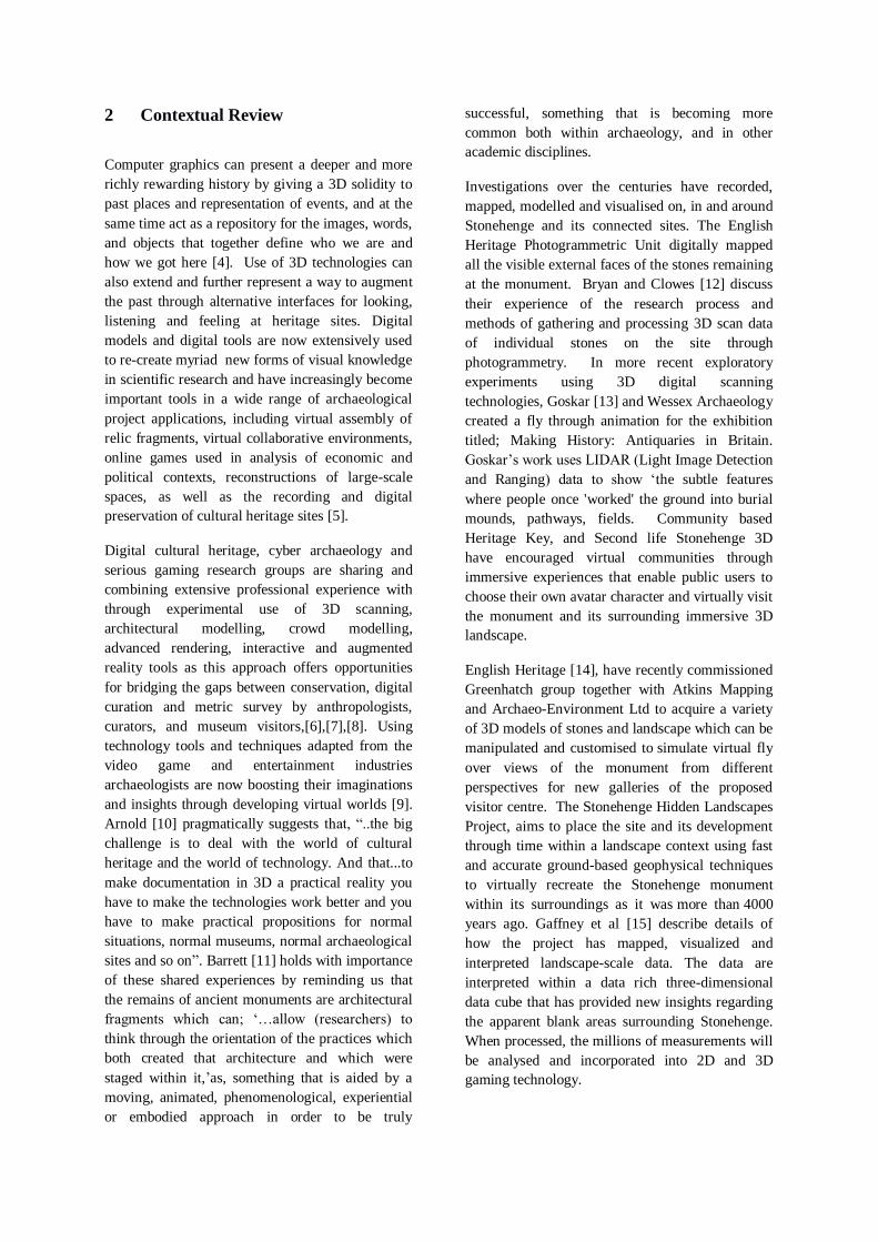
Fig. 8. Lighting, renderings, and shadows
4.3 Visual Effects
The Visual effects (VFX) are the various processes
where imagery is manipulated to create
environments which look authentic or naturalistic.
Visual and environmental physical effects were
introduced to enhance the animations and to help to
represent how Stonehenge phase 3vi might have
been used during a ritual ceremony. Figure 9 and
10 show 3D particle effects. Particle effects tools
were tested for generating sizes and qualities of
fire. Parker Pearson et al [16] suggest that fire
would have been created as a heat and light source
for use in cooking and ritual ceremonies in
Stonehenge as large quantities of burnt and unburnt
human remains from Stonehenge. 3D physics tools
available in 3DStudio Max software enable fire,
smoke, rain and water to be simulated and
parameters modify accuracy of environmental
conditions for application to enhance evaluation or
visualisations.
Fig. 9. Fire and environmental effects
Fig. 10. Simulation of ritual fires
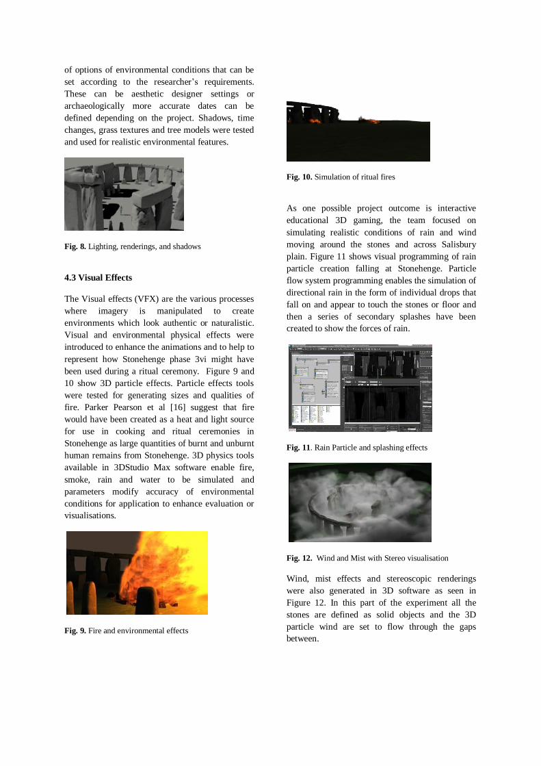
As one possible project outcome is interactive
educational 3D gaming, the team focused on
simulating realistic conditions of rain and wind
moving around the stones and across Salisbury
plain. Figure 11 shows visual programming of rain
particle creation falling at Stonehenge. Particle
flow system programming enables the simulation of
directional rain in the form of individual drops that
fall on and appear to touch the stones or floor and
then a series of secondary splashes have been
created to show the forces of rain.
Fig. 11. Rain Particle and splashing effects
Fig. 12. Wind and Mist with Stereo visualisation
Wind, mist effects and stereoscopic renderings
were also generated in 3D software as seen in
Figure 12. In this part of the experiment all the
stones are defined as solid objects and the 3D
particle wind are set to flow through the gaps
between.
5 Interactive 3D applications
In earlier stages of the acoustic experimental
research work, Till [17] sourced a basic digital
model of Stonehenge from Imigea digital modelling
company for initial acoustic tests in Odeon room
simulation software shown in Figure 13.
Fig. 13. Sound analysis in Odeon software.
During this current phase of the research;
experiments involved stages of 3D processing of
the photogrammetric scanned stone files sourced
from the English Heritage Archive and modelling
on a LIDAR landscape as discussed in sections 3
and 4. With the structure of the Stonehenge model
completed the team felt confident that the further
work being carried out was now structurally and
naturalistically realistic and therefore had the
potential to produce a virtual 3D model of
Stonehenge for use in much more detailed acoustic
experiments, virtual exhibitions and for interactive
heritage learning applications.
To test the model in interactive environments, the
stones were transferred to two different 3D virtual
interactive environments (Unity 3D and Cry
Engine) for evaluating experiential interactivity and
further potential for heritage game development. In
these environments the visitor can walk around 3D
Stonehenge, navigate using basic keyboard, mouse
or joystick interactions and can virtually experience
surface materials, lighting and other environmental
conditions. 3D human characters were added to the
environment for testing user interaction. The
Crytek game engine was used to create virtual
environment for heritage gameplay as shown in
Figure 10. Crytek features a vast number of tools
for creating environments and character editing
tools and AI programming.
Fig. 14. Stonehege 3D model in Crytek Game Engine
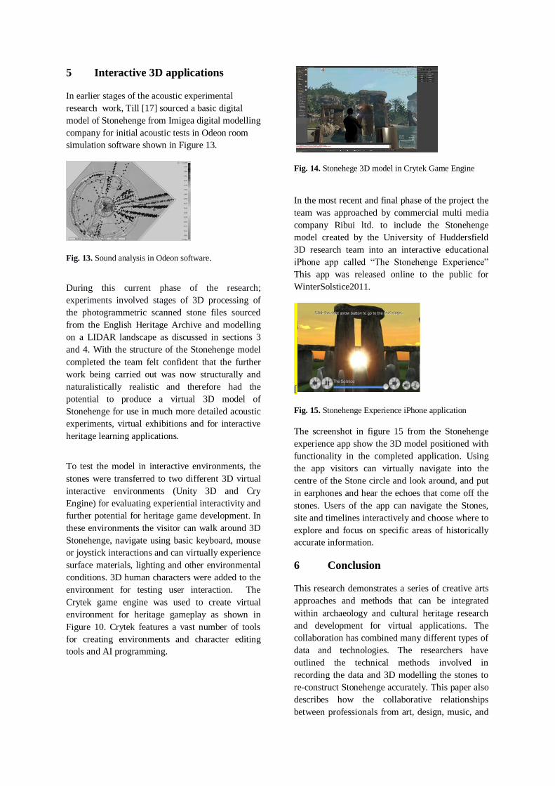
In the most recent and final phase of the project the
team was approached by commercial multi media
company Ribui ltd. to include the Stonehenge
model created by the University of Huddersfield
3D research team into an interactive educational
iPhone app called “The Stonehenge Experience”
This app was released online to the public for
WinterSolstice2011.
[
Fig. 15. Stonehenge Experience iPhone application
The screenshot in figure 15 from the Stonehenge
experience app show the 3D model positioned with
functionality in the completed application. Using
the app visitors can virtually navigate into the
centre of the Stone circle and look around, and put
in earphones and hear the echoes that come off the
stones. Users of the app can navigate the Stones,
site and timelines interactively and choose where to
explore and focus on specific areas of historically
accurate information.
6 Conclusion
This research demonstrates a series of creative arts
approaches and methods that can be integrated
within archaeology and cultural heritage research
and development for virtual applications. The
collaboration has combined many different types of
data and technologies. The researchers have
outlined the technical methods involved in
recording the data and 3D modelling the stones to
re-construct Stonehenge accurately. This paper also
describes how the collaborative relationships
between professionals from art, design, music, and

other related subjects have evolved through practice
based approach by using the same data differently
across different disciplines. The research has shown
how visual artists and designers can contribute
unique insight, experiences and skills to further
improve the ways in which archaeologists bring the
sites and past activities to life for contemporary
audiences and public exhibition which increasingly
expects a more active visually rich content.
The world is changing and expanding through
immersive experience with technologies, and also
advancing through interdisciplinary research being
responsible for transforming the boundaries of
traditional science, arts, and humanities disciplines.
The pervasiveness of high quality experiential
gaming will inevitably increase cultural
expectations for direct engagement for interacting
with emerging 3D technologies which are widely
available and used for entertainment at home such
as PlayStation PS3, Xbox 360 3D games. The
natural evolution of this cultural phenomenon
surely must encourage further support for
enhancements in online exhibitions, virtual heritage
experiences, and interdisciplinary research.
References
1. Gaffney, V, in Wuyts, A (2010) The Stonehenge
Hidden Landscapes Project: Virtual Excavation &
Digital Recreation, http://heritage-
key.com/blogs/ann/stonehenge-hidden-landscapes-
project-virtual-excavation-digital-recreation
2. English Heritage National Monuments Record;
http://www.englishheritage.org.uk/professional/arch
ives-and-collections/nmr/
3. Ambpnetwork,http://ambpnetwork.wordpress.com
4. Sanders,D.H. Why do Virtual Heritage?
Archaeology.http://www.archaeology.org/online/fea
tures/virtualheritage/
5. Gill, A.A.Digitizing the Past: Charting New Courses
in the Modeling of Virtual Landscapes. Visual
Resources 25(4): pp.313-332. (2009)
6. Hess, M., Were, G., Brown, I., MacDonald, S. &
Simon Millar, F. E-Curator: A 3D Web-based
Archive for Conservators and Curators. Ariadne
Issue 60. http://www.ariadne.ac.uk/issue60/hess-et-
al/
7. Anderson, E.F., McLoughlin,L., Liarokapis, F.,Peters, C., Petridis,P.,de Freitas,S: Serious games
in cultural heritage, The 10th International Symposium on Virtual Reality, Archaeology and Cultural Heritage VAST - State of the Art Reports (2009).
8. Foni, A., G. P., N. Magnenat-Thalmann; A Virtual
Heritage Case Study_ A Modern Approach to the
Revival of Ancient Historical or Archeological
Sites." MIRALab, University of Geneva. (2003)
9. Bawaya, M; Virtual Archaeologists Recreate Parts
of Ancient Worlds, Science, Vol. 327. pp.140-
141.(2010).
10. Arnold, D, in ; Arnold, D., Coulié, A., Kolin,D.,
Geert, W, European Commision Research &
Innovation) Cultural heritage - a newdimension.
(2012)http://ec.europa.eu/research/infocentre/article
_en.
11. Barrett, J. Fragments From Antiquity: An
Archaeology of Social Life in Britain, 2900 – 1200
BC, Oxford. (1994).
12. Bryan, P. G. Clowes M. Surveying Stonehenge By
Photogrammetry, The Photogrammetric Record,
Volume 15, Issue 89, pages 739-751. (1997).
13. Goskar, T. (2007). The Stonehenge Landscape in
3D. http://www.wessexarch.co.uk/blogs/
14. English Heritage (2011), 3D Stonehenge Model
Unveiled,http://www.englishheritage.org.uk/about/n
ews/3d-stonehenge-model-unveiled/
15. Gaffney, C., Gaffney, V., Neubauer, W., Baldwin,
E., Chapman, H., Garwood, P., Moulden, H.,
Sparrow, T., Bates, R., Löcker, K., Hinterleitner, A.,
Trinks, I., Nau, E., Zitz, T., Floery, S., Verhoeven,
G. and Doneus, M. The Stonehenge Hidden
Landscapes Project. Archaeol. Prospect.. doi:
10.1002/arp.1422. (2012),
16. Parker Pearson, M, Cleal, R, Pollard, J, Richards,
C,Thomas,J, Tilley,C, Welham, K, Chamberlain,A,
Chenery,C, Evans,J, Montgomery, J & Richards,
M., The Age of Stonehenge. (2007).
http://nora.nerc.ac.uk/9174/1/Age_of_Stonehenge_
Antiquity-2.pdf
17. Till, Rupert Songs of the Stones: an investigation
into the musical history and culture of Stonehenge.
International Association for the Study of Popular
Music Journal, 1 (2). pp. 1-18. (2010)
Acknowledgements
The research team acknowledges the support and
contributions in this research project of: English
Heritage, Geomatics, University of Huddersfield, Dr.
Rupert Till, & Dan Hughes MA 3D Digital Design.


![Stonehenge: Partial differential equations of mathematical physics (Bauman Moscow State Technical University). [in Russian and Latvian]](https://img.dokumen.tips/doc/110x75/63546d008db8416a940e253a/stonehenge-partial-differential-equations-of-mathematical-physics-bauman-moscow.jpg)


