Embed Size (px)
Citation preview
Initial Environmental Examination (IEE) Project Number: 44328-013 Loan: 3289
CAM: UPLANDS IRRIGATION AND WATER RESOURCES MANAGEMENT SECTOR PROJECT (UIWRMSP)
(MOWRAM-CW05) – O’ Kra Nahk Irrigation System
Part 1
July 2018
Prepared by Ministry of Water Resources and Meteorology, the Kingdom of Cambodia for the Asian Development Bank. This Initial Environmental Examination (IEE) is a document of the borrower. The views expressed herein do not necessarily represent those of ADB's Board of Directors, Management, or staff, and may be preliminary in nature. In preparing any country program or strategy, financing any project, or by making any designation of or reference to a particular territory or geographic area in this document, the Asian Development Bank does not intend to make any judgments as to the legal or other status of any territory or area.
UIWRMSP_ OKN Sub-Project (CW-05) _IEE Page | 2
Project Name: Uplands Irrigation and Water Resources Management Sector Project, Cambodia (ADB LOAN 3289-CAM) Project Management and Implementation Consultant
Report Name: Initial Environmental Examination (IEE) of O’Kra Nahk Irrigation System
PREPARATION, REVIEW, AND APPROVAL
Prepared by: Ms. Sao Sambatmorakath Signature:
Position: Environment Specialist/PMIC Date:
Reviewed by: Mr. Ung Kotaro Signature:
Position: Deputy Team Leader/PMIC Date:
Approved by: Mr. Keo Sovathapheap Signature:
Position: Safeguard Officer/PMU Date:
ISSUE REGISTER
Distribution List Date Issued No. of Copies
Project Management Unit – PMU Office
Asian Development Bank, Cambodia
Project Management and Implementation Consultant – PMIC Office
UIWRMSP_ OKN Sub-Project (CW-05) _IEE Page | 3
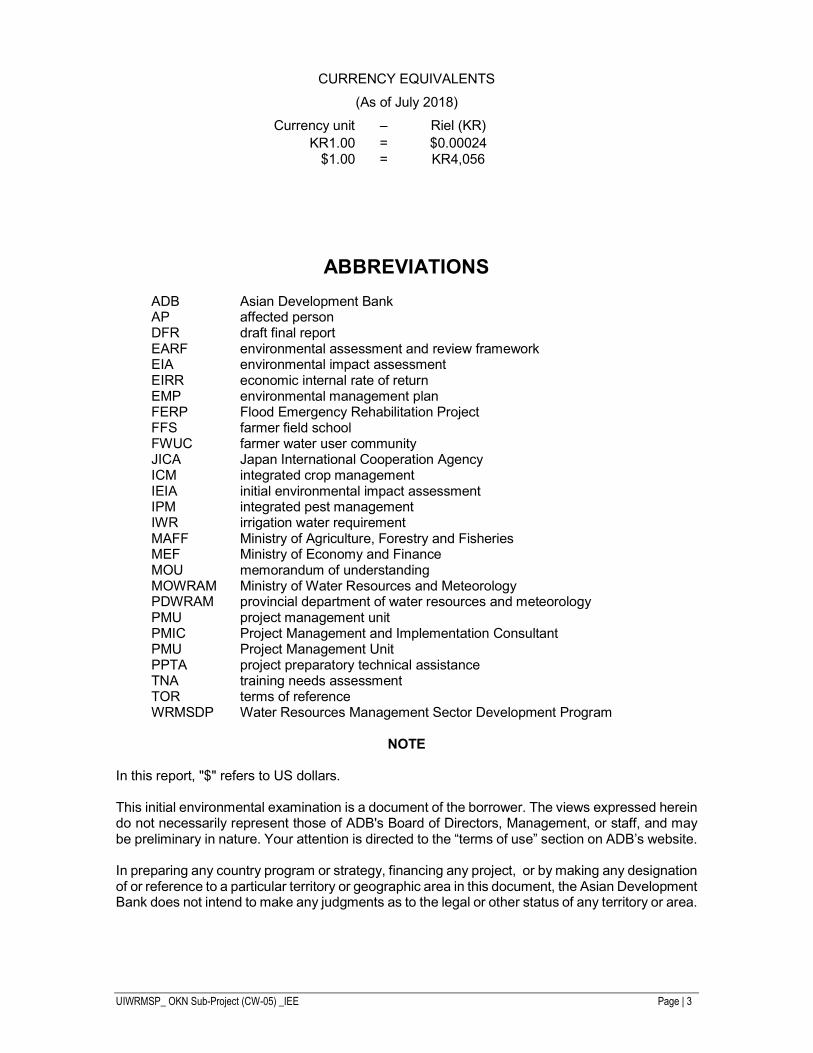
CURRENCY EQUIVALENTS
(As of July 2018)
Currency unit – Riel (KR) KR1.00 = $0.00024
$1.00 = KR4,056
ABBREVIATIONS
ADB Asian Development Bank AP affected person DFR draft final report EARF environmental assessment and review framework EIA environmental impact assessment EIRR economic internal rate of return EMP environmental management plan FERP Flood Emergency Rehabilitation Project FFS farmer field school FWUC farmer water user community JICA Japan International Cooperation Agency ICM integrated crop management IEIA initial environmental impact assessment IPM integrated pest management IWR irrigation water requirement MAFF Ministry of Agriculture, Forestry and Fisheries MEF Ministry of Economy and Finance MOU memorandum of understanding MOWRAM Ministry of Water Resources and Meteorology PDWRAM provincial department of water resources and meteorology PMU project management unit PMIC Project Management and Implementation Consultant PMU Project Management Unit PPTA project preparatory technical assistance TNA training needs assessment TOR terms of reference WRMSDP Water Resources Management Sector Development Program
NOTE
In this report, "$" refers to US dollars. This initial environmental examination is a document of the borrower. The views expressed herein do not necessarily represent those of ADB's Board of Directors, Management, or staff, and may be preliminary in nature. Your attention is directed to the “terms of use” section on ADB’s website. In preparing any country program or strategy, financing any project, or by making any designation of or reference to a particular territory or geographic area in this document, the Asian Development Bank does not intend to make any judgments as to the legal or other status of any territory or area.
UIWRMSP_ OKN Sub-Project (CW-05) _IEE Page | 4
TABLE OF CONTENT
ABBREVIATIONS ..................................................................................................................... 3 TABLE OF CONTENT ............................................................................................................... 4 LIST OF FIGURES .................................................................................................................... 6 LIST OF TABLE ........................................................................................................................ 7 EXECUTIVE SUMMARY ........................................................................................................... 8
Background .................................................................................................................... 8 Project Components ....................................................................................................... 8 The IEE Report ........................................................................................................... 8 Assessment Findings .................................................................................................. 9 Mitigation Measures...................................................................................................... 10 Environmental Management Plan ................................................................................. 10
I. INTRODUCTION .................................................................................................................. 11 II. LEGAL AND ADMINISTRATIVE FRAMEWORK ................................................................. 12
ADB Environmental Requirements ............................................................................... 12 Public disclosure. .......................................................................................................... 12 Government Environmental Regulations ................................................................... 12 Evaluation Standards ................................................................................................ 13 1. Law on the Management of Pesticides and Fertilizers ............................................... 13 2. Law on Water Resources Management .................................................................... 14 3. Water Pollution Control Sub-decree .......................................................................... 14 4. Drinking Water Quality Standards ............................................................................. 15 5. Solid waste management sub-decree ....................................................................... 15 6. Air Pollution Control Sub-decree ............................................................................... 15 7. Silt/Sediment Quality ................................................................................................. 17 8. National Integrated Pest Management Program ........................................................ 17 Environmental, Health and Safety Guidelines ............................................................... 17
III. DESCRIPTION OF THE PROJECT COMPONENTS ......................................................... 19 Overall Project .............................................................................................................. 19 O Kra Nhak Schemes ................................................................................................... 19 Subproject Components ............................................................................................ 23 1. Specifications of Work ............................................................................................... 23 2. Command Areas ....................................................................................................... 23
Project Implementation ................................................................................................. 24 IV. DESCRIPTION OF THE ENVIRONMENT ......................................................................... 26
A. Physical Environment ................................................................................................... 26 B. Biological Environment ................................................................................................. 31
1. Land Use, Vegetation and Forest .............................................................................. 31 2. Fisheries ................................................................................................................... 33 3. Protected Areas ........................................................................................................ 34 4. Community Forestry in Kampong Thom .................................................................... 35
C. Socio-economic Environment/Development .............................................................. 36 1. Agricultural Practice .................................................................................................. 36 2. Human and Economic development .......................................................................... 38 3. Floods and Extreme Weather Events ........................................................................ 39 4. Climate Change Scenarios ........................................................................................ 39
V. ANTICIPATED ENVIRONMENTAL IMPACTS AND MITIGATION MEASURES ................. 42 Positive Impact and Environmental Benefits ................................................................. 42 Environmental Measures during Pre-Construction Phase ............................................. 42 Impacts and Mitigation Measures during the Construction Phase ............................. 42 1. Contractor Performance and Site Management ........................................................ 42 2. Construction .............................................................................................................. 43 Environmental Impact and Mitigation Measures during Operation ............................. 45 1. Hydrological Impacts ................................................................................................. 45 2. Impacts from Intensification of Agriculture ................................................................. 45 3. Water User Conflict ................................................................................................... 45
UIWRMSP_ OKN Sub-Project (CW-05) _IEE Page | 5
4. Chemical Fertilizer Use ............................................................................................. 46 Environmental Health and Safety.................................................................................. 46 Unanticipated Impacts during Construction and Operation ........................................... 46 Climate Change Impact Assessment......................................................................... 46 1. Greenhouse Gas Emissions ...................................................................................... 47 2. Adaptation to Future Climate Change ....................................................................... 47
VI. INFORMATION DISCLOSURE, CONSULTATION AND INSTITUTIONAL ARRANGEMENT ................................................................................................................................................ 54
Consultation and Participation Process......................................................................... 54 Project Responses ....................................................................................................... 54 Institutional Arrangement .............................................................................................. 55
VII. GRIEVANCE REDRESS MECHANISM ............................................................................ 58 Proposed Mechanism ................................................................................................... 58 GRM Procedure and Timeframe ................................................................................... 58
VIII. CONCLUSION AND ASSURANCES ............................................................................... 61 Positive Impact and Environmental Benefits ................................................................. 61 Negative Impacts .......................................................................................................... 61 Assurances ................................................................................................................... 61 Conclusion .................................................................................................................... 61
Appendix 1: Environmental Management Plan ........................................................................ 63 Introduction ................................................................................................................... 63 Responsibilities for Implementation .............................................................................. 63 Summary of Potential Impacts ...................................................................................... 64 C1. Mitigation Measures .............................................................................................. 64 C2. Environmental Management Costs ........................................................................ 71 Environmental Monitoring ............................................................................................. 71 Training Program .......................................................................................................... 71
Appendix 2: Result of Soil Quality Test ................................................................................... 72 Appendix 3: Result of Surface Water and Ground Water Quality Test ..................................... 77 Appendix 4: Rapid Environmental Assessment (REA) Checklist ............................................. 79 Appendix 5: Climate Risk Assessment .................................................................................... 83 Appendix 6: List of Participants during Public Consultation ................................................... 104
UIWRMSP_ OKN Sub-Project (CW-05) _IEE Page | 6
LIST OF FIGURES
Figure 1: Location of O Kra Nahk Core Subproject .................................................................. 19
Figure 2: Existing O Kra Nahk Scheme Showing Main Canal and Irrigation Communes ......... 21
Figure 3: Layout of O Kra Nhak Irrigation System ................................................................... 22
Figure 4: Soil Quality Sampling Station ................................................................................... 27
Figure 5: Water Resources System, OKN System .................................................................. 28
Figure 6: Flow measurement point during field trip on 28 April 2016 at 2h40’PM .................... 29
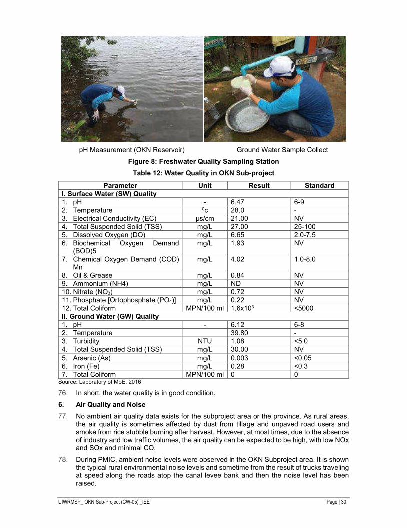
Figure 7: Watershed and Digital Elevation Model for Okranhak ............................................... 29
Figure 8: Freshwater Quality Sampling Station ....................................................................... 30
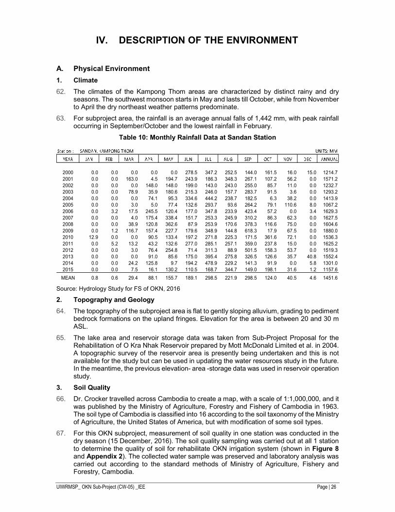
Figure 9: Map of Main Land Use in Sandan District, Kampong Thom Province ....................... 32
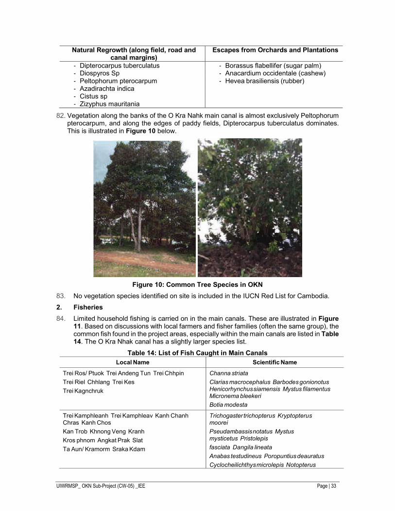
Figure 10: Common Tree Species in OKN .............................................................................. 33
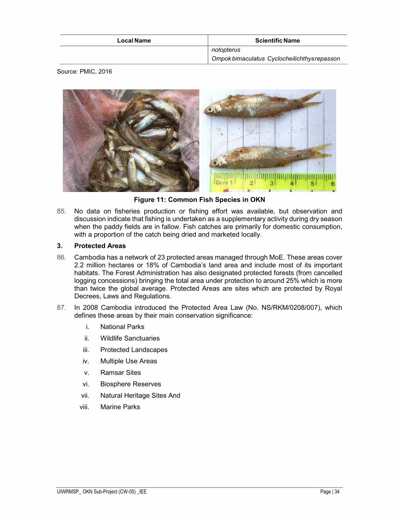
Figure 11: Common Fish Species in OKN ............................................................................... 34
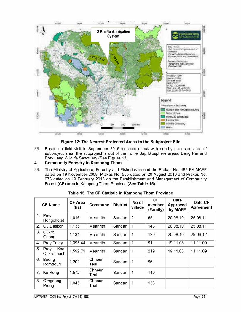
Figure 12: The Nearest Protected Areas to the Subproject Site .............................................. 35
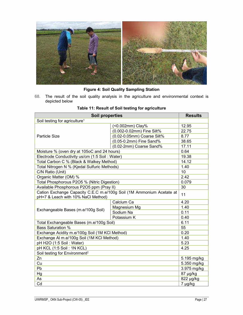
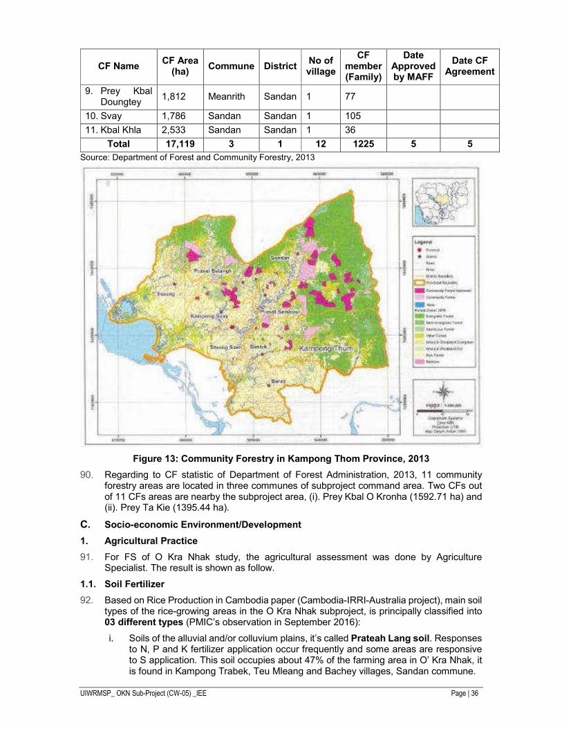
Figure 13: Community Forestry in Kampong Thom Province, 2013 ......................................... 36
Figure 14: Low Rainfall Probability Analysis ............................................................................ 40
Figure 15: List of Potential Natural Hazards ............................................................................ 40
Figure 16: Comparison of SRES and RCP Future CO2 Emission ............................................ 48
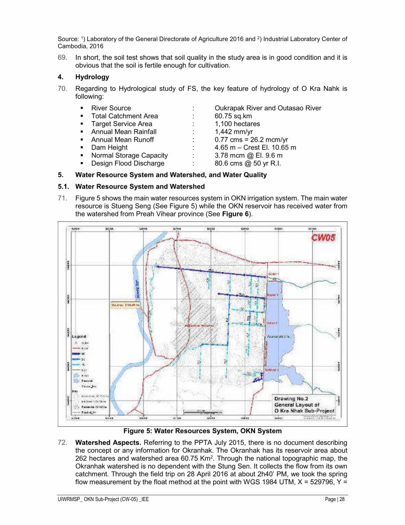
Figure 17: Plotting of Mean Monthly Historical and Climate Change Rainfall Data in MM. ....... 49
Figure 18: Photo of Public Meeting for OKN ............................................................................ 55
Figure 19: Concept of Proposed GRM .................................................................................... 60
UIWRMSP_ OKN Sub-Project (CW-05) _IEE Page | 7
LIST OF TABLE
Table 1: List of Projects Requiring an IEIA or EIA ................................................................... 13
Table 2: Water Quality Standard in Public Water Areas for Biodiversity Conservation............. 14
Table 3: Drinking Water Standards .......................................................................................... 15
Table 4: Ambient Air Quality Standard a .................................................................................. 16
Table 5: Maximum Permitted Noise Level in Public and Residential Area (dB ( A)) ................. 16
Table 6: Maximum Permitted Noise Level in Public and Residential Area (dB ( A)) ................... 16
Table 7: Summary of Subproject Structures, Works and Equipment – O Kra Nhak Subproject 23
Table 8: Administrative Scope and Coverage of O Kra Nhak Subproject................................. 23
Table 9: Increases in Irrigated Areas as a Result of the Project .............................................. 24
Table 10: Monthly Rainfall Data at Sandan Station ................................................................. 26
Table 11: Result of Soil testing for agriculture ......................................................................... 27
Table 12: Water Quality in OKN Sub-project ........................................................................... 30
Table 13: Land Tenure Arrangement ....................................................................................... 31
Table 14: List of Fish Caught in Main Canals .......................................................................... 33
Table 15: The CF Statistic in Kampong Thom Province .......................................................... 35
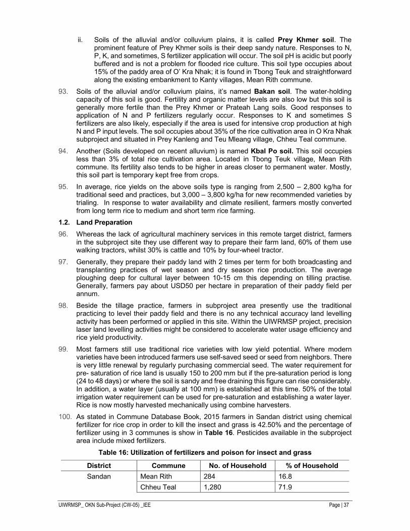
Table 16: Utilization of fertilizers and poison for insect and grass ............................................ 37
Table 17: Subproject Land Area for Agriculture Purpose ......................................................... 38
Table 18: Impact of flooding (18 October 2013)....................................................................... 39
Table 19: Affected and Evacuated Families in 2013 and 2011 (Kampong Thom Province) ..... 39
Table 20: ADB Preliminary Climate Screening Tool ................................................................ 41
Table 21: Construction Equipment Noise Impact Distance ...................................................... 44
Table 22: GHG Emissions from Rice Paddy ............................................................................ 47
Table 23: GHG Emissions and GWP from Rice Paddy Increases .......................................... 47
Table 24: Annual Rainfall for Projection Period 2020-2049 ..................................................... 48
Table 25: Monthly Mean Historical and Climate Change Rainfall Data in Millimeters .............. 49
Table 26: 1-day Probable Maximum Rainfall in Millimeters ..................................................... 50
Table 27: Institutional Roles and Responsibilities in EMP Implementation .............................. 56
Table A1.27: Summary of Potential Impacts and Mitigation Measures ................................... 65
UIWRMSP_ OKN Sub-Project (CW-05) _IEE Page | 8
EXECUTIVE SUMMARY Background
The overall goal of the proposed Uplands Irrigation and Water Resources Management Sector Project is to assist the Government of Cambodia to improve the management and governance of existing irrigation systems, increase agricultural production, and improve the productivity of subproject areas with the aim to increase the incomes of poor farmers. The project will focus on increased efficiency of irrigation systems and improved management of water resources in the uplands areas away from the Tonle Sap.
Project Components
The specifications of the proposed subprojects, which are subject to this initial environment examination (IEE), comprise works to:
- Main Embankment: Backfill of potholes/ruts, leveling and provision of laterite
- Secondary Embankment: Repair of existing control gate, leveling, and provision of laterite, extend by 300 m, and construct one control structure
- Outlet No.1: Repair downstream, upstream slabs, construct stilling basin downstream, replace gates and hand rails, repair downstream & upstream protection
- Outlet No.2: Repair downstream, upstream slabs, construct stilling basin downstream, replace gates and hand rails, repair downstream & upstream protection
- Outlet No.3: Repair lifting mechanism, repaint and lubricate gate, repair concrete channel downstream.
- Spillway: Repair cut-off walls and gates, construct stilling basin, install gate valve for irrigation and environment flow, repair control structure downstream.
- MC-1: Rehabilitate embankment with road & laterite, construct structures – 3 checks, 12 outlets, construct 3 TC, 1 tail escape
- MC-2: Rehabilitate embankment with road & laterite, construct structure – 2 checks, 1 check/drop, 2 outlets to SC, 2 outlets to TC, 1 tail escape
o SC-1: Rehabilitate embankment with road & laterite, construct structures – 4 outlets to TC, and construct four TCs, 5 tails escape.
o SC-2: Rehabilitate embankment with road & laterite, construct structures – 4 outlets to TC, 1 tail escape.
- MC-3: Rehabilitate embankment with road & laterite, construct structures – 1 check, 2 outlets, and 1 tail escape.
- Drainage creek: Clear and dredge – about 700 m.
The IEE Report
The objectives of the IEE report are to:
i. Describe the existing natural and socio-economical resources in and surrounding the project area;
ii. Identify and assess potential significant impacts based on existing environmental conditions including during project pre-construction, construction, and operation and maintenance (O&M) stages;
iii. Identify and recommend mitigation measures to minimize any potential impacts caused by project activities;
iv. Undertake public consultation to present subproject environmental issues to project stakeholders and local people of the subprojects’ areas and to collect community concerns; and
UIWRMSP_ OKN Sub-Project (CW-05) _IEE Page | 9
v. Develop an Environmental Management Plan (EMP) with cost estimates, and including monitoring plans during construction and operation stages to guide subproject implementation.
The IEE was prepared following the ADB Safeguard Policy Statement (SPS) (2009), the 2003 ADB Environmental Assessment Guidelines, the ADB Environmental Guidelines for Selected Irrigation and Drainage Development Projects and relevant environmental policies and guidelines of the government.
The project is classified under ADB guidelines/rules as a Category B. Such projects are judged to have some adverse environmental impacts most is occurring during construction phase, but of lesser degree and/or significance than those for category “A” projects. An IEE is required to determine whether or not significant environmental impacts warranting an Environmental Impact Assessment (EIA) are likely. If an EIA is not needed, the IEE is regarded as the final environmental assessment report.
Since the subprojects involve the refurbishment of existing irrigation schemes, they do not require EIA under Government Sub-decree No. 72 ANRK.BK. However, where the command area is substantially expanded by the refurbishment of a scheme to provide more than 5,000 hectares (ha) of newly irrigated land or land previously without reliable irrigation, the provisions of the sub-decree will apply. In the case of the subproject which is not the subjects of this IEE, the increase in reliably irrigated land will be in the order of 1,430ha. This IEE will not be forwarded to the Ministry of Environment (MoE). Therefore, the Ministry of Water Resources and Meteorology (MOWRAM), the project’s executing agency, will only submit the IEE to ADB for approval.
The subproject which is the subject of this IEE has been chosen using a set of selection criteria. Although these criteria did not include specific environmental impact issues, the subproject when applied had the effect of selecting for relatively straightforward scheme without significant environmental impacts. These were:
i. Subproject should not cause involuntary resettlement and should require as less land acquisition as possible. Subproject should not be a Category “A” and should be a maximum of Category “B” for Involuntary Resettlement and Environment, and Category “C” for Indigenous Peoples.
ii. Irrigation system has low irrigation efficiency and water productivity, and would have scope for substantial enhancement of both irrigation efficiency and water productivity;
iii. Subproject should involve only rehabilitation of the existing systems or related schemes and should not involve construction of new systems;
iv. Subproject should be located outside the Tonle Sap basin;
v. Subproject should involve rehabilitation of both primary and secondary canals to ensure that water reached the farm;
vi. Subproject should not be covered by other ongoing or proposed projects financed by ADB or any other Development Partner;
vii. Beneficiaries should include sharecroppers, poor farmers, and women farmers; and
viii. Subproject should be economically viable; and technically, socially and environmentally feasible. The Economic Internal Rate of Return (EIRR) of each subproject should be greater than 12%.
Assessment Findings
During construction, the main issues will be air and water pollution and soil erosion, all of which must be managed by strict control of construction contractors. Additional localized traffic congestion is anticipated and this must be minimized by responsible transport planning. Health and safety of construction workers is also, as always, a primary concern.
Post-construction, the main concerns are local increases in the levels of agricultural fertilizer and pesticide residues and their effects on water quality and people. Post-
UIWRMSP_ OKN Sub-Project (CW-05) _IEE Page | 10
construction mitigation will benefit from capacity building and training under the project to use fertilizers and pesticides efficiently and responsibly.
There is also a concern that the irrigation schemes must be sustainable and responsibly managed, to ensure that agreed irrigation flows are maintained and other water users are not disadvantaged. The EMP requires a clear and detailed extraction plan for the dry season to be prepared and submitted before construction.
Greenhouse gas emissions from the increased area of paddy as a result of the subprojects total approximately 3,034 tons/year, which is below the threshold of 100,000 tons/year and requires no further monitoring under ADB’s SPS (2009).
Additionally, the initial rapid environmental assessment (REA) for the project identified a medium climate risk. Therefore, the climate risk and vulnerability assessment (CRVA) which was prepared during project preparation stage and the impact assessment.
Mitigation Measures
Measures to mitigate the above are provided through prior design of infrastructure and also by the rigorous application of social safeguards in the form of resettlement plans (RPs) and an ethnic minority development plan (EMDP).
Mitigation of construction-phase impacts relies heavily on responsibility of works contractors to follow specification clauses specifically designed to minimize pollution of air and water and soil erosion. This mitigation will in turn rely on enforcement by the environmental and social management officer in each provincial project management unit and also by construction supervision consultants.
Post-construction mitigation will benefit from capacity building and training under the project to use fertilizers and pesticides efficiently and responsibly.
Environmental Management Plan
The IEE includes an EMP where the identified environmental impacts and mitigation measures are transformed into an action plan for their implementation. The plan includes methods of mitigation, responsibilities, indicators of progress, and frequency and nature of monitoring activities with cost estimates.
The EMP is a critical document for each subproject. The provisions of the EMP will be incorporated into tender documents and construction contracts.
UIWRMSP_ OKN Sub-Project (CW-05) _IEE Page | 11
I. INTRODUCTION
Under Output 1 of the Upland Irrigation and Water Resources Management Sector Project (UIWRMSP), identified non-core subprojects are to be subjected to feasibility study (FS) to assess their viability. The O Kra Nhak (OKN) subproject is one of these non-core subprojects proposed for rehabilitation and upgrading of facilities. The OKN subproject is located in Sandan District, Kampong Thom Province, about 247 km from Phnom Penh. The present irrigation system covers about 800 hectares (ha) with a potential to expand to 1,134 hectares (ha). The water sources of OKN system are two small tributaries with a combined catchment area of 60.7 sq km. The OKN irrigation system consists of an earth embankment dam and a distribution canal system. The reservoir has three gated outlets leading to the three main canals. A smaller fourth outlet is incorporated in one spillway gate, feeding one secondary canal.
The OKN irrigation system was constructed in 1977 and operated for some time. In the year 2000, the irrigation system was damaged by a major flood and was proposed for rehabilitation under the Flood Emergency Rehabilitation Project (FERP) in 2004. However, since the completion of the major works under FERP, no significant improvement works have been undertaken, and the irrigation facilities have deteriorated from inadequate repair and maintenance.
The main purpose of this initial environmental examination (IEE) is to provide an assessment of environmental concerns that need to be undertaken in regard to rehabilitate the existing irrigation structures of O Kra Nhak.
The OKN sub-project of UIWRMSP is categorized as environmental category B and the initial environmental examination (IEE) has been prepared. IEE was prepared in accordance with the ADB’s Environment Assessment Guideline (2003).
The IEE provides an assessment of the activities to be carried out under the proposed project, with the intention of identifying potentially significant environmental impacts, and determining appropriate mitigation measures.
UIWRMSP_ OKN Sub-Project (CW-05) _IEE Page | 12
II. LEGAL AND ADMINISTRATIVE FRAMEWORK
This IEE has been prepared for O Kra Nhak subproject of the Uplands Irrigation and Water Resources Management Sector Project in the Kingdom of Cambodia. It has been designed to satisfy both ADB and relevant Cambodian environmental guidelines and regulations.
ADB Environmental Requirements
A safeguard policy statement (SPS) describes common objectives of ADB’s safeguards, lays out policy principles, and outlines the delivery process for ADB’s safeguard policy. The SPS is designed for application to current and future lending modalities and caters to the varying capacities and needs of DMC clients in both the public and private sectors.
On the basis of subproject screening by using a rapid environmental assessment (REA) checklist, the subproject is to be category B for environmental impact. This category entails environmental impacts that can be mitigated. This consolidated IEE has been prepared under the provisions of the ADB’s SPS (2009) which requires a number of critical considerations, including:
i. Project level grievance redress mechanism, including documentation in the EMP;
ii. Physical cultural resources damage prevention analysis;
iii. Climate change mitigation and adaptation;
iv. Occupational and community health and safety requirements, including emergency preparedness and response;
v. Economic displacement that is not part of land acquisition;
vi. Meaningful consultation and participation; and
vii. An EMP which comprises implementation schedule and (measurable) performance indicators.
Relevant ADB environmental policies and guidelines used in the preparation of this IEE are:
i. Safeguard Policy Statement – SPS (2009);
ii. Operation Manual Bank Policies (BP) on SPS (2009);
iii. Environment Policy of the Asian Development Bank (2002);
iv. Environmental Assessment Guidelines (2003) – Appendix 3: Content and Format Initial Environmental Examination (IEE);
v. Environmental Guidelines for Selected Agricultural and Natural Resources Development Projects (November 1991); and
vi. Rapid Environmental Checklist (2013) for Irrigation project.
Public disclosure.
ADB will post the below safeguard documents on its website as well as disclose relevant information in accessible manner in local communities.
i. Final or updated IEE and EMP upon receipt, and
ii. Environmental monitoring report submitted for the project.
Government Environmental Regulations
1. Law on Environmental Protection and Natural Resource Management
The Law on Environmental Protection and Natural Resources Management was enacted by the National Assembly and launched by the Preah Reach Kram/NS-RKM-1296/36. It was enacted on 24 December 1996. This law has the following objectives:
UIWRMSP_ OKN Sub-Project (CW-05) _IEE Page | 13
i. To protect and promote environment quality and public health through prevention, reduction and control of pollution;
ii. To assess the environmental impacts of all proposed projects prior to the issuance of a decision by the government;
iii. To ensure the rational and sustainable conservation, development, management and use of the natural resources of the Kingdom of Cambodia;
iv. To encourage and provide possibilities for the public to participate in the protection of environment and the management of the natural resources; and
v. To suppress any acts that cause harm to the environment.
Under this law the developers or project owners need to prepare an Initial Environmental Impact Assessment (IEIA) or a full EIA report for their proposed or existing development projects.
2. Environmental Impact Assessment Process Sub-decree
The Sub-decree No. 72 ANRK.BK in the Law on Environmental Impact Assessment Process dated 11 August 1999 sets out EIA procedures. The main objectives of this sub-decree are:
i. To determine an EIA for every private and public project or activity, through review by the MOE, prior to the submission for a decision from the government;
ii. To determine the type and size of the proposed project(s) and activities, including existing and ongoing activities in both private and public sector prior to undertaking the process of EIA; and
iii. To encourage public participation in the implementation of the EIA process and take into account their input and suggestions for reconsideration prior to the implementation of any project.
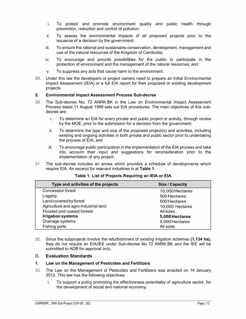
The sub-decree includes an annex which provides a schedule of developments which require EIA. An excerpt for relevant industries is at Table 1.
Table 1: List of Projects Requiring an IEIA or EIA
Type and activities of the projects Size / Capacity
Concession forest 10,000 Hectares Logging 500 Hectares Land covered by forest 500 Hectares Agriculture and agro-industrial land 10,000 Hectares Flooded and coastal forests All sizes Irrigation systems 5,000 Hectares Drainage systems 5,000 Hectares Fishing ports All sizes
Since the subprojects involve the refurbishment of existing irrigation schemes (1,134 ha), they do not require an EIA/IEE under Sub-decree No 72 ANRK.BK and the IEE will be submitted to ADB for approval only.
Evaluation Standards
1. Law on the Management of Pesticides and Fertilizers
The Law on the Management of Pesticides and Fertilizers was enacted on 14 January 2012. This law has the following objectives:
i. To support a policy promoting the effectiveness potentiality of agriculture sector, for the development of social and national economy;
UIWRMSP_ OKN Sub-Project (CW-05) _IEE Page | 14
ii. To ensure the safe and effective control of pesticides and fertilizers, whether in consistent with the international standards;
iii. To enhance public awareness on the implementation of standard requirements of pesticides and fertilizers for all relevant activities related to these products; and
iv. To reduce risks caused by the use of pesticides and fertilizers, for beneficiary of farmers and people in the nationwide, by ensuring food security, food safety, public health, and the sustainability of environment.
The scope of the law shall apply to the management and the implementation of standard requirements for:
i. All type of pesticides and fertilizers, raw materials or active ingredients and other compositions of pesticides and fertilizers which are used as inputs in agricultural production.
ii. All activities of natural persons or legal entities who are traders, formulators, pests control services operators, advertisers, donors, and users of all types of pesticides and fertilizers.
2. Law on Water Resources Management
The Law on Water Resources Management was adopted by the National Assembly on 22 May 2007. This law provides procedures for the management of water resources within Cambodia. The purpose of the law is to foster the effective management of the water resources of the Kingdom of Cambodia to attain socioeconomic development and the welfare of communities.
The law shall determine:
i. The rights and obligations of water users;
ii. The fundamental principles of water resources management;
iii. The institutions in charge of its implementation and enforcement; and
iv. The participation of users and their associations in the sustainable development of water resources.
Under this law, MOWRAM may declare any basin, sub-basin or aquifer as Water Law Implementation Area when within that basin, sub-basin, ground water or aquifer there are likely to be conflicts among water users, problems of water pollution or watershed degradation.
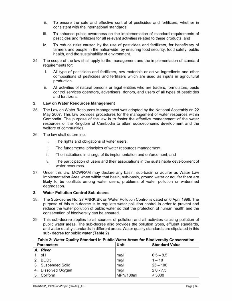
3. Water Pollution Control Sub-decree
The Sub-decree No. 27 ANRK.BK on Water Pollution Control is dated on 6 April 1999. The purpose of this sub-decree is to regulate water pollution control in order to prevent and reduce the water pollution of public water so that the protection of human health and the conservation of biodiversity can be ensured.
This sub-decree applies to all sources of pollution and all activities causing pollution of public water areas. The sub-decree also provides the pollution types, effluent standards, and water quality standards in different areas. Water quality standards are stipulated in this sub- decree for public water (Table 2)
Table 2: Water Quality Standard in Public Water Areas for Biodiversity Conservation
Parameters Unit Standard Value
A. River
1. pH mg/l 6.5 – 8.5
2. BOD5 mg/l 1 – 10
3. Suspended Solid mg/l 25 – 100
4. Dissolved Oxygen mg/l 2.0 - 7.5
5. Coliform MPN/100ml < 5000
UIWRMSP_ OKN Sub-Project (CW-05) _IEE Page | 15
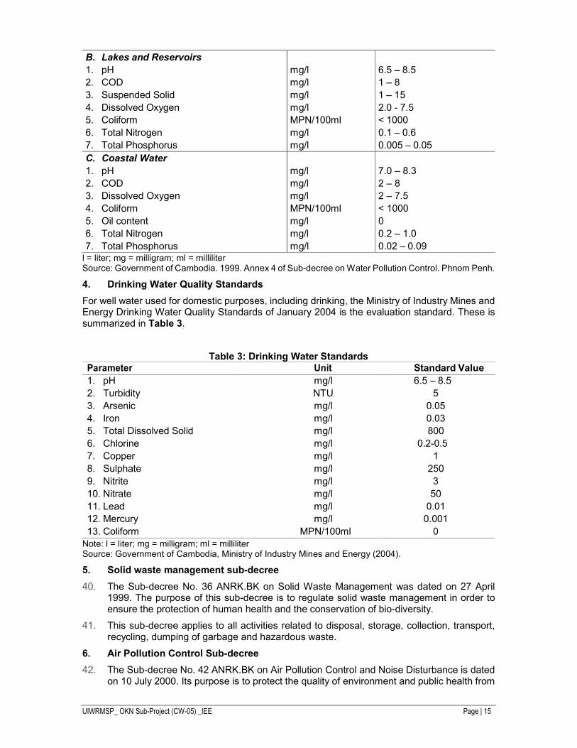
B. Lakes and Reservoirs
1. pH mg/l 6.5 – 8.5
2. COD mg/l 1 – 8
3. Suspended Solid mg/l 1 – 15
4. Dissolved Oxygen mg/l 2.0 - 7.5
5. Coliform MPN/100ml < 1000
6. Total Nitrogen mg/l 0.1 – 0.6
7. Total Phosphorus mg/l 0.005 – 0.05
C. Coastal Water
1. pH mg/l 7.0 – 8.3
2. COD mg/l 2 – 8
3. Dissolved Oxygen mg/l 2 – 7.5
4. Coliform MPN/100ml < 1000
5. Oil content mg/l 0
6. Total Nitrogen mg/l 0.2 – 1.0
7. Total Phosphorus mg/l 0.02 – 0.09 l = liter; mg = milligram; ml = milliliter Source: Government of Cambodia. 1999. Annex 4 of Sub-decree on Water Pollution Control. Phnom Penh.
4. Drinking Water Quality Standards
For well water used for domestic purposes, including drinking, the Ministry of Industry Mines and Energy Drinking Water Quality Standards of January 2004 is the evaluation standard. These is summarized in Table 3.
Table 3: Drinking Water Standards
Parameter Unit Standard Value
1. pH mg/l 6.5 – 8.5
2. Turbidity NTU 5
3. Arsenic mg/l 0.05
4. Iron mg/l 0.03
5. Total Dissolved Solid mg/l 800
6. Chlorine mg/l 0.2-0.5
7. Copper mg/l 1
8. Sulphate mg/l 250
9. Nitrite mg/l 3
10. Nitrate mg/l 50
11. Lead mg/l 0.01
12. Mercury mg/l 0.001
13. Coliform MPN/100ml 0 Note: l = liter; mg = milligram; ml = milliliter Source: Government of Cambodia, Ministry of Industry Mines and Energy (2004).
5. Solid waste management sub-decree
The Sub-decree No. 36 ANRK.BK on Solid Waste Management was dated on 27 April 1999. The purpose of this sub-decree is to regulate solid waste management in order to ensure the protection of human health and the conservation of bio-diversity.
This sub-decree applies to all activities related to disposal, storage, collection, transport, recycling, dumping of garbage and hazardous waste.
6. Air Pollution Control Sub-decree
The Sub-decree No. 42 ANRK.BK on Air Pollution Control and Noise Disturbance is dated on 10 July 2000. Its purpose is to protect the quality of environment and public health from
UIWRMSP_ OKN Sub-Project (CW-05) _IEE Page | 16
air pollutants and noise pollution (Table 4 and Table 5). This sub-decree applies to all movable sources and immovable sources of air and noise pollution.
Table 4: Ambient Air Quality Standard a
Parameters Period 1hr
average (mg/m3)
Period 8hrs average (mg/m3)
Period 24hrs average (mg/m3)
Period 1year average (mg/m3)
1. Carbon Monoxide (CO) 40 20 - -
2. Nitrogen Dioxide (NO2) 0.3 - 0.1 -
3. Sulfur Dioxide (SO2) 0.5 - 0.3 0.1
4. Ozone (O3) 0.2 - - -
5. Lead (Pb) - - 0.005 -
6. Total Suspended Particles (TSP) - - 0.33 0.1
Note: - hr = hours, m3=cubic meters, mg = milligram - a This standard applied to evaluation of ambient air quality and to monitoring of air pollution status.
Source: Government of Cambodia. 2000. Annex 1 of Sub-decree on Air Pollution Control and Noise Disturbance.
Table 5: Maximum Permitted Noise Level in Public and Residential Area (dB ( A))
Locations Period
06:00 to 18:00 18:00 to 22:00 22:00 to 06:00
Silence Area - Hospital
- Library
- School
- Nursery
40 40 35
Resident Area - Hotel
- Administration Place
- House
60 50 45
Commercial, Services Areas and mix
70 65 50
Small industrial factories intermingling in residential areas
75 70 50
Note: - hr = hours, m3=cubic meters, mg = milligram - a This standard applied to evaluation of ambient air quality and to monitoring of air pollution status.
Source: Government of Cambodia. 2000. Annex 1 of Sub-decree on Air Pollution Control and Noise Disturbance.
Table 6: Maximum Permitted Noise Level in Public and Residential Area (dB ( A))
Locations Period
06:00 to 18:00 18:00 to 22:00 22:00 to 06:00
Silence Area - Hospital 40 40 35
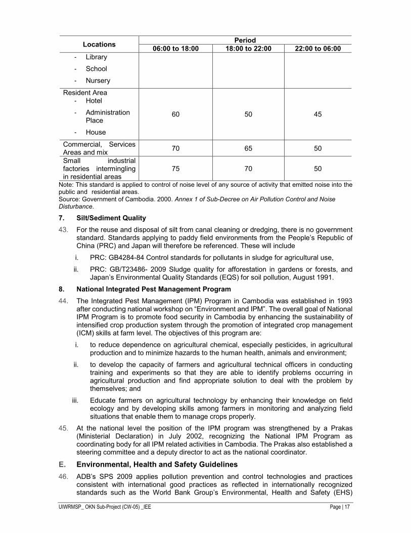
UIWRMSP_ OKN Sub-Project (CW-05) _IEE Page | 17
Locations Period
06:00 to 18:00 18:00 to 22:00 22:00 to 06:00
- Library
- School
- Nursery
Resident Area - Hotel
- Administration Place
- House
60 50 45
Commercial, Services Areas and mix
70 65 50
Small industrial factories intermingling in residential areas
75 70 50
Note: This standard is applied to control of noise level of any source of activity that emitted noise into the public and residential areas. Source: Government of Cambodia. 2000. Annex 1 of Sub-Decree on Air Pollution Control and Noise Disturbance.
7. Silt/Sediment Quality
For the reuse and disposal of silt from canal cleaning or dredging, there is no government standard. Standards applying to paddy field environments from the People’s Republic of China (PRC) and Japan will therefore be referenced. These will include
i. PRC: GB4284-84 Control standards for pollutants in sludge for agricultural use,
ii. PRC: GB/T23486- 2009 Sludge quality for afforestation in gardens or forests, and Japan’s Environmental Quality Standards (EQS) for soil pollution, August 1991.
8. National Integrated Pest Management Program
The Integrated Pest Management (IPM) Program in Cambodia was established in 1993 after conducting national workshop on “Environment and IPM”. The overall goal of National IPM Program is to promote food security in Cambodia by enhancing the sustainability of intensified crop production system through the promotion of integrated crop management (ICM) skills at farm level. The objectives of this program are:
i. to reduce dependence on agricultural chemical, especially pesticides, in agricultural production and to minimize hazards to the human health, animals and environment;
ii. to develop the capacity of farmers and agricultural technical officers in conducting training and experiments so that they are able to identify problems occurring in agricultural production and find appropriate solution to deal with the problem by themselves; and
iii. Educate farmers on agricultural technology by enhancing their knowledge on field ecology and by developing skills among farmers in monitoring and analyzing field situations that enable them to manage crops properly.
At the national level the position of the IPM program was strengthened by a Prakas (Ministerial Declaration) in July 2002, recognizing the National IPM Program as coordinating body for all IPM related activities in Cambodia. The Prakas also established a steering committee and a deputy director to act as the national coordinator.
Environmental, Health and Safety Guidelines
ADB’s SPS 2009 applies pollution prevention and control technologies and practices consistent with international good practices as reflected in internationally recognized standards such as the World Bank Group’s Environmental, Health and Safety (EHS)
UIWRMSP_ OKN Sub-Project (CW-05) _IEE Page | 18
Guidelines. The guidelines provide the context of international best practice and contribute to establishing targets for environmental performance. The air and noise standards in the EHS guidelines will be used to complement the government standards in this document where needed.
Occupational and community health and safety, as laid out in the EHS guidelines, will be a cross-cutting assessment for the subprojects.
UIWRMSP_ OKN Sub-Project (CW-05) _IEE Page | 19
III. DESCRIPTION OF THE PROJECT COMPONENTS
Overall Project
The project will be implemented in Kampong Thom provinces. The uplands of this province have potential for improved land and water productivity through improved irrigation systems and water resource management. The project area will comprise selected irrigation systems in Kampong Thom province, which has potential for growing vegetables and fruits with paddy being the main crop.
The project will (i) rehabilitate, modernize and climate proof existing irrigation systems and improve their performance and management, (ii) enhance land and water productivity through watershed management and land improvement, and (iii) improve management of water resources through participatory irrigation and water resource management.
This will comprise capital works to the main canals and side canals including embankments and headworks as well as refurbishment or replacement of cross regulators, off-takes, sluices and bridges. Works will also encompass the construction of new secondary and tertiary canals and drains with regulators, off-take structures and culverts.
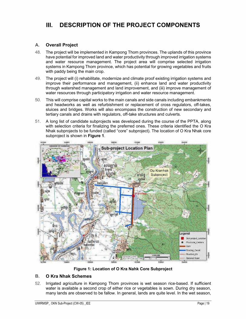
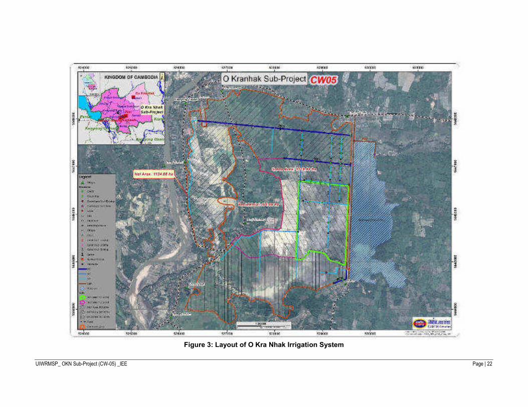
A long list of candidate subprojects was developed during the course of the PPTA, along with selection criteria for finalizing the preferred ones. These criteria identified the O Kra Nhak subprojects to be funded (called “core” subproject). The location of O Kra Nhak core subproject is shown in Figure 1.
Figure 1: Location of O Kra Nahk Core Subproject
O Kra Nhak Schemes
Irrigated agriculture in Kampong Thom provinces is wet season rice-based. If sufficient water is available a second crop of either rice or vegetables is sown. During dry season, many lands are observed to be fallow. In general, lands are quite level. In the wet season,
UIWRMSP_ OKN Sub-Project (CW-05) _IEE Page | 20
the schemes also have drainage problems during the wet season; and water-logged areas are observed in several places.
Systems, in general, show poor maintenance of their facilities. Many canals are subject to embankment erosion, especially in the many sandy soils. Recently built systems were observed to be either still incomplete and under delayed construction or abandoned and not usable after just a few seasons. Several lined canal parts/systems were also observed as dry and not connected to a water supply.
Farmers employ low-head portable diesel pumps (owned or rented) where the water level in canals or even drains are too low to service lands by gravity. Rice yields are low in general between 0.8 to 1.5 ton/ha, with only a few places reaching 2.5 tons/ha. Post-harvest drying and processing are potentially wasteful with significant losses. Seed quality is often poor. Most planting is broadcast, and requires both rain and some irrigation to meet the large needs of land soaking and land preparation.
O’ Kra Nhak Irrigation System is located in Sandan District, Kampong Thom Province. It is 247 km from Phnom Penh and is accessible by land with travel time of 4 to 5 hours passing through the National Road No. 6 and connected Road No. 64. The O Kra Nahk system is supplied by a simple reservoir with outlet-control. The system was constructed in 1977 and immediately benefited the farmers as they grew wet and dry season rice crop. Continuous operation without maintenance of the irrigation facilities combined with sequence of natural disasters resulted to damaged and ineffective infrastructure and reduced rice production in the area. The floods of 2000 caused further damage to the embankment and distribution network. In 2004, a major rehabilitation was undertaken by the Flood Emergency Rehabilitation Project (FERP) funded through World Bank loan. The rehabilitation done by FERP made the embankment robust and sturdy as it was provided with sufficient protection from erosion on both upstream and downstream sections.
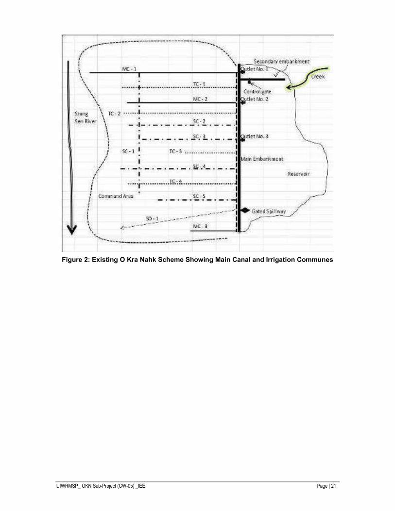
Figure 2 shows the schematic diagram of O’ Kra Nhak Irrigation System (OKN). The current situation shows a very complex operation scheme because of the following:
i. 3 outlets directly from the reservoir and each one could release water independently;
ii. the spillway also served as the outlet to MC-3 and the downstream creek which served as the natural drainage to Stung Sen River and water source to part of the command area;
iii. 3 main canals, one each from the two outlets and another from the gated-spillway;
iv. 5 secondary canals and four tertiary canals;
v. 1 outlet serve secondary canal no. 3 directly;
vi. outlet no. 1 is separated from the main reservoir by a secondary embankment;
vii. during period of low water level in the reservoir, outlet no. 1 has no access to the water in the reservoir;
viii. the creek supplying outlet no. 1 changed course and releases water directly to the main reservoir, hence during dry months water could hardly reach outlet no. 1;
ix. SC-1 cut across TC-1, MC-2, TC-2, SC-2, SC-3, SC-4 and TC-4;
x. all canals are in various levels of deterioration due to lack of maintenance;
xi. water control structures are either non-operational or non-existent;
UIWRMSP_ OKN Sub-Project (CW-05) _IEE Page | 21
Figure 2: Existing O Kra Nahk Scheme Showing Main Canal and Irrigation Communes
UIWRMSP_ OKN Sub-Project (CW-05) _IEE Page | 22
Figure 3: Layout of O Kra Nhak Irrigation System
UIWRMSP_ OKN Sub-Project (CW-05) _IEE Page | 23
Subproject Components
1. Specifications of Work
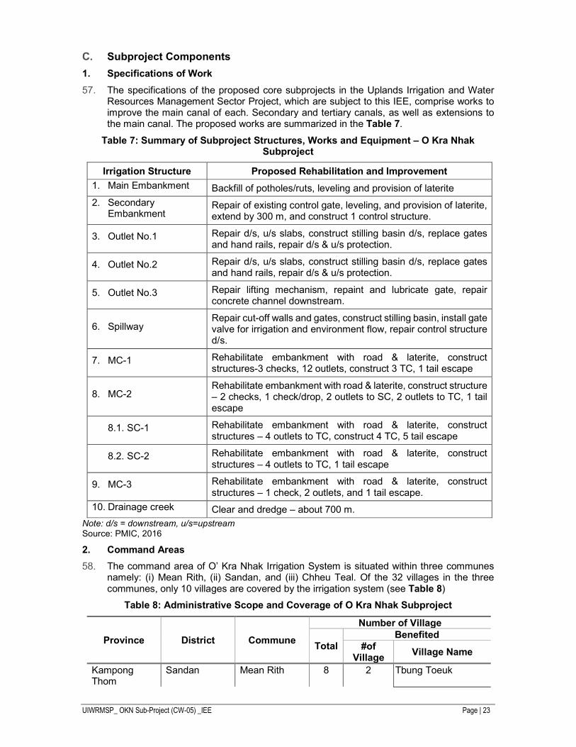
The specifications of the proposed core subprojects in the Uplands Irrigation and Water Resources Management Sector Project, which are subject to this IEE, comprise works to improve the main canal of each. Secondary and tertiary canals, as well as extensions to the main canal. The proposed works are summarized in the Table 7.
Table 7: Summary of Subproject Structures, Works and Equipment – O Kra Nhak Subproject
Irrigation Structure Proposed Rehabilitation and Improvement
1. Main Embankment Backfill of potholes/ruts, leveling and provision of laterite
2. Secondary Embankment
Repair of existing control gate, leveling, and provision of laterite, extend by 300 m, and construct 1 control structure.
3. Outlet No.1 Repair d/s, u/s slabs, construct stilling basin d/s, replace gates and hand rails, repair d/s & u/s protection.
4. Outlet No.2 Repair d/s, u/s slabs, construct stilling basin d/s, replace gates and hand rails, repair d/s & u/s protection.
5. Outlet No.3 Repair lifting mechanism, repaint and lubricate gate, repair concrete channel downstream.
6. Spillway Repair cut-off walls and gates, construct stilling basin, install gate valve for irrigation and environment flow, repair control structure d/s.
7. MC-1 Rehabilitate embankment with road & laterite, construct structures-3 checks, 12 outlets, construct 3 TC, 1 tail escape
8. MC-2 Rehabilitate embankment with road & laterite, construct structure – 2 checks, 1 check/drop, 2 outlets to SC, 2 outlets to TC, 1 tail escape
8.1. SC-1 Rehabilitate embankment with road & laterite, construct structures – 4 outlets to TC, construct 4 TC, 5 tail escape
8.2. SC-2 Rehabilitate embankment with road & laterite, construct structures – 4 outlets to TC, 1 tail escape
9. MC-3 Rehabilitate embankment with road & laterite, construct structures – 1 check, 2 outlets, and 1 tail escape.
10. Drainage creek Clear and dredge – about 700 m.
Note: d/s = downstream, u/s=upstream Source: PMIC, 2016
2. Command Areas
The command area of O’ Kra Nhak Irrigation System is situated within three communes namely: (i) Mean Rith, (ii) Sandan, and (iii) Chheu Teal. Of the 32 villages in the three communes, only 10 villages are covered by the irrigation system (see Table 8)
Table 8: Administrative Scope and Coverage of O Kra Nhak Subproject
Province District Commune
Number of Village
Total Benefited
#of Village
Village Name
Kampong Thom
Sandan Mean Rith 8 2 Tbung Toeuk
UIWRMSP_ OKN Sub-Project (CW-05) _IEE Page | 24
Province District Commune
Number of Village
Total Benefited
#of Village
Village Name
Kanty Sandan 13 5 Kampong Trabek Teouk Maleang Chhor Bachey Sandan Chheu Teal 11 3 Chheu Teal Boeng Rolum Prey Konleng
Total 1 3 32 10 Source: Chiefs of the 3 communes and Officer of District Office of Agriculture, Forestry & Fisheries.
The embankments of the reservoir are all in good condition and would require minor works that will address maintenance activities that were deferred in the past. The outlet and spillway structures along the embankment generally need rehabilitation of downstream and upstream transitions, repair or replacement of gates, and installation of downstream and upstream protection from erosion. The main canal embankments are badly deteriorated and would require rehabilitation including provision of road on one embankment. Additional control structures such as checks and outlets are also needed. Similarly, restoration of the secondary and tertiary canals is necessary.
Table 9: Increases in Irrigated Areas as a Result of the Project
O’ Kra Nhak Irrigation System
Before Project After Project (Net command area)
Irrigated Area (ha) 800 ha 1,134 ha
Project Implementation
MOWRAM will be the executing agency. MOWRAM’s Department of Farmer Water User Communities (DFWUC) will be the implementing agency. A Project Management Unit (PMU) was established in the DFWUC before the project preparatory technical assistance began. The PMU is headed by a project director, who is the deputy director-general for technical affairs of the DFWUC. A project manager, who is the director of DFWUC, will assist the project director. The PMU was fully involved in the preparation of the project. During project implementation, the PMU will have 22 designated staff members from MOWRAM, the DFWUC, the MAFF, the DHRW, and the PDWRAMs of Kampong Thom provinces. MAFF staff will coordinate the land leveling and other activities to be provided in support of the project by the Climate-Resilient Rice Commercialization Sector Development Program (CRRCSDP). The CRRCSDP will give the project access to quality seed and agriculture value chain facilities and services. The PDWRAMs will be responsible for coordinating all field activities with the FWUCs and the DFWUC. The DHRW will coordinate installation, operation, and data collection of the hydro-meteorological stations. It will also be responsible for providing guidance to the PMU on operational challenges during implementation.
A steering committee will oversee the project’s implementation and management and provide policy guidance. It will be chaired by the minister of the MOWRAM and comprise senior officials from MOWRAM, the MAFF, the Ministry of Economy and Finance, and the offices of the governors of this project provinces. Any resettlement and land acquisition will be implemented by and under the management of an inter-ministerial resettlement committee of representatives from the relevant line ministries, which will be chaired by the
UIWRMSP_ OKN Sub-Project (CW-05) _IEE Page | 25
Ministry of Economy and Finance. The committee will cooperate closely with the Kampong Thom provincial resettlement subcommittees. The PMU will be responsible for project implementation, planning, organization, monitoring, and reporting and will be supported by the project management and implementation consultants.
UIWRMSP_ OKN Sub-Project (CW-05) _IEE Page | 26
IV. DESCRIPTION OF THE ENVIRONMENT
A. Physical Environment
1. Climate
The climates of the Kampong Thom areas are characterized by distinct rainy and dry seasons. The southwest monsoon starts in May and lasts till October, while from November to April the dry northeast weather patterns predominate.
For subproject area, the rainfall is an average annual falls of 1,442 mm, with peak rainfall occurring in September/October and the lowest rainfall in February.
Table 10: Monthly Rainfall Data at Sandan Station
Source: Hydrology Study for FS of OKN, 2016
2. Topography and Geology
The topography of the subproject area is flat to gently sloping alluvium, grading to pediment bedrock formations on the upland fringes. Elevation for the area is between 20 and 30 m ASL.
The lake area and reservoir storage data was taken from Sub-Project Proposal for the Rehabilitation of O Kra Nhak Reservoir prepared by Mott McDonald Limited et al. in 2004. A topographic survey of the reservoir area is presently being undertaken and this is not available for the study but can be used in updating the water resources study in the future. In the meantime, the previous elevation- area -storage data was used in reservoir operation study.
3. Soil Quality
Dr. Crocker travelled across Cambodia to create a map, with a scale of 1:1,000,000, and it was published by the Ministry of Agriculture, Forestry and Fishery of Cambodia in 1963. The soil type of Cambodia is classified into 16 according to the soil taxonomy of the Ministry of Agriculture, the United States of America, but with modification of some soil types.
For this OKN subproject, measurement of soil quality in one station was conducted in the dry season (15 December, 2016). The soil quality sampling was carried out at all 1 station to determine the quality of soil for rehabilitate OKN irrigation system (shown in Figure 8 and Appendix 2). The collected water sample was preserved and laboratory analysis was carried out according to the standard methods of Ministry of Agriculture, Fishery and Forestry, Cambodia.
✁�✂�✄☎✆ ✝ ✁✞✟✠✞✟✡ ☛✞☞✌✍✟✎ ✏✑✍☞ ✔✟✒✏✁✝ ☞☞
✖✓✞✕ ✙✞✟ ✚✓✗ ☞✞✕ ✞✌✕ ☞✞✖ ✙✔✟ ✙✔✘ ✞✔✎ ✁✓✌ ✍✛✏ ✟✍✜ ✠✓✛ ✞✟✟✔✞✘
2000 0.0 0.0 0.0 0.0 0.0 278.5 347.2 252.5 144.0 161.5 16.0 15.0 1214.7
2001 0.0 0.0 163.0 4.5 194.7 243.9 186.3 348.3 267.1 107.2 56.2 0.0 1571.2
2002 0.0 0.0 0.0 148.0 148.0 199.0 143.0 243.0 255.0 85.7 11.0 0.0 1232.7
2003 0.0 0.0 78.9 35.9 180.6 215.3 246.0 157.7 283.7 91.5 3.6 0.0 1293.2
2004 0.0 0.0 0.0 74.1 95.3 334.6 444.2 238.7 182.5 6.3 38.2 0.0 1413.9
2005 0.0 0.0 3.0 5.0 77.4 132.6 293.7 93.6 264.2 79.1 110.6 8.0 1067.2
2006 0.0 3.2 17.5 245.5 120.4 177.0 347.8 233.9 423.4 57.2 0.0 3.4 1629.3
2007 0.0 0.0 4.0 175.4 338.4 151.7 253.3 245.9 310.2 86.3 62.3 0.0 1627.5
2008 0.0 0.0 38.9 120.8 362.6 87.9 253.9 170.6 378.3 116.6 75.0 0.0 1604.6
2009 0.0 1.2 116.7 157.4 227.7 179.6 348.9 144.8 618.3 17.9 67.5 0.0 1880.0
2010 12.9 0.0 0.0 90.5 133.4 197.2 271.8 225.3 171.5 361.6 72.1 0.0 1536.3
2011 0.0 5.2 13.2 43.2 132.6 277.0 285.1 257.1 359.0 237.8 15.0 0.0 1625.2
2012 0.0 0.0 3.0 76.4 254.8 71.4 311.3 88.9 501.5 158.3 53.7 0.0 1519.3
2013 0.0 0.0 0.0 91.0 85.6 175.0 395.4 275.8 326.5 126.6 35.7 40.8 1552.4
2014 0.0 0.0 24.2 125.8 9.7 194.2 478.9 229.2 141.3 91.9 0.0 5.8 1301.0
2015 0.0 0.0 7.5 16.1 130.2 110.5 168.7 344.7 149.0 198.1 31.6 1.2 1157.6
MEAN 0.8 0.6 29.4 88.1 155.7 189.1 298.5 221.9 298.5 124.0 40.5 4.6 1451.6
UIWRMSP_ OKN Sub-Project (CW-05) _IEE Page | 27
Figure 4: Soil Quality Sampling Station
The result of the soil quality analysis in the agriculture and environmental context is depicted below
Table 11: Result of Soil testing for agriculture
Soil properties Results
Soil testing for agriculture1
Particle Size
(<0.002mm) Clay% 12.95
(0.002-0.02mm) Fine Silt% 22.75 (0.02-0.05mm) Coarse Silt% 8.77 (0.05-0.2mm) Fine Sand% 38.65 (0.02-2mm) Coarse Sand% 17.11
Moisture % (oven dry at 105oC and 24 hours) 0.64 Electrode Conductivity us/cm (1:5 Soil : Water) 19.38 Total Carbon C % (Black & Walkey Method) 14.12 Total Nitrogen N % (Kjedal Sulfuric Methods) 1.40 C/N Ratio (Unit) 10 Organic Matter (OM) % 2.42 Total Phosphorous P2O5 % (Nitric Digestion) 0.079 Available Phosphorous P2O5 ppm (Pray II) 30
Cation Exchange Capacity C.E.C m.e/100g Soil (1M Ammonium Acetate at pH=7 & Leach with 10% NaCl Method)
11
Exchangeable Bases (m.e/100g Soil)
Calcium Ca 4.20
Magnesium Mg 1.40 Sodium Na 0.11 Potassium K 0.40
Total Exchangeable Bases (m.e/100g Soil) 6.11 Bass Saturation % 55 Exchange Acidity m.e/100g Soil (1M KCl Method) 0.20 Exchange Al m.e/100g Soil (1M KCl Method) 1.40 pH H2O (1:5 Soil : Water) 5.23 pH KCL (1:5 Soil : 1N KCL) 4.25 Soil testing for Environment2 Zn 5.195 mg/kg Cu 5.350 mg/kg
Pb 3.975 mg/kg Hg 87 µg/kg As 822 µg/kg Cd 7 µg/kg
UIWRMSP_ OKN Sub-Project (CW-05) _IEE Page | 28
Source: 1) Laboratory of the General Directorate of Agriculture 2016 and 2) Industrial Laboratory Center of Cambodia, 2016
In short, the soil test shows that soil quality in the study area is in good condition and it is obvious that the soil is fertile enough for cultivation.
4. Hydrology
Regarding to Hydrological study of FS, the key feature of hydrology of O Kra Nahk is following:
� River Source : Oukrapak River and Outasao River � Total Catchment Area : 60.75 sq.km � Target Service Area : 1,100 hectares � Annual Mean Rainfall : 1,442 mm/yr � Annual Mean Runoff : 0.77 cms = 26.2 mcm/yr � Dam Height : 4.65 m – Crest El. 10.65 m � Normal Storage Capacity : 3.78 mcm @ El. 9.6 m � Design Flood Discharge : 80.6 cms @ 50 yr R.I.
5. Water Resource System and Watershed, and Water Quality
5.1. Water Resource System and Watershed
Figure 5 shows the main water resources system in OKN irrigation system. The main water resource is Stueng Seng (See Figure 5) while the OKN reservoir has received water from the watershed from Preah Vihear province (See Figure 6).
Figure 5: Water Resources System, OKN System
Watershed Aspects. Referring to the PPTA July 2015, there is no document describing the concept or any information for Okranhak. The Okranhak has its reservoir area about 262 hectares and watershed area 60.75 Km2. Through the national topographic map, the Okranhak watershed is no dependent with the Stung Sen. It collects the flow from its own catchment. Through the field trip on 28 April 2016 at about 2h40’ PM, we took the spring flow measurement by the float method at the point with WGS 1984 UTM, X = 529796, Y =
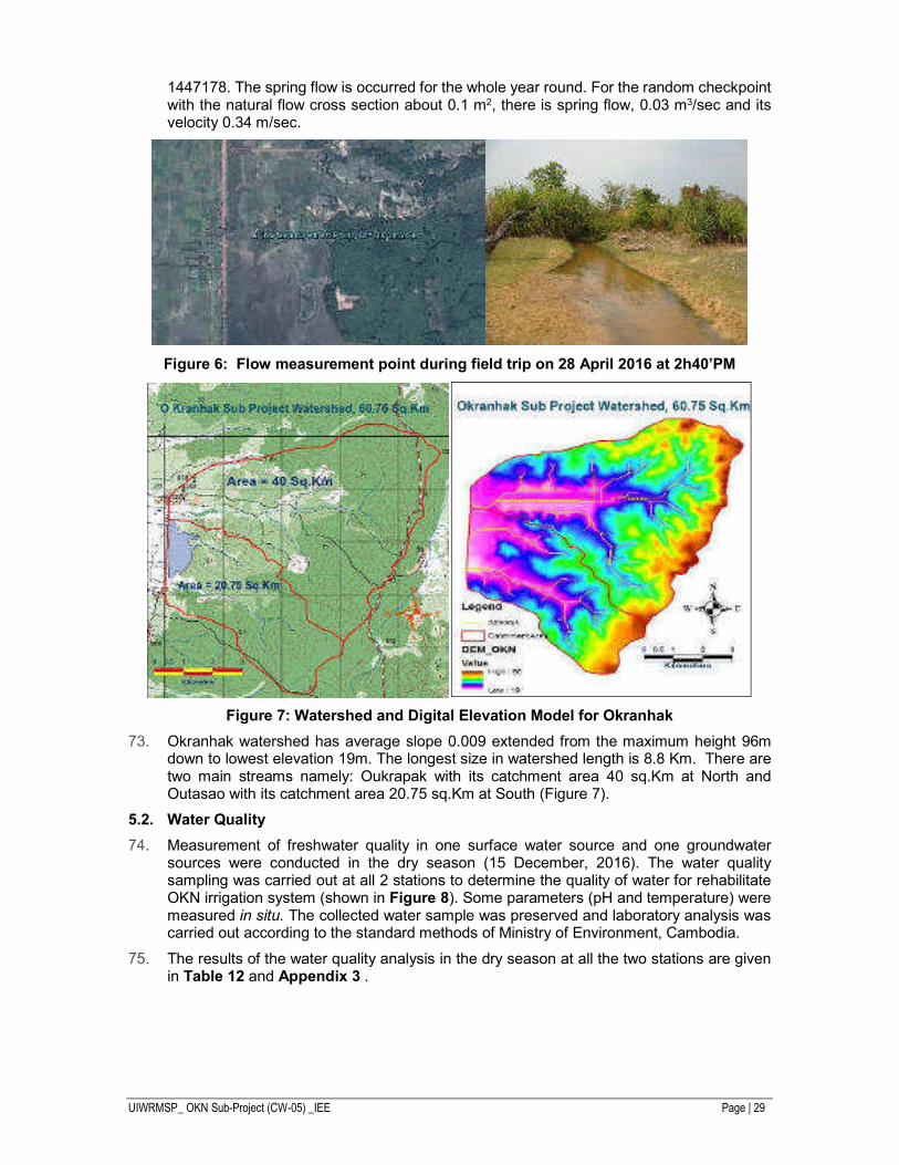
UIWRMSP_ OKN Sub-Project (CW-05) _IEE Page | 29
1447178. The spring flow is occurred for the whole year round. For the random checkpoint with the natural flow cross section about 0.1 m2, there is spring flow, 0.03 m3/sec and its velocity 0.34 m/sec.
Figure 6: Flow measurement point during field trip on 28 April 2016 at 2h40’PM
Figure 7: Watershed and Digital Elevation Model for Okranhak
Okranhak watershed has average slope 0.009 extended from the maximum height 96m down to lowest elevation 19m. The longest size in watershed length is 8.8 Km. There are two main streams namely: Oukrapak with its catchment area 40 sq.Km at North and Outasao with its catchment area 20.75 sq.Km at South (Figure 7).
5.2. Water Quality
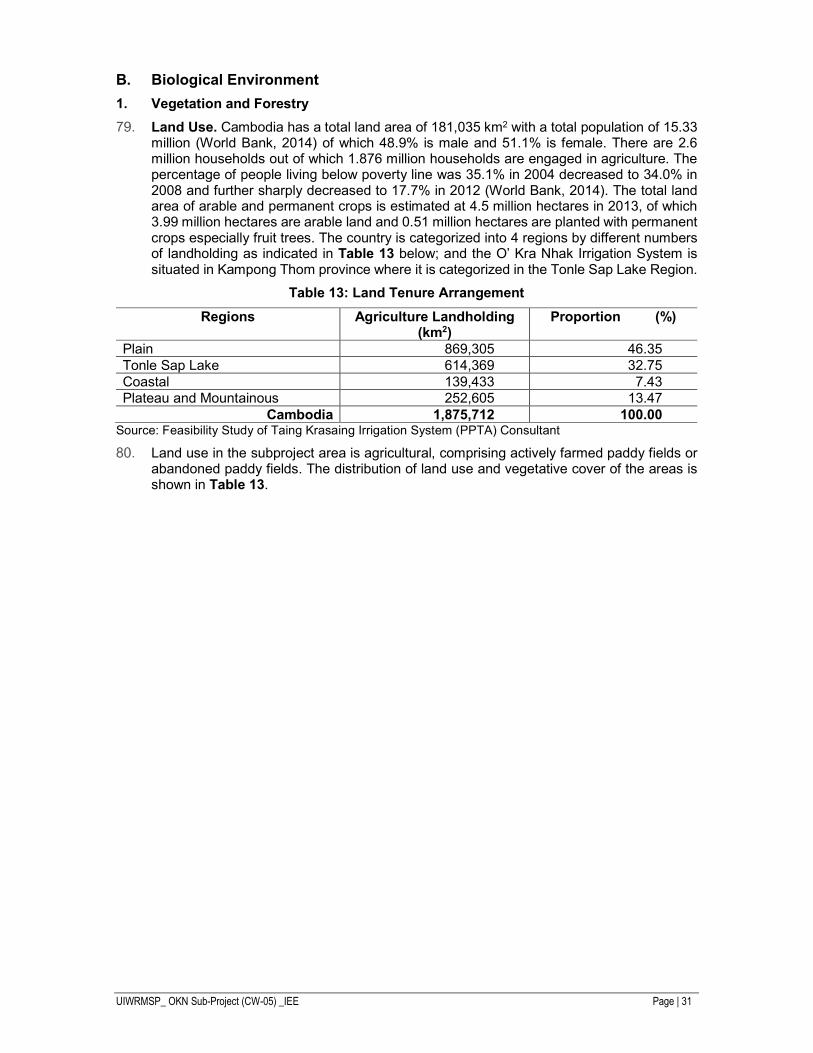
Measurement of freshwater quality in one surface water source and one groundwater sources were conducted in the dry season (15 December, 2016). The water quality sampling was carried out at all 2 stations to determine the quality of water for rehabilitate OKN irrigation system (shown in Figure 8). Some parameters (pH and temperature) were measured in situ. The collected water sample was preserved and laboratory analysis was carried out according to the standard methods of Ministry of Environment, Cambodia.
The results of the water quality analysis in the dry season at all the two stations are given in Table 12 and Appendix 3 .
UIWRMSP_ OKN Sub-Project (CW-05) _IEE Page | 30
pH Measurement (OKN Reservoir) Ground Water Sample Collect
Figure 8: Freshwater Quality Sampling Station
Table 12: Water Quality in OKN Sub-project
Parameter Unit Result Standard
I. Surface Water (SW) Quality 1. pH - 6.47 6-9 2. Temperature 0c 28.0 - 3. Electrical Conductivity (EC) µs/cm 21.00 NV 4. Total Suspended Solid (TSS) mg/L 27.00 25-100 5. Dissolved Oxygen (DO) mg/L 6.65 2.0-7.5 6. Biochemical Oxygen Demand
(BOD)5 mg/L 1.93 NV
7. Chemical Oxygen Demand (COD) Mn
mg/L 4.02 1.0-8.0
8. Oil & Grease mg/L 0.84 NV 9. Ammonium (NH4) mg/L ND NV 10. Nitrate (NO3) mg/L 0.72 NV 11. Phosphate [Ortophosphate (PO4)] mg/L 0.22 NV 12. Total Coliform MPN/100 ml 1.6x10³ <5000 II. Ground Water (GW) Quality 1. pH - 6.12 6-8 2. Temperature 39.80 - 3. Turbidity NTU 1.08 <5.0 4. Total Suspended Solid (TSS) mg/L 30.00 NV 5. Arsenic (As) mg/L 0.003 <0.05 6. Iron (Fe) mg/L 0.28 <0.3 7. Total Coliform MPN/100 ml 0 0
Source: Laboratory of MoE, 2016
In short, the water quality is in good condition.
6. Air Quality and Noise
No ambient air quality data exists for the subproject area or the province. As rural areas, the air quality is sometimes affected by dust from tillage and unpaved road users and smoke from rice stubble burning after harvest. However, at most times, due to the absence of industry and low traffic volumes, the air quality can be expected to be high, with low NOx and SOx and minimal CO.
During PMIC, ambient noise levels were observed in the OKN Subproject area. It is shown the typical rural environmental noise levels and sometime from the result of trucks traveling at speed along the roads atop the canal levee bank and then the noise level has been raised.
UIWRMSP_ OKN Sub-Project (CW-05) _IEE Page | 31
B. Biological Environment
1. Vegetation and Forestry
Land Use. Cambodia has a total land area of 181,035 km2 with a total population of 15.33 million (World Bank, 2014) of which 48.9% is male and 51.1% is female. There are 2.6 million households out of which 1.876 million households are engaged in agriculture. The percentage of people living below poverty line was 35.1% in 2004 decreased to 34.0% in 2008 and further sharply decreased to 17.7% in 2012 (World Bank, 2014). The total land area of arable and permanent crops is estimated at 4.5 million hectares in 2013, of which 3.99 million hectares are arable land and 0.51 million hectares are planted with permanent crops especially fruit trees. The country is categorized into 4 regions by different numbers of landholding as indicated in Table 13 below; and the O’ Kra Nhak Irrigation System is situated in Kampong Thom province where it is categorized in the Tonle Sap Lake Region.
Table 13: Land Tenure Arrangement
Regions Agriculture Landholding (km2)
Proportion (%)
Plain 869,305 46.35 Tonle Sap Lake 614,369 32.75 Coastal 139,433 7.43 Plateau and Mountainous 252,605 13.47
Cambodia 1,875,712 100.00 Source: Feasibility Study of Taing Krasaing Irrigation System (PPTA) Consultant
Land use in the subproject area is agricultural, comprising actively farmed paddy fields or abandoned paddy fields. The distribution of land use and vegetative cover of the areas is shown in Table 13.
UIWRMSP_ OKN Sub-Project (CW-05) _IEE Page | 32
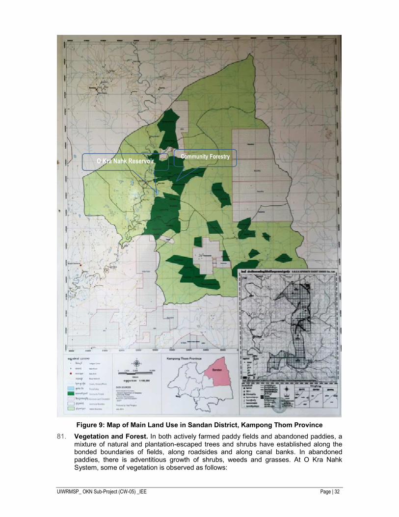
Figure 9: Map of Main Land Use in Sandan District, Kampong Thom Province
Vegetation and Forest. In both actively farmed paddy fields and abandoned paddies, a mixture of natural and plantation-escaped trees and shrubs have established along the bonded boundaries of fields, along roadsides and along canal banks. In abandoned paddies, there is adventitious growth of shrubs, weeds and grasses. At O Kra Nahk System, some of vegetation is observed as follows:
O Kra Nahk Reservoir Community Forestry
UIWRMSP_ OKN Sub-Project (CW-05) _IEE Page | 33
Natural Regrowth (along field, road and canal margins)
Escapes from Orchards and Plantations
- Dipterocarpus tuberculatus - Borassus flabellifer (sugar palm) - Diospyros Sp - Anacardium occidentale (cashew) - Peltophorum pterocarpum - Hevea brasiliensis (rubber) - Azadirachta indica - Cistus sp - Zizyphus mauritania
Vegetation along the banks of the O Kra Nahk main canal is almost exclusively Peltophorum pterocarpum, and along the edges of paddy fields, Dipterocarpus tuberculatus dominates. This is illustrated in Figure 10 below.
Figure 10: Common Tree Species in OKN
No vegetation species identified on site is included in the IUCN Red List for Cambodia.
2. Fisheries
Limited household fishing is carried on in the main canals. These are illustrated in Figure 11. Based on discussions with local farmers and fisher families (often the same group), the common fish found in the project areas, especially within the main canals are listed in Table 14. The O Kra Nhak canal has a slightly larger species list.
Table 14: List of Fish Caught in Main Canals
Local Name Scientific Name
Trei Ros/ Ptuok Trei Andeng Tun Trei Chhpin
Trei Riel Chhlang Trei Kes
Trei Kagnchruk
Channa striata
Clarias macrocephalus Barbodes gonionotus Henicorhynchus siamensis Mystus filamentus Micronema bleekeri
Botia modesta
Trei Kamphleanh Trei Kamphleav Kanh Chanh Chras Kanh Chos
Kan Trob Khnong Veng Kranh
Kros phnom Angkat Prak Slat
Ta Aun/ Kramorm Sraka Kdam
Trichogaster trichopterus Kryptopterus moorei
Pseudambassis notatus Mystus mysticetus Pristolepis
fasciata Dangila lineata
Anabas testudineus Poropuntius deauratus
Cyclocheilichthys microlepis Notopterus
UIWRMSP_ OKN Sub-Project (CW-05) _IEE Page | 34
Local Name Scientific Name
notopterus
Ompok bimaculatus Cyclocheilichthys repasson
Source: PMIC, 2016
Figure 11: Common Fish Species in OKN
No data on fisheries production or fishing effort was available, but observation and discussion indicate that fishing is undertaken as a supplementary activity during dry season when the paddy fields are in fallow. Fish catches are primarily for domestic consumption, with a proportion of the catch being dried and marketed locally.
3. Protected Areas
Cambodia has a network of 23 protected areas managed through MoE. These areas cover 2.2 million hectares or 18% of Cambodia’s land area and include most of its important habitats. The Forest Administration has also designated protected forests (from cancelled logging concessions) bringing the total area under protection to around 25% which is more than twice the global average. Protected Areas are sites which are protected by Royal Decrees, Laws and Regulations.
In 2008 Cambodia introduced the Protected Area Law (No. NS/RKM/0208/007), which defines these areas by their main conservation significance:
i. National Parks
ii. Wildlife Sanctuaries
iii. Protected Landscapes
iv. Multiple Use Areas
v. Ramsar Sites
vi. Biosphere Reserves
vii. Natural Heritage Sites And
viii. Marine Parks
UIWRMSP_ OKN Sub-Project (CW-05) _IEE Page | 35
Figure 12: The Nearest Protected Areas to the Subproject Site
Based on field visit in September 2016 to cross check with nearby protected area of subproject area, the subproject is out of the Tonle Sap Biosphere areas, Beng Per and Prey Lang Wildlife Sanctuary (See Figure 12).
4. Community Forestry in Kampong Thom
The Ministry of Agriculture, Forestry and Fisheries issued the Prakas No. 489 BK.MAFF dated on 19 November 2008, Prakas No. 555 dated on 20 August 2010 and Prakas No. 078 dated on 19 February 2013 on the Establishment and Management of Community Forest (CF) area in Kampong Thom Province (See Table 15).
Table 15: The CF Statistic in Kampong Thom Province
CF Name CF Area
(ha) Commune District
No of village
CF member (Family)
Date Approved by MAFF
Date CF Agreement
1. Prey Hongchotet
1,016 Meanrith Sandan 2 65 20.08.10 25.08.11
2. Ou Daskor 1,135 Meanrith Sandan 1 143 20.08.10 25.08.11
3. Oukro Gnong
1,131 Meanrith Sandan 1 120 20.08.10 29.06.12
4. Prey Tatey 1,395.44 Meanrith Sandan 1 91 19.11.08 11.11.09
5. Prey Kbal Oukronhach
1,592.71 Meanrith Sandan 1 219 19.11.08 11.11.09
6. Boeng Romdourl
1,201 Chheur Teal
Sandan 1 96
7. Ke Rong 1,572 Chheur Teal
Sandan 1 140
8. Orngdong Preng
1,945 Chheur Teal
Sandan 1 133
O Kra Nahk Irrigation System
UIWRMSP_ OKN Sub-Project (CW-05) _IEE Page | 36
CF Name CF Area
(ha) Commune District
No of village
CF member (Family)
Date Approved by MAFF
Date CF Agreement
9. Prey Kbal Doungtey
1,812 Meanrith Sandan 1 77
10. Svay 1,786 Sandan Sandan 1 105
11. Kbal Khla 2,533 Sandan Sandan 1 36
Total 17,119 3 1 12 1225 5 5
Source: Department of Forest and Community Forestry, 2013
Figure 13: Community Forestry in Kampong Thom Province, 2013
Regarding to CF statistic of Department of Forest Administration, 2013, 11 community forestry areas are located in three communes of subproject command area. Two CFs out of 11 CFs areas are nearby the subproject area, (i). Prey Kbal O Kronha (1592.71 ha) and (ii). Prey Ta Kie (1395.44 ha).
C. Socio-economic Environment/Development
1. Agricultural Practice
For FS of O Kra Nhak study, the agricultural assessment was done by Agriculture Specialist. The result is shown as follow.
1.1. Soil Fertilizer
Based on Rice Production in Cambodia paper (Cambodia-IRRI-Australia project), main soil types of the rice-growing areas in the O Kra Nhak subproject, is principally classified into 03 different types (PMIC’s observation in September 2016):
i. Soils of the alluvial and/or colluvium plains, it’s called Prateah Lang soil. Responses to N, P and K fertilizer application occur frequently and some areas are responsive to S application. This soil occupies about 47% of the farming area in O’ Kra Nhak, it is found in Kampong Trabek, Teu Mleang and Bachey villages, Sandan commune.
UIWRMSP_ OKN Sub-Project (CW-05) _IEE Page | 37
ii. Soils of the alluvial and/or colluvium plains, it is called Prey Khmer soil. The prominent feature of Prey Khmer soils is their deep sandy nature. Responses to N, P, K, and sometimes, S fertilizer application will occur. The soil pH is acidic but poorly buffered and is not a problem for flooded rice culture. This soil type occupies about 15% of the paddy area of O’ Kra Nhak; it is found in Tbong Teuk and straightforward along the existing embankment to Kanty villages, Mean Rith commune.
Soils of the alluvial and/or colluvium plains, it’s named Bakan soil. The water-holding capacity of this soil is good. Fertility and organic matter levels are also low but this soil is generally more fertile than the Prey Khmer or Prateah Lang soils. Good responses to application of N and P fertilizers regularly occur. Responses to K and sometimes S fertilizers are also likely, especially if the area is used for intensive crop production at high N and P input levels. The soil occupies about 35% of the rice cultivation area in O Kra Nhak subproject and situated in Prey Kanleng and Teu Mleang village, Chheu Teal commune.
Another (Soils developed on recent alluvium) is named Kbal Po soil. This soil occupies less than 3% of total rice cultivation area. Located in Tbong Teuk village, Mean Rith commune. Its fertility also tends to be higher in areas closer to permanent water. Mostly, this soil part is temporary kept free from crops.
In average, rice yields on the above soils type is ranging from 2,500 – 2,800 kg/ha for traditional seed and practices, but 3,000 – 3,800 kg/ha for new recommended varieties by trialing. In response to water availability and climate resilient, farmers mostly converted from long term rice to medium and short term rice farming.
1.2. Land Preparation
Whereas the lack of agricultural machinery services in this remote target district, farmers in the subproject site they use different way to prepare their farm land, 60% of them use walking tractors, whilst 30% is cattle and 10% by four-wheel tractor.
Generally, they prepare their paddy land with 2 times per term for both broadcasting and transplanting practices of wet season and dry season rice production. The average ploughing deep for cultural layer between 10-15 cm this depending on tilling practise. Generally, farmers pay about USD50 per hectare in preparation of their paddy field per annum.
Beside the tillage practice, farmers in subproject area presently use the traditional practicing to level their paddy field and there is no any technical accuracy land levelling activity has been performed or applied in this site. Within the UIWRMSP project, precision laser land levelling activities might be considered to accelerate water usage efficiency and rice yield productivity.
Most farmers still use traditional rice varieties with low yield potential. Where modern varieties have been introduced farmers use self-saved seed or seed from neighbors. There is very little renewal by regularly purchasing commercial seed. The water requirement for pre- saturation of rice land is usually 150 to 200 mm but if the pre-saturation period is long (24 to 48 days) or where the soil is sandy and free draining this figure can rise considerably. In addition, a water layer (usually at 100 mm) is established at this time. 50% of the total irrigation water requirement can be used for pre-saturation and establishing a water layer. Rice is now mostly harvested mechanically using combine harvesters.
As stated in Commune Database Book, 2015 farmers in Sandan district using chemical fertilizer for rice crop in order to kill the insect and grass is 42.50% and the percentage of fertilizer using in 3 communes is show in Table 16. Pesticides available in the subproject area include mixed fertilizers.
Table 16: Utilization of fertilizers and poison for insect and grass
District Commune No. of Household % of Household
Sandan Mean Rith 284 16.8
Chheu Teal 1,280 71.9
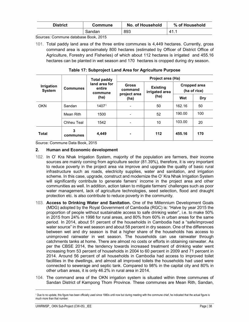
UIWRMSP_ OKN Sub-Project (CW-05) _IEE Page | 38
District Commune No. of Household % of Household
Sandan 893 41.1
Sources: Commune database Book, 2015
Total paddy land area of the three entire communes is 4,449 hectares. Currently, gross
command area is approximately 800 hectares (estimated by Officer of District Office of
Agriculture, Forestry and Fisheries) of which about 112 hectares is irrigated and 455.16
hectares can be planted in wet season and 170 hectares is cropped during dry season.
Table 17: Subproject Land Area for Agriculture Purpose
Irrigation System
Communes
Total paddy land area for
entire commune
(ha)
Project area (Ha)
Gross command
project area (ha)
Existing irrigated area
(ha)
Cropped area
(ha of rice)
Wet Dry
OKN Sandan 14071 - 50 162.16 50
Mean Rith 1500 - 52 190.00
100
Chheu Teal 1542 - 10 103.00
20
Total 3
communes 4,449 - 112 455.16 170
Source: Commune Data Book, 2015
2. Human and Economic development
In O’ Kra Nhak Irrigation System, majority of the population are farmers, their income sources are mainly coming from agriculture sector (81.39%), therefore, it is very important to reduce poverty in the project area via improve and upgrade the quality of basic rural infrastructure such as roads, electricity supplies, water and sanitation, and irrigation scheme. In this case, upgrade, construct and modernize the O’ Kra Nhak Irrigation System will significantly contribute to generate famers’ income in the project area and other communities as well. In addition, action taken to mitigate farmers’ challenges such as poor water management, lack of agriculture technologies, seed selection, flood and draught protection etc. is also contribute to reduce poverty in the community.
Access to Drinking Water and Sanitation. One of the Millennium Development Goals (MDG) adopted by the Royal Government of Cambodia (RGC) is: “Halve by year 2015 the proportion of people without sustainable access to safe drinking water”, i.e. to make 50% in 2015 from 24% in 1998 for rural areas, and 80% from 60% in urban areas for the same period. In 2014, about 51 percent of the households in Cambodia had a “safe/improved water source” in the wet season and about 58 percent in dry season. One of the differences between wet and dry season is that a higher share of the households has access to unimproved rainwater in wet season. The households can use rainwater through catchments tanks at home. There are almost no costs or efforts in obtaining rainwater. As per the CBSE 2014, the tendency towards increased treatment of drinking water went increasing from 53 percent of households in 2004 to 60 percent in 2009 and 71 percent in 2014. Around 56 percent of all households in Cambodia had access to improved toilet facilities in the dwellings, and almost all improved toilets the households had used were connected to sewerage and septic tank. Compared to 98% in the capital city and 80% in other urban areas, it is only 46.2% in rural area in 2014.
The command area of the OKN irrigation system is situated within three communes of Sandan District of Kampong Thom Province. These communes are Mean Rith, Sandan,
1 Due to no update, this figure has been officially used since 1980s until now but during meeting with the commune chief, he indicated that the actual figure is much more than that number.
UIWRMSP_ OKN Sub-Project (CW-05) _IEE Page | 39
and Chheu Teal. The reservoir of the irrigation system is located within the Mean Rith commune. There are 32 villages in the three communes, but only 10 villages are covered by the irrigation system. Based on Commune Data Based, 2015, ground water is the main source for drinking water in all the three communes (67% of demand), rain water harvesting (6% of demand) and rest of the demand of drinking water is met by river, pond and stream. Every household has water tanker to harvest rainwater. About 22% of the households have sanitary facilities majority of these being the pouring water latrines. Still around 78% of the households in the area do not have sanitary facilities in these communes. No waste management facilities exist and there is no system of collection of hazardous wastes like used containers/bottles of insecticides and pesticides.
3. Floods and Extreme Weather Events
Flooding is a regular phenomenon in Cambodia, with rainfalls commonly exceeding 500 mm per month in the rainy season. However, recent flooding in the Mekong region has been very damaging and the Mekong River Commission records show an increasingly shorter return period for major floods. The following flood statistics for the subproject provinces in Table 18 illustrate the levels of damage.
Table 18: Impact of flooding (18 October 2013)
Province Kampong Thom
Affected Districts 7
Affected Communes 61
Affected Families 1,7463
Affected people 80,330
Evacuated families 1,114
Evacuated people 5,124
Houses Affects 17,463
Deaths 24
Victims Injured 3
Flood Affected Schools 121
Pagodas 41
Health Center and Hospitals 4
Source: Humanitarian Response Forum (HRF), Situation Report No.4, 23 October 2013
Table below compares data collected by NCDM in 2013 and 2011, at the peak of the floods in each year, by province. Changes in the number of affected or evacuated families in 2013 compared to 2011 are highlighted.
Table 19: Affected and Evacuated Families in 2013 and 2011 (Kampong Thom Province)
Years Affected Families Comparison (affected families) 2013 and 2011
2013 17,463 - 36,951
2011 54,414
Source: Humanitarian Response Forum (HRF), Final Report No.07, December 2013
4. Climate Change Scenarios
Climate change will have different impact on the project depending on the type of project development and location of the project. ADB has looked at the various types of geo-hazards or natural disaster that may affect ADB development projects and these are presented in Figure 14.
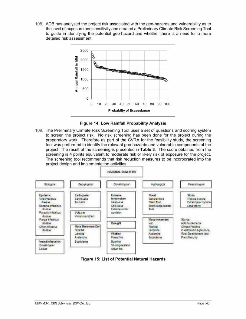
UIWRMSP_ OKN Sub-Project (CW-05) _IEE Page | 40
ADB has analyzed the project risk associated with the geo-hazards and vulnerability as to the level of exposure and sensitivity and created a Preliminary Climate Risk Screening Tool to guide in identifying the potential geo-hazard and whether there is a need for a more detailed risk assessment
Figure 14: Low Rainfall Probability Analysis
The Preliminary Climate Risk Screening Tool uses a set of questions and scoring system to screen the project risk. No risk screening has been done for the project during the preparatory work. Therefore as part of the CVRA for the feasibility study, the screening tool was performed to identify the relevant geo-hazards and vulnerable components of the project. The result of the screening is presented in Table 3. The score obtained from the screening is 4 points equivalent to moderate risk or likely risk of exposure for the project. The screening tool recommends that risk reduction measures to be incorporated into the project design and implementation activities.
Figure 15: List of Potential Natural Hazards
0
500
1000
1500
2000
2500
0 10 20 30 40 50 60 70 80 90 100
Probabilty of Exceedance
An
nu
al R
ain
fall in
MM
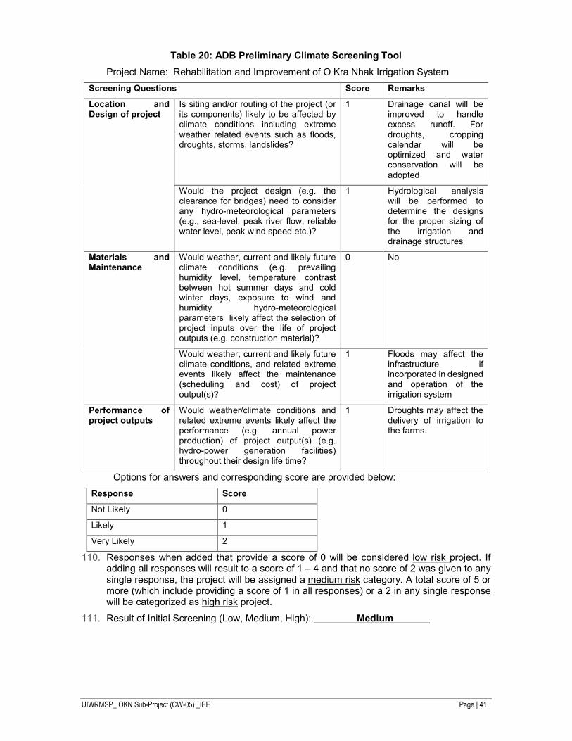
UIWRMSP_ OKN Sub-Project (CW-05) _IEE Page | 41
Table 20: ADB Preliminary Climate Screening Tool
Project Name: Rehabilitation and Improvement of O Kra Nhak Irrigation System
Screening Questions Score Remarks
Location and Design of project
Is siting and/or routing of the project (or its components) likely to be affected by climate conditions including extreme weather related events such as floods, droughts, storms, landslides?
1 Drainage canal will be improved to handle excess runoff. For droughts, cropping calendar will be optimized and water conservation will be adopted
Would the project design (e.g. the clearance for bridges) need to consider any hydro-meteorological parameters (e.g., sea-level, peak river flow, reliable water level, peak wind speed etc.)?
1 Hydrological analysis will be performed to determine the designs for the proper sizing of the irrigation and drainage structures
Materials and Maintenance
Would weather, current and likely future climate conditions (e.g. prevailing humidity level, temperature contrast between hot summer days and cold winter days, exposure to wind and humidity hydro-meteorological parameters likely affect the selection of project inputs over the life of project outputs (e.g. construction material)?
0 No
Would weather, current and likely future climate conditions, and related extreme events likely affect the maintenance (scheduling and cost) of project output(s)?
1 Floods may affect the infrastructure if incorporated in designed and operation of the irrigation system
Performance of project outputs
Would weather/climate conditions and related extreme events likely affect the performance (e.g. annual power production) of project output(s) (e.g. hydro-power generation facilities) throughout their design life time?
1 Droughts may affect the delivery of irrigation to the farms.
Options for answers and corresponding score are provided below:
Response Score
Not Likely 0
Likely 1
Very Likely 2
Responses when added that provide a score of 0 will be considered low risk project. If adding all responses will result to a score of 1 – 4 and that no score of 2 was given to any single response, the project will be assigned a medium risk category. A total score of 5 or more (which include providing a score of 1 in all responses) or a 2 in any single response will be categorized as high risk project.
Result of Initial Screening (Low, Medium, High): Medium
UIWRMSP_ OKN Sub-Project (CW-05) _IEE Page | 42
V. ANTICIPATED ENVIRONMENTAL IMPACTS AND MITIGATION MEASURES
Positive Impact and Environmental Benefits
This core subproject which is the subject of this IEE has been chosen using a set of selection criteria. Although these criteria did not include specific environmental impact issues, three of them when applied had the effect of selecting for relatively straightforward schemes without significant environmental impacts. These were:
i. Subproject should involve only rehabilitation of existing systems or related schemes and should not involve construction of new systems.
ii. Subproject should be located away from the Tonle Sap.Subproject should not cause involuntary resettlement and should require as less land acquisition as possible.
iii. Subproject should not be a Category “A” for Involuntary Resettlement and Environment; maximum of Category “B” for Involuntary Resettlement and Environment; and Category “C” for Indigenous Peoples.
The result of the subproject irrigation and drainage facilities will be (i) an increase in certainty and control of existing irrigation areas; (ii) expansion of reliable irrigation into new areas; and (iii) winning of longer cropping periods on areas previously unavailable for parts of the year due to flooding.
Environmental Measures during Pre-Construction Phase
A number of environmental management measures will be implemented in the pre – construction phase to ensure that appropriate plans and documentation to determine environmental performance of construction and operation of subprojects are in place. These include:
Updating EMP. Mitigation measures defined in this EMP will be updated and incorporated into the detailed design to minimize adverse environmental impacts. This will be the responsibility of the PMUs.
Final designs of embankments, siting of control structures and canal alignments will be completed after taking into account the provisions of the EMP.
Contract documents. Preparation of the environment section in the Terms of Reference for bidders for construction contracts and environmental contract clauses for contractors, namely the special conditions (referencing the EMP and monitoring plan). This will be the responsibility of the PMUs with the support of the PMICs.
Establishment of the Grievance Redress Mechanism during the subproject design.
Environmental Protection Training. Environmental specialists and/or officials from local MoE offices will be invited to provide training on implementation and supervision of environmental mitigation measures to contractors. This will be the responsibility of the PMUs.
Impacts and Mitigation Measures during the Construction Phase
1. Contractor Performance and Site Management
To ensure that construction contractors are able to implement the mitigation measures, the PMUs will put in place the following arrangements: (i) environmental specifications will be included in the bidding documents to contractors; (ii) an appropriate environment section describing standards and responsibilities will be included in the terms of reference for bidders; (iii) material haulage routes, and waste disposal arrangements will be defined in the construction tender documents as appropriate; and (iv) clauses referencing the EMP mitigation provisions and monitoring plans will be written into the construction contracts.
UIWRMSP_ OKN Sub-Project (CW-05) _IEE Page | 43
Following the award of construction contracts, the successful head contractor will prepare a Site Environmental Management and Supervision Manual, including an emergency preparedness and response plan for construction emergencies and site environmental health and safety plan, for approval by the PMUs.
During construction, the Environmental Management Officers of each PMU will be active in site supervision, management and appraisal, so as to identify problems and solve them in a timely fashion. Environmental training, especially related to environmental management by the contractor, is included in the EMP.
2. Construction
The following impacts and mitigation measures refer to construction impacts which are common to this subproject. The subproject will require earthworks, soil stabilization, dust and noise control as well as management of the impacts from machinery operation, transport and haulage of building materials and the domestic needs of the workforce.
Spoil disposal. The design during feasibility study for the O Kra Nahk subproject indicates that excavation volumes from embankments and canal will be generally balanced with embankment fill volumes. The subproject only plans for the disposal of unsuitable spoil (too sandy for compaction). This spoil will be made available to nearby communities for use as building pads and bunds.
Dredge Spoil. The O Kra Nhak canal improvement works will involve dredging of the canal to establish contoured shape and design slopes. The sediment quality of the dredge spoil will need to be tested and assessed against an appropriate standard before re-use in the structure of embankments (see Monitoring Plan in EMP). The sediment testing results will confirm safe re-use of the material.
Erosion of Disturbed Surfaces. Areas most vulnerable to erosion are temporary construction sites, and other places where surface soil will be disturbed. The most effective erosion control will be interception drainage to protect disturbed surfaces from surface flows. Construction plans will include erosion control prescriptions for construction work areas, including (i) constructing intercepting ditches and drains to prevent runoff entering construction sites and diverting runoff from sites to existing drainage; (ii) limiting construction and material handling during periods of rains and high winds; and (iii) stabilizing all cut slopes, embankments, and other erosion-prone working areas while works are going on. All earthwork disturbance areas shall be stabilized within 30 days after earthworks have ceased at the sites.
Construction wastewater. Construction wastewater is produced from the maintenance and cleaning of mechanical equipment and vehicles, maintenance water for mixing and curing concrete, cooling water, and lost water and soil during the construction period which is discharged as pollutants. The effluent, comprised mainly of inorganic wastewater, commonly contains no poisonous and harmful substance, except suspended solid, but, if discharged in an improper manner, still has the potential to impact existing water bodies. Some oil-containing wastewater can arise from machinery repairs.
Construction wastewater will not be discharged unto the surrounding soil or into surface water systems. Sedimentation tanks will be built, and after settling out of solids the upper clear liquid will be recycled for spraying the construction site (dust control), and the waste residue in the tank will be cleared and transported to designated landfills. Oil-containing wastewater will require the installation of oil-water separators before the sedimentation tank.
Gaseous Air Pollution. Construction machinery on all sites will consume petrol and diesel, releasing gaseous SO2, CO, and NOx. Equipment will be maintained to a high standard to ensure efficient running and fuel-burning. High-horsepower equipment will be provided with tail gas purifiers. All vehicle emissions will be in compliance with relevant Cambodian emission standards.
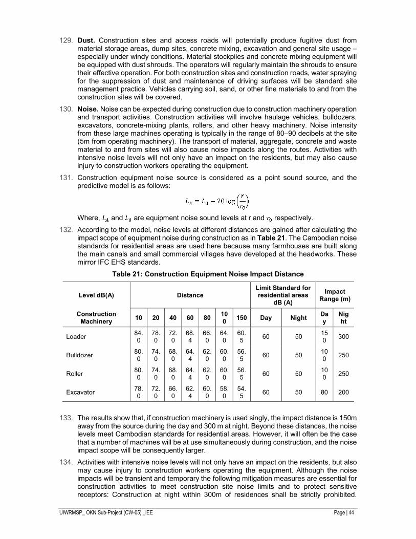
UIWRMSP_ OKN Sub-Project (CW-05) _IEE Page | 44
Dust. Construction sites and access roads will potentially produce fugitive dust from material storage areas, dump sites, concrete mixing, excavation and general site usage – especially under windy conditions. Material stockpiles and concrete mixing equipment will be equipped with dust shrouds. The operators will regularly maintain the shrouds to ensure their effective operation. For both construction sites and construction roads, water spraying for the suppression of dust and maintenance of driving surfaces will be standard site management practice. Vehicles carrying soil, sand, or other fine materials to and from the construction sites will be covered.
Noise. Noise can be expected during construction due to construction machinery operation and transport activities. Construction activities will involve haulage vehicles, bulldozers, excavators, concrete-mixing plants, rollers, and other heavy machinery. Noise intensity from these large machines operating is typically in the range of 80–90 decibels at the site (5m from operating machinery). The transport of material, aggregate, concrete and waste material to and from sites will also cause noise impacts along the routes. Activities with intensive noise levels will not only have an impact on the residents, but may also cause injury to construction workers operating the equipment.
Construction equipment noise source is considered as a point sound source, and the predictive model is as follows:
Where, and are equipment noise sound levels at r and respectively.
According to the model, noise levels at different distances are gained after calculating the impact scope of equipment noise during construction as in Table 21. The Cambodian noise standards for residential areas are used here because many farmhouses are built along the main canals and small commercial villages have developed at the headworks. These mirror IFC EHS standards.
Table 21: Construction Equipment Noise Impact Distance
Level dB(A) Distance Limit Standard for residential areas
dB (A)
Impact Range (m)
Construction Machinery
10 20 40 60 80 100
150 Day Night Day
Night
Loader 84.0
78.0
72.0
68.4
66.0
64.0
60.5
60 50 150
300
Bulldozer 80.0
74.0
68.0
64.4
62.0
60.0
56.5
60 50 100
250
Roller 80.0
74.0
68.0
64.4
62.0
60.0
56.5
60 50 100
250
Excavator 78.0
72.0
66.0
62.4
60.0
58.0
54.5
60 50 80 200
The results show that, if construction machinery is used singly, the impact distance is 150m away from the source during the day and 300 m at night. Beyond these distances, the noise levels meet Cambodian standards for residential areas. However, it will often be the case that a number of machines will be at use simultaneously during construction, and the noise impact scope will be consequently larger.
Activities with intensive noise levels will not only have an impact on the residents, but also may cause injury to construction workers operating the equipment. Although the noise impacts will be transient and temporary the following mitigation measures are essential for construction activities to meet construction site noise limits and to protect sensitive receptors: Construction at night within 300m of residences shall be strictly prohibited.
UIWRMSP_ OKN Sub-Project (CW-05) _IEE Page | 45
During daytime construction, the contractor will ensure that: (i) equipment with high noise and high vibration are not used in village or township areas and only low noise machinery or the equipment with sound insulation is employed; (ii) sites for concrete-mixing plants and similar activities will be located at least 1 km away from sensitive areas such as residences and schools; and (iii) temporary anti- noise barriers will be installed to shield any schools, residences and medical centers within 100m of the work sites.
Construction camps solid waste. The construction contractors will establish site offices and work camps at the headwork’s end of the main canals in both subprojects. The construction workforce will generate domestic wastewater and garbage (food wastes, kitchen wastes, paper, and other solid waste including food-laden wash water). Proper disposal of this waste will be essential. It will be the responsibility of the construction contractors to provide toilets with pump-out and disposal facilities and sufficient garbage bins at strategic locations and ensure that they are (i) protected from birds and vermin, (ii) emptied regularly (using the nearest township solid waste system and landfill), and (iii) do not overflow.
Hazardous and polluting materials. Construction material handling and disposal guidelines and directions that include spill responses will be prepared and implemented as part of the Site Environmental Management and Supervision Manual of each construction site. The following measures will be taken to prevent pollution of soil and surface water/groundwater: (i) storage facilities for fuels, oil, cement, and chemicals will be within secured areas on impermeable surfaces, provided with bunds and cleanup installations; (ii) vehicles and equipment will be properly staged in designated areas to prevent contamination of soil and surface water; (iii) vehicle, machinery, and equipment maintenance and re-fueling will be carried out in such a way that spilled materials do not seep into the soil; (iv) oil traps will be provided for service areas and parking areas; and (v) fuel storage and refilling areas will be located at least 50 m from canals and channels and will be protected by temporary drainage bunds to contain spills.
Flora and Fauna. All protected areas listed in Chapter IV (Description of the Environment) are more than 50 km away from the subproject sites. The subproject areas have been intensively farmed and irrigated for generations. No natural terrestrial or aquatic habitats exist and natural biodiversity comprises only common wildlife living among humans in agricultural regions, domesticated animals and feral pests and rodents. The vegetation comprises cultivated crops, agricultural weeds and tree plantations along roads, canal banks and dyke walls. There will be no significant loss of native flora and fauna as a result of the Project.
Cultural Heritage. During construction, contractors will ensure that any local cultural sites (including shrines and graves) will be kept clear of construction material and protected from dust and other disturbance. Access to these sites will not be impeded, and after construction is finished any disturbed surroundings will be restored to pre-construction standards.
Environmental Impact and Mitigation Measures during Operation
1. Hydrological Impacts
Since the hydrological impacts will be identified and prepared by hydrological specialist, so this section will be included in the main report under hydrological study section.
2. Impacts from Intensification of Agriculture
Since the agriculture impacts will be identified and prepared by agriculture specialist, so this section will be included in the main report under agriculture study section.
3. Water User Conflict
During operation there will be some conflicts which expected between water users at downstream and upstream respectively. Generally conflicts will result from insufficient quantity of water uses, competition of water demand and in-understandability. The water
UIWRMSP_ OKN Sub-Project (CW-05) _IEE Page | 46
users at upstream will be able to access water easily than users at downstream. Therefore, without proper management and water equitable share, the conflict cannot be avoidable.
4. Chemical Fertilizer Use
As mentioned in Section C. Socio-economic Environment/Development
1. Agricultural Practice is shown in Table 16, chemical uses for agriculture are popular to all farmers in the area to improve agricultural product. A tendency of agricultural activities will increase when the O Kra Nhak irrigation system will be improved. Hence pollution of chemical fertilizers will be expected to be increased respectively. Impacts can be reduced or avoided if the proposed mitigation measures will be properly implemented. Environmental training and public awareness on impact of chemical fertilizers, benefit of organic/compost fertilizers and environmental impacts.
Environmental Health and Safety
Safety and health of both workers and residents may be threatened by construction activities. Numerous workers will gather within the construction site, with potentially relatively low living conditions such as unclean water, poor food, and increased risk of diseases infection and transmission. Surrounding residents may also be affected by noise and dust. Workers will confront construction safety risks as well.
Measures to protect the community will include:
i. Planning construction activities (including demolition work) so as to minimize disturbances to residents, utilities and services. Temporary land occupation will be planned well ahead of construction to minimize its impact. Land will be reinstated to its original condition after construction.
ii. Implementing safety measures around the construction sites to protect the public, including warning signs to alert the public to potential safety hazards, and barriers to prevent public access to construction sites and unsafe areas.
Measures to ensure occupational health and safety will include:
i. Contractors shall be required by the PMUs to ensure that their workers and other staff engaged in the proposed constructions are in a safe environment.
ii. Following the award of construction contracts, the successful contractors will prepare site environmental health and safety plan, for approval by the PMUs.
iii. Contractors shall ensure that: (a) all reasonable steps are taken to protect any person on the site from health and safety risks; (b) the construction site is a safe and healthy workplace; (c) machineries and equipment are safe; (d) adequate training or instruction for occupational health and safety is provided; (e) adequate supervision of safe work systems is implemented; and (f) means of access to and egress from the site are without risk to health and safety.
Unanticipated Impacts during Construction and Operation
If any unanticipated impacts become apparent during project implementation, the borrower will (i) inform and seek ADB’s advice; (ii) assess the significance of such unanticipated impacts; (iii) evaluate the options available to address them; and (iv) prepare or update the EIA including EMP. ADB will help the borrower mobilize the resources required to mitigate any adverse unanticipated impacts or damage.
Climate Change Impact Assessment
The environmental risks from climate change need to be addressed in two different but complementary ways: (i) consideration of greenhouse gas emissions; and (ii) adaptation to safeguard infrastructure against the effects of future climate change.
UIWRMSP_ OKN Sub-Project (CW-05) _IEE Page | 47
1. Greenhouse Gas Emissions
Net greenhouse gas emissions from the project will derive from GHGs emitted by agricultural activities – in particular the CH4, N2O and CO2 emissions from rice paddy flooding and cultivation. The greenhouse gas emissions from rice paddy fields have been studied in India, Philippines and Japan (Table 22), and to a lesser extent in China and the USA. Only the studies in northern India have studied the emission of the suite of GHGs (CH4, N2O and CO2) in combination with different ranges of nitrogen fertilizer applications and on a range of soils. Studies have also compared the GHG emission consequences of different periods of inundation of rice crops.
Table 22: GHG Emissions from Rice Paddy
Location Methane (CH4) from Rice Paddy
Northern India2 40 – 100 kg/ha Philippines3 100 – 150 kg/ha
Japan4 150 – 200 kg/ha The Indian study approximates the subproject conditions for comparable levels of fertilizer
application and temperatures. The yearly emission levels used for this project are therefore:
66 kg/ha CH4: 690 kg/ha CO2: 1.93 kg/ha NO2.
These emission rates are calculated for the Project area in Table 23, and converted into equivalent levels of CO2 using the following formula:
Global warming potential (GWP) = CO2 emissions + CH4 emissions*21 + NO2 emissions*310
Table 23: GHG Emissions and GWP from Rice Paddy Increases
Increase in Rice Paddy
CH4 Emissions
(kg/yr)
CO2 emission
(kg/yr)
NO2 emission
(kg/yr)
GWP
(tons/yr CO2e)
1,134.6 74,883.6 782,874 2,190 3,034
The total CO2e emissions generated by the project will be approximately 3,034 tons/year. This is below the threshold of 100,000 tons/annum of the ADB SPS 20095 and therefore, no further monitoring is required.
2. Adaptation to Future Climate Change
The CRVA for O Kra Nhak FS is prepared based on the recommendation in AR5, which uses RCP-4.5 and RCP-8.5. There is currently an ADB project (TA-7610 CAM) on the impact of climate change being undertaken by MOWRAM to update the previous climate change assessment from AR-3 to AR-5 using RCP setup. However, the MOWRAM – TA project has only started it work and has yet to generate climate change data for Cambodia according to the Project Manager.
2 Pathak H, C Li and R Wassmann. 2005. 3 Corton et al. 2000. 4 Yagi et al.1996. 5 That requires an annual quantification of GHG emissions in accordance with internationally recognized methodologies.
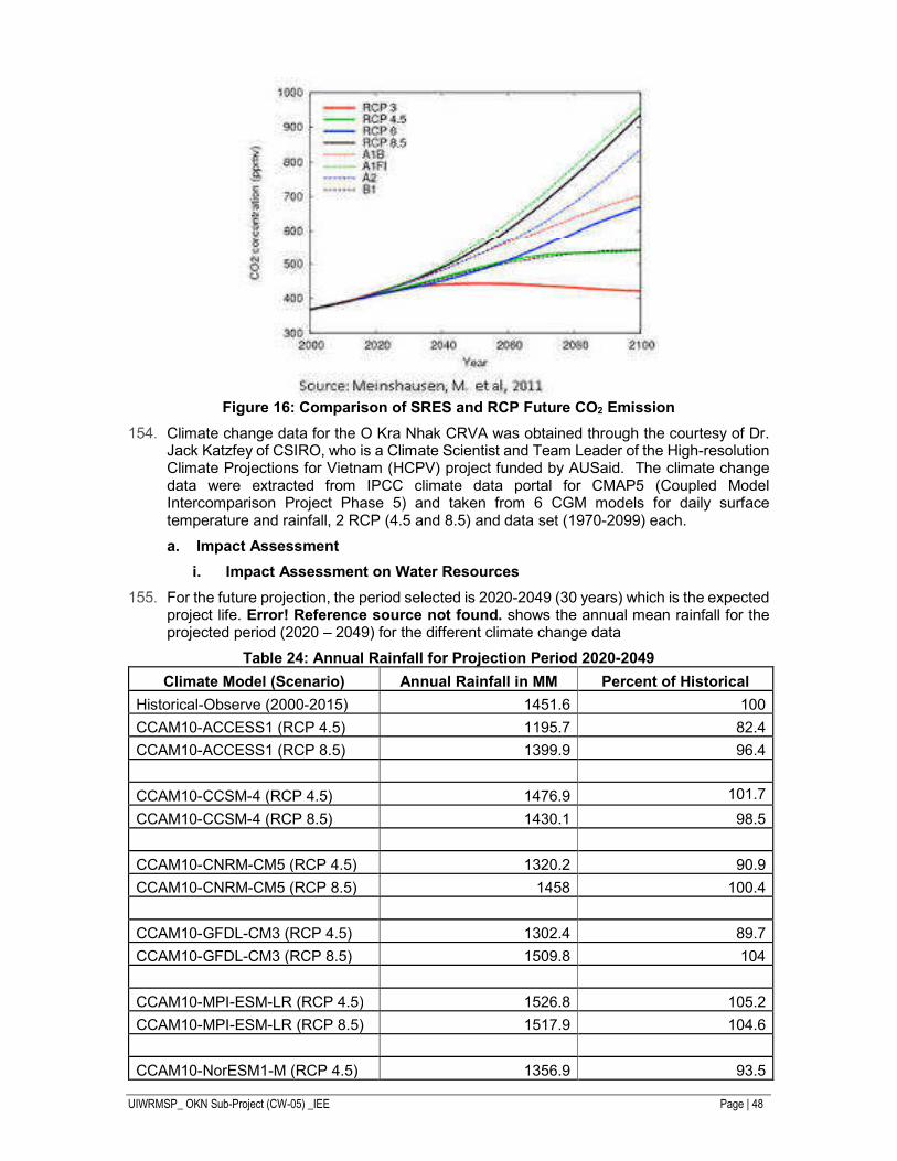
UIWRMSP_ OKN Sub-Project (CW-05) _IEE Page | 48
Figure 16: Comparison of SRES and RCP Future CO2 Emission
Climate change data for the O Kra Nhak CRVA was obtained through the courtesy of Dr. Jack Katzfey of CSIRO, who is a Climate Scientist and Team Leader of the High-resolution Climate Projections for Vietnam (HCPV) project funded by AUSaid. The climate change data were extracted from IPCC climate data portal for CMAP5 (Coupled Model Intercomparison Project Phase 5) and taken from 6 CGM models for daily surface temperature and rainfall, 2 RCP (4.5 and 8.5) and data set (1970-2099) each.
a. Impact Assessment
i. Impact Assessment on Water Resources
For the future projection, the period selected is 2020-2049 (30 years) which is the expected project life. Error! Reference source not found. shows the annual mean rainfall for the projected period (2020 – 2049) for the different climate change data
Table 24: Annual Rainfall for Projection Period 2020-2049
Climate Model (Scenario) Annual Rainfall in MM Percent of Historical
Historical-Observe (2000-2015) 1451.6 100
CCAM10-ACCESS1 (RCP 4.5) 1195.7 82.4
CCAM10-ACCESS1 (RCP 8.5) 1399.9 96.4
CCAM10-CCSM-4 (RCP 4.5) 1476.9 101.7
CCAM10-CCSM-4 (RCP 8.5) 1430.1 98.5
CCAM10-CNRM-CM5 (RCP 4.5) 1320.2 90.9
CCAM10-CNRM-CM5 (RCP 8.5) 1458 100.4
CCAM10-GFDL-CM3 (RCP 4.5) 1302.4 89.7
CCAM10-GFDL-CM3 (RCP 8.5) 1509.8 104
CCAM10-MPI-ESM-LR (RCP 4.5) 1526.8 105.2
CCAM10-MPI-ESM-LR (RCP 8.5) 1517.9 104.6
CCAM10-NorESM1-M (RCP 4.5) 1356.9 93.5
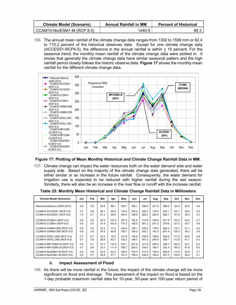
UIWRMSP_ OKN Sub-Project (CW-05) _IEE Page | 49
Climate Model (Scenario) Annual Rainfall in MM Percent of Historical
CCAM10-NorESM1-M (RCP 8.5) 1440.9 99.3
The annual mean rainfall of the climate change data ranges from 1302 to 1599 mm or 82.4 to 110.2 percent of the historical observes data. Except for one climate change data (ACCESS1-RCP4.5), the difference in the annual rainfall is within + 10 percent. For the seasonal trend, the monthly mean rainfall of the climate change data were plotted in. It shows that generally the climate change data have similar seasonal pattern and the high rainfall period closely follows the historic observe data. Figure 17 shows the monthly mean rainfall for the different climate change data.
Figure 17: Plotting of Mean Monthly Historical and Climate Change Rainfall Data in MM.
Climate change can impact the water resources both on the water demand side and water supply side. Based on the majority of the climate change data generated, there will be either similar or an increase in the future rainfall. Consequently, the water demand for irrigation use is expected to be reduced with higher rainfall during the wet season. Similarly, there will also be an increase in the river flow or runoff with the increase rainfall.
Table 25: Monthly Mean Historical and Climate Change Rainfall Data in Millimeters
ii. Impact Assessment of Flood
As there will be more rainfall in the future, the impact of the climate change will be more significant on flood and drainage. The assessment of the impact on flood is based on the 1-day probable maximum rainfall data for 10-year, 50-year and 100-year return period of
0
50
100
150
200
250
300
350
400
Jan Feb Mar Apr May Jun Jul Aug Sep Oct Nov Dec
Historical-Observe(2000-2015) CCAM10-ACCESS1(RCP 4.5) CCAM10-ACCESS1(RCP 8.5) CCAM10-CCSM-4(RCP 4.5) CCAM10-CCSM-4(RCP 8.5) CCAM10-CNRM-CM5(RCP 4.5) CCAM10-CNRM-CM5(RCP 8.5) CCAM10-GFDL-CM3(RCP 4.5) CCAM10-GFDL-CM3(RCP 8.5) CCAM10-MPI-ESM-LR (RCP 4.5) CCAM10-MPI-ESM-LR (RCP 8.5) CCAM10-NorESM1-M (RCP 4.5) CCAM10-NorESM1-M (RCP 8.5)
Prepared by PMIC
Consultant
ACCESS1
(DRY)
MPI-ESM-LR
(WET)
CCSM4
(MEDIAN)
Climate Model (Scenario) Jan Feb Mar Apr May Jun Jul Aug Sep Oct Nov Dec
Historical-Observe (2000-2015) 0.8 0.6 29.4 88.1 155.7 189.1 298.5 221.9 298.5 124.0 40.5 4.6
CCAM10-ACCESS1 (RCP 4.5) 0.7 0.6 26.1 84.9 118.9 163.2 256.2 175.2 225.1 103.1 38.0 3.5
CCAM10-ACCESS1 (RCP 8.5) 1.0 0.7 27.2 96.8 164.4 198.5 283.2 220.4 262.7 101.6 39.0 4.4
CCAM10-CCSM-4 (RCP 4.5) 0.9 0.6 40.5 103.3 157.3 182.5 314.9 235.8 271.9 122.3 42.2 4.7
CCAM10-CCSM-4 (RCP 8.5) 0.8 0.5 31.6 103.5 175.3 195.5 281.2 201.3 279.6 121.3 34.7 4.9
CCAM10-CNRM-CM5 (RCP 4.5) 0.6 0.6 27.4 77.6 145.4 159.1 276.5 178.0 294.4 115.1 41.1 4.4 CCAM10-CNRM-CM5 (RCP 8.5) 0.6 0.8 30.5 85.8 156.7 194.5 345.7 181.0 291.9 130.3 36.3 3.9
CCAM10-GFDL-CM3 (RCP 4.5) 0.7 0.7 32.2 75.5 141.8 140.9 278.8 199.2 263.6 117.3 46.6 4.9 CCAM10-GFDL-CM3 (RCP 8.5) 0.7 0.9 29.6 83.7 132.3 146.7 357.2 264.5 328.1 113.8 47.1 5.2
CCAM10-MPI-ESM-LR (RCP 4.5) 0.9 0.7 37.7 116.2 152.1 207.9 277.8 204.5 308.7 160.5 53.7 6.2
CCAM10-MPI-ESM-LR (RCP 8.5) 0.7 0.8 33.3 111.9 158.7 203.0 318.5 184.7 302.4 150.3 47.6 6.0
CCAM10-NorESM1-M (RCP 4.5) 0.8 0.6 24.5 83.3 165.0 193.4 317.8 154.5 265.8 114.6 32.9 3.7
CCAM10-NorESM1-M (RCP 8.5) 0.9 0.7 30.5 97.1 181.2 199.4 338.5 165.4 257.2 130.5 35.5 4.1
UIWRMSP_ OKN Sub-Project (CW-05) _IEE Page | 50
each climate change data, which are the hydrologic parameters used in the design. The probable rainfall data are shown in Table 26.
Table 26: 1-day Probable Maximum Rainfall in Millimeters
It can be noted that all of the climate change data are comparably below the historical observed probable rainfall for all three selected return periods. Although it is predicted that there will be more rainfall in the future, the rainfall intensity seems to be less than the historical observe data. It is likely that the lower results may be attributed to the downscaling effect in which case the historical data is adopted in the design. Nonetheless, the proposed project has included the rehabilitation and improvement of the drainage system in the command area to mitigate any future flooding.
b. Vulnerability Assessment
Water Resources: In the FS study, the irrigation water requirement (IWR) was computed using a decadal (10-days) paddy water balance computation. The comparison of the vulnerability on irrigation water requirement is performed for the historical observed data, the average climate change data (CCAM10-CCSM-4: RCP 8.5) and the worst-case scenario data (CCAM10-ACCESS1: RCP 4.5). The combined effect of a higher irrigation water requirement and lower reservoir inflow was also assessed using a reservoir operation simulation. The reservoir operation simulation was performed for the same three conditions and the amount of annual shortage was assessed. Based on the results, there is no change in the crop area even for the worst-case scenario. There is sufficient inflow in the wet season to offset the reduction in runoff and higher irrigation demand as shown by the amount of reservoir spillage.
Flooding and Drainage: For the vulnerability assessment due to flooding, a different set of climate change data was selected that exhibited higher amount of rainfall. The selection was based on the probable maximum 1-day rainfall. The historical observed data was compared to the average climate data (CCAM10-CCSM-4 : RCP 4.5) and worst case scenario (CCAM10-NorESM1-M : RCP 8.5). It is already clear that all the climate change data are below the historical observe and therefore, there is no more additional impact anticipated on the design of the spillway and the drainage system.
c. Adaptation Assessment
Design of Irrigation Facilities: In the feasibility study, the irrigation system was optimized to maximize the design command area. The stored water in the reservoir is a significant safeguard against drought if properly managed and conserved. A reservoir operation study (ROS) was used to optimize the reservoir use by simulating various types of crops and cropping calendars. The crops considered are hybrid rice and vegetables or other cash
UIWRMSP_ OKN Sub-Project (CW-05) _IEE Page | 51
crops. The planting of the hybrid rice will be spread out to early wet rice crop, main wet rice crop and dry season rice crop while two successive vegetable or cash crops will be planted immediately after the main wet rice crop is harvested to take advantage of the high residual soil moisture content. The reservoir operation was also optimized so that the reservoir will always be at full storage capacity at every start of the main rice crop. The reservoir operation shows that there is adequate water supply based on the average climate change data (CCAM10-CCSM-4 : RCP 8.5) and even for the worst case scenario (CCAM10-GFDL-CM3 : RCP 4.5), it is possible to overcome the reduced water supply by proper water management and adopting water conservation measures (increase irrigation efficiency by 10 percent).
Operation of O Kra Nhak Irrigation System: During the operation of the irrigation system, it is important that factors considered in the design of the irrigation system should be adopted in the operation and not be changed since it will affect the command area. Foremost, the operation of the system should follow the cropping pattern used in the feasibility study. In the wet season, all the command area can be irrigated, however during the dry season, there will be limited water supply and only part of the command area should be planted. To aid in setting the size of the dry season crop, a reservoir rule curve will be provided and used in the pre-season planning and system operation.
Before the start of the wet season planting period, a pre-season planning or consultation shall be held between PDRAM and FWUC officials and members to determine the target crop area and the start of the cropping for both wet and dry seasons. The pre-season consultation will give PDRAM the information to prepare the scheduling of the opening of the irrigation gates and for the FWUC to designate areas to be planted and irrigated. During the planting period, close monitoring of water releases will be done to prevent wastage and suspended irrigation practices will be implemented to conserve irrigation water. Suspension of irrigation supply will be implemented when there is sufficient rainfall observed in the command area and the suspension can be one or more days depending on the amount of rainfall and area covered.
Farm Practices and Operation: The farmers are key partners in the climate adaptation since they are well experienced in coping with drought and flooding in their respective areas. In general, the highest water loss is at the farm level. It is estimated that 30 to 40 percent of the water delivered to the farm is lost due to improper use and wastage. Large amount of water is supplied during land preparation and the retained water is drained prior to broadcasting. The amount of water delivered for land preparation should be regulated to reduce any wastage. Another source of wastage is to supply irrigation water when it had rained heavily a day before. Suspended irrigation should be practiced during the crop operation stage to conserve water.
To promote timely and equitable supply of water in the paddy, the project will improve the tertiary canals. The tertiary canals will ensure that all areas can be irrigated quickly and therefore, these canals should be maintained properly. The farmers should also maintain the paddy dikes levels so that there will be minimum drainage and there is adequate space to capture rain water.
Another water conservation measure that can be introduced is the Alternate Wetting and Drying (AWD) method. This method allows the water in the paddy to be slightly below the saturation level and use a small diameter tube to observe and monitor the water table. By allowing the water level to be lowered, the plant roots will increase and results to higher yield and at the same time increase the amount of effective rainfall or rainfall captured in the paddy.
The farmers shall be encouraged to cultivate more cash crops to reduce water use and increase their income. At present, farmers are planting watermelon on 5 hectares area. Other types of cash crops are proposed such as mongo beans, young corn, onion, garlic and exotic vegetables.

UIWRMSP_ OKN Sub-Project (CW-05) _IEE Page | 52
d. Implementation
Project Response to Drought and Increased Crop Water Demand: In general, the climate change data indicated that there would be an increase in the average annual rainfall in the project location. Notwithstanding, the cycle of El Nino will continue to affect the global climate and will result to irregular and varying degree of drought events. The following are the project response to drought and increase crop water demand:
i. The proposed crops have been selected to ensure that the command area can be fully utilized during the wet and dry season and the irrigation system will give the farmers the greatest benefit by including high-value or cash crops in the dry season.
ii. Cropping calendar of each crop (early rice, main rice, dry season rice and cash crops) has been optimized in the reservoir operation simulation to effectively use the stored water.
iii. Water management and water conservation practices will be adopted such as pre-season planning and consultation, use of reservoir rule curve in setting the dry season crop area, suspension of irrigation after heavy rainfall, AWD practices and proper maintenance of paddy dikes and tertiary canals.
iv. Close coordination between PDRAM and FWUC in the operation and water management of the O Kra Nhak irrigation system.
Project Response to Increased Flood Potential: The predicted increase in future rainfall will result to more frequently and intense rainfall events and higher rainfall in the wet season that will likely results to more flooding. Flooding in the project area are mainly located in the lower portion of the command area near Stung Sen. Increase runoff can also affect the operation of the reservoir and damage irrigation structures. The following are the project response to increase flood potential.
i. The irrigation canal been designed not only to convey irrigation water but also to drain excess water from the paddy. The irrigation canal cum drainage canal will ensure that the crop will not be submerged beyond 24 hours with paddy depth greater than 120 mm to prevent permanent crop failure.
ii. The reservoir spillway has been design to handle a 50-year design flood and corresponding modification of the spillway has been incorporated in the design. The spillway will also be improved by providing additional energy dissipaters to reduce scoring after the downstream apron.
iii. As an additional safeguard for the reservoir, the 3 irrigation outlets also function as emergency outlet, which is the current practice by the farmers. Modification irrigation outlets are included in the project plans to uniformly discharge the flood water and minimize downstream scouring. These modifications will include setting the top of the gates (gates closed) at the same level as the spillway and providing energy dissipaters at the downstream apron of the irrigation outlets.
iv. The downstream command area which is subject to flooding from Stung Sen will be planted with early rice crop to reduce flood damage and dry season of high-value crop to maximize the farmers’ income.
Watershed Management: Although the project does not include a component on watershed management, it is considered essential in the operation of the irrigation system especially during drought and to adapt to potential adverse impact of climate change. The management of the watershed can be led by the local commune chiefs and district officers with the participation of the FWUC and farmers/beneficiaries. The activities that can be undertaken are as follows:
i. Planting of trees in the watershed, which will include fruit trees and fast growing trees. The fruit trees can provide additional income to the farmers while the fast growing trees can be used as firewood and construction materials.
UIWRMSP_ OKN Sub-Project (CW-05) _IEE Page | 53
ii. Forest conservation should be promoted which include increase bio-diversity in trees and plants, management of tree cutting and clearing, and fire prevention.
iii. Sediment control should also be setup to prevent sediment from reaching the lake area and reducing the storage capacity. Sediment control will include setting up of sediment traps along the small creeks and building strategically located sediment retention dam upstream of the reservoir lake area.
iv. Conduct awareness campaign to inform the farmers and the community in general on the importance and benefit of preserving the watershed.
Community Response to Climate Change: The farmers and the local community has the most capacity and experience to adapt to the impact of climate change. They have learned to adapt with drought and flooding and some of these adaptive practices are as follows:
i. Typical Cambodian rural houses are constructed on stilts to protect it from high floodwater and with large windows and high ceiling to keep the house cool during summer and high temperature periods.
ii. Houses and communities are located on high grounds and far from the main river to protect it from flood inundation.
iii. Farmers store extra food during the rainy season in case of flooding and isolation.
iv. Farmers plant crops in the exposed area of the reservoir during drought or extended dry spell.
v. Farmers plant high value crops during drought to reduce water use and obtain
additional income.
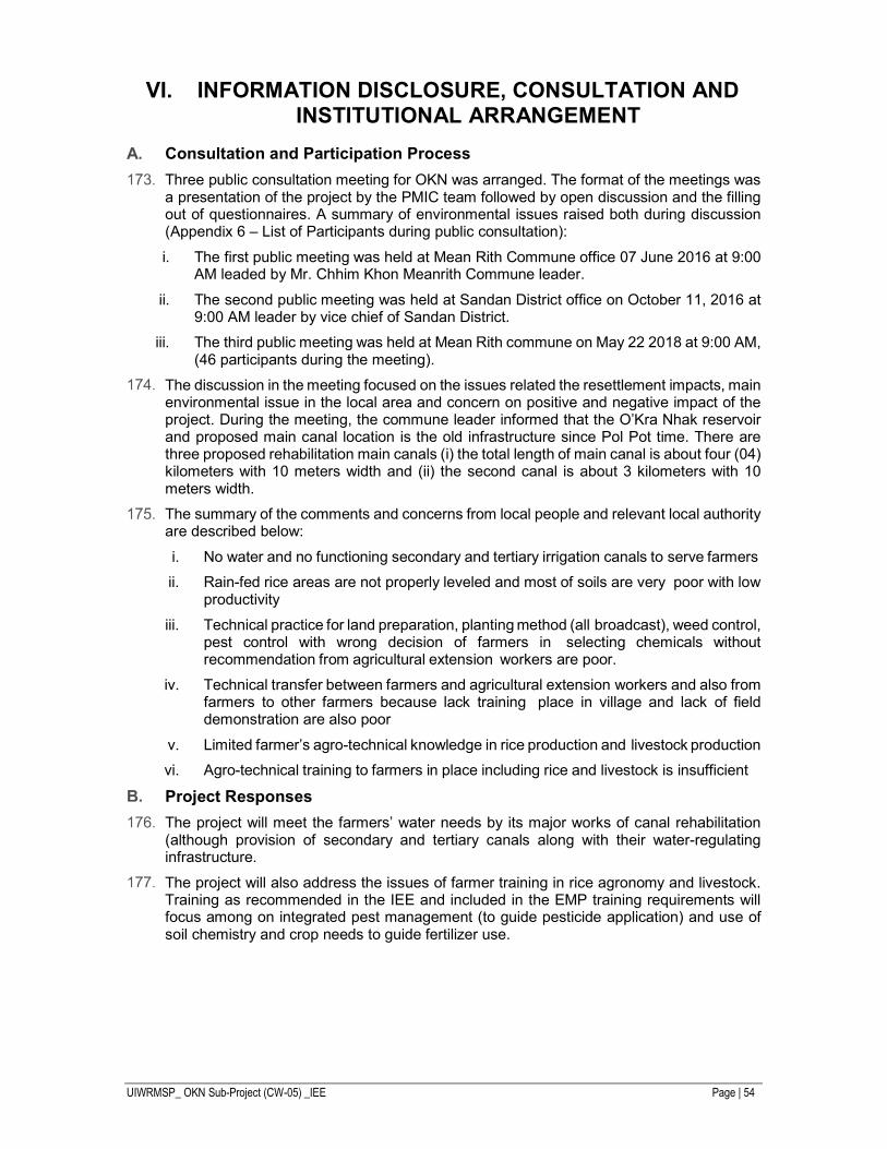
UIWRMSP_ OKN Sub-Project (CW-05) _IEE Page | 54
VI. INFORMATION DISCLOSURE, CONSULTATION AND INSTITUTIONAL ARRANGEMENT
Consultation and Participation Process
Three public consultation meeting for OKN was arranged. The format of the meetings was a presentation of the project by the PMIC team followed by open discussion and the filling out of questionnaires. A summary of environmental issues raised both during discussion (Appendix 6 – List of Participants during public consultation):
i. The first public meeting was held at Mean Rith Commune office 07 June 2016 at 9:00 AM leaded by Mr. Chhim Khon Meanrith Commune leader.
ii. The second public meeting was held at Sandan District office on October 11, 2016 at 9:00 AM leader by vice chief of Sandan District.
iii. The third public meeting was held at Mean Rith commune on May 22 2018 at 9:00 AM, (46 participants during the meeting).
The discussion in the meeting focused on the issues related the resettlement impacts, main environmental issue in the local area and concern on positive and negative impact of the project. During the meeting, the commune leader informed that the O’Kra Nhak reservoir and proposed main canal location is the old infrastructure since Pol Pot time. There are three proposed rehabilitation main canals (i) the total length of main canal is about four (04) kilometers with 10 meters width and (ii) the second canal is about 3 kilometers with 10 meters width.
The summary of the comments and concerns from local people and relevant local authority are described below:
i. No water and no functioning secondary and tertiary irrigation canals to serve farmers
ii. Rain-fed rice areas are not properly leveled and most of soils are very poor with low productivity
iii. Technical practice for land preparation, planting method (all broadcast), weed control, pest control with wrong decision of farmers in selecting chemicals without recommendation from agricultural extension workers are poor.
iv. Technical transfer between farmers and agricultural extension workers and also from farmers to other farmers because lack training place in village and lack of field demonstration are also poor
v. Limited farmer’s agro-technical knowledge in rice production and livestock production
vi. Agro-technical training to farmers in place including rice and livestock is insufficient
Project Responses
The project will meet the farmers’ water needs by its major works of canal rehabilitation (although provision of secondary and tertiary canals along with their water-regulating infrastructure.
The project will also address the issues of farmer training in rice agronomy and livestock. Training as recommended in the IEE and included in the EMP training requirements will focus among on integrated pest management (to guide pesticide application) and use of soil chemistry and crop needs to guide fertilizer use.
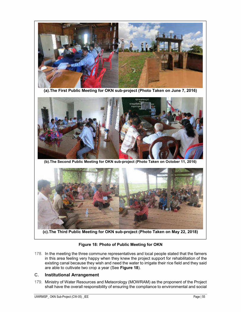
UIWRMSP_ OKN Sub-Project (CW-05) _IEE Page | 55
Figure 18: Photo of Public Meeting for OKN
In the meeting the three commune representatives and local people stated that the famers in this area feeling very happy when they knew the project support for rehabilitation of the existing canal because they wish and need the water to irrigate their rice field and they said are able to cultivate two crop a year (See Figure 18).
Institutional Arrangement
Ministry of Water Resources and Meteorology (MOWRAM) as the proponent of the Project shall have the overall responsibility of ensuring the compliance to environmental and social
(a).The First Public Meeting for OKN sub-project (Photo Taken on June 7, 2016)
(b).The Second Public Meeting for OKN sub-project (Photo Taken on October 11, 2016)
(c).The Third Public Meeting for OKN sub-project (Photo Taken on May 22, 2018)
UIWRMSP_ OKN Sub-Project (CW-05) _IEE Page | 56
safeguard policies and the implementation of the EMP of the entire component. MOWRAM shall coordinate with Ministry of Environment and Ministry of Agriculture, Fishery and Forestry and other concerned agencies for their active participation in the implementation of EMP and to ensure compliance with national requirements. MOWRAM shall delegate the authority in implementing EMP of different components and ensuring the implementation of EMPs. Project Management Unit (PMU) and PMU of the Provincial Department of MOWRAM shall have the main responsibility of implementation of EMP during the construction and operation phase of the project. PMU will designate a liaison officer for environmental protection and mitigation for the subproject and assure compliance with EMP requirements. Project Management and Implementation Consultant (PMIC) shall assist PMU in fulfilling their responsibilities. PMIC shall support PMU in the evaluation of the implementation of EMP and modify the EMP if needed, and in strengthening the institutional capacity of different involved parties in the project implementation.
The Contractor will be responsible for compliance with environmental covenants as indicated in the contract. Farmers Water Users Community (FWUC) shall have the very important role in the implementation of the forestry and watershed conservation programs to enhance the water availability in the river basin and use of water resources efficiently for maximizing the benefits of the projects. FWUC will also raise awareness of farmers in the proper utilization of the chemical fertilizers, insecticides and pesticides to avoid the impacts on human health. The role and responsibilities of involved institutions are summed up in Table 27.
Table 27: Institutional Roles and Responsibilities in EMP Implementation
Institutions/ Communities
Roles and Responsibilities
MOWRAM • Overall responsibility in ensuring the project compliance of safeguard policies and compliance reporting
• Coordinating with other government institutions and donor to facilitate the implementation of the EMP
PMU • Support MOWRAM in the coordination with different government ministries and donor for obtaining necessary approvals
• Design and implement the capacity building programs for the ministry staffs and staffs of provincial department of the ministry
• Provide necessary resources for the implementation of the EMP • Evaluate the effectiveness of the EMP and propose for update if
needed • Support PMU at each provinces in the implementation of EMP
PMU at provincial level
• Day to day management of the implementation of the project including ensuring the implementation of EMP
• Supervise the work of CME and Contractors • coordinate with local bodies and communities for their participation in
the execution of EMP. PMIC • Ensure that the project implementation fully complies with the ADB
environmental and social safeguard policies • Support PMU in the design and execution of the training programs for
the capacity building of ministry and provincial department of the ministry
• Provide technical support to PMU, PMU at provincial level and the CME-PMIC in the evaluation of the monitoring results obtained from the monitoring programs and update the EMP if needed.
CME-PMIC • Technical support to PMU at provincial level in the execution of the project including in the implementation of the EMP
• Monitoring the work of contractors in compliance with environmental covenants of the contract.
UIWRMSP_ OKN Sub-Project (CW-05) _IEE Page | 57
Institutions/ Communities
Roles and Responsibilities
• Work closely with PMIC head office in reviewing the effectiveness of EMP and update it if needed.
Contractors • Implementation of the recommended mitigation measures during the construction phase of the project.
• Ensuring the compliance with the Occupational Health and Safety standards.
• Training of the workforce in Good Practices in construction management and waste management in the construction sites.
• Prepare the quarterly environmental monitoring report and submit to PMU through PMIC.
FWUC • Participate in the implementation of the programs related to the conservation of forestry and watershed in the river basin, aquatic weeds management, proper utilization of chemical fertilizers and pesticides and support the fishery conservation program.
• Coordinate with different government departments and other FWUCs to maximize the benefits of the project.
Local authorities and communities
• Participate in the project developments and ensure that their views are incorporated.
• Monitor contractor’s activities to ensure compliance with requirements • Report field engineer and environmental liaison officer if any
noncompliance. MOWRAM: Ministry of Water Resources and Meteorology; PMU: Project Management Unit, PMIC: Project
Management and Implement Consultant, CME: Construction Management Engineer, FWUC: Farmers
Water Users Communities
UIWRMSP_ OKN Sub-Project (CW-05) _IEE Page | 58
VII. GRIEVANCE REDRESS MECHANISM
A grievance redress mechanism (GRM) will be established in each subproject province in compliance with ADB’s SPS 2009 requirement to prevent and address community concerns and assist the project to maximize environmental and social benefits.
The GRM will be accessible to diverse members of the community, including more vulnerable groups such as women and youth. Multiple points of entry, including face-to-face meetings, written complaints, telephone conversations, or e-mail, will be available. Opportunities for confidentiality and privacy for complainants will be honored where this is seen as important.
Proposed Mechanism
The PMU will establish a Project Public Complaint Unit (PPCU), which will act as a central recording and coordinating unit for all subprojects under the Project. Each subproject PMU will ensure that the GRM is publicized locally so that the community is fully aware of the mechanism and the local points of entry to it. The setting up of the GRM in the PMU and its initial implementation through the PMUs will be supported by the environmental consultant of the PMIC.
When construction starts, a sign will be erected at each construction site providing the public with updated project information and summarizing the grievance redress mechanism process including details of the GRM entry points. The contact persons for different GRM entry points; PMU, FWUC leaders, contractors, and operators of project facilities, will be identified prior to construction. The contact details for the entry points (e.g. phone numbers, addresses, e- mail addresses, etc.) will be publicly disseminated on information boards at construction sites and on the website of the local government.
The preferred action sequence for complaints handling is that the complaint should be investigated and resolved by the unit receiving the complaint. If this is not possible, the complaint should be referred to the PMU (whose wider membership will enable coordinated action in response).
The PPCU will maintain records of complaints and actions taken to correct them. This data will be included in the PMU’s reports to the ADB. The PPCU will establish a GRM tracking and documentation system. The system will include the following elements: (i). tracking forms and procedures for gathering information from project personnel and complainant(s); (ii). Staff to update the database routinely; (iii). Systems with the capacity to analyze information so as to recognize grievance patterns, identify any systemic causes of grievances, promote transparency, publicize how complaints are being handled, and periodically evaluate the overall functioning of the mechanism; (iv). Processes for informing stakeholders about the status of a case; and (v). Procedures to retrieve data for reporting purposes, including the periodic reports to the ADB.
GRM Procedure and Timeframe
The procedure and timeframe for the grievance redress mechanism are described as follows (see Figure 19). The stages are represented by different colors in the flow diagram:
i. Stage 1: Contractor/villager chief/commune at village and commune Level (5 working days). Affected People (APs) will present their complaints and grievances verbally or in writing to the contractor/village chief, commune chief. The receiving agent will be obliged to provide immediate written confirmation of receiving the complaint. If after 5 days the aggrieved AP does not hear from taken in the first step, the complaint may be brought to the District Office/ PIU/PMIC (CME) at provincial level.
ii. Stage 2: District/PIU/PMIC (CME) at district and provincial level (5 working days). This level has 5 working days within which to resolve the complaint to the satisfaction of all concerned. If the complaint not be solved at this stage, the District
UIWRMSP_ OKN Sub-Project (CW-05) _IEE Page | 59
office/PMU/PMIC (CME) at provincial level will bring the case to the PMU/PMIC at national level.
iii. Stage 3: PPCU/PMU/PMIC at national Level (10 working days). This level has 10 working days within which meets with the aggrieved party and tries to resolve the situation. Within 10 working days of submission of the grievance, the PPCU must make a written decision and submit copies to the MOWRAM/PDOWRAM and the APs. If the complaint still not be solved at this stage, the complaint may be brought to ADB. If the complaint still not be solved at this stage, the complaint may be brought to ADB.
During construction, the PPCU will be informed by contractors and construction supervisors, FWUC staff, or PMUs if people complain about the project. During operation, the PPCU will be advised of complaints by the PDOWRAM and FWUC. The PPCU will also inform the ADB project team and submit all relevant documents.
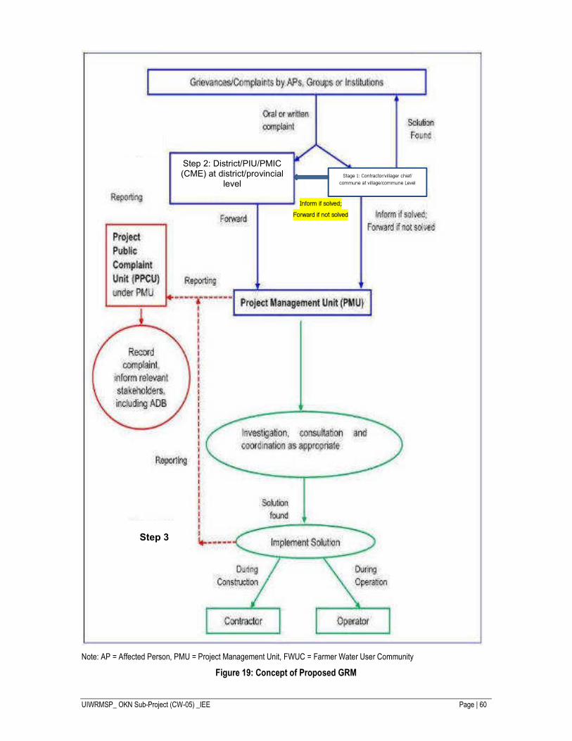
UIWRMSP_ OKN Sub-Project (CW-05) _IEE Page | 60
Note: AP = Affected Person, PMU = Project Management Unit, FWUC = Farmer Water User Community
Figure 19: Concept of Proposed GRM
Step 2: District/PIU/PMIC (CME) at district/provincial
level Stage 1: Contractor/villager chief/
commune at village/commune Level
Step 3
Inform if solved;
Forward if not solved
UIWRMSP_ OKN Sub-Project (CW-05) _IEE Page | 61
VIII. CONCLUSION AND ASSURANCES
Positive Impact and Environmental Benefits
The result of the subproject irrigation facilities will be (i) an increase in certainty and control of existing irrigation areas; (ii) expansion of irrigation into new areas; and (iii) winning of longer or new cropping periods on areas previously unavailable for parts of the year due to flooding. The beneficiaries of these changes will be local farmers, with flow-on effects to local commercial enterprises. Since rural populations are the poorest sectors of the Cambodian population, poverty alleviation effects will be direct and sustainable.
Negative Impacts
During construction, the main issues will be air, water pollution and soil erosion, all of which must be managed by strict control of construction contractors. Additional localized traffic hazards are anticipated and this must be minimized by site access and road safety planning. Health and safety of construction workers is also, as always, a primary concern. Mitigation of construction-phase impacts relies heavily on responsibility of works contractors to follow specification clauses specifically designed to minimize pollution of air and water and soil erosion. This mitigation will in turn rely on enforcement by the Environmental Management Officer in each project management unit and also by construction supervision consultants.
Post-construction, the main concerns are local increases in the levels of agricultural fertilizer and pesticide residues and their effects on water quality and people. Post-construction mitigation will benefit from capacity building and training under the project to use fertilizers and pesticides efficiently and responsibly.
There is also a concern that the irrigation schemes must be sustainable and responsibly managed, to ensure that agreed irrigation flows are maintained and other water users are not disadvantaged. The EMP requires a clear and detailed extraction plan for the cropping seasons to be prepared and submitted before construction.
Assurances
The most important assurance, which should be guaranteed by a loan covenant is that the PMUs will undertake the full range of effective measures set out in the IEE and EMP to ensure that the environmental management provisions and the environmental monitoring plan will be implemented effectively during project implementation, and that the implementation reports of the environmental management and monitoring plan in accordance with ADB requirements will be submitted in a timely fashion. Part of this monitoring and management commitment will be a commitment to implement and maintain an appropriate Grievance Redress Mechanism covering the construction and operation of the subprojects.
Other, specific assurances are that:
i. The sediment quality of spoil from channel dredging will need to be tested and assessed against the relevant standards before reuse. The sediment testing results will determine the requirements to ensure safe reuse.
ii. The Project will deliver, as part of its Capacity Building and Training component, training modules specifically tailored to the needs of farmers on Integrated Pest Management (IPM) and low chemical cultivation applicable to cropping conditions and capacities in the local soil and climatic environments.
Conclusion
The majority of identified environmental impacts are not assessed as significant. It is concluded that the infrastructure subprojects planned for the O Kra Nhak schemes have significant potential benefits for the rural populations of these areas. In addition, the design features, operational regimes and construction management safeguards will address the range of potential environmental impacts identified and will be active through the project
UIWRMSP_ OKN Sub-Project (CW-05) _IEE Page | 62
EMP and continuously checked in the environmental monitoring program. No further study or detail EIA study needs to be undertaken based on the ADB safeguard requirements.
UIWRMSP_ OKN Sub-Project (CW-05) _EMP Page | 63
Appendix 1: Environmental Management Plan
Cambodia: Uplands Irrigation and Water Resources Management Sector Project
O Kra Nhak Sub-Project (CW-05)
Environmental Management Plan – EMP
Introduction
The Environmental Management Plan (EMP) covers all phases of non-core sub-project implementation from preparation through commissioning and operation, and it aims to ensure the monitoring of environmental impacts and activation of environmental mitigation measures. Relevant parts of the EMP will be incorporated into the construction, operation, and management of each sub-project. Environmental protection measures will (i) avoid, and (ii) where avoidance is not possible, mitigate environmental impacts, and (iii) achieve compliance with national environmental regulations and ADB Safeguard Policy Statement 2009.
Environmental Monitoring Programs will be carried out and the results will be used to evaluate the extent and severity of actual environmental impacts against the predicted impacts and the performance of the environmental protection measures.
Responsibilities for Implementation
The Ministry of Water Resources and Meteorology (MOWRAM) is the executing agency (the EA) and Department of Farmer Water User Community (DFWUC) is the implementing agency (the IA). A Project Steering Committee, headed by Minister MOWRAM, will oversee the Project Implementation and Management. A Project Management Unit (PMU) was established and the PMU was fully involved in the Project preparation. The PMU is headed by a Project Director who is the Deputy Director General for Technical Affairs and a Project Manager who is the Director of the Department of FWUC. The PMU is composed of 24 designated personel from MOWRAM, MAFF and PDWRAM. This will also include staff from the PDWRAM of the province within which the sub-project is located. For the O Kra Nhak the PMU will be responsible for the supervision and monitoring of project-related environmental activities during the pre-construction, construction and operation phases as part of their functions. In line with this an Environmental Management Officer (EMO) in the PMU will be assigned to be responsible for supervision of environmental management and for environmental monitoring. The major responsibilities of the environmental officer will be to ensure that:
a. Mitigation measures and monitoring of these activities are carried out in accordance with the EMP;
b. Environmental Monitoring program, comprising the of taking samples and analysis are being carried out;
c. Reporting is performed in compliance with ADB requirements.
However, the main environmental guidance for the implementation phase will be provided by the Environment Specialist in the Project Management and Implementation Consultants (PMIC) team. The role of the PMIC will be to work as part of the PMU, helping them fulfill their supervision and monitoring responsibilities. The PMIC will also provide monitoring reports for the ADB. The PMIC was contracted by the PMU for the duration of the loan implementation period.
Contractors will be engaged by the PMU for construction. The construction impact mitigation measures contained in this EMP will be included as necessary activities in the contract documents. The incorporation of EMP provision into the contract documents will
UIWRMSP_ OKN Sub-Project (CW-05) _EMP Page | 64
be undertaken by the PMU. The contractors will have the responsibility for implementation of the impact mitigation measures in the construction phase and their performance will be supervised by the PMU.
Environmental monitoring during operation of the Project in the longer term is the responsibility of the respective PDWRAM.
Summary of Potential Impacts
Table A1.1 summarizes the potential impacts of the sub-project during construction and operation as identified by the Initial Environmental Examination (IEE) as well as corresponding mitigation measures designed to minimize those impacts.
C1. Mitigation Measures
The mitigation measures will be incorporated into the tender documents, construction contracts, and operational management procedures. Contractors and PMU and PDWRAMs will implement these measures, depending upon sub-project phases. The effectiveness of these measures will be carefully watched via the environmental monitoring to determine whether to continue them or to make improvements.


