Embed Size (px)
Citation preview

CIVIL ENGINEERING
Hydrology & Irrigation
Chapter 1: HYDROLOGICAL CYCLE AND PRECIPITATION ......................................................... 6
HYDROLOGIC CYCLE .......................................................................................................................... 6
PRECIPITATION .................................................................................................................................... 7
MEASUREMENT OF PRECIPITATION .................................................................................................... 8
ESTIMATION OF MISSING DATA ........................................................................................................ 15
ABSTRACTIONS FROM PRECIPITATION ............................................................................................. 16
EVAPORATION ................................................................................................................................... 16
SUMMARY ...................................................................................................................................... 16
FORMULA ....................................................................................................................................... 17
TIPS .................................................................................................................................................. 18
PREVIOUS YEAR GATE QUESTIONS ........................................ Error! Bookmark not defined.
Chapter 2: INFILTRATION AND RUNOFF ....................................... Error! Bookmark not defined.
INFILTRATION .................................................................................... Error! Bookmark not defined.
RUNOFF ............................................................................................. Error! Bookmark not defined.
RUNOFF—RAINFALL RELATIONS ..................................................... Error! Bookmark not defined.
STAGE DISCHARGE RELATIONSHIP ................................................... Error! Bookmark not defined.
SUMMARY ...................................................................................... Error! Bookmark not defined.
TIPS .................................................................................................. Error! Bookmark not defined.
PREVIOUS GATE QUESTIONS .................................................... Error! Bookmark not defined.
Chapter 3: HYDROGRAPHS ............................................................... Error! Bookmark not defined.
Hydrographs ...................................................................................... Error! Bookmark not defined.
Hydrograph Analysis ........................................................................ Error! Bookmark not defined.
Unit Hydrograph ............................................................................... Error! Bookmark not defined.
Synthetic Unit Hydrograph ............................................................... Error! Bookmark not defined.
Use and Limitations of Unit Hydrograph ......................................... Error! Bookmark not defined.
PROBLEM ........................................................................................ Error! Bookmark not defined.
SUMMARY ...................................................................................... Error! Bookmark not defined.
TIPS .................................................................................................. Error! Bookmark not defined.
PREVIOUS YEAR GATE QUESTIONS ........................................ Error! Bookmark not defined.
Chapter 4: Floods and Flood Estimation ............................................... Error! Bookmark not defined.
Floods ................................................................................................ Error! Bookmark not defined.
Planning of Reservoirs ...................................................................... Error! Bookmark not defined.
Flood Routing ................................................................................... Error! Bookmark not defined.
PROBLEM ........................................................................................ Error! Bookmark not defined.
SUMMARY ...................................................................................... Error! Bookmark not defined.
FORMULA ....................................................................................... Error! Bookmark not defined.
TIPS .................................................................................................. Error! Bookmark not defined.
PREVIOUS YEAR GATE QUESTIONS ............................................ Error! Bookmark not defined.
Chapter 5: Well Hydraulics .................................................................. Error! Bookmark not defined.
Ground Water Resources .................................................................. Error! Bookmark not defined.
Well Irrigation ................................................................................... Error! Bookmark not defined.
Occurrence of Ground Water ............................................................ Error! Bookmark not defined.
Well Hydraulics ................................................................................ Error! Bookmark not defined.
Equilibrium Equations ...................................................................... Error! Bookmark not defined.
Well Interference .............................................................................. Error! Bookmark not defined.
Pumping Tests (Or Aquifier Tests) ................................................... Error! Bookmark not defined.
SUMMARY ...................................................................................... Error! Bookmark not defined.
FORMULA ....................................................................................... Error! Bookmark not defined.
TIPS .................................................................................................. Error! Bookmark not defined.
PREVIOUS YEAR GATE QUESTIONS ........................................ Error! Bookmark not defined.
Chapter 6: Introduction to Irrigation ..................................................... Error! Bookmark not defined.
INTRODUCTION .................................................................................. Error! Bookmark not defined.
STORAGE OF SOME MAJOR DAMS (2) ............................................... Error! Bookmark not defined.
IMPACT OF IRRIGATION ON HUMAN ENVIRONMENT ........................ Error! Bookmark not defined.
WATER RESOURCES OF INDIA ........................................................... Error! Bookmark not defined.
NEED OF IRRIGATION IN INDIA .......................................................... Error! Bookmark not defined.
IDEAL WEATHER FOR KHARIF AND RABI SEASONS .......................... Error! Bookmark not defined.
CROPS OF KHARIF SEASON ............................................................... Error! Bookmark not defined.
CROPS OF RABI SEASON .................................................................... Error! Bookmark not defined.
OTHER MAJOR CROPS ....................................................................... Error! Bookmark not defined.
MULTIPLE CROPPING ........................................................................ Error! Bookmark not defined.
SUMMARY ...................................................................................... Error! Bookmark not defined.
TIPS .................................................................................................. Error! Bookmark not defined.
Chapter 7: Water Requirements of Crops ............................................. Error! Bookmark not defined.
SOIL–WATER RELATIONSHIPS .......................................................... Error! Bookmark not defined.
ROOT-ZONE SOIL WATER ................................................................. Error! Bookmark not defined.
INFILTRATION .................................................................................... Error! Bookmark not defined.
CONSUMPTION USE (OR EVAPOTRANSPIRATION) ............................. Error! Bookmark not defined.
IRRIGATION REQUIREMENT............................................................... Error! Bookmark not defined.
FREQUENCY OF IRRIGATION ............................................................. Error! Bookmark not defined.
SUMMARY ...................................................................................... Error! Bookmark not defined.
FORMULA ....................................................................................... Error! Bookmark not defined.
TIPS .................................................................................................. Error! Bookmark not defined.
PREVIOUS YEAR GATE QUESTIONS ........................................ Error! Bookmark not defined.
Chapter 8: Canal Irrigation ................................................................... Error! Bookmark not defined.
ESTIMATION OF DESIGN DISCHARGE OF A CANAL ........................... Error! Bookmark not defined.
SUMMARY ...................................................................................... Error! Bookmark not defined.
FORMULA ....................................................................................... Error! Bookmark not defined.
TIPS .................................................................................................. Error! Bookmark not defined.
PREVIOUS YEAR GATE QUESTIONS ........................................ Error! Bookmark not defined.
Chapter 9: Canal Head Works .............................................................. Error! Bookmark not defined.
LOCATION OF HEADWORKS ON RIVERS ............................................ Error! Bookmark not defined.
DIFFERENT UNITS OF HEADWORKS .................................................. Error! Bookmark not defined.
FISH LADDER .................................................................................... Error! Bookmark not defined.
CANAL HEAD REGULATOR ............................................................... Error! Bookmark not defined.
DESIGN OF WEIR ............................................................................... Error! Bookmark not defined.
WEIR CREST, GLACIS, AND IMPERVIOUS FLOOR .............................. Error! Bookmark not defined.
UPSTREAM AND DOWNSTREAM LOOSE PROTECTION ....................... Error! Bookmark not defined.
SUMMARY ...................................................................................... Error! Bookmark not defined.
FORMULA ....................................................................................... Error! Bookmark not defined.
TIPS .................................................................................................. Error! Bookmark not defined.
PREVIOUS YEAR GATE QUESTIONS: ....................................... Error! Bookmark not defined.
Chapter 10: Gravity Dams .................................................................... Error! Bookmark not defined.
FORCES ON A GRAVITY DAM............................................................ Error! Bookmark not defined.
STRESS ANALYSIS OF GRAVITY DAMS ................................... Error! Bookmark not defined.
ELEMENTARY PROFILE OF A GRAVITY DAM .................................... Error! Bookmark not defined.
SUMMARY ...................................................................................... Error! Bookmark not defined.
FORMULA ....................................................................................... Error! Bookmark not defined.
TIPS .................................................................................................. Error! Bookmark not defined.
PREVIOUS YEAR GATE QUESTIONS: ....................................... Error! Bookmark not defined.
Chapter 11: Water Logging .................................................................. Error! Bookmark not defined.
WATERLOGGING ............................................................................... Error! Bookmark not defined.
ECONOMICS OF CANAL LINING ......................................................... Error! Bookmark not defined.
DRAINAGE OF IRRIGATED LANDS ..................................................... Error! Bookmark not defined.
SUMMARY ...................................................................................... Error! Bookmark not defined.
FORMULA ....................................................................................... Error! Bookmark not defined.
TIPS .................................................................................................. Error! Bookmark not defined.
Chapter 12: Methods of Irrigation ........................................................ Error! Bookmark not defined.
METHODS OF IRRIGATION ................................................................. Error! Bookmark not defined.
WATER USE SUBSYSTEMS ................................................................ Error! Bookmark not defined.
SURFACE IRRIGATION ....................................................................... Error! Bookmark not defined.
SUMMARY ...................................................................................... Error! Bookmark not defined.
TIPS .................................................................................................. Error! Bookmark not defined.
PREVIOUS YEAR GATE QUESTIONS ........................................ Error! Bookmark not defined.
Chapter 1: HYDROLOGICAL CYCLE AND PRECIPITATION
The word hydrology means science of water which deals with the spatial and temporal
characteristics of the earth’s water in all its aspects such as occurrence, circulation, distribution,
physical and chemical properties, and impact on environment and living things.
HYDROLOGIC CYCLE
The total water of earth, excluding deep ground water, is in constant circulation from the earth
(including oceans) to atmosphere and back to the earth and oceans. This cycle of water amongst
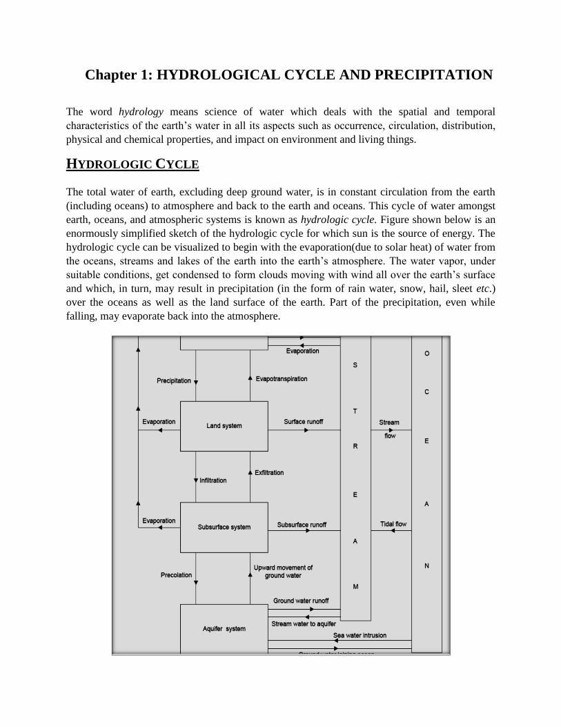
earth, oceans, and atmospheric systems is known as hydrologic cycle. Figure shown below is an
enormously simplified sketch of the hydrologic cycle for which sun is the source of energy. The
hydrologic cycle can be visualized to begin with the evaporation(due to solar heat) of water from
the oceans, streams and lakes of the earth into the earth’s atmosphere. The water vapor, under
suitable conditions, get condensed to form clouds moving with wind all over the earth’s surface
and which, in turn, may result in precipitation (in the form of rain water, snow, hail, sleet etc.)
over the oceans as well as the land surface of the earth. Part of the precipitation, even while
falling, may evaporate back into the atmosphere.
Another part of the precipitation may be intercepted by vegetation on the ground or other
surfaces. The intercepted precipitation may either evaporate into the atmosphere or fall back on
the earth’s surface. The greater part of the precipitation falling on the earth’s surface is retained
in the upper soil from where it may return to the atmosphere through evaporation and
transpiration by plants and/or find its way, over and through the soil surface as runoff, to stream
(or river) channels and the runoff thus becoming stream flow. Yet another part of the
precipitation may penetrate into the ground to become part of the ground water. The water of
stream channels, under the influence of gravity, moves towards lower levels to ultimately meet
the oceans. Water from ocean may also find its way into the adjoining aquifers. Part of the
stream water also gets evaporated back into the atmosphere from the surface of the stream. The
ground water too moves towards the lower levels to ultimately reach the oceans. The ground
water, at times, is a source of stream flow.
Hydrologic system is defined as a structure or volume in space surrounded by a boundary that
receives water and other inputs, operates on them internally, and produces them as outputs.
The global hydrologic cycle can be termed a hydrologic system containing three sub-systems:
the atmospheric water system, the surface water system, and the subsurface water system. Another example of the hydrologic system is storm-rainfall-runoff process on a watershed. Watershed
(or drainage basin or catchment) is a topographic area that drains rain water falling on it into a surface
stream and discharges surface stream flow through one particular location identified as watershed
outlet or watershed mouth. The term ‘watershed’ used for the catchment area should be distinguished
from the watershed used in the context of canal alignment
PRECIPITATION
The atmospheric air always contains moisture. Evaporation from the oceans is the major source
(about 90%) of the atmospheric moisture for precipitation. Continental evaporation contributes
only about 10% of the atmospheric moisture for precipitation.
The common forms of precipitation are drizzle or mist (water droplets of diameters less than 0.5
mm), rain (water drops of size between 0.5 mm and 6.0 mm), snow (ice crystals combining to
form flakes with average specific gravity of about 0.1), sleet (rain water drops, falling through air
at or below freezing temperatures, turned to frozen rain drops), and hail (precipitation in the
form of ice balls of diameter more than about 8 mm).
Most of the precipitation, generally, is in the form of rains. Therefore, the terms precipitation and
rain fall are considered synonymous. Rainfall, i.e., liquid precipitation, is considered light when
the rate of rainfall is upto 2.5 mm/hr, moderate when the rate of rainfall is between 2.5 mm/hr
and about 7.5 mm/hr, and heavy when the rate of rainfall is higher than about 7.5 mm/hr.
The temporal variation of annual rainfall at a given place is expressed in terms of the coefficient
of variation, Cv defined as
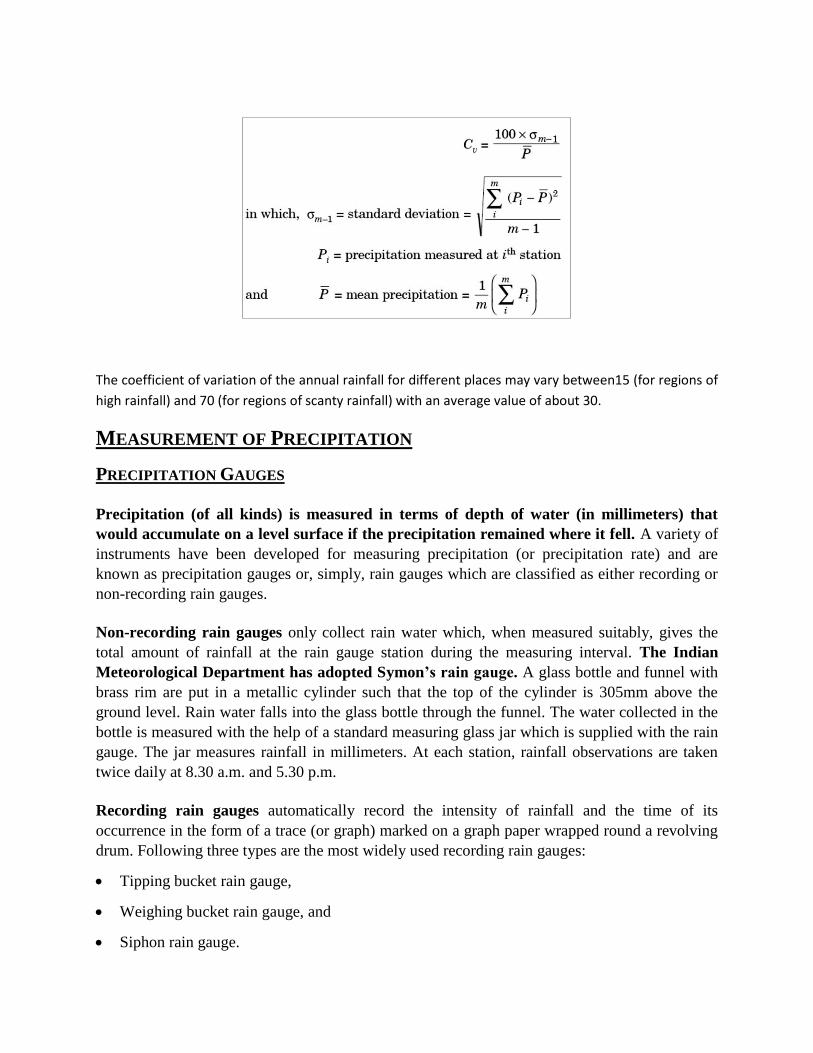
The coefficient of variation of the annual rainfall for different places may vary between15 (for regions of
high rainfall) and 70 (for regions of scanty rainfall) with an average value of about 30.
MEASUREMENT OF PRECIPITATION
PRECIPITATION GAUGES
Precipitation (of all kinds) is measured in terms of depth of water (in millimeters) that
would accumulate on a level surface if the precipitation remained where it fell. A variety of
instruments have been developed for measuring precipitation (or precipitation rate) and are
known as precipitation gauges or, simply, rain gauges which are classified as either recording or
non-recording rain gauges.
Non-recording rain gauges only collect rain water which, when measured suitably, gives the
total amount of rainfall at the rain gauge station during the measuring interval. The Indian
Meteorological Department has adopted Symon’s rain gauge. A glass bottle and funnel with
brass rim are put in a metallic cylinder such that the top of the cylinder is 305mm above the
ground level. Rain water falls into the glass bottle through the funnel. The water collected in the
bottle is measured with the help of a standard measuring glass jar which is supplied with the rain
gauge. The jar measures rainfall in millimeters. At each station, rainfall observations are taken
twice daily at 8.30 a.m. and 5.30 p.m.
Recording rain gauges automatically record the intensity of rainfall and the time of its
occurrence in the form of a trace (or graph) marked on a graph paper wrapped round a revolving
drum. Following three types are the most widely used recording rain gauges:
Tipping bucket rain gauge,
Weighing bucket rain gauge, and
Siphon rain gauge.
Tipping bucket rain gauge: A 300 mm diameter funnel collects rain water and conducts it to one
of the two small buckets which are so designed that when 0.25 mm of rainfall is collected in a
bucket, it tilts and empties its water into a bigger storage tank and, simultaneously, moves the
other bucket below the funnel. When any of the two buckets tilts, it actuates an electric circuit
causing a pen to make a mark on a revolving drum. The recording equipment can be remotely
located in a building away from the rain gauge. At a scheduled time, the rain water collected in
the storage tank can be measured to yield total rainfall in the measuring duration. The rainfall
intensity (and also the total rainfall) can be estimated by studying the record sheet on which each
mark indicates 0.25 mm of rain in the duration elapsed between the two adjacent marks.
Weighing bucket rain gauge: This gauge has a system by which the rain that falls into a bucket
set on a platform is weighed by a weighing device suitably attached to the platform. The
increasing weight of rain water in the bucket moves the platform. This movement is suitably
transmitted to a pen which makes a trace of accumulated amount of rainfall on a suitably
graduated chart wrapped round a clock driven revolving drum. The rainfall record of this gauge
is in the form of a mass curve of rainfall. The slope of this curve at any given time gives the
intensity of rainfall at that time.
Siphon rain gauge: This gauge is also called float type rain gauge as this gauge has a chamber
which contains a light and hollow float. The vertical movement of float on account of rise in the
water level in the chamber (due to rain water falling in it) is transmitted by a suitable mechanism
to move a pen on a clock-driven revolving chart. The record of rainfall is in the form of a mass
curve of rainfall and, hence, the slope of the curve gives the intensity of rainfall.
Bureau of Indian Standards has laid down the following guidelines for selecting the site for
rain gauges (IS : 4897-1968):
The rain gauge shall be placed on a level ground, not upon a slope or a terrace and never
upon a wall or roof.
On no account the rain gauge shall be placed on a slope such that the ground falls away
steeply in the direction of the prevailing wind.
The distance of the rain gauge from any object shall not be less than twice the height of the
object above the rim of the gauge.
Great care shall be taken at mountain and coast stations so that the gauges are not unduly
exposed to the sweep of the wind. A belt of trees or a wall on the side of the prevailing wind
at a distance exceeding twice its height shall form an efficient shelter.
In hills where it is difficult to find a level space, the site for the rain gauge shall be chosen
where it is best shielded from high winds and where the wind does not cause eddies.
The location of the gauge should not be changed without taking suitable precautions.
Description of the site and surroundings should be made a matter of record.
AVERAGE DEPTH OF PRECIPITATION OVER AN AREA
The information on the average depth of precipitation (or rainfall) over a specified area on either
the storm basis or seasonal basis or annual basis is often required in several types of hydrologic
problems. The depth of rainfall measured by a rain gauge is valid for that rain gauge station and
in its immediate vicinity. Over a large area like watershed (or catchment) of a stream, there will
be several such stations and the average depth of rainfall over the entire area can be estimated by
one of the following methods:
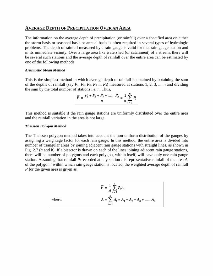
Arithmetic Mean Method
This is the simplest method in which average depth of rainfall is obtained by obtaining the sum
of the depths of rainfall (say P1, P2, P3, P4 .... Pn) measured at stations 1, 2, 3, .....n and dividing
the sum by the total number of stations i.e. n. Thus,
This method is suitable if the rain gauge stations are uniformly distributed over the entire area
and the rainfall variation in the area is not large.
Theissen Polygon Method
The Theissen polygon method takes into account the non-uniform distribution of the gauges by
assigning a weightage factor for each rain gauge. In this method, the entire area is divided into
number of triangular areas by joining adjacent rain gauge stations with straight lines, as shown in
Fig. 2.7 (a and b). If a bisector is drawn on each of the lines joining adjacent rain gauge stations,
there will be number of polygons and each polygon, within itself, will have only one rain gauge
station. Assuming that rainfall Pi recorded at any station i is representative rainfall of the area Ai
of the polygon i within which rain gauge station is located, the weighted average depth of rainfall
P for the given area is given as
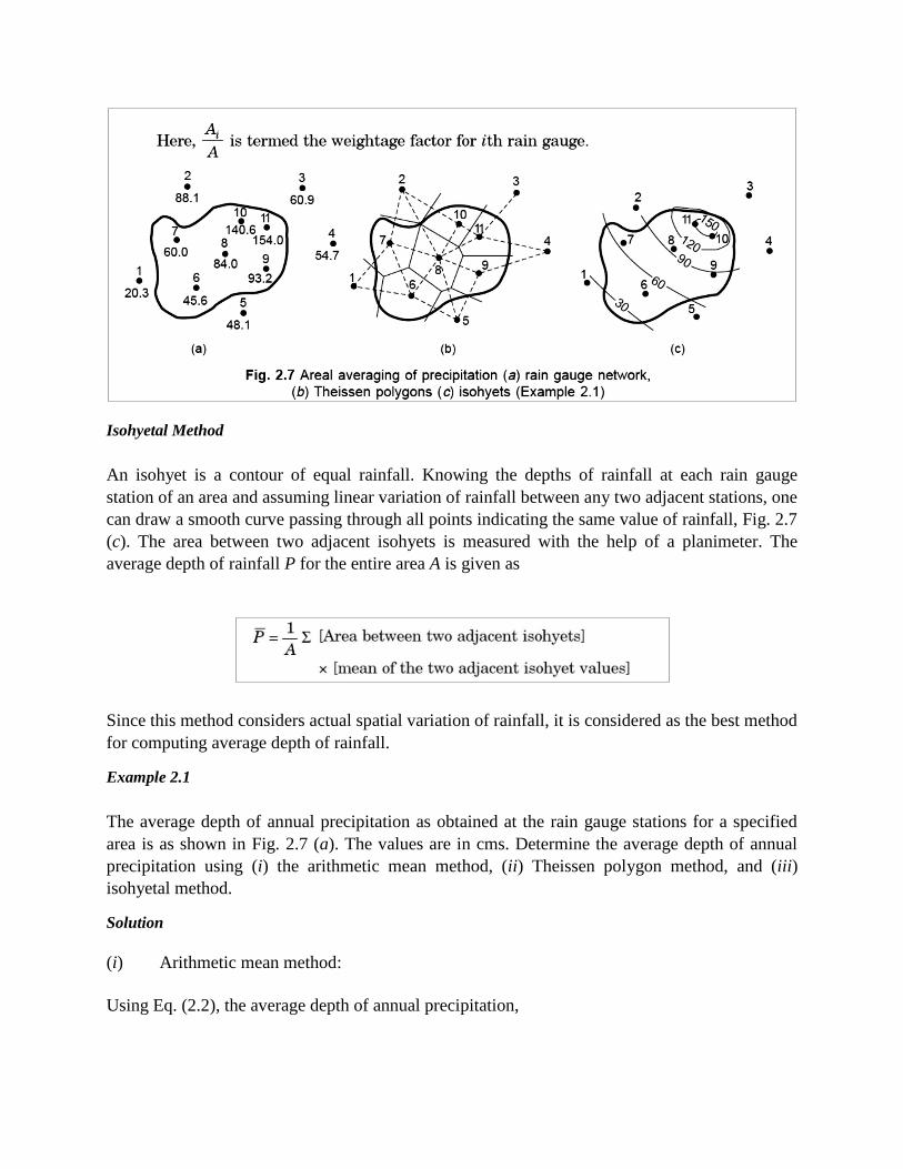
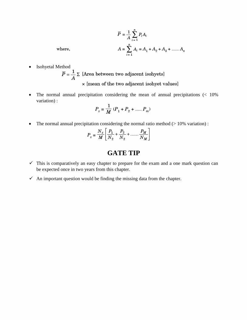
Isohyetal Method
An isohyet is a contour of equal rainfall. Knowing the depths of rainfall at each rain gauge
station of an area and assuming linear variation of rainfall between any two adjacent stations, one
can draw a smooth curve passing through all points indicating the same value of rainfall, Fig. 2.7
(c). The area between two adjacent isohyets is measured with the help of a planimeter. The
average depth of rainfall P for the entire area A is given as
Since this method considers actual spatial variation of rainfall, it is considered as the best method
for computing average depth of rainfall.
Example 2.1
The average depth of annual precipitation as obtained at the rain gauge stations for a specified
area is as shown in Fig. 2.7 (a). The values are in cms. Determine the average depth of annual
precipitation using (i) the arithmetic mean method, (ii) Theissen polygon method, and (iii)
isohyetal method.
Solution
(i) Arithmetic mean method:
Using Eq. (2.2), the average depth of annual precipitation,
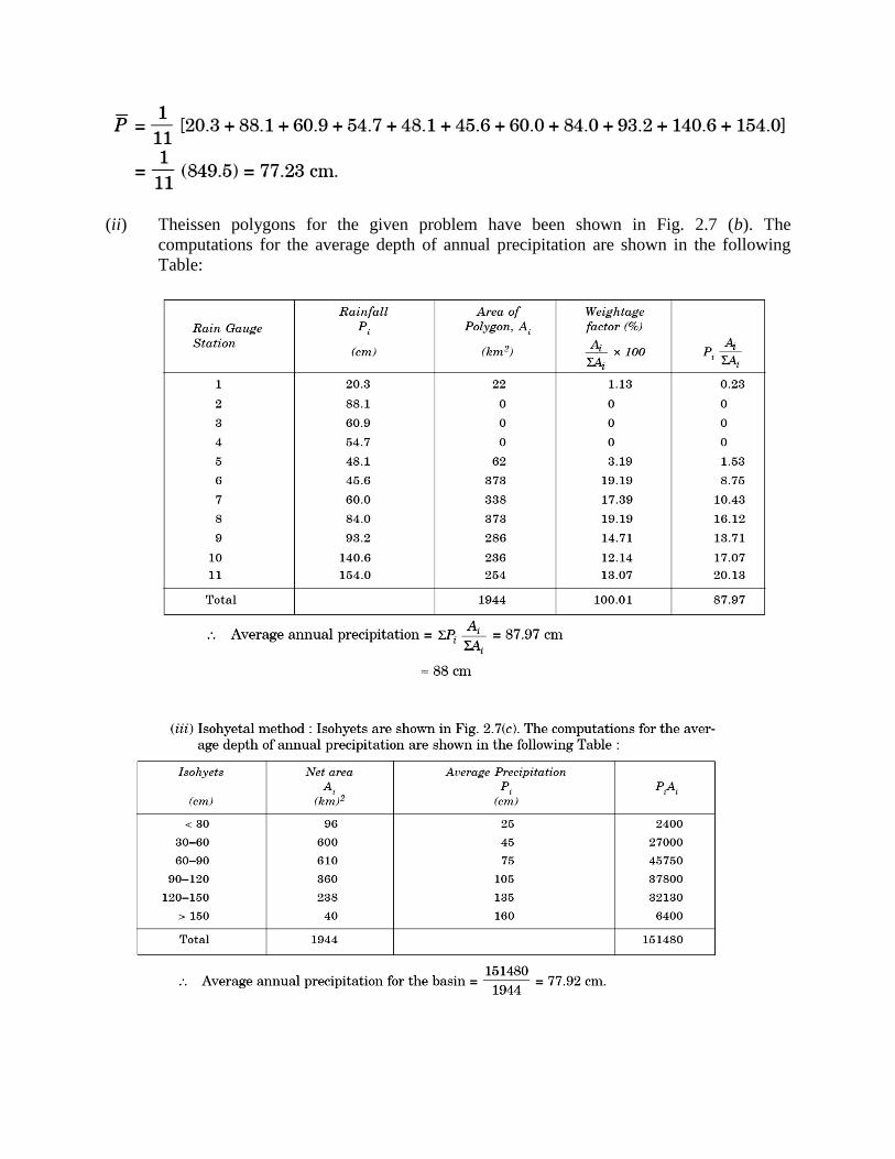
(ii) Theissen polygons for the given problem have been shown in Fig. 2.7 (b). The
computations for the average depth of annual precipitation are shown in the following
Table:
PRECIPITATION GAUGE NETWORK
The spatial variability of the precipitation, nature of the terrain and the intended uses of the
precipitation data govern the density (i.e., the catchment area per rain gauge) of the precipitation
gauge (or rain gauge) network. Obviously, the density should be as large as possible depending
upon the economic and other considerations such as topography, accessibility etc. The World
Meteorological Organization (WMO) recommends the following ideal densities (acceptable
values given in brackets) of the precipitation gauge network:
For flat regions of temperate, Mediterranean, and tropical zones, 600 to 900 sq. km (900–
3000 sq. km) per station.
For mountainous regions of temperate, Mediterranean, and tropical zones, 100 to 250 sq. km
(250 to 1000 sq. km) per station.
For small mountainous islands with irregular precipitation, 25 sq. km per station.
For arid and polar zones, 1500 to 10,000 sq. km per station.
At least ten per cent of rain gauge stations should be equipped with self-recording gauges to
know the intensities of rainfall. The Bureau of Indian Standards recommends the following
densities for the precipitation gauge network:
In plains: 520 sq. km per station;
In regions of average elevation of 1000 m: 260 to 390 sq. km per station; and
In predominantly hilly areas with heavy rainfall: 130 sq. km per station.
For an existing network of raingauge stations, one may need to know the adequacy of the
raingauge stations and, therefore, the optimal number of raingauge stations N required for a
desired accuracy (or maximum error in per cent, ) in the estimation of the mean rainfall. The
optimal number of raingauge stations N is given as
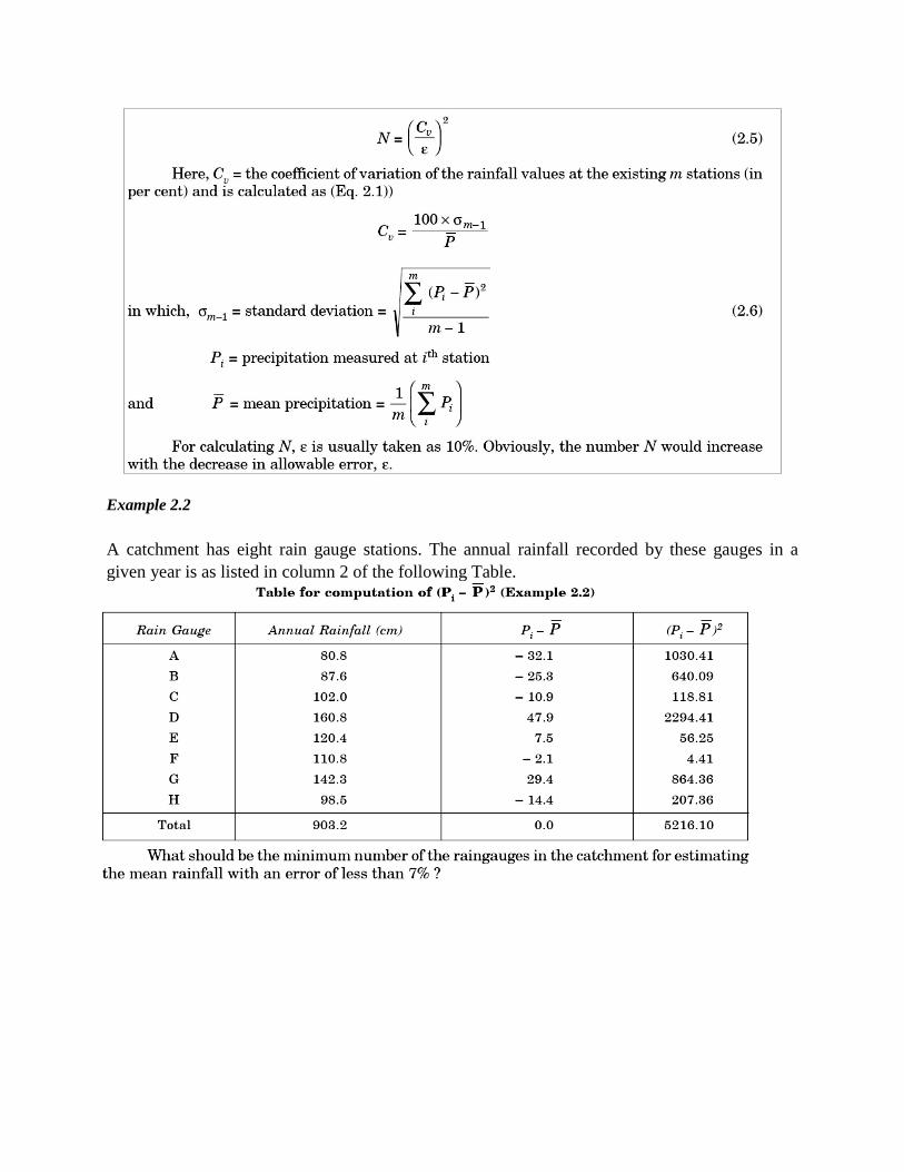
Example 2.2
A catchment has eight rain gauge stations. The annual rainfall recorded by these gauges in a
given year is as listed in column 2 of the following Table.
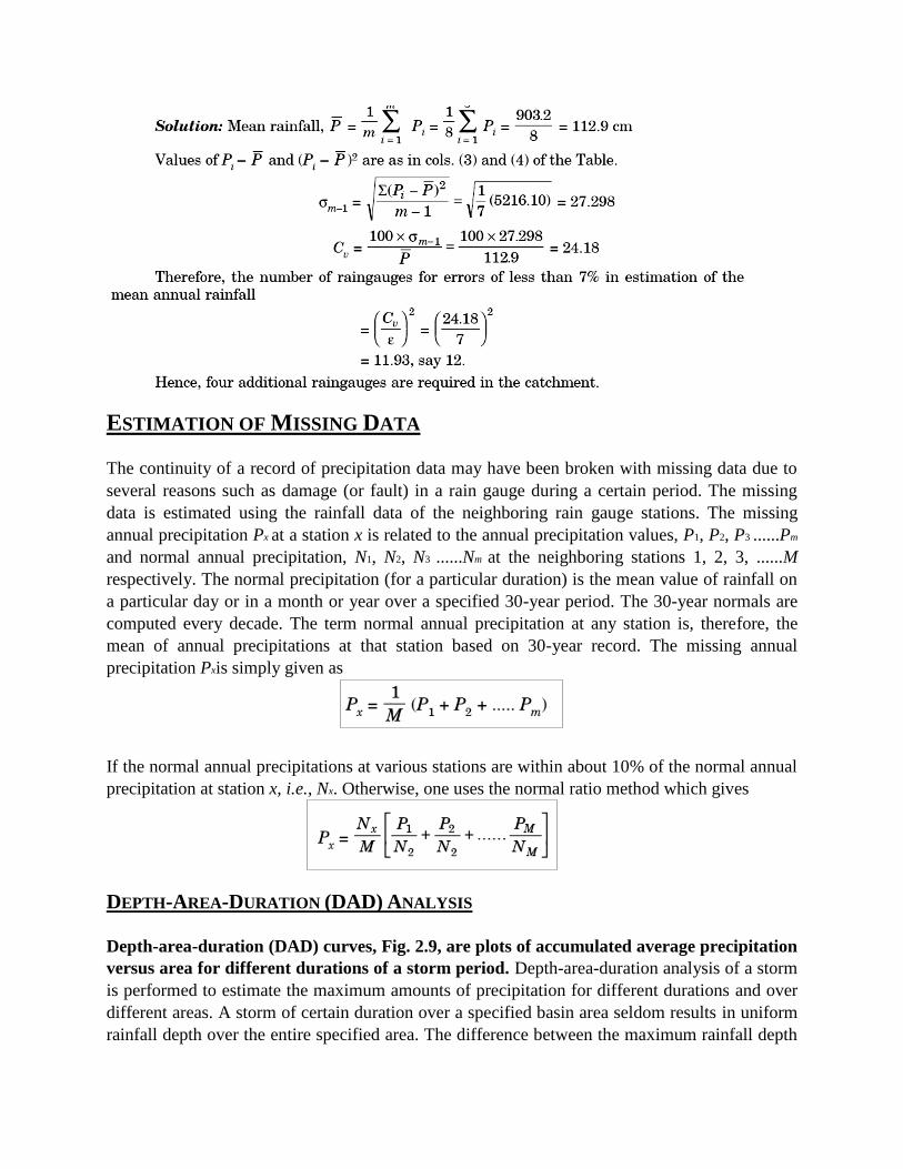
ESTIMATION OF MISSING DATA
The continuity of a record of precipitation data may have been broken with missing data due to
several reasons such as damage (or fault) in a rain gauge during a certain period. The missing
data is estimated using the rainfall data of the neighboring rain gauge stations. The missing
annual precipitation Px at a station x is related to the annual precipitation values, P1, P2, P3 ......Pm
and normal annual precipitation, N1, N2, N3 ......Nm at the neighboring stations 1, 2, 3, ......M
respectively. The normal precipitation (for a particular duration) is the mean value of rainfall on
a particular day or in a month or year over a specified 30-year period. The 30-year normals are
computed every decade. The term normal annual precipitation at any station is, therefore, the
mean of annual precipitations at that station based on 30-year record. The missing annual
precipitation Pxis simply given as
If the normal annual precipitations at various stations are within about 10% of the normal annual
precipitation at station x, i.e., Nx. Otherwise, one uses the normal ratio method which gives
DEPTH-AREA-DURATION (DAD) ANALYSIS
Depth-area-duration (DAD) curves, Fig. 2.9, are plots of accumulated average precipitation
versus area for different durations of a storm period. Depth-area-duration analysis of a storm
is performed to estimate the maximum amounts of precipitation for different durations and over
different areas. A storm of certain duration over a specified basin area seldom results in uniform
rainfall depth over the entire specified area. The difference between the maximum rainfall depth
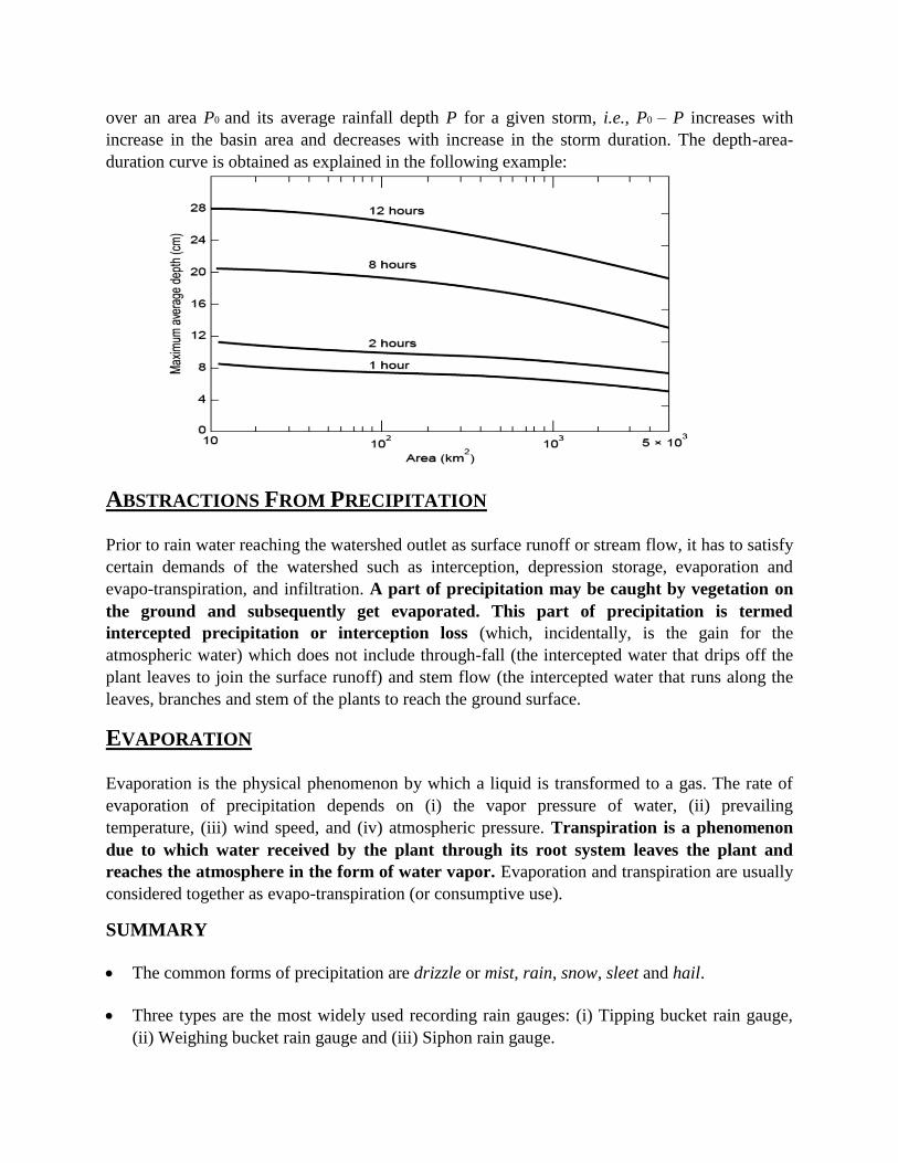
over an area P0 and its average rainfall depth P for a given storm, i.e., P0 – P increases with
increase in the basin area and decreases with increase in the storm duration. The depth-area-
duration curve is obtained as explained in the following example:
ABSTRACTIONS FROM PRECIPITATION
Prior to rain water reaching the watershed outlet as surface runoff or stream flow, it has to satisfy
certain demands of the watershed such as interception, depression storage, evaporation and
evapo-transpiration, and infiltration. A part of precipitation may be caught by vegetation on
the ground and subsequently get evaporated. This part of precipitation is termed
intercepted precipitation or interception loss (which, incidentally, is the gain for the
atmospheric water) which does not include through-fall (the intercepted water that drips off the
plant leaves to join the surface runoff) and stem flow (the intercepted water that runs along the
leaves, branches and stem of the plants to reach the ground surface.
EVAPORATION
Evaporation is the physical phenomenon by which a liquid is transformed to a gas. The rate of
evaporation of precipitation depends on (i) the vapor pressure of water, (ii) prevailing
temperature, (iii) wind speed, and (iv) atmospheric pressure. Transpiration is a phenomenon
due to which water received by the plant through its root system leaves the plant and
reaches the atmosphere in the form of water vapor. Evaporation and transpiration are usually
considered together as evapo-transpiration (or consumptive use).
SUMMARY
The common forms of precipitation are drizzle or mist, rain, snow, sleet and hail.
Three types are the most widely used recording rain gauges: (i) Tipping bucket rain gauge,
(ii) Weighing bucket rain gauge and (iii) Siphon rain gauge.
As per the World Meteorological Organization (WMO) the ideal densities (acceptable values
given in brackets) of the precipitation gauge network :
• For flat regions of temperate, Mediterranean, and tropical zones, 600 to 900 sq. km
(900–3000 sq. km) per station.
• For mountainous regions of temperate, Mediterranean, and tropical zones, 100 to 250
sq. km (250 to 1000 sq. km) per station.
• For small mountainous islands with irregular precipitation, 25 sq. km per station.
• For arid and polar zones, 1500 to 10,000 sq. km per station.
As per the Bureau of Indian Standards the densities for the precipitation gauge network:
• In plains: 520 sq. km per station;
• In regions of average elevation of 1000 m: 260 to 390 sq. km per station; and
• In predominantly hilly areas with heavy rainfall: 130 sq. km per station.
The rate of evaporation of precipitation depends on (i) the vapor pressure of water, (ii)
prevailing temperature, (iii) wind speed, and (iv) atmospheric pressure.
Evaporation and transpiration are usually considered together as evapo-transpiration (or
consumptive use).
FORMULA
Coefficient of variation, Cv defined as
Arithmetic Mean Method
Theissen Polygon Method
Isohyetal Method
The normal annual precipitation considering the mean of annual precipitations (< 10%
variation) :
The normal annual precipitation considering the normal ratio method (> 10% variation) :
GATE TIP
This is comparatively an easy chapter to prepare for the exam and a one mark question can
be expected once in two years from this chapter.
An important question would be finding the missing data from the chapter.


![Fundamentals of Hydrology [Tim Davie]](https://img.dokumen.tips/doc/110x75/6326e2cecc700bcbb30bdac5/fundamentals-of-hydrology-tim-davie.jpg)


