Embed Size (px)
Citation preview
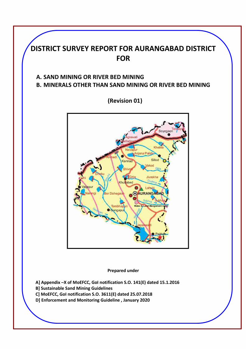
DISTRICT SURVEY REPORT FOR AURANGABAD DISTRICT FOR
A. SAND MINING OR RIVER BED MINING B. MINERALS OTHER THAN SAND MINING OR RIVER BED MINING
(Revision 01)
Prepared under
A] Appendix –X of MoEFCC, GoI notification S.O. 141(E) dated 15.1.2016 B] Sustainable Sand Mining Guidelines C] MoEFCC, GoI notification S.O. 3611(E) dated 25.07.2018 D] Enforcement and Monitoring Guideline , January 2020
Index
Sr. No.
Description Page No.
1 District Survey Report for Sand Mining Or River Bed Mining 1-82 1.0 Introduction 2
Brief Introduction of Aurangabad district 2
Salient Features of Aurangabad District 8
2.0 Overview of Mining Activity in the district 9
3.0 List of the Mining Leases in the district with Location, area and period of validity
11
Location of Sand Ghats along the Rivers in the district 16
4.0 Detail of Royalty/Revenue received in last three years from Sand Scooping activity
17
5.0 Details of Production of Sand or Bajri or minor mineral in last three Years
17
6.0 Process of Deposition of Sediments in the rivers of the District
17
Stream Flow Guage Map for rivers in Aurangabad district 21
Siltation Map for rivers in Aurangabad district 22
7.0 General Profile of the district 23
8.0 Land Utilization Pattern in the District : Forest, Agriculture, Horticulture, Mining etc.
36
9.0 Physiography of the District 39
River Inventory of the district 48
Basin Map for Aurangabad district is drawn as 49
Confluence Points for the rivers in the district 50
Rivers marked on toposheets 51-53
HFL Maps for rivers 54-59
L & Cross sections for rivers 60-62
10.0 Rain Fall Data for Aurangabad district 63
11.00 Geology and Mineral Wealth 64
Geological Map For Aurangabad District 66
District wise details of river or stream and other sand sources 67
District wise availability of sand and gravel or aggregate resources 68
Drainage System with description of main rivers 68
Salient Features of important rivers and streams 69
List of Sand Spots 70
Annual Deposition 73
2 District Survey Report for Minerals Other Than Sand Mining Or River Bed Mining
83-174
1.0 Introduction 84
Brief Introduction of Aurangabad district 84
Salient Features of Aurangabad District 90
2.0 Overview of Mining Activity in the district 91
3.0 General Profile of the district 93
Location of leases on Map of District 105
4.0 Geology of the District 106
Minerals Available in the District 107
Geological Map of Aurangabad District 108
5.0 Drainage and irrigation Pattern 109
6.0 Land Utilization Pattern in the District : Forest, Agriculture, Horticulture, Mining etc.
111
Mining Area 113
7.0 Surface Water And Ground Water Scenario 114
8.0 Rainfall of the district and Climatic Conditions
118
9.0 Details of the mining leases in the district as per the following format 120
10.0 Details of Royalty or Revenue received in last three years 130
11.0 Details of Production of Minor Mineral in last three years : (Approx. Quantity)
130
12.0 Mineral Map of District 130
13.0 List of Letter of Intent (LOI)Holders in the district along with its validity as per following format
132
14.0 Total Mineral Reserves Available in the District 157
15.0 Quality / Grade of Mineral available in the District 157
16.0 Use of Mineral 157
17.0 Demand and Supply of the Mineral in last three years 157
18.0 Mining Leases marked on District Map 158
19.0 Details of the area of where there is a cluster of mining leases viz. no. of mining leases. Location
159
20.0 Details of Eco sensitive area 160
21.0 Impact on the Environment (Air, Water, Noise Soil, Flora & Fauna, Land Use, agriculture, forest etc.) due to mining activity
163
22.0 Remedial measures to mitigate the impact of mining on 164
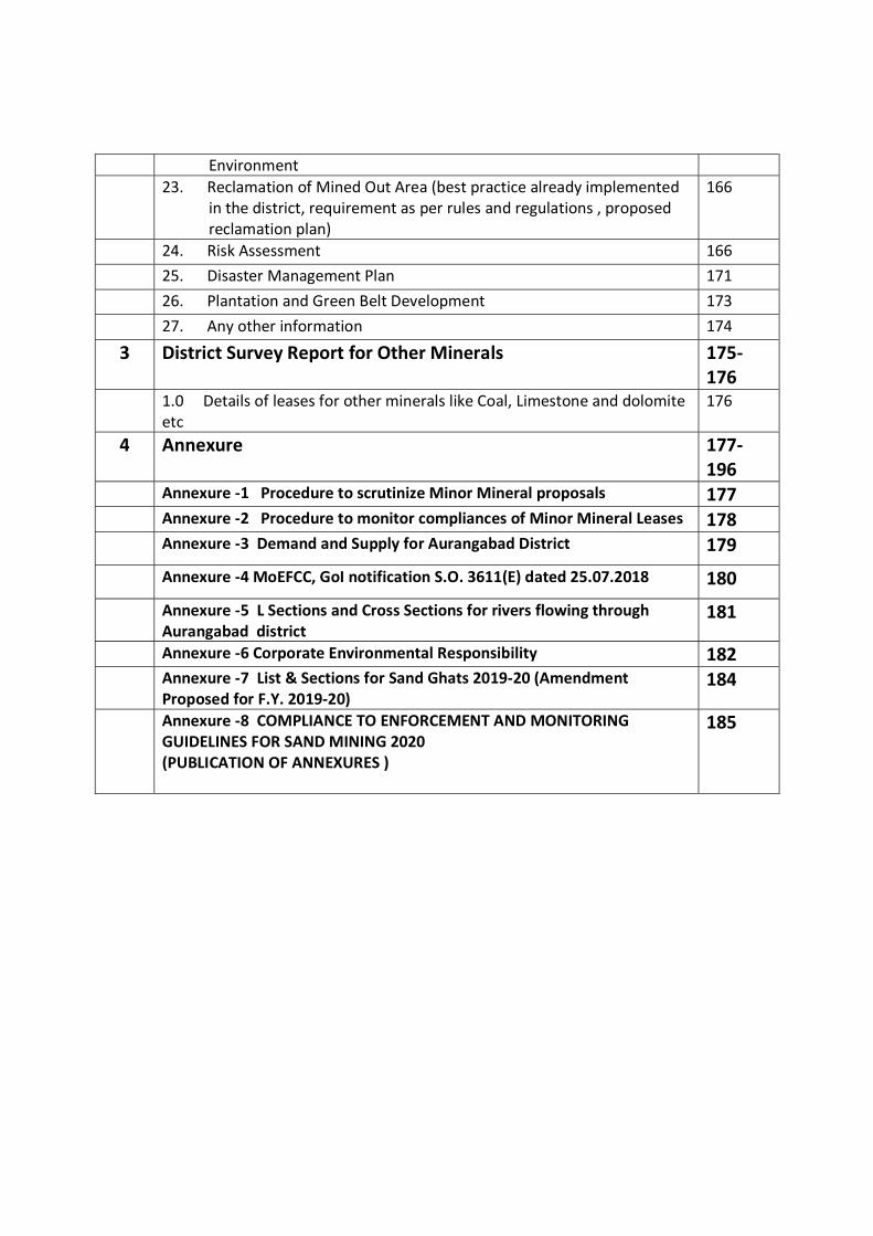
Environment 23. Reclamation of Mined Out Area (best practice already implemented
in the district, requirement as per rules and regulations , proposed reclamation plan)
166
24. Risk Assessment 166
25. Disaster Management Plan 171
26. Plantation and Green Belt Development 173
27. Any other information 174
3 District Survey Report for Other Minerals 175-176
1.0 Details of leases for other minerals like Coal, Limestone and dolomite etc
176
4 Annexure 177-196
Annexure -1 Procedure to scrutinize Minor Mineral proposals 177 Annexure -2 Procedure to monitor compliances of Minor Mineral Leases 178 Annexure -3 Demand and Supply for Aurangabad District 179
Annexure -4 MoEFCC, GoI notification S.O. 3611(E) dated 25.07.2018 180
Annexure -5 L Sections and Cross Sections for rivers flowing through Aurangabad district
181
Annexure -6 Corporate Environmental Responsibility 182 Annexure -7 List & Sections for Sand Ghats 2019-20 (Amendment
Proposed for F.Y. 2019-20) 184
Annexure -8 COMPLIANCE TO ENFORCEMENT AND MONITORING GUIDELINES FOR SAND MINING 2020 (PUBLICATION OF ANNEXURES )
185
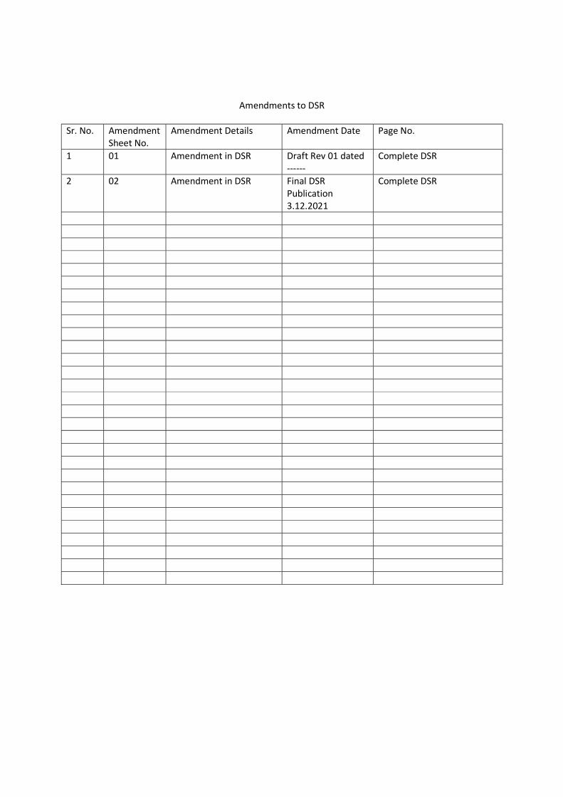
Amendments to DSR
Sr. No. Amendment Sheet No.
Amendment Details Amendment Date Page No.
1 01 Amendment in DSR Draft Rev 01 dated ------
Complete DSR
2 02 Amendment in DSR Final DSR Publication 3.12.2021
Complete DSR
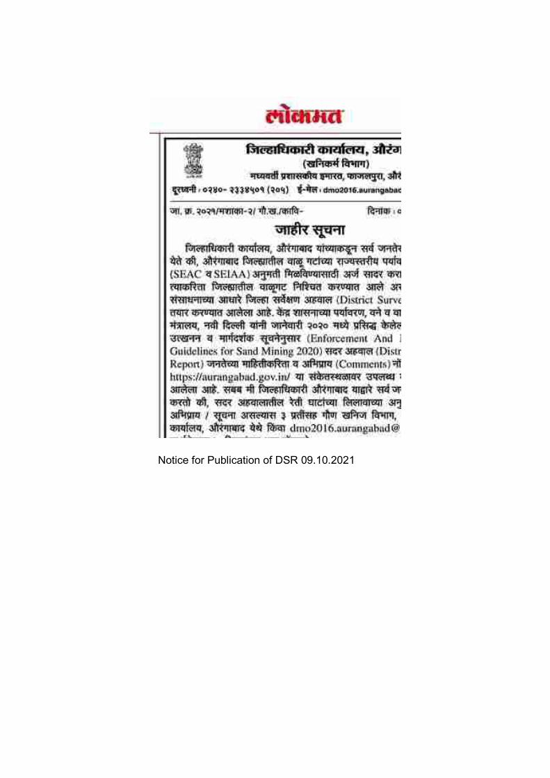
Notice for Publication of DSR 09.10.2021
1
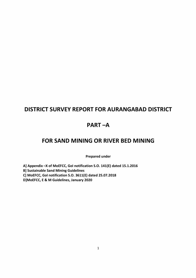
DISTRICT SURVEY REPORT FOR AURANGABAD DISTRICT
PART –A
FOR SAND MINING OR RIVER BED MINING
Prepared under
A] Appendix –X of MoEFCC, GoI notification S.O. 141(E) dated 15.1.2016 B] Sustainable Sand Mining Guidelines C] MoEFCC, GoI notification S.O. 3611(E) dated 25.07.2018 D]MoEFCC, E & M Guidelines, January 2020
2
1.0 Introduction : Hon’ble Supreme Court of India vide its judgement dated February 27,2012 and further relief amendment dated April 16,2012 directed all state, union territories and ministry of Environment and Forest, Govt. of India, New Delhi to screen mining of minor minerals leases within the purview of EIA notification 2006 and made requirement of environmental clearance to minor minerals less than 5 ha compulsory. Ministry of Environment & Forest , GoI vide its office Memorandum L-11011/47/2011.IA.II(M) dated 18.05.2012 directed mass to comply Ho’ble Supreme Court decision. Further streamlining of environmental clearance procedures, MOEFCC, GoI amended EIA notification 2006 vide S.O. 141(E) dated 15.01.2016 where procedure for preparation of District Survey Report (DSR) for minor minerals has been prescribed. Further the procedure for preparation of DSR and format is amended vide MOEFCC notification S.O. 3611(E) dated 25.07.2018. The subjected DSR is defined at “ Appendix -X (See Paragraph 7(iii)(a)” of the notification S.O.141(E)dated 15.01.2016 and S.O. 3611(E) dated 25.07.2018 This District survey report comply the environmental & monitoring guidelines issued by MoEFCC, GoI, New Delhi published in January 2020. This District Survey Report will be utilized for assessing the minor minerals proposals of the district for grant of minor mineral leases, their feasibility and for grant of environmental clearances by the designated authorities. Brief Introduction of Aurangabad district : Aurangabad District is located mainly in Godavari Basin and its some part towards North West of Tapi River Basin. This District’s general down level is towards South and East and North West part comes in Purna-Godavari river basin. The Aurangabad district’s North Longitude ( Degree) is 19 and 20 and East Longitude (Degree ) is 74 to 76. Aurangabad district is named after, its headquarters place of Aurangabad. The City was founded in 1610 A.D. by Malik Ambhar, the Prime Minister of Murtaza Nizam Shah of Ahmadnagar on the sight of Village called Khirki. Malik Ambar was succeeded by his son Fateh Khan, who changed the name of Khirki to Fatehnagar. With the capture Daulatabad by the imperial troops in 1633, the Nizamshahi dominions including Fatehnagar came under the possession of the Moghals. In 1653 when Aurangzab was appointed, the Viceroy of the Deccan, he made Fatehnagar his capital and called it Aurangabad. The historians of his reign also occasionally style the city Khujistan Bunyad. Since then the city came to be known as Aurangabad.

3
It appears from the Archaeological excavations made in the neighbouring district that this region was occupied in the Early Stone Age. The earliest period known from the excavations is the chalcolithic or Early Bronze Age i.e. from 1500-500 B.C. According to the literary tradition, when the Aryans penetrated to the Deccan, the whole region was covered by a thick jungle. Agastya was the first Aryan who crossed the Vindhyas. We learn from the Ramayana that Rama accompanied by his brother Lakshman and wife Sita met Agastya near Godavari. Buddhism was first introduced in Maharashtra by Buddhist missionary named Maha Dharma Rakshita by narrating to the people the story of the Maha Naradakassapa Jataka during the reign of Ashoka. This led to the excavation of caves in different parts of Maharashtra; some of these were excavated at Pitalkhora, 80 Kms. from Aurangabad and at Ajanta on the northern fringe of the district. After the death of Ashoka, the Satavahanas rose to power in the Deccan. They made Pratishthana (Paithan) as their Capital. They received support from local rulers called Maharathis. Their kingdom extended up to Pune, Nashik, Ahmadnagar, Aurangabad and Jalna districts the earliest group of caves at Ajanta belongs to the Satavahana age. During the period of Satavahanas, this region must have attained a high level of prosperity. The Chalukyas of Badami (Bijapur district) rose to power in the first half of the sixth century A.D. Their kingdom extended up to the Narmada in the north. The Chinese pilgrim, Hiuen Tsang calls about King Pulakeshi II from Chalukya dynasty as the Lord of Maharashtra. Pulakeshi obtained a resounding victory over Harsha, the lord paramount of North India. Thereafter he assumed the title of Parameshvara. In the last quarter of the 12th century A.D., the Yadavas of Devagiri (Daulatabad) came into prominence. In 1296 A.D., Ala-ud-din Khilji invaded the kingdom of Ramachandra (King of Devagiri), he had to pay a heavy ransom to the Muslim conqueror. He was succeeded by his son Shankaragana. He was defeated and slain by Malik Kafur. Thus, the Hindu Kingdom of Devagiri came to an end in 1318 A.D. From the early 13th century onwards, Muslim rulers started invading this region. They conquered many small forts. The prominent being the Devagiri fort. Since then the Maratha power never established in this region. After the death of Emperor Bahadur Shah in 1711, the civil war that took place for supremacy prompted Nizam-ul-Mulk, a Governer in Mughals court to become the Viceroy of the Deccan in 1713. He founded the Nizam dynasty. This family ruled in Hyderabad till 1948. There were no major changes in the boundaries of the district or its talukas between 1901 to 1941. Eight villages of Ambad taluka were exchanged with six villages of Pathri taluka of Parbhani district. In 1950, twenty-five enclave villages belonging to the neighbouring districts of Nashik, East Khandesh and Ahmadnagar were transferred to Aurangabad district. More than one third of the district was Jagir area. Nizam’s own estate called “Sarf-e-Khas” comprising two talukas was merged with the Government area under Sarf-e-Khas (Merger) Regulation of 1949. Consequent upon the integration of Jagirs and Sarf-e-Khas areas, all the taluka boundaries were reconstituted in April 1950. Two new Mahals (Tahsils) with headquarters at Jafferabad were created. In 1953 another new mahal (tahsil) with headquarters at Soegaon was created by transferring 37 villages from Sillod taluka and 30 from Kannad taluka. All the villages transferred to this mahal are situated to the north of the Satmala hills. With the reorganisation of States in 1956, the district was transferred from Hyderabad State to Bombay State and since 1960 it forms a part ofMaharashtra.
4
Drainage The district can be broadly divided into three physiographic units namely, Ajanta hill ranges, Satmala hill ranges and Godavari Plains. Geomorphologically, the district comprises varied topographic features and landscape consisting of high hills and plains and low-lying hills. Most of the hill ranges are located in the northern part of the district. The Satmala and Ajanta hills extend from east to west. The hills near Verul in Khuldabad block are part of these ranges which extend to Chouka hill range and Aurangabad hills. The Satmala range encompasses several hills overlooking the Tapi valley. From west to east they are Antur (826 m amsl), Satonda (552 m amsl), Abasgand (671 m amsl) and Ajantha (578 m amsl). The Satmala hill (493 m amsl) from which name of the range is derived is situated north of Kannad town. The district is a part of the Deccan Plateau. In general, the slopes in the district are towards south and southeast. The average elevation of the district is in the order of 500 m amsl. Within it there are flat topped hill ranges extending over wide area and also hills separated by broad valleys. Major part of the district falls in Godavari basin with a small area in north eastern parts falling Tapi Basin. The major river in the district is the Godavari with its tributaries namely; Purna, Dudhna and Shivna rivers. The other important tributaries are Sukna, Khelna, Kham, Gulathi, Shivbhadra and Girija rivers. Depending on the drainage and geomorphology, the district has been divided into 52 watersheds. Climate The climate of the district is characterized by a hot summer and a general dryness throughout the year except during the south west monsoon season, which is from June to September while October and November constitute the postmonsoon season. The winter season commences towards the end of November when temperatures begin to fall rapidly. December is the coldest month with the mean maximum temperature of 28.9° C, while the mean minimum temperature is 10.3°C. From the beginning of March, the daily temperature increases continuously. May is the hottest month with the mean maximum temperature of 39.8°C and the mean minimum temperature of 24.6° C. With the onset of the south-west monsoon by about the second week of June, the temperature falls appreciably. Except during the southwest monsoon season, when the relative humidity is high, the air is generally dry over the district. The summer months are the driest when the relative humidity is generally between 20 and 25% in the afternoon. Winds are generally light to moderate with increase in speed during the latter half of the hot season and in the monsoon season. The winds flow predominantly from directions between west and north during the hot season. They are mostly from directions between south west and northwest during the south west monsoon season. They blow mostly from the directions between northeast and southeast during the rest of the year becoming southwesterly to north westerly in January and February. The average annual rainfall of the district is 705 mm
5
Natural Economic Resources Deccan Traps cover a major part of the District. Trap rocks are very hard and compact and are ark grey in colour. Trap rocks being dense, hard and compact are extensively used as building stones, road metal, railway ballast and as an aggregate in cement concrete. Erosive agents and weathering together have formed good fertile soils near the river beds. Aurangabad district has some gem stone quarries.
Aurangabad district is having good Industrial background, specially famous for the Seed and other automobile industries. The industrial development at Aurangabad is widely based on Engineering, Plastic and Agriculture.
Pulses mills, oil mills, refineries, steel re-rolling, plastic, tiles & cement pipe, fertilizers, insecticides, pesticides and the co-operative sugar factories are also playing important part in the industrial development of Aurangabad.
There are also cotton ginning and pressing factories and an agricultural market produce committee handling large quantities of all kinds of agricultural produce, including cotton. In view of the overall industrial backwardness of the region, the state government has initiated a master plan to encourage the establishment of of small and large- scale industrial units. Under this plan Maharashtra Industrial Development Corporation (MIDC) has set up an industrial area in Aurangabad consisting of …large-scale, …medium scale and ..small scale industries.
Himroo, is a fabric made of silk and cotton that is locally grown in Aurangabad. The word Himroo is derived from the persian word ‘hum-ruh’ which means ‘similar’. Himroo is a replica of Kum-Khwab, which was woven with golden and silver threads of ancient times and was for the royal families. Himroo uses the Persian design, and it is very characteristic and distinctive in appearance. Himroo from Aurangbad has a high demand for its unique and fascinating style and design. Himroo is woven near the Gaffar Gate in Himroo fabric
Paithani is a popular variety of sari, named after the Paithan town in Aurangabad district where they are woven by hand. Paithani saris are made from very fine silk and are considered as one of the richest saris in India.
Paithani is characterized by borders of an oblique square design, and a pallu with a Peacock design. Plain as well as spotted designs are available. Among other varieties, single colored and kaleidoscope-colored designs are also popular. The kaleidoscopic effect is achieved by using one color for weaving lengthwise and another for weaving width wise.
Tourism industry also contributes as an economic resources to the district. Along with ancient monuments specified in the district, Panchakki, many gates, Salim Ali Lake Soneri Mahal, Chhatrapti Shivaji Maharaj Museum are also tourist attraction in the district.
6
Forestry In Aurangbad district total Forest Area is 135.75 Sq.Km. As compare to Maharashtra the forest area of Aurangabad is 9.03%. Gautala-Aurtam Ghat Wildlife sanctuary is notiofied vide State Govt. notification vide WLP/1085/CR-75/F-5(V) dated 25.02.1986 nad then by MoEFCC notification for Gautala Autram Ghat WLS vide SO3996(A) dated 9.12.2016 for 260.61 sq. km area Also Jaikwadi Bird Sanctuary is notiofied vide State Govt. notification vide WLP/1086/27206/CR39186(II)F5 dated 10.10.1986 and then by MoEFCC notification for Jaikwadi Bird Sanctuary SO2202(A)12.07.2017 for 341.05 Sq. Km. Minerals and mining Minerals of great economic importance are not found in Aurangabad district. The geology of the region consists of dark coloured colcanic lava flows. It is spread in the form of horizontal sheets or beds. Because of their dominantly basaltic composition and the tendancy to form flat – topped plateau, the lavas are termed plateau basalt. Trap rocks are hard , dense and durable and are suitable for building /construction purposes. Economically important mneral required for ndustrialization not found in the district. Hence district has basalt mining for infrastructural requirements with natural river sand up to some extend. At some places some patches of agate are found but with inferior quality. Aurangabad district has some gem stone quarries. Soil and Cropping pattern Soil plays a very important role in the agricultural activities and forest growth of the area. The fertility of the soil from agricultural point of view depends upon the texture and structure which controls the retaining and transmitting capacity of moisture and various nutrients such as nitrogen, phosphorous and potassium present in the soil. The formation of the soil in the area is influenced by the climate, geology, vegetation and topography. The major part of the district is covered by black cotton soil or ‘Regur’ formed by the weathering of Deccan Trap Basalt. It is rich in plant nutrients such as lime, magnesia, iron and alkalies on which cotton and dry crops like Jowar, Bazra and tur etc flourish. It swells and becomes sticky on watering while on drying it contracts and develops many cracks. The soil varies both in texture and depth. In northern portion of the district the soils are shallow and relatively poor while in south they become deep and fairly rich in nutrients. Aurangabad district is spread over an area of 10.08 lakh ha. Out of which area under cultivation is 8.52 Lakh Ha. The total population of the district is 40.83 lakh, out of which, 84.2 % population is dependent on agriculture and allied sector. Agriculture plays an important role in the district economy. The total number of farmers in the district is 9.16 lakhs, of which, 47 % and 31 % are marginal farmers and small farmers, respectively. The average land holding is 1.46 Ha. Agriculture in the Aurangabad district is diversified, wide range of crops are grown in the district. Major food grains are Jowar, pearl millet, wheat& gram, among oilseeds Soybean is major crops while Cotton is major cash crops.
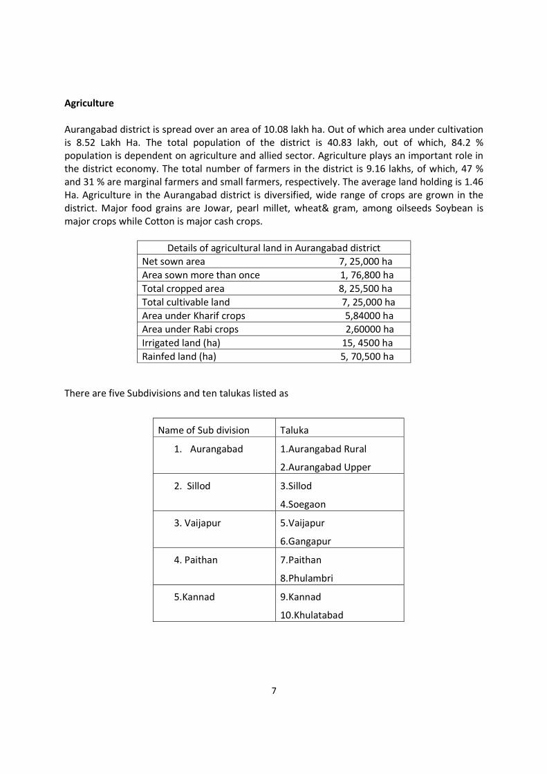
7
Agriculture Aurangabad district is spread over an area of 10.08 lakh ha. Out of which area under cultivation is 8.52 Lakh Ha. The total population of the district is 40.83 lakh, out of which, 84.2 % population is dependent on agriculture and allied sector. Agriculture plays an important role in the district economy. The total number of farmers in the district is 9.16 lakhs, of which, 47 % and 31 % are marginal farmers and small farmers, respectively. The average land holding is 1.46 Ha. Agriculture in the Aurangabad district is diversified, wide range of crops are grown in the district. Major food grains are Jowar, pearl millet, wheat& gram, among oilseeds Soybean is major crops while Cotton is major cash crops.
Details of agricultural land in Aurangabad district Net sown area 7, 25,000 ha Area sown more than once 1, 76,800 ha Total cropped area 8, 25,500 ha Total cultivable land 7, 25,000 ha Area under Kharif crops 5,84000 ha Area under Rabi crops 2,60000 ha Irrigated land (ha) 15, 4500 ha Rainfed land (ha) 5, 70,500 ha
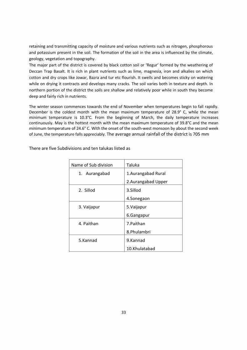
There are five Subdivisions and ten talukas listed as
Name of Sub division Taluka
1. Aurangabad 1.Aurangabad Rural
2.Aurangabad Upper
2. Sillod 3.Sillod
4.Soegaon
3. Vaijapur 5.Vaijapur
6.Gangapur
4. Paithan 7.Paithan
8.Phulambri
5.Kannad 9.Kannad
10.Khulatabad
8
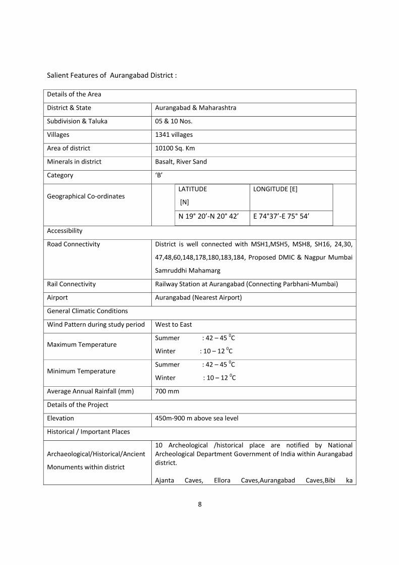
Salient Features of Aurangabad District : Details of the Area
District & State Aurangabad & Maharashtra
Subdivision & Taluka 05 & 10 Nos.
Villages 1341 villages
Area of district 10100 Sq. Km
Minerals in district Basalt, River Sand
Category ‘B’
Geographical Co-ordinates
LATITUDE
[N]
LONGITUDE [E]
N 19° 20’-N 20° 42’ E 74°37’-E 75° 54’
Accessibility
Road Connectivity District is well connected with MSH1,MSH5, MSH8, SH16, 24,30,
47,48,60,148,178,180,183,184, Proposed DMIC & Nagpur Mumbai
Samruddhi Mahamarg
Rail Connectivity Railway Station at Aurangabad (Connecting Parbhani-Mumbai)
Airport Aurangabad (Nearest Airport)
General Climatic Conditions
Wind Pattern during study period West to East
Maximum Temperature Summer : 42 – 45 0C
Winter : 10 – 12 0C
Minimum Temperature Summer : 42 – 45 0C
Winter : 10 – 12 0C
Average Annual Rainfall (mm) 700 mm
Details of the Project
Elevation 450m-900 m above sea level
Historical / Important Places
Archaeological/Historical/Ancient
Monuments within district
10 Archeological /historical place are notified by National Archeological Department Government of India within Aurangabad district. Ajanta Caves, Ellora Caves,Aurangabad Caves,Bibi ka
9
Maqbara,Daulatabad fort and Chand Minar,Tomb of Aurangzaeb, Tomb of Malik Ambar,Ancient Mound in Paithan,Pitalkhora caves,Ghrishneshwar Temple Chattries and ancient sites(Verul-Ellora) However there are seven monuments those are listed below are protected by State Governemt of Maharashtra. Khan-I-Jahan Bagh, Baitulwadi fort, Taltam Fort, Antur Fort (Kannad), Ghatotkach Lena(Janjala), Rudreshwar Lena, Jogeshwari Devi Lena (Sollod city)
Names of the national park,
sanctuary Biosphere reserve, Tiger
Reserve, Elephant reserve, Forest
(RF/PF/Unclassified)
Sactuaries, Tiger reserves, Biosphere,ESA/ESZ are notified in the district. Gautala Wildlife Sanctuary
State Govt. notification vide WLP/1085/CR-75/F-5(V) dated
25.02.1986
MoEFCC notification for Gautala Autram Ghat WLS vide SO3996(A)
dated 9.12.2016 for 260.61 sq. km area
Jaikwadi Bird Sanctuary
State Govt. notification vide WLP/1086/27206/CR39186(II)F5 dated
10.10.1986
MoEFCC notification for Jaikwadi Bird Sanctuary
SO2202(A)12.07.2017 for 341.05 Sq. Km.
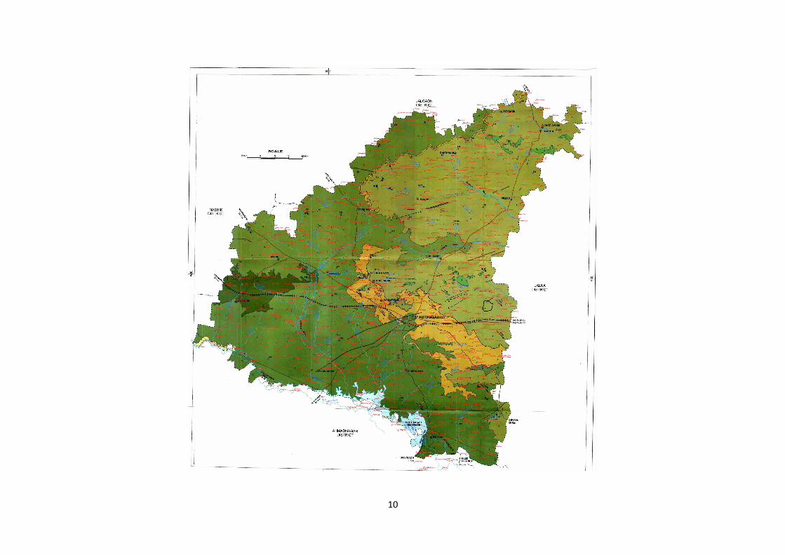
2.0 Overview of Mining Activity in the district : Aurangabad district is rich in minor minerals such as building stone and sand. Mining activity is one of the main revenue source for the district. District has 42 stone quarry leases till March 2021 covering area 74.66ha. There are no nonworking stone quarries within the district as per information recorded in the district mining office in the month of March 2021. (Source info. District Mining Office Aurangabad) There are 47 locations of sand ghats over Purna, Godavari, Khirna nala,Shivnala,Anjana, Girija rivers where sand deposition are allowed from replenishment and other safety point of view in the district. (Source info. District Mining Office, Aurangabad). Villages marked on the district geological map is as below :
10
11
3.0 List of the Mining Leases in the district with Location, area and period of validity : As per the sand mining and auction policy of Government of Maharashtra, Sand ghats are identified for deposition by respective tahsildars and recommended by Tahsil Level Technical Committee comprising G.S.D.A. and other authorities authorities of the district for mineable depth considering impact of sand scooping on ground water availability and stream. Hon’ble District Collector is a chairman and District Mining Officer who is a Geologist is member secretary of district level technical committee approving sand ghats. District Mining Officer is a project proponent to complete further procedures for auction including pricing and approval of Divisional Commissioner. Tahsildar at Headquarter is the holder of the sand ghats. After auction of sand ghats for period specified in the auction policy of Govt. of Maharashtra dated 3.09.2019, all rights to comply the terms and conditions for scooping of sand from sand ghats are transferred to Successful Bidder.
12
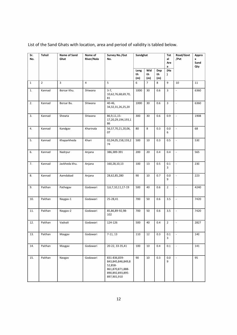
List of the Sand Ghats with location, area and period of validity is tabled below.
Sr. No.
Tehsil Name of Sand Ghat
Name of River/Nala
Survey No./Gut No.
Sandghat Total Area
Road/Govt/Pvt
Approx SandQty
Length (m)
Width (m)
Depth (m)
(Ha)
1 2 3 4 5 6 7 8 9 10 11
1.
Kannad Borsar Khu. Shiwana 3-7, 10,62,76,68,69,70,81
1000 30 0.6 3 - 6360
2.
Kannad Borsar Bu. Shiwana 40-46, 34,32,31,26,25,20
1000 30 0.6 3 - 6360
3.
Kannad Shewta Shiwana 86,9,11,15-17,20,29,194,193,186
300 30 0.6 0.9 - 1908
4.
Kannad Kandgav Kharinala 56,57,70,21,20,06,07
80 8 0.3 0.06
- 68
5.
Kannad Khaparkheda Khari 02,04,05,158,159,274
500 10 0.3 0.5 - 530
6.
Kannad Nadrpur Anjana 386,389-391 200 20 0.4 0.4 - 565
7.
Kannad Javkheda khu. Anjana 160,28,10,13 100 13 0.5 0.13
- 230
8.
Kannad Aamdabad Anjana 28,62,85,280 90 10 0.7 0.09
- 223
9.
Paithan Pathegav Godawari 3,6,7,10,11,17-19 500 40 0.6 2 - 4240
10.
Paithan Naygav-1 Godawari 25-28,41 700 50 0.6 3.5 - 7420
11.
Paithan Naygav-2 Godawari 85,86,89-92,98-102
700 50 0.6 3.5 - 7420
12.
Paithan Vadvali Godawari 124-126 500 40 0.4 2 - 2827
13.
Paithan Maygav Godawari 7-11, 13 110 12 0.3 0.13
- 140
14.
Paithan Maygav Godawari 20-22, 33-35,41 100 10 0.4 0.1 - 141
15.
Paithan Navgav Godawari 831-836,839-843,845,846,849,852,858-861,870,871,888-890,892,893,895-897,901,910
90 10 0.3 0.09
- 95

13
16.
Phulambri Shewta khu. Girija 227,240-242 150 60 0.4 0.9 - 1272
17.
Phulambri Pinpalgav valan Girija 22,23,55-57,60,61,69,70
50 10 0.5 0.05
- 88
18.
Phulambri Vadod ku. Girija 159-161, 165 150 60 0.4 0.06
- 1272
19.
Phulambri Kavithkheda Girija 59,62,64,65,68-70,73,85-92
50 15 0.4 0.4 - 106
20.
Phulambri Bhalgav Girija 15-17,31-35 50 12 0.3 0.06
- 64
21.
Phulambri Shelgav Girija 19-22,29,30 100 20 0.3 0.2 - 212
22.
Phulambri Vanegav khu. Bu.
Girija 15-19 200 20 0.3 0.4 - 424
23.
Sillod Dhanora Purnna 54/2, 34/1, 60/1, 60/2,61/2
700 25 0.6 1.75
- 3710
24.
Sillod Bhawan Purnna 189,190,204,227,231-234,236
250 30 0.3 0.75
- 795
25.
Sillod Didgav Purnna 21,12,4,13,10,11,9,8,5,7,23,27,24,28,37,39
500 30 1.2 1.5 - 6360
26.
Sillod Kothnandra Purnna 14,21,54,137 150 18 0.3 0.27
- 286
27.
Sillod Savkheda khu. Bu.
Purnna 340,39,41,47-51,53,56,178-180,182,163,165,142,152,136,137
300 20 0.6 0.6 - 1272
28.
Sillod Borgav bajar Purnna 5,50-53,75,148,480,474
80 15 0.3 0.12
- 127
29.
Sillod Modha khu. Purnna 62,63,68-72,102 400 20 0.4 0.8 - 1131
30.
Sillod Kenhala Purnna 555-557,568,569 700 30 0.5 2.1 - 3710
31.
Sillod Aambi Kelna 9,290,109,144,146,136-140
90 10 0.6 0.09
- 191
32.
Gangapur Sirsgav Shiwna 12,14,16 500 30 0.6 1.5 - 3180
33.
Gangapur Dinvada Shiwna 3,8,90,15,16 100 13 1 0.13
- 459

14
34.
Gangapur Malunja khu. Shiwna 3,5,10,11,121 60 10 1.2 0.06
- 254
35.
Gangapur Bhalgav Shiwna 15-20 100 12 0.3 0.12
- 127
36.
Vaijapur Lasurgav Shiwna 1,17,12,41,25,137 800 20 0.4 1.6 - 2261
37.
Vaijapur Manur Shiwna 90,91 250 15 0.4 0.3 - 530
38.
Vaijapur Lakhni Shiwna 5,6,51,64-66,86,87,93,110,116,107,106,146
300 30 0.5 0.9 - 1590
39.
Vaijapur Jhelegav Shiwna 2,3,36,28,41,49-54,58,60
200 20 0.5 0.4 - 706
40.
Vaijapur Purngav Godawari 246-248,250,252-258
800 30 0.8 2.4 - 6784
41.
Vaijapur Vanjargav Godawari 251-258, 250,246-248
500 40 0.8 2 - 5654
42.
Vaijapur Dagpinplagav Godawari 181-183, 165-167, 169-172, 185
200 25 0.8 0.5 - 1413
43.
Vaijapur Babhulgav Godawari 238-245 500 30 0.8 1.5 - 4240
44 Paithan Hirdpuri Godawari 185-188, 191, 192,
201, 202 600 40 0.6 2.4 - 5088
45 Gevrai Surlegav Godawari
2,4-7,9,12,13,15,17,19
375 35 1 1.95
- 4637
46 Paithan Takli Anbad Godawari
246,261-265,269,279,280,2
91-298 600 40 1.5 2.4 - 12721
47 Gevrai Gulaj Godawari 214-219, 258 620 35 1 2.4 - 7668
15
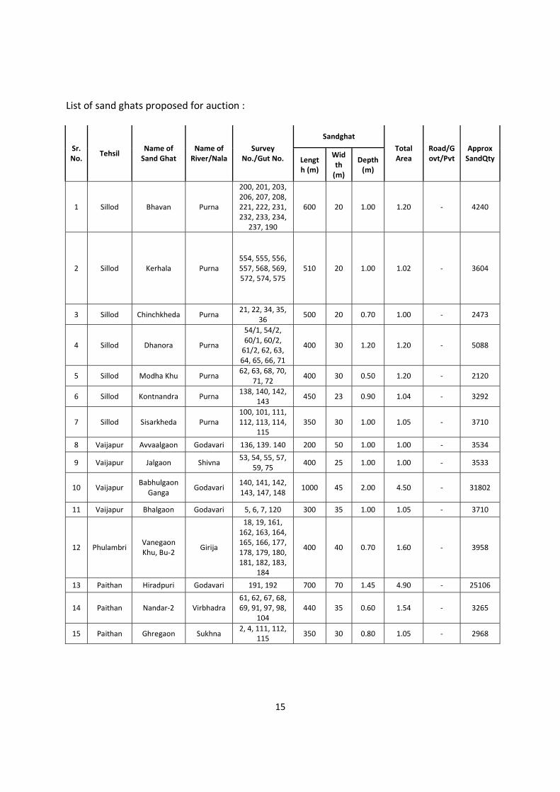
List of sand ghats proposed for auction :
Sr. No. Tehsil
Name of Sand Ghat
Name of River/Nala
Survey No./Gut No.
Sandghat Total Area
Road/Govt/Pvt
Approx SandQty Lengt
h (m)
Width
(m)
Depth (m)
1 Sillod Bhavan Purna
200, 201, 203, 206, 207, 208, 221, 222, 231, 232, 233, 234,
237, 190
600 20 1.00 1.20 - 4240
2 Sillod Kerhala Purna 554, 555, 556, 557, 568, 569, 572, 574, 575
510 20 1.00 1.02 - 3604
3 Sillod Chinchkheda Purna 21, 22, 34, 35,
36 500 20 0.70 1.00 - 2473
4 Sillod Dhanora Purna
54/1, 54/2, 60/1, 60/2,
61/2, 62, 63, 64, 65, 66, 71
400 30 1.20 1.20 - 5088
5 Sillod Modha Khu Purna 62, 63, 68, 70,
71, 72 400 30 0.50 1.20 - 2120
6 Sillod Kontnandra Purna 138, 140, 142, 143
450 23 0.90 1.04 - 3292
7 Sillod Sisarkheda Purna 100, 101, 111, 112, 113, 114,
115 350 30 1.00 1.05 - 3710
8 Vaijapur Avvaalgaon Godavari 136, 139. 140 200 50 1.00 1.00 - 3534
9 Vaijapur Jalgaon Shivna 53, 54, 55, 57,
59, 75 400 25 1.00 1.00 - 3533
10 Vaijapur Babhulgaon
Ganga Godavari
140, 141, 142, 143, 147, 148
1000 45 2.00 4.50 - 31802
11 Vaijapur Bhalgaon Godavari 5, 6, 7, 120 300 35 1.00 1.05 - 3710
12 Phulambri Vanegaon Khu, Bu-2 Girija
18, 19, 161, 162, 163, 164, 165, 166, 177, 178, 179, 180, 181, 182, 183,
184
400 40 0.70 1.60 - 3958
13 Paithan Hiradpuri Godavari 191, 192 700 70 1.45 4.90 - 25106
14 Paithan Nandar-2 Virbhadra 61, 62, 67, 68, 69, 91, 97, 98,
104 440 35 0.60 1.54 - 3265
15 Paithan Ghregaon Sukhna 2, 4, 111, 112,
115 350 30 0.80 1.05 - 2968
16
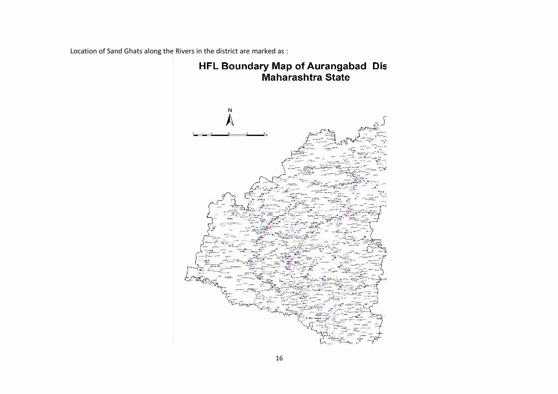
Location of Sand Ghats along the Rivers in the district are marked as :
17
4.0 Detail of Royalty/Revenue received in last four years from Sand Scooping activity: Financial Year Revenue in Rs. Crores F.Y. 2017-18 0.74 F.Y. 2018-19 0.64 F.Y. 2019-20 0 F.Y. 2020-21 2.54 5.0 Details of Production of Sand or Bajri or minor mineral in last four Years Financial Year Scooping of River
Bed Sand in Brass Scooping of River Bed Sand in Cum.
Scooping of River Bed Sand in Tonnes
F.Y. 2017-18 4800 13584 38035 F.Y. 2018-19 6243 17667 49467 F.Y. 2019-20 0 0 0 F.Y. 2020-21 18109 51248 143494 6.0 Process of Deposition of Sediments in the rivers of the District :
Sand is replenishable. Due to sparse rainfall over the last few years the river flows to an average height but flows to its maximum height only during and just after monsoon season. Mining of Building Grade sand from the river bed will not have any impact on the ground water body in the area. During heavy rains the floodwaters overflow the bank and inundate the fields and dry regions. The floods have its own ways of depositing sand not only at the bank but also on the dry surface region. Added to the deposition of sand on the river basin by stratification through lateral deposition of sands on the land surface is by Differential Lateral Deposition (DLD). The later grade is coarse, medium and fine sand to mud and soil beyond. In this soil, agricultural operation goes on from the bank to the cultivated land surface.
The yearly deposition of sand is by natural filling during flood season with slight variation depending upon the amount of river flow, the quantity of water flowing and the amount of sand load carried during the river flow. The deposition pattern will be monitored every year & measurements will be carried out as soon as the monsoon comes to an end.
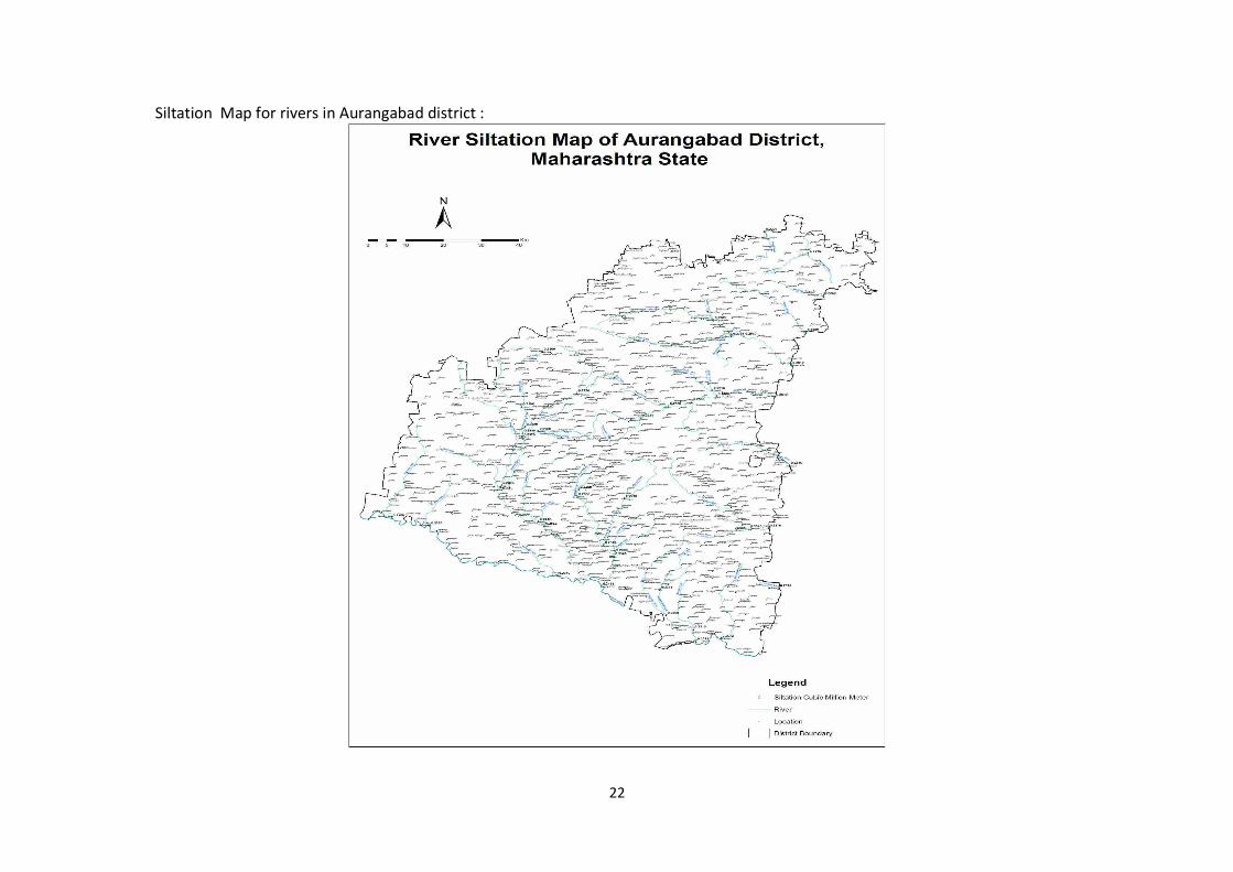
Deposition rate for the year 2020-21 is monitored, calculated and mapped with the help of technical consultant. Data for gauging of stream is mapped and enclosed below. Data for Siltation is mapped and enclosed ..
Based on siltation rate and survey every year sand ghats are proposed for scooping of sand and auctioned as per the State Government Policy empowered under rule 15 of Mines and Minerals (Development and Regulation) Act 1957 and amendments thereof.
Sediment refers to the conglomerate of materials, organic and inorganic, that can be carried away by water, wind or ice. While the term is often used to indicate soil-based, mineral matter
18
(e.g. clay, silt and sand), decomposing organic substances and inorganic biogenic material are also considered sediment . Most mineral sediment comes from erosion and weathering, while organic sediment is typically detritus and decomposing material such as algae.
Sediment particles come in different sizes and can be inorganic or organic in origin.
These particulates are typically small, with clay defined as particles less than 0.00195 mm in diameter, and coarse sand reaching up only to 1.5 mm in diameter. However, during a flood or other high flow event, even large rocks can be classified as sediment as they are carried downstream . Sediment is a naturally occurring element in many bodies of water, though it can be influenced by anthropogenic factors .
In an aquatic environment, sediment can either be suspended (floating in the water column) or bedded (settled on the bottom of a body of water)
In other words water flow tries to scour its surface whenever it flows in the channel. Silt or gravels enen larger boulders are detached from its bed or banks. The moving water sweeps these detached particles in downstream along its flow. Silting and scouring is not very uncommon and must be avoided by proper designs. It reduces supply level of water. The channel section gets reduced by silt and reduces discharging capacity. Sediments seriously threatens various projects due to silt carried out by rivers up to point of interceptions. Sediment is also threatening denudation of forests. Sediment is a major obstruction on the flow line . It shorten longevity of channel. It causes soil erosion. Therefore data base must be needed for policy making and planning. Sediments are calculated as sediment load. There are three types of sediments Coarse Sediments Particle size above 0.2mm Water sample passing through 100/72
mesh sieve (BSS). Residue over sieve is washed, dried and weighed It gives coarse sediments in gm/lit
Medium Sediments Particle size ranging 0.075mm-0.2mm After removal of coarse sediments residual water passed through 200mesh sieve (BSS), we get medium sements
Fine Sediments Particle size less than 0.075mm Filtrate and washing residue allowed to settle for 12hrs. About 5-10 % alum solution is added to hasten coagulation of colloidal silt Using Whatman Paper no02 filter paper, residue is filtered, dried and weighed. We will get fine sediments in gm/lit
19
Co relation between Siltation & Sediment Load
Siltation is deposition by fine particulate terrestrial clastic material, with a particle size dominated by silt or clay. It refers both to the increased concentration of suspended sediments, and to the increased accumulation (temporary or permanent) of fine sediments on bottoms where they are undesirable. Siltation is most often caused by soil erosion or sediment spill.
Sometimes siltation is called sediment pollution. The total Sediment load includes all particles moving as bedload, suspended load, and wash load
Bedload
Bedload is the portion of sediment transport that rolls, slides or bounces along the bottom of a waterway. This sediment is not truly suspended, as it sustains intermittent contact with the streambed, and the movement is neither uniform nor continuous . Bedload occurs when the force of the water flow is strong enough to overcome the weight and cohesion of the sediment While the particles are pushed along, they typically do not move as fast as the water around them, as the flow rate is not great enough to fully suspend them. Bedload transport can occur during low flows (smaller particles) or at high flows (for larger particles). Approximately 5-20% of total sediment transport is bedload . In situations where the flow rate is strong enough, some of the smaller bedload particles can be pushed up into the water column and become suspended.
Suspended Load
While there is often overlap, the suspended load and suspended sediment are not the same thing. Suspended sediment are any particles found in the water column, whether the water is flowing or not. The suspended load, on the other hand, is the amount of sediment carried downstream within the water column by the water flow. Suspended loads require moving water, as the water flow creates small upward currents (turbulence) that keep the particles above the bed . The size of the particles that can be carried as suspended load is dependent on the flow rate . Larger particles are more likely to fall through the upward currents to the bottom, unless the flow rate increases, increasing the turbulence at the streambed. In addition, suspended sediment will not necessarily remain suspended if the flow rate slows.
Wash Load
The wash load is a subset of the suspended load. This load is comprised of the finest suspended sediment (typically less than 0.00195 mm in diameter). The wash load is differentiated from the suspended load because it will not settle to the bottom of a waterway during a low or no flow period 11. Instead, these particles remain in permanent suspension as they are small enough to bounce off water molecules and stay afloat. However, during flow periods, the wash load and suspended load are indistinguishable.
20
Turbidity in lakes and slow moving rivers is typically due the wash load. When the flow rate increases (increasing the suspended load and overall sediment transport), turbidity also increases. While turbidity cannot be used to estimate sediment transport, it can approximate suspended sediment concentrations at a specific location.
River Dynamics (Physical)
Godavari,SUkhna,Dudhna,Purna,Kelna,Dheku, Waghu Rivers are in the matured stage of development running in wide serpentine course. The river meanders with convex & concave shape. The river in its course impinges on convex side. The concave side abounds with sand grain. The mining operation is most profitable on the concave side.
There is yearly deposition of sand as the amount of sand excavated gets redeposit in the pits by natural filing during flood season with slight variation depending upon the amount of river flow, the quantity of water flowing and the amount of sand load carried during the river flow. The deposition pattern will be monitored every year & measurements will be carried out as soon as the monsoon comes to an end and fresh excavation will be carried.
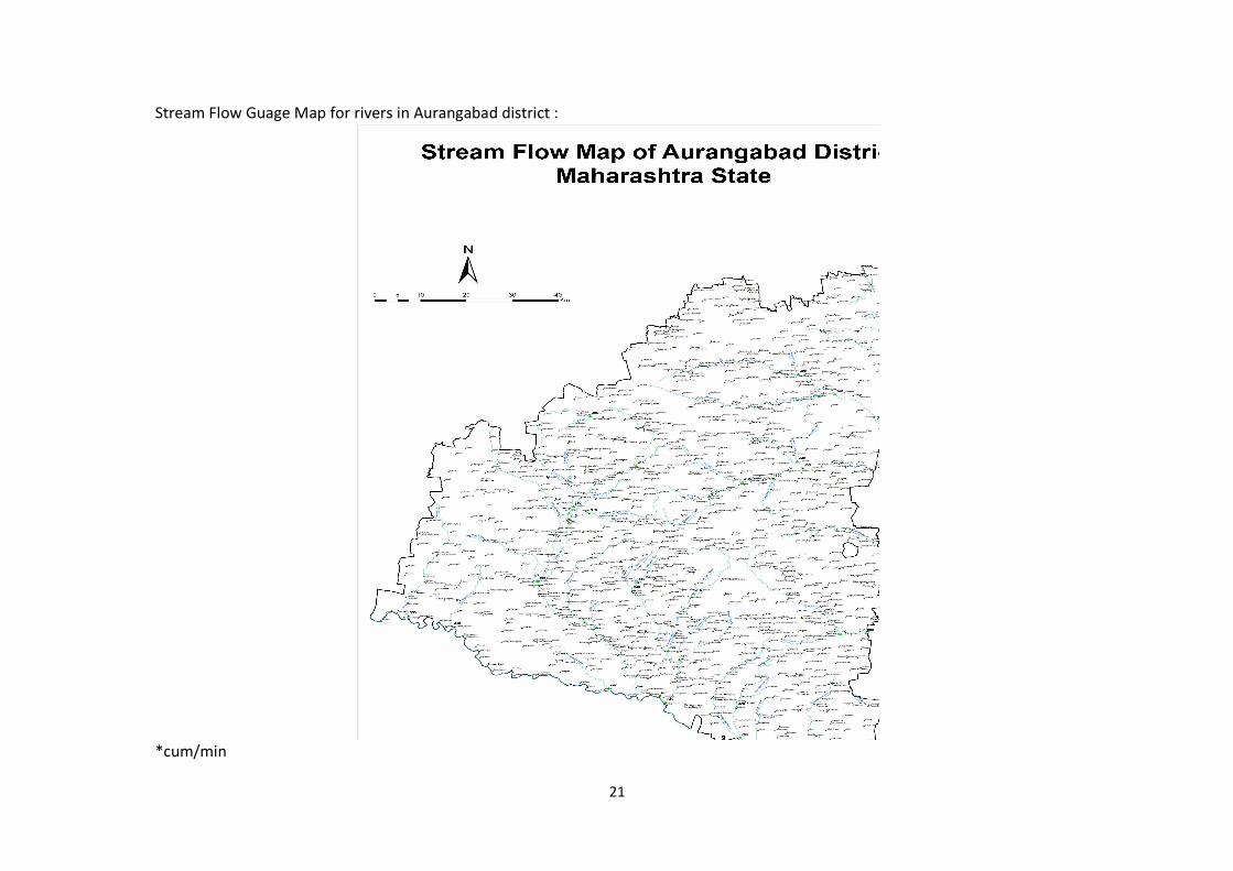
21
Stream Flow Guage Map for rivers in Aurangabad district :
*cum/min
22
Siltation Map for rivers in Aurangabad district :
23
7. General Profile of the district : Aurangabad District is located mainly in Godavari Basin and its some part towards North West of Tapi River Basin. This District’s general down level is towards South and East and North West part comes in Purna-Godavari river basin. The Aurangabad district’s North Longitude ( Degree) is 19 and 20 and East Longitude (Degree ) is 74 to 76. Aurangabad district is named after, its headquarters place of Aurangabad. The City was founded in 1610 A.D. by Malik Ambhar, the Prime Minister of Murtaza Nizam Shah of Ahmadnagar on the sight of Village called Khirki. Malik Ambar was succeeded by his son Fateh Khan, who changed the name of Khirki to Fatehnagar. With the capture Daulatabad by the imperial troops in 1633, the Nizamshahi dominions including Fatehnagar came under the possession of the Moghals. In 1653 when Aurangzab was appointed, the Viceroy of the Deccan, he made Fatehnagar his capital and called it Aurangabad. The historians of his reign also occasionally style the city Khujistan Bunyad. Since then the city came to be known as Aurangabad. It appears from the Archaeological excavations made in the neighbouring district that this region was occupied in the Early Stone Age. The earliest period known from the excavations is the chalcolithic or Early Bronze Age i.e. from 1500-500 B.C. According to the literary tradition, when the Aryans penetrated to the Deccan, the whole region was covered by a thick jungle. Agastya was the first Aryan who crossed the Vindhyas. We learn from the Ramayana that Rama accompanied by his brother Lakshman and wife Sita met Agastya near Godavari. Buddhism was first introduced in Maharashtra by Buddhist missionary named Maha Dharma Rakshita by narrating to the people the story of the Maha Naradakassapa Jataka during the reign of Ashoka. This led to the excavation of caves in different parts of Maharashtra; some of these were excavated at Pitalkhora, 80 Kms. from Aurangabad and at Ajanta on the northern fringe of the district. After the death of Ashoka, the Satavahanas rose to power in the Deccan. They made Pratishthana (Paithan) as their Capital. They received support from local rulers called Maharathis. Their kingdom extended up to Pune, Nashik, Ahmadnagar, Aurangabad and Jalna districts the earliest group of caves at Ajanta belongs to the Satavahana age. During the period of Satavahanas, this region must have attained a high level of prosperity. The Chalukyas of Badami (Bijapur district) rose to power in the first half of the sixth century A.D. Their kingdom extended up to the Narmada in the north. The Chinese pilgrim, Hiuen Tsang calls about King Pulakeshi II from Chalukya dynasty as the Lord of Maharashtra. Pulakeshi obtained a resounding victory over Harsha, the lord paramount of North India. Thereafter he assumed the title of Parameshvara. In the last quarter of the 12th century A.D., the Yadavas of Devagiri (Daulatabad) came into prominence. In 1296 A.D., Ala-ud-din Khilji invaded the kingdom of Ramachandra (King of Devagiri), he had to pay a heavy ransom to the Muslim conqueror. He was succeeded by his son Shankaragana. He was defeated and slain by Malik Kafur. Thus, the Hindu Kingdom of Devagiri came to an end in 1318 A.D. From the early 13th century onwards, Muslim rulers started invading this region. They conquered many small forts. The prominent being the Devagiri fort. Since then the Maratha power never established in this region. After the death of Emperor Bahadur Shah in 1711, the civil war that took place for supremacy prompted Nizam-ul-Mulk, a Governer in Mughals court to become the Viceroy of the Deccan in 1713. He founded the Nizam dynasty. This family ruled in Hyderabad till 1948. There were no major changes in the boundaries of the district or its talukas between 1901 to 1941. Eight villages of Ambad taluka were exchanged with six villages of Pathri taluka of Parbhani district. In 1950, twenty-five enclave villages belonging to the neighbouring districts of Nashik, East Khandesh and Ahmadnagar were transferred to Aurangabad district. More than one third of the district was Jagir area. Nizam’s own estate called “Sarf-e-Khas” comprising two talukas was merged with the Government area
24
under Sarf-e-Khas (Merger) Regulation of 1949. Consequent upon the integration of Jagirs and Sarf-e-Khas areas, all the taluka boundaries were reconstituted in April 1950. Two new Mahals (Tahsils) with headquarters at Jafferabad were created. In 1953 another new mahal (tahsil) with headquarters at Soegaon was created by transferring 37 villages from Sillod taluka and 30 from Kannad taluka. All the villages transferred to this mahal are situated to the north of the Satmala hills. With the reorganisation of States in 1956, the district was transferred from Hyderabad State to Bombay State and since 1960 it forms a part ofMaharashtra. The district comprises of varied topographic features and landscapes consisting of high hills and plains and low lying hills. Most of the hill ranges are located in the northern part of the district. The Satmala hills and Ajanta hills extend from east to west. The hills near Verul in Khuldabad taluka are part of these ranges which extend to Chawaka ranges and Aurangabad hills. The Satmala range encompasses several hills overlooking the Tapi valley. From west to east they are Antur (826 m amsl), Satonda (552 m amsl), Abasgand (671 m amsl) and Ajantha (578 m amsl). The Satmala hill (493 m amsl) from which name of the range is derived, is situated north to Kannad town. The district is a part of the Deccan Plateau. In general, the slopes in the district are towards south and southeast. The average elevation of the district is in the order of 500 m amsl. Within it there are flat topped hill ranges extending over wide area and also hills separated by broad valleys. Major part of the district falls in Godavari basin with a small area in north eastern parts falling Tapi Basin. The major river in the district is the Godavari with its tributaries namely; Purna, Dudhna and Shivna rivers. The other important tributaries are Sukna, Khelna, Kham, Gulathi, Shivbhadra and Girija rivers. Depending on the drainage and geomorphology, the district has been divided into 52 watersheds.
The district being a part of the Deccan plateau sloping southeastwards from the Sahyadris, has many features in common with other districts of the Deccan or like location. The southeasterly trending Chandavad range in Nasik district becomes very subdued in the western part of Aurangabad district as a result of dis- section in north-south but opposite directions by the Maniyad and Shivna rivers in a probably structural depression. East of the latter rising steeply the Ajanta plateau begins with elevations of over 900 metres and slopes gently eastwards to be drained by the Purna and its tributaries. The northern edge of this plateau is a continuation in an eastnortheast direction of the Chandavad range after the above-mentioned depression as the Satmala or the Ajanta range. This presents a pronounced scarp face towards the Tapi valley on the north and a gentle back slope to south on the plateau. -The energetic northward flowing tributaries of the Tapi have in several places cut across the scarp by their active headward erosion and extended their source regions farther south into the plateau, so that the water divide between the Tapi and the Godavari drainage has receded from this scarp and has become low and indistinct in several places.
The Satmala hill (3093 ft. or 943 metres) from which one of the names of the range is derived is situated north of Kannad town. The Outram Ghat providing road communication from Karmad to Chalisgaon across the Satmala range is situated about 7 km. to the west of this Satmala hill.
The Satmala range contains several hill forts on it overlooking the Tapi valley to the north. From west to east they are Antur (2704 ft. or 826 metres), Sutonba (1812 ft. or 552 metres), Abasgadh (2202 ft. or 671 metres), Baithaulvadi (2052 ft. or 625 metres) and Ajanta (1897 ft. or 578 metres).

25
Near the northeastern corner of the district there is an off-shoot from this range extending southeastwards forming the western edge of the Buldhana plateau. Most of this range lies outside the district. Only the northeastern boundary of Jagerabad tahsil extends upto this off-shoot range.
Near the trijunction formed by Nasik Jalgaon and Aurangabad districts, a branch of the Ajanta range first extends southwards and then proceeds nearly eastwards as far as the Shivna nadi. This contains several peaks over 2500 ft. or 760 metres and three of them rise over 900 metres. The first two of the latter are situated in close proximity to each other in the west where this ridged changes from a southerly to easterly direction and the third one the highest (3144 ft. or 958 metres) is Surpainath hill situated farther east.
The western edge of the Ajanta plateau flanking the Shivna basin and containing the Ellora (Verul) caves may be considered as forming the Ellora range branching off southwards from the main Ajanta range just to the east of the Satmala hill. After the Ellora caves it runs in a southeasterly direction and beyond the Aurangabad gap appears as the Satara range and then continues in a series of discontinuous low hill as far as Ambad town.
The several eastward trending ridges from this Ellora. range are really the residual hills left behind by the dissection of the Purna and its tributaries in the Ajanta plateau. Of these, the divides between the Purna and the Anjan, between the Anjan and the Girja, and between the Girja and the upper Kham-Sukna trough are the more important ones. The first one, that between the Purna and the Anjan extends nearly eastwards from the Satmala hill and has considerable extent of flat topped summit areas at levels over 800 metres which are utilised for agricultural purposes. The second one, that between the Anjan and the Giria is a ridge extending eastwards of Kannad town and has similar summit plateau levels of slightly lower altitudes but more discontinuous and irregular (the result of greater degree of dissection), used for agricultural purposes. But this extends much farther eastwards. The third one. which is south of the Girja nadi ex. tends still farther eastwards and is of similar character.
Rivers.-The rivers of the district may be grouped into three classes :
(i) the Godavari and its direct tributaries,
(6) the Purna and the Dudna and their tributaries and
(iii) the tributaries of the Tapi basin.
Godavari.-The Godavari forms nearly the entire southern boundary of the district from Dongaon about 3 kilometres above Puntamba to Gunj Buzurg, a distance of nearly 230, kilometres.
The following are among the direct tributaries of the Godavari: the Kol. nadi, the Narangi Nala, the Shivna, the Kham, the Yelganga, the Shivbhadra, the Yelbhadra, the Galhati, the Dhenda, the Dudna and the Musa.
Kol.-The first significant tributary of the Godavari after it enters the district is the Kol. nadi, which has only a small part of its lower course lying within the district.
26
Narangi Nala.-The Narangi rises on the southern slopes of the water divide to the south of the Maniyad river a little above Naral village and flows past Vaijapur. A little below the latter, it is joined by the Deo nala, flowing from Nasik district. It has a fairly long south southwesterly course before its point of entry into the Godavari is carried a little down the latter. It is joined by the Chor nala from the west and Kurla nala from the east. Actually the Narangi continues the trend of the Kurla river after the latter’s confluence.
Narali.-The Narali nala is a small stream rising above Jambargaon on a low divide and after passing by Virgaon joins the Godavari at Dak Pimpalgaon.
Kalanibi.-The Kalambi nala is a similar small stream flowing past Gangapur in a southeasterly course joining the Godavari at Golnimb.
Shivna.-The Shivna is a much larger river than any of the streams mentioned above and is a master stream of the western part of Aurangabad district. The Shivna rises on the eastern slopes of the Ajanta range just east of the trijunction of Jalgaon, Nasik and Aurangabad districts above Kalanki village and has a fairly long easterly course as far as Kannad town draining the entire area lying between the Ajanta range on the north and the Surpalnath range on the south. Near Kannad it is joined by several streams draining the Ajanta range and the northern part of the Ellora range, inclusive of the one which rises on the southern slopes of the Satmala hill. South of Kannad, the Shivna after flowing beyond the eastern extremity of the Surpalnath range, is relieved of the restrictive influence of the latter and flows in a southwesterly direction as far as Baigaon, where it turns and flows almost in a southerly course upto Katepimpalgaon. Here it turns and flows in a southeasterly course to join the Godavari at Sawkheda. Thus the river has an initial easterly course, then a southwesterly course, then a southerly course and lastly a southeasterly course. These changing directions of flow depict the lines of structural lines of weakness in the basal rocks.
But for a few minor streams which flow directly into the Godavari, almost the entire area west of the Ellora range in the district may be said to be drained by this master stream.
Bori nala.-The westernmost significant tributary of the Shivna is Bori nald which rises above HilaIpur on the low water divide separating it from the Maniyad. Near Kolhi where the ShiynaVaijapur road crosses the Bori is located the Kolhi Project. After passing by Borsar, Bhaigaon, Parsoda and Karanjgaon it turns and flows southwards to join the Shivna above Katepimpalgaon below the confluence of the Dheku.
Dheku.-The Dheku. nala rises in the Gorakhnath and Kapilanath hills of the Ajanta range above Dheku. village in Nasik district and flows in a southerly course as Tunki, where it turns and flows in southeasterly course. The Karali nala, a similar stream flowing a little eastwards joins the Dheku. The headworks of the Dheku Project are located below this confluence and upstream of Bhatana village. Below Bhatana the river flows in a more southerly course and after running nearly parallel to the Shivna for more than 20 km., joins the latter upstream of Katepimpalgaon.
Khari-The Khari nala rises in the Ajanta range and after an initial course in Nasik district enters this district. Soon it is joined by the Chamandara nala and the combined stream flows southeastwards and joins the Shivna near Bharagaon.

27
Innumerable streams rise on the southern slopes of the Surpalnath range and flow nearly due southwards to join either the Khari nadi or directly into the Shivna. Of these may be mentioned the Gorji nadi flowing by Chinchkheda. and JavIi, the Dongri nadi flowing by Chapner, and the Vach and the Vaghvadi nadi which combine before joining the Shivna.
Gan -Among the left or east bank tributaries of the Shivna, the most important one is the Gan nadi. Actually the main river Shivna may be considered to join this river below Hatnur as the combined river continues the trend of the Gan nadi. It is quite probable that this southeasterly stretch of the Gan and the Shivna represents a pronounced line of weakness of spot heights on the banks, at Tapargaon 1883 ft. or 574 metres, at Lohali 1812 ft. or 552 metres and near Bhargaon 1735 ft. or 529 metres. Compared with these, heights on the banks on the Banganga and the Girja on the eastern side of the Ellora range the heights are at Sobalgaon 2249 ft. or 686 metres, at Banganga-Girja confluence 2105 ft. or 642 metres, at Pathari 2048 ft. or 624 metres etc. It is clear from these that the base level nadi extending its source farther back - across the Ellora range, is much lower than that of the Banganga-Girja rivers flowing to the cast. This accounts for the rapid headward erosion of the Gan nadi extending its source farther back across the Ellora range. This is so marked that some of the southeasterly stretches of these headwaterstreams may be considered as the beheaded portions of the tributaries of the Banganga system resulting in an easterly migration of the watershed.
Velganga.-Among the other several left bank tributaries, flowing westwards from the Ellora range the more important ones are the Velganga which flows past Ellora or Verul village and the Khaki, which flows by Kasabkheda. These two join just above Deogaon and the combined river continues westwards to join the Shivna opposite to Lakhni.
Lendi.-The Lendi nadi rises in the Verul hill and flows in a southeasterly course and then southwards to join the Shivna opposite to Sirasgaon.
Nagjhari.-Several streams draining the southern slopes of the Verul and Deogiri hills combine to form the Nagjhari and become an appreciable river below Kasod. After flowing past Turkabad, Limbe Jalgaon, Antapur and Dhamori Buzurg, it joins the Kaum river.
Kaum.-The Kaum river rises on the southern slopes of the east to west divide south of the Giria nadi and flows through Aurangabad town in a general southwesterly course till it is joined by the Nagjhari. Then, after a short southeasterly course it continues the trend of another tributary, the Buraguli southwards and joins the Godavari near Jogeshwari.
Buraguli.-The Buraguli is a small tributary of the Kaum draining southwestwards from the Satara range.
Yelganaga.-The Yelganga nadi rises above Kasner and after an initial westerly course to southeast and south joins the Godavari.
Vanki-The Vanki is a smaller river rising on the southern slopes of the same hill and flowing west of Dhorkingaon joins the Shivbhadra.
Shivbhadra.-The Shivbhadra nadi rising in the same hill above Dongaon flows past Pipalwadi and joins the Godavari a little below the confluence of the Yelganga.
28
Yelbhadra -The Yelbhadra river rises in the same bill further east near Daregaon and flows at first southwards and then southeastwards to join the Godavari at Naugaon.
Galhati.- The Galhati rises in the same range still farther east and flows by Pachud Buzurg in a southeasterly direction to join the Godavari at Chincholi. The earthen dam of the Galhati Project is built across this river downstream of Baraswadi village.
Musa.-The Musa nadi rises east of the Ambad hill and flows southwards towards the Godavari and joins it at Jogladevi.
Purna.-The Puma river rises in the Ajanta range about 8 km. northeast of the Satmala hill above Mehun village at a height of about 775 metres and has the longest course of any river within the district, before it leaves the district about a kilometre and a half below Brainhapuri at a level of 518 metres. Next to the Godavari, it is the most important river of the district. Along with its several tributaries including the Dudna, the largest of them but joining it outside the district, the Purna drains the entire area between the Ellora range and Tapi-Godavari water divide. The important tributaries of the Purna on the left or north bank in the district are the Charna important tributaries of the Puma on the left or north bank in the district are the Charna, the Khelna, the Jui, the Dhamna and those on the right or south bank are the Anjan, the Girja, the Jivrakha and the Dudna.
Charna.-The Charna is a small stream rising in the Ajanta range some 3 kilometres north of Ghatnandra. After flowing past Ghatnandra, Charna and Deulgaon it joins the Puma at Savkheda.
Khelna.-The headstreams of the Khelna lie within a short distance (less that a kilometre) of those of the Charna in the same Ajanta range. This very much longer tributary flows past Kelgaon. Chichpur, Palod, Anvi. Ayhana and Bhokardan and joins the Purna at Jafferabad.
Jui-The Jui, an important tributary of the Khelna, rises above Undangaon and after passing by that village, has a fairly long southerly and southeasterly course and joins the Khelna some 5 kilometres below Assaye.
Dhamna.-The Dhamna rises in the Lagnia hill in the Ajanta range and flows nearly southwards past Vadhona, Dhamangaon and is joined by the Raighol at Takli, after which it flows in a southeasterly direction continuing the trend of this tributary. From a point about a kilometre and a half upstream of Dhamangaon (Buldhana side) to a point about 3 kilometres downstream of Takli, the river forms the district boundary beyond which it flows outside the district. It re-enters the district a little above Borgaon Buzurg and flows nearly southwards joining the Purna within the district about 5 kilometres downstream of Jafferabad.
Lendi.-The Lendi river drains the southeastern slopes of the edge of the Buldhana plateau, flows entirely within the district in a south-southwesterly direction and joins the Puma about 2 kilometres downstream of the Dhamna confluence. It is quite significant that the Purna here makes a right angular bend changing from the easterly to the southerly direction to continue the trend of this tributary.
Madnai.-The Madnai is a stream very similar to the Lendi but has only a small part of its middle course within the district.
29
Anjan.-The first significant long tributary of the Purna on the right or south side is the Anjan river. Its source lies close to that of the Purna on the south side of the Purna-Anjan divide. The Anjan has a fairly long winding course eastwards passing by Nimbhore, Vasri, Pishore, etc., and joins the Purna 2 kilometres west of Dhanora.
Girja.-The Girja is the longest tributary of the Puma in the district on the right bank. This river rises on the eastern slopes of the Ellora range to the west of Takali and has unlike the more northerly ones, a long general east-north-east course up to Vadod Buzurg, after which it flows in an easterly and southeasterly course past Hasnabad. Two kilometres downstream of Sirasgaon it again resumes the northeasterly course and joins the Purna.
Nagjhari.-The next stream to join on the left is the Nagjhari which has its source just east of that of the Banganga and has a general southeasterly course passing by Babra, Loha and joins the Girja a little north of Paithan.
Banganga.-The Banganga rising in the Anjan-Girja divide has a remarkably straight southerly course as far as Sangvi, where it turns and flows in an east-southeasterly direction to join the Girja.
Phulmasta.-The Phulmasta is the first significant right bank tributary of the Girja. It rises in the hill to the north of Khuldabad and flowing away eastwards of Khuldabad it assumes a northeasterly and northerly course to join the Girja.
The Girja has several small tributaries joining from the south, among which may be mentioned the one flowing past Phulambri, and the Khatkali joining it at Hasnabad.
Banganga.-The Banganga (different from the northern tributary of the Girja of the same name) is a small river flowing from the south joining the Purna some distance below the Girja confluence.
Jivrakha.-The Jivrakha is another right bank tributary of the Purna. Rising above Longaon it flows at first in a northeasterly course as far as Akola. After Akola it turns and flows in more northerly course passing by Tembhurni and joins the Purna a little upstream of the Khelna confluence. The earthen dam forming the headworks of the Jivrakha Project is located about a kilometre and a half above Akola.
Dudna.-The largest tributary of the Purna is the Dudna which is nearly as long as the main river up to the confluence point. The Dudna rises above the Kankur village on the northern slopes of the easterly trending off-shoot of the Ellora range forming the divide between this stream and the Sukna and flows some 15 km. to the north of Aurangabad town. After an initial irregular winding course it turns and flows in a southeasterly direction as far as Akola. At Somthana above Akola the river is crossed by an earthen dam providing the storage for the upper Dudna project. After Akola it flows more southerly passing by Badnapur and is joined by the Sukna at Sadesangvi. The main river continues the course of the Sukna after the latter's confluence resulting in an easterly course. The Dudna has a further long course in Parbhani district before it joins the Purna. Among the left bank tributaries of the Dudna are the Baldi, the Kundlika and the Kalyan.
Baldi.-The Baldi is a small stream rising a little above Anvi village from the Dudna-Girja divide flowing in a general south-south-westerly course to join the Dudna.
30
Kundlika.-The Kundlika river rises further east on the same divide but well back on the north indicating a retreat of the divide here. After an initial course in a south south-westerly direction up to Ganeshwadi, it changes into a southeasterly course passing through JaIna town. The Godavari Valley railway line crosses the Dudna just before the confluence of the Kundlika.
Kalyan.-The Kalyan river rises on the same divide further eastwards above village and flows southwards up to Pir Kalyan, where it turns to flow southeastwards. Two left bank tributaries, the Gandi and the Girja (very much smaller one than the big tributary of the Purna of the same name) join this river. This Kalyan river forms for a while the district boundary where it joins the Dudna.
Among the right bank tributaries of the Dudna are the Lahuki, the Sukna and the Jatashankar.
Lahuki-The Lahuki nadi is a small stream rising near the source of the Dudna on the southern slopes of the divide separating the two and flows southeastwards past Dudhad and Roshangaon to join the Dudna a little north of the Sukna confluence with the latter.
Sukna.-The Sukna rises to the west of the source of the Lahuki above Kolthan village and has an initial course parallel to the Kaurn river. The head streams of this river appear to have been beheaded by the Kaum river. The Sukna flows southeastwards past Chikalthana receiving a number of small streams on both, sides and joins the Dudna at Sadesangvi.
Chite.-The Chite rises in the Satara Range above Sindhon village and flows between two eastward trending parallel ridges of that range and beyond their extremity at Chitepipalgaon, it turns north wards to join the Sukna.
Bemla.-The Bemla is a small stream flowing parallel to the Chite but farther south in a general easterly direction joining the Sukna just west of Gharegaon. After the confluence the Sukna continues the easterly trend of this river. Tapi basin tributaries
Gadadgad.-The Gadadgad nadi rises on the northeastern and eastern slopes of the Satmala hill and flows northwards leaving the district below Nagad to join the Tittur river, a tributary of the Girna.
Rangarai.-The Rangarai is a sub-tributary rising to the northeast of the headstreams of the Gadadgad on the Ajanta range and joining this latter river, has only a short course within this district.
Another sub-tributary of Gadadgad rises in the Ajanta range east of the Antur fort hill and Chipghat and flows northwards. The active headward erosion of this stream has resulted in a significant receding of the escarpment about a kilometre southeast of Chipghat.
Hivra.-The next stream of importance is the Hivra nadi, whose back-cutting action across the Ajanta range is even more severe. Its principal headstream is well south of the line of the escarpment flowing by Dudmal and the low existing divide between this stream and the Purna is some 3 kilometres south of the escarpment. It is quite probable that the present easterly course of the headstream of the Hivra past Dudmal, might have been the beheaded portion of a headstream of the Purna, whose surviving lower remnant flows by Shendra, the wind gap being located just south of Talner.

31
The Hivra passes by Vadi, Banoti, Vathan and Ghorkund and continues northwards leaving the district below Mhasekotha. It may be noted that this river flows past Pachora in Jalgaon district. The Hivra has several tributaries whose headstreams rise further eastwards in the Ajanta range but only some small portions of their upper courses lie within the limits of the district. They are the Indragadhi, Utavli, Doha, BavIa, Khutkai and Nandvohi rivers. A portion of the last mentioned river forms the district boundary.
Sonad.-The Sonad river rises a little to the north of Ghatamri and flows northwards past Soegaon and after a kilometre forms the district boundary for some distance and then goes outside the district. This is another powerful stream which has trenched deeply cutting back across the scarp face so that the water divide at Ghatamri is some 6 kilometres and a half south of Abasgadh fort hill.
Waghur.-The Waghur river is the most active of all the Tapi streams of the district. The trenching of the escarpment face and the backcutting action and the accompanying retreat of the water divide is nowhere so remarkable as in the case of this river, one of whose headstreams flow past Ajanta village and another past the Ajanta caves. It is the trenching action of the latter which has been responsible for such a splendid site for the caves. The water divide has receded to as much sq 15 kilometres behind the northern line of the scarp above Fardapur. It is here that a considerable drainage of the Purna lying to the north of the upper reaches of the Jui river might have been annexed to the Tapi basin by the aggrandisement of this river.
The remaining tributaries of the Tapi, the Khadki, Meh, Kag and Kang are much less powerful streams. Only the first two of them rising in springs, have done some appreciable back cutting in the escarpment. The Meh leaves the district below RavIa and the Kang nadi flows past Savaladbara. A very small portion of the extreme northeastern part of the district contains the headwaters of the Sur nadi.
Geographical Regions.- The district may be broadly divided into the following geographical regions:
(i) The Shivna-Godavari basin.
(ii) The northern piedmont slopes.
(iii) The Ajanta Plateau.
The first region forming the basins of the Shivna and the Godavari rivers comprises the relatively lowlying areas to the west and south of the Ajanta plateau. This may be divided into sub-regions, the one comprising the Shivna basin and the upper part of the Godavari valley in the district made up of the western and southern parts of Kannad tahsil, a small part of Khuldabad lying to the west of Ellora scarp and the whole of Vaijapur and Gangapur tahsils, and the other comprising the rest of the Godavari valley region south of the Ajanta plateau made up of the whole of Paithan tahsil, and a small adjoining southwestern portion of Aurangabad tahsil and the southern two-thirds of Ambad tahsil.
In the first sub-region of the basin of Shivna and upper Godavari the soils generally improve in quality as one proceeds from the north to the south. Accordingly the proportion of gross cropped area under jowar increases from north to south, the reverse trend being noticeable in bajri. In the whole of Aurangabad district it is only in this sub-region that the proportion of area under wheat to total gross cropped area is about a tenth or more. On the other hand the cotton area in this region is least important in the district. In the north in Kannad tahsil owing to the piedmont character of the soils,

32
mango trees are of considerable importance. The variety known as Maruti Amba of Mundwadi has small nuts and is considered to be very sweet. There has been of late considerable development of mosambi cultivation owing to the extension of irrigation facilities. Bahirgaon is one such place. The relatively dry condition prevailing in Vaijapur tahsil seems to favour the cultivation of grapes. However there is acute water scarcity and the wells are generally deeper than 30 feet. Dhondalgaon is noted for its grapes. In the south of this sub-region the Gangapur sugar factory is located on the northern bank of the Godavari river, to the south of Gangapur town. Though there is some cane cultivation in the area round about, based upon lift irrigation, the bulk of the supply to the factory comes from Ahmadnagar district across the border.
In the second sub-region forming the middle and lower portions of the Godavari valley in the district, the fertility of the soils reaches its highest level in the district Jowar occupies nearly a third of the gross cropped area and is grown more in the rabi season. Cotton here occupies a fifth of the cropped area whereas its proportion is less than a tenth of the cropped area in the former sub-region.
Rising above the Tapi basin of the north and the Shivna and the Godavari basins of the west and the south, lies the Ajanta plateau region, which is dissected by the Purna and the Dudna and their tributaries with residual interfluve ridges generally trending eastwards. Of all these interfluves, the one separating the Dudna and the Purna basins, stretching almost due west to east is so well marked that it is possible to consider the Ajanta plateau region as divided into subregions, the Purna basin and the Dudna basin. The Purna basin comprises the whole of Sillod and Jafrerabad tahsils and the northeastern part of the Kannad tahsil, eastern part of Khuldabad, and Bhokardan tahsil excluding its small northeastern portion forming a salient between Jalgaon and Buldhana districts. The Dudna basin comprises Aurangabad tahsil excluding the southwestern part (which has been considered as included in the Godavari valley region), the whole of JaIna tahsil and the northern third of Ambad tahsil.
Considering the Ajanta plateau as a whole, the soils generally increase in depth and fertility eastwards and accordingly the proportion of the cropped area under Jowar increases, while that under bajra decreases. On this plateau region pulses account for more than a fifth of the cropped area. While pulses show a slight decrease eastwards, the area under cotton definitely shows an increase eastwards. In the three eastern tahsils of Bhokardan, Jafferabad and JaIna it occupies about a fifth of the cropped area.
The region sloping away northwards from the Ajanta Satmala ranges stretches from the environs of Nagad in the northern part of Kannad tahsil in the west through the whole of Soegaon tahsil to a small portion of Bhokardan tahsil which forms a salient extending northeastwards between Jalgaon and Buldhana districts. On the piedmont slopes the soil is mostly poor. However ground water is abundant on account of springs all along the foot of the scarp. Garden crops and cotton are of considerable importance in this region. Wheat is negligible, but pulses and cotton each account for a fourth of the cropped area. There is about an equal extent under food and nonfood crops, the proportion of the former to the latter being the least in this area compared to the rest of the district. The common kharif mixtures are either jowar (Nilav) with udid, and mug or bajra with tur. There is some double cropping also especially in the west. Jowar is some times grown after mug in the rabi season. Plantain and mosambi are the favourite garden crops. Almost all the villages are on the banks of innumerable streams which drain this region. Vanjari huts are scattered all over the area. Soil plays a very important role in the agricultural activities and forest growth of the area. The fertility of the soil from agricultural point of view depends upon the texture and structure which controls the
33
retaining and transmitting capacity of moisture and various nutrients such as nitrogen, phosphorous and potassium present in the soil. The formation of the soil in the area is influenced by the climate, geology, vegetation and topography. The major part of the district is covered by black cotton soil or ‘Regur’ formed by the weathering of Deccan Trap Basalt. It is rich in plant nutrients such as lime, magnesia, iron and alkalies on which cotton and dry crops like Jowar, Bazra and tur etc flourish. It swells and becomes sticky on watering while on drying it contracts and develops many cracks. The soil varies both in texture and depth. In northern portion of the district the soils are shallow and relatively poor while in south they become deep and fairly rich in nutrients.
The winter season commences towards the end of November when temperatures begin to fall rapidly. December is the coldest month with the mean maximum temperature of 28.9° C, while the mean minimum temperature is 10.3°C. From the beginning of March, the daily temperature increases continuously. May is the hottest month with the mean maximum temperature of 39.8°C and the mean minimum temperature of 24.6° C. With the onset of the south-west monsoon by about the second week of June, the temperature falls appreciably. The average annual rainfall of the district is 705 mm
There are five Subdivisions and ten talukas listed as
Name of Sub division Taluka
1. Aurangabad 1.Aurangabad Rural
2.Aurangabad Upper
2. Sillod 3.Sillod
4.Sonegaon
3. Vaijapur 5.Vaijapur
6.Gangapur
4. Paithan 7.Paithan
8.Phulambri
5.Kannad 9.Kannad
10.Khulatabad
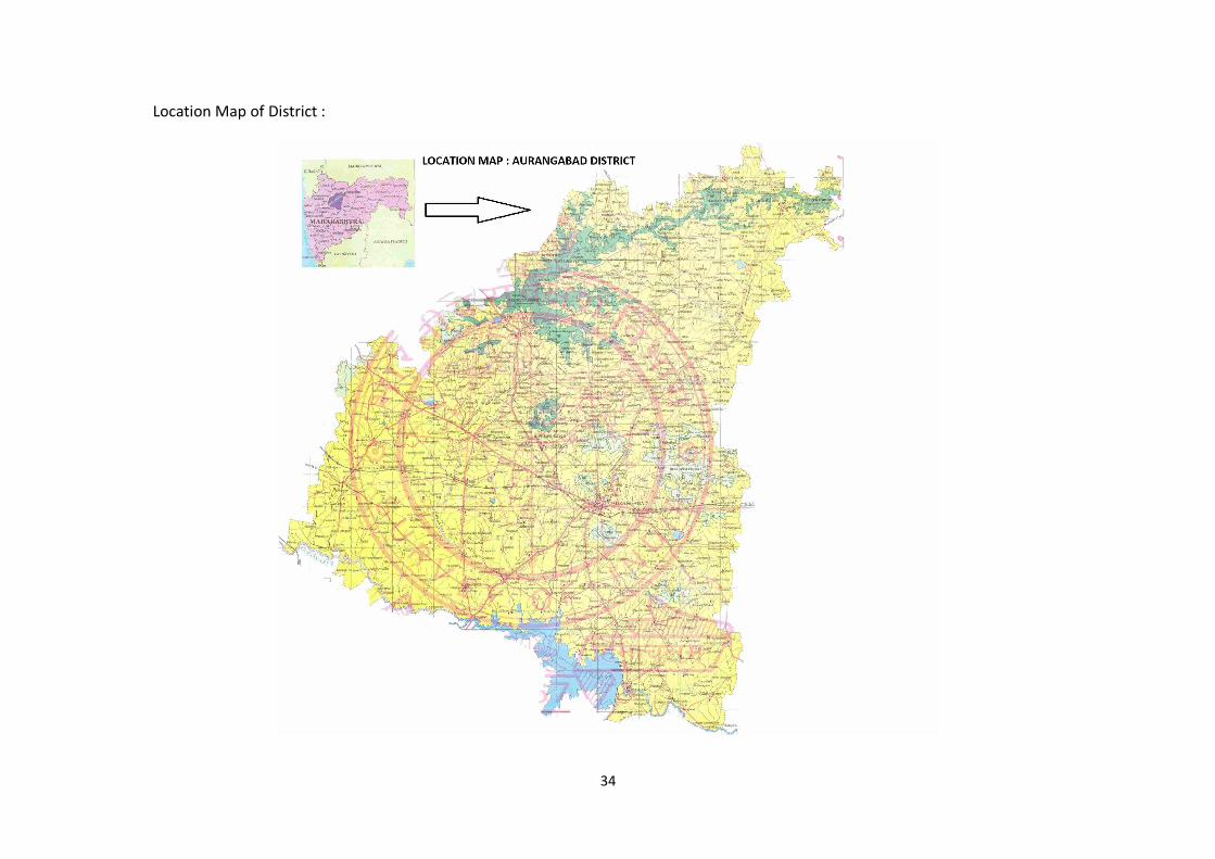
34
Location Map of District :
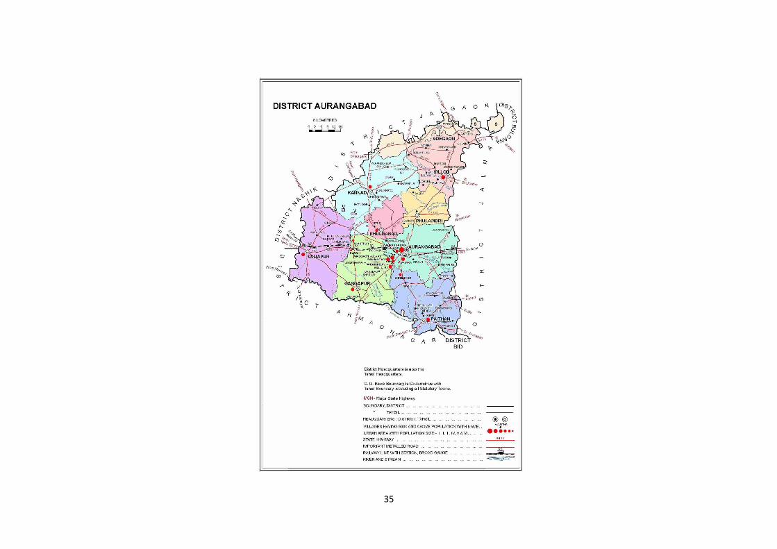
35
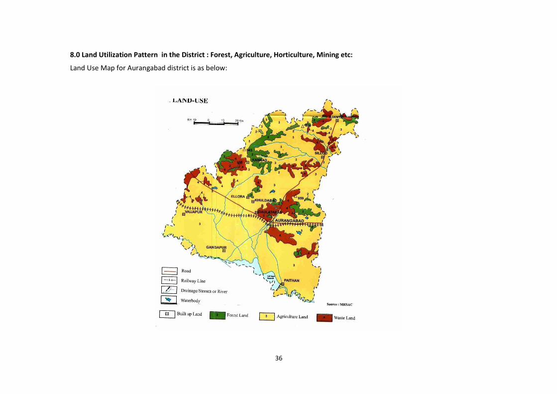
36
8.0 Land Utilization Pattern in the District : Forest, Agriculture, Horticulture, Mining etc:
Land Use Map for Aurangabad district is as below:
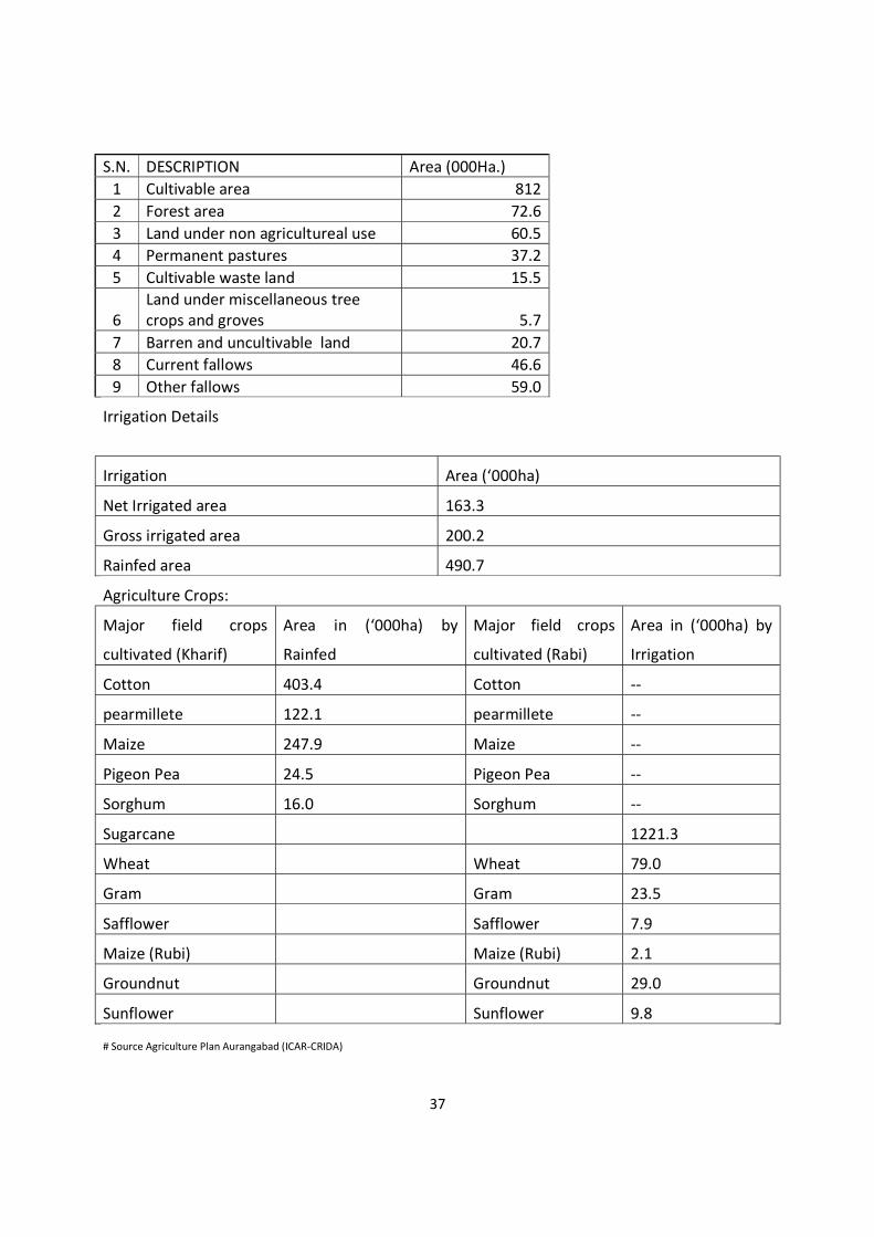
37
S.N. DESCRIPTION Area (000Ha.) 1 Cultivable area 812 2 Forest area 72.6 3 Land under non agricultureal use 60.5 4 Permanent pastures 37.2 5 Cultivable waste land 15.5
6 Land under miscellaneous tree crops and groves 5.7
7 Barren and uncultivable land 20.7 8 Current fallows 46.6 9 Other fallows 59.0
Irrigation Details
Irrigation Area (‘000ha)
Net Irrigated area 163.3
Gross irrigated area 200.2
Rainfed area 490.7
Agriculture Crops:
Major field crops
cultivated (Kharif)
Area in (‘000ha) by
Rainfed
Major field crops
cultivated (Rabi)
Area in (‘000ha) by
Irrigation
Cotton 403.4 Cotton --
pearmillete 122.1 pearmillete --
Maize 247.9 Maize --
Pigeon Pea 24.5 Pigeon Pea --
Sorghum 16.0 Sorghum --
Sugarcane 1221.3
Wheat Wheat 79.0
Gram Gram 23.5
Safflower Safflower 7.9
Maize (Rubi) Maize (Rubi) 2.1
Groundnut Groundnut 29.0
Sunflower Sunflower 9.8
# Source Agriculture Plan Aurangabad (ICAR-CRIDA)
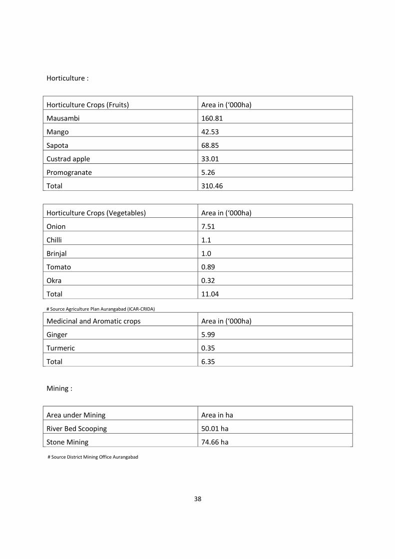
38
Horticulture :
Horticulture Crops (Fruits) Area in (‘000ha)
Mausambi 160.81
Mango 42.53
Sapota 68.85
Custrad apple 33.01
Promogranate 5.26
Total 310.46
Horticulture Crops (Vegetables) Area in (‘000ha)
Onion 7.51
Chilli 1.1
Brinjal 1.0
Tomato 0.89
Okra 0.32
Total 11.04
# Source Agriculture Plan Aurangabad (ICAR-CRIDA)
Medicinal and Aromatic crops Area in (‘000ha)
Ginger 5.99
Turmeric 0.35
Total 6.35
Mining :
Area under Mining Area in ha
River Bed Scooping 50.01 ha
Stone Mining 74.66 ha
# Source District Mining Office Aurangabad
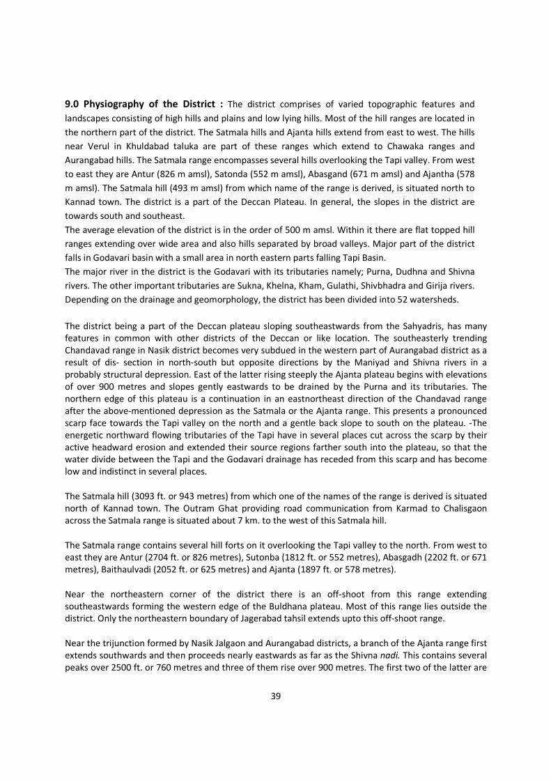
39
9.0 Physiography of the District : The district comprises of varied topographic features and landscapes consisting of high hills and plains and low lying hills. Most of the hill ranges are located in the northern part of the district. The Satmala hills and Ajanta hills extend from east to west. The hills near Verul in Khuldabad taluka are part of these ranges which extend to Chawaka ranges and Aurangabad hills. The Satmala range encompasses several hills overlooking the Tapi valley. From west to east they are Antur (826 m amsl), Satonda (552 m amsl), Abasgand (671 m amsl) and Ajantha (578 m amsl). The Satmala hill (493 m amsl) from which name of the range is derived, is situated north to Kannad town. The district is a part of the Deccan Plateau. In general, the slopes in the district are towards south and southeast. The average elevation of the district is in the order of 500 m amsl. Within it there are flat topped hill ranges extending over wide area and also hills separated by broad valleys. Major part of the district falls in Godavari basin with a small area in north eastern parts falling Tapi Basin. The major river in the district is the Godavari with its tributaries namely; Purna, Dudhna and Shivna rivers. The other important tributaries are Sukna, Khelna, Kham, Gulathi, Shivbhadra and Girija rivers. Depending on the drainage and geomorphology, the district has been divided into 52 watersheds.
The district being a part of the Deccan plateau sloping southeastwards from the Sahyadris, has many features in common with other districts of the Deccan or like location. The southeasterly trending Chandavad range in Nasik district becomes very subdued in the western part of Aurangabad district as a result of dis- section in north-south but opposite directions by the Maniyad and Shivna rivers in a probably structural depression. East of the latter rising steeply the Ajanta plateau begins with elevations of over 900 metres and slopes gently eastwards to be drained by the Purna and its tributaries. The northern edge of this plateau is a continuation in an eastnortheast direction of the Chandavad range after the above-mentioned depression as the Satmala or the Ajanta range. This presents a pronounced scarp face towards the Tapi valley on the north and a gentle back slope to south on the plateau. -The energetic northward flowing tributaries of the Tapi have in several places cut across the scarp by their active headward erosion and extended their source regions farther south into the plateau, so that the water divide between the Tapi and the Godavari drainage has receded from this scarp and has become low and indistinct in several places.
The Satmala hill (3093 ft. or 943 metres) from which one of the names of the range is derived is situated north of Kannad town. The Outram Ghat providing road communication from Karmad to Chalisgaon across the Satmala range is situated about 7 km. to the west of this Satmala hill.
The Satmala range contains several hill forts on it overlooking the Tapi valley to the north. From west to east they are Antur (2704 ft. or 826 metres), Sutonba (1812 ft. or 552 metres), Abasgadh (2202 ft. or 671 metres), Baithaulvadi (2052 ft. or 625 metres) and Ajanta (1897 ft. or 578 metres).
Near the northeastern corner of the district there is an off-shoot from this range extending southeastwards forming the western edge of the Buldhana plateau. Most of this range lies outside the district. Only the northeastern boundary of Jagerabad tahsil extends upto this off-shoot range.
Near the trijunction formed by Nasik Jalgaon and Aurangabad districts, a branch of the Ajanta range first extends southwards and then proceeds nearly eastwards as far as the Shivna nadi. This contains several peaks over 2500 ft. or 760 metres and three of them rise over 900 metres. The first two of the latter are
40
situated in close proximity to each other in the west where this ridged changes from a southerly to easterly direction and the third one the highest (3144 ft. or 958 metres) is Surpainath hill situated farther east.
The western edge of the Ajanta plateau flanking the Shivna basin and containing the Ellora (Verul) caves may be considered as forming the Ellora range branching off southwards from the main Ajanta range just to the east of the Satmala hill. After the Ellora caves it runs in a southeasterly direction and beyond the Aurangabad gap appears as the Satara range and then continues in a series of discontinuous low hill as far as Ambad town.
The several eastward trending ridges from this Ellora. range are really the residual hills left behind by the dissection of the Purna and its tributaries in the Ajanta plateau. Of these, the divides between the Purna and the Anjan, between the Anjan and the Girja, and between the Girja and the upper Kham-Sukna trough are the more important ones. The first one, that between the Purna and the Anjan extends nearly eastwards from the Satmala hill and has considerable extent of flat topped summit areas at levels over 800 metres which are utilised for agricultural purposes. The second one, that between the Anjan and the Giria is a ridge extending eastwards of Kannad town and has similar summit plateau levels of slightly lower altitudes but more discontinuous and irregular (the result of greater degree of dissection), used for agricultural purposes. But this extends much farther eastwards. The third one. which is south of the Girja nadi ex. tends still farther eastwards and is of similar character.
Rivers.-The rivers of the district may be grouped into three classes :
(i) the Godavari and its direct tributaries,
(6) the Purna and the Dudna and their tributaries and
(iii) the tributaries of the Tapi basin.
Godavari.-The Godavari forms nearly the entire southern boundary of the district from Dongaon about 3 kilometres above Puntamba to Gunj Buzurg, a distance of nearly 230, kilometres.
The following are among the direct tributaries of the Godavari: the Kol. nadi, the Narangi Nala, the Shivna, the Kham, the Yelganga, the Shivbhadra, the Yelbhadra, the Galhati, the Dhenda, the Dudna and the Musa.
Kol.-The first significant tributary of the Godavari after it enters the district is the Kol. nadi, which has only a small part of its lower course lying within the district.
Narangi Nala.-The Narangi rises on the southern slopes of the water divide to the south of the Maniyad river a little above Naral village and flows past Vaijapur. A little below the latter, it is joined by the Deo nala, flowing from Nasik district. It has a fairly long south southwesterly course before its point of entry into the Godavari is carried a little down the latter. It is joined by the Chor nala from the west and Kurla nala from the east. Actually the Narangi continues the trend of the Kurla river after the latter’s confluence.
41
Narali.-The Narali nala is a small stream rising above Jambargaon on a low divide and after passing by Virgaon joins the Godavari at Dak Pimpalgaon.
Kalanibi.-The Kalambi nala is a similar small stream flowing past Gangapur in a southeasterly course joining the Godavari at Golnimb.
Shivna.-The Shivna is a much larger river than any of the streams mentioned above and is a master stream of the western part of Aurangabad district. The Shivna rises on the eastern slopes of the Ajanta range just east of the trijunction of Jalgaon, Nasik and Aurangabad districts above Kalanki village and has a fairly long easterly course as far as Kannad town draining the entire area lying between the Ajanta range on the north and the Surpalnath range on the south. Near Kannad it is joined by several streams draining the Ajanta range and the northern part of the Ellora range, inclusive of the one which rises on the southern slopes of the Satmala hill. South of Kannad, the Shivna after flowing beyond the eastern extremity of the Surpalnath range, is relieved of the restrictive influence of the latter and flows in a southwesterly direction as far as Baigaon, where it turns and flows almost in a southerly course upto Katepimpalgaon. Here it turns and flows in a southeasterly course to join the Godavari at Sawkheda. Thus the river has an initial easterly course, then a southwesterly course, then a southerly course and lastly a southeasterly course. These changing directions of flow depict the lines of structural lines of weakness in the basal rocks.
But for a few minor streams which flow directly into the Godavari, almost the entire area west of the Ellora range in the district may be said to be drained by this master stream.
Bori nala.-The westernmost significant tributary of the Shivna is Bori nald which rises above HilaIpur on the low water divide separating it from the Maniyad. Near Kolhi where the ShiynaVaijapur road crosses the Bori is located the Kolhi Project. After passing by Borsar, Bhaigaon, Parsoda and Karanjgaon it turns and flows southwards to join the Shivna above Katepimpalgaon below the confluence of the Dheku.
Dheku.-The Dheku. nala rises in the Gorakhnath and Kapilanath hills of the Ajanta range above Dheku. village in Nasik district and flows in a southerly course as Tunki, where it turns and flows in southeasterly course. The Karali nala, a similar stream flowing a little eastwards joins the Dheku. The headworks of the Dheku Project are located below this confluence and upstream of Bhatana village. Below Bhatana the river flows in a more southerly course and after running nearly parallel to the Shivna for more than 20 km., joins the latter upstream of Katepimpalgaon.
Khari-The Khari nala rises in the Ajanta range and after an initial course in Nasik district enters this district. Soon it is joined by the Chamandara nala and the combined stream flows southeastwards and joins the Shivna near Bharagaon.
Innumerable streams rise on the southern slopes of the Surpalnath range and flow nearly due southwards to join either the Khari nadi or directly into the Shivna. Of these may be mentioned the Gorji nadi flowing by Chinchkheda. and JavIi, the Dongri nadi flowing by Chapner, and the Vach and the Vaghvadi nadi which combine before joining the Shivna.
Gan -Among the left or east bank tributaries of the Shivna, the most important one is the Gan nadi. Actually the main river Shivna may be considered to join this river below Hatnur as the combined river continues the trend of the Gan nadi. It is quite probable that this southeasterly stretch of the Gan and
42
the Shivna represents a pronounced line of weakness of spot heights on the banks, at Tapargaon 1883 ft. or 574 metres, at Lohali 1812 ft. or 552 metres and near Bhargaon 1735 ft. or 529 metres. Compared with these, heights on the banks on the Banganga and the Girja on the eastern side of the Ellora range the heights are at Sobalgaon 2249 ft. or 686 metres, at Banganga-Girja confluence 2105 ft. or 642 metres, at Pathari 2048 ft. or 624 metres etc. It is clear from these that the base level nadi extending its source farther back - across the Ellora range, is much lower than that of the Banganga-Girja rivers flowing to the cast. This accounts for the rapid headward erosion of the Gan nadi extending its source farther back across the Ellora range. This is so marked that some of the southeasterly stretches of these headwaterstreams may be considered as the beheaded portions of the tributaries of the Banganga system resulting in an easterly migration of the watershed.
Velganga.-Among the other several left bank tributaries, flowing westwards from the Ellora range the more important ones are the Velganga which flows past Ellora or Verul village and the Khaki, which flows by Kasabkheda. These two join just above Deogaon and the combined river continues westwards to join the Shivna opposite to Lakhni.
Lendi.-The Lendi nadi rises in the Verul hill and flows in a southeasterly course and then southwards to join the Shivna opposite to Sirasgaon.
Nagjhari.-Several streams draining the southern slopes of the Verul and Deogiri hills combine to form the Nagjhari and become an appreciable river below Kasod. After flowing past Turkabad, Limbe Jalgaon, Antapur and Dhamori Buzurg, it joins the Kaum river.
Kaum.-The Kaum river rises on the southern slopes of the east to west divide south of the Giria nadi and flows through Aurangabad town in a general southwesterly course till it is joined by the Nagjhari. Then, after a short southeasterly course it continues the trend of another tributary, the Buraguli southwards and joins the Godavari near Jogeshwari.
Buraguli.-The Buraguli is a small tributary of the Kaum draining southwestwards from the Satara range.
Yelganaga.-The Yelganga nadi rises above Kasner and after an initial westerly course to southeast and south joins the Godavari.
Vanki-The Vanki is a smaller river rising on the southern slopes of the same hill and flowing west of Dhorkingaon joins the Shivbhadra.
Shivbhadra.-The Shivbhadra nadi rising in the same hill above Dongaon flows past Pipalwadi and joins the Godavari a little below the confluence of the Yelganga.
Yelbhadra -The Yelbhadra river rises in the same bill further east near Daregaon and flows at first southwards and then southeastwards to join the Godavari at Naugaon.
Galhati.- The Galhati rises in the same range still farther east and flows by Pachud Buzurg in a southeasterly direction to join the Godavari at Chincholi. The earthen dam of the Galhati Project is built across this river downstream of Baraswadi village.
43
Musa.-The Musa nadi rises east of the Ambad hill and flows southwards towards the Godavari and joins it at Jogladevi.
Purna.-The Puma river rises in the Ajanta range about 8 km. northeast of the Satmala hill above Mehun village at a height of about 775 metres and has the longest course of any river within the district, before it leaves the district about a kilometre and a half below Brainhapuri at a level of 518 metres. Next to the Godavari, it is the most important river of the district. Along with its several tributaries including the Dudna, the largest of them but joining it outside the district, the Purna drains the entire area between the Ellora range and Tapi-Godavari water divide. The important tributaries of the Purna on the left or north bank in the district are the Charna important tributaries of the Puma on the left or north bank in the district are the Charna, the Khelna, the Jui, the Dhamna and those on the right or south bank are the Anjan, the Girja, the Jivrakha and the Dudna.
Charna.-The Charna is a small stream rising in the Ajanta range some 3 kilometres north of Ghatnandra. After flowing past Ghatnandra, Charna and Deulgaon it joins the Puma at Savkheda.
Khelna.-The headstreams of the Khelna lie within a short distance (less that a kilometre) of those of the Charna in the same Ajanta range. This very much longer tributary flows past Kelgaon. Chichpur, Palod, Anvi. Ayhana and Bhokardan and joins the Purna at Jafferabad.
Jui-The Jui, an important tributary of the Khelna, rises above Undangaon and after passing by that village, has a fairly long southerly and southeasterly course and joins the Khelna some 5 kilometres below Assaye.
Dhamna.-The Dhamna rises in the Lagnia hill in the Ajanta range and flows nearly southwards past Vadhona, Dhamangaon and is joined by the Raighol at Takli, after which it flows in a southeasterly direction continuing the trend of this tributary. From a point about a kilometre and a half upstream of Dhamangaon (Buldhana side) to a point about 3 kilometres downstream of Takli, the river forms the district boundary beyond which it flows outside the district. It re-enters the district a little above Borgaon Buzurg and flows nearly southwards joining the Purna within the district about 5 kilometres downstream of Jafferabad.
Lendi.-The Lendi river drains the southeastern slopes of the edge of the Buldhana plateau, flows entirely within the district in a south-southwesterly direction and joins the Puma about 2 kilometres downstream of the Dhamna confluence. It is quite significant that the Purna here makes a right angular bend changing from the easterly to the southerly direction to continue the trend of this tributary.
Madnai.-The Madnai is a stream very similar to the Lendi but has only a small part of its middle course within the district.
Anjan.-The first significant long tributary of the Purna on the right or south side is the Anjan river. Its source lies close to that of the Purna on the south side of the Purna-Anjan divide. The Anjan has a fairly long winding course eastwards passing by Nimbhore, Vasri, Pishore, etc., and joins the Purna 2 kilometres west of Dhanora.
Girja.-The Girja is the longest tributary of the Puma in the district on the right bank. This river rises on the eastern slopes of the Ellora range to the west of Takali and has unlike the more northerly ones, a
44
long general east-north-east course up to Vadod Buzurg, after which it flows in an easterly and southeasterly course past Hasnabad. Two kilometres downstream of Sirasgaon it again resumes the northeasterly course and joins the Purna.
Nagjhari.-The next stream to join on the left is the Nagjhari which has its source just east of that of the Banganga and has a general southeasterly course passing by Babra, Loha and joins the Girja a little north of Paithan.
Banganga.-The Banganga rising in the Anjan-Girja divide has a remarkably straight southerly course as far as Sangvi, where it turns and flows in an east-southeasterly direction to join the Girja.
Phulmasta.-The Phulmasta is the first significant right bank tributary of the Girja. It rises in the hill to the north of Khuldabad and flowing away eastwards of Khuldabad it assumes a northeasterly and northerly course to join the Girja.
The Girja has several small tributaries joining from the south, among which may be mentioned the one flowing past Phulambri, and the Khatkali joining it at Hasnabad.
Banganga.-The Banganga (different from the northern tributary of the Girja of the same name) is a small river flowing from the south joining the Purna some distance below the Girja confluence.
Jivrakha.-The Jivrakha is another right bank tributary of the Purna. Rising above Longaon it flows at first in a northeasterly course as far as Akola. After Akola it turns and flows in more northerly course passing by Tembhurni and joins the Purna a little upstream of the Khelna confluence. The earthen dam forming the headworks of the Jivrakha Project is located about a kilometre and a half above Akola.
Dudna.-The largest tributary of the Purna is the Dudna which is nearly as long as the main river up to the confluence point. The Dudna rises above the Kankur village on the northern slopes of the easterly trending off-shoot of the Ellora range forming the divide between this stream and the Sukna and flows some 15 km. to the north of Aurangabad town. After an initial irregular winding course it turns and flows in a southeasterly direction as far as Akola. At Somthana above Akola the river is crossed by an earthen dam providing the storage for the upper Dudna project. After Akola it flows more southerly passing by Badnapur and is joined by the Sukna at Sadesangvi. The main river continues the course of the Sukna after the latter's confluence resulting in an easterly course. The Dudna has a further long course in Parbhani district before it joins the Purna. Among the left bank tributaries of the Dudna are the Baldi, the Kundlika and the Kalyan.
Baldi.-The Baldi is a small stream rising a little above Anvi village from the Dudna-Girja divide flowing in a general south-south-westerly course to join the Dudna.
Kundlika.-The Kundlika river rises further east on the same divide but well back on the north indicating a retreat of the divide here. After an initial course in a south south-westerly direction up to Ganeshwadi, it changes into a southeasterly course passing through JaIna town. The Godavari Valley railway line crosses the Dudna just before the confluence of the Kundlika.
Kalyan.-The Kalyan river rises on the same divide further eastwards above village and flows southwards up to Pir Kalyan, where it turns to flow southeastwards. Two left bank tributaries, the Gandi and the
45
Girja (very much smaller one than the big tributary of the Purna of the same name) join this river. This Kalyan river forms for a while the district boundary where it joins the Dudna.
Among the right bank tributaries of the Dudna are the Lahuki, the Sukna and the Jatashankar.
Lahuki-The Lahuki nadi is a small stream rising near the source of the Dudna on the southern slopes of the divide separating the two and flows southeastwards past Dudhad and Roshangaon to join the Dudna a little north of the Sukna confluence with the latter.
Sukna.-The Sukna rises to the west of the source of the Lahuki above Kolthan village and has an initial course parallel to the Kaurn river. The head streams of this river appear to have been beheaded by the Kaum river. The Sukna flows southeastwards past Chikalthana receiving a number of small streams on both, sides and joins the Dudna at Sadesangvi.
Chite.-The Chite rises in the Satara Range above Sindhon village and flows between two eastward trending parallel ridges of that range and beyond their extremity at Chitepipalgaon, it turns north wards to join the Sukna.
Bemla.-The Bemla is a small stream flowing parallel to the Chite but farther south in a general easterly direction joining the Sukna just west of Gharegaon. After the confluence the Sukna continues the easterly trend of this river. Tapi basin tributaries
Gadadgad.-The Gadadgad nadi rises on the northeastern and eastern slopes of the Satmala hill and flows northwards leaving the district below Nagad to join the Tittur river, a tributary of the Girna.
Rangarai.-The Rangarai is a sub-tributary rising to the northeast of the headstreams of the Gadadgad on the Ajanta range and joining this latter river, has only a short course within this district.
Another sub-tributary of Gadadgad rises in the Ajanta range east of the Antur fort hill and Chipghat and flows northwards. The active headward erosion of this stream has resulted in a significant receding of the escarpment about a kilometre southeast of Chipghat.
Hivra.-The next stream of importance is the Hivra nadi, whose back-cutting action across the Ajanta range is even more severe. Its principal headstream is well south of the line of the escarpment flowing by Dudmal and the low existing divide between this stream and the Purna is some 3 kilometres south of the escarpment. It is quite probable that the present easterly course of the headstream of the Hivra past Dudmal, might have been the beheaded portion of a headstream of the Purna, whose surviving lower remnant flows by Shendra, the wind gap being located just south of Talner.
The Hivra passes by Vadi, Banoti, Vathan and Ghorkund and continues northwards leaving the district below Mhasekotha. It may be noted that this river flows past Pachora in Jalgaon district. The Hivra has several tributaries whose headstreams rise further eastwards in the Ajanta range but only some small portions of their upper courses lie within the limits of the district. They are the Indragadhi, Utavli, Doha, BavIa, Khutkai and Nandvohi rivers. A portion of the last mentioned river forms the district boundary.
Sonad.-The Sonad river rises a little to the north of Ghatamri and flows northwards past Soegaon and after a kilometre forms the district boundary for some distance and then goes outside the district. This is
46
another powerful stream which has trenched deeply cutting back across the scarp face so that the water divide at Ghatamri is some 6 kilometres and a half south of Abasgadh fort hill.
Waghur.-The Waghur river is the most active of all the Tapi streams of the district. The trenching of the escarpment face and the backcutting action and the accompanying retreat of the water divide is nowhere so remarkable as in the case of this river, one of whose headstreams flow past Ajanta village and another past the Ajanta caves. It is the trenching action of the latter which has been responsible for such a splendid site for the caves. The water divide has receded to as much sq 15 kilometres behind the northern line of the scarp above Fardapur. It is here that a considerable drainage of the Purna lying to the north of the upper reaches of the Jui river might have been annexed to the Tapi basin by the aggrandisement of this river.
The remaining tributaries of the Tapi, the Khadki, Meh, Kag and Kang are much less powerful streams. Only the first two of them rising in springs, have done some appreciable back cutting in the escarpment. The Meh leaves the district below RavIa and the Kang nadi flows past Savaladbara. A very small portion of the extreme northeastern part of the district contains the headwaters of the Sur nadi.
Geographical Regions.- The district may be broadly divided into the following geographical regions:
(i) The Shivna-Godavari basin.
(ii) The northern piedmont slopes.
(iii) The Ajanta Plateau.
The first region forming the basins of the Shivna and the Godavari rivers comprises the relatively lowlying areas to the west and south of the Ajanta plateau. This may be divided into sub-regions, the one comprising the Shivna basin and the upper part of the Godavari valley in the district made up of the western and southern parts of Kannad tahsil, a small part of Khuldabad lying to the west of Ellora scarp and the whole of Vaijapur and Gangapur tahsils, and the other comprising the rest of the Godavari valley region south of the Ajanta plateau made up of the whole of Paithan tahsil, and a small adjoining southwestern portion of Aurangabad tahsil and the southern two-thirds of Ambad tahsil.
In the first sub-region of the basin of Shivna and upper Godavari the soils generally improve in quality as one proceeds from the north to the south. Accordingly the proportion of gross cropped area under jowar increases from north to south, the reverse trend being noticeable in bajri. In the whole of Aurangabad district it is only in this sub-region that the proportion of area under wheat to total gross cropped area is about a tenth or more. On the other hand the cotton area in this region is least important in the district. In the north in Kannad tahsil owing to the piedmont character of the soils, mango trees are of considerable importance. The variety known as Maruti Amba of Mundwadi has small nuts and is considered to be very sweet. There has been of late considerable development of mosambi cultivation owing to the extension of irrigation facilities. Bahirgaon is one such place. The relatively dry condition prevailing in Vaijapur tahsil seems to favour the cultivation of grapes. However there is acute water scarcity and the wells are generally deeper than 30 feet. Dhondalgaon is noted for its grapes. In the south of this sub-region the Gangapur sugar factory is located on the northern bank of the Godavari river, to the south of Gangapur town. Though there is some cane cultivation in the area round about,
47
based upon lift irrigation, the bulk of the supply to the factory comes from Ahmadnagar district across the border.
In the second sub-region forming the middle and lower portions of the Godavari valley in the district, the fertility of the soils reaches its highest level in the district Jowar occupies nearly a third of the gross cropped area and is grown more in the rabi season. Cotton here occupies a fifth of the cropped area whereas its proportion is less than a tenth of the cropped area in the former sub-region.
Rising above the Tapi basin of the north and the Shivna and the Godavari basins of the west and the south, lies the Ajanta plateau region, which is dissected by the Purna and the Dudna and their tributaries with residual interfluve ridges generally trending eastwards. Of all these interfluves, the one separating the Dudna and the Purna basins, stretching almost due west to east is so well marked that it is possible to consider the Ajanta plateau region as divided into subregions, the Purna basin and the Dudna basin. The Purna basin comprises the whole of Sillod and Jafrerabad tahsils and the northeastern part of the Kannad tahsil, eastern part of Khuldabad, and Bhokardan tahsil excluding its small northeastern portion forming a salient between Jalgaon and Buldhana districts. The Dudna basin comprises Aurangabad tahsil excluding the southwestern part (which has been considered as included in the Godavari valley region), the whole of JaIna tahsil and the northern third of Ambad tahsil.
Considering the Ajanta plateau as a whole, the soils generally increase in depth and fertility eastwards and accordingly the proportion of the cropped area under Jowar increases, while that under bajra decreases. On this plateau region pulses account for more than a fifth of the cropped area. While pulses show a slight decrease eastwards, the area under cotton definitely shows an increase eastwards. In the three eastern tahsils of Bhokardan, Jafferabad and JaIna it occupies about a fifth of the cropped area.
The region sloping away northwards from the Ajanta Satmala ranges stretches from the environs of Nagad in the northern part of Kannad tahsil in the west through the whole of Soegaon tahsil to a small portion of Bhokardan tahsil which forms a salient extending northeastwards between Jalgaon and Buldhana districts. On the piedmont slopes the soil is mostly poor. However ground water is abundant on account of springs all along the foot of the scarp. Garden crops and cotton are of considerable importance in this region. Wheat is negligible, but pulses and cotton each account for a fourth of the cropped area. There is about an equal extent under food and nonfood crops, the proportion of the former to the latter being the least in this area compared to the rest of the district. The common kharif mixtures are either jowar (Nilav) with udid, and mug or bajra with tur. There is some double cropping also especially in the west. Jowar is some times grown after mug in the rabi season. Plantain and mosambi are the favourite garden crops. Almost all the villages are on the banks of innumerable streams which drain this region. Vanjari huts are scattered all over the area. Soil plays a very important role in the agricultural activities and forest growth of the area. The fertility of the soil from agricultural point of view depends upon the texture and structure which controls the retaining and transmitting capacity of moisture and various nutrients such as nitrogen, phosphorous and potassium present in the soil. The formation of the soil in the area is influenced by the climate, geology, vegetation and topography. The major part of the district is covered by black cotton soil or ‘Regur’ formed by the weathering of Deccan Trap Basalt. It is rich in plant nutrients such as lime, magnesia, iron and alkalies on which cotton and dry crops like Jowar, Bazra and tur etc flourish. It swells and becomes sticky on watering
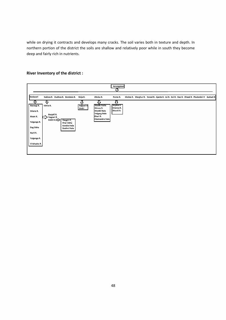
48
while on drying it contracts and develops many cracks. The soil varies both in texture and depth. In northern portion of the district the soils are shallow and relatively poor while in south they become deep and fairly rich in nutrients.
River Inventory of the district :
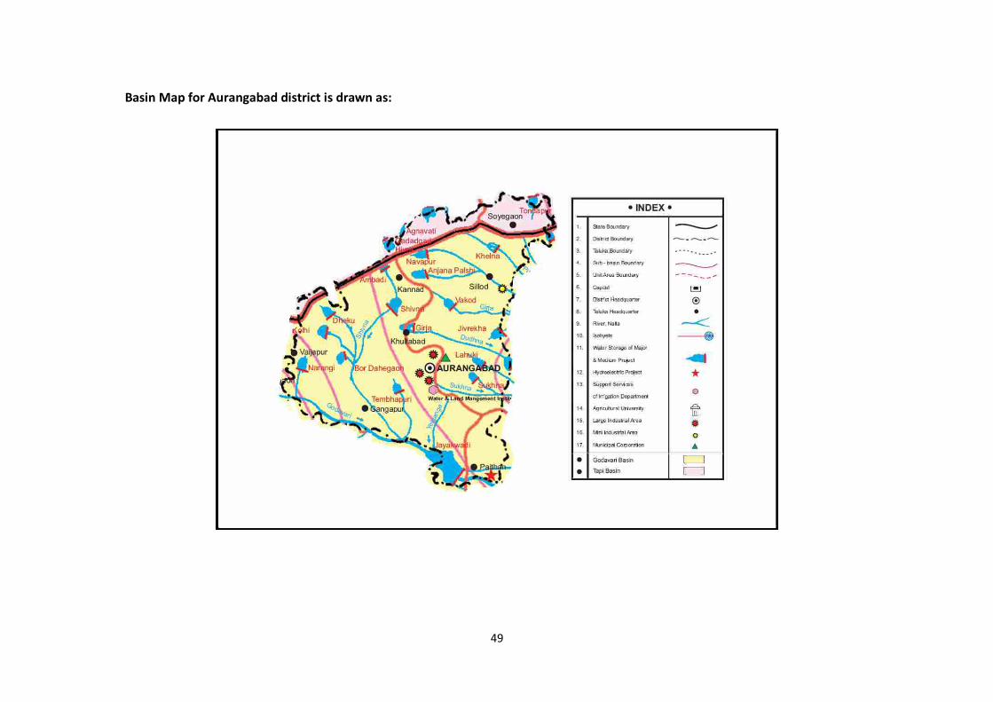
49
Basin Map for Aurangabad district is drawn as:
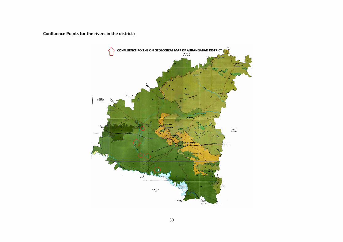
50
Confluence Points for the rivers in the district :
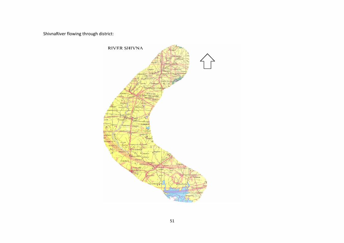
51
ShivnaRiver flowing through district:
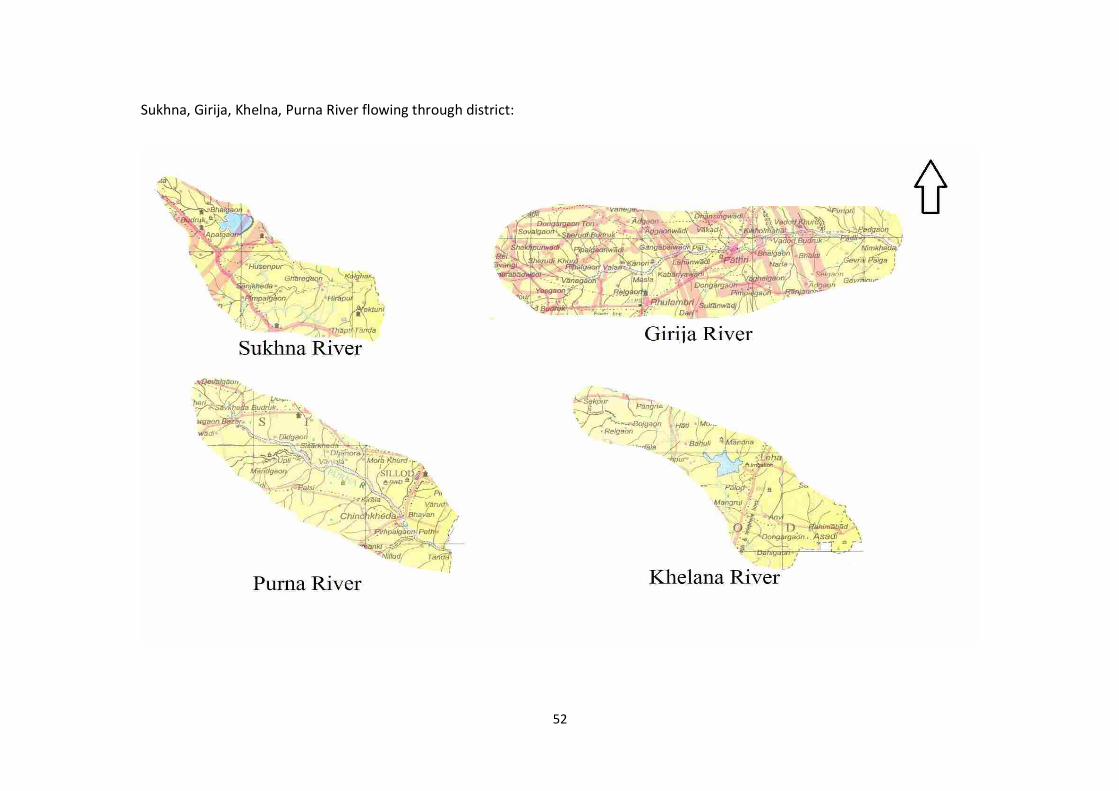
52
Sukhna, Girija, Khelna, Purna River flowing through district:
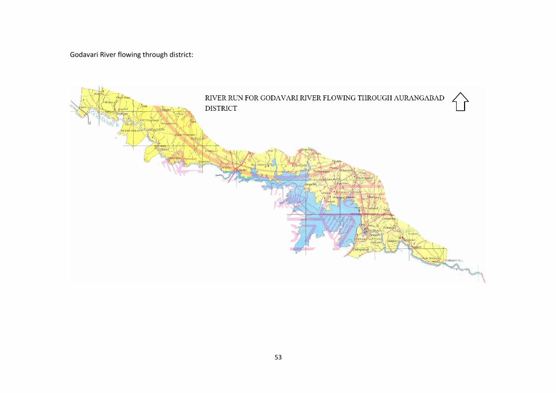
53
Godavari River flowing through district:
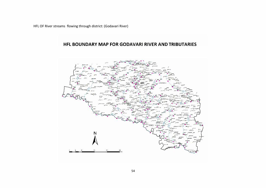
54
HFL OF River streams flowing through district: (Godavari River)
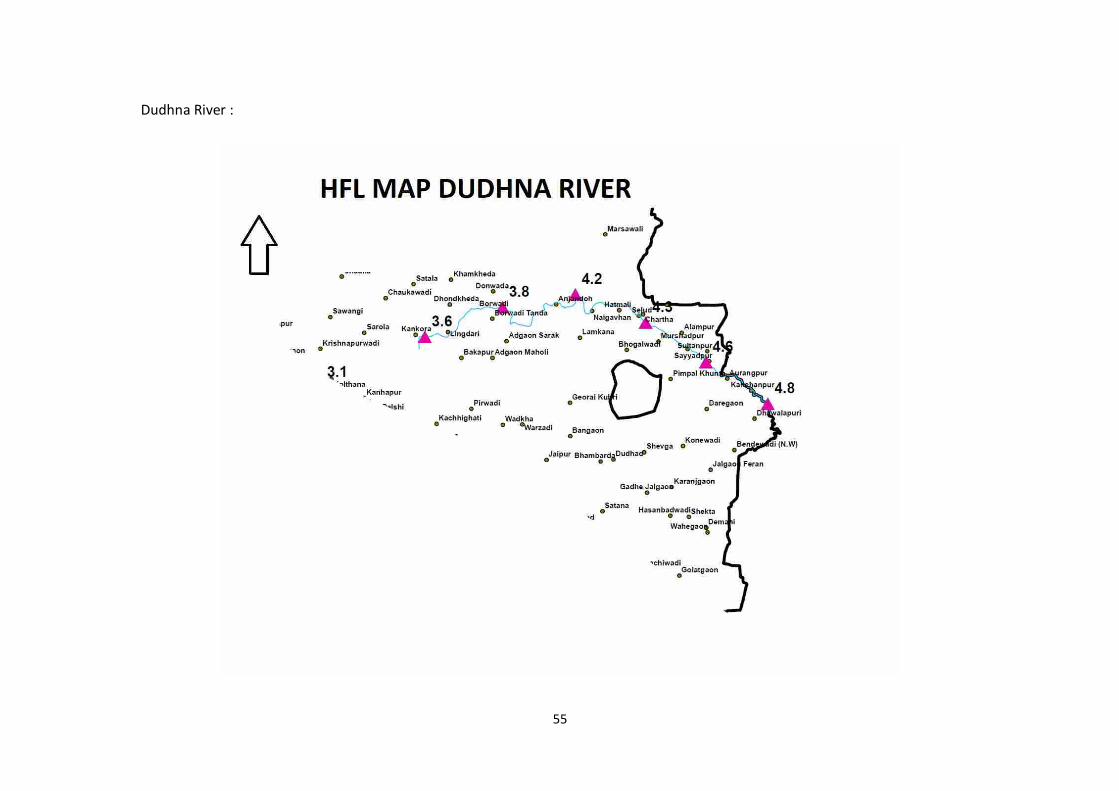
55
Dudhna River :
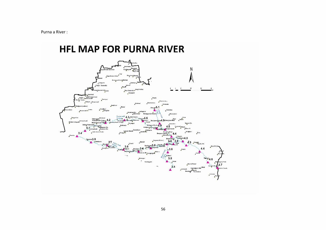
56
Purna a River :
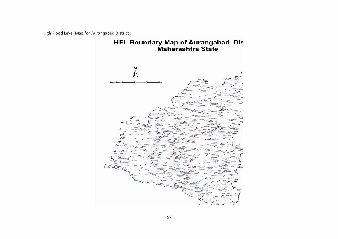
57
High Flood Level Map for Aurangabad District :
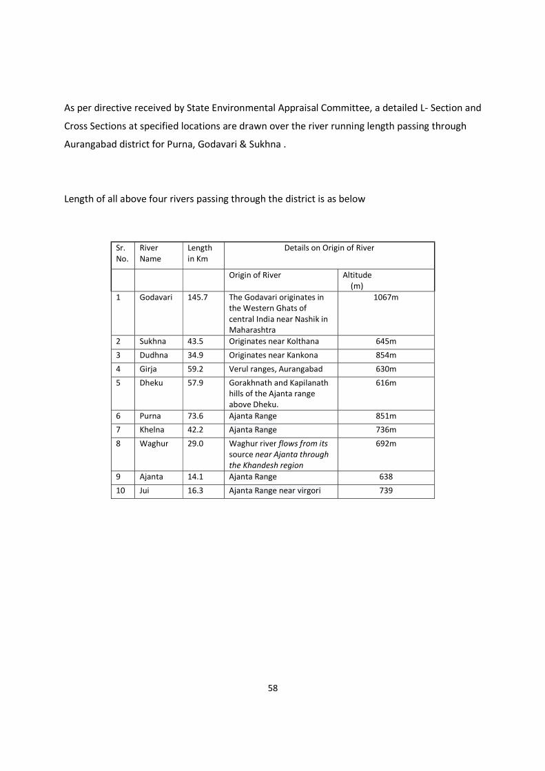
58
As per directive received by State Environmental Appraisal Committee, a detailed L- Section and
Cross Sections at specified locations are drawn over the river running length passing through
Aurangabad district for Purna, Godavari & Sukhna .
Length of all above four rivers passing through the district is as below
Sr. No.
River Name
Length in Km
Details on Origin of River
Origin of River Altitude (m)
1 Godavari 145.7 The Godavari originates in the Western Ghats of central India near Nashik in Maharashtra
1067m
2 Sukhna 43.5 Originates near Kolthana 645m
3 Dudhna 34.9 Originates near Kankona 854m
4 Girja 59.2 Verul ranges, Aurangabad 630m
5 Dheku 57.9 Gorakhnath and Kapilanath hills of the Ajanta range above Dheku.
616m
6 Purna 73.6 Ajanta Range 851m
7 Khelna 42.2 Ajanta Range 736m
8 Waghur 29.0 Waghur river flows from its source near Ajanta through the Khandesh region
692m
9 Ajanta 14.1 Ajanta Range 638
10 Jui 16.3 Ajanta Range near virgori 739
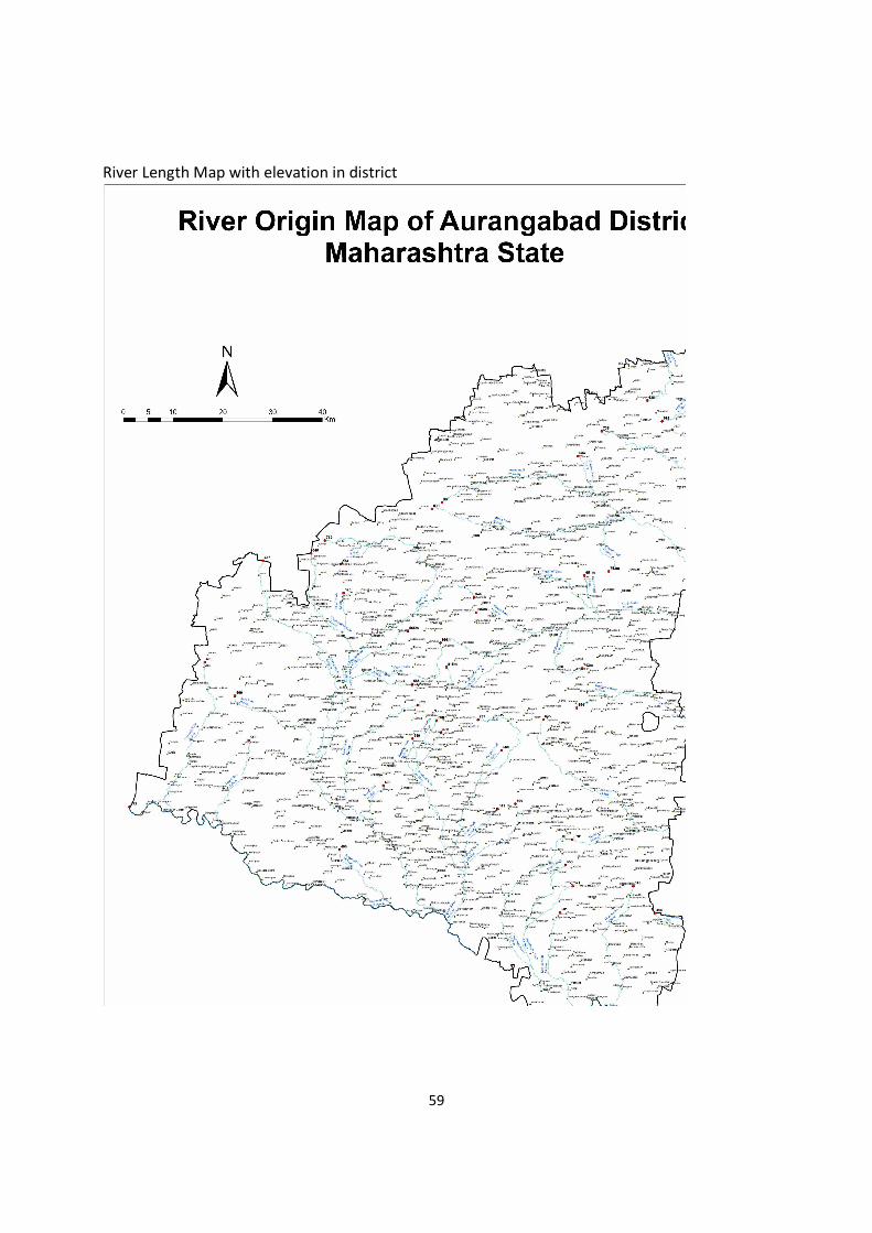
59
River Length Map with elevation in district
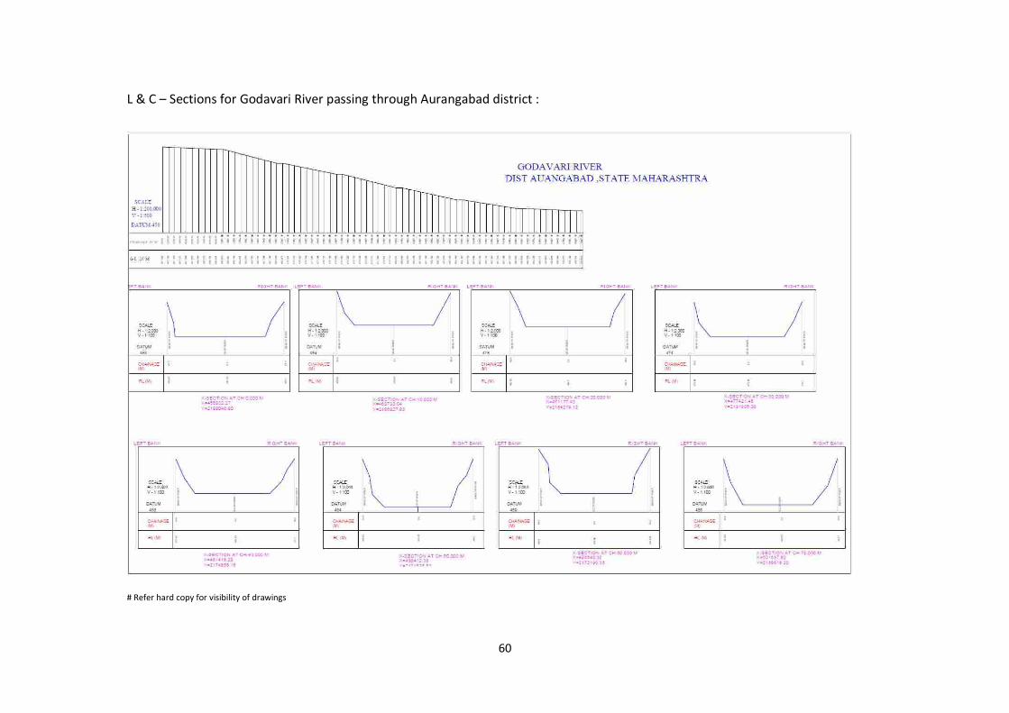
60
L & C – Sections for Godavari River passing through Aurangabad district :
# Refer hard copy for visibility of drawings
61
L & C – Sections for Purna River passing through Aurangabad district :
# Refer hard copy for visibility of drawings
62
L & C – Sections for Sukhna River passing throughAurangabad district :
# Refer hard copy for visibility of drawings
63
10.0 Rain Fall Data for Aurangabad district: Average rainfall for Aurangabad district is 705 mm per year. Rainfall data recorded for last two years is tabulated below :
Rainfall Last Two Years, Aurangabad Rainfall (mm) Sr No. Month 2019 2020
1 January 5 1 2 Februaray 2 2 3 March 3 3 4 April 0 4 5 May 2 5 6 June 129.3 158.3 7 July 144.4 186.1 8 August 156.1 156.2 9 September 141.7 132.2
10 October 6 10 11 November 4 6 12 December 9 4
602.5 667.8
Comparison of rainfall
MONTH WISE RAINFALL OF THE DISTRICT FOR THE YEAR 2019
Month Normal Rain
Actual Rain
Rainy Days
January 2.3 - - February 1.5 - -
March 3 - -
April 4 - -
May 16.3 - -
June 131.4 106.7 10
July 168.1 173.6 16 August 166.7 123.1 13
September 157.3 225.3 19 October 51.8 212.6 16
November 19.3 33.7 4 December 12.4 6.2 1
Total 734.1 881.2 79
64
11.00 Geology and Mineral Wealth:
Deccan trap of the Late Cretaceous-Palaeogene(68-62 million years age) comprising lava flows of basaltic composition, occupy the whole area of the district. Dykes of doleritic composition occur as an intrusives within these flows. The Basalt flows are of Aa and Pahoehoe types. The Aa flows are massive characterized by fairly persistent fragmentary top and impersistent clinkery basal part. The Pahoehoe flows comprisebasal vesicular part with pipe amydules, middle massive part and top vesicular part with spherical vesicles and exhibit characteristic ropy structures, cavity and in crack fillings and toe structures. Minerologically, the flows are quartz normative tholeiites. The Deccan Trap in Aurangabad district divided in to Lower Ratangarh, Upper Ratangarh, Ajanta and Chikhali formations in the ascending order of succession. The Lower Ratangarh Formation occurs in the Western part of the district having a total thickness of 360m, comprising mainly pahoehoe flows. Upper Ratangarh Formation occupies a larhe part of the district and comprises a sequence of 7 flows showing sparsely to moderately porphyritic character. The Lower five flows are of compound pahoehoe type and the top two are of Aa type.The topmost Aa flow is a megacrystic flow up to 30m thickness containing large size(average 5cm) phenocrysts of plagioclase feldspar. It forms a marker horizon within the sequence of flows. Ajanta formation comprises 22 flows of which 5 are of compound pahoehoe type and rest (17 flows) are of Aa type.The maximum exposed thickness of this formation is 420m. The flows are nonporphyritic to sparsely porphyritic. The famous Ajanta and Ellora caves have been carved out in the compound flows of this formation. CHikhli Formation occupying the tops of isolated hills and plateau, has a total thickness of around 100m and comprises 6 simple Aa and 2 compound pahoehoe flows. The rock is dark grey, massive and non to-sparsely porphyritic. The total joints are sub vertical to vertical , varying in trend NE-SW,NNE-SSW,E-W to NW-SE and are from a few hundred meters to a few kilometers in length and up to 9 meters in width. The rock is fine grained , massive and aphyric to sparsely porphyritic in texture. Some of the dykes contains xenoliths of basement rocks. Quatenary alluvium (<1.64m.y.age) occupies the Godavari valley within thickness varying from a few meters to 20m. It is well exposed to south of Vaijapur and comprises of gravel beds,sand, silt and clay. Massive basalt within the Deccan Trap forms source of building material and is quarried at various places throughout the district. Stratigraphic status for the Aurangabad district is as below
65
Aurangabad district is rich in minor minerals such as building stone and sand. Mining activity is one of the main revenue source for the district. District has 42 stone quarry leases till March 2021 covering area 74.66ha. There are no nonworking stone quarries within the district as per information recorded in the district mining office in the month of March 2021. (Source info. District Mining Office Aurangabad) There are 47 locations of sand ghats over Purna, Godavari, Khirna nala,Shivnala,Anjana, Girija rivers where sand deposition are allowed from replenishment and other safety point of view in the district.These sand ghats covers are of 50.01ha (Source info. District Mining Office, Aurangabad).
Mineral Mineable Reserves in Million Tonnes
Stone 25.08(Approx.)
Sand 0.700(Approx.)
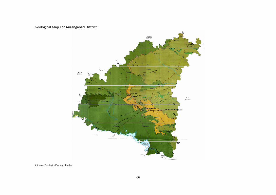
66
Geological Map For Aurangabad District :
# Source Geological Survey of India
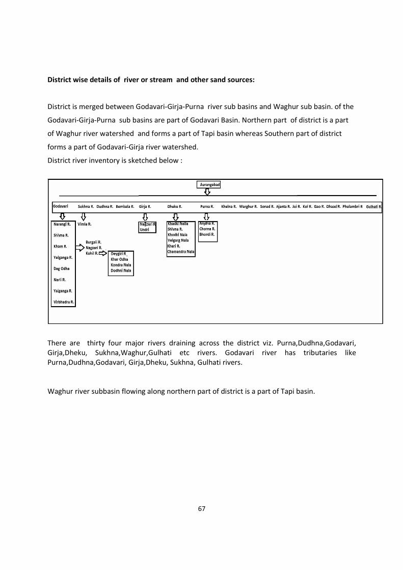
67
District wise details of river or stream and other sand sources:
District is merged between Godavari-Girja-Purna river sub basins and Waghur sub basin. of the
Godavari-Girja-Purna sub basins are part of Godavari Basin. Northern part of district is a part
of Waghur river watershed and forms a part of Tapi basin whereas Southern part of district
forms a part of Godavari-Girja river watershed.
District river inventory is sketched below :
There are thirty four major rivers draining across the district viz. Purna,Dudhna,Godavari, Girja,Dheku, Sukhna,Waghur,Gulhati etc rivers. Godavari river has tributaries like Purna,Dudhna,Godavari, Girja,Dheku, Sukhna, Gulhati rivers. Waghur river subbasin flowing along northern part of district is a part of Tapi basin.
68
District has few leases of stone producing mechanical sand by crushing and meeting as per IS
standards for building grade sand. But demand is for river bed sand and hence scooping of sand
is a major activity to cater sand requirement to infrastructural development. However district
authority is promoting to use mechanical sand to balance between river bed sand scooping.
District wise availability of sand and gravel or aggregate resources:
District has 47 Sand scooping sand ghats catering 52000 brass of sand. District has 42 stone
quarries catering 1273500 brass stone aggregates of different sizes like 6mm,20mm,40mm,
60mm and mechanical sand.
District wise details of existing mining leases of sand and aggregates :
District administration every year survey the sand deposits as per rules framed by Govt. of
Maharashtra policy dated 03.09.2019 and after all legal clearances auction for period of
maximum one year excluding monsoon period of 10 June till 30 September. There are 47about
sand ghats identified by administration for scooping of sand.
No. of Leases of aggregates Total Area in ha Mineable Reserves Available
in Million MT
47 50.01 ha 0.70 (approx.)
Drainage System with description of main rivers:
S.No. Name of River Area drained in Sq. Km. % Area drained in the
District
1 Godavari and its
tributaries
5252 52.00 %
2 Dudhna River and its
tributaries
909 9.1 %
3 Rest of Rivers and its
tributaries
3939 38.9 %
# All three rivers includes their tributaries
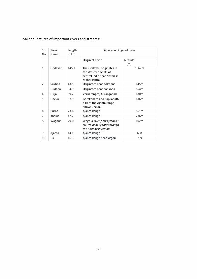
69
Salient Features of important rivers and streams:
Sr. No.
River Name
Length in Km
Details on Origin of River
Origin of River Altitude (m)
1 Godavari 145.7 The Godavari originates in the Western Ghats of central India near Nashik in Maharashtra
1067m
2 Sukhna 43.5 Originates near Kolthana 645m
3 Dudhna 34.9 Originates near Kankona 854m
4 Girja 59.2 Verul ranges, Aurangabad 630m
5 Dheku 57.9 Gorakhnath and Kapilanath hills of the Ajanta range above Dheku.
616m
6 Purna 73.6 Ajanta Range 851m
7 Khelna 42.2 Ajanta Range 736m
8 Waghur 29.0 Waghur river flows from its source near Ajanta through the Khandesh region
692m
9 Ajanta 14.1 Ajanta Range 638
10 Jui 16.3 Ajanta Range near virgori 739
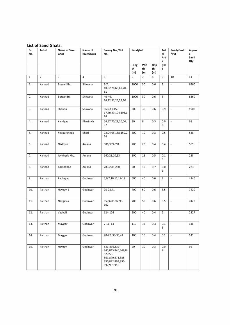
70
List of Sand Ghats: Sr. No.
Tehsil Name of Sand Ghat
Name of River/Nala
Survey No./Gut No.
Sandghat Total Area
Road/Govt/Pvt
Approx SandQty
Length (m)
Width (m)
Depth (m)
(Ha)
1 2 3 4 5 6 7 8 9 10 11
1.
Kannad Borsar Khu. Shiwana 3-7, 10,62,76,68,69,70,81
1000 30 0.6 3 - 6360
2.
Kannad Borsar Bu. Shiwana 40-46, 34,32,31,26,25,20
1000 30 0.6 3 - 6360
3.
Kannad Shewta Shiwana 86,9,11,15-17,20,29,194,193,186
300 30 0.6 0.9 - 1908
4.
Kannad Kandgav Kharinala 56,57,70,21,20,06,07
80 8 0.3 0.06
- 68
5.
Kannad Khaparkheda Khari 02,04,05,158,159,274
500 10 0.3 0.5 - 530
6.
Kannad Nadrpur Anjana 386,389-391 200 20 0.4 0.4 - 565
7.
Kannad Javkheda khu. Anjana 160,28,10,13 100 13 0.5 0.13
- 230
8.
Kannad Aamdabad Anjana 28,62,85,280 90 10 0.7 0.09
- 223
9.
Paithan Pathegav Godawari 3,6,7,10,11,17-19 500 40 0.6 2 - 4240
10.
Paithan Naygav-1 Godawari 25-28,41 700 50 0.6 3.5 - 7420
11.
Paithan Naygav-2 Godawari 85,86,89-92,98-102
700 50 0.6 3.5 - 7420
12.
Paithan Vadvali Godawari 124-126 500 40 0.4 2 - 2827
13.
Paithan Maygav Godawari 7-11, 13 110 12 0.3 0.13
- 140
14.
Paithan Maygav Godawari 20-22, 33-35,41 100 10 0.4 0.1 - 141
15.
Paithan Navgav Godawari 831-836,839-843,845,846,849,852,858-861,870,871,888-890,892,893,895-897,901,910
90 10 0.3 0.09
- 95
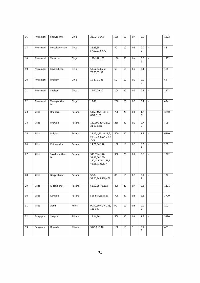
71
16.
Phulambri Shewta khu. Girija 227,240-242 150 60 0.4 0.9 - 1272
17.
Phulambri Pinpalgav valan Girija 22,23,55-57,60,61,69,70
50 10 0.5 0.05
- 88
18.
Phulambri Vadod ku. Girija 159-161, 165 150 60 0.4 0.06
- 1272
19.
Phulambri Kavithkheda Girija 59,62,64,65,68-70,73,85-92
50 15 0.4 0.4 - 106
20.
Phulambri Bhalgav Girija 15-17,31-35 50 12 0.3 0.06
- 64
21.
Phulambri Shelgav Girija 19-22,29,30 100 20 0.3 0.2 - 212
22.
Phulambri Vanegav khu. Bu.
Girija 15-19 200 20 0.3 0.4 - 424
23.
Sillod Dhanora Purnna 54/2, 34/1, 60/1, 60/2,61/2
700 25 0.6 1.75
- 3710
24.
Sillod Bhawan Purnna 189,190,204,227,231-234,236
250 30 0.3 0.75
- 795
25.
Sillod Didgav Purnna 21,12,4,13,10,11,9,8,5,7,23,27,24,28,37,39
500 30 1.2 1.5 - 6360
26.
Sillod Kothnandra Purnna 14,21,54,137 150 18 0.3 0.27
- 286
27.
Sillod Savkheda khu. Bu.
Purnna 340,39,41,47-51,53,56,178-180,182,163,165,142,152,136,137
300 20 0.6 0.6 - 1272
28.
Sillod Borgav bajar Purnna 5,50-53,75,148,480,474
80 15 0.3 0.12
- 127
29.
Sillod Modha khu. Purnna 62,63,68-72,102 400 20 0.4 0.8 - 1131
30.
Sillod Kenhala Purnna 555-557,568,569 700 30 0.5 2.1 - 3710
31.
Sillod Aambi Kelna 9,290,109,144,146,136-140
90 10 0.6 0.09
- 191
32.
Gangapur Sirsgav Shiwna 12,14,16 500 30 0.6 1.5 - 3180
33.
Gangapur Dinvada Shiwna 3,8,90,15,16 100 13 1 0.13
- 459
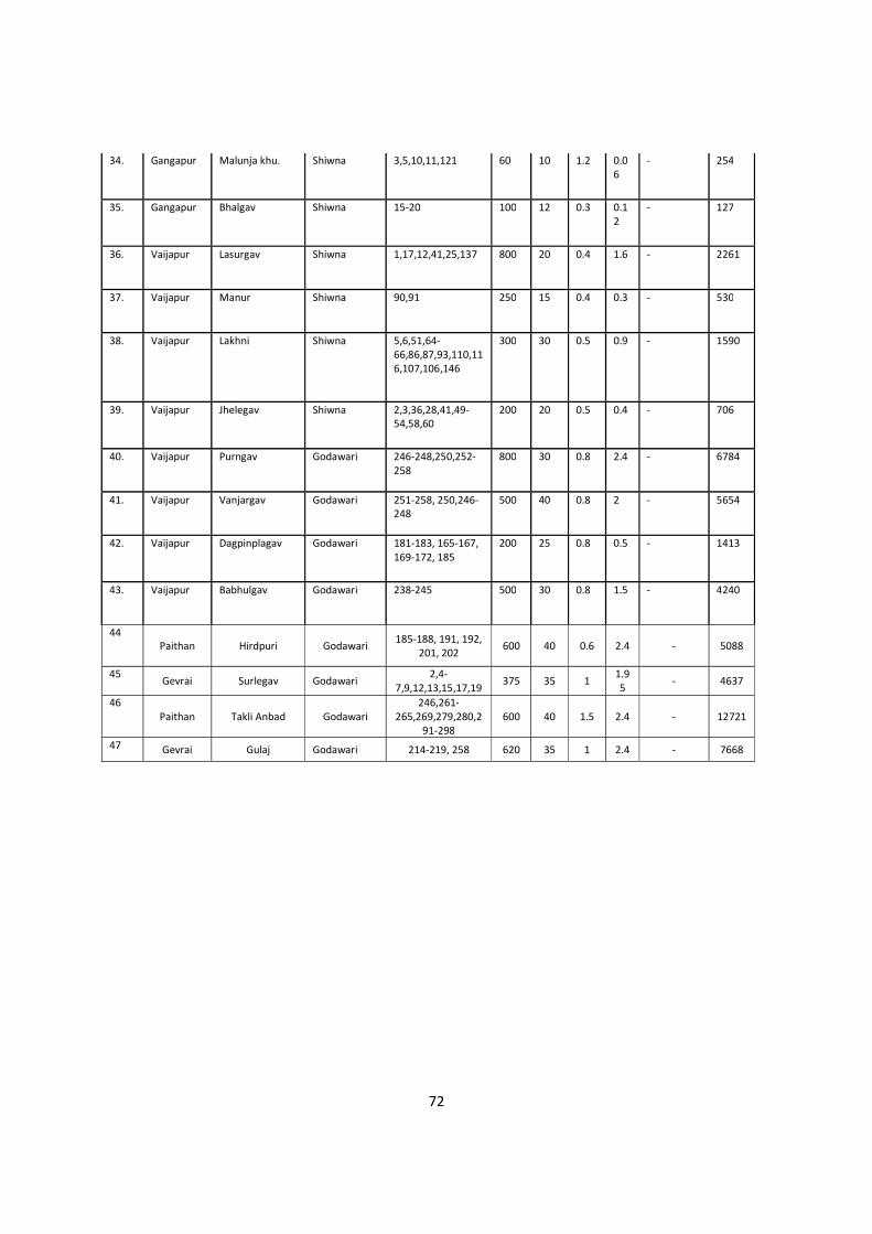
72
34.
Gangapur Malunja khu. Shiwna 3,5,10,11,121 60 10 1.2 0.06
- 254
35.
Gangapur Bhalgav Shiwna 15-20 100 12 0.3 0.12
- 127
36.
Vaijapur Lasurgav Shiwna 1,17,12,41,25,137 800 20 0.4 1.6 - 2261
37.
Vaijapur Manur Shiwna 90,91 250 15 0.4 0.3 - 530
38.
Vaijapur Lakhni Shiwna 5,6,51,64-66,86,87,93,110,116,107,106,146
300 30 0.5 0.9 - 1590
39.
Vaijapur Jhelegav Shiwna 2,3,36,28,41,49-54,58,60
200 20 0.5 0.4 - 706
40.
Vaijapur Purngav Godawari 246-248,250,252-258
800 30 0.8 2.4 - 6784
41.
Vaijapur Vanjargav Godawari 251-258, 250,246-248
500 40 0.8 2 - 5654
42.
Vaijapur Dagpinplagav Godawari 181-183, 165-167, 169-172, 185
200 25 0.8 0.5 - 1413
43.
Vaijapur Babhulgav Godawari 238-245 500 30 0.8 1.5 - 4240
44 Paithan Hirdpuri Godawari 185-188, 191, 192,
201, 202 600 40 0.6 2.4 - 5088
45 Gevrai Surlegav Godawari
2,4-7,9,12,13,15,17,19
375 35 1 1.95
- 4637
46 Paithan Takli Anbad Godawari
246,261-265,269,279,280,2
91-298 600 40 1.5 2.4 - 12721
47 Gevrai Gulaj Godawari 214-219, 258 620 35 1 2.4 - 7668
73
Mineral Potential :
Boulder (MT) Bajari (MT) Sand(MT) Total Mineable
Mineral Potential
25.08MT 0.700 MT 25.78 MT
Annual Deposition :
Annual deposition is calculated by considering watershed area in Km2 ,Annual Rainfall in mm3,,
Average Watershed slope, Drainage density in Km-1,Vegetative cover factor, Annual
precipitation in cm, mean annual runoff in cm, mean annual temperature for Godavari, Girija,
Sukhna, Kelna,Dudhna rivers and plotted on district map as :
74
#cum/min
75
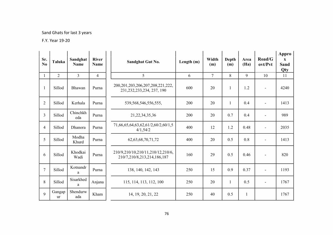
76
Sand Ghats for last 3 years
F.Y. Year 19-20
Sr. No
Taluka Sandghat
Name River Name
Sandghat Gut No. Length (m)
Width (m)
Depth (m)
Area (Ha)
Road/Govt/Pvt
Approx
SandQty
1 2 3 4 5 6 7 8 9 10 11
1 Sillod Bhawan Purna
200,201,203,206,207,208,221,222,231,232,233,234, 237, 190
600 20 1 1.2 - 4240
2 Sillod Kerhala Purna
539,568,546,556,555, 200 20 1 0.4 - 1413
3 Sillod Chinchkh
eda Purna
21,22,34,35,36 200 20 0.7 0.4 - 989
4 Sillod Dhanora Purna
71,66,65,64,63,62,61/2,60/2,60/1,54/1,54/2
400 12 1.2 0.48 - 2035
5 Sillod Modha Khurd
Purna
62,63,68,70,71,72 400 20 0.5 0.8 - 1413
6 Sillod Khodkai
Wadi Purna
210/9,210/10,210/11,210/12,210/6,210/7,210/8,213,214,186,187
160 29 0.5 0.46 - 820
7 Sillod Kotnandr
a Purna
138, 140, 142, 143 250 15 0.9 0.37 - 1193
8 Sillod Sisarkhed
a Anjana
115, 114, 113, 112, 100 250 20 1 0.5 - 1767
9 Gangap
ur Shendurw
ada Kham
14, 19, 20, 21, 22 250 40 0.5 1 1767
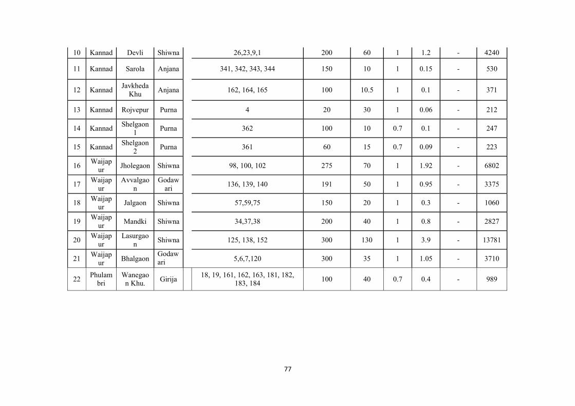
77
10 Kannad Devli Shiwna
26,23,9,1 200 60 1 1.2 - 4240
11 Kannad Sarola Anjana
341, 342, 343, 344 150 10 1 0.15 - 530
12 Kannad Javkheda
Khu Anjana
162, 164, 165 100 10.5 1 0.1 - 371
13 Kannad Rojvepur Purna
4 20 30 1 0.06 - 212
14 Kannad Shelgaon
1 Purna
362 100 10 0.7 0.1 - 247
15 Kannad Shelgaon
2 Purna
361 60 15 0.7 0.09 - 223
16 Waijap
ur Jholegaon Shiwna
98, 100, 102 275 70 1 1.92 - 6802
17 Waijap
ur Avvalgao
n Godaw
ari
136, 139, 140 191 50 1 0.95 - 3375
18 Waijap
ur Jalgaon Shiwna
57,59,75 150 20 1 0.3 - 1060
19 Waijap
ur Mandki Shiwna
34,37,38 200 40 1 0.8 - 2827
20 Waijap
ur Lasurgao
n Shiwna
125, 138, 152 300 130 1 3.9 - 13781
21 Waijap
ur Bhalgaon
Godawari
5,6,7,120 300 35 1 1.05 - 3710
22 Phulam
bri Wanegao
n Khu. Girija
18, 19, 161, 162, 163, 181, 182,
183, 184 100 40 0.7 0.4 - 989
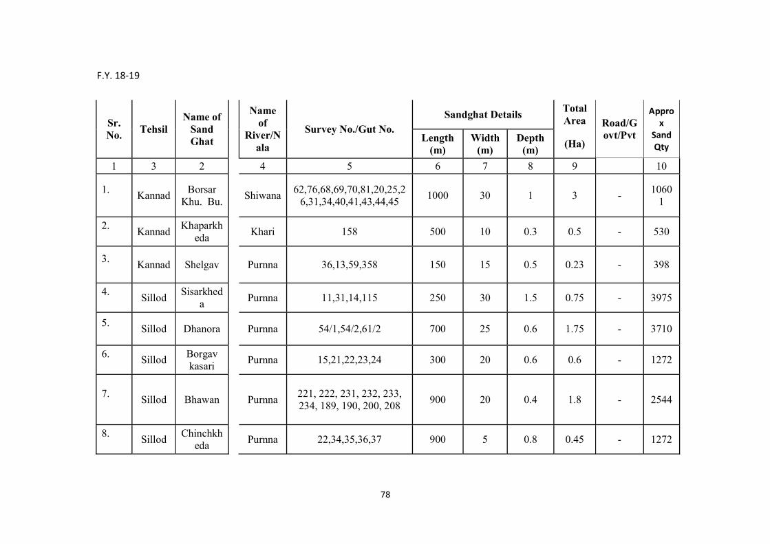
78
F.Y. 18-19
Sr. No.
Tehsil Name of
Sand Ghat
Name
of River/N
ala
Survey No./Gut No. Sandghat Details
Total Area Road/G
ovt/Pvt
Approx
SandQty
Length (m)
Width (m)
Depth (m)
(Ha)
1 3 2 4 5 6 7 8 9 10
1.
Kannad
Borsar Khu. Bu. Shiwana
62,76,68,69,70,81,20,25,26,31,34,40,41,43,44,45
1000 30 1 3 - 1060
1
2.
Kannad
Khaparkheda Khari 158 500 10 0.3 0.5 - 530
3.
Kannad Shelgav Purnna 36,13,59,358 150 15 0.5 0.23 - 398
4.
Sillod
Sisarkheda Purnna 11,31,14,115 250 30 1.5 0.75 - 3975
5.
Sillod Dhanora Purnna 54/1,54/2,61/2 700 25 0.6 1.75 - 3710
6.
Sillod
Borgav kasari Purnna 15,21,22,23,24 300 20 0.6 0.6 - 1272
7.
Sillod Bhawan Purnna
221, 222, 231, 232, 233, 234, 189, 190, 200, 208
900 20 0.4 1.8 - 2544
8.
Sillod
Chinchkheda Purnna 22,34,35,36,37 900 5 0.8 0.45 - 1272
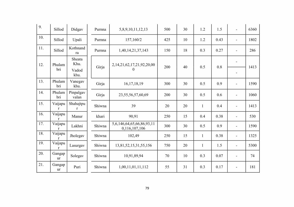
79
9.
Sillod Didgav Purnna 5,8,9,10,11,12,13 500 30 1.2 1.5 - 6360
10.
Sillod Upali Purnna 157,160/2 425 10 1.2 0.43 - 1802
11.
Sillod
Kothnandra Purnna 1,40,14,21,37,143 150 18 0.3 0.27 - 286
12.
Phulam
bri
Sheata Khu.
Girja 2,14,21,62,17,21,92,20,00
0 200 40 0.5 0.8
- 1413
Vadod khu. -
13.
Phulam
bri Vanegav
khu. Girja 16,17,18,19 300 30 0.5 0.9 - 1590
14.
Phulam
bri Pinpalgav
valan Girja 23,55,56,57,60,69 200 30 0.5 0.6 - 1060
15.
Vaijapu
r Shahajtpu
r Shiwna 39 20 20 1 0.4 - 1413
16.
Vaijapu
r Manur khari 90,91 250 15 0.4 0.38 - 530
17.
Vaijapu
r Lakhni Shiwna
5,6,146,64,65,66,86,93,110,116,107,106
300 30 0.5 0.9 - 1590
18.
Vaijapu
r Jholegav Shiwna 102,49 250 15 1 0.38 - 1325
19.
Vaijapu
r Lasurgav Shiwna 13,81,52,15,31,55,156 750 20 1 1.5 - 5300
20.
Gangap
ur Solegav Shiwna 10,91,89,94 70 10 0.3 0.07 - 74
21.
Gangap
ur Puri Shiwna 1,00,11,01,11,112 55 31 0.3 0.17 - 181
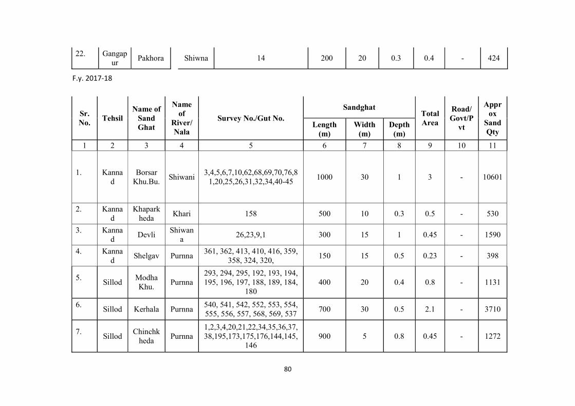
80
22.
Gangap
ur Pakhora Shiwna 14 200 20 0.3 0.4 - 424
F.y. 2017-18
Sr. No.
Tehsil Name of
Sand Ghat
Name of
River/Nala
Survey No./Gut No. Sandghat
Total Area
Road/Govt/P
vt
Approx
SandQty
Length (m)
Width (m)
Depth (m)
1 2 3 4 5 6 7 8 9 10 11
1.
Kanna
d Borsar
Khu.Bu. Shiwani
3,4,5,6,7,10,62,68,69,70,76,81,20,25,26,31,32,34,40-45
1000 30 1 3 - 10601
2.
Kanna
d Khapark
heda Khari 158 500 10 0.3 0.5 - 530
3.
Kanna
d Devli
Shiwana
26,23,9,1 300 15 1 0.45 - 1590
4.
Kanna
d Shelgav Purnna
361, 362, 413, 410, 416, 359, 358, 324, 320,
150 15 0.5 0.23 - 398
5.
Sillod
Modha Khu.
Purnna 293, 294, 295, 192, 193, 194, 195, 196, 197, 188, 189, 184,
180 400 20 0.4 0.8 - 1131
6.
Sillod Kerhala Purnna
540, 541, 542, 552, 553, 554, 555, 556, 557, 568, 569, 537
700 30 0.5 2.1 - 3710
7.
Sillod
Chinchkheda
Purnna 1,2,3,4,20,21,22,34,35,36,37,38,195,173,175,176,144,145,
146 900 5 0.8 0.45 - 1272
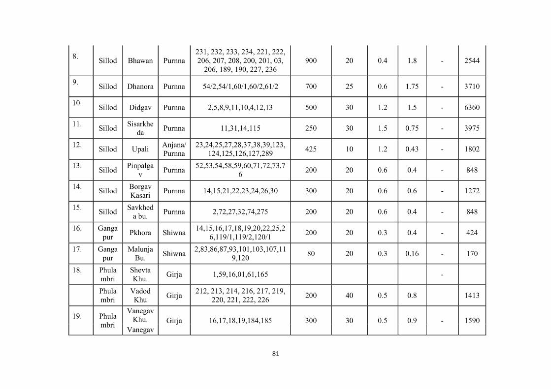
81
8.
Sillod Bhawan Purnna
231, 232, 233, 234, 221, 222, 206, 207, 208, 200, 201, 03,
206, 189, 190, 227, 236 900 20 0.4 1.8 - 2544
9.
Sillod Dhanora Purnna 54/2,54/1,60/1,60/2,61/2 700 25 0.6 1.75 - 3710
10.
Sillod Didgav Purnna 2,5,8,9,11,10,4,12,13 500 30 1.2 1.5 - 6360
11.
Sillod
Sisarkheda
Purnna 11,31,14,115 250 30 1.5 0.75 - 3975
12.
Sillod Upali
Anjana/ Purnna
23,24,25,27,28,37,38,39,123,124,125,126,127,289
425 10 1.2 0.43 - 1802
13.
Sillod
Pinpalgav
Purnna 52,53,54,58,59,60,71,72,73,7
6 200 20 0.6 0.4 - 848
14.
Sillod
Borgav Kasari
Purnna 14,15,21,22,23,24,26,30 300 20 0.6 0.6 - 1272
15.
Sillod
Savkheda bu.
Purnna 2,72,27,32,74,275 200 20 0.6 0.4 - 848
16.
Ganga
pur Pkhora Shiwna
14,15,16,17,18,19,20,22,25,26,119/1,119/2,120/1
200 20 0.3 0.4 - 424
17.
Ganga
pur Malunja
Bu. Shiwna
2,83,86,87,93,101,103,107,119,120
80 20 0.3 0.16 - 170
18.
Phulambri
Shevta Khu.
Girja 1,59,16,01,61,165 -
Phulambri
Vadod Khu
Girja 212, 213, 214, 216, 217, 219,
220, 221, 222, 226 200 40 0.5 0.8 1413
19.
Phulambri
Vanegav Khu. Girja 16,17,18,19,184,185 300 30 0.5 0.9 - 1590
Vanegav
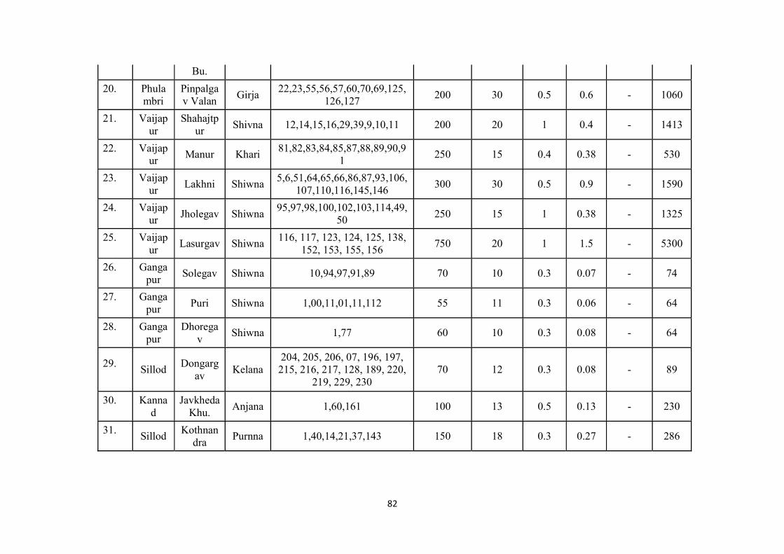
82
Bu.
20.
Phulambri
Pinpalgav Valan
Girja 22,23,55,56,57,60,70,69,125,
126,127 200 30 0.5 0.6 - 1060
21.
Vaijap
ur Shahajtp
ur Shivna 12,14,15,16,29,39,9,10,11 200 20 1 0.4 - 1413
22.
Vaijap
ur Manur Khari
81,82,83,84,85,87,88,89,90,91
250 15 0.4 0.38 - 530
23.
Vaijap
ur Lakhni Shiwna
5,6,51,64,65,66,86,87,93,106,107,110,116,145,146
300 30 0.5 0.9 - 1590
24.
Vaijap
ur Jholegav Shiwna
95,97,98,100,102,103,114,49,50
250 15 1 0.38 - 1325
25.
Vaijap
ur Lasurgav Shiwna
116, 117, 123, 124, 125, 138, 152, 153, 155, 156
750 20 1 1.5 - 5300
26.
Ganga
pur Solegav Shiwna 10,94,97,91,89 70 10 0.3 0.07 - 74
27.
Ganga
pur Puri Shiwna 1,00,11,01,11,112 55 11 0.3 0.06 - 64
28.
Ganga
pur Dhorega
v Shiwna 1,77 60 10 0.3 0.08 - 64
29.
Sillod
Dongargav
Kelana 204, 205, 206, 07, 196, 197, 215, 216, 217, 128, 189, 220,
219, 229, 230 70 12 0.3 0.08 - 89
30.
Kanna
d Javkheda
Khu. Anjana 1,60,161 100 13 0.5 0.13 - 230
31.
Sillod
Kothnandra
Purnna 1,40,14,21,37,143 150 18 0.3 0.27 - 286
83
DISTRICT SURVEY REPORT FOR AURANGABAD DISTRICT
PART –B
FOR MINOR MINERALS OTHER THAN SAND MINING OR RIVER BED MINING
Prepared under
A] Appendix –X of MoEFCC, GoI notification S.O. 141(E) dated 15.1.2016 B] Sustainable Sand Mining Guidelines C] MoEFCC, GoI notification S.O. 3611(E) dated 25.07.2018 D] E & M Guidelines, MoEFCC, GoI, New Delhi, January 2020
84
1.0 Introduction : Hon’ble Supreme Court of India vide its judgement dated February 27,2012 and further relief amendment dated April 16,2012 directed all state, union territories and ministry of Environment and Forest, Govt. of India, New Delhi to screen mining of minor minerals leases within the purview of EIA notification 2006 and made requirement of environmental clearance to minor minerals less than 5 ha compulsory. Ministry of Environment & Forest , GoI vide its office Memorandum L-11011/47/2011.IA.II(M) dated 18.05.2012 directed mass to comply Ho’ble Supreme Court decision. Further streamlining of environmental clearance procedures, MOEFCC, GoI amended EIA notification 2006 vide S.O. 141(E) dated 15.01.2016 where procedure for preparation of District Survey Report (DSR) for minor minerals has been prescribed. Further the procedure for preparation of DSR and format is amended vide MOEFCC notification S.O. 3611(E) dated 25.07.2018. The subjected DSR is defined at “ Appendix -X (See Paragraph 7(iii)(a)” of the notification S.O.141(E)dated 15.01.2016 and S.O. 3611(E) dated 25.07.2018 This District survey report comply the environmental & monitoring guidelines issued by MoEFCC, GoI, New Delhi published in January 2020. This District Survey Report will be utilized for assessing the minor minerals proposals of the district for grant of minor mineral leases, their feasibility and for grant of environmental clearances by the designated authorities. Brief Introduction of Aurangabad district : Aurangabad District is located mainly in Godavari Basin and its some part towards North West of Tapi River Basin. This District’s general down level is towards South and East and North West part comes in Purna-Godavari river basin. The Aurangabad district’s North Longitude ( Degree) is 19 and 20 and East Longitude (Degree ) is 74 to 76. Aurangabad district is named after, its headquarters place of Aurangabad. The City was founded in 1610 A.D. by Malik Ambhar, the Prime Minister of Murtaza Nizam Shah of Ahmadnagar on the sight of Village called Khirki. Malik Ambar was succeeded by his son Fateh Khan, who changed the name of Khirki to Fatehnagar. With the capture Daulatabad by the imperial troops in 1633, the Nizamshahi dominions including Fatehnagar came under the possession of the Moghals. In 1653 when Aurangzab was appointed, the Viceroy of the Deccan, he made Fatehnagar his capital and called it Aurangabad. The historians of his reign also occasionally style the city Khujistan Bunyad. Since then the city came to be known as Aurangabad.
85
It appears from the Archaeological excavations made in the neighbouring district that this region was occupied in the Early Stone Age. The earliest period known from the excavations is the chalcolithic or Early Bronze Age i.e. from 1500-500 B.C. According to the literary tradition, when the Aryans penetrated to the Deccan, the whole region was covered by a thick jungle. Agastya was the first Aryan who crossed the Vindhyas. We learn from the Ramayana that Rama accompanied by his brother Lakshman and wife Sita met Agastya near Godavari. Buddhism was first introduced in Maharashtra by Buddhist missionary named Maha Dharma Rakshita by narrating to the people the story of the Maha Naradakassapa Jataka during the reign of Ashoka. This led to the excavation of caves in different parts of Maharashtra; some of these were excavated at Pitalkhora, 80 Kms. from Aurangabad and at Ajanta on the northern fringe of the district. After the death of Ashoka, the Satavahanas rose to power in the Deccan. They made Pratishthana (Paithan) as their Capital. They received support from local rulers called Maharathis. Their kingdom extended up to Pune, Nashik, Ahmadnagar, Aurangabad and Jalna districts the earliest group of caves at Ajanta belongs to the Satavahana age. During the period of Satavahanas, this region must have attained a high level of prosperity. The Chalukyas of Badami (Bijapur district) rose to power in the first half of the sixth century A.D. Their kingdom extended up to the Narmada in the north. The Chinese pilgrim, Hiuen Tsang calls about King Pulakeshi II from Chalukya dynasty as the Lord of Maharashtra. Pulakeshi obtained a resounding victory over Harsha, the lord paramount of North India. Thereafter he assumed the title of Parameshvara. In the last quarter of the 12th century A.D., the Yadavas of Devagiri (Daulatabad) came into prominence. In 1296 A.D., Ala-ud-din Khilji invaded the kingdom of Ramachandra (King of Devagiri), he had to pay a heavy ransom to the Muslim conqueror. He was succeeded by his son Shankaragana. He was defeated and slain by Malik Kafur. Thus, the Hindu Kingdom of Devagiri came to an end in 1318 A.D. From the early 13th century onwards, Muslim rulers started invading this region. They conquered many small forts. The prominent being the Devagiri fort. Since then the Maratha power never established in this region. After the death of Emperor Bahadur Shah in 1711, the civil war that took place for supremacy prompted Nizam-ul-Mulk, a Governer in Mughals court to become the Viceroy of the Deccan in 1713. He founded the Nizam dynasty. This family ruled in Hyderabad till 1948. There were no major changes in the boundaries of the district or its talukas between 1901 to 1941. Eight villages of Ambad taluka were exchanged with six villages of Pathri taluka of Parbhani district. In 1950, twenty-five enclave villages belonging to the neighbouring districts of Nashik, East Khandesh and Ahmadnagar were transferred to Aurangabad district. More than one third of the district was Jagir area. Nizam’s own estate called “Sarf-e-Khas” comprising two talukas was merged with the Government area under Sarf-e-Khas (Merger) Regulation of 1949. Consequent upon the integration of Jagirs and Sarf-e-Khas areas, all the taluka boundaries were reconstituted in April 1950. Two new Mahals (Tahsils) with headquarters at Jafferabad were created. In 1953 another new mahal (tahsil) with headquarters at Soegaon was created by transferring 37 villages from Sillod taluka and 30 from Kannad taluka. All the villages transferred to this mahal are situated to the north of the Satmala hills. With the reorganisation of States in 1956, the district was transferred from Hyderabad State to Bombay State and since 1960 it forms a part ofMaharashtra.
86
Drainage The district can be broadly divided into three physiographic units namely, Ajanta hill ranges, Satmala hill ranges and Godavari Plains. Geomorphologically, the district comprises varied topographic features and landscape consisting of high hills and plains and low-lying hills. Most of the hill ranges are located in the northern part of the district. The Satmala and Ajanta hills extend from east to west. The hills near Verul in Khuldabad block are part of these ranges which extend to Chouka hill range and Aurangabad hills. The Satmala range encompasses several hills overlooking the Tapi valley. From west to east they are Antur (826 m amsl), Satonda (552 m amsl), Abasgand (671 m amsl) and Ajantha (578 m amsl). The Satmala hill (493 m amsl) from which name of the range is derived is situated north of Kannad town. The district is a part of the Deccan Plateau. In general, the slopes in the district are towards south and southeast. The average elevation of the district is in the order of 500 m amsl. Within it there are flat topped hill ranges extending over wide area and also hills separated by broad valleys. Major part of the district falls in Godavari basin with a small area in north eastern parts falling Tapi Basin. The major river in the district is the Godavari with its tributaries namely; Purna, Dudhna and Shivna rivers. The other important tributaries are Sukna, Khelna, Kham, Gulathi, Shivbhadra and Girija rivers. Depending on the drainage and geomorphology, the district has been divided into 52 watersheds. etc. Climate The climate of the district is characterized by a hot summer and a general dryness throughout the year except during the south west monsoon season, which is from June to September while October and November constitute the postmonsoon season. The winter season commences towards the end of November when temperatures begin to fall rapidly. December is the coldest month with the mean maximum temperature of 28.9° C, while the mean minimum temperature is 10.3°C. From the beginning of March, the daily temperature increases continuously. May is the hottest month with the mean maximum temperature of 39.8°C and the mean minimum temperature of 24.6° C. With the onset of the south-west monsoon by about the second week of June, the temperature falls appreciably. Except during the southwest monsoon season, when the relative humidity is high, the air is generally dry over the district. The summer months are the driest when the relative humidity is generally between 20 and 25% in the afternoon. Winds are generally light to moderate with increase in speed during the latter half of the hot season and in the monsoon season. The winds flow predominantly from directions between west and north during the hot season. They are mostly from directions between south west and northwest during the south west monsoon season. They blow mostly from the directions between northeast and southeast during the rest of the year becoming southwesterly to north westerly in January and February. The average annual rainfall of the district is 705 mm
87
Natural Economic Resources Deccan Traps cover a major part of the District. Trap rocks are very hard and compact and are ark grey in colour. Trap rocks being dense, hard and compact are extensively used as building stones, road metal, railway ballast and as an aggregate in cement concrete. Erosive agents and weathering together have formed good fertile soils near the river beds. Aurangabad district has some gem stone quarries.
Aurangabad district is having good Industrial background, specially famous for the Seed and other automobile industries. The industrial development at Aurangabad is widely based on Engineering, Plastic and Agriculture.
Pulses mills, oil mills, refineries, steel re-rolling, plastic, tiles & cement pipe, fertilizers, insecticides, pesticides and the co-operative sugar factories are also playing important part in the industrial development of Aurangabad.
There are also cotton ginning and pressing factories and an agricultural market produce committee handling large quantities of all kinds of agricultural produce, including cotton. In view of the overall industrial backwardness of the region, the state government has initiated a master plan to encourage the establishment of of small and large- scale industrial units. Under this plan Maharashtra Industrial Development Corporation (MIDC) has set up an industrial area in Aurangabad consisting of …large-scale, …medium scale and ..small scale industries.
Himroo, is a fabric made of silk and cotton that is locally grown in Aurangabad. The word Himroo is derived from the persian word ‘hum-ruh’ which means ‘similar’. Himroo is a replica of Kum-Khwab, which was woven with golden and silver threads of ancient times and was for the royal families. Himroo uses the Persian design, and it is very characteristic and distinctive in appearance. Himroo from Aurangbad has a high demand for its unique and fascinating style and design. Himroo is woven near the Gaffar Gate in Himroo fabric
Paithani is a popular variety of sari, named after the Paithan town in Aurangabad district where they are woven by hand. Paithani saris are made from very fine silk and are considered as one of the richest saris in India.
Paithani is characterized by borders of an oblique square design, and a pallu with a Peacock design. Plain as well as spotted designs are available. Among other varieties, single colored and kaleidoscope-colored designs are also popular. The kaleidoscopic effect is achieved by using one color for weaving lengthwise and another for weaving width wise.
Tourism industry also contributes as an economic resources to the district. Along with ancient monuments specified in the district, Panchakki, many gates, Salim Ali Lake Soneri Mahal, Chhatrapti Shivaji Maharaj Museum are also tourist attraction in the district.
88
Forestry In Aurangbad district total Forest Area is 135.75 Sq.Km. As compare to Maharashtra the forest area of Aurangabad is 9.03%. Gautala-Aurtam Ghat Wildlife sanctuary is notiofied vide State Govt. notification vide WLP/1085/CR-75/F-5(V) dated 25.02.1986 nad then by MoEFCC notification for Gautala Autram Ghat WLS vide SO3996(A) dated 9.12.2016 for 260.61 sq. km area Also Jaikwadi Bird Sanctuary is notiofied vide State Govt. notification vide WLP/1086/27206/CR39186(II)F5 dated 10.10.1986 and then by MoEFCC notification for Jaikwadi Bird Sanctuary SO2202(A)12.07.2017 for 341.05 Sq. Km. Minerals and mining Minerals of great economic importance are not found in Aurangabad district. The geology of the region consists of dark coloured colcanic lava flows. It is spread in the form of horizontal sheets or beds. Because of their dominantly basaltic composition and the tendancy to form flat – topped plateau, the lavas are termed plateau basalt. Trap rocks are hard , dense and durable and are suitable for building /construction purposes. Economically important mneral required for ndustrialization not found in the district. Hence district has basalt mining for infrastructural requirements with natural river sand up to some extend. At some places some patches of agate are found but with inferior quality. Aurangabad district has some gem stone quarries. Soil and Cropping pattern Soil plays a very important role in the agricultural activities and forest growth of the area. The fertility of the soil from agricultural point of view depends upon the texture and structure which controls the retaining and transmitting capacity of moisture and various nutrients such as nitrogen, phosphorous and potassium present in the soil. The formation of the soil in the area is influenced by the climate, geology, vegetation and topography. The major part of the district is covered by black cotton soil or ‘Regur’ formed by the weathering of Deccan Trap Basalt. It is rich in plant nutrients such as lime, magnesia, iron and alkalies on which cotton and dry crops like Jowar, Bazra and tur etc flourish. It swells and becomes sticky on watering while on drying it contracts and develops many cracks. The soil varies both in texture and depth. In northern portion of the district the soils are shallow and relatively poor while in south they become deep and fairly rich in nutrients. Aurangabad district is spread over an area of 10.08 lakh ha. Out of which area under cultivation is 8.52 Lakh Ha. The total population of the district is 40.83 lakh, out of which, 84.2 % population is dependent on agriculture and allied sector. Agriculture plays an important role in the district economy. The total number of farmers in the district is 9.16 lakhs, of which, 47 % and 31 % are marginal farmers and small farmers, respectively. The average land holding is 1.46 Ha. Agriculture in the Aurangabad district is diversified, wide range of crops are grown in the district. Major food grains are Jowar, pearl millet, wheat& gram, among oilseeds Soybean is major crops while Cotton is major cash crops. Agriculture
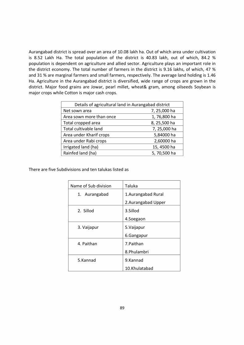
89
Aurangabad district is spread over an area of 10.08 lakh ha. Out of which area under cultivation is 8.52 Lakh Ha. The total population of the district is 40.83 lakh, out of which, 84.2 % population is dependent on agriculture and allied sector. Agriculture plays an important role in the district economy. The total number of farmers in the district is 9.16 lakhs, of which, 47 % and 31 % are marginal farmers and small farmers, respectively. The average land holding is 1.46 Ha. Agriculture in the Aurangabad district is diversified, wide range of crops are grown in the district. Major food grains are Jowar, pearl millet, wheat& gram, among oilseeds Soybean is major crops while Cotton is major cash crops.
Details of agricultural land in Aurangabad district Net sown area 7, 25,000 ha Area sown more than once 1, 76,800 ha Total cropped area 8, 25,500 ha Total cultivable land 7, 25,000 ha Area under Kharif crops 5,84000 ha Area under Rabi crops 2,60000 ha Irrigated land (ha) 15, 4500 ha Rainfed land (ha) 5, 70,500 ha
There are five Subdivisions and ten talukas listed as
Name of Sub division Taluka
1. Aurangabad 1.Aurangabad Rural
2.Aurangabad Upper
2. Sillod 3.Sillod
4.Soegaon
3. Vaijapur 5.Vaijapur
6.Gangapur
4. Paithan 7.Paithan
8.Phulambri
5.Kannad 9.Kannad
10.Khulatabad

90
Salient Features of Aurangabad District : Details of the Area
District & State Aurangabad & Maharashtra
Subdivision & Taluka 05 & 10 Nos.
Villages 1341 villages
Area of district 10100 Sq. Km
Minerals in district Basalt, River Sand
Category ‘B’
Geographical Co-ordinates
LATITUDE
[N]
LONGITUDE [E]
N 19° 20’-N 20° 42’ E 74°37’-E 75° 54’
Accessibility
Road Connectivity District is well connected with MSH1,MSH5, MSH8, SH16, 24,30,
47,48,60,148,178,180,183,184, Proposed DMIC & Nagpur Mumbai
Samruddhi Mahamarg
Rail Connectivity Railway Station at Aurangabad (Connecting Parbhani-Mumbai)
Airport Aurangabad (Nearest Airport)
General Climatic Conditions
Wind Pattern during study period West to East
Maximum Temperature Summer : 42 – 45 0C
Winter : 10 – 12 0C
Minimum Temperature Summer : 42 – 45 0C
Winter : 10 – 12 0C
Average Annual Rainfall (mm) 700 mm
Details of the Project
Elevation 450m-900 m above sea level
Historical / Important Places
Archaeological/Historical/Ancient
Monuments within district
10 Archeological /historical place are notified by National Archeological Department Government of India within Aurangabad district. Ajanta Caves, Ellora Caves,Aurangabad Caves,Bibi ka
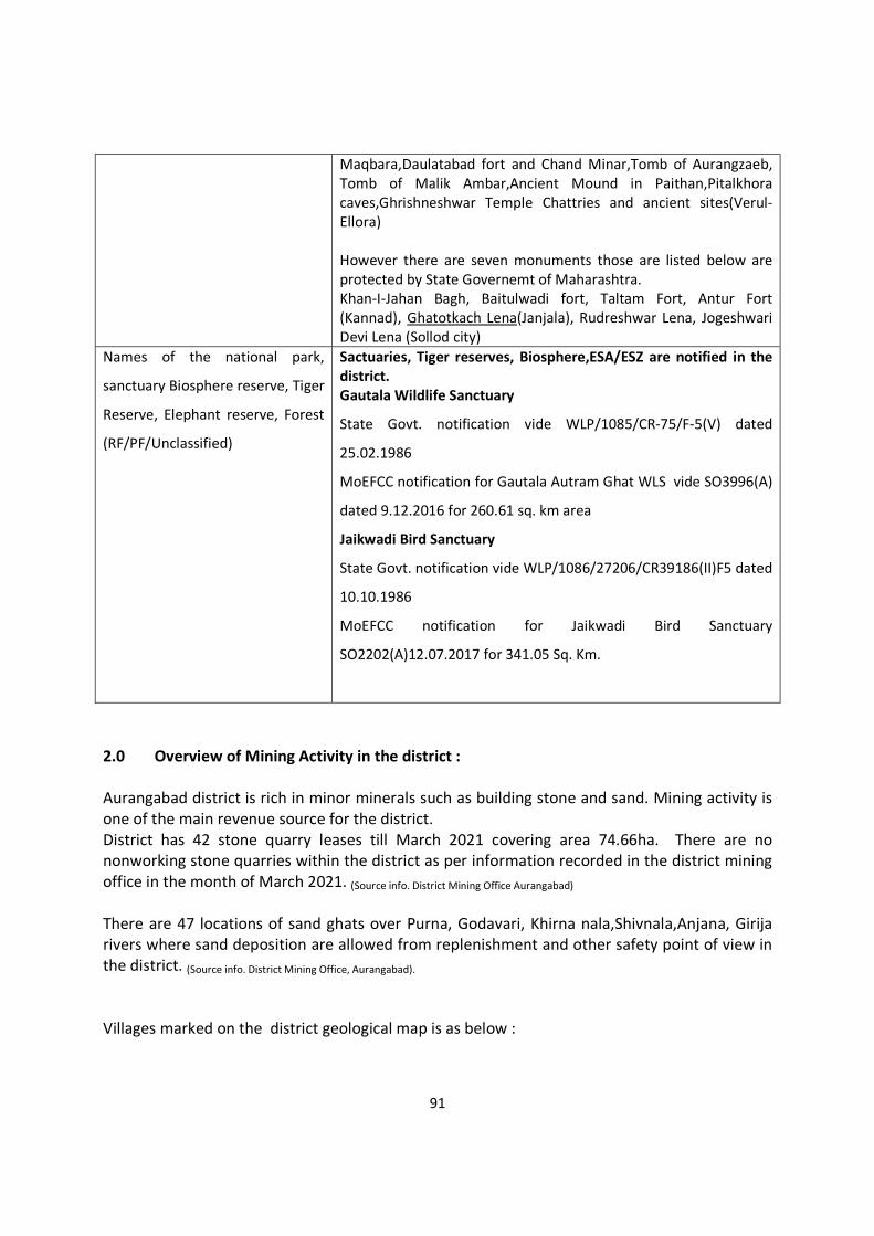
91
Maqbara,Daulatabad fort and Chand Minar,Tomb of Aurangzaeb, Tomb of Malik Ambar,Ancient Mound in Paithan,Pitalkhora caves,Ghrishneshwar Temple Chattries and ancient sites(Verul-Ellora) However there are seven monuments those are listed below are protected by State Governemt of Maharashtra. Khan-I-Jahan Bagh, Baitulwadi fort, Taltam Fort, Antur Fort (Kannad), Ghatotkach Lena(Janjala), Rudreshwar Lena, Jogeshwari Devi Lena (Sollod city)
Names of the national park,
sanctuary Biosphere reserve, Tiger
Reserve, Elephant reserve, Forest
(RF/PF/Unclassified)
Sactuaries, Tiger reserves, Biosphere,ESA/ESZ are notified in the district. Gautala Wildlife Sanctuary
State Govt. notification vide WLP/1085/CR-75/F-5(V) dated
25.02.1986
MoEFCC notification for Gautala Autram Ghat WLS vide SO3996(A)
dated 9.12.2016 for 260.61 sq. km area
Jaikwadi Bird Sanctuary
State Govt. notification vide WLP/1086/27206/CR39186(II)F5 dated
10.10.1986
MoEFCC notification for Jaikwadi Bird Sanctuary
SO2202(A)12.07.2017 for 341.05 Sq. Km.
2.0 Overview of Mining Activity in the district : Aurangabad district is rich in minor minerals such as building stone and sand. Mining activity is one of the main revenue source for the district. District has 42 stone quarry leases till March 2021 covering area 74.66ha. There are no nonworking stone quarries within the district as per information recorded in the district mining office in the month of March 2021. (Source info. District Mining Office Aurangabad) There are 47 locations of sand ghats over Purna, Godavari, Khirna nala,Shivnala,Anjana, Girija rivers where sand deposition are allowed from replenishment and other safety point of view in the district. (Source info. District Mining Office, Aurangabad). Villages marked on the district geological map is as below :

92

93
3. General Profile of the district : Aurangabad District is located mainly in Godavari Basin and its some part towards North West of Tapi River Basin. This District’s general down level is towards South and East and North West part comes in Purna-Godavari river basin. The Aurangabad district’s North Longitude ( Degree) is 19 and 20 and East Longitude (Degree ) is 74 to 76. Aurangabad district is named after, its headquarters place of Aurangabad. The City was founded in 1610 A.D. by Malik Ambhar, the Prime Minister of Murtaza Nizam Shah of Ahmadnagar on the sight of Village called Khirki. Malik Ambar was succeeded by his son Fateh Khan, who changed the name of Khirki to Fatehnagar. With the capture Daulatabad by the imperial troops in 1633, the Nizamshahi dominions including Fatehnagar came under the possession of the Moghals. In 1653 when Aurangzab was appointed, the Viceroy of the Deccan, he made Fatehnagar his capital and called it Aurangabad. The historians of his reign also occasionally style the city Khujistan Bunyad. Since then the city came to be known as Aurangabad. It appears from the Archaeological excavations made in the neighbouring district that this region was occupied in the Early Stone Age. The earliest period known from the excavations is the chalcolithic or Early Bronze Age i.e. from 1500-500 B.C. According to the literary tradition, when the Aryans penetrated to the Deccan, the whole region was covered by a thick jungle. Agastya was the first Aryan who crossed the Vindhyas. We learn from the Ramayana that Rama accompanied by his brother Lakshman and wife Sita met Agastya near Godavari. Buddhism was first introduced in Maharashtra by Buddhist missionary named Maha Dharma Rakshita by narrating to the people the story of the Maha Naradakassapa Jataka during the reign of Ashoka. This led to the excavation of caves in different parts of Maharashtra; some of these were excavated at Pitalkhora, 80 Kms. from Aurangabad and at Ajanta on the northern fringe of the district. After the death of Ashoka, the Satavahanas rose to power in the Deccan. They made Pratishthana (Paithan) as their Capital. They received support from local rulers called Maharathis. Their kingdom extended up to Pune, Nashik, Ahmadnagar, Aurangabad and Jalna districts the earliest group of caves at Ajanta belongs to the Satavahana age. During the period of Satavahanas, this region must have attained a high level of prosperity. The Chalukyas of Badami (Bijapur district) rose to power in the first half of the sixth century A.D. Their kingdom extended up to the Narmada in the north. The Chinese pilgrim, Hiuen Tsang calls about King Pulakeshi II from Chalukya dynasty as the Lord of Maharashtra. Pulakeshi obtained a resounding victory over Harsha, the lord paramount of North India. Thereafter he assumed the title of Parameshvara. In the last quarter of the 12th century A.D., the Yadavas of Devagiri (Daulatabad) came into prominence. In 1296 A.D., Ala-ud-din Khilji invaded the kingdom of Ramachandra (King of Devagiri), he had to pay a heavy ransom to the Muslim conqueror. He was succeeded by his son Shankaragana. He was defeated and slain by Malik Kafur. Thus, the Hindu Kingdom of Devagiri came to an end in 1318 A.D. From the early 13th century onwards, Muslim rulers started invading this region. They conquered many small forts. The prominent being the Devagiri fort. Since then the Maratha power never established in this region. After the death of Emperor Bahadur Shah in 1711, the civil war that took place for supremacy prompted Nizam-ul-Mulk, a Governer in Mughals court to become the Viceroy of the Deccan in 1713. He founded the Nizam dynasty. This family ruled in Hyderabad till 1948. There were no major changes in the boundaries of the district or its talukas between 1901 to 1941. Eight villages of Ambad taluka were exchanged with six villages of Pathri taluka of Parbhani district. In 1950, twenty-five enclave villages belonging to the neighbouring districts of Nashik, East Khandesh and Ahmadnagar were transferred to Aurangabad district. More than one third of the district was Jagir area. Nizam’s own estate called “Sarf-e-Khas” comprising two talukas was merged with the Government area

94
under Sarf-e-Khas (Merger) Regulation of 1949. Consequent upon the integration of Jagirs and Sarf-e-Khas areas, all the taluka boundaries were reconstituted in April 1950. Two new Mahals (Tahsils) with headquarters at Jafferabad were created. In 1953 another new mahal (tahsil) with headquarters at Soegaon was created by transferring 37 villages from Sillod taluka and 30 from Kannad taluka. All the villages transferred to this mahal are situated to the north of the Satmala hills. With the reorganisation of States in 1956, the district was transferred from Hyderabad State to Bombay State and since 1960 it forms a part ofMaharashtra. The district comprises of varied topographic features and landscapes consisting of high hills and plains and low lying hills. Most of the hill ranges are located in the northern part of the district. The Satmala hills and Ajanta hills extend from east to west. The hills near Verul in Khuldabad taluka are part of these ranges which extend to Chawaka ranges and Aurangabad hills. The Satmala range encompasses several hills overlooking the Tapi valley. From west to east they are Antur (826 m amsl), Satonda (552 m amsl), Abasgand (671 m amsl) and Ajantha (578 m amsl). The Satmala hill (493 m amsl) from which name of the range is derived, is situated north to Kannad town. The district is a part of the Deccan Plateau. In general, the slopes in the district are towards south and southeast. The average elevation of the district is in the order of 500 m amsl. Within it there are flat topped hill ranges extending over wide area and also hills separated by broad valleys. Major part of the district falls in Godavari basin with a small area in north eastern parts falling Tapi Basin. The major river in the district is the Godavari with its tributaries namely; Purna, Dudhna and Shivna rivers. The other important tributaries are Sukna, Khelna, Kham, Gulathi, Shivbhadra and Girija rivers. Depending on the drainage and geomorphology, the district has been divided into 52 watersheds.
The district being a part of the Deccan plateau sloping southeastwards from the Sahyadris, has many features in common with other districts of the Deccan or like location. The southeasterly trending Chandavad range in Nasik district becomes very subdued in the western part of Aurangabad district as a result of dis- section in north-south but opposite directions by the Maniyad and Shivna rivers in a probably structural depression. East of the latter rising steeply the Ajanta plateau begins with elevations of over 900 metres and slopes gently eastwards to be drained by the Purna and its tributaries. The northern edge of this plateau is a continuation in an eastnortheast direction of the Chandavad range after the above-mentioned depression as the Satmala or the Ajanta range. This presents a pronounced scarp face towards the Tapi valley on the north and a gentle back slope to south on the plateau. -The energetic northward flowing tributaries of the Tapi have in several places cut across the scarp by their active headward erosion and extended their source regions farther south into the plateau, so that the water divide between the Tapi and the Godavari drainage has receded from this scarp and has become low and indistinct in several places.
The Satmala hill (3093 ft. or 943 metres) from which one of the names of the range is derived is situated north of Kannad town. The Outram Ghat providing road communication from Karmad to Chalisgaon across the Satmala range is situated about 7 km. to the west of this Satmala hill.
The Satmala range contains several hill forts on it overlooking the Tapi valley to the north. From west to east they are Antur (2704 ft. or 826 metres), Sutonba (1812 ft. or 552 metres), Abasgadh (2202 ft. or 671 metres), Baithaulvadi (2052 ft. or 625 metres) and Ajanta (1897 ft. or 578 metres).
95
Near the northeastern corner of the district there is an off-shoot from this range extending southeastwards forming the western edge of the Buldhana plateau. Most of this range lies outside the district. Only the northeastern boundary of Jagerabad tahsil extends upto this off-shoot range.
Near the trijunction formed by Nasik Jalgaon and Aurangabad districts, a branch of the Ajanta range first extends southwards and then proceeds nearly eastwards as far as the Shivna nadi. This contains several peaks over 2500 ft. or 760 metres and three of them rise over 900 metres. The first two of the latter are situated in close proximity to each other in the west where this ridged changes from a southerly to easterly direction and the third one the highest (3144 ft. or 958 metres) is Surpainath hill situated farther east.
The western edge of the Ajanta plateau flanking the Shivna basin and containing the Ellora (Verul) caves may be considered as forming the Ellora range branching off southwards from the main Ajanta range just to the east of the Satmala hill. After the Ellora caves it runs in a southeasterly direction and beyond the Aurangabad gap appears as the Satara range and then continues in a series of discontinuous low hill as far as Ambad town.
The several eastward trending ridges from this Ellora. range are really the residual hills left behind by the dissection of the Purna and its tributaries in the Ajanta plateau. Of these, the divides between the Purna and the Anjan, between the Anjan and the Girja, and between the Girja and the upper Kham-Sukna trough are the more important ones. The first one, that between the Purna and the Anjan extends nearly eastwards from the Satmala hill and has considerable extent of flat topped summit areas at levels over 800 metres which are utilised for agricultural purposes. The second one, that between the Anjan and the Giria is a ridge extending eastwards of Kannad town and has similar summit plateau levels of slightly lower altitudes but more discontinuous and irregular (the result of greater degree of dissection), used for agricultural purposes. But this extends much farther eastwards. The third one. which is south of the Girja nadi ex. tends still farther eastwards and is of similar character.
Rivers.-The rivers of the district may be grouped into three classes :
(i) the Godavari and its direct tributaries,
(6) the Purna and the Dudna and their tributaries and
(iii) the tributaries of the Tapi basin.
Godavari.-The Godavari forms nearly the entire southern boundary of the district from Dongaon about 3 kilometres above Puntamba to Gunj Buzurg, a distance of nearly 230, kilometres.
The following are among the direct tributaries of the Godavari: the Kol. nadi, the Narangi Nala, the Shivna, the Kham, the Yelganga, the Shivbhadra, the Yelbhadra, the Galhati, the Dhenda, the Dudna and the Musa.
Kol.-The first significant tributary of the Godavari after it enters the district is the Kol. nadi, which has only a small part of its lower course lying within the district.

96
Narangi Nala.-The Narangi rises on the southern slopes of the water divide to the south of the Maniyad river a little above Naral village and flows past Vaijapur. A little below the latter, it is joined by the Deo nala, flowing from Nasik district. It has a fairly long south southwesterly course before its point of entry into the Godavari is carried a little down the latter. It is joined by the Chor nala from the west and Kurla nala from the east. Actually the Narangi continues the trend of the Kurla river after the latter’s confluence.
Narali.-The Narali nala is a small stream rising above Jambargaon on a low divide and after passing by Virgaon joins the Godavari at Dak Pimpalgaon.
Kalanibi.-The Kalambi nala is a similar small stream flowing past Gangapur in a southeasterly course joining the Godavari at Golnimb.
Shivna.-The Shivna is a much larger river than any of the streams mentioned above and is a master stream of the western part of Aurangabad district. The Shivna rises on the eastern slopes of the Ajanta range just east of the trijunction of Jalgaon, Nasik and Aurangabad districts above Kalanki village and has a fairly long easterly course as far as Kannad town draining the entire area lying between the Ajanta range on the north and the Surpalnath range on the south. Near Kannad it is joined by several streams draining the Ajanta range and the northern part of the Ellora range, inclusive of the one which rises on the southern slopes of the Satmala hill. South of Kannad, the Shivna after flowing beyond the eastern extremity of the Surpalnath range, is relieved of the restrictive influence of the latter and flows in a southwesterly direction as far as Baigaon, where it turns and flows almost in a southerly course upto Katepimpalgaon. Here it turns and flows in a southeasterly course to join the Godavari at Sawkheda. Thus the river has an initial easterly course, then a southwesterly course, then a southerly course and lastly a southeasterly course. These changing directions of flow depict the lines of structural lines of weakness in the basal rocks.
But for a few minor streams which flow directly into the Godavari, almost the entire area west of the Ellora range in the district may be said to be drained by this master stream.
Bori nala.-The westernmost significant tributary of the Shivna is Bori nald which rises above HilaIpur on the low water divide separating it from the Maniyad. Near Kolhi where the ShiynaVaijapur road crosses the Bori is located the Kolhi Project. After passing by Borsar, Bhaigaon, Parsoda and Karanjgaon it turns and flows southwards to join the Shivna above Katepimpalgaon below the confluence of the Dheku.
Dheku.-The Dheku. nala rises in the Gorakhnath and Kapilanath hills of the Ajanta range above Dheku. village in Nasik district and flows in a southerly course as Tunki, where it turns and flows in southeasterly course. The Karali nala, a similar stream flowing a little eastwards joins the Dheku. The headworks of the Dheku Project are located below this confluence and upstream of Bhatana village. Below Bhatana the river flows in a more southerly course and after running nearly parallel to the Shivna for more than 20 km., joins the latter upstream of Katepimpalgaon.
Khari-The Khari nala rises in the Ajanta range and after an initial course in Nasik district enters this district. Soon it is joined by the Chamandara nala and the combined stream flows southeastwards and joins the Shivna near Bharagaon.
97
Innumerable streams rise on the southern slopes of the Surpalnath range and flow nearly due southwards to join either the Khari nadi or directly into the Shivna. Of these may be mentioned the Gorji nadi flowing by Chinchkheda. and JavIi, the Dongri nadi flowing by Chapner, and the Vach and the Vaghvadi nadi which combine before joining the Shivna.
Gan -Among the left or east bank tributaries of the Shivna, the most important one is the Gan nadi. Actually the main river Shivna may be considered to join this river below Hatnur as the combined river continues the trend of the Gan nadi. It is quite probable that this southeasterly stretch of the Gan and the Shivna represents a pronounced line of weakness of spot heights on the banks, at Tapargaon 1883 ft. or 574 metres, at Lohali 1812 ft. or 552 metres and near Bhargaon 1735 ft. or 529 metres. Compared with these, heights on the banks on the Banganga and the Girja on the eastern side of the Ellora range the heights are at Sobalgaon 2249 ft. or 686 metres, at Banganga-Girja confluence 2105 ft. or 642 metres, at Pathari 2048 ft. or 624 metres etc. It is clear from these that the base level nadi extending its source farther back - across the Ellora range, is much lower than that of the Banganga-Girja rivers flowing to the cast. This accounts for the rapid headward erosion of the Gan nadi extending its source farther back across the Ellora range. This is so marked that some of the southeasterly stretches of these headwaterstreams may be considered as the beheaded portions of the tributaries of the Banganga system resulting in an easterly migration of the watershed.
Velganga.-Among the other several left bank tributaries, flowing westwards from the Ellora range the more important ones are the Velganga which flows past Ellora or Verul village and the Khaki, which flows by Kasabkheda. These two join just above Deogaon and the combined river continues westwards to join the Shivna opposite to Lakhni.
Lendi.-The Lendi nadi rises in the Verul hill and flows in a southeasterly course and then southwards to join the Shivna opposite to Sirasgaon.
Nagjhari.-Several streams draining the southern slopes of the Verul and Deogiri hills combine to form the Nagjhari and become an appreciable river below Kasod. After flowing past Turkabad, Limbe Jalgaon, Antapur and Dhamori Buzurg, it joins the Kaum river.
Kaum.-The Kaum river rises on the southern slopes of the east to west divide south of the Giria nadi and flows through Aurangabad town in a general southwesterly course till it is joined by the Nagjhari. Then, after a short southeasterly course it continues the trend of another tributary, the Buraguli southwards and joins the Godavari near Jogeshwari.
Buraguli.-The Buraguli is a small tributary of the Kaum draining southwestwards from the Satara range.
Yelganaga.-The Yelganga nadi rises above Kasner and after an initial westerly course to southeast and south joins the Godavari.
Vanki-The Vanki is a smaller river rising on the southern slopes of the same hill and flowing west of Dhorkingaon joins the Shivbhadra.
Shivbhadra.-The Shivbhadra nadi rising in the same hill above Dongaon flows past Pipalwadi and joins the Godavari a little below the confluence of the Yelganga.

98
Yelbhadra -The Yelbhadra river rises in the same bill further east near Daregaon and flows at first southwards and then southeastwards to join the Godavari at Naugaon.
Galhati.- The Galhati rises in the same range still farther east and flows by Pachud Buzurg in a southeasterly direction to join the Godavari at Chincholi. The earthen dam of the Galhati Project is built across this river downstream of Baraswadi village.
Musa.-The Musa nadi rises east of the Ambad hill and flows southwards towards the Godavari and joins it at Jogladevi.
Purna.-The Puma river rises in the Ajanta range about 8 km. northeast of the Satmala hill above Mehun village at a height of about 775 metres and has the longest course of any river within the district, before it leaves the district about a kilometre and a half below Brainhapuri at a level of 518 metres. Next to the Godavari, it is the most important river of the district. Along with its several tributaries including the Dudna, the largest of them but joining it outside the district, the Purna drains the entire area between the Ellora range and Tapi-Godavari water divide. The important tributaries of the Purna on the left or north bank in the district are the Charna important tributaries of the Puma on the left or north bank in the district are the Charna, the Khelna, the Jui, the Dhamna and those on the right or south bank are the Anjan, the Girja, the Jivrakha and the Dudna.
Charna.-The Charna is a small stream rising in the Ajanta range some 3 kilometres north of Ghatnandra. After flowing past Ghatnandra, Charna and Deulgaon it joins the Puma at Savkheda.
Khelna.-The headstreams of the Khelna lie within a short distance (less that a kilometre) of those of the Charna in the same Ajanta range. This very much longer tributary flows past Kelgaon. Chichpur, Palod, Anvi. Ayhana and Bhokardan and joins the Purna at Jafferabad.
Jui-The Jui, an important tributary of the Khelna, rises above Undangaon and after passing by that village, has a fairly long southerly and southeasterly course and joins the Khelna some 5 kilometres below Assaye.
Dhamna.-The Dhamna rises in the Lagnia hill in the Ajanta range and flows nearly southwards past Vadhona, Dhamangaon and is joined by the Raighol at Takli, after which it flows in a southeasterly direction continuing the trend of this tributary. From a point about a kilometre and a half upstream of Dhamangaon (Buldhana side) to a point about 3 kilometres downstream of Takli, the river forms the district boundary beyond which it flows outside the district. It re-enters the district a little above Borgaon Buzurg and flows nearly southwards joining the Purna within the district about 5 kilometres downstream of Jafferabad.
Lendi.-The Lendi river drains the southeastern slopes of the edge of the Buldhana plateau, flows entirely within the district in a south-southwesterly direction and joins the Puma about 2 kilometres downstream of the Dhamna confluence. It is quite significant that the Purna here makes a right angular bend changing from the easterly to the southerly direction to continue the trend of this tributary.
Madnai.-The Madnai is a stream very similar to the Lendi but has only a small part of its middle course within the district.

99
Anjan.-The first significant long tributary of the Purna on the right or south side is the Anjan river. Its source lies close to that of the Purna on the south side of the Purna-Anjan divide. The Anjan has a fairly long winding course eastwards passing by Nimbhore, Vasri, Pishore, etc., and joins the Purna 2 kilometres west of Dhanora.
Girja.-The Girja is the longest tributary of the Puma in the district on the right bank. This river rises on the eastern slopes of the Ellora range to the west of Takali and has unlike the more northerly ones, a long general east-north-east course up to Vadod Buzurg, after which it flows in an easterly and southeasterly course past Hasnabad. Two kilometres downstream of Sirasgaon it again resumes the northeasterly course and joins the Purna.
Nagjhari.-The next stream to join on the left is the Nagjhari which has its source just east of that of the Banganga and has a general southeasterly course passing by Babra, Loha and joins the Girja a little north of Paithan.
Banganga.-The Banganga rising in the Anjan-Girja divide has a remarkably straight southerly course as far as Sangvi, where it turns and flows in an east-southeasterly direction to join the Girja.
Phulmasta.-The Phulmasta is the first significant right bank tributary of the Girja. It rises in the hill to the north of Khuldabad and flowing away eastwards of Khuldabad it assumes a northeasterly and northerly course to join the Girja.
The Girja has several small tributaries joining from the south, among which may be mentioned the one flowing past Phulambri, and the Khatkali joining it at Hasnabad.
Banganga.-The Banganga (different from the northern tributary of the Girja of the same name) is a small river flowing from the south joining the Purna some distance below the Girja confluence.
Jivrakha.-The Jivrakha is another right bank tributary of the Purna. Rising above Longaon it flows at first in a northeasterly course as far as Akola. After Akola it turns and flows in more northerly course passing by Tembhurni and joins the Purna a little upstream of the Khelna confluence. The earthen dam forming the headworks of the Jivrakha Project is located about a kilometre and a half above Akola.
Dudna.-The largest tributary of the Purna is the Dudna which is nearly as long as the main river up to the confluence point. The Dudna rises above the Kankur village on the northern slopes of the easterly trending off-shoot of the Ellora range forming the divide between this stream and the Sukna and flows some 15 km. to the north of Aurangabad town. After an initial irregular winding course it turns and flows in a southeasterly direction as far as Akola. At Somthana above Akola the river is crossed by an earthen dam providing the storage for the upper Dudna project. After Akola it flows more southerly passing by Badnapur and is joined by the Sukna at Sadesangvi. The main river continues the course of the Sukna after the latter's confluence resulting in an easterly course. The Dudna has a further long course in Parbhani district before it joins the Purna. Among the left bank tributaries of the Dudna are the Baldi, the Kundlika and the Kalyan.
Baldi.-The Baldi is a small stream rising a little above Anvi village from the Dudna-Girja divide flowing in a general south-south-westerly course to join the Dudna.

100
Kundlika.-The Kundlika river rises further east on the same divide but well back on the north indicating a retreat of the divide here. After an initial course in a south south-westerly direction up to Ganeshwadi, it changes into a southeasterly course passing through JaIna town. The Godavari Valley railway line crosses the Dudna just before the confluence of the Kundlika.
Kalyan.-The Kalyan river rises on the same divide further eastwards above village and flows southwards up to Pir Kalyan, where it turns to flow southeastwards. Two left bank tributaries, the Gandi and the Girja (very much smaller one than the big tributary of the Purna of the same name) join this river. This Kalyan river forms for a while the district boundary where it joins the Dudna.
Among the right bank tributaries of the Dudna are the Lahuki, the Sukna and the Jatashankar.
Lahuki-The Lahuki nadi is a small stream rising near the source of the Dudna on the southern slopes of the divide separating the two and flows southeastwards past Dudhad and Roshangaon to join the Dudna a little north of the Sukna confluence with the latter.
Sukna.-The Sukna rises to the west of the source of the Lahuki above Kolthan village and has an initial course parallel to the Kaurn river. The head streams of this river appear to have been beheaded by the Kaum river. The Sukna flows southeastwards past Chikalthana receiving a number of small streams on both, sides and joins the Dudna at Sadesangvi.
Chite.-The Chite rises in the Satara Range above Sindhon village and flows between two eastward trending parallel ridges of that range and beyond their extremity at Chitepipalgaon, it turns north wards to join the Sukna.
Bemla.-The Bemla is a small stream flowing parallel to the Chite but farther south in a general easterly direction joining the Sukna just west of Gharegaon. After the confluence the Sukna continues the easterly trend of this river. Tapi basin tributaries
Gadadgad.-The Gadadgad nadi rises on the northeastern and eastern slopes of the Satmala hill and flows northwards leaving the district below Nagad to join the Tittur river, a tributary of the Girna.
Rangarai.-The Rangarai is a sub-tributary rising to the northeast of the headstreams of the Gadadgad on the Ajanta range and joining this latter river, has only a short course within this district.
Another sub-tributary of Gadadgad rises in the Ajanta range east of the Antur fort hill and Chipghat and flows northwards. The active headward erosion of this stream has resulted in a significant receding of the escarpment about a kilometre southeast of Chipghat.
Hivra.-The next stream of importance is the Hivra nadi, whose back-cutting action across the Ajanta range is even more severe. Its principal headstream is well south of the line of the escarpment flowing by Dudmal and the low existing divide between this stream and the Purna is some 3 kilometres south of the escarpment. It is quite probable that the present easterly course of the headstream of the Hivra past Dudmal, might have been the beheaded portion of a headstream of the Purna, whose surviving lower remnant flows by Shendra, the wind gap being located just south of Talner.
101
The Hivra passes by Vadi, Banoti, Vathan and Ghorkund and continues northwards leaving the district below Mhasekotha. It may be noted that this river flows past Pachora in Jalgaon district. The Hivra has several tributaries whose headstreams rise further eastwards in the Ajanta range but only some small portions of their upper courses lie within the limits of the district. They are the Indragadhi, Utavli, Doha, BavIa, Khutkai and Nandvohi rivers. A portion of the last mentioned river forms the district boundary.
Sonad.-The Sonad river rises a little to the north of Ghatamri and flows northwards past Soegaon and after a kilometre forms the district boundary for some distance and then goes outside the district. This is another powerful stream which has trenched deeply cutting back across the scarp face so that the water divide at Ghatamri is some 6 kilometres and a half south of Abasgadh fort hill.
Waghur.-The Waghur river is the most active of all the Tapi streams of the district. The trenching of the escarpment face and the backcutting action and the accompanying retreat of the water divide is nowhere so remarkable as in the case of this river, one of whose headstreams flow past Ajanta village and another past the Ajanta caves. It is the trenching action of the latter which has been responsible for such a splendid site for the caves. The water divide has receded to as much sq 15 kilometres behind the northern line of the scarp above Fardapur. It is here that a considerable drainage of the Purna lying to the north of the upper reaches of the Jui river might have been annexed to the Tapi basin by the aggrandisement of this river.
The remaining tributaries of the Tapi, the Khadki, Meh, Kag and Kang are much less powerful streams. Only the first two of them rising in springs, have done some appreciable back cutting in the escarpment. The Meh leaves the district below RavIa and the Kang nadi flows past Savaladbara. A very small portion of the extreme northeastern part of the district contains the headwaters of the Sur nadi.
Geographical Regions.- The district may be broadly divided into the following geographical regions:
(i) The Shivna-Godavari basin.
(ii) The northern piedmont slopes.
(iii) The Ajanta Plateau.
The first region forming the basins of the Shivna and the Godavari rivers comprises the relatively lowlying areas to the west and south of the Ajanta plateau. This may be divided into sub-regions, the one comprising the Shivna basin and the upper part of the Godavari valley in the district made up of the western and southern parts of Kannad tahsil, a small part of Khuldabad lying to the west of Ellora scarp and the whole of Vaijapur and Gangapur tahsils, and the other comprising the rest of the Godavari valley region south of the Ajanta plateau made up of the whole of Paithan tahsil, and a small adjoining southwestern portion of Aurangabad tahsil and the southern two-thirds of Ambad tahsil.
In the first sub-region of the basin of Shivna and upper Godavari the soils generally improve in quality as one proceeds from the north to the south. Accordingly the proportion of gross cropped area under jowar increases from north to south, the reverse trend being noticeable in bajri. In the whole of Aurangabad district it is only in this sub-region that the proportion of area under wheat to total gross cropped area is about a tenth or more. On the other hand the cotton area in this region is least important in the district. In the north in Kannad tahsil owing to the piedmont character of the soils,
102
mango trees are of considerable importance. The variety known as Maruti Amba of Mundwadi has small nuts and is considered to be very sweet. There has been of late considerable development of mosambi cultivation owing to the extension of irrigation facilities. Bahirgaon is one such place. The relatively dry condition prevailing in Vaijapur tahsil seems to favour the cultivation of grapes. However there is acute water scarcity and the wells are generally deeper than 30 feet. Dhondalgaon is noted for its grapes. In the south of this sub-region the Gangapur sugar factory is located on the northern bank of the Godavari river, to the south of Gangapur town. Though there is some cane cultivation in the area round about, based upon lift irrigation, the bulk of the supply to the factory comes from Ahmadnagar district across the border.
In the second sub-region forming the middle and lower portions of the Godavari valley in the district, the fertility of the soils reaches its highest level in the district Jowar occupies nearly a third of the gross cropped area and is grown more in the rabi season. Cotton here occupies a fifth of the cropped area whereas its proportion is less than a tenth of the cropped area in the former sub-region.
Rising above the Tapi basin of the north and the Shivna and the Godavari basins of the west and the south, lies the Ajanta plateau region, which is dissected by the Purna and the Dudna and their tributaries with residual interfluve ridges generally trending eastwards. Of all these interfluves, the one separating the Dudna and the Purna basins, stretching almost due west to east is so well marked that it is possible to consider the Ajanta plateau region as divided into subregions, the Purna basin and the Dudna basin. The Purna basin comprises the whole of Sillod and Jafrerabad tahsils and the northeastern part of the Kannad tahsil, eastern part of Khuldabad, and Bhokardan tahsil excluding its small northeastern portion forming a salient between Jalgaon and Buldhana districts. The Dudna basin comprises Aurangabad tahsil excluding the southwestern part (which has been considered as included in the Godavari valley region), the whole of JaIna tahsil and the northern third of Ambad tahsil.
Considering the Ajanta plateau as a whole, the soils generally increase in depth and fertility eastwards and accordingly the proportion of the cropped area under Jowar increases, while that under bajra decreases. On this plateau region pulses account for more than a fifth of the cropped area. While pulses show a slight decrease eastwards, the area under cotton definitely shows an increase eastwards. In the three eastern tahsils of Bhokardan, Jafferabad and JaIna it occupies about a fifth of the cropped area.
The region sloping away northwards from the Ajanta Satmala ranges stretches from the environs of Nagad in the northern part of Kannad tahsil in the west through the whole of Soegaon tahsil to a small portion of Bhokardan tahsil which forms a salient extending northeastwards between Jalgaon and Buldhana districts. On the piedmont slopes the soil is mostly poor. However ground water is abundant on account of springs all along the foot of the scarp. Garden crops and cotton are of considerable importance in this region. Wheat is negligible, but pulses and cotton each account for a fourth of the cropped area. There is about an equal extent under food and nonfood crops, the proportion of the former to the latter being the least in this area compared to the rest of the district. The common kharif mixtures are either jowar (Nilav) with udid, and mug or bajra with tur. There is some double cropping also especially in the west. Jowar is some times grown after mug in the rabi season. Plantain and mosambi are the favourite garden crops. Almost all the villages are on the banks of innumerable streams which drain this region. Vanjari huts are scattered all over the area. Soil plays a very important role in the agricultural activities and forest growth of the area. The fertility of the soil from agricultural point of view depends upon the texture and structure which controls the

103
retaining and transmitting capacity of moisture and various nutrients such as nitrogen, phosphorous and potassium present in the soil. The formation of the soil in the area is influenced by the climate, geology, vegetation and topography. The major part of the district is covered by black cotton soil or ‘Regur’ formed by the weathering of Deccan Trap Basalt. It is rich in plant nutrients such as lime, magnesia, iron and alkalies on which cotton and dry crops like Jowar, Bazra and tur etc flourish. It swells and becomes sticky on watering while on drying it contracts and develops many cracks. The soil varies both in texture and depth. In northern portion of the district the soils are shallow and relatively poor while in south they become deep and fairly rich in nutrients.
The winter season commences towards the end of November when temperatures begin to fall rapidly. December is the coldest month with the mean maximum temperature of 28.9° C, while the mean minimum temperature is 10.3°C. From the beginning of March, the daily temperature increases continuously. May is the hottest month with the mean maximum temperature of 39.8°C and the mean minimum temperature of 24.6° C. With the onset of the south-west monsoon by about the second week of June, the temperature falls appreciably. The average annual rainfall of the district is 705 mm
There are five Subdivisions and ten talukas listed as
Name of Sub division Taluka
1. Aurangabad 1.Aurangabad Rural
2.Aurangabad Upper
2. Sillod 3.Sillod
4.Sonegaon
3. Vaijapur 5.Vaijapur
6.Gangapur
4. Paithan 7.Paithan
8.Phulambri
5.Kannad 9.Kannad
10.Khulatabad
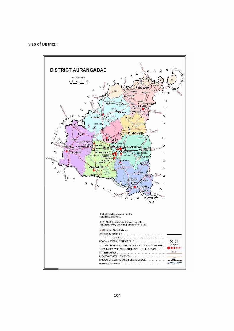
104
Map of District :
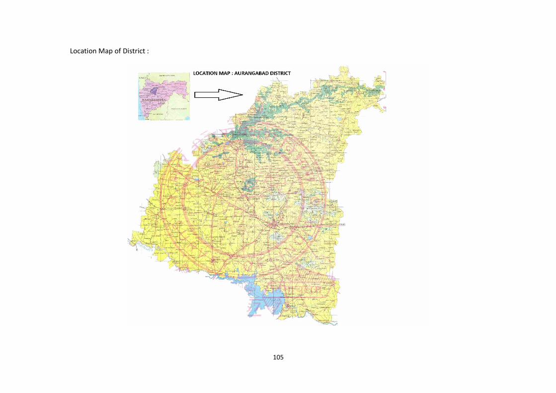
105
Location Map of District :
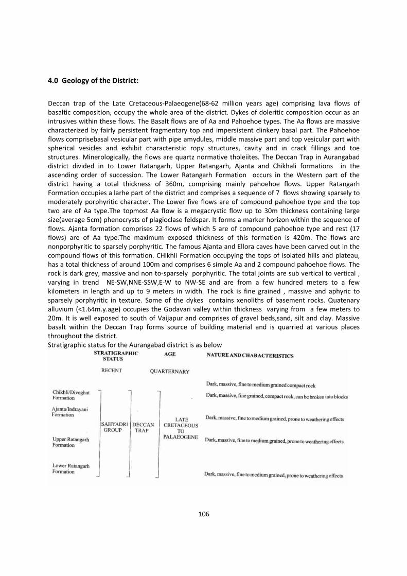
106
4.0 Geology of the District:
Deccan trap of the Late Cretaceous-Palaeogene(68-62 million years age) comprising lava flows of basaltic composition, occupy the whole area of the district. Dykes of doleritic composition occur as an intrusives within these flows. The Basalt flows are of Aa and Pahoehoe types. The Aa flows are massive characterized by fairly persistent fragmentary top and impersistent clinkery basal part. The Pahoehoe flows comprisebasal vesicular part with pipe amydules, middle massive part and top vesicular part with spherical vesicles and exhibit characteristic ropy structures, cavity and in crack fillings and toe structures. Minerologically, the flows are quartz normative tholeiites. The Deccan Trap in Aurangabad district divided in to Lower Ratangarh, Upper Ratangarh, Ajanta and Chikhali formations in the ascending order of succession. The Lower Ratangarh Formation occurs in the Western part of the district having a total thickness of 360m, comprising mainly pahoehoe flows. Upper Ratangarh Formation occupies a larhe part of the district and comprises a sequence of 7 flows showing sparsely to moderately porphyritic character. The Lower five flows are of compound pahoehoe type and the top two are of Aa type.The topmost Aa flow is a megacrystic flow up to 30m thickness containing large size(average 5cm) phenocrysts of plagioclase feldspar. It forms a marker horizon within the sequence of flows. Ajanta formation comprises 22 flows of which 5 are of compound pahoehoe type and rest (17 flows) are of Aa type.The maximum exposed thickness of this formation is 420m. The flows are nonporphyritic to sparsely porphyritic. The famous Ajanta and Ellora caves have been carved out in the compound flows of this formation. CHikhli Formation occupying the tops of isolated hills and plateau, has a total thickness of around 100m and comprises 6 simple Aa and 2 compound pahoehoe flows. The rock is dark grey, massive and non to-sparsely porphyritic. The total joints are sub vertical to vertical , varying in trend NE-SW,NNE-SSW,E-W to NW-SE and are from a few hundred meters to a few kilometers in length and up to 9 meters in width. The rock is fine grained , massive and aphyric to sparsely porphyritic in texture. Some of the dykes contains xenoliths of basement rocks. Quatenary alluvium (<1.64m.y.age) occupies the Godavari valley within thickness varying from a few meters to 20m. It is well exposed to south of Vaijapur and comprises of gravel beds,sand, silt and clay. Massive basalt within the Deccan Trap forms source of building material and is quarried at various places throughout the district. Stratigraphic status for the Aurangabad district is as below
107
Aurangabad district is rich in minor minerals such as building stone and sand. Mining activity is one of the main revenue source for the district. Aurangabad district is rich in minor minerals such as building stone and sand. Mining activity is one of the main revenue source for the district. District has 42 stone quarry leases till March 2021 covering area 74.66ha. There are no nonworking stone quarries within the district as per information recorded in the district mining office in the month of March 2021. (Source info. District Mining Office Aurangabad) There are 47 locations of sand ghats over Purna, Godavari, Khirna nala,Shivnala,Anjana, Girija rivers where sand deposition are allowed from replenishment and other safety point of view in the district. (Source info. District Mining Office, Aurangabad).
Mineral Mineable Reserves in Million Tonnes
Stone 25.08(Approx.)
Sand 0.700(Approx.)
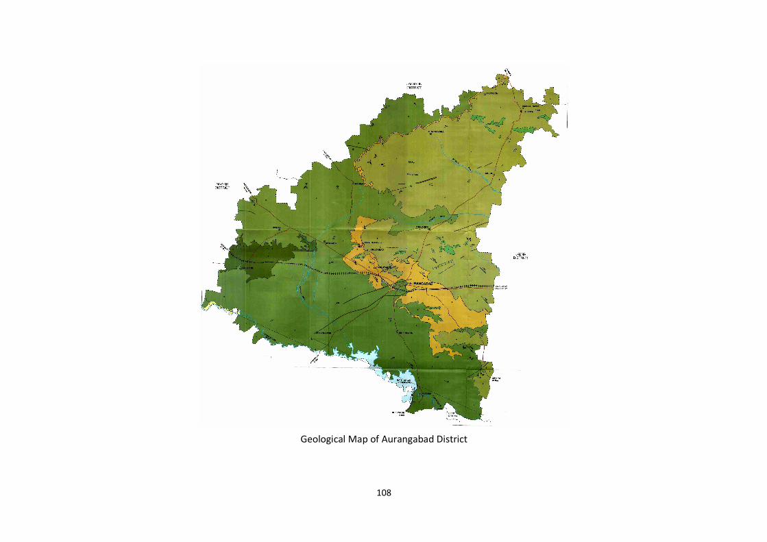
108
Geological Map of Aurangabad District
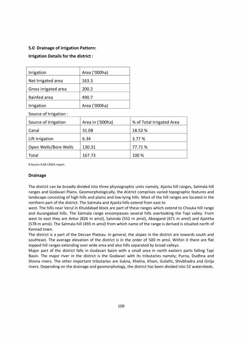
109
5.0 Drainage of irrigation Pattern:
Irrigation Details for the district :
Irrigation Area (‘000ha)
Net Irrigated area 163.3
Gross irrigated area 200.2
Rainfed area 490.7
Irrigation Area (‘000ha)
Source of Irrigation :
Source of Irrigation Area in (‘000ha) % of Total Irrigated Area
Canal 31.08 18.52 %
Lift irrigation 6.34 3.77 %
Open Wells/Bore Wells 130.31 77.71 %
Total 167.73 100 %
# Source ICAR-CRIDA report.
Drainage The district can be broadly divided into three physiographic units namely, Ajanta hill ranges, Satmala hill ranges and Godavari Plains. Geomorphologically, the district comprises varied topographic features and landscape consisting of high hills and plains and low-lying hills. Most of the hill ranges are located in the northern part of the district. The Satmala and Ajanta hills extend from east to west. The hills near Verul in Khuldabad block are part of these ranges which extend to Chouka hill range and Aurangabad hills. The Satmala range encompasses several hills overlooking the Tapi valley. From west to east they are Antur (826 m amsl), Satonda (552 m amsl), Abasgand (671 m amsl) and Ajantha (578 m amsl). The Satmala hill (493 m amsl) from which name of the range is derived is situated north of Kannad town. The district is a part of the Deccan Plateau. In general, the slopes in the district are towards south and southeast. The average elevation of the district is in the order of 500 m amsl. Within it there are flat topped hill ranges extending over wide area and also hills separated by broad valleys. Major part of the district falls in Godavari basin with a small area in north eastern parts falling Tapi Basin. The major river in the district is the Godavari with its tributaries namely; Purna, Dudhna and Shivna rivers. The other important tributaries are Sukna, Khelna, Kham, Gulathi, Shivbhadra and Girija rivers. Depending on the drainage and geomorphology, the district has been divided into 52 watersheds.
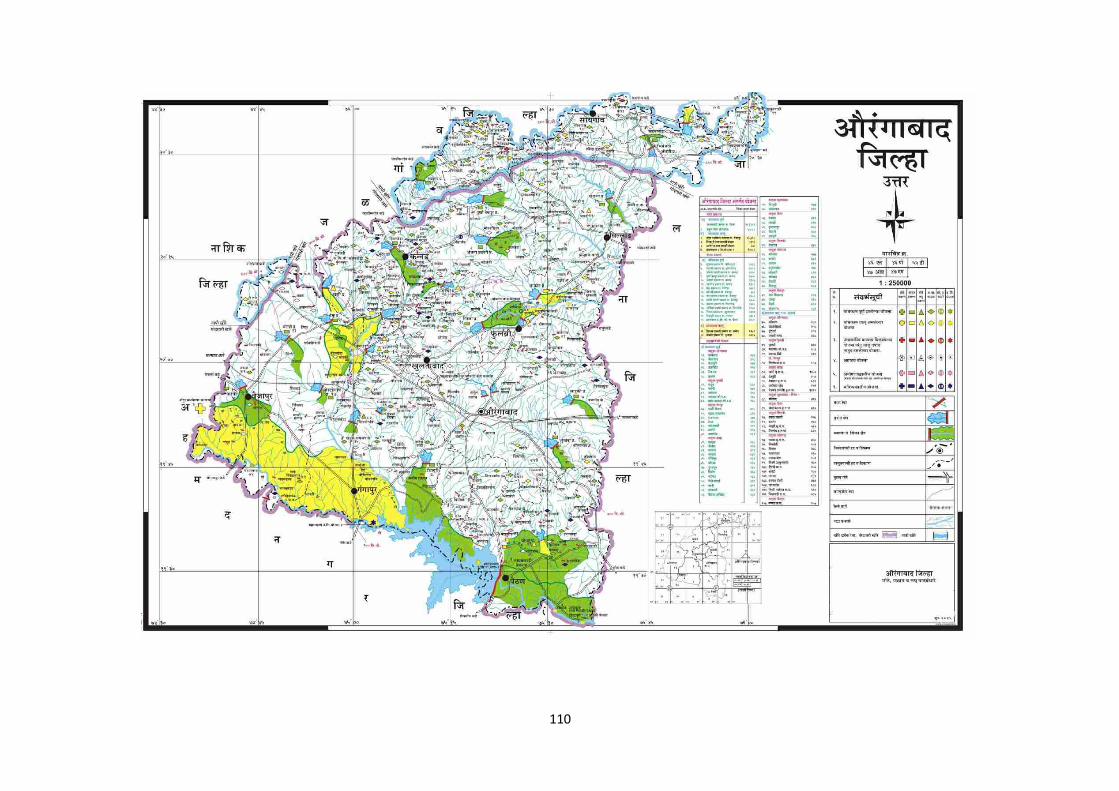
110
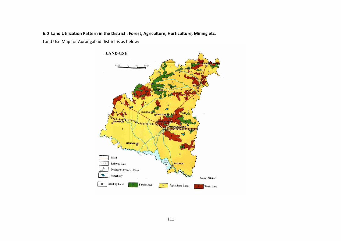
111
6.0 Land Utilization Pattern in the District : Forest, Agriculture, Horticulture, Mining etc.
Land Use Map for Aurangabad district is as below:

112
S.N. DESCRIPTION Area (000Ha.)
1 Cultivable area 812 2 Forest area 72.6 3 Land under agricultureal use 60.5 4 Permanent pastures 37.2 5 Cultivable waste land 15.5 6 Land under miscellaneous tree crops and groves 5.7 7 Barren and uncultivable land 20.7 8 Current fallows 46.6 9 Other fallows 59.0
Irrigation Area (‘000ha)
Net Irrigated area 163.3
Gross irrigated area 200.2
Rainfed area 490.7
Agriculture Crops:
Major field crops
cultivated (Kharif)
Area in (‘000ha) by
Rainfed
Major field crops
cultivated (Rabi)
Area in (‘000ha) by
Irrigation
Cotton 403.4 Cotton --
pearmillete 122.1 pearmillete --
Maize 247.9 Maize --
Pigeon Pea 24.5 Pigeon Pea --
Sorghum 16.0 Sorghum --
Sugarcane 1221.3
Wheat Wheat 79.0
Gram Gram 23.5
Safflower Safflower 7.9
Maize (Rubi) Maize (Rubi) 2.1
Groundnut Groundnut 29.0
Sunflower Sunflower 9.8
# Source Agriculture Plan Aurangabad (ICAR-CRIDA)
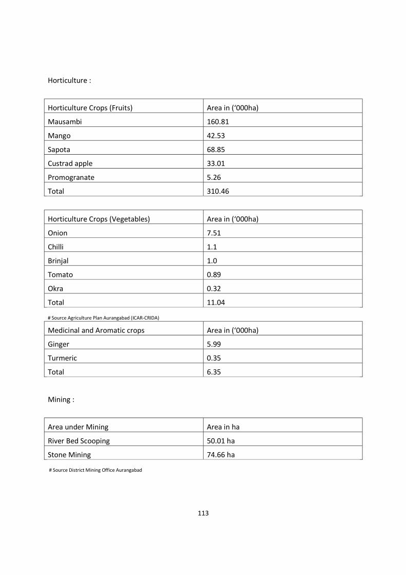
113
Horticulture :
Horticulture Crops (Fruits) Area in (‘000ha)
Mausambi 160.81
Mango 42.53
Sapota 68.85
Custrad apple 33.01
Promogranate 5.26
Total 310.46
Horticulture Crops (Vegetables) Area in (‘000ha)
Onion 7.51
Chilli 1.1
Brinjal 1.0
Tomato 0.89
Okra 0.32
Total 11.04
# Source Agriculture Plan Aurangabad (ICAR-CRIDA)
Medicinal and Aromatic crops Area in (‘000ha)
Ginger 5.99
Turmeric 0.35
Total 6.35
Mining :
Area under Mining Area in ha
River Bed Scooping 50.01 ha
Stone Mining 74.66 ha
# Source District Mining Office Aurangabad
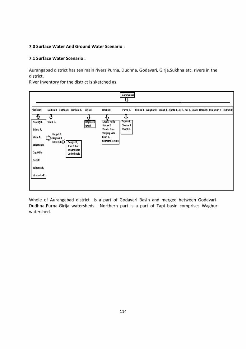
114
7.0 Surface Water And Ground Water Scenario : 7.1 Surface Water Scenario : Aurangabad district has ten main rivers Purna, Dudhna, Godavari, Girja,Sukhna etc. rivers in the district. River Inventory for the district is sketched as
Whole of Aurangabad district is a part of Godavari Basin and merged between Godavari-Dudhna-Purna-Girija watersheds . Northern part is a part of Tapi basin comprises Waghur watershed.
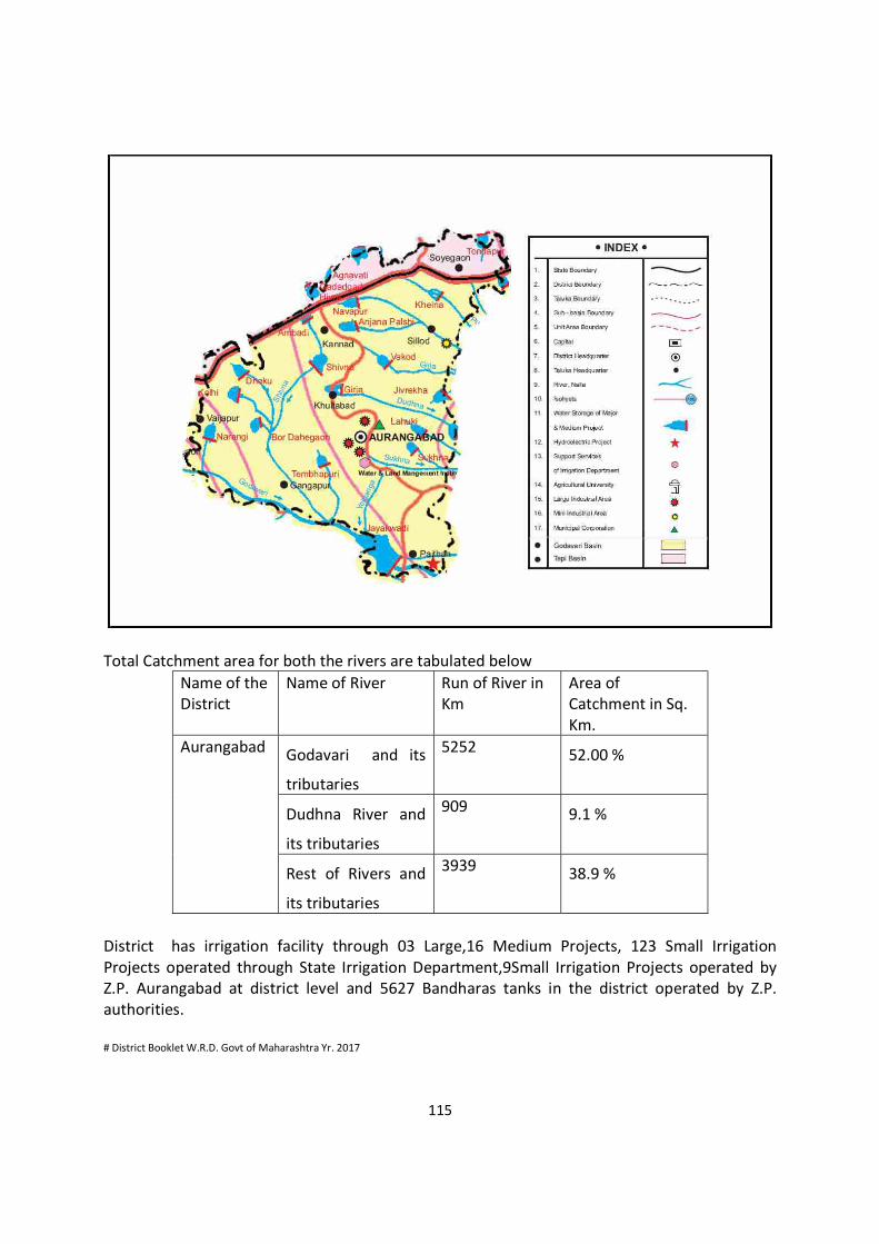
115
Total Catchment area for both the rivers are tabulated below
Name of the District
Name of River Run of River in Km
Area of Catchment in Sq. Km.
Aurangabad
Godavari and its
tributaries
5252 52.00 %
Dudhna River and
its tributaries
909 9.1 %
Rest of Rivers and
its tributaries
3939 38.9 %
District has irrigation facility through 03 Large,16 Medium Projects, 123 Small Irrigation Projects operated through State Irrigation Department,9Small Irrigation Projects operated by Z.P. Aurangabad at district level and 5627 Bandharas tanks in the district operated by Z.P. authorities. # District Booklet W.R.D. Govt of Maharashtra Yr. 2017
116
7.2 Ground Water Scenario : The major part (95%) of the district constitutes a sequence of basaltic lava flows (Deccan Trap) while alluvium occupies a small portion. There are two distinct hydrogeological units in the district i.e. fissured formations (different units of basaltic lava flows) and porous formations (isolated patches of alluvial deposits). The occurrence and movement of ground water is controlled by variation in water bearing properties of these formations. Hydrogeology Deccan traps are a thick pile of basaltic flows, horizontally disposed and apparently more or less uniform in composition. Each individual flow is a typical section, which varies from porous weathered base to a massive middle unit, becoming increasingly vesicular towards the top. The ground water occurs under water table and semi confined to confined conditions in Deccan Trap Basalt. The vesicular units in different trappean flows range in thickness from 2-8 meters and have primary porosity. However, the nature and density of the vesicles, their distribution, interconnection between the vesicles, depth of weathering and topography of the area are the decisive factor for occurrence and movement of ground water in these units. Since the zeolitic units in vesicular traps are highly susceptible to weathering, the vesicular units comprising weathered zeolitic traps occurring in topographic lows are the main water bearing formation in hard rock terrain of the district. In massive unit of Deccan Trap Basalt, ground water occurs in soil cum weathered mantle, joints, cracks and other weaker zones. The upper portion of the massive traps show persistent spheroidal weathering and exfoliation which helps in retaining more ground water in these rocks in comparison to compact massive unit. The storage of ground water in compact massive unit totally depends upon the presence of joints and their nature, distribution and interconnection. The average depth range of dugwells is 12.00 m to 15.00 m and that of borewells is 50.00 to 60.00 m in hard rock areas
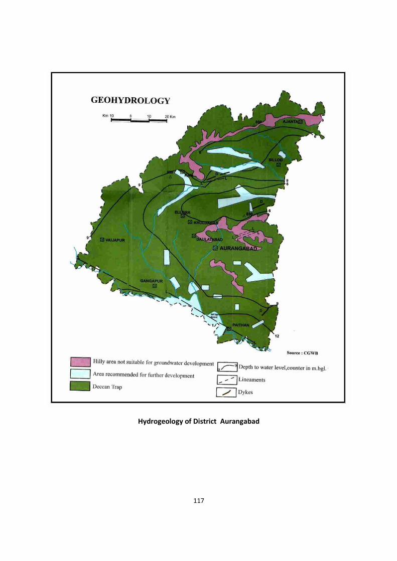
117
Hydrogeology of District Aurangabad
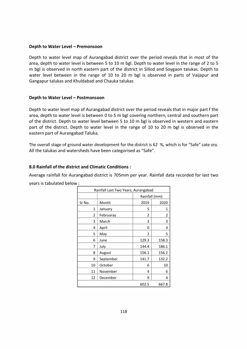
118
Depth to Water Level – Premonsoon Depth to water level map of Aurangabad district over the period reveals that in most of the area, depth to water level is between 5 to 10 m bgl. Depth to water level in the range of 2 to 5 m bgl is observed in north eastern part of the district in Sillod and Soygaon talukas. Depth to water level between in the range of 10 to 20 m bgl is observed in parts of Vaijapur and Gangapur talukas and Khuldabad and Chauka talukas Depth to Water Level – Postmonsoon Depth to water level map of Aurangabad district over the period reveals that in major part f the area, depth to water level is between 0 to 5 m bgl covering northern, central and southern part of the district. Depth to water level between 5 to 10 m bgl is observed in western and eastern part of the district. Depth to water level in the range of 10 to 20 m bgl is observed in the eastern part of Aurangabad Taluka. The overall stage of ground water development for the district is 62 %, which is for “Safe” cate ory. All the talukas and watersheds have been categorised as “Safe”. 8.0 Rainfall of the district and Climatic Conditions :
Average rainfall for Aurangabad district is 705mm per year. Rainfall data recorded for last two
years is tabulated below : Rainfall Last Two Years, Aurangabad
Rainfall (mm)
Sr No. Month 2019 2020
1 January 5 1
2 Februaray 2 2
3 March 3 3
4 April 0 4
5 May 2 5
6 June 129.3 158.3
7 July 144.4 186.1
8 August 156.1 156.2
9 September 141.7 132.2
10 October 6 10
11 November 4 6
12 December 9 4
602.5 667.8

119
The winter season commences towards the end of November when temperatures begin to fall rapidly. December is the coldest month with the mean maximum temperature of 28.9° C, while the mean minimum temperature is 10.3°C. From the beginning of March, the daily temperature increases continuously. May is the hottest month with the mean maximum temperature of 39.8°C and the mean minimum temperature of 24.6° C. With the onset of the south-west monsoon by about the second week of June, the temperature falls appreciably
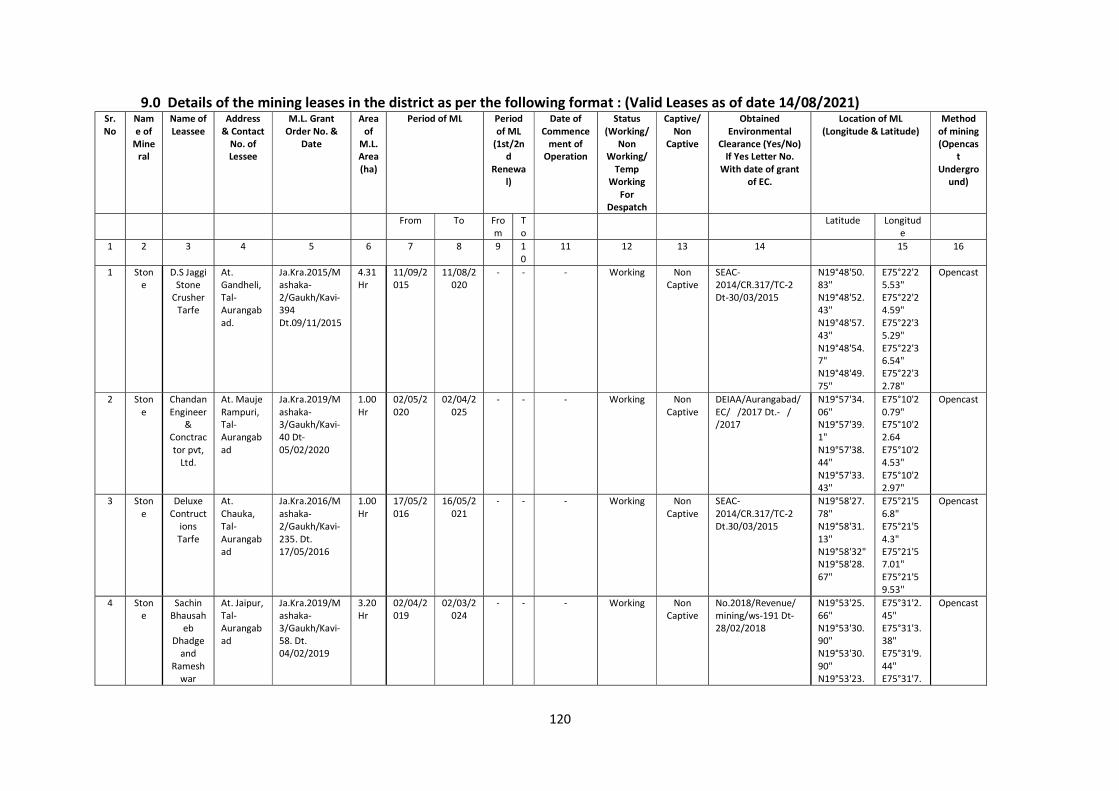
120
9.0 Details of the mining leases in the district as per the following format : (Valid Leases as of date 14/08/2021) Sr.No
Name of
Mineral
Name of Leassee
Address & Contact
No. of Lessee
M.L. Grant Order No. &
Date
Area of
M.L. Area (ha)
Period of ML Period of ML
(1st/2nd
Renewal)
Date of Commence
ment of Operation
Status (Working/
Non Working/
Temp Working
For Despatch
Captive/Non
Captive
Obtained Environmental
Clearance (Yes/No) If Yes Letter No.
With date of grant of EC.
Location of ML (Longitude & Latitude)
Method of mining (Opencas
t Undergro
und)
From To From
To
Latitude Longitude
1 2 3 4 5 6 7 8 9 10
11 12 13 14 15 16
1 Stone
D.S Jaggi Stone
Crusher Tarfe
At. Gandheli, Tal-Aurangabad.
Ja.Kra.2015/Mashaka-2/Gaukh/Kavi-394 Dt.09/11/2015
4.31 Hr
11/09/2015
11/08/2020
- - - Working Non Captive
SEAC-2014/CR.317/TC-2 Dt-30/03/2015
N19°48'50.83" N19°48'52.43" N19°48'57.43" N19°48'54.7" N19°48'49.75"
E75°22'25.53" E75°22'24.59" E75°22'35.29" E75°22'36.54" E75°22'32.78"
Opencast
2 Stone
Chandan Engineer
& Conctractor pvt,
Ltd.
At. Mauje Rampuri, Tal-Aurangabad
Ja.Kra.2019/Mashaka-3/Gaukh/Kavi-40 Dt-05/02/2020
1.00 Hr
02/05/2020
02/04/2025
- - - Working Non Captive
DEIAA/Aurangabad/EC/ /2017 Dt.- / /2017
N19°57'34.06" N19°57'39.1" N19°57'38.44" N19°57'33.43"
E75°10'20.79" E75°10'22.64 E75°10'24.53" E75°10'22.97"
Opencast
3 Stone
Deluxe Contruct
ions Tarfe
At. Chauka, Tal- Aurangabad
Ja.Kra.2016/Mashaka-2/Gaukh/Kavi-235. Dt. 17/05/2016
1.00 Hr
17/05/2016
16/05/2021
- - - Working Non Captive
SEAC-2014/CR.317/TC-2 Dt.30/03/2015
N19°58'27.78" N19°58'31.13" N19°58'32" N19°58'28.67"
E75°21'56.8" E75°21'54.3" E75°21'57.01" E75°21'59.53''
Opencast
4 Stone
Sachin Bhausah
eb Dhadge
and Ramesh
war
At. Jaipur, Tal- Aurangabad
Ja.Kra.2019/Mashaka-3/Gaukh/Kavi-58. Dt. 04/02/2019
3.20 Hr
02/04/2019
02/03/2024
- - - Working Non Captive
No.2018/Revenue/mining/ws-191 Dt-28/02/2018
N19°53'25.66" N19°53'30.90" N19°53'30.90" N19°53'23.
E75°31'2.45" E75°31'3.38" E75°31'9.44" E75°31'7.
Opencast
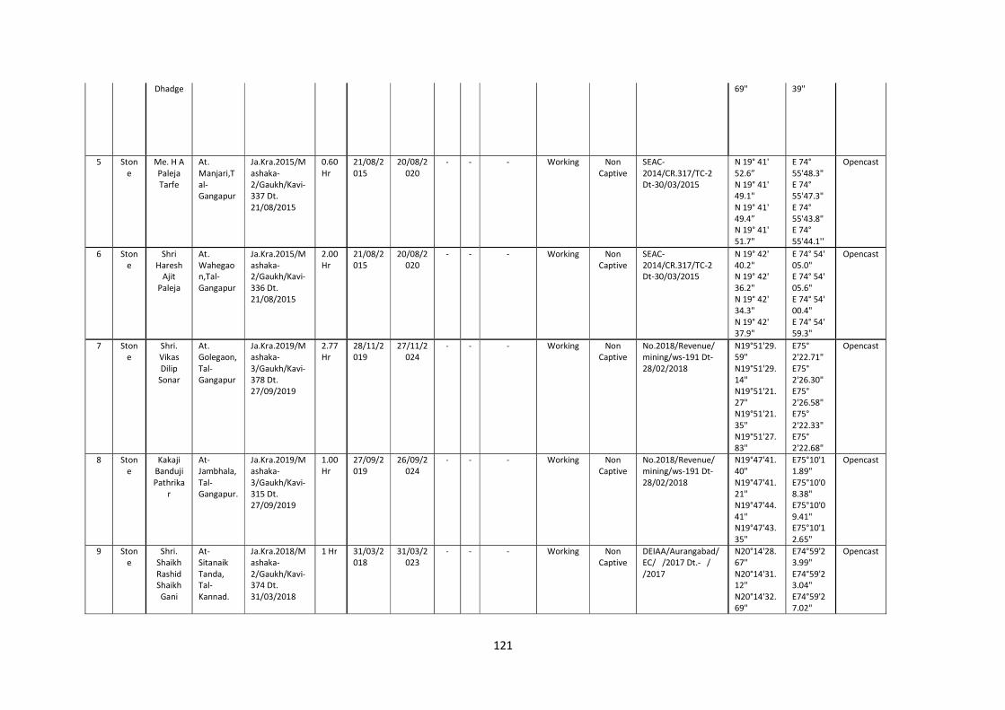
121
Dhadge 69" 39"
5 Stone
Me. H A Paleja Tarfe
At. Manjari,Tal- Gangapur
Ja.Kra.2015/Mashaka-2/Gaukh/Kavi-337 Dt. 21/08/2015
0.60 Hr
21/08/2015
20/08/2020
- - - Working Non Captive
SEAC-2014/CR.317/TC-2 Dt-30/03/2015
N 19° 41' 52.6” N 19° 41' 49.1" N 19° 41' 49.4” N 19° 41' 51.7"
E 74° 55'48.3" E 74° 55'47.3" E 74° 55'43.8" E 74° 55'44.1''
Opencast
6 Stone
Shri Haresh
Ajit Paleja
At. Wahegaon,Tal- Gangapur
Ja.Kra.2015/Mashaka-2/Gaukh/Kavi-336 Dt. 21/08/2015
2.00 Hr
21/08/2015
20/08/2020
- - - Working Non Captive
SEAC-2014/CR.317/TC-2 Dt-30/03/2015
N 19° 42' 40.2" N 19° 42' 36.2" N 19° 42' 34.3" N 19° 42' 37.9"
E 74° 54' 05.0" E 74° 54' 05.6" E 74° 54' 00.4" E 74° 54' 59.3"
Opencast
7 Stone
Shri. Vikas Dilip
Sonar
At. Golegaon, Tal- Gangapur
Ja.Kra.2019/Mashaka-3/Gaukh/Kavi-378 Dt. 27/09/2019
2.77 Hr
28/11/2019
27/11/2024
- - - Working Non Captive
No.2018/Revenue/mining/ws-191 Dt-28/02/2018
N19°51'29.59" N19°51'29.14" N19°51'21.27" N19°51'21.35" N19°51'27.83"
E75° 2'22.71" E75° 2'26.30" E75° 2'26.58" E75° 2'22.33" E75° 2'22.68"
Opencast
8 Stone
Kakaji Banduji Pathrika
r
At- Jambhala, Tal- Gangapur.
Ja.Kra.2019/Mashaka-3/Gaukh/Kavi-315 Dt. 27/09/2019
1.00 Hr
27/09/2019
26/09/2024
- - - Working Non Captive
No.2018/Revenue/mining/ws-191 Dt-28/02/2018
N19°47'41.40" N19°47'41.21" N19°47'44.41" N19°47'43.35"
E75°10'11.89" E75°10'08.38" E75°10'09.41" E75°10'12.65"
Opencast
9 Stone
Shri. Shaikh Rashid Shaikh Gani
At- Sitanaik Tanda, Tal- Kannad.
Ja.Kra.2018/Mashaka-2/Gaukh/Kavi-374 Dt. 31/03/2018
1 Hr 31/03/2018
31/03/2023
- - - Working Non Captive
DEIAA/Aurangabad/EC/ /2017 Dt.- / /2017
N20°14'28.67" N20°14'31.12" N20°14'32.69"
E74°59'23.99" E74°59'23.04" E74°59'27.02"
Opencast
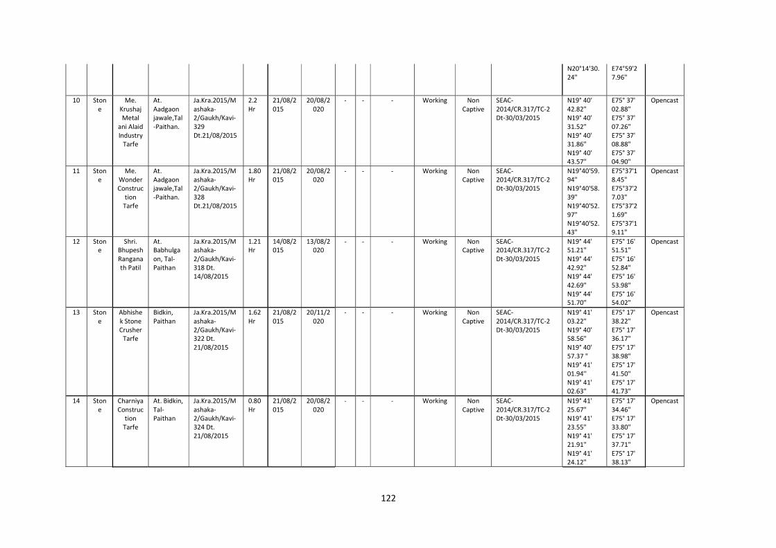
122
N20°14'30.24"
E74°59'27.96''
10 Stone
Me. Krushaj Metal
ani Alaid Industry
Tarfe
At. Aadgaon jawale,Tal-Paithan.
Ja.Kra.2015/Mashaka-2/Gaukh/Kavi-329 Dt.21/08/2015
2.2 Hr
21/08/2015
20/08/2020
- - - Working Non Captive
SEAC-2014/CR.317/TC-2 Dt-30/03/2015
N19° 40' 42.82" N19° 40' 31.52" N19° 40' 31.86" N19° 40' 43.57"
E75° 37' 02.88" E75° 37' 07.26" E75° 37' 08.88" E75° 37' 04.90"
Opencast
11 Stone
Me. Wonder Construc
tion Tarfe
At. Aadgaon jawale,Tal-Paithan.
Ja.Kra.2015/Mashaka-2/Gaukh/Kavi-328 Dt.21/08/2015
1.80 Hr
21/08/2015
20/08/2020
- - - Working Non Captive
SEAC-2014/CR.317/TC-2 Dt-30/03/2015
N19°40'59.94" N19°40'58.39" N19°40'52.97" N19°40'52.43"
E75°37'18.45" E75°37'27.03" E75°37'21.69" E75°37'19.11"
Opencast
12 Stone
Shri. Bhupesh Ranganath Patil
At. Babhulgaon, Tal-Paithan
Ja.Kra.2015/Mashaka-2/Gaukh/Kavi-318 Dt. 14/08/2015
1.21 Hr
14/08/2015
13/08/2020
- - - Working Non Captive
SEAC-2014/CR.317/TC-2 Dt-30/03/2015
N19° 44' 51.21" N19° 44' 42.92" N19° 44' 42.69" N19° 44' 51.70"
E75° 16' 51.51" E75° 16' 52.84" E75° 16' 53.98" E75° 16' 54.02"
Opencast
13 Stone
Abhishek Stone Crusher
Tarfe
Bidkin, Paithan
Ja.Kra.2015/Mashaka-2/Gaukh/Kavi-322 Dt. 21/08/2015
1.62 Hr
21/08/2015
20/11/2020
- - - Working Non Captive
SEAC-2014/CR.317/TC-2 Dt-30/03/2015
N19° 41' 03.22" N19° 40' 58.56" N19° 40' 57.37 " N19° 41' 01.94'' N19° 41' 02.63"
E75° 17' 38.22" E75° 17' 36.17" E75° 17' 38.98" E75° 17' 41.50" E75° 17' 41.73"
Opencast
14 Stone
Charniya Construc
tion Tarfe
At. Bidkin, Tal-Paithan
Ja.Kra.2015/Mashaka-2/Gaukh/Kavi-324 Dt. 21/08/2015
0.80 Hr
21/08/2015
20/08/2020
- - - Working Non Captive
SEAC-2014/CR.317/TC-2 Dt-30/03/2015
N19° 41' 25.67" N19° 41' 23.55" N19° 41' 21.91" N19° 41' 24.12"
E75° 17' 34.46" E75° 17' 33.80" E75° 17' 37.71" E75° 17' 38.13"
Opencast
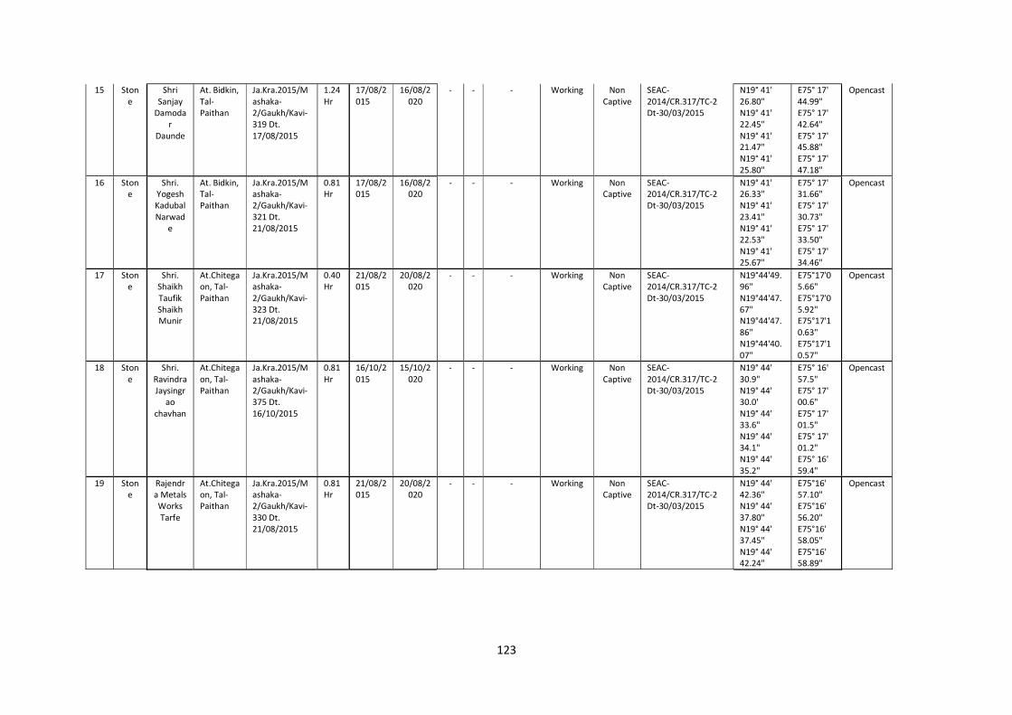
123
15 Stone
Shri Sanjay
Damodar
Daunde
At. Bidkin, Tal-Paithan
Ja.Kra.2015/Mashaka-2/Gaukh/Kavi-319 Dt. 17/08/2015
1.24 Hr
17/08/2015
16/08/2020
- - - Working Non Captive
SEAC-2014/CR.317/TC-2 Dt-30/03/2015
N19° 41' 26.80" N19° 41' 22.45" N19° 41' 21.47" N19° 41' 25.80"
E75° 17' 44.99" E75° 17' 42.64" E75° 17' 45.88" E75° 17' 47.18"
Opencast
16 Stone
Shri. Yogesh Kadubal Narwad
e
At. Bidkin, Tal-Paithan
Ja.Kra.2015/Mashaka-2/Gaukh/Kavi-321 Dt. 21/08/2015
0.81 Hr
17/08/2015
16/08/2020
- - - Working Non Captive
SEAC-2014/CR.317/TC-2 Dt-30/03/2015
N19° 41' 26.33" N19° 41' 23.41" N19° 41' 22.53" N19° 41' 25.67"
E75° 17' 31.66" E75° 17' 30.73" E75° 17' 33.50" E75° 17' 34.46"
Opencast
17 Stone
Shri. Shaikh Taufik Shaikh Munir
At.Chitegaon, Tal-Paithan
Ja.Kra.2015/Mashaka-2/Gaukh/Kavi-323 Dt. 21/08/2015
0.40 Hr
21/08/2015
20/08/2020
- - - Working Non Captive
SEAC-2014/CR.317/TC-2 Dt-30/03/2015
N19°44'49.96" N19°44'47.67" N19°44'47.86" N19°44'40.07"
E75°17'05.66" E75°17'05.92" E75°17'10.63" E75°17'10.57"
Opencast
18 Stone
Shri. Ravindra Jaysingr
ao chavhan
At.Chitegaon, Tal-Paithan
Ja.Kra.2015/Mashaka-2/Gaukh/Kavi-375 Dt. 16/10/2015
0.81 Hr
16/10/2015
15/10/2020
- - - Working Non Captive
SEAC-2014/CR.317/TC-2 Dt-30/03/2015
N19° 44' 30.9" N19° 44' 30.0' N19° 44' 33.6" N19° 44' 34.1" N19° 44' 35.2"
E75° 16' 57.5" E75° 17' 00.6" E75° 17' 01.5" E75° 17' 01.2" E75° 16' 59.4"
Opencast
19 Stone
Rajendra Metals Works Tarfe
At.Chitegaon, Tal-Paithan
Ja.Kra.2015/Mashaka-2/Gaukh/Kavi-330 Dt. 21/08/2015
0.81 Hr
21/08/2015
20/08/2020
- - - Working Non Captive
SEAC-2014/CR.317/TC-2 Dt-30/03/2015
N19° 44' 42.36" N19° 44' 37.80" N19° 44' 37.45" N19° 44' 42.24"
E75°16' 57.10" E75°16' 56.20" E75°16' 58.05" E75°16' 58.89"
Opencast
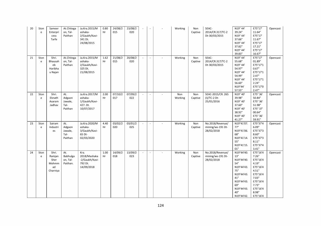
124
20 Stone
Sameer Enterpri
cess Tarfe
At.Chitegaon, Tal-Paithan
Ja.Kra.2015/Mashaka-2/Gaukh/Kavi-341 Dt. 24/08/2015
0.80 Hr
24/08/2015
23/08/2020
- - - Working Non Captive
SEAC-2014/CR.317/TC-2 Dt-30/03/2015
N19° 44' 39.24" N19° 44' 37.66" N19° 44' 37.82" N19° 44' 39.83"
E75°17' 11.64" E75°17' 11.67" E75°17' 17.21" E75°17' 16.67"
Opencast
21 Stone
Shri. Bhausah
eb Haribhau Najan
At.Chitegaon, Tal-Paithan
Ja.Kra.2015/Mashaka-2/Gaukh/Kavi-325 Dt. 21/08/2015
1.62 Hr
21/08/2015
20/08/2020
- - - Working Non Captive
SEAC-2014/CR.317/TC-2 Dt-30/03/2015
N19° 44' 55.68" N19° 44' 54.97" N19° 44' 54.99" N19° 44' 56.60" N19°44' 57.55"
E75°17' 01.89" E75°17'10.67" E75°17'12.47" E75°17'12.24" E75°17'02.47"
Opencast
22 Stone
Shri. Eknath Asaram Jadhav
At. Adgaon Jawale, Tal- Paithan
Ja.Kra.2017/Mashaka-1/Gaukh/Kavi-427. Dt. 10/07/2017
2.00 Hr
07/10/2017
07/09/2022
- - - Non Working
Non Captive
SEAC-2015/CR. 265 (I)/TC-2 Dt- 25/01/2016
N19° 40' 39.98" N19° 40' 37.60" N19° 40' 38.92" N19° 40' 41.27"
E75° 36' 50.84" E75° 36' 51.98" E75° 37' 00.64" E75° 36' 59.91"
Opencast
23 Stone
Sairam Industri
es
At. Adgaon Jawale, Tal- Paithan
Ja.Kra.2020/Mashaka-3/Gaukh/Kavi-65 Dt-02/03/2020
4.40 Hr
03/02/2020
03/01/2025
- - - Working Non Captive
No.2018/Revenue/mining/ws-191 Dt-28/02/2018
N19°41'07.77" N19°41'06.68" N19°41'14.55" N19°41'15.01"
E75°37'46.09" E75°37'38.60" E75°37'38.11" E75°37'43.41"
Opencast
24 Stone
Shri. Ramjan
Sher Mohmm
ad Charniya
At. Babhulgaon, Tal- Paithan.
Kra. 2018/Mashaka-2/Gaukh/Kavi-792 Dt. 14/09/2018
1.00 Hr
14/09/2018
13/09/2023
- - - Working Non Captive
No.2018/Revenue/mining/ws-191 Dt-28/02/2018
N19°44'40.13" N19°44'40.54" N19°44'43.75" N19°44'43.41" N19°44'43.69" N19°44'43.40" N19°44'42.
E75°16'47.26" E75°16'44.19" E75°16'44.51" E75°16'47.03" E75°16'47.73" E75°16'48.98" E75°16'4
Opencast
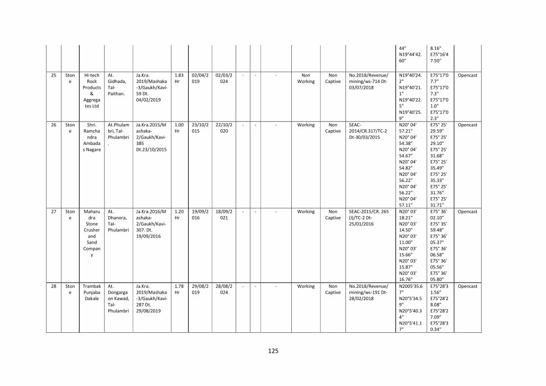
125
44" N19°44'42.60"
8.16" E75°16'47.50"
25 Stone
Hi-tech Rock
Products &
Aggregates Ltd
At. Gidhada, Tal- Paithan.
Ja.Kra. 2019/Mashaka-3/Gaukh/Kavi-59 Dt. 04/02/2019
1.83 Hr
02/04/2019
02/03/2024
- - - Non Working
Non Captive
No.2018/Revenue/mining/ws-714 Dt-03/07/2018
N19°40'24.2" N19°40'21.1" N19°40'22.5" N19°40'25.9"
E75°17'07.7" E75°17'07.3" E75°17'01.0" E75°17'02.3"
Opencast
26 Stone
Shri. Ramcha
ndra Ambadas Nagare
At.Phulambri, Tal-Phulambri.
Ja.Kra.2015/Mashaka-2/Gaukh/Kavi-385 Dt.23/10/2015
1.00 Hr
23/10/2015
22/10/2020
- - - Working Non Captive
SEAC-2014/CR.317/TC-2 Dt-30/03/2015
N20° 04' 57.21" N20° 04' 54.38" N20° 04' 54.67" N20° 04' 54.82" N20° 04' 56.22" N20° 04' 56.22" N20° 04' 57.11"
E75° 25' 29.59" E75° 25' 29.10" E75° 25' 31.68" E75° 25' 35.49" E75° 25' 35.33" E75° 25' 31.76" E75° 25' 31.71"
Opencast
27 Stone
Maharudra
Stone Crusher
and Sand
Company
At. Dhanora, Tal- Phulambri
Ja.Kra.2016/Mashaka-2/Gaukh/Kavi-307. Dt. 19/09/2016
1.20 Hr
19/09/2016
18/09/2021
- - - Working Non Captive
SEAC-2015/CR. 265 (I)/TC-2 Dt- 25/01/2016
N20° 03' 18.21" N20° 03' 14.50" N20° 03' 11.00" N20° 03' 15.66" N20° 03' 15.87" N20° 03' 16.76"
E75° 36' 02.10" E75° 35' 59.48" E75° 36' 05.37" E75° 36' 06.58" E75° 36' 05.56" E75° 36' 05.80"
Opencast
28 Stone
Trambak Punjaba Dakale
At. Dongargaon Kawad, Tal-Phulambri
Ja.Kra. 2019/Mashaka-3/Gaukh/Kavi-287 Dt. 29/08/2019
1.78 Hr
29/08/2019
28/08/2024
- - - Working Non Captive
No.2018/Revenue/mining/ws-191 Dt-28/02/2018
N2005'35.67" N20°5'34.59" N20°5'40.34" N20°5'41.17"
E75°28'31.56" E75°28'28.08" E75°28'27.09" E75°28'30.34"
Opencast
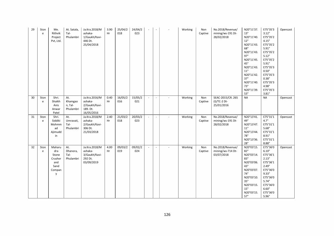
126
29 Stone
Me. Rithvik Project Pvt, Ltd.
At. Satala, Tal-Phulambri
Ja.Kra.2018/Mashaka-1/Gaukh/Kavi-446 Dt. 25/04/2018
3.90 Hr
25/04/2018
24/04/2023
- - - Working Non Captive
No.2018/Revenue/mining/ws-191 Dt-28/02/2018
N20°11'37.13" N20°11'40.12" N20°11'43.68" N20°11'43.97" N20°11'45.45" N20°11'43.11" N20°11'42.37" N20°11'40.73" N20°11'39.53"
E75°35'33.12" E75°35'24.15" E75°35'25.91" E75°35'25.12" E75°35'25.91" E75°35'30.50" E75°35'30.38" E75°35'34.98" E75°35'33.81"
Opencast
30 Stone
Shri. Shaikh
Anis Anwar Patel
At. Khamgaon, Tal- Phulambri
Ja.Kra.2016/Mashaka-2/Gaukh/Kavi-189. Dt. 16/05/2016
0.40 Hr
16/05/2016
15/05/2021
- - - Working Non Captive
SEAC-2015/CR. 265 (I)/TC-2 Dt- 25/01/2016
NA NA Opencast
31 Stone
Shri. Siddiki
Mohmmad
Ajimuddin
At. Umravati, Tal- Phulambri
Ja.Kra.2018/Mashaka-2/Gaukh/Kavi-306 Dt. 21/03/2018
2.40 Hr
21/03/2018
20/03/2023
- - - Working Non Captive
No.2018/Revenue/mining/ws-191 Dt-28/02/2018
N20°13'41.49" N20°13'47.11" N20°13'44.78" N20°13'36.28"
E75°31'14.7" E75°31'15.68" E75°31'18.91" E75°31'18.88"
Opencast
32 Stone
Maharudra
Stone Crusher
and Sand
Company
At. Dhanora, Tal- Phulambri
Ja.Kra.2018/Mashaka-3/Gaukh/Kavi-292 Dt. 03/09/2019
4.00 Hr
09/03/2019
09/02/2024
- - - Working Non Captive
No.2018/Revenue/mining/ws-714 Dt-03/07/2018
N20°03'15.82" N20°03'14.83" N20°03'06.43" N20°03'07.74" N20°03'10.35" N20°03'15.15" N20°03'15.57"
E75°36'06.10" E75°36'12.13" E75°36'12.49" E75°36'09.33" E75°36'05.74" E75°36'06.60" E75°36'05.96"
Opencast
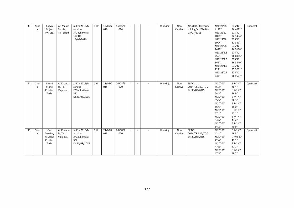
127
33 Stone
Rutvik Project Pvt, Ltd.
At. Mauje Sarola, Tal- Sillod.
Ja.Kra.2019/Mashaka-3/Gaukh/Kavi-177 Dt. 15/05/2019
3 Hr 15/05/2019
15/05/2024
- - - Working Non Captive
No.2018/Revenue/mining/ws-714 Dt-03/07/2018
N20°22'58.4142'' N20°22'57.4801" N20°22'58.1904" N20°22'58.7449" N20°23'5.3656" N20°23'2.9662" N20°23'1.2727" N20°23'0.7533"
E75°42' 36.4082" E75°42' 32.1494" E75°42' 32.321" E75°42' 26.5138" E75°42' 36.0885" E75°42' 36.3449" E75°42' 35.3281" E75°42' 36.9657"
Opencast
34 Stone
Laxmi Stone
Crusher Tarfe
At.Khandala, Tal-Vaijapur.
Ja.Kra.2015/Mashaka-2/Gaukh/Kavi-331 Dt.21/08/2015
1 Hr 21/08/2015
20/08/2020
- - - Working Non Captive
SEAC-2014/CR.317/TC-2 Dt-30/03/2015
N 20° 01' 55.2" N 20° 01' 54.3" N 20° 01' 55.5" N 20° 01' 56.6" N 20° 01' 57.1" N 20° 01' 54.6" N 20° 01' 54.2"
E 74° 47' 40.4" E 74° 47' 36.9" E 74° 47' 36.3" E 74° 47' 39.0" E 74° 47' 42.1" E 74° 47' 43.2" E 74° 47' 40.9"
Opencast
35 Stone
Om Dakshayni Stone Crusher
Tarfe
At.Khandala, Tal-Vaijapur.
Ja.Kra.2015/Mashaka-2/Gaukh/Kavi-332 Dt.21/08/2015
1 Hr 21/08/2015
20/08/2020
- - - Working Non Captive
SEAC-2014/CR.317/TC-2 Dt-30/03/2015
N 20° 01' 42.1" N 20° 01' 42.4" N 20° 01' 47.8" N 20° 01' 47.5"
E 74° 47' 49.3" E 740 47' 47.1" E 74° 47' 47.7" E 74° 47' 49.7"
Opencast
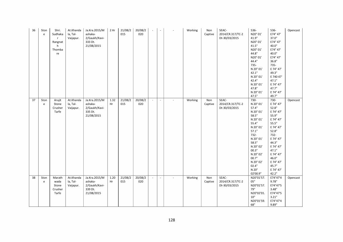
128
36 Stone
Shri. Sudhaka
r Rangnat
h Thomba
re
At.Khandala, Tal-Vaijapur.
Ja.Kra.2015/Mashaka-2/Gaukh/Kavi-333 Dt. 21/08/2015
2 Hr 21/08/2015
20/08/2020
- - - Working Non Captive
SEAC-2014/CR.317/TC-2 Dt-30/03/2015
536- N20° 01' 41.9" N20° 01' 41.5" N20° 01' 44.8" N20° 01' 44.4" 735- N 20° 01' 42.1" N 20° 01' 42.4" N 20° 01' 47.8" N 20° 01' 47.5"
536- E74° 47' 37.0" E74° 47' 40.0" E74° 47' 40.0" E74° 47' 36.8" 735- E 74° 47' 49.3" E 740 47' 47.1" E 74° 47' 47.7" E 74° 47' 49.7"
Opencast
37 Stone
Arujit Stone
Crusher Tarfe
At.Khandala, Tal-Vaijapur.
Ja.Kra.2015/Mashaka-2/Gaukh/Kavi-335 Dt. 21/08/2015
1.32 Hr
21/08/2015
20/08/2020
- - - Working Non Captive
SEAC-2014/CR.317/TC-2 Dt-30/03/2015
730- N 20° 01' 57.4" N 20° 01' 58.5" N 20° 01' 55.4" N 20° 01' 57.1" 732- N 20° 01' 58.5" N 20° 02' 00.3" N 20° 02' 00.7" N 20° 02' 02.4" N 20° 02'00.9"
730- E 74° 47' 52.8" E 74° 47' 55.9" E 74° 47' 55.5" E 74° 47' 52.8" 732- E 74° 47' 44.3" E 74° 47' 47.1" E 74° 47' 46.0" E 74° 47' 45.7" E 74° 47' 42.2"
Opencast
38 Stone
Marathwada Stone
Crusher Tarfe
At.Khandala, Tal-Vaijapur.
Ja.Kra.2015/Mashaka-2/Gaukh/Kavi-339 Dt. 21/08/2015
1.20 Hr
21/08/2015
20/08/2020
- - - Working Non Captive
SEAC-2014/CR.317/TC-2 Dt-30/03/2015
N20°01'57.05" N20°01'57.79" N20°02'01.10" N20°01'59.68"
E74°47'49.78" E74°47'53.48" E74°47'53.21" E74°47'49.89"
Opencast
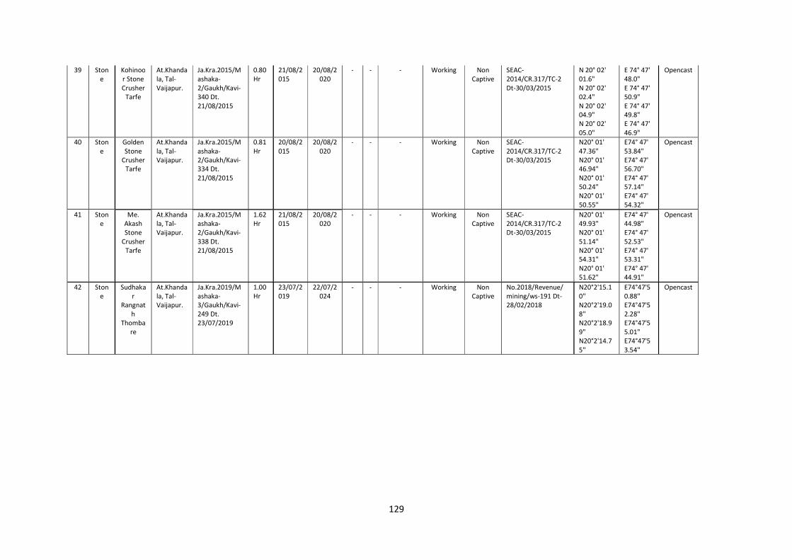
129
39 Stone
Kohinoor Stone Crusher
Tarfe
At.Khandala, Tal-Vaijapur.
Ja.Kra.2015/Mashaka-2/Gaukh/Kavi-340 Dt. 21/08/2015
0.80 Hr
21/08/2015
20/08/2020
- - - Working Non Captive
SEAC-2014/CR.317/TC-2 Dt-30/03/2015
N 20° 02' 01.6" N 20° 02' 02.4" N 20° 02' 04.9" N 20° 02' 05.0"
E 74° 47' 48.0" E 74° 47' 50.9" E 74° 47' 49.8" E 74° 47' 46.9"
Opencast
40 Stone
Golden Stone
Crusher Tarfe
At.Khandala, Tal-Vaijapur.
Ja.Kra.2015/Mashaka-2/Gaukh/Kavi-334 Dt. 21/08/2015
0.81 Hr
20/08/2015
20/08/2020
- - - Working Non Captive
SEAC-2014/CR.317/TC-2 Dt-30/03/2015
N20° 01' 47.36" N20° 01' 46.94" N20° 01' 50.24" N20° 01' 50.55"
E74° 47' 53.84" E74° 47' 56.70" E74° 47' 57.14" E74° 47' 54.32"
Opencast
41 Stone
Me. Akash Stone
Crusher Tarfe
At.Khandala, Tal-Vaijapur.
Ja.Kra.2015/Mashaka-2/Gaukh/Kavi-338 Dt. 21/08/2015
1.62 Hr
21/08/2015
20/08/2020
- - - Working Non Captive
SEAC-2014/CR.317/TC-2 Dt-30/03/2015
N20° 01' 49.93" N20° 01' 51.14" N20° 01' 54.31" N20° 01' 51.62"
E74° 47' 44.98" E74° 47' 52.53" E74° 47' 53.31" E74° 47' 44.91"
Opencast
42 Stone
Sudhakar
Rangnath
Thombare
At.Khandala, Tal-Vaijapur.
Ja.Kra.2019/Mashaka-3/Gaukh/Kavi-249 Dt. 23/07/2019
1.00 Hr
23/07/2019
22/07/2024
- - - Working Non Captive
No.2018/Revenue/mining/ws-191 Dt-28/02/2018
N20°2'15.10'' N20°2'19.08'' N20°2'18.99" N20°2'14.75''
E74°47'50.88'' E74°47'52.28'' E74°47'55.01" E74°47'53.54''
Opencast
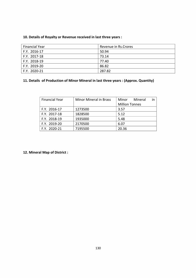
130
10. Details of Royalty or Revenue received in last three years : Financial Year Revenue in Rs.Crores F.Y. 2016-17 50.94 F.Y. 2017-18 73.14 F.Y. 2018-19 77.40 F.Y. 2019-20 86.82 F.Y. 2020-21 287.82 11. Details of Production of Minor Mineral in last three years : (Approx. Quantity)
Financial Year Minor Mineral in Brass Minor Mineral in Million Tonnes
F.Y. 2016-17 1273500 3.57 F.Y. 2017-18 1828500 5.12 F.Y. 2018-19 1935000 5.48 F.Y. 2019-20 2170500 6.07 F.Y. 2020-21 7195500 20.36
12. Mineral Map of District :

131
Mineral Map of District

132
13. List of Letter of Intent (LOI)Holders in the district along with its validity as per following format:
Sr.No Name of Mineral
Name of Leassee in english
Name of Leassee in marathi Address Taluka Private/ Gov
Gut No
Area Of M.L To be allotted
Use Captive/Non
Captive
1 Stone/Murum swati stone crusher tarphe sachin atmaram palskar
वाती टोन शर तफ ी स चन आ माराम पळसकर
Palsi Aurangabad Private 150 4.07 Non Captive
2 Stone/Murum balaji stone crusher tarphe bharat sudamrao pawar
बालाजी टोन शर तफ ी. भरत सदुामराव पवार
Ekod Aurangabad Private 15/2 1.00
Non Captive
3 Stone/Murum progresiv civil constuction compani pvt ltd tarphe
chandrabhan maruti abhang
ो े स ह सि हल कं शन कंपनी ा. ल. तफ चं भान मा ती अभगं .
Jalgaon feran
Aurangabad Private 22 1.98
Non Captive
4 Stone/Murum riyal stone crusher tarphe
amarjyot khan abdul jalik khan रयल टोन शर तफ अम योत खान अ दलु ज लल खान
Rahalpatti tanda
Aurangabad Private 79 2.58
Non Captive
5 Stone/Murum suprime citiskap developers pvt ltd tarphe abdul vakil abdul bari
kureshi
मे.सपुर म सट कप डे हलपस ा. ल. तफ ी.अ दलु वक ल अ दलु बार कुरेशी
Rahalpatti tanda
Aurangabad Private 79 2.68 Non Captive
6 Stone/Murum riyal stone crusher रयल टोन शर Rahalpatti
tanda Aurangabad Private 78 2.58
Non Captive
7 Stone/Murum vyanktesh stone मे. यंकटेश टोन Naigaon Aurangabad Private 89 3.70 Non Captive
8 Stone/Murum disha blakkor mining मे. दशा लॅककोर माय नगं Naigaon Aurangabad Private 89 3.45 Non Captive
9 Stone/Murum rilaybal stone crushing industri
tarphe khan mohamad ali emran
मे. रलायबल टोन शींग इंड तफ ी.खान मोहमद अल इमरान
Palsi Aurangabad Private 171 2.00 Non Captive
10 Stone/Murum city buildcon मे. सट ब डकॉन Ladsavngi Aurangabad Private 147 1.60 Non Captive
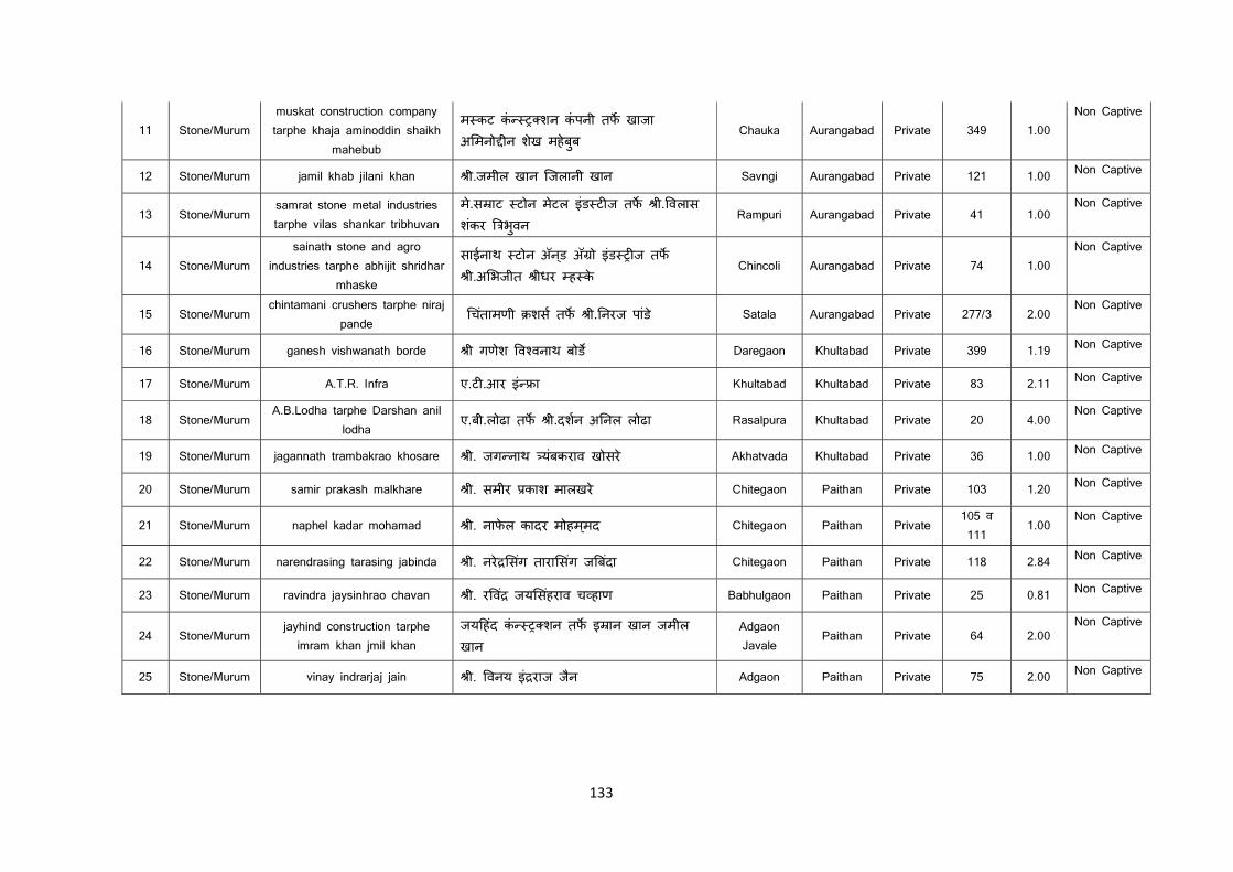
133
11 Stone/Murum muskat construction company tarphe khaja aminoddin shaikh
mahebub
म कट कं शन कंपनी तफ खाजा अ मनो ीन शेख महेबुब
Chauka Aurangabad Private 349 1.00 Non Captive
12 Stone/Murum jamil khab jilani khan ी.जमील खान िजलानी खान Savngi Aurangabad Private 121 1.00 Non Captive
13 Stone/Murum samrat stone metal industries tarphe vilas shankar tribhuvan
मे.स ाट टोन मेटल इंड ट ज तफ ी. वलास शकंर भवुन
Rampuri Aurangabad Private 41 1.00 Non Captive
14 Stone/Murum sainath stone and agro
industries tarphe abhijit shridhar mhaske
साईनाथ टोन अॅनड् अॅ ो इंड ज तफ ी.अ भजीत ीधर ह के
Chincoli Aurangabad Private 74 1.00 Non Captive
15 Stone/Murum chintamani crushers tarphe niraj
pande चतंामणी शस तफ ी. नरज पांड े Satala Aurangabad Private 277/3 2.00
Non Captive
16 Stone/Murum ganesh vishwanath borde ी गणेश व वनाथ बोड Daregaon Khultabad Private 399 1.19 Non Captive
17 Stone/Murum A.T.R. Infra ए.ट .आर इं ा Khultabad Khultabad Private 83 2.11 Non Captive
18 Stone/Murum A.B.Lodha tarphe Darshan anil
lodha ए.बी.लोढा तफ ी.दशन अ नल लोढा Rasalpura Khultabad Private 20 4.00
Non Captive
19 Stone/Murum jagannath trambakrao khosare ी. जग नाथ यबंकराव खोसरे Akhatvada Khultabad Private 36 1.00 Non Captive
20 Stone/Murum samir prakash malkhare ी. समीर काश मालखरे Chitegaon Paithan Private 103 1.20 Non Captive
21 Stone/Murum naphel kadar mohamad ी. नाफेल कादर मोहमम्द Chitegaon Paithan Private 105 व 111
1.00 Non Captive
22 Stone/Murum narendrasing tarasing jabinda ी. नरे सगं तारा सगं ज बदंा Chitegaon Paithan Private 118 2.84 Non Captive
23 Stone/Murum ravindra jaysinhrao chavan ी. र वं जय सहंराव च हाण Babhulgaon Paithan Private 25 0.81 Non Captive
24 Stone/Murum jayhind construction tarphe
imram khan jmil khan जय हदं कं शन तफ इ ान खान जमील खान
Adgaon Javale
Paithan Private 64 2.00 Non Captive
25 Stone/Murum vinay indrarjaj jain ी. वनय इं राज जनै Adgaon Paithan Private 75 2.00 Non Captive
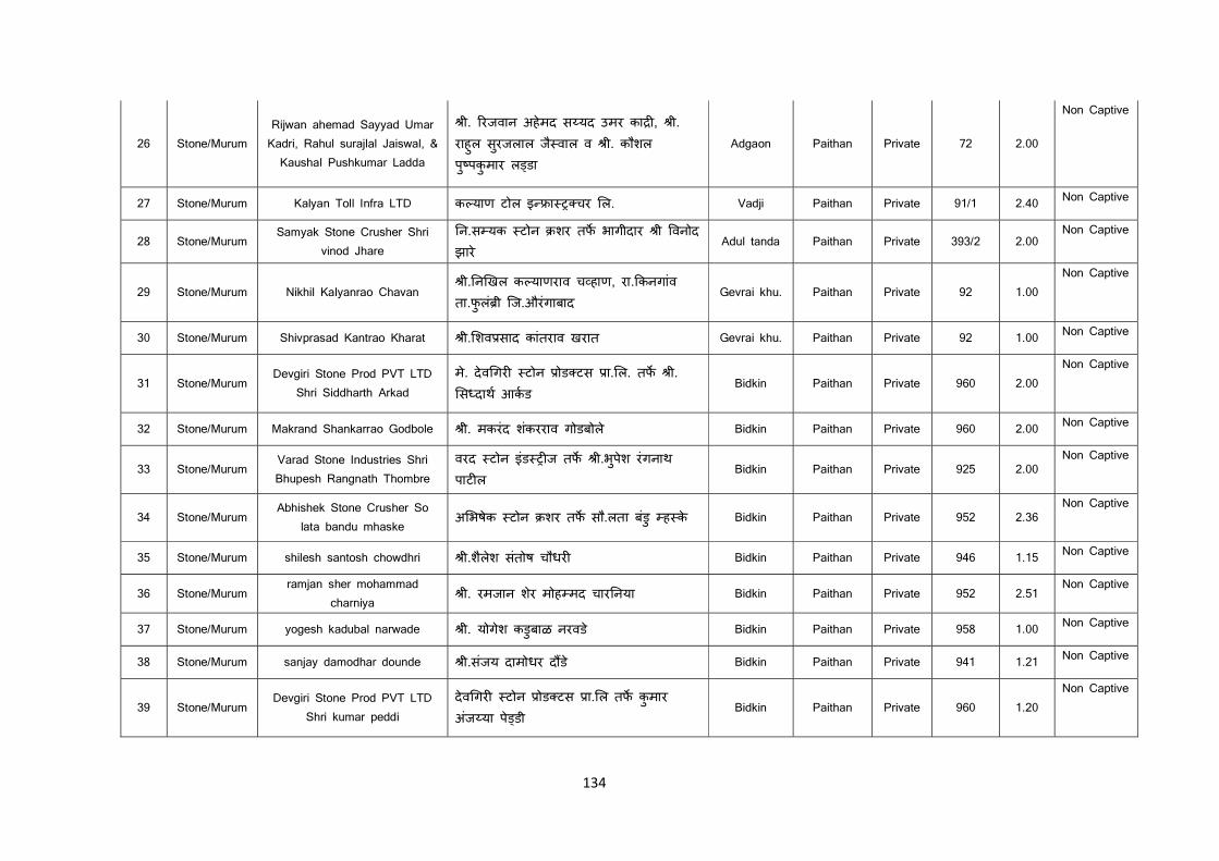
134
26 Stone/Murum Rijwan ahemad Sayyad Umar Kadri, Rahul surajlal Jaiswal, &
Kaushal Pushkumar Ladda
ी. रजवान अहेमद स यद उमर का , ी. राहुल सरुजलाल जै वाल व ी. कौशल पु पकुमार ल डा
Adgaon Paithan Private 72 2.00
Non Captive
27 Stone/Murum Kalyan Toll Infra LTD क याण टोल इ ा चर ल. Vadji Paithan Private 91/1 2.40 Non Captive
28 Stone/Murum Samyak Stone Crusher Shri
vinod Jhare न.स यक टोन शर तफ भागीदार ी वनोद झारे
Adul tanda Paithan Private 393/2 2.00 Non Captive
29 Stone/Murum Nikhil Kalyanrao Chavan ी. न खल क याणराव च हाण, रा. कनगांव
ता.फुलं ी िज.औरंगाबाद Gevrai khu. Paithan Private 92 1.00
Non Captive
30 Stone/Murum Shivprasad Kantrao Kharat ी. शव साद कांतराव खरात Gevrai khu. Paithan Private 92 1.00 Non Captive
31 Stone/Murum Devgiri Stone Prod PVT LTD
Shri Siddharth Arkad मे. देव गर टोन ोड टस ा. ल. तफ ी. स दाथ आकड
Bidkin Paithan Private 960 2.00 Non Captive
32 Stone/Murum Makrand Shankarrao Godbole ी. मकरंद शकंरराव गोडबोले Bidkin Paithan Private 960 2.00 Non Captive
33 Stone/Murum Varad Stone Industries Shri Bhupesh Rangnath Thombre
वरद टोन इंड ज तफ ी.भपेुश रंगनाथ पाट ल
Bidkin Paithan Private 925 2.00 Non Captive
34 Stone/Murum Abhishek Stone Crusher So
lata bandu mhaske अ भषेक टोन शर तफ सौ.लता बडुं ह के Bidkin Paithan Private 952 2.36
Non Captive
35 Stone/Murum shilesh santosh chowdhri ी.शैलेश संतोष चौधर Bidkin Paithan Private 946 1.15 Non Captive
36 Stone/Murum ramjan sher mohammad
charniya ी. रमजान शरे मोह मद चार नया Bidkin Paithan Private 952 2.51
Non Captive
37 Stone/Murum yogesh kadubal narwade ी. योगेश कडुबाळ नरवडे Bidkin Paithan Private 958 1.00 Non Captive
38 Stone/Murum sanjay damodhar dounde ी.संजय दामोधर द डे Bidkin Paithan Private 941 1.21 Non Captive
39 Stone/Murum Devgiri Stone Prod PVT LTD
Shri kumar peddi देव गर टोन ोड टस ा. ल तफ कुमार अजं या पे डी
Bidkin Paithan Private 960 1.20 Non Captive
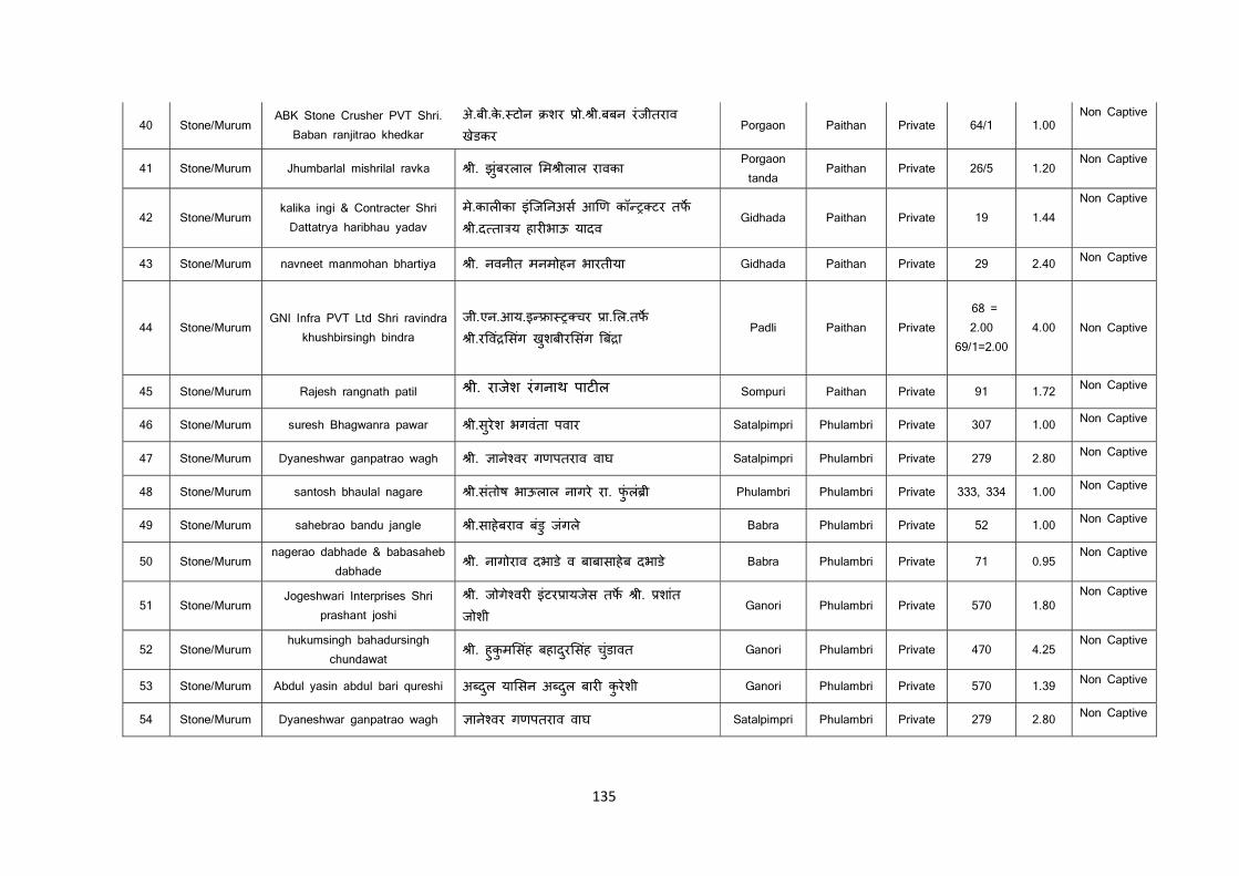
135
40 Stone/Murum ABK Stone Crusher PVT Shri.
Baban ranjitrao khedkar अे.बी.के. टोन शर ो. ी.बबन रंजीतराव खेडकर
Porgaon Paithan Private 64/1 1.00 Non Captive
41 Stone/Murum Jhumbarlal mishrilal ravka ी. झंुबरलाल म ीलाल रावका Porgaon tanda
Paithan Private 26/5 1.20 Non Captive
42 Stone/Murum kalika ingi & Contracter Shri Dattatrya haribhau yadav
मे.काल का इंिज नअस आ ण कॉ टर तफ ी.द ता य हार भाऊ यादव
Gidhada Paithan Private 19 1.44 Non Captive
43 Stone/Murum navneet manmohan bhartiya ी. नवनीत मनमोहन भारतीया Gidhada Paithan Private 29 2.40 Non Captive
44 Stone/Murum GNI Infra PVT Ltd Shri ravindra
khushbirsingh bindra जी.एन.आय.इ ा चर ा. ल.तफ ी.र वं सगं खुशबीर सगं बं ा
Padli Paithan Private 68 = 2.00
69/1=2.00 4.00 Non Captive
45 Stone/Murum Rajesh rangnath patil ी. राजेश रंगनाथ पाट ल Sompuri Paithan Private 91 1.72 Non Captive
46 Stone/Murum suresh Bhagwanra pawar ी.सुरेश भगवंता पवार Satalpimpri Phulambri Private 307 1.00 Non Captive
47 Stone/Murum Dyaneshwar ganpatrao wagh ी. ाने वर गणपतराव वाघ Satalpimpri Phulambri Private 279 2.80 Non Captive
48 Stone/Murum santosh bhaulal nagare ी.संतोष भाऊलाल नागरे रा. फंुलं ी Phulambri Phulambri Private 333, 334 1.00 Non Captive
49 Stone/Murum sahebrao bandu jangle ी.साहेबराव बडुं जंगले Babra Phulambri Private 52 1.00 Non Captive
50 Stone/Murum nagerao dabhade & babasaheb
dabhade ी. नागोराव दभाडे व बाबासाहेब दभाडे Babra Phulambri Private 71 0.95
Non Captive
51 Stone/Murum Jogeshwari Interprises Shri
prashant joshi ी. जोगे वर इंटर ायजेस तफ ी. शांत
जोशी Ganori Phulambri Private 570 1.80
Non Captive
52 Stone/Murum hukumsingh bahadursingh
chundawat ी. हुकुम सहं बहादरु सहं चुडंावत Ganori Phulambri Private 470 4.25
Non Captive
53 Stone/Murum Abdul yasin abdul bari qureshi अ दलु या सन अ दलु बार कुरेशी Ganori Phulambri Private 570 1.39 Non Captive
54 Stone/Murum Dyaneshwar ganpatrao wagh ाने वर गणपतराव वाघ Satalpimpri Phulambri Private 279 2.80 Non Captive
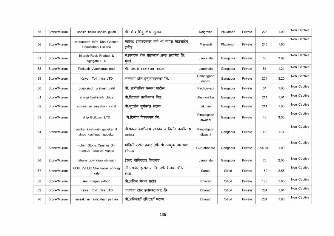
136
55 Stone/Murum shaikh bhiku shaikh gulab ी. शेख भकु शखे गलुाब Naigavan Phulambri Private 228 1.00 Non Captive
56 Stone/Murum maharudra Infra Shri Ganesh
Bhausaheb Ukkirde महा इं ा चर तफ ी गणेश भाऊसाहेब उक ड े
Marsavli Phulambri Private 245 1.60 Non Captive
57 Stone/Murum hi-tech Rock Product &
Agrigate LTD मे.हायटेक रॉक ोड टस अॅ ड अ ीगेट ल. मुबंई
Jambhala Gangapur Private 56 2.92 Non Captive
58 Stone/Murum Prakash Vyankatrao patil ी. काश यकंटराव पाट ल Jambhala Gangapur Private 51 1.21 Non Captive
59 Stone/Murum Kalyan Toll Infra LTD क याण टोल इन ् ा चर ल. Ranjangaon
nahari Gangapur Private 204 3.20
Non Captive
60 Stone/Murum prajotsingh prakash patil ी. जोत सह काश पाट ल Pachpirvadi Gangapur Private 64 1.00 Non Captive
61 Stone/Murum shivaji kashinath chide ी. शवाजी का शनाथ चडे Dhamori bu. Gangapur Private 211 1.01 Non Captive
62 Stone/Murum sudarshan suryakant saraf ी.सुदशन सयुकांत सराफ Jikthan Gangapur Private 214 1.00 Non Captive
63 Stone/Murum dilip Buildcon LTD मे. दल प ब डकॉन ल. Pimpalgaon diwashi
Gangapur Private 46 3.53 Non Captive
64 Stone/Murum pankaj kashinath gadekar & vinod kashinath gadekar
ी.पंकज काशीनाथ गाडेकर व वनोद काशीनाथ गाडेकर
Pimpalgaon diwashi
Gangapur Private 46 1.74 Non Captive
65 Stone/Murum mohini Stone Crusher Shri mansuk narayan kopnar
मो हनी टोन शर तफ ी.मनसकु नारायण कोपनर
Gurudhanora Gangapur Private 81/1/क 1.00 Non Captive
66 Stone/Murum Ishwar govindrao shirsath ई वर गो वदंराव शरसाठ Jambhala Gangapur Private 76 2.00 Non Captive
67 Stone/Murum GSK Pvt.Ltd Shri kailas shrirag
kale जी.एस.के. इ ा ा. ल. तफ कैलास ीरंग काळे
Sarola Sillod Private 159 2.55 Non Captive
68 Stone/Murum Anil magan rathod ी.अ नल मगन राठोड Bhavan Sillod Private 186 1.60 Non Captive
69 Stone/Murum Kalyan Toll Infra LTD क याण टोल इ ा चर ल. Bharadi Sillod Private 284 1.61 Non Captive
70 Stone/Murum anisakhan rashdkhan pathan ी.अ नसखॉ ंर शदखॉ ंपठाण Bharadi Sillod Private 284 1.80 Non Captive
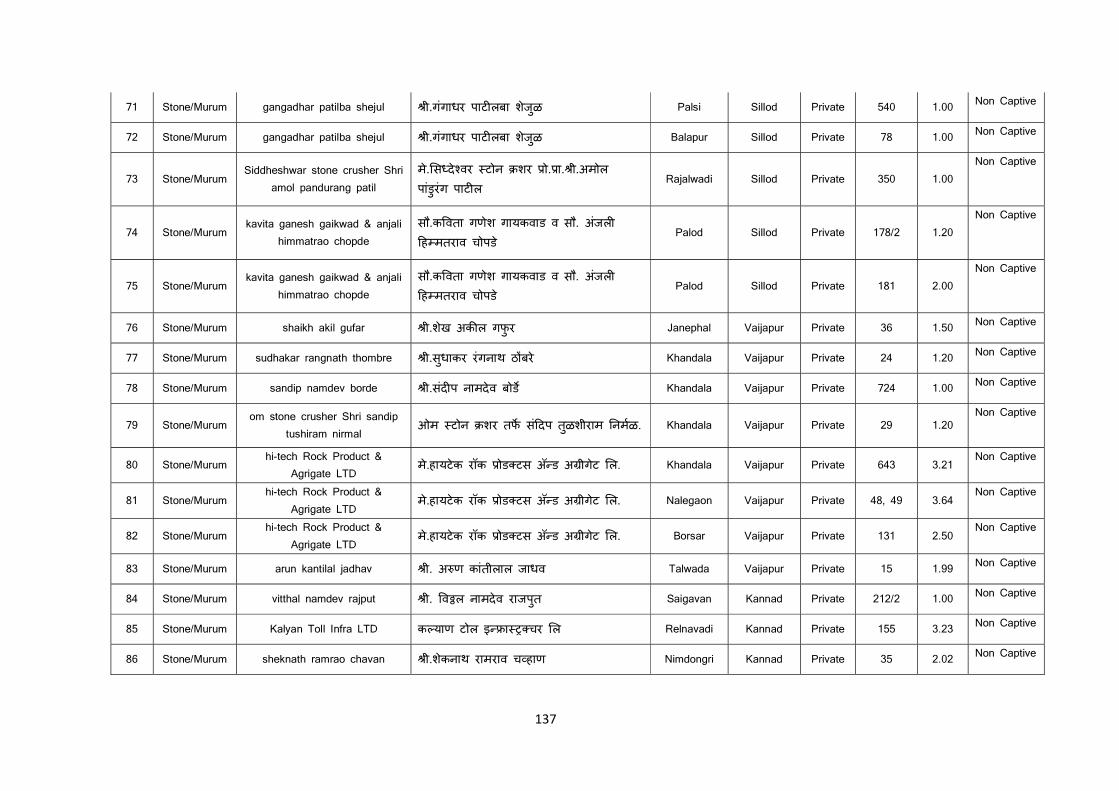
137
71 Stone/Murum gangadhar patilba shejul ी.गंगाधर पाट लबा शेजळु Palsi Sillod Private 540 1.00 Non Captive
72 Stone/Murum gangadhar patilba shejul ी.गंगाधर पाट लबा शेजळु Balapur Sillod Private 78 1.00 Non Captive
73 Stone/Murum Siddheshwar stone crusher Shri
amol pandurang patil मे. स दे वर टोन शर ो. ा. ी.अमोल पांडुरंग पाट ल
Rajalwadi Sillod Private 350 1.00 Non Captive
74 Stone/Murum kavita ganesh gaikwad & anjali
himmatrao chopde सौ.क वता गणेश गायकवाड व सौ. अजंल ह मतराव चोपड े
Palod Sillod Private 178/2 1.20 Non Captive
75 Stone/Murum kavita ganesh gaikwad & anjali
himmatrao chopde सौ.क वता गणेश गायकवाड व सौ. अजंल ह मतराव चोपड े
Palod Sillod Private 181 2.00 Non Captive
76 Stone/Murum shaikh akil gufar ी.शेख अक ल गफुर Janephal Vaijapur Private 36 1.50 Non Captive
77 Stone/Murum sudhakar rangnath thombre ी.सुधाकर रंगनाथ ठ बरे Khandala Vaijapur Private 24 1.20 Non Captive
78 Stone/Murum sandip namdev borde ी.संद प नामदेव बोड Khandala Vaijapur Private 724 1.00 Non Captive
79 Stone/Murum om stone crusher Shri sandip
tushiram nirmal ओम टोन शर तफ सं दप तळुशीराम नमळ. Khandala Vaijapur Private 29 1.20
Non Captive
80 Stone/Murum hi-tech Rock Product &
Agrigate LTD मे.हायटेक रॉक ोड टस अॅ ड अ ीगेट ल. Khandala Vaijapur Private 643 3.21
Non Captive
81 Stone/Murum hi-tech Rock Product &
Agrigate LTD मे.हायटेक रॉक ोड टस अॅ ड अ ीगेट ल. Nalegaon Vaijapur Private 48, 49 3.64
Non Captive
82 Stone/Murum hi-tech Rock Product &
Agrigate LTD मे.हायटेक रॉक ोड टस अॅ ड अ ीगेट ल. Borsar Vaijapur Private 131 2.50
Non Captive
83 Stone/Murum arun kantilal jadhav ी. अ ण कांतीलाल जाधव Talwada Vaijapur Private 15 1.99 Non Captive
84 Stone/Murum vitthal namdev rajput ी. व ल नामदेव राजपुत Saigavan Kannad Private 212/2 1.00 Non Captive
85 Stone/Murum Kalyan Toll Infra LTD क याण टोल इ ा चर ल Relnavadi Kannad Private 155 3.23 Non Captive
86 Stone/Murum sheknath ramrao chavan ी.शेकनाथ रामराव च हाण Nimdongri Kannad Private 35 2.02 Non Captive
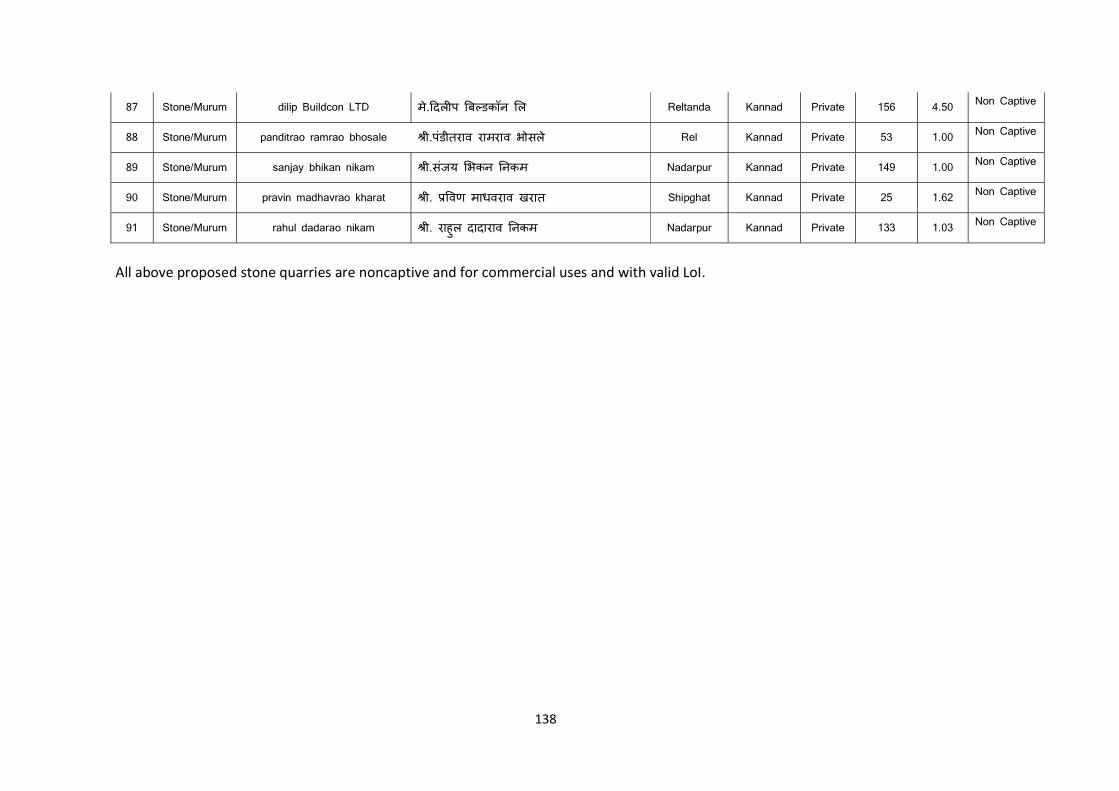
138
87 Stone/Murum dilip Buildcon LTD मे. दल प ब डकॉन ल Reltanda Kannad Private 156 4.50 Non Captive
88 Stone/Murum panditrao ramrao bhosale ी.पंडीतराव रामराव भोसले Rel Kannad Private 53 1.00 Non Captive
89 Stone/Murum sanjay bhikan nikam ी.संजय भकन नकम Nadarpur Kannad Private 149 1.00 Non Captive
90 Stone/Murum pravin madhavrao kharat ी. वण माधवराव खरात Shipghat Kannad Private 25 1.62 Non Captive
91 Stone/Murum rahul dadarao nikam ी. राहुल दादाराव नकम Nadarpur Kannad Private 133 1.03 Non Captive
All above proposed stone quarries are noncaptive and for commercial uses and with valid LoI.
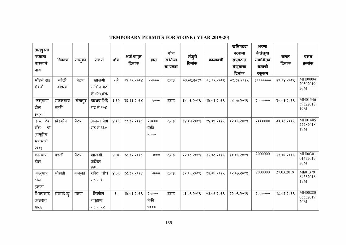
139
TEMPORARY PERMITS FOR STONE ( YEAR 2019-20)
तात ् पुरता परवाना धारकाच े
नांव
ठकाण तालुका गट न ं े अज ाप ् त
दनांक ास
गौण
ख नजाचा कार
मंजुर
दनांक कालावधी
ख नपटटा परवाना संपूष ् ठात
येण ् याचा दनांक
भरणा केलेल ् या स ् वा मत ् वधनाची रक् कम
चलन
दनांक
चलन
मांक
मॉडन रोड
मेकस
कोळी बोडखा
पैठण खाजगी ज मन गट
नं ४२५,४२६
२ हे ०५.०९.२०१८ २५००० दगउ ०३.०९.२०१९ ०३.०९.२०१९ ०१.१२.२०१९ १००००००० २९.०४.२०१९ MH000942050201920M
कल ् याण
टोल
इन ् ा
राजनगाव
नहर
गगंापुर उदधव शदें
गट नं २०४
३.१२ २६.११.२०१८ ५००० दगड १४.०६.२०१९ १४.०६.२०१९ ०४.०७.२०१९ २०००००० २०.०३.२०१९ MH013465932201819M
हाय टेक
रॉक ो (राष ् य
महामाग
२११)
बडक न पैठण अजंया पेडी गट नं ९६०
४.१६ ११.१२.२०१८ २५०००
पैक
५०००
दगड १४.०५.२०१९ १४.०५.२०१९ ०२.०६.२०१९ २०००००० ३०.०३.२०१९ MH014052228201819M
कल ् याण
टोल
वडजी पैठण खाजगी ज मन
99/1
४.५१ १८.१२.२०१८ ५००० दगड २२.०८.२०१९ २२.०८.२०१९ १०.०९.२०१९ 2000000 २१.०६.२०१९ MH003010147201920M
कल ् याण
टोल
इन ् ा
मोहाडी कन ् नड र व चौध े
गट नं १
४.३६ १८.१२.२०१८ ५००० दगड १२.०६.२०१९ १२.०६.२०१९ ०२.०७.२०१९ 2000000 27.03.2019 Mh013798435201819M
शव साद
ांतराव
खरात
गेवराई खु पैठण नखील
चव ् हाण
गट नं ९२
१. १४.०१.२०१९ २५०००पैक
५०००
दगड ०३.०९.२०१९ ०३.०९.२०१९ २२.०९.२०१९ २०००००० १८.०६.२०१९ MH002800553201920M
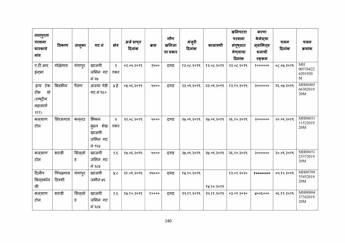
140
तात ् पुरता परवाना धारकाच े
नांव
ठकाण तालुका गट न ं े अज ाप ् त
दनांक ास
गौण
ख नजाचा कार
मंजुर
दनांक कालावधी
ख नपटटा परवाना संपूष ् ठात
येण ् याचा दनांक
भरणा केलेल ् या स ् वा मत ् वधनाची रक् कम
चलन
दनांक
चलन
मांक
ए.ट .आर
इंन ् ा गोळेगाव गगंापुर खाजगी
ज मन गट
नं २७
२
एकर
०२.०५.२०१९ २५०० दगड १३.०८.२०१९ १३.०८.२०१९ २२.०८.२०१९ १०००००० ०८.०७.२०१९ MH 003764226201920M
हाय टेक
रॉक ो (राष ् य
महामाग
२११)
बडक न पैठण अजंया पेडी गट नं ९६०
४ हे ०४.०६.२०१९ ५००० दगड २३.०९.२०१९ २३.०९.२०१९ १२.१०.२०१९ २०००००० १६.०७.२०१९ MH004056630201920M
कल ् याण
टोल
सरसगाव कन ् नउ भकन
बुढन शखे
खाजगी ज मन गट
नं १६४
२
एकर
२२.०८.२०१९ ५००० दगड २७.०९.२०१९ २७.०९.२०१९ २६.१०.२०१९ २०००००० २०.०९.२०१९ MH006511152201920M
कल ् याण
टोल
भराडी सल ् लोड
खाजगी ज मन गट
नं २८४
१.६ १७.०६.२०१९ ५००० दगड २७.०९.२०१९ २७.०९.२०१९ २६.१०.२०१९ २०००००० २०.०९.२०१९ MH006512537201920M
दल प
बल ् डकॉन
ल
पपंळगाव
दवशी गगंापुर खाजगी
जमीन ४६
४.८ २१.०९.२०१९ २५००० दगड १४.१०.२०१९
१४.१०.२०१९
१३.०१.२०२० १००००००० ०५.१०.२०१९ MH007095545201920M
कल ् याण
टोल
भराडी सल ् लोड
खाजगी ज मन गट
नं २८४
१.६ १७.१०.२०१९ १०००० दगड २५.११.२०१९ २५.११.२०१९ ०३.०१.२०२० ४००६००० ०६.११.२०१९ MH008043734201920M
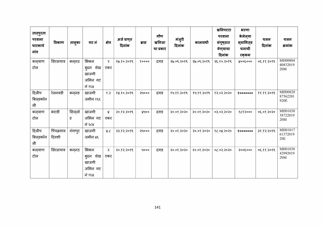
141
तात ् पुरता परवाना धारकाच े
नांव
ठकाण तालुका गट न ं े अज ाप ् त
दनांक ास
गौण
ख नजाचा कार
मंजुर
दनांक कालावधी
ख नपटटा परवाना संपूष ् ठात
येण ् याचा दनांक
भरणा केलेल ् या स ् वा मत ् वधनाची रक् कम
चलन
दनांक
चलन
मांक
कल ् याण
टोल
सरसगाव कन ् नउ भकन
बुढन शखे
खाजगी ज मन गट
नं १६४
२
एकर
१७.१०.२०१९ १०००० दगड २७.०९.२०१९ २७.०९.२०१९ २६.१०.२०१९ ४००६००० ०६.११.२०१९ MH008044083201920M
दल प
बल ् डकॉन
ल
रेलनवडी कन ् नड खाजगी जमीन १६६
१.२ १४.१०.२०१९ २५००० दगड १५.११.२०१९ १५.११.२०१९ १२.०२.२०२० १००००००० ११.११.२०१९ MH0082087562201920E
कल ् याण
टोल
भराडी सल ् लोड
खाजगी ज मन गट
नं २८४
४
एकर
२०.१२.२०१९ ४५०० दगड २०.०१.२०२० २०.०१.२०२० ०३.०२.२०२० १८१२००० ०६.०१.२०२० MH010383872201920M
दल प
बल ् डकॉन
ल
पपंळगाव
दवशी गगंापुर खाजगी
जमीन ४६
४.८ २३.१२.२०१९ २५००० दगड २०.०१.२०२० २०.०१.२०२० १८.०४.२०२० १००००००० ३१.१२.२०१९ MH010176137201920E
कल ् याण
टोल
सरसगाव कन ् नउ भकन
बुढन शखे
खाजगी ज मन गट
नं १६४
२
एकर
२०.१२.२०१९ ५००० दगड २०.०१.२०२० २०.०१.२०२० ०८.०२.२०२० २००६००० ०६.११.२०१९ MH010384299201920M
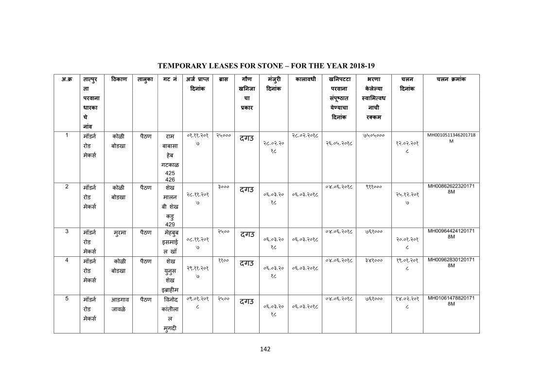
142
TEMPORARY LEASES FOR STONE – FOR THE YEAR 2018-19
अ. ता पुरता परवाना धारकाचे नांव
ठकाण तालकुा गट नं अज ा त दनांक
ास गौण ख नजाचा कार
मजंरु
दनांक
कालावधी ख नपटटा परवाना सपंू ठात ये याचा दनांक
भरणा केले या वा म वधनाची र कम
चलन दनांक
चलन मांक
1 मॉडन
रोड मेकस
कोळी बोडखा
पैठण राम
बाबासाहेब
गटकाळ 425 426
01.11.2017
25000 दगउ 28.02.20
18
28.02.2018 26.05.2018
7505000 12.02.201
8
MH0010511346201718M
2 मॉडन
रोड मेकस
कोळी बोडखा
पैठण शेख
मालनबी शेख कडु 429
28.11.201
7
3000 दगउ 06.03.20
18
06.03.2018
04.06.2018 911000 25.12.201
7
MH008626223201718M
3 मॉडन
रोड मेकस
मरुमा पैठण मेहबुब इसमाईल खॉ
08.11.201
7
2500 दगउ 06.03.20
18
06.03.2018
04.06.2018 761000 20.01.201
8
MH009644241201718M
4 मॉडन
रोड मेकस
कोळी बोडखा
पैठण शेख युनसु शेख
इ ाह म
29.11.201
7
1100 दगउ 06.03.20
18
06.03.2018
04.06.2018 341000 19.01.2018
MH009628301201718M
5 मॉडन
रोड मेकस
आडगाव जावळे
पैठण वनोद कांतीला
ल मगुद
09.01.2018
2500 दगउ 06.03.20
18
06.03.2018
04.06.2018 761000 14.02.2018
MH010614788201718M
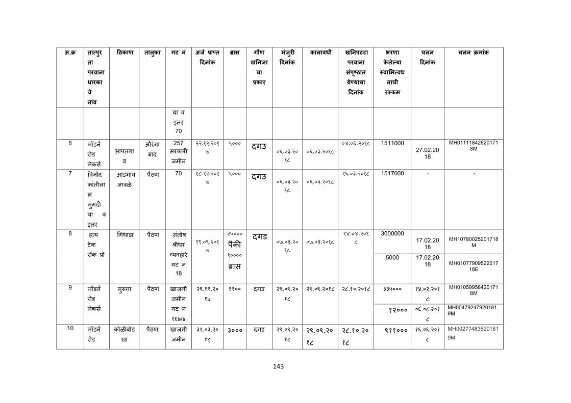
143
अ. ता पुरता परवाना धारकाचे नांव
ठकाण तालकुा गट नं अज ा त दनांक
ास गौण ख नजाचा कार
मजंरु
दनांक
कालावधी ख नपटटा परवाना सपंू ठात ये याचा दनांक
भरणा केले या वा म वधनाची र कम
चलन दनांक
चलन मांक
या व इतर 70
6 मॉडन
रोड मेकस
आपतगाव
औरंगाबाद
257
सरकार जमीन
22.12.2017
5000 दगउ 06.03.20
18
06.03.2018
04.06.2018 1511000 27.02.20
18
MH011118426201718M
7 वनोद
कांतीलाल मगुदया व इतर
आडगाव जावळे
पैठण 70 18.12.2017
5000 दगउ 06.03.20
18
06.03.2018
16.03.2018 1517000 - -
8 हाय टेक रॉक ो
गधाडा पैठण सतंोष ीधर
यवहारे गट न ं
18
19.09.201
7
25000
पैक 10000
ास
दगड 07.03.20
18
07.03.2018
14.04.2018
3000000 17.02.20
18
MH10780025201718
M
5000 17.02.2018
MH01077909522017
18E
9 मॉडन
रोड मेकस
मु मा पैठण खाजगी जमीन गट न ं१६७/४
२९.११.२०१७
११०० दगउ २९.०९.२०१८
२९.०९.२०१८ २८.१०.२०१८ ३३५००० १४.०२.२०१८
MH010599584201718M
१२००० ०६.०८.२०१८
MH004792479201819M
10 मॉडन
रोड कोळीबोड
खा पैठण खाजगी
जमीन ३१.०३.२०
१८
३००० दगड २९.०९.२०१८
२९.०९.२०१८
२८.१०.२०१८
९११००० १६.०६.२०१८
MH002774835201819M
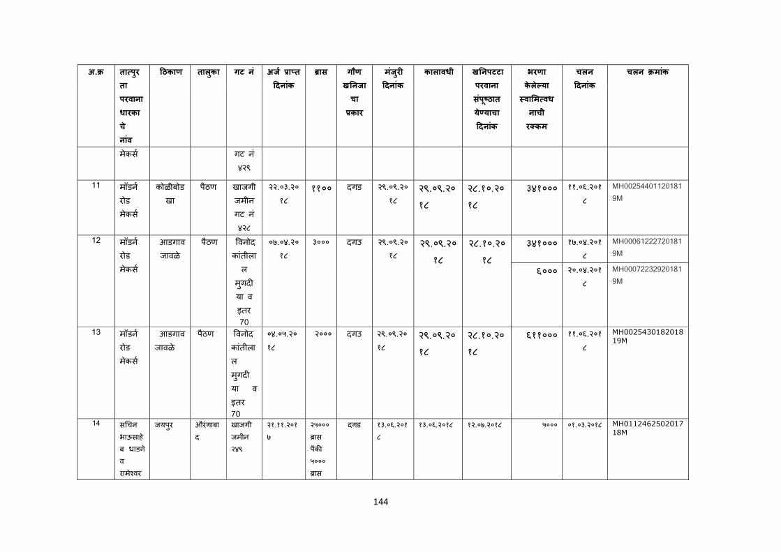
144
अ. ता पुरता परवाना धारकाचे नांव
ठकाण तालकुा गट नं अज ा त दनांक
ास गौण ख नजाचा कार
मजंरु
दनांक
कालावधी ख नपटटा परवाना सपंू ठात ये याचा दनांक
भरणा केले या वा म वधनाची र कम
चलन दनांक
चलन मांक
मेकस गट न ं४२९
11 मॉडन
रोड मेकस
कोळीबोडखा
पैठण खाजगी जमीन गट न ं४२८
२२.०३.२०१८
११०० दगड २९.०९.२०१८
२९.०९.२०१८
२८.१०.२०१८
३४१००० ११.०६.२०१८
MH002544011201819M
12 मॉडन
रोड मेकस
आडगाव जावळे
पैठण वनोद कांतीला
ल मगुदया व इतर 70
०७.०४.२०१८
३००० दगउ २९.०९.२०१८
२९.०९.२०१८
२८.१०.२०१८
३४१००० १७.०४.२०१८
MH000612227201819M
६००० २०.०४.२०१८
MH000722329201819M
13 मॉडन रोड मेकस
आडगाव जावळे
पैठण वनोद कांतीलाल मगुदया व
इतर 70
०४.०५.२०१८
२००० दगउ २९.०९.२०१८
२९.०९.२०१८
२८.१०.२०१८
६११००० ११.०६.२०१८
MH002543018201819M
14 स चन भाऊसाहेब धाडगे व रामे वर
जयपुर औरंगाबाद
खाजगी जमीन २४९
२१.११.२०१७
२५००० ास
पैक ५००० ास
दगड १३.०६.२०१८
१३.०६.२०१८ १२.०७.२०१८ ५००० ०१.०३.२०१८ MH011246250201718M
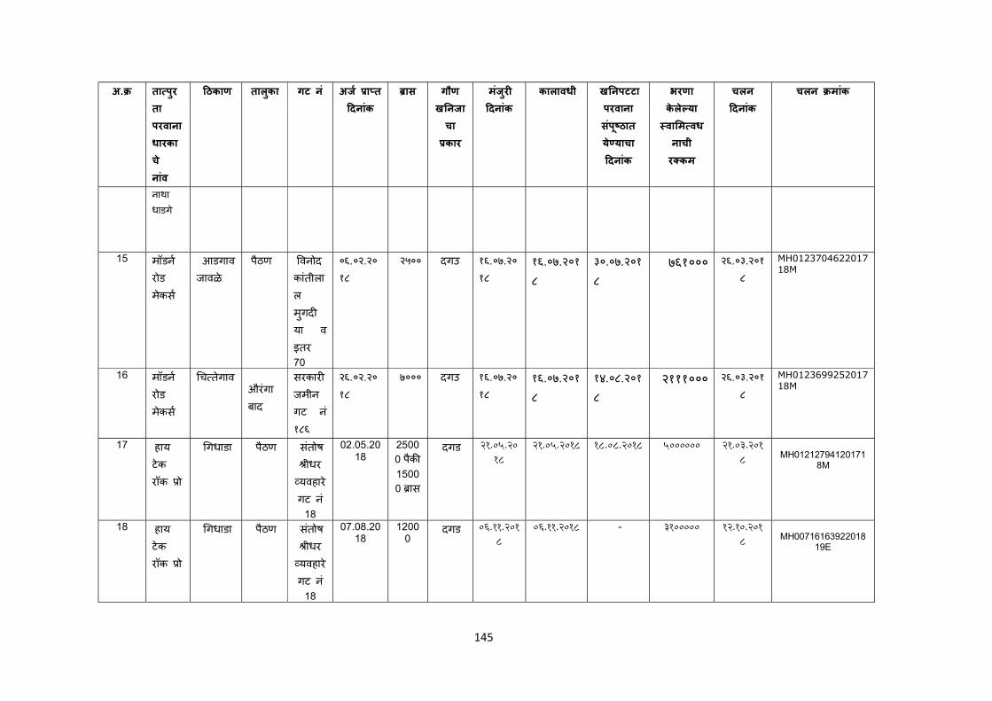
145
अ. ता पुरता परवाना धारकाचे नांव
ठकाण तालकुा गट नं अज ा त दनांक
ास गौण ख नजाचा कार
मजंरु
दनांक
कालावधी ख नपटटा परवाना सपंू ठात ये याचा दनांक
भरणा केले या वा म वधनाची र कम
चलन दनांक
चलन मांक
नाथा धाडगे
15 मॉडन रोड मेकस
आडगाव जावळे
पैठण वनोद कांतीलाल मगुदया व
इतर 70
०६.०२.२०१८
२५०० दगउ १६.०७.२०१८
१६.०७.२०१८
३०.०७.२०१८
७६१००० २६.०३.२०१८
MH012370462201718M
16 मॉडन रोड मेकस
च तेगाव
औरंगाबाद
सरकार जमीन गट नं १८६
२६.०२.२०१८
७००० दगउ १६.०७.२०१८
१६.०७.२०१८
१४.०८.२०१८
२१११००० २६.०३.२०१८
MH012369925201718M
17 हाय टेक रॉक ो
गधाडा पैठण सतंोष ीधर
यवहारे गट न ं
18
02.05.2018
2500
0 पैक 1500
0 ास
दगड 21.05.2018
21.05.2018 18.08.2018 5000000 21.03.2018
MH01212794120171
8M
18 हाय टेक रॉक ो
गधाडा पैठण सतंोष ीधर
यवहारे गट न ं
18
07.08.2018
12000
दगड 06.11.2018
06.11.2018 - 3100000 12.10.2018
MH00716163922018
19E
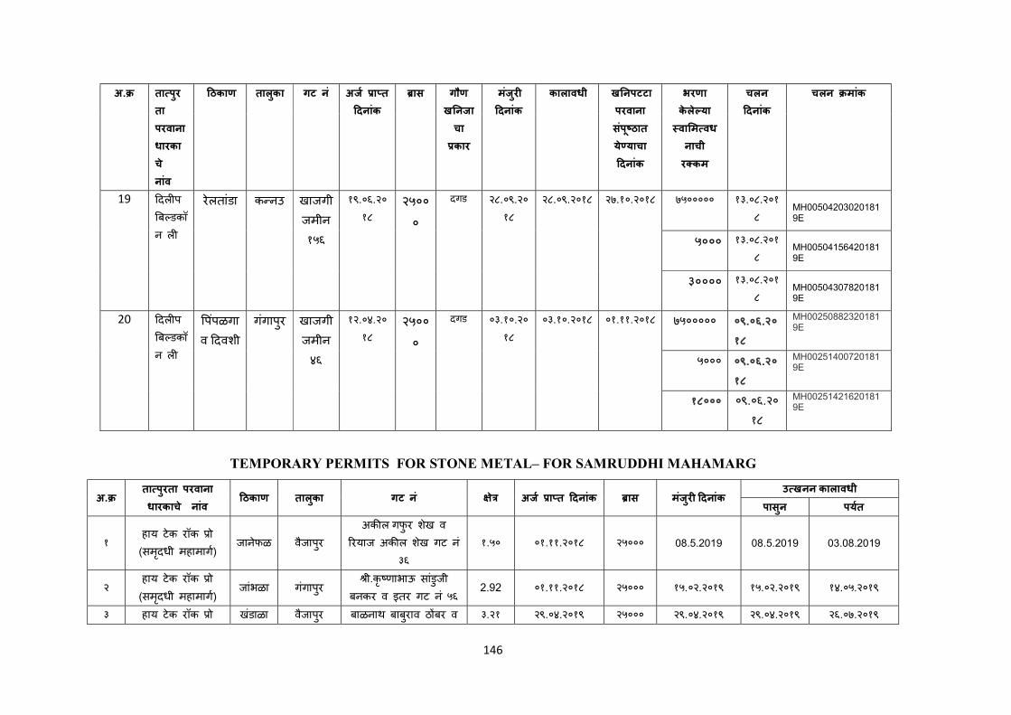
146
अ. ता पुरता परवाना धारकाचे नांव
ठकाण तालकुा गट नं अज ा त दनांक
ास गौण ख नजाचा कार
मजंरु
दनांक
कालावधी ख नपटटा परवाना सपंू ठात ये याचा दनांक
भरणा केले या वा म वधनाची र कम
चलन दनांक
चलन मांक
19 दल प
ब डकॉन ल
रेलतांडा क नउ खाजगी जमीन १५६
१९.०६.२०१८
२५०००
दगड २८.०९.२०१८
२८.०९.२०१८ २७.१०.२०१८ ७५००००० १३.०८.२०१८
MH005042030201819E
५००० १३.०८.२०१८
MH005041564201819E
३०००० १३.०८.२०१८
MH005043078201819E
20 दल प
ब डकॉन ल
पपंळगाव दवशी
गगंापुर खाजगी जमीन ४६
१२.०४.२०१८
२५०००
दगड ०३.१०.२०१८
०३.१०.२०१८ ०१.११.२०१८ ७५००००० ०९.०६.२०१८
MH002508823201819E
५००० ०९.०६.२०१८
MH002514007201819E
१८००० ०९.०६.२०१८
MH002514216201819E
TEMPORARY PERMITS FOR STONE METAL– FOR SAMRUDDHI MAHAMARG
अ. ता पुरता परवाना धारकाचे नांव
ठकाण तालकुा गट नं े अज ा त दनांक ास मजंरु दनांक उ खनन कालावधी
पासुन पयत
१ हाय टेक रॉक ो (समदृधी महामाग)
जानेफळ वैजापरु अक ल गफुर शेख व
रयाज अक ल शखे गट न ं३६
१.५० ०१.११.२०१८ २५००० 08.5.2019 08.5.2019 03.08.2019
२ हाय टेक रॉक ो (समदृधी महामाग)
जांभळा गंगापरु ी.कृ णाभाऊ सांडुजी
बनकर व इतर गट न ं५६ 2.92 ०१.११.२०१८ २५००० १५.०२.२०१९ १५.०२.२०१९ १४.०५.२०१९
३ हाय टेक रॉक ो खंडाळा वैजापरु बाळनाथ बाबरुाव ठ बर व ३.२१ २९.०४.२०१९ २५००० २९.०४.२०१९ २९.०४.२०१९ २६.०७.२०१९
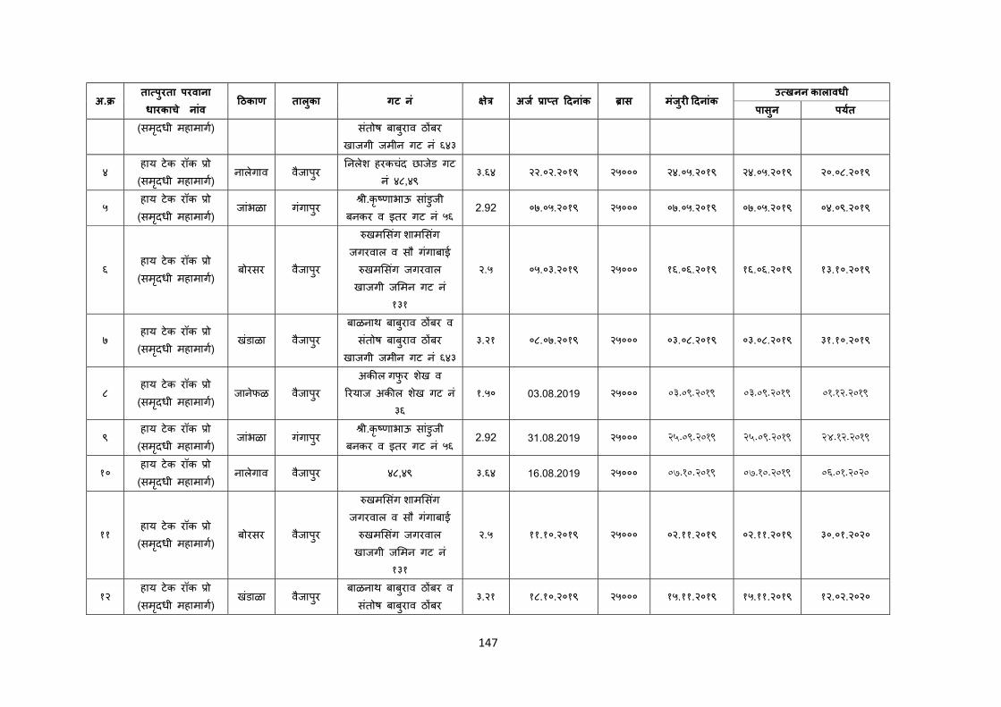
147
अ. ता पुरता परवाना धारकाचे नांव
ठकाण तालकुा गट नं े अज ा त दनांक ास मजंरु दनांक उ खनन कालावधी
पासुन पयत
(समदृधी महामाग) सतंोष बाबुराव ठ बर खाजगी जमीन गट न ं६४३
४ हाय टेक रॉक ो (समदृधी महामाग)
नालेगाव वैजापरु नलेश हरकचदं छाजेड गट
न ं४८,४९ ३.६४ २२.०२.२०१९ २५००० २४.०५.२०१९ २४.०५.२०१९ २०.०८.२०१९
५ हाय टेक रॉक ो (समदृधी महामाग)
जांभळा गंगापरु ी.कृ णाभाऊ सांडुजी
बनकर व इतर गट न ं५६ 2.92 ०७.०५.२०१९ २५००० ०७.०५.२०१९ ०७.०५.२०१९ ०४.०९.२०१९
६ हाय टेक रॉक ो (समदृधी महामाग)
बोरसर वैजापरु
खम सगं शाम सगं जगरवाल व सौ गंगाबाई
खम सगं जगरवाल खाजगी ज मन गट न ं
१३१
२.५ ०५.०३.२०१९ २५००० १६.०६.२०१९ १६.०६.२०१९ १३.१०.२०१९
७ हाय टेक रॉक ो (समदृधी महामाग)
खंडाळा वैजापरु बाळनाथ बाबरुाव ठ बर व
सतंोष बाबुराव ठ बर खाजगी जमीन गट न ं६४३
३.२१ ०८.०७.२०१९ २५००० ०३.०८.२०१९ ०३.०८.२०१९ ३१.१०.२०१९
८ हाय टेक रॉक ो (समदृधी महामाग)
जानेफळ वैजापरु अक ल गफुर शेख व
रयाज अक ल शखे गट न ं३६
१.५० 03.08.2019 २५००० 03.09.2019 03.09.2019 01.12.2019
९ हाय टेक रॉक ो (समदृधी महामाग)
जांभळा गंगापरु ी.कृ णाभाऊ सांडुजी
बनकर व इतर गट न ं५६ 2.92 31.08.2019 २५००० 25.09.2019 25.09.2019 24.12.2019
१० हाय टेक रॉक ो (समदृधी महामाग)
नालेगाव वैजापरु ४८,४९ ३.६४ 16.08.2019 २५००० 07.10.2019 07.10.2019 06.01.2020
११ हाय टेक रॉक ो (समदृधी महामाग)
बोरसर वैजापरु
खम सगं शाम सगं जगरवाल व सौ गंगाबाई
खम सगं जगरवाल खाजगी ज मन गट न ं
१३१
२.५ ११.१०.२०१९ २५००० ०२.११.२०१९ ०२.११.२०१९ ३०.०१.२०२०
१२ हाय टेक रॉक ो (समदृधी महामाग)
खंडाळा वैजापरु बाळनाथ बाबरुाव ठ बर व
सतंोष बाबुराव ठ बर ३.२१ १८.१०.२०१९ २५००० १५.११.२०१९ १५.११.२०१९ १२.०२.२०२०
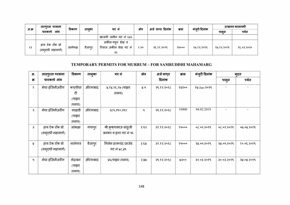
148
अ. ता पुरता परवाना धारकाचे नांव
ठकाण तालकुा गट नं े अज ा त दनांक ास मजंरु दनांक उ खनन कालावधी
पासुन पयत
खाजगी जमीन गट न ं६४३
१३ हाय टेक रॉक ो (समदृधी महामाग)
जानेफळ वैजापरु अक ल गफुर शेख व
रयाज अक ल शखे गट न ं३६
१.५० २६.११.२०१९ २५००० १७.१२.२०१९ १७.१२.२०१९ १६.०३.२०२०
TEMPORARY PERMITS FOR MURRUM – FOR SAMRUDDHI MAHAMARG
अ.
तात ् पुरता परवाना धारकाच े नांव
ठकाण तालुका गट न ं े अज ाप ् त
दनांक
ास मंजुर दनांक मुदत
पासुन पयत
१ मेघा इंिजनीअर ंग कच ् चीघाट
(पाझर
तलाव)
औरंगाबाद ४,१४,१६,१७ (पाझर
तलाव)
४.५ २९.१२.२०१८ १४२०० १४-Jan-२०१९ - -
२ मेघा इंिजनीअर ंग वरझडी (पाझर
तलाव)
औरंगाबाद २८५,२९०,२९१ ५ २९.१२.२०१८ 10800 04.02.2019 - -
३ हाय टेक रॉक ो (समदृधी महामाग)
जांभळा गगंापुर ी.कृष ् णाभाऊ सांडुजी बनकर व इतर गट नं ५६
२.९२ ३१.१२.२०१८ १५००० ०८.०२.२०१९ ०८.०२.२०१९ ०७.०४.२०१९
४ हाय टेक रॉक ो (समदृधी महामाग)
नालेगाव वैजापुर नलेश हरकचंद छाजेड
गट नं ४८,४९
३.६४ ३१.१२.२०१८ १५००० २४.०५.२०१९ २४.०५.२०१९ १०.०६.२०१९
५ मेघा इंिजनीअर ंग शे ाबन
(पाझर
तलाव)
औरंगाबाद ४६(पाझर तलाव) २.४७ २९.१२.२०१८ ७२०० ३०.०३.२०१९ ३०.०३.२०१९ २४.०४.२०१९
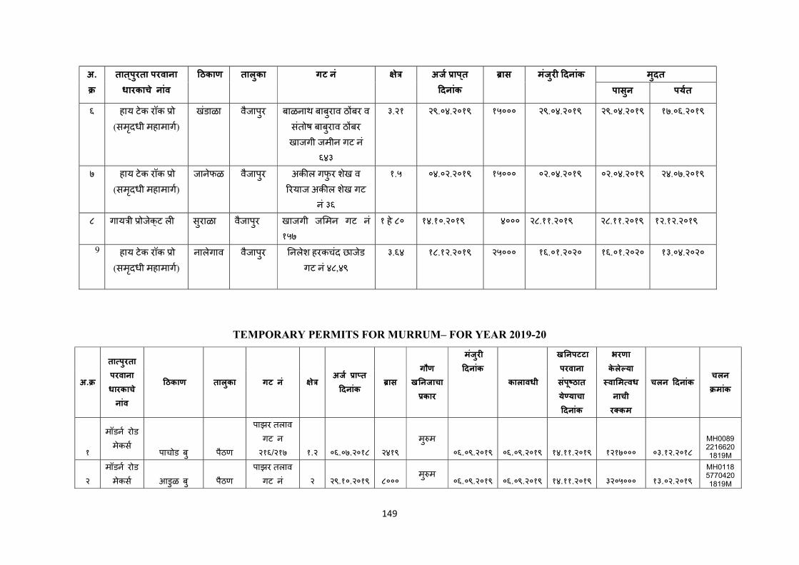
149
अ.
तात ् पुरता परवाना धारकाच े नांव
ठकाण तालुका गट न ं े अज ाप ् त
दनांक
ास मंजुर दनांक मुदत
पासुन पयत
६ हाय टेक रॉक ो (समदृधी महामाग)
खंडाळा वैजापुर बाळनाथ बाबुराव ठ बर व
संतोष बाबुराव ठ बर
खाजगी जमीन गट नं ६४३
३.२१ २९.०४.२०१९ १५००० २९.०४.२०१९ २९.०४.२०१९ १७.०६.२०१९
७ हाय टेक रॉक ो (समदृधी महामाग)
जानेफळ वैजापुर अक ल गफुर शखे व
रयाज अक ल शखे गट
नं ३६
१.५ ०४.०२.२०१९ १५००० ०२.०४.२०१९ ०२.०४.२०१९ २४.०७.२०१९
८ गाय ी ोजेक् ट ल सुराळा वैजापुर खाजगी ज मन गट न ं
१५७
१ हे ८० १४.१०.२०१९ ४००० २८.११.२०१९ २८.११.२०१९ १२.१२.२०१९
9 हाय टेक रॉक ो (समदृधी महामाग)
नालेगाव वैजापुर नलेश हरकचंद छाजेड
गट नं ४८,४९
३.६४ १८.१२.२०१९ २५००० १६.०१.२०२० १६.०१.२०२० १३.०४.२०२०
TEMPORARY PERMITS FOR MURRUM– FOR YEAR 2019-20
अ.
ता पुरता परवाना धारकाचे नांव
ठकाण तालकुा गट नं े अज ा त
दनांक ास
गौण ख नजाचा
कार
मजंरु
दनांक
कालावधी
ख नपटटा परवाना सपंू ठात ये याचा दनांक
भरणा केले या वा म वधनाची र कम
चलन दनांक चलन मांक
१
मॉडन रोड
मेकस पाचोड बु पैठण
पाझर तलाव गट न २१६/२१७ १.२ ०६.०७.२०१८ २४१९
मु म
०६.०९.२०१९ ०६.०९.२०१९ १४.११.२०१९ १२१७००० ०३.१२.२०१८
MH008922166201819M
२
मॉडन रोड
मेकस आडुळ बु पैठण
पाझर तलाव गट नं २ २९.१०.२०१९ ८०००
मु म ०६.०९.२०१९ ०६.०९.२०१९ १४.११.२०१९ ३२०५००० १३.०२.२०१९
MH011857704201819M
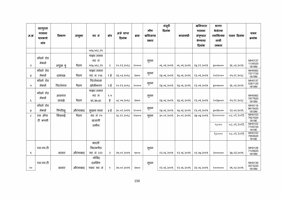
150
अ.
ता पुरता परवाना धारकाचे नांव
ठकाण तालकुा गट नं े अज ा त
दनांक ास
गौण ख नजाचा
कार
मजंरु
दनांक
कालावधी
ख नपटटा परवाना सपंू ठात ये याचा दनांक
भरणा केले या वा म वधनाची र कम
चलन दनांक चलन मांक
५१७,५१८,१९
३
मॉडन रोड
मेकस आडुळ बु पैठण
पाझर तलाव गट नं
५१७,५१८,१९ २ १०.१२.२०१८ १००००
मु म
०६.०९.२०१९ ०६.०९.२०१९ १४.११.२०१९ ४००५००० २६.०३.२०१९
MH013711340201819M
४
मॉडन रोड
मेकस दाभ ळ पैठण
पाझर तलाव गट न १५६ १ हे २३.०३.२०१८ २५००
मु म १४.०६.२०१९ १४.०६.२०१९ १३.०९.२०१९ १०११००० १५.११.२०१८
MH008275717201819M
५
मॉडन रोड
मेकस च तेगाव पैठण
च तेनाला खोल करण २ हे १०.१२.२०१८ १००००
मु म १४.०६.२०१९ १४.०६.२०१९ १३.०९.२०१९ ४००५००० २६.०३.२०१९
MH013703811201819M
६
मॉडन रोड
मेकस आडगाव जावळे पैठण
पाझर तलाव गट नं
४६,४७,४८
१.५
हे ०८.०५.२०१८ २५००
मु म
१४.०६.२०१९ १४.०६.२०१९ १३.०९.२०१९ १०१७००० १५.११.२०१८
MH008276778201819M
७
मॉडन रोड
मेकस पपंर ख ु औरंगाबाद सखुना नाला ४ हे ३०.०१.२०१९ १०००० मु म
१४.०६.२०१९ १४.०६.२०१९ १३.०९.२०१९ ४०२९००० १३.०२.२०१९
MH011886154201819M
८ एल अॅ ड ट कपनी
शवनाई पैठण गट नं १५
खजागी जमीन
२८.११.२०१८ १५००० मु म ३०.०१.२०१९ ३०.०१.२०१९ २४.०४.२०१९ 6000000 08.01.2019 MH010379218201819E
5000 08.01.2019 MH010377457201819E
18000 08.01.2019 MH010379506201819E
९
एल.एन.ट
सतारा औरंगाबाद
भारती वदयापीठ
गट नं २२२ २ २५.०१.२०१९ ५०००
मु म
१२.०६.२०१९ १२.०६.२०१९ ०२.०७.२०१९ २०००००० २७.०3.२०१९
MH012871456201819M
१०
एल.एन.ट
सतारा औरंगाबाद
गो वदं दल सगं
पवार गट न ं १ २५.०१.२०१९ २५००
मु म
१२.०६.२०१९ १२.०६.२०१९ २२.०६.२०१९ १०००००० २९.०३.२०१९
MH013945732201819M
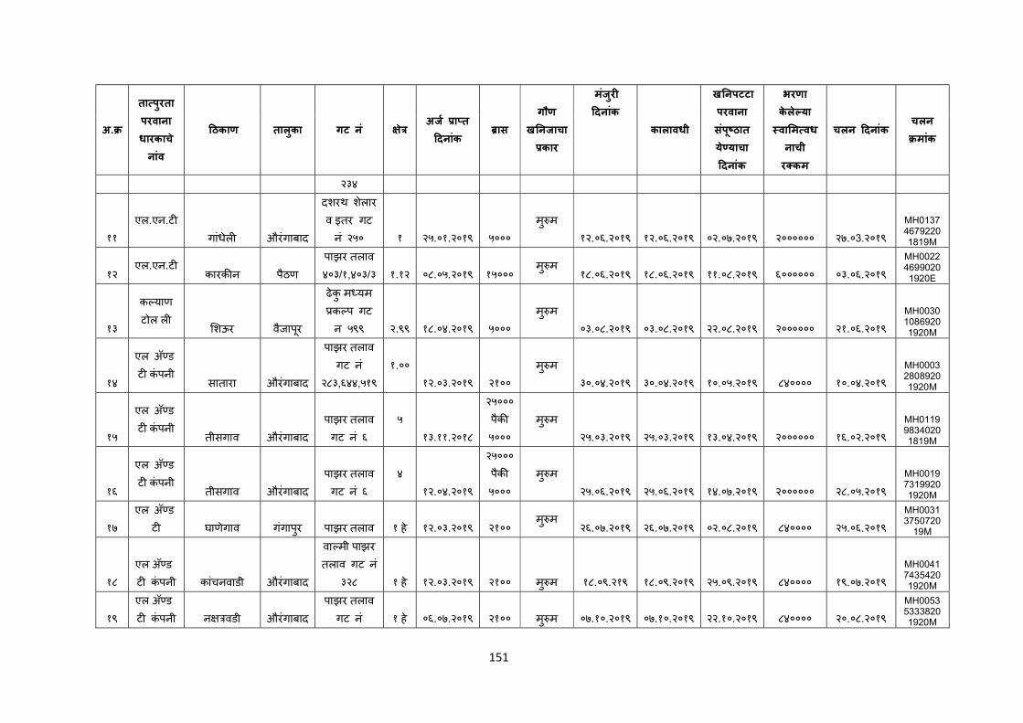
151
अ.
ता पुरता परवाना धारकाचे नांव
ठकाण तालकुा गट नं े अज ा त
दनांक ास
गौण ख नजाचा
कार
मजंरु
दनांक
कालावधी
ख नपटटा परवाना सपंू ठात ये याचा दनांक
भरणा केले या वा म वधनाची र कम
चलन दनांक चलन मांक
२३४
११
एल.एन.ट
गांधेल औरंगाबाद
दशरथ शेलार व इतर गट न ं२५० १ २५.०१.२०१९ ५०००
मु म
१२.०६.२०१९ १२.०६.२०१९ ०२.०७.२०१९ २०००००० २७.०3.२०१९
MH013746792201819M
१२ एल.एन.ट
कारक न पैठण
पाझर तलाव ४०३/१,४०३/३ १.१२ ०८.०५.२०१९ १५०००
मु म १८.०६.२०१९ १८.०६.२०१९ ११.०८.२०१९ ६०००००० ०३.०६.२०१९
MH002246990201920E
१३
क याण टोल ल
शऊर वैजापूर
ढेकु म यम क प गट न ५९९ २.९९ १८.०४.२०१९ ५०००
मु म
०३.०८.२०१९ ०३.०८.२०१९ २२.०८.२०१९ २०००००० २१.०६.२०१९
MH003010869201920M
१४
एल अॅ ड ट कंपनी
सातारा औरंगाबाद
पाझर तलाव गट नं
२८३,६४४,५१९
१.००
१२.०३.२०१९ २१००
मु म
३०.०४.२०१९ ३०.०४.२०१९ १०.०५.२०१९ ८४०००० १०.०४.२०१९
MH000328089201920M
१५
एल अॅ ड ट कंपनी
तीसगाव औरंगाबाद
पाझर तलाव गट नं ६
५
१३.११.२०१८
२५०००
पैक ५०००
मु म
२५.०३.२०१९ २५.०३.२०१९ १३.०४.२०१९ २०००००० १६.०२.२०१९
MH011998340201819M
१६
एल अॅ ड ट कंपनी
तीसगाव औरंगाबाद
पाझर तलाव गट नं ६
४
१२.०४.२०१९
२५०००
पैक ५०००
मु म
२५.०६.२०१९ २५.०६.२०१९ १४.०७.२०१९ २०००००० २८.०५.२०१९
MH001973199201920M
१७
एल अॅ ड ट घाणेगाव गंगापुर पाझर तलाव १ हे १२.०३.२०१९ २१००
मु म २६.०७.२०१९ २६.०७.२०१९ ०२.०८.२०१९ ८४०००० २५.०६.२०१९
MH00313750720
19M
१८
एल अॅ ड ट कंपनी कांचनवाडी औरंगाबाद
वा मी पाझर तलाव गट नं
३२८ १ हे १२.०३.२०१९ २१०० मु म १८.०९.२१९ १८.०९.२०१९ २५.०९.२०१९ ८४०००० १९.०७.२०१९
MH004174354201920M
१९
एल अॅ ड ट कंपनी न वडी औरंगाबाद
पाझर तलाव गट नं १ हे ०६.०७.२०१९ २१०० मु म ०७.१०.२०१९ ०७.१०.२०१९ २२.१०.२०१९ ८४०००० २०.०८.२०१९
MH005353338201920M
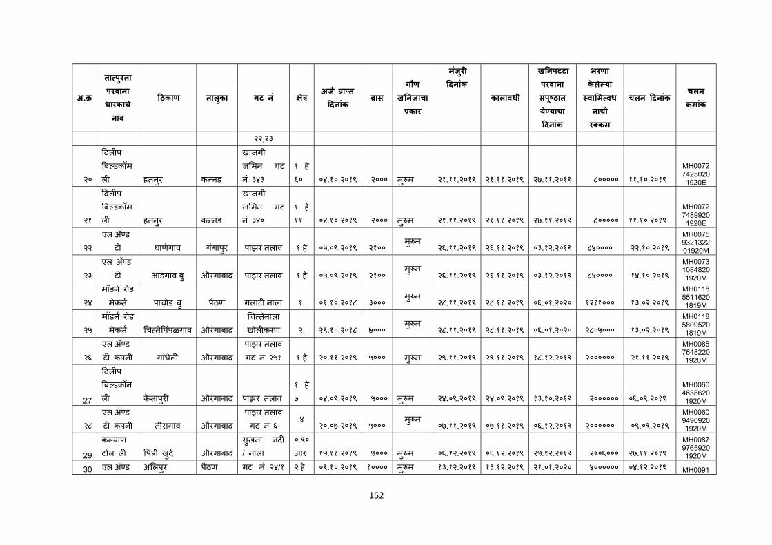
152
अ.
ता पुरता परवाना धारकाचे नांव
ठकाण तालकुा गट नं े अज ा त
दनांक ास
गौण ख नजाचा
कार
मजंरु
दनांक
कालावधी
ख नपटटा परवाना सपंू ठात ये याचा दनांक
भरणा केले या वा म वधनाची र कम
चलन दनांक चलन मांक
२२,२३
२०
दल प ब डकॉम ल हतनरु क नड
खाजगी ज मन गट नं ३४३
१ हे ६० ०४.१०.२०१९ २००० मु म २१.११.२०१९ २१.११.२०१९ २७.११.२०१९ ८००००० ११.१०.२०१९
MH007274250201920E
२१
दल प ब डकॉम ल हतनरु क नड
खाजगी ज मन गट नं ३४०
१ हे ११ ०४.१०.२०१९ २००० मु म २१.११.२०१९ २१.११.२०१९ २७.११.२०१९ ८००००० ११.१०.२०१९
MH007274899201920E
२२
एल अॅ ड ट घाणेगाव गंगापुर पाझर तलाव १ हे ०५.०९.२०१९ २१००
मु म २६.११.२०१९ २६.११.२०१९ ०३.१२.२०१९ ८४०००० २२.१०.२०१९
MH0075932132201920M
२३
एल अॅ ड ट आडगाव बु औरंगाबाद पाझर तलाव १ हे ०५.०९.२०१९ २१००
मु म २६.११.२०१९ २६.११.२०१९ ०३.१२.२०१९ ८४०००० १४.१०.२०१९
MH007310848201920M
२४
मॉडन रोड
मेकस पाचोड बु पैठण गलाट नाला १. ०१.१०.२०१८ ३००० मु म
२८.११.२०१९ २८.११.२०१९ ०६.०१.२०२० १२११००० १३.०२.२०१९
MH011855116201819M
२५
मॉडन रोड
मेकस च ते पपंळगाव औरंगाबाद
च तेनाला खोल करण २. २९.१०.२०१८ ७०००
मु म २८.११.२०१९ २८.११.२०१९ ०६.०१.२०२० २८०५००० १३.०२.२०१९
MH011858095201819M
२६
एल अॅ ड ट कंपनी गांधेल औरंगाबाद
पाझर तलाव गट नं २५१ १ हे २०.११.२०१९ ५००० मु म २९.११.२०१९ २९.११.२०१९ १८.१२.२०१९ २०००००० २१.११.२०१९
MH008576482201920M
27
दल प ब डकॉन ल केसापुर औरंगाबाद पाझर तलाव
१ हे ७ ०४.०९.२०१९ ५००० मु म २४.०९.२०१९ २४.०९.२०१९ १३.१०.२०१९ २०००००० ०६.०९.२०१९
MH006046386201920M
२८
एल अॅ ड ट कंपनी तीसगाव औरंगाबाद
पाझर तलाव गट नं ६
४ २०.०७.२०१९ ५०००
मु म ०७.११.२०१९ ०७.११.२०१९ ०६.१२.२०१९ २०००००० ०९.०९.२०१९
MH006094909201920M
29
क याण टोल ल पं ी खुद औरंगाबाद
सखुना नद / नाला
०.९० आर १५.११.२०१९ ५००० मु म ०६.१२.२०१९ ०६.१२.२०१९ २५.१२.२०१९ २००६००० २७.११.२०१९
MH008797659201920M
30 एल अॅ ड अ लपुर पैठण गट नं २४/१ २ हे ०९.१०.२०१९ १०००० मु म १३.१२.२०१९ १३.१२.२०१९ २१.०१.२०२० ४०००००० ०४.१२.२०१९ MH0091
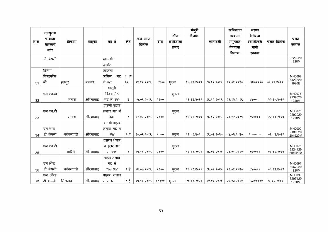
153
अ.
ता पुरता परवाना धारकाचे नांव
ठकाण तालकुा गट नं े अज ा त
दनांक ास
गौण ख नजाचा
कार
मजंरु
दनांक
कालावधी
ख नपटटा परवाना सपंू ठात ये याचा दनांक
भरणा केले या वा म वधनाची र कम
चलन दनांक चलन मांक
ट कंपनी खाजगी ज मन
02239201920M
31
दल प ब डकॉम ल हतनरु क नड
खाजगी ज मन गट नं ३४३
१ हे ६० ०५.१२.२०१९ ६५०० मु म १७.१२.२०१९ १७.१२.२०१९ १०.०१.२०२० २६००००० ०९.१२.२०१९
MH009264238201920E
32
एल.एन.ट
सतारा औरंगाबाद
भारती वदयापीठ
गट नं २२२ २ ०५.०९.२०१९ २१००
मु म
१६.१२.२०१९ १६.१२.२०१९ २३.१२.२०१९ ८४०००० २२.१०.२०१९
MH007592393201920M
33
एल.एन.ट
सतारा औरंगाबाद
वा मी पाझर तलाव गट नं
३३९ १ १२.०३.२०१९ २१००
मु म
१६.१२.२०१९ १६.१२.२०१९ २३.१२.२०१९ ८४०००० २२.१०.२०१९
MH007592920201920M
34
एल अॅ ड ट कंपनी कांचनवाडी औरंगाबाद
वा मी पाझर तलाव गट नं
३२८ १ हे ३०.०९.२०१९ ५००० मु म १६.०१.२०२० १६.०१.२०२० ०४.०२.२०२० २०००००० ०६.०२.२०१९
MH00009180529201920M
35
एल.एन.ट
गांधेल औरंगाबाद
दशरथ शेलार व इतर गट न ं२५० १ ०९.१०.२०१९ २१००
मु म
१६.०१.२०२० १६.०१.२०२० २३.०१.२०२० ८४०००० ०६.१२.२०१९
MH00759224129201920M
36
एल अॅ ड ट कंपनी कांचनवाडी औरंगाबाद
पाझर तलाव गट नं १७७,१६८ १ हे ०६.०७.२०१९ २१०० मु म १६.०१.२०२० १६.०१.२०२० २३.०१.२०२० ८४०००० ०६.१२.२०१९
MH009180670201920M
३७
एल अॅ ड ट कंपनी तसगाव औरंगाबाद
पाझर तलाव ग न ं६ २ हे १९.११.२०१९ १७००० मु म २०.०१.२०२० २०.०१.२०२० २४.०३.२०२० ६८००००० २६.१२.२०१९
MH009972971201920M
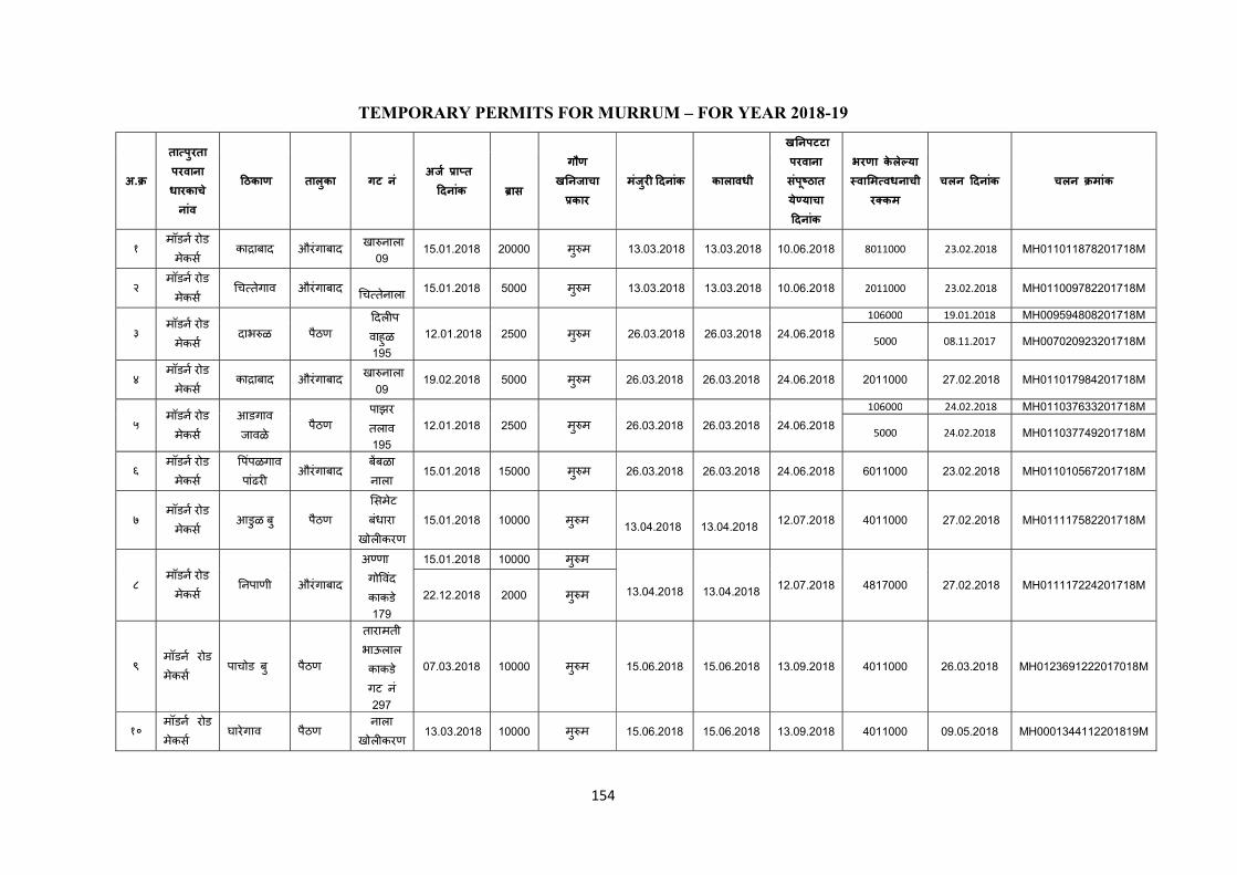
154
TEMPORARY PERMITS FOR MURRUM – FOR YEAR 2018-19
अ.
ता पुरता परवाना धारकाचे नांव
ठकाण तालुका गट नं अज ा त
दनांक
गौण
ख नजाचा कार
मंजरु दनांक कालावधी
ख नपटटा परवाना संपू ठात ये याचा दनांक
भरणा केले या वा म वधनाची
र कम
चलन दनांक चलन मांक ास
१ मॉडन रोड मेकस
का ाबाद औरंगाबाद खा नाला
09 15.01.2018 20000 मु म 13.03.2018 13.03.2018 10.06.2018 8011000 23.02.2018 MH011011878201718M
२ मॉडन रोड मेकस
च तेगाव औरंगाबाद
च तेनाला 15.01.2018 5000 मु म 13.03.2018 13.03.2018 10.06.2018 2011000 23.02.2018 MH011009782201718M
३ मॉडन रोड मेकस
दाभ ळ पैठण
दल प वाहुळ 195
12.01.2018 2500 मु म 26.03.2018 26.03.2018 24.06.2018
106000 19.01.2018 MH009594808201718M
5000 08.11.2017 MH007020923201718M
४ मॉडन रोड मेकस
का ाबाद औरंगाबाद खा नाला
09 19.02.2018 5000 मु म 26.03.2018 26.03.2018 24.06.2018 2011000 27.02.2018 MH011017984201718M
५ मॉडन रोड मेकस
आडगाव
जावळे पैठण
पाझर
तलाव 195
12.01.2018 2500 मु म 26.03.2018 26.03.2018 24.06.2018
106000 24.02.2018 MH011037633201718M
5000 24.02.2018 MH011037749201718M
६ मॉडन रोड मेकस
पपंळगाव पांढर
औरंगाबाद बबळा नाला
15.01.2018 15000 मु म 26.03.2018 26.03.2018 24.06.2018 6011000 23.02.2018 MH011010567201718M
७ मॉडन रोड मेकस
आडुळ ब ु पैठण
समेट बंधारा
खोल करण
15.01.2018 10000 मु म 13.04.2018
13.04.2018
12.07.2018 4011000 27.02.2018 MH011117582201718M
८ मॉडन रोड मेकस
नपाणी औरंगाबाद
अ णा गो वदं काकडे 179
15.01.2018 10000 मु म
13.04.2018
13.04.2018
12.07.2018 4817000 27.02.2018 MH011117224201718M 22.12.2018 2000 मु म
९ मॉडन रोड मेकस
पाचोड ब ु पैठण
तारामती भाऊलाल काकडे गट नं 297
07.03.2018 10000 मु म 15.06.2018 15.06.2018 13.09.2018 4011000 26.03.2018 MH0123691222017018M
१० मॉडन रोड मेकस
घारेगाव पैठण नाला
खोल करण 13.03.2018 10000 मु म 15.06.2018 15.06.2018 13.09.2018 4011000 09.05.2018 MH0001344112201819M
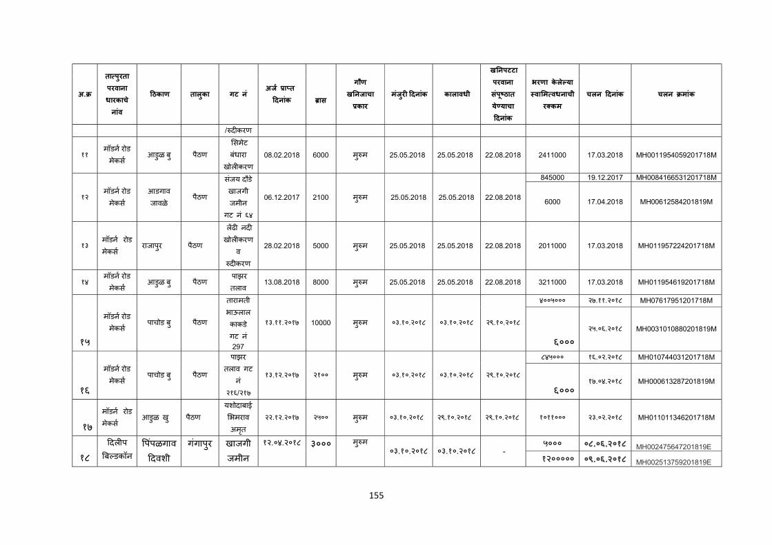
155
अ.
ता पुरता परवाना धारकाचे नांव
ठकाण तालुका गट नं अज ा त
दनांक
गौण
ख नजाचा कार
मंजरु दनांक कालावधी
ख नपटटा परवाना संपू ठात ये याचा दनांक
भरणा केले या वा म वधनाची
र कम
चलन दनांक चलन मांक ास
/ द करण
११ मॉडन रोड मेकस
आडुळ ब ु पैठण
समेट बंधारा
खोल करण
08.02.2018 6000 मु म 25.05.2018 25.05.2018 22.08.2018 2411000 17.03.2018 MH0011954059201718M
१२ मॉडन रोड मेकस
आडगाव
जावळे पैठण
संजय दौडे खाजगी जमीन
गट नं ६४
06.12.2017 2100 मु म 25.05.2018 25.05.2018 22.08.2018
845000 19.12.2017 MH0084166531201718M
6000 17.04.2018 MH00612584201819M
१३ मॉडन रोड मेकस
राजापुर पैठण
लढ नद खोल करण
व द करण
28.02.2018 5000 मु म 25.05.2018 25.05.2018 22.08.2018 2011000 17.03.2018 MH011957224201718M
१४ मॉडन रोड मेकस
आडुळ ब ु पैठण पाझर तलाव
13.08.2018 8000 मु म 25.05.2018 25.05.2018 22.08.2018 3211000 17.03.2018 MH011954619201718M
१५
मॉडन रोड मेकस
पाचोड ब ु पठैण
तारामती भाऊलाल काकडे गट नं 297
१३.११.२०१७ 10000 मु म ०३.१०.२०१८ ०३.१०.२०१८ २९.१०.२०१८
४००५००० २७.११.२०१८ MH07617951201718M
६००० २५.०६.२०१८ MH0031010880201819M
१६
मॉडन रोड मेकस
पाचोड ब ु पैठण
पाझर
तलाव गट नं
२१६/२१७
१३.१२.२०१७ २१०० मु म ०३.१०.२०१८ ०३.१०.२०१८ २९.१०.२०१८
८४५००० १६.०२.२०१८ MH010744031201718M
६००० १७.०४.२०१८ MH000613287201819M
१७
मॉडन रोड मेकस
आडुळ ख ु पैठण
यशोदाबाई
भमराव अमतृ
२२.१२.२०१७ २५०० मु म ०३.१०.२०१८ २९.१०.२०१८ २९.१०.२०१८ १०११००० २३.०२.२०१८ MH011011346201718M
१८
दल प
ब डकॉन पपंळगाव
दवशी गगंापुर खाजगी
जमीन १२.०४.२०१८ ३००० मु म
०३.१०.२०१८ ०३.१०.२०१८ - ५००० ०८.०६.२०१८ MH002475647201819E
१२००००० ०९.०६.२०१८ MH002513759201819E

156
अ.
ता पुरता परवाना धारकाचे नांव
ठकाण तालुका गट नं अज ा त
दनांक
गौण
ख नजाचा कार
मंजरु दनांक कालावधी
ख नपटटा परवाना संपू ठात ये याचा दनांक
भरणा केले या वा म वधनाची
र कम
चलन दनांक चलन मांक ास
ल ४६ १८००० ०९.०६.२०१८ MH002514340201819E
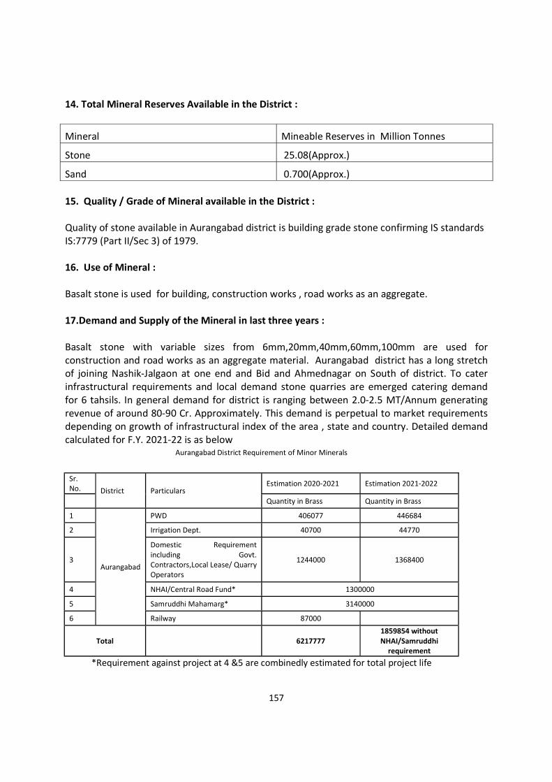
157
14. Total Mineral Reserves Available in the District :
Mineral Mineable Reserves in Million Tonnes
Stone 25.08(Approx.)
Sand 0.700(Approx.) 15. Quality / Grade of Mineral available in the District : Quality of stone available in Aurangabad district is building grade stone confirming IS standards IS:7779 (Part II/Sec 3) of 1979. 16. Use of Mineral : Basalt stone is used for building, construction works , road works as an aggregate. 17.Demand and Supply of the Mineral in last three years : Basalt stone with variable sizes from 6mm,20mm,40mm,60mm,100mm are used for construction and road works as an aggregate material. Aurangabad district has a long stretch of joining Nashik-Jalgaon at one end and Bid and Ahmednagar on South of district. To cater infrastructural requirements and local demand stone quarries are emerged catering demand for 6 tahsils. In general demand for district is ranging between 2.0-2.5 MT/Annum generating revenue of around 80-90 Cr. Approximately. This demand is perpetual to market requirements depending on growth of infrastructural index of the area , state and country. Detailed demand calculated for F.Y. 2021-22 is as below
Aurangabad District Requirement of Minor Minerals
Sr. No. District Particulars
Estimation 2020-2021 Estimation 2021-2022
Quantity in Brass Quantity in Brass
1
Aurangabad
PWD 406077 446684
2 Irrigation Dept. 40700 44770
3
Domestic Requirement including Govt. Contractors,Local Lease/ Quarry Operators
1244000 1368400
4 NHAI/Central Road Fund* 1300000
5 Samruddhi Mahamarg* 3140000
6 Railway 87000
Total 6217777 1859854 without NHAI/Samruddhi
requirement
*Requirement against project at 4 &5 are combinedly estimated for total project life
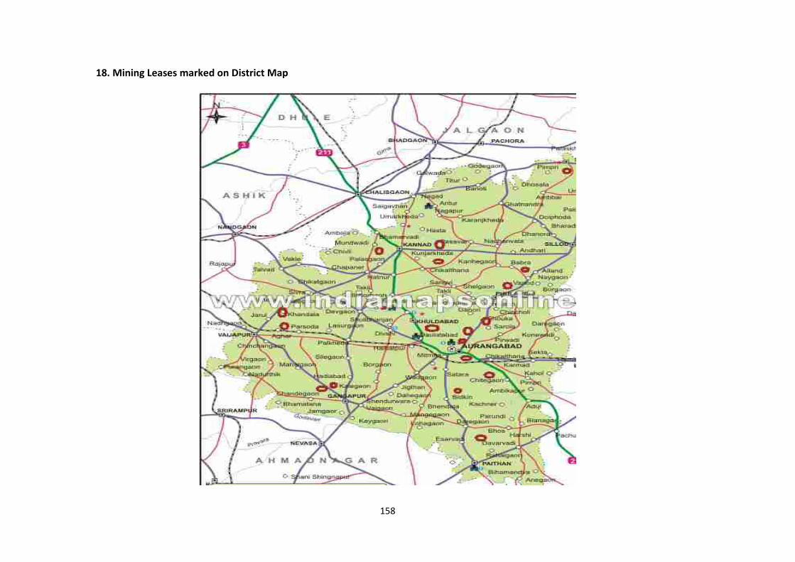
158
18. Mining Leases marked on District Map
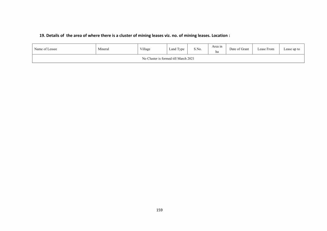
159
19. Details of the area of where there is a cluster of mining leases viz. no. of mining leases. Location :
Name of Lessee Mineral Village Land Type S.No. Area in
ha Date of Grant Lease From Lease up to
No Cluster is formed till March 2021
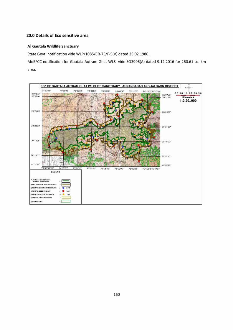
160
20.0 Details of Eco sensitive area
A] Gautala Wildlife Sanctuary
State Govt. notification vide WLP/1085/CR-75/F-5(V) dated 25.02.1986.
MoEFCC notification for Gautala Autram Ghat WLS vide SO3996(A) dated 9.12.2016 for 260.61 sq. km
area.
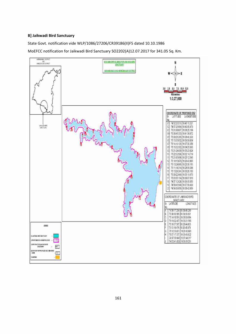
161
B] Jaikwadi Bird Sanctuary
State Govt. notification vide WLP/1086/27206/CR39186(II)F5 dated 10.10.1986
MoEFCC notification for Jaikwadi Bird Sanctuary SO2202(A)12.07.2017 for 341.05 Sq. Km.
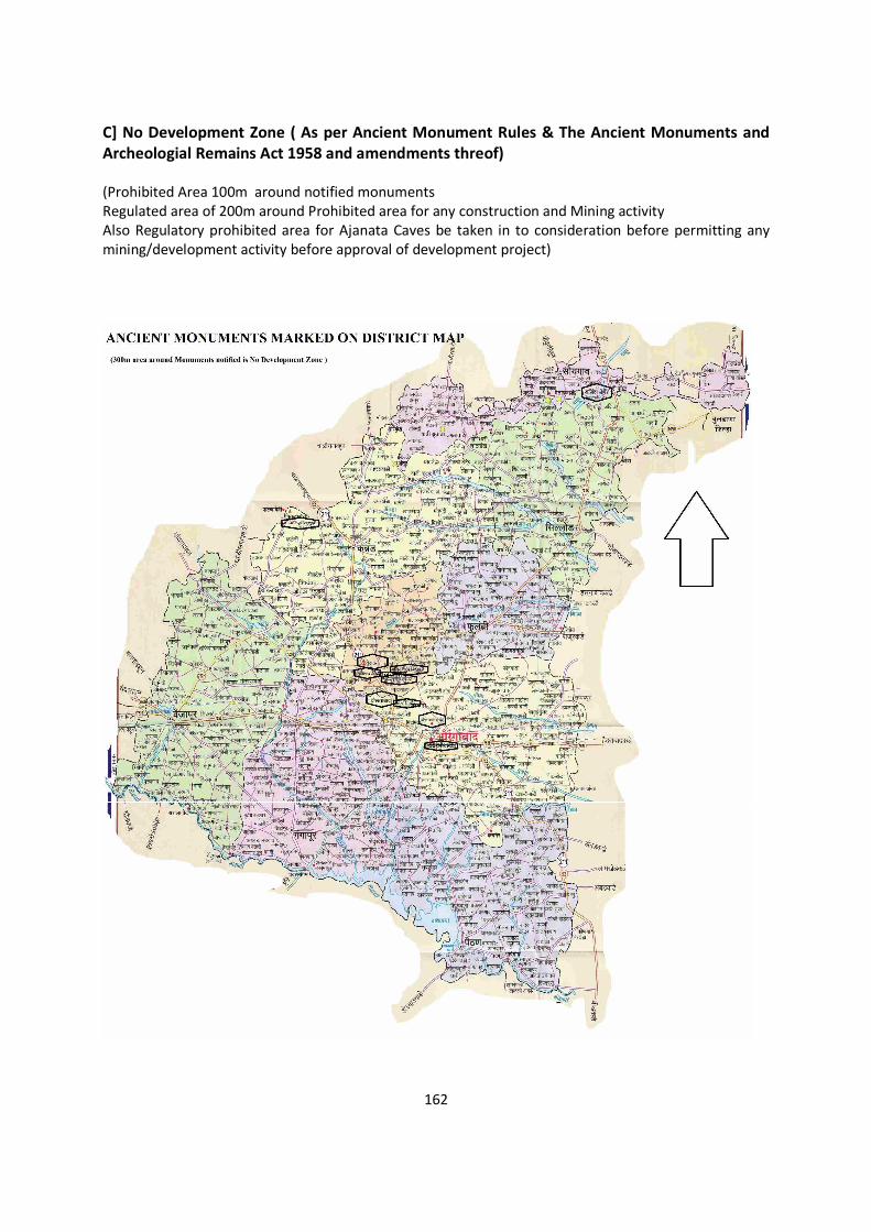
162
C] No Development Zone ( As per Ancient Monument Rules & The Ancient Monuments and Archeologial Remains Act 1958 and amendments threof) (Prohibited Area 100m around notified monuments Regulated area of 200m around Prohibited area for any construction and Mining activity Also Regulatory prohibited area for Ajanata Caves be taken in to consideration before permitting any mining/development activity before approval of development project)
163
21. Impact on the Environment (Air, Water, Noise Soil, Flora & Fauna, Land Use, agriculture, forest etc.) due to mining activity : Air Environment : Anticipated Impacts
Stone/metal mining is carried out by opencast manual method. The air borne particulate
matter generated by mining and handling operations, transportation and screening of stone
chips at crusher is the main air pollutant. The emissions of Sulphur dioxide (SO2), Oxides of
Nitrogen (NOX) contributed by tractor trolley. As the number of trips of tractor trolley are less,
the pollutant levels are well within prescribed limits . Prediction of impacts on air environment
has been carried out taking into consideration proposed production and net increase in
emissions. Air pollution sources in the operating mine are classified into three categories
a. Point sources
b. Area sources
c. Line sources
Drilling & Blasting and crusher operations of the mine are considered as point sources
As the cumulative impacts for cluster of stone quarries are to be considered, thus the
cluster of stone mines is described as area sources
Transportation of stone chips from mining pit to crusher is considered as line sources
The other source of air pollution is the dust generated during the movement of tractor trolley.
Water tankers with spraying arrangement will be used for regular water sprinkling on the haul
roads to ensure effective dust suppression. The tractor trolley are well maintained so that
exhaust smoke does not contribute abnormal values of noxious gases and un-burnt
hydrocarbons.
Noise Environment : Anticipated Impacts:
The main sources of noise in the mine are classified as follows:
Transportation Vehicles/tractor trolley
Drilling & Blasting
Crushing & Screening
Exposure of Noise may lead to hearing losses and may impact of mental health of Workers
working in the vicinity.
164
Water Environment : Anticipated Impacts:
Mining activities cause adverse impacts due to mine drainage and siltation due to storm water.
The impact on water environment has been considered under the following heads:
Water consumption
Mine seepage and impact on ground water
Impact on surface water bodies
Storm water management
Soil Environment : Anticipated Impacts
Most of the stone quarries are operated at the barren area where outcrops of basalt are
exposed having very thin layer of soil and overburden. This soil is removed and stacked
separately for plantation around peripheral area of 7.5 m.
Land Use :
These stone quarries are very small in area. After removal of stone these abandoned quarries
are used as water tank for irrigation purpose by lessee.
Forest :
No quarry is permitted within district within 250m of forest boundary and within 10 km buffer
area of Eco Sensitive Area.
22. Remedial measures to mitigate the impact of mining on Environment: Remedial measures to mitigate air environment Dust suppression arrangements like water tankers on haulage road and at all dust
generation points
Dust extractors during crushing/ screening
Grading of haul roads time to time and cleaning to remove the accumulated dusty
material
Regular maintenance of the tractor trolley.
Practicing wet drilling.
165
Controlled blasting using delay detonators.
Usage of sharp drill bits for drilling of holes
Avoiding of overloading of 10T tippers and covering of loaded tippers with tarpaulins
during stone chip transportation
Dust mask provision to workers
Adequate barrier zone will be maintained all along the mine lease boundary and green
belt will be maintained in the barrier zone
Periodical monitoring of air quality to take steps to control the pollutants
Remedial measures to mitigate noise environment: The operations of the mining equipment, plying of tractor trolley and mine machinery like drill
operations are the major sources of undesirable noise in the proposed project area.
The following control measures are proposed for bringing down the noise levels-
The vibration due to blasting is minimized by careful planning, supervision and execution
of each blast and using milli-second(M.S) delay detonators and proper stemming to
prevent blow out of holes
Green belt will be made around the working areas to screen the noise and also for
arresting fugitive dust
Maintenance and tuning of machinery would be ensured to reduce undesirable noise
Earplugs and earmuffs will be provided to the workmen
Limiting the speed of haulage tractor
Rubber lining in the chutes of Crushing/ screening plant
Remedial measures to mitigate water environment: The only pollution anticipated in the surface drainage water is the suspended solids, due to
wash off. For this purpose retaining wall with garland drain is proposed. The discharge from this
drain is diverted to a settling tank unused pit workings, which allows the sediments to settle.
Further to arrest the silted drainage entering into the area down below, check dams and gully
plugs shall be erected in the existing natural drains. These check dams also assist in the
recharge of ground water system.
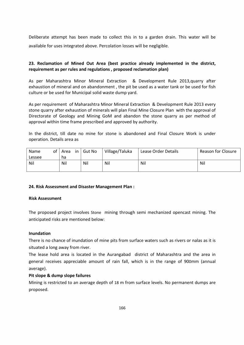
166
Deliberate attempt has been made to collect this in to a garden drain. This water will be
available for uses integrated above. Percolation losses will be negligible.
23. Reclamation of Mined Out Area (best practice already implemented in the district, requirement as per rules and regulations , proposed reclamation plan) As per Maharashtra Minor Mineral Extraction & Development Rule 2013,quarry after exhaustion of mineral and on abandonment , the pit be used as a water tank or be used for fish culture or be used for Municipal solid waste dump yard. As per requirement of Maharashtra Minor Mineral Extraction & Development Rule 2013 every stone quarry after exhaustion of minerals will plan Final Mine Closure Plan with the approval of Directorate of Geology and Mining GoM and abandon the stone quarry as per method of approval within time frame prescribed and approved by authority. In the district, till date no mine for stone is abandoned and Final Closure Work is under operation. Details area as Name of Lessee
Area in ha
Gut No Village/Taluka Lease Order Details Reason for Closure
Nil Nil Nil Nil Nil Nil
24. Risk Assessment and Disaster Management Plan : Risk Assessment The proposed project involves Stone mining through semi mechanized opencast mining. The anticipated risks are mentioned below: Inundation There is no chance of inundation of mine pits from surface waters such as rivers or nalas as it is situated a long away from river. The lease hold area is located in the Aurangabad district of Maharashtra and the area in general receives appreciable amount of rain fall, which is in the range of 900mm (annual average). Pit slope & dump slope failures Mining is restricted to an average depth of 18 m from surface levels. No permanent dumps are proposed.
167
Blasting Controlled blasting using delay detonators is proposed Surface Fire There are no ignitable materials in Basalt deposit. Sufficient fire extinguishers of suitable type and make will be made available at strategic locations in the mine lease area to control any
fire/explosion incident. Dust from the screening & crushing operations The hazard is the inhalation of dust which is created during the screening & crushing operations which may result in the various respiratory diseases to the workers. While it is not presently possible to totally remove the hazard, properly applied control measures can substantially reduce the risk. The dust generated during the screening & crushing operations can be controlled by providing proper enclosure to the plant area and by installing rain guns at transfer points inside the plant. Water sprinkling at the crushing and screening plant units also forms an effective measure of controlling dust generation. Provision of green belt surrounding the plant area will further suppress the spread of airborne dust to the surrounding atmosphere. The workers engaged in these operations will be provided with dusk masks. Noise Loading, screening & crushing operations give rise to harmful levels of noise. Noise generated by screening & crushing can be well controlled by providing enclosure and the green belt. The workers engaged will be provided with ear muffs. The noise created is harmful to anyone who is within a zone around screening & crushing machines at which the noise level is above that considered to be safe for persons to work without having to use control measures. Therefore wherever necessary, the workers engaged will be provided with ear muffs. The noise levels around screening & crushing equipment should be measured and the risk assessed. Unless control measures are in place no-one, except those necessary for the work in hand, should be allowed inside the designated noisy area. In most cases this will be the operators. The risk is highest at older machines. Newer large machines are provided with sound insulated systems which control the noise levels to acceptable levels.
168
Other control measures will include training operators and providing them with ear protection, although the later should only be seen as an interim precaution until a permanent solution can be found. The risk is very high when no control measures are provided. However if all the control measures specified as above are provided the risk will be low. Loading The main hazard associated with loading is the Mineral falling on to the loading labour/tractor, tractor toppling over due to uneven ground, failure of hydraulic systems. Good housekeeping practices, regular cleaning of the haulage roads and regular maintenance of the tractors, loading operations under supervision of competent persons, etc will be done to avoid such accidents. Heavy Vehicles Tractor used for excavation and loading and 20 tonne dumpers used for mineral and waste transport are the major heavy vehicles in the proposed mine. The main hazards arising from the use of such machines are incompetent drivers, brake failure, lack of all around visibility from the drivers position, access to the cab, vehicle movements particularly reversing, roll over, vibration, noise, dust and maintenance. Those most at risk are the driver and company employees likely to be struck by the vehicle, and drivers of smaller vehicles, which cannot be seen from the cabs of large vehicles. Visibility defects can be reduced by the use of visibility aids such rear view mirrors. Good maintenance and regular testing are necessary to reduce the possibility of brake failure. An area shall be set out as a testing area where regular tests are carried out on the effectiveness of a vehicles braking system. Protection guards will be provided for moving parts of the equipment and handling heavy components during maintenance work. Those most at risk will be the users of the system, vehicle operators and also company employees working in such areas may also be at risk. Explosives No magazine is within lease hold area. Contractual blasting is proposed. House keeping The provision and maintenance of a safe and healthy workplace is the most basic principle of health and safety. Dirty and untidy workplaces or walkways contribute to a very large proportion of trip and fall accidents. In the context of surface mining the provision of well defined roadways and walkways clear of obstruction and regular cleaning up of spillage will
169
greatly reduce the potential risk for this type of accidents. Lack of maintenance may lead to roadways and walkways being unsuitable for use. The Work The application of risk assessment depends upon a full understanding of all aspects of the job being undertaken. In carrying out a risk assessment in relation to a particular task the evaluation must include a review of the knowledge, experience and training of those persons carrying out the work. Personal Competence It follows that the knowledge, experience and training of personnel involved in work is critical to evaluate any risk assessment. A knowledgeable, experienced well-trained and competently supervised workforce will be at a lower risk of accidents occurring than a poorly trained and badly supervised workforce. For this purpose all the supervisory and managerial staff qualified under MMR 1957 shall only be employed. Co-ordination A competent person should be given the responsibility for overseeing and coordinating work as required under the MMMEDR 2013. It is essential that the coordinator ensures that everyone engaged in the work is capable and understands the role of others and their responsibility for each other. This is particularly important when contract workers undertake part or all of the work to be carried out. Equipments The prerequisite for the risk assessment is that equipments are suitable for the work being undertaken and have been designed, manufactured and installed to at least the minimum standards for health and safety. Failure to meet the standard will result in people being at higher risk and remedial steps have to be implemented to compensate the shortfall. Other interim arrangements should be implemented to protect any persons exposed to latent danger. Maintenance of plant and equipment to agreed specification, whether original or upgraded to the latest health and safety standards, is essential. Dangerous parts of machinery Parts of machinery such as revolving parts, in running nips and entrapment between reciprocating parts as defined in European and National standards should be protected meeting those standards. Health hazards For the purposes of this document health hazards should be interpreted as being harmful dust and noise which is emitted during surface mining operations, as well as the handling of heavy loads.
170
While complete elimination and often suppression at source is not practicable, in many cases, the normal threshold values of health standards should be made applicable. Personal Protective Equipment (PPE) The PPE should be of good construction, where ever possible ISI certified, suitable for the hazard e.g. a dust respirator fitted with the correct filter to capture the particular hazardous dust and maintained to recommended standards. As personal protective equipment only affords limited protection it should only be used as a last resort and then as an interim arrangement until other steps are taken to reduce the risk of personal injury to an acceptable level. Traffic Movement The traffic movement should only take place within designated areas and over suitable roadways. Adopting one way traffic movement systems are preferred to two directional traffic systems. The risk of accidents due to traffic movement is much less with a one way traffic. Whenever mineral is mined the first step in winning the product is the preparation of the site. The four main stages in the site preparation are: 1. Planning 2. Surveying 3. Clearing of site 4. Laying out Planning The risk of injuries can be significantly reduced if sufficient regard is given to health and safety at the planning stage of a new or developing mine. Using trained drivers can largely eliminate the danger of being struck by large moving vehicles and providing the vehicles with suitable appliances, such as aids to ensure the driver has all round visibility. Designing and implementing one-way traffic systems and ensuring that open edges of roadways are suitably protected with parapet wall to prevent accidental driving off the edge can further reduce the danger. Additionally, ensuring that the vehicles are properly maintained in good working condition, particularly the braking system will go a long way to help the driver control the vehicle. Well-designed access and working platforms will also reduce the possibility of a fall. Surveying Surveying has its hazards, for example surveyors are likely to be seriously injured if they fall from heights or are thrown out of overturning vehicles. Since the hazards are created by ground formation it is unlikely that they can be removed.
171
Those normally at risk would be the surveying team of the surveyor and assistants. Individuals working at the edge of vertical face or on very steep undulating ground are at greater risk than those working on level ground. Driving over steep rough terrain is more dangerous than driving over gentle slopes. It is necessary to give clear positive instruction and ensure vehicles used to gain access to the areas to be surveyed are well maintained and suitable for the terrain over which access is to be gained. Clearance Clearance covers all the activities associated with preparing a site ready for laying out primary roads for working a face. The primary hazards are being struck by falling trees and debris from demolition of buildings, use of power saws, equipment used in the removal of the top layers of earth and trucks used to convey it to storage areas, and the possibility of being struck by trucks. The hazards are created in clearing the site. While the clearing of the site cannot be avoided adopting the safest methods to carry out the work can control hazards. For example, fully trained persons should be used in tree felling operations. Well-maintained fully protected power saws should be used and the operatives should wear full personal protection e.g. safety helmets, ear defenders, face shields, gloves, full protection for legs (trousers) and boots. Laying out There are many different ways of opening and development of mines but careful planning particularly concerning the mine layout will reduce hazards. Well maintained equipment is essential to reduce the risk of injuries. If suitable equipment is not used, for example if poor and badly constructed scaffolding is used there is a much higher probability of persons falling from heights or the scaffolding collapsing than if good properly constructed scaffolding is used. To reduce the risk of injuries while using large earth moving equipment and vehicles the equipment drivers and those giving signals should be well trained. The lack of training and competence in the use of such equipment is the biggest cause of such type of accidents. 25. Disaster Management Plan The following natural/industrial hazards may occur during normal operation.
Inundation of mine pit due to flood/excessive rains; Slope failure of pits
172
Accident due to explosives; Accident due to heavy mining equipment; and
In order to take care of above hazard/disasters, the following control measures have been adopted.
Checking and regular maintenance of garland drains and earthen bunds to avoid any inflow of surface water in the pit
Provision of suitable pumps for pumping out water from the pit during heavy rains Entry of unauthorized persons is prohibited Fire fighting and first-aid provisions in the mines office complex and mining area Provisions of all the safety appliances such as safety boot, helmets, goggles etc. are
made available to the employees and regular check for their use Training and refresher courses for all the employees working in hazardous premises Working of mine, as per approved plans and regularly updating the mine plans Cleaning of mine faces is regularly done Regular maintenance and testing of all mining equipment as per manufacturer’s
guidelines Suppression of dust on the haulage roads Increasing the awareness of safety and disaster through competitions, posters and other
similar drives The management is able to deal with the situation efficiently to reduce confusion keeping in view of the likely sources of danger in the mine. Out Line Of Disaster Management Plan The purpose of disaster management plan is to restore the normalcy for early resumption of mining operation due to an unexpected, sudden occurrence resulting to abnormalities in the course of mining activity leading to a serious danger to workers or any machinery or the environment. System of communication An internal communication system for the department head and to their line of command should be maintained. Having the telephone nos and addresses of adjoining mines, rescue station, police station, Fire service station, local hospital, electricity supply agency and standing consultative committee members is another essential aspect.
173
Consultative committee A standing consultative committee of 3 persons headed by Mines Manager will be formed. Facilities & Accommodation Accommodation and facilities for medical centre, rescue room and for various working groups will be provided. First Aid & medical facilities The mine management is having first aid for use in emergency situation. All casualties would be registered and will be given first aid. Stores and equipment A detailed list of equipment available its type & capacity and items reserved for emergency will be maintained. Transport services A well-defined transport control system will be provided to deal with the situation. Functions of public relations group A cordial relation with government officials and other social service organization and working groups shall be maintained. To liaise with representatives of the mine workers to ameliorate the situation of panic, tension, sentiments, grievances and misgivings created by any disaster. To ameliorate the injured, survivors and family members of affected persons by providing material, moral support, finance and establishing contact with relatives of victims. Security Strict manning of security posts during the disaster will be done. Catering & Refreshment Arrangements will be made for the victims, rescue teams and others for their Catering & Refreshment services. 26. Plantation and Green Belt Development in respect of leases already granted in the district: District administration on yearly basis collects the compliance w.r.t. green clearance along with photographic evidences of plantation and safety measures the green belt development plan
174
along with quarry owners individually and with their associations. District has developed a very handsome inventory of trees with pollution control measure implementation system. 27. Any other information : Nil
175
DISTRICT SURVEY REPORT FOR AURANGABAD DISTRICT
PART –C
FOR OTHER MINERALS EXCLUDING RIVERBED SAND, BUILDING STONE
Prepared under
A] Appendix –X of MoEFCC, GoI notification S.O. 141(E) dated 15.1.2016 B] Sustainable Sand Mining Guidelines C] MoEFCC, GoI notification S.O. 3611(E) dated 25.07.2018 D] E&M guidelines MoEFCC, GoI, New Delhi, January 2020
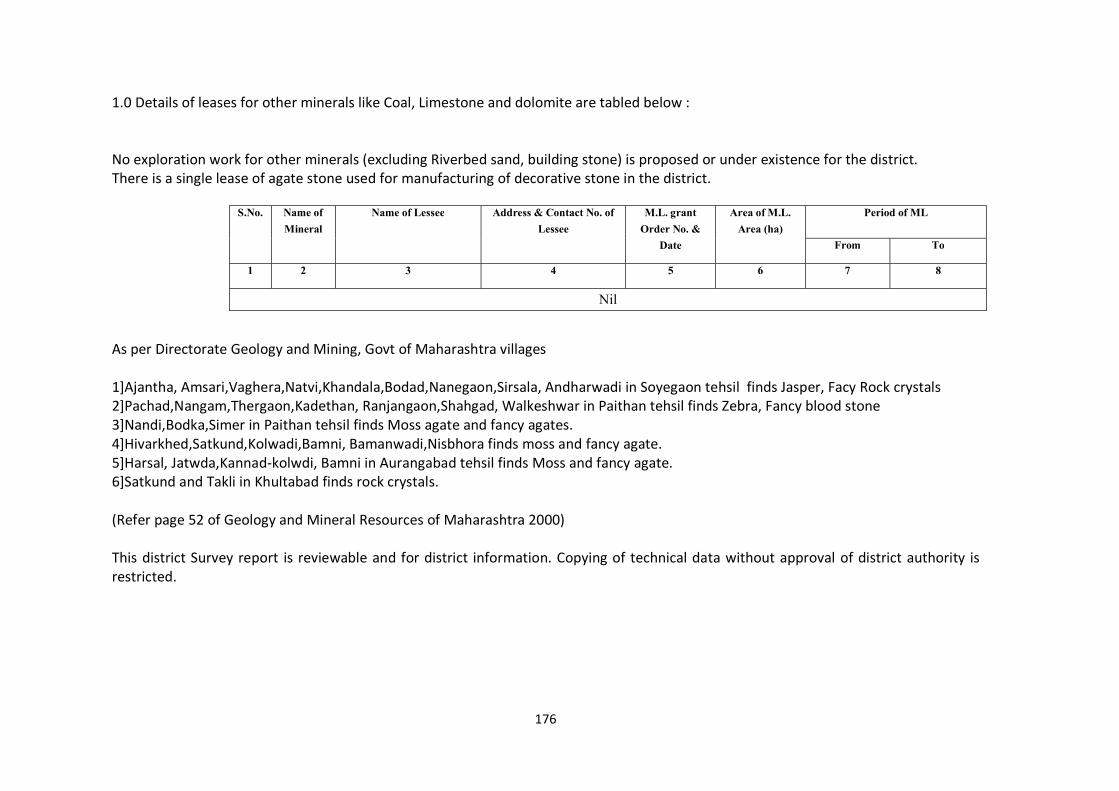
176
1.0 Details of leases for other minerals like Coal, Limestone and dolomite are tabled below : No exploration work for other minerals (excluding Riverbed sand, building stone) is proposed or under existence for the district. There is a single lease of agate stone used for manufacturing of decorative stone in the district.
As per Directorate Geology and Mining, Govt of Maharashtra villages 1]Ajantha, Amsari,Vaghera,Natvi,Khandala,Bodad,Nanegaon,Sirsala, Andharwadi in Soyegaon tehsil finds Jasper, Facy Rock crystals 2]Pachad,Nangam,Thergaon,Kadethan, Ranjangaon,Shahgad, Walkeshwar in Paithan tehsil finds Zebra, Fancy blood stone 3]Nandi,Bodka,Simer in Paithan tehsil finds Moss agate and fancy agates. 4]Hivarkhed,Satkund,Kolwadi,Bamni, Bamanwadi,Nisbhora finds moss and fancy agate. 5]Harsal, Jatwda,Kannad-kolwdi, Bamni in Aurangabad tehsil finds Moss and fancy agate. 6]Satkund and Takli in Khultabad finds rock crystals. (Refer page 52 of Geology and Mineral Resources of Maharashtra 2000) This district Survey report is reviewable and for district information. Copying of technical data without approval of district authority is restricted.
S.No. Name of Mineral
Name of Lessee Address & Contact No. of Lessee
M.L. grant Order No. &
Date
Area of M.L. Area (ha)
Period of ML
From To
1 2 3 4 5 6 7 8
Nil
177
Annexure -1 : Procedure to scrutinize Minor Mineral proposals Procedure to scrutinize Minor Mineral proposals 1] Receipt of Application as per MMMEDR 2013 with required documents 2] Receipt of S.D.O. Report over 14 points stipulated by administration. 3] Site Visit by representative of Mining Office, Aurangabad/District Mining Officer, Aurangabad. 4] correlating demand and supply for the taluka, nearest town or any specific demand for specific project on feasibility of requirement of stone quarry. 5] Issuance of Letter of Intent. 6] Procedure for award of Lease.
178
Annexure -2 : Procedure to monitor compliances of Minor Mineral Leases Procedure to monitor compliances of Minor Mineral Leases 1] After award of lease, first compliance to prior EC conditions are to be submitted by Leasee for ground work carried out. 2] Yearly Compliance to Lease Agreement for royalty clearance, Lease conditions and prior EC conditions(scrutiny based on photographic and documentary evidences with site visit). 3] Penal Action : failure to submit compliance as per sr. no. 2, district administration reserves right to hold the royalty passes or to suspend of cancel lease agreement subject to fulfillment of compliance.
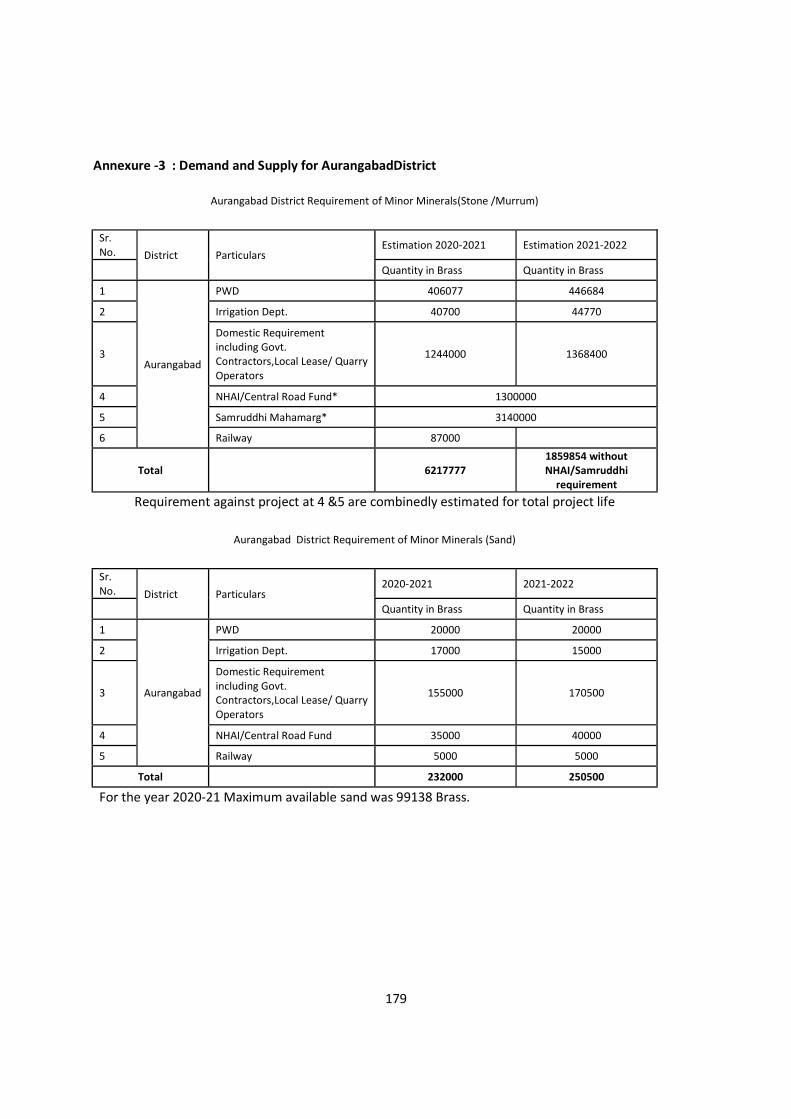
179
Annexure -3 : Demand and Supply for AurangabadDistrict
Aurangabad District Requirement of Minor Minerals(Stone /Murrum)
Sr. No. District Particulars
Estimation 2020-2021 Estimation 2021-2022
Quantity in Brass Quantity in Brass
1
Aurangabad
PWD 406077 446684
2 Irrigation Dept. 40700 44770
3
Domestic Requirement including Govt. Contractors,Local Lease/ Quarry Operators
1244000 1368400
4 NHAI/Central Road Fund* 1300000
5 Samruddhi Mahamarg* 3140000
6 Railway 87000
Total 6217777 1859854 without NHAI/Samruddhi
requirement
Requirement against project at 4 &5 are combinedly estimated for total project life
Aurangabad District Requirement of Minor Minerals (Sand)
Sr. No. District Particulars
2020-2021 2021-2022
Quantity in Brass Quantity in Brass
1
Aurangabad
PWD 20000 20000
2 Irrigation Dept. 17000 15000
3
Domestic Requirement including Govt. Contractors,Local Lease/ Quarry Operators
155000 170500
4 NHAI/Central Road Fund 35000 40000
5 Railway 5000 5000
Total 232000 250500
For the year 2020-21 Maximum available sand was 99138 Brass.

180
Annexure -4 MoEFCC, GoI notification S.O. 3611(E) dated 25.07.2018
181
Annexure -5 L Sections and Cross Sections for rivers flowing through Aurangabad district
182
Annexure -6 Corporate Environmental Responsibility Aurangabad District for Stone Quarries
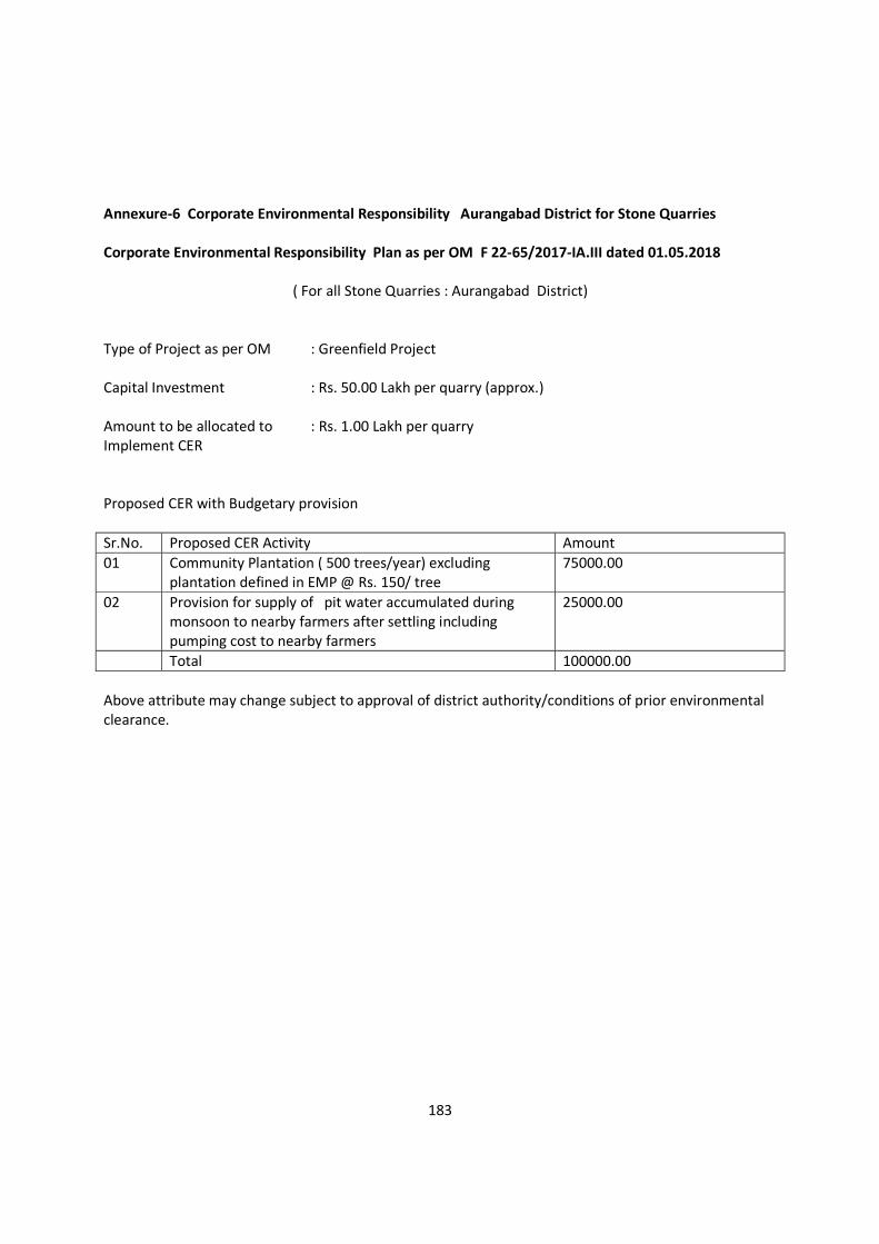
183
Annexure-6 Corporate Environmental Responsibility Aurangabad District for Stone Quarries Corporate Environmental Responsibility Plan as per OM F 22-65/2017-IA.III dated 01.05.2018
( For all Stone Quarries : Aurangabad District) Type of Project as per OM : Greenfield Project Capital Investment : Rs. 50.00 Lakh per quarry (approx.) Amount to be allocated to : Rs. 1.00 Lakh per quarry Implement CER Proposed CER with Budgetary provision Sr.No. Proposed CER Activity Amount 01 Community Plantation ( 500 trees/year) excluding
plantation defined in EMP @ Rs. 150/ tree 75000.00
02 Provision for supply of pit water accumulated during monsoon to nearby farmers after settling including pumping cost to nearby farmers
25000.00
Total 100000.00 Above attribute may change subject to approval of district authority/conditions of prior environmental clearance.
184
Annexure -7 Sections for Sand Ghats 2021-222 (Amendment Proposed for F.Y. 2021-22)
185
Annexure -8 COMPLIANCE TO ENFORCEMENT AND MONITORING GUIDELINES FOR SAND MINING 2020
(PUBLICATION OF ANNEXURES )
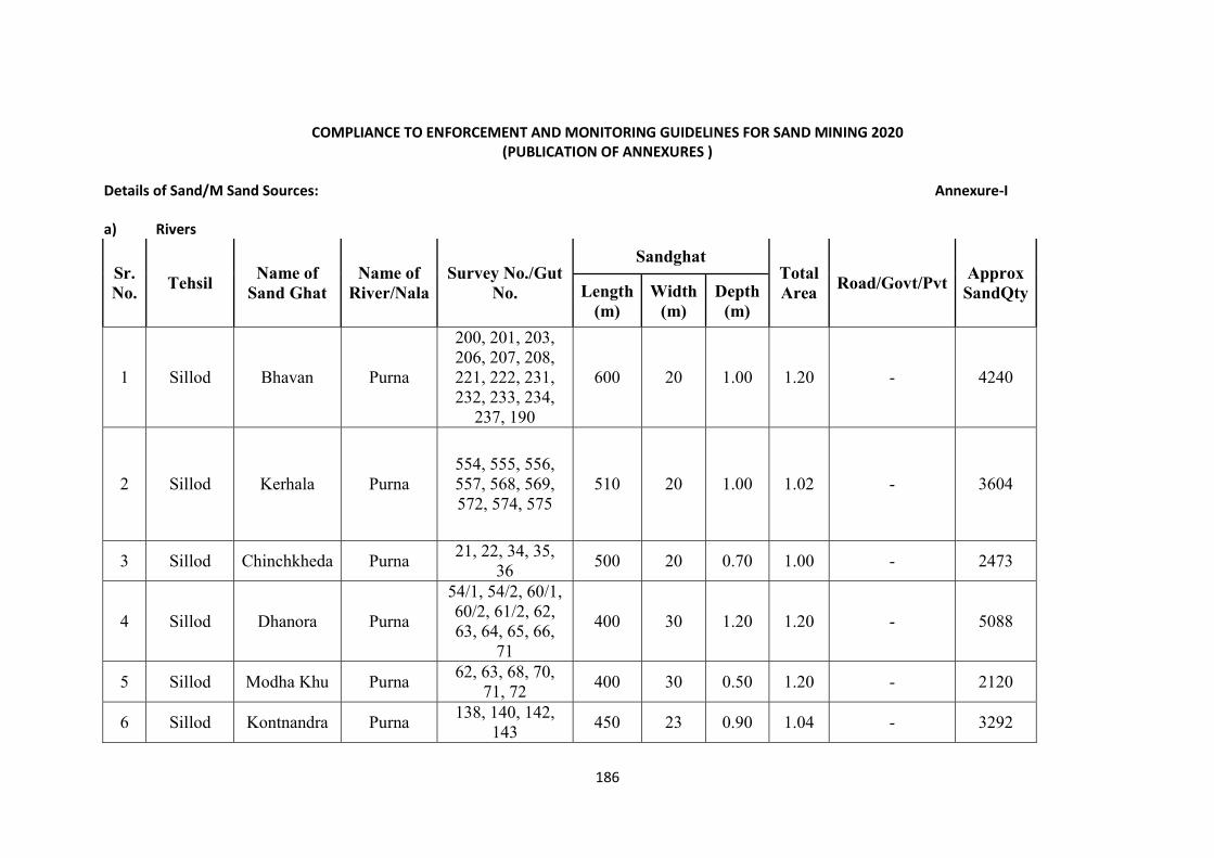
186
COMPLIANCE TO ENFORCEMENT AND MONITORING GUIDELINES FOR SAND MINING 2020
(PUBLICATION OF ANNEXURES ) Details of Sand/M Sand Sources: Annexure-I a) Rivers
Sr. No.
Tehsil Name of
Sand Ghat Name of
River/Nala Survey No./Gut
No.
Sandghat Total Area
Road/Govt/Pvt Approx
SandQty Length (m)
Width (m)
Depth (m)
1 Sillod Bhavan Purna
200, 201, 203, 206, 207, 208, 221, 222, 231, 232, 233, 234,
237, 190
600 20 1.00 1.20 - 4240
2 Sillod Kerhala Purna 554, 555, 556, 557, 568, 569, 572, 574, 575
510 20 1.00 1.02 - 3604
3 Sillod Chinchkheda Purna 21, 22, 34, 35,
36 500 20 0.70 1.00 - 2473
4 Sillod Dhanora Purna
54/1, 54/2, 60/1, 60/2, 61/2, 62, 63, 64, 65, 66,
71
400 30 1.20 1.20 - 5088
5 Sillod Modha Khu Purna 62, 63, 68, 70,
71, 72 400 30 0.50 1.20 - 2120
6 Sillod Kontnandra Purna 138, 140, 142,
143 450 23 0.90 1.04 - 3292
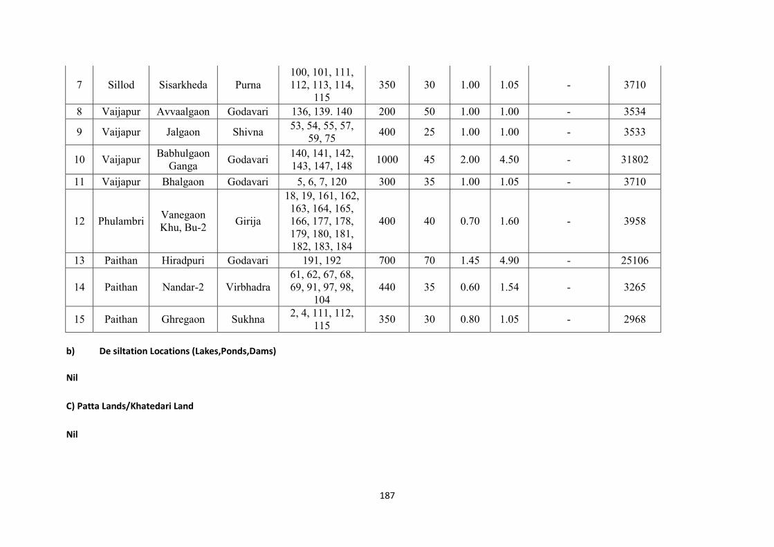
187
7 Sillod Sisarkheda Purna 100, 101, 111, 112, 113, 114,
115 350 30 1.00 1.05 - 3710
8 Vaijapur Avvaalgaon Godavari 136, 139. 140 200 50 1.00 1.00 - 3534
9 Vaijapur Jalgaon Shivna 53, 54, 55, 57,
59, 75 400 25 1.00 1.00 - 3533
10 Vaijapur Babhulgaon
Ganga Godavari
140, 141, 142, 143, 147, 148
1000 45 2.00 4.50 - 31802
11 Vaijapur Bhalgaon Godavari 5, 6, 7, 120 300 35 1.00 1.05 - 3710
12 Phulambri Vanegaon Khu, Bu-2
Girija
18, 19, 161, 162, 163, 164, 165, 166, 177, 178, 179, 180, 181, 182, 183, 184
400 40 0.70 1.60 - 3958
13 Paithan Hiradpuri Godavari 191, 192 700 70 1.45 4.90 - 25106
14 Paithan Nandar-2 Virbhadra 61, 62, 67, 68, 69, 91, 97, 98,
104 440 35 0.60 1.54 - 3265
15 Paithan Ghregaon Sukhna 2, 4, 111, 112,
115 350 30 0.80 1.05 - 2968
b) De siltation Locations (Lakes,Ponds,Dams) Nil C) Patta Lands/Khatedari Land Nil
188
d) M-Sand Plants Inclusion of M Sand/Patta Land in DSR not give landowners/operators right to operate M-sand Plant/Sand Mining Lease. All the sand ghats referred above are in the stage of various clearance on district administration level. No M sand units are registered in the district
189
List of Potential Mining Leases (Existing & Proposed) Annexure-II A] Rivers (Mineral Sand)
Sr. No.
Tehsil Name of
Sand Ghat Name of
River/Nala Survey No./Gut
No.
Sandghat Total Area
Road/Govt/Pvt Approx
SandQty Length (m)
Width (m)
Depth (m)
1 Sillod Bhavan Purna
200, 201, 203, 206, 207, 208, 221, 222, 231, 232, 233, 234,
237, 190
600 20 1.00 1.20 - 4240
2 Sillod Kerhala Purna 554, 555, 556, 557, 568, 569, 572, 574, 575
510 20 1.00 1.02 - 3604
3 Sillod Chinchkheda Purna 21, 22, 34, 35,
36 500 20 0.70 1.00 - 2473
4 Sillod Dhanora Purna
54/1, 54/2, 60/1, 60/2, 61/2, 62, 63, 64, 65, 66,
71
400 30 1.20 1.20 - 5088
5 Sillod Modha Khu Purna 62, 63, 68, 70,
71, 72 400 30 0.50 1.20 - 2120
6 Sillod Kontnandra Purna 138, 140, 142,
143 450 23 0.90 1.04 - 3292
7 Sillod Sisarkheda Purna 100, 101, 111, 112, 113, 114,
115 350 30 1.00 1.05 - 3710
190
8 Vaijapur Avvaalgaon Godavari 136, 139. 140 200 50 1.00 1.00 - 3534
9 Vaijapur Jalgaon Shivna 53, 54, 55, 57,
59, 75 400 25 1.00 1.00 - 3533
10 Vaijapur Babhulgaon
Ganga Godavari
140, 141, 142, 143, 147, 148
1000 45 2.00 4.50 - 31802
11 Vaijapur Bhalgaon Godavari 5, 6, 7, 120 300 35 1.00 1.05 - 3710
12 Phulambri Vanegaon Khu, Bu-2
Girija
18, 19, 161, 162, 163, 164, 165, 166, 177, 178, 179, 180, 181, 182, 183, 184
400 40 0.70 1.60 - 3958
13 Paithan Hiradpuri Godavari 191, 192 700 70 1.45 4.90 - 25106
14 Paithan Nandar-2 Virbhadra 61, 62, 67, 68, 69, 91, 97, 98,
104 440 35 0.60 1.54 - 3265
15 Paithan Ghregaon Sukhna 2, 4, 111, 112,
115 350 30 0.80 1.05 - 2968
191
B] De siltation Locations (Lakes,Ponds,Dams) Nil C] Patta Lands/Khatedari Land Nil
D] M-Sand Plants No M sand units are registered in the district
Inclusion of M Sand/Patta Land in DSR not give landowners/operators right to operate M-sand Plant/Sand Mining Lease. All the sand ghats referred above are in the stage of various clearance on district administration level.
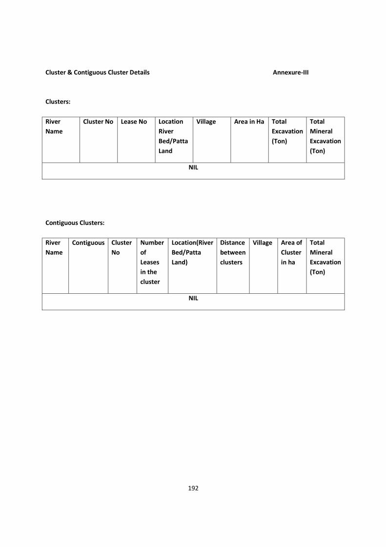
192
Cluster & Contiguous Cluster Details Annexure-III Clusters: River Name
Cluster No Lease No Location River Bed/Patta Land
Village Area in Ha Total Excavation (Ton)
Total Mineral Excavation (Ton)
NIL
Contiguous Clusters: River Name
Contiguous Cluster No
Number of Leases in the cluster
Location(River Bed/Patta Land)
Distance between clusters
Village Area of Cluster in ha
Total Mineral Excavation (Ton)
NIL
193
Transportation routes for individual leases ANNEXURE IV Transportation routes for leases in cluster No cluster is formed…..
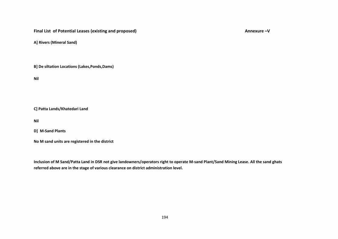
194
Final List of Potential Leases (existing and proposed) Annexure –V A] Rivers (Mineral Sand) B] De siltation Locations (Lakes,Ponds,Dams) Nil C] Patta Lands/Khatedari Land Nil
D] M-Sand Plants No M sand units are registered in the district
Inclusion of M Sand/Patta Land in DSR not give landowners/operators right to operate M-sand Plant/Sand Mining Lease. All the sand ghats referred above are in the stage of various clearance on district administration level.
195
Cluster & Contiguous Cluster Details Annexure-VI Clusters: River Name
Cluster No Lease No Location River Bed/Patta Land
Village Area in Ha Total Excavation (Ton)
Total Mineral Excavation (Ton)
NIL
Contiguous Clusters: River Name
Contiguous Cluster No
Number of Leases in the cluster
Location(River Bed/Patta Land)
Distance between clusters
Village Area of Cluster in ha
Total Mineral Excavation (Ton)
NIL
196
Final Transportation routes for individual leases ANNEXURE VII Transportation routes for leases in cluster No cluster is formed…..


