Embed Size (px)
Citation preview
PREDICTION OF SEDIMENT YIELD FROM
TRIBUTARY BASINS ALONG HUELSDONK RIDGE,
HOH RIVER, WASHINGTON
by
R. L. Logan, K. L. Kaler, and P. K. Bigelow
WASHINGTON DIVISION OF GEOLOGY AND EARTH RESOURCES
OPEN FILE REPORT 91-7
December 1991
This report has not been edited or reviewed for conformity with
Division of Geology and Earth Resources standards and nomenclature
' ' WASHJNGTON STATE DEPARTMENT OF ~ Natural Resources .,..,.
Bnan Boyle ~ Commissioner of Pubilc Lands Art Stearns ~ Supervisor
Division of Geology and Earth Resources Raymond Lasmanis. State Geologist


PREDICTION OF SEDIMENT YIELD FROM TRIBUTARY BASINS ALONG HUELSDONK RIDGE, HOH RIVER, WASHINGTON
by R. L. Logan, K. L. Kaler, and P. K. Bigelow
ABSTRACT
Field investigations and aerial photographs were used to determine that, during the winter of 1989-1990, slope failures in ten Hoh River tributary basins on the north side of Huelsdonk Ridge mobilized an estimated 243,000 cubic yards of sediment from clearcuts. An estimated one-third, or 83,000 cubic yards, of the mobilized sediment was delivered to the lower tributary reaches, side channels, and south fork and main stem Hoh River. Only two of 105 landslides occurred entirely within old-growth stands. Seventy-five percent of the slope failures are located well below ridge tops in a midslope position and occurred in soils less than 5 feet (1.5 meters) thick on slopes ranging from 49 percent to 104 percent. Slope stability on these steep slopes is heavily dependent on root reinforcement. Failures in soils thicker than the average for the local slope are commonly associated with bedrock faults. Forty-three percent of the slope failures were associated with zero-order basins; this small percentage precludes using zeroorder basins in remaining old-growth stands as a predictive tool for sediment production. Remaining old-growth stands are in areas that have characteristics (slope, climate, geology, soils, and elevation) within the same ranges as those of the clearcut areas that contain 103 of the 105 landslides studied. Limited data indicate that sediment yield increases as a function of area clearcut. If old-growth forests on slopes between 49 percent and 104 percent are clearcut, sediment yields can be expected to be similar in magnitude and composition to those from existing clearcut areas and may be long term.
Slope failures along Huelsdonk Ridge are a major source of sediment for the Hoh River and its tributaries. Research on the nature and extent of the impact of this sediment on fisheries resources in the river was recently completed by Hatten (1991 ), Cederholm (1991 ), and McHenry (1991) as part of the Hoh River Slope Stability Project. Their studies indicate that the volume, size, and residence time of sediment entering the Hoh River and its tributaries are adversely influencing productivity of the fish habitat. In order to minimize future habitat degradation, resource management alternatives must acknowledge the importance of adequate information about sediment yield.
This project is part of the Hoh River Slope Stability Project, a program designed to develop resource management alternatives for parts of the Hoh River basin (Fig. 1) and to be used as a model for developing management alternatives for other basins in which the Washington State Department of Natural Resources (DNR) has management responsibilities. In this study we have attempted to (1) assess the amount and timing of sediment delivered to the Hoh River by mass-wasting processes along the north side of Huelsdonk Ridge (Fig. 1) and (2) provide a critique of how this assessment was accomplished.
Huelsdonk Ridge is a drainage divide that protrudes westward from the Olympic Mountains. It separates the Owl Creek drainage to the south from the mainstem and South Fork Hoh River drainage basins to the north. The ridge is composed of highly deformed and faulted siltstones, sandstones, and conglomerates of the Western Olympic lithic Assemblage of Tabor and Cady (1988). Glacial/fluvial terraces, which consist of sand, gravel, and silt, cover the lower flanks; till and colluvium, both blanketed with colluvial soils, cover the mid-slopes. Nearer the ridge crest, colluvial soils commonly are in sharp contact with bedrock or local patches of till. North-flowing streams, tributary to the south and main forks of the Hoh River, have cut deeply into the ridge, leaving extremely steep canyon walls on their interfluves. These spurs have been faceted by alpine glaciers that once occupied the Hoh basin.

Owl
Study Area
ii Location Map
Figure 1. Hoh River Slope Stability Project area, Jefferson County, Washington.
0 l MILE
Contour Interval • 400 feet
0 -0 m z :::!J r m :,:; m -0 0 :,:; -l <.O _.
I
"

SEDIMENT STUDIES, HOH RIVER
Mature timber has been harvested by clearcutting in the Huelsdonk area tributary basins for about 30 years. Today, only about 35 percent of the mature timber stands remain, primarily in the steep upper reaches of the tributary streams. These steep canyons are the areas studied most closely in this project. A major goal of this investigation was to provide a means of predicting the amount of sediment that will be introduced into fish habitat areas of the south and main forks of the Hoh River under various harvest management scenarios.
PROCEDURE
The preliminary project design was approved jointly by the DNR Olympic Region and the Divisions of Geology and Earth Resources and Forest Land Management in May 1990. Field work began in mid-June and included locating, measuring, and sampling soils and describing slope failures and sediment storage areas. Field data sheets were filled out at most localities visited. These forms were designed and worked well to enhance efficient and consistent data collection and reduction. (A sample of this sheet follows the references cited.)
Field mapping was hampered because aerial photography of the study area was not available until August. This made field location and planning difficult and prevented field checking of many features that could otherwise have been investigated.
The aerial photography analysis phase of this project was not completed until the end of the field season. Field measurements of the volumes of depressions left in slopes by slope failures and volumes of in-channel sediment deposits were compared with estimates of volumes of these features on the aerial photographs to determine the accuracy of estimates made from the photographs. Volumes of landslide sediment sources not visited in the field were then estimated from the aerial photographs by careful measurement with calipers, and corrections were made for slope.
Information recorded on the field data sheets was tabulated and studied to determine which factors might be the most useful for the expedient development of management alternatives. Computer-aided drafting (CAD) was used to generate timber stand inventory maps from aerial photographs for use in sediment yield predictions. Large-scale (1 in. = 400 ft) topographic maps were used to study landforms that may be related to slope instability.
The results of this sediment yield study are to be combined with the results of several other studies to provide an estimate of the relative impact of sediment and the duration of this impact on fish habitat. The historic landslide inventory project should provide information about background levels of mass wasting, the hydrologic study should document sediment transport rates, and the stream sediment and macroinvertebrate studies will offer additional impact and recovery estimates. The combined results of these studies will make up a basis from which resource management alternatives can be developed. The quality of the alternatives will depend on the qua I ity of the supporting studies.
RESULTS OF FIELD, AERIAL PHOTOGRAPHY, AND LANDFORM STUDIES
Field studies, aerial photography, and landform and laboratory analyses provided spatial, causal, and, to some degree, temporal information about sediment delivery in the study area. These studies showed that slope failures are major sediment sources in the tributary basins. Debris slides, flows, and/or torrents in combination with dam-break floods and side-channel erosion (including important sources such as the terrace deposits dissected by Iron Maiden Creek in its lower reach) produce major pulses of sediment into local streams. An estimated 243,000 yd3 of soil and rock was mobilized by mass wasting during the winter of 1989-1990.
More than 90 percent of the failures originated in clearcut areas. Although healed landslide scars are apparent in mature timber stands, few large, fresh scars are present in those areas. Where fresh scars exist in mature stands, they are typically near roads or clearcuts. In the study area, only two fresh scars were detected in mature stands on the aerial photographs taken during the summer of 1990. Older black and white aerial photographs of various vintages show evidence of fresh debris torrent scour that probably occurred shortly before the
3

OPEN FILE REPORT 91-7
Table 1. Midslope failures in tributaries on the north side of Huelsdonk Ridge
Percent Percent Hoh Tributary Total East facing West facing east facing west facing
Boundary Creek 8 7 1 88% 12%
Hoot Creek 3 2 67% 33%
Line Creek 22 15 7 68% 32%
Split Creek (East Fork) 7 6 86% 14%
Split Creek (West Fork) 8 7 88% 12%
McQuarry Creek 11 6 5 55% 45%
Virginia Falls Creek 11 3 8 27% 73%
H-1 070 Creek 5 4 80% 20%
Washout Creek
West Fork Washout Creek 0 0% 100%
Iron Maiden Creek 3 2 33% 67%
Total 79 51 28 65% 35%
photographs were taken. Some of these scars run the full length of tributary channels; others are localized. However, landslides are far more numerous in the 1990 aerial photograph set (Schlichte, 1991 ).
Most failures in harvested areas are at mid-slope (Tables 1 and 2), not spatially associated with ridge tops, landings, or roads. Although not as numerous as mid-slope failures, road and landing failures (Table 3) are commonly major contributors of sediment to the Hoh River and its tributaries. Sediment source volumes are artificially increased and factors of safety are artificially decreased by sidecasting, because both the sidecast prism and the subjacent soil horizon are subject to failure.
Table 2. Slope failures in tributaries on the north side of Huelsdonk Ridge
Percent Percent Hoh Tributary Total East facing West facing east facing west facing
Boundary Creek 11 9 2 82% 18%
Hoot Creek 8 6 2 75% 25%
Line Creek 24 17 7 71% 29%
Split Creek (East Fork) 11 10 91% 9%
Split Creek (West Fork) 9 8 89% 11%
McQuarry Creek 13 8 s 62% 38%
Virginia Falls Creek 13 s 8 38% 62%
H-1070 Creek 6 5 83% 17%
Washout Creek
West Fork Washout Creek 3 2 67% 33%
Iron Maiden Creek 7 2 4 29% 57%
Total 105 72 32 69% 30%
4

SEDIMENT STUDIES, HOH RIVER
Many locations in the study area are at risk of failure, especially roadfill, landing, and sidecast sites. Poor road construction techniques, particularly burial of organic material or soils on steep slopes, are commonly responsible for the fill failures. The at-risk sites can be identified by reconnaissance field mapping to locate old fill and sidecast areas. These areas can then be evaluated for stability on a site-specific basis.
Although the data base is limited, landslides throughout clearcut areas appear to be related to a combination of natural factors including landform, bedrock, bedrock faults, soil, and vegetation. About 43 percent of the documented landslides are associated with zero-order basins, that is, concave-upward stream headwall areas in which no defined channel exists (Tables 2 and 4). We originally expected that most failures would be associated with these basins. If we could verify this correlation, then we could count these basins in the mature stands and thereby predict failure rates that could be expected after the mature stands were harvested. However, with such poor correlation, we have concluded that such predictions cannot made on the basis of the number of zero-order basins in a drainage.
A higher proportion of failures occurred on the long, planar slopes of asymmetric tributary valleys than on the shorter and/or convex-upward slopes (Fig. 2). This trend may be related to the distance of failures from the drainage divide, but this relation was not investigated. Because so many local factors, such as soil depth, soil density, discontinuity surfaces (soil/bedrock interfaces), and root cohesion (Buchanan and Savigny, 1990) influence slope stability, it is difficult to make accurate stability predictions over large areas without large-scale detailed investigations. Tributary-wide morphological factors, such as valley asymmetry, however, can be used to identify general areas of relatively greater landslide risk.
Many failures on Huelsdonk Ridge, which can begin as rotational slumps, are spatially associated with bedrock faults. Fairly deep soils tend to form above these faults, where fragmented bedrock is more easily weathered. These soil pockets commonly appear as v-shaped wedges where they are exposed in roadcuts. The v-shape of the bedrock surface causes groundwater to converge toward the deep soils. If sidecast material is placed on these soil wedges, an artificial load is added and contributes to slope instability.
Of the 105 landslides observed, 79 (7 5 percent) occurred in clearcuts where soils are less than 5 ft thick and overlie smooth, steep soil/bedrock contacts. Most of these failures began as debris slides; many developed into debris torrents or flows. O'Loughl in and Ziemer (1982) attribute this type of failure to loss of cohesive strength caused by root decay after harvest. The thin soil layer, steep slopes, intense rainfall, and soil/rock type in the
Table 3. Sidecast and ridgetop failures in tributaries on the north side of Huelsdonk Ridge
Percent Percent Hoh Tributary Total East facing West facing east facing west facing
Boundary Creek 3 2 67% 33%
Hoot Creek 5 4 80% 20%
Line Creek 2 2 0 100% 0%
Split Creek (East Fork) 4 4 0 100% 0%
Split Creek (West Fork) 0 100% 0%
McQuarry Creek 2 2 0 100% 0%
Virginia Falls Creek 2 2 0 100% 0%
H-1 070 Creek 0 100% 0%
Washout Creek
West Fork Washout Creek 2 2 0 100% 0%
Iron Maiden Creek 4 2 25% 50%
Total 26 21 4 81% 15%
5

E
2800 Rid9e
~ lop 2618
aJ •• 2400 ~
C 2000-C.
C ._g 1600 0 > V w 1200 -
0
E
2800
6 2000-
c :.2. 1600 -0 > ••
w Hool Creek side-slope profile //5 Coincident with smell side-drainage an wesl slope of Hool Creek
400 800 1200 1600 2000 2400
Distance (in feel) '·" •.
East Fork Split Creek side profile 1 -5
2050
Top of ridge 2J50
2800
w
Top of ridge 2720
(;j 1200 -1---,---,---,---.---,---,---,
0 400 800 1200 1 GOO 2000 2400 2800
Distance (in feel) P.H,D.
E
2800 Rid9~
~ top 2!>JO •• 2400 ~
C
~ 0 > V
2000
1600
w West Fork Split Creek Side profile of upper-most large failure (/11)
1955
Top ot rid9e 200
w 1200-1--~--.---,---.---,
2800 Ridge 2640
lop 2400
-::;-Ji 2000
C C. 1600
C
._g 1200 0 > <I)
0
E
w 800 -
400 -
400 800 1200 1600 2000
Distance (in feel) P.K.8.
w
Top of ridge
SEALEVEL -1---,--~--..--~-~-~
0 400 800 1200 1600 2000 2400
Distance (in feel)
Figure 2. Cross sections of asymmeclric tributary valleys. Lanclslidcs arc commonly associated with the longer, straighter, or concave-upwarcl slopes. Cross sections were scaled from DNR 1 "=400' topographic maps, then digitizccl using computer-aided drafting (CAD).
0 -0 m z :!! r m Al m -0 0 Al -i I.O _.
I
"

SEDIMENT STUDIES, HOH RIVER
Huelsdonk tributary basins are similar to those described by O'Loughlin and Ziemer (1982), suggesting that root networks are a major factor in slope stability in the study area.
Results of our textural (sieve) analyses indicate that soils in headscarps of debris slides throughout the Huelsdonk Ridge area are composed of about 30 to 40 percent of 0.85 mm or smaller material. This abundance of fine material is consistent with findings of other studies: bedrock or parent material influences the composition and particle size of overlying soil and colluvium. For example, Duncan and Ward (1985) showed that areas underlain by basalt produce coarser weathering and erosional products than areas underlain by sandstone and siltstone. Huelsdonk Ridge is underlain by sandstone, silt, and minor conglomerate. Glacial/fluvial deposits common to the study area also contain fine sediment. Much of the boulder-size fraction is stored in the main channels of the tributaries; a large portion of the fine fraction is transported to side channels (Hatten, 1991 ), where it is deposited, or is carried to the main channel of the Hoh River (Cederholm, 1991 ).
DISCUSSION
On the north side of Huelsdonk Ridge between the Olympic National Park boundary and the confluence of Owl Creek and the Hoh River (Fig. 1 ), nearly all slope failures that occurred during the fall and winter of 1989-1990 were spatially associated with clearcuts and/or roads. Where slope failures have been detected or investigated in old-growth areas along Huelsdonk Ridge, nearly all originated in areas affected by drainage alterations, clearcuts, or sidecasts.
Although some failures in the study area can be attributed to sidecast instability, the majority are mid-slope failures (Table 1) and result from the effects of clearcut harvest on slopes ranging in gradient from 26 to 46 degrees (49 to 1 04 percent) (Fig. 3) at elevations between 1,400 and 2,900 ft (Fig. 4). Slopes are generally very steep, and the loose, sandy soils fail during major rain or rain-on-snow storms (when the soils are saturated) because root networks have decayed after harvest. These findings are consistent with work of others, such as O'Loughlin and Ziemer (1982) and Ziemer and Swanston (1977).
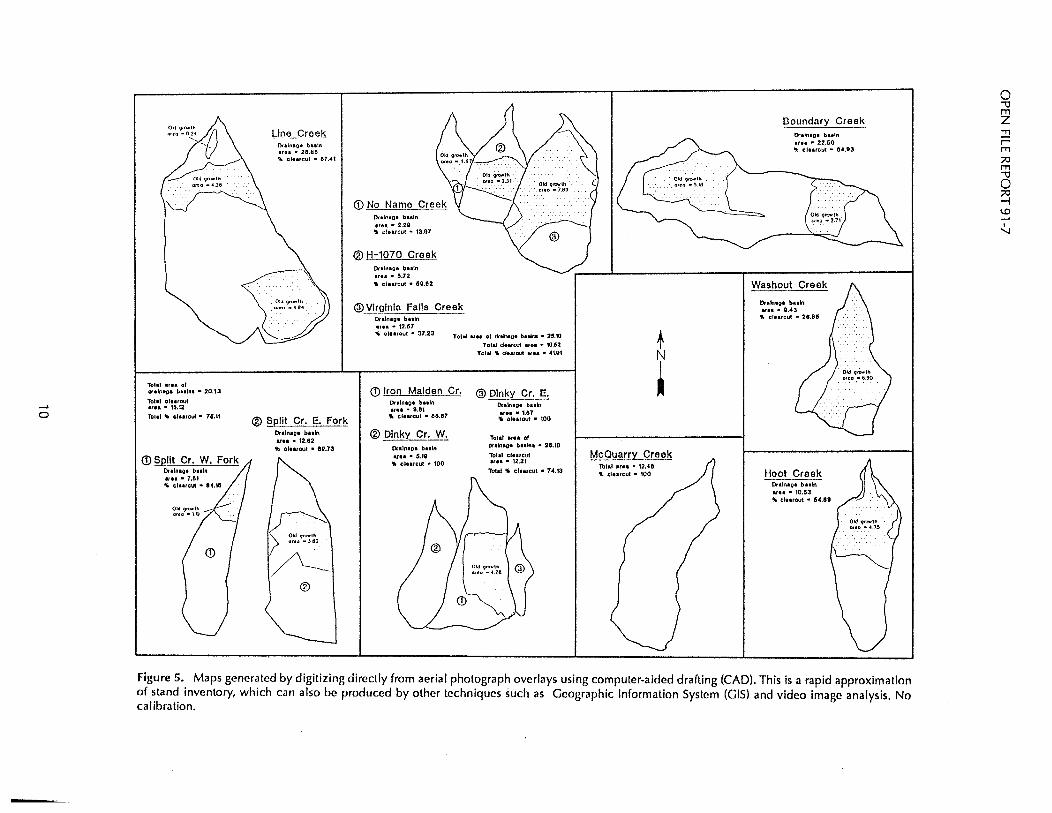
Future sediment delivery rates can be approximated by comparing the sediment inventory, which has been summarized in Table 5, with stand inventory maps (Fig. 5). The results are shown in Table 6. The roots of
Table 4. Zero-order basins in tributaries on the north side of Huelsdonk Ridge
Percent Percent Hoh Tributary Total East facing West facing east facing west facing
Boundary Creek 14 10 4 71% 29%
Hoot Creek 8 5 3 63% 37%
Line Creek 29 22 7 76% 24%
Split Creek (East Fork) 7 7 0 100% 0%
Split Creek (West Fork) 19 15 4 79% 21%
McQuarry Creek 24 11 13 46% 54%
Virginia Falls Creek 13 5 7 39% 54%
H-1 070 Creek 12 8 3 67% 25%
Washout Creek 8 8 0 100% 0%
West Fork Washout Creek 4 4 0 100% 0%
Iron Maiden Creek 9 4 5 44% 56%
Total 147 99 46 67% 31%
7

OPEN FILE REPORT 91-7
5 16 15 20 25' '36"'35" 40 Slope Angle (degrees)
50
remaining old-growth trees within the basin of each tributary will continue to reinforce and protect the soils. However, if the timber is harvested, regardless of the method, soil failures will follow because the roots will no longer contribute to soil cohesion. Failures probably will occur at rates similar to those in adjacent clearcut areas.
Although our data are limited, there is a rough correlation between the number of landslides and the amount of land logged on Huelsdonk Ridge (Fig. 6). This is consistent with the conclusions in Eide (1990), who showed that the number of landslides in the Deer Creek basin in Snohomish County is directly related to the size of the area logged.
Figure 3. Slope angle vs number of slope failures in 10 tributaries on the north side of Huelsdonk Ridge. An inspection of pre-1990 aerial pho
tographs indicates that the frequency and magnitude of slope failures and, therefore, the amount of sediment input to the Hoh have increased significantly above pre-harvest levels. Fresh failures can be recognized by the lack of vegetation on landslide scars, scour, and deposition zones and by the fact that contained organic debris is not sun bleached. These characteristics are consistently observable throughout tributary basins along Hue!sdonk Ridge where aerial photograph identification of fresh scars has been confirmed by ground reconnaissance. It is apparent from the aerial photographs taken during the summer of 1990 that most of the recent failures have occurred either totally or partially within clearcut areas. The same relation of clearcutting to slope failure was noted on aerial photographs of slopes on the north side of the Hoh River.
21 2 1 18 17
1/l 16 ~ 15 ::l 14 ~ 13 u. 1 ~ 11 .2 1 en 9
8 7 6 5 4 3 2 1 O+---,-....,.....,,-,-..,....,.--,-r-,-"",.-"T-,-,
1 5 10 15 20 Elevation, in feet x 100
Figure 4. Number of slope failures vs elevation in 1 O tributaries on the north side of Huelsdonk Ridge.
8
Remaining old growth stands cover portions of tributary valley walls that have precipitation regimes, slopes, geology, and soils similar to those in clearcut areas. It follows that similar rates of sediment production can be expected after future harvests. However, estimates of sediment volume would be conservative because nearly all of the failures examined were fresh, that is, resulting from erosion related to storms during the winter of 1989-1990. The many failures and storms that have occurred since then have produced more sediment than was estimated in this study. Many more failures and continued erosion of present failures can be expected as the result of future storms.
The elevated sediment production caused by slope failures and soil erosion will likely continue for a long

SEDIMENT STUDIES, HOH RIVER
Table 5. Estimated volume of sediment mobilized, stored in channels, and delivered to the Hoh River, winter 1989-1990
Minimum sediment Total Sediment delivered to South
mobilized during Estimated in-channel Fork or main fork winter 1989-1990 sediment storage of Hoh River
Creek Name (1,000 yd3) (1,000 yd3) (1,000 yd3)
Boundary Creek 30.3 5.3 25.0
Hoot Creek 14.0 28.9 ?
Line Creek 50.0 42.6 7.4
West Split Creek 18.1 11.7 6.4
East Split Creek 20.8 30.6 ?
McQuarry Creek 30.6 21.2 9.4
Virginia Falls Creek 26.2 13.9 12.3
H-1 070 Creek 3.4 31.6 ?
Washout Creek 12.0 0 12.0
Iron Maiden Creek 37.9 27.6 10.3
Total 243.3 82.8
time. For instance, L. Lundgren (p. 13 in Swanson and others, 1982) estimated that in Tanzania an amount of sediment equal to that of the original failure will be produced over the 7 years following the initial event. M. Tanaka (p. 13 in Swanson and others, 1982) showed the rates of sediment discharge from SO-year-old debris scars are about 100 times greater than rates from undisturbed slopes.
Additional mid-slope and sidecast failures in currently clearcut areas can be expected in the near future. Loss of cohesive strength resulting from root decay begins shortly after harvest. O'Loughlin and Ziemer (1982) showed root strength declines of 50 to 60 percent within 1.5 to 2 years after harvest for Western Hemlock and Sitka Spruce in Alaska and Douglas Fir in the Oregon coastal region. They found that failures begin to occur after about 20 months (Fig. 7). Other authors have found even higher rates of root degradation in coastal areas of the Pacific Northwest. A comprehensive discussion of rates of root decay after clearcutting and the importance of root strength to slope stability can be found in Sidle and others (1985).
Several studies have been done on the recovery of root networks and/or their relation to slope stability in second-growth timber stands. McMinn (1963) hydraulically excavated roots of immature stands of Douglas Fir on Vancouver Island, British Columbia. He demonstrated that significant recovery of root systems is not established until new stands are 40 to 50 years old. Ziemer (1981) showed that after clearcut, relative reinforcement of the soil by roots recovers to about 60 percent after 10 years, degrades again to about40 percent at 20 years, and then begins a steady climb back to normal (Fig. 8). For slopes as steep as those in the study area, this implies that levels of sediment production above background levels can be expected for many years after clearcut, probably even after selective or partial-cut harvests because these techniques will also weaken the natural fabric of the root networks.
Little can be done to mitigate the loss of root strength by harvest in the short term, but slope instability related to road or landing construction can be at least partially treated. A sidecast removal program in the study area was undertaken during the summer of 1990 and is scheduled to continue because many unstable sidecasts and landings remain. The project will reduce the amount of sediment that would have otherwise been mobilized, but only about one-third of the mass of a potential failure can be removed by the machinery being used (Traub, 1990). The remaining sidecast prisms wil I continue to act as overburden on many slopes that are only marginally stable at best; they therefore represent potential additional sediment sources.
9
..... 0
Tolal at•• of drainage bHlna • 20.13
1b1al oleuout ., .. • 115.12 lotat 1IJ ~lureut • 11.11
Drainage baaln .,. .. • 7.61 , t.lurcut • 8'4.1G
Old 9rowlh oreo • \U
(D
Otaln•o• b .. ln .,o. • 28.60 .._ clearcut • 87.41
® §9-lit Cr. E. Fork Dralnao• buln arn • 12.82 ., cloarout • 09.73
®
(j) No Name Creek lxaln•o• basin area • 2.29
1ft clurcut • 13,97
® H-1070 Creek Drainage baaln area • IS.72 " clearcut • 159.82
@ Virginia Falls Creek Dralnag• bHln ., •• • 12.67 4' OIHrout • 37.23 Tobi, atff of chhac,e buln• • 25.'tO
Total dewcut ., .. • 10.62 Total Ii dN1out a,u • 4UU
(D Iron Malgen Cr. @ Dinky Cr. E. Dulnao• bHln area • 0.81
Iii clnrcul • 68.87
® Dinky Cr. W. Dnln•o• bHln ., •• • 5.111 .. t.lHtC:ut • 100
Dr•ln•o• buln UH • 1.87
IJa oleatout • 100
Total .,,. of dralnao• bulna • 24.10
Tola! clHtCUt ., .. • 12.21
Total " clurcut • 7".13
McQuarry Creek Total ., .. • 12 . .C 8 11 clearcut • 100
Boundary Creek Dnln•o• buln .,.. • 22.60 1r clearcut • 84.93
Washout Creak
Dr•ln•o• buln .,. .. • 0.43
-., ClHrCut • 20.85
Hoot Creek Onlnao• b uln ., .. • 10.53 Iii olearout • 54.89
Figure 5. Maps generated by digitizing directly from aerial photograph overlays using computer-aided drafting (CAD). This is a rapid approximation of stand inventory, which can also be produced by other techniques such as Geographic Information System (GIS) and video image analysis. No calibration.
0 "'1J m z ::!:! r m ;;,::, m "'1J 0 ;;,::, -I
"' ...... I
'.J

SEDIMENT STUDIES, HOH RIVER
The complementary stream morphology, stream sediment core sampling, and landslide inventory studies were designed to provide a historic perspective on the sediment dynamics of the Hoh River. Cederholm (1991) reported that the fine ( mm) sediment fraction in the main channel of the Hoh River during the summer of 1990 was below 12 percent and is similar to those levels within the undisturbed reaches within Olympic National Park. This indicates that high water flows in the main channel are able to winnow out the fine size fraction. Hatten (1991 ), on the other hand, has found high levels of fine sediment in side-channel deposits, which are important redd areas; many of his measurements exceed established limits for salmon id survival. Fish habitat in the lower reaches of many of the Hoh tributaries has also been destroyed by terminal fan and debris dam deposits left by debris torrents from harvested slopes.
The duration of the effects of fine sediment, debris deposits, and scour can be determined only through future monitoring efforts because there is no record of the number and magnitude of slope failures in the study area before harvest and no previous clearcutting in the area. In other words, the historic landslide inventory and stream morphology studies may have little value in predicting habitat recovery rates. The sediment inventory coupled with stand inventory information may provide a way of estimating future sediment yields.
We also recognized that some tributaries may have greater impact on the Hoh River than others. Some, such as Split Creek, empty into the main channel; others, such as Iron Maiden Creek, flow into side channels after passing through glacial/alluvial terrace deposits and thereby deliver relatively larger quantities of sediment to much more sensitive environments.
We tried an estimate of yield by completing a sediment inventory for each tributary basin. These inventories are summarized in Table 5. Out of a total of 243,000 yd3 mobilized, 83,000 yd3
, or about one-third of the sediment, was estimated to have been delivered to the lower tributary reaches, side channels, and south fork and main stem Hoh River. Because we found that most of the failures that mobilized the sediment occurred in clearcut areas, we assumed that proportionate amounts of sediment should be generated from future clearcuts. This is an approximation, but we think that making such estimates for the Huelsdonk Ridge tributaries is valid
Table 6. Projected effect of old growth harvest. Column 3 lists the predicted minimum amount of sediment that well be mobilized if remaining old growth is harvested. This is an approximate value because there are many variables involved. For instance, some sediment will be stored in tributary channels and be mobilized again during storms and existing and future slope failures will continue to contribute fine sediment to the Hoh River/South Fork and the lower tributaries for many years at a rate that only future monitoring can determine.
Projected minimum Total calculated Area of sediment increase
sediment mobilized remaining if all old growth 1989-1990 old growth is harvested
Creek Name (1,000 yd3) (percent) (1,000 yd3)
Boundary Creek 30.3 35.1 16.4
Hoot Creek 14.0 45.1 11.5
Line Creek 50.0 32.6 24.2
West Split Creek 18.1 15.9 3.4
East Split Creek 20.8 30.3 9.0
McQuarry Creek 30.6 0 *
Virginia Falls Creek 26.2 67.2 44.2
H-1070 Creek 3.4 40.4 2.3
Washout Creek 12.0 73.2 32.7
Iron Maiden Creek 37.9 25.9 13.2
11

OPEN FILE REPORT 91-7
0 Q) 1 .0 E :J z
6
4
A VIRGINIA FALLS
A H-1070
W. FORK SPLIT
.... E. FORK SPLIT
A LINE
A McOUARRY
A BOUNDARY
because most of the remaining timber is located on similar (very steep) slopes with similar aspect, elevation, and climate, and the trees grow on sandy soils that lie on smooth-surfaced, effectively impermeable bedrock.
Figure 5 shows the distribution and percentages of clearcut and old growth stands. Areas were measured directly from aerial photographs; they were not corrected for distortion and are, therefore, approximate. By
2 comparing sediment inventory ...._ wAsHOUT to areal distribution of old 0·+------,------,------,------------1
o 5 10 15 20 25 growth, it can be shown that for Clearcut in CAD area units
Figure 6. The relationship between the amount of area logged and the number of landslides is apparent in this chart Area is plotted as CAD area units because they were measured by the computer on areas digitized directly from aerial photographs without terrain correction.
those basins in which midslope failures dominate, expected sediment delivery can be prorated on the basis of oldgrowth distribution. For example, Virginia Falls Creek (Fig. 5) is 63 percent old growth and 37 percent clearcut, that is, there
is 1.7 times as much remaining old growth, which, if harvested, can reasonably be expected to produce an amount of sediment that is at least proportional to that produced during the winter of 1989-1990. To calculate the amount of sediment delivered from Virginia Falls Creek to the Hoh River, we estimated (from measurements made in the field and from aerial photographs) the amount of material that was mobilized (26,200 yd3) and the amount stored in channel (13,900 yd3
) and calculated the difference, which is 12,300 yd3• By multiplying 1.7 X 12,300 yd3
, we estimate that a minimum of 20,900 yd3 of sediment will be mobilized in the Virginia Falls Creek basin if 100 percent of the remaining old growth is harvested. Table 6 lists all of the drainages in the study
60-
.c 40 Ol C
i <Jl
~ <Jl C 2Q .$ 0 0 a:
0-+-----,-----r-----,-, -----,-----, 0 10 20 JO 40
Time since cutting (months)
Figure 7. Curves of mean tensile strength vs time elapsed since tree felling for small roots of various conifer and hardwood trees (Modified from O'Loughlin and Ziemer, 1982).
12
50
area and the minimum amounts of sediment that would probably be mobilized in each basin if all of the mature stands are harvested. About one-third of the mobilized sediment would then be yielded to downstream reaches. It should be noted that these estimates, although very crude, are also likely to be quite conservative because they are based on one winter season. Several more major washouts were observed during the winter of 1990-1991, and long-term continued erosion, as noted above, can be expected.
Another potentially useful observation made during this study is the recognition of a preferential geographidgeomorphic location of landslide scars. We noted that many landslides occurred on east-facing slopes, and at first we speculated that this could be related to sun angle, dominant storm direc-

1.0
0.8 c (l)
E (l)
~ 0.6 0
~ ~ (l)
0.4 > ·75 ai a:
0.2
0
.
I 20
Years after logging
Figure 8. Relative reinforcement of soils by live roots generally increased while that by dead roots rapidly decreased with time after clearfelling. The total reinforcement by live and dead roots dropped to a low point about 7 years after logging (Redrawn from Ziemer, 1981 ).
SEDIMENT STUDIES, HOH RIVER
tion, bedrock orientation, or distribution of snowpack. However, there are exceptions to this observation. Most failures in Virginia Falls Creek, for instance, are on the longer west-facing slope of the asymmetric valley. Figure 2 i II ustrates the asymmetry of several tributary valleys in which there is a preferred eastern aspect for landslides. The landslides are associated with the longer valley wall. Apparently, the longer the slope, the more hydrostatic pressure can develop within the soil profile during large storms. A relatively high hydrostatic head in a shallow sandy soil on a steep slope will lower the soil's resistance to failure. This information may be useful when micro-zonation of landslide hazards is needed.
CONCLUSIONS
Sediment yield in the Huelsdonk Ridge study area is directly influenced by road building and clearcutting. Although sediment production from roads can be miti
gated through better construction techniques and routing and possibly by sidecast pul I back efforts, it will only be aggravated by clearcut harvest in nearly all remaining old-growth stands. Sediment production will increase in proportion to the size of the area that is harvested because the remaining timber, with only minor exceptions, grows in the same natural conditions that are found in the steep clearcut areas. ·
Background levels of sediment production from current old-growth in the tributary basins in the study area could perhaps be estimated and sediment production from clearcut areas could be reduced if no more harvesting were allowed in the area. However, Platts and others (1989) have shown, based on 20 years of data, that sediment in spawning areas may actually increase after management activities have been curtailed in adjacent forest lands (which, incidentally, in their study area, were on gentler slopes than those in the Huelsdonk tributary basins).
The duration of the impact of fine-sediment storage in the spawning gravels is unknown. However, monitoring of sediment transport, deposition, and storage will be extremely difficult to interpret if harvest continues in the study area. Otherwise, both sediment budget studies and stream-sediment core sampling will be needed to provide the information for determining how long the effects of the current sediment regime and stream configuration wil I last. Continued monitoring is essential to determine the duration and significance of negative impact of sedimentation on fish habitat and to design any possible mitigation efforts.
Cost effectiveness, feasibility, and environmental impact of mitigation projects should draw heavily on information provided by monitoring programs, and they should use the expertise of fisheries biologists, engineering geologists, engineering soil scientists, engineers, and engineering hydrologists. Without comprehensive input from these professions, time and money can be wasted and irreparable damage to the environment and resources is more likely to occur.
All of this does not mean that no harvest should be considered. Clearcutting in a few selected areas (all of which are outside of the steep tributary valleys) might be accommodated without significant effects on sediment production. However, careful site inspection should be conducted and resultant recommendations heeded before approval for any such management activity is given. If harvested, these sites should be carefully monitored to ensure that they do not influence other monitoring programs that may be operating in the study area. Micro-zonation of potential harvest sites in the study area can be enhanced on a limited basis by locating
13

OPEN FILE REPORT 91-7
bedrock faults, studying tributary valley cross-sections (which can be generated using the DNR 1 in. = 400 ft topographic maps), and analyzing historic aerial photographs in addition to considering slope angle and other variables recognized as important to slope stability.
REFERENCES CITED
Buchanan, P.; Savigny, K. W., 1990, Factors controlling debris avalanche initiation: Canadian Geotechnical Journal, v. 27, no. 5, p. 659-675.
Cederholm, C. J., 1991, Spawning gravel sampling in landslide affected and unaffected areas of the mainstream Hoh River: Unpublished ReportHoh River Slope Stability Project, 20 p.
Duncan, S. H.; Ward, J. W., 1985, The influence of watershed geology and forest roads on the composition of salmon spawning gravel: Northwest Science, v. 59, no. 3, p. 204-212.
Eide, J., 1990, A 48-year sediment budget (1942-1989) for Deer Creek basin, Washington: Western Washington University Master of Science thesis, 122 p.
Hatten, James, 1991, The effects of debris torrents on spawning gravel quality in tributary basins of the Hoh River, Washington: Unpublished ReportHoh River Slope Stability Project, 22 p.
McHenry, Michael, 1991, The effects of debris torrents on macroinvertebrate populations in tributary basins of the Hoh River, Washington: Unpublished ReportHoh River Slope Stability Project, 33 p.
McMinn, R. G., 1963, Characteristics of Douglas-fir root systems: Canadian Journal of Botany, v. 41, p. 105-122.
O'loughlin, Colin; Ziemer, R. R., 1982, The importance of root strength and deterioration rates upon edaphic stability in steepland forests. In Carbon uptake and allocation in subalpine ecosystems as a key to management Proceedings of an 1.U.F.R.O. Workshop, Aug. 2-3, Oregon State University, Corvallis, p. 70-78.
Platts, W. S.; Torquemada, R. J.; McHenry, M. L.; Graham, C. K., 1989, Changes in salmon spawning and rearing habitat from increased delivery of fine sediment to the South Fork Salmon River, Idaho: Transactions of the American Fisheries Society, v. 118,.p. 274-283.
Sehl ichte, Kenneth, 1991, Aeria I photo interpretation of the mass wasting history in the Huelsdonk Ridge area: Unpublished reportHoh River Slope Stability Project, 8 p.
Sidle, R. C.; Pearce, A. J.; O'Loughlin, C. L., 1985, Hillslope stability and land use: American Geophysical Union Water Resources Monograph Series 11, 140 p.
Swanson, F. J.; Janda, R. J.; Dunne, T.; Swanston, D. N., 1982, Sediment budgets and routing in forested drainage basins: U.S. Forest Service GeneralTechnical Report PNW-141, 165 p.
Tabor, R. W.; Cady, W. M., 1989, Geologic map of the Olympic Peninsula, Washington: U.S. Geological Survey Miscellaneous Investigation Series Map 1-994 [reprint], 2 sheets, scale 1 :125,000.
Traub, W., 1990, Untitled report on sidecast removal project DNR internal written communication, 10 p., with appendix.
Ziemer, R.R., 1981, Roots and the stability of forested slopes. In Davies, T. R.H.; Pearce, A. J., Erosion and sediment transport in Pacific Rim steeplands: IAHS Publication 132, p. 343-361.
Ziemer, R.R.; Swanston, D. N., 1977, Root strength changes after logging in southeast Alaska: USDA Forest Service Research Note PNW-306, 10 p.
14

DNR - GEOLOGY GEOLOGIC FIELD DATA PT. NO. HOH RIVER PROJECT DATA FORM
PAGE NO. OF
GEOLOGIST (S) DATE lt'EATH~R T __ . R __ sec
DATA DESCRIPTWN AND CQ.\IMENl'S: NUMBr:R S.\~PLE PllOTO
., SLOPE
DEGliEt9
DIRECTION
• SOil DESCP.IPTIONS (BY HORIZON)
GEOMORPHIC SETTING
DEPTH TO BEDROCK/THICKNESS
STRUCTURE
COLOR
MOISTURE (DRY.DAMP.MOIST)
uses CLASSIFICATION
PLASTICICTY INDEX (APL.BPL.NPL)
MOLDABLE
CLASTS:
SPHERICITY
ROUNDNESS
SIZE
GRADING
PERCENT CLASTS
• BEDROCK CHARACTERISTICS
STRIKE/DIP
LITHOLOGY
STRUCTURE
• Yl:CET.-l tJON
• STP.EAJIBED CIIARACTEPJSTICS
• CO.llJIENTS
• FLlCCEO ? D


![Electronic Discovery Preparedness Checklist [Ober|Kaler]](https://img.dokumen.tips/doc/110x75/61f4b9049fb7614dc939e2b9/electronic-discovery-preparedness-checklist-oberkaler.jpg)