Embed Size (px)
Citation preview

Dynamic Planet
Restless Earth Climate and Change
Battle for the Biosphere Water World
Coastal Change Oceans on the Edge

Restless Earth The lithosphere is the upper most layer of the Earth. It is cool and brittle and includes the top part of the mantle and above this the crust. The asthenosphere is a ‘lubricating’ layer beneath the lithosphere. How do we know what the layers are like? There are several clues:
1) Meteorites from space 2) Volcanic eruptions 3) Earthquake waves

How do the tectonic plates move?
Convection currents in the mantle move the tectonic plates a few centimetres a year. The heat that ‘drives’ the plates is caused by radioactive decay of uranium and thorium in the core and mantle. Plumes are concentrated zones of heat. They bring magma to the surface. When magma reaches the surface it is known as lava.
Pangea was a ‘super continent’ (when all the land masses were joined together). This diagram shows the position of the continents 250 million years ago. They are still moving apart today!
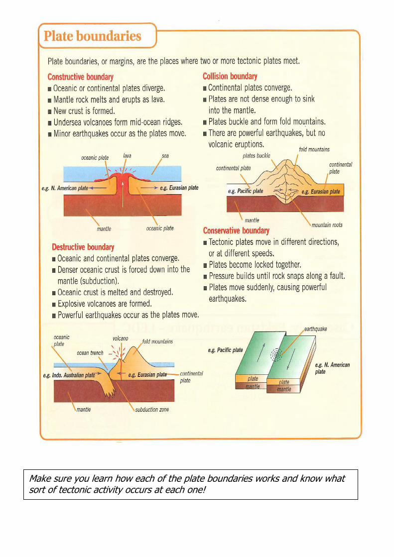
Make sure you learn how each of the plate boundaries works and know what sort of tectonic activity occurs at each one!

Volcanoes!
So why do people live so close to active volcanoes? Minerals - minerals such as tin, silver, gold, copper and even diamonds
can be found in volcanic rocks. Geothermal power - heat from underground is used to heat water turning
it into steam to drive turbines and produce electricity, or to heat water supplies that are then used to provide household heating and hot water.
Tourism – Volcanoes attract millions of visitors a year. Around the volcano may be warm bathing lakes, hot springs, bubbling mud pools and steam vents.
Fertile soils – Cool lava needs hundreds of years to become weathered and broken down before they form rich soils. When they do become soils though, they form some of the richest ones on the planet.
Poverty – Some people in LEDC’s are not able to move away from a potentially dangerous volcano as they are too poor.
Religious beliefs – e.g. the Aetas who live around Mt Pinatubo believe the volcano is a ‘God’

Case study: Mt Pinatubo (Indonesia - LEDC)

Case Study: Sakurajima (Japan - MEDC)
Sakurajima is a stratovolcano so is dangerous and explosive. Why do you think people in an MEDC such as Sakurajima live close to it? (write your ideas below)
What effects do volcanic eruptions have?
Social Effects Economic Effects Environmental Effects People are killed by the explosion / pyroclastic flows / lahars and poisonous gases! Homes are destroyed People can be injured from harmful gases / debris etc.
Tourism can be affected (positively and negatively) Crops can be destroyed by lava / ash and pyroclastic flows Communications can be destroyed (e.g. roads / railways)
The environment can be severely altered e.g. forests completely blown away in the blast of the eruption Wildlife will not survive a violent eruption
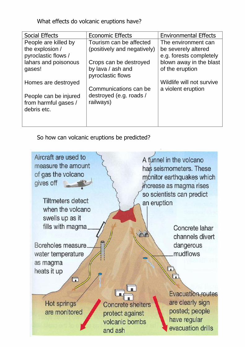
So how can volcanic eruptions be predicted?

Are there different types of volcano?
There are three different types of volcanoes. The different types of volcanoes are: composite (or stratovolcanoes), shield and cinder cones.
Layers, or strata, of rock and lava form the Composite or Stratovolcanoes. These volcanoes come in a number of shapes. A composite volcano resembles a helmet. The sides of this type of volcano are usually steep, some reaching a pointy peak at the top. This is because the lava is
viscous and so ‘plies’ up quickly forming steep layers. Sakurajim in Japan and Mt Pinatubo in Indonesia are both good examples. Eruptions are particularly intense. As magma rises to the eruption point, it tends to get clogged due to high viscosity. The pressure needed to force the magma out of the volcano is huge, and the result is an explosion of both rock and lava. It is quite dangerous to witness such an eruption up close.
Shield volcanoes are huge in size. They are built by many layers of runny lava flows (the lave is not very viscous). Lava spills out of a central vent or group of vents. A broad shaped, gently sloping cone is formed. This is caused by the very fluid, basaltic lava which can't be piled up into steep mounds. Shields erupt frequently, but tend not to be highly explosive. These are some of the best volcano eruptions to witness at a relatively close, but still safe, range, since lava spray is uncommon. Both Mauna Loa and Kilauea in Hawaii are examples of the shield volcano. Shields also form on the ocean floor, gradually building height through a steady stream of magma.
Cinder cones are likewise relatively gentle in eruption. They tend to occur in mountain ranges with other types of volcanoes. A central vent forms a volcano made up of lava fragments. Cinders grow quickly but tend not to exceed about 800 feet (243.84m) in height. Occasionally, cinders form on ground with no known history of volcanic activity. In 1934, Paricutín erupted out
of a Mexican cornfield and in approximately five days, grew to 300 feet (91.44m) tall.
Tip: You will need to be able to explain how each of the volcano types above
forms.

A comparison of two different volcanoes:
Philippines - Mt Pinatubo Iceland - Eyjafjallajokull Type of volcano: Composite
Type of volcano: Shield
The lava is viscous. This means that as is solidifies the cone becomes steep sided. It erupts with violent force due to the viscosity of the lava (the main vent can often get blocked).
The lava is less viscous and ‘runny’. This means that it flows freely. It will cover a larger surface area and as the lava solidifies it will create a gently sloping volcano.
Tectonic plates responsible: The Philippines plate (oceanic) subducted beneath the Eurasian plate (continental). This is a destructive plate boundary.
Tectonic plates responsible: The Eurasian plate and the North American plates are pulling apart. This is a constructive plate boundary.
Date last erupted: June 1991
Date last erupted April 2010.
Social effects: 1500 people died 50,000 people made homeless Water contaminated
Social effects: 500 – 600 people evacuated Roads closed / travel made difficult People stranded around world due to travel chaos Schools closed in parts of Iceland
Economic effects: 200,000 buildings destroyed Lahars devastated rice harvest 1 million farm animals died 650,000 people lost their jobs
Economic effects: Millions of pounds lost in travel industry Thick layer of ash erupted has made farming impossible in parts of Iceland

Earthquakes!
The focus is the point at which the earthquake starts.
The epicentre is the point directly above the focus point.
Earthquakes are measured using a seismometer.
The magnitude of an earthquake is sown on the Richter Scale.

A comparison of two different earthquakes:
Kobe (Japan) 1995 Sichuan (China) 2008
Magnitude: 7.2
Magnitude: 8.0
Plates responsible: The Philippine plate is subducted beneath the Eurasian plate. This is a destructive plate boundary.
Plates responsible: The Indian plate and the Eurasion plate colliding (Making the Himalayas). This is a collision plate boundary.
Depth of Focus point: 14km
Depth of Focus point: 19km
Location of epicentre: Awaji Island
Location of epicentre: Wenchuan
Deaths: 5,477 Injuries: 35,000 Buildings collapsed: over 172,000 Total damage: 10 billion yen!
Deaths: 70,000 Injuries: 400,000 Building collapsed: 420,000 Total damage: $75 billion
Other facts: Soft ground (unconsolidated land) made the shaking worse.
Other facts: 700 schools collapsed! – This should not have happened due to strict building codes.

Japan is an MEDC whereas China has only recently become an NIC (Newly Industrialised Country) and is still comparatively poor. How do you think their level of development affected the way in which they prepared themselves for earthquakes / coped with the event itself?

Restless Earth Question Checklist – make sure you can
answer these using this guide and your exercise books!
1. Draw a diagram to show the layers of the earth.
2. State two differences between oceanic and continental crust.
3. Explain why plates move.
4. Explain the term “ subduction “ when does it occur? You can draw a
diagram if you wish.
5. Why are no volcanoes found at collision boundaries?
6. Describe the main features of shield volcanoes. ( mention shape,
frequency of eruption and type of lava)
7. Describe the main features of composite volcanoes. ( mention shape,
frequency of eruption and type of lava)
8. Which type of country developed or developing is more vulnerable when
experiencing tectonic hazards? Why, use examples you have studied.
9. Compare the effects of a volcanic eruption is a developed and developing
country ? Use named examples.
10.Why are some areas of the world more likely to experience tectonic
hazards than others?
11.Why do earthquakes occur?
12.How are they measured?
13.Explain the terms, epicentre, focus, seismometer, seismograph
14.What is the differences between primary and secondary impacts of a
volcanic eruption or earthquake?
15.Why do earthquakes occur at destructive plate margins?
16.How can earthquakes and volcanoes be predicted and planned for?
17.How can buildings be protected from earthquakes?

Climate and Change
A climatologist is a scientist who is an expert in climate and climate change. Graphs can be constructed using ice cores (from Antarctica), fossilised animals and pollen and landforms such as U-shaped valleys left behind from glaciers. To look at the more recent changes in temperature the following records are used: Old photographs and drawings Written records such as books and diaries Recorded dates of events such as harvests.
They are not very accurate but they can give us an idea of the overall trends.

Why has climate changed in the past? There are 3 main theories: 1) The eruption theory 2) The sunspot theory 3) The orbital theory
The eruption theory: When a volcano erupts it throws out large volumes of sulphur dioxide (SO2), water vapour, dust, and ash into the atmosphere. Although the volcanic activity may last only a few days, yet the large volumes of gases and ash can influence climatic patterns for years. Millions of tonnes of sulphur dioxide gas can reach the upper levels of the atmosphere from a major eruption. The gases and dust particles partially block the incoming rays of the sun, leading to cooling.
The sunspot theory:
The number of dark spots (known as sun spots) visible on the disc of the sun varies over roughly an 11-year period. When there are many spots, the sun's magnetic activity increases and the sun radiates more heat. These changes in total irradiance are very slight, and represent only a tiny percentage of the sun's total output, but even these small changes can produce a significant change in the earth's heat balance.
The orbital theory: 1) The Earth’s orbit is sometimes circular and sometimes more of an eclipse (oval).
2) The Earth’s axis tilts. Sometimes it is more upright and sometimes more on its side.
3) The Earth’s axis wobbles, like a spinning top about to fall over.
These three changes alter the amount of light that the Earth receives from the sun. They also affect where light falls on the Earth’s surface. It would be enough to start or finish an ice age.

The Little Ice Age: This cooler period lasted from approximately 1315 to 1860. Impacts: Wheat and Oat crops did not ripen ‘The Great Famine’ started in 1317 and lasted until 1325. In some areas 10-20% of peasant farmers may have died of
hunger. The numbers that died during the Black Death in 1349 in
Europe was made worse by the cooler climate and bad farming conditions.
Sea ice stopped trade with Iceland and Norway. Cattle and sheep had less food in winter so animals did not
survive. Fighting between local people may have increased as food
ran short. In the Alps valley glaciers advanced down valleys destroying
villages and farmland. People in Europe had to adapt. They did this by farming new crops, abandoning farms in higher altitudes, and enjoying the colder climate by having frost fairs on rivers! The impact of climate change on megafauna: Megafauna refers to ‘big animals’ that weighed over 40kg e.g. the Woolly mammoth. As the last ice age ended and the climate warmed by 6 degrees many animals had to move. The impacts were:
They migrated to areas where the climate better suited them.
But finding food to eat was hard as many plants were not suitable.
This would have disrupted food chains leaving some animals short of food.
Climate change may have made the megafauna weaker than normal.
As the climate warmed back up people also migrated to different areas and hunted some of the megafauna, this meant less prey for carnivores. Some herbivores were hunted to extinction leaving carnivores with nothing to eat.

Enhanced Greenhouse effect - A warming of the Earth’s temperature due to human interference.

Scientists do not fully know what will happen to future climate. The estimates are that temperatures will rise between 1.1 and 6.4 degrees centigrade. Sea level is predicted to rise by 30cm to 1 meter by 2100.
So what might be in store for the UK?

Case Study: Bangladesh (LEDC)

Battle for the Biosphere
Climate and Change Question Checklist – make sure you can
answer these using this guide and your exercise books!
1. What is climate?
2. Using the graph in this guide, describe what has happened to the earth’s
temperature during the period shown.
3. Explain the three natural causes of climate change.
4. What evidence is there that the earth’s climate has changed in the past?
How reliable is this evidence?
5. What could have caused the little Ice Age?
6. Describe one advantage and one disadvantage of the little ice age for
people alive at the time.
7. What does megafauna mean?
8. What is an ecosystem?
9. Using examples describe how ecosystems were affected by climate change
in the past.
10.What are the main greenhouse gases?
11.Draw a diagram to explain how the greenhouse effect works.
12.How can human activities add greenhouse gases into the atmosphere? List
as many examples as you can.
13.Why do people in the developing world produce only a small amount of
greenhouse gases?
14.The greenhouse effect can occur naturally, what is the enhanced
greenhouse effect?
15.Using examples, explain how global warming could have both costs and
benefits for the UK.
16.How could sea level changes caused by global warming affect other
countries in the world such as Bangladesh, the Maldives and Tuvalu ?