Embed Size (px)
Citation preview
भारतीय भूवैज्ञानिक सवेक्षण,
Geological Survey of India पूवोत्तर के्षत्र
North Eastern Region
सकं्षिप्त पुस्तक BBrriieeffiinngg BBooookk
(अक्टूबर /January’14 - दिसम्बर /March’14)

Cover Page Photo: SSaatteelllliittee iimmaaggeerryy ooff NNoorrtthh EEaasstteerrnn RReeggiioonn ((ssoouurrccee--iinntteerrnneett))
CCoorrrreessppoonnddeennccee aaddddrreessss::
‘‘SSHHYYLLLLAA’’ BBUUIILLDDIINNGG,, NNOONNGGRRIIMM HHIILLLLSS
SSHHIILLLLOONNGG –– 779933000033
PPhhoonnee:: 00336644--22552200222288,, FFaaxx:: 00336644--22552200003333
EEmmaaiill:: hhoodd..nneerr@@ggssii..ggoovv..iinn

i
EXECUTIVE SUMMARY- BRIEFING BOOK, GSI, NER March, 2014
(January’14 to March’14)
MISSION-I & IB
STM (12 items): 3277.5 sq.km completed out of 3295 sq.km. Shortfall of 20 sq km
pertaining to item no: STM/NER/SAP/2013/004 will be covered in the
month of April, 2014 as per approval 1863/S1/1/1/fsp/NER(vol.1)/ 2014-
15/46F dated 04.04.2014.
SGM (4 items): 2640 sq.km completed out of 2640 sq.km.
GCM (7 items): 4948 sq.km completed out of 4850 sq.km
GPM (1 item): 1400 sq.km completed out of 1750 sq.km. Shortfall of 350 sq km
pertaining to item no: GPM/NER/RHQ/2013/014 will be covered in the
month of April, 2014 as per approval 1586/S/1/1/FSP/NER(vol.1)/ 2013-
14/46F dated 25.03.2014.
RSAS (1 item): 900 sq.km completed out of 900 sq.km (modified as per
5522/6/1/1/FSP/NER(vol.1)/ 2013-14/46F dated 09/10/2013.
MISSION-II
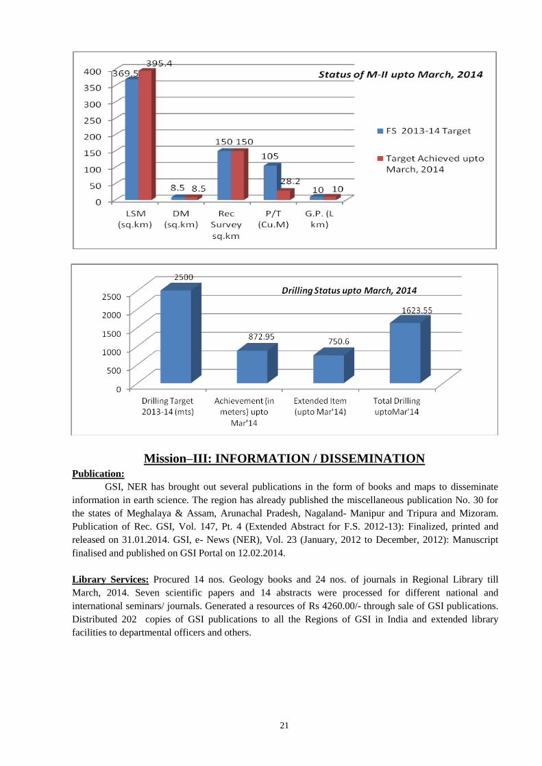
LSM (9 items): 395.4 sq.km completed out of 369.50 sq.km
Drilling(4 items): 872.95m and 750.6 m (extended item): total = 1623.55 m drilling
completed.
DM (5 items): 8.5 (100 %) sq.km completed out of 8.5 sq.km
MISSION-III
DRM:
Manipur-Nagaland: DRM’s of 4 districts of Manipur (Tamenglong, Ukhrul, Imphal East &
Senapati districts) completed.
Tripura- Mizoram DRM’s of 2 districts of Mizoram (Aizawl and Champhai districts on 1:
2,50,000 scale) completed.
Assam DRM’s of Kamrup, Darrang and Goalpara district is completed.
Modification and preparation of hard copy layout for Karimganj,
Hailakandi, Sibsagar, Golaghat, Cachar, Dibrugarh, Dhemaji & Tinsukia
DRM completed Compilation of Bongaigaon, Nagaon, Lakhimpur, North
Cachar Hills districts and Jorhat DRM is also completed. Digitisation of
Geology and mineral Layer of Karbi-Anglong district completed.
Meghalaya Compilation of West Garo Hills, East Garo Hills, South Garo Hills, East
Khasi, West Khasi and Ri-Bhoi districts of Mehgalaya is completed.
DRMs of East Khasi, West Khasi, Ribhoi and East Garo Hills districts of
Meghalaya have already been published. DRM of Jaintia district of
Meghalaya is completed.
Publication:
Adding of Accession Numbers of
Unpublished Progress Reports of GSI,
NER for the F.S. 2012-13 uploaded in GSI
portal.
During 2012-13, Assigned Accession number to 37
reports completed. Received Hard copies of Reports
for Regional Library.
Publication of Rec. GSI, Vol. 147, Pt.- 4
(Extended Abstract for F.S. 2012-2013).
Ext. Abstract Completed, Printed and Released on
31-3-2014.
Preparation of AGR for F.S. 2012-2013
(Rec. GSI, Vol. 147, Pt. 1)
Completed. Submitted already AGR on 23.7.2013 to
Director, PID CHQ, Kolkata.
GSI, News (NER), Vol. 23 (January 2012
to December 2012).
Completed. Submitted on portal On 12-2-2014

ii
Library Services:
Scrutiny and processing of scientific papers/ abstracts
submitted by the officers of the region
17 paper and 15 abstracts (upto
March, 2014) .
Information service: (a) Sale of publication
(b) Distribution of GSI
Publications
Total : Rs. 8382,
Total : 847 (upto March, 2014)
Library services-Modernization of Library, Updating of
bibliographic database on books, journals, GSI
publications etc.
a) Procurement of new books and journals.
Unpublished G.S.I progress report .
Library Facilities were extended to all
officers and Staff.
Geology Books: 14
Journals : 138.
Unpub. G.S.I progress report : (37)
Geoinformatics:
1.Scrutiny and finalization of Geological Map layer on
1:50K and uploading to the portal as Version 1: 4 sheets
(78J/2,6; 78G/13 & 14)
Scrutiny and Finalisation of
3 toposheet (78J/2, 78G/13 & 14)
completed
2.Creation of metadata of digitized Toposheet wise
geological maps for portal uploading : 4 sheets
3 sheets
3.Preparation and implementation of uniform legends at
regional level
Preparation of uniform legend up to
litho-unit level is Completed
4.Modification to the attribute and Graphic data of the
uploaded Digital geological maps as per the validation &
standardization at regional level and uploading them as
version - II
346 sheets completed
5. Extraction of data from unpublished geological reports
on to prescribed forms and validation:-
a. Map 50K (including QG)
b. Mining
c. Geophysics
d. Preparation of lexicons
61 reports
33 reports
25 reports
3 reports
Lexicon Updated
MISSION-IV
Palaeontological Studies: A search of fossils and preparation of geological map on 1: 50,000
scale was carried out along Shillong-Sohra, Shillong-Mawsynram and Shillong-Dawki in East
Khasi Hills district of Meghalaya. A dozen of oval to rounded egg fossil like samples were
collected in and around Dawki area, East Khasi Hills District, Meghalaya.
Geotechnical Investigations: Geotechnical Evaluation of Water Resource Development Projects
in Arunachal Pradesh was done which include Construction stage geotechnical investigation of
the Kameng H E Project: Package-I (Bichom Dam Complex), Package-II (Tenga Dam Group),
Package-III (Kimi Power House Complex),West Kameng District, Geotechnical Investigation of
Noa Dehing Multipurpose Project, Changlang District, and Geotechnical Investigation for Pare
H.E. Project, Papumpare District, Arunachal Pradesh were also attended. Geotechnical
Evaluation- Pre-Construction Stage of Water Resource development projects in Mawblei Hydro
Electric Project, West Khasi Hills District, Upper Khri Hydro Electric Project, West Khasi Hills
District, New Umtru Hydro Electric Project, Ribhoi District, Meghalaya were also completed.
Other geotechnical investigations carried out in Turial Hydroelectric Project, Kolasib District,
Mizoram pertaining to Water Resource Development Projects, Mizoram.
Medical Geology: Systematic spot analysis of groundwater and surface water by Merck Arsenic
Field kit were carried out in the field in Toposheet 83 B/12 & B/16 to study of arsenic
contamination in water and soil in parts of nagaon and marigaon districts, Assam. The arsenic
values in groundwater varies from nil to 100 ppb where as that of surface water varies from nil to
5 ppb. The high arsenic values occurring as zones were transferred over the geological map shows
iii
that most of the high values occur within the Newer alluvium sediments of Barpeta and Hauli
Formations. Older alluvium sediments are devoid of arsenic contamination thus having fresh
water.
Landslide Hazard Zonation:
Landslide Hazard Zonation Project (LHZP) was formed during 1995 to exclusively cater to the
needs of landslide studies in NER by GSI. Subsequently GSI was declared nodal agency for
landslides by Govt. of India in 2004. GSI has undertaken studies related to landslide at specific
request from State Governments and other organizations. The information has been often used by
Government and other organizations for better planning of their infrastructures, developmental
activities and disaster preparedness.
The problem of landslide hazard is multiplied in recent times due to increased developmental
activities like construction of road, building and various infrastructures. GSI has covered major
part of urban agglomerations, road corridors of the vulnerable hilly terrain in NE India through
macro scale landslide susceptibility mapping. GSI undertakes site specific landslide investigation
for containing the distressing in the hill slopes, comprehensive understanding of the processes, and
formulation of both short and long term mitigation measures. GSI also attempted monitoring of
few conspicuous slides in Sikkim and Meghalaya. GSI, NER regularly updates the landslide
database of the entire NE regions through landslide inventory work. After became a declared
nodal agency for understanding the coordinating landslide investigation and formulation for
mitigation measures. GSI’s activity for Landslide Hazard Risk Mitigation in region includes Pre-
Disaster Study, Landslide Zonation Mapping, Landslide Inventory Work, Detailed Site Specific
Study of landslide for identifying causative factor and most suitable remedial measures, Landslide
monitoring/real time monitoring by instrumentation for development of an early warning system.
During FS 2013-14, Landslide Hazard Zonation studies at macro scale in Anjaw District,
Arunachal
Pradesh and along Rangpo-Singtam-Dikchu-Chungthang road corridor, Sikkim were taken up
besides detailed study of the 13th mile landslide in East District, Sikkim and Site specific study of
proposed Pakyong Airport area, Sikkim.
Updation of existing landslide inventory of NER for FS 2013-14 is as follows:
Assam: 1 Earth-Soil slide & 1 Rock fall.
Arunachal: 7 cut-slope failures, 28 Rock slides, 4 Complex slides, 15 Debris slides.
Meghalaya: 1 rock fissure-ground crack.
Mizoram: 1 Complex slide & 1 Debris slide.
Nagaland: 1 Slope failure, 1 Rock fall, 1 Complex slide, 1 Earth slide, 7 Debris slides & 1
rock slide.
Sikkim: 1 mudslide & 1 debris flow.
Earthquake Studies: Study of Seismic and Landslide Hazard Assessment of Aizawl town,
Mizoram & Kohima City, Nagaland were carried out during FS 2013-14.
Aizawl town, Mizoram: An area of about 50 sq. km was covered by geological mapping and
landslide hazard assessment on 1:25,000 scale in the Aizawl master plan area. Synthesis of
seismicity data within 300 km radius in and around Aizwal area, involving conversion of Ms and
Mb earthquake magnitudes to Mw for assessing the recurrence period and to determine PGA of
the area was undertaken. It appears that the slope instability can be attributed to the inherent rock
mass condition, anthropogenic interference (unscientific slope cutting / static loading due to
constructional activities), unguided drainage, etc. Besides, ground water information based on the
available hand pump locations were recorded and are being analysed with other collateral
subsurface information collected from different Government agencies. The collected field data are
being processed for the preparation of relevant thematic maps for analysis and interpretation
regarding the Seismic Hazard Assessment of the area.
Kohima City, Nagaland: An area of 300 km radius around Kohima city was taken up to carried
out to analyse past seismicity data and delineation of potential seismic source area. The
Morphotectonic and lineament map covering 50 sq. km area was prepared using LISS-III and
iv
SRTM data of Kohima area. Surface Geological Mapping on 1:25,000 scale covering 50 sq. km
was undertaken. Facet wise data collection of about 50 sq. km in the southern part of the study
area was undertaken for landslide hazard zonation. Besides, study of groundwater information
along with borehole litho log collected from the Directorate of Geology and mining, Govt. of
Nagaland was also carried out. Presently the work is under progress and will be continued during
FS 2014-15, the second year of the study.
Gangtok, Sikkim: Seismic Hazard Assessment of Gangtok , Sikkim was carried out by Site
response study by three component digital seismograph (Kinemetrics make SS-1) using H/V
method developed by Nakamura (1989) to eliminate the source effects in the spectra of the micro
tremor signal.
MISSION-V
Training Institute: During the period of January, 2014 to March, 2014 the Regional Training
Institute, GSI, NER successfully conducted a 6 days (28.1.14 to 2.2.14) Field workshop –cum
training on active fault mapping, conducted a 30 days training to 37th OCG, Batch-G as part of
Orientation Course for Geologist of GSI. Organized 7 days (24.3.14 to 30-3-14) Training on
Landslide Hazard Zonation and Disaster Management for Geologist of DGM and GSI Officers,
NER, at GSI, Gangtok, Sikkim.
SUPPORT SYSTEM–I: STSS
Petrology Lab: Total No. of thin sections received = 342 nos, Total No. of thin sections prepared
= 101 nos, Total No. of polished sections received = 4 nos, Total No. of heavy minerals separation
= Nil. Participated in State level science & environmental fair, 2014 held on 13th & 14th of
March, 2014 by S.C.S.T.E, Meghalaya. As part of the research item carried out by Petrology
Division, 10 LKm of Geological Mapping on (1:12,500) in Mawpyut mafic-ultramafic complex
which is located approximately 10kms SW of Jowai towards Dawky along a N-S trending valley.
Field work was carried out in and around Mawpyut, Jowai, Pyngthorlantein, Mawgajai,
Sohmanang, Pohshadkhap, Pomiku and Mosakhia areas. 145 nos of samples of sandstone, granite,
porphyritic granite, pabbro, pyroxenite were collected for thin section, EPMA, SEM/ EDS study
and for Major/Trace/REE and PGE & Au analysis.
Chemical Lab: Sl
No
Item Particular
1. Total Nos.
of
Samples
Collected/
analysed
during FS
2013-14
Package Pkg.
‘A’
Pkg.
‘B’
Pkg.
‘C’
Pkg.
‘D’
Pkg.
‘E’
Pkg.
‘F’
Pkg.
‘G’
Pkg.
‘H’
Pkg.
‘I’
Pkg.
‘J’
Total
Submitted
To Lab.
Analyses
Reported
597 0 278 710 318 0 538 197 0 234 1064
Pendenc
y
467 1064 786 354 746 1064 526 867 1064 830
* All NGCM package ‘A’ and Non-NGCM samples for major, minor oxides & trace by XRF will be
cleared by 31st July, 2014 including package ‘D’ (As, Bi, Se, Sb) & package ‘G’ (Hg)
NB: Upto 31.03.2014
Non-NGCM samples send to CHQ, Kolkata for Major & Minor Oxides (XRF) analyses = 1109 nos.
Analytical reports received– 817 nos.
Pending Non-NGCM samples- 292 nos.
Trace Elements & REE (ICP-MS) samples send to CHQ, Kolkata for analyses – 501 nos.
Analytical reports received -195 nos.
Pending REE samples- 306 nos.
PGE samples sent to CHQ, Kolkata for analyses - 17 nos.
Analytical reports received - 2 nos
Pending PGE samples- 15 nos.

v
SUPPORT SYSTEM–II: ASS
Administration:
a) Pay-roll data regularly updated.
b) HRMIS data is being updated regularly.
c) Tour applications of all gazetted officers are processed through portal.
d) Leave Module in portal implemented.
e) Claims Module in portal implemented.
f) Purchases under ME & IT Heads are being monitored. PAC and TAC are being held regularly.
SUPPORT SYSTEM–III: PSS
RAC: 7th RAC on 21.01.2014.
भारतीय भूवैज्ञानिक सवेक्षण, Geological Survey of India
पूवोत्तर के्षत्र North Eastern Region
संक्षिप्त पुस्तक BRIEFING BOOK
(Updated up to March, 2014) C O N T E N T
Page
No.
1. Introduction
(i) State-wise Geology and Mineral Resources
(ii) Status Map (s)
1
2. Organisational Structure of the Region (updated) 12
3. Activity Domain of the Region 13
4. Mission Wise Information For Field Season 2013-14 (updated) 14
5. Financial Performance (updated) 39
6. Mission Wise RCA Expenditure (updated) 39
7. Scientific workshops / Meetings / Seminars / Symposium, Exhibitions etc., organised /
participated (updated)
39
8. HRD, Establishment, Payroll, HRMIS, e-service book, etc. (updated) 39
9. Vehicles & Transport Infrastructure including outsourcing and age of vehicles, Vehicles MIS
(updated)
39
10. Modernization 39
11. Drilling Infrastructure (updated) 39
12. Outsourcing of routine services [housekeeping, security, garden, etc.] 39
13. Other Activities (updated) 39
14. Special Scientific Study. 40
15. Perception Management Activies in NER (updated) 40
16. Savottam (updated) 40
17. Consolidated List of Group A & B (Gaz.) Officers in NER (as on 31.12.2013) (updated) 40
ANNEXURES (updated):
Annexure-1A Major Minerals Resources [Under Various Unfc Categories] Estimated By The
Region, Showing State-Wise Five-Yearly Increment, For The Last 15 Years.
41
Annexure-1B National Mineral Inventory –
No. Of Reports Converted As Per Unfc Compliance
41
Annexure-2A Activity Domain Pertaining To Mission I & Ii Of The Region And Achievements
[Fsp Related Items] During The Xi Plan Period [2007-12] & Xii Plan Period
42
Annexure-2B Fsp Rolling Plan For F.S. 2012-13 & 2013-14 43
Annexure-3A Quarter-wise, Head-wise Allotment of Plan Fund Versus Expenditure Booked
During the Financial Year 2013-14 (2nd Year Of The Xiith 5-Year Plan) IN
RESPECT OF NORTH-EASTERN REGION OF GSI
53
Annexure-3B Head-Wise & Quarter-Wise Allotment of Plan Fund Versus Expenditure for the
Financial Year 2013-14 (2nd Year Of The Xiith 5-Year Plan) in Respect of North-
Eastern Region of GSI
54
Annexure–4 Mission Wise Pro-Rata Rca Expenditure In Different Projects Visa-Vis Targets
And Achievements
55
Annexure-5 Progress & Pendency Report Of Chemical Analyses Of Ngcm Samples 77
Annexure-6 Year-Wise, State-Wise, Report Pendency Progress 79
Annexure-7 Status Of Uploading In Gsi Portal 80
Annexure-8 Case Studies Uploaded In Gsi Portal (All Cases As Well As Cases Uploaded
During The Quarter)
83
Annexure-9 List Of Publications Brought Out In The Last Five Years 84
Annexure-10 Courses Conducted At Ftc’s Along With List Of Faculty Members 86
Annexure-11 List Of Rac / Oac / Stage Review / Sgpb Meetings With Date And Status Of
Uploading Of Minutes
88
Annexure-12 Employment Position In The Region 89
Annexure-13 Vehicle Position In North Eastern Region 91
Annexure-14 Procurement Status Of Major Equipments/ Modernization Items/ Machinery
Proposed For Procurement During F.Y. 2013-14
92
Annexure-15A Status Of Existing Drilling Equipments Under Deployment 94
Annexure-15B Status Of Existing Drilling And Other High-End (Rs >1 Core) Equipments To Be
Procured During Fy 2013-14
95
Annexure-16 Status Of Pending Legal Cases Of North Eastern Region 96
Annexure-17 Consolidated List Of Group A & B Officers In Ner (Gaz.) 97
1
REGIONAL BRIEFING BOOK OF GEOLOGICAL SURVEY OF INDIA
NORTH EASTERN REGION
1. INTRODUCTION
The North Eastern Region with an area of 262,093 sq km (7.92% of Indian Territory) represents varied
geomorphological & geological set up, which is ranging from Precambrian to recent age. It is manifested by
spectacular Himalayan mountain belt in the north, the vast Brahmaputra plain in the central portion, Shillong
Massif plateau in the south and Indo-Myanmar range in the East.
GEOLOGY & MINERAL RESOURCES
A summarised description of geology & mineral recourses of different states of NER is given below:
Arunchal Pradesh: Arunachal Pradesh, borders Bhutan, China and Myanmar, with the Naga Hills to the
south-east. The northern and north-western parts of Arunachal Pradesh comprise mainly ancient metamorphic
rocks, which are called Sela Group towards west and Lohit Granodiorite toward east. The Siang Valley
exposes an extensive sequence of metamorphosed Mesozoic rocks with intercalated volcanic flows. A narrow
strip of Gondwana sandstones and shales with discontinuous coal occurrences, usually crop out along the
southern flank of the metamorphics. The southern foot hills of the Himalayan belt are composed of the
younger Siwalik / Assam Tertiary sedimentaries - silty sandstone, clay and sandstone deposited during the last
stage of mountain-building. Massive and vesicular basaltic and andesitc rocks of Abor volcanics associated
with Miri Quartzite occur in the western flank of Subansisri valley, Igo valley, Basar-Along areas and in Siang
valley areas in Arunachal Pradesh. The easternmost part of the state, namely the Changland and Tirap,
represent a segment of the Naga-Patkoi range comprising the northern tip of Indo-Myanmar (Arakan)
mountain range made up of folded Tertiary sediments, mostly sandstone and shale.
The state is rich in mineral deposit of graphite, limestone, coal along with significant deposits of
quartzite, basemetals and minor PGE mineralization. Reserve of 342mt limestone, 246.75mt dolomite,
86.15mt graphite, 90.23mt coal and 5.15mt quartzite are the main mineral deposit of the state. Beside these,
state has hydro-electric potential of 33,850 MW in different basins.
The coal is located mainly in Namchik-Namphuk area and Miao Bum area in the eastern part of Tirap District.
A linear belt of 350 km from Haflong in Assam in SW to Namchik-Namphuk area of Arunachal Pradesh in
NE holds promise of presence of more Tertiary coal.
DEPTH-WISE RESOURCE OF COAL IN ARUNACHAL PRADESH
(Resource in million tonne)
STATE COAL
TYPE
DEPTH
RANG
E (m)
PROVE
D
INDICATE
D
INFERRED
TOTAL (Exploration) (Mapping)
UNCF Code G1 G2 G3 G4
TERTIARY
ARUNACHAL
PRADESH
HIGH
SULPHU
R
0-300 31.23 40.11 12.89 6 90.23
GRAND TOTAL 31.23 40.11 12.89 6 90.23
Ref: Coal News, Natural Energy Resources, GSI, vol.32
Assam: The major part of the state is covered by recent alluvium of east - west trending Brahmaputra plain.
The Karbi Anglong Hills & North Cachar Hills located at the central portion comprising of gneisses and
schists with granite intrusions and folded Tertiary sedimentaries of the Naga-Arakan sequence respectively
and the Cachar plain in the south comprises of recent alluvium. Crude oil is the most important natural
resource of Assam. The state has a reserve of 513.31mt of coal, 394mt of limestone, 30mt of iron ore, 13.4mt
of silica sand, 2.0mt of fireclay, 13mt of clay along with high potential of granite, sandstone and mica.
Crude oil is found in upper part of Tertiary Barail sequence, where largest amount of oil is discovered
in this region so far, while Tipam sandstone is another important oil productive horizon. In the shelf zone, oil
was discovered just above the basement at Borholla and gas in Eocene sand near Tengakhat
2
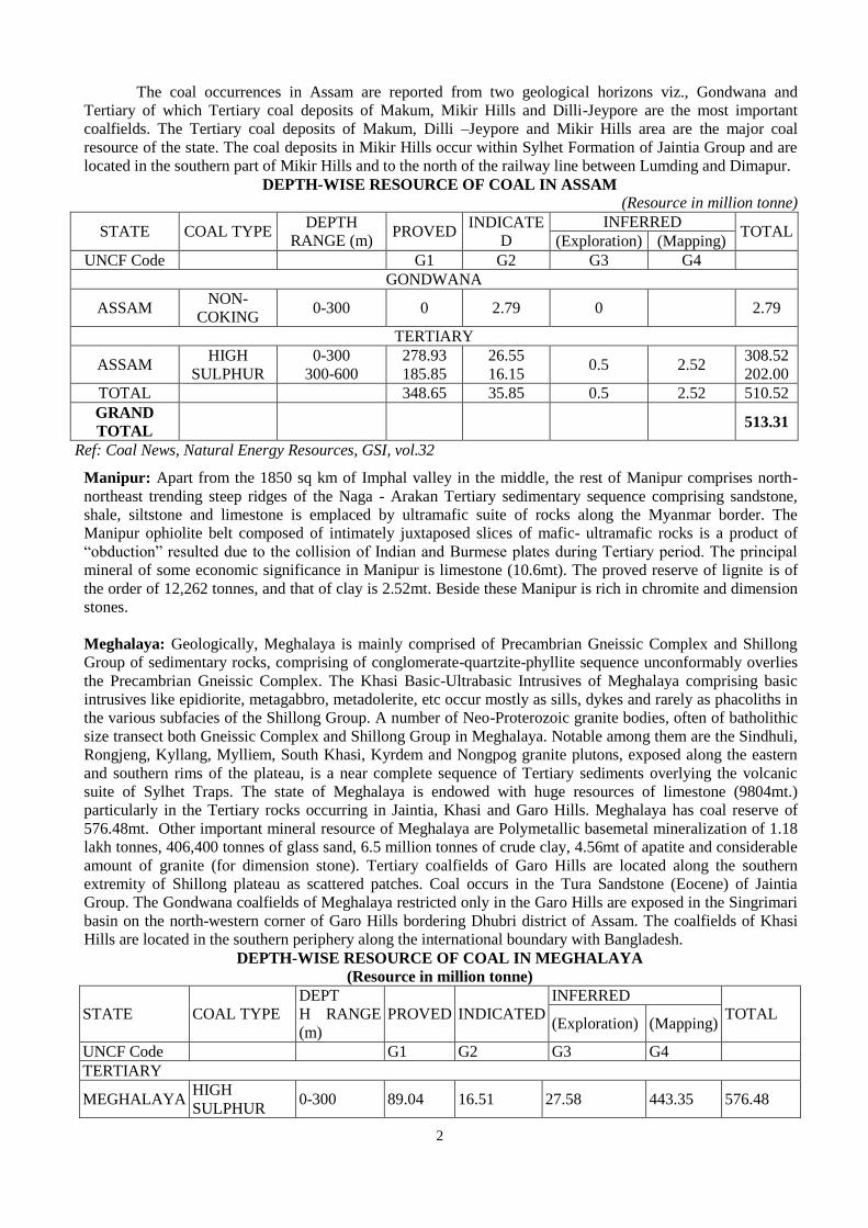
The coal occurrences in Assam are reported from two geological horizons viz., Gondwana and
Tertiary of which Tertiary coal deposits of Makum, Mikir Hills and Dilli-Jeypore are the most important
coalfields. The Tertiary coal deposits of Makum, Dilli –Jeypore and Mikir Hills area are the major coal
resource of the state. The coal deposits in Mikir Hills occur within Sylhet Formation of Jaintia Group and are
located in the southern part of Mikir Hills and to the north of the railway line between Lumding and Dimapur.
DEPTH-WISE RESOURCE OF COAL IN ASSAM
(Resource in million tonne)
STATE COAL TYPE DEPTH
RANGE (m) PROVED
INDICATE
D
INFERRED TOTAL
(Exploration) (Mapping)
UNCF Code G1 G2 G3 G4
GONDWANA
ASSAM NON-
COKING 0-300 0 2.79 0 2.79
TERTIARY
ASSAM HIGH
SULPHUR
0-300
300-600
278.93
185.85
26.55
16.15 0.5 2.52
308.52
202.00
TOTAL 348.65 35.85 0.5 2.52 510.52
GRAND
TOTAL 513.31
Ref: Coal News, Natural Energy Resources, GSI, vol.32
Manipur: Apart from the 1850 sq km of Imphal valley in the middle, the rest of Manipur comprises north-
northeast trending steep ridges of the Naga - Arakan Tertiary sedimentary sequence comprising sandstone,
shale, siltstone and limestone is emplaced by ultramafic suite of rocks along the Myanmar border. The
Manipur ophiolite belt composed of intimately juxtaposed slices of mafic- ultramafic rocks is a product of
“obduction” resulted due to the collision of Indian and Burmese plates during Tertiary period. The principal
mineral of some economic significance in Manipur is limestone (10.6mt). The proved reserve of lignite is of
the order of 12,262 tonnes, and that of clay is 2.52mt. Beside these Manipur is rich in chromite and dimension
stones.
Meghalaya: Geologically, Meghalaya is mainly comprised of Precambrian Gneissic Complex and Shillong
Group of sedimentary rocks, comprising of conglomerate-quartzite-phyllite sequence unconformably overlies
the Precambrian Gneissic Complex. The Khasi Basic-Ultrabasic Intrusives of Meghalaya comprising basic
intrusives like epidiorite, metagabbro, metadolerite, etc occur mostly as sills, dykes and rarely as phacoliths in
the various subfacies of the Shillong Group. A number of Neo-Proterozoic granite bodies, often of batholithic
size transect both Gneissic Complex and Shillong Group in Meghalaya. Notable among them are the Sindhuli,
Rongjeng, Kyllang, Mylliem, South Khasi, Kyrdem and Nongpog granite plutons, exposed along the eastern
and southern rims of the plateau, is a near complete sequence of Tertiary sediments overlying the volcanic
suite of Sylhet Traps. The state of Meghalaya is endowed with huge resources of limestone (9804mt.)
particularly in the Tertiary rocks occurring in Jaintia, Khasi and Garo Hills. Meghalaya has coal reserve of
576.48mt. Other important mineral resource of Meghalaya are Polymetallic basemetal mineralization of 1.18
lakh tonnes, 406,400 tonnes of glass sand, 6.5 million tonnes of crude clay, 4.56mt of apatite and considerable
amount of granite (for dimension stone). Tertiary coalfields of Garo Hills are located along the southern
extremity of Shillong plateau as scattered patches. Coal occurs in the Tura Sandstone (Eocene) of Jaintia
Group. The Gondwana coalfields of Meghalaya restricted only in the Garo Hills are exposed in the Singrimari
basin on the north-western corner of Garo Hills bordering Dhubri district of Assam. The coalfields of Khasi
Hills are located in the southern periphery along the international boundary with Bangladesh.
DEPTH-WISE RESOURCE OF COAL IN MEGHALAYA
(Resource in million tonne)
STATE COAL TYPE
DEPT
H RANGE
(m)
PROVED INDICATED
INFERRED
TOTAL (Exploration) (Mapping)
UNCF Code G1 G2 G3 G4
TERTIARY
MEGHALAYA HIGH
SULPHUR 0-300 89.04 16.51 27.58 443.35 576.48

3
GRAND
TOTAL 89.04 16.51 27.58 443.35 576.48
GONDWANA
SINGIMARI,
MEGHALAYA
& ASSAM
NON-
COKING 0-300 0.00 2.79 - -
2.79
GRAND
TOTAL 0.00 2.79 - -
2.79
Ref: Coal News, Natural Energy Resources, GSI, vol.32
Inferred reserve is 406,400 tonnes of white sandstone useful in glass industry occur in Cherrapunjee
and Laitryngew areas. Inferred reserve of 6.5 million tonnes crude clay is reported 2.4 km west of Sohrarim on
Cherrapunjee Road. White clay is also reported from Nongalbibre in South Garo Hills and Rongrengre in East
Garo Hills districts. Good quality Kaolin occurs around Smit and Laitlyngkot in East Khasi Hills,
Thandlaskein, Shangpung, Mulieh and Mynsngat in Jaintia Hills and Darugiri in East Garo Hills districts.
China clay, suitable for pottery manufacture, has been reported from several places in Sutnga area in Sylhet
Sandstone.
Mizoram: A repetitive succession of young Tertiary sediments, mostly shale, siltstone and sandstone, tightly
folded into a ridge and valley sequence comprise the whole state. Along the somewhat broad valleys in the
northern part, bordering Assam, recent alluvium covers the sediments. There is some potential for oil and gas,
lignite, decorative shell limestone, sandstone slabs (as dimension stone) and clay body within the
sedimentaries.There is some potential for oil and gas accumulation in the folded sedimentaries. There is scope
for hydel power generation in the state on a large scale along the Kolodyne and Tuivai rivers and as
microhydel schemes along many smaller streams. Indication of oil, saline springs and a few gas seepages in
the central part of Mizoram are reported. Salt spring has been located north of Sabual village in western part of
Mizoram. Occurrence of 3 metres long and 10 cms thick, grey, pyrite-bearing, lignite patch in ferruginous,
brownish, yellow, soft, Bokabil sandstone has been reported south of Chubel village. About 6.5 kms southeast
of Ngopa, a few lenticular pockets of coal have been recorded. Streaks, stringers and patches of coal are found
in the Upper Bhuban Sandstone. The Mizoram state Department of Industries (Geology and Mining Wing) has
proved 5200 cubic metres of decorative shell limestone at Ngrum Lui near Turial Bridge and 6000 cubic
metres at Sesawang. A thin horizon of clay is noticed northwest of Borai, near Momchera and in the valley
near Plura village. The clay has a vast potential for making bricks.
Nagaland : Geologically, Nagaland comprises Tertiary sedimentary rocks of Disang, Barail, Surma and
Tipam Groups that form the northern extension of Arakan-Yoma ranges, while the younger alluvial sediments
occupy valley areas. NNE-SSW trending ophiolite suite of rocks represented by mafic- ultramafic sequence is
juxtaposed with Naga metamorphic belt along the eastern margin all along the contact with Myanmar. In
Nagaland, occurrences of major minerals are limestone (375mt.), coal (315.41mt.) and nickel-cobalt bearing
magnetite. Sulphide (Cu-Fe) occurrences are noted in chert-volcanics and mafic-ultramafic association of
ophiolite belt at some places of Phek and Tuensang Districts. Oil and natural gas occur in western foothill
areas and Schuppen Belt, being trapped in fractured and weathered basement rocks, and in the overlying
Tertiary cover sediments of Kopili / Barail / Surma / Tipam rocks.Coal deposits, which occur in Tikak Parbat /
Jenam Formations of Barail Group, are located in Borjan-Tiru areas of Mon district, Changki-Chongliyimsen
and Lakhuni areas of Mokokchung district, Leo Longidang area of Wokha district and Konya area of
Tuensang district.
DEPTH-WISE RESOURCE OF COAL IN NAGALAND
(Resource in million tonne)
STATE COAL TYPE
DEPTH
RANGE
(m)
PROVE
D
INDICAT
ED
INFERRED
TOTAL (Exploration) (Mapping)
UNCF Code G1 G2 G3 G4
TERTIARY
NAGALAN
D
HIGH
SULPHUR 0-300 8.76 0 8.6 298.05 315.41
4
Ref: Coal News, Natural Energy Resources, GSI, vol.32
Sikkim: The state is mostly comprises low to medium grade Precambrian metamorphites of Daling Group,
high grade Darjeeling gneiss and Kanchendzonga gneiss, quartzite, calc-silicate rock, marble and graphite
schist of Chungthang Formation. Daling Group of rocks are classified into Gorubathan, Reyang and Buxa
Formations. Dolomitic limestone and stromatolitic limestone occurs in Buxa Formation. "Lingtse Gneiss"
occurs as a NE-SW to N-S trending strip and forms a general line of separation between the Daling and the
high grade Kanchendzonga gneiss. The folded Tethyan sedimentaries, exposed in the northern part of Sikkim
are fossiliferous at places and represented by Everest Formation (shale/phyllite), Mount Everest Limestone
Formation, Lachi Formation (conglomerate with thick diamictite base) and Tso Lhamo Formation (calcareous
shale, limestone band, calcareous sandstone).
The Gondwana Supergroup consists of sandstone, shale, and carbonaceous shale with occasional thin
bands of coal and pebbly shale horizon are best exposed at Namchi, South District of Sikkim. Strata bound
basemetal occurrences are located at Rangpo (Bhotang), Pachekhani- Rorathang, and Dikchu. The copper-zinc
vein type mineralization of Dikchu area (thickness-1.25m, strike length-600m and depth of 100m) occurs in
the garnet-staurolite-quartz-mica schist of Daling Group at the contact with Central Crystalline Gneissic
Complex. Coal seams of Gondwana Supergroup are exposed at Namchi & Rishi area. Dolomite in Buxa
Formation of Daling Group is found along Naya Bazar – Legship road and surrounding hills. Pink limestone
of cement grade with interbands of shale is exposed near Naya Bazar, Namgaon and Mangalbaria area.
Graphite occurrences with an estimated reserve of 6000 tonnes are recorded at Chitre. Asbestos has been
recorded within amphibolites of Daling Group at the southern foot of Tashiding ridge, while talc occurs in
association with quartzites of Daling Group around Mausari village. Coal seams belonging to Gondwana
Supergroup are best exposed at Namchi, South district of Sikkim. Other coal occurrences are recorded at
Namchi-Tinjir road section in the areas on eastern slope of Rangit river along Rishi – Sagbari section. At
Namchi bituminous to semi-anthracitic coal has been estimated. The coal is useful for local consumption.
DEPTH-WISE RESOURCE OF COAL IN SIKKIM
(Resource in million tonne)
STATE COAL TYPE
DEPTH
RANGE
(m)
PROVE
D
INDICAT
ED
INFERRED
TOTAL (Exploration) (Mapping)
UNCF Code G1 G2 G3 G4
GONDWANA
SIKKIM NON-
COKING 0-300 0 58.25 42.98 101.23
GRAND
TOTAL 0 58.25 42.98 101.23
Ref: Coal News, Natural Energy Resources, GSI, vol.32
Dolomite bearing blocks have been delineated with a reserve of one million tonne estimated down to a
depth of 30 m. Grey limestone is recorded at Rishi Khola, south of Namgaon. Pink limestone is exposed near
Naya Bazar. Graphite occurrences with an estimated reserve of 6000 tonnes are recorded at Chitre in rocks of
Chungthang Formation of Central Crystalline Gneissic Complex in West Sikkim. Asbestos has been recorded
at the southern foot of Tashiding ridge, while talc occurs around Mausari village. A preliminary estimate of
quartzite and talc reserves up to 25m depth is around 15 million tonnes.
Tripura: Geologically, Tripura is comprised of Surma, Tipam and Dupitila Group of sedimentary rocks of
Miocene to Pleistocene age. Repetitive sequence of deformed and folded sequence of sandstone, shale and
clay occur along north-south trending ridges and valleys. The most important mineral resources are oil and
natural gas being explored by ONGC. Besides, there are glass sand (0.49mt), limestone and plastic clay
(13.32mt) deposits suitable for commercial exploration, apart from hard rock resources (sandstone and
limestone) useful as construction material. The major water resources projects of the state are Gumti Hydel
Project (construction stage), multipurpose Juri river Project (feasibility stage) and Longlai Valley Project
(feasibility stage) with power benefits of 22 MW.
Few occurrences of Lignite/coal (15 to 60 cms) are reported at Ujan-Tangang area in North Tripura
District. Minor occurrence of coal has been reported from west of Ambassa near purbaraipara chhara and
Hathimara Chhara in Dhalai district, which requires further detail study.
5
STATUS MAP (S)
GEOLOGICAL MAP OF NORTH EASTERN REGION:
6
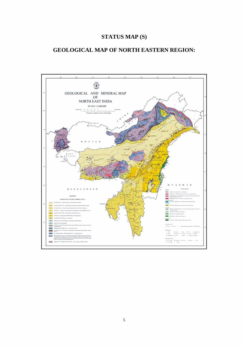
STATUS OF SYSTEMATIC GEOLOGICAL MAPPING IN NER
ALONG WITH AREA PROPOSED FOR F.S. 2013-2014
State Wise Item distribution: Assam (2), Manipur (1), Nagaland (1).
Target for FS 2013 -14 is 2640 sq.km. Achievement till 31 March 2014 is 2640 sq.km (100%)
7
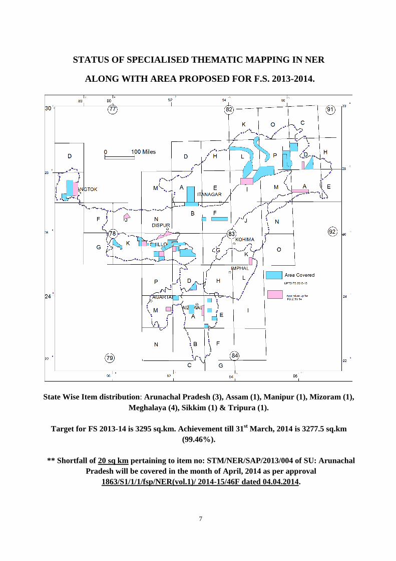
STATUS OF SPECIALISED THEMATIC MAPPING IN NER
ALONG WITH AREA PROPOSED FOR F.S. 2013-2014.
State Wise Item distribution: Arunachal Pradesh (3), Assam (1), Manipur (1), Mizoram (1),
Meghalaya (4), Sikkim (1) & Tripura (1).
Target for FS 2013-14 is 3295 sq.km. Achievement till 31st March, 2014 is 3277.5 sq.km
(99.46%).
** Shortfall of 20 sq km pertaining to item no: STM/NER/SAP/2013/004 of SU: Arunachal
Pradesh will be covered in the month of April, 2014 as per approval
1863/S1/1/1/fsp/NER(vol.1)/ 2014-15/46F dated 04.04.2014.
8
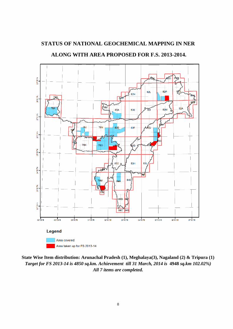
STATUS OF NATIONAL GEOCHEMICAL MAPPING IN NER
ALONG WITH AREA PROPOSED FOR F.S. 2013-2014.
State Wise Item distribution: Arunachal Pradesh (1), Meghalaya(3), Nagaland (2) & Tripura (1)
Target for FS 2013-14 is 4850 sq.km. Achievement till 31 March, 2014 is 4948 sq.km 102.02%)
All 7 items are completed.
9
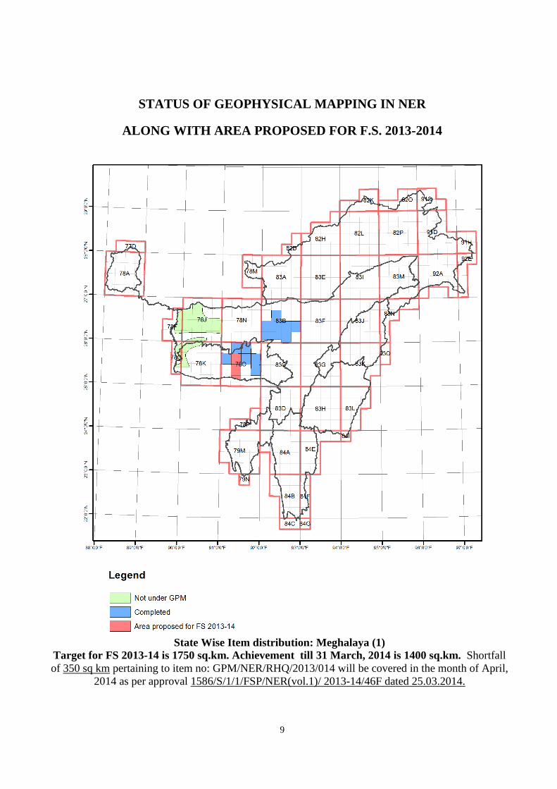
STATUS OF GEOPHYSICAL MAPPING IN NER
ALONG WITH AREA PROPOSED FOR F.S. 2013-2014
State Wise Item distribution: Meghalaya (1)
Target for FS 2013-14 is 1750 sq.km. Achievement till 31 March, 2014 is 1400 sq.km. Shortfall
of 350 sq km pertaining to item no: GPM/NER/RHQ/2013/014 will be covered in the month of April,
2014 as per approval 1586/S/1/1/FSP/NER(vol.1)/ 2013-14/46F dated 25.03.2014.
10
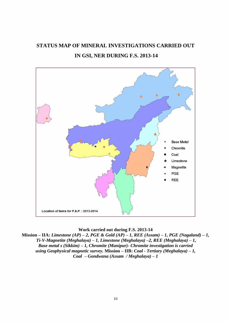
STATUS MAP OF MINERAL INVESTIGATIONS CARRIED OUT
IN GSI, NER DURING F.S. 2013-14
Work carried out during F.S. 2013-14
Mission – IIA: Limestone (AP) – 2, PGE & Gold (AP) – 1, REE (Assam) – 1, PGE (Nagaland) – 1,
Ti-V-Magnetite (Meghalaya) – 1, Limestone (Meghalaya) –2, REE (Meghalaya) – 1,
Base metal s (Sikkim) – 1, Chromite (Manipur)- Chromite investigation is carried
using Geophysical magnetic survey. Mission – IIB: Coal - Tertiary (Meghalaya) – 1,
Coal – Gondwana (Assam / Meghalaya) – 1

11
STATUS OF 50K MAPS IN NER

12
2. ORGANISATIONAL STRUCTURE: (As on 31.03. 2014)
13
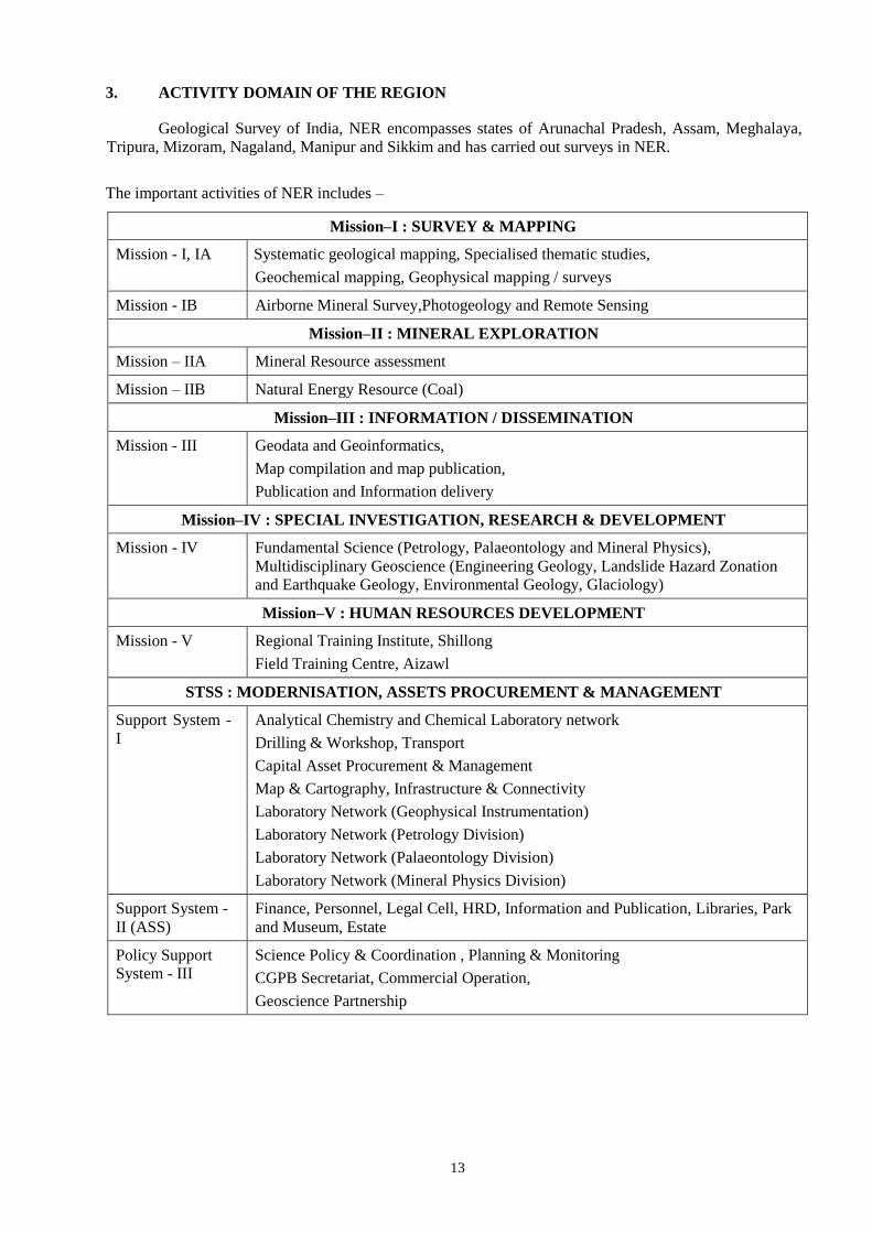
3. ACTIVITY DOMAIN OF THE REGION
Geological Survey of India, NER encompasses states of Arunachal Pradesh, Assam, Meghalaya,
Tripura, Mizoram, Nagaland, Manipur and Sikkim and has carried out surveys in NER.
The important activities of NER includes –
Mission–I : SURVEY & MAPPING
Mission - I, IA Systematic geological mapping, Specialised thematic studies,
Geochemical mapping, Geophysical mapping / surveys
Mission - IB Airborne Mineral Survey,Photogeology and Remote Sensing
Mission–II : MINERAL EXPLORATION
Mission – IIA Mineral Resource assessment
Mission – IIB Natural Energy Resource (Coal)
Mission–III : INFORMATION / DISSEMINATION
Mission - III Geodata and Geoinformatics,
Map compilation and map publication,
Publication and Information delivery
Mission–IV : SPECIAL INVESTIGATION, RESEARCH & DEVELOPMENT
Mission - IV Fundamental Science (Petrology, Palaeontology and Mineral Physics),
Multidisciplinary Geoscience (Engineering Geology, Landslide Hazard Zonation
and Earthquake Geology, Environmental Geology, Glaciology)
Mission–V : HUMAN RESOURCES DEVELOPMENT
Mission - V Regional Training Institute, Shillong
Field Training Centre, Aizawl
STSS : MODERNISATION, ASSETS PROCUREMENT & MANAGEMENT
Support System -
I
Analytical Chemistry and Chemical Laboratory network
Drilling & Workshop, Transport
Capital Asset Procurement & Management
Map & Cartography, Infrastructure & Connectivity
Laboratory Network (Geophysical Instrumentation)
Laboratory Network (Petrology Division)
Laboratory Network (Palaeontology Division)
Laboratory Network (Mineral Physics Division)
Support System -
II (ASS)
Finance, Personnel, Legal Cell, HRD, Information and Publication, Libraries, Park
and Museum, Estate
Policy Support
System - III
Science Policy & Coordination , Planning & Monitoring
CGPB Secretariat, Commercial Operation,
Geoscience Partnership
14
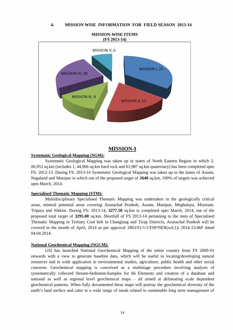
4. MISSION WISE INFORMATION FOR FIELD SEASON 2013-14
MISSION-WISE ITEMS
(FS 2013-14)
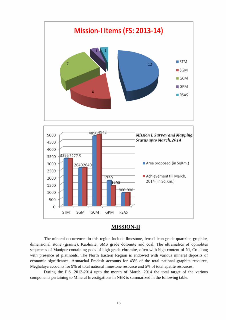
MISSION-I
Systematic Geological Mapping (SGM):
Systematic Geological Mapping was taken up in states of North Eastern Region in which 2,
06,953 sq.km (includes 1, 44,966 sq.km hard rock and 61,987 sq.km quaternary) has been completed upto
FS: 2012-13. During FS: 2013-14 Systematic Geological Mapping was taken up in the states of Assam,
Nagaland and Manipur in which out of the proposed target of 2640 sq.km, 100% of targets was achieved
upto March, 2014.
Specialised Thematic Mapping (STM):
Multidisciplinary Specialised Thematic Mapping was undertaken in the geologically critical
areas, mineral potential areas covering Arunachal Pradesh, Assam, Manipur, Meghalaya, Mizoram,
Tripura and Sikkim. During FS: 2013-14, 3277.50 sq.km is completed upto March, 2014, out of the
proposed total target of 3295.00 sq.km. Shortfall of FS 2013-14 pertaining to the item of Specialised
Thematic Mapping in Tertiary Coal belt in Changlang and Tirap Districts, Arunachal Pradesh will be
covered in the month of April, 2014 as per approval 1863/S1/1/1/FSP/NER(vol.1)/ 2014-15/46F dated
04.04.2014.
National Geochemical Mapping (NGCM):
GSI has launched National Geochemical Mapping of the entire country from FS 2000-01
onwards with a view to generate baseline data, which will be useful in locating/developing natural
resources and in wide application in environmental studies, agriculture, public health and other social
concerns. Geochemical mapping is conceived as a multistage procedure involving analysis of
systematically collected Stream-Sediment-Samples for 66 Elements and creation of a database and
national as well as regional level geochemical maps – all aimed at delineating scale dependent
geochemical patterns. When fully documented these maps will portray the geochemical diversity of the
earth’s land surface and cater to a wide range of needs related to sustainable long term management of
15
environment and natural resources. The geochemical database can be utilised for targeting mineral
exploration, land use, agriculture, forestry, management of environment, animal and human health etc.
An area of 25196 sq.km (Assam: 7970 sq.km, Arunachal Pradesh: 3631 sq.km, Meghalaya: 8346
sq.km, Mizoram: 1136 sq.km, Nagaland: 1150 sq.km, Sikkim: 2963 sq.km and Tripura: 1746 sq.km) has
been covered till F.S. 2012-13. Out of the proposed target of 4850 sq.km for FS: 2013-14, 4948 sq.km is
completed upto March, 2014.
Geophysical Mapping:
North Eastern Region of the Geological Survey of India has capability of high precision, high
resolution geophysical equipments, which have put us to a new digital era of Geophysical Surveys on
land. Now, it is possible to utilize Gravity and Magnetic Surveys also in the areas of Environmental
Studies, Landslides, Geotechnical and Seismotectonics surveys.
Gravity-Magnetic mapping have been conducted over the last few years in parts of Meghalaya
and Assam to generate gravity and magnetic maps on 1:50,000 scale. Out of the 1750 sq.km proposed for
FS:2013-14, GPM of 1400 sq.km area is completed upto March, 2103. Gravity-magnetic Survey has been
carried out along different roads and tracks in 1: 50,000 scale pertaining to toposheet no. 78 O/6, 7 and
parts of 8 in west Khasi hills in order to delineate subsurface geological structures and preparations of
Gravity-Magnetic Map. Shortfall of 350 sq km of FS: 2013-14 pertaining to item Gravity-Magnetic
Mapping in Parts of West Khasi Hills District, Meghalaya will be covered in the month of April, 2014 as
per approval 1586/S/1/1/FSP/NER(vol.1)/ 2013-14/46F dated 25.03.2014.
RSAS:
In FS: 2013-15 Geological mapping of 2000 sq km on 1:50,000 scale using remotely sensed data
with selected field checks covering T.S. Nos. 78 G/15; 78 K/3,4, 8, 12, 16 is proposed to be mapped.
During FS: 2013-14, 900 sq km in covering T.S. 78 K/4,8,12 & 16 is to be carried out of which 900
sq.km has been completed upto March 2013 (the targets of original proposal has been modified as per
PPM letter no. 5522/6/1/1/FSP/NER(vol.1)/ 2013-14/46F dated 09/10/2013.
Sl.
No.
Item Utility
1. ERADAS Image 2010 installed Digital image processing and interpretation for
geological studies.
ERDAS IMAGINE version 2010,
classic interface.
Digital image processing and interpretation for
geological studies.
2. Geo-coded IRS Images of area part
of NER
219 No
3. IRS Images soft copy Total 112 No, For geological studies and survey
work.
4. Aerial photographs on 1;50,000 and
30,000 scale
For Geological mapping and studies.
5. Mirror Stereoscopes Total 4 No, For generating optical model of the
terrain and study of geology and structure.
6 CARTOSAT-1 (IRS-P5) Terrain modeling , mapping in different terrain,
monitoring of environmental parameters, glacial
monitoring etc.
16
MISSION-II
The mineral occurrences in this region include limestone, ferrosilicon grade quartzite, graphite,
dimensional stone (granite), Kaolinite, SMS grade dolomite and coal. The ultramafics of ophiolites
sequences of Manipur containing pods of high grade chromite, often with high content of Ni, Co along
with presence of platinoids. The North Eastern Region is endowed with various mineral deposits of
economic significance. Arunachal Pradesh accounts for 43% of the total national graphite resource,
Meghalaya accounts for 9% of total national limestone resource and 5% of total apatite resources.
During the F.S. 2013-2014 upto the month of March, 2014 the total target of the various
components pertaining to Mineral Investigations in NER is summarized in the following table.
17
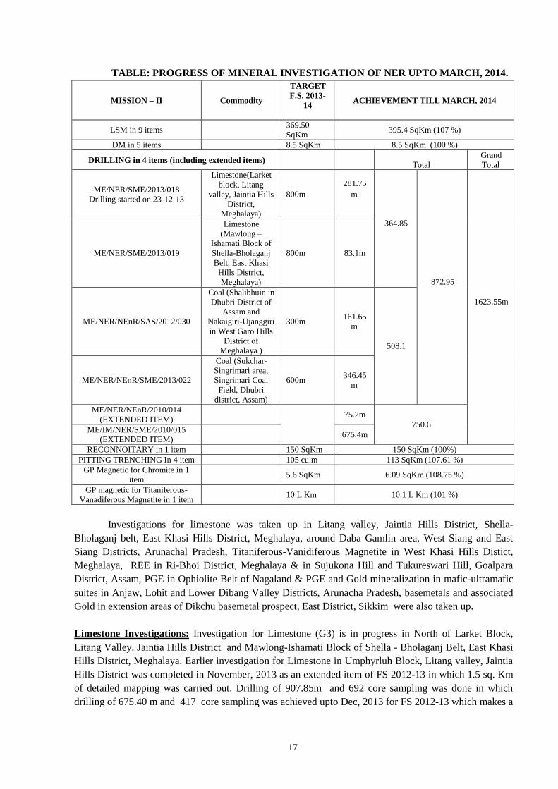
TABLE: PROGRESS OF MINERAL INVESTIGATION OF NER UPTO MARCH, 2014.
MISSION – II Commodity
TARGET
F.S. 2013-
14
ACHIEVEMENT TILL MARCH, 2014
LSM in 9 items 369.50
SqKm 395.4 SqKm (107 %)
DM in 5 items 8.5 SqKm 8.5 SqKm (100 %)
DRILLING in 4 items (including extended items)
Total
Grand
Total
ME/NER/SME/2013/018
Drilling started on 23-12-13
Limestone(Larket
block, Litang
valley, Jaintia Hills
District,
Meghalaya)
800m
281.75
m
364.85
872.95
1623.55m
ME/NER/SME/2013/019
Limestone
(Mawlong –
Ishamati Block of
Shella-Bholaganj
Belt, East Khasi
Hills District,
Meghalaya)
800m 83.1m
ME/NER/NEnR/SAS/2012/030
Coal (Shalibhuin in
Dhubri District of
Assam and
Nakaigiri-Ujanggiri
in West Garo Hills
District of
Meghalaya.)
300m 161.65
m
508.1
ME/NER/NEnR/SME/2013/022
Coal (Sukchar-
Singrimari area,
Singrimari Coal
Field, Dhubri
district, Assam)
600m 346.45
m
ME/NER/NEnR/2010/014
(EXTENDED ITEM)
75.2m
750.6 ME/IM/NER/SME/2010/015
(EXTENDED ITEM) 675.4m
RECONNOITARY in 1 item 150 SqKm 150 SqKm (100%)
PITTING TRENCHING In 4 item 105 cu.m 113 SqKm (107.61 %)
GP Magnetic for Chromite in 1
item 5.6 SqKm 6.09 SqKm (108.75 %)
GP magnetic for Titaniferous-
Vanadiferous Magnetite in 1 item 10 L Km 10.1 L Km (101 %)
Investigations for limestone was taken up in Litang valley, Jaintia Hills District, Shella-
Bholaganj belt, East Khasi Hills District, Meghalaya, around Daba Gamlin area, West Siang and East
Siang Districts, Arunachal Pradesh, Titaniferous-Vanidiferous Magnetite in West Khasi Hills Distict,
Meghalaya, REE in Ri-Bhoi District, Meghalaya & in Sujukona Hill and Tukureswari Hill, Goalpara
District, Assam, PGE in Ophiolite Belt of Nagaland & PGE and Gold mineralization in mafic-ultramafic
suites in Anjaw, Lohit and Lower Dibang Valley Districts, Arunacha Pradesh, basemetals and associated
Gold in extension areas of Dikchu basemetal prospect, East District, Sikkim were also taken up.
Limestone Investigations: Investigation for Limestone (G3) is in progress in North of Larket Block,
Litang Valley, Jaintia Hills District and Mawlong-Ishamati Block of Shella - Bholaganj Belt, East Khasi
Hills District, Meghalaya. Earlier investigation for Limestone in Umphyrluh Block, Litang valley, Jaintia
Hills District was completed in November, 2013 as an extended item of FS 2012-13 in which 1.5 sq. Km
of detailed mapping was carried out. Drilling of 907.85m and 692 core sampling was done in which
drilling of 675.40 m and 417 core sampling was achieved upto Dec, 2013 for FS 2012-13 which makes a
18
total of 1583.25m and 1109 nos of core sampling. In addition to 439.29 million tonnes of different grade
of limestone estimated during F.S 2010-12 which is based on fifteen boreholes, a resource of about 64.43
million tonnes of different grade of limestone was estimated for the three boreholes of this block.
Geologically the Larket block exposes mainly the Middle Tertiary Sedimentary sequence comprising
Kopili and Shella Formation of middle to upper Eocene age with cover recent to sub recent alluvium. The
Shella Formation is represented by nummulitic limestone. The limestone is grey to dark grey in colour,
medium grained, massive, compact and highly fossiliferous, dominant fossils being nummulites while the
Kopili Formation is represented by shale and ferruginous nummulitic argillaceous limestone/marl. Shale
is dark in colour, thinly laminated and splintery in nature.
The general trend of the Formation is sub horizontal with strike varying from NNE- SSW to NE-
SW and dip varying from 30º to 50º towards ESE to SE. Three sets of joints are developed in the
limestone, out of which two are vertical to sub vertical trending NW-SE and NNE-SSW. Stylolite with
varying magnitude and wavelength are the common solution structure present in the limestone.
Disseminations of pyrite is observed along the fractures of drill cores, Oolitic structures showing
concentric carbonate rims of various shapes and size ranges from few mm to 2.30 cm across. Ball and
pillow structure are also seen in the drilled core.
During FS 2013-14, in the Larket block, drilling commenced on 23.12.2013 and progressed up to
281.75m in which 112 nos of core sampling was done till March, 2014. The remaining drilling target of
FS 2013-14 will be carried over during FS 2014-15. Borehole no.JNLK-1 was closed at depth of 89.10m.
Borehole no. JNLK-2 commenced on 10.02.2014 and attained a depth of 51.50m in which limestone band
ranging in thickness from 79.00 m to 95.00 m has been intersected at shallow depth. Limestone resource
of 43.89 million tonnes of unclassified category has been estimated from borehole no. JNLK-I and JNLK-
2. To assess the potentiality of limestone along the western continuity of Mawlong-Ishamati Block, Shell-
Bholaganj belt in which 1.5 sq. km area has been mapped on 1:5000 scale. The lithounits encountered in
the area are limestone, shale and sandstone. The northern part of mapped area occupied by E-W trending
limestone ridge of 80 m to 100 m in height with steep slope. Limestone is hard and grey in colour and
trend along E-W direction with variable dip from 35° to 45° towards north. The limestone belongs to
Shella Formation of Palaeocene-Eocene age. Petrographic studies of limestone shows predominant
presence of foraminifers with large amount of other fossil shells. Few veins of pyrite were observed
within limestone in western part of the area.
Shale of Kopili formation of Palaeocene-Eocene age occurs in south of limestone ridge. It is
highly weathered, splintery in nature and shows variable dips in the area. The contact between limestone
and shale is faulted and trends E-W. The Kopili shale is younger but in the area it lies in down thrown
block. Sandstone band of 20m to 30m wide was also demarcated within the shale. Sandstone is fine to
medium grained and grey in colour.
Analytical results of 7 grab samples collected from of limestone ridge shows an average CaO
50.75%, Fe2O3 0.21%, MgO 0.81% and SiO2 3.51%. The analytical data indicate chemical grade of
limestone. In this block subsurface exploration by drilling (RD-30; Unit No:441) commenced on
28.03.2014 in which three boreholes has been taken up (one completed and two in progress). Total
meterage achieved in all the boreholes in this Block was 83.10 meters in which 22 nos. core samples were
generated till March, 2014. The first borehole ISBH-1 was planned to intersect the western continuity of
limestone of Mawlong-Ishamati block. This borehole drilled up to 54.75m and intersected boulders of
limestone, sand and clay. Borehole no. ISBH-2 was planned at 120m west of borehole no. ISBH-1 to find
the lateral continuity of limestone bands towards west. The borehole ISBH-2 progressed up to 23.85m
and was suspended due to break down of drill machine (Unit-462). It has intersected fossiliferous
limestone with occasional calcite veins. 22 nos. of core samples were collected and submitted for
analysis. Results of core samples are still awaited. Borehole ISBH-3 was planned further 400m west of
Borehole no. ISBH-2 and drilled up to 4.50m depth (31.03.2014). It has intersected fossiliferous
limestone and bore hole is in progress.
19
Coal Exploration: Study of Gondwana Coal was carried out in Sukchar-Singrimari Block, Singrimari
Coal Field, Dhubri district, Assam which is located at the border of Assam and Meghalaya in which two
coal seam of thickness 0.55 m and 2.15 m have been found at 257.90 m and 262.70 m depth respectively.
During FS 2012-13, borehole no. SN-05 was closed at a depth of 281.00 m on 22.05.13 out of total
562.55m, drilling of 75.20 m was achieved in FS 2013-14 as extended target.
In FS 2013-14, 3.00 sq km of Large Scale Mapping (1:10000) was achieved. A basic dyke of
about 10m width and also another ultramafic dyke of about 5m width, intrusive within the gneissic
complex have been mapped near Shalibhuin.
Drilling (Unit: 422) of 346.45 meters has been achieved till March, 2014. The maiden borehole
no. SK-01 commenced on 25.11.13 and closed on 12.03.14 at a depth of 243.45m within basement
metamorphic rock. A coal seam of 0.90 m thickness has been intersected at 109m depth while a thick
carbonaceous zone of about 25m has been intersected at a depth of 193m. Second and the last borehole
no. SK-02, located downdip of borehole no.SK-01, was commenced on 19.03.14 and attained the depth
103m.
Geological study in Coal Zone in Tertiary sequence around Shalibhuin in Dhubri district, Assam
and Nakaigiri-Ujanggiri in West Garo Hills, Meghalaya was kept in abeyance from November, 2013 in
which 1.4 sq. km of LSM (1:10K scale with 5m contour interval) and 161.65m drilling was carried out.
The Tertiary sequence trends NW-SE with very low dips varying from 5 to 10° towards SW. Based on
these existing coal pits in the area, one scout borehole USD-01 was done and was closed on 23.10.13 at a
depth of 161.65m.
REE Investigation: During the FS 2013-14, Preliminary investigation for REE (G4) in parts of
Nongpoh pluton, Ri-Bhoi district, Meghalaya located in parts of Nonghkhyllem Reserve Forest and
western part of the area, Umran, Shangbangla, Nongpoh is in progress in which LSM: 60 sq.km (scale
1:12,500) was done.
Lithounits observed in the area includes sillimanite-biotite gneiss, granite gneiss and diorite
gneiss of Precambrian gneissic complex, mafic rock/lamprophyre (?), diorite-granodiorite, porphyritic
granite and non-porphyritic granite of Nongpoh pluton. Three generation of Nongpoh granite/granitic
events have been identified on the basis of field relationships. These are Early Non-porphyritic Granite,
Porphyritic Granite and Late Non-porphyritic Granite. Three types of enclaves viz; xenolith of country
rock, dark grey porphyry and black biotite rich microgranular enclaves were observed in Nongpoh
porphyritic granite. The mafic enclaves (MEs) in the area have various shapes including circular,
rounded, ellipsoidal, angular to sub angular, as dykes. The mixing compatible textures observed during
petrographic study viz; acicular and stubby apatite, resorbed plagioclase xenocrysts, titanite-feldspars
ocellar relation, ocellar quartz, poikilitic microcline, plagioclase, hornblende and quartz, combined with
frequent occurrence of MEs of various shapes and size suggest magma mixing and mingling was a major
process during the evolution of Nongpoh Granitoids. SSS data of 8 nos. samples yield ∑REE (La-
Lu+Sc+Y) value range between 226 to 2984 ppm with an average value of 900ppm. One sample contains
2984 ppm at the contact of porphyritic granite and basement gneiss. BRS analysis of 9 samples of
Porphyritic granite yield ∑REE (La-Lu+Sc+Y) ranges between 562 to 980ppm with an average value of
813ppm. 6 samples of Non-porphyritic granite yield ∑REE (La-Lu+Sc+Y) ranges between 578 to
2148ppm with an average value of 1152ppm. Two granite samples yield ∑REE (La-Lu+Sc+Y) value
1803 and 2148 ppm have visible spindle shaped sphene (titanite) and allanite (?) in hand specimen. One
sample of Granodiorite (?) from Garikhana area yield ∑REE 813ppm. 06 nos. soil samples yield ∑REE
(La-Lu+Sc+Y) value ranges between 653.57 to 1614.50ppm with an average value of 1041.92ppm.
EPMA analysis of Nongpoh Granitoids indicated presence of REE Carbonate (70.65% tREO), Monazite
(61.16% tREO), Allanite (18.52% tREO) and Sphene (2.4-4.1 %tREO). Apatite and zircon contains very
less (<1%) total REO.
20
Specks and disseminated grains of pyrite and chalcopyrite are observed in gneisses,
diorite/granodiorite, mafic intrusive rock, porphyritic granite, quartz and pegmatite veins. Sheelite grains
have been identified by EPMA study in garnet-epidote rock which are observed in porphyritic and grey
non-porphyritic granite. Disseminated magnetite crystals in the pegmatite intruding in grey granite was
observed (west of Mawdaran). Two samples collected from granite and associated pegmatite near
Mawdaran village shows 7 ppmm & 36 ppm Mo at Mawdaran quarry.
Titaniferous-Vanadiferous Magnetite Investigation: Titaniferous-Vanadiferous Magnetite
Investigation around Rambrai in West Khasi Hills district, Meghalaya is in progress. An area of 25
sq.km has been mapped on scale 12,500 in which lithounits encountered in the area are granite gneiss,
banded gneiss, granite and mafic granulite. The granite gneiss is medium to coarse grained with a crude
foliation. It is mainly composed of quartz, Plagioclase, feldspar, biotite. Tourmaline and magnetite are
accessory minerals. At places granite gneiss is highly weathered and shows a typical banded nature
defined by 3-4cm thick quartzo-feldspathic layers intervened by thin mafic layers. Three meta norite
bodies of different length and width have been identified and delineated in the area viz., (i) Northwest of
Moulih, (ii) West of Rambrai, (iii) Southwest of Rambrai. These bodies trending NW to WNW direction.
The rock is dark grey colour, fine to medium grained and massive. The first two meta-norite bodies are
having bands of titaniferous-vanadiferous magnetite and partially laterised. The dominant foliation within
the gneiss is trending NW-SE with moderate to steep dips towards NE. Two prominent set of sub-vertical
joints trending NE-SW and E-W also observed in the area.
Large Scale Mapping on scale 1:2000 was done of an area of 1.10 sq.km near Moulih
village and pitting and trenching of 3.20 cu m was carried out. The meta-norite body is bouldery in nature
and trending NW-SE dipping towards 40°-60° SW. The bed rock samples were collected for XRF, PGE
and REE analysis. Mineral phases identified by EPMA study are. Ilmenite, Titaniferous - Vanadiferous
magnetite, Chalcopyrite and Pyrite. A total of 60 nos. of bed rock samples were collected for which
analysis of 26 samples (XRF) received so far shows Fe2O3 ranges between 6.82% to 30.96% (average
14.03%),TiO2 0.72% to 4.30% (2.06%), Vanadium 81ppm to 1398ppm (688ppm), Zr 47ppm to 1802ppm
(205ppm) and copper from 5ppm to 566ppm(188ppm).
Assistance to State Government and other Agencies
GSI, NER has taken up investigation for PGE of ophiolite belt in association with the
DGM, Nagaland state. Besides, an investigation for coal is taken up in Singrimari area, Assam at the
request of Assam state.
21
Mission–III: INFORMATION / DISSEMINATION
Publication:
GSI, NER has brought out several publications in the form of books and maps to disseminate
information in earth science. The region has already published the miscellaneous publication No. 30 for
the states of Meghalaya & Assam, Arunachal Pradesh, Nagaland- Manipur and Tripura and Mizoram.
Publication of Rec. GSI, Vol. 147, Pt. 4 (Extended Abstract for F.S. 2012-13): Finalized, printed and
released on 31.01.2014. GSI, e- News (NER), Vol. 23 (January, 2012 to December, 2012): Manuscript
finalised and published on GSI Portal on 12.02.2014.
Library Services: Procured 14 nos. Geology books and 24 nos. of journals in Regional Library till
March, 2014. Seven scientific papers and 14 abstracts were processed for different national and
international seminars/ journals. Generated a resources of Rs 4260.00/- through sale of GSI publications.
Distributed 202 copies of GSI publications to all the Regions of GSI in India and extended library
facilities to departmental officers and others.
22
Map & Cartography :
DRM: A brief highlights of the Compilation of District Resource Maps of different states of NER is
given below:
Manipur-Nagaland: Prepared digitized and finalized the DRM’s of 4 districts of Manipur (Tamenglong,
Ukhrul, Imphal East & Senapati districts).
Tripura- Mizoram: Finalisation of the main map consisting of all layers of Aizawl and Champhai
districts on 1: 2,50,000 scale and finalized Inset Maps of geomorphology and Geotechnical details of
these two districts on 1: 1 million scale along with geological notes for DRM.
Assam: Digitisation & Digital Layout Preparation of Kamrup, Darrang and Goalpara district (Pertaining
to FS 2010-12) DRM is completed in all respect. Modification and preparation of hard copy layout for
Karimganj, Hailakandi, Sibsagar, Golaghat, Cachar, Dibrugarh, Dhemaji & Tinsukia DRM (FS 2012-13)
completed and the layouts have been sent to RMH-III for vetting. Compilation of Bongaigaon, Nagaon,
Lakhimpur, North Cachar Hills districts and Jorhat DRM is also completed. Digitisation of Geology and
mineral Layer of Karbi-Anglong district completed.
Meghalaya: Compilation of West Garo Hills, East Garo Hills, South Garo Hills, East Khasi, West Khasi
and Ri-Bhoi districts of Mehgalaya is completed in all respects. DRMs of East Khasi, West Khasi, Ribhoi
and East Garo Hills districts of Meghalaya have already been published. DRM of Jaintia district of
Meghalaya is completed.
For the creation of theme based 50K Geological Database, modification of graphic elements and
attribution of lithology as per the standardized legend is completed for 346 portal uploaded toposheets.
Digitization and attribution of three compiled geological maps of Assam is completed. Preparation and
uploading of metadata of three sheets is completed.
Preparation of Quadrangle Geological Map of Degree-sheet 78O on 1: 250,000 scale covering parts of
Meghalaya and Assam is competed in all respects including Geological section.
Geoinformatics: Creation of theme based database of degree sheet no 78O covering parts of East Garo
Hill, West Khasi Hill, Jaintia & Ri-Bhoi Districts of Meghalaya and Kamrup & Goalpara Districts of
Assam, extraction and entry of data of Seven (07) reports pertaining to Mining (Mineral Exploration)
theme, Three (03) reports of Map 50K theme and Two (02) reports of Geophysics theme were completed.
A total of 177 nos. of lithological records in individual sub-form of respective toposheets were inserted in
the Map 50K domain. The standardized Geometry ID’s of the lithological units as prepared by the M&C
Division were used for Oracle data entry. The modified data was supplied to the Geodata Division for
updation of NER repository on Portal. Data were extracted and inserted for around 2000 cells in sub-forms
viz. Lithological Unit (Geometry ID, Notation, Lithology, Supergroup, Group, Formation, Member,
Minimum/Maximum thickness), Standard Lithology (Lithology, Texture, Remarks),
Microscopic/Macroscopic Minerals, Quaternary description (Intensity of Oxidation, Pedogenesis,
Vegetation cover type etc.)
Lexicon for Locality names was updated with 67 new values for the sub-form Mineral
Occurrence of Mining Exploration Domain. A total of 81 nos. of mineral occurrences in degree sheet 78O
have been extracted from the reports for their entry into the Mining Exploration Domain. The Geometry
IDs of the each mineral location were modified with 6 digit integer values ranging between 781501 and
781581. The Mineral Occurrences were attributed with fields on the Geological Settings, derived from the
overlay of LI layer. The modified MI layer was supplied to Geodata Division for Spatial Repository of
NER and uploading to portal. Data have been extracted for various headers viz. Mineral Occurrence Id,
Latitude, Longitude, Mean Sea Level, Toposheet subdivision, Host rock age, Structural setting, Macro
alteration, Worker name, Year, Bibliographic reference, Comments and Other information. There are five
other sub-forms namely Commodity, Structural Elements, FSP Numbers, Samples (s) and Field
observation (s) to enter specific data.
23
A report of the database was generated through SQL at the central server of the Oracle Database.
Discussions were held with Geodata, CHQ regarding input of chemical data in Drilling Domain and with
the officers of Chemical Division, NER regarding creation of Protocol ID and Lab Lexicon ID for Oracle
Database entry of NER which will include Laboratory Code, Element Code, Analytical Method Code,
Sample Digestion details, Unit Code, Lower Detection Limit, Upper Detection Limit, etc. List of Protocol
and Lab Lexicons for entry of Chemical Data were finalised.
Geodata : There are two linked program with M&C Division for Geodata component. Edge-matching of
different feature elements of graphic geological data and extraction of unpublished reports under
Geoinformatics item.
Mission–IV: SPECIAL INVESTIGATION, RESEARCH & DEVELOPMENT
Palaeontological Studies:A field investigation was taken up along Shillong-Sohra, Shillong-Mawsynram
and Shillong-Dawki in East Khasi Hills district of Meghalaya for search of fossils and preparation of
geological map on 1: 50,000 scale. Twenty four (24) specimens have been collected covering 17 sq km of
the area. 10 L.km. mapping was done and 5 sections measured. Trace fossils like burrows, bi-valve resting
impressions etc. were collected from Mahadek and Langpar Formation along Shillong-Sohra, Shillong-
Mawsynram and Shillong-Dawki sections. Numerous wood fossils were collected from Langpar Formation
along these sections. In case of invertebrate fossils, Allectryonia sp., Nummulites sp. etc were collected
from Mahadek Formation and Shella Limestone respectively. Most interesting part is that, about dozen of
oval to rounded egg fossil like samples were collected in and around Dawki area, East Khasi Hills District,
Meghalaya and these were examined physically and thin sections were prepared at different directions
(tangential & radial). The SEM-EDX study and thin section study of the suspected egg shell were carried
out at Palaeontology Division - I Laboratory, CHQ, Kolkata. EDX study shows that these samples contains
very high calcium which in turn suggests that these are fossils not phosphatic nodules. SEM study shows
presence of pore spaces in some samples. Few thin section studies show egg shell structure and pore spaces
in tangential section. Radial thin section was prepared and studied but they do not shows typical
canaliculae of tubocanaliculate pore system which is the characteristic feature of egg shell of reptiles.
Detailed study of thin section in SEM and EDX graphs suggests these are not egg fossils but are
invertebrate fossils falling within gryphoid group, most of them are possibly algal balls and a very few are
possibly erosional features within limestone.
Geotechnical investigations:NER may be termed as the ‘power house’ of India as it possesses
hydropower potential, which is about 30% of the total hydel potential of the country. The hydel potential
of major river basin of Arunachal Pradesh like Kameng, Subansiri, Siang, Lohit and Dibang totals
production of 34920 MW at 60% load factor (CEA) i.e. about 90% of the total hydropower resources of
NER.
A large number of major and minor hydroelectric projects have been completed or are under
various stages of investigation/construction with the active help and support of geoscientific inputs by the
GSI, e.g. Ranganadi, Doyang, Umiam (Barapani), Pare, Kopili, Turial, Kameng, communication projects
and border roads.
Arunachal Pradesh contributes a major share of the water of the Brahmaputra river system and the high
relief offers extensive scope for hydel power generation. Geotechnical evaluation of water resources
development projects in North Eastern Region has been taken up at the request of the project authorities.
GSI has carried out geotechnical studies for various hydro power projects in the NER:
Feasibility studies: (Dihang (AP), Pare (A.P.), Dikrong (AP), Subansiri (AP), Lohit Dam Project, (A.P),
Dimwe (AP.), Kameng (AP), Atnring (Assam), Amuna (Assam), Kulsi (Assam), Dalaima (Assam),
Loktak (Manipur),Barak (Manipur)

24
Pre-construction and detailed investigations: (Sessri (AP.), Ranganadi Stage-II, (A.P.), Kamleng (AP.),
Lower Kopili ((Assam)),Intermediate Barapani (Meghalaya), Pagladiya Dam Project (Assam), Tuivai
Project (Mizoram), Tunal Project (Mizoram), Doleswari (Bharvi) project (Mizoram), Mat Valley Project,
(Mizoram), Kolodyne Stage-I, (Mizoram), Kolodyne Stage-II, (Mizoram), Kapak Leyak H.E. Project,
Arunachal Pradesh, Mawhu H.E. Project, Meghalaya, Myntdu – Leshka H.E. Project Stage-II,
Meghalaya, Myntdu – Leshka H.E. Project Stage-II, Meghalaya, Umngot Combined Stage-I & II, H.E.
Project, Meghalaya, Umngi H.E. Project Stage-I, Meghalaya, New Umtru H.E. Project, Meghalaya,
Ganol H.E. Project, Meghalaya, Simsang (Someswari) Multipurpose Project, Meghalaya, Kynshi
(Jadukata) Multipurpose Project (Stage-I), Meghalaya.
Construction Stage investigations: Ranganadi (AP.), Kameng HEP (AP), Kopili (Assam), Lower
Borpani (Assam), Doyang HEP, (Nagaland),Thoubal Project (Manipur), Singda Project, (Manipur),
Khuga Project (Manipur),Myntdu – Leshka H.E. Project Stage-I, Meghalaya)
Geotechnical evaluation of Water Resource Development Projects were taken up during FS 2013-14 in
Kameng H.E.Project, West Kameng District, Arunachal Pradesh, Kulsi Multipurpose Dam Project,
Kamrup District, Assam, Turial H.E.Project, Aizawl District, Mizoram and Mawblei H.E.Project, West
Khasi Hills District, Meghalaya.
Landslide Hazard Studies:
GSI has carried out landslide studies on different scales in following areas of NER:
MACRO SCALE LHZ
(1:50,000 SCALE)
MACRO SCALE
LHZ
(1:250,000 SCALE)
MESO SCALE
LHZ
(1:10,000 SCALE)
SITE SPECIFIC
STUDIES
SU: Assam
Kalapahar, Guwahati, Kamrup
district, Assam (FS 1998-99)
Kalapahar,
Guwahati, Kamrup
district, Assam (FS
1998-99)
Kalapahar,
Guwahati, Kamrup
district, Assam (FS
1998-99)
Cachar, Assam & Jaintia district,
Meghalaya (FS 1998-99)
Guwahati Urban Complex, Assam
(FS 2002-03)
Guwahati Urban
Complex, Assam
(FS 2002-03)
Kolsaib district, Mizoram and
Cachar district, Assam
(FS 2003-04)
Guwahati, Assam (FS 2004-05) Guwahati, Assam(
FS 2004-05)
Guwahati,
Assam(FS 2004-05)
SU: Arunachal Pradesh
Itanagar Capital Complex,
Arunachal Pradesh (FS 1998-99)
Bomdila & Tawang, West
Kameng And Tawang Districts,
Arunachal Pradesh( FS 2012-13 &
FS 2013-14)
Bomdila &
Tawang, West
Kameng And
Tawang Districts,
Anjaw & Lohit
Districts Arunachal
Pradesh( FS 2012-
13 & FS 2013-14)
NH-52a Corridor From
25
Banderdewa To Gohpur (Holongi)
Via Itanagar, Papumpare Districts,
Arunachal Pradesh
(FS 2012-13)
SU: Tripura-Mizoram
Lunglei, Lawngtlai & Saiha
districts, Mizoram (FS 1995-98)
Lunglei area,
Mizoram (FS 2005-
06)
Kolsaib and Aizawl districts,
Mizoram (FS 2001-02)
Lunglei area, Mizoram (FS 2005-
06)
Lunglei Town, Mizoram (FS
2006-07)
Lunglei Town,
Mizoram (FS 2006-
07)
Serchip, Chiahtiang Townships,
Serchip district, Mizoram
(FS 2000-01)
Serchip, Chiahtiang
Townships, Serchip
district, Mizoram (FS
2000-01)
Serchip, Hmar Veng, Serchip
district, Mizoram (FS 2000-01)
Serchip, Hmar
Veng, Serchip
district, Mizoram
(FS 2000-01)
Serchip, Hmar
Veng, Serchip
district, Mizoram
(FS 2000-01)
SU: Manipur-Nagaland
Mao Song, Senapati district,
Manipur (FS 2003-04)
Mao Song, Senapati
district, Manipur (FS
2003-04)
Mao Song, Senapati
district, Manipur
(FS 2003-04)
Kohima, Nagaland (FS 2004-05) Kohima, Nagaland
(FS 2004-05)
Imphal, Manipur (FS2004-05) Imphal, Manipur
(FS2004-05)
NH-39 (Imphal-Kohima), (FS
2005-06)
NH-53 (Imphal-Nungba), (FS
2006-07)
Zubza, Kohima district, Nagaland
(FS 2008-09 & 2009-10)
Zubza, Kohima
district, Nagaland
(FS 2008-09 &
2009-10)
Zubza, Kohima
district, Nagaland
(FS 2008-09 &
2009-10)
SU: Meghalaya
East Khasi Hills and Ri-Bhoi
districts, Meghalaya (FS 1999-
2000)
NH-40 (Shillong-
Phalangpongtung (Dawki)),
Meghalaya (FS 2007-08)
Shillong Town, Meghalaya
(FS 2009-10 & 2010-12)
Shillong Town,
Meghalaya (FS
2009-10 & 2010-12)
Macro-scale landslide hazard Zonation (1 : 50,000) of the Hayulinag –Challagam and Teju- Hayuliang
road sector of Lohit and Anjaw district of Arunachal Pradesh was carried out with the aim to prepare a
landslide susceptibility map of the selected stretch and evaluate the overall stability of the area in respect
to future landslide initiation. As a part of the exercises the 150 line km of the road bench between Teju in
26
the Lohit district and Chaglagam in the Anjaw district has been covered for augmentation of thematic
data bases and preparation of the landslide susceptibility map. A significant observation made during the
study is the nature and quantum of coarse debris being carried out by all the mountain streams. A huge
volume of debris mostly boulder laden is found to be transported by nearly all the streams and the trunk
rivers in the area. The same along with near absence of finer fractions in the riverine material may be
explained in terms of rejuvenation of the stream under the influence of neo- tectonic activities. As a part
of the work 56 numbers of the active and reactivated landslides were identified and mapped. Among these
31 are rockslides, 22 are debris slide and 3 are debris flow. Along the observed section the rock slides
found to be the dominant one. Both old rock slides and large/prominent new rock slides found traversed
the slope and affecting the road bench, upslope and down slope in the studied area. Planar failures,
combination of planar and wedge failure as well as toppling are the major identified failure mechanism.
Apart from the rockslides the other major kind of slope distressing that was observed and documented in
the area are Confined/at places unconfined debris flow initiated at high slope and descended through
majority of the mountain streams. The major outcome of the work besides the preparation of thematic
maps is i) Identification and documentation of the predisposing, triggering and revealing factors for
landslide initiation .ii). Detailed inventory of the observed slope instabilities encountered in the studied
corridor. iii) Detailed evaluation of a few trouble spots for understanding of the causative factors, failure
mechanism and formulation of suggested remedial measures. iv) Perspective assessment of the landslide
initiation process based on the revealing factors, slope morpho-metry, stream configuration and nature&
amount of sediments load in the drainage.
Detailed (1:1000) Site Specific Geological Studies of the Landslides near Tawang Monastery,
Tawang district, Arunachal Pradesh has been carried out for comprehensive evaluation of the various
attributes across the large dynamic slope mass of the conspicuous landslides near famous historic Tawang
Monastery.The slope failures initiated at least before 1985 is being continuously evolving in space and
time covering more than 0.6 sq km area is responsible for significant administrative and social concern
due to its proximity to the famous Tawang Gaden Namgyal Lhatse (TGNL) Monastery (popularly known
as Tawang Monastery), founded in the year 1680-81. The studies reveals presence of multi-level slide
scrap of varying dimension and geometry, initiated and evolved in varying slope forming material was
identified along and across the landslide complex. The prominent among the slide scars is the
conspicuous curvilinear crown scar extending over 100 m and subsequently found joined with the
prominent left side scars. Corresponding to the zone of depletion proximal to the scarps, a prominent
zone of accumulation in the form of gently sloping bench could be identified. The material identified
along and across the affected slope are isolated exposure of slight to moderately garnetiferous quartzo-
feldspathic gneiss, highly weathered Gneiss, in-situ soil, failed debris mass, mud flow and debris flow
deposits. The attitude of gneissosity varies from N180-300E/160-280→S780E (dipping inside hill) to
SW. Besides, the rockmass is traversed by three joint sets. Deep rotational failure in the in-situ soil and
failed debris mass, shallow and deep translational failure in the weathered rock mass, large block
subsidence in the flank were identified for initiation of slope failures at various space and time. Multiple
episode of debris/mud flow of varying run out length initiated in pulses is identified as one the important
mode of slope failures. The unconfined debris/ mud flow with significant momentum descended down
slope and are found partially submerged a school (Kendriya Vidyalaya). The most prominent debris flow
observed was initiated from upslope accumulated debris found descended along the moderately steep left
bank slope of Kangteng River through two branching type of confined flow path and accumulated heap
near bank of the Kangteng River. Partial blockade of the river due to the flowing debris mass was also
noticed along the left bank for more than 100 m. Reactivation of some of the failure surfaces along the
prominent scars is also anticipated. The controlling law and parameters of the different stages of failure
and consequences of the same to the element at risks are being evaluated through detailed studies. As a
part of the endeveour nine (9) suitable borehole locations were delineated to understand the spatial and
temporal variation of the bedrock across the landslide complex. The field based findings will form the
basis for comprehensive understanding of triggering mechanism and causative factors responsible for
initiation and further continuation of failures to the upslope.
Detailed Study of 13th mile slide on Gangtok-Nathula Road, East District, Sikkim was carried
out. An attempt was made to study the slope stability on the eastern flank of the slide using slicing
method of Morgenstern-Price. During the stability analysis, the Factor of safety values ranging from 0.76
to 0.89 (in dry conditions) and from 0.72 to 0.84 (in wet conditions) were acquired indicating that the
slope is more vulnerable in the wet season. As the road passes mostly through the crest of the distress
27
zone, it is proposed from one Stability analysis, that the road may be shifted above the exposed rock line
upslope of road bench or to construct a retaining wall up to a depth of 48m for the road in its current
position. Using the monitoring data, strain analysis indicating the parts of the landslide where pillar nos.
1,2,3,5,6,7,9 and 16 are present in a compressive zone relative to others. The velocity and displacement of
installed pillars indicates a general displacement of the landslide in the SE direction.
Macro scale landslide hazard zonation on 1:50,000 scale along Rangpo-Singtam-Dikchu-
Chungthang road corridor, Sikkim Macro scale (1:50,000) was carried out to categorize the hill slope
into zones of varying degree of hazards (instability) and understanding the extent of new landslide
initiation and reactivation of the old landslides aftermath of the 18th September, 2011 (6.8 Mw) Sikkim
earthquake. As it is very much important to look into the landslide hazard zonation map from time to time
specially after every major earthquake (>5 on Richter’s Scale), and the selected corridor which is one of
the major passage connecting towards North Sikkim and densely populated townships viz. Rangpo,
Singtam, Dikchu, Mangan, Chungthang and major hydel projects namely Teesta stage III, IV and V falls
along this road corridor and in view of the post Sikkim earthquake scenario. A total of 42 nos. of
landslide incidences were recorded from Rangpo to Tung road corridor and most of them are of Rock
cum debris slide in nature. Almost 81% of the study area from Rangpo to Tung is falling under
moderately steep to steep slope having range from 26⁰ to 45⁰. Minimum relative relief is 35m near
Rangpo where as the maximum is 1835m found near Mangkha village. Landuse/Landcover map have
been prepared by using all available satellite imageries including LISS-III data and which has been
validated with field checks. About 80% land is barren with forest cover, 15% have agriculture and 5%
land is utilized by settlements.
A total of 23 sq. km area is covered out of 25 sq. km under geological mapping on 1:25,000 scale
was carried out for the Site specific study of proposed Pakyong airport area, Sikkim. The main lithounits
in and around Pakyong area belongs to Gorubathan Formation of Daling Group represented by low grade
metapelitic rocks, phyllite and schist with thin intercalations of quartzites. The trends of foliation are
varying from NE-SW to NW-SE dipping either easterly or westerly. Slope morphometry map has been
prepared which was derived from DEM. Major part of the study area belongs to gentle slope, followed by
very gentle slope and moderately steep slope and steep slope. The highly steep slope category occupies
very small portion of the area. The lineament map has been prepared for 100 sq.km. area in and around
Pakyong area. Majority of large lineaments follow NE-SW to NEE-SWW trend, whereas some
lineaments also have N-S, E-W and NW-SE trends. Drainage map has also been prepared from the
toposheet. The main drainage of the area is Pachey Khola which is a tributary of Rangpo Chhu. Slope
facet being basic unit of Landslide Hazard Zonation (LHZ), the map was prepared from toposheet and a
total of 1025 nos. of facets have been identified from 100 sq. km area. Relative relief map has also been
prepared from which it can be found that, major part of the studied area is characterized by high relief
(49.48%). Next to this, medium relief occupies 45.70% and rest of the area (4.8%) belongs to low relief
category. Landuse and landcover map, which is an indirect parameter governing slope stability have
been prepared after field check. Major part of the study area is agricultural land with isolated houses. The
densely populated land is mainly concentrated in the Pakyong town. The landslide incidences and
subsidence are mostly concentrated in the moderately steep slope of the northeastern part of the proposed
airstrip as compared to the other parts of the study area and various sinking zones are observed which are
mostly concentrated in the vicinity of the perennial nalas.
Earthquake Studies: During FS 2013-14, study of Seismic and Landslide Hazard Assessment of Aizwal
town, Mizoram & Kohima City, Nagaland and Gangtok and surrounding areas of Sikkim were taken up.
Aizawl town, Mizoram: In the Aizawl master plan area and an area of about 50 sq. km geological
mapping on 1:25,000 scale covering facet wise data collection on various Geofactors for Landslide
hazard zonation along with 5 L km section / Measurement was carried out. The areas covered include
Laipuitlang, Falkland, ITI Veng, Zemabawk, Lungleng, Samtlang, Hlimen, Tlangnuam, Maubawk,
Khatla, Reickai, Muallungthu, Falkawn, Kelsih, Melriate, Kulikawn, Mualpui, Sairang, Tanhril, Khalta,
Electric Veng, etc. Landslide hazard assessment studies were also carried out in an area of about 25 sq.
km within the Aizawl master plan. Collected 10 nos. of undisturbed soil samples and 5 nos. of rock
samples for analysis of different geotechnical parameters. The collected rock and soil samples were
submitted to Geotechnical Laboratory, Eastern Region for analysis of relevant geotechnical parameters.
Geologically the area is represented by a thick sequence of arenaceous and argillaceous sediments
28
belonging to the Bhuban Formation of Surma Group. The litho units occurring in and around the
Muallungthu to Hualngohmun areas are dominantly by bedded silt shale / shale sequence with few bands
of siltstone and sandstone intercalation. Various thickness of over burden in the form of colluvial
material and highly weathered mantle rocks occupy the gentle slopes, whereas along the spur surfaces
the thickness of overburden ranges from 1 to > 5 m in the above mentioned areas. Lungleng, Sairang and
Tanhril areas are occupied by dominantly massive thickly bedded sandstone interbedded with thin bands
of shale/ silty shale overlained by thick weathered mantle and soil on the gentle slope and spur surface.
Aizawl master plan area falls on the N-S trending broad and asymmetric antiform with axes shifted
laterally at places. These are traversed by sets of E-W trending fault systems which are having distinct
geomorphic expressions of faulting. Different slope forming materials like highly weathered mantle
rocks and colluvial materials ranging its thickness from 1 to 8 m thick were studied and mapped for
arriving at the site response / landslide hazard assessment. In general the rocks in the study area trends
NNE-SSW to NNW-SSE with moderate to high dips on either sides. Synthesis of seismicity data within
300 km radius in and around Aizwal area, involving conversion of Ms and Mb earthquake magnitudes to
Mw for assessing the recurrence period and to determine PGA of the area was undertaken.During the
course of the study Landslide inventory were carried out in and around the Aizawl master plan area as
well as along Sairang – Kanpui road section. It appears that the slope instability can be attributed to the
inherent rock mass condition, anthropogenic interference (unscientific slope cutting / static loading due
to constructional activities), unguided drainage, etc. Besides, ground water information based on the
available hand pump locations were recorded and are being analysed with other collateral subsurface
information collected from different Government agencies. The collected field data are being processed
for the preparation of relevant thematic maps for analysis and interpretation regarding the Seismic
Hazard Assessment of the area.
Kohima City, Nagaland: Analysis of past seismicity data of 300 km radius around Kohima city was
carried out to delineate potential seismic source area. The analysis has indicated high seismic activity
along the Eastern Boundary Thrust Fault which is located about 83kms south/southeast of Kohima.
Moderately high seismic activity along the Belt of Schuppen, Kopili Fault and Shillong massif
Seismogenic zone was also observed, which is located within 100kms and 200kms respectively from the
Kohima area. Study and synthesis of rainfall data for 30 years of the study area, provided by the
Department of Soil and water conservation, Government of Nagaland was also undertaken. Synthesis of
this data was undertaken for estimating the recurrence period and PGA value. The Morphotectonic and
lineament map covering 50 sq. km area was prepared using LISS-III and SRTM data of Kohima area.
The study area is located in a fold thrust tectonic set up of the Belt of Schuppen comprising of 5-6
tectonic slices bounded by the Naga Thrust and the Haflong - Disang thrust in the north and the Eastern
Boundary subduction zone in the south. Surface Geological Mapping on 1:25,000 scale covering 17 sq.
km around the areas of New Secretariat complex, Merema, High school area, IG stadium and Zubza
river section of the Kohima Master Plan area was undertaken. Highly weathered carbonaceous shale of
the Disang Group of rocks are exposed in this area, which trends NW-SE with moderate dips towards
NE. Facet wise data collection on different geo-factors like lithology, structure, landuse / landcover,
hydrological condition, etc. covering an area of about 17 sq. km in the southern part of the study area
was undertaken for landslide hazard zonation. This data is being synthesised to arrive at different hazard
levels in the area. Slope instabilities studied in this part of the area revealed that the weak rock mass
(highly weathered shale), toe erosion of the slope, saturated slope wash material and construction of new
road across the slope have resulted in the instability of these slopes. Although some part of the area is
slightly away from the main settlement, the instability in this zone has an impact on the agricultural land
and the settlement on the top part of the slope. Besides, study of groundwater information along with
borehole litho log collected from the Directorate of Geology and mining, Govt. of Nagaland was also
carried out. Four soil and two rock samples were collected and all the samples were submitted to
Geotechnical Laboratory, Eastern Region for analysis of relevant geotechnical parameters. Presently the
work is under progress and will be continued during FS 2014-15, the second year of the study.
Study of active landslide incidences within the Master plan area like the Phesama slide, old dumping
slide along NH-29 and Merema slide along NH-61 were also undertaken and the causative factors of the
slide, morphology of the slide, etc. were studied and appropriate remedial measures were suggested.
Three rock samples of fine grained sandstone of Laisong Formation (Barail Group) and one rock sample
of Shale (Disang Group) were collected for analysis of different geotechnical properties.
29
Gangtok, Sikkim: The Seismic Observatories installed at Agartala (Tripura), Itanagar (Arunachal
Pradesh) and Adampool, Gangtok (Sikkim), which are equipped with broadband seismographs, are being
used to record the seismicity round the clock of the North Eastern Region and its adjoining neighboring
countries, such as Bhutan, Nepal, Bangladesh, and Myanmar. These Observatories are very useful for
providing potential information on earthquake genesis of the eastern Himalayan region as well as sub-
oceanic earthquakes from the Bay of Bengal, which will be helpful in evolving earthquake mitigation
model for the region as a long-term goal. Study of toposheet and SRTM data to delineate different
geomorphic /morphotectonic units and Lineaments. Seismic Hazard Assessment of Gangtok and
surrounding areas of Sikkim were initiated by State Unit: Sikkim. Seismic Hazard Assessment of
Gangtok , Sikkim was carried out by Site response study was carried out by three component digital
seismograph (Kinemetrics make SS-1) using H/V method developed by Nakamura (1989) to eliminate the
source effects in the spectra of the micro tremor signal. Preliminary analysis shows a moderate site
amplification factor (HVSR) varying between 3-5 in the eastern part of the study area which includes the
Gangtok town and extends to the station G1 (Gairgaon area) in the south. Recording of ambient noise for
Seismic site response study in Gangtok and surrounding areas was carried out. For 50sq area, Site
response study by measuring ambient noise using short period Seismograph at every 1-2 km. station
spacing have been completed. Surface Geological mapping on 1:25,000 of 50 sq. km Geological
mapping on 1:25,000 scale was completed in and around Gangtok along with 5 L.km Profile section /
measurement. 25 nos. soil samples for Geotechnical properties were collected and send to GT Lab, ER,
Kolkata. High site amplification is observed close to site S6, (Slave ground) in the northern side of the
study area which lies in the flat ground with gentle slopes on both sides, whereas, high amplification in
the south near to N2, lower Nagdok, is on the steep slope side near to the valley. The site P8 (Pastanga) in
the south also shows high amplification on the gentle slope in the valley edge. Most of the area in the
western part has comparatively low amplification zones where HVSR varies between 1 and 3, except at
stationT4, where the site is on a flat hill top with a thick soil cover.
Medical Geology: Systematic spot analysis of groundwater and surface water by Merck Arsenic Field kit
were carried out in the field in Toposheet 83 B/12 & B/16 to study of arsenic contamination in water and
soil in parts of nagaon and marigaon districts, Assam. The arsenic values in groundwater varies from nil
to 100 ppb where as that of surface water varies from nil to 5 ppb. Exceeding the WHO’s permissible
limit i.e. 10 ppb, 47 nos. samples of groundwater collected from handpumps and tubewells have recorded
arsenic values of 25 ppb. One sample in TS 83 B/16 has arsenic 100 ppb in Nis Daboka and two samples
have arsenic values 50 ppb. The depth of handpumps varies from 30 to 50 ft b.g.l and tube wells vary
from 200 to 400 ft b.g.l within younger floodplain in the area. The concentration of high arsenic values in
groundwater occurs as small zones/clusters near villages Raha, Chapermukh, Kusigaon, Darangigaon,
Guimari, Saragoan, Tetchgarh, Bhagtakagaon, Charaihagi, Jamunamukh, Kampur and Tetlisarah villages.
10 ppb values of arsenic have been recorded in Tapakushi, Molankata, Jorabari, Kothiatoi, Kampur,
Barkula, Atikampur, Tetlibora, Saraipather,Kondoli, Bindura, Paraiguri, Middaimargaon, Hariamukh. In
other villages, the value of arsenic ranges from 0 to 5 ppb. The surface water samples values of Arsenic
range from 0 to 5 ppb. The high arsenic values occurring as zones were transferred over the geological
map shows that most of the high values occur within the Newer alluvium sediments of Barpeta and Hauli
Formations. Older alluvium sediments are devoid of arsenic contamination thus having fresh water.
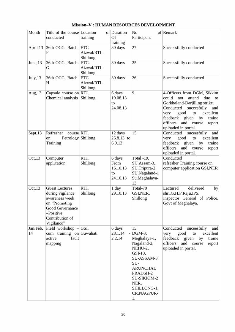
30
Mission–V : HUMAN RESOURCES DEVELOPMENT
Month Title of the course
conducted
Location of
training
Duration
Of
training
No of
Participant
Remark
April,13 36th OCG, Batch-
F
FTC-
Aizwal/RTI-
Shillong
30 days 27 Successfully conducted
June,13 36th OCG, Batch-
G
FTC-
Aizwal/RTI-
Shillong
30 days 25 Successfully conducted
July,13 36th OCG, Batch-
H
FTC-
Aizwal/RTI-
Shillong
30 days 26 Successfully conducted
Aug,13 Capsule course on
Chemical analysis
RTI,
Shillong
6 days
19.08.13
to
24.08.13
9 4-Officers from DGM, Sikkim
could not attend due to
Gorkhaland-Darjilling strike.
Conducted suceesfully and
very good to excellent
feedback given by traine
officers and course report
uploaded in portal.
Sept,13 Refresher course
on Petrology
Training
RTI,
Shillong
12 days
26.8.13 to
6.9.13
15 Conducted suceesfully and
very good to excellent
feedback given by traine
officers and course report
uploaded in portal.
Oct,13 Computer
application
RTI,
Shillong
6 days
From
16.10.13
to
24.10.13
Total -19,
SU.Assam-3,
SU.Tripura-2
SU.Nagaland-1
Su.Meghalaya-
13.
Conducted
refresher Training course on
computer application GSI,NER
Oct,13 Guest Lectures
during vigilance
awareness week
on “Promoting
Good Governance
–Positive
Contribution of
Vigilance”
RTI,
Shillong
1 day
29.10.13
Total-70
GSI,NER,
Shillong
Lectured delivered by
shri.G.H.P.Raju,IPS.
Inspector General of Police,
Govt of Meghalaya.
Jan/Feb,
14
Field workshop –
cum training on
active fault
mapping
GSI,
Guwahati
6 days
28.1.14 -
2.2.14
15
DGM-3;
Meghalaya-1,
Nagaland-2.
NEHU-2,
GSI-10,
SU-ASSAM-3,
SU-
ARUNCHAL
PRADSH-2
SU-SIKKIM-2
NER,
SHILLONG-1,
CR,NAGPUR-
1,
Conducted suceesfully and
very good to excellent
feedback given by traine
officers and course report
uploaded in portal.
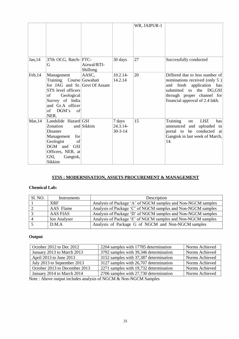
31
WR, JAIPUR-1
Jan,14 37th OCG, Batch-
G
FTC-
Aizwal/RTI-
Shillong
30 days 27 Successfully conducted
Feb,14 Management
Training Course
for JAG and Sr.
STS level officers
of Geological
Survey of India
and Gr.A officer
of DGM’s of
NER.
AASC,
Guwahati
Govt Of Assam
10.2.14-
14.2.14
20 Differed due to less number of
nominations received (only 5 )
and fresh application has
submitted to the DG,GSI
through proper channel for
financial approval of 2.4 lakh.
Mar,14 Landslide Hazard
Zonation and
Disaster
Management for
Geologist of
DGM and GSI
Officers, NER, at
GSI, Gangtok,
Sikkim
GSI
Sikkim
7 days
24.3.14-
30-3-14
15 Training on LHZ has
announced and uploaded in
portal to be conducted at
Gangtok in last week of March,
14.
STSS : MODERNISATION, ASSETS PROCUREMENT & MANAGEMENT
Chemical Lab:
Sl. NO. Instruments Description
1 XRF Analysis of Package ‘A’ of NGCM samples and Non-NGCM samples
2 AAS Flame Analysis of Package ‘C’ of NGCM samples and Non-NGCM samples
3 AAS FIAS Analysis of Package ‘D’ of NGCM samples and Non-NGCM samples
4 Ion Analyser Analysis of Package ‘E’ of NGCM samples and Non-NGCM samples
5 D.M.A Analysis of Package G of NGCM and Non-NGCM samples
Output
October 2012 to Dec 2012 2204 samples with 17785 determination Norms Achieved
January 2013 to March 2013 3792 samples with 39,346 determination Norms Achieved
April 2013 to June 2013 3152 samples with 37,387 determination Norms Achieved
July 2013 to September 2013 3127 samples with 26,707 determination Norms Achieved
October 2013 to December 2013 2271 samples with 19,732 determination Norms Achieved
January 2014 to March 2014 2706 samples with 27,730 determination Norms Achieved
Note : Above output includes analysis of NGCM & Non-NGCM Samples
32
AMC.
INSTRUMENTS PERIOD NO. OF VISITS AMOUNTS
(Rs.)
XRF
(CAMC)
01.11.2013 to 31.10.2014 2 Rs. 11,23,600/-
AAS (P.E.-100).AMC 01.07.2013 to 30.06.2014 2 Rs. 98,876/-
AAS (AA-240 DUO) CAMC. 01.02.2014 to 31.01.2015 2 Rs. 2,37,040/-
UPS for the above Instruments 01.10.2013 to 30.09.2014 On Call No. limit Rs. 80,023/-
DMA (AMC) 01.12.2013 to 30.11.2014 2 Rs. 98,876/-
Budget
2013 - 2014 97 Lakhs
Petrology Lab: Laboratory Infrastructure-Items and Output
EQUIPMENT/ITEM PROCURED FROM JANUARY, 2014 TO MARCH, 2014
Sl.
No.
Name of Item Qnty Price Date of received
1. Digital Camera (Sony Model-
DSC-HX50)
10 nos. 22,790/- each 31-3-2014
2. GPS (Etrex-30) 10 nos. 15,900/- each 31-3-2014
3. Web Camera (Model C920)
Logitech
6 nos. 7,250/- each 28.3.2014
SECTION CUTTING
Sl.
No
Name of Item Qnty Price Date of
received
Remarks
1. Semi Automatic Machine
for thin sections
preparation.
1 no. 65, 873/- 11-11-2013 New machine has been
installed and in used.
2. Single Disc grinding / rock
polishing machine
1 set. 65,873/- 7-2-2014 -do-
3. Heater – 2KW 1 no. 3350/- 21-3-2014 -do-
4. Blower – 2KW 1 no. 2130/- -do- -do-
5. Geyser- 3ltr 1 no. 3430/- -do- -do-
6. Portable rock cutting
machine
1 no. 5900/- 06-02-2014 -do-
SURVEY EQUIPTMENTS
Sl.
No.
Name of Item Qnty Price Date of received
1. Rechargeable Battery BDC-70 5 nos. 19, 000/- each 19-3-2014
2. Plumbob 5 nos. 150/- each 28-3-2014
3. Survey Umbrella 10 nos. 1400/- each -do-
4. Levelling Staff 10 nos. 1300/- each -do-

33
FIELD ITEMS ISSUED TO OFFICERS IN SHILLONG
Sl.
No.
Division/Project Digital
Camera
Brunton
Compass
GPS Geological
Hammer
Lens
Magnet Streak
Plate
Steel
Tape
1 NGCM 3
2. STM
3. MMIP
4. Geophysics
5. Earthquake
Geology
6. Publication
7. Engg. Geology 1 1
8. Palaeontology 1 1 1 1 1 1
9. Chemical
10. Petrology 2 1 1 1
11. RSAS
12. Engg. Divn
13. PSS
14. LHZP 1 1 1 1
15. RMH-I & II 1
Total 4 4 7 3 2 1 Nil Nil
LABORATORY INFRASTRUCTURE: ITEMS AND OUTPUT
Sl.
No
Name of the equipment Utility of the
equipment
AMC Output
(Jan 14 to Mar'14)
1. Leitz Orthoplan Polarising
microscope
Thin section and
polished section
studies (transmitted
and reflected light)
AMC with M/s
Star
Instrumentation
Kolkata
205 nos. PS were studied
by respective project
officers pertaining to FSP
items of GSI, NER.
Petrological
supports/guidance was
provided as and when
required.
Gem stone Study :Nil.
2. Carl Zeisss JENA
Polarising microscope
Petrographic studies
(transmitted light)
-do-
3. Stereozoom Carl Zeiss
Microscope
Thin section and
grain studies
-do-
4. Leical Stereozoom
(S8APO)
Thin section and
grain studies
-do-
5. Reichard Microscope Petrographic studies
(transmitted light)
-do-
6. * Optigem-4 Trinocular
Microscope
Gem Testing - Nil.
7 *Mettlers Toledo Balance
AB 204-S
Specific gravity
Determination (Gem
Testing)
- Nil.
8. *Refractometer (KRUSS) Refractive Index
determination (Gem
Testing)
- Nil.
9. *U.V. Lamp (KRUSS) Susceptibility for
ultraviolet light
(Gem Testing)
- Nil.
10. *Spectroscope (KRUSS) Optical
determination (Gem
Testing)
- Nil.
11. *Seive shaker equipment Sand analyses
(Grain size analysis)
- Nil.
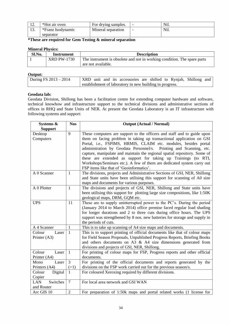
34
12. *Hot air oven For drying samples. - Nil.
13. *Franz Isodynamic
separator
Mineral separation - Nil.
*These are required for Gem Testing & mineral separation
Mineral Physics:
Sl.No. Instrument Description
1 XRD PW-1730 The instrument is obsolete and not in working condition. The spare parts
are not available.
Output:
During FS 2013 – 2014 XRD unit and its accessories are shifted to Rynjah, Shillong and
establishment of laboratory in new building in progress.
Geodata lab:
Geodata Division, Shillong has been a facilitation centre for extending computer hardware and software,
technical knowhow and infrastructure support to the technical divisions and administrative sections of
offices in RHQ and State Units of NER. At present the Geodata Laboratory is an IT infrastructure with
following systems and support:
Systems &
Support
Nos Output (Actual / Normal)
Desktop
Computers
9 These computers are support to the officers and staff and to guide upon
them on facing problem in taking up transactional application on GSI
Portal, i.e., FSPIMS, HRMIS, CLAIM etc. modules, besides portal
administration by Geodata Personnel/s. Printing and Scanning, etc.
capture, manipulate and maintain the regional spatial repository. Some of
these are extended as support for taking up Trainings (to RTI,
Workshops/Seminars etc.). A few of them are dedicated system carry out
FSP items like that of ‘Geoinformatics’.
A 0 Scanner 1 The divisions, projects and Administrative Sections of GSI, NER, Shillong
and State units have been utilising this support for scanning of A0 size
maps and documents for various purposes.
A 0 Plotter 1 The divisions and projects of GSI, NER, Shillong and State units have
been utilising this support for plotting large size compositions, like 1:50K
geological maps, DRM, GQM etc.
UPS 11 These are to supply uninterrupted power to the PC’s. During the period
(January 2014 to March 2014) office premise faced regular load shading
for longer durations and 2 to three cuts during office hours. The UPS
support was strengthened by 8 nos. new batteries for storage and supply in
the periods of cuts.
A 4 Scanner 1 This is to take up scanning of A4 size maps and documents.
Colour Laser
Printer (A3)
1 This is to support printing of official documents like that of colour maps
for Field Season Proposals, Unpublished Progress Reports, Briefing Books
and others documents on A3 & A4 size dimensions generated from
divisions and projects of GSI, NER, Shillong.
Colour Laser
Printer (A4)
1 For printing of colour maps for FSP, Progress reports and other official
documents.
Mono Laser
Printers (A4)
3
(+1)
For printing of the official documents and reports generated by the
divisions on the FSP work carried out for the previous season/s.
Colour Digital
Copier
1 For coloured Xeroxing required by different divisions.
LAN Switches
and Router
7 For local area network and GSI WAN
Arc GIS 10 2 For preparation of 1:50k maps and portal related works (1 license for
35
Shillong and 1 license for Itanagar). The GIS runs by reading on line
license from CHQ resident server.
Surfer 8 1 For preparation of maps.
Grapher 9.0 - The software is a support to carry out technical work.
IGPET 2010 – The software is a support to carry out a specific technical work.
Besides, the systems & support - as above, Geodata Laboratory extends infrastructure and
personnel support in carrying out various office work and technical work on digital concepts, as desired
time to time by the administration, RTI and divisions. The division is the centre for personnel support in
MAP items of FSPs and maintenance of regional spatial-data repository. The spatial data from the
repository is over plotted to compose maps for their delivery. Majority of the purchase of IT products,
i.e., Hardware and software have been carried out by the APM&D of the Region on the specifications
prescribed by the Geodata Division, on received requisitions from and requirements of divisions and
sections.
The www.portal.gsi.gov.in is the portal for the Geological Survey of India. This web based IT
development is catered through centralised servers at CHQ, Kolkata. The LAN or WAN/ WiFi connected
systems at RHQ and State Units in NER operate on BSNL Telephone Line (WWW) / Lease Line to run
the Portal. Like the other region, the desktops and systems are procured at / supplied to Guwahati,
Gangtok, Itanagar, Dimapur, Agartala - the HQs for SUs , and Shillong - the RHQ, in NER. Barring the
stand alone systems to carry out dedicated Office and Technical work, the other systems are on the Net.
Majority of these systems have foundation on Windows XP operating system switching to new supplies
with Windows 7 in light of migration from IPv4 to IPv6 address system on the NET. WAN / Lease Line
is in effect in the premises of NER from February 2009.
STATUS OF NETWORKING & IMPLIMENTATION OF PORTAL AT GSI, NER
Portal Phase I (Installation of LAN at RHQ and SUs):
Infrastructure: Installation of LAN at RHQ: GSI, NER, Shillong is operating from several rented
buildings at Shillong. Local Area Networking exist at three premises viz., Shylla building, Kumud villa
and building at Motinagar. Regional headquarters of NER, TCD, TCS and LHZP is functional from
Shylla building. Where as Petrology, Palaeontology, Publication, M&C and Chemical Divisions with
their laboratories form a clusture about Kumud Villa. With its laboratory of the Geodata division and
Administration run from a building located at Motinagar.
Lease line runs for portal access into the networks on upgraded 1 MBPS bandwidth. Internet connection
to the office premises frequently marred by interruptions or out of the reach situations on the networks in
Shillong which are on BSNL broadband and WiFi devices.
LAN infrastructure is not-feasible in buildings other than the stated three LAN net workings.
Recently, Wi-Fi access points have been put on broadband line to these buildings. This gives a lean
access to portal and internet in these deprived buildings. Since second quarter of 2013 offices of Mission-
I, II, III & IV and RTI have occupied two rented buildings close to Kumudvilla. These buildings are in
need to develop networking so that the divisions have the access to the portal. WiFi Access points on
BSNL Telephone Lines have been installed in these two buildings (Mission-I, II and Mission-III & IV) as
a temporary measure to extend the internet support to the DDGs (Missions, recently posted to NER). The
WiFi Systems started their operation in the last two quarters.
Portal Applications: All the officers and staff of State Units and RHQ have been given training on the
various transactional applications, in phases, on GSI Portal and modules therein.
With acquisition of approval on FSP items, the divisional heads start loading relevant items to GSI Portal.
Many a times, they come across problem in loading. On reporting the faced problem the Geodata tries to
resolve, at its laboratory, but at times when Geodata identifies some complex issues in process, it get this
rectified through the Help Desk at CHQ.
Officers and staff, on policy based - for short period (2 to 3 years) of time, are posted in NER. In
coming into and out going from the region on transfers, is normal phenomenon. A post holder leaves or
joins, affect the chain of reciprocation in between reporting to reported officers / officials. This gets
reflected into the HRMIS (organogram) of the Portal. In lack of a functional e-governance cell within the
region, re-smoothening of the reciprocation chains are being carried out at the Geodata Division.
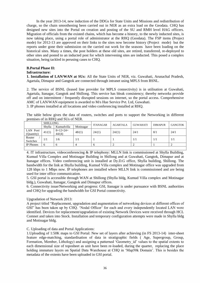
36
In the year 2013-14, new induction of the DDGs for State Units and Missions and redistribution of
charge, so the chain smoothening been carried out in NER as an extra load on the Geodata. CHQ has
designed new sites into the Portal on creation and posting of the SU and RMH level HAG officers.
Migration of officials from the existed chains, which has become a history, to the newly inducted sites, is
now taking place, using a portal role of administrator at the RHQ (Geodata). The FSP items (Project
mode) for 2012-13 are approved on their links to the sites now become history (Project mode) but the
reports under gone their submission on the carried out work for the seasons have been loading on the
historical sites. Many a times, the post holders at these old sites, are retired, transferred, re-deployed to
other sites and posted to an inducted post for which intervening sites are inducted. This posed a complex
situation, being tackled in perusing cases to CHQ.
B.Portal Phase II:
Infrastructure:
1. Installation of LAN/WAN at SUs: All the State Units of NER, viz. Guwahati, Arunachal Pradesh,
Agartala, Dimapur and Gangtok are connected through intranet using MPLS from BSNL.
2. The service of BSNL (leased line provider for MPLS connectivity) is in utilisation at Guwahati,
Agartala, Itanagar, Gangtok and Shillong. This service has bleak consistency; thereby networks provide
off and on intermittent / frequently disrupted sessions on internet, so the portal access. Comprehensive
AMC of LAN/WAN equipment is awarded to M/s Hue Service Pvt. Ltd, Guwahati.
3. IP phones installed at all locations and video conferencing installed at RHQ.
The table below gives the data of routers, switches and ports to support the Networking in different
premises of in RHQ and SUs of NER.
SHILLONG
ITANAGAR AGARTALA GUWAHATI DIMAPUR GANGTOK Shylla Kumudvilla Motinagar
LAN Port/
(Quantity) 41/(1)
8+12+24=
44/(4) 48/(1) 24/(1) 24/(1) 24/1 8/1 24/1
Router /
Switches 1/1 1/6 1/1 1 1 1/1 1/1 1/1
IP Phones 6 6 4 6 2 2 1 2
4. IT infrastructure, videoconferencing & IP telephony: MLLN link is commissioned at Shylla Building,
Kumud Villa Complex and Motinagar Building in Shillong and at Guwahati, Gangtok, Dimapur and at
Itanagar offices. Video conferencing unit is installed at Dy.D.G office, Shylla building, Shillong. The
bandwidth for the link at Shylla building, Kumud Villa complex and Motinagar office was upgraded from
128 kbps to 1 Mbps now. IP telephones are installed where MLLN link is commissioned and are being
used for inter office communication.
5. GSI portal is accessible through WAN at Shillong (Shylla bldg, Kumud Villa complex and Motinagar
bldg.), Guwahati, Itanagar, Gangtok and Dimapur offices.
6. Connectivity issue/Networking and progress: GSI, Itanagar is under pursuance with BSNL authorities
and CHQ for upgrading the bandwidth for GSI Portal connectivity.
Upgradation of Network 2013:
A project titled “Replacement, upgradation and augmentation of networking devices at different offices of
GSI” has been taken up by CHQ. ‘Nodal Officer’ for each and every independently located LAN were
identified. Devices for replacement/upgradation of existing Network Devices were received through HCL
Comnet and taken into Stock. Installation and temporary configuration attempts were made in Shylla bldg
and Motinagar bldg.
C. Uploading of data and Portal Applications:
1.Uploading of 1:50K maps to GSI Portal: New set of layers after achieving (in FS 2013-14) inter-sheet
feature edge-matching, standardisation of data in stratigraphic fields ( Age, Supergroup, Group,
Formation, Member, Lithology) and assigning a patterned ‘Geometry_id’ values to the spatial extents to
each dimensional size of toposheet as unit have been re-loaded, during the quarter, replacing the place
holding immature layers on Spatial Data Warehouse at CHQ in ‘Map50k Domain’. This is besides the
metadata of the extents have been uploaded in GSI portal.
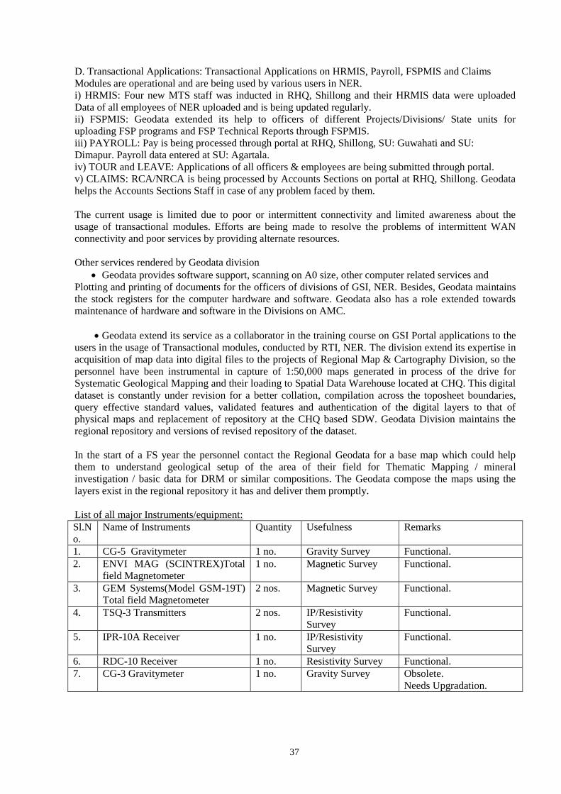
37
D. Transactional Applications: Transactional Applications on HRMIS, Payroll, FSPMIS and Claims
Modules are operational and are being used by various users in NER.
i) HRMIS: Four new MTS staff was inducted in RHQ, Shillong and their HRMIS data were uploaded
Data of all employees of NER uploaded and is being updated regularly.
ii) FSPMIS: Geodata extended its help to officers of different Projects/Divisions/ State units for
uploading FSP programs and FSP Technical Reports through FSPMIS.
iii) PAYROLL: Pay is being processed through portal at RHQ, Shillong, SU: Guwahati and SU:
Dimapur. Payroll data entered at SU: Agartala.
iv) TOUR and LEAVE: Applications of all officers & employees are being submitted through portal.
v) CLAIMS: RCA/NRCA is being processed by Accounts Sections on portal at RHQ, Shillong. Geodata
helps the Accounts Sections Staff in case of any problem faced by them.
The current usage is limited due to poor or intermittent connectivity and limited awareness about the
usage of transactional modules. Efforts are being made to resolve the problems of intermittent WAN
connectivity and poor services by providing alternate resources.
Other services rendered by Geodata division
Geodata provides software support, scanning on A0 size, other computer related services and
Plotting and printing of documents for the officers of divisions of GSI, NER. Besides, Geodata maintains
the stock registers for the computer hardware and software. Geodata also has a role extended towards
maintenance of hardware and software in the Divisions on AMC.
Geodata extend its service as a collaborator in the training course on GSI Portal applications to the
users in the usage of Transactional modules, conducted by RTI, NER. The division extend its expertise in
acquisition of map data into digital files to the projects of Regional Map & Cartography Division, so the
personnel have been instrumental in capture of 1:50,000 maps generated in process of the drive for
Systematic Geological Mapping and their loading to Spatial Data Warehouse located at CHQ. This digital
dataset is constantly under revision for a better collation, compilation across the toposheet boundaries,
query effective standard values, validated features and authentication of the digital layers to that of
physical maps and replacement of repository at the CHQ based SDW. Geodata Division maintains the
regional repository and versions of revised repository of the dataset.
In the start of a FS year the personnel contact the Regional Geodata for a base map which could help
them to understand geological setup of the area of their field for Thematic Mapping / mineral
investigation / basic data for DRM or similar compositions. The Geodata compose the maps using the
layers exist in the regional repository it has and deliver them promptly.
List of all major Instruments/equipment:
Sl.N
o.
Name of Instruments Quantity Usefulness Remarks
1. CG-5 Gravitymeter 1 no. Gravity Survey Functional.
2. ENVI MAG (SCINTREX)Total
field Magnetometer
1 no. Magnetic Survey Functional.
3. GEM Systems(Model GSM-19T)
Total field Magnetometer
2 nos. Magnetic Survey Functional.
4. TSQ-3 Transmitters 2 nos. IP/Resistivity
Survey
Functional.
5. IPR-10A Receiver 1 no. IP/Resistivity
Survey
Functional.
6. RDC-10 Receiver 1 no. Resistivity Survey Functional.
7. CG-3 Gravitymeter 1 no. Gravity Survey Obsolete.
Needs Upgradation.
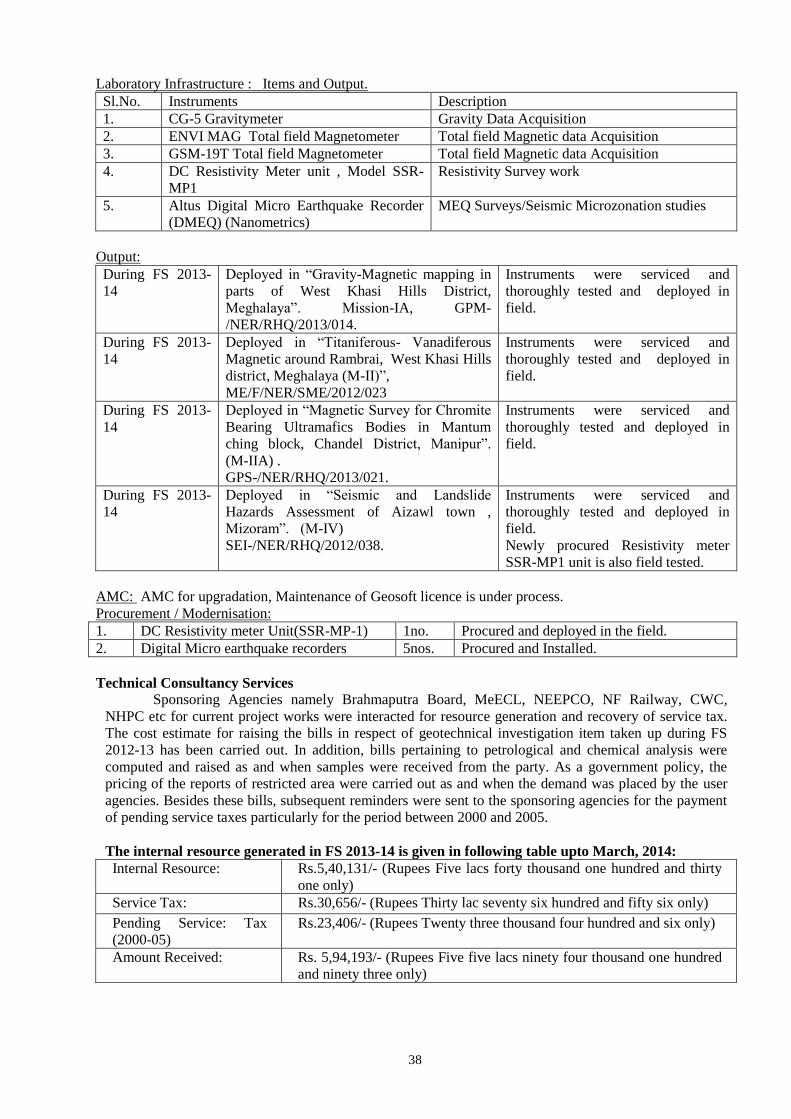
38
Laboratory Infrastructure : Items and Output.
Sl.No. Instruments Description
1. CG-5 Gravitymeter Gravity Data Acquisition
2. ENVI MAG Total field Magnetometer Total field Magnetic data Acquisition
3. GSM-19T Total field Magnetometer Total field Magnetic data Acquisition
4. DC Resistivity Meter unit , Model SSR-
MP1
Resistivity Survey work
5. Altus Digital Micro Earthquake Recorder
(DMEQ) (Nanometrics)
MEQ Surveys/Seismic Microzonation studies
Output:
During FS 2013-
14
Deployed in “Gravity-Magnetic mapping in
parts of West Khasi Hills District,
Meghalaya”. Mission-IA, GPM-
/NER/RHQ/2013/014.
Instruments were serviced and
thoroughly tested and deployed in
field.
During FS 2013-
14
Deployed in “Titaniferous- Vanadiferous
Magnetic around Rambrai, West Khasi Hills
district, Meghalaya (M-II)”,
ME/F/NER/SME/2012/023
Instruments were serviced and
thoroughly tested and deployed in
field.
During FS 2013-
14
Deployed in “Magnetic Survey for Chromite
Bearing Ultramafics Bodies in Mantum
ching block, Chandel District, Manipur”.
(M-IIA) .
GPS-/NER/RHQ/2013/021.
Instruments were serviced and
thoroughly tested and deployed in
field.
During FS 2013-
14
Deployed in “Seismic and Landslide
Hazards Assessment of Aizawl town ,
Mizoram”. (M-IV)
SEI-/NER/RHQ/2012/038.
Instruments were serviced and
thoroughly tested and deployed in
field.
Newly procured Resistivity meter
SSR-MP1 unit is also field tested.
AMC: AMC for upgradation, Maintenance of Geosoft licence is under process.
Procurement / Modernisation:
1. DC Resistivity meter Unit(SSR-MP-1) 1no. Procured and deployed in the field.
2. Digital Micro earthquake recorders 5nos. Procured and Installed.
Technical Consultancy Services
Sponsoring Agencies namely Brahmaputra Board, MeECL, NEEPCO, NF Railway, CWC,
NHPC etc for current project works were interacted for resource generation and recovery of service tax.
The cost estimate for raising the bills in respect of geotechnical investigation item taken up during FS
2012-13 has been carried out. In addition, bills pertaining to petrological and chemical analysis were
computed and raised as and when samples were received from the party. As a government policy, the
pricing of the reports of restricted area were carried out as and when the demand was placed by the user
agencies. Besides these bills, subsequent reminders were sent to the sponsoring agencies for the payment
of pending service taxes particularly for the period between 2000 and 2005.
The internal resource generated in FS 2013-14 is given in following table upto March, 2014:
Internal Resource: Rs.5,40,131/- (Rupees Five lacs forty thousand one hundred and thirty
one only)
Service Tax: Rs.30,656/- (Rupees Thirty lac seventy six hundred and fifty six only)
Pending Service: Tax
(2000-05)
Rs.23,406/- (Rupees Twenty three thousand four hundred and six only)
Amount Received: Rs. 5,94,193/- (Rupees Five five lacs ninety four thousand one hundred
and ninety three only)

39
5. FINANCIAL PERFORMANCE
Financial outlay and expenditure during XI plan period has been given in Annexure -3A. Scheme-wise,
quarter-wise distribution of approved plan funds and actual expenditure during 2013-14 (2ND
quarter) are
given in Anneure-3b &3C.
6. MISSION WISE RCA EXPENDITURE
The details of RCA expenditure in different projects visa-vis targets and achievements of FS 2013-
14 are given in annexure-04.
7. SCIENTIFIC WORKSHOPS / MEETINGS / SEMINARS / SYMPOSIUM, EXHIBITIONS
ETC., ORGANISED / PARTICIPATED.
Stage Review Committee was held on the 3rd
& 4th October, 2013, the 8
th meeting to review the
Progress of Ongoing Mineral Development Projects was held at GSI, NER, Shillong on the 21st Nov,
2013 and 9th Central Geological Programming Board Committee VIII on the Geology and Mineral
Resources of North Eastern Region was held on the 29th November, 2013. SGPB/RAC meetings for
different states of NER were held from time to time the detail of which is given in annexure-11.
8.HRD, ESTABLISHMENT, PAYROLL, HRMIS, E-SERVICE BOOK, ETC.
Statement on RTI Act : 31 cases received, and all cases have been disposed and no case is pending
Statement on Grievance cases : No case is pending on Grievance.
Statement on Vigilance cases : No case is pending on Vigilance.
Statement of pending VIP reference cases in the Region : Nil
The information on Employment position in the Region is given in Annexure – 12. The HRMIS details in
respect of Group A, B & C have already been uploaded to GSI Portal.
9. VEHICLES & TRANSPORT INFRASTRUCTURE INCLUDING OUTSOURCING AND AGE
OF VEHICLES, VEHICLES MIS.
The required information is given in the attached Annexure – 13.
10. MODERNIZATION
As a part of the efforts for meeting emerging challenges, GSI is constantly upgrading its
technology both for field and laboratory equipments and efforts are being made to modernize the
Geodata, Petrology and Chemical Laboratories
11. DRILLING INFRASTRURE
Status of drilling activities, performance and cost effectiveness: The status of drilling in NER during FS
2013-14 is given in Annexure – 15A.
Efforts for Modernizing Drilling Machinery: Indents are being prepared for replacement of old
machineries and accessories keeping in view the type of drilling assignment to be taken up in the near
future.
12. OUTSOURCING OF ROUTINE SERVICES (HOUSKEEPING, SECURITY, GARDEN,
ETC.)
The housekeeping of GSI offices in NER is being done by the Departmental personnel. Security
at GSI, Itanagar office is outsourced. Contractural workers are employed for durwan duty, other office
work as and when required.
13. OTHER ACTIVITIES
Details of Museums and curatorial activities in the Region and operational units:
Nodal officer with Museum committee visited Don Bosco Museum for Surveying, which would provide
guidance to establish geological museum in NER, Shillong. Other procedures of sample selection/
collection and arrangement for display etc are in progress.
Two Museums each in Petrology and Palaeontology Division, RHQ, Shillong are being maintained
by respective units. One Rock Garden, GSI, Itanagar is being maintained by SU: Arunachal Pradesh, GSI,
Itanagar. Nodal Officers in all State Units have been nominated for maintenance/upkeep for museum at
40
state units and the of newly established geological museum of NER, Shillong in Petrology Division,
NCERT building.
Library: Library facilities are available in the Publication Division, RHQ, Shillong and in all the State
Units of North Eastern Region.
Core Library: The Cores of Litang Valley Limestone investigation, Jaintia Hills district, Meghalaya and
Mawmaram basemetal investigation, East Khasi hills district have been skeletonised and preserved at
Shillong. Core Library is The Regional Core Library of GSI, NER is functional at Guwahati.
14. SPECIAL SCIENTIFIC STUDY: NA
15. PERCEPTION MANAGEMENT ACTIVIES IN NER
RTI, Shillong organized training for Officers of State DGMs of North Eastern Region. (Photographs of
training given in field, lab and lectures in classroom are in back page).
16. SAVOTTAM: Service Quality Improvement initiative was taken & declared DDG & RMH as Nodal
Officer for Quality Management. They will look after implementation of an appropriate Service Quality
Management System i.e - Successful implementation of Citizen’s Charters, identification of services
rendered, the quality of service delivery process, its control and delivery requirements. NER also has a
good Public Grievance Redress Mechanism headed by Joint Director (P&A).
17. CONSOLIDATED LIST OF GROUP A & B OFFICERS IN NER (GAZETTED)
Please see attached Annexure – 17.

41
ANNEXURE-1A
MAJOR MINERALS RESOURCES [UNDER VARIOUS UNFC CATEGORIES] ESTIMATED
BY THE REGION, SHOWING STATE-WISE FIVE-YEARLY INCREMENT, FOR THE LAST
15 YEARS.
ANNEXURE-1B
NATIONAL MINERAL INVENTORY
NO. OF REPORTS CONVERTED AS PER UNFC COMPLIANCE
Nodal Officer: Shri Brij Kumar, DDG & RMH, GSI, NER, Shillong.
Upto December 2010 Upto March 2012 Upto March 2013
Meghalaya 2004 – 05 onwards – 08 nos. Completed
Pre-F.S. 2004-05 – 22 nos. Completed
Arunachal Pradesh 2004 – 05 onwards – Nil Nil
Pre-F.S. 2004-05 – 05 nos. Completed
Agartala 2004 – 05 onwards – Nil Nil
Pre-F.S. 2004-05 – 18 nos. Completed
Guwahati 2004 – 05 onwards – Nil Nil
Pre-F.S. 2004-05 – 06 nos. Completed
Sikkim 2004 – 05 onwards – Nil Nil
Pre-F.S. 2004-05 – 04 nos. Completed
Dimapur 2004 – 05 onwards – Nil Nil
Pre-F.S. 2004-05 – 05 nos. Completed
COMMODITY/
MINERAL
STATE 1995 -
2000
2001-
2005
2005-
2007
2010-
2012
2012-
2013
2013-
2014
Limestone Meghalaya 3062.71mt
(332)
2678.24mt.
(332) 366.62mt
(333)
261.46mt
(333)
177.83mt
(333)
42
ANNEXURE-2A
ACTIVITY DOMAIN PERTAINING TO MISSION I & II OF THE REGION AND ACHIEVEMENTS [FSP RELATED ITEMS] DURING
THE XII PLAN PERIOD [2012-17] (AS ON 31.03.2014)
Sl.
No
Major Activity area Programme
Target
F.S. 2012-13
Achievement of
F.S. 2012-13
Programme
Target
F.S. 2013-14
Achievement of
F.S. 2013-14
Programme
Target
F.S. 2014-15
Achievement of
F.S. 2014-15
Programme
Target
F.S. 2015-16
Achievement of
F.S. 2015-16
I. Survey and Mapping
a) Ground Survey
i) Special Thematic
Mapping
(sq. km) (1:25000)
3520 3594.5 3295 3277.5 2750 + 25 L
Km T.M.
ia) Systematic Geological
Mapping (sq. km)
(1:50000)
1280 1289 2640 2640 660
ii) Geochemical mapping
(sq. km) 3892 3697 4850 4948 7600
iii) Geophysical Mapping
(sq. km) 700 700 1750 1400 1000
II. Mineral Exploration
i) Large Scale Mapping
(sq. km.) (1:12,500)
332 341 369.5 395.4
407 sq km
LSM and 50 L
km
Geophysical
survey
ia) Reconnoitary
geological traverse
mapping
(sq. km.) (1:50000)
150 150 150 150 Nil
ii) Detailed Mapping
(sq. km.)
(1:5000/2000)
5 5 8.5 8.5 09.5
iii) Drilling (metre) (M-
IIA) 1575 1418.65* 1600
364.85 & 750.6
(extended item) 2200
Drilling (metre) (M-
IIB) 800 637.75* 900 508.1 900
Drilling extended in FS 2014-15 (as per decission of Term Review)
43
ANNEXURE-2B
FSP ROLLING PLAN FOR F.S. 2013-14 & 2014-15
MISSION: I
SL.
NO.
FSP CODE TITLE OF THE ITEM TOPOSHEET NO PERSONNEL F.S. TARGET
(2013-14)
1 GM/NER/SAS/2012/003 SYSTEMATIC GEOLOGICAL MAPPING ON
1:50,000 SCALE IN TOPOSHEET NO. 78 J/9 &
J/10 IN GOALPARA DISTRICT, ASSAM
78 J/9 & 10 Varun Vara &
Yhunyelo Tep
2013-
14
865 sq.km
2 GM/NER/SAS/2013/001 SYSTEMATIC GEOLOGICAL MAPPING ON
1:50,000 SCALE IN TOPOSHEET NO. 78 J/1, 5 &
13, 78 N/1, 5, 9 & 13 IN KAMRUP, GOALPARA
AND DARRANG DISTRICT, ASSAM
78 J/1, 5 & 13; 78
N/1, 5, 9 & 13
Rajkumar Tapon
Kumar & Satrughan
Majhi
2013-
14
955 sq.km
3 GM/NER/SMN/2013/002 SYSTEMATIC GEOLOIGICAL MAPPING IN
PARTS OF PEREN, DIMAPUR, KIPHIRE,
KOHIMA AND PHEK DISTRICTS, NAGALAND
ON 1:50,000 SCALE
83 G/6, 7, 10, 12, 13,
14; 83 K/1, 10, 14; 83
O/1
B.Behera(
transferred), C.
Yanthan & T. S.
Kom
2013-
15
360 sq.km
4 GM/NER/SMN/2013/003 SYSTEMATIC GEOLOIGICAL MAPPING IN
PARTS OF CHURACHANDPUR DISTRICT,
MANIPUR ON 1:50,000 SCALE
83 H/12 P. Enos Ezung, V.
Zaphu, 1G & 1G
from DGM, Manipur
2013-
14
460 sq.km
5 STM/NER/SAP/2012/001 SPECIALISED THEMATIC MAPPING IN
PARTS OF ANJAW DISTRICT, ARUNACHAL
PRADESH
91 D/12 Rupesh Kumar &
Sebabrata Das
2012-
14
220 sq.km
6 STM/NER/SAP/2012/002 SPECIALISED THEMATIC MAPPING FOR
STUDY OF EVOLUTION OF GONDWANA
AND SIWALIK GROUPS IN SIANG RIVER
BASINS IN PARTS OF WEST SIANG AND
EAST SIANG DISTRICTS, ARUNACHAL
PRADESH
83 I/5, 9, 13, 14 B.N.Mahanta
(transferred to T.C
Div), B. R. Syngai(
Transferred to GSI,
Shillong), Raman
Kumar, K. Sekhose
& V. Vitso
2012-
14
330 sq.km
7 STM/NER/SAP/2013/004 SPECIALISED THEMATIC MAPPING IN
TERTIARY COAL BELT IN CHANGLANG
AND TIRAP DISTRICTS, ARUNACHAL
PRADESH
92 A/3, 7 & 11 Amit Kumar, ,
Ranjita
Bhattarcharjee,
Diethovilie Pieru,
Welhitshou Mero, V
K Bendre
(APMDTCL) & A S
2013-
15
110 sq.km
44
Rawat (DGM, AP)
8 STM/NER/SMN/2013/005 SPECIALISED THEMATIC MAPPING OF
OPHIOLITE SUITE OF ROCKS OF MANIPUR
BETWEEN NINGTHI TO NUNGBI KHULLEN,
UKHRUL DISTRICT, MANIPUR
83 K/8; 83 L/5 J.K. Angami,
K.Theoneou &1G
(DGM, MANIPUR)
2013-
15
220 sq.km
9 STM/NER/SAS/2012/077 SPECIALIZED THEMATIC MAPPING TO
DECIPHER LITHOLOGICAL SEQUENCE AND
STRUCTURAL SET-UP IN WESTERN PART OF
BATGURI, GOALPARA AND BONGAIGAON
DISTRICTS, ASSAM
78 /11 B.Baruah, Ramesh
Chandra Kishan &
Parusharama
Gangaikoppa
2013-
14
300 sq.km
10 STM/NER/SME/2012/006 SPECIALISED THEMATIC MAPPING OF THE
GNEISS AND GRANITOIDS TO DECIPGER
THEIR STRATIGRAPHIC RELATION WITH
THE SHILLONG GROUP AND ASSOCIATED
MINERALISATION BETWEEN NONGPOH,
JIRANG AND PATHARKHMAH, RI-BHOI
DISTRICT, MEGHALAYA
78 N/16; 78 O/9 & 13 Balbir Singh,
Vekhoto Shijoh &
Imrongtola Pongen
2012-
14
450 sq.km
11 STM/NER/SME/2012/007 SPECIALISED THEMATIC MAPPING TO
CHARACTERISE THE ANORTHOSITE-
MANGERITE- CHARNOCKITE-GRANITOID
(AMCG) SUITE OF ROCKS WITH SPECIAL
EMPHASIS ON TECTONOMAGMATIC
HISTORY AND MUTUAL RELATIONSHIPS OF
ROCKS BETWEEN RANGBLANG AND
MANAD MAWBIDONG AREAS, WEST KHASI
HILLS DISTRICT, MEGHALAYA
78 O/7 & 11 S.R. Mishra &
Lalneo Haokip
2012-
14
450 sq.km
12 STM/NER/SME/2012/008 SPECIALISED THEMATIC MAPPING FOR
CHARACTERISATION OF HIGH GRADE
META-SEDIMENTS, GRANULITES AND
GNEISSIC COMPLEX SOUTH OF
SONAPAHAR, WEST KHASI HILLS DISTRICT,
MEGHALAYA
78 O/2 Lalboi T. Haokip, A.
Ranjith & Shampita
Das
2012-
14
220 sq.km
13 STM/NER/SME/2013/006 SPECIALISED THEMATIC MAPPING TO
DECIPHER THE TECTONO-MAGMATIC AND
METAMORPHIC HISTORY OF THE GNEISSIC
COMPLEX, MIGMATITES AND SHILLONG
83 C/2 Sougrakpam Sujata,
Imlishila Imchen &
Avi Mero
2013-
14
330 sq.km
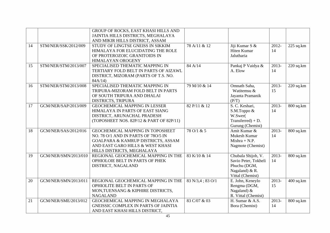
45
GROUP OF ROCKS, EAST KHASI HILLS AND
JAINTIA HILLS DISTRICTS, MEGHALAYA
AND MIKIR HILLS DISTRICT, ASSAM
14 STM/NER/SSK/2012/009 STUDY OF LINGTSE GNEISS IN SIKKIM
HIMALAYA FOR ELUCIDATING THE ROLE
OF PROTEROZOIC GRANITOIDS IN
HIMALAYAN OROGENY
78 A/11 & 12 Jiji Kumar S &
Hiten Kumar
Jalutharia
2012-
14
225 sq.km
15 STM/NER/STM/2013/007 SPECIALISED THEMATIC MAPPING IN
TERTIARY FOLD BELT IN PARTS OF AIZAWL
DISTRICT, MIZORAM (PARTS OF T.S. NO.
84A/14)
84 A/14 Pankaj P Vaidya &
A. Elow
2013-
14
220 sq.km
16 STM/NER/STM/2013/008 SPECIALISED THEMATIC MAPPING IN
TRIPURA-MIZORAM FOLD BELT IN PARTS
OF SOUTH TRIPURA AND DHALAI
DISTRICTS, TRIPURA
79 M/10 & 14 Omnath Saha,
Watitemsu &
Jayanta Pramanik
(P/T)
2013-
15
220 sq.km
17 GCM/NER/SAP/2013/009 GEOCHEMICAL MAPPING IN LESSER
HIMALAYA IN PARTS OF EAST SIANG
DISTRICT, ARUNACHAL PRADESH
(TOPOSHEET NOS. 82P/12 & PART OF 82P/11)
82 P/11 & 12 S. C. Keshari,
S.M.Toppo &
W.Swer(
Transferred) + D.
Gurung (Chemist)
2013-
14
800 sq.km
18 GCM/NER/SAS/2012/016 GEOCHEMICAL MAPPING IN TOPOSHEET
NO. 78 O/1 AND IN PARTS OF 78O/5 IN
GOALPARA & KAMRUP DISTRICTS, ASSAM
AND EAST GARO HILLS & WEST KHASI
HILLS DISTRICTS, MEGHALAYA
78 O/1 & 5 Amit Kumar &
Mukesh Kumar
Mishra + N.P.
Nagmote (Chemist)
2013-
14
800 sq.km
19 GCM/NER/SMN/2013/010 REGIONAL GEOCHEMICAL MAPPING IN THE
OPHIOLOIE BELT IN PARTS OF PHEK
DISTRICT, NAGALAND
83 K/10 & 14 Chubala Shijoh, V.
Savio Peter, Tokheli
Phuchu (DGM,
Nagaland) & R.
Vittal (Chemist)
2013-
14
800 sq.km
20 GCM/NER/SMN/2013/011 REGIONAL GEOCHEMICAL MAPPING IN THE
OPHIOLITE BELT IN PARTS OF
MON,TUENSANG & KIPHIRE DISTRICTS,
NAGALAND
83 N/3,4 ; 83 O/1 E. John, Keneylo
Rengma (DGM,
Nagaland) &
R. Vittal (Chemist)
2013-
15
400 sq.km
21 GCM/NER/SME/2013/012 GEOCHEMICAL MAPPING IN MEGHALAYA
GNEISSIC COMPLEX IN PARTS OF JAINTIA
AND EAST KHASI HILLS DISTRICT,
83 C/07 & 03 H. Sumar & A.S.
Bora (Chemist)
2013-
14
800 sq.km
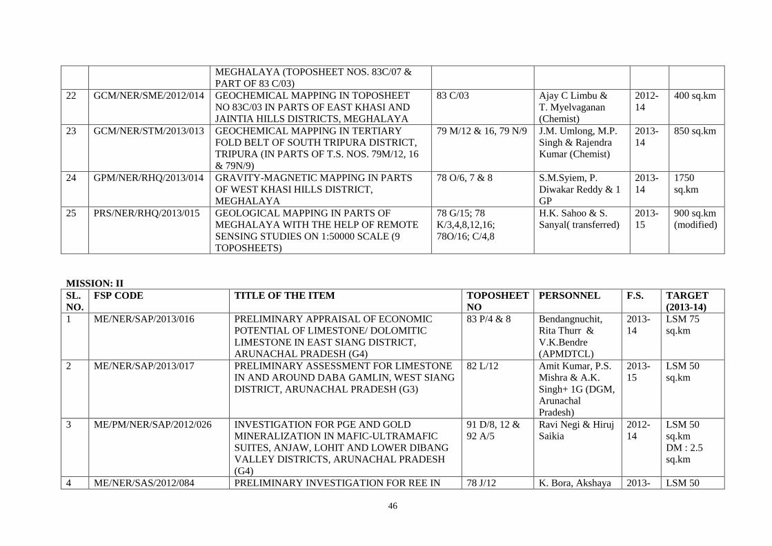
46
MEGHALAYA (TOPOSHEET NOS. 83C/07 &
PART OF 83 C/03)
22 GCM/NER/SME/2012/014 GEOCHEMICAL MAPPING IN TOPOSHEET
NO 83C/03 IN PARTS OF EAST KHASI AND
JAINTIA HILLS DISTRICTS, MEGHALAYA
83 C/03 Ajay C Limbu &
T. Myelvaganan
(Chemist)
2012-
14
400 sq.km
23 GCM/NER/STM/2013/013 GEOCHEMICAL MAPPING IN TERTIARY
FOLD BELT OF SOUTH TRIPURA DISTRICT,
TRIPURA (IN PARTS OF T.S. NOS. 79M/12, 16
& 79N/9)
79 M/12 & 16, 79 N/9 J.M. Umlong, M.P.
Singh & Rajendra
Kumar (Chemist)
2013-
14
850 sq.km
24 GPM/NER/RHQ/2013/014 GRAVITY-MAGNETIC MAPPING IN PARTS
OF WEST KHASI HILLS DISTRICT,
MEGHALAYA
78 O/6, 7 & 8 S.M.Syiem, P.
Diwakar Reddy & 1
GP
2013-
14
1750
sq.km
25 PRS/NER/RHQ/2013/015 GEOLOGICAL MAPPING IN PARTS OF
MEGHALAYA WITH THE HELP OF REMOTE
SENSING STUDIES ON 1:50000 SCALE (9
TOPOSHEETS)
78 G/15; 78
K/3,4,8,12,16;
78O/16; C/4,8
H.K. Sahoo & S.
Sanyal( transferred)
2013-
15
900 sq.km
(modified)
MISSION: II
SL.
NO.
FSP CODE TITLE OF THE ITEM TOPOSHEET
NO
PERSONNEL F.S. TARGET
(2013-14)
1 ME/NER/SAP/2013/016 PRELIMINARY APPRAISAL OF ECONOMIC
POTENTIAL OF LIMESTONE/ DOLOMITIC
LIMESTONE IN EAST SIANG DISTRICT,
ARUNACHAL PRADESH (G4)
83 P/4 & 8 Bendangnuchit,
Rita Thurr &
V.K.Bendre
(APMDTCL)
2013-
14
LSM 75
sq.km
2 ME/NER/SAP/2013/017 PRELIMINARY ASSESSMENT FOR LIMESTONE
IN AND AROUND DABA GAMLIN, WEST SIANG
DISTRICT, ARUNACHAL PRADESH (G3)
82 L/12 Amit Kumar, P.S.
Mishra & A.K.
Singh+ 1G (DGM,
Arunachal
Pradesh)
2013-
15
LSM 50
sq.km
3 ME/PM/NER/SAP/2012/026 INVESTIGATION FOR PGE AND GOLD
MINERALIZATION IN MAFIC-ULTRAMAFIC
SUITES, ANJAW, LOHIT AND LOWER DIBANG
VALLEY DISTRICTS, ARUNACHAL PRADESH
(G4)
91 D/8, 12 &
92 A/5
Ravi Negi & Hiruj
Saikia
2012-
14
LSM 50
sq.km
DM : 2.5
sq.km
4 ME/NER/SAS/2012/084 PRELIMINARY INVESTIGATION FOR REE IN 78 J/12 K. Bora, Akshaya 2013- LSM 50
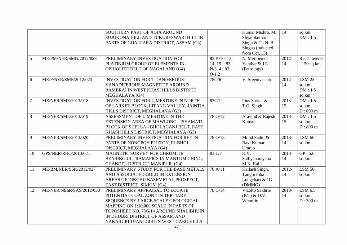
47
SOUTHERN PART OF AGIA AROUND
SUJUKONA HILL AND TUKURESWARI HILL IN
PARTS OF GOALPARA DISTRICT, ASSAM (G4)
Kumar Mishra, M.
Shyamkumar
Singh & Th N. B.
Singha (inducted
from Oct, 13)
14 sq.km
DM : 1.5
5 ME/PM/NER/SMN/2012/028 PRELIMINARY INVESTIGATION FOR
PLATINIUM GROUP OF ELEMENTS IN
OPHIOLITE BELT OF NAGALAND (G4)
83 K/10, 13,
14, 15 ; 83
N/3, 4 ; 83
O/1,2
N. Meribemo
Yanthan& 1G
(Petrology)
2012-
14
Rec.Traverse
: 150 sq.km
6 ME/F/NER/SME/2012/023 INVESTIGATION FOR TITANIFEROUS-
VANADIFEROUS MAGNETITE AROUND
RAMBRAI IN WEST KHASI HILLS DISTRICT,
MEGHALAYA (G4)
78O/6 V. Sreenivasiah 2012-
14
LSM 25
sq.km
DM : 1.5
sq.km
7 ME/NER/SME/2013/018 INVESTIGATION FOR LIMESTONE IN NORTH
OF LARKET BLOCK, LITANG VALLEY, JAINTIA
HILLS DISTRICT, MEGHALAYA (G3)
83C/11 Pius Sarkar &
T.G. Singh
2013-
15
DM : 1.5
sq.km
D : 800 m
8 ME/NER/SME/2013/019 ASSESSMENT OF LIMESTONE IN THE
EXTENSION AREA OF MAWLONG - ISHAMATI
BLOCK OF SHELLA - BHOLAGANJ BELT, EAST
KHASI HILLS DISTRICT, MEGHALAYA (G3)
78 O/12 Aravind & Rajesh
Kumar
2013-
15
DM : 1.5
sq.km
D : 800 m
9 ME/NER/SME/2013/020 PRELIMINARY INVESTIGATION FOR REE IN
PARTS OF NONGPOH PLUTON, RI-BHOI
DISTRICT, MEGHALAYA (G4)
78 O/13 Mohd Sadiq &
Ravi Kumar
Umrao
2013-
14
LSM 60
sq.km
10 GPS/NER/RHQ/2013/021 MAGNETIC SURVEY FOR CHROMITE
BEARING ULTRAMAFICS IN MANTUM CHING,
CHANDEL DISTRICT, MANIPUR, (G4)
83 L/7 K.V.
Sathyanarayana
M.K. Rai
2013-
14
GP : 5.6
sq.km
11 ME/BM/NER/SSK/2012/027 PRELIMINARY STUDY FOR THE BASE METALS
AND ASSOCIATED GOLD IN EXTENSION
AREAS OF DIKCHU BASEMETAL PROSPECT,
EAST DISTRICT, SIKKIM (G4)
78 A/11 Kailash Singh,
Tangtirenba
Longchari & 1G
(DMMG)
2012-
14
LSM 50
sq.km
12 ME/NER/NEnR/SAS/2012/030 PRELIMINARY APPRAISAL TO LOCATE
POTENTIAL COAL ZONE IN TERTIARY
SEQUENCE BY LARGE SCALE GEOLOGICAL
MAPPING ON 1:10,000 SCALE IN PARTS OF
TOPOSHEET NO. 78G/14 AROUND SHALIBHUIN
IN DHUBRI DISTRICT OF ASSAM AND
NAKAIGIRI-UJANGGIRI IN WEST GARO HILLS
78 G/14 Vizolto Sakhrie
(P/T) & D.V.
Whourie
2013-
14
LSM 6.5
sq.km
D : 300 m

48
OF MEGHALAYA (G4)
13 ME/NER/NEnR/SME/2013/022 REGIONAL EXPLORATION FOR GONDWANA
COAL IN THE AREA ADJACENT TO SUKCHAR -
SINGRIMARI AREA, SINGRIMARI COALFIELD,
DHUBRI DISTRICT, ASSAM AT THE BORDER
OF ASSAM & MEGHALAYA
78 G/13 Vizolto Sakhrie
(P/T) & D.V.
Whourie
2013-
14
LSM 3
sq.km
D : 600 m
MISSION: III
SL.
NO.
FSP CODE TITLE OF THE ITEM TOPOSHEET
NO
PERSONNEL F.S. TARGET
(2013-14)
1 MAP/NER/RHQ/2013/023 DIGITISATION, SCRUTINY, MODIFICATION,
UPLOADING OF 1:50,000 MAPS, VALIDATION
AND STANDARDISATION OF UPLOADED MAPS
IN THE PORTAL
P.K. Mukherjee
(M&C) (P/T)
&Darinia C. War
(P/T)
+ 1G (/PT) (Geodata)
2013-14 4 sheets
2 DB/NER/RHQ/2013/024 CREATION OF THEME BASED DATABASE OF
DEGREE SHEET NO 78 O COVERING PARTS OF
EAST GARO HILLS, EAST KHASI HILL, WEST
KHASI HILL, JAINTIA & RIBHOI DISTRICTS OF
MEGHALAYA AND KAMRUP & GOALPARA
DISTRICTS OF ASSAM
S. Banerjee 2013-14 122
reports
3 MAP/NER/RHQ/2013/025 COMPILATION, SCRUTINY AND PREPARATION
OF 1:250,000 (QUADRANGLE GEOLOGICAL)
MAP (78O) OF MEGHALAYA
78 O/1 - 15 P.K. Mukerjee
(M&C) (P/T) & 1G
(P/T) (Geodata)
2013-14 1 degree
sheet
4 SER/NER/RHQ/2012/033 COMPILATION OF DISTRICT RESOURCE MAP
(JAINTIA) OF MEGHALAYA (1:250,000 SCALE)
78 O/15 & 16 ;
83 C/2-4. 6-8,
10-12 & 15-16
P.K. Mukerjee
(M&C) (P/T)
2012-14 1 district
5 PUB/NER/RHQ/2013/026 PUBLICATION RELATED ACTIVITIES AND
PROCESSING OF SCIENTIFIC PAPERS
B.N. Gohain (P/T &
transferred) & Amit
Srivastava, S.M.
Singh
2013-14
6 MAP/NER/SAS/2013/027 PREPARATION OF DISTRICT RESOURCE MAPS
(DRM) OF ASSAM STATE AND DIGITIZATION
OF DISTRICT RESOURCE MAPS (DRM) OF
ASSAM
Rupali Thakur Bhuyan
(P/T),
N. Goswami & Anjan
Bora
2013-14 5 districts
7 MAP/NER/SMN/2013/028 COMPILATION OF DISTRICT RESOURCE MAPS 83G/8, 12, 15, R.L. Jat (P/T) 2013-15 4 districts
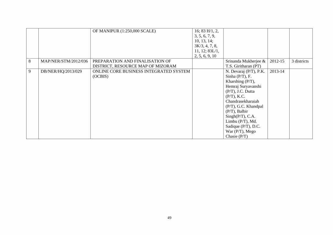
49
OF MANIPUR (1:250,000 SCALE) 16; 83 H/1, 2,
3, 5, 6, 7, 9,
10, 13, 14;
3K/3, 4, 7, 8,
11, 12; 83L/1,
2, 5, 6, 9, 10
8 MAP/NER/STM/2012/036 PREPARATION AND FINALISATION OF
DISTRICT, RESOURCE MAP OF MIZORAM
Srinanda Mukherjee &
T.S. Giritharan (PT)
2012-15 3 districts
9 DB/NER/HQ/2013/029 ONLINE CORE BUSINESS INTEGRATED SYSTEM
(OCBIS)
N. Devaraj (P/T), P.K.
Sinha (P/T), F.
Kharshing (P/T),
Hemraj Suryavanshi
(P/T), J.C. Dutta
(P/T), K.C.
Chandrasekharaiah
(P/T), G.C. Khandpal
(P/T), Balbir
Singh(P/T), C.A.
Limbu (P/T), Md.
Sadique (P/T), D.C.
War (P/T), Mego
Chasie (P/T)
2013-14
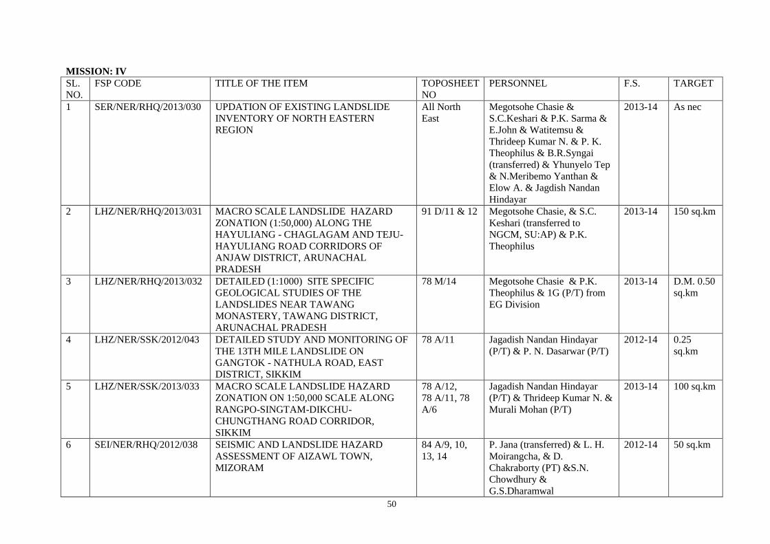
50
MISSION: IV
SL.
NO.
FSP CODE TITLE OF THE ITEM TOPOSHEET
NO
PERSONNEL F.S. TARGET
1 SER/NER/RHQ/2013/030 UPDATION OF EXISTING LANDSLIDE
INVENTORY OF NORTH EASTERN
REGION
All North
East
Megotsohe Chasie &
S.C.Keshari & P.K. Sarma &
E.John & Watitemsu &
Thrideep Kumar N. & P. K.
Theophilus & B.R.Syngai
(transferred) & Yhunyelo Tep
& N.Meribemo Yanthan &
Elow A. & Jagdish Nandan
Hindayar
2013-14 As nec
2 LHZ/NER/RHQ/2013/031 MACRO SCALE LANDSLIDE HAZARD
ZONATION (1:50,000) ALONG THE
HAYULIANG - CHAGLAGAM AND TEJU-
HAYULIANG ROAD CORRIDORS OF
ANJAW DISTRICT, ARUNACHAL
PRADESH
91 D/11 & 12 Megotsohe Chasie, & S.C.
Keshari (transferred to
NGCM, SU:AP) & P.K.
Theophilus
2013-14 150 sq.km
3 LHZ/NER/RHQ/2013/032 DETAILED (1:1000) SITE SPECIFIC
GEOLOGICAL STUDIES OF THE
LANDSLIDES NEAR TAWANG
MONASTERY, TAWANG DISTRICT,
ARUNACHAL PRADESH
78 M/14 Megotsohe Chasie & P.K.
Theophilus & 1G (P/T) from
EG Division
2013-14 D.M. 0.50
sq.km
4 LHZ/NER/SSK/2012/043 DETAILED STUDY AND MONITORING OF
THE 13TH MILE LANDSLIDE ON
GANGTOK - NATHULA ROAD, EAST
DISTRICT, SIKKIM
78 A/11 Jagadish Nandan Hindayar
(P/T) & P. N. Dasarwar (P/T)
2012-14 0.25
sq.km
5 LHZ/NER/SSK/2013/033 MACRO SCALE LANDSLIDE HAZARD
ZONATION ON 1:50,000 SCALE ALONG
RANGPO-SINGTAM-DIKCHU-
CHUNGTHANG ROAD CORRIDOR,
SIKKIM
78 A/12,
78 A/11, 78
A/6
Jagadish Nandan Hindayar
(P/T) & Thrideep Kumar N. &
Murali Mohan (P/T)
2013-14 100 sq.km
6 SEI/NER/RHQ/2012/038 SEISMIC AND LANDSLIDE HAZARD
ASSESSMENT OF AIZAWL TOWN,
MIZORAM
84 A/9, 10,
13, 14
P. Jana (transferred) & L. H.
Moirangcha, & D.
Chakraborty (PT) &S.N.
Chowdhury &
G.S.Dharamwal
2012-14 50 sq.km
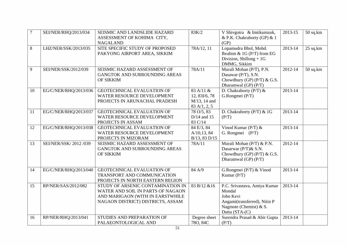
51
7 SEI/NER/RHQ/2013/034 SEISMIC AND LANDSLIDE HAZARD
ASSESSMENT OF KOHIMA CITY,
NAGALAND
83K/2 V Shivgotra & Imtikumzuk,
& P.K. Chakraborty (GP) & 1
(GP)
2013-15 50 sq.km
8 LHZ/NER/SSK/2013/035 SITE SPECIFIC STUDY OF PROPOSED
PAKYONG AIRPORT AREA, SIKKIM
78A/12, 11 Lopamudra Bhol, Mohd.
Ibrahim & 1G (P/T) from EG
Division, Shillong + 1G
DMMG, Sikkim
2013-14 25 sq.km
9 SEI/NER/SSK/2012/039 SEISMIC HAZARD ASSESSMENT OF
GANGTOK AND SURROUNDING AREAS
OF SIKKIM
78A/11 Murali Mohan (P/T), P.N.
Dasawar (P/T), S.N.
Chowdhury (GP) (P/T) & G.S.
Dharamwal (GP) (P/T)
2012-14 50 sq.km
10 EG/C/NER/RHQ/2013/036 GEOTECHNICAL EVALUATION OF
WATER RESOURCE DEVELOPMENT
PROJECTS IN ARUNACHAL PRADESH
83 A/11 &
12, 83I/6, 78
M/13, 14 and
83 A/1, 2, 5
D. Chakraborty (P/T) &
G.Rongmei (P/T)
2013-14
11 EG/C/NER/RHQ/2013/037 GEOTECHNICAL EVALUATION OF
WATER RESOURCE DEVELOPMENT
PROJECTS IN ASSAM
78 O/5, 83
D/14 and 15
83 C/14
D. Chakraborty (P/T) & 1G
(P/T)
2013-14
12 EG/C/NER/RHQ/2013/038 GEOTECHNICAL EVALUATION OF
WATER RESOURCE DEVELOPMENT
PROJECTS IN MIZORAM
84 E/3, 84
A/10,13, 84
B/13, 83 D/15
Vinod Kumar (P/T) &
G. Rongmei (P/T)
2013-14
13 SEI/NER/SSK/ 2012 /039 SEISMIC HAZARD ASSESSMENT OF
GANGTOK AND SURROUNDING AREAS
OF SIKKIM
78A/11 Murali Mohan (P/T) & P.N.
Dasarwar (P/T)& S.N.
Chowdhury (GP) (P/T) & G.S.
Dharamwal (GP) (P/T)
2012-14
14 EG/C/NER/RHQ/2013/040 GEOTECHNICAL EVALUATION OF
TRANSPORT AND COMMUNICATION
PROJECTS IN NORTH EASTERN REGION
84 A/9 G.Rongmei (P/T) & Vinod
Kumar (P/T)
2013-14
15 RP/NER/SAS/2012/082 STUDY OF ARSENIC CONTAMINATION IN
WATER AND SOIL IN PARTS OF NAGAON
AND MARIGAON (WITH IN EARSTWHILE
NAGAON DISTRICT) DISTRICTS, ASSAM
83 B/12 &16 P.C. Srivastava, Amiya Kumar
Mondal
John Kevi
Angami(transferred), Nitin P
Nagmote (Chemist) & S.
Dutta (STA-(C)
2013-14
16 RP/NER/RHQ/2013/041 STUDIES AND PREPARATION OF
PALAEONTOLOGICAL AND
Degree sheet
78O, 84C
Surendra Prasad & Abir Gupta
(P/T)
2013-14
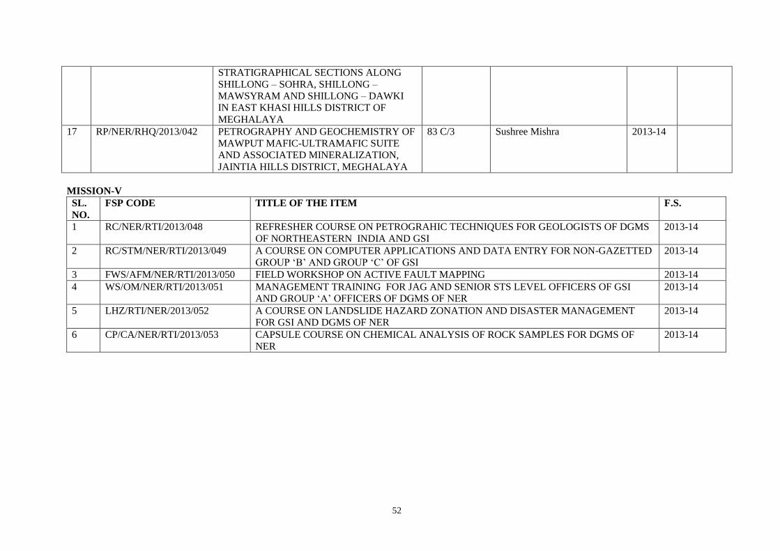
52
STRATIGRAPHICAL SECTIONS ALONG
SHILLONG – SOHRA, SHILLONG –
MAWSYRAM AND SHILLONG – DAWKI
IN EAST KHASI HILLS DISTRICT OF
MEGHALAYA
17 RP/NER/RHQ/2013/042 PETROGRAPHY AND GEOCHEMISTRY OF
MAWPUT MAFIC-ULTRAMAFIC SUITE
AND ASSOCIATED MINERALIZATION,
JAINTIA HILLS DISTRICT, MEGHALAYA
83 C/3 Sushree Mishra 2013-14
MISSION-V
SL.
NO.
FSP CODE TITLE OF THE ITEM F.S.
1 RC/NER/RTI/2013/048 REFRESHER COURSE ON PETROGRAHIC TECHNIQUES FOR GEOLOGISTS OF DGMS
OF NORTHEASTERN INDIA AND GSI
2013-14
2 RC/STM/NER/RTI/2013/049 A COURSE ON COMPUTER APPLICATIONS AND DATA ENTRY FOR NON-GAZETTED
GROUP ‘B’ AND GROUP ‘C’ OF GSI
2013-14
3 FWS/AFM/NER/RTI/2013/050 FIELD WORKSHOP ON ACTIVE FAULT MAPPING 2013-14
4 WS/OM/NER/RTI/2013/051 MANAGEMENT TRAINING FOR JAG AND SENIOR STS LEVEL OFFICERS OF GSI
AND GROUP ‘A’ OFFICERS OF DGMS OF NER
2013-14
5 LHZ/RTI/NER/2013/052 A COURSE ON LANDSLIDE HAZARD ZONATION AND DISASTER MANAGEMENT
FOR GSI AND DGMS OF NER
2013-14
6 CP/CA/NER/RTI/2013/053 CAPSULE COURSE ON CHEMICAL ANALYSIS OF ROCK SAMPLES FOR DGMS OF
NER
2013-14

53
ANNEXURE – 3A
QUARTER-WISE, HEAD-WISE ALLOTMENT OF PLAN FUND versus EXPENDITURE BOOKED DURING THE FINANCIAL YEAR 2013-14 (2nd year of the XIIth 5-year Plan) IN RESPECT OF NORTH-EASTERN REGION OF GSI
QUARTER-WISE, HEAD-WISE ALLOTMENT OF PLAN FUND versus EXPENDITURE BOOKED DURING THE FINANCIAL YEAR 2013-14 (2nd
year of the XIIth 5-year Plan) IN RESPECT OF NORTH-EASTERN REGION OF GSI
Financial Year & FSP (April to March)
HEAD OF EXPENDITURE (Classification as MoM/GSI and MoF)
HEAD OF EXPENDITURE (Classification as MoM/GSI and MoF)
Total of ASS {Sal. + Hqrs.Wages + OTA + Med. + DTE + FTE + OE (v) + OE(c) + RRT + OAE + PS}
Mission-I Mission-II Mission-III (Information Dissemination) Mission-IVA Mission-IVB Mission-V (Human Resource Development)
Total of Mission I, II, III, IVA, IVB & V
STSS (Modernisation & Replacement) Total of ASS, all Missions & STSS
Minor Works (Minor Civil, Electrical and Operarational-Machine etc. related for protection / maintenance /addition / alteration / modification etc. of Govt. properties)
Major Works (Major Civil Exp. related to development of new premises/ complexes/ compounds, new Construction and/or New Major Electrical Installations
SC/ST Welfare related Expdr.
Total of ASS, all Missions, STSS, Minor Works, Major Works and SC/ST Welfare
Survey & Mapping (Wages + POL +
OC)
Mineral Exploration
(Wages + POL + OC)
Other expdr. (Publication + OAE + Adv. &
Publicity)
Other Expdr. {IT (OAE)}
Total of Mission - III [i.e., Total of
Other Expdr. {i.e., Pubn. + OAE +
Adv. & Pub. + IT (OAE)}]
Research & Development
(Wages + Sup. & Mat + POL + OC)
Investigation (Wages + POL +
OC)
Training & Capacity Building
(OAE)
Other Expdr. (Sup. & Mat.+
Clothing & Tentage)
Capital Assets (MV + ME)
Total of STSS {i.e., Total of
Other Expdr. (i.e., Sup. & Mat. +
Clothing & Tentage + MV +
ME)}
Allotment (+) OR ( - ) during the Qtr.
Expdr. (during the Qtr.)
Allotment (+) OR ( - ) during the Qtr.
Expdr. (during the Qtr.)
Allotment (+) OR ( - ) during the Qtr.
Expdr. (during the Qtr.)
Allotment (+) OR ( - ) during the Qtr.
Expdr. (during the Qtr.)
Allotment (+) OR ( - ) during the Qtr.
Expdr. (during the Qtr.)
Allotment (+) OR ( - ) during the Qtr.
Expdr. (during the Qtr.)
Allotment (+) OR ( - ) during the Qtr.
Expdr. (during the Qtr.)
Allotment (+) OR ( - ) during the Qtr.
Expdr. (during the Qtr.)
Allotment (+) OR ( - ) during the Qtr.
Expdr. (during the Qtr.)
Allotment (+) OR ( - ) during the Qtr.
Expdr. (during the Qtr.)
Allotment (+) OR ( - ) during the Qtr.
Expdr. (during the Qtr.)
Allotment (+) OR ( - ) during the Qtr.
Expdr. (during the Qtr.)
Allotment (+) OR ( - ) during the Qtr.
Expdr. (during the Qtr.)
Allotment (+) OR ( - ) during the Qtr.
Expdr. (during the Qtr.)
Allotment (+) OR ( - ) during the Qtr.
Expdr. (during the Qtr.)
Allotment (+) OR ( - ) during the Qtr.
Expdr. (during the Qtr.)
Allotment (+) OR ( - ) during the Qtr.
Expdr. (during the Qtr.)
Allotment (+) OR ( - ) during the Qtr.
Expdr. (during the Qtr.)
Rs. In Lakh
Rs. In Lakh
Rs. In Lakh
Rs. In Lakh
Rs. In Lakh
Rs. In Lakh
Rs. In Lakh
Rs. In Lakh
Rs. In Lakh
Rs. In Lakh
Rs. In Lakh
Rs. In Lakh
Rs. In Lakh
Rs. In Lakh
Rs. In Lakh
Rs. In Lakh
Rs. In Lakh
Rs. In Lakh
Rs. In Lakh
Rs. In Lakh
Rs. In Lakh
Rs. In Lakh
Rs. In Lakh
Rs. In Lakh
Rs. In Lakh
Rs. In Lakh
Rs. In Lakh
Rs. In Lakh
Rs. In Lakh
Rs. In Lakh
Rs. In Lakh
Rs. In Lakh
Rs. In Lakh
Rs. In Lakh
Rs. In Lakh
Rs. In Lakh
2013-14 (For the 1st Qtr.)
1188.00 589.33 50.00 13.85 50.00 23.54 25.00 1.24 20.00 5.93 45.00 7.17 30.00 4.58 25.00 1.15 5.00 0.03 205.00 50.32 2.00 360.00 48.40 362.00 48.40 1755.00 688.05 25.00 1780.00 688.05
2013-14 (For the 2nd Qtr.)
10.00 470.18 8.68 16.31 2.94 6.99 0.00 9.93 6.23 2.74 10.00 4.25 10.00 48.14 31.07 0.00 31.07 20.00 549.39 43.12 6.87 40.00 6.34 103.12 562.60
2013-14 (For the 3rd Qtr.)
0.00 71.05 17.43 7.52 10.42 0.49 0.00 10.91 5.12 1.63 2.82 0.00 45.43 0.35 76.62 0.00 76.97 0.00 193.45 -7.00 49.60 29.91 -7.00 272.96
2013-14 (For the 4th Qtr.)
16.47 76.25 9.96 2.62 0.20 9.97 6.03 0.20 16.00 12.47 1.50 20.81 1.00 8.43 2.70 70.29 1.53 177.48 0.00 179.01 19.17 325.55 3.60 5.00 8.61 24.17 337.76
Total (at the end of filled-up Qtr.) --->
1214.47 1206.81 50.00 49.92 50.00 49.99 25.20 24.57 20.00 19.44 45.20 44.01 30.00 28.40 26.50 26.33 16.00 15.53 217.70 214.18 2.00 1.88 360.00 333.57 362.00 335.45 1794.17 1756.44 61.12 60.07 0.00 0.00 45.00 44.86 1900.29 1861.37
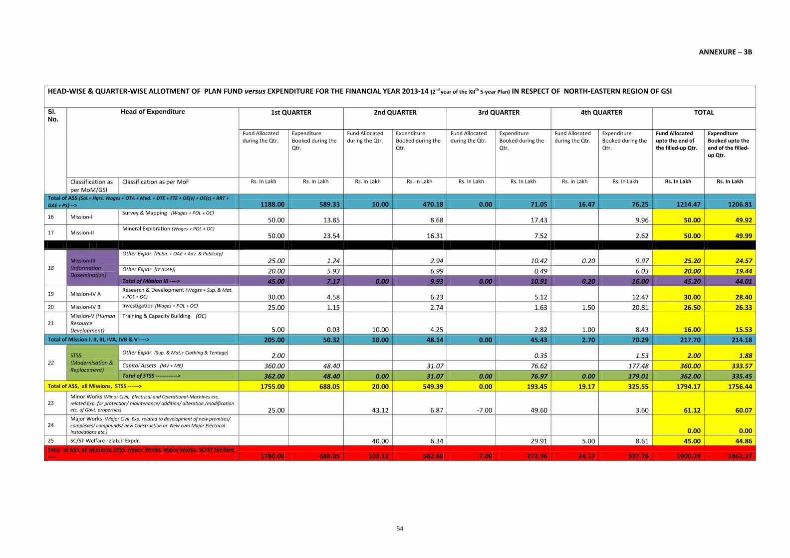
54
ANNEXURE – 3B
HEAD-WISE & QUARTER-WISE ALLOTMENT OF PLAN FUND versus EXPENDITURE FOR THE FINANCIAL YEAR 2013-14 (2nd year of the XII
th 5-year Plan) IN RESPECT OF NORTH-EASTERN REGION OF GSI
Sl. No.
Head of Expenditure 1st QUARTER 2nd QUARTER 3rd QUARTER 4th QUARTER TOTAL
Fund Allocated during the Qtr.
Expenditure Booked during the Qtr.
Fund Allocated during the Qtr.
Expenditure Booked during the Qtr.
Fund Allocated during the Qtr.
Expenditure Booked during the Qtr.
Fund Allocated during the Qtr.
Expenditure Booked during the Qtr.
Fund Allocated upto the end of the filled-up Qtr.
Expenditure Booked upto the end of the filled-up Qtr.
Classification as per MoM/GSI
Classification as per MoF Rs. In Lakh Rs. In Lakh Rs. In Lakh Rs. In Lakh Rs. In Lakh Rs. In Lakh Rs. In Lakh Rs. In Lakh Rs. In Lakh Rs. In Lakh
Total of ASS {Sal.+ Hqrs. Wages + OTA + Med. + DTE + FTE + OE(v) + OE(c) + RRT +
OAE + PS} --> 1188.00 589.33 10.00 470.18 0.00 71.05 16.47 76.25 1214.47 1206.81
16 Mission-I Survey & Mapping (Wages + POL + OC)
50.00 13.85 8.68 17.43 9.96 50.00 49.92
17 Mission-II Mineral Exploration (Wages + POL + OC)
50.00 23.54 16.31 7.52 2.62 50.00 49.99
18 Mission-III (Information Dissemination)
Other Expdr. (Pubn. + OAE + Adv. & Publicity)
25.00 1.24 2.94 10.42 0.20 9.97 25.20 24.57 Other Expdr. {IT (OAE)} 20.00 5.93 6.99 0.49 6.03 20.00 19.44
Total of Mission III ----> 45.00 7.17 0.00 9.93 0.00 10.91 0.20 16.00 45.20 44.01
19 Mission-IV A Research & Development (Wages + Sup. & Mat.
+ POL + OC) 30.00 4.58 6.23 5.12 12.47 30.00 28.40
20 Mission-IV B Investigation (Wages + POL + OC) 25.00 1.15 2.74 1.63 1.50 20.81 26.50 26.33
21 Mission-V (Human Resource Development)
Training & Capacity Building (OC)
5.00 0.03 10.00 4.25 2.82 1.00 8.43 16.00 15.53
Total of Mission I, II, III, IVA, IVB & V ----> 205.00 50.32 10.00 48.14 0.00 45.43 2.70 70.29 217.70 214.18
22 STSS (Modernisation & Replacement)
Other Expdr. (Sup. & Mat.+ Clothing & Tentage) 2.00 0.35 1.53 2.00 1.88
Capital Assets (MV + ME) 360.00 48.40 31.07 76.62 177.48 360.00 333.57
Total of STSS ------------> 362.00 48.40 0.00 31.07 0.00 76.97 0.00 179.01 362.00 335.45
Total of ASS, all Missions, STSS ------> 1755.00 688.05 20.00 549.39 0.00 193.45 19.17 325.55 1794.17 1756.44
23 Minor Works (Minor Civil, Electrical and Operational-Machines etc. related Exp. for protection/ maintenance/ addition/ alteration /modification etc. of Govt. properties) 25.00 43.12 6.87 -7.00 49.60 3.60 61.12 60.07
24 Major Works (Major Civil Exp. related to development of new premises/ complexes/ compounds/ new Construction or New cum Major Electrical Installations etc.) 0.00 0.00
25 SC/ST Welfare related Expdr. 40.00 6.34 29.91 5.00 8.61 45.00 44.86 Total of ASS, all Missions, STSS, Minor Works, Major Works, SC/ST Welfare ---> 1780.00 688.05 103.12 562.60 -7.00 272.96 24.17 337.76 1900.29 1861.37
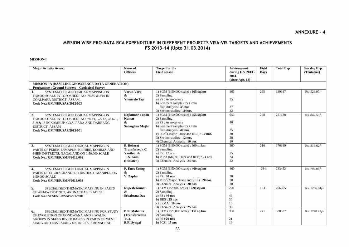
55
ANNEXURE – 4
MISSION WISE PRO-RATA RCA EXPENDITURE IN DIFFERENT PROJECTS VISA-VIS TARGETS AND ACHIEVEMENTS FS 2013-14 (Upto 31.03.2014)
MISSION-I
Major Activity Areas Name of
Officers
Target for the
Field season
Achievement
during F.S. 2013 -
2014
(since Apr. 13)
Field
Days
Total Exp. Per day Exp.
(Tentative)
MISSION-IA (BASELINE GEOSCIENCE DATA GENERATION)
Programme : Ground Surveys – Geological Survey
1. SYSTEMATIC GEOLOGICAL MAPPING ON 1:50,000 SCALE IN TOPOSHEET NO. 78 J/9 & J/10 IN
GOALPARA DISTRICT, ASSAM.
Code No.: GM/NER/SAS/2012/003
Varun Vara
&
Yhunyelo Tep
1) SGM (1:50,000 scale) : 865 sq.km
2) Sampling
a) PS : As necessary
b) Sediment samples for Grain Size Analysis : 35 nos
3) Section studies : 10 nos.
865
35
37
32
265 139647 Rs. 526.97/-
2. SYSTEMATIC GEOLOGICAL MAPPING ON 1:50,000 SCALE IN TOPOSHEET NO. 78 J/1, 5 & 13, 78 N/1,
5, 9 & 13 IN KAMRUP, GOALPARA AND DARRANG
DISTRICT, ASSAM
Code No.: GM/NER/SAS/2013/001
Rajkumar Tapon
Kumar
&
Satrughan Majhi
1) SGM (1:50,000 scale) : 955 sq.km
2) Sampling
a) PS : As necessary
b) Sediment samples for Grain Size Analysis : 40 nos
c) PCS# (Major, Trace and REE) : 10 nos.
3) Section studies : 12 nos.
4) Chemical Analysis : 10 nos.
955
40
35
20
20 10
268 227138 Rs. 847.53/-
3. SYSTEMATIC GEOLOIGICAL MAPPING IN
PARTS OF PEREN, DIMAPUR, KIPHIRE, KOHIMA AND PHEK DISTRICTS, NAGALAND ON 1:50,000 SCALE
Code No.: GM/NER/SMN/2013/002
B. Behera(
Transferred), C.
Yanthan &
T.S. Kom
(Initiated)
1) SGM (1:50,000 scale) : 360 sq.km
2) Sampling
a) PS : 12 nos. b) PCS# (Major, Trace and REE) : 24 nos.
3) Chemical Analysis : 24 nos.
360
25 24
22
216 176389 Rs. 816.62/-
4. SYSTEMATIC GEOLOIGICAL MAPPING IN
PARTS OF CHURACHANDPUR DISTRICT, MANIPUR ON 1:50,000 SCALE
Code No.: GM/NER/SMN/2013/003
P. Enos Ezung
&
V. Zaphu
1) SGM (1:50,000 scale) : 460 sq.km
2) Sampling
a) PS : 30 nos.
b) PCS# (Major, Trace and REE) : 20 nos.
3) Chemical Analysis : 20 nos.
460
30 20
20
294 233452 Rs. 794.05/-
5. SPECIALISED THEMATIC MAPPING IN PARTS OF ANJAW DISTRICT, ARUNACHAL PRADESH.
Code No.: STM/NER/SAP/2012/001
Rupesh Kumar
&
Sebabrata Das
1) STM (1:25000 scale) : 220 sq.km 2) Sampling
a) PS : 40 nos
b) BRS : 25 nos
c) EPMA : 10 nos
3) Chemical Analysis : 25 nos.
220
43
30 10
30
163 206365 Rs. 1266.04/-
6. SPECIALISED THEMATIC MAPPING FOR STUDY OF EVOLUTION OF GONDWANA AND SIWALIK
GROUPS IN SIANG RIVER BASINS IN PARTS OF WEST
SIANG AND EAST SIANG DISTRICTS, ARUNACHAL
B.N. Mahanta
(Transferred to
TC),
B.R. Syngai
1) STM (1:25,000 scale) : 330 sq.km
2) Sampling a) PS : 20 nos
b) PCS : 15 nos
330
21
19
271 338337 Rs. 1248.47/-
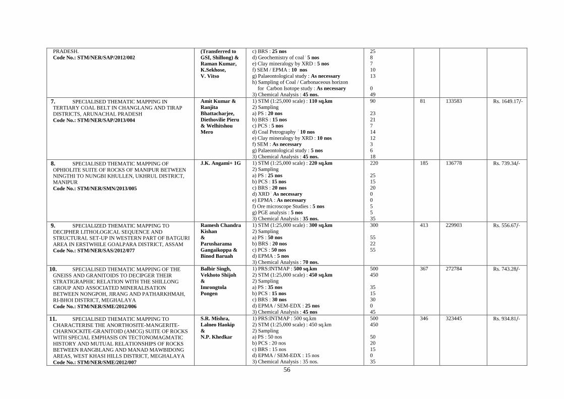
56
PRADESH.
Code No.: STM/NER/SAP/2012/002
(Transferred to
GSI, Shillong) &
Raman Kumar,
K.Sekhose,
V. Vitso
c) BRS : 25 nos
d) Geochemistry of coal : 5 nos
e) Clay mineralogy by XRD : 5 nos
f) SEM / EPMA : 10 nos
g) Palaeontological study : As necessary
h) Sampling of Coal / Carbonaceous horizon
for Carbon Isotope study : As necessary
3) Chemical Analysis : 45 nos.
25
8 7
10
13
0
49
7. SPECIALISED THEMATIC MAPPING IN TERTIARY COAL BELT IN CHANGLANG AND TIRAP
DISTRICTS, ARUNACHAL PRADESH
Code No.: STM/NER/SAP/2013/004
Amit Kumar &
Ranjita
Bhattacharjee,
Diethovilie Pieru
& Welhitshou
Mero
1) STM (1:25,000 scale) : 110 sq.km 2) Sampling
a) PS : 20 nos
b) BRS : 15 nos
c) PCS : 5 nos
d) Coal Petrography : 10 nos
e) Clay mineralogy by XRD : 10 nos
f) SEM : As necessary
g) Palaeontological study : 5 nos
3) Chemical Analysis : 45 nos.
90
23
21 7
14
12 3
6
18
81 133583 Rs. 1649.17/-
8. SPECIALISED THEMATIC MAPPING OF
OPHIOLITE SUITE OF ROCKS OF MANIPUR BETWEEN NINGTHI TO NUNGBI KHULLEN, UKHRUL DISTRICT,
MANIPUR
Code No.: STM/NER/SMN/2013/005
J.K. Angami+ 1G 1) STM (1:25,000 scale) : 220 sq.km
2) Sampling
a) PS : 25 nos b) PCS : 15 nos
c) BRS : 20 nos
d) XRD : As necessary
e) EPMA : As necessary
f) Ore microscope Studies : 5 nos
g) PGE analysis : 5 nos
3) Chemical Analysis : 35 nos.
220
25 15
20
0
0
5
5 35
185 136778 Rs. 739.34/-
9. SPECIALIZED THEMATIC MAPPING TO
DECIPHER LITHOLOGICAL SEQUENCE AND STRUCTURAL SET-UP IN WESTERN PART OF BATGURI
AREA IN ERSTWHILE GOALPARA DISTRICT, ASSAM
Code No.: STM/NER/SAS/2012/077
Ramesh Chandra
Kishan
&
Parusharama
Gangaikoppa &
Binod Baruah
1) STM (1:25,000 scale) : 300 sq.km
2) Sampling a) PS : 50 nos
b) BRS : 20 nos
c) PCS : 50 nos
d) EPMA : 5 nos
3) Chemical Analysis : 70 nos.
300
55
22
55
413 229903 Rs. 556.67/-
10. SPECIALISED THEMATIC MAPPING OF THE GNEISS AND GRANITOIDS TO DECIPGER THEIR
STRATIGRAPHIC RELATION WITH THE SHILLONG
GROUP AND ASSOCIATED MINERALISATION BETWEEN NONGPOH, JIRANG AND PATHARKHMAH,
RI-BHOI DISTRICT, MEGHALAYA
Code No.: STM/NER/SME/2012/006
Balbir Singh,
Vekhoto Shijoh
&
Imrongtola
Pongen
1) PRS:INTMAP : 500 sq.km
2) STM (1:25,000 scale) : 450 sq.km
2) Sampling
a) PS : 35 nos
b) PCS : 15 nos c) BRS : 30 nos
d) EPMA / SEM-EDX : 25 nos
3) Chemical Analysis : 45 nos
500
450
35
15 30
0
45
367 272784 Rs. 743.28/-
11. SPECIALISED THEMATIC MAPPING TO
CHARACTERISE THE ANORTHOSITE-MANGERITE- CHARNOCKITE-GRANITOID (AMCG) SUITE OF ROCKS
WITH SPECIAL EMPHASIS ON TECTONOMAGMATIC
HISTORY AND MUTUAL RELATIONSHIPS OF ROCKS BETWEEN RANGBLANG AND MANAD MAWBIDONG
AREAS, WEST KHASI HILLS DISTRICT, MEGHALAYA
Code No.: STM/NER/SME/2012/007
S.R. Mishra,
Lalneo Haokip
&
N.P. Khedkar
1) PRS:INTMAP : 500 sq.km
2) STM (1:25,000 scale) : 450 sq.km
2) Sampling a) PS : 50 nos
b) PCS : 20 nos
c) BRS : 15 nos d) EPMA / SEM-EDX : 15 nos
3) Chemical Analysis : 35 nos.
500
450
50
20
15 0
35
346 323445 Rs. 934.81/-
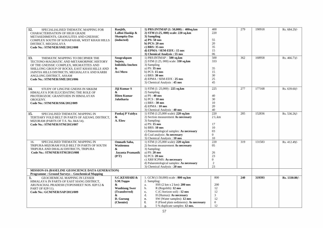
57
12. SPECIALIALISED THEMATIC MAPPING FOR
CHARACTERISATION OF HIGH GRADE METASEDIMENTS, GRANULITES AND GNEISSIC
COMPLEX SOUTH OF SONAPAHAR, WEST KHASI HILLS
DISTRICT, MEGHALAYA
Code No.: STM/NER/SME/2012/008
Ranjith,
Lalboi Haokip &
Shampita Das
(inducted)
1) PRS:INTMAP (1: 50,000) : 400sq.km
2) STM (1:25, 000) scale: 220 sq.km
3) Sampling
a) PS: 50 nos
b) PCS: 20 nos
c) BRS: 35 nos
d) EPMA / SEM-EDX : 15 nos
3) Chemical Analysis : 55 nos
400
220
55
20 35
15
06
279 190918 Rs. 684.29/-
13. THEMATIC MAPPING TO DECIPHER THE TECTONO-MAGMATIC AND METAMORPHIC HISTORY
OF THE GNEISSIC COMPLEX, MIGMATITES AND
SHILLONG GROUP OF ROCKS, EAST KHASI HILLS AND
JAINTIA HILLS DISTRICTS, MEGHALAYA AND KARBI
ANGLONG DISTRICT, ASSAM
Code No.: STM/NER/SME/2013/006
Sougrakpam
Sujata,
Imlishila Imchen
&
Avi Mero
1) PRS:INTMAP : 500 sq.km
2) STM (1:25, 000) scale: 330 sq.km
3) Sampling
a) PS: 35 nos b) PCS: 15 nos
c) BRS: 30 nos
d) EPMA / SEM-EDX : 25 nos
3) Chemical Analysis : 45 nos
500 333
35 15
30
25 45
362 168958 Rs. 466.73/-
14. STUDY OF LINGTSE GNEISS IN SIKKIM HIMALAYA FOR ELUCIDATING THE ROLE OF
PROTEROZOIC GRANITOIDS IN HIMALAYAN
OROGENY.
Code No.: STM/NER/SSK/2012/009
Jiji Kumar S
&
Hiten Kumar
Jalutharia
1) STM (1: 25,000) : 225 sq.km
2) Sampling a) PS : 40 nos
b) PCS : 10 nos
c) BRS : 30 nos d) EPMA : 10 nos
3) Chemical Analysis : 40 nos
225
40
30
10 20
40
277 177168 Rs. 639.60/-
15. SPECIALISED THEMATIC MAPPING IN TERTIARY FOLD BELT IN PARTS OF AIZAWL DISTRICT,
MIZORAM (PARTS OF T.S. No. 84A/14).
Code No.: STM/NER/STM/2013/007
Pankaj P Vaidya
&
A. Elow
1) STM (1:25,000 scale): 220 sq.km 2) Section measurement As necessary
3) Sampling:
a) PS: 15 nos
b) BRS: 10 nos
c) Palaeontological samples: As necessary
d) Coal analysis: As necessary
3) Chemical Analysis : 10 nos
220 2 L.km
17 10
03
0 10
285 152836 Rs. 536.26/-
16. SPECIALISED THEMATIC MAPPING IN
TRIPURA-MIZORAM FOLD BELT IN PARTS OF SOUTH TRIPURA AND DHALAI DISTRICTS, TRIPURA
Code No.: STM/NER/STM/2013/008
Omnath Saha,
Watitemsu
&
Jayanta Pramanik
(P/T)
1) STM (1:25,000 scale): 220 sq.km
2) Section measurement As necessary 3) Sampling:
a) PS: 20 nos
b) PCS: 20 nos
c) XRF/ICPMS: As necessary
d) Palaeontological samples: As necessary
3) Chemical Analysis : 20 nos
220
05
26
23
0
2
23
319 131583 Rs. 412.49/-
MISSION-IA (BASELINE GEOSCIENCE DATA GENERATION)
Programme : Ground Surveys – Geochemical Mapping
1. GEOCHEMICAL MAPPING IN LESSER HIMALAYA IN PARTS OF EAST SIANG DISTRICT,
ARUNACHAL PRADESH (TOPOSHEET NOS. 82P/12 &
PART OF 82P/11).
Code No.: GCM/NER/SAP/2013/009
S.C.KESHARI &
S.M.Toppo
&
Wanbiang Swer
(Transferred)
&
D. Gurung
(Chemist)
1. GCM (1:50,000) scale : 800 sq.km
2. Sampling: a. SSS (2 km x 2 km): 200 nos
b. R (Regolith): 12 nos
c. C (C-horizon soil) : 12 nos
d. H (Humus): As necessary
e. SW (Water samples): 12 nos
f. F (Flood plain sediments): As necessary
g. 5 % duplicate samples: 12 nos.
800
200
12
12 3
12
0
12
240 319393 Rs. 1330.80/-

58
3. Analysis of samples: 248 nos. 248
2. GEOCHEMICAL MAPPING IN TOPOSHEET NO. 78 O/1 AND PARTS OF 78O/5 IN GOALPARA & KAMRUP
DISTRICTS, ASSAM AND EAST GARO HILLS & WEST
KHASI HILLS DISTRICTS, MEGHALAYA
Code No.: GCM/NER/SAS/2012/016
Amit Kumar &
Mukesh Kumar
Mishra
&
N.P. Nagmote
(Chemist)
1. GCM (1:50,000 scale) : 800 sq.km
2. Sampling: a. Stream Sediment sample (SSS)
(2 Km x 2 Km grid): 165 nos
b. Composite Stream Sediment samples (2 Km x 2 Km grid): 48 nos
c. Sediment Sample (SS)
(4 Km x 4 Km): 22 (11+11) nos d. C-Horizon(C): 8 nos
e. Regolith Sample (R) : 8 nos
f. Humus Sample (H) : 8 nos g. Stream Water Sample (SW) : 8 nos
h. Flood Plain Sample (FP) : As necessary
i. 5 % duplicate samples: 12 nos 3. Analysis of samples: 272 nos
800
145
48
24
8 8
8
8 0
12
0
269 232589 Rs. 864.64/-
3. REGIONAL GEOCHEMICAL MAPPING IN THE OPHIOLOIE BELT IN PARTS OF PHEK DISTRICT,
NAGALAND
Code No.: GCM/NER/SMN/2013/010
Chubala Shijoh,
D. Bharati
&
R.Vittal
(Chemist)
1. GCM (1:50,000 scale) : 800 sq.km 2. Sampling:
a. Stream Sediment Sample (SSS)
(2 Km X 2 Km) : 200 nos b. Soil Sample (C-horizon) : 12 nos
c. Regolith Sample (R) : 12 nos
d. Humus Sample (H) : As necessary
e. Stream Water Sample (SW) : 24 nos
f. Duplicate SSS (3 to 5% of the area) : 12
nos 3. Analysis of samples: 260 nos
800
200 12
12
0
12
12
353 182259 Rs. 516.31/-
4. REGIONAL GEOCHEMICAL MAPPING IN THE
OPHIOLITE BELT IN PARTS OF MON,TUENSANG & KIPHIRE DISTRICTS, NAGALAND
Code No.: GCM/NER/SMN/2013/011
E. John
&
R.Vittal
(Chemist)
1. GCM (1:50,000 scale) : 400 sq.km
2. Sampling: a. Stream Sediment Sample (SSS)
(2 Km X 2 Km) : 100 nos
b. Soil Sample (C-horizon) : 6 nos c. Regolith Sample (R) : 6 nos
d. Humus Sample (H) : As necessary
e. Stream Water Sample (SW) : 12 nos f. Duplicate SSS (3 to 5% of the area) : 6 nos
3. Analysis of samples: 130 nos
400
113
6 6
0
6 6
170 145909 Rs. 858.29/-
5. GEOCHEMICAL MAPPING IN MEGHALAYA GNEISSIC COMPLEX IN PARTS OF JAINTIA AND EAST
KHASI HILLS DISTRICT, MEGHALAYA (TOPOSHEET
NOS. 83C/07 & PART OF 83 C/03) Code No.: GCM/NER/SME/2013/012
H. Sumar
&
A.S.Bora
(Chemist)
1. GCM (1:50,000) scale: 800 sq.km
2. Sampling: a. SSS (Stream sediment sample): 416 nos
b. Composite samples:208 nos
c. R (Regolith): 11 nos d. C (C-horizon soil): 11 nos
e. H (Humus): As necessary
f. SW ( Water samples) : 22 nos
g. F (Flood plain sediments): As necessary
h. 5 % duplicate samples: 11 composites
3. Analysis of samples: 263 nos
205 207438 Rs. 1011.89/-

59
6. GEOCHEMICAL MAPPING IN TOPOSHEET NO
83C/03 IN PARTS OF EAST KHASI HILL AND JAINTIA HILL DISTRICTS, MEGHALAYA.
Code No.: GCM/NER/SME/2012/014
Ajay C. Limbu
&
T. Myelvaganan
(Chemist)
1. GCM (1:50,000) scale: 400 sq.km
2. Sampling: a. SSS (Stream sediment sample): 208 nos
b. Composite Samples: 104 nos
c. R (Regolith): 5 nos d. C (C-horizon soil): 5 nos
e. H (Humus): As necessary
f. SW (Water samples): 10 nos
g. F (Flood plain sediments): As necessary
h. 5 % duplicate samples: 5 composites
3. Analysis of samples: 129 nos
800
416
208
11 11
0
22 22
04
118 138758 Rs. 1175.91/-
7. CHEMICAL MAPPING IN TERTIARY FOLD BELT OF SOUTH TRIPURA DISTRICT, TRIPURA (IN PARTS OF
T.S. Nos. 79M/12, 16 & 79N/9)
Code No.: GCM/NER/STM/2013/013
J.M.Umlong &
M.P. Singh
&
Rajendra Kumar
(Chemist)
1. GCM (1:50,000) scale: 850 sq.km 2. Sampling:
a. SSS (Stream Sediment Samples) : 850 nos
b. CS (Composite samples) :216 nos c. R (Regolith) : 12 nos
d. C (C-horizon Soil) : 12 nos
e. H (Humus) : As necessary f. SW ( Water Samples): 24 nos
g. F (Flood plain sediments): As necessary
h. Duplicate samples : 5% : 11 nos 3. Analysis of samples: 275 nos
850
659*
220£ 12
12
0 24
0
11
319 193261 Rs. 605.83/-
MISSION-IA (BASELINE GEOSCIENCE DATA GENERATION)
Programme : Ground Surveys – Geophysical Mapping
8. GRAVITY-MAGNETIC MAPPING IN PARTS OF WEST KHASI HILLS DISTRICT, MEGHALAYA.
Code No.: GPM/NER/RHQ/2013/014
S.M.Syiem
&
P. Diwakar Reddy
GPM (1:50,000 scale) : 1750 sq.km
Gravity Obs.
Magnetic Obs.
1400 431
431
327 335418 Rs. 1025.74/-
MISSION: IB (BASELINE GEOSCIENCE DATA GENERATION)
Programme : Remote Sensing and Aerial Surveys : Photogeology & Remote Sensing
9. GEOLOGICAL MAPPING IN PARTS OF MEGHALAYA WITH THE HELP OF REMOTE SENSING
STUDIES ON 1:50000 SCALE (9 TOPOSHEETS)
Code No.: PRS/NER/RHQ/2013/015
S. Sanyal
(transferred),
H.C.Shahu
Geological mapping on 1:50,000 scale using
remotely sensed data with selected field checks in T. S. Nos. 78G/15; 78K/3, 4, 8, 12, 16; 78O/16; and
83C/4, 8 : 1150 sq.km
900 13 21363 Rs. 1643.31/-
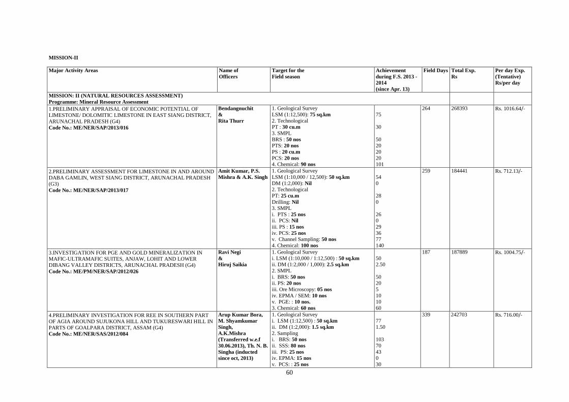
60
MISSION-II
Major Activity Areas Name of
Officers
Target for the
Field season
Achievement
during F.S. 2013 -
2014
(since Apr. 13)
Field Days Total Exp.
Rs
Per day Exp.
(Tentative)
Rs/per day
MISSION: II (NATURAL RESOURCES ASSESSMENT)
Programme: Mineral Resource Assessment
10. 1.PRELIMINARY APPRAISAL OF ECONOMIC POTENTIAL OF
LIMESTONE/ DOLOMITIC LIMESTONE IN EAST SIANG DISTRICT,
ARUNACHAL PRADESH (G4)
Code No.: ME/NER/SAP/2013/016
Bendangnuchit
&
Rita Thurr
1. Geological Survey
i. LSM (1:12,500): 75 sq.km
2. Technological i. PT : 30 cu.m
3. SMPL
i. BRS : 50 nos ii. PTS: 20 nos
iii. PS : 20 cu.m
iv. PCS: 20 nos 4. Chemical: 90 nos
75
30
50 20
20
20 101
264 268393 Rs. 1016.64/-
11. 2.PRELIMINARY ASSESSMENT FOR LIMESTONE IN AND AROUND
DABA GAMLIN, WEST SIANG DISTRICT, ARUNACHAL PRADESH (G3)
Code No.: ME/NER/SAP/2013/017
Amit Kumar, P.S.
Mishra & A.K. Singh
1. Geological Survey
i. LSM (1:10,000 / 12,500): 50 sq.km
ii. DM (1:2,000): Nil 2. Technological
i. PT: 25 cu.m
ii. Drilling: Nil 3. SMPL
i. PTS : 25 nos ii. PCS: Nil
iii. PS : 15 nos
iv. PCS: 25 nos
v. Channel Sampling: 50 nos
4. Chemical: 100 nos
54
0
28
0
26 0
29
36 77
140
259 184441 Rs. 712.13/-
12. 3.INVESTIGATION FOR PGE AND GOLD MINERALIZATION IN MAFIC-ULTRAMAFIC SUITES, ANJAW, LOHIT AND LOWER
DIBANG VALLEY DISTRICTS, ARUNACHAL PRADESH (G4)
Code No.: ME/PM/NER/SAP/2012/026
Ravi Negi
&
Hiruj Saikia
1. Geological Survey
i. LSM (1:10,000 / 1:12,500) : 50 sq.km
ii. DM (1:2,000 / 1,000): 2.5 sq.km
2. SMPL
i. BRS: 50 nos
ii. PS: 20 nos
iii. Ore Microscopy: 05 nos
iv. EPMA / SEM: 10 nos v. PGE: : 10 nos.
3. Chemical: 60 nos
50 2.50
50
20
5
10 10
60
187 187889 Rs. 1004.75/-
13. 4.PRELIMINARY INVESTIGATION FOR REE IN SOUTHERN PART OF AGIA AROUND SUJUKONA HILL AND TUKURESWARI HILL IN
PARTS OF GOALPARA DISTRICT, ASSAM (G4)
Code No.: ME/NER/SAS/2012/084
Arup Kumar Bora,
M. Shyamkumar
Singh,
A.K.Mishra
(Transferred w.e.f
30.06.2013), Th. N. B.
Singha (inducted
since oct, 2013)
1. Geological Survey i. LSM (1:12,500) : 50 sq.km
ii. DM (1:2,000): 1.5 sq.km
2. Sampling i. BRS: 50 nos
ii. SSS: 80 nos
iii. PS: 25 nos
iv. EPMA: 15 nos
v. PCS: : 25 nos
77
1.50
103
70
43 0
30
339 242703 Rs. 716.00/-
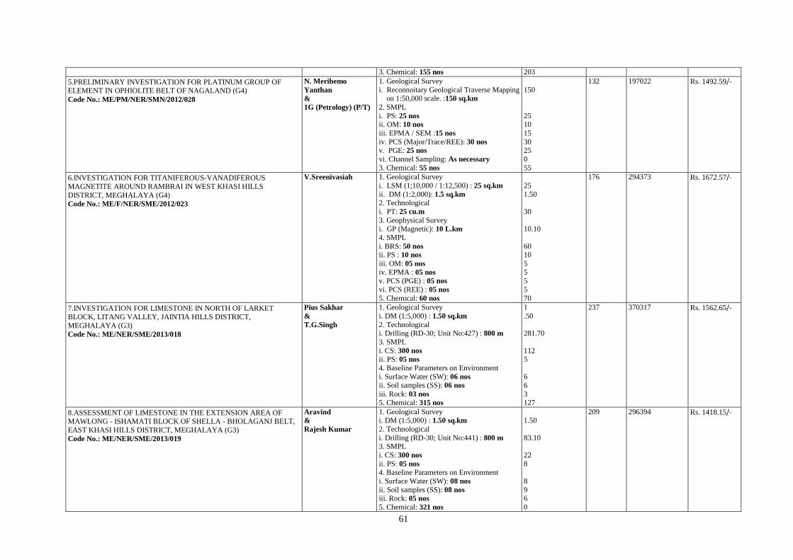
61
3. Chemical: 155 nos 203
14. 5.PRELIMINARY INVESTIGATION FOR PLATINUM GROUP OF ELEMENT IN OPHIOLITE BELT OF NAGALAND (G4)
Code No.: ME/PM/NER/SMN/2012/028
N. Meribemo
Yanthan
&
1G (Petrology) (P/T)
1. Geological Survey
i. Reconnoitary Geological Traverse Mapping on 1:50,000 scale. :150 sq.km
2. SMPL
i. PS: 25 nos
ii. OM: 10 nos
iii. EPMA / SEM :15 nos
iv. PCS (Major/Trace/REE): 30 nos v. PGE: 25 nos
vi. Channel Sampling: As necessary
3. Chemical: 55 nos
150
25 10
15
30 25
0
55
132 197022 Rs. 1492.59/-
15. 6.INVESTIGATION FOR TITANIFEROUS-VANADIFEROUS
MAGNETITE AROUND RAMBRAI IN WEST KHASI HILLS
DISTRICT, MEGHALAYA (G4)
Code No.: ME/F/NER/SME/2012/023
V.Sreenivasiah
1. Geological Survey
i. LSM (1;10,000 / 1:12,500) : 25 sq.km
ii. DM (1:2,000): 1.5 sq.km 2. Technological
i. PT: 25 cu.m
3. Geophysical Survey i. GP (Magnetic): 10 L.km
4. SMPL
i. BRS: 50 nos
ii. PS : 10 nos
iii. OM: 05 nos
iv. EPMA : 05 nos
v. PCS (PGE) : 05 nos
vi. PCS (REE) : 05 nos
5. Chemical: 60 nos
25
1.50
30
10.10
60 10
5
5
5
5
70
176 294373 Rs. 1672.57/-
16. 7.INVESTIGATION FOR LIMESTONE IN NORTH OF LARKET
BLOCK, LITANG VALLEY, JAINTIA HILLS DISTRICT,
MEGHALAYA (G3)
Code No.: ME/NER/SME/2013/018
Pius Sakhar
&
T.G.Singh
1. Geological Survey
i. DM (1:5,000) : 1.50 sq.km
2. Technological i. Drilling (RD-30; Unit No:427) : 800 m
3. SMPL
i. CS: 300 nos ii. PS: 05 nos
4. Baseline Parameters on Environment
i. Surface Water (SW): 06 nos ii. Soil samples (SS): 06 nos
iii. Rock: 03 nos
5. Chemical: 315 nos
1
.50
281.70
112 5
6 6
3
127
237 370317 Rs. 1562.65/-
17. 8.ASSESSMENT OF LIMESTONE IN THE EXTENSION AREA OF MAWLONG - ISHAMATI BLOCK OF SHELLA - BHOLAGANJ BELT,
EAST KHASI HILLS DISTRICT, MEGHALAYA (G3)
Code No.: ME/NER/SME/2013/019
Aravind
&
Rajesh Kumar
1. Geological Survey i. DM (1:5,000) : 1.50 sq.km
2. Technological
i. Drilling (RD-30; Unit No:441) : 800 m 3. SMPL
i. CS: 300 nos
ii. PS: 05 nos 4. Baseline Parameters on Environment
i. Surface Water (SW): 08 nos
ii. Soil samples (SS): 08 nos iii. Rock: 05 nos
5. Chemical: 321 nos
1.50
83.10
22
8
8
9 6
0
209 296394 Rs. 1418.15/-
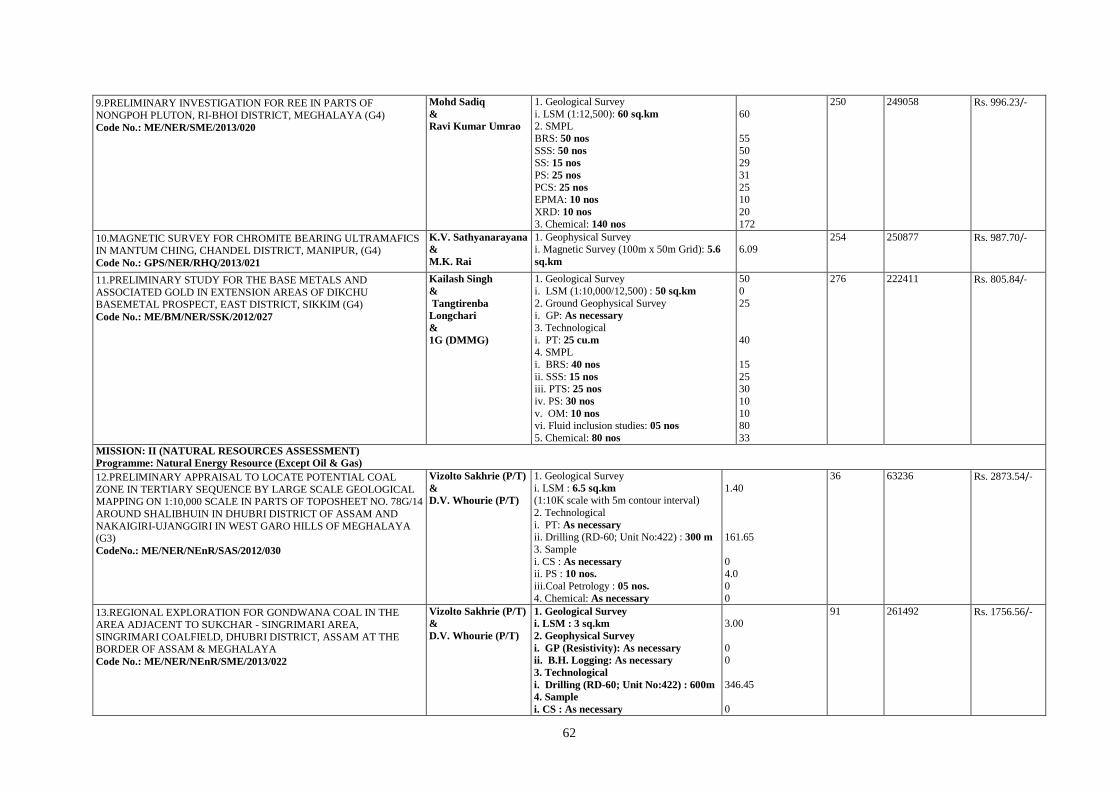
62
18. 9.PRELIMINARY INVESTIGATION FOR REE IN PARTS OF
NONGPOH PLUTON, RI-BHOI DISTRICT, MEGHALAYA (G4)
Code No.: ME/NER/SME/2013/020
Mohd Sadiq
&
Ravi Kumar Umrao
1. Geological Survey
i. LSM (1:12,500): 60 sq.km 2. SMPL
i. BRS: 50 nos
ii. SSS: 50 nos iii. SS: 15 nos
iv. PS: 25 nos
v. PCS: 25 nos vi. EPMA: 10 nos
vii. XRD: 10 nos
3. Chemical: 140 nos
60
55
50 29
31
25 10
20
172
250 249058 Rs. 996.23/-
19. 10.MAGNETIC SURVEY FOR CHROMITE BEARING ULTRAMAFICS IN MANTUM CHING, CHANDEL DISTRICT, MANIPUR, (G4)
Code No.: GPS/NER/RHQ/2013/021
K.V. Sathyanarayana
&
M.K. Rai
1. Geophysical Survey i. Magnetic Survey (100m x 50m Grid): 5.6
sq.km
6.09
254 250877 Rs. 987.70/-
20. 11.PRELIMINARY STUDY FOR THE BASE METALS AND
ASSOCIATED GOLD IN EXTENSION AREAS OF DIKCHU BASEMETAL PROSPECT, EAST DISTRICT, SIKKIM (G4)
Code No.: ME/BM/NER/SSK/2012/027
Kailash Singh
&
Tangtirenba
Longchari
&
1G (DMMG)
1. Geological Survey
i. LSM (1:10,000/12,500) : 50 sq.km
2. Ground Geophysical Survey i. GP: As necessary
3. Technological
i. PT: 25 cu.m 4. SMPL
i. BRS: 40 nos
ii. SSS: 15 nos iii. PTS: 25 nos
iv. PS: 30 nos
v. OM: 10 nos vi. Fluid inclusion studies: 05 nos
5. Chemical: 80 nos
50
0
25
40
15
25 30
10
10 80
33
276 222411 Rs. 805.84/-
MISSION: II (NATURAL RESOURCES ASSESSMENT)
Programme: Natural Energy Resource (Except Oil & Gas)
21. 12.PRELIMINARY APPRAISAL TO LOCATE POTENTIAL COAL
ZONE IN TERTIARY SEQUENCE BY LARGE SCALE GEOLOGICAL MAPPING ON 1:10,000 SCALE IN PARTS OF TOPOSHEET NO. 78G/14
AROUND SHALIBHUIN IN DHUBRI DISTRICT OF ASSAM AND
NAKAIGIRI-UJANGGIRI IN WEST GARO HILLS OF MEGHALAYA (G3)
CodeNo.: ME/NER/NEnR/SAS/2012/030
Vizolto Sakhrie (P/T)
&
D.V. Whourie (P/T)
1. Geological Survey
i. LSM : 6.5 sq.km (1:10K scale with 5m contour interval)
2. Technological
i. PT: As necessary
ii. Drilling (RD-60; Unit No:422) : 300 m
3. Sample
i. CS : As necessary ii. PS : 10 nos.
iii.Coal Petrology : 05 nos.
4. Chemical: As necessary
1.40
161.65
0 4.0
0
0
36 63236 Rs. 2873.54/-
22. 13.REGIONAL EXPLORATION FOR GONDWANA COAL IN THE AREA ADJACENT TO SUKCHAR - SINGRIMARI AREA,
SINGRIMARI COALFIELD, DHUBRI DISTRICT, ASSAM AT THE BORDER OF ASSAM & MEGHALAYA
Code No.: ME/NER/NEnR/SME/2013/022
Vizolto Sakhrie (P/T)
&
D.V. Whourie (P/T)
1. Geological Survey
i. LSM : 3 sq.km
2. Geophysical Survey
i. GP (Resistivity): As necessary
ii. B.H. Logging: As necessary
3. Technological
i. Drilling (RD-60; Unit No:422) : 600m
4. Sample
i. CS : As necessary
3.00
0 0
346.45
0
91 261492 Rs. 1756.56/-
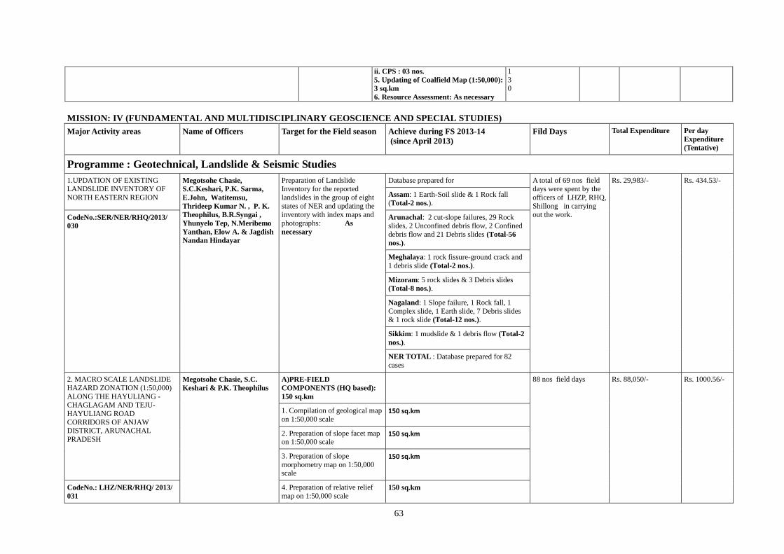
63
ii. CPS : 03 nos.
5. Updating of Coalfield Map (1:50,000):
3 sq.km
6. Resource Assessment: As necessary
1
3 0
MISSION: IV (FUNDAMENTAL AND MULTIDISCIPLINARY GEOSCIENCE AND SPECIAL STUDIES)
Major Activity areas Name of Officers Target for the Field season Achieve during FS 2013-14
(since April 2013)
Fild Days Total Expenditure Per day
Expenditure
(Tentative)
Programme : Geotechnical, Landslide & Seismic Studies
1.UPDATION OF EXISTING LANDSLIDE INVENTORY OF
NORTH EASTERN REGION
Megotsohe Chasie,
S.C.Keshari, P.K. Sarma,
E.John, Watitemsu,
Thrideep Kumar N. , P. K.
Theophilus, B.R.Syngai ,
Yhunyelo Tep, N.Meribemo
Yanthan, Elow A. & Jagdish
Nandan Hindayar
Preparation of Landslide Inventory for the reported
landslides in the group of eight
states of NER and updating the inventory with index maps and
photographs: As
necessary
Database prepared for A total of 69 nos field days were spent by the
officers of LHZP, RHQ,
Shillong in carrying out the work.
Rs. 29,983/- Rs. 434.53/-
Assam: 1 Earth-Soil slide & 1 Rock fall
(Total-2 nos.).
CodeNo.:SER/NER/RHQ/2013/
030 Arunachal: 2 cut-slope failures, 29 Rock slides, 2 Unconfined debris flow, 2 Confined
debris flow and 21 Debris slides (Total-56
nos.).
Meghalaya: 1 rock fissure-ground crack and
1 debris slide (Total-2 nos.).
Mizoram: 5 rock slides & 3 Debris slides (Total-8 nos.).
Nagaland: 1 Slope failure, 1 Rock fall, 1
Complex slide, 1 Earth slide, 7 Debris slides & 1 rock slide (Total-12 nos.).
Sikkim: 1 mudslide & 1 debris flow (Total-2
nos.).
NER TOTAL : Database prepared for 82
cases
2. MACRO SCALE LANDSLIDE
HAZARD ZONATION (1:50,000)
ALONG THE HAYULIANG -CHAGLAGAM AND TEJU-
HAYULIANG ROAD
CORRIDORS OF ANJAW DISTRICT, ARUNACHAL
PRADESH
Megotsohe Chasie, S.C.
Keshari & P.K. Theophilus A)PRE-FIELD
COMPONENTS (HQ based):
150 sq.km
88 nos field days
Rs. 88,050/- Rs. 1000.56/-
1. Compilation of geological map
on 1:50,000 scale 150 sq.km
2. Preparation of slope facet map on 1:50,000 scale
150 sq.km
3. Preparation of slope
morphometry map on 1:50,000 scale
150 sq.km
CodeNo.: LHZ/NER/RHQ/ 2013/
031 4. Preparation of relative relief
map on 1:50,000 scale
150 sq.km

64
5. Study of satellite imageries and
preparation of lineament map on 1:50,000 scale
150 sq.km
B) FIELD COMPONENTS:
150 sq.km
150 sq.km
Collection of relevant field
attributes for preparation of
landslide hazard zonation on 1:50,000 scale following GSI
Guidelines (2005) pertaining to
the various themes, viz. Slope morphometry, Relative relief,
Lithology, Structure, Landuse,
Landcover, Landslide incidences, Slope erosion, Hydro-geological
condition and Rainfall (Average
Annual Rainfall)
3. DETAILED (1:1000) SITE
SPECIFIC GEOLOGICAL
STUDIES OF THE LANDSLIDES NEAR TAWANG MONASTERY,
TAWANG DISTRICT,
ARUNACHAL PRADESH
Megotsohe Chasie , P.K.
Theophilus & 1G (P/T) from
EG Division
1.DM on 1:1000 scale* ( contour
map on required scale to be
provided by PWD Dept, Government of Arunachal): 0. 50
sq.km
0.50 sq. km.
74 nos field days Rs.60,512/- Rs.812.86/-
2.Geological profile ( along and across the slope): As necessary
4-along and 1-across Profile sections taken.
Code No.:LHZ/NER/RHQ/ 2013/
032 3.Geological profile ( along and
across the slope): As necessary1.
Collection of undisturbed soil
sample and determination of
physical parameters [size
analysis, moisture content ,
cohesion(c) and angle of
internal friction(f), etc ]: As
necessary
4 undisturbed soil samples and 4 disturbed
soil samples collected and the samples submitted to Geotechnical Lab, ER, Kolkata.
4.Collection of rainfall data ( pre
and post monsoon): As necessary
Collected from the Rural Works Dept.,
Tawang.
5. Geophysical survey*:
Electrical and resistivity survey
to be taken up by Arunachal Government:2 line km
6.Drilling* ( to be taken up by Arunachal Government): 8 bore
holes down to bed rock/
competent foundation
Identified nine suitable borehole locations
7. Logging of drill cores from

65
Boreholes: As necessary
8. Stability analysis: As
necessary
To be carried out after obtaining the required inputs
4. DETAILED STUDY OF THE
13TH MILE LANDSLIDE ON GANGTOK-NATHULA ROAD,
EAST DISTRICT, SIKKIM
Megotsohe Chasie , P.K.
Theophilus , 1G (P/T) from
EG Division, Jagadish
Nandan Hindayar (P/T) & P.
N. Dasarwar (P/T)
1. Delineation of slide-scars
within the distressed zone: As
necessary
1) 32 slide scars 111 nos field days by
officers and 8 days by the Supervisory officer
Wages : 46,206/-
POL : 30,005/- OC: 33,881/-
Rs.991.81 /-
Code No.: LHZ/NER/SSK/ 2012/
043
2. DM on 1:1000 scale of the
13th
Mile Slide : 0.25 sq.km
2) 0.25 sq km
3. Undisturbed soil samples: 3
nos
3) 8 nos. Total : 1,10,092/-
4. Identification of appropriate
locations for erection of Survey
Pillars for future monitoring:
Monitoring of the Survey
pillars
4) 8 locations have been identified for erection
of survey pillars
5. Erection of Survey Pillars and monitoring of Survey Pillars: 6
nos
5)16 nos pillars erected and monitored
6. Rainfall data: As necessary 6) Rainfall Data from Jan 13 to Feb 14
7. Profile (3 nos.): As necessary 7) 03 nos. Profile sections
5. MACRO SCALE LANDSLIDE
HAZARD ZONATION ON 1:50,000 SCALE ALONG
RANGPO-SINGTAM-DIKCHU-
CHUNGTHANG ROAD CORRIDOR, SIKKIM
Jagadish Nandan Hindayar
(P/T), Thrideep Kumar N. &
Murali Mohan (P/T)
A. Field components: 100
sq.km
1.Preliminary landslide hazard
zonation on 1:50,000 scale
through collection of field data for preparation of different
thematic maps, viz;
100 sq km mapping carried out in the study
area.
157 nos field days by
officers and 9 days by the Supervisory officer
Wages : 40,344/-
POL : 28,965/- OC: 25,286/-
Rs.602.51 /-
CodeNo.:LHZ/ NER/ SSK/ 2013/
033 a. Slope morphometry
map.
b. Relative relief map.
c. Lithological map.
d. Structural map. Total : 94.595/-
e. Landuse map.
f. Landcover map.
g. Landslide incidences
map.
h. Hydro-geological map.
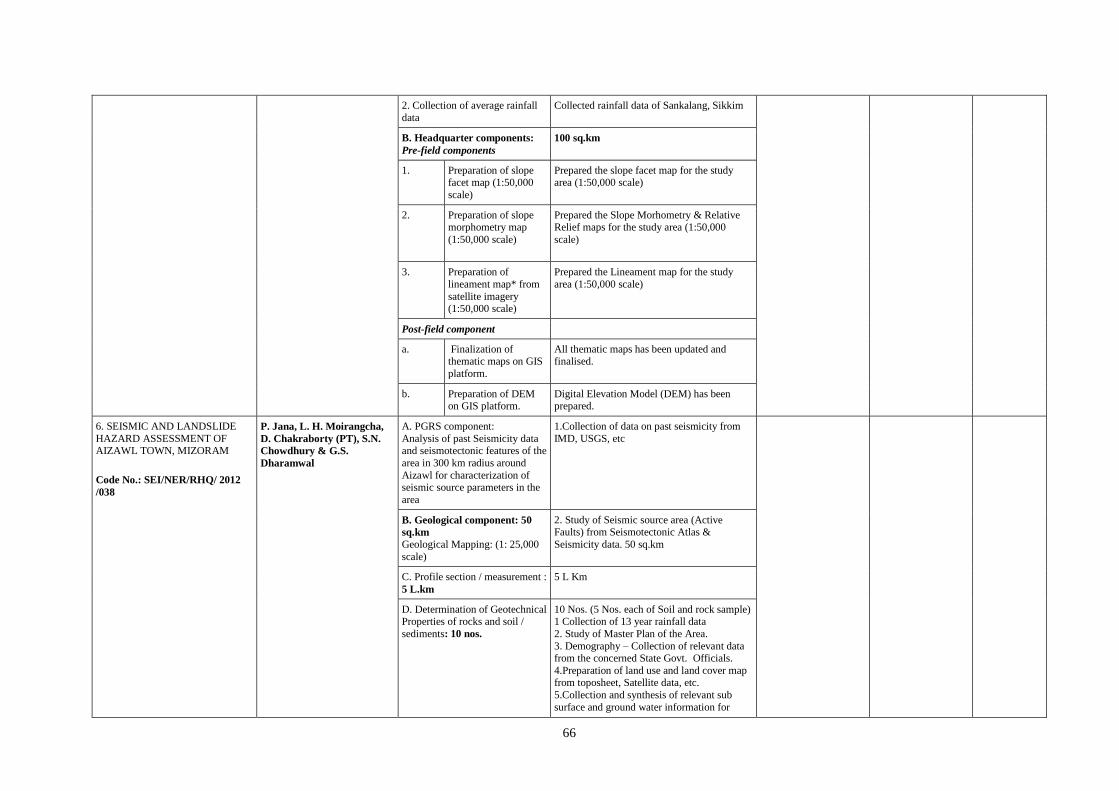
66
2. Collection of average rainfall
data
Collected rainfall data of Sankalang, Sikkim
B. Headquarter components:
Pre-field components
100 sq.km
1. Preparation of slope facet map (1:50,000
scale)
Prepared the slope facet map for the study area (1:50,000 scale)
2. Preparation of slope morphometry map
(1:50,000 scale)
Prepared the Slope Morhometry & Relative Relief maps for the study area (1:50,000
scale)
3. Preparation of
lineament map* from
satellite imagery (1:50,000 scale)
Prepared the Lineament map for the study
area (1:50,000 scale)
Post-field component
a. Finalization of thematic maps on GIS
platform.
All thematic maps has been updated and finalised.
b. Preparation of DEM on GIS platform.
Digital Elevation Model (DEM) has been prepared.
6. SEISMIC AND LANDSLIDE
HAZARD ASSESSMENT OF AIZAWL TOWN, MIZORAM Code No.: SEI/NER/RHQ/ 2012
/038
P. Jana, L. H. Moirangcha,
D. Chakraborty (PT), S.N.
Chowdhury & G.S.
Dharamwal
A. PGRS component:
Analysis of past Seismicity data and seismotectonic features of the
area in 300 km radius around
Aizawl for characterization of seismic source parameters in the
area
1.Collection of data on past seismicity from
IMD, USGS, etc
B. Geological component: 50
sq.km Geological Mapping: (1: 25,000
scale)
2. Study of Seismic source area (Active Faults) from Seismotectonic Atlas &
Seismicity data. 50 sq.km
C. Profile section / measurement :
5 L.km
5 L Km
D. Determination of Geotechnical Properties of rocks and soil /
sediments: 10 nos.
10 Nos. (5 Nos. each of Soil and rock sample) 1 Collection of 13 year rainfall data
2. Study of Master Plan of the Area.
3. Demography – Collection of relevant data from the concerned State Govt. Officials.
4.Preparation of land use and land cover map from toposheet, Satellite data, etc.
5.Collection and synthesis of relevant sub
surface and ground water information for

67
certain locations of Aizawl master plan area.
E. Studies of Ground Water, Demography, Landuse map: 50
sq.km
50 sq.km
F. Landslide Hazard Assessment (1: 50,000 / 25,000 scale): 50
sq.km
G. Geophysical Study: i) Site response study by
measuring ambient noise using
short period Seismograph at every 1 - 2 km. station spacing:
50 sq.km
ii) Resistivity sounding at selected sites : 50 sq.km
50 sq km
7.SEISMIC AND LANDSLIDE HAZARD ASSESSMENT OF KOHIMA CITY, NAGALAND
V Shivgotra & Imtikumzuk, P.K. Chakraborty (GP) & 1 (GP)
A. Analysis of past seismicity data: Analysis of past Seismicity data and seismo-tectonic features of the area in 300 km radius around Kohima for characterization of seismic source parameters in the area.
Study and analysis of seismicity data covering 300Km radius around Kohima.
152 Days Rs. 1,11,564/- Rs.733.97 /-
Code No.: SEI/NER/RHQ/ 2013/034 B. PGRS component:
Preparation of Morpho-
tectonic map from Study
Satellite imageries and Aerial
photographs
PGRS of 250 sq.km area and
preparation of morphotectonic
map
250 sq. km
C. Geological component: 50
sq.km Geological Mapping: (1: 25,000 scale)
50 sq. km
D. Profile section /
measurement : 5 L.km
3.0 LKm
E. Determination of
Geotechnical Properties of
rocks and soil / sediments: 10
nos.
Six rock samples and 4 soil samples for
analysis of different geotechnical parameters.
F. Studies of Ground Water,
Demography, Landuse map: 50
Study of Master Plan area Map with landuse
pattern and Rainfall data of Kohima town
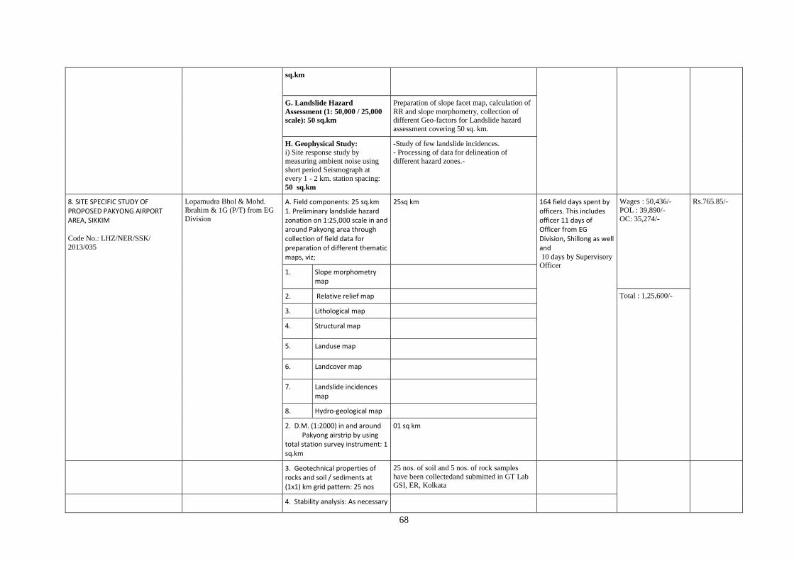
68
sq.km
G. Landslide Hazard
Assessment (1: 50,000 / 25,000
scale): 50 sq.km
Preparation of slope facet map, calculation of
RR and slope morphometry, collection of different Geo-factors for Landslide hazard
assessment covering 50 sq. km.
H. Geophysical Study: i) Site response study by
measuring ambient noise using
short period Seismograph at
every 1 - 2 km. station spacing:
50 sq.km
-Study of few landslide incidences.
- Processing of data for delineation of
different hazard zones.-
8. SITE SPECIFIC STUDY OF PROPOSED PAKYONG AIRPORT AREA, SIKKIM Code No.: LHZ/NER/SSK/
2013/035
Lopamudra Bhol & Mohd.
Ibrahim & 1G (P/T) from EG
Division
A. Field components: 25 sq.km 1. Preliminary landslide hazard zonation on 1:25,000 scale in and around Pakyong area through collection of field data for preparation of different thematic maps, viz;
25sq km
164 field days spent by officers. This includes officer 11 days of Officer from EG Division, Shillong as well and 10 days by Supervisory Officer
Wages : 50,436/-
POL : 39,890/-
OC: 35,274/-
Rs.765.85/-
1. Slope morphometry map
2. Relative relief map Total : 1,25,600/-
3. Lithological map
4. Structural map
5. Landuse map
6. Landcover map
7. Landslide incidences map
8. Hydro-geological map
2. D.M. (1:2000) in and around Pakyong airstrip by using total station survey instrument: 1 sq.km
01 sq km
3. Geotechnical properties of rocks and soil / sediments at (1x1) km grid pattern: 25 nos
25 nos. of soil and 5 nos. of rock samples
have been collectedand submitted in GT Lab GSI, ER, Kolkata
4. Stability analysis: As necessary
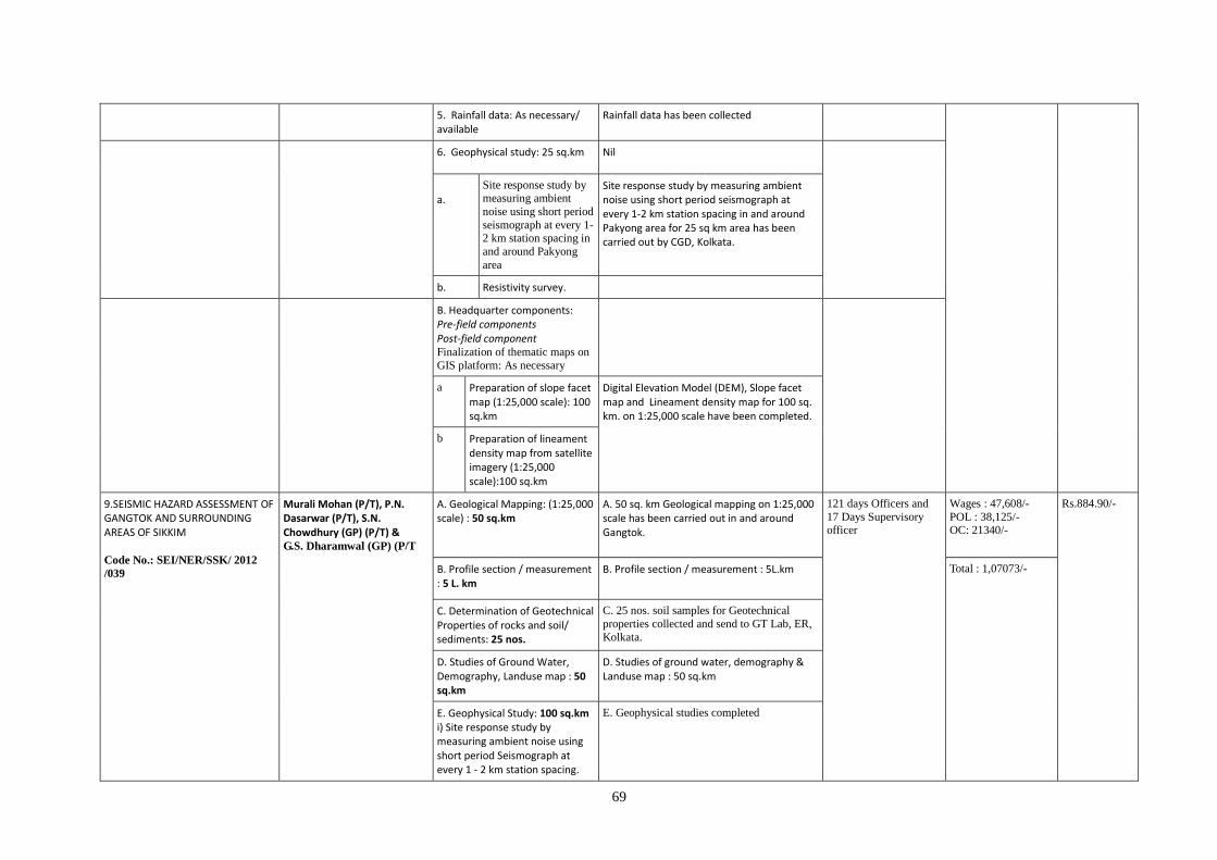
69
5. Rainfall data: As necessary/ available
Rainfall data has been collected
6. Geophysical study: 25 sq.km Nil
a.
Site response study by measuring ambient
noise using short period
seismograph at every 1-2 km station spacing in
and around Pakyong
area
Site response study by measuring ambient noise using short period seismograph at every 1-2 km station spacing in and around Pakyong area for 25 sq km area has been carried out by CGD, Kolkata.
b. Resistivity survey.
B. Headquarter components: Pre-field components Post-field component Finalization of thematic maps on
GIS platform: As necessary
a Preparation of slope facet map (1:25,000 scale): 100 sq.km
Digital Elevation Model (DEM), Slope facet map and Lineament density map for 100 sq. km. on 1:25,000 scale have been completed.
b Preparation of lineament density map from satellite imagery (1:25,000 scale):100 sq.km
9.SEISMIC HAZARD ASSESSMENT OF GANGTOK AND SURROUNDING AREAS OF SIKKIM Code No.: SEI/NER/SSK/ 2012
/039
Murali Mohan (P/T), P.N. Dasarwar (P/T), S.N. Chowdhury (GP) (P/T) & G.S. Dharamwal (GP) (P/T
A. Geological Mapping: (1:25,000 scale) : 50 sq.km
A. 50 sq. km Geological mapping on 1:25,000 scale has been carried out in and around Gangtok.
121 days Officers and
17 Days Supervisory officer
Wages : 47,608/-
POL : 38,125/- OC: 21340/-
Rs.884.90/-
B. Profile section / measurement : 5 L. km
B. Profile section / measurement : 5L.km Total : 1,07073/-
C. Determination of Geotechnical Properties of rocks and soil/ sediments: 25 nos.
C. 25 nos. soil samples for Geotechnical
properties collected and send to GT Lab, ER,
Kolkata.
D. Studies of Ground Water, Demography, Landuse map : 50 sq.km
D. Studies of ground water, demography & Landuse map : 50 sq.km
E. Geophysical Study: 100 sq.km i) Site response study by measuring ambient noise using short period Seismograph at every 1 - 2 km station spacing.
E. Geophysical studies completed
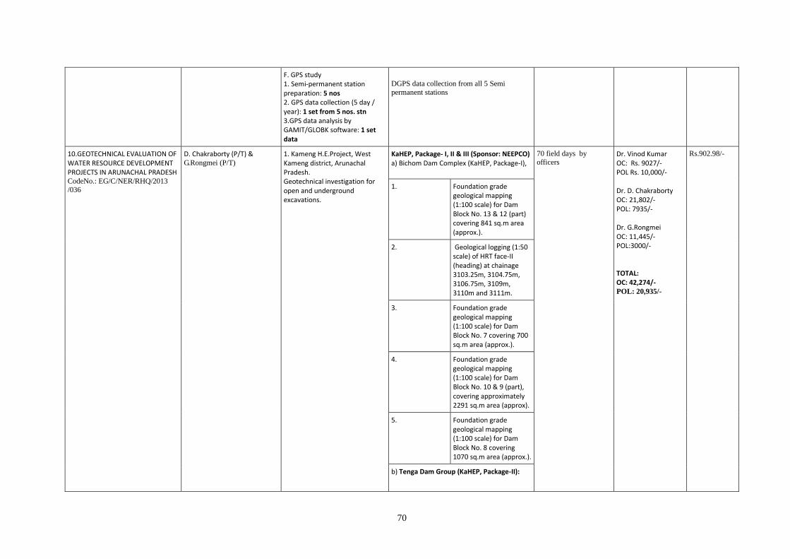
70
F. GPS study 1. Semi-permanent station preparation: 5 nos 2. GPS data collection (5 day / year): 1 set from 5 nos. stn 3.GPS data analysis by GAMIT/GLOBK software: 1 set data
DGPS data collection from all 5 Semi
permanent stations
10.GEOTECHNICAL EVALUATION OF WATER RESOURCE DEVELOPMENT PROJECTS IN ARUNACHAL PRADESH CodeNo.: EG/C/NER/RHQ/2013
/036
D. Chakraborty (P/T) & G.Rongmei (P/T)
1. Kameng H.E.Project, West Kameng district, Arunachal Pradesh. Geotechnical investigation for open and underground excavations.
KaHEP, Package- I, II & III (Sponsor: NEEPCO) a) Bichom Dam Complex (KaHEP, Package-I),
70 field days by
officers Dr. Vinod Kumar OC: Rs. 9027/- POL Rs. 10,000/- Dr. D. Chakraborty OC: 21,802/- POL: 7935/- Dr. G.Rongmei OC: 11,445/- POL:3000/- TOTAL: OC: 42,274/- POL: 20,935/-
Rs.902.98/-
1. Foundation grade geological mapping (1:100 scale) for Dam Block No. 13 & 12 (part) covering 841 sq.m area (approx.).
2. Geological logging (1:50 scale) of HRT face-II (heading) at chainage 3103.25m, 3104.75m, 3106.75m, 3109m, 3110m and 3111m.
3. Foundation grade geological mapping (1:100 scale) for Dam Block No. 7 covering 700 sq.m area (approx.).
4. Foundation grade geological mapping (1:100 scale) for Dam Block No. 10 & 9 (part), covering approximately 2291 sq.m area (approx).
5. Foundation grade geological mapping (1:100 scale) for Dam Block No. 8 covering 1070 sq.m area (approx.).
b) Tenga Dam Group (KaHEP, Package-II):
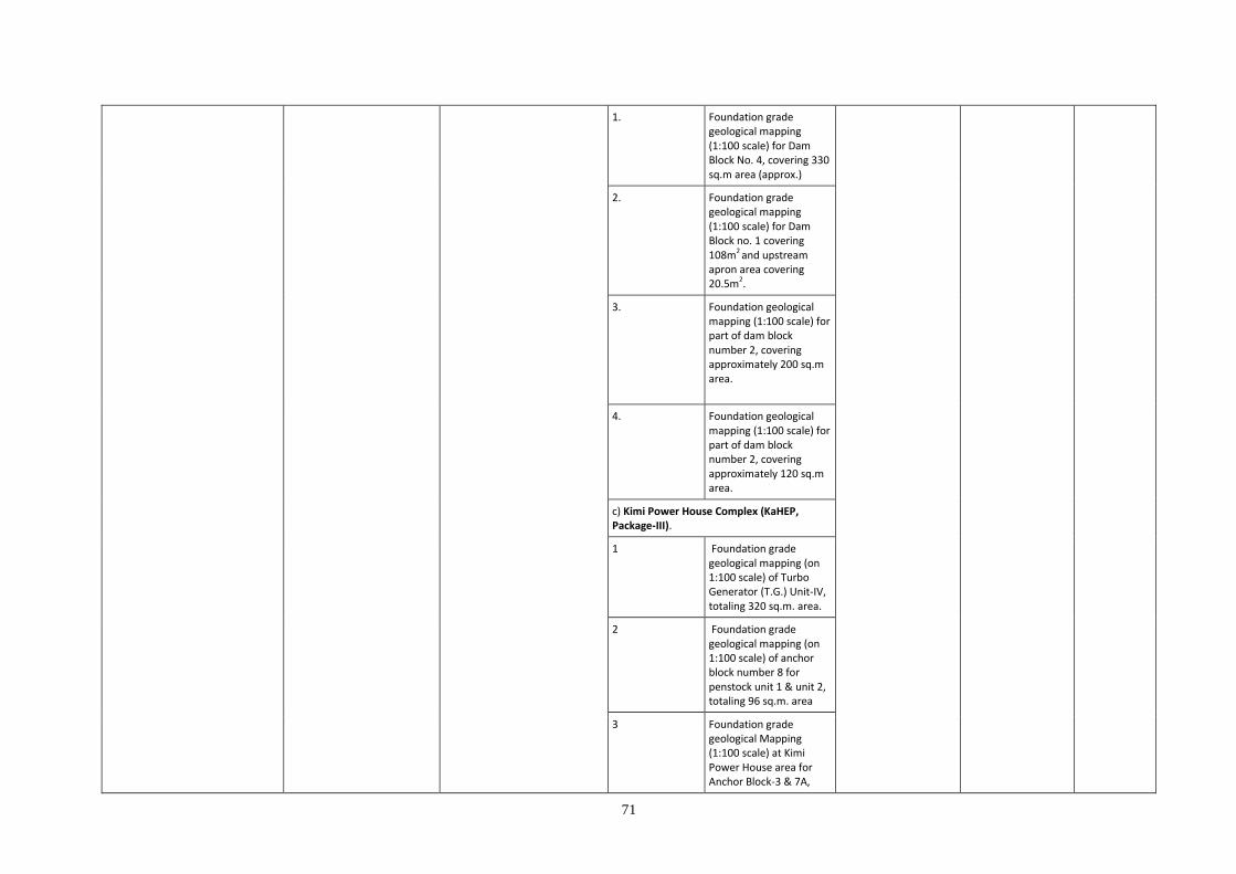
71
1. Foundation grade geological mapping (1:100 scale) for Dam Block No. 4, covering 330 sq.m area (approx.)
2. Foundation grade geological mapping (1:100 scale) for Dam Block no. 1 covering 108m2 and upstream apron area covering 20.5m2.
3. Foundation geological mapping (1:100 scale) for part of dam block number 2, covering approximately 200 sq.m area.
4. Foundation geological mapping (1:100 scale) for part of dam block number 2, covering approximately 120 sq.m area.
c) Kimi Power House Complex (KaHEP, Package-III).
1 Foundation grade geological mapping (on 1:100 scale) of Turbo Generator (T.G.) Unit-IV, totaling 320 sq.m. area.
2 Foundation grade geological mapping (on 1:100 scale) of anchor block number 8 for penstock unit 1 & unit 2, totaling 96 sq.m. area
3 Foundation grade geological Mapping (1:100 scale) at Kimi Power House area for Anchor Block-3 & 7A,

72
covering 180sq.m area.
4 Foundation grade geological Mapping (1:100 scale) at Kimi Power House area for Anchor Block-7B (Unit 1), covering 18sq.m area
Pare H E Project (Addl. Item), Sponsor: NEEPCO
1. Assessment of the quantum of geotechnical work to be generated at project site.
2. Drill core logging of boreholes DH-3 and DH-4 with cumulative length of 101.8m each 50.3m and 51.5m respectively
3. Drill core logging of boreholes DAH-5 for 67.50m depth.
4. Foundation geological mapping of Dam Block No. 4 covering 200 sqm on 1:100 scale.
Noa Dehing M P Project (Addl. Item), Sponsor: Brahmaputra Board
1. Reconnoitary traverse had been carried out towards left bank and right bank of proposed dam site along with drill core logging of 7 bore holes (at dam site area) totaling 313.50m.
2. Carried out drill core logging of 3 bore hole no.14, 16 &23 for a cumulative length of
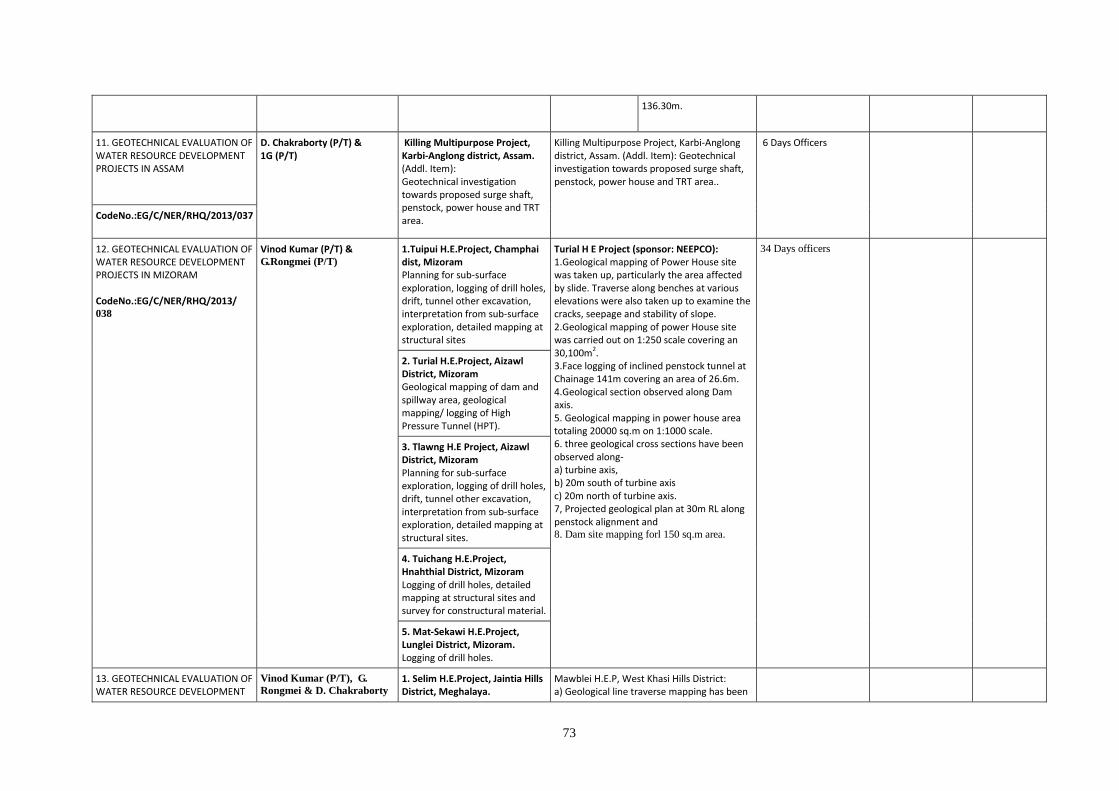
73
136.30m.
11. GEOTECHNICAL EVALUATION OF WATER RESOURCE DEVELOPMENT PROJECTS IN ASSAM
D. Chakraborty (P/T) & 1G (P/T)
Killing Multipurpose Project, Karbi-Anglong district, Assam. (Addl. Item): Geotechnical investigation towards proposed surge shaft, penstock, power house and TRT area.
Killing Multipurpose Project, Karbi-Anglong district, Assam. (Addl. Item): Geotechnical investigation towards proposed surge shaft, penstock, power house and TRT area..
6 Days Officers
CodeNo.:EG/C/NER/RHQ/2013/037
12. GEOTECHNICAL EVALUATION OF WATER RESOURCE DEVELOPMENT PROJECTS IN MIZORAM CodeNo.:EG/C/NER/RHQ/2013/ 038
Vinod Kumar (P/T) & G.Rongmei (P/T)
1.Tuipui H.E.Project, Champhai dist, Mizoram Planning for sub-surface exploration, logging of drill holes, drift, tunnel other excavation, interpretation from sub-surface exploration, detailed mapping at structural sites
Turial H E Project (sponsor: NEEPCO): 1.Geological mapping of Power House site was taken up, particularly the area affected by slide. Traverse along benches at various elevations were also taken up to examine the cracks, seepage and stability of slope. 2.Geological mapping of power House site was carried out on 1:250 scale covering an 30,100m2. 3.Face logging of inclined penstock tunnel at Chainage 141m covering an area of 26.6m. 4.Geological section observed along Dam axis. 5. Geological mapping in power house area totaling 20000 sq.m on 1:1000 scale. 6. three geological cross sections have been observed along- a) turbine axis, b) 20m south of turbine axis c) 20m north of turbine axis. 7, Projected geological plan at 30m RL along penstock alignment and 8. Dam site mapping forl 150 sq.m area.
34 Days officers
2. Turial H.E.Project, Aizawl District, Mizoram Geological mapping of dam and spillway area, geological mapping/ logging of High Pressure Tunnel (HPT).
3. Tlawng H.E Project, Aizawl District, Mizoram Planning for sub-surface exploration, logging of drill holes, drift, tunnel other excavation, interpretation from sub-surface exploration, detailed mapping at structural sites.
4. Tuichang H.E.Project, Hnahthial District, Mizoram Logging of drill holes, detailed mapping at structural sites and survey for constructural material.
5. Mat-Sekawi H.E.Project, Lunglei District, Mizoram. Logging of drill holes.
13. GEOTECHNICAL EVALUATION OF WATER RESOURCE DEVELOPMENT
Vinod Kumar (P/T), G.
Rongmei & D. Chakraborty
1. Selim H.E.Project, Jaintia Hills District, Meghalaya.
Mawblei H.E.P, West Khasi Hills District: a) Geological line traverse mapping has been
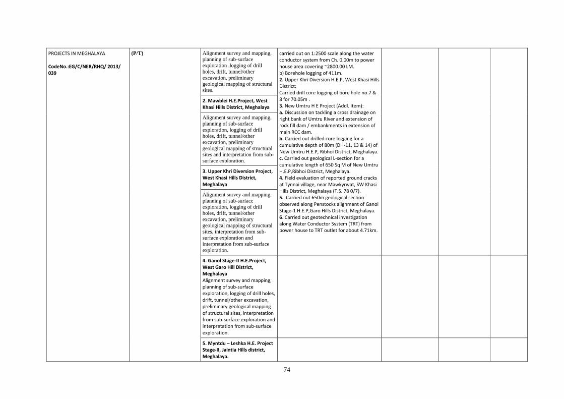
74
PROJECTS IN MEGHALAYA CodeNo.:EG/C/NER/RHQ/ 2013/ 039
(P/T) Alignment survey and mapping,
planning of sub-surface exploration ,logging of drill
holes, drift, tunnel/other
excavation, preliminary geological mapping of structural
sites.
carried out on 1:2500 scale along the water conductor system from Ch. 0.00m to power house area covering ~2800.00 LM. b) Borehole logging of 411m. 2. Upper Khri Diversion H.E.P, West Khasi Hills District: Carried drill core logging of bore hole no.7 & 8 for 70.05m . 3. New Umtru H E Project (Addl. Item): a. Discussion on tackling a cross drainage on right bank of Umtru River and extension of rock fill dam / embankments in extension of main RCC dam. b. Carried out drilled core logging for a cumulative depth of 80m (DH-11, 13 & 14) of New Umtru H.E.P, Ribhoi District, Meghalaya. c. Carried out geological L-section for a cumulative length of 650 Sq M of New Umtru H.E.P,Ribhoi District, Meghalaya. 4. Field evaluation of reported ground cracks at Tynnai village, near Mawkyrwat, SW Khasi Hills District, Meghalaya (T.S. 78 0/7). 5. Carried out 650m geological section observed along Penstocks alignment of Ganol Stage-1 H.E.P,Garo Hills District, Meghalaya. 6. Carried out geotechnical investigation along Water Conductor System (TRT) from power house to TRT outlet for about 4.71km.
2. Mawblei H.E.Project, West Khasi Hills District, Meghalaya
Alignment survey and mapping,
planning of sub-surface
exploration, logging of drill holes, drift, tunnel/other
excavation, preliminary
geological mapping of structural sites and interpretation from sub-
surface exploration.
3. Upper Khri Diversion Project, West Khasi Hills District, Meghalaya
Alignment survey and mapping,
planning of sub-surface exploration, logging of drill
holes, drift, tunnel/other
excavation, preliminary geological mapping of structural
sites, interpretation from sub-
surface exploration and interpretation from sub-surface
exploration.
4. Ganol Stage-II H.E.Project, West Garo Hill District, Meghalaya Alignment survey and mapping, planning of sub-surface exploration, logging of drill holes, drift, tunnel/other excavation, preliminary geological mapping of structural sites, interpretation from sub-surface exploration and interpretation from sub-surface exploration.
5. Myntdu – Leshka H.E. Project Stage-II, Jaintia Hills district, Meghalaya.
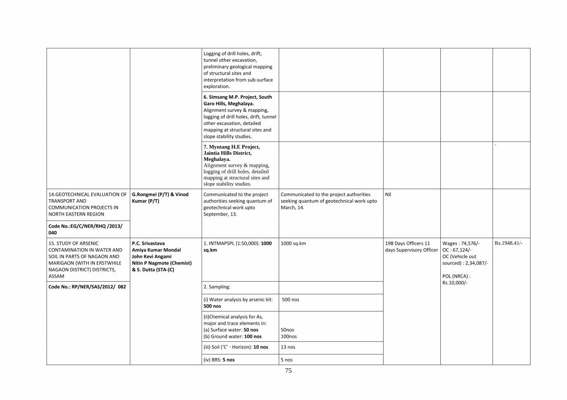
75
Logging of drill holes, drift, tunnel other excavation, preliminary geological mapping of structural sites and interpretation from sub-surface exploration.
6. Simsang M.P. Project, South Garo Hills, Meghalaya. Alignment survey & mapping, logging of drill holes, drift, tunnel other excavation, detailed mapping at structural sites and slope stability studies.
7. Myntang H.E Project,
Jaintia Hills District,
Meghalaya. Alignment survey & mapping,
logging of drill holes, detailed mapping at structural sites and
slope stability studies.
`
14.GEOTECHNICAL EVALUATION OF TRANSPORT AND COMMUNICATION PROJECTS IN NORTH EASTERN REGION
G.Rongmei (P/T) & Vinod Kumar (P/T)
Communicated to the project authorities seeking quantum of geotechnical work upto September, 13.
Communicated to the project authorities seeking quantum of geotechnical work upto March, 14.
Nil
Code No.:EG/C/NER/RHQ /2013/ 040
15. STUDY OF ARSENIC CONTAMINATION IN WATER AND SOIL IN PARTS OF NAGAON AND MARIGAON (WITH IN ERSTWHILE NAGAON DISTRICT) DISTRICTS, ASSAM
P.C. Srivastava Amiya Kumar Mondal John Kevi Angami Nitin P Nagmote (Chemist) & S. Dutta (STA-(C)
1. INTMAPSPL (1:50,000): 1000 sq.km
1000 sq.km
198 Days Officers 11 days Supervisory Officer
Wages : 74,576/- OC : 67,124/- OC (Vehicle out sourced) : 2,34,087/- POL (NRCA) : Rs.10,000/-
Rs.1948.41/-
Code No.: RP/NER/SAS/2012/ 082 2. Sampling:
(i) Water analysis by arsenic kit: 500 nos
500 nos
(ii)Chemical analysis for As, major and trace elements in: (a) Surface water: 50 nos (b) Ground water: 100 nos
50nos 100nos
(iii) Soil (‘C’ - Horizon): 10 nos 13 nos
(iv) BRS: 5 nos 5 nos
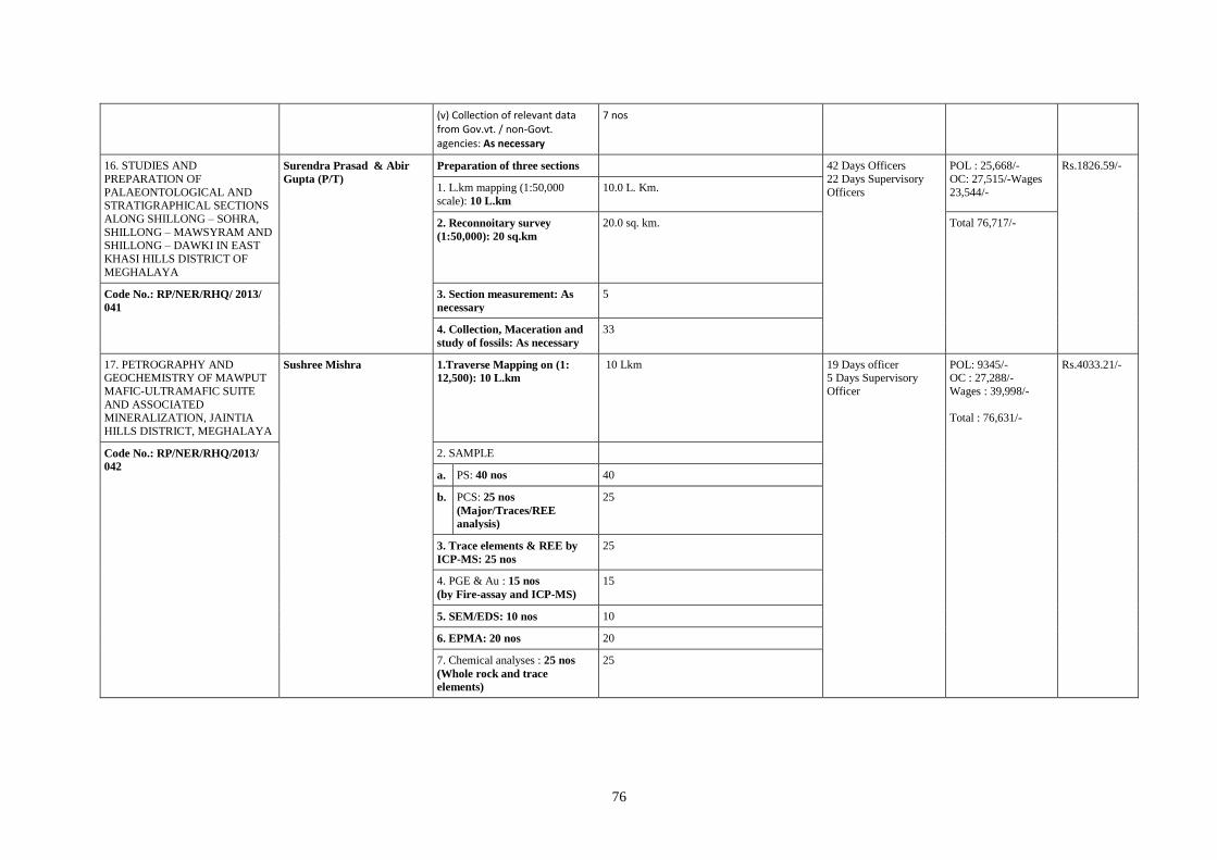
76
(v) Collection of relevant data from Gov.vt. / non-Govt. agencies: As necessary
7 nos
16. STUDIES AND
PREPARATION OF
PALAEONTOLOGICAL AND STRATIGRAPHICAL SECTIONS
ALONG SHILLONG – SOHRA,
SHILLONG – MAWSYRAM AND SHILLONG – DAWKI IN EAST
KHASI HILLS DISTRICT OF
MEGHALAYA
Surendra Prasad & Abir
Gupta (P/T) Preparation of three sections 42 Days Officers
22 Days Supervisory
Officers
POL : 25,668/-
OC: 27,515/-Wages
23,544/-
Rs.1826.59/-
1. L.km mapping (1:50,000
scale): 10 L.km
10.0 L. Km.
2. Reconnoitary survey
(1:50,000): 20 sq.km
20.0 sq. km. Total 76,717/-
Code No.: RP/NER/RHQ/ 2013/
041
3. Section measurement: As
necessary
5
4. Collection, Maceration and
study of fossils: As necessary
33
17. PETROGRAPHY AND GEOCHEMISTRY OF MAWPUT
MAFIC-ULTRAMAFIC SUITE
AND ASSOCIATED MINERALIZATION, JAINTIA
HILLS DISTRICT, MEGHALAYA
Sushree Mishra 1.Traverse Mapping on (1:
12,500): 10 L.km
10 Lkm 19 Days officer 5 Days Supervisory
Officer
POL: 9345/- OC : 27,288/-
Wages : 39,998/-
Total : 76,631/-
Rs.4033.21/-
Code No.: RP/NER/RHQ/2013/
042 2. SAMPLE
a. PS: 40 nos 40
b. PCS: 25 nos
(Major/Traces/REE
analysis)
25
3. Trace elements & REE by
ICP-MS: 25 nos
25
4. PGE & Au : 15 nos
(by Fire-assay and ICP-MS)
15
5. SEM/EDS: 10 nos 10
6. EPMA: 20 nos 20
7. Chemical analyses : 25 nos
(Whole rock and trace
elements)
25

77
ANNEXURE - 5
PROGRESS & PENDENCY REPORT OF CHEMICAL ANALYSES OF NGCM SAMPLES (upto 31.03.2014)
Sl
No Item Particular
1 Machine
Capacity in the
Region (nos. of
samples) per
month
Pkg. ‘A’
Pkg. ‘B’ Pkg.
‘C’
Pkg. ‘D’ Pkg. ‘E’ Pkg. ‘F’ Pkg.
‘G’
Pkg. ‘H’ Pkg.
‘I’
400/02 Chemists 200/02
Chemists
150/02
Chemists
125/01
Chemist
400/1
2. Capacity to analyse
in the Region (nos.
of samples) per
month
Pkg. ‘A’
Pkg. ‘B’ Pkg.
‘C’
Pkg. ‘D’ Pkg. ‘E’ Pkg. ‘F’ Pkg.
‘G’
Pkg. ‘H’ Pkg.
‘I’
400/02 Chemist 120/1 250/2 125/1 400/1
3. Total Nos. of
Samples Collected,
and
Pendency up-to
Field
Season 2012 -13
(since
beginning of the
NGCM
program)
Month Jan.
2013
Feb.
2013
Mar.
2013
Apr.
2013
May
2013
June
2013
July
2013
Aug.
2013
Sep.
2013
Oct.
2013
Nov.
2013
Dec.
2013
Jan.
2014
Feb.
2014
Mar
2014
Collected
Submitted
To Lab.
139 190 148 362 13 16 0 0 0 0 0 0 1174
Analyses Reported [up-to the month of ] [up-to Field Season 2012 – 13.]
Pkg. ‘A’ 326 505 560 810 948 1086 1174 0 0 0 0 0 0 0 0 1174
Pkg. ‘B’ 0 0 102 102 246 246 246 639 863 1174 0 0 0 0 0 1174
Pkg. ‘C’ 278 399 479 529 634 830 905 1158 1174 0 0 0 0 0 0 1174
Pkg. ‘D’ 0 183 432 632 881 1015 1137 1162 1174 0 0 0 0 0 0 1174
Pkg. ‘E’ 0 102 218 379 560 723 868 1124 1174 0 0 0 0 0 0 1174
Pkg. ‘F’ 0 0 0 349 349 349 349 730 730 1174 0 0 0 0 0 1174
Pkg. ‘G’ 244 349 475 758 758 758 1135 1135 1174 0 0 0 0 0 0 1174
Pkg. ‘H’ 0 0 82 82 228 480 530 738 738 1174 0 0 0 0 0 1174
Pkg. ‘I’ 0 0 0 0 0 0 0 0 0 0 0 0 0 0 0 0
Pendency [up-to the end of the month ] [up-to end of Field Season 2012 -13]
Pkg. ‘A’ 119 130 223 335 210 88 0 0 0 0 0 0 0 0 0 0
Pkg. ‘B’ 445 635 681 1043 912 928 928 535 311 0 0 0 0 0 0 0
Pkg. ‘C’ 167 236 304 616 524 344 269 16 0 0 0 0 0 0 0 0
Pkg. ‘D’ 363 452 351 513 277 159 37 12 0 0 0 0 0 0 0 0
Pkg. ‘E’ 445 533 565 766 598 451 306 50 0 0 0 0 0 0 0 0
Pkg. ‘F’ 445 635 783 796 809 825 825 444 444 0 0 0 0 0 0 0
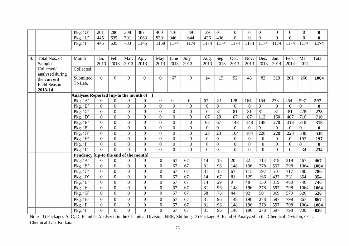
78
Pkg. ‘G’ 201 286 308 387 400 416 39 39 0 0 0 0 0 0 0 0
Pkg. ‘H’ 445 635 701 1063 930 946 644 436 436 0 0 0 0 0 0 0
Pkg. ‘I’ 445 635 783 1145 1158 1174 1174 1174 1174 1174 1174 1174 1174 1174 1174 1174
4. Total Nos. of
Samples
Collected/
analysed during
the current
Field Season
2013-14
Month Jan.
2013
Feb.
2013
Mar.
2013
Apr.
2013
May
2013
June
2013
July
2013
Aug.
2013
Sep.
2013
Oct.
2013
Nov.
2013
Dec.
2013
Jan.
2014
Feb.
2014
Mar
2014
Total
Collected
Submitted
To Lab.
0 0 0 0 0 67 0 14 15 52 48 82 319 201 266 1064
Analyses Reported [up-to the month of ]
Pkg. ‘A’ 0 0 0 0 0 0 0 67 81 128 164 164 278 454 597 597
Pkg. ‘B’ 0 0 0 0 0 0 0 0 0 0 0 0 0 0 0 0
Pkg. ‘C’ 0 0 0 0 0 0 0 0 81 81 81 81 81 81 278 278
Pkg. ‘D’ 0 0 0 0 0 0 0 67 29 67 67 112 160 467 710 710
Pkg. ‘E’ 0 0 0 0 0 0 0 67 67 148 148 148 278 318 318 318
Pkg. ‘F’ 0 0 0 0 0 0 0 0 0 0 0 0 0 0 0 0
Pkg. ‘G’ 0 0 0 0 0 0 0 23 23 104 104 228 228 228 538 538
Pkg. ‘H’ 0 0 0 0 0 0 0 0 0 0 0 0 0 0 197 197
Pkg. ‘I’ 0 0 0 0 0 0 0 0 0 0 0 0 0 0 0 0
Pkg. ‘J’ 0 0 0 0 0 0 0 0 0 0 0 0 0 0 234 234
Pendency [up-to the end of the month]
Pkg. ‘A’ 0 0 0 0 0 67 67 14 15 20 32 114 319 319 467 467
Pkg. ‘B’ 0 0 0 0 0 67 67 81 96 148 196 278 597 798 1064 1064
Pkg. ‘C’ 0 0 0 0 0 67 67 81 15 67 115 197 516 717 786 786
Pkg. ‘D’ 0 0 0 0 0 67 67 14 67 81 129 166 437 331 354 354
Pkg. ‘E’ 0 0 0 0 0 67 67 14 29 0 48 130 319 480 746 746
Pkg. ‘F’ 0 0 0 0 0 67 67 81 96 148 196 278 597 798 1064 1064
Pkg. ‘G’ 0 0 0 0 0 67 67 58 73 44 92 50 369 570 526 526
Pkg. ‘H’ 0 0 0 0 0 67 67 81 96 148 196 278 597 798 867 867
Pkg. ‘I’ 0 0 0 0 0 67 67 81 96 148 196 278 597 798 1064 1064
Pkg. ‘J’ 0 0 0 0 0 67 67 81 96 148 196 278 597 798 830 830
Note 1) Packages A, C, D, E and G-Analyzed in the Chemical Division, NER, Shillong. 2) Package B, F and H Analyzed in the Chemical Division, CCL
Chemical Lab. Kolkata.
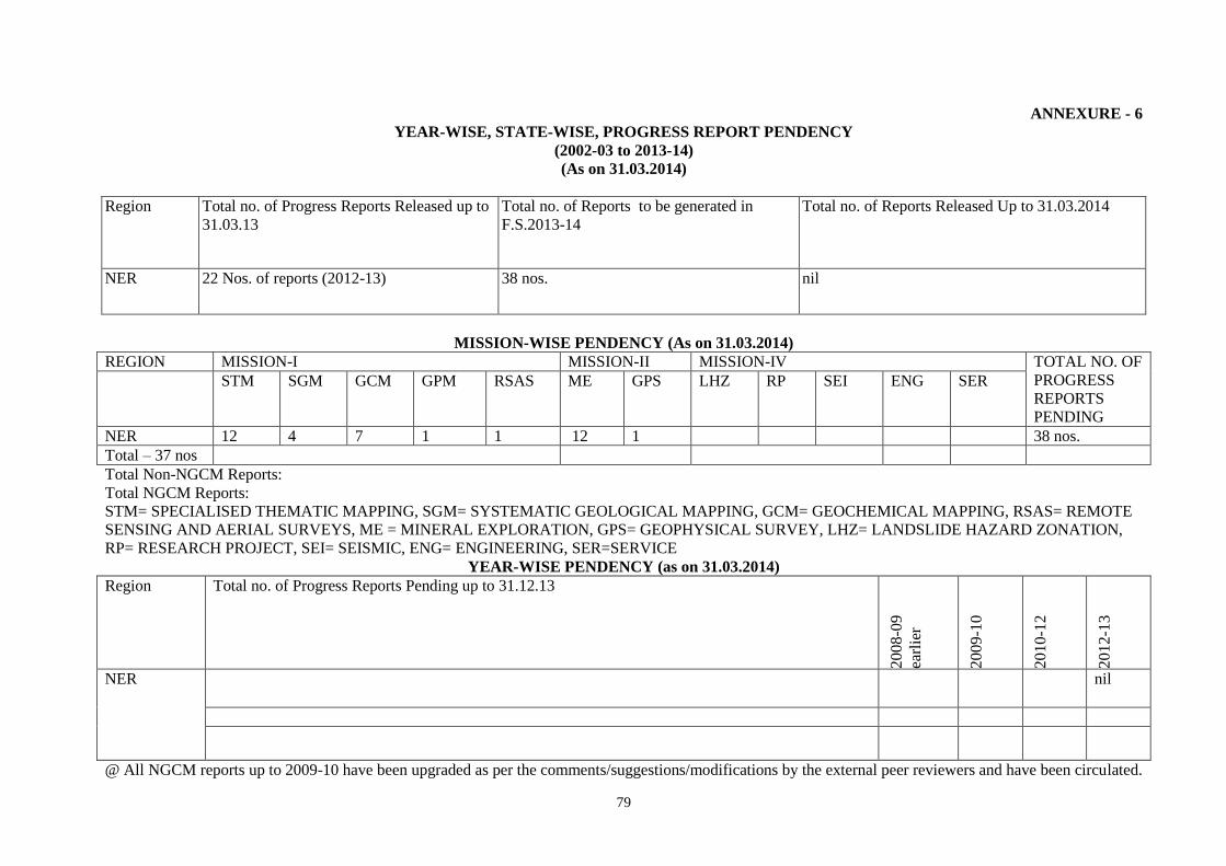
79
ANNEXURE - 6
YEAR-WISE, STATE-WISE, PROGRESS REPORT PENDENCY
(2002-03 to 2013-14)
(As on 31.03.2014)
Region Total no. of Progress Reports Released up to
31.03.13
Total no. of Reports to be generated in
F.S.2013-14
Total no. of Reports Released Up to 31.03.2014
NER 22 Nos. of reports (2012-13) 38 nos. nil
MISSION-WISE PENDENCY (As on 31.03.2014)
REGION MISSION-I MISSION-II MISSION-IV TOTAL NO. OF
PROGRESS
REPORTS
PENDING
STM SGM GCM GPM RSAS ME GPS LHZ RP SEI ENG SER
NER 12 4 7 1 1 12 1 38 nos.
Total – 37 nos
Total Non-NGCM Reports:
Total NGCM Reports:
STM= SPECIALISED THEMATIC MAPPING, SGM= SYSTEMATIC GEOLOGICAL MAPPING, GCM= GEOCHEMICAL MAPPING, RSAS= REMOTE
SENSING AND AERIAL SURVEYS, ME = MINERAL EXPLORATION, GPS= GEOPHYSICAL SURVEY, LHZ= LANDSLIDE HAZARD ZONATION,
RP= RESEARCH PROJECT, SEI= SEISMIC, ENG= ENGINEERING, SER=SERVICE
YEAR-WISE PENDENCY (as on 31.03.2014)
Region Total no. of Progress Reports Pending up to 31.12.13
20
08-0
9
earl
ier
20
09-1
0
20
10-1
2
20
12-1
3
NER nil
@ All NGCM reports up to 2009-10 have been upgraded as per the comments/suggestions/modifications by the external peer reviewers and have been circulated.
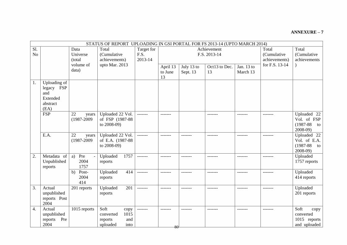
80
ANNEXURE – 7
STATUS OF REPORT UPLOADING IN GSI PORTAL FOR FS 2013-14 (UPTO MARCH 2014)
Sl.
No
Data
Universe
(total
volume of
data)
Total
(Cumulative
achievements)
upto Mar. 2013
Target for
F.S.
2013-14
Achievement
F.S. 2013-14
Total
(Cumulative
achievements)
for F.S. 13-14
Total
(Cumulative
achievements
) April 13
to June
13
July 13 to
Sept. 13
Oct13 to Dec.
13
Jan. 13 to
March 13
1. Uploading of
legacy FSP
and
Extended
abstract
(EA)
FSP 22 years
(1987-2009
Uploaded 22 Vol.
of FSP (1987-88
to 2008-09)
------- ------- ------- ------- ------- Uploaded 22
Vol. of FSP
(1987-88 to
2008-09)
E.A. 22 years
(1987-2009
Uploaded 22 Vol.
of E.A. (1987-88
to 2008-09)
------- ------- ------- ------- ------- ------- Uploaded 22
Vol. of E.A.
(1987-88 to
2008-09)
2. Metadata of
Unpublished
reports
a) Pre -
2004
1757
Uploaded 1757
reports
------- ------- ------- ------- ------- ------- Uploaded
1757 reports
b) Post-
2004
414
Uploaded 414
reports
------- ------- ------- ------- ------- ------- Uploaded
414 reports
3. Actual
unpublished
reports Post
2004
201 reports Uploaded 201
reports
------- ------- ------- ------- ------- ------- Uploaded
201 reports
4. Actual
unpublished
reports Pre
2004
1015 reports Soft copy
converted 1015
reports and
uploaded into
------- ------- ------- ------- ------- ------- Soft copy
converted
1015 reports
and uploaded
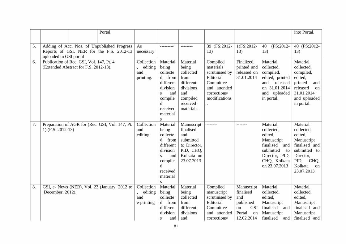
81
Portal. into Portal.
5. Adding of Acc. Nos. of Unpublished Progress
Reports of GSI, NER for the F.S. 2012-13
uploaded in GSI portal
As
necessary
--------- -------- 39 (FS:2012-
13)
1(FS:2012-
13)
40 (FS:2012-
13)
40 (FS:2012-
13)
6. Publication of Rec. GSI, Vol. 147, Pt. 4
(Extended Abstract for F.S. 2012-13).
Collection
, editing
and
printing.
Material
being
collecte
d from
different
division
s and
compile
d
received
material
s
Material
being
collected
from
different
divisions
and
compiled
received
materials.
Compiled
materials
scrutinised by
Editorial
Committee
and attended
corrections/
modifications
.
Finalized,
printed and
released on
31.01.2014
Material
collected,
compiled,
edited, printed
and released
on 31.01.2014
and uploaded
in portal.
Material
collected,
compiled,
edited,
printed and
released on
31.01.2014
and uploaded
in portal.
7. d) Preparation of AGR for (Rec. GSI, Vol. 147, Pt.
1) (F.S. 2012-13)
Collection
and
editing
Material
being
collecte
d from
different
division
s and
compile
d
received
material
s
Manuscript
finalised
and
submitted
to Director,
PID, CHQ,
Kolkata on
23.07.2013
------- ------- Material
collected,
edited,
Manuscript
finalised and
submitted to
Director, PID,
CHQ, Kolkata
on 23.07.2013
Material
collected,
edited,
Manuscript
finalised and
submitted to
Director,
PID, CHQ,
Kolkata on
23.07.2013
8. e) GSI, e- News (NER), Vol. 23 (January, 2012 to
December, 2012).
Collection
, editing
and
e-printing
Material
being
collecte
d from
different
division
s and
Material
being
collected
from
different
divisions
and
Compiled
manuscript
scrutinised by
Editorial
Committee
and attended
corrections/
Manuscript
finalised
and
published
on GSI
Portal on
12.02.2014
Material
collected,
edited,
Manuscript
finalised and
Manuscript
finalised and
Material
collected,
edited,
Manuscript
finalised and
Manuscript
finalised and

82
compile
d
received
material
s
compiled
received
materials.
modifications
.
published on
GSI Portal on
12.02.2014
published on
GSI Portal on
12.02.2014
9. Scrutiny and processing of scientific papers/
abstracts submitted by the officers of the region.
Papers as
necessary
4 5 1 7 17 17
Abstracts
as
necessary
7 4 3 - 14 14
10. Information
Services
Sale of publication (in Rs.) As
Necessary
1363 2109 650 4260 8382 8382
Distribution of GSI publications. As
Necessary
22 428 67 202 719 719
11. Library
services –
Modernizati
on of
Library.
Procured Books As
Necessary
8 6 -- ---- 14 14
Procured Journals As
Necessary
42 47 22 24 135 135
12. Hard copies of reports for FS 2012-13 received As
Necessary
20 2 1 41 41
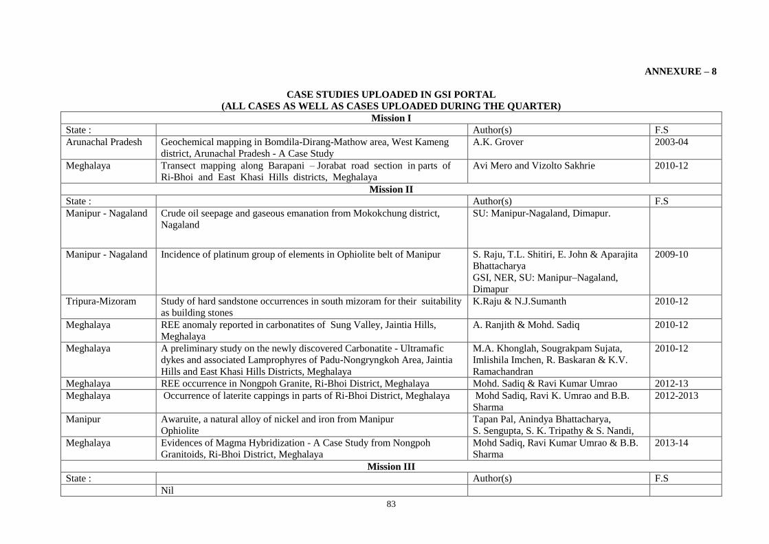
83
ANNEXURE – 8
CASE STUDIES UPLOADED IN GSI PORTAL
(ALL CASES AS WELL AS CASES UPLOADED DURING THE QUARTER)
Mission I
State : Author(s) F.S
Arunachal Pradesh Geochemical mapping in Bomdila-Dirang-Mathow area, West Kameng
district, Arunachal Pradesh - A Case Study
A.K. Grover 2003-04
Meghalaya Transect mapping along Barapani – Jorabat road section in parts of
Ri-Bhoi and East Khasi Hills districts, Meghalaya
Avi Mero and Vizolto Sakhrie
2010-12
Mission II
State : Author(s) F.S
Manipur - Nagaland Crude oil seepage and gaseous emanation from Mokokchung district,
Nagaland
SU: Manipur-Nagaland, Dimapur.
Manipur - Nagaland Incidence of platinum group of elements in Ophiolite belt of Manipur S. Raju, T.L. Shitiri, E. John & Aparajita
Bhattacharya
GSI, NER, SU: Manipur–Nagaland,
Dimapur
2009-10
Tripura-Mizoram Study of hard sandstone occurrences in south mizoram for their suitability
as building stones
K.Raju & N.J.Sumanth 2010-12
Meghalaya REE anomaly reported in carbonatites of Sung Valley, Jaintia Hills,
Meghalaya
A. Ranjith & Mohd. Sadiq 2010-12
Meghalaya A preliminary study on the newly discovered Carbonatite - Ultramafic
dykes and associated Lamprophyres of Padu-Nongryngkoh Area, Jaintia
Hills and East Khasi Hills Districts, Meghalaya
M.A. Khonglah, Sougrakpam Sujata,
Imlishila Imchen, R. Baskaran & K.V.
Ramachandran
2010-12
Meghalaya REE occurrence in Nongpoh Granite, Ri-Bhoi District, Meghalaya Mohd. Sadiq & Ravi Kumar Umrao 2012-13
Meghalaya Occurrence of laterite cappings in parts of Ri-Bhoi District, Meghalaya Mohd Sadiq, Ravi K. Umrao and B.B.
Sharma
2012-2013
Manipur Awaruite, a natural alloy of nickel and iron from Manipur
Ophiolite
Tapan Pal, Anindya Bhattacharya,
S. Sengupta, S. K. Tripathy & S. Nandi,
Meghalaya Evidences of Magma Hybridization - A Case Study from Nongpoh
Granitoids, Ri-Bhoi District, Meghalaya
Mohd Sadiq, Ravi Kumar Umrao & B.B.
Sharma
2013-14
Mission III
State : Author(s) F.S
Nil

84
Mission IV (Fundamental & Multidisciplinary)
State : Author(s) F.S
Meghalaya Vehicular Tunnel Project of Aizawl city, Mizoram: A Geotechnical
Evaluation.
R. Pitchai Muthu
Meghalaya Active fault studies along foothills of Assam- Bhutan Himalaya,
Kokrajhar (BTAD) District, Assam
Officers from SU: Meghalaya, Shillong.
Meghalaya Geotechnical evaluation of some foundation problems at Kitpi MHS in the
Tawang Valley of Arunachal Pradesh
Officers from SU: Meghalaya, Shillong.
Meghalaya Sonapur Landslide, Jaintia Hills District, Meghalaya Officers from SU: Meghalaya, Shillong.
Meghalaya Kyllang Granite Pluton V.V. Sesha Sai et al 2009-10
Meghalaya Dinosaur remains from Meghalaya - A case history Officers from SU: Meghalaya, Shillong.
Eastern Region Palaeobotanical study of the Gondwana equivalent sediments exposed in
the Rangit window, Sikkim
Dr. K.M. Wanjarwadkar
Eastern Region Macroseismic Survey of Sikkim Earthquake, 14th February,
2006
S. K. Som, P. Jana & U. Bhattacharya
ANNEXURE - 9
LIST OF PUBLICATIONS BROUGHT OUT IN THE LAST FIVE YEARS
Sl.No Title of Publication Periodicity of
Publication
When last published
(Date)
Whether Available
Soft copy Hard copy
1. Records of Geological Survey of India Vol. 141, Pt. 4 (FS: 2006-07) 22.01.2009 Yes
Yes
2. i) Records of Geological Survey of India Vol. 140, Pt. 4
ii) GSI, NER, NEWS, Vol. 19
iii) Geology and Mineral Resources of Assam (Misc. Pub.
No. 30, Pt. 4, Vol. i)
iv) Geology and Mineral Resources of Meghalaya (Misc.
Pub. No. 30, Pt. 4, Vol. ii)
(FS: 2007-08)
Jan to Dec’ 08
2009
2009
06.11.2009
05.01.2010
06.11.2009
06.11.2009
Yes
Yes
Yes
Yes
Yes
Yes
Yes
Yes
3. i) Records of Geological Survey of India Vol. 143, Pt. 4
ii) GSI, NER, NEWS, Vol. 20
iii) Geology and Mineral Resources of Arunachal Pradesh
(Misc. Pub. No. 30, Pt. 4, Vol. 1, part-1)
(FS: 2008-09)
Jan to Dec ‘09
2010
28.10.2010
06.01.2011
28.10.2010
Yes
Yes
Yes
Yes
Yes
Yes

85
4. i) Geology and Mineral Resources of Manipur, Mizoram,
Nagaland and Tripura (Misc. Pub. No. 30, Pt. 4, Vol. 1,
part-2)
2011 28.03.2011 Yes
Yes
5. i) Records of Geological Survey of India Vol. 144, Pt. 4
ii) GSI, NER, NEWS, Vol. 21.
(FS: 2009-10)
Jan to Dec ‘10
04.03.2012
04.03.2012
Yes
Yes
Yes
Yes
6. i) GSI, NER, News, Vol. 22
ii) Records of Geological Survey of India Vol. 145-146, Pt.
4
Jan. to Dec. 2011
(FS: 2010-12)
17.09.2012
14.02.2013
Yes
Yes
Yes
Yes
7. Bull. Sr. A, No. 63 (Limestone deposit of Litang Valley,
Jaintia Hills district, Meghalaya)
2013 18.10.2013 Yes Yes
8. Abstract Volume of Regional Workshop on Landslide
Disaster Management, 22-23 Nov, 2013
2013 22.11.2013 Yes Yes
9. GSI, NER, e-NEWS, Vol. 23 Jan 2012 -Dec 2012 12.02.2014 Yes Yes
10. Records of Geological Survey of India Vol. 147, Pt. 4
(FS: 2012-13)
31.03.2014 Yes Yes

86
ANNEXURE -10
COURSES CONDUCTED AT RTI & FTC’S
Month Title of the course
conducted
Location of training Duration
Of training
No of Participant Remark
April,13 36th OCG, Batch-F FTC-Aizwal/RTI-
Shillong
30 days 27 Successfully conducted
June,13 36th OCG, Batch-G FTC-Aizwal/RTI-
Shillong
30 days 25 Successfully conducted
July,13 36th OCG, Batch-H FTC-Aizwal/RTI-
Shillong
30 days 26 Successfully conducted
Aug,13 Capsule course on
Chemical analysis
RTI,
Shillong
6 days
19.08.13 to
24.08.13
9 4-Officers from DGM, Sikkim could not
attend due to Gorkhaland-Darjilling strike.
CONDUCTED SUCEESFULLY AND VERY
GOOD TO EXCELLENT FEEDBACK
GIVEN BY TRAINE OFFICERS AND
COURSE REPORT UPLOADED IN
PORTAL.
Sept,13 Refresher course on
Petrology Training
RTI,
Shillong
12 days
26.8.13 to
6.9.13
15 CONDUCTED SUCEESFULLY AND VERY
GOOD TO EXCELLENT FEEDBACK
GIVEN BY TRAINE OFFICERS AND
COURSE REPORT UPLOADED IN
PORTAL.
Oct,13 Computer application RTI,
Shillong
6 days
From 16.10.13
to 24.10.13
Total -19,
SU.Assam-3,
SU.Tripura-2
SU.Nagaland-1
Su.Meghalaya-13.
Conducted
refresher Training course on
computer application GSI,NER
Oct,13 Guest Lectures during
vigilance awareness week
on
“Promoting Good
Governance –Positive
Contribution of
Vigilance”
RTI,
Shillong
1 day
29.10.13
Total-70
GSI,NER, Shillong
Lectured delivered by shri.G.H.P.Raju,IPS.
Inspector General of Police, Govt of
Meghalaya.
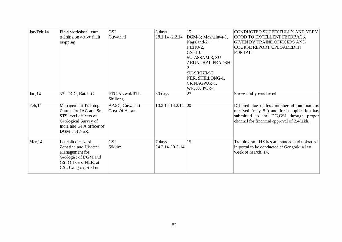
87
Jan/Feb,14 Field workshop –cum
training on active fault
mapping
GSI,
Guwahati
6 days
28.1.14 -2.2.14
15
DGM-3; Meghalaya-1,
Nagaland-2.
NEHU-2,
GSI-10,
SU-ASSAM-3, SU-
ARUNCHAL PRADSH-
2
SU-SIKKIM-2
NER, SHILLONG-1,
CR,NAGPUR-1,
WR, JAIPUR-1
CONDUCTED SUCEESFULLY AND VERY
GOOD TO EXCELLENT FEEDBACK
GIVEN BY TRAINE OFFICERS AND
COURSE REPORT UPLOADED IN
PORTAL.
Jan,14 37th OCG, Batch-G FTC-Aizwal/RTI-
Shillong
30 days 27 Successfully conducted
Feb,14 Management Training
Course for JAG and Sr.
STS level officers of
Geological Survey of
India and Gr.A officer of
DGM’s of NER.
AASC, Guwahati
Govt Of Assam
10.2.14-14.2.14 20 Differed due to less number of nominations
received (only 5 ) and fresh application has
submitted to the DG,GSI through proper
channel for financial approval of 2.4 lakh.
Mar,14 Landslide Hazard
Zonation and Disaster
Management for
Geologist of DGM and
GSI Officers, NER, at
GSI, Gangtok, Sikkim
GSI
Sikkim
7 days
24.3.14-30-3-14
15 Training on LHZ has announced and uploaded
in portal to be conducted at Gangtok in last
week of March, 14.
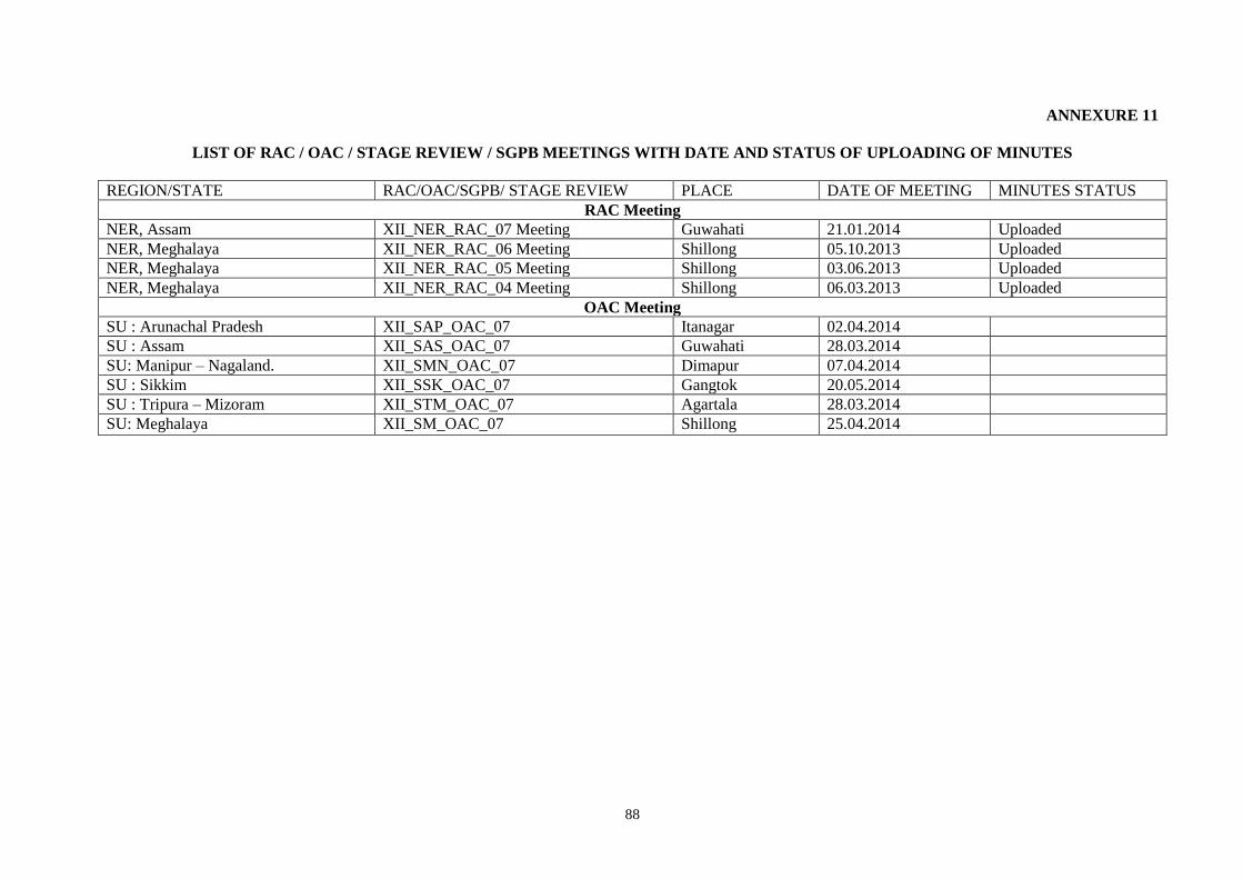
88
ANNEXURE 11
LIST OF RAC / OAC / STAGE REVIEW / SGPB MEETINGS WITH DATE AND STATUS OF UPLOADING OF MINUTES
REGION/STATE RAC/OAC/SGPB/ STAGE REVIEW PLACE DATE OF MEETING MINUTES STATUS
RAC Meeting
NER, Assam XII_NER_RAC_07 Meeting Guwahati 21.01.2014 Uploaded
NER, Meghalaya XII_NER_RAC_06 Meeting Shillong 05.10.2013 Uploaded
NER, Meghalaya XII_NER_RAC_05 Meeting Shillong 03.06.2013 Uploaded
NER, Meghalaya XII_NER_RAC_04 Meeting Shillong 06.03.2013 Uploaded
OAC Meeting
SU : Arunachal Pradesh XII_SAP_OAC_07 Itanagar 02.04.2014
SU : Assam XII_SAS_OAC_07 Guwahati 28.03.2014
SU: Manipur – Nagaland. XII_SMN_OAC_07 Dimapur 07.04.2014
SU : Sikkim XII_SSK_OAC_07 Gangtok 20.05.2014
SU : Tripura – Mizoram XII_STM_OAC_07 Agartala 28.03.2014
SU: Meghalaya XII_SM_OAC_07 Shillong 25.04.2014

89
ANNEXURE-12
Employment position in the region AS ON 31.03.2014
POSITION OF GROUP 'A' & 'B' GAZETTED OFFICERS IN GEOLOGICAL SURVEY OF INDIA,
NORTH EASTERN REGION
Sl.
No.
Designation Shillong Sikkim Guwahati Itanagar Dimapur Agartala TOTAL
A B C D E F G H
Additional Director General 01 01
1 Dy. Director General 2 - 1 1 - - 04
2 Director (G) 8 - 2 1 1 0 12
3 Superintending Geologist 9 2 2 2 2 2 19
4 Senior Geologist 22 0 8 3 3 4 40
5 Geologist 29 12 11 13 9 7 81
6 Director (Chemist) 1 - - - - - 01
7 Sr. Chemist 3 - - - - - 03
8 Chemist 5 - - - - - 05
9 Assistant Chemist Grade – I 0 - - - - - 0
10 Supdt Geophysicist 1 - - - - - 01
11 Senior Geophysicist 5 - - - - - 05
12 Geophysicist 2 - - - - - 02
Jr. Geophysicist 0 - - - - - 0
13 Assistant Geophy 1 - - - - - 01
14 Mineralogist 0 - - - - - 0
Executive Engineer (NFJAG) 1 - - - - - 01
15 Asstt. Executive Engineer 1 - - - - - 01
16 Joint Director (P&A) 1 - - - - - 01
17 Deputy Director (P&A) 1 - - - - - 01
18 Stores Manager 2 - - - - - 02
19 Asstt. Director (P&A) 1 - - - 1 - 02
20 Administrative Officer Grade – II 5 1 2 - 1 1 10
21 Artist 0 - 1 - - - 01
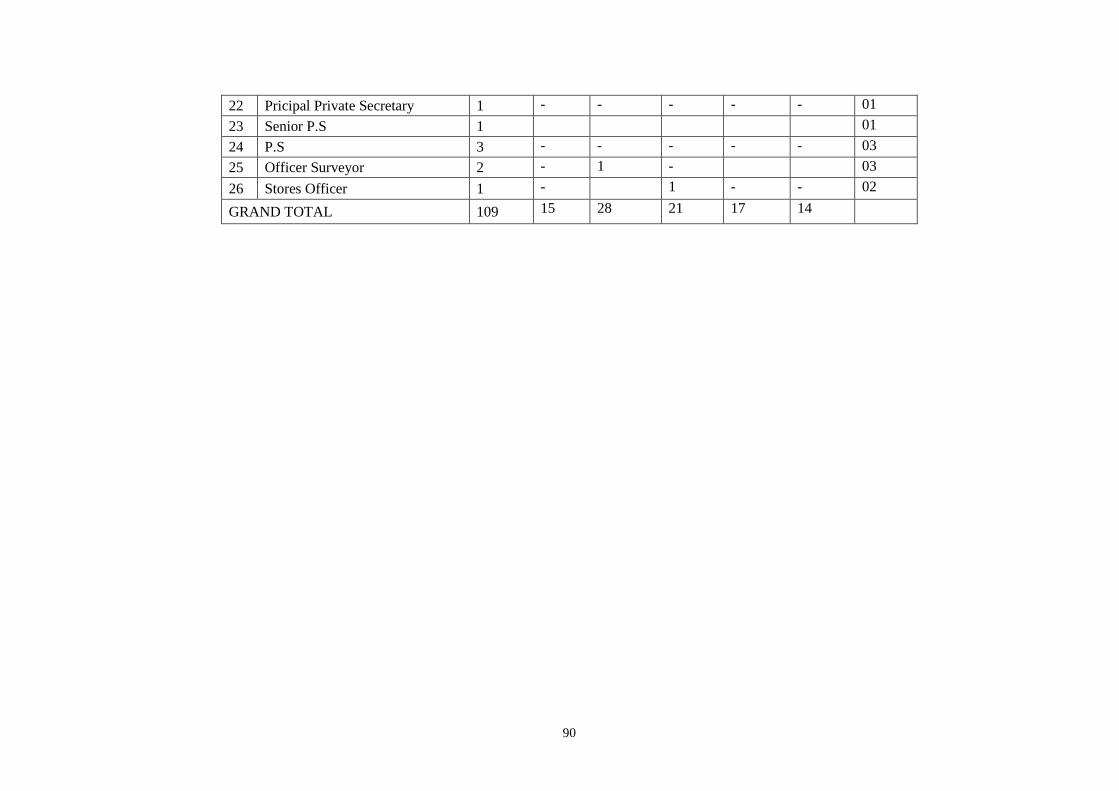
90
22 Pricipal Private Secretary 1 - - - - - 01
23 Senior P.S 1 01
24 P.S 3 - - - - - 03
25 Officer Surveyor 2 - 1 - 03
26 Stores Officer 1 - 1 - - 02
GRAND TOTAL 109 15 28 21 17 14
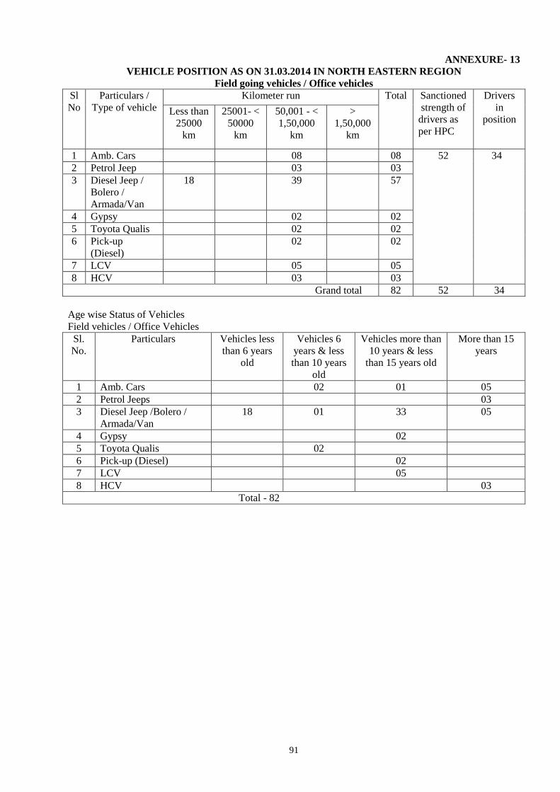
91
ANNEXURE- 13
VEHICLE POSITION AS ON 31.03.2014 IN NORTH EASTERN REGION
Field going vehicles / Office vehicles
Sl
No
Particulars /
Type of vehicle
Kilometer run Total Sanctioned
strength of
drivers as
per HPC
Drivers
in
position
Less than
25000
km
25001- <
50000
km
50,001 - <
1,50,000
km
>
1,50,000
km
1 Amb. Cars 08 08 52 34
2 Petrol Jeep 03 03
3 Diesel Jeep /
Bolero /
Armada/Van
18 39 57
4 Gypsy 02 02
5 Toyota Qualis 02 02
6 Pick-up
(Diesel)
02 02
7 LCV 05 05
8 HCV 03 03
Grand total 82 52 34
Age wise Status of Vehicles
Field vehicles / Office Vehicles
Sl.
No.
Particulars Vehicles less
than 6 years
old
Vehicles 6
years & less
than 10 years
old
Vehicles more than
10 years & less
than 15 years old
More than 15
years
1 Amb. Cars 02 01 05
2 Petrol Jeeps 03
3 Diesel Jeep /Bolero /
Armada/Van
18 01 33 05
4 Gypsy 02
5 Toyota Qualis 02
6 Pick-up (Diesel) 02
7 LCV 05
8 HCV 03
Total - 82

92
ANNEXURE – 14
ASSETS PROCUREMENT AND MANAGEMENT DIVISION, GEOLOGICAL SURVEY OF
INDIA, NORTH EASTERN REGION
LIST OF PROCUREMENT UNDER M.E. HEAD/STATUS FOR 2013-14.
As on 31.03.14
A. Procurement Status – Bill released
Sl. No. Item Cost in Rs. Status
1. Brunton Compass-75 nos. 1145813 Bill released
2. Brunton Compass-05 nos.(DGM) 86625 Bill released
3. Drilling Accessories Core Barrel 275933 Bill released
4. Microscopes-07 nos
(Custom Clearance)
403941 Payment released
5. Inverter-02 nos. 86125 Bill released
6. Microscopes-07 nos
(10% Balance Payment)
649488 Payment released
7. Pulveriser LC Charges 5285 Payment released
8. Pulveriser (Foreign Purchase) 2476800 Debited
9. UPS Battery-08 nos.(Chemical) 19600 Bill released
10. Water Analysis Kit-01 no. 261050 Bill released
11. Arsenic Test Kit-05 nos. (SU-Assam) 46478 Bill released
12. Magnetometer=01 752625 Bill released
13. AO Scanner-03 nos. 1527750 Bill released
14. Pulveriser (Foreign Purchase) (10%
Balance Payment)
291545 Payment released
15. Inverter – 2 KVA 43063 Bill released
16. LC Charges – 01 Microscope 3468 Payment released
17. DG Set 5KVA (SU-Dimapur) 315331 Bill released
Bill released in Rs. 83,45,515
B. Procurement Status – P.O. Placed
Sl. No. Item Cost in Rs. Status
1. Thin Section Grinding Machines-01 no. 65873 Bill released
2. Microscopes-01 no. SU-Dimapur 917011 Payment debited
Bill released in Rs. 9,82,884
C. Procurement Status – Budget Stage
Sl. No. Item Cost in Rs. Status
1. Color Photocopier Machine – 08 nos 1876161 LOA Issued/Bill released
2. DC Resistivity Meter-03nos. 425850 Bill released
3. Geotechnical Instruments 696937 Bill released
4. Holland Cathode Lamp-04 nos 209421 Bill released
5. A0 Plotter-02 nos. 629900 Bill released
Bill released in Rs. 3838724
D. Procurement Status – Indigenous Purchase- PAC/TEC/TAC Stage
Sl. No. Item Cost in Rs. Status
1. A-3 Color Printer – 01 no. (RTI) 210000 P.O. Placed
E. Procurement Status – Foreign Purchase- PAC/TEC/TAC Stage
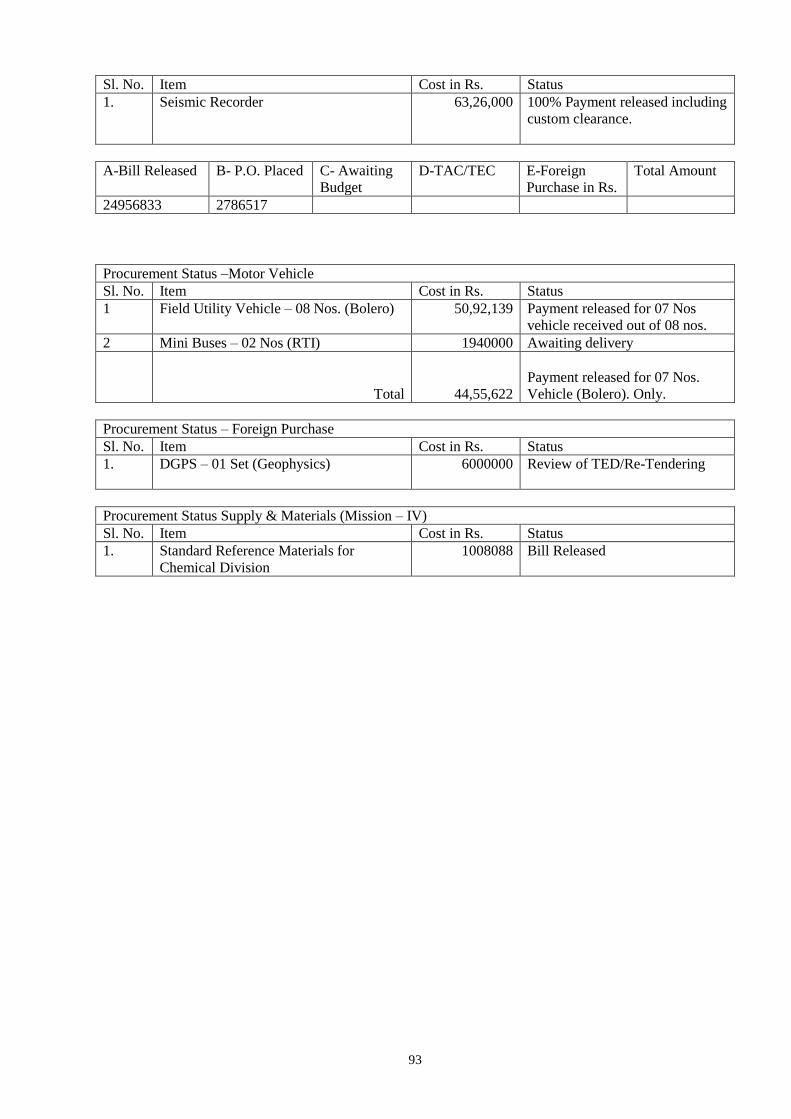
93
Sl. No. Item Cost in Rs. Status
1. Seismic Recorder 63,26,000 100% Payment released including
custom clearance.
A-Bill Released B- P.O. Placed C- Awaiting
Budget
D-TAC/TEC E-Foreign
Purchase in Rs.
Total Amount
24956833 2786517
Procurement Status –Motor Vehicle
Sl. No. Item Cost in Rs. Status
1 Field Utility Vehicle – 08 Nos. (Bolero) 50,92,139 Payment released for 07 Nos
vehicle received out of 08 nos.
2 Mini Buses – 02 Nos (RTI) 1940000 Awaiting delivery
Total
44,55,622
Payment released for 07 Nos.
Vehicle (Bolero). Only.
Procurement Status – Foreign Purchase
Sl. No. Item Cost in Rs. Status
1. DGPS – 01 Set (Geophysics) 6000000 Review of TED/Re-Tendering
Procurement Status Supply & Materials (Mission – IV)
Sl. No. Item Cost in Rs. Status
1. Standard Reference Materials for
Chemical Division
1008088 Bill Released
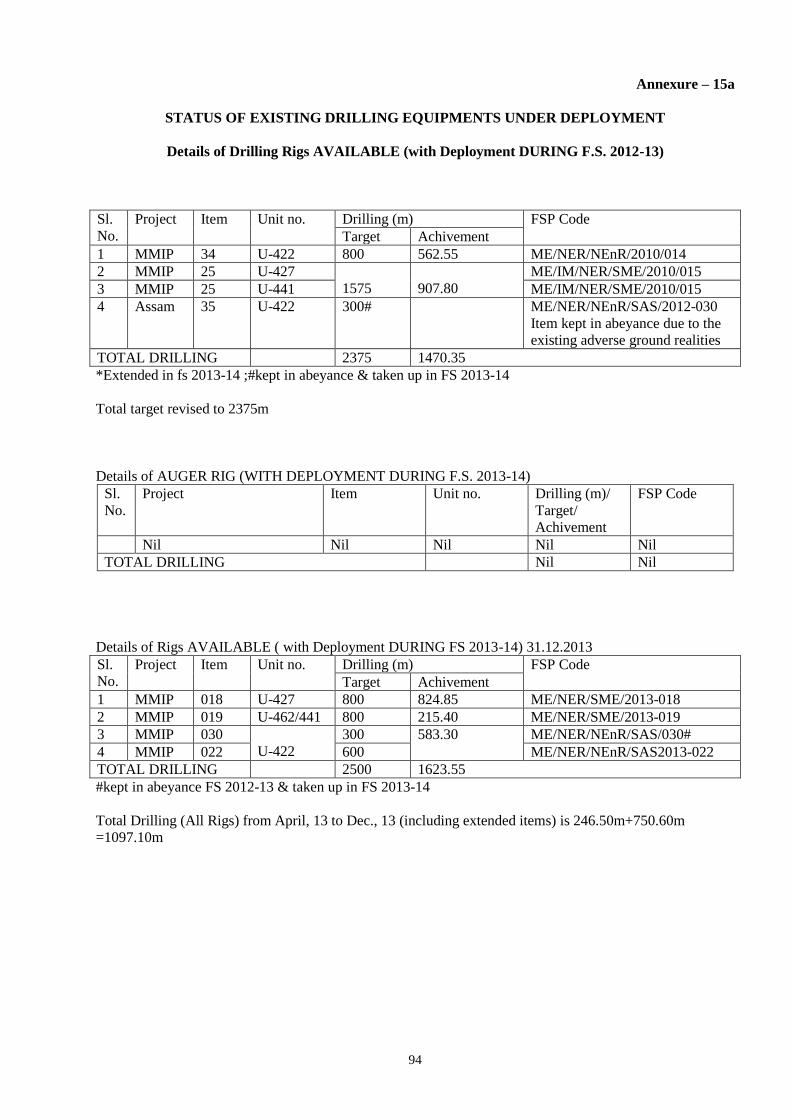
94
Annexure – 15a
STATUS OF EXISTING DRILLING EQUIPMENTS UNDER DEPLOYMENT
Details of Drilling Rigs AVAILABLE (with Deployment DURING F.S. 2012-13)
Sl.
No.
Project Item Unit no. Drilling (m) FSP Code
Target Achivement
1 MMIP 34 U-422 800 562.55 ME/NER/NEnR/2010/014
2 MMIP 25 U-427
1575
907.80
ME/IM/NER/SME/2010/015
3 MMIP 25 U-441 ME/IM/NER/SME/2010/015
4 Assam 35 U-422 300# ME/NER/NEnR/SAS/2012-030
Item kept in abeyance due to the
existing adverse ground realities
TOTAL DRILLING 2375 1470.35
*Extended in fs 2013-14 ;#kept in abeyance & taken up in FS 2013-14
Total target revised to 2375m
Details of AUGER RIG (WITH DEPLOYMENT DURING F.S. 2013-14)
Sl.
No.
Project Item Unit no. Drilling (m)/
Target/
Achivement
FSP Code
Nil Nil Nil Nil Nil
TOTAL DRILLING Nil Nil
Details of Rigs AVAILABLE ( with Deployment DURING FS 2013-14) 31.12.2013
Sl.
No.
Project Item Unit no. Drilling (m) FSP Code
Target Achivement
1 MMIP 018 U-427 800 824.85 ME/NER/SME/2013-018
2 MMIP 019 U-462/441 800 215.40 ME/NER/SME/2013-019
3 MMIP 030
U-422
300 583.30 ME/NER/NEnR/SAS/030#
4 MMIP 022 600 ME/NER/NEnR/SAS2013-022
TOTAL DRILLING 2500 1623.55
#kept in abeyance FS 2012-13 & taken up in FS 2013-14
Total Drilling (All Rigs) from April, 13 to Dec., 13 (including extended items) is 246.50m+750.60m
=1097.10m

95
ANNEXURE 15B
STATUS OF EXISTING DRILLING AND OTHER HIGH-END (RS >1 CORE) EQUIPMENTS TO BE PROCURED DURING FY 2013-14
Type of instrument Indenting
Region
Qty Cost Lead
Time
PAC/
Sr.
PAC
DG’s approval &
CPMC
recommendation
Tendering/
Re-
tendering
TEC TAC PO
Placed
LC
opened
Delivery
to be or
Received
Utility of
the
Instrument
[Mission-
wise]
Geophysical
[STSS-MI, MII &
MIV]
NER NIL --- --- --- --- --- --- --- --- --- --- ---
TOTAL NER NIL --- --- --- --- --- --- --- --- --- --- ---
Geology
[STSS- MI, MII &
MIV]
NER NIL --- --- --- --- --- --- --- --- --- --- ---
TOTAL NER NIL --- --- --- --- --- --- --- --- --- --- ---
FIELD/ SURVEY
[STSS – MI, MII &
MIV]
NER NIL --- --- --- --- --- --- --- --- --- --- ---
Drilling NER NIL NIL NIL NIL NIL NIL NIL NIL NIL NIL NIL NIL
TOTAL NER NIL --- --- --- --- --- --- --- --- --- --- ---
GRAND TOTAL NER NIL --- --- --- --- --- --- --- --- --- --- ---
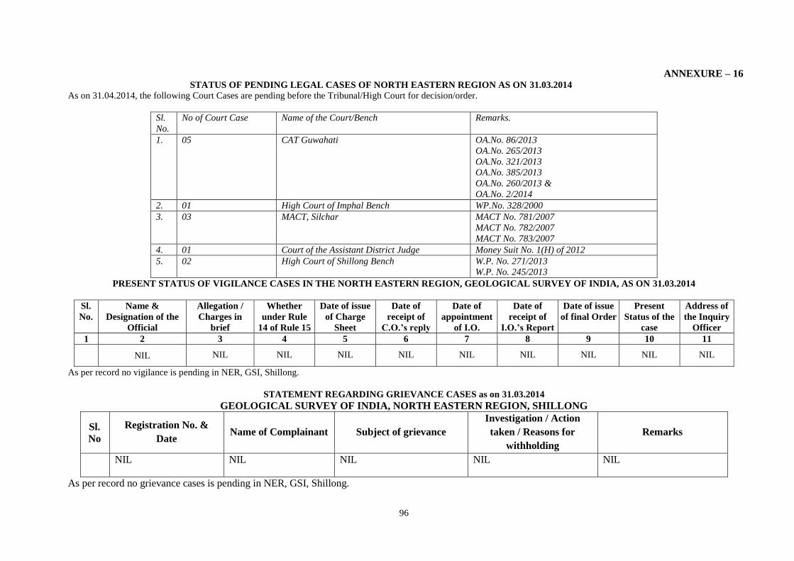
96
ANNEXURE – 16 STATUS OF PENDING LEGAL CASES OF NORTH EASTERN REGION AS ON 31.03.2014
As on 31.04.2014, the following Court Cases are pending before the Tribunal/High Court for decision/order.
Sl.
No.
No of Court Case Name of the Court/Bench Remarks.
1. 05 CAT Guwahati OA.No. 86/2013
OA.No. 265/2013
OA.No. 321/2013
OA.No. 385/2013
OA.No. 260/2013 &
OA.No. 2/2014
2. 01 High Court of Imphal Bench WP.No. 328/2000
3. 03 MACT, Silchar MACT No. 781/2007
MACT No. 782/2007
MACT No. 783/2007
4. 01 Court of the Assistant District Judge Money Suit No. 1(H) of 2012
5. 02 High Court of Shillong Bench W.P. No. 271/2013
W.P. No. 245/2013
PRESENT STATUS OF VIGILANCE CASES IN THE NORTH EASTERN REGION, GEOLOGICAL SURVEY OF INDIA, AS ON 31.03.2014
Sl.
No.
Name &
Designation of the
Official
Allegation /
Charges in
brief
Whether
under Rule
14 of Rule 15
Date of issue
of Charge
Sheet
Date of
receipt of
C.O.’s reply
Date of
appointment
of I.O.
Date of
receipt of
I.O.’s Report
Date of issue
of final Order
Present
Status of the
case
Address of
the Inquiry
Officer
1 2 3 4 5 6 7 8 9 10 11
NIL NIL NIL NIL NIL NIL NIL NIL NIL NIL
As per record no vigilance is pending in NER, GSI, Shillong.
STATEMENT REGARDING GRIEVANCE CASES as on 31.03.2014
GEOLOGICAL SURVEY OF INDIA, NORTH EASTERN REGION, SHILLONG
Sl.
No
Registration No. &
Date Name of Complainant Subject of grievance
Investigation / Action
taken / Reasons for
withholding
Remarks
NIL NIL NIL NIL NIL
As per record no grievance cases is pending in NER, GSI, Shillong.
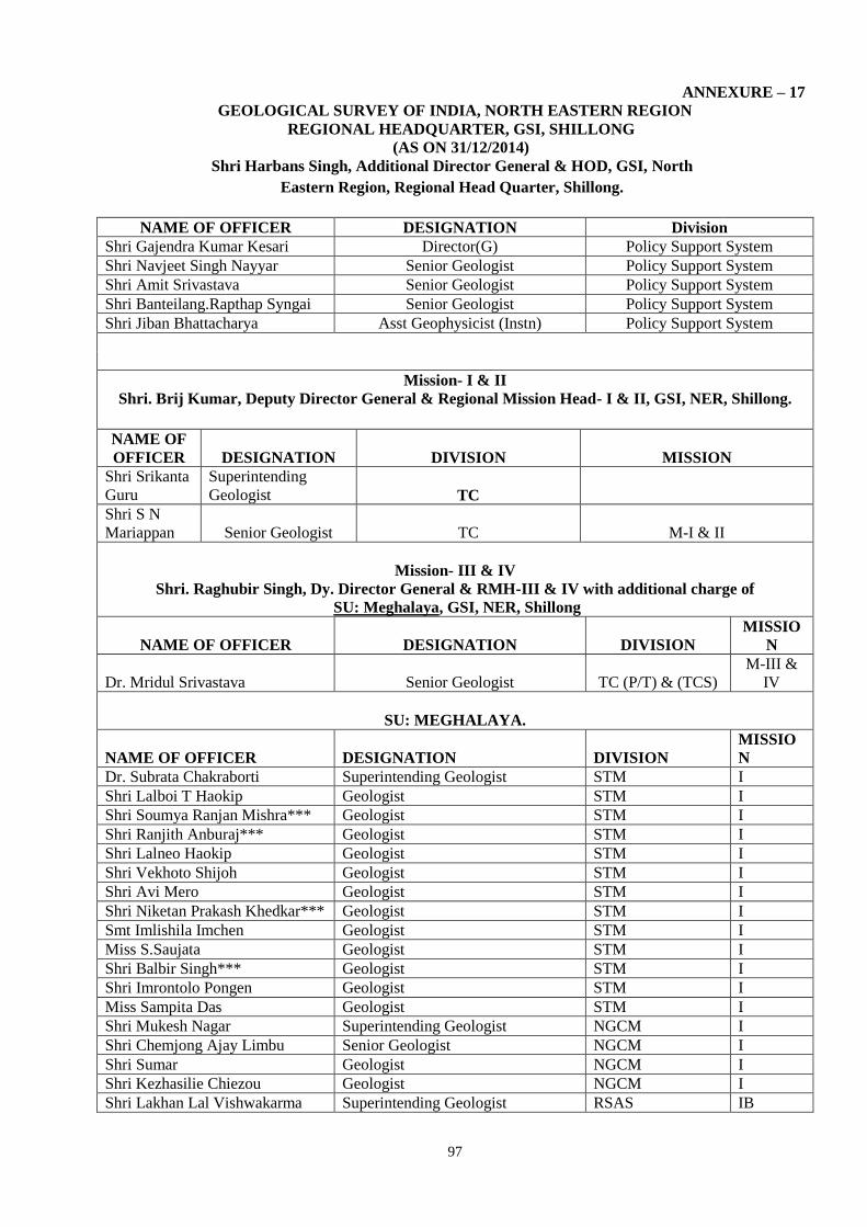
97
ANNEXURE – 17
GEOLOGICAL SURVEY OF INDIA, NORTH EASTERN REGION
REGIONAL HEADQUARTER, GSI, SHILLONG
(AS ON 31/12/2014)
Shri Harbans Singh, Additional Director General & HOD, GSI, North
Eastern Region, Regional Head Quarter, Shillong.
NAME OF OFFICER DESIGNATION Division
Shri Gajendra Kumar Kesari Director(G) Policy Support System
Shri Navjeet Singh Nayyar Senior Geologist Policy Support System
Shri Amit Srivastava Senior Geologist Policy Support System
Shri Banteilang.Rapthap Syngai Senior Geologist Policy Support System
Shri Jiban Bhattacharya Asst Geophysicist (Instn) Policy Support System
Mission- I & II
Shri. Brij Kumar, Deputy Director General & Regional Mission Head- I & II, GSI, NER, Shillong.
NAME OF
OFFICER DESIGNATION DIVISION MISSION
Shri Srikanta
Guru
Superintending
Geologist TC
Shri S N
Mariappan Senior Geologist TC M-I & II
Mission- III & IV
Shri. Raghubir Singh, Dy. Director General & RMH-III & IV with additional charge of
SU: Meghalaya, GSI, NER, Shillong
NAME OF OFFICER DESIGNATION DIVISION
MISSIO
N
Dr. Mridul Srivastava Senior Geologist TC (P/T) & (TCS)
M-III &
IV
SU: MEGHALAYA.
NAME OF OFFICER DESIGNATION DIVISION
MISSIO
N
Dr. Subrata Chakraborti Superintending Geologist STM I
Shri Lalboi T Haokip Geologist STM I
Shri Soumya Ranjan Mishra*** Geologist STM I
Shri Ranjith Anburaj*** Geologist STM I
Shri Lalneo Haokip Geologist STM I
Shri Vekhoto Shijoh Geologist STM I
Shri Avi Mero Geologist STM I
Shri Niketan Prakash Khedkar*** Geologist STM I
Smt Imlishila Imchen Geologist STM I
Miss S.Saujata Geologist STM I
Shri Balbir Singh*** Geologist STM I
Shri Imrontolo Pongen Geologist STM I
Miss Sampita Das Geologist STM I
Shri Mukesh Nagar Superintending Geologist NGCM I
Shri Chemjong Ajay Limbu Senior Geologist NGCM I
Shri Sumar Geologist NGCM I
Shri Kezhasilie Chiezou Geologist NGCM I
Shri Lakhan Lal Vishwakarma Superintending Geologist RSAS IB

98
Shri Harish Chandra Shahu Senior Geologist RSAS IB
Shri Aloke Kumar Lahiri Superintending Geophysicist
Geophysics/
Mineral Physics IA/ STSS
Shri K V Satyanarayana*** Senior Geophysicist Geophysics IA
Shri Om Prakash Senior Geophysicist Geophysics IA
Dr Babul Pathak Senior Geophysicist Geophysics IA
Shri Syntai Manick Syiem Senior Geophysicist Geophysics IA
Shri Sumit Narayan Choudhuri Senior Geophysicist Geophysics IA
Shri Pranab Kumar Chakraborty Geophysicist Geophysics IA
Shri V Vidyasagar*** Geophysicist (Instt) Geophysics IA
Miss Saralin Khongwar Assistant Geophysicist Geophysics IA
Shri Neipekreizo Kesiezie Geologist Geophysics IA
MISSION- II
Shri Atanu Ray Supterintending Geologist
Addl Charge TC/
M-II II
Shri Brij Bhushan Sharma Superintending Geologist MMIP II
Dr. Sudip Bhattacharyya Superintending Geologist MMIP II
Shri Pius Sahkhar Senior Geologist MMIP II
Shri Arvind Geologist MMIP II
Mohd. Sadiq Geologist MMIP II
Shri Rajesh Kumar Geologist MMIP II
Shri Vizolto Sakhrie Geologist MMIP II
Shri Dzieseneituo Vincent
Whuorie Geologist MMIP II
Shri Ravi Kumar Umrao Geologist MMIP II
Shri Tongbram Guneshwar
Singh*** Geologist MMIP II
Shri Sreenivasaiah V*** Geologist MMIP II
Shri Anjan Jyoti Deka Geologist MMIP II
MISSION- III
Dr Bijay Kumar Sahu Superintending Geologist M & C III
Shri Rajinder Kumar Superintending Geologist
Publication
Division III
Shri Shougaijam Mohendro Singh Senior Geologist
Publication
Division III
Shri Amit Srivastava Senior Geologist
Publication
Division III
Shri Praveen Kumar Sinha Superintending Geologist Geodata Division III
Shri Subhash Banerjee Senior Geologist Geodata Division III
Smt Darnia C. War Senior Geologist Geodata Division III
Shri Asutosh Kumar Tripathy Senior Geologist Geodata Division III
Shri Y.C. Puttabasappa Officer Surveyor Geodata Division III
Dr Bijay Kumar Sahu Superintending Geologist
Map& Cartography
Division III
Dr Pradip Kr Mukherjee*** Senior Geologist
Map and
Cartography III
MISSION- IV
Shri Dinesh Vitthalrao Ganvir Director(G) Engineering Geology IV
Dr. Vinod Kumar Senior Geologist Engineering Division IV
Shri Gaikungam Rongmei Senior Geologist Engineering Geology IV
Shri Dhrubajyoti Chakraborty*** Senior Geologist Engineering Geology IV
Shri Wungmarong Shimrey
Rocky Senior Geologist Engineering Geology IV
Shri Konthoujam Kipgen Singh Geologist Engineering Geology IV
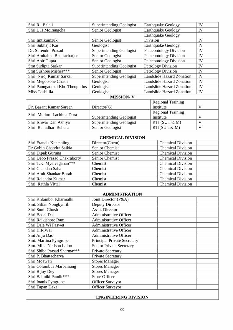
99
Shri R. Balaji Superintending Geologist Earthquake Geology IV
Shri L H Moirangcha Senior Geologist Earthquake Geology IV
Shri Imtikumzuk Senior Geologist
Earthquake Geology
Division IV
Shri Subhajit Kar Geologist Earthquake Geology IV
Dr. Surendra Prasad Superintending Geologist Palaeontology Division IV
Shri Amitabha Bhattacharjee Senior Geologist Palaeontology Division IV
Shri Abir Gupta Senior Geologist Palaeontology Division IV
Smt Sudipta Sarkar Superintending Geologist Petrology Division IV
Smt Sushree Mishra*** Senior Geologist Petrology Division IV
Shri. Niroj Kumar Sarkar Superintending Geologist Landslide Hazard Zonation IV
Shri Megotsohe Chasie Geologist Landslide Hazard Zonation IV
Shri Paongaomai Kho Theophilus Geologist Landslide Hazard Zonation IV
Miss Toshilila Geologist Landslide Hazard Zonation IV
MISSION- V
Dr. Basant Kumar Sareen Director(G)
Regional Training
Institute V
Shri. Muduru Lachhna Dora Superintending Geologist
Regional Training
Institute V
Shri Ishwar Dan Ashiya Superintending Geologist RTI (SU:T& M) V
Shri Benudhar Behera Senior Geologist RTI(SU:T& M) V
CHEMICAL DIVISION
Shri Francis Kharshiing Director(Chem) Chemical Division
Dr Gobin Chandra Saikia Senior Chemist Chemical Division
Shri Dipak Gurung Senior Chemist Chemical Division
Shri Debo Prasad Chakraborty Senior Chemist Chemical Division
Shri T.K. Myelvaganan*** Chemist Chemical Division
Shri Chandan Saha Chemist Chemical Division
Shri Amit Shankar Borah Chemist Chemical Division
Shri Rajendra Kumar Chemist Chemical Division
Shri. Rathla Vittal Chemist Chemical Division
ADMINISTRATION
Shri Khlainbor Kharmalki Joint Director (P&A)
Smt. Silian Nongkynrih Deputy Director
Shri Sunil Ghosh Asstt. Director
Shri Badal Das Administrative Officer
Shri Rajkishore Ram Administrative Officer
Shri Dale Wi Paswet Administrative Officer
Shri H.R.War Administrative Officer
Smt Anju Das Administrative Officer
Smt. Martina Pyngrope Principal Private Secretary
Smt. Mina Neilson Laloo Senior Private Secretary
Shri Shiba Prasad Sharma*** Private Secretary
Shri P. Bhattacharya Private Secretary
Shri Moawati Stores Manager
Shri Columbus Marbaniang Stores Manager
Shri Bijoy Dey Stores Manager
Shri Balmiki Pandit*** Store Officer
Shri Ioanis Pyngrope Officer Surveyor
Shri Tapan Deka Officer Surveyor
ENGINEERING DIVISION
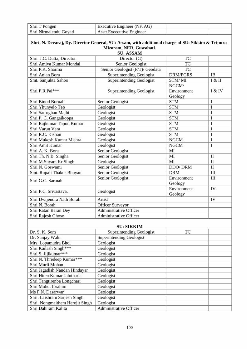
100
Shri T Pongen Executive Engineer (NFJAG)
Shri Nirmalendu Goyari Asstt.Exeecutive Engineer
Shri. N. Devaraj, Dy. Director General, SU: Assam, with additional charge of SU: Sikkim & Tripura-
Mizoram, NER, Guwahati.
SU: ASSAM
Shri J.C. Dutta, Director Director (G) TC
Shri Amiya Kumar Mondal Senior Geologist TC
Shri P.K. Sharma Senior Geologist (P/T)/ Geodata TC
Shri Anjan Bora Superintending Geologist DRM/PGRS IB
Smt. Sanjukta Sahoo Superintending Geologist STM/ MI I & II
Shri P.R.Pai*** Superintending Geologist
NGCM/
Environment
Geology
I & IV
Shri Binod Boruah Senior Geologist STM I
Shri Yhunyelo Tep Geologist STM I
Shri Satrughan Majhi Geologist STM I
Shri P. C. Gangaikoppa Geologist STM I
Shri Rajkumar Tapon Kumar Geologist STM I
Shri Varun Vara Geologist STM I
Shri R.C. Kishan Geologist STM I
Shri Mukesh Kumar Mishra Geologist NGCM I
Shri Amit Kumar Geologist NGCM I
Shri A. K. Bora Senior Geologist MI
Shri Th. N.B. Singha Senior Geologist MI II
Shri M.Shyam Kr.Singh Geologist MI II
Shri N. Goswami Senior Geologist DDO/ DRM II
Smt. Rupali Thakur Bhuyan Senior Geologist DRM III
Shri G.C. Sarmah Senior Geologist Environment
Geology
III
Shri P.C. Srivastava, Geologist Environment
Geology
IV
Shri Dwijendra Nath Borah Artist IV
Shri N. Borah Officer Surveyor
Shri Ratan Baran Dey Administrative Officer
Shri Rajesh Ghose Administrative Officer
SU: SIKKIM
Dr. S. K. Som Superintending Geologist TC
Dr. Sanjay Wahi Superintending Geologist
Mrs. Lopamudra Bhol Geologist
Shri Kailash Singh*** Geologist
Shri S. Jijikumar*** Geologist
Shri N. Thredeep Kumar*** Geologist
Shri Murli Mohan Geologist
Shri Jagadish Nandan Hindayar Geologist
Shri Hiten Kumar Jalutharia Geologist
Shri Tangtirenba Longchari Geologist
Shri Mohd. Ibrahim Geologist
Ms P.N. Dasarwar Geologist
Shri. Laishram Sarjesh Singh Geologist
Shri. Nongmaithem Herojit Singh Geologist
Shri Dahiram Kalita Administrative Officer
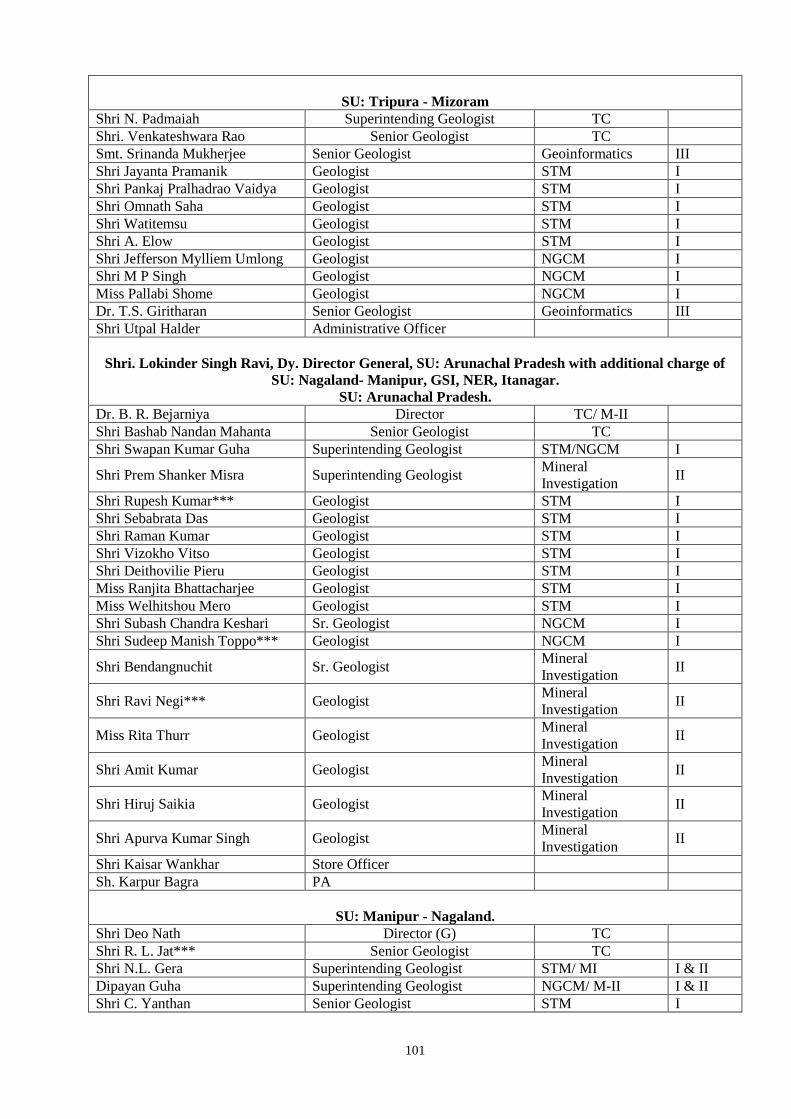
101
SU: Tripura - Mizoram
Shri N. Padmaiah Superintending Geologist TC
Shri. Venkateshwara Rao Senior Geologist TC
Smt. Srinanda Mukherjee Senior Geologist Geoinformatics III
Shri Jayanta Pramanik Geologist STM I
Shri Pankaj Pralhadrao Vaidya Geologist STM I
Shri Omnath Saha Geologist STM I
Shri Watitemsu Geologist STM I
Shri A. Elow Geologist STM I
Shri Jefferson Mylliem Umlong Geologist NGCM I
Shri M P Singh Geologist NGCM I
Miss Pallabi Shome Geologist NGCM I
Dr. T.S. Giritharan Senior Geologist Geoinformatics III
Shri Utpal Halder Administrative Officer
Shri. Lokinder Singh Ravi, Dy. Director General, SU: Arunachal Pradesh with additional charge of
SU: Nagaland- Manipur, GSI, NER, Itanagar.
SU: Arunachal Pradesh.
Dr. B. R. Bejarniya Director TC/ M-II
Shri Bashab Nandan Mahanta Senior Geologist TC
Shri Swapan Kumar Guha Superintending Geologist STM/NGCM I
Shri Prem Shanker Misra Superintending Geologist Mineral
Investigation II
Shri Rupesh Kumar*** Geologist STM I
Shri Sebabrata Das Geologist STM I
Shri Raman Kumar Geologist STM I
Shri Vizokho Vitso Geologist STM I
Shri Deithovilie Pieru Geologist STM I
Miss Ranjita Bhattacharjee Geologist STM I
Miss Welhitshou Mero Geologist STM I
Shri Subash Chandra Keshari Sr. Geologist NGCM I
Shri Sudeep Manish Toppo*** Geologist NGCM I
Shri Bendangnuchit Sr. Geologist Mineral
Investigation II
Shri Ravi Negi*** Geologist Mineral
Investigation II
Miss Rita Thurr Geologist Mineral
Investigation II
Shri Amit Kumar Geologist Mineral
Investigation II
Shri Hiruj Saikia Geologist Mineral
Investigation II
Shri Apurva Kumar Singh Geologist Mineral
Investigation II
Shri Kaisar Wankhar Store Officer
Sh. Karpur Bagra PA
SU: Manipur - Nagaland.
Shri Deo Nath Director (G) TC
Shri R. L. Jat*** Senior Geologist TC
Shri N.L. Gera Superintending Geologist STM/ MI I & II
Dipayan Guha Superintending Geologist NGCM/ M-II I & II
Shri C. Yanthan Senior Geologist STM I
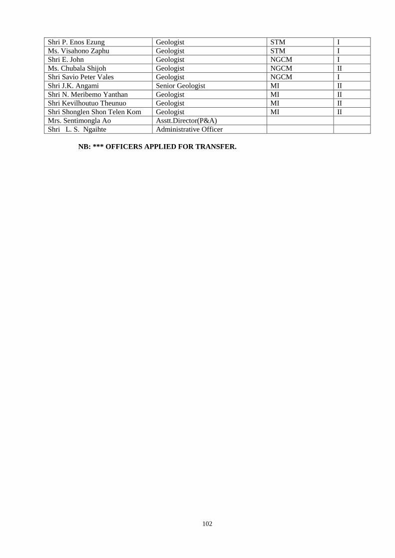
102
Shri P. Enos Ezung Geologist STM I
Ms. Visahono Zaphu Geologist STM I
Shri E. John Geologist NGCM I
Ms. Chubala Shijoh Geologist NGCM II
Shri Savio Peter Vales Geologist NGCM I
Shri J.K. Angami Senior Geologist MI II
Shri N. Meribemo Yanthan Geologist MI II
Shri Kevilhoutuo Theunuo Geologist MI II
Shri Shonglen Shon Telen Kom Geologist MI II
Mrs. Sentimongla Ao Asstt.Director(P&A)
Shri L. S. Ngaihte Administrative Officer
NB: *** OFFICERS APPLIED FOR TRANSFER.

103
Photographs of training given in field, lab and lectures in classroom by Regional Training Institute, GSI, NER, Shillong
GSI Faculty explaining to the trainees about the contact metamorphisim between Shillong quartzite-phyllit and Mylliem granite, East Khasi Hills District, Meghalaya.
Trainees being given training for mapping in Nongpoh Granite, South Khasi Hills District, Meghalaya.
Field discussions between GSI Faculty and trainees about fenitisation in Alkaline-caebonatite-ultramafic complex,Sung valley, Jaintia Hills District, Meghalaya.
Trainees being given training for mapping in Mylliem Granite, East Khasi Hills District, Meghalaya.