Embed Size (px)
Citation preview
FOR OFFICIAL USE ONLY
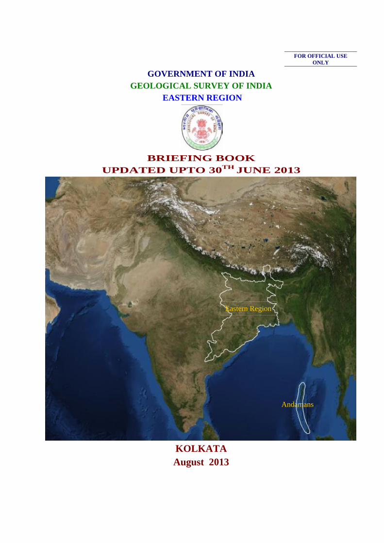
GOVERNMENT OF INDIA GEOLOGICAL SURVEY OF INDIA
EASTERN REGION
BRIEFING BOOK UPDATED UPTO 30TH JUNE 2013
KOLKATA August 2013
Eastern Region
Andamans
BRIEFING BOOK OF EASTERN REGION
Updated upto 30/06/2013
CONTENTS
Chapter Subject Page Nos.
11 IINNTTRROODDUUCCTTIIOONN 11
22 OORRGGAANNIISSAATTIIOONNAALL SSTTRRUUCCTTUURREE 1199
33 AACCTTIIVVIITTYY DDOOMMAAIINN OOFF GGSSII EEAASSTTEERRNN RREEGGIIOONN 2244
44 MMIILLEESSTTOONNEESS && MMAAJJOORR AACCHHIIEEVVEEMMEENNTTSS 4422
55 FFIIEELLDD SSEEAASSOONN 22001122--1133 AACCHHIIEEVVEEMMEENNTTSS 4455
66 FFIIEELLDD SSEEAASSOONN PPRROOGGRRAAMMMMEE WWOORRKK,, 22001133--1144 8800
77 XXII AANNDD XXIIII PPLLAANN WWOORRKK EENNVVIISSAAGGEEDD FFOORR EERR ((YYEEAARR--WWIISSEE)) 110000
88 FFIINNAANNCCIIAALL PPEERRFFOORRMMAANNCCEE UUNNDDEERR CCUURRRREENNTT PPLLAANN,, SSTTAATTEE –– ((YYEEAARR--WWIISSEE)) 110000
9 SSTTAAGGEE RREEVVIIEEWW MMEEEETTIINNGG 110011
10 MMIIDD--TTEERRMM RREEVVIIEEWW MMEEEETTIINNGGSS 110011
11 LLAABBOORRAATTOORRYY IINNFFRRAASSTTRRUUCCTTUURREE 110022
12 GGEEOOIINNFFOORRMMAATTIICCSS 110055
13 TTRRAAIINNIINNGG //CCAAPPAACCIITTYY BBUUIILLDDIINNGG AACCTTIIVVIITTIIEESS IINN TTHHEE RREEGGIIOONN 110077
14 SSCCIIEENNTTIIFFIICC WWOORRKKSSHHOOPPSS//MMEEEETTIINNGGSS//SSEEMMIINNAARRSS//SSYYMMPPOOSSIIUUMM,, EEXXHHIIBBIITTIIOONN OORRGGAANNIIZZEEDD //PPAARRTTIICCIIPPAATTEEDD 110099
15 HHRRDD,, EESSTTAABBLLIISSHHMMEENNTT,, PPAAYYRROOLLLL,, HHRRMMIISS,, ee--SSEERRVVIICCEE BBOOOOKK 110099
16 VVEEHHIICCLLEESS && TTRRAANNSSPPOORRTT IINNFFRRAASSTTRRUUCCTTUURREE IINNCCLLUUDDIINNGG OOUUTT SOURCING AND AGE OF VEHICLES, VVEEHHIICCLLEE MIS 110099
17 MMOODDEERRNNIIZZAATTIIOONN 111100
18 DDRRIILLLLIINNGG IINNFFRRAASSTTRRUUCCTTUURREE,, EERR,, GGSSII 111111
19 OOUUTT--SSOOUURRCCIINNGG OOFF RROOUUTTIINNEE SSEERRVVIICCEESS 111144
20 DDEETTAAIILLSS OOFF EESSTTAATTEE AAFFFFAAIIRRSS 111144
21 MMUUSSEEUUMM AANNDD CCUURRAATTOORRIIAALL AACCTTIIVVIITTIIEESS IINN RREEGGIIOONN && SS UU 111144
22 LLIIBBRRAARRYY DDEETTAAIILLSS 111144
23 CCOORREE LLIIBBRRAARRYY 111155
24 RRTTII AAPPPPEEAALL SSTTAATTUUSS 112211
25 SSTTAATTEEMMEENNTT OOFF PPEENNDDEENNCCYY OOFF GGRRIIEEVVAANNCCEESS 112222
2
ANNEXURES Page
Annexure – IA MAJOR MINERALS RESOURCES [UNDER VARIOUS UNFC CATEGORIES] ESTIMATED BY THE REGION, SHOWING STATE-WISE FIVE-YEARLY INCREMENT, FOR THE LAST 15 YEARS. 112233
Annexure – IB NATIONAL MINERAL INVENTORY NO. OF REPORTS CONVERTED AS PER UNFC COMPLIANCE 112277
Annexure –IIA ACTIVITY DOMAIN PERTAINING TO MISSION I & II OF THE REGION AND ACHIEVEMENTS [FSP RELATED ITEMS] DURING THE XII PLAN PERIOD
114444
Annexure – IIB FSP ROLLING PLAN FOR F.S. 2014-15 & 15-16 114455
Annexure – IIC SHELF OF PROJECTS 114499
Annexure – IIIA FINANCIAL OUTLAY AND EXPENDITURE DURING XI PLAN PERIOD 115500
Annexure -IIIB SCHEME-WISE, QUARTER-WISE DISTRIBUTION OF APPROVED PLAN FUNDS AND ACTUAL EXPENDITURE FOR THE YEARS 2007-08, 2008-09 , 2009-10, 2010-11, 2011-12, 2012-13 & 2013-14 115511
Annexure -IIIC SCHEME-WISE, MONTH-WISE DISTRIBUTION OF APPROVED PLAN FUNDS AND ACTUAL EXPENDITURE FOR 2010-11, 2011-12, 2012-13 115588
Annexure -IV MISSION-WISE PRO-RATA RCA EXPENDITURE IN DIFFERENT PROJECTS VISÀ- VIS TARGETS AND ACHIEVEMENTS 116622
Annexure -IVA FIELD DAYS OF OFFICERS OF ENGINEERING DIVIDION 220022
Annexure–V PROGRESS & PENDENCY REPORT OF CHEMICAL ANALYSES OF NGCM SAMPLES 220033
Annexure–VI REPORT PENDENCY 220088
Annexure–VII STATUS OF UPLOADING IN GSI PORTAL 221100
Annexure–VIII CASE STUDY FROM GEOLOGICAL SURVEY OF INDIA , EASTERN REGION UPLOADED IN GSI PORTAL 222200
Annexure–IX LIST OF PUBLICATIONS BROUGHT OUT IN LAST FIVE YEARS 222233
Annexure -X COURSES CONDUCTED BY TRAINING INSTITUTE DURING F.S. 2012-13 222255
Annexure–XI LIST OF RAC / OAC / STAGE REVIEW / SGPB MEETINGS WITH DATE AND STATUS OF UPLOADING OF MINUTES
222277
Annexure -XII EMPLOYMENT POSITION IN THE REGION 223300
Annexure–XIII VEHICLE POSITION IN EASTERN REGION 223311
Annexure–XIV PROCUREMENT STATUS OF MAJOR EQUIPMENTS/ MODERNIZATION ITEMS/ MACHINERY EARLIER PROPOSED FOR PROCUREMENT DURING 2012-13
223322
Annexure–XVA STATUS OF EXISTING DRILLING EQUIPMENTS UNDER DEPLOYMENT 223399
Annexure–XVB STATUS OF EXISTING DRILLING AND OTHER HIGH-END (RS. >1 CORE) EQUIPMENTS TO BE PROCURED DURING FY 2013-14
224422
Annexure–XVI STATUS OF PENDING LEGAL CASES OF EASTERN REGION 224433
3
EXECUTIVE SUMMARY
Subject Modification
Page Nos.
IINNTTRROODDUUCCTTIIOONN Retained as before 11
OORRGGAANNIISSAATTIIOONNAALL SSTTRRUUCCTTUURREE Updated upto June 2013 1199
AACCTTIIVVIITTYY DDOOMMAAIINN OOFF GGSSII EEAASSTTEERRNN RREEGGIIOONN Retained as before 2244
MMIILLEESSTTOONNEESS && MMAAJJOORR AACCIIEEVVEEMMEENNTTSS Retained as before 4422
FFIIEELLDD SSEEAASSOONN 22001122--1133 AACCHHIIEEVVEEMMEENNTTSS added 4455
FFIIEELLDD SSEEAASSOONN PPRROOGGRRAAMMMMEE WWOORRKK,, 22001133--1144 added 8800
XXII PPLLAANN WWOORRKK EENNVVIISSAAGGEEDD FFOORR EERR ((YYEEAARR--WWIISSEE)) Retained as before 110000
FFIINNAANNCCIIAALL PPEERRFFOORRMMAANNCCEE UUNNDDEERR CCUURRRREENNTT PPLLAANN,, SSTTAATTEE –– ((YYEEAARR--WWIISSEE))
Updated upto June 2013 110000
SSTTAAGGEE RREEVVIIEEWW MMEEEETTIINNGG Updated upto June 2013 110011
MMIIDD--TTEERRMM RREEVVIIEEWW MMEEEETTIINNGGSS Updated upto June 2013 110011
LLAABBOORRAATTOORRYY IINNFFRRAASSTTRRUUCCTTUURREE Retained as before 110022
GGEEOOIINNFFOORRMMAATTIICCSS Retained as before 110055
TTRRAAIINNIINNGG //CCAAPPAACCIITTYY BBUUIILLDDIINNGG AACCTTIIVVIITTIIEESS IINN TTHHEE RREEGGIIOONN
Retained as before 110077
SSCCIIEENNTTIIFFIICC WWOORRKKSSHHOOPPSS//MMEEEETTIINNGGSS//SSEEMMIINNAARRSS//SSYYMMPPOOSSIIUUMM,, EEXXHHIIBBIITTIIOONN OORRGGAANNIIZZEEDD //PPAARRTTIICCIIPPAATTEEDD
Retained as before 110099
HHRRDD,, EESSTTAABBLLIISSHHMMEENNTT,, PPAAYYRROOLLLL,, HHRRMMIISS,, ee--SSEERRVVIICCEE BBOOOOKK
Retained as before 110099
VVEEHHIICCLLEESS && TTRRAANNSSPPOORRTT IINNFFRRAASSTTRRUUCCTTUURREE IINNCCLLUUDDIINNGG OOUUTT SOURCING AND AGE OF VEHICLES, VVEEHHIICCLLEE MIS
Retained as before 110099
MMOODDEERRNNIIZZAATTIIOONN Retained as before 111100
DDRRIILLLLIINNGG IINNFFRRAASSTTRRUUCCTTUURREE,, EERR,, GGSSII Retained as before 111111
OOUUTT--SSOOUURRCCIINNGG OOFF RROOUUTTIINNEE SSEERRVVIICCEESS Retained as before 111144
DDEETTAAIILLSS OOFF EESSTTAATTEE AAFFFFAAIIRRSS Retained as before 111144
MMUUSSEEUUMM AANNDD CCUURRAATTOORRIIAALL AACCTTIIVVIITTIIEESS IINN RREEGGIIOONN && SS UU
Retained as before 111144
LLIIBBRRAARRYY DDEETTAAIILLSS Updated upto June 2013 111144
CCOORREE LLIIBBRRAARRYY Updated upto June 2013 111155
RRTTII AAPPPPEEAALL SSTTAATTUUSS Updated upto June 2013 112211
SSTTAATTEEMMEENNTT OOFF PPEENNDDEENNCCYY OOFF GGRRIIEEVVAANNCCEESS Updated upto June 2013 112222
AAnnnneexxuurree IIAA ttoo XXVVII Updated upto June 2013 112233--224433
1
GSI BRIEFING BOOK OF EASTERN REGION
11.. IINNTTRROODDUUCCTTIIOONN
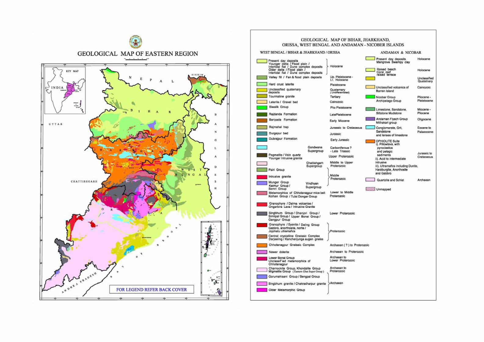
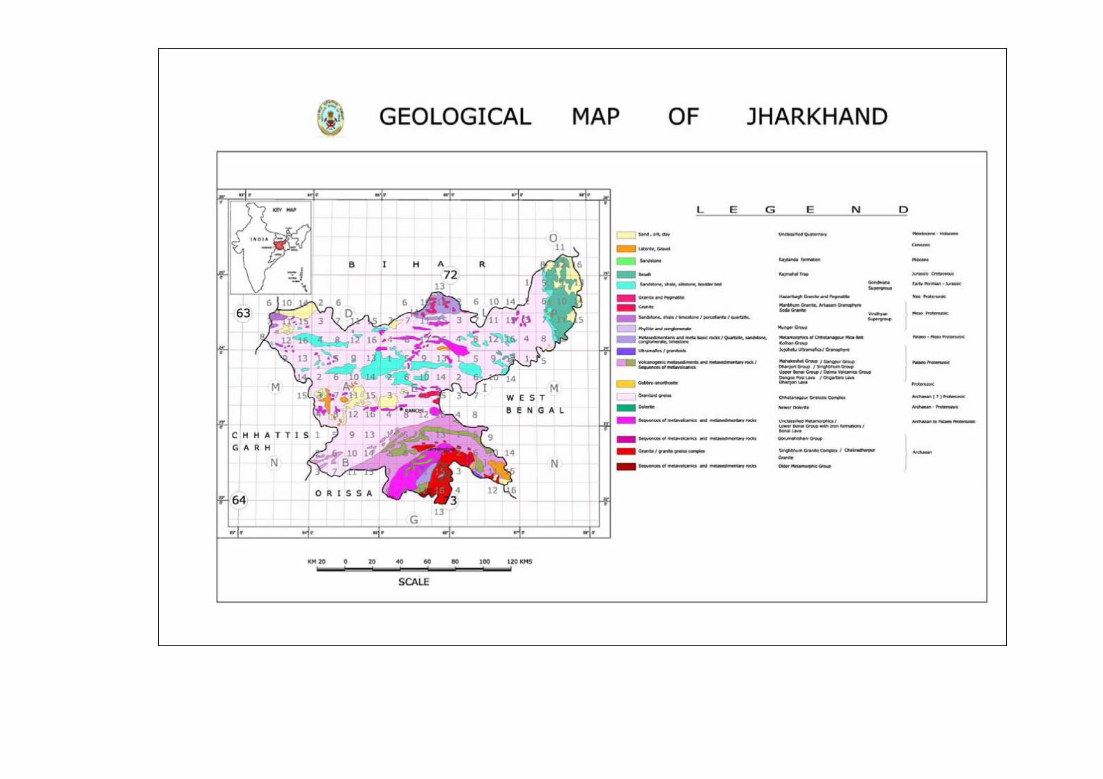
The Eastern Region of Geological Survey of India was established in 1961 with the regional headquarters at Kolkata and Circle Offices of Bihar, Orissa and West Bengal –Andaman and Sikkim Unit with headquarters at Patna, Bhubaneswar, Kolkata and Gangtok respectively. The circle offices were mainly involved with the systematic geological mapping and assessment of mineral resources. At the Regional Headquarters there were specialized divisions like Engineering Geology, Map compilation, Geophysical investigation, Chemical Laboratory and Drilling Division. The activities were further expanded to Photogeology & Remote Sensing, Regional Integrated Survey, and Quaternary & Environmental Geology, Earthquake Geology and the Geodata Divisions.
Subsequently the Circle Offices were redesignated as “Operation”. In the year 2000, two major changes took place as regards the operational coverage of Eastern Region. Operation Bihar & Jharkhand was split into Operation Bihar and Operation Jharkhand with headquarters at Patna and Ranchi. The erstwhile AMSE Eastern zone headquartered at Ranchi was amalgamated with operation Jharkhand. At the same time the Sikkim Unit (of Operation West Bengal) was delinked from Eastern Region and amalgamated with NER, Shillong. Thus Eastern Region now covers geographical area of 0.426 million sq km in the states of WB (88752sq km)-Andaman (8249 sq km), Bihar (94162 sq km), Jharkhand (79714 sq km) and Orissa (1,55,707 sq km). Geologically the main land part of Eastern Region represents:
- Archaean -Proterozoic Rocks, hosting a majority of mineral occurrences in Orissa, Jharkhand and West Bengal.
- Proterozoic Rocks, including limestone in the Vindhyans in Bihar and Jharkhand. - Gondwana Supergroup, a storehouse for coal, refractory clays and coal bed methane. - Late Cretaceous - Early Palaeocene Rajmahal traps equivalent of the Deccan Continental
Flood Basalts. - The sub-Himalayan foothills covering Darjeeling and Duars with marine Gondwana,
Siwaliks and the Pleistocene fan deposit - The Quaternary Indo-Gangetic Alluvium covering major parts of Bihar and West Bengal.
The Andaman & Nicobar Islands on the other hand represents:
- Dominantly post-Cretaceous Ophiolite–flysch–wacke sequence developed as accretionary prism and wedge resultant to the ongoing subduction process along the Indo-Eurasian Plate margin in the Bay of Bengal.
PHYSIOGRAPHY AND TECTONIC FRAMEWORK
Physiographically the Chhotanagpur Plateau region of central and south Bihar–Jharkhand can be divided on the basis of physiographic consideration into Ranchi and Hazaribagh plateaus. The former is the main plateau with general elevation of about 600m above m.s.l. in Ranchi district, has a flat to gently undulating topography with occasional ridges and gradually slopes down towards south-east into the hilly and undulating topography with occasional ridges of Singhbhum. To the north of Tatanagar, the Dalma hills rising about 500m to 600m from the plains with a prominent east-west trending hill ranges are flanked on either side by easily denuded phyllites and mica schists forming the plains. The vast Singhbhum Granite cratonic terrain is represented by a peneplane, which is highly intercepted by residual mounds and rock knolls. The drainage system of the area is mainly controlled by the Damodar, Ajoy, Subarnerakha, north and south Koel river forming different basins.
The eastern fringe of Indian peninsula to a large extent constitutes part of the Eastern Ghats hill ranges which flanks the main cratonic part to the west. Geomorphology of the area is broadly
2
controlled by various regional geological and tectonic features. The prominent central highland is marked by linear hill ranges lending NE-SW in the southern part and WNW-ESE or E-W in the central part. It is separated from the low-level coastal plain in the east by a series of faults. The central highland is again separated by upthrusts parallel to its hill ranges from the western part of the state which is the continuation of the dissected central Indian plateau-land.
The central highland is further cut-across by the NW-SE trending Mahanadi graben in Orissa along which the river flows from west to east, The Mahanadi and sub-parallel Brahmani lineaments form a tectonic zone which divides the central highland into a southern segment constituted of granulite facies litho assemblages continuing southwards into Andhra Pradesh, and a northern segment exposing ancient (Archaean) granite-greenstone assemblages continuing northwards into Jharkhand. The Eastern Ghats is separated by Northern Orissa Boundary Fault (NOBF) from the northern part of the central highland.The shield area of Jharkhand is predominantly occupied by Archaean Singhbhum granite batholith , flanked by Proterozoic supracrustals of Singhbhum Group, Dalma volcanic belt and vast peneplain area of Chhotanagpur granite gneissic complex in the north.
The northern segment of the central highland and the western plateau-land bordering Eastern Ghats are similar in geological set up and are known respectively as the North Orissa Craton and Bastar Craton. While in the middle of it lies the Gondwana formations in Mahanadi graben bounded by faults, which have rich coal resources, some sectors of the coastal plains are mostly covered by Tertiary, and Quaternary sediments and low-level laterite.
The Extra-peninsular region of West Bengal comprises the mountainous tract of the Eastern Himalayas, covering Darjeeling and part of Jalpaiguri districts. The three longitudinal morphotectonic sub-divisions of the Himalayas, i.e. the Lesser and Central or Higher Himalayas are traceable in the Darjeeling sector. The Main Boundary Fault (MBF/MBT) separates the syn-orogenic Siwalik Group of the Sub-Himalayas in the foreland from the stacked pile of thrust sheets constituting the Lesser Himalayan Zone. The Main Central Thrust (MCT) separates the Lesser Himalayas from the Higher Himalayas in the north constituted of mainly gneissic rocks associated with high-grade metamorphites. The major portion of Bihar and West Bengal is occupied by the Gangetic alluvial plain. The Andaman and Nicobar Islands arc forms the northern extension of outer Indonesian Island arc system and represent part of a major accretionary complex that extends from Indonesian Island arcs in the south to Burma in the north. The Andaman arc-trench system has been described as the result of the active subduction of the Indian oceanic lithosphere below the Eurasian plate along the Andaman-Java trench, from Cretaceous to the present day The ophiolite occurrences in Andaman Islands are interpreted as thrust slices of oceanic crust scraped off the subducting slab at the toe of the accretionary complex. GEOLOGICAL CONTEXT WEST BENGAL
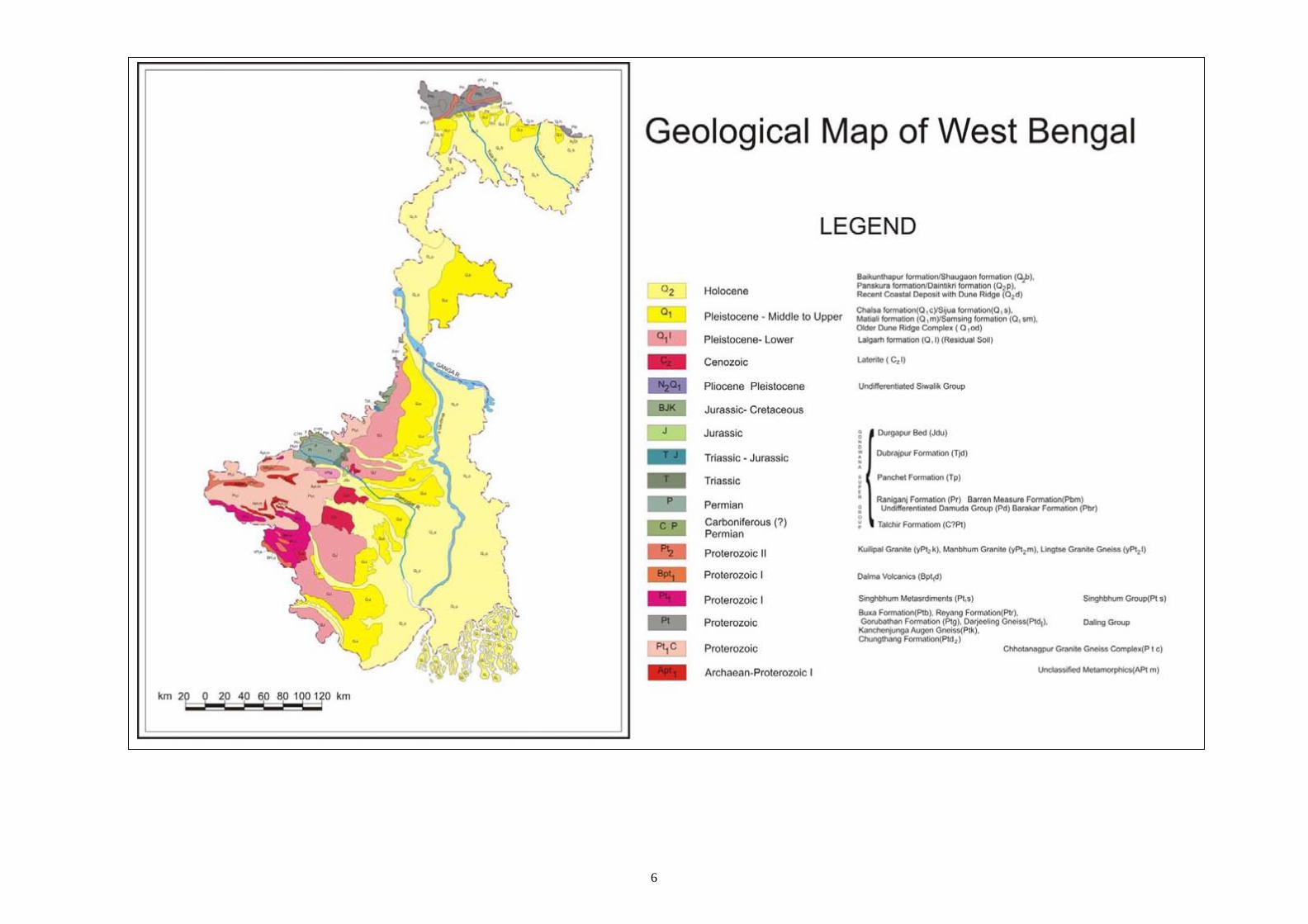
The state of West Bengal, covering an area of 88752 sq. km is bounded by Latitude 21o 30’ to 27o 30’ N and Longitude 85o 30’ to 89o 45’ E. It encompasses diverse rock types ranging from Archaean to Recent alluvial sediments. The hard rocks occupy about 25% and the alluvial tract covers about 75% of the total area. The Extra Peninsular region shows three longitudinal morphotectonic subdivisions. The Main Boundary Fault separates syn-orogenic Siwalik Group (Tertiary) comprising coarse, hard, salt -pepper sandstone, silt stone, shale and conglomerate of the Sub Himalayas in the foreland from the Lesser Himalaya which constitutes stacked pile of thrust sheets constituting dominantly dolostones, cherts, slates, phyllite, quartzites, high grade schists and gneisses. The Main Central Thrust separates Lasser Himalayas from the Higher Himalayas in the north which constitutes mainly high grade gneissic rocks. Gondwana Supergroup of rocks with anthracite coal seams is found near Jalpaiguri and Darjeeling districts. The Quaternary deposits of the extra Peninsular region occurs just south of Siwalik Group as alluvial fans and fluvial depositional terraces in the upper reaches and as fluvial terraces of flood plain facies in the lower reaches.
3
Within the peninsular mass in the south-western part of the state, the Chhotanagpur Gnessic Complex (CGC) forms an integral and important segment of Precambrian Shield of Eastern India. The Proterozoic rocks are exposed in southern part of Purulia district and extend over the western parts of Bankua, Bardhaman, Birbhum and Midnapur districts. The rock types include paragneisses and schists, gabbros, norites and anorthosites, granites and granitoids metavolcanics and recent find of carbonatite. The WNW-ESE trending Tamar-Porapahar Shear Zone (TPSZ) between Chhotanagpur Gneissic Complex (CGC) and Singhbhum Group of rocks and E-W trending North Purulia Shear Zone within CGC are sites of base metal and rare earth mineralisation. Gondwana Supergroup of rocks rest unconformably over the Proterozoics and are characterised by extensive presence of coal seams.
The Tertiary rocks occur as patchy occurrences of ferruginous sandstone, red shale, grits and gravels in parts of Midnapur, Bankura and Bardhaman districts. Quaternary deposits are represented by present day flood plain deposits, older flood plain deposits and older alluviums over a mantle of lower Quaternary age.
Mineral Resources: Various metallic and nonmetallic minerals are found in the Peninsular and Extra Peninsular parts of the state. Apatite- Vien type apatite-magnetite mineralisation occurs in Purulia district in Beldih, Mednitanr, Chirugora, Purtaha, Kanti and Dandodih-Gamardih. Basemetal occurrences are located in Gorubathan (Darjeeling dist, Pb-Zn)and Tamakun (Purulia dist, Cu). China clay- Extensive deposits of china clay have been located with the Gondwanas in the western districts of the sate. Coal- Coal is the most important economic mineral of West Bengal and contributes about 13% of the total coal production in the country. The important coalfields are Raniganj coalfield and those located in Birbhum, Bankura and Purulia districts. Small coal deposits are located in Darjeeling district. Dolomite- Extensive deposits of dolomite occur in Precambrian Bauxa Group of rocks in Jainti-Bauxa Duar area of Jalpaiguri district.with CaO varying from 10.9% to 37.5% and MgO from 6.43% to 22.24%. Fire clay- The fire clay deposits are generally associated with coal seams over a wide area in Raniganj coal field and partly in Birbhum coal field. Kyanite- Discontinuous bodies of Kyanite quartz rocks are located in Purulia district. Silica sand- Huge reserves of sands are available from the beds of many rivers in the western and northern part of the state and most river sands are impure in nature. Besides, moulding sand and glass sand also occur ii some parts of the state. Wolframite - Wolframite occurs in Chhendapathar and Porapahar areas of Bankura district and also in Mansang area of Darjeeling district.
4
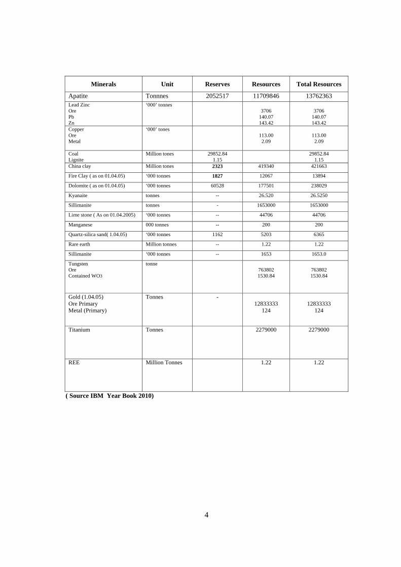
( Source IBM Year Book 2010)
Minerals Unit Reserves Resources Total Resources
Apatite Tonnnes 2052517 11709846 13762363 Lead Zinc Ore Pb Zn
‘000’ tonnes 3706
140.07 143.42
3706
140.07 143.42
Copper Ore Metal
‘000’ tones
113.00
2.09
113.00
2.09
Coal Lignite
Million tones 29852.84 1.15
29852.84 1.15
China clay Million tones 2323 419340 421663
Fire Clay ( as on 01.04.05) ‘000 tonnes 1827 12067 13894
Dolomite ( as on 01.04.05) ‘000 tonnes 60528 177501 238029
Kyanaite tonnes -- 26.520 26.5250
Sillimanite tonnes - 1653000 1653000
Lime stone ( As on 01.04.2005) ‘000 tonnes -- 44706 44706
Manganese 000 tonnes -- 200 200
Quartz-silica sand( 1.04.05) ‘000 tonnes 1162 5203 6365
Rare earth Million tonnes -- 1.22 1.22
Sillimanite ‘000 tonnes -- 1653 1653.0
Tungsten Ore Contained WO3
tonne
763802 1530.84
763802 1530.84
Gold (1.04.05) Ore Primary Metal (Primary)
Tonnes - 12833333
124
12833333
124
Titanium Tonnes 2279000 2279000
REE Million Tonnes 1.22 1.22
6
7
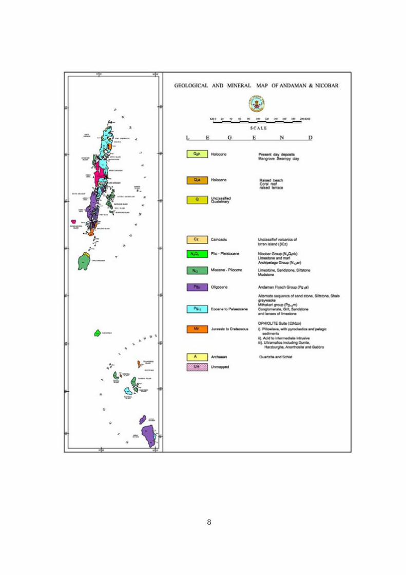
ANDAMAN & NICOBAR ISLANDS
This arcuate chain of Andaman & Nicobar group of Islands flanked on the west by the Bay of Bengal and on the east by the Andaman Sea constitutes the southern most part of the Indian subcontinent covering an area of 8249 sq. km. Among 700+ islands, those which are large, reasonably suitable for habitation, sustainable for eco-friendly development and host of good natural resources are known as Andaman Islands. Associated with them is other small but important islands like Rutland, Neil, Havlock, Ritches Archipelago and Baratang. These Islands together with the Quaternary volcanic Islands at Barren and Narcondam retain a wealth of information about Recent and Cenozoic geological processes.
Andaman and Nicobar group of Islands represents a part of an arcuate chain of islands running from Myanmar in the north to Indonesia in the south in Indo-Sumatra subduction zone. The island chain represent the subaerial part of the submarine fore arc ridge of the Indonesian Island Arc system. An active zone of subduction along the Andaman-Java trench lies to the west of the Andaman-Nicobar islands and continues southward into the Indonesia. Underthusting of the Indian oceanic plate below the Eurasian plate since Cretaceous to present day along this subduction zone has resulted in the formation of a wide accretionary prism and upbuilding of a high fore arc - outer arc ridge known as Andaman-Nicobar ridge. These islands geologically comprise continental metamorphic rocks of pre-ophiolitic age, described as Pre-ophiolitic rocks. These are located as large and xenolithic patches within the ophiolite. The oldest groups of rocks comprise a package of metamorphic rocks viz., quartzite, quartz sericite schist etc.
The widely accepted lithostratigraphy for the Andaman Islands depict oceanic crust and associated pelagic sediments represented by Ophiolite suite of Cretaceous age (80-100 million years) as the oldest stratigraphic horizon. They comprise ultramafic rocks, gabbro, basalt, plagio-granite, diorite and limestone-chert.
Thin and discontinuous occurrences of radiolarian chert, jasper, mudstone and shale that are interstratified with basalt are part of the ophiolite sequence that have been described as Oceanic Pelagic Sediments (OPS). The Eocene to Pliocene sedimentary sequence younger to OPS comprises conglomerate, sandstone, limestone, siltstone- shale. This sediment pile has been classified into three Groups- Mithakari, Andaman Flysch and Archipelago in ascending order. Clastic and volcaniclastic sediments of Mithakhari Group are laterally extensive and considerably thick siliciclastic turbidite succession, the Andaman Flysch overlying the Mithakhari Group and. The top most stratigraphic horizon of Mio-Pliocene age is an interbedded sequence of claystone-tuffs-sandstone-limestone referred to as Archipelago Group. The ophiolite suite of rocks also occurs as dismembered units of subhorizontal thrust slices lying over the Andaman Flysch..
Quaternary sediments are seen overlying the hard rocks at places. The Narcondam and the Barren are volcanic islands in the inner arc of the subduction zone.
The outer arc-fore arc terrain constituting the Andaman-Nicobar Islands is characterized by a complex mosaic of different geological provinces each has its own records of origin and geological evolution. Rocks of the Andaman Islands are tectonically thrusted into a narrow north-south trending linear belt paralleling the north-south trend of the Andaman-Java subduction zone. The Ophiolites, their cover sediments and the Andaman Flysh together are folded into an open anticline (Ray, 1982). Sets of mesoscopic folds occur in all the sedimentary units associated with ophiolites. MINERAL RESOURCES The Andaman Islands have long been investigated for minerals of economic importance, constructional material, and for occurrences of liquid fuel. Mineral investigation by the GSI led to the find of limestone, chromite, nickel, base metals, gold, PGE and coal in different islands. Except limestone, the other minerals so far assessed are found to be sub-economic. The limestone resources in Long Island have yielded a reserve of over four million tonnes of cement grade
8
9
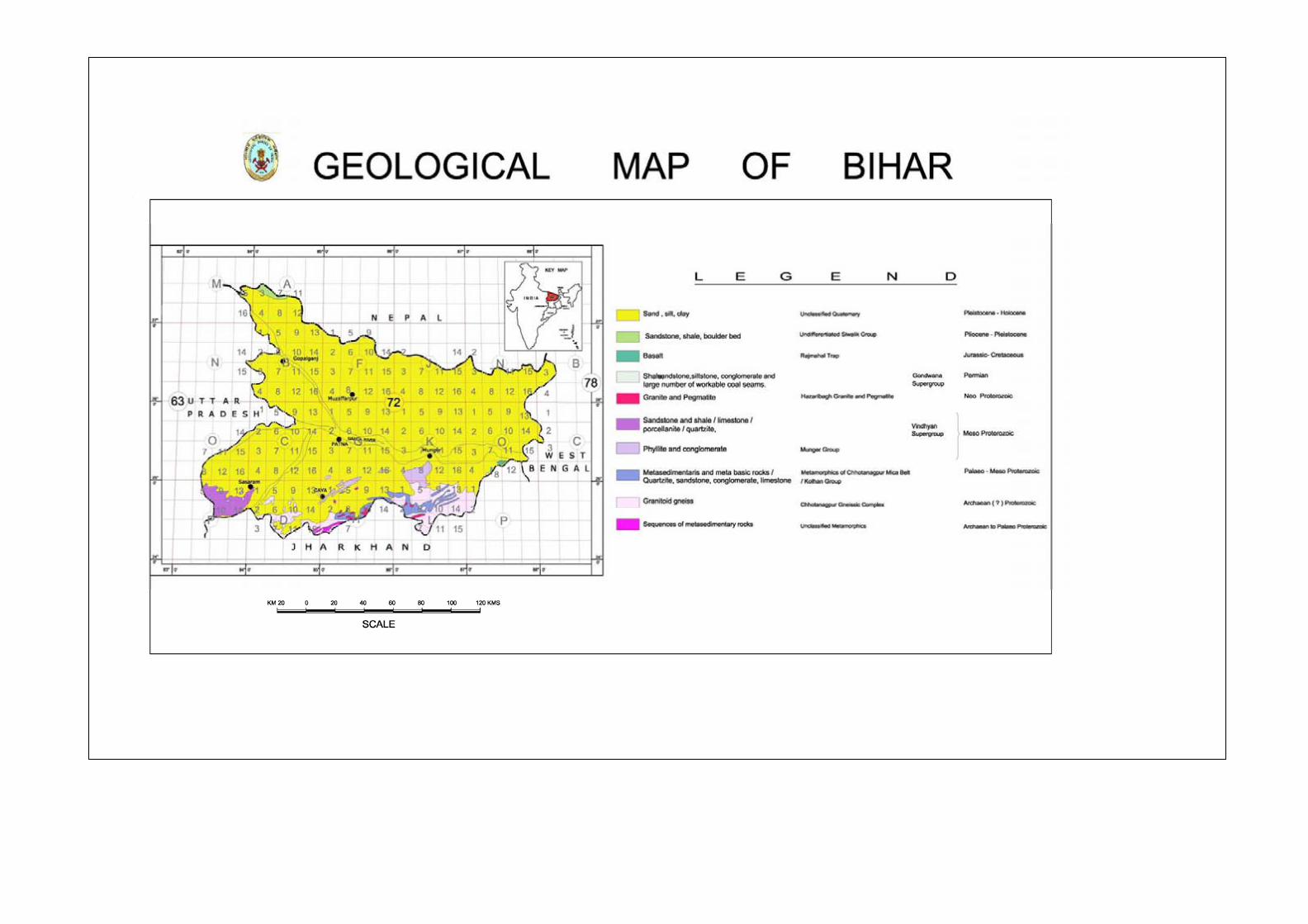
BIHAR
After bifurcation of the state in the year 2000, presently the State of Bihar covers an area of 94162 sq. km. bounded by latitudes 24º 15' N and 27º 31' N and longitudes 83º 20' E and 88º 18' E, Nearly two-thirds of the state of Bihar is covered by Indo-Gangetic alluvial sediments. They are flanked by the belt of Himalayan foothill sediments to the north and Vindhyan Plateau, coal bearing Gondwana basins, Chhotanagpur plateau and other highland cratonic elements of Pre-Cambrian formations to the south.
Amongst the significant geological formations in the state are the Munger Group located close to the northern margin of the Chhotanagpur Gneissic terrain of Jharkhand and occurrung as several NE-ENE - SW-WSW trending ridges rising above the Gangetic Alluvium. The group comprises metasedimentary lithopackages of quartzite and phyllite. These are intruded at places by granite and basic rocks. The munger Group rocks have been folded and faulted inticately. Some of the Hot-springs of Rajgir area lie over some of such faults. Munger Group have been considered by some as time equivalent of a part of Vindhayans. Vindhan rocks in the state of Bihar are located to the easternmost continuity of the Son Valley vindhanyans. It covers about 3740 sqkm area.and is bounded in the north by the Mahakoshals and the Chhotanagpur gneissic complex in the south and by Gangetic Alluvium in the north and represent the Semri – Kaimur Groups,the lower part of the Super Group.
Representatives of the Tertiary period in Bihar are few and scattered and are represented by the fossiliferous unit known as the Rajdanda Formation. Undifferentiated Siwalik Groupof rocks occur towards the NW margin bordering Nepal and comprise calc-arenite, calci-lutite, impure limestones, sub-gerywacke, variegated clay, boulder conglomerates and red clay. They have been correlated with Lower, Middle and Upper Siwaliks of western Himalya and with the Surma, Tipam and Dihings of Assam valley. Vertibrate fossil remains are reported from the Middle Siwaliks in Banktwa and Raghis, West Champaran district.
The alluvial terrain of the state represents a conspicuous part of the geological history. Predominant feature is the Gangetic plain covered by the riverine alluvial deposits forming part of the great northern plains of India. Rising above the alluvial plain are some inselbergs of older rocks. Recent studies have brought into light presence of NE-SW trending faults oblique to the NW-SE trend of the Himalayas occurring to north and also to the peninsular shield elements and as such conceived that several ancient rifted basinal features co-exist with regions of uplift, within a broad framework of the nprthern extension of the shield elements. This terrain comprises a 6000m thick pile of sediments in the Himalayan front and a platform belt in the south with sediment thickness varying between 3000 to 6000m. MINERAL RESOURCES
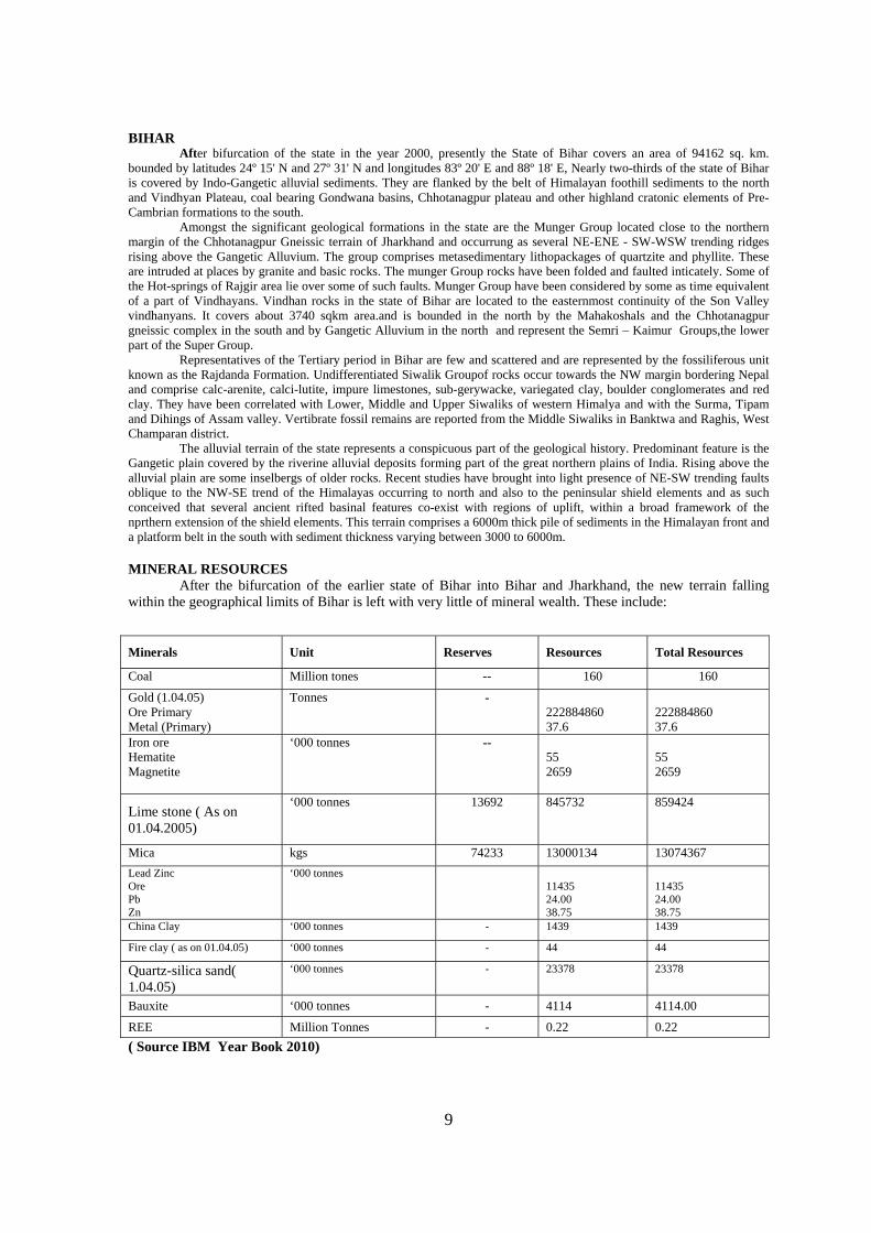
After the bifurcation of the earlier state of Bihar into Bihar and Jharkhand, the new terrain falling within the geographical limits of Bihar is left with very little of mineral wealth. These include:
( Source IBM Year Book 2010)
Minerals Unit Reserves Resources Total Resources
Coal Million tones -- 160 160
Gold (1.04.05) Ore Primary Metal (Primary)
Tonnes - 222884860 37.6
222884860 37.6
Iron ore Hematite Magnetite
‘000 tonnes -- 55 2659
55 2659
Lime stone ( As on 01.04.2005)
‘000 tonnes 13692 845732 859424
Mica kgs 74233 13000134 13074367
Lead Zinc Ore Pb Zn
‘000 tonnes 11435 24.00 38.75
11435 24.00 38.75
China Clay ‘000 tonnes - 1439 1439
Fire clay ( as on 01.04.05) ‘000 tonnes - 44 44
Quartz-silica sand( 1.04.05)
‘000 tonnes - 23378 23378
Bauxite ‘000 tonnes - 4114 4114.00
REE Million Tonnes - 0.22 0.22
11
JHARKHAND
The State of Jharkhand lying between latitudes 22º 00' N and 24º 15' N and longitudes 83º 20' E and 87º 55' E covers an area of 79714 sq. km.
Jharkhand preserves the signature of Archaean to Recent time either in complete or in vestigial form that are manifested by Archaean Supracrustals of 3.4 m.y.,age Pre-Cambrian Granite-greenstone and granulite gneiss belt in the southern cratonic part.. The shield area of the state of Jharkhand displays a mosaic of several geological provinces viz., (a)The Archaean Cratonic massif of Singhbhum Granite including older metamorphics (b) Iron ore province of South Singhbhum (c) Proterozoic mobile belt of North Singhbhum and (d) Chhotanagpur granite gneissic massif with enclaves of high grade rocks.
The Archaean-Proterozoic rocks of the shield area occurring to the south of Gangetic alluvium and forming the basement for the younger rocks consist of two major tectonic units:
(i) The Singhbhum Province in the south and
(ii) Chhotanagpur Province in the north.
The boundary between the two provinces is defined by a basement dislocation zone now manifested by Tamar-Porapahar Shear Zone (TPSZ). The most spectacular structural element of the Singhbhum Craton is a 1-10 km wide and 160 km (approximate ) long arcuate belt of shear zone (Singhbhum Shear Zone) separating the North Singhbhum Mobile Belt in the north from Iron Ore Super group and the Singhbhum Granite to the south acts as locale of copper mineralization. The Older Metamorphic Group (OMG) represents the oldest rocks in the Singhbhum Craton. It is a diverse group consisting of medium grade (amphibolite facies), pelitic schist, arenites, calc-silicate rocks, para-and ortho-amphibolites (Saha, 1994). It is best exposed (type area) in 200 sq. km. area to the west and southwest of Champua.
The north-south, elongated Singhbhum Granite Complex (SBG) massif is a multi-component unit ranging in composition from tonalite through granodiorite to granite. It occupies an area of about 3000 sq km out of a total 8000 sq km for the entire cratonic block.The Singhbhum Granite batholith (sensu stricto) is considered to be made up of 12 magmatic bodies of biotite granodiorite-granite emplaced in three distinct phases. The Iron Ore province (Iron Ore Supergroup) comprises an assemblage of Archaean supracrustal consisting of mafic-ultramafic volcanics, volcano-clastics, chert, BIF, greywackes, meta-argillites and arenites (with polyphase deformation and greenschist facies of metamorphism) and are deposited in three major basins of Eastern India; viz.
i) Potka-Gorumahisani-Badampahar basin along the eastern border of Singhbhum Granite (Part designated as Gorumahisani Group),
ii) West Singhbhum-Kendujhar basin in the western flank of Singhbhum Granite massif (designated as Lower Bonai Group),
iii) Palalahara-Daiteri basin along southern part, confined entirely to the State of Orissa.
In the State of Jharkhand, the litho-assemblages of Lower Bonai Group occur only in parts of East and West Singhbhum districts. IOG/ Lower Bonai rocks occur along the eastern flank of the Singhbhum Granite with fork shaped curvilinear belts along Kunderkocha -Tiring-Rajnagar in the west and Kunderkocha-Digharsai-Potka-Ukampahar in the north. These are considered to be the classical Greenstone belt comparable with the other such belts of the world and the sequences are engulfed and intruded by Singhbhum Granite, This Granite-Greenstone sequence is considered to be a significant locale for gold mineralization. In west Singhbhum the Lower Bonai IOG rocks lying to the west of SBG is dominated by BIF along with volcanics in the southeastern part and low grade meta-sediments with minor volcanics in the northern part which forms a part of the ‘Horse Shoe’ shaped Iron Ore synclinorium with NNE-SSW axial trend.
The ancient Singhbhum craton is surrounded on the east, north and northeast by predominantly pelitic supracrustals with a number of intrusive granitoids and the set-up is designated as Proterozoic Mobile Belt or North Singhbhum Mobile Belt. This belt extends along a roughly east-west trend and bounded by Singhbhum Shear Zone (SSZ) in the south and vast expanse of Chhotanagpur gneissic terrain in the north and with the east-west trending Tamar-Porapahar shear zone (TPSZ) in between. The prominent feature of this mobile belt is the arcuate Dalma volcanics,
12
The Proterozoic period also represented by the Vindhyan Supergroup of rocks exposed in the Western part, which draws attention for its bio-organic sedimentary structure and limestone deposits.
The coal bearing horizons of Gondwana Supergroup represent the Phanerozoic period. In Peninsular India several belts of depocentres of largely continental sediments were developed during the period, a major part of which falls within Bihar-Jharkhand. The Gondwana rocks occur as isolated basins within the Chhotanagpur Granite Gneiss terrain. These rocks occupy a significant part of Jharkhand and also include thick measures of coal seam. The basins have been developed along two distinct tectonic trends: (i) the east-west trending Damodar and Koel valley basins and its subsidiary belt and (ii) the north-south trending Rajmahal-Purnea belt.The Gondwanas are overlain by Rajmahal Volcanics in the Eastern part. The Pleistocene-Holocene period represented by the cover sediments of the Indo-Gangetic alluvial deposits occupy a vast tract in the northern part. MINERAL RESOURCES APATITE: Apatite is found in East and West Singhbhum district as veins emplaced in the Singhbhum Shear Zone in a 60 km. long belt in the eastern part of shear zone. Apatite mineralisation also occurs as an associated mineral in mica pegmatites of Bihar Mica Belt, in parts of Gaya, Hazaribagh and Munger districts.
BAUXITE: Extensive deposits of bauxite are found in the western parts of Chhotanagpur Plateau falling in Lohardaga, Gumla and adjoining Palamau district. The reserves of high grade bauxite, containing above 50% Al2O3 were tentatively estimated to be about 9 mt in the erstwhile Ranchi district and 1.7 mt in Palamau district. The exploration at Amtipani area established an estimated reserve of 4.95 mt analyzing 48.47% Al2O3 and 5.59% SiO2.
COAL: Jharkhand, the leading state in the Indian subcontinent in respect of its coal deposits, bears the testimony of classical development of the Permian coal measures. Out of different Gondwana basins of Peninsular India, Jharkhand state occupy the most important E-W trending Damodar-Koel valley basin covering coalfields like Raniganj, Jharia, Bokaro, Ramgarh, Karanpura, Auranga and Hutar from east to west.
COPPER: The Singhbhum Copper Belt, Jharkhand, stretched over a length of 128 km between Duarpuram (22º46´: 85°34´) in the west and Baharagora (2216’:8643’) in the southeast has been a major sorce of copper ores in India. This length of potential mineralized zone lies along a shear zone and is divided into three i.e., eastern (Baharagora-Badia), central (Badia-Kharkai River) and western (Tamadungri-Duarpuram) sectors. Copper occurrences are also recorded from Tulsitanr in Deoghar district and Baraganda in Giridih district.
DOLOMITE:Dolomite occurrences are restricted mainly to the rocks of Singhbhum Group, Chhotanagpur Granite Gneiss Complex (CGGC) and rocks of Vindhyan Supergroup. Within CGGC dolomite is restricted mainly in Palamau district. Dolomite in Vindhyan from Rohtas district occurs near Banjari.
GOLD: Gold is known to occur in several areas of Jharkhand. Auriferous quartz reefs are commonly found in the low-grade metasediments and metavolcanic rocks of ultramafic to acidic composition belonging to Iron Ore Group and Singhbhum Group and volcanics of Dhanjori-Dalma affinities. Among the important occurrences are Kunderkocha deposit, E Singhbhum district, Lawa-Maysara deposits and quartz-pebble-conglomerate located at the base of Dhanjori basin. Other notable occurrences include Rungikocha - Pahardia, Ankua, Sausal, Bhitardari, Parasi and Digarsai of Ranchi and W. Singhbhum district.
IRON ORE: Jharkhand is one of the most important states with respect to high grade iron ore deposits. Iron ores occur in a series of ridges with NNE-SSW trend, extending from the SW part of Singhbhum district in Jharkhand to adjoining Keonjhar and Sundergarh districts in Orissa, capping the hills and extending down to varying depths. Workable deposits of iron-ore in Jharkhand are located around Noamundi, Notuburu, Jamda, Gua, Meghatuburu, Kiriburu, Chiria, Ghatkuri and in other areas in Singhbhum district. The host rock is BIF and main ore mineral is hematite.
LEAD AND ZINC: In Singhbhum district galena has been found associated with the auriferous quartz veins of Pahardia and Sausal area. In Hesatu-Belbathan polymetallic mineralization within Chhotanagpur Granite Gneiss Complex, numerous small occurrences have been recorded. This belt runs in ENE-WSW direction from Hesatu in the Hazaribagh district to Belbathan in Santhal Pargana (presentlyGodda) district for a distance of about 250 km with a maximum width of about 50 km.
13
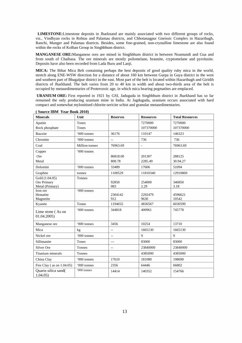
LIMESTONE:Limestone deposits in Jharknand are mainly associated with two different groups of rocks, viz., Vindhyan rocks in Rohtas and Palamau districts, and Chhotanagpur Gneissic Complex in Hazaribagh, Ranchi, Munger and Palamau districts. Besides, some fine-grained, non-crystalline limestone are also found within the rocks of Kolhan Group in Singhbhum district.
MANGANESE ORE:Manganese ores are mined in Singhbhum district in between Noamundi and Gua and from south of Chaibasa. The ore minerals are mostly psilomelane, braunite, cryptomelane and pyrolusite. Deposits have also been recorded from Lada Buru and Lanji.
MICA: The Bihar Mica Belt containing perhaps the best deposits of good quality ruby mica in the world, stretch along ENE-WSW direction for a distance of about 160 km between Gurpa in Gaya district in the west and southern part of Bhagalpur district in the east. Most part of the belt is located within Hazaribagh and Giridih districts of Jharkhand. The belt varies from 20 to 40 km in width and about two-thirds area of the belt is occupied by metasedimentaries of Proterozoic age, in which mica bearing pegmatites are emplaced.
URANIUM ORE: First reported in 1921 by GSI, Jaduguda in Singhbhum district in Jharkhand has so far remained the only producing uranium mine in India. At Jagduguda, uranium occurs associated with hard compact and somewhat mylonitised chlorite-sericite schist and granular metasedimentaries.
( Source IBM Year Book 2010) Minerals Unit Reserves Resources Total Resources
Apatite Rock phosphate
Tones Tones
7270000 107370000
7270000 107370000
Bauxite ‘000 tonnes 36176 110147 146323
Chromite ‘000 tonnes -- 736 736
Coal Million tonnes 76963.69 - 76963.69
Copper Ore Metal
‘000 tonnes 86818.00 808.78
201307 2285.49
288125 30.94.27
Dolomite ‘000 tonnes 33489 17606 51094
Graphite tonnes 1100529 11810340 12910869
Gold (1.04.05) Ore Primary Metal (Primary)
Tonnes 92850 083
254000 2.29
346850 3.18
Iron ore Hematite Magnetite
‘000 tonnes 2304142 912
2292479 9630
4596621 10542
Kyanite Tonne 1194032 4836567 6030599
Lime stone ( As on 01.04.2005)
‘000 tonnes
344818 400961 745778
Manganese ore ‘000 tonnes 3456 10254 13710
Mica kg -- 1665130 1665130
Nickel ore ‘000 tonnes -- 9 9
Sillimanite Tones --- 83000 83000
Silver Ore Tonnes -- 23840000 23840000
Titanium minerals Tonnes 4385000 4385000
China Clay ‘000 tonnes 17610 181080 198690
Fire Clay ( as on 1.04.05) ‘000 tonnes 2356 64446 66802
Quartz-silica sand( 1.04.05)
‘000 tonnes 14414 140352 154766
15
ORISSA
The state of Orissa covering about 1, 55,707square km area, lies along the east coast of India ( Lat.17o48’ – 22o34’ and Long. 81o24’ – 87o29’) with a sprawling 480 km of coastline. Orissa is divisible in to four major physiographic regions: the Northern Plateau, the Central River Basin, the Eastern Ghats hill ranges and the Coastal Plains.
GEOLOGY:
The state of Orissa comprises dominantly of Pre-cambrians (Mesoarchean to Neoproterozoic, 72.5%) while the Phanerozoic (8%, represented by the Late Palaeozoic – Mid Mesozoic coal bearing Gondwana Supergroup); minor Tertiary patches and Quaternary formations (19.5%) make up the rest.
The Precambrian terrain represents the northeastern part of the Indian Precambrian Shield and exposes parts of two major cratonic domains viz. the Eastern Indian Craton in the north and Bastar Craton in the west as well as bordering mobile belts [parts of the Eastern Ghat Mobile Belt and the (Singhbhum -) Gangpur segment of the Satpura Mobile Belt].
Eastern Indian Craton (EIC) represents an Archean – Palaeoproterozoic granite-greenstone terrain bounded by two crustal-scale shear/thrust zones, viz., the Singhbhum (Copper Belt) shear/thrust zone in the north and the Gohira – Sukinda shear/thrust zone in the south. These two shear/thrust zones isolate the EIC from the Singhbhum – Gangpur segment of the Satpura Mobile Belt occurring in the north and northeast and the EGMB occurring in the south. Major lithological components of the EIC comprise Supracrustal sequences, granitoids, mafic-ultramafic and gabbro-anorthosite complexes and mafic dyke swarms. An older limit of ca. 3.5 Ga has been envisaged as the age of sedimentation of Supracrustals in EIC.
Bastar Craton, exposed in the western parts of the state comprises of: Archean Supracrustals of the Bengpal and Bailadila Groups, granitic gneisses and granitoids ranging in age from Neo-archaean to Palaeoproterozoic, a wide variety of post-tectonic silicic intrusives with alkaline affinity, mafic/ultramafic rocks and several Meso-Neoproterozoic sequences of platformal sediments (Chhatisgarh Supergroup). Isotopic ages of granitoids in this craton range from 2.11 to 2.67 Ga.
Gangpur-Singhbhum Group comprising medium-grade Proterozoic rocks form a curvilinear mobile zone skirting the Archean EIC stretching from Mayurbhanj in northeast to the Gangpur region in the northwest through Singhbhum in the state of Jharkhand.
Eastern Ghat Mobile Belt (EGMB), extending for over 1000 km from Orissa to southeastern parts of Andhra Pradesh along the eastern coast of the Indian Peninsula, represents one of the most highly deformed and metamorphosed crustal segment of the Indian Shield. The EGMB comprises Khondalite Group, Charnockite, Mafic granulites, Metaultramafic, Migmatitic granitic gneisses/leptynites/granitoids, Plutonic alkaline complexes and massif-type anorthosite complexes. In the Orissa sector, from east to west, the EGMB is divided into Eastern Khondalite Zone, Central Migmatite Zone, Western Khondalite Zone, Western Charnockite Zone and the Westernmost Transition Zone. The NW-SE trending Mahanadi graben sub-parallels the Brahmani lineament and form a tectonic zone which divides the central highland into a southern segment comprising granulite facies lithoassemblages continuing southwards into Andhra Pradesh, and a northern segment exposing ancient (Archaean) granite-greenstone assemblages continuing northwards into Jharkhand.
However, the Mahanadi and Godavari rifts divide the EGMB into three segments across its length, viz. (i) northern segment (ii) central segment and (iii) southern segment.
The southern segment of the EGMB is separated by North Orissa Boundary Fault (NOBF) from the central highland. The northern segment of the central highland and the western plateau-land bordering Eastern Ghats are similar in geological set up that are known respectively as the North Orissa Craton (part of EIC) and Bastar Craton. While in the middle of it lies the Gondwana formations in Mahanadi graben bounded by faults, which have rich coal resources. Some sectors of the coastal plains are covered by sediments of Tertiary and Quaternary periods besides some low-level laterite.
Gondwana Supergroup comprising Permo-Carboniferous to Lr. Cretaceous coal bearing rocks are spread over 12,415 sq.km area along the NW – SE trending linear belt in the Mahanadi valley. Three major basins (Talchir, Ib River and Athgarh) and a number of small patches (outliers) of Gondwana rocks (Katiringia, Gaisilat, Athmalik, Chhatarpur) in the districts of Angul, Dhenkanal, Sambalpur, Sundargarh, Phulbani, Baudh, Bolangir, Cuttack, Khurda, Puri and Ganjam, also expose Gondwana rocks. While the Lower Gondwana rocks are a vast repository of coal, the Upper Gondwana sandstones have been used as building material for the Lord Jagannath temple at Puri, Lingaraj temple at Bhubaneswar and partly the Sun Temple at Konark. The Jain caves at Khandagiri and Udaigiri, located near Bhubaneswar, have also been carved out of these sandstones.
16
Tertiary formations (Baripada Beds) occur around Baripada town (21o56’ N: 86o44’ E), over a radius of 8 km in the bed of the Budhabalang river. The Baripada sediments are horizontal to sub-horizontal in disposition and comprise alternate sets of stratified clay and sand with semi-consolidated clay, ferruginous grit, soil and occasional marly clay or limestone interbands.
Quaternary formations in the state include volcanic ash beds confined along river valleys, deltas and coastal plain and attain maximum width of about 100 km in the Mahanadi delta.
MINERAL RESOURCES:
Basemetals - Associated with the Precambrian schists, copper and lead ores mainly occur at Kesarpur , Mayurbhanj district; Adash, Sambalpur district and Sargipalli (T.S no. 65N/16) in Sundargarh district respectively.
Bauxite - Orissa accounts for 59% of the total bauxite production of the country. The bauxite deposits of Orissa are broadly classified into five different categories based on nature of the bed-rock as (i) Relatively large capping over khondalites, Eastern Ghats Super Group in Koraput, Kalahandi, Phulbani, Bolangir and Sambalpur districts, (ii) Cappings developed over charnockite, diorite /dioritic gneisses, Eastern Ghats Super Group in Koraput and Kalahandi districts, (iii) Minor cappings over Chattishgarh shale in Khariar highlands in Nuapada district, (iv) Minor cappings over mafic volcanics and shale of Koira Group in Kendujhar – Sundargarh district and (v) Capping over Simlipal volcanic rocks in Mayurbhanj district.
Beach Sand Minerals - The coastal tracts of Ganjam and Puri districts contain workable concentration of heavy minerals in the beach and dune sands, which include ilmenite, garnet, rutile, sillimanite, zircon and monazite.
Cassiterite (Tin Ore) - Cassiterite occurs both as primary and secondary mineralization in Malkangiri district associated with pegmatites emplaced within the Precambrian Bengpal Group of rocks and also as the colluvial maters formed out of such pegmatites.
Coal - Orissa has 24% of the total coal resource of the country. The major coal bearing formations in both Talchir and Ib-river coal fields are Karharbari and Barakar. Talchir Coal field in Angul district is characterized by east-west running strike faults and in the process, repetition of coal seams has resulted in increased quarriable potentiality.
Chromite - Orissa holds the first place in reserves position and production of chromite in the country, contributing to over 97% of the all India output. The deposit yielding metallurgical, refractory and chemical grade of ores occur within the chromiferous ultramafic rocks emplaced into the Archaean Badampahar Group of rocks around Sukinda and Nuasahii covering parts of Jajpur, Kendujhar and Dhenkanal districts.
Gemstones - The Eastern Ghats Granulite belt hosts most of the gemstone occurrences of the state. Among the several gemstone belts of Orissa, the 25km long Jilingdhar- Hinjilibahal belt, Kalahandi district is the most important contributing the best quality ruby. Besides deep blue dichroic iolite in cordierite gneiss, hessonite and zircon in pegmatites traversing calc-granulites, chrysoberyl (Cat’s eye) in pegmatites traversing pyroxene granulite are the other gemstones of this belt.
Occurrences of emerald, topaz, heliodor and aquamarine associated with low dipping unzoned pegmatites emplaced in granite gneiss are reported from Bolangir district. Greenish blue to sea blue aquamarine is reported from gemstone tracts of Sonepur district. Rare occurrence of alexandrite in biotite schist developed along the contact of granite pegmatite and peridotite is reported from Sambalpur district.
Gold - Gold occurrences of Orissa are confined to mainly placers, though there is evidence of old mining activity in the northern parts of Orissa, especially in Kendujhar disrtict adjoining Jharkhand. Occurrence of alluvial gold has been recorded in almost all the districts of Orissa and panning of the stream sediments in the major rivers has yielded gold.
Graphite - Orissa continues to be the leading producer of graphite accounting for 67% of the country’s total production. The graphite occurrences are distributed in six belts, viz, Sargipalli, Titlagarh, Tumudibandh, Nishikal, Muniguda and Dhandatapa belts. Almost the entire production of high grade graphite is contributed by Sargipalli mine in Baragarh district.
Iron Ore - Orissa has vast reserves of high grade iron-ores. Important iron ore bearing areas are Thakuranii Pahar, Sidhamat Parbat, Durga Parbat, Joda east and west, Banspani Pahar, Dal Pahar, north and west of Kurband, Jhiling Pahar, Longlota Pahar, Guali, Kiriburu, Kalta and Gandhamardan. Kendujhar district, In Sundargarh district, the notable iron ore deposits are in Bonai range viz. Khandadhar, Malangtoli, Dandrahar Pahar, Taldih, Kalta, Basada, Baliapahar, Badamgarh Pahar, Hitikuda, Rakmo, Daringburu and Barsuan. In Mayurbhanj district, iron ore deposits are located in Badampahar, Sulaipat and Gorumahisani areas while
17
Daitari hill is the only iron ore deposit in Jajpur district. The host rock is banded hematite jasper/ quartzite (BHJ/ BHQ) of Precambrian age.
Limestone and dolomite - Orissa is endowed with vast resources of limestone confined to three distinct geological settings viz; Gangpur Group, Chattishgarh Supergroup and Eastern Ghats Supergroup of rocks. One of the most important Precambrian limestone and dolomite deposits of Orissa occurs associated with Gangpur Group of rocks in Sundergarh district. The lime content in the rock varies from 30 to 52% while the insoluble and silica show variation from 30 to 35 % and magnesia up to 15%. Alumina and iron oxide contents never exceed 6 % and 8% respectively.
Manganese - Orissa accounts for one third of the country’s annual production of manganese and possesses the second largest recoverable manganese resources/ reserve in the country. The manganese deposits of Orissa, restricted to the Precambrian rocks, occur chiefly in four distinct geographic belts: (i) the Bonai – Kendujhar Belt in Sundargarh and Kendujhar districts, associated with chert-shale sequence and laterites, (ii) Kuttinga – Nishikal – Ambadola – Patna belt in Koraput, Kalahandi and Bolangir districts, associated with Khondalites (iii) Ghoriajhor belt (Gangpur Group) in Sundargarh district associated with Gonditic rocks and (iv) Bamra subdivision of Sambalpur district associated with laterite over metasediments.
Nickel - Nickel ores associated with limonitised and silicified ultrabasic rocks occur in Sukinda area, Jajpur district and within the weathered zone of ultramafic differentiates of the Amjori sill emplaced in the Simlipal Group of rocks in Simlipal area, Mayurbhanj district.
Platinum – PGE mineralisation has been reported from the ultramafic complexes of Sukinda and Nuasahi areas located at the trijunction of Kendujhar, Jaipur and Dhenkanal districts. Layered, differentiated ultramafic to mafic plutons emplaced in stable cratonic blocks of Late Archaean to early Proterozoic age are most potential for hosting orthomagmatic PGE deposits.
Vanadiferous Magnetite - Deposits of vanadiferous magnetite occurring in association with gabbro-anorthosite suite of rocks in north Orissa are distributed in five belts viz. (I) Bisoi-Rairangpur, (ii) Bisoi-Jasipur, (iii) Baripada-Udala in Mayurbhanj district and (iv) Nausahi-Baula and (v) Rangmatia-Betai in Kendujhar and Balasore districts. Reserves/Resources of Minerals Orissa ( Source IBM Year Book 2010)
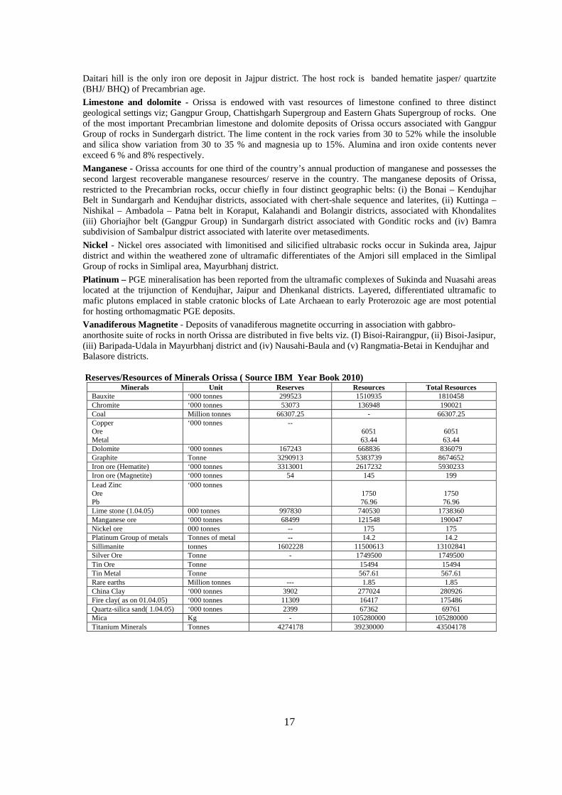
Minerals Unit Reserves Resources Total Resources Bauxite ‘000 tonnes 299523 1510935 1810458 Chromite ‘000 tonnes 53073 136948 190021 Coal Million tonnes 66307.25 - 66307.25 Copper Ore Metal
‘000 tonnes -- 6051 63.44
6051 63.44
Dolomite ‘000 tonnes 167243 668836 836079 Graphite Tonne 3290913 5383739 8674652 Iron ore (Hematite) ‘000 tonnes 3313001 2617232 5930233 Iron ore (Magnetite) ‘000 tonnes 54 145 199 Lead Zinc Ore Pb
‘000 tonnes 1750 76.96
1750 76.96
Lime stone (1.04.05) 000 tonnes 997830 740530 1738360 Manganese ore ‘000 tonnes 68499 121548 190047 Nickel ore 000 tonnes -- 175 175 Platinum Group of metals Tonnes of metal -- 14.2 14.2 Sillimanite tonnes 1602228 11500613 13102841 Silver Ore Tonne - 1749500 1749500 Tin Ore Tonne 15494 15494 Tin Metal Tonne 567.61 567.61 Rare earths Million tonnes --- 1.85 1.85 China Clay ‘000 tonnes 3902 277024 280926 Fire clay( as on 01.04.05) ‘000 tonnes 11309 16417 175486 Quartz-silica sand( 1.04.05) ‘000 tonnes 2399 67362 69761 Mica Kg - 105280000 105280000 Titanium Minerals Tonnes 4274178 39230000 43504178
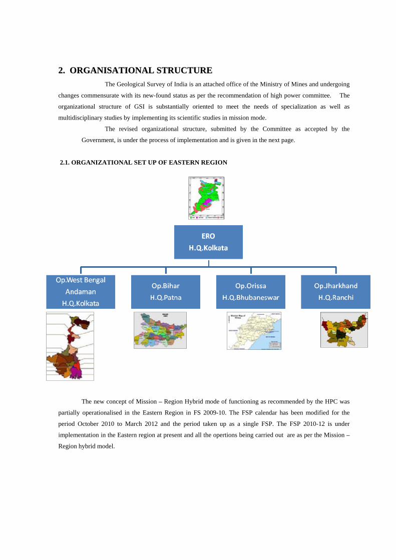
22.. OORRGGAANNIISSAATTIIOONNAALL SSTTRRUUCCTTUURREE
The Geological Survey of India is an attached office of the Ministry of Mines and undergoing
changes commensurate with its new-found status as per the recommendation of high power committee. The
organizational structure of GSI is substantially oriented to meet the needs of specialization as well as
multidisciplinary studies by implementing its scientific studies in mission mode.
The revised organizational structure, submitted by the Committee as accepted by the
Government, is under the process of implementation and is given in the next page.
2.1. ORGANIZATIONAL SET UP OF EASTERN REGION
The new concept of Mission – Region Hybrid mode of functioning as recommended by the HPC was
partially operationalised in the Eastern Region in FS 2009-10. The FSP calendar has been modified for the
period October 2010 to March 2012 and the period taken up as a single FSP. The FSP 2010-12 is under
implementation in the Eastern region at present and all the opertions being carried out are as per the Mission –
Region hybrid model.
19
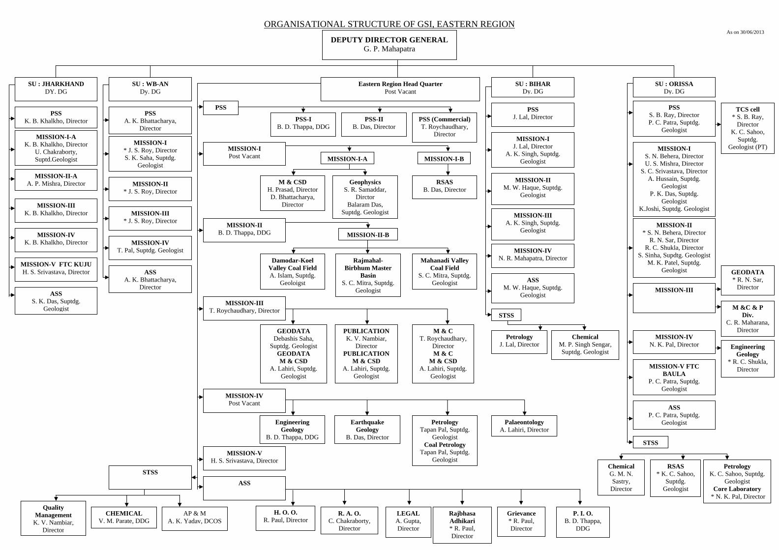
ORGANISATIONAL STRUCTURE OF GSI, EASTERN REGION As on 30/06/2013
DEPUTY DIRECTOR GENERAL G. P. Mahapatra
Eastern Region Head Quarter Post Vacant
SU : BIHAR Dy. DG
SU : ORISSA Dy. DG
SU : WB-AN Dy. DG
SU : JHARKHAND DY. DG
PSS PSS
A. K. Bhattacharya, Director
PSS K. B. Khalkho, Director
PSS J. Lal, Director
PSS S. B. Ray, Director P. C. Patra, Suptdg.
Geologist MISSION-I-A
K. B. Khalkho, Director U. Chakraborty, Suptd.Geologist
MISSION-I * J. S. Roy, Director S. K. Saha, Suptdg.
Geologist
MISSION-I Post Vacant
MISSION-I J. Lal, Director
A. K. Singh, Suptdg. Geologist
MISSION-I S. N. Behera, Director U. S. Mishra, Director
S. C. Srivastava, Director A. Hussain, Suptdg.
Geologist P. K. Das, Suptdg.
Geologist K.Joshi, Suptdg. Geologist
MISSION-II-A A. P. Mishra, Director MISSION-II
* J. S. Roy, Director
MISSION-II B. D. Thappa, DDG
MISSION-II M. W. Haque, Suptdg.
Geologist
MISSION-III K. B. Khalkho, Director MISSION-III
* J. S. Roy, Director
MISSION-III T. Roychaudhary, Director
MISSION-III
STSS
ASS A. K. Bhattacharya,
Director ASS
S. K. Das, Suptdg. Geologist
MISSION-V H. S. Srivastava, Director
MISSION-V FTC KUJU H. S. Srivastava, Director
MISSION-IV K. B. Khalkho, Director MISSION-IV
T. Pal, Suptdg. Geologist
MISSION-IV Post Vacant
MISSION-IV N. R. Mahapatra, Director
MISSION-II * S. N. Behera, Director
R. N. Sar, Director R. C. Shukla, Director
S. Sinha, Supdtg. Geologist M. K. Patel, Suptdg.
Geologist
MISSION-III A. K. Singh, Suptdg.
Geologist
ASS
PSS-I B. D. Thappa, DDG
PSS-II B. Das, Director
PSS (Commercial) T. Roychaudhary,
Director
ASS M. W. Haque, Suptdg.
Geologist
Chemical M. P. Singh Sengar, Suptdg. Geologist
Petrology J. Lal, Director
MISSION-IV N. K. Pal, Director
MISSION-V FTC BAULA
P. C. Patra, Suptdg. Geologist
ASS P. C. Patra, Suptdg.
Geologist
STSS
Chemical G. M. N. Sastry,
Director
RSAS * K. C. Sahoo,
Suptdg. Geologist
MISSION-I-BMISSION-I-A
M & CSD H. Prasad, Director D. Bhattacharya,
Director
Geophysics S. R. Samaddar,
Dirctor Balaram Das,
Suptdg. Geologist
RSAS B. Das, Director
MISSION-II-B
Damodar-Koel Valley Coal Field A. Islam, Suptdg.
Geoloigst
Rajmahal-Birbhum Master
Basin S. C. Mitra, Suptdg.
Geologist
Mahanadi Valley Coal Field
S. C. Mitra, Suptdg. Geologist
Engineering Geology
* R. C. Shukla, Director
GEODATA * R. N. Sar,
Director
M &C & P Div.
C. R. Maharana, Director
TCS cell * S. B. Ray,
Director K. C. Sahoo,
Suptdg. Geologist (PT)
Petrology K. C. Sahoo, Suptdg.
Geologist Core Laboratory
* N. K. Pal, Director
GEODATA Debashis Saha,
Suptdg. Geologist GEODATA M & CSD
A. Lahiri, Suptdg. Geologist
M & C T. Roychaudhary,
Director M & C
M & CSD A. Lahiri, Suptdg.
Geologist
PUBLICATION K. V. Nambiar,
Director PUBLICATION
M & CSD A. Lahiri, Suptdg.
Geologist
Palaeontology A. Lahiri, Director
Engineering Geology
B. D. Thappa, DDG
Earthquake Geology
B. Das, Director
Petrology Tapan Pal, Suptdg.
Geologist Coal Petrology
Tapan Pal, Suptdg. Geologist
Rajbhasa Adhikari * R. Paul, Director
LEGAL A. Gupta, Director
R. A. O. C. Chakraborty,
Director
H. O. O. R. Paul, Director
Grievance * R. Paul, Director
P. I. O. B. D. Thappa,
DDG
AP & M A. K. Yadav, DCOS
Quality Management
K. V. Nambiar, Director
CHEMICAL V. M. Parate, DDG
STSS
20
As on 30th June, 2013
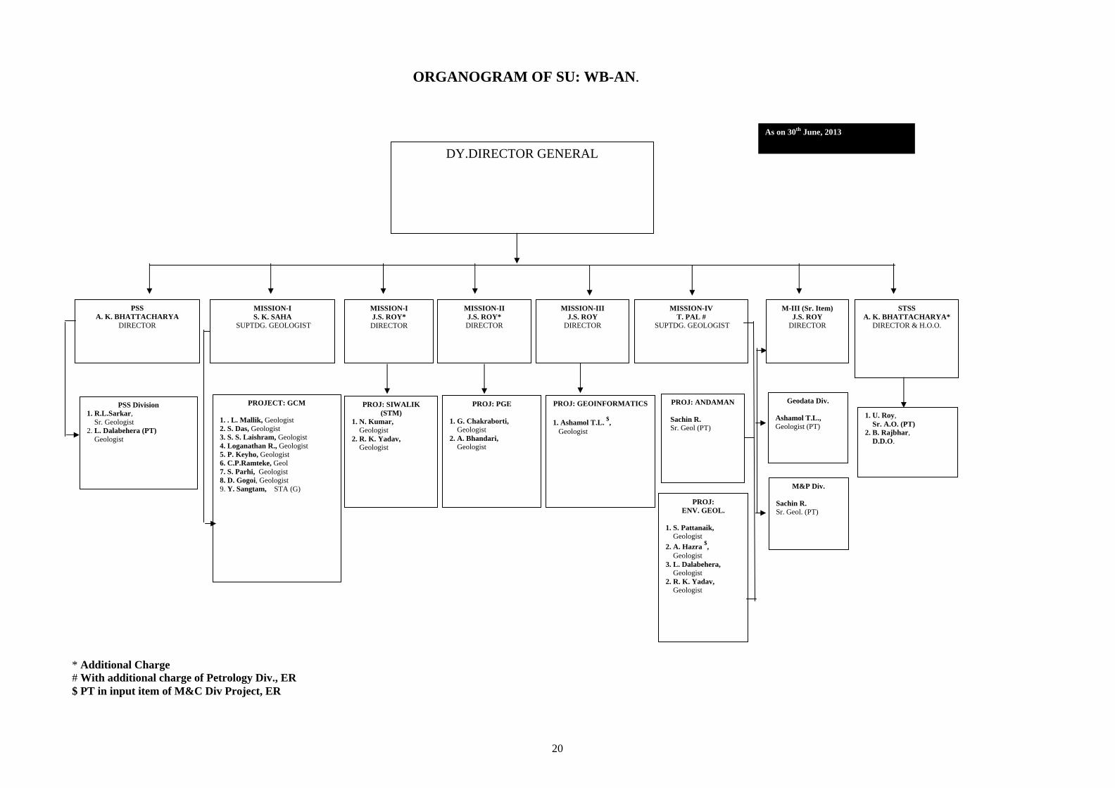
DY.DIRECTOR GENERAL
STSS A. K. BHATTACHARYA*
DIRECTOR & H.O.O.
1. U. Roy, Sr. A.O. (PT) 2. B. Rajbhar, D.D.O.
PSS A. K. BHATTACHARYA
DIRECTOR
PSS Division 1. R.L.Sarkar, Sr. Geologist 2. L. Dalabehera (PT) Geologist
Geodata Div.
Ashamol T.L., Geologist (PT)
M&P Div.
Sachin R. Sr. Geol. (PT)
M-III (Sr. Item) J.S. ROY
DIRECTOR
PROJECT: GCM
1. . L. Mallik, Geologist 2. S. Das, Geologist 3. S. S. Laishram, Geologist 4. Loganathan R., Geologist 5. P. Keyho, Geologist 6. C.P.Ramteke, Geol 7. S. Parhi, Geologist 8. D. Gogoi, Geologist 9. Y. Sangtam, STA (G)
MISSION-I S. K. SAHA
SUPTDG. GEOLOGIST
MISSION-I J.S. ROY* DIRECTOR
PROJ: SIWALIK (STM)
1. N. Kumar, Geologist 2. R. K. Yadav, Geologist
PROJ: PGE
1. G. Chakraborti, Geologist 2. A. Bhandari, Geologist
MISSION-II J.S. ROY* DIRECTOR
PROJ: GEOINFORMATICS
1. Ashamol T.L. $,
Geologist
MISSION-III J.S. ROY
DIRECTOR
PROJ: ANDAMAN
Sachin R. Sr. Geol (PT)
PROJ: ENV. GEOL.
1. S. Pattanaik, Geologist
2. A. Hazra $,
Geologist 3. L. Dalabehera, Geologist 2. R. K. Yadav, Geologist
MISSION-IV T. PAL #
SUPTDG. GEOLOGIST
* Additional Charge # With additional charge of Petrology Div., ER $ PT in input item of M&C Div Project, ER
ORGANOGRAM OF SU: WB-AN.
21
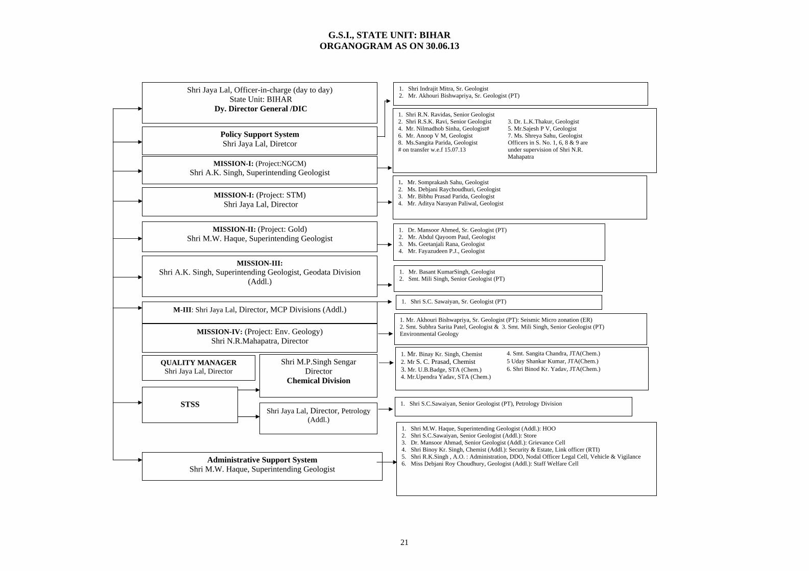
1. Shri Indrajit Mitra, Sr. Geologist 2. Mr. Akhouri Bishwapriya, Sr. Geologist (PT)
1. Shri R.N. Ravidas, Senior Geologist 2. Shri R.S.K. Ravi, Senior Geologist 3. Dr. L.K.Thakur, Geologist 4. Mr. Nilmadhob Sinha, Geologist# 5. Mr.Sajesh P V, Geologist 6. Mr. Anoop V M, Geologist 7. Ms. Shreya Sahu, Geologist 8. Ms.Sangita Parida, Geologist Officers in S. No. 1, 6, 8 & 9 are
under supervision of Shri N.R. Mahapatra
# on transfer w.e.f 15.07.13
1. Mr. Somprakash Sahu, Geologist2. Ms. Debjani Raychoudhuri, Geologist 3. Mr. Bibhu Prasad Parida, Geologist 4. Mr. Aditya Narayan Paliwal, Geologist
1. Dr. Mansoor Ahmed, Sr. Geologist (PT) 2. Mr. Abdul Qayoom Paul, Geologist 3. Ms. Geetanjali Rana, Geologist 4. Mr. Fayazudeen P.J., Geologist
1. Mr. Basant KumarSingh, Geologist 2. Smt. Mili Singh, Senior Geologist (PT)
1. Mr. Akhouri Bishwapriya, Sr. Geologist (PT): Seismic Micro zonation (ER) 2. Smt. Subhra Sarita Patel, Geologist & 3. Smt. Mili Singh, Senior Geologist (PT) Environmental Geology
1. Mr. Binay Kr. Singh, Chemist 4. Smt. Sangita Chandra, JTA(Chem.)
2. Mr S. C. Prasad, Chemist 5 Uday Shankar Kumar, JTA(Chem.)
3. Mr. U.B.Badge, STA (Chem.) 6. Shri Binod Kr. Yadav, JTA(Chem.) 4. Mr.Upendra Yadav, STA (Chem.)
1. Shri S.C.Sawaiyan, Senior Geologist (PT), Petrology Division
1. Shri M.W. Haque, Superintending Geologist (Addl.): HOO 2. Shri S.C.Sawaiyan, Senior Geologist (Addl.): Store 3. Dr. Mansoor Ahmad, Senior Geologist (Addl.): Grievance Cell 4. Shri Binoy Kr. Singh, Chemist (Addl.): Security & Estate, Link officer (RTI) 5. Shri R.K.Singh , A.O. : Administration, DDO, Nodal Officer Legal Cell, Vehicle & Vigilance 6. Miss Debjani Roy Choudhury, Geologist (Addl.): Staff Welfare Cell
1. Shri S.C. Sawaiyan, Sr. Geologist (PT)
Shri Jaya Lal, Officer-in-charge (day to day) State Unit: BIHAR
Dy. Director General /DIC
Policy Support System Shri Jaya Lal, Diretcor
MISSION-I: (Project:NGCM) Shri A.K. Singh, Superintending Geologist
MISSION-II: (Project: Gold) Shri M.W. Haque, Superintending Geologist
MISSION-III: Shri A.K. Singh, Superintending Geologist, Geodata Division
(Addl.)
MISSION-IV: (Project: Env. Geology) Shri N.R.Mahapatra, Director
STSS
Shri M.P.Singh Sengar Director
Chemical Division
Shri Jaya Lal, Director, Petrology (Addl.)
MISSION-I: (Project: STM) Shri Jaya Lal, Director
M-III: Shri Jaya Lal, Director, MCP Divisions (Addl.)
QUALITY MANAGER Shri Jaya Lal, Director
Administrative Support System Shri M.W. Haque, Superintending Geologist
G.S.I., STATE UNIT: BIHAR ORGANOGRAM AS ON 30.06.13
22
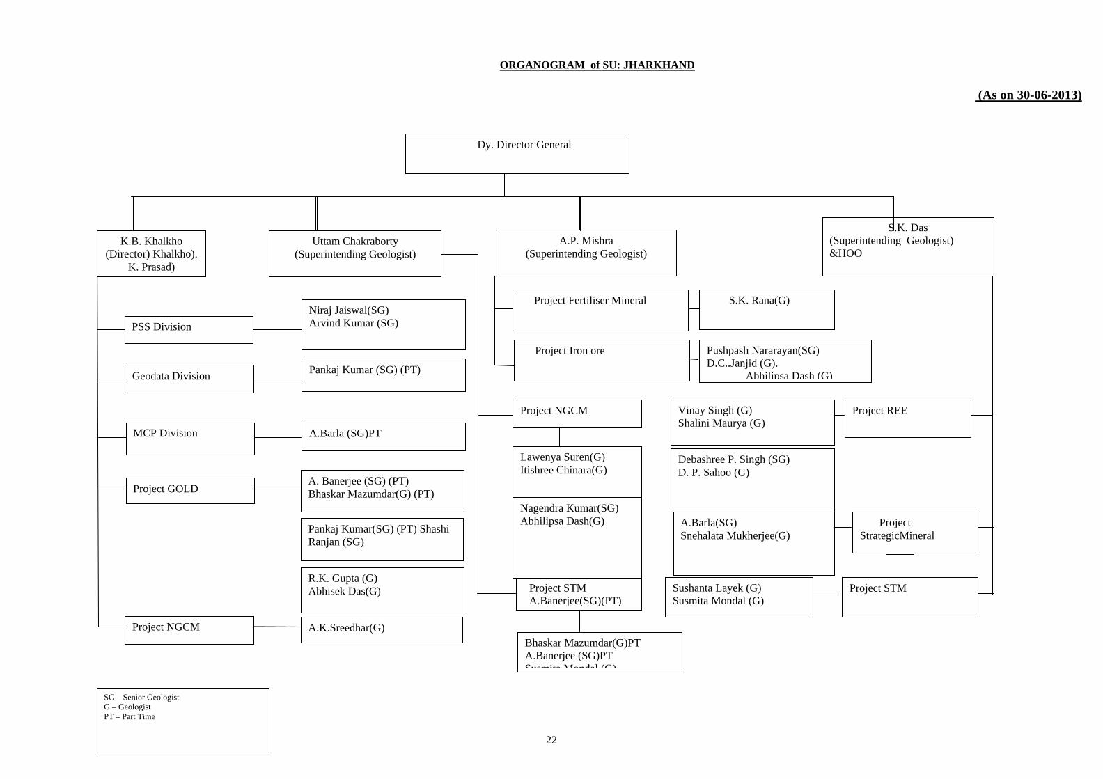
ORGANOGRAM of SU: JHARKHAND
(As on 30-06-2013)
K.B. Khalkho (Director) Khalkho).
K. Prasad)
Pankaj Kumar (SG) (PT)
S.K. Das (Superintending Geologist) &HOO
MCP Division
SG – Senior Geologist G – Geologist PT – Part Time
PSS Division
Geodata Division
Project NGCM
Niraj Jaiswal(SG) Arvind Kumar (SG)
A.Barla (SG)PT
R.K. Gupta (G) Abhisek Das(G)
Debashree P. Singh (SG) D. P. Sahoo (G)
Project REE
Dy. Director General
A. Banerjee (SG) (PT) Bhaskar Mazumdar(G) (PT)
Pushpash Nararayan(SG) D.C..Janjid (G).
Abhilipsa Dash (G)
A.K.Sreedhar(G)
Pankaj Kumar(SG) (PT) Shashi Ranjan (SG)
Vinay Singh (G) Shalini Maurya (G)
Project STM Sushanta Layek (G) Susmita Mondal (G)
S.K. Rana(G)
Uttam Chakraborty (Superintending Geologist)
Project GOLD
Project StrategicMineral
A.Barla(SG) Snehalata Mukherjee(G)
Project STM A.Banerjee(SG)(PT)
A.P. Mishra (Superintending Geologist)
Project Fertiliser Mineral
Project Iron ore
Project NGCM
Lawenya Suren(G) Itishree Chinara(G)
Nagendra Kumar(SG) Abhilipsa Dash(G)
Bhaskar Mazumdar(G)PT A.Banerjee (SG)PT Susmita Mondal (G)
23
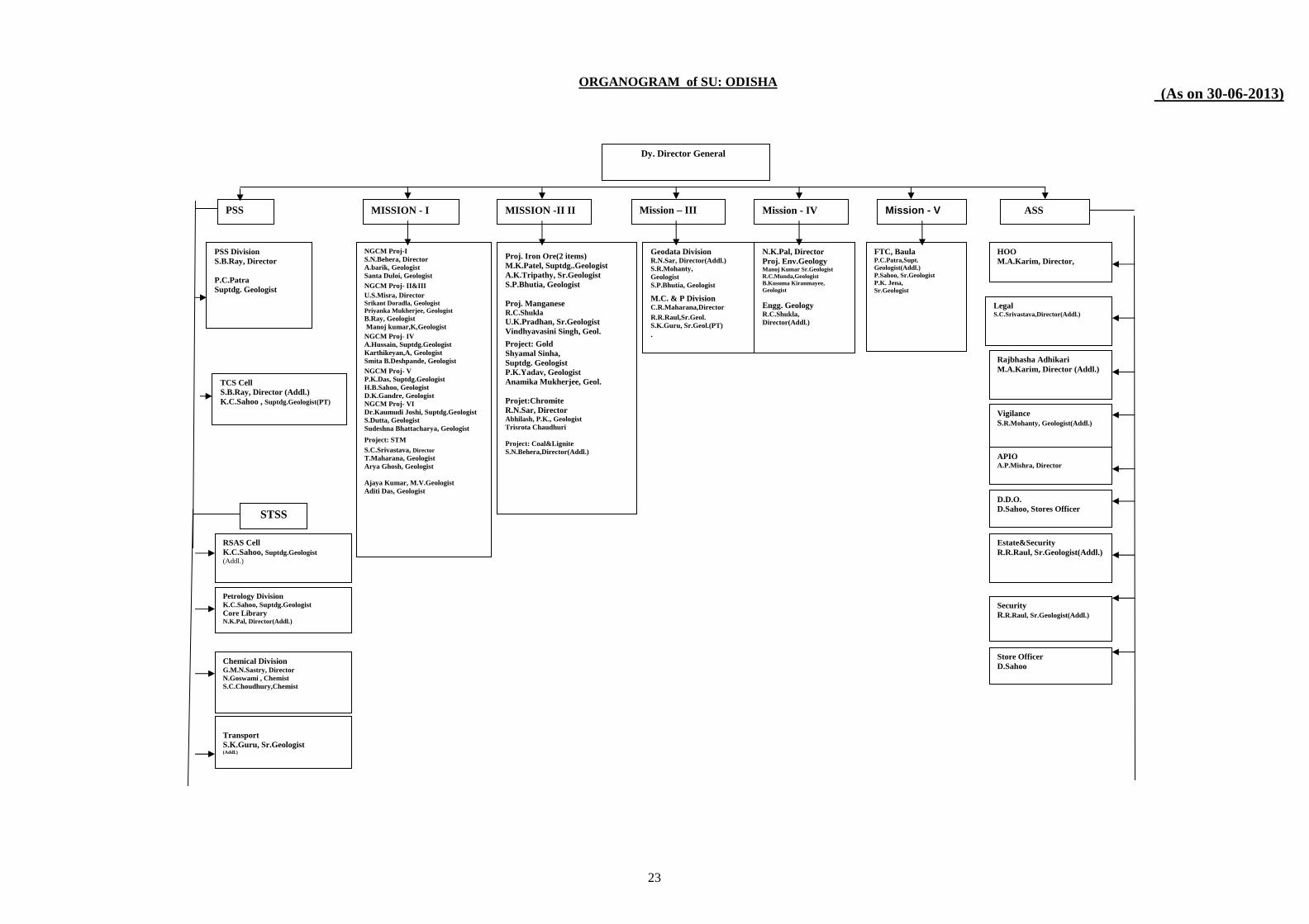
(As on 30-06-2013)
PSS MISSION - I MISSION -II II Mission – III Mission - IV Mission - V
PSS Division S.B.Ray, Director P.C.Patra Suptdg. Geologist
NGCM Proj-I S.N.Behera, Director A.barik, Geologist Santa Duloi, Geologist
NGCM Proj- II&III
U.S.Misra, Director Srikant Doradla, Geologist Priyanka Mukherjee, Geologist B.Ray, Geologist Manoj kumar,K,Geologist
NGCM Proj- IV A.Hussain, Suptdg.Geologist Karthikeyan,A, Geologist Smita B.Deshpande, Geologist
NGCM Proj- V P.K.Das, Suptdg.Geologist H.B.Sahoo, Geologist D.K.Gandre, Geologist NGCM Proj- VI Dr.Kaumudi Joshi, Suptdg.Geologist S.Dutta, Geologist Sudeshna Bhattacharya, Geologist
Project: STM
S.C.Srivastava, Director T.Maharana, Geologist Arya Ghosh, Geologist Ajaya Kumar, M.V.Geologist Aditi Das, Geologist
Proj. Iron Ore(2 items) M.K.Patel, Suptdg..Geologist A.K.Tripathy, Sr.Geologist S.P.Bhutia, Geologist Proj. Manganese R.C.Shukla U.K.Pradhan, Sr.Geologist Vindhyavasini Singh, Geol.
Project: Gold Shyamal Sinha, Suptdg. Geologist P.K.Yadav, Geologist Anamika Mukherjee, Geol. Projet:Chromite R.N.Sar, Director Abhilash, P.K., Geologist Trisrota Chaudhuri Project: Coal&Lignite S.N.Behera,Director(Addl.)
Geodata Division R.N.Sar, Director(Addl.) S.R.Mohanty, Geologist S.P.Bhutia, Geologist
M.C. & P Division C.R.Maharana,Director
R.R.Raul,Sr.Geol. S.K.Guru, Sr.Geol.(PT) .
N.K.Pal, Director Proj. Env.Geology Manoj Kumar Sr.Geologist R.C.Munda,Geologist B.Kusuma Kiranmayee, Geologist
Engg. Geology R.C.Shukla, Director(Addl.)
FTC, Baula P.C.Patra,Supt. Geologist(Addl.) P.Sahoo, Sr.Geologist P.K. Jena, Sr.Geologist
TCS Cell S.B.Ray, Director (Addl.) K.C.Sahoo , Suptdg.Geologist(PT)
ASS
Security R.R.Raul, Sr.Geologist(Addl.)
Store Officer D.Sahoo
HOO M.A.Karim, Director,
Estate&Security R.R.Raul, Sr.Geologist(Addl.)
Legal S.C.Srivastava,Director(Addl.)
Rajbhasha Adhikari M.A.Karim, Director (Addl.)
Vigilance S.R.Mohanty, Geologist(Addl.)
APIO A.P.Mishra, Director
D.D.O. D.Sahoo, Stores Officer
STSS
RSAS Cell K.C.Sahoo, Suptdg.Geologist
(Addl.)
Petrology Division K.C.Sahoo, Suptdg.Geologist
Core Library N.K.Pal, Director(Addl.)
Transport S.K.Guru, Sr.Geologist (Addl.)
Chemical Division G.M.N.Sastry, Director N.Goswami , Chemist S.C.Choudhury,Chemist
Dy. Director General
ORGANOGRAM of SU: ODISHA
24
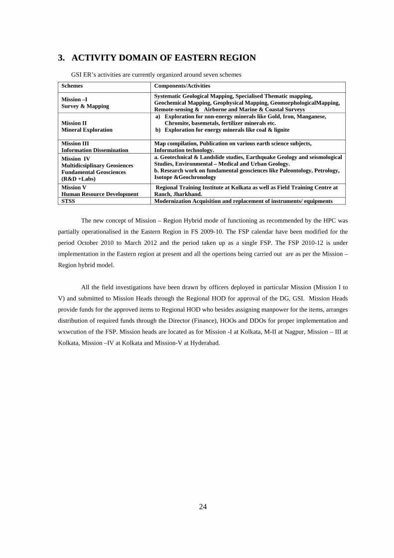
33.. AACCTTIIVVIITTYY DDOOMMAAIINN OOFF EEAASSTTEERRNN RREEGGIIOONN
GSI ER’s activities are currently organized around seven schemes
Schemes Components/Activities
Mission –I Survey & Mapping
Systematic Geological Mapping, Specialised Thematic mapping, Geochemical Mapping, Geophysical Mapping, GeomorphologicalMapping, Remote-sensing & Airborne and Marine & Coastal Surveys
Mission II Mineral Exploration
a) Exploration for non-energy minerals like Gold, Iron, Manganese, Chromite, basemetals, fertilizer minerals etc.
b) Exploration for energy minerals like coal & lignite
Mission III Information Dissemination
Map compilation, Publication on various earth science subjects, Information technology.
Mission IV Multidicsiplinary Geosiences Fundamental Geosciences (R&D +Labs)
a. Geotechnical & Landslide studies, Earthquake Geology and seismological Studies, Environmental – Medical and Urban Geology. b. Research work on fundamental geosciences like Paleontology, Petrology, Isotope &Geochronology
Mission V Human Resource Development
Regional Training Institute at Kolkata as well as Field Training Centre at Ranch, Jharkhand.
STSS Modernization Acquisition and replacement of instruments/ equipments
The new concept of Mission – Region Hybrid mode of functioning as recommended by the HPC was
partially operationalised in the Eastern Region in FS 2009-10. The FSP calendar have been modified for the
period October 2010 to March 2012 and the period taken up as a single FSP. The FSP 2010-12 is under
implementation in the Eastern region at present and all the opertions being carried out are as per the Mission –
Region hybrid model.
All the field investigations have been drawn by officers deployed in particular Mission (Mission I to
V) and submitted to Mission Heads through the Regional HOD for approval of the DG, GSI. Mission Heads
provide funds for the approved items to Regional HOD who besides assigning manpower for the items, arranges
distribution of required funds through the Director (Finance), HOOs and DDOs for proper implementation and
wxwcution of the FSP. Mission heads are located as for Mission -I at Kolkata, M-II at Nagpur, Mission – III at
Kolkata, Mission –IV at Kolkata and Mission-V at Hyderabad.
25
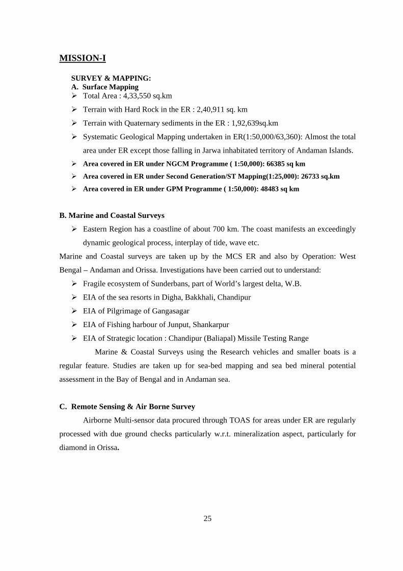
MISSION-I
SURVEY & MAPPING: A. Surface Mapping Total Area : 4,33,550 sq.km
Terrain with Hard Rock in the ER : 2,40,911 sq. km
Terrain with Quaternary sediments in the ER : 1,92,639sq.km
Systematic Geological Mapping undertaken in ER(1:50,000/63,360): Almost the total
area under ER except those falling in Jarwa inhabitated territory of Andaman Islands.
Area covered in ER under NGCM Programme ( 1:50,000): 66385 sq km
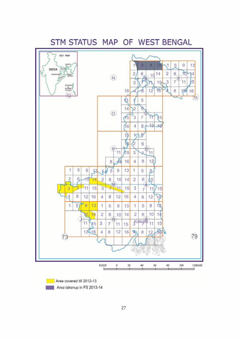
Area covered in ER under Second Generation/ST Mapping(1:25,000): 26733 sq.km
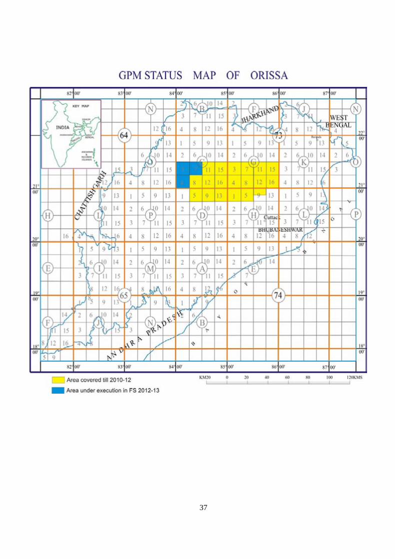
Area covered in ER under GPM Programme ( 1:50,000): 48483 sq km
B. Marine and Coastal Surveys
Eastern Region has a coastline of about 700 km. The coast manifests an exceedingly
dynamic geological process, interplay of tide, wave etc.
Marine and Coastal surveys are taken up by the MCS ER and also by Operation: West
Bengal – Andaman and Orissa. Investigations have been carried out to understand:
Fragile ecosystem of Sunderbans, part of World’s largest delta, W.B.
EIA of the sea resorts in Digha, Bakkhali, Chandipur
EIA of Pilgrimage of Gangasagar
EIA of Fishing harbour of Junput, Shankarpur
EIA of Strategic location : Chandipur (Baliapal) Missile Testing Range
Marine & Coastal Surveys using the Research vehicles and smaller boats is a
regular feature. Studies are taken up for sea-bed mapping and sea bed mineral potential
assessment in the Bay of Bengal and in Andaman sea.
C. Remote Sensing & Air Borne Survey
Airborne Multi-sensor data procured through TOAS for areas under ER are regularly
processed with due ground checks particularly w.r.t. mineralization aspect, particularly for
diamond in Orissa.
26
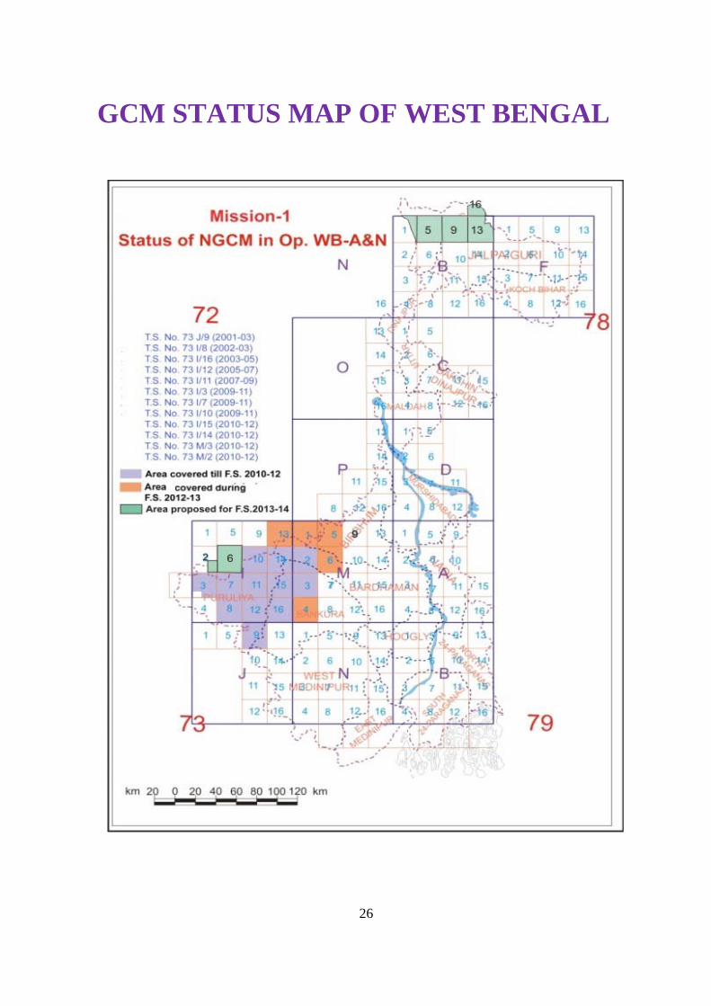
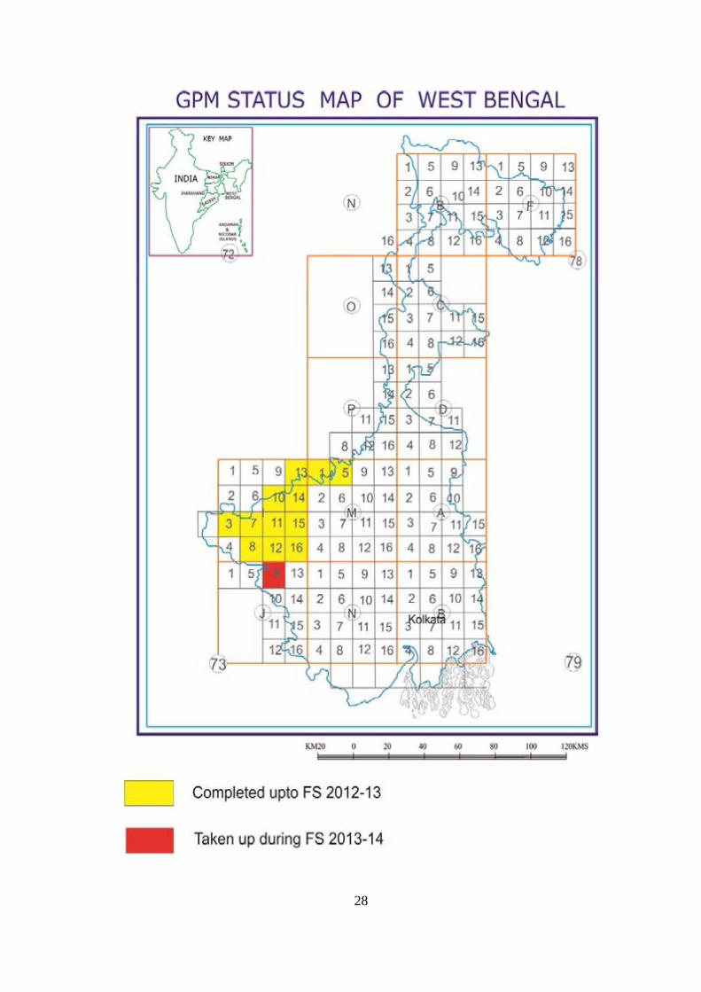
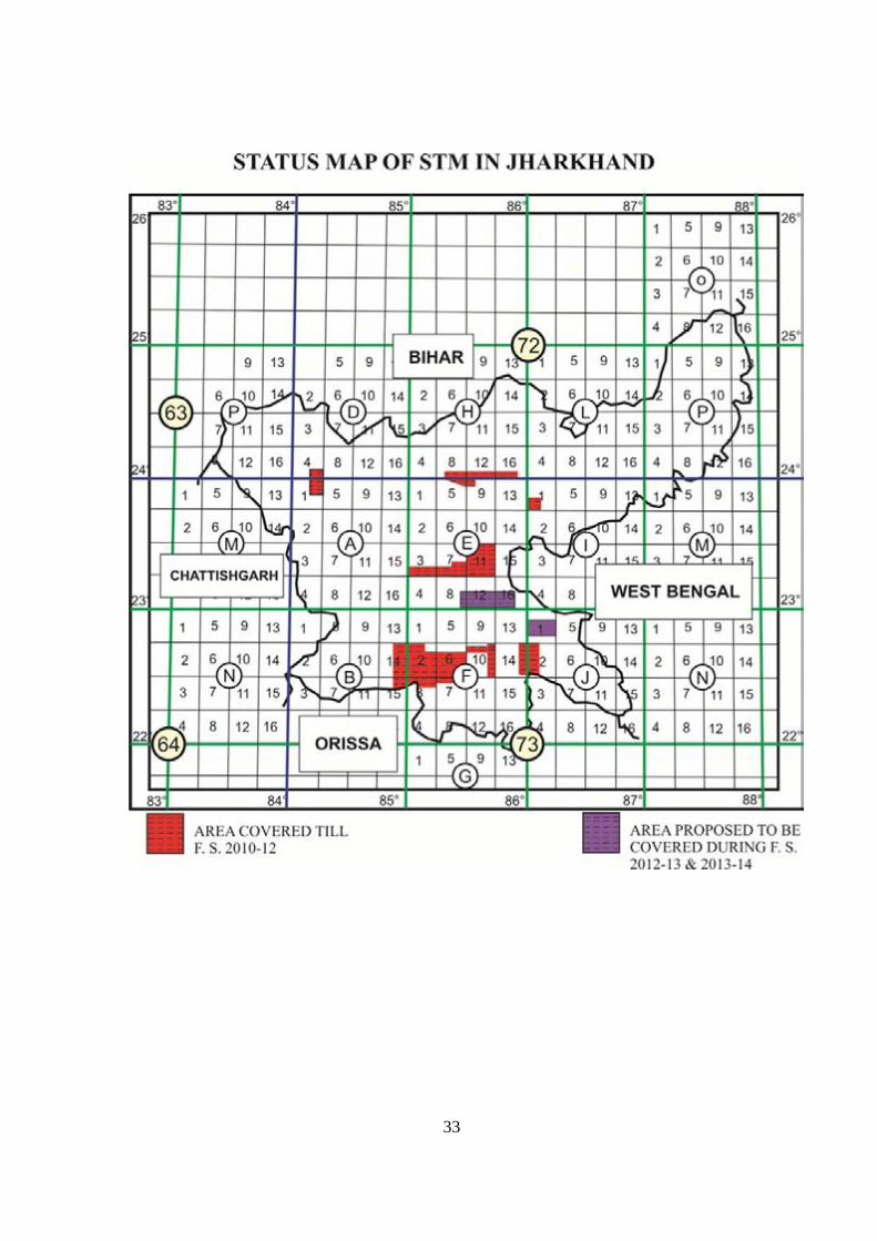
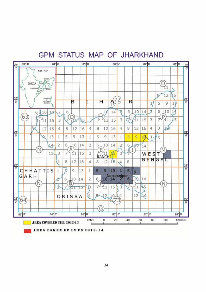
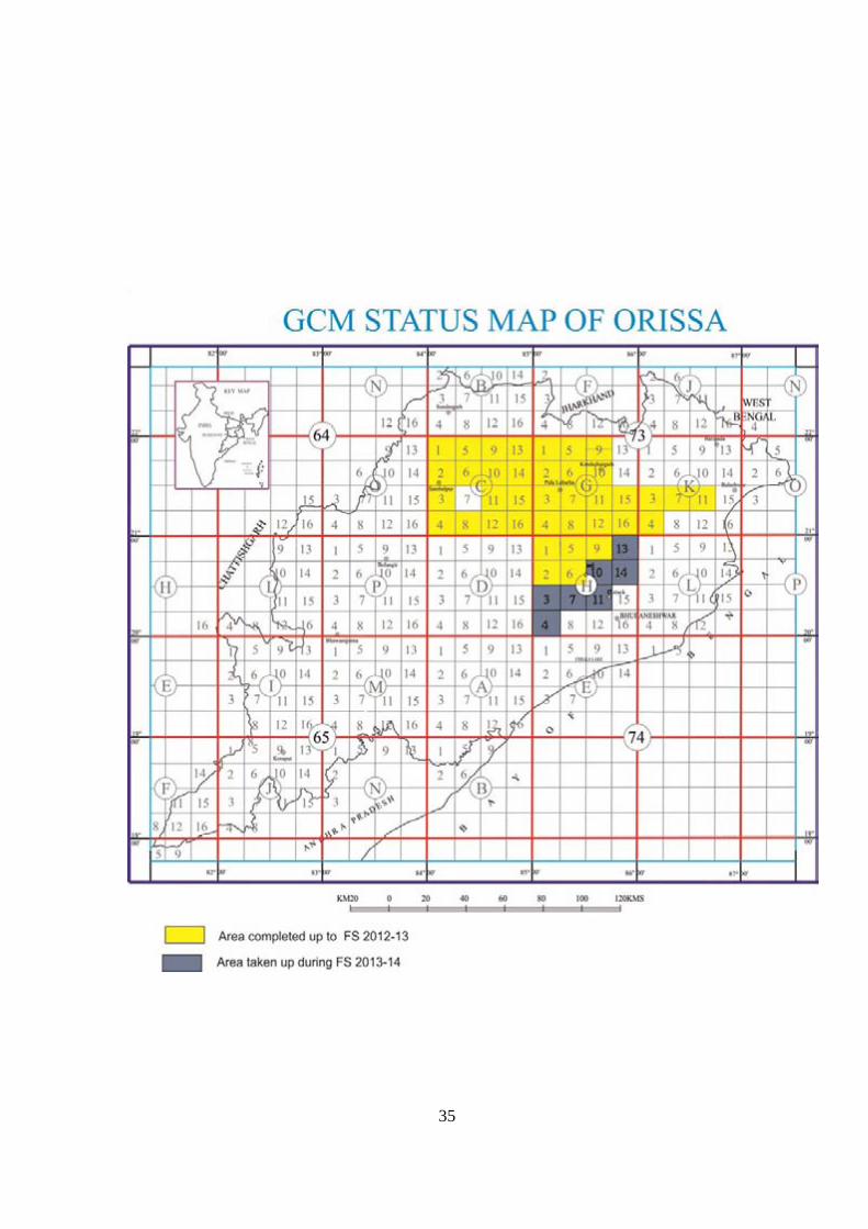
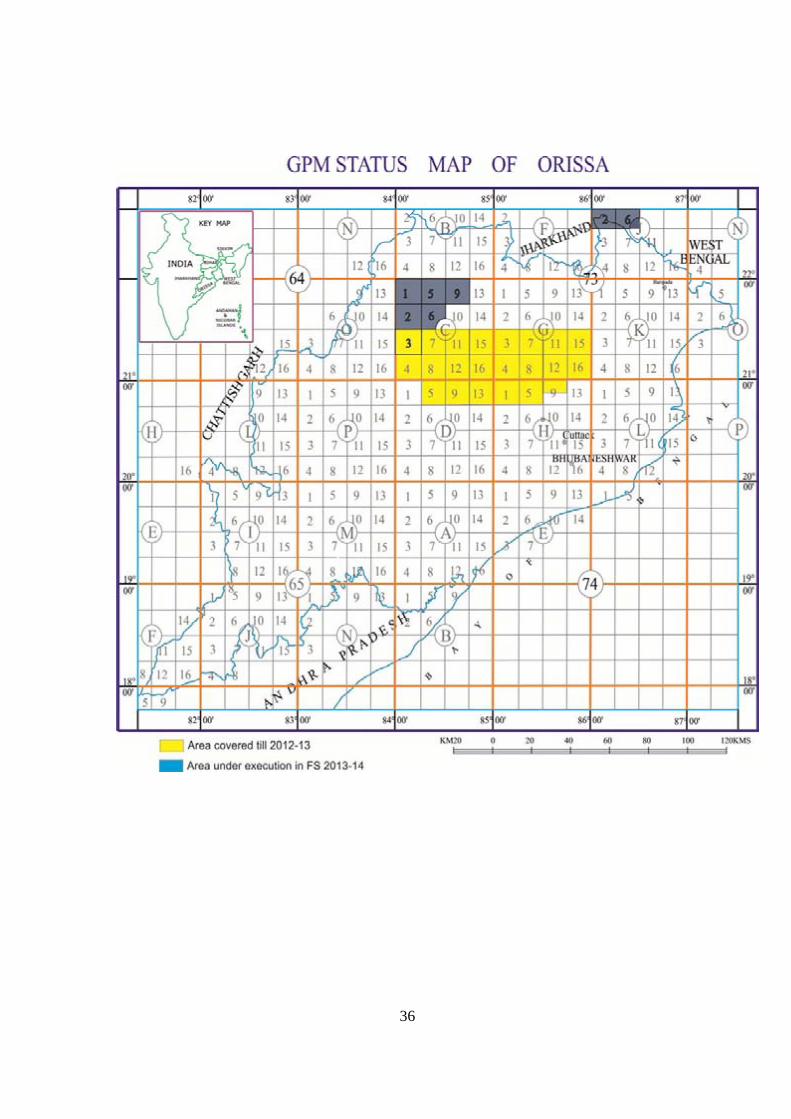
GCM STATUS MAP OF WEST BENGAL
27
28
29
30

31
32
33
34
35
36
37
38
MISSION: II
MINERAL INVESTIGATION
a) Non-energy Mineral resources
Regular investigations are launched under various Operations in ER for search of
non-energy minerals that range from Industrial to Precious and noble metals through
fertilizer, ferrous& non-ferrous minerals and base metals.
Significant discoveries made in this filed in ER through detailed exploration &
assessment include:
PGE of Boula-Nuasahi belt, Orissa
Cesium from Chhotanagpur Gneissic terrain of Purulia district, W. Bengal
East Coast Bauxite deposit of ( >75%, of the total reserve of the country)
Iron ore deposits in Jharkhand and Orissa
Manganese deposits in Bolangir & Sundargarh Dists, Orissa
Chromium deposits in Cuttak, Jajpur, Keonjhar and Balasore districts of
Orissa and East and West Singhbhum districts of Jharkhand (> 90% of the
total reserves of India)
Gold in Parasi area, Ranchi district, Jharkhand.
b) Energy Mineral resources (Coal & Lignite)
The states of Orissa, Jharkhand and West Bengal house some of the larger
coal basins of India. Continuous resource assessment of coal is a regular feature in GSI.
Though this activity was being attended by the erstwhile Coal Wing, with the restructuring in
GSI, coal resource augmentation and search within the above mentioned states is now being
attended by ER. Resource estimation for coal have been carried out in the Birbhum Basin and
Damodar –Koel valley WB – Jharkhand and the Talchir basin, Orissa.
39
MISSION: III
IT ACTIVITIES
LAN has been activated in the ER. It comprises:
Three tier architecture, Core, Distribution and Edge switches
64 Gbps back plane Core switch
Fibre optic back bone
CAT 6 UTP cabling
Structured Cabling, 25 years application assurance guarantee
L3/L2 Cisco switches, VLAN, Data, Voice and Video ready
High redundancy, upto the edge switch level
A total of 573 nodes across ER, MW, CW
CiscoWorks LMS2.0 for LAN management system
Power over Ethernet (POE) switches for IP telephony
24X7 service planned after connecting CAN to GSINET
High level network security, TACACS and RADIUS enabled
MAP & CARTOGRAPHY
Activities under taken by this unit involves
Preparation of Thematic Maps
Compilation & Publishing different generations of Geological Map
Digitization of all compiled and thematic maps viz 1:50K GMS; GQM, DRM and
MBM.
DATA DISSEMINATION
Publishing of Memoir, Bulletins, Records and Eastern Region News
Conversion of All Geological Reports to Digital Form and uploading in Public domain
though GSI Portal.
40
MISSION –IV
GEOTECHNICAL & LANDSLIDE INVESTIGATIONS
Under this field of activity, geotechnical assistance is provide to various user agencies
involved in River Valley Projects, construction of Dams etc. communication Projects and
Landslide hazard assessment and suggesting mitigation methodology etc . some of the
significant Projects attended in Eastern Region are as given in the Table below.
WEST BENGAL
Purulia Pumped Storage Hydel Project Rammam Hydel Project Jaldhaka Project
PROJECTS IN ORISSA
Upper Kolab Multipurpose Project Mahanadi-Godavari Link Project Lower Indravati Irrigation Project Hirakud Project
PROJECTS IN BIHAR
Nabinagar NTPC Railway joint venture Kosi Barrage Kadhwan Dam
PROJECTS IN JHARKHAND
Garhi Reservoir Scheme Upper Sankh Reservoir scheme Kodai bank irrigation project Ajoy barrage project
PROJECTS IN SIKKIM
Tista Hydel Project Stage-II, III, IV, V & VI Chakung Chu Hydel Project Rangit Hydel Project Lower Lagyup Hydel Project Pakyang Airstrip
PROJECTS IN ANDAMAN&NICOBAR Indira Nala Reservoir Scheme Dhanikadi Water Supply Scheme Kamsarat Minor Irrigation Project Korang Nala Minor Irrigation
GEOENVIRONMENTAL STUDIES CARRIED OUT IN EASTERN REGION
STUDY OF LAND USE PLANNING AROUND CITIES
Kolkata Mega City Project
Durgapur-Asansol Urban Development Project
Bardhaman Urban Development Project
HEALTH HAZARDS RELATED STUDIES
Arsenic Toxicity in Southern part of W.Bengal
Arsenic Toxicity in Bhojpur district, Bihar
Goitre problem in N.Bengal
High fluoride incidence in ground water in Birbhum, W.Bengal & Nuapara, Orissa
41
EARTHQUAKE GEOLOGY
Studies have so far been undertaken in Sikkim, West Bengal and Andaman & Nicobar
Islands. These include:
Tsunami damage studies in Andaman & Nicobar following 24th December 2004 earthquake Macroseismic surveys in Sikkim, West Bengal and Andamans Seismic microzonation Active Fault mapping in the Himalayan Foothills, West Bengal and South Andaman DGPS studies on crystal deformation processes along major tectonic planes in Himalaya in
West Bengal and Andamans Monitoring of Active Fault, West Bengal
COASTAL ENVIRONMENT MONITORING
Studies of coastal dynamics &geological processes along 700 km long coast line of Bengal
& Orissa
Studies on fragile ecosystem of Sunderbans, W.Bengal- Part of World’s largest delta
Sea resorts – Digha, Bakkhali, Chandipur
Pilgrimage of Gangasaga
Fishing harbour of Junput, Shankarpur
Strategic location : Chandipur (Baliapal) Missile Testing Range, Orissa
42
44.. MMIILLEESSTTOONNEESS AANNDD MMAAJJOORR AACCHHIIEEVVEEMMEENNTTSS OOFF EEAASSTTEERRNN RREEGGIIOONN
MISSION –I SURFACE MAPPING Total Area :4,33,550 Sq.Km
Area covered by hard rock : 2,40,911 Sq.Km
Area covered by Quaternary sediments : 1,92,639 Sq.Km
Systematic Geological mapping carriedout (Scale- 1:50,000/63,360): Covered almost entire area
except Jarwa inhabitated territory of Andamans
Geochemical mapping carried out (Scale-1:50,000): 51502 Sq Km
Second Generation/STM Mapping carried out (1:25,000) :24923 Sq.Km
Area covered in ER under GPM Programme ( 1:50,000): 44983 sq km
MISSION –II
MINERAL (NON-ENERGY) INVESTIGATIONS
Significant discovery, exploration & assessment carried out in the Region include:
PGE of Boula-Nuasahi belt, Orissa
Cesium from Chhotanagpur Gneissic terrain of Purulia district,W.Bengal
Bauxite deposit of East Coast ( >75%, of the total reserve of the country)
Iron ore deposits in Jharkhand and Orissa (In the districts of East Singhbhum, West Singhbhum,
Palamu of Jharkhand and Keonjhar, Sundergarh, Jajpur, Nawarangpur, Mayurbhanj, Sambalpur
districts of Orissa)
Manganese deposits in Bolangir & Sundargarh Dists, Orissa
Chromium deposits in Cuttak, Jajpur, Keonjhar and Balasore districts of Orissa and East and West
Singhbhum districts of Jharkhand (> 90% of the total reserves of India)
Gold in Parasi area in Jharkhand .
PGM mineralisation in Baula-Nuasahi complex,Orissa
PGE established in associated with chromite bearing ultramafic suit
3 PGM bearing zones located with in the ultramafics.
Reserve estimate: 6 m.t. of PGM and Au with average tenor of 2ppm (Pt+Pd+Au).
Investigation for rare metal (Cs) in pegmatite and aplite bodies, Belamu – Sarjamhatu area,
Purulia district, W.B.
Exploration work in the Beku- Belamu – Khatanga areas indicated a total reserve of 79839.09
tonnes of mineralised pegmatite (0.67% Cs) and 233770.98 tonnes of aplite (1.26% Cs).
After Canada, Namibia and Zimbabwe, India is the first Asian country having pollucite - rich
pegmatite and aplite bodies.
43
MISSION –III
IT ACTIVITIES
Establihment of LAN comprising :
Three tier architecture, Core, Distribution and Edge switches
64 Gbps back plane Core switch
Fibre optic back bone
CAT 6 UTP cabling
Structured Cabling, 25 years application assurance guarantee
L3/L2 Cisco switches, V LAN, Data, Voice and Video ready
High redundancy, upto the edge switch level
A total of 573 nodes across ER, MW, CW
CiscoWorks LMS2.0 for LAN management system
Power over ethernet (POE) switches for IP telephony
24 X 7 service planned after connecting CAN to GSINET
High level network security, TACACS and RADIUS enabled
DATA DISSEMINATION Publishing of Memoir, Bulletins, Records and Regional News
Conversion of All The Reports to Digital Form
Preparation of Thematic Maps
Publishing of Different Generations of Geological Map
MISSION - IV
GEOTECHNICAL STUDIES: ASSISTANCE RENDERED IN IMPORTANT PROJECT IN ER PROJECTS IN WEST BENGAL Purulia Pumped Storage Hydel Project Rammam Hydel Project Jaldhaka Project
PROJECTS IN ORISSA Upper Kolab Project Mahanadi-Godavari Link Project Lower Indravati Irrigation Project
Hirakud Project PROJECTS IN BIHAR Nabinagar NTPC Railway joint venture Kosi Barrage Kadhwan Dam
PROJECTS IN JHARKHAND Garhi Reservoir Scheme Upper Sankh Reservoir scheme Kodai bank irrigation project
Ajoy barrage project PROJECTS IN SIKKIM Tista Hydel Project Stage-II, III, IV, V & VI Chakung Chu Hydel Project Rangit Hydel Project Lower Lagyup Hydel Project
Pakyang Airstrip
PROJECTS IN ANDAMAN&NICOBER Indira Nala Reservoir Scheme Dhanikadi Water Supply Scheme Kamsarat Minor Irrigation Project Korang Nala Minor Irrigation
44
LANDSLIDE STUDIES AND HAZARD ASSESSMENT:
Studies carried out on all major communication links in Darjeeling and Sikkim including the National
and State Highways besides site specific land slide studies including DGPS monitoring.
EARTHQUAKE & SEISMOTECTONIC STUDIES
Seismic Microzonation of Siliguri
Post tsunami Damage assessment in Andaman & Nicobar Islands
Studies on crustal stress development through Geodetic survey using DGPS in Andamans & Sikkim-
Darjeeling- Duars in Sikkim –West Bengal Himalaya.
GEOENVIRONMENTAL STUDIES CARRIED OUT IN EASTERN REGION
STUDY OF LAND USE PLANNING AROUND CITIES
Kolkata Mega City Project
Durgapur-Asansol Urban Development Project
Bardhaman Urban Development Project
MEDICAL GEOLOGICAL STUDIES
Arsenic Toxicity in South Bengal & Gangetic plains in Bihar
Goitre problem in N.Bengal
High fluoride incidence in ground water in Birbhum, W.Bengal; Nuapara, Orissa
COASTAL ENVIRONMENT MONITORING
Studies of coastal dynamics &geological processes along 700 km long coast line of Bengal &
Orissa
Studies on fragile ecosystem of Sunderbans, W.Bengal- Part of World’s largest delta
Strategic location : Chandipur (Baliapal) Missile Testing Range, Orissa
45
5. FIELD SEASON 2012-13- ACHIEVEMENTS The FSP 2012-13 of Eastern Region in Mission Mode is uploaded and approved through GSI Portal and has been executed by concerned Director/Project Heads. FSPMIS introduction pages for all uploaded items pertaining to ER are appended in Annexure - Highlights of the investigations carried out during FS 2012-13 are listed below as per missions MISSION-I BIHAR: STM: SPECIALIZED THEMATIC MAPPING AROUND NABINAGAR, AMBA AND DEO AREA IN AURANGABAD AND GAYA DISTRICTS, BIHAR Specialized thematic mapping was carried out covering an area of 300 sq km on
1:25000 scale in parts of Aurangabad and Gaya districts of Bihar, falling in toposheets 72 D/6 and 72 D/7.
The objective was to find out the possible western extension of the Bathani volcano sedimentary sequence and its stratigraphic status with respect to CGC, to work out the possible correlation with Mahakoshal Belt, if any and to carry out the petrographic characterization of different lithounits present in the area.
Granitoids, granite gneisses and metasedimentary units like sillimanite-garnet schist, biotite schist and banded magnetite quartzite (BMQ) are predominantly exposed in the area. These rocks are later intruded by basic dykes, pegmatites and quartz veins.
The area has undergone three phases of folding (deformation). F1 are represented by tight to isoclinal folds, trending N22E/78E. F2 are represented by close folds, axial plane trending N50E to N65E dipping 78° to 80° southerly; plunging moderately (52°to 56°) towards N65E. F1 and F2 phases were near co-axial, giving rise to hook shaped folds (Type III, Ramsay 1967) at places. F3 occurs as open folds with axial plane striking E-W (N78 to 80E) dipping steeply (80°) towards north, plunging moderately (51°to 58°) towards S70W.
A 2 km wide and 7 km long east-west trending shear zone is observed in the southern part of the mapped area between Chakrabandha (72 D/6) and Maigara (72 D/7).
Sulphide mineralization (in patches) in the form of arsenopyrite, chalcopyrite and surficial stains of bornite has been observed within sheared granites and quartz veins at Savera (72 D/7), Mahulan and Dhanras hill (72 D/6).
A small mound of BMQ has been observed near Mahulan village; slag materials were obtained further west of this hillock of BMQ.
SPECIALISED THEMATIC MAPPING TO EXAMINE INTER-RELATIONSHIP BETWEEN GRANITIC PHASE VIS-À-VIS MAFIC AND FELSIC VOLCANICS IN THE NORTHERN PERIPHERY OF THE CHHOTANAGPUR GNEISSIC COMPLEX (CGC) Specialised Thematic Mapping was carried out in parts of Aurangabad and Gaya
districts of Bihar falling in toposheet No.72 D/10. A total area of 302 km2 has been mapped on 1:25000 scale. The mapped area exposes phyllite, mica schist and quartzite of meta-sedimentary
rocks; chlorite schist, amphibolite, hornblende schist, meta gabbro & dolerite of meta basic rock; meta pyroxenite of meta ultrabasic rock; porphyritic granite, biotite
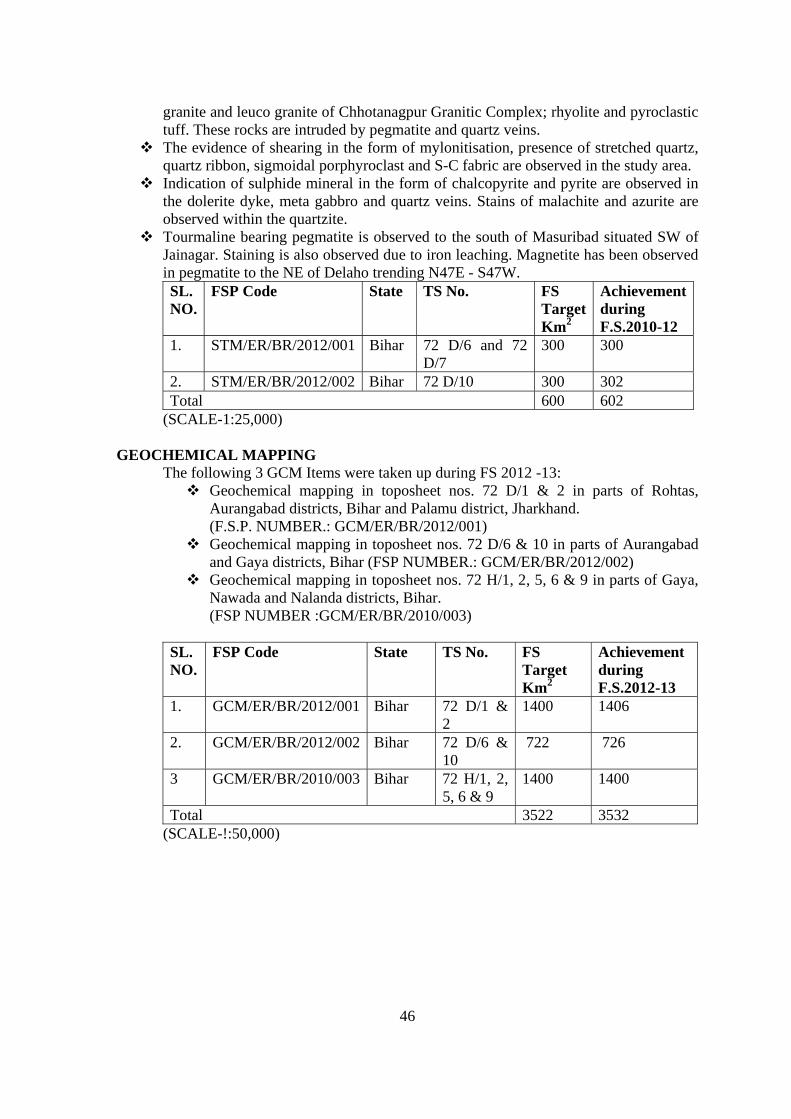
46
granite and leuco granite of Chhotanagpur Granitic Complex; rhyolite and pyroclastic tuff. These rocks are intruded by pegmatite and quartz veins.
The evidence of shearing in the form of mylonitisation, presence of stretched quartz, quartz ribbon, sigmoidal porphyroclast and S-C fabric are observed in the study area.
Indication of sulphide mineral in the form of chalcopyrite and pyrite are observed in the dolerite dyke, meta gabbro and quartz veins. Stains of malachite and azurite are observed within the quartzite.
Tourmaline bearing pegmatite is observed to the south of Masuribad situated SW of Jainagar. Staining is also observed due to iron leaching. Magnetite has been observed in pegmatite to the NE of Delaho trending N47E - S47W. SL. NO.
FSP Code State TS No. FS Target Km2
Achievement during F.S.2010-12
1. STM/ER/BR/2012/001 Bihar 72 D/6 and 72 D/7
300 300
2. STM/ER/BR/2012/002 Bihar 72 D/10 300 302 Total 600 602
(SCALE-1:25,000) GEOCHEMICAL MAPPING
The following 3 GCM Items were taken up during FS 2012 -13: Geochemical mapping in toposheet nos. 72 D/1 & 2 in parts of Rohtas,
Aurangabad districts, Bihar and Palamu district, Jharkhand. (F.S.P. NUMBER.: GCM/ER/BR/2012/001)
Geochemical mapping in toposheet nos. 72 D/6 & 10 in parts of Aurangabad and Gaya districts, Bihar (FSP NUMBER.: GCM/ER/BR/2012/002)
Geochemical mapping in toposheet nos. 72 H/1, 2, 5, 6 & 9 in parts of Gaya, Nawada and Nalanda districts, Bihar. (FSP NUMBER :GCM/ER/BR/2010/003)
SL. NO.
FSP Code State TS No. FS Target Km2
Achievement during F.S.2012-13
1. GCM/ER/BR/2012/001 Bihar 72 D/1 & 2
1400 1406
2. GCM/ER/BR/2012/002 Bihar 72 D/6 & 10
722 726
3 GCM/ER/BR/2010/003 Bihar 72 H/1, 2, 5, 6 & 9
1400 1400
Total 3522 3532 (SCALE-!:50,000)
47
JHARKHAND
STM: STM of Tamar Porapahar Shear Zone in Tamar- Sarjamdih -Tiruldih area, Ranchi and Saraikela- Kharsawan districts, Jharkhand with special emphasis on structural manifestation and locating favorable areas of associated Au, Cu, REE mineralization. (Code No. STM//ER/JH/2012/001) ,73E/12 & 16) Dextral sense of rotation of porphyroblast within augen gneiss at Nuridih and Agra village. Brecciated quartzite as an evidence of shearing in and around Kutam village. Angular
fragments are varying in size, shape and colour. Matrix is also varying in colour and composition.
Dextral sense of slip movements within quartz schist/quartzite and augen gneiss near Sarjamdih and Nuridih.
F1 inclined fold within granite gneiss near Dulmi village plunging 30° towards 230° degree. Ferruginisation in quartzite, network of quartz veins of different phases, rotation of
porphyroblast, mesoscopic faults and brecciated quartzite indicate a major tectonic zone from Tamar-Sarjamdih to Kutam.
Sulphide mineralisation as an evidenced in quartz vein and leaching effect have also been noticed.
Two phase of quartz veins near Chunidih village. One is well foliated and another one is massive, the younger one.
Mafic rock near Chunidih village showing concordant relationship with mica schist. 30° toward 270° plunge of F2 fold (tight inclined fold in mica schist) near Chunidih. Showing
mullions in the XY plane of strain ellipsoid near the hinge part. Different types of rock have been studied under microscope like amphibolite, dolerite, mica
schist, quartz sericite schist, granite gneiss, phyllitic mylonite, brecciated quartzite, brecciated granite, volcanic tuff etc. The study has been summarized below Amphibolite: The rock is coarse grained. It consists of mainly amphibole, quartz and plagioclase feldspar, opaque, epidote etc. All the amphibole grains are not oriented in a particular direction. Few are oriented in a particular direction and few are making a triangular relationship. The intergranular spaces are filled with quartz and altered feldspar. The amphiboles are bluish green in colour and fibrous in nature. The amphiboles are showing different character under PPL & CPL condition by their interference colour and pleochroism. The reaction texture is evidenced by their replacing character to each other and the development of quartz and opaque. This character of the amphibole seems to be the result of alkali metasomatism. Actually further detail study is required to identify the minerals under EPMA. The opaque are subhedral to euhedral in shape. Some skeletal grain of opaque are observed. Along the cleavage plane the quartz and feldspar are being developed creating a sieve like texture. Different slides of amphibolite are showing somewhat different character by their volumetric percentages of mineral association and intensity of deformation. The reaction texture is not always clear. Dolerite: The rock is composed of hornblende, plagioclase, quartz and opaques. Epidote occurs as a secondary mineral which is alteration product of plagioclase feldspar. The interlocking igneous texture is preserved in this rock. The rock is showing ophitic to subophitic texture. Epidote and quartz occupy triangular to polygonal intergranular spaces formed by orientation of hornblend laths.. The pyroxene grains have been altered to hornblende. Hence no pyroxenes are preserved in this rock. The opaques are randomly oriented in the rock. The shape of these grains is rectangular, squarish, anhedral, circular etc. Size of the opaques also varies from 0.03 mm to 0.65 mm.
48
Mica schist/quartz sericite schist: The rock is composed of muscovite, biotite, quartz, orthoclase feldspar etc. The phyllosilicates are showing preferred orientation defining the schistocity plane. The small grains of feldspar and quartz are embedded in the interspaces of the mica flakes. The early schistocity planes have been deformed and developed excellent crenulations cleavage’ during the later deformation. The cleavage domains are filled with the micas and the cleavage domains are filled up with the quartz and feldspar. At places the mica has been altered to sericite showing clay like structure. The volumetric percentages of quartz and sericite are varying from slide to slide. So the nomenclatures of the rock have been done considering the percentages of the minerals observed. Rotation of the porphyroblast of quartz and feldspar is observed in the mica schist adjacent to the shear zone the mapped area. Different types of shear fabric like “σ”, “ψ”, mica fish etc are observed. Some microscopic tight isoclinal F1 fold is observed. This mica schist is intruded by quartz veins. The veins are showing vug filling structure. Mylonite: The rock is mainly composed of quartz and biotite in decreasing order of abundance. It is a schistose rock and schistosity is formed by planner orientation of biotite flakes. In Q domain quartz are present with small amount of biotite. Here qurtz are subhedral to anhedral in outline and showing undulose extinction and recrystallised mosaic. In P domain biotite flakes are present. They forms aggregate at places. The clear grinding effect of the quartz and feldspar is observed. The rock is very fine grained and composed of muscovite, quartz, feldspar, and opaque. The major foliation is cutting by the shear fabric which is at a low angle to the schistocity. S-C fabric is preserved. Quartz ribbon is observed. Rotation of quartz grain showing dextral sence of rotation is present. Brecciated granite and quartz: Brecciated granite and quartzite both are available in the study area. Earlier worker of the area reported only the brecciated quartzite. But brecciated granite is also observed in the field. This is found in the major shear zone of the area. In brecciated quartzite the quartz grains are predominant. Small grains of micas are observed surrounding the quartz grains. The grains are fractured and the fracture spaces are filled up with quartz veins and matrix of quartz. Shape of the angular clast varies from triangular, rectangular, hexagonal, pentagonal etc. The brecciated granite is composed of plagioclase, microcline, quartz, biotite etc. The angular clast is varying in shape and size. Granite gneiss: Alternate bands of quartz, feldspar and biotite is observed which is the most dominant character of a gneissic rock. The microcline and orthoclase feldspar are dominant than plagioclase feldspar. Biotite and opaque are also observed. At places the feldspar grains are showing augen shape. Plagioclase feldspar is present as blebs within the microcline i.e the plagioclase is hosted by the k-feldspar grains. So, it is a perthitic texture. So the exsolution between k-feldspar and plagioclase occurred during the magmatic crystallisation. Volcanic tuff/acid tuff: This type of rock has been encountered near the Tikar village. The rock is composed of very fine grained. This is a porphyritic rock and composed of altered glass, quartz and opaque minerals. Glass surges are observed. The lapillae of opaque mineral are euhedral in shape and randomly oriented in groundmass of quart and alterd glass.. These are brownish dark in colour in plane polarized light and pleochroic from reddish dark to brownish dark. Maximum size of the grains are 400 micron. Actually further detail study is required to identify the minerals under EPMA. After the detailed microscopic study it required to study EPMA to know the character of the amphiboles in amphibolite, type of the opaques in the different rocks, kind of the plagioclase, kfeldspar grains and mica, to decifer the details of the perthite , antiperthite, tuff etc.
STM of North Singhbhum Mobile Belt in Chandil – Khokro - Kandra area, Saraikela - Kharsawan district, Jharkhand. (Code No. STM//ER/JH/2012/002) During carrying out of STM in FSP 2012-13, the undersigned reported algal mat structure associated with chemogenic sediments i.e., intercalated chert and dolomite beds of Lower Singhbhum
49
Formation near Chandil area. In India, intensive studies on the stromatolites of Proterozoic basins have brought out very encouraging results in Lesser Himalaya as well as in the Indian peninsula. The Singhbhum Group of rocks is characterized with paucity of fossil, hence in the light of intrabasinal startigraphic correlation based on stromatolites these new finding add some modification in the prevailing correlations. The study of stromatolites in the Singhbhum Group of rocks is interesting and significant due to paucity of conventional fossil in them. At 6 km east of Chandil town the distribution of algal mat structure exposed in the chert-dolomite bed. The regional strike of the bed is N70°E- S70°W dipping 50° to 70° towards southerly. The base of the measured section is comprises by buff coloured medium grained acid volcanics and tuffaceous phyllite. The intermediate unit represents chert beds displays a prolific development of algal stromatolites, which include columnar and stratiform structure. The thickness of stromatolite bearing chert beds is nearly 100m and 1000m continuous in lateral disposition. The columnar stromatolites are relatively common while stratiform structures are less common. The stromatolite bearing chert beds of Lower Singhbhum Formation are dark grey to buff white in colour and characterize with thinly to thickly crinkled lamination. The alternating wavy crinkled laminae form finally fascicle and fascicles built up into columns or domes. During collection of field data it was recorded that most of the crinkled laminae of stromatolite are convex at the top and pointing towards south direction which indicates occurrences of younger litho-sequence towards south direction. The stromatolite beds truncated and overlain by top unit i.e. carbonaceous shale near foot of the hill. Field Description of Stromatolites: The colonies are straight and columnar in outline. Each colony consists of a number of hemispherical lamina rounded at the top and the margin pointing downward. Each column is made up of rounded, hemispheroidal laminae and their edges point downward along the margin. They show parallel branching but at places highly broken with reworked and amalgamated with each other (Fig. 1). At places the laminae contains brown to grey coloured fine crystalline suspected material with rounded micro oolites which may be apatite mineral. In view of these representative powdered samples has been submitted to chemical lab for P2O5 analysis. The Columns are cylindrical in shape and rounded to oval in plan section (Fig. 1). Surface height of the columns varies between 50 to 70cm and diameter varies between 10 to 30 cm. The laminae are gentle to convex and closely arranged with minimum interspaces. Dome shaped hemispherical composed of thin dark coloured laminae. The interspaces between fascicles and columns are usually narrow and contain crystalline siliceous material. Columnar forms with parallel branching and absence of wall structure allow them to be considered Collenia columnaris (Fenton and Fenton 1937). During the STM mapping the lithostratigraphically four litho-domains established i.e 1) Lower Singhbhum or Pre Dalbhum Formation 2) Dalbhum Formation 3) Lower Dalma Formation. 4) Upper Dalma Formation. Discovery of stromatolite structure from Lower Singhbhum Group of rocks also remarks about significance of aquatic life and Paleoenvironment as well as biostratigraphy of the mapping area. On the basis of surface manifestation and distribution of old working two brown fields for future exploration area were demarcated. The BRS samples for gold and base metal were collected from those two target area and submitted to ER lab, Kolkata. Similarly it was noted that the area experiences three deformations with planar and linear structure. The lithostratigraphy of four lithodomains are 1) of Pre Dalbhum Formation=Lower Singhbhum Formation equivalent to Chaibasa Formation, and structurally this lithopackage established as older than Dalbhum Formation). This Lower Singhbhum Formation consists of three alternate bands of acid volcanics and epigenetic quartzite (*as epigenetic named due to absence of bedding and sedimentary structure). 2) Dalbhum Formation consists of carbon phyllite, cholorophyllite and interbanded quartzite exposed in the form of high linear hill and inter mountain valley from Tengadih –Saharbera- to west of Jaidah. 3) Lower Dalma Formation consists of carbon phyllite, banded carbonaceous chert, purple tuff and two bands of breciated quartzite/acid volcanic? exposed from Balidih west to Katjor
50
east. In view of future exploration of gold and basemetal the Lower Dalma lithodomain seems to be important brown field. These two bands of breciated quartzite contains numerous gossanised feature and at places shallow to deep old workings. The breciated quartzite-I within the carbonaceous phyllite are occurs more or less continuous while breciated quartzite-II occurs within the brown siliceous tuff which is now targeted for gold exploration in Rudiya and Largadih Block. The distribution of breciated quartzite-II is not continuous like BQ-I. It was disposed as folded and then faulted and distributed as in echelon pattern from west to east. 4) The Upper Dalma Formation consists of Schistose agglomerate, Unschistose agglomerate, pillow meta basalts and three linear body of gabbro dyke. The clast of schistose agglomerate is highly stretched and elliptical where C axis is five time longer than X axis; while the clast of unschistose agglomerate are angular, subrounded to square in shape. Especially in Unschistose variety high amount of unsorting of clast was noticed which varies from cm to meter scale indicated explosive robust of lava flow. Three generation of structural deformation has been recognized in the area. All the lithounits oriented at WNW-ESE direction and dipping towards south. The first deformation represent by first foliation trending in N70ºW-S70ºE orientation and dipping 70º to 80º towards southerly. The second foliation shows N40ºW to N40ºE trend with 45º dip. The crenulation cleavage /puckering related to second deformation has noted in chlorophyllite and purple phyllite. Similarly second generation of fold with different axial angle of geometry in which axial trace of macroscopic fold and regional fold shows similar disposition. At places fold axis lineation is highly prominent. The third foliation which cut all the earlier foliation is trending N20ºE - S20ºW with sub-vertical dip. SL. NO.
FSP Code State TS No. FS TargetKm2
Achievement during F.S.2012-13
1. STM/ER/JH/2012/001 Jharkhand 73 E/12, 16 300 3012. STM/ER/JH/2012/002 Jharkhand 73J/1 150 150 GEOCHEMICAL MAPPING SL. NO.
FSP Code State TS No. FS TargetKm2
Achievement during F.S.2012-13
1. GCM/ER/JH/2012/001 Jharkhand 73E/12 700 7282. GCM/ER/JH/2012/002 Jharkhand 72P/5 700 7033 GCM/ER/JH/2012/003 Jharkhand 72P/6 700 7004 GCM/ER/JH/2012/004 Jharkhand 72L/8 700 7245 GCM/ER/JH/2012/005 Jharkhand 72L/12 700 7006 GCM/ER/JH/2012/006 Jharkhand 72L/16 700 700
51
SU: ODISHA STM: Specialised Thematic Mapping around Kudarsahi- Kuchaiburi-Kuhisila area of Badampahar-Gorumahisani belt, Mayurbhanj District, Odisha with special emphasis on search for gold mineralization. STM//ER/ORS/2012/001 Two bodies of magnetite are observed within anorthositic gabbro near Kumbhardubi and
north-west of Kumbhardubi. Length and width of magnetite bodies vary from 75m-700m and 30m-50m respectively.
Near Tandipani, tongue of alkali-feldspar granite is intruded into anorthositic gabbro and xenolith of anorthositic gabbro is observed within alkali-feldspar granite south-east of Bhasankocha. On the basis of field observations it is suggested that the alkali-feldspar granite is younger to anorthositic gabbro.
Structurally the area has undergone at least three phases of deformation
Specialised thematic mapping in Riamal-Rengali-Lodhajhari area in the marginal zone between Singbhum craton and Easternghat Mobile Belt, Angul-Deogarh districts, Odisha. STM//ER/ORS/2012/002 The mapped area represents northern most occurrence of Easternghat super group of rocks in Odisha. Regionally, the area forms a part of the contact/marginal zone between the Easternghats Super Group and Singhbhum craton. A shear zone was observed during the course of the field work near Thianal village on bed of Hinguli Nadi in which grey coloured quartz-mica schist was observed alternating with light coloured fine grained feldspar rich mass in 73C/16.The occurrence of nephlene syenite is observed in the mapped area (alkaline magmatism) in a linear pattern and may indicate a prominent zone of weakness and probable suture zone between EGMB and Singhbhum Craton. SL. NO.
FSP Code State TS No. FS Target Km2
Achievement during F.S.2012-13
1. STM/ER/ORS/2012/001 Odisha 73J/3, 7 300 3042.
STM/ER/ORS/2012/002 Odisha 73C/15,16 &
73G /2, 4 450 453 GEOCHEMICAL MAPPING SL. NO.
FSP Code State TS No. FS Target Km2
Achievement during F.S.2012-13
1. GCM/ER/ORS/2012/001 Odisha 73H/1 700 7192. GCM/ER/ORS/2012/002 Odisha 73H/2 700 7203 GCM/ER/ORS/2012/003 Odisha 73H/5 700 7084 GCM/ER/ORS/2012/004 Odisha 73H/6 700 7285 GCM/ER/ORS/2012/005 Odisha 73H/9 700 706
52
SU: WBAN
GEOCHEMICAL MAPPING
Five GCM items were taken up during FS 2012-13 covering parts of Bankura, Birbhum &
Bardhaman districts of W.B. and Dumka, Jamtara, Dhanbad districts of Jharkhand in T.S. 73 I/13, M/1, M/4, M/5 & M/6. The study area mainly exposes different variants of granite gneisses, meta-pelites, metabasic rock with intrusive pegmatite etc. of Chhotanagpur Granite-Gneiss Complex (CGC) , Gondwana Supergroup of rocks and Tertiary rock types.
During FS 2012-13 total 3515 sq km area was covered by Geochemical mapping on 1: 50000 scale. as per the following break up. The target of all items was fully achieved.
SL. NO.
FSP Code State TS No. FS TargetKm2
Achievement during F.S.2012-13
1. GCM/ER/WBAN/2012/001 WB 73M/4 700 7092. GCM/ER/WBAN/2012/002 WB 73M/5 700 706 GCM/ER/WBAN/2012/003 WB 73M/6 700 700 GCM/ER/WBAN/2012/004 WB 73M/1 700 700 GCM/ER/WBAN/2012/005 WB 73I/13 700 700
GEOPHYSICAL MAPPING: Ground Geophysical Mapping In Parts Of Degree Sheet No.73 I & M Toposheet No. 73i/13, 73 M/1 & M/5), Bardhaman & Birbhum Districts, West Bengal and Dhanbad & Jamatara Districts, Jharkhand,F.S -2012-013/GPM/ER/HQ/2012/001
Target : 2100 Sq.km An area of 2100 Sq. Km. of area has been covered during FS:2012-2013 by geophysical mapping
employing gravity and magnetic surveys in parts of Toposheet Nos. 73 I/13, M/1 & M/5. These surveys were taken up with a view to identifying the regional geological units and to bring out the structures that may have bearing on possible mineralization.
The general trend of gravity and magnetic contours are in the direction of NW-SE direction with a gradual rise towards the east under soil cover. Qualitative analysis of gravity anomalies indicated three domains of gravity anomalies; A. Moderate gravity anomalies representing the CGC, B. Gravity high zone of about 15 mGals over the soil cover indicating the possible presence of EGMB suite of rocks under the cover and C. Well defined gravity low covering part of Gondwana basin (Talchir formations).
Magnetic anomalies indicated lows over CGC, moderate anomalies in the central part of the area over Rajmahal traps and high zones in the south and Eastern part of the area reflecting the nature of basement to be EGMB suite of rocks under the sedimentary cover.
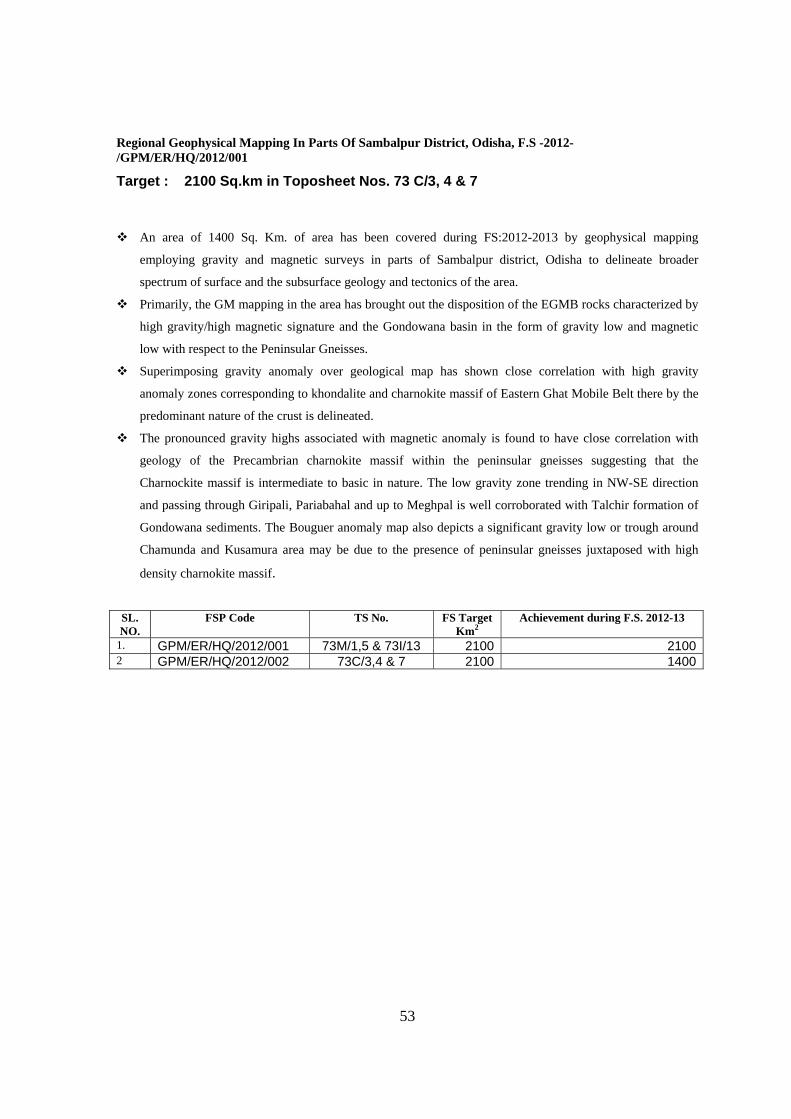
53
Regional Geophysical Mapping In Parts Of Sambalpur District, Odisha, F.S -2012-/GPM/ER/HQ/2012/001
Target : 2100 Sq.km in Toposheet Nos. 73 C/3, 4 & 7 An area of 1400 Sq. Km. of area has been covered during FS:2012-2013 by geophysical mapping
employing gravity and magnetic surveys in parts of Sambalpur district, Odisha to delineate broader
spectrum of surface and the subsurface geology and tectonics of the area.
Primarily, the GM mapping in the area has brought out the disposition of the EGMB rocks characterized by
high gravity/high magnetic signature and the Gondowana basin in the form of gravity low and magnetic
low with respect to the Peninsular Gneisses.
Superimposing gravity anomaly over geological map has shown close correlation with high gravity
anomaly zones corresponding to khondalite and charnokite massif of Eastern Ghat Mobile Belt there by the
predominant nature of the crust is delineated.
The pronounced gravity highs associated with magnetic anomaly is found to have close correlation with
geology of the Precambrian charnokite massif within the peninsular gneisses suggesting that the
Charnockite massif is intermediate to basic in nature. The low gravity zone trending in NW-SE direction
and passing through Giripali, Pariabahal and up to Meghpal is well corroborated with Talchir formation of
Gondowana sediments. The Bouguer anomaly map also depicts a significant gravity low or trough around
Chamunda and Kusamura area may be due to the presence of peninsular gneisses juxtaposed with high
density charnokite massif.
SL. NO.
FSP Code TS No. FS Target Km2
Achievement during F.S. 2012-13
1. GPM/ER/HQ/2012/001 73M/1,5 & 73I/13 2100 21002 GPM/ER/HQ/2012/002 73C/3,4 & 7 2100 1400
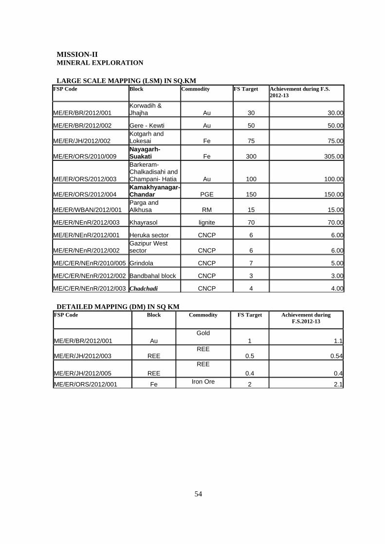
54
MISSION-II MINERAL EXPLORATION
LARGE SCALE MAPPING (LSM) IN SQ.KM
FSP Code Block Commodity FS Target
Achievement during F.S. 2012-13
ME/ER/BR/2012/001 Korwadih & Jhajha Au 30 30.00
ME/ER/BR/2012/002 Gere - Kewti Au 50 50.00
ME/ER/JH/2012/002 Kotgarh and Lokesai Fe 75 75.00
ME/ER/ORS/2010/009 Nayagarh-Suakati Fe 300 305.00
ME/ER/ORS/2012/003
Barkeram-Chalkadisahi and Champani- Hatia Au 100 100.00
ME/ER/ORS/2012/004 Kamakhyanagar-Chandar PGE 150 150.00
ME/ER/WBAN/2012/001 Parga and Alkhusa RM 15 15.00
ME/ER/NEnR/2012/003 Khayrasol lignite 70 70.00
ME/ER/NEnR/2012/001 Heruka sector CNCP 6 6.00
ME/ER/NEnR/2012/002 Gazipur West sector CNCP 6 6.00
ME/C/ER/NEnR/2010/005 Grindola CNCP 7 5.00
ME/C/ER/NEnR/2012/002 Bandbahal block CNCP 3 3.00
ME/C/ER/NEnR/2012/003 Chadchadi CNCP 4 4.00
DETAILED MAPPING (DM) IN SQ KM
FSP Code Block Commodity FS Target
Achievement during F.S.2012-13
ME/ER/BR/2012/001 Au Gold
1 1.1
ME/ER/JH/2012/003 REE REE
0.5 0.54
ME/ER/JH/2012/005 REE
REE
0.4 0.4
ME/ER/ORS/2012/001 Fe Iron Ore 2 2.1
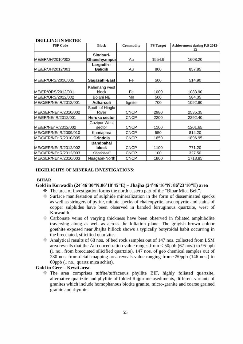
55
DRILLING IN METRE
FSP Code Block Commodity FS Target
Achievement during F.S 2012-13
ME/ER/JH/2010/002 Sindauri-
Ghanshyampur Au 1554.9 1608.20
ME/ER/JH/2012/001 Largadih -
Balidih Au 800 857.85
ME/ER/ORS/2010/005 Sagasahi-East Fe 500 514.90
ME/ER/ORS/2012/001 Kalamang west
block Fe 1000 1083.90 ME/ER/ORS/2012/002 Bolani NE Mn 500 584.35 ME/C/ER/NEnR/2012/001 Adharsuli lignite 700 1092.80
ME/C/ER/NEnR/2010/002 South of Hingla
River CNCP 2980 2535.35 ME/ER/NEnR/2012/001 Heruka sector CNCP 2200 2292.40
ME/ER/NEnR/2012/002 Gazipur West
sector CNCP 1100 1201.65 ME/C/ER/NEnR/2009/010 Khariapara CNCP 550 814.20 ME/C/ER/NEnR/2010/005 Grindola CNCP 1650 1896.95
ME/C/ER/NEnR/2012/002 Bandbahal
block CNCP 1100 771.20 ME/C/ER/NEnR/2012/003 Chadchadi CNCP 100 327.50 ME/C/ER/NEnR/2010/003 Nuagaon-North CNCP 1800 1713.85
HIGHLIGHTS OF MINERAL INVESTIGATIONS: BIHAR Gold in Korwadih (24°46’30”N:86o18’45”E) – Jhajha (24o46’16”N: 86o23’10”E) area The area of investigation forms the north eastern part of the “Bihar Mica Belt”. Surface manifestation of sulphide mineralization in the form of disseminated specks
as well as stringers of pyrite, minute specks of chalcopyrite, arsenopyrite and stains of copper sulphides have been observed in banded ferruginous quartzite, west of Korwadih.
Carbonate veins of varying thickness have been observed in foliated amphibolite traversing along as well as across the foliation plane. The grayish brown colour goethite exposed near Jhajha hillock shows a typically botyroidal habit occurring in the brecciated, silicified quartzite.
Analytical results of 68 nos. of bed rock samples out of 147 nos. collected from LSM area reveals that the Au concentration value ranges from < 50ppb (67 nos.) to 95 ppb (1 no., from brecciated silicified quartzite). 147 nos. of geo chemical samples out of 230 nos. from detail mapping area reveals value ranging from <50ppb (146 nos.) to 60ppb (1 no., quartz mica schist).
Gold in Gere – Kewti area The area comprises tuffite/tuffaceous phyllite BIF, highly foliated quartzite,
alternative quartzite and phyllite of folded Rajgir metasediments, different variants of granites which include homophanous biotite granite, micro-granite and coarse grained granite and rhyolite.
56
Second generation quartz veins parallel to the shear foliation at Gandhar are showing mineralisation in the form of arsenopyrite, chalcopyrite & minor pyrite grains.
Shear zones within microgranite near Abgila and within coarse grained granite at Gere shows significant sulphide minerals in the form of chalcopyrite, galena, minor arsenopyrite and pyrite. Minor sulphide minerals in rhyolite at the thrust contact north of Mirzapur village has also been observed.
One strong bipolar IP anomaly in the central part of the Gandhar quartzite which is also partly supported by SP anomaly has been observed.
So far analytical result for 205 nos samples has been received. Except one (70 ppb), the remaining samples have yielded Au concentration of < 50ppb gold concentration. The concentration of Ag in all analysed samples is less than 2ppm.
The sheared granite samples from Gere area yielded relatively high concentration of base metal particularly copper and zinc. The highest concentration of Cu 1.94% and Zn 0.15% is found in quartz vein traversing sheared granite at Gere.
JHARKHAND Investigation for gold in Sindauri-Ghanshyampur Block, Ranchi District, Jharkhand. (Code No. ME/ER/JH/2010/002) Highlight of work:
Sindauri-Ghansyampur is the eastern continuity of Lungtu-Hepsel-Parasi block where gold resources have been already established. The area is located about 12 km south of Tamar, Ranchi district, Jharkhand which is situated at about 55 km from Ranchi on NH-33 on the way to Jamshedpur. The exposed rocks belong to Singhbhum Group bounded by Chotanagpur Gneissic Complex in the north and Singhbhum Granite in the south. Singhbhum Group starts with Chaibasa Formation constituting of Kyanite-garnet-staurolite bearing mica schist with band of quartzite and ortho/para hornblende schist. This is followed by Dhalbhum Formation containing chlorite, magnetite bearing phyllite with quartzite intercalations and epidiorite shills. The Singhbhum Group is terminated with eruptive Dalma Volcanics represented by tuffaceous phyllite interbedded with quartzite, basalt, rhyolite and pyroclasts. . EXPLORATION DETAILS:
Subsurface exploration by drilling during Apr 2012 to March 2013, in the Sindauri -Ghansyampur Block continued by the help of two rigs (FS 2012-13) in which total Four (7 ) numbers of boreholes from SEB-10,11, 12 , 13 ,14,15 and .16 are drilled. The rock types intersected in these boreholes include magnetite-quartz- chlorite- sericite schist, phyllite, buff/ grey quartzite, calc-quartzite/ferruginous quartzite, quartzo- felspathic-phyllite, metagabbro, amphibolite, quartz/carbonate vein and quartz veins. Evidences of shearing are noted at various borehole depths in almost all these boreholes. Significant gold mineralization were inferred on the basis of presence of sulphides such as pyrite, arsenopyrite, etc. Gold mineralization shows it’s affinity with pyrite &/ or arsenopyrite. However, at places, free gold grains were also observed. The Borehole no. SEB-10 drilled up to 250.00 m, the unit intersected up to the drilled depth was phyllite with intercalated quartzite, quartzite, MBQ schist and quartz and quartz-carbonate veins. 2 (two) gold mineralized zones of 05.00m cumulative width with value ranging from 100ppb to > 1.0ppm has been found from depth 91.00-94.00m & 112.00-114.00m along the borehole and 6 zones with cumulative width of 41.00 m. of mineralization in the form of sulphides were seen from 115.00- 244.00m along the borehole whose result is awaited.
The Borehole no. SEB-11 drilled up to 250.00m, the units intersected up to the drilled depth were phyllite, quartz chlorite schist with or without magnetite, phyllite with intercalated quartzite, grey quartzite and quartz and quartz-carbonate veins.14 zones with approx. cumulative width of 86.00
57
m. of mineralization in the form of pyrite and arsenopyrite (sulphides) were seen mostly in phyllite with intercalated quartzite from 48.75m -246.70m along the borehole.
Borehole no. SEB-12 drilled up to 227.50m, the units intersected up to the drilled depth phyllite, tuff, phyllite with intercalated quartzite, quartzite, quartz mica schist and quartz and quartz-carbonate veins.12 zones with approx. cumulative width of 71.00 m. of mineralization in the form of pyrite and arsenopyrite (sulphides) were seen mostly in phyllite with intercalated quartzite from 42.75m-226.00 m along the borehole.
Borehole no. SEB-13 progressed up to 218.25m on 15.01.2013. The units intersected up to the drilled depth broken core of phyllite and tuff, phyllite with intercalated quartzite, quartzite, metabasics, quartz mica schist and quartz and quartz-carbonate veins.07 zones with approx. cumulative width of 12.00 m. of mineralization in the form of pyrite and arsenopyrite (sulphides) were seen mostly in phyllite with intercalated quartzite from 61.00-200.00m along the borehole.
Borehole no. SEB-14 progressed up to 24.70m on 15.01.2013. The units intersected up to the drilled depth mostly sludge and broken core of phyllite and tuff, quartz mica schist and quartz and quartz-carbonate veins. Borehole no. SEB -14 progressed from 161.25m to 288.20m on 31.03.2013. The units intersected up to the drilled depth were brown quartz mica schist, tuffaceous phyllite, metabasic, tuffaceous phyllite intercalated with grey chert, and tuffaceous phyllite with quartz vein / quartzite. Mineralizations in the form of disseminated sulfides such as pyrite, arsenopyrite, pyrrhotites were found in the drilled depth of 161.25-162.05m, 167.10-169.05m, 172.40-179.25m, 179.85-181.95m, 190.55-191.40m, 201.35-203.20m, 218.25-220.85m, 232.65-234.25m, 270.35-276.90m. The mineralisation has been observed in the tuffaceous phyllite intercalated with phyllite / chert. Borehole no. SEB -15 progressed from 90.20m to 284.40m on 31.03.2013. The units intersected up to the drilled depth were quartz mica schist, metabasic, tuffaceous phyllite intercalated with grey chert, and tuffaceous phyllite with quartz vein / quartzite. Mineralizations in the form of disseminated sulfides such as pyrite, arsenopyrite, pyrrhotites were found in the drilled depth of 85.50-87.05m, 87.80-94.05m, 97.00-105.65m, 106.80-111.40m, 112.20-114.60m, 121.60-124.20m, 134.00-134.75m, 136.00-139.00m, 140.10-143.10m, 145.10-149.45m, 152.55-157.75m, 160.75-162.85m, 169.75-170.25m, 171.25-172.25m, 187.00-187.90m, 184.10-187.10m, 194.10-198.10m, 201.50-207.00m, 210.90-211.90m, 218.20-221.30m, 226.40-227.40m, 263.40-267.70m. The mineralisation has been observed in the tuffaceous phyllite intercalated with phyllite / chert. Borehole no. SEB -16 progressed from 51.30m to 184.70m on 31.03.2013. The units intersected up to the drilled depth were quartz mica schist, tuffaceous phyllite, tuffaceous phyllite intercalated with quartzite, and tuffaceous phyllite with quartz vein / quartzite. Mineralizations in the form of disseminated sulfides such as pyrite, arsenopyrite, pyrrhotites were found in the drilled depth of 50.60-53.55m, 54.25-61.50m, 63.65-64.85m, 65.95-69.80m, 70.70-72.00m, 73.70-80.65m, 85.95-89.30m, 110.35-112.50m, 125.50-126.00m, 128.50-136.60m, 157.85-158.85m, 164.60-168.95m, 177.30-184.70m. The mineralisation has been observed in the tuffaceous phyllite intercalated with phyllite / chert. The Fire Assay analysis of gold received recently shows gold value in SBH6 from 2.6 to 13.05ppm, in SBH8 from 1.21- 9.60ppm,SBH9 from0.9-6ppm and in SBH-10 from 0.20- 1.6 ppm. Investigation for gold in Largadih-Balidih Block, Sareikela- Kharsawan, Jharkhand. (Code No. ME/ER/JH/2012/001) The investigation work is aimed to delineate gold mineralization in Largadih block, which is the western extension of the Rudiya block, Sareikela - Kharsawan district, Jharkhand (Toposheet no.73J/1). The Largadih-Rudiya block comprises lithopackages of upper Dalma Formation (volcanics) and the metasedimentaries of Singhbhum Group. The Largadih Block consists mainly of carbonaceous phyllite, acid volcanic/ subordinate chert band, siliceous tuff, mafic/ultramafic volcanic rocks and breciated quartzite. Structural elements of three phases of deformation have been
58
noted. The S0 is recognized by color and compositional banding mainly in carbon phyllite and acid volcanics. The D1 deformation produced tight rootless fold and is represented by S0//S1 schistosity. The mineral lineation in the form of L1 has been noticed in breciated and sheared quartzite. The D2 deformation produced open to close folds preserved in the lithounits of carbonaceous phyllite, acid volcanic and breciated quartzite on mesoscopic scale, where F2 plunges 40 in N80W direction. The D3 deformation produced open fold with N10E axial plane is almost ubiquitous and present in all lithounits.. Drilling
The borehole NRB-2A in Rudiya block has drilled up to 176 m depth. The NRB-2A encountered 0 m to 5.00m overburden sludge material and from 5.00m to 46.40m consists of brown & buff colour siliceous tuff and after that from 46.40 to 61.90m consist medium grained breciated quartzite contain only limonitised tints. The second facies of siliceous tuff i.e fine grained grey colour tuff start from 61.90m to 97.30m depth and after that again second level of breciated quartzite started at the depth from 97.30m to 106.52m. After that quartz chlorite schist continues up to 176 m. The NRB2A encounters three mineralization zone i.e from 77.40 -79.25m in siliceous tuff & 103.40 -109.40m in breciated quartzite; 146.35m -148.00m in quartz chlorite schist unit represents 3-5% sulfide (V.E) consists of Pyrite-Chalcopyrite-Arsenopyrite and suspected gold specks. The borehole NRB-5 in Rudiya Block has drilled up to 217.00m depth in which it encounters 0.00m to 49.35m yellow to brown colour fine siliceous tuff and after that up to 70.20m it encounters the grey to buff coloured fine grained siliceous tuff. In the depth of 70.20m the breciated quartzite unit starts which continues up to 82.00m after that grey colour quartz chlorite schist continues up to 144.10m. A second level breciated quartzite noted in between 144.10m to 160.55m and after that quartz chlorite schist continues up to 217m depth. The borehole NRB-5 encounters four mineralization zone i.e from 70.20m-82.00m depth in breciated quartzite; 95.85m-100.45m & 118.20m -121.30m in quartz chlorite schist; 144.10m to 160.55m depth in second level breciated quartzite represents 3-5% sulfide (V.E) consists of Pyrite- chalcopyrite-Arsenopyrite and few suspected specks of gold. The borehole LRG-1 has drilled up to 175 m in which it encounters 0.00m to 7.00m as overburden, after that it encounters yellow to brown colour siliceous tuff up to 36.90m and consequently grey colour siliceous tuff up to 81.50m. The breciated quartzite unit starts from 81.50 & continues up to 98.00m and after that quartz chlorite schist continues up to 175 m. The borehole LRG-1 encountered five mineralization zones i.e from 57.75m -59.50m in siliceous tuff, 81.50 - 98.00m in breciated quartzite; 100.30-108.00m & 131.90 – 132.85m & 165.00-168.30m in quartz chlorite schist. The mineralization zones represent fine dissemination & elliptical lenses of pyrite, chalcopyrite and arsenopyrite and few suspected specks of gold. The borehole LRG-2 has drilled up to 137.70m in which it encounters 0m to 5.00m as overburden, after that it encounters yellow to brown colour siliceous tuff up to 59.65m. From the depth of 59.65m the breciated quartzite unit starts and continues up to 78.25m after that grey colour quartz chlorite schist continues up to 137.70m. The borehole LRG-2 encountered four mineralized zone i.e 62.30m to 63.50m, 64.65m to 69.40m and 73.95 to 77.40m in breciated quartzite, 132.50m to 136.10m in quartz chlorite schist represents stringers and dissemination of pyrite, chalcopyrite &arsenopyrite The borehole LRG-3 has drilled up to 18.00m in which it encounters 0.00m to 4.55m as overburden, after that it encounters yellow to brown colour siliceous tuff up to 6.75m. From the depth of 5.65m the breciated quartzite unit starts and continues up to 8.90m after that yellow to brown colour siliceous tuff continues up to 18.00m. In this month the borehole LRG-3 encountered one mineralized zone in breciated quartzite unit i.e 6.75m to 8.90m consists of brown colour oxidised sulfides. The borehole LRG-4 is 81.90m and in total 90.90m depth in which it encounters 0m to 1.50m as overburden, after that it encounters brown colour siliceous tuffs upto 39m and grey colour tuff upto 70.70m. From the depth of 70.70m to 90.90m the breciated quartzite unit was noted during logging. In this month the borehole LRG-4 encountered three mineralized zone i.e first from 42.00m to
59
46.50m in siliceous tuff unit and second & third from 72.20m to 76.10m & 80.70m to 84.60m respectively. The mineralized zone represents dissemination and stringers of pyrite-arsenopyrite. Title: Investigation for locating Iron ore and manganese ore occurrences in the rocks of Iron Ore Group between Kotgarh and Lokesai, West Singhbhum District, Jharkhand. (Code No. ME/ER/JH/2012/002)
Highlights: The mapping was carried out in and around Bahada, Katikora, Foga Buru, Hatanabera,
Aikuti, Robenta, Lokesai, Kumirita, Kutingta, Kudamsada, Kuchibera and Katidiri. The rock type encountered are Dolomitic limestone, Purple colour shale, volcanic rock of Jagannathpur lava and laterite traversed by quartz vein. Dolomitic limestone is exposed in and around Hatanabera Aikuti Bahada, and North of Katikora village area, which is situated NW corner of the area. The attitude of the bedding in the dolomitic limestone is N700E to E-W with gentle dip (40 to 100) towards South as well as North. The attitude of foliation is observed N600E to N800E with moderate dip (250 to 450) towards north. The rock is dark gray in colour, hard and compact it gives effervesces with acid. Purple colour Shale was exposed Kotgarh, Kumirita, Katidiri Kudamsada, Katikora area. It is very fine grained and purple in colour. The general trend observed of this rock unit is N800E to EW with very gentle (40 to 100) dip towards Northernly. Basic rock is exposed near Kumirta area. The rock is very fine grained melanocrati, massive, shows amygdaloidal structure. It is hard and compact. Laterite capping are observed on Shale Foga Buru (in East of Aikuti & West of Kudamsada Village) and on basic volcanic rock in and around Kutingta area.
Investigation for rare metals and REE in Chotanagpur Gneissic Complex in Dublaberatoli - Sundil area, Ranchi District, Jharkhand. (Code No. ME/ER/JH/2012/003)
Highlights: Geological work was carried out to the east of village Dublaberatoli. The area is part of Chatanagpur Gneissic Complex (CGC). The major distinctive lithic units observed are the Pegmatite (dominantly mixed type and fine grained aplitic type), Mica-Schist, Amphibolites, quartzite and calc-silicate. Detailed sketching and plotting in graph sheet of the pegmatite body was carried out at for suitable outcrop to see the zonation and variation of the character of the pegmatite body. Zonation of the 1.2 km stretch pegmatite body was carried out in 100 meter interval. The outer zone is coarse grained, consisting of dominantly tourmaline and muscovite. Towards core the grain size gradually reduced. The core is consisting of quartz, feldspar components. Coarser to medium fraction are found at the middle part of the pegmatite body. This middle part is enriching in biotite. In some outcrop pink feldspar is observed at the middle zone. Other lihounits which were observed in the area are the Amphibolites, Quartzite and Calc-silicate. Some more numbers pits and trenches were carried out to see the pegmatite extension and contact of the other litho units. Three dimensional pit & trench log were prepared. BRS, PS, PTS samples were collected for analysis
ICP MS analysis of 26 (twenty six) no. of samples (FSP 2012-13) of Dublaberatoli shows that the concentration of total Rare Earth Elements (TREE) ranges from 66.7 ppm to 398.47 ppm. The concentration of rare Metals shows that Li (10 – 81ppm), Cs (<10 – 16 ppm) and Rb (175 – 488 ppm).
Results of XRD analysis of 37 bed rocks shows the presence rare minerals in the mapped area shows the presence of , Columbite, Cebaite, Barite, Upalite, Rutile, Anatase, Lepidolite, Fluocerite, Pollucite in traces in pegmatites.
Title: Investigation for rare metals and REE in Chhotanagpur Gneissic Complex in and around Kasidih area, Ranchi District, Jharkhand. (Code No. ME/ER/JH/2012/005) Highlights:
Engaged in detail mapping on 1:500 scale in and around Kasidih area along with surveyors. The pegmatite body is showing compositional variations in length as well as in width Presence of allanite in also noticed in the pegmatite in which radioactivity is marked by the presence
of brownish halos present around the allanite. The results of XRD analysis of 10 no of samples have been received in which five samples are showing encouraging results i.e., containing columbite, leucosphenite, zorite, pollucite and amblygonite
60
Odissa: Exploration for iron ore in Kalamang west block, Bonai-Keonjhar belt, Sundergarh district, Odisha”, Stage G3. ME/ER/ORS/2012/001.
Strike length of mineralized zone(s) :1st-500m, 2nd- 400m and 3rd- 125m Average width and grade of the zones: Width of 1st zone vary from 25m to 170m,
that of 2nd zone vary from 100 to 150m and that of third zone is 50m. Average grade based on available chemical data is 59.76% (Fe total).
Reserve estimated: The resource so far estimated of Kalamang west block at 45% Fe cut off based on visual estimate is 33.78 million tones.
Exploration for Iron ore in the Sagasahi East block, Sundergarh district, Odisha.ME/ER/ORS/2010/005.
Strike and length of mineralized zone(s) : Area 1200mX700m
Average width and grade of the zones: Average width for the three zone is 100m. The average grade based on available chemical analysis result 63.79% Fe.
Reserve estimated: The resource so far estimated of Sagasahi-east block at 55% Fe cut off is 2.97 million tonnes.
Search Search for occurrence of Detrital Iron Ore Deposits (DID), their structural disposition and correlation in the southern margin of Horse shoe basin around Nayagarh - Suakati area, Kendujhar district, Odisha (G-4).ME/ER/ORS/2010/009
Seven Nos. of isolated Detrital Iron ore deposits (DID) occurrences have been
identified at different location viz. Suakati, western flank and eastern flank (Uppar Kansari, Laupada and Ichinda area) of Gandhamardan Paharh with variable dimensions ranging from 250 m x 200 m to 1 km x 300 m. DID occurs as consolidated, indurated and subangular to subrounded clast-supported conglomerate mainly composed of different clasts of hematite, jasper, BHJ, goethite, ferruginous shale and volcanic rock fragments in 0.5 cm to 30 cm size ranges. The population of Iron bearing clasts (hematite with massive/ hard & soft laminated + BHJ) is ranging from 45 to 75% by volume in the DID. The content of Fe(T) ranges from 45 to 60%(VE).
Stratigraphically, these are unconformably lying over basalt, ferruginous shale and basal gritty quartzite.Fe-rich laterite occurs near Khejurmundi, Kusumita and Dumurdihi area with Fe(T) ranging from 40-50%. These could be a low grade resource of iron ore in future due to lowering of the cut-off grade to 45% Fe in iron ore industry.
61
Exploration for Manganese in the identified , Bolani Northeast block, Bonai – Kendujhar belt, Kendujhar district, Orissa (G3) (ME/ ER/ ORS/ 2012/ 002) The manganese ore mineralization demarcated during detailed geological mapping in Bolani
NE block varies from 30X20 m to 50X20 m. Based on the geological cross sections prepared from borehole intersections, the Mn mineralised bands trend NNE-SSW in conformity with the general trend of litho units.
The width/thickness of individual ore band varies from 0.20m to nearly 12.50m (BNE-8 on V.E) and number of ore zones varies from 1 to 5 as per V.E.
So far a total manganese resource of 0.097 million tonnes (UNFC-333) has been calculated at 20%cut off and an additional 0.241 million tonnes of marginal grade (10-20%) of manganese resource is estimated.
Investigation for gold in Barkeram-Chalkadisahi and Champani- Hatia blocks of Badampahar-Gorumahisani belt, Mayurbhanj district, Odisha.ME/ER/ORS/2012/003
A sulphide mineralization zone of 20m X 250m dimension was demarcated at the contact of granodiorite and hornblende schist near Kalimati-Tilaijhori villages.The mineralization was noticed in sheared granodiorite traversed by numerous quartz veins of varying thickness along and across the foliation. The silicified zone within the sheared granite contains profuse sulphides of pyrite, arsenopyrite and pyrrhotite. Besides, incidences of sulphidation are also found in different localities in both the blocks.
1 sq km. area has been demarcated in Champani-Hatia block, Mayurbhanj dist for DM (1: 2000 scale), PT and close spaced sampling on the basis of sulphide mineralisation. Analytical results of about 585 soil sample and 40 TP samples are awaited. After receiving the Gold analytical results, future work will be proposed
Search for PGE in Kamakhyanagar-Chandar sector in the Marginal Zone between Eastern Ghats Mobile Belt and Singhbhum Craton, Dhenkanal District, Odisha (ME/ER/ORS/2012/004)
Lensoidal bodies of chromiferous serpentinised ultramafics comprising massive chromitite, olivine chromitite, serpentinised dunite, altered orthopyroxenite and peridotite occur as detached outcrops in this area.
The regional strike of all lithounits in this domain is WNW-ESE. The earliest identifiable isoclinal reclined folds (F1) are recorded in the Mg-Al metapelite and charnockite near Bhushal and Chandar. The second deformation (D2) has folded the S1 fabric into WNW-ESE trending asymmetric low plunging folds. The regional disposition of different lithounits of this domain is controlled by D2 deformation with a distinctly different geometry.
Chromiferous ultramafics and pyroxenites which occur as lenses within this marzinal zone are sampled for PGE.
Geophysical survey Geophysical Investigation of Volcano-Sedimentary Sequence and Associated Rocks to identify gold and basemetal mineralization at Gere- Kewti area of Gaya district, Bihar, F.S -2012-013/SEI/ER/HQ/2012/004
Target : 250 Sq.km (72H/1 & 5) In Gere-Kewti area, the magnetic (TF) contour map has shown the regional trend of
anomalies follows the general strike direction of the lithological units of the area. Some
62
bipolar anomalies of long wave length have also been observed, which are indicative of fault zone/intrusive/ contact of two lithological units in the area. The one high magnetic anomaly is observed in central part of the area NE-SW direction at Kewti village which may be due to the intrusive.
In Gandhar area, the IP survey has delineated two anomaly zones (IP1&IP2) for a
cumulative strike length of 550 m trending in NE-SW over quartzite and soil cover. IP-1, in the central part of the area, is partly corroborative with feeble magnetic, very low SP and well corroborative with low resistivity anomalies. The Central feeble anomaly zone (IP-2) with strike length of about 50 m and it is supported by low magnetic & resistivity anomalies.
In Kewti area, IP survey has delineated three anomaly zones for a cumulative strike length of
5.1 km trending in NE-SW over Tuff intercalated magnetic formations. The Chargeability zone CH-1 broadly follows the magnetic anomaly zone in the northern part of the area on Tuff intercalated magnetic formations with soil cover. Similarly the chargeability zone CH-2 is within the magnetic anomaly zone in the southern part of the area. This anomaly zone is well corroborating with high order magnetic anomaly, very low SP and resistivity anomalies.
This corroborative geophysical anomaly is suggestive of a favorable zone for the occurrence
of gold and associated sulphide mineralization. The anomaly zone CH-3 is within the magnetic anomaly in the southern part of the area. This
chargeability anomaly corroborates well with high order magnetic, and low resistivity anomalies.
The general depth to the top of the causative body is estimated from the IP pseudo depth
sections are 16m to 20m from the surface. Geophysical logging of boreholes in coal/lignite fields of Odisha & WB
F.S -2012-013/SEI/ER/HQ/2012/017
During the period from April, 2012 to March, 2013, geophysical logging was conducted in the coalfields of Orissa and coal / lignite fields of West Bengal under regional and promotional coal exploration programmes undertaken by the department. Altogether 22 boreholes, including 18 promotional ones for coal & lignite, have been logged in the said coalfields involving total meterage of 8432 m. The geophysical logs as obtained have been utilized for delineation of coal sections, determination of depth/thickness of coal bed and basic intrusive & demarcation of interfaces of different Gondwana Formations, as encountered in the boreholes.
Geophysical logging for investigation of gold in Largadih –Balidih block, Sareikela-Kharsawan, Jharkhand , F.S -2012-013/ME/ER/JH/2012/001
During the period from April, 2012 to March, 2013 the geophysical logging was conducted in 2
boreholes for 397m for gold exploration in Jharkhand. One (1) borehole is located in Largadih - Balidih block, Saraikela - Kharswan district and the other one in Sindauri block, Ranchi district. Due to non-availability of IP and susceptibility probes only electrical method was used for logging for the boreholes. The geophysical logs normally exhibit synergic character of against the formations and geophysical responses in same nature create ambiguity in identification of target zone. As such geophysical could help only to delineate conducting horizons; however, mineralized zone associated with gold could not be confirmed by available parameters.
63
MISSION-III
‘Creation of Theme-based database for Degreesheet 78F’ was taken up during FS. 2012-13 with the objectives of synthesis and collation of data and their integration for creation of digital storehouse of geoscientific data of GSI. The data base was created on eight (8) identified themes such as Geological Map 50K, Geochemical Exploration, Mining-Drilling, Geophysical, PGRS, Environmental Geology, Natural Hazard and Rock Sample Analysis (Petrology).
During execution of the project, in respect of all the eight themes, analysis and extraction of data from thirty four (34) reports were carried out for insertion into the Geoscientific Database as per the format of the Oracle Database. Highlights of work: A. Extraction of data from reports into formats
1. Map 50K- 13 report was studied and relevant data were extracted. 2. Drilling- Mining theme - Total 9 reports pertaining to dolomite, limestone, copper and coal
investigation of degree sheet 73Fwere studied and relevant data extracted. 3. Geochemical theme - 1report was studied and relevant data extracted. 4. PGRS theme - 1 report was studied and relevant data extracted. 5. Geophysics theme: Data extracted from 4 reports for geophysical investigation. 6. Rock sample Analysis: Total 2 nos of reports were studied and relevant data extracted
B. Thematic data input of themes into Oracle data base 1. Map 50K theme- Data entry has been made from the available extracted data from 34
geological of 8 themes. C. Layer wise Graphic data input for 16 compiled sheets:
1. Map 50,000 - Graphic data input for five layers as available from the M&C division, ER were completed.
2. PGRS theme – 4 layers were completed. 3. Environmental Geology- 5 layers (Geology, landuse, landform, slope and well data) were
completed.
64
MISSION-IV - Multidisciplinary Studies: ENGINEERING GEOLOGY: Water Resources Development Projects
Orissa: 1.Korapani Irrigation Project, Sundargarh district(Additional item)-Jaydip Mukherjee A total of 95.45m cores from six boreholes drilled at the gap areas of earthen have been logged. Bedrock occurs at depths varying between surface and 10.6 m whereas fresh rock occurs at 9.53m to 12.52m below ground surface. Metabasic rock is the main rock type intercepted in the said holes. Cut off of earth dam should be placed over weathered bedrock. 2.Kala Barrage Project, Deogarh district(Additional item)-Jaydip Mukherjee A total of 72 m cores from nine boreholes drilled at the gap areas of the proposed barrage site have been logged. Bedrock occurs at depths varying between 1.4m and 5.55 m whereas fresh rock occurs at 5.2 m to 7.63 m below ground surface. Metabasic rock is the main rock type intercepted in the said holes. 3.Aherajore Barrage Project, Jharsaguda district: (Additional item)-Jaydip Mukherjee A total of 33.55 m cores from three boreholes drilled at the proposed barrage site have been logged. Fresh rock in the form of silicified granite occurs at 1.15 m to 4.19 m below ground surface. The proposed barrage site over Aherajore nala appears to be feasible on geotechnical consideration and the barrage is to be founded over fresh, hard rock. 4.Low Height structures in Sundargarh district(Additional item)-Jaydip Mukherjee Department of Water Resources, Government of Orissa is planning to construct low height storage structures across Ib, Koel, Vasundhara, Ichha, Veden, Saphai and some other small nalas for providing irrigation and drinking water supply. No rock exposure has been found in and around Jhirpani site over Koel River and Kinjirma site over Saphai River. Intermittent exposures of quartzitic phyllite at the left bank in Vedvyas site over Koel River, metabasic rock at the left bank in Kopsingha site over Ib River, granite gneiss at the right bank in kudabaga site have been observed. No rock exposue has been found in and around Deogaon site over Ib River and Phulbari site over Saphai River. Intermittent exposures of slaty phyllite intruded by vein quartz have been found at Sankh and Badjore site. Small outcrops of gneissic rock have been found at the banks of Koitara and Katikela sites. 36m cores from 6 holes drilled at Kinjirima site, 30m cores from 5 holes drilled at Kopsingha site and 30m cores from 5 holes drilled at Kudabaga site have been logged. At kinjirima site, weathered bedrock occurs at 1.9m to 3.8m, whereas no fresh rock has been intercepted in the said holes. At Kopsingha site, bedrock and fresh rock occurs at depths ranging between 1.1m-3.6m and 2.17m -5.08m repectively. At Kudabaga site, weathered rock occurs at depths varying between 2.5m and 4.8m whereas fresh rock occurs at more than 5m depth. The sites appear to be feasible on prima facie geotechnical consideration. 5.Rukura Irrigation Project, Sundargarh district(EG/C/ER/HQ/2012/002) Jaydip Mukherjee Detailed geological mapping of excavated cut off trench between RD 70M and RD 170M= 600 sqm on 1:100 scale was done. Cut off depth varies between 1.62m (RD 95m) and 3.35 m (RD 170m). The excavated cut off under study- indicate presence of top soil overlying on highly weathered and decomposed feldspathic granite mixed with rock pieces, completely decomposed and weathered granite gneiss and highly weathered and decomposed metadolerite. A persistent pebble zone of about 1.5m and 2.1m thickness occurs at the excavated cut off. This pebble zone occurs upto excavated cut off between RD 110 m and RD 130 m – where profuse seepage has been noticed- where cut off is to be taken below pebble bed. The excavated foundation of the key wall and part of right abutment shows presence of fresh, hard feldspathic granite gneiss – dissected by fresh, hard metabasic rock. Rest part is covered with disintegrated rock. Plate load test is to be carried out at this part in order to assess the bearing capacity of the foundation media .Excavated right main canal section between RD 1105m -RD 1400m and RD 1600m-RD 1740m has been studied. The excavated canal section shows presence of top dark grayish brown silty sand followed by highly weathered, disintegrated and decomposed feldspathic granite intruded by metabasic rock. 6.Ret Irrigation Project, Kalahandi district(EG/C/ER/HQ/2012/002) Jaydip Mukherjee Detailed geological mapping of the right abutment between RD 686.5m and RD 713.5m for 185.3m length covering 3706 sqm. on 1:200 scale was done. Average foundation level varies between RL 264m and RL 265m against designed foundation level RL 265m. At the excavated foundation, fresh, hard, compact and competent grey granite gneiss and garnetiferous granite gneiss have been intercepted. Three (3) shear zones have been recorded which are to be excavated twice the width and then to be filled with rich concrete. Detailed geological mapping of the excavated foundation of river bed central spillway Block nos. 4,5,6,7 between RD 636 m and RD 687 m covering 2601 Sqm. on 1:200 scale was done. Average foundation level ranges between 262.7m and 263.18m.At the excavated foundation, fresh, hard, compact and competent grey granite gneiss and garnetiferous
65
granite gneiss have been intercepted. Shear zones have been recorded at places which are to be excavated twice the width and then to be filled with concrete of appropriate strength. 7.Uttei- Raul Integrated irrigation Project, Kalahandi district(EG/C/ER/HQ/2012/002) A total of 0.0646 sq.km area of the proposed 10m high and 340m long Roul Barrage has been mapped on 1:1000 scale covering 90m upstream and 100m downstream of the barrage axis. Intermittent presence of partially weathered to fresh, hard porphyroblastic garnetiferrous granite gneiss has been noted along the proposed barrage site. This lithounit continues in both up stream and down stream Xenoliths of metabasic rocks have also been noted within this rock. Both right and left flanks have been covered by pale grayish brown silty sandy soil. Beside exposed rock, fine to medium grained sand and pebbles/boulders are present. The present Roul Barrage appears to be feasible on techno-economical consideration. Subsarface exploration has been recommended to assess feasibility of the structure. 8. Lanth Barrage Project, Bolangir district(EG/C/ER/HQ/2012/002) Jaydip Mukherjee A 340 m long and 5 m high barrage has been proposed across Lanth River near village Deng for providing irrigation facilities to drought prone Bolangir district. A total of 0.051 sq.km. area covering 50 m u/s and 100 m d/s of the proposed barrage has been geologically mapped on 1:500 scale and 105 m cores from 6 has been logged. The river bed in and around the barrage alignment is covered with coarse grained buff coloured sand. One small outcrop of dark black coloured silicified metabasic rock occurs at the left bank. Weathered rock occurs at depths varying between 2.1m and 8.8m whereas fresh rock occurs at depths ranging between 8.13m and 14m. Subsarface exploration has been recommended in the gap areas to assess feasibility of the structure. 9.Chandrinala Irrigation Project, Sundargarh district(Additional item)-Jaydip Mukherjee A total of 104.8m cores from six boreholes drilled at the gap areas of earthen section have been logged. Bedrock occurs at depths varying between 1.6m and 9.45m whereas fresh rock occurs at 3.8m to 14.93m below ground surface. Silicified metabasic rock is the main rock type. 10. Kanupur Irrigation Project, Keonjhar district (EG/C/ER/HQ/2012/002) Debashis Bhattacharya &A.Bora- Detailed geological mapping of downstream wing and return foundation area on (1:100) scale covering an area of about 2500 sq.m has been done. The mapped area mainly consists of slightly weathered to fresh hard medium grained granite which is later intruded by dolerite dykes along some of the major joint planes giving rise to hybrid type of rock. Due to this intrusive activity the granite has been sheared at places. The granite is traversed by three to four major sets of joints, though in some of the areas it is massive in nature.The two major Shear have been delineated. All the Shearzone were suggested to be thoroughly cleaned before applying dental treatment and fully grouted anchor bars 25mm dia should be provided @ 2.0m C/C in the sloped portions in staggered manner. The major Shearzone in the northern most corner of the mapped area should be provided with Hammock reinforcement with 25mm dia steel both ways as is being followed in the U/S Shearzone in between offset 71m to 82m. Consolidation grouting should be done in the entire mapped area @ 6.0m grid pattern to a depth of 6.0m in staggered fashion from offset 94.7m U/S to 80.90m D/S, distance measured from axis of the spillway. Post grout water loss test should be carried out at least one in six holes. Some seepage points have been observed near RD 1378, 1385 & 1396 at offset 80.90m.The levels of hard granite rock for foundation may be kept as 397.500m. The exposed face/pockets should be covered with concrete immediately so as to avoid any untoward incidences because of heavy cutting. The existing rock near the Shearzone in the U/S wing wall is competent for bearing for reinforcement purpose. 11.Hadgarh Dam, Keonjhar district(Additional item)-Jaydip Mukherjee Fine hair line cracks have been observed at the inspection gallery and adit portion of Hadgarh Dam over Salandi River. During the present investigation, 2 – 5 m long 0.5 mm – 1 mm wide cracks have been noted in both adit and inspection gallery part. It has been reported by the Proejct Authority and local people that tremor also has been felt due to simultaneous heavy blasting of the nearby underground and opencast Chromite Mines located at 0.75 Km – 1.5 Km from the damsite. The nearby guest house of Forest department also show severe crack. On the study of these cracks, it seems that these cracks are blasting induced. The Project Authority installed some glass table tale tail which have been found to be intact on the day of visit. As short-term measure, installation of more glass plates along and across the cracks with proper observation has been suggested. Moreover, the details of location of mines and blasting details are to be collected. 12.Anandapur Barrage Project, Keonjhar district(EG/C/ER/HQ/2012/002) Jaydip Mukherjee Construction stage geotechnical investigation of Block No.4 shows that PCC work has been completed for Bay Nos.20, 21 and 22 where foundation has been kept on soil considering stage bearing capacity. Presently the downstream cut-off between R.D. 265 m and R.D. 287 m has been excavated upto designed foundation level i.e., R.L. 22 m where weathered and decomposed granite gneiss has been intercepted. A total 189 m cores from twelve boreholes drilled at the body part, upstream and downstream cut-off of Block No.3 has been logged which shows presence of weathered bedrock feldspathic granite / granite gneiss between 6.0 m and 9 m depth.
66
As fresh rock occurs at deeper level, foundation of body and both cut-off of Block No.3 should be kept on soil / decomposed rock considering safe bearing capacity. 13.Laxmipathar Irrigation Project, Boudh district(EG/C/ER/HQ/2012/002) Indranil Chakraborty A 545.0m long and 35m high earth dam has been envisaged across the Laxmipathar Nala. Drill core logging of fifteen drill holes, covering 369.0 RM was carried out. The overall assessment of the drill core data reveals that the bed rock depth ranges between 4.5m to 16.5m in the dam axis, between 4.5m to 9.0m at upstream side and between 3.0m to 15.0m at downstream side. The recovery is very poor at some holes, as a result bed rock and fresh rock depth could not be interpreted. At some holes fresh rock has not been encountered within drilled depth. 14.Brahmanipada Irrigation Project, Kandhamal district(EG/C/ER/HQ/2012/002) Indranil Chakraborty The project engrosses a 975m long and 28m high earth dam across river Kolera. Drill core logging of seventeen boreholes, covering 419.0 RM was carried out. Hard lateritic clay has been found upto the drilled depth in the most of the drill holes along the proposed dam axis and highly weathered rock intersected only two holes at 4.5m and 19.50m depth. No fresh rock has been encountered upto the drilled depth (25m) at the holes drilled at the downstream side of the proposed dam axis. Only at three holes bed rock has been found at 9.0m, 10.50m and 18.0m depth. The project has proposed a saddle spillway at the left bank saddle about 5-6 km away from the left abutment. It has been suggested to prepare a contour plan of the saddle area for detailed geological mapping and further investigation of the proposed spillway site. 15.Khadaga Irrigation Project, Ganjam district(Additional item) Indranil Chakraborty - Geological mapping of the barrage site (about 120m long and 12m high), covering 0.02 km2 has been carried out. High grade gneiss (W1) intruded by vein quartz is exposed on the two banks of the river Khadaga at the proposed barrage axis. The river was full of water; therefore the riverbed was not exposed for mapping. However from the geological exposures and strike continuity it appears that rock is either exposed or covered with thin overburden at the river bed. Necessary subsurface investigations have been suggested. 16. Kalasa Irrigation Project, Ganjam district(Additional item) Indranil Chakraborty Geological mapping of the barrage site (about 9.5m high), covering 0.03 km2 area has been carried out. No rock outcrop has been noticed along the proposed barrage axis, abutment, and its surrounding area. The barrage axis has been selected about 40m downstream of the confluence of Kalasa River and a local nala. The mapped area is covered with riverine sand and clayey sand. Necessary subsurface investigations have been suggested. 17.Badanadi Irrigation Project, Ganjam district(Additional item) Indranil Chakraborty Geological mapping of the weir site (about 4.5m high), covering 0.01km2 area reveals that the mapped area is devoid of any rock exposure. Riverine sand and clayey sand cover the entire mapped reach. By observing the materials (big parts of tree) on the river course, it seems that high flood comes along the river; therefore adopting of necessary protection measures has been advised to the project authority. Necessary subsurface investigations have been suggested. 18.Manjore Irrigation Project, Angul district(EG/C/ER/HQ/2012/002) Jaydip Mukherjee A total of 109.5 m cores have been geologically logged which indicate presence of fresh, hard charnockite and granite gneiss at depths varying between 0.15m to 10.17m. In general, fresh rock level gradually goes deeper at the downstream. 19.Prachi Barrage Project, Puri district(EG/C/ER/HQ/2012/002) Jaydip Mukherjee The alternate barrage site over Prachi River near Bajepur village has been studied through geological mapping of 0.05 Sqkm on 1:1000 scale and geological logging of four boreholes totalling 89.5 m. The study indicates that the present barrage alignment appears to be geotectonically feasible. Foundation depth ranges between 4.5 and 5 m in river
bed part and 7.5 m at right bank part. The supplied plate load rest at 2 m depth is 3.555 t/m2 with safety factor of 2.5. Ground condition indicates that bearing capacity will be definitely improved at foundation depth i.e. 4.5 - 5 m as reflected from SPT ‘N’ value. 20.Taladanda Main Canal, Jagatsingpur district(Additional item)-Jaydip Mukherjee Recently slope failure and seepage problem has been observed in Taladanda Canal System between RD 42.5 km and RD 44.4km during the monsoon. To ascertain the reasons of such seepage and slope failure, twelve explanatory holes have been drilled over a length of 2 km. From the study of the exploratory drill hole data, it has been found that in general a persistent sand layer with medium to high permeability (SW, SW-SM class) occurs below this silty sand/clay layer all along the stretch under study. It seems that the canal has been constructed over the sandy horizon of the palaeo channel deposit of Mahanadi River. For arresting the seepage in the stretch between RD 42.5km and RD 44.4km, excavation of a cut off trench at the toe of the left embankment (on river side) puncturing the pervious zone and complete removal of the same and to be filled with impervious earth and compacting the same has been suggested. 21.Hadua Irrigation Project, Cuttack district(EG/C/ER/HQ/2012/002) Jaydip Mukherjee A total 90.8m cores from six exploratory holes drilled (2 at Mahakali nala Bridge site and 4 at Giritota nala Bridge site )have been logged. At Mahakali site, weathered rock (charnockite) occurs at depths varying between 5m and 7m
67
whereas fresh rock occurs at 10.24-19.05m depth. At Giritota crossing, weathered rock (charnockite and garnetiferrous quartzite) occurs at 3m to 6.5m depth whereas fresh rock occurs at 9.22m to 16.21m depth. In general the foundation of the piers of both the bridges is to be kept on weathered rock. 22.Upper Udanti Irrigation Project, Nuapada district(EG/C/ER/HQ/2012/002) Jaydip Mukherjee A total 59.5m cores from 5(five) holes in and around the proposed barrage axis have been logged. Bedrock (Granite gneiss and metabasite) occurs at depths varying between 1.2m and 1.8m whereas fresh rock occurs at depths ranging between 6.2 m and 7.95m. 23.Haladia Irrigation Project, Mayurbhanj district(EG/C/ER/HQ/2012/002) Jaydip Mukherjee During the present investigation, a total of 2340 sq.m. area of the excavated cut-off trench between R.D. 2070 m –R.D. 2160 m, R.D. 2410 m – R.D. 2508 m , R.D. 2520 m – R.D. 2560 m RD 2950m - RD 3010m, RD 3180m - RD3310m have been mapped on 1:200 scale for assessing the geological condition of the cut-off trench. Average cut-off depth ranges between 3 m and 4 m. Cut-off has been kept over highly weathered and decomposed quartzitic phyllite forming clayey mass. Slope failure at the upstream wall between R.D. 2448 m – R.D. 2460 m and R.D. 2494 m – R.D. 2500 m has been noted where the slip occurred at the contact between the pebble bed and highly weathered and decomposed bedrock layer. For this distressed slope part, all the slided materials were suggested to be removed and moderation of slope through proper benching in stepped manner for receiving layer wise compaction. As the test grouting carried out by the Project show appreciable reduction of permeability, two nos. curtain grouting upto 2/3 H has been suggested .The Project Authority arranged Plate Load Test for the above two sites as no fresh foundation grade rock is available upto 30m depth. Safe bearing capacity at 3mtr depth comes to be about 8 tonnes/sqm, which is in lower side. So foundation of the head regulators are to be kept in this soil after improving the bearing capacity and accordingly the foundation should be designed. West Bengal: 1.Pratappur Barrage Project, Bankura district(EG/C/ER/HQ/2012/001) Indranil Chakraborty Two dams have been proposed on Gandheswari river (Height = 28m) and Dwarakeswar river (Height = 33m) at Bankura district, West Bengal for irrigation purpose. Regionally the area belongs to the Chotonagpur Gneissic Complex, represented by Granite Gneiss with occasional metabasic intrusives like amphibolites and epidiorites. Detailed geological mapping of two damsites covering 0.14sq km has been done on 1:1000 scale which reveal that no rock exposure is present on the both banks of the two proposed dam axis. Core logging of fourteen bore holes drilled along the proposed Pratappur barrage covering 167.6 m and logging of twenty three pits covering 42.84 m were carried out. From the drill core log data it may be concluded that at the right end of the barrage, the depth of the bedrock is shallow to moderate (1.5-7.5m), but at the left end of the barrage rock will be encountered at more depth (9-12.50m). No rock is found upto drilled depth at right afflux bundh. Permeability test at the foundation/cut off depth is to be carried out for adopting suitable measures. Subsurface exploration will be required in order to know the foundation condition of Dwarakeswar dam. 2.Purulia Pumped Storage Extension Scheme (Turga Project), Purulia district(Additional item)-Saibal Ghosh & Indranil Chakraborty Purulia Pumped Storage Extension Scheme (Survey of India TopoSmall Hydroelectric Projectet No 73I/4) envisages construction of two rockfill dams, one upper dam (796 m long, 79 m high) and one lower dam (502 m long, 69 m high) across Turga nala to generate 1000 MW (installed capacity) of power in the Ayodhya Hills near Baghmundi town in Purulia district, West Bengal. Water will be passed through two 1634m± long Head Race Tunnels (HRT) for feeding four reversible turbines in an underground power house [157 m (L) x 24 m (W) x 48 m (H)] on the right bank. Regionally the area belongs to the Chotonagpur Gneissic Complex, represented by Granite Gneiss, Porphyritic Granite Gneiss with occasional metabasic intrusives like amphibolites and epidiorites. The bedrock in the project area is hard, competent, and massive and is traversed by prominent schistosity/foliation and three sets of joints. At the proposed upper dam axis,presence of highly fractured, brecciated quartzo feldspathic rock, profuse silicification, swerving of all drainage courses and the marked straight course of the nala indicate likely presence of a brittle zone (presently sealed fault). A tentative location of the dam axis was decided on the basis of narrow nala course, availability of rock on the two abutments and disposition of the major nalas joining with Turga nala. Prepartion of a contour plan of the whole project area depicting the layout of the project has been advised for detailed geological mapping and further investigation. 3.Rammam Hydroelectric Project,Stage-I, Darjeeling district(EG/C/ER/HQ/2012/001) Saibal Ghosh & Indranil Chakraborty Geological mapping (1:1000scale) has been carried out at Rammam intake, Shri Khola intake, Parthem Khola intake, portal area of approach adit to HRT at Mahavir Khola and Bungsen Khola. Jointed quartzo feldspathic gneiss has been noticed in the mapped areas. Drill core logging of eight drill holes covering 410m has been carried out. Garnet bearing quatzo feldspathic biotite gneiss has been encountered at the holes.
68
4.Kalimpong Water Supply Scheme, Darjeeling district(Additional item)Debashis Bhattacharya A 4 MGD water plant near Puja Dara with intake on Relli River has been proposed to be constructed for catering the needs of water supply to Kalimpong town. During the present visit, various components like intake, water supply mains and intermediate reservoirs for lifting were studied- which have been found to be suitable on geotechnical consideration. Sikkim: 1.Suntaley Hydropower Project(EG/C/ER/HQ/2012/006) Indranil Chakraborty Geological mapping of the proposed powerhouse area, covering 0.15km2 area, has been carried out. Weathered phyllite is exposed from river terrace to road level above which the slope is cover with scree and slopewash material. A sinking zone is observed on the road (El 492m) which may be caused due to piping out of finer materials. Out of two powerhouse sites, the site-1 is favorable due to the absence of sinking zone and presence of rock at the base. However, suitable slope protection measures should be adopted during construction time as the back slope is made up of scree/ slopewash materials. The surge shaft position has to be finalised considering the powerhouse position. Drill core logging (totaling 401m) of three drill holes at dam site and one drill hole at powerhouse and surge shaft site has been carried out. Bed rock in the form of phyllite occurs at depths ranging between 5m and 32m. 2.Kalez khola Hydropower Project(EG/C/ER/HQ/2012/006) Indranil Chakraborty Geological mapping (1:1000) of dam site, covering 0.18 km2 has been carried out. The mapped area is covered with puckered and jointed phyllite (W2), slope wash/debris and terrace materials. Drill core logging covering 32 m has been carried out for the surge shaft area. Fresh quartzite/quartzitic phyllite has been encountered. At the lower portion (from 99m to 107m) soft rock strata (phyllite) has been encountered. Therefore it is suggested to incorporate proper stabilization measure during the excavation of the junction of HRT and surge shaft area. Four quarry site areas have been visited for the construction materials for the concrete portion of the dam for both Kalej Khola and Suntaley Khola Projects. Granite gneiss at two places and dolomitic quartzite at two places are found. Andaman & Nicobar Islands: Khudirampur Water Supply Scheme(EG/C/ER/HQ/2012/003) Saibal Ghosh & Debashis Bhattacharya Detailed geological mapping of damsite covering an area of 0.03 sq km on 1:500 has been done. Main rock type is undifferentiated ultramafics of Ophiolite Group. Alternative damsite has been suggested on the basis of geotechnical consideration. Jharkhand: 1.Suru Reservoir Schme, Seraikela-Kharswan district(Additional item) Jaydip Mukherjee A 165.81 m long and 35.0 m earth dam has been proposed over Suru River near Hurangda and Lakhandih village in Seraikela-Kharwan district. During the present investigation, a total of 230.95 m from twenty (20) exploratory holes drilled at the proposed chute spillway site have been logged, which indicates psence of decomposed and weathered phyllite / schist. No fresh rock has been intercepted in the said holes even upto 25 m depth. From the subsurface condition, it seems that the chute spillway is to be founded on weathered and decomposed rock. 2.Sukri Reservoir Scheme, Lohardaga district(EG/C/ER/HQ/2012/005) Debshis Bhattacharya & A.Bora Cut off trench of the dam in the river bed portion between RD 332.00m and RD 361.00m was studied. Weathered granite-gneiss is exposed at the floor as well as in the wall of the COT right up to 709.00m and the condition of this rock is expected to improve at depth. Seepage has been noticed in the interface of rock and overburden in the upstream wall of the COT. In the adjacent portion of the COT in the left bank, upstream clay blanket has been provided along with partial cut off between RD 214.00m and RD 262.00m and the same has been extended up to 120.00m in the upstream. Considering the pervious nature of the overburden encountered in the presently excavated COT and keeping the above mentioned foundation treatment in the adjacent part of the COT in mind, it would be prudent to provide similar treatment in the river bed portion of the COT. Moreover, the clay blanket may be extended and tagged with the bedrock exposed in the upstream taking care of the overall provisions made in the revised drawing of the project authority. The excavated COT should be completely filled with impervious clay up to the designed level before the onset of the monsoon to avoid any untoward incident. Bihar
69
1.Kundghat Reservoir Project, Jamui district(EG/C/ER/HQ/2012/004) Jaydip Mukherjee A 351 m long and 38.735 m earth dam has been proposed over Bauhar River near Kundghat village in Jamui district. During the present investigation, drill core logging ( 204. 5 m) of nine (9) exploratory holes drilled at the proposed earth dam and spillway site have been done which indicates occurrence of decomposed and weathered quartzite from surface to 7.77m depth below ground surface. Fresh quartzite and mica schist occur at depths ranging between 1.46m and 11.5 m depth below ground surface. At the proposed spillway site, fresh rock occurs at 1.56m depth below ground surface. Earth dam cutoff is to be kept on weathered bedrock whereas spillway is to be founded over fresh, hard rock- which is available at reasonably shallow depth. 2.Burhi Gandak-None-Baya-Ganga (BG-N-B-G) Link Project, Samastipur, Begugusarai district(EG/C/ER/HQ/2012/004) Debshis Bhattacharya & Jaydip Mukherjee Detailed Project Report (DPR) stage geotechnical investigation has been carried out for Burhi Gandak-None-Baya-Ganga (BG-N-B-G) Link Project During this investigation, off-take point, Burhi Gandak Barrage site, None River Crossing (at R.D. 21.4 Km.) Jamurai Nala Crossing (at R.D. 7.9 Km.), Sultana Nala Crossing (at R.D. 24 Km.), Kabrain Nala Crossing (at R.D. 19.8 Km.), Baya outfall point sites have been examined. The area under study belongs to a part of Burhi Gandak-Gangetic alluvial plain lying between Himalayan Foothills in north and Chotanagpur plateau in south. The area belongs to Ganga Kosi Formation representing older flood plain deposits which consists of unoxidised to feebly oxidized dark grey clayey silt, sandy silt and silty clay. From this study, it appears that the entire canal alignment alongwith CD / CM structures will pass through Gangetic alluvial reach. Preparation of site contour maps of BurhiGandak Barrage site and proposed cross drainage sites has been suggested. (Landslide Projects) 1. Detailed geotechnical investigation of Gayabari(14th Mile) slide on NH-55, Darjeeling District, West Bengal(LHZ/ER/HQ/2012/003)Saibal Ghosh & Indranil Chakraborty Geological mapping (1:1000) of Gayabari Landslide, covering 0.26 km2 has been carried out. The geological mapping revealed that presently the landslide is about 1000 m long (slope distance from crown to toe) with a horizontal distance of ~ 600 m and a slope difference of ~550 m between its crown and toe. The crown of this landslide now rest at EL ~ 1307 m at the lower slope of Giddapahar Tea Estate between two levels of NH-55 (upper & lower) below the Gayabari-3 Gram Panchayat and its toe goes down to the right bank of southerly flowing Shiva Khola at EL ~ 751m. Highly weathered, jointed and sheared mica schist and quartzite have been noticed about 20-30m above existing road level (NH-55) and about 90-100m below the same. At the main run-out portion of the landslide, slided debris of variable thicknesses (~ 5 – 20 m) are selectively accumulated at places, from which evidences of fresh debris sliding/ debris flows are also observed. The left scar is demarcated by a major nala between road level and river. Some minor nalas are observed as gully erosion within the debris materials. Two large fissures/cracks have been noticed at the left side of the left scar above the road. At the right toe region of the slide phyllite intruded by vein quartz is cropping out. Large scale geological mapping reveals that it is a rock slide. The Gayabari end in the south is comparatively less active than that of the slope towards Mahanadi end in the north, where signatures of fresh debris sliding and rock fall are noticed. The some of the possible major causes of this slide are i) wedge failure due to intersection of differently oriented joints within highly weathered and sheared rock ii) planar failure along foliation planes dipping towards the left bank of the Shiva khola at the toe part iii) uncontrolled drainage throughout the area is one of the main triggering factors specially at monsoon time and iv) proximity of a highly mobile tectonic fabric that is the Main Central Thrust (MCT) which favours a strong linkage of inherent geological reasons for sliding or destabilization in this area. 2. Detailed geotechnical investigation of 17 km slide on Algara- Pedong Road, Darjeeling District, West Bengal (LHZ/ER/HQ/2012/002)Jaydip Mukherjee & Nilabja Roy(DMMWB) 17 km slide on Algara - Pedong-Rishi road is an old reactivated distressed zone During the present geotechnical investigation, detailed geological mapping has been done in and around the slide and distressed zone covering 0.18 sq.km area on 1:1000 scale and eight disturbed soil samples and twenty rock samples have been collected from the different parts of the slide complex in order to have an idea of the geotechnical properties of the slope forming mass and preparation of slope mass rating(SMR). 17 km slide is mostly a rock slide got aggravated during subsequent rainy seasons and started enlarging towards left side i.e. Pedong end - after heavy rain during last part of June,2012. In the slide area, the rock type is moderately to highly weathered intercalations of sericite-chlorite schist and silicified phyllite of Gorubathan Formation of Daling Group. At the main slide zone, partially weathered to highly weathered chlorite schist occurs. Appreciable subsidence (1 m – 1.5 m) and cracks have been recorded at the road benches where these nalas are passing. Cracks are concave towards downslope
70
indicating prograding nature of slope failure towards downslope. The entire slope mass is slightly moist and profuse seepage have been recorded at the left part of the slide i.e. Pedong side Shearing is pronounced along the main regional schistosity.. Along this valley ward dipping surface, planer failure is a prominent feature. Intersection of joint planes form prominent wedges. The main reasons of this slide and subsidence are weathered and sheared nature of country rock-chlorite schist/phyllite, unfavourable structural disposition(prominent valley ward dipping joint) ,opening of joints during blasting operation carried out for road metals. In order to arrest the slide and slope distress , repairing of the damaged and subsided part of the road, training and guiding of nala and afforestation are to be considered as short term measure. 3. Updating the existing landslide inventory data along major road corridors of Sikkim-Darjeeling Himalayas during and after 2012 monsoon. (LHZ/ER/HQ/2012/002) Debshis Bhattacharya & A.Bora
A landslide inventory map has been prepared along the major road corridors of Sikkim-Darjeeling Himalaya which reveals spatial distribution of the slides along a total coverage of about 600 line km in different parts of Darjeeling district, West Bengal and the state of Sikkim . This inventory contains information on the landslides occurred along this road during recent times (mainly post 2007 till September, 2012). The present inventory contains information of 118 landslides of which 81 are rock slides and rests 37 are soil/debris slide. Furthermore, 30 slides are new and 88 are old landslides. Out of the 118 slides 46 are active in nature and 39 got reactivated. In total 20 slides are small in nature, 88 are medium and 10 are large landslides depending on their respective dimension. Out of these 118 occurrences of slope failures 98 are cases of landslides and the remaining 23 are the sites of road subsidence/sinking. The quantified relations between geology and landslides indicate that soft, fragile and fractured litho logy of Daling Group consisting of meta-pelites are the most susceptible and vulnerable to landslides reporting 83 incidences in this rock type. Kalimpong Sub-division is the worst sufferer accounting for 51 landslide incidences, 31 slides in other parts of Darjeeling district and remaining 36 slides in Sikkim (mainly East, West and South districts). Out of 51 landslides in Kalimpong 21 are active slides with continuous distress and causing damages to the road corridors. Landslide inventory map depicts the distribution of landslides and its patterns w.r.t. a particular triggering event and thus it may give an idea regarding the probability of occurrence of future events in terms of time and magnitude. This will provide a broad data base of the landslide incidences for the major parts of the Sikkim-Darjeeling Himalayas and this data base would help as a guide for future investigations, monitoring, installation of early warning system etc. depending on its severity. It is also a ready reference to the planners and the administration before taking up any infrastructural and other developmental activities. This inventory can also be utilized as a dependable data source for different kinds of probabilistic landslide susceptibility/hazard assessment of the area. As landslide is a dynamic process this database has been designed in such a way so that the same can be updated / appended whenever required.
Earthquake Geology 1. Study of crustal deformation and strain buildup along MFT, MBT, MCT and
transverse faults in Darjeeling – Sikkim Himalaya and foothills in West Bengal through Geodetic survey using DGPS.
One set of data for a total of 30 stations have been acquired in campaign mode during
FS 2012-13. The RINEX conversion of all the collected raw data, and the 1st phase of data
processing by GAMIT software have been performed with the Teq C and GAMIT softwares respectively. After error cleaning in GAMIT, analysis will be carried out in GLOBK softwares, and subsequently, the final velocity data will be generated.
2. Active Fault Mapping in East Patna Fault Numerous stream offsets along different stream segments were observed and
majority of them point to a dextral slip movement in the area. Sinuousity of the Sugarwe Nadi and Kamla-Balan river reflects the clear effect of faulting on drainage.
Preferential shifting and frequent abandonment of streams of different orders to east are observed in the area.
The clastic sill, composed of medium grained sand, with branching and rebranching features and the micro faults noticed in the left bank of Sugarwe
71
river section are aligned with the sub-surface trace of EPF. The paleoliquefaction site at Kewalpatti area was not reported by earlier workers.
Trenching, detailing, and sampling of the sand blow crater have been carried out. The MEQ survey was carried out by establishing four seismograph stations in and
around Jhanjapur area, Madhubani district covering an area of 400 sq. km. The network was in operation for period of two week in the month of March 2013. The continuous monitoring of the stations enable to record 20 events out of which 8 events with varying magnitude 2 to 4 ml have been located. Besides the events falling around 20-25 km from the East Patna Fault, a few events have been located close to MBT/MCT. Since the item is for two progrmme (FSP.2012-14) the interpretation of seismic data and preparation of maps are under process.
3. Seismic microzonation of Patna Town
An area of 150sq km was covered for Geological, Land use & Depth to water table mapping.
Besides these, an area of 150 sq km of area was surveyed for site response and Vertical electrical sounding studies in and around Patna town b y CGD , CHQ.
To interpret the nature and stiffness of soil and other subsurface geological parameters drilling was carried out and a meterage of 670.10 m was achieved.
Satelite images ( Landsat ETM + and IRS P6 LISS III ) of 250sqkm of area in and around Patna was studied by the PGRS division , ER and lineament Geomorphological attributes are extracted .
The SPT samples thus generated during the course of drilling were sent to the GT Lab , ER for geotechnical analysis for deciphering parameters like Atterberg’s limit , natural density , moisture content , porosity and granulometric studies.
ENVIRONMENTAL STUDIES Study of coastal processes in Puri-Balighai sector, Puri district, Odisha. Code No. ENV/ER/ORS/2012/001 The beach deposits exhibit bimodal grain size is comprised of medium quartz sand with minor heavies. The repeat beach profiling over a distance of about 5.2 km for pre and post monsoon seasons indicated beach erosion in the western part (Baliapanda area) and accretion in the eastern part (Penthakata area) i.e, an eastward transport of sediments in study area. The ground water salinity in northern tidal flat and brackish to fresh water within sandy coastal tract has been respectively attributed to the tidal sequence in which proportion of coarse well sorted brown sand increases sea-ward. The ground water salinity, in general, gradually decreases from hinterland plain area to beach area.
Title: Study of high fluoride incidence in groundwater in Purulia-I, Purulia –II Raghunathpur-I, Raghunathpur II, Hura, Jaipur, Kashipur and Para blocks of Purulia district, West Bengal. (Code No: ENV/ER/WBAN/2010/004)
The high fluoride concentrations >1.5mg/litre had been reported in sixteen (16) blocks of Purulia district as per the data provided by the PHED, Govt. of WB. The highest value of 7.73mg/l is from Kashipur Block. Based on the frequency of incidence of high values in the tube well samples, eight (8) blocks were proposed to be investigated in two successive field seasons (2010-12 & 2012-13).
72
Geomorphologically, the area represents a broad pediplain with dissected pediments showing 100 to 250 slope along with widely scattered denudational hills. The groundwater is mainly controlled by secondary porosity i.e. interconnected fractures / joints, bedding planes and fissures within the country rocks.
Geologically, the area forms a part of the Chhotanagpur Gneissic Complex. Endemicity of fluoride-related problems were probed and several cases of teeth- and skeletal-related problems were noticed in Purulia-1, Raghunathpur-1, Kashipur, Jaipur and Para blocks. These villages are Bhul and Ghagurjuri in Purulia-1, Rangamatiya and Napara in Raghunathpur-1, Kharai in Kashipur, Kalyanpur in Jaipur and Chhota-irga in Para blocks of Purulia district.
A total of three hundred and six (306) nos. of water samples from tube-well (153 post-monsoon and 153 pre-monsoon) and 10 special water samples had been collected from streams and ponds in the fluoride-affected areas. The highest values (5.4mg/l & 5.65 mg/l) from Patamputra and Bhul villages respectively were noted in Purulia-1 Block. The high value of 4.9mg/l was recorded from Kharai village in Kashipur Block, where several cases of dental and skeletal fluorosis have also been noticed.
Its high incidence in groundwater may be the result of weathering of Biotite / Muscovite minerals, present in the granite gneiss in the study area. The Biotite-bearing Porphyroclastic granite gneiss identified near the villages, affected by fluorosis may be the source rocks. The apatite in the country rocks present in Panrkidih and Bhelaidih areas may also be considered as the other source.
The ground water samples from tube wells analyzed high-fluoride concentrations around the depth ranging from 30m to 70m, while the maximum frequency of its incidence is around 50m below ground level (b.g.l).
There is a negative correlation between high-fluoride incidence in ground water and drainage density. Most of the fluoride-affected villages are situated on water divide in the study area.
The analytical results of Stream sediments samples showed more than 500ppm of fluoride- concentration in 19 samples, >1000ppm in 3 and >2000ppm in 2 samples, thus indicating the presence of a source of high-incidence of fluoride in solid media also.
A few ‘Mitigation Measures’ were also considered by the investigators. Study of the ophiolite and petrogenesis of the ophiolites of the Great Nicobar Island.(Code No: RP/ER/WBAN/2012/001)
The investigation pointed out that Ophiolites occur in very limited extent in the Great Nicobar Island (Toposheet Nos. 88E/16 & 88F/13). Close spaced traverse mapping has revealed three isolated small exposures of the ophiolitic rocks in the eastern part of the island. The units of ophiolite sequence are exposed as dismembered slices of pillow basalt, basaltic andesite and pyroclastic andesite. All three ophiolite bodies unlike the ophiolite bodies of Andaman Islands are in contact with the sediments of the Andaman Flysch Group.
In general, the ophiolite bodies occurring within the study area of the Great Nicobar Island compared to Andaman ophiolite are very small in size and occur in tectonic contact with Andaman Flysch (Oligocene) sediments. Here only upper part of the ophiolite stratigraphy is preserved as extrusives in the form of pillowed basalt and pyroclastic andesite. No mantle section and cumulate section have been encountered. As three different ophiolite units are found in separate exposures, correlation among them in terms of particular ophiolite slices is difficult. Large part of the study area is covered by Andaman Flysch sediments. The emplacement of ophiolite was considered to be restricted within Eocene sediments from studies in Andaman Islands. But the current study on the Great Nicobar
73
ophiolite suggests, that emplacement of the ophiolite in Andaman and Nicobar Islands as a whole continued even into the Oligocene sediments. Characterization and stratigraphic correlation of the tuffaceous sediments exposed in south and middle Andaman Islands and Ritchie’s Archipelago group of islands.(Code No: RP/ER/WBAN/2010/006).
During the investigation, white coloured porcelainitic beds identified as felsic tuff along with tuffaceous sediments are reported from main Andaman Islands, Ritchie’s Archipelago Group of Islands and Nicobar Islands. These tuff and tuffaceous sediments occur in different parts of Main Andaman Group of Islands and Archipelago Group of Islands.
The tuff-tuffaceous sediments occur in three distinct stratigraphic horizons: a) In between Mithakhari sediments (Eocene) and Andaman Flysch (Oligocene) sediments. b) Basal part of the Archipelago Group (Early Miocene) interbedded with siliciclastic sediments c) Middle part of Archipelago Group of sediments (Middle-Late Miocene/Pliocene) interbedded with
carbonate sediments.
The observations suggest that the sedimentation of Mithakhari Group (Eocene) ends with a volcanic episode. Similarly sedimentation of Andaman Flysch Group (Oligocene) ends with a felsic volcanic episode. Volcanic episodes also repeats within Archipelago Group as found as repetitive tuff beds with carbonates (Mio-Pliocene). Title : Microearthquake Survey In Bankura And Burdwan District, West Bengal ( F.S -2012-013/SEI/ER/HQ/2012/004)
Target : 5 fixed MEQ stations
A Temporary Seismographs Network consisting four stations established in part of Bankura and
Burdwan districts, West Bengal and continuous monitoring of the seismograph stations was carried out
for the duration of three months. The purpose of this program was to assess the seismicity of the area and
to relate any earthquakes detected to faulting and the regional tectonics of the areas.
The monitoring of seismographs stations for a duration of three months in the area enable to record 80
numbers of events with varying magnitude, out of which 48 events were selected for analysis and
determination of earthquake parameters. The magnitude of the events are found be varies 2 to 3.5 ml and
focal depth varies from 2 to 18 km. The frequency and magnitude of events indicate that the area is
characterized by a moderate seismicity.
The earthquakes are mainly clustered at the junction of WNW-ESE and NE-SW lineaments between
Asansol and Panagarh with the extension of 50 km. A few events are also located close proximity of
Hingla fault and few scattered events beyond Asansol to the west. The epicenters of earthquakes
significantly lined up along WNW-ESE lineament defining the southern margin of Koel-Damodar Valley
Graben and thus indicate that the Asansol - Panagarh segment of Damodar valley graben fault is
seismically active and underlying seismogenic sources are cause of earthquakes in recent times. The
thematic mapping carried out in the Damodar valley from Burdwan to Asansol has traced neo-tectonic
signature along this lineament. Title: Study of foraminifera and algae from Tertiary sediments of South Andaman Island, Andaman (. RP/ER/HQ/2012/002)
Highlights:
74
Palaeontological studies were taken up in South Andaman, to create an account of foraminifera and fossil algae and their significance for Tertiary sediments exposed in South Andaman and to establish details of palaeogeography and palaeoenvironments of deposition.
During the field work, 08 nos. of selected sections were measured and 60 samples were collected from the measured sections and different localities for palaeontological studies.
20 species of larger benthic foraminifera belonging to 7 genera, and 23 species of planktonic foraminifera under 4 genera and 8 species of smaller benthic foraminifera under 5 genera have been recorded along with records of fossil algae and 3 ichnogenera.
Palaeocene sequence is not developed in South Andaman .As such the extension of erstwhile Ranikot Sea can not be established beyond Middle Andaman.
Occurrence of ichnofossil assemblage of Skolithos, Planolites and Thalassinoides indicated a subtidal to near shore shallow marine depositional environment for the Mithakhari Group of rocks. However, the foraminiferal limestone pebbles found in the Conglomerate in Chiriyatapu indicates local reefoidal environment during Middle Eocene. Planktonic and smaller benthic foraminifera including Globigerina, Lagena sp., Nodosaria sp. and Stainforthia sp., Cibicides sp. and Karerriai? sp. indicate a deep marine depositional environment for the Andaman Flysch Group of rocks. An open marine the depositional environment is indicated by the predominance of planktonic foraminiferal assemblage during Miocene.
Title: Search for fossils in the sediments exposed between Lethi river and Murti river, Darjeeling district, West Bengal (Item No. RP/ER/HQ/2012/003) Highlights:
Palaeontological study was carried out in the area between Lethi River and Murti River in the Himalayan foothills to search for fossil records and establish the stratigraphic status of the ‘Siwalik gap area’ within the foothills of Darjeeling and Jalpaiguri districts of West Bengal.
Five(5)nos. of sections were measured and forty (40) nos. of samples were collected. Ichnofossils Planolites sp. and Skolithos sp. were observed during examination of the sediments in
the study area. Laboratory study of the collected samples did not yield any vertebrate, invertebrate or palynofossils. . As such, stratigraphic status of the study area could not be ascertained.
75
Mission V:
COURSES CONDUCTED BY RTI, ER DURING F.S. 2012-2013 (as on MARCH 31ST, 2013):
Sl. No.
Course GSITI FSP Item No.
Date From To
conducted/ not conducted
Core Faculty Guest Faculty (GSI) Guest Faculty ( outside GSI)
1 Kolkata Lab. Module for 35th OCG ‘A’ batch trainee
Outside FSP
19.03.2012 to 16.04.2012
Completed H.S. Shrivastava & Sukhendu Ray
Dr. Shyamal Sengupta Tapan Pal Subrato Chakraborty Abhijit Ray Debahuti Mukerjee K.M.Wanjarwadkar T. Koley, S. Nath, A. Natrajan, M/S Sweta Chattopadhyay, Rama Rudra, J.G. Ghosh, S. Ghosh, D. Guha & S. Nandi
Dr. Arijit Ray Dr Dhurjati Sengupta Dr. Subir sarkar Dr. Bapi Goswami
2 Kolkata Lab. Module for 35th OCG ‘G’ batch trainee
Outside FSP
19.04.2012 to 16.05.2012
Conducted H.S. Shrivastava & Sukhendu Ray
Dr. A. Roy (Retd) Dr. Shyamal Sengupta Tapan Pal Subrato Chakraborty Abhijit Ray Debahuti Mukerjee K.M.Wanjarwadkar T. Koley, S. Nath, A. Natrajan, M/S Sweta Chattopadhyay, Rama Rudra, J.G. Ghosh, S. Ghosh, D. Guha & S. Nandi
Dr. Arijit Ray Dr Dhurjati Sengupta Dr. Subir sarkar Dr. Bapi Goswami
3 Summer training course in application Outside 18.06.2012 to Conducted H.S. Shrivastava Shri S.R. Samaddar Nil
76
of geophysical methods for Applied geophysics M.Sc Tech students of ISM Dhanbad
FSP 29.06.2012 & Sukhendu Ray
Dr. L.K. Das Dr. S.K. De Dr. Narendra Singh Dr. Babul Pathak Shri Balaram Das Dr. R.R. Singh Dr. J.R. Kayal Dr. A. Mondal Dr. A. Roy J.V. Rama Rao Dr. M.M. Mukherjee O.P. Singh D.C. Naskar
4 A short course on digitization in Arc-GIS for drawing personnel of M&C Division, CHQ
Outside FSP
02.07.2012 to 06.07.2012
Conducted H.S. Shrivastava & Sukhendu Ray
S. Ramamurthy S.K Das S.K. Guha P.V. Krishna Rao
Nil
5 A course on computer applications and data entry for Non-Gazetted Group ‘B’ and Group ‘C’ attached to scientific streams of GSI
FSP NO. 106
23.07.2012 to 31.07.2012
Conducted H.S. Shrivastava & Sukhendu Ray
S.. Roychoudhary D. Sengupta S. Bhattacharyya G.Sarkar S.S.Sarkar
6. Workshop on roster maintenance for Group ‘C’ officials of the department
FSP NO. 107
22.08.2012 to 24.08.2012
Conducted H.S. Shrivastava & Sukhendu Ray
Shri Utpal Haldar Shri D. Sandhukha
7. Refresher course on functioning of GSI after implementation of HPC and RTI Act 2005 for Group ‘C’ Ministerial Staff
FSP NO. 105
04.09.2012 to 07.09.2012
Conducted H.S. Shrivastava & Sukhendu Ray
U. Halder, K.L. Mukherjee, S.S.Sarkar Gobinda Sarkar
8. Workshop on use of Hindi in day to day official works for Group ‘C’ Ministerial Staff
FSP NO. 108
18.09.2012 to 20.09.2012
Conducted H.S. Shrivastava Sukhendu Ray
Dr. S.Madabhushi; Sri Joypal Damhe;. Shri A. P. Rai
Miss Sangita Bothra; Smt. Manju Shirin; Shri Ramnarayan Saroj; Department of official language; Dr. Satish Pandey;;
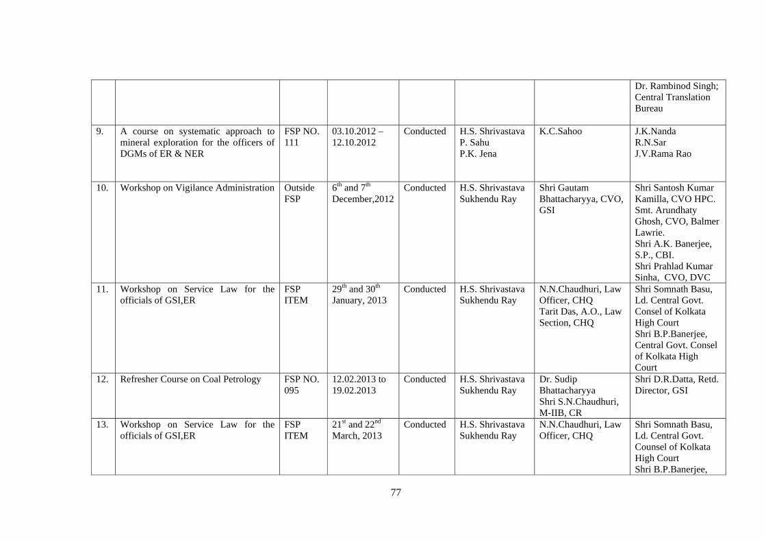
77
Dr. Rambinod Singh; Central Translation Bureau
9. A course on systematic approach to mineral exploration for the officers of DGMs of ER & NER
FSP NO. 111
03.10.2012 – 12.10.2012
Conducted H.S. Shrivastava P. Sahu P.K. Jena
K.C.Sahoo
J.K.Nanda R.N.Sar J.V.Rama Rao
10. Workshop on Vigilance Administration Outside FSP
6th and 7th December,2012
Conducted H.S. Shrivastava Sukhendu Ray
Shri Gautam Bhattacharyya, CVO, GSI
Shri Santosh Kumar Kamilla, CVO HPC. Smt. Arundhaty Ghosh, CVO, Balmer Lawrie. Shri A.K. Banerjee, S.P., CBI. Shri Prahlad Kumar Sinha, CVO, DVC
11. Workshop on Service Law for the officials of GSI,ER
FSP ITEM
29th and 30th January, 2013
Conducted H.S. Shrivastava Sukhendu Ray
N.N.Chaudhuri, Law Officer, CHQ Tarit Das, A.O., Law Section, CHQ
Shri Somnath Basu, Ld. Central Govt. Consel of Kolkata High Court Shri B.P.Banerjee, Central Govt. Consel of Kolkata High Court
12. Refresher Course on Coal Petrology FSP NO. 095
12.02.2013 to 19.02.2013
Conducted H.S. Shrivastava Sukhendu Ray
Dr. Sudip Bhattacharyya Shri S.N.Chaudhuri, M-IIB, CR
Shri D.R.Datta, Retd. Director, GSI
13. Workshop on Service Law for the officials of GSI,ER
FSP ITEM
21st and 22nd March, 2013
Conducted H.S. Shrivastava Sukhendu Ray
N.N.Chaudhuri, Law Officer, CHQ
Shri Somnath Basu, Ld. Central Govt. Counsel of Kolkata High Court Shri B.P.Banerjee,
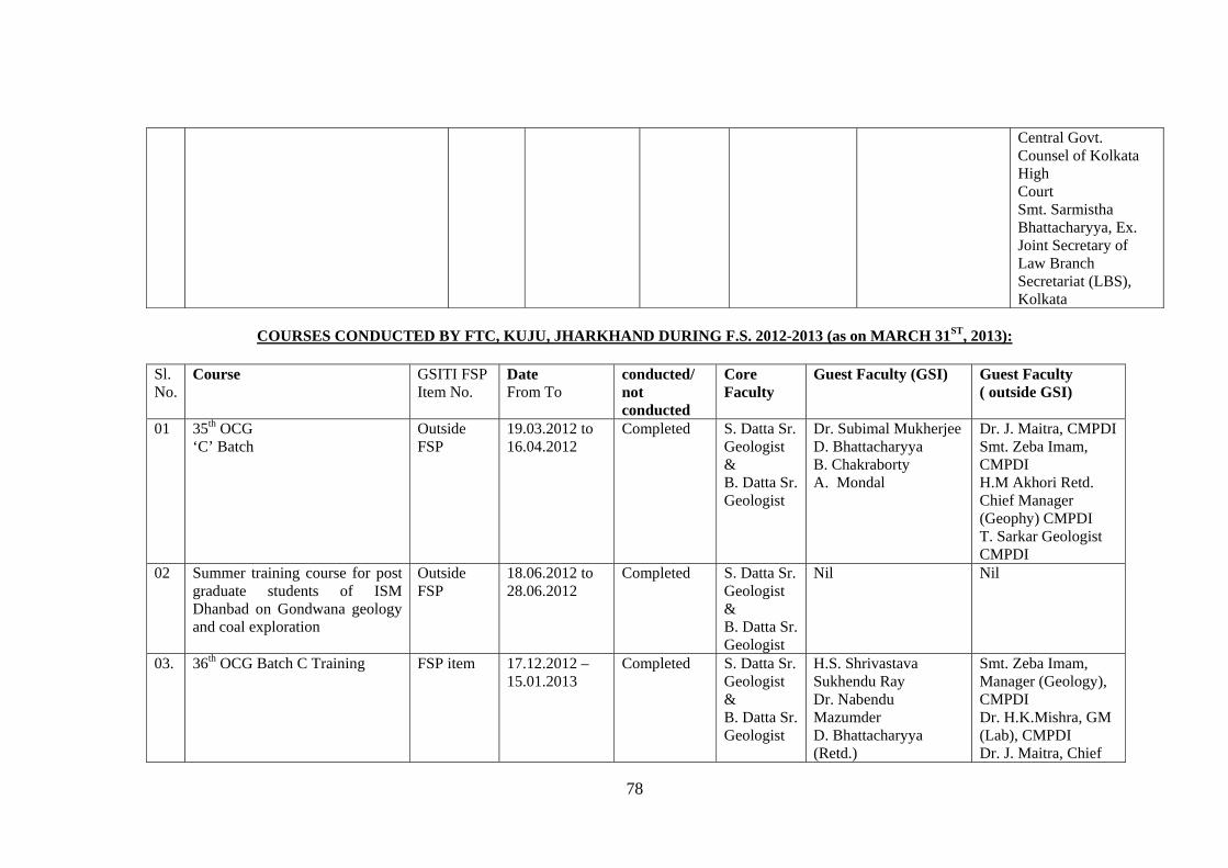
78
Central Govt. Counsel of Kolkata High Court Smt. Sarmistha Bhattacharyya, Ex. Joint Secretary of Law Branch Secretariat (LBS), Kolkata
COURSES CONDUCTED BY FTC, KUJU, JHARKHAND DURING F.S. 2012-2013 (as on MARCH 31ST, 2013):
Sl. No.
Course GSITI FSP Item No.
Date From To
conducted/ not conducted
Core Faculty
Guest Faculty (GSI) Guest Faculty ( outside GSI)
01 35th OCG ‘C’ Batch
Outside FSP
19.03.2012 to 16.04.2012
Completed S. Datta Sr. Geologist & B. Datta Sr. Geologist
Dr. Subimal Mukherjee D. Bhattacharyya B. Chakraborty A. Mondal
Dr. J. Maitra, CMPDI Smt. Zeba Imam, CMPDI H.M Akhori Retd. Chief Manager (Geophy) CMPDI T. Sarkar Geologist CMPDI
02 Summer training course for post graduate students of ISM Dhanbad on Gondwana geology and coal exploration
Outside FSP
18.06.2012 to 28.06.2012
Completed S. Datta Sr. Geologist & B. Datta Sr. Geologist
Nil Nil
03. 36th OCG Batch C Training FSP item 17.12.2012 – 15.01.2013
Completed S. Datta Sr. Geologist & B. Datta Sr. Geologist
H.S. Shrivastava Sukhendu Ray Dr. Nabendu Mazumder D. Bhattacharyya (Retd.)
Smt. Zeba Imam, Manager (Geology), CMPDI Dr. H.K.Mishra, GM (Lab), CMPDI Dr. J. Maitra, Chief
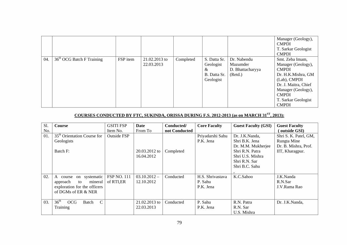
79
Manager (Geology), CMPDI T. Sarkar Geologist CMPDI
04. 36th OCG Batch F Training FSP item 21.02.2013 to 22.03.2013
Completed S. Datta Sr. Geologist & B. Datta Sr. Geologist
Dr. Nabendu Mazumder D. Bhattacharyya (Retd.)
Smt. Zeba Imam, Manager (Geology), CMPDI Dr. H.K.Mishra, GM (Lab), CMPDI Dr. J. Maitra, Chief Manager (Geology), CMPDI T. Sarkar Geologist CMPDI
COURSES CONDUCTED BY FTC, SUKINDA, ORISSA DURING F.S. 2012-2013 (as on MARCH 31ST, 2013):
Sl. No.
Course GSITI FSP Item No.
Date From To
Conducted/ not Conducted
Core Faculty Guest Faculty (GSI) Guest Faculty ( outside GSI)
01. 35th Orientation Course for Geologists Batch F:
Outside FSP 20.03.2012 to 16.04.2012
Completed
Priyadarshi Sahu P.K. Jena
Dr. J.K.Nanda, Shri B.K. Jena Dr. M.M. Mukherjee Shri R.N. Patra Shri U.S. Mishra Shri R.N. Sar Shri B.C. Sahu ,
Shri S. K. Patel, GM, Rungta Mine Dr. B. Mishra, Prof. IIT, Kharagpur.
02. A course on systematic approach to mineral exploration for the officers of DGMs of ER & NER
FSP NO. 111 of RTI,ER
03.10.2012 – 12.10.2012
Conducted H.S. Shrivastava P. Sahu P.K. Jena
K.C.Sahoo
J.K.Nanda R.N.Sar J.V.Rama Rao
03. 36th OCG Batch C Training
21.02.2013 to 22.03.2013
Conducted P. Sahu P.K. Jena
R.N. Patra R.N. Sar U.S. Mishra
Dr. J.K.Nanda,
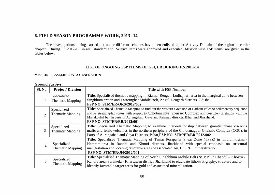
80
66.. FFIIEELLDD SSEEAASSOONN PPRROOGGRRAAMMMMEE WWOORRKK,, 22001133----1144
The investigations being carried out under different schemes have been enlisted under Activity Domain of the region in earlier chapter. During FS 2012-13, in all standard and Service items were approved and executed. Mission wise FSP items are given in the tables below:
LIST OF ONGOING FSP ITEMS OF GSI, ER DURING F.S.2013-14
MISSION-I: BASELINE DATA GENERATION
Ground Surveys
Sl. No. Project/ Division Title with FSP Number
1 Specialized Thematic Mapping
Title: Specialised thematic mapping in Riamal-Rengali-Lodhajhari area in the marginal zone between Singbhum craton and Easternghat Mobile Belt, Angul-Deogarh districts, Odisha.. FSP NO. STM/ER/ORS/2012/002
2
Specialized Thematic Mapping
Title: Specialized Thematic Mapping to find out the western extension of Bathani volcano-sedimentary sequence and its stratigraphic status with respect to Chhotanagpur Gneissic Complex and possible correlation with the Mahakoshal belt in parts of Aurangabad, Gaya and Palamau districts, Bihar and Jharkhand. FSP NO. STM/ER/BR/2012/001
3 Specialized Thematic Mapping
Title: Specialised Thematic Mapping to examine inter-relationship between granitic phase vis-à-vis mafic and felsic volcanics in the northern periphery of the Chhotanagpur Gneissic Complex (CGC), in Parts of Aurangabad and Gaya Districts, Bihar,FSP NO. STM/ER/BR/2012/002
4 Specialized Thematic Mapping
Title: Specialised Thematic Mapping of Tamar Porapahar Shear Zone (TPSZ) in Tiruldih-Tamar-Hemram-area in Ranchi and Khunti districts, Jharkhand with special emphasis on structural manifestation and locating favorable areas of associated Au, Cu, REE mineralization FSP NO. STM/ER/JH/2012/001
5 Specialized Thematic Mapping
Title: Specialised Thematic Mapping of North Singhbhum Mobile Belt (NSMB) in Chandil – Khokro - Kandra area, Saraikela - Kharsawan district, Jharkhand to elucidate lithostratigraphy, structure and to identify favorable target areas for gold and associated mineralization.
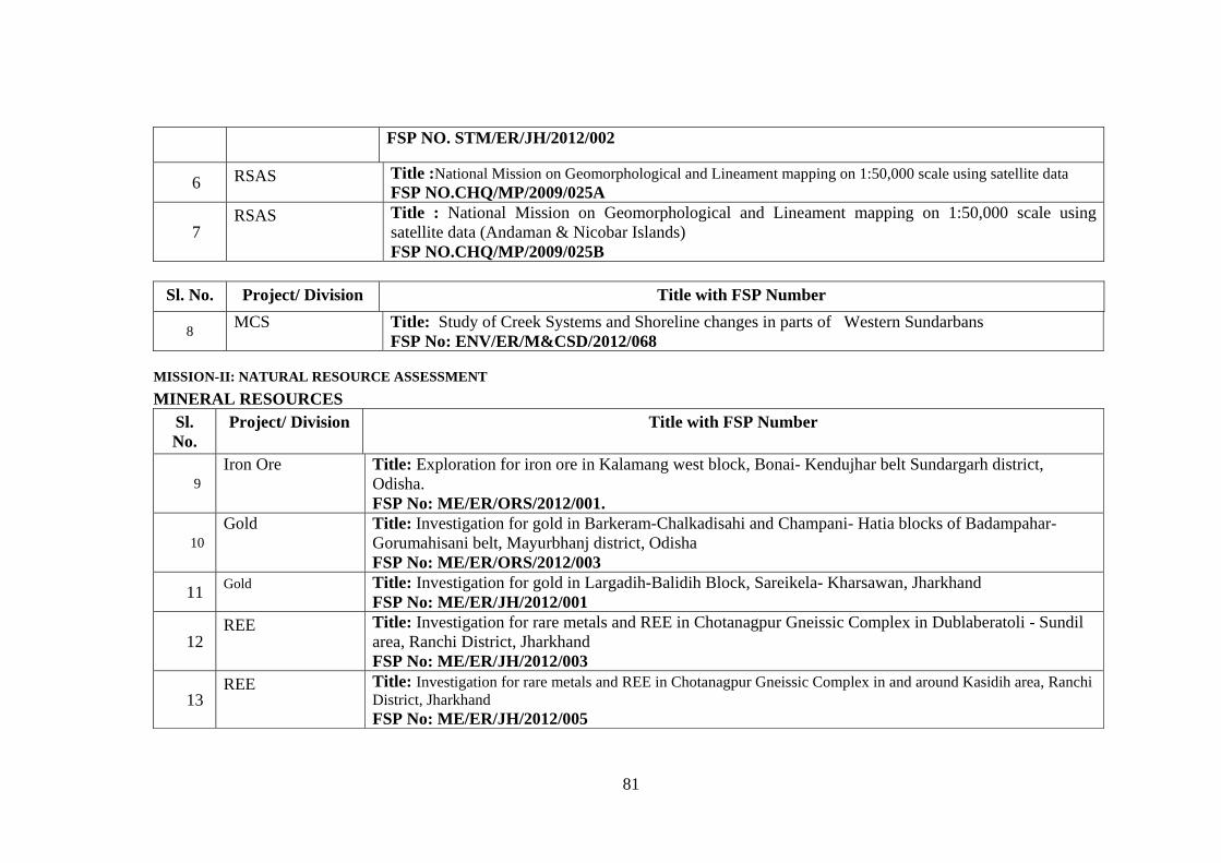
81
FSP NO. STM/ER/JH/2012/002
6 RSAS Title :National Mission on Geomorphological and Lineament mapping on 1:50,000 scale using satellite data FSP NO.CHQ/MP/2009/025A
7 RSAS Title : National Mission on Geomorphological and Lineament mapping on 1:50,000 scale using
satellite data (Andaman & Nicobar Islands) FSP NO.CHQ/MP/2009/025B
Sl. No. Project/ Division Title with FSP Number
8 MCS Title: Study of Creek Systems and Shoreline changes in parts of Western Sundarbans
FSP No: ENV/ER/M&CSD/2012/068
MISSION-II: NATURAL RESOURCE ASSESSMENT
MINERAL RESOURCES Sl. No.
Project/ Division Title with FSP Number
9 Iron Ore
Title: Exploration for iron ore in Kalamang west block, Bonai- Kendujhar belt Sundargarh district, Odisha. FSP No: ME/ER/ORS/2012/001.
10 Gold Title: Investigation for gold in Barkeram-Chalkadisahi and Champani- Hatia blocks of Badampahar-
Gorumahisani belt, Mayurbhanj district, Odisha FSP No: ME/ER/ORS/2012/003
11 Gold Title: Investigation for gold in Largadih-Balidih Block, Sareikela- Kharsawan, Jharkhand
FSP No: ME/ER/JH/2012/001
12 REE Title: Investigation for rare metals and REE in Chotanagpur Gneissic Complex in Dublaberatoli - Sundil
area, Ranchi District, Jharkhand FSP No: ME/ER/JH/2012/003
13 REE Title: Investigation for rare metals and REE in Chotanagpur Gneissic Complex in and around Kasidih area, Ranchi
District, Jharkhand FSP No: ME/ER/JH/2012/005
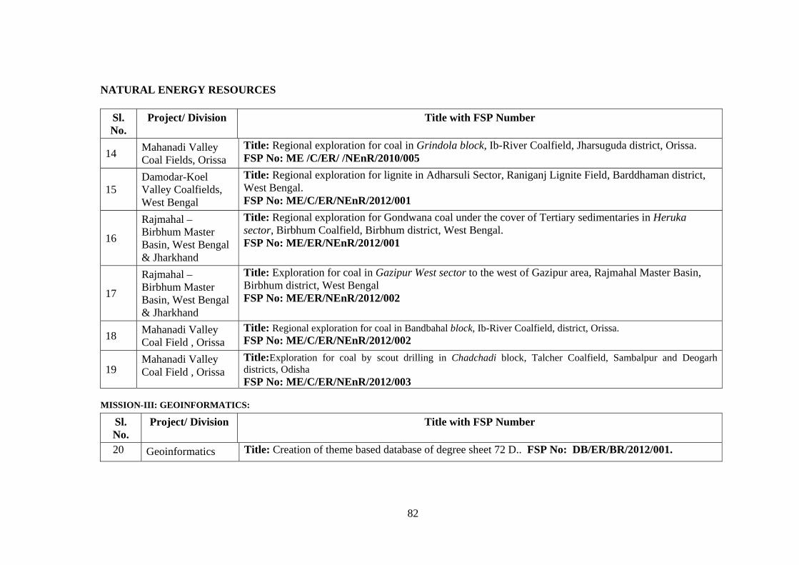
82
NATURAL ENERGY RESOURCES
Sl. No.
Project/ Division Title with FSP Number
14 Mahanadi Valley Coal Fields, Orissa
Title: Regional exploration for coal in Grindola block, Ib-River Coalfield, Jharsuguda district, Orissa. FSP No: ME /C/ER/ /NEnR/2010/005
15 Damodar-Koel Valley Coalfields, West Bengal
Title: Regional exploration for lignite in Adharsuli Sector, Raniganj Lignite Field, Barddhaman district, West Bengal. FSP No: ME/C/ER/NEnR/2012/001
16
Rajmahal – Birbhum Master Basin, West Bengal & Jharkhand
Title: Regional exploration for Gondwana coal under the cover of Tertiary sedimentaries in Heruka sector, Birbhum Coalfield, Birbhum district, West Bengal. FSP No: ME/ER/NEnR/2012/001
17
Rajmahal – Birbhum Master Basin, West Bengal & Jharkhand
Title: Exploration for coal in Gazipur West sector to the west of Gazipur area, Rajmahal Master Basin, Birbhum district, West Bengal FSP No: ME/ER/NEnR/2012/002
18 Mahanadi Valley Coal Field , Orissa
Title: Regional exploration for coal in Bandbahal block, Ib-River Coalfield, district, Orissa. FSP No: ME/C/ER/NEnR/2012/002
19 Mahanadi Valley Coal Field , Orissa
Title:Exploration for coal by scout drilling in Chadchadi block, Talcher Coalfield, Sambalpur and Deogarh districts, Odisha FSP No: ME/C/ER/NEnR/2012/003
MISSION-III: GEOINFORMATICS: Sl. No.
Project/ Division Title with FSP Number
20 Geoinformatics Title: Creation of theme based database of degree sheet 72 D.. FSP No: DB/ER/BR/2012/001.
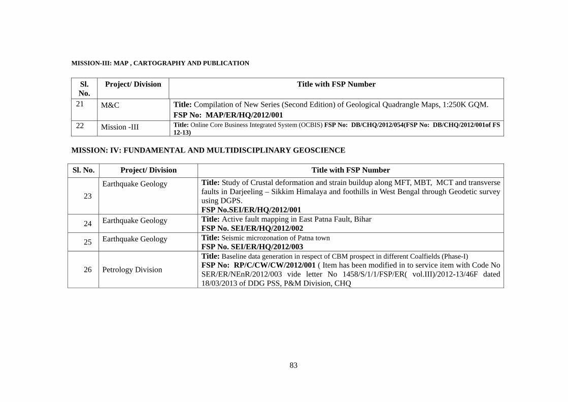
83
MISSION-III: MAP , CARTOGRAPHY AND PUBLICATION
Sl. No.
Project/ Division Title with FSP Number
21 M&C Title: Compilation of New Series (Second Edition) of Geological Quadrangle Maps, 1:250K GQM. FSP No: MAP/ER/HQ/2012/001
22 Mission -III Title: Online Core Business Integrated System (OCBIS) FSP No: DB/CHQ/2012/054(FSP No: DB/CHQ/2012/001of FS 12-13)
MISSION: IV: FUNDAMENTAL AND MULTIDISCIPLINARY GEOSCIENCE Sl. No. Project/ Division Title with FSP Number
23
Earthquake Geology Title: Study of Crustal deformation and strain buildup along MFT, MBT, MCT and transverse faults in Darjeeling – Sikkim Himalaya and foothills in West Bengal through Geodetic survey using DGPS. FSP No.SEI/ER/HQ/2012/001
24 Earthquake Geology Title: Active fault mapping in East Patna Fault, Bihar FSP No. SEI/ER/HQ/2012/002
25 Earthquake Geology Title: Seismic microzonation of Patna town FSP No. SEI/ER/HQ/2012/003
26 Petrology Division
Title: Baseline data generation in respect of CBM prospect in different Coalfields (Phase-I) FSP No: RP/C/CW/CW/2012/001 ( Item has been modified in to service item with Code No SER/ER/NEnR/2012/003 vide letter No 1458/S/1/1/FSP/ER( vol.III)/2012-13/46F dated 18/03/2013 of DDG PSS, P&M Division, CHQ
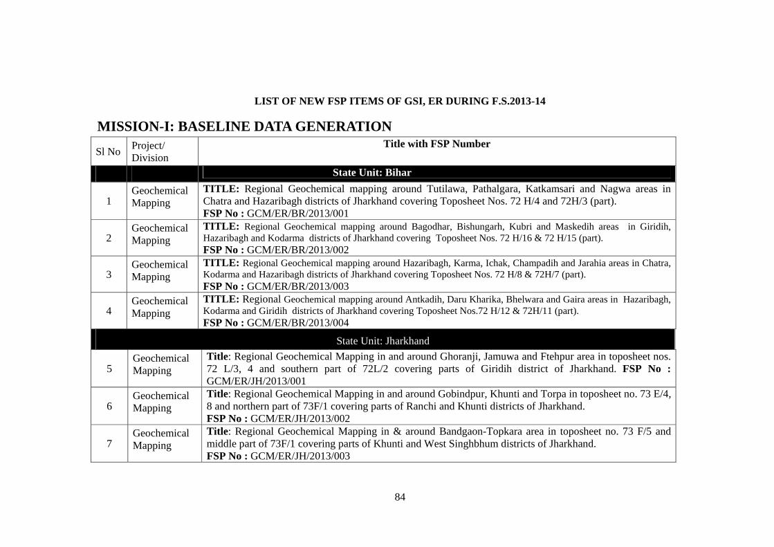
84
LIST OF NEW FSP ITEMS OF GSI, ER DURING F.S.2013-14
MISSION-I: BASELINE DATA GENERATION
Sl No Project/ Division
Title with FSP Number
State Unit: Bihar
1 Geochemical Mapping
TITLE: Regional Geochemical mapping around Tutilawa, Pathalgara, Katkamsari and Nagwa areas in Chatra and Hazaribagh districts of Jharkhand covering Toposheet Nos. 72 H/4 and 72H/3 (part).
FSP No : GCM/ER/BR/2013/001
2 Geochemical Mapping
TITLE: Regional Geochemical mapping around Bagodhar, Bishungarh, Kubri and Maskedih areas in Giridih, Hazaribagh and Kodarma districts of Jharkhand covering Toposheet Nos. 72 H/16 & 72 H/15 (part).
FSP No : GCM/ER/BR/2013/002
3 Geochemical Mapping
TITLE: Regional Geochemical mapping around Hazaribagh, Karma, Ichak, Champadih and Jarahia areas in Chatra, Kodarma and Hazaribagh districts of Jharkhand covering Toposheet Nos. 72 H/8 & 72H/7 (part). FSP No : GCM/ER/BR/2013/003
4 Geochemical Mapping
TITLE: Regional Geochemical mapping around Antkadih, Daru Kharika, Bhelwara and Gaira areas in Hazaribagh, Kodarma and Giridih districts of Jharkhand covering Toposheet Nos.72 H/12 & 72H/11 (part). FSP No : GCM/ER/BR/2013/004
State Unit: Jharkhand
5 Geochemical Mapping
Title: Regional Geochemical Mapping in and around Ghoranji, Jamuwa and Ftehpur area in toposheet nos. 72 L/3, 4 and southern part of 72L/2 covering parts of Giridih district of Jharkhand. FSP No : GCM/ER/JH/2013/001
6 Geochemical Mapping
Title: Regional Geochemical Mapping in and around Gobindpur, Khunti and Torpa in toposheet no. 73 E/4, 8 and northern part of 73F/1 covering parts of Ranchi and Khunti districts of Jharkhand. FSP No : GCM/ER/JH/2013/002
7 Geochemical Mapping
Title: Regional Geochemical Mapping in & around Bandgaon-Topkara area in toposheet no. 73 F/5 and middle part of 73F/1 covering parts of Khunti and West Singhbhum districts of Jharkhand. FSP No : GCM/ER/JH/2013/003
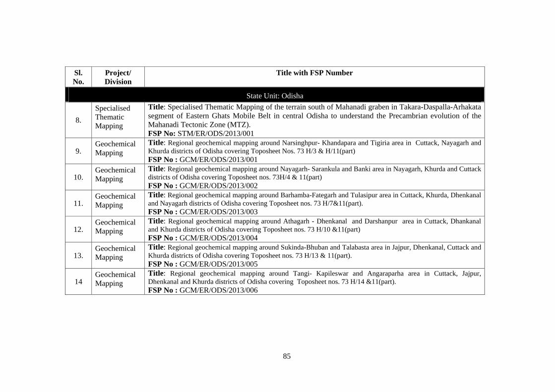
85
Sl. No.
Project/ Division
Title with FSP Number
State Unit: Odisha
8.
Specialised Thematic Mapping
Title: Specialised Thematic Mapping of the terrain south of Mahanadi graben in Takara-Daspalla-Arhakata segment of Eastern Ghats Mobile Belt in central Odisha to understand the Precambrian evolution of the Mahanadi Tectonic Zone (MTZ). FSP No: STM/ER/ODS/2013/001
9. Geochemical Mapping
Title: Regional geochemical mapping around Narsinghpur- Khandapara and Tigiria area in Cuttack, Nayagarh and Khurda districts of Odisha covering Toposheet Nos. 73 H/3 & H/11(part) FSP No : GCM/ER/ODS/2013/001
10. Geochemical Mapping
Title: Regional geochemical mapping around Nayagarh- Sarankula and Banki area in Nayagarh, Khurda and Cuttack districts of Odisha covering Toposheet nos. 73H/4 & 11(part) FSP No : GCM/ER/ODS/2013/002
11. Geochemical Mapping
Title: Regional geochemical mapping around Barhamba-Fategarh and Tulasipur area in Cuttack, Khurda, Dhenkanal and Nayagarh districts of Odisha covering Toposheet nos. 73 H/7&11(part). FSP No : GCM/ER/ODS/2013/003
12. Geochemical Mapping
Title: Regional geochemical mapping around Athagarh - Dhenkanal and Darshanpur area in Cuttack, Dhankanal and Khurda districts of Odisha covering Toposheet nos. 73 H/10 &11(part) FSP No : GCM/ER/ODS/2013/004
13. Geochemical Mapping
Title: Regional geochemical mapping around Sukinda-Bhuban and Talabasta area in Jajpur, Dhenkanal, Cuttack and Khurda districts of Odisha covering Toposheet nos. 73 H/13 & 11(part). FSP No : GCM/ER/ODS/2013/005
14 Geochemical Mapping
Title: Regional geochemical mapping around Tangi- Kapileswar and Angaraparha area in Cuttack, Jajpur, Dhenkanal and Khurda districts of Odisha covering Toposheet nos. 73 H/14 &11(part). FSP No : GCM/ER/ODS/2013/006
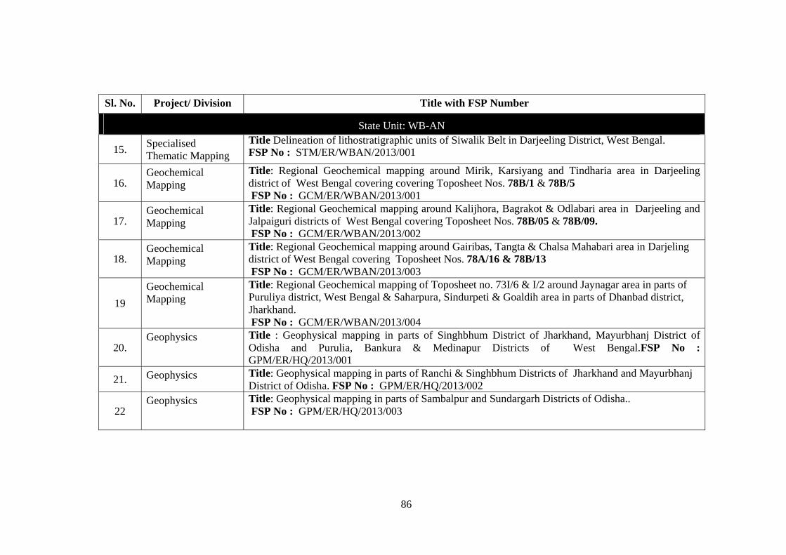
86
Sl. No. Project/ Division Title with FSP Number
State Unit: WB-AN
15. Specialised Thematic Mapping
Title Delineation of lithostratigraphic units of Siwalik Belt in Darjeeling District, West Bengal.FSP No : STM/ER/WBAN/2013/001
16. Geochemical Mapping
Title: Regional Geochemical mapping around Mirik, Karsiyang and Tindharia area in Darjeeling district of West Bengal covering covering Toposheet Nos. 78B/1 & 78B/5 FSP No : GCM/ER/WBAN/2013/001
17. Geochemical Mapping
Title: Regional Geochemical mapping around Kalijhora, Bagrakot & Odlabari area in Darjeeling and Jalpaiguri districts of West Bengal covering Toposheet Nos. 78B/05 & 78B/09. FSP No : GCM/ER/WBAN/2013/002
18. Geochemical Mapping
Title: Regional Geochemical mapping around Gairibas, Tangta & Chalsa Mahabari area in Darjeling district of West Bengal covering Toposheet Nos. 78A/16 & 78B/13 FSP No : GCM/ER/WBAN/2013/003
19
Geochemical Mapping
Title: Regional Geochemical mapping of Toposheet no. 73I/6 & I/2 around Jaynagar area in parts of Puruliya district, West Bengal & Saharpura, Sindurpeti & Goaldih area in parts of Dhanbad district, Jharkhand. FSP No : GCM/ER/WBAN/2013/004
20. Geophysics Title : Geophysical mapping in parts of Singhbhum District of Jharkhand, Mayurbhanj District of
Odisha and Purulia, Bankura & Medinapur Districts of West Bengal.FSP No : GPM/ER/HQ/2013/001
21. Geophysics Title: Geophysical mapping in parts of Ranchi & Singhbhum Districts of Jharkhand and Mayurbhanj District of Odisha. FSP No : GPM/ER/HQ/2013/002
22 Geophysics Title: Geophysical mapping in parts of Sambalpur and Sundargarh Districts of Odisha..
FSP No : GPM/ER/HQ/2013/003
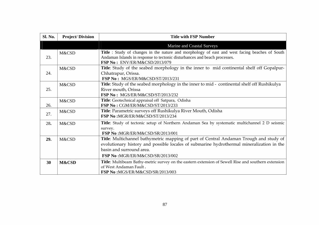
87
Sl. No. Project/ Division Title with FSP Number
Marine and Coastal Surveys
23. M&CSD Title : Study of changes in the nature and morphology of east and west facing beaches of South
Andaman Islands in response to tectonic disturbances and beach processes. FSP No : ENV/ER/M&CSD/2013/079
24. M&CSD Title: Study of the seabed morphology in the inner to mid continental shelf off Gopalpur-
Chhatrapur, Orissa. FSP No : MGS/ER/M&CSD/ST/2013/231
25. M&CSD Title: Study of the seabed morphology in the inner to mid - continental shelf off Rushikulya
River mouth, Orissa FSP No : MGS/ER/M&CSD/ST/2013/232
26.
M&CSD Title: Geotechnical appraisal off Satpara, Odisha FSP No : CGM/ER/M&CSD/ST/2013/233
27. M&CSD Title: Parametric surveys off Rushikulya River Mouth, Odisha
FSP No :MGR/ER/M&CSD/ST/2013/234
28. M&CSD Title: Study of tectonic setup of Northern Andaman Sea by systematic multichannel 2 D seismic survey. FSP No :MGR/ER/M&CSD/SR/2013/001
29.
M&CSD Title: Multichannel bathymetric mapping of part of Central Andaman Trough and study of evolutionary history and possible locales of submarine hydrothermal mineralization in the basin and surround area. FSP No :MGR/ER/M&CSD/SR/2013/002
30 M&CSD Title: Multibeam Bathy-metric survey on the eastern extension of Sewell Rise and southern extension of West Andaman Fault . FSP No :MGS/ER/M&CSD/SR/2013/003
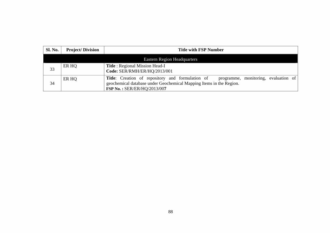
88
Sl. No. Project/ Division Title with FSP Number
Eastern Region Headquarters
33 ER HQ
Title : Regional Mission Head-I Code: SER/RMH/ER/HQ/2013/001
34 ER HQ Title: Creation of repository and formulation of programme, monitoring, evaluation of
geochemical database under Geochemical Mapping Items in the Region. FSP No. : SER/ER/HQ/2013/007
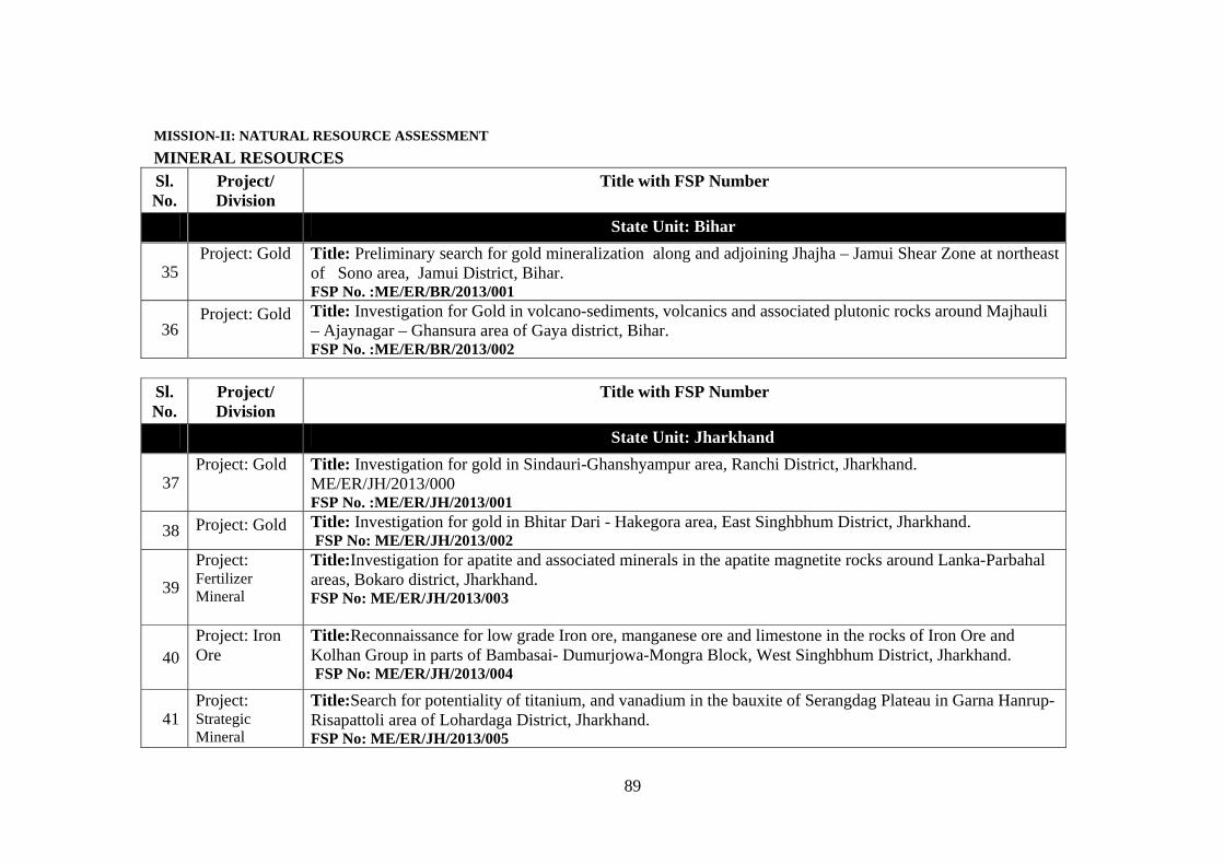
89
MISSION-II: NATURAL RESOURCE ASSESSMENT
MINERAL RESOURCES Sl. No.
Project/ Division
Title with FSP Number
State Unit: Bihar
35 Project: Gold
Title: Preliminary search for gold mineralization along and adjoining Jhajha – Jamui Shear Zone at northeast of Sono area, Jamui District, Bihar. FSP No. :ME/ER/BR/2013/001
36 Project: Gold Title: Investigation for Gold in volcano-sediments, volcanics and associated plutonic rocks around Majhauli
– Ajaynagar – Ghansura area of Gaya district, Bihar. FSP No. :ME/ER/BR/2013/002
Sl. No.
Project/ Division
Title with FSP Number
State Unit: Jharkhand
37Project: Gold
Title: Investigation for gold in Sindauri-Ghanshyampur area, Ranchi District, Jharkhand. ME/ER/JH/2013/000 FSP No. :ME/ER/JH/2013/001
38 Project: Gold Title: Investigation for gold in Bhitar Dari - Hakegora area, East Singhbhum District, Jharkhand. FSP No: ME/ER/JH/2013/002
39
Project: Fertilizer Mineral
Title:Investigation for apatite and associated minerals in the apatite magnetite rocks around Lanka-Parbahal areas, Bokaro district, Jharkhand. FSP No: ME/ER/JH/2013/003
40Project: Iron Ore
Title:Reconnaissance for low grade Iron ore, manganese ore and limestone in the rocks of Iron Ore and Kolhan Group in parts of Bambasai- Dumurjowa-Mongra Block, West Singhbhum District, Jharkhand. FSP No: ME/ER/JH/2013/004
41Project: Strategic Mineral
Title:Search for potentiality of titanium, and vanadium in the bauxite of Serangdag Plateau in Garna Hanrup-Risapattoli area of Lohardaga District, Jharkhand. FSP No: ME/ER/JH/2013/005
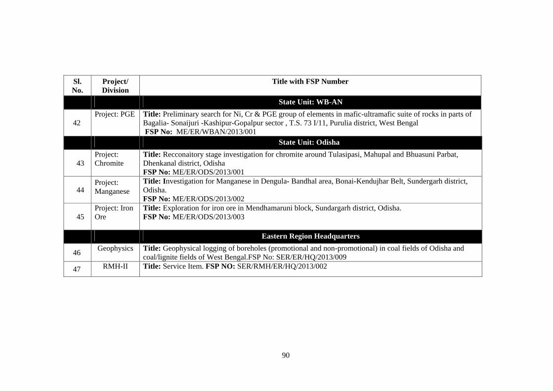
90
Sl. No.
Project/ Division
Title with FSP Number
State Unit: WB-AN
42 Project: PGE Title: Preliminary search for Ni, Cr & PGE group of elements in mafic-ultramafic suite of rocks in parts of
Bagalia- Sonaijuri -Kashipur-Gopalpur sector , T.S. 73 I/11, Purulia district, West Bengal FSP No: ME/ER/WBAN/2013/001
State Unit: Odisha
43 Project: Chromite
Title: Recconaitory stage investigation for chromite around Tulasipasi, Mahupal and Bhuasuni Parbat, Dhenkanal district, Odisha FSP No: ME/ER/ODS/2013/001
44 Project: Manganese
Title: Investigation for Manganese in Dengula- Bandhal area, Bonai-Kendujhar Belt, Sundergarh district, Odisha. FSP No: ME/ER/ODS/2013/002
45 Project: Iron Ore
Title: Exploration for iron ore in Mendhamaruni block, Sundargarh district, Odisha. FSP No: ME/ER/ODS/2013/003
Eastern Region Headquarters
46 Geophysics Title: Geophysical logging of boreholes (promotional and non-promotional) in coal fields of Odisha and
coal/lignite fields of West Bengal.FSP No: SER/ER/HQ/2013/009
47 RMH-II Title: Service Item. FSP NO: SER/RMH/ER/HQ/2013/002
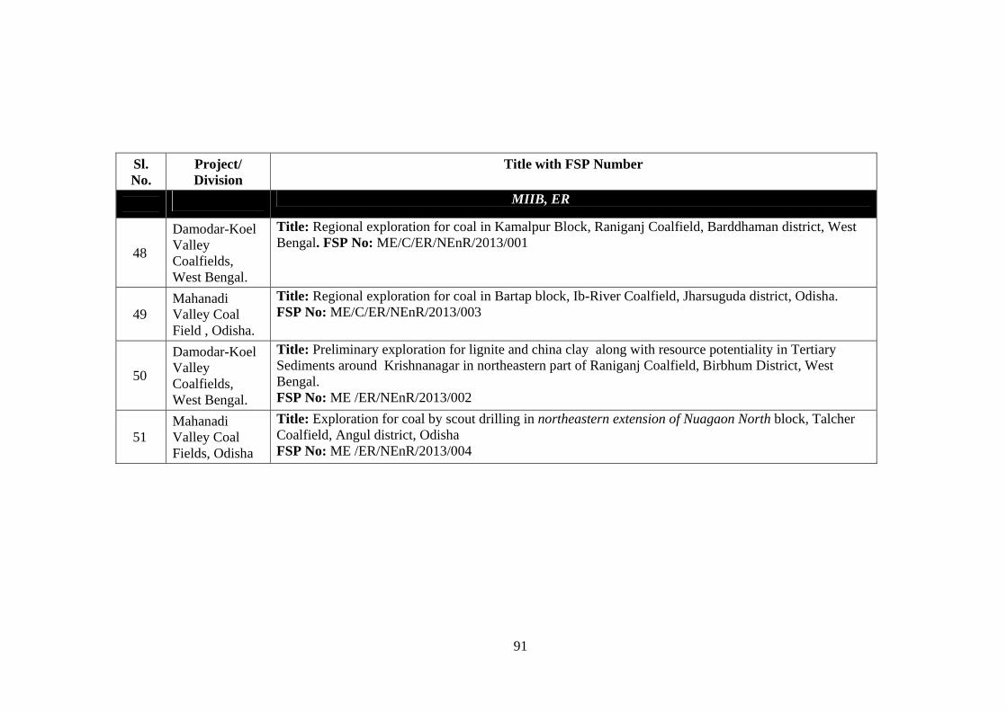
91
Sl. No.
Project/ Division
Title with FSP Number
MIIB, ER
48
Damodar-Koel Valley Coalfields, West Bengal.
Title: Regional exploration for coal in Kamalpur Block, Raniganj Coalfield, Barddhaman district, West Bengal. FSP No: ME/C/ER/NEnR/2013/001
49 Mahanadi Valley Coal Field , Odisha.
Title: Regional exploration for coal in Bartap block, Ib-River Coalfield, Jharsuguda district, Odisha. FSP No: ME/C/ER/NEnR/2013/003
50
Damodar-Koel Valley Coalfields, West Bengal.
Title: Preliminary exploration for lignite and china clay along with resource potentiality in Tertiary Sediments around Krishnanagar in northeastern part of Raniganj Coalfield, Birbhum District, West Bengal. FSP No: ME /ER/NEnR/2013/002
51 Mahanadi Valley Coal Fields, Odisha
Title: Exploration for coal by scout drilling in northeastern extension of Nuagaon North block, Talcher Coalfield, Angul district, Odisha FSP No: ME /ER/NEnR/2013/004
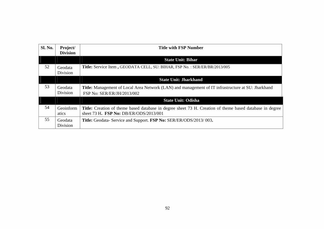
92
Sl. No. Project/
Division Title with FSP Number
State Unit: Bihar
52 Geodata Division
Title: Service Item , GEODATA CELL, SU: BIHAR, FSP No. : SER/ER/BR/2013/005
State Unit: Jharkhand
53 Geodata Division
Title: Management of Local Area Network (LAN) and management of IT infrastructure at SU: Jharkhand FSP No: SER/ER/JH/2013/002
State Unit: Odisha
54 Geoinformatics
Title: Creation of theme based database in degree sheet 73 H. Creation of theme based database in degree sheet 73 H. FSP No: DB/ER/ODS/2013/001
55 Geodata Division
Title: Geodata- Service and Support. FSP No: SER/ER/ODS/2013/ 003.
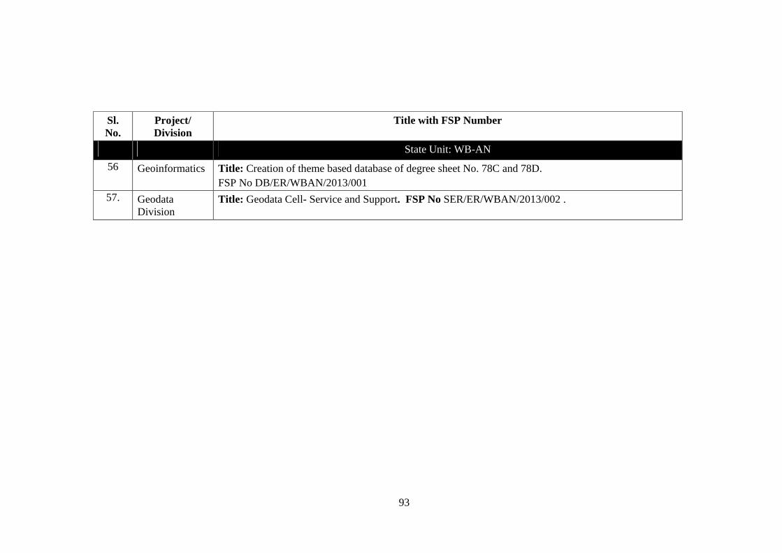
93
Sl. No.
Project/ Division
Title with FSP Number
State Unit: WB-AN
56 Geoinformatics Title: Creation of theme based database of degree sheet No. 78C and 78D. FSP No DB/ER/WBAN/2013/001
57. Geodata Division
Title: Geodata Cell- Service and Support. FSP No SER/ER/WBAN/2013/002 .
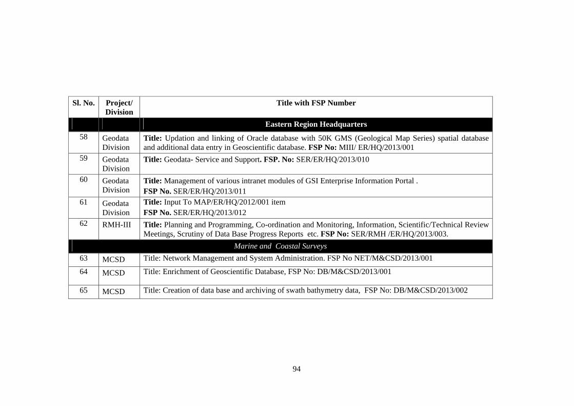
94
Sl. No. Project/
Division Title with FSP Number
Eastern Region Headquarters
58 Geodata Division
Title: Updation and linking of Oracle database with 50K GMS (Geological Map Series) spatial database and additional data entry in Geoscientific database. FSP No: MIII/ ER/HQ/2013/001
59 Geodata Division
Title: Geodata- Service and Support. FSP. No: SER/ER/HQ/2013/010
60 Geodata Division
Title: Management of various intranet modules of GSI Enterprise Information Portal . FSP No. SER/ER/HQ/2013/011
61 Geodata Division
Title: Input To MAP/ER/HQ/2012/001 item FSP No. SER/ER/HQ/2013/012
62 RMH-III Title: Planning and Programming, Co-ordination and Monitoring, Information, Scientific/Technical Review Meetings, Scrutiny of Data Base Progress Reports etc. FSP No: SER/RMH /ER/HQ/2013/003.
Marine and Coastal Surveys
63 MCSD Title: Network Management and System Administration. FSP No NET/M&CSD/2013/001
64 MCSD Title: Enrichment of Geoscientific Database, FSP No: DB/M&CSD/2013/001
65 MCSD Title: Creation of data base and archiving of swath bathymetry data, FSP No: DB/M&CSD/2013/002
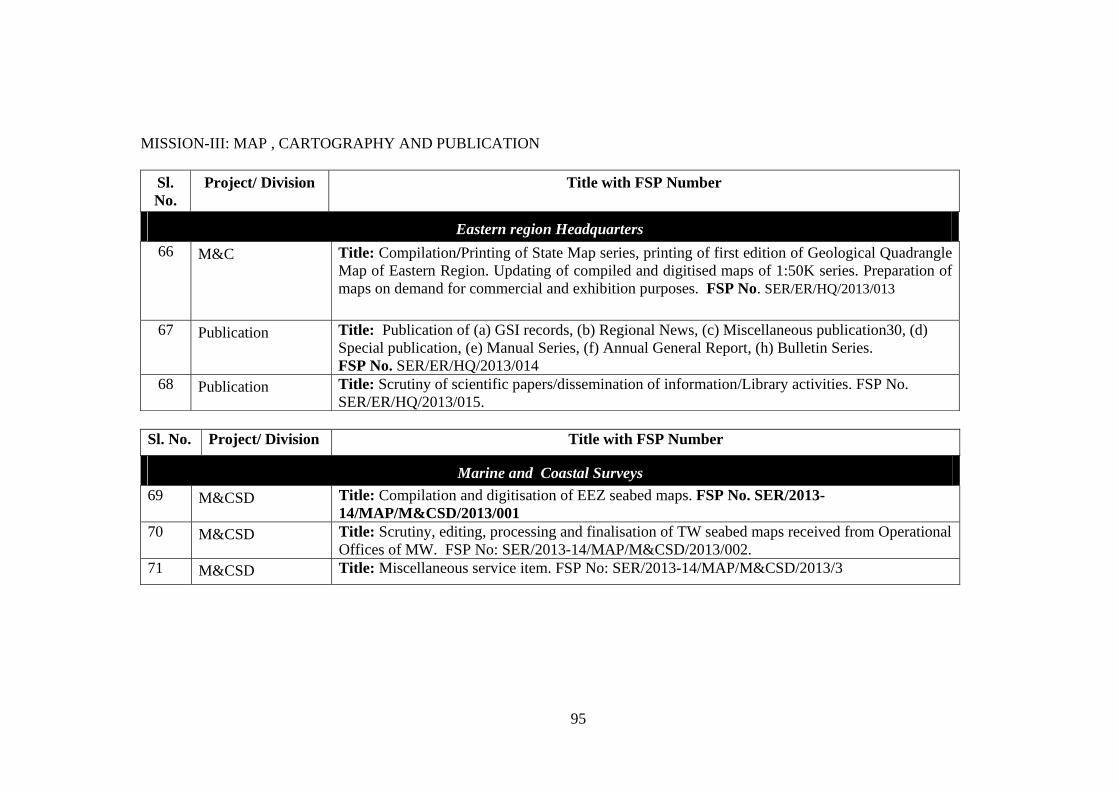
95
MISSION-III: MAP , CARTOGRAPHY AND PUBLICATION
Sl. No.
Project/ Division Title with FSP Number
Eastern region Headquarters
66 M&C Title: Compilation/Printing of State Map series, printing of first edition of Geological Quadrangle Map of Eastern Region. Updating of compiled and digitised maps of 1:50K series. Preparation of maps on demand for commercial and exhibition purposes. FSP No. SER/ER/HQ/2013/013
67 Publication Title: Publication of (a) GSI records, (b) Regional News, (c) Miscellaneous publication30, (d) Special publication, (e) Manual Series, (f) Annual General Report, (h) Bulletin Series. FSP No. SER/ER/HQ/2013/014
68 Publication Title: Scrutiny of scientific papers/dissemination of information/Library activities. FSP No. SER/ER/HQ/2013/015.
Sl. No. Project/ Division Title with FSP Number
Marine and Coastal Surveys
69 M&CSD Title: Compilation and digitisation of EEZ seabed maps. FSP No. SER/2013-14/MAP/M&CSD/2013/001
70 M&CSD Title: Scrutiny, editing, processing and finalisation of TW seabed maps received from Operational Offices of MW. FSP No: SER/2013-14/MAP/M&CSD/2013/002.
71 M&CSD Title: Miscellaneous service item. FSP No: SER/2013-14/MAP/M&CSD/2013/3
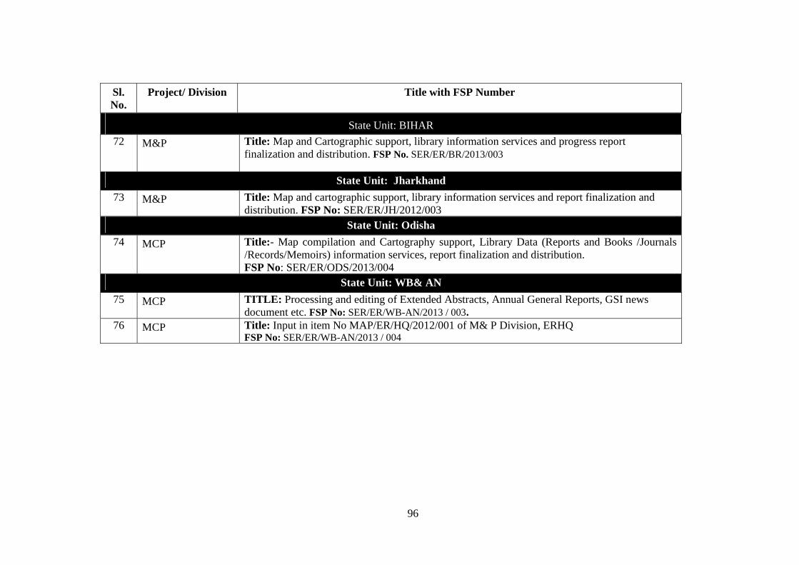
96
Sl. No.
Project/ Division Title with FSP Number
State Unit: BIHAR
72 M&P Title: Map and Cartographic support, library information services and progress report finalization and distribution. FSP No. SER/ER/BR/2013/003
State Unit: Jharkhand
73 M&P Title: Map and cartographic support, library information services and report finalization and distribution. FSP No: SER/ER/JH/2012/003
State Unit: Odisha
74 MCP Title:- Map compilation and Cartography support, Library Data (Reports and Books /Journals /Records/Memoirs) information services, report finalization and distribution. FSP No: SER/ER/ODS/2013/004
State Unit: WB& AN
75 MCP TITLE: Processing and editing of Extended Abstracts, Annual General Reports, GSI news document etc. FSP No: SER/ER/WB-AN/2013 / 003.
76 MCP Title: Input in item No MAP/ER/HQ/2012/001 of M& P Division, ERHQ FSP No: SER/ER/WB-AN/2013 / 004
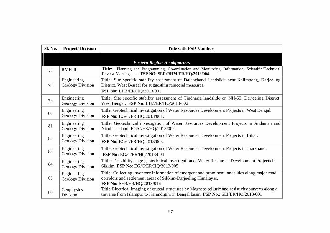
97
Sl. No. Project/ Division Title with FSP Number
Eastern Region Headquarters
77 RMH-II Title: Planning and Programming, Co-ordination and Monitoring, Information, Scientific/Technical Review Meetings, etc. FSP NO: SER/RHM/ER/HQ/2013/004
78 Engineering Geology Division
Title: Site specific stability assessment of Dalapchand Landslide near Kalimpong, Darjeeling District, West Bengal for suggesting remedial measures. FSP No: LHZ/ER/HQ/2013/001
79 Engineering Geology Division
Title: Site specific stability assessment of Tindharia landslide on NH-55, Darjeeling District, West Bengal. FSP No: LHZ/ER/HQ/2013/002
80 Engineering Geology Division
Title: Geotechnical investigation of Water Resources Development Projects in West Bengal. FSP No: EG/C/ER/HQ/2013/001.
81 Engineering Geology Division
Title: Geotechnical investigation of Water Resources Development Projects in Andaman and Nicobar Island. EG/C/ER/HQ/2013/002.
82 Engineering Geology Division
Title: Geotechnical investigation of Water Resources Development Projects in Bihar. FSP No: EG/C/ER/HQ/2013/003.
83 Engineering Geology Division
Title: Geotechnical investigation of Water Resources Development Projects in Jharkhand. FSP No: EG/C/ER/HQ/2013/004
84 Engineering Geology Division
Title: Feasibility stage geotechnical investigation of Water Resources Development Projects in Sikkim. FSP No: EG/C/ER/HQ/2013/005
85 Engineering Geology Division
Title: Collecting inventory information of emergent and prominent landslides along major road corridors and settlement areas of Sikkim-Darjeeling Himalayas. FSP No: SER/ER/HQ/2013/016
86 Geophysics Division
Title:Electrical Imaging of crustal structures by Magneto-telluric and resistivity surveys along a traverse from Islampur to Karandigihi in Bengal basin. FSP No.: SEI/ER/HQ/2013/001
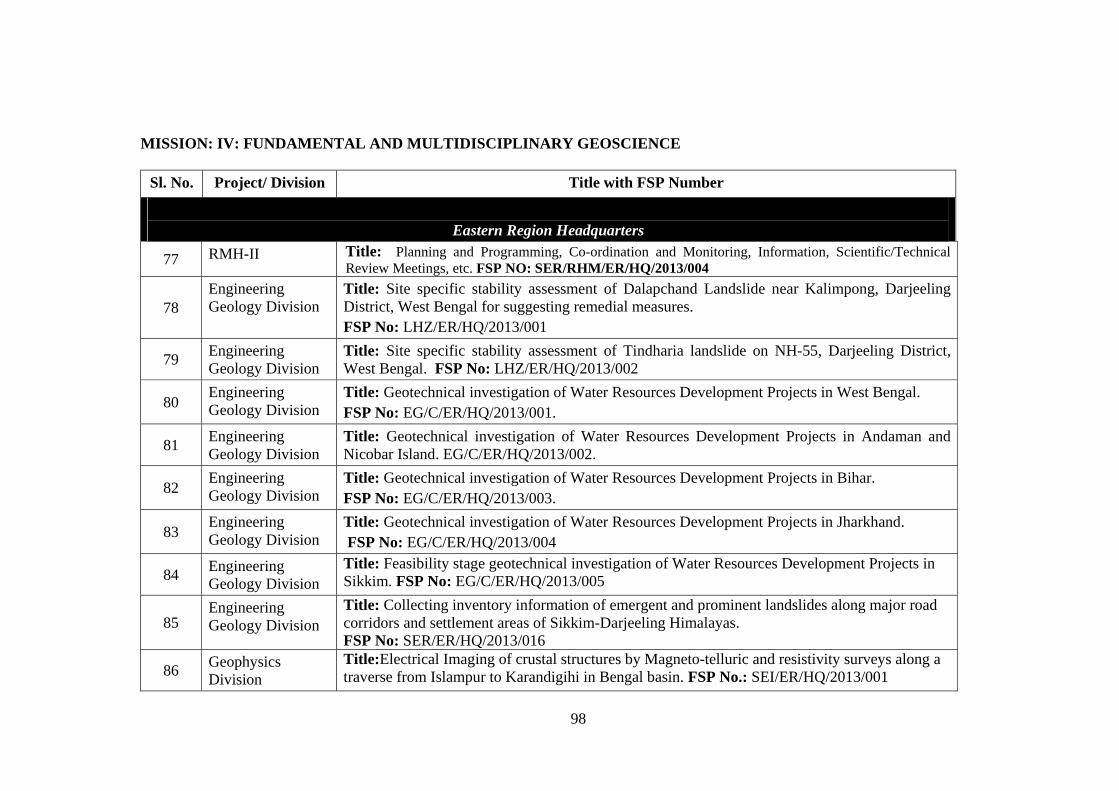
98
MISSION: IV: FUNDAMENTAL AND MULTIDISCIPLINARY GEOSCIENCE
Sl. No. Project/ Division Title with FSP Number
Eastern Region Headquarters
77 RMH-II Title: Planning and Programming, Co-ordination and Monitoring, Information, Scientific/Technical Review Meetings, etc. FSP NO: SER/RHM/ER/HQ/2013/004
78 Engineering Geology Division
Title: Site specific stability assessment of Dalapchand Landslide near Kalimpong, Darjeeling District, West Bengal for suggesting remedial measures. FSP No: LHZ/ER/HQ/2013/001
79 Engineering Geology Division
Title: Site specific stability assessment of Tindharia landslide on NH-55, Darjeeling District, West Bengal. FSP No: LHZ/ER/HQ/2013/002
80 Engineering Geology Division
Title: Geotechnical investigation of Water Resources Development Projects in West Bengal. FSP No: EG/C/ER/HQ/2013/001.
81 Engineering Geology Division
Title: Geotechnical investigation of Water Resources Development Projects in Andaman and Nicobar Island. EG/C/ER/HQ/2013/002.
82 Engineering Geology Division
Title: Geotechnical investigation of Water Resources Development Projects in Bihar. FSP No: EG/C/ER/HQ/2013/003.
83 Engineering Geology Division
Title: Geotechnical investigation of Water Resources Development Projects in Jharkhand. FSP No: EG/C/ER/HQ/2013/004
84 Engineering Geology Division
Title: Feasibility stage geotechnical investigation of Water Resources Development Projects in Sikkim. FSP No: EG/C/ER/HQ/2013/005
85 Engineering Geology Division
Title: Collecting inventory information of emergent and prominent landslides along major road corridors and settlement areas of Sikkim-Darjeeling Himalayas. FSP No: SER/ER/HQ/2013/016
86 Geophysics Division
Title:Electrical Imaging of crustal structures by Magneto-telluric and resistivity surveys along a traverse from Islampur to Karandigihi in Bengal basin. FSP No.: SEI/ER/HQ/2013/001
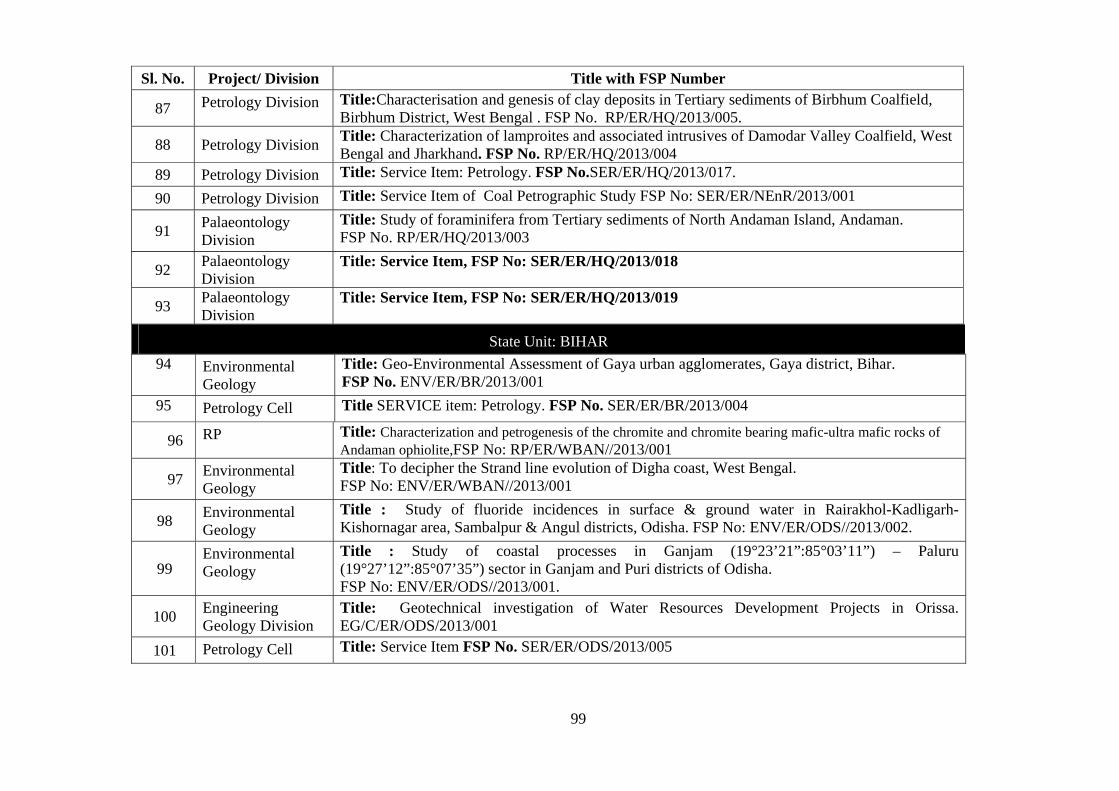
99
State Unit: BIHAR
94 Environmental Geology
Title: Geo-Environmental Assessment of Gaya urban agglomerates, Gaya district, Bihar. FSP No. ENV/ER/BR/2013/001
95 Petrology Cell Title SERVICE item: Petrology. FSP No. SER/ER/BR/2013/004
96 RP Title: Characterization and petrogenesis of the chromite and chromite bearing mafic-ultra mafic rocks of Andaman ophiolite,FSP No: RP/ER/WBAN//2013/001
97 Environmental Geology
Title: To decipher the Strand line evolution of Digha coast, West Bengal. FSP No: ENV/ER/WBAN//2013/001
98 Environmental Geology
Title : Study of fluoride incidences in surface & ground water in Rairakhol-Kadligarh-Kishornagar area, Sambalpur & Angul districts, Odisha. FSP No: ENV/ER/ODS//2013/002.
99 Environmental Geology
Title : Study of coastal processes in Ganjam (19°23’21”:85°03’11”) – Paluru (19°27’12”:85°07’35”) sector in Ganjam and Puri districts of Odisha. FSP No: ENV/ER/ODS//2013/001.
100 Engineering Geology Division
Title: Geotechnical investigation of Water Resources Development Projects in Orissa. EG/C/ER/ODS/2013/001
101 Petrology Cell Title: Service Item FSP No. SER/ER/ODS/2013/005
Sl. No. Project/ Division Title with FSP Number
87 Petrology Division Title:Characterisation and genesis of clay deposits in Tertiary sediments of Birbhum Coalfield, Birbhum District, West Bengal . FSP No. RP/ER/HQ/2013/005.
88 Petrology Division Title: Characterization of lamproites and associated intrusives of Damodar Valley Coalfield, West Bengal and Jharkhand. FSP No. RP/ER/HQ/2013/004
89 Petrology Division Title: Service Item: Petrology. FSP No.SER/ER/HQ/2013/017.
90 Petrology Division Title: Service Item of Coal Petrographic Study FSP No: SER/ER/NEnR/2013/001
91 Palaeontology Division
Title: Study of foraminifera from Tertiary sediments of North Andaman Island, Andaman. FSP No. RP/ER/HQ/2013/003
92 Palaeontology Division
Title: Service Item, FSP No: SER/ER/HQ/2013/018
93 Palaeontology Division
Title: Service Item, FSP No: SER/ER/HQ/2013/019
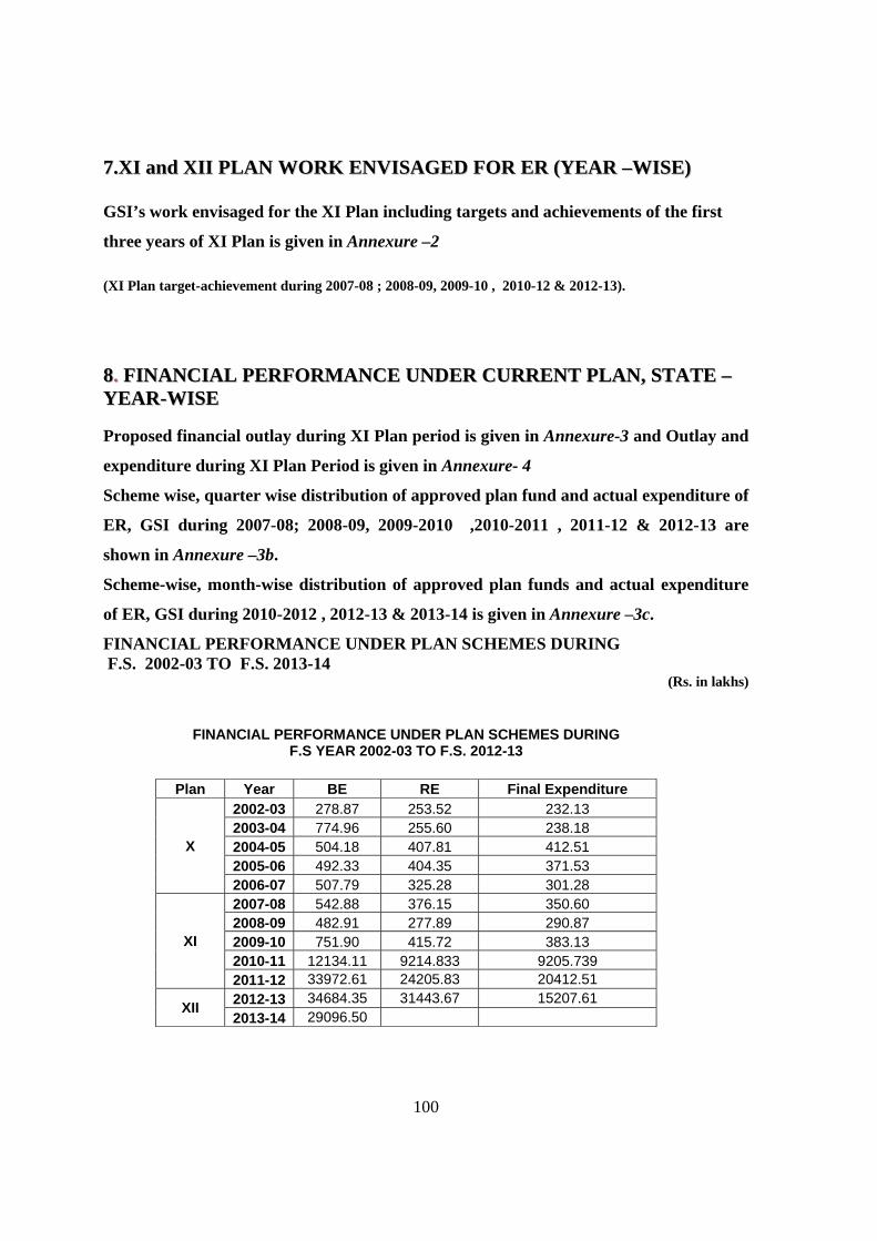
100
77..XXII aanndd XXIIII PPLLAANN WWOORRKK EENNVVIISSAAGGEEDD FFOORR EERR ((YYEEAARR ––WWIISSEE)) GSI’s work envisaged for the XI Plan including targets and achievements of the first
three years of XI Plan is given in Annexure –2
(XI Plan target-achievement during 2007-08 ; 2008-09, 2009-10 , 2010-12 & 2012-13). 88.. FFIINNAANNCCIIAALL PPEERRFFOORRMMAANNCCEE UUNNDDEERR CCUURRRREENNTT PPLLAANN,, SSTTAATTEE –– YYEEAARR--WWIISSEE Proposed financial outlay during XI Plan period is given in Annexure-3 and Outlay and
expenditure during XI Plan Period is given in Annexure- 4
Scheme wise, quarter wise distribution of approved plan fund and actual expenditure of
ER, GSI during 2007-08; 2008-09, 2009-2010 ,2010-2011 , 2011-12 & 2012-13 are
shown in Annexure –3b.
Scheme-wise, month-wise distribution of approved plan funds and actual expenditure
of ER, GSI during 2010-2012 , 2012-13 & 2013-14 is given in Annexure –3c.
FINANCIAL PERFORMANCE UNDER PLAN SCHEMES DURING F.S. 2002-03 TO F.S. 2013-14
(Rs. in lakhs)
FINANCIAL PERFORMANCE UNDER PLAN SCHEMES DURING F.S YEAR 2002-03 TO F.S. 2012-13
Plan Year BE RE Final Expenditure
X
2002-03 278.87 253.52 232.13 2003-04 774.96 255.60 238.18 2004-05 504.18 407.81 412.51 2005-06 492.33 404.35 371.53 2006-07 507.79 325.28 301.28
XI
2007-08 542.88 376.15 350.60 2008-09 482.91 277.89 290.87 2009-10 751.90 415.72 383.13 2010-11 12134.11 9214.833 9205.739 2011-12 33972.61 24205.83 20412.51
XII 2012-13 34684.35 31443.67 15207.61
2013-14 29096.50
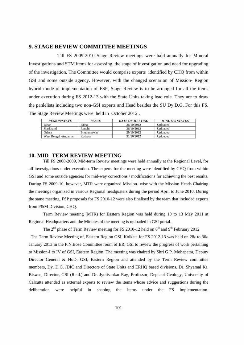
101
99.. SSTTAAGGEE RREEVVIIEEWW CCOOMMMMIITTTTEEEE MMEEEETTIINNGGSS
Till FS 2009-2010 Stage Review meetings were hald annually for Mineral
Investigations and STM items for assessing the stage of investigation and need for upgrading
of the investigation. The Committee would comprise experts identified by CHQ from within
GSI and some outside agency. However, with the changed scenarion of Mission- Region
hybrid mode of implementation of FSP, Stage Review is to be arranged for all the items
under execution during FS 2012-13 with the State Units taking lead role. They are to draw
the panlelists including two non-GSI experts and Head besides the SU Dy.D.G. For this FS.
The Stage Review Meetings were held in October 2012 .
REGION/STATE PLACE DATE OF MEETING MINUTES STATUS Bihar Patna 26/10/2012 Uploaded Jharkhand Ranchi 26/10/2012 Uploaded Orissa Bhubaneswar 29/10/2012 Uploaded West Bengal -Andaman Kolkata 31/10/2012 Uploaded
10. MID- TERM REVIEW MEETING Till FS 2008-2009, Mid-term Review meetings were held annually at the Regional Level, for
all investigations under execution. The experts for the meeting were identified by CHQ from within
GSI and some outside agencies for mid-way corrections / modifications for achieving the best results.
During FS 2009-10, however, MTR were organized Mission- wise with the Mission Heads Chairing
the meetings organized in various Regional headquaters during the period April to June 2010. During
the same meeting, FSP proposals for FS 2010-12 were also finalised by the team that included experts
from P&M Division, CHQ.
Term Review meeting (MTR) for Eastern Region was held during 10 to 13 May 2011 at
Regional Headquarters and the Minutes of the meeting is uploaded in GSI portal.
The 2nd phase of Term Review meeting for FS 2010-12 held on 8th and 9th February 2012
The Term Review Meeting of, Eastern Region GSI, Kolkata for FS 2012-13 was held on 28th to 30th
January 2013 in the P.N.Bose Committee room of ER, GSI to review the progress of work pertaining
to Mission-I to IV of GSI, Eastern Region. The meeting was chaired by Shri G.P. Mohapatra, Deputy
Director General & HoD, GSI, Eastern Region and attended by the Term Review committee
members, Dy. D.G. /DIC and Directors of State Units and ERHQ based divisions. Dr. Shyamal Kr.
Biswas, Director, GSI (Retd.) and Dr. Jyotisankar Ray, Professor, Dept. of Geology, University of
Calcutta attended as external experts to review the items whose advice and suggestions during the
deliberation were helpful in shaping the items under the FS implementation.
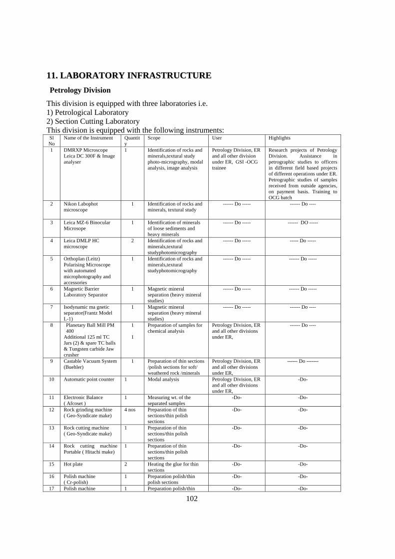
102
1111.. LLAABBOORRAATTOORRYY IINNFFRRAASSTTRRUUCCTTUURREE
Petrology Division
This division is equipped with three laboratories i.e. 1) Petrological Laboratory 2) Section Cutting Laboratory This division is equipped with the following instruments:
Sl No
Name of the Instrument Quantity
Scope User Highlights
1 DMRXP Microscope Leica DC 300F & Image analyser
1 Identification of rocks and minerals,textural study photo-micrography, modal analysis, image analysis
Petrology Division, ER and all other division under ER, GSI -OCG trainee
Research projects of Petrology Division. Assistance in petrographic studies to officers in different field based projects of different operations under ER. Petrographic studies of samples received from outside agencies, on payment basis. Training to OCG batch
2 Nikon Labophot microscope
1 Identification of rocks and minerals, textural study
------ Do ----- ------ Do ----
3 Leica MZ-6 Binocular Microsope
1 Identification of minerals of loose sediments and heavy minerals
------ Do ----- ------ DO -----
4 Leica DMLP HC microscope
2 Identification of rocks and minerals,textural studyphotomicrography
------ Do ----- ----- Do -----
5 Orthoplan (Leitz) Polarising Microscope with automated microphotography and accessories
1 Identification of rocks and minerals,textural studyphotomicrography
------ Do ----- ------ Do -----
6 Magnetic Barrier Laboratory Separator
1 Magnetic mineral separation (heavy mineral studies)
------ Do ----- ------ Do -----
7 Isodynamic ma gnetic separator(Frantz Model L-1)
1 Magnetic mineral separation (heavy mineral studies)
------ Do ----- ------ Do ----
8 Planetary Ball Mill PM 400
Additional 125 ml TC Jars (2) & spare TC balls & Tungsten carbide Jaw crusher
1 1
Preparation of samples for chemical analysis
Petrology Division, ER and all other divisions under ER,
------ Do ----
9 Castable Vacuum System (Buehler)
1 Preparation of thin sections /polish sections for soft/ weathered rock /minerals
Petrology Division, ER and all other divisions under ER,
------ Do -------
10 Automatic point counter 1 Modal analysis Petrology Division, ER and all other divisions under ER,
-Do-
11 Electronic Balance ( Afcoset )
1 Measuring wt. of the separated samples
-Do- -Do-
12 Rock grinding machine ( Geo-Syndicate make)
4 nos Preparation of thin sections/thin polish sections
-Do- -Do-
13 Rock cutting machine ( Geo-Syndicate make)
1 Preparation of thin sections/thin polish sections
-Do- -Do-
14 Rock cutting machine Portable ( Hitachi make)
1 Preparation of thin sections/thin polish sections
-Do- -Do-
15 Hot plate 2 Heating the glue for thin sections
-Do- -Do-
16 Polish machine ( Cr-polish)
1 Preparation polish/thin polish sections
-Do- -Do-
17 Polish machine 1 Preparation polish/thin -Do- -Do-
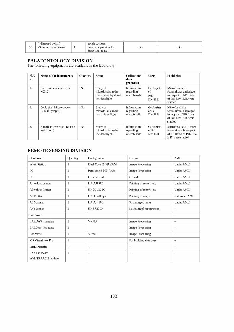
103
( diamond polish) polish sections 18 Vibratory sieve shaker 1 Sample separation for
loose sediments -Do- -Do-
PALAEONTOLOGY DIVISION The following equipments are available in the laboratory
Sl.No.
Name of the instruments Quantity Scope Utilization/ data generated
Users Highlights
1. Stereomicroscope-Leica MZ12
1No. Study of microfossils under transmitted light and incident light
Information regarding microfossils
Geologists of
Pal. Div.,E.R.
Microfossils i.e. foaminifera and algae in respect of RP Items of Pal. Div. E.R. were studied
2. Biological Microscope-CH2 (Olympus)
1No. Study of microfossils under transmitted light
Information regarding microfossils
Geologists of Pal. Div.,E.R
Microfossils i.e. foaminifera and algae in respect of RP Items of Pal. Div. E.R. were studied
3. Simple microscope (Bausch and Lomb)
1No. Study of microfossils under incident light
Information regarding microfossils
Geologists of Pal. Div.,E.R
Microfossils i.e. larger foaminifera in respect of RP Items of Pal. Div. E.R. were studied
REMOTE SENSING DIVISION
Hard Ware Quantity Configuration Out put AMC
Work Station 1 Dual Core, 2 GB RAM Image Processing Under AMC
PC 1 Pentium 64 MB RAM Image Processing Under AMC
PC 1 Official work Offical Under AMC
A4 colour printer 1 HP DJ840C Printing of reports etc Under AMC
A3 colour Printer 1 HP DJ 1125C Printing of reports etc Under AMC
A0 Plotter 1 HP DJ 4000ps Printing of maps Not under AMC
A0 Scanner 1 HP DJ 4500 Scanning of maps Under AMC
A4 Scanner 1 HP SJ 2300 Scanning of report/maps --
Soft Ware --
EARDAS Imageine 1 Ver 8.7 Image Processing --
EARDAS Imageine 1 Image Processing --
Arc View 1 Ver 9.0 Image Processing --
MS Visual Fox Pro 1 For building data base --
Requirement -- -- -- --
ENVI software
With TRAASH module
1 -- -- --
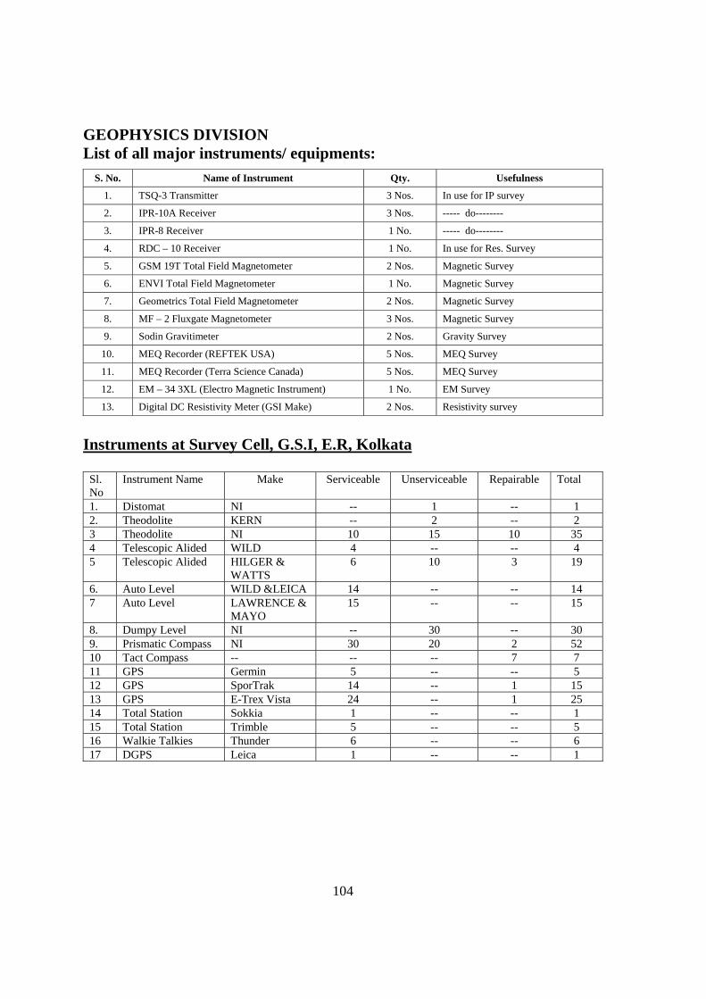
104
GEOPHYSICS DIVISION List of all major instruments/ equipments:
S. No. Name of Instrument Qty. Usefulness
1. TSQ-3 Transmitter 3 Nos. In use for IP survey
2. IPR-10A Receiver 3 Nos. ----- do--------
3. IPR-8 Receiver 1 No. ----- do--------
4. RDC – 10 Receiver 1 No. In use for Res. Survey
5. GSM 19T Total Field Magnetometer 2 Nos. Magnetic Survey
6. ENVI Total Field Magnetometer 1 No. Magnetic Survey
7. Geometrics Total Field Magnetometer 2 Nos. Magnetic Survey
8. MF – 2 Fluxgate Magnetometer 3 Nos. Magnetic Survey
9. Sodin Gravitimeter 2 Nos. Gravity Survey
10. MEQ Recorder (REFTEK USA) 5 Nos. MEQ Survey
11. MEQ Recorder (Terra Science Canada) 5 Nos. MEQ Survey
12. EM – 34 3XL (Electro Magnetic Instrument) 1 No. EM Survey
13. Digital DC Resistivity Meter (GSI Make) 2 Nos. Resistivity survey
Instruments at Survey Cell, G.S.I, E.R, Kolkata
Sl. No
Instrument Name Make Serviceable Unserviceable Repairable Total
1. Distomat NI -- 1 -- 1 2. Theodolite KERN -- 2 -- 2 3 Theodolite NI 10 15 10 35 4 Telescopic Alided WILD 4 -- -- 4 5 Telescopic Alided HILGER &
WATTS 6 10 3 19
6. Auto Level WILD &LEICA 14 -- -- 14 7 Auto Level LAWRENCE &
MAYO 15 -- -- 15
8. Dumpy Level NI -- 30 -- 30 9. Prismatic Compass NI 30 20 2 52 10 Tact Compass -- -- -- 7 7 11 GPS Germin 5 -- -- 5 12 GPS SporTrak 14 -- 1 15 13 GPS E-Trex Vista 24 -- 1 25 14 Total Station Sokkia 1 -- -- 1 15 Total Station Trimble 5 -- -- 5 16 Walkie Talkies Thunder 6 -- -- 6 17 DGPS Leica 1 -- -- 1
105
1122.. GGEEOOIINNFFOORRMMAATTIICCSS GSI NET – Portal Project:
During February 2002 Geological Survey of India approached this Ministry with the proposal to have a complete Enterprise Information Portal of all its offices through LAN and WAN.
A Standing Finance Committee [SFC] was set up for appraisal and approval of this project by the Ministry of Mines on 9.4.2003. The meeting of the SFC was held on 11.8.03 under the chairmanship of the then Secretary [Mines] and the proposal for setting up of GSI NET and PORTAL in two Phases at a cost of Rs.25 crores [Rs.12.20 crore in Phase-I and Rs.12.80 crore in Phase-II].
Portal applications:
The Portal is designed to provide spatial (map) and non-spatial data in respect of following pertaining to Eastern Region
(i) Legacy FSP (ii) Extended abstract (iii) Current FSP data through FSPMIS application (iv) Metadata of unpublished reports (v) Unpublished reports of post 2004 (vi) Unpublished reports of pre 2004 (vii) 1:50,000 geological maps for map service (viii) Pay roll data (ix) Photographs for photo gallery (x) Published paper maps and Case studies
GSI Enterprise Portal: Data uploading
The GSI Enterprise Portal has become functional in entire ER by implementing WAN connectivity. The connectivity now enables 42 IP telephones of the Region to be voice activated with the rest of GSI. The Load/Upload utility for 50K geological maps now enables the Region to directly upload digital maps onto the Portal in the GIS domain. Uploading of 1: 50K Geological Maps: 704 geological maps of the Region out of a total 704 maps have been uploaded onto the Portal. Photo-Gallery module: 406 field photographs from the Region have been uploaded. Case Studies: 26 items on different aspects of field activities of the Eastern Region have been uploaded onto the Portal. Payroll and HRMIS data: HRMIS Data for 1010 officials and Payroll data of 995officials of the Region have been entered onto the Portal.

106
Data entry of Legacy FSP and Extended abstracts: Uploading of 21 volumes for the FS
1995-96, 1996- 97, 1997-98, 1998-99, 1999-2000, 2000-01, 2001-02, 2002-03, 2003-04, 2004-05, 2005- 06, 2006-07, onto the Portal have been completed.
For Eastern Region the paper maps published and uploaded on GSI portal include: District Resource Maps: (DRM) – Printed – 105 Mineral Belt Maps- Uploaded – 45.
Unpublished Maps:
704 sheets of 1: 50 K geological maps have been compiled and digitized and of these maps have already been uploaded on GSI Portal for intranet users in UTM projection using WGS 84 datum Unpublished Reports:
Metadata of reports and abstracts of 4616 reports; 194 (out of 470 post-2004) reports and 1474(out of 4045 pre-2004) reports have been uploaded. Free Data Policy as on 05.06.2009 is given below:
Published Maps: GSI will continue to print and publish maps of different scales and themes both as hard copy prints along with soft copy (pdf) format contained in CD after obtaining statutory clearance from SOI/ MOD as required. These maps are sold at a price not exceeding the printing cost and other processing charges. While the present system will continue, hereafter all State Geological & Mineral maps as and when published will be available in GSI portal as raster images for free viewing in the public domain. All other maps printed and published by GSI will also be uploaded as thumbnail images. Along with this an Internet map service has been created through uploading of multiple thematic layers of 1: 2m Geological Map of India as vector image for free viewing and querying. In future all maps published by GSI in the scale of 1: 1m and smaller (1:2,5,7.5m etc) will be uploaded as vector images Status of publication of Extended Abstract: Extended Abstract pertaining up to FS 2005-2006 have been Published while those for FS 2006-2007 and 2007-2008 were released in August 2010.
107
1133.. TTRRAAIINNIINNGG //CCAAPPAACCIITTYY BBUUIILLDDIINNGG AACCTTIIVVIITTIIEESS IINN TTHHEE RREEGGIIOONN Recently GSI ER has opened Regional Training Institute at Kolkata and has linked it up with the existing Field Training Centre at Kuju (Ranchi).
13.1 FUNCTION OF REGIONAL TRAINING CENTRE (RTC), EASTERN REGION,
GSI 13.1.1: THEME OF RTI, ER AND FTC: SUKINDA AND KUJU OE EASTERN REGION RTI, ER: The Regional Training Institute is catering various technical and administrative
training needs of the region as a whole. It caters to the need of outside department also. The
laboratory module of the Orientation Courses of Geologists is regularly being served by the
RTI, ER.
The various aspects which can be covered by the RTI, ER as broad theme:
Petrological Study: Introduction to various laboratory techniques used in petrological studies.
Petrographic study of sedimentary, igneous and metamorphic rocks including
petrography of sedimentary rocks of the Kuju area.
Ore microscopy—study of sulphides and oxide samples of various deposits of the
country.
Exposure to EPMA, Geochronology (TIMS, C 14 dating, XRF) laboratories.
Exposure to the Gem Testing Laboratory.
Exposure to various techniques of rock and soil mechanics in the Geotechnical
Laboratory.
Palaeontology Study: Invertebrate Palaeontology
Micropalaeontology and Palynology
Vertebrate Palaeontology with special reference to Dinosaurs – visit to the Indian
Statistical Institute (ISI), Kolkata.
Study on Andaman Geology:
108
Ophiolite sequence, Andaman flysch Barren Island Volcanism (if possible)
Theme of FTC, Kuju (Ranchi, Jharkhand) : Basic geological mapping exercises pertaining to sedimentary terrain.
Sedimentary structures.
Palaeocurrent analyses.
Guided geological mapping of Gondwana formations on 1: 25,000 scale in selected
blocks.
Detailed geological mapping (outcrop mapping) of Gondwana formations on 1:5000
scale in selected blocks and preparation of geological map.
Section measurements & building of stratigraphic columns.
Coal exploration techniques.
Reserve estimation.
Coal geology and coal petrography.
Introduction to CBM studies.
Environmental impact of coal mining.
Geological map reading.
Theme of FTC Sukinda (Baula, Orissa):
Geological mapping in PGE mineralized areas.
Exploration techniques of PGE
Mineral exploration techniques of Iron ore and Manganese ore
Geological & Structural mapping
Visit to various Iron/ Manganese/ PGE mines for basic understandings of the ore
body disposition with respect to host rock.
NGCM programme and sampling.
Geophysical logging method for understanding mineralization.
109
1144.. SSCCIIEENNTTIIFFIICC WWOORRKKSSHHOOPPSS//MMEEEETTIINNGGSS//SSEEMMIINNAARRSS//SSYYMMPPOOSSIIUUMM,,
EEXXHHIIBBIITTIIOONN OORRGGAANNIIZZEEDD//PPAARRTTIICCIIPPAATTEEDD Engineering Geology Division of Eastern Region organized a two day workshop on
LANDSLIDES during 27th & 28th January 2009 at P.N.Bose Auditorium of ER. A number of delegates from Netherlands, Germany, Italy and India participated in the workshop and in the open discussions. The workshop comprised of lectures followed by interactive sessions, on various topics related to landslides, its related hazards, monitoring, mitigation and development of early warning system. The foreign delegates presented their case histories and site specific studies, whereas the Indian delegates or to be specific GSI scientists presented the work carried out in India and parameters used in landslides in Himalayan terrain. Besides the above mentioned workshop, GSI, ER has regularly participated in the exhibitions organized during all the CGPB meetings. Regular participation in meetings such as SGPB and CGPB of different committees are also done. 1st meeting of the Quality Management cell of GSI was held on 31st March 2010 under the chairmanship of the Additional Director General, ER . IGCP 523 meeting was held in GSI, ER under chairmanship of ADG, ER. 31st HOD meeting was held at GSI, ER on 31st May 2010 under the chairmanship of Director General, GSI with participation of Delhi office and Special Secretary, MOM through video conferencing. ADG, Eastern Region being convener for CGPB , Committee-I( Ferrous minerals ) has so far organized three regular and one special meeting through which base documents on exploration strategies for Iron, Manganese and Chromite ores have been finalized and uploaded in the GSI portal for public participation. 4th meeting of the CGPB Committee-I (Ferrous Minerals) was held on 7th December 2010 in ERO, Kolkata. 5th meeting of the CGPB Committee-I (Ferrous Minerals) was held on 15th July 2011in ERO, Kolkata. A Brain storming session on NGCM Survey pertains to Eastern Region project was held on 2nd August 2011 .
Took part in the Jatiya Sanhati Utsav o Bharat Mela at Gobindanagar High School ground, Canning , 24 Parganas ( South) from 10th December to 17th December 2011. 1155.. HHRRDD,, EESSTTAABBLLIISSHHMMEENNTT,, PPAAYYRROOLLLL.. HHRRMMIISS,, ee--SSEERRVVIICCEE BBOOOOKK
HRD, PAYROLL, HRMIS, RCA claim modules etc including tour and leave modules have been initiated and details given in Annexure-9.
1166.. VVEEHHIICCLLEESS &&TTRRAANNSSPPOORRTT IINNFFRRAASSTTRRUUCCTTUURREE IINNCCLLUUDDIINNGG OOUUTT SOURCING AND AGE OF VEHICLES, Vehicle MIS Details have been furnished in Annexure -XI
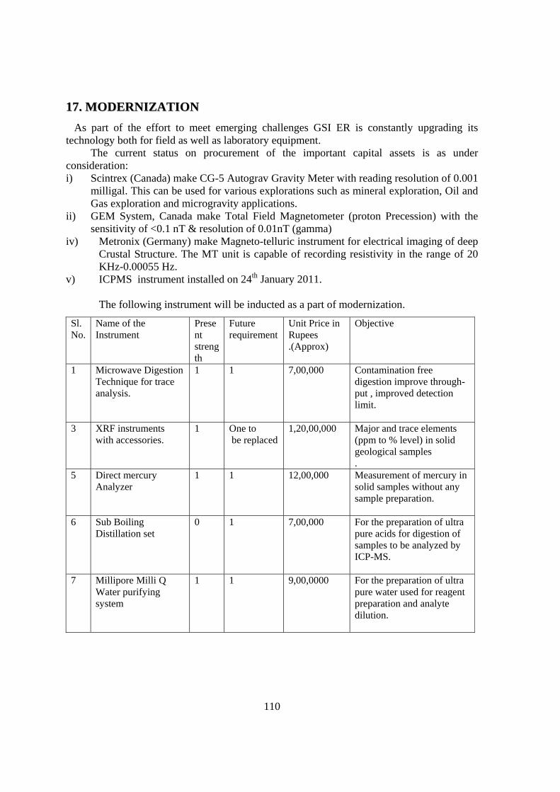
110
1177.. MMOODDEERRNNIIZZAATTIIOONN
As part of the effort to meet emerging challenges GSI ER is constantly upgrading its technology both for field as well as laboratory equipment.
The current status on procurement of the important capital assets is as under consideration: i) Scintrex (Canada) make CG-5 Autograv Gravity Meter with reading resolution of 0.001
milligal. This can be used for various explorations such as mineral exploration, Oil and Gas exploration and microgravity applications.
ii) GEM System, Canada make Total Field Magnetometer (proton Precession) with the sensitivity of <0.1 nT & resolution of 0.01nT (gamma)
iv) Metronix (Germany) make Magneto-telluric instrument for electrical imaging of deep Crustal Structure. The MT unit is capable of recording resistivity in the range of 20 KHz-0.00055 Hz.
v) ICPMS instrument installed on 24th January 2011.
The following instrument will be inducted as a part of modernization.
Sl. No.
Name of the Instrument
Present strength
Future requirement
Unit Price in Rupees .(Approx)
Objective
1 Microwave Digestion Technique for trace analysis.
1 1 7,00,000 Contamination free digestion improve through-put , improved detection limit.
3 XRF instruments with accessories.
1 One to be replaced
1,20,00,000 Major and trace elements (ppm to % level) in solid geological samples .
5 Direct mercury Analyzer
1 1 12,00,000 Measurement of mercury in solid samples without any sample preparation.
6 Sub Boiling Distillation set
0 1 7,00,000 For the preparation of ultra pure acids for digestion of samples to be analyzed by ICP-MS.
7 Millipore Milli Q Water purifying system
1 1 9,00,0000 For the preparation of ultra pure water used for reagent preparation and analyte dilution.
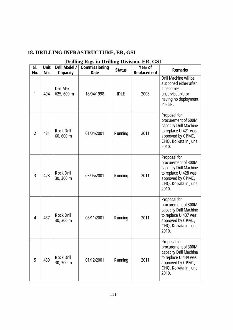
111
1188.. DDRRIILLLLIINNGG IINNFFRRAASSTTRRUUCCTTUURREE,, EERR,, GGSSII
Drilling Rigs in Drilling Division, ER, GSI Sl. No.
Unit No.
Drill Model / Capacity
Commissioning Date Status
Year of Replacement Remarks
1 404 Drill Max 625, 600 m
18/04/1998 IDLE 2008
Drill Machine will be auctioned either after it becomes unserviceable or having no deployment in FSP.
2 421 Rock Drill 60, 600 m
01/04/2001 Running 2011
Proposal for procurement of 600M capacity Drill Machine to replace U 421 was approved by CPMC, CHQ, Kolkata in June 2010.
3 428 Rock Drill 30, 300 m 03/05/2001 Running 2011
Proposal for procurement of 300M capacity Drill Machine to replace U 428 was approved by CPMC, CHQ, Kolkata in June 2010.
4 437 Rock Drill 30, 300 m
08/11/2001 Running 2011
Proposal for procurement of 300M capacity Drill Machine to replace U 437 was approved by CPMC, CHQ, Kolkata in June 2010.
5 439 Rock Drill 30, 300 m
01/12/2001 Running 2011
Proposal for procurement of 300M capacity Drill Machine to replace U 439 was approved by CPMC, CHQ, Kolkata in June 2010.
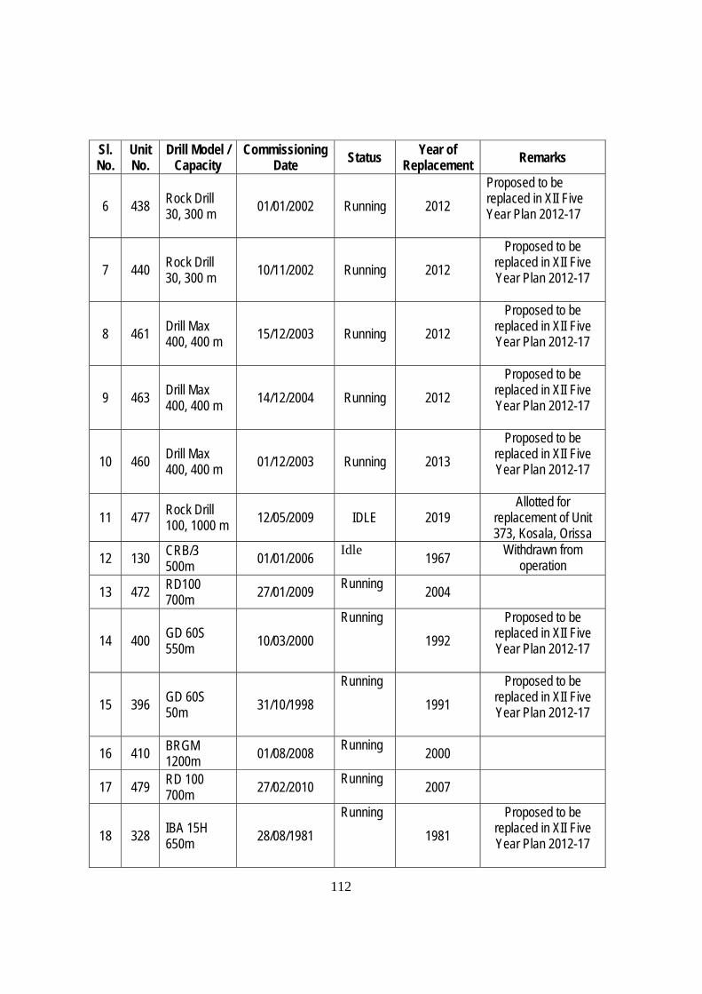
112
Sl. No.
Unit No.
Drill Model / Capacity
Commissioning Date Status
Year of Replacement Remarks
6 438 Rock Drill 30, 300 m
01/01/2002 Running 2012
Proposed to be replaced in XII Five Year Plan 2012-17
7 440 Rock Drill 30, 300 m
10/11/2002 Running 2012
Proposed to be replaced in XII Five Year Plan 2012-17
8 461 Drill Max 400, 400 m 15/12/2003 Running 2012
Proposed to be replaced in XII Five Year Plan 2012-17
9 463 Drill Max 400, 400 m
14/12/2004 Running 2012
Proposed to be replaced in XII Five Year Plan 2012-17
10 460 Drill Max 400, 400 m 01/12/2003 Running 2013
Proposed to be replaced in XII Five Year Plan 2012-17
11 477 Rock Drill 100, 1000 m 12/05/2009 IDLE 2019
Allotted for replacement of Unit 373, Kosala, Orissa
12 130 CRB/3 500m
01/01/2006 Idle
1967 Withdrawn from
operation
13 472 RD100 700m 27/01/2009
Running 2004
14 400 GD 60S 550m
10/03/2000
Running
1992
Proposed to be replaced in XII Five Year Plan 2012-17
15 396 GD 60S 50m 31/10/1998
Running
1991
Proposed to be replaced in XII Five Year Plan 2012-17
16 410 BRGM 1200m
01/08/2008 Running
2000
17 479 RD 100 700m
27/02/2010 Running
2007
18 328 IBA 15H 650m
28/08/1981
Running
1981
Proposed to be replaced in XII Five Year Plan 2012-17
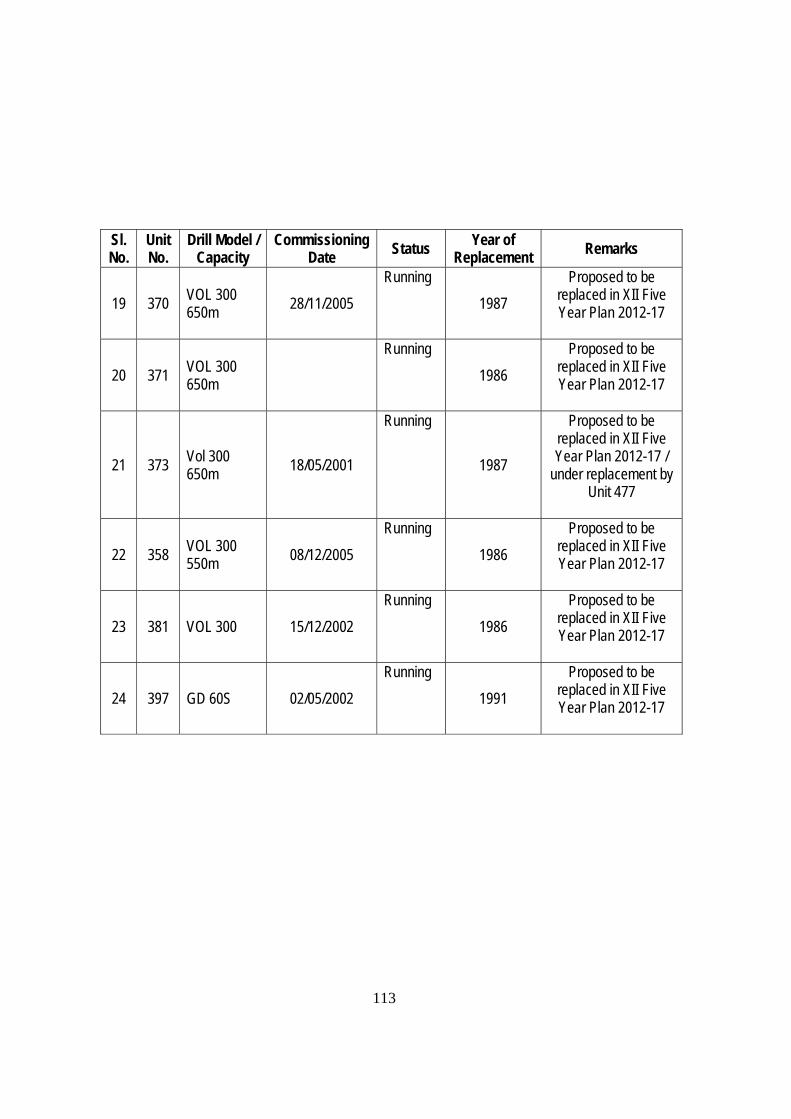
113
Sl. No.
Unit No.
Drill Model / Capacity
Commissioning Date Status Year of
Replacement Remarks
19 370 VOL 300 650m
28/11/2005
Running
1987
Proposed to be replaced in XII Five Year Plan 2012-17
20 371 VOL 300 650m
Running
1986
Proposed to be replaced in XII Five Year Plan 2012-17
21 373 Vol 300 650m
18/05/2001
Running
1987
Proposed to be replaced in XII Five Year Plan 2012-17 /
under replacement by Unit 477
22 358 VOL 300 550m 08/12/2005
Running
1986
Proposed to be replaced in XII Five Year Plan 2012-17
23 381 VOL 300 15/12/2002
Running
1986
Proposed to be replaced in XII Five Year Plan 2012-17
24 397 GD 60S 02/05/2002
Running
1991
Proposed to be replaced in XII Five Year Plan 2012-17
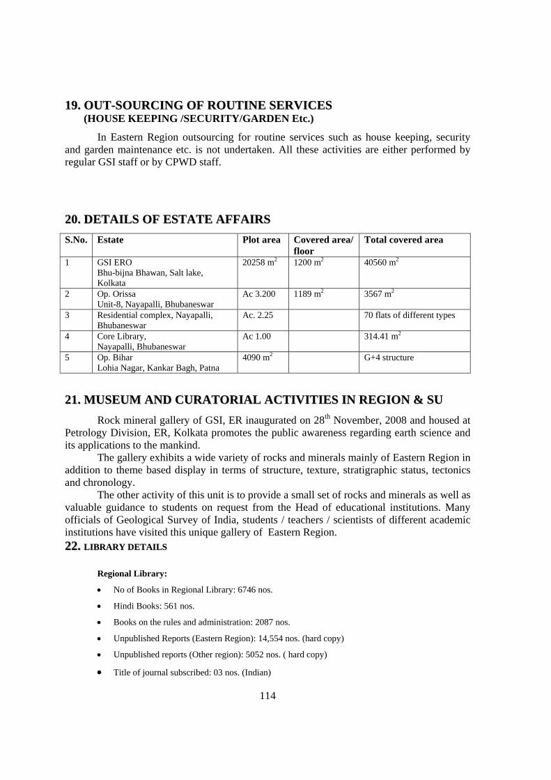
114
1199.. OOUUTT--SSOOUURRCCIINNGG OOFF RROOUUTTIINNEE SSEERRVVIICCEESS (HOUSE KEEPING /SECURITY/GARDEN Etc.)
In Eastern Region outsourcing for routine services such as house keeping, security and garden maintenance etc. is not undertaken. All these activities are either performed by regular GSI staff or by CPWD staff.
2200.. DDEETTAAIILLSS OOFF EESSTTAATTEE AAFFFFAAIIRRSS
S.No. Estate Plot area Covered area/ floor
Total covered area
1 GSI ERO Bhu-bijna Bhawan, Salt lake, Kolkata
20258 m2 1200 m2 40560 m2
2 Op. Orissa Unit-8, Nayapalli, Bhubaneswar
Ac 3.200 1189 m2 3567 m2
3 Residential complex, Nayapalli, Bhubaneswar
Ac. 2.25 70 flats of different types
4 Core Library, Nayapalli, Bhubaneswar
Ac 1.00 314.41 m2
5 Op. Bihar Lohia Nagar, Kankar Bagh, Patna
4090 m2 G+4 structure
2211.. MMUUSSEEUUMM AANNDD CCUURRAATTOORRIIAALL AACCTTIIVVIITTIIEESS IINN RREEGGIIOONN && SSUU
Rock mineral gallery of GSI, ER inaugurated on 28th November, 2008 and housed at Petrology Division, ER, Kolkata promotes the public awareness regarding earth science and its applications to the mankind.
The gallery exhibits a wide variety of rocks and minerals mainly of Eastern Region in addition to theme based display in terms of structure, texture, stratigraphic status, tectonics and chronology.
The other activity of this unit is to provide a small set of rocks and minerals as well as valuable guidance to students on request from the Head of educational institutions. Many officials of Geological Survey of India, students / teachers / scientists of different academic institutions have visited this unique gallery of Eastern Region. 2222.. LLIIBBRRAARRYY DDEETTAAIILLSS
Regional Library:
No of Books in Regional Library: 6746 nos.
Hindi Books: 561 nos.
Books on the rules and administration: 2087 nos.
Unpublished Reports (Eastern Region): 14,554 nos. (hard copy)
Unpublished reports (Other region): 5052 nos. ( hard copy)
Title of journal subscribed: 03 nos. (Indian)
115
23. CCOORREE LLIIBBRRAARRYY The Regional Core Library, Geological Survey of India Eastern Region, started functioning at Bhubaneswar since January, 2010. The Core Library is designed and constructed in such a manner that it can accommodate 4800 no. of drill core boxes systematically. Facility is being created to provide access to the fellow scientists, researcher and students from various earth science organization and University for research and academic activities. Altogether a total of 1686 boxes of 8229.93m skeletonised drill cores have been systematically arranged and preserved in cells earmarked for individual states (Jharkhand, Odisha, West Bengal and Sikkim). The preserved skeletonised drill cores are from Iron, Manganese, Bauxite, PGE, Gold, Rare Metals and Coal investigations carried out in different field seasons by different state units of Eastern Region and erstwhile Coal Wing. The process for transferring of cores (skeletonised) of different Mineral Investigations carried out by GSI is continuing and effort is being made to obtain cores from other sister organizations. Core Preservation The drill cores generated from investigations are preserved in GI sheet boxes of 90cm x 30cm x 10cm with a lid. The cores selected as per the guidelines from CHQ have been transferred to the GI sheet boxes. The details of depth of core preserved and borehole numbers were written on two sides of the GI sheet boxes and ghutkas with paint and by engraving. For storage of drill core boxes inside the Core Library in multi-layer system, heavy duty racks with four partitions have been used. The racks are properly arranged in the repository taking maximum advantage of natural ventilation and illumination and keeping sufficient place for movement of men and machinery. Drill core boxes are stacked systematically state-wise as per Project/Investigation, Borehole and depth of cores. Details of the drill Core Preserved So far, the drill cores preserved in the Regional Core Library are from 16 investigations, pertaining to 4 stat graphic boreholes for Gondwana coal and 1 from Rangit Window, Sikkim and rest 11 for 6 mineral commodities like Iron, Manganese, Gold, PGE, Rare Metals and apatite. The drill cores preserved in the Core Repository include boreholes drilled for Iron ore, manganese and bauxite investigations in Bonai-Keonjhar belt; PGE investigation in Baula-Nausahi M-UM complex in Odisha, Gold investigations from Pahardia and Parasi areas, Jharkhand; Rare Metal and apatite investigation from Purulia district, West Bengal; and coal investigation from Bokaro Coal field, Jharkhand, Raniganj coal field, Birbhum Coal Field, West Bengal, Talcher Coal Field, Odisha. Out of the 1686 boxes of skeletonised core preserved in the core library, there are 124 boxes with a length of 492.30m of core from 3 Iron ore investigations representing 10 boreholes, 155 boxes with 490.56m length of core from 2 Manganese ore investigations from 13 boreholes, 98 boxes with 1180.65m length of core from 1 Bauxite investigation from 39 boreholes, 50 boxes with 363.65m length of core from 1 PGE investigation from 8 boreholes and 167 boxes with 462.02m of core from 1 stratigraphic borehole in for coal in the state of Odisha. Similarly, there are 92 boxes with 443.70m length of core from 1 Rare Metal investigation representing 23 boreholes, 42 core boxes of 195.50m drill core of 6 boreholes drilled during apatite
116
investigation of Purulia district, West Bengal 332 boxes with 1680.25m length of core from 2 stratigraphic boreholes of coal in the State of West Bengal and 1 from Rangit Window, Sikkim. There are 385 boxes with 1766.55m length of core from 2 gold investigation representing 58 boreholes located and 200 boxes with 1028.90m drill core from 1 stratigraphic borehole of coal in Jharkhand. As per the Policy Guideline for establishing National Drill Core Library and recommendations of the Core library Committee, modernization of the core library at Bhubaneswar is in progress. Litholog data available for all skeletonised drill core have been entered in MS Excel format. Database framework for data connectivity has been created in MS Access incorporating borehole details, storage position in the library, litholog, major oxide and trace element analytical data, petrography, ore characteristics, mineral chemistry, etc. Petrochemical data of drill core samples (each 1m length) for a total legth of 157.00m from the Boreholes JBH-9 & JBH-28, drilled during Iron Ore Investigation at Jumka-Pathriposhi area, Bonai-Kendujhar Belt, Sundargarh district, Odisha. was entered in MS Access Format. Presented the work of Core Library for the F.S. 2012-13, before the Chairman and Members of Stage Review Committee. Engaged in entering Petrochemical data of core samples(varying in length from 0.50 to 1.00m) for a total length of 63.05m for the borehole KPB-3, PBH-37, LBH-37, PBH-45 & LEB-7 drilled during Manganese investigation of Bonai-Kendujhar Belt, Odisha. Engaged in entering the trace element analyses of Core samples for a total length of 5.65m samples of Borehole BBH-3 drilled during Purulia apatite Investigation, Bheliadih area, F.S.2008-2010, Purulia district, West Bengal. Submitted a proposal to the DIC, SU, Odisha for the visit of Shri V.K. Khadse, Suptdg. Geologist, SR, Hyderabad to SU. Odisha for demonstrating and guiding the geologist to carry out the work of Core Library, Bhubaneswar. The officers were engaged in entering Petrological details in MS Access Format of 14 thin sections of drill core samples of Borehole PDA-1, 9 &10 and also entering the data of Ore microscopic studies of 21 polished sections of core samples of Borehole PDA-1, 2, 3 & 6 drilled during gold investigation of Pahardia-Rungikocha area, West Singhbhum District, Jharkhand. Engaged in entering trace element analyses of 204 core samples in MS Access format of 8 Boreholes BK-4, 5, 8, 10, 11, BMB-4, 5 & 6 drilled during Rare Metal Investigation within the pegmatites of Chhotanagpur Gneissic Complex of Purulia district, West Bengal.
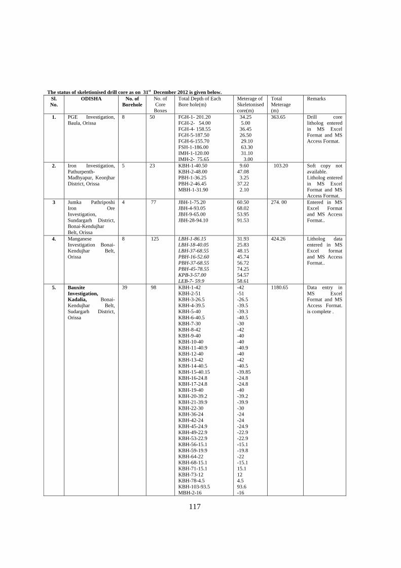
117
The status of skeletionised drill core as on 31st December 2012 is given below.
Sl. No.
ODISHA No. of Borehole
No. of Core
Boxes
Total Depth of Each Bore hole(m)
Meterage of Skeletonised core(m)
Total Meterage (m)
Remarks
1. PGE Investigation, Baula, Orissa
8 50 FGH-1- 201.20 FGH-2- 54.00 FGH-4- 158.55 FGH-5-187.50 FGH-6-155.70 FSH-1-186.00 IMH-1-120.00 IMH-2- 75.65
34.25 5.00 36.45 26.50 29.10 63.30 31.10 3.00
363.65 Drill core litholog entered in MS Excel Format and MS Access Format.
2. Iron Investigation, Pathurpenth- Madhyapur, Keonjhar District, Orissa
5 23 KBH-1-40.50 KBH-2-48.00 PBH-1-36.25 PBH-2-46.45 MBH-1-31.90
9.60 47.08 3.25 37.22 2.10
103.20 Soft copy not available. Litholog entered in MS Excel Format and MS Access Format.
3 Jumka Pathriposhi Iron Ore Investigation, Sundargarh District, Bonai-Kendujhar Belt, Orissa
4 77 JBH-1-75.20 JBH-4-93.05 JBH-9-65.00 JBH-28-94.10
60.50 68.02 53.95 91.53
274. 00 Entered in MS Excel Format and MS Access Format..
4. Manganese Investigation Bonai-Kendujhar Belt, Orissa
8 125 LBH-1-86.15 LBH-18-40.05 LBH-37-68.55 PBH-16-52.60 PBH-37-68.55 PBH-45-78.55 KPB-3-57.00 LEB-7- 59.9
31.93 25.83 48.15 45.74 56.72 74.25 54.57 58.61
424.26 Litholog data entered in MS Excel format and MS Access Format..
5. Bauxite Investigation, Kadalia, Bonai-Kendujhar Belt, Sudargarh District, Orissa
39 98 KBH-1-42 KBH-2-51 KBH-3-26.5 KBH-4-39.5 KBH-5-40 KBH-6-40.5 KBH-7-30 KBH-8-42 KBH-9-40 KBH-10-40 KBH-11-40.9 KBH-12-40 KBH-13-42 KBH-14-40.5 KBH-15-40.15 KBH-16-24.8 KBH-17-24.8 KBH-19-40 KBH-20-39.2 KBH-21-39.9 KBH-22-30 KBH-36-24 KBH-42-24 KBH-45-24.9 KBH-49-22.9 KBH-53-22.9 KBH-56-15.1 KBH-59-19.9 KBH-64-22 KBH-68-15.1 KBH-71-15.1 KBH-73-12 KBH-78-4.5 KBH-103-93.5 MBH-2-16
-42 -51 -26.5 -39.5 -39.3 -40.5 -30 -42 -40 -40 -40.9 -40 -42 -40.5 -39.85 -24.8 -24.8 -40 -39.2 -39.9 -30 -24 -24 -24.9 -22.9 -22.9 -15.1 -19.8 -22 -15.1 15.1 12 4.5 93.6 -16
1180.65 Data entry in MS Excel Format and MS Access Format. is complete .
118
MBH-8-16 MBH-11-40.9
-16 -40.9
6. Coal Exploration, Talchir Coalfield, Jamujhari-Brahamanbil Block, Angul District, Orissa
3 167 TJM-9-298.40m TJM-11-586.10 TJM-13-492.50
259.32 11.75 228.39
462.02m Drill core litholog entered in MS Excel Format and MS Access Format.
7 Iron Ore Investigation in bore hole SGB-4 from Gorhaburhani Block, Sundergarh district, F.S. 2007-2010
1 24 SGB-4-115.10m 115.10m 115.10m Drill core litholog entered in MS Excel Format and MS Access Format.
8. Manganese investigation of Bonai –Kenduajhar Belt, Kedujhar District, Orissa., F.S. 2007-2009.
5 30 DB-2-9.3m DB-14-5.5m BEB-26-2 m DB-4-3.7m DB-1-23.35 BEB-12-18.3m BEB-19-4.15m
66.3 66.3 Drill core litholog entered in MS Excel and MS Access Format.
Total meterage of Orissa
2989.18m
Sl.No. JHARKHAND No. of Borehole
No. of Core
Boxes
Total Depth of Each Bore hole(m)
Data entered Meterage of Skeletonised core(m)
Total Meterage (m)
Remarks
1. Gold Investigation, Pahardia-Rungikocha area, West Singbhum District, Jharkhand
29 158 PDA-1-11.05m PDA-2-128.15 PDA-3- 165.10 PDA-4-111.80 PDA-5-132.10 PDA-6-120.05 PDA-7-127.05 PDA-8-125.5 PDA-9-126.30
57.25 21.28 23.55 39.75 33.90 106.25 12.15 20.05 10.40
324.58m for bore PDA-1 to PDA-9 A total of 683.37m for 29 Boreholes.
Discrepancy occur between the total number core boxes and number of borehole drilled. Some of the core boxes are not properly labeled. Lithog of 29 borehole for a total length of 683.37m (324.58 m for Borehole PDA-1 to PDA-9 (and 358.79m for borehole RGA1 to RGA-10 and EPA1 to EPA-5 and bore borehole PDA-10 to PDA-14 in Pahardia Rungikocha Block are entered in MS Excel Format and MS Access Format)
2. Coal Exploration Bokarao Coal Field
2 200 EBPN-3-892.00 EBM-1-1219.00
268.00 1219.00
74.55+ 954.35 =1028.90m
Data entry for borehole EBPN-3 and EBM-1 is complete in MS Excel and MS Access Format.
3. Gold Investigation, Parasi-Lungtu-Sinduri area, Ranchi, District, Jharkhand.
29 227 LPS-2-140.00 LPS-4-150.00 LPS-6-147.60 LPS-8-181.00 LPS-10-150.50
46.85 54.60 32.90 39.45 48.35
1083.18 Summarised litholog Available, Drill core litholog entered in MS
119
LPS-11-159.50 LPS-12-150.70 LPS-13-171.50 LPS-14-213.15 LPS-15-98.05 LPS-16A-301.40 LPS-17A-122.00 LPS-18W-158.90 LPS-19-76.50 LPS-20-74.00 LPS-21-66.50 LPS-22-88.30 LPS-23-136.00 LPS-24-123.25 LPS-25E-203.75 LPS-26-190.30 LPS-27-280.30 LPS-28-220.10 LPS-29E-200.00 LPS-30-165.00 LPS-31-128.80 LPS-32W-172.65 LPS-33E-191.50 LPS-34-135.60
48.88 34.00 28.25 22.80 15.05 50.65 39.55 46.30 41.65 31.70 23.15 9.95 66.35 27.00 39.80 39.10 18.25 14.50 79.00 49.00 19.20 35.75 43.45 38.50
Excel Format
Total meterage of Jharkhand
2795.45
Sl.No. WEST BENGAL No. of Borehole
No. of Core
Boxes
Total Depth of Each Bore hole(m)
Meterage of Skeletonised core(m)
Total Meterage (m)
Remarks
1. Rare metal Investigation, Purulia, W.B.
23 92 BMB-1-45.15m BMB-2-40.10 BMB-3-42.05 BMB-4-39.90 BMB-5-30.55 BMB-6-18.95 BMB-7-58.50 BMB-8-49.10 BMB-9-44.05 BMB-10-65.50 BMB-11-81.70 BMB-12-21.80 BMB-13-25.20 BMB-14-30.05 BM(EB)-1-40.05 BMEB-2-28.80 KTB-1-45.05 KTB-2-35.00 BK-1-70.05 BK-2- &0.15 BK-3-100.05 BK-4-55.10 BK-5-95.30 BK-6-61.00 BK-7-35.05 BK-8-32.70 BK-9-23.20 BK-145.55 BK-11-21.30 BK-12-49.95
443.70m Drill core litholog entered in MS Excel Format and MS Access Format.
2. Coal Investigation, Raniganj Coal field, Rakshitpur Sector, T.S. No. 73 M/6.
1 145 RRK-1- 991.65 980.25m Summarised litholog of Borhole RRK-1 drilled in Rakshitpur area entered in MS Excel Format Drill core litholog entered in MS Excel Format and MS Access Format.
120
Out of 951.65 m drilled in Borehole RRK-1 In Rakshitpur area 6.65 m length of core was skeletonised.
3. Coal Exploration, Birbhum Coal Field drilled at Kapasdanga Bharkanta Sector of Birbhum Coalfield, Birbhum District W.B.
1 187 BKB-2-846.95 827.94m 700.00m Drill core litholog entered in MS Excel Format and MS Access Format.
4.
Purulia apatite Investigation , Bheliadih area, F.S.2008-2010
3
25 BBH-1- 105.35m BBH-2- 42.70m BBH-3- 60.50m
105.35 13.20 8.85
127.40m
Panrkidih Block F.S. 2010-2012
3 17 PBH-2-60.00m PBH-5-50.20m PBH-6-48.60m
60.00 5.40 2.70
68.10m
Total meterage of West Bengal
2319.45m
Sl.No. SIKKIM No. of Borehole
No. of Core
Boxes
Total Depth of Each Bore hole(m)
Meterage of Skeletonised core(m)
Total Meterage (m)
1 Stratigraphic Drilling in Rangit Window, Project Tectonostratigraphy, South District, Sikkim.
2 41 KSS-1- 38.5m KSS-1A 114.35
38.35 87.35
125.85
Total meterage of Sikkim
125.85
Total Meterage
8229.93m
121
24. RTI APPEAL STATUS (01-04-2013 TO 30-06-2013) ER
Nature of quarries: General quarries are transfer and posting, promotion,
accounts related information in respect of persons.
Constraint in filing the reply: The replies were not received in time
Organisation & Month
No. of Cases Remarks Previous pendency
No. of RTI Appeal received during the period
Disposal No. of Appeals rejected / information denied under section
Balance T The balance cases are pending with Head of office for final reply since 25.6.13.
GSI, ER
April 2013 2 4 6 Nil nil May 2013 nil 3 1 Nil 2 June 2013 2 5 2 Nil 5
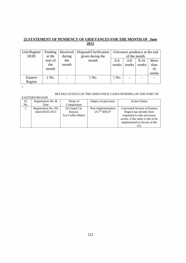
122
25.STATEMENT OF PENDENCY OF GRIEVANCES FOR THE MONTH OF June
2013
Unit/Region/ HOD
Pending at the
start of the
month
Received during
the month
Disposal/Clarification given during the
month
Grievance pendency at the end of the month
0-4 weeks
4-8 weeks
8-16 weeks
More than 16
weeksEastern Region
1 No. - 1 No. 1 No. - - -
- DETAILS STATUS OF THE GRIEVANCE CASES PENDING ON THE PART OF EASTERN REGION
Sl. No.
Registration No. & Date
Name of Complainant
Subject of grievance Action Status
1 Registration No. Nil dated 08.05.2013
Sri Gopal Ch. Baiyari,
Tea-Coffee Maker
Non-implementation of 2nd MACP
Concerned Section of Eastern Region has already been
requested to take necessary action, if the same is due to be implemented in favour of the
GS.
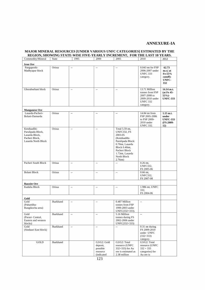
123
ANNEXURE-IA
MAJOR MINERAL RESOURCES [UNDER VARIOUS UNFC CATEGORIES] ESTIMATED BY THE
REGION, SHOWING STATE-WISE FIVE-YEARLY INCREMENT, FOR THE LAST 10 YEARS. Commodity/Mineral State 1995 2000 2005 2010 2012
Iron Ore Pangaposhi- Madhyapur block
Orissa -- -- -- 0.043 mt for FSP 2006-2007 under UNFC 333 category.
62.73 m.t.( at Fe:55% cutoff)-UNFC-332
Ghoraburhani block Orissa -- -- -- 13.71 Million tonnes from FSP 2007-2008 to 2009-2010 under UNFC 332 category.
14.14 m.t. (at Fe 45-55%)-UNFC-333
Manganese Ore Lasarda-Pacheri-Bolani-Damurda
Orissa -- -- -- 14.84 mt from FSP 2005-2006 to FSP 2009-2010 under UNFC 332.
1.15 m.t. under UNFC-333 (FS:2009-12)
Kenduadihi- Parulipada Block, Lasarda Block, Pacheri Block, Lasarda North Block
Orissa -- -- Total 5.59 mt, UNFC332, FS 2003-05 (Kenduadihi- Parulipada Block: 0.70mt, Lasarda Block 0.40mt, Pacheri Block 1.73mt, Lasarda North Block 2.76mt)
Pacheri South Block Orissa -- -- -- 0.26 mt, UNFC332, FS 2005-06
Bolani Block Orissa -- -- -- 0.66 mt, UNFC332, FS 2007-08
Bauxite Ore Kadalia Block Orissa -- -- -- 1.986 mt, UNFC
332, FS 2004-06
Gold Gold (Pahardiha-Rungikocha area)
Jharkhand -- -- 0.487 Million tonnes from FSP 1999-2003 under UNFC(332+333).
--
Gold (Parasi- Central, Eastern and western blocks)
Jharkhand -- -- 5.16 Million tonnes during FS 2002-2006 under UNFC(332+333)
--
Gold (Sindauri East block)
Jharkhand -- -- -- 0.31 mt during FS 2009-2010 under UNFC (332+333) category.
GOLD Jharkhand G3/G2: Gold deposit, possible resource (indicated
G3/G2: Total resource (UNFC 332+333) for Au ore is estimated as 2.38 million
G3/G2: Total resource (UNFC 332 + 333 categories) for Au ore is
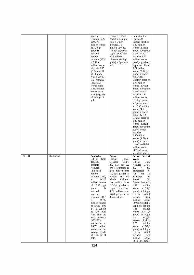
124
mineral resource 332) as 0.378 million tonnes of 3.28 g/t grade & inferred mineral resource (333) is 0.109 million tonnes of grade 3.95 g/t (at cut off of 1.0 ppm Au). Thus the total resource (332+333) works out to 0.487 million tonnes at an average grade of 3.43 g/t of gold
124ones (1.25g/t grade) at 0.5ppm cut off which includes, 1.0 million 124ones (2.52g/t grade) at 1ppm cut off and 0.26 million 124ones (6.48 g/t grade) at 3ppm cut off.
estimated for Parasi (A) Eastern block as 1.32 million tonnes (1.55g/t grade) at 0.5ppm cut off which includes 1.02 million tonnes (3.08g/t grade) at 1ppm cut off and 0.21 million tonnes (5.54 g/t grade) at 3ppm cut off;(B) Western block as 0.75 million tonnes (1.74g/t grade) at 0.5ppm cut off which includes 0.57 million tonnes (2.12 g/t grade) at 1ppm cut off and 0.49 million tonnes (4.63 g/t grade) at 3ppm cut off & (C) Central block as 0.80 million tonnes (1.11g/t grade) at 0.5ppm cut off which includes 0.40million tonnes (1.61g/t grade) at 1ppm cut off and 0.04 million tonnes (3.76 g/t grade) at 3ppm cut off.
GOLD Jharkhand Pahardia: G3/G2: Gold deposit, possible resource (indicated mineral resource 332) as 0.378 million tonnes of 3.28 g/t grade & inferred mineral resource (333) is 0.109 million tonnes of grade 3.95 g/t (at cut off of 1.0 ppm Au). Thus the total resource (332+333) works out to 0.487 million tonnes at an average grade of 3.43 g/t of gold
Parasi: G3/G2: Total resource (UNFC 332+333) for Au ore is estimated as 2.38 million ones (1.25g/t grade) at 0.5ppm cut off which includes, 1.0 million ones (2.52g/t grade) at 1ppm cut off and 0.26 million ones (6.48 g/t grade) at 3ppm cut off.
Parasi East & West: G3/G2: Total resource (UNFC 332 + 333 categories) for Au ore is estimated for Parasi (A) Eastern block as 1.32 million tonnes (1.55g/t grade) at 0.5ppm cut off which includes 1.02 million tonnes (3.08g/t grade) at 1ppm cut off and 0.21 million tonnes (5.54 g/t grade) at 3ppm cut off;(B) Western block as 0.75 million tonnes (1.74g/t grade) at 0.5ppm cut off which includes 0.57 million tonnes (2.12 g/t grade)
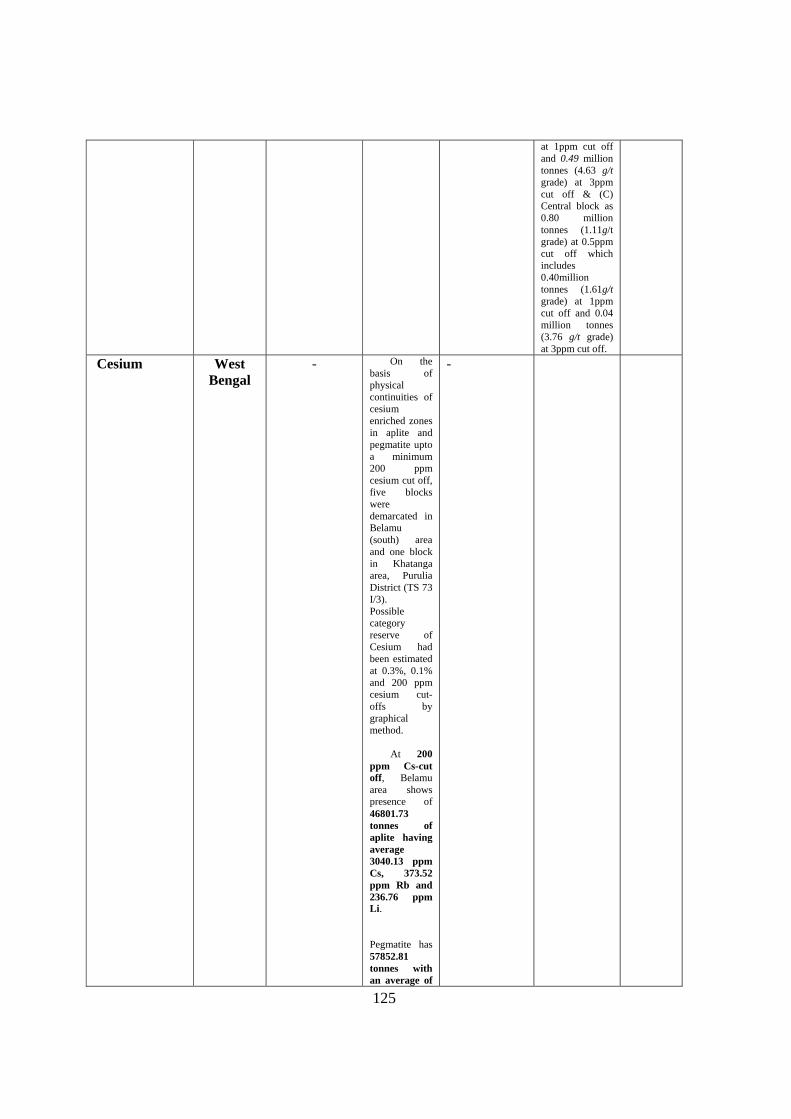
125
at 1ppm cut off and 0.49 million tonnes (4.63 g/t grade) at 3ppm cut off & (C) Central block as 0.80 million tonnes (1.11g/t grade) at 0.5ppm cut off which includes 0.40million tonnes (1.61g/t grade) at 1ppm cut off and 0.04 million tonnes (3.76 g/t grade) at 3ppm cut off.
Cesium West Bengal
- On the basis of physical continuities of cesium enriched zones in aplite and pegmatite upto a minimum 200 ppm cesium cut off, five blocks were demarcated in Belamu (south) area and one block in Khatanga area, Purulia District (TS 73 I/3). Possible category reserve of Cesium had been estimated at 0.3%, 0.1% and 200 ppm cesium cut-offs by graphical method. At 200 ppm Cs-cut off, Belamu area shows presence of 46801.73 tonnes of aplite having average 3040.13 ppm Cs, 373.52 ppm Rb and 236.76 ppm Li. Pegmatite has 57852.81 tonnes with an average of
-
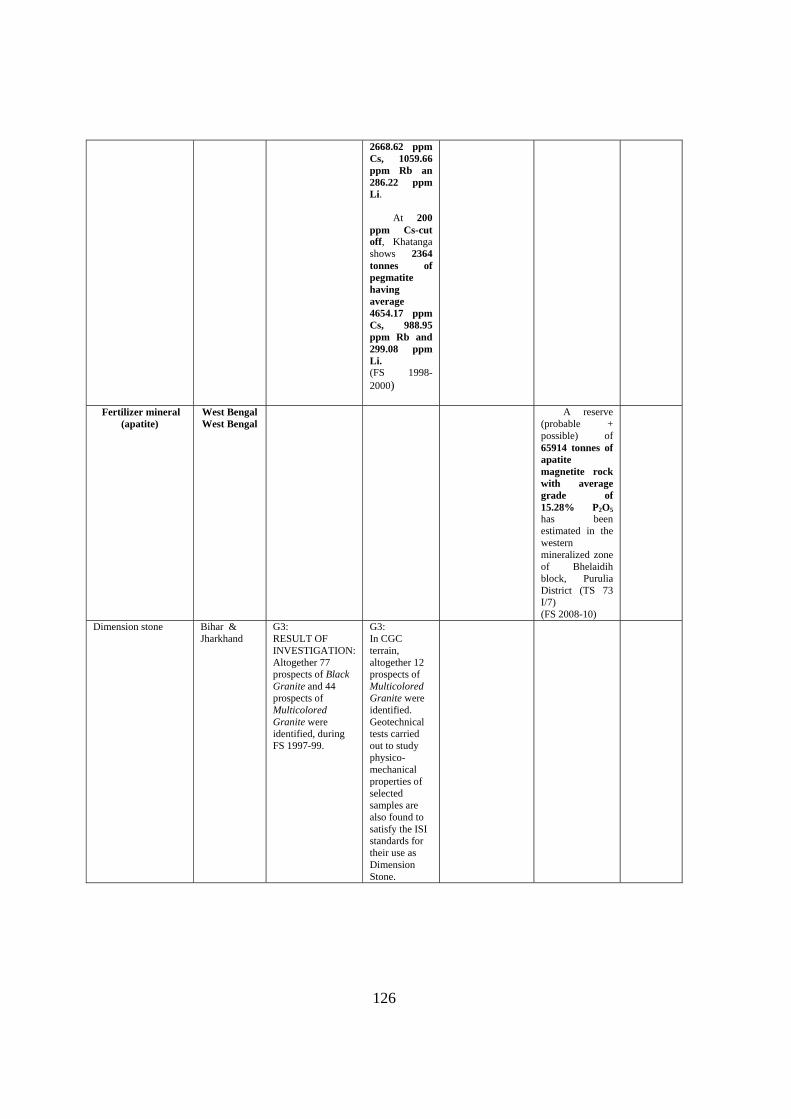
126
2668.62 ppm Cs, 1059.66 ppm Rb an 286.22 ppm Li. At 200 ppm Cs-cut off, Khatanga shows 2364 tonnes of pegmatite having average 4654.17 ppm Cs, 988.95 ppm Rb and 299.08 ppm Li. (FS 1998-2000)
Fertilizer mineral
(apatite) West Bengal West Bengal
A reserve (probable + possible) of 65914 tonnes of apatite magnetite rock with average grade of 15.28% P2O5 has been estimated in the western mineralized zone of Bhelaidih block, Purulia District (TS 73 I/7) (FS 2008-10)
Dimension stone Bihar & Jharkhand
G3: RESULT OF INVESTIGATION: Altogether 77 prospects of Black Granite and 44 prospects of Multicolored Granite were identified, during FS 1997-99.
G3: In CGC terrain, altogether 12 prospects of Multicolored Granite were identified. Geotechnical tests carried out to study physico-mechanical properties of selected samples are also found to satisfy the ISI standards for their use as Dimension Stone.
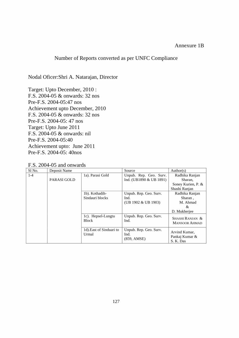
127
Annexure 1B
Number of Reports converted as per UNFC Compliance
Nodal Oficer:Shri A. Natarajan, Director Target: Upto December, 2010 : F.S. 2004-05 & onwards: 32 nos Pre-F.S. 2004-05:47 nos Achievement upto December, 2010 F.S. 2004-05 & onwards: 32 nos Pre-F.S. 2004-05: 47 nos Target: Upto June 2011 F.S. 2004-05 & onwards: nil Pre-F.S. 2004-05:40 Achievement upto: June 2011 Pre-F.S. 2004-05: 40nos F.S. 2004-05 and onwards Sl No. Deposit Name Source Author(s) 1-4
PARASI GOLD
1a). Parasi Gold Unpub. Rep. Geo. Surv. Ind. (UB1890 & UB 1891)
Radhika Ranjan Sharan,
Soney Kurien, P. & Shashi Ranjan
1b). Kothadih- Sindauri blocks
Unpub. Rep. Geo. Surv. Ind. (UB 1902 & UB 1903)
Radhika Ranjan Sharan ,
M. Ahmad &
D. Mukherjee 1c). Hepsel-Lungtu Block
Unpub. Rep. Geo. Surv. Ind.
SHASHI RANJAN & MANSOOR AHMAD
1d).East of Sinduari to Urmal
Unpub. Rep. Geo. Surv. Ind. (859, AMSE)
Arvind Kumar, Pankaj Kumar & S. K. Das
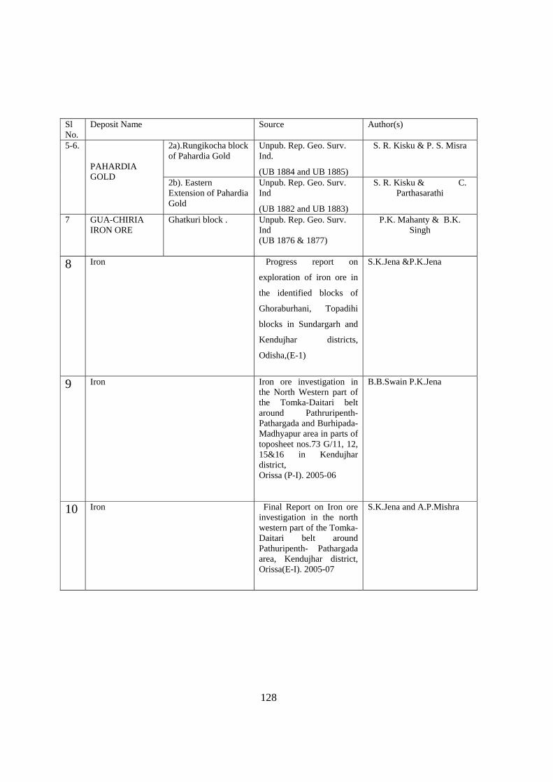
128
Sl No.
Deposit Name Source Author(s)
5-6. PAHARDIA GOLD
2a).Rungikocha block of Pahardia Gold
Unpub. Rep. Geo. Surv. Ind.
(UB 1884 and UB 1885)
S. R. Kisku & P. S. Misra
2b). Eastern Extension of Pahardia Gold
Unpub. Rep. Geo. Surv. Ind
(UB 1882 and UB 1883)
S. R. Kisku & C. Parthasarathi
7 GUA-CHIRIA IRON ORE
Ghatkuri block . Unpub. Rep. Geo. Surv. Ind (UB 1876 & 1877)
P.K. Mahanty & B.K. Singh
8 Iron Progress report on
exploration of iron ore in
the identified blocks of
Ghoraburhani, Topadihi
blocks in Sundargarh and
Kendujhar districts,
Odisha,(E-1)
S.K.Jena &P.K.Jena
9 Iron Iron ore investigation in the North Western part of the Tomka-Daitari belt around Pathruripenth-Pathargada and Burhipada-Madhyapur area in parts of toposheet nos.73 G/11, 12, 15&16 in Kendujhar district, Orissa (P-I). 2005-06
B.B.Swain P.K.Jena
10 Iron Final Report on Iron ore investigation in the north western part of the Tomka- Daitari belt around Pathuripenth- Pathargada area, Kendujhar district, Orissa(E-I). 2005-07
S.K.Jena and A.P.Mishra
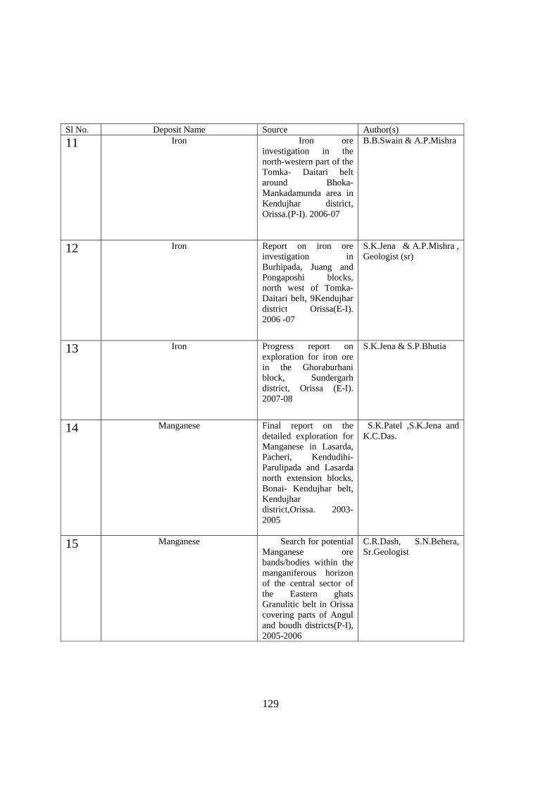
129
Sl No. Deposit Name Source Author(s)
11 Iron Iron ore investigation in the north-western part of the Tomka- Daitari belt around Bhoka- Mankadamunda area in Kendujhar district, Orissa.(P-I). 2006-07
B.B.Swain & A.P.Mishra
12 Iron Report on iron ore investigation in Burhipada, Juang and Pongaposhi blocks, north west of Tomka-Daitari belt, 9Kendujhar district Orissa(E-I). 2006 -07
S.K.Jena & A.P.Mishra , Geologist (sr)
13 Iron Progress report on exploration for iron ore in the Ghoraburhani block, Sundergarh district, Orissa (E-I). 2007-08
S.K.Jena & S.P.Bhutia
14 Manganese Final report on the detailed exploration for Manganese in Lasarda, Pacheri, Kendudihi-Parulipada and Lasarda north extension blocks, Bonai- Kendujhar belt, Kendujhar district,Orissa. 2003-2005
S.K.Patel ,S.K.Jena and K.C.Das.
15 Manganese Search for potential Manganese ore bands/bodies within the manganiferous horizon of the central sector of the Eastern ghats Granulitic belt in Orissa covering parts of Angul and boudh districts(P-I), 2005-2006
C.R.Dash, S.N.Behera, Sr.Geologist
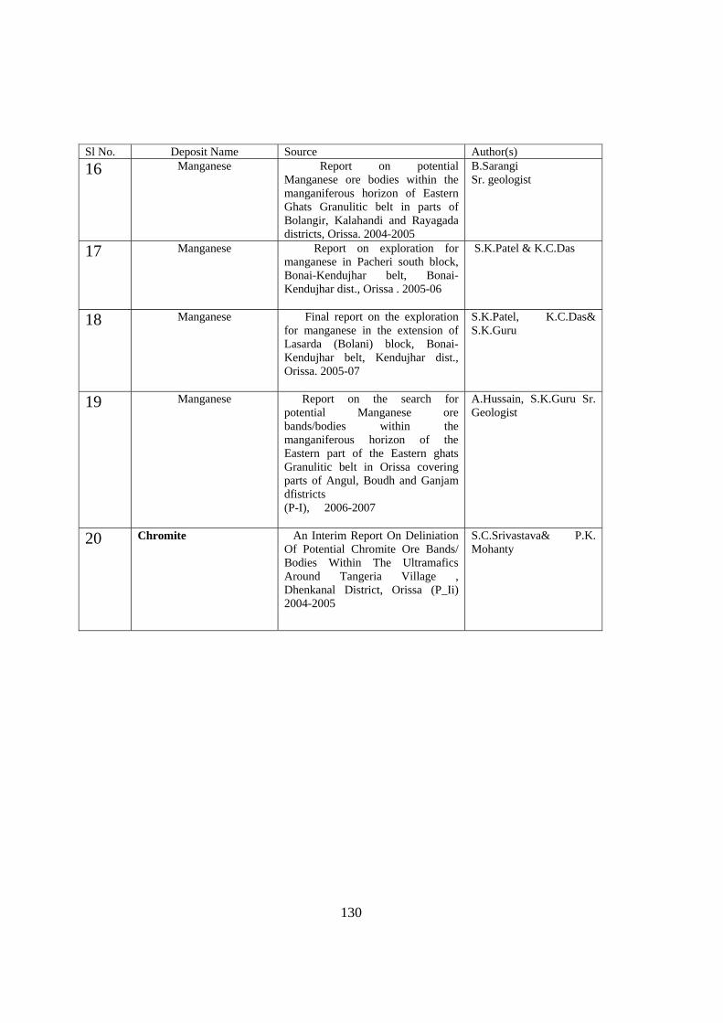
130
Sl No. Deposit Name Source Author(s)
16 Manganese Report on potential Manganese ore bodies within the manganiferous horizon of Eastern Ghats Granulitic belt in parts of Bolangir, Kalahandi and Rayagada districts, Orissa. 2004-2005
B.Sarangi Sr. geologist
17 Manganese Report on exploration for manganese in Pacheri south block, Bonai-Kendujhar belt, Bonai-Kendujhar dist., Orissa . 2005-06
S.K.Patel & K.C.Das
18 Manganese Final report on the exploration for manganese in the extension of Lasarda (Bolani) block, Bonai- Kendujhar belt, Kendujhar dist., Orissa. 2005-07
S.K.Patel, K.C.Das& S.K.Guru
19 Manganese Report on the search for potential Manganese ore bands/bodies within the manganiferous horizon of the Eastern part of the Eastern ghats Granulitic belt in Orissa covering parts of Angul, Boudh and Ganjam dfistricts (P-I), 2006-2007
A.Hussain, S.K.Guru Sr. Geologist
20 Chromite An Interim Report On Deliniation Of Potential Chromite Ore Bands/ Bodies Within The Ultramafics Around Tangeria Village , Dhenkanal District, Orissa (P_Ii) 2004-2005
S.C.Srivastava& P.K. Mohanty
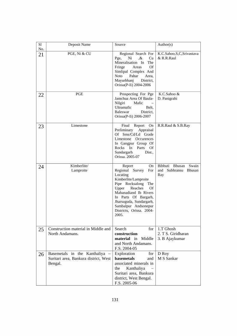
131
Sl No.
Deposit Name Source Author(s)
21 PGE, Ni & CU Regional Search For Pge, Ni ,& Cu Mineralisation In The Fringe Areas Of Simlipal Complex And Noto Pahar Area, Mayurbhanj District, Orissa(P-Ii) 2004-2006
K.C.Sahoo,S,C,Srivastava & R.R.Raul
22 PGE Prospecting For Pge Jamchua Area Of Baula- Nilgiri Mafic – Ultramafic Belt, Baleswar District, Orissa(P-Ii) 2006-2007
K.C.Sahoo & D. Panigrahi
23 Limestone Final Report On Preliminary Appraisal Of Sms/Cd/Ld Grade Limestone Occurences In Gangpur Group Of Rocks In Parts Of Sundargarh Dist., Orissa. 2005-07
R.R.Raul & S.B.Ray
24 Kimberlite/ Lamproite
Report On Regional Survey For Locating Kimberlite/Lamproite Pipe Rocksalong The Upper Reaches Of Mahanadiand Ib Rivers In Parts Of Bargarh, Jharsuguda, Sundargarh, Sambalpur Andsonepur Districts, Orissa. 2004-2005.
Bibhuti Bhusan Swain and Subhransu Bhusan Ray
25 Construction material in Middle and North Andamans.
Search for construction material in Middle and North Andamans. F.S. 2004-05
1.T Ghosh 2. T S. Giridharan 3. B Ajaykumar
26 Basemetals in the Kanthaliya – Suritari area, Bankura district, West Bengal.
Exploration for basemetals and associated minerals in the Kanthaliya – Suritari area, Bankura district, West Bengal. F.S. 2005-06
D Roy M S Sankar
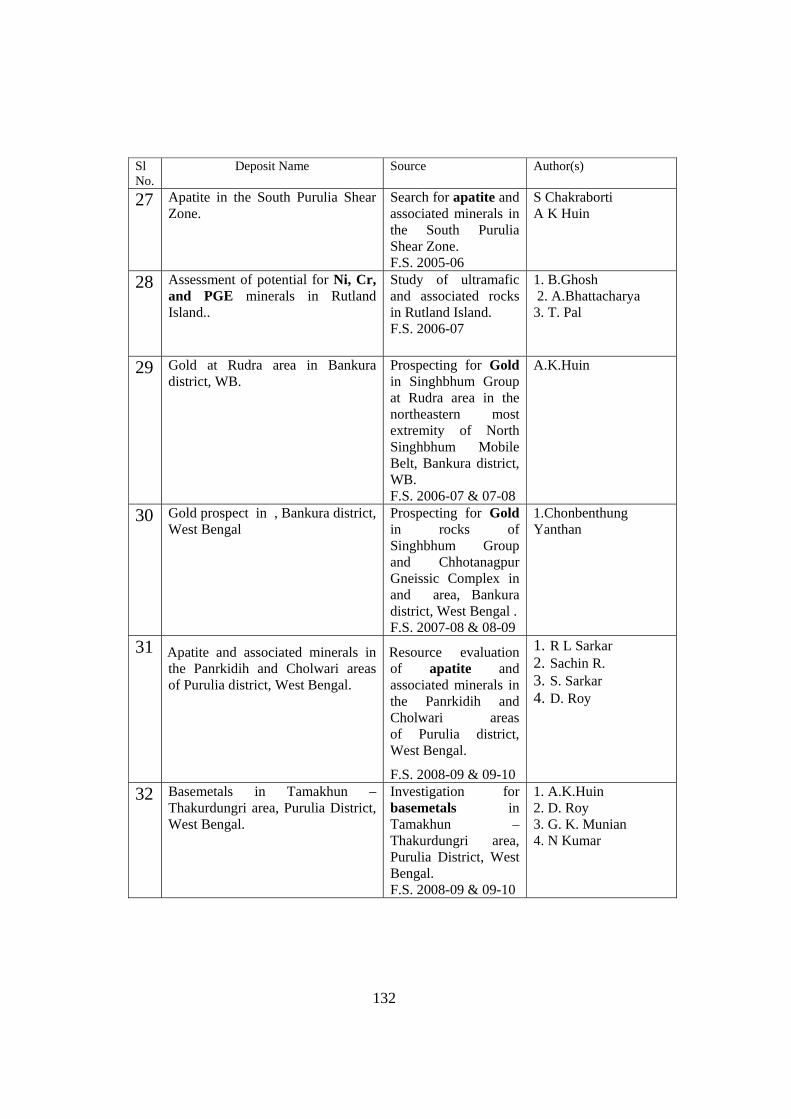
132
Sl No.
Deposit Name Source Author(s)
27 Apatite in the South Purulia Shear Zone.
Search for apatite and associated minerals in the South Purulia Shear Zone. F.S. 2005-06
S Chakraborti A K Huin
28 Assessment of potential for Ni, Cr, and PGE minerals in Rutland Island..
Study of ultramafic and associated rocks in Rutland Island. F.S. 2006-07
1. B.Ghosh 2. A.Bhattacharya 3. T. Pal
29 Gold at Rudra area in Bankura district, WB.
Prospecting for Gold in Singhbhum Group at Rudra area in the northeastern most extremity of North Singhbhum Mobile Belt, Bankura district, WB. F.S. 2006-07 & 07-08
A.K.Huin
30 Gold prospect in , Bankura district, West Bengal
Prospecting for Gold in rocks of Singhbhum Group and Chhotanagpur Gneissic Complex in and area, Bankura district, West Bengal . F.S. 2007-08 & 08-09
1.Chonbenthung Yanthan
31 Apatite and associated minerals in the Panrkidih and Cholwari areas of Purulia district, West Bengal.
Resource evaluation of apatite and associated minerals in the Panrkidih and Cholwari areas of Purulia district, West Bengal.
F.S. 2008-09 & 09-10
1. R L Sarkar 2. Sachin R. 3. S. Sarkar 4. D. Roy
32 Basemetals in Tamakhun – Thakurdungri area, Purulia District, West Bengal.
Investigation for basemetals in Tamakhun – Thakurdungri area, Purulia District, West Bengal. F.S. 2008-09 & 09-10
1. A.K.Huin 2. D. Roy 3. G. K. Munian 4. N Kumar
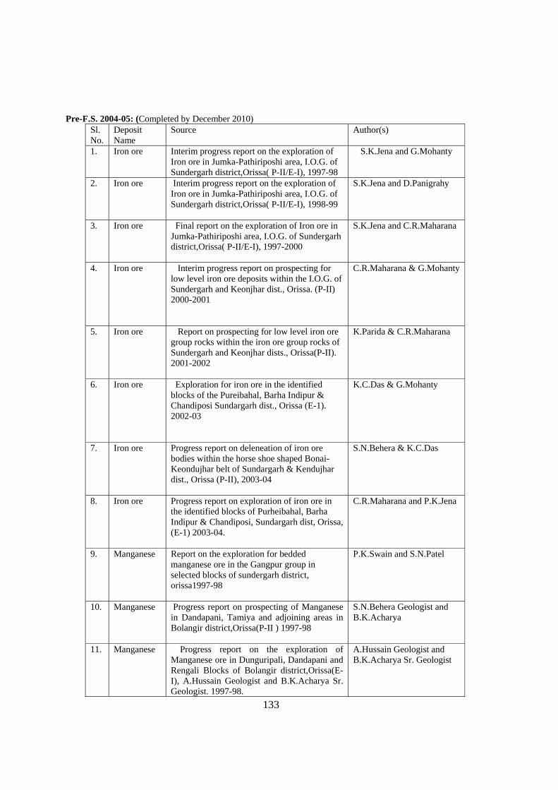
133
Pre-F.S. 2004-05: (Completed by December 2010)
Sl. No.
Deposit Name
Source Author(s)
1. Iron ore Interim progress report on the exploration of Iron ore in Jumka-Pathiriposhi area, I.O.G. of Sundergarh district,Orissa( P-II/E-I), 1997-98
S.K.Jena and G.Mohanty
2. Iron ore Interim progress report on the exploration of Iron ore in Jumka-Pathiriposhi area, I.O.G. of Sundergarh district,Orissa( P-II/E-I), 1998-99
S.K.Jena and D.Panigrahy
3. Iron ore Final report on the exploration of Iron ore in Jumka-Pathiriposhi area, I.O.G. of Sundergarh district,Orissa( P-II/E-I), 1997-2000
S.K.Jena and C.R.Maharana
4. Iron ore Interim progress report on prospecting for low level iron ore deposits within the I.O.G. of Sundergarh and Keonjhar dist., Orissa. (P-II) 2000-2001
C.R.Maharana & G.Mohanty
5. Iron ore Report on prospecting for low level iron ore group rocks within the iron ore group rocks of Sundergarh and Keonjhar dists., Orissa(P-II). 2001-2002
K.Parida & C.R.Maharana
6. Iron ore Exploration for iron ore in the identified blocks of the Pureibahal, Barha Indipur & Chandiposi Sundargarh dist., Orissa (E-1). 2002-03
K.C.Das & G.Mohanty
7. Iron ore Progress report on deleneation of iron ore bodies within the horse shoe shaped Bonai-Keondujhar belt of Sundargarh & Kendujhar dist., Orissa (P-II), 2003-04
S.N.Behera & K.C.Das
8. Iron ore Progress report on exploration of iron ore in the identified blocks of Purheibahal, Barha Indipur & Chandiposi, Sundargarh dist, Orissa, (E-1) 2003-04.
C.R.Maharana and P.K.Jena
9. Manganese Report on the exploration for bedded manganese ore in the Gangpur group in selected blocks of sundergarh district, orissa1997-98
P.K.Swain and S.N.Patel
10. Manganese Progress report on prospecting of Manganese in Dandapani, Tamiya and adjoining areas in Bolangir district,Orissa(P-II ) 1997-98
S.N.Behera Geologist and B.K.Acharya
11. Manganese Progress report on the exploration of Manganese ore in Dunguripali, Dandapani and Rengali Blocks of Bolangir district,Orissa(E-I), A.Hussain Geologist and B.K.Acharya Sr. Geologist. 1997-98.
A.Hussain Geologist and B.K.Acharya Sr. Geologist
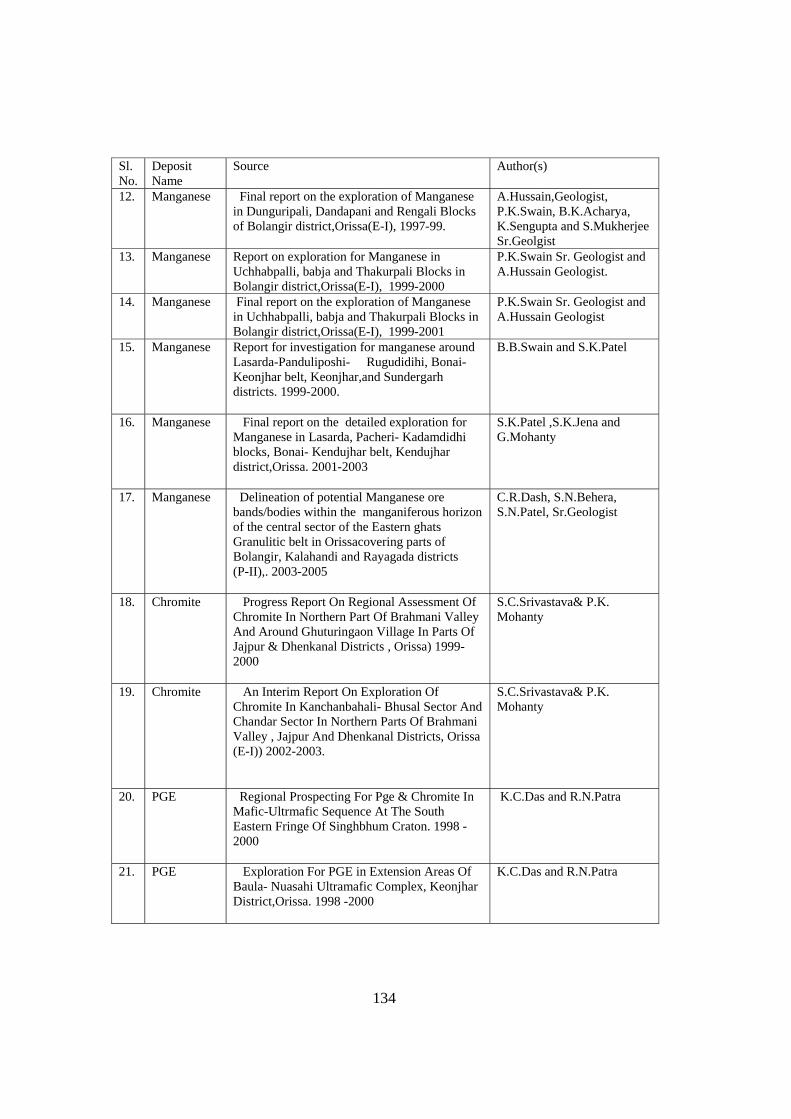
134
Sl. No.
Deposit Name
Source Author(s)
12. Manganese Final report on the exploration of Manganese in Dunguripali, Dandapani and Rengali Blocks of Bolangir district,Orissa(E-I), 1997-99.
A.Hussain,Geologist, P.K.Swain, B.K.Acharya, K.Sengupta and S.Mukherjee Sr.Geolgist
13. Manganese Report on exploration for Manganese in Uchhabpalli, babja and Thakurpali Blocks in Bolangir district,Orissa(E-I), 1999-2000
P.K.Swain Sr. Geologist and A.Hussain Geologist.
14. Manganese Final report on the exploration of Manganese in Uchhabpalli, babja and Thakurpali Blocks in Bolangir district,Orissa(E-I), 1999-2001
P.K.Swain Sr. Geologist and A.Hussain Geologist
15. Manganese Report for investigation for manganese around Lasarda-Panduliposhi- Rugudidihi, Bonai-Keonjhar belt, Keonjhar,and Sundergarh districts. 1999-2000.
B.B.Swain and S.K.Patel
16. Manganese Final report on the detailed exploration for Manganese in Lasarda, Pacheri- Kadamdidhi blocks, Bonai- Kendujhar belt, Kendujhar district,Orissa. 2001-2003
S.K.Patel ,S.K.Jena and G.Mohanty
17. Manganese Delineation of potential Manganese ore bands/bodies within the manganiferous horizon of the central sector of the Eastern ghats Granulitic belt in Orissacovering parts of Bolangir, Kalahandi and Rayagada districts (P-II),. 2003-2005
C.R.Dash, S.N.Behera, S.N.Patel, Sr.Geologist
18. Chromite Progress Report On Regional Assessment Of Chromite In Northern Part Of Brahmani Valley And Around Ghuturingaon Village In Parts Of Jajpur & Dhenkanal Districts , Orissa) 1999-2000
S.C.Srivastava& P.K. Mohanty
19. Chromite An Interim Report On Exploration Of Chromite In Kanchanbahali- Bhusal Sector And Chandar Sector In Northern Parts Of Brahmani Valley , Jajpur And Dhenkanal Districts, Orissa (E-I)) 2002-2003.
S.C.Srivastava& P.K. Mohanty
20. PGE Regional Prospecting For Pge & Chromite In Mafic-Ultrmafic Sequence At The South Eastern Fringe Of Singhbhum Craton. 1998 -2000
K.C.Das and R.N.Patra
21. PGE Exploration For PGE in Extension Areas Of Baula- Nuasahi Ultramafic Complex, Keonjhar District,Orissa. 1998 -2000
K.C.Das and R.N.Patra
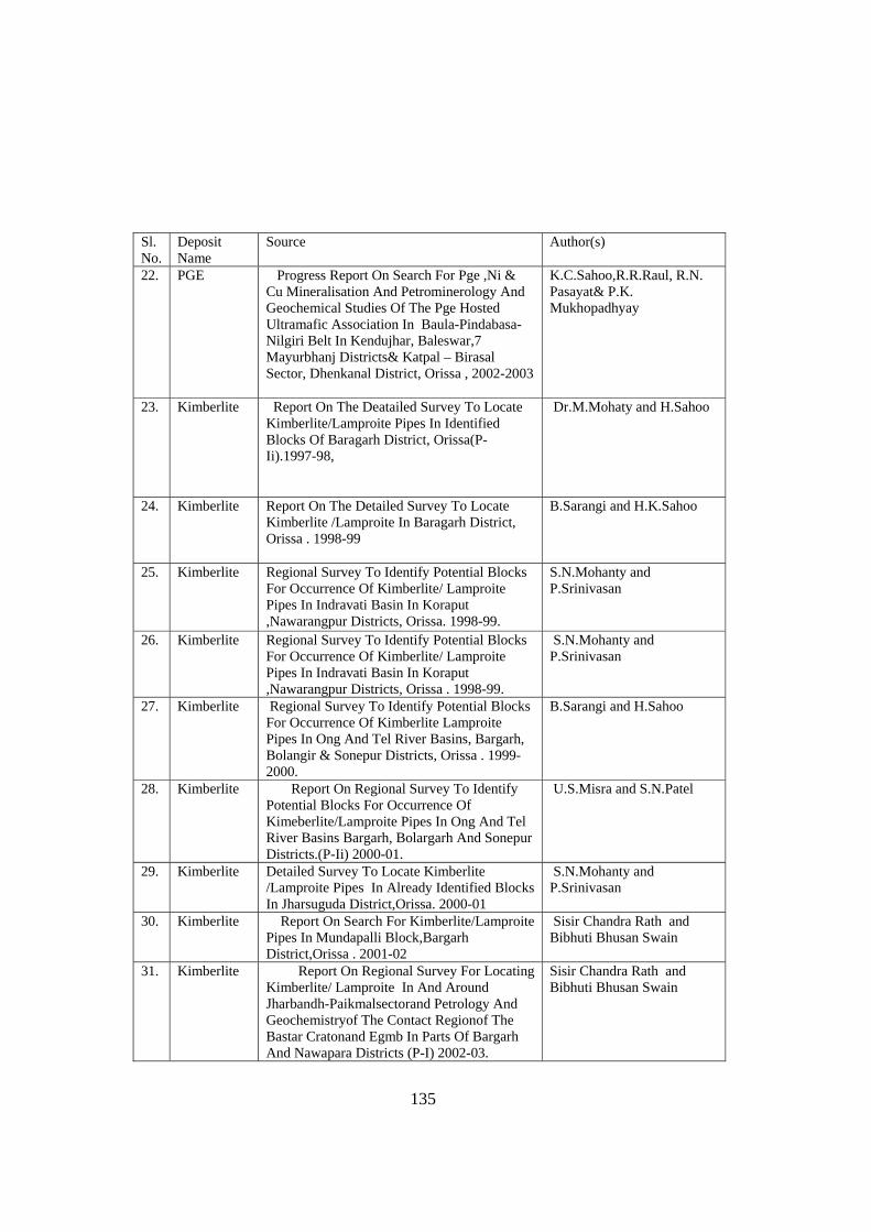
135
Sl. No.
Deposit Name
Source Author(s)
22. PGE Progress Report On Search For Pge ,Ni & Cu Mineralisation And Petrominerology And Geochemical Studies Of The Pge Hosted Ultramafic Association In Baula-Pindabasa- Nilgiri Belt In Kendujhar, Baleswar,7 Mayurbhanj Districts& Katpal – Birasal Sector, Dhenkanal District, Orissa , 2002-2003
K.C.Sahoo,R.R.Raul, R.N. Pasayat& P.K. Mukhopadhyay
23. Kimberlite Report On The Deatailed Survey To Locate Kimberlite/Lamproite Pipes In Identified Blocks Of Baragarh District, Orissa(P-Ii).1997-98,
Dr.M.Mohaty and H.Sahoo
24. Kimberlite Report On The Detailed Survey To Locate Kimberlite /Lamproite In Baragarh District, Orissa . 1998-99
B.Sarangi and H.K.Sahoo
25. Kimberlite Regional Survey To Identify Potential Blocks For Occurrence Of Kimberlite/ Lamproite Pipes In Indravati Basin In Koraput ,Nawarangpur Districts, Orissa. 1998-99.
S.N.Mohanty and P.Srinivasan
26. Kimberlite Regional Survey To Identify Potential Blocks For Occurrence Of Kimberlite/ Lamproite Pipes In Indravati Basin In Koraput ,Nawarangpur Districts, Orissa . 1998-99.
S.N.Mohanty and P.Srinivasan
27. Kimberlite Regional Survey To Identify Potential Blocks For Occurrence Of Kimberlite Lamproite Pipes In Ong And Tel River Basins, Bargarh, Bolangir & Sonepur Districts, Orissa . 1999-2000.
B.Sarangi and H.Sahoo
28. Kimberlite Report On Regional Survey To Identify Potential Blocks For Occurrence Of Kimeberlite/Lamproite Pipes In Ong And Tel River Basins Bargarh, Bolargarh And Sonepur Districts.(P-Ii) 2000-01.
U.S.Misra and S.N.Patel
29. Kimberlite Detailed Survey To Locate Kimberlite /Lamproite Pipes In Already Identified Blocks In Jharsuguda District,Orissa. 2000-01
S.N.Mohanty and P.Srinivasan
30. Kimberlite Report On Search For Kimberlite/Lamproite Pipes In Mundapalli Block,Bargarh District,Orissa . 2001-02
Sisir Chandra Rath and Bibhuti Bhusan Swain
31. Kimberlite Report On Regional Survey For Locating Kimberlite/ Lamproite In And Around Jharbandh-Paikmalsectorand Petrology And Geochemistryof The Contact Regionof The Bastar Cratonand Egmb In Parts Of Bargarh And Nawapara Districts (P-I) 2002-03.
Sisir Chandra Rath and Bibhuti Bhusan Swain
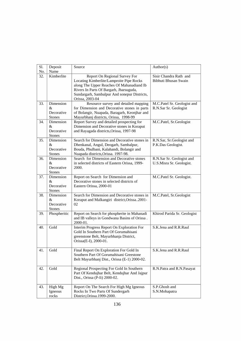
136
Sl. No.
Deposit Name
Source Author(s)
32. Kimberlite Report On Regional Survey For Locating Kimberlite/Lamproite Pipe Rocks along The Upper Reaches Of Mahanadiand Ib Rivers In Parts Of Bargarh, Jharsuguda, Sundargarh, Sambalpur And sonepur Districts, Orissa, 2003-04
Sisir Chandra Rath and Bibhuti Bhusan Swain
33. Dimension & Decorative Stones
Resource survey and detailed mapping for Dimension and Decorative stones in parts of Bolangir, Nuapada, Baragarh, Keonjhar and Mayurbhanj districts, Orissa, 1998-99
M.C.Patel Sr. Geologist and R.N.Sar Sr. Geologist
34. Dimension & Decorative Stones
Report Survey and detailed prospecting for Dimension and Decorative stones in Koraput and Rayagada districts,Orissa, 1997-98
M.C.Patel, Sr.Geologist
35. Dimension & Decorative Stones
Search for Dimension and Decorative stones in Dhenkanal, Angul, Deogarh, Sambalpur, Bouda, Phulbani, Kalahandi, Bolangir and Nuapada districts,Orissa. 1997-98.
R.N.Sar, Sr.Geologist and P.K.Das Geologist.
36. Dimension & Decorative Stones
Search for Dimension and Decorative stones in selected districts of Eastern Orissa, 1999-2000.
R.N.Sar Sr. Geologist and U.S.Misra Sr. Geologist.
37. Dimension & Decorative Stones
Report on Search for Dimension and Decorative stones in selected districts of Eastern Orissa, 2000-01
M.C.Patel Sr. Geologist.
38. Dimension & Decorative Stones
Search for Dimension and Decorative stones in Koraput and Malkangiri district,Orissa..2001-02
M.C.Patel, Sr.Geologist
39. Phospheritic Report on Search for phospherite in Mahanadi and IB valleys in Gondwana Basins of Orissa . 2000-01.
Khirod Parida Sr. Geologist
40. Gold Interim Progress Report On Exploration For Gold In Southern Part Of Gorumahisani greenstone Belt, Mayurbhanja District, Orissa(E-I), 2000-01.
S.K.Jena and R.R.Raul
41. Gold Final Report On Exploration For Gold In Southern Part Of Gorumahisani Greestone Belt Mayurbhanj Dist., Orissa (E-1) 2000-02.
S.K.Jena and R.R.Raul
42. Gold Regional Prospecting For Gold In Southern Part Of Kendujhar Belt, Kendujhar And Jajpur Dist., Orissa (P-Ii) 2000-02.
R.N.Patra and R.N.Pasayat
43. High Mg Igneous rocks
Report On The Search For High Mg Igneous Rocks In Two Parts Of Sundergarh District,Orissa.1999-2000.
S.P.Ghosh and S.N.Mohapatra
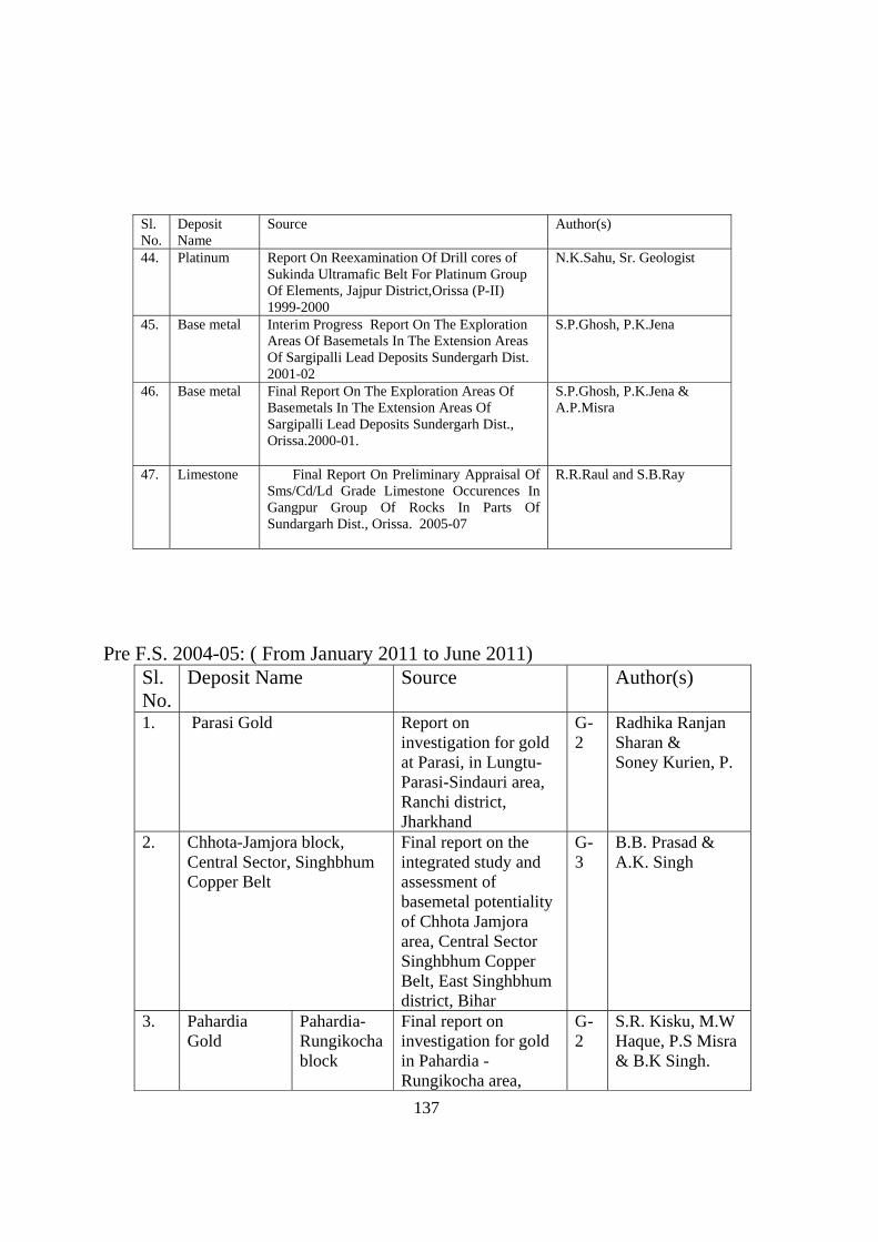
137
Sl. No.
Deposit Name
Source Author(s)
44. Platinum Report On Reexamination Of Drill cores of Sukinda Ultramafic Belt For Platinum Group Of Elements, Jajpur District,Orissa (P-II) 1999-2000
N.K.Sahu, Sr. Geologist
45. Base metal Interim Progress Report On The Exploration Areas Of Basemetals In The Extension Areas Of Sargipalli Lead Deposits Sundergarh Dist. 2001-02
S.P.Ghosh, P.K.Jena
46. Base metal Final Report On The Exploration Areas Of Basemetals In The Extension Areas Of Sargipalli Lead Deposits Sundergarh Dist., Orissa.2000-01.
S.P.Ghosh, P.K.Jena & A.P.Misra
47. Limestone Final Report On Preliminary Appraisal Of Sms/Cd/Ld Grade Limestone Occurences In Gangpur Group Of Rocks In Parts Of Sundargarh Dist., Orissa. 2005-07
R.R.Raul and S.B.Ray
Pre F.S. 2004-05: ( From January 2011 to June 2011)
Sl. No.
Deposit Name Source Author(s)
1. Parasi Gold Report on investigation for gold at Parasi, in Lungtu- Parasi-Sindauri area, Ranchi district, Jharkhand
G-2
Radhika Ranjan Sharan & Soney Kurien, P.
2. Chhota-Jamjora block, Central Sector, Singhbhum Copper Belt
Final report on the integrated study and assessment of basemetal potentiality of Chhota Jamjora area, Central Sector Singhbhum Copper Belt, East Singhbhum district, Bihar
G-3
B.B. Prasad & A.K. Singh
3. Pahardia Gold
Pahardia- Rungikocha block
Final report on investigation for gold in Pahardia - Rungikocha area,
G-2
S.R. Kisku, M.W Haque, P.S Misra & B.K Singh.
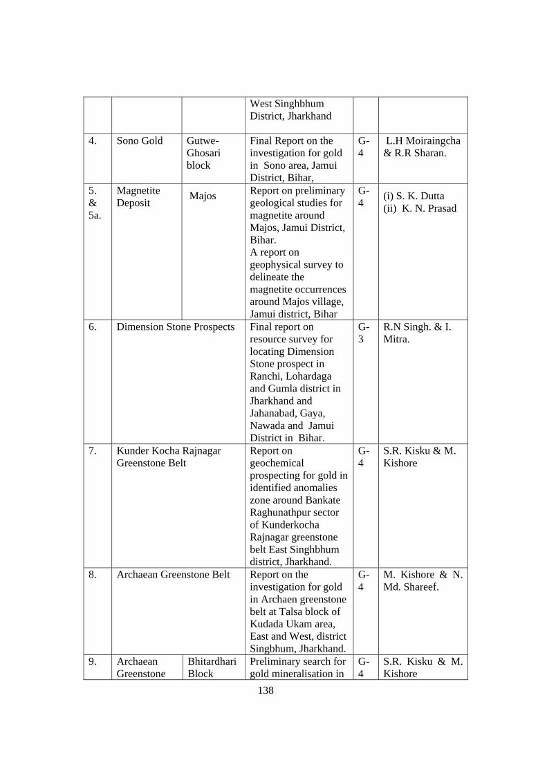
138
West Singhbhum District, Jharkhand
4. Sono Gold Gutwe-Ghosari block
Final Report on the investigation for gold in Sono area, Jamui District, Bihar,
G-4
L.H Moiraingcha & R.R Sharan.
5. & 5a.
Magnetite Deposit
Majos
Report on preliminary geological studies for magnetite around Majos, Jamui District, Bihar. A report on geophysical survey to delineate the magnetite occurrences around Majos village, Jamui district, Bihar
G-4
(i) S. K. Dutta (ii) K. N. Prasad
6. Dimension Stone Prospects Final report on resource survey for locating Dimension Stone prospect in Ranchi, Lohardaga and Gumla district in Jharkhand and Jahanabad, Gaya, Nawada and Jamui District in Bihar.
G-3
R.N Singh. & I. Mitra.
7. Kunder Kocha Rajnagar Greenstone Belt
Report on geochemical prospecting for gold in identified anomalies zone around Bankate Raghunathpur sector of Kunderkocha Rajnagar greenstone belt East Singhbhum district, Jharkhand.
G-4
S.R. Kisku & M. Kishore
8. Archaean Greenstone Belt Report on the investigation for gold in Archaen greenstone belt at Talsa block of Kudada Ukam area, East and West, district Singbhum, Jharkhand.
G-4
M. Kishore & N. Md. Shareef.
9. Archaean Greenstone
Bhitardhari Block
Preliminary search for gold mineralisation in
G-4
S.R. Kisku & M. Kishore
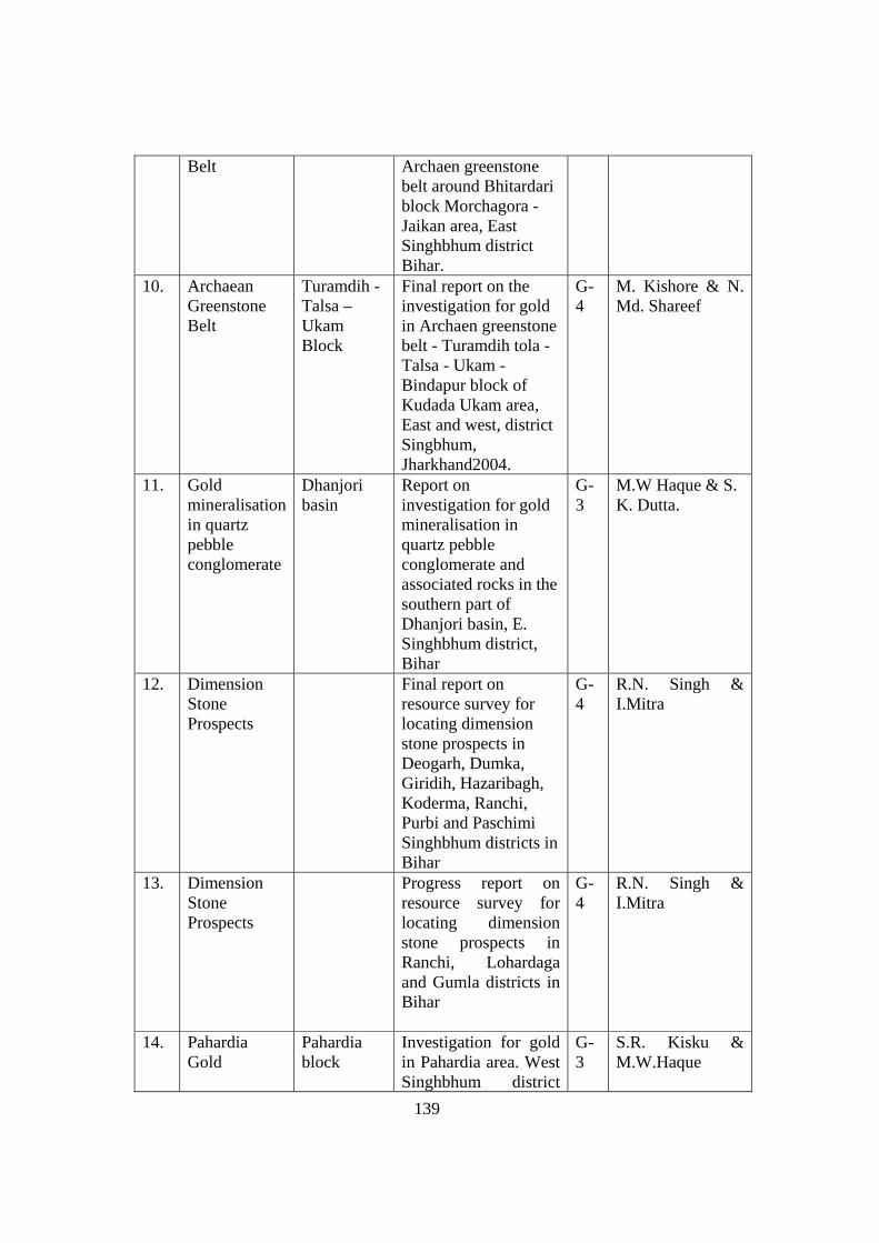
139
Belt Archaen greenstone belt around Bhitardari block Morchagora - Jaikan area, East Singhbhum district Bihar.
10. Archaean Greenstone Belt
Turamdih - Talsa – Ukam Block
Final report on the investigation for gold in Archaen greenstone belt - Turamdih tola - Talsa - Ukam - Bindapur block of Kudada Ukam area, East and west, district Singbhum, Jharkhand2004.
G-4
M. Kishore & N. Md. Shareef
11. Gold mineralisation in quartz pebble conglomerate
Dhanjori basin
Report on investigation for gold mineralisation in quartz pebble conglomerate and associated rocks in the southern part of Dhanjori basin, E. Singhbhum district, Bihar
G-3
M.W Haque & S. K. Dutta.
12. Dimension Stone Prospects
Final report on resource survey for locating dimension stone prospects in Deogarh, Dumka, Giridih, Hazaribagh, Koderma, Ranchi, Purbi and Paschimi Singhbhum districts in Bihar
G-4
R.N. Singh & I.Mitra
13. Dimension Stone Prospects
Progress report on resource survey for locating dimension stone prospects in Ranchi, Lohardaga and Gumla districts in Bihar
G-4
R.N. Singh & I.Mitra
14. Pahardia Gold
Pahardia block
Investigation for gold in Pahardia area. West Singhbhum district
G-3
S.R. Kisku & M.W.Haque
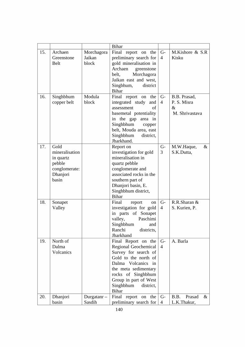
140
Bihar 15. Archaen
Greenstone Belt
Morchagora Jaikan block
Final report on the preliminary search for gold mineralisation in Archaen greenstone belt, Morchagora Jaikan east and west, Singbhum, district Bihar
G-4
M.Kishore & S.R Kisku
16. Singhbhum copper belt
Modula block
Final report on the integrated study and assessment of basemetal potentiality in the gap area in Singhbhum copper belt, Mouda area, east Singhbhum district, Jharkhand.
G-4
B.B. Prasad, P. S. Misra & M. Shrivastava
17. Gold mineralisation in quartz pebble conglomerate: Dhanjori basin
Report on investigation for gold mineralisation in quartz pebble conglomerate and associated rocks in the southern part of Dhanjori basin, E. Singhbhum district, Bihar
G-3
M.W.Haque, & S.K.Dutta,
18. Sonapet Valley
Final report on investigation for gold in parts of Sonapet valley, Paschimi Singhbhum and Ranchi districts, Jharkhand
G-4
R.R.Sharan & S. Kurien, P.
19. North of Dalma Volcanics
Final Report on the Regional Geochemical Survey for search of Gold to the north of Dalma Volcanics in the meta sedimentary rocks of Singhbhum Group in part of West Singhbhum district, Bihar
G-4
A. Barla
20. Dhanjori basin
Durgatanr – Sasdih
Final report on the preliminary search for
G-4
B.B. Prasad & L.K.Thakur,
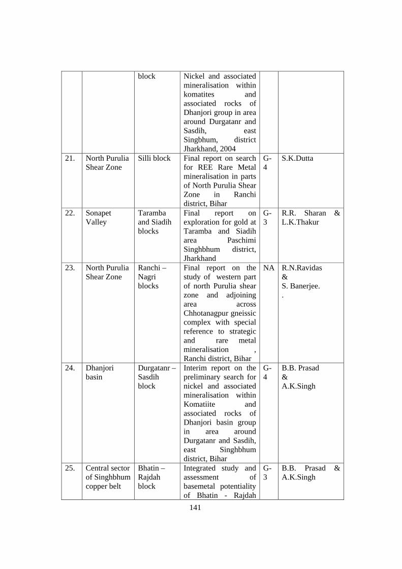
141
block Nickel and associated mineralisation within komatites and associated rocks of Dhanjori group in area around Durgatanr and Sasdih, east Singbhum, district Jharkhand, 2004
21. North Purulia Shear Zone
Silli block Final report on search for REE Rare Metal mineralisation in parts of North Purulia Shear Zone in Ranchi district, Bihar
G-4
S.K.Dutta
22. Sonapet Valley
Taramba and Siadih blocks
Final report on exploration for gold at Taramba and Siadih area Paschimi Singhbhum district, Jharkhand
G-3
R.R. Sharan & L.K.Thakur
23. North Purulia Shear Zone
Ranchi – Nagri blocks
Final report on the study of western part of north Purulia shear zone and adjoining area across Chhotanagpur gneissic complex with special reference to strategic and rare metal mineralisation , Ranchi district, Bihar
NA R.N.Ravidas & S. Banerjee. .
24. Dhanjori basin
Durgatanr – Sasdih block
Interim report on the preliminary search for nickel and associated mineralisation within Komatiite and associated rocks of Dhanjori basin group in area around Durgatanr and Sasdih, east Singhbhum district, Bihar
G-4
B.B. Prasad & A.K.Singh
25. Central sector of Singhbhum copper belt
Bhatin – Rajdah block
Integrated study and assessment of basemetal potentiality of Bhatin - Rajdah
G-3
B.B. Prasad & A.K.Singh
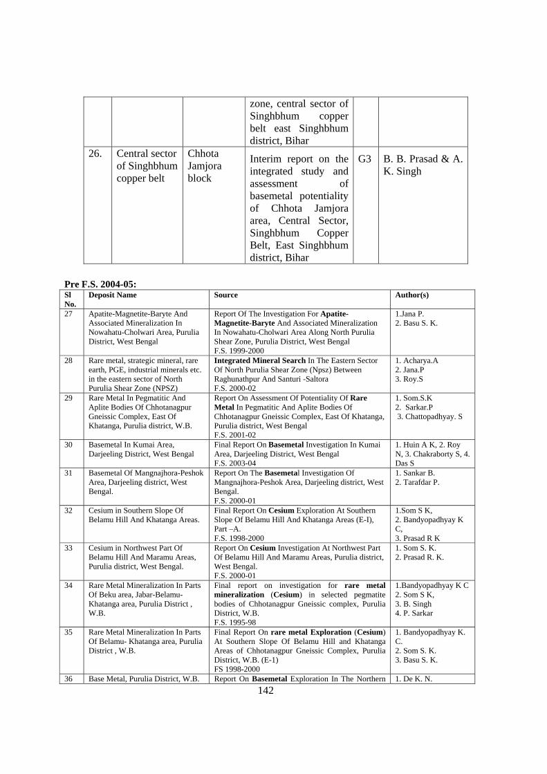
142
zone, central sector of Singhbhum copper belt east Singhbhum district, Bihar
26. Central sector of Singhbhum copper belt
Chhota Jamjora block
Interim report on the integrated study and assessment of basemetal potentiality of Chhota Jamjora area, Central Sector, Singhbhum Copper Belt, East Singhbhum district, Bihar
G3 B. B. Prasad & A. K. Singh
Pre F.S. 2004-05: Sl No.
Deposit Name Source Author(s)
27 Apatite-Magnetite-Baryte And Associated Mineralization In Nowahatu-Cholwari Area, Purulia District, West Bengal
Report Of The Investigation For Apatite-Magnetite-Baryte And Associated Mineralization In Nowahatu-Cholwari Area Along North Purulia Shear Zone, Purulia District, West Bengal F.S. 1999-2000
1.Jana P. 2. Basu S. K.
28 Rare metal, strategic mineral, rare earth, PGE, industrial minerals etc. in the eastern sector of North Purulia Shear Zone (NPSZ)
Integrated Mineral Search In The Eastern Sector Of North Purulia Shear Zone (Npsz) Between Raghunathpur And Santuri -Saltora F.S. 2000-02
1. Acharya.A 2. Jana.P 3. Roy.S
29 Rare Metal In Pegmatitic And Aplite Bodies Of Chhotanagpur Gneissic Complex, East Of Khatanga, Purulia district, W.B.
Report On Assessment Of Potentiality Of Rare Metal In Pegmatitic And Aplite Bodies Of Chhotanagpur Gneissic Complex, East Of Khatanga, Purulia district, West Bengal F.S. 2001-02
1. Som.S.K 2. Sarkar.P 3. Chattopadhyay. S
30 Basemetal In Kumai Area, Darjeeling District, West Bengal
Final Report On Basemetal Investigation In Kumai Area, Darjeeling District, West Bengal F.S. 2003-04
1. Huin A K, 2. Roy N, 3. Chakraborty S, 4. Das S
31 Basemetal Of Mangnajhora-Peshok Area, Darjeeling district, West Bengal.
Report On The Basemetal Investigation Of Mangnajhora-Peshok Area, Darjeeling district, West Bengal. F.S. 2000-01
1. Sankar B. 2. Tarafdar P.
32 Cesium in Southern Slope Of Belamu Hill And Khatanga Areas.
Final Report On Cesium Exploration At Southern Slope Of Belamu Hill And Khatanga Areas (E-I), Part –A. F.S. 1998-2000
1.Som S K, 2. Bandyopadhyay K C, 3. Prasad R K
33 Cesium in Northwest Part Of Belamu Hill And Maramu Areas, Purulia district, West Bengal.
Report On Cesium Investigation At Northwest Part Of Belamu Hill And Maramu Areas, Purulia district, West Bengal. F.S. 2000-01
1. Som S. K. 2. Prasad R. K.
34 Rare Metal Mineralization In Parts Of Beku area, Jabar-Belamu- Khatanga area, Purulia District , W.B.
Final report on investigation for rare metal mineralization (Cesium) in selected pegmatite bodies of Chhotanagpur Gneissic complex, Purulia District, W.B. F.S. 1995-98
1.Bandyopadhyay K C 2. Som S K, 3. B. Singh 4. P. Sarkar
35 Rare Metal Mineralization In Parts Of Belamu- Khatanga area, Purulia District , W.B.
Final Report On rare metal Exploration (Cesium) At Southern Slope Of Belamu Hill and Khatanga Areas of Chhotanagpur Gneissic Complex, Purulia District, W.B. (E-1) FS 1998-2000
1. Bandyopadhyay K. C. 2. Som S. K. 3. Basu S. K.
36 Base Metal, Purulia District, W.B. Report On Basemetal Exploration In The Northern 1. De K. N.
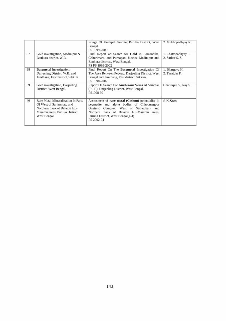
143
Fringe Of Kuilapal Granite, Purulia District, West Bengal. FS 1999-2000
2. Mukhopadhyay K.
37 Gold investigation, Medinipur & Bankura district, W.B.
Final Report on Search for Gold in Bamandiha, Chhurimara, and Purnapani blocks, Medinipur and Bankura districts, West Bengal. FS FS 1999-2002
1. Chattopadhyay S. 2. Sarkar S. S.
38 Basemetal Investigation, Darjeeling District, W.B. and Jamthang, East district, Sikkim
Final Report On The Basemetal Investigation Of The Area Between Pedong, Darjeeling District, West Bengal and Jamthang, East district, Sikkim. FS 1998-2002
1. Bhargava H. 2. Tarafdar P.
39 Gold investigation, Darjeeling District, West Bengal.
Report On Search For Auriferous Veins At Samthar (P - II), Darjeeling District, West Bengal. FS1998-99
Chatterjee S., Ray S.
40 Rare Metal Mineralization In Parts Of West of Sarjamhatu and Northern flank of Belamu hill-Maramu areas, Purulia District, West Bengal
Assessment of rare metal (Cesium) potentiality in pegmatite and alpite bodies of Chhotanagpur Gneissic Complex, West of Sarjamhatu and Northern flank of Belamu hill-Maramu areas, Purulia District, West Bengal(E-I) FS 2002-04
S.K.Som
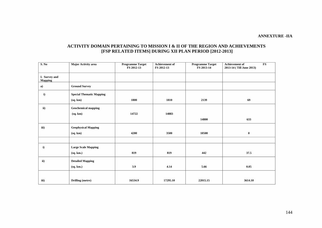
144
ANNEXTURE -IIA
ACTIVITY DOMAIN PERTAINING TO MISSION I & II OF THE REGION AND ACHIEVEMENTS [FSP RELATED ITEMS] DURING XII PLAN PERIOD [2012-2013]
S. No Major Activity area Programme Target
FS 2012-13 Achievement of FS 2012-13
Programme Target FS 2013-14
Achievement of FS 2013-14 ( Till June 2013)
I. Survey and Mapping
a) Ground Survey
i) Special Thematic Mapping
(sq. km)
1800
1810 2139 69
ii) Geochemical mapping
(sq. km)
14722
14883
14800 633
iii) Geophysical Mapping
(sq. km)
4200
3500 10500 0
i) Large Scale Mapping
(sq. km.)
819
819 442 37.5
ii) Detailed Mapping
(sq. km.)
3.9
4.14 5.66 0.05
iii)
Drilling (metre)
16534.9
17295.10 22015.15 3614.10
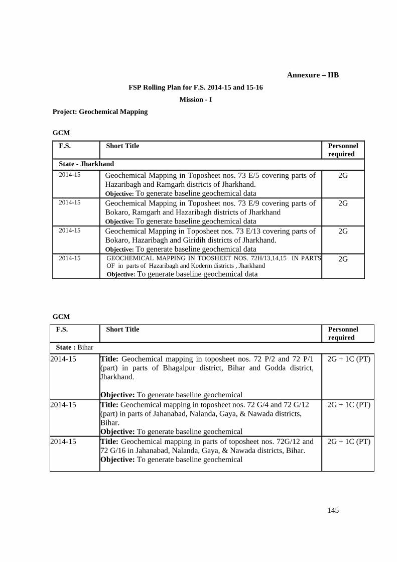
145
Annexure – IIB
FSP Rolling Plan for F.S. 2014-15 and 15-16
Mission - I
Project: Geochemical Mapping
GCM
F.S. Short Title Personnel required
State - Jharkhand 2014-15 Geochemical Mapping in Toposheet nos. 73 E/5 covering parts of
Hazaribagh and Ramgarh districts of Jharkhand. Objective: To generate baseline geochemical data
2G
2014-15 Geochemical Mapping in Toposheet nos. 73 E/9 covering parts of Bokaro, Ramgarh and Hazaribagh districts of Jharkhand Objective: To generate baseline geochemical data
2G
2014-15 Geochemical Mapping in Toposheet nos. 73 E/13 covering parts of Bokaro, Hazaribagh and Giridih districts of Jharkhand. Objective: To generate baseline geochemical data
2G
2014-15 GEOCHEMICAL MAPPING IN TOOSHEET NOS. 72H/13,14,15 IN PARTS OF in parts of Hazaribagh and Koderm districts , Jharkhand Objective: To generate baseline geochemical data
2G
GCM
F.S. Short Title Personnel required
State : Bihar
2014-15 Title: Geochemical mapping in toposheet nos. 72 P/2 and 72 P/1 (part) in parts of Bhagalpur district, Bihar and Godda district, Jharkhand. Objective: To generate baseline geochemical
2G + 1C (PT)
2014-15 Title: Geochemical mapping in toposheet nos. 72 G/4 and 72 G/12 (part) in parts of Jahanabad, Nalanda, Gaya, & Nawada districts, Bihar. Objective: To generate baseline geochemical
2G + 1C (PT)
2014-15 Title: Geochemical mapping in parts of toposheet nos. 72G/12 and 72 G/16 in Jahanabad, Nalanda, Gaya, & Nawada districts, Bihar. Objective: To generate baseline geochemical
2G + 1C (PT)
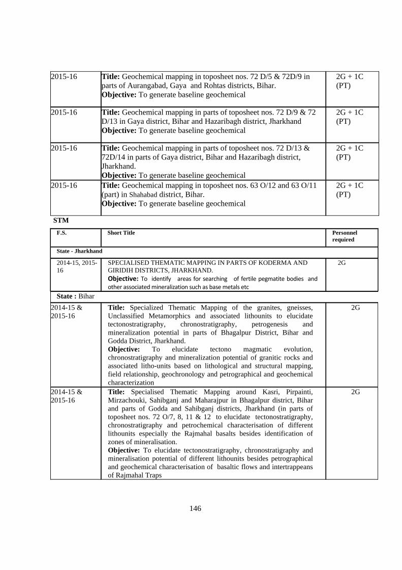
146
2015-16 Title: Geochemical mapping in toposheet nos. 72 D/5 & 72D/9 in parts of Aurangabad, Gaya and Rohtas districts, Bihar. Objective: To generate baseline geochemical
2G + 1C (PT)
2015-16 Title: Geochemical mapping in parts of toposheet nos. 72 D/9 & 72 D/13 in Gaya district, Bihar and Hazaribagh district, Jharkhand Objective: To generate baseline geochemical
2G + 1C (PT)
2015-16 Title: Geochemical mapping in parts of toposheet nos. 72 D/13 & 72D/14 in parts of Gaya district, Bihar and Hazaribagh district, Jharkhand. Objective: To generate baseline geochemical
2G + 1C (PT)
2015-16 Title: Geochemical mapping in toposheet nos. 63 O/12 and 63 O/11 (part) in Shahabad district, Bihar. Objective: To generate baseline geochemical
2G + 1C (PT)
STM
F.S. Short Title Personnel required
State - Jharkhand
2014-15, 2015-16
SPECIALISED THEMATIC MAPPING IN PARTS OF KODERMA AND GIRIDIH DISTRICTS, JHARKHAND. Objective: To identify areas for searching of fertile pegmatite bodies and other associated mineralization such as base metals etc
2G
State : Bihar
2014-15 & 2015-16
Title: Specialized Thematic Mapping of the granites, gneisses, Unclassified Metamorphics and associated lithounits to elucidate tectonostratigraphy, chronostratigraphy, petrogenesis and mineralization potential in parts of Bhagalpur District, Bihar and Godda District, Jharkhand. Objective: To elucidate tectono magmatic evolution, chronostratigraphy and mineralization potential of granitic rocks and associated litho-units based on lithological and structural mapping, field relationship, geochronology and petrographical and geochemical characterization
2G
2014-15 & 2015-16
Title: Specialised Thematic Mapping around Kasri, Pirpainti, Mirzachouki, Sahibganj and Maharajpur in Bhagalpur district, Bihar and parts of Godda and Sahibganj districts, Jharkhand (in parts of toposheet nos. 72 O/7, 8, 11 & 12 to elucidate tectonostratigraphy, chronostratigraphy and petrochemical characterisation of different lithounits especially the Rajmahal basalts besides identification of zones of mineralisation. Objective: To elucidate tectonostratigraphy, chronostratigraphy and mineralisation potential of different lithounits besides petrographical and geochemical characterisation of basaltic flows and intertrappeans of Rajmahal Traps
2G
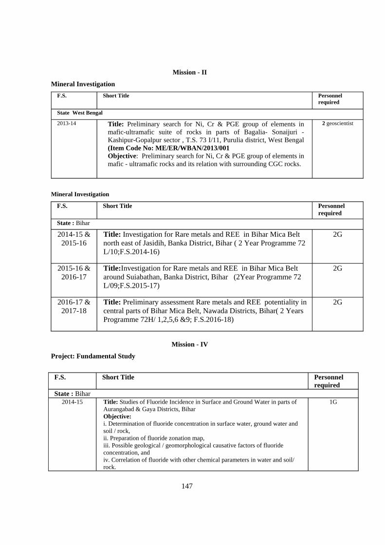
147
Mission - II
Mineral Investigation
F.S. Short Title Personnel required
State West Bengal
2013-14 Title: Preliminary search for Ni, Cr & PGE group of elements in mafic-ultramafic suite of rocks in parts of Bagalia- Sonaijuri -Kashipur-Gopalpur sector , T.S. 73 I/11, Purulia district, West Bengal (Item Code No: ME/ER/WBAN/2013/001 Objective: Preliminary search for Ni, Cr & PGE group of elements in mafic - ultramafic rocks and its relation with surrounding CGC rocks.
2 geoscientist
Mineral Investigation
F.S. Short Title Personnel required
State : Bihar
2014-15 & 2015-16
Title: Investigation for Rare metals and REE in Bihar Mica Belt north east of Jasidih, Banka District, Bihar ( 2 Year Programme 72 L/10;F.S.2014-16)
2G
2015-16 & 2016-17
Title:Investigation for Rare metals and REE in Bihar Mica Belt around Suiabathan, Banka District, Bihar (2Year Programme 72 L/09;F.S.2015-17)
2G
2016-17 & 2017-18
Title: Preliminary assessment Rare metals and REE potentiality in central parts of Bihar Mica Belt, Nawada Districts, Bihar( 2 Years Programme 72H/ 1,2,5,6 &9; F.S.2016-18)
2G
Mission - IV
Project: Fundamental Study
F.S. Short Title Personnel
requiredState : Bihar
2014-15 Title: Studies of Fluoride Incidence in Surface and Ground Water in parts of Aurangabad & Gaya Districts, Bihar Objective: i. Determination of fluoride concentration in surface water, ground water and soil / rock, ii. Preparation of fluoride zonation map, iii. Possible geological / geomorphological causative factors of fluoride concentration, and iv. Correlation of fluoride with other chemical parameters in water and soil/ rock.
1G
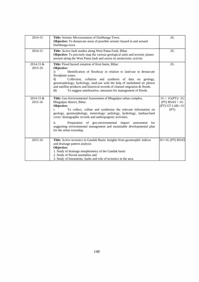
148
2014-15 Title: Seismic Microzonation of Darbhanga Town. Objective: To demarcate areas of possible seismic hazard in and around Darbhanga town
2G
2014-15 Title: Active fault studies along West Patna Fault, Bihar Objective: To precisely map the various geological units and tectonic planes present along the West Patna fault and assess its neotectonic activity
2G
2014-15 & 2015-16
Title: Flood hazard zonation of Kosi basin, Bihar. Objective: i) Identification of floodway in relation to land-use to demarcate floodplain zones. ii) Collection, collation and synthesis of data on geology, geomorphology, hydrology, land-use with the help of multidated air photos and satellite products and historical records of channel migration & floods. iii) To suggest ameliorative, measures for management of floods.
2G
2014-15 & 2015-16
Title: Geo-Environmental Assessment of Bhagalpur urban complex, Bhagalpur district, Bihar. Objective: i. To collect, collate and synthesize the relevant information on geology, geomorphology, meterology/ pedology, hydrology, landuse/land cover: demographic records and anthropogenic activities.
ii. Preparation of geo-environmental impact assessment for suggesting environmental management and sustainable developmental plan for the urban township.
1G + 1G(PT)+ 1G (PT) RSAS + 1G
(PT) GT LAB.+1C (PT)
2015-16 Title: Active tectonics in Gandak Basin: Insights from geomorphic indices and drainage pattern analysis Objective: 1. Study of drainage morphometry of the Gandak basin 2. Study of fluvial anomalies and 3. Study of lineaments, faults and role of tectonics in the area
2G+1G (PT) RSAS
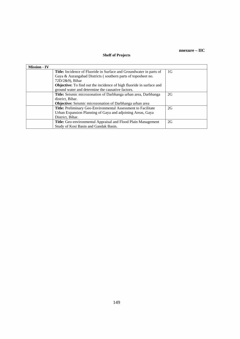
149
nnexure – IIC
Shelf of Projects
Mission - IV Title: Incidence of Fluoride in Surface and Groundwater in parts of
Gaya & Aurangabad Districts ( southern parts of toposheet no. 72D/2&9), Bihar Objective: To find out the incidence of high fluoride in surface and ground water and determine the causative factors.
1G
Title: Seismic microzonation of Darbhanga urban area, Darbhanga district, Bihar. Objective: Seismic microzonation of Darbhanga urban area
2G
Title: Preliminary Geo-Environmental Assessment to Facilitate Urban Expansion Planning of Gaya and adjoining Areas, Gaya District, Bihar.
2G
Title: Geo-environmental Appraisal and Flood Plain Management Study of Kosi Basin and Gandak Basin.
2G

150
Annexure-IIIA
FINANCIAL OUTLAY AND EXPENDITURE DURING XI PLAN PERIOD Year Survey &
Mapping Mineral Exploration
Specialised Investigation
Research & Development and Other Exploration
Information Dissemination
Human resource Development
Modernis ation & Replacement
Plan Outlay without construction Budget
Constr uction
Total Plan Outlay
Outlay/ Expenditure
Outlay/ Expenditure
Outlay/ Expenditure
Outlay/ Expenditure
Outlay/ Expenditure
Outlay/ Expenditure
Outlay/ Expenditure
Outlay/ Expenditure
Outlay/ Expenditure
Outlay/ Expenditure
2007-08
27.11 / 26.59
97.95 / 96.42
2.03 / 1.91 18.92 / 18.13
60.00 / 58.99
00 / 00 170.14 / 148.56 376.15 / 350.60 00 / 00 376.15 / 350.60
2008-09
28.50 / 25.97
100.80 / 96.76
2.40 / 1.60 22.40 / 20.64
36.30 / 35.77
00 / 00 87.49 / 110.13 277.89 / 290.87 00 / 00 277.89 / 290.87
2009-10
26.98 / 24.44
106.88 / 104.23
1.45 / 1.37 32.66 / 32.45
93.76 / 81.39
00 / 00 153.99 / 139.25 415.72 / 383.13 00 / 00 415.72 / 383.13
2010-11
3564.95 / 3563.447
542.50 / 539.011
4.21 / 3.825
79.453 / 77.673
83.29 / 82.352
14.50 / 14.496
4917.80 / 4916.825
9206.703 / 9197.629
8.13 / 8.111
9214.833 / 9205.740
2011-12
3003.50/3003.57
100.29/100.32
6.05/5.86 61.88/61.89
88.06/87.18 14.00/13.99
17115.84 / 17115.70
20389.62 / 20388.50
24.00/24.01
20413.62 / 20412.51
2012-13
995.48/994.35
202.00/201.63
11.00/10.15
85.16/84.02
96.42/94.16
23.16/22.95
12767.90/12767.16
14181.14/14174.41
26.86/26.41
14207.98/14200.82
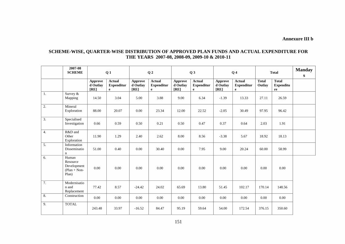
151
Annexure III b
SCHEME-WISE, QUARTER-WISE DISTRIBUTION OF APPROVED PLAN FUNDS AND ACTUAL EXPENDITURE FOR
THE YEARS 2007-08, 2008-09, 2009-10 & 2010-11 2007-08
SCHEME Q 1 Q 2 Q 3 Q 4 Total Manday
s Approve
d Outlay [RE]
Actual Expenditure
Approved Outlay [RE]
Actual Expenditure
Approved Outlay [RE]
Actual Expenditure
Approved Outlay [RE]
Actual Expenditure
Total Outlay
Total Expenditure
1.
Survey & Mapping 14.50 3.04 5.00 3.88 9.00 6.34 -1.39 13.33 27.11 26.59
2.
Mineral Exploration 88.00 20.07 0.00 23.34 12.00 22.52 -2.05 30.49 97.95 96.42
3.
Specialised Investigation 0.66 0.59 0.50 0.21 0.50 0.47 0.37 0.64 2.03 1.91
4.
R&D and Other Exploration
11.90 1.29 2.40 2.62 8.00 8.56 -3.38 5.67 18.92 18.13
5.
Information Dissemination
51.00 0.40 0.00 30.40 0.00 7.95 9.00 20.24 60.00 58.99
6.
Human Resource Development (Plan + Non-Plan)
0.00 0.00 0.00 0.00 0.00 0.00 0.00 0.00 0.00 0.00
7.
Modernisation and Replacement
77.42 8.57 -24.42 24.02 65.69 13.80 51.45 102.17 170.14 148.56
8.
Construction 0.00 0.00 0.00 0.00 0.00 0.00 0.00 0.00 0.00 0.00
9.
TOTAL 243.48 33.97 -16.52 84.47 95.19 59.64 54.00 172.54 376.15 350.60
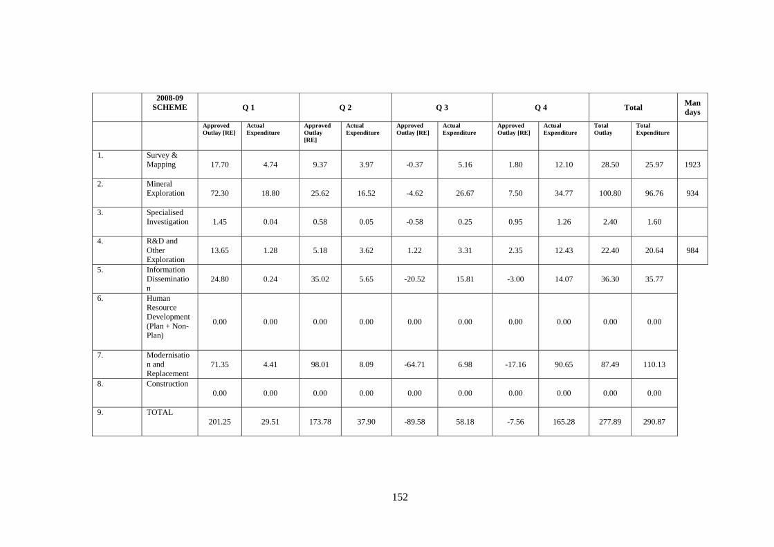
152
2008-09
SCHEME Q 1 Q 2 Q 3 Q 4 Total Mandays
Approved Outlay [RE]
Actual Expenditure
Approved Outlay [RE]
Actual Expenditure
Approved Outlay [RE]
Actual Expenditure
Approved Outlay [RE]
Actual Expenditure
Total Outlay
Total Expenditure
1.
Survey & Mapping 17.70 4.74 9.37 3.97 -0.37 5.16 1.80 12.10 28.50 25.97 1923
2.
Mineral Exploration 72.30 18.80 25.62 16.52 -4.62 26.67 7.50 34.77 100.80 96.76 934
3.
Specialised Investigation 1.45 0.04 0.58 0.05 -0.58 0.25 0.95 1.26 2.40 1.60
4.
R&D and Other Exploration
13.65 1.28 5.18 3.62 1.22 3.31 2.35 12.43 22.40 20.64 984
5.
Information Dissemination
24.80 0.24 35.02 5.65 -20.52 15.81 -3.00 14.07 36.30 35.77
6.
Human Resource Development (Plan + Non-Plan)
0.00 0.00 0.00 0.00 0.00 0.00 0.00 0.00 0.00 0.00
7.
Modernisation and Replacement
71.35 4.41 98.01 8.09 -64.71 6.98 -17.16 90.65 87.49 110.13
8.
Construction 0.00 0.00 0.00 0.00 0.00 0.00 0.00 0.00 0.00 0.00
9.
TOTAL 201.25 29.51 173.78 37.90 -89.58 58.18 -7.56 165.28 277.89 290.87
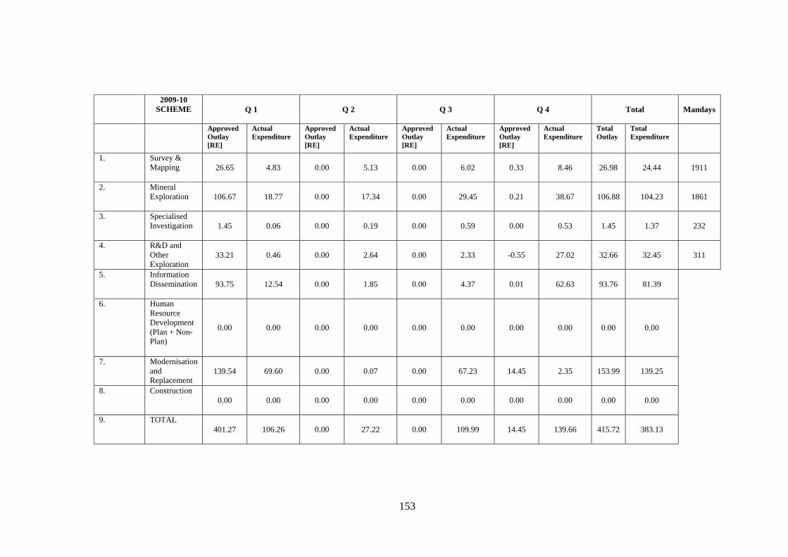
153
2009-10
SCHEME Q 1 Q 2 Q 3 Q 4 Total Mandays
Approved Outlay [RE]
Actual Expenditure
Approved Outlay [RE]
Actual Expenditure
Approved Outlay [RE]
Actual Expenditure
Approved Outlay [RE]
Actual Expenditure
Total Outlay
Total Expenditure
1.
Survey & Mapping 26.65 4.83 0.00 5.13 0.00 6.02 0.33 8.46 26.98 24.44 1911
2.
Mineral Exploration 106.67 18.77 0.00 17.34 0.00 29.45 0.21 38.67 106.88 104.23 1861
3.
Specialised Investigation 1.45 0.06 0.00 0.19 0.00 0.59 0.00 0.53 1.45 1.37 232
4.
R&D and Other Exploration
33.21 0.46 0.00 2.64 0.00 2.33 -0.55 27.02 32.66 32.45 311
5.
Information Dissemination 93.75 12.54 0.00 1.85 0.00 4.37 0.01 62.63 93.76 81.39
6.
Human Resource Development (Plan + Non-Plan)
0.00 0.00 0.00 0.00 0.00 0.00 0.00 0.00 0.00 0.00
7.
Modernisation and Replacement
139.54 69.60 0.00 0.07 0.00 67.23 14.45 2.35 153.99 139.25
8.
Construction 0.00 0.00 0.00 0.00 0.00 0.00 0.00 0.00 0.00 0.00
9.
TOTAL 401.27 106.26 0.00 27.22 0.00 109.99 14.45 139.66 415.72 383.13

154
2010-11
SCHEME Q 1 Q 2 Q 3 Q 4 Total Mandays
Approved Outlay [RE]
Actual Expenditure
Approved Outlay [RE]
Actual Expenditure
Approved Outlay [RE]
Actual Expenditure
Approved Outlay [RE]
Actual Expenditure
Total Outlay
Total Expenditure
1.
Survey & Mapping 2110.70 1991.76 1704.00 1530.87 -230.70 13.15 -19.05 27.66 3564.95 3563.447 1815
2.
Mineral Exploration 147.50 44.23 331.50 192.16 -45.00 136.16 108.50 166.46 542.50 539.011 2049
3.
Specialised Investigation 0.35 0.01 0.00 0.13 3.90 2.17 -0.04 1.52 4.21 3.825 181
4.
R&D and Other Exploration
41.68 0.10 1.00 19.27 38.78 20.13 -2.01 38.17 79.453 77.673 610
5.
Information Dissemination 36.50 0.95 42.50 38.99 4.00 29.15 0.29 13.26 83.29 82.352
6.
Human Resource Development (Plan + Non-Plan)
0.00 0.00 6.50 2.34 0.00 3.56 8.00 8.60 14.50 14.496
7.
Modernisation and Replacement
563.32 303.43 365.17 514.93 4032.89 90.57 -43.58 4007.89 4917.80 4916.824
8.
Construction 0.00 0.00 0.00 0.00 0.00 0.00 8.13 8.11 8.13 8.111
9.
TOTAL 2900.05 2340.48 2450.67 2298.69 3803.87 294.91 60.24 4271.67 9214.833 9205.739

155
2011-12 SCHEME Q 1 Q 2 Q 3 Q 4 Total Mandays
Approved Outlay [RE]
Actual Expenditure
Approved Outlay [RE]
Actual Expenditure
Approved Outlay [RE]
Actual Expenditure
Approved Outlay [RE]
Actual Expenditure
Total Outlay
Total Expenditure
1.
Survey & Mapping 3224.50 979.519 3215.50 1412.67 3211.50 12.39 3003.50 598.98 3003.50 3003.57
2.
Mineral Exploration 223.00 72.321 223.00 77.63 233.00 -108.83 100.29 59.20 100.29 100.31
3.
Specialised Investigation 6.05 1.142 6.05 2.50 6.05 1.17 6.05 1.05 6.05 5.86
4.
R&D and Other Exploration
61.25 13.655 61.25 24.07 61.25 10.34 61.88 13.83 61.88 61.89
5.
Information Dissemination 75.00 10.72 86.50 16.42 86.50 21.13 88.06 38.91 88.06 87.18
6.
Human Resource Development (Plan + Non-Plan)
20.00 4.046 20.00 1.27 20.00 0.22 14.00 8.45 14.00 13.99
7.
Modernisation and Replacement
746.30 22.34 7678.30 7502.05 7887.37 407.33 17115.84 9183.98 17115.84 17115.70
8.
Construction
0.00 0.00 0.00 0.00 18.01 18.01 24.00 6.00 24.00 24.01
9.
TOTAL
4356.10 1103.743 11290.60 9036.61 11523.68 361.75 20413.62 9910.40 20413.62 20412.51
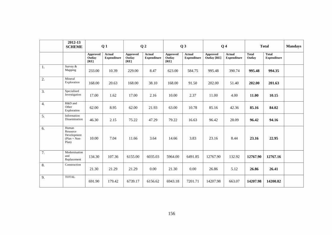
156
2012-13
SCHEME Q 1 Q 2 Q 3 Q 4 Total Mandays
Approved Outlay [RE]
Actual Expenditure
Approved Outlay [RE]
Actual Expenditure
Approved Outlay [RE]
Actual Expenditure
Approved Outlay [RE]
Actual Expenditure
Total Outlay
Total Expenditure
1.
Survey & Mapping 233.00 10.39 229.00 8.47 623.00 584.75 995.48 390.74 995.48 994.35
2.
Mineral Exploration 168.00 20.63 168.00 38.10 168.00 91.50 202.00 51.40 202.00 201.63
3.
Specialised Investigation 17.00 1.62 17.00 2.16 10.00 2.37 11.00 4.00 11.00 10.15
4.
R&D and Other Exploration
62.00 8.95 62.00 21.93 63.00 10.78 85.16 42.36 85.16 84.02
5.
Information Dissemination 46.30 2.15 75.22 47.29 79.22 16.63 96.42 28.09 96.42 94.16
6.
Human Resource Development (Plan + Non-Plan)
10.00 7.04 11.66 3.64 14.66 3.83 23.16 8.44 23.16 22.95
7.
Modernisation and Replacement
134.30 107.36 6155.00 6035.03 5964.00 6491.85 12767.90 132.92 12767.90 12767.16
8.
Construction
21.30 21.29 21.29 0.00 21.30 0.00 26.86 5.12 26.86 26.41
9.
TOTAL
691.90 179.42 6739.17 6156.62 6943.18 7201.71 14207.98 663.07 14207.98 14200.82
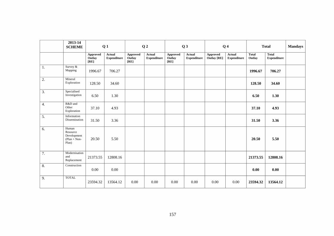
157
2013-14
SCHEME Q 1 Q 2 Q 3 Q 4 Total Mandays
Approved Outlay [RE]
Actual Expenditure
Approved Outlay [RE]
Actual Expenditure
Approved Outlay [RE]
Actual Expenditure
Approved Outlay [RE]
Actual Expenditure
Total Outlay
Total Expenditure
1.
Survey & Mapping 1996.67 706.27 1996.67 706.27
2.
Mineral Exploration 128.50 34.60 128.50 34.60
3.
Specialised Investigation 6.50 1.30 6.50 1.30
4.
R&D and Other Exploration
37.10 4.93 37.10 4.93
5.
Information Dissemination 31.50 3.36 31.50 3.36
6.
Human Resource Development (Plan + Non-Plan)
20.50 5.50 20.50 5.50
7.
Modernisation and Replacement
21373.55 12808.16 21373.55 12808.16
8.
Construction
0.00 0.00 0.00 0.00
9.
TOTAL
23594.32 13564.12 0.00 0.00 0.00 0.00 0.00 0.00 23594.32 13564.12
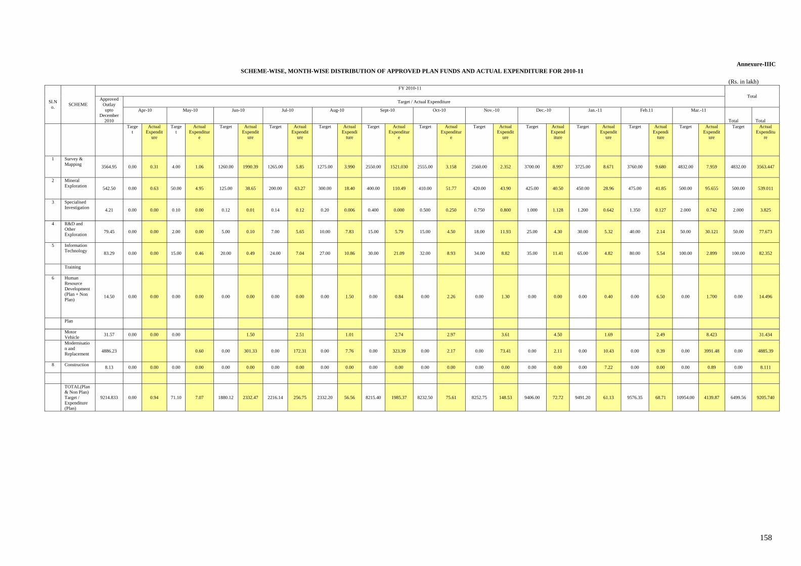
158
Annexure-IIIC SCHEME-WISE, MONTH-WISE DISTRIBUTION OF APPROVED PLAN FUNDS AND ACTUAL EXPENDITURE FOR 2010-11
(Rs. in lakh)
Sl.No.
SCHEME
FY 2010-11
Total Approved
Outlay upto
December 2010
Target / Actual Expenditure
Apr-10 May-10 Jun-10 Jul-10 Aug-10 Sept-10 Oct-10 Nov.-10 Dec.-10 Jan.-11 Feb.11 Mar.-11
Total Total Targe
t Actual
Expenditure
Target
Actual Expenditur
e
Target Actual Expendit
ure
Target Actual Expendit
ure
Target Actual Expendi
ture
Target Actual Expenditur
e
Target Actual Expenditur
e
Target Actual Expendit
ure
Target Actual Expend
iture
Target Actual Expendit
ure
Target Actual Expendi
ture
Target Actual Expendit
ure
Target Actual Expenditu
re
1 Survey & Mapping 3564.95 0.00 0.31 4.00 1.06 1260.00 1990.39 1265.00 5.85 1275.00 3.990 2550.00 1521.030 2555.00 3.158 2560.00 2.352 3700.00 8.997 3725.00 8.671 3760.00 9.680 4832.00 7.959 4832.00 3563.447
2 Mineral Exploration 542.50 0.00 0.63 50.00 4.95 125.00 38.65 200.00 63.27 300.00 18.40 400.00 110.49 410.00 51.77 420.00 43.90 425.00 40.50 450.00 28.96 475.00 41.85 500.00 95.655 500.00 539.011
3 Specialised Investigation 4.21 0.00 0.00 0.10 0.00 0.12 0.01 0.14 0.12 0.20 0.006 0.400 0.000 0.500 0.250 0.750 0.800 1.000 1.128 1.200 0.642 1.350 0.127 2.000 0.742 2.000 3.825
4 R&D and Other Exploration
79.45 0.00 0.00 2.00 0.00 5.00 0.10 7.00 5.65 10.00 7.83 15.00 5.79 15.00 4.50 18.00 11.93 25.00 4.30 30.00 5.32 40.00 2.14 50.00 30.121 50.00 77.673
5 Information Technology 83.29 0.00 0.00 15.00 0.46 20.00 0.49 24.00 7.04 27.00 10.86 30.00 21.09 32.00 8.93 34.00 8.82 35.00 11.41 65.00 4.82 80.00 5.54 100.00 2.899 100.00 82.352
Training
6 Human Resource Development (Plan + Non Plan)
14.50 0.00 0.00 0.00 0.00 0.00 0.00 0.00 0.00 0.00 1.50 0.00 0.84 0.00 2.26 0.00 1.30 0.00 0.00 0.00 0.40 0.00 6.50 0.00 1.700 0.00 14.496
Plan
Motor Vehicle
31.57 0.00 0.00 0.00 1.50 2.51 1.01 2.74 2.97 3.61 4.50 1.69 2.49 8.423 31.434
Modernisation and Replacement
4886.23 0.60 0.00 301.33 0.00 172.31 0.00 7.76 0.00 323.39 0.00 2.17 0.00 73.41 0.00 2.11 0.00 10.43 0.00 0.39 0.00 3991.48 0.00 4885.39
8 Construction 8.13 0.00 0.00 0.00 0.00 0.00 0.00 0.00 0.00 0.00 0.00 0.00 0.00 0.00 0.00 0.00 0.00 0.00 0.00 0.00 7.22 0.00 0.00 0.00 0.89 0.00 8.111
TOTAL(Plan & Non Plan) Target / Expenditure (Plan)
9214.833 0.00 0.94 71.10 7.07 1880.12 2332.47 2216.14 256.75 2332.20 56.56 8215.40 1985.37 8232.50 75.61 8252.75 148.53 9406.00 72.72 9491.20 61.13 9576.35 68.71 10954.00 4139.87 6499.56 9205.740
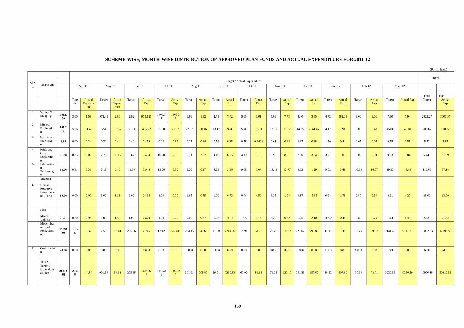
159
SCHEME-WISE, MONTH-WISE DISTRIBUTION OF APPROVED PLAN FUNDS AND ACTUAL EXPENDITURE FOR 2011-12
(Rs. in lakh)
Sl.No.
SCHEME
Total Target / Actual Expenditure
Apr-11 May-11 Jun-11 Jul-11 Aug-11 Sept-11 Oct-11 Nov.-11 Dec.-11 Jan.-12 Feb.12 Mar.-12
Total Total Targ
et Actual
Expenditure
Target Actual Expend
iture
Target Actual Exp
Target Actual Exp
Target Actual Exp
Target Actual Exp
Target Actual Exp
Target Actual Exp
Target Actual Exp
Target Actual Exp
Target Actual Exp
Target Actual Exp Target Actual Exp
1 Survey & Mapping 3003.
50 3.00 1.59 972.41 2.80 2.92 975.125
1403.74
1403.33
1.86 1.92 2.71 7.42 5.65 1.01 5.06 7.73 4.40 3.65 4.72 582.03 9.00 9.01 7.80 7.94 2423.27 3003.57
2 Mineral Exploration
100.29
5.96 11.45 6.54 15.65 16.00 45.222 35.00 21.87 22.07 30.96 13.17 24.80 24.89 18.31 13.57 17.32 14.35 -144.46 4.12 7.91 6.00 5.48 45.00 45.81 206.67 100.32
3 Specialised Investigation
6.05 0.00 0.24 0.20 0.44 0.40 0.459 0.20 0.82 0.27 0.84 0.59 0.85 0.78 0.1408 0.61 0.65 0.37 0.38 1.50 0.44 0.05 0.05 0.55 0.55 5.52 5.87
4 R&D and Other Exploration
61.88 0.33 0.00 2.70 10.16 5.87 3.494 10.20 9.95 5.71 7.87 4.40 6.25 4.19 -1.31 5.95 8.31 7.50 3.34 3.77 1.06 3.00 2.94 9.83 9.84 63.45 61.89
5 Information Technology
88.06 0.31 0.31 3.19 6.46 11.50 3.945 13.00 6.30 5.20 6.17 4.29 3.96 9.68 7.07 14.41 12.77 8.62 1.29 9.02 3.41 16.50 16.07 19.33 19.43 115.05 87.18
Training
6 Human Resource Development (Plan ) 14.00 0.00 0.00 3.00 1.18 2.00 2.866 1.00 0.00 1.95 0.55 1.90 0.72 0.94 4.50 3.35 1.28 3.87 -5.55 0.28 1.73 2.50 2.50 4.21 4.22 25.00 13.99
Plan
Motor Vehicle
21.91 0.50 0.98 1.00 1.50 1.00 0.870 1.00 0.22 0.00 0.87 1.25 11.16 1.05 1.15 3.20 0.32 1.05 2.10 10.00 0.44 0.80 0.79 1.44 1.43 22.29 21.82
Modernisation and Replacement
17093.93
15.58
0.32 2.50 16.44 255.96 2.246 12.12 25.48 264.15 249.65 11.60 7214.66 19.91 51.10 25.78 55.79 221.07 296.86 47.11 10.08 35.75 29.87 9141.40 9141.37 10052.93 17093.89
8 Construction
24.00 0.00 0.00 0.00 0.00 0.000 0.00 0.00 0.000 0.00 0.000 0.00 0.00 0.00 0.000 18.01 0.000 0.00 0.000 0.00 6.000 6.00 0.000 0.00 6.00 24.01
TOTAL Target / Expenditure (Plan)
20413.62
25.68
14.89 991.54 54.62 295.65 1034.22
7 1476.2
6 1467.9
7 301.21 298.82 39.91 7269.83 67.09 81.98 71.93 122.17 261.23 157.60 80.52 607.10 79.60 72.71 9229.56 9230.59 12920.18 20412.51
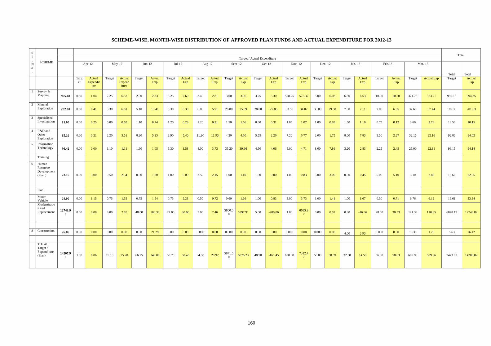
160
SCHEME-WISE, MONTH-WISE DISTRIBUTION OF APPROVED PLAN FUNDS AND ACTUAL EXPENDITURE FOR 2012-13
Sl.No.
SCHEME
Total Target / Actual Expenditure
Apr-12 May-12 Jun-12 Jul-12 Aug-12 Sept-12 Oct-12 Nov.-12 Dec.-12 Jan.-13 Feb.13 Mar.-13
Total Total Targ
et Actual
Expenditure
Target Actual Expend
iture
Target Actual Exp
Target Actual Exp
Target Actual Exp
Target Actual Exp
Target Actual Exp
Target Actual Exp
Target Actual Exp
Target Actual Exp
Target Actual Exp
Target Actual Exp Target Actual Exp
1 Survey & Mapping 995.48 0.50 1.04 2.25 6.52 2.00 2.83 3.25 2.60 3.40 2.81 3.00 3.06 3.25 3.30 578.25 575.37 5.00 6.08 6.50 6.53 10.00 10.50 374.75 373.71 992.15 994.35
2 Mineral Exploration 202.00 0.50 0.41 3.30 6.81 5.10 13.41 5.30 6.30 6.00 5.91 26.00 25.89 28.00 27.85 33.50 34.07 30.00 29.58 7.00 7.11 7.00 6.85 37.60 37.44 189.30 201.63
3 Specialised Investigation 11.00 0.00 0.25 0.00 0.63 1.10 0.74 1.20 0.29 1.20 0.21 1.50 1.66 0.60 0.31 1.05 1.07 1.00 0.99 1.50 1.10 0.75 0.12 3.60 2.78 13.50 10.15
4 R&D and Other Exploration
85.16 0.00 0.21 2.20 3.51 8.20 5.23 8.90 5.40 11.90 11.93 4.20 4.60 5.55 2.26 7.20 6.77 2.00 1.75 8.00 7.83 2.50 2.37 33.15 32.16 93.80 84.02
5 Information Technology 96.42 0.00 0.00 1.10 1.11 1.60 1.05 6.30 3.58 4.00 3.73 35.20 39.96 4.50 4.06 5.00 4.71 8.00 7.86 3.20 2.83 2.25 2.45 25.00 22.81 96.15 94.14
Training
6 Human Resource Development (Plan ) 23.16 0.00 3.00 0.50 2.34 0.00 1.70 1.00 0.00 2.50 2.15 1.00 1.49 1.00 0.00 1.00 0.83 3.00 3.00 0.50 0.45 5.00 5.10 3.10 2.89 18.60 22.95
Plan
Motor Vehicle
24.00 0.00 1.15 0.75 1.52 0.75 1.54 0.75 2.28 0.50 0.72 0.60 1.66 1.00 0.83 3.00 3.73 1.00 1.41 1.00 1.67 0.50 0.71 6.76 6.12 16.61 23.34
Modernisation and Replacement 12743.9
0 0.00 0.00 9.00 2.85 48.00 100.30 27.00 30.00 5.00 2.46
5800.00
5997.91 5.00 -200.06 1.00 6685.9
2 0.00 0.02 0.80 -16.96 28.00 30.53 124.39 110.85 6048.19 12743.82
8 Construction 26.86 0.00 0.00 0.00 0.00 0.00 21.29 0.00 0.00 0.000 0.00 0.000 0.00 0.00 0.00 0.000 0.00 0.000 0.00 4.00 3.93 0.000 0.00 1.630 1.20 5.63 26.42
TOTAL Target / Expenditure (Plan)
14207.98
1.00 6.06 19.10 25.28 66.75 148.08 53.70 50.45 34.50 29.92 5871.5
0 6076.23 48.90 -161.45 630.00
7312.47
50.00 50.69 32.50 14.50 56.00 58.63 609.98 589.96 7473.93 14200.82
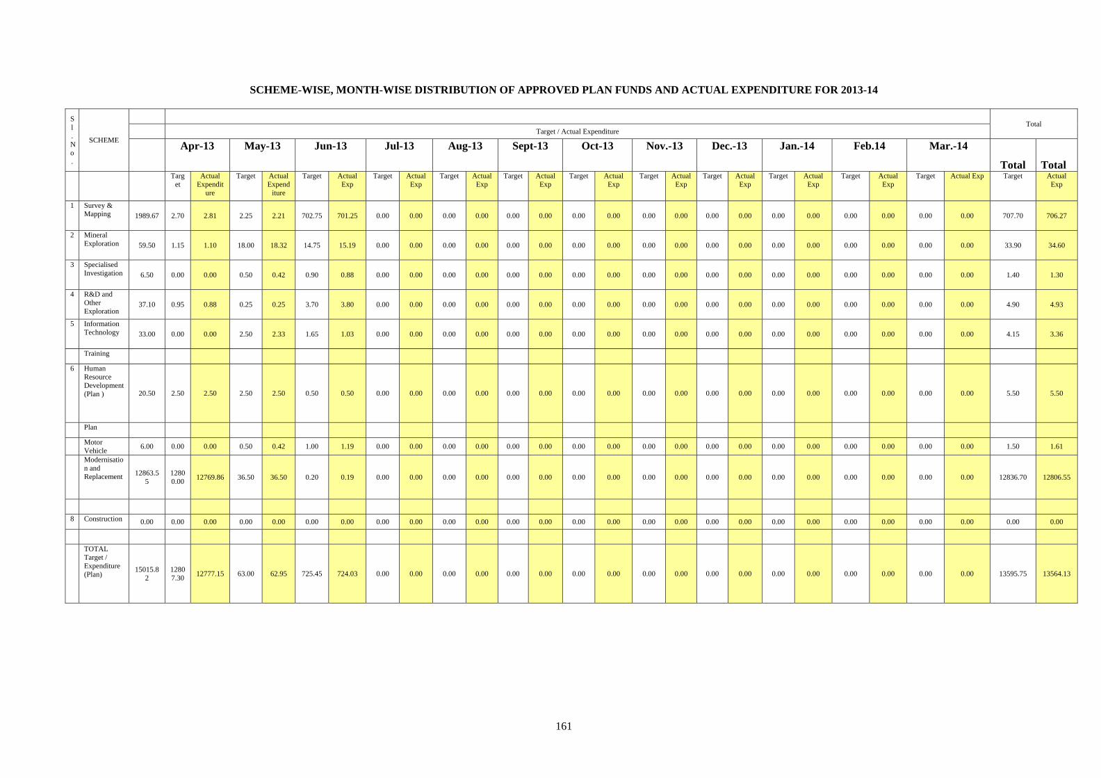
161
SCHEME-WISE, MONTH-WISE DISTRIBUTION OF APPROVED PLAN FUNDS AND ACTUAL EXPENDITURE FOR 2013-14
Sl.No.
SCHEME
Total Target / Actual Expenditure
Apr-13 May-13 Jun-13 Jul-13 Aug-13 Sept-13 Oct-13 Nov.-13 Dec.-13 Jan.-14 Feb.14 Mar.-14
Total Total Targ
et Actual
Expenditure
Target Actual Expend
iture
Target Actual Exp
Target Actual Exp
Target Actual Exp
Target Actual Exp
Target Actual Exp
Target Actual Exp
Target Actual Exp
Target Actual Exp
Target Actual Exp
Target Actual Exp Target Actual Exp
1 Survey & Mapping 1989.67 2.70 2.81 2.25 2.21 702.75 701.25 0.00 0.00 0.00 0.00 0.00 0.00 0.00 0.00 0.00 0.00 0.00 0.00 0.00 0.00 0.00 0.00 0.00 0.00 707.70 706.27
2 Mineral Exploration 59.50 1.15 1.10 18.00 18.32 14.75 15.19 0.00 0.00 0.00 0.00 0.00 0.00 0.00 0.00 0.00 0.00 0.00 0.00 0.00 0.00 0.00 0.00 0.00 0.00 33.90 34.60
3 Specialised Investigation 6.50 0.00 0.00 0.50 0.42 0.90 0.88 0.00 0.00 0.00 0.00 0.00 0.00 0.00 0.00 0.00 0.00 0.00 0.00 0.00 0.00 0.00 0.00 0.00 0.00 1.40 1.30
4 R&D and Other Exploration
37.10 0.95 0.88 0.25 0.25 3.70 3.80 0.00 0.00 0.00 0.00 0.00 0.00 0.00 0.00 0.00 0.00 0.00 0.00 0.00 0.00 0.00 0.00 0.00 0.00 4.90 4.93
5 Information Technology 33.00 0.00 0.00 2.50 2.33 1.65 1.03 0.00 0.00 0.00 0.00 0.00 0.00 0.00 0.00 0.00 0.00 0.00 0.00 0.00 0.00 0.00 0.00 0.00 0.00 4.15 3.36
Training
6 Human Resource Development (Plan ) 20.50 2.50 2.50 2.50 2.50 0.50 0.50 0.00 0.00 0.00 0.00 0.00 0.00 0.00 0.00 0.00 0.00 0.00 0.00 0.00 0.00 0.00 0.00 0.00 0.00 5.50 5.50
Plan
Motor Vehicle
6.00 0.00 0.00 0.50 0.42 1.00 1.19 0.00 0.00 0.00 0.00 0.00 0.00 0.00 0.00 0.00 0.00 0.00 0.00 0.00 0.00 0.00 0.00 0.00 0.00 1.50 1.61
Modernisation and Replacement 12863.5
5 12800.00
12769.86 36.50 36.50 0.20 0.19 0.00 0.00 0.00 0.00 0.00 0.00 0.00 0.00 0.00 0.00 0.00 0.00 0.00 0.00 0.00 0.00 0.00 0.00 12836.70 12806.55
8 Construction 0.00 0.00 0.00 0.00 0.00 0.00 0.00 0.00 0.00 0.00 0.00 0.00 0.00 0.00 0.00 0.00 0.00 0.00 0.00 0.00 0.00 0.00 0.00 0.00 0.00 0.00 0.00
TOTAL Target / Expenditure (Plan)
15015.82
12807.30
12777.15 63.00 62.95 725.45 724.03 0.00 0.00 0.00 0.00 0.00 0.00 0.00 0.00 0.00 0.00 0.00 0.00 0.00 0.00 0.00 0.00 0.00 0.00 13595.75 13564.13
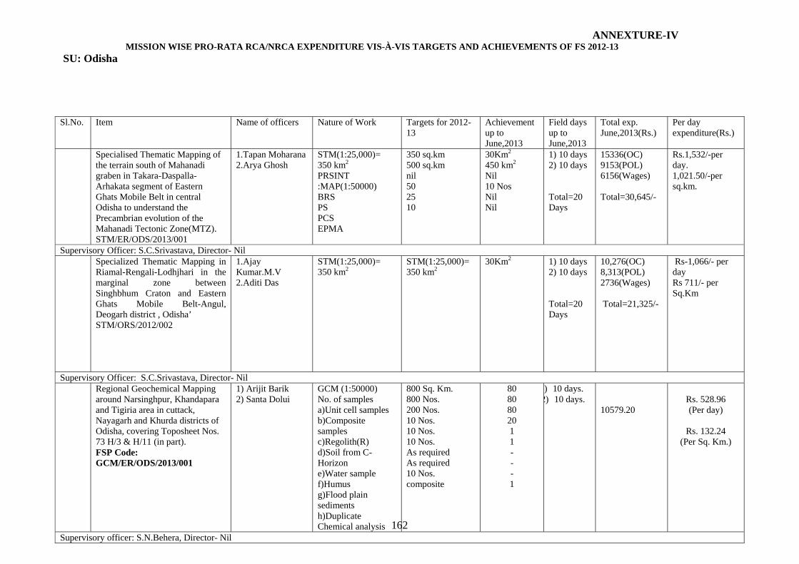
162
Sl.No. Item Name of officers Nature of Work Targets for 2012-13
Achievement up to June,2013
Field days up to June,2013
Total exp. June,2013(Rs.)
Per day expenditure(Rs.)
Specialised Thematic Mapping of the terrain south of Mahanadi graben in Takara-Daspalla-Arhakata segment of Eastern Ghats Mobile Belt in central Odisha to understand the Precambrian evolution of the Mahanadi Tectonic Zone(MTZ). STM/ER/ODS/2013/001
1.Tapan Moharana 2.Arya Ghosh
STM(1:25,000)= 350 km2 PRSINT :MAP(1:50000) BRS PS PCS EPMA
350 sq.km 500 sq.km nil 50 25 10
30Km2 450 km2
Nil 10 Nos Nil Nil
1) 10 days 2) 10 days Total=20 Days
15336(OC) 9153(POL) 6156(Wages) Total=30,645/-
Rs.1,532/-per day. 1,021.50/-per sq.km.
Supervisory Officer: S.C.Srivastava, Director- Nil Specialized Thematic Mapping in
Riamal-Rengali-Lodhjhari in the marginal zone between Singhbhum Craton and Eastern Ghats Mobile Belt-Angul, Deogarh district , Odisha’ STM/ORS/2012/002
1.Ajay Kumar.M.V 2.Aditi Das
STM(1:25,000)= 350 km2
STM(1:25,000)= 350 km2
30Km2
1) 10 days 2) 10 days Total=20 Days
10,276(OC) 8,313(POL) 2736(Wages) Total=21,325/-
Rs-1,066/- per day Rs 711/- per Sq.Km
Supervisory Officer: S.C.Srivastava, Director- Nil Regional Geochemical Mapping
around Narsinghpur, Khandapara and Tigiria area in cuttack, Nayagarh and Khurda districts of Odisha, covering Toposheet Nos. 73 H/3 & H/11 (in part). FSP Code: GCM/ER/ODS/2013/001
1) Arijit Barik 2) Santa Dolui
GCM (1:50000) No. of samples a)Unit cell samples b)Composite samples c)Regolith(R) d)Soil from C-Horizon e)Water sample f)Humus g)Flood plain sediments h)Duplicate Chemical analysis
800 Sq. Km. 800 Nos. 200 Nos. 10 Nos. 10 Nos. 10 Nos. As required As required 10 Nos. composite
80 80 80 20 1 1 - - - 1
) 10 days. 2) 10 days.
10579.20
Rs. 528.96 (Per day)
Rs. 132.24
(Per Sq. Km.)
Supervisory officer: S.N.Behera, Director- Nil
ANNEXTURE-IV MISSION WISE PRO-RATA RCA/NRCA EXPENDITURE VIS-À-VIS TARGETS AND ACHIEVEMENTS OF FS 2012-13
SU: Odisha
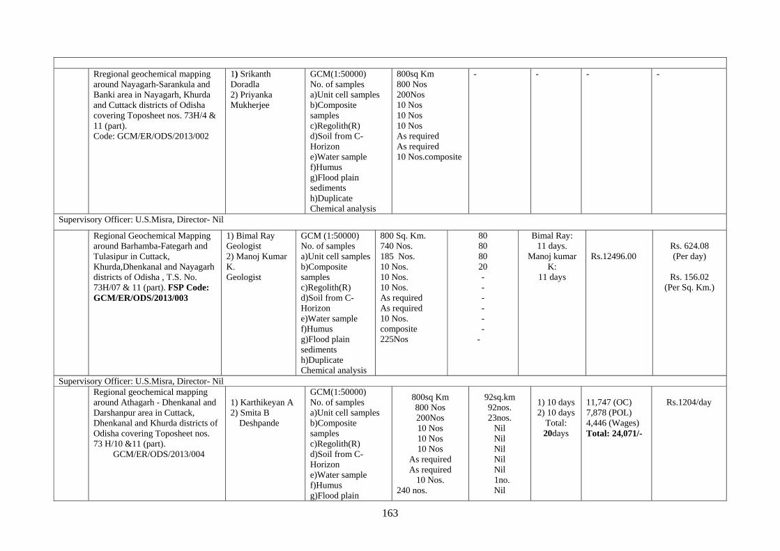
163
Rregional geochemical mapping
around Nayagarh-Sarankula and Banki area in Nayagarh, Khurda and Cuttack districts of Odisha covering Toposheet nos. 73H/4 & 11 (part). Code: GCM/ER/ODS/2013/002
1) Srikanth Doradla 2) Priyanka Mukherjee
GCM(1:50000) No. of samples a)Unit cell samples b)Composite samples c)Regolith(R) d)Soil from C-Horizon e)Water sample f)Humus g)Flood plain sediments h)Duplicate Chemical analysis
800sq Km 800 Nos 200Nos 10 Nos 10 Nos 10 Nos As required As required 10 Nos.composite
- - - -
Supervisory Officer: U.S.Misra, Director- Nil
Regional Geochemical Mapping around Barhamba-Fategarh and Tulasipur in Cuttack, Khurda,Dhenkanal and Nayagarh districts of Odisha , T.S. No. 73H/07 & 11 (part). FSP Code: GCM/ER/ODS/2013/003
1) Bimal Ray Geologist 2) Manoj Kumar K. Geologist
GCM (1:50000) No. of samples a)Unit cell samples b)Composite samples c)Regolith(R) d)Soil from C-Horizon e)Water sample f)Humus g)Flood plain sediments h)Duplicate Chemical analysis
800 Sq. Km. 740 Nos. 185 Nos. 10 Nos. 10 Nos. 10 Nos. As required As required 10 Nos. composite 225Nos
80 80 80 20 - - - - - -
-
Bimal Ray: 11 days.
Manoj kumar K:
11 days
Rs.12496.00
Rs. 624.08 (Per day)
Rs. 156.02
(Per Sq. Km.)
Supervisory Officer: U.S.Misra, Director- Nil Regional geochemical mapping
around Athagarh - Dhenkanal and Darshanpur area in Cuttack, Dhenkanal and Khurda districts of Odisha covering Toposheet nos. 73 H/10 &11 (part).
GCM/ER/ODS/2013/004
1) Karthikeyan A 2) Smita B
Deshpande
GCM(1:50000) No. of samples a)Unit cell samples b)Composite samples c)Regolith(R) d)Soil from C-Horizon e)Water sample f)Humus g)Flood plain
800sq Km 800 Nos 200Nos 10 Nos 10 Nos 10 Nos
As required As required
10 Nos. 240 nos.
92sq.km 92nos. 23nos.
Nil Nil Nil Nil Nil
1no. Nil
1) 10 days 2) 10 days
Total: 20days
11,747 (OC) 7,878 (POL) 4,446 (Wages) Total: 24,071/-
Rs.1204/day
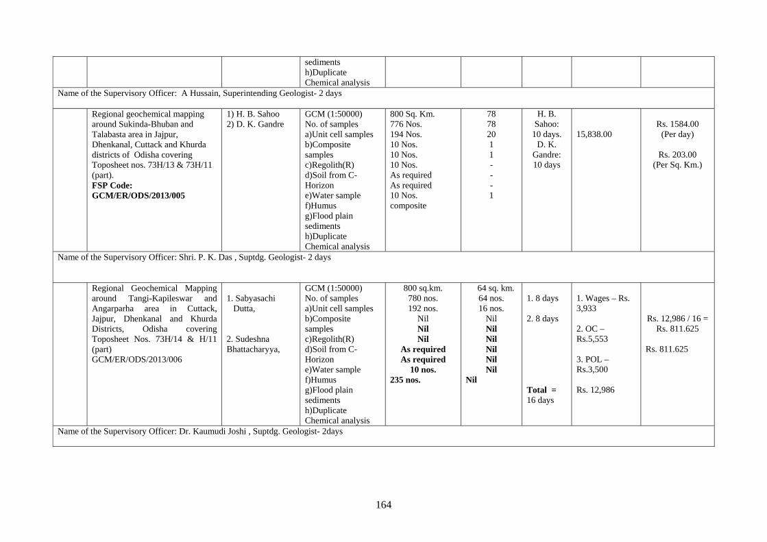
164
sediments h)Duplicate Chemical analysis
Name of the Supervisory Officer: A Hussain, Superintending Geologist- 2 days Regional geochemical mapping
around Sukinda-Bhuban and Talabasta area in Jajpur, Dhenkanal, Cuttack and Khurda districts of Odisha covering Toposheet nos. 73H/13 & 73H/11 (part). FSP Code: GCM/ER/ODS/2013/005
1) H. B. Sahoo 2) D. K. Gandre
GCM (1:50000) No. of samples a)Unit cell samples b)Composite samples c)Regolith(R) d)Soil from C-Horizon e)Water sample f)Humus g)Flood plain sediments h)Duplicate Chemical analysis
800 Sq. Km. 776 Nos. 194 Nos. 10 Nos. 10 Nos. 10 Nos. As required As required 10 Nos. composite
78 78 20 1 1 - - - 1
H. B. Sahoo:
10 days. D. K.
Gandre: 10 days
15,838.00
Rs. 1584.00
(Per day)
Rs. 203.00 (Per Sq. Km.)
Name of the Supervisory Officer: Shri. P. K. Das , Suptdg. Geologist- 2 days Regional Geochemical Mapping
around Tangi-Kapileswar and Angarparha area in Cuttack, Jajpur, Dhenkanal and Khurda Districts, Odisha covering Toposheet Nos. 73H/14 & H/11 (part) GCM/ER/ODS/2013/006
1. Sabyasachi Dutta, 2. Sudeshna Bhattacharyya,
GCM (1:50000) No. of samples a)Unit cell samples b)Composite samples c)Regolith(R) d)Soil from C-Horizon e)Water sample f)Humus g)Flood plain sediments h)Duplicate Chemical analysis
800 sq.km. 780 nos. 192 nos.
Nil Nil Nil
As required As required
10 nos. 235 nos.
64 sq. km. 64 nos. 16 nos.
Nil Nil Nil Nil Nil Nil
Nil
1. 8 days 2. 8 days Total = 16 days
1. Wages – Rs. 3,933 2. OC – Rs.5,553 3. POL – Rs.3,500
Rs. 12,986
Rs. 12,986 / 16 = Rs. 811.625
Rs. 811.625
Name of the Supervisory Officer: Dr. Kaumudi Joshi , Suptdg. Geologist- 2days
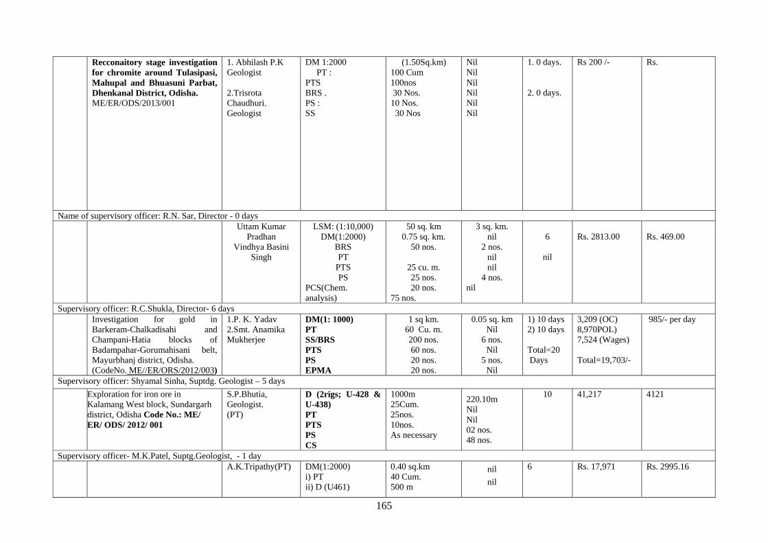
165
Recconaitory stage investigation for chromite around Tulasipasi, Mahupal and Bhuasuni Parbat, Dhenkanal District, Odisha. ME/ER/ODS/2013/001
1. Abhilash P.K Geologist 2.Trisrota Chaudhuri. Geologist
DM 1:2000 PT : PTS BRS . PS : SS
(1.50Sq.km) 100 Cum 100nos 30 Nos. 10 Nos. 30 Nos
Nil Nil Nil Nil Nil Nil
1. 0 days. 2. 0 days.
Rs 200 /-
Rs.
Name of supervisory officer: R.N. Sar, Director - 0 days Uttam Kumar
Pradhan Vindhya Basini
Singh
LSM: (1:10,000) DM(1:2000)
BRS PT
PTS PS
PCS(Chem. analysis)
50 sq. km 0.75 sq. km.
50 nos.
25 cu. m. 25 nos. 20 nos.
75 nos.
3 sq. km. nil
2 nos. nil nil
4 nos. nil
6
nil
Rs. 2813.00
Rs. 469.00
Supervisory officer: R.C.Shukla, Director- 6 days Investigation for gold in
Barkeram-Chalkadisahi and Champani-Hatia blocks of Badampahar-Gorumahisani belt, Mayurbhanj district, Odisha. (CodeNo. ME//ER/ORS/2012/003)
1.P. K. Yadav 2.Smt. Anamika Mukherjee
DM(1: 1000) PT SS/BRS PTS PS EPMA
1 sq km. 60 Cu. m. 200 nos. 60 nos. 20 nos. 20 nos.
0.05 sq. km Nil
6 nos. Nil
5 nos. Nil
1) 10 days 2) 10 days Total=20 Days
3,209 (OC) 8,970POL) 7,524 (Wages) Total=19,703/-
985/- per day
Supervisory officer: Shyamal Sinha, Suptdg. Geologist – 5 days
Exploration for iron ore in Kalamang West block, Sundargarh district, Odisha Code No.: ME/ ER/ ODS/ 2012/ 001
S.P.Bhutia, Geologist. (PT)
D (2rigs; U-428 & U-438) PT PTS PS CS
1000m 25Cum. 25nos. 10nos. As necessary
220.10m Nil Nil 02 nos. 48 nos.
10 41,217 4121
Supervisory officer- M.K.Patel, Suptg.Geologist, - 1 day A.K.Tripathy(PT) DM(1:2000)
i) PT ii) D (U461)
0.40 sq.km 40 Cum. 500 m
nil
nil
6 Rs. 17,971 Rs. 2995.16
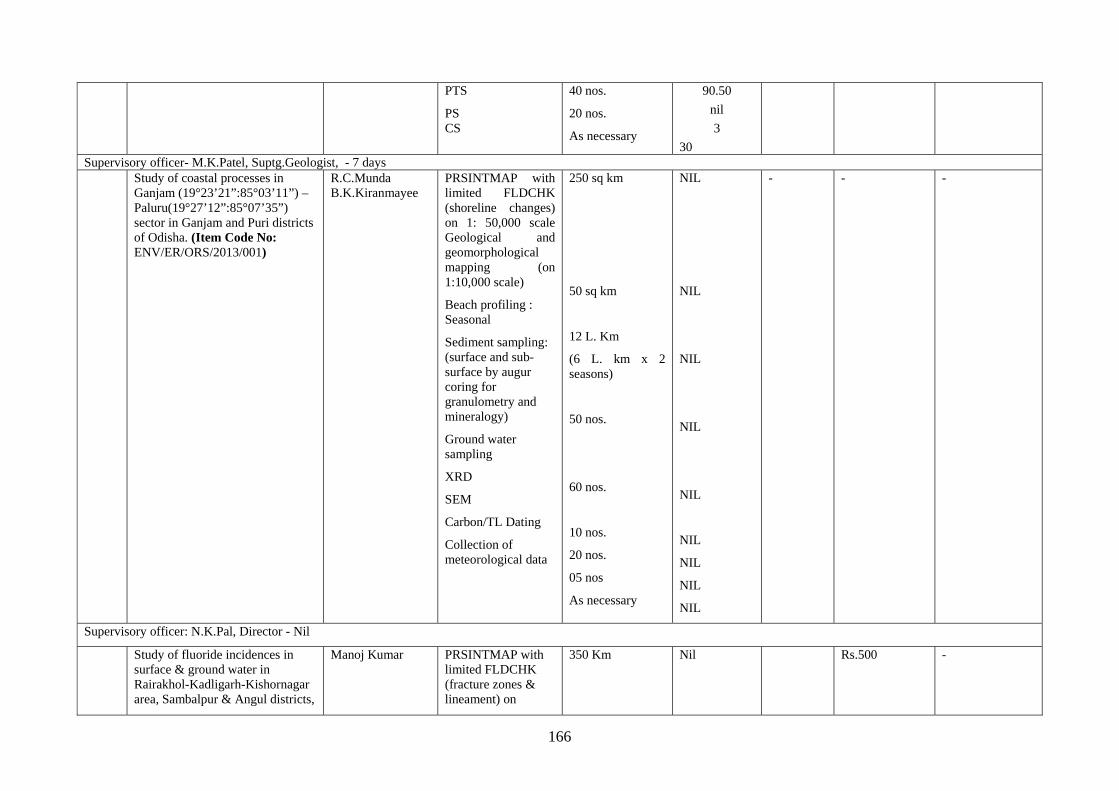
166
PTS
PS CS
40 nos.
20 nos.
As necessary
90.50
nil
3
30 Supervisory officer- M.K.Patel, Suptg.Geologist, - 7 days Study of coastal processes in
Ganjam (19°23’21”:85°03’11”) – Paluru(19°27’12”:85°07’35”) sector in Ganjam and Puri districts of Odisha. (Item Code No: ENV/ER/ORS/2013/001)
R.C.Munda B.K.Kiranmayee
PRSINTMAP with limited FLDCHK (shoreline changes) on 1: 50,000 scale Geological and geomorphological mapping (on 1:10,000 scale)
Beach profiling : Seasonal
Sediment sampling: (surface and sub-surface by augur coring for granulometry and mineralogy)
Ground water sampling
XRD
SEM
Carbon/TL Dating
Collection of meteorological data
250 sq km
50 sq km
12 L. Km
(6 L. km x 2 seasons)
50 nos.
60 nos.
10 nos.
20 nos.
05 nos
As necessary
NIL
NIL
NIL
NIL
NIL
NIL
NIL
NIL
NIL
- - -
Supervisory officer: N.K.Pal, Director - Nil
Study of fluoride incidences in surface & ground water in Rairakhol-Kadligarh-Kishornagar area, Sambalpur & Angul districts,
Manoj Kumar PRSINTMAP with limited FLDCHK (fracture zones & lineament) on
350 Km
Nil
Rs.500 -
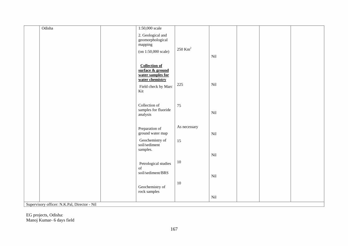
167
EG projects, Odisha: Manoj Kumar- 6 days field
Odisha 1:50,000 scale
2. Geological and geomorphological mapping
(on 1:50,000 scale)
Collection of surface & ground water samples for water chemistry
Field check by Marc Kit
Collection of samples for fluoride analysis
Preparation of ground water map
Geochemistry of soil/sediment samples.
Petrological studies of soil/sediment/BRS
Geochemistry of rock samples
250 Km2
225
75
As necessary
15
10
10
Nil
Nil
Nil
Nil
Nil
Nil
Nil
Supervisory officer: N.K.Pal, Director - Nil
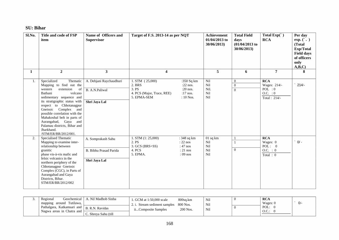
168
SU: Bihar
Sl.No. Title and code of FSP item
Name of Officers and Supervisor
Target of F.S. 2013-14 as per NQT Achievement 01/04/2013 to 30/06/2013)
Total Field days (01/04/2013 to 30/06/2013)
Total Exp(`)RCA
Per day exp. (`. ) (Total Exp/Total Field days of officers only A,B,C)
1 2 3 4 5 6 7 8
1. Specialized Thematic Mapping to find out the western extension of Bathani volcano sedimentary sequence and its stratigraphic status with respect to Chhotanagpur Gneissic Complex and possible correlation with the Mahakoshal belt in parts of Aurangabad, Gaya and Palamau districts, Bihar and Jharkhand. /STM/ER/BR/2012/001.
A. Debjani Raychaudhuri 1. STM ( 25,000) :350 Sq km 2. BRS :22 nos. 3. PS :20 nos. 4. PCS (Major, Trace, REE) :17 nos. 5. EPMA-SEM : 10 Nos.
Nil Nil Nil. Nil Nil
0 RCA Wages: 214/- POL : 0 O.C. : 0 Total : 214/-
` 214/- 0
B. A.N.Paliwal 0
Shri Jaya Lal
2. Specialised Thematic Mapping to examine inter-relationship between granitic phase vis-à-vis mafic and felsic volcanics in the northern periphery of the Chhotanagpur Gneissic Complex (CGC), in Parts of Aurangabad and Gaya Districts, Bihar. STM/ER/BR/2012/002
A. Somprakash Sahu
1. STM (1: 25,000) : 348 sq km 2. PS : 22 nos 3. GCS (BRS+SS) : 47 nos 4. PCS : 21 nos 5. EPMA. : 09 nos
01 sq km Nil Nil Nil Nil
1 RCA Wages: 0 POL : 0 O.C. : 0 Total : 0
` 0/- 1
B. Bibhu Prasad Parida 0
Shri Jaya Lal
3. Regional Geochemical mapping around Tutilawa, Pathalgara, Katkamsari and Nagwa areas in Chatra and
A. Nil Madhob Sinha
1. GCM at 1:50,000 scale 800sq.km 2. i. Stream sediment samples 800 Nos. ii...Composite Samples 200 Nos.
Nil Nil Nil
0 RCA Wages: 0 POL: 0 O.C.: 0
` 0/-
B. R.N. Ravidas 0
C. Shreya Sahu (till
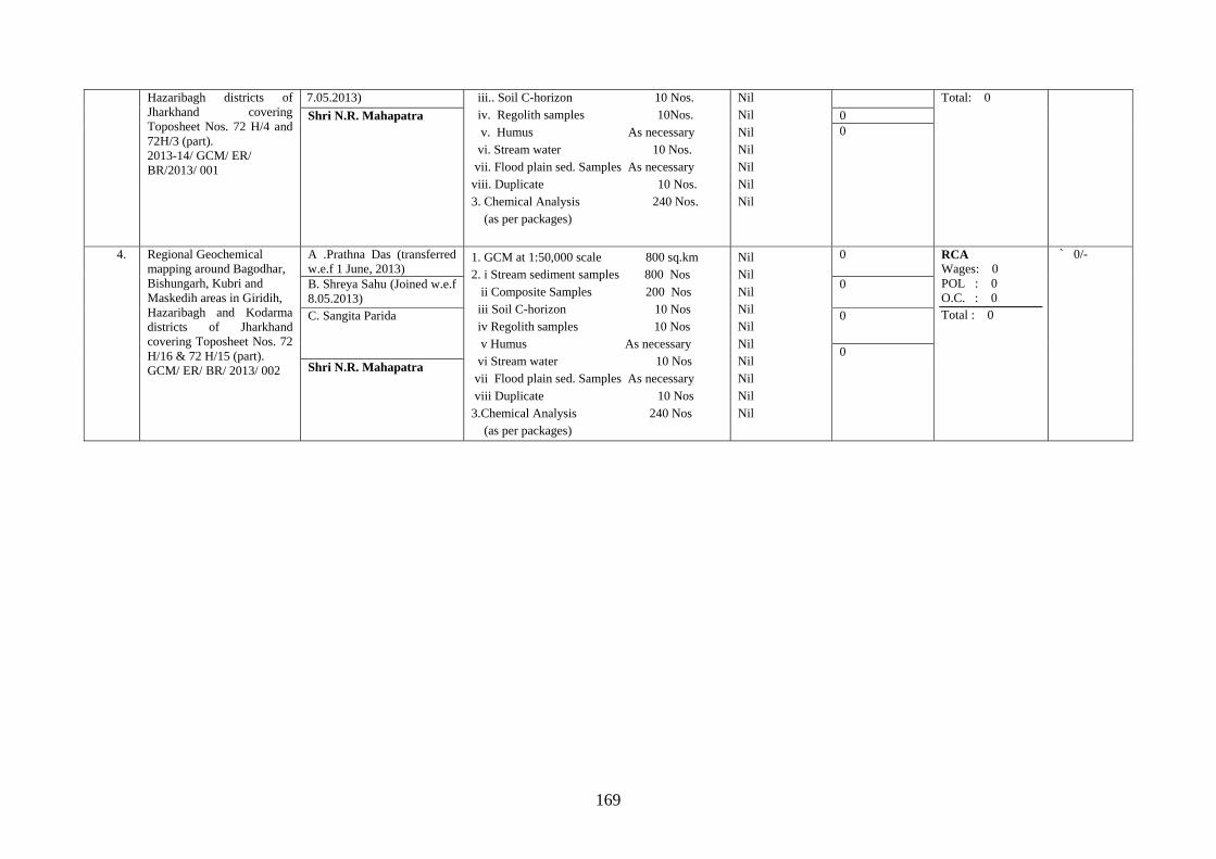
169
Hazaribagh districts of Jharkhand covering Toposheet Nos. 72 H/4 and 72H/3 (part). 2013-14/ GCM/ ER/ BR/2013/ 001
7.05.2013) iii.. Soil C-horizon 10 Nos. iv. Regolith samples 10Nos. v. Humus As necessary vi. Stream water 10 Nos. vii. Flood plain sed. Samples As necessary viii. Duplicate 10 Nos. 3. Chemical Analysis 240 Nos. (as per packages)
Nil Nil Nil Nil Nil Nil Nil
Total: 0 Shri N.R. Mahapatra
0 0
4. Regional Geochemical mapping around Bagodhar, Bishungarh, Kubri and Maskedih areas in Giridih, Hazaribagh and Kodarma districts of Jharkhand covering Toposheet Nos. 72 H/16 & 72 H/15 (part). GCM/ ER/ BR/ 2013/ 002
A .Prathna Das (transferred w.e.f 1 June, 2013)
1. GCM at 1:50,000 scale 800 sq.km 2. i Stream sediment samples 800 Nos ii Composite Samples 200 Nos iii Soil C-horizon 10 Nos iv Regolith samples 10 Nos v Humus As necessary vi Stream water 10 Nos vii Flood plain sed. Samples As necessary viii Duplicate 10 Nos 3.Chemical Analysis 240 Nos (as per packages)
Nil Nil Nil Nil Nil Nil Nil Nil Nil Nil
0 RCA Wages: 0 POL : 0 O.C. : 0 Total : 0
` 0/-
B. Shreya Sahu (Joined w.e.f 8.05.2013)
0
C. Sangita Parida 0
0 Shri N.R. Mahapatra
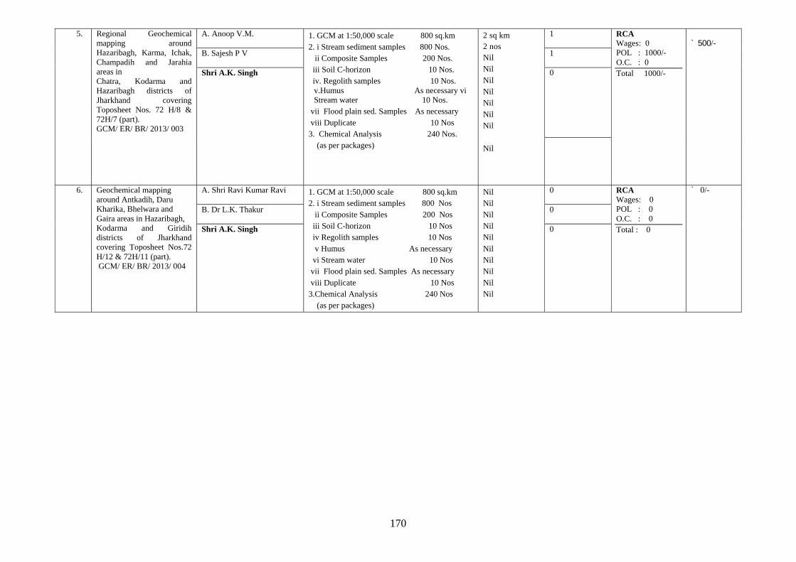
170
5. Regional Geochemical mapping around Hazaribagh, Karma, Ichak, Champadih and Jarahia areas in Chatra, Kodarma and Hazaribagh districts of Jharkhand covering Toposheet Nos. 72 H/8 & 72H/7 (part). GCM/ ER/ BR/ 2013/ 003
A. Anoop V.M.
1. GCM at 1:50,000 scale 800 sq.km 2. i Stream sediment samples 800 Nos. ii Composite Samples 200 Nos. iii Soil C-horizon 10 Nos. iv. Regolith samples 10 Nos.
v.Humus As necessary vi Stream water 10 Nos.
vii Flood plain sed. Samples As necessary viii Duplicate 10 Nos 3. Chemical Analysis 240 Nos. (as per packages)
2 sq km 2 nos Nil Nil Nil Nil Nil Nil Nil Nil
1 RCA Wages: 0 POL : 1000/- O.C. : 0 Total 1000/-
` 500/-
B. Sajesh P V
1
Shri A.K. Singh 0
6. Geochemical mapping around Antkadih, Daru Kharika, Bhelwara and Gaira areas in Hazaribagh, Kodarma and Giridih districts of Jharkhand covering Toposheet Nos.72 H/12 & 72H/11 (part). GCM/ ER/ BR/ 2013/ 004
A. Shri Ravi Kumar Ravi
1. GCM at 1:50,000 scale 800 sq.km 2. i Stream sediment samples 800 Nos ii Composite Samples 200 Nos iii Soil C-horizon 10 Nos iv Regolith samples 10 Nos v Humus As necessary vi Stream water 10 Nos vii Flood plain sed. Samples As necessary viii Duplicate 10 Nos 3.Chemical Analysis 240 Nos (as per packages)
Nil Nil Nil Nil Nil Nil Nil Nil Nil Nil
0 RCA Wages: 0 POL : 0 O.C. : 0 Total : 0
` 0/-
B. Dr L.K. Thakur
0
Shri A.K. Singh 0
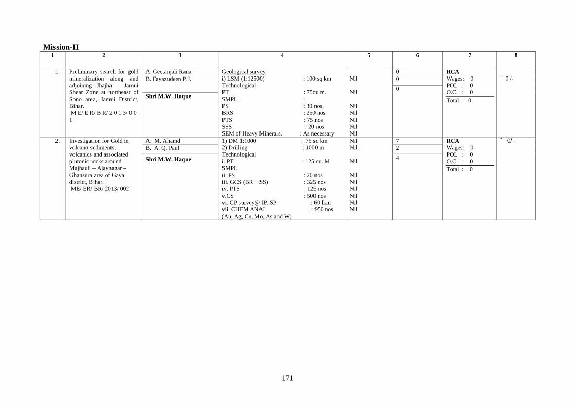
171
Mission-II 1 2 3 4 5 6 7 8
1. Preliminary search for gold mineralization along and adjoining Jhajha – Jamui Shear Zone at northeast of Sono area, Jamui District, Bihar. M E/ E R/ B R/ 2 0 1 3/ 0 0 1
A. Geetanjali Rana Geological survey i) LSM (1:12500) : 100 sq km Technological : PT : 75cu m. SMPL : PS : 30 nos. BRS : 250 nos PTS : 75 nos SSS : 20 nos SEM of Heavy Minerals. : As necessary
Nil Nil Nil Nil Nil Nil Nil
0 RCA Wages: 0 POL : 0 O.C. : 0 Total : 0
` 0 /- B. Fayazudeen P.J.
0
0 Shri M.W. Haque
2. Investigation for Gold in volcano-sediments, volcanics and associated plutonic rocks around Majhauli – Ajaynagar – Ghansura area of Gaya district, Bihar. ME/ ER/ BR/ 2013/ 002
A. M. Ahamd 1) DM 1:1000 : .75 sq km 2) Drilling : 1000 m Technological i. PT : 125 cu. M SMPL ii PS : 20 nos iii. GCS (BR + SS) : 325 nos iv. PTS : 125 nos v.CS : 500 nos vi. GP survey@ IP, SP : 60 lkm vii. CHEM ANAL : 950 nos (Au, Ag, Cu, Mo, As and W)
Nil Nil. Nil Nil Nil Nil Nil Nil Nil
7 RCA Wages: 0 POL : 0 O.C. : 0 Total : 0
` 0/- B. A. Q. Paul 2
Shri M.W. Haque 4
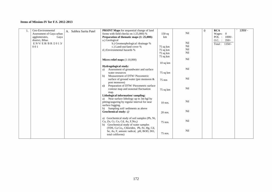
172
Items of Mission-IV for F.S. 2012-2013
1. Geo-Environmental Assessment of Gaya urban agglomerates, Gaya district, Bihar. E N V/ E R/ B R /2 0 1 3/ 0 0 1
A. Subhra Sarita Patel
PRSINT Maps for sequential change of land forms with field checks on 1:25,000) % Preparation of thematic maps (1: 25,000): a.) Geological
b.) Geomorphological /drainage % c.) Land-use/land cover %
d.) Environmental hazards % Micro relief maps (1:10,000) Hydrogelogical study: a) Assessment of groundwater and surface
water resources b) Measurement of DTW/ Piezometric
surface of ground water (pre monsoon & post monsoon)
c) Preparation of DTW/ Piezometric surface contour map and seasonal fluctuation map.
Lithological information/ sampling: a) Near surface lithology up to 3m bgl by pitting/auguring by regular interval for near surface logging. b) Sampling soil/ sediments as above Geochemical study: @ a) Geochemical study of soil samples (Pb, Ni, Cu, Zn, Cr, Co, Cd, As, F,No3) b) Geochemical study of water samples
(TDS, Ca Co3, Chlorides, Pb, Fe, Hg, Cd, Se, As, F, anionic radical, pH, BOD, DO, total coliforms)
150 sq
km
75 sq km 75 sq km 75 sq km 75 sq km
10 sq km
75 sq km
75 nos
75 sq km
10 nos.
20 nos.
75 nos.
75 nos.
Nil
Nil Nil Nil Nil
Nil
Nil
Nil
Nil
Nil
Nil
Nil
Nil
0 RCA Wages: 0 POL : 1000/- O.C. : 350/- Total : 1350/-
` 1350/-
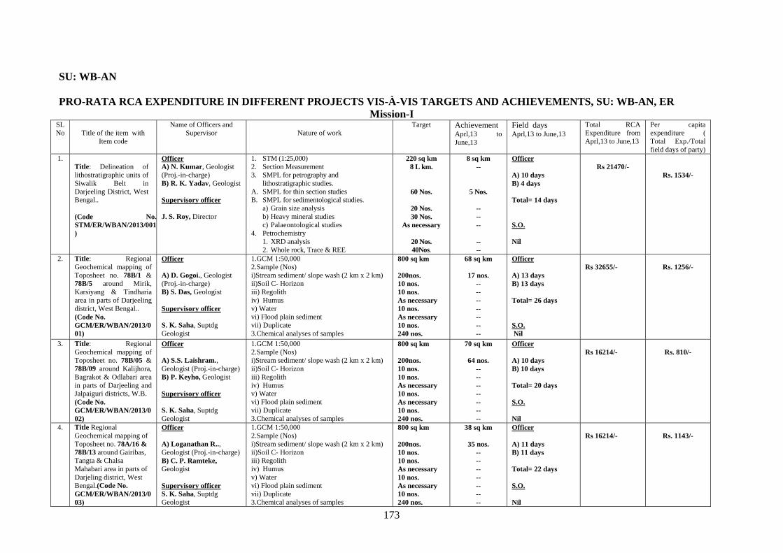
173
SU: WB-AN PRO-RATA RCA EXPENDITURE IN DIFFERENT PROJECTS VIS-À-VIS TARGETS AND ACHIEVEMENTS, SU: WB-AN, ER
Mission-I SLNo
Title of the item with
Item code
Name of Officers and Supervisor
Nature of work
Target Achievement Aprl,13 to June,13
Field days Aprl,13 to June,13
Total RCA Expenditure from Aprl,13 to June,13
Per capita expenditure ( Total Exp./Total field days of party)
1. Title: Delineation of lithostratigraphic units of Siwalik Belt in Darjeeling District, West Bengal.. (Code No.STM/ER/WBAN/2013/001)
Officer A) N. Kumar, Geologist (Proj.-in-charge) B) R. K. Yadav, Geologist Supervisory officer J. S. Roy, Director
1. STM (1:25,000) 2. Section Measurement 3. SMPL for petrography and
lithostratigraphic studies. A. SMPL for thin section studies B. SMPL for sedimentological studies.
a) Grain size analysis b) Heavy mineral studies c) Palaeontological studies
4. Petrochemistry 1. XRD analysis 2. Whole rock, Trace & REE
220 sq km 8 L km.
60 Nos.
20 Nos. 30 Nos.
As necessary
20 Nos. 40Nos.
8 sq km --
5 Nos.
-- -- --
-- --
Officer A) 10 days B) 4 days Total= 14 days S.O. Nil
Rs 21470/-
Rs. 1534/-
2. Title: Regional Geochemical mapping of Toposheet no. 78B/1 & 78B/5 around Mirik, Karsiyang & Tindharia area in parts of Darjeeling district, West Bengal.. (Code No. GCM/ER/WBAN/2013/001)
Officer A) D. Gogoi., Geologist (Proj.-in-charge) B) S. Das, Geologist Supervisory officer S. K. Saha, Suptdg Geologist
1.GCM 1:50,000 2.Sample (Nos) i)Stream sediment/ slope wash (2 km x 2 km) ii)Soil C- Horizon iii) Regolith iv) Humus v) Water vi) Flood plain sediment vii) Duplicate 3.Chemical analyses of samples
800 sq km 200nos. 10 nos. 10 nos. As necessary 10 nos. As necessary 10 nos. 240 nos.
68 sq km
17 nos. -- -- -- -- -- -- --
Officer A) 13 days B) 13 days Total= 26 days S.O. Nil
Rs 32655/-
Rs. 1256/-
3. Title: Regional Geochemical mapping of Toposheet no. 78B/05 & 78B/09 around Kalijhora, Bagrakot & Odlabari area in parts of Darjeeling and Jalpaiguri districts, W.B. (Code No. GCM/ER/WBAN/2013/002)
Officer A) S.S. Laishram., Geologist (Proj.-in-charge) B) P. Keyho, Geologist Supervisory officer S. K. Saha, Suptdg Geologist
1.GCM 1:50,000 2.Sample (Nos) i)Stream sediment/ slope wash (2 km x 2 km) ii)Soil C- Horizon iii) Regolith iv) Humus v) Water vi) Flood plain sediment vii) Duplicate 3.Chemical analyses of samples
800 sq km 200nos. 10 nos. 10 nos. As necessary 10 nos. As necessary 10 nos. 240 nos.
70 sq km
64 nos. -- -- -- -- -- -- --
Officer A) 10 days B) 10 days Total= 20 days S.O. Nil
Rs 16214/-
Rs. 810/-
4. Title Regional Geochemical mapping of Toposheet no. 78A/16 & 78B/13 around Gairibas, Tangta & Chalsa Mahabari area in parts of Darjeling district, West Bengal.(Code No. GCM/ER/WBAN/2013/003)
Officer A) Loganathan R.., Geologist (Proj.-in-charge) B) C. P. Ramteke, Geologist Supervisory officer S. K. Saha, Suptdg Geologist
1.GCM 1:50,000 2.Sample (Nos) i)Stream sediment/ slope wash (2 km x 2 km) ii)Soil C- Horizon iii) Regolith iv) Humus v) Water vi) Flood plain sediment vii) Duplicate 3.Chemical analyses of samples
800 sq km 200nos. 10 nos. 10 nos. As necessary 10 nos. As necessary 10 nos. 240 nos.
38 sq km
35 nos. -- -- -- -- -- -- --
Officer A) 11 days B) 11 days Total= 22 days S.O. Nil
Rs 16214/-
Rs. 1143/-
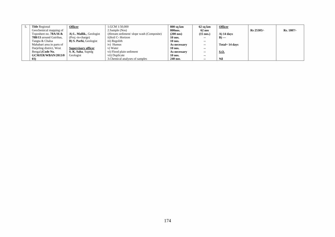
174
5. Title Regional Geochemical mapping of Toposheet no. 78A/16 & 78B/13 around Gairibas, Tangta & Chalsa Mahabari area in parts of Darjeling district, West Bengal.(Code No. GCM/ER/WBAN/2013/003)
Officer A) L. Mallik., Geologist (Proj.-in-charge) B) S. Parhi, Geologist Supervisory officer S. K. Saha, Suptdg Geologist
1.GCM 1:50,000 2.Sample (Nos) i)Stream sediment/ slope wash (Composite) ii)Soil C- Horizon iii) Regolith iv) Humus v) Water vi) Flood plain sediment vii) Duplicate 3.Chemical analyses of samples
800 sq km 800nos. (200 nos) 10 nos. 10 nos. As necessary 10 nos. As necessary 10 nos. 240 nos.
62 sq km 62 nos
(15 nos.) -- -- -- -- -- -- --
Officer A) 14 days B) --- Total= 14 days S.O. Nil
Rs 25305/-
Rs. 1807/-
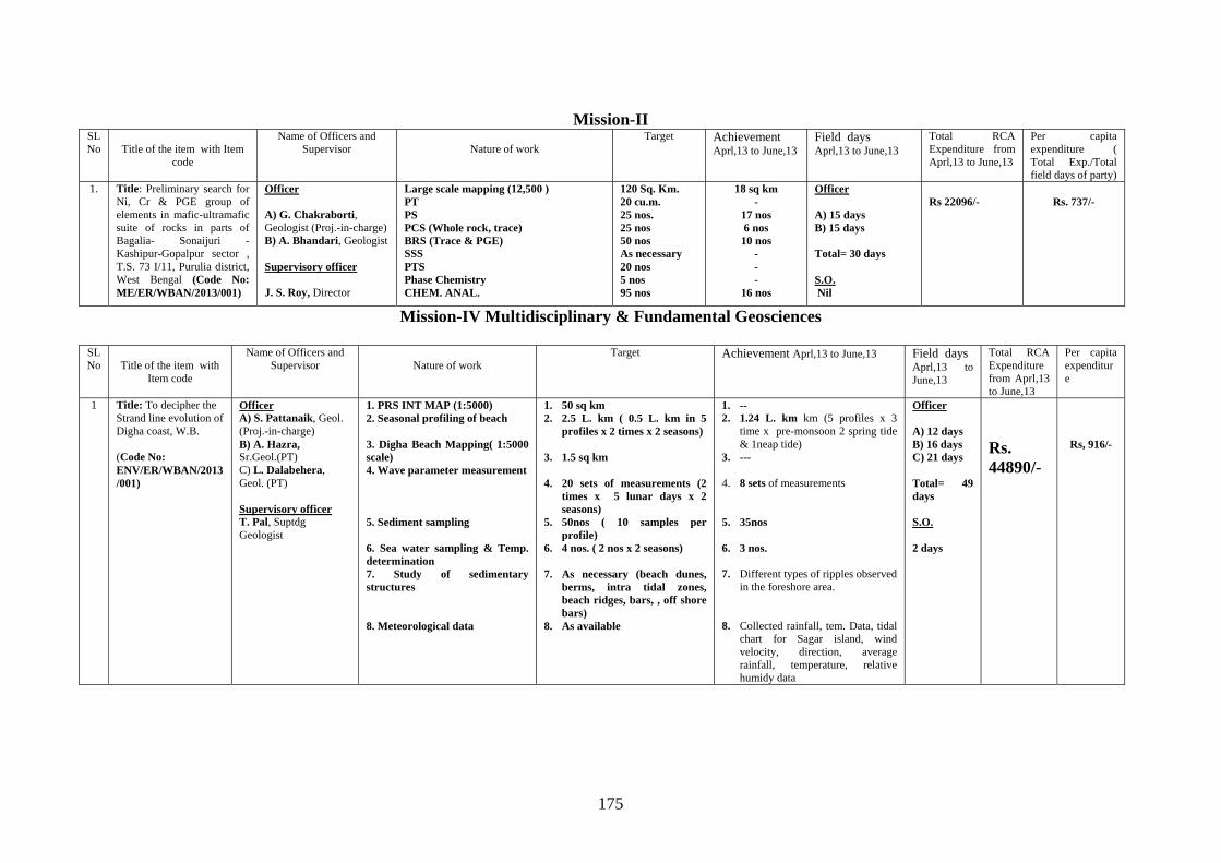
175
Mission-II
SLNo
Title of the item with Item
code
Name of Officers and Supervisor
Nature of work
Target Achievement Aprl,13 to June,13
Field days Aprl,13 to June,13
Total RCA Expenditure from Aprl,13 to June,13
Per capita expenditure ( Total Exp./Total field days of party)
1. Title: Preliminary search for Ni, Cr & PGE group of elements in mafic-ultramafic suite of rocks in parts of Bagalia- Sonaijuri -Kashipur-Gopalpur sector , T.S. 73 I/11, Purulia district, West Bengal (Code No: ME/ER/WBAN/2013/001)
Officer A) G. Chakraborti, Geologist (Proj.-in-charge) B) A. Bhandari, Geologist Supervisory officer J. S. Roy, Director
Large scale mapping (12,500 ) PT PS PCS (Whole rock, trace) BRS (Trace & PGE) SSS PTS Phase Chemistry CHEM. ANAL.
120 Sq. Km. 20 cu.m. 25 nos. 25 nos 50 nos As necessary 20 nos 5 nos 95 nos
18 sq km -
17 nos 6 nos 10 nos
- - -
16 nos
Officer A) 15 days B) 15 days Total= 30 days S.O. Nil
Rs 22096/-
Rs. 737/-
Mission-IV Multidisciplinary & Fundamental Geosciences
SLNo
Title of the item with
Item code
Name of Officers and Supervisor
Nature of work
Target Achievement Aprl,13 to June,13 Field days Aprl,13 to June,13
Total RCA Expenditure from Aprl,13 to June,13
Per capita expenditure
1 Title: To decipher the Strand line evolution of Digha coast, W.B. (Code No: ENV/ER/WBAN/2013/001)
Officer A) S. Pattanaik, Geol. (Proj.-in-charge) B) A. Hazra, Sr.Geol.(PT) C) L. Dalabehera, Geol. (PT) Supervisory officer T. Pal, Suptdg Geologist
1. PRS INT MAP (1:5000) 2. Seasonal profiling of beach 3. Digha Beach Mapping( 1:5000 scale) 4. Wave parameter measurement 5. Sediment sampling 6. Sea water sampling & Temp. determination 7. Study of sedimentary structures 8. Meteorological data
1. 50 sq km 2. 2.5 L. km ( 0.5 L. km in 5
profiles x 2 times x 2 seasons) 3. 1.5 sq km 4. 20 sets of measurements (2
times x 5 lunar days x 2 seasons)
5. 50nos ( 10 samples per profile)
6. 4 nos. ( 2 nos x 2 seasons) 7. As necessary (beach dunes,
berms, intra tidal zones, beach ridges, bars, , off shore bars)
8. As available
1. -- 2. 1.24 L. km km (5 profiles x 3
time x pre-monsoon 2 spring tide & 1neap tide)
3. --- 4. 8 sets of measurements 5. 35nos 6. 3 nos. 7. Different types of ripples observed
in the foreshore area. 8. Collected rainfall, tem. Data, tidal
chart for Sagar island, wind velocity, direction, average rainfall, temperature, relative humidy data
Officer A) 12 days B) 16 days C) 21 days Total= 49 days S.O. 2 days
Rs. 44890/-
Rs, 916/-
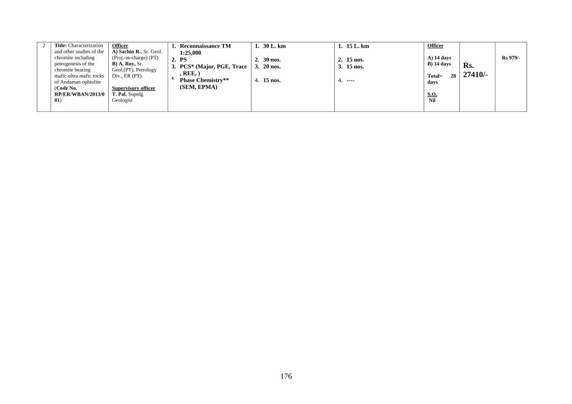
176
2 Title: Characterization and other studies of the chromite including petrogenesis of the chromite bearing mafic-ultra mafic rocks of Andaman ophiolite (Code No. RP/ER/WBAN/2013/001)
Officer A) Sachin R., Sr. Geol. (Proj.-in-charge) (PT) B) A. Roy, Sr. Geol.(PT), Petrology Div., ER (PT) Supervisory officer T. Pal, Suptdg Geologist
1. Reconnaissance TM 1:25,000
2. PS 3. PCS* (Major, PGE, Trace
, REE, ) 4. Phase Chemistry**
(SEM, EPMA)
1. 30 L. km
2. 30 nos. 3. 20 nos. 4. 15 nos.
1. 15 L. km
2. 15 nos. 3. 15 nos.
4. ----
Officer A) 14 days B) 14 days Total= 28 days S.O. Nil
Rs. 27410/-
Rs 979/-
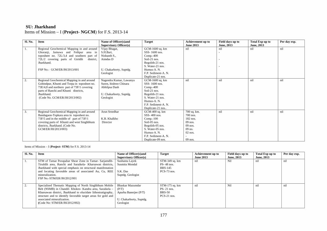
177
SU: Jharkhand Items of Mission – I (Project- NGCM) for F.S. 2013-14 Sl. No. Item Name of Officer(s)and
Supervisory Officer(s) Target Achievement up to
June 2013 Field days up to June, 2013
Total Exp up to June, 2013
Per day exp.
1. Regional Geochemical Mapping in and around Ghoranji, Jamuwa and Fethpur area in toposheet no. 72L/3,4 and southern part of 72L/2 covering parts of Giridih district, Jharkhand. FSP No.- GCM/ER/JH/2013/001
Vijay Bhagat, S.H.Bari, Nishanth S., Aimdas D U. Chakarborty, Suptdg. Geologist
GCM-1600 sq. km SSS- 1600 nos. Comp.-400 Soil-21 nos. Regolith-21 nos. S. Water-21 nos. Humus-A. N. F.P. Sediment-A. N. Duplicate-21 nos.
nil nil - - -
nil nil
2. Regional Geochemical Mapping in and around Gobindpur, Khunti and Torpa in toposheet no. 73E/4,8 and northern part of 73F/1 covering parts of Ranchi and Khunti districts, Jharkhand. (Code No. GCM/ER/JH/2013/002)
Nagendra Kumar, Lawanya Suren, Itishree Chinara Abhilpsa Dash U. Chakarborty, Suptdg. Geologist
GCM-1600 sq. km SSS- 1600 nos. Comp.-400 Soil-21 nos. Regolith-21 nos. S. Water-21 nos. Humus-A. N. F.P. Sediment-A. N. Duplicate-21 nos..
nil nil
nil nil
3. Regional Geochemical Mapping in and around Bandagaon-Topkara area in toposheet no. 73F/5 and in the middle of part of 73F/1 covering parts of Khunti and west Singhbhum districts, Jharkhand. (Code No. GCM/ER/JH/2013/003)
Arun Sreedhar K.B. Khalkho Director
GCM-400 sq. km SSS- 400 nos. Comp.-100 Soil-05 nos. Regolith-05 nos. S. Water-05 nos. Humus-A. N. F.P. Sediment-A. N. Duplicate-09 nos.
700 sq. km. 700 nos. 182 nos. 09 nos. 09 nos. 09 no. 02 nos. - 09 nos.
nil
nil nil
Items of Mission – I (Project- STM) for F.S. 2013-14 Sl. No. Item Name of Officer(s)and
Supervisory Officer(s) Target Achievement up to
June 2013 Field days up to June, 2013
Total Exp up to June, 2013
Per day exp.
1. STM of Tamar Porapahar Shear Zone in Tamar- Sarjamdih-Tiruldih area, Ranchi and Saraikela- Kharsawan districts, Jharkhand with special emphasis on structural manifestation and locating favorable areas of associated Au, Cu, REE mineralization. FSP No.-STM/ER/JH/2012/001
Sushanta Layek Susmita Mondal S.K. Das Suptdg. Geologist
STM-349 sq. km PS- 48 nos. BRS-145 PCS-73 nos.
nil Nil nil nil
2. Specialised Thematic Mapping of North Singhbhum Mobile Belt (NSMB) in Chandil- Khokro- Kandra area, Saraikela – Kharsawan district, Jharkhand to elucidate lithostratigraphy, structure and to identify favorable target areas for gold and associated mineralization. (Code No: STM/ER/JH/2012/002)
Bhaskar Mazumdar (P/T) Apurba Banerjee (P/T) U. Chakarborty, Suptdg. Geologist
STM-175 sq. km PS- 21 nos. BRS-50 PCS-21 nos.
nil Nil nil nil
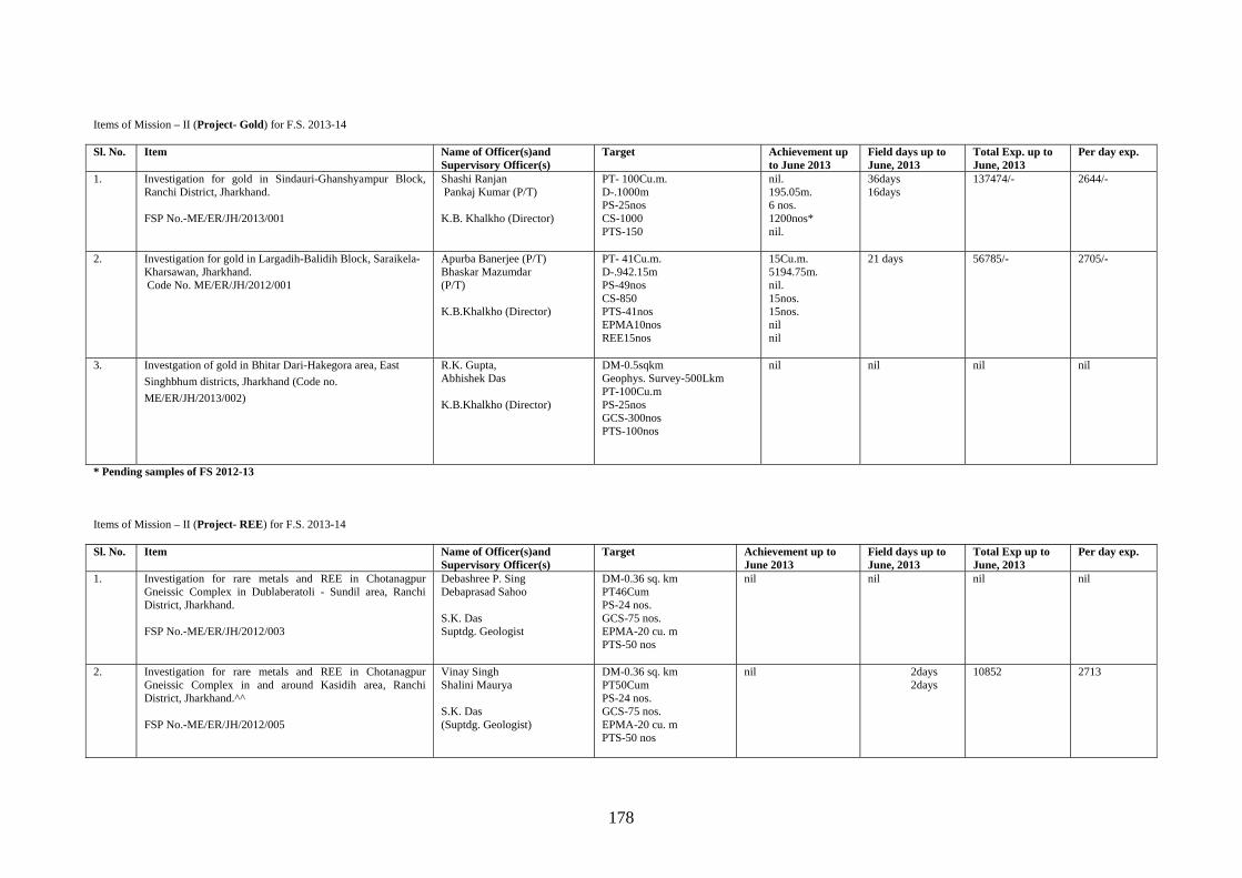
178
Items of Mission – II (Project- Gold) for F.S. 2013-14 Sl. No. Item Name of Officer(s)and
Supervisory Officer(s) Target Achievement up
to June 2013 Field days up to June, 2013
Total Exp. up to June, 2013
Per day exp.
1. Investigation for gold in Sindauri-Ghanshyampur Block, Ranchi District, Jharkhand. FSP No.-ME/ER/JH/2013/001
Shashi Ranjan Pankaj Kumar (P/T) K.B. Khalkho (Director)
PT- 100Cu.m. D-.1000m PS-25nos CS-1000 PTS-150
nil. 195.05m. 6 nos. 1200nos* nil.
36days 16days
137474/- 2644/-
2. Investigation for gold in Largadih-Balidih Block, Saraikela- Kharsawan, Jharkhand. Code No. ME/ER/JH/2012/001
Apurba Banerjee (P/T) Bhaskar Mazumdar (P/T) K.B.Khalkho (Director)
PT- 41Cu.m. D-.942.15m PS-49nos CS-850 PTS-41nos EPMA10nos REE15nos
15Cu.m. 5194.75m. nil. 15nos. 15nos. nil nil
21 days
56785/- 2705/-
3. Investgation of gold in Bhitar Dari-Hakegora area, East
Singhbhum districts, Jharkhand (Code no.
ME/ER/JH/2013/002)
R.K. Gupta, Abhishek Das K.B.Khalkho (Director)
DM-0.5sqkm Geophys. Survey-500Lkm PT-100Cu.m PS-25nos GCS-300nos PTS-100nos
nil nil nil nil
* Pending samples of FS 2012-13 Items of Mission – II (Project- REE) for F.S. 2013-14 Sl. No. Item Name of Officer(s)and
Supervisory Officer(s) Target Achievement up to
June 2013 Field days up to June, 2013
Total Exp up to June, 2013
Per day exp.
1. Investigation for rare metals and REE in Chotanagpur Gneissic Complex in Dublaberatoli - Sundil area, Ranchi District, Jharkhand. FSP No.-ME/ER/JH/2012/003
Debashree P. Sing Debaprasad Sahoo S.K. Das Suptdg. Geologist
DM-0.36 sq. km PT46Cum PS-24 nos. GCS-75 nos. EPMA-20 cu. m PTS-50 nos
nil nil nil nil
2. Investigation for rare metals and REE in Chotanagpur Gneissic Complex in and around Kasidih area, Ranchi District, Jharkhand.^^ FSP No.-ME/ER/JH/2012/005
Vinay Singh Shalini Maurya S.K. Das (Suptdg. Geologist)
DM-0.36 sq. km PT50Cum PS-24 nos. GCS-75 nos. EPMA-20 cu. m PTS-50 nos
nil 2days 2days
10852 2713
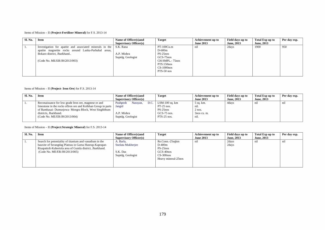
179
Items of Mission – II (Project-Fertiliser Mineral) for F.S. 2013-14 Sl. No. Item Name of Officer(s)and
Supervisory Officer(s) Target Achievement up to
June 2013 Field days up to June, 2013
Total Exp up to June, 2013
Per day exp.
1. Investigation for apatite and associated minerals in the apatite magnetite rocks around Lanka-Parbahal areas, Bokaro district, Jharkhand.. (Code No. ME/ER/JH/2013/003)
S.K. Rana A.P. Mishra Suptdg. Geologist
PT-100Cu.m D-600m PS-25nos GCS-75nos CH:SMPL.- 75nos PTS:150nos CS-1000nos PTS-50 nos
nil 2days 1900 950
Items of Mission – II (Project- Iron Ore) for F.S. 2013-14 Sl. No. Item Name of Officer(s)and
Supervisory Officer(s) Target Achievement up to
June 2013 Field days up to June, 2013
Total Exp up to June, 2013
Per day exp.
1. Reconaissance for low grade Iron ore, magnese or and limestone in the rocks ofIron ore and Kolkhan Group in parts of Bambasai- Dumurjowa- Mongra Block, West Singhbhum districts, Jharkhand. (Code No. ME/ER/JH/2013/004)
Pushpesh Narayan, D.C. Jangid A.P. Mishra Suptdg. Geologist
LSM-100 sq. km PT-25 nos. PS-25nos GCS-75 nos. PTS-25 nos.
5 sq. km. nil. 2 nos. 3nos cu. m. nil.
4days nil nil
Items of Mission – II (Project:Strategic Mineral) for F.S. 2013-14 Sl. No. Item Name of Officer(s)and
Supervisory Officer(s) Target Achievement up to
June 2013 Field days up to June, 2013
Total Exp up to June, 2013
Per day exp.
1. Search for potentiality of titanium and vanadium in the bauxite of Serangdag Plateau in Garna Hanrup-Kaprapat- Risapattoli-Kubertola area of Gumla district, Jharkhand. (Code No. ME/ER/JH/2013/005)
A. Barla, Snelata Mukherjee S.K. Das Suptdg. Geologist
Re.Conn.-25sqkm D-400m PS-25nos GCS-40nos CS-300nos Heavy mineral-25nos
nil 2days 2days
nil nil
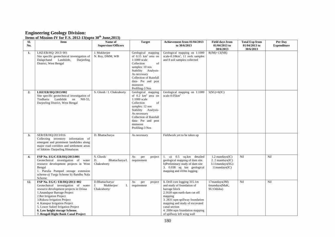
180
Engineering Geology Division: Items of Mission-IV for F.S. 2012-13(upto 30th June,2013)
Sl. No.
Item Name of Supervisor/Officers
Target Achievement from 01/04/2013 to 30/6/2013
Field days from 01/04/2013 to
30/6/2013
Total Exp from 01/04/2013 to
30/6/2013
Per Day Expenditure
1. LHZ/ER/HQ/ 2013/ 001 Site specific geotechnical investigation of Dalapchand Landslide, Darjeeling District, West Bengal
J. Mukherjee N. Roy, DMM, WB
Geological mapping of 0.15 km2 area on 1:1000 scale Collection of samples: 10 nos Stability Analysis- As necessary Collection of Rainfall data- Pre and post monsoon Profiling-3 Nos
Geological mapping on 1:1000 scale-0.10km2, 11 rock samples and 8 soil samples collected
8(JM)+13(NR)
2. LHZ/ER/HQ/2013/002 Site specific geotechnical investigation of Tindharia Landslide on NH-55, Darjeeling District, West Bengal
S. Ghosh / I. Chakraborty Geological mapping of 0.2 km2 area on 1:1000 scale Collection of samples: 12 nos Stability Analysis- As necessary Collection of Rainfall data- Pre and post monsoon Profiling-3 Nos
Geological mapping on 1:1000 scale-0.05km2
5(SG)+6(IC)
3. SER/ER/HQ/2013/016 Collecting inventory information of emergent and prominent landslides along major road corridors and settlement areas of Sikkim- Darjeeling Himalayas
D. Bhattacharya As necessary
Fieldwork yet to be taken up
4. FSP No. EG/C/ER/HQ/2013/001 Geotechnical investigation of water resource development projects in West Bengal 1. Purulia Pumped storage extension scheme-a) Turga Scheme b) Bandhu Nala Scheme
S. Ghosh/ D. Bhattacharya/I. Chakraborty
As per project requirement
1. a) 0.5 sq.km detailed geological mapping of dam site. b)Preliminary study of dam site 3. 0.038 sq km geological mapping and 410m logging
1.2 mandays(IC) 2. 2 mandays(IC) 3.11mandays(SG)
11mandays(IC)
Nil Nil
12. FSP No. EG/C/ ER/HQ/2013/ 002 Geotechnical investigation of water resource development projects in Orissa 1.Anandapur Barrage Project 2.Ret Irrigation Project 3.Rukura Irrigation Project 4. Kanupur Irrigation Project 5. Lower Suktel Irrigation Project 6. Low height storage Scheme. 7. Rengali Right Bank Canal Project
D.Bhattacharya/ J. Mukherjee/ I. Chakraborty/
As per project requirement
1. Drill core logging 315.1m and study of foundation of barrage block 2.1618 sqm earth dam cut off mapping 3. 2831 sqm spillway foundation mapping and study of excavated canal section 4. 2684 sqm foundation mapping of spillway left wing wall
17mandays(JM) 6mandays(MaK, SU:Odisha)
Nil Nil
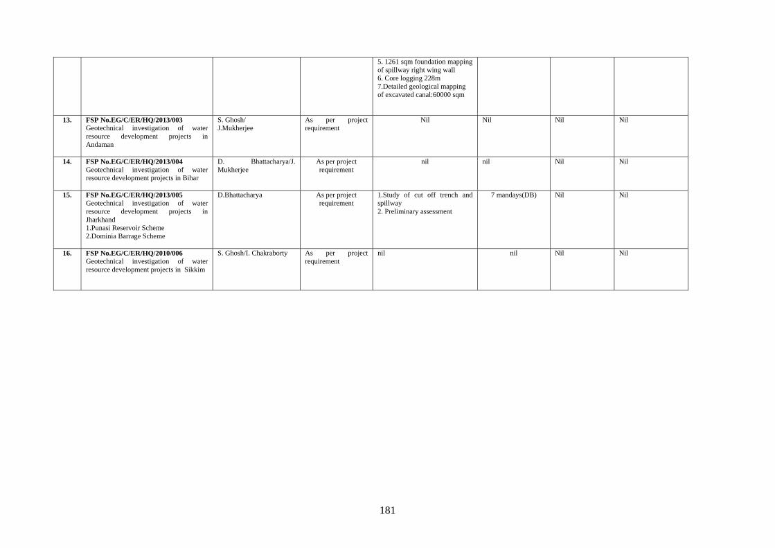
181
5. 1261 sqm foundation mapping of spillway right wing wall 6. Core logging 228m 7.Detailed geological mapping of excavated canal:60000 sqm
13. FSP No.EG/C/ER/HQ/2013/003 Geotechnical investigation of water resource development projects in Andaman
S. Ghosh/ J.Mukherjee
As per project requirement
Nil Nil Nil Nil
14. FSP No.EG/C/ER/HQ/2013/004 Geotechnical investigation of water resource development projects in Bihar
D. Bhattacharya/J. Mukherjee
As per project requirement
nil nil Nil Nil
15. FSP No.EG/C/ER/HQ/2013/005 Geotechnical investigation of water resource development projects in Jharkhand 1.Punasi Reservoir Scheme 2.Dominia Barrage Scheme
D.Bhattacharya As per project requirement
1.Study of cut off trench and spillway 2. Preliminary assessment
7 mandays(DB) Nil Nil
16. FSP No.EG/C/ER/HQ/2010/006 Geotechnical investigation of water resource development projects in Sikkim
S. Ghosh/I. Chakraborty As per project requirement
nil nil Nil Nil
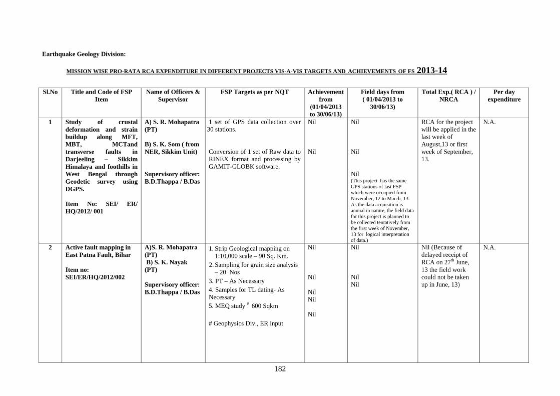
182
Earthquake Geology Division:
Sl.No Title and Code of FSP Item
Name of Officers & Supervisor
FSP Targets as per NQT Achievement from
(01/04/2013 to 30/06/13)
Field days from ( 01/04/2013 to
30/06/13)
Total Exp.( RCA ) / NRCA
Per day expenditure
1
Study of crustal deformation and strain buildup along MFT, MBT, MCTand transverse faults in Darjeeling – Sikkim Himalaya and foothills in West Bengal through Geodetic survey using DGPS. Item No: SEI/ ER/ HQ/2012/ 001
A) S. R. Mohapatra (PT)
B) S. K. Som ( from NER, Sikkim Unit) Supervisory officer: B.D.Thappa / B.Das
1 set of GPS data collection over 30 stations. Conversion of 1 set of Raw data to RINEX format and processing by GAMIT-GLOBK software.
Nil Nil
Nil Nil Nil (This project has the same GPS stations of last FSP which were occupied from November, 12 to March, 13. As the data acquisition is annual in nature, the field data for this project is planned to be collected tentatively from the first week of November, 13 for logical interpretation of data.)
RCA for the project will be applied in the last week of August,13 or first week of September, 13.
N.A.
2
Active fault mapping in East Patna Fault, Bihar Item no: SEI/ER/HQ/2012/002
A)S. R. Mohapatra (PT) B) S. K. Nayak (PT) Supervisory officer: B.D.Thappa / B.Das
1. Strip Geological mapping on 1:10,000 scale – 90 Sq. Km.
2. Sampling for grain size analysis – 20 Nos
3. PT – As Necessary 4. Samples for TL dating- As Necessary 5. MEQ study # 600 Sqkm # Geophysics Div., ER input
Nil Nil Nil Nil Nil
Nil Nil Nil
Nil (Because of delayed receipt of RCA on 27th June, 13 the field work could not be taken up in June, 13)
N.A.
MISSION WISE PRO-RATA RCA EXPENDITURE IN DIFFERENT PROJECTS VIS-A-VIS TARGETS AND ACHIEVEMENTS OF FS 2013-14
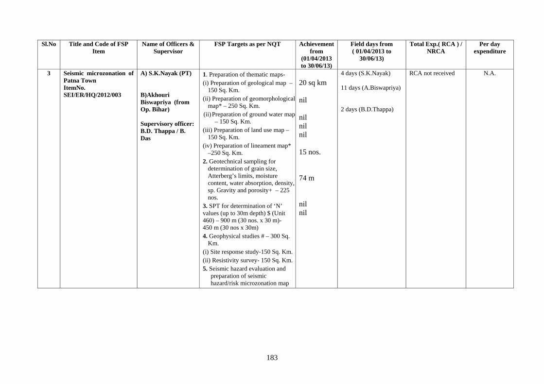
183
Sl.No Title and Code of FSP Item
Name of Officers & Supervisor
FSP Targets as per NQT Achievement from
(01/04/2013 to 30/06/13)
Field days from ( 01/04/2013 to
30/06/13)
Total Exp.( RCA ) / NRCA
Per day expenditure
3 Seismic microzonation of Patna Town ItemNo. SEI/ER/HQ/2012/003
A) S.K.Nayak (PT)
B)Akhouri Biswapriya (from Op. Bihar) Supervisory officer: B.D. Thappa / B. Das
1. Preparation of thematic maps- (i) Preparation of geological map –
150 Sq. Km. (ii) Preparation of geomorphological
map* – 250 Sq. Km. (ii) Preparation of ground water map
– 150 Sq. Km. (iii) Preparation of land use map –
150 Sq. Km. (iv) Preparation of lineament map*
–250 Sq. Km. 2. Geotechnical sampling for
determination of grain size, Atterberg’s limits, moisture content, water absorption, density, sp. Gravity and porosity+ – 225 nos.
3. SPT for determination of ‘N’ values (up to 30m depth) $ (Unit 460) – 900 m (30 nos. x 30 m)- 450 m (30 nos x 30m) 4. Geophysical studies # – 300 Sq.
Km. (i) Site response study-150 Sq. Km.(ii) Resistivity survey- 150 Sq. Km.5. Seismic hazard evaluation and
preparation of seismic hazard/risk microzonation map
20 sq km nil nil nil nil 15 nos. 74 m nil nil
4 days (S.K.Nayak) 11 days (A.Biswapriya) 2 days (B.D.Thappa)
RCA not received
N.A.
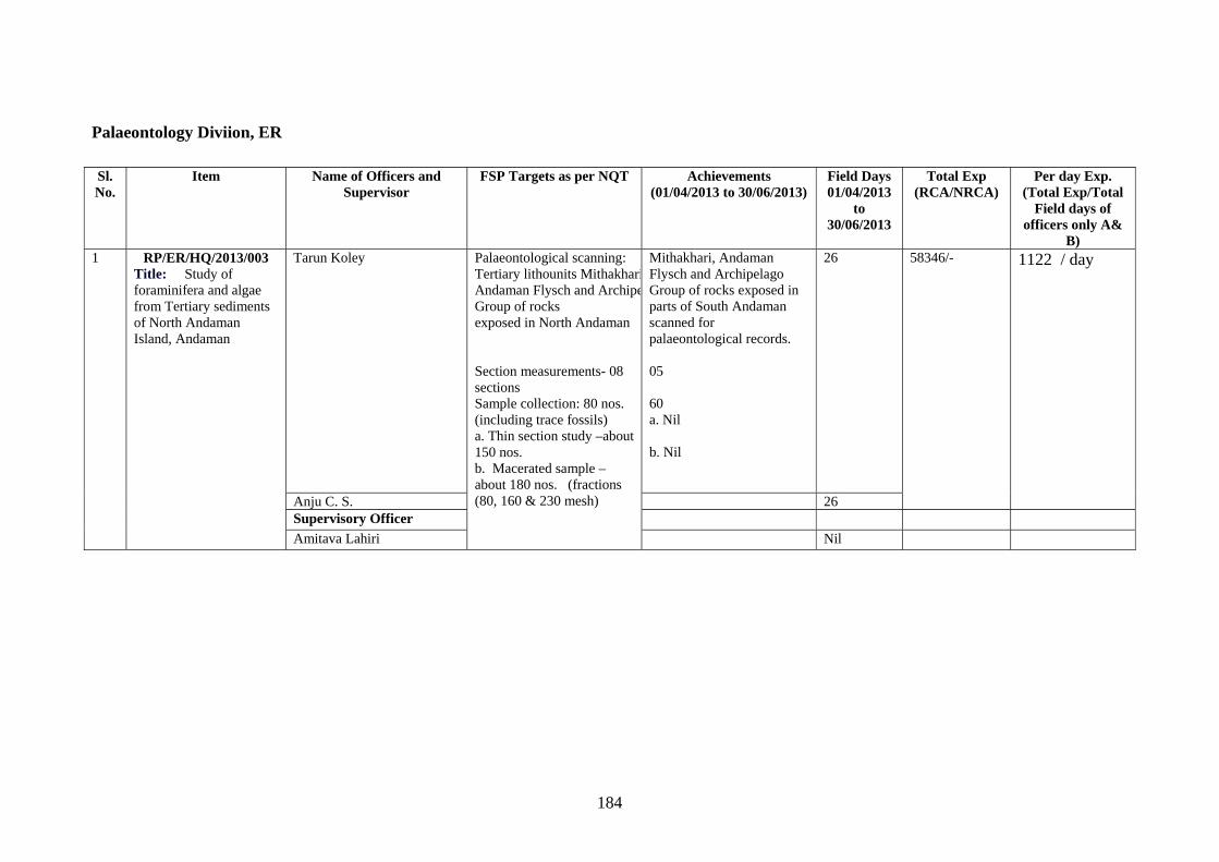
184
Palaeontology Diviion, ER
Sl. No.
Item Name of Officers and Supervisor
FSP Targets as per NQT Achievements (01/04/2013 to 30/06/2013)
Field Days 01/04/2013
to 30/06/2013
Total Exp (RCA/NRCA)
Per day Exp. (Total Exp/Total
Field days of officers only A&
B) 1 RP/ER/HQ/2013/003
Title: Study of foraminifera and algae from Tertiary sediments of North Andaman Island, Andaman
Tarun Koley Palaeontological scanning: Tertiary lithounits MithakhariAndaman Flysch and ArchipeGroup of rocks exposed in North Andaman Section measurements- 08 sections Sample collection: 80 nos. (including trace fossils) a. Thin section study –about 150 nos. b. Macerated sample – about 180 nos. (fractions (80, 160 & 230 mesh)
Mithakhari, Andaman Flysch and Archipelago Group of rocks exposed in parts of South Andaman scanned for palaeontological records. 05 60 a. Nil b. Nil
26 58346/- 1122 / day
Anju C. S. 26 Supervisory Officer Amitava Lahiri Nil
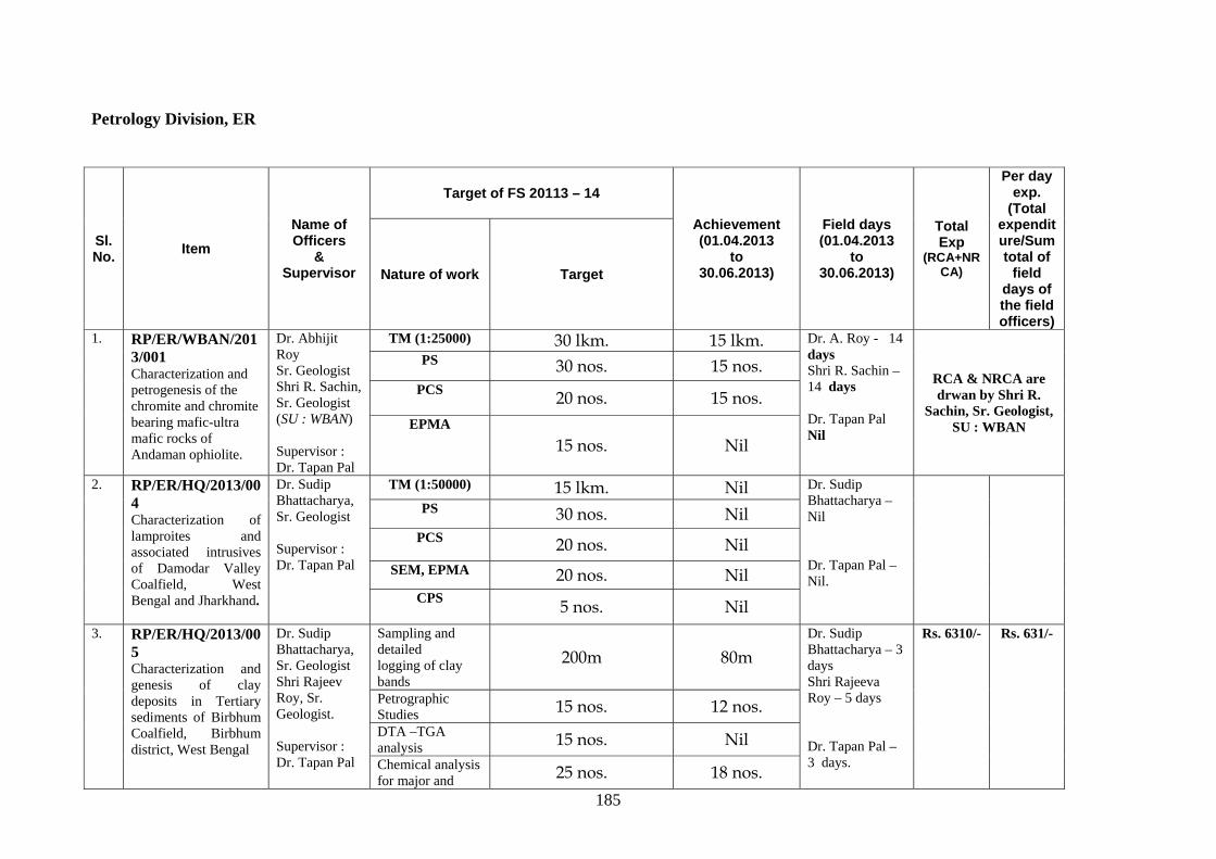
185
Petrology Division, ER
Sl. No. Item
Name of Officers
& Supervisor
Target of FS 20113 – 14
Achievement (01.04.2013
to 30.06.2013)
Field days (01.04.2013
to 30.06.2013)
Total Exp
(RCA+NRCA)
Per day exp.
(Total expenditure/Sum total of
field days of the field officers)
Nature of work Target
1. RP/ER/WBAN/2013/001 Characterization and petrogenesis of the chromite and chromite bearing mafic-ultra mafic rocks of Andaman ophiolite.
Dr. Abhijit Roy Sr. Geologist Shri R. Sachin, Sr. Geologist (SU : WBAN) Supervisor : Dr. Tapan Pal
TM (1:25000) 30 lkm. 15 lkm. Dr. A. Roy - 14 days Shri R. Sachin – 14 days Dr. Tapan Pal Nil
RCA & NRCA are drwan by Shri R.
Sachin, Sr. Geologist, SU : WBAN
PS 30 nos. 15 nos. PCS 20 nos. 15 nos.
EPMA
15 nos. Nil
2. RP/ER/HQ/2013/004 Characterization of lamproites and associated intrusives of Damodar Valley Coalfield, West Bengal and Jharkhand.
Dr. Sudip Bhattacharya, Sr. Geologist Supervisor : Dr. Tapan Pal
TM (1:50000) 15 lkm. Nil Dr. Sudip Bhattacharya – Nil Dr. Tapan Pal – Nil.
PS 30 nos. Nil PCS 20 nos. Nil
SEM, EPMA 20 nos. Nil CPS 5 nos. Nil
3. RP/ER/HQ/2013/005 Characterization and genesis of clay deposits in Tertiary sediments of Birbhum Coalfield, Birbhum district, West Bengal
Dr. Sudip Bhattacharya, Sr. Geologist Shri Rajeev Roy, Sr. Geologist. Supervisor : Dr. Tapan Pal
Sampling and detailed logging of clay bands
200m 80m Dr. Sudip Bhattacharya – 3 days Shri Rajeeva Roy – 5 days Dr. Tapan Pal – 3 days.
Rs. 6310/- Rs. 631/-
Petrographic Studies 15 nos. 12 nos. DTA –TGA analysis 15 nos. Nil Chemical analysis for major and 25 nos. 18 nos.
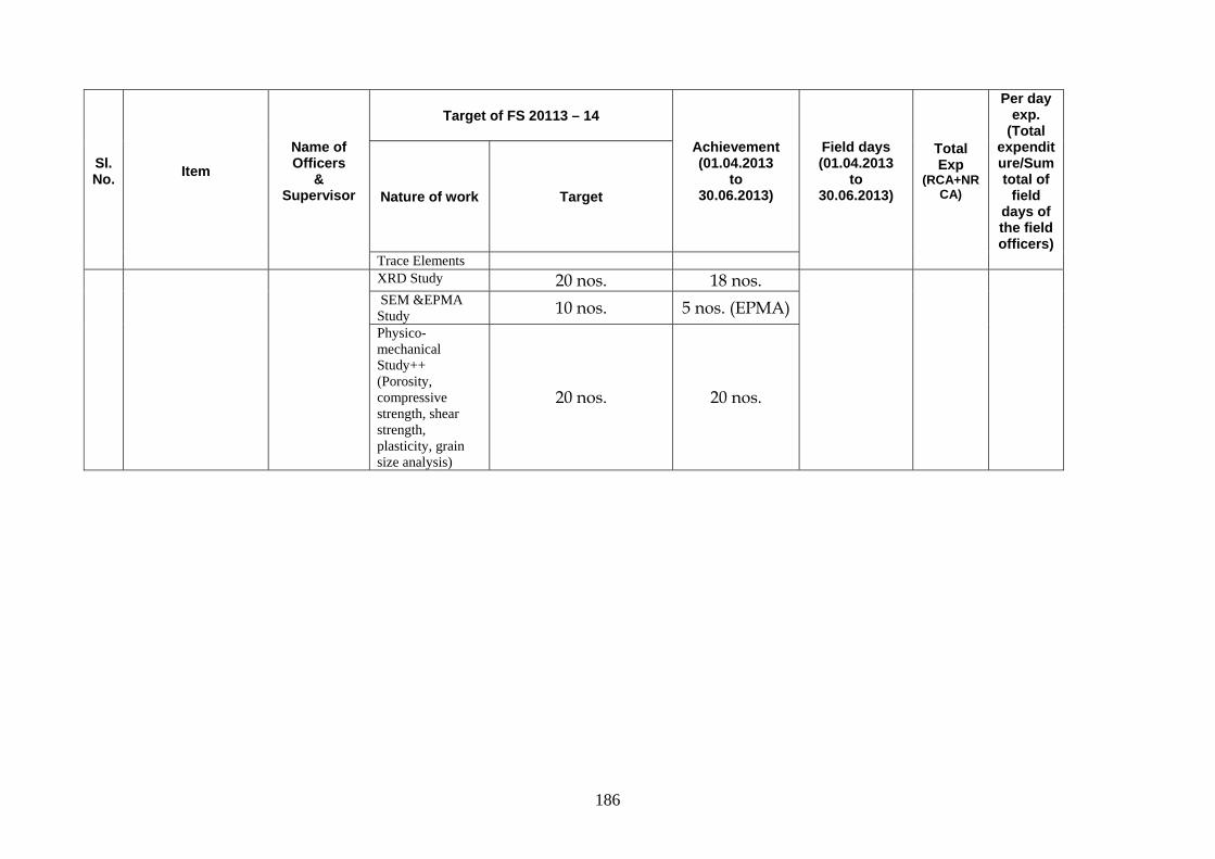
186
Sl. No. Item
Name of Officers
& Supervisor
Target of FS 20113 – 14
Achievement (01.04.2013
to 30.06.2013)
Field days (01.04.2013
to 30.06.2013)
Total Exp
(RCA+NRCA)
Per day exp.
(Total expenditure/Sum total of
field days of the field officers)
Nature of work Target
Trace Elements XRD Study 20 nos. 18 nos.
SEM &EPMA Study 10 nos. 5 nos. (EPMA) Physico-mechanical Study++ (Porosity, compressive strength, shear strength, plasticity, grain size analysis)
20 nos. 20 nos.
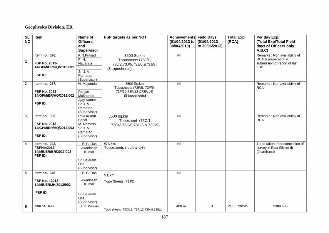
187
Geophysics Division, ER SL NO
Item Name of Officers and Supervisor
FSP targets as per NQT Achievements(01/04/2013 to 30/06/2013)
Field Days (01/04/2013 to 30/06/2013)
Total Exp (RCA)
Per day Exp. (Total Exp/Total Field days of Officers only A,B,C)
1
Item no. 026, FSP No. 2013-14/GPM/ER/HQ/2013/001 FSP ID:
K N.Prasad 3500 Sq.km Toposheets (73J/1,
73J/2,73J/5,73J/6 &73J/9) (5 toposheets)
Nil Remarks : Non availability of RCA & preparation & submission of report of last FSP
P. N. Nagaraja Sri J. V. Ramarao (Supervisor)
2 Item no. 027, FSP No. 2013-14/GPM/ER/HQ/2013/002 FSP ID:
N. Majumdar
3500 Sq.km Toposheets (73F/5, 73F/9, 73F/10,73F/13 &73F/14)
(5 toposheets)
Nil Remarks : Non availability of RCA
Ranjan Mukherjee Ajay Kumar Sri J. V. Ramarao (Supervisor)
3 Item no. 028, FSP No. 2013-14/GPM/ER/HQ/2013/003 FSP ID:
Ravi Kumar Bandi
3500 sq.km Toposheet (73C/1,
73C/2,73C/5,73C/6 & 73C/9)
Nil Remarks : Non availability of RCA
M. Ramesh Sri J. V. Ramarao (Supervisor)
4 Item no. 042,FSPNo:2013- 14/ME/ER/BR/2013/002 FSP ID:
P. C. Das 60 L km, Toposheets (72G/8 &72H/5)
Nil To be taken after completion of survey in East Sikkim dt (Jharkhand)
Awadhesh Kumar
Sri Balaram Das (Supervisor)
5 Item no. 045 FSP No. : 2013-14/ME/ER/JH/2013/002 FSP ID:
P. C. Das 5 L km
Topo Sheets: 73J/2
Nil
Awadhesh Kumar
Sri Balaram Das (Supervisor)
6 Item no. S-18
S. K. Biswas Topo sheets: 73C/12, 73P/12,73M/9,73E/1
488 m 3 POL : 2029/-
3389.63/-
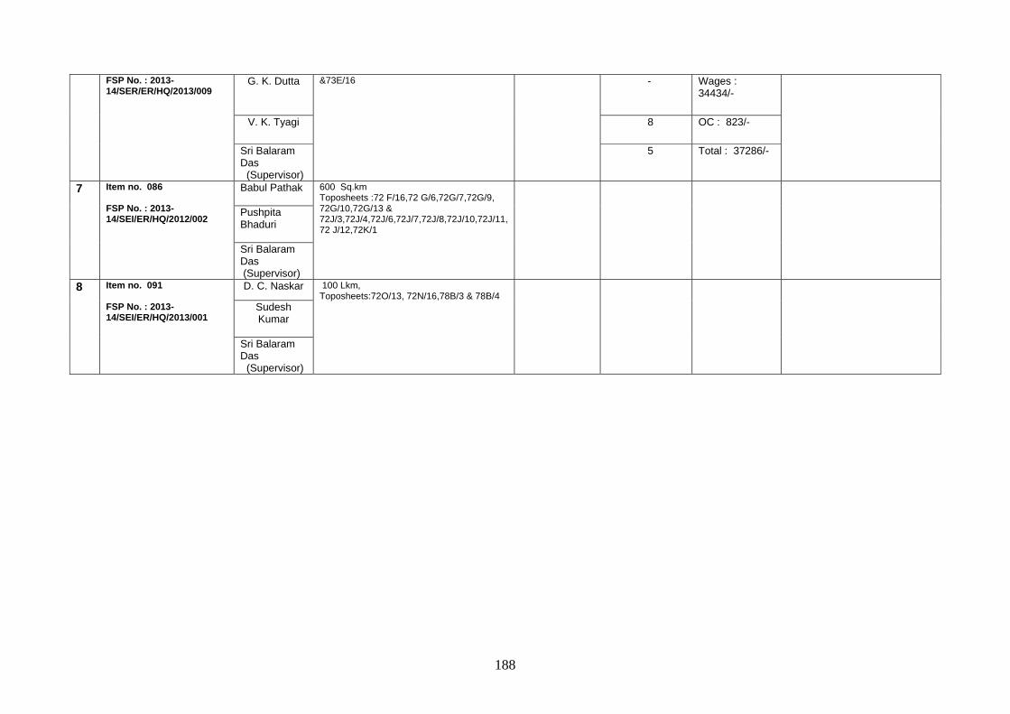
188
FSP No. : 2013-14/SER/ER/HQ/2013/009 G. K. Dutta
&73E/16
- Wages :
34434/-
V. K. Tyagi 8 OC : 823/-
Sri Balaram Das (Supervisor)
5 Total : 37286/-
7 Item no. 086 FSP No. : 2013-14/SEI/ER/HQ/2012/002
Babul Pathak
600 Sq.km Toposheets :72 F/16,72 G/6,72G/7,72G/9, 72G/10,72G/13 & 72J/3,72J/4,72J/6,72J/7,72J/8,72J/10,72J/11, 72 J/12,72K/1
Pushpita Bhaduri Sri Balaram Das (Supervisor)
8 Item no. 091 FSP No. : 2013-14/SEI/ER/HQ/2013/001
D. C. Naskar 100 Lkm, Toposheets:72O/13, 72N/16,78B/3 & 78B/4
Sudesh Kumar
Sri Balaram Das (Supervisor)
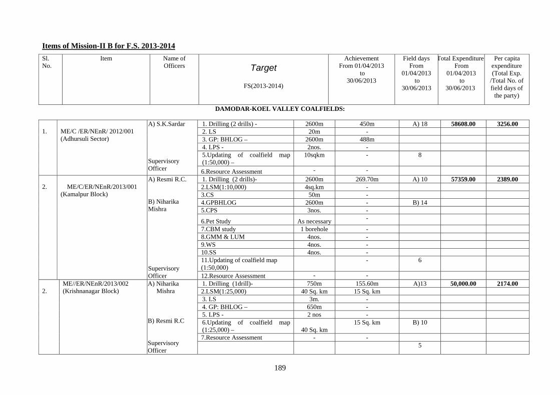
189
Items of Mission-II B for F.S. 2013-2014
DAMODAR-KOEL VALLEY COALFIELDS:
1.
ME/C /ER/NEnR/ 2012/001 (Adhursuli Sector)
A) S.K.Sardar Supervisory Officer
1. Drilling (2 drills) - 2600m 450m A) 18 58608.00 3256.00 2. LS 20m - 3. GP: BHLOG – 2600m 488m 4. LPS - 2nos. - 5.Updating of coalfield map (1:50,000) –
10sqkm - 8
6.Resource Assessment - -
2.
ME/C/ER/NEnR/2013/001
(Kamalpur Block)
A) Resmi R.C. B) Niharika Mishra Supervisory Officer
1. Drilling (2 drills)- 2600m 269.70m A) 10 57359.00 2389.00 2.LSM(1:10,000) 4sq.km - 3.CS 50m - 4.GPBHLOG 2600m - B) 14 5.CPS 3nos. -
6.Pet Study As necessary -
7.CBM study 1 borehole - 8.GMM & LUM 4nos. - 9.WS 4nos. - 10.SS 4nos. - 11.Updating of coalfield map (1:50,000)
- 6
12.Resource Assessment - - 2.
ME//ER/NEnR/2013/002 (Krishnanagar Block)
A) Niharika Mishra
B) Resmi R.C Supervisory Officer
1. Drilling (1drill)- 750m 155.60m A)13 50,000.00 2174.00 2.LSM(1:25,000) 40 Sq. km 15 Sq. km 3. LS 3m. - 4. GP: BHLOG – 650m - 5. LPS - 2 nos - 6.Updating of coalfield map (1:25,000) – 40 Sq. km
15 Sq. km B) 10
7.Resource Assessment - -
5
Sl. No.
Item Name of Officers Target
FS(2013-2014)
Achievement From 01/04/2013
to 30/06/2013
Field days From
01/04/2013 to
30/06/2013
Total Expenditure From
01/04/2013 to
30/06/2013
Per capita expenditure (Total Exp.
/Total No. of field days of
the party)
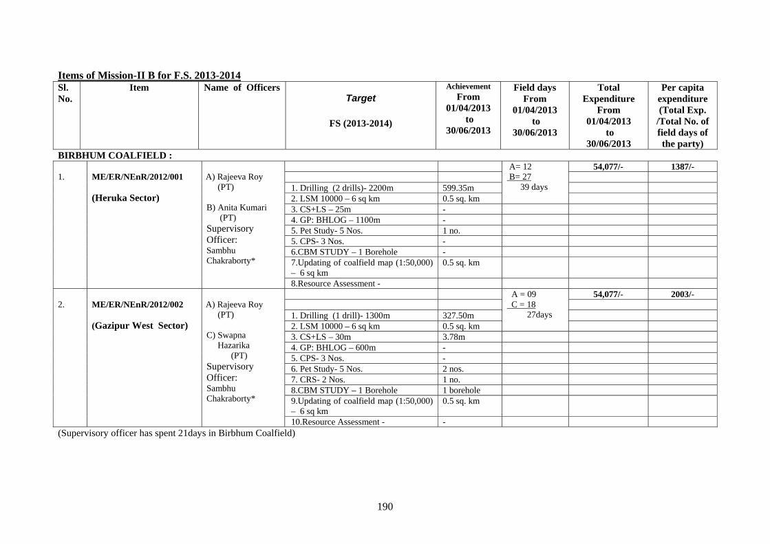
190
Items of Mission-II B for F.S. 2013-2014 Sl. No.
Item Name of Officers Target
FS (2013-2014)
Achievement From
01/04/2013 to
30/06/2013
Field days From
01/04/2013 to
30/06/2013
Total Expenditure
From 01/04/2013
to 30/06/2013
Per capita expenditure (Total Exp.
/Total No. of field days of the party)
BIRBHUM COALFIELD : 1.
ME/ER/NEnR/2012/001 (Heruka Sector)
A) Rajeeva Roy
(PT) B) Anita Kumari (PT) Supervisory Officer: Sambhu Chakraborty*
A= 12 B= 27 39 days
54,077/- 1387/- 1. Drilling (2 drills)- 2200m 599.35m 2. LSM 10000 – 6 sq km 0.5 sq. km 3. CS+LS – 25m - 4. GP: BHLOG – 1100m - 5. Pet Study- 5 Nos. 1 no. 5. CPS- 3 Nos. - 6.CBM STUDY – 1 Borehole - 7.Updating of coalfield map (1:50,000) – 6 sq km
0.5 sq. km
8.Resource Assessment - 2.
ME/ER/NEnR/2012/002 (Gazipur West Sector)
A) Rajeeva Roy
(PT) C) Swapna
Hazarika (PT) Supervisory Officer: Sambhu Chakraborty*
A = 09 C = 18 27days
54,077/- 2003/- 1. Drilling (1 drill)- 1300m 327.50m 2. LSM 10000 – 6 sq km 0.5 sq. km 3. CS+LS – 30m 3.78m 4. GP: BHLOG – 600m - 5. CPS- 3 Nos. - 6. Pet Study- 5 Nos. 2 nos. 7. CRS- 2 Nos. 1 no. 8.CBM STUDY – 1 Borehole 1 borehole 9.Updating of coalfield map (1:50,000) – 6 sq km
0.5 sq. km
10.Resource Assessment - - (Supervisory officer has spent 21days in Birbhum Coalfield)
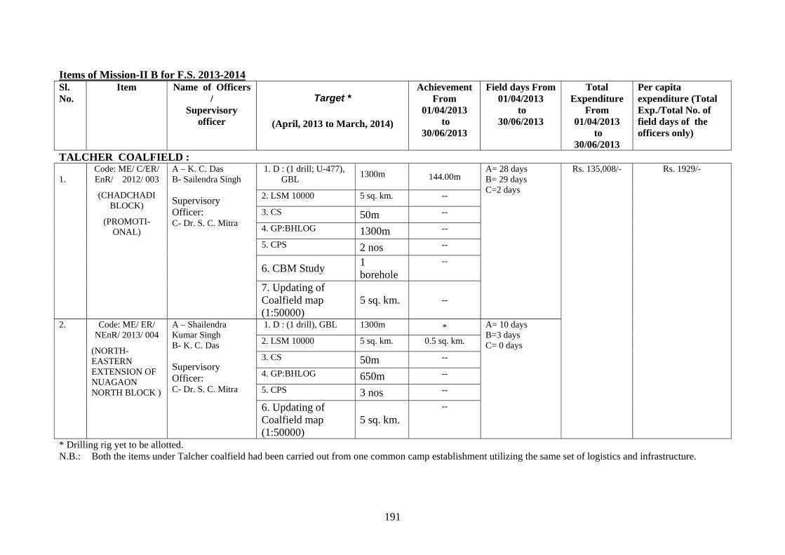
191
Items of Mission-II B for F.S. 2013-2014 Sl. No.
Item Name of Officers /
Supervisory officer
Target *
(April, 2013 to March, 2014)
Achievement From
01/04/2013 to
30/06/2013
Field days From 01/04/2013
to 30/06/2013
Total Expenditure
From 01/04/2013
to 30/06/2013
Per capita expenditure (Total Exp./Total No. of field days of the officers only)
TALCHER COALFIELD : 1.
Code: ME/ C/ER/ EnR/ 2012/ 003
(CHADCHADI BLOCK)
(PROMOTI-ONAL)
A – K. C. Das B- Sailendra Singh Supervisory Officer: C- Dr. S. C. Mitra
1. D : (1 drill; U-477), GBL
1300m 144.00m A= 28 days B= 29 days C=2 days
Rs. 135,008/- Rs. 1929/-
2. LSM 10000 5 sq. km. --
3. CS 50m --
4. GP:BHLOG 1300m --
5. CPS 2 nos --
6. CBM Study 1 borehole
--
7. Updating of Coalfield map (1:50000)
5 sq. km. --
2. Code: ME/ ER/ NEnR/ 2013/ 004
(NORTH-EASTERN EXTENSION OF NUAGAON NORTH BLOCK )
A – Shailendra Kumar Singh B- K. C. Das Supervisory Officer: C- Dr. S. C. Mitra
1. D : (1 drill), GBL 1300m * A= 10 days B=3 days C= 0 days 2. LSM 10000 5 sq. km. 0.5 sq. km.
3. CS 50m --
4. GP:BHLOG 650m --
5. CPS 3 nos --
6. Updating of Coalfield map (1:50000)
5 sq. km. --
* Drilling rig yet to be allotted. N.B.: Both the items under Talcher coalfield had been carried out from one common camp establishment utilizing the same set of logistics and infrastructure.
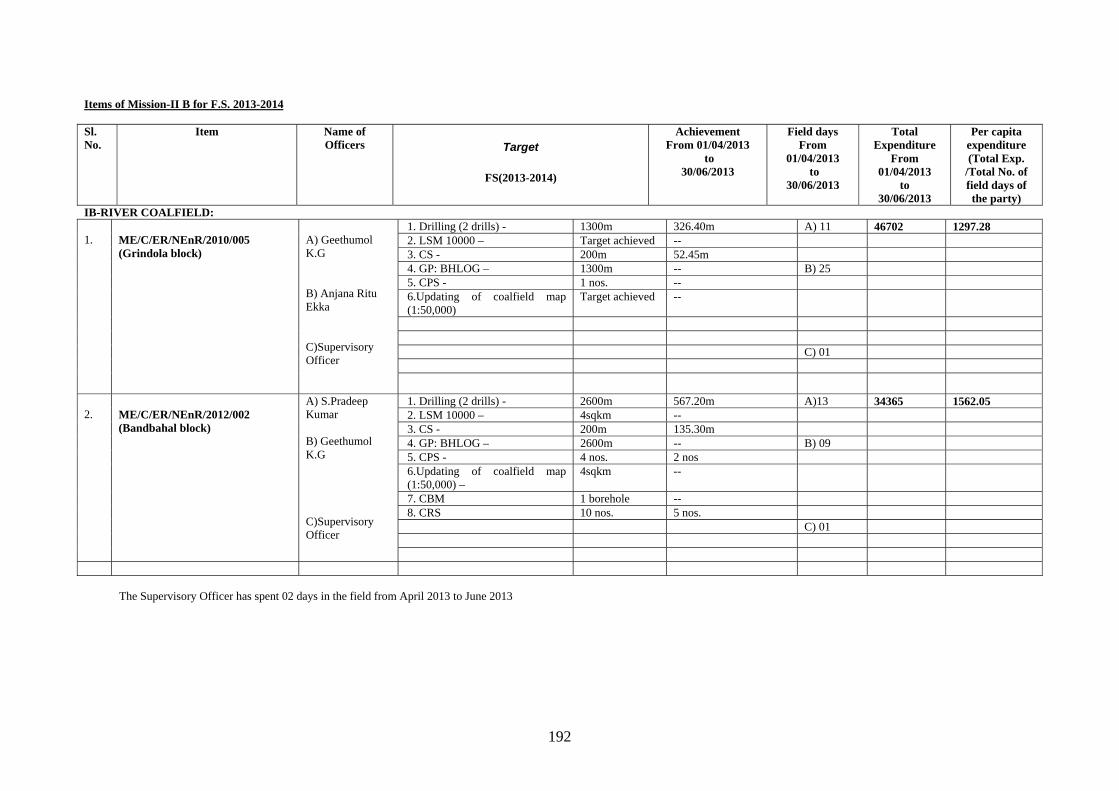
192
Items of Mission-II B for F.S. 2013-2014 Sl. No.
Item Name of Officers Target
FS(2013-2014)
Achievement From 01/04/2013
to 30/06/2013
Field days From
01/04/2013 to
30/06/2013
Total Expenditure
From 01/04/2013
to 30/06/2013
Per capita expenditure (Total Exp.
/Total No. of field days of the party)
IB-RIVER COALFIELD: 1.
ME/C/ER/NEnR/2010/005 (Grindola block)
A) Geethumol K.G B) Anjana Ritu Ekka C)Supervisory Officer
1. Drilling (2 drills) - 1300m 326.40m A) 11 46702 1297.28 2. LSM 10000 – Target achieved -- 3. CS - 200m 52.45m 4. GP: BHLOG – 1300m -- B) 25 5. CPS - 1 nos. -- 6.Updating of coalfield map (1:50,000)
Target achieved --
C) 01
2.
ME/C/ER/NEnR/2012/002 (Bandbahal block)
A) S.Pradeep Kumar B) Geethumol K.G C)Supervisory Officer
1. Drilling (2 drills) - 2600m 567.20m A)13 34365 1562.05 2. LSM 10000 – 4sqkm -- 3. CS - 200m 135.30m 4. GP: BHLOG – 2600m -- B) 09 5. CPS - 4 nos. 2 nos 6.Updating of coalfield map (1:50,000) –
4sqkm --
7. CBM 1 borehole -- 8. CRS 10 nos. 5 nos. C) 01
The Supervisory Officer has spent 02 days in the field from April 2013 to June 2013
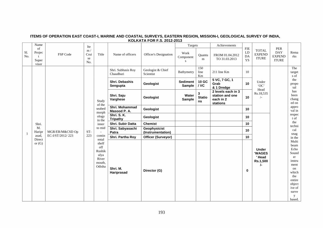
193
ITEMS OF OPERATION EAST COAST-I, MARINE AND COASTAL SURVEYS, EASTERN REGION, MISSION-I, GEOLOGICAL SURVEY OF INDIA, KOLKATA FOR F.S. 2012-2013
Sl. No.
Name of
Project
Supervisor
FSP Code
Item / Cruise
No.
Title Name of officers Officer's Designation
Targets Achievements FIELD DAYS
TOTAL EXPENDITURE
PER DAY
EXPENDITURE
Remarks
Work Component
s
Quantum
FROM 01.04.2012 TO 31.03.2013
1
Shri. M.
Hariprasad, Director (G)
MGR/ER/M&CSD Op EC-I/ST/2012/ 223
ST-223
Study of the seabed morphology in the inner
to mid -
continental shelf off
Rushikulya
River mouth, Odisha
Shri. Subhasis Roy Chaudhuri
Geologist & Chief Scientist
Bathymetry 150 line Km
211 line Km 10
Under ‘OC’ Head
Rs.18,535/-
The targets of the
proposal has
been changed on approval in respec
t of the
technical
snag in the Multibeam Echo Sound
er instrument on
which the
entire objective of surve
y based.
Shri. Debashis Sengupta Geologist Sediment
Sample 10 GC / VC
5 VC, 7 GC, 1 Grab & 1 Dredge
10
Shri. Saju Varghese Geologist Water
Sample 3 Stations
2 levels each in 3 station and one each in 2 stations
10
Shri. Mohammad Masood P. A. Geologist 10
Shri. S. K. Tripathy Geologist 10
Under 'WAGES' Head
Rs.1,500/-
Shri. Subir Datta Chemist 10 Shri. Sabyasachi Patra
Geophysicist (Instrumentation) 10
Shri. Partha Roy Officer (Surveyor) 10
Shri. M. Hariprasad Director (G) 0
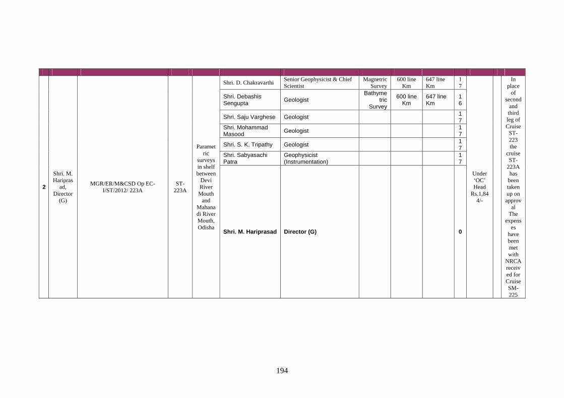
194
2
Shri. M. Haripras
ad, Director
(G)
MGR/ER/M&CSD Op EC-I/ST/2012/ 223A
ST-223A
Parametric
surveys in shelf between
Devi River Mouth
and Mahanadi River Mouth, Odisha
Shri. D. Chakravarthi Senior Geophysicist & Chief Scientist
Magnetric Survey
600 line Km
647 line Km
17
Under ‘OC’ Head
Rs.1,844/-
In place
of second
and third leg of Cruise
ST-223 the
cruise ST-
223A has
been taken up on
approval
The expens
es have been met with
NRCA received for Cruise SM-225
Shri. Debashis Sengupta
Geologist Bathyme
tric Survey
600 line Km
647 line Km
16
Shri. Saju Varghese Geologist 17
Shri. Mohammad Masood
Geologist 17
Shri. S. K. Tripathy Geologist 17
Shri. Sabyasachi Patra
Geophysicist (Instrumentation)
17
Shri. M. Hariprasad Director (G) 0
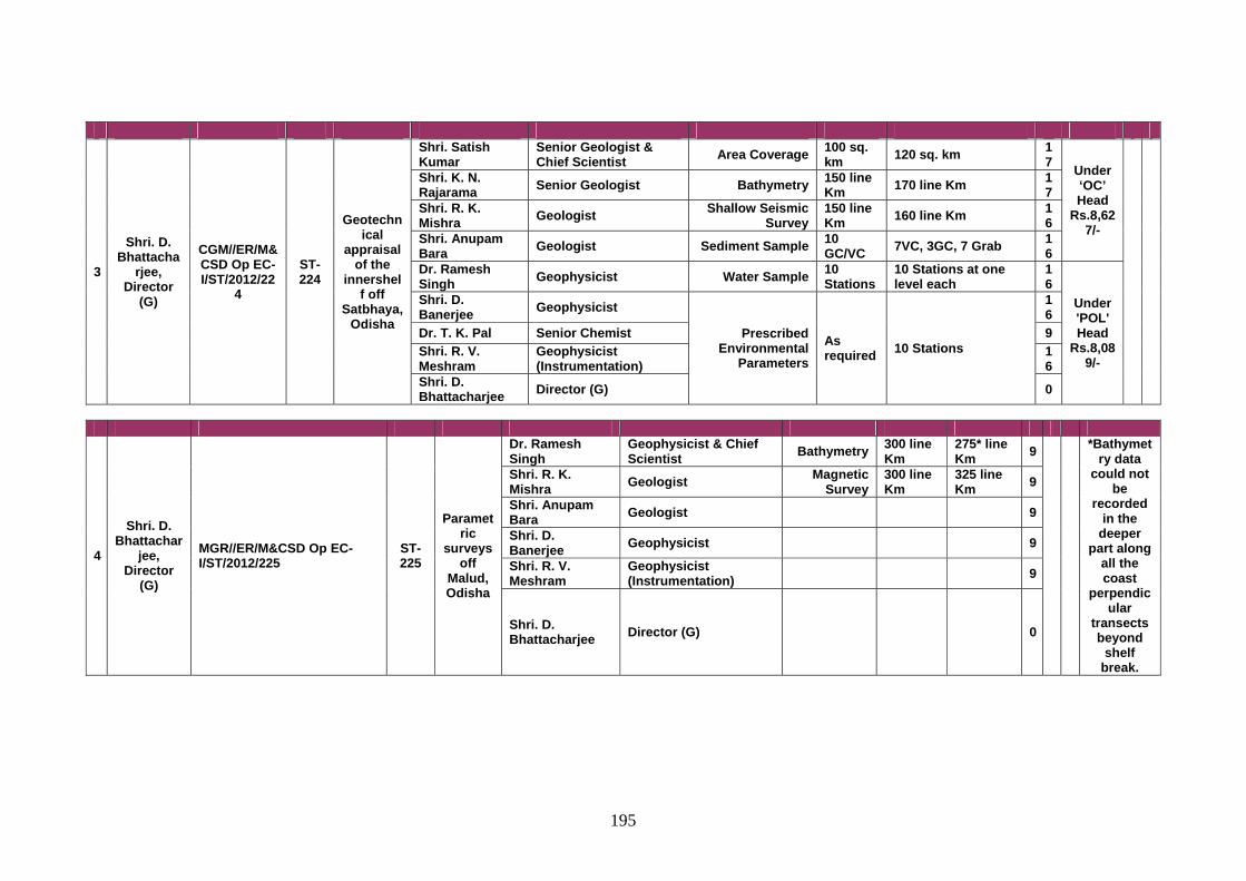
195
3
Shri. D. Bhattacha
rjee, Director
(G)
CGM//ER/M&CSD Op EC-I/ST/2012/22
4
ST-224
Geotechnical
appraisal of the
innershelf off
Satbhaya, Odisha
Shri. Satish Kumar
Senior Geologist & Chief Scientist Area Coverage 100 sq.
km 120 sq. km 17 Under
‘OC’ Head
Rs.8,627/-
Shri. K. N. Rajarama Senior Geologist Bathymetry 150 line
Km 170 line Km 17
Shri. R. K. Mishra Geologist Shallow Seismic
Survey 150 line Km 160 line Km 1
6 Shri. Anupam Bara Geologist Sediment Sample 10
GC/VC 7VC, 3GC, 7 Grab 16
Dr. Ramesh Singh Geophysicist Water Sample 10
Stations 10 Stations at one level each
16
Under 'POL' Head
Rs.8,089/-
Shri. D. Banerjee Geophysicist
Prescribed Environmental
Parameters As required 10 Stations
16
Dr. T. K. Pal Senior Chemist 9 Shri. R. V. Meshram
Geophysicist (Instrumentation)
16
Shri. D. Bhattacharjee Director (G) 0
4
Shri. D. Bhattachar
jee, Director
(G)
MGR//ER/M&CSD Op EC-I/ST/2012/225
ST-225
Parametric
surveys off
Malud, Odisha
Dr. Ramesh Singh
Geophysicist & Chief Scientist Bathymetry 300 line
Km 275* line Km 9
*Bathymetry data
could not be
recorded in the
deeper part along
all the coast
perpendicular
transects beyond
shelf break.
Shri. R. K. Mishra Geologist Magnetic
Survey 300 line Km
325 line Km 9
Shri. Anupam Bara Geologist 9
Shri. D. Banerjee Geophysicist 9
Shri. R. V. Meshram
Geophysicist (Instrumentation) 9
Shri. D. Bhattacharjee Director (G) 0
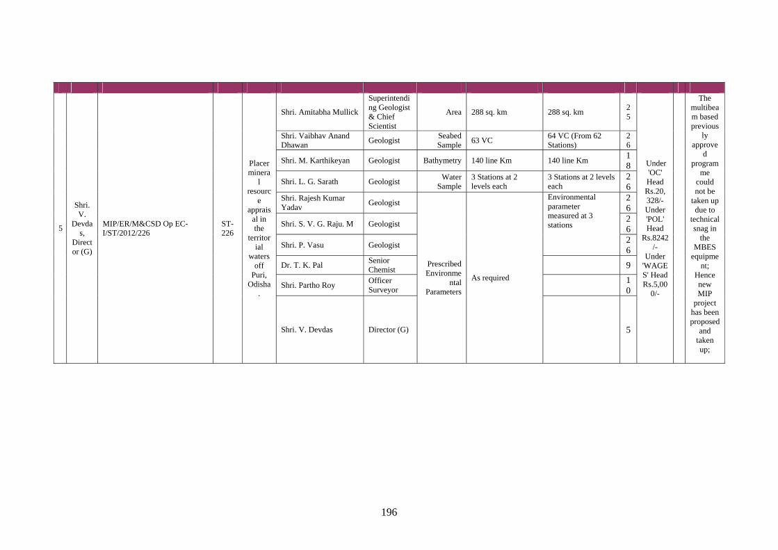
196
5
Shri. V.
Devdas,
Director (G)
MIP/ER/M&CSD Op EC-I/ST/2012/226
ST-226
Placer minera
l resourc
e apprais
al in the
territorial
waters off
Puri, Odisha
.
Shri. Amitabha Mullick
Superintending Geologist & Chief Scientist
Area 288 sq. km 288 sq. km 25
Under 'OC' Head Rs.20, 328/- Under 'POL' Head
Rs.8242/-
Under 'WAGES' Head Rs.5,00
0/-
The multibeam based previous
ly approve
d program
me could not be
taken up due to
technical snag in
the MBES
equipment;
Hence new MIP
project has been proposed
and taken up;
Shri. Vaibhav Anand Dhawan
Geologist Seabed Sample
63 VC 64 VC (From 62 Stations)
26
Shri. M. Karthikeyan Geologist Bathymetry 140 line Km 140 line Km 18
Shri. L. G. Sarath Geologist Water
Sample 3 Stations at 2 levels each
3 Stations at 2 levels each
26
Shri. Rajesh Kumar Yadav
Geologist
Prescribed Environme
ntal Parameters
As required
Environmental parameter measured at 3 stations
26
Shri. S. V. G. Raju. M Geologist 26
Shri. P. Vasu Geologist 26
Dr. T. K. Pal Senior Chemist
9
Shri. Partho Roy Officer Surveyor
10
Shri. V. Devdas Director (G) 5
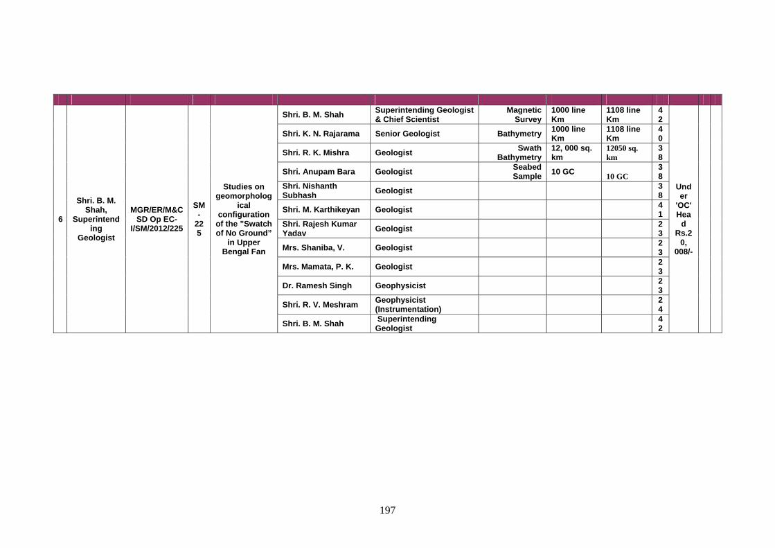
197
6
Shri. B. M. Shah,
Superintending
Geologist
MGR/ER/M&CSD Op EC-
I/SM/2012/225
SM-
225
Studies on geomorpholog
ical configuration
of the ”Swatch of No Ground”
in Upper Bengal Fan
Shri. B. M. Shah Superintending Geologist & Chief Scientist
Magnetic Survey
1000 line Km
1108 line Km
42
Under
'OC' Hea
d Rs.2
0, 008/-
Shri. K. N. Rajarama Senior Geologist Bathymetry 1000 line Km
1108 line Km
40
Shri. R. K. Mishra Geologist Swath Bathymetry
12, 000 sq. km
12050 sq. km
38
Shri. Anupam Bara Geologist Seabed Sample 10 GC
10 GC 38
Shri. Nishanth Subhash Geologist 3
8
Shri. M. Karthikeyan Geologist 41
Shri. Rajesh Kumar Yadav Geologist 2
3
Mrs. Shaniba, V. Geologist 23
Mrs. Mamata, P. K. Geologist 23
Dr. Ramesh Singh Geophysicist 23
Shri. R. V. Meshram Geophysicist (Instrumentation) 2
4
Shri. B. M. Shah Superintending Geologist 4
2
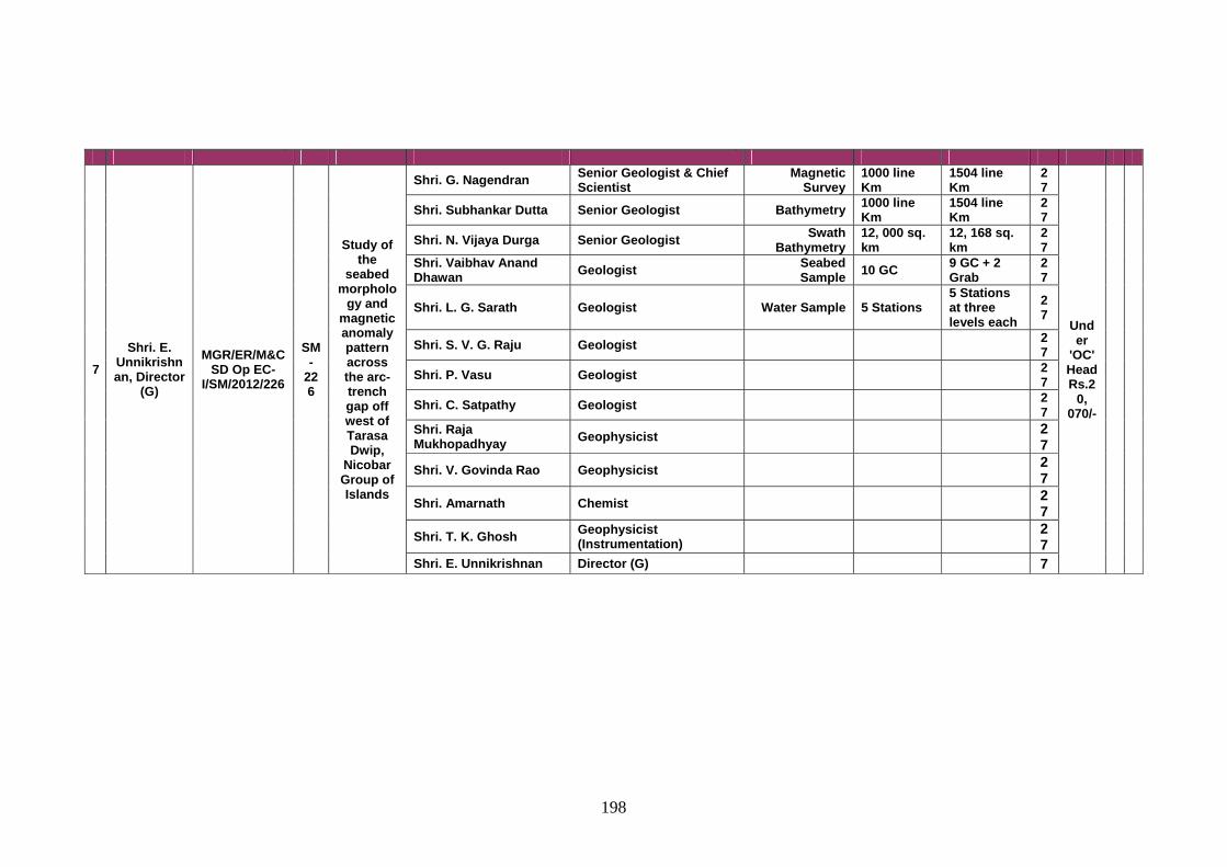
198
7 Shri. E.
Unnikrishnan, Director
(G)
MGR/ER/M&CSD Op EC-
I/SM/2012/226
SM-
226
Study of the
seabed morpholo
gy and magnetic anomaly pattern across the arc-trench gap off west of Tarasa Dwip,
Nicobar Group of Islands
Shri. G. Nagendran Senior Geologist & Chief Scientist
Magnetic Survey
1000 line Km
1504 line Km
27
Under
'OC' Head Rs.2
0, 070/-
Shri. Subhankar Dutta Senior Geologist Bathymetry 1000 line Km
1504 line Km
27
Shri. N. Vijaya Durga Senior Geologist Swath Bathymetry
12, 000 sq. km
12, 168 sq. km
27
Shri. Vaibhav Anand Dhawan Geologist Seabed
Sample 10 GC 9 GC + 2 Grab
27
Shri. L. G. Sarath Geologist Water Sample 5 Stations 5 Stations at three levels each
27
Shri. S. V. G. Raju Geologist 27
Shri. P. Vasu Geologist 27
Shri. C. Satpathy Geologist 27
Shri. Raja Mukhopadhyay Geophysicist 2
7 Shri. V. Govinda Rao Geophysicist 2
7 Shri. Amarnath Chemist 2
7 Shri. T. K. Ghosh Geophysicist
(Instrumentation) 27
Shri. E. Unnikrishnan Director (G) 7
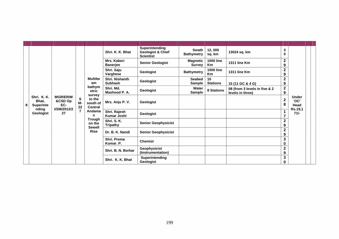
199
8
Shri. K. K. Bhat,
Superintending
Geologist
MGR/ER/M&CSD Op
EC-I/SM/2012/2
27
SM-227
Multibeam
bathymetric
survey to the
south of Central Andama
n Trough on the Sewell Rise
Shri. K. K. Bhat Superintending Geologist & Chief Scientist
Swath Bathymetry
12, 000 sq. km 13024 sq. km 3
0
Under 'OC' Head
Rs.19,171/-
Mrs. Kaberi Banerjee Senior Geologist Magnetic
Survey 1000 line Km 1311 line Km 2
9 Shri. Saju Varghese Geologist Bathymetry 1000 line
Km 1311 line Km 29
Shri. Nishanth Subhash Geologist Seabed
Sample 10 Stations 15 (11 GC & 4 G)
29
Shri. Md. Mashood P. A. Geologist Water
Sample 8 Stations 08 (from 3 levels in five & 2 levels in three)
29
Mrs. Anju P. V. Geologist 28
Shri. Rajesh Kumar Joshi Geologist 1
7 Shri. S. K. Tripathy Senior Geophysicist 2
9 Dr. B. K. Nandi Senior Geophysicist 2
9 Shri. Prema Kumar. P. Chemist 3
0 Shri. B. N. Borkar Geophysicist
(Instrumentation) 29
Shri. K. K. Bhat Superintending Geologist 3
0
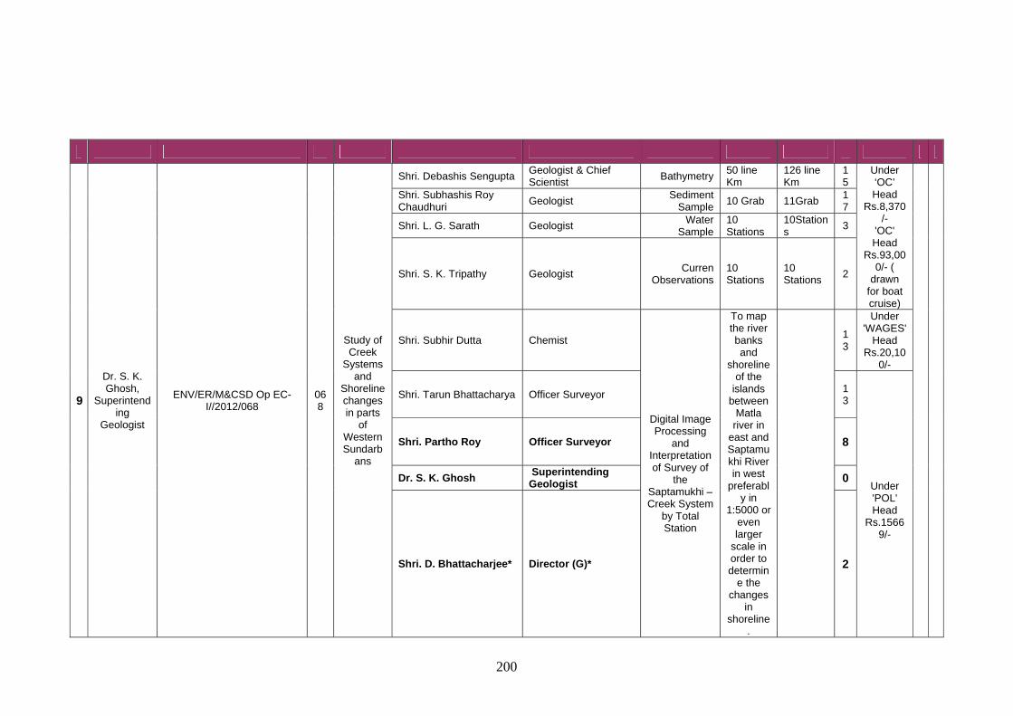
200
9
Dr. S. K. Ghosh,
Superintending
Geologist
ENV/ER/M&CSD Op EC-I//2012/068
068
Study of Creek
Systems and
Shoreline changes in parts
of Western Sundarb
ans
Shri. Debashis Sengupta Geologist & Chief Scientist
Bathymetry 50 line Km
126 line Km
15
Under ‘OC’ Head
Rs.8,370/-
'OC' Head
Rs.93,000/- (
drawn for boat cruise)
Shri. Subhashis Roy Chaudhuri
Geologist Sediment
Sample 10 Grab 11Grab
17
Shri. L. G. Sarath Geologist Water
Sample 10 Stations
10Stations
3
Shri. S. K. Tripathy Geologist Curren
Observations 10 Stations
10 Stations
2
Shri. Subhir Dutta Chemist
Digital Image Processing
and Interpretation of Survey of
the Saptamukhi – Creek System
by Total Station
To map the river banks and
shoreline of the
islands between
Matla river in
east and Saptamukhi River in west
preferably in
1:5000 or even larger
scale in order to determin
e the changes
in shoreline
.
13
Under 'WAGES'
Head Rs.20,10
0/-
Shri. Tarun Bhattacharya Officer Surveyor 13
Under 'POL' Head
Rs.15669/-
Shri. Partho Roy Officer Surveyor 8
Dr. S. K. Ghosh Superintending Geologist 0
Shri. D. Bhattacharjee* Director (G)* 2
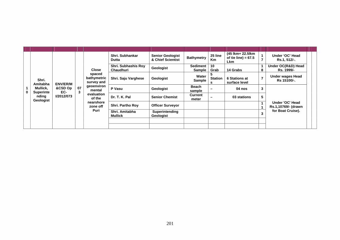
201
10
Shri. Amitabha Mullick,
Superintending
Geologist
ENV/ER/M&CSD Op
EC-I/2012/073
073
Close spaced
bathymetric survey and geoenviron
mental evaluation
of the nearshore zone off
Puri
Shri. Subhankar Dutta
Senior Geologist & Chief Scientist Bathymetry 25 line
Km (45 lkm+ 22.5lkm of tie line) = 67.5 Lkm
17
Under ‘OC’ Head Rs.1, 512/-.
Shri. Subhashis Roy Chaudhuri Geologist Sediment
Sample 10 Grab 14 Grabs
18
Under OC(R&D) Head Rs. 1999/-
Shri. Saju Varghese Geologist Water Sample
5 Stations
6 Stations at surface level
7 Under wages Head Rs 15100/-.
P Vasu Geologist Beach sample – 04 nos 3
Under 'OC' Head Rs.1,10769/- (drawn
for Boat Cruise).
Dr. T. K. Pal Senior Chemist Current meter – 03 stations 5
Shri. Partho Roy Officer Surveyor 11
Shri. Amitabha Mullick
Superintending Geologist 3
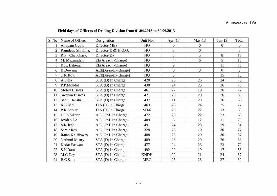
202
Annexexure: IVa
Field days of Officers of Drilling Division from 01.04.2013 to 30.06.2013
Sl No Name of Officer Designation Unit No. Apr ‘13 May-13 Jun-13 Total 1 Anupam Gupta Director(ME) HQ 0 0 0 0 2 Ramdeep Shivliha, Director(D)& H.O.O. HQ 3 0 3 3 R.P. Chaudhary, Director(D) HQ 5 5 8 18 4 M. Mazumder, EE(Area-In-Charge) HQ 4 6 5 15 5 B.K. Behera, EE(Area-In-Charge) HQ 9 11 20 6 B.Dewanji AEE(Area-In-Charge) HQ 0 3 0 3 7 T K Roy. AEE(Area-In-Charge) HQ 8 15 23 8 A.Ojha STA (D) In Charge 428 26 26 24 76 9 P.P.Mondal STA (D) In Charge 438 24 25 26 75
10 Moloy Biswas STA (D) In Charge 461 27 19 26 72 11 Swapan Biswas STA (D) In Charge 421 23 20 26 69 12 Sabuj Banshi STA (D) In Charge 437 11 29 26 66 13 K.G.Mal JTA (D) In Charge 463 28 24 25 77 14 P.K.Sarkar JTA (D) In Charge SD-6 25 22 13 60 15 Dilip Sikdar A.E. Gr-I In Charge 472 23 22 23 68 16 Joydeb De A.E. Gr-I In Charge 409 6 12 11 29 17 S.K.Jena A.E. Gr-I In Charge 491 24 28 29 81 18 Samir Roy A.E. Gr-I In Charge 328 28 19 30 77 19 Ratan Kr. Biswas A.E. Gr-I In Charge 488 28 29 30 87 20 Nathuni Mistry STA (D) In Charge 489 28 29 26 83 21 Kedar Paswan STA (D) In Charge 477 24 23 23 70 22 S.N.Ram STA (D) In Charge 492 20 19 17 56 23 M.C.Dey STA (D) In Charge KNDH 22 21 24 67 24 B.C.Saha STA (D) In Charge MBC 25 28 27 80
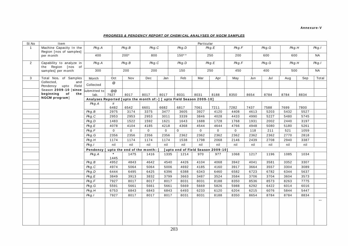
203
Annexure-V
PROGRESS & PENDENCY REPORT OF CHEMICAL ANALYSES OF NGCM SAMPLES
Sl.No Item Particular 1 Machine Capacity In the
Region [nos of samples] per month
Pkg.A Pkg.B Pkg.C Pkg.D Pkg.E Pkg.F Pkg.G Pkg.H Pkg.I
400 200* 800 150** 250 200 600 600 NA
2 Capability to analyze in the Region [nos of samples] per month
Pkg.A Pkg.B Pkg.C Pkg.D Pkg.E Pkg.F Pkg.G Pkg.H Pkg.I
300 200 200 150 250 450 400 500 NA
3 Total Nos. of Samples Collected, and Pendency upto Field Season 2009-10 [since beginning of the NGCM program]
Month Oct Nov Dec Jan Feb Mar Apr May Jun Jul Aug Sep Total Collected @
Submitted to lab.
@@ 7927
8017
8017
8017
8031
8031
8188
8350
8654
8784
8784
8834
Analyses Reported [upto the month of:-] [ upto Field Season 2009-10] Pkg.A #
6482
6542
6601
6682
6817
7061
7211
7282
7437
7588
7699
7800
Pkg.B 2975 3174 3375 3477 3605 3927 4120 4408 4613 5203 5432 5527 Pkg.C 2953 2953 2953 3011 3339 3846 4028 4433 4990 5227 5480 5745 Pkg.D 1483 1522 1592 1621 1643 1688 1728 1768 1931 2002 2440 3197 Pkg.E 4078 4104 4185 4218 4368 4544 4644 4766 4948 5080 5180 5261 Pkg.F 0 0 0 0 0 0 0 0 118 211 521 1059 Pkg.G 2356 2356 2356 2356 2362 2362 2362 2362 2362 2362 2770 2818 Pkg.H 1174 1174 1174 1174 1538 1798 2068 2146 2439 2708 2940 3387 Pkg.I nil nil nil nil nil nil nil nil nil nil nil nil Pendency [ upto the end of the month:-] [upto end of Field Season 2009-10] Pkg.A *
1445 1475 1416 1335 1214 970 977 1068 1217 1196 1085 1034
Pkg.B 4952 4843 4642 4540 4426 4104 4068 3942 4041 3581 3352 3307 Pkg.C 4974 5064 5064 5006 4692 4185 4160 3917 3664 3557 3304 3089 Pkg.D 6444 6495 6425 6396 6388 6343 6460 6582 6723 6782 6344 5637 Pkg.E 3849 3913 3832 3799 3663 3487 3524 3584 3706 3704 3604 3573 Pkg.F 7927 8017 8017 8017 8031 8031 8188 8350 8536 8573 8263 7775 Pkg.G 5591 5661 5661 5661 5669 5669 5826 5988 6292 6422 6014 6016 Pkg.H 6753 6843 6843 6843 6493 6233 6120 6204 6215 6076 5844 5447 Pkg.I 7927 8017 8017 8017 8031 8031 8188 8350 8654 8784 8784 8834
--
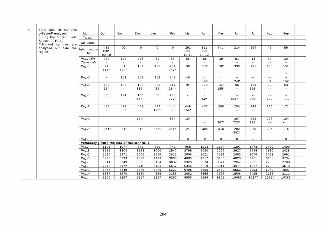
204
4
Total Nos. of Samples collected/analyzed during the current Field Season 2010-12 (*Marked samples are analysed out side the region)
Month
Oct
Nov
Dec
Jan
Feb
Mar
Apr
May
Jun
Jul
Aug
Sep Target
Collected
Submitted to lab
431 FSP: 09-10
02 0 0 0 291 FSP: 10-12
311 FSP
10-12
NIL 214 194 47 59
Pkg.A/ER Other Lab
270 -
120 -
228 -
50 -
56 -
66 -
66 -
39 -
91 --
18 --
50 --
30 --
Pkg.B 71 111*
81 173*
151 -
153 -
201 257*
38 -
172 -
182 -
339 --
175 --
163 --
151
--
Pkg.C - -
151 -
363 -
152 -
243 -
46 -
- 148
- -
-- 753*
-- --
-- 91
-- 152
Pkg.D 125 18*
128 -
122 839*
231 424*
111 184*
94 -
179 -
157 155*
96 --
150 296*
50 --
93 --
Pkg.E 63 -
194 -
100 147*
38 -
255 177*
- -
- 60*
- -
-- 831*
-- 330*
-- 102
-- 117
Pkg.F 488 -
479 69*
462 -
439 170*
444 -
449 154*
437 -
208 -
254 --
248 --
236 --
171 --
Pkg.G - - 174* - 53* 18* - -
- 367*
367 723*
228 236*
298 --
184 --
Pkg.H 341* 261* 81* 853* 951* 24 308 -
318 -
202 843*
275 --
304 --
116 --
Pkg.I 0 0 0 0 0 0 0 0 0 0 0 0 Pendency [ upto the end of the month:-] Pkg.A 1195 1077 849 799 743 968 1213 1174 1297 1473 1470 1499 Pkg.B 3556 3304 3153 3000 2542 2795 2934 2752 2627 2646 2530 2438 Pkg.C 3520 3371 3008 2856 2613 2858 3021 3021 2482 2676 2632 2691 Pkg.D 5925 5799 4838 4183 3888 4085 4217 3905 4023 3771 3768 3734 Pkg.E 3941 3749 3502 3464 3032 3323 3574 3574 2957 2821 2766 2708 Pkg.F 7718 7172 6710 6101 5657 5345 5219 5011 4971 4917 4728 4616 Pkg.G 6447 6449 6275 6275 6222 6495 6806 6439 5563 5293 5042 4907 Pkg.H 5537 5270 5189 4336 3385 3652 3655 3337 2506 2425 2168 2111 Pkg.I 9265 9267 9267 9267 9267 9558 9869 9869 10083 10277 10324 10383
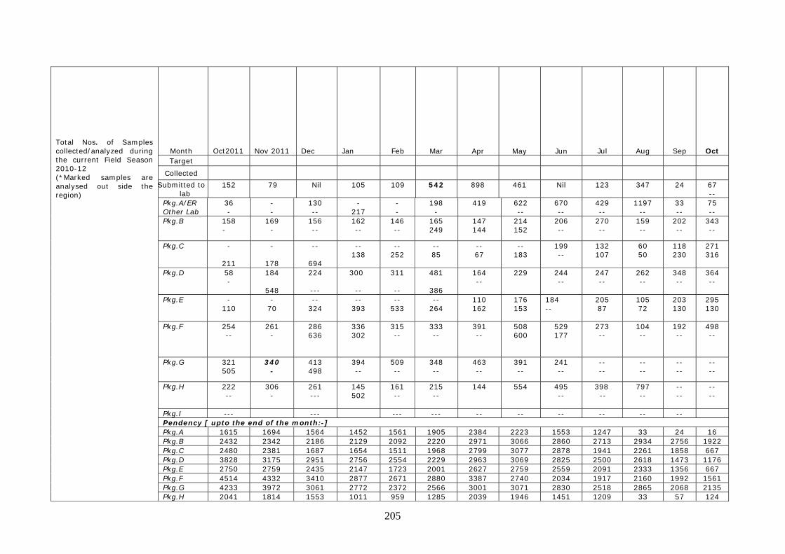
205
Total Nos. of Samples collected/analyzed during the current Field Season 2010-12 (*Marked samples are analysed out side the region)
Month
Oct2011
Nov 2011
Dec
Jan
Feb
Mar
Apr
May
Jun
Jul
Aug
Sep
Oct Target
Collected
Submitted to lab
152 79 Nil 105 109 542 898 461
Nil 123 347 24 67 --
Pkg.A/ER Other Lab
36 -
- -
130 --
- 217
- -
198 -
419 622 --
670 --
429 --
1197 --
33 --
75 --
Pkg.B 158 -
169 -
156 --
162 --
146 --
165 249
147 144
214 152
206 --
270 --
159 --
202 --
343 --
Pkg.C -
211
-
178
--
694
-- 138
-- 252
-- 85
-- 67
-- 183
199 --
132 107
60 50
118 230
271 316
Pkg.D 58 -
184
548
224
---
300
--
311
--
481
386
164 --
229 244 --
247 --
262 --
348 --
364 --
Pkg.E - 110
- 70
-- 324
-- 393
-- 533
-- 264
110 162
176 153
184 --
205 87
105 72
203 130
295 130
Pkg.F 254 --
261 -
286 636
336 302
315 --
333 --
391 --
508 600
529 177
273 --
104 --
192 --
498 --
Pkg.G 321 505
340 -
413 498
394 --
509 --
348 --
463 --
391 --
241 --
-- --
-- --
-- --
-- --
Pkg.H 222 --
306 -
261 ---
145 502
161 --
215 --
144 554 495 --
398 --
797 --
-- --
-- --
Pkg.I --- --- --- --- -- -- -- -- -- -- Pendency [ upto the end of the month:-] Pkg.A 1615 1694 1564 1452 1561 1905 2384 2223 1553 1247 33 24 16 Pkg.B 2432 2342 2186 2129 2092 2220 2971 3066 2860 2713 2934 2756 1922 Pkg.C 2480 2381 1687 1654 1511 1968 2799 3077 2878 1941 2261 1858 667 Pkg.D 3828 3175 2951 2756 2554 2229 2963 3069 2825 2500 2618 1473 1176 Pkg.E 2750 2759 2435 2147 1723 2001 2627 2759 2559 2091 2333 1356 667 Pkg.F 4514 4332 3410 2877 2671 2880 3387 2740 2034 1917 2160 1992 1561 Pkg.G 4233 3972 3061 2772 2372 2566 3001 3071 2830 2518 2865 2068 2135 Pkg.H 2041 1814 1553 1011 959 1285 2039 1946 1451 1209 33 57 124
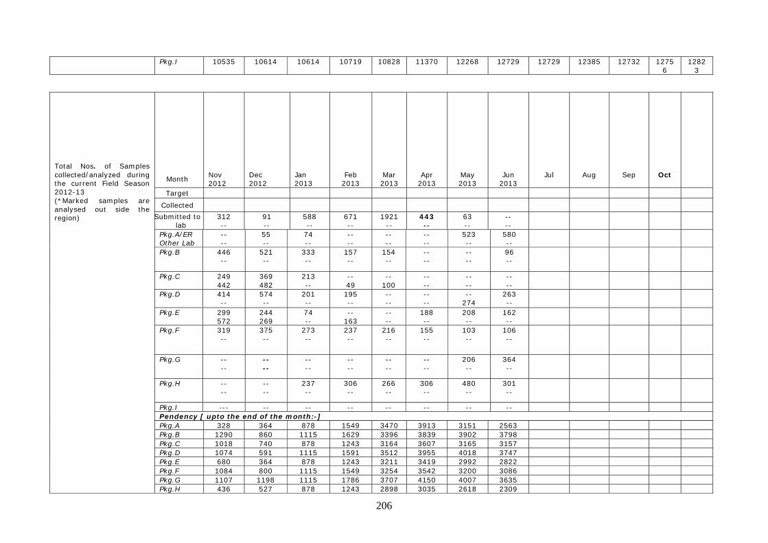
206
Pkg.I 10535 10614 10614 10719 10828 11370 12268 12729 12729 12385 12732 12756
12823
Total Nos. of Samples collected/analyzed during the current Field Season 2012-13 (*Marked samples are analysed out side the region)
Month
Nov 2012
Dec 2012
Jan 2013
Feb 2013
Mar 2013
Apr 2013
May 2013
Jun 2013
Jul
Aug
Sep
Oct
Target
Collected
Submitted to lab
312 --
91 --
588 --
671 --
1921 --
443 --
63 --
-- --
Pkg.A/ER Other Lab
-- --
55 --
74 --
-- --
-- --
-- --
523 --
580 --
Pkg.B 446 --
521 --
333 --
157 --
154 --
-- --
-- --
96 --
Pkg.C 249 442
369 482
213 --
-- 49
-- 100
-- --
-- --
-- --
Pkg.D 414 --
574 --
201 --
195 --
-- --
-- --
-- 274
263 --
Pkg.E 299 572
244 269
74 --
-- 163
-- --
188 --
208 --
162 --
Pkg.F 319 --
375 --
273 --
237 --
216 --
155 --
103 --
106 --
Pkg.G -- --
-- --
-- --
-- --
-- --
-- --
206 --
364 --
Pkg.H -- --
-- --
237 --
306 --
266 --
306 --
480 --
301 --
Pkg.I --- -- -- -- -- -- -- -- Pendency [ upto the end of the month:-] Pkg.A 328 364 878 1549 3470 3913 3151 2563 Pkg.B 1290 860 1115 1629 3396 3839 3902 3798 Pkg.C 1018 740 878 1243 3164 3607 3165 3157 Pkg.D 1074 591 1115 1591 3512 3955 4018 3747 Pkg.E 680 364 878 1243 3211 3419 2992 2822 Pkg.F 1084 800 1115 1549 3254 3542 3200 3086 Pkg.G 1107 1198 1115 1786 3707 4150 4007 3635 Pkg.H 436 527 878 1243 2898 3035 2618 2309
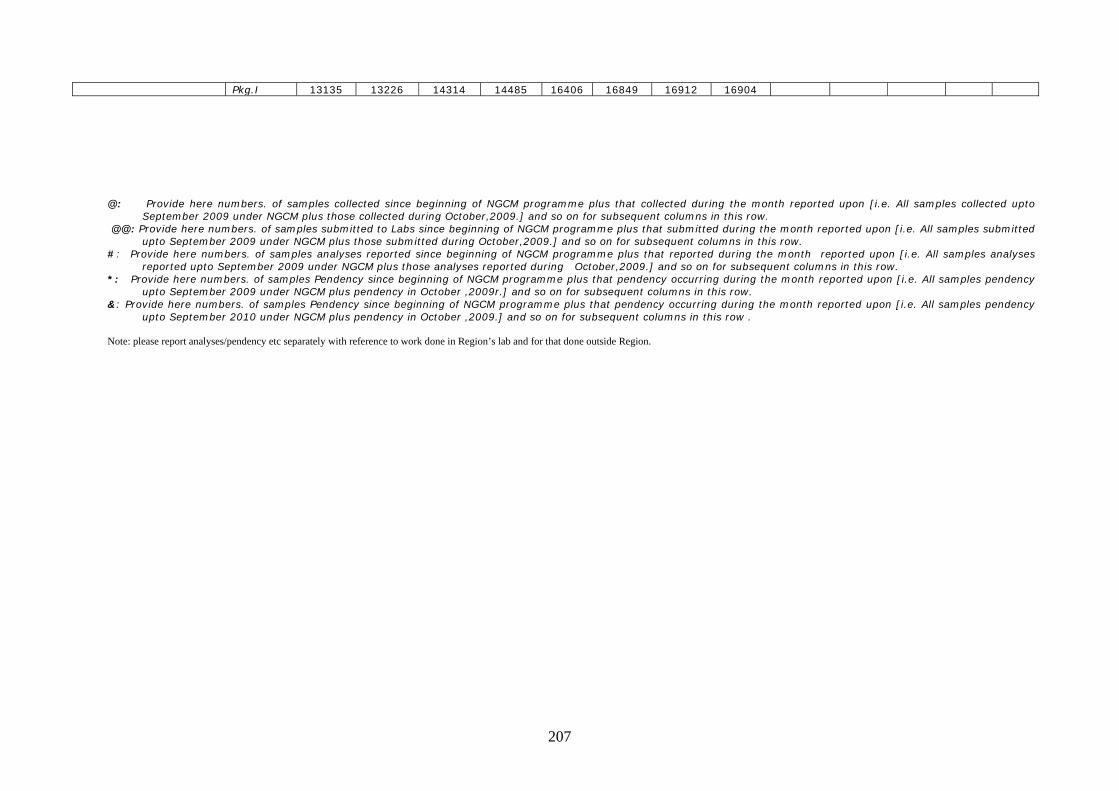
207
Pkg.I 13135 13226 14314 14485 16406 16849 16912 16904 @: Provide here numbers. of samples collected since beginning of NGCM programme plus that collected during the month reported upon [i.e. All samples collected upto
September 2009 under NGCM plus those collected during October,2009.] and so on for subsequent columns in this row. @@: Provide here numbers. of samples submitted to Labs since beginning of NGCM programme plus that submitted during the month reported upon [i.e. All samples submitted
upto September 2009 under NGCM plus those submitted during October,2009.] and so on for subsequent columns in this row. #: Provide here numbers. of samples analyses reported since beginning of NGCM programme plus that reported during the month reported upon [i.e. All samples analyses
reported upto September 2009 under NGCM plus those analyses reported during October,2009.] and so on for subsequent columns in this row. *: Provide here numbers. of samples Pendency since beginning of NGCM programme plus that pendency occurring during the month reported upon [i.e. All samples pendency
upto September 2009 under NGCM plus pendency in October ,2009r.] and so on for subsequent columns in this row. &: Provide here numbers. of samples Pendency since beginning of NGCM programme plus that pendency occurring during the month reported upon [i.e. All samples pendency
upto September 2010 under NGCM plus pendency in October ,2009.] and so on for subsequent columns in this row . Note: please report analyses/pendency etc separately with reference to work done in Region’s lab and for that done outside Region.
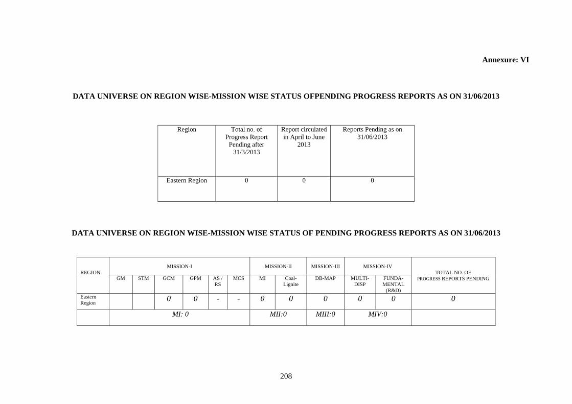
208
Annexure: VI
DATA UNIVERSE ON REGION WISE-MISSION WISE STATUS OFPENDING PROGRESS REPORTS AS ON 31/06/2013
DATA UNIVERSE ON REGION WISE-MISSION WISE STATUS OF PENDING PROGRESS REPORTS AS ON 31/06/2013
Region Total no. of Progress Report
Pending after 31/3/2013
Report circulated in April to June
2013
Reports Pending as on 31/06/2013
Eastern Region
0 0 0
REGION
MISSION-I
MISSION-II
MISSION-III
MISSION-IV
TOTAL NO. OF PROGRESS REPORTS PENDING GM STM GCM GPM AS /
RS MCS MI Coal-
Lignite DB-MAP MULTI-
DISP FUNDA-MENTAL
(R&D) Eastern Region
0 0 - - 0 0 0 0 0 0
MI: 0 MII:0 MIII:0 MIV:0
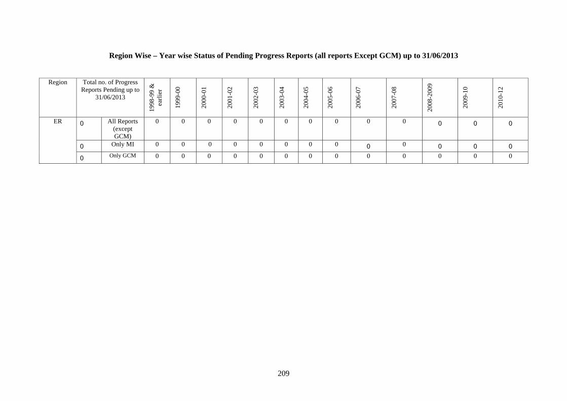
209
Region Wise – Year wise Status of Pending Progress Reports (all reports Except GCM) up to 31/06/2013
Region Total no. of Progress Reports Pending up to
31/06/2013
1998
-99
&
earl
ier
1999
-00
2000
-01
2001
-02
2002
-03
2003
-04
2004
-05
2005
-06
2006
-07
2007
-08
2008
-200
9
2009
-10
2010
-12
ER 0 All Reports (except GCM)
0 0 0 0 0 0 0 0 0 0 0 0 0
0 Only MI 0 0 0 0 0 0 0 0 0 0 0 0 0
0 Only GCM 0 0 0 0 0 0 0 0 0 0 0 0 0

210
Annexure VII
Status of Uploading in GSI Portal upto June 2013 Publication of ERHQ
Sl. No. Component
Data universe (total vol. of data)
Achievement during F.S. 2008 – 09 & 2009 - 10
Target F.S. 10 - 12
Achievement During FS 2010-12
Target F.S. 2012-13
Achievement During April 2012 to June 2012
Achievement During July 2012 to Sept 2012
Achievement During Oct 2012 to December 2012
Achievement During Jan 2013 to March 2013
Total (cumulative achievement up to 31/03/2013
Remarks
1 Uploading of Legacy FSP and Extended Abstract (EA)
FSP 1577 nos. F.S. 1987 – 88 to F.S. 2007 - 2008
1577 nos.
1577 nos.
Job completed
EA 2149 nos. F.S. 1987 – 88 to F.S. 2007 - 2008
2149 nos.
2149 nos.
Job completed
2 Metadata of unpublished reports
4616 nos. 4616 nos.
---
---
4616 nos.
Job completed
3 Actual unpublished reports post-2004
470 nos. of reports
194 nos. to be uploaded
194 nos. uploaded
194 uploaded (upto F.S 2008)
Job completed
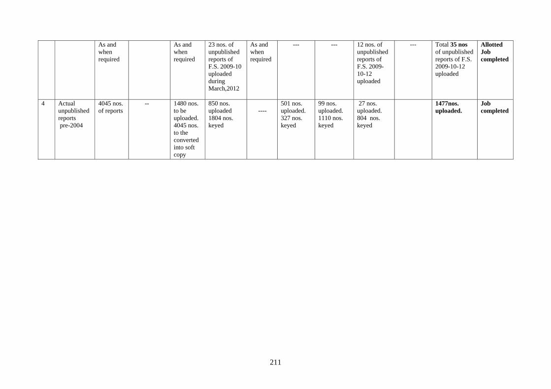
211
As and when required
As and when required
23 nos. of unpublished reports of F.S. 2009-10 uploaded during March,2012
As and when required
--- --- 12 nos. of unpublished reports of F.S. 2009-10-12 uploaded
--- Total 35 nos of unpublished reports of F.S. 2009-10-12 uploaded
Allotted Job completed
4 Actual unpublished reports pre-2004
4045 nos. of reports
-- 1480 nos. to be uploaded. 4045 nos. to the converted into soft copy
850 nos. uploaded 1804 nos. keyed
----
501 nos. uploaded. 327 nos. keyed
99 nos. uploaded. 1110 nos. keyed
27 nos. uploaded. 804 nos. keyed
1477nos. uploaded.
Job completed
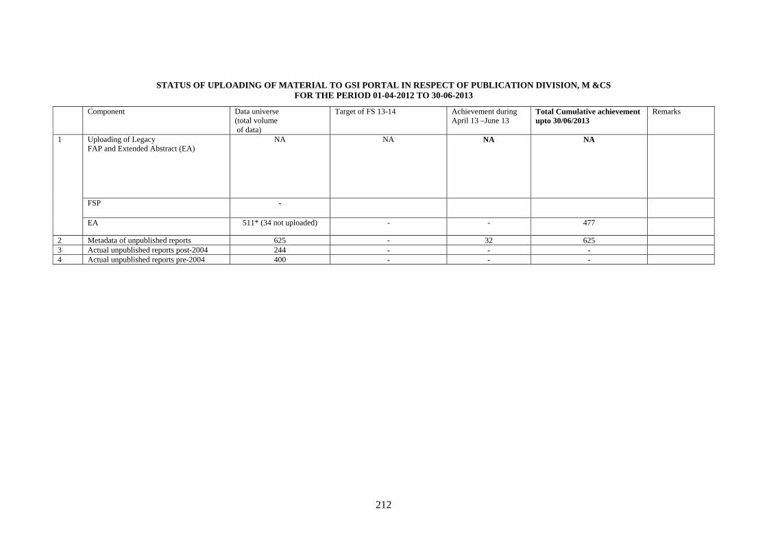
212
STATUS OF UPLOADING OF MATERIAL TO GSI PORTAL IN RESPECT OF PUBLICATION DIVISION, M &CS FOR THE PERIOD 01-04-2012 TO 30-06-2013
Component Data universe (total volume of data)
Target of FS 13-14 Achievement during April 13 –June 13
Total Cumulative achievement upto 30/06/2013
Remarks
1 Uploading of Legacy FAP and Extended Abstract (EA)
NA NA NA NA
FSP
-
EA 511* (34 not uploaded) - - 477
2 Metadata of unpublished reports 625 - 32 625 3 Actual unpublished reports post-2004 244 - - - 4 Actual unpublished reports pre-2004 400 - - -
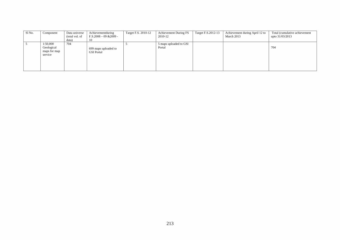
213
Sl No. Component Data universe
(total vol. of data)
Achievementduring F.S.2008 – 09 &2009 - 10
Target F.S. 2010-12 Achievement During FS 2010-12
Target F.S.2012-13 Achievement during April 12 to March 2013
Total (cumulative achievement upto 31/03/2013
5 1:50,000 Geological maps for map service
704
699 maps uploaded to GSI Portal
5 5 maps uploaded to GSI Portal
704
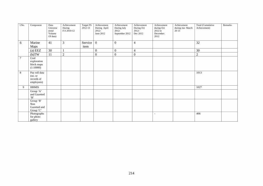
214
l.No. Component Data
Universe (total Volume Of data)
Achievement During F.S 2010-12
Target FS 2012-13
Achievement During April 2012- June 2012
Achievement During July 2012- September 2012
Achievement During Oct 2012- Dec 2012
Achievement during Oct 2012 to December. 2012
Achievement during Jan- March 20 13
Total (Cumulative Achievement)
Remarks
6 Marine Maps
41 3 Service item
0 0 4 32
(a) EEZ 30 1 0 0 4 30 (b)TW 11 2 0 0 0 2
7 Coal exploration block maps (1:10000)
8 Pay roll data (no. or records of employees)
1013
9 HRMIS 1027 Group ‘A’
and Gazetted ‘B’
Group ‘B’ Non Gazetted and Group ‘C’
Photographs for photo gallery
- 406
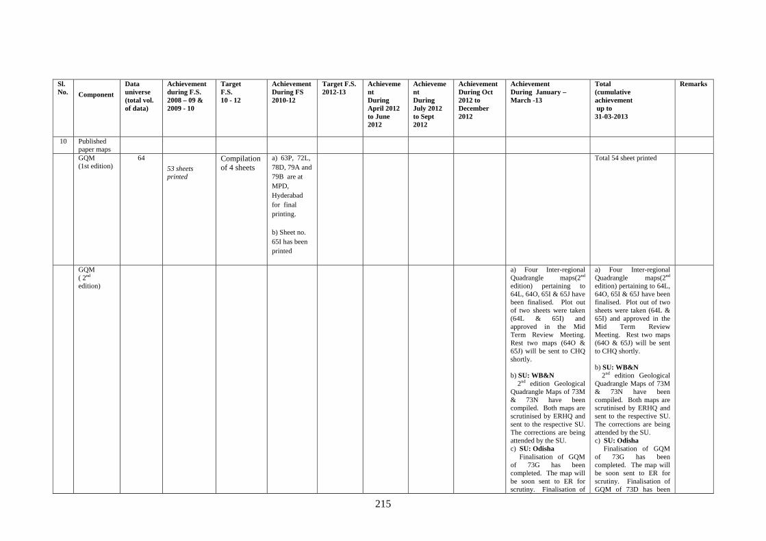
215
Sl. No. Component
Data universe (total vol. of data)
Achievement during F.S. 2008 – 09 & 2009 - 10
Target F.S. 10 - 12
Achievement During FS 2010-12
Target F.S. 2012-13
Achievement During April 2012 to June 2012
Achievement During July 2012 to Sept 2012
Achievement During Oct 2012 to December 2012
Achievement During January – March -13
Total (cumulative achievement up to 31-03-2013
Remarks
10 Published paper maps
GQM (1st edition)
64
53 sheets printed
Compilation of 4 sheets
a) 63P, 72L, 78D, 79A and 79B are at MPD, Hyderabad for final printing.
b) Sheet no. 65I has been printed
Total 54 sheet printed
GQM ( 2nd edition)
a) Four Inter-regional Quadrangle maps(2nd edition) pertaining to 64L, 64O, 65I & 65J have been finalised. Plot out of two sheets were taken (64L & 65I) and approved in the Mid Term Review Meeting. Rest two maps (64O & 65J) will be sent to CHQ shortly. b) SU: WB&N 2nd edition Geological Quadrangle Maps of 73M & 73N have been compiled. Both maps are scrutinised by ERHQ and sent to the respective SU. The corrections are being attended by the SU. c) SU: Odisha Finalisation of GQM of 73G has been completed. The map will be soon sent to ER for scrutiny. Finalisation of
a) Four Inter-regional Quadrangle maps(2nd edition) pertaining to 64L, 64O, 65I & 65J have been finalised. Plot out of two sheets were taken (64L & 65I) and approved in the Mid Term Review Meeting. Rest two maps (64O & 65J) will be sent to CHQ shortly. b) SU: WB&N 2nd edition Geological Quadrangle Maps of 73M & 73N have been compiled. Both maps are scrutinised by ERHQ and sent to the respective SU. The corrections are being attended by the SU. c) SU: Odisha Finalisation of GQM of 73G has been completed. The map will be soon sent to ER for scrutiny. Finalisation of GQM of 73D has been
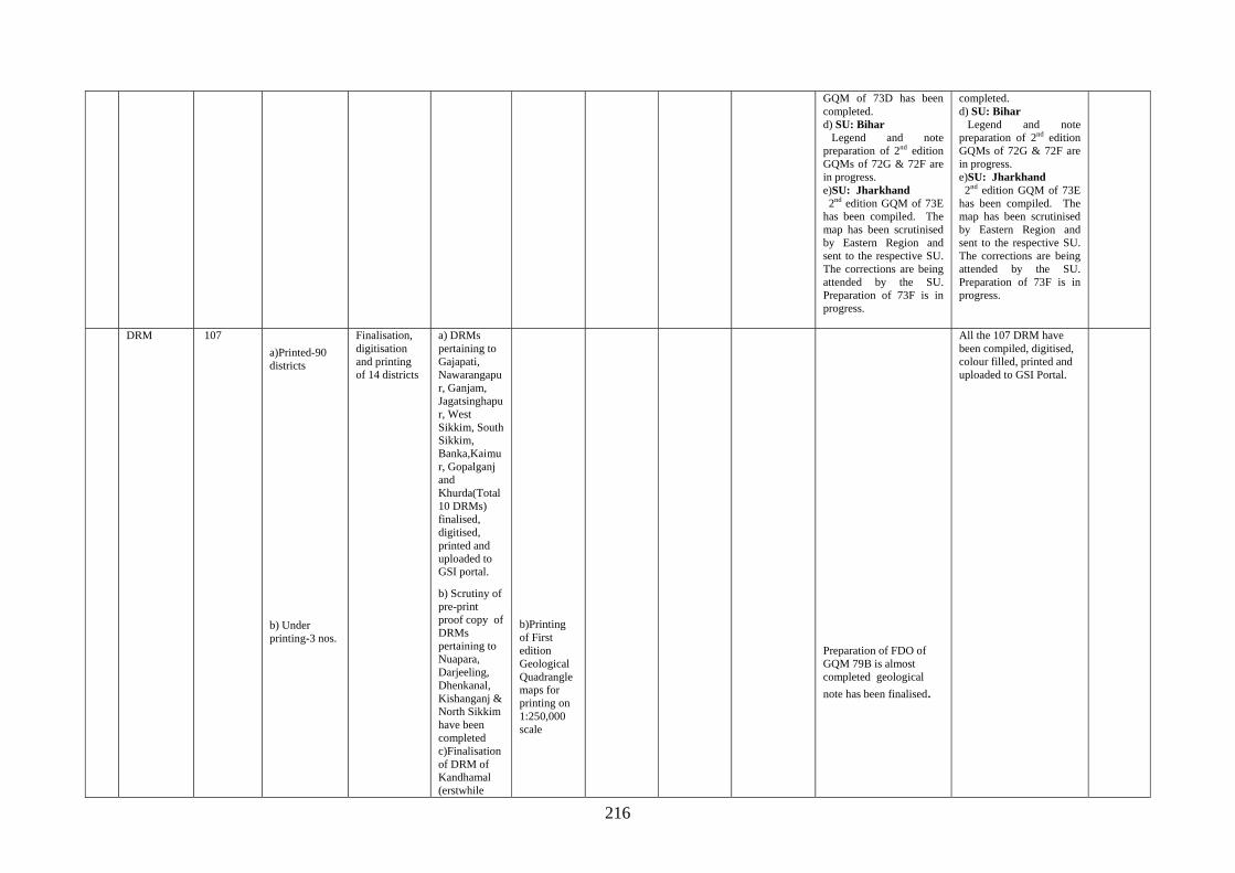
216
GQM of 73D has been completed. d) SU: Bihar Legend and note preparation of 2nd edition GQMs of 72G & 72F are in progress. e)SU: Jharkhand 2nd edition GQM of 73E has been compiled. The map has been scrutinised by Eastern Region and sent to the respective SU. The corrections are being attended by the SU. Preparation of 73F is in progress.
completed. d) SU: Bihar Legend and note preparation of 2nd edition GQMs of 72G & 72F are in progress. e)SU: Jharkhand 2nd edition GQM of 73E has been compiled. The map has been scrutinised by Eastern Region and sent to the respective SU. The corrections are being attended by the SU. Preparation of 73F is in progress.
DRM 107
a)Printed-90 districts
b) Under printing-3 nos.
Finalisation, digitisation and printing of 14 districts
a) DRMs pertaining to Gajapati, Nawarangapur, Ganjam, Jagatsinghapur, West Sikkim, South Sikkim, Banka,Kaimur, Gopalganj and Khurda(Total 10 DRMs) finalised, digitised, printed and uploaded to GSI portal.
b) Scrutiny of pre-print proof copy of DRMs pertaining to Nuapara, Darjeeling, Dhenkanal, Kishanganj & North Sikkim have been completed c)Finalisation of DRM of Kandhamal (erstwhile
b)Printing of First edition Geological Quadrangle maps for printing on 1:250,000 scale
Preparation of FDO of GQM 79B is almost completed geological
note has been finalised.
All the 107 DRM have been compiled, digitised, colour filled, printed and uploaded to GSI Portal.
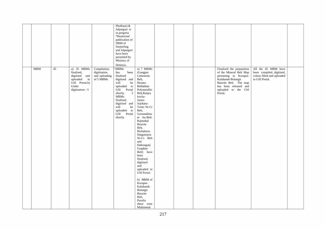
217
Phulbani) & Jalpaiguri is in progress *Restricted publication of DRM of Darjeeling and Jalpaiguri have been permitted by Ministry of
Defence. MBM 45 a) 35 MBMs
finalised, digitised and uploaded in GSI Portal.b) Under digitisation - 5
Compilation, digitisation and uploading of 5 MBMs
7 MBMs has been finalised digitised and will be uploaded to GSI Portal shortly. 3 MBMs finalised, digitised and will be uploaded to GSI Portal shortly.
a) 7 MBMs (Gangpur Limestone Belt, Hesatu-Belbathan Polymetallic Belt,Ranjrakocha-Janao-Jojohatu-Tonto Ni-Cr Belt, Gorumahisani Au-Belt, Rajmahal Bauxite Belt, Bichaburu-Hatgamaria Ni-Cr. Belt and Daltonganj Graphite Belt) have been finalised, digitised and uploaded to GSI Portal. b) MBM of Koraput- Kalahandi- Bolangir Bauxite Belt, Purulia shear zone Multimetal
Finalised the preparation of the Mineral Belt Map pertaining to Koraput-Kalahandi-Bolangir Bauxite Belt. The map has been released and uploaded to the GSI Portal.
All the 45 MBM have been compiled, digitised, colour filled and uploaded to GSI Portal.
218
Belt,Sambalpur Limestone Belthas been finalised digitised and will be uploaded to GSI Portal shortly.
State Geological Maps
5 a) Under Printing at MPD-1 (Orissa) b)Compilation completed and under scrutiny at CHQ – 1 (Jharkhand) c) Under compilation-A&N Islands.
Compilation of Maps of West Bengal & Bihar
a) Map of Orissa - Printed & released in OMEGA 2011 Seminar at Bhubaneswar. b) Under printing at MPD- map of Jharkhand. Scrutiny of 1st proof of Jharkhand as sent from MPD is in progress. Preparation of explanatory brochure of Jharkhand completed. c) Preparation of explanatory brochure of State maps of Andaman & Nicobar Island is in progress. d) Compilation of revised edition of Misc. Pub. 30 map of West
a) Compilation of Maps of West Bengal. b) Checking of pre-print proofs of Jharkhand, A&N Island, Bihar, West Bengal as and when received from Map Printing Division, Hyderabad.
a) Compilation
of Bihar state map is completed. Incorporation of mineral data is in progress. b) Corre
ctions attended on pre-print proof copy of Jharkhand State Map sent by MPD, Hyderabad.
c)Correction work on State Map of ndaman & Nicobar Island as received from Director, M&C Division, CHQ is in progress.
a) Finalised
plotting of minerals on pre-print proof copy of Jharkhand State Map sent by MPD Hyderabad. Also compilation of geological note of Jharkhand State map is in progress. b) Corre
ction work on State Map of Andaman & Nicobar Island as received from Director, M&C, CHQ is in progress. c) Com
pleted
a) State Map
of Jharkhand has been finalised. The corrections suggested by CHQ have been attended. Scrutiny of pre-print copies of the map has been completed and the final pre-print proof copy has been sent to MPD, Hyderabad for printing after approval of. Director General, GSI. b) The
State Map of Andaman & Nicobar Island has been corrected and the finalised FDO has been sent to CHQ along
a) State Map of Jharkhand has been finalised, printed and released in CGPB meeting. b) State map of Andaman & Nicobar Islands has been
finalised after attending the required corrections suggested by Director, M&C, CHQ. The FDO, colour guide, ammonia copy of the map alongwith geological note are ready to be sent to the CHQ. c) Color guide preparation of State Map of Bihar has been completed and will be sent to CHQ soon. Brochure preparation is in progress. d) Preparation of State map of West Bengal is in progress.
Printed - Sikkim, Jharkhand & Odisha. Awaiting for D.G’s approval : Andaman &
Nicobar Islands.
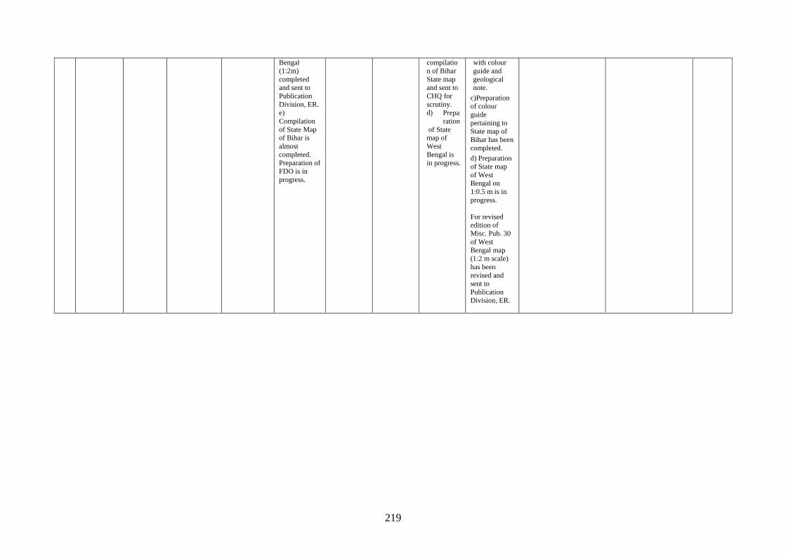
219
Bengal (1:2m) completed and sent to Publication Division, ER. e) Compilation of State Map of Bihar is almost completed. Preparation of FDO is in progress.
compilation of Bihar State map and sent to CHQ for scrutiny. d) Prepa
ration of State map of West Bengal is in progress.
with colour guide and geological note.
c)Preparation of colour guide pertaining to State map of Bihar has been completed.
d) Preparation of State map of West Bengal on 1:0.5 m is in progress. For revised edition of Misc. Pub. 30 of West Bengal map (1:2 m scale) has been revised and sent to Publication Division, ER.
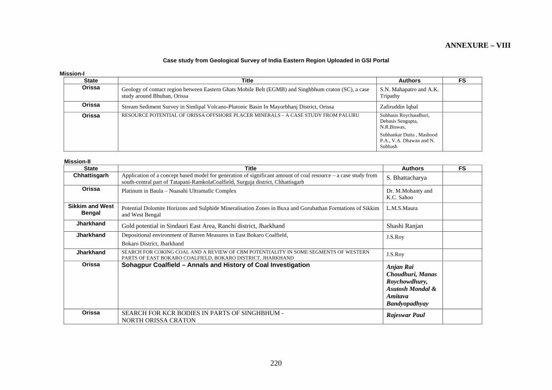
220
ANNEXURE – VIII
Case study from Geological Survey of India Eastern Region Uploaded in GSI Portal
Mission-I State Title Authors FS
Orissa Geology of contact region between Eastern Ghats Mobile Belt (EGMB) and Singhbhum craton (SC), a case study around Bhuban, Orissa
S.N. Mahapatro and A.K. Tripathy
Orissa Stream Sediment Survey in Simlipal Volcano-Plutonic Basin In Mayurbhanj District, Orissa Zafiruddin Iqbal
Orissa RESOURCE POTENTIAL OF ORISSA OFFSHORE PLACER MINERALS – A CASE STUDY FROM PALURU Subhasis Roychaudhuri, Debasis Sengupta, N.R.Biswas,
Subhankar Dutta , Mashood P.A., V.A. Dhawan and N. Subhash
Mission-II
State Title Authors FS Chhattisgarh Application of a concept based model for generation of significant amount of coal resource – a case study from
south-central part of Tatapani-RamkolaCoalfield, Surguja district, Chhattisgarh S. Bhattacharya
Orissa Platinum in Baula – Nuasahi Ultramafic Complex Dr. M.Mohanty and K.C. Sahoo
Sikkim and West Bengal
Potential Dolomite Horizons and Sulphide Mineralisation Zones in Buxa and Gorubathan Formations of Sikkim and West Bengal
L.M.S.Maura
Jharkhand Gold potential in Sindauri East Area, Ranchi district, Jharkhand Shashi Ranjan
Jharkhand Depositional environment of Barren Measures in East Bokaro Coalfield,
Bokaro District, Jharkhand J.S.Roy
Jharkhand SEARCH FOR COKING COAL AND A REVIEW OF CBM POTENTIALITY IN SOME SEGMENTS OF WESTERN PARTS OF EAST BOKARO COALFIELD, BOKARO DISTRICT, JHARKHAND
J.S.Roy
Orissa Sohagpur Coalfield – Annals and History of Coal Investigation Anjan Rai Choudhuri, Manas Roychowdhury, Asutosh Mondal & Amitava Bandyopadhyay
Orissa SEARCH FOR KCR BODIES IN PARTS OF SINGHBHUM - NORTH ORISSA CRATON
Rajeswar Paul
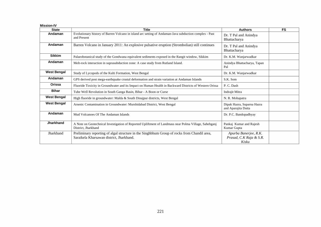
221
Mission-IV State Title Authors FS
Andaman Evolutionary history of Barren Volcano in island arc setting of Andaman-Java subduction complex - Past and Present
Dr. T Pal and Anindya Bhattacharya
Andaman Barren Volcano in January 2011: An explosive pulsative eruption (Strombolian) still continues Dr. T Pal and Anindya Bhattacharya
Sikkim Palaeobotanical study of the Gondwana equivalent sediments exposed in the Rangit window, Sikkim Dr. K.M. Wanjarwadkar
Andaman Melt-rock interaction in suprasubduction zone: A case study from Rutland Island. Anindya Bhattacharya, Tapan Pal
West Bengal Study of Lycopods of the Kulti Formation, West Bengal Dr. K.M. Wanjarwadkar
Andaman GPS derived post mega-earthquake crustal deformation and strain variation at Andaman Islands S.K. Som
Orissa Fluoride Toxicity in Groundwater and its Impact on Human Health in Backward Districts of Western Orissa P. C. Dash
Bihar Tube Well Revolution in South Ganga Basin, Bihar - A Boon or Curse Indrajit Mitra
West Bengal High fluoride in groundwater: Malda & South Dinajpur districts, West Bengal N. R. Mohapatra
West Bengal Arsenic Contamination in Groundwater: Murshidabad District, West Bengal Dipak Hazra, Suparna Hazra and Aparajita Dutta
Andaman Mud Volcanoes Of The Andaman Islands Dr. P.C. Bandopadhyay
Jharkhand A Note on Geotechnical Investigation of Reported Upliftment of Landmass near Polma Village, Sahebganj District, Jharkhand
Pankaj Kumar and Rajesh Kumar Gupta
Jharkhand Preliminary reporting of algal structure in the Singhbhum Group of rocks from Chandil area, Saraikela Kharsawan district, Jharkhand.
Apurba Banerjee, R.K. Prasad, C.K Raja & S.R.
Kisku
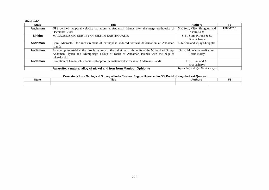
222
Mission-IV State Title Authors FS
Andaman GPS derived temporal velocity variations at Andaman Islands after the mega earthquake of December, 2004
S.K.Som, Vijay Shivgotra and Ashim Saha
2005-2010
Sikkim MACROSEISMIC SURVEY OF SIKKIM EARTHQUAKE, S. K. Som, P. Jana & U. Bhattacharya
Andaman Coral Microatoll for measurement of earthquake induced vertical deformation at Andaman islands
S.K.Som and Vijay Shivgotra
Andaman An attempt to establish the bio-chronology of the individual litho units of the Mithakhari Group, Andaman Flysch and Archipelago Group of rocks of Andaman Islands with the help of microfossils
Dr. K. M. Wanjarwadkar and Tarun Koley
Andaman Evolution of Green schist facies sub-ophiolitic metamorphic rocks of Andaman Islands Dr. T. Pal and A. Bhattacharya
Awaruite, a natural alloy of nickel and iron from Manipur Ophiolite Tapan Pal, Anindya Bhattacharya
Case study from Geological Survey of India Eastern Region Uploaded in GSI Portal during the Last Quarter
State Title Authors FS
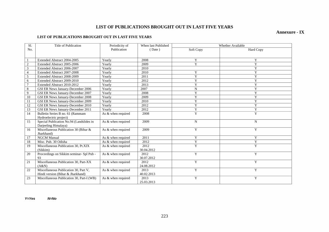
223
LIST OF PUBLICATIONS BROUGHT OUT IN LAST FIVE YEARS Annexure - IX
LIST OF PUBLICATIONS BROUGHT OUT IN LAST FIVE YEARS
Sl. No.
Title of Publication Periodicity of Publication
When last Published ( Date )
Whether Available Soft Copy Hard Copy
1 Extended Abstract 2004-2005 Yearly 2008 Y Y 2 Extended Abstract 2005-2006 Yearly 2009 Y Y 3 Extended Abstract 2006-2007 Yearly 2010 Y 4 Extended Abstract 2007-2008 Yearly 2010 Y Y 5 Extended Abstract 2008-2009 Yearly 2011 Y Y 6 Extended Abstract 2009-2010 Yearly 2012 Y Y 7 Extended Abstract 2010-2012 Yearly 2013 Y Y 8 GSI ER News January-December 2006 Yearly 2007 N Y 9 GSI ER News January-December 2007 Yearly 2008 Y Y 10 GSI ER News January-December 2008 Yearly 2009 Y Y 11 GSI ER News January-December 2009 Yearly 2010 Y Y 12 GSI ER News January-December 2010 Yearly 2012 Y Y 13 GSI ER News January-December 2011 Yearly 2012 Y Y 14 Bulletin Series B no. 61 (Rammam
Hydroelectric project) As & when required 2008 Y Y
15 Special Publication No.94 (Landslides in Darjeeling Himalaya)
As & when required 2009 N N
16 Miscellaneous Publication 30 (Bihar & Jharkhand)
As & when required 2009 Y Y
17 NGCM Manual As & when required 2011 Y Y 18 Misc. Pub. 30 Odisha As & when required 2012 Y Y 19 Miscellaneous Publication 30, Pt.XIX
(Sikkim) As & when required 2012
30.04.2012 Y Y
20 Proceedings on Sikkim seminar- Spl Pub - 93
As & when required 2012 30.07.2012
Y Y
21 Miscellaneous Publication 30, Part-XX (A&N)
As & when required 2012 24.08.2012
Y Y
22 Miscellaneous Publication 30, Part V, Hindi version (Bihar & Jharkhand)
As & when required 2013 40.02.2013
Y Y
23 Miscellaneous Publication 30, Part-I (WB) As & when required 2013 25.03.2013
Y Y
Y=Yes N=No
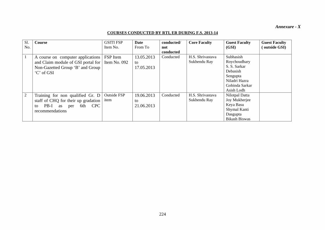
224
Annexure - X COURSES CONDUCTED BY RTI, ER DURING F.S. 2013-14
Sl. No.
Course GSITI FSP Item No.
Date From To
conducted/ not conducted
Core Faculty Guest Faculty (GSI)
Guest Faculty ( outside GSI)
1 A course on computer applications and Claim module of GSI portal for Non-Gazetted Group ‘B’ and Group ‘C’ of GSI
FSP Item Item No. 092
13.05.2013 to 17.05.2013
Conducted H.S. Shrivastava Sukhendu Ray
Subhasish Roychoudhary S. S. Sarkar Debasish Sengupta Niladri Hazra Gobinda Sarkar Asish Lodh
2 Training for non qualified Gr. D staff of CHQ for their up gradation to PB-I as per 6th CPC recommendations
Outside FSP item
19.06.2013 to 21.06.2013
Conducted H.S. Shrivastava Sukhendu Ray
Nilotpal Datta Joy Mukherjee Keya Basu Shymal Kanti Dasgupta Bikash Biswas
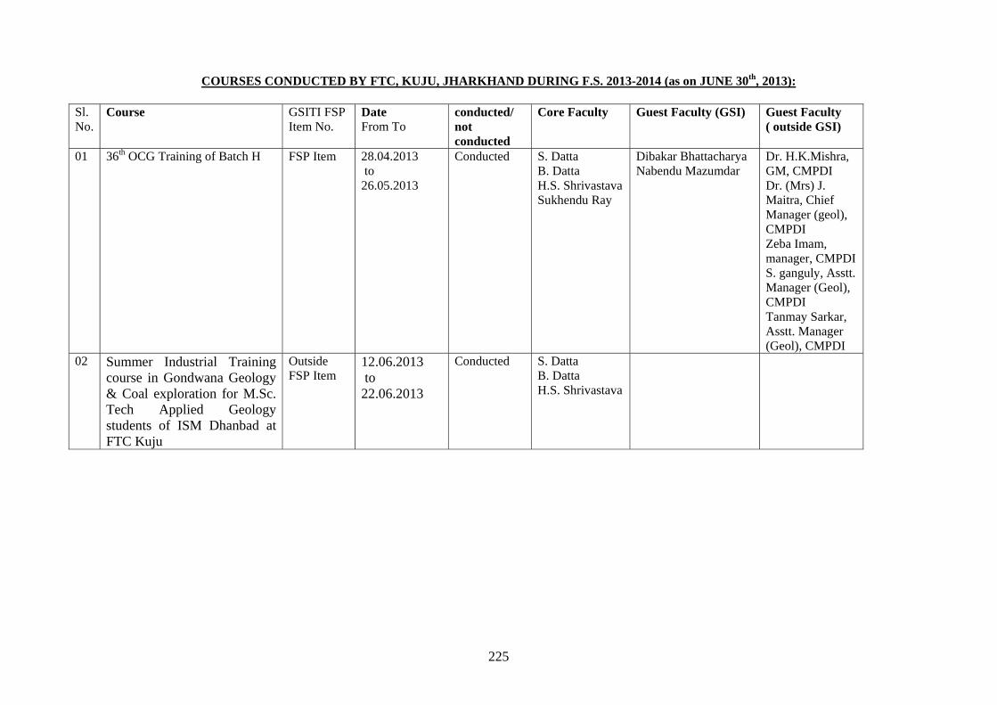
225
COURSES CONDUCTED BY FTC, KUJU, JHARKHAND DURING F.S. 2013-2014 (as on JUNE 30th, 2013):
Sl. No.
Course GSITI FSP Item No.
Date From To
conducted/ not conducted
Core Faculty Guest Faculty (GSI) Guest Faculty ( outside GSI)
01 36th OCG Training of Batch H FSP Item 28.04.2013 to 26.05.2013
Conducted S. Datta B. Datta H.S. Shrivastava Sukhendu Ray
Dibakar Bhattacharya Nabendu Mazumdar
Dr. H.K.Mishra, GM, CMPDI Dr. (Mrs) J. Maitra, Chief Manager (geol), CMPDI Zeba Imam, manager, CMPDI S. ganguly, Asstt. Manager (Geol), CMPDI Tanmay Sarkar, Asstt. Manager (Geol), CMPDI
02 Summer Industrial Training course in Gondwana Geology & Coal exploration for M.Sc. Tech Applied Geology students of ISM Dhanbad at FTC Kuju
Outside FSP Item
12.06.2013 to 22.06.2013
Conducted S. Datta B. Datta H.S. Shrivastava
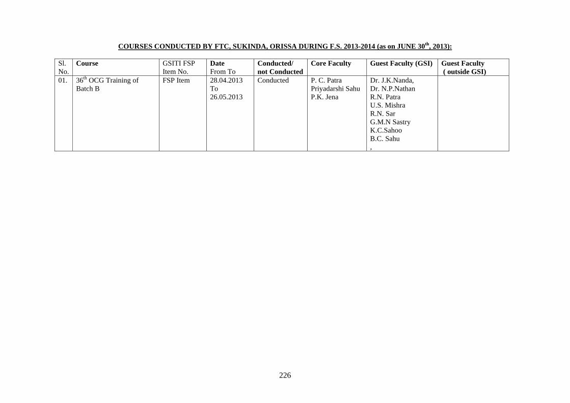
226
COURSES CONDUCTED BY FTC, SUKINDA, ORISSA DURING F.S. 2013-2014 (as on JUNE 30th, 2013):
Sl. No.
Course GSITI FSP Item No.
Date From To
Conducted/ not Conducted
Core Faculty Guest Faculty (GSI) Guest Faculty ( outside GSI)
01. 36th OCG Training of Batch B
FSP Item 28.04.2013 To 26.05.2013
Conducted P. C. Patra Priyadarshi Sahu P.K. Jena
Dr. J.K.Nanda, Dr. N.P.Nathan R.N. Patra U.S. Mishra R.N. Sar G.M.N Sastry K.C.Sahoo B.C. Sahu ,
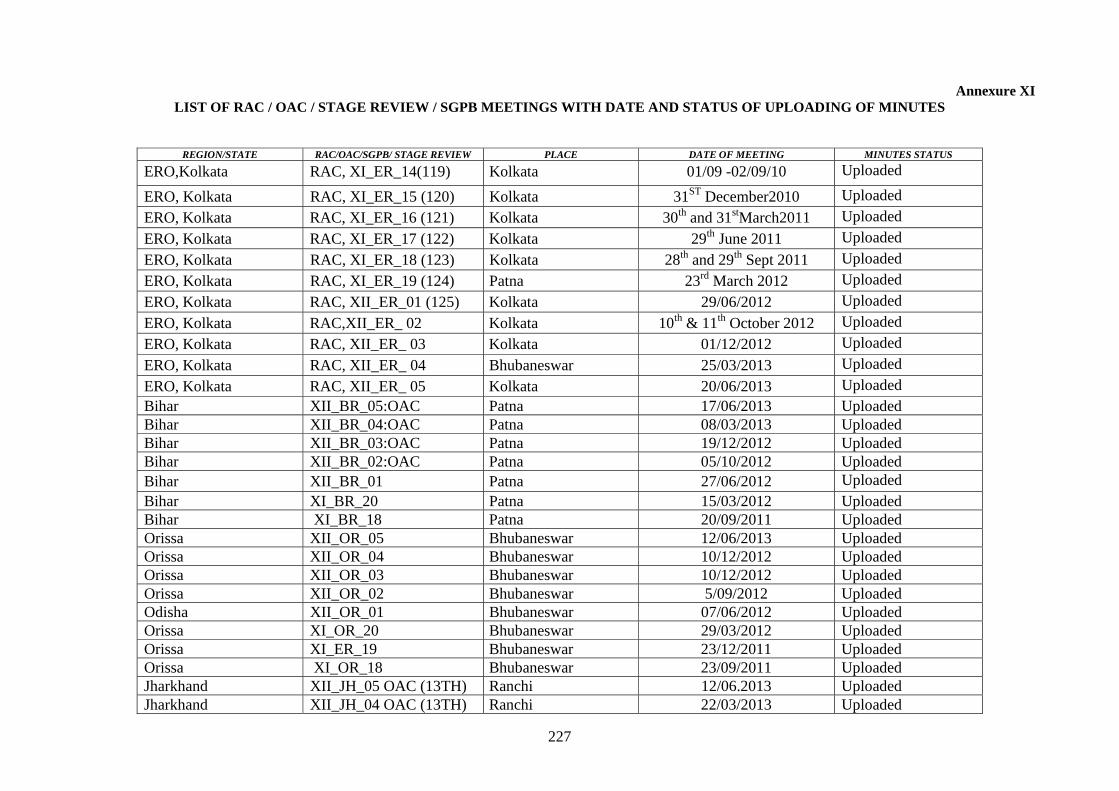
227
Annexure XI LIST OF RAC / OAC / STAGE REVIEW / SGPB MEETINGS WITH DATE AND STATUS OF UPLOADING OF MINUTES
REGION/STATE RAC/OAC/SGPB/ STAGE REVIEW PLACE DATE OF MEETING MINUTES STATUS
ERO,Kolkata RAC, XI_ER_14(119) Kolkata 01/09 -02/09/10 Uploaded
ERO, Kolkata RAC, XI_ER_15 (120) Kolkata 31ST December2010 Uploaded
ERO, Kolkata RAC, XI_ER_16 (121) Kolkata 30th and 31stMarch2011 Uploaded
ERO, Kolkata RAC, XI_ER_17 (122) Kolkata 29th June 2011 Uploaded
ERO, Kolkata RAC, XI_ER_18 (123) Kolkata 28th and 29th Sept 2011 Uploaded
ERO, Kolkata RAC, XI_ER_19 (124) Patna 23rd March 2012 Uploaded
ERO, Kolkata RAC, XII_ER_01 (125) Kolkata 29/06/2012 Uploaded
ERO, Kolkata RAC,XII_ER_ 02 Kolkata 10th & 11th October 2012 Uploaded
ERO, Kolkata RAC, XII_ER_ 03 Kolkata 01/12/2012 Uploaded
ERO, Kolkata RAC, XII_ER_ 04 Bhubaneswar 25/03/2013 Uploaded
ERO, Kolkata RAC, XII_ER_ 05 Kolkata 20/06/2013 Uploaded Bihar XII_BR_05:OAC Patna 17/06/2013 Uploaded Bihar XII_BR_04:OAC Patna 08/03/2013 Uploaded Bihar XII_BR_03:OAC Patna 19/12/2012 Uploaded Bihar XII_BR_02:OAC Patna 05/10/2012 Uploaded Bihar XII_BR_01 Patna 27/06/2012 Uploaded Bihar XI_BR_20 Patna 15/03/2012 Uploaded Bihar XI_BR_18 Patna 20/09/2011 Uploaded Orissa XII_OR_05 Bhubaneswar 12/06/2013 Uploaded Orissa XII_OR_04 Bhubaneswar 10/12/2012 Uploaded Orissa XII_OR_03 Bhubaneswar 10/12/2012 Uploaded Orissa XII_OR_02 Bhubaneswar 5/09/2012 Uploaded Odisha XII_OR_01 Bhubaneswar 07/06/2012 Uploaded Orissa XI_OR_20 Bhubaneswar 29/03/2012 Uploaded Orissa XI_ER_19 Bhubaneswar 23/12/2011 Uploaded Orissa XI_OR_18 Bhubaneswar 23/09/2011 Uploaded Jharkhand XII_JH_05 OAC (13TH) Ranchi 12/06.2013 Uploaded Jharkhand XII_JH_04 OAC (13TH) Ranchi 22/03/2013 Uploaded
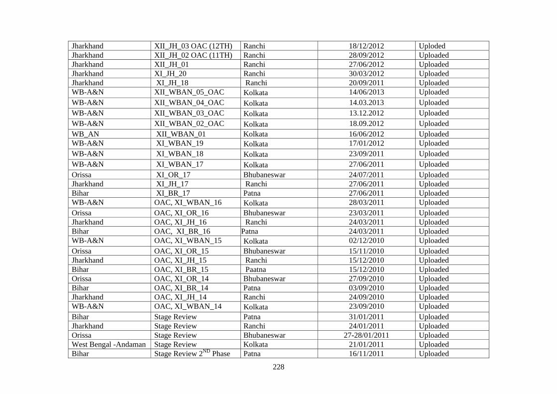
228
Jharkhand XII_JH_03 OAC (12TH) Ranchi 18/12/2012 Uploded Jharkhand XII_JH_02 OAC (11TH) Ranchi 28/09/2012 Uploaded Jharkhand XII_JH_01 Ranchi 27/06/2012 Uploaded Jharkhand XI_JH_20 Ranchi 30/03/2012 Uploaded Jharkhand XI_JH_18 Ranchi 20/09/2011 Uploaded WB-A&N XII_WBAN_05_OAC Kolkata 14/06/2013 Uploaded WB-A&N XII_WBAN_04_OAC Kolkata 14.03.2013 Uploaded WB-A&N XII_WBAN_03_OAC Kolkata 13.12.2012 Uploaded WB-A&N XII_WBAN_02_OAC Kolkata 18.09.2012 Uploaded WB_AN XII_WBAN_01 Kolkata 16/06/2012 Uploaded WB-A&N XI_WBAN_19 Kolkata 17/01/2012 Uploaded WB-A&N XI_WBAN_18 Kolkata 23/09/2011 Uploaded WB-A&N XI_WBAN_17 Kolkata 27/06/2011 Uploaded Orissa XI_OR_17 Bhubaneswar 24/07/2011 Uploaded Jharkhand XI_JH_17 Ranchi 27/06/2011 Uploaded Bihar XI_BR_17 Patna 27/06/2011 Uploaded WB-A&N OAC, XI_WBAN_16 Kolkata 28/03/2011 Uploaded Orissa OAC, XI_OR_16 Bhubaneswar 23/03/2011 Uploaded Jharkhand OAC, XI_JH_16 Ranchi 24/03/2011 Uploaded Bihar OAC, XI_BR_16 Patna 24/03/2011 Uploaded WB-A&N OAC, XI_WBAN_15 Kolkata 02/12/2010 Uploaded Orissa OAC, XI_OR_15 Bhubaneswar 15/11/2010 Uploaded Jharkhand OAC, XI_JH_15 Ranchi 15/12/2010 Uploaded Bihar OAC, XI_BR_15 Paatna 15/12/2010 UploadedOrissa OAC, XI_OR_14 Bhubaneswar 27/09/2010 Uploaded Bihar OAC, XI_BR_14 Patna 03/09/2010 Uploaded Jharkhand OAC, XI_JH_14 Ranchi 24/09/2010 Uploaded WB-A&N OAC, XI_WBAN_14 Kolkata 23/09/2010 Uploaded Bihar Stage Review Patna 31/01/2011 Uploaded Jharkhand Stage Review Ranchi 24/01/2011 Uploaded Orissa Stage Review Bhubaneswar 27-28/01/2011 Uploaded West Bengal -Andaman Stage Review Kolkata 21/01/2011 Uploaded Bihar Stage Review 2ND Phase Patna 16/11/2011 Uploaded
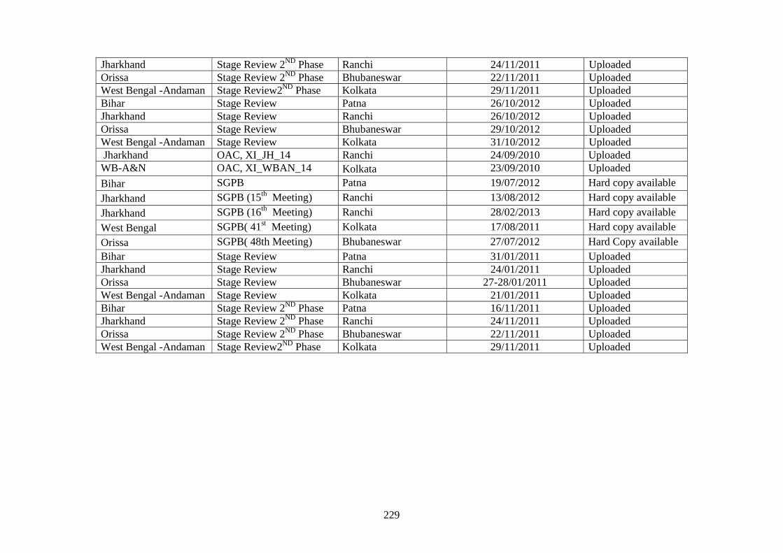
229
Jharkhand Stage Review 2ND Phase Ranchi 24/11/2011 Uploaded Orissa Stage Review 2ND Phase Bhubaneswar 22/11/2011 Uploaded West Bengal -Andaman Stage Review2ND Phase Kolkata 29/11/2011 Uploaded Bihar Stage Review Patna 26/10/2012 Uploaded Jharkhand Stage Review Ranchi 26/10/2012 Uploaded Orissa Stage Review Bhubaneswar 29/10/2012 Uploaded West Bengal -Andaman Stage Review Kolkata 31/10/2012 Uploaded Jharkhand OAC, XI_JH_14 Ranchi 24/09/2010 Uploaded WB-A&N OAC, XI_WBAN_14 Kolkata 23/09/2010 Uploaded
Bihar SGPB Patna 19/07/2012 Hard copy available
Jharkhand SGPB (15th Meeting) Ranchi 13/08/2012 Hard copy available
Jharkhand SGPB (16th Meeting) Ranchi 28/02/2013 Hard copy available
West Bengal SGPB( 41st Meeting) Kolkata 17/08/2011 Hard copy available
Orissa SGPB( 48th Meeting) Bhubaneswar 27/07/2012 Hard Copy available Bihar Stage Review Patna 31/01/2011 Uploaded Jharkhand Stage Review Ranchi 24/01/2011 Uploaded Orissa Stage Review Bhubaneswar 27-28/01/2011 Uploaded West Bengal -Andaman Stage Review Kolkata 21/01/2011 Uploaded Bihar Stage Review 2ND Phase Patna 16/11/2011 Uploaded Jharkhand Stage Review 2ND Phase Ranchi 24/11/2011 Uploaded Orissa Stage Review 2ND Phase Bhubaneswar 22/11/2011 Uploaded West Bengal -Andaman Stage Review2ND Phase Kolkata 29/11/2011 Uploaded
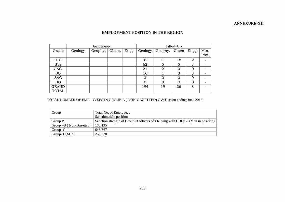
230
ANNEXURE-XII
EMPLOYMENT POSITION IN THE REGION
Sanctioned Filled-Up Grade Geology Geophy. Chem. Engg. Geology Geophy. Chem Engg. Min.
Phy. JTS 92 11 18 2 - STS 62 5 5 3 - JAG 21 2 0 0 - SG 16 1 3 3 -
SAG 3 0 0 0 - HG 0 0 0 0 -
GRAND TOTAL
194 19 26 8 -
TOTAL NUMBER OF EMPLOYEES IN GROUP-B,( NON-GAZETTED),C & D as on ending June 2013
Group Total No. of Employees Sanctioned/In position
Group B Sanction strength of Group-B officers of ER lying with CHQ/ 26(Man in position)Group –B ( Non-Gazetted ) 186/135 Group- C 648/367 Group- D(MTS) 260/238
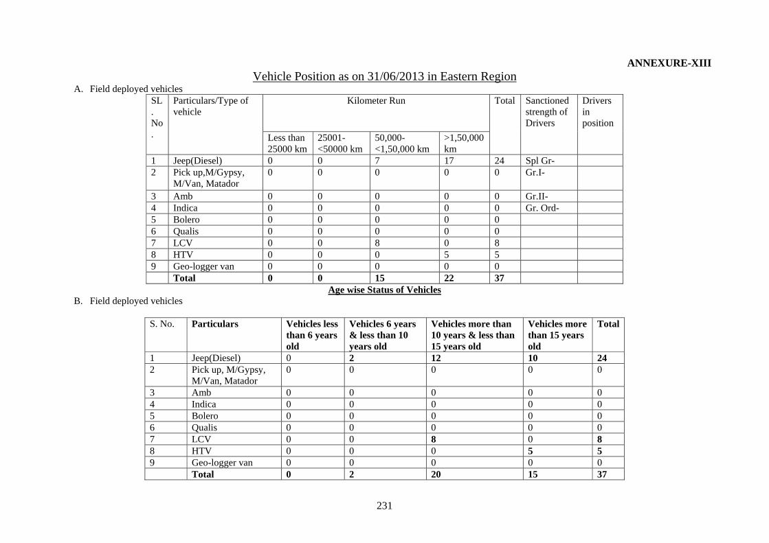
231
ANNEXURE-XIII Vehicle Position as on 31/06/2013 in Eastern Region
A. Field deployed vehicles SL. No.
Particulars/Type of vehicle
Kilometer Run Total Sanctioned strength of Drivers
Drivers in position
Less than 25000 km
25001-<50000 km
50,000-<1,50,000 km
>1,50,000 km
1 Jeep(Diesel) 0 0 7 17 24 Spl Gr- 2 Pick up,M/Gypsy,
M/Van, Matador 0 0 0 0 0 Gr.I-
3 Amb 0 0 0 0 0 Gr.II- 4 Indica 0 0 0 0 0 Gr. Ord- 5 Bolero 0 0 0 0 0 6 Qualis 0 0 0 0 0 7 LCV 0 0 8 0 8 8 HTV 0 0 0 5 5 9 Geo-logger van 0 0 0 0 0 Total 0 0 15 22 37
Age wise Status of Vehicles B. Field deployed vehicles
S. No. Particulars Vehicles less
than 6 years old
Vehicles 6 years & less than 10 years old
Vehicles more than 10 years & less than 15 years old
Vehicles more than 15 years old
Total
1 Jeep(Diesel) 0 2 12 10 24 2 Pick up, M/Gypsy,
M/Van, Matador 0 0 0 0 0
3 Amb 0 0 0 0 0 4 Indica 0 0 0 0 0 5 Bolero 0 0 0 0 0 6 Qualis 0 0 0 0 0 7 LCV 0 0 8 0 8 8 HTV 0 0 0 5 5 9 Geo-logger van 0 0 0 0 0 Total 0 2 20 15 37
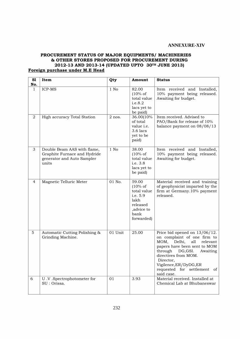
232
ANNEXURE-XIV
PROCUREMENT STATUS OF MAJOR EQUIPMENTS/ MACHINERIES & OTHER STORES PROPOSED FOR PROCUREMENT DURING
2012-13 AND 2013-14 (UPDATED UPTO 30TH JUNE 2013) Foreign purchase under M.E Head
Sl
No. Item Qty Amount Status
1 ICP-MS 1 No 82.00 (10% of total value i.e.8.2 lacs yet to be paid)
Item received and Installed, 10% payment being released. Awaiting for budget.
2 High accuracy Total Station 2 nos. 36.00(10% of total value i.e. 3.6 lacs yet to be paid)
Item received. Advised to PAO/Bank for release of 10% balance payment on 08/08/13
3 Double Beam AAS with flame, Graphite Furnace and Hydride generator and Auto Sampler units
1 No 38.00 (10% of total value i.e. 3.8 lacs yet to be paid)
Item received and Installed, 10% payment being released. Awaiting for budget.
4 Magnetic Telluric Meter 01 No. 59.00 (10% of total value i.e. 5.9 lakh released ,advice to bank forwarded)
Material received and training of geophysicist imparted by the firm at Germany.10% payment released.
5 Automatic Cutting Polishing & Grinding Machine.
01 Unit 25.00 Price bid opened on 13/06/12. on complaint of one firm to MOM, Delhi, all relevant papers have been sent to MOM through DG,GSI. Awaiting directives from MOM. Director, Vigilence,ER/DyDG,ER requested for settlement of said case.
6 U .V .Spectrophotometer for SU : Orissa.
01 3.93 Material received. Installed at Chemical Lab at Bhubaneswar

233
Domestic purchase M.E Head Sl. No
Description of Stores Amount in Rs. (Lakhs)
Status
1 Planetary Ball Mill 18.00 Material Received. Payment to be made. Awaiting for budget.
2 Core Barrels (T-2 & T-6) 43.06 Order placed. Inspection to be made in 3rd week of Aug 2013
3 T .C. Bits 13.50 Part Supply received. Bill Processed. 4 Casing Dia .Bits & R-Shells 19.50 Order placed. Inspection to be made
in 3rd week of Aug 2013 5 T-6 Dia. Bits 33.25 6 Wire Line Dia. Bits & R-Shells 26.96 7 Casing Dia. Bits 14.98 8 G. I. Core Boxes 19.95 Material Received. Payment to be
made (Lying with PAO) 9 Bentonite Mud 8.52 Materials Inspected. To be supplied
soon. 10 Spares for Rock drill rig &
pumps 28.00 Part Materials Inspected. To be
supplied soon. 11 BW parallel rod 15.50 Order Placed.
12 X series casing NX/BX 18.00 Order Placed. 13 Air conditioner m/c 6.43 Materials received. Installation to be
made. 14 Gen-Set 10KVA 3.00 Material received. Installed. 15 Bio metric m/c for SUs 6.00 Installed, part payment released 16 Brunton compass 2.77 Material received , . Payment to be
made (Lying with PAO) 17 Tyres &Tubes 5.60 Material Received. Payment made 18 GPS (Hand held) 6.00 Order placed. 19 Digital camera 4.00 Material Received. Payment made. 20 T-2 Dia. Bits 15.42 Order placed. Inspection to be made
in 3rd week of Aug 2013 21 Geological hammer 2.00 Material received, Payment to be
made (Lying with PAO Tentage and clothing Head Sl. No
Description of Stores Amount in Rs. (Lakhs)
Status
1 Tentages of various types 47.00 Under TAC stage
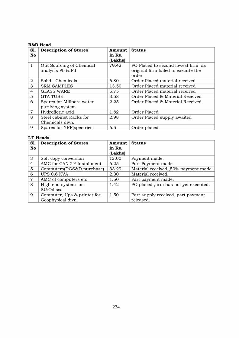
234
R&D Head Sl. No
Description of Stores Amount in Rs. (Lakhs)
Status
1 Out Sourcing of Chemical analysis Pb & Pd
79.42 PO Placed to second lowest firm as original firm failed to execute the order
2 Solid Chemicals 6.80 Order Placed material received 3 SRM SAMPLES 13.50 Order Placed material received 4 GLASS WARE 6.75 Order Placed material received 5 GTA TUBE 3.58 Order Placed & Material Received 6 Spares for Millpore water
purifying system 2.25 Order Placed & Material Received
7 Hydrofloric acid 1.82 Order Placed 8 Steel cabinet Racks for
Chemicals divn. 2.98 Order Placed supply awaited
9 Spares for XRF(spectries) 6.5 Order placed I.T Heads Sl. No
Description of Stores Amount in Rs. (Lakhs)
Status
3 Soft copy conversion 12.00 Payment made. 4 AMC for CAN 2nd Installment 6.25 Part Payment made 5 Computers(DGS&D purchase) 33.29 Material received ,50% payment made 6 UPS 0.6 KVA 2.30 Material received. 7 AMC of computers etc 1.50 Part payment made. 8 High end system for
SU:Odissa 1.42 PO placed ,firm has not yet executed.
9 Computer, Ups & printer for Geophysical divn.
1.50 Part supply received, part payment released.
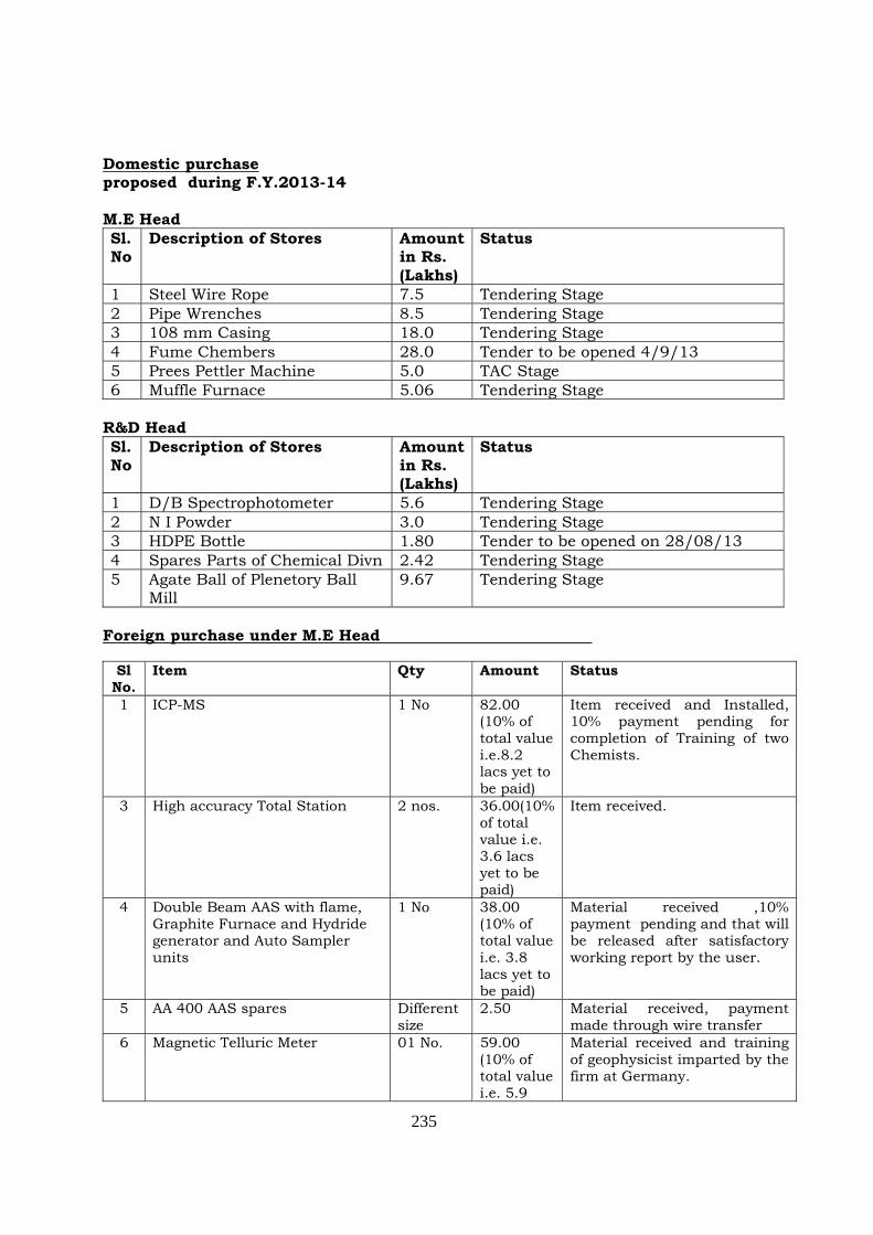
235
Domestic purchase proposed during F.Y.2013-14 M.E Head Sl. No
Description of Stores Amount in Rs. (Lakhs)
Status
1 Steel Wire Rope 7.5 Tendering Stage 2 Pipe Wrenches 8.5 Tendering Stage 3 108 mm Casing 18.0 Tendering Stage 4 Fume Chembers 28.0 Tender to be opened 4/9/13 5 Prees Pettler Machine 5.0 TAC Stage 6 Muffle Furnace 5.06 Tendering Stage
R&D Head Sl. No
Description of Stores Amount in Rs. (Lakhs)
Status
1 D/B Spectrophotometer 5.6 Tendering Stage 2 N I Powder 3.0 Tendering Stage 3 HDPE Bottle 1.80 Tender to be opened on 28/08/13 4 Spares Parts of Chemical Divn 2.42 Tendering Stage 5 Agate Ball of Plenetory Ball
Mill 9.67 Tendering Stage
Foreign purchase under M.E Head
Sl
No. Item Qty Amount Status
1 ICP-MS 1 No 82.00 (10% of total value i.e.8.2 lacs yet to be paid)
Item received and Installed, 10% payment pending for completion of Training of two Chemists.
3 High accuracy Total Station 2 nos. 36.00(10% of total value i.e. 3.6 lacs yet to be paid)
Item received.
4 Double Beam AAS with flame, Graphite Furnace and Hydride generator and Auto Sampler units
1 No 38.00 (10% of total value i.e. 3.8 lacs yet to be paid)
Material received ,10% payment pending and that will be released after satisfactory working report by the user.
5 AA 400 AAS spares Different size
2.50 Material received, payment made through wire transfer
6 Magnetic Telluric Meter 01 No. 59.00 (10% of total value i.e. 5.9
Material received and training of geophysicist imparted by the firm at Germany.
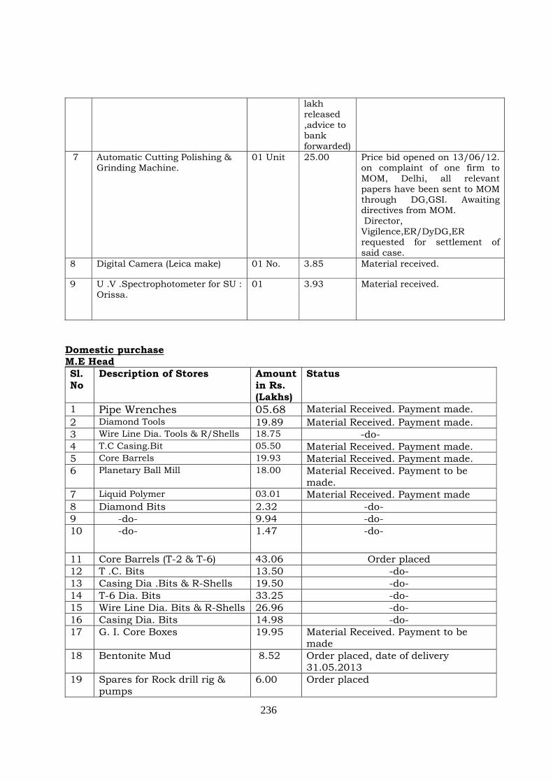
236
lakh released ,advice to bank forwarded)
7 Automatic Cutting Polishing & Grinding Machine.
01 Unit 25.00 Price bid opened on 13/06/12. on complaint of one firm to MOM, Delhi, all relevant papers have been sent to MOM through DG,GSI. Awaiting directives from MOM. Director, Vigilence,ER/DyDG,ER requested for settlement of said case.
8 Digital Camera (Leica make) 01 No. 3.85 Material received.
9 U .V .Spectrophotometer for SU : Orissa.
01 3.93 Material received.
Domestic purchase M.E Head Sl. No
Description of Stores Amount in Rs. (Lakhs)
Status
1 Pipe Wrenches 05.68 Material Received. Payment made. 2 Diamond Tools 19.89 Material Received. Payment made. 3 Wire Line Dia. Tools & R/Shells 18.75 -do- 4 T.C Casing.Bit 05.50 Material Received. Payment made. 5 Core Barrels 19.93 Material Received. Payment made. 6 Planetary Ball Mill 18.00 Material Received. Payment to be
made. 7 Liquid Polymer 03.01 Material Received. Payment made 8 Diamond Bits 2.32 -do- 9 -do- 9.94 -do- 10 -do- 1.47 -do-
11 Core Barrels (T-2 & T-6) 43.06 Order placed 12 T .C. Bits 13.50 -do- 13 Casing Dia .Bits & R-Shells 19.50 -do- 14 T-6 Dia. Bits 33.25 -do- 15 Wire Line Dia. Bits & R-Shells 26.96 -do- 16 Casing Dia. Bits 14.98 -do- 17 G. I. Core Boxes 19.95 Material Received. Payment to be
made 18 Bentonite Mud 8.52 Order placed, date of delivery
31.05.2013 19 Spares for Rock drill rig &
pumps 6.00 Order placed
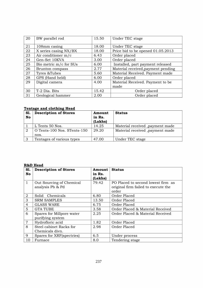
237
20 BW parallel rod 15.50 Under TEC stage
21 108mm casing 18.00 Under TEC stage 22 X series casing NX/BX 18.00 Price bid to be opened 01.05.2013 23 Air conditioner m/c 6.43 Order placed 24 Gen-Set 10KVA 3.00 Order placed 25 Bio metric m/c for SUs 6.00 Installed, part payment released 26 Brunton compass 2.77 Material received,payment pending 27 Tyres &Tubes 5.60 Material Received. Payment made 28 GPS (Hand held) 6.00 Order placed 29 Digital camera 4.00 Material Received. Payment to be
made 30 T-2 Dia. Bits 15.42 Order placed 31 Geological hammer 2.00 Order placed
Tentage and clothing Head Sl. No
Description of Stores Amount in Rs. (Lakhs)
Status
1 L Tents 50 Nos. 14.25 Material received ,payment made 2 O Tents-100 Nos. STents-150
nos. 29.20 Material received ,payment made
3 Tentages of various types 47.00 Under TEC stage R&D Head Sl. No
Description of Stores Amount in Rs. (Lakhs)
Status
1 Out Sourcing of Chemical analysis Pb & Pd
79.42 PO Placed to second lowest firm as original firm failed to execute the order
2 Solid Chemicals 6.80 Order Placed 3 SRM SAMPLES 13.50 Order Placed 4 GLASS WARE 6.75 Order Placed 5 GTA TUBE 3.58 Order Placed & Material Received 6 Spares for Millpore water
purifying system 2.25 Order Placed & Material Received
7 Hydrofloric acid 1.82 Order Placed 8 Steel cabinet Racks for
Chemicals divn. 2.98 Order Placed
9 Spares for XRF(spectries) 6.5 Under process 10 Furnace 8.0 Tendering stage
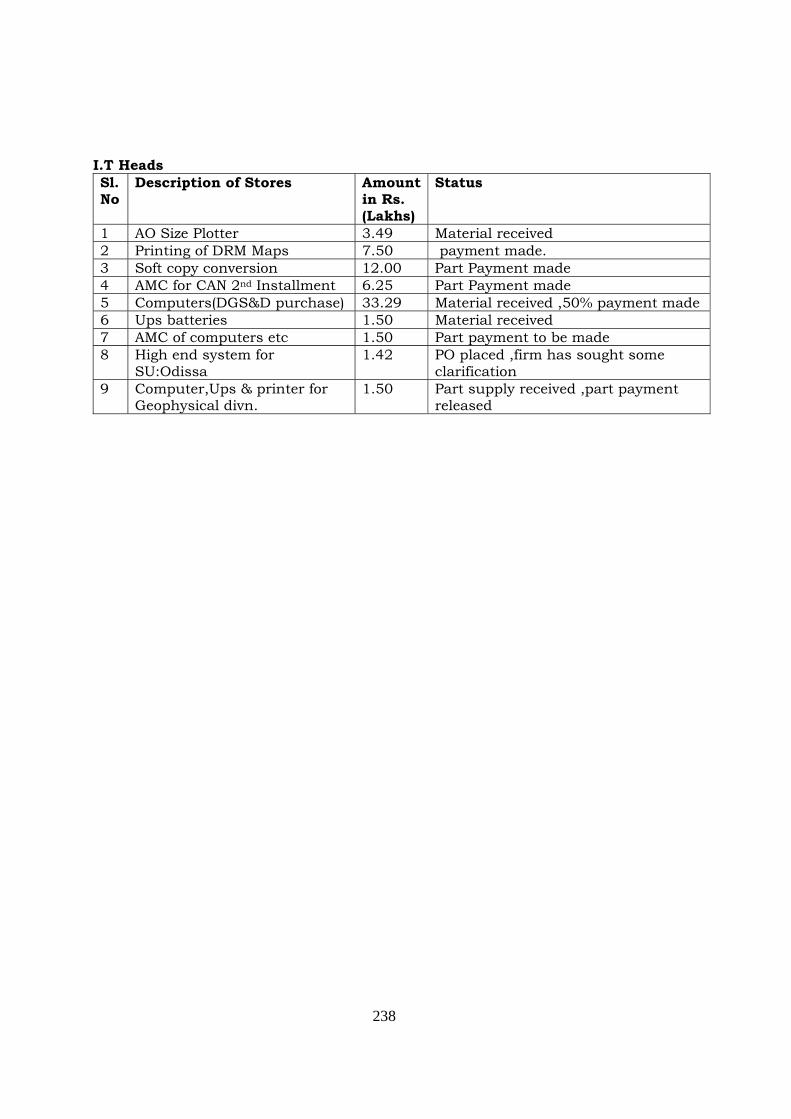
238
I.T Heads Sl. No
Description of Stores Amount in Rs. (Lakhs)
Status
1 AO Size Plotter 3.49 Material received 2 Printing of DRM Maps 7.50 payment made. 3 Soft copy conversion 12.00 Part Payment made 4 AMC for CAN 2nd Installment 6.25 Part Payment made 5 Computers(DGS&D purchase) 33.29 Material received ,50% payment made 6 Ups batteries 1.50 Material received 7 AMC of computers etc 1.50 Part payment to be made 8 High end system for
SU:Odissa 1.42 PO placed ,firm has sought some
clarification 9 Computer,Ups & printer for
Geophysical divn. 1.50 Part supply received ,part payment
released
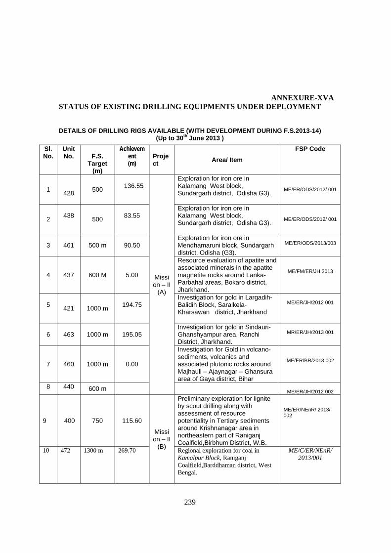
239
ANNEXURE-XVA
STATUS OF EXISTING DRILLING EQUIPMENTS UNDER DEPLOYMENT
DETAILS OF DRILLING RIGS AVAILABLE (WITH DEVELOPMENT DURING F.S.2013-14) (Up to 30th June 2013 )
Sl. No.
Unit No.
F.S.
Target (m)
Achievement (m)
Project Area/ Item
FSP Code
1
428 500
136.55
Mission – II
(A)
Exploration for iron ore in Kalamang West block, Sundargarh district, Odisha G3).
ME/ER/ODS/2012/ 001
2
438
500
83.55
Exploration for iron ore in Kalamang West block, Sundargarh district, Odisha G3).
ME/ER/ODS/2012/ 001
3 461 500 m
90.50
Exploration for iron ore in Mendhamaruni block, Sundargarh district, Odisha (G3).
ME/ER/ODS/2013/003
4 437 600 M
5.00
Resource evaluation of apatite and associated minerals in the apatite magnetite rocks around Lanka-Parbahal areas, Bokaro district, Jharkhand.
ME/FM/ER/JH 2013
5
421 1000 m
194.75
Investigation for gold in Largadih-Balidih Block, Saraikela- Kharsawan district, Jharkhand
ME/ER/JH/2012 001
6
463 1000 m
195.05 Investigation for gold in Sindauri-Ghanshyampur area, Ranchi District, Jharkhand.
MR/ER/JH/2013 001
7
460 1000 m
0.00
Investigation for Gold in volcano-sediments, volcanics and associated plutonic rocks around Majhauli – Ajaynagar – Ghansura area of Gaya district, Bihar
ME/ER/BR/2013 002
8 440 600 m ME/ER/JH/2012 002
9
400
750 115.60
Mission – II
(B)
Preliminary exploration for lignite by scout drilling along with assessment of resource potentiality in Tertiary sediments around Krishnanagar area in northeastern part of Raniganj Coalfield,Birbhum District, W.B.
ME/ER/NEnR/ 2013/ 002
10 472 1300 m 269.70 Regional exploration for coal in Kamalpur Block, Raniganj Coalfield,Barddhaman district, West Bengal.
ME/C/ER/NEnR/ 2013/001
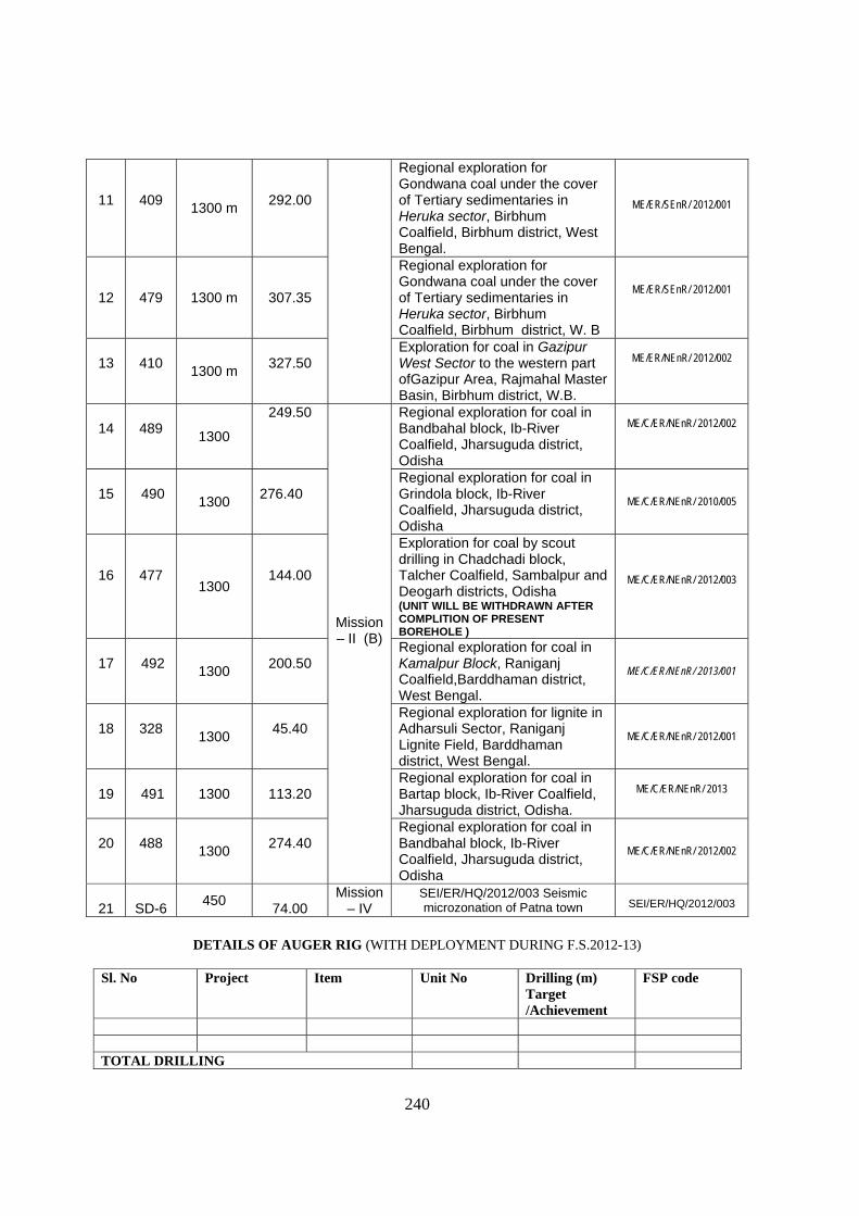
240
DETAILS OF AUGER RIG (WITH DEPLOYMENT DURING F.S.2012-13)
Sl. No Project Item Unit No Drilling (m)
Target /Achievement
FSP code
TOTAL DRILLING
11
409 1300 m
292.00
Regional exploration for Gondwana coal under the cover of Tertiary sedimentaries in Heruka sector, Birbhum Coalfield, Birbhum district, West Bengal.
ME/ER/SEnR/ 2012/001
12
479 1300 m
307.35
Regional exploration for Gondwana coal under the cover of Tertiary sedimentaries in Heruka sector, Birbhum Coalfield, Birbhum district, W. B
ME/ER/SEnR/ 2012/001
13
410
1300 m
327.50
Exploration for coal in Gazipur West Sector to the western part ofGazipur Area, Rajmahal Master Basin, Birbhum district, W.B.
ME/ER/NEnR/ 2012/002
14
489
1300
249.50
Mission – II (B)
Regional exploration for coal in Bandbahal block, Ib-River Coalfield, Jharsuguda district, Odisha
ME/C/ER/NEnR/ 2012/002
15
490
1300
276.40
Regional exploration for coal in Grindola block, Ib-River Coalfield, Jharsuguda district, Odisha
ME/C/ER/NEnR/ 2010/005
16
477 1300
144.00
Exploration for coal by scout drilling in Chadchadi block, Talcher Coalfield, Sambalpur and Deogarh districts, Odisha (UNIT WILL BE WITHDRAWN AFTER COMPLITION OF PRESENT BOREHOLE )
ME/C/ER/NEnR/ 2012/003
17
492
1300
200.50
Regional exploration for coal in Kamalpur Block, Raniganj Coalfield,Barddhaman district, West Bengal.
ME/C/ER/NEnR/ 2013/001
18
328
1300
45.40
Regional exploration for lignite in Adharsuli Sector, Raniganj Lignite Field, Barddhaman district, West Bengal.
ME/C/ER/NEnR/ 2012/001
19
491 1300
113.20
Regional exploration for coal in Bartap block, Ib-River Coalfield, Jharsuguda district, Odisha.
ME/C/ER/NEnR/ 2013
20
488
1300
274.40
Regional exploration for coal in Bandbahal block, Ib-River Coalfield, Jharsuguda district, Odisha
ME/C/ER/NEnR/ 2012/002
21
SD-6
450
74.00 Mission
– IV SEI/ER/HQ/2012/003 Seismic microzonation of Patna town
SEI/ER/HQ/2012/003
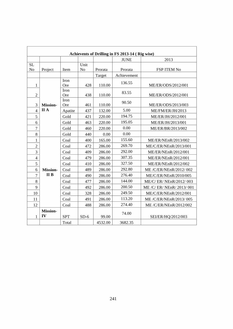
241
Achievents of Drilling in FS 2013-14 ( Rig wise)
JUNE 2013 SL No Project Item
Unit No Prorata Prorata FSP ITEM No
Target Achievement
1
Mission- II A
Iron Ore 428 110.00
136.55 ME/ER/ODS/2012/001
2 Iron Ore 438 110.00
83.55 ME/ER/ODS/2012/001
3 Iron Ore 461 110.00
90.50 ME/ER/ODS/2013/003
4 Apatite 437 132.00 5.00 ME/FM/ER/JH/2013
5 Gold 421 220.00 194.75 ME/ER/JH/2012/001
6 Gold 463 220.00 195.05 ME/ER/JH/2013/001
7 Gold 460 220.00 0.00 ME/ER/BR/2013/002
8 Gold 440 0.00 0.00
1
Mission- II B
Coal 400 165.00 155.60 ME/ER/NEnR/2013/002
2 Coal 472 286.00 269.70 ME/C/ER/NEnR/2013/001
3 Coal 409 286.00 292.00 ME/ER/NEnR/2012/001
4 Coal 479 286.00 307.35 ME/ER/NEnR/2012/001
5 Coal 410 286.00 327.50 ME/ER/NEnR/2012/002
6 Coal 489 286.00 292.80 ME /C/ER/NEnR/2012/ 002
7 Coal 490 286.00 276.40 ME/C/ER/NEnR/2010/005
8 Coal 477 286.00 144.00 ME/C/ ER/ NEnR/2012/ 003
9 Coal 492 286.00 200.50 ME /C/ ER/ NEnR/ 2013/ 001
10 Coal 328 286.00 249.50 ME/C/ER/NEnR/2012/001
11 Coal 491 286.00 113.20 ME /C/ER/NEnR/2013/ 005
12 Coal 488 286.00 274.40 ME /C/ER/NEnR/2012/002
1 Mission- IV SPT SD-6 99.00
74.00 SEI/ER/HQ/2012/003
Total 4532.00 3682.35
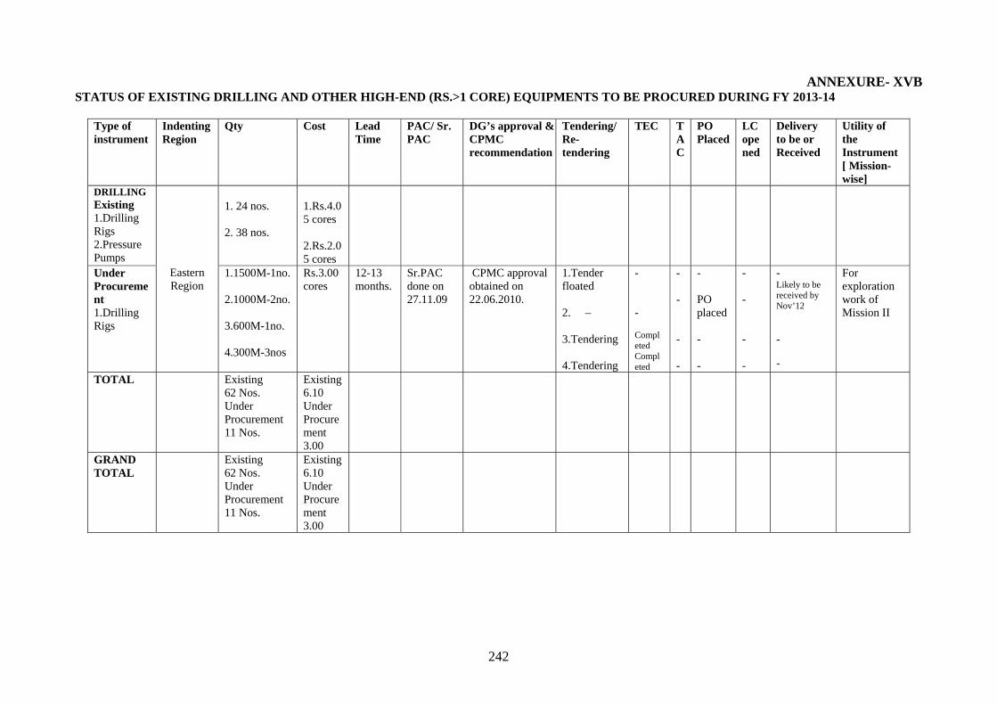
242
ANNEXURE- XVB STATUS OF EXISTING DRILLING AND OTHER HIGH-END (RS.>1 CORE) EQUIPMENTS TO BE PROCURED DURING FY 2013-14
Type of instrument
Indenting Region
Qty Cost Lead Time
PAC/ Sr. PAC
DG’s approval & CPMC recommendation
Tendering/ Re-tendering
TEC TAC
PO Placed
LC opened
Delivery to be or Received
Utility of the Instrument [ Mission-wise]
DRILLING Existing 1.Drilling Rigs 2.Pressure Pumps
Eastern Region
1. 24 nos. 2. 38 nos.
1.Rs.4.05 cores 2.Rs.2.05 cores
Under Procurement 1.Drilling Rigs
1.1500M-1no. 2.1000M-2no. 3.600M-1no. 4.300M-3nos
Rs.3.00 cores
12-13 months.
Sr.PAC done on 27.11.09
CPMC approval obtained on 22.06.2010.
1.Tender floated 2. – 3.Tendering 4.Tendering
- - Completed Completed
- - - -
- PO placed - -
- - - -
- Likely to be received by Nov’12
-
-
For exploration work of Mission II
TOTAL Existing 62 Nos. Under Procurement 11 Nos.
Existing 6.10 Under Procurement 3.00
GRAND TOTAL
Existing 62 Nos. Under Procurement 11 Nos.
Existing 6.10 Under Procurement 3.00
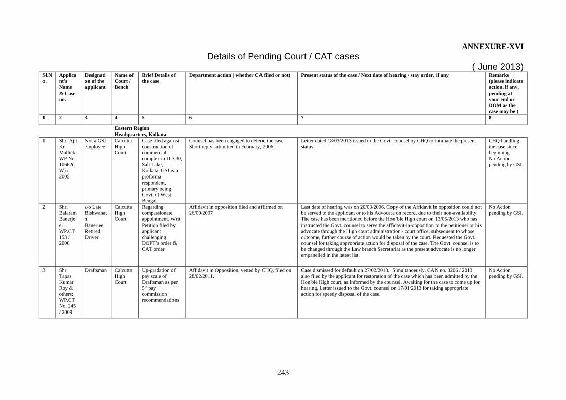
243
ANNEXURE-XVI Details of Pending Court / CAT cases
( June 2013) Sl.No.
Applicant's Name & Case no.
Designation of the applicant
Name of Court / Bench
Brief Details of the case
Department action ( whether CA filed or not) Present status of the case / Next date of hearing / stay order, if any Remarks (please indicate action, if any, pending at your end or DOM as the case may be )
1 2 3 4 5 6 7 8
Eastern Region Headquarters, Kolkata
1 Shri Ajit Kr. Mallick; WP No. 10662(W) / 2005
Not a GSI employee
Calcutta High Court
Case filed against construction of commercial complex in DD 30, Salt Lake, Kolkata. GSI is a proforma respondent, primary being Govt. of West Bengal.
Counsel has been engaged to defend the case. Short reply submitted in February, 2006.
Letter dated 18/03/2013 issued to the Govt. counsel by CHQ to intimate the present status.
CHQ handling the case since beginning. No Action pending by GSI.
2 Shri Balaram Banerjee; WP.CT 153 / 2006
s/o Late Bishwanath Banerjee, Retired Driver
Calcutta High Court
Regarding compassionate appointment. Writ Petition filed by applicant challenging DOPT’s order & CAT order
Affidavit in opposition filed and affirmed on 26/09/2007
Last date of hearing was on 20/03/2006. Copy of the Affidavit in opposition could not be served to the applicant or to his Advocate on record, due to their non-availability. The case has been mentioned before the Hon’ble High court on 13/05/2013 who has instructed the Govt. counsel to serve the affidavit-in-opposition to the petitioner or his advocate through the High court administration / court office, subsequent to whose outcome, further course of action would be taken by the court. Requested the Govt. counsel for taking appropriate action for disposal of the case. The Govt. counsel is to be changed through the Law branch Secretariat as the present advocate is no longer empanelled in the latest list.
No Action pending by GSI.
3 Shri Tapas Kumar Roy & others; WP.CT No. 245 / 2009
Draftsman Calcutta High Court
Up-gradation of pay scale of Draftsman as per 5th pay commission recommendations
Affidavit in Opposition, vetted by CHQ, filed on 28/02/2011.
Case dismissed for default on 27/02/2013. Simultanoeusly, CAN no. 3206 / 2013 also filed by the applicant for restoration of the case which has been admitted by the Hon'ble High court, as informed by the counsel. Awaiting for the case to come up for hearing. Letter issued to the Govt. counsel on 17/01/2013 for taking appropriate action for speedy disposal of the case.
No Action pending by GSI.
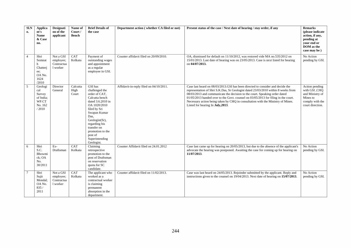
244
Sl.No.
Applicant's Name & Case no.
Designation of the applicant
Name of Court / Bench
Brief Details of the case
Department action ( whether CA filed or not) Present status of the case / Next date of hearing / stay order, if any Remarks (please indicate action, if any, pending at your end or DOM as the case may be )
4 Shri Somnath Chatterjee; OA No. 1624 /2010
Not a GSI employee; Contractual worker
CAT Kolkata
Payment of outstanding wages and appointment as a regular employee in GSI.
Counter affidavit filed on 20/09/2010. OA, dismissed for default on 11/10/2012, was restored vide MA no.535/2012 on 15/01/2013. Last date of hearing was on 23/05/2013. Case is next listed for hearing on 04/07/2013.
No Action pending by GSI.
5 Geological Survey of India; WP.CT No. 162 / 2010
Director General
Calcutta High Court
GSI has challenged the order of CAT, Calcutta bench dated 3.6.2010 in OA 1020/2010 filed by Sri Swapan Kumar Das, Geologist(Sr), regarding his transfer on promotion to the post of Superintending Geologist.
Affidavit-in-reply filed on 04/10/2011. Case last heard on 08/03/2013.GSI has been directed to consider and decide the representation of Shri S.K.Das, Sr Geologist dated 23/03/2010 within 8 weeks from 08/03/2013 and communicate the decision to the court. Speaking order dated 01/05/2013 handed over to the Govt. counsel on 03/05/2013 for filing in the court. Necessary action being taken by CHQ in consultation with the Ministry of Mines. Listed for hearing In July,2013.
Action pending with GSI ,CHQ and Ministry of Mines to comply with the court direction.
6 Shri S.C. Bhowmick; OA No. 30/2011
Ex-Draftsman
CAT Kolkata
Claiming retrospective promotion to the post of Draftsman on reservation quota for SC candidate.
Counter Affidavit filed on 24.01.2012 Case last came up for hearing on 20/05/2013, but due to the absence of the applicant's advocate the hearing was postponed. Awaiting the case for coming up for hearing on 11/07/2013.
No Action pending by GSI.
7 Shri Sujit Mondal; OA No. 835 / 2011
Not a GSI employee; Contractual worker
CAT Kolkata
The applicant who worked as a contractual worker is claiming permanent absorption in the department.
Counter affidavit filed on 11/02/2013. Case was last heard on 24/05/2013. Rejoinder submitted by the applicant. Reply and instructions given to the counsel on 19/04/2013. Next date of hearing on 15/07/2013.
No Action pending by GSI.
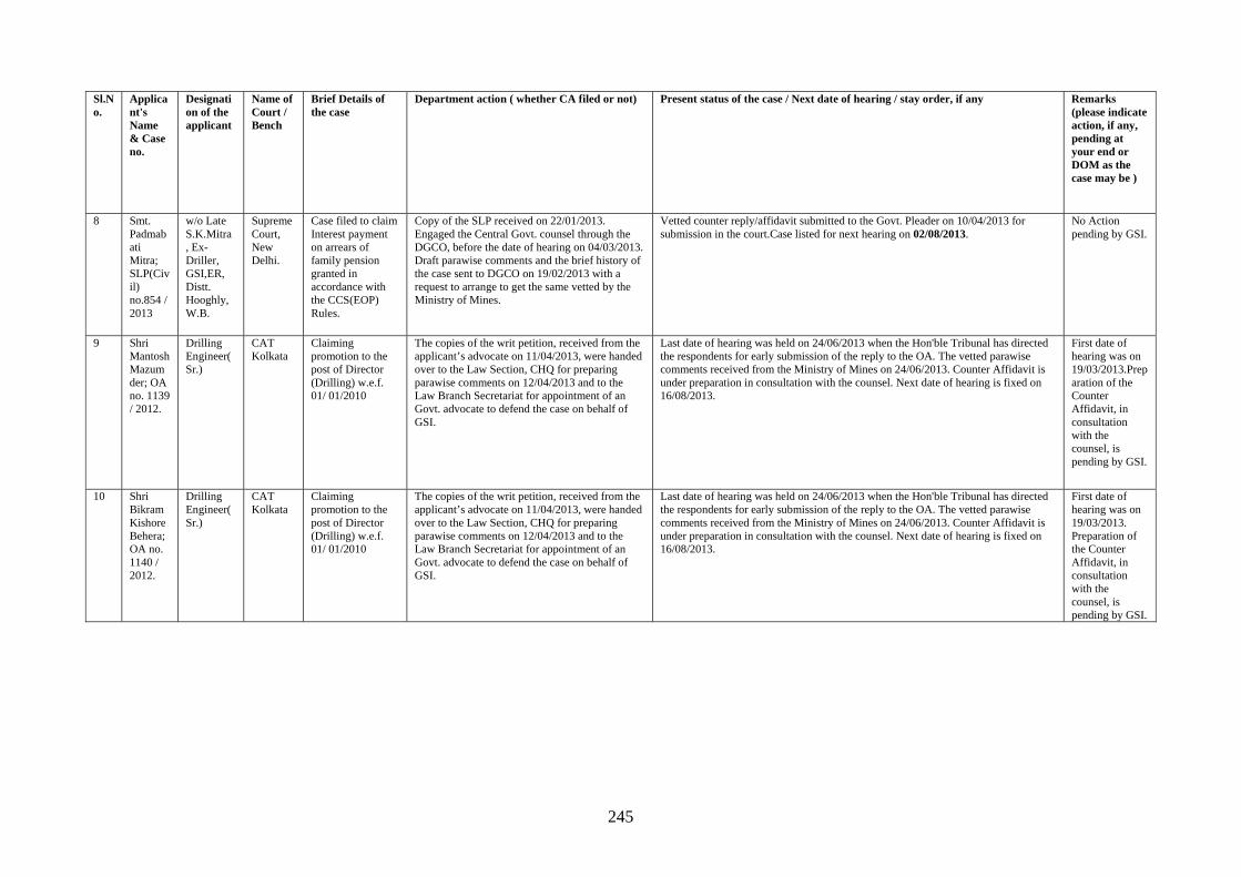
245
Sl.No.
Applicant's Name & Case no.
Designation of the applicant
Name of Court / Bench
Brief Details of the case
Department action ( whether CA filed or not) Present status of the case / Next date of hearing / stay order, if any Remarks (please indicate action, if any, pending at your end or DOM as the case may be )
8 Smt. Padmabati Mitra; SLP(Civil) no.854 / 2013
w/o Late S.K.Mitra , Ex-Driller, GSI,ER, Distt. Hooghly, W.B.
Supreme Court, New Delhi.
Case filed to claim Interest payment on arrears of family pension granted in accordance with the CCS(EOP) Rules.
Copy of the SLP received on 22/01/2013. Engaged the Central Govt. counsel through the DGCO, before the date of hearing on 04/03/2013. Draft parawise comments and the brief history of the case sent to DGCO on 19/02/2013 with a request to arrange to get the same vetted by the Ministry of Mines.
Vetted counter reply/affidavit submitted to the Govt. Pleader on 10/04/2013 for submission in the court.Case listed for next hearing on 02/08/2013.
No Action pending by GSI.
9 Shri Mantosh Mazumder; OA no. 1139 / 2012.
Drilling Engineer(Sr.)
CAT Kolkata
Claiming promotion to the post of Director (Drilling) w.e.f. 01/ 01/2010
The copies of the writ petition, received from the applicant’s advocate on 11/04/2013, were handed over to the Law Section, CHQ for preparing parawise comments on 12/04/2013 and to the Law Branch Secretariat for appointment of an Govt. advocate to defend the case on behalf of GSI.
Last date of hearing was held on 24/06/2013 when the Hon'ble Tribunal has directed the respondents for early submission of the reply to the OA. The vetted parawise comments received from the Ministry of Mines on 24/06/2013. Counter Affidavit is under preparation in consultation with the counsel. Next date of hearing is fixed on 16/08/2013.
First date of hearing was on 19/03/2013.Preparation of the Counter Affidavit, in consultation with the counsel, is pending by GSI.
10 Shri Bikram Kishore Behera; OA no. 1140 / 2012.
Drilling Engineer(Sr.)
CAT Kolkata
Claiming promotion to the post of Director (Drilling) w.e.f. 01/ 01/2010
The copies of the writ petition, received from the applicant’s advocate on 11/04/2013, were handed over to the Law Section, CHQ for preparing parawise comments on 12/04/2013 and to the Law Branch Secretariat for appointment of an Govt. advocate to defend the case on behalf of GSI.
Last date of hearing was held on 24/06/2013 when the Hon'ble Tribunal has directed the respondents for early submission of the reply to the OA. The vetted parawise comments received from the Ministry of Mines on 24/06/2013. Counter Affidavit is under preparation in consultation with the counsel. Next date of hearing is fixed on 16/08/2013.
First date of hearing was on 19/03/2013. Preparation of the Counter Affidavit, in consultation with the counsel, is pending by GSI.
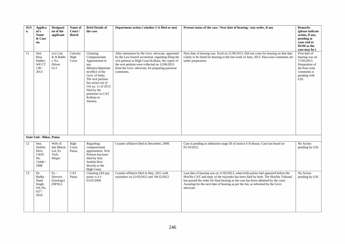
246
Sl.No.
Applicant's Name & Case no.
Designation of the applicant
Name of Court / Bench
Brief Details of the case
Department action ( whether CA filed or not) Present status of the case / Next date of hearing / stay order, if any Remarks (please indicate action, if any, pending at your end or DOM as the case may be )
11 Smt. Rina Halder; WP.CT 138 / 2013
w/o Late K.N.Halder, Ex- Driver Gr.I
Calcutta High Court
Claiming Compassionate Appointment in any Ministry/department/office of the Govt. of India. The writ petition has arisen out of OA no. 11 of 2013 filed by the petitioner in CAT Kolkata in January,
After intimation by the Govt. advocate, appointed by the Law branch secretariat, regarding filing the writ petition in High Court Kolkata, the copies of the writ petition were collected on 12/06/2013 from the Govt. advocate, for preparing parawise comments.
Next date of hearing was fixed on 21/06/2013. Did not come for hearing on that date Likely to be listed for hearing in the last week of June, 2013. Para-wise comments are under preparation.
First date of hearing was on 17/05/2013. Preparation of the Para-wise comments is pending with GSI.
State Unit : Bihar, Patna
12 Smt. Sushila Devi; CWJC No. 13446 / 2008
Wife of late Bharat Lal, Ex Tech. Helper
High Court, Patna.
Regarding compassionate appointment. Writ Petition has been filed by Smt. Sushila Devi directly to the High Court.
Counter affidavit filed in December, 2008. Case is pending in admission stage III of Justice S.N.Hasan. Case last heard on 01/10/2012.
No Action pending by GSI.
13 Dr. Radha Nand Singh; OA No. 637 / 2010
Ex - Director (Geology) (NFSG)
CAT Patna
Claiming IAS pay parity w.e.f. 01/01/2006
Counter affidavit filed in May, 2011 with rejoinders on 21/03/2012 and 04/12/2012
Last date of hearing was on 11/02/2013, when both parties had appeared before the Hon'ble CAT and reply of the rejoinder has been filed by both. The Hon'ble Tribunal has passed the order for final hearing as the case has been admitted by the court. Awaiting for the next date of hearing as per the list, as informed by the Govt. advocate.
No Action pending by GSI.
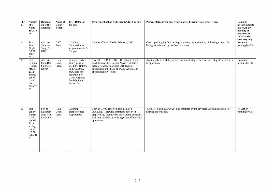
247
Sl.No.
Applicant's Name & Case no.
Designation of the applicant
Name of Court / Bench
Brief Details of the case
Department action ( whether CA filed or not) Present status of the case / Next date of hearing / stay order, if any Remarks (please indicate action, if any, pending at your end or DOM as the case may be )
14 Smt Renu Singh; OA No. 166 / 2011
w/o Late Surendra Singh,Ex-UDC
CAT Patna
Claiming Compassionate Appointment in Gr ‘D’ post
Counter affidavit filed in February, 2012. Case is pending for final hearing. Awaiting the availability of the single bench for listing, as informed by the Govt. advocate.
No Action pending by GSI.
15 Smt. Deomoni Singh; MJC of 2012 arising out of CWJC No. 8843/2008
w/o Late Suraj Deo Singh, Ex-Driver
High Court, Patna.
Arrear of revised family pension w.e.f. 01/01/1996 to 28/06/1999. MJC filed for restoration of CWJC disposed for default on 19/10/2011
Case filed on 19.01.1012. SU : Bihar instructed Govt. Counsel Mr. Raghib Ahsan vide letter dated 27.3.2012 to prepare Affidavit-in-opposition on the basis of PWC. Affidavit-in-opposition not yet filed.
Awaiting the availability of the bench for listing of the case and filing of the affidavit in opposition.
No Action pending by GSI.
16 Shri Sanjay Kumar; CWJC No.Nil / 2013 arising out of OA No. 676/2012
Son of Late Ram Nath Ram, Ex-Driver
High Court, Patna
Claiming compassionate Appointment
Copy of CWJC received from Patna on 08/02/2013. Parawise comments have been prepared and submitted to the standing counsel at Patna on 20/03/2013 for filing of the affidavit-in-opposition.
Affidavit filed on 29/04/2013, as informed by the advocate. Awaiting next date of hearing as per listing.
No Action pending by GSI.
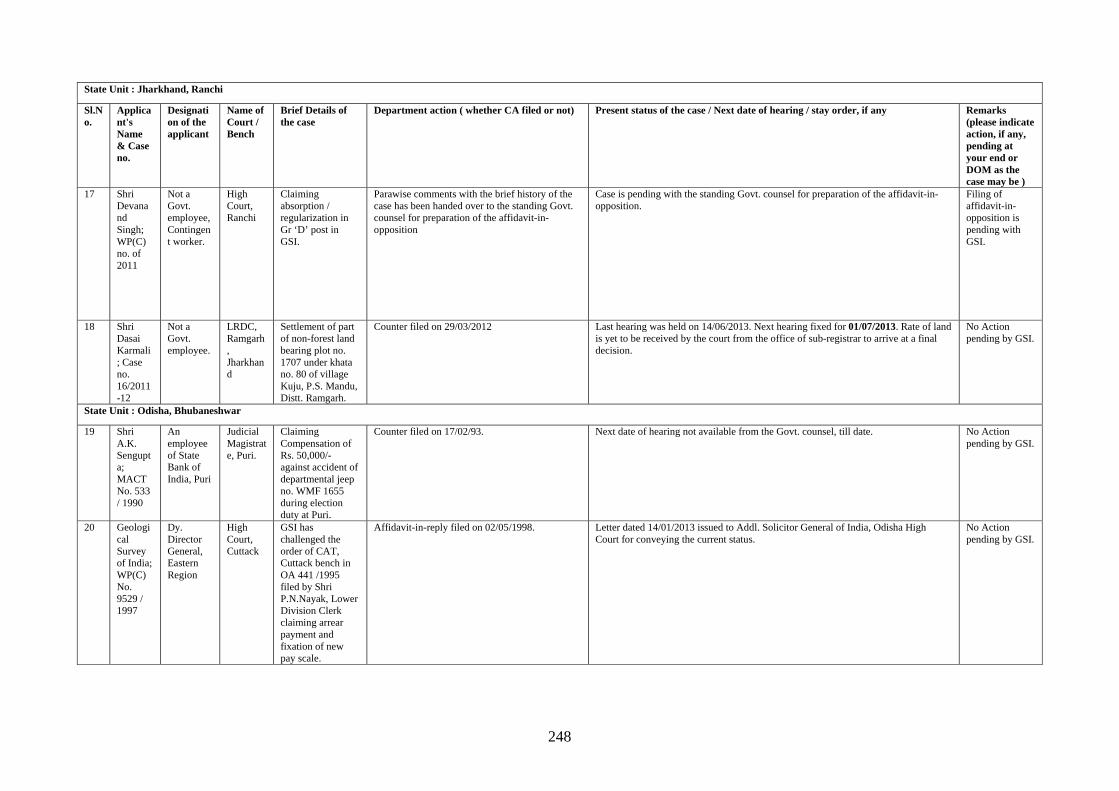
248
State Unit : Jharkhand, Ranchi
Sl.No.
Applicant's Name & Case no.
Designation of the applicant
Name of Court / Bench
Brief Details of the case
Department action ( whether CA filed or not) Present status of the case / Next date of hearing / stay order, if any Remarks (please indicate action, if any, pending at your end or DOM as the case may be )
17 Shri Devanand Singh; WP(C) no. of 2011
Not a Govt. employee, Contingent worker.
High Court, Ranchi
Claiming absorption / regularization in Gr ‘D’ post in GSI.
Parawise comments with the brief history of the case has been handed over to the standing Govt. counsel for preparation of the affidavit-in-opposition
Case is pending with the standing Govt. counsel for preparation of the affidavit-in-opposition.
Filing of affidavit-in-opposition is pending with GSI.
18 Shri Dasai Karmali; Case no. 16/2011-12
Not a Govt. employee.
LRDC, Ramgarh, Jharkhand
Settlement of part of non-forest land bearing plot no. 1707 under khata no. 80 of village Kuju, P.S. Mandu, Distt. Ramgarh.
Counter filed on 29/03/2012 Last hearing was held on 14/06/2013. Next hearing fixed for 01/07/2013. Rate of land is yet to be received by the court from the office of sub-registrar to arrive at a final decision.
No Action pending by GSI.
State Unit : Odisha, Bhubaneshwar
19 Shri A.K. Sengupta; MACT No. 533 / 1990
An employee of State Bank of India, Puri
Judicial Magistrate, Puri.
Claiming Compensation of Rs. 50,000/- against accident of departmental jeep no. WMF 1655 during election duty at Puri.
Counter filed on 17/02/93. Next date of hearing not available from the Govt. counsel, till date. No Action pending by GSI.
20 Geological Survey of India; WP(C) No. 9529 / 1997
Dy. Director General, Eastern Region
High Court, Cuttack
GSI has challenged the order of CAT, Cuttack bench in OA 441 /1995 filed by Shri P.N.Nayak, Lower Division Clerk claiming arrear payment and fixation of new pay scale.
Affidavit-in-reply filed on 02/05/1998. Letter dated 14/01/2013 issued to Addl. Solicitor General of India, Odisha High Court for conveying the current status.
No Action pending by GSI.
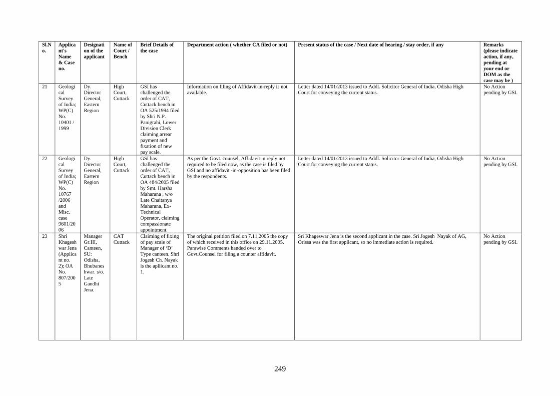
249
Sl.No.
Applicant's Name & Case no.
Designation of the applicant
Name of Court / Bench
Brief Details of the case
Department action ( whether CA filed or not) Present status of the case / Next date of hearing / stay order, if any Remarks (please indicate action, if any, pending at your end or DOM as the case may be )
21 Geological Survey of India; WP(C) No. 10401 / 1999
Dy. Director General, Eastern Region
High Court, Cuttack
GSI has challenged the order of CAT, Cuttack bench in OA 525/1994 filed by Shri N.P. Panigrahi, Lower Division Clerk claiming arrear payment and fixation of new pay scale.
Information on filing of Affidavit-in-reply is not available.
Letter dated 14/01/2013 issued to Addl. Solicitor General of India, Odisha High Court for conveying the current status.
No Action pending by GSI.
22 Geological Survey of India; WP(C) No. 10767 /2006 and Misc. case 9601/2006
Dy. Director General, Eastern Region
High Court, Cuttack
GSI has challenged the order of CAT, Cuttack bench in OA 484/2005 filed by Smt. Harsha Maharana , w/o Late Chaitanya Maharana, Ex-Technical Operator, claiming compassionate appointment.
As per the Govt. counsel, Affidavit in reply not required to be filed now, as the case is filed by GSI and no affidavit -in-opposition has been filed by the respondents.
Letter dated 14/01/2013 issued to Addl. Solicitor General of India, Odisha High Court for conveying the current status.
No Action pending by GSI.
23 Shri Khageshwar Jena (Applicant no. 2); OA No. 807/2005
Manager Gr.III, Canteen, SU: Odisha, Bhubaneshwar. s/o. Late Gandhi Jena.
CAT Cuttack
Claiming of fixing of pay scale of Manager of ‘D’ Type canteen. Shri Jogesh Ch. Nayak is the apllicant no. 1.
The original petition filed on 7.11.2005 the copy of which received in this office on 29.11.2005. Parawise Comments handed over to Govt.Counsel for filing a counter affidavit.
Sri Khageswar Jena is the second applicant in the case. Sri Jogesh Nayak of AG, Orissa was the first applicant, so no immediate action is required.
No Action pending by GSI.
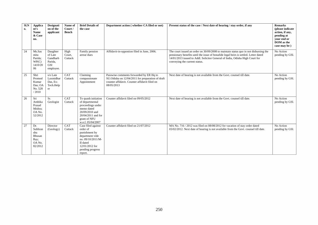
250
Sl.No.
Applicant's Name & Case no.
Designation of the applicant
Name of Court / Bench
Brief Details of the case
Department action ( whether CA filed or not) Present status of the case / Next date of hearing / stay order, if any Remarks (please indicate action, if any, pending at your end or DOM as the case may be )
24 Ms.Sasmita Parida; WP(C) 1410/2006
Daughter of Late Gandharb Parida, GSI employee.
High Court, Cuttack
Family pension arrear dues
Affidavit-in-oppostion filed in June, 2006. The court issued an order on 30/09/2008 to maintain status quo in not disbursing the pensionary benefits until the issue of bonafide legal heirs is settled. Letter dated 14/01/2013 issued to Addl. Solicitor General of India, Odisha High Court for conveying the current status.
No Action pending by GSI.
25 Shri Promod Kumar Das; OA No. 528 / 2010
s/o Late Laxmidhar Das, Ex-Tech.Helper
CAT Cuttack
Claiming compassionate Appointment
Parawise comments forwarded by ER Hq to SU:Odisha on 12/04/2011 for preparation of draft counter affidavit. Counter affidavit filed on 08/05/2013
Next date of hearing is not available from the Govt. counsel till date. No Action pending by GSI.
26 Sri Ambika Prasad Mishra; OA No. 52/2012
Sr. Geologist
CAT Cuttack
To quash initiation of departmental proceedings under memo dated 20/09/2010 and 20/04/2011 and for grant of NFU w.e.f. 05/04/2007
Counter affidavit filed on 09/05/2012 Next date of hearing is not available from the Govt. counsel till date. No Action pending by GSI.
27 Dr. Subhranshu Bhusan Ray; OA No. 82/2012
Director (Geology)
CAT Cuttack
Case filed against order of punishment by department vide no. 09/10/2011/M-II dated 12/01/2012 for pending progress report.
Counter affidavit filed on 21/07/2012 MA No. 716 / 2012 was filed on 08/08/2012 for vacation of stay order dated 03/02/2012. Next date of hearing is not available from the Govt. counsel till date.
No Action pending by GSI.
251
Sl.No.
Applicant's Name & Case no.
Designation of the applicant
Name of Court / Bench
Brief Details of the case
Department action ( whether CA filed or not) Present status of the case / Next date of hearing / stay order, if any Remarks (please indicate action, if any, pending at your end or DOM as the case may be )
28 Ms. Sitoshna Sahoo; OA No. 782 / 2012
Candidate for the post of Geologist.w/o Shri Saroj Kumar Sahoo, Distt. Khurda, Odisha
CAT Cuttack
Case filed against denial of appointment as Geologist in 2006 UPSC batch.
Awaiting vetted para-wise comments from CHQ / MOM sent to Ministry of Mines by CHQ vide letter dated 10/01/2013 with reminder letter dated 05/03/2013 with simultaneous filing of MA for extension of time by 4 weeks to file the counter affidavit.
Vetted para-wise comments received from CHQ / MOM and forwarded to the Addl standing counsel on 08/04/2013 for preparation of the counter affidavit, which has been filed on 09/05/2013. Awaiting filing of rejoinder by the applicant and the next date of hearing.
No Action pending by GSI.
29 Shri S.P.Bhutia; OA no. 212/2013
Geologist CAT Cuttack
Case filed against order of promotion of 9 nos.Geologists to the post of Sr. Geologist who were junior to him as per Gradation list of Geologists as on 01/01/2012.
The up to date status of the WP(C) no. 07/2010 filed by GSI before the Hon'ble High court of Calcutta against the judgement passed by CAT Calcutta in the OA no. 466/2009, has been sought from CHQ.
Last hearing was held on 12/04/2013 when three weeks time was granted by the Hon'ble, CAT Cuttack to obtain instruction on the up to date status of the WP(C) no. 07/2010 filed by GSI before the Hon'ble High court of Calcutta against the judgement passed by CAT Calcutta in the OA no. 466/2009. The operation of the CAT order in the OA no. 466/2009 has since been stayed. Status is awaited from CHQ.
Providing of the status information is pending with CHQ. GSI.


