Embed Size (px)
Citation preview
Geochemistry@BGS: A guide to geochemical data at the British Geological Survey
Environmental Geoscience Baselines/
Information Management Programme
Open Report OR/09/028

BRITISH GEOLOGICAL SURVEY
ENVIRONMENTAL GEOSCIENCE BASELINES/
INFORMATION MANAGEMENT PROGRAMME
OPEN REPORT OR/09/028
The National Grid and other Ordnance Survey data are used with the permission of the Controller of Her Majesty’s Stationery Office. Licence No: 100017897/ 2011.
Keywords Geochemistry.
Front cover Cover picture details, delete if no cover picture.
Bibliographical reference
JOHNSON, C.C. 2011. Geochemistry@BGS: A guide to geochemical data at the British Geological Survey. British Geological Survey Open Report, OR/09/028. 70pp. Copyright in materials derived from the British Geological Survey’s work is owned by the Natural Environment Research Council (NERC) and/or the authority that commissioned the work. You may not copy or adapt this publication without first obtaining permission. Contact the BGS Intellectual Property Rights Section, British Geological Survey, Keyworth, e-mail [email protected]. You may quote extracts of a reasonable length without prior permission, provided a full acknowledgement is given of the source of the extract. Maps and diagrams in this book use topography based on Ordnance Survey mapping.
Geochemistry@BGS: A guide to geochemical data at the British Geological Survey
C C Johnson
Contributors D G Jones, B Palumbo-Roe, C H Vane, A C Mackenzie, T R Lister, S F Hobbs, P L Smedley, M E Stuart, N Breward, J Wragg, M R Cave and A G Stevenson
© NERC 2011. All rights reserved Keyworth, Nottingham British Geological Survey 2011
The full range of our publications is available from BGS shops at Nottingham, Edinburgh, London and Cardiff (Welsh publications only) see contact details below or shop online at www.geologyshop.com
The London Information Office also maintains a reference collection of BGS publications, including maps, for consultation.
We publish an annual catalogue of our maps and other publications; this catalogue is available online or from any of the BGS shops.
The British Geological Survey carries out the geological survey of Great Britain and Northern Ireland (the latter as an agency service for the government of Northern Ireland), and of the surrounding continental shelf, as well as basic research projects. It also undertakes programmes of technical aid in geology in developing countries.
The British Geological Survey is a component body of the Natural Environment Research Council.
British Geological Survey offices BGS Central Enquiries Desk Tel 0115 936 3143 Fax 0115 936 3276 email [email protected] Website www.bgs.ac.uk Shop online at www.geologyshop.com Kingsley Dunham Centre, Keyworth, Nottingham NG12 5GG Tel 0115 936 3241 Fax 0115 936 3488 email [email protected]
Murchison House, West Mains Road, Edinburgh EH9 3LA
Tel 0131 667 1000 Fax 0131 668 2683 email [email protected]
Natural History Museum, Cromwell Road, London SW7 2DE Tel 020 7589 4090 Fax 020 7584 8270 Tel 020 7942 5344/45 email [email protected]
Columbus House, Greenmeadow Springs, Tongwynlais, Cardiff CF15 7NE Tel 029 2052 1962 Fax 029 2052 1963
Maclean Building, Crowmarsh Gifford, Wallingford OX10 8BB Tel 01491 838800 Fax 01491 692345
Geological Survey of Northern Ireland, Colby House, Stranmillis Court, Belfast BT9 5BF Tel 028 9038 8462 Fax 028 9038 8461
www.bgs.ac.uk/gsni/
Parent Body
Natural Environment Research Council, Polaris House, North Star Avenue, Swindon SN2 1EU Tel 01793 411500 Fax 01793 411501 www.nerc.ac.uk
BRITISH GEOLOGICAL SURVEY
i
Contents Summary ........................................................................................................................................ 1
1 Introduction ............................................................................................................................ 3
2 Geochemical data in BGS ...................................................................................................... 5
2.1 Geochemical Data for UK Mineral Exploration ............................................................. 5
2.2 Regional Geochemical Mapping of the UK land area .................................................... 9
2.3 Surface water geochemistry .......................................................................................... 19
2.4 Groundwater Geochemistry .......................................................................................... 19
2.5 Offshore/marine Geochemistry .................................................................................... 21
2.6 Estuarine Geochemistry ................................................................................................ 26
2.7 Environmental Geochemistry ....................................................................................... 27
2.8 Radiometric Data .......................................................................................................... 29
2.9 Isotopic Geochemistry .................................................................................................. 31
2.10 Lithogeochemistry ........................................................................................................ 32
2.11 International Geochemistry .......................................................................................... 34
2.12 Organic Geochemistry .................................................................................................. 39
3 Sources of Geochemical Data in BGS ................................................................................. 41
Recommendations for making BGS geochemical data more accessible to users .................. 47
References .................................................................................................................................... 49
Appendix 1 :List of UK Regional Geochemistry Atlases ................................................... 57
Appendix 2 :Groundwater Baseline Reports ...................................................................... 58
Appendix 3 : Reports and Publications containing information and data from BGS Organic Geochemistry ................................................................................................................ 62
FIGURES
Figure 1: Entity diagram for the Geochemistry Database ....................... 6
Figure 2: BGS Internet GeoIndex page showing information about MRP stream sediment samples east of Bodmin. ................................................................... 7
Figure 3: Progress with regional geochemical sampling until end of 2008 – drainage sites (sediment and waters) ....................................................................... 11
Figure 4: Progress with regional geochemical sampling until end of 2008 – soils 12
Figure 5: BGS Internet GeoIndex page showing information about G-BASE samples 17
Figure 6: Pie chart showing the main contributing projects to the BGS Geochemistry Database (based on 2005 data) ......................................................................... 17
Figure 7: Example of typical G-BASE geochemical image generated by IDW gridding in ArcGIS .............................................................................................. 19
ii
Figure 8: Boxplot of minor and trace elements in the Crag groundwaters (after Ander et al., 2006) ................................................................................................. 20
Figure 9: Distribution of mercury in sediments on the sea-bed of the North Sea (from IGS Annual Report, 1979) ....................................................................... 22
Figure 10: Figure showing the chronology of the sea-bed sediment sampling (after Stevenson et al. 1995) ............................................................................................ 23
Figure 11: Geochemical image for zinc in sea-bed sediments (from Stevenson et al. 1995) 24
Figure 12: Geochemical image for Pb for the combined offshore sea-bed sediments and the onshore stream sediments ................................................................. 25
Figure 13: Distribution of rock and core sample sites in the Geochemistry Database (after Hulbert, 2007) ................................................................................... 33
Figure 14: Flow chart to inform enquiries regarding sources of geochemical data in BGS 43
Figure 15: Example of some geochemistry discovery metadata available from the BGS internet site ..................................................................................................... 46
TABLES Table 1: Summary of the most common sample types in the Geochemistry Database categorised
by Project .......................................................................................... 5
Table 2: Summary of query layers for interrogating the Geochemistry Database 8
Table 3: Explanation of the numbering_system code in the Geochemistry Database (from BGS_MTA_DOM_NUMBERING_SYSTEM) ............................... 8
Table 4: Sample type codes from the Geochemistry Database domain table (from BGS_MTA_DOM_SAMPLE_TYPE) ............................................. 9
Table 5: Summary of the sample types collected by the G-BASE project and the analytes determined ........................................................................................ 10
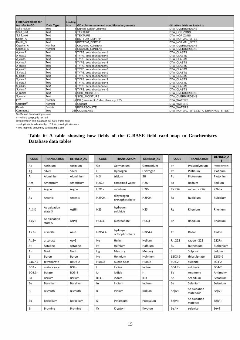
Table 6: A table showing how fields of the G-BASE field card map to Geochemistry Database data tables ......................................................................................... 15
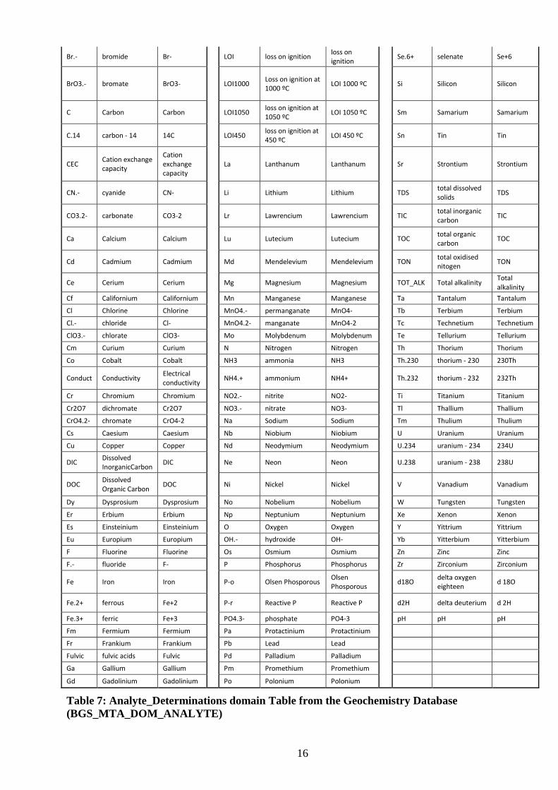
Table 7: Analyte_Determinations domain Table from the Geochemistry Database (BGS_MTA_DOM_ANALYTE) ..................................................... 16
Table 8: Elements determined on the sea-bed sediments reported by Stevenson et al. (1995) 25
Table 9: Number of rock and core samples in the Geochemistry Database (using the NORMAL_ROCKS and CORE_POSITIONS tables) ..................... 32
Table 10: Number of rock and core samples defined in Table 9 that have associated Analyte Determinations.................................................................................. 33
Table 11: List of International Regional Geochemistry CD-ROMs available for purchase from the BGS online book shop ................................................................ 35
Table 12: Summary of some international groundwater/pollution projects from past 16 years (compiled by Marianne Stuart, BGS Wallingford) .......................... 36
Table 13: Summary of some BGS-ODA/DFID projects concerning groundwater and human health, carried out in developing countries ....................................... 37
Table 14: Summary of some BGS-ODA/DFID geochemistry and health projects – including groundwater - carried out in developing countries ........................... 38
Table 15: A summary of sources of geochemical data in BGS .............. 45
1
Summary
This report reviews the main activities in the British Geological Survey (and previously as the Institute of Geological Sciences) that have generated geochemical data. Included are; the mineral reconnaissance programme; regional geochemical mapping; groundwater geochemistry; marine and estuarine surveys; environmental geochemistry and health; radiometric surveys; isotopic geochemistry; lithogeochemical investigations; organic geochemistry laboratories; and many international activities involving geochemical sampling. An indication is given as to where the data resides and who is currently responsible for managing it. An objective of this report is to give better access to the geochemical results and information both for the internal and external users of geochemical data. A list of recommendations are proposed to help give a more corporate and joined up approach to BGS provision of geochemical data and information. The presentation of the geochemical data to the public should be done in a less project-orientated manner. The corporate Geochemistry Database is rather a misnomer as it only contains geochemical data generated by a small number (although very sizable) projects. Other geochemical databases exist but they are not particularly accessible. There is still a lot of geochemical data that is not captured to any corporately supported database. Internal and external reports are one of the major sources of geochemical data and information and this report contains a comprehensive reference list to key BGS geochemical publications.

2
3
1 Introduction This report is a guide to the geochemical data, samples and associated information that have been produced in BGS. It seeks to better inform geochemical data users (both internal and external) as to the range of geochemical data holdings and how to access them. BGS has a wealth of geochemical data generated by numerous applied geochemical projects over the past 50 years both in the UK and internationally. The report does not claim to have captured all the information regarding geochemistry at BGS. For example, a major area of BGS geochemical work excluded from this report is the commissioned projects on radioactive waste disposal and fluid processes as the majority of this work was done as “commercial-in-confidence”. The BGS analytical laboratories are a principal source of the geochemical data generated but are not discussed in any detail unless the laboratory is an integral part of the science project as is the case for NERC Isotopic Geoscience Laboratory (NIGL) and the organic geochemistry laboratory.
The geochemical data is a sub-set of BGS’s environmental data set and it continues to underpin many parts of the BGS strategy (British Geological Survey, 2009). The collection and analysis of samples, and their interpretation and presentation is considered to be part of BGS’s national capability. As a result BGS has a good international reputation in the field of applied geochemistry and it is well positioned to compete for and win commission projects (or external income EI). The take up, application and exploitation of the geochemical data is generally encapsulated in BGS’s research programmes, for example, modelling and understanding soil processes, human health and contaminated land studies, and investigations of groundwater vulnerability. A better understanding of the BGS geochemical data heritage will improve its exploitation and application. BGS has a wealth of geochemical data that has cost millions of pounds to generate yet it remains a greatly under-utilised resource.
The following definitions seek to describe the scope of the BGS geochemical data holdings:
1. A measurement of a chemical element or compound. A chemical element will be one of the 117 elements of the Periodic Table. An analyte may be a mixture or single isotope, cation or anion, or a compound consisting of a combination of two or more elements. The definition therefore covers both inorganic and organic compounds and in the database the chemical element or compound will be referred to as an analyte. The measurements must have a defined unit of measurement and the analyte determined will be associated with a defined analytical method.
2. A measurement made by direct or remote contact with a material being analysed which may be in situ or a sample removed for analysis elsewhere.
This will include measurements made by non-destructive analysis such as XRFS or neutron activation where a specific sample has been used for analysis. Data generated by remote geophysical techniques such as airborne or sea-bed gamma-ray spectrometer can also be considered as geochemical data though here there is considerable overlap with data more generally considered as geophysical measurements.
3. A measurement that has been made or commissioned by BGS. Geochemical data in this report refer to measurements made by or commissioned by the BGS. The ownership and IPR rights will vary according to the project that generated the data. The provision of geochemical data to users must be accompanied by a clear definition of ownership and the IPR rights. For data generated through commissioned work there are likely to be restrictions on how the data can be used. Third party data donated or otherwise to BGS are not considered in this report.
4
4. A measurement with a unique identifier and spatial coordinates defined with a temporal reference.
The spatial coordinates will define whether the geochemical data is classified as being from the UK land area (on-shore), UK territorial waters (off-shore), or classified as an “International” measurement. This threefold geographical definition is the initial criterion used to classify BGS geochemical data. Note that anything collected from below the marine high water mark in UK territorial waters is considered as off-shore data and this would include the results of the BGS estuarine projects.
The geochemical data may be accompanied by measurements of other parameters that help to understand or interpret the chemical concentrations. These could include measurements such as pH, Eh, conductivity or temperature. These measurements alone do not constitute geochemical data.
The samples collected for geochemical analysis should also be considered as part of the BGS geochemistry data holdings. BGS has an extensive UK collection of soil, rock, drill core and drainage samples, including stream water samples in cold storage. The storage of the samples is the responsibility of the National Geoscience Data Centre (NGDC) at Keyworth.
The management of geochemical data is the responsibility of the Information Management Programme of BGS. Within this programme there is a data management team which leads data management projects. Geochemistry data management (IM4) is one of these projects and this project is primarily responsible for UK land surface geochemistry (i.e. excluding hydrogeology (IM3) and marine geology data (IM6)). In recent years, as part of project start up, new projects are required to write a data management plan and in the case of geochemical projects this should involve storage of excess samples in the NGDC and input of geochemical results into a corporate database. This is what should happen but in practice databases are not able to accept data for analytes extracted and determined by methods not defined in the database tables (e.g., a lot of the chemical information generated by bioaccessibility studies of G-BASE soil samples). The geochemical data and its storage must conform to corporate database and dictionary standards. Legacy geochemical data will invariably have some non-conformity with current standards e.g. because of revision of dictionary codes. It is important that any translations of legacy data to fit with corporate standards are documented.
The British Geological Survey (BGS) has been actively generating geochemical data for the UK from “treetop to bedrock” since the 1960s in support of special surveys, the principal of which have been for mineral exploration (Mineral Reconnaissance Programme, Haslam et al., 1990), baseline geochemical mapping (G-BASE, Johnson et al., 2005), natural quality of groundwater (Edmunds et al., 2003), offshore sea-bed sediment geochemistry (Stevenson et al., 1995), estuary studies (Ridgway and Shimmield, 2002 and Jones et al., 2004), environmental radioactivity studies (especially radon) onshore (e.g. Miles and Appleton, 2005), uranium exploration (e.g. Bowie et al., 1973), and seabed gamma spectrometry for a range of applications (e.g. Jones, 2001). Outside of the UK substantial amounts of geochemical data have been generated by development projects (mainly supported by the Overseas Development Administration (ODA) and its successor Department for International Development (DfID). These international data are generally not in corporate databases (with the exception of hydrogeochemical data) but are published in reports and geochemical atlases (e.g. Sumatra, Indonesia, Muchsin et al., 1997) or made available on CD-ROMs.
5
2 Geochemical data in BGS 2.1 GEOCHEMICAL DATA FOR UK MINERAL EXPLORATION
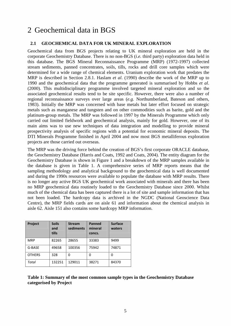
Geochemical data from BGS projects relating to UK mineral exploration are held in the corporate Geochemistry Database. There is no non-BGS (i.e. third party) exploration data held in this database. The BGS Mineral Reconnaissance Programme (MRP) (1972-1997) collected stream sediments, panned concentrates, soils, tills, rocks and drill core samples which were determined for a wide range of chemical elements. Uranium exploration work that predates the MRP is described in Section 2.8.1. Haslam et al. (1990) describe the work of the MRP up to 1990 and the geochemical data that the programme generated is summarised by Hobbs et al. (2000). This multidisciplinary programme involved targeted mineral exploration and so the associated geochemical results tend to be site specific. However, there were also a number of regional reconnaissance surveys over large areas (e.g. Northumberland, Bateson and others, 1983). Initially the MRP was concerned with base metals but later effort focused on strategic metals such as manganese and tungsten and on other commodities such as barite, gold and the platinum-group metals. The MRP was followed in 1997 by the Minerals Programme which only carried out limited fieldwork and geochemical analysis, mainly for gold. However, one of its main aims was to use new techniques of data integration and modelling to provide mineral prospectivity analysis of specific regions with a potential for economic mineral deposits. The DTI Minerals Programme finished in April 2004 and now most BGS metalliferous exploration projects are those carried out overseas.
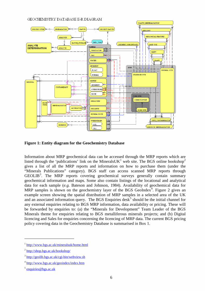
The MRP was the driving force behind the creation of BGS’s first corporate ORACLE database, the Geochemistry Database (Harris and Coats, 1992 and Coats, 2004). The entity diagram for the Geochemistry Database is shown in Figure 1 and a breakdown of the MRP samples available in the database is given in Table 1. A comprehensive series of MRP reports means that the sampling methodology and analytical background to the geochemical data is well documented and during the 1990s resources were available to populate the database with MRP results. There is no longer any active BGS UK geochemical work associated with minerals and there has been no MRP geochemical data routinely loaded to the Geochemistry Database since 2000. Whilst much of the chemical data has been captured there is a lot of site and sample information that has not been loaded. The hardcopy data is archived in the NGDC (National Geoscience Data Centre), the MRP fields cards are on aisle 61 and information about the chemical analysis in aisle 62. Aisle 151 also contains some hardcopy MRP information.
Project Soils
and tills
Stream sediments
Panned mineral concs.
Surface waters
MRP 82265 28655 33383 9499
G-BASE 49658 100356 75942 74871
OTHERS 328 0 0 0
Total 132251 129011 38271 84370
Table 1: Summary of the most common sample types in the Geochemistry Database categorised by Project
6
Figure 1: Entity diagram for the Geochemistry Database
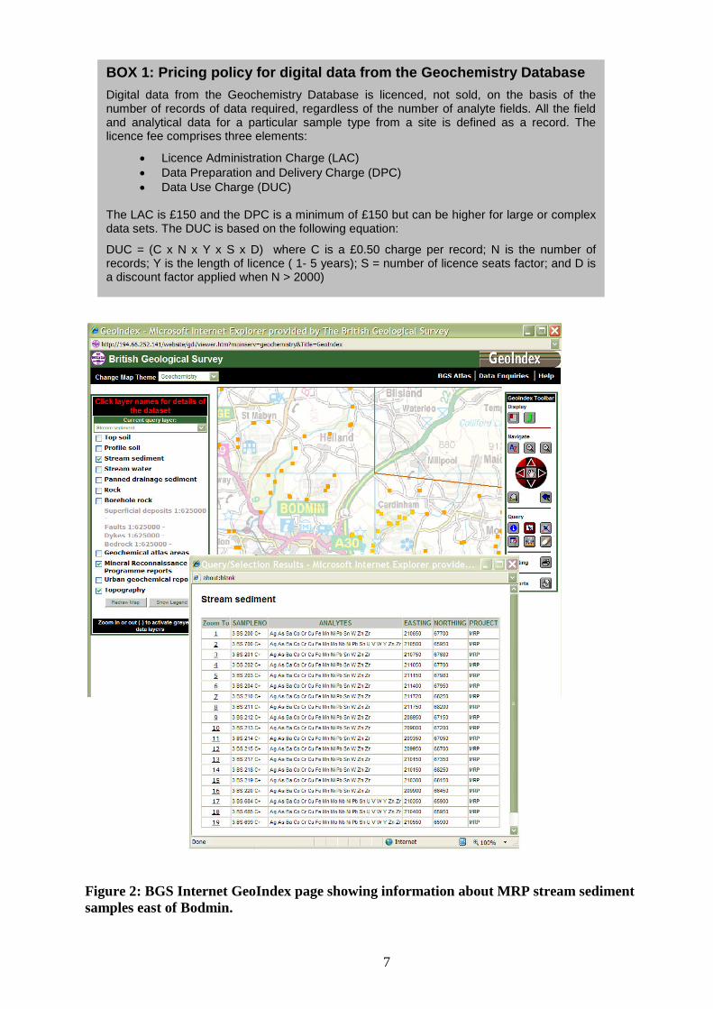
Information about MRP geochemical data can be accessed through the MRP reports which are listed through the ‘publications’ link on the MineralsUK1 web site. The BGS online bookshop2 gives a list of all the MRP reports and information on how to purchase them (under the “Minerals Publications” category). BGS staff can access scanned MRP reports through GEOLIB3. The MRP reports covering geochemical surveys generally contain summary geochemical information and maps. Some also contain listings of the locational and analytical data for each sample (e.g. Bateson and Johnson, 1984). Availability of geochemical data for MRP samples is shown on the geochemistry layer of the BGS GeoIndex4 Figure 2. gives an example screen showing the spatial distribution of MRP samples in a selected area of the UK and an associated information query. The BGS Enquiries desk5
should be the initial channel for any external enquiries relating to BGS MRP information, data availability or pricing. These will be forwarded by enquiries to: (a) the “Minerals for Development” Team Leader of the BGS Minerals theme for enquiries relating to BGS metalliferous minerals projects; and (b) Digital licencing and Sales for enquiries concerning the licencing of MRP data. The current BGS pricing policy covering data in the Geochemistry Database is summarised in Box 1.
1 http://www.bgs.ac.uk/mineralsuk/home.html 2 http://shop.bgs.ac.uk/bookshop/ 3 http://geolib.bgs.ac.uk/cgi-bin/webview.sh 4 http://www.bgs.ac.uk/geoindex/index.htm 5 [email protected]
7
Figure 2: BGS Internet GeoIndex page showing information about MRP stream sediment samples east of Bodmin.
BOX 1: Pricing policy for digital data from the Geochemistry Database Digital data from the Geochemistry Database is licenced, not sold, on the basis of the number of records of data required, regardless of the number of analyte fields. All the field and analytical data for a particular sample type from a site is defined as a record. The licence fee comprises three elements:
• Licence Administration Charge (LAC) • Data Preparation and Delivery Charge (DPC) • Data Use Charge (DUC)
The LAC is £150 and the DPC is a minimum of £150 but can be higher for large or complex data sets. The DUC is based on the following equation:
DUC = (C x N x Y x S x D) where C is a £0.50 charge per record; N is the number of records; Y is the length of licence ( 1- 5 years); S = number of licence seats factor; and D is a discount factor applied when N > 2000)
8
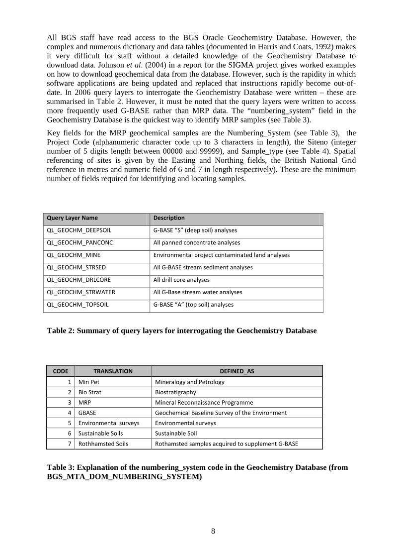
All BGS staff have read access to the BGS Oracle Geochemistry Database. However, the complex and numerous dictionary and data tables (documented in Harris and Coats, 1992) makes it very difficult for staff without a detailed knowledge of the Geochemistry Database to download data. Johnson et al. (2004) in a report for the SIGMA project gives worked examples on how to download geochemical data from the database. However, such is the rapidity in which software applications are being updated and replaced that instructions rapidly become out-of-date. In 2006 query layers to interrogate the Geochemistry Database were written – these are summarised in Table 2. However, it must be noted that the query layers were written to access more frequently used G-BASE rather than MRP data. The “numbering_system” field in the Geochemistry Database is the quickest way to identify MRP samples (see Table 3).
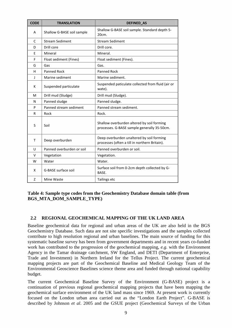
Key fields for the MRP geochemical samples are the Numbering_System (see Table 3), the Project Code (alphanumeric character code up to 3 characters in length), the Siteno (integer number of 5 digits length between 00000 and 99999), and Sample_type (see Table 4). Spatial referencing of sites is given by the Easting and Northing fields, the British National Grid reference in metres and numeric field of 6 and 7 in length respectively). These are the minimum number of fields required for identifying and locating samples.
Query Layer Name Description
QL_GEOCHM_DEEPSOIL G-BASE “S” (deep soil) analyses
QL_GEOCHM_PANCONC All panned concentrate analyses
QL_GEOCHM_MINE Environmental project contaminated land analyses
QL_GEOCHM_STRSED All G-BASE stream sediment analyses
QL_GEOCHM_DRLCORE All drill core analyses
QL_GEOCHM_STRWATER All G-Base stream water analyses
QL_GEOCHM_TOPSOIL G-BASE “A” (top soil) analyses
Table 2: Summary of query layers for interrogating the Geochemistry Database
CODE TRANSLATION DEFINED_AS
1 Min Pet Mineralogy and Petrology
2 Bio Strat Biostratigraphy
3 MRP Mineral Reconnaissance Programme
4 GBASE Geochemical Baseline Survey of the Environment
5 Environmental surveys Environmental surveys
6 Sustainable Soils Sustainable Soil
7 Rothhamsted Soils Rothamsted samples acquired to supplement G-BASE
Table 3: Explanation of the numbering_system code in the Geochemistry Database (from BGS_MTA_DOM_NUMBERING_SYSTEM)
9
CODE TRANSLATION DEFINED_AS
A Shallow G-BASE soil sample Shallow G-BASE soil sample. Standard depth 5-20cm.
C Stream Sediment Stream Sediment
D Drill core Drill core.
E Mineral Mineral.
F Float sediment (Fines) Float sediment (Fines).
G Gas Gas.
H Panned Rock Panned Rock
J Marine sediment Marine sediment.
K Suspended particulate Suspended paticulate collected from fluid (air or wate).
M Drill mud (Sludge) Drill mud (Sludge).
N Panned sludge Panned sludge.
P Panned stream sediment Panned stream sediment.
R Rock Rock.
S Soil Shallow overburden altered by soil forming processes. G-BASE sample generally 35-50cm.
T Deep overburden Deep overburden unaltered by soil forming processes (often a till in northern Britain).
U Panned overburden or soil Panned overburden or soil.
V Vegetation Vegetation.
W Water Water.
X G-BASE surface soil Surface soil from 0-2cm depth collected by G-BASE.
Z Mine Waste Tailings etc
Table 4: Sample type codes from the Geochemistry Database domain table (from BGS_MTA_DOM_SAMPLE_TYPE)
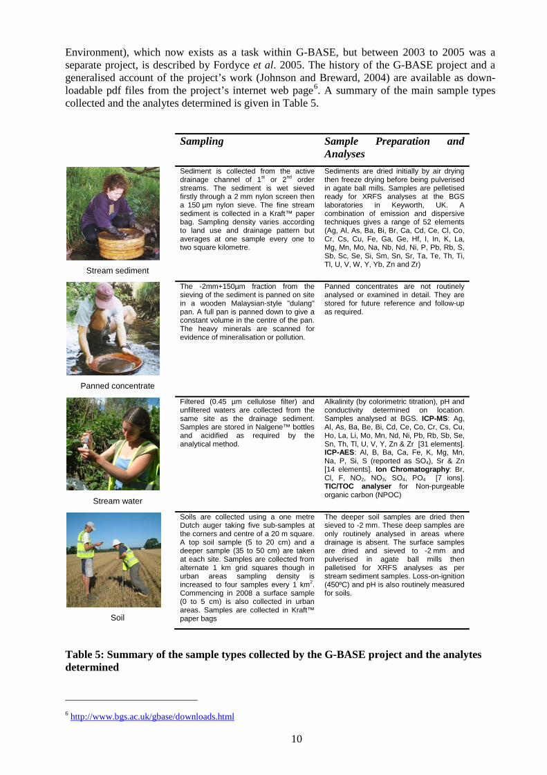
2.2 REGIONAL GEOCHEMICAL MAPPING OF THE UK LAND AREA Baseline geochemical data for regional and urban areas of the UK are also held in the BGS Geochemistry Database. Such data are not site specific investigations and the samples collected contribute to high resolution regional and urban baselines. The main source of funding for this systematic baseline survey has been from government departments and in recent years co-funded work has contributed to the progression of the geochemical mapping, e.g. with the Environment Agency in the Tamar drainage catchment, SW England, and DETI (Department of Enterprise, Trade and Investment) in Northern Ireland for the Tellus Project. The current geochemical mapping projects are part of the Geochemical Baseline and Medical Geology Team of the Environmental Geoscience Baselines science theme area and funded through national capability budget.
The current Geochemical Baseline Survey of the Environment (G-BASE) project is a continuation of previous regional geochemical mapping projects that have been mapping the geochemical surface environment of the UK land mass since 1969. At present work is currently focused on the London urban area carried out as the “London Earth Project”. G-BASE is described by Johnson et al. 2005 and the GSUE project (Geochemical Surveys of the Urban
10
Environment), which now exists as a task within G-BASE, but between 2003 to 2005 was a separate project, is described by Fordyce et al. 2005. The history of the G-BASE project and a generalised account of the project’s work (Johnson and Breward, 2004) are available as down-loadable pdf files from the project’s internet web page6
Table 5. A summary of the main sample types
collected and the analytes determined is given in .
Sampling Sample Preparation and Analyses
Stream sediment
Sediment is collected from the active drainage channel of 1st or 2nd order streams. The sediment is wet sieved firstly through a 2 mm nylon screen then a 150 µm nylon sieve. The fine stream sediment is collected in a Kraft™ paper bag. Sampling density varies according to land use and drainage pattern but averages at one sample every one to two square kilometre.
Sediments are dried initially by air drying then freeze drying before being pulverised in agate ball mills. Samples are pelletised ready for XRFS analyses at the BGS laboratories in Keyworth, UK. A combination of emission and dispersive techniques gives a range of 52 elements (Ag, Al, As, Ba, Bi, Br, Ca, Cd, Ce, Cl, Co, Cr, Cs, Cu, Fe, Ga, Ge, Hf, I, In, K, La, Mg, Mn, Mo, Na, Nb, Nd, Ni, P, Pb, Rb, S, Sb, Sc, Se, Si, Sm, Sn, Sr, Ta, Te, Th, Ti, Tl, U, V, W, Y, Yb, Zn and Zr)
Panned concentrate
The -2mm+150µm fraction from the sieving of the sediment is panned on site in a wooden Malaysian-style "dulang" pan. A full pan is panned down to give a constant volume in the centre of the pan. The heavy minerals are scanned for evidence of mineralisation or pollution.
Panned concentrates are not routinely analysed or examined in detail. They are stored for future reference and follow-up as required.
Stream water
Filtered (0.45 µm cellulose filter) and unfiltered waters are collected from the same site as the drainage sediment. Samples are stored in Nalgene™ bottles and acidified as required by the analytical method.
Alkalinity (by colorimetric titration), pH and conductivity determined on location. Samples analysed at BGS. ICP-MS: Ag, Al, As, Ba, Be, Bi, Cd, Ce, Co, Cr, Cs, Cu, Ho, La, Li, Mo, Mn, Nd, Ni, Pb, Rb, Sb, Se, Sn, Th, Tl, U, V, Y, Zn & Zr [31 elements]. ICP-AES: Al, B, Ba, Ca, Fe, K, Mg, Mn, Na, P, Si, S (reported as SO4), Sr & Zn [14 elements]. Ion Chromatography: Br, Cl, F, NO2, NO3, SO4, PO4 [7 ions]. TIC/TOC analyser for Non-purgeable organic carbon (NPOC)
Soil
Soils are collected using a one metre Dutch auger taking five sub-samples at the corners and centre of a 20 m square. A top soil sample (5 to 20 cm) and a deeper sample (35 to 50 cm) are taken at each site. Samples are collected from alternate 1 km grid squares though in urban areas sampling density is increased to four samples every 1 km2. Commencing in 2008 a surface sample (0 to 5 cm) is also collected in urban areas. Samples are collected in Kraft™ paper bags
The deeper soil samples are dried then sieved to -2 mm. These deep samples are only routinely analysed in areas where drainage is absent. The surface samples are dried and sieved to -2 mm and pulverised in agate ball mills then palletised for XRFS analyses as per stream sediment samples. Loss-on-ignition (450ºC) and pH is also routinely measured for soils.
Table 5: Summary of the sample types collected by the G-BASE project and the analytes determined 6 http://www.bgs.ac.uk/gbase/downloads.html
11
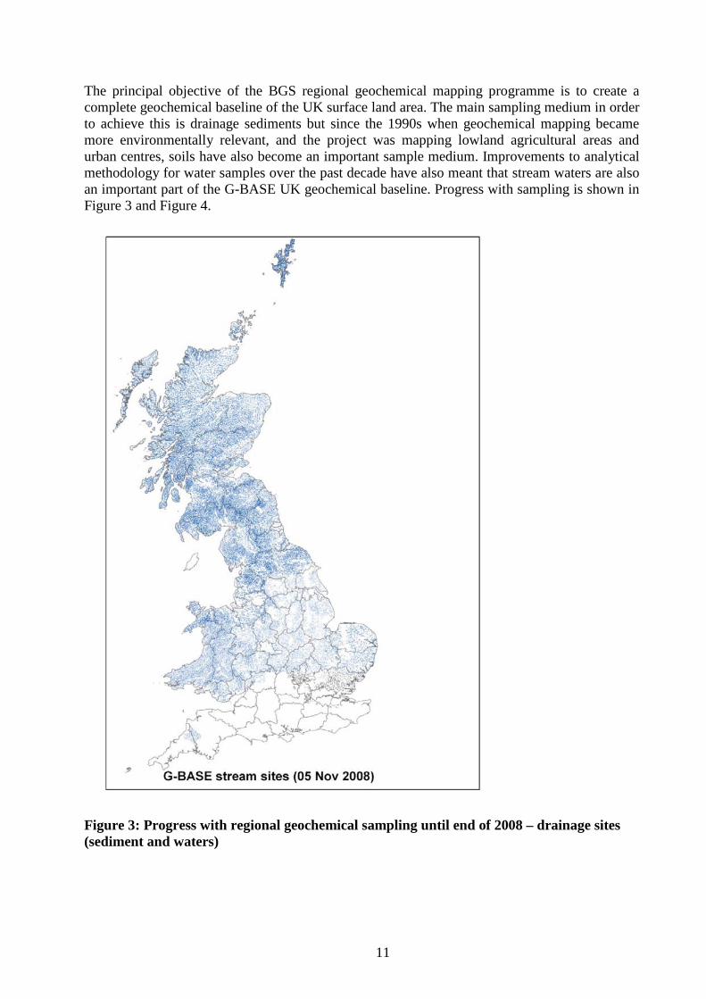
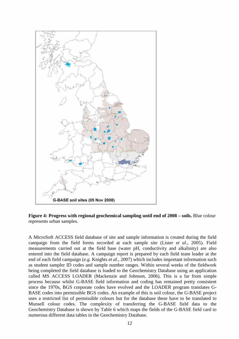
The principal objective of the BGS regional geochemical mapping programme is to create a complete geochemical baseline of the UK surface land area. The main sampling medium in order to achieve this is drainage sediments but since the 1990s when geochemical mapping became more environmentally relevant, and the project was mapping lowland agricultural areas and urban centres, soils have also become an important sample medium. Improvements to analytical methodology for water samples over the past decade have also meant that stream waters are also an important part of the G-BASE UK geochemical baseline. Progress with sampling is shown in Figure 3 and Figure 4.
Figure 3: Progress with regional geochemical sampling until end of 2008 – drainage sites (sediment and waters)
12
Figure 4: Progress with regional geochemical sampling until end of 2008 – soils. Blue colour represents urban samples.
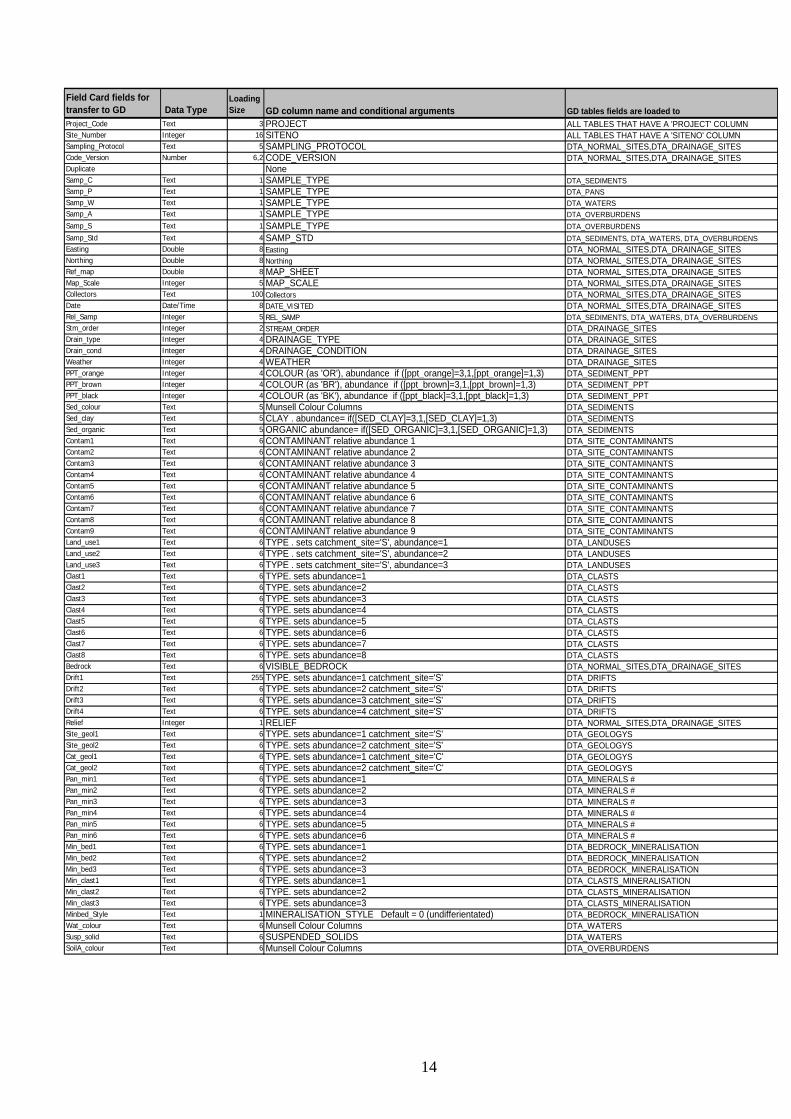
A MicroSoft ACCESS field database of site and sample information is created during the field campaign from the field forms recorded at each sample site (Lister et al., 2005). Field measurements carried out at the field base (water pH, conductivity and alkalinity) are also entered into the field database. A campaign report is prepared by each field team leader at the end of each field campaign (e.g. Knights et al., 2007) which includes important information such as student sampler ID codes and sample number ranges. Within several weeks of the fieldwork being completed the field database is loaded to the Geochemistry Database using an application called MS ACCESS LOADER (Mackenzie and Johnson, 2006). This is a far from simple process because whilst G-BASE field information and coding has remained pretty consistent since the 1970s, BGS corporate codes have evolved and the LOADER program translates G-BASE codes into permissible BGS codes. An example of this is soil colour, the G-BASE project uses a restricted list of permissible colours but for the database these have to be translated to Munsell colour codes. The complexity of transferring the G-BASE field data to the Geochemistry Database is shown by Table 6 which maps the fields of the G-BASE field card to numerous different data tables in the Geochemistry Database.
13
Samples collected during a summer field campaign are generally analysed by the following March. Since 2006 stream sediment and soil results (where X-Ray Fluorecence Spectrometry (XRFS) is the principal method of analysis) are loaded directly via the BGS Laboratory Information Management System (LIMS) to raw data tables in the Oracle database. Control sample information and laboratory and batch information tables are exported to the database at the same time (Ault et al., 2006). Earlier analytical data in digital format had to be loaded manually to the database using the LOADER application or manually using standard SQL direct into ORACLE. Stream water data is usually received as digital MS EXCEL files and also has to be manually loaded to the Geochemistry Database using the LOADER application.
The “raw” soil and sediment data needs to be subjected to a data conditioning process (Lister and Johnson, 2005 and Johnson et al., 2008) so data is fully quality controlled, the accuracy and precision assessed, and, where necessary, levelled with respect to earlier results so seamless national geochemical maps can be produced from data spanning four decades. Conditioned data is loaded to the Geochemistry Database using the LOADER application to the Analyte_Determinations table (see Table 7). It is a deficiency of the Geochemistry Database that geochemical data from a variety of different projects exists in the Analyte_Determinations table but only someone with a good knowledge of the project that generated it will know the amount of quality control and levelling that data has been subjected to.
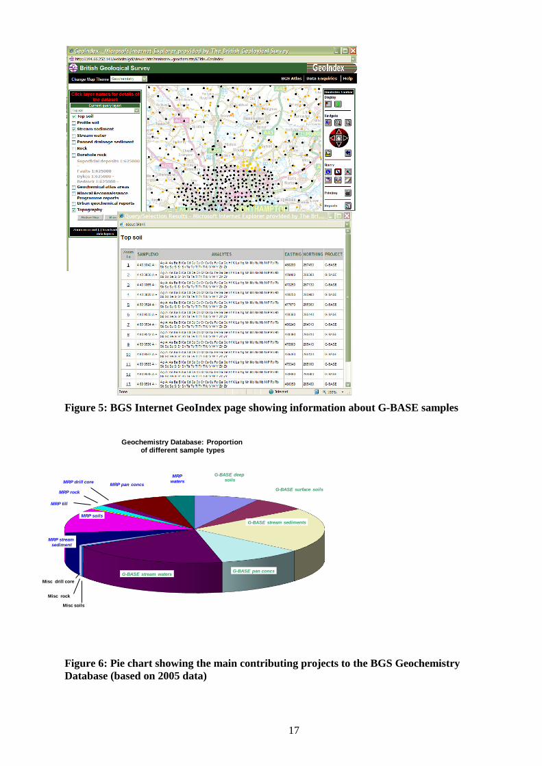
The location of G-BASE samples can be determined from the BGS internet GeoIndex (e.g. Figure 5) and this information is now generally updated soon after the completion of a field campaign. Whilst raw analytical data is generally available within six months of sample collection, G-BASE data are not generally released until they have undergone the rigorous data conditioning process, which in its entirety may take up to three years to complete. This is because the final process of the data conditioning, to level the data between analytical batches and different field campaigns, is best done on larger data sets covering atlas sheet areas. At the current rate of sampling, atlas sheet areas are taking many years to complete. The GeoIndex will show that analytical data is available for completed atlas areas but gives no indication that raw unqualified analytical data is available. The data conditioning process is important in confirming the data quality and during this process analyte determinations can be qualified by use of qualifier codes in the qualifier field of the Analyte_Determinations table. An example of this would be the replacement of semi-quantitative below detection results with a specified value by a method indicated by the qualifier code, e.g. a value one half of the analysts specified detection limit. Such data conditioning and qualification of the data is essential if customers that are non-geochemists are using the data.
Field forms for all G-BASE samples are either kept in metal “punch-card” drawers in P006 and are still actively used by several projects (East Midlands and East Anglia atlas areas and the most recent sampling) or archived to aisle 129 in the NGDC. All G-BASE field data since 1994 has been captured to the Geochemistry Database following the publication of the protocols covering the field database (Lister et al., 2005). The history of G-BASE field forms and databases is documented in Lister et al. 2005. Much of the pre-1994 G-BASE field data has not been loaded to the database and exists only in analogue form. Analytical data is now reported in digital format, either directly to the ORACLE database as in the case of the soil and sediment results or as MS EXCEL files for stream water data. There are therefore no longer any primary hardcopy data files. Before 2004 all data was reported to the G-BASE data manager who maintained hardcopy records of G-BASE data. There are no hardcopy data records from 1996- 2002 and since then records are stored in the Data Manager’s office (Bob Lister P005) or P006. Hardcopy analytical data from before 1996 is patchy but generally well documented in notes and files now stored in aisle 128 of the NGDC records room. There are no hardcopy or digital records of the earliest raw data on which much of the Scottish G-BASE results in the Geochemistry Database are based.
14
Field Card fields for transfer to GD Data Type
Loading Size GD column name and conditional arguments GD tables fields are loaded to
Project_Code Text 3 PROJECT ALL TABLES THAT HAVE A 'PROJECT' COLUMNSite_Number Integer 16 SITENO ALL TABLES THAT HAVE A 'SITENO' COLUMNSampling_Protocol Text 5 SAMPLING_PROTOCOL DTA_NORMAL_SITES,DTA_DRAINAGE_SITESCode_Version Number 6,2 CODE_VERSION DTA_NORMAL_SITES,DTA_DRAINAGE_SITESDuplicate NoneSamp_C Text 1 SAMPLE_TYPE DTA_SEDIMENTSSamp_P Text 1 SAMPLE_TYPE DTA_PANSSamp_W Text 1 SAMPLE_TYPE DTA_WATERSSamp_A Text 1 SAMPLE_TYPE DTA_OVERBURDENSSamp_S Text 1 SAMPLE_TYPE DTA_OVERBURDENSSamp_Std Text 4 SAMP_STD DTA_SEDIMENTS, DTA_WATERS, DTA_OVERBURDENSEasting Double 8 Easting DTA_NORMAL_SITES,DTA_DRAINAGE_SITESNorthing Double 8 Northing DTA_NORMAL_SITES,DTA_DRAINAGE_SITESRef_map Double 8 MAP_SHEET DTA_NORMAL_SITES,DTA_DRAINAGE_SITESMap_Scale Integer 5 MAP_SCALE DTA_NORMAL_SITES,DTA_DRAINAGE_SITESCollectors Text 100 Collectors DTA_NORMAL_SITES,DTA_DRAINAGE_SITESDate Date/Time 8 DATE_VISITED DTA_NORMAL_SITES,DTA_DRAINAGE_SITESRel_Samp Integer 5 REL_SAMP DTA_SEDIMENTS, DTA_WATERS, DTA_OVERBURDENSStm_order Integer 2 STREAM_ORDER DTA_DRAINAGE_SITESDrain_type Integer 4 DRAINAGE_TYPE DTA_DRAINAGE_SITESDrain_cond Integer 4 DRAINAGE_CONDITION DTA_DRAINAGE_SITESWeather Integer 4 WEATHER DTA_DRAINAGE_SITESPPT_orange Integer 4 COLOUR (as 'OR'), abundance if ([ppt_orange]=3,1,[ppt_orange]=1,3) DTA_SEDIMENT_PPTPPT_brown Integer 4 COLOUR (as 'BR'), abundance if ([ppt_brown]=3,1,[ppt_brown]=1,3) DTA_SEDIMENT_PPTPPT_black Integer 4 COLOUR (as 'BK'), abundance if ([ppt_black]=3,1,[ppt_black]=1,3) DTA_SEDIMENT_PPTSed_colour Text 5 Munsell Colour Columns DTA_SEDIMENTSSed_clay Text 5 CLAY . abundance= if([SED_CLAY]=3,1,[SED_CLAY]=1,3) DTA_SEDIMENTSSed_organic Text 5 ORGANIC abundance= if([SED_ORGANIC]=3,1,[SED_ORGANIC]=1,3) DTA_SEDIMENTSContam1 Text 6 CONTAMINANT relative abundance 1 DTA_SITE_CONTAMINANTSContam2 Text 6 CONTAMINANT relative abundance 2 DTA_SITE_CONTAMINANTSContam3 Text 6 CONTAMINANT relative abundance 3 DTA_SITE_CONTAMINANTSContam4 Text 6 CONTAMINANT relative abundance 4 DTA_SITE_CONTAMINANTSContam5 Text 6 CONTAMINANT relative abundance 5 DTA_SITE_CONTAMINANTSContam6 Text 6 CONTAMINANT relative abundance 6 DTA_SITE_CONTAMINANTSContam7 Text 6 CONTAMINANT relative abundance 7 DTA_SITE_CONTAMINANTSContam8 Text 6 CONTAMINANT relative abundance 8 DTA_SITE_CONTAMINANTSContam9 Text 6 CONTAMINANT relative abundance 9 DTA_SITE_CONTAMINANTSLand_use1 Text 6 TYPE . sets catchment_site='S', abundance=1 DTA_LANDUSESLand_use2 Text 6 TYPE . sets catchment_site='S', abundance=2 DTA_LANDUSESLand_use3 Text 6 TYPE . sets catchment_site='S', abundance=3 DTA_LANDUSESClast1 Text 6 TYPE. sets abundance=1 DTA_CLASTSClast2 Text 6 TYPE. sets abundance=2 DTA_CLASTSClast3 Text 6 TYPE. sets abundance=3 DTA_CLASTSClast4 Text 6 TYPE. sets abundance=4 DTA_CLASTSClast5 Text 6 TYPE. sets abundance=5 DTA_CLASTSClast6 Text 6 TYPE. sets abundance=6 DTA_CLASTSClast7 Text 6 TYPE. sets abundance=7 DTA_CLASTSClast8 Text 6 TYPE. sets abundance=8 DTA_CLASTSBedrock Text 6 VISIBLE_BEDROCK DTA_NORMAL_SITES,DTA_DRAINAGE_SITESDrift1 Text 255 TYPE. sets abundance=1 catchment_site='S' DTA_DRIFTSDrift2 Text 6 TYPE. sets abundance=2 catchment_site='S' DTA_DRIFTSDrift3 Text 6 TYPE. sets abundance=3 catchment_site='S' DTA_DRIFTSDrift4 Text 6 TYPE. sets abundance=4 catchment_site='S' DTA_DRIFTSRelief Integer 1 RELIEF DTA_NORMAL_SITES,DTA_DRAINAGE_SITESSite_geol1 Text 6 TYPE. sets abundance=1 catchment_site='S' DTA_GEOLOGYSSite_geol2 Text 6 TYPE. sets abundance=2 catchment_site='S' DTA_GEOLOGYSCat_geol1 Text 6 TYPE. sets abundance=1 catchment_site='C' DTA_GEOLOGYSCat_geol2 Text 6 TYPE. sets abundance=2 catchment_site='C' DTA_GEOLOGYSPan_min1 Text 6 TYPE. sets abundance=1 DTA_MINERALS #Pan_min2 Text 6 TYPE. sets abundance=2 DTA_MINERALS #Pan_min3 Text 6 TYPE. sets abundance=3 DTA_MINERALS #Pan_min4 Text 6 TYPE. sets abundance=4 DTA_MINERALS #Pan_min5 Text 6 TYPE. sets abundance=5 DTA_MINERALS #Pan_min6 Text 6 TYPE. sets abundance=6 DTA_MINERALS #Min_bed1 Text 6 TYPE. sets abundance=1 DTA_BEDROCK_MINERALISATIONMin_bed2 Text 6 TYPE. sets abundance=2 DTA_BEDROCK_MINERALISATIONMin_bed3 Text 6 TYPE. sets abundance=3 DTA_BEDROCK_MINERALISATIONMin_clast1 Text 6 TYPE. sets abundance=1 DTA_CLASTS_MINERALISATIONMin_clast2 Text 6 TYPE. sets abundance=2 DTA_CLASTS_MINERALISATIONMin_clast3 Text 6 TYPE. sets abundance=3 DTA_CLASTS_MINERALISATIONMinbed_Style Text 1 MINERALISATION_STYLE Default = 0 (undifferientated) DTA_BEDROCK_MINERALISATIONWat_colour Text 6 Munsell Colour Columns DTA_WATERSSusp_solid Text 6 SUSPENDED_SOLIDS DTA_WATERSSoilA_colour Text 6 Munsell Colour Columns DTA_OVERBURDENS
15
Table 6: A table showing how fields of the G-BASE field card map to Geochemistry Database data tables
CODE TRANSLATION DEFINED_AS CODE TRANSLATION DEFINED_AS CODE TRANSLATION DEFINED_A
S
Ac Actinium Actinium Ge Germanium Germanium Pr Praseodymium Praseodymium
Ag Silver Silver H Hydrogen Hydrogen Pt Platinum Platinum
Al Aluminium Aluminium H.3 tritium 3H Pu Plutonium Plutonium
Am Americium Americium H2O.+ combined water H2O+ Ra Radium Radium
Ar Argon Argon H2O.- moisture H2O- Ra.226 radium - 226 226Ra
As Arsenic Arsenic
H2PO4.- dihydrogen orthophosphate
H2PO4-
Rb Rubidium Rubidium
As(III) As oxidation state 3
As(III)
H2S hydrogen sulphide
H2S
Re Rhenium Rhenium
As(V) As oxidation state 5
As(V)
HCO3.- bicarbonate HCO3-
Rh Rhodium Rhodium
As.3+ arsenite As+3
HPO4.2- hydrogen orthophosphate
HPO4-2
Rn Radon Radon
As.5+ arsenate As+5 He Helium Helium Rn.222 radon - 222 222Rn
At Astatine Astatine Hf Hafnium Hafnium Ru Ruthenium Ruthenium
Au Gold Gold Hg Mercury Mercury S Sulphur Sulphur
B Boron Boron Ho Holmium Holmium S2O3.2- thiosulphate S2O3-2
B4O7.2- tetraborate B4O7-2 Humic humic acids Humic SO3.2- sulphite SO3-2
BO2.- metaborate BO2- I Iodine Iodine SO4.2- sulphate SO4-2
BO3.3- borate BO3-3 I.- iodide I- Sb Antimony Antimony
Ba Barium Barium IO3.- iodate IO3- Sc Scandium Scandium
Be Beryllium Beryllium In Indium Indium Se Selenium Selenium
Bi Bismuth Bismuth
Ir Iridium Iridium
Se(IV) Se oxidation state four
Se(IV)
Bk Berkelium Berkelium
K Potassium Potassium
Se(VI) Se oxidation state six
Se(VI)
Br Bromine Bromine Kr Krypton Krypton Se.4+ selenite Se+4
Field Card fields for transfer to GD Data Type
Loading Size GD column name and conditional arguments GD tables fields are loaded to
SoilS_colour Text 6 Munsell Colour Columns DTA_OVERBURDENSSoilA_text Text 6 TEXTURE DTA_HORIZONSSoilS_text Text 6 TEXTURE DTA_HORIZONSDepth_A Text 6 BOTTOM_DEPTH* DTA_NORMAL_SITESDepth_S Text 6 BOTTOM_DEPTH* DTA_NORMAL_SITESOrganic_A Number 1 ORGANIC_CONTENT DTA_OVERBURDENSOrganic_S Number 1 ORGANIC_CONTENT DTA_OVERBURDENSA_clast1 Text 6 TYPE. sets abundance=1 DTA_CLASTSA_clast2 Text 6 TYPE. sets abundance=2 DTA_CLASTSA_clast3 Text 6 TYPE. sets abundance=3 DTA_CLASTSA_clast4 Text 6 TYPE. sets abundance=4 DTA_CLASTSA_clast5 Text 6 TYPE. sets abundance=5 DTA_CLASTSA_clast6 Text 6 TYPE. sets abundance=6 DTA_CLASTSS_clast1 Text 6 TYPE. sets abundance=1 DTA_CLASTSS_clast2 Text 6 TYPE. sets abundance=2 DTA_CLASTSS_clast3 Text 6 TYPE. sets abundance=3 DTA_CLASTSS_clast4 Text 6 TYPE. sets abundance=4 DTA_CLASTSS_clast5 Text 6 TYPE. sets abundance=5 DTA_CLASTSS_clast6 Text 6 TYPE. sets abundance=6 DTA_CLASTSA_moist Text 6 SOIL_MOISTURE DTA_OVERBURDENSS_moist Text 6 SOIL_MOISTURE DTA_OVERBURDENSPh@ Number 6,2 PH (recorded to 1 dec place e.g. 7.2) DTA_WATERSConduct@ Number 5 Conduct DTA_WATERSBicarb Double 8 BICARBONATE DTA_WATERSComments Text 255 COMMENTS DTA_NORMAL_SITES,DTA_DRAINAGE_SITES$ = Default from loading screen# = where samp_p is not null@=entered in field database but not on field card~ = duplicate is indicated by 1,2,3 etc non duplicates as +* Top_depth is derived by subtracting 0.15m
16
Br.- bromide Br-
LOI loss on ignition loss on ignition
Se.6+ selenate Se+6
BrO3.- bromate BrO3-
LOI1000 Loss on ignition at 1000 ºC
LOI 1000 ºC
Si Silicon Silicon
C Carbon Carbon
LOI1050 loss on ignition at 1050 ºC
LOI 1050 ºC
Sm Samarium Samarium
C.14 carbon - 14 14C
LOI450 loss on ignition at 450 ºC
LOI 450 ºC
Sn Tin Tin
CEC Cation exchange capacity
Cation exchange capacity
La Lanthanum Lanthanum
Sr Strontium Strontium
CN.- cyanide CN-
Li Lithium Lithium
TDS total dissolved solids
TDS
CO3.2- carbonate CO3-2
Lr Lawrencium Lawrencium
TIC total inorganic carbon
TIC
Ca Calcium Calcium
Lu Lutecium Lutecium
TOC total organic carbon
TOC
Cd Cadmium Cadmium
Md Mendelevium Mendelevium
TON total oxidised nitogen
TON
Ce Cerium Cerium Mg Magnesium Magnesium TOT_ALK Total alkalinity Total alkalinity
Cf Californium Californium Mn Manganese Manganese Ta Tantalum Tantalum
Cl Chlorine Chlorine MnO4.- permanganate MnO4- Tb Terbium Terbium
Cl.- chloride Cl- MnO4.2- manganate MnO4-2 Tc Technetium Technetium
ClO3.- chlorate ClO3- Mo Molybdenum Molybdenum Te Tellurium Tellurium
Cm Curium Curium N Nitrogen Nitrogen Th Thorium Thorium
Co Cobalt Cobalt NH3 ammonia NH3 Th.230 thorium - 230 230Th
Conduct Conductivity Electrical conductivity
NH4.+ ammonium NH4+
Th.232 thorium - 232 232Th
Cr Chromium Chromium NO2.- nitrite NO2- Ti Titanium Titanium
Cr2O7 dichromate Cr2O7 NO3.- nitrate NO3- Tl Thallium Thallium
CrO4.2- chromate CrO4-2 Na Sodium Sodium Tm Thulium Thulium
Cs Caesium Caesium Nb Niobium Niobium U Uranium Uranium
Cu Copper Copper Nd Neodymium Neodymium U.234 uranium - 234 234U
DIC Dissolved InorganicCarbon
DIC
Ne Neon Neon
U.238 uranium - 238 238U
DOC Dissolved Organic Carbon
DOC
Ni Nickel Nickel
V Vanadium Vanadium
Dy Dysprosium Dysprosium No Nobelium Nobelium W Tungsten Tungsten
Er Erbium Erbium Np Neptunium Neptunium Xe Xenon Xenon
Es Einsteinium Einsteinium O Oxygen Oxygen Y Yittrium Yittrium
Eu Europium Europium OH.- hydroxide OH- Yb Yitterbium Yitterbium
F Fluorine Fluorine Os Osmium Osmium Zn Zinc Zinc
F.- fluoride F- P Phosphorus Phosphorus Zr Zirconium Zirconium
Fe Iron Iron
P-o Olsen Phosporous Olsen Phosporous
d18O delta oxygen eighteen
d 18O
Fe.2+ ferrous Fe+2 P-r Reactive P Reactive P d2H delta deuterium d 2H
Fe.3+ ferric Fe+3 PO4.3- phosphate PO4-3 pH pH pH
Fm Fermium Fermium Pa Protactinium Protactinium Fr Frankium Frankium Pb Lead Lead Fulvic fulvic acids Fulvic Pd Palladium Palladium Ga Gallium Gallium Pm Promethium Promethium Gd Gadolinium Gadolinium Po Polonium Polonium
Table 7: Analyte_Determinations domain Table from the Geochemistry Database (BGS_MTA_DOM_ANALYTE)
17
Figure 5: BGS Internet GeoIndex page showing information about G-BASE samples
Figure 6: Pie chart showing the main contributing projects to the BGS Geochemistry Database (based on 2005 data)
G-BASE deepsoils
G-BASE surface soils
G-BASE stream sediments
G-BASE pan concsG-BASE stream waters
Misc soils
Misc rock
Misc drill core
MRP streamsediment
MRP soils
MRP till
MRP rock
MRP drill core MRP pan concs
MRP waters
Geochemistry Database: Proportionof different sample types
18
Keyfields for the G-BASE data are as for those described for the MRP data. G-BASE identifies soils in a different way to that used in MRP projects with an additional sample types “A” for topsoils (5-20 cm) and “X” for surface soils (0-2 cm). Whereas G-BASE will have “A”, “S” and “X” soil samples collected from a single site, the MRP would assign all samples as “S” but assign a different site number (Siteno) for soils collected at different depths down a soil profile.
In 2007 a major ground geochemical survey was completed by the Tellus Project in Northern Ireland which extended the area sampled by G-BASE in the 1990s. The geochemical sampling was directed by the G-BASE project and the data will be loaded to the BGS Geochemistry Database when all the data conditioning is complete (this work was still in progress in early 2010). However, the principal first contact point for Northern Ireland geochemical data or samples should be the Geological Survey of Northern Ireland (GSNI) office in Belfast. All other regional and urban geochemical data for the UK is managed by the BGS Geochemistry Data Manager.
The pricing policy for digital geochemical data is the same as that previously described for MRP data (Box 1). Internal use of baseline geochemical data should be coordinated through the BGS Geochemistry Data Manager. External enquiries should initially be routed through the BGS enquiries desk who will forward enquires about digital data licencing and IPR to the BGS digital licencing manager. Any other enquiries about the availability of regional or urban baseline geochemical data will be forwarded to the Geochemistry Baselines and Medical Geology Team Leader.
The G-BASE project is now the only project that is routinely adding geochemical data to the Geochemistry Database. Two-thirds of the samples in the database have originated from the G-BASE project (see Figure 6). It is somewhat misleading that there are many active BGS projects generating geochemical data that are not captured to the corporate Geochemistry Database because the database was specifically designed for MRP, G-BASE and mineralogy/petrology data only. As one of the earliest BGS Oracle databases the Geochemistry Database was a divisional rather than a corporate initiative and so the Geochemistry Database is more-or-less exclusive to the MRP and G-BASE projects.
All BGS staff have read access to the Geochemistry Database and samples and results can be accessed using the query layers mentioned in the previous sub-section (see also Table 2). Baseline geochemistry results can be retrieved using Numbering_System code = 4.
Regional geochemistry atlases are the main published source of information for the baseline data. G-BASE also has a substantial record of peer-reviewed publications and these can be found referenced in the G-BASE project EndNote bibliography located on the Geochemistry Baselines Team area of the SAN (access to internal BGS users only). Urban data was reported in the BGS Internal Report series until 2007 but are now presented in the new BGS Open Report series. Urban geochemical data is presented in BGS reports as summary statistics for each element and the preferred method of data presentation is as proportional symbol maps. In 2009 all the G-BASE/GSUE urban geochemistry reports were added to NERC Online Research Archive NORA7
Figure 7
and can also be downloaded from the G-BASE internet web pages. The internet GeoIndex (geochemistry data layer) graphically displays the reporting areas (with a bibliographic reference) for atlases and urban reports. As described previously, the GeoIndex identifies baseline sample sites for all the different sample media and using the information tool users can identify site numbers and analytes determined. External customers have no direct access to the chemical results. For collaborative projects baseline data are often provided in an ArcGIS project as an IDW gridded tiff image (e.g. ) and use of these images in publications is an issue of copyright rather than one of data licencing.
7 NORA (NERC Open Research Archive) http://nora.nerc.ac.uk/
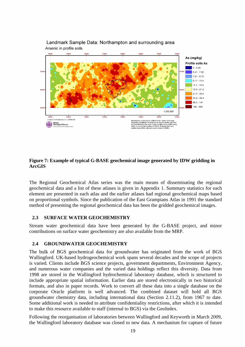
19
Figure 7: Example of typical G-BASE geochemical image generated by IDW gridding in ArcGIS
The Regional Geochemical Atlas series was the main means of disseminating the regional geochemical data and a list of these atlases is given in Appendix 1. Summary statistics for each element are presented in each atlas and the earlier atlases had regional geochemical maps based on proportional symbols. Since the publication of the East Grampians Atlas in 1991 the standard method of presenting the regional geochemical data has been the gridded geochemical images.
2.3 SURFACE WATER GEOCHEMISTRY Stream water geochemical data have been generated by the G-BASE project, and minor contributions on surface water geochemistry are also available from the MRP.
2.4 GROUNDWATER GEOCHEMISTRY The bulk of BGS geochemical data for groundwater has originated from the work of BGS Wallingford. UK-based hydrogeochemical work spans several decades and the scope of projects is varied. Clients include BGS science projects, government departments, Environment Agency, and numerous water companies and the varied data holdings reflect this diversity. Data from 1998 are stored in the Wallingford hydrochemical laboratory database, which is structured to include appropriate spatial information. Earlier data are stored electronically in two historical formats, and also in paper records. Work to convert all these data into a single database on the corporate Oracle platform is well advanced. The combined dataset will hold all BGS groundwater chemistry data, including international data (Section 2.11.2), from 1967 to date. Some additional work is needed to attribute confidentiality restrictions, after which it is intended to make this resource available to staff (internal to BGS) via the GeoIndex.
Following the reorganisation of laboratories between Wallingford and Keyworth in March 2009, the Wallingford laboratory database was closed to new data. A mechanism for capture of future
20
groundwater chemistry data from the BGS laboratory to the new Oracle tables is under active consideration between the laboratory Facility Leader and the groundwater science programme.
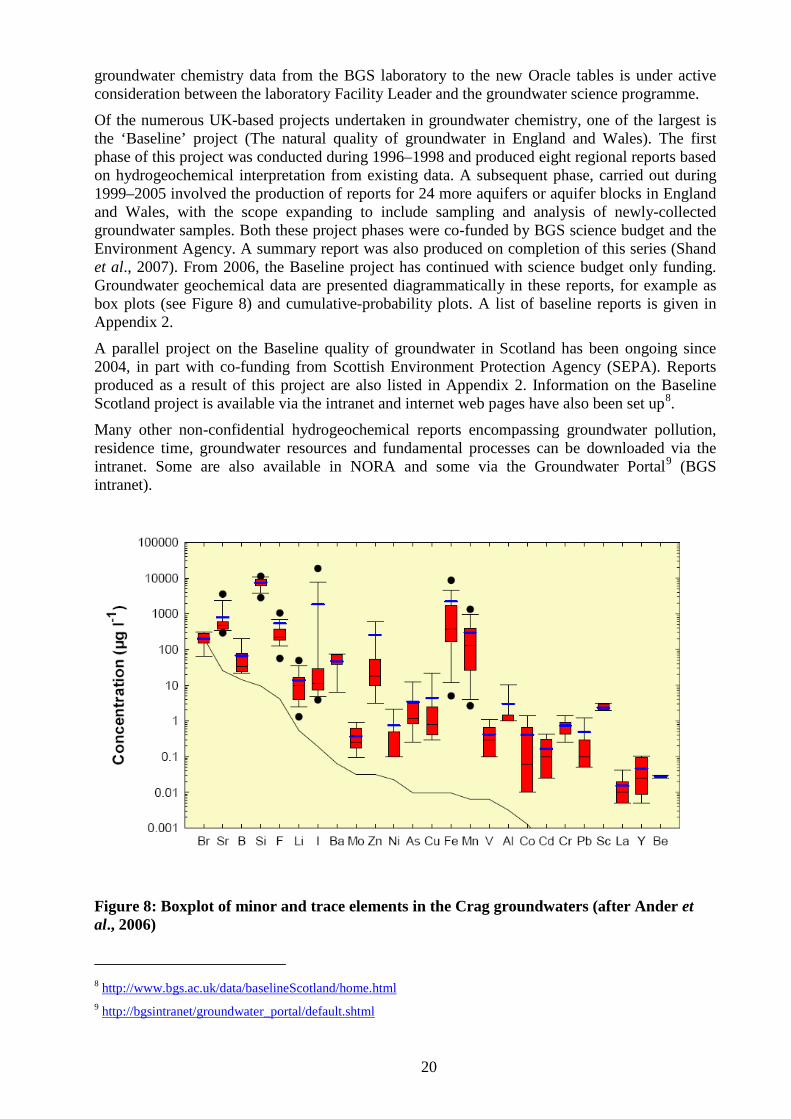
Of the numerous UK-based projects undertaken in groundwater chemistry, one of the largest is the ‘Baseline’ project (The natural quality of groundwater in England and Wales). The first phase of this project was conducted during 1996–1998 and produced eight regional reports based on hydrogeochemical interpretation from existing data. A subsequent phase, carried out during 1999–2005 involved the production of reports for 24 more aquifers or aquifer blocks in England and Wales, with the scope expanding to include sampling and analysis of newly-collected groundwater samples. Both these project phases were co-funded by BGS science budget and the Environment Agency. A summary report was also produced on completion of this series (Shand et al., 2007). From 2006, the Baseline project has continued with science budget only funding. Groundwater geochemical data are presented diagrammatically in these reports, for example as box plots (see Figure 8) and cumulative-probability plots. A list of baseline reports is given in Appendix 2.
A parallel project on the Baseline quality of groundwater in Scotland has been ongoing since 2004, in part with co-funding from Scottish Environment Protection Agency (SEPA). Reports produced as a result of this project are also listed in Appendix 2. Information on the Baseline Scotland project is available via the intranet and internet web pages have also been set up8
Many other non-confidential hydrogeochemical reports encompassing groundwater pollution, residence time, groundwater resources and fundamental processes can be downloaded via the intranet. Some are also available in NORA and some via the Groundwater Portal
.
9
(BGS intranet).
Figure 8: Boxplot of minor and trace elements in the Crag groundwaters (after Ander et al., 2006)
8 http://www.bgs.ac.uk/data/baselineScotland/home.html 9 http://bgsintranet/groundwater_portal/default.shtml
21
2.5 OFFSHORE/MARINE GEOCHEMISTRY This section is concerned with offshore geochemical investigations in UK territorial waters – international offshore geochemical studies are briefly discussed in Section 2.11.4. The history of the BGS offshore geochemistry programme is described by Stevenson et al. (1995) and summarised below. This report was originally classified as commercial in confidence but has now been declassified and can be made publically available through the BGS library. More recently Fordyce et al. (2004) have reviewed BGS offshore (and onshore) geochemical data in relation to contaminant transport investigations. BGS has carried out geochemical investigations in a number of estuaries in the UK and although such work should be classified as offshore or marine geochemistry it is discussed in a separate section (see Section 2.6). Furthermore, much of the sea-bed sediment sampling was conducted concurrently with the offshore radiometric surveys described in Section 2.8.2.
In the 1970s there was growing concern about the levels of mercury in fish. The analytical chemistry unit of the BGS (or Institute of Geological Sciences (IGS) as it was then called) was asked to look at trace metal contents, particularly mercury, in waters and sediments around the British Isles. Initial work in the tidal reaches of the River Thames was published by Smith et al. (1971). This was followed by a study of the Thames Estuary sediments in conjunction with the City of London Polytechnic (Smith et al., 1973).
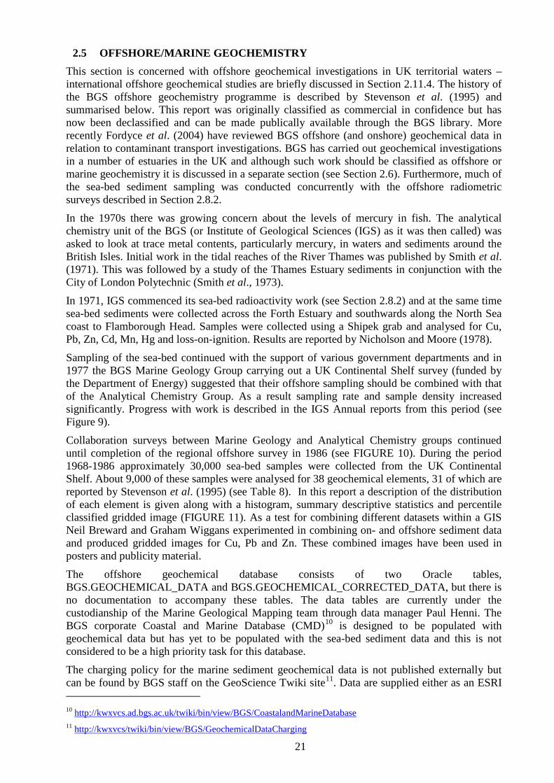
In 1971, IGS commenced its sea-bed radioactivity work (see Section 2.8.2) and at the same time sea-bed sediments were collected across the Forth Estuary and southwards along the North Sea coast to Flamborough Head. Samples were collected using a Shipek grab and analysed for Cu, Pb, Zn, Cd, Mn, Hg and loss-on-ignition. Results are reported by Nicholson and Moore (1978).
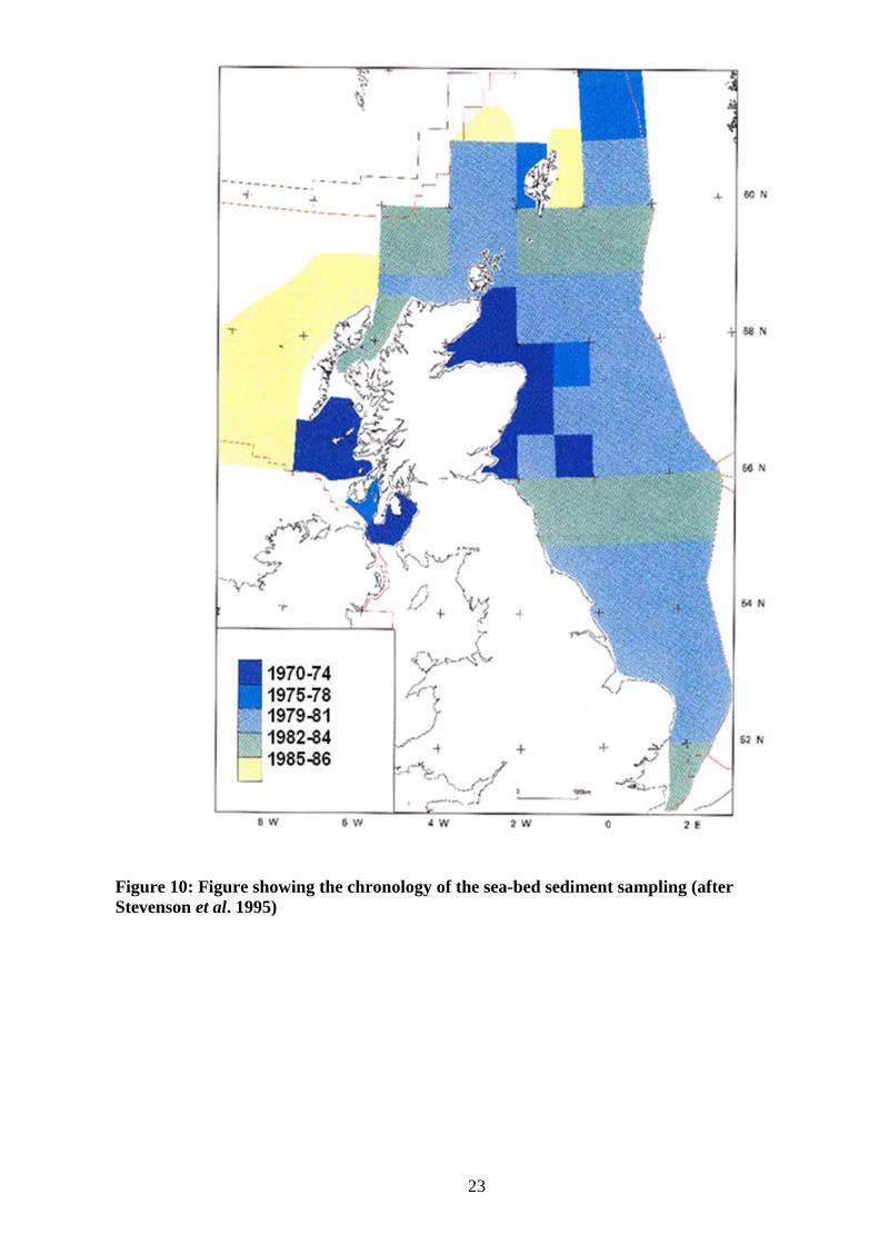
Sampling of the sea-bed continued with the support of various government departments and in 1977 the BGS Marine Geology Group carrying out a UK Continental Shelf survey (funded by the Department of Energy) suggested that their offshore sampling should be combined with that of the Analytical Chemistry Group. As a result sampling rate and sample density increased significantly. Progress with work is described in the IGS Annual reports from this period (see Figure 9).
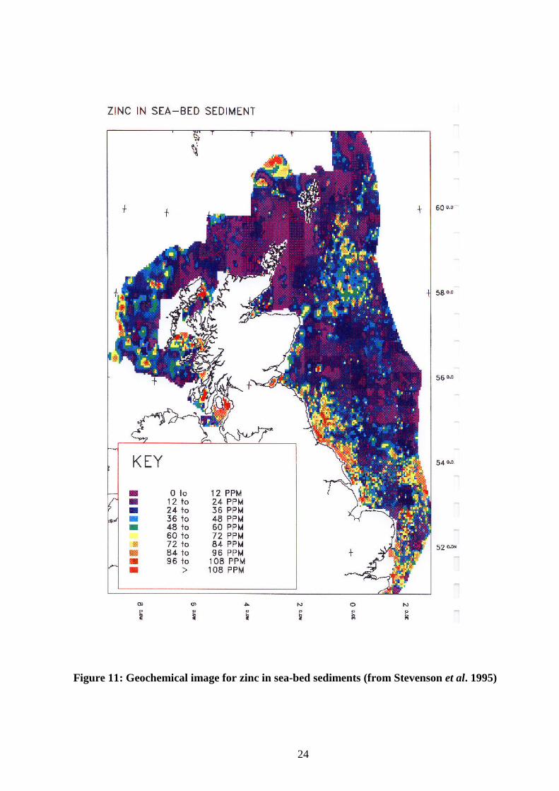
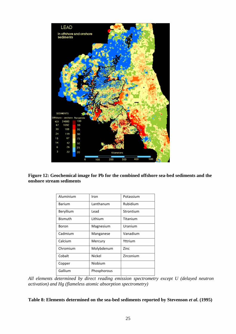
Collaboration surveys between Marine Geology and Analytical Chemistry groups continued until completion of the regional offshore survey in 1986 (see FIGURE 10). During the period 1968-1986 approximately 30,000 sea-bed samples were collected from the UK Continental Shelf. About 9,000 of these samples were analysed for 38 geochemical elements, 31 of which are reported by Stevenson et al. (1995) (see Table 8). In this report a description of the distribution of each element is given along with a histogram, summary descriptive statistics and percentile classified gridded image (FIGURE 11). As a test for combining different datasets within a GIS Neil Breward and Graham Wiggans experimented in combining on- and offshore sediment data and produced gridded images for Cu, Pb and Zn. These combined images have been used in posters and publicity material.
The offshore geochemical database consists of two Oracle tables, BGS.GEOCHEMICAL_DATA and BGS.GEOCHEMICAL_CORRECTED_DATA, but there is no documentation to accompany these tables. The data tables are currently under the custodianship of the Marine Geological Mapping team through data manager Paul Henni. The BGS corporate Coastal and Marine Database (CMD)10
The charging policy for the marine sediment geochemical data is not published externally but can be found by BGS staff on the GeoScience Twiki site
is designed to be populated with geochemical data but has yet to be populated with the sea-bed sediment data and this is not considered to be a high priority task for this database.
11
10
. Data are supplied either as an ESRI
http://kwxvcs.ad.bgs.ac.uk/twiki/bin/view/BGS/CoastalandMarineDatabase 11 http://kwxvcs/twiki/bin/view/BGS/GeochemicalDataCharging
22
interpolated grid for each chemical element (£250 ex. VAT) or as a data file for plotting point data (£500 for each element, ex. VAT). Text information about the data is available in Stevenson (2001).
Figure 9: Distribution of mercury in sediments on the sea-bed of the North Sea (from IGS Annual Report, 1979) (length of symbol arm is proportional to the Hg concentration though scale and units not given in original diagram)
23
Figure 10: Figure showing the chronology of the sea-bed sediment sampling (after Stevenson et al. 1995)
24
Figure 11: Geochemical image for zinc in sea-bed sediments (from Stevenson et al. 1995)
25
Figure 12: Geochemical image for Pb for the combined offshore sea-bed sediments and the onshore stream sediments
Aluminium Iron Potassium
Barium Lanthanum Rubidium
Beryllium Lead Strontium
Bismuth Lithium Titanium
Boron Magnesium Uranium
Cadmium Manganese Vanadium
Calcium Mercury Yttrium
Chromium Molybdenum Zinc
Cobalt Nickel Zirconium
Copper Niobium
Gallium Phosphorous
All elements determined by direct reading emission spectrometry except U (delayed neutron activation) and Hg (flameless atomic absorption spectrometry)
Table 8: Elements determined on the sea-bed sediments reported by Stevenson et al. (1995)
26
2.6 ESTUARINE GEOCHEMISTRY Systematic studies of estuarine contamination have been undertaken since 1999, originally under the Coastal Geoscience Programmes and currently under Marine Geoscience. The main areas studied are the Mersey Estuary (Ridgway et al., In press; Vane et al., 2007b), the Tawe Estuary in South Wales (no published reference) and ongoing work on the Clyde Estuary (Jones et al., 2004; Vane et al., 2007a). Earlier projects have studied aspects of the geochemistry of individual estuaries or estuaries in particular geographic areas e.g. the Tees and Humber estuaries, studied as part of the NERC-funded Land-Ocean Interaction Project (Plater et al., 1998; Rees et al., 1998a), several Irish Sea estuaries examined for a Department of the Environment, Transport and the Regions (DETR)-funded project on distinguishing natural and anthropogenic inputs to the Irish Sea (Ridgway et al., 2001; Ridgway et al., 2003) and a more general study of the effects of different processes on contaminants (with the emphasis on radio-nuclides) in the Irish Sea for the Department for Environment, Food and Rural Affairs (DEFRA) (Jones et al., 2002; Jones et al., 2007).
Funding for the systematic surveys has been on a co-funding basis, with a mix of science budget (SB) and commissioned research (CR) inputs, including contributions from the Environment Agency for England and Wales (EA), Associate and British Ports (ABP), Glasgow City Council and SEPA. Other specific projects have been NERC research topics or CR as outlined above.
The estuarine geochemical work involves the assessment of the contamination of the sediments by both inorganic and organic substances. An important part is the distinguishing between the natural background and anthropogenic components. The geochemical results are placed in the context of the longer term evolution of the estuary, provided by geophysical studies (e.g. single or multibeam bathymetry, sidescan sonar and shallow seismic reflection) and sampling. Surface sediment and core samples are collected by a variety of methods. Intertidal sediments have normally been collected at low tide from hovercraft or on foot, the surface material by trowel, deeper sediments by hand coring or the use of vibrocorers or a Marlow corer. Subtidal sampling is achieved by the use of grab samplers from survey vessels, including Van Veen, Shipek and Day grabs to obtain surface sediments, and different corers (e.g. gravity, Mackereth and Craib) to sample to greater depth. A cruise report is typically prepared after each survey.
A brief general description of the samples is made in the field at all sites and sample site photographs taken at intertidal sites. A recent development (2007-8) has been geochemical screening of the cores. The first stage of this is the gamma logging of the intact core in its plastic liner. This provides an initial assessment of the distribution of natural radioactivity (K, U and Th) down the core and of the anthropogenic 137Cs, which is useful for indicating the part of the core subject to relatively recent contamination; 137Cs was introduced into the environment by man in significant quantities only from the 1950s as a product of nuclear power, weapons testing and accidents such as Chernobyl. After this screening the cores are sliced in half longitudinally, a descriptive log made and photographs taken (sometimes including X-ray images). The second stage of screening involves the use of portable XRF on the cut core surface. The results from this analysis, and the earlier gamma logging, are used to select cores for further study.
Surface sediment samples and depth slices from the cores are then freeze dried, sieved to remove the >2 μm fraction and further prepared as necessary for analysis. An inorganic suite of elements, very similar to that used for G-BASE, is measured by XRFS. In addition Hg and a range of organic substances are also analysed (TOC, TPH, PAH, PCB).
Sequential extractions are made on a small selection of samples, followed by determination of a range of inorganic analytes. The particle size of the sediments is obtained by sieving and Sedigraph analysis and the mineralogy and petrology by XRD (whole sediment and <2 μm fraction) and microscopy (optical and SEM). These studies help to understand the phases with
27
which different elements are associated in the sediments, their availability and the diagenetic and other processes operating.
The data are provided as MS Excel files from the analysts and then as tables in MS Access. As full a range as possible of the data can be viewed within the project GIS along with other information for the estuary. Basic information on the geophysics and samples are held in the BGS Marine Database and can be viewed using the Marine and Coastal GIS or using GeoIndex. There has been ongoing discussion about incorporating the analytical data into the Marine database or the Geochemistry Database, and this remains an aspiration. Currently estuarine geochemical data is neither “owned” by onshore or offshore corporate geochemistry databases and because of this there is a danger that it will get neglected.
Quality control is maintained by the analysis of monitor samples (from the Mersey Estuary) with each batch. There have rarely been any issues of data levelling because the data for each estuary have been generated over a relatively short time span using the same methods.
There is no formal pricing policy for licencing of offshore data, although it is likely that data would be released on a similar basis as that applying to G-BASE and other datasets. Data has been provided as part of co-funding arrangements, for example to Glasgow City Council and SEPA in return for their providing direct and indirect (ship time) funding for the work. At present information about estuarine geochemical data is dealt with on a personal level through enquiries directed either to Dave Jones or Bob Lister at BGS Keyworth.
2.7 ENVIRONMENTAL GEOCHEMISTRY BGS work on environmental geochemistry and health goes back to the early days of the G-BASE project and peer-reviewed publications demonstrate this fact (e.g. Plant and Moore, 1979). Ad hoc projects were carried out investigating contaminated land by the Geochemistry Group before the BGS matrix came into operation in 2000 (e.g. Appleton et al. (1991), and Breward and Cheney (1995)). BGS has also carried out major research projects internationally in the field of mining contamination and studies of trace element deficiencies and toxicities and their impact on human health (see Section 2.11.3).
This section essentially reports on the environmental geochemistry data generated by the abandoned mine and contaminated land team and the medical geology team. After the BGS reorganisation in 2000 this was initially work done under the Chemical and Biological Hazard (CBH) Programme, later renamed the “Environment & Health” Theme, matching the new NERC theme “Environment, Pollution and Human Health” from the “Next Generation Science for Planet Earth” Strategy 2007-2012. The Environment & Health theme area of BGS ceased to exist after April 2009 and this work was dispersed across many teams throughout BGS. The emphasis on geochemical data acquisition is in order to understand the fate and transport of inorganic and organic pollutants in the terrestrial environment and their impact on human health. The data type, mostly geo-referenced but not always, tends to be site-specific and often focussed to explaining water-rock interaction processes.
Under this general remit, a number of projects have produced geochemical data in specific areas which are described in the following paragraphs. The geochemical raw and processed data are scattered throughout various BGS Reports, peer reviewed papers and PhD thesis which are listed in the Chemical and Biological Hazards (CBH) EndNote database. However, as this programme and its successor (Environment & Health Theme) no longer exist there is currently no obvious location for this EndNote library on the SAN.
2.7.1 Geochemical data for the Abandoned Mine and Contaminated Land Team This Team’s projects have involved targeted areas, known for their mining related contamination, and, therefore, the acquired geochemical data are site-specific.
28
SW England.The geochemical survey at Devon Great Consols Mine comprises total chemical analysis of soil, mine waste and surface water samples (Klinck et al. 2005; Palumbo-Roe et al. 2007; Palumbo-Roe and Klinck 2007). This dataset has been loaded to the Geochemistry Database. Geochemical data have also been obtained from chemical sequential extractions of selected samples, aimed at the characterisation of the elemental distribution in different mineralogical phases.
Central Wales
Batch and column leaching experiments have been carried out on composite samples representing the mine tailings material and provide geochemical data on the leaching properties of the material (Palumbo-Roe et al. 2009).
.A reconnaissance survey over the abandoned mines of the central Wales orefield consists of soil, water and mine waste sample collection and chemical analysis (Palumbo and Klinck 2002). Site specific investigation of two abandoned mines, Grogwynion and Frongoch mines, has been carried out with chemical analysis of soil, waste, surface water and pore water samples. Geochemical data have also been obtained from chemical sequential extractions of selected samples, aimed at the characterisation of the elemental distribution in different mineralogical phases.
This dataset will be entered into the Geochemistry Database, once the research project is completed.
Northern Pennines
2.7.2 Geochemical data for the Medical Geology Team
.A reconnaissance survey on the impact of mining and ore smelting in the Rookhope area in Weardale consists of vegetation, soil, mine waste and freshwater sample collection and chemical analysis. This dataset has been loaded to the Geochemistry Database. Three synoptic water samplings (June 2007 - January 2008) and river flow measurement of the Rookhope catchment have produced a dataset of water chemistry and element loads for the Rookhope Burn.
One of the aims of the Team is to investigate the exposure of different receptors (i.e. humans and groundwaters) to potentially harmful elements (PHE) in soils. This work is centred on the mobility of key inorganic elements such as arsenic, chromium, cadmium, nickel and lead and organic compounds polycyclic aromatic hydrocarbons (PAHs) and polychlorinated biphenyls (PCBs) which are priority contaminants of concern. A number of methods are employed to determine contaminant mobility, with the choice of methodology being dependant on the receptor under investigation. One such methodology employed, for assessing human exposure to soil contaminants via the oral ingestion routes, is in vitro bioaccessibility testing. The term bioaccessibility is used to describe the fraction of the total elemental concentration that is soluble in the human stomach and gut and as a result is available for systemic uptake. An in vitro test, the physiologically based extraction test (PBET) has been used in BGS to simulate the leaching of a solid matrix in the human stomach and gastrointestinal tract (Oomen et al. 2004). In addition to assessing the mobility of contaminants from point sources, the medical geology team also use the available methodologies to assess this form of contaminant mobility on a spatial scale. To date, the spatial coverage of bioaccessibility data focussed on areas where either the natural background soil concentration or mining-impacted soil concentration of PHEs is above the recommended soil guidelines values. Research in this area includes investigation of arsenic bioaccessibility in soils developed over Jurassic ironstones in eastern England (Palumbo-Roe et al., 2005; Wragg, 2005), in mineralised soils in SW England (Klinck et al., 2005) and lead mobility (bioaccessibility) investigations in lead mining areas in central Wales (Palumbo and Klinck, 2002; Wragg and Klinck, 2007).
Other geochemical data are integrated with the bioaccessibility data to study the relationship between natural geological factors and health in man and animals, and the influence of ordinary environmental factors on the geographical distribution of such health problems. In particular, the Chemometric Identification of Substrates and Element Distribution (CISED) test, a simple and
29
quick multi-elemental sequential extraction methodology is used to identify the chemical forms of potentially harmful elements that are present in contaminated soils (Cave et al., 2004; Palumbo-Roe et al., 2005; Palumbo-Roe et al., 2007; Wragg et al., 2007).
The Medical Geology Team has domestic and international links with other research groups investigating the area of soil PHE mobility, in particular bioaccessibility. An aim of the Team is to strengthen these links by collaborative research projects with UK Universities and Local Authorities, whereby resources and skills can be pooled in order to achieve a common goal. Ongoing research opportunities include the application of a structured informatic approach to hazard/risk assessment of PHEs in UK soils where existing G-BASE data (soil, stream sediments and water) and the collection of additional geochemical data is used predict and model the bioaccessibility of PHE’s in UK soils. The international links made whilst serving as Secretary and Chair of the Bioaccessibility Research Group of Europe (BARGE) are strengthened through international research projects investigating the measurement of the solid phase distribution and bioaccessibility of PHEs in old Dutch Town soils in collaboration with RIVM and TNO in the Netherlands. Similarly, the measurement of the solid phase distribution of PHEs, in this case As and Sb, features in a collaboration with INERIS, France. The outcomes of both collaborations will influence local policy decisions on contaminant mobility and ultimately the risk assessment process in the respective countries.
2.8 RADIOMETRIC DATA Radiometric data for the UK have been acquired over many years, for both onshore and offshore areas. This extends back at least to the search for uranium at the end of the Second World War and continued into the Mineral Reconnaissance Programme (e.g. Bowie et al., 1971; Haslam et al., 1990). Many new measurements were obtained in conjunction with the mapping of indoor radon and for SB and CR projects in environmental radioactivity (e.g. Appleton and Ball, 1995, 2002; Ball et al., 1992; Miles and Appleton, 2005).
Resource exploration (primarily for uranium) involved both field measurements and the laboratory analysis of samples. Field techniques included radon in soil gas and gamma-ray methods, initially as total count (or exposure/dose) and later providing K, U and Th data by gamma spectrometry. Many of the instruments used were developed for the programme in collaboration with Harwell. This was also true of the original seabed gamma spectrometer (Eel) systems, developed from the 1970s onwards (Jones, 2001), which produced data on continuous traverses of the sea floor. Similar traverses were made with car-borne and airborne gamma systems, in addition to point measurements on the ground. For the early regional geochemical surveys (predecessors to G-BASE) measurements of gamma ray exposure (in μR h-1) were made at each site, although the data were never entered into a digital database and results can be found on the original field cards stored in NGDC (aisle 128).
Radon in soil gas methods were used to produce radon potential maps of several areas of the UK with European and UK government funding (e.g. Department of Environment), the driver being the hazard to health posed by indoor radon. Extensive datasets of soil gas radon and in situ gamma spectrometry were produced during these studies for parts of Derbyshire, Somerset, Devon, Cornwall, Northamptonshire and elsewhere. These types of studies were continued under the Natural Environmental Radioactivity Survey project, which compiled and collected new data for map sheets of Liverpool Bay, Lake District and East Midlands, and its successor the Environmental Radioactivity Project, and has been ongoing, on a smaller scale, up to the present. Enquiries about Radiometric data are currently directed to Dave Jones.
30
2.8.1 Onshore Data from the earliest uranium exploration work is not readily accessible, except when tabulated in old reports of the Atomic Energy Division or Radiogeology and Rare Minerals Unit (RRMU)/Radioactivity and Metalliferous Minerals Unit (RMMU) or included in published papers (e.g. Bowie et al., 1966, 1979; Bowie and Plant, 1983; Miller and Taylor, 1966; Miller, 1967; Miller and Ball, 1968; Plant et al., 1983). Mineral Reconnaissance Programme data is generally included in the Geochemistry Database although some may only be available within MRP reports (listed in Haslam et al., 1990).
The later radon and gamma spectrometer data (e.g. Appleton and Ball, 1995; Emery et al., 2003, 2005) are generally held in digital form as MS Excel or Access files, but compilation into a single database was never achieved. The raw radon in soil gas data are converted into activity concentrations (Bg L-1 = kBq m-3) by calibration of the instrument and individual counting cells using a known radon concentration from the FRED (Fast Radon Exposure Device) facility at the Health Protection Agency. The field gamma spectrometer data are converted to concentrations of K, eU and eTh using calibrations based on concrete pads of known concentration. The eU and eTh are equivalent U and Th, because the measurements are of the decay products of these radioelements and equilibrium in the decay chain is assumed. Data have also been generated for the anthropogenic radionuclide 137Cs in certain areas, particularly from surveys around the Irish Sea coasts, where this fission product was discharged in the past from the Sellafield reprocessing plant.
More recent borehole logging suites include the Spectral Gamma Ray (Gamma spectrometer) tool, rather than just providing the gamma (i.e. total gamma tool) and the Geochemical Logging Tool (GLT). Thus for certain boreholes information on K, U and Th content is available and, from the GLT, Al, Si, Ca, Fe, Ti, Gd, H and Cl. Information on BGS holdings can be obtained by BGS staff through the IDA (BGS Intranet Data Access Application).
Airborne gamma spectrometer data exist for parts of the UK – much of this data was gathered as part of the HiRES project and these areas can be found in the geophysics layer of the GeoIndex12
2.8.2 Offshore
. These are directly analogous to the ground-based measurements except for being an averaged reading over a larger area. As they are often acquired with other airborne geophysical data (e.g. magnetic and electromagnetic) these results are dealt with in BGS as part of geophysical datasets and are therefore not discussed further here.
The BGS towed seabed gamma spectrometer (Eel) was developed originally in the 1970s with Harwell with later versions being produced through continued collaboration with Harwell, KVI Groningen and the German company Antares (Jones, 2001; Miller and Symons, 1973; Miller et al., 1977). Surveys were carried out on the UK continental shelf between 1971 and 1991, covering different areas, including regional surveys of the Irish Sea and North Sea with wide line spacing (10 km or greater) and more detailed local surveys (line spacing typically 1-5 km) covering specific areas or long individual lines or groups of lines such as the corridors along pipeline and cable routes.
The early data were typically collected over 1 minute intervals and were often averaged over 10 minutes when converted into radioelement concentrations (K, U and Th as well as total gamma count rates). This conversion was made by reference to counts on calibration pads with known radioelement contents or buried point sources of known strength. When present (particularly in the Irish Sea), the concentrations of anthropogenic radionuclides, such as 137Cs, were also calculated.
12 http://www.bgs.ac.uk/GeoIndex/index.htm
31
The older data (up to ca1980) are usually tied to Decca Navigator System positions, so that positional errors could be as great as several hundred metres. The post-1980 results were more usually located using more accurate methods such as Trisponder, Motorola Miniranger or GPS, with errors typically of a few metres. Other geophysical techniques were often run in conjunction with the Eel, such as echo sounder, shallow seismic (sparker, boomer, pinger) and sidescan sonar. Samples of seabed sediments and bedrock were also normally taken for calibration and interpretational purposes, most frequently by Shipek grab, cone dredge and gravity corer, although other techniques were used on certain surveys. The samples were commonly analysed for radionuclides and often particle size analysis and inorganic geochemistry was undertaken.
In general the locations of the Eel and geophysical survey lines were incorporated into the BGS Offshore database along with the basic sample descriptions, but some survey information may not be recorded in that way. There has not been a systematic check that all information was provided from every cruise and it is probable that basic data for some surveys is missing. The geophysical results exist only as analogue records, held in the National Geoscience Data Centre (NGDC) although for many surveys the depth at fix points was included in digital files and, in a few cases, was tidally corrected. The Eel data was all held digitally at some point. However, the early survey data was recorded on punched tape or punch cards. The ultimate computer files may not have been transferred in all cases from one BGS computer system to the next (e.g. across old mainframe system such as the GEC and VAX to PCs). It is possible that some data exist only as computer printout or may have been lost. The more recent data exists as digital files, usually as text files or spreadsheets.
The UK Eel cruises are summarised in an Excel spreadsheet held by David Jones This was compiled in 2003 and contains incomplete information on the data collected on each survey. This task was not finished because of insufficient time being available. At a similar time a lot of sorting of paper records was undertaken as part of the archiving of coastal data by Tony Crosby. He incorporated a lot of basic plots and maps from the Eel surveys into the NGDC and summarised what he did in Word documents. In addition to UK surveys, Eel work was carried out overseas with surveys in Belgium, the Netherlands, Philippines, S. Korea and the USA.
2.9 ISOTOPIC GEOCHEMISTRY Although the status of the NERC Isotopic Geoscience Laboratory (NIGL) has meant that in the past it has generally not been considered part of BGS it does nevertheless generate geochemical data at the BGS Keyworth site and it is necessary to know what data is held by NIGL when we receive external enquiries.
NIGL13
Ian Millar currently has data management responsibilities in NIGL which is structured around the four sections of NIGL:
employ a wide range of isotopic methods to a variety of applications including solid earth geoscience, geochronology, pollution, hydrology, climate change, archaeology and forensic/medical studies. There is no single database of isotope data and the isotope geochemists would explain that the raw data itself is of little value out of context.
i. U/Th/Pb dating [Stephen Noble] ii. Tracers (Sr/Nd/Pb/Hf etc.) [Matthew Horstwood]
iii. Stable Isotopes (CHOS – carbon-hydrogen-oxygen-silicon isotope facility) [Melanie Leng]
iv. Stable isotopes (CAL – combustion and laser analysis facility) [Tim Heaton]
13 http://www.bgs.ac.uk/nigl/index.htm
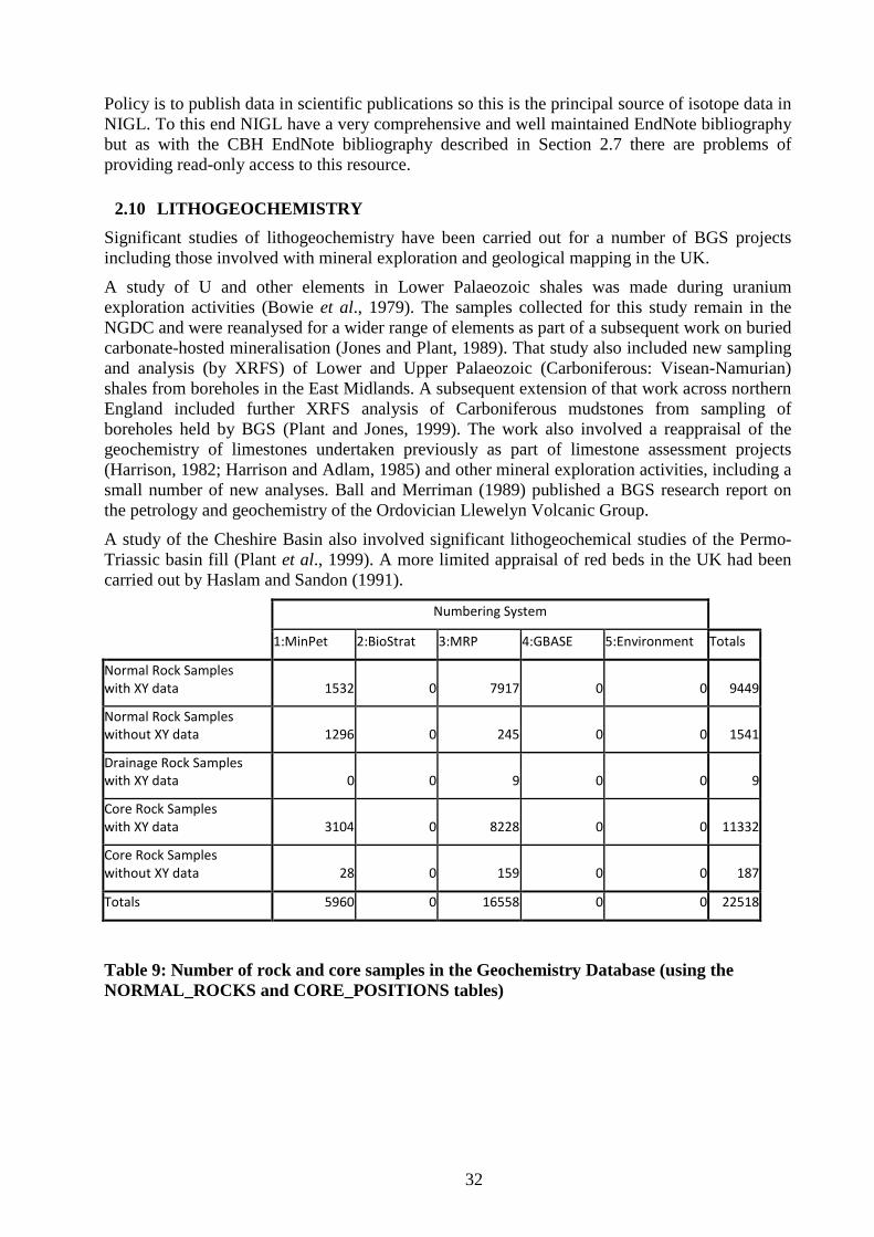
32
Policy is to publish data in scientific publications so this is the principal source of isotope data in NIGL. To this end NIGL have a very comprehensive and well maintained EndNote bibliography but as with the CBH EndNote bibliography described in Section 2.7 there are problems of providing read-only access to this resource.
2.10 LITHOGEOCHEMISTRY Significant studies of lithogeochemistry have been carried out for a number of BGS projects including those involved with mineral exploration and geological mapping in the UK.
A study of U and other elements in Lower Palaeozoic shales was made during uranium exploration activities (Bowie et al., 1979). The samples collected for this study remain in the NGDC and were reanalysed for a wider range of elements as part of a subsequent work on buried carbonate-hosted mineralisation (Jones and Plant, 1989). That study also included new sampling and analysis (by XRFS) of Lower and Upper Palaeozoic (Carboniferous: Visean-Namurian) shales from boreholes in the East Midlands. A subsequent extension of that work across northern England included further XRFS analysis of Carboniferous mudstones from sampling of boreholes held by BGS (Plant and Jones, 1999). The work also involved a reappraisal of the geochemistry of limestones undertaken previously as part of limestone assessment projects (Harrison, 1982; Harrison and Adlam, 1985) and other mineral exploration activities, including a small number of new analyses. Ball and Merriman (1989) published a BGS research report on the petrology and geochemistry of the Ordovician Llewelyn Volcanic Group.
A study of the Cheshire Basin also involved significant lithogeochemical studies of the Permo-Triassic basin fill (Plant et al., 1999). A more limited appraisal of red beds in the UK had been carried out by Haslam and Sandon (1991).
Numbering System
1:MinPet 2:BioStrat 3:MRP 4:GBASE 5:Environment Totals
Normal Rock Samples with XY data 1532 0 7917 0 0 9449
Normal Rock Samples without XY data 1296 0 245 0 0 1541
Drainage Rock Samples with XY data 0 0 9 0 0 9
Core Rock Samples with XY data 3104 0 8228 0 0 11332
Core Rock Samples without XY data 28 0 159 0 0 187
Totals 5960 0 16558 0 0 22518
Table 9: Number of rock and core samples in the Geochemistry Database (using the NORMAL_ROCKS and CORE_POSITIONS tables)
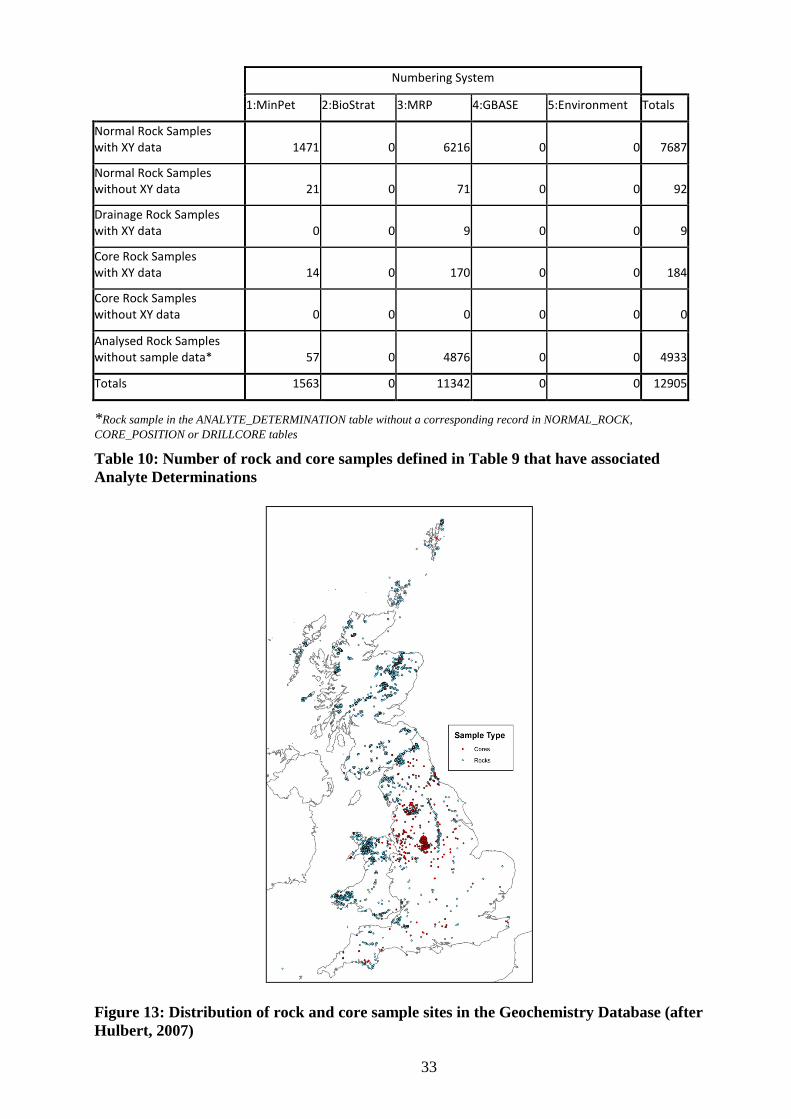
33
Numbering System
1:MinPet 2:BioStrat 3:MRP 4:GBASE 5:Environment Totals
Normal Rock Samples with XY data 1471 0 6216 0 0 7687
Normal Rock Samples without XY data 21 0 71 0 0 92
Drainage Rock Samples with XY data 0 0 9 0 0 9
Core Rock Samples with XY data 14 0 170 0 0 184
Core Rock Samples without XY data 0 0 0 0 0 0
Analysed Rock Samples without sample data* 57 0 4876 0 0 4933
Totals 1563 0 11342 0 0 12905
*Rock sample in the ANALYTE_DETERMINATION table without a corresponding record in NORMAL_ROCK, CORE_POSITION or DRILLCORE tables Table 10: Number of rock and core samples defined in Table 9 that have associated Analyte Determinations
Figure 13: Distribution of rock and core sample sites in the Geochemistry Database (after Hulbert, 2007)
34
The availability of lithogeochemical data in the BGS Geochemistry Database was investigated by Hulbert (2007) (Table 9 and Table 10 are from this report, as is Figure 13). The databasing of lithogeochemical data was the responsibility of the Geochemistry Division Database Group pre-2000. It is part of the “corporate memory loss” (notably when Robert Jones, Stan Coats and Henry Haslam retired) that the history and whereabouts of the stand alone lithogeochemistry database (UK-IGBA) is not clearly known. This is thought to have become the responsibility of someone in Leicester University. The fate of this lithogeochemistry database to which BGS contributed needs to be investigated. IGBA (IGneous dataBAse) and the national geochemical data bank are described by Le Bas et al. (1983).
Lithogeochemistry was also a part of BGS mapping projects and reference should be made to relevant reports. For example the work carried out by Derek Cooper and Brett Beddoe-Stephens for the multidisciplinary Lake District project (e.g. Allen and Cooper, 1986; Allen et al., 1987 ; Beddoe-Stephens, 1991, 1997; Beddoe-Stephens et al., 1995; Cooper et al., 1988, 2004).
2.11 INTERNATIONAL GEOCHEMISTRY
2.11.1 Geochemical Mapping and Mineral Exploration A good summary of international exploration and baseline mapping work (1965 -1993) is presented by Jones and Coats (1993). A draft report focusing on BGS international minerals related data holdings has also been prepared by Pitfield (2001). Much of the early BGS international work was done as technical assistance projects supported by the British Overseas Development Administration (ODA). However, overseas geochemical work since 1994 has either been as commissioned projects sponsored by organisations such as the World Bank or national governments or ODA TDR/DFID KAR (Knowledge and Research) projects.
National geochemical mapping commissioned by national governments (e.g. Ecuador, Morocco, Mauritania, Madagascar, Nigeria and Zambia) have generated large geochemical data sets that belong to the respective national governments and should be available from the national geological surveys either in map or digital form. Some of these have been described in peer-reviewed publications e.g. Williams et al. (2000) (Ecuador) and Key et al. (2004) (Zambia). International geochemical research projects have also been published in peer reviewed publications such as Ball et al. (1990) and Ridgway et al. (1991). Non-confidential maps and reports on this geochemical work should be available from the BGS library and in some instances, e.g. Morocco, CD-ROMs of project data and reports are still retained in BGS (e.g. Direction de la Géologie, 2001). Although BGS had no involvement in the sample collection for the Hong Kong geochemical atlas, BGS was commissioned to prepare the geochemical images and interpret the data (Johnson and Breward, 1997).
Hardcopy files relating to pre-1994 international geochemistry projects are stored in Aisle 128 of NGDC, and these often include analytical results and sample information. Many of the national geochemical mapping surveys produced geochemical atlases and reports that are available in the BGS library and these are an important source of geochemical information (e.g. Uganda – Reedman, 1973; North Sumatra – Stephenson et al., 1982; Solomon Islands – Ridgeway, 1983; Eastern Bolivia – Appleton and Llanos, 1985; Southern Sumatra – Muchsin et al., 1997). Some geochemical samples from these projects (e.g. split of the stream sediments from Bolivia) are stored in NGDC.
A large amount of geochemical data for rock samples was generated by the SE Asia tin granites project (Cobbing et al., 1992). This Overseas Development Administration (ODA)-funded project between 1981-88 provided data on 11 major oxides plus loss-on-ignition and 28 trace elements for 171 samples from Peninsular Malaysia, 83 samples from the Indonesian tin islands, 225 samples from Thailand and 150 samples from Burma (Myanmar). The collection of granites from Burma was made by Bob Beckinsale during a technical cooperation project in 1977.
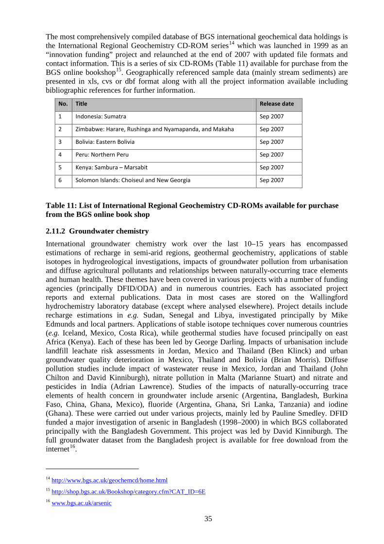
35
The most comprehensively compiled database of BGS international geochemical data holdings is the International Regional Geochemistry CD-ROM series14
Table 11
which was launched in 1999 as an “innovation funding” project and relaunched at the end of 2007 with updated file formats and contact information. This is a series of six CD-ROMs ( ) available for purchase from the BGS online bookshop15
No.
. Geographically referenced sample data (mainly stream sediments) are presented in xls, cvs or dbf format along with all the project information available including bibliographic references for further information.
Title Release date
1 Indonesia: Sumatra Sep 2007
2 Zimbabwe: Harare, Rushinga and Nyamapanda, and Makaha Sep 2007
3 Bolivia: Eastern Bolivia Sep 2007
4 Peru: Northern Peru Sep 2007
5 Kenya: Sambura – Marsabit Sep 2007
6 Solomon Islands: Choiseul and New Georgia Sep 2007
Table 11: List of International Regional Geochemistry CD-ROMs available for purchase from the BGS online book shop
2.11.2 Groundwater chemistry International groundwater chemistry work over the last 10–15 years has encompassed estimations of recharge in semi-arid regions, geothermal geochemistry, applications of stable isotopes in hydrogeological investigations, impacts of groundwater pollution from urbanisation and diffuse agricultural pollutants and relationships between naturally-occurring trace elements and human health. These themes have been covered in various projects with a number of funding agencies (principally DFID/ODA) and in numerous countries. Each has associated project reports and external publications. Data in most cases are stored on the Wallingford hydrochemistry laboratory database (except where analysed elsewhere). Project details include recharge estimations in e.g. Sudan, Senegal and Libya, investigated principally by Mike Edmunds and local partners. Applications of stable isotope techniques cover numerous countries (e.g. Iceland, Mexico, Costa Rica), while geothermal studies have focused principally on east Africa (Kenya). Each of these has been led by George Darling. Impacts of urbanisation include landfill leachate risk assessments in Jordan, Mexico and Thailand (Ben Klinck) and urban groundwater quality deterioration in Mexico, Thailand and Bolivia (Brian Morris). Diffuse pollution studies include impact of wastewater reuse in Mexico, Jordan and Thailand (John Chilton and David Kinniburgh), nitrate pollution in Malta (Marianne Stuart) and nitrate and pesticides in India (Adrian Lawrence). Studies of the impacts of naturally-occurring trace elements of health concern in groundwater include arsenic (Argentina, Bangladesh, Burkina Faso, China, Ghana, Mexico), fluoride (Argentina, Ghana, Sri Lanka, Tanzania) and iodine (Ghana). These were carried out under various projects, mainly led by Pauline Smedley. DFID funded a major investigation of arsenic in Bangladesh (1998–2000) in which BGS collaborated principally with the Bangladesh Government. This project was led by David Kinniburgh. The full groundwater dataset from the Bangladesh project is available for free download from the internet16
14
.
http://www.bgs.ac.uk/geochemcd/home.html 15 http://shop.bgs.ac.uk/Bookshop/category.cfm?CAT_ID=6E 16 www.bgs.ac.uk/arsenic
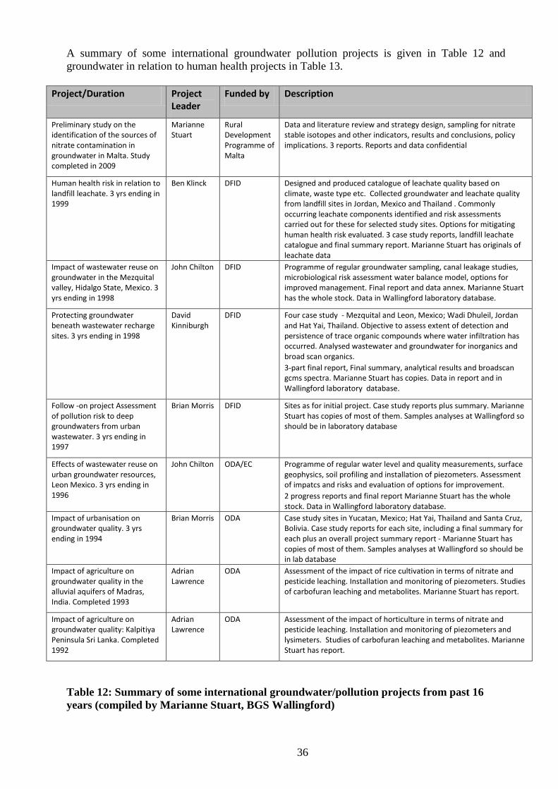
36
A summary of some international groundwater pollution projects is given in Table 12 and groundwater in relation to human health projects in Table 13.
Project/Duration Project Leader
Funded by Description
Preliminary study on the identification of the sources of nitrate contamination in groundwater in Malta. Study completed in 2009
Marianne Stuart
Rural Development Programme of Malta
Data and literature review and strategy design, sampling for nitrate stable isotopes and other indicators, results and conclusions, policy implications. 3 reports. Reports and data confidential
Human health risk in relation to landfill leachate. 3 yrs ending in 1999
Ben Klinck DFID Designed and produced catalogue of leachate quality based on climate, waste type etc. Collected groundwater and leachate quality from landfill sites in Jordan, Mexico and Thailand . Commonly occurring leachate components identified and risk assessments carried out for these for selected study sites. Options for mitigating human health risk evaluated. 3 case study reports, landfill leachate catalogue and final summary report. Marianne Stuart has originals of leachate data
Impact of wastewater reuse on groundwater in the Mezquital valley, Hidalgo State, Mexico. 3 yrs ending in 1998
John Chilton DFID Programme of regular groundwater sampling, canal leakage studies, microbiological risk assessment water balance model, options for improved management. Final report and data annex. Marianne Stuart has the whole stock. Data in Wallingford laboratory database.
Protecting groundwater beneath wastewater recharge sites. 3 yrs ending in 1998
David Kinniburgh
DFID Four case study - Mezquital and Leon, Mexico; Wadi Dhuleil, Jordan and Hat Yai, Thailand. Objective to assess extent of detection and persistence of trace organic compounds where water infiltration has occurred. Analysed wastewater and groundwater for inorganics and broad scan organics. 3-part final report, Final summary, analytical results and broadscan gcms spectra. Marianne Stuart has copies. Data in report and in Wallingford laboratory database.
Follow -on project Assessment of pollution risk to deep groundwaters from urban wastewater. 3 yrs ending in 1997
Brian Morris DFID Sites as for initial project. Case study reports plus summary. Marianne Stuart has copies of most of them. Samples analyses at Wallingford so should be in laboratory database
Effects of wastewater reuse on urban groundwater resources, Leon Mexico. 3 yrs ending in 1996
John Chilton ODA/EC Programme of regular water level and quality measurements, surface geophysics, soil profiling and installation of piezometers. Assessment of impatcs and risks and evaluation of options for improvement. 2 progress reports and final report Marianne Stuart has the whole stock. Data in Wallingford laboratory database.
Impact of urbanisation on groundwater quality. 3 yrs ending in 1994
Brian Morris ODA Case study sites in Yucatan, Mexico; Hat Yai, Thailand and Santa Cruz, Bolivia. Case study reports for each site, including a final summary for each plus an overall project summary report - Marianne Stuart has copies of most of them. Samples analyses at Wallingford so should be in lab database
Impact of agriculture on groundwater quality in the alluvial aquifers of Madras, India. Completed 1993
Adrian Lawrence
ODA Assessment of the impact of rice cultivation in terms of nitrate and pesticide leaching. Installation and monitoring of piezometers. Studies of carbofuran leaching and metabolites. Marianne Stuart has report.
Impact of agriculture on groundwater quality: Kalpitiya Peninsula Sri Lanka. Completed 1992
Adrian Lawrence
ODA Assessment of the impact of horticulture in terms of nitrate and pesticide leaching. Installation and monitoring of piezometers and lysimeters. Studies of carbofuran leaching and metabolites. Marianne Stuart has report.
Table 12: Summary of some international groundwater/pollution projects from past 16 years (compiled by Marianne Stuart, BGS Wallingford)
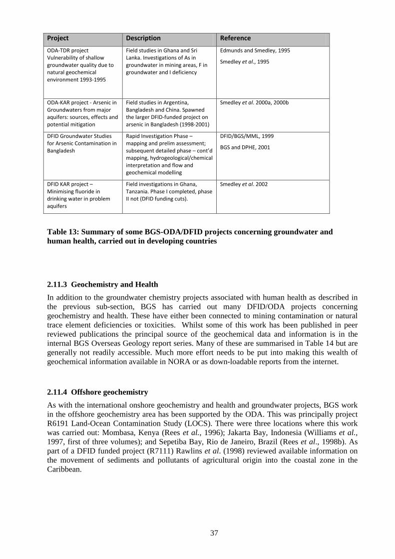
37
Project Description Reference
ODA-TDR project Vulnerability of shallow groundwater quality due to natural geochemical environment 1993-1995
Field studies in Ghana and Sri Lanka. Investigations of As in groundwater in mining areas, F in groundwater and I deficiency
Edmunds and Smedley, 1995
Smedley et al., 1995
ODA-KAR project - Arsenic in Groundwaters from major aquifers: sources, effects and potential mitigation
Field studies in Argentina, Bangladesh and China. Spawned the larger DFID-funded project on arsenic in Bangladesh (1998-2001)
Smedley et al. 2000a, 2000b
DFID Groundwater Studies for Arsenic Contamination in Bangladesh
Rapid Investigation Phase – mapping and prelim assessment; subsequent detailed phase – cont’d mapping, hydrogeological/chemical interpretation and flow and geochemical modelling
DFID/BGS/MML, 1999
BGS and DPHE, 2001
DFID KAR project – Minimising fluoride in drinking water in problem aquifers
Field investigations in Ghana, Tanzania. Phase I completed, phase II not (DFID funding cuts).
Smedley et al. 2002
Table 13: Summary of some BGS-ODA/DFID projects concerning groundwater and human health, carried out in developing countries
2.11.3 Geochemistry and Health In addition to the groundwater chemistry projects associated with human health as described in the previous sub-section, BGS has carried out many DFID/ODA projects concerning geochemistry and health. These have either been connected to mining contamination or natural trace element deficiencies or toxicities. Whilst some of this work has been published in peer reviewed publications the principal source of the geochemical data and information is in the internal BGS Overseas Geology report series. Many of these are summarised in Table 14 but are generally not readily accessible. Much more effort needs to be put into making this wealth of geochemical information available in NORA or as down-loadable reports from the internet.
2.11.4 Offshore geochemistry As with the international onshore geochemistry and health and groundwater projects, BGS work in the offshore geochemistry area has been supported by the ODA. This was principally project R6191 Land-Ocean Contamination Study (LOCS). There were three locations where this work was carried out: Mombasa, Kenya (Rees et al., 1996); Jakarta Bay, Indonesia (Williams et al., 1997, first of three volumes); and Sepetiba Bay, Rio de Janeiro, Brazil (Rees et al., 1998b). As part of a DFID funded project (R7111) Rawlins et al. (1998) reviewed available information on the movement of sediments and pollutants of agricultural origin into the coastal zone in the Caribbean.
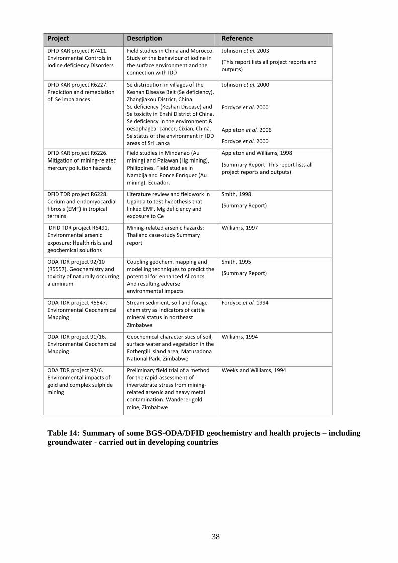
38
Project Description Reference
DFID KAR project R7411. Environmental Controls in Iodine deficiency Disorders
Field studies in China and Morocco. Study of the behaviour of iodine in the surface environment and the connection with IDD
Johnson et al. 2003
(This report lists all project reports and outputs)
DFID KAR project R6227. Prediction and remediation of Se imbalances
Se distribution in villages of the Keshan Disease Belt (Se deficiency), Zhangjiakou District, China. Se deficiency (Keshan Disease) and Se toxicity in Enshi District of China. Se deficiency in the environment & oesophageal cancer, Cixian, China. Se status of the environment in IDD areas of Sri Lanka
Johnson et al. 2000
Fordyce et al. 2000
Appleton et al. 2006
Fordyce et al. 2000
DFID KAR project R6226. Mitigation of mining-related mercury pollution hazards
Field studies in Mindanao (Au mining) and Palawan (Hg mining), Philippines. Field studies in Nambija and Ponce Enríquez (Au mining), Ecuador.
Appleton and Williams, 1998
(Summary Report -This report lists all project reports and outputs)
DFID TDR project R6228. Cerium and endomyocardial fibrosis (EMF) in tropical terrains
Literature review and fieldwork in Uganda to test hypothesis that linked EMF, Mg deficiency and exposure to Ce
Smith, 1998
(Summary Report)
DFID TDR project R6491. Environmental arsenic exposure: Health risks and geochemical solutions
Mining-related arsenic hazards: Thailand case-study Summary report
Williams, 1997
ODA TDR project 92/10 (R5557). Geochemistry and toxicity of naturally occurring aluminium
Coupling geochem. mapping and modelling techniques to predict the potential for enhanced Al concs. And resulting adverse environmental impacts
Smith, 1995
(Summary Report)
ODA TDR project R5547. Environmental Geochemical Mapping
Stream sediment, soil and forage chemistry as indicators of cattle mineral status in northeast Zimbabwe
Fordyce et al. 1994
ODA TDR project 91/16. Environmental Geochemical Mapping
Geochemical characteristics of soil, surface water and vegetation in the Fothergill Island area, Matusadona National Park, Zimbabwe
Williams, 1994
ODA TDR project 92/6. Environmental impacts of gold and complex sulphide mining
Preliminary field trial of a method for the rapid assessment of invertebrate stress from mining-related arsenic and heavy metal contamination: Wanderer gold mine, Zimbabwe
Weeks and Williams, 1994
Table 14: Summary of some BGS-ODA/DFID geochemistry and health projects – including groundwater - carried out in developing countries
39
2.12 ORGANIC GEOCHEMISTRY
2.12.1 Overview Organic Geochemistry within BGS is led by Chris Vane and provides a scientific understanding of natural organic matter and anthropogenic organic compounds in soils, sediments and waters. The objectives of are four fold:
1. Provide data and interpretations that underpin NERC Strategy 2007-2012 “Next Generation Science for Planet Earth”;
2. Provide data and interpretations in support of BGS projects and themes; 3. Conduct commercial analyses to generate income; 4. Research and development for 1-3.
The science ranges from simple bulk measurements to complex series of molecular analyses designed to meet the needs of research projects. Organic geochemistry is now widely considered one of the most scientifically active areas within the BGS analytical chemistry facilities as evidenced by the quality and quantity of peer reviewed publications, BGS reports and a growing national/international reputation. Furthermore, organic geochemistry supplies both data and associated interpretations to nine of the twelve BGS science themes.
The organic geochemistry at BGS can be broadly divided into the four areas (with loss-on-ignition being determined as part of the general chemistry function of the laboratory):
1. Baseline Pollution Studies and Environmental Forensics Quantification of persistent organic pollutants (POPs) in soils, sediments and waters including total non-volatile hydrocarbons (saturate/aromatic and NSO compound classes) by TLC-FID (Iatroscan), Total Petroleum Hydrocarbons (TPH) by GC-FID, 15 of the 16 US EPA “priority pollutant” polycyclic aromatic hydrocarbons (PAH) by HPLC with fluorescence detection, Polychlorinated Biphenyls (PCB) reported as individual ICES 7 PCB and the sum of: tri, tetra, hepta, hexa and hepta homologues as well as the sum of PCB congeners by GC/MS. Values can be normalised to Total Organic Carbon (TOC) to enable direct sample comparison. Additional expertise in the analysis of volatile organic compounds such as BTEX and TCE by headspace GC/MS, pesticides such as mecoprop, atrazine and diuron, organo-metallic species such as tributyl-tins (TBT) and xenoestrogens. The laboratory is also capable of quantification of explosives formulations HMX, RDX and TNT in sediments by HPLC and quantification of sewage sterols to track sewage/faecal matter in the environment by GC/MS.
2. Terrestrial and Marine Palaeoenvironmental Analysis Application of analytical Pyrolysis combined with Gas Chromatography-Mass-Spectrometry (Py-GC/MS), Chemolysis-GC/MS and Infrared Spectroscopy (FTIR), to characterise structural polymers and macromolecules such as polysaccharides, lignin, suberin and tannin as well geomacromolecules such as kerogens and coal in order to reconstruct palaeoenvironment, determine biotic and abiotic alteration and understand biochemical evolution. The O&GC section is also competent in the quantification of Black Carbon (BC) in soils and sediments by chemothermo/oxidation method and in the isolation of dissolved organic carbon (DOC) in groundwaters by Tangential Flow Ultrafiltration (TFU).
3. Climate Change Estimation of palaeotemperature and palaeoclimate using biomarkers “fossil biological molecules”. Sedimentary organic matter that is soluble in organic solvent is removed by accelerated solvent extraction (ASE) fractionated by column chromatography and analysed by GC/MS operated in either full scan or selected ion monitoring mode. The range of
40
biomarkers analysed for includes n-alkanes, n-alkanols, carboxylic acids, sterols (palaeoecology and atmospheric transport), highly branched isoprenoids (palaeosalinity) as well as alkenones for the UK37 and UK37 sea-surface temperature proxy.
4. Hydrocarbon Exploration and Reservoir Studies Oil-source rock correlations, oil-oil correlations and reservoir studies using TOC and Iatrosan screening for saturate, aromatic and polar (NSO) fractions, quantification of saturate fraction using GC-FID evaluation of n-alkane envelop, CPI, pristine/n-C17 ratio, Pr+Ph / n-alkanes to indicate maturation, migration, biodegradation. A more detailed picture of oil chemistry is obtained by analysing the saturate fraction by GC/MS in SIM mode for specific biomarkers such as steranes, triterpanes and a variety of other compound classes.
2.12.2 Data Storage The geochemical data generated by the organic geochemists at BGS takes many forms: quantitative, semi-quantitative and qualitative data. The worked up data is held by the relevant projects and some raw data where appropriate also stored in the UKAS central filing system in BGS (room U113). Due to the nature of organic geochemistry, data is not generally sold to internal or external clients in raw form, indeed many of the raw outputs (mass spectra and chromatograms are only compatible with specific forms of software). Moreover, the organic analysts supply interpretations of the data as part of projects which are published in reports and where appropriate academic journals/book chapters.
2.12.3 Sources of Organic Geochemical Information The primary source of information concerning organic geochemistry in BGS is in the form of reports and publications. A comprehensive selection of these is given in Appendix 3.
41
3 Sources of Geochemical Data in BGS Past and present projects generating a broad range of geochemical data are described in the preceding section. The principal sources of this geochemical data, classified by the main theme areas described in Section 2, are summarised in Table 15. It is immediately apparent from this table that there are numerous different geochemical data sources in BGS. With the exception of the BGS GeoIndex, references to internet links are surprisingly absent in Table 15. Although the different science areas of BGS have informative internet pages with links to geochemical content (e.g. G-BASE17
Principal databases are the Geochemistry Database administered in Keyworth (mainly for UK drainage samples, soils and rocks) and the Hydrogeochemistry Database (MS ACCESS) at Wallingford. The Marine Geology Database whilst designed to receive geochemical data has not yet been populated. Many areas of geochemical data (e.g. estuarine geochemical results) are represented by ad hoc databases (e.g. as Excel spreadsheets) administered by individuals and remnants from now defunct projects. The position is further confused by the fact that the BGS corporate Geochemistry Database is actually only populated with data from a few specific projects in BGS. For someone looking for geochemical data it would be reasonable to assume that the BGS corporate Geochemistry Database would be the definitive starting point but it is clearly not. Furthermore, because of the nature of geochemical data, which is always tied to a number of quality and usage issues, it is very difficult for non-specialist geochemists to access digital data directly. Requests for geochemical data (internal and external) usually have to be dealt with by one or two trained individuals who have a good understanding of all the caveats concerning the data usage. Whilst the introduction of “Query Layers” for searching the Oracle Geochemistry Database removes the complexity of linking numerous data tables, it still fails as a satisfactory system for delivering geochemical data to those who wish to use it.
), the different threads of geochemistry are not joined up and searching for BGS geochemistry content on the internet site is a frustrating challenge. The BGS web site needs a high level link that points directly to a page that covers all the areas of geochemistry discussed in this report.
Much of BGS geochemical data is published in reports and external publications. EndNote bibliographies are therefore a valuable first stage into finding geochemical data but there is no corporate system that allows access to and the sharing of these important bibliographies. When programmes and theme areas in BGS have disappeared, the bibliographies have disappeared with them.
BGS can be seen as having several warehouses for geochemical data. Generally that data is well collated and organised and much legacy data is available for future generations of scientists to use. However, only specialist users have the key to accessing the data. More effort needs to be put into delivering the geochemical data from the disparate BGS sources in a format that potential users can access and download more easily. The Information Products team have to some extent started this process. For example, by taking various different data sets (using different sample media) a complete “predictive” arsenic map for England and Wales has been created (Appleton et al., 2008). A module using soil geochemical data has been prepared for Landmark as an option for the “Home Owners Pack” that highlights the risk of contaminated land.
The creation of a series of International Regional Geochemistry CD-ROMs (see Table 11) was an excellent example of providing data in a format that was readily useable by external customers. The innovation project that created the CD-ROMs received c.£5k and CD sales to mineral exploration companies exceeded £30k within 3 years. The CD-ROMs are now sold 17 http://www.bgs.ac.uk/gbase/home.html
42
directly through the BGS online bookshop and does not require a specialist geochemist to be involved in delivering the data to the user.
Information Products are primarily concerned with generating income for BGS. However, geochemical data is fundamental to underpinning much of the science that is done in BGS so the delivery of geochemical data for science users must also be of great importance. The BGS intranet (for internal data users) and internet (for external data users) is key to delivering the data in a format that is easily useable. Hydrogeochemistry is well documented through the Groundwater Portal18
New databases and derived products (e.g. gridded geochemical images for use in GIS) need to be delivered over the web. Users should not be concerned with the complexities of which database the data is derived from or what project generated it. The products should come with clear information regarding the quality of the data and limitations on its use.
on the BGS intranet (under data and information), particularly with regards to information and access to publications. Easy access to BGS geochemistry reports and publications is essential to enable the wide range of our geochemical work to be disseminated and particularly important for those areas which rely on publications for the distribution of geochemical data (e.g. NIGL and organic geochemistry). The NERC Open Research Archive (NORA) is growing to be a useful resource for the world to access BGS geochemistry reports (e.g. the urban geochemistry reports for UK cities). However, more effort has to be made to declassify reports and get them loaded into NORA.
The flow chart of Figure 14 attempts to classify the different sources of geochemical data into three main groups; UK Onshore; UK Offshore; and International geochemical data. The data is further subdivided into the theme areas to match with those identified in Section 2 and Table 15. The subdivision for the flow chart is based on key questions an enquirer may have concerning the geochemical data required. The BGS science area responsible for the data is also identified. Whilst the chart is a simplification of many different geochemical data sources where there is overlap between themes, it should inform enquirers as to what geochemical data BGS holds and where to go to get the data or further information.
Someone seeking geochemical data, information or samples from BGS (that have been generated or commissioned by the BGS) should firstly know the geographical site or area for which data is sought. At the highest level this may be a country or region of the world, or at a more detailed level the geographical coordinates (e.g. Eastings and Northings for the UK land area). If the geochemical data has not been gathered by remote sensing (as in the case of radiometric data) then the enquiry should relate to a specific sample media type or the nature of the investigation that generated it. With this information to hand an enquiry about geochemical data should then follow the flow paths shown in Figure 14.
A further source of information concerning BGS geochemical data holdings is the discovery metadata accessible from the BGS internet site19
. A search using the keyword “geochemistry” will return metadata for some 35 datasets. This is a useful starting point to find some geochemical information but not all areas of BGS geochemistry are represented by the available metadata, titles for the metadata sets are not systematic or particularly informative and minor small projects are given equal status to major programmes.
18 http://intranet/groundwater_portal/default.shtml 19 http://www.bgs.ac.uk/discoverymetadata/index.html
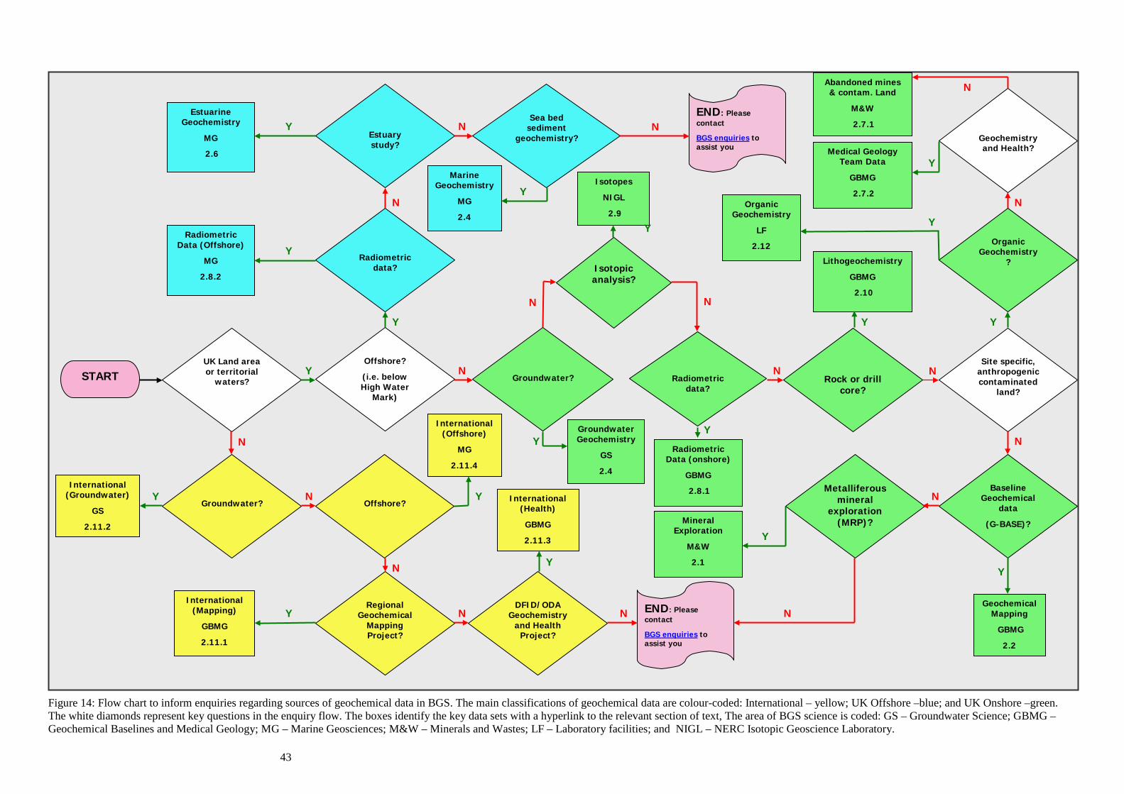
43
Figure 14: Flow chart to inform enquiries regarding sources of geochemical data in BGS. The main classifications of geochemical data are colour-coded: International – yellow; UK Offshore –blue; and UK Onshore –green. The white diamonds represent key questions in the enquiry flow. The boxes identify the key data sets with a hyperlink to the relevant section of text, The area of BGS science is coded: GS – Groundwater Science; GBMG – Geochemical Baselines and Medical Geology; MG – Marine Geosciences; M&W – Minerals and Wastes; LF – Laboratory facilities; and NIGL – NERC Isotopic Geoscience Laboratory.
END: Please contact
BGS enquiries to assist you
END: Please contact
BGS enquiries to assist you
UK Land area or territorial
waters?
Groundwater?
International (Groundwater)
GS
2.11.2
Regional Geochemical
Mapping Project?
Estuary study?
Radiometric data?
Offshore?
(i.e. below High Water
Mark)
Groundwater?
Radiometric data?
Rock or drill core?
Site specific, anthropogeniccontaminated
land?
Offshore?
Sea bed sediment
geochemistry?
Isotopic analysis?
DFID/ODA Geochemistry
and Health Project?
Metalliferous mineral
exploration (MRP)?
Baseline Geochemical
data
(G-BASE)?
Radiometric Data (Offshore)
MG
2.8.2
Estuarine Geochemistry
MG
2.6
Marine Geochemistry
MG
2.4
Mineral Exploration
M&W
2.1
Geochemical Mapping
GBMG
2.2
Geochemistry and Health?
Abandoned mines & contam. Land
M&W
2.7.1
Medical Geology Team Data
GBMG
2.7.2 Organic
Geochemistry
LF
2.12 Organic Geochemistry
? Lithogeochemistry
GBMG
2.10
Radiometric Data (onshore)
GBMG
2.8.1
Isotopes
NIGL
2.9
Groundwater Geochemistry
GS
2.4
Y
Y
Y
Y
Y
Y
Y
Y
Y Y
Y
Y
Y
Y
Y
Y
Y
N
N
N
N
N
N
N
N
N N
N N
N
N
N
N
N
N
Y
START
International (Mapping)
GBMG
2.11.1
International (Offshore)
MG
2.11.4
International (Health)
GBMG
2.11.3

44
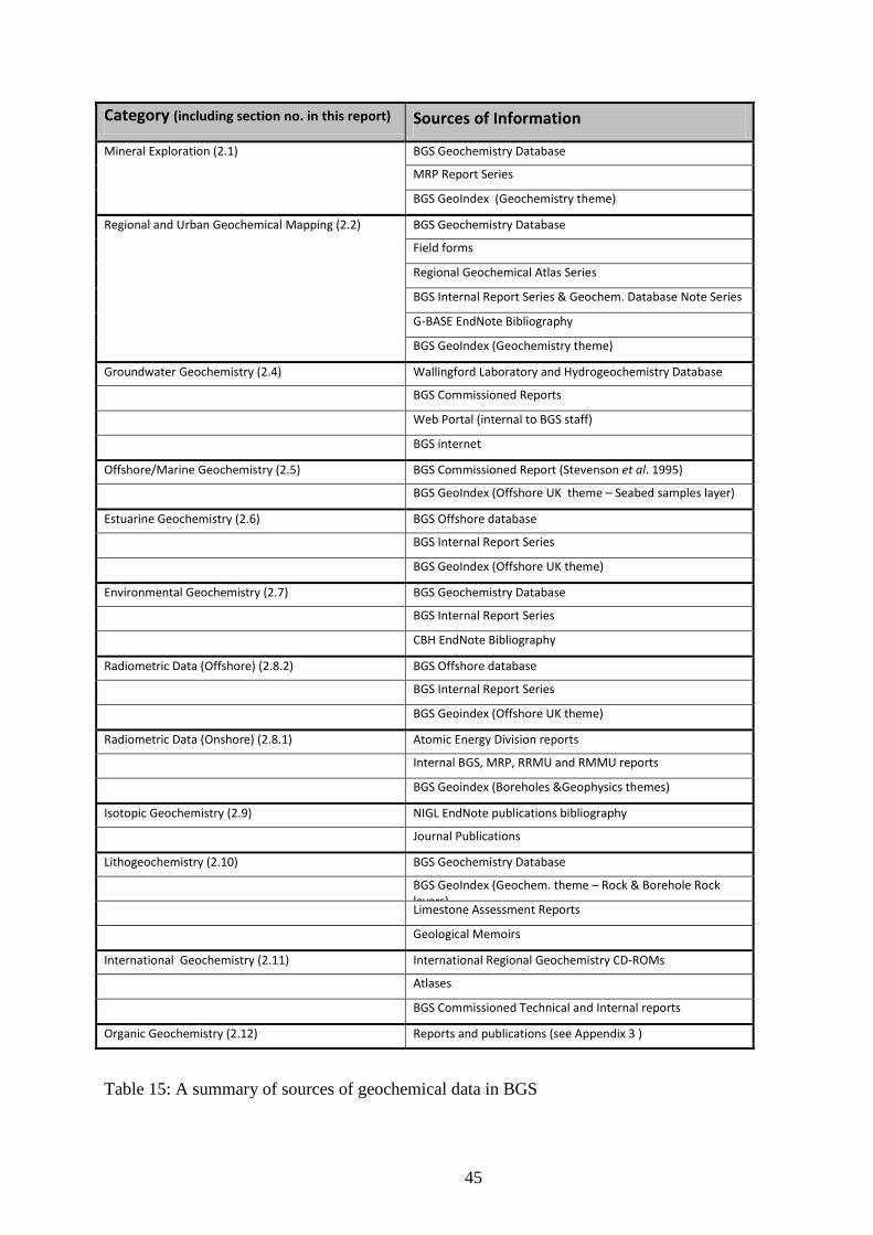
45
Table 15: A summary of sources of geochemical data in BGS
Category (including section no. in this report) Sources of Information
Mineral Exploration (2.1) BGS Geochemistry Database
MRP Report Series
BGS GeoIndex (Geochemistry theme)
Regional and Urban Geochemical Mapping (2.2) BGS Geochemistry Database
Field forms
Regional Geochemical Atlas Series
BGS Internal Report Series & Geochem. Database Note Series
G-BASE EndNote Bibliography
BGS GeoIndex (Geochemistry theme)
Groundwater Geochemistry (2.4) Wallingford Laboratory and Hydrogeochemistry Database
BGS Commissioned Reports
Web Portal (internal to BGS staff)
BGS internet
Offshore/Marine Geochemistry (2.5) BGS Commissioned Report (Stevenson et al. 1995)
BGS GeoIndex (Offshore UK theme – Seabed samples layer)
Estuarine Geochemistry (2.6) BGS Offshore database
BGS Internal Report Series
BGS GeoIndex (Offshore UK theme)
Environmental Geochemistry (2.7) BGS Geochemistry Database
BGS Internal Report Series
CBH EndNote Bibliography
Radiometric Data (Offshore) (2.8.2) BGS Offshore database
BGS Internal Report Series
BGS Geoindex (Offshore UK theme)
Radiometric Data (Onshore) (2.8.1) Atomic Energy Division reports
Internal BGS, MRP, RRMU and RMMU reports
BGS Geoindex (Boreholes &Geophysics themes)
Isotopic Geochemistry (2.9) NIGL EndNote publications bibliography
Journal Publications
Lithogeochemistry (2.10) BGS Geochemistry Database
BGS GeoIndex (Geochem. theme – Rock & Borehole Rock layers)
Limestone Assessment Reports
Geological Memoirs
International Geochemistry (2.11) International Regional Geochemistry CD-ROMs
Atlases
BGS Commissioned Technical and Internal reports
Organic Geochemistry (2.12) Reports and publications (see Appendix 3 )
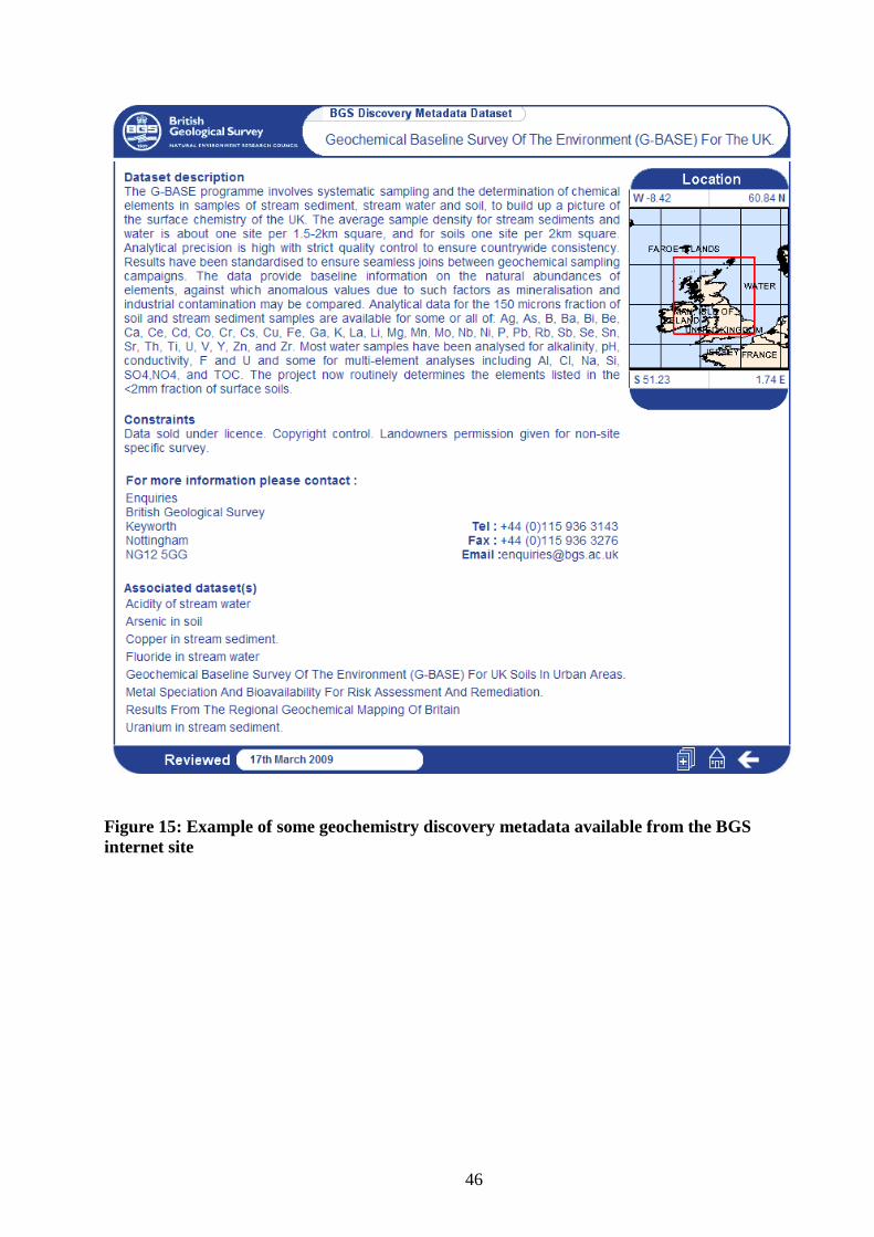
46
Figure 15: Example of some geochemistry discovery metadata available from the BGS internet site
47
Recommendations for making BGS geochemical data more accessible to users The following recommendations are made to increase the accessibility of BGS geochemical data and information for both internal and external users so as to better contribute to the delivery of the BGS strategy;
1. Project Data Management plans need to be managed and enforced to ensure projects generating geochemical data conform to corporate standards for the storage of samples and data. This should be a function of the Geochemistry Data Management Project but will only be successful if projects are provided with clear guidance and policies as to what they should do with the data that is generated.
2. With the exception of the GeoIndex, links on the BGS internet about geochemical data and information are dispersed and hard to find. There is an absence of any high level entry point providing links to the existing geochemical resources. The removal of the word “geochemistry” from all parts of the organisational structure leaves users without any reference point to start from. A search on “Geochemistry” gives a long list of unjoined-up links that is an unhelpful overview of geochemistry at BGS. It is suggested that links to all the geochemical theme areas in this report are focused from within one specific science area of BGS.
3. It is misleading to have something called the corporate BGS Geochemistry Database that only receives a small part of BGS’s geochemical data. External (and indeed internal users) are misled into believing this is BGS’s only source of geochemical data. Whilst it would be good to have all BGS geochemical data in one place this would be impractical (see below). It is suggested that the term “corporate BGS Geochemical Database” be qualified to reflect its true content, e.g. corporate BGS Geochemical Database for the UK land surface.
4. Ideally all BGS geochemical data should be accessed via linked Oracle databases. However, this would require the investment of a lot of resources to replace and revamp adequate databases that already exist in different areas across BGS. The more pragmatic approach is to focus on delivery of data to the users. This will mean the creation of derived geochemical products delivered via the internet. An example of this would be a set of ArcGIS geochemical images for UK baseline geochemical data downloadable from the BGS web site.
5. The licensing of land surface geochemical data for the UK has been operating satisfactorily for many years. There needs to be a consistent pricing policy for all geochemical data, particularly with regard to the provision of geochemical data for external academic research.
6. Some particular areas that have generated geochemical data need support to capture legacy data and information before it is lost. Currently much of the data from estuarine, radiometric and raw G-BASE geochemical data is dependent upon the custodianship of individuals rather than corporate systems. The capture of these data sets to corporate systems needs to be addressed in the information management delivery plan.
7. Currently estuary geochemical data is neither “owned” by the Marine Geology or Environmental Geoscience Baselines themes and as a consequence, data from estuarine projects is in danger of becoming neglected. This report defines offshore as being below the high water mark and consequently estuary data is considered as being “offshore”.
48
8. Information regarding the igneous rock geochemical database (UK-IGBA) no longer resides within BGS. Retired staff should be contacted so the status and whereabouts of this database can be re-established.
9. This report has demonstrated that in many areas of geochemical data generation it is publications and reports that play an important part in information dissemination. This is particularly the case for isotopic, organic and international research projects. The hydrogeology portal gives excellent access to downloadable pdfs of many hydrogeochemistry reports but this is restricted to BGS intranet users only. Bibliographic lists like those provided in the hydrogeology portal should be made available from the BGS internet site with associated links to free downloadable reports. There is a great wealth of geochemical information and data in inaccessible, non-digital internal and technical BGS reports, particularly for international research projects. These should be scanned and made available over the intranet.
10. EndNote bibliographies provide useful and comprehensive lists of reports that detail geochemical information and data. A corporate approach to the use and sharing of EndNote bibliographies is required. Valuable EndNote libraries are lost when programmes/Science theme areas are reorganised.
11. The confidential classification on many BGS technical and internal geochemical reports needs to be reviewed and wherever possible removed. Many of the geochemical theme areas are already making good use of the NERC Online Research Archive (NORA) but more geochemical reports should be added.
12. Team Leaders associated with the various geochemical theme areas should be providing more “geochemical data awareness” lectures within BGS and externally (for example to university departments). There is also scope for the provision of a training course to educate non-specialist geochemists in the use and interpretation of geochemical data.
49
References British Geological Survey holds most of the references listed below, and copies may be obtained via the library service subject to copyright legislation (contact [email protected] for details). The library catalogue is available at: http://geolib.bgs.ac.uk
ALLEN, P M and COOPER, D C. 1986 The stratigraphy and composition of the Latterbarrow and Redmain sandstones, Lake District, England. Geological Journal, Vol. 21, 59-76.
.
ALLEN, P M, COOPER, D C and FORTEY, N J. 1987 Composite lava flows of Ordovician age in the English Lake District. Journal of the Geological Society of London, Vol. 144, 945-960.
ANDER E L, SHAND P and WOOD S. 2006. Baseline Report Series: 21. The Chalk and Crag of north Norfolk and the Waveney Catchment. British Geological Survey Commissioned Report CR/06/043N.
APPLETON, J D and BALL, T K. 1995. Radon and background radioactivity from natural sources : characteristics, extent and relevance to planning and development in Great Britain. British Geological Survey Technical Report, WP/95/002, pp. 93.
APPLETON, J D and BALL, T K. 2002. Geological radon potential mapping. 577-613 in Geoenvironmental mapping, methods, theory and practice. P. T. BOBROWSKY (editor). (Lisse: A.A. Balkema.)
APPLETON, J D, and LLANOS, L I. 1985. Atlas geoquimico de Bolivia oriental, 1:1 000 000 British Geological Survey.
APPLETON, J D and WILLIAMS, T M. 1998. Mitigation of mining-related mercury pollution hazards: Project Summary Report. British Geological Survey Technical Report (Overseas Geology Series), WC/98/34.
APPLETON, J D, BREWARD, N, COOPER, D C, FORDYCE, F M, LOVELAND, P J and BIRD, S. 1991. Preliminary review of the relevance of natural heavy metal (potentially toxic element) contamination and trace element deficiencies to planning and development in Great Britain. BGS Technical Report WP/91/10R (Commissioned by the Department of the Environment)
APPLETON, J D, ZHANG, Q, GREEN, K A, ZHAMG, G, GE, X, LIU, X and LI, J X. 2006. Selenium in soil, grain, human hair and drinking water in relation to esophageal cancer in the Cixian area, Hebei Province, People’s Republic of China. Applied Geochemistry, 21, 684-700.
APPLETON, J.D., RAWLINS, B.G. and THORNTON, I. 2008. National-scale estimation of potentially harmful element ambient background concentrations in topsoil using parent material classified soil:stream-sediment relationships. Applied Geochemistry, 23(9), 2596-2611.
AULT, L, MACKENZIE, A C, INGHAM, M N, VICKERS, B P, GRIMSLEY, L D and JOHNSON, C C. 2006. From LIMS to Geochemistry Database: G-BASE Samples Analytical Data. British Geological Survey, BGS Internal Report Number IR/06/075.
BALL, T K and MERRIMAN, R J. 1989. The petrology and geochemistry of the Ordovician Llewelyn Volcanic Group, Snowdonia, North Wales. British Geological Survey Research Report SG/89/1.
BALL, T K, CROW, M J, LAFFOLEY, N, PIPER, D and RIDGWAY, J. 1990 Application of soil gas geochemistry to mineral exploration in Africa. Journal of Geochemical Exploration, 38, 103-115.
BALL, T K, CAMERON, D G and COLMAN, T B. 1992. Aspects of radon potential mapping in Britain. Radiation Protection Dosimetry, Vol. 45, 211-214.
50
BATESON, J H and JOHNSON, C C. 1984. Mineral A regional geochemical soil investigation of the Carboniferous Limestone areas south of Kendal (south Cumbria and north Lancashire). Mineral Reconnaissance Programme. British Geological Survey, MRP Report No. 71.
BATESON, J H, EVANS, A D and JOHNSON, C C. 1983. Mineral Reconnaissance in the Northumberland Trough. Mineral Reconnaissance Programme. Institute of Geological Sciences, MRP Report No. 62.
BEDDOE-STEPHENS, B W. 1991. Geochemical variation through the Lower Borrowdale Volcanic Group, Devoke Water area. British Geological Survey Technical Report, WG/91/019, pp. 30.
BEDDOE-STEPHENS, B W. 1997. Geochemistry of the Borrowdale Volcanic Group in the Keswick district. British Geological Survey Technical Report, Mineralogy & Petrology Series, Short Report, MP/SR/97/010, pp. 32.
BEDDOE-STEPHENS, B W, PETTERSON, M G, MILLWARD, D and MARRINER, G F. 1995. Geochemical variation and magmatic cyclicity within an Ordovician continental-arc volcanic field: the lower Borrowdale Volcanic Group, English Lake District. Journal of Volcanology and Geothermal Research Vol. 65, 81-110.
BOWIE, S H U and PLANT, J A. 1983. Natural radioactivity in the environment. 481-494 in Applied Environmental Geochemistry. I. THORNTON (editor). (London: Academic Press.)
BOWIE, S H U, DAWSON, J, GALLAGHER, M J and OSTLE, D. 1966. Potassium-rich sediments in the Cambrian of Northwest Scotland. Transactions of the Institution of Mining and Metallurgy, Sect.B, Vol. 75, 125-145.
BOWIE, S H U, OSTLE, D and BALL, T K. 1971. Geochemical methods in the detection of hidden uranium deposits. Canadian Institute of Mining and Metallurgy Special Volume, Vol. 11, 103-111.
BOWIE, S H U, OSTLE, D and CAMPBELL, C B. 1973. Uranium mineralization in northern Scotland, Wales, the Midlands and Southwest England. Transactions of the Institution of Mining and Metallurgy, Section B, Vol. 82, 177-179.
BOWIE, S H U, PARKER, A and RAYNOR, E J. 1979. Uranium Reconnaissance Survey of British Lower Palaeozoic shales: trace elements related to clay mineralogy. Transactions of the Institute Mining & Metallurgy (Section B), Vol. 88, B61-64.
BREWARD, N and CHENEY, C. 1995. The geochemistry of the soils and waters of the Mawddach river catchment in the vicinity of the Gwynfynydd Gold Mine, Dolgellau, Wales. BGS Technical Report No. WP/95/17C.
BRITISH GEOLOGICAL SURVEY. 2009. British Geological Survey 2009-2014. Applied goscience for our changing Earth. British Geological Survey, Keyworth, Nottingham. Online at: http://www.bgs.ac.uk/about/strategy2009-2014.html
CAVE, M R, MILODOWSKI, A E and FRIEL, E N (2004). Evaluation of a method for Identification of Host Physico-chemical Phases for Trace Metals and Measurement of their Solid-Phase Partitioning in Soil Samples by Nitric Acid Extraction and Chemometric Mixture Resolution. Geochemistry: Exploration, Environment, Analysis 4, 71-86.
COATS, J S. 2004. The BGS Geochemistry Database: history, design and current usage. British Geological Survey, Internal Report No. IR/04/033.
COBBING, E J, PITFIELD, P E J, DARBYSHIRE, D P F AND MALLICK ,D I J. 1992. The granites of the South-East Asian tin belt. HMSO. 369pp.
COOPER, D C, LEE, M K, FORTEY, N J, COOPER, A H, RUNDLE, C C, WEBB, B C and ALLEN, P M. 1988. The Crummock Water aureole: a zone of metasomatism and source of ore metals in the Lake District. Journal of the Geological Society, Vol. 145, 523-540.
51
COOPER, A H, FORTEY, N J, HUGHES, R A, MOLYNEUX, S G, MOORE, R M, RUSHTON, A W A, STONE, P, ALLEN, P M, COOPER, D C, EVANS, J A, HIRONS, S R and WEBB, B C. 2004. The Skiddaw group of the English Lake District : memoir for parts of sheets 22 Maryport, 23 Cockermouth, 24 Penrith, 28 Whitehaven, 29 Keswick, 30 Appleby, 31 Brough and 48 Ulverston. (Keyworth, Nottingham: Bristish Geological Survey.)
DIRECTION DE LA GÉOLOGIE. 2001. CD-ROM of geochemical results for stream sediments and other digital data for the Lot 2 area (Boumalne et Qalaa't Mgouna). British Geological Survey/Direction de la Géologie, CD-ROM prepared for contract N° 8:97-98/DG.
EDMUNDS, W M, SHAND, P, HART, P and WARD, R S. 2003. The natural (baseline) quality of groundwater: a UK pilot study. The Science of the Total Environment, 310, 25-35.
EMERY, C, JONES, D, DAVIS, J and STRUTT, M. 2003. An investigation of soil gas radon and distribution of uranium over the Upper Greensand Formation, Wiltshire. British Geological Survey Report IR/03/033R.
EMERY, C, HODGKINSON, E, JONES, D, DAVIS, J and STRUTT, M. 2005. Investigation of airborne and ground-based radiometric data with soil gas radon to assess variability of indoor radon potential for the Carboniferous limestone of Derbyshire. British Geological Survey Report IR/05/061.
FORDYCE, F M, MASARA, D, and APPLETON, J D. 1994. Final report on stream sediment, soil and forage chemistry as indicators of cattle mineral status in northeast Zimbabwe. British Geological Survey, Overseas Geology Series, WC/94/3.
FORDYCE, F M, JOHNSON, C C, NAVARATNA, U R B, APPLETON, J D and DISSANAYAKE, C B. 2000. Selenium and iodine in soil, rice and drinking water in relation to endemic goitre in Sri Lanka. The Science of the Total Environment, Vol. 263, 127-141.
FORDYCE, F M, ZHANG, G, GREEN, K and LIU, X. 2000. Soil, grain and water chemistry in relation to human selenium-responsive diseases in Enshi District, China. Applied Geochemistry, Vol. 15, 117-132.
FORDYCE, F M, BREWARD, N and STEVENSON, A G. 2004. A review of BGS Onshore and Offshore geochemical data in relation to contaminant transport investigations. British Geological Survey Report IR/03/174R.
FORDYCE, F M, BROWN, S E, ANDER, E L, RAWLINS, B G, O'DONNELL, K E, LISTER, T R, BREWARD, N and JOHNSON, C C. 2005. GSUE: Urban geochemical mapping in Great Britain. Geochemistry: Exploration-Environment-Analysis 5(4), 325-336.
HARRIS, J R and COATS, J S. 1992. Geochemistry database: data analysis and proposed design. British Geological Survey Technical Report No. WF/92/5 and Mineral Reconnaissance Report No. 125.
HARRISON, D J. 1982. The limestone resources of the Craven lowlands. Institute of Geological Sciences Mineral Assessment Report, 116, pp. 103.
HARRISON, D J and ADLAM, K A M. 1985. Limestones of the Peak: a guide to the limestone and dolomite resources of the Peak District of Derbyshire and Staffordshire. Institute of Geological Sciences Mineral Assessment Report, 144, pp. 40.
HASLAM, H W and SANDON, P T S. 1991. The geochemistry of some red-bed formations in the United Kingdom. British Geological Survey Technical Report No. WP/90/2, pp. 47.
HASLAM, H W, CAMERON, D G and EVANS, A D. 1990. The Mineral Reconnaissance Programme in 1990. A continuing programme of mineral exploration in the United Kingdom carried out by the British Geological Survey on behalf of the Department of Trade & Industry. British Geological Survey Technical Report No.WP/90/6. Mineral Reconnaissance Programme Report No. 114.
52
HOBBS, S F, KIMBELL, S F, COATS, J S and FORTEY, N J. 2000. BGS databases for mineral exploration: status in 2000. British Geological Survey Research Report No.RR/00/011.
HULBERT, A.G.. 2007. An appraisal of rock data in the Geochemistry Database. British Geological Survey, Geochemistry Database Note Series No. 07/01. 11pp.
JOHNSON, C C and BREWARD, N. 1997. The Geochemistry of chemical elements determined in the geochemical survey of Hong Kong. BGS Technical Report No.WP/97/4C
JOHNSON, C C and BREWARD, N. 2004. G-BASE: Geochemical Baseline Survey of the Environment. British Geological Survey Commissioned Report No. CR/04/016N.
JOHNSON, C C, FORDYCE, F M and STEWART, A G. 2003. Environmental Controls in Iodine Deficiency Disorders. Project Summary Report. British Geological Survey, Commissioned Report CR/03/058N.
JOHNSON, C C, COATS, J S, BREWARD, N, ANDER, E L and MACKENZIE, A C. 2004. Geochemical data as a standard reference data set for the SIGMA project. British Geological Survey Internal Report No. IR/04/026N.
JOHNSON, C C, BREWARD, N, ANDER, E L and AULT, L. 2005. G-BASE: Baseline geochemical mapping of Great Britain and Northern Ireland. Geochemistry: Exploration-Environment-Analysis, 5(4), 347-357.
JOHNSON, C C, ANDER, E L, LISTER, T R, and FLIGHT, D M A. 2008. Data conditioning of environmental geochemical data: quality control procedures used in the British Geological Survey's Regional Geochemical Mapping Project. Chapter 5, 93-118 In: Environmental Geochemistry: Site characterisation, data analysis and case histories. de Vivo, B, Belkin, H E, and Lima, A (editors). (Oxford: Elsevier.)
JONES, D G. 2001. Development and application of marine gamma-ray measurements: a review. Journal of Environmental Radioactivity, 53, 313-333.
JONES, R C and COATS, J S. 1993. Sources of Geochemical Data collected by the International Division since 1965. British Geological Survey Technical Report No.WC/93/17.
JONES, D G and PLANT, J A. 1989. Geochemistry of shales. 65-94. in Metallogenic models and exploration criteria for buried carbonate-hosted ore deposits-a multidisciplinary study in eastern England. J. A. PLANT and D. G. JONES (editors). (Keyworth, Nottingham: British Geological Survey; London: The Institution of Mining and Metallurgy.)
JONES, D G, BOUCH, J, BURT, G R, CAMPBELL, N, CAVE, M R, CHESMAN, B S, COOMBS, P, DAVIES, A M, DAVIS, J R, HALL, P, HARDS, V L, HARRISON, I, HIGGO, J J W, HUMPHREYS, B, HYSLOP, E K, JAMES, J W C, JONES, J E, LANGSTON, W J, MCKERVEY, J, METCALFE, R, MILODOWSKI, A E, MOORE, Y, PEARCE, J M, POPE, N D, RIDGWAY, J, ROCHELLE, C, STRUTT, M H, VANE, C H, WALLIS, D, WEST, J M, WRAGG, J and XING, J. 2002. Assessment of the relative importance of biological, physical and chemical processes on the transport and speciation of pollutants, particularly radionuclides, in the Irish Sea. AE1129 Final Report for DEFRA. British Geological Survey Commissioned Report No. CR/02/295.
JONES, D G, LISTER, T R, STRUTT, M H, ENTWISLE, D C, HARRISON, I, KIM, A W, RIDGWAY, J and VANE, C H. 2004. Estuarine Geochemistry: Report for Glasgow City Council. British Geological Survey Commissioned Report No. CR/04/057.
JONES, D G, KERSHAW, P J, MCMAHON, C A, MILODOWSKI, A E, MURRAY, M and HUNT, G J. 2007. Changing patterns of radionuclide distribution in Irish Sea subtidal sediments. Journal of Environmental Radioactivity, 96, 63-74.
KEY, R M, DE WAELE, B and LIYUNGU, A K. (2004). A multi-element baseline geochemical database from the western extension of the Central Africa Copperbelt in northwestern
53
Zambia. Applied Earth Science (Trans. Inst. Min. Metall. B), September 2004, 113, B205-B226.
KLINCK, B A, PALUMBO, B, CAVE, M R, and WRAGG J. (2005). Arsenic dispersal and bioaccessibility in mine contaminated soils: a case study from an abandoned arsenic mine in Devon, UK, pp. 52. British Geological Survey Research Report No. RR/04/03.
KNIGHTS, K V, SCHEIB, A J and WILLIAMS, J D O. 2007. A report on the G-BASE summer field campaign of 2007: Oxfordshire, Bedfordshire, Buckinghamshire and Hertfordshire. British Geological Survey Internal Report No. IR/07/082.
LE BAS, M J, DURHAM, J and PLANT, J A. 1983. IGBA and the national geochemical data bank in the UK: Design and system. Computers and Geosciences, 9(4), 513-521.
LISTER, T R, AND JOHNSON, C C. 2005. G-BASE data conditioning procedures for stream sediment and soil chemical analyses. British Geological Survey Internal Report No. IR/05/150.
LISTER, T R, FLIGHT, D M A, BROWN, S E, JOHNSON, C C and MACKENZIE, A C. 2005. The G-BASE field database. British Geological Survey Internal Report No. IR/05/001.
MACKENZIE, A C and JOHNSON, C C. 2006. Loading analyte results to the Geochemistry Database using the MS ACCESS LOADER application. British Geological Survey Internal Report No. IR/06/097.
MILES, J C H and APPLETON, J D. 2005. Mapping variation in radon potential both between and within geological units. Journal of Radiological Protection, Vol. 25, 257-276.
MILLER, J M. 1967. Interim report on the measurement of radon in soil air as a prospecting technique. Geological Survey of Great Britain Atomic Energy Division Report, 272, pp. 7.
MILLER, J M and BALL, T K. 1968. Second progress report on the measurement of Radon in soil air as a prospecting technique. Institute of Geological Sciences Geochemical Division, Radiogeology and Rare Minerals Unit Report 286
MILLER, J M and SYMONS, J D. 1973. Radiometric Traverse of the Seabed off the Yorkshire Coast. Nature, 242, 184-186.
MILLER, J M and TAYLOR, K. 1966. Uranium mineralization near Dalbeattie, Kirkcudbrightshire. Bulletin of the Geological Survey of Great Britain, Vol. 25, 1-18.
MILLER, J M, ROBERTS, P D, SYMONS, G D, MERRILL, N H and WORMALD, M R. 1977. A towed gamma-ray spectrometer for continental shelf surveys. 465-498 in International Symposium on Nuclear Techniques in Exploration, Extraction and Processing of Mineral Resources. (Vienna: IAEA).
MUCHSIN, M A, JOHNSON, C C, CROW, M J, DJUMSARI, A and SUMARTONO. 1997. Geochemical Atlas of Southern Sumatra. Regional Geochemical Atlas Series of Indonesia No. 2. (Keyworth, Nottingham, UK/Bandung, Indonesia: Directorate of Mineral Resources/British Geological Survey.)
NICHOLSON, R A and MOORE, P J. 1978. NERC Continental Shelf Heavy Metals Programme: Firth of Forth Study. Appendix 1, pages 30-40. In: IGS studies of the geology of the Firth of Forth and its approaches. Thomson, M E (Editor). Institute of Geological Sciences Report No. 77/17.
OOMEN, A G, ROMPELBERG, C J M, VAN DE KAMP, E, PEREBOOM, D P K H , DE ZWART, L L and SIPS, A J A M. (2004). Effect of Bile Type on the Bioaccessibility of Soil Contaminants in an In Vitro Digestion Model. Archives of Environmental Contamination and Toxicology , 46(2), 183-188.
54
PALUMBO, B and KLINCK, BA. 2002. The environmental impact of abandoned lead mining in mid-Wales. British Geological Survey Internal Report No. IR/02/123.
PALUMBO-ROE B and KLINCK, BA. 2007. Bioaccessibility of Arsenic in Mine Waste Contaminated Soils: a Case Study from an Abandoned Arsenic Mine in SW England (UK). J. Environ. Sci. Health, Part A, ‘Special Issue’ (Bioaccessibility of Soil Contaminants) A42, No. 9.
PALUMBO-ROE B, CAVE M R, KLINCK B A, WRAGG J, TAYLOR H, O'DONNELL K E and SHAW, R A. 2005. Bioaccessibility of arsenic in soils developed over Jurassic Ironstones in eastern England. Environmental Geochemistry and Health, 27, 121-130.
PALUMBO-ROE B, KLINCK B A and CAVE M R. 2007. Arsenic speciation and mobility in mine wastes from a copper- arsenic mine in Devon, UK: A SEM, XAS, sequential chemical extraction study. In Elsevier book series, "Trace Metals and Other Contaminants in the Environment"; Series Editor: Jerome O. Nriagu, USA. (ed. Elsevier).
PALUMBO-ROE B, KLINCK B A, BANKS V and QUIGLEY S. 2009. Prediction of the long-term performance of abandoned lead zinc mine tailings in a Welsh catchment. Journal of Geochemical Exploration , 100, 169-181.
PITFIELD, P E J. 2001. Assessment of the size and extent of BGS International minerals-related data holdings and their digital conversion. Scoping study produced as an unpublished Draft Internal report. British Geological Survey, Keyworth. Commissioned by Onshore Minerals and Energy Resources Programme and BGS International.
PLANT, J A and JONES, D G. 1999. Development of regional exploration criteria for buried carbonate-hosted mineral deposits: a multidisciplinary study in northern England. British Geological Survey Technical Report, WP/91/1.
PLANT, J A and MOORE, P J. 1979. Geochemical mapping and interpretation in Britain. Philosophical Transactions of the Royal Society, Vol. B288, 95-112.
PLANT, J A, OSTLE, D and MILLER, J M. 1983. Natural levels of uranium in Britain - economic and environmental significance. Institute of Geological Sciences Report, 83/1, pp. 32-39.
PLANT, J A, JONES, D G and HASLAM, H W (editors). 1999. Basin evolution, fluid movement and mineral resources in a Permo-Triassic rift setting: the Cheshire Basin. (Keyworth, Nottingham: British Geological Survey).
PLATER, A J, RIDGWAY, J, APPLEBY, P G, BERRY, A and WRIGHT, M R. 1998. Historical contaminant fluxes in the Tees estuary, UK: Geochemical, magnetic and radionuclide evidence. Marine Pollution Bulletin, Vol. 37, 343-360.
RAWLINS, B G, FERGUSON, A J, CHILTON, P J, ARTHURTON, R S, REES, J G, BALDOCK, J W, EVANS C D R, and BREWARD, N. 1998. Review of currently available information on pollution of coastal waters by sediments and agrochemicals in the Caribbean region with particular emphasis on small island states. British Geological Survey Technical Report (Overseas Geology Series) WC/98/09.
REEDMAN, A J. 1973. Geochemical atlas of Uganda. Entebbe, Uganda Geological Survey and Mines Department.
REES, J G, WILLIAMS, T M, NGULI, M M, KAIRU, K K and YOBE, A C. 1996. Contamination transport and storage in the estuarine creek system of Mombasa, Kenya. British Geological Survey Technical Report (Overseas Geology Series) WC/96/42.
REES, J G, RIDGWAY, J, KNOX, R, WIGGANS, G and BREWARD, N. 1998a. Sediment-borne contaminants in rivers discharging into the Humber estuary, UK. Marine Pollution Bulletin, Vol. 37, 316-329.
55
REES, J G, BREWARD, N, MADDOCK, J E L, FERGUSON, A J and WILLIAMS, T M. 1998b. Assessment of contamination by metals and selected organic compounds in coastal sediments and waters of Sepetiba Bay, Rio de Janeiro State, Brazil. British Geological Survey Technical Report (Overseas Geology Series) WC/98/30.
RIDGWAY J. 1983 Choiseul and the Shortland Islands: summary of the geology and geochemical exploration results. British. Technical Cooperation, Western Solomons Mapping Project Report No. 19, 51pp.
RIDGWAY, J and SHIMMIELD, G. 2002. Estuaries as Repositories of Historical Contamination and their Impact on Shelf Seas. Estuarine, Coastal and Shelf Science, Vol. 55, 903-928.
RIDGWAY J, GOMEZ CABALLERO A, MACIAS-ROMER C, MARTINY B and VILLASENOR M G. 1991 Ammonium geochemistry of some Mexican silver deposits. Journal of Geochemical Exploration, 40, 311-327.
RIDGWAY, J, LANGSTON, W J, ROWLATT, S M, BREWARD, N, BURT, G R, CAMPBELL, S, CHENERY, S R, CHESMAN, B S, GOWING, C J, INGHAM, M N, LISTER, R, POPE, N D and REES, J G. 2001. Distinguishing between natural and anthropogenic sources of metals entering the Irish Sea. British Geological Survey, Commissioned Research Report, CR/01/15, 180 pp.
RIDGWAY, J, BREWARD, N, LANGSTON, W J, LISTER, R, REES, J G and ROWLATT, S M. 2003. Distinguishing between natural and anthropogenic sources of metals entering the Irish Sea. Applied Geochemistry, Vol. 18, 283-309.
RIDGWAY, J, BEE, E, BREWARD, N, CAVE, M R, CHENERY, S, GOWING, C, HARRISON, I, HODGKINSON, E, HUMPHREYS, B, INGHAM, M, JARROW, A, JENKINS, G, KIM, A, LISTER, T R, MILODOWSKI, A E, PEARSON, S, ROWLANDS, K, SPIRO, B, STRUTT, M H, TURNER, P and VANE, C H. In press. The Mersey Estuary: Sediment Geochemistry. British Geological Survey Research Report.
SHAND, P., EDMUNDS, W.M., LAWRENCE, A.R., SMEDLEY, P.L. AND BURKE, S. 2007. The natural (baseline) quality of groundwater in England and Wales. BGS Report RR/07/06; Environment Agency Report NC/99/74/24.
SMITH, B. 1995. Geochemistry and toxicity of naturally occurring aluminium: A summary report. British Geological Survey Technical Report (Overseas Geology Series) WC/95/23.
SMITH, B. 1998. Cerium and endomyocardial fibrosis in tropical terrain: Project summary report. British Geological Survey Technical Report (Overseas Geology Series) WC/98/26.
SMITH, J D, NICHOLSON, R A and MOORE, P J. 1971. Mercury in water from the tidal Thames. Nature, 232, 5310, 393-394.
SMITH, J D, NICHOLSON, R A and MOORE, P J. 1973. Mercury in sediments from the Thames Estuary. Environmental Pollution, 4, 153-157.
STEPHENSON, B, GHAZALI, S A, AND WIDJAJA, H. 1982. Regional geochemical atlas series of Indonesia : 1. Northern Sumatra 1:1 500 000 Keyworth, Nottingham, Institute of Geological Sciences.
STEVENSON, A G, 2001. Metal concentrations in marine sediments around Scotland: a baseline for environmental studies. Continental Shelf Research, 21, 879-897.
STEVENSON, A G, TAIT, B A R, RICHARDSON, A E, SMITH, R T, NICHOLSON, R A, AND STEWART, H R. 1995. The geochemistry of sea-bed sediments of the United Kingdom Continental Shelf; the North Sea, Hebrides and western Shetland shelves, and the Malin-Hebrides sea area. British Geological Survey, Keyworth, Nottingham, Confidential Report Number WB/95/28C [now declassified].
56
VANE, C H, HARRISON, I and KIM, A W. 2007a. Assessment of polyaromatic hydrocarbons (PAHs) and polychlorinated biphenyls (PCBs) in surface sediments of the Inner Clyde Estuary, UK. Marine Pollution Bulletin, Vol. 54, 1301-1306.
VANE, C H, HARRISON, I and KIM, A W. 2007b. Polycyclic aromatic hydrocarbons (PAHs) and polychlorinated biphenyls (PCBs) in sediments from the Mersey Estuary, U.K. Science of The Total Environment, Vol. 374, 112-126.
WEEKS, J and WILLIAMS, T M. 1994. Preliminary field trial of a method for the rapid assessment of invertebrate stress from mining-related arsenic and heavy metal contamination: Wanderer gold mine, Zimbabwe. British Geological Survey Technical Report (Overseas Geology Series), WC/94/66R
WILLIAMS, T M. 1994. Geochemical characteristics of soil, surface water and vegetation in the Fothergill Island area, Matusadona National Park, Zimbabwe. British Geological Survey Technical Report (Overseas Geology Series), WC/94/68R
WILLIAMS, T M. 1997. Mining-related arsenic hazards: Thailand case-study Summary report. British Geological Survey Technical Report (Overseas Geology Series), WC/97/49
WILLIAMS, T M, REES, J and SETIAPERMANA, D. 1997. Land-derived contaminant influx to Jakarta Bay, Indonesia. Volume 1: Geochemistry of marine water and sediment. British Geological Survey Technical Report (Overseas Geology Series), WC/97/19.
WILLIAMS, T M, DUNKLEY, P N, CRUZ, E, ACTIMBAY, V, GAIBOR, A, LPEZ, E, BAEZ, N, and ASPDEN, J A. 2000. Regional geochemical reconnaissance of the Cordillera Occidental of Ecuador: economic and environmental applications. Applied Geochemistry, Vol. 15, 531-550.
WRAGG J. 2005. A Study of the relationship between arsenic bioaccessibility and its solid phase distribution in Wellingborough soils. PhD Thesis, University of Nottingham. 427pp.
WRAGG J and KLINCK B A. 2007. The bioaccessibility of lead from Welsh mine waste using a respiratory uptake test. Journal of Environmental Science and Health, Part A 42(9), 1223 - 1231.
WRAGG J, CAVE M R and NATHANAIL P. 2007. A Study of the relationship between arsenic bioaccessibility and its solid-phase distribution in soils from Wellingborough, UK. Journal of Environmental Science and Health, Part A, Vol. 42, 1303 - 1315.
57
Appendix 1 :List of UK Regional Geochemistry Atlases Listed in year order.
INSTITUTE OF GEOLOGICAL SCIENCES. 1978. Regional Geochemical Atlas: Shetland. (London: Institute of Geological Sciences).
INSTITUTE OF GEOLOGICAL SCIENCES. 1978. Regional Geochemical Atlas: Orkney. (London: Institute of Geological Sciences).
INSTITUTE OF GEOLOGICAL SCIENCES. 1978. Regional Geochemical Atlas: South Orkney and Caithness. (London: Institute of Geological Sciences).
INSTITUTE OF GEOLOGICAL SCIENCES. 1982. Regional Geochemical Atlas: Sutherland. (London: Institute of Geological Sciences).
INSTITUTE OF GEOLOGICAL SCIENCES. 1983. Regional Geochemical Atlas: The Hebrides. (London: Institute of Geological Sciences).
BRITISH GEOLOGICAL SURVEY. 1987. Regional Geochemical Atlas: Great Glen. (Keyworth, Nottingham: British Geological Survey).
BRITISH GEOLOGICAL SURVEY. 1990. Regional Geochemical Atlas: Argyll. (Keyworth, Nottingham: British Geological Survey).
BRITISH GEOLOGICAL SURVEY. 1991. Regional geochemistry of the East Grampians area. Regional Geochemistry (Keyworth, Nottingham: British Geological Survey).
BRITISH GEOLOGICAL SURVEY. 1992. Regional geochemistry of the Lake District and adjacent areas. Regional Geochemistry (Keyworth, Nottingham: British Geological Survey).
BRITISH GEOLOGICAL SURVEY. 1993. Regional geochemistry of southern Scotland and part of Northern England. Regional Geochemistry (Keyworth, Nottingham: British Geological Survey).
BRITISH GEOLOGICAL SURVEY. 1996. Regional geochemistry of north-east England. Regional geochemistry (Keyworth, Nottingham: British Geological Survey).
BRITISH GEOLOGICAL SURVEY. 1999. Regional geochemistry of Wales and part of west-central Englan: stream water. (Keyworth, Nottingham: British Geological Survey).
BRITISH GEOLOGICAL SURVEY. 2000. Regional geochemistry of wales and part of west-central England: stream sediment and soil. (Keyworth, Nottingham: British Geological Survey).
58
Appendix 2 :Groundwater Baseline Reports The following list is taken from the BGS intranet.
England and Wales
Abesser C, Shand P and Ingram J. 2005. Baseline report series: 18. The Millstone Grit of northern England. British Geological Survey Commissioned Report CR/05/015N.
Abesser C, Shand P and Ingram J. 2005. Baseline report series 22: The Carboniferous Limestone of northern England. British Geological Survey Commissioned Report CR/05/076N.
Abesser, C. and Smedley, P.L. 2008. Baseline groundwater chemistry: the Carboniferous Limestone aquifer of the Derbyshire Dome. BGS Open Report OR/08/028.
Ander E L, Shand P, Griffiths K J, Lawrence A R, Hart P and Pawley J. 2004. Baseline Report Series: 13. The Great Ouse Chalk Aquifer, East Anglia. British Geological Survey Commissioned Report CR/04/236N.
Ander E L, Shand P and Wood S. 2006. Baseline Report Series: 21. The Chalk and Crag of north Norfolk and the Waveney Catchment. British Geological Survey Commissioned Report CR/06/043N Brewerton, L J and Edmunds, W M. 1997. The Magnesian Limestone of Yorkshire and Northumbria. British Geological Survey, WD/97/58.
Cobbing J E, Moreau M, Shand P and Lancaster A. 2004. Baseline Report Series 14: The Corallian of Oxfordshire and Wiltshire. British Geological Survey Commissioned Report CR/04/262N.
Edmunds, W M and Brewerton, L J. 1997. The Chalk of the South Downs. British Geological Survey, WD/97/55 (Environment Agency Project Record W6/i7222/4/A).
Edmunds, W M and Brewerton, L J. 1997. The Chalk of Berkshire and the Chilterns. British Geological Survey, WD/97/57 (Environment Agency Project Record W6/i7222/6/A).
Edmunds, W M, Brewerton, L J, Shand, P and Smedley, P L. 1997. Part 1: A guide to the natural (baseline) quality study. British Geological Survey, WD/97/51.
Edmunds W M, Doherty P, Griffiths K J and Shand, P. 2002. Baseline Report Series: 4. The Chalk of Dorset. British Geological Survey Commissioned Report CR/02/268N.
Griffiths K J, Shand P and Ingram I. 2002. Baseline Reports Series: 2. The Permo-Triassic Sandstones of west Cheshire and the Wirral. British Geological Survey Commissioned Report CR/02/109N.
Griffiths K J, Shand P and Ingram J. 2003 Baseline Report Series: 8. The Permo-Triassic Sandstones of Manchester and east Cheshire. British Geological Survey Commissioned Report CR/03/265C.
Griffiths K J, Shand P and Ingram J. 2005. Baseline report series: 19. The Permo-Triassic Sandstones of Liverpool and Rufford. British Geological Survey Commissioned Report CR/05/131N.
59
Griffiths K J, Shand P and Marchant P. 2006. Baseline report series: 23. The Lincolnshire Limestone. British Geological Survey Commissioned Report CR/06/060N.
Griffiths K.J., Shand, P. and Marchant, P. 2006. The Lincolnshire Limestone. BGS Report CR/06/060N; Environment Agency Report NC/99/74/23.
Moreau M, Shand P, Wilton P, Brown S and Allen D. 2004. Baseline Report Series: 12. The Devonian aquifer of south Wales and Herefordshire. British Geological Survey Commissioned Report CR/04/185N.
Neumann I, Brown S, Smedley P L and Besien T. 2003. Baseline Report Series: 7. The Great and the Inferior Oolite of the Cotswold district. British Geological Survey Commissioned Report CR/03/202N.
Neumann I, Cobbing J E, Tooth A and Shand P. 2004. Baseline Report Series: 15. The Palaeogene of the Wessex Basin. British Geological Survey Commissioned Report CR/04/245N.
Shand, P and Brewerton, L J. 1997. The Culm of south west England. British Geological Survey, WD/97/53 (Environment Agency Project Record W6/i722/2/A).
Shand, P and Brewerton L J. 1997. The Triassic Sandstones of Cumbria. British Geological Survey, WD/97/54 (Environment Agency Project Record W6/i722/3/A).
Shand P, Tyler-Whittle R A, Morton M, Simpson E, Lawrence A R and Hargreaves R L. 2002. Baseline Report Series: 1. The Triassic Sandstones of the Vale of York. British Geological Survey Commissioned Report CR/02/102N.
Shand P, Tyler-Whittle R, Besien T, Lawrence A R and Lewis O H. 2003 Baseline Report Series: 6. The Chalk of the Colne and Lee river catchments. British Geological Survey Commissioned Report CR/03/069N.
Shand P, Cobbing J E, Tyler-Whittle R, Tooth, A and Lancaster A. 2003. Baseline Report Series: 9. The Lower Greensand of southern England. British Geological Survey Commissioned Report CR/03/273C.
Shand P, Ander E L, Griffiths K J, Doherty P and Lawrence A R. 2004. Baseline Report Series: 11. The Bridport Sands of Dorset and Somerset. British Geological Survey Commissioned Report CR/04/166N.
Shand P, Abesser C, Farr G, Wilton N, Lapworth D J, Gooddy D C, Haria A and Hargreaves R L. 2005. Baseline report series:17. The Ordovician and Silurian meta-sedimentary aquifers of central and south-west Wales. British Geological Survey Commissioned Report CR/05/034N.
Shand, P., Edmunds, W.M., Lawrence, A.R., Smedley, P.L. and Burke, S. 2007. The natural (baseline) quality of groundwater in England and Wales. BGS Report RR/07/06; Environment Agency Report NC/99/74/24.
Smedley P L and Allen D. 2004. Baseline Report Series: 16. The Granites of south-west England. British Geological Survey Commissioned Report CR/04/255N.
Smedley, P L, and Brewerton, L J. 1997. The Chalk of Lincolnshire. British Geological Survey, WD/97/56 (Environment Agency Project Record W6/i722/5/A).
60
Smedley, P L, and Brewerton, L J. 1998. The Triassic Sherwood Sandstone of the East Midlands and South Yorkshire. British Geological Survey, WD/97/52 (Environment Agency Project Record W6/i722/1/A).
Smedley P L, Griffiths K J and Tyler-Whittle R. 2003. Baseline Report Series: 5. The Chalk of north Downs, Kent and east Surrey. British Geological Survey Commissioned Report CR/03/033N.
Smedley P L, Neumann I and Farrell R. 2004. Baseline Report Series: 10. The Chalk aquifer of Yorkshire and North Humberside. British Geological Survey Commissioned Report CR/04/128N.
Smedley P L, Neumann I and Brown S. 2005. Baseline report series: 20. The Permo-Triassic Sandstones of Shropshire. British Geological Survey Commissioned Report CR/05/061N.
Tyler-Whittle R, Brown S and Shand P. 2002. Baseline Report Series: 3. The Permo-Triassic Sandstones of south Staffordshire and north Worcestershire. British Geological Survey Commissioned Report CR/02/119N.
Scotland
MacDonald A M and Ó Dochartaigh B É. 2005. Baseline Scotland: an overview of available groundwater chemistry data for Scotland. British Geological Survey Commissioned Report CR/05/239N.
Ó Dochartaigh, B. É., Smedley, P.,L. MacDonald, A. M. and Darling, W. G. (2004) Baseline Scotland: the Lower Devonian aquifer of Strathmore. Commissioned Report, CR/06/250N. British Geological Survey.
Northern Ireland
Griffiths K J, McConvey P and Shand P. 2006. Natural (baseline) variations in the groundwater quality of the Palaeogene Antrim Lava Group, Northern Ireland. British Geological Survey Commissioned Report CR/06/059C. This report is confidential so no pdf is available at present.
Some Groundwater reports –British
Edmunds, W M, Cook, J M, Kinniburgh, D G, Miles, D L, and Trafford, J M. 1989. Trace element occurrence in British groundwaters. British Geological Survey, Research Report SD/89/3.
Groundwater other reports – environment and health
BGS and DPHE 2001. Arsenic Contamination of Groundwater in Bangladesh. Eds: Kinniburgh, D G and Smedley, P L. British Geological Survey Technical Report, WC/00/19. Four Volumes. Graphosman, Dhaka.
DPHE/BGS/MML 1999. Groundwater studies for arsenic contamination in Bangladesh. Phase I: Rapid Investigation Phase. BGS/MML Technical Report to Department for International Development (UK), Six volumes.
61
Edmunds W M and Smedley P L 1995. Vulnerability of shallow groundwater quality due to natural geochemical environment. 1: Water, geochemistry and health - an overview. British Geological Survey Report WC/95/43, 37 pp.
Smedley P L, Edmunds W M, West J M, Gardner S J and Pelig-Ba K B. 1995. Vulnerability of shallow groundwater quality due to natural geochemical environment. 2: Health problems related to groundwater in the Obuasi and Bolgatanga areas, Ghana. British Geological Survey Report WC/95/43, 122 pp.
Smedley P L, Macdonald D M J, Nicolli H B, Barros A J, Tullio J O and Pearce J M 2000. Arsenic and other quality problems in groundwater from northern La Pampa Province, Argentina. BGS Technical Report WC/99/36, 176 pp.
Smedley P L, Nicolli H B, and Luo Z 2000. Arsenic in groundwaters from major aquifers: sources, effects and potential mitigation. BGS Technical Report WC/99/38, 42 pp.
Smedley, P.L., Nkotagu, H., Pelig-Ba, K., MacDonald, A.M., Tyler-Whittle, R., Whitehead, E.J. and Kinniburgh, D.G. 2002. Fluoride in groundwater from high-fluoride areas of Ghana and Tanzania. CR/02/316.

62
Appendix 3 : Reports and Publications containing information and data from BGS Organic Geochemistry ACADEMIC PAPERS 2001-2008 2001 G.M.Williams, I.Harrison, D.J.Noy, O.Crowley & R.M.Kalin. (2001). The use of enantiomeric ratios to assess the fate of mecoprop in groundwater. Pesticide behaviour in soils and water. British Crop Protection Council Symposium Proceedings, No 78, 211 –216. M.J.Spence, S.H.Bottrell, J.J.W.Higgo, I.Harrison & A.E. Fallick. (2001). Denitrification and phenol degradation in a contaminated aquifer. Journal of Contaminant Hydrology, 53 (3-4), 305-318. I.Harrison, G.M.Williams, J.J.W.Higgo, R.U.Leader, A.W. Kim & D.J. Noy. (2001). Microcosm studies of microbial degradation in a coal tar distillate plume. Journal of Contaminant Hydrology, 53 (3-4), 319-340. 2002 Drage, T.C., Vane, C.H., Abbott, G.D. 2002. The closed system pyrolysis at 300°C of β-O-4 lignin substructure model compounds. Organic Geochemistry: 33, 1523-1531. Vane, C.H. 2003. The molecular composition of lignin in spruce decayed by white-rot fungi (Phanerochaete chrysosporium and Trametes versicolor) using Pyrolysis–GC-MS and Thermochemolysis with Tetramethylammonium Hydroxide. International Biodeterioration and Biodegradation: 51, 1, 67-75. G.M.Williams, I.Harrison, D.J.Noy, S.Dumpleton, C.A.Carlick, O.Crowley & R.M.Kalin. (2002). Natural attenuation of chiral mecoprop in a fractured limestone aquifer. Geochimica et Cosmochimica Acta, 66 (15A), A838-A838 Suppl. G.M.Williams, I.Harrison, D.J.Noy, O.Crowley & R.M.Kalin. (2002). The use of enantiomeric ratios to identify natural attenuation of chiral mecoprop in the Lincolnshire Limestone. Published in Groundwater Quality: Natural and Enhanced Restoration of Groundwater Pollution- ed. S.F.Thornton & S.E.Oswald IAHS (International Association of Hydrological Sciences) Publication No. 275, pp.295-300. D.C.Gooddy, P.J.Chilton & I.Harrison (2002). A field study to assess the degradation and transport of diuron and its metabolites in a calcareous soil. Science of the Total Environment, 297 (1-3), 67-83. 2003 Vane, C.H., Drage, T.C., Snape, C.E. 2003. Biodegradation of Oak (Quercus alba) wood during growth of the Shiitake Mushroom (Lentinula edodes): A Molecular Approach. Journal of Agriculture and Food Chemistry: 51, 4, 947-956. Vane, C.H. 2003. Monitoring decay of black gum (Nyssa sylvatica) wood during growth the shiitake mushroom (Lentinula edodes) using DRIFT spectroscopy. Applied Spectroscopy: 57, 5, 514-517. I.Harrison, G.M.Williams & C.A.Carlick (2003). Enantioselective biodegradation of mecoprop in aerobic and anaerobic microcosms. Chemosphere, 53 (5), 539-549. G.M.Williams, I.Harrison, C.A.Carlick & O.Crowley (2003). Changes in enantiomeric fraction as evidence of natural attenuation of mecoprop in a limestone aquifer. Journal of Contaminant Hydrology, 64 (3-4), 253-267. 2004 Beramendi-Orosco, L.E., Castro-Diaz, M., Snape C.E., Vane C.H., Large, D.J. 2004. Application of catalytic hydropyrolysis for the rapid preparation of lignin concentrates from wood. Organic Geochemistry: 35, 61-72. Meridith, W., Russell, C.A., Cooper, M., Snape, C.E., Love, G.D., Fabbri, D., Vane C.H. 2004. Trapping hydropyrolysates on silica and their subsequent thermal desorption to facilitate rapid fingerprinting by GC/MS. Organic Geochemistry: 35, 73-89. 2005 Vane, C.H., Drage, T.C., Snape, C.E. Stephenson. M.H. Foster C.B. 2005 Decay of cultivated apricot wood (Prunus armeniaca) by the ascomycete Hypocrea sulphurea using solid state 13C NMR and Off-line TMAH thermochemolysis with GC-MS. International Biodeterioration and Biodegradation, 55, 175-185. Stephenson, M. H., Leng, M. J., Vane, C.H., Osterloff P.L., Arrowsmith. C. 2005. Investigating Permian climate change from argillaceous sediments, Oman, Geological Society of London, 162, 1-11. Vane C.H. and Trick J.K. 2005. Evidence of adipocere in a burial pit from the foot and mouth epidemic of 1967 using gas chromatography-mass spectrometry. Forensic Science International, 154,1, 19-23 Langston, W.J., Burt, G.R. Chesman, B.S, and Vane, C.H. 2005. Partitioning, bioavailability and effects of oestrogens and xen-oestrogens in the aquatic environment. Journal of the Marine Biological Association: 85, 1-30. 2006 Vane, C.H., Drage, T.C., Snape, C.E. 2006. Bark Decay by the white-rot fungus Lentinula edodes: Polysaccharide loss, lignin resistance and the unmasking of suberin. International Biodeterioration and Biodegradation, 57, 14-23.
63
Beramendi-Orosco LE , Vane C.H, Cooper M, Sun CG, Large DJ, Snape CE. 2006. Evaluation of errors associated with 13C analysis of lignin-derived TMAH thermochemolysis products by Gas Chromatography-Combustion-Isotope Ratio Mass Spectrometry. Journal of Analytical and Applied Pyrolysis, 76, 88-95. Rawlins, B Simon, K., Hodgkinson, E.H., Riding, J., Vane,C.H., Poulton, C. Freeborough, K.. 2006. The potential and pitfalls of establishing the provenance of earth-related samples in forensic investigations. Journal of Forensic Science 51, 4, 832-845. Stephenson, M.H., Leng, M.L. Michie, U and Vane, C.H. 2006. Palaeolimnology of Palaeozoic lakes, focussing on a single lake cycle in the Middle Devonian of the Orcadian Basin, Scotland. Earth Science Reviews, 75, 177-197. 2007 Vane, C.H., Harrison; I and Kim, A.W. 2007. Polycyclic aromatic hydrocarbons (PAHs) and polychlorinated biphenyls (PCBs) in sediments from the Mersey Estuary, U.K. Science of the Total Environment 374, 112-126. Vane, C.H., Harrison; I and Kim, A.W. 2007. Assessment of Polyaromatic Hydrocarbons (PAHs) and Polychlorinated Biphenyls (PCBs) in surface sediments of the Inner Clyde Estuary, U.K. Marine Pollution Bulletin, 54, 8, 1301-1306. Gooddy D.G., Mathias S.A., Harrison I., Lapworth D.J. and Kim A.W. 2007. The significance of colloids in the transport of pesticides through chalk. Science of the Total Environment, 385, 1-3, 262-271. Michael J. Watts, Alex W. Kim, Daniel S. Vidler, Richard O. Jenkins, John F. Hall, Chris F. Harrington. 2007. Construction and Evaluation of a Low Cost Interface for the Determination of Elemental Speciation by Gas Chromatography Coupled to Inductively Coupled Plasma Mass Spectrometry (GC-ICP-MS), Instrumentation Science and Technology, 35 (1) pp. 15 – 31. Rawlins, B. G., Vane, C.H, Kim, A.W, Tye, A., Kemp, S., Bellamy, P. 2007.The quantity and form of soil organic carbon in UK urban areas. 24, 47-59. Lamb, A.L., Vane, C.H., Rees, J.G., Wilson, G.P. and Moss-Hayes, V.L. 2007. Assessing δ13C and C/N ratios from stored organic material as Holocene sea-level and palaeoenvironmental indicators in the Humber Estuary, UK. Marine Geology 244, 109-128. 2008 Vane, C.H. Kim, A.W. Milodowski, A.E. Smellie, J. Tullborg, E.L. West, J.M. Scientific basis for nuclear waste management 2008. Molecular characterisation of dissolved organic matter (DOM) in ground waters from the Aspo underground research laboratory, Sweden : a novel "finger printing" tool for palaeohydrological assessment: In: Scientific basis for nuclear waste management / edited by Lee W.E., Roberts J.W., Hyatt N.C., Grimes R.W. Warrendale, PA : USA : Materials Research Society, 2008. p. 557-565.
ORGANIC GEOCHEMISTRY REPORTS 2001-2007 2001 Rainey, R., Ridgway, J, Mackenzie, A and Vane, C.H. 2001 Determination of natural geochemical background levels in areas subject to maintenance dredging. Confidential Report to CEFAS. 2002 Vane.C.H. Gas chromatography of the alkane fraction from marbles and limestones. Report to Rio Tinto Mining. British Geological Survey Report 2002 Vane.C.H. Determination of acidic pharmaceuticals in the River Trent by solid phase extraction and gas chromatography-mass spectrometry. British Geological Survey Report IR 2003 Vane.C.H.. IR spectrosopy study of clays. Ground movements: shrink swell project. British Geological Survey Report IR/02/033, 2003. Trick, J.K., Coombs, P., Vane, C.H., Smith, B. 2003. Chemical and microbiological characterisation of 1967 foot and mouth epidemic burial pits. Environment Agency R&D Technical Report 54pp. British Geological Survey Report CR/02/157. Humphreys, B. & others. Geological Controls on Carbon Budgets. The global role of sediments as a sink and store for Carbon: literature review. British Geological Survey Report IR/03/135, 2003 129pp. Jones D.G. Assessment of the relative importance of biological, physical and chemical processes on the transport and speciation of pollutants, particularly radionuclides, in the Irish Sea AE1129 final project report for DEFRA: British Geological Survey Report CR/02/295N (2003). 2004 Fordyce, F.M., Dochartaigh, B.E.O., Lister, T.R., Cooper, Harrison, I., Kim, A.W., Vane, C.H., Brown, S.E. Clyde Tributaries: Report of urban stream sediment and surface water geochemistry for Glasgow. British Geological Survey Report CR/04/037, 2004. Ridgway, J., Breward, N., Lister,T.R., MacKennzie, A.C. Vane, C.H. Background levels and the anthropogenic of natural occurring elements in marine sediments subject to dredging and disposal. British Geological Survey Report CR/04/266, 2005.
64
Ridgway, J.,& others. Estuarine Contamination of the Mersey: Report of the organic and inorganic pollution in surface and near surface sediments BGS report. 2004. British Geological Survey Report (Unpublished). Jones, D.G., Lister, T.R., Strutt, M.H., Entwistle, D.C., Harrison, I., Kim.A.W., Philpott, S.L. Ridgway, J.M. Vane, C.H. Estuarine geochemistry report for Glasgow city council. British Geological Survey Report IR CR/04/057. Harrison, I., Vane, C.H., Wealthall, G., Smith, B. Potential occurrence of carbon disulphide in surficial sediments and soils of the UK: A review. (Confidential Report to Golders). British Geological Survey Report CR/04/273. 2004. 2005 Lapworth, D.J., Goody, D.C., Harrison, I., Kim, A.W., Vane, C.H. Colloidal Phase transport of pesticides: a review with special reference to major U.K. aquifers. British Geological Survey Report IR/05/131, 2005. Vane, C.H. Analytical procedure developed for the simultaneous analysis steroidal and alkylphenol endocrine-disrupting compounds in estuarine sediments. Confidential Report to MBA 10pp 2005. Langston, W.J., Burt, G.R. Chesman, B.S, and Vane, C.H. Partitioning, bioavailability and effects of oestrogens and xen-oestrogens in the aquatic environment: A review. Confidential Report to DEFRA 66 pp 2005. British Geological Survey Report Vane C.H. Organic Geochemistry in the new BGS scientific programme (2005-2010). IR/05/100, 19pp 2005. 2006 Ferriday, I.F., Bojesen-Koefoed, J.A., Vane, C.H. SINDRI R&D project Greater Faroese region: Petroleum systems in the Greater Faroese region: an oil-source correlation study. Confidential Report to SINDRI consortium. British Geological Survey Report CR/06/171. 2006. 2007 Vane, C.H., Kim, A.W., Milodowski, A.E., Tame, C.D. Organic geochemical and petrographical analysis of rock, rock fractures and porewaters associated with jet fuel. British Geological Survey Report CR/07/130, 2007. Kim, A.W. and Vane C.H. Analysis of dust deposits associated with bus signs. Confidential report to Mckenna Bros. British Geological Survey Report CR/07/096, 2007. Kim, A.W. and Vane C.H. Simultaneous determination of PAHs and PCBs by GC/MS analysis. British Geological Survey Report IR/07/045, 2007. Harrison I.H. and Vane C.H. Assessment of organic pollution from soils of Belfast and Londonderry. British Geological Survey Report CR/07/103, 2007. Auton,C.A., Everest, J.D. Entwhistle, D.C., Kemp, S.J. Milowdowski, A.E., Vane, C.H., Wagner, D., Wilkinson, I.P. Analysis of window core samples from the Mill Lade area, Dounreay site. British Geological Survey Report CR/07/014, 2007. Bateman, K, Coombs, P. Harrison, H. Milodowski, A.E., Noy, D.J. Vane, C.H. Wagner, D. West, J.M. BioTran: Microbial transport indicators of mass transport through geological media: a literature survey. British Geological Survey Report IR/06/029, 2007. Vane, C.H., Kim, A.W., Milowdowski, A.E., Smelly, J., West, J.M. Molecular Characterisation of Dissolved Organic Matter (DOM) in Groundwaters from the Äspö Underground Research Laboratory, Sweden: A Novel “Finger Printing” Tool for Palaeohydrological Assessment. Confidential report to SKB. British Geological Survey, 2007.