Embed Size (px)
Citation preview

X. Zhang and D. Qiao (Eds.): QShine 2010, LNICST 74, pp. 571–583, 2011. © Institute for Computer Sciences, Social Informatics and Telecommunications Engineering 2011
Analysis of Information Fusion for Low Cost, Precise and Reliable Vehicular Cooperative
Positioning with DSRC
Mahmoud Efatmaneshnik1, Allison Kealy2, Samsung Lim1, and Andrew G. Dempster1
1 School of Surveying and Spatial Information Systems, The University of New South Wales, Australia
2 Department of Geomatics, The University of Melbourne, Australia {mahmoud.e,s.lim}@unsw.edu.au,
[email protected], [email protected]
Abstract. Information from digital maps and measurements from a low cost digital compass and the vehicle ABS odometer can be fused with those available from an onboard GPS receiver to bridge the outages frequently experienced by GPS when navigating in urban environments. This fusion strategy can also be used to improve the positioning accuracy of GPS. The emergence of infrastructure such as dedicated short range communications (DSRC) allows us to establish ad hoc vehicular networks in which range measurements between the moving vehicles can be measured and included as part of the integrated positioning solution. All these information sources together form a platform for robust position estimation that can meet the strict performance requirements of a range of road safety systems and services. In this paper, a Cramer Rao Lower Bound analysis is performed to describe the performance of such a comprehensive cooperative positioning system.
Keywords: DSRC, Cooperative Positioning, Cramer Rao Lower Bound, GPS outage, Information Fusion, Positioning error, Network Localization.
1 Introduction
The delivery of robust, technology based systems and services that can improve road safety, traffic congestion and optimize road use and management fundamentally rely on a robust infrastructure that accommodates for information communication between vehicles, vehicles and pedestrians and with road infrastructure. 5.9GHz band of Dedicated Short Range Communication (DSRC) technology is being established globally as a means of delivering this enhanced operational capability. The DSRC architecture comprises three integrated domains:
1. Application domain: the interface with drivers/pedestrians, e.g. the type of applications, the form of warning and recommendation/assistance messages, etc.
2. Communication domain: DSRC boards, related electronic devices, and hardware/software are considered in this domain, using three layers of the ISO model: the application, physical, and MAC (or communication protocol) layers.

572 M. Efatmaneshnik et al.
3. Positioning domain: Accurate and Reliable positioning technologies are the first and foremost requirement of all DSRC Location-based services such as collision avoidance systems.
The focus of this paper is on meeting the positioning performance requirements for tasks that are within the DSRC applications domain. In addition, the approach for developing a robust positioning capability has to be one that can be practically delivered across the established communications domain. In particular, we focus on the positioning requirements for safety applications as these are considered to be the most stringent. With regards to reliable positioning for safety purposes three issues must be addressed:
1. Position availability 2. Position accuracy 3. Position frequency
All the safety applications require continual position estimation and for the most important applications, such as collision avoidance, position must be estimated at a frequency of 10Hz with an accuracy of no less than 50cm [1]. Yet the issue that is often neglected is that single frequency GPS receivers that are assumed to be used for vehicular navigation are typically a position estimation engine with 10m accuracy at 1Hz frequency. This means that the positioning requirements of safety applications are not met with conventional GNSS (Global Navigation Satelite Systems) positioning systems in urban areas.
In addition to the accuracy issue, GNSS are not reliable in the deep urban canyons typical of most cities due to lack of satellite visibility. The likelihood of position solution outage is high near buildings and multipathing effects (reflection of the satellite signal by obstacles such as buildings) can also deteriorate position accuracy. Cooperative Network Positioning or Cooperative Positioning (CP) is a cost-effective solution to these problems as it requires no major additional equipment other than the DSRC boards. CP is cited in the literature as a competent provider of safe and reliable position information for road safety applications [2-6].
In this paper we analyze the reliability of CP. The next section gives an overview of GPS performance, and then the traditional low-cost information fusion approaches to GPS performance improvement are discussed. The rest of the paper is dedicated to CP analysis via Cramer Rao Lower Bound (CRLB).
1.1 GPS Performance
GPS-alone positioning with a conventional low cost L1single frequency antenna is often used for vehicular positioning and has a Circular Error Probable (CEP) of 10m and a directional error of 7m. In addition, within urban and other difficult environments, it can also include a variable bias due to multipath. For example a set of GPS data collected on 25/11/2009 in the Sydney central business district (CBD) with a typical GPS navigation receiver UbloxTM showed a maximum error of 90m from the centre line of the road (Fig. 1). In other areas where high rise buildings were absent (i.e. insignificant multipath) the maximum error was 5.5m from the centre line of the travelling road (these parts of the data are excluded from Fig. 2). The accuracy assessment used GIS software. The positional errors are assumed to be the nearest

Analysis of Information Fusion 573
distances from the GPS coordinates to the road, i.e. the easting and northing of the GPS coordinates were compared with the existing road network from the NSW Land and Property Management Authority (LPMA) and each point's nearest distance to the corresponding road line was computed. The minimum and maximum errors were 0.001m and 90.699m, respectively, and the mean and the standard deviation were 7.783m and 9.881m, respectively.
In addition to the multipath, the high rise buildings create interruptions in the GPS measurements, because they can totally mask the satellite. As is evident in Fig. 1 there are some outages i.e. gaps in the GPS trajectory. Fig. 2 shows the frequency of the masked area lengths in meters. Most of the masked areas are segments of the road of less than 25m length and only a few more that 35m. The total distance of the travelled path shown on the map is 2.7km. Most of the outages cover very short lengths of the streets, and the longer the length of the masked area the lower its likelihood is. The total number of outages that have lengths greater than 15m are 25 which means there are roughly 10 outages of those lengths in every kilometre of the CBD area. The outages may also be studied in terms of the duration of position unavailability, which, given the slow movement of vehicles due to traffic in the Sydney CBD, are of the order of 5 to 35 seconds. The frequency of the outage durations peaks at about 10 seconds. There are very few outages at durations more than 20s.
Based on these observations, we consider a simple model for outages in the next sections and in the simulation. We assume 10 uniformly distributed outages randomly allocated over every kilometre of the road. The uniform distribution of the outages has a lower bound of 15m and an upper bound of 35m. This outage model represents a kind of worst case scenario.
Fig. 1. The trajectory of the collected GPS data in Sydney CBD area

574 M. Efatmaneshnik et al.
Fig. 2. The masked areas and their frequencies
1.2 Information Fusion for Vehicular Positioning
Data fusion from multiple sensors has always been a popular challenge for vehicular positioning. Emerging techniques for vehicular positioning include the use of digital road maps, Automatic Braking Systems (ABS) odometeric velocity solutions, and gyro or compass heading solutions. The purpose of these techniques is to increase the accuracy of the GPS, in particular in places where the multipath has diminished the accuracy or there is an outage.
Map information is extracted from the Geographic Information System (GIS) which has coordinates with typical error of 2m. Digital maps are very useful in removing the multipath-induced bias. Odometry builds an incremental model of the motion using measurements of the elementary wheel rotations. Odometers are already available in the front and rear wheels of vehicles equipped with an Anti-lock Breaking Systems (ABS). The accuracy of the ABS velocity measurements is about 0.1m/s but require digital conversion. Because the velocity derived from ABS does not indicate heading a heading solution is required that can be readily extracted from GPS or other means such as digital compass, low cost gyros or a combinations of these. A digital compass can provide a heading solution of accuracy 0.5° at relatively low cost. The combined heading and velocity information can effectively fill the gaps of GPS outages.
A method to provide an estimated location of an outdoor vehicle relative to a digital road map using Belief Theory and Kalman Filtering is described in [7]. They described an Extended Kalman Filter that combined GPS and odometer measurements from ABS sensors to produce an approximation of the vehicle position. By using Belief Theory and based on distance, direction and velocity measurements, a most likely segment from a road network database was chosen. Then a new
Analysis of Information Fusion 575
observation was built from the selected segment, and the approximate position was adjusted in a second Kalman filter.
A similar work [8] introduced the odometric technique using the four ABS sensors available on four wheels and GPS. Due to the redundancy of the measurements, better precision was achieved relative to when only one of the rear wheels’ odometers was deployed. The results showed a maximum of 4m directional error. Also when there were small masks of 10s in the GPS measurements, the results showed position errors of no more than 5m.
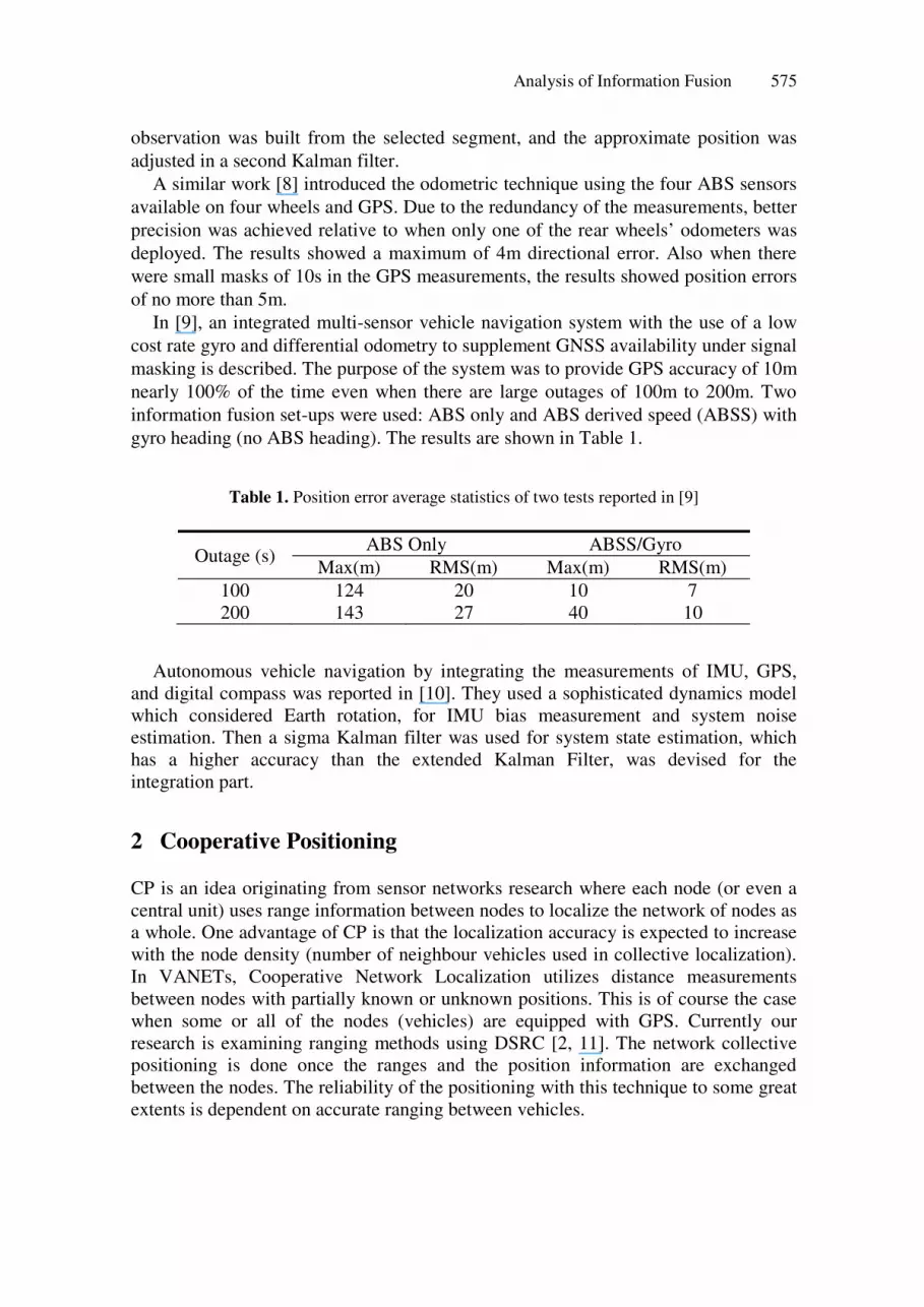
In [9], an integrated multi-sensor vehicle navigation system with the use of a low cost rate gyro and differential odometry to supplement GNSS availability under signal masking is described. The purpose of the system was to provide GPS accuracy of 10m nearly 100% of the time even when there are large outages of 100m to 200m. Two information fusion set-ups were used: ABS only and ABS derived speed (ABSS) with gyro heading (no ABS heading). The results are shown in Table 1.
Table 1. Position error average statistics of two tests reported in [9]
Outage (s) ABS Only ABSS/Gyro
Max(m) RMS(m) Max(m) RMS(m) 100 124 20 10 7 200 143 27 40 10
Autonomous vehicle navigation by integrating the measurements of IMU, GPS,
and digital compass was reported in [10]. They used a sophisticated dynamics model which considered Earth rotation, for IMU bias measurement and system noise estimation. Then a sigma Kalman filter was used for system state estimation, which has a higher accuracy than the extended Kalman Filter, was devised for the integration part.
2 Cooperative Positioning
CP is an idea originating from sensor networks research where each node (or even a central unit) uses range information between nodes to localize the network of nodes as a whole. One advantage of CP is that the localization accuracy is expected to increase with the node density (number of neighbour vehicles used in collective localization). In VANETs, Cooperative Network Localization utilizes distance measurements between nodes with partially known or unknown positions. This is of course the case when some or all of the nodes (vehicles) are equipped with GPS. Currently our research is examining ranging methods using DSRC [2, 11]. The network collective positioning is done once the ranges and the position information are exchanged between the nodes. The reliability of the positioning with this technique to some great extents is dependent on accurate ranging between vehicles.

576 M. Efatmaneshnik et al.
Fig. 3. Cooperative Positioning concept. Arrows indicate measured pseudoranges
2.1 Cramer Rao Lower Bound for Cooperative Positioning
The CRLB sets the minimum variance of any unbiased estimation of a random variable, and is the inverse of the Fisher Information matrix. Thus, CRLB is a means of estimating the performance of the cooperative positioning technique as well as benchmarking the performance of any localization algorithm. The CRLB has been derived for the general case of Adhoc Networks in [12]. Consider a vehicle with n-1 other vehicles in its neighborhood. The position of the vehicles can be unknown or partially known with known accuracy. Assume the ground truth positions of vehicles are [ ]{ }n
iii YXx 1== for localization in a two dimensional plane. Let
jijiji e ,,,ˆ += δδ be the inter-node range measurements between pairs of n nodes with
a standard noise ),0(~ 2,, jiji Ne σ , all stacked in a column matrix į which has n×(n-1)
elements. Under the normality assumption, ( )xf |δδ is a normal distribution with 2, jiσ on its diagonal covariance matrix Ȉ which underlines the assumption of inter-
nodes measurements independence then
( ) ( )Σ,| δδδ Nxf = (1)
The Fisher Information matrix ( )δ|XF for the estimation of position vector X is:
( ) ( )( ) ( )( )[ ]TxfXxfXExF ||| δδδδδ ∇×∇= (2)
Where X∇ denotes the gradient with respect to elements of vector X. The inverse of
( )δ|XF in its current form gives the CRLB for the case when only the range measurements are used without the a priori information about the node locations. Assuming that ΣP is the covariance matrix of the a priori position information X (e.g. provided by GPS), a hybrid CRLB for cooperative positioning can be introduced as:

Analysis of Information Fusion 577
1)|(1 −¸¹·¨
©§ +−= δxFPP Σ (3)
For mobile network localization, the motion information of the nodes and their likely routes can be used to refine the position estimates. A computational algorithm that facilitates tracking and fusion of spatial information across time is referred to as a filter. By the filtering mechanism the position estimation at each instant k in time is refined by the estimation at instant k-1 based on a mobility model. Assume the velocity based mobility:
kkkkkk TuTxx ξ++=+1 (4)
Where,
],,,,,,,[ 2121k
nkkk
nkk
k YYYXXXx ��= (5)
],,,,,,,[ 2121k
nkkk
nkk
k VVVUUUu ��= (6)
U is velocity in X direction and V in Y. Tk is the time interval between measurements.
kξ is a standard error with zero mean and variance of 2vσ . Thus the hybrid CRLB for
mobile networks becomes:
( )( ) 1111 )|(
−−−+ ++¦+= δxFTPP Pvkkk Σ (7)
Where Pk+1 and Pk are the hybrid CRLB matrices at instants k+1and k, Tk is the scalar elapsed time, Σv is the diagonal covariance matrix of the measured velocity of vehicles. From equation 8 it is clear that noisier velocity measurements, thus larger 2
vσ , lead to a smaller contribution from the previous instant’s position information and if it is too large filtering has no effect on the accuracy. An indicator of cooperative positioning error for each node over a period of time (K) can be readily obtained based on Circular Error Probability (CEP):
21
1
22
¸̧¸
¹
·
¨̈¨
©
§ += ¦
=
K
k
i
kyi
kx
KC
σσ (8)
Where 2
ikxσ and
2
i
kyσ respectively are the estimated error variance of node i at time k
in directions x and y.
2.2 Simulation and Performance Analysis
A simulation study was set up to demonstrate the performance of CP based on the error indicator in equation (8) averaged over time. A street traffic network was simulated by NetlogoTM that is an agent-based and Java-based programming platform. Fig. 4 is a snapshot of the traffic network. The length of the horizontal road was set at

578 M. Efatmaneshnik et al.
2km. From this simulation, only the ground truth values of the vehicles’ positions were obtained. The rest of the calculations were performed in the MatlabTM environment. Four traffic conditions were considered that were controlled by the total number of vehicles in the traffic simulation street network. The considered traffic rates were 300vehicles/h in the main streets for sparse/fast traffic, 600vehicles/hour, 900 vehicles/hour and 1200vehicles/hour for heavy/slow traffic. In all four cases a target vehicle was set to travel a particular path of about 2km. The simulation time in each case thus depends on the traffic condition, for example for sparse traffic it takes a shorter time than for heavy traffic to travel the same distance. The DSRC range was set at 250 m. The underlying assumption for this test and all the following tests are that the inter-node ranging error has a mean of zero and variance of 2
Rσ , which was
changed to show the sensitivity of the CRLB to 2Rσ . The positioning directional error
was set at 7m.
Fig. 4. Netlogo agent based software was used for the traffic simulation
Fig. 5(a) shows the expected error for CP based on CRLB analysis for heavy traffic conditions. The errors are averaged over the simulation run (200s). For this test ıR varied between 1m and 10m; ıv, the standard deviation of velocity, varied between 0.1m/s and 2.1m/s. From this figure, it can be seen that CP error has high sensitivity to the velocity error. Below 1 meter accuracies are typical for when the velocity measurement has error standard deviation of about 0.1m/s. Remember that this velocity error margin can be met with ABS-based odometers. Fig. 5(b) shows the typical CP error in all types of traffic conditions. This figure proves that the velocity measurement accuracy contributes more to the CP accuracy than heavier traffic conditions.

Analysis of Information Fusion 579
Fig. 5. Error bounds for heavy traffic conditions with several range measurements error standard deviation (from 1 to 10) and velocity error standard deviation (a). The range errors are indicated on the error curves. Average CRLB based error over the simulation run for ıR=3m. The traffic conditions in terms of rate of vehicles/hour (v/h) are indicated on the error curves (b).
In the next simulation experiment 20 outages of 15m to 35m long were randomly allocated throughout the simulated street network. If a vehicle entered the outage zones, its position error deviation was set at infinity (or a very large number) which literally means the absence of position information in those zones. Fig.6 shows the
(b)
(a)

580 M. Efatmaneshnik et al.
Fig. 6. The increase in CP error for ıR=10m due to 10 outages of 15m to 35m in every kilometre of the road (a). The same increase for ıR=3m (b). The traffic rates are printed on the error increase curves.
results in terms of the increase in average CP error relative to the no-outage case (the previous test). From this figure it is evident that even for sparse traffic, the GPS outages do not have significant effect on the CP error, as long as ranges can be measured.
(a)
(b)

Analysis of Information Fusion 581
In Fig. 7 the error bounds for two cases as well as the GPS drop out times are shown. Case 1 is the worst case scenario for CP performance where traffic conditions are very heavy. Also the ranging and velocity errors are set at their highest, ıR=10m and ıv=1m/s. Case 2 has the same traffic conditions and ranging error but better velocity measurements ıv=0.1m/s. This figure shows that in case 1, CP error has some sensitivity in the form of sharp short spikes to the outages. However, case 2 has a very smooth error even during the outages. The smoothness particularly is due to better velocity measurements. This figure illustrates the important positive impact of the velocity accuracies on both smoothness of the CP solution as well as its accuracy.
Fig. 7. CP error for two cases. Both cases are for heavy traffic condition and ıR=10m. The velocity error for case 1 (red) is ıv=1m/s and for case 2 (blue) is ıv=0.1m/s. The green dashed lines show the outages. A value of 1 indicates GPS availability and 0 the GPS unavailability.
The last case considered here is the hypothetical case where other information fusion techniques using GPS, odometers, compass and digital map are available to all vehicles in the network. In this condition we assume that the position information has an error of 4m and that during outages has an error of 5m; the errors are chosen according to the results reported in [8] that had similar outage conditions. In this case, CP always delivers the desired accuracy of less than 50cm for all types of traffic and any ranging accuracy between 1m to 10m. The simultaneous implementation of CP with the results of [9] in Table 1 more or less would similar to the CP results without any outages.

582 M. Efatmaneshnik et al.
Fig. 8. CP and other information fusion approaches together. The hypothetical CP performance if ranging error ıR=3m, .the position information error is ıp=4m, and the same during the outages is ıp=5m.
3 Conclusion
In this paper the CP performance was simulated by means of CRLB analysis. The results are promising and indicate the capacity of CP to provide reliable and robust vehicular positioning. CP as a positioning solution has no major cost implications to DSRC system developers. The only concerns are the particular protocols for ranging between the vehicles. These are most likely to be based on a Time of Arrival technique. Future VANET architectures will also have Road Side Units that can be used as fixed position beacons that will improve the CP accuracy even further. In a The effect of multipath driven position bias on the CP performance can also evaluated by more or less similar technique of this paper. However, as noted before the digital maps are very helpful in reducing the bias so the multipath effect can be eliminated especially if accurate velocity measurements are available. The odometer is again important for this case because although the GPS bias can be corrected by digital map, the GPS velocity accuracy that severely deteriorates by the multipath cannot.
References
1. Vander, J., Shladover, W.S., Miller, M.A.: Conceptual Development and Performance Assessment for the Deployment Staging of Advanced Vehicle Control and Safety Systems. Institute of Transportation Studies California Partners for Advanced Transit and Highways (PATH), University of California, Berkeley (2004)
Analysis of Information Fusion 583
2. Alam, N., Balaei, A.T., Dempster, A.: Ranging with DSRC: Facts and Challenges. In: International Global Navigation Satellite Systems Society IGNSS Symposium 2009Holiday Inn Surfers Paradise, Qld, Australia (2009)
3. Benslimane, A.: Localization in Vehicular Ad-hoc networks. ICW/ICHSN/ICMCS/SENET, pp. 19–25 (2005)
4. Efatmaneshnik, M., Balaei, A.T., Alam, N., Dempster, A.G.: A modified multidimensional scaling with embedded particle filter algorithm for cooperative positioning of vehicular networks. In: 2009 IEEE International Conference on Vehicular Electronics and Safety (ICVES), pp. 7–12 (2009)
5. Efatmaneshnik, M., Balaei, A.T., Dempster, A.G.: A Channel Capacity Perspective on Cooperative Positioning Algorithms for VANET ION GNSS, Savannah, Georgia (2009)
6. Parker, R., Valaee, S.: Vehicular Node Localization Using Received-Signal-Strength Indicator. IEEE Transactions on Vehicular Technology 56, 3371–3380 (2007)
7. El Najjar, M.E., Bonnifait, P.: A Road-Matching Method for Precise Vehicle Localization Using Belief Theory and Kalman Filtering. Autonomous Robots 19, 173–191 (2005)
8. Bonnifait, P., Bouron, P., Crubille, P., Meizel, D.: Data fusion of four ABS sensors and GPS for an enhanced localization of car-like vehicles. In: Proceedings of 2001 ICRA IEEE International Conference on Robotics and Automation, vol. 2, 1592, pp. 1597–1602 (2001)
9. Stephen, J.E.: Development of a GNSS-based Multi-Sensor Vehicle Navigation System. Geomatics Engineering. University of Calgary (2000)
10. Zhang, P., Gu, J., Milios, E.E., Huynh, P.: Navigation with IMU/GPS/digital compass with unscented Kalman filter. In: 2005 IEEE International Conference on Mechatronics and Automation, vol. 3, 1493, pp. 1497–1502 (2005)
11. Alam, N., Balaie, A.T., Dempster, A.G.: Dynamic Path Loss Exponent Estimation in a Vehicular Network using Doppler Effect and Received Signal Strength. In: VTC Vehicular Technology Conference (2010)
12. Savvides, A., Garber, W., Adlakha, S., Moses, R., Srivastava, M.: On the error characteristics of multihop node localization in ad-hoc sensor networks. In: Zhao, F., Guibas, L.J. (eds.) IPSN 2003. LNCS, vol. 2634, pp. 317–332. Springer, Heidelberg (2003)