Embed Size (px)
Citation preview

Remote Sens. 2012, 4, 1310-1336; doi:10.3390/rs4051310
Remote Sensing ISSN 2072-4292
www.mdpi.com/journal/remotesensing Article
A Semi-Automated Object-Based Approach for Landslide Detection Validated by Persistent Scatterer Interferometry Measures and Landslide Inventories
Daniel Hölbling 1,*, Petra Füreder 1, Francesco Antolini 2,†, Francesca Cigna 2,‡, Nicola Casagli 2
and Stefan Lang 1
1 Z_GIS Centre for Geoinformatics, Salzburg University, Schillerstrasse 30, A-5020 Salzburg,
Austria; E-Mails: [email protected] (P.F.); [email protected] (S.L.) 2 Department of Earth Sciences, University of Firenze, Via La Pira 4, I-50121 Firenze, Italy;
E-Mails: [email protected] (F.A.); [email protected] (F.C.);
[email protected] (N.C.)
* Author to whom correspondence should be addressed; E-Mail: [email protected];
Tel.: +43-662-8044-5281; Fax: +43-662-8044-5260.
† Present address: Politecnico di Torino, Corso Duca degli Abruzzi 24, I-10129 Torino, Italy.
‡ Present address: British Geological Survey, Nicker Hill, Keyworth, Nottingham NG12 5GG, UK.
Received: 29 March 2012; in revised form: 27 April 2012 / Accepted: 28 April 2012 /
Published: 7 May 2012
Abstract: Geoinformation derived from Earth observation (EO) plays a key role for
detecting, analyzing and monitoring landslides to assist hazard and risk analysis. Within
the framework of the EC-GMES-FP7 project SAFER (Services and Applications For
Emergency Response) a semi-automated object-based approach for landslide detection
and classification has been developed. The method was applied to a case study in
North-Western Italy using SPOT-5 imagery and a digital elevation model (DEM),
including its derivatives slope, aspect, curvature and plan curvature. For the classification
in the object-based environment spectral, spatial and morphological properties as well as
context information were used. In a first step, landslides were classified on a coarse
segmentation level to separate them from other features with similar spectral characteristics.
Thereafter, the classification was refined on a finer segmentation level, where two categories
of mass movements were differentiated: flow-like landslides and other landslide types. In
total, an area of 3.77 km² was detected as landslide-affected area, 1.68 km² were classified
as flow-like landslides and 2.09 km² as other landslide types. The outcomes were compared
to and validated by pre-existing landslide inventory data (IFFI and PAI) and an interpretation
OPEN ACCESS

Remote Sens. 2012, 4
1311
of PSI (Persistent Scatterer Interferometry) measures derived from ERS1/2, ENVISAT
ASAR and RADARSAT-1 data. The spatial overlap of the detected landslides and existing
landslide inventories revealed 44.8% (IFFI) and 50.4% (PAI), respectively. About 32% of
the polygons identified through OBIA are covered by persistent scatterers data.
Keywords: object-based image analysis (OBIA); landslide mapping; persistent scatterers
(PS); radar-interpretation; validation
1. Introduction
1.1. Background
Gravitational mass movements such as landslides constitute a major natural hazard in all hilly or
mountainous regions throughout the world. Although these movements are mostly a very local
phenomenon, they cause damage to all types of man-made structures and affect infrastructures from
local to regional scales and even on a national scale. The floods and landslides in China from May to
August 2010 ranked second highest in terms of economic damage caused by natural disasters, with
US$ 18 billion worth of damage [1]. In the course of this natural disaster, mass movements killed
1,765 persons and ranked in the top 10 of the most important disasters by number of persons killed [1].
Landslide triggering conditions, such as heavy rain falls and typhoons or earthquakes, can affect very
large areas and sometimes cause several thousand landslides per event; for example Tsai et al. [2]
reported over 9,000 detected landslides after typhoon Morakot in Taiwan in August 2009.
Within the framework of the EC-GMES-FP7 project SAFER (Services and Applications For
Emergency Response), where an integrated Landslide Monitoring (LM) service has been established, a
semi-automated object-based approach for landslide detection has been developed for Mont de la Saxe
area, Aosta Valley, Italy. Landslide Monitoring represents a thematic reference service carried out to
retrieve past ground movements of single large landslides affecting built-up areas with a high level of
risk. For the site of Mont de la Saxe, LM was based on the integration of object-based analysis of
optical satellite images with InSAR (Interferometric Synthetic Aperture Radar) and PSI (Persistent
Scatterer Interferometry) measures of ground displacements obtained from interferometric processing
of radar satellite images. These input data were subsequently integrated with further ancillary data
(e.g., detailed geological and geomorphological information) and in situ measurements following a
consolidated methodology, in order to obtain detailed information about the spatial and temporal
distribution of landslide movements within the study area. This approach is particularly useful for
investigating highly hazardous landslides, which threaten exposed, built-up areas. In such situations,
the assessment of the future evolution of slope instabilities by means of integrated monitoring systems
plays a major role in the adequate set up of early warning systems (EWS) and emergency plans,
fundamental tools for landslide hazard and risk reduction.
The SAFER services, which are part of the GMES (Global Monitoring for Environment and
Security) initiative, are targeted at the integration of users (e.g., public authorities such as civil
protection agencies, humanitarian aid organizations, NGOs), who are supposed to make use of the

Remote Sens. 2012, 4
1312
provided services and products in emergency situations. By expressing their explicit needs as well as
proposing improvements through feedback questionnaires, the users support the deployment of an
operational emergency response service. The user engaged in the LM monitoring service in the Mont
de la Saxe area is the Italian Department of Civil Protection (DPC), the national institution in charge
of risk management and mitigation over the whole Italian territory. The investigated area represents
one of the most hazardous areas of the Valle d’Aosta Region due to widespread slope instability
affecting very steep slopes overlooking narrow, but densely urbanized valleys and exposing local
population and infrastructure at risk.
1.2. OBIA for Landslide Mapping
Today, the wide range of available Earth observation (EO) data implies the need for accurate and
fast methods for detecting, analyzing and monitoring landslides and to facilitate the generation of
landslide inventory maps and databases to assist hazard and risk analysis. Landslide inventories are
traditionally derived by visual interpretation of aerial photographs and field surveys. This kind of
inventory is, however, time-consuming, fraught with the subjectivity of the visual interpreters and very
costly in terms of data and workload. Satellite imagery offers a fast and economical opportunity to
monitor slopes and map landslides over large and inaccessible areas, especially since the spatial
resolution is ever increasing [3–6]. Applying automated methods can contribute to more efficient
monitoring and timesaving as well as cost-efficient updating of existing landslide inventories.
Supervised and unsupervised classification methods of multi-spectral SPOT-5 imagery for mapping
landslides were successfully used by Borghuis et al. [7] and then compared to a manual delineation.
Nicol and Wong [8] used a Maximum Likelihood classifier with SPOT XS images and were able to
detect approximately 70% of the existing landslides. A multiple change detection (MCD) technique to
semi-automatically recognize and map landslides triggered by typhoons has been developed by
Mondini et al. [9]. However, in many cases object-based methods seem to capture the complexity of
natural phenomena and geomorphologic processes such as landslides in a more appropriate way than
traditional pixel-based ones [10]. Thus, salt-and-pepper effects are avoided, which is especially
important when dealing with complex features in terms of shape and size as landslides, where pixels
show quite different spectral values. Semi-automated methods for landslide detection and analysis,
especially object-based image analysis (OBIA) techniques [11,12], although still not very common, are
able to deliver fast and accurate results as demonstrated by several studies. An object-based approach
using a combination of high spatial resolution satellite imagery and DEM derivatives has been
proposed by Barlow et al. [3]. According to the classification scheme of Cruden and Varnes [13] they
distinguished between debris slides, debris flows and rock slides and achieved accuracy rates between
60% for debris flows and 90% for debris slides. Barlow et al. [3] pointed out that per pixel spectral
response patterns are ineffective for delineating mass movements and instead applied an image
segmentation and classification approach combining high spatial resolution satellite imagery and
digital elevation derivatives. Similar approaches were demonstrated by Lahousse et al. [14], who applied
a multi-scale object-based landslide detection technique based on optical imagery supported by digital
elevation information to map shallow landslides in Taiwan, or Martha et al. [10], who characterized
landslides based on their spectral, spatial and morphometric properties, while Martha et al. [15]

Remote Sens. 2012, 4
1313
elaborated the objective selection of suitable segmentation parameters to outline landslides as
individual segments for subsequent landslide classification. A supervised workflow based on a
Random Forest machine learning algorithm was developed by Stumpf and Kerle [5] and successfully
tested on various optical data sets reaching accuracies between 73% and 87%. Further approaches for
object-based landslide identification were shown by Martin and Franklin [16] for classifying soil and
bedrock-dominated landslides in British Columbia, Moine et al. [17], who semi-automatically detected
landslides in the French Alps using aerial and satellite images, Rau et al. [18] by using imagery
acquired by a fixed-wing unmanned aerial vehicle (UAV), Hölbling and Füreder [19], who carried out
preliminary work in the Aosta Valley, Northern Italy, distinguishing different mass movement types,
or by Aksoy and Ercanoglu [20], who identified landslides on Landsat ETM+ (Enhanced Thematic
Mapper Plus) imagery applying fuzzy classification. In the context of rapid landslide mapping a
semi-automatic object-based change detection analysis was suggested by Lu et al. [4]. An automated
classification system of morphological landform elements based on OBIA has been established by
Drǎgut and Blaschke [21]. Their approach focuses on the use of Digital Terrain Models (DTMs) and
its derivatives and they were able to transfer the approach to different landscapes and datasets. A
related object-based method was recently proposed by Drǎgut and Eisank [22], who automatically
classified topography from SRTM (Shuttle Radar Topography Mission) data to decompose land-surface
complexity into homogeneous domains.
OBIA is making considerable progress towards a spatially explicit information extraction
workflow [11] as it offers a methodological framework for addressing complex classes, defined by
spectral, spatial and structural as well as hierarchical properties [23]. Thus, it provides suitable
methods for analyzing landslides by using remote sensing data. Main assets of OBIA are the general
potential to tackle the complexity and multi-scale characteristics of very high spatial resolution
(VHSR) imagery and to allow the integration of various data sources [11,12]. Object-based methods
have a high potential to monitor the evolution of landslide-prone areas over time, as spectral, spatial,
contextual as well as morphological parameters can be considered [19]. In the present study the
potential of an object-based landslide detection and classification approach is evaluated in an
operational context aiming for the development of integrated solutions for mapping and monitoring
landslides.
2. Study Area and Data
2.1. Geological Characterization of the Study Area
The study area ‘Mont de la Saxe’ is located in the Aosta Valley, North-Western Italy, near the Mont
Blanc massif and covers approximately 70 km² (see Figure 1). Major villages within the study area are
Cormayeur and Entréves. The Dora Baltea river originates here as the confluence of Dora di Ferret and
Dora di Vèny streams. The study area is characterized by steep terrain with altitudes ranging from
approximately 1,100 m to over 4,000 m above sea level.
The Western Italian Alps constitute a collisional belt developed from the Cretaceous onwards by
subduction of a Mesozoic ocean and continental crust of the Adriatic (Austroalpine-Southalpine) and
European (Penninic-Helvetic) continental margins [24].

Remote Sens. 2012, 4
1314
Figure 1. Overview of the study area Mont de la Saxe (SPOT-5 data within the red
rectangle is displayed in false color composite, band combination 1-2-3, Acquisition Date:
5 May 2005).
In the study area, from the external to the internal sectors, three main tectono-stratigraphic units
crop out (Figure 2):
Monte Bianco massif and Mont Chètif wedge complex, belonging to the Helvetic Domain,
consist of paragneisses, migmatites, orthogneisses, granites and porphyries; in the SE part of
the massif (Val Veny-Val Ferret) the contact with surrounding units is tectonic.
Ultrahelvetic units, a meta-sedimentary sequence which predominantly consist of closely
foliated carbonate-bearing argillaceous schists and arenaceous limestones with quartz arenites
levels. The age of the sequence can be referred to as the Middle Jurassic.
Penninic units, which comprise the lower distal clastics and pelagic Cretaceous deposits of the
Courmayeur Zone, the more internal ocean-continent transition zone (Valais zone) and the middle
Penninic nappes consist of Zone Huillère Permo-Carboniferous deposits (black schist with coal
measures, quartzites and conglomerates) and a Pre-Permian crystalline basement (paragneiss and
micaschists with amphibolites and metabasites intercalations). The described units dip towards SE
forming an imbricated structure, and are arranged as large belts oriented NE-SW.

Remote Sens. 2012, 4
1315
Quaternary alluvial, glacial and debris deposits directly lie unconformably and discontinuously on
the bedrock. The recent and actual alluvial deposits rest on the valleys’ bottom and consist of gravels,
pebbles and boulders in coarse-grained sandy matrix along the river channels and finer-grained
deposits (sandy silts and silts) in floodplain areas. Old glacial deposits crop out discontinuously along
the slopes at elevations up to 2,000 m above sea level, while the recent ones become particularly
widespread along secondary tributary valleys at higher altitudes. They consist of massive boulders,
pebbles and gravels in an abundant sandy-silty matrix (diamicton). The debris deposits include talus,
alluvial fan and flow deposits and crop out at the base of rocky cliffs (talus), along the stream incision
(flow deposits) and at the outlet of the minor valleys (alluvial fans).
Figure 2. Geologic and structural sketch of the study area. Modified from Carta Geologica
d’Italia 1:100,000, Sheets 27–28.
The structural setting of the study area is strictly influenced by the Penninic frontal thrust and the
Ultrahelvetic front, two regional compressive structures oriented NE-SW which separate the main
tectono-stratigraphic units previously described. These lineaments are associated with secondary shear
planes, milonitic and cataclastic bands, further complicating the structural setting of the area. In
particular, the Penninic frontal thrust is a tectonic alignment of regional importance and its presence is
detectable along most of the Western Alps [25–27].
Due to the general high relief energy and the steep slope gradient, slope instability is quite diffused
in the study area. There is a clear relationship between the material involved in the instability and
development of a particular type of movement. Rock falls and topples, resulting in formation of wide
talus deposits are, in general, widespread along the steep rocky slopes and cliffs characterized by the
presence of fractured hard rock mass (granites, gneiss, porphyries, quartzites). In some cases complex

Remote Sens. 2012, 4
1316
large falls (i.e., rock avalanches) have been reported [28]. Deep-seated large landslides affect high
steep slopes shaped in metamorphic rocks with marked anisotropy such as gneiss and schists of the
Ultrahelvetic and Penninic units. Within the displaced mass the development of sudden and rapid
secondary landslides (topples, rotational and planar slides, and flow-like movements) is a common
feature, giving rise to complex deformational patterns. Shallow landslides and channelized flows affect
in general colluviums, weathered bedrock, soils and the more erodible lithologies of the Ultrahelvetic
and Penninic units, such as argillaceous schists and black schists with coal measures (Zone Houillère).
In some cases, movements could be initialized by sliding on the bedding or schistosity planes and then
evolve as flow-like phenomena, thus generating complex landslides. The Mont de la Saxe is affected by the Bois de Plan Cereux landslide (Figure 3), which constitutes
an active portion of a large deep-seated gravitational slope deformation (DSGSD) extending along the
whole Mont de la Saxe ridge. The instability, which can be classified as a complex landslide [13] with
an estimated volume of a few Mm3, involves a significant portion of the slope and poses high risk to
the Entrèves and La Palud villages as well as to the infrastructure (i.e., A5 motorway, SS26 national
road, Monte Bianco cableway). The SE slope of the Mont de la Saxe ridge (Val Sapin) is characterized
by the presence of complex and planar/rotational slides.
Figure 3. Frontal view of the Mont de la Saxe deep-seated gravitational slope deformation
(DSGSD) showing the Bois du Plan Cereux active landslide and the Bois du Point Pailler
dormant landslide.
2.2. Data
The object-based detection of landslides was based on optical, very high spatial resolution satellite
imagery (SPOT-5, acquisition date: 5 May 2005) and digital elevation data (DEM with 20 m GSD)
including its derived products slope, aspect, curvature and plan curvature. The multispectral SPOT-5

Remote Sens. 2012, 4
1317
image with two bands in the visible spectrum (red, green) and a near infrared (NIR) band was available
in pan-sharpened mode with a spatial resolution of 2.5 m. Although the satellite image was supplied in
geo-referenced format, it had to be co-registered to remove distortions between the SPOT-5 image and
available orthophotos, which were used as reference for the visual interpretation of the PSI results. Due
to the steep terrain features within the study area, some mountain sides, including the northern hillside
of Mont de la Saxe, are shaded on the SPOT-5 image and could not be taken into account for the
classification.
The DEM showed some gaps and data errors, which had to be corrected before integrating it in the
further analysis. Single DEM tiles were mosaicked and false values adjusted taking into account
neighborhood statistics calculated for each affected input cell using map algebra in ArcGIS 10
software. The following morphological parameters were derived from the DEM to support the
object-based classification of landslides: slope, aspect, curvature and plan curvature. A low pass
3-by-3 filter was applied to the curvature derivative to generate a smoother layer with less noise.
Data used for validating results of the object-based image analysis included the Italian national
landslides inventory: IFFI (Inventario dei Fenomeni Franosi in Italia), and the Hydrogeological Asset
Plan: PAI (Piano Stralcio per l’Assetto Idrogeologico) of the Po River Basin Authority. In addition,
datasets of persistent scatterers (PS) were obtained by the processing of satellite SAR (Synthetic
Aperture Radar) data acquired by three different C-band satellites (wavelength of 5.6 cm) along both
ascending and descending orbits, and using monthly temporal frequency. ERS1/2 data acquired in
ascending mode from 11/06/1993 to 25/12/2000, and in descending mode from 17/04/1992 to
25/12/2000 with a nominal repeat cycle of 35 d and ENVISAT ASAR (Advanced SAR) and
RADARSAT-1 scenes with 35 and 24 d repeat cycle were used. ENVISAT ascending and descending
data cover the intervals from 07/06/2004 to 19/10/2009 and 20/09/2004 to 23/11/2009, while
RADARSAT-1 ascending and descending images span the intervals from 05/05/2006 to 28/10/2009
and 25/08/2005 to 15/10/2009. These data were processed by Altamira Information with the Stable
Point Network (SPN) technique [29,30].
3. Methodology
3.1. Object-Based Class Modeling
The distinction of the two classes flow-like landslides and other landslide types (falls, topples, slides
and spreads) follows the kinematic-based classification of Cruden and Varnes [13]. Within the study
area the class flow-like landslides mainly covers channelized debris bodies and their depositional areas.
The source areas of the flows are included in the class other landslide types since the movements very
often initiate at the head of the stream incisions by sliding or by concentrate erosion. The detection of
flow-like landslides and other landslide types was conducted by applying object-based image analysis
in eCognition 8 software, which offers a modular programming environment for (image-)object
handling in a vertical and horizontal hierarchy [31]. Rulesets for automated analysis are coded in CNL
(Cognition Network Language) within the mentioned software. OBIA constitutes the methodological
framework for machine-based interpretation of target features defined by spectral, spatial, structural,
contextual and also hierarchical properties [23], while reducing the influence of per pixel spectral

Remote Sens. 2012, 4
1318
response patterns. Knowledge is represented through the use of rule-based classifiers, making explicit
the required spectral and geometrical properties just as spatial relationships for advanced class
modeling [32]. Class modeling, a cyclic process of segmentation and classification, allows addressing
objects individually in a region-specific manner at any stage in the ruleset [32].
3.2. Estimation of Appropriate Scale Parameter
In order to objectively select a suitable scale parameter for the appropriate image segmentation a
statistical tool called ESP (estimation of scale parameter), developed by Drǎguţ et al. [33], was used.
The ESP tool iteratively generates image-objects at multiple scale levels in a bottom-up approach and
calculates the local variance of object heterogeneity within a scene for each scale [33]. By plotting the
local variance against the respective scale the variation in heterogeneity can be evaluated. The scale
levels at which the image can be segmented in the most appropriate manner, relative to the data
properties at the scene level, are indicated by the thresholds in rates of change of local variance
(ROC-LV) [33]. Based on this evaluation a scale parameter of 36, indicated by a peak in the ROC-LV
graph (see Figure 4), was chosen for the initial multi-resolution segmentation.
Figure 4. Results of the estimation of scale parameter (ESP) analysis showing potential
scales for image segmentation. The peaks in the Rate of Change graph indicate object
levels at which the image can be segmented in an appropriate manner (here a scale
parameter of 36 was found suitable).
The three multispectral bands of the SPOT-5 image were used for segmentation. A higher weight
was given to the color criterion than to the shape criterion. A coarser segmentation level with scale
parameter 82 and the same shape (0.3) and compactness factors (0.5) as for the finer segmentation

Remote Sens. 2012, 4
1319
level, also determined by making use of the ESP tool, resulting in larger image-objects, was created to
facilitate a first, rough delineation of target areas affected by landslides.
3.3. Rule-Based Classification
By using OBIA, the influence of variant spectral reflectance of single pixels can be minimized. This
seems to be applicable especially for natural, complex phenomena such as landslides, which tend to
exhibit varying spectral response patterns. The creation of rulesets relied on the transformation of
expert knowledge into machine-based rules, whereby the SPOT-5 image constituted the a priori data
used for landslide detection and classification. During class modeling absolute spectral threshold
values were kept to a minimum, whereas relational features and spatial characteristics were used
instead. Vegetation indices as the NDVI (Normalized Difference Vegetation Index) and the MSAVI
(Modified Soil-Adjusted Vegetation Index, see Equation (1)) proved to be very useful for differentiating
target areas from areas of no interest.
∗ ∗ (1)
where NIR is the near infrared band and RED the red band.
As a first step, potential landslides were identified as target objects on the finer segmentation level
by applying the mentioned vegetation indices in combination with other feature characteristics, for
example slope, standard deviation of the near infrared band, the maximum spectral difference within
image-objects, neighborhood information, shape properties (e.g., length/width) or relief, the maximum
change in elevation within an object. Objects with slope gradients above 60 degrees and below 10
degrees were excluded from the target objects. The range of these thresholds was defined relatively
wide, but should ensure not to miss any areas of interest. Additionally, aspect, curvature and plan
curvature appeared to be appropriate for improving the detection of target areas. By making use of
these characteristics it was possible to exclude falsely classified target areas, for example rocky ridges
in high-lying areas, as well as add some missed objects. The pre-classified objects were further divided
into two classes: flow-like landslides and other landslide types. As the segmentation levels follow a
strict image-object hierarchy the initial classification of target areas on the finer level could be
transferred to the level above. The differentiation of classes was initially done on the coarse
segmentation level, where shape parameters in particular, but also morphological characteristics
appeared to be more significant for a first, rough separation than on the fine segmentation level (cf.
Figure 5). Mainly the mean slope was used to distinguish flow-like landslides from other landslide
types. Image-objects with a mean slope higher than 25° were allocated to the class other landslide
types, those with a lower value were classified as flow-like landslides. Besides slope, also aspect,
curvature and plan curvature were used for this first differentiation. Latter mentioned morphological
characteristics turned out to be useful for supporting the class separation on the coarse segmentation
level (e.g., low plan curvature values were considered for the detection of flow-like channelized
landslides), but as the spatial resolution of the available DEM (20 m GSD) was not fully sufficient for
determining unique thresholds, they were mainly used in combination with shape characteristics such
as length/width or the brightness of objects (flow-like landslides tend to appear brighter on the SPOT-5
image) to facilitate the stepwise refinement of the classification.

Remote Sens. 2012, 4
1320
Figure 5. Workflow for the semi-automated detection of flow-like landslides and other
landslide types in an object-based environment.
Subsequently, the intermediate classification results were transferred to the finer segmentation level
for further improvement of the classification. The refinement of the classification comprised the use of
selected feature characteristics: besides the NDVI, spectral and spatial properties (length/width or
compactness), morphological parameters as aspect and slope and especially context information (e.g.,
relative common border to neighboring objects) and hierarchical information (relations to super objects
on the higher segmentation level) were taken into account. As natural phenomena like landslides can
hardly be described using one absolute threshold, several image-object feature characteristics
combined with context information were used for the further improvement of the classification. For
instance, if objects were primarily classified as flow-like landslides, but their classification was fraught
with uncertainty and the objects only slightly missed the parameter thresholds attached to the class
other landslide types, they were assigned to a temporary class in the first step. Secondly, if these
temporary objects, which were most often relatively small ones, showed a high relative border to the
class other landslide types or were almost completely enclosed by this class, they were finally
reclassified as other landslides type. Using neighborhood characteristics, in this case the relative
border to neighboring objects, contributed essentially to the improvement of the classification.

Remote Sens. 2012, 4
1321
3.4. Region-Specific Refinement
In a few areas (e.g., partially shadowed regions on the SPOT-5 image) some misclassifications still
occurred. In such cases, we made use of the capability of eCognition software to address specific
regions individually. Thereby it is possible to adapt certain rules only to pre-defined regions within a
larger study area. This allows for more detail and quickly eliminates classification errors and also
reduces analysis time as it is not necessary to find valid rules for the whole area under investigation.
3.5. Image-Object Border Refinement for Deriving Meaningful Image-Objects
Finally, the delineation of ‘meaningful’ image-objects was further enhanced through applying split
and merge functions as well as smoothing of image-object boundaries by using pixel-based resizing
algorithms. In order to keep the preliminary existing result, the refinement of the boundaries was done
on an independent segmentation and classification layer. Working with such sub-projects in one
eCognition project allows running processes independently, for example performing independent
segmentation and classification while not changing the initial image-object borders.
For smoothing the boundaries of classified objects, specific pixel-based shrinking algorithms were
applied. Edge pixels between flow-like landslides and other landslide types with an NDVI value below
0.1 were allocated to a temporary class applying a surface tension of larger than 0.4 within a 5 × 5
pixel window. Surface tension is calculated based on the relative area of a given class within a moving
window around the current candidate pixel. The ratio of the relative area of seed pixels to all pixels
inside the moving window is computed [34]. The temporary image-objects were subsequently merged
to those neighboring objects with the highest relative common border. Consequently, smoother borders
between flow-like landslides and other landslide types were achieved (Figure 6). Further shrinking was
done for edge pixels between classified landslide objects with NDVI values higher than 0.2 and
unclassified objects, keeping the same size of the moving window, but increasing the surface tension
value to 0.5.
Figure 6. Pixel-based resizing of object boundaries. Black ellipses highlight examples for
edge pixels between flow-like landslides and other landslide types; red ellipses highlight
examples for edge pixels between classified objects and unclassified objects. (a) Classified
objects before pixel-based resizing. (b) Temporary image-objects are displayed in blue
color. (c) Result with smoother boundaries after applying pixel-based resizing.

Remote Sens. 2012, 4
1322
As one of the last refinement steps, classified image-objects smaller than 200 m², having no common
border to other classified objects, were removed, and unclassified objects smaller than 300 m², which
were enclosed by flow-like landslides or other landslide types, were assigned to the respective
enclosing class. While a few objects, which probably constituted objects of interest, still remained
unclassified and some others seemed to be assigned to the wrong class, a minimal manual refinement
was done at this stage. As this affected only a minor number of small objects it was decided to perform
a manual improvement instead of applying additional rules.
Finally, the classified objects were partly merged to obtain more ‘meaningful’ objects. Therefore,
several rules, considering aspect, size or maximum change of slope, were used to ensure that not all
objects of one class were merged, but rather the most similar ones, which ideally represent one
landslide.
4. Results and Discussion
4.1. Results of Object-Based Landslide Detection
The result of the object-based landslide detection for the Mont de la Saxe study area, which covers
approximately 70 km², is shown in Figure 7. In total, an area of 3.77 km² was classified as
landslide-affected; comprising an area of 1.68 km² flow-like landslides (mainly channelized debris
bodies and their depositional areas) and 2.09 km² classified as other landslide types (falls, topples,
slides and spreads). The smallest other landslide type detected is 556 m², the largest 94,500 m²; the
smallest and largest flow-like landslides are 1,800 m² and 262,000 m², respectively.
Due to the illumination conditions at the acquisition time and the orientation of the mountainous
ridges and valleys (NE-SW), all slopes facing towards NW resulted in shadowed areas (see Figure 7).
For these areas, it was hardly possible to detect all landslides on the basis of the optical satellite image.
Other than these obstacles, minor errors of omission (i.e., a few small landslides or sub-areas of
landslide complexes could not be detected) and commission (i.e., wrongly classified parts) occurred
(see Figure 8). To correct these errors minor manual editing was conducted.
4.2. Validation
4.2.1. Cross-Comparison with Pre-Existing Landslide Inventories
In order to validate the detected flow-like landslides and other landslide types, the areas (i.e.,
classified image-objects) recognised as affected by instability processes, were compared with the
Italian national landslides inventory: IFFI, and the Hydrogeological Asset Plan: PAI of the Po River
Basin Authority.
Concerning the IFFI inventory (Figure 9(a)), the database, updated to 2007, was created by
integrating a collection of historical and archive data, manual aerial photo interpretation, field surveys
and detailed mapping. For every landslide a minimum datasheet indicating the localization, the type of
movement and the state of activity is reported. The distinction of different types of movement is
mostly based on the classification proposed by Varnes [35] and Cruden and Varnes [13] with some
modifications. In particular, some types of movements (deep-seated gravitational slope deformations,

Remote Sens. 2012, 4
1323
areas affected by numerous falls/topples, numerous sinkholes or numerous shallow landslides) have
been introduced, which, even limited in size, are widespread along certain slopes or affect very large
areas [36]. In addition, the IFFI inventory also includes linear instability phenomena and limited areal
phenomena displayed as point features.
Figure 7. Result of the object-based landslide detection based on the SPOT-5 imagery
(acquisition date: 5 May 2005, false color composite). Pink areas represent flow-like
landslides and yellow areas indicate other landslide types.

Remote Sens. 2012, 4
1324
Figure 8. (a) Results of the object-based landslide detection showing (b) wrongly
classified other landslide types (white outline) and (c) and (d) other landslide types, which
were missed (black outline).
The main objective of the Hydrogeological Asset Plan (PAI, Figure 9(b)) is the reduction of the
hydrogeological risk to ensure the safety of people and to minimize the threat to the exposed elements
at risk. In Italy the Environmental Protection Law 183/1989 identified hydrographic basins as the
optimal physical environment for land management in terms of risk limitation. The study area of Mont
de la Saxe lies in the northern sector of the Po river hydrographic basin, the major Italian river basin
with a total surface of about 74,000 km2. In this context, the areas characterized by higher landslide
risk (R3 and R4 classes) were taken into account for validating the result of the object-based approach.
The PAI maps have been updated to 2006 and also served as archive data for the realization of the IFFI
database.

Remote Sens. 2012, 4
1325
Figure 9. Hillshade of the study area showing (a) the IFFI landslide inventory and (b) the
R3/R4 risk areas as reported in the Hydrogeological Asset Plan PAI.
Table 1. Number of features and area of the landslides included in IFFI and PAI
inventories compared to the results of the object-based image analysis.
OBIA No of Features Area [km2]
Flow-like landslides 275 1.68 Other landslide types 357 2.09 Total 632 3.77 Spatial overlap with IFFI Flow-like landslides 181 1.16 Other landslide types 89 0.53 Total 270 1.69 Spatial overlap with PAI Flow-like landslides 178 1.16 Other landslide types 104 0.74 Total 282 1.90 IFFI
Fall/topple 15 2.83 Planar/rotation slide 2 0.14
Rapid flow 2 1.18 Complex 12 3.18 DSGSD 6 10.79 Total 37 18.12 PAI R3 and R4 areas 50 12.26
In Table 1 the extension of the areas recognized as unstable by the object-based image analysis
approach and the areas affected by landslides reported in the IFFI inventory and in the PAI are shown.

Remote Sens. 2012, 4
1326
It is worth noting that 92.9% of the high risk areas (in terms of km2) reported in the PAI are also
included in the IFFI database. For this comparison and further validation, not the result with the
merged objects was used, but the objects showing the borders before the final merge instead. By using
these smaller objects more detailed comparative statements can be made regarding the coincidence of
specific objects with reference data sets.
An area of 3.77 km2 has been recognized as affected by landslides by the object-based approach.
Approximately 44.8% (i.e., 1.69 km²) of the detected landslides are also classified areas of the IFFI
inventory and about 50.4% (i.e., 1.9 km²) spatially overlap with the R3 and R4 areas of the PAI map.
The marked differences in terms of total surface affected by slope instability between OBIA and the
ancillary inventories are mainly due to the fact that the densely vegetated areas in the lower slope
portions, where IFFI and PAI report a considerable amount of landslides, prevented a complete
extraction of the landslide features with the available data (cf. Figure 10(a,b)). Moreover, it was not
possible to carry out the semi-automated analysis on the whole study area due to illumination
conditions. On the other hand, in high, mountainous areas with limited accessibility (i.e., areas
generally without element at risk) the IFFI and PAI maps are not completed and/or updated on a
regular basis and show fewer landslides than detected through OBIA. In general, it has to be
mentioned that these existing inventories, although officially used, cannot provide the ‘true’ reference
as the delineation of affected areas is rather coarse and partly incomplete.
Further slight differences between the OBIA results and the pre-existing inventories can be
attributed to the fact that the SPOT-5 image used in the analysis was acquired in 2005 while PAI and
IFFI landslide maps are updated to 2006 and 2007, respectively.
In particular, taking into account the type of movement as indicated in the landslide inventory, the
object-based approach was more effective in the detection of flow-like channelized landslides and
areas affected by diffuse falls and topples. The major concentration of unstable areas is located in the
SE slopes of the Monte Bianco massif (Ferret valley) and along the SE slopes of Mont de la Saxe ridge
(Sapin valley).
In the lower Ferret valley (Figure 10(a,b)) many features detected by OBIA are located along the
boundaries of the classified IFFI and PAI flow-like or falls/topples landslide bodies. In this case, it
should be noted that IFFI inventory tends to classify only the channelized debris bodies in the valleys
and the depositional areas in the alluvial fans and talus as areas affected by flows or landslides. The
OBIA approach instead allowed the identification of the source areas of the flows, located in the upper
portion of the catchment basins. It is well-known that these areas can undergo very fast modifications
following rainfalls and snow melting resulting in a retrogressive extension of the instability at the head
of the river catchments. Concentrated erosion (gully erosion) is the typical process which causes the
extension of the instability in the direction opposite the movement of the displaced material and
preferably affects the erodible lithologies, such as the argillaceous schists of the Ultrahelvetic units and
the detritic cover.

Remote Sens. 2012, 4
1327
Figure 10. Comparison of OBIA results, (a) IFFI and (b) PAI maps in the lower Ferret valley.
Another important geological consideration is that the IFFI classification of the instability
phenomena along the SE slopes of the Monte Bianco massif is just a schematization and all landslides
should be considered as complex. In fact, the upper portion of the slopes, constituted by hard rocks
(granites, orthogneiss, migmatites), is characterized by diffuse falls and topples. The mobilized
material is able to reach the valley’s bottom in some cases, but more often it accumulates as talus and
scree deposits along the slope. It can be subsequently mobilized and channelized as debris flows or
debris slide during rainfall events. Therefore, all fan-shaped deposits along the Ferret valley should be
considered as mixed alluvial fans-talus depositional systems. Hence, in this area the distinction
between flow-like landslides and other landslide types can be considered subtle since talus and scree
deposits can subsequently be mobilized as landslides.
The Bois de Plan Cereux landslide (cf. Figure 3) was not detected by the OBIA methodology as its
area was affected by shadowing at the time of the SPOT-5 acquisition, and hence the landslide was not
visible to the optical satellite.
Figure 11 shows that the object-based methodology allowed to identify the whole detachment area
of a large slide in the upper part of the Sapin valley (Figure 11(a)) and to extend the unstable sectors
towards NE. Comparing the IFFI and PAI maps, the landslide boundaries are not coincident, but the
PSI analysis confirmed that towards NE the whole area has been affected by major movements. Two
further landslides mapped in the IFFI inventory (Landslide B and C in Figure 11(a)) were partially
identified with a less degree of precision since the slope is mainly covered by forest. Towards the
upper portion of the Sapin valley the Ultrahelvetic units and the Monte Bianco-Mont Chètif crystalline
complex are divided by the Penninic frontal thrust. The rocks belonging to the frontal portion of the
Penninic units (calcschists, dolomites, limestones, chalk, gypsum, conglomerates and breccias) are
highly tectonized and prone to the development of instability. In particular, the OBIA method
recognized a whole secondary valley incised in Tarantasia breccias characterized by potential

Remote Sens. 2012, 4
1328
instability, which has been only partially mapped as R4 area in the PAI inventory, and an adjacent area
affected by falling and toppling (Figure 11) detected also by the PSI analysis. Landslide A mapped in
PAI (Figure 11(b)) could only partly be detected by the object-based analysis due to vegetation cover.
Figure 11. Comparison between OBIA results, (a) IFFI and (b) PAI maps in the Sapin
Valley with indication of the larger instability phenomena underlain by orthophotos from
1998–1999.
4.2.2. Advanced Interpretation of Persistent Scatterers Data in 1992–2009
InSAR techniques, especially the use of persistent scatterers (PS), provide valuable information on
ground deformation [37–40]. To quantify the historical and recent deformation rates of the unstable
areas identified through OBIA and to validate the semi-automated landslide recognition, we employed
six datasets of persistent scatterers obtained by SPN processing of ascending and descending ERS1/2

Remote Sens. 2012, 4
1329
(1992–2000), ENVISAT ASAR and RADARSAT-1 (2004–2009) data, which allowed the recognition
of more than 12,000 PS over the whole area (~70 km2). Only low density of PS can be obtained for
densely vegetated areas due to the absence of good radar reflectors and strong temporal decorrelation.
On the other hand, several targets are detected on urban structures and exposed rocks, allowing the
estimation of LOS (Line Of Sight) yearly velocities as well as time series of deformation for the
investigated area from 1992 to 2009 with millimeter precision.
Of the 632 polygons identified through OBIA about 32% are covered by PS data; in particular,
estimates of ground deformation are available for 149 flow-like landslides and 54 areas affected by
other landslide types by at least one of the six PS datasets. For E, SE and NE facing slopes the datasets
exploiting the ascending acquisition geometry are providing higher densities of PS, while W, SW and
NW facing slopes are better analyzed with descending acquisition geometries. This is justified by the
geometric visibility and topographic distortions of SAR imagery in the ascending and descending
configurations, which are more suitable to investigate slopes facing in the same direction of the
employed LOS (i.e., E and W facing areas). On the other hand, slopes facing the satellite undergo
layover and foreshortening effects. As for the NW facing Bois de Plan Cereux landslide (cf. Figure 3),
although a good topographic visibility is achieved using the descending geometry, a dense vegetation
cover prevents reflective scatterers to be identified in the radar imagery; and as a direct consequence,
the SPN processing was not able to deliver appropriate results for this area.
Interpretation of 1992–2009 PS measures (recently called ‘radar-interpretation’; [41,42]) supported
the definition of boundaries and areas of unstable sectors identified within the pre-existing inventories
(PAI and IFFI), and detected through OBIA. For those unstable sectors characterized by high densities
of PS data within their boundaries, the estimation of average velocities was also performed, together
with their classification according to Cruden and Varnes [13]. Due to intrinsic characteristics of PS
data and their difficulties in the analysis of motions exceeding few tens of cm/yr, only extremely slow
(v < 16 mm/yr) and very slow (16 mm/yr ≤ v < 1.6 m/yr) phenomena were detected. Two examples of
validation of the OBIA results through radar-interpretation are analyzed below. They show the
cross-comparison of the object-based detection with PS data, the main advantages of the combined use
of these two types of datasets and their complementarities, as well as critical issues, which should be
addressed through field checks and validation.
4.3. Combined Use of OBIA and PS Interpretation for Integrated Landslide Mapping
In the area of Sapin valley the object-based approach identified quite a steep area of ~0.085 km2
classified as affected by slope instability and characterized by an average NDVI of 0.12 (Figure 12). This
area was previously mapped within the IFFI inventory as affected by falls and topples. PSI data stacks
gathered from ENVISAT and RADARSAT-1 descending data reveal average rates of deformation of
about 13 mm/yr (ENVISAT) and 15 mm/yr (RADARSAT) along the LOS, confirming the presence of
active ground instability occurring in this area. The slight difference in the velocities estimated by the
two datasets is mainly justified by the different orientation of the LOS of ENVISAT and RADARSAT-1
satellites, which are characterized by different look angles (i.e., ~23° and ~34°, respectively). Due to the
local orientation of the unstable slope, which faces WSW and has an average inclination of 30°, the

Remote Sens. 2012, 4
1330
component of the motion captured through the RADARSAT geometry (i.e., 15 mm/yr) is higher than
that observed by ENVISAT (i.e., 13 mm/yr).
Figure 12. Integrated landslide mapping in the Sapin valley area updating the IFFI
pre-existing inventory (a) through the OBIA approach and (b) complemented through
radar-interpretation of ENVISAT (2004–2009) and RADARSAT-1 (2005–2009)
descending PS data. Landslide mapping and PS data are overlapped on the 1998–1999
orthophoto, displayed using grey scale. Negative velocity values for the identified PS
represent LOS movements in the direction away from the sensor, while positive values
represent movements towards the satellite sensor.
Assuming the direction of maximum slope as the main direction of deformation of this
landslide-prone area, LOS rates estimated by both ENVISAT and RADARSAT were projected along
the maximum slope direction. This projection produced an average velocity of about 17–18 mm/yr for
both datasets, which allowed classifying the landslide as a very slow phenomenon [13]. The combined
interpretation of radar measures and landslide boundaries detected through OBIA facilitated the
updating of the pre-existing landslide mapping, enlarging the unstable area in the uppermost sector of
the slope (100 m NNE) and in its eastern portion (Figure 12). The total area of the unstable sector was
updated from ~0.141 km2 (IFFI) to ~0.158 km2.
In the NE sector of Ferret valley, the OBIA method identified several unstable areas classified as
flow-like landslides (Figure 13(a)), previously mapped within the IFFI inventory as affected by falls
and topples; orientation of this sector is predominantly SE, with average slopes of 30–35° and an
NDVI ranging between 0.08 and 0.2. Due to slope orientation, the available PS data mostly belong to
the ascending stacks of ENVISAT and RADARSAT-1 data (Figure 13(b)). These PS stacks reveal deformation velocities ranging between ±3 mm/yr (RADARSAT) and -4 and +3 mm/yr (ENVISAT),
moving from the uppermost to the lowermost portions of the slope. An interpolated map of
RADARSAT measured from 2005–2009 confirms this velocity distribution for all identified areas
(Figure 13(c)). This behavior reflects the changes in the orientation of the main direction of
displacement for the different portions of the slope. In the upper portion—characterized by higher

Remote Sens. 2012, 4
1331
inclinations—motion is mainly parallel to the slope, and produces negative deformation velocities (up to -4 mm/yr) when projected along the ascending LOS direction. On the other hand, the lower portion
is characterized by less steep slopes (up to 5°) and displacements show stronger horizontal components,
which are seen by the ascending LOS as motions in the direction towards the sensor (i.e., positive
velocities, up to +3 mm/yr). Velocities projected along the maximum slope direction reveal for this
unstable area up to 5–10 mm/yr; therefore, the movement can be classified as extremely slow [13].
Slight enlargement of the unstable area in its western sector was performed to include those areas
highlighted by OBIA and showing geomorphologic evidences of ground instability (Figure 13(b)).
Figure 13. Integrated landslide mapping in the area of Ferret valley, refining the IFFI
inventory through OBIA and radar-interpretation of ENVISAT (2004–2009) and
RADARSAT-1 (2005–2009) ascending PS data. Pre-existing mapping from IFFI
inventory and the results of the object-based analysis are shown in (a), while the updated
landslide boundaries and PS data are shown in (b) and the interpolated LOS velocity of
RADARSAT-1 PS in 2005–2009 in (c).
Remote Sens. 2012, 4
1332
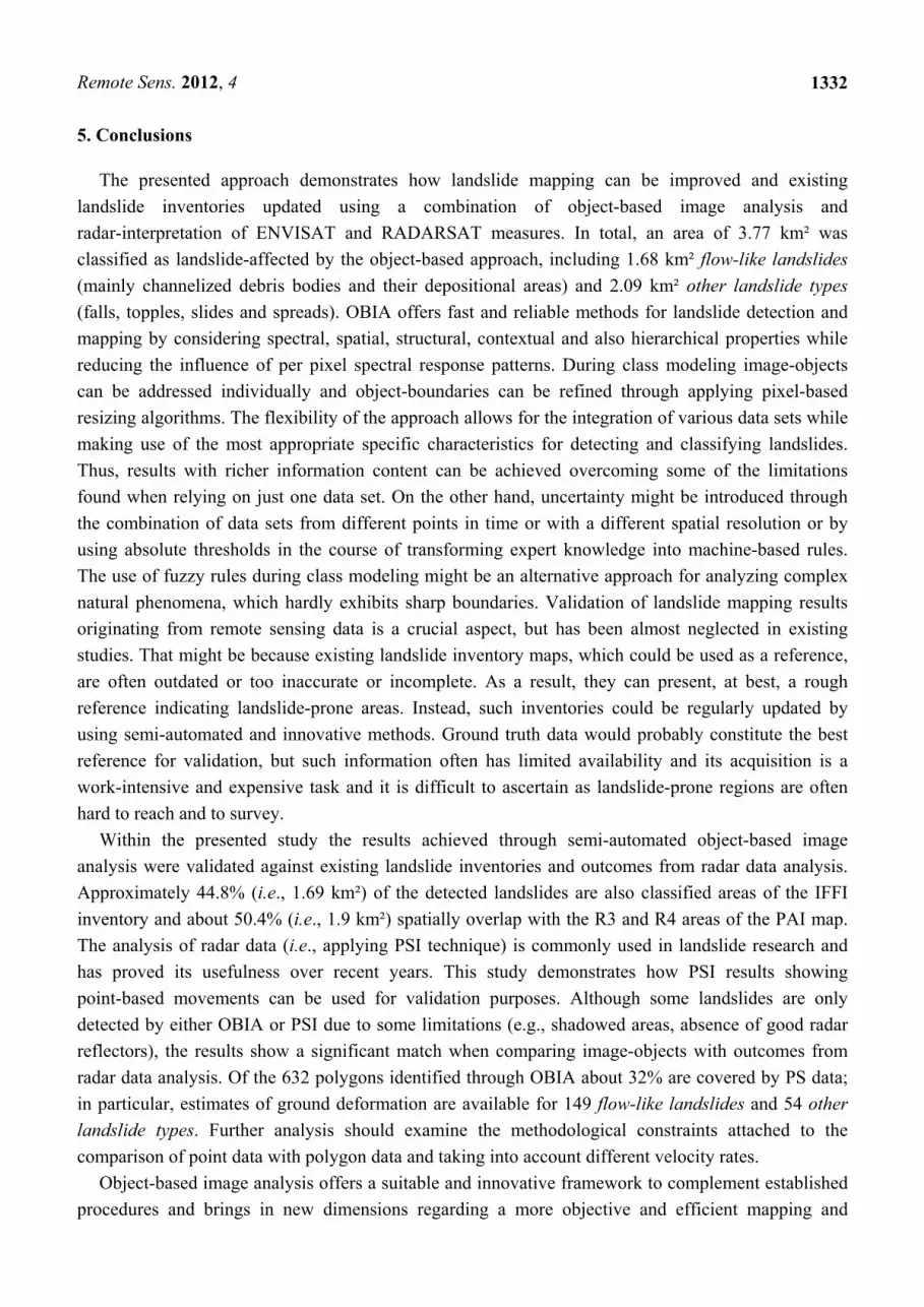
5. Conclusions
The presented approach demonstrates how landslide mapping can be improved and existing
landslide inventories updated using a combination of object-based image analysis and
radar-interpretation of ENVISAT and RADARSAT measures. In total, an area of 3.77 km² was
classified as landslide-affected by the object-based approach, including 1.68 km² flow-like landslides
(mainly channelized debris bodies and their depositional areas) and 2.09 km² other landslide types
(falls, topples, slides and spreads). OBIA offers fast and reliable methods for landslide detection and
mapping by considering spectral, spatial, structural, contextual and also hierarchical properties while
reducing the influence of per pixel spectral response patterns. During class modeling image-objects
can be addressed individually and object-boundaries can be refined through applying pixel-based
resizing algorithms. The flexibility of the approach allows for the integration of various data sets while
making use of the most appropriate specific characteristics for detecting and classifying landslides.
Thus, results with richer information content can be achieved overcoming some of the limitations
found when relying on just one data set. On the other hand, uncertainty might be introduced through
the combination of data sets from different points in time or with a different spatial resolution or by
using absolute thresholds in the course of transforming expert knowledge into machine-based rules.
The use of fuzzy rules during class modeling might be an alternative approach for analyzing complex
natural phenomena, which hardly exhibits sharp boundaries. Validation of landslide mapping results
originating from remote sensing data is a crucial aspect, but has been almost neglected in existing
studies. That might be because existing landslide inventory maps, which could be used as a reference,
are often outdated or too inaccurate or incomplete. As a result, they can present, at best, a rough
reference indicating landslide-prone areas. Instead, such inventories could be regularly updated by
using semi-automated and innovative methods. Ground truth data would probably constitute the best
reference for validation, but such information often has limited availability and its acquisition is a
work-intensive and expensive task and it is difficult to ascertain as landslide-prone regions are often
hard to reach and to survey.
Within the presented study the results achieved through semi-automated object-based image
analysis were validated against existing landslide inventories and outcomes from radar data analysis.
Approximately 44.8% (i.e., 1.69 km²) of the detected landslides are also classified areas of the IFFI
inventory and about 50.4% (i.e., 1.9 km²) spatially overlap with the R3 and R4 areas of the PAI map.
The analysis of radar data (i.e., applying PSI technique) is commonly used in landslide research and
has proved its usefulness over recent years. This study demonstrates how PSI results showing
point-based movements can be used for validation purposes. Although some landslides are only
detected by either OBIA or PSI due to some limitations (e.g., shadowed areas, absence of good radar
reflectors), the results show a significant match when comparing image-objects with outcomes from
radar data analysis. Of the 632 polygons identified through OBIA about 32% are covered by PS data;
in particular, estimates of ground deformation are available for 149 flow-like landslides and 54 other
landslide types. Further analysis should examine the methodological constraints attached to the
comparison of point data with polygon data and taking into account different velocity rates.
Object-based image analysis offers a suitable and innovative framework to complement established
procedures and brings in new dimensions regarding a more objective and efficient mapping and

Remote Sens. 2012, 4
1333
monitoring of landslides. However, more research is needed to make rulesets more intuitive, robust
and transferable to different settings and conditions. Future research directions should aim at the
further implementation of automated and operational workflows by a full integration of all available
data sets (i.e., integrating both, optical and radar data supplemented by elevation information and
ancillary data). Thus, it might be possible to automatically attach information about moving directions
and rates to image-objects and to come up with fully integrated workflows and results.
Acknowledgments
The research leading to these results has received funding from the European Community’s Seventh
Framework Programme (FP7/2007–2013) under the SAFER (Services and Applications For
Emergency Response) project, grant agreement no. 218802. ERS1/2, ENVISAT and RADARSAT
images were provided under EC-ESA (European Commission-European Space Agency) GSC-DA
(GMES Space Component Data Access), and were processed by Altamira Information within the
SAFER project. Access to IFFI (Inventario dei Fenomeni Franosi in Italia) was possible through the
ISPRA’s WMS service, while PAI (Piano Stralcio di Bacino per l’Assetto Idrogeologico) was made
available to the Earth Sciences Department-University of Firenze, Italy, by the Italian Civil Protection
Department. The authors would also like to thank Barbara Friedl for supporting work done and Gaia
Righini for her contribution during the selection of the satellite imagery.
References
1. Guha-Sapir, D.; Vos, F.; Below, R.; Ponserre, S. Annual Disaster Statistical Review 2010: The
Numbers and Trends; Centre for Research on the Epidemiology of Disasters (CRED), Université
catholique de Louvain: Brussels, Belgium, 2011; p. 41.
2. Tsai, F.; Hwang, J.-H.; Chen, L.C.; Lin T.H. Post-disaster assessment of landslides in southern
Taiwan after 2009 Typhoon Morakot using remote sensing and spatial analysis. Nat. Hazards
Earth. Syst. 2010, 10, 2179–2190.
3. Barlow, J.; Franklin, S.; Martin, Y. High spatial resolution satellite imagery, DEM derivatives,
and image segmentation for the detection of mass wasting processes. Photogramm. Eng. Remote
Sensing 2006, 72, 687–692.
4. Lu, P.; Stumpf, A.; Kerle, N.; Casagli, N. Object-oriented change detection for landslide rapid
mapping. IEEE Geosci. Remote Sens. Lett. 2011, 8, 701–705.
5. Stumpf, A.; Kerle, N. Object-oriented mapping of landslides using Random Forests. Remote Sens.
Environ. 2011, 115, 2564–2577.
6. Debella-Gilo, M.; Kääb, A. Measurement of surface displacement and deformation of mass
movements using least squares matching of repeat high resolution satellite and aerial images.
Remote Sens. 2012, 4, 43–67.
7. Borghuis, A.M.; Chang, K.T.; Lee, H.Y. Comparison between automated and manual mapping of
typhoon-triggered landslides from SPOT-5 imagery. Int. J. Remote Sens. 2007, 28, 1843–1856.
8. Nichol, J.E.; Wong, M.S. Satellite remote sensing for detailed landslide inventories using change
detection and image fusion. Int. J. Remote Sens. 2005, 26, 1913–1926.

Remote Sens. 2012, 4
1334
9. Mondini, A.C.; Chang, K.T.; Yin, H.Y. Combining multiple change detection indices for mapping
landslides triggered by typhoons. Geomorphology 2011, 134, 440–451.
10. Martha, T.R.; Kerle, N.; Jetten, V.; van Westen, C.J.; Kumar, K.V. Characterising spectral, spatial
and morphometric properties of landslides for semi-automatic detection using object-oriented
methods. Geomorphology 2010, 116, 24–36.
11. Blaschke, T. Object based image analysis for remote sensing. ISPRS J. Photogramm. 2010, 65,
2–16.
12. Lang, S. Object-Based Image Analysis for Remote Sensing Applications: Modeling
Reality—Dealing with Complexity. In Object-Based Image Analysis: Spatial Concepts for
Knowledge-Driven Remote Sensing Applications; Blaschke, T., Lang, S., Hay, G.J., Eds.;
Springer: Berlin/Heidelberg, Germany, 2008; pp. 3–28.
13. Cruden, D.M.; Varnes, D.J. Landslide Types and Processes. In Landslides: Investigation and
Mitigation; Turner, A.K., Schuster, R.L., Eds; Sp. Rep. 247; Transportation Research Board,
National research Council, National Academy Press: Washington, DC, USA, 1996; pp. 36–75.
14. Lahousse, T.; Chang, K.T.; Lin, Y.H. Landslide mapping with multi-scale object-based imaged
analysis- a case study in the Baichi watershed, Taiwan. Nat. Hazards Earth. Syst. 2011, 11, 1–12.
15. Martha, T.R.; Kerle, N.; van Westen, C.J.; Jetten, V.; Kumar, K.V. Segment optimization and
data-driven thresholding for knowledge-based landslide detection by object-based image analysis.
IEEE Trans. Geosci. Remote Sens. 2011, 49, 4928–4943.
16. Martin, Y.E.; Franklin, S.E. Classification of soil and bedrock-dominated landslides in British
Columbia using segmentation of satellite imagery and DEM data. Int. J. Remote Sens. 2005, 26,
1505–1509.
17. Moine, M.; Puissant, A.; Malet, J.P. Detection of Landslides from Aerial and Satellite Images
with a Semi-Automatic Method. Application to the Barcelonnette Basin (Alps-de-Haute-Provence).
In Landslide Processes: From Geomorphological Mapping to Dynamic Modelling; Malet, J.-P.,
Remaitre, A., Bogaard, T., Eds.; CERG: Strasbourg, France, 2009; pp. 63–68.
18. Rau, J.Y.; Jhan, J.P.; Lo, C.F.; Lin, Y.S. Landslide Mapping Using Imagery Acquired by a
Fixed-Wing UAV. In Proceedings of the International Conference on Unmanned Aerial Vehicle
in Geomatics (UAV-g), Zurich, Switzerland, 14–16 September 2011; In International Archives of
the Photogrammetry, Remote Sensing and Spatial Information Sciences; 2011; Volume XXXVIII,
p. 6.
19. Hölbling, D.; Füreder, P. A (semi-)automated object-based approach for landslide detection based
on SPOT-5 imagery and digital elevation data. Geophys. Res. Abs. 2011, 13, EGU 2011-6786.
20. Aksoy, B.; Ercanoglu, M. Landslide identification and classification by object-based image
analysis and fuzzy logic: An example from the Azdavay region (Kastamonu, Turkey). Comput.
Geosci. 2012, 38, 87–98.
21. Drǎgut, L.; Blaschke, T. Automated classification of landform elements using object-based image
analysis. Geomorphology 2006, 81, 330–344.
22. Drǎgut, L.; Eisank, C. Automated object-based classification of topography from SRTM data.
Geomorphology 2012, 141-142, 21–33.
23. Lang, S.; Albrecht, F.; Kienberger, S.; Tiede, D. Object validity for operational tasks in a policy
context. J. Spatial Sci. 2010, 55, 9–22.

Remote Sens. 2012, 4
1335
24. Dal Piaz, G.V.; Bistacchi, A.; Massironi, M. Geological outline of the Alps. Episodes 2004, 28,
174–179.
25. Roure, F.; Bergerat, F.; Damotte, B.; Mugnier, J.L.; Polino, R. The ECORS-CROP Alpine seismic
traverse. Memoires de la Societe Geologique de France 1996, 170, 1–113.
26. Bernabini, M.; Polino, R.; Nicolich, R. Seismic lines CROP-ECORS across the Western Alps. In
Mem. Descr. Carta Geol. d’It. 2003, LXII; pp. 89–96.
27. Bucher, S.; Ulardic, C.; Bousquet, R.; Ceriani, S.; Fügenschuh, B.; Gouffon, Y.; Schmid, S.M.
Tectonic evolution of the Briançonnais units along a transect (ECORS-CROP) through the
Italian-French Western Alps. Eclogae. Geol. Helv. 2004, 97, 321–345.
28. Deline, P.; Broccolato, M.; Noetzli, J.; Ravanel, L.; Tamburini, A. The December 2008 Crammont
rock avalanche, Mont Blanc massif area, Italy. Geophys. Res. Abs. 2010, 12, EGU 2010-10388.
29. Arnaud, A.; Adam, N.; Hanssen, R.; Inglada, J.; Duro, J.; Closa, J.; Eineder M. ASAR ERS
Interferometric Phase Continuity. In Proceedings of the International Geoscience and Remote
Sensing Symposium (IGARSS’03), Toulouse, France, 21–25 July 2003; pp. 1133–1135.
30. Duro, J.; Inglada, J.; Closa, J.; Adam, N.; Arnaud, A. High Resolution Differential Interferometry
Using Time Series of ERS and ENVISAT SAR Data. In Proceedings of FRINGE 2003 Workshop,
Frascati, Italy, 1–5 December 2003; p. 6.
31. Tiede, D.; Lang, S.; Albrecht, F.; Hölbling, D. Object-based class modeling for cadastre-constrained
delineation of geo-objects. Photogramm. Eng. Remote Sensing 2010, 76, 193–202.
32. Tiede, D.; Lang, S.; Hoffmann, C. Type-Specific Class Modelling for One-Level Representation
of Single Trees. In Object-Based Image Analysis: Spatial Concepts for Knowledge-Driven
Remote Sensing Applications; Blaschke, T., Lang, S., Hay, G.J., Eds.; Springer: Berlin, German,
2008; pp. 133–151.
33. Drǎguţ, L.; Tiede, D.; Levick, S.R. ESP: A tool to estimate scale parameter for multiresolution
image segmentation of remotely sensed data. Int. J. Geogr. Inf. Sci. 2010, 24, 859–871.
34. Trimble Documentation. eCognition® Developer 8.64.0 Reference Book; Trimble Germany
GmbH: Munich, Germany, 2010.
35. Varnes, D.J. Slope Movements: Types and Processes. In Landslides: Analysis and Control;
Schuster, R.L., Krizek, R.J., Eds.; Special Report 176; Transportation Research Board, National
Academy of Sciences: Washington, DC, USA, 1978; pp. 11–33.
36. Agenzia per la Protezione dell’Ambiente e per i Servizi Tecnici (APAT). Rapporto Sulle Frane in
Italia, Il Progetto IFFI: Metodologia, Risultati e Rapporti Regionali; APAT Report 78; APAT:
Rome, Italy, 2007.
37. Crosetto, M.; Monserrat, O.; Cuevas, M.; Crippa, B. Spaceborne differential SAR interferometry:
Data analysis tools for deformation measurement. Remote Sens. 2011, 3, 305–318.
38. Zhou, X.; Chang, N.-B.; Li, S. Applications of SAR Interferometry in earth and environmental
science research. Sensors 2009, 9, 1876–1912.
39. Meisina, C.; Zucca, F.; Notti, D.; Colombo, A.; Cucchi, A.; Savio, G.; Giannico, C.; Bianchi, M.
Geological interpretation of PSInSAR data at regional scale. Sensors 2008, 8, 7469–7492.
40. Delacourt, C.; Raucoules, D.; Le Mouélic, S.; Carnec, C.; Feurer, D.; Allemand, P.; Cruchet, M.
Observation of a large landslide on La Reunion Island using differential SAR Interferometry (JERS
and Radarsat) and correlation of optical (Spot5 and Aerial) images. Sensors 2009, 9, 616–630.

Remote Sens. 2012, 4
1336
41. Farina, P.; Casagli, N.; Ferretti, A. Radar-interpretation of InSAR Measurements for Landslide
Investigations in Civil Protection Practices. In Proceedings of the 1st North American Landslide
Conference, Vail, CO, USA, 3–8 June 2007; pp. 272–283.
42. Cigna, F.; Del Ventisette, C.; Liguori, V.; Casagli, N. Advanced radar-interpretation of InSAR
time series for mapping and characterization of geological processes. Nat. Hazards. Earth. Syst.
2011, 11, 865–881.
© 2012 by the authors; licensee MDPI, Basel, Switzerland. This article is an open access article
distributed under the terms and conditions of the Creative Commons Attribution license
(http://creativecommons.org/licenses/by/3.0/).