Embed Size (px)
Citation preview

1
THE KOMÁROM-ESZTERGOM COUNTY (SUBREGION NUTS 3) AS AN EXAMPLE OF A SUCCESSFUL TRANSFORMATION- CASE STUDY REPORT
Authors: James Scott and Boglárka Szallai WP6 Task 3 The research leading to these results has received funding from the European Union's Seventh Framework Programme (FP7/2007-2013) under grant agreement “Growth-Innovation- Competitiveness: Fostering Cohesion in Central and Eastern Europe” (GRNCOH)
2
Introduction of the Central-Tansdanubian region and Komárom-Esztergom County Within Hungary there are huge differences in development levels that are mainly based on historical impacts, different natural/environmental conditions. The most developed region of the country is Central Hungary (including Budapest). In general western regions are more developed than eastern ones, and there is a general North-South pattern of disparity in terms of settlement structure, population, demographics, economic development and social diversification with southern areas being the most disadvantaged. Central Transdanubia (Közép-Dunántúl) region is one of Hungary’s seven NUTS II regions1, and consists of 3 counties (NUTS III regions): Fejér, Veszprém and Komárom-Esztergom. Among the three counties Komárom-Esztergom is the most urbanized one, 14% of its 76 settlements2 are towns compared to Fejér and Veszprém (7%), which is mostly characterized mostly by a proliferation of tiny smallholder settlements. Komárom-Eszergom county is situated on the northern border of Hungary, surrounded by Slovakia, Győr-Moson-Sopron, Veszprém, Fejér and Pest counties. The county seat is Tatabánya. Esztergom, established in 972 is one of the oldest settlements in Hungary, inhabited by 30.434 people is the second biggest town in Komárom-Esztergom county. With a surface area of 100 km2 Esztergom is the centre of the Esztergom microregion, inhabited by 56 840 people (2011, census, KSH). With a surface area of 2265 km2 Komárom-Esztergom is the smallest county of Central Transdanubia and in Hungary as well. With a total population of 302.451 people (2013), almost 30% of the Central-Transdanubian regions population live in Komárom-Esztergom county.3 Thanks to the small surface area the density of population (141 people /km2) is the second highest after Pest county (excluding Budapest itself with 3305). In Komárom-Esztergom since 2001 the birth-death balance is -3,7 (per 1000 inhabitant per year) in average, the decrease of the population is caused by the internal migration, which was positive till 2008 (1,7 in average), but it turned into negative from 2009 (-0,8 in average). +International migration (0,8 and 0,0) The Central Hungarian region is the most populous one hosting 30 percent of the total population of Hungary (2.953.883 people), whereas Central Transdanubia on 11.000 km2 (12% of Hungary’s surface area) is home for 11% of Hungary’s total population (1.074.702 people). The Central Hungarian region is the most densely populated, with 424 people/km2, while Central Transdanubia the second one (97 people/km24). The most urbanized region is Central Hungary (26% of its settlements are towns), followed by two Great Plain regions and the Central Transdanubia; 10 percent of its settlements are towns. After the transition a mass migration began to the region and to Komárom-Eszterom County: between 1990
1Central Hungary (Közép-Magyarország), Central Transdanubia (Közép-Dunántúl), Western Transdanubia (Nyugat-
Dunántúl), Southern Transdanubia (Dél-Dunántúl), Northern Hungary (Észak-Magyarország), Northern Great Plain (Észak-
Alföld), Southern Great Plain (Dél-Alföld) 2Including 1 megyei jogú város (Tatabánya), 9 towns, 66 villages and 7 microregions
3http://www.ksh.hu/docs/hun/xstadat/xstadat_eves/i_wdsd003a.html
4http://www.ksh.hu/docs/hun/xstadat/xstadat_eves/i_wdsd005.html

3
(when the pop. was 317.000 people) and 2001 a natural decrease of 8500 people was compensated with a migration balance of 8100 people (when it had also 317.000 inhabitants).
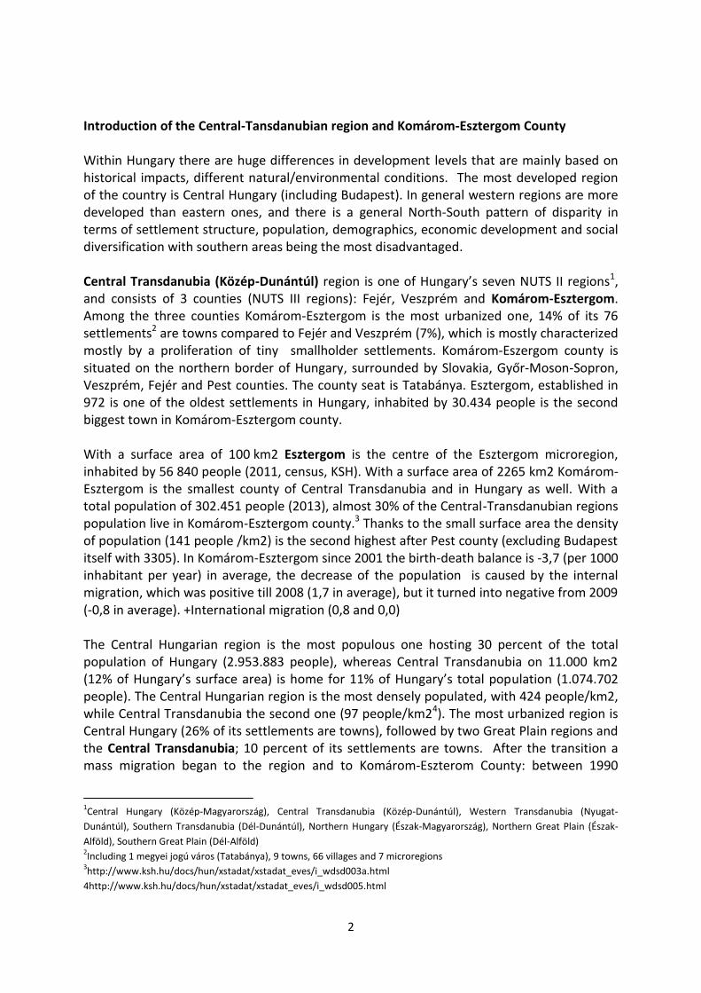
Table 1: Population trends, 2001 = 100%, Source: KSH
As in all regions of Hungary, the population continues to decline in Komárom-Esztergom County. The drop (-1,8%) is below the county and regional average (-2,1% and -2,4% respectively) and ranks no. 5 among 20 counties. Since 2002 all regional populations have decreased slowly and constantly except of the Central region, where the difference between the birth-death is still negative. The population decreases in Western and Central Transdanubia are the slowest. The difference between birth-death rates is negative in each Hungarian region (even in the central region it is -2,5 per 1000 inhabitant per year) but is compensated by inmigration. The population is aging; in 1980 23% of the pop. was less than 18 years old while in 2011 it was only 15%. (KSH, 2011) More than half of the drop is coming from 2010 and 2011, when the decline rate grew to five times of its original rate (from 319 avg. loss/year between 2001 and 2009 to 1520 avg. loss/year in 2010 and 2011). As shown in the waterfall chart below this was mainly driven by the internal and international migration balance as the yearly average natural growth remained stable. Before 2009 both national and international migration balance were strongly positive slowing down the diminution of the population whereas from 2010 both turned to negative.
96%
97%
98%
99%
100%
101%
Komárom-Esztergom Central Transdanubia Hungary

4
Table 1: Change of population in Komárom-Esztergom County Source: KSH
Economy
Table 2: GDP per capita, thousand HUF, KSH
GDP per capita growth (+106%) outperformed the regional and country average (+77% and +87% respectively) between 2001 and 2011. Regarding GDP/capita CT region has always been the third one (88%) among regions lagging behind Central Hungary (164% of country average) and Western Transdanubia (102% of country average)5.
5http://www.ksh.hu/docs/hun/xstadat/xstadat_eves/i_qpt014.html
31
6 9
98
31
4 4
50
31
1 4
09
-9019
-3445
4396
-306
2075
-369
300 000
305 000
310 000
315 000
320 000
0
500
1 000
1 500
2 000
2 500
3 000
Komárom-Esztergom Central Transdanubia Hungary

5
Table 4: GDP per capita vs. secondary sector production growth in Komárom-Esztergom County, 2001 = 100, KSH
The main factor for Komárom-Esztergom county’s growth is the increasing output produced by the secondary sector; their development is in close correlation. The drop in GDP per capita in 2009 can be also tracked back to a significant (19%) fall in industrial production. Komárom-Esztergom county’s composition of corporations is also industry intensive with having 22% of companies in the secondary sector. As for comparison this rate is 17% for Hungary and 19% for Hungary without counting Pest county and Budapest (as the service sector concentrates here) (KSH). Foreign investments The number of companies with foreign interest increased by 4% in 10 years (from 2001 to 2011), meanwhile the county average grew by 11% but only due to the fact that Pest county and Budapest (Central Hungary) experienced an increase of 30%. Without Pest and Budapest the Hungarian average growth rate turns into an 18% decline. 71% of all foreign companies operate in Central Hungary (21. 365 businesses/ 29879), and they provide 60% of the foreign capital (10579 bln HUF/17989 bln HUF). While in Central Transdanubia 5% of all foreign businesses (1623 businesses) making 7% of all foreign capital (1258 bln HUF).
0%
50%
100%
150%
200%
250%
300%
350%
400%
0%
50%
100%
150%
200%
250%
GDP per capita Production of secondary sector (secondary)
6
Table 3: Capital in companies with foreign interest, 2001 = 100, KSH
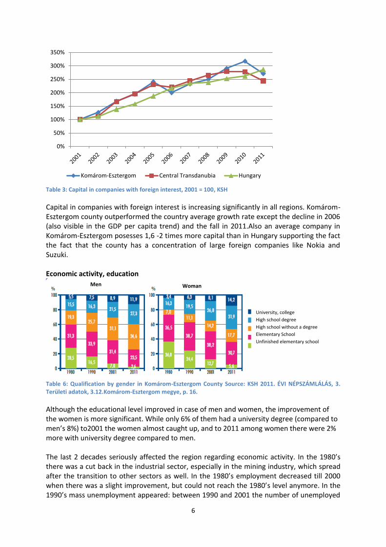
Capital in companies with foreign interest is increasing significantly in all regions. Komárom-Esztergom county outperformed the country average growth rate except the decline in 2006 (also visible in the GDP per capita trend) and the fall in 2011.Also an average company in Komárom-Esztergom posesses 1,6 -2 times more capital than in Hungary supporting the fact the fact that the county has a concentration of large foreign companies like Nokia and Suzuki. Economic activity, education
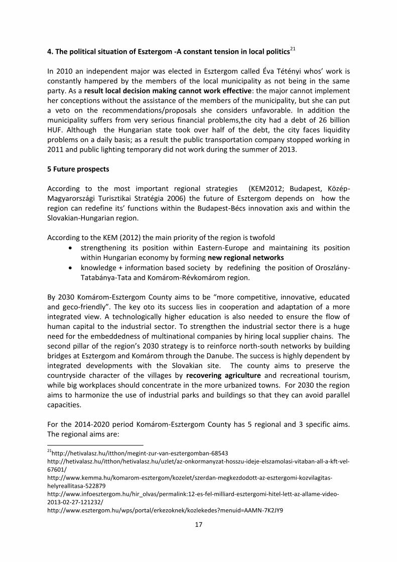
Table 6: Qualification by gender in Komárom-Esztergom County Source: KSH 2011. ÉVI NÉPSZÁMLÁLÁS, 3. Területi adatok, 3.12.Komárom-Esztergom megye, p. 16.
Although the educational level improved in case of men and women, the improvement of the women is more significant. While only 6% of them had a university degree (compared to men’s 8%) to2001 the women almost caught up, and to 2011 among women there were 2% more with university degree compared to men. The last 2 decades seriously affected the region regarding economic activity. In the 1980’s there was a cut back in the industrial sector, especially in the mining industry, which spread after the transition to other sectors as well. In the 1980’s employment decreased till 2000 when there was a slight improvement, but could not reach the 1980’s level anymore. In the 1990’s mass unemployment appeared: between 1990 and 2001 the number of unemployed
0%
50%
100%
150%
200%
250%
300%
350%
Komárom-Esztergom Central Transdanubia Hungary
Men Woman
University, college
High school degree
High school without a degree
Elementary School
Unfinished elementary school

7
people increased by 200% and to 2011 by 400%. Number of employed people reached its bottom in 1995-1996 in Central Transdanubian region thanks to the structural change in the economy; 11.000 people were fired from agricultural sector and more than a 20.000 from industrial companies. From the late nineties the number of employers increased despite the constantly shrinking agricultural sector. The sectoral shifts were different from what happened in the rest of Hungary: while the proportion of the workforce in the tertiary sector grew by 10% within the country compared to 1992, the proportion of people working in the industry sector decreased by 3,2%. In the Central Transdanubian region both sectors increased by 3 percentage, while the proportion of those working in agriculture decreased to 4,9%. The increase of inactive earners from the mid-nineties is a result of the introduction of several possibilities that people could retire earlier0. In 1992 46% of unemployed had only elementary degree, and only 2,3% of them had a university/college degree. In 2006 more than 7 % of job seekers had bachelor degrees and less than one third (32%) had only an elementary degree.6
Table 7: Population by economic activity. Source: KSH 2011. ÉVI NÉPSZÁMLÁLÁS,3.Területi adatok, 3.12. Komárom-Esztergom megye, p. 16.
6FOGLALKOZTATOTTSÁG, KERESETEKA KÖZÉP-DUNÁNTÚLONVeszprém,Központi Statisztikai Hivatal Veszprémi
Igazgatósága, 2007
29,6 26,6 23,4
25,3 31,2 28,5
0,9 3
5
44,2 39,2 43
0%
20%
40%
60%
80%
100%
1990 2001 2011
Dependant Inactive earner Unemployed Employed

8
Figure 1: Schematic Geopolitical Development Map of Hungary (indicates the location of Komárom-Esztergom County in the major development corridor between Vienna, Györ and Budapest Regions). Source: Komárom-Esztergom Megyei Önkormányzát (2013)
Figure 2: Schematic Development map of Komárom-Esztergom County (indicates subareas of partnership between municipalities in preparation for new Cohesion Policy rules). Source: Komárom-Esztergom Megyei Önkormányzát (2013)

9
1.1 The Esztergom Agglomeration and its components Spatial range of the agglomeration Esztergom itself has an agglomeration zone of ca. 50 surrounding settlements (2/3 of them located in Slovakia) but to understand the present situation of Komárom-Esztergom county and the agglomeration of Esztergom we need to go back in history. Till the Tatar Invasion (1422) Esztergom was one of the main centres of Hungary hosting the main public administrational, religional functions. In 1895 Mária-Valéria Bridge has been built to connect Esztergom with Slovakia (Párkány).The Trianon Treaty (1920) affected seriously the relations of cities and their agglomeration zones by separating them with a border (Győri R. 2006). As a result several agglomeration zones in Hungary were left without their corresponding cities, causing either serious regional depression or the pressure of forming “artificial cities” in these regions to replace the functions of the former ones. The case of Esztergom was the first one, as being separated from its’ natural agglomeration zone in Slovakia by the Trianon Treaty. In 1923 Esztergom became the seat of Esztergom county but only until 1950 when it was replaced by Tatabánya. Several regional functions still remained at Esztergom; for example county court, county jail. Esztergom can be regarded as a winner of the transition since after 1990 several factors contributed to the reconstruction of the original agglomeration zones of the city. Namely (1) in 1991 Suzuki settled down in Esztergom, serving as a base for the later industrial park, and facilitating Esztergom to restitute the Slovakian agglomeration zone by hiring numerous Slovakian people. (2) In 2001 Esztergom recovered its historical agglomeration zone (vonzáskörzet) by renovation of the Mária-Valéria Bridge connecting Párkány (Slovakia) and Esztergom. (3) Joining the EU opened the door for the Slovakian workforce which could easily find jobs in the industrial parks. (4) After the transition the former agglomeration zone of Esztergom in Slovakia was hit by a serious structural crisis leaving many people unemployed, while costs of living increased. All of these factors contributed to the development of the Esztergom agglomeration zone consisting of 50 settlements including 33 Slovakian ones (Jaschitz, 2009). 1.2 Is there a commonly accepted delimitation of the city’s metropolitan area and what are its criteria? On one hand officially the bunch of settlements belonging to the metropolitan areas is defined by the Hungarian law7 but it does not define the term “metropolitan area” itself, but lists the settlements belonging to the zone exclusively one by one. Based on KSH’s classification there are 21 agglomeration zones in Hungary8, but it does not mention Esztergom. On the other hand relevant literature uses several definitions of metropolitan area simultaneously that are consistent in the main points, but they also show some minor dissimilarities caused by stressing different aspects of the metropolitan area. They have one thing in common: none of them are specific enough for identifying what settlement does
72005 évi LXIV törvény (http://net.jogtar.hu/jr/gen/hjegy_doc.cgi?docid=A0500064.TV)
8Source: http://www.ksh.hu/teruleti_atlasz_agglomeraciok

10
and what does not constitute a metropolitan area. The definition of the United Nations gives enough space to elaborate own agglomeration definitions, it only emphasizes that an agglomeration consists of a city and a surrounding area which generally are not administrative units9. When describing metropolitan area, all definitions - even the simplest ones – mention the tight links between the city/cities and the surrounding area. Kőszegfalvi (1995) emphasizes the residents’ and enterprises’ daily and close ties with the city though he does not specifies the nature of the relations10. The definition used by Nemes Nagy (2005) is much more specific and focused on the nature of relations between the city and the agglomeration zone; the author underlines also the intense economic and social links between the suburbs and the city and the concentration of population around the city due to the concentration and centralization processes of production power11. According to Ortt (1983) the agglomeration consists of settlements involved in an intensive division of labour where complex multiway relationships emerge due to the spatial differentiation of the functions which also can be observed in the development of the infrastructure. In Perger’s (2006) definition the term „metropolitan area” is closely linked to the urbanization when the city overgrows its borders, and simultaneously new settlements come off within the surroundings of the city12. 1.3 Does the dominant city have an administrative or statistical counterpart reflecting the area of its influences (metropolitan macro-region)? Although Esztergom is gaining back its agglomeration zone in Slovakia, it is in a very difficult position regarding its location as Esztergom is stacked between the agglomeration zones of the capital, Budapest and Tatabánya, the county seat and former industrial center. Since it is located 45 km far from the capital it can be regarded as part of the biggest agglomeration zone of Hungary: the agglomeration zone of Budapest (consisting of 81 settlements) inhabited by 2.529.000 people (2010)13 and it has a number of migration and economic-related connections to the capital. Esztergom is also less than 50 km far from the county
9 “Referstothe de facto populationcontainedwithinthecontours of a
contiguousterritoryinhabitedaturbandensitylevelswithoutregardtoadministrativeboundaries. Itusuallyincorporatesthepopulationin a city ortown plus thatinthesub-urbanareaslyingoutside of but being adjacenttothe city boundaries.” Source: http://esa.un.org/unup/Documentation/WUP_glossary.htm 10
„Agglomerációnak a nagyvárost és a nagyváros körüli azon települések együttesét nevezzük, amelynek lakossága és vállalkozásai szoros, napi szintű kapcsolatban vannak egymással” (Kőszegfalvi 1995). 11„A termelőerők koncentrációs és centralizációs folyamatainak eredményeként létrejövő olyan
településegyüttes, amelyben – alapesetben – a környezetéből kiemelkedően fejlett várost és a körülötte fekvő településeket a gazdasági és társadalmi élet területein intenzív kapcsolat köti össze, és ahol a központi város körül népességtömörülés megy végbe” (Nemes Nagy 2005). 12
„Az agglomerációk többnyire közigazgatási határokkal tagolt, ugyanakkor szoros társadalmi gazdasági és funkcionális-területi kapcsolatokkal egységbe fogott település-csoportok. Az agglomerációk a városiasodás, városfejlődés (urbanizáció) folyamatában alakultak ki, mely során korábban önálló települések összefonódnak, melyben a nagyváros „kinövi” határait, illetve a nagyváros vonzáskörzetében új települések alakulnak. (Perger É. 2006) 13
http://www.terport.hu/kiemelt-tersegek/budapesti-agglomeracio

11
seat, Tatabánya -with a population of 70.000 people-and its agglomeration zone consisting of 12 settlements. 1.4. Does the existing administrative division on the regional level (NUTS2) and subregional level (NUTS3) correspond to the city’s influence areas, i.e.: a) the metropolitan area, b) the metropolitan region? As the “feasibility study for the cargo bridge between Párkány and Esztergom” (2006) points out the current regional division does not correspond to Esztergom’s influence areas as it is lying in the north- eastern edge of the Central Transdanubian region (NUTS2) and Komárom-Esztergom county (NUTS2), relatively far from the region’s main development axis along Székesfehérvár-Tatabánya, which means that it is relatively close to the rest of the county, while it has strong connections with the capital.
2. The most important strengths and weaknesses and factors influencing the development of Komárom-Esztergom county and Esztergom Although the location of Komárom-Esztergom county and Esztergom could be regarded as highly advantageous from transportation point of view, the region cannot make use of its location for several reasons. Strengths and weaknesses regarding location and transport14:
Two TEN-t roads cross the region which are located on the Budapest-Vienna innovation axis thanks to the TEN-T 4. road (From Austria and Slovakia –through Budapest-to Románia), but the highways are in a very bad condition therefore they cannot facilitate the attraction of foreign investment.
Although TEN-T 7 water way crosses the region 50 km long along the Danube from Austria to Romania (part of Danube – Majna – Rajna water way ), water transport is not relevant, there are no scheduled ships on the Danube, lacking bridges which are in bad condition, the docks are not suitable to join international traffic . As pointed out by the development program of Ister-Granum Euroregion (2005) the region earlier had a significant cargo activity to transfer products of industrial factories. Within the framework of INTERREG IIIA a new bridge is planned to be built between Komárom and Komarno to connect the economic actors of South-Slovakia with the North-Hungarian region, the actual construction can only start in 201615. Since Budapest-Bécs train line crossed the most developed industrial areas in the previous era, several industrial tracks (ipari vágány) can be found along the line that became less useful after the transition as industrial production reduced.
Interregional and microregional networks are weak since north-southern road networks are missing, as a result West-Balkan is approachable only through Budapest.
Although Esztergom is relatively close to the capital and primary routes Nr 11 and 10 connect Budapest with Esztergom, both are highly overburdened and in a very bad
14
Komárom-Esztergom Megye Területfejlesztési Koncepció, 2013 15
http://www.kemma.hu/komarom-esztergom/gazdasag/uj-duna-hid-keszulnek-a-tanulmanyok-536000 http://www.kemkh.hu/

12
condition which makes commuting time-consuming and affects R+D potential negatively.
The density of public transport network is relatively high but the train lines are in a very dilapidated condition except for the line to Hegyeshalom. The region’s main train line is the Budapest-Esztergom one which was reconstructed in 2000.
A train line to Slovakia is also missing. Strengths and weaknesses regarding tourism, industry and economy:
Although Komárom-Esztergom County and Esztergom also have outstanding capabilities for tourism; thanks to the advantageous geographical location the region posses several touristic attractions, like thermal baths, 7 natural reserves, and has historical horse and hunting traditions, the performance of tourism is relatively weak.
As Esztergom is the center of Roman Catholic Church it lures pilgrims from all Hungary.
Komárom-Esztergom County hosts prestigious Educational institutions with a long history (pl: Esztergom – ferences, Tata – piarista)
Local supplier chains have not evolved; suppliers of multinational companies mainly consist of foreign actors.
Tertier sector (services) is underrepresented since inhabitants do not use local services but they prefer Budapest and Győr.
Although there are industrial parks, several innovation centers in Komárom-Esztergom County, the information-flow among them is weak, they do not constitute a network, as a result industrial parks are not specialized
Innovation is not embedded into the region; economic links between science, education and economic actors are weak
The communication between organizations involved into regional development is not sufficient
Small and medium size enterprises cannot apply for EU grants as they lack the capital needed, while capital is concentrated in big businesses, in addition there is no central budget for project preparation.
Centralized decision making
Neither local nor regional municipalities have the proper tools for incentivizing investment
Present structure of agriculture is not optimal, agricultural market is not protected from external influence, in addition EU-contribution is not sufficient
A central strategy for agriculture is missing
2.4. Most important development factors
As Jaschitz (2009) stated between 1965 and 1980 the annual economic decline of Esztergom was 1 percentage caused by the (1) growth of Budapest that lured the workforce of Komárom-Esztergom County and (2) the artificial expansion of nearby industrial towns, like Tatabánya and (3) the negligence of settlements along the border. The situation of Esztergom worsened between 1980 and 1990, as it was hit harder by the crises of the transition than other towns within the region (Lados M., 1995).

13
According to Bódiné Vajda Gy. (2004) Esztergom was one of the biggest loosers of the Trianon Treaty and also the regional policy of the socialist era, but the city was one of the biggest winners of the transition and the border-demolition after Hungary’s European integration. As Lados M. states (1995) the transition and the European integration affected the area highly beneficial, offering the possibility to gain advantage of its geographical location. Additionally right after the transition foreign companies appeared and altogether 30 industrial parks were founded in the Transdanubian region16. The first business settleing down in Esztergom was Suzuki in 1991, 1994: AMP, 1997 fotexoptika, serving as a base for the Industrial Park established in 1997. In the same year, another Industrial Park was funded in Tatabánya that nowadays hosts 25 companies, including 18 multinational ones17. According to Bartal-Hardi (2005.) in the first years the parks hired local workforce, but between 1998 and 2007 the industrial parks have been enlarged and needed a workforce from outside of the region (and also the country). According to the feasibility study for the cargo bridgebetween Esztergom and Párkány (2006) from the beginning the agglomeration zone of Esztergom could not meet the demand for human resource, so it “imported” employees from a zone of 50 km, and from Eastern-Hungary and Romania. According to Bartal-Hardi (2005) the industrial parks hired men in good physical condition among the foreign employees, while other skills had no importance; in 2003 54% of foreign employees had a primary school-qualification at most. Between 2001 and 2004 the number of Slovakian employers in Hungary increased from 496 to 7536, and 64% of all Slovak employees working in Hungary were hired in Komárom-Esztergom county. In 2001 Esztergom recovered its historical agglomeration zone (vonzáskörzet) -lost beforehand due to the treaty of Trianon- by renovation of the Mária-Valéria Bridge connecting Párkány (Slovakia) and Esztergom. The rebuilt bridge had a very strong impact on the traffic near the border and the foundation of the of Ister-Granum Eurorégió in 2003 with Esztergom centre. The next year after renewal of the bridge 2,5 million people crossed the border (feasibility study of the cargo bridge between Esztergom and Párkány,2006), and vehicular traffic increased to 10 times of its original volume and after 2004 the traffic stagnated on a permanent high level. (www.istergranum.hu). With the renewal of the bridge the flow of workforce from Slovakia to Hungary accelerated by removing the physical obstacle between the two countries. In 2004 joining to the EU ruined legal obstacles as well.
16
http://www.logsped.hu/kdr.htm 17
http://www.iph.hu/

14
Table 7: Number of vehicles crossing the border on Mária-Valéria bridge. Source: KOMÁROM-ESZTERGOM MEGYEI TERÜLETRENDEZÉSI TERV – MÓDOSÍTÁS, 2011 p.30
Bartal-Hardi mentions 3 main reasons of Slovakians commuting to the industrial parks; namely (1) After the transition the South Region of Slovakia (Južnýregión) was hit by a serious structural crises; in the second half of the 1990’ years the agricultural plants that were the main employers of the region went bankrupt, leaving many people unemployed; unemployment rate reached 35% at regional level. (2) Growing costs of living in Slovakia with low salaries. According to the feasibility study of the cargo bridge (2006) in the end of 2001 the inhabitants of Esztergom regarded the renewal of the bridge as the third most important happening in world politics. For the 2000’ years Esztergom regained its old “bridge-function” instead of the disadvantageous border-function it could be characterized before the transition. According to Bódiné Vajda Gy.,(2004) Esztergom is on the way to become a regional centre by recovering its historical agglomeration zone by serving as a good base for the establishment of Ister-Granum Euroregion. 2.6. Regional differences between the metropolitan area and regional hinterland
Based on the data of the latest census (2011)18 similarly to Hungary there are significant differences between the metropolitan area and the hinterland regarding social and economic characteristics also. The dispersion of population is highly uneven, it shows a concentration in towns, villages are less populated; more than one fifth of the population of Komárom-Esztergom County (22 percent) live in the seat, Tatabánya, 43 percent in other towns, and 35% in villages. Not only the dispersion but the change of population is also highly affected by the settlement type; villages were much less affected by the population decrease than towns and especially Tatabánya; between 2001 and 2011the population of Tatabánya decreased by 6,5 percent (4717 people), caused by natural decrease and inland
182011 évi népszámlálás 3. területi adatok, 3.12. Komárom-Esztergom Megye, Veszprém 2013
0
200 000
400 000
600 000
800 000
1 000 000
1 200 000
1 400 000
1 600 000
1 800 000
2 000 000
1995 1996 1997 1998 1999 2000 2001 2002 2003 2004 2005 2006 2007
Number of vehicles

15
migration, while villages average decrease was -1,8%. There are vast differences in density of population: while the regional average is 135 people/km2, Tatabánya is more than 10 times densely populated than villages (Tatabánya 741 people/km2, villages 67 people/km2). Ageing - which affects the whole region - hits villages more seriously; in average 11% of the population were 70+ in Komárom-Esztergom, similarly to Tatabánya and other towns as well, but in the villages the proportion of the 70+population reaches 20%. In strong connection with the age structure, the level of education is highly different between towns and villages, in the country seat and in the towns almost half of the population (47-49%) has a high school degree, while in villages it is only 38%. The proportion of those who have a university or college degree is the highest in towns 17%, 6 percentages points higher than that of villages. The dispersion of economically active people also varies between settlement types: in 2011 66% of economically active people lived in towns, including 23% who lived in Tatabánya, where the employment rate was higher than average, and had an average unemployment rate. In towns 43 people of 100 are employed, and 5 unemployed, while in villages unemployed, inactive earners and dependant are overrepresented. The number of dwellings also shows regional differences. From 1990 to 2001 number of dwellings increased by 3% (From 116 to 120.000), and the level in 2011 reached 106% of the 2001 level. This increase was 1,8%points behind the country average, and also shows regional differences within the county; the increase in Tatabánya was 5,8%, a bit less than in other towns, and 0,5% higher than in villages. In the first half of the decade the number of dwellings increased radically due to a national support system, but as a result of the financial crisis from 2008 it decreased dramatically similarly to the trends observable in the country. to the main focus of the constructions were Tatabánya and Esztergom, 40% of newly built dwellings could be found there. The economy of the county is also highly concentrated; among the 12 industrial Parks located in Komárom-Esztergom county 8 are located along the Danube, 4 within the Oroszlány-Tatatbánya- Tata area (KEM területfejlesztésikoncepció, 2008).19
3 Relationship of Komárom-Esztergom county and Budapest
The Komárom-Esztergom County and Budapest mutually need each other and their relationship has a history of more than 20 years. According to several professional organizations (BAFT (2007), interviews with BKK, TOP) one of the main problems of the Budapest agglomeration zone (including Komárom-Esztergom County) is the underdeveloped transportation connections. As Kovács (1990) explains after the end of prohibition of industry setting (ipar telepítési tilalom) in the 1980’ years numerous of multinational enterprises appeared in the agglomeration zone of Budapest, especially in the zones with an adequate infrastructural network (Budaörs, Szentendre) was available supporting economic suburbanization processes by hiring many employees from the city and the agglomeration zone as well. As the number of commuting people grew, transportation system could not adopt to the situation till the present days. According to the
19
KOMÁROM‐ESZTERGOM MEGYE TERÜLETFEJLESZTÉSI KONCEPCIÓ HELYZETFELTÁRÁS ÉS –ÉRTÉKELÉS, Készítette: Város-TeampannonKft, 2008

16
study of the BAFT (2007) 75% of the traffic on the Road Nr.10 (10-es főút) in the rush hours consists of people commuting day-by day polluting the environment, causing traffic jams regularly by overburdening the capacity of the road. In the last 5-6 years Komárom-Esztergom County has not received sources from the central budget as the transportationrelated priorities of the country waere developing of underprivileged regions’ transportation network and unburden the capital from the transit traffic (KEM-helyzetelemzés, 2011). A negative effect of suburbanization on the region is that the region’s several geographical capabilities are unique; it possesses natural reserves, and the Gerecse-Pilis Hills that are endangered by the inhabitants moving in. Until 2000 the dilapidated railway network connecting Komárom-Esztergom and Budapest made the transportation between the two region difficult, but in 2000 several new trains were purchased, tracks were renewed and within the framework of Transport Operational Programme (KÖZOP) the reconstruction of the Budapest-Esztergom railway lines has begun. The railway transfers commuters to Budapest and the northwestern sector of the agglomeration zone (Piliscsaba, Solymár, Pilisvörösvár, Piliscsaba and Dorog) and students of the faculty of humanities and social sciences of Pázmány Péter University in Piliscsaba. With the establishment of EDUTUS college (former MÜTF) in 1992 in Tatabánya commutting of opposite direction begun, as a significant proportion of the students were from the central region (Sikos-Tiner 2002) Within the framework of TOP north-south regional rapid railway which is planned to cross the Esztergom region ensuring for Esztergom railways to use the line. Another negative effect of the proximity of Budapest is that inhabitants and firms of Esztergom use services of the capital (and Győr) instead of the local ones, while the region possess the human resources needed to establish the tertier sector (KEM,2011). Although 42% of touristic attractions and 76%20of attractions with international reputation (nemzetközivonzóerővelrendelkezőlátványosság) concentrate on Budapest, tourism is not negligible within the region, although it underperforms expectations. Thanks to the advantageous geographical location the region possess several touristic attractions, like thermal baths, 7 natural reserves, and has historical horse and hunting traditions. As Esztergom is the center of Roman Catholic Church it lures pilgrims from all Hungary. From the transition tourism it tried to rebuild itself by offering recreational packages specialized for needs of tourists from Budapest, Wien, Pozsony and Győr (Sikos-Tiner 2002). Due to the proximity of the capital the population of Komárom-Esztergom County decreases less than other countries thanks to the suburbanization processes and the concentration of the workplaces on the Budapest-Bécs axis. The proximity of the Budapest-Bécs axis is also observable in the net incomes of the inhabitants, where after the first Budapest, Győr-Moson and Komárom-Esztergom are in the second and third place for years (KEM, Helyzetelemzés, 2011).
20
A Budapest-közép-dunavidéki régióturisztikai stratégiája, 2006, Magyar Turizmus Zrt.
17
4. The political situation of Esztergom -A constant tension in local politics21
In 2010 an independent major was elected in Esztergom called Éva Tétényi whos’ work is constantly hampered by the members of the local municipality as not being in the same party. As a result local decision making cannot work effective: the major cannot implement her conceptions without the assistance of the members of the municipality, but she can put a veto on the recommendations/proposals she considers unfavorable. In addition the municipality suffers from very serious financial problems,the city had a debt of 26 billion HUF. Although the Hungarian state took over half of the debt, the city faces liquidity problems on a daily basis; as a result the public transportation company stopped working in 2011 and public lighting temporary did not work during the summer of 2013. 5 Future prospects According to the most important regional strategies (KEM2012; Budapest, Közép-Magyarországi Turisztikai Stratégia 2006) the future of Esztergom depends on how the region can redefine its’ functions within the Budapest-Bécs innovation axis and within the Slovakian-Hungarian region. According to the KEM (2012) the main priority of the region is twofold
strengthening its position within Eastern-Europe and maintaining its position within Hungarian economy by forming new regional networks
knowledge + information based society by redefining the position of Oroszlány-Tatabánya-Tata and Komárom-Révkomárom region.
By 2030 Komárom-Esztergom County aims to be “more competitive, innovative, educated and geco-friendly”. The key oto its success lies in cooperation and adaptation of a more integrated view. A technologically higher education is also needed to ensure the flow of human capital to the industrial sector. To strengthen the industrial sector there is a huge need for the embeddedness of multinational companies by hiring local supplier chains. The second pillar of the region’s 2030 strategy is to reinforce north-south networks by building bridges at Esztergom and Komárom through the Danube. The success is highly dependent by integrated developments with the Slovakian site. The county aims to preserve the countryside character of the villages by recovering agriculture and recreational tourism, while big workplaces should concentrate in the more urbanized towns. For 2030 the region aims to harmonize the use of industrial parks and buildings so that they can avoid parallel capacities. For the 2014-2020 period Komárom-Esztergom County has 5 regional and 3 specific aims. The regional aims are:
21
http://hetivalasz.hu/itthon/megint-zur-van-esztergomban-68543 http://hetivalasz.hu/itthon/hetivalasz.hu/uzlet/az-onkormanyzat-hosszu-ideje-elszamolasi-vitaban-all-a-kft-vel-67601/ http://www.kemma.hu/komarom-esztergom/kozelet/szerdan-megkezdodott-az-esztergomi-kozvilagitas-helyreallitasa-522879 http://www.infoesztergom.hu/hir_olvas/permalink:12-es-fel-milliard-esztergomi-hitel-lett-az-allame-video-2013-02-27-121232/ http://www.esztergom.hu/wps/portal/erkezoknek/kozlekedes?menuid=AAMN-7K2JY9

18
1. Development of networks, economy and society 2. Cross-border cooperation with twin cities and their agglomeration zones 3. Structural change along river Danube 4. Strengthening the agricultural region of the Kisalföld 5. Complex strengthening of the hills(dombvidék)
The specific ones are:
1. Stabilization of the economic position of the county by diversification of the economical structure
2. Improving activity, creativity and social integration 3. Improving the foreign capital in the industrial parks, rehabilitation of unused
industrial territories The aims of the KEM are partially harmonized with the development concept of Hungary for the period 2014-203022. According to the long-term development concept of Hungary the development of regions in underdog position is a key factor as the local differences cause huge losses on national and international level. For this reason the measures on medium term are (p.85):
Solving the employment-related and social problems of the peripheral areas
Strengthening cross-border cooperation by improving the accessibility of regions on the border
Long-term objectives areas:
Budapest as a macro regional center
settlements ensuring modern and quality life
developments based on cooperation of networks of settlements
renewal of the relations of city-region
For the 2014-2020 period Hungary will adopt a new approach regarding regional
development: a new regional structure will be adopted based on local, geographical, agricultural, industrial properties of the regions. So called “functional regions” (funkcionális térségek) will be designed (picture), which determines how the region contributes to the national economy. The functions of the regions will also be supported from the national and EU-budgets based on their character, which means that the main focus will not only be on the development of underdeveloped areas on a functional basis.
22
http://www.mek.hu/index.php?option=com_content&task=view&id=41661&Itemid=124

19
Figure 3: Functional regions of Hungary. Source: Országos Területfejlesztési Koncepció, 2013, p.109
The relation of Budapest and Komárom-Esztergom
The concept regards Budapest as the only region in Hungary that is able to develop to a macro regional center and it also emphasizes the need for amulticentric structure. The challenges of the agglomeration (including Komárom-Esztergom County) can be solved only with the cooperation of national and regional actors. The concept also offers recommendation to the settlements of the agglomeration in order to redefine their profile. In case of Tatabánya the “competitive, family friendly and innovation supporting city“(p.134) the concept suggests to strengthen the industry, especially the processing industry and logistics. As the heart of the economic region of the county it should strengthen its networks with Oroszlány, Tata and Komárom. Esztergom, the “centre of regional partnership” has a strong industrial basis (including machine engineering, rubber industry and logistics), while R+D and car-industry should be improved in the future. It is an industrial center and has very strong touristic potential as well.
In order to strengthen the network of the agglomeration and the region the following principles should be followed (p.135):
Development of regional Transport network within the region
Development /establishment of R+D and educational institutions
Establishment of local supplier chains and clusters
Budapest agglomeration zone
Economic- technological
centres
Residential settlements
Touristic area
Természetközeligazdálkodás
Agriculturalarea
20
Environment-developments to compensate the pollution caused by traffic and industrial activities
Establishment of “Budapest Business Region” with the cooperation of Budapest and the settlements in the region by common regional planning, harmonized tax- investment and transportation policy
Within the Cohesion Policy there will be also several changes within the 2014-2020 period that Komárom-Esztergom County can take advantage of, mainly coming from decentralization23, like
introduction of Integrated Territorial Investment (ITI), and Community-led Local Development (CLLD)
2007-2013: 7 regional operative programme, level of planning: NUTS II regions
2014-2020: Regional development OP (16,15% of all CF, ESF and ERFA sources: 1175,3 MRD HUF), level of planning: county, megyeijogúváros, microregion, CLLD
A negative change for Komárom-Esztergom county may be that in 2007-2013 the Central-Hungarian Region belonged to the convergence regions, while for 2014-2020 it became a developed region as a result the budget for the OP for a competitive Central Hungary will be significantly cut (3,55% of total CF, ESF and ERFA sources: 260 MRD HUF). The national targets of the Europe 2020 Strategy24are likely adaptable by Komárom-Esztergom, (it has 3 main priorities; knowledge- and innovation-based growth, sustainable growth, expansive employment):
EU targets National targets within the framework of NRP (National Reform Program)25
75% of people between 20 and 75 should be employed
Employment rate growth to 75%
3% of the GDP of EU should be spent on R+D 1,8%
Reduction in greenhouse gasemission by 20% the growth of GHGemission should by max 10% higher than in 2005
Improving energetics efficiency to 20% by 10 %
Improving the share of renewable energy to 20% 14,6%
Proportion of early school leavers should decrease below 10% and increase the share of the population aged 30-34 having completed tertiary education to 40%
Decrease the rate of early school leavers to 10% (among 18-24 years) tertiary ed. 30,3%
The number of Europeans living below the national poverty line should be reduced by 25%
of those who live in poverty should decrease with 450.000 people.
23
Presentation of Eszter Bálint (2014), A 2014-2020-as fejlesztési időszak uniós forrásainak tervezése 24
Források: Európa 2020: Okos, fenntartható és inkluzív növekedés stratégiája 2010, Éves előrehaladási jelentés (2011. január), http://ec.europa.eu/europe2020/documents/documents-and-reports/index_en.htm 25
basedonCzéghér(2013) A 2014-2020-as fejlesztési időszak uniós forrásainaktervezése