Embed Size (px)
Citation preview

N22 Baile Bhuirne - Macroom (Baile Bhuirne to Coolcour)
Environmental Impact StatementVolume 1: Non-Technical Summary
October 2009
McCarthy Hyder ConsultantsConsulting Engineers
in association withP.J. Tobin & Co.
Cork County CouncilComhairle Chontae Chorcai
Bringing Y ou Closer
N22 Baile Bhuirne - Macroom (Baile Bhuirne to Coolcour)
Environmental Impact StatementVolume 2: Main Text
October 2009
This scheme is being financed by the Irish Government under the National Development Plan (NDP) 2007 - 2013 and part financed by the European Union

N22 Baile Bhuirne to Coolcour EIS McCarthy Hyder Consultants
Volume 2 – Main Text
N22 BAILE BHUIRNE – MACROOM
(Baile Bhuirne to Coolcour)
ENVIRONMENTAL IMPACT STATEMENT
VOLUME 2 MAIN TEXT
Document Title: Environmental Impact Statement
Document Ref(s). : NE02426/R9/1
Date Edition/Rev Status Originator Checked Approved
October
2009 R9 Final LC TC TC
This report has been prepared for Cork County Council, in association with the National Roads Authority, in accordance with the terms and conditions of appointment for consulting engineering services in connection with proposed national roads project N22 Baile Bhuirne – Macroom (Baile Bhuirne to Coolcour). McCarthy Hyder Consultants cannot accept any responsibility for any use of or reliance on the contents of this report by any third party.
Cork County Council County Hall Cork
McCarthy Hyder Consultants Nutgrove Office Park Rathfarnam Dublin 16

N22 Baile Bhuirne to Macroom EIS McCarthy Hyder Consultants
October 2009 i-1 Volume 2 – Table of Contents
EIS Structure
Volume 1 – Non-Technical Summary
Volume 2 – Main Text
Volume 3 – Figures
Volume 4A – Technical Reports and Appendices (Part 1)
Volume 4B – Technical Reports and Appendices (Part 2)
I) VOLUME 2 – MAIN TEXT CONTENTS
II) ENGLISH TRANSLATION OF PLACENAMES WITHIN THE GAELTACHT
III) ABBREVIATIONS
IV) GLOSSARY
1.0 INTRODUCTION....................................................................................................................1-1
1.1 INTRODUCTION .......................................................................................................1-1 1.2 PROGRESSION OF THE ROAD DEVELOPMENT ..................................................1-1 1.3 NEED FOR THE ROAD DEVELOPMENT.................................................................1-1 1.4 OBJECTIVES OF THE ROAD DEVELOPMENT.......................................................1-2 1.5 PREPARATION OF THE EIS ....................................................................................1-2
2.0 BACKGROUND TO THE EIS ................................................................................................2-1
2.1 REQUIREMENT FOR ENVIRONMENTAL IMPACT ASSESSMENT (EIA) ..............2-1 2.2 SCOPE OF EIS..........................................................................................................2-1 2.3 METHODOLOGY.......................................................................................................2-2 2.4 STRUCTURE OF THE ENVIRONMENTAL IMPACT STATEMENT .........................2-2 2.5 CONSULTATIONS ....................................................................................................2-2
3.0 TRAFFIC ...................................................................................................................................1
3.1 INTRODUCTION ..........................................................................................................1 3.2 METHODOLOGY..........................................................................................................1 3.3 PREDICTED TRAFFIC FLOWS ...................................................................................2 3.4 EFFECT OF THE ROAD DEVELOPMENT ..................................................................2
4.0 PROJECT DEVELOPMENT AND OUTLINE OF ALTERNATIVES......................................4-1
4.1 INTRODUCTION .......................................................................................................4-1 4.2 CONSTRAINTS STUDY STAGE...............................................................................4-1 4.3 ROUTE CORRIDOR SELECTION STAGE ...............................................................4-1 4.4 PRELIMINARY DESIGN STAGE...............................................................................4-5
5.0 PROPOSED ROAD - DESCRIPTION....................................................................................5-1
5.1 INTRODUCTION .......................................................................................................5-1 5.2 DESCRIPTION ..........................................................................................................5-1 5.3 PROPOSED ROAD DEVELOPMENT LAND-TAKE/EXTINGUISHMENTS ..............5-9 5.4 CONSTRUCTION OF THE PROPOSED ROAD DEVELOPMENT.........................5-10 5.5 ENVIRONMENTAL MANAGEMENT DURING THE CONSTRUCTION PHASE.....5-12 5.6 OPERATION AND MAINTENANCE........................................................................5-14
6.0 PLANS AND POLICIES.........................................................................................................6-1
6.1 INTRODUCTION AND METHODOLOGY .................................................................6-1 6.2 CONCLUSIONS.........................................................................................................6-1
7.0 SOCIO - ECONOMICS ..........................................................................................................7-1
7.1 INTRODUCTION AND METHODOLOGY .................................................................7-1 7.2 EXISTING ENVIRONMENT.......................................................................................7-2 7.3 ASSESSMENT OF EFFECTS...................................................................................7-3

N22 Baile Bhuirne to Macroom EIS McCarthy Hyder Consultants
October 2009 i-2 Volume 2 – Table of Contents
7.4 MITIGATION MEASURES.........................................................................................7-6 7.5 CONCLUSION...........................................................................................................7-6
8.0 AGRICULTURAL LAND........................................................................................................8-1
8.1 INTRODUCTION AND METHODOLOGY .................................................................8-1 8.2 EXISTING ENVIRONMENT.......................................................................................8-1 8.3 ASSESSMENT OF EFFECTS: CONSTRUCTION AND OPERATION .....................8-2 8.4 MITIGATION PROPOSALS.......................................................................................8-3 8.5 CONCLUSION...........................................................................................................8-4
9.0 LANDSCAPE AND AESTHETICS ........................................................................................9-1
9.1 INTRODUCTION AND METHODOLOGY .................................................................9-1 9.2 EXISTING ENVIRONMENT.......................................................................................9-2 9.3 ASSESSMENT ..........................................................................................................9-5 9.4 MITIGATION PROPOSALS.......................................................................................9-7 9.5 SUMMARY OF ASSESSMENT.................................................................................9-8
10.0 SURFACE WATER QUALITY AND DRAINAGE ................................................................10-1
10.1 INTRODUCTION .....................................................................................................10-1 10.2 METHODOLOGY.....................................................................................................10-1 10.3 EXISTING ENVIRONMENT.....................................................................................10-2 10.4 ASSESSMENT OF EFFECTS: CONSTRUCTION..................................................10-4 10.5 ASSESSMENT OF EFFECTS: OPERATION..........................................................10-6 10.6 MITIGATION PROPOSALS...................................................................................10-11
11 ECOLOGY (HABITATS, FLORA, FAUNA AND FISHERIES) ............................................11-1
11.1 INTRODUCTION .....................................................................................................11-1 11.2 METHODOLOGY.....................................................................................................11-1 11.3 EXISTING ENVIRONMENT.....................................................................................11-4 11.4 POTENTIAL IMPACTS..........................................................................................11-12 11.5 MITIGATION..........................................................................................................11-24 11.6 PREDICTED RESIDUAL IMPACTS ......................................................................11-30 11.7 COMPENSATION MEASURES.............................................................................11-32
12.0 CULTURAL HERITAGE ......................................................................................................12-1
12.1 INTRODUCTION .....................................................................................................12-1 12.2 METHODOLOGY.....................................................................................................12-1 12.3 BACKGROUND ENVIRONMENT............................................................................12-1 12.4 RECEIVING ENVIRONMENT..................................................................................12-2 12.5 STUDY AREA..........................................................................................................12-4 12.6 ASSESSMENT OF IMPACTS ...............................................................................12-12 12.7 PROPOSED MITIGATION MEASURES ...............................................................12-19 12.8 MONITORING........................................................................................................12-20
13.0 AIR QUALITY ...........................................................................................................................1
13.1 INTRODUCTION AND METHODOLOGY ....................................................................1 13.2 EXISITING ENVIRONMENT.........................................................................................1 13.3 IMPACTS ON THE ENVIRONMENT............................................................................2 13.4 MITIGATION MEASURES............................................................................................4 13.5 CONCLUSIONS............................................................................................................4
14.0 NOISE AND VIBRATION.....................................................................................................14-1
14.1 INTRODUCTION .....................................................................................................14-1 14.2 METHODOLOGY.....................................................................................................14-1 14.3 EXISTING ENVIRONMENT.....................................................................................14-1 14.4 POTENTIAL IMPACTS............................................................................................14-2 14.5 MITIGATION............................................................................................................14-3

N22 Baile Bhuirne to Macroom EIS McCarthy Hyder Consultants
October 2009 i-3 Volume 2 – Table of Contents
15.0 NON – AGRICULTURAL LAND USE AND AMENITIES ....................................................15-1
15.1 INTRODUCTION AND METHODOLOGY ...............................................................15-1 15.2 EXISTING ENVIRONMENT.....................................................................................15-1 15.3 ASSESSMENT OF EFFECTS: CONSTRUCTION AND OPERATION ...................15-1 15.4 MITIGATION PROPOSALS.....................................................................................15-3 15.5 CONCLUSION.........................................................................................................15-4
16.0 GEOLOGY ...........................................................................................................................16-1
16.1 INTRODUCTION AND METHODOLOGY ...............................................................16-1 16.2 EXISTING ENVIRONMENT.....................................................................................16-1 16.3 ASSESSMENT OF CONSTRUCTION EFFECTS ...................................................16-4 16.4 ASSESSMENT OF OPERATIONAL EFFECTS ......................................................16-5 16.5 MITIGATION MEASURES.......................................................................................16-5 16.6 CONCLUSIONS.......................................................................................................16-6
17.0 HYDROGEOLOGY ..............................................................................................................17-1
17.1 INTRODUCTION AND METHODOLOGY ...............................................................17-1 17.2 EXISTING ENVIRONMENT.....................................................................................17-2 17.3 ASSESSMENT OF IMPACTS .................................................................................17-4 17.4 MITIGATION PROPOSALS AND RESIDUAL IMPACTS ........................................17-7 17.5 CONCLUSIONS.......................................................................................................17-8
18.0 INTER-RELATIONSHIPS AND INTERACTIONS OF EFFECTS ........................................18-1
18.1 INTRODUCTION .....................................................................................................18-1 18.2 HUMAN BEINGS .....................................................................................................18-1 18.3 PLANS AND POLICIES...........................................................................................18-2 18.4 AGRICULTURAL LAND...........................................................................................18-2 18.5 LANDSCAPE AND AESTHETICS...........................................................................18-2 18.6 SURFACE WATER QUALITY AND DRAINAGE .....................................................18-3 18.7 ECOLOGY ...............................................................................................................18-3 18.8 CULTURAL HERITAGE...........................................................................................18-4 18.9 AIR QUALITY...........................................................................................................18-4 18.10 NOISE AND VIBRATION.........................................................................................18-4 18.11 NON-AGRICULTURAL LAND USE AND AMENITIES ............................................18-4 18.12 GEOLOGY AND HYDROGEOLOGY ......................................................................18-5 18.13 MITIGATION MEASURES.......................................................................................18-5
19.0 MITIGATION MEASURES...................................................................................................19-1
V) REFERENCES

N22 Baile Bhuirne to Macroom EIS McCarthy Hyder Consultants
October 2009 i-4 Volume 2 – Table of Contents

N22 Baile Bhuirne to Macroom EIS McCarthy Hyder Consultants
October 2009 ii-1 Volume 2 – Main Text
English Translation of Placenames within the Gaeltacht
As defined by Placenames (Ceantair Ghaeltachta) Order (SI 872 of 2004)
Table 1: Townlands
Irish Name English Name Townland Number
Baile Mhic Íre Ballymakeery 7
An Cheapach Thoir Cappagh East 18
An Cheapach Thiar Cappagh West 19
Cúil an Bhuacaigh Coolavokig 34
Cúil Aodha Coolea 36
Cúil na Cathrach Coolnacaheragh 38
Doire na Sagart Derrynasaggart 64
An Gairdín Sasanach Englishgarden 73
Magh Réidh Flats 74
Inse na Amhraí Inchinahoury 105
Na Cillíní Killeen 111
An Sliabh Riabhach Slievereagh 151
Tonn Láin Toonlane 153
Table 2: Parishes
Irish Name English Name Parish Number
Baile Bhuirne Ballyvourney 2
Cill na Martra Kilnamartery 5
N22 Baile Bhuirne to Macroom EIS McCarthy Hyder Consultants
October 2009 iii-1 Volume 2 – Main Text
ABBREVIATIONS
AADT Annual Average Daily Traffic Flow
AAP Areas of Archaeological Potential AGLV Area of Great Landscape Value
AH Archaeological Heritage AOD Above Ordnance Datum AONB Area of Outstanding Natural Beauty
AP Archaeological Potential AQSR Air Quality Standards Regulations
ATC Automatic Traffic Counters AWC Annual Work Unit
B&B Bed and Breakfast BCR Benefit Cost Ratio BGL Below Ground Level
BMWRA Border, Midland and Western Regional Assembly BOD Biological Oxygen Demand
BRE Building Research Establishment BS British Standard c. Circa
CDP County Development Plan C6H6 Benzene
Ch Chainage CIRIA Construction Industry Research and Information Association
CLCA County Landscape Character Assessment CO Carbon Monoxide CO2 Carbon Dioxide
COBA Cost Benefit Analysis COD Chemical Oxygen Demand
CPO Compulsory Purchase Order CRTN Calculation of Road Traffic Noise
cSAC candidate Special Area of Conservation CSO Central Statistics Office DAHGI Department of Arts, Heritage, Gaeltacht and the Islands
dB decibels dB(A) decibels (Adjusted)
DCA Designated Conservation Area DED District Electoral Divisions DOEHLG Department of Environment, Heritage and Local Government
DETR Department of Environment, Transport and the Regions DM Do-Minimum
DMRB Design Manual for Roads and Bridges DNIAH Draft National Inventory of Architectural Heritage DoT Department of Transport
EC European Community ED Electoral Division
EEC European Economic Community EIA Environmental Impact Assessment
EIS Environmental Impact Statement EPA Environmental Protection Agency

N22 Baile Bhuirne to Macroom EIS McCarthy Hyder Consultants
October 2009 iii-2 Volume 2 – Main Text
EPO Environmental Protection Officer
EQS Environmental Quality Standards EU European Union Fe Iron
FEH Flood Estimation Handbook FEHRR Flood Estimation Handbook Rainfall Runoff
FIA Flood Impact Assessment FSRSC Flood Studies Report Small Catchments
GIS Geographical Information System GOMMMS Guidance on the Methodology for Multi-Modal Studies GSI Geological Survey of Ireland
GWS Group Water Supply ha Hectares
HA Highways Agency HC Hydrocarbons HGV Heavy Goods Vehicles
Hrs Hours Hz Hertz
IAN Interim Advice Note IEMA Institute of Environmental Management and Assessment
IFA Institute of Field Archaeologists IH Industrial Heritage IPPC Integrated Pollution Control and Prevention
km/hr Kilometres per Hour kph Kilometres per Hour
LAQM TG Local Air Quality Management Technical Guidance LAT Lower Assessment Threshold LCC Laois County Council
Lg Locally Important Aquifer LI Landscape Institute
LGV Light Goods Vehicle LOS C Level of Service ‘C’ LV Limit Value
m Metres MAC Maximum Admissible Concentration
m bgl Metres below ground level mg/m3 Milligrams per metre cubed
MHC MaCarthy Hyder Consultants mm Millimetres Mm3 Million metres cubed
Mn Manganese MOT Margin Of Tolerance
mph miles per hour MRA Midlands Regional Authority NAAQS US National Ambient Air Quality Standard
NDP National Development Plan NGR National Gird Reference
NHA National Heritage Area NIAH National Inventory for Architectural Heritage NO Nitric Oxide

N22 Baile Bhuirne to Macroom EIS McCarthy Hyder Consultants
October 2009 iii-3 Volume 2 – Main Text
NO2 Nitrogen Dioxide
NOx Nitrous Oxides NPB Net Present Benefits
NPC Net Present Costs NPV Net Present Value NPWS National Parks and Wildlife Service
NRA National Roads Authority NRDO National Roads Design Office
NSCA National Society for Clean Air NSS National Spatial Strategy
NTCC North Tipperary County Council NTS Non Technical Summary NUTS Nomenclature of Territorial Units for Statistics
OCC Offaly County Council OPW Office of Public Works
OS Ordnance Survey PA Per Annum PAH Polycyclic Aromatic Hydrocarbons
pcSAC proposed candidate Special Area for Conservation PM10 Particulate Material
pNHA proposed National Heritage Area Q Value Quality Value RC River Crossing
RFB Regional Fisheries Board RFC Ratio of Flow to Capacity
RMP Record of Monuments and Places RPG Regional Planning Guidance
RPS Record of Protected Structures RCSR Route Corridor Selection Report RSR Route Selection Report
SAC Special Area of Conservation SERA Southern and Eastern Regional Assembly
SI Statutory Instrument SMR Sites and Monument Record SO2 Sulphur Dioxide
SPA Special Protection Area SPL Sound Pressure Level
SPZ Source Protection Zone SRFB Southern Regional Fisheries Board
SUDS Sustainable Urban Development Systems THC Total Hydrocarbons tn/yr Tonnes per year
TPO Tree Preservation Order TSP Total Suspended Particle
UAA Utilisable Agricultural Area UAT Upper Assessment Threshold Um Microns
WHO World Health Organisation ZVI Zone of Visual Influence

N22 Baile Bhuirne to Macroom EIS McCarthy Hyder Consultants
October 2009 iv-1 Volume 2 – Main Text
GLOSSARY
Aquifer
A geological formation with sufficient interconnected porosity and permeability to store and transmit significant quantities of water under natural hydraulic gradients.
Attenuation Pond
Constructed basin that functions to limit the rate of runoff passing to the receiving water, so that the capacity of the downstream channel is not exceeded.
Background Levels
Levels of pollutants which are representative of the surrounding area (does not include the direct influence of local sources).
Baffles
Obstruction placed inside a culvert to divert and reduce the velocity of the flow through the culvert.
Bann Flakes
Flint tools (blades and flakes used as knives) dated to the later Mesolithic period (5500 – 4000 BC). Many are found in the River Bann in Northern Ireland.
Barrow
Circular burial monument of the Bronze Age and Iron Age with a central area defined by a ditch and an external bank.
Benzene
Pollutant emitted mainly from petrol-engined vehicles and the petrol refining industry.
Bivallate
Two sets of ramparts
Boreen
Properly ‘bóthrín’. An Irish word describing a narrow country lane.
Bronze Age
A period of time when the use of the first metal artefacts, made of bronze, gradually became widespread. In the British Isles this period is dated to approximately 4,000-3,000 years ago.
Cairn
Mound composed of stones, sometimes with internal structures, usually a burial monument, but sometimes used as a memorial.
Carbon Monoxide (CO)
Pollutant emitted mainly from road transport vehicles.
Carriageway
The particular part of the road used by vehiclular traffic.
Cashel
Monuments similar in types to earthen ringforts (see below) but enclosed by walls of dry stone construction. Usually referred to as ‘cashels’, although ‘cahir’ and ‘dun’ are also used popularly and in place names. While some stone built circular enclosures have been dated to the late

N22 Baile Bhuirne to Macroom EIS McCarthy Hyder Consultants
October 2009 iv-2 Volume 2 – Main Text
Bronze Age (1000 – 600 BC), the bulk of these monuments are probably merely the stone equivalents of the earthen ringforts and date to the same period.
Catchment Area
Area of land over which all water drains into a river, reservoir or other water body.
Chainage
Length on metres from the start of the proposed road development (chainage 0m).
Cist
A stone-lined grave, usually built of slabs set upright to form a box-like construction and capped by a large slab or several smaller lintels. Use of cists for burial began during the Bronze Age (2400 – 600 BC).
Combined Filter Drain
Perforated drainage pipe, normally laid along the edge of roads, used to collect surface runoff. Combined Filter Drains have a dual function of conveyance and treatment.
Contractor’s Maintenance Period
The period of time after the completion of construction that the Contractor is responsible of the upkeep of the works.
Crop Mark
Where buried features such as ditches or walls affect the covering soil and alter the colour of the surface vegetation and/or crop.
Culvert
Structure or drain for the diversion of a stream or river.
Cumec
Measure of water flow. Cubic meters per second (unit).
Cutting (Cut)
Section of earthworks where the level of the proposed road is below the original ground level.
dB(A)
‘A-weighting’ system has been found to provide one of the best correlations with perceived loudness. (See Appendix 16.1 for a full definition of noise terminology used in the EIS).
Delisted Sites
Sites that are no longer considered to be of archaeological importance i.e. non-archaeological in nature or post date 1700.
Demesne
The land attached to a manorial house or other landed property.
Diffusion Tube
Small sampler used for long-term measurement of pollutant levels.
Do Minimum Scenario
This is the consideration of the upgrade of the existing N22 by widening the existing carriageway. Localised bypasses of settlements are also considered.

N22 Baile Bhuirne to Macroom EIS McCarthy Hyder Consultants
October 2009 iv-3 Volume 2 – Main Text
Do Nothing Scenario
This is the consideration of the existing road network without the proposed road development in place.
Do Something Scenario
This is the consideration of the existing road network with the proposed road development in place.
Dun
A ringfort, usually with earthen banks, but a name also given to prehistoric ceremonial enclosures.
Earthwork
Any monument made entirely or largely of earth.
EIA
Environmental Impact Assessment. The process of examining the environmental effects of development from consideration of environmental aspects at design stage, through to preparation of an Environmental Impact Statement, evaluation of the EIS by a competent authority and the subsequent decision as to whether the development should be permitted to proceed, also encompassing public response to that decision.
EIS
Environmental Impact Statement. A statement of the effects, if any, which the proposed development, if carried out, would have on the environment.
Embankment
Mounded earth on which the roadway runs.
Embankment Toe Drain
Drainage conduit used to carry seepage water away from an embankment.
Enclosure
Any monument consisting of an enclosing feature, such as a bank or a ditch, usually earthen, such as barrows or ringforts.
Excavation
As an archaeological term, excavation means the manual and mechanical excavation by an archaeologist-led team with specific objectives as regards information, preservation, recording, etc. of archaeological information. Its purpose is to fully investigate archaeological deposits and features.
Fauna
A collective term for the animals of a region.
Field System
Patterns of fields, now no longer in use, sometimes visible as low earthworks and often associated with medieval or earlier settlements.
Fill
Material used for the raising of the level of the ground.
Floodplain
Any normally dry land area that is susceptible to inundation by water from any natural source.

N22 Baile Bhuirne to Macroom EIS McCarthy Hyder Consultants
October 2009 iv-4 Volume 2 – Main Text
Flora
A collective term for the plants of a region.
Fosse
A ditch or moat, usually defensive in nature.
Dust Emissions
Occur from the surface if the winds are sufficiently strong and turbulent and the surface dry and loose enough to cause re-suspension from the ground and road surfaces.
Fulacht Fia (singular) / Fulachta Fiadh (plural)
These sites are regarded as ancient cooking places which date to the bronze age (2400 – 600 BC). A fulacht fia consists of a horse-shoe or kidney shaped mound of fire cracked stone, surrounding a slight hollow in which either a clay lined pit or wood lined trough is normally found. They are usually located in low-lying areas near a water source, and are often found in clusters.
Furze
A type of vegetation also known as gorse.
Geometrics
Details of the various vertical and horizontal curves and straights used to make up the road alignment.
Geophysics
A non-disturbance survey method involving one or more of the following: electrical resistivity, various types of magnetometry and ground penetrating radar.
Grade Separated Junction
Road junction at which at least one road passes over another.
Greenfield Rates
This occurs when the rate of discharge of surface water runoff remains the same upon completion of the development.
Greenhouse Gases (GHGs)
Gases which absorb the longer wavelength radiation that would otherwise be lost in space thus leading to an increase in the temperature of the earth. So far about 30 greenhouse gases produced by human activity have been identified. The main gases are carbon dioxide (CO2), methane (CH4), chlorofluorocarbons (CFCs) and nitrous oxide (N2O).
Groundwater
Water that occupies pores and crevices in rock and soil, below the surface and above a layer of impermeable material.
Habitat
The dwelling place of a species or community which provides a particular set of environmental conditions (e.g. forest floor).
Harled
Harled is when the external walls of a building have been covered with plaster mixed with a coarse aggregate such as gravel.
Interceptor drains
Drains constructed to intercept and carry away surface water from higher ground.

N22 Baile Bhuirne to Macroom EIS McCarthy Hyder Consultants
October 2009 iv-5 Volume 2 – Main Text
Invert
The lowest visible surface, the floor of a culvert, drain, sewer or tunnel.
Kerbing/Kerbstones
Large stones placed around the edge of a cairn or mound to define and consolidate the monument – a retaining wall; in passage tombs, they can be decorated with art.
Landform
Landform is the term used to describe the elevation, slope and broad topography of an area.
Lazy-beds
An agricultural term, also called ridge-and-furrow. Describes a system of farming used during the medieval and post medieval periods whereby small trenches (furrows) were dug into the ground to form the ridges where crops were placed.
Level of Service (LOS)
The term used to represent an objective average journey speed, under ideal conditions, combined with satisfactory conditions for overtaking and driver operation (as defined by the USA Highway Capacity Manual).
Lime Kiln
A stone and brick structure utilised for the burning of lime. Mostly built in the eighteenth and nineteenth centuries when the burning of lime as an agricultural fertiliser was widespread.
Limit Value
Specified in European Union air quality Directives as a concentration of a pollutant which must not be exceeded in order to protect health.
Middens
A refuse mound usually consisting of the remains of foodstuff, such as animal bone and seashells, thus also referred to as ‘kitchen midden’. Frequently indicates the site of a prehistoric habitation.
Multivallate
More than two sets of ramparts.
Pollutant emitted from combustion sources, mainly road transport vehicles.
Occupation Site
A settlement site; the term is usually used to indicate a prehistoric site.
Ogham
An ancient Irish alphabet or cypher system. Appears to have been used predominantly during the early Christian period (5th – 10 Century AD), although it probably originated in pre-Christian times. It consists of notches engraved on, diagonally across, or on either side of a central line. It survives almost exclusively on upright stones, with one sharper edge acting as the central line for the inscription, but literary evidence suggests it was also used on wood and iron. The extant examples are mostly boundary markers or memorial inscriptions.
Oligotrophic
Lake or other water body having extremely low nutrient concentrations.
Opes
Meaning an ‘opening’.

N22 Baile Bhuirne to Macroom EIS McCarthy Hyder Consultants
October 2009 iv-6 Volume 2 – Main Text
Passage Tomb
Megalithic tomb dating to the Neolithic characterised by an oval or circular mound, kerbing, and a passage, often terminating with a chamber in which cremated burials were placed; often situated on hilltops.
Piles
Piles are relatively long and slender members used to transmit foundation loads through soil strata of low bearing capacity to deeper soil or rock strata having a high bearing capacity.
Probing
A proven archaeological prospective technique for locating pre-bog built structures.
Quoins
The corner stones of brick or stone walls. They may be structural, or may be decorative.
Rath
A ringfort, usually with earthen banks, or any circular enclosure.
Receptor
Location such as residential area, hospital or school where predictions regarding the impact of the road development were made.
Reveal
The side of an opening in a wall between the framework and the outer face of the wall.
Ring Ditch
Barrow with flat or dished central area.
Ringfort
Roughly circular enclosure delimited by a bank and ditch. Regarded as defended family homesteads and were constructed to protect farmsteads. The extant dating evidence suggests they were primarily built between the 7th and 9th Centuries AD. These are the most frequently recorded archaeological site type and c.50,000 examples are recorded in the Irish landscape.
Riparian Ecology
Bankside habitat/ecology.
Run-Off
The gravity flow of water in open channels.
Salmonid Waters
High quality waters suitable for the maintenance of viable self-sustaining populations of wild salmon and trout.
Shortened Measurement Procedure
This presents a method whereby LA10(18 hour) values are obtained through a combination of measurement and calculation.
Skewed Bridges
Bridges not perpendicular to the roadway.
Soffit
The underside of an opening in a building, such as an arch, window or door.

N22 Baile Bhuirne to Macroom EIS McCarthy Hyder Consultants
October 2009 iv-7 Volume 2 – Main Text
Souterrain
Artificial underground structures, usually built of dry stone walling and containing passages and chambers. They are most commonly found in association with early medieval habitation sites.
Sulphur Dioxide (SO2)
Pollutant emitted from industrial combustion sources (mainly power stations). Emissions from road transport vehicles are negligible.
Surround
A frame, as of any architectural feature, like a door surround.
Swales
Shallow grassed channels, normally located adjacent to carriageways, providing a means of conveyance for surface water runoff.
T-Junction
An at-grade junction of two roads, at which the minor road joins the major road approximately at right angles.
Test Excavation
A form of archaeological excavation where the purpose is to establish the nature and extent of archaeological deposits and features present in a location that is proposed for development. Its purpose is not to fully investigate those deposits or features.
Test Trenching
See Test Excavation.
Toponomy
Where a monument has been forgotten or destroyed, a place name may still refer to it and may indicate the possibility that the remains of certain sites survive below the surface.
Tower House
Small castle, usually of three storeys, dating from the fourteenth to sixteenth centuries.
Tumulus
A simple earthen mound used in the Neolithic period (4000 – 2400 BC) and Bronze Age (2400 – 600 BC) to cover burials.
Uncoursed
Masonry laid in a random form.
Univallate
Single set of ramparts.
Votive
Used to describe offerings that were made to a deity in fulfilment of a vow or as a gesture of devotion or gratitude.
Zone of Archaeological Potential (also Area of Archaeological Potential)
An exclusion area around an archaeological site or monument where there is potential for the recovery of archaeology associated with the site or monument.

N22 Baile Bhuirne to Macroom EIS McCarthy Hyder Consultants
October 2009 iv-8 Volume 2 – Main Text

N22 Baile Bhuirne to Macroom EIS McCarthy Hyder Consultants
October 2009 1-1 Volume 2 – Main Text
1.0 INTRODUCTION
1.1 INTRODUCTION
The N22 is a National Primary route, which runs from Cork City to Tralee. The existing N22 route is a single carriageway passing through several towns and villages, including Macroom, Baile Mhic Íre and Baile Bhuirne. This EIS will consider and assess the impacts of a 22km long proposed road development (Figure 1.1).
1.2 PROGRESSION OF THE ROAD DEVELOPMENT
In 2001, MHC undertook a Constraints Study and a Route Corridor Selection Study for the N22 Ballyvourney– Macroom – Ballincollig Road Project (In this EIS, Ballyvourney and Ballymakeery will be referred to as Baile Bhuirne and Baile Mhic Íre, in-line with the Official Languages Act 2003 and the Placenames Orders. A list of placenames and their translations is provided at the front of this Volume). This led to the development of a Preferred Route corridor and Emerging Preferred Route for a 46km road development between Baile Bhuirne and Ballincollig. At this time, only part of the Preferred Route, i.e. that section between Baile Bhuirne and Coolcour, is being progressed by Cork County Council. This 22km section will have the potential, in the future, to link up as part of the longer 46km Preferred Route. However, at this stage, the 22km section will be considered as a stand-alone project. Construction of the remainder of the Preferred Route may be taken forward at a later date but this would be subject to a separate assessment.
The consideration and assessment of likely significant effects/impacts and the measures envisaged to avoid, reduce and where possible remedy significant adverse effects/impacts (mitigation measures) are based on the preliminary design. The preliminary design and the environmental mitigation measures will be further progressed and refined during the detailed design of the proposed road development, including the mitigation measures contained in such Approval as may be granted. The detailed design will seek to develop the preliminary design in a manner such that there is no material change in terms of significant adverse effect on the environment. Opportunities may be identified to further reduce the significance of adverse effect/impact and, in some cases, improve the residual effect/impact.
1.3 NEED FOR THE ROAD DEVELOPMENT
1.3.1 Existing N22
The existing N22 comprises a single carriageway of varying width, with hard shoulders along some of its length. Sections of road with reduced width hard shoulders or verges are also present. The N22 passes through Macroom and is prone to congestion and traffic jams at peak hours. Along the existing N22, there are many at-grade accesses and junctions, which have inadequate sight distances. Overtaking opportunities along the route are limited because of topography, traffic levels and adverse geometry along the road.
Traffic accident statistics have been supplied by the NRA for the period 2000 to 2004 (the latest information available at the time of writing). Along the existing N22 there were 2 fatal accidents, 9 accidents involving serious injuries and 35 accidents involving minor injuries during this period (NRA 2006). The proposed road development will improve driving conditions by providing: an improved vertical and horizontal route alignment; safer access, via grade separated junctions; and, safer driving conditions, as a result of the divided carriageway that will reduce the risk of head on collisions. It is the intention of Cork County Council to seek the reclassification of the existing N22 as a regional road with a reduced speed limit.
1.3.2 Plans and Policies
The need to upgrade the N22 is confirmed in Transport 21, the National Spatial Strategy (NSS) document and in the National Development Plan (NDP) 2000 – 2006 and 2007 – 2013 (see Chapter 6.0 Plans and Policies for more details). These documents are closely inter-related and the need for improvement and investment in the National Primary Routes is a common policy in each.

N22 Baile Bhuirne to Macroom EIS McCarthy Hyder Consultants
October 2009 1-2 Volume 2 – Main Text
The NDP 2007 – 2013 notes the major investment in transport infrastructure that took place between 2000 – 2006, to address the inadequate physical infrastructure for national economic needs, but states that this must now be built on and accelerated to achieve the overall objective of a further enhancement in the transport network by 2013. This includes the N22 which was identified as requiring “major improvement” in the 2000 – 2006 Plan. The current NDP recognises and supports those road network improvements outlined in Transport 21 and the NSS. The NSS states that the implementation of the road investment programme under the NDP is a key element in enhancing regional accessibility and thereby underpinning better regional development. The proposed road development is part of the NSS and would assist in delivering the development of the south-western regional gateways and hubs. It is an aim of Transport 21 to increase accessibility, ensure sustainability, expand capacity, increase use; and enhance quality of the national network. Additionally Transport 21 recognises the strategic development objectives of the NSS.
1.4 OBJECTIVES OF THE ROAD DEVELOPMENT
In accordance with the NDP, NSS and Transport 21, the main objectives of the N22 Baile Bhuirne to Macroom Road development include:
� Provide a high quality road for this strategic route.
� Provide a National Route with sufficient capacity and required level of service.
� Alleviate traffic congestion along the National Roads by removing bottlenecks.
� Reduce capacity deficiencies.
� Maintain existing roads for local traffic.
� Improve safety along the existing roads and at junctions/ accesses.
� Regulate and reduce journey times for long distance and local traffic.
� Minimise environmental and social impacts on the local residents and communities along the existing N22.
In addition, the road development will: � Provide an adequate transport infrastructure, which will support trade, industry, &
economic growth at a local, regional and national level.
� Enhance the reliability of the road transport system and reduce congestion and journey time variances.
� Remove national traffic from the roadside towns and villages improving the living conditions within these areas and high speed through traffic and noise and air pollution in these communities.
� Reduce road accident fatalities.
1.5 PREPARATION OF THE EIS
MHC Specialists have prepared this EIS with input from the following specialist sub-consultants:
� Agricultural Land – Con Curtin Associates;
� Ecology (Habitats, Flora, Fauna and Fisheries) – RPS Group with assistance from specialist sub-consultants;
� Cultural Heritage – Irish Archaeological Consultancy (IAC) Limited; and,
� Noise and Vibration – WYG.

N22 Baile Bhuirne to Macroom EIS McCarthy Hyder Consultants
October 2009 2-1 Volume 2 – Main Text
2.0 BACKGROUND TO THE EIS
2.1 REQUIREMENT FOR ENVIRONMENTAL IMPACT ASSESSMENT (EIA) An Environmental Impact Statement (EIS) is has been described as “a statement of the effects, if any, which the proposed development, if carried out, would have on the environment” (Environmental Protection Agency, 2002). Certain public and private projects that are likely to have significant effects on the environment are subject to EIA requirements derived from EIA Directive 85/337/EC (as amended by Directive 97/11/EC) and Directive 2003/4/EC. The requirements for EIA are set out in the Roads Act 1993-2007, and the Roads Regulations 1994-2000. In particular, sections 50 and 51 of the Act, as amended, deal with EIA. A Road Authority is obliged to prepare an EIS in respect of the types of proposed road development specified therein including “any prescribed type of proposed road development …” The Roads Regulations 1994 (SI No. 119 of 1994) in Article 8 thereof prescribe the said types of proposed road development which include: “Construction of a new road of four or more lanes, or the realignment or widening of an existing road so as to provide four or more lanes, where such new, realigned or widened road would be eight kilometres or more in length in a rural area, or 500 metres or more in length in an urban area” and the “construction of a new bridge or tunnel which would be 100 metres or more in length”. An EIA is required for the proposed N22 Baile Bhuirne to Coolcour road development.
2.2 SCOPE OF EIS The approach adopted in this EIS has been outlined in the Scoping Report prepared for the road development (MHC 2005). The approach has been set out to meet the requirements of the Roads Act 1993, as amended. The topics and issues to be covered in the assessment have been identified having regard to the Environmental Protection Agency (EPA) Guidelines and Advice Notes, the NRA Project Management Guidelines and the NRA Environmental Planning Guidelines series. In addition, the scope has considered the particular context of the road development. The topics and issues appear in the EIS under the following subject titles:
Project Development and Outline of Alternatives;
Proposed Road – Description;
Plans and Policies;
Socio-Economics;
Agricultural Land;
Landscape and Aesthetics;
Surface Water Quality and Drainage;
Ecology (Flora, Fauna and Fisheries);
Cultural Heritage;
Air Quality;
Noise and Vibration;
Non-Agricultural Land Use and Amenities;
Geology;
Hydrogeology;
Inter-relationships and Interaction of Effects; and,
Mitigation Measures.

N22 Baile Bhuirne to Macroom EIS McCarthy Hyder Consultants
October 2009 2-2 Volume 2 – Main Text
2.3 METHODOLOGY The objectives in compiling this EIS can be summarised as follows:
To establish the existing environmental conditions of the site and surrounding area, which may potentially be affected by the proposed development;
To identify the potential effects, both positive and negative, that may arise from the construction and operation of the proposed development, taking account of its size and location, the sensitivity of the local environment, the concerns of interested parties and the requirements of statutory consultees;
To predict and evaluate the extent and significance of the potential effects; and
To identify and evaluate measures that can be employed to mitigate significant adverse effects.
The EIS has addressed the direct, indirect, secondary, cumulative, short, medium and long-term, permanent, temporary, positive and negative effects, as well as interactions between the effects having regard to current knowledge and methodology. The effects have been examined for the construction and operation stages of the project to assess the full impact of the proposed road development. These impacts are considered in the relevant Chapters. In determining the criteria for impact assessment, the EPA Guidelines and relevant NRA Environmental Planning Guidelines have been consulted. As far as possible, a consistent approach in the various topic assessments is adopted and the method by which significant effects have been identified is set out in each of the relevant Chapters. Where appropriate, mitigation measures have been proposed to reduce any significant adverse impacts and the EIS presents the residual impacts of the road development after the proposed mitigation measures, as identified in each Chapter, have been taken into account. In Chapter 19.0 Summary of Mitigation Measures, “worst case” impacts have been considered. The EPA Guidelines state that these impacts are those that might result, where failure of the project, or its mitigation, could lead directly to profound, irreversible or life-threatening consequences.
2.4 STRUCTURE OF THE ENVIRONMENTAL IMPACT STATEMENT This EIS has been prepared in discrete Chapters in order to present the full picture for each individual subject area, likely to be affected by the road development. The environmental subject areas have been determined through the consultations and from the statutory criteria, as defined above. The EIS document has been divided into the following four volumes for ease of use:
Volume 1 – Non-Technical Summary;
Volume 2 – Main Text;
Volume 3 – Figures; and,
Volume 4 – Technical Reports (including appendices).
Volume 2 is the principal volume of the EIS. It sets out the impacts of the proposed road development as described in the methodology section above. The information contained in Volume 2 relies, inter alia, on data contained in the technical reports that have been prepared by specialists. These technical reports are provided as Volume 4 and provide further background information on each of the assessment topics.
2.5 CONSULTATIONS Statutory and non-statutory bodies, as well as local interest groups and members of the public, have been consulted through all stages of the progression of the road development. A list of those consulted is presented in Volume 4 of this EIS (Consultees List). Public Consultations were also held at the Constraints and Route Corridor Selection Stages and these are discussed further in Chapter 4.0 Project Development and Outline of Alternatives.

N22 Baile Bhuirne to Macroom EIS McCarthy Hyder Consultants
October 2009 1 Volume 2 – Main Text
3.0 TRAFFIC
3.1 INTRODUCTION The traffic survey data collection, model development and economic forecasts have been undertaken in accordance with the NRA Design Manual for Roads and Bridges (DMRB) guidance
3.2 METHODOLOGY A base traffic model was developed using the SATURN modelling suite and calibrated and validated against collected data. This data included road side interviews and manual and automatic traffic count data collected in 2001 by a specialist contractor. Given the high levels of traffic growth experienced locally, it was considered prudent to conduct further volumetric and journey time surveys in May 2005 in order to update the base year traffic model to represent traffic flow conditions at that time. These surveys were again undertaken by a specialist contractor and were concentrated on the area through and around Macroom. Junction turning movement counts and Automatic Traffic Counts (ATCs) were carried out at four key junctions and links in to Macroom, particularly links to the north of Macroom that would be intersected by the road development. Limited additional turning movement surveys were undertaken to the west of Macroom to ascertain local traffic movements in this area. A 2005 base year model was developed from this data and this shows that:
Daily average heavy goods vehicles (HGV) proportion is 11.4%;
The AM peak, inter-peak and PM peak HGV proportions are 8%, 14% and 9% respectively;
Daily traffic volume on the N22 west of Macroom is 9,750 vehicles (combined two-way traffic);
Daily traffic volume on the R582 at the intersection with the N22 is 5,050 vehicles;
Daily traffic volume on the R618 east of New Bridge is 3,025 vehicles;
Daily traffic volume on the N22 east of Macroom is 13,200 vehicles; and,
Daily traffic volumes on the remaining roads north of Macroom is no more than 1,700 vehicles on individual links, and 2,600 in total.
The majority of traffic (90%) in the area is carried by three roads; the N22, R582 and R618. A significant proportion of this traffic is made up of HGVs. The traffic flows to the east of Macroom carried on the N22 and R618 (16,225 combined) are reasonably balanced with traffic flows to the west of Macroom carried by the N22 and R582 (14,800 combined). A large proportion of this traffic, around 57%, is through-traffic that does not start or end in Macroom or the immediate area around it.
3.2.1 Traffic Growth Forecasts The traffic growth forecasts have been derived from: Development traffic within Macroom.
Cork Strategic Plan for trips within the Cork area; and,
NRA publication ‘Future Traffic Forecasts 2002 – 2040’, which provides growth factors for Primary and Secondary Roads for Light and Heavy vehicles;

N22 Baile Bhuirne to Macroom EIS McCarthy Hyder Consultants
October 2009 2 Volume 2 – Main Text
Traffic forecast to be generated from developments in Macroom have been taken from the approved Traffic Impact Assessments and are estimated at 11,000 vehicles per day. These flows have been included in the forecast opening and design year flows.
For zones that form part of the Cork Strategic Plan area, a growth factor of 1.24 for period 2005-2012 and 1.28 for period 2012-2020 has been applied. Thereafter zero growth has been assumed for these zones.
For other zones not directly related to Macroom or Cork, the weighted forecast factors on the primary and secondary road networks have been produced for the AM peak, inter-peak and PM peak separately from the NRA publication ‘Future Traffic Forecasts 2002-2040’. The overall growth is shown in Table 3.1 for the opening and design years.
Table 3.1: Future Traffic Growth Forecasts Year AM Peak Inter-peak PM Peak
2005 1.00 1.00 1.00 2012 1.24 1.23 1.24
2027 1.56 1.57 1.56
3.3 PREDICTED TRAFFIC FLOWS The modelled traffic flows for 2005, the forecast flows for the road development opening year of 2012 and design year of 2027 for the existing road network, and the future road network with the road development in place are given in Figure 3.1. The information is presented as 24hr Annual Average Daily Traffic Flows (AADT) for the Do–Nothing and Do–Something Scenarios for the opening year (2012) and for the Do Something Scenario for the design year (2027). If no improvements were made to the existing N22, traffic delays along the route would increase, leading to increases in vehicle operating costs. The average number of annual accidents would increase with an increase in traffic, without improvements to the network. In addition, the increase in traffic on the existing N22 would give rise to an increase in noise and community severance would worsen. The traffic flow projections show that by 2012, without the road development in place, traffic flows on the existing N22, to the west of Macroom, will grow to 15,900 vehicles per day (AADT). In the town of Macroom itself, it is expected that traffic flows on the existing N22 will grow to approximately 15,500 vehicles by 2012. Without the road development in place, and with the three major developments in Macroom being built, traffic volumes though Macroom will exceed capacity by over 2,000 vehicles per day. These traffic conditions will contribute to severe congestion and delay through the town, with the associated problems of safety and community severance. The model shows that when the proposed road development is opened (2012), the majority of traffic on the existing N22 will divert to the proposed road development. This section of the road development could be expected to attract as many as 8,700 vehicles per day. The existing N22 will continue to experience traffic levels of around 7,600 vehicles per day on the bypassed section to the west of Macroom. Between the opening and design years for the road development, overall traffic movements are expected to increase by 28%. By 2027 (the design year), traffic flows on the road development will be expected to be approximately 11,200 vehicles per day to the west of Macroom, and approximately between 9,500 and 11,500 vehicles per day on the bypassed section in Macroom.
3.4 EFFECT OF THE ROAD DEVELOPMENT The road development will help the economy of the area by improving road access. By providing an alternative route but still maintaining local access to Macroom, surrounding villages and the wider area, journey times will be shorter and traffic delays and vehicle operating costs will be reduced. As a consequence, noise pollution and pedestrian safety will improve. In overall terms, the improvements in environmental quality in the towns and villages will be significant. The reduced levels of traffic will particularly benefit cyclists and pedestrians. It is

N22 Baile Bhuirne to Macroom EIS McCarthy Hyder Consultants
October 2009 3 Volume 2 – Main Text
anticipated that when the road development opens in 2012, through-traffic flows will significantly decrease in Baile Bhuirne and Baile Mhic Íre creating a more pleasant environment in these villages. The reduction in traffic in Macroom will improve the setting of the town and improve congestion along the main street (See Chapter 7.0 Socio-economics).
Journey times throughout the network will be improved by about 5 minutes along the proposed road development for average conditions. However, the model used to forecast these savings cannot take account of variations occurring at peak times, in particular the interaction of formal and informal parking, and the problems that occur when HGVs try to pass through the centre of Macroom in opposite directions. In the Do-Nothing scenario, the delay caused as a result of these interactions can exceed the delay that the model forecasts for average hourly conditions. The benefits that the road development will bring (as a result of HGVs diverting) in terms of journey time savings will therefore be higher than that predicted by the model.
There is a degree of uncertainty in predicting the amount of accident reduction produced by a road improvement. However, it is likely that there will be a reduction in accidents (and in particular, head-on collisions) as a result of providing a high quality dual-carriageway, grade-separated junctions and improved horizontal and vertical alignments. Based on the analysis of the modelled study area, the construction and opening of the proposed road development will result in a reduction of around 700 Personal Injury Accidents (PIA) over the 30 year analysis period including 16 fewer fatalities. Of this, the model has shown that there will be a reduction of 560 PIAs to the Baile Bhuirne to Macroom section of the existing N22 as a result of the road development.

N22 Baile Bhuirne to Macroom EIS McCarthy Hyder Consultants
October 2009 4-1 Volume 2 – Main Text
4.0 PROJECT DEVELOPMENT AND OUTLINE OF ALTERNATIVES
4.1 INTRODUCTION The development of the Preliminary Design to which this EIS relates has been the result of studies undertaken in three key stages – the Constraints Study Stage, Route Corridor Selection Stage and Preliminary Design Stage. Throughout these stages appropriate statutory and non-statutory bodies, as well as local interest groups and the public, have been consulted.
4.2 CONSTRAINTS STUDY STAGE Work commenced on the Constraints Study Stage in 2000 with the establishment of the Study Area for the project. The Study Area was approximately 37km long and up to 11km wide (Figure 4.1) between the then proposed N22 Ballincollig bypass, east of Ovens to a point on the existing N22 west of Baile Bhuirne. During the Constraints Study Stage, information was gathered on potential constraints within the Study Area, which could affect the design and location of the road development. Studies covered planning, ecology, landscape, cultural heritage, geology, surface water quality and drainage and agriculture. The studies involved consultation, desktop investigations and site visits. Details are provided in the Constraints Study Report (MHC 2001).
4.2.1 First Public Consultation The first non-statutory public consultation was held on 29th and 30th January 2001 in Macroom and Ballincollig. The aim of the consultation was to inform the public of the extent of the Study Area and the constraints identified to date. The objective was also to give the public the opportunity to highlight aspects of local concern or special interest to be taken into account in the planning and design of the road development. The responses to the public consultation are detailed in the Constraints Study Report. Over 850 people attended the public consultations and a total of 186 questionnaires were returned. In all, 92% of responses received on questionnaires indicated that there was a need to improve the current road.
4.3 ROUTE CORRIDOR SELECTION STAGE 4.3.1 Introduction The aim of the Route Corridor Selection Stage was to identify potential route corridor options for the road development and then identify a Preferred Route Corridor based on an assessment of environmental, engineering and economic factors. Following the initial work carried out at the Constraints Stage, a number of provisional concept alignment corridors were developed that avoided the majority of known major constraints. These corridors were developed with the objective of minimising adverse impact on identified constraints whilst securing policy objectives. The route corridor selection process involved traffic surveys, identification and investigation of possible options, assessment of impacts on land holdings/severance, broad assessment of environmental impacts, economic evaluation and the preparation of budget/cost estimates for each corridor option. The corridors were designed in accordance with national design standards current at the time.
4.3.2 Route Corridor Options Development Workshop (April 2001) A Route Corridor Options Development Workshop was held in April 2001 with representatives of all the specialists involved in the project. The objective of the workshop was to define several possible route corridors. Following extensive discussions, four route corridor options with variations were proposed. Following further assessment after the workshop, several corridors were discounted due to environmental constraints. The remaining corridors were brought forward for further assessment and for consideration at the Second Public Consultation. These corridors consisted of two routes to the west of Macroom – Green and Yellow – and four to the east – Green, Red, Yellow and Blue (see Table 4.1). The routes were divided into nodes in

N22 Baile Bhuirne to Macroom EIS McCarthy Hyder Consultants
October 2009 4-2 Volume 2 – Main Text
order to allow for assessment of individual sections of the corridors. Link Corridors, identified as purple corridors, were also provided as a means of providing a way to link separate route corridors and so provide additional options overall, by using sections of each original corridor. Table 4.1: Description of Selected Route Corridors Baile Bhuirne to Macroom Route Description Length
(km) Width
(m) No. of
Properties within
Corridor
Green This would be the most direct route. It would be the most northerly of the routes going north of Clondrohid.
17 600 130
Yellow This would follow the existing N22 as far as is practical and bypass Baile Bhuirne, Baile Mhic Íre and Macroom. This is the “Do – Minimum” option.
18 600 185
Macroom to Ballincollig
Green This would be the most direct route. It would be the most northerly of the routes going north of Coachford. It would have the longest reservoir crossing and would include part of Lough Gall.
25.5 600 175
Yellow This would be adjacent to the existing N22. It would be the longest route and could impact on the bat habitat near Dunisky. The route corridor would cross part of the River Bride flood plain.
28.5 600 365
Red This route would go from Macroom to Ballincollig on a direct line traversing the south side of the Lee Valley. It would be the shortest route with views over the reservoir.
24.5 600 325
Blue This would be the most southerly route, crossing the River Bride flood plain. It would bypass Lissarda to the north and would access Macroom via Mashanaglass. The route would be near the Friary at Kilcrea and would affect quarrying in the Bride Valley.
28 600 255
4.3.3 Second Non-Statutory Public Consultation A Route Corridor Options Public Consultation was held between 26th and 28th June 2001 at venues in Macroom, Baile Bhuirne and Ballincollig. The aim was to inform the public of each of the route corridors being considered and to gather additional information. It displayed the most feasible route corridors along with the three possible link corridors that could combine these route corridors (twelve possible options in total). As there was no Preferred Route Corridor at this stage, feedback was received on each corridor, which was then incorporated in the Route Corridor Selection Report (MHC 2002). Over 1400 people attended the public consultations and a total number of 2778 questionnaires were returned. The views of the respondents and any information relevant to the route corridor selection was recorded and used, in part, in establishing a Preferred Route Corridor.
4.3.4 Route Corridor Workshop (August 2001) Following the Second Public Consultation, the routes were further developed to take account of information received from the public and from further surveys and assessments. A second
N22 Baile Bhuirne to Macroom EIS McCarthy Hyder Consultants
October 2009 4-3 Volume 2 – Main Text
workshop was undertaken to assess the routes in detail and to determine any further improvements that could be made to the corridor design. The result of the workshop was a further refinement of the Corridors (Green, Yellow, Red and Blue) and the provision of Link Corridors (see Figure 4.1).
4.3.5 Emerging Preferred Route (Baile Bhuirne to Ovens) The corridors and links identified in Figure 4.1 were assessed and the results of this assessment were presented in the Route Corridor Selection Report in December 2002 (MHC 2002). Based on the results of the environmental appraisal, consideration of engineering issues and review of the cost benefit analysis (including a further workshop in November 2001), a combination of the Green and Yellow routes emerged as the Preferred Route (see Figure 4.2). The Green route between nodes 1 to 3 (Western tie-in location to Baile Bhuirne) and the Yellow route between nodes 3 to 16 (Baile Bhuirne to Ovens) were therefore selected as the Emerging Preferred Route. Below is a summary of the findings of the route corridor selection assessment that was undertaken to establish the emerging preferred route. The summary is focused on the assessment relating to selection of the preferred route. Full details of the assessment and consideration of the other route options are provided in the Route Corridor Selection Route for this road development.
4.3.5.1 Assessment between Western tie-in to Baile Bhuirne (Nodes 1 to 3) Comparison of Yellow and Green routes - preferred route is Green. Economic, archaeological, ecological, agricultural and landscape impacts associated with the Green route and Yellow route were assessed as similar between Nodes 1 and 3. Neither of the routes would require demolition of residential dwellings. The Green and Yellow route both had a major adverse impact on the Cascade Wood area. Based on designation status of the wood at the time, it was assessed that the Green and Yellow routes were preferable to the potential route options to the north. Alternative routes to the north of Cascade Wood were assessed to have severe adverse visual impacts due to large cuttings into the hillside above Baile Bhuirne. The reason for the preference of the Green route over the Yellow is due to negative elements on the Yellow route. In order to achieve the necessary change in direction, the Yellow route alignment will require a roundabout at the connection to the existing N22 west of Baile Bhuirne. The use of a roundabout in this location would affect journey times. Whilst construction of the tie-in to the existing road west of Baile Bhuirne would cause some disruption to traffic by both routes, the Yellow route would entail improvement along the existing N22 between the proposed junction and the existing wide single carriageway thereby creating more disturbance than the Green route.
4.3.5.2 Assessment between Baile Bhuirne to Ballyveerane (Nodes 3 to 6) Comparison of Green, Yellow and Green/Link/Yellow routes - preferred route is YELLOW. With respect to environment, there are important ecological and archaeological concerns within this section. However, when the routes were compared, the Yellow route was preferable for most criteria. Both the Green and Green/Link/Yellow routes would cross sites of high or potentially high ecological value, both of which may have corresponded to Annex 1 habitat “Old Sessile Oak Woodland”. The Yellow route did not pass through any sites of high ecological value, although it does pass close to Prohus Wood pNHA. The Green/Link/Yellow would have resulted in fewer cultural heritage sites sustaining a major or moderate impact than the Green or the Yellow routes. The Green route would have had a major impact on the greatest number of sites and monuments (5), one more than the Yellow route (4), including Carrigaphooca Castle. In comparison to the Yellow route, the Green and Green/Link/Yellow route passed through relatively undeveloped rural areas. The proposed Yellow route would have affected the landscape seen by more residential properties than the Green or Green/Link Yellow routes,

N22 Baile Bhuirne to Macroom EIS McCarthy Hyder Consultants
October 2009 4-4 Volume 2 – Main Text
however, these properties had already affected by the existing road and gain the benefit of access to a national road. Surface water quality was also an important consideration in this section. The Yellow route crossed the fewest rivers classified as Class A, although it would run alongside the River Sullane. The Green/Link/Yellow route was considered to represent a localised and limited increase to the flood risk of the Foherish River. In terms of agriculture, the Yellow route was preferred because, although requiring greater landtake, the quality of land was relatively poorer. The Green route would have resulted in splitting the community of Clondrohid and would result in loss of passing trade to existing businesses along the existing N22. The Yellow and the Green/Link/Yellow routes would also result in a loss of passing trade and would split the small community of Clonfadda.
4.3.5.3 Assessment between Ballyveerane to Crookstown (Nodes 6 to 11) Comparison of Yellow, Blue and Yellow/Link/Blue route - preferred route is YELLOW. Yellow was chosen firstly due the high impact on archaeological sites by the Blue route, and secondly due to the higher impact in terms of ecology, noise, vibration and air quality on the Yellow/Link/Blue route when compared with the Yellow route. The Blue route would have impacted upon a large area of high archaeological potential situated in the vicinity of Mashanaglass. There were many sites already recorded in this area and the density suggests that there could well be other subsurface sites. Due to the importance and density of this area, the Blue route would have had an unacceptable impact on the cultural heritage of the area. It is for this reason that the Blue route is the least preferred option. The other two routes of Yellow and Yellow/Link/Blue differed in alignment at the bypass for Lissarda (between nodes 8 and 11). These routes were quite similar with respect to cultural heritage, but the Yellow route would have affected fewer recorded sites than the Yellow/Link/Blue route. The Yellow and Yellow/Link/Blue would also have had a similar impact on the ecology of the area. Both would pass through sites of high or potentially high ecological value, the Yellow route passed through an area of marshy grassland, and the Yellow/Link/Blue route through, an area of coniferous and broad-leaved woodland. All routes cross the Carrigadrohid reservoir. The Yellow/Link/Blue route had potential to affect flooding to residential properties. On this basis the Yellow route is preferred with respect to surface water impacts, however localised and limited changes to the run off may change flood risk to agricultural land. It was acknowledged that the Yellow route would have had a severe impact in terms of landscape, air quality and noise impact on Lissarda, as this route is close to properties in the village. These impacts were mitigated to some degree by virtue of the fact that Lissarda is already on the existing N22 and thus experiences these affects to a certain degree. The Yellow/Link/Blue route would affect more rural areas, which is deemed to have a higher impact.
4.3.5.4 Assessment between Crookstown to Ovens (Nodes 11 to 16) Comparison of Yellow, Blue and Yellow/Link/Blue route - preferred route is YELLOW. Yellow was selected in this section for ecological, socio-economic and archaeological considerations. The proximity of the Blue route to Kilcrea Friary and graveyard would have seriously affected the setting of this nationally important site and for this reason, the Blue route from Node 11 to Node 12a is the least preferred route. The River Bride had been proposed at the time for consideration as a Special Area of Conservation. The River Bride is the most important salmonid river in the region, and the Fisheries Board had expressed concern regarding the proximity of the route to the river in particular with regard to silty run-off during the construction phase. The Yellow route would be close to the river between node 11 and node 12, as it generally follows the line of the existing N22, which already runs alongside the river. However, the Yellow route would have crossed fewer of the Bride’s tributaries over this section (11-12a) than the Blue route. The Yellow route would be preferred over this section, despite its proximity to the River Bride, due to the likely

N22 Baile Bhuirne to Macroom EIS McCarthy Hyder Consultants
October 2009 4-5 Volume 2 – Main Text
impact on Kilcrea Friary from the Blue Route. Between nodes 12a and node 15, the Yellow route is further from the River Bride, and is preferred over this stretch for this reason. All routes represented a widespread increase in flood risk to agricultural land and a number of properties close to the River Bride. All the routes crossed notable areas of productive mineral deposits some of which may be sterilised by the road development. This conflicts with Cork CC policies to protect mineral resources in the county and would have the potential to adversely affect employment in the area. The Yellow route would potentially have the most impact on mineral resources, as it would cross the deeper northern vein of gravel. The Blue route would have traversed the significantly shallower southern vein. However, this is considered less significant when compared to the potential environmental impact of the Blue route.
4.3.6 Third Non-Statutory Public Consultation A third round of public consultation was undertaken in April 2002. The Emerging Preferred Route and a draft of the Route Corridor Selection Report were presented to local councillors, and affected landowners. As a result of consultations with landowners, a number of alternative alignments for certain sections of the Preferred Route were put forward. These alternatives were investigated at the next stage of assessment. A public exhibition was held between 16th and 18th April in Macroom, Baile Bhuirne and Ovens. Over 520 people attended the exhibition.
4.3.7 Development of the Emerging Preferred Route The alternative alignments that were discussed at the landowner meeting in April 2002 were considered and evaluated. Those that were feasible were subject to further assessment. In all, 19 alternatives were assessed; 7 alternatives were not further assessed as they were found to provide insufficient value. The assessments of the alternatives are shown in the Route Corridor Selection Report. Those alternatives that were considered to be preferred over the corresponding section of the route and were incorporated into the design are listed below (see Figure 4.3):
Alternative 1 – Ch. 0,000 to 2,000;
Alternative 2a – Ch. 3,000 to 4,500;
Alternative 2b – Ch. 4,500 to 6,500;
Alternative 3 – Ch. 9,000 to 12,500;
Alternative 4 – Ch. 13,100 to 15,500;
Alternative 5 – Ch. 16,000 to 19,250;
Alternative 6 – Ch. 19,250 to 20,500;
Alternative 10* – Ch. 25,500 to 27,750; and,
Alternative 17* – Ch. 38,750 to 44,500.
Alternatives 3, 4, 5 and 6 involved minor realignments to the proposed route and could be accommodated with the existing route corridor. Those marked with an asterisk (*) relate to the Macroom to Ovens sections of the road development. The Route Corridor Selection Report was published in December 2002 (MHC 2002).
4.4 PRELIMINARY DESIGN STAGE As the Preliminary Design of the road development developed, it was confirmed that the road development would be progressed as a divided carriageway. The Preliminary Design presented a Type 2 dual carriageway, in-line with current NRA policy and standards. It was also decided that the road development would be progressed in sections with the Baile Bhuirne to Coolcour section to be assessed first. (This section is the basis of the Preliminary Design, which is assessed in this EIS). The design of this section allows for the possibility of

N22 Baile Bhuirne to Macroom EIS McCarthy Hyder Consultants
October 2009 4-6 Volume 2 – Main Text
the construction of the remaining sections of the N22 Baile Bhuirne – Macroom – Ballincollig Road Project at a later stage, subject to statutory procedures. The Baile Bhuirne to Coolcour road development is presented in Figure 5.1 and described in Chapter 5.0 (Proposed Road - Description).
4.4.1 Development of the Preliminary Design following Route Corridor Selection Following the Route Corridor Selection Stage a review of the design standards was carried out, which commented on the various elements associated with the technical design of the road development. The review was based on specialist inputs after environmental appraisals and surveys. Where required, additional specialist workshops were undertaken to comparatively assess any design refinements. The modifications and reasons for the changes are scheduled in Table 4.2. Table 4.2: Schedule of changes in Development of the Preliminary Design
Mainline Location Description
Ch 0 – Ch 21+300 The most significant change to the design was the change from both a standard and wide single cross-section to a divided carriageway cross- section.
Ch 0+300 – Ch 1+300 Minor realignment (Southwards) to reduce impact on relic landscape.
Ch 2+040 – Ch 4+100 Major realignment (400m North). To minimise the effect on areas of archaeological importance in particular at Ch 1+900: possible location of a famine graveyard to the south. Model Farm Ch 3+450 Holy well and standing stone. At Ch 3+500 possible location of a famine graveyard also to the south.
Ch 4+000 – Ch 4+900 Minor realignment (Northwards) to remove conflict with ringfort and area of archaeological importance.
Ch 14+500 – Ch 15+500 Minor realignment following walkover environmental surveys
Ch 19+900 – Ch 19+500 Minor realignment (Eastwards) to reduce impact of earthworks on ‘Battle Site’
Ch 19+900 – Ch 21+300 Minor realignment (Westwards) to reduce impact on reservoir flood plain. Chainages listed are for the Preliminary Design. As part of the technical review process, the proposed design and location of the junctions for the road development were examined. This process resulted in amendments to the junction at Coolyhane. The roundabout was moved to the east of its original proposed location. The alteration of the junction at Coolyhane provided an opportunity to include a link road from the Coolyhane roundabout into Macroom town via Fitzgerald Street. This refinement was incorporated into the Preliminary Design at this stage as it provide direct access into Macroom However, the proposed link road has now been removed from the road development as traffic modelling has shown that it would only offer limited benefits.
4.4.2 Supplemental Non-Statutory Public Exhibition As the road development progressed, a public exhibition was held on 3rd and 4th July 2006 in Macroom. Members of the public, TDs, local councillors and affected landowners were consulted on the proposed road development. The road development was presented as the Baile Bhuirne to Coolcour road development - a 21.8km divided carriageway road development, possibly a 2+1 road development, with proposed roundabout junctions. Comments on the road development and information on the local environment were gathered as part of this process and fed into the EIA.

N22 Baile Bhuirne to Macroom EIS McCarthy Hyder Consultants
October 2009 4-7 Volume 2 – Main Text
4.4.3 Route Corridor Deviations The refinement of the Emerging Preferred Route into the Preliminary Design has lessened the environmental impacts of the road development. Refinements have meant that the road development has moved outside of the Preferred Route Corridor in three areas (see Figure 4.3). The decision to move outside the Preferred Route Corridor in these locations was taken based on comparative assessments. The option of assessing and ultimately moving the alignment outside of the route corridor was taken only when it was confirmed that the environmental impacts would be reduced. The changes resulted in the provision of an improved engineering design solution. Further details on the comparative assessments are contained in the Route Corridor Alignment Deviation Report (MHC 2007 Report Number 6001-NE02426-NER-01) and a summary is provided in the Table below. Table 4.3: Route Corridor Deviations
Section Start Chainage
End Chainage
Max. Distance outside of Preferred
Route Corridor
Summary of Reasons for Deviation
1 2,600 4,000 230m Landscape and Visual, Cultural Heritage, Plans
and Policies Impacts
2 15,400 15,500 33m Landscape and Visual, Ecology Impacts
3 21,400 21,800 160m Cultural Heritage Impacts
4.4.4 Divided Carriageway The Baile Bhuirne to Macroom road development had been presented in the July 2006 exhibition as a divided carriageway with the possibility of the road development being developed as a ‘2+1’ road development. However, the Preliminary Design has since been developed as a Type 2 dual carriageway road development in-line with NRA policy and guidelines. This design will provide a safe, high quality road for this section of the National Primary route, which will accommodate modelled traffic flows.
4.4.5 Junction Strategy The provision of junctions along the proposed road development has been based on traffic need, suitable engineering designs and identification of environmental constraints. Consultations with the public and a review of the junction design meant that the design and layout of the junctions has changed during the assessment of the road development. The Preliminary Design has been developed to provide three compact grade-separated junctions and 1 roundabout junction (the eastern terminus of the road development where it rejoins the existing N22). It was determined that compact grade-separated junctions would be the preferred junction design along the road development as they would provide a consistent driving experience for road users travelling on the National Primary Route and would best facilitate the modelled traffic movements and flows. The refinement of the junction strategy has continued through the Preliminary Design Stage and the proposed junction locations are detailed in Chapter 5.0 (Proposed Road - Description).
4.4.6 Cúil na Cathrach Realignment The ambush that took place in 1921 during the War of Independence at Cúil na Cathrach is detailed in Chapter 12.0 (Cultural Heritage). As the development of the road development has progressed through the Constraints Stage, Route Corridor Selection Stage and Environmental Impact Assessment, the proposed road development has been developed to minimise impacts to the ambush site (ch. 6,500). Public consultations, a cultural heritage assessment of the ambush based on historical records and field surveys and an assessment of environmental and engineering constraints have been undertaken in the assessment of alternative options for the proposed road development. It has been assessed that the proposed road development minimises the overall environmental impacts to the area and avoids the main area of

N22 Baile Bhuirne to Macroom EIS McCarthy Hyder Consultants
October 2009 4-8 Volume 2 – Main Text
engagement during the ambush as compared to other potential design options. The topography of the area, the presence of the River Sullane (see Figure 11.2), numbers of residential properties (see Figure 9.2) and other cultural heritage features (see Figure 12.1) were key considerations in the assessment of alternatives. It was determined any realignment of the proposed road development to the north or south were increase the environmental impact to other constraints in the area. By avoiding the main area of the engagement to the south, the overall impact of the proposed road development is lessened. The assessment of the impact to the ambush site and proposals for mitigation measures are contained in Chapter 12.0 (Cultural Heritage). Further details on the assessment of options in the area of the ambush site are available in the stand alone report ‘Assessment of Alternatives Alignments at Coolnacaheragh Ambush Site’ (MHC Oct 2008, Report number 6014-NE02426).
4.4.7 Cascade Wood Realignment On 20 September 2007 Minister Gormley TD announced that it was the intention of the DoEHLG to extend the designation of the St Gobnet’s Wood SAC, to the south of Baile Bhuirne, to include the area of Cascade Wood. This decision was based on the presence of Sessile Oak and Kerry Slug. Following this announcement, the western end of the road development from Ch 0 to approximately the Na Cillíní Bridge Ch 3+500 needed to be realigned in order to avoid impact on the newly designated area. Based on a comparative assessment that was undertaken of six alternative options, it was determined that alternative option 5 was the preferred option. This resulted in the realignment of the proposed road development northwards between Ch 0 and Ch 3500 with the Baile Bhuirne junction being repositioned further to the west. Alternative option 5 has been incorporated into the proposed road development and is assessed within this EIS.
4.4.8 Macroom Link Road At one stage in the development of the Preliminary Design, a link road had been proposed to be included. This link road was proposed to provide access to and from the Mart area of Macroom via a junction at ch. 19+000 on the mainline. The proposed road development with the link road was presented to the public and affected landowners at several exhibitions, consultations and meetings. However, as the design was developed, the traffic and economic assessment of the link road indicated that it would not be cost effective at this time for the link road to be included in the proposed road development. With the provision of two junctions in the Macroom area (Gurteenroe and Coolcour) it was assessed that traffic levels would not require a third junction (the link road) and did not justify the additional cost of the construction of the link road at this time. The link road is therefore not a part of the proposed road development and not assessed within this EIS.
4.4.9 Summary of alternative routes considered and reasons for changes made The route of the proposed road development has evolved from the Constraints Study Stage and Route Corridor Selection Stages. The Yellow Route Corridor was identified as the preferred route for the reasons described in section 4.3.5 above. A number of alternative routes were considered within this corridor before the route of the proposed road development was confirmed. The horizontal and vertical alignment of the road development have been designed to minimise environmental impact by avoiding properties, ecological sites and cultural heritage constraints. The route has also been designed to minimise impact on watercourses (minimising the need for watercourse diversions and crossings). Specific route changes include the Route Corridor Deviations described in section 4.4.3 to reduce landscape, cultural heritage and ecological impacts. The route was further re-aligned to the north of Cascade Wood to avoid impacts on the woodland, following the proposed extension to the St Gobnets Wood SAC (described in section 4.4.7). Further alternative routes were examined at Cúil na Cathrach and the route was eventually realigned further west to minimise impact on the ambush site.
N22 Baile Bhuirne to Macroom EIS McCarthy Hyder Consultants
October 2009 5-1 Volume 2 – Main Text
5.0 PROPOSED ROAD - DESCRIPTION
5.1 INTRODUCTION This Chapter includes details of engineering features, land-take requirements, construction and operational requirements. The description includes references to road development chainages (Ch) denoting the distance in metres along the road development.
5.2 DESCRIPTION 5.2.1 Main Elements The proposed road development commences to the west of Baile Bhuirne, tying into the existing N22 on the main Cork, Killarney, Tralee route. For 6.6km the road development continues in an easterly direction, approximately parallel to and north of the existing N22, crossing to the south of the existing N22 in the townland of Cúil na Cathrach (Start Ch 0-500 to 6+650). The route then continues in an easterly direction south of the existing N22 for approximately 6km until it crosses the existing N22 for a second time at Carrigaphooca (Ch 13+000). The route then takes a north easterly direction bypassing the town of Macroom, which lies to the south. At this point, the road development turns southwards before crossing the River Laney and River Sullane and rejoins the existing N22 approximately 2km from Macroom, where it ties into a proposed roundabout at Coolcour. Figure 5.1 shows the general horizontal layout of the proposed road development. The road development at present comprises of approximately 22km of Type 2 dual carriageway with four junctions provided at the following locations:
Baile Bhuirne grade-separated junction: the tie in with the existing N22 at the western end of the road development west of Baile Bhuirne (chainage 0-200);
Tonn Láin grade-separated junction and off-line roundabout: This will provide access to and from the existing N22, to the east of Baile Mhic Íre;
Gurteenroe grade-separated junction and off-line roundabout: The location where the proposed route crosses the regional road, R582;
Coolcour roundabout: This is the tie-in with the existing N22 at the eastern end of the road development in the townland of Coolcour.
The existing national, local and regional road infrastructure, as well as current and predicted traffic flows (including road users needs and emergency services provision), has dictated the junction frequency and location for the proposed road development.
5.2.2 Junction Movements The Tonn Láin, Gurteenroe and Coolcour Junction will provide for full movements to and from the road development from the existing road network as described below.
Tonn Láin junction serves existing N22 and the Clondrohid road (L -34009-0). Full access provided to Baile Bhuirne, Baile Mhic Íre and existing road network;
Gurteenroe junction serves R582. Full access provided to and from Macroom and existing road network; and,
Coolcour roundabout serves the existing N22. Full access provided to and from Macroom and existing road network.
It is intended that the Tonn Láin junction will serve as the primary junction for the villages of Baile Bhuirne, Baile Mhic Íre and their hinterland. The primary purpose of the Baile Bhuirne Junction is to provide a connection point between the proposed road development and the existing N22. This approach is in line with NRA policy on the provision of junctions on National Primary Routes and it is in line will traffic demand for the areas. The Tonn Láin junction will be signposted for the villages and it has been assessed that the provision of that junction will accommodate traffic demand for the area. The Baile Bhuirne junction will not provide for full movements. The junction will provide access for:

N22 Baile Bhuirne to Macroom EIS McCarthy Hyder Consultants
October 2009 5-2 Volume 2 – Main Text
Westbound traffic to the existing N22 from the proposed road development (Killarney direction);
Westbound traffic from Baile Bhuirne area to continue on the existing N22 (Killarney direction);
Eastbound traffic from the existing N22 (Killarney direction) to the proposed road development;
Eastbound traffic to the existing N22 (Baile Bhuirne direction); and,
Local residential access.
Other traffic movements to and from the Baile Bhuirne and Baile Mhic Íre area will be directed with signposts to use the existing N22 or to use the Tonn Láin junction to access the road development. It has been assessed that there will be no significant disruption to vehicle users because of the:
Level of demand for that traffic movement;
Proximity of the junctions (approximately 5km);
Reduction in congestion on the existing N22; and,
Additional time and distance to take that particular traffic movement as opposed to using the Tonn Láin junction or the existing road network.
5.2.3 Mainline Carriageway The Preliminary Design consists of a divided carriageway road development called a Type 2 dual carriageway with a design speed of 100km/h (a typical cross-section for this type of road development is shown in Figure 5.2). There will be two lanes provided in either direction separated by a safety barrier.
5.2.4 Description of the Preliminary Design The following is a summary of the Preliminary Design, which is shown in detail in Figure 5.3. Figure 5.4 illustrates the Preliminary Design overlaid onto aerial photography.
5.2.4.1 Baile Bhuirne to Tonn Láin The proposed road development starts west of Baile Bhuirne where it ties in with the existing N22. The Baile Bhuirne Junction will require the diversion of the Owengarve watercourse to accommodate the relocation of an existing sideroad. The route runs approximately parallel to the existing N22 for this 5.5km stretch. The road development starts in an Easterly direction north of the existing N22. It crosses two county roads at An Sliabh Riabhach (Ch0+200) and An Cheapach Thiar (Ch 1+800), where two bridges will accommodate traffic on these roads. Also at An Cheapach Thiar (Ch1+800) the mainline crosses the Bohill River at Ch 1+820 where a river bridge (combining road bridge) will be incorporated into the design. It is also envisaged that accommodation access will be provided as necessary over this section. The alignment crosses An Cheapach Thoir ‘Upper Road’ bridge at Ch 2+950 providing unrestricted movement along the existing road. At Ch 3+900 the mainline alignment cuts the L-7417-0 at Na Cillíní. A bridge (Ch 3+900) will accommodate the traffic on this realigned road without disrupting the traffic on the proposed mainline. An accommodation bridge at Ch3+300 will provided access for two landholding (including dwelling house) across mainline. In addition an access road north of the mainline at Ch 3+800 will also provide access to severed landholding. At Baile Mhic Íre, a bridge (Ch 4+500) will accommodate the through local route crossing the mainline. The mainline route continues in an easterly direction as it approaches Tonn Láin where the realigned L-3409-0 incorporating a compact Grade Separated junction and roundabout (off line) will link the proposed route to the existing N22 (Ch5+100).

N22 Baile Bhuirne to Macroom EIS McCarthy Hyder Consultants
October 2009 5-3 Volume 2 – Main Text
5.2.4.2 Tonn Láin to Carrigaphooca The route continues east past Tonn Láin where the provision of accommodation bridges have been provided where necessary and three road bridges. At Cúil na Cathrach, Ch 6+600, the route crosses the existing N22 for the first time. At this location the provision of a bridge will allow local traffic to continue to use the existing route with no disturbance to the mainline traffic. The proposed route now runs in an Easterly direction, but South of the existing N22. From Cúil na Cathrach to Carrigaphooca several access tracks have been provided. To maintain access accommodation bridges have been identified to ensure that sufficient access to severed lands is maintained. Access to the severed L-3407-0 at Lynch’s cross near Sullane is maintained with the provision of a bridge at Ch9+500. The route crosses the existing N22 for the second time in Carrigaphooca at Ch 13+100, where a proposed bridge (Ch 13+300) will accommodate the crossing of the mainline.
5.2.4.3 Carrigaphooca to Gurteenroe As the road development crosses the existing N22 at Carrigaphooca, the proposed mainline will run north of the old route. An offline roundabout provides a direct link with the L-34151-9 and the realigned existing N22 north of the mainline at Killaclug. The second river crossing in the road development is encountered at Ch 13+800 where the mainline intersects the River Foherish. A single clear span river bridge will be required at this point. Also within this section of the alignment one road bridge will be provided at Clonfadda, Ch 14+300, as the mainline severs the L-7456-0. To maintain access one further accommodation bridge has been identified to ensure that sufficient access to severed lands is maintained at ch13+900. The route continues east with one further accommodation structures proposed as the road approaches Gurteenroe. A Compact grade separated junction and off line roundabout is required at Gurteenroe to provide access for traffic using both the regional road R582 and the proposed mainline.
5.2.4.4 Gurteenroe to Coolyhane bridge The route continues in predominantly easterly direction as it crosses over the L-7459 at Kilnagurteen, where a bridge (Ch 16+900) ensures continuity of the local road. A bridge is also required at Ballyveerane (Ch 17+800) to facilitate two local roads (L-3418), one of which has been realigned to form one crossing point of the proposed mainline. The route then changes to a southeasterly direction, entering cutting where Coolyhane overbridge crosses at Ch 18+600. The mainline continues along a sloping cut / fill interface until the Coolyhane accommodation bridge at (Ch19+500). Further accommodation accesses / tracks are located as necessary along this section to provide access to severed landholdings.
5.2.4.5 Coolyhane bridge to Coolcour The road development continues from Coolyhane accommodation bridge in a predominantly southeasterly direction. Two more rivers crossing points are encountered on this section as the road development approaches Coolcour. Firstly the Laney River is crossed (Ch19+900) and then the Sullane River (Ch20+700). A bridge is also required at Ummera, Ch 20+100, for mainline to bridge over the R618 onto ‘New Bridge’ (the existing bridge crossing of the Sullane. Finally the route intersects the existing N22 at Coolcour and a roundabout is proposed to tie back into the existing network.
5.2.5 Road and Accommodation Bridges Crossings of the proposed road development will be provided via road bridges and accommodation bridges. These structures will be provided as underbridges or overbridges, dependent on the vertical alignment of the mainline at the Detailed Design Stage. Figures 5.6 and 5.7 show general arrangements for typical overbridges and underbridges respectively. The Contractor will confirm headroom for each underbridge at the Detailed Design Stage. The amount of clearance provided will be appropriate for the type of structure in question. The proposed Type 2 Dual Carriageway road crosses 1 national route (N22) twice (excluding tie-ins), 2 regional roads, 16 County roads local and a number of accommodation access roads. At certain locations specified in the side roads crossing Schedule there are proposed local

N22 Baile Bhuirne to Macroom EIS McCarthy Hyder Consultants
October 2009 5-4 Volume 2 – Main Text
realignments and/or link roads to adjacent local roads whose at-grade junctions were impacted by the development of the new Type 2 Dual Carriageway road. (see Table 5-1 below). Table 5-1: Local Roads and Access Crossing Schedule
Chainage Road type Road No. Townland / Structure Ref.
Design Speed (KPH) Treatments
0 National Existing N22 Baile Bhuirne S01 85 Junction
0+250 County - An Sliabh Riabhach S02 60 Road bridge
1+800 County - An Cheapach Thiar S03 N/A
Road bridge (combined with River Crossing)
3+000 County - An Cheapach Thoir ‘Upper Road’ 60 Road bridge
3+900 County L-7417-0 Na Cillíní S05 60 Road bridge
4+500 County - Baile Mhic Íre S06
Restricted Local Access only Road bridge
5+100 County L-3409-0 Realigned
Tonn LáinS07 60 Road bridge
5+350 Access Road N/A S08 30 Access Culvert
6+600 National Existing N22 Cúil na Cathrach S09 85 Road bridge
9+500 County L-3407-0 Inse na Amhraí S14 N/A Road bridge
13+300 National Existing N22 Carrigaphooca S17 85 Road bridge
14+300 County L-7456-0 Clonfadda S20 60 Road bridge
16+200 Regional R582 Gurteenroe S21 85
Road bridge & Junction
16+900 County L-7459 Kilnagurteen S22 60 Road bridge
17+750 County L-3418 Ballyveerane S23 60 Road bridge
17+750 -
17+800 County - Ballyveerane S23 60 Road bridge
18+600 County L-7480-0 Coolyhane S24 60 Road bridge
19+500 County - Coolyhane S25
30 (Local Access) Road bridge
20+100 Regional R618 Ummera S27 N/A Road bridge
21+700 National Existing N22 Coolcour 85 Roundabout Tie in
N/A – no treatment to existing carriageway

N22 Baile Bhuirne to Macroom EIS McCarthy Hyder Consultants
October 2009 5-5 Volume 2 – Main Text
5.2.6 Lay-bys In accordance with current NRA guidelines, lay-bys are not required on Type 2 dual carriageways. The type, provision and spacing of Garda Observation Platform will be agreed with Garda Síochána and comply with NRA guidelines and standards at the time of construction.
5.2.7 Accommodation Roads Initial consultations with landowners have taken place aimed at agreeing principle of accommodation roads to identify land take requirements. Further consultations will be carried out by the Designer and Local Authority during the statutory process to formulate agreements on the exact treatment for each individual landowner. Accommodation roads will:
Provide landowners with access (where required) onto the local road network;
Ensure access between multiple land parcels owned by any one landowner; and,
Avoid direct access onto the proposed road development.
Accommodation roads will provide private means to link current or future access points with the local road network.
5.2.8 River Bridge Crossings There are a total of four river bridge crossings on the proposed road development: Bohill (Ch. 1+800), Foherish (Ch. 13+780), the Laney (Ch. 19+900) and the Sullane (Ch. 20+700). The Foherish and the Laney crossing bridges will be clear span structures with their abutments set back a minimum of 5m from the riverbank edge. The Sullane crossing is proposed to be a two-span structure with a central pier in the river channel on a gravel island. The Bohill crossing structure will be a two span bridge with no direct impact to the river channel. Where access tracks are to be provided under the bridges, pollution control measures will be put in place to prevent the river being contaminated. More details are provided below.
River Bridge Bohill at Ch. 1+800:
2 Span 2x53m with access on Western side only
Width of Structure: Over all width of structure is 19m.
River Bridge Foherish at Ch. 13+780:
Span Arrangement: Single Span. 1 x 43.3m m, with access track on both
sides.
Width of Structure: Over all width of structure is 19.5m.
River Bridge Laney at Ch. 19+900:
Span Arrangement: Single Span. 1 x 45.0 m
Width of Structure: Over all width of structure is 19.0m.
River Bridge Sullane at Ch. 20+700:
Span Arrangement: Two Spans. 2 x 48.0 m, with access track both side.
Width of Structure: Over all width of structure is 19.5m.
Substructure: Reinforced concrete cast-in-situ type.
N22 Baile Bhuirne to Macroom EIS McCarthy Hyder Consultants
October 2009 5-6 Volume 2 – Main Text
Typical river crossings are shown in Figure 5.5. There will be a crossing of the Inishcarra Reservoir at the eastern end of the scheme. This crossing will be completed with an embankment from chainage 21+400 to 21+700. At the Detailed Design Stage, it is possible that the Preliminary Design and environmental mitigation measures will be further developed to allow for innovations in construction methods, available technology or changes in the existing situation. Any amendments to the design of Bohill River crossing from that design assessed in this EIS would only be possible where there would be no significant adverse change in environmental impacts, or where there would be an improvement in impacts. Any amendments must pay particular regard to the potential impact on the freshwater pearl mussel within the Sullane catchment. The final scheme design will have to comply with all the relevant design standards and with all relevant statutory approvals.
5.2.9 Pavement The pavement design for the mainline and side roads will conform to relevant national standards and best practice techniques in construction. The pavement for accommodation access roads will be appropriate to the level of traffic use.
5.2.10 Traffic Signs and Lighting Traffic signs and road markings will comply with the specification and requirements outlined in the Traffic Signs Manual (1999 and revisions) and Interim Notes for Guidance. The location and type of traffic signs and markings will be developed at the Detailed Design Stage. Traffic signs at the junctions and along the road development will be located within the permanent fenceline. According to the NRA DMRB requirements for a rural carriageway, the locations for future provision of lighting equipment are the areas of junctions and, if applicable, where the existing crossed roads already have lighting provided. To minimise light pollution and minimise the impact of the road development on the wider landscape, no road lighting is considered necessary for the majority of the mainline. However lighting will be required on the approach to Coolcour roundabout for the mainline in line with NRA guidelines and health and safety requirements. Lighting will also be provided on the immediate approaches (slip roads) to and from the junctions along the road development . Additionally, lighting will be provided on sections of the existing road network that are currently lit which are crossed by the proposed road development. The lighting installed at these locations will be designed to minimise the impact of light pollution on adjacent areas. To facilitate this fully cut-off high pressure sodium lighting will be used. All lighting columns and brackets will be supplied and installed in compliance with the relevant technical standards. The requirements for road lighting, including electrical supply lines, will be fully accommodated within the landtake for the road development.
5.2.11 Cyclists / Pedestrian facilities No facilities for pedestrians or cyclists are proposed on the proposed road development mainline. Cyclists and pedestrians will be encouraged by signage to use an alternative route, for example the existing N22 and other existing roads.
5.2.12 Services The relevant utility companies have been consulted to identify services likely to be affected and the accommodation measures required to protect and/or divert the plant. These include Electricity Supply Board power lines, Eircom telephone lines and water services (in terms of both sewerage and water supply). The Detailed Design will ensure no permanent disruption of these services as a result of the road development. The following services will require diversions: Eircom: The road development crosses a fibre optic cable at CH 19+500, which will be protected during construction. Approximately 2.7km of overhead and underground services will be affected by the proposed road development. Diversions will be provided.

N22 Baile Bhuirne to Macroom EIS McCarthy Hyder Consultants
October 2009 5-7 Volume 2 – Main Text
ESB: The proposed road development will affect approximately 2km of 10kV lines, 0.1km of 38kV lines 2.2km of 100kv lines and 1 km of 230 kV lines. The diversion work on ESB plant will be carried out to ESB requirements and to standard details. The route of the diversions will follow the existing alignment of the lines as far as possible and there will be no significant changes in the existing position of the lines or poles. Cork County Council Water Main Services: seven sections of water mains will require diversion or protection of existing network, prior to construction. This work will be carried out in consultation with Cork County Council.
5.2.13 Preliminary Drainage Design Preliminary Drainage Design details are presented in Figure 5.3. A review of available information and further consultations with all relevant interested parties, including statutory consultees, will be required throughout the detailed drainage design process.
5.2.13.1 Culverts Culverts will be provided at a number of locations to allow the road development to be conveyed across existing waterways. The size of culverts will vary depending on the flow regime of the particular waterway, but will be designed with regard to the OPW recommendation for a minimum culvert diameter of 900mm and the requirement to maintain a bed depth of 500mm where fish passage is required. The length of culverts will be minimised. This may require the watercourse to be diverted. Culverts that are separate to watercourse crossings and are provided for mammals will be a minimum of 600mm. Provision for fish passage will be allowed for in all watercourses with evidence of, or the potential to support, salmonids or trout. General principles are outlined in the Ecology Chapter (Chapter 11.0). Other measures include incorporation of benching into the lower part of the culvert channel, provision of baffles and reinstatement of the bed of the channel upstream and downstream of the culvert with material similar to that removed during construction. Ecological surveys have suggested that all watercourses are likely to contain otter. Where otter or mammal passage is required at the same location as a drainage culvert, a second culvert will be installed adjacent to the main culvert with a minimum diameter of 900mm. If this is not possible, a ledge or similar structure will be constructed within the main culvert. Culverts and artificial channels designated as fish sensitive must be designed and constructed with fish passage in mind in order to allow fish movement. The Regional Fisheries Board prefer such culverts to be “bottomless”, however box culverts with a stepped bottom profile could alternatively be used to maintain a minimum depth of water and to provide a suitable ledge for the passage of mammals. The beds of such culverts are to be a minimum of 500mm below the existing bed of the stream and will be filled with stone and gravel. The bed of the channel both upstream and downstream of the culvert shall be reinstated with material similar to that removed during construction. This would be similar to a “natural” bed contiguous with the existing stream bed, upstream and downstream of the proposed culvert. Proposed culverts encroaching on fish habitats will be designed to ensure that the velocity of flow will be less than the swimming speed to allow passage of migrating fish.
5.2.13.2 Road Drainage The main methods of drainage will be grassed swales, combined filter drains and sealed drainage systems where specifically required. Ponds will be used to provide run-off attenuation and pollution control. The road drainage will be in-line with NRA and OPW guidelines and standards. Attenuation ponds are vegetated depressions that provide water storage to allow the run-off from the proposed road development to be mitigated. These ponds also improve discharge water quality by facilitating the settlement of course silts. Petrol and oil separators will be used at high-risk accident locations, i.e. outfalls in the vicinity of junctions and roundabouts. Bypass separators are designed so that the pollutants are stored separately and the water discharges from the unit by gravity. All separators shall conform to the

N22 Baile Bhuirne to Macroom EIS McCarthy Hyder Consultants
October 2009 5-8 Volume 2 – Main Text
recommendations of CIRIA Report 142 “Control of Pollution from Highway Drainage Discharges”.
5.2.14 Owengarve Diversion The Owengarve River will require a diversion as part of the construction of the Baile Bhuirne junction at Ch. 0-300. The work will be carried out to the methodology as described below. At this stage, this has been assessed to be the best methodology to minimise the impact to the watercourse. An alternative methodology could be used if it is assessed by National Parks and Wildlife Service (NPWS) and Regional Fisheries Board (RFB) to be an improvement and would further minimise the impacts to the diversion of the watercourse. All works are to be conducted between March and September and only in dry weather. Excavation works will stop during inclement weather and exposed earthworks covered to prevent silt run off. The new channel will be constructed prior to the diversion of the Owengarve River. The new channel will be constructed to a depth to the same depth as the existing channel and will be excavated by machinery to a distance of 2m from the break out points where the new channel will connect to the existing channel. At this stage, sand bags will be placed at the breakout points within the existing channel. These sand bags will be double bagged and in a good state of repair in order to ensure no release of their contents. The purpose of the sand bags will be to reinforce the break out points and ensure that the banks do not fail during the completion of the new channel. Once the sand bags are in place, the gradient of the new channel will be formed. The channel will be sloped at the same gradient as the existing channel to ensure a similar water flow. The width of the new channel will reflect the width of the existing channel. The channel will have graded bank and will have a gravel substrate to a minimum depth of 500mm. The size of the gravel stones will vary as would naturally be the case. The channel will be lined with a geotextile bedding. The newly constructed channel banks will be formed with a combination of rock armour (not gabions) and, as far as possible, log bank revetments. The bed will be lined with at least 300mm of suitable gravels. Additionally the new channel will have in stream stone deflectors (rip-raps), the location and number of which is to be agreed at contract stage. The rip-raps should be placed on the bends within the new channel to maintain the channel design and prevent erosion. A number of pools will be created within the new channel to reflect the depth variation within the existing channel. Run-riffle sequence will be constructed in consultation with the RFB. The break points will be broken through carefully with large earthmoving equipment. The remaining 2m bank will be removed in dry conditions from the side of the new channel. Rows of slit traps, such as straw bales, will be placed downstream in the existing channel in a minimum of three locations to act as barriers to the downstream transportation of silt. The downstream breakout point will be completed first. The sand bags will be retained to maintain the existing water flow conditions in the existing channel. On removal of the downstream earth bank, slit traps will be lined across the new channel to prevent siltation. The upstream breakout point will be removed in a controlled matter in low flow conditions only. The sand bags will remain in the existing channel to minimise the release of water into the new channel. The banks and substrate around the break out locations will be completed at this stage. The sand bags at the upstream location will be removed in a staged process. In this way, the water flow will be allowed to divert from the existing channel in a controlled matter. The levels of siltation will be closely monitored. At the same stage, sand bag barriers will be placed in the existing channel to help divert the flow of water to the new channel and to allow for any fish salvage operations. After any fish or other ecological salvage operations, a coffer dam will be constructed in the existing channel at the upstream breakout point to ensure the permanent diversion of the river. The release of silt will be controlled primarily by the construction of the new channel offline. This will allow the earthworks to be undertaken without affecting water quality. The new channel will be finished with a gravel bed to ensure that fine particles are not washed down stream when the channel is opened. The river bank will be reinforced in part by boulder rip-raps. Exposed earth above the water line will be covered with coir matting, in conjunction with planting, to prevent erosion and improve stability. The coir matting will not affect the long-term recolonisation of the river banks. Below the water line in locations where the banks were not

N22 Baile Bhuirne to Macroom EIS McCarthy Hyder Consultants
October 2009 5-9 Volume 2 – Main Text
being re-enforced, brash bundles, for example, will be used to provide stability until vegetation had fully established. Any silt release within the water channel will be contained by silt traps. It is proposed to use a sediment entrapment mat, such as Sedimat (www.hy-tex.co.uk). This product is a biodegradable layered mat material with an open weave mesh and an inner layer of fibrous material, which traps sediment within the water flow. The mats are fixed to the channel bed immediately downstream of the proposed work with stones or wooden stakes. As the mats are perpendicular to the water flow across the river channel, sediment within the water flow will pass over the mat and the fine material will become trapped within the fibrous material. This product would not disrupt water flow as such other techniques that would dam the water flow (e.g. hay bales). The mats can be removed from the channel when they become filled with material. A series of the mat will be used to control the release of silt downstream and prevent the release of sediment during their removal. An ecologist will be employed by the contractor to supervise all stages of the works. The detailed design of the new channel will be developed with the RFB and NPWS and undertaken in-line with the NRA Guidelines for the Crossing of Watercourses during the Construction of National Road Schemes and international best practice.
5.3 PROPOSED ROAD DEVELOPMENT LAND-TAKE/EXTINGUISHMENTS The boundary of the areas of proposed land-take represents the proposed permanent fence line. The following parameters have been used to identify the requirement for land-take for the road development:
5m maintenance strip from the top of cuttings/bottom of embankments on the mainline. This may increase where swales are required;
3m maintenance strip on link roads and side roads (where possible);
Drainage attenuation measures and watercourse realignments;
Accommodation access tracks;
Landscape planting; and,
Acquisition of small unviable landlocked parcels of land.
The expected total permanent land-take for the Preliminary Design is approximately 191ha for the full 22km road development.
Details of localised route realignments required as follows: Clondrohid Road (Local Road) – this road will be realigned from chainage 4+850.
Toonlane Road (Local Road) – this road will be realigned from chainage 5+900.
Dromduff Road (Local Road) – this road will be realigned at Ch 18+000.
Massytown Road (Local Road) – this road will remain open to local traffic at Ch 19+500.
(further detail is provided Section 15.3.6).
Extinguishments of rights of way identified in the CPO for the scheme.
5.3.1 Property Demolition and Land-Take The Preliminary Design has developed to avoid demolition of residential properties, as far as possible. However it will be necessary to acquire and demolish one non-residential (agricultural storage) property to construct the road development and three residential properties, one derelict (ch, 1,775) and two inhabited (ch. 1,800 and 16,200). The derelict property has been assessed to be not fit for human habitation at reasonable cost. Impacts to residential holdings in terms of direct land-take impacts and disruption to residential access are outlined within Chapter 15.0 (Non-Agricultural Land Use and Amenities).

N22 Baile Bhuirne to Macroom EIS McCarthy Hyder Consultants
October 2009 5-10 Volume 2 – Main Text
5.4 CONSTRUCTION OF THE PROPOSED ROAD DEVELOPMENT 5.4.1 Programme Subject to the satisfactory completion of the statutory procedures and to the availability of finance, it is anticipated that construction work will begin in 2010. The construction period is anticipated to last approximately 2.5 years, with the road opening in 2012. Construction works will be expected to be ongoing for longer periods in areas of major earthwork activity, areas of poor ground, and locations where large structures are required. This will include areas of large cut / fill particularly along the section of the proposed road development and major watercourse crossings. Where restrictions may be placed on the Contractor due to seasonal constraints, consideration will be given to advance works being undertaken where appropriate. Although tourism is an important factor in the local economy, it is not considered that construction will have a significant effect on the tourist industry and no significant restrictions will be placed on the construction programme to accommodate peak tourist seasons.
5.4.2 Material Requirements and Waste Disposal The construction of the proposed road will require an earthworks operation comprising the following elements: From approximate preliminary calculations, the total cut volume from the road development is 2.3 million m3 and the total volume of required fill is 2.4 million m3. This equates to a potential shortfall of material of approximately 0.1 million m3. Therefore suitable material will need to be imported to site in order to make up this shortfall. The above quantities will be reviewed at the detail design stage. For the minimal net requirement of imported material, potential primary sources of the imported fill material will include local commercial quarries. Only those quarries or borrow pits that conform to all necessary statutory consents will be used as in the construction phase. Sourcing of materials for construction of embankments and road surfacing will be determined by the Contractor, subject to the necessary statutory procedures. Concrete will be required throughout the construction period. Demand will be greatest during the bridge construction works. Concrete may be ordered from local suppliers or batched on site. It is anticipated that the majority of material made available from excavation activities will be used in the construction of either the main earthworks or landscaping. Materials such as clays and peats are unsuitable for construction use. Consideration will be given to using any such material remaining after completion of the permanent works for agricultural/ecological improvement works in accordance with additional planning controls, if necessary.. Peat material will be used primarily in the construction of the road development attenuation ponds as a substrate. The peat material will help retain moisture in the ponds, creating wetland habitats. Any additional peat material will be used in the landscape mitigation planting areas as mulching material. At this stage it is envisioned that all peat material excavated during the construction phase onsite will be reused on site. Because of the Design and Build nature of the road development, the amount of material could vary from the amount expected to be excavated for the Preliminary Design. Therefore the need for some off site disposal of peat material cannot be ruled out. The Contractor will be responsible for ensuring all statutory requirements are met in the disposal of this material and shall make every reasonable effort to find a suitable re-use project for the peat to avoid sending the material to landfill. It is likely that the mass haulage of earthworks will be carried out along the haul routes within the fenced off area required for construction. The local road network will therefore be largely unaffected by the bulk of the earthworks.
5.4.3 Construction Compounds Construction compounds will include stores, offices and plant storage. Following construction, these areas will be cleared and re-instated. The Contractor will be responsible for selecting the location of construction compounds and for obtaining the necessary approvals in accordance with local planning controls for any locations outside of the Compulsory Purchase Order (CPO) boundary and any Approval as may be granted. These compounds shall not be located in the

N22 Baile Bhuirne to Macroom EIS McCarthy Hyder Consultants
October 2009 5-11 Volume 2 – Main Text
vicinity of any sensitive receptors such as schools or residential homes. They shall be located in area that will minimise the visual impact of the compounds (i.e. they will not be located on ridges or on hills so that they would be widely visible). The compounds shall have appropriate road access to ensure that construction traffic travel along the road identified below (Section 5.4.4). They also will be located in close proximity to the construction area to minimise construction traffic on public roads. The compounds shall not be located in areas of unresolved archaeological potential and or any Site of Ecological Importance, as defined by the ecology chapter of this EIS. Any storage of hydrocarbons or any chemicals within the compounds shall not be within 50m of a watercourse. All fuel storage area will be bunded to 110% of capacity to prevent spills. The compounds will also have an appropriate level of security to avoid damage, such as chemical spills caused by vandalism.
5.4.4 Construction Traffic Construction traffic will be generated by movement of material, equipment and supply vehicles. A small amount of traffic will be generated by site personnel. Primary access to the site for all construction vehicles will be provided from the existing N22, which is a National Primary Route and, generally, of sufficient width and condition to accommodate construction traffic without causing adverse effects to nearby property or delays for road users. Secondary access to certain areas of the site will be permitted from local roads (such as regional roads) that are capable of accommodating two-way traffic, without vehicles having to give way to allow others to pass. Within the site the majority of construction traffic will use haul roads along the road corridor itself, for access. Measures to reduce the impact of construction noise and dust will include road sweeping in the vicinity of site entrances, and working hours limited to those provided in Table 1: Maximum Permissible Noise Levels at the Façade of Dwelling during Construction (Guidelines for the Treatment of Noise and Vibration in National Road Schemes (Rev. 1, National Roads Authority, October 2004) Mitigation measures are discussed further in Chapter 13.0 Air Quality of Chapter 14.0 Noise and Vibration. The Contractor will be responsible for daily inspection and maintenance of roads used by construction vehicles to ensure that they are free of construction debris, dust and mud. Mitigation measures are discussed further in Chapter 13.0 Air Quality.
5.4.5 Temporary Road Diversions The construction of major crossings, junctions and roundabouts at Baile Bhuirne, Tonn Láin, Gurteenroe and Coolcour will have to be sequenced to allow road works to proceed while traffic continues to use the existing N22 and the R582 at Gurteenroe. Temporary diversions may be required in a number of locations; this will entail re-routing of traffic via an existing road, or the construction of a temporary road. The mainline also crosses the existing N22 at Carrigaphooca and Cúil na Cathrach. These locations will require provision of temporary roads within the land take and phasing during construction of the mainline. The R618 Coachford road, Cúil Na Cathrach bridge and Sullane bridge (Ch9+500) will need temporary closure for bridge lift (night working subject to approval from Cork County Council). All diversion routes will be properly sign-posted. The areas requiring temporary traffic management measures include:
An Sliabh Riabhach bridge Ch 0+200
An Cheapach bridge Ch 1+900
Na Cillíní bridge Ch 3+900
Baile Mhic Íre bridge Ch 4+400
Cúil na Cathrach bridge Ch 6+700
Accommodation access Ch7+400
Sullane bridge Ch 9+500
Clonfadda bridge Ch 14+300

N22 Baile Bhuirne to Macroom EIS McCarthy Hyder Consultants
October 2009 5-12 Volume 2 – Main Text
Gurteenroe bridge Ch 16+200
Kilnagurteen bridge Ch 16+900
Coolyhane bridge Ch 19+500
5.4.6 Construction Works Fencing will be erected to mark the land take boundary. Further archaeological surveys and testing will be undertaken as part of the mitigation strategy. Site clearance, including vegetation clearance, will be undertaken involving the use of large machinery and vehicles. The construction compounds will be created for site offices, material storage and site vehicles. Where necessary, services will be diverted. Materials brought to site will include pre-cast concrete structures, materials for the road pavement, cement, hard core/gravel, pipes, chemicals and oils. The construction of the road and associated structures including bridges and river crossings will involve earth movements, crossing services, site drainage and run-off, de-watering operations, working near or within watercourses, working on flood plains and laying the road pavement. The majority of the major earthworks required for landscaping will be undertaken during the main construction phase. Landscaping works will be included as part of the main construction contract.
5.5 ENVIRONMENTAL MANAGEMENT DURING THE CONSTRUCTION PHASE Although construction impacts are generally of short-term duration and are localised in nature, the Contractor will reduce the impacts as far as is practicable by complying with the mitigation measures outlined in this EIS, construction industry guidelines (such as CIRIA C502 Environmental Good Practice on Site, etc.) and NRA Environmental Construction Guidelines (those currently published finished and those that are effective at the time of construction). This relevant guidance and best practice requirements will be detailed in the Environmental Operating Plan as detailed in Section 5.5.3 as part of the implementation of the mitigation strategy contained within the EIS. The construction phase impact of the proposed road development has been assessed under the relevant assessment topics of this EIS. The Contractor will be responsible for appointing a Responsible Person to maintain communication with the local community. This will allow information to be communication and allow any complaints to be appropriately resolved.
5.5.1 NRA Environmental Construction Guidelines The following guidelines for national road development construction will be followed by the Contractor (this list is not exhaustive and relevant guidance current at the time should be followed):
Guidelines for the Treatment of Badgers prior to the Construction of a National Road Schemes;
Guidelines for the Treatment of Bats during the Construction of National Road Schemes;
Guidelines for the Crossing of Watercourses during the Construction of National Road Schemes;
Guidelines for the Testing and Mitigation of the Wetland Archaeological Heritage for National Road Schemes;
Guidelines for the Protection and Preservation of Trees, Hedgerows and Scrub Prior to, During and Post-Construction of National Road Schemes;
Guidelines for the Treatment of Air Quality During the Planning and Construction of National Road Schemes;
Draft Guidelines on the Management of Noxious Weeds on National Roads;
Guidelines for the Treatment of Noise and Vibration in National Road Schemes;

N22 Baile Bhuirne to Macroom EIS McCarthy Hyder Consultants
October 2009 5-13 Volume 2 – Main Text
Guidelines for the Treatment of Otters Prior to the Construction of National Road Schemes; and,
Guidelines for the Creation, Implementation and Maintenance of an Environmental Operating Plan.
5.5.2 Construction and Demolition Waste Management Plan A Project Construction and Demolition (C&D) Waste Management Plan will be prepared and maintained by the main Contractor for the road development. The Project C&D Waste Management Plan will address the following aspects of the Project:
Analysis of the waste arisings/material surpluses;
Specific waste management objectives for the project;
Methods proposed for the prevention, reuse and recycling of wastes;
Material handling procedures; and,
Proposals for education of the workforce and plan dissemination programme.
The Project C&D Waste Management Plan will be organised systematically and the following individual headings will be provided:
Description of the Project;
Wastes arising including proposals for minimisation/reuse/recycling;
Estimated cost of waste management;
Demolition Plan;
Roles including training and responsibilities for C&D Waste;
Record keeping procedures; and,
Waste auditing protocols.
The Contractor will comply with the Best Practice Guidelines on the Preparation of Waste Management Plans for Construction and Demolition Projects (DoEHLG, July 2006). The Project C&D Waste Management Plan shall be incorporated into the Project’s Environmental Operating Plan.
5.5.3 Environmental Operating Plan The Contractor will prepare and maintain an Environmental Operating Plan (EOP) in-line with the NRA guidelines. The EOP will assist the Contractor in preventing, managing and/or minimising significant environmental impacts during the construction phase as part of the implementation of the mitigation strategy within the EIS. To achieve this objective the EOP will:
incorporate all Environmental Commitments set out in the Contract documents to be prepared by the Local Authority and derived from the EIS, any requirements from statutory bodies (e.g. NPWS, etc.) and any conditions and/or modifications imposed by An Bord Pleanála;
Provide a method of documenting compliance with these Environmental Commitments and conditions/modifications;
List all relevant environmental legislative requirements and provide a method of documenting compliance with these requirements; and,
Outline methods by which construction work will be managed to prevent, reduce or compensate for potential adverse impacts on the environment.

N22 Baile Bhuirne to Macroom EIS McCarthy Hyder Consultants
October 2009 5-14 Volume 2 – Main Text
5.6 OPERATION AND MAINTENANCE Remedial works and maintenance of the road development will be undertaken as required by the successful Contractor, before responsibility is handed to Cork County Council. During the period of establishment, landscape maintenance will be carried out. The Local Authority normally undertakes routine maintenance on National Primary Roads. The Contractor will draw up a Maintenance and Environmental Management Plan. This will define ongoing maintenance requirements for all the facilities provided as part of the road development and details of how to maintain these facilities to ensure they operate within the required parameters. Items to be included are (inter alia):
Treatment of attenuation ponds;
Maintenance of swales;
Road sweeping;
Lighting maintenance;
Highway drainage network (gully emptying); and
Landscape maintenance (see below).
In addition, the Management Plan will set out the proposed strategy for handover to the relevant authority after the Contractor’s maintenance period. The Plan will provide recommendations for the future maintenance and management of all the soft estate (including landscape and ecological areas) for a 15-year period following implementation. The management plan will include:
Strategies for the regular maintenance of all of the soft estate and any ecological mitigation measures;
A timetable for the implementation of each regular maintenance operation during a typical twelve month period; and,
A timetable showing the regular monitoring requirements for the soft estate, including those in relation to protected species and/or water quality, as agreed with the relevant statutory and non-statutory bodies.
The structures will be designed for a 120-year life and the mainline road pavement for a minimum of 40 years.

N22 Baile Bhuirne to Macroom EIS McCarthy Hyder Consultants
October 2009 6-1 Volume 2 – Main Text
6.0 PLANS AND POLICIES
6.1 INTRODUCTION AND METHODOLOGY This Chapter considers and assesses national, regional and local planning policies relevant to the proposed road. National policy and guidance documents include:
National Development Plan, 2007 – 2013;
Reform of the Structural Funds 2000-2006, and the Third Report on Economic and Social Cohesion (MRA & EU, 2004);
Southern and Eastern NUTS II (Nomenclature of Territorial Units for Statistics) Region, Development Strategy, 2000 – 2006;
The National Spatial Strategy 2002 – 2020: People, Places And Potential;
Department of Transport – Statement of Strategy, 2008 – 2010;
Transport 21;
Sustainable Development: A Strategy for Ireland (1997);
Making Ireland’s Development Sustainable (2002);
Ireland, National Climate Change Strategy, 2007-2012.
The proposed road lies in the South West Regional Authority within the County of Cork. At this level, the following planning documents include:
South West Regional Authority, Regional Planning Guidelines (May 2004);
Cork Area Strategic Plan 2001-2020;
North and West Cork Strategic Plan 2002-2020;
Cork County Council: Cork County Development Plan 2009;
Macroom Electoral Area Local Area Plan (September 2005); and,
Macroom Development Plan 2009-2015
6.2 CONCLUSIONS The enhancement of the N22 Baile Bhuirne to Coolcour route, provided by this road development, is an overall positive benefit to the area, by virtue of improvements made in respect of transport, accessibility, safety and economic regeneration objectives. Impacts of the proposed road development on policy at the European, national, regional and local levels are summarised below.
6.2.1 European Level At the European level, the road development is in compliance with the broad objectives of the Third Report on Economic and Social Cohesion (E.C 2004) and will assist in attaining the sustainable mobility of persons and goods under the best possible social and environmental conditions, and combining all modes of transport, taking account of their comparative advantages.
6.2.2 National Level The road development is in compliance with national policy objectives for providing an adequate transport infrastructure to support trade, industry, economic growth and regional development. The road development also contributes to the national objective for the improvement of road safety, particularly by removing through-traffic from Macroom town centre. The road development is fully in line with the National Development Plan, the NSS, the Southern and Eastern NUTS II Region Development Strategy, the Submission for Structural Funds for the period 2000-2006 and current Department of Transport Statement of Strategy.
6.2.3 Regional Level The road development contributes positively to achieving accessibility, safety and economic regeneration objectives through the improvements that will be made to the Cork-Tralee corridor from a regional perspective.
N22 Baile Bhuirne to Macroom EIS McCarthy Hyder Consultants
October 2009 6-2 Volume 2 – Main Text
6.2.4 Local Level The road development is included within the Cork County Development Plan, the Macroom Electoral Area Plan and the Macroom Town Development Plan. Principal areas of impact at the local level include those on environmental policies and objectives and on economic development policies and objectives. In terms of the former, whilst the road development avoids designated sites of ecological importance, it does impact directly upon the Macroom Green Belt and on areas of landscape scenic amenity value. Other environmental impacts of the road development such as noise impacts and light emissions and impacts to the natural environment are assessed and mitigation measures proposed to ensure the impact is minimised as far as possible. Potential negative/adverse impacts on these areas have been minimised through careful consideration of horizontal route alignment. Impacts will be further minimised through the proposed mitigation measures, such as the landscape mitigation proposals for the road development. Activities will be controlled during both construction and operation, through the adoption of an appropriate environmental management system as part of the mitigation strategy. These measures are described in more detail in the relevant Chapters of this EIS. The road development is likely to have a beneficial impact on economic development in the area, from the benefits associated with temporary construction employment through to employment provision associated with the improved accessibility of the area. A further benefit will arise in the form of an improved environment in Macroom town centre as a direct result of the reduction in traffic congestion. This will increase the attractiveness of the area for both local residents (thereby improving quality of life) and potential visitors to the area. It should be noted, however, that there might be a minor negative impact on certain local business activities from the possible decline in passing trade as a result of the road development - this is considered further in the Chapter 7.0 of the EIS dealing with Socio-economics. Overall, the road development secures compliance with Plans and Policies at all levels.

N22 Baile Bhuirne to Macroom EIS McCarthy Hyder Consultants
October 2009 7-1 Volume 2 – Main Text
7.0 SOCIO - ECONOMICS
7.1 INTRODUCTION AND METHODOLOGY This Chapter considers the impacts arising from both construction and operation of the proposed road development, including the impacts to quality of life arising from direct physical impacts of the road development, the change in long-term traffic and social severance. This assessment has been based on:
Collection and analysis of data (including the Local Area Plans and County Development Plan) establishing a profile of the local areas;
Multiple business surveys, which included small premises and major local businesses in and around Macroom, Baile Mhic Íre, Baile Bhuirne and Cill na Martra, which are likely to be affected by loss of passing trade; and,
Consultation with local planning authority staff and the Macroom Town Clerk to identify any issues or opportunities that could arise from the proposed road development.
An indication of the significance and duration of impacts are presented in Tables 7.1 and 7.2 respectively. Table 7.1: Significance Criteria
Impact Description Significant Positive Impact An impact which, by its character, magnitude, duration or
intensity alters a sensitive aspect of the social and economic environment resulting in an improvement to the quality of the social and economic environment
Moderate Positive Impact An impact that alters the character of the social and economic environment in a manner that is consistent with existing and emerging trends resulting in an improvement to the quality of the social and economic environment
Slight Positive Impact An impact which causes noticeable changes in the character of the social and economic environment resulting in an improvement to the quality of the social and economic environment
Neutral Impact A change which does not affect the quality of the social and economic environment
Slight Negative Impact An impact which, by its character, magnitude, duration or intensity alters a sensitive aspect of the social and economic environment which reduces the quality of the social and economic environment
Moderate Negative Impact An impact that alters the character of the social and economic environment in a manner that is consistent with existing and emerging trends which reduces the quality of the social and economic environment
Significant Negative Impact An impact which, by its character, magnitude, duration or intensity alters a sensitive aspect of the social and economic environment which reduces the quality of the social and economic environment
Table 7.2: Impact Duration
Impact Description Short-term Impact Impact lasting one to seven years Medium-term Impact Impact lasting seven to fifteen years Long-term Impact Impact lasting fifteen to sixty years

N22 Baile Bhuirne to Macroom EIS McCarthy Hyder Consultants
October 2009 7-2 Volume 2 – Main Text
7.2 EXISTING ENVIRONMENT 7.2.1 Background The existing N22 links Tralee, the county town of Co. Kerry in the west, to the towns of Killarney, Macroom, Ballincollig and Cork City in the east. The towns through which the current route passes experience heavy flows of traffic on the main shopping streets, which can be very disruptive. The settlements covered by this assessment include Macroom, Baile Mhic Íre and Baile Bhuirne, which are currently located on the existing N22 and are all to be bypassed by the road development. Although not located along the existing route, the assessment is also concerned with the village of Cill na Martra, which is approximately 3km south of the existing N22. The stretch of the N22 which currently runs through the market town of Macroom experiences high traffic numbers, compared to the road capacity, including a large number of Heavy Goods Vehicles (HGVs). In certain parts of the town the current road narrows to a width which restricts the passing of two large vehicles, causing increased congestion on an already over used road. Baile Bhuirne and Baile Mhic Íre are two contiguous settlements, which lie to the west of Macroom and also experience similar heavy traffic flows resulting in congestion, particularly in the peak periods. Chapter 3.0 (Traffic and Economics) highlights the levels of traffic experienced along the existing N22.
7.2.2 Population Over the period 2002 to 2006, Cork County experienced a general increase in population of 7.5% rising from 447,829 to 481,295 (Central Statistics Office, Census 2006). Over the same period the South West Region saw a population increase from 580,356 to 621,130, a rise of 6.6%. National rate of growth was at a level of 7.6%. Population growth in the urban area of Macroom exceeded the national average and at rate of 20.1% over the period 2002-2006 (Central Statistics Office, Census 2006). The wider Macroom rural area experienced an increase of 7.3% over the same period. Figures for Baile Mhic Íre and Baile Bhuirne are not published within the small area statistics, however, comparisons of 1996 and 2002 data illustrate a population growth of 12.8%. Although not directly comparable to the wider Macroom rural area, this figure suggests a similar high rate of growth within the outlying villages.
7.2.3 Settlement Pattern Macroom is identified as a “Ring Town” within the Cork Area Strategic Plan and is considered a district centre fulfilling significant convenience and comparison Town Centre functions. The retail strategy describes how the town of Macroom has an attractive town centre with a focus on its market place. However, the strategy also states that retail capacity of the town is currently restricted due to the volume of traffic that passes along the main street. The development of the road is seen as key to improving the retail environment of Macroom. Baile Mhic Íre and Baile Bhuirne are two neighbouring settlements that together are designated as a key village in the Macroom Electoral Area Local Area Plan. The villages represent an important local service centre and have a number of facilities including a certain amount of comparison retailing. The land use outside of the settlements between Macroom and Baile Bhuirne and Baile Mhic Íre is primarily open countryside. There is limited employment within the area and the settlement pattern is dispersed with single, often large residential units sporadically located within the area, which is dominated by agricultural holdings. Within this area is Cill na Martra, designated as a ‘village’ within the Macroom Electoral Area Local Area Plan, fulfilling an important role as a service and employment centre in the Gaeltacht Mhuscraí. 7.2.4 Housing The Cork Planning Authorities Joint Housing Strategy (2001) predicted that between 2001-2006 approximately 3,750 new households (or 750 per annum) would form in the Ring Town area. This figure was aimed at meeting the projected increase in overall number of households, whilst

N22 Baile Bhuirne to Macroom EIS McCarthy Hyder Consultants
October 2009 7-3 Volume 2 – Main Text
also meeting demand from those moving out of uninhabitable housing. Baile Mhic Íre and Baile Bhuirne are also discussed in the Strategy. Due to the rural nature of the region, estimations for housing output were considerably lower than those for Macroom. Output was set at 1,450 households over the period 2001-2006 or 290 per annum. The Draft Joint Strategy (2007) estimates a growth rate of 2.46% in relation to households over the period 2006-2020 and presents a predicted growth in housing units of some 4,707 between 2006-2011.
7.2.5 Commercial Activity There are approximately 130 commercial outlets within Macroom Town including convenience and comparison retailing, petrol filling stations, eateries and public houses, tourist accommodation, including B&Bs and Hotels, and a variety of other institutions.The main anchor store along the Main Street is the Super Valu store, a medium sized supermarket. A series of recent mixed-use development planning applications and permissions in the town has and is likely to change both the scale of retailing and the retail offer in Macroom. Developments that have been completed or are due to be completed shortly include:
Cork Co-op Marts extension of market premises;
A three-storey development on the site of the old Neville’s Bakery, including a branch of Dunnes Stores; 10 retail units with a floor area of 1,087 sq metres; 16 two-bedroom and 4 one-bedroom apartments, a new car park facility and improvements to access; and,
Development proposed at Murray’s Field/Sleveen East to include retail, residential, commercial development along with the construction of an 8-classroom school.
Baile Mhic Íre and Baile Bhuirne are the largest settlements located within the Gaeltacht Mhuscraí and are seen as key settlements in the area providing an important local service centre. Services include community facilities, a primary school, health centre, convenience stores, public houses and a certain amount of comparison retailing. Cill na Martra is designated as a village and functions as a local service centre, offering a number of important community facilities including a primary school, convenience store and a GAA Ground. A number of manufacturing industries are also located in the village, providing valuable employment in the area. Údarás na Gaeltachta has a number of industrial premises in the village and actively promotes employment opportunities in the area.
7.2.6 Employment and Unemployment There are a number of employers in the Macroom area offering various opportunities and services, ranging from key employers Rockwell Construction, Alida Systems Ltd and The Ship Company Ltd, to dental equipment services and retailers to bakeries, cafes, hotels and public houses. Recent large-scale redundancies have seen the loss of 180 jobs through the closure of Delta Offsite Solutions in September 2006. Within Baile Mhic Íre and Baile Bhuirne, key employers on the industrial park include Eurofoil Teoranta (pharmaceuticals), employing 14, Ossian (metal stamping/ electroplating), employing 15, Muscrai Construction Limited, employing 17, Follain Teoranta (preservatives, fine foods etc), employing 9, and a boiler manufacturer, Firebird. Other key employers within the area include the Quilt Centre (shop and factory), employing 9, the An Cruisan Lan café, employing 12, and a timber merchant employing 35. Two large public houses/ hotels are also located within the area, The Mills Inn and the Abbey Hotel, employing approximately 40 and 35 respectively. Numerous smaller employment units are also present. Within Cill na Martra there are a number of employers supporting the local economy. The largest employer in the area is Prince August, employing 30 and specialising in the production of toy soldiers and other miniatures for a large national and international market. Other employers include E-tek energy products, a small shop and a number of bars and accommodation establishments.
7.3 ASSESSMENT OF EFFECTS Macroom, Baile Bhuirne and Baile Mhic Íre are all located on the N22 National Primary Route. This has implications in terms of traffic congestion, traffic encroachment into shopping districts and residential areas, delivery problems, noise and air pollution. The provision of a road

N22 Baile Bhuirne to Macroom EIS McCarthy Hyder Consultants
October 2009 7-4 Volume 2 – Main Text
development that bypasses these settlements will greatly reduce many of these problems, creating a safer, quieter, cleaner and a more attractive place to live, work and visit. The road development is also likely to remove the majority of HGVs from the main shopping and residential areas of the settlements.
7.3.1 Commercial Survey To assess the views of businesses likely to be affected by the road development, business surveys were undertaken in 2004 and 2005, sampling a broad range of businesses. Topics discussed included, proportion of trade from certain areas / regions, business development (previous & future), issues of location, the current traffic situation and the possible impact of the proposed road development. The main responses from each survey are outlined below:
Macroom In relation to the existing situation (results based on responses to 18 business surveys):
76% felt that the current situation was having a negative effect on their business;
14% believed the current situation (i.e. with the N22 passing through the town) was a benefit to their business (passing trade); and,
10% of respondents believed the current situation has either no effect or only a limited effect on their business.
In relation to the proposed road development: 76% felt the road development would have a positive effect on their business;
10% felt it would have a negative effect;
4% felt it would have no effect; and,
10% felt the road development could have both positive and negative effects on their business.
Baile Mhic Íre and Baile Bhuirne In relation to the existing situation (results based on responses to 20 business surveys):
29% felt that the current situation was having a negative effect on their business;
53% believed that the current situation (with N22 passing through the villages) was a benefit to their business; and
17% of respondents felt that the current situation has either no effect or only a limited effect on their business.
In relation to the proposed road development: 29% felt the road development would have a positive effect on their business;
53% felt it would have a negative effect; and
17% of respondents considered that it would have no effect.
Cill na Martra Although not located on the route of the existing N22, Cill na Martra has access to the route via local roads and the impact on businesses in the area is also considered important. In contrast to many businesses within Macroom, Baile Bhuirne and Baile Mhic Íre, the majority of businesses consulted in Cill na Martra had experienced little growth over recent years with many commenting of fluctuations in turnover. Consultations revealed that local business were concerned that the proposed road development might have negative impacts on business, should access to the new road (i.e. a junction) not be provided in the vicinity to Cill na Martra. Overall, the business survey illustrated that the large majority of business within Macroom are in favour of the road development in terms of potential to improve town environment. Objections to the road development in Baile Mhic Íre and Baile Bhuirne related to the potential loss of passing trade that respondents perceived would result. Mitigation measures such as the provision of signage and junctions from the road development were considered by some respondents to be advantageous in maintaining passing trade. In Cill na Martra, comments received during consultation outlined that a junction, allowing direct access to the proposed road development at or near to the existing junction would go some way to mitigating the potential impacts.

N22 Baile Bhuirne to Macroom EIS McCarthy Hyder Consultants
October 2009 7-5 Volume 2 – Main Text
7.3.2 Impact Assessment There will be a direct impact to a yard used by a haulage firm at the Gurteenroe Junction. This represents a slight negative long-term impact to that business. Overall, the reduction of traffic, particularly HGVs, will create a safer environment and generally enhance the residential amenity and community linkages within the area, removing the community severance that currently exists in Macroom, Baile Bhuirne and Baile Mhic Íre. The retail environment and potential of Macroom, Baile Bhuirne and Baile Mhic Íre will be enhanced, with the creation of a safer shopping and commercial environment, and pedestrian friendly zones. Access to Cill na Martra and the areas surrounding the settlement will be maintained via the existing road network. There will be no significant reduction in passing trade to the businesses of Cill na Martra and vehicle travellers will benefit from reduced traffic on the existing N22 road. Tourist attractions in the area should be signposted from the proposed road development based on the NRA Policy on the Provision of Tourist and Leisure Signage on National Roads (2007). The road development will bring negligible severance of rural communities due to the sparsely populated area outside of Macroom and the retention of the existing road network or availability of alternative routes. Once the proposed road development is completed and operational, the existing N22 will be downgraded from a National Primary Route to a Regional Road. This downgrading could allow for an increase in development potential, subject to review by the Local Planning Authority. There will be no significant impact to the status of Irish language as a result of the construction or operation of the road development and any potential signage along the road development would be bilingual outside of the Gaeltacht and signage within the Gaeltacht will use the Irish version of placenames in line with Placenames (Ceantair Ghaeltachta) Order (SI 872 of 2004). A summary of the impacts are presented in Table 7.3 and 7.4 below. Table 7.3: Sectors affected by Construction
Sector Affected Description of Effect Significance Employment Temporary employment may be created in
the local construction industry Slight positive short-
term impact Commercial /
Business Activity Construction staff expenditure in the area will contribute to local business especially hotels and eateries.
Slight positive short-term impact
Commercial / Business Activity
Local quarries and building supplies will benefit, as material is likely to be sourced locally.
Moderate positive short-term impact
Traffic / town environment
Construction traffic will contribute to the current poor traffic situation. Appropriate Mitigation Measures will be provided.
Slight negative short-term impact
Residential amenity / town environment /
Tourism
Construction work will create a less attractive environment. Appropriate Mitigation Measures will be provided.
Slight negative short-term impact

N22 Baile Bhuirne to Macroom EIS McCarthy Hyder Consultants
October 2009 7-6 Volume 2 – Main Text
Table 7.4: Sectors affected by Operational Phase
Sector Affected Description of Effect Significance Tourism Reduction in traffic, particularly HGVs will
create a more desirable tourist environment.
Significant positive long-term impact
Business / Commercial Activity
Potential for passing and tourist trade to increase within the area
Moderate positive long-term impact
Commercial Activity The increased accessibility and attractiveness of the town and villages will increase the potential for industry to locate in and around Macroom, Baile Mhic Íre and Baile Bhuirne. There will no be significant impact to passing trade in Cill na Martra and vehicle travellers will benefit from reduced traffic on the existing N22 road.
Moderate positive long-term impact
Commercial Activity There will be a direct impact to a yard used by a haulage firm at the Gurteenroe Junction
Slight negative long-term impact
Residential Amenity The road development will create a safer, more resident friendly environment along the existing route.
Significant positive long-term impact
Retail The road development will create a more pleasant retail environment in Macroom, Baile Mhic Íre and Baile Bhuirne allowing the retail capacity of Macroom to grow to its potential
Moderate positive long-term impact
Business / Commercial Activity
Possible loss of passing trade, but may be countered by tourist trade and pleasant retail environment.
Slight negative long-term impact
7.4 MITIGATION MEASURES As stated above, the principal social and economic impacts of the proposal will be positive. Construction management and planning will aim to minimise disruption due to construction works. Traffic management will also aim to minimise disruption to traffic on local roads so as to maintain local access. Liaison will be maintained with the local communities to avoid disruption to local businesses and service providers. Where there is a direct impact to the haulage business yard, accommodation works will be further addressed in negotiation with the landowner and as part of statutory compensation. Sign design will be based upon relevant and national standards. Signage can encourage passing traffic and tourists to divert off the new route into nearby settlements. This will mitigate, to some extent, the loss of passing trade to businesses such as restaurants, public houses and filling stations. Tourist attractions in the area should be signposted from the proposed road development based on the NRA Policy on the Provision of Tourist and Leisure Signage on National Roads (2007).
7.5 CONCLUSION During construction the road development will bring a number of short-term, temporary benefits to both the local construction industry and suppliers of construction goods, materials and services. There will also be a number of indirect benefits during construction such as construction-related spend within local businesses, particularly eateries and accommodation. Despite these perceived benefits, construction of the road development will bring increased numbers of related heavy good vehicles to the area, potentially further reducing the residential amenity within the area during construction works. In the longer term the road development will remove a large volume of traffic from the current route which passes through the town centres of Macroom, Baile Mhic Íre and Baile Bhuirne. This decrease in traffic movements, especially those of HGVs, will reduce congestion within the

N22 Baile Bhuirne to Macroom EIS McCarthy Hyder Consultants
October 2009 7-7 Volume 2 – Main Text
towns (particularly at current pinch points), along with creating a safer, quieter and cleaner town centre environment. Although the reduction in flows may also impact negatively on certain businesses, who rely on passing trade, in the longer term the increased amenity within the centres may encourage increased visits and attract people wishing to break their journeys for longer periods, often bringing increased spend. The downgrading of the existing route to a regional road and the increased amenity may also allow for further development within the towns in relation to housing, commercial and retail. This growth would bring associated spend increases within the centres. Overall, it is considered that the road development will have a Moderate Positive impact on the social and economic environment of the study area.

N22 Baile Bhuirne to Macroom EIS McCarthy Hyder Consultants
October 2009 8-1 Volume 2 – Main Text
8.0 AGRICULTURAL LAND
8.1 INTRODUCTION AND METHODOLOGY This Chapter considers the potential effects that the road development will have on the existing agricultural practices and businesses in the vicinity of the proposed road development. The assessment has been based on:
Information from general meetings with landowners and Cork County Council;
Examination of land registry records;
A review of OS colour aerial photographs; and,
Meetings and discussions with landowners, collect information on individual landholdings.
All farms directly impacted (e.g. access, land take, severance, loss of farm buildings) by the construction and operation of the road development, have been identified. The assessment has considered the affected area, which refers to the combined land area of all the individual farms, which are directly impacted. It should be noted that farmers affected may also have other land outside the affected area, which has not been included in this study. The land take required for the construction and operation of the road development has also been considered. In assessing the impacts, the significance criteria, as outlined in Table 8.1, have been used. Table 8.1: Significance Criteria
Impact Significance Criteria
Severe The existing farm enterprise cannot be continued as a result of the road development or a dramatic change is required in future management of the farm. This would occur where land take was of such a scale that the remaining land would not form a viable unit or where severance was of such a nature to make the holding unworkable or where important farm buildings and facilities were removed and could not be replaced. Impact of this degree would be most likely to occur on a dairy or stud farm.
Major The farm enterprise cannot be continued without considerable management or operational changes. This would typically occur where the farm was split in two due to the severance but where access between the severed portions and the farm buildings could still be achieved effectively. Typically where the impact is major an enterprise change would be necessitated e.g. from dairy to beef.
Moderate The farm enterprise can be continued as before but with increased management or operational difficulties. While portions of the land would be severed the enterprise mix would be such that the farming system could continue perhaps with additional labour contractor charges or other changes.
Minor The farm enterprise experiences inconvenience as a result of the road development. Severance would not occur and the farm buildings and facilities would be left in place. Typically only a small portion of land would be removed at the boundary of the farm.
Not Significant An impact is not significant where the farm enterprise suffers a slight inconvenience.
8.2 EXISTING ENVIRONMENT 8.2.1 Farm Size The average farm size of the farms along the route based on information gathered in the farmer interviews is approximately 31 hectares (ha). This is smaller than the County Cork average farm size i.e. 37.5 ha (based on Central Statistics Office (CSO) data).
8.2.2 Land Use For this assessment, agricultural groups have been divided into five categories, which are similar to those used in the National Census of Agricultural Statistics:
Mainly Dairy (majority dairy livestock);

N22 Baile Bhuirne to Macroom EIS McCarthy Hyder Consultants
October 2009 8-2 Volume 2 – Main Text
Other Grazing Livestock (remaining livestock enterprises – includes specialist sheep, specialist beef cattle and mixed farms with cattle sheep and horses);
Mainly Tillage (specialist tillage);
Mixed Crops and Livestock (various crops and livestock); and,
Other (e.g. forestry, equestrian or dog rearing as one of the main enterprise).
Table 8.2 shows the land use statistics for the farms affected by the road development and land use for farms affected by the road development is shown on Figure 8.1. Table 8.2: Land Use Statistics
Farm/Enterprise Category
Total Nos. of affected farms within each category
% of farms within each category for Farms along route
Mainly Dairy 12 17
Other Grazing Livestock 54 75
Mainly Tillage 0 0
Mixed Crops & Livestock 1 1
Other 5 7
Total 72 100
In comparison to CSO statistics, the affected area has a similar percentage of farms and land in the dairy and beef enterprise categories to County Cork and the remainder of Ireland. However the affected area has a lower percentage in the tillage enterprise and a higher percentage in the other enterprise categories. The soils and topography along the proposed route are more suited to grassland farming than tillage and this is reflected in the land use statistics. The principal enterprise of the affected area is Other Grazing Livestock (mainly beef), represented by 75% of affected farms.
8.3 ASSESSMENT OF EFFECTS: CONSTRUCTION AND OPERATION 8.3.1 Loss of Agricultural Land The agricultural land take required for the construction and operation of the road development is approximately 182 ha. This permanent land take represents 0.004% of the total national agricultural area (4,443,948 ha) and 0.03% of the area within County Cork – 534,000 ha. The loss will not be significant at a national or county level. The agricultural area affected, which includes farms where there will be changes to access, land take, severance or loss of farm buildings etc. is approximately 2236 hectares (i.e. the total area of the 72 individual farms). The land take required (182 ha) is approximately 8% of the affected area, which represents a significant impact on affected farms.
8.3.2 Individual Farm Impacts Seventy-one farms will be affected. Details of the farms affected in terms of the type of enterprise, size of the affected area, soil association and land quality are presented in Appendix 4.1 (Volume 4). For each of the farms, the predicted impacts in terms of land take, severance and the nature of impacts are also presented in Appendix 4.1 (Volume 4).
8.3.3 Severance Forty farms are affected by severance (56% of all farms along the Preliminary Design and 69% of the affected area), and approximately 49 new farm segments will be created due to the construction of the proposed road. The assessment considers several inter-related factors that contribute to the degree of ‘severance’ experienced as a result of the Road development, including new farm segmentation, farm access, farm enterprise and location of severance.

N22 Baile Bhuirne to Macroom EIS McCarthy Hyder Consultants
October 2009 8-3 Volume 2 – Main Text
8.3.4 Construction Disruption Temporary impacts will occur during the construction phase, including temporary noise and dust generation through earthworks activities and transportation of materials. Prior to the installation of any accommodation works (that would form part of an agreed compensation package with individual landowners), there could be occasional difficulties with access to severed land parcels, which would affect the movement of livestock from one part of the farm to another. However, alterations to access arrangements during the works will be discussed with the landowner in advance. Any field drainage systems affected will be reinstated as part of the works developed and as part of the Compulsory Purchase Order (CPO) process and Detailed Design stage. Construction works may temporarily affect surface water sources used for agricultural purposes. Mitigation measures for surface water sources are described in Chapters 10.0 (Surface Water Quality and Drainage).
8.4 MITIGATION PROPOSALS 8.4.1 Construction Phase Boundary fencing will be erected to delineate the site boundary and prevent disturbance to adjacent land. Issues expected to result from disruption during the works will be addressed during consultations on accommodation works. Liaison between the Contractor and farmers during the works will also minimise difficulties caused by the restriction of access to severed land parcels. Good communication with farmers will facilitate the organisation of farm enterprises, so that vulnerable livestock are kept as far away as possible from the construction work during critical times. The Contractor will be informed of the location of particularly sensitive areas, such as farms with horses. Precautions will be taken by the Contractor to control noise and vibration as discussed in Chapter 14.0 (Noise and Vibration). The Contractor will notify in advance all land owners likely to be affected by any blasting. The Contractor will also employ measures to prevent the spread of dust and mud onto public roads (Chapter 13.0 (Air Quality)). A key contact will be appointed during the construction phase to facilitate communications between affected landowners and the Contractor. Construction works may temporarily affect surface water sources used for agricultural purposes. Mitigation measures for surface water sources are described in Chapters 10.0 (Surface Water Quality and Drainage). If a water supply is affected during construction, an alternative water supply will be provided. General mitigation measures which will be implemented during the construction phase are detailed in Chapter 5.0 (Proposed Road - Description). An Environmental Operating Plan will be prepared prior to construction commencing.
8.4.2 Operation Phase Consultations with landowners have been taken into consideration in the Preliminary Design of accommodation roads. For safety reasons there will be no agricultural access directly onto the mainline of the road development. The impact on agricultural traffic will be accommodated by maintaining the local road network and access to the road development will be achieved via the junctions on the road development. The suggestions received from landowners have been evaluated and where possible incorporated. Access tracks will provide landowners with access onto the local road network, access between multiple land parcels severed by the road development and avoid the requirement for direct access onto the road development. Access tracks will be provided where necessary to link current or future access points with the local road network or as a means of crossing the mainline. Permanent access arrangements to some severed parcels of land will form part of the negotiations with affected landowners. Some small parcels of severed, landlocked land will be acquired through the CPO process. Details of bridges and accommodation roads included in the Preliminary Design are discussed in Chapter 5.0 (Proposed Road - Description). Accommodation works will be addressed further during the Detailed Design Stage. This will include further consultation with affected landowners to discuss aspects such as access, fencing, water supplies and drainage. The road development crosses watercourses and field drainage systems. The drainage design for the road development has taken into consideration suggestions for agricultural land drainage. Some access and related issues will be further considered and addressed under the separate CPO compensation code.

N22 Baile Bhuirne to Macroom EIS McCarthy Hyder Consultants
October 2009 8-4 Volume 2 – Main Text
8.5 CONCLUSION There are 72 farms affected by the Preliminary Design and of these, 12 are dairy farmers, 54 are Other Grazing Livestock, 1 is a mixed crops and livestock farm, 5 are categorised as other farms (forestry, equestrian or dog rearing enterprises). Approximately 182 ha of agricultural land will be required and there will be a significant impact on farms affected. Severance will affect 56% of the farms. The majority of farms are in the not significant to moderate impact categories (60% of the total farm numbers) in the major and severe impact categories. Tables 8.3 and 8.4 summarise the agricultural impacts as a result of the road development. Table 8.3: Summary of Overall Impacts for Numbers of Affected Farms within Enterprise Categories
Nos. of Farms within Enterprise Categories
Level of Impact Mainly Dairy
Other Grazing
Livestock
Mainly Tillage
Mixed Crop and
Livestock
Other (Forestry,
equestrian & dog rearing)
Totals
Non-Significant 1 7 0 0 2 10
Minor 4 11 0 0 0 15
Moderate 3 14 0 0 1 18
Major 3 18 0 1 2 24
Severe 1 4 0 0 0 5
Total Nos. Farms 72
Table 8.4 Summary of Overall Impacts for Land Areas within Enterprise Categories Land Area within Enterprise Categories (ha)
Level of Impact Mainly Dairy
Other Grazing
Livestock
Mainly Tillage
Mixed Crop and
Livestock
Other (Forestry,
equestrian & dog rearing)
Totals
Non-Significant 43 230.4 0 0 17.7 291.1
Minor 227 344.5 0 0 0 571.7
Moderate 128 408 0 0 34.4 570.3
Major 153 479.5 0 3.8 52.5 688.8
Severe 50.3 64 0 0 0 114.2
Total Land Area 2236.2

N22 Baile Bhuirne to Macroom EIS McCarthy Hyder Consultants
October 2009 9-1 Volume 2 – Main Text
9.0 LANDSCAPE AND AESTHETICS
9.1 INTRODUCTION AND METHODOLOGY This Chapter considers the potential landscape and visual impact of the road development upon its receiving landscape and visual receptor (Background details for the landscape assessment are provided in Technical Report 5: Landscape and Aesthetics). The methods of assessment are based on those described in the UK Department of Transport’s Design Manual for Roads and Bridges (DMRB), Volume 11, Section 3, Part 5: Landscape Effects (1993 & revisions). Further guidance has also been drawn from the Institute of Environmental Management and Assessment and the Landscape Institute publication, ‘Guidelines for Landscape and Visual Impact Assessment’ (IEMA/LI 2002), the Landscape Character Assessment Guidance from the Countryside Agency (now part of Natural England), and Scottish Natural Heritage Guidelines for the Protection and Preservation of Trees, Hedgerows and Scrub Prior to, During and Post-Construction of National Road Schemes (NRA 2006), Environmental Impact Assessment of National Road Schemes - A Practical Guide (NRA 2006) and the Town and Country Planning (Environmental Impact Assessment) Regulations 1999.
9.1.1 Baseline Studies The following Baseline Studies have been undertaken: Landscape Character Appraisal – The landscape characteristics of the existing
environment within which the road development will be set are described, including a description of the defining features and characteristics of the locale as they combine to form its landscape character.
Visual Receptors – The type and sensitivity of visual receptors most likely to be affected by the road development using the results of field survey.
9.1.2 Assessment of Effects The Assessment of Effects section considers the potential landscape and visual impact of the proposed road development and provides an objective assessment of the following: The potential magnitude of impact of the proposed road development upon the landscape
character areas, within the receiving landscape through which the road development will pass;
The potential magnitude of visual impact of the proposed road development upon views from occupied residential properties (at the time of survey) within the study corridor of the road development, and from a number of publicly accessible viewpoints identified during field survey. The assessment considers the potential visual impact of the road development at Year 1 (Winter following road development opening) and at Year 15 (Summer and Winter following the full establishment of new planting and seeding works forming part of the overall mitigation strategy for the road development) for each property and viewpoint identified by the study; and,
Identification and assessment of potential effects resulting from the road development upon the visual receptors and the landscape resource. This section includes an assessment of the potential 'significance’ of the road development’s effects based upon consideration of the following:
the sensitivity of the landscape resource to the type and nature of the road development proposals;
the magnitude of effect of the road development’s potential impacts; and, Identification of residual effects that cannot be eliminated through mitigation.
9.1.3 Landscape and Visual Effects Landscape and visual effects are assessed separately although they are closely related topics. The assessment of landscape effects is concerned with the potential effects of change upon the

N22 Baile Bhuirne to Macroom EIS McCarthy Hyder Consultants
October 2009 9-2 Volume 2 – Main Text
baseline landscape resource. Visual effects are concerned with the potential effects of change to existing views for a range of visual receptors including local residents and visitors. Walkover survey of the road development was undertaken as part of the assessment of the road development. The potential landscape and visual impact of the road development is assessed using the criteria defined in Volume 4 of the EIS (Appendix 5.1). The assessment is based upon that of the proposed road development, inclusive of the mitigation described in Section 9.4 of the Chapter and shown in Figure 9.3.
9.1.4 Design Appraisal The assessment process aims to be objective and to describe the changes factually. However, the assessment of landscape and visual impacts inevitably requires a degree of subjective analysis. Whilst the potential changes arising from proposals can be factually defined, the significance of these changes does require qualitative judgements to be made. The conclusions to this assessment therefore combine objective measurement and subjective professional interpretation.
9.2 EXISTING ENVIRONMENT 9.2.1 Landscape Planning This section considers the potential impact of the proposed road development upon designated landscape areas or features within the following Plans: Cork Area Strategic Plan 2001-2020 – A ‘Key Goal’ of this plan is to “Enhance the
environmental quality and landscape setting of the Cork City-Region, and minimise impacts on ecologically sensitive areas and on built heritage and cultural landscapes”.
North and West Cork Strategic Plan 2002-2020 - Chapter 4 of the plan highlights the requirement to “maintain the built and natural heritage” and generate an “increased appreciation of the unique qualities – environmental, heritage and cultural of each part of north and west Cork”.
Cork County Council: Cork County Development Plan 2009 – The CCCDP details polices which set out various objectives. Included are objectives that seek to:
minimise noise and/or light pollution associated with activities or development.
protect the visual and scenic amenities of areas identified as ‘scenic landscape’.
An area west of Macroom between Codrum and Carrigaphooca and stretching north to Glebe and south to the Sullane River has been designated as a Scenic Landscape site. The existing N22 also passes close to a proposed Natural Heritage Area (Prohus Wood pNHA 1218) that encompasses a natural woodland at Inchinoury. PNHA designations cover nationally important habitats, landforms, geomorphologic features and wild plant and animal species or a combination of these attributes.
“preserve the character of all important views and prospects, particularly views of unspoilt mountain, upland or coastal landscapes, views of historical or cultural significance and views of natural beauty”, and “ to preserve the character of those views and prospects obtainable from Scenic Routes”.
Two designated Scenic Routes exist within the study corridor. The existing N22 is a Scenic Route (A26), leading between the Codrum Cross Roads through to Baile Bhuirne and beyond and the second is the road that leads off of the N22 at Lissacressig heading south towards Rae na nDoirí (A28). Objectives ENV 1-5, 1-8, 1-9 and 1-10 relate to nature conservation and outlines the need to protect biodiversity and plant, animal species and habitats identified by the Habitats Directive, Birds Directive, Wildlife Act (1976) and the Flora Protection Order (S.I. No. 94 of 1999).
9.2.2 Landscape Character Appraisal Landscape Character Assessment for Cork is set out in the County Development Plan 2009 (See Volume 1, Section 7.2 and map within Volume 4 Landscape Character Map – Second Edition, Issue 1, April 2006). The Plan identifies 16 distinct Landscape Types and 76 separate

N22 Baile Bhuirne to Macroom EIS McCarthy Hyder Consultants
October 2009 9-3 Volume 2 – Main Text
Landscape Character Areas within Cork County. The route passes through 3 different Landscape Character Areas travelling from west to east including Area 23: Baile Bhuirne (Composite Middle Valley of Rugged Scrub and Marginal Land), 64: Macroom (Broad Middle Valley of Semi-rugged Mosaic Hills and Rock Outcrops) and 56: Lee Reservoir (Rolling Patchwork Hills and Lake). These are identified as being of the following landscape types: Type 12: Rolling Marginal Middleground, Type 13: Valleyed Marginal Middleground and Type 8: Hilly River and Reservoir Valleys. The proposed road development has been divided into its representative landscape types and landscape character areas based upon the results of walkover survey, aerial photos and visual analysis.
9.2.3 Landscape Character Areas: Classification and Evaluation The key characteristics of each landscape character area along the course of the proposed road development are described and evaluated in this section. Each of the landscape character areas is also listed under their respective landscape type. In each case, however, it is the value of the local and unique landscape character area that has been evaluated. The baseline landscape character and value was evaluated using the LI/IEMA guidelines and its classification follows a four point scale interpreted in Table 9.1 Table 9.1 Landscape Character Area Assessment Criteria (Landscape / Value)
Value Definition
Very High Areas and/or features which have a particularly high value, by nature of their condition, high scenic qualities, strong characteristics such as pattern and land cover, cultural associations, and/or relative position and amenity including level of tranquillity. These are likely to be, but not necessarily, within a National Park, Area of Outstanding Natural Beauty, Registered Park and Garden, World Heritage Site or Heritage Coast.
High Areas and/or features which are considered to be of high value by virtue of their positive characteristics such as pattern and land cover, sense of place or local or cultural associations and level of tranquillity. These areas will be of regional or local importance and are likely to be, but not necessarily, designated by the planning authority as being of landscape value.
Medium Landscapes and/or features which retain a positive character such as pattern or land cover and a sense of place or local or cultural associations and a degree of tranquillity. These areas are unlikely to be designated for their landscape value.
Low Landscapes in fair to poor condition, which have undergone change to the extent that they no longer have a distinctive local character such as pattern and/or land cover, or particular aesthetic quality, or they lack cultural associations or tranquillity.
9.2.4 Description of the Road Development Setting The landscape through which the proposed road development passes is shown on Figure 9.1. At its eastern end, the proposed road development ties into the existing N22 south east of Coolcour and to the north east of where the Lee River flows into the Sullane River basin, by means of approach roads from a new elevated roundabout junction (Coolcour Roundabout) to include associated lighting. The road development then continues in a wide arc on embankment passing across the floodplain beside ‘New bridge’ (Sullane River bridge), near Hartnett’s Cross. Bypassing the eastern end of Macroom, the road development remains on embankment passing through enclosed pasture. To the immediate east of Macroom, the road development rises to a hillside between Firville and Ballyveerane on minor embankments but mostly in cutting. Here the road development will cross irregular shaped pasture fields. The road development will be cut in to the hillside leaving conspicuous cutting slopes on some places. The road development then passes over open fields whilst still in cutting but also partly at grade. At Coolyhane a bridge is provided to reconnect a severed local lane. Mature vegetation will be lost as a result of construction of the Coolyhane bridge.

N22 Baile Bhuirne to Macroom EIS McCarthy Hyder Consultants
October 2009 9-4 Volume 2 – Main Text
The proposed road development is on embankment as it begins to cross a broad ridge of undulating pasture fields, characterised by a diverse enclosure pattern of both trimmed and unmanaged hedges, which has created a mosaic of fields of irregular and rectilinear form. Passing towards Ballyveerane (in cutting and embankment across a lower lying area between ridges), the mainline severs two side roads. With the mainline on embankment, a bridge is provided (Ballyveerane Bridge) and a realigned side road is required to re-establish access. After this, the landform rises to form a broad ridge of small rectilinear field pattern, enclosed by hedgerows and stone walls. The road development passes across the ridge in deep cutting, resulting in a loss of hedgerow vegetation. The landform drops again between Gurteenroe and Teerbeg. A junction is provided where the road development crosses the R582. To the east of the R582, the junction is cut deep into the edge of the ridge slope. Removal of mature vegetation that currently encloses this area will be required in order to incorporate the junction and associated lighting. The road development continues west on embankment, before passing into cutting and then returning to grade across an undulating plateau area, characterised by rectilinear pasture fields enclosed by unmanaged hedges. The road development will result in the removal of trees that occur in this area as small pockets of wet woodland. As the road development heads towards Carrigaphooca and Lissacressig, it passes mainly on embankment through an area characterised by enclosed pasture, interspersed with large rocky outcrops. The proposed road development then drops to cross the existing N22 to the west of the Foherish River with the loss of some mature vegetation associated with both features. Leaving Carrigaphooca, the road development continues west, briefly in cutting and on embankment, before returning to grade and running parallel to the existing N22. This section of the road development is at the lowest level of elevation since crossing the Sullane River. The road development crosses various side roads in this area that connect land holdings to local roads. Beyond Lissacressig, the mainline is on embankment close to the Sullane River, with embankment slopes sitting next to the riverbank. Further west, the road development continues through the area on embankment and cuts across an area characterised by larger, more rugged, rocky outcrops and small irregular fields (Cúil na Cathrach Open Pasture), switching between being in cutting and on embankment. Again, several side roads cross the mainline. A number of areas of rock outcrop will be removed or cut into as a result. Passing into the Baile Mhic Íre Open Pasture character area near the Baile Mhic Íre bridge, the road development sits on embankment. At Tonn Láin (Chainage 5,100), a roundabout, junction and a bridge provides a link between the new road, the existing N22 and local roads. At Baile Mhic Íre, a bridge is provided to link the local side road (Chainage 4,500) severed by the mainline route. Further west at Na Cillíní a bridge is provided (Chainage 3,900) the route then moves into cutting briefly before continuing on high embankment, passing into Baile Bhuirne Open Pasture at this point. An Cheapach Thoir Upper Road bridge is provided to link local roads. Localised vegetation will be removed to accommodate the bridges and any associated lighting. Beyond Baile Mhic Íre the route passes across elevated undulating pasture of large rectilinear fields on high embankment and shallow cutting, before crossing towards Baile Bhuirne. Pockets of woodland and mature hedgerow field boundaries will need to be removed as a result. In this section, the road development crosses the valley associated with the Bohill River, passing on embankment across an area dominated by rocky outcrops and pockets of pasture, resulting in the loss of mature vegetation to accommodate the route and the Bohill Riverbridge at Chainage 1,850. At An Sliabh Riabhach the road development cuts across the middle of the ridge in deep cutting before continuing mainly on low embankment towards the tie-in with the existing N22. This junction will sit in deep cutting to the north with an at grade roundabout adjoining the existing N22.
9.2.5 Landscape Character Classification The indicative extent of each landscape character area is shown on Figure 9.1. Essentially, throughout its length the road development passes through an agricultural or farmland landscape. However, distinct landscape types have been identified based upon changes in elevation and landform. These have been further sub-divided into character areas based upon

N22 Baile Bhuirne to Macroom EIS McCarthy Hyder Consultants
October 2009 9-5 Volume 2 – Main Text
topography and vegetation. Landscape types and character areas are described and evaluated in detail in Volume 4 of this EIS (Appendix 5.2).
9.2.6 Existing Night-time Landscape The existing night-time landscape is characterised by linear settlements and individual farmsteads which generally result in isolated point sources of light rather than significant areas of visible sky-glow. Existing light sources include the settlements of Baile Bhuirne, Baile Mhic Íre and the main town of Macroom. Sky-glow above Macroom does feature within night-time views over a considerable distance. However, the visibility of sky-glow from smaller settlements is limited by surrounding ridgelines. Light sources from scattered properties beyond these settlements are present, however the general night-time character of the study corridor is of an intrinsically dark rural landscape. The service town of Macroom does create some noticeable areas of sky-glow, mainly in respect of the well-lit elevated church within the centre of the town, the main streets and housing developments, and well lit car dealerships at either end of the town. Outside of Macroom, at the industrial estate at Hartnett’s Cross, there is existing lighting next to the road development within the industrial estate. The adjacent road junction is also lit. Lighting extends some 500m from the junction up to the industrial estate. There are no other significant sources of lighting until the edge of Baile Mhic Íre at Tonn Láin. However, lighting on the public house (P173, See Figure 9.1) at Lissacressig is prominent in views from the existing N22 and properties in close proximity (P170, P171, P172 and P174). Within Baile Mhic Íre, existing lighting is generally situated on one side of the road only, except in the main centre, where lighting is positioned either side of the road. Lighting continues through the settlement and into Baile Bhuirne. Situated to the north of Baile Mhic Íre there is an industrial estate with similar lighting to that used at the Hartnett’s Cross industrial estate in Macroom. Street lighting continues on the main road between the two settlements and through Baile Bhuirne on the westbound side of the road until the centre of the settlement. Lighting is positioned on both sides of the road, around the Hotel and Public House and local shops. Illumination from the Hotel is noticeable in glimpsed views from the existing N22 and from the lane accessing nearby properties (P24), however surrounding vegetation within Cascade Wood partially screens the lighting. Lighting terminates at Baile Bhuirne parallel with property P17. Vehicle headlights from traffic on the existing N22 are also a noticeable feature within night-time views, which contrasts markedly with the static nature of other light sources and the rural landscape. Varying traffic volumes alter the magnitude of impact of vehicle headlights upon views.
9.3 ASSESSMENT 9.3.1 The Nature of Landscape Impacts The main direct effect of the proposed road development will be the major alteration and/or loss by clearance and removal of landscape features that contribute to landscape character. The following landscape features are identified: Hedgerows/Hedgebanks –The proposed road development will cause severance of the
enclosure pattern throughout its length.
Woodlands – Areas of woodland will need to be removed to accommodate the proposed road development.
Landform – The most severe landscape impacts will result from sections of the road development that are on major embankments or in deep cuttings i.e. where earthworks required for the road development will be out of character with the existing landform.
Cultural Heritage Features – The road development will pass between areas of residential settlement and a number of cultural heritage features located near to the road development.
Other Features, including Watercourses, Rock Outcrops and Stonewalls – Loss of / or potential impact upon each of these features will result in some form of landscape impact.
The proposed road development will also impact upon the landscape settings of each of the landscape types and character areas described in Section 9.2.3 above. Whilst this impact may

N22 Baile Bhuirne to Macroom EIS McCarthy Hyder Consultants
October 2009 9-6 Volume 2 – Main Text
be perceived visually, the road development will also impact upon the more sensory qualities of these landscapes such as their sense of wilderness or tranquillity.
9.3.2 Features of the Road Development The road development itself will directly impact upon the landscape character areas through which it passes. Signage will introduce a static urban component, whilst traffic will introduce a transitory landscape impact that will vary in relation to the volume of traffic using the road development. Each of these features will introduce elements of an urban landscape to an otherwise essentially rural landscape setting. Lighting will impact upon the setting and intrinsic qualities of landscape character areas, as discussed above.
9.3.3 Indirect (or Secondary Effects) The proposed road development will have the positive indirect effect of improving the townscape quality and general urban environment within the settlements, through the removal of traffic from town centres, including Macroom, Baile Mhic Íre and Baile Bhuirne. The proposed road development will not affect the existing drainage pattern or hydrological regime of the wider landscape, and therefore no indirect landscape character impacts are anticipated.
9.3.4 Cumulative Effects Generally, the proposed road development will result in an adverse landscape impact. The road development will, however, enhance the quality of the urban environment within the main town of Macroom and the more rural settlements of Baile Bhuirne and Baile Mhic Íre by diverting the majority of traffic, including heavy vehicles, away from associated residential areas and retail centres.
9.3.5 The Nature of Visual Impacts Visual impacts associated with the proposed road development will occur as a result of changes in the nature of existing views and the consequent effect upon the visual amenity. It is acknowledged that each of the potential direct, indirect and cumulative effects described above will also potentially impact upon the quality of local views.
9.3.6 Landscape and Visual Impacts During Construction Construction impacts will include groundworks, movement of construction traffic, temporary stockpiles, materials storage and lighting of works. These will result in additional, but temporary landscape and visual impacts that will be confined to the construction period for the road development.
9.3.7 Operational Landscape and Visual Impacts The following potential operational effects of the road development have been identified: Maintenance operations associated with both the carriageway and soft estate;
Road development lighting; and,
Vehicle lights and movement (including the effects of traffic noise upon landscape character).
The daytime effects of new road lighting have been considered as part of the visual impact assessment for properties adjoining the route, as listed in Volume 4, Appendix 5.3. The potential night-time impacts of new road lighting and vehicle headlights upon properties immediately adjoining the route have also been considered (see Volume 4, Appendix 5.4). Generally, the potential impacts of these additional operational effects have been considered as part of the overall assessment of landscape and visual impact for the road development. They are not considered to change a potential magnitude of landscape or visual impact from that stated in Section 5.3 as a whole. However, they are likely to have different magnitudes of

N22 Baile Bhuirne to Macroom EIS McCarthy Hyder Consultants
October 2009 9-7 Volume 2 – Main Text
impact at different periods of the day. For example, traffic volumes are likely to be at a maximum at the start and end of the working day resulting in different levels of visual disturbance over the length of the road development. The visual environments of Macroom, Baile Bhuirne and Baile Mhic Íre will be improved upon by lessening concentrated traffic volumes and therefore reducing visual disturbance. A similar effect will also be experienced by a number of individual properties adjoining the existing N22. Specific impacts associated with the road development are described in detail in Volume 4 of this EIS (Technical Report 5.0: Landscape and Aesthetics). It should be read in association with Figure 9.1. The potential landscape and visual impacts of the proposed road development when in operation are described, taking into account mitigation that is proposed.
9.4 MITIGATION PROPOSALS 9.4.1 General Landscape Mitigation Proposals Landscape mitigation measures have been prepared with the aim of minimising the potential adverse landscape and visual effects of the road development (see Figure 9.3). Where it has proved impractical to “design-out” certain adverse impacts, such as high embankments and deep cuttings, the planting of new woodlands, grasslands/wildflower grasslands, scattered scrub and hedgebanks/hedgerows (depending upon the type of field boundary found within the local area of the road development) will facilitate the landscape and visual integration of the road development. Sections of reinstatement are proposed, in which the general landscape strategy has been to restore the road verges to grassland in response to the open character of the receiving landscape. Elsewhere, landscape mitigation is proposed which will provide some visual screening to views from a number of properties in the long-term. Generally, on embankments passing through open agricultural landscape, a grassland mix is proposed with minimum wildflower content to compliment the existing pasture of the wider landscape. In many areas, woodlands and hedgebanks are proposed to integrate the road development within the receiving landscape and to link existing severed field boundaries. Landscape management/maintenance will be implemented throughout the establishment period for the planting and seeding areas shown on Figure 9.3. The design of the lighting will ensure light spill beyond the highway boundary is kept to a minimum.
9.4.2 Specific Mitigation Proposals Mitigation measures are shown on Figure 9.3, and include specific measures that are designed to reduce the potential landscape and visual impact of the road development. Details of mitigation proposals are presented in Volume 4 of this EIS (Technical Report 5.0: Landscape and Aesthetics).
9.4.3 Species Mixes Species mixes for the various planting and seeding shown on Figure 9.3 are subject to review at Detail Design Stage. However, all planting and seeding will use native species sourced preferably from a local population, and as a minimum of Irish origin (as defined in the Flora Locale Code of Practice for Suppliers). The habitat types for each planting and seeding area are detailed in Volume 4 Technical Report 5.0: Landscape and Aesthetics.
9.4.4 Visual Impact Assessment The potential visual impact of the proposed road development will result from changes in the character of existing views and the consequent effect upon the visual amenity offered by a view following construction of the proposed road development. A positive visual effect is that views will be available from the proposed road development over areas of landscape that were previously inaccessible to the public. The viewpoint analysis includes an assessment of the potential significance of visual impact upon a number of selected viewpoints chosen to show the general change in landscape character across the mainline route. It also indicates areas where the impact will be at its highest and illustrates the characteristics of the landscape through which the road development will pass. The viewpoint analysis is presented in Figure 9.2. Included in the visual impact study is an assessment of the potential significance of visual impact of the road development, upon views from a number of individual properties adjoining

N22 Baile Bhuirne to Macroom EIS McCarthy Hyder Consultants
October 2009 9-8 Volume 2 – Main Text
the proposed road development. The location of each property is shown on Figure 9.1, and receptor schedules are included in Volume 4 of this EIS (Appendix 5.3). The schedules include a listing of all the properties within a 2.0km corridor of the road development (1.0km either side of the mainline). At a distance of over 1.0km from the road development, either existing vegetation and landform severely restrict (or sometimes entirely screen) views to the road development or the road development represents such a small element within views that any change is not significant.
9.4.5 Road Development Lighting The daytime effects of proposed road development lighting have been considered as part of the visual impact assessment for properties within the study corridor, as listed in Volume 4 of this EIS (Appendix 5.3). The potential night-time impacts of proposed road development lighting and vehicle headlights upon properties have also been considered (see Volume 4, Appendix 5.4). New lighting will introduce a linear arrangement of columns and lanterns that will markedly contrast with the scattered point source nature of existing light sources. For the majority of properties, the proposed road development lighting will be visible within night-time views either as an element itself or as sky-glow. The lighting assessment demonstrates that due to orientation of properties and vegetation within property boundaries, few properties will be directly impacted by glare from vehicle headlights on the proposed road development. proposed landscaping measures around junctions and side roads will also provide mitigation against light glare.
9.4.6 Construction Effects As construction impacts will be temporary in nature, no specific mitigation is proposed.
9.4.7 Operational Effects Mitigation of lighting impacts (either from highway lighting or vehicle headlights) has been included in the landscape mitigation design as shown in Figure 9.3.
9.5 SUMMARY OF ASSESSMENT The proposed road development will pass through a rural landscape that is characterised by a number of local ridges, expansive undulating pasture enclosed by hedgebanks, rocky outcrops and woodland clumps and a continuous river corridor culminating in a floodplain reservoir. The landscape is crossed with narrow lanes, and side roads connecting a scattered settlement pattern. The majority of areas are assessed as being of Good and Very Attractive landscape value in this study, there is also an area designated as ‘Scenic Landscape’ (between Chainages 13,000 and 16,150). The route corridor runs through a dramatic landscape setting afforded by several ridges along the road development and, to the western end of the route, the Doire na Sagart Mountains. The area is valued by both local people and tourists for these characteristics. The proposed road development will introduce a new scale of engineered road development within a hitherto rural landscape setting. The road development will, however, improve the general environmental quality of the town of Macroom and the smaller linear settlements of Baile Mhic Íre and Baile Bhuirne by reducing traffic volumes passing through these areas. Whilst the proposed road development is the result of a design process that has sought to define an alignment that minimises environmental impact, there are inevitable adverse effects upon a number of environmental features, including landscape. A landscape mitigation plan has been provided as part of the design of the road development (see Figure 9.3). The proposed road development will have its most significant impact on landscape character where it passes through areas of Good to Highest landscape value, and where it is in deep cutting or on high embankment i.e. where required earthworks are out of scale and context with the existing landscape. Sections of the road development that have been judged as receiving a significant impact on local landscape character within this study are located as follows: Ch -532 – 1,850 (An Sliabh Riabhach Enclosed Pasture and An Sliabh Riabhach Ridge
Pasture) Although this area has already been impacted upon by the existing N22, the presence of the new grade-separated junction and the approach on embankment (passing across the rural and relatively remaining untouched grassland slopes) will introduce a further engineered element. This will enclose properties between the proposed road development and the existing N22. The ridge pasture is quite apparent in long distance views, especially when travelling along the existing N22. The depth of

N22 Baile Bhuirne to Macroom EIS McCarthy Hyder Consultants
October 2009 9-9 Volume 2 – Main Text
cutting across the An Sliabh Riabhach Ridge will form a large landscape scar that will create a significant change in the existing rural landscape character.
Ch 1,850 – 2,910 (Baile Bhuirne Open Pasture) Although the area is predominantly open pasture the mainline will be passing through a section of intrinsically rural landscape of woodland pockets, rock outcrops and small pasture areas within part of this character area. The road development will impact upon this area by way of introducing a highly engineered aspect into an area that is sparsely populated, not intensively farmed and has large areas untouched by agriculture or development. The scale of the road development at this point will be greater than existing elements within this area and will therefore be considered to be significantly detrimental to the rural quality of the area.
Ch 5,500 – 9,500 (Cúil na Cathrach Open Pasture) where the road development will impact upon the area of relatively undisturbed rocky outcrops that exist in concentration throughout this area.
Ch 19,450 – 20,200 (Macroom Lowland Pasture) where the road development will impact upon a narrow corridor of rural low-lying pasture immediately adjacent to the Sullane River in extremely close proximity to Bealick Mill, affecting the setting of the mill and existing Laney River bridge and also the existing Sullane River bridge (New Bridge).
Ch 20,200- 21,800 (Sullane River Floodplain) where the road development will pass through local landscape character areas where the impact of this scale of road development will be most detrimental;
Despite only five areas potentially being affected to a significant degree, there are a number of areas throughout the proposed road development that will suffer a moderately significant impact. These are as follows: Ch 2,850 – 5,500 (Baile Mhic Íre Pasture) where the road development will pass through
a prominent ridgeline above Baile Mhic Íre on embankment and in deep cutting;
Ch 13,000 – 13,780 (Carrigaphooca Ridge) where the road development will impact upon the distinctly vegetated rocky outcrop ridgeline;
Ch 13,780 – 16,150 (Teerbeg and Codrum Enclosed Pasture) where the road development will impact upon an area designated as Scenic Landscape;
Ch 16,150 – 17,750 (Massytown Ridge Pasture and Kilnagurteen Open Pasture) where the road development will impact upon the broad ridgeline and will impact upon a number of views of the ridge and within a rural and historic farming landscape.
The proposed road development will also have a moderate adverse landscape impact upon the foothills of the Doire na Sagart and An Sliabh Riabhach ridges, the Inchinlinane Lowland Pasture and the Macroom and Ballyveerane Enclosed Pasture. The proposed road development will have its highest levels of adverse visual impact on views from residential properties. The road development will be visible from properties on the hillside to the north of Macroom and from properties on the northern edge of the town. Elsewhere, views will also be available from properties around and within Baile Mhic Íre. More distant views will be seen from scattered and generally isolated properties and a number of relatively small settlements. New planting as part of the mitigation proposals will reduce the impact of proposals. As a positive aspect, the road development will provide panoramic views across the wider landscape for vehicle travellers from certain locations. The visibility schedules in Appendix 5.3 and 5.4 include individual assessments of the potential significance of visual impact that will be experienced by 318 individual properties, groups of properties and residential areas. The results of the study are summarised in Tables 9.2 and 9.3.

N22 Baile Bhuirne to Macroom EIS McCarthy Hyder Consultants
October 2009 9-10 Volume 2 – Main Text
Table 9.2: Visual Effects on Property - Daytime Significance of Effect Year 1 Winter
(Opening Year) Year 15 Winter Year 15 Summer
Significant 66 61 43 Moderately Significant 3 1 1 Not significant 249 256 274
Refer to Appendix 5.1Methodology Table 4 and Table 6 and Appendix 5.3 Visibility Schedules. Table 9.3: Visual Effects on Property – Night-time
Significance of Effect Year 1 Winter (Opening Year)
Year 15 Winter Year 15 Summer
Significant 68 63 60 Moderately Significant 0 0 0 Not significant 250 255 258
Refer to Appendix 5.1 Methodology Table 4 and Table 6 and Appendix 5.4 Night-time effects of Lighting upon Properties. Table 9.2 indicates that 66 individual properties/groups of properties/residential area receptors are likely to experience a significant adverse visual effect due to the potential daytime effects of the road development. By year 15 the number of properties incurring significant impacts decreases to 61 dropping to 43 in summer. A low number of properties (3) will be moderately impacted by the road development in year 1. By year 15 this has decreased to 1 in winter. The majority of properties (249) are considered to receive only minor or no impacts as a result of the road development in year 1 increasing to 274 by the summer of year 15. Referring to Table 9.3 it is considered that there will be a significant night-time effect upon 68 receptor groups due to the proposed road development lighting around main junctions and vehicle headlights. By year 15 this number drops to 60 receptors which are mainly located close to proposed junctions or in close proximity to the mainline on embankment with open views. The remainder of receptors will have no significant impact.
9.5.1 Residual Effects Despite the proposed mitigation strategies the road development will, therefore, have a local adverse residual landscape and visual impact. However, the urban environments within the existing towns and villages, which will be bypassed by the road development, will be improved. Overall, the road development will have some residual adverse effect upon some areas of local landscape character in particular those that are considered sensitive to development of this nature. There will also be a residual adverse effect upon a number of local visual receptors which are located in an intrinsically rural and dark landscape i.e. where roads are currently narrow with high vegetation forming a corridor to the roads and where there are no large scale engineered roads or structures within the local landscape.
N22 Baile Bhuirne to Macroom EIS McCarthy Hyder Consultants
October 2009 10-1 Volume 2 – Main Text
10.0 SURFACE WATER QUALITY AND DRAINAGE
10.1 INTRODUCTION This chapter considers and assesses the potential impacts of the proposed road development on surface water quality, hydrology and drainage, including flood risk. All surface water features likely to be affected along the 22km proposed road development are identified and the potential impacts arising from the construction and operation of the proposed road development are examined. Where potential negative impacts are identified, mitigation measures are proposed. Specific hydrological and hydraulic studies have been undertaken for the most significant of the proposed watercourse/floodplain crossings.
10.2 METHODOLOGY The assessment has been completed in line with current best practice methodologies and with reference to applicable guidelines.
10.2.1 Information Sources A process of liaison and consultation with a number of organisations and interested parties was undertaken including Office of Public Works (OPW), Cork County Council, the Electricity Supply Board (ESB), the South Western Regional Fisheries Board and the Environmental Protection Agency (EPA). This was supplemented by site visits, during which walkovers of the proposed road development were carried out to undertake water features surveys. All water features and floodplains to be crossed by the proposed road development were inspected. Catchment boundaries, river networks and waterbodies were confirmed in the context of local topography, and digital photographs were taken to provide a visual record of baseline conditions.
10.2.2 Water Quality Assessment Where available, both existing physico-chemical and biological water quality data has been collected for the watercourses crossed by the proposed road development. Additional chemical water quality sampling has not been carried out but biological quality surveys of the main watercourses in the area have been undertaken. Assumptions have been made as to the baseline water quality of smaller minor tributary streams.
10.2.3 Hydrological and Hydraulic Assessment Hydrological and hydraulic studies have been undertaken for the River Laney, the Foherish River, the Bohill River and the Owengarve River. Those sections of the Sullane that were judged to be potentially impacted by the proposed road development were also assessed. Hydraulic computer models of the watercourses were constructed to define the extent of the existing 1-in-100 year floodplain of these rivers and assess the effects of the proposed road development crossings and embankments on baseline flood water levels and flood extents. Background details of the methodology applied are presented in the Flood Risk Assessment report for the proposed road development (MHC 2008). In addition to the main river crossings, the proposed route would cross a number of smaller tributaries. For 9 of these streams, an assessment of potential impacts on hydrology and hydraulics has also been undertaken in-line with best practice hydrological methodologies and in consultation with the OPW. Where the proposed road development crosses more minor streams it was agreed with the OPW that assessments would be undertaken using the backwater method, as described in CIRIA Report 168 ‘Culvert Design Guide’. The design of bridges and culverts and their hydrological assessment has been undertaken in-line with the OPW guidelines on applications for consenting bridges and culverts.
10.2.4 Significance Criteria The significance of the effect of the proposed road development on water quality, hydrology and drainage is based on:
EPA Advice Notes on Current Practice (EPA 2003);

N22 Baile Bhuirne to Macroom EIS McCarthy Hyder Consultants
October 2009 10-2 Volume 2 – Main Text
National Roads Authority guidance – Environmental Impact Assessment of National Road Schemes - A Practical Guide (NRA 2005); and,
UK Government for Transport Analysis Guidance (TAG), Unit 3.3.11 - The Water Environment Sub-objective (Department for Transport UK 2003).
The sensitivity of an attribute and the magnitude of impact that the attribute is likely to experience as a result of the proposed works, allows an assessment of the significance of any potential effects to be made. The significance of effects has been measured on a five-point scale, ranging from ‘Very Significant’ to ‘Insignificant’ for both adverse and beneficial effects as shown in Table 10.1. (Definitions of magnitude of impact and the sensitivity of an attribute are available in Volume 4 of this EIS, Technical Report 6). Table 10.1: Criteria for Estimating the Significance of Potential Impacts
Sensitivity of Attribute Magnitude of
potential impact
Very High High Medium Low
Major Very Highly Significant
Highly Significant Significant Low Significance
Moderate Highly Significant Significant Low Significance Insignificant
Minor Significant Low Significance Insignificant Insignificant
No Effect Low Significance Insignificant Insignificant Insignificant
10.3 EXISTING ENVIRONMENT 10.3.1 Surface Waterbodies There are a number of surface water features within the study area, including named watercourses, tributaries of named watercourses and a reservoir, as shown in Figure 10.1. The Rivers Foherish, Laney, Sullane, Bohill and Owengarve and the Carrigadrohid reservoir are the main water features to be affected. In addition, the proposed road development will cross a large number of minor tributary streams of these rivers. Details of the fisheries and conservation importance of the main rivers crossed by the route are discussed in further detail in Chapter 11.0 Ecology (Habitats, Flora, Fauna and Fisheries). None of the watercourses crossed by the proposed road development are designated as a salmonid watercourse under the Quality of Salmonid Waters Regulations, 1988. However, the Sullane River is a first order tributary of the River Lee, which is a designated salmonid river.
10.3.2 River Sullane There will be one crossing of the Sullane River, located at mainline chainage 20, 700. In addition, a significant embankment will cross the Sullane delta at Coolcour and the proposed road development also potentially encroaches onto the river’s floodplain in a number of other locations, for example, at Lynch’s Crossroads. The River Sullane serves a number of functions. These include recreational use, a source of potable water supply for Macroom (up to 3180m3 per day) and for the discharge of effluents (Macroom, Lissacresig and Baile Bhuirne Waste Water Treatment Works). The EPA routinely monitor the chemical and biological quality of the Sullane and it has good water quality, supporting high levels of biodiversity; the river has achieved a Class A status (1995 to 2005). It can be concluded that this watercourse is of high sensitivity to change due to the favourable status of its baseline water quality and given that this river is a major tributary of the River Lee, a designated salmonid water. Consultations revealed that there are few recurring flooding problems associated with the Sullane. The last incident of significant flooding occurred in 1986 when the Sullane burst its

N22 Baile Bhuirne to Macroom EIS McCarthy Hyder Consultants
October 2009 10-3 Volume 2 – Main Text
banks causing flooding at Baile Bhuirne, Baile Mhic Íre, and in the Massytown region. During this event, the highest flood flow in the River Sullane since records began was experienced. The low-lying area adjacent to the River Sullane between Baile Mhic Íre and Baile Bhuirne has been identified as at risk of more frequent and localised flooding. The area adjacent to the Mills at Baile Bhuirne is subject to localised flooding to the east and flooding can result in the existing N22 becoming temporarily impassable. Figure 10.2 (Sheets 1 to 3) illustrate the indicative baseline floodplain extents of the River Sullane within the modelled reaches. In terms of hydrology and flood risk, the River Sullane is assessed to be of medium sensitivity.
10.3.3 River Laney The Laney River, a first order tributary of the Sullane, will be crossed by the proposed road development at one location. The river supports good stocks of Brown Trout and provides habitat for the Freshwater Pearl Mussel. Otter populations are also likely to utilise the watercourse. There are currently no significant abstractions from or discharges to the river. The river has good water quality, supporting high levels of biodiversity; the river has achieved a Class A status in recent years. Consultation with OPW Officers has confirmed that occasional flooding around the Laney/Sullane confluence is confined to lower lying pasture land, with no effects on property or roads. In terms of hydrology and flood risk, the River Laney and the Mill Race, a small channel diversion off the Laney constructed to carry water to Bealick Mill, are therefore considered to be of medium/low sensitivity.
10.3.4 River Foherish The Foherish River is a first order tributary of the River Sullane and will be crossed by the proposed road development at one location. The river receives discharges of effluents from the Clondrohid Waste Water Treatment Works and the Clondrohid Creamery. It has good water quality, supporting high levels of biodiversity and has achieved a Class A status in recent years. This watercourse is judged to be highly sensitivity to change due to the favourable status of its baseline water quality. No recurring problems of significant flooding within the river’s catchment are reported. The river’s floodplain is limited in extent due to the steeply sloping nature of the catchment topography and during the water features survey it was confirmed that, in the vicinity of the proposed crossing, there are no properties or other buildings at risk of inundation. In terms of hydrology and flood risk, the River Foherish is therefore considered to be of low sensitivity.
10.3.5 Bohill River The Bohill River is a first order tributary of the River Sullane and will be crossed by the road development at one location. The river is assumed to have a favourable baseline water quality status, based on the nearest available data from the Sullane River. Results of biological water quality sampling from the Bohill River, undertaken in 2004 and 2005, confirm this assessment. In terms of water quality, the River Bohill is therefore considered to be of medium sensitivity. No recurring problems of significant flooding within the river’s catchment are reported. The river’s floodplain is limited because of the steeply sloping nature of the catchment topography and during the water features survey it was confirmed that in the vicinity of the proposed road development crossing there are no properties at risk of flooding. In terms of hydrology and flood risk, the River Bohill is therefore considered to be of low sensitivity.
10.3.6 Owengarve River The final named watercourse that would be affected by the proposed road development is the Owengarve River. The road development requires a single crossing of the river by a side road that connects to the mainline at the western extent of the proposed road development. The river is a tributary of the River Sullane. Biological water quality sampling survey results indicate that the river has good water quality and is considered to be of medium sensitivity. No recurring problems of significant flooding within the river’s catchment are reported. The river’s floodplain is very limited, with flood flows largely retained in bank due to the deeply incised channel and steeply sloping nature of the catchment topography. During the water features survey it was confirmed that, in the vicinity of the proposed road development crossing, there are no properties or other buildings at risk of flooding. In terms of hydrology and flood risk this river is judged to be of low sensitivity.

N22 Baile Bhuirne to Macroom EIS McCarthy Hyder Consultants
October 2009 10-4 Volume 2 – Main Text
10.3.7 The Carrigadrohid Reservoir The EPA monitor the water quality of the reservoir and it is reported that over the last monitoring period there has been a marked and progressive reduction in the reservoirs total phosphorous concentrations and a large reduction in planktonic algal growth. This waterbody currently has a trophic status that is classified by the EPA as ‘mesotrophic’. The Carrigadrohid reservoir was commissioned, along with the neighbouring Inniscarra reservoir, in 1957. It is used for electricity generation, is a major source of water supply to Cork city, provides a degree of flood attenuation and is used for fishing and other recreational activities. This water feature is therefore considered to be of medium sensitivity to change.
10.3.8 Other Areas of Sensitive Hydrology There are a number of areas of ‘wetland’ habitat along the route corridor, some of which will be directly affected by the construction of the proposed road development. Examples of areas of wetland that will be directly physically impacted are located in the vicinity of Teerbeg, Clonfadda and Codrum. Another significant area of wetland habitat occurs at the Sullane Delta in the vicinity of Coolcour, which the proposed road development would cross on an embankment. For further details please refer to Chapter 7.0 Ecology (Habitats, Flora, Fauna and Fisheries).
10.3.9 Existing Road Surface Water Drainage There is understood to be no existing formal road drainage system on the N22 between Coolcour and Baile Bhuirne. Generally, along the existing highway run-off flows untreated to adjacent watercourses, wetlands and field systems. To the west of Baile Bhuirne, however, where the N22 has already been improved, road drainage is achieved via over-edge run-off to swales and filter drains, with interceptor ditches collecting natural catchment run-off, segregating it from road surface run-off. Natural catchment run-off is conveyed under the road via intermittent culverts.
10.3.10 General Drainage Patterns In addition to the water features described above, numerous streams drain the hill slopes along the length of the proposed road development. These are typically relatively steeply sloping and between 0.5 and 1m wide (bed width). The proposed road development will cross a number of these streams and ditches, which are described in Volume 4 of this EIS (Technical Report 6). The sensitivity of the streams and ditches is judged as ‘medium’ in terms of water quality as whilst biological water quality surveys of five of the streams indicate favourable baseline water quality, these streams are important only at a local scale. Further details are provided in Chapter 11.0 Ecology (Habitats, Flora, Fauna and Fisheries). With regards to hydrology and flood risk, a small number of these streams have been identified as being of high sensitivity, with the remainder judged to have medium/low sensitivity.
10.4 ASSESSMENT OF EFFECTS: CONSTRUCTION Construction of the proposed road development will involve a number of activities including for example, clearing and grubbing of vegetation, stripping of topsoil, excavation of soils and rock, laying of paving and other impermeable surfaces, temporary diversion and permanent realignment of watercourses and construction of structures at watercourse crossings and for road drainage. All of these processes have the potential to affect various attributes of the surface water environment within the study area, and these impacts are discussed in the following sections.
10.4.1 Water Quality Impacts Construction works have the potential to cause contamination of adjacent waterbodies. The construction of the various culverts and bridges that are required where the road or its embankments cross streams, rivers and their floodplains, has the potential to temporarily add significant sediment loads to these watercourses due to the disturbance of bed materials. There

N22 Baile Bhuirne to Macroom EIS McCarthy Hyder Consultants
October 2009 10-5 Volume 2 – Main Text
is similar potential for pollution of the water environment associated with stream realignment or diversion works. Run-off that is high in silt and particulates may also be generated from flows of surface water run-off across the works area, where vegetation will be cleared and the topsoil stripped away. This has implications for the physico-chemical quality of waters downstream of the construction works, with potential impacts on riverine habitats and species, as detailed in Chapter 11.0 Ecology (Habitats, Flora, Fauna and Fisheries). Other potential sources of pollution include fuels and oils from construction equipment and materials such as cements and concrete. Risks are associated with the transport, storage and careless use of these materials. The most sensitive locations are the named rivers, as these have good baseline water quality status and are known to provide spawning and nursery habitat for salmonid species, and habitat for the protected Freshwater Pearl Mussel (Margaritifera margaritifera). Any impacts will be limited to the duration of construction and will therefore be temporary. However, if a pollution incident were to occur, prior to mitigation, there would be potential for a major adverse impact that is ‘highly significant’ on the main rivers (Sullane, Laney and Foherish) and a moderate adverse impact that is ‘significant’ for the reservoir, Bohill and Owengarve Rivers. A moderate adverse impact that is of ‘low significance’ is judged as applicable to the smaller streams, which are of medium sensitivity. The implementation of appropriate mitigation measures will reduce both general site run-off and the risk of an accidental spillage of a contaminant during the construction phase. In the event of a spillage, measures will also be in place to increase the ability to contain it or otherwise minimise the impact, therefore the potential impacts will be significantly reduced.
10.4.2 Flood Risk Impacts During the construction phase, impacts on the baseline flood risk may arise as a result of the following activities:
Storage of construction materials, plant and stockpiles of material within the floodplain, resulting in a temporary reduction in the available fluvial floodplain storage volume. Should a high flow event occur, this would affect flood water levels, with flooding potentially affecting a larger area of land;
The construction of watercourse crossings and new in-stream structures has potential implications for flood risk. At the crossings of the smaller tributaries, where culverts will be constructed, temporary channel diversions or damming is likely to be required. Where temporary channels have insufficient capacities to convey high flow events, there is potential for out of bank flows and minor, localised flooding. Due to the nature of the topography within the study area, diversion channels would be relatively steeply sloping and there is only limited flood risk from existing watercourses. Also these impacts will be restricted to the duration of the construction works.
Given the relatively limited floodplain extents within the study area, storage of construction equipment and materials outside of the floodplain is easily achievable. In terms of the second potential cause of increased flood risk, any impact would have temporary, minor and localised affects. Without mitigation, there is potential for impacts of moderate adverse magnitude, with an overall classification of low negative significance. Where the larger watercourses will be crossed, there are similar potential implications of temporary degradation to water quality and increases in flood risk. Without mitigation, these moderate adverse impacts are judged to be significant.
10.4.3 Surface Water Drainage Impacts The construction of the proposed road development will result in an increase in the area covered by impermeable surfaces within the Sullane catchment. The construction of earthworks and embankments will result in the interception of surface water run-off from adjacent slopes. If appropriate drainage systems were not introduced in conjunction with the construction of the proposed road development, adjacent watercourses would have to convey increased rates and volumes of run-off generated from additional impermeable areas and, as the construction works progressed, existing surface water drainage patterns may be disrupted, with potential implications for hydrologically sensitive habitats.

N22 Baile Bhuirne to Macroom EIS McCarthy Hyder Consultants
October 2009 10-6 Volume 2 – Main Text
The majority of watercourses in the vicinity of the proposed road development are judged to be of medium importance in terms of their flow conveyance attributes because they are in good physical condition e.g. having steeply sloping channels, but are relatively small in geographical scale. They have medium to low sensitivity in terms of existing flood risk. The magnitude of the impact is therefore judged to be moderate, due to the potential for temporary localised increased flood risk and redistribution of surface water run-off. Prior to mitigation, overall there is likely to be a negative impact of low significance for the majority of watercourses, with significant adverse impacts where the proposed road development crosses tributaries that have been identified as being more sensitive e.g. at Ch. 16+ 089 and Ch. 17+ 930.
10.4.4 Other Impacts No impacts on the integrity of existing discharges to or abstractions from surface water sources within the study area have been identified in association with the construction of the proposed road development. The potential implications for private water supplies and other abstractions from groundwater sources are discussed in Chapter 17.0 Hydrogeology.
10.5 ASSESSMENT OF EFFECTS: OPERATION 10.5.1 Water Quality Impacts During routine operation, pollutants, for example oils and hydrocarbons from fuel combustion and salts or herbicides from road maintenance, will be deposited on the road surfaces. The implications for water quality relate to the potential for these pollutants to be transported in surface run-off and enter the water environment via the road drainage system. The impact will depend on the volume and type of traffic using the road, the provision of pollution control measures, and the sensitivity of the receiving watercourse. This sensitivity is influenced by the flow of the receiving watercourse, which partly depends on the watercourses’ catchment area. This is because the flow determines the amount of available dilution for pollutants. Where road drainage discharges to watercourses at locations close to their source, the impact of the discharge on receiving water quality may be locally more noticeable. The concentration of constituent contaminants is widely accepted to be dependent on traffic volumes. Significant pollution impacts on receiving waters is restricted primarily to roads carrying more than 30,000 vehicles per day, although for roads carrying more than 15,000 vehicles per day the level of pollution associated with surface water run-off may result in some noticeable impact. By 2027 (the design year) traffic flows along the proposed road development will be expected to be approximately 13,250 vehicles per day between Baile Bhuirne and Gurteenroe, and approximately 13,600 vehicles per day between Gurteenroe and Coolcour. The traffic forecasts are therefore below the UK DMRB quoted thresholds. Outfalls from the surface water drainage system will discharge to the Rivers Laney, Sullane, Foherish, Bohill and Owengarve, in addition to several unnamed tributaries of these rivers. The discharge of run-off from outfalls into local watercourses has the potential to increase the risk of erosion within the receiving watercourse, resulting in elevated suspended sediment loads downstream of the discharge point. Without the inclusion of appropriate pollution control/run-off treatment measures, there is also potential for physico-chemical water quality degradation as watercourses receive discharges of road run-off containing metals, hydrocarbons, and other contaminants, which can exhibit toxic effects. A combination of filter drains and swales will collect highway drainage, encouraging treatment of road run-off prior to its infiltration to ground or discharge to a watercourse. Pollution control devices (petrol/oil separators) will also be incorporated into the design where drainage discharge outfalls are located in the vicinity of junctions (i.e. where there is a higher risk of an accidental spillage incident) and other sensitive areas. In addition, a total of 18 attenuation ponds are proposed, all of which will be situated such that not to encroach onto the 1-in-100 year floodplain of the River Sullane or its major tributaries. The ponds have preliminarily been sized to accommodate flows generated from a 1-in-25 year return period storm; however this return period will be agreed with the relevant authorities during Detailed Design. Whilst the primary function of the ponds is flow attenuation (storage and controlled release of flows during

N22 Baile Bhuirne to Macroom EIS McCarthy Hyder Consultants
October 2009 10-7 Volume 2 – Main Text
storm events), basic treatment of run-off will also be achieved when the ponds are in use e.g. settlement of particulates. This will therefore further improve the quality of effluent that is discharged to receiving waters. Any measures that increase the length of time for road drainage to travel from source to the receiving watercourse will reduce potential water quality impacts by facilitating processes such as settlement, containment or possibly degradation of potentially harmful materials. Natural run-off from areas adjacent to the proposed road development will be collected by interceptor ditches and the quality of this run-off will be unaffected by the operation of the road development. In the instances when it may be necessary to combine run-off from adjacent areas with run-off from the proposed road development, the entire volume of run-off will receive treatment. However, combining the run-off from the two areas will result in increased dilution of pollutants, and, after treatment, have a lesser impact on receiving water quality. Future traffic flows for the proposed road development are below the threshold flow (15,000 AADT) that is reported to result in a potentially noticeable environmental effect. Mitigation in terms of road run-off treatment will be incorporated however, but a limited potential for some minor localised water quality effects would still remain. For the River Sullane, which provides a potable water supply source and is a tributary of the salmonid River Lee, this impact is judged to be of minor adverse magnitude, with a low negative significance. For the other main rivers there is judged to be an insignificant impact and, where more minor streams receive road drainage discharges, there is potential for an impact of low negative significance, due to potential lesser dilution of pollutants. Traffic flow projections show that by 2012, traffic flows on the existing N22 will grow to between 9,000 and 17,600 vehicles per day (AADT) if the proposed road development is not built. Once the proposed road development is operational, vehicle usage on the existing N22 will reduce and traffic flows are predicted to range from nominal levels to 8,500 in Macroom. Given that no mechanisms to treat highway drainage are present on the existing N22, it is expected that the decrease in vehicle usage (and therefore potential for pollution arising from highway drainage) along the existing N22 will have an overall localised minor beneficial impact on the water quality attributes of receiving watercourses. This will be of low positive significance for all receiving watercourses.
10.5.2 Pollution Resulting from Accidental Spillage Pollution may occur following accidents that result in spillage of fuel or other materials (e.g. chemicals, milk etc). An abnormal event such as this has a small likelihood of occurring, with a reduced risk subject to the road geometry and layout. Accidents are more likely to occur at junctions, roundabouts and side roads i.e. locations where traffic enters or exits the main carriageway. Spillage of a potentially polluting material is more likely to occur if a Heavy Goods Vehicle (HGV) is involved in an accident. The likelihood that an accidental spillage will occur also increases with increasing traffic flow and the proportion of HGVs. There are 3 junctions along the proposed road development, in addition to 6 roundabouts (2 of which are offline), and access will not be permitted elsewhere onto the proposed road development. This will improve safety and considerably reduce the likelihood of accidents occurring compared with the existing N22. In addition, petrol/oil separator devices will be provided at higher risk accident locations, i.e. outfalls in the vicinity of junctions and roundabouts, reducing the impact on receiving watercourses should an accidental spill occur. During Detailed Design, the proposed pollution control devices and attenuation ponds along the route will be designed with an inherent component of storage for emergency spill containment scenarios. Should an accidental pollution incident occur, the impact will therefore be localised and minor, having a low negative significance for the River Sullane and its smaller tributaries, and an insignificant impact for the remainder of the watercourses that receive road drainage. The existing N22 will be reclassified and the levels of traffic will considerably decrease as discussed in Chapter 3.0 Traffic and Economics. As a result, the overall likelihood of an accidental pollution incident occurring on the existing route will also decrease. For the existing N22, the localised magnitude of impact is expected to be minor beneficial, with an overall effect of low positive significance for receiving watercourses.

N22 Baile Bhuirne to Macroom EIS McCarthy Hyder Consultants
October 2009 10-8 Volume 2 – Main Text
10.5.3 Flood Risk Impacts Potential impacts on flood risk are associated with the introduction of new in-stream structures where the proposed road development carriageway or embankments cross water features. Should these structures have an insufficient capacity to convey flood flows, causing a restriction during these events, there would be potential for elevated water levels upstream of the structure and an increased risk of out of bank flows. Drainage culverts have been initially sized using computer modelling and CIRIA guidelines, in line with OPW recommendations. Further modelling, for example of more minor stream crossings or channel diversions/ realignments, will be undertaken as required during the Detailed Design Stage. Preliminary culverts were sized to pass the 1-in-100 year flow in all cases. Although the OPW recommend that culverts are adequate to convey the 1-in-25 year event in rural areas, a conservative approach has been adopted as the catchments draining to these culverts are typically steeply sloping with a short time of concentration. In addition, all culverts have been sized to avoid flooding of the proposed road development during a 1-in-100 year event. A minimum capacity culvert of 900mm was utilised where assessment of the design flows resulted in smaller culvert sizing. Some culverts may be increased in size to aid construction or may be alternative shapes to minimise the adverse effects on aquatic habitats and species. Prior to mitigation, the impact on flood risk associated with crossings of the more minor watercourses is judged to be moderate, with an overall low negative significance. However, given the above methodology for culvert sizing and the low sensitivity of the many of these watercourses in terms of baseline flood risk, post mitigation, the impact on flood risk is insignificant.
10.5.4 Crossing of River Sullane and its floodplain The encroachment of the proposed road development onto the floodplain of the River Sullane and the crossing of the river has the potential to impact on baseline flood risk. Increased flood risk, in terms of increased flood water levels and extents of inundation, could result due to permanent loss of floodplain storage volume and constrictions to flood flows at new bridge structures. Within the modelled reach from just upstream of the existing Sullane Bridge at Inse na Amhraí to just downstream of the Foherish River confluence, encroachment of the proposed road development onto the floodplain of the Sullane River would result in a volume of floodwater storage loss equal to approximately 4900m3. As a result of these losses, water level increases of up to 18cm are predicted, with minor affects on baseline water levels predicted along a 392m reach of the river. However, as illustrated in Figure 10.2, the extent of land that would be inundated is only locally and very marginally increased from the baseline scenario (+17m). No additional buildings have been identified that would be directly affected by the minor predicted increases in water depths and inundation extents. Further downstream, a new crossing of the river is proposed as part of the proposed road development, located at Ch. 20+700. A two 48m span bridge with a central pier is proposed. Comparing results from baseline and post development modelling, marginal increases in baseline flood water levels are predicted in some areas along the modelled reach. Where the proposed road development crosses the floodplain of the Sullane, maximum localised water level increases of up to 25cm would result. In this area the extent of the floodplain would be marginally increased with a maximum increase in width of 20m. Further downstream, the embankment of the proposed road development forms a barrier that prevents inundation of a relatively large area of the baseline floodplain, resulting in floodplain volume storage losses. A total storage volume loss along this modelled reach has been estimated as approximately 2,250m3. This loss is a very small proportion of the total floodplain storage that is available and the impact of the proposed road development is therefore minor in terms of reduced floodplain storage. No additional buildings have been identified that would be directly affected by the predicted increases in water depths and inundation extents. The only impacts relate to marginal increases in flood water levels at the Macroom sewage treatment works, which is inundated in the baseline situation, and marginal increases in the localised flooding that occurs on the existing N22 road in the current situation. There will be no increased flood risk to residential properties or other buildings.

N22 Baile Bhuirne to Macroom EIS McCarthy Hyder Consultants
October 2009 10-9 Volume 2 – Main Text
It is concluded that the crossing of the Sullane River and its floodplain by the proposed road development has a minor adverse impact on baseline flood risk.
10.5.5 Carrigadrohid Reservoir Crossing The proposed footprint of the road embankment crosses the River Sullane delta and encroaches on the inflow to the Carrigadrohid reservoir, between Ch. 21+230 to Ch. 21+740. This results in a reduction in the storage volume of the reservoir (15,980m3), however, in relation to its current total surface area (9km2) the reduction in storage is negligible and flood water level increases of just 0.01m are predicted at this location. The crossing of the reservoir by the proposed road development therefore has an insignificant impact on baseline flood risk. Culverts will be used to maintain hydrological connectivity between the main body of the reservoir and the severed section.
10.5.6 River Laney Crossing One new crossing of the river is proposed as part of the road development, adjacent to the existing Laney Bridge (Ch. 19+898). This structure is proposed as a 35m single-span bridge, with a minimum soffit level of 66m above Malin Head Datum (aMHD). As a result of the proposed road development only minor impacts on baseline flood water levels and extents are predicted. At the top of the Laney modelled reach, the 1-in-100 year water level is not significantly raised. In the vicinity of the existing and proposed Laney bridges an average water level increase of 6cm is predicted, mainly a result of the constriction of flow at the proposed Laney Bridge structure. Water levels at the existing Laney Bridge are increased marginally by 7cm. These water level increases translate to a maximum increase in the baseline flood extent of approximately 10m on the right hand floodplain. The crossing of the Laney River by the proposed road development therefore has an insignificant impact on baseline flood risk.
10.5.7 River Foherish Crossing One new crossing of the river is proposed as part of the road development, approximately 500m upstream of the existing N22 crossing (Carrigaphooca Bridge). This structure is proposed as a 40m single span bridge, with a minimum soffit level of 84m aMHD. As a result of the construction of the new crossing and very minor losses in floodplain storage volume where the proposed road development encroaches onto the Foherish floodplain, relatively minor and localised water level increases are predicted. Impacts are restricted to a very localised reach immediately upstream of the new crossing and during the 1-in-100 year flood event a maximum increase in baseline water levels equal to 13cm is predicted. Implications for flood extents are negligible, and no properties will be affected by the predicted water level increases. Downstream of the new bridge there is no impact on baseline flood water levels or inundation extents. The crossing of the Foherish River by the proposed road development therefore has an insignificant impact on baseline flood risk.
10.5.8 Bohill River Crossing One new crossing of the river is proposed as part of the road development, located approximately 850m upstream of Bohill Bridge and the existing N22 crossing. The river channel has a significant meander at this location however will be clear spanned by the proposed road development, in line with NRA guidelines, crossing the river via a proposed structure with a minimum soffit level of 162.22m aMHD. Comparison of baseline and post development modelling results indicates that there would be negligible impacts on 1-in-100 year floodwater levels as a result of the construction of the proposed crossing. A negligible impact on flood levels (+0.01m) is predicted. Embankments associated with proposed access tracks adjacent to the river would encroach onto the limited floodplain, resulting in very minor losses of floodplain storage volume (22m3).

N22 Baile Bhuirne to Macroom EIS McCarthy Hyder Consultants
October 2009 10-10 Volume 2 – Main Text
The crossing of the Bohill River by the proposed road development is concluded to have a negligible impact on baseline flood risk.
10.5.9 The Owengarve River The alignment of the proposed road development is such that a relatively short reach of the Owengarve River downstream of Colthurst Bridge will be permanently realigned. Results of hydraulic modelling of the realignment indicate that there would be no increase in baseline water levels either upstream or downstream during the 1-in-100 year flood event. As the river drains a small, relatively steeply sloping catchment, flood flows are largely contained in bank and given the construction of an appropriately sized and designed channel there will be a negligible effect on the existing flow conveyance properties of the watercourse and no discernable impact on baseline flood risk.
10.5.10 Flood Risk to Proposed Access Tracks The proposed road development includes a series of access tracks under the alignment to facilitate landowner and livestock movement. An assessment of the potential inundation of these access tracks during the 1-in-100 year flood event has been undertaken. The track adjacent to the Bohill River and the right bank of the Foherish River remain dry during this event and minor inundation to a depth of approximately 31cm is predicted on the left bank track during the 1-in-100 year flood event. Alongside the Sullane River at Lynch’s Crossroads, the track would be protected from inundation by a ridge of high ground. Inundation of the remaining tracks adjacent to the Sullane River at, Firville and Hartnett’s Cross is predicted.
10.5.11 Surface Water Drainage Impacts When operational, surface storm water run-off will be received by the Sullane, Laney, Foherish Bohill and Owengarve rivers as well as by many of the smaller tributaries of these rivers. The proposed road development will result in an increase in the area covered by impermeable surfaces such as tarmac and paving, with a corresponding increase in the volumes and rates of storm water run-off that is generated. Prior to mitigation, this is likely to contribute to increases in flow in the receiving water bodies. There is also potential for the proposed road development to disrupt the existing run-off flow paths, which could affect the water regime of hydrologically sensitive habitats, earthworks adjacent to these areas having the potential to intercept and divert existing flow paths of water influx to these sites. Where permanent stream diversions/realignments are required, for example a tributary of the Sullane River at Ch. 10+766, and the Owengarve River, there is potential for impacts on water quality, flood risk and aquatic habitats and species. However, diverted watercourses will be constructed to conform to the existing stream profiles upstream and downstream of the diversion. This will include the width, invert levels and bank slopes of the streams. In some instances however, the diverted stream profiles may be wider to accommodate culvert inlet works and to minimise flood level increases. Stream transitions at culvert/stream and diversion channel/existing stream interfaces will be designed to ensure smooth flow transitions. Diverted streams will be recreated with appropriate planting as outlined in Chapter 11.0 Ecology (Habitats, Flora, Fauna and Fisheries). The magnitude of impact will therefore be classified as “no effect”, and overall there is an insignificant impact.
10.5.12 Other Impacts The addition of culverts at the points where the road alignment crosses a watercourse has a number of potential impacts on the flow conveyance and biodiversity attributes of the water feature. The construction of the various culverts has the potential to temporarily add significant sediment loads to the streams as the stream beds are disturbed. Once operational, in-stream structures could act as a barrier, providing a physical obstacle to the free movement of species such as otter and fish. More subtle impacts on the hydraulics of the watercourse may also be caused by the addition of culverts, with results such as increased channel bed/bank erosion due to increased flow velocities on entry and/or exit from the culvert.

N22 Baile Bhuirne to Macroom EIS McCarthy Hyder Consultants
October 2009 10-11 Volume 2 – Main Text
The watercourses to be crossed by culverts are of medium to high sensitivity in terms of their existing flow conveyance and biodiversity attributes and the magnitude of the impact is classified as moderate adverse, resulting in a potential impact prior to mitigation that is classified as having low negative significance.
10.6 MITIGATION PROPOSALS Mitigation to address specific impacts on water quality, flood risk; catchment hydrology and drainage are discussed in the following sections.
10.6.1 Mitigation of Water Quality Impacts 10.6.1.1 Construction Impacts A number of the most significant potential impacts on water quality during the construction of the proposed road development relate to risks of pollution from the transportation, storage and use of fuels and oils for machinery. Also there are risks related to the handling of cement and concrete. The risk of a pollution incident as a result of the transport and storage of construction materials can be reduced by ensuring that deliveries are supervised and that storage facilities are surrounded by an effective and impervious bund capable of holding 110% of the contents of the stored substance. Guidelines published by CIRIA and the Eastern Region Fisheries Board set out best practice methodologies to avoid the degradation of surface water quality during construction works at river sites. The following mitigation measures will be employed during construction of the proposed road development:
Use of pre-cast in preference to cast-in-situ concrete for bridge and culvert structures;
Carrying out in-stream works involving cement in dry conditions and allowing works to cure for 48 hours before re-flooding;
Monitoring concrete usage carefully to ensure no accidental discharge into any watercourse;
Avoiding the discharge of mixer washings and excess concrete to water; and,
Refuelling of plant and other equipment at locations that are remote from any watercourse or drain.
Spill kits will be stored on-site during construction so that they are readily available should a spill occur. These will be used in the event of a fuel or chemical spillage. Such kits will contain absorbent materials (such as absorbent granules, booms or mats) and plastic drain covers. Operatives responsible for handling chemicals or oils or for plant refuelling will be trained in the use of these kits. In order to minimise the discharge of run-off with high concentrations of silts and particulates the following measures will be adopted:
Containment of run-off from the working site or any areas of exposed soil in a settlement pond before discharge to a watercourse;
Localised temporary erosion protection to the earthworks within the River Sullane floodplain during construction and until such time as the Operation phase landscaping is established; and,
Provision shall be made for any silted or discoloured water pumped from excavations to be irrigated over grassland or settled in a lagoon prior to any discharge to a watercourse.
By implementing these measures, risks will be minimised to a level where any events that did occur will be contained and limited in scale, such that the residual impact is classified as ‘insignificant’.

N22 Baile Bhuirne to Macroom EIS McCarthy Hyder Consultants
October 2009 10-12 Volume 2 – Main Text
10.6.2 Operational Impacts The potential for permanent impacts on water quality as a result of routine operation of the road development is judged not to be significant enough to influence the water quality classification of the named watercourses in the study area. The risk of the occurrence of an accidental spillage resulting in a serious pollution incident is also very low. Highway drainage design includes ameliorative measures to minimise the risk of pollution of watercourses by surface water run-off from the proposed road development, including the provision of petrol/oil separators and the use of drainage systems such as filter drains and swales which can remove more than 80% of suspended solids, lead and zinc and more than 70% of oils and organic chemicals in highway runoff. In areas that have been identified as being particularly vulnerable to groundwater contamination, the proposed drainage principles will be modified. Swales and combined filter drains will be lined with an impermeable membrane, to allow water to enter but prevent water infiltrating out into the ground, with flows conveyed either to outfall into a suitable surface watercourse, or to a point beyond the influence of the vulnerable aquifer, where it will again be allowed to infiltrate into the ground. A number of attenuation ponds are also included in the drainage design. Whilst the primary function of the ponds is to attenuate flows, discharging to receiving watercourses at a controlled/regulated rate, some improvement in the quality of run-off is also likely to be achieved as some silt and larger particulates would settle out whilst run-off is retained in the ponds. It is concluded that overall, watercourses will receive road drainage discharges from the proposed road development that is of improved quality compared to the run-off that is discharged from the existing N22. There is potential therefore for a ‘beneficial impact of low significance’ on the water quality of receiving watercourses.
10.6.3 Mitigation of Flood Risk Impacts 10.6.3.1 Construction The identified potential impacts of road construction on flood risk will be mitigated by ensuring that equipment, materials and spoil are stored outside of the indicative floodplain of the Sullane and its tributaries. This can be achieved relatively easily due to the limited extent of fluvial floodplains within the majority of the study area. Potential flood risks can also be mitigated by ensuring channel diversion works are carried out during the appropriate season, to avoid likely high flow periods, and completed in a timely manner. The length of the diversion channel shall also be restricted to the minimum required and, where available, culverts would be built perpendicular to the road to minimise their length.
10.6.3.2 Operation Ensuring that culverts are appropriately sized to avoid capacity problems during high flow events will avoid unacceptable increases in flood risk, and as such, where the proposed road development crosses small, unnamed streams, culverts will be sized to convey the 1-in-100 year flood flow. Where permanent stream realignments are required the new channel will be sized to accommodate 1-in-100 year flood flows and designed to maintain the existing watercourse characteristics. Impacts on flood water levels as a result of the proposed road development crossing of the River Sullane, River Laney, Foherish River, Bohill River, and the floodplains of some of these watercourses have been demonstrated to be acceptable. Soffits levels on all of the new bridge structures will be set at a minimum of 300m above the predicted 1-in-100 year flood water level, in line with OPW guidelines and to ensure adequate clearance for the passage of large floating debris. This will reduce the likelihood of blockage of the new bridge openings during a flood event. Also, to prevent part of the storage capacity of the Sullane delta/Carrigadrohid reservoir being cut-off by the proposed road development embankment, culverts will be incorporated to ensure maintenance of a drainage path for flood flows, thereby preventing floodwater becoming trapped on this area of land. As a result of these measures impacts on flood risk will be largely insignificant.

N22 Baile Bhuirne to Macroom EIS McCarthy Hyder Consultants
October 2009 10-13 Volume 2 – Main Text
10.6.4 Mitigation of Drainage Impacts During operation of the proposed road development, the potential for impacts on baseline rates and volumes of surface water run-off have been identified associated with the addition of impermeable surfaces. Subsequent to consultation with the Macroom Area Engineers office, it was agreed that attenuation would generally not be required where discharges are to be received by a major watercourse, for example the Sullane River. However, at sensitive locations, for example, where regular flooding has occurred in the past, a combination of infrastructure designed to minimise the potential for increasing flows in receiving watercourses will be incorporated into the proposed road development’s surface water drainage system. Swales and filter drains will be constructed, where considered appropriate, to slow down flows and maximise the amount of road run-off that infiltrates to ground or is lost via evapotranspiration. Where receiving watercourses have been identified as being at or close to their existing capacity, hence sensitive in terms of existing flood risk, and where aquifers vulnerable to pollution have been identified, road run-off will be directed to attenuation ponds. These ponds will function to limit the discharge of surface water road drainage to greenfield rates and to provide some form of run-off treatment and spillage containment. As a result, any increase in the rates and volumes of run-off discharging to receiving watercourses will be negligible and baseline flood risk will not be affected.
10.6.5 Mitigation of Other Impacts The use of adequately sized and sensitively designed structures is key to the mitigation of potential impacts associated with the introduction of in-stream structures. With the exception of the Sullane River bridge, structures of a clear span design are proposed in line with NRA guidelines ‘Crossing of Watercourses during Construction of National Road Schemes’, leaving natural river bed and banks largely undisturbed. Where in stream works are required e.g. at the River Sullane bridge, which will be a two span structure with a central pier, works would be carried out under the direction of Fisheries Board personnel during the appropriate season, to minimise the impact on in-stream habitats and species. To prevent structures such as culverts acting as a barrier to the free movement of mammals that live along the riverbanks, e.g. otters, a second culvert will be installed adjacent to the main culvert with a minimum diameter of 600mm. If separate 600mm culverts are not provided, culverts will incorporate ledges at a suitable level to ensure usability. Culvert entrances and exits will also be landscaped using vegetation. In line with NRA Guidelines, to reduce the potential impacts for migrating aquatic species, on fish sensitive watercourses, natural bed materials and stream gradients will be maintained by using open-bottomed type culverts where feasible, or constructing culverts such that the invert is a minimum of 500mm below the grade line of the natural stream bed. Culvert design will also ensure that, as far as possible, year round flow is maintained through culverts and excessive flow velocities are avoided. Avoiding excess flow velocities at culvert inlets and outlets will also prevent increased erosion of the channel bed and pollution of watercourses with suspended solids/sediment. The overall impact of the road development on the surface water environment is assessed to be Minor adverse.

N22 Baile Bhuirne to Macroom EIS McCarthy Hyder Consultants
October 2009 11-1 Volume 2 – Main Text
11 ECOLOGY (HABITATS, FLORA, FAUNA AND FISHERIES)
11.1 INTRODUCTION This chapter provides an assessment of the likely impact on the ecological environment of the Baile Bhuirne to Macroom road development. Further background details are available in Technical Report 7: Ecology in Volume 4 of this EIS.
11.2 METHODOLOGY The study area assessed in this Technical Report covers the ‘ecological areas and features (i.e. the ecological resources/receptors) likely to be affected by the physical changes caused by the project, however remote from the route’ land-take as prescribed in Guidelines for Assessment of Ecological Impacts of National Road Schemes. Revision 1, (NRA 2006a) as updated by Revision 2 (NRA 2009). Areas outside the landtake of the proposed road development up to 250m from the centreline of the mainline are included in the study area where appropriate, but in cases where local landscape features restrict the area likely to be affected by the road development, this distance is reduced. The assessment is based on a series of field surveys, desktop reviews and consultation with statutory and non-statutory bodies, including the following:
Habitat Survey of the road development corridor (during which observations of birds and other fauna were also recorded);
A four season survey of the bat activity along the road development;
A survey of mammal activity;
An assessment of the hedgerows within the study area;
A winter waterfowl survey of the Sullane Delta area;
An assessment of published data on the lands through which the road development passes;
Consultation with appropriate statutory and non-statutory bodies;
A freshwater Aquatic Ecology Survey
A survey of freshwater pearl-mussel;
A bryophyte and fern survey of the Bohill River and Cascade Wood;
A survey of Kerry slug at Cascade Wood and surrounding area;
A series of summer and autumn surveys of bat activity along the length of the road development;
A winter survey of roosting bats in selected areas within the road development corridor;
Spring bat surveys of selected portions of the road development;
A Barn Owl survey; and
Surveys for bird species of high conservation concern; Nightjar (See Section 11.2.7), Merlin, Hen Harrier and Curlew, in areas of potentially suitable habitat in the western part of the study area.
Details of specific methodologies used for individual sections of this assessment are provided in Sections 11.2.3 to 11.2.11. In preparing this assessment, all the studies were carried out with reference to guidelines such as the National Roads Authority’s National Roads Project Management Guidelines (March 2001), and Guidelines for Assessment of Ecological Impacts of National Road Schemes, Revision 1 (NRA 2006a) and Revision 2 (NRA 2009); Environmental Protection Agency’s (EPA) Guidelines on the Information to be Contained in Environmental Impact Statements (2002), the

N22 Baile Bhuirne to Macroom EIS McCarthy Hyder Consultants
October 2009 11-2 Volume 2 – Main Text
UK Highways Agency’s ‘Design Manual for Roads and Bridges’, (DMRB 1997, 2001) and using ‘best practice’ in the ecological assessment of road schemes. Where relevant it has also been prepared in accordance with the Environmental Assessment and Construction Guidelines series, as published by the National Roads Authority. Some of the ecological surveys undertaken were carried out prior to the publication of this guidance. However, in each case an appropriate and robust level of survey was undertaken.
11.2.1 Desktop Review A desktop review of the road development corridor was carried out in order to identify the presence of designated sites of National or International Importance; i.e. Natural Heritage Areas (NHAs), proposed Natural Heritage Areas (pNHAs), candidate Special Areas of Conservation (cSAC), Special Protection Areas (SPAs) and other designated sites. These sites are indicated in Figure 1. Non-designated sites of ecological interest, including ‘shadow sites’, which have been identified by a grouping of Irish Non-Government Organisations (Dwyer 2000), and Important Bird Areas (IBAs) as identified by BirdLife International, were also reviewed. Those relevant sites within 5km are presented below
11.2.2 Consultation A consultation process was undertaken and the following bodies/individuals were consulted and asked to submit relevant information and comments:
The National Parks and Wildlife Service (NPWS) of the Department of Environment, Heritage & Local Government (DoEHLG);
Cork County Council Heritage Officer;
South Western Regional Fisheries Board;
Central Fisheries Board;
The Marine Institute; and
The Electricity Supply Board (ESB).
11.2.3 Habitat Survey A full multi-disciplinary walk-over survey was undertaken along the length of the proposed road development, in accordance with the Guidelines for Assessment of Ecological Impacts of National Road Schemes, Revision 2 (NRA 2009). Habitats were classified according to the habitat classification scheme published by the Heritage Council in A Guide to Habitats in Ireland (Fossitt 2000). Survey results were used to identify Sites of Ecological Interest (SEIs). The term “SEI” should not be taken to imply that these sites have any formal designation, but is a term used in this assessment for ease of description. The SEIs are shown in Figure 11.2, and are discussed in Section 11.3.2. Each SEI was evaluated according to the Site Evaluation Scheme described in Table 1 of the Guidelines for Assessment of Ecological Impacts of National Road Schemes. Revision 2 (NRA 2009), on the following scale of importance:
International Importance;
National Importance;
County Importance;
Local Importance (higher value); and
Local Importance (lower value).
Results of this evaluation are discussed in Section 11.3.2. The impact of habitat loss by direct physical land-take was quantified by overlaying the proposed road development onto the habitat plan (Figure 11.2) and Table 11.4 gives the total area of each habitat type that lies within the SEIs that will be lost. Other impacts such as those relating to habitat fragmentation, hydrological impacts and disturbance were assessed in a

N22 Baile Bhuirne to Macroom EIS McCarthy Hyder Consultants
October 2009 11-3 Volume 2 – Main Text
qualitative manner based upon available information from relevant technical literature (for example: Treweek 1999). The significance of impacts was assessed according to Section 3.4 of Guidelines for Assessment of Ecological Impacts of National Road Schemes, Revision 2 (NRA 2009) (Impact Assessment). Impacts on features of below Local Importance (higher value) should not be selected as ‘key ecological receptors’ for which detailed assessment is required.
11.2.4 Four Season Bat Surveys Field survey work was conducted from 2004 to 2008. Night-time bat detector assessment was conducted for feeding and commuting activity of bats in sites adjacent to and crossed by the N22. Day-time examination of buildings and river bridges to either side of the road development with high potential for bats such as whiskered, Natterer’s, lesser horseshoe bat. Consultation was also undertaken with locals, NPWS and with Cork County Bat Group.
11.2.5 Terrestrial Mammal Survey The survey was undertaken prior to the publication of the NRA Guidelines for the Treatment of Badgers Prior to the Construction of National Road Schemes and was therefore carried out in accordance with the guidelines given in the Design Manual for Roads and Bridges (DMRB 1997 & 2001). Suitable hedgerows, field drains, riverbanks, roadsides, woodlands and scrub boundaries were searched for signs of badger, red squirrel and otter. Habitats encountered along the road development were also assessed as to their potential suitability for other protected mammal species.
11.2.6 Hedgerow Survey A hedgerow survey of the study area was undertaken in order to evaluate the quality of hedgerows within the study area and to assess the impact on hedgerows of the proposed road development.
11.2.7 Bird surveys It was determined that detailed bird surveys were required in two areas, the Sullane Delta (SEI 1) and the western upland portions of the route corridor (in and around SEI 22, Slievereagh). The Sullane Delta (SEI 1) in the east of the study area is known to be an important site for wintering waterfowl. A series of three wader and wildfowl counts of this area were made in order to evaluate the importance of this site and to assess any likely impacts on the site resulting from construction and operation of the proposed. Some upland areas in the western portion of the route corridor, in and around Slievereagh (SEI 22, see Section 11.3.2) provide potentially suitable (though not optimal) breeding habitat for the species of high conservation concern, Merlin, Hen Harrier and Curlew. Targeted surveys for these species were carried out during the breeding season of 2008.
11.2.8 Freshwater Ecology A freshwater aquatic ecological survey was undertaken to assess the present fish populations, fishery value, invertebrate fauna, aquatic flora, water quality, habitat value and general ecological condition of freshwater streams/rivers and reservoir in the vicinity of the proposed development and provide baseline data against which future changes can be assessed. This data has been used as described below:
To assess the general status of the streams/rivers and Carrigadrohid Reservoir from an ecological and fisheries perspective in the context of downstream catchments;
To assess the potential impact of the proposed development on water quality and aquatic flora and fauna; and,
To suggest amelioration measures where negative impacts are predicted.

N22 Baile Bhuirne to Macroom EIS McCarthy Hyder Consultants
October 2009 11-4 Volume 2 – Main Text
At each survey site the following assessments were carried out: Habitat Assessment; Salmonid Habitat Assessment; Invertebrate Sampling and Water Quality Assessment; Aquatic Plant Assessment; and, Assessment of Fish Stocks.
11.2.9 Bryophyte and Fern Survey During April 2007, a survey was conducted of the Bohill River gorge within Cascade Wood. The site was intensively surveyed. In addition to recording the bryophyte flora (mosses and liverworts), as well as the pteridophytes (ferns and fern allies), GIS mapping of notable species was undertaken.
11.2.10 Kerry slug (Geomalacus maculosus) survey Cascade Wood was surveyed for Kerry Slug in April 2007. The area to the west of the Cascade Wood (the Slievereagh area) was assessed in November 2007.
11.2.11 Freshwater Pearl-mussel (Margaritifera margaritifera) Survey A pearl-mussel survey of the Sullane and its tributaries was carried-out during 2007. Two different methodologies were employed in order to make a suitable assessment. In June and July 2007, a Stage 1 survey was conducted for rivers without prior mussel records, and in September 2007, a Stage 2 survey was conducted in rivers with prior records. Both survey types followed the standard NPWS methodology (Anon., 2004).
11.3 EXISTING ENVIRONMENT 11.3.1 Designated Sites All nationally and internationally designated sites that could be affected, either directly or indirectly by the proposed road development within the study area are considered, as prescribed in the NRA Guidelines (NRA, 2009). There are no designated sites directly impacted by the road development. Table 11.1 below shows those sites that are with 5km of the proposed road development. Table 11.1 Statutory Designated Sites within 5km of the Proposed Route
Site Name NPWS Site Code
Distance and Direction From Route (closest point of route)
Designation Type Key Habitats at the Site
The Gearagh 000108 1.3km to the southwest * (Ch 21 +500)
cSAC / pNHA / SPA / Statutory Nature Reserve
A unique alluvial forest
St. Gobnet’s Wood
000106 67m to the south of fenceline line 150m from centreline (Ch 2 + 100)
cSAC / pNHA Old oak woodland
Mullaghanish Bog
001890 3.6km to the north (Ch 3 + 000)
cSAC / pNHA Mountain blanket bog
Killarney National Park Macgillycuddy’s Reeks and
000365 4.0km to the north and northeast (Ch 000)
cSAC / pNHA A wide range of habitats and species, mainly in relation to

N22 Baile Bhuirne to Macroom EIS McCarthy Hyder Consultants
October 2009 11-5 Volume 2 – Main Text
Caragh River Catchment
rivers, uplands, bogs and woodland
Mullaghinish to Musheramore Mountains SPA
004162 60m from centre line (0m from a side road) to the northeast (Ch 2 + 900)
SPA Hen Harrier (and other bird species) in upland habitats
Prohus Wood 001248 120m to the south (Ch 10 + 500)
pNHA Semi-natural woodland
Lough Gal 001067 4.6km to the northeast (Ch 20 + 000)
pNHA Lake and fen habitats
* The Statutory Nature Reserve and SPA at The Gearagh are smaller than the cSAC and pNHA, and lie 2.3km from the road development. Birdlife International (Hunt et al. 2000) classifies the area of ‘The Gearagh and the Inishcarra Reservoir’ as an Important Bird Area (Republic of Ireland IBA no. 84). The IBA covers The Gearagh and the upper part of the Inishcarra Reservoir, as far downstream as Carrigadrohid Dam. The site as a whole holds nationally important numbers of Teal (1,600 birds, 1996), Wigeon (2,000 birds, 1996), Mallard (1,750 birds, 1985), Coot (312 birds, 1995) and Golden Plover (1,500 birds, 1985). The proposed road development will have some direct impact on Inishcarra Reservoir and hence of this IBA (see Section 11.4.2).
11.3.2 Habitat Survey Significant areas of semi-natural habitat identified during the field survey were classified as sites of Ecological Interest (SEIs) with the following exceptions:
Hedgerows and tree-lines, which are assessed separately in Section 11.3.3 of this report;
Small areas of highly modified, or predominantly non-native, woodlands which whilst being of some value to birds mammals and insects, are widespread throughout the study corridor; and in the general area; and,
Small, isolated areas of scrub, which whilst being of some value to birds, mammals and insects, are widespread throughout the study corridor and in the general area.
The 26 Sites of Ecological Interest (SEIs) that have been identified are described below in Table 11.2, with a brief description of the habitats. For more information on these sites, please refer to Technical Report 7: Ecology in Volume 4 of this EIS. Table 11.2 Sites of Ecological Interest SEI Description Assessment (* see note below) SEI 1 Sullane Delta Wetland area with habitats for
waterfowl with riparian woodland
Local Importance (higher value)
SEI 2 Coolcour Woodland Deciduous woodland Local Importance (higher value)
SEI 3 River Sullane River with bankside vegetation
National Importance
SEI 4 River Laney River with bankside vegetation
National Importance
SEI 5 Coolyhane Valley Valley of a small stream with semi-natural habitats
Local Importance (higher value)

N22 Baile Bhuirne to Macroom EIS McCarthy Hyder Consultants
October 2009 11-6 Volume 2 – Main Text
SEI 6 Ballyveerane Valley Riparian woodland Local Importance (lower value)
SEI 7 Codrum Wood Woodland Local Importance (higher value)
SEI 8 Teerbeg Wetland Wet grassland Local Importance (lower value)
SEI 9 Glananarig Woodlands Semi-natural habitats with Sessile Oak (Natural Woodland)
County Importance
SEI 10 Foherish River River with bankside vegetation
National Importance
SEI 11 Inchinlinane Woodlands
Woodland, scrub and wet grassland
Local Importance (higher value)
SEI 12 Carrignamaddry Woods
Woodland and scrub Local Importance (lower value)
SEI 13 Prohus Wood pNHA Woodland National Importance SEI 14 Lissacresig Scrublands
Scrub /Wet Heath. Local Importance (higher value)
SEI 15 Coolavokig Stream Woodland along a small stream
Local Importance (lower value)
SEI 16 Coolnacaheragh East Semi-natural habitats. wet heath and scrub poor fen and flush woodland
Local Importance (higher value)
SEI 17 Coolnacaheragh West Wetland habitats broadleaved woodland
Local Importance (higher value)
SEI 18 Toonlane Patchwork of habitats pasture; rocky outcrops; damp flushed areas of grassland dominated by Purple Moor-grass; dry scrubby areas and dryer wooded patches and probably corresponds to the EU Habitats Directive Annex I habitat ‘old sessile oak woods with Ilex and Blechnum in the British Isles (91AO)’.
Local Importance (higher value)
SEI 19 Carrigaphooca Bog Peatland woodland Local Importance (higher value)
SEI 20 Cappagh Woodlands Area of small, woodlands Improved Grassland.
Local Importance (higher value)
SEI 21 Cascade Wood Complex
Woodland with river gorge International Importance
SEI 22 Slievereagh Peatland Local Importance (higher value)
SEI 23 Owengarve River River with riparian woodland and wet grassland.
County Importance
SEI 24 Cappagh West Rough grassland, heath and bog-type habitats
Local Importance (lower value)
SEI 25 Bohill River Corridor Fairly narrow but intact riparian corridor along the River Bohill, consisting of mature trees and scrub.
Local Importance (higher value)
SEI 26 Cappagh Uplands (Mullaghanish to Musheramore Mountains SPA)
Mosaic of habitats mostly improved grassland
International Importance

N22 Baile Bhuirne to Macroom EIS McCarthy Hyder Consultants
October 2009 11-7 Volume 2 – Main Text
(*the impact significance presented in this report is given at the highest geographic level at which there is a significant impact identified)
11.3.3 Hedgerows The total number of hedgerows and tree-lines within land-take for the road development is 183, which is about 16.5km of hedgerows and tree-lines. The overall quality of hedgerows within the study area is quite low. They are generally not maintained, few remain stock-proof, and many are reduced to little more than linear scrub features composed of Bramble and Common Gorse, with wire fencing keeping the boundaries stock-proof. The hedgerows of the study area are assessed as generally being of moderate or low quality and ecological value, with very few of high quality. Overall, the assessment is that the hedgerows that will be impacted upon by the road development are of Local Importance (lower value).
11.3.4 Flora The proposed road development passes through Ordnance Survey National Grid 10km squares W17, W26 and W27. A rare or protected plant species list for these 10km squares was generated through a desktop survey and the following species were identified:
Mudwort;
Small Cudweed;
Heath Cudweed;
Bird Cherry;
Round-leaved Cranesbill.
The NPWS Rare Plants Database includes records of Mudwort from The Gearagh from 1983 and 1984, but includes no records from Inishcarra Reservoir. No Mudwort was recorded at Inishcarra Reservoir during field survey work for this assessment or identified in the area of landtake by NPWS. No suitable habitat for Small Cudweed was found within the study area, and it is considered unlikely that it occurs. It is considered unlikely that Heath Cudweed occurs within the study area. Bird Cherry is a shrub or small tree of woods, stream sides and damp rocky places. It has been recorded recently from Co. Cork, and is known from The Gearagh. It was not however recorded during any field survey work for this Assessment. No areas of highly suitable habitat are present within the landtake of the road development and it is considered unlikely that it occurs. Round-leaved Cranesbill is found in hedgerows, on walls and on roadsides as an opportunistic casual often occurring on ephemeral habitats waste ground. During construction and for some years following construction it is likely that substantial areas of suitable habitat for this species will become available. A survey of bryophytes and ferns was conducted at the Bohill River gorge in Cascade Wood during April 2007. Whilst none of the bryophyte species protected under the Flora (Protection) order of 1999 were found or suspected to occur at the site, the survey indicates that the site supports a high frequency and diverse community of hygrophyllous bryophytes (oceanic species dependent upon high levels of humidity).
11.3.5 Fauna 11.3.5.1 Bats Results of the bat surveys indicate that the study area is of considerable importance to a range of bat species, including the EU Habitats Directive Annex II species lesser horseshoe bat, which was found to be present at four locations within the study area. Whiskered bat, a species of high conservation concern, was found to be more common within the study area than is usual in Ireland. Soprano Pipistrelle was found to be abundant within the study area. Common Pipistrelle, Leisler’s bat, brown long-eared bat, Natterer’s bat and Daubenton’s bat were also recorded.

N22 Baile Bhuirne to Macroom EIS McCarthy Hyder Consultants
October 2009 11-8 Volume 2 – Main Text
There are no known hibernation sites with significant numbers of bats close to the proposed road development, nor is there any clear corridor along which bats may migrate to a hibernation site that will be affected by the road development. It is reasonable to expect that once bat movement is permitted to continue across the road development by measures such as underpasses and unlit river stretches, there will be no long-term interference with bat ecology on the regional or landscape scale. The presence of any population of lesser horseshoe bat at a site would make it of County Importance (NRA 2009. Whiskered bat is a species of high conservation concern and should also be considered to be of County Importance. The presence of a strong population of other bat species within the study area, including good numbers of whiskered / Brandt’s bats, is considered to be of County Importance. Lesser horseshoe bat This species was recorded from four sites within the study area (within 250m of the proposed road development) during the summer bat surveys but they were not found during the winter surveys. Whiskered bat (and Brandt’s bat) This species was found throughout the study area with a high density in the Macroom area. A summer roost was found at an out building of Mount Massy ruins. One bat was confirmed to be a whiskered bat and a further number of bats, approximately 10, may also have been of this species. If confirmed, this would constitute a roost of National Importance. Natterer’s bat This species is easily overlooked in bat detector surveys due to the relatively weak signals it registers, and can therefore be under-recorded. Natterer’s bats are present throughout much of the study area. Daubenton’s bat During the course of the survey, this species was recorded feeding along the River Laney, the River Sullane and at Laney Bridge. No Daubenton’s’s bat roosts were identified in this assessment. Brown long-eared bat It is considered that this species is common and widespread within the study area. Leisler’s bat Leisler’s bats were uncommon along the road development but a number of individuals were heard either feeding or emitting social calls. Common pipistrelle This species was encountered throughout the study area during the course of the bat survey. Roosts of this species were found at properties adjacent to the proposed road development (not directly impacted). Soprano pipistrelle This species was recorded commonly throughout the study area during the course of the surveys. Some known roosts in the vicinity of Macroom are very large; one to the southeast of the town (outside study area) which holds in excess of 1700 individuals at times, may be the largest in Ireland.
11.3.5.2 Other Mammals The following list of protected mammals species have been identified following a desktop survey of available data sources. It is known that the following species occur in the vicinity of the road

N22 Baile Bhuirne to Macroom EIS McCarthy Hyder Consultants
October 2009 11-9 Volume 2 – Main Text
development: Hedgehog, Pygmy shrew, Irish (mountain) hare, Red squirrel, Pine Marten, (Irish) stoat, Badger, Otter, Red Deer and Sika deer. Badger Results of the mammal survey carried out along the whole length of the proposed road development indicate that the density of badgers within the study area appears to be relatively low. A total of 15 setts were located. Ten of the setts were considered likely to be ‘main’ setts. A total of six setts were active, including four of the ‘main’ setts. Three setts are located within the proposed land take of the road development (see Figure 11.3). The badger population of the study area is considered to be of Local Importance (higher value). Otter Results of the Mammal survey carried out along the whole length of the road development indicate the presence of a strong population of otter throughout the suitable habitats of the entire study area. Otter signs were found along the Rivers Sullane, Foherish and Laney, and a number of tributaries of these rivers were assessed as being highly suitable for otter. As a species listed on Annex II of the EU Habitats Directive, this apparently strong population of otter is considered to be of County Importance (NRA 2009). Red Squirrel Direct evidence of the presence of red squirrel was found during the mammal survey at Cascade Wood (SEI 21) and at the Bohill River Corridor (SEI 25). This area provides very good quality habitat for this species. This population is considered to be of County Importance. Other Mammals Deer droppings, hoofprints and paths were found in the Toonlane area, and hoofprints were also found at the extreme western end of the proposed route at Slievereagh (see Figure 11.3). The size and form of the footprints and droppings indicate that the species involved is most likely to be Sika deer, but it is possible that the observations refer to red deer; or to hybrids between the two species. Desktop research indicates that Sika Deer are present in the vicinity of the length of road development red deer are present in the 20km x 20km square within which Slievereagh lies, but not further east. Hedgehog, Pygmy Shrew and Irish Stoat are likely to be found throughout the study area. No evidence was found for these species but there is an abundance of suitable habitat in the area. A single Irish hare was recorded in the Cappagh uplands area (SEI 26), within Mullaghanish to Musheramore Mountains SPA, approximately 850m from the fenceline of the proposed road development, in May 2008. Other hares were also recorded in the Slievereagh area approximately 200m to the south of the alignment and approximately 150m to the north of the alignment (see Figure 11.3). Other sections of the study area appear suitable for this species, particularly the relatively large fields found along the Sullane floodplain and on the higher land in the eastern part of the study area, between Mount Massey and Glananarig. No evidence was found for the presence of pine marten within the study area. Evaluation: overall for these other mammals, the study area as a whole is considered to be of Local Importance (lower value).
11.3.5.3 Birds The following bird species are those recorded in the vicinity of the road development that are of high conservation concern: Hen Harrier; Merlin; Lapwing; Black-headed Gull, Curlew and Kingfisher. It is likely that Kingfisher breeds on Rivers Laney, Sullane, Foherish and Bohill Stream wherever suitable banks occur and it is therefore possible that the crossing points of the proposed road development may lie within the breeding territories of Kingfishers. No highly suitable breeding habitat for Hen Harrier, Lapwing, Curlew, Black-headed Gull of Merlin occurs within the study area, and it is not considered at all likely that any of these species currently breed in the vicinity.

N22 Baile Bhuirne to Macroom EIS McCarthy Hyder Consultants
October 2009 11-10 Volume 2 – Main Text
In addition to the species identified from desktop research, two other species of high conservation concern were recorded during the field surveys. Barn Owl was confirmed regularly breeding at Mount Massey. Barn Owl is listed on the ‘red list’ as a species of conservation concern, and it is also listed in the Irish Red Data Book. Peregrine was recorded on two occasions in the vicinity of Prohus Wood (September 2004 and April 2005). Breeding Peregrines can have a very large feeding range, and it is possible that these records refer to birds that are breeding some distance from the study area in surrounding mountain areas. Peregrine is listed under Annex I of the EU Birds Directive and the Irish population is classified as ‘Internationally Important’ in the Irish Red Data Book. A single Whooper Swan was recorded at the Sullane Delta in October 2004. There is a regular winter flock of this Birds Directive Annex I species at The Gearagh, and these birds occasionally occur at other sites within the reservoir system. Overall, the study area holds a bird fauna typical of lowland agricultural areas of southern Ireland, but generally lacks the species associated with arable land such as Yellowhammer. Few species of restricted range in Ireland were noted during the course of the field surveys, however, noteworthy species were recorded such as the Jay, Dipper and Spotted Flycatcher. Evaluation: The diversity of breeding birds within the study area is generally typical of agricultural (pasture) areas of lowland Ireland, and is therefore of no more than Local Importance (lower value). Any site holding a population of breeding Kingfisher is considered to be of County Importance. A location supporting breeding Barn Owl (Mount Massey), is considered as being of County Importance. Sullane Delta Bird Survey During the scoping process for this assessment, the Sullane delta was identified as a significant site for wintering waterfowl. A series of bird counts was conducted at the Sullane Delta (SEI 1) in order to evaluate the site’s importance for wintering wildfowl and waders. The results indicate that the Sullane Delta is an important element within the broader area of Inishcarra Reservoir (including The Gearagh), and that the site is of considerable importance in its own right, particularly for ducks. There are high populations of Mallard and Teal. The Mallard flock may represent a post-breeding concentration rather than a wintering population. The results also indicate that the site is of some importance for Wigeon, Lapwing and Tufted Duck; and for an inland site, also holds noteworthy numbers of Black-tailed Godwit and Dunlin, which are wader species more usually associated with coastal sites. Green Sandpiper is a relatively scarce species in Ireland, so the count of six, is also of interest. Evaluation: County Importance.
11.3.5.4 Other Fauna Reptiles and Amphibians Common frog was found at SEI 5, SEI 8 and SEI17. Other wet sites along the whole length of the road development are also potentially suitable for this species. Much of the site holds rocky habitats which are potentially suitable for viviparous lizard. No lizards were recorded during the course of the field survey, but potentially suitable sites include SEI 11, SEI 14, SEI 16 and SEI 18. Invertebrates Kerry slug is a species listed under Annex II of the EU Habitats Directive. The proposed road development will direct impact the species as it is widespread in Cascade Wood and the Slievereagh area. Evaluation: ‘National Importance’. There are no recent records of the Habitats Directive Annex II butterfly species marsh fritillary in the vicinity of the scheme and it is considered unlikely that this species occurs within the study area. Gatekeeper, a butterfly of restricted range in Ireland was recorded from Toonlane (SEI 18).
11.3.6 Aquatic Ecology 11.3.6.1 Description of the Existing Environment Potentially affected aquatic receptors are set out below in Table 11.3:

N22 Baile Bhuirne to Macroom EIS McCarthy Hyder Consultants
October 2009 11-11 Volume 2 – Main Text
Table 11.3: Potentially Affected Water Bodies Potentially Affected Water
Bodies Potential Impact Locations (PIL)
Approximate Chainage
Owengarve A Chainage -300
Bohill River B Chainage 1+800
Slievereagh West Stream E Chainage +100
Slievereagh East Stream F Chainage +400
“Toonlane” Stream 1 Chainage 5+250
Sullane River 3, 5, 9 & 10 (and downstream impacts from A, B, D, E, F,1, 2, 4 & 6)
3 – Ch. 9+500-10+500 5 – Ch. 12+100 9 – Ch. 20+100 10 – Ch. 20+700
“Lissacresig” Stream 2 Chainage 9+900
“Inchinlinane” Stream 4 Ch. 10+800-11+400
Foherish River 6 Ch. 13+400-13-800
“Gurteenroe” Stream 7 Chainage 16+050
“Ballyveerane” Stream 8 Chainage 17+700
Laney River D Chainage 19+900
Inishcarra Reservoir 11 Ch. 21+350-21+700 The proposed road development is in the catchment of the Sullane River which along with its tributaries drains the western slopes of the Derrynasaggart Mountains. The river flows in an easterly direction for 37km through Baile Bhuirne and Macroom and enters Inishcarra Reservoir, about 3km downstream of Macroom. Tributaries of the Sullane to be crossed by the proposed road development include the Owengarve, Bohill, Foherish and Laney Rivers. The reservoir also receives the flow from the upper River Lee and it drains to the River Lee which flows to the sea at Cork Harbour. Electro-fishing surveys carried out by ESB in 2001 recorded salmon in the main channel of the Sullane, in the River Laney and in the Foherish River (ESB 2002). The Lee Reservoir is described by South Western Regional Fisheries Board as a year round coarse fishery with bream and rudd the main species in the lower reservoir and pike in the upper (Inishcarra Reservoir). EPA biological water quality monitoring data 1971 – 2002 for the Sullane, Laney and Foherish at sites on these rivers have without exception indicated unpolluted conditions and in most instances have indicated pristine or close to pristine conditions. The results of the present survey indicate that the water quality of the Sullane and Foherish Rivers remains high at the main channel sites assessed. Brook Lamprey has been recorded as spawning in the Sullane and the Freshwater Pearl-mussel (Margaritifera margaritifera) has been recorded in the Sullane, the Foherish and the Laney Rivers. Atlantic Salmon (Salmo salar) has been recorded in the Sullane & Foherish Rivers in the present survey. All three species are listed in Annex II of the Habitats Directive, and the Freshwater Pearl-mussel is a scheduled species under the 1976 Wildlife Act and consequently the species and its habitat are protected by law. The surveys for the Freshwater Pearl-mussel show a high level of nutrient enrichment in all three rivers, which is negatively affecting the species. The surveys have shown that there is a decline of the populations in all three rivers is likely to have commenced at least over the past 20 years. The most likely cause is increased fertiliser application in the catchment, and drainage leading to rapid loss of nutrients and silt into the rivers.
N22 Baile Bhuirne to Macroom EIS McCarthy Hyder Consultants
October 2009 11-12 Volume 2 – Main Text
The exceptionally high quality of salmonid habitat combined with an unbroken record of virtually pristine water quality, along with the protected species listed above, render the Sullane and its tributaries the Laney and Foherish of regional or arguably national importance.
11.4 POTENTIAL IMPACTS This section outlines the potential impacts, i.e. impacts in the absence of mitigation, on habitats, flora and fauna that would result from the construction and operation of the proposed road development. The magnitude and the significance of potential impacts have been assessed according to the criteria described in the Guidelines for Assessment of Ecological Impacts of National Road Schemes Revision 2. (NRA 2009).
11.4.1 Designated Sites There will be no direct impacts on any designated sites as a result of the road development. The Cascade Wood portion of St Gobnet’s Wood cSAC lies within 150m of the centre line of the proposed road development. The Conservation Objectives of the site include the protection of some woodland and aquatic faunal species such as lesser horseshoe bat and otter are likely to use the Bohill River corridor which runs north from the wood, and will hence suffer a degree of habitat severance as a result of construction of the road development. The proposed road development may also act as a physical barrier to the movement of some species. Mullaghanish to Musheramore Mountains SPA is adjacent to the road development. The SPA is designated on the basis of its breeding population of Hen Harrier, and the boundary of the SPA has been drawn-up to include the area used by the birds for all aspects of their breeding biology including typical feeding habitat. Surveys for Hen Harrier, and also for Red Grouse, Merlin and Curlew indicate that none of these species breed within 1.2km of the proposed road development within the SPA. There will be no significant impact to the bird species or the designated site itself. Prohus Wood pNHA is approximately 111m from the road development, but is separated from it by the Sullane River. There will be no significant impact to the site. None of the remaining sites listed in Section 11.3.1 are close enough to the proposed road development for indirect impacts to be of significance.
11.4.2 Appropriate Assessment A Screening Report for an ‘Appropriate Assessment of the potential for the proposed road development to impact upon Natura 2000 sites (SPAs and cSACs) has been carried out by McCarthy Hyder Consultants. This assessment is presented in a separate report entitled Habitats Directive Assessment Screening and Finding of No Significant Effects (FoNSE) Report (Report Number 5001-NE02974-NER-01). Two Natura 2000 sites are located within 500m of the proposed road development route. These are: St Gobnet’s Wood cSAC (located within 150m of the proposed road development at its
closest point); and The Mullaghanish to Musheramore Mountains SPA (located adjacent to a side road
associated with the proposed road development and 60m from the centreline at its closest points).
The EIA for the proposed road development has identified the most likely sources of adverse impact to arise from the proposed road development as: Fragmentation/severance of connections with adjacent habitat; Nitrogen deposition as a result of increased NOx; and Impacts upon natural processes, specifically those related to groundwater/hydrology.

N22 Baile Bhuirne to Macroom EIS McCarthy Hyder Consultants
October 2009 11-13 Volume 2 – Main Text
Each of these has been explored in terms of the effects upon the qualifying interests identified for the cSAC and SPA to determine whether there will be a likely significant effect as a result of the proposed road development. The screening report concluded that there is no likely significant effect upon the qualifying interests of the Natura 2000 sites as a result of the proposed road development. NPWS confirmed in October 2009 that they agree with the conclusions of the Screening and FoNSE Report i.e. that there are not likely to be significant effects as a result of the proposed road development. Following this conclusion, it is not necessary to proceed to undertake Appropriate Assessment.
11.4.3 Habitats 11.4.3.1 Direct Impacts The total land area of semi-natural habitat within the landtake of the road is 46.0ha. In addition to the terrestrial and wetland habitat blocks that will be directly impacted, a section of Inishcarra Reservoir, and several sections of river, lie within the landtake area of the road and will therefore experience direct impacts. The significance of direct impacts on Sites of Ecological Interest (SEIs) is set out below in Table 11.3.

N22 Baile Bhuirne to Macroom EIS McCarthy Hyder Consultants
October 2009 11-14 Volume 2 – Main Text
Table 11.3: Significance of Direct Impacts on Sites of Ecological Interest (SEIs) SEI Type of Habitat
Impacted Approx. Area Affected Assessment of Direct
Impacts SEI 1 Sullane Delta
Riparian Woodland 1.38ha Significant at the Local level Wet Grassland 0.10ha
SEI 2 Coolcoor Woodland
Broadleaved Woodland 0.71ha Not significant at the Local level
SEI 3 River Sullane
Mixed Woodland 0.62ha Significant at the National level,
SEI 4 River Laney Riparian woodland 0.14ha (Fragmentation of remaining habitat occurs)
Not significant at the National level
SEI 5 Coolyhane Valley
Scrub 0.40 ha (Fragmentation of remaining
habitat occurs)
Significant at the Local level Broadleaved woodland 0.42ha
Dense bracken 0.33ha SEI 6 Ballyveerane Valley
Scrub 0.09ha (Fragmentation of remaining habitat occurs)
Not significant at the Local level Riparian woodland 0.42ha
SEI 7 Codrum Wood
Wet willow-alder-ash woodland
0.41ha Not significant at the
Local level Riparian woodland 0.04ha
SEI 8 Teerbeg Wetland
Wet willow-alder-ash woodland
0.77ha (Fragmentation of remaining habitat occurs)
Not significant at the Local level Wet grassland 1.39ha
SEI 9 Glananarig Woodlands
Woodland 0.31 ha Significant at the
County level Scrub 1.18ha
SEI 10 Foherish River
Riparian woodland 0.72ha (Fragmentation of remaining habitat occurs)
Not significant at the National level
SEI 11 Inchinlinane Woodlands
Scrub and heath 3.22ha (Fragmentation of remaining habitat occurs) Significant at the Local
level
Plantation woodland 0.32ha Broadleaved woodland 0.34ha Mixed broadleaved / conifer woodland
0.36ha
SEI 14 Lissacresig Scrublands
Scrub 0.70ha (Fragmentation of remaining habitat occurs)
Not significant at the Local level Wet heath 0.04ha
SEI 15 Coolavokig Stream
Wet willow-alder-ash woodland
0.25ha (Fragmentation of remaining habitat occurs)
Not significant at the Local level
SEI 16 Coolnacaheragh East
Scrub 0.92ha (Fragmentation of remaining habitat occurs)
Not significant at the Local level
Wet willow-alder-ash woodland
0.13ha
Wet heath 0.32ha SEI 18 Toonlane Oak-birch-holly
woodland 0.39ha
Significant at the Local level
Scrub 4.7ha (Fragmentation of remaining habitat occurs)
Broadleaved woodland 0.56ha Wet grassland 0.26ha
SEI 20 Cappagh Woodlands
Broadleaved woodland 0.37ha (Fragmentation of remaining
Significant at the Local level

N22 Baile Bhuirne to Macroom EIS McCarthy Hyder Consultants
October 2009 11-15 Volume 2 – Main Text
habitat occurs) SEI 22 Slievereagh
Wet heath 1.93ha (Fragmentation of remaining habitat occurs)
Significant at the Local level
SEI 23 Owengarve River
Riparian scrub 0.05ha Not significant at the County level River channel 280m
SEI 24 Cappagh West
Wet grassland 2.0ha
Not significant at the Local level
Dry grassland 1.0ha Scrub 0.46ha Dry-humid acid grassland
0.74ha
Mixed broadleaved / coniferous woodland
0.03ha
SEI 25 Bohill River Corridor
Riparian corridor Fragmentation of remaining habitat occurs
Significant at the Local level
SEIs 12 (Carrignamaddy Woods), 13 (Prohus Wood), 17 (Coolnacaheragh West), 19 (Carrigaphooca Bog) and 21 (Cascade Wood Complex) and 26 Cappagh Uplands (Mullaghanish To Musheramore Mountains SPA) will experience no direct impact from the proposed road development and impact magnitude for these sites is therefore assessed as being not significant. Indirect Impacts As well as direct impacts in terms of habitat loss and resultant habitat fragmentation, there is potential for indirect impacts outside the land take area of the proposed road development. If such changes significantly alter habitats then these can effectively constitute additional habitat loss. The two most likely indirect impacts of the proposed road development on ecological features are air pollution impacts and hydrological impacts. Air Pollution Ecological habitats sensitive to air pollution have been assessed in line with the NRA Air Quality Guidelines. There will be no significant impacts. Hydrological Impacts Direct impacts on small sections of wet grassland have been identified at in areas along the proposed landtake for the proposed road development. Direct impacts on wet woodland areas have been identified in Section 7.4.2 of Technical Report 7, at Codrum Wood (SEI 7), Teerbeg Wetland (SEI 8), Coolavokig Stream (SEI 15) and Coolnacaheragh East (SEI 16); and on riparian woodland at the Sullane Delta (SEI 1), the River Sullane (SEI 3), the River Laney (SEI 4), Ballyveerane Valley (SEI 6), the Foherish River (SEI 10) and the Bohill River Corridor (SEI 25). There is potential that minor hydrological impacts might occur in these areas which could be either positive or negative in terms of biodiversity. The poor fen area within Coolnacaheragh East (SEI 16) lies more than 110m from the landtake of the proposed road development, and between the two there is a high rocky ridge, indirect hydrological impacts on this site are considered unlikely.
11.4.4 Hedgerows Overall within the study area, it is not considered that hedgerows are a highly significant component in the landscape within respect to flora and fauna; and the overall impact of the proposed road development on hedgerows is assessed as being not significant at the local level.

N22 Baile Bhuirne to Macroom EIS McCarthy Hyder Consultants
October 2009 11-16 Volume 2 – Main Text
11.4.5 Flora There will be no significant impact to any plant species listed in the Red Book Data List.
11.4.6 Fauna 11.4.6.1 Bats Loss of roosts There is one bat roost identified as being demolished as a result of the road development. This is a roost of approximately 5 brown long-eared bats in an agricultural shed at chainage 1,900, which will be demolished. Any roost loss on this road development has the potential of a short-term to medium-term significant impact for the resident bat population (road kill, access prevented to a roost or restriction on access to feeding sites). If the species concerned are either lesser horseshoe bat, whiskered/ Brandt’s or Natterer’s bat, this is a significant impact at the National level. All other roost loss is of significant at the local level. Interference with commuting and feeding activity When crossing roads, bats are highly vulnerable to collision with motor vehicles, resulting in mortality. Bats have been identified to feed, and commute along roads, hedgerows, tree-lines and rivers in townlands along the entire length of the proposed road development and there is a likelihood that bats of several species are present in all townlands traversed by the road development. The lesser horseshoe bat is not as abundant as other species but their existing commuting lines do cross the mainline of the road development and mitigation measures are required. Common and soprano pipistrelle roosts lie close to the road development in a number of places. Pipistrelles are the most abundant and widespread species in this area and were noted flying along several existing roads and hedgerows that are intersected by the proposed road development. Due to their relative abundance, this may be a much less damaging impact than upon species such as lesser horseshoe bat or whiskered bat. Increased noise levels The proposed road development will increase noise levels in areas along the route. The raised noise level may affect the ability of bats to hear social calls emitted by their own species. For species such as the brown long-eared bat, there may also be an impact on the ability to avail of passive hearing as a means of prey capture (i.e. without the use of echolocation). This is a significant impact that will affect activity very close to the route but is unlikely to interfere with areas greater than 100 metres from the route. The likely locations where traffic collision will be a potential impact on bats, have been identified, particularly those locations where mortality of the Habitats Directive Annex II species lesser horseshoe bat may occur. Mitigation measures are proposed in Section 11.5.3 which will reduce a number of the mortality factors discussed above, these include the provision and modification of underpasses at a number of locations (see Figure 11.5) which will reduce the number of bats attempting to cross the road; and the provision of linear hedgerows and tree-lines running parallel to the road development and dense planting of shrubs and trees, which will ‘deflect’ bats commuting along routes which might take them across the road. It should also be noted that reduced traffic volumes on the existing N22 will very likely result in a reduction in mortality rates of bats on that road. Otter Potential impacts on otters include, habitat loss; increased risk of road casualty; habitat fragmentation; the loss of holts, potential holt sites, couches and food resources; disturbance; and effects resulting from deterioration in water quality. Loss of riparian woodland can also impact indirectly upon the food supply for otters by reducing insect populations and hence making an area less attractive to fish (the main prey of otters). Otters are known on all the rivers crossed by the road development and many of the smaller watercourses. In the absence of appropriate mitigation these impacts on otters should be viewed as potentially being a significant impact at the National level.

N22 Baile Bhuirne to Macroom EIS McCarthy Hyder Consultants
October 2009 11-17 Volume 2 – Main Text
Badger A new road scheme can impact upon badgers in three main ways: by direct loss of setts; by severance of badger territories; and by causing an increase in mortality due to traffic accidents in the absence of appropriate mitigation measures. Three setts will be directly impacted by the landtake of the road development, which will be a significant impact at the County level without appropriate mitigation. It will be necessary, prior to the commencement of construction of the road development, to seek a license for the destruction of these setts. Badger setts are prone to collapse or serious damage if blasting is carried-out close to them, and as badger setts are legally protected under the Wildlife Acts, blasting activity in the vicinity of badger setts required a Section 23 (7) (iv) licence from the Minister for the Environment, Heritage and Local Government in exercise of the powers conferred on him by section 22, 23 and 34(3)(d) of the Wildlife Act, 1976. Deer Sika deer have been recorded in the Toonlane area and close to the western terminal junction, in the western part of the study area. The number of prints and droppings found is small in both locations and a small group (less than 10 animals) appeared to have been involved. Whilst there is no evidence that large numbers of deer are regularly present within the study area, under the precautionary approach it must be assumed that small numbers of animals do use the area and construction of the road may result in severance impacts on these animals. This is assessed as not significant at the Local level. Red Squirrel Red squirrel is known to occur in Cascade Wood (SEI 21) and is suspected of being present at several sites along the road development. Severance of the riparian corridor associated with the Bohill River may have a significant impact on Red Squirrel, isolating Cascade Wood and St Gobnet’s Wood to the south from other suitable habitat to the north. The UK Species Action Plan for red squirrel states that fragmentation of habitat can result in an increase in the species’ vulnerability to displacement by grey squirrels, which is a major cause of the decline in range and population of this species in recent years. Operation of the road will also result in an increased risk of mortality and injury due to collisions with traffic. Impacts on red squirrel at this location are assessed as being a significant at the County level, whilst impacts on this species along the remainder of the route are assessed as not significant at the Local level. Birds Construction of the proposed road development will result in an overall temporary loss of breeding and feeding habitat for common, widespread bird species within the study area. Over time, this impact will decline, as landscape, screening and compensation planting grows-in. In the absence of mitigation, impacts on the rivers within the study area, and therefore on Kingfisher and Dipper are potentially significant, however these impacts will be mitigated. Overall, in the absence of mitigation, the impact of habitat loss on birds is assessed as a not significant at the Local level. Barn Owls breed at Mount Massey ruins, within 200m of the main carriageway of the road. The reported former breeding site at Carrigaphooca Castle lies 250m from the main carriageway of the road, and Barn Owls have also been observed foraging within 100m of the carriageway of the road at Cappagh, however no nest site has been located in this area. Whilst it is not considered likely that construction of the road will have negative impacts on these birds, operation of the road will increase the risk of collision with road vehicles, which is a significant cause of mortality for Barn Owls. The Sullane Delta holds important post-breeding and wintering populations of waterfowl. The main area used by the waterfowl will not be directly impacted by the road development – not significant at the Local level. Indirectly, both visual and noise disturbance during both the construction and operation of the road development could potentially have negative impacts. In the absence of mitigation, this impact is assessed as potentially a significant impact at the County level, however, effective mitigation can be employed, which will reduce the magnitude of this impact considerably.

N22 Baile Bhuirne to Macroom EIS McCarthy Hyder Consultants
October 2009 11-18 Volume 2 – Main Text
Potential Impacts on breeding Kingfisher and Dipper are possibly found along the following watercourses: Owengarve, Bohill, Sullane, Foherish, Ballyveerane Stream and River Laney. In the absence of mitigation construction and operation of the proposed road development would constitute a significant impact at the Local level which requires mitigation measures to be implemented. Suitable nesting habitat for both Hen Harrier and Merlin occurs along the fringes of an extensive immature spruce plantation approximately 1,200m to the north of the proposed road development, within Mullaghanish To Musheramore Mountains SPA (SEI 26). Neither species was recorded during the survey however the area provides apparently highly suitable breeding habitat for both Hen Harrier and Merlin, and nesting in this area in the future is possible. The area of suitable breeding habitat is elevated more than 130m (vertical distance) above the proposed road development and is 1.2km distant from it, so it is considered very unlikely that the proposed road development will discourage these species from nesting in this area in the future. No highly suitable breeding for Curlew occurs in the vicinity of the proposed road development within Mullaghanish To Musheramore Mountains SPA (SEI 26) or the Slievereagh area (SEI 21), and no Curlew were recorded during the survey of 2008. Some suboptimal habitat is present and the possibility of future breeding by this species cannot be ruled out, however these areas are not immediately adjacent to the proposed road development and it is considered very unlikely that the presence of the proposed road will result in any negative impact on future breeding of this species in this area. Invertebrates Cascade Wood and surrounding area supports a large population of the EU ‘Habitats Directive’ Annex II species Kerry slug. There is therefore potential for barrier effects on this species as a result of construction of the proposed road development, with populations potentially becoming isolated north and south of the proposed road development. There will also be a direct impact to the species as the proposed road development will result in the loss of suitable habitat. The surveys have determined that the species is common throughout the area, including the area of the proposed landtake. This constitutes a significant impact at the National level, but not at International level. This requires mitigation measures to be implemented. Other Indirect Impacts on Fauna Other than direct impacts in the form of habitat loss, habitat fragmentation and road casualties, a number of indirect negative impacts on fauna are possible as a result of construction of the proposed road development. Disturbance The construction and operation of the road development has potential to produce disturbance to fauna along the whole length of the road development in several forms as follows:
Increased noise levels during both construction and operation of the proposed road development;
Increased levels of visual disturbance in the form of movements of people, machinery and vehicles during construction; and of vehicles during operation of the proposed road development; and,
Increased night-time lighting levels in otherwise dark areas.
Whilst some studies on these issues exist, for example, it has been shown that increased noise levels in close proximity to roads can impact upon breeding birds, reducing their reproductive success, in general, the significance of such disturbance impacts is extremely difficult to assess. Barrier Effects Roads may act as barriers to the movement of many types of animal, including vertebrates and invertebrates. These barrier effects apply along the length of the road development, but where the proposed road development fragments or severs semi-natural habitats and hedgerows, the

N22 Baile Bhuirne to Macroom EIS McCarthy Hyder Consultants
October 2009 11-19 Volume 2 – Main Text
significance of these impacts is likely to be greatest. Common frog is known to occur within the study area and viviparous lizard is suspected of occurring. These species may be vulnerable to barrier effects.
11.4.7 Aquatic Ecology 11.4.7.1 Potential Impacts on the River Environment The potential significant impacts of the construction and operation of the proposed development will be:
Pollution of watercourses and reservoir with suspended solids due to runoff of soil from construction areas, or due to disturbance of fine subsurface substrates in the course of in-stream construction and excavation.
Pollution of watercourses and reservoir with other substances such as fuels, lubricants, waste concrete, waste water from site toilet and wash facilities, etc.
Permanent loss of habitat where the road is constructed over or in close proximity to streams/rivers/reservoir or where streams/rivers are permanently diverted to new channels to facilitate the road.
Obstruction to upstream movement of fish due to construction of culverts or bridge aprons etc.
Pollution of watercourses and reservoir with contaminated water draining from the new road during its operation.
Changes in hydrology, peak and minimum flow rates, etc.
Impact of blasting for road construction on aquatic fauna.
Impact of Suspended Solids on the Freshwater Pearl-mussel Silt has been identified in the scientific literature as a serious threat to Margaritifera. Ross (1988) states that it appears that 'the only significant stocks of Margaritifera remaining in the European Community countries are located in Ireland and Scotland'. Dr Evelyn Moorkens, who carried out surveys of Margaritifera in Ireland for the NPWS has stated that the decline in Margaritifera has been most serious in Ireland over the last 15 years. In her survey she found a serious decline in mussels under the age of 20 years, which were found in very few rivers. She has concluded that most Irish rivers only have adults and no new generation, and that future large scale extinctions in Irish rivers seem likely (Moorkens pers. comm.). As juvenile Margaritifera are fully buried in the sand and gravel of the river bed they are more vulnerable to siltation. 'Any siltation of the river bed results in a rapid decrease in the oxygen content of the interstitial water and death of the juveniles living there' (Buddensiek et al. 1993). Potential Impact on the Sullane River Main Channel The proposed road development is to be constructed in close proximity to a c.1km section of the Sullane River at Potential Impact Location 3, a c.150m section of the river at Potential Impact Location 5, and c.500m section of the river at Potential Impact Location 9. The proposed road development will cross the Sullane River at Potential Impact Location 10. In the absence of adequate mitigation, construction could result in the loss of in-stream habitat at the road crossing point with direct loss of salmon and their habitat. The proposed road development crossing could also cause obstruction to upstream fish movement, particularly movement of salmonid fish from Carrigadrohid Reservoir to spawning areas in the Sullane River. Contamination of water with suspended solids and other pollutants at and downstream of these impact locations could also occur with detrimental impacts on salmonid fish (particularly spawning), freshwater pearl-mussels and brook lamprey. The development could also result in loss of riparian vegetation, especially tree cover, with consequent detrimental impact on aquatic insects many of which require mature vegetation during their adult (winged) phase, and which form an important element of fish diet. Run-off from the proposed road also has the potential in the absence of adequate mitigation to result in pollution of the river. Suspended solids and other pollution of the Sullane could also be caused by proposed tributary crossings at Potential Impact Locations A, B, D, E, F, 1, 2, 4, 6, 7 & 8.

N22 Baile Bhuirne to Macroom EIS McCarthy Hyder Consultants
October 2009 11-20 Volume 2 – Main Text
Surveys of freshwater pearl-mussels in the Sullane River and its tributaries carried out in 2007 (Moorkens 2007) estimated that c. 41% of the total mussel population in the Sullane River itself and c.35% of the total population in the Sullane River system (including its tributaries) occur immediately downstream of the confluence with the Bohill River i.e. c.1.2km downstream of the proposed Bohill River crossing and c. 3km downstream of the proposed Owengarve realignment. The report concludes that the species is endangered in the Sullane system, endangered in Ireland, and is in serious danger of global extinction. In the context of the Sullane population Moorkens (2007) states that “It has been established that mussels that are already stressed by algal blooms or other problems have much less resistance to siltation than very healthy mussel individuals, so extreme care needs to be taken to prevent silt reaching the rivers”. Potential Impact on the Foherish River The proposed road is to be constructed in close proximity to a c.400m section of the Foherish River at Potential Impact Location 6. In the absence of adequate mitigation, construction could result in contamination of water with suspended solids and other pollutants at and downstream of the impact locations, with detrimental impacts on salmonid fish (particularly spawning), freshwater pearl-mussels and brook lamprey. The development could also result in loss of riparian vegetation, especially tree cover, with consequent detrimental impact on aquatic insects, many of which require mature vegetation during their adult (winged) phase, and which form an important element of fish diet. Runoff from the proposed road also has the potential in the absence of adequate mitigation to result in pollution of the river. In the absence of adequate mitigation, contamination with suspended solids and other pollutants would occur at the proposed bridge crossing of the Foherish River at Potential Impact Location 6. Bridge construction could also result in the permanent loss of salmonid habitat at the crossing point and obstruction to upstream fish movement, particularly movement of salmonid fish to spawning areas in the Foherish River. Potential Impact on the Owengarve River The proposed road development is to be constructed in close proximity to a c.250 m section of the Owengarve River at Potential Impact Location A and it is proposed to realign a further c.200m of the river into a new channel. In the absence of adequate mitigation, construction could result in contamination of water with suspended solids and other pollutants at and downstream of the impact locations, with detrimental impacts on salmonid fish (particularly spawning), brook lamprey and particularly freshwater pearl-mussels which are present c.2km downstream of the potential impact location and which are extremely sensitive to suspended solids pollution. Runoff from the proposed road also has the potential in the absence of adequate mitigation to result in pollution of the river. Construction of the road and slip road has the potential for significant loss of riparian habitat particularly trees and bushes on both sides of the river. The proposed realignment of the river will result in the loss of c. 200m of instream habitat which constitutes good adult salmonid habitat, very good salmonid nursery habitat and fair- good salmonid spawning habitat. Potential Impact on the Bohill River It is proposed to bridge the Bohill at Potential Impact Location B. The proposed bridge will require no instream works and will have no instream structures, however the bridge will have support structures in close proximity to the river. In the absence of adequate mitigation construction of the bridge is likely to result in contamination of water with suspended solids and other pollutants at and downstream of the impact location, with detrimental impacts on salmonid fish (particularly spawning), freshwater pearl-mussels and brook lamprey. The development could also result in loss of riparian vegetation, especially tree cover, with consequent detrimental impact on aquatic insects, many of which require mature vegetation during their adult (winged) phase, and which form an important element of fish diet. Runoff from the proposed road also has the potential in the absence of adequate mitigation to result in pollution of the river.

N22 Baile Bhuirne to Macroom EIS McCarthy Hyder Consultants
October 2009 11-21 Volume 2 – Main Text
Potential Impact on the Laney River The proposed road is to cross the Laney River c. 100m upstream of its confluence with the Sullane. In the absence of adequate mitigation, construction could result in contamination of water with suspended solids and other pollutants at and downstream of the impact locations, with detrimental impacts on salmonid fish (particularly spawning), and possibly on freshwater pearl-mussels and brook lamprey. The development could also result in loss of riparian vegetation, especially tree cover, with consequent detrimental impact on aquatic insects, many of which require mature vegetation during their adult (winged) phase, and which form an important element of fish diet. Bridge construction could also result in the permanent loss of salmonid habitat at the crossing point and obstruction to upstream fish movement, particularly movement of salmonid fish to spawning areas in the Laney River. Potential Impact on the Slievereagh West Stream In the absence of adequate mitigation, construction of a road crossing over the stream at Potential Impact Location E could result in the loss of c. 50m of habitat which constitutes good salmonid nursery and fair–good spawning habitat, and could result in pollution with suspended solids and other pollutants of the lower 150m of the stream and of the Owengarve and Sullane River downstream of the confluence, with detrimental impacts on salmonid fish (particularly spawning), freshwater pearl-mussels and brook lamprey. If the proposed stream crossing is not made passable for fish, upstream movement of fish and other aquatic fauna in this stream could be prevented. Runoff from the proposed road also has the potential in the absence of adequate mitigation to result in pollution of the stream and downstream waters. Potential Impact on the Slievereagh East Stream In the absence of adequate mitigation, construction of a road crossing over the stream at Potential Impact Location F could result in the loss of c. 50m of habitat which constitutes fair - good salmonid nursery and fair–good spawning habitat, and could result in pollution with suspended solids and other pollutants of the lower 700m of the stream and of the Owengarve and Sullane River downstream of the confluence, with detrimental impacts on salmonid fish (particularly spawning), freshwater pearl-mussels and brook lamprey. If the proposed stream crossing is not made passable for fish, upstream movement of fish and other aquatic fauna in this stream could be prevented. Runoff from the proposed road also has the potential in the absence of adequate mitigation to result in pollution of the stream and downstream waters. Potential Impact on “Toonlane Stream” Construction of a road crossing over the stream at Potential Impact Location 1 will result in the loss of c. 100m of fair – good salmonid nursery habitat due to culverting, and could result in pollution with suspended solids and other pollutants of the lower 500m of the stream and of the Sullane downstream of the confluence, with detrimental impacts on salmonid fish (particularly spawning), freshwater pearl-mussels and brook lamprey. If the culvert is not made passable for fish, upstream fish movement in this stream could be prevented. Runoff from the proposed road also has the potential in the absence of adequate mitigation to result in pollution of the stream. Potential Impact on “Lissacresig Stream” Construction of a road crossing over the stream at Potential Impact Location 2 could result in pollution with suspended solids and other pollutants of the lower 200m of the stream with detrimental impacts on salmonid fish (particularly spawning) and brook lamprey in the stream and of the Sullane downstream of the confluence, with detrimental impacts on salmonid fish (particularly spawning), freshwater pearl-mussels and brook lamprey.. The road crossing will result in the loss of a 50m section of fair–good salmonid nursery and spawning habitat due to culverting. If the culvert is not made passable for fish, upstream fish movement in this stream could be prevented. Runoff from the proposed road also has the potential in the absence of adequate mitigation to result in pollution of the stream. Potential Impact on “Inchinlinane Stream” Construction of a road crossing over the stream will result in the loss of c. 500m of stream habitat due to culvert construction and stream realignment at Potential Impact Location 4. In this section of stream salmonid habitat quality is classified as poor – none. The crossing could also result in pollution with suspended solids and other pollutants of the lower section of the stream

N22 Baile Bhuirne to Macroom EIS McCarthy Hyder Consultants
October 2009 11-22 Volume 2 – Main Text
(which does not constitute significant salmonid habitat) and of the Sullane downstream of the confluence, with detrimental impacts on salmonid fish, freshwater pearl-mussels and brook lamprey. Runoff from the proposed road also has the potential in the absence of adequate mitigation to result in pollution of the stream and the Sullane River downstream of the confluence. Potential Impact on “Gurteenroe Stream” Construction of a main road crossing and two minor road crossings over the stream at Potential Impact Location 7, and the construction of a junction in close proximity to the stream, could result in pollution with suspended solids and other pollutants of the lower 1.3km of the stream with detrimental impacts on trout and possibly salmon and brook lamprey and of the Sullane downstream of the confluence with possible detrimental impacts on freshwater pearl-mussels. If the three stream crossings are not made passable for fish, upstream fish movement in this stream could be prevented. The road crossings will result in the loss of a c.100m of good trout nursery habitat if the stream is culverted at the road crossings. Run-off from the proposed road also has the potential in the absence of adequate mitigation to result in pollution of the stream. Potential Impact on “Ballyveerane Stream” Construction of a road crossing over the stream at Potential Impact Location 8 could result in pollution with suspended solids and other pollutants of the lower 1km of the stream with detrimental impacts on a good trout population and possibly on salmon and brook lamprey and with possible detrimental impacts on freshwater pearl-mussels in the Sullane River downstream of the confluence. The road crossing will result in the loss of a 75m section of good trout nursery habitat and of a man made pond due to culverting. Runoff from the proposed road also has the potential in the absence of adequate mitigation to result in pollution of the stream. Any improvements to the existing road to the south of the junction, which is in close proximity to the stream, has the potential for contamination of the stream and loss of bankside vegetation. Loss of c. 200m of riparian trees and bushes may occur on the east side of the stream downstream of the crossing. Potential Impact on Inishcarra Reservoir Construction of the road on a 63m wide causeway across a shallow marginal section of the reservoir will result in the loss of c. 2.25ha of shallow water habitat (RPS pers comm.) Construction of the causeway and road has the potential for pollution with suspended solids and other pollutants. Runoff from the proposed road also has the potential in the absence of adequate mitigation to result in pollution of the reservoir. In the absence of mitigation the construction of the causeway has the potential to prevent movement of fish and other aquatic life from the main reservoir to the area of shallow habitat to the west of the causeway. On the basis of existing information and applying the precautionary principle it is concluded that the 2.2h ha of reservoir which will be lost serves as a significant area for coarse fish spawning. The above impacts are summarised in Table 11.5 below.

N22 Baile Bhuirne to Macroom EIS McCarthy Hyder Consultants
October 2009 11-23 Volume 2 – Main Text
Table 11.5: Summary of the Potential Impacts without Mitigation Measures Potential Impact Location (PIL)
Approximate Chainage Importance Rating** Impact Significance Rating**
A Chainage -300 County Importance at proposed road crossing point National Importance 2.5km downstream
Significant at the County level, but not at National level or higher
B Chainage 1+800 National Importance Significant at the National level, but not at International level
D Chainage 19+900 National Importance Significant at the National level, but not at International level
E Chainage +100 County Importance Significant at the County level, but not at National level or higher
F Chainage +400 Local Importance (higher value).County Importance c.700m downstream, National Importance c.2km downstream
Significant at the National level, but not at International level
1 Chainage 5+250 County Importance at Proposed Crossing Point National Importance 600m downstream
Significant at the National level, but not at International level
2 Chainage 9+900 County Importance at Proposed Crossing Point National Importance20m downstream
Significant at the National level, but not at International level
3 Ch. 9+500-10+500 National Importance Significant at the National level, but not at International level
4 Ch. 10+800-11+400 Local Importance (lower value) at proposed crossing point; National Importance 150m downstream
Significant at the National level, but not at International level
5 Ch. 12+100 National Importance Significant at the National level, but not at International level
6 Ch. 13+400-13-800 National Importance Significant at the National level, but not at International level
7 Chainage 16+050 County Importance National Importance c.1m downstream
Significant at the National level, but not at International level
8 Chainage 17+700 County Importance
National Importance c.1km downstream
Significant at the National level, but not at International level
9 Ch. 20+100 National Importance Significant at the National level, but not at International level
10 Ch. 20+700 National Importance Significant at the National level, but not at International level
11 Ch. 21+350-21+700 County Importance Significant at the County level, but not at National level
*The impact assessment presented in the aquatic survey report is based on the Guidelines for Assessment of Ecological Impacts of National Road Schemes. Revision 1 (NRA 2006a). For consistency, within this EIS the significance assessments have been amended to reflect those presented in Revision 2 of these Guidelines (NRA 2009). Freshwater Pearl-Mussel The results show that almost half of the freshwater pearl-mussels found in the Sullane are upstream of any proposed road works, and that there is a second key section just below the confluence of the Bohill River, therefore the mitigation measures in the section of road construction close to the Bohill River are of the utmost importance.

N22 Baile Bhuirne to Macroom EIS McCarthy Hyder Consultants
October 2009 11-24 Volume 2 – Main Text
The estimate for the Foherish River is 82 freshwater pearl-mussels, approximately 20% of which are above any proposed works. The remaining mussels in the Foherish River and the (approximately) 20 mussels in the Sullane immediately downstream of the Foherish confluence are at risk during the road construction and again, mitigation measures here need to be fully implemented. The Laney River was found to have the lowest mussel population, and individuals found were all upstream of any proposed road works and therefore will not be impacted by any construction.
11.5 MITIGATION 11.5.1 General Mitigation Measures 11.5.1.1 Habitat Fragmentation and Barrier Effects Many of the impacts associated with severance of habitats and the creation of barriers to free passage of fauna are not practically mitigable. In the case of otters and badgers and some other species, underpasses and culverts will be provided.
11.5.1.2 Hydrological Impacts Existing surface drainage patterns shall be maintained through provision of culverts, to allow free movement of water beneath the road development at wetland sites such as Teerbeg Wetland (SEI 8) and Coolnacaheragh West (SEI 17).
11.5.1.3 Air Quality Dense planting of scrub adjacent to roads can reduce air pollution by filtering pollutants from the air (PAA 1993). General recommendations on types and location of species have been incorporated into the landscape planting mitigation design. Landscape and other roadside planting shall be of native species that are representative of local vegetation, and are, where possible of local provenance i.e. from southwest Irish native-origin stock.
11.5.1.4 Trees and Shrubs The most abundant native trees and shrubs within the road development corridor are as follows:
• Dry soils: Downy Birch, Ash, Holly, Blackthorn, Hawthorn, Common Gorse, Sessile Oak, Hazel; and,
• Wet soils: Alder, Grey Willow, Ash. These species will be used for landscape planting and screening where suitable. Other native species that might be considered are Rusty Willow, Rowan, Goat Willow and Eared Willow. All planting proposals shall be reviewed by a suitably qualified ecologist prior to their implementation. Within Sites of Ecological Interest (SEIs), the contracted ecologist shall ensure, through field visits, that the planting is appropriate to the local vegetation communities and habitat types.
11.5.1.5 Grassland Where suitable, natural colonisation of grasses and herbs shall be allowed. Seed-mixes that are used shall be composed of native species and should be of native Irish stock.
11.5.1.6 Hedgerows Wherever construction of the proposed road development results in the loss of sections of hedgerow, and severance of the hedgerow network therefore occurs, replacement planting shall be carried out. Whilst severance of the hedgerow network by the road development is not practically mitigable, the network on either side of the road development can be enhanced by planting of roadside vegetation in such a way that connectivity of hedgerows is maintained and enhanced. Roadside tree and shrub planting shall be designed that lines and groups of trees and shrubs connect with existing hedgerows, tree lines, woodlands and in areas of scrub. Planting of isolated stands of trees and shrubs is of relatively little ecological value as compared to the creation of

N22 Baile Bhuirne to Macroom EIS McCarthy Hyder Consultants
October 2009 11-25 Volume 2 – Main Text
an interconnected network of trees, shrubs, woodlands, hedgerows etc. The design of such planting will require that a suitably qualified ecologist works in tandem with the landscape design team.
11.5.2 SEI Mitigation Measures 11.5.2.1 Sullane Delta SEI 1 Disturbance to birds at this site, particularly during construction, has been identified as a potential impact of the proposed road development. Whilst some degree of disturbance to birds in this area during construction of the proposed road development is inevitable, measures can be taken to reduce this impact. The site is important for ducks, particularly Mallard and Teal, during the post-breeding period as well as during the winter, when many other species are also present. Hence, disturbance is likely to be a significant impact from August through until March. It is recognised that it will not be possible to restrict construction over such a long season, and hence disturbance to birds will constitute a residual impact, the magnitude of which is very difficult to quantify. Noise disturbances during construction are not practically mitigable, however, there is dense tree cover to the southeast of the proposed road development, and removal of trees in this area shall be kept to a minimum, and within the landtake of the proposed road development. Site staff shall also remain within the landtake of the proposed road development, and shall not enter these woodland areas, or other areas of this site. Fencing and signage shall be erected along the edge of the CPO line in this area to prevent site staff from entering this area, and all site staff shall be instructed that this area is strictly out of bounds. Visual impacts will be largely screened from the main areas where water birds concentrate, to the south and east, by existing trees, but direct lines of sight to these areas exist between Chainages 21 + 400 and 21 + 750 and perhaps also between 20 + 550 and 21 + 000, and at these points, activity on the construction site may result in some visual disturbance to birds, which constitutes a residual impact. During the operational phase of the proposed road development, visual disturbance issues are less likely to be of significance, as birds quickly become accustomed to predictable visual disturbances such as moving traffic. Measures shall, however be taken to minimise the potential for such disturbance in the form of screening planting. Specific mitigation proposals shall be incorporated at the detailed design stage of the development in consultation with National Parks and Wildlife Service. Such measures will include (but are not limited to) dense planting of shrubs, and / or banks or solid barriers (depending upon practical limitations). These shall be considered on the eastern side of the proposed road development between the crossing of the River Sullane at Chainages 20 + 720 and Chainage 21 + 150 in particular. Planting of additional Grey Willow and Alder in low-lying areas either side of the proposed road development between the crossing of the River Sullane at Chainage 20 + 720 and Chainage 21 + 150 shall also be implemented; to reduce disturbance and air pollution impacts, and compensate for tree loss within the site. The proposed road development passes through Inishcarra Reservoir between Chainages 21 + 400 and 21 + 750. The road will be constructed atop an embankment which will incorporate frequent culverts, designed to allow free passage of water beneath. The specifications and locations of culverts beneath the causeway shall be agreed with South West Regional Fisheries Board during the detailed design stage of the road design programme. The embankment shall also include measures to allow free passage of otters beneath the proposed road development.
11.5.2.2 Other SEIs The loss and severance of habitats will be mitigated with the incorporation of replacement planting into the landscape planting mitigation design. At a minimum, the number of trees planted shall match the number removed for construction of the road development. At certain sites, barrier effects to common frogs will be mitigated with the provision of drainage culverts.
11.5.3 Bat Mitigation 11.5.3.1 Establishment of Vegetation Cover Planting of hedgerow and shrubs of native species along the proposed road development will provide some screening against the lights of travelling vehicles and also provide feeding habitat

N22 Baile Bhuirne to Macroom EIS McCarthy Hyder Consultants
October 2009 11-26 Volume 2 – Main Text
for bats. In addition to this, once the plants have established and are growing, the row of vegetation shall also serve as a corridor along which bats would feed. Where the road development passes in the vicinity to roosts of the brown long-eared bat and the lesser horseshoe bat, the landscape planting mitigation design has allowed for dense planting to minimise impacts from lighting and to reduce the noise disruption. Native species of local stock shall provide feeding and shelter for commuting and feeding bats. These man-made linear features will encourage bats to avail of such access to reach the opposite side of the road development without flying over it. These provide an alternative vegetation corridor for bats to replace hedgerow lines that are removed for road development construction. Most species of bat commute along such corridors for feeding, wind shelter and for some species (e.g. lesser horseshoe bats), they may serve as a navigational aid. The sides of the road shall be heavily planted running past the roost building north of Baile Bhuirne between Chainages 2 + 600 and 2 + 900. This section will require the introduction of mature planting. The two areas at which the proposed road development comes closest to other roosts are the brown long-eared bat roost at Lissacresig (Chainage 8 + 750) and the lesser horseshoe bat roost at Clonfadda (Chainage 14 + 400). Planting shall be especially dense in these two areas (i.e. between Chainages 8 + 550 and 9 + 000 and between Chainages 13 + 770 and 14 + 600) to screen off any impact from lighting and to reduce the noise disruption. Dense linear planting of shrubby vegetation will be carried-out along the southern side of the proposed road (parallel to it), between Chainage 17 + 200 and the culvert entrance at Ch 17 + 735, which will help to guide bats to this crossing (mitigation planting for Barn Owl will also be carried-out in this area). Landscape planting to the north of the culvert will be planned in such a way that bats can follow linear routes to the existing network of hedgerows and trees in this area.
11.5.3.2 Measures for the Crossing of the Bohill River The proposed bridge over the Bohill River shall allow a clear passage for bats under its span. This shall allow for a minimum of two metres above the water surface in order that species such as whiskered, Natterer’s and pipistrelles may all fly under rather than over or be restricted from accessing woodland and river. A licence must be secured from the Minister for the Environment, Heritage and Local Government in exercise of the powers conferred on him by section 22, 23 and 34(3)(d) of the Wildlife Act, 1976 allowing the exclusion of bats from a roost at Cappagh Bridge over the Bohill River of brown long-eared bats. A minimum of 9 Bat boxes shall be erected in the vicinity of the Bohill River to replace the roost loss. These will provide alternative roost sites for brown long-eared bats.
11.5.3.3 Underpasses Providing Access for Bats Three drainage culverts have been oversized so that they will also act as underpasses for bats. The culverts are as follows:
Ch. 14,035 (CO35) – 6.0m (span) x 3.0m (height)
Ch. 15,035 (CO37) – 3.6 m x 3.0m
Ch. 17,720 (CO42) – 3.0 x 3.0 m
These culverts will have a minimum of 3m clearance to provide access that will not be overgrown by hedgerow or scrub and to allow bats to fly high if necessary to avoid predation risk (e.g. bats could be preyed upon by foxes or pine martens if there is not sufficient clearance). These culverts shall be designed in consultation with a bat expert. Other similar culverts, river bridges and accommodation bridges also act as effective bat underpasses.
11.5.3.4 Checking of Mature Trees for Bats Prior to Felling All trees with suitable crevices or cavities that offer roosting opportunity for bats shall be re-examined for bat presence prior to construction of the proposed road development. .

N22 Baile Bhuirne to Macroom EIS McCarthy Hyder Consultants
October 2009 11-27 Volume 2 – Main Text
11.5.3.5 Erection of Bat Boxes Bat boxes of varying designs shall be erected in the vicinity of felled trees. These will provide alternative roost sites.
11.5.3.6 Buildings All buildings that have been earmarked for demolition shall be re-examined for bats by a bat specialist in the summer/autumn prior to demolition. This would require an internal examination of the buildings for evidence of bats as well as a bat detector assessment of the structures from outside. Full requirements are presented in Technical Report 7: Ecology.
11.5.3.7 Lighting There shall be no lighting in areas with important bat populations, including, Cascade Wood (approximate Chainages 1,700 to 2,300), Cappagh (approximate Chainages 2,300 to 3,000), Clonfadda (approximate Chainages 13 + 400 to 14 + 600), Codrum (approximate Chainages 14 + 900 to 16 + 100), Mount Massey (approximate Chainages 16 + 900 to 17 + 900), the River Laney (approximate Chainages 19 + 700 to 20 + 100) or Inishcarra Reservoir (Chainages 21 + 400 to 21 + 750) that overspills into the surrounding vegetation or waterways. This would interfere with the suitability for the site for species such as whiskered/ Brandt’s, lesser horseshoe bats and Natterer’s bats. Bats roosting in the farmhouse at Cappagh, Baile Bhuirne, to the north of the carriageway at Chainage 2,700 will be facilitated in crossing the road by the modification of the farm access underpass at Chainage 2,500. The underpass will be unlit and bats will be led to the underpass by planting vegetation corridors on both sides of the road between Ch 2,250 and 2,900. The bats roosting at the barn north of the road at Chainage 8,750 will be facilitated in crossing the road by modifying the road bridge at Ch 8,900. The road bridge will be unlit and bats will be led to the underpass by planting vegetation corridors on both sides of the road between Ch 8,400 and Ch 9,000.
11.5.3.8 Monitoring All measures shall be reviewed by a bat specialist to ensure that mitigation measures identified in this report and in subsequent evaluations of the proposed road development are properly installed/addressed. This would require an examination of the measures prior to the opening of the proposed road development.
Bat boxes will be assessed annually for a minimum of 5 years to determine the success of mitigation measures for the conservation of bats. 11.5.4 Badger Mitigation 11.5.4.1 Pre-construction survey A full survey of badger activity has been completed as part of this EIA. However, the locations of badger paths and territory boundaries are liable to change over time and therefore a full badger survey of the land-take of the road shall be conducted prior to the commencement of construction of the road in accordance with the NRA Guidelines for the Treatment of Badgers Prior to the Construction of National Road Schemes (NRA 2006).
11.5.4.2 Badger Sett Removal Currently, three badger setts lie within the land-take of the proposed road development. The pre-construction survey may uncover more setts. It will be necessary, prior to the commencement of construction of the road development, to seek a license for the destruction of these setts. Sett destruction will be carried out during the period when no dependent young are present 1st July and 1st December.
11.5.4.3 Mitigation of the Impacts of Blasting Mitigation of impacts on badger setts during blasting activity will be guided by the NRA Guidelines (2006) with additional measures, as necessary, determined in consultation with NPWS following the pre-construction survey (see above).
11.5.4.4 Prevention of Access to the Road Carriageway by Badgers Mitigation measures that are required to prevent badgers from accessing the carriageway of the road and to prevent the disruption of their current pathways are presented in Table 11.6.

N22 Baile Bhuirne to Macroom EIS McCarthy Hyder Consultants
October 2009 11-28 Volume 2 – Main Text
Table 11.6 Locations of Badger Mitigation Measures with respect to Setts
Chainage Nature of Badger activity Proposed action / mitigation requirements
7 + 820 Active main sett Sett destruction, combined with appropriate mitigation informed by results of a bait-marking study.
8 + 500 Active paths Fencing and access across the road development via the proposed under-bridge at this Chainage.
11 + 230 Active main sett Sett destruction, combined with appropriate mitigation informed by results of a bait-marking study.
14 + 600 Badger footprints noted Fencing and access across the road development via the bridge or culvert required to cross the stream that is present at this location.
17 + 980 Active paths and a nearby sett
Fencing and access across the road development via the bridge or culvert required to cross the stream that is present at this location.
19 + 110 Disused Sett Sett destruction.
11.5.5 Otter Mitigation Figure 11.5 gives details of the locations where mitigation to minimise or eliminate impacts on otters is required. Culverts and bridges are designed and constructed in such a way that otters are not deterred from passing along watercourses that path beneath the proposed road development. Also otter-resistant fencing is provided to deter or prevent otters from gaining access to the road carriageway.
11.5.6 Deer Mitigation No specific mitigation is proposed.
11.5.7 Red Squirrel Severance of Cascade Wood and St Gobnet’s Wood from areas of suitable habitat to the north has been identified as a negative impact on red squirrel. At the crossing point of the Bohill River, the carriageway is raised above ground level sufficiently to allow passage of red squirrels beneath the carriageway at this point. A continuous riparian corridor of tall vegetation will be maintained beneath the bridge, connecting the retained woodland, tree-lines and hedgerows to both the north and south of the carriageway.
11.5.8 Bird Mitigation A pre-construction survey for nesting Kingfisher and Dipper shall be conducted at those locations where the species are believed to occur. If a kingfisher nest is to be removed then an alternative artificial nest will be constructed in the vicinity. Where a kingfisher or dipper nest will need to be removed this will be carried out in accordance with the mitigation compensation enhancement as identified in the Kingfisher Key Card detailed in the NRA Guidelines A pre-construction survey for Barn Owl is required. This will include a survey of the building at Mount Massey, where Barn Owl is known to occur. The survey will also include detailed examination of any buildings, sheds, barns or other man-made structures that are to be demolished as part of the road development. Wherever Barn Owls are present (including Mount Massey), suitable mitigation shall be implemented that will prevent any impact upon the wider

N22 Baile Bhuirne to Macroom EIS McCarthy Hyder Consultants
October 2009 11-29 Volume 2 – Main Text
population of Barn Owl and include the erection of nest boxes in suitable locations if nest sites are to be removed or impacted by the close proximity of the new road. At Mount Massey, planting of continuous lines of trees and shrubs; and minimisation of grassland shall extend from Chainage 17 + 100, to the western end of the cutting at Chainage 18 + 200, on both sides of the carriageway. In addition, the banks of the deep cutting between Chainages 15 + 900 and 17 + 100, including the cuttings associated with the Gurteenroe interchange, should not be planted with grassland, but shall instead be vegetated with woody shrubs (see above). At Cappagh, planting of continuous lines of trees and shrubs; and minimisation of grassland shall extend from the Bohill River crossing at Chainage 1 + 850 to the western end of the cutting at Chainage 2 + 100 on the north side of the carriageway and Chainage 2 + 200 on the south side of the carriageway; and then from the eastern end of that cutting at Chainage 2 + 400 to the western end of the next cutting at Chainage 3 + 500. At Carrigaphooca the planting of continuous lines of trees; and minimisation of grassland shall extend from the eastern end of the cutting at Chainage 12 + 650 to the crossing of the Foherish River at Chainage 13 + 750.
11.5.9 Invertebrates Measures to reduce the magnitude of impact on Kerry Slug include the following:
• Collection of individual Kerry slugs immediately prior to site clearance of the land take area for the road development. The collected Kerry slugs shall be relocated to similar habitat away from the road development. This will involve a finger-tip ‘destructive search’ for the slugs beneath all suitable refuges and in suitable habitats within the area of land take between chainages 0-532 and 3+000;
• Leaving trees during felling operations for several days in suitable locations adjoining retained habitat before logging and removal;
• Using felled logs as habitat piles in selected locations in the remaining woodland; and
• A careful review of the sit e clearance proposals in these locations with the intention of maintaining existing conditions, in terms of shade and humidity in particular, in the adjoining Kerry slug habitat.
• Using new planting and other measures, for example ‘dead hedging’ to help maintain micro-climatic conditions in adjoining habitats.
• Particularly vigilant supervision and judicious use of protective fencing to ensure that impacts on adjoining Kerry slug habitat are avoided entirely.
• An assessment of the likely risks of the Kerry slug gaining access to working areas, and a review of measures such as barriers to slug movement, that might be necessary to ensure that slugs are not killed incidentally during the works
11.5.10 Aquatic Ecology 11.5.10.1 Construction Phase The key factors in erosion and sediment control are to intercept and manage off- and on-site runoff as proposed in the mitigation strategy. This limits the potential for soils to be eroded and enter streams in runoff. Runoff and surface erosion control is more effective and less expensive than sediment control with sediment control ponds only. The general guidelines for erosion and sediment control are largely based on Goldman et al (1986) and outlined in full in Volume 4 of this EIS (Technical Report 7: Ecology) and Chapter 5.0. Flow attenuation facilities, such as attenuation ponds, have been included in the road drainage design in order to ensure that no significant increase in peak stream/river flows is caused by the proposed road development. For blasting within 400 m of the streams/ rivers assessed in the present study, blast energy shall be minimised by using low velocity charges, multiple charges and special detonation

N22 Baile Bhuirne to Macroom EIS McCarthy Hyder Consultants
October 2009 11-30 Volume 2 – Main Text
techniques, and damage to surroundings shall be minimised by using blasting mats and blast deflectors. Further details are outlined in Volume 4 of this EIS (Technical Report 7: Ecology). Procedure for Contractors The Contractor will prepare and maintain an Environmental Operating Plan (EOP) in-line with the NRA guidelines. The EOP will assist the Contractor in preventing, managing and/or minimising significant environmental impacts during the construction phase (see Volume 2 Chapter 5.0: Project Description) for more details) as part of the implementation of the mitigation strategy. Contractors shall establish contact with the South Western Regional Fisheries Board to agree a method statement before works commence, and there shall be ongoing liaison with the Board throughout the construction process. Contractors shall comply with "Control of water pollution from construction sites - Guidance for consultants and contractors" published by the Construction Industry Research and Information Association (CIRIA 2001).
11.5.11 Operational Phase The realignment of the Bohill River will follow best practice and will follow those mitigation measures outlined in Volume 4 of this EIS (Technical Report 7: Ecology). Further details regarding design of drainage in relation to fish passage and pollution control are included in Technical Report 7: Ecology. Monitoring and Further Survey Recommendations As the Foherish, Laney and Sullane Rivers have an unbroken record of virtually pristine water quality, it is also proposed that biological water quality be established at potential impact locations B, C, D, 3, 4, 5, 6, 9 & 10 immediately prior to and immediately after completion of road construction works at each of these locations. Periodic long-term monitoring of water quality downstream of road drainage outfalls is also proposed.
11.6 PREDICTED RESIDUAL IMPACTS Designated Sites With mitigation measures implemented at the crossing of the Bohill River to prevent any indirect impacts on St Gobnet’s Wood cSAC, no residual impacts are predicted on any designated nature conservation sites.
11.6.1 Habitats 11.6.1.1 Sites of Ecological Interest Habitat loss and habitat fragmentation have been identified as potential significant impacts within a number of the SEIs. Whilst the mitigation measures will reduce the overall magnitude of some of these impact of habitat loss, there will inevitable remain a residual impact in some instances. The SEIs where a significant residual impact in terms of habitat loss will remain after the implementation of the mitigation measures are as follows:
• Coolyhane Valley SEI 5: significant residual impact at the Local level, but not above, in terms of habitat loss and severance.
• Ballyveerane Valley SEI 6: significant residual impact at the Local level, but not above, in terms of severance.
• Teerbeg Wetland SEI 8: significant residual impact at the Local level, but not above, in terms of habitat loss and severance.
• Glananarig Woodlands SEI 9: significant residual impact at the Local level, but not above, in terms of habitat loss.
• Inchinlinane Woodlands SEI 11: significant residual impact at the Local level, but not above, in terms of habitat loss and severance.
• Toonlane SEI 18: significant residual impact at the Local level, but not above, in terms of habitat loss and severance.

N22 Baile Bhuirne to Macroom EIS McCarthy Hyder Consultants
October 2009 11-31 Volume 2 – Main Text
• Cappagh Woods SEI 20: significant residual impact at the Local level, but not above, in terms of habitat loss and severance.
• Cascade Woodland Complex SEI 21: significant residual impact at the Local level, but not above,in terms of habitat loss and severance.
11.6.1.2 Hedgerows Overall, residual impacts on hedgerows are seen as not significant at the local level.
11.6.2 Flora There is no evidence that there will be any residual impacts on flora species of conservation concern
11.6.3 Fauna 11.6.3.1 Bats There will be a short to medium term loss of feeding for bats. There will be a short-term interruption to commuting corridors while mitigation such as planting becomes established. It is reasonable to assume that along the 22km scheme, there may be small roosts in trees. Based on that assumption, there will be a medium to long-term loss of tree roost sites. This cannot be fully addressed by mitigation. Bat boxes will provide suitable roost sites once they are colonised by bats. Overall there will be a significant residual impact at the Local level on bats. Residual Impacts on Bats at Specific sites
• Cascade Wood – significant residual impact at the County level; • Cappagh – significant residual impact at the Local level; • Killeen – significant residual impact at the County level; • Toonlane – significant residual impact at the Local level; • Lissacresig – significant residual impact at the Local level; • Clonfadda – significant residual impact at the Local level; • Mount Massey – significant residual impact at the Local level; and, • Coolyhane – significant residual impact at the County level.
11.6.3.2 Badgers There will be residual negative impacts on the badger territories through which the proposed road development passes, and particularly upon the group that will have its current main setts destroyed, at Chainage 8 + 250. The residual impact on the badger population in the broader context is assessed as a significant residual impact at the Local level.
11.6.3.3 Otters With mitigation implemented, including the planting of new riparian woodland along the banks of the Sullane, then impacts on otters will be largely eliminated and there will be no residual impacts.
11.6.3.4 Deer Sika deer are present in the western part of the study area. It is likely that construction of the proposed road development will result in a degree of severance within the range of these animals. This is assessed as a significant residual impact at the Local level.
11.6.3.5 Red squirrel Impacts on red squirrel in terms of habitat fragmentation and increased risk of road mortality (which cannot be mitigated), are assessed as being a significant residual impact at the County level at Cascade Wood; and as a Minor significant residual impact at the Local level elsewhere.

N22 Baile Bhuirne to Macroom EIS McCarthy Hyder Consultants
October 2009 11-32 Volume 2 – Main Text
11.6.3.6 Birds Disturbance of ducks and waders at the Sullane Delta (SEI 1) during the period August to March has been identified as a residual impact. The general area of Inishcarra Reservoir, including The Gearagh does however provide extensive areas of suitable alternative habitat for displaced birds, so it is considered highly unlikely that such temporary disturbance will result in any long-term negative impacts on the populations of non-breeding wildfowl and waders in the area.
11.6.3.7 Kerry Slug There will be a temporary residual impact on a small part of the area, which constitutes a significant residual impact at the County level on this species.
11.6.4 Aquatic Ecology The significance of impacts with all mitigation in place is set out below: Table 11.7: Residual Impacts on Aquatic Ecological Features Potential Impact location
Approximate Chainage
Importance Rating** Residual Impact Significance Rating**
A Chainage -300 County Importance at proposed road crossing point National Importance 2.5km downstream
Not significant
B Chainage 1+800 National Importance Not significant
D Chainage 19+900 National Importance Not significant
E Chainage +100 County Importance Not significant
F Chainage +400 Local Importance (higher value).County Importance c.700m downstream, National Importance c.2km downstream
Not significant
1 Chainage 5+250 County Importance at Proposed Crossing Point National Importance 600m downstream
Not significant
2 Chainage 9+900 County Importance at Proposed Crossing Point National Importance20m downstream
Not significant
3 Ch. 9+500-10+500 National Importance Not significant
4 Ch. 10+800-11+400 Local Importance (lower value) at proposed crossing point; National Importance 150m downstream
Not significant
5 Ch. 12+100 National Importance Not significant
6 Ch. 13+400-13-800 National Importance Not significant
7 Chainage 16+050 County Importance National Importance c.1m downstream
Not significant
8 Chainage 17+700 County Importance
National Importance c.1km downstream
Not significant
9 Ch. 20+100 National Importance Not significant
10 Ch. 20+700 National Importance Not significant
11 Ch. 21+350-21+700 County Importance Not significant
**The residual impact assessment presented in the aquatic survey report is based on the Guidelines for Assessment of Ecological Impacts of National Road Schemes. Revision 1 (NRA 2006a). For consistency, within this EIS the significance assessments have been amended to reflect those presented in Revision 2 of these Guidelines (NRA 2009).
11.7 COMPENSATION MEASURES Compensation measures are defined as measures taken to offset significant residual adverse impacts, i.e. those that cannot be entirely avoided or mitigated to the point that they become insignificant: for example, habitat creation or enhancement.

N22 Baile Bhuirne to Macroom EIS McCarthy Hyder Consultants
October 2009 11-33 Volume 2 – Main Text
In the context of this proposed road development the South Western Regional Fisheries Board has requested compensatory works on the Owengarve at the western end of the proposed road development. Recent fish survey work carried out by SWRFB indicate that upstream fish passage in the Owengarve is being obstructed by two unsuitable culverts and ‘temporary’ piping to facilitate previous road works. Suitable modification of the two culverts and removal of the temporary pipe would allow spawning fish to access upstream spawning and nursery areas. Compensatory works proposed are set out below in Table 11.8: Table 11.8: Proposed Compensation Measures for Impacts on Fish Movement
Location Obstacle to Fish Movement
Works Proposed
W1728 7943 ‘Temporary’ pipes
Remove pipes under guidance of SWRFB
W1791 7906 Weir/Bridge Apron
Modifications to be designed in consultation the Dept. Communications, Marine & Natural Resources and implemented under guidance of SWRFB.
W1814 7902 Culvert Modifications to be designed in consultation with the Dept. Communications, Marine & Natural Resources and implemented under guidance of SWRFB.
W1827 7886 Culvert Modifications to be designed in consultation with the Dept. Communications, Marine & Natural Resources and implemented under guidance of SWRFB.
W1824 7896 Culvert at bottom of Slievereagh West Stream
Minor works should be carried out at the downstream end of this culvert to improve fish access to this potential spawning and nursery stream. Modifications to be designed in consultation with the Dept. Communications, Marine & Natural Resources and implemented under guidance of SWRFB.
11.7.1 Net residual impacts after compensatory measures With mitigation measures implemented, impacts will not be significant (at the Local level or higher) with the exception three impacts:
• A Significant Impact at the Local level, but not above, due to the loss of c.200m of good salmonid nursery and spawning habitat on the Owengarve River (where it is proposed to divert the river into a realigned channel). This will be bioengineered to maximise salmonid habitat value;
• The loss of c. 2.2ha of reservoir that is classified as a significant area for coarse fish spawning. However the impact on species and/or habitats of ecological value is not significant; and
• A Significant Impact at the Local level, but not above due to the loss of c. 200m of good riparian habitat on the Ballyveerane Stream.
Given that the compensation measures outlined above will allow free access by trout and salmon to several kilometres of good salmonid nursery and spawning habitat on the Owengarve stream, at present obstructed by unsuitable culverts and bridge structures, it is considered that the net impact of habitat loss associated with the proposed road development will not be significant.

N22 Baile Bhuirne to Macroom EIS McCarthy Hyder Consultants
October 2009 12-1 Volume 2 – Main Text
12.0 CULTURAL HERITAGE
12.1 INTRODUCTION For the purposes of this chapter the surrounding landscape has been divided into three separate sections to examine the archaeological and cultural heritage resource that may be impacted on by the proposed road development. The Background Environment consists of an overview of the landscape circa 1km either side of the proposed road development. This identifies all RMP sites and RPS sites within the surrounding area and provides an indication as to their position in relation to the proposed road development. The Receiving Environment refers to a corridor of 300m that includes the CPO of the proposed road development and consists of an in depth analysis of the archaeological, architectural and cultural heritage resource present within this area. The Study Area refers to the actual CPO corridor of the proposed road development and details the immediate impacts of the proposed road development.
12.2 METHODOLOGY The study involved detailed interrogation of the existing archaeological and historical records pertaining to the landscape surrounding the proposed road development. This included information from the Record of Monuments and Places of County Cork, the County Development Plan, the topographical files of the National Museum of Ireland, cartographic and documentary records. Consultations were also carried out with statutory bodies such as the National Monuments Section of the Department of Environment, Heritage and Local Government, along with non-state organisations such as the Trinity University Map Library, Dublin. Local voluntary bodies were also consulted as part of the study, including the Macroom History Society and landowners (who were available). (A full list of consultations and data sources is outlined in Volume 4 of this EIS: Technical Report 8). Aerial photographic coverage of the receiving environment, along with the results of the flyover survey, were assessed. Field inspections were also carried out to identify previously unrecorded archaeological and cultural heritage features or sites within the study area. Further archaeological surveys have been undertaken in sensitive areas, such as the Bealick battlesite and adjacent to Carrigaphooca Castle. An impact assessment and a mitigation strategy has been prepared. The impact assessment is undertaken to outline potential adverse impacts that the proposed development may have on the cultural heritage resource, while the mitigation strategy is designed to avoid, reduce or offset such adverse impacts. Impact definitions are detailed in Volume 4a of this EIS (Technical Report 8) and are based on the National Road Authority’s Guidelines for the Assessment of Archaeological Heritage Impacts of National Road Schemes (2005), the National Road Authority’s Guidelines for the Assessment of Architectural Heritage Impacts of National Road Schemes (2005) and National Inventory of Architectural Heritage Handbook (June 2006).
12.3 BACKGROUND ENVIRONMENT The proposed road development traverses a predominantly early modern rural landscape of landed gentry and tenants, with isolated clusters of prehistoric sites. These represent the last remains of 6000 years of human occupation within this area, from the late Neolithic to present day. There are a total of 137 sites recorded within the RMP within a 1km radius of the proposed road development. However, there is a larger amount of individual sites recorded as one RMP designation may cover two or more site types. An example of this would be a ringfort and souterrain, which are often found in association with one another. All 137 sites within the background environment are listed in Volume 4a of this EIS (Technical Report 8). The prehistoric period is well represented within the landscape with a total of 50 sites (RMPs) present, which may date to this period (standing stones, stone circles, burial monuments and fulacht fiadh). The most common site is that of the early medieval settlement site, the ringfort, with 42 sites present within the RMP. In comparison there are 8 sites recorded as ecclesiastical sites with probable roots in the early medieval period, along with 5 holy wells. The largest of
N22 Baile Bhuirne to Macroom EIS McCarthy Hyder Consultants
October 2009 12-2 Volume 2 – Main Text
these sites is the monastic settlement of St. Gobnet’s (CO058-034) to the south of Baile Bhuirne, which is over 750m away from the proposed road development, and also classed as a RPS (369). The medieval period is represented by 3 castle sites, including Carrigaphooca Castle, which is an RMP site (CO070-034), a National Monument and a RPS (422). This is located more than 100m to the south of the proposed road development (from the constraint area). The post medieval period is also represented with a total of 14 RMP sites. These consist of mills, country houses and an ornamental tower (CO058-010), which is located more than 500m to the south of the proposed road development in Baile Bhuirne. The Cork County Development Plan (2009) also lists 11 RPS, 9 of which date to the post medieval period. Those which are not already covered by RMP status consist of 2 bridges (434, 835), a former Church of Ireland (371) and a country house at Carrigaphooca (833). Although now for the most part largely denuded, the demesnes that once accompanied the large country houses re-characterised what was a largely agricultural landscape into one that became more ornamental in function. As with the prehistoric and early medieval periods, the post medieval landscape helps us to understand our more recent past and is an important part of the cultural heritage of the area under examination.
12.4 RECEIVING ENVIRONMENT 12.4.1 Introduction For the purposes of this assessment, the receiving environment includes the landscape 300m from the proposed CPO of the proposed road development. There are 39 Archaeological Heritage (AH) sites within the receiving environment, all of which are listed in the Record of Monuments and Places (RMP). 2 of these sites are protected as National Monuments (AH 25, 26) and 1 of the sites has a Preservation Order attached to it (AH 19). A further 4 of the sites are also registered within the RPS. A total of 31 Areas of Archaeological Potential (AAPs) have been identified within the receiving environment. These include areas where a stream or river is to be impacted on by the proposed road development, as such riverine areas are known for having a high archaeological potential. It also includes areas referred to a relic landscapes, which are formed by land characterised by rocky outcrops and remain almost untouched by the modern human hand. A total of 24 Sites of Archaeological Potential (SAPs) have been identified within the receiving environment along with 60 Built Heritage (BH) sites, 3 of which are registered as Protected Structures. There are 6 Aerial Survey (AS) sites (see Tables 12.8 and 12.13 below), which have been identified within the receiving environment of the proposed road development using both high level vertical aerial photographs and low level oblique aerial photographs. A further 3 sites of cultural heritage importance have also been identified within the receiving environment designated for archaeological/architectural potential. During the course of this assessment a total of 163 sites of archaeological, architectural or cultural heritage significance have been identified within the receiving environment of the proposed road development. The 163 sites are shown on Figure 12.1, listed in Volume 4a of this EIS (Technical Report 8) and individual descriptions and assessments of each site are provided in Volume 4, Appendices 8.1 to 8.6.
12.4.2 Cork County Development Plan (2009) The Record of Protected Structures for County Cork is listed in the County Development Plan. The sites in the following table are within the receiving environment of the proposed road development.
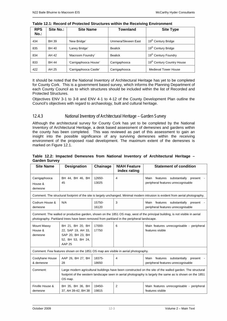
N22 Baile Bhuirne to Macroom EIS McCarthy Hyder Consultants
October 2009 12-3 Volume 2 – Main Text
Table 12.1: Record of Protected Structures within the Receiving Environment RPS No.:
Site No.: Site Name Townland Site Type
434 BH 39 ‘New Bridge’ Ummera/Sleveen East 19th Century Bridge
835 BH 40 ‘Laney Bridge’ Bealick 19th Century Bridge
834 AH 42 ‘Macroom Foundry’ Bealick 19th Century Foundry
833 BH 44 ‘Carrigaphooca House’ Carrigaphooca 19th Century Country House
422 AH 25 ‘Carrigaphooca Castle’ Carrigaphooca Medieval Tower House
It should be noted that the National Inventory of Architectural Heritage has yet to be completed for County Cork. This is a government based survey, which informs the Planning Department of each County Council as to which structures should be included within the list of Recorded and Protected Structures. Objectives ENV 3-1 to 3-8 and ENV 4-1 to 4-12 of the County Development Plan outline the Council’s objectives with regard to archaeology, built and cultural heritage.
12.4.3 National Inventory of Architectural Heritage – Garden Survey Although the architectural survey for County Cork has yet to be completed by the National Inventory of Architectural Heritage, a desk based assessment of demesnes and gardens within the county has been completed. This was reviewed as part of this assessment to gain an insight into the possible significance of any surviving demesnes within the receiving environment of the proposed road development. The maximum extent of the demesnes is marked on Figure 12.1. Table 12.2: Impacted Demesnes from National Inventory of Architectural Heritage – Garden Survey
Site Name Designation Chainage NIAH Feature index rating
Statement of condition
Carrigaphooca
House & demesne
BH 44, BH 46, BH 45
12650-13025
4 Main features substantially present - peripheral features unrecognisable
Comment: The structural footprint of the site is largely unchanged. Minimal modern intrusion is evident from aerial photography.
Codrum House & demesne
N/A 15750-16120
3 Main features substantially present - peripheral features unrecognisable
Comment: The walled or productive garden, shown on the 1851 OS map, west of the principal building, is not visible in aerial photography. Parkland trees have been removed from parkland in the peripheral landscape.
Mount Massy House & demesne
BH 21, BH 20, BH 22, SAP 19, AH 33, SAP 20, BH 23, BH 52, BH 53, BH 24, AAP 25
17000-17750
6 Main features unrecognisable - peripheral features visible
Comment: Few features shown on the 1851 OS map are visible in aerial photography.
Coolyhane House & demesne
AAP 26, BH 27, BH 28
18375-18650
4 Main features substantially present - peripheral features unrecognisable
Comment: Large modern agricultural buildings have been constructed on the site of the walled garden. The structural footprint of the western landscape seen in aerial photography is largely the same as is shown on the 1851 OS map.
Firville House & demesne
BH 35, BH 36, BH 37, AH 39-42, BH 38
19450-19815
2 Main features unrecognisable - peripheral features visible

N22 Baile Bhuirne to Macroom EIS McCarthy Hyder Consultants
October 2009 12-4 Volume 2 – Main Text
Site Name Designation Chainage NIAH Feature index rating
Statement of condition
Comment: Many modern agricultural buildings have been constructed in the core landscape. Parkland trees have been removed from the peripheral landscape. Coolcour House & demesne
BH 42 21800 5 Main features unrecognisable - peripheral features visible
Comment: The peripheral landscape of this site is indistinguishable from surrounding farmland. Large modern agricultural buildings have been constructed in the core landscape.
12.5 STUDY AREA 12.5.1 Introduction The study area is defined as the land that will be included within the proposed CPO of the proposed road development. Any sites of archaeological, historical or cultural heritage value located partially or completely within this area will be impacted on to some degree, whether it is visually or physically. The AH sites are surrounded by a constraint area subject to statutory protection under the National Monuments Act. The remaining AAP, SAP, AS and BH sites are surrounded by a constraint area, which has been designated as deemed appropriate. The proposed road development will travel through the 3 parishes of Baile Bhuirne, Clondrohid and Macroom. The townlands within the study area are divided into the three parishes as follows from west to east: Table 12.3: Parishes and Townlands within the Study Area
Parish Townland
Baile Bhuirne An Sliabh Riabhach, An Cheapach Thoir, An Cheapach Thiar, Na Cillíní, Baile Mhic Íre, Tonn Láin, Cúil na Cathrach and Cúil an Bhuacaigh
Clondrohid Lissacressig, Inchinlinane, Carrigaphooca, Killaclug, Glananarig, Clonfadda and Teerbeg
Macroom Codrum, Gurteenroe, Kilnagurteen, Ballyveerane, Coolyhane, Bealick, Sleveen East, Ummera, Coolcour
Table 12.4: Archaeological Heritage within the Study Area AH No.: Townland Classification RMP No.: Impact on constraint only or
feature
AH 1 Na Cillíní Holy well, cross slab
CO058-013 Constraint only
AH 4 Baile Mhic Íre Ringfort and souterrain
CO058-042 Constraint only
AH 8 Baile Mhic Íre Ringfort CO058-045 Constraint and feature
AH 9 Tonn Láin Souterrain CO058-050 Constraint only
AH 12 Tonn Láin Fulacht fiadh CO058-051 Constraint and feature
AH 19 Cúil an Bhuacaigh Standing stone CO070-012 Constraint only
AH 20 Inchinlinane Standing stone CO070-079 Constraint only
AH 27 Codrum Fulacht fiadh CO070-046 Constraint only
AH 32 Coolyhane Standing stone CO071-011 Constraint only
AH 35 Bealick Stone row CO071-014 Constraint only
AH 36 Bealick Souterrain (possible)
CO071-015 Constraint, but feature remains un-located
AH 38 Bealick Corn mill CO071-016 Constraint only
Table 12.5: Areas of Archaeological Potential within the Study Area

N22 Baile Bhuirne to Macroom EIS McCarthy Hyder Consultants
October 2009 12-5 Volume 2 – Main Text
AAP No.: Townland: Classification:
AAP 1 Doire na Sagart/ An Sliabh Riabhach Riverine
AAP 2 An Sliabh Riabhach Riverine
AAP 3 An Sliabh Riabhach Riverine
AAP 4 An Sliabh Riabhach Relic field system
AAP 5 An Sliabh Riabhach Riverine
AAP 6 An Sliabh Riabhach/ An Cheapach Thiar Riverine
AAP 7 An Cheapach Thiar Riverine
AAP 8 An Cheapach Thiar Riverine
AAP 9 An Cheapach Thoir/Na Cillíní Riverine
AAP 10 Na Cillíní Wetland
AAP 11 Na Cillíní Wetland and riverine
AAP 12 Baile Mhic Íre Wetland
AAP 13 Baile Mhic Íre Riverine
AAP 14 Baile Mhic Íre Riverine
AAP 15 Cúil na Cathrach Wetland
AAP 16 Cúil an Bhuacaigh Relic landscape
AAP 17 Cúil an Bhuacaigh Riverine
AAP 18 Cúil an Bhuacaigh Riverine
AAP 19 Inchinlinane Relic Landscape
AAP 20 Inchinlinane/Carrigaphooca Riverine
AAP 21 Carrigaphooca/Glananarig Riverine
AAP 22 Glananarig Riverine
AAP 23 Clonfadda, Codrum and Teerbeg Wetland and riverine
AAP 24 Teerbeg/Gurteenroe Riverine
AAP 25 Gurteenroe Riverine
AAP 26 Kilnagurteen/Ballyveerane Riverine
AAP 27 Ballyveerane/Coolyhane Riverine
AAP 28 Coolyhane Riverine
AAP 29 Bealick/Sleveen East Reputed area of 10th century battle
AAP 30 Bealick/Ummera Riverine
AAP 31 Ummera/Coolcour Riverine

N22 Baile Bhuirne to Macroom EIS McCarthy Hyder Consultants
October 2009 12-6 Volume 2 – Main Text
Table 12.6: Sites of Archaeological Potential within the Study Area SAP No.: Townland: Classification: Impact on constraint only
or feature
SAP 1 An Sliabh Riabhach Possible fulacht fiadh Constraint and feature
SAP 5 Na Cillíní Possible mound Constraint and feature
SAP 7 Baile Mhic Íre Mound Constraint and feature
SAP 8 Tonn Láin Possible fulacht fiadh Constraint and feature
SAP 11 Cúil an Bhuacaigh Possible Standing stone Constraint only
SAP 12 Cúil an Bhuacaigh Levelled fulacht fiadh Constraint and feature
SAP 14 Cúil an Bhuacaigh Possible enclosure Constraint only
SAP 15 Lackaneen Possible fulacht fiadh Constraint and feature
SAP 16 Carrigaphooca Possible raised settlement platform Constraint and feature
SAP 17 Teerbeg Possible fulacht fiadh Constraint and feature
SAP 22 Ballyveerane Possible settlement platform Constraint and feature
Table 12.7: Built Heritage Sites within the Study Area BH No.: Townland: Classification: RPS
No.: Impact on constraint only
or structure
BH 2 An Sliabh Riabhach Bridge - Constraint only
BH 3 An Sliabh Riabhach School house - Constraint only
BH 4 An Sliabh Riabhach Old road - Constraint and part of road
BH 7 An Sliabh Riabhach Vernacular farmyard - Constraint and two structures
BH 8 An Sliabh Riabhach Vernacular farm house - Constraint only
BH 10 An Sliabh Riabhach/ An Cheapach Thiar
Bridge - Constraint and structure
BH 11 An Cheapach Thiar Ruined cottage - Constraint and structure
BH 17 Na Cillíní Concrete farm buildings - Constraint only
BH 21 Cúil na Cathrach Vernacular house - Constraint only
BH 23 Cúil an Bhuacaigh Vernacular farmyard - Constraint only
BH 24 Cúil an Bhuacaigh Vernacular farm - Constraint only
BH 25 Cúil an Bhuacaigh Bridge - Constraint only
BH 26 Cúil an Bhuacaigh Vernacular House - Constraint only
BH 27 Cúil an Bhuacaigh Enclosure - Constraint and structure
BH 28 Carrigaphooca Demesne entrance - Constraint only
BH 29 Carrigaphooca Demesne entrance and tunnel - Constraint only
BH 31 Carrigaphooca Bridge - Constraint only
BH 32 Clonfadda Old field system - Constraint and some boundaries
BH 33 Teerbeg Bridge - Constraint and structure
BH 34 Kilnagurteen Vernacular gate and pillars - Constraint and structure
BH 36 Kilnagurteen Well - Constraint only

N22 Baile Bhuirne to Macroom EIS McCarthy Hyder Consultants
October 2009 12-7 Volume 2 – Main Text
BH No.: Townland: Classification: RPS No.:
Impact on constraint only or structure
BH 37 Ballyveerane Bridge - Constraint and structure
BH 38 Ballyveerane Disused Spa - Constraint and structure
BH 39 Kilnagurteen Possible drive embankment - Constraint and part of structure
BH 40 Ballyveerane Bridge - Constraint and structure
BH 41 Ballyveerane Culvert - Constraint and structure
BH 45 Coolyhane Vernacular house - Constraint only
BH 46 Coolyhane Vernacular house - Constraint only
BH 48 Coolyhane Well - Constraint and structure
BH 49 Coolyhane Well - Constraint and structure
BH 50 Coolyhane Vernacular farm house - Constraint only
BH 52 Bealick Demesne entrance - Constraint only
BH 53 Bealick Lodge - Constraint only
BH 54 Bealick Old road and stepping stones - Constraint and part of road
BH 55 Bealick and Ummera Bridge 835 Constraint only
BH 56 Ummera Bridge 434 Constraint only
BH 57 Coolcour Disused railway - Constraint and part of structure
BH 58 Coolcour Lodge and entrance - Constraint and entrance
BH 59 An Cheapach Thiar Old road - Constraint and part of road
Table 12.8.: Aerial Survey Sites within the Study Area
AS No.: Townland: Classification: Impact on constraint or feature
AS 5 Coolyhane Possible enclosure Constraint and feature
Table 12.9: Cultural Heritage Sites within the Study Area CH No.: Townland: Classification: Impact on constraint area
CH 2 Cúil na Cathrach 1921 Ambush site Constraint area
CH 3 Bealick/Coolyhane/ Ummera/Sleveen East
Reputed site of 10th century battle
Constraint area
12.5.2 A Summary of Previous Archaeological Fieldwork undertaken within the Study Area A survey of the Excavations Bulletin (Bennett 1970-2003) has indicated that no previous archaeological fieldwork has been undertaken within the study area of the proposed road development. However, as part of this assessment, it was decided in conjunction with the National Monuments Section of the DoEHLG and National Museum of Ireland, to undertake archaeological geophysical survey and testing at the reputed site of the 10th century battle site in Bealick (AAP 29, AH 39), along with geophysical survey at Carrigaphooca Castle (AH 21) and at the site of a ringfort in Baile Mhic Íre (AH 8).
12.5.2.1 Geophysical Survey at Bealick Geophysical survey was undertaken at the reputed 10th century battle site that is marked by a pair of stones within the townland of Bealick (AH 34), to ascertain whether there were any archaeological anomalies visible to confirm the presence of features that may be associated with the battle, such as large graves.

N22 Baile Bhuirne to Macroom EIS McCarthy Hyder Consultants
October 2009 12-8 Volume 2 – Main Text
There is no conclusive evidence to support the presence of the 978 AD battle site fought within the area investigated. Historical references suggest that the battle may have taken place elsewhere or even on the other side of the river (Ring 1995). Late 10th century weapons (swords, axes, spearheads etc.) and armour can be expected to be constructed of iron. Iron (ferrous) deposits, give a particular magnetic response, a dipolar anomaly, none of which can be seen in the magnetic gradiometer data. Unless these are deeply buried (greater than 1.5 m), it is unlikely that any such materials are present. The possible cairn around the stone alignment (AH 34) has been interpreted as such simply because the feature was suspected; the same geophysical response may have been caused by stone packing, geology, platforms or field clearance. No definitive evidence supporting the presence of a mass burial ‘of men and horses’ can be seen, although it is possible that such a feature could be located within the vicinity of the geological anomalies that ‘mask’ all other geophysical responses. A mass burial may also be expected to create a number of dipolar anomalies (grave goods, horse furniture etc.); again none can be seen within the survey area. The presence of possible plough furrows up to and possibly through the Laght Mahon stone alignment, suggests that the stones were erected some time after a significant ploughing event. This may imply that the stones were not erected directly following the battle, but at a much later date. The plough furrows are consistent with late medieval ridge and furrow, although modern ploughing could also create similar anomalies. The magnetic data suggests that the stones may have been erected relatively recently, possibly within the last 500 years, although only an excavation can prove this. If this is true, its function as a grave marker or battlefield memorial could be coincidental. If the proposed road development proceeds across the survey area, the geophysical survey suggests that it will impact upon 12 ditches (which encompass earlier field systems), an area of magnetic enhancement (which may or may not represent small archaeological features such as pits and hearths), a possible brick lined drain that may be associated with the surrounding rivers and Bealick Mill, and a high resistance anomaly that may or may not represent a cairn or foundation/packing material. Other, weak magnetic or non-contrasting resistive features may also be present; a geophysical survey cannot provide a 100% record of the underlying archaeology, only an intrusive investigation can determine this.
12.5.2.2 Archaeological Testing at Bealick Once the geophysical survey was complete, archaeological test trenching was employed to prove or disprove the results of the survey, which suggested that this was not the site of the 10th century battle. During the course of this program of testing, no features of archaeological significance were discovered. The area that was subjected to geophysical survey was investigated with 27 linear test trenches (Chainage 19125-19410). The remaining Chainage of 19410-19500 was not tested due to the presence of the Old Bowl Road (BH 38) and issues concerning the landowner. A small stretch of land close to the entrance into the field was also not tested due to access issues. These areas will be tested at a later date. A total of 11.9 percent of the test area was subjected to archaeological investigation. Any potential archaeological features that were discovered were thoroughly investigated with sections inserted through the features to help to determine their nature and extent. The 2 features that were discovered have been interpreted as modern drainage features that may have been excavated in association with one another. No stray archaeological artefacts were discovered during the removal of the topsoil, whilst the trenches were being excavated. The testing conditions were very favourable such that there is a high degree of confidence in the accuracy of the testing results, namely that no finds, features or deposits of archaeological significance were noted within the tested areas.

N22 Baile Bhuirne to Macroom EIS McCarthy Hyder Consultants
October 2009 12-9 Volume 2 – Main Text
12.5.2.3 Geophysical Survey at Carrigaphooca Castle Geophysical survey was undertaken within an accessible area of pasture surrounding the ruins of Carrigaphooca Castle (AH 21), which is recorded as a National Monument is state care. Fieldwork was carried our in January 2007 under licence 06R0203. The castle itself is located almost 200m to the south of the proposed road development. However, the survey was carried out to ascertain whether there were any archaeological anomalies associated with the castle within its immediate surroundings that may be impacted on by the construction of the proposed road development. There are no clear indications in the data to suggest that archaeological features are present in the area to the north of the remains of the castle. Several weak trends and ill-defined positive anomalies have been recorded, although the general character of these suggests they may relate to former patterns of drainage and / or variations in the underlying soils and bedrock. Interpretation has been limited by the narrow breadth of survey in these areas. The gradiometer survey failed to detect any significant remains within the vicinity of Carrigaphooca Castle (CO070-034, AH 21). The possibility that archaeological features associated with the monument are present within the survey area should not be dismissed. However, the range of background variation and modern interference present in the results suggests that they are likely to be below the levels of magnetic variation caused by the underlying geology and soils. The landscape is thought to have been subject to significant clearance, drainage works and improvements and, consequently, archaeological features may remain undetectable using conventional methods of geophysical prospection. Several targets of potential archaeological interest have been highlighted from survey, including a number of weak linear trends to the south of the Castle and a group of isolated positive anomalies to the south-east, both of which are located over 200m to the south of the proposed road development. However, no clear pattern emerges from the data to support a more conclusive archaeological interpretation for these anomalies. A natural soil/geological origin is expected for many of the anomalies highlighted from survey.
12.5.2.4 Geophysical Survey at Baile Mhic Íre Ringfort Geophysical survey was undertaken within an area of pasture occupied by the possible remains of a ringfort, which is recorded as an RMP site (AH 8). Fieldwork was carried our in January 2007 under licence 06R0204. The ringfort is partially located within the CPO of the proposed road development and the survey was carried out to ascertain whether there were any archaeological anomalies associated with the site. The gradiometer survey failed to detect any clear evidence to suggest that remains of ringfort AH 8 are present within the survey area. Interpretation has been made difficult by interference from bedrock geology and the soils of the locality. Several ill-defined anomalies of potential interest have been highlighted although a natural source for some of these may be expected in view of the background variations present. It is suggested that the potential ringfort AH 8 has been levelled to such an extent that it would remain undetectable using conventional geophysical techniques.
12.5.2.5 The IRA Ambush site at Cúil na Cathrach One of the most recently dated sites of cultural heritage importance is that of the IRA ambush site at Cúil na Cathrach (CH 2). This site is marked on the third edition OS map. The ambush formed part of the Anglo-Irish War or War of Independence in Ireland (21st Jan 1919 – 9th July 1921). The two main accounts of the engagement are included within two publications, the first being by Charlie Brown (1971), entitled The Story of the 7th: A Concise History of the 7th Battalion, Cork No.1 Brigade, Irish Republican Army from 1915-1921. The second is by Michael O’Suilleabhain (O’Sullivan) and is entitled Where Mountainy Men have Sown (1965). However, an account of the engagement is also recorded within a historical Journal (1998) and recounts the experiences of John and James Cronin who formed part of the

N22 Baile Bhuirne to Macroom EIS McCarthy Hyder Consultants
October 2009 12-10 Volume 2 – Main Text
Ballingeary Company. This was one of many companies that formed the Brigade Flying Column, under the over all command of Sean Hegarty. A number of IRA accounts of the ambush are also included within the Witness Statements taken by the Bureau of Military History 1913-1921, which are kept within the National Archives and were recorded between 1950 and 1955. The Witness Statement of Charlie Browne includes a sketch map of the ambush, which was not included within his publication and provides more detail than the thus un-provenanced map provided to Mr Ken Hanley (NRA Archaeologist) by Mr Denis O’Shea. However, Mr O’Shea did state that the map was given to him by Mr Padraig O’Sullivan whose father was the No. 2 gunner during the ambush. This does equate with many of the accounts which state that a Eugene O’Sullivan was the No. 2 Gunner during the ambush. No official record of the engagement could be located during research. However, a brief account of the engagement is recorded within The History of the 6th Division, which is included within the Strickland Papers, deposited in the Imperial War Museum. This document written by Major General Sir Peter Strickland records all the significant events in the country during this time period. Further accounts from members of the IRA are also recorded in the O’Malley notebooks, held by the University College Dublin Archives. These contain approximately 400 interviews describing events surrounding the War for Independence. The ambush at Coolnacahera or Coolnacaheragh (Cúil na Cathrach), took place on the 25th February 1921 and is also recorded as the Coolavokig Ambush or the Poulnabro Ambush. The IRA force consisted of a Brigade Flying Column numbering approximately 60 members. They intended to ambush a convoy of British Auxiliary Cadets who were travelling between Macroom and Ballyvourney. The ambush commenced in the morning, when the convoy stopped within the eastern portion of the ambush area, allegedly having been tipped off that an ambush was present in the area. When it became clear that the convoy was not going to move forward, the IRA opened fire on the cadets, killing the commander and forcing the remainder to retreat into two cottages on the southern side of the road. The remainder of the convoy further to the east also dismounted and a group attempted to out flank members of the 7th Battalion situated on the southern side of the road. After four hours of exchanging fire, British reinforcements arrived from Macroom and the IRA men had to retreat to the north. Officially three members of the convoy were killed (although numbers of casualties vary according to IRA accounts and the memorial plaque at the site). The dead included the commander of the convoy, Major Seafield Grant. One RIC man died the next day of his wounds (Constable Kane) and a further temporary cadet (Cadet Soady) died on the 27th February also from his wounds. It is thought that Constable Kane may have been the only Australian man to be killed during the Irish War of Independence, which if verified would be of historical significance (William Sheehan pers. comm.). None of the IRA men were killed during the encounter. The memorial at the site is thought to represent the location that the commander of the convoy was killed, and commemorates the IRA volunteers who took part in the event. For more detail please see Appendix 8.6 of Volume 4 of this EIS. As a result of the research carried out for the EIS, the overall cultural heritage significance of the site can be defined as being of regional importance. The significance of the site is not defined in any of the academic texts used during the research as it was a relatively small event when compared to other ambushes that took place during the War of Independence, such as Kilmichael. However, it does contribute to the history of the region and the war when addressed as one of many similar events that took place. The fact that possibly the only Australian to be killed during the war may add a further significance to the site, but this would ultimately require further research to verify. To the men that took part in the ambush and the local population who still remember the event, it was a significant event, made more so by the death of three members of the British forces. This is reflected in some of the Witness Statements held by the Bureau of Military History. However, some account has to be made for the historical bias that exists within such documents from both the Irish and British sides, which relates to the amount of deaths and numbers of reinforcements. The event is still remembered and celebrated by the local population. A wreath is laid on the anniversary of the ambush at the memorial located on the side of the existing N22. It is perhaps ironic therefore that at the time of the ambush both senior IRA and British army members

N22 Baile Bhuirne to Macroom EIS McCarthy Hyder Consultants
October 2009 12-11 Volume 2 – Main Text
considered it to have been a badly executed attack, which could have been far more successful in terms of defeating the enemy. However, the 80th anniversary of the event was celebrated in 2001, with a memorial service at the site ambush. This was reported on by Catherine Ketch in the Southern Star (March 2001). William Sheehan, a published author on the War of Independence has highlighted that:
"From a historic perspective, the most interesting fact (about the ambush site) is that Constable Kane was an Australian, and may indeed be the only Australian to die in action during the War of Independence."
This has not been verified and other sources (Abbot, R 2000 Police Casualties in Ireland 1919-1922 pg 203) cite that he was from London and make no mention of Australia. Further details of the ambush site are available in Volume 4 of this EIS and in the stand alone report ‘A Review of The Evidence – The Coolnacaheragh Ambush, 25th February 1921, County Cork’ (IAC October 2008. Report Number 6015-NE02426).
12.5.3 Field Inspection The field inspection sought to assess the land take area of the proposed road development, its previous and current land use, the topography and any additional environmental information relevant to the report. During the course of the field investigation the proposed road development and its surrounding environs were inspected.
12.5.4 Summary of the Study Area The landscape is characterised by a significant amount of both archaeological and historical sites, some of which are already recorded within the Sites and Monuments Record and Record of Monuments and Places and some of which have been freshly discovered during the assessment of the proposed road development, both on the ground and from the air. There are a total of 96 sites of archaeological and historical value located within the study area of the proposed road development. Twelve of these sites are defined by a zone of archaeological potential which is subject to statutory protection under the National Monuments Act (AH1, 4, 8, 9,12, 19, 20, 27, 32, 35, 36, 38), although only 2 archaeological features located within these zones are also located partially within the CPO of the proposed road development (AH 8, 12). A further 31 Areas of Archaeological Potential (AAPs) have also been identified, 24 of which are formed by rivers or streams. The remaining sites consist of 3 areas of wetland, 2 relic landscapes and 1 possible 10th century battlefield and a relic field boundary. A total of 11 Sites of archaeological potential have been identified in or partially within the study area of the proposed road development, with 9 of these sites containing features located within the footprint of the proposed road development. A total of 5 potential fulachta fiadh sites have been identified, along with possible settlements areas. There are 39 Built Heritage sites (BH) located in or partially within the study area of the proposed road development, with 19 structures significantly impacted on by the proposed road development. There is 1 Aerial Survey site (AS) located within the study area, which has been identified as a possible enclosure. There are 2 Cultural Heritage Sites located within the study area of the proposed route. CH 2 consists of an IRA ambush site dating to the 1920’s, where IRA volunteers ambushed a convoy of British Auxiliary Cadets and succeeded in killing their commanding officer within the townland of Cúil na Cathrach.

N22 Baile Bhuirne to Macroom EIS McCarthy Hyder Consultants
October 2009 12-12 Volume 2 – Main Text
CH 3 consists of a large area, reputed to be the location of a 10th century battle involving Brian Boru. This area includes 13 separate archaeological and architectural designations.
12.6 ASSESSMENT OF IMPACTS A total of 96 archaeological, architectural or cultural heritage significance (known and potential) are located in or partially within the study area (proposed CPO) of the proposed road development. Of these 96 sites, 12 have been designated as Archaeological Heritage (AH) sites, and are recorded as RMP sites. These sites and the designated zone of archaeological potential that surrounds them receive statutory protection under the National Monuments Act. A total of 12 of the areas of archaeological potential surrounding these sites will be adversely impacted on by the proposed road development, whilst 2 sites (possible ringfort AH 8 and a fulacht fiadh AH 12) will be directly impacted on. It is further possible that the proposed road development will directly impact on AH 36 (a souterrain site), although the location of the souterrain has not been determined during the course of this assessment and may not be located within this area. One particular AH site, located in the townland of Bealick (AH 34) consists of a stone row, thought to mark the spot of a 10th century battle involving Brian Boru. Although the row will not be physically impacted on by the proposed route, it was possible that archaeology relating to a battle in this area may be impacted on by the proposed road development. As a result, geophysical survey and archaeological testing was carried out within the area of the proposed CPO, although nothing of archaeological significance was discovered. Of the 39 AH sites located within the receiving environment of the route, 2 are classed as National Monuments in State Care (Carrigaphooca Castle AH 21 and stone circle AH 22). Whilst the castle itself is located almost 200m to the south of the route, as part of the assessment a geophysical survey was undertaken within the area surrounding the castle, especially to the north where the proposed route will follow the existing N22. No anomalies of definite archaeological origin were identified during the survey within the CPO of the proposed route as it passes the castle. The stone circle is also located over 150m to the south of the proposed route and to the east of Carrigaphooca Castle. Geophysical survey was also undertaken at the site of a ringfort in Baile Mhic Íre (AH 8), which will be impacted on by the proposed road development. However, no features of definite archaeological origin were noted at this site during the survey, and it is possible that the ringfort has been completely levelled. During the course of this assessment a total of 31 Areas of Archaeological Potential (AAP) were identified either in or partially within the proposed CPO of the road development. Of these, 24 sites consist of water courses, which will be crossed by the proposed route, with the remaining being formed by wetland, a possible relic field system and relic landscapes. The latter have been defined as areas of rocky outcrop, not suitable for cultivation, which have remained relatively un-touched by human hand. 1 of the areas has also been designated as battlefield site, with AAP 29 forming the potential location of the 10th century battle close to Macroom (see above AH 34). The water courses have been designated AAPs due to the fact that a water supply often makes an area more desirable for human habitation and the water courses themselves may preserve archaeological artefacts such as worked wood, leather and organic environmental information. These artefacts are not typically found within the terrestrial archaeological record as water tables are often not high enough to preserve such items. The larger rivers, such as the Laney River and Foherish River, will be crossed by single span bridge and as a result there will be no impact on the river beds themselves. However, the crossing of the Sullane River in the townland of Ummera/Coolcour will consist of a double span bridge, which will impact on the river bed. The route will cross the Bohill River at a substantial bend and as a result will not consist of a single span construction. The smaller watercourses will be culverted beneath the proposed route and the Owengarve River, will be subject to some straightening.

N22 Baile Bhuirne to Macroom EIS McCarthy Hyder Consultants
October 2009 12-13 Volume 2 – Main Text
The IRA ambush site (CH 2) occupies a position either side of the existing N22 within the townland of Cúil na Cathrach. The site consists for the most part of rocky outcrops looking down onto the existing N22, which would have been an ideal location to stage an ambush. The proposed route will impact on the western edge of the site, passing to the west of the monument that was erected to commemorate the battle. To mitigate against the adverse impact that the route will have on the site, a full metal detector survey will be undertaken within the ambush area, along with a topographical survey, to map the various outcrops. The metal detector survey shall be carried out under licence to the Department of Environment, Heritage and Local Government, in consultation with the National Museum of Ireland and the Project Archaeologist. A total of 24 Sites of Archaeological Potential (SAP) were identified within the receiving area of the proposed route. Of these, 11 sites are located in or partially within the proposed CPO of the road development. These consist of 5 possible fulachta fiadh, 1 possible standing stone, 2 mounds, 2 possible raised settlement platforms and a possible enclosure. To mitigate against any potential adverse impacts on identified SAP sites, it has been proposed that full archaeological investigation be carried out within the areas affected by the proposed route. A number of site investigation methods shall be considered, including topographical survey, geophysical survey and/or archaeological test trenching. This work will be undertaken well in advance of construction in order to allow sufficient time to take ameliorative action in the event of archaeological remains being identified. All investigative work will be carried out by a licence eligible archaeologist under Ministerial Directions from the Department of Environment, Heritage and Local Government, in consultation with the National Museum of Ireland and the Project Archaeologist. A total of 60 Built Heritage (BH) sites have been identified during the course of the assessment within the receiving environment. Of these, 35 are located in or partially within the proposed CPO of the route. A total of 15 structures will be significantly impacted on by the proposed road development, with 16 being moderately impacted on, 18 slightly impacted on and 7 imperceptibly impacted on. A total of 3 structures are listed within the Record of Protected Structures for County Cork and as a result receive statutory protection. Laney Bridge (BH 55) and New Bridge (BH 56) are located within the immediate vicinity of the proposed route. Carrigaphooca House (BH 28) is located within its own demesne almost 100m to the N of the route. The bridges and the house, which have been allotted a regional importance will not be physically impacted. Although not impacted on directly, 2 other structures have been allotted a regional importance due to the high quality of architecture noted at these sites. These consist of a large farm complex (BH 15) and a former N22 road bridge at Carrigaphooca (BH 31). The remaining structures (all allotted a local or record only importance value) consist of relatively small structures and include a number of vernacular farms and farm houses, 2 old field systems, 4 small bridges, 3 old roads and several demesne entrances. It is proposed that detailed written and photographic records be made of any such structure that will be removed as part of the proposed road development, so they are fully preserved by record. Furthermore, it is proposed that a photographic and written record be made of the remaining structures that will be located within the immediate vicinity of the proposed road development so an appropriate record can be made of their context and setting prior to the construction of the proposed route.

N22 Baile Bhuirne to Macroom EIS McCarthy Hyder Consultants
October 2009 12-14 Volume 2 – Main Text
12.6.1 Potential Impacts on Archaeological sites Table 12.10: Archaeological Heritage Impacts Site ID Classification Chainage Statutory Protection Potential Impact
AH 1 Holy well, cross slab 3895 Recorded Monument Slight
AH 2 Ringfort (possible) 2660 Recorded Monument Imperceptible
AH 3 Ringfort 4560 Recorded Monument Imperceptible
AH 4 Ringfort, souterrain 4245 Recorded Monument Slight
AH 5 Ballaun stone 4260 Recorded Monument Imperceptible
AH 6 Ringfort 4585 Recorded Monument Imperceptible
AH 7 Holy well 4745 Recorded Monument Imperceptible
AH 8 Ringfort 4755 Recorded Monument Significant
AH 9 Souterrain 5635 Recorded Monument Moderate
AH 10 Natural feature 5745 Recorded Monument Imperceptible
AH 11 Fulacht fiadh 5950 Recorded Monument Imperceptible
AH 12 Fulacht fiadh 5990 Recorded Monument Significant
AH 13 Standing stone 6380 Recorded Monument Imperceptible
AH 14 Miscellaneous 6510 Recorded Monument Imperceptible
AH 15 Cashel 7125 Recorded Monument with Preservation Order
Imperceptible
AH 16 Stone group 7795 Recorded Monument Imperceptible
AH 17 Fulacht fiadh 8465 Recorded Monument Imperceptible
AH 18 Burial ground (possible) 8880 Recorded Monument Imperceptible
AH 19 Standing stone 9600 Recorded Monument Moderate
AH 20 Standing stone 11525 Recorded Monument Moderate
AH 21 Tower house 12945 National Monument Slight
AH 22 Multiple stone circle 13190 National Monument Slight
AH 23 Natural feature 13465 Recorded Monument Imperceptible
AH 24 Fulacht fiadh (possible) 13430 Recorded Monument Imperceptible
AH 25 Mass rock 13805 Recorded Monument Imperceptible
AH 26 Ringfort, souterrain 15030 Recorded Monument Imperceptible
AH 27 Ringfort 15475 Recorded Monument Imperceptible
AH 28 Fulacht fiadh 15590 Recorded Monument Moderate
AH 29 Country house 17315 Recorded Monument Slight
AH 30 Ringfort, lime kiln 17745 Recorded Monument Imperceptible
AH 31 Ringfort, possible souterrain 17840 Recorded Monument Imperceptible
AH 32 Standing stone 18680 Recorded Monument Moderate
AH 33 Potential site 18850 Recorded Monument Imperceptible
AH 34 Standing stone 19545 Recorded Monument Imperceptible
AH 35 Stone row 19620 Recorded Monument Moderate
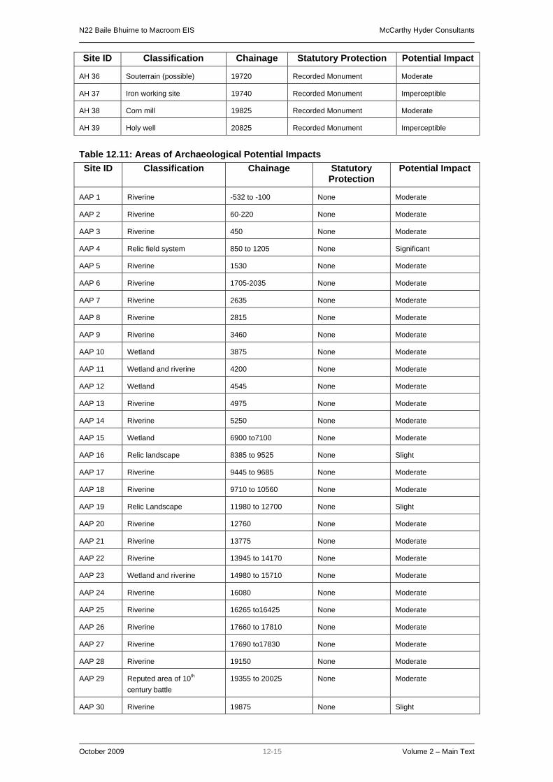
N22 Baile Bhuirne to Macroom EIS McCarthy Hyder Consultants
October 2009 12-15 Volume 2 – Main Text
Site ID Classification Chainage Statutory Protection Potential Impact
AH 36 Souterrain (possible) 19720 Recorded Monument Moderate
AH 37 Iron working site 19740 Recorded Monument Imperceptible
AH 38 Corn mill 19825 Recorded Monument Moderate
AH 39 Holy well 20825 Recorded Monument Imperceptible
Table 12.11: Areas of Archaeological Potential Impacts Site ID Classification Chainage Statutory
Protection Potential Impact
AAP 1 Riverine -532 to -100 None Moderate
AAP 2 Riverine 60-220 None Moderate
AAP 3 Riverine 450 None Moderate
AAP 4 Relic field system 850 to 1205 None Significant
AAP 5 Riverine 1530 None Moderate
AAP 6 Riverine 1705-2035 None Moderate
AAP 7 Riverine 2635 None Moderate
AAP 8 Riverine 2815 None Moderate
AAP 9 Riverine 3460 None Moderate
AAP 10 Wetland 3875 None Moderate
AAP 11 Wetland and riverine 4200 None Moderate
AAP 12 Wetland 4545 None Moderate
AAP 13 Riverine 4975 None Moderate
AAP 14 Riverine 5250 None Moderate
AAP 15 Wetland 6900 to7100 None Moderate
AAP 16 Relic landscape 8385 to 9525 None Slight
AAP 17 Riverine 9445 to 9685 None Moderate
AAP 18 Riverine 9710 to 10560 None Moderate
AAP 19 Relic Landscape 11980 to 12700 None Slight
AAP 20 Riverine 12760 None Moderate
AAP 21 Riverine 13775 None Moderate
AAP 22 Riverine 13945 to 14170 None Moderate
AAP 23 Wetland and riverine 14980 to 15710 None Moderate
AAP 24 Riverine 16080 None Moderate
AAP 25 Riverine 16265 to16425 None Moderate
AAP 26 Riverine 17660 to 17810 None Moderate
AAP 27 Riverine 17690 to17830 None Moderate
AAP 28 Riverine 19150 None Moderate
AAP 29 Reputed area of 10th century battle
19355 to 20025 None Moderate
AAP 30 Riverine 19875 None Slight

N22 Baile Bhuirne to Macroom EIS McCarthy Hyder Consultants
October 2009 12-16 Volume 2 – Main Text
Site ID Classification Chainage Statutory Protection
Potential Impact
AAP 31 Riverine 20660 None Moderate
Table 12.12: Sites of Archaeological Potential Impacts
Site ID Classification Chainage Statutory Protection
Potential Impact
SAP 1 Possible fulacht fiadh 530 None Profound
SAP 2 Clearance cairn 1235 None Slight
SAP 3 Standing stone and mass rock 2160 None Imperceptible
SAP 4 Settlement Site and wetland 2470 None Imperceptible
SAP 5 Possible mound 4170 None Significant
SAP 6 Possible fulacht fiadh 4640 None Slight
SAP 7 Mound 4910 None Moderate
SAP 8 Possible fulacht fiadh 5380 None Profound
SAP 9 Possible megalithic tomb 6430 None Slight
SAP 10 Possible fulacht fiadh 7430 None Slight
SAP 11 Possible Standing stone 7560 None Moderate
SAP 12 Levelled fulacht fiadh 7665 None Significant
SAP 13 Possible raised settlement platform
7795 None Imperceptible
SAP 14 Possible enclosure 10035 None Slight
SAP 15 Possible fulacht fiadh 10430 None Profound
SAP 16 Possible raised settlement platform
13320 None Significant
SAP 17 Possible fulacht fiadh 15995 None Profound
SAP 18 Grave stone 16055 None Slight
SAP 19 Mound 16240 None Imperceptible
SAP 20 fulacht fiadh 17080 None Imperceptible
SAP 21 Possible raised settlement platform
17670 None Imperceptible
SAP 22 Possible settlement platform 18255 None Profound
SAP 23 Spring 18990 None Imperceptible
SAP 24 Prostate megalith 19120 None Imperceptible

N22 Baile Bhuirne to Macroom EIS McCarthy Hyder Consultants
October 2009 12-17 Volume 2 – Main Text
Table 12.13: Aerial Survey Sites Impacts Site ID Classification Chainage Statutory
Protection Potential Impact
AS 1 Potential enclosure 4760 None Imperceptible
AS 2 Possible fulachta fiadh 7770 None Imperceptible
AS 3 Possible enclosure 8965 None Imperceptible
AS 4 Possible enclosure 12245 None Imperceptible
AS 5 Potential enclosure 18975 None Moderate
AS 6 Potential enclosure 18920 None Imperceptible
Table 12.14: Built Heritage Sites Impacts and Significance Site ID
Classification Chainage Statutory
Protection Importance Potential
Impact:
BH 1 Vernacular house -530 - Local Imperceptible
BH 2 Bridge -350 - Local Slight
BH 3 School House -150 - Local Moderate
BH 4 Old road 185 - Local Slight
BH 5 Three vernacular buildings 195 - Local Imperceptible
BH 6 Vernacular house 270 - Local Imperceptible
BH 7 Vernacular farmyard 235 - Record Only Slight
BH 8 Vernacular farm house 320 - Local Slight
BH 9 Ruined building 1255 - Local Slight
BH 10 Bridge 1845 - Local Significant
BH 11 Ruined cottage 1855 - Local Significant
BH 12 Vernacular farm house 1915 - Local Slight
BH 13 Mill turbine and bridge 2155 - Local Imperceptible
BH 14 Vernacular farm 2715 - Local Slight
BH 15 Vernacular farm 2270 - Regional Imperceptible
BH 16 Vernacular farm 3215 - Local Slight
BH 17 Concrete farm buildings 3945 - Record Only Moderate
BH 18 Vernacular house 3995 - Local Moderate
BH 19 Vernacular farm 4700 - Local Imperceptible
BH 20 Vernacular house 6855 - Local Imperceptible
BH 21 Vernacular house 6870 - Local Imperceptible
BH 22 Ruined building 7040 - Record Only Slight
BH 23 Vernacular farm 8765 - Local Moderate
BH 24 Vernacular farm 9300 - Local Moderate
BH 25 Bridge 9430 - Local Slight
BH 26 Vernacular House 9555 - Local Moderate
BH 27 Field enclosure 9740 - Local Significant

N22 Baile Bhuirne to Macroom EIS McCarthy Hyder Consultants
October 2009 12-18 Volume 2 – Main Text
BH 28 Country house 12785 833 Regional Slight
BH 29 Demesne entrance 12785 - Local Slight
BH 30 Demesne entrance and tunnel
12955 - Local Significant
BH 31 Bridge 13390 - Regional Moderate
BH 32 Old field system 14960 - Local Moderate
BH 33 Bridge 16105 - Local Significant
BH 34 Vernacular gate and pillars 17060 - Local Significant
BH 35 Natural spring, utilised 17170 - Local Slight
BH 36 Well 17150 - Local Slight
BH 37 Bridge 17760 - Local Significant
BH 38 Disused Spa 17780 - Local Significant
BH 39 Possible drive embankment 17675 - Local Moderate
BH 40 Bridge 17750 - Local Significant
BH 41 Culvert 17775 - Local Significant
BH 42 Vernacular house 18045 - Local Slight
BH 43 Remains of walled garden 18490 - Local Slight
BH 44 Country House 18570 - Local Slight
BH 45 Vernacular house 18665 - Local Moderate
BH 46 Vernacular house 18670 - Local Slight
BH 47 Ruined wall of vernacular building
18660 - Record Only Imperceptible
BH 48 Well 18955 - Record Only Significant
BH 49 Well 19020 - Record Only Significant
BH 50 Vernacular farm house 19295 - Local Slight
BH 51 Country house 19660 - Local Slight
BH 52 Demesne entrance 19760 - Local Significant
BH 53 Lodge 19785 - Local Moderate
BH 54 Old road and stepping stones
19830 - Local Significant
BH 55 Bridge 19895 835 Regional Significant
BH 56 Bridge 20110 434 Regional Significant
BH 57 Disused railway 21300 - Local Moderate
BH 58 Lodge and demesne entrance
21500 - Local Moderate
BH 59 Old road 1900 - Local Significant
BH 60 Vernacular house 1890 - Local Slight

N22 Baile Bhuirne to Macroom EIS McCarthy Hyder Consultants
October 2009 12-19 Volume 2 – Main Text
Table 12.15: Potential Impacts on Cultural Heritage Sites CH No.:
Classification: Chainage: Statutory Protection:
Potential Impact:
CH 1 Wall niche and statue of Virgin Mary
1910 None Imperceptible
CH 2 IRA Ambush site 6490 to 6870 None Significant
CH 3 Reputed site of 10th century battle
19300 to 20275 Within constraint are 5 RMP sites and 2 RPS
Moderate
12.7 PROPOSED MITIGATION MEASURES Based on the results of the Archaeological Impact Assessment, the following proposals are made to mitigate against any impact the route may have on the identified Cultural Heritage sites and areas of archaeological potential: • All cultural heritage mitigation works will be undertaken in compliance with the provisions of
the National Monuments (Amendments) Act 1930-2004 and the Code of Practice (2000) agreed between the National Roads Authority and the Minister for Arts, Heritage, Gaeltacht and the Islands.
• All sites listed in Appendices 8.1 – 8.6 of Volume 4 of this EIS that will be directly impacted upon by the proposed route, will be archaeologically investigated in order to help determine their nature, age and extent. A number of site investigation methods shall be considered, including topographical survey, geophysical survey, metal detector survey and/or archaeological test trenching.
The following sites will be targeted during archaeological investigations: o CH 2, CH 3 o AH 1, AH 4, AH 8, AH 9, AH 12, AH 19, AH 20, AH 27, AH 32, AH 35, AH 36 o AAP 1-AAP 31. This includes the terrestrial sections of any riverine or stream areas. o SAP 1, SAP 5, SAP 7, SAP 8, SAP 11, SAP 12, SAP 14, SAP 15, SAP 16, SAP 17 o AS 5 o BH 4, BH 39, BH 54, BH 59, BH 32
• Those sites, whose settings will be altered as a result of the construction of the proposed route, will have their current landscape contexts recorded prior to construction taking place. The following archaeological sites will be subject to a full written and photographic record (utilising ground and aerial photographs where appropriate). o CH 2 o AH 1, AH 4, AH 8, AH 9, AH 12, AH 19, AH 20, AH 21, AH 22, AH 28, AH 29, AH 32,
AH 35, AH 36, AH 39 o AAP 4 o SAP 3, SAP 25
• Underwater archaeological assessments (or wade surveys where appropriate) will be carried out, in consultation with the road development’s Project Archaeologist, and under licence from the National Monuments Section of the Department of Environment, Heritage and Local Government, on the impacted portion of the following waterways: o AAP 1, AAP 2, AAP 3, AAP 5, AAP 6, AAP 7, AAP 8, AAP 9, AAP 11, AAP 13, AAP 14,
AAP 17, AAP 18, AAP 20, AAP 21, AAP 22, AAP 23, AAP 24, AAP 25, AAP 26, AAP 27, AAP 28
• It is proposed to make a full written and photographic record of any structures of built heritage value that will be significantly or profoundly impacted on as part of the proposed road development. This includes a record of their current context if it is to be radically altered by the proposed route. o BH 2, BH 3, BH 4, BH 7, BH 8, BH 10, BH 11, BH 14, BH 15, BH 16, BH 17, BH 18, BH
21 to BH 46, BH 48 to BH 60

N22 Baile Bhuirne to Macroom EIS McCarthy Hyder Consultants
October 2009 12-20 Volume 2 – Main Text
• It is proposed to establish natural screening to help preserve the setting of sites of cultural heritage value, along the edge of the proposed road development at the following sites: o AH 4, AH 21, AH 22, AH 29, BH 28
• An extensive programme of archaeological site investigation work across the remainder of the road development will be undertaken in order to identify any unknown or buried sites of cultural heritage value. A number of site investigation methods shall be considered, including topographical survey, geophysical survey and/or archaeological test trenching. This work will be undertaken well in advance of construction in order to allow sufficient time to take ameliorative action in the event of cultural heritage remains being identified.
• It is proposed that a program of metal detecting be carried out around the area of CH 2, section of IRA ambush site to be impacted on by the proposed route with a detailed topographical survey of the entire ambush area. Any finds such as bullet cases would be mapped and the information made available to the public. Any such finds will also help to map the engagement in more detail.
• It is proposed to highlight CH 2, the IRA ambush site, to the passer-by, either on the main line or along the existing section of the N22. This may be achieved by the erection of art work or sculpture at this location, or by means of a small lay-by and information plaque on the existing N22. This will bring more awareness of the site to people passing along the existing N22, both regionally and nationally.
• All proposed works will be carried out in consultation with the road development's appointed Project Archaeologist, the Department of the Environment, Heritage & Local Government (DEHLG) and the National Museum of Ireland (NMI).
• All archaeological investigations will be carried out by archaeologists under the terms of the National Monuments (Amendments) Act 1930-2004, as required. Full provision will be made for the resolution of any archaeological deposits or features that may be discovered during investigations.
• Where Cultural Heritage sites cannot be preserved in situ then the portion of direct impact will be preserved by record, either through archaeological excavation and/or survey, reporting, publishing and archiving, as approved by the road development’s appointed Project Archaeologist, the National Monuments Section of the Department of Environment, Heritage and Local Government and in consultation with the National Museum.
• All mitigation measures within this report will be subject to approval by the road development’s appointed Project Archaeologist, the National Monuments Section of the Department of Environment, Heritage and Local Government and in consultation with the National Museum under the statutory provisions.
• All known monuments in close proximity to the development, that will not be significantly or profoundly impacted upon will be cordoned off during all site works to the satisfaction of the road development’s appointed Project Archaeologist (National Roads Design Office, Cork).
12.8 MONITORING The mitigation measures identified above would also function as a monitoring system to allow the further assessment of the scale of the predicted impacts and the effectiveness of the mitigation measures.

N22 Baile Bhuirne to Macroom EIS McCarthy Hyder Consultants
October 2009 1 Volume 2 – Main Text
13.0 AIR QUALITY
13.1 INTRODUCTION AND METHODOLOGY This chapter assesses the air quality impacts associated with the construction and operation of the N22 Baile Bhuirne to Macroom road development. This includes an air quality assessment of the dust impacts associated with the construction of the proposed bypass and the operational impacts from vehicle emissions. The key pollutants of concern related to road traffic are nitrogen dioxide (NO2) and particulate matter with a diameter of 10 micrometers or less (PM10). The air quality assessment for the Base Year (2005), Do-Nothing and Do Something in the opening year (2012) and design year (2027, for the regional assessment only) has been undertaken following the National Roads Authority (NRA) Guidelines for the Treatment of Air Quality During the Planning and Construction of National Road Schemes (2006). The latest UK Design Manual for Roads and Bridges (DMRB) air quality spreadsheet model has been used in this assessment as described in the DMRB Volume 11, Section 3, Part 1 HA207/07 Air Quality (May 2007). The study comprises the following assessments: Construction assessment – dust deposition;
Operation – localised air quality assessment;
Operation – index of overall change in exposure;
Operation – regional air quality assessment; and
Operation – nutrient nitrogen deposition assessment.
Where appropriate the predicted concentrations have been compared to the Air Quality Standards Regulations (AQSR, 2002) and significance criteria provided in the NRA Guidelines for assessment of air quality and construction dust impacts.
13.2 EXISITING ENVIRONMENT Air quality monitoring of NO2 by diffusion tubes was undertaken from 30th March to 30th June 2005 at 12 locations in the vicinity of the existing N22. PM10 monitoring was undertaken using Osiris dust monitors from 13th May to 12th August 2005 at two locations in the vicinity of the existing N22 (Figure 13.1). Both pollutants were monitored at roadside and background locations to establish a general overview of the air quality within the vicinity of the existing N22. Monitoring data from the Glashaboy, Glanmire (north-east of Cork City) and Heatherton Park (off Douglas Road, Cork City) long-term monitoring sites was obtained from the Environmental Protection Agency (EPA) and used to convert the short-term NO2 and PM10 monitoring data into an equivalent annual average using the procedures outlined in Local Air Quality Management Technical Guidance (LAQM.TG(03)). These sites were chosen as they are located in close proximity to the proposed road development The monitoring results for PM10 and NO2 indicate that the equivalent annual average concentrations at all sites are below their annual average Limit Value of 40 µg/m³. There are also no exceedances of the 24 hour average Limit Value for PM10 at either of the two sites. The converted equivalent annual averages for PM10 and NO2 were then compared against the model outputs in order to check the accuracy of the model predictions against actual monitored data. The model shows a good correlation to the actual monitoring data of PM10. NO2 modelled results over-predicted monitored concentrations at most monitoring locations, with the exception of two results which were under-predicted, therefore the precautionary approach was taken (i.e. worse case scenario was assessed).

N22 Baile Bhuirne to Macroom EIS McCarthy Hyder Consultants
October 2009 2 Volume 2 – Main Text
13.3 IMPACTS ON THE ENVIRONMENT 13.3.1 Construction assessment- dust deposition The impact of construction activity on air quality is primarily related to suspended and depositional dust. Construction activities such as earth moving, excavations and traffic movements can generate dust especially during periods of dry weather. This dust assessment considers sensitive areas (including gardens and houses) and is based on the significance criteria presented in the NRA guidelines, 2006. The impact of dust emissions from the construction of the proposed road development is classified as major, taking into consideration the large scale of the construction site, the high use of haul routes and the close proximity of vegetation at designated sites in the vicinity. There are 211 properties identified within 100m of the proposed road development that may have significant dust impacts. The impact on air quality due to emissions from heavy vehicles associated with the construction work is unlikely to cause a deterioration of ambient air quality significant enough to cause an exceedance of the AQSR Limit Values. This is because the construction of the road is for a limited duration and the number of HGVs required during the construction period is unlikely to increase the overall flow by 10% or more on any existing road.
13.3.2 Localised air quality assessment The localised assessment of air quality calculates the concentrations of benzene, carbon monoxide, NO2 and PM10 at 17 identified local representative sensitive receptors (Figure 13.1) for the Base Year (2005), Do-Nothing and Do-Something in the opening year (2012). The assessment was undertaken in accordance with the air quality section of DMRB and predicted concentrations have then been compared to standards contained within the AQSR. The significance impact determined for each receptor has been assessed in accordance with the method outlined in the NRA guidelines, 2006. The predicted DMRB air quality concentrations are below the AQSR Limit Values for all pollutants for the Base Year (2005), Do-Nothing and Do-Something (2012) scenarios. For example at receptor R28 there is an increase in annual average NO2 concentration of 2.58µg/m³ for the Do Something compared to Do-Nothing due to an increase in AADT of 9,500. Over time, all pollutant concentrations are predicted to decrease. This is due to the improvements in vehicle technologies resulting in lower emissions through improved engine performance and pollutant removal from exhaust gases. Therefore by the design year even lower pollutant concentrations are anticipated and as pollutant concentrations are already predicted to be below AQSR Limit Values in the Opening Year no further design year localised calculations have been undertaken. As a result of the operation of the road development, concentrations of pollutants along the existing N22 will be reduced. The significance criteria for NO2 and PM10 indicate either moderate beneficial, slight beneficial or negligible impacts. The reduction in concentrations is due to a large decrease in the amount of traffic using the existing road network, as traffic switches to the proposed road development. The development of the proposed road development comparative to the Do-Nothing demonstrates a predicted increase in pollutant concentrations along the proposed alignment. The significance criteria for NO2 and PM10 indicate either slight adverse or negligible impacts. This is due to increases in the amount of traffic passing near to sensitive receptors within 200m of the proposed road development. Although pollutant concentrations increase at these receptors as a result of the road development, they remain below the AQSR Limit Values
13.3.3 Index of overall change in exposure Calculation of the Index of Overall Change in Exposure for oxides of Nitrogen (NOx) and PM10 allows a comparison of the overall impact of the proposed road development relative to a Do-Nothing. The Index is based on the identification of the number of sensitive receptor locations (e.g. residential properties) within 50m of the carriageway of all road links that would experience a significant change in traffic (+/-10%) for the existing network and the proposed road development. The overall assessment scores are -3376975 and -74584 for NOx and PM10 respectively in the opening year of 2012. The negative scores in 2012 indicate an overall improvement in air quality as a result of the operation of the road development.

N22 Baile Bhuirne to Macroom EIS McCarthy Hyder Consultants
October 2009 3 Volume 2 – Main Text
13.3.4 Regional air quality assessment The DMRB assessment of the contribution of the road development to regional air quality is based on the total annual emission of CO, hydrocarbons, NOx, PM10 and carbon (C) over the road network. The DMRB regional assessment calculation uses the traffic characteristics and road length for each road in the study. The results of the regional air quality assessment indicate that the development of the road development will result in an increase in all emissions compared to the Do-Nothing scenario in the opening year (2012) and the design year (2027). This is due to increases in traffic flows, traffic speeds and a slight increase in the journey distance between the proposed road development and the existing N22. The road development will result in an approximate increase of 1,029 tonnes of Carbon a year for the opening year (2012) and 1,496 tonnes a year for the design year (2027). However it is recognised that any mechanism for reducing greenhouse gas emissions will be as part of a national policy for climate change.
13.3.5 Nutrient nitrogen deposition assessment The potential air quality impacts to ecological areas have been assessed in line with NRA Air Quality Guidelines. The designated ecological areas of St. Gobnet’s Wood, Prohus Wood and the Mullaghanish to Musheramore Mountains are within 200m of the proposed road development and are shown on Figure 11.1. The potential impact of nitrogen, as a result of vehicle emissions, has been assessed based on the change in traffic levels that would result from traffic diverting from the existing N22 to the proposed road development. The impact from nitrogen is assessed as Nitrogen Oxides (NOx) and nitrogen deposition. The results of the assessment are presented in the table below. Table 13.1: NOx Concentrations in Designated Ecological Areas in 2012
Site Distance NOx Annual Average
(µg/m3) Do-Nothing Do Something Difference
St Gobnet’s Wood cSAC (Southern Section)
40m from existing N22 16.29 9.90 -6.39
St Gobnet’s Wood cSAC (Cascade Wood Section)
30m from existing N22 18.12 10.12 -7.99
St Gobnet’s Wood cSAC (Cascade Wood Section)
150m from proposed road
development 9.90 10.43 +0.53
Prohus Wood pNHA 111m
from proposed road development
9.90 11.13 +1.23
Mullaghanish to Musheramore Mountains SPA
60m from proposed road
development 9.90 14.36 +4.46
Table 13.1 Nutrient Nitrogen Deposition Rates in Designated Ecological Areas in 2012
Site Distance Total N Deposition
(Kg N ha/yr) Do-Nothing Do Something Difference
St Gobnet’s Wood cSAC (Southern Section)
40m from existing N22 2.97 2.70 -0.27
St Gobnet’s Wood cSAC (Cascade Wood Section)
30m from existing N22 3.04 2.71 -0.33
St Gobnet’s Wood cSAC (Cascade Wood Section)
150m from proposed road
development 2.70 2.73 +0.03
Prohus Wood pNHA 111m
from proposed road development
2.70 2.76 +0.06
Mullaghanish to Musheramore Mountains SPA
60m from proposed road
development 2.70 2.89 +0.19

N22 Baile Bhuirne to Macroom EIS McCarthy Hyder Consultants
October 2009 4 Volume 2 – Main Text
The NRA guidelines states that NOx levels of 30µg/m³ would result in impacts to the habitat types of the designated sites. The table shows that all three sites are well below the 30µg/m³ Limit Value. The largest increase is found in the Mullaghanish to Musheramore Mountains site where NOx concentrations increase by 4.46µg/m3 resulting in an annual average NOx concentration of 14.36µg/m3, below the 30µg/m3 Limit Value for the protection of vegetation. This site is designated on the basis of the breeding bird species that it supports rather than for scarce or sensitive habitat types. The sections of the site located closest to the road development comprise mainly improved agricultural grassland, a habitat type that is not sensitive to nutrient nitrogen deposition, or of any intrinsic biodiversity value. In terms of nitrogen deposition, the NRA guidelines state that the critical load levels of the habitat types of the designated sites are between 10 - 20 Kg N ha/year. The proposed road development will not result in any significant increase of nitrogen deposition and the levels are well below the critical load levels. There will be no significant air quality impacts to any designated sites as a result of the road development.
13.4 MITIGATION MEASURES 13.4.1 Construction mitigation measures Mitigation measures would include:
• Vehicles to be wheel washed prior to leaving the site. • Provision will be made for spraying of exposed areas and maximum drop heights for
continuous and batch drop activities will be set. • Haul routes will be constructed away from properties if possible and the width kept to a
minimum to reduce the disturbed surface area. • During prolonged dry weather, haul routes will be sprayed periodically with water to
minimise dust disturbance. • Vehicle speeds will be limited. • Paved haul roads and public roads affected by construction traffic will be swept
regularly. • Crushing plant will be located away from sensitive sites. • Earthworks will be completed as soon as possible, or sealed/re-vegetated as a
temporary measure. • Stockpiles will be located away from the site boundary or wind breaks provided, kept to
minimum practicable height, and where appropriate re-vegetated. • Storage time of materials on site will be minimised. • Appropriate equipment and techniques such as dust extraction will be employed to
reduce dust. • Dust monitoring will be undertaken during construction to ensure the effective
application of the mitigation measures.
13.4.2 Operational mitigation measures No mitigation measures are considered necessary during operation of the road development, as there are no predicted exceedances of the AQSR Limit Values.
13.5 CONCLUSIONS The main benefit of the road development, in terms of air quality, will be the diversion of the majority of the traffic flow from the existing N22 to the proposed road development, improving air quality for a large number of roadside properties and their residents.

N22 Baile Bhuirne to Macroom EIS McCarthy Hyder Consultants
October 2009 5 Volume 2 – Main Text
Dust arising from construction activities without mitigation measures in place is initially determined to have a major impact on 211 local properties within 100m of the proposed road development. However, the limited duration of construction activities at any one location and with the implementation of suitable mitigation measures, the impact of construction dust will be reduced to minor or negligible.
N22 Baile Bhuirne to Macroom EIS McCarthy Hyder Consultants
October 2009 14-1 Volume 2 – Main Text
14.0 NOISE AND VIBRATION
14.1 INTRODUCTION The purpose of the Noise and Vibration Assessment is to identify potential impacts on the environment associated with the proposed N22 Baile Bhuirne to Macroom road development and to prescribe mitigation measures as applicable to mitigate against the predicted impacts identified. A baseline environmental noise survey was undertaken at a number of locations along the alignment of the existing N22, regional and local roads, in areas where roads improvement works are proposed and in the vicinity of noise sensitive receptors located along the proposed road development to provide a description of the environmental noise character of the area to be crossed by the proposed road development. The approach taken was to carryout noise measurements at representative locations along the proposed road development study area, with an emphasis on properties that are likely to be adversely affected. Road traffic noise impact predictions were conducted using the Cadna_A noise modelling software, which generates predicted noise levels for noise sensitive receptors in the vicinity of the proposed road development. This noise prediction model incorporates the calculation methodologies outlined in the Calculation of Road Traffic Noise (CRTN) produced by the UK Department of Transport and the Welsh Office. The Cadna_A computational model develops a visual and mathematical representation of the existing and predicted noise environment in the vicinity of the proposed road scheme. Existing and future predicted traffic data and horizontal and vertical alignments of the proposed road scheme have been used to predict the traffic noise impact at the nearby sensitive receptor due to the proposed road scheme.
14.2 METHODOLOGY The environmental Noise & Vibration assessment undertaken for this study, (including the assessment of impacts and associated prescription of mitigation measures) was undertaken with reference to the following Guidance Documents: - Environmental Protection Agency (EPA) Guidelines on the Information to be Contained in
Environmental Impact Statements (EPA, 2002);
Environmental Protection Agency, (EPA) Advice Notes on Current Practice in the Preparation of Environmental Impact Statements (EPA, 2003);
National Roads Authority (NRA) Guidelines for the Treatment of Noise and Vibration in National Road Schemes, October 2004;
National Roads Authority (NRA) Environmental Assessment and Construction Guidelines (NRA, 2006);
Department of Transport, Calculation of Road Traffic Noise (CRTN), HMSO, 1988.
A baseline noise survey was carried out in accordance with ISO 1996 “Description and measurement of environmental noise”. Assessment of construction noise impact was based on BS 5228 “Noise control on open and construction sites”. The noise generated during the operational phase was calculated based on measured data, using a noise model in accordance with the above guidelines and standards. Traffic flow data was estimated based on details provided in the Traffic section of the EIS, and additional traffic prediction data compiled in accordance with the NRA Guidelines. In assessing noise impact the criteria contained within the National Roads Authority “Guidelines for the Treatment of Noise and Vibration in National Road Schemes, October 2004” were used.
14.3 EXISTING ENVIRONMENT The first stage of the assessment was to quantify the current noise environment at the noise sensitive receptors nearest to the proposed road development. The baseline noise monitoring locations selected generally represent “worst case” scenarios in terms of sensitivity and proximity to the proposed road development. A number of baseline noise monitoring locations/sensitive receptors were also selected at more remote locations, i.e. set-back from the

N22 Baile Bhuirne to Macroom EIS McCarthy Hyder Consultants
October 2009 14-2 Volume 2 – Main Text
existing N22, in proximity to the route of the proposed road development, in order to determine the nature of the noise environment in these locations also. A series of attended short period (15 minute) and unattended 24-hour daytime and night-time baseline noise monitoring surveys were carried out. The measurement locations (in addition to noise prediction locations) are shown in Figure 14.1. The survey results show that the existing ambient noise environment is dominated primarily by traffic noise, at the majority of properties along the proposed road development. Where traffic noise was not noted as the dominant noise source, i.e. at more remote properties, noise levels were primarily influenced by a combination of noise sources including birdcall/birdsong, agricultural activity and distant traffic noise on existing roads.
14.4 POTENTIAL IMPACTS 14.4.1 Construction Phase It is envisaged that varying degrees of overburden removal, including rock breaking and rock blasting will be required in a number of cut sections of the proposed road development. Additionally, it will be necessary to construct retaining structures at a number of locations along the road development. The majority of the works associated with the construction of the proposed road development will be ground works that will be required in order to excavate the cut sections, and to form the embankments and sub-base of the fill sections along the alignment of the road development. Additional works will include road paving and installation of services etc., along the proposed road development. Noise emissions from equipment, such as rock breakers, rock blasting, excavators, piling equipment, generators, dump trucks and road rollers etc. will be the main noise sources associated with the construction phase of the proposed road development. The National Roads Authority outlined construction noise limits in its “Guidelines for the Treatment of Noise and Vibration in National Roads Schemes”.
14.4.2 Construction Vibration Common practice in Ireland has been to use guidance from internationally recognised standards. Vibration standards come in two varieties, those dealing with human comfort and those dealing with cosmetic or structural damage to buildings. A condition survey of buildings/properties will be carried out prior to the commencement of rock breaking/blasting works.
14.4.3 Operational Phase The NRA “Guidelines for the Treatment of Noise & Vibration in National Road Schemes” was published in October 2004. This document proposes a design target of 60 dB(A) LDEN for new road schemes (where feasible). The term “LDEN” refers to the “day, evening, night” noise level. This is the EU environmental noise measurement parameter, as defined in the European Union Environmental Noise Directive 2002/49/EC. Lden is a 24-hour average noise level (LAeq), but with penalty weightings of +5dB applied to the evening noise level, and +10 dB applied to the night-time noise levels. In addition to the absolute noise criterion of 60 dB(A) LDEN described above, the perceived noise impact of traffic noise depends on the change in noise level. The subjective response to changes in noise levels are shown in Table 14.1.

N22 Baile Bhuirne to Macroom EIS McCarthy Hyder Consultants
October 2009 14-3 Volume 2 – Main Text
Table 14.1: Subjective assessment of changes in noise levels, in terms of perceived change and loudness
Change in Noise Level Impact Rating EPA Glossary of Impacts
Subjective Reaction Subjective Change
0 No change n/a n/a No change
<3 dB(A) Not Significant Neutral, Imperceptible or Slight Impact
Barely perceptible Negligible
3 – 5 dB(A) Minor Significant Impact:
Positive or Negative
Perceptible Noticeable
6 – 10 dB(A) Moderate Up to a doubling of loudness
Clearly Noticeable
11 – 15 dB(A) Major Over a doubling of loudness
Substantial
>15 dB(A) Severe Profound Significant
Impact: Negative only
--- Very Substantial
Road traffic noise calculations were conducted using an acoustic modelling package Cadna_A noise modelling software), which generates predicted noise levels for noise sensitive receptors in the vicinity of the proposed road development. Vehicles travelling on the proposed road development will generate traffic noise at nearby properties along the route. This assessment applies to the component of traffic, which is associated with traffic travelling along the proposed mainline of the road development and associated link roads. It should be noted that there will be an associated redistribution of traffic on the existing N22 and other local roads in the area, upon opening of the proposed road development. The changes in traffic volumes on the existing road network have also been incorporated into the noise prediction models. The varying annual average daily traffic (AADT) volumes on the overall proposed road development are provided in the Traffic Section of the EIS. The noise impact assessment has been carried out allowing for the variations in AADT for the relevant sections of the existing N22 route and the proposed road development. The resulting traffic noise level attributable to the combined AADT volumes (incl. 11% HCVs on major roads and 4% on minor roads) at residential properties.
14.4.4 Noise Prediction Models As stated above, road traffic noise impact predictions were conducted using the Cadna_A noise modelling software, which generates predicted noise levels for noise sensitive receptors in the vicinity of the proposed road development. This noise prediction model incorporates the calculation methodologies outlined in the Calculation of Road Traffic Noise (CRTN) produced by the UK Department of Transport. The alignment of the proposed road development was digitised within the Cadna_A noise model based on the Preliminary Design of the proposed road development, as presented in the Scheme Description chapter (Volume 2, Chapter 5.0). The projected traffic flows associated with the road development (outlined in the traffic section of the EIS) for both the opening year (2012) and the design year (2027), was input into separate models. The Cadna_A noise prediction software allows for a prediction of noise levels at a numbers of receptor points which may be affected by the proposed scheme. Noise levels resulting from the introduction of the proposed N22 route have been predicted to assess the change in the noise climate in the vicinity of these receptors. The predicted noise levels have been compared to the NRA Design Goal to determine if mitigation is required.
14.5 MITIGATION 14.5.1 Mitigation During Construction Phase During the construction phase there is a potential for a negative noise impact associated with earthworks and road construction. In the event that rock breaking or piling works are

N22 Baile Bhuirne to Macroom EIS McCarthy Hyder Consultants
October 2009 14-4 Volume 2 – Main Text
necessitated, there may be a potential that vibration associated with construction works would be of sufficient magnitude to generate noticeable ground vibration. In order to ensure that the noise limit of 70 dB(A) LAeq (1hr) at any potentially negatively affected sensitive properties in the area is achieved, noise emissions at the construction site should be managed in accordance with BS 5228 “Noise control on open and construction sites”. It should be noted however, that existing ambient noise levels monitored during the baseline surveys recorded levels in excess of 70 dB(A) LAeq (15-mins) at a number of noise sensitive receptors in the vicinity of the existing N22 route. Given the existing elevated noise levels at these locations, it may not be possible to achieve the recommended limit of 70 dB(A) LAeq (1hr) at these properties during the construction phase. The mitigation measures, to reduce potential construction noise impact, are outlined as follows: Temporary noise screens at the rock breaker/piling rig to ensure a noise level of less than
70 dB(A), in the direction of the houses that may potentially be negatively affected.
Piling using recognised noise reducing systems, and only during specified working hours confined to specific locations and be of limited duration.
Noise and vibration monitoring at the affected properties during critical stages of the rock blasting and rock breaking/piling works.
The National Roads Authority vibration limits shall be complied with during rock blasting and rock breaking/piling works (NRA: Guidelines for the Treatment of Noise and Vibration in National Roads Schemes, October 2004).
A condition survey of buildings/properties will be carried out prior to the commencement of rock breaking/blasting works, and other works associated with the construction phase of the proposed road development.
In the event that property condition surveys determine that any buildings are structurally weak, or there is reason to believe that they may otherwise be unusually prone to vibration damage, this will be taken into account, and provided for accordingly by the contractor for the rock blasting and rock breaking/piling works.
The contract documents will specify that the Contractor undertaking the construction of the works will be obliged to take specific noise abatement measures and comply with the recommendations of BS 5228, “Noise Control on Construction and Demolition Sites”. The Contractor will be required to ensure that: All vehicles and mechanical plant will be fitted with effective exhaust silencers and
maintained in good working order for the duration of the contract.
Compressors will be of the “sound reduced” models fitted with properly lined and sealed acoustic covers which will be kept closed whenever the machines are in use and all ancillary pneumatic tools shall be fitted with suitable silencers.
Machines, which are used intermittently, will be shut down or throttled back to a minimum during those periods when they are not in use.
Any plant, such as generators or pumps, which are required to work outside of normal working hours, will be surrounded by an acoustic enclosure.
Throughout the contract, the supervision of the works will include ensuring compliance with the limits using the methods set out in BS 5228.
Normal working hours will be based on Local Authority limits. Works other than the pumping out of excavations, security and emergency works will not be undertaken outside these working hours without the written permission of Cork County Council. This permission, if granted, can be withdrawn at any time should the working regulations be breached.
Works other than pumping out of excavations, security and emergency works will not be undertaken at night and on Sundays without the written permission of Cork County Council. When overtime and shift working is permitted, the hauling of spoil and delivery of materials outside normal working hours is prohibited and the noise limits outlined in the NRA Guidelines will apply, subject to confirmation with Cork County Council.

N22 Baile Bhuirne to Macroom EIS McCarthy Hyder Consultants
October 2009 14-5 Volume 2 – Main Text
14.5.2 Mitigation During Operational Phase The NRA has stipulated that all national road schemes should be designed, where feasible, to meet the 60dB Lden design goal as stipulated in the NRA Guidelines for the Treatment of Noise and Vibration in National Road Schemes. Mitigation measures are deemed necessary when the following three conditions are satisfied at designated sensitive receptors: (a) the combined expected maximum traffic noise level, i.e. the relevant noise level, from
the proposed road scheme together with other traffic in the vicinity is greater than the 60dB Lden design goal;
(b) the relevant noise level is at least 1dB more than the expected traffic noise level without the proposed road scheme in place;
(c) the contribution to the increase in the relevant noise level from the proposed road scheme is at least 1dB.
These conditions ensure that mitigation measures arising out of this process are based upon the impact of the actual proposed scheme under consideration. Therefore, mitigation measures are considered when the proposed road development has a net negative impact, i.e. the predicted traffic noise level is greater than 60 dB Lden and the predicted noise level is at least 1 dB more than the noise level would otherwise be without the proposed road development, where the contribution to the increased noise level from the proposed road development is at least 1 dB. Noise mitigation design must be undertaken for noise sensitive properties that fulfil each of the three criteria outlined above. On assessment of the operational noise impact for the Year of Opening (2012) and the design year (2027) scenario assuming a receiver height of 1.5m and 4m for all noise sensitive properties, a total of 18 noise sensitive properties (i.e. N9, N11, N17, N24, N25, N31, N46, N48, N51, N53, N55, N58, N59, N90, N97, N98, N138 and N161) were identified in proximity to the proposed road development which may require mitigation. Each of these individual properties has then been modelled as either a bungalow of 2 storey property, as appropriate, in order to accurately design mitigation measures in the vicinity of these properties. Properties N24, N55 and N98 are bungalows. Therefore, it has been determined that N24 does not require mitigation design. This has resulted in a requirement for 16 noise barriers to be placed along the proposed road alignment. Along a number of sections of the proposed road development, the screening effects of embankments will provide natural attenuation for nearby properties and this local topographical terrain has been included in the noise prediction model using ground contour data and horizontal and vertical alignment details for the proposed road development. The provision of appropriately designed roadside noise barriers, where deemed necessary, together with low noise road surfacing has resulted in a significant reduction in noise levels at receiver points along the proposed N22 Baile Bhuirne to Macroom road. The provision of a pervious (low noise) road surface can reduce noise levels by 3.5 dB(A). On assessment of the operational noise impact for the design year (2027) scenario, a total of 98 noise sensitive properties at 1.5m receiver height and 97 noise sensitive properties at 4m receiver height of the 162 properties assessed will experience a positive impact in terms of a quieter noise climate. The preliminary design and the mitigation measures will be further progressed and refined during the detailed design of the scheme, including the recommended noise mitigation measures should such an approval be granted. The further detailed design will seek to develop the preliminary design in a manner such that there is no material change in terms of significant adverse effect on the environment. Opportunities may be identified to further reduce the significance of adverse impact and, in some cases, improve the residual impact. In this way the indicative noise mitigation measures may be refined so as to provide the best design solution based on available construction techniques and technologies at the time of construction. Table 14.2 outlines the specific noise sensitive receptor locations at which mitigation measures are required based on predicted noise impacts for the Year of Opening 2012 and the Design Year 2027, the appropriate design of these mitigation measures and states the predicted impact of the proposed mitigation measures. Table 14.2: Indicative Noise Barriers to be Implemented on Proposed Road Development

N22 Baile Bhuirne to Macroom EIS McCarthy Hyder Consultants
October 2009 14-6 Volume 2 – Main Text
Receptor Number
Proposed Mitigation Design Details Predicted Noise Levels With Mitigation in 2027
NRA Design Criteria Achieved
Barrier No.
Chainage (m) Height (m)
Length (m)
Barrier Type
Modelled results dB Lden
9 1 Along access road 275 - 365
2.75 100 Top of cutting of access road
63.3 No
11 2 18700 – 18900 2.5 210 Top of Cutting 59.3 Yes 17 3 17600 – 18000 2.5 405 Edge of verge 59.2 Yes 25 4 5770 – 5940 2.7 170 Top of Cutting 59.4 Yes 31 5A 9100 - 9250 2.5 145 Top of Cutting 59.3 Yes
5B 9250 – 9400 2.1 160 Top of Cutting 46 6 4370 – 4590 1.5 205 Edge of verge 59.4 Yes 48 7 3930 – 4100 2.75 160 Top of Cutting 61.2 No 51 8 2760 – 2910 1 200 Edge of verge 59.4 Yes 55 9 110 - 410 2.5 300 Edge of verge 58.9 Yes 58 10 170 - 385 2 200 Edge of verge 58.9 Yes 59 11 1800 - 2000 2.75 300 Edge of verge 59.5 Yes 90 12 18700 – 18900 2.5 210 Top of Cutting 56.9 Yes 97 13 16000 - 16260 2 245 Edge of verge 65.1 Yes 98 14 1600 - 16140 1.5 120 Edge of verge 62.6 Yes
138 15 8660 - 8910 2.6 250 Edge of verge 59.3 Yes
161 16 4350 - 4660 2.5 310 Edge of verge 59.2 Yes
N22 Baile Bhuirne to Macroom EIS McCarthy Hyder Consultants
October 2009 14-7 Volume 2 – Main Text
7.6 RESIDUAL IMPACT An increase in traffic noise will be experienced at a number of properties in close proximity to the proposed N22 Baile Bhuirne to Macroom road. However, the mitigation measures to be implemented into the design/construction of the proposed road will ensure that traffic noise levels comply with the NRA design criteria at the majority of noise sensitive receptors in the vicinity of the proposed route, where feasible. However, there are two properties where it is not practicable to meet the NRA design criteria. This will occur at the properties identified as N9 and N48. The design criteria cannot reasonably be achieved at these locations on account of the proximity of the locations to the proposed road development, the elevation of the receptor in relation to the road, the cumulative effect of a nearby link road or a combination of all three. At N9 and N48, the NRA design criteria cannot be achieved predominantly due to the topography in the vicinity of the proposed N22 Baile Bhuirne to Macroom road development. There will be a positive impact, through the reduction in ambient noise levels at many locations, in particular those situated in close proximity to the existing N22. Once the proposed N22 Baile Bhuirne to Macroom road development is operational, traffic will be diverted away from the existing N22 leading to a reduction of traffic noise on receptors located near to the existing N22.

N22 Baile Bhuirne to Macroom EIS McCarthy Hyder Consultants
October 2009 15-1 Volume 2 – Main Text
15.0 NON – AGRICULTURAL LAND USE AND AMENITIES
15.1 INTRODUCTION AND METHODOLOGY This Chapter considers the potential effects that the road development will have on existing land use, properties and recreational facilities. Where appropriate, mitigation measures have been incorporated into the proposed road development in order to reduce or eliminate adverse effects. The assessment has been based on:
Walkover surveys;
Information collected from landowners;
A review of OS colour aerial photographs; and
Information on planning applications provided by the Planning Department of Cork County Council.
In assessing the impacts the significance criteria, as adapted from the NRA EIA guidelines (NRA 2006) as outlined in Table 15.1 have been used.
Table 15.1: Significance Criteria Impact Significance Criteria
Severe adverse impact
Acquisition and/or demolition of occupied residential property, commercial property or complete loss of non-agricultural land holding, community facility, recreational or amenity land.
Major adverse impact
Considerable land-take from occupied residential or commercial property, non-agricultural land holding, community facility, recreational or amenity land. Major realignment or closure of roads requiring significant diversions.
Moderate adverse impact
Partial loss of land from occupied residential or commercial property, non-agricultural land holding, community facility, recreational or amenity land. Demolition of unoccupied residential or commercial properties. Major realignment or closure of roads requiring small diversions.
Minor adverse impact
Minor land-take or change of access arrangements to occupied residential or commercial property, non-agricultural land holding, community facility, recreational or amenity land. Realignment of existing road network – minimal diversion.
No impact No demolition of occupied or unoccupied residential or commercial properties, no land-take from non-agricultural land holding, recreational facilities or amenity land. No impact on planning permissions.
15.2 EXISTING ENVIRONMENT Within the study area land use is mainly agricultural. The largest settlement in the area is Macroom. Other settlements include Baile Mhic Íre and Baile Bhuirne, which lie along the existing N22 and Cill na Martra to the south. The surrounding area is predominantly rural with scattered farms and residences and also a number of small businesses. An overview of the facilities within the towns is given in Chapter 7.0 (Socio-Economics). The majority of the proposed road development will affect agricultural land. Details of planning applications and amenities in the general area of the road development are shown on Figure 15.1.
15.3 ASSESSMENT OF EFFECTS: CONSTRUCTION AND OPERATION Impacts on the surrounding human environment are considered in Chapter 7.0 (Socio- Economics), Chapter 9.0 (Landscape and Aesthetics), Chapter 13.0 (Air Quality) and Chapter 14.0 (Noise and Vibration). Impacts on agricultural land use are assessed in Chapter 8.0 (Agricultural Land). Impacts on fisheries are assessed in Chapter 11.0 (Ecology (Flora, Fauna and Fisheries)).

N22 Baile Bhuirne to Macroom EIS McCarthy Hyder Consultants
October 2009 15-2 Volume 2 – Main Text
15.3.1 Acquisition of Property The proposed road development has developed to avoid demolition of residential properties, as far as possible. However it will be necessary to acquire one non-residential (agricultural storage - moderate adverse impact) property to construct the road development and three residential properties, one derelict and two inhabited. The affected properties are at Ch 1,775 (derelict - moderate adverse impact), 1,800 (inhabited - severe adverse impact) and 16,200 (inhabited - severe adverse impact).
15.3.2 Land-take from Property Direct impacts to residential properties in terms of access and land-take are outlined in Table 15.3. The properties listed in the table are those that are directly impacted by the road development. There will be a direct impact to a yard used by a haulage firm for parking of Heavy Goods Vehicles at the Gurteenroe Junction. This will be a moderate adverse impact and mitigation measures will be agreed directly with the landowner.
15.3.3 Diversion of Services As identified in Chapter 5.0 (Proposed Road - Description), there will be a number of services that will require diversion as a result of the proposed road development. The repositioning of a 110kV electric line will be undertaken for an approximate 2km length by ESB. The line will repositioned as close as possible to the existing line and will not move significantly closer to any residential properties than the existing line. As the works will be undertaken as advance works or in the early phase of construction that ere will be no significant disruption to services.
15.3.4 Community Facilities/ Recreation and Amenity Areas The proposed road development will not require any land-take from any community facilities/ recreation or amenity facilities.
15.3.5 Planning Applications Planning applications for all properties that will be subject to land-take, disruption to access and which are in close proximity to the road development have been researched. This ensures that any planning applications that could be affected by the road development or affect the road development, including its construction, have been identified. The local planning authority has maintained a “sterile zone” for planning applications within the area of the Preferred Route Corridor since 2002.
15.3.6 Local Road Realignments The proposed road development has developed to accommodate the existing road network as far as possible. The existing N22 will remain fully open but reclassified as a regional road upon the construction of the proposed road development. Existing regional and local roads will be accommodated with the provision of overbridges, underbridges, or road realignments. No existing route has been severed as part of this road development. There will therefore be a minor adverse impact as a result of the realignments. Details of localised route realignments are as follows:
Clondrohid Road (Local Road) – this road will be realigned from chainage 4+850, 200 metre east crossing the proposed mainline until tying into existing N22 by means of an off line roundabout.
Toonlane Road (Local Road) – this road will be realigned from chainage 5+900, continuing along proposed parallel access road for 550m west direct north of mainline at which point it will be taken under proposed mainline to tie into remaining existing Toonlane road.
Dromduff Road (Local Road) – this road will be realigned at Ch 18+000, 200m West (North of the mainline) rationalising the proposed crossing points using one underbridge. Also serving as the Ballyveerane road bridge.
Massytown Road (Local Road) – this road will remain open to local traffic at Ch 19+500.

N22 Baile Bhuirne to Macroom EIS McCarthy Hyder Consultants
October 2009 15-3 Volume 2 – Main Text
15.4 MITIGATION PROPOSALS During the construction phase access will be maintained to properties. Landowners will be informed on the timing of works that would affect direct access to the property. A Construction Management Plan and Environmental Operating Plan will be in place for the construction works and phasing to ensure minimum disruption to traffic on the existing roads. Where access to residential properties from public roads is affected by the Preliminary Design, alternative access arrangements will be provided at an appropriate location. If a driveway is regraded or any structures such as boundary walls and gateposts demolished, the replacement will be of an equal quality and standard to the existing material unless otherwise agreed with the owners. To mitigate disruption to access during construction works:
The Contractor will maintain good communication with landowners;
The Contractor will make a point of contact available to landowners to discuss any relevant issue prior to and during the construction phase;
Where access to a property is disrupted due to the construction of the road development, the Contractor will give notice to the affected landowners in advance of the works;
Access to all properties will be maintained during the construction phase (however it should be noted that some temporary closures may be needed);
Any construction works in the vicinity of residential properties will be carried out to best practice;
The proposed road development includes access provision to property where appropriate; and,
The acquisition of residential property will be dealt with as part of the Compulsory Purchase Order (CPO) process.
Details of boundary treatment to properties affected by partial land-take will be agreed at the Detailed Design Stage. Any access affected will be reinstated. The proposed mitigation measures for the affected rights of way are outlined in Table 15.4.

N22 Baile Bhuirne to Macroom EIS McCarthy Hyder Consultants
October 2009 15-4 Volume 2 – Main Text
Table 15.2: Affected Rights of Way Chainage Comments Treatment
7+450 The right of way is severed by proposed road development.
A bridge is to be provided with access tracks.
7+800 The right of way is severed by proposed road development.
A bridge is to be provided with access tracks
8+700 The right of way is severed by proposed road development.
A bridge is to be provided
17+750 The right of way is severed by proposed road development.
Bridge to be provided with parallel access tracks.
18+665 – 18+810
Right of way is not severed by proposed road development. It runs parallel to proposed roadway for approximately 170m on northern eastern side of proposed road development. The right of way is mainly servicing a small cluster of houses and the farm, giving them access to the existing road, which is severed by proposed road development.
A bridge is to be provided.
15.5 CONCLUSION The proposed road development has minimised the requirement to demolish property. However it will require the acquisition of one derelict property and one non-residential agricultural property used for storage, resulting in moderate adverse impacts. The acquisition of two inhabited properties will be a severe adverse impact. There will be further moderate adverse impacts to 6 residential properties, with 35 residential properties experiencing minor adverse impacts. The proposed road development has largely avoided land-take from commercial property. Only one yard used by a haulage company will be impacted by the road development. Community, recreation and amenity areas are unaffected Four local roads will be realigned by the proposed road development and alternative routes will be provided. These diversions will represent a minor adverse impact. Overall there will be a minor adverse impact to non-agricultural land use and amenities.

N22 Baile Bhuirne to Macroom EIS McCarthy Hyder Consultants
October 2009 15-5 Volume 2 – Main Text
Table 15.3: Residential Properties Directly Impacted by the Road Development (in terms of Land-take and Access) Approximate
Mainline Chainage *
Location Property Identification
No’s **
No of Properties
***
Impact Assessment
0-500 Baile Bhuirne Junction, North of Mainline PA, PB, PC 3 Permanent Disruption to Access Moderate Adverse 0+250 Baile Bhuirne Junction, North of Mainline P4, P5 2 Temporary Disruption to Access Minor Adverse 1+800 Bohill Bridge, North of Mainline P29a, P31 2 Temporary Disruption to Access Minor Adverse 2+800 Na Cillíní Bridge, North of Mainline P33 1 Temporary Disruption to Access Minor Adverse 4+000 Na Cillíní, North of Mainline P38 1 Temporary Disruption to Access and minor land
take Minor Adverse
5+100 Tonn Láin Junction P120 3 Minor Land-take. Temporary Disruption to Access Minor Adverse 5+650 Tonn Láin Junction P136 1 Minor Land-take. Temporary Disruption to Access Minor Adverse 5+800 Tonn Láin Junction P137, P138 2 Temporary Disruption to Access Minor Adverse 13+000 Carrigaphooca, South of Mainline P198 1 Minor Land-take. Disruption to Access Moderate Adverse 13+400 Carrigaphooca, North of Mainline P202 1 Minor Land-take. Temporary Disruption to Access Minor Adverse 16+000 Gurteenroe Junction, North of Mainline P233, P234 7 Temporary Disruption to Access Minor Adverse 16+150 Gurteenroe Junction, South of Mainline P235, 3 Minor Land-take. Temporary Disruption to Access Minor Adverse 16+150 Gurteenroe Junction, South of Mainline P235a 1 Land-take. Disruption to Access Moderate Adverse 18+600 North East Coolyhane Bridge, North of Mainline P267 6 Minor Land-take. Temporary Disruption to Access Minor Adverse 18+600 North East Coolyhane Bridge, East of Mainline P244 3 Minor Land-take. Temporary Disruption to Access Minor Adverse 18+500 South West Coolyhane Bridge, West of
Mainline P245 3 Minor Land-take. Temporary Disruption to Access Minor Adverse
19+250 Coolyhane Junction, North of Mainline P268 1 Minor Land-take. Disruption to Access Moderate Adverse * These chainages relate to the approximate location of the property in relation to the chainage on the mainline. ** Property Identification Numbers as listed shown in Figure 9.1, Volume 3. *** Number of properties affected within the property identification area. This number should only be used as an approximate guide. The impacts to the residential properties are assessed based on the proposed road development and proposed Compulsory Purchase Order area. The impacts to the residential properties will be confirmed and most likely reduced at the Detailed Design Stage, with further development of the road development design and consultations with the affected residents.

N22 Baile Bhuirne to Macroom EIS McCarthy Hyder Consultants
October 2009 16-1 Volume 2 – Main Text
16.0 GEOLOGY
16.1 INTRODUCTION AND METHODOLOGY This Chapter considers the potential effects that the Road development will have on the existing geology, geo-environmental setting and soil condition in the vicinity of the proposed Road development. The study area for the assessment of the geology comprises the area of the proposed route, together with a 250m buffer zone beyond the proposed highway boundaries. The methodology used in this assessment follows the requirements detailed in the Institute of Geologists of Ireland, Geology in Environmental Impact Statements – A Guide (September 2002), as well as Environmental Protection Agency Advice Notes on current practice (in the preparation of Environmental Statements, 2003)). There is a degree of overlap between Geology and the chapters on Hydrogeology (Chapter 17.0), Surface Water Quality and Drainage (Chapter 10.0), Noise and Vibration (Chapter 14.0), and Ecology (Chapter 11.0). Where necessary, supporting information is referred to from the relevant Chapters. Information on soils is included in Volume 4 of the EIS, Technical Report 4.0 (Agricultural Land).
16.1.1 Assessment Criteria The importance of the geology and Definition of Magnitude of Impact are shown in Volume 4 of this EIS (Technical Report 11). As there are no published magnitude and significance criteria for geology, the criteria used to assess the effect of the road development have been developed specifically for this road development in keeping with the methodology as presented in the EPA and NRA EIS guidelines. When the magnitude of impact is cross-referenced with the importance of a feature, the significance of an effect on a feature can be determined. This is shown in Table 16.1. Table 16.1: Definition of Significance of Effect
Magnitude of Impact (Degree of Change)
No Change
Negligible Minor Moderate Major
Impo
rtan
ce o
f G
eolo
gica
l Fea
ture
Very High Neutral Slight Moderate Large Very Large
High Neutral Slight Slight Moderate Large
Medium Neutral Neutral Slight Moderate Moderate
Low Neutral Neutral Neutral Slight Slight
Negligible Neutral Neutral Neutral Neutral Slight Where there are interacting impacts, please refer to Chapter 18.0 Inter-relationships.
16.2 EXISTING ENVIRONMENT There are no known sites of potential geological heritage or protected geological areas in the vicinity of the route. There are no recorded quarries along the proposed road development. GSI 1997 published data, sheet 21 ‘Geology of Kerry – Cork’ shows the solid geology of the road development to be predominantly of the Devonian Old Red Sandstone (Cadamstown Formation) with Waulsortian Limestones east of Macroom (Ch. 20+750 to 21+200). There are a number of possible sources of contamination within the study area. These include the former Shanakill landfill that is situated to the south-east of Macroom along the existing N22 (now a picnic area) and the Macroom Iron Foundry that was located behind Bealick Mill.
16.2.1 Drift Geology The geology as interpreted from the site investigation exploratory holes undertaken (see GI Report MHC 2007) broadly concur with the published geology. The superficial deposits encountered along the selected route are mainly glacial in origin from the Quaternary Age.

N22 Baile Bhuirne to Macroom EIS McCarthy Hyder Consultants
October 2009 16-2 Volume 2 – Main Text
These are likely to be esker sands and gravels or sand and gravel outwash and moraine deposits. Based on the ground investigation, the general sequence of drift geology together with their respective material properties along the selected route can be summarised as shown in Table 16.2. Table 16.2: General Sequence of Drift Geology Along the Proposed Road Development
Strata Description Strata Thickness
Topsoil Light to Dark brown slightly sandy to sandy Silt Thickness of material typically 0.2m to 0.4m thick
Peat (where encountered)
Dark brown amorphous Thickness varies from 0.5m to 4.4m.
Sand & Gravel Loose to dense green, grey and purple sub-angular to rounded gravel with bands of sand and frequent angular and rounded cobbles and boulders.
Thickness varies significantly throughout the road development from 0.95m to 13.6m
16.2.2 Solid Geology A summary of the solid geology, as recorded on the GSI map Sheet 21 ‘Geology of Kerry-Cork’ for the road development area is presented in Table 16.3. It is noteworthy that although the Waulsortian Limestone is indicated this represents only 2% of the total road development, the remaining 98% is represented by the Devonian Old Red Sandstone. The local geology is highly faulted in nature and the road development passes through seventeen identified faults (See Table 16.5). These generally run perpendicular to the proposed route. This faulting gives rise to changes in geology along the road development and this has been summarised in Table 16.4. Table 16.3: Solid Geology within the Road Development Area
Formation Lithological Description
Waulsortian Limestones (WA)
(Courceyan)
Predominantly massive wackestones and packstones, many of which contain original cavities filled with internal sediments and fibrous and
blocky sparry cements.
Ballytrasna Formation (BS)
(Devonian)
Dusky-red to purple mudstones and siltstones with subordinate fine-grained pale-red sandstones.
Gun Point Formation (GP)
(Devonian)
Purple and green medium to coarse-grained and cross-stratified sandstones with interbedded decametric (x10m) sequences of thin purple
siltstones and fine-grained parallel and cross-laminated sandstones.
Caha Mountain Formation
(CH) (Devonian)
Decimetric sheet-like beds of parallel-laminated purple sandstones, some of which contain current and wave ripple cross-lamination, and red to
purple siltstones.
Gortanimill Formation (GM)
(Devonian)
Varied medium-grained sandstone bodies and thick sequences of green fine-grained sandstone and siltstone.
Bird Hill Formation (BH)
(Devonian)
Purple-grey to grey-green fine-grained sandstone with bed thicknesses of usually less than 1m. These beds are laminated with occasional massive beds. Mudcracks and very small-scale carbonate nodules are common.
Table 16.4: Anticipated Underlying Solid Geology
Approximate Chainage Expected Solid Geology
-0,532 – 4,700 Gun Point Formation

N22 Baile Bhuirne to Macroom EIS McCarthy Hyder Consultants
October 2009 16-3 Volume 2 – Main Text
4,700 – 4,900 Bird Hill Formation
4,900 – 7,350 Gortanimill Formation
7,350 – 8,150 Caha Mountain Formation
8,150 – 9,900 Gortanimill Formation
9,900 – 13,350 Gun Point Formation
13,350 – 17,500 Caha Mountain Formation
17,500 – 17,750 Gun Point Formation
17,750 – 19,500 Caha Mountain Formation
19,500 – 19,950 Ballytrasna Formation
19,950 – 20,750 Caha Mountain Formation
20,750 – 21,200 Waulsortian Limestones
21,200 – 21,750 Ballytrasna Formation Table 16.5: GSI Recorded Faults along the Selected Route
Approximate Chainage(s)
Remarks
2,130 Fault through Gun Point Formation
5,420 Fault dividing Bird Hill Formation and Gortanimill Formation
5,670 Fault through Gortanimill Formation
5,950 Synclinal Axis in Gortanimill Formation
6,410 Fault through Gortanimill Formation
7,160 Fault through Gortanimill Formation
7,910 Stratigraphical Boundary between Gortanimill Formation and Caha Mountain Formation
8,650 Fault dividing Caha Mountain Formation and Gortanimill Formation
10,430 Fault dividing Gortanimill Formation and Gun Point Formation
13,840 Fault dividing Gun Point Formation and Caha Mountain Formation
17,830 Fault dividing Caha Mountain Formation
18,030 – 18,280 Gun Point Formation bounded by Caha Mountain Formation
18,530 Fault dividing Caha Mountain Formation
20,010 Stratigraphical Boundary between Caha Mountain Formation and Ballytrasna Formation
20,480 Thrust between Ballytrasna Formation and Caha Mountain Formation
21,250 Thrust between Caha Mountain Formation and Waulsortian Limestones
21,630 Synclinal Axis in Waulsortian Limestones
16.2.3 Ground Investigation The initial and subsequent ground investigation comprised cable percussive boreholes with rotary cored follow-on, dynamic probing, trial pitting, scanline logging and a geophysical survey. The information gained from the ground investigation correlates reasonably well with the published locations of the sandstones and siltstones expected along the proposed route.

N22 Baile Bhuirne to Macroom EIS McCarthy Hyder Consultants
October 2009 16-4 Volume 2 – Main Text
Weathered bedrock was frequently encountered along the proposed route, particularly where the alignment approaches the River Sullane. This is where greater thicknesses of overburden were encountered overlying the bedrock. Waulsortian Limestone was not encountered east of Macroom. Borehole BH48, located in this vicinity, was completed to a depth of 13.55m, within a stratum of medium dense sand. This geological formation could contain karst solution features. These formations have the potential to increase the vulnerability of aquifers through rapid movement of groundwater. Generally, the strength of the bedrock varies from being moderately weak to moderately strong. However, scan line logging indicates that much of the exposed existing rock contains near-vertical to vertical discontinuities.
16.2.4 Contaminated Land The former Shanakill landfill covers an area of approximately 0.35 hectares and is located along the existing N22 to the south east of Macroom, adjacent to the proposed road development at Ch. 21+100 to 21+450. The facility was closed in 1996 and converted to a picnic area and public amenity site. Details of the material placed in this site are unknown but is thought to be household waste. Six-inch field maps show that the Macroom Iron Foundry was located behind Bealick Mill near Ch. 19+850, approximately 100m to the east of the road development and is adjacent to the confluence of the River Laney and the Sullane River.
16.3 ASSESSMENT OF CONSTRUCTION EFFECTS A number of major structures will be constructed using a mixture of spread foundations (where ground conditions allow) and reinforced concrete bored piles. Proposed structures include accommodation underbridges, overbridges, river bridges, junctions and culverts. A number of attenuation ponds are proposed for the road development, which would discharge storm water to existing watercourses at a controlled rate. Further details of these proposals are presented in Chapter 5.0 (Proposed Road - Description) and Chapter 10.0 (Surface Water and Drainage). In general, 80 – 90% of the sand and gravel deposits overlying the bedrock would be suitable for use as a granular fill once suitably processed. The soft clays and peat deposits would not be acceptable for re-use as an embankment fill material. It would however be acceptable as a landscaping material and for use in the construction of attenuation ponds subject to appropriate testing.
16.3.1 Effects relating to Cuttings and Embankments The carriageway would be constructed at grade, in cutting and on embankment as dictated by the vertical alignment and topography. Approximately 15.0km of the route will be constructed on embankment and 7.5km in cutting with the remaining 0.5 km at grade. The majority of the cutting slopes would be at gradients 1:2 (Vertical: horizontal) although shallower slopes 1:4 would be required in areas of soft ground. . The total cut volume from the road development is approximately 2.3M m3 and the total volume of required fill is 2.5M m3. This equates to a potential shortfall of approximately 200,000 m3 of suitable material, which will therefore need to be imported to site. The primary source of imported fill will be determined by the Contractor, and will be subject to the relevant statutory procedures. The Cork County Council Quarry Register indicates there are four quarries within, and four quarries outside, a 10km radius of the road development, which could potentially supply the imported fill requirement. All cuttings will require excavation through groundwater bearing sands and gravels. Approximately 70% of the cuttings along the proposed road development will require cutting into bedrock. These cuttings are likely to be excavated by mechanical means, however deep cuts may require blasting (see Chapter 14.0 Noise and Vibration). .

N22 Baile Bhuirne to Macroom EIS McCarthy Hyder Consultants
October 2009 16-5 Volume 2 – Main Text
16.3.2 Impacts Relating to Structural Geology The composition of the bedrock where geological faults occur may have implications for slope stability. Fractured or shattered zones may be unstable due to movement. Soil infill with structurally weak material within fractured zones may also have occurred.
16.3.3 Impacts Relating to Contaminated Land Due to the distance from the former Shanakill Landfill site, and that the road development is on embankment, there will be no associated contamination impacts to this site, or to the road development. The site of the former Macroom Iron Foundry has the potential for contaminants to migrate through a section of the Preliminary Design. Further intrusive investigation and chemical soil and leachate testing will be required, prior to the construction phase, to ascertain information of contaminants present. However, the road development is constructed on embankment through this area and, apart from some minor topsoil stripping, the existing conditions will remain unchanged. Any contaminants associated with the iron foundry will not be disturbed and there will therefore be no adverse impact as a result. Excavation of contaminated soils could expose hazardous material to the environment and construction workers during the construction phase. If contamination were identified, the material would need to be addressed in accordance with the current relevant statutory regulations and guidelines. Generally, the presence of contaminants along the route is likely to be low, due to the mainly greenfield nature of the area. Therefore, in terms of construction, risk of exposure of contaminated soils is considered to represent a minor adverse impact.
16.4 ASSESSMENT OF OPERATIONAL EFFECTS The majority of effects on geology would take place during the construction of the road development. However, there may be some minor effects associated with future contamination of shallow surface soils and underlying geology, as a result of polluted spray caused by vehicles travelling at high speed. Pollutants are deposited on the roadway as dust and are subsequently dispersed by air or spray to soils, and may originate from exhaust emissions (e.g. carbon monoxide, nitrogen oxides and PAHs), accidental spills, and wear and tear of vehicle tyres and components which can also cause elevated levels of a number of metal contaminants. Soil pollutants associated with de-icing salt are principally sodium and chloride, whilst copper, chromium, manganese and nickel are found in de-icing salt in trace quantities. Fuel / oil spillages from motor vehicles may represent another potential source of contamination. However, these would generally be contained within the road drainage system (see Chapter 10.0 Surface Water Quality and Drainage). Ground contamination from these sources is considered to have a minor adverse impact on geology. These effects would mainly be concentrated within the road development boundary.
16.5 MITIGATION MEASURES Mitigation includes investigation of potential contamination, with particular emphasis on the area close to the site of the iron foundry and where the Shanakill landfill site lies near the road development if there were to be disturbance of the ground in that area. However, the likelihood of disturbance of these materials is very low, given the nature of the construction proposed (i.e. low embankment which will only require minor topsoil stripping) and the distance from the highway (up to 75m). Should contamination be identified, strict working methods would need to be observed, including testing and stockpiling of spoil in accordance with the relevant waste management legislation. In addition, any material to be disposed of, including contaminated material, would be assessed and classified then transported and disposed of at a licensed waste management facility. In addition, where rock blasting is required close to existing residential or commercial premises, air quality and noise and vibration monitoring will be required (see Chapters 13.0 and 14.0)

N22 Baile Bhuirne to Macroom EIS McCarthy Hyder Consultants
October 2009 16-6 Volume 2 – Main Text
16.6 CONCLUSIONS No known geological sites with statutory protection and no known quarries lie within the vicinity of the Preliminary Design. The main geological impacts will be as a result of cuttings, the depth of which would be minimised to reduce disruption of the existing ground conditions and groundwater. However, cuttings would also expose sections of the underlying geology, which potentially could create areas of geological interest. The overall environmental value (sensitivity) of the various geological attributes within the study area is considered low and the magnitude of impact or degree of change due to the road development on the attribute is considered to be ‘negligible’. Therefore the overall significance of the road development on geology is considered to be ‘neutral’. During earthworks, appropriate testing of spoil, protected stockpiling and transportation of any contaminated materials (in accordance with Waste Management Regulations) would be carried out to minimise impacts during construction.
N22 Baile Bhuirne to Macroom EIS McCarthy Hyder Consultants
October 2009 17-1 Volume 2 – Main Text
17.0 HYDROGEOLOGY
17.1 INTRODUCTION AND METHODOLOGY This Chapter considers the potential effects that the road development will have on the existing hydrogeological aspects in the vicinity of the proposed road development. The existing (baseline) hydrogeological conditions are first described. Potential impacts that may result from road development are then identified and their significance assessed and measures to minimise any adverse impacts of the road development are proposed and residual impacts identified. Impacts on groundwater cannot be considered in isolation, as there is significant overlap between Hydrogeology and Agricultural Land (Chapter 8.0), Surface Water Quality and Drainage (Chapter 10.0), Ecology (Chapter 11.0) and Geology (Chapter 16.0). The potential impacts are discussed in this Chapter, and where necessary additional Chapters are referenced. This hydrogeological assessment is based on a site survey and a desk study of all available information (a full list of references is provided in Volume 4 Technical Report 12: Hydrogeology) including the preliminary geotechnical information. The site walkover survey examined geology and water features along the route.
17.1.1 Potential Impacts of the Proposed Road Development Numerous impacts on groundwater can arise from road developments during both the construction phase and the operation phase. These impacts affect either groundwater quality and/or groundwater flow system (in terms of groundwater levels and hence flow rates or flow paths within the aquifer). Hydrogeological impacts may potentially affect groundwater receptors including private groundwater abstractions and local groundwater dependent ecological sites. Potential impacts during the construction of the road include: Groundwater contamination due to the accidental spillage of hazardous materials and/or
contaminated run-off from the site;
Groundwater contamination by the disruption and/or breaching of areas of contaminated land, in particular landfills;
Draining of perched water tables in overburden, which may in turn affect surface habitats and local groundwater users; and,
Disruption of groundwater flow field (in terms of groundwater levels, flow direction and flow quantity) due to temporary dewatering.
Potential impacts during the operation of the proposed route include: Permanent disruption of groundwater flow field due to permanent dewatering
and/or drainage design along the route; and,
Groundwater contamination due to discharge of highway runoff to the aquifer, particularly where soakaways are to be utilised.
The likelihood and potential severity of these impacts are typically greatest where the proposed route is contained within cuttings that either intercept the water table or minimise the depth to water table and thickness of overlying unconsolidated material.
17.1.2 Assessment Criteria The assessment has been undertaken in accordance with the Environmental Protection Agency (EPA) Guidelines on the Information to be Contained in Environmental Impact Statements (2002); the EPA Advice Notes on Current Practice in the Preparation of Environmental Statements (2003); and the National Roads Authority publication Environmental Impact Assessment of National Road Schemes – A Practical Guide (2006). The assessment involves the identification of all features that may be affected by the proposal and a description of the character of those features. These features are assigned an importance, and a magnitude of impact determined using the criteria outlined in Volume 4 of this EIS (Technical Report 12). The importance of the feature and magnitude of the impact are considered together to determine the significance of the potential impact, as show in Table 17.1.

N22 Baile Bhuirne to Macroom EIS McCarthy Hyder Consultants
October 2009 17-2 Volume 2 – Main Text
Table 17.1: Significance of Impacts Magnitude of
Potential Impact
Importance of Attribute Very High High Medium Low
Major Profound Significant Moderate Moderate Moderate Significant Moderate Slight Slight
Minor Moderate Slight Imperceptible Imperceptible Negligible Slight Imperceptible Imperceptible Imperceptible
As adapted from National Roads Authority Environmental Impact Assessment of National Road Schemes – A Practical Guide (2006). In accordance with the National Roads Authority guidelines (NRA 2006) and general best practice, the impact on hydrogeology by the proposed road development has been assessed based on the criteria of a positive, neutral or negative impact.
17.2 EXISTING ENVIRONMENT 17.2.1 Geology and Topography The geology of the area has been described in detail in Volume 2 Chapter 16.0 (Geology), and is shown in Figures 16.1 and 16.2. Solid geology is dominated by Devonian sandstones and siltstones of the Southern Derrynasaggart Mountains succession. In the vicinity of the proposed route this includes the Bird Hill Formation, Slaheny Sandstone Formation, Gortanimill Formation, Caha Mountain Formation and Gun Point Formation. Numerous NW-SE trending faults that cross the route are identified on the geological map of the area, as well as the E-W trending Reananerree thrust that the proposed route follows south of Macroom (GSI 1997). In the southeast a small outlier of Carboniferous Waulsortian Limestones is exposed along the hinge of the Macroom-Blarney syncline. The route crosses only 500m of this limestone in the extreme east of its exposure. These limestones are potentially karstic in nature and thus require careful consideration under both drainage and geotechnical remits. The proposed route follows the northern side of the Sullane River valley, within the foothills of the Derrynasaggart Mountains. In places the proposed road development traverses areas of higher elevation situated away from the river.
17.2.2 Hydrogeological Units and Aquifer Vulnerability Aquifer designations and aquifer vulnerability classifications have been obtained from draft maps for South Cork produced by the Geological Survey of Ireland (GSI 1997b and 2000). The precise aquifer locations are presented in Volume 4 Technical Report 12 (Hydrogeology). The distribution of aquifer designations reflect the subsurface solid geology with the area of poor aquifer (PI) correlating with surface outcrop of the Caha Mountain Formation and Birdhill Formation, and the area of locally important aquifer (LI) correlating with the Gun Hill Formation and Gortanimill Formation. The outlier of Waulsortian Limestone forms the small area of Regionally Important Aquifer (Rk) traversed by the route. The vulnerability of all aquifer units is either ‘Extreme’ or ‘High’, according to the classification methodology of the GSI (Daly and Warren 1998). It is important to consider that the designated Aquifer Vulnerability is not applicable in instances where construction works reduce or remove protective overburden horizons.
17.2.3 Existing Hydrogeological Conditions Recharge to the sandstone bedrock aquifer is derived from direct precipitation to the land surface, predominantly over the area of high ground situated to the north of the Sullane River. Annual rainfall is high, ranging between 1,100 to 1,200mm per year in lowland areas (Pracht 1997). Runoff will be significant in these steep catchments, although the thin overburden allows a significant potential for groundwater recharge (650 to 750mm per year). The limited extent

N22 Baile Bhuirne to Macroom EIS McCarthy Hyder Consultants
October 2009 17-3 Volume 2 – Main Text
and thickness of overburden across the high ground suggest that unconfined aquifer conditions will dominate, although confined conditions may occur where clay rich glacial deposits (i.e. Tills) overlie the bedrock aquifer. Groundwater flow within the sandstone aquifer occurs through bedding plane fractures and high angle joint sets that dissect the units. In general, the water table in the sandstone aquifer is likely to follow topography (encouraged by the SE dip of the geological strata) with groundwater flowing from areas of high ground towards the valley bottoms. Groundwater flow paths are likely to be comparatively shallow, discharging groundwater close to the point of recharge. The yield from the locally important bedrock aquifer is generally around 0.5 to 3.0 litres per second compared with less than 0.5 litres per second in the poor aquifer units (Pracht 1997). Local rivers constitute the main receptors for discharging groundwater. Discharge occurs either as diffuse baseflow or discrete spring flow (to the main rivers and tributary streams). Springs appear to be a common feature throughout the area and provide the water supply to many rural dwellings. The Waulsortian Limestones constitute a Regionally Important aquifer unit. Recharge to the limestone aquifer will also be derived from precipitation to the surface of the local limestone exposure and groundwater flow will be orientated toward the watercourses and reservoir situated on this unit. The area of limestone traversed by the proposed route is particularly limited as the tributary of the Sullane River (that drains the reservoir situated on the Limestone) is likely to act as a hydraulic boundary to the groundwater flow system in the west.
17.2.4 Groundwater Development and Source Protection Zones The location of groundwater users within the vicinity of the proposed road development has been identified through site visits to properties and from draft hydrogeological maps provided by the GSI (GSI 1997b). The water requirements of most rural properties situated along the route are dependent on either local groundwater or surface water supply. A total of one hundred and forty-nine groundwater features have been identified by this process and during landowner consultation along the proposed route, further details of which are presented in Volume 4 Technical Report 12 (Hydrogeology). Although considerable time has been taken to develop this dataset, the rural nature of the surrounding land means that there is the potential for the existence of other features. Therefore, further surveys will be undertaken prior to construction. The identified features are shown in Figure 17.1. It is notable that the majority of these groundwater dependent private water supplies appear to be fed either by springs or by shallow wells (which are also likely to be spring fed). Water supplies from deep boreholes do not appear to be common in this area which also suggests that groundwater is shallow across the proposed route. This if further supported by evidence obtained from the intrusive ground investigation works, which established a maximum depth of groundwater of 5.5m below ground level.
Public Water Supply Schemes Data from the GSI indicates that there are four Public Supply sources within 1200m of the proposed road. Three of these features (Ref A37, A38 and A66) are some distance from the proposed road development. However, the GSI suggests that one Public Supply feature (GA71) is located 140m from the proposed route. Consultation with Cork County Council Water Services Department has confirmed that the feature probably relates to a former artesian well that is thought to have existed prior to the development of the Sullane River dam. No trace of the feature can be found by the Water Services Department.
Group Supply Schemes Information from the GSI indicates that there are no designated group supply schemes in the survey area.
17.2.5 Groundwater Quality Groundwater quality is monitored by the EPA, bi-annually at a network of boreholes across Ireland. No EPA boreholes appear to sample groundwater in the Devonian sandstone bedrock aquifer or Waulsortian Limestone in the vicinity of the proposed route. Consequently, no water

N22 Baile Bhuirne to Macroom EIS McCarthy Hyder Consultants
October 2009 17-4 Volume 2 – Main Text
quality data was available at the time of writing. Baseline groundwater quality will therefore be defined after the installation of groundwater investigation boreholes prior to construction, and selected sampling of wells and springs that supply water to the rural dwellings in the area.
17.2.6 Groundwater Dependent Features Springs are the most obvious groundwater dependent features identified along the proposed route and are commonly shown on the topographic base maps for the route. The distribution, hydrogeological setting and magnitude of spring discharges and seepage zones will be mapped in detail along the route. Most springs feed into streams that ultimately flow into the Sullane River.
17.2.7 Contaminated Land No former or present landfills have been identified within the landtake for the proposed route. The former Shanakill landfill covers an area of approximately 0.35 hectares and is located along the existing N22 to the south east of Macroom, adjacent to the proposed road development at Ch. 21+100 to 21+450. (See Section 16.2.4). The site of a former iron foundry has been identified adjacent to the Mill on the River Laney to the east of Macroom. This is an area of potentially contaminated land, although it is considered unlikely that the construction work will encounter any contaminated soil or water that may be associated with this former mill. However, should any such contamination be encountered during construction work, a hydrogeological risk assessment will be carried out and appropriate measures taken to minimise any potential harm to the environment. It is considered that there is the potential to encounter previously unidentified contaminated ground during construction. Such conditions could include exposing quantities of buried wastes derived from domestic and agricultural practices. Although it is not possible to mitigate against this risk, appropriate measures taken when such materials are encountered will minimise any potential harm to the environment.
17.3 ASSESSMENT OF IMPACTS 17.3.1 AQUIFERS The sandstone and siltstones that dominate solid geology along the proposed route constitute either a locally important or a poor aquifer unit that is generally low yielding. However, both types of aquifer are used for potable supply along the proposed route and are therefore considered to have a High Importance. The small area of regionally important principal aquifer at the eastern end of the route is considered to have a Very High Importance. The magnitude of impact upon these aquifer units depends upon the local nature of the proposed development. The bedrock aquifer is highly vulnerable to surface activities owing to the limited extent of overlying deposits. During the construction phase, impacts are most likely to occur in the vicinity of deep cuttings (identified in Volume 4 Technical Report 12: (Hydrogeology) and shown on Figure 17.2), particularly where permanent dewatering is required to reduce groundwater levels. The magnitude of the potential impact around these cuttings is considered to be Major. The route also crosses a 500m section of Regionally Important karstic limestone aquifer in the extreme east of the route. As the aquifer at this point is extremely limited in extent, the proposed route is situated on an embankment; and no karstic features have been identified (GSI 1997b), there is little risk of adverse impacts on this aquifer system. The magnitude of potential impact on this feature is therefore considered to be Negligible.
Groundwater Flow and Levels Initial groundwater level information derived from the intrusive geotechnical investigations along the proposed road development has established the existence of groundwater at shallow depths below ground level. Dewatering activities will have a substantial impact on the flow system as it will result in significantly reduced water levels at these points. This impact may not be significant in this ‘locally important’ or ‘poor’ aquifer, although it may potentially be significant to any local receptors dependent on this groundwater flow. The discharge of groundwater from regions of dewatering may also have implications for the watercourses that receive this additional flow.

N22 Baile Bhuirne to Macroom EIS McCarthy Hyder Consultants
October 2009 17-5 Volume 2 – Main Text
Groundwater Contamination The Extreme or High aquifer vulnerability across the route indicates that groundwater quality within the sandstone aquifer is at potential risk from surface contamination. The risk of contamination will be greatest where deposits overlying the bedrock aquifer are thin or absent and the water table is close to the surface. Areas of highest risk therefore include the major cuttings and regions where the water table is naturally situated close to the surface. The observation of numerous spring discharges on the topographic maps of the area suggests that this may be common, and this is supported by groundwater level data obtained during the ground investigation. Impacts on groundwater quality during construction may result from accidental spillages of hazardous materials and/or contaminated run-off from the site. Run-off from the site may pose a risk to groundwater in the areas where it ponds and collects. Accidental spillages can be considered low probability events that could have severe impacts on groundwater quality. Conversely surface run-off may be considered more likely although the potential significance of the impact is Slight.
Highway Drainage Design The highway drainage design may potentially impact the local bedrock aquifers. The construction of an interceptor drain to collect surface run-off along the entire route is likely to result in locally increased recharge to the aquifer. As the aquifer is shallow and dependent on precipitation this should not adversely affect water quality, as accidental spillages on the highway would be retained within the highway drainage system, using forebays. Elevated recharge through an interceptor drain could potentially result in elevated groundwater flows down gradient of the drain, which may increase discharges at springs or to streams. This may potentially be a positive impact of the road development. Highway run-off can pose a threat to groundwater quality where it is able to infiltrate to the water table. This is most extreme when soakaways are utilised as the method of run-off disposal, but can also occur through seepage from attenuation ponds. The drainage design for the N22 utilises attenuation ponds before being discharged to surface watercourses. These discharge arrangements pose little risk to the local bedrock aquifer provided that suitable mechanisms such as cut-off/isolation structures are installed to protect against the possibility of accidental spillages on the carriageway from reaching unlined attenuation ponds. Such mechanisms will be determined following a detailed risk assessment of the final drainage design. In sensitive areas (e.g. Ch. 21+100m+) swales and combined filter drains will be lined with an impermeable membrane in such a way as to allow water to enter but prevent water infiltrating out into the ground. Instead, the water will be conveyed along the ditch or drain to a point beyond the influence.
17.3.2 Groundwater Users No public group water supplies have been identified in the vicinity of the proposed road development. A considerable number of private water supplies dependent on groundwater have been identified along the proposed road development. This number is likely to increase with continued consultation and site work prior to construction. Water supplies are utilised for domestic water supply, general agricultural purposes and/or to feed streams used for stock watering. Most sources are associated with near surface spring discharges with no abstraction boreholes identified to date. The proposed road development may affect these water supplies in terms of the reliability of the supply or the quality of groundwater abstracted. It is considered that all the private abstractions, springs and wells identified are of High importance. In order to assess the potential magnitude of impacts on these features a screening approach has been adopted for the purposes of this assessment. All features within 25m of the central line have thus been provisionally classified as at risk of Major impact from the proposed development. Features between 25m and 500m from the central line have been deemed to be at risk from Moderate impact. Features at distances in excess of 500m are all deemed to be at risk from Minor impact.

N22 Baile Bhuirne to Macroom EIS McCarthy Hyder Consultants
October 2009 17-6 Volume 2 – Main Text
Reliability of Supply The reliability of supply may be adversely impacted by any significant alteration to the natural groundwater flow system, particularly with regards to groundwater levels. This will be most severe in major cuttings where permanent dewatering of the bedrock aquifer is required. Major dewatering may potentially result in the complete drying of spring discharges and shallow wells. In the absence of detailed groundwater level data, a preliminary assessment of the potential vulnerability of these sources is achieved by considering their location on the route (in terms of cuttings and embankments), their proximity to the highway and their position either up or down hydraulic gradient of the road. The greatest vulnerability will occur where features are situated down hydraulic gradient in close proximity to a section of the route located in a major cutting. . Full findings of the preliminary assessment are presented in Volume 4 Technical Report 12 (Hydrogeology). The majority of sources identified during the preliminary assessment are situated within approximately 350 m of the route. The features have been assessed as being particularly at risk if they meet any of the following criteria:
1) they are within 100m of a cutting 2) they are within 25m of the central line 3) the proposed road bisects the source from the known user.
Of the 149 identified supplies, there are 35 considered to be at risk of major negative impact and 31 of a moderate negative impact. It is unlikely that any of the private supplies situated near embanked sections of the proposed road development will be adversely affected in terms of supply. However, where an embanked section of the route is situated directly on a spring or well a large adverse impact is likely to result and may also pose potential engineering problem during construction. Mitigation measures are provided in such locations and include the provision of an alternative source of water. .
17.3.3 Groundwater Dependent Ecological Features As outlined in Volume 2 Chapter 11.0 (Ecology), there are seven designated sites within the study area. Four of these sites are situated in the vicinity of the proposed road development and include St. Gobnet's Wood (NNR, cSAC, pNHA), Mullaghanish to Musheramore (pSPA), Prohus Wood (pNHA) and The Gearagh (NNR, SPA, cSAC, pNHA, Ramsar). Prohus Wood and the Gearagh are situated on southern side of the Sullane River and none are considered at risk from hydrogeological impacts likely to arise from the proposed road development. The Cascade Wood section of St. Gobnet’s Wood is located 150m to the south of the proposed road development at its closest point. The habitat type is old oak woodland and as such is not a groundwater dependent feature. Given the habitat type and the distance from the site to cuttings along the road development, it is considered unlikely that there will be any impact to the site. The Mullaghanish to Musheramore pSPA is located 60m from the centreline of the road development to the north. As the road development is on embankment where it passes the Mullaghanish to Musheramore pSPA and that it is an agricultural improved grassland habitat, it is considered that there will be no impact to the site. Numerous areas of wet heath, wet grassland, marsh and other wet habitats have been identified during the ecological studies. These habitats do not benefit from formal designation. Several of these wet habitats lie close to the proposed road development, and it is therefore possible that some impact may occur, particularly if reliant on shallow groundwater and positioned in close proximity to a cutting.
17.3.4 Spring Discharges Where spring discharges and seepages are situated in close proximity to sections of the route contained in cuttings (that dewater the aquifer) there is the potential for flows to be adversely impacted by the proposed highway. Springs and seepages situated downstream of such cuttings will be at most at risk to significant adverse impacts. Points of spring discharge may potentially be the site of locally important flora and fauna and the total discharge may be important in sustaining flow in the local streams.

N22 Baile Bhuirne to Macroom EIS McCarthy Hyder Consultants
October 2009 17-7 Volume 2 – Main Text
17.3.5 Watercourses Watercourses may potentially be adversely impacted by reduced spring flow or baseflow caused by a reduction in groundwater levels due to dewatering of the bedrock aquifer. This is likely to be of only a minor significance as groundwater removed by dewatering will be discharged back to the local watercourses. Adverse impacts, in terms of flow, will be restricted to small spring fed streams where dewatering groundwater is not returned. This is unlikely to result in a significant adverse impact on these sites considering the high rainfall and surface runoff typical of the area.
17.3.6 Dewatering of Perched Aquifers The nature of the geology along the road development is such that there is the possibility for the presence of minor water bearing horizons to be present, perched above the main water table. Such perched horizons can be expected to be limited in extent and very seasonal in nature are therefore unlikely to provide significant supplies of water. However it is possible that some wet habitats may be dependent on such features. The significance of the potential dewatering is low and so there is the potential for a slight negative impact.
17.3.7 Contaminated Land No landfills have been identified within the landtake of the proposed route, and as such pose no threat to the Road development. There is no information to confirm the occurrence of any form of potential contamination from the former iron foundry, and due to this site being situated away from the proposed route, it is considered unlikely to pose a threat to groundwater. As the former Shanakill landfill site lies approximately 75m from the route of the proposed road, and will be constructed on embankment, the landfill site would not be affected by the road development. .
17.4 MITIGATION PROPOSALS AND RESIDUAL IMPACTS 17.4.1 Aquifers The impact of the proposed development on the Locally Important and Poor Aquifers along the route of the proposed road, and in the area of cuttings is considered to be Significant. The impact on groundwater flow that can result from deep cuttings cannot easily be mitigated in an area of high and variable topography. A residual impact on the hydrogeology of the aquifer is therefore anticipated. The significance of the development on the Regionally Important karstic aquifer is considered to be Slight. Adverse impacts resulting from accidental spillage and site run-off can be mitigated for by recognised and well established industry guidance and measures.
17.4.2 Private Groundwater Users The potential impact on water features within 25m of the central line is considered to be Significant and the impact on features within 500m of a cutting is Moderate prior to the implementation of mitigation measures. Adverse impacts on supply and water quality can be mitigated for by provision of an alternative source of water supply, including connection to mains supply; piping of alternative spring supply; deepening of shallow wells and installation of shallow replacement boreholes (assuming productive boreholes can be constructed in the shallow bed rock aquifer). Adverse impacts on groundwater quality can also be mitigated for by careful design of the proposed highway drainage to avoid areas of particular sensitivity and the adoption of best practice during construction.
17.4.3 Highway Drainage The final design for highway drainage may potentially have an adverse impact upon groundwater. The adherence to standard industry guidance and measures will therefore be undertaken. Careful consideration of the location of potentially adverse impacts of drainage design with respect to areas of hydrogeological sensitivity will be undertaken during the design process.

N22 Baile Bhuirne to Macroom EIS McCarthy Hyder Consultants
October 2009 17-8 Volume 2 – Main Text
17.4.4 Groundwater Dependent Features Ecological surveys have identified the presence of wet habitats within and immediately adjacent to the area of land take that may be impacted by the proposed road development (Chapter 11, Section 4.2). The greatest risk to these attributes is considered to derive from dewatering of shallow aquifers adjacent to cuttings. It is possible to assess the significance of the impact based on a worse case scenario, in which the magnitude of the potential impact on each feature is considered to be Major. Wet grassland and heath land areas are not uncommon within Ireland. The other areas identified in the ecological survey (i.e. non designated ecological areas) are not formally designated the importance of these attributes as Groundwater Dependent Features from a hydrogeological point of view must be deemed to be Low. Correspondingly the Significance of an impact on these features is assessed as Slight. Mitigation measures are therefore not proposed for these features. Depletion of spring flows may be mitigated for by discharge arrangement of dewatering groundwater. Water quality will be protected by the adoption of pollution control best practice such as the inclusion of forebays so that accidental spillages on the road can be isolated from the natural drainage (surface and groundwater) network.
17.4.5 Monitoring of Groundwater It is proposed that a comprehensive monitoring program for “at risk” sources is implemented commencing a minimum of 12 months prior to construction and extending through construction and for a minimum of 12 months following the road completion (a survey would be carried out prior to construction to confirm that all groundwater features that may be affected by the proposed road have been identified). Where a source is derogated, or likely to be derogated, remedial works will be undertaken which may include modification of the existing source (e.g. deepening of the well), or installation of a new supply (such as a borehole). Residual impacts on flows will be confirmed after completion of the monitoring program and the mitigation measures will be assessed for their effectiveness.
17.5 CONCLUSIONS Overall the proposed road development has some negative impact on the local hydrogeological regime. Adverse impacts of the proposed road development may result during the construction of road cuttings, from temporary dewatering works, drainage design and from contamination during construction. The impacts arising from any permanent dewatering works (particularly associated with cuttings) cannot be easily mitigated. However, as the bedrock aquifer is not a principal aquifer unit in Ireland (i.e. Regionally Important Aquifer) small local impacts may be tolerated assuming the residual impacts on groundwater receptors (including groundwater users and groundwater dependent features) are minimised. Although groundwater quality can be adversely impacted by many aspects of the road development, this can be mitigated for by use of pollution control measures. It will be necessary to provide mitigation measures (e.g. replacement supplies) for users of features, where they are at risk from profound and permanent impact. As part of the pre-construction mitigation strategy, it will be necessary to design and implement a groundwater monitoring plan to include these features and any others identified. Water levels will be monitored in these features for a year prior to construction works commencing, during construction and for a year post-construction. This data will be used to determine what further mitigation measures would be required, if any.

N22 Baile Bhuirne to Macroom EIS McCarthy Hyder Consultants
October 2009 18-1 Volume 2 – Main Text
18.0 INTER-RELATIONSHIPS AND INTERACTIONS OF EFFECTS
18.1 INTRODUCTION This Chapter considers where individual impacts would interact and thus ensures that the main effects of the scheme are assessed cumulatively, rather than in isolation. These interactions are summarised in Table 18.1 below and discussed further in the following sections.
Table 18.1 Matrix showing general Inter-Relationships of Environmental Effects INTER-RELATIONSHIP MATRIX
Soci
o- E
cono
mic
s
Agr
icul
tura
l Lan
d
Land
scap
e an
d A
esth
etic
s
Wat
er Q
ualit
y an
d D
rain
age
Eco
logy
Cul
tura
l Her
itage
Air
Qua
lity
Noi
se a
nd V
ibra
tion
Non
Agr
icul
tura
l Lan
d U
se
Geo
logy
/Hyd
roge
olog
y
Socio- Economics • • • • • • • Agricultural Land • • • • • Landscape and Aesthetics • • • • • • • Water Quality and Drainage • • • • • • Ecology • • • • • • • Cultural Heritage • • • • Air Quality • • Noise and Vibration • • • • • Non Agricultural Land Use • • • • • • • Geology/Hydrogeology • • • •
18.2 HUMAN BEINGS The impacts to human beings are addressed primarily within the Socio-Economics Chapter 7.0, but also throughout the EIS in a number of other Chapters (as outlined in Chapter 2.0 Background to the EIS). Inter-relationships with other environmental aspects comprise, inter alia the following:
Impacts arising from construction phase on human beings are primarily outlined in Chapter 5.0 (Proposed Road - Description). Mitigation measures to reduce the impacts from construction are also presented. Chapters 6.0 – 17.0 further detail the impact of the construction phase with regard to specific aspects of the receiving environment;
Impacts on human beings in terms of plans and policies are discussed in Chapter 6.0;
Issues relating to agricultural land are described in Chapter 8.0 and mitigation measures to reduce the impacts of severance, land take, loss of buildings, access, etc. are presented;
The potential impacts of the scheme on the landscape and aesthetics are addressed in Chapter 9.0. Indicative landscape mitigation measures are presented;
Potential changes in flooding extents are addressed in Chapter 10.0. The design of structures and the mitigation measures proposed are presented;

N22 Baile Bhuirne to Macroom EIS McCarthy Hyder Consultants
October 2009 18-2 Volume 2 – Main Text
A number of properties are also sites of architectural interest. Impacts on these sites are discussed in Chapter 12.0;
Potential air quality impacts are outlined in Chapter 13.0. Mitigation measures for construction management in relation to dust and mud are presented;
The potential impacts of noise and vibration on local residents are discussed in Chapter 14.0. Proposals to reduce potential impacts, such as noise barriers, are presented;
Impacts arising on human beings in relation to non-agricultural land and amenities are detailed in Chapter 15.0. These impacts include impacts to planning applications, demolition of property, land take and disruption of access to residential property; and,
Proposals to mitigate potential impacts on the quality and productivity of wells, public water supplies and group water supplies are discussed in Chapter 17.0.
18.3 PLANS AND POLICIES The potential impacts of the scheme on planning policy are described in Chapter 6.0. However, impacts on planning policy are also addressed in other relevant Chapters. For example, policies relating to socio-economics are considered in Chapter 7.0, policies in relation to landscape are considered in Chapter 9.0, policies relating to, designations of sites of ecological interest are considered in Chapters 11.0, protection of archaeological and architectural sites are considered in Chapters 12.0, planning control in relation to planning applications is considered in Chapter 15.0 and protection of designated sites vulnerable to drainage are considered in Chapter 17.0.
18.4 AGRICULTURAL LAND The potential impacts of the scheme on agricultural land are described in Chapter 8.0. Inter-relationships with other environmental aspects comprise of the following:
Areas of land within the permanent fenceline have been utilised to incorporate mitigation measures for landscape and ecological mitigation, as outlined in Chapters 9.0 and 11.0;
The Preliminary Drainage design is described in Chapter 5.0. Measures to mitigate potential impacts on water quality and flooding are presented in Chapter 10.0;
Chapter 13.0 presents mitigation measures to control the spread of mud and dust onto public roads and adjacent land during the construction works;
Measures to mitigate potential noise and vibration impacts are presented in Chapter 14.0; and,
The potential impacts on geology and hydrogeology are detailed in Chapter 17.0. Measures to mitigate potential impacts on groundwater quality, groundwater abstractions, wells, and groundwater fed natural features vulnerable to drainage are presented.
18.5 LANDSCAPE AND AESTHETICS The potential impacts of the scheme on landscape and aesthetics are addressed in Chapter 9.0. Inter-relationships with other environmental aspects comprise the following:
The potential impacts of the scheme on communities are discussed in Chapter 7.0. Views from residential properties are assessed and mitigation measures presented in Chapter 9.0;
The design of river bridges is described in Chapter 5.0. The landscape and visual impacts of structures have been considered;
The location of mitigation measures to reduce the potential impacts of noise and vibration, such as noise barriers are outlined in Chapter 14.0. The visual impacts associated with these mitigation measures have been considered in Chapter 9.0;
N22 Baile Bhuirne to Macroom EIS McCarthy Hyder Consultants
October 2009 18-3 Volume 2 – Main Text
The ecological impacts of the scheme are addressed in Chapter 11.0. Mitigation measures to reduce impacts on the landscape and views from properties as well as measures to mitigate impacts to ecologically important sites have been integrated within the landscape proposals presented in Chapter 9.0;
The archaeological and architectural heritage interest is described in Chapter 12.0. The visual impact of the scheme on the setting of sites of archaeological, and architectural interest has been considered, with mitigation measures presented; and,
The Preliminary Design has been developed based on the geological and hydrogeological conditions presented in Chapters 17.0 and 18.0, such as the location and heights of cuttings and embankments, slope design etc. Landscape Proposals have been developed based on the Preliminary Design as discussed in Chapter 9.0.
18.6 SURFACE WATER QUALITY AND DRAINAGE The potential impacts of the scheme on surface water quality and drainage are described in Chapter 10.0. Inter-relationships with other environmental aspects comprise of the following:
Agricultural landownership and use along the route are described in Chapter 8.0. Measures to mitigate potential impacts on surface water quality and flooding, which could affect land use or water supplies are considered;
There is a strong inter-relationship between ecology (Chapter 11.0) and surface water quality and drainage. Mitigation measures outlined consider aspects such as pollution of aquatic ecosystems, changes in habitat due to variations in water levels, impacts on fisheries and the design of culverts to allow mammal or fish passage;
The design of structures and mitigation measures proposed are outlined to reduce the potential effects on properties and land arising from changes in flooding (Chapter 10.0);
Landscape and aesthetic impacts of river and watercourse crossings have been considered in Chapter 9.0;
The archaeological importance of river crossings and the architectural heritage importance of millraces and bridges are recognised in Chapter 12.0 respectively. Mitigation measures are presented to address the potential impacts; and,
The inter-relationship between surface water drainage and geology and hydrogeology is discussed in Chapters 17.0 and 18.0.
18.7 ECOLOGY The potential impacts of the scheme on ecology are described in Chapter 11.0. Inter-relationships with other environmental aspects comprise of the following:
Mitigation measures proposed to reduce both the impacts on the landscape and aesthetics and ecologically important sites/species are integrated within the Landscape Proposals and described in Chapter 9.0;
The close inter-relationship with ecological aspects has been recognised in the assessment for surface water quality and drainage presented in Chapter 10.0 (e.g. the design of culverts and river bridge crossings, water quality contamination during construction etc.). The Preliminary Drainage design as described in Chapter 5.0 has been developed to minimise the impacts to aquatic ecology;
There is a potential indirect impact on ecology arising from disturbance such as noise and vibration, primarily during construction but also during the operation of the scheme. The impact from noise and vibration during the construction phase will be controlled by the mitigation measures detailed in Chapter 14.0; and,
The potential impacts of the scheme on geology and hydrogeology are addressed in Chapters 17.0 and 18.0. The potential effects resulting from changes to the

N22 Baile Bhuirne to Macroom EIS McCarthy Hyder Consultants
October 2009 18-4 Volume 2 – Main Text
groundwater regime on nearby habitats (such as bogs or groundwater fed natural features) have been considered in Chapters 11.0 and 18.0.
18.8 CULTURAL HERITAGE The potential impacts of the scheme on the archaeological and architectural interest are described in Chapters 12.0. Inter-relationships with other environmental aspects comprise of the following:
Mitigation measures are presented for sites of architectural interest and for those which are also residential properties;
Mitigation measures proposed to reduce both the impacts on the landscape and aesthetics are presented in the Landscape Proposals and Chapter 9.0. The Landscape Proposals take into consideration sites of archaeological and architectural interest and, where appropriate, incorporate measures to mitigate the impact of the scheme; and,
The archaeological importance of the river crossings and architectural importance of millraces and bridges are discussed in Chapter 12.0. The design of river crossings is considered in Chapter 5.0.
18.9 AIR QUALITY The impact of the scheme on air quality is detailed in Chapter 13.0. Inter-relationships with other environmental aspects comprise of the following:
Mitigation of construction related dust emissions are detailed in Chapter 5.0 and 13.0;
The improvement in air quality for communities along the existing N22 following opening of the scheme are discussed in Chapter 7.0 and 13.0.
18.10 NOISE AND VIBRATION The impact of the scheme on noise and vibration is addressed in Chapter 14.0. Possible interactions with other environmental aspects of the environment include:
The potential impacts of noise and vibration on local residents arising from the construction and operation of the scheme are discussed in Chapters 7.0 and 14.0. Proposals to reduce potential impacts, such as the construction of noise bunds and barriers at particularly sensitive locations, are presented;
There is a potential indirect impact on ecology arising from disturbance such as noise and vibration, primarily during construction but also during the operation of the scheme. The impact from noise and vibration during the construction phase will be controlled by the mitigation measures detailed in Chapter 5.0 and 14.0; and,
The visual impacts associated with proposed noise barriers have been considered within Chapter 9.0
18.11 NON-AGRICULTURAL LAND USE AND AMENITIES The impacts of the scheme with respect to Non-Agricultural Land Use and Amenities are presented in Chapter 15.0. Interacting impacts include:
Impacts arising on human beings in relation to non-agricultural land and amenities have been detailed in Chapter 15.0. Impacts include demolition of property, land take and disruption of access to residential land and impacts to planning applications; and,
Impacts on planning applications are in line with the relevant County Development Plans, as discussed in Chapter 6.0.

N22 Baile Bhuirne to Macroom EIS McCarthy Hyder Consultants
October 2009 18-5 Volume 2 – Main Text
18.12 GEOLOGY AND HYDROGEOLOGY The impacts of the scheme on geology and hydrogeology are described in Chapters 17.0 and 18.0. Possible interactions with other aspects of the environment include:
The design of cuttings and embankments will contribute to the visual impact of the proposed scheme. This has been considered in Chapter 9.0;
Where the scheme will be in cutting, on embankment or at grade will influence air quality and noise levels as discussed in Chapters 13.0 and 14.0;
The proposed earthworks may involve the use of heavy machinery and/or blasting that may result in dust, noise and vibration. These impacts are assessed and mitigation is proposed in Chapters 5.0, 13.0 and 14.0;
The Preliminary Drainage design is presented in Chapter 5.0 and discussed in Chapter 10.0. The inter-relationship between drainage and earthworks has been considered in Chapter 17.0;
Measures to mitigate potential impacts on ground water quality, ground water abstractions and wells are presented in Chapter 17.0; and,
The potential effects resulting from changes to the groundwater regime on nearby habitats (such as bogs or groundwater fed natural features) have been considered in Chapters 11.0 and 17.0
18.13 MITIGATION MEASURES The mitigation measures that are identified in relation to the proposed road development are set out within Chapter 19 Mitigation Measures. These address many of the inter-relationships and inter-dependencies covered in this Chapter.

N22 Baile Bhuirne to Macroom EIS McCarthy Hyder Consultants
October 2009 19-1 Volume 2 – Main Text
19.0 MITIGATION MEASURES
This Chapter summarises the specific mitigation measures identified within the proposed road development. Commitment
Reference Number
Topic Chainage Description
EC.5.1 Construction Phase -
Primary access to the site for all construction vehicles will be provided from the existing N22, which is a National Primary Route and, generally, of sufficient width and condition to accommodate construction traffic without causing adverse effects to nearby property or delays for road users. Secondary access to certain areas of the site will be permitted from local roads (such as regional roads) that are capable of accommodating two-way traffic, without vehicles having to give way to allow others to pass.
EC.5.2 Construction Phase -
The Contractor will be responsible for daily inspection and maintenance of roads used by construction vehicles to ensure that they are free of construction debris, dust and mud.
EC.5.3 Construction Phase -
The Contractor will be responsible for appointing a Responsible Person to maintain communication with the local community.
EC.5.4 Construction Phase -
A Project Construction and Demolition (C&D) Waste Management Plan will be prepared and maintained by the main Contractor for the road development.
EC.5.5 Construction Phase -
The Contractor will prepare and maintain an Environmental Operating Plan (EOP) in-line with the NRA guidelines.
EC.5.6 Construction Phase -
The Contractor will draw up a Maintenance and Environmental Management Plan. This will define ongoing maintenance requirements for all the facilities provided as part of the road development and details of how to maintain these facilities to ensure they operate within the required parameters. The Plan will provide recommendations for the future maintenance and management of all the soft estate (including landscape and ecological areas) for a 15-year period following implementation.
EC.5.7 Construction Phase 0-300
The Owengarve River diversion will be carried out to the methodology as described in Volume 2, Chapter 5 of the EIS. . An alternative methodology could be used if it is assessed by National Parks and Wildlife Service (NPWS) and Regional Fisheries Board (RFB) to be an improvement and would further minimise the impacts to the diversion of the watercourse.
EC.5.8 Construction Phase -
During the construction phase access will be maintained to properties. Landowners will be informed on the timing of works that would affect direct access to the property.
EC.5.9 Construction Phase -
If a driveway is regraded or any structures such as boundary walls and gateposts demolished, the replacement will be of an equal quality and standard to the existing material unless otherwise agreed with the owners.
N22 Baile Bhuirne to Macroom EIS McCarthy Hyder Consultants
October 2009 19-2 Volume 2 – Main Text
EC.5.10 Construction Phase -
Where access to a property is disrupted due to the construction of the road development, the Contractor will give notice to the affected landowners in advance of the works
EC.5.11 Construction Phase - Open and safe access to all properties will be maintained
during the construction phase
EC.5.12 Construction Phase 7+450 A bridge is to be provided with access tracks to provide
mitigation for an affected right of way.
EC.5.13 Construction Phase 7+800 A bridge is to be provided with access tracks to provide
mitigation for an affected right of way.
EC.5.14 Construction Phase 8+700 A bridge is to be provided to provide mitigation for an
affected right of way.
EC.5.15 Construction Phase 17+750 Bridge to be provided with parallel access tracks to
provide mitigation for an affected right of way.
EC.5.16 Construction Phase 18+665 – 18+810 A bridge is to be provided to provide mitigation for an
affected right of way.
EC.7.1 Socio-economics -
Signage will be provided at the junctions to highlight local amenities (e.g. restaurants, welfare facilities and filling stations).
EC.7.2 Socio-economics -
Tourist attractions in the area will be signposted from the proposed road development based on the NRA Policy on the Provision of Tourist and Leisure Signage on National Roads (2007).
EC.8.1 Agricultural Land - Boundary fencing will be erected to delineate the site
boundary and prevent disturbance to adjacent land
EC.8.2 Agricultural Land - Where agricultural water supplies are affected during
construction, an alternative water supply will be provided.
EC.9.1 Landscape and Aesthetics -
A landscape mitigation plan has been provided as part of the design of the road development (see Figure 9.3, Volume 3 of this EIS).
EC.9.2 Landscape and Aesthetics -
On embankments passing through a predominantly open agricultural landscape, a grassland mix is proposed with minimum wildflower content
EC.9.3 Landscape and Aesthetics - The design of the lighting will ensure light spill beyond
the highway boundary is kept to a minimum.
EC.9.4 Landscape and Aesthetics 0-532 to 0+750
New broadleaved woodlands and hedgerows are proposed to partially screen the proposed grade-separated Baile Bhuirne Junction and to provide some visual screening within views to the junction at Year 15 from properties (PA-PE), particularly on the eastern side. Much of the landscape between chainage -532 and 750 consists of small-scale pasture fields enclosed with hedgerows or is formed of scrub grassland and is quite an open landscape within the narrow area between the local ridges. Between chainages -352 and 250, cutting slopes around the junction would be planted with a mix of woodland and hedgerows. The northern approach to the junction and the area between chainage 250 and 500 on the main line to the south west would be planted with a mix of grassland and scrub to tie in with the existing landscape type.

N22 Baile Bhuirne to Macroom EIS McCarthy Hyder Consultants
October 2009 19-3 Volume 2 – Main Text
EC.9.5 Landscape and Aesthetics 0+750 to 1+850
Between chainages 750 and 1,500 cutting slopes along the mainline would be planted with a grassland scrub mix to tie the road development into the surrounding landscape of unmanaged pastoral fields. Beyond the edge of the slopes, scrub planting would be proposed to provide partial screening and to re-create the grassland scrub mix of the scrub-vegetated ridge of An Sliabh Riabhach. Between chainages 1,500 and 1,850 embankment slopes would be planted with woodland to provide screening of views from property P28.
EC.9.6 Landscape and Aesthetics 1+850 to 2+910
New broadleaved woodland planting is proposed in areas between chainages 1,850 and 2,000 to assist with the integration of the road development within the local landscape and to provide screening. Beyond the woodland the landscape is gently undulating and consists of undisturbed scrub vegetation. Planting here would consist of a mix of grass, scrub and hedgebanks to integrate the embankment slopes within the local landscape.
EC.9.7 Landscape and Aesthetics 2+910 to 5+500
The majority of the road development would be seeded with grasslands on embankments and within cuttings. Hedgerow/hedgebank and woodland planting would be added in some small sections to provide some screening to properties (P25, P35, P38 and P40), as ecological mitigation and integration, in particular around the Bohill Riverbridge and the Na Cillíní Bridge. In places, scattered scrub would be planted as the road development passes through more informal grassland areas. An area of mixed woodland and hedgerows/hedgebanks is proposed around the Baile Mhic Íre bridge and the Tonn Láin junction to provide further screening of views from a number of properties in close proximity to the road development.
EC.9.8 Landscape and Aesthetics 5+500 to 9+500
Grassland, along with hedgebanks located at the top of cutting slopes, is proposed to provide an element of integration as the proposed road development would cut through this enclosed rocky outcrop character area. Additional scrub planting is proposed around the edges of the local side roads and bridges and along various stretches to reduce the potential impact of the road development within views from nearby properties.
EC.9.9 Landscape and Aesthetics 9+500 to 13+000
Between chainages 9,500 and 10,250 a mixture of grassland, some scrub planting, woodland and hedgerows/hedgebank is proposed. Grassland is proposed to tie the route into the low lying pasture as it passes virtually at grade. Additional native hedgerows are also proposed to link severed access roads and field boundaries to provide screening to properties. New broadleaved woodland is proposed to link with the vegetation corridor along the Sullane River, with woodland pockets in the character area and to link with Inse na Amhraí Woodland. Scrub within grassland is proposed on low embankments throughout this section of the route, which will aim to reflect the vegetation established on scattered rock outcrops that are a feature of the landscape character area. This will also help to screen views from a number of properties, in particular (P168, 169, P171, P187, P189) situated to the north of the road development.

N22 Baile Bhuirne to Macroom EIS McCarthy Hyder Consultants
October 2009 19-4 Volume 2 – Main Text
EC.9.10 Landscape and Aesthetics 13+000 to 13+800
Landscape treatment to this area is limited to scrub within grassland in response to the landscape character of this section, however a part is proposed with hedgerow to provide ecological mitigation. The ridge landscape is enclosed and rugged in form with limited views due to the undulating nature of the area and vegetation within it. Additional scrub, with some hedgebank planting, is proposed on the edge of cutting slopes, to tie in with the proposed Carrigaphooca bridge and realigned sections of the existing N22.
EC.9.11 Landscape and Aesthetics 13+800 to 16+150
This section crosses the pastoral farmland of Teerbeg and Macroom. The area appears enclosed due to field boundary vegetation and pockets of woodland and also includes the proposed Clonfadda bridge. Grass and scrubland vegetation is proposed for the embankment slopes within the initial part of this section up to the bridge. Woodland and hedgebanks with grassed cutting slopes are proposed between chainage 14,000 and 16,150 to provide an element of screening of the bridge and to restrict views from properties within the area and to cover aspects required for ecological mitigation. Pockets of woodland are interspersed between areas of grassland and hedgebanks to the south to tie the road development in to the local pastoral landscape that is dispersed with pockets of wet woodland and to provide an element of screening in year 15 to properties (P230, P233-P235) in close proximity to the road development.
EC.9.12 Landscape and Aesthetics 16+150 to 17+300
New hedgebank and woodland planting is proposed for the cutting slopes on the proposed Gurteenroe road junction in response to the vegetation loss that would occur as a result of the road development. Planting is also proposed to provide an element of screening to properties, in particular P234 and P235. The integration of the road development into the open pastoral ridge landscape allows for little more than grassland and some scrub vegetation, however hedgerow has been proposed as part of the ecological mitigation for the road development. Some hedgebank/hedgerow planting is suggested to re-connect severed field boundaries.
EC.9.13 Landscape and Aesthetics 17+300 to 17+750
New hedgerow and broadleaved woodland planting is proposed on the road development around Ballyveerane bridge and approach road as it follows the undulating landform. Grassland is also proposed on mainline embankment slopes. These proposals would tie in with the open informal and pastoral character of the area and will provide some visual screening within views from P239, P252 and P257.
EC.9.14 Landscape and Aesthetics 17+750 to 19+450
The landscape is a large and generally open, undulating pasture. Reinstatement is to consist of grassland where the road development crosses pastoral fields. New hedgerow planting will provide some increased visual screening around Coolyhane from properties P245 and P267-P269, at Year 15. Elsewhere, hedgebanks/hedgerows are included to re-connect severed field boundaries.

N22 Baile Bhuirne to Macroom EIS McCarthy Hyder Consultants
October 2009 19-5 Volume 2 – Main Text
EC.9.15 Landscape and Aesthetics 19+450 to 20+200
The landscape is a narrow corridor of level pasture enclosed by hedgebanks with well-established vegetation and stonewalling. New hedgerow/hedgebanks are proposed near Bealick Mill, where the road development would sever field boundaries, in order to reinstate the existing field pattern. This will provide some visual screening to property P275 and views from New Bridge. Remaining areas would be seeded with grassland and would include some hedgebank planting to reinstate areas likely to be lost during construction of the road development. Existing vegetation at this location would be retained to provide screening for views from nearby properties.
EC.9.16 Landscape and Aesthetics 20+200 to 21+900
Between chainage 20,200 and 21,050 new grasslands with hedgerows on exposed sections of embankment are proposed for landscape integration, for visual interest and to link severed field boundaries. The low-lying area is widely open in character and mitigation to match with the local landscape would be limited to grassland. Nearby properties are elevated and views expansive. In some areas though, property vegetation would provide some screening of the road development which is on embankment throughout this section. Grassland and hedgerow vegetation is proposed for the embankment slopes as the road development passes through the relatively undisturbed Sullane river floodplain. New broadleaved woodland is proposed on the approach to the Coolcour roundabout. This would aim to conceal the road development within views and to reinstate the field pattern within this broad open valley where extensive views are available from a number of properties. On the north eastern approach arm to the roundabout junction, hedge bank planting is proposed to tie the road development into the existing landscape and to reinstate some of the vegetation lost during construction.
EC.9.17 Landscape and Aesthetics -
Species mixes for the various planting and seeding shown on Figure 9.3 are based upon those within A Guide to Habitats in Ireland (Fossitt, 2000). Exact species mixes are subject to review at Detailed Design stage, final selection being largely dependent upon available soils/substrates used in the reinstatement of the road development. However, all planting and seeding will use native species sourced preferably from a local population, but at a minimum of Irish origin as defined in the Flora Locale Code of Practice for Suppliers.
EC.10.1 Surface Water
Quality and Drainage
- Deliveries are supervised and that storage facilities are surrounded by an impervious bund capable of holding 110% of the contents of the stored substance.
EC.10.2 Surface Water
Quality and Drainage
-
Guidelines published by CIRIA and the Eastern Region Fisheries Board set out best practice methodologies to avoid the degradation of surface water quality during construction works at river sites.
EC.10.3 Surface Water
Quality and Drainage
- Use of pre cast in preference to cast in situ concrete for bridge and culvert structures.
EC.10.4 Surface Water
Quality and Drainage
- Carrying out in-stream works involving cement in dry conditions and allowing works to cure for 48 hours before re-flooding.

N22 Baile Bhuirne to Macroom EIS McCarthy Hyder Consultants
October 2009 19-6 Volume 2 – Main Text
EC.10.5 Surface Water
Quality and Drainage
- Monitoring concrete usage carefully to ensure no accidental discharge into any watercourse.
EC.10.6 Surface Water
Quality and Drainage
- Avoiding the discharge of mixer washings and excess concrete to water; and,
EC.10.7 Surface Water
Quality and Drainage
- Refuelling of plant and other equipment at locations that are remote from any watercourse or drain.
EC.10.8 Surface Water
Quality and Drainage
-
Spill kits will be stored on-site during construction, and used in the event of a fuel or chemical spillage. Such kits will contain absorbent materials (such as absorbent granules, booms or mats) and plastic drain covers. Appropriate operatives responsible for handling chemicals or oils or for plant refuelling will be trained in the use of these kits.
EC.10.9 Surface Water
Quality and Drainage
- Containment of run-off from the working site or any areas of exposed soil in a settlement pond before discharge to a watercourse.
EC.10.10 Surface Water
Quality and Drainage
-
Localised temporary erosion protection to the earthworks within the River Sullane floodplain during construction and until such time as the Operation phase landscape is established.
EC.10.11 Surface Water
Quality and Drainage
-
Provision shall be made for any silted or discoloured water pumped from excavations to be irrigated over grassland or settled in a lagoon prior to any discharge to a watercourse.
EC.10.12 Surface Water
Quality and Drainage
-
Highway drainage design includes ameliorative measures to minimise the risk of pollution of watercourses by surface water run-off from the Preliminary Design, including the provision of petrol/oil separators and the use of drainage systems such as filter drains and swales.
EC.10.13 Surface Water
Quality and Drainage
-
In areas that have been identified as being particularly vulnerable to groundwater contamination, the proposed drainage principles will be modified. Swales and combined filter drains will be lined with an impermeable membrane, to allow water to enter but prevent water infiltrating out into the ground, with flows conveyed either to outfall into a suitable surface watercourse, or to a point beyond the influence of the vulnerable aquifer where it will again be allowed to infiltrate into the ground.
EC.10.14 Surface Water
Quality and Drainage
- Equipment, materials and spoil are to be stored outside of the indicative floodplain of the Sullane and its tributaries.
EC.10.15 Surface Water
Quality and Drainage
-
Ensuring that culverts are appropriately sized to avoid capacity problems during high flow events will avoid unacceptable increases in flood risk, and as such, where the Preliminary Design crosses small, unnamed streams culverts will be sized to convey the 1-in-100 year flood flow.
EC.10.16 Surface Water
Quality and Drainage
-
Where permanent stream realignments are required, for example on the Owengarve River, the new channel would be sized to accommodate 1-in-100 year flood flows and designed to maintain the existing watercourse characteristics.
EC.10.17 Surface Water
Quality and Drainage
- Soffits levels on all of the new bridge structures will be set at a minimum of 300m above the predicted 1-in-100 year flood water level.

N22 Baile Bhuirne to Macroom EIS McCarthy Hyder Consultants
October 2009 19-7 Volume 2 – Main Text
EC.10.18 Surface Water
Quality and Drainage
-
To prevent structures such as culverts acting as a barrier to the free movement of mammals that live along the riverbanks, e.g. otters, a second culvert will be installed adjacent to the main culvert with a minimum diameter of 600mm. Where this arrangement is inappropriate, drainage culverts will incorporate ledges at a suitable level to ensure usability.
EC.10.19 Surface Water
Quality and Drainage
-
Natural bed materials and stream gradients will be maintained by using open-bottomed type culverts where feasible, or constructing culverts such that the invert is a minimum of 500mm below the grade line of the natural stream bed. Appropriate culvert design will also ensure that, as far as possible, year round flow is maintained through culverts and excessive flow velocities are avoided.
EC.11.1 Ecology -
Landscape Planting
- Landscape and other roadside planting shall be of native species that are representative of local vegetation, and are, where possible of local provenance i.e. Irish origin.
EC.11.2 Ecology -
Landscape Planting
-
Species used for landscape planting and screening shall include the following: • Dry soils: Downy Birch, Ash, Holly, Blackthorn, Hawthorn, Common Gorse, Sessile Oak, Hazel. • Wet soils: Alder, Grey Willow, Ash. Other native species that might also be considered are Rusty Willow, Rowan, Goat Willow and Eared Willow.
EC.11.3 Ecology -
Landscape Planting
- For general shrub planting, Hawthorn, Blackthorn and Hazel are the most appropriate species over much of the proposed road development.
EC.11.4 Ecology -
Landscape Planting
- Potentially invasive non-native species such as Cherry-laurel shall be avoided.
EC.11.5 Ecology -
Landscape Planting
-
All planting proposals shall be reviewed by a suitably qualified ecologist prior to their implementation. Within Sites of Ecological Interest (SEIs), the contracted ecologist shall ensure, through field visits where necessary, that the planting is appropriate to the local vegetation communities and habitat types.
EC.11.6 Ecology -
Landscape Planting
- Grassland seed-mixes that are used shall be composed of native species; where possible, seed will be of native Irish stock.
EC.11.7 Ecology -
Landscape Planting
-
Roadside tree and shrub planting shall be designed in such a way that lines and groups of trees and shrubs connect with existing hedgerows, tree lines, woodlands and areas of scrub. The design of such planting shall require that a suitably qualified ecologist works in tandem with the landscape design team.
EC.11.8 Ecology - Habitat
Mitigation
River Crossings: Sullane 9+400 to
10+500 Foherish 13+400
to 13+700 Sullane/Laney
19+900 to 20+100
The areas shall be fenced off during construction and clearly signed to prevent an access or any construction activity whatever, including storage, dumping, parking of vehicles, etc. from occurring either within the river channel or on the river banks outside the direct landtake of the road; in line with the NRA Guidelines for the Protection and Preservation of Trees, Hedgerows and Scrub Prior to, During and Post-Construction of National Road Schemes

N22 Baile Bhuirne to Macroom EIS McCarthy Hyder Consultants
October 2009 19-8 Volume 2 – Main Text
EC.11.9 Birds -
Construction Phase
Sullane Delta SEI 1
Site staff shall remain within the landtake of the proposed road development, and shall not enter adjacent woodland areas, or other areas of this site. Fencing and signage shall be erected along the edge of the CPO line in this area to prevent site staff from entering this area, and all site staff shall be instructed that this area is strictly out of bounds.
EC.11.10 Ecology - Habitat
Mitigation
20+720 to 21+150 (the eastern side of the proposed
road development)
Specific mitigation proposals shall be incorporated at the detailed design stage of the development in consultation with National Parks and Wildlife Service. Such measures are likely to include dense planting of shrubs. Planting of additional Grey Willow and Alder shall be undertaken in low-lying areas either side of the proposed road development.
EC.11.11 Freshwater
Environment – Culvert Design
21+400 to 21+750
The culverts with the embankment crossing the Inishcarra Reservoir will be designed to allow free passage of water beneath. The specifications and locations of culverts beneath the causeway will be agreed with South West Regional Fisheries Board during the detailed design stage of the road design programme. The embankment will include measures to allow free passage of otters beneath the proposed road development.
EC.11.12 Ecology - Habitat
Mitigation
Coolcour Woodland SEI 2
Replacement planting shall be carried out at suitable sites that compensates for this loss.
EC.11.13 Ecology -
Landscape Planting
Sullane River SEI 3
Replacement planting shall be carried out on the northern bank of the Sullane between Chainages 9 + 525 and 9 + 650; and between Chainages 20 + 000 and 20 + 150. Planting of riparian woodland shall also be carried out on the northern bank of the Sullane between Chainages 10 + 000 and 10 + 500; to connect with existing riparian woodland to the east and to the west.
EC.11.14 Ecology -
Landscape Planting
River Laney SEI 4
Replacement planting shall be carried out at suitable sites that compensates for this loss. The span shall include a broad section of undisturbed bank on either side of the river that will allow free passage of wildlife and the establishment of vegetation communities beneath the structure. Planting of appropriate species such as alder and native willows shall be carried out immediately adjacent to the completed bridge, on both banks of the river, in order to minimise the width of severance to the riparian corridor
EC.11.15 Ecology - Habitat
Mitigation
Coolyhane Valley SEI 5
Replacement planting shall be carried out at suitable sites that compensates for this loss.
EC.11.16 Ecology - Habitat
Mitigation
Teerbeg Wetland SEI 8
Free passage of water below the proposed road development shall preserve wetland to either side. Culverts shall allow free passage of frogs beneath the proposed road development. Replacement planting of trees shall be carried-out. Dense planting of scrub and trees shall be carried out along the southern side of the proposed road development. Planting shall be carried out between approximate Chainages 14 + 900 and 16 + 150.
EC.11.17 Ecology - Habitat
Mitigation
Glananarig Woods SEI 9
Replacement planting shall be carried out at suitable sites that compensates for this loss. This will include Sessile Oak.

N22 Baile Bhuirne to Macroom EIS McCarthy Hyder Consultants
October 2009 19-9 Volume 2 – Main Text
EC.11.18 Ecology - Habitat
Mitigation
Foherish River SEI 10
Replacement planting shall be carried out at suitable sites that compensates for this loss. The span shall include a broad section of undisturbed bank on either side of the river that will allow free passage of wildlife and the establishment of vegetation communities beneath the structure. Planting of appropriate species such as alder and native willows shall be carried out immediately adjacent to the completed bridge, on both banks of the river.
EC.11.19 Ecology - Habitat
Mitigation
Inchinlinane Woods SEI 11
Replacement planting shall be carried out at suitable sites that compensates for this loss.
EC.11.20 Ecology - Habitat
Mitigation
Lissacresig Scrublands SEI 14
Replacement planting shall be carried out at suitable sites that compensates for this loss.
EC.11.21 Ecology - Habitat
Mitigation
Coolnacaheragh East SEI 16
Replacement planting of trees shall be carried-out. Free passage of water below the proposed road development will preserve wetland to either side, and if designed appropriately, culverts may also allow free passage of frogs beneath the proposed road development.
EC.11.22 Ecology - Habitat
Mitigation Toonlane SEI 18 Replacement planting of trees shall be carried-out,
including Sessile Oak.
EC.11.23 Ecology - Habitat
Mitigation
Cappagh Woods SEI 20
Replacement planting shall be carried out at suitable sites that compensates for this loss.
EC.11.24 Ecology - Habitat
Mitigation
Owengarve River SEI 23
Replacement planting shall be carried out at suitable sites that compensates for this loss.
EC.11.25 Ecology - Habitat
Mitigation
Bohill River Corridor SEI 25
The bridge across the Bohill will be raised above the river and there will not be any direct impact on bankside vegetation other than essential tree felling, so to some extent the riparian corridor will be retained. Trees and shrubs will be replanted along the riverbank to ensure that the riparian corridor remains intact beneath the bridge.
EC.11.26 Bat - Mitigation Measures -
A suitably qualified bat worker shall be employed at an early stage of the project, to design, implement and oversee the details of the mitigation measures outlined in this section.
EC.11.27 Bat - Roost Removal -
Any mature trees or trees with suitable crevices or cavities offer roosting opportunity for bats and must be examined for bat presence prior to felling. If felling is carried-out during the bat breeding season, it is imperative to wait for the bats to leave the tree. Trees shall be left overnight to allow bats that may still be within the tree to exit. A suitably qualified bat worker shall be employed during the tree felling programme to implement and oversee these mitigation measures.
EC.11.28 Bat - Roost Removal -
Bat boxes must be in place before the demolition of buildings or the felling of trees. Bat boxes of varying designs shall be erected in the vicinity of felled trees. The number and location of these boxes will be decided at the time of clearance once it is known what vegetation will be retained and what level of usage has been noted. Bat boxes shall be sited in an area that will not be further subject to vegetation removal or demolition, but on a tree or building wall that will not be affected by the road construction or other operations.
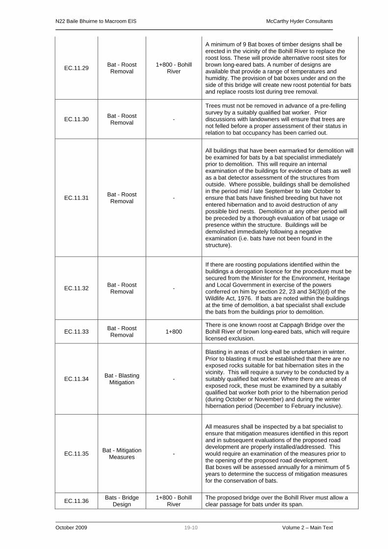
N22 Baile Bhuirne to Macroom EIS McCarthy Hyder Consultants
October 2009 19-10 Volume 2 – Main Text
EC.11.29 Bat - Roost Removal
1+800 - Bohill River
A minimum of 9 Bat boxes of timber designs shall be erected in the vicinity of the Bohill River to replace the roost loss. These will provide alternative roost sites for brown long-eared bats. A number of designs are available that provide a range of temperatures and humidity. The provision of bat boxes under and on the side of this bridge will create new roost potential for bats and replace roosts lost during tree removal.
EC.11.30 Bat - Roost Removal -
Trees must not be removed in advance of a pre-felling survey by a suitably qualified bat worker. Prior discussions with landowners will ensure that trees are not felled before a proper assessment of their status in relation to bat occupancy has been carried out.
EC.11.31 Bat - Roost Removal -
All buildings that have been earmarked for demolition will be examined for bats by a bat specialist immediately prior to demolition. This will require an internal examination of the buildings for evidence of bats as well as a bat detector assessment of the structures from outside. Where possible, buildings shall be demolished in the period mid / late September to late October to ensure that bats have finished breeding but have not entered hibernation and to avoid destruction of any possible bird nests. Demolition at any other period will be preceded by a thorough evaluation of bat usage or presence within the structure. Buildings will be demolished immediately following a negative examination (i.e. bats have not been found in the structure).
EC.11.32 Bat - Roost Removal -
If there are roosting populations identified within the buildings a derogation licence for the procedure must be secured from the Minister for the Environment, Heritage and Local Government in exercise of the powers conferred on him by section 22, 23 and 34(3)(d) of the Wildlife Act, 1976. If bats are noted within the buildings at the time of demolition, a bat specialist shall exclude the bats from the buildings prior to demolition.
EC.11.33 Bat - Roost Removal 1+800
There is one known roost at Cappagh Bridge over the Bohill River of brown long-eared bats, which will require licensed exclusion.
EC.11.34 Bat - Blasting Mitigation -
Blasting in areas of rock shall be undertaken in winter. Prior to blasting it must be established that there are no exposed rocks suitable for bat hibernation sites in the vicinity. This will require a survey to be conducted by a suitably qualified bat worker. Where there are areas of exposed rock, these must be examined by a suitably qualified bat worker both prior to the hibernation period (during October or November) and during the winter hibernation period (December to February inclusive).
EC.11.35 Bat - Mitigation Measures -
All measures shall be inspected by a bat specialist to ensure that mitigation measures identified in this report and in subsequent evaluations of the proposed road development are properly installed/addressed. This would require an examination of the measures prior to the opening of the proposed road development. Bat boxes will be assessed annually for a minimum of 5 years to determine the success of mitigation measures for the conservation of bats.
EC.11.36 Bats - Bridge Design
1+800 - Bohill River
The proposed bridge over the Bohill River must allow a clear passage for bats under its span.

N22 Baile Bhuirne to Macroom EIS McCarthy Hyder Consultants
October 2009 19-11 Volume 2 – Main Text
EC.11.37 Bats - Bridge Design
13+780 - Foherish River
The bridge crossing the Foherish River will have a minimum 4.8m clearance and a 38m span, and will therefore also allow free passage of bats.
EC.11.38 Bats -
Landscape Planting
2+600 to 2+900 The sides of the road shall be heavily planted running past the roost building north of Baile Bhuirne between Chainages 2 + 600 and 2 + 900.
EC.11.39 Bats -
Landscape Planting
8+550 to 9+000 Planting shall be especially dense to screen off any impact from lighting and to reduce the noise disruption to bats.
EC.11.40 Bats -
Landscape Planting
13+770 to 14+600 Planting shall be especially dense to screen off any impact from lighting and to reduce the noise disruption to bats.
EC.11.41 Bats -
Landscape Planting
14+350 to 15+100
Dense linear planting of shrubby vegetation will be carried-out along the northern side of the proposed road (parallel to it) , which will help to guide bats to the culvert at 15+035.
EC.11.42 Bats -
Landscape Planting
17+200 to 17+720 Dense linear planting of shrubby vegetation will be carried-out along the southern side of the proposed road which will help to guide bats to the provided culvert.
EC.11.43 Bats -
Landscape Planting
2+250 to 2+900 Planting vegetation corridors on both sides of the proposed road development to guide bats to underpass at Ch. 2+500.
EC.11.44 Bats -
Landscape Planting
8+400 to 9+000 Bats will be led to the bridge at 8+750 by planting vegetation corridors on both sides of the proposed road development.
EC.11.45 Barn Owls - Landscape
Planting 17+100 to 18+200
Planting of continuous lines of trees and shrubs where the road is at grade or is embanked to discourage Barn Owls from low-level flying across the carriageway.
EC.11.46 Barn Owls - Landscape
Planting 15+900 to 17+100
The banks of the deep cutting, including the cuttings associated with the Gurteenroe interchange, shall be planted with shrubs.
EC.11.47 Barn Owls - Landscape
Planting 1+850 to 2+200 Planting of continuous lines of trees and shrubs; and
minimisation of grassland as barn owl mitigation.
EC.11.48 Barn Owls - Landscape
Planting 2+400 to 3+500 Planting of continuous lines of trees and shrubs; and
minimisation of grassland as barn owl mitigation.
EC.11.49 Barn Owls - Landscape
Planting
12+650 to 13+750
Planting of continuous lines of trees and shrubs; and minimisation of grassland as barn owl mitigation.
EC.11.50 Bats - Underpasses 14+035
An underpass will be constructed to allow the passage of bats. The underpass will measure 6m (span) x 3m (height).
EC.11.51 Bats - Underpasses 15+035 The stream culvert will be ‘oversized’ to 3.6m x 3m in
order to allow free passage of bats.
EC.11.52 Bats - Underpasses 17+720 The stream culvert will be ‘oversized’ to 3m x 3m in order
to allow free passage of bats.
EC.11.53 Bats - Lighting Design 2+500 The bridge will be unlit.
EC.11.54 Bats - Lighting Design 8+750 The bridge will be unlit.
EC.11.55 Bats - Lighting Design 1+700 to 2+300 No lighting that overspills into the surrounding vegetation
or waterways.
EC.11.56 Bats - Lighting Design 2+300 to 3+000
No lighting that overspills into the surrounding vegetation, waterways, buildings used by the bats (see Figure 11.3) or the vegetation surrounding these buildings.

N22 Baile Bhuirne to Macroom EIS McCarthy Hyder Consultants
October 2009 19-12 Volume 2 – Main Text
EC.11.57 Bats - Lighting Design 13+400 to 14+600
No lighting that overspills into the surrounding vegetation, waterways, buildings used by the bats (see Figure 11.3) or the vegetation surrounding these buildings.
EC.11.58 Bats - Lighting Design 14+900 to 16+100 No lighting that overspills into the surrounding vegetation
or waterways.
EC.11.59 Bats - Lighting Design 16+900 to 17+900 No lighting that overspills into the surrounding vegetation
or waterways.
EC.11.60 Bats - Lighting Design 19+700 to 20+100 No lighting that overspills into the surrounding vegetation
or waterways.
EC.11.61 Bats - Lighting Design 21+400 to 21+750 No lighting that overspills into the surrounding vegetation
or waterways.
EC.11.62 Badgers - Pre construction
survey -
A full survey of badger activity has been completed as part of this EIA. However, the locations of badger paths and territory boundaries are liable to change over time and therefore a full badger survey of the landtake of the road shall be conducted prior to the commencement of construction of the road.
EC.11.63 Badgers - Pre construction
survey -
Three badger setts were found within the landtake of the proposed road development. Two were active at the time of the survey, sett numbers 13 and 14; one was inactive, sett number 2. It will be necessary, prior to the commencement of construction of the proposed road development, to seek licences for the removal of these setts. Sett removal (of active setts) can only be carried out during the period when no dependent young are present within the sett, which is between 1st July and 1st December.
EC.11.64
Badgers - Pre construction survey / Site Clearance
5+750 and 6+770
An experienced badger worker shall be present on-site during site clearance activities in these areas when construction of the proposed road development commences, and shall work with the site clearance team to check these sections for badger setts.
EC.11.65
Badgers - Pre construction survey / Site Clearance
8+440 and 8+640
An experienced badger worker shall be present on-site during site clearance activities in these areas when construction of the proposed road development commences, and shall work with the site clearance team to check these sections for badger setts.
EC.11.66
Badgers - Pre construction survey / Site Clearance
10+530 and10+680
An experienced badger worker shall be present on-site during site clearance activities in these areas when construction of the proposed road development commences, and shall work with the site clearance team to check these sections for badger setts.
EC.11.67
Badgers - Pre construction survey / Site Clearance
12+200 and 12+670
An experienced badger worker shall be present on-site during site clearance activities in these areas when construction of the proposed road development commences, and shall work with the site clearance team to check these sections for badger setts.
EC.11.68
Badgers - Pre construction survey / Site Clearance
12+970 and 13+350
An experienced badger worker shall be present on-site during site clearance activities in these areas when construction of the proposed road development commences, and shall work with the site clearance team to check these sections for badger setts.
EC.11.69
Badgers - Pre construction survey / Site Clearance
13+570 and 13+770
An experienced badger worker shall be present on-site during site clearance activities in these areas when construction of the proposed road development commences, and shall work with the site clearance team to check these sections for badger setts.

N22 Baile Bhuirne to Macroom EIS McCarthy Hyder Consultants
October 2009 19-13 Volume 2 – Main Text
EC.11.70 Badgers - Sett Removal -
There will be a requirement, prior to the licence application, to conduct further investigations of these setts.
EC.11.71 Badgers - Sett Removal -
Where blasting is proposed outside the badger breeding season within 50m of an active badger sett, then removal or temporary closure of the sett shall be considered. This shall be done on a case by case basis in full consultation with NPWS following the pre-construction survey
EC.11.72 Mammal Mitigation 400 to 1+600 Mammal proof fencing is proposed at this location.
EC.11.73 Mammal Mitigation 4+800 to 5+550 Mammal proof fencing is proposed at this location.
EC.11.74 Mammal Mitigation 7+800 to 14+100 Mammal proof fencing is proposed at this location.
EC.11.75 Mammal Mitigation 14+500 to 16+500 Mammal proof fencing is proposed at this location.
EC.11.76 Mammal Mitigation 17+580 to 17+880 Mammal proof fencing is proposed at this location.
EC.11.77 Mammal Mitigation 18+200 to 18+800 Mammal proof fencing is proposed at this location.
EC.11.78 Mammal Mitigation 19+300 to 20+600 Mammal proof fencing is proposed at this location.
EC.11.79 Mammal Mitigation 20+710 to 21+900 Mammal proof fencing is proposed at this location.
EC.11.80 Mammal Mitigation 5+250 Culvert to maintain free passage for otters
EC.11.81 Mammal Mitigation 9+900 Culvert to maintain free passage for otters
EC.11.82 Mammal Mitigation 10+500 Culvert to maintain free passage for otters
EC.11.83 Mammal Mitigation 10+780 Culvert to maintain free passage for otters
EC.11.84 Mammal Mitigation 11+300 Culvert to maintain free passage for otters
EC.11.85 Mammal Mitigation 11+900 Culvert to maintain free passage for otters
EC.11.86 Mammal Mitigation 12+700 (2 no.) Culvert to maintain free passage for otters
EC.11.87 Mammal Mitigation 15+000 Culvert to maintain free passage for otters
EC.11.88 Mammal Mitigation 16+100 Culvert to maintain free passage for otters
EC.11.89 Mammal Mitigation 17+700 Culvert to maintain free passage for otters
EC.11.90 Mammal Mitigation 10+300 Badger Underpass
EC.11.91 Mammal Mitigation 8+200 Badger Underpass
EC.11.92 Mammal Mitigation 8+900 Badger Underpass
EC.11.93 Mammal Mitigation 500 Underpasses suitable for badgers and otters
EC.11.94 Mammal Mitigation 18+350 Underpasses suitable for badgers and otters
EC.11.95 Otter Mitigation 0+200 to 0+900 Fencing along mainline, side-roads and slip-roads of junctions as indicated in Figure 11.5, to prevent access to the road by otters.
EC.11.96 Otter Mitigation 1+930 to 2+350 Maintenance of free passage for otters along Bohill river. Fencing along both sides of the mainline as indicated in Figure 11.5.
EC.11.97 Otter Mitigation 5+100 to 5+350 Maintenance of free passage for otters along the stream. Fencing along both sides of the mainline and on side roads as indicated in Figure 11.5.

N22 Baile Bhuirne to Macroom EIS McCarthy Hyder Consultants
October 2009 19-14 Volume 2 – Main Text
EC.11.98 Otter Mitigation 9+000 to 12+850
Fencing along both the mainline and the access roads as indicated in Figure 11.5. Maintenance of free passage for otters beneath Sullane Bridge and along six different streams at Chainages, 9+900; 10+520 and 10+750, 11+360, 11+950, 12+720 (both mainline and side roads).
EC.11.99 Otter Mitigation 13+400 to 13+930 Fencing along both sides of the mainline as indicated in Figure 11.5. Maintenance of free passage of otters beneath the Foherish River bridge.
EC.11.100 Otter Mitigation
14+500 to 16+250 (includes sections
of badger mitigation)
Fencing along both sides of the mainline as indicated in Figure 11.5. Maintenance of free passage of otters along the stream at Teerbeg at Chainage 15+030 and the stream at Gurteenroe at Chainage 16+100.
EC.11.101 Otter Mitigation 17+650 to 17+850 Fencing along both sides of the mainline and side-roads as indicated in Figure 11.5. Maintenance of free passage of otters along the stream.
EC.11.102 Otter Mitigation
18+250 to 18+800 (includes sections
of badger mitigation)
Fencing along both sides of the mainline as indicated in Figure 11.5.Maintenance of free passage of otters along the stream.
EC.11.103 Otter Mitigation
19+320 to 21+800 (eastern end of proposed road development)
Fencing along both sides of mainline and around the junction at Coolcour as indicated in Figure 11.5. Maintenance of free passage of otters along the Rivers Laney and Sullane; and within Inishcarra Reservoir.
EC.11.104 Red Squirrel -
At the crossing point of the Bohill River, the carriageway is raised above ground level sufficiently to allow passage of red squirrels beneath the carriageway at this point. A continuous riparian corridor of tall vegetation will be maintained beneath the bridge, connecting the retained woodland, treelines and hedgerows to both the north and south of the carriageway.
EC.11.105
Breeding Kingfisher and
Dipper - Preconstruction
Survey
-
A pre-construction survey for nesting Kingfisher and Dipper shall be conducted at all points where the proposed road development runs close to, or crosses such watercourses. The purpose of the survey will be to locate any Kingfisher or Dipper nest within 50m of any construction works, and to propose appropriate site-specific mitigation measures that will prevent disturbance to the breeding birds.
EC.11.106 Barn Owls -
Preconstruction Survey
-
A pre-construction survey for Barn Owl is required. This will include detailed examination of any buildings, sheds, barns or other man-made structures that are to be demolished as part of the proposed road development.
EC.11.107 Barn Owls - Removal of
nests -
Should nest sites be discovered in buildings that are being removed then further mitigation or compensation measure would be required, details of which would need to be agreed with National Parks and Wildlife Service.

N22 Baile Bhuirne to Macroom EIS McCarthy Hyder Consultants
October 2009 19-15 Volume 2 – Main Text
EC.11.108 Kerry Slug 0-532 to 3+000
Potential impacts on Kerry slug have been assessed as a Major Negative Impact. Measures to reduce the magnitude of this impact shall include the following:
• Collection of individual Kerry slugs immediately prior to site clearance of the land take area for the road development. The collected Kerry slugs shall be relocated to similar habitat away from the road development. This will involve a finger-tip ‘destructive search’ for the slugs beneath all suitable refuges and in suitable habitats within the area of land take between chainages 0-532 and 3+000;
• Leaving trees during felling operations for several days in suitable locations adjoining retained habitat before logging and removal;
• Using felled logs as habitat piles in selected locations in the remaining woodland; and
• A careful review of the sit e clearance proposals in these locations with the intention of maintaining existing conditions, in terms of shade and humidity in particular, in the adjoining Kerry slug habitat.
• Using new planting and other measures, for example ‘dead hedging’ to help maintain micro-climatic conditions in adjoining habitats.
• Particularly vigilant supervision and judicious use of protective fencing to ensure that impacts on adjoining Kerry slug habitat are avoided entirely.
• An assessment of the likely risks of the Kerry slug gaining access to working areas, and a review of measures such as barriers to slug movement, that might be necessary to ensure that slugs are not killed incidentally during the works.
EC.11.109
Freshwater Environment – Construction
Phase
- General guidelines for erosion, sediment and pollution control, based on Goldman et al (1986) and Chilibeck et al (1992), will be implemented.
EC.11.110 Freshwater
Environment – Culvert Design
-
Culverts shall be designed in consultation with the South Western Regional Fisheries Board and constructed in such a way as to ensure that streams remain passable for fish and other aquatic fauna, as set out in Technical Report 7: Ecology.
EC.11.111
Freshwater Environment – Construction
Phase
-
Oil separators and filter drains with porous stone backfill, geotextile surround and silt trap manholes shall be used where possible for surface drainage. Where filter drains are not practicable, alternative systems which provide an equivalent level of pollution reduction shall be used.

N22 Baile Bhuirne to Macroom EIS McCarthy Hyder Consultants
October 2009 19-16 Volume 2 – Main Text
EC.11.112
Freshwater Environment – Construction
Phase
-
During construction concentrations of pollutants likely to be detrimental to the Freshwater Pearl Mussel populations which have been identified in the Sullane and Foherish Rivers to be prevented following guidelines above. During the operation of the road concentrations of pollutants likely to be detrimental to the Freshwater Pearl Mussel populations which have been identified in the Sullane and Foherish Rivers to be prevented following guidelines above. It is important to note that stringent measures to protect Freshwater Pearl Mussels will have to be applied to streams flowing into the Mussel bearing rivers as well as to the rivers themselves. Surface water discharges from the completed road to the Sullane, Bohill, Foherish and Laney Rivers shall be treated by filter drains which discharge to a constructed wetland or vegetated lagoon before discharging to the river. No instream structures or works in the Bohill, Sullane, Foherish & Laney Rivers.
EC.11.113
Freshwater Environment – Construction
Phase
-
The diversion of c.200m of the Owengarve into a realigned channel carries a very high risk of suspended solids pollution with a consequent risk to the Freshwater Pearl Mussel population in the Sullane river c.2km downstream. Measures must be put in place to ensure that the suspended solids in the Owengarve immediately downstream of the proposed realignment are controlled using suitable pollution controls. Moorkens (2007) estimated that over 41% of the total mussel population in the Sullane River itself and over 35% of the total population in the Sullane River system (including its tributaries) occur between c.2km and c.3km downstream of the proposed Owengarve realignment. Should this population decline significantly during the proposed realignment of the Owengarve or before the realigned channel has stabilised, it will be important to be able to rule out such a decline having been caused by the realignment of 200m of river c.2km upstream of the population. Monitoring of suspended solids shall therefore be carried out immediately upstream and downstream of the realignment works up to a period of 6 months following the realignment.
EC.11.114 Water Quality Monitoring
1+800 - Bohill River
11+350 - “Inchinlinane”
Stream 13+780 - Foherish
River 19+900 - Laney
River 10+450, 12+100, 20+000, 20+700 -
Sullane River
Biological water quality will be established at potential impact locations B, D, 3, 4, 5, 6, 9 & 10 immediately prior to and immediately after completion of road construction works at each of these locations.

N22 Baile Bhuirne to Macroom EIS McCarthy Hyder Consultants
October 2009 19-17 Volume 2 – Main Text
EC.11.115 Freshwater
Pearl Mussel - Monitoring
Irish Grid Ref: Sullane Section 4 W 17200 76353 to W 17660 76258 Section 8 Below confluence of the Bohill River W 20208 76951 to W 20217 76910 Section 10 From Toonlane Confluence W 223 757 to Pollnabro Bridge W 227 756Section 14 From confluence with Foherish downstream to W 297 731 Foherish Section 4 W 289 752 to road bridge at W 292 753 Section 5 From W 297 738 downstream to road bridge at on N22 Section 6 From N22 road bridge to confluence with Sullane River Laney Section 6 Between Morris’s and Laney Bridge at W 36729 73616 and 100m upstream and downstream
In addition, the key areas where groups of mussels were counted in 2007, in particular at the Sullane sections 4 (control), 8, 10, and 14, the Foherish section 4 (control), 5 and 6 and the Laney 6 (control) should be repeated one year and again 5 years after construction is finished in order to assess any impact related to the road and consequently the long-term effectiveness of the mitigation measures for Margaritifera.
EC.11.116
Freshwater Environment – Construction
Phase
1+800 Bohill River5+250 “Toonlane”
Stream 16+090
“Gurteenroe” Stream 17+710
“Ballyveerane” Stream
Impact locations B, 1, 7 & 8: A leave strip of >10m shall apply except at actual road crossing point, or where works closer to the river are completely necessary, in which case a narrower leave strip shall be established.
EC.11.117
Freshwater Environment – Construction
Phase
10+450 - Sullane
Impact location 3: Along this c.1km section of river, the riparian trees on the steep bank shall be retained and a >5m wide leave strip established from the top of the bank.
EC.11.118
Freshwater Environment – Construction
Phase
12+100 - Sullane Impact Location 5: Along this c.150m section of river, the raised embankment with trees including willow, ash, hawthorn and holly shall be retained.

N22 Baile Bhuirne to Macroom EIS McCarthy Hyder Consultants
October 2009 19-18 Volume 2 – Main Text
EC.11.119
Freshwater Environment – Construction
Phase
13+780 - Foherish
Impact Location 6: A leave strip shall be established as close as possible upstream and downstream of the bridge crossing point. The bridge support structures shall be set back >5m from the bank. Along the c.400m of river close to the road construction all riparian trees shall be retained and a leave strip of 5m established from the top of the river bank (including the bank of the high water channel). Where possible a total leave strip width of 15m shall be established from the river edge and left undisturbed.
EC.11.120
Freshwater Environment – Construction
Phase
20+000 - Sullane
Impact location 9: Along this c.0.5km section of river, the riparian trees shall be retained and a >5m wide leave strip established from the top of the bank. At the bridging point of the Laney River a leave strip shall be established as close as possible upstream and downstream of the bridge crossing point.
EC.11.121
Freshwater Environment – Construction
Phase
0-300 - Owengarve
1+800 - Bohill River
0+000 - Slievereagh West
Stream 0+450 -
Slievereagh East Stream 5+250 -
“Toonlane” Stream10+450, 12+100, 20+000, 20+700 -
Sullane River 9+880 -
“Lissacresig” Stream
11+350 - “Inchinlinane”
Stream 13+780 - Foherish
River 16+090 -
“Gurteenroe” Stream
17+710 - “Ballyveerane”
Stream 19+900 - Laney
River 21+400 - Inishcarra Reservoir
Construction works likely to generate suspended solids within 10m of all watercourses shall not take place between the beginning of October and the end of March without the prior agreement of the South Western Regional Fisheries Board. No instream works shall take place within this period without the prior agreement of South Western Regional Fisheries Board.
EC.11.122
Freshwater Environment – Construction
Phase
0+000 - Slievereagh West
Stream 16+090 -
“Gurteenroe” Stream
17+710 - “Ballyveerane”
Stream
River crossing to be by open arch culvert at least 1.2 times the bankfull width of the stream or by single span bridge

N22 Baile Bhuirne to Macroom EIS McCarthy Hyder Consultants
October 2009 19-19 Volume 2 – Main Text
EC.11.123
Freshwater Environment – Construction
Phase
0-300 - Owengarve
1+800 - Bohill River
0+000 - Slievereagh West
Stream 0+450 -
Slievereagh East Stream 5+250 -
“Toonlane” Stream10+450, 12+100, 20+000, 20+700 -
Sullane River 9+880 -
“Lissacresig” Stream
11+350 - “Inchinlinane”
Stream 13+780 - Foherish
River 16+090 -
“Gurteenroe” Stream
17+710 - “Ballyveerane”
Stream 19+900 - Laney
River 21+400 - Inishcarra Reservoir
Use filter drains and oil separators. Outfalls to be sealable in case of major accidental spillages.
EC.12.1 Cultural Heritage -
All Cultural Heritage mitigation works will be undertaken in compliance with the provisions of the National Monuments (Amendments) Act 1930-2004 and the Code of Practice (2000) agreed between the National Roads Authority and the Minister for Arts, Heritage, Gaeltacht and the Islands.
EC.12.2 Cultural Heritage -
All sites listed in Appendices 8.1 to 8.6 that will be directly impacted upon by the proposed route, will be archaeologically investigated in order to help determine their nature, age and extent. A number of site investigation methods shall be considered, including topographical survey, geophysical survey, metal detector survey and/or archaeological test trenching.
EC.12.3 Cultural Heritage -
The following sites will be targeted during archaeological investigations: o CH 2, CH 3 o AH 1, AH 4, AH 8, AH 9, AH 12, AH 19, AH 20, AH 27, AH 32, AH 35, AH 36 o AAP 1-AAP 31. This includes the terrestrial sections of any riverine or stream areas. o SAP 1, SAP 5, SAP 7, SAP 8, SAP 11, SAP 12, SAP 14, SAP 15, SAP 16, SAP 17 o AS 5 o BH 4, BH 8, BH 39, BH 54, BH 59, BH 32
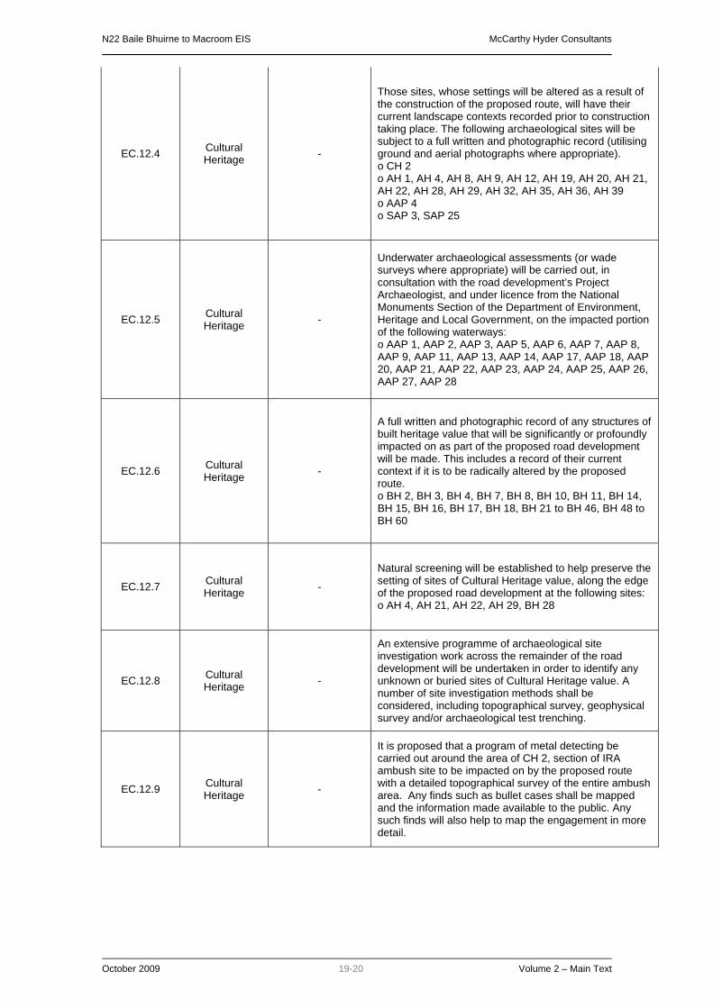
N22 Baile Bhuirne to Macroom EIS McCarthy Hyder Consultants
October 2009 19-20 Volume 2 – Main Text
EC.12.4 Cultural Heritage -
Those sites, whose settings will be altered as a result of the construction of the proposed route, will have their current landscape contexts recorded prior to construction taking place. The following archaeological sites will be subject to a full written and photographic record (utilising ground and aerial photographs where appropriate). o CH 2 o AH 1, AH 4, AH 8, AH 9, AH 12, AH 19, AH 20, AH 21, AH 22, AH 28, AH 29, AH 32, AH 35, AH 36, AH 39 o AAP 4 o SAP 3, SAP 25
EC.12.5 Cultural Heritage -
Underwater archaeological assessments (or wade surveys where appropriate) will be carried out, in consultation with the road development’s Project Archaeologist, and under licence from the National Monuments Section of the Department of Environment, Heritage and Local Government, on the impacted portion of the following waterways: o AAP 1, AAP 2, AAP 3, AAP 5, AAP 6, AAP 7, AAP 8, AAP 9, AAP 11, AAP 13, AAP 14, AAP 17, AAP 18, AAP 20, AAP 21, AAP 22, AAP 23, AAP 24, AAP 25, AAP 26, AAP 27, AAP 28
EC.12.6 Cultural Heritage -
A full written and photographic record of any structures of built heritage value that will be significantly or profoundly impacted on as part of the proposed road development will be made. This includes a record of their current context if it is to be radically altered by the proposed route. o BH 2, BH 3, BH 4, BH 7, BH 8, BH 10, BH 11, BH 14, BH 15, BH 16, BH 17, BH 18, BH 21 to BH 46, BH 48 to BH 60
EC.12.7 Cultural Heritage -
Natural screening will be established to help preserve the setting of sites of Cultural Heritage value, along the edge of the proposed road development at the following sites: o AH 4, AH 21, AH 22, AH 29, BH 28
EC.12.8 Cultural Heritage -
An extensive programme of archaeological site investigation work across the remainder of the road development will be undertaken in order to identify any unknown or buried sites of Cultural Heritage value. A number of site investigation methods shall be considered, including topographical survey, geophysical survey and/or archaeological test trenching.
EC.12.9 Cultural Heritage -
It is proposed that a program of metal detecting be carried out around the area of CH 2, section of IRA ambush site to be impacted on by the proposed route with a detailed topographical survey of the entire ambush area. Any finds such as bullet cases shall be mapped and the information made available to the public. Any such finds will also help to map the engagement in more detail.
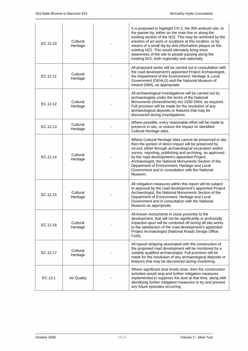
N22 Baile Bhuirne to Macroom EIS McCarthy Hyder Consultants
October 2009 19-21 Volume 2 – Main Text
EC.12.10 Cultural Heritage -
It is proposed to highlight CH 2, the IRA ambush site, to the passer-by, either on the main line or along the existing section of the N22. This may be achieved by the erection of art work or sculpture at this location, or by means of a small lay-by and information plaque on the existing N22. This would ultimately bring more awareness of the site to people passing along the existing N22, both regionally and nationally.
EC.12.11 Cultural Heritage -
All proposed works will be carried out in consultation with the road development's appointed Project Archaeologist, the Department of the Environment, Heritage & Local Government (DEHLG) and the National Museum of Ireland (NMI), as appropriate.
EC.12.12 Cultural Heritage -
All archaeological investigations will be carried out by archaeologists under the terms of the National Monuments (Amendments) Act 1930-2004, as required. Full provision will be made for the resolution of any archaeological deposits or features that may be discovered during investigations.
EC.12.13 Cultural Heritage -
Where possible, every reasonable effort will be made to preserve in situ, or reduce the impact on identified Cultural Heritage sites.
EC.12.14 Cultural Heritage -
Where Cultural Heritage sites cannot be preserved in situ then the portion of direct impact will be preserved by record, either through archaeological excavation and/or survey, reporting, publishing and archiving, as approved by the road development’s appointed Project Archaeologist, the National Monuments Section of the Department of Environment, Heritage and Local Government and in consultation with the National Museum.
EC.12.15 Cultural Heritage -
All mitigation measures within this report will be subject to approval by the road development’s appointed Project Archaeologist, the National Monuments Section of the Department of Environment, Heritage and Local Government and in consultation with the National Museum as appropriate.
EC.12.16 Cultural Heritage -
All known monuments in close proximity to the development, that will not be significantly or profoundly impacted upon will be cordoned off during all site works to the satisfaction of the road development’s appointed Project Archaeologist (National Roads Design Office, Cork).
EC.12.17 Cultural Heritage -
All topsoil stripping associated with the construction of the proposed road development will be monitored by a suitably qualified archaeologist. Full provision will be made for the resolution of any archaeological deposits or features that may be discovered during monitoring.
EC.13.1 Air Quality -
Where significant dust levels arise, then the construction activities would stop and further mitigation measures implemented to suppress the dust at that time, along with identifying further mitigation measures to try and prevent any future episodes occurring.
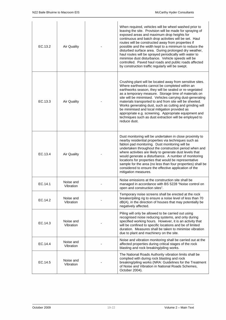
N22 Baile Bhuirne to Macroom EIS McCarthy Hyder Consultants
October 2009 19-22 Volume 2 – Main Text
EC.13.2 Air Quality -
When required, vehicles will be wheel washed prior to leaving the site. Provision will be made for spraying of exposed areas and maximum drop heights for continuous and batch drop activities will be set. Haul routes will be constructed away from properties if possible and the width kept to a minimum to reduce the disturbed surface area. During prolonged dry weather, haul routes will be sprayed periodically with water to minimise dust disturbance. Vehicle speeds will be controlled. Paved haul roads and public roads affected by construction traffic regularly will be swept.
EC.13.3 Air Quality -
Crushing plant will be located away from sensitive sites. Where earthworks cannot be completed within an earthworks season, they will be sealed or re-vegetated as a temporary measure. Storage time of materials on site will be minimised. Vehicles carrying dust-generating materials transported to and from site will be sheeted. Works generating dust, such as cutting and grinding will be minimised and local mitigation provided as appropriate e.g. screening. Appropriate equipment and techniques such as dust extraction will be employed to reduce dust.
EC.13.4 Air Quality -
Dust monitoring will be undertaken in close proximity to nearby residential properties via techniques such as fablon pad monitoring. Dust monitoring will be undertaken throughout the construction period when and where activities are likely to generate dust levels that would generate a disturbance. A number of monitoring locations for properties that would be representative sample for the area (no less than four properties) shall be considered to ensure the effective application of the mitigation measures.
EC.14.1 Noise and Vibration -
Noise emissions at the construction site shall be managed in accordance with BS 5228 “Noise control on open and construction sites”.
EC.14.2 Noise and Vibration -
Temporary noise screens shall be erected at the rock breaker/piling rig to ensure a noise level of less than 70 dB(A), in the direction of houses that may potentially be negatively affected.
EC.14.3 Noise and Vibration -
Piling will only be allowed to be carried out using recognised noise reducing systems, and only during specified working hours. However, it is an activity that will be confined to specific locations and be of limited duration. Measures shall be taken to minimise vibration due to plant and machinery on the site.
EC.14.4 Noise and Vibration -
Noise and vibration monitoring shall be carried out at the affected properties during critical stages of the rock blasting and rock breaking/piling works.
EC.14.5 Noise and Vibration -
The National Roads Authority vibration limits shall be complied with during rock blasting and rock breaking/piling works (NRA: Guidelines for the Treatment of Noise and Vibration in National Roads Schemes, October 2004).

N22 Baile Bhuirne to Macroom EIS McCarthy Hyder Consultants
October 2009 19-23 Volume 2 – Main Text
EC.14.6 Noise and Vibration -
Given the potential that existing cracks (if any are present) in properties may be reported as being due to construction works, a condition survey of buildings/properties will be carried out prior to the commencement of rock breaking/blasting works, and other works associated with the construction phase of the proposed road development.
EC.14.7 Noise and Vibration -
In the event that property condition surveys determine that any buildings are structurally weak, or there is reason to believe that they may otherwise be unusually prone to vibration damage, this would need to be taken into account, and provided for accordingly by the contractor for the rock blasting and rock breaking/piling works.
EC.14.8 Noise and Vibration -
Works other than pumping out of excavations, security and emergency works will not be undertaken at night or on Sundays without the written permission of Cork County Council. When overtime and shift working is permitted, the hauling of spoil and delivery of materials outside normal working hours is prohibited and the noise limits outlined in Table 10.2 (Volume , Chapter 10 of the EIS) will apply, subject to confirmation with Cork County Council.
EC.14.9 Noise and Vibration -
A low road noise (pervious) surface will incorporated along the entire length of the proposed N22 Baile Bhuirne to Macroom scheme. The surfacing shall obtain a 3.5dB reduction in road traffic noise.
EC.14.10 Noise and Vibration
Along access road 275 - 365
EC.14.10 to EC.14.26 are the proposed noise barriers for the proposed road development Height (m): 2.75 Length (m): 100 Top of cutting of access road Reflective
EC.14.11 Noise and Vibration 18+700 – 18+900
Height (m): 2.5 Length (m): 210 Top of Cutting Reflective
EC.14.12 Noise and Vibration 17+600 – 18+000
Height (m): 2.5 Length (m): 405 Edge of verge Reflective
EC.14.13 Noise and Vibration 5+770 – 5+940
Height (m): 2.7 Length (m): 170 Top of Cutting Reflective
EC.14.14 Noise and Vibration 9+100 - 9+250
Height (m): 2.5 Length (m): 145 Top of Cutting Reflective
EC.14.15 Noise and Vibration 9+250 – 9+400
Height (m): 2.1 Length (m): 160 Top of Cutting Reflective
EC.14.16 Noise and Vibration 4+370 – 4+590
Height (m): 1.5 Length (m): 205 Edge of verge Absorptive

N22 Baile Bhuirne to Macroom EIS McCarthy Hyder Consultants
October 2009 19-24 Volume 2 – Main Text
EC.14.17 Noise and Vibration 3+930 – 4+100
Height (m): 2.75 Length (m): 160 Top of Cutting Reflective
EC.14.18 Noise and Vibration 2+760 – 2+910
Height (m): 1 Length (m): 200 Edge of verge Reflective
EC.14.19 Noise and Vibration 110 - 410
Height (m): 2.5 Length (m): 300 Edge of verge Absorptive
EC.14.20 Noise and Vibration 170 - 385
Height (m): 2 Length (m): 200 Edge of verge Absorptive
EC.14.21 Noise and Vibration 1+800 - 2+000
Height (m): 2.75 Length (m): 300 Edge of verge Reflective
EC.14.22 Noise and Vibration 18+700 – 18+900
Height (m): 2.5 Length (m): 210 Top of Cutting Reflective
EC.14.23 Noise and Vibration 16+000 - 16+260
Height (m): 2 Length (m): 245 Edge of verge Reflective
EC.14.24 Noise and Vibration 1+600 - 16+140
Height (m): 1.5 Length (m): 120 Edge of verge Reflective
EC.14.25 Noise and Vibration 8+660 - 8+910
Height (m): 2.6 Length (m): 250 Edge of verge Reflective
EC.14.26 Noise and Vibration 4+350 - 4+660
Height (m): 2.5 Length (m): 310 Edge of verge Absorptive
EC.15.1 Non-
agricultural Land Use
-
During the construction phase access will be maintained to properties. Landowners will be informed on the timing of works that would affect direct access to the property. A Construction Management Plan and Environmental Operating Plan will be in place for the construction works and phasing to ensure minimum disruption to traffic on the existing roads. Where access to residential properties from public roads is affected by the Preliminary Design, alternative access arrangements will be provided at an appropriate location. If a driveway is regraded or any structures such as boundary walls and gateposts demolished, the replacement will be of an equal quality and standard to the existing material unless otherwise agreed with the owners.
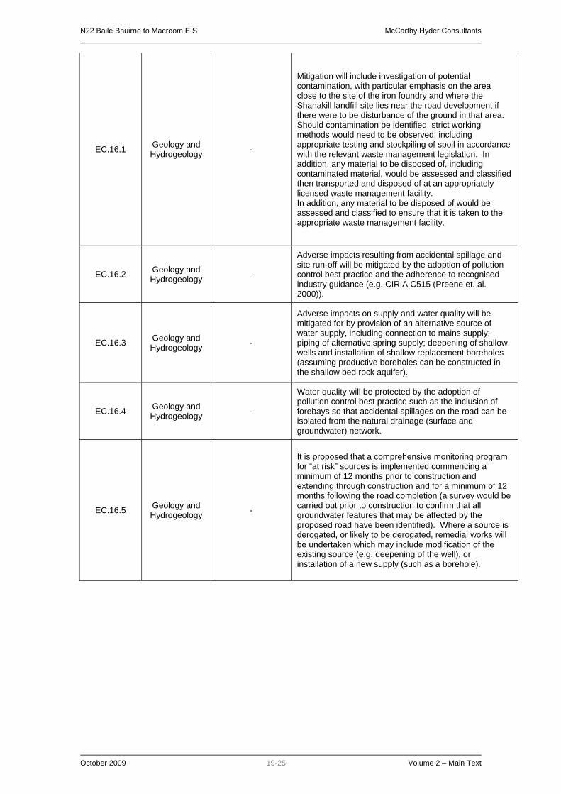
N22 Baile Bhuirne to Macroom EIS McCarthy Hyder Consultants
October 2009 19-25 Volume 2 – Main Text
EC.16.1 Geology and Hydrogeology -
Mitigation will include investigation of potential contamination, with particular emphasis on the area close to the site of the iron foundry and where the Shanakill landfill site lies near the road development if there were to be disturbance of the ground in that area. Should contamination be identified, strict working methods would need to be observed, including appropriate testing and stockpiling of spoil in accordance with the relevant waste management legislation. In addition, any material to be disposed of, including contaminated material, would be assessed and classified then transported and disposed of at an appropriately licensed waste management facility. In addition, any material to be disposed of would be assessed and classified to ensure that it is taken to the appropriate waste management facility.
EC.16.2 Geology and Hydrogeology -
Adverse impacts resulting from accidental spillage and site run-off will be mitigated by the adoption of pollution control best practice and the adherence to recognised industry guidance (e.g. CIRIA C515 (Preene et. al. 2000)).
EC.16.3 Geology and Hydrogeology -
Adverse impacts on supply and water quality will be mitigated for by provision of an alternative source of water supply, including connection to mains supply; piping of alternative spring supply; deepening of shallow wells and installation of shallow replacement boreholes (assuming productive boreholes can be constructed in the shallow bed rock aquifer).
EC.16.4 Geology and Hydrogeology -
Water quality will be protected by the adoption of pollution control best practice such as the inclusion of forebays so that accidental spillages on the road can be isolated from the natural drainage (surface and groundwater) network.
EC.16.5 Geology and Hydrogeology -
It is proposed that a comprehensive monitoring program for “at risk” sources is implemented commencing a minimum of 12 months prior to construction and extending through construction and for a minimum of 12 months following the road completion (a survey would be carried out prior to construction to confirm that all groundwater features that may be affected by the proposed road have been identified). Where a source is derogated, or likely to be derogated, remedial works will be undertaken which may include modification of the existing source (e.g. deepening of the well), or installation of a new supply (such as a borehole).

N22 Baile Bhuirne to Macroom EIS McCarthy Hyder Consultants
October 2009 v-1 Volume 2 – Main Text
REFERENCES
BS 5228 Noise control on open and construction sites.
Cork County Council (2006) Planning Enquiry System www.corkcoco.ie March 2007
Department of Environment, Food and Rural Affairs (Defra) Local Air Quality Management,
Technical Guidance (LAQM.TG(03)) (2003)
Design Manual for Roads and Bridges (DMRB), Highways Agency, 1994, Volume 11, Part 3,
Section 1 Air Quality (HA207/07) (May, 2007)
DMRB (2000) Design Manual for Roads and Bridges Volume 11 Environment Assessment, The
Stationary Office, London.
Environmental Protection Agency (March 2002), Guidelines on the Information to be Contained
in Environmental Impact Statements
Environmental Protection Agency (September 2003), Advice Notes on Current Practice (in the
preparation of Environmental Impact Statements).
Environmental Protection Agency website - http://www.epa.ie/
EPA, (2002) Guidelines on the information to be contained in Environmental Impact Statements.
Environmental Protection Agency, Johnstown Castle, Ireland.
ISO 1996 Description and measurement of environmental noise, Parts 1-3.
McCarthy Hyder Consultants. 2001. N22 Baile Bhuirne - Macroom - Ballincollig Road Project
Constraints Study Report.
McCarthy Hyder Consultants. 2002. N22 Baile Bhuirne - Macroom - Ballincollig Road Project
Route Corridor Selection Report.
McCarthy Hyder Consultants. 2007. Realignment Comparative Assessment Report (Chainage
0 to 3+500) (Report no: 6002-NE02426-NER-04)
McCarthy Hyder Consultants. 2007. Route Corridor Alignment Deviation Report. (Report
Number 6001-NE02426-NER-01)
MHC. 2005. N22 Baile Bhuirne - Macroom - Ballincollig Road Project (Baile Bhuirne to
Coolcour) EIA Scoping Report.
National Roads Authority (2000), National Road Project Management Guidelines, March 2000.
National Roads Authority (2006) Environmental Impact Assessment of National Road Schemes
- A Practical Guide
National Roads Authority. 2006. Road accident data supplied for western Cork area for 2000 -
2004.
The Air Quality Regulations (2000). The Air Quality Amendment Regulations (2002)
The National Climate Change Strategy, Department of Environment (2000)
Treatment of Air Quality during the Planning and Construction of National Road Schemes,
National Roads Authority (NRA) Guidelines:
Guidelines for the Treatment of Badgers prior to the Construction of a National Road Schemes
Guidelines for the Treatment of Bats during the Construction of National Road Schemes
Guidelines for the Crossing of Watercourses during the Construction of National Road Schemes
Guidelines for the Testing and Mitigation of the Wetland Archaeological Heritage for National
Road Schemes

N22 Baile Bhuirne to Macroom EIS McCarthy Hyder Consultants
October 2009 v-2 Volume 2 – Main Text
Guidelines for the Protection and Preservation of Trees, Hedgerows and Scrub Prior to, During
and Post-Construction of National Road Schemes
Guidelines for the Treatment of Air Quality During the Planning and Construction of National
Road Schemes
Draft Guidelines on the Management of Noxious Weeds on National Roads
Guidelines for the Treatment of Noise and Vibration in National Road Schemes
Guidelines for the Treatment of Otters Prior to the Construction of National Road Schemes
Guidelines for the Creation, Implementation and Maintenance of an Environmental Operating
Plan.
Guidelines for the Treatment of Noise and Vibration in National Road Schemes.
Guidelines for Assessment of Ecological Impacts of National Road Schemes
Guidelines for the Assessment of Architectural Heritage and National Road Schemes –
Guidelines for the Assessment of Archaeological Heritage Impact of National Road Schemes
Environmental Impact Assessment of National Road Schemes, A Practical Guide –
Best Practice Guidelines for the Conservation of Bats in the Planning of National Road
Schemes
"A Guide to Landscape Treatments for National Road Schemes"
"Guidelines for the Treatment of Air Quality during the Planning and Construction of National
Road Schemes"