Embed Size (px)
Citation preview

M
Itcha Ilgachuz Provincial Park and Ilgachuz Range Ecological Reserve
ANAGEMENT
P LAN
December 2002
Ministry of Water, Land and Air Protection Environmental Stewardship Division


Itcha Ilgachuz Provincial Park and Ilgachuz Range Ecological Reserve
M
Prepared by Environmental Stewardship Division Cariboo Region Williams Lake British Columbia
ANAGEMENT
P LAN

National Library of Canada Cataloguing in Publication Data British Columbia. Environmental Stewardship Division. Cariboo Region.
Itcha Ilgachuz Provincial Park and Ilgachuz Range Ecological Reserve management plan.
Cover title: Management plan [for] Itcha Ilgachuz Provincial
Park and Ilgachuz Range Ecological Reserve. “December 2002” Also available on the Internet. ISBN 0-7726-4966-9 1. Itcha Ilgachuz Park (B.C.) 2. Ilgachuz Range Ecological
Reserve (B.C.) 3. Provincial parks and reserves - British Columbia - Management. 4. Ecological reserves - British Columbia - Management. 5. Ecosystem management - British Columbia - Itcha Ilgachuz Park. 6. Ecosystem management - British Columbia - Ilgachuz Range Ecological Reserve. II. Title. FC3815.I82B74 2003 333.78’3’0971175 C2003-960101-3 F1089.C3B74 2003

Itcha Ilgachuz Provincial Park and Ilgachuz Range Ecological Reserve
Management Plan

This Management Plan is a component of the Cariboo-Chilcotin Land-Use Plan, and was developed through direction from that land-use plan. The Plan has been approved by the Cariboo-Chilcotin Regional Resources Committee and the Cariboo Mid-Coast Interagency Management Committee as being
“Consistent with the spirit and intent of the CCLUP”,

Table of Contents Acknowledgements ……………………………………………………………………………… 1 Plan Highlights ………………………………………………………………………………….. 2 1.0 Introduction………………………………………………………………………………….. 4 1.1 Management Planning Process 4 1.2 Background 4 1.3 Relationship to Other Land Use Planning 5 2.0 The Role of the Protected Area …………………………………………………………….. 7 2.1 Provincial Context and Significance 7 2.2 Protected Area Roles 8 2.3 Vision Statement 11 2.4 Relationship with First Nations 12 3.0 Protected Area Zoning
……………………………………………………………………… 13 3.1 Introduction 13 3.2 Ecological Reserve 13 3.3 Wilderness Recreation Zone 15 3.4 Natural Environment Zone (Winter) 16 3.5 Natural Environment Zone (Summer) 17
4.0 Natural and Cultural Values Management ………………………………………………… 20 4.1 Land and Resource Tenures 20 4.2 Vegetation and Forest Health 22 4.3 Wildlife and Fish 25 4.4 Cultural Heritage 29 4.5 Access and Adjacency 31 5.0 Outdoor Recreation Opportunities Management …………………………………………. 34 Recreation Concept 34 New Commercial Recreation Opportunities 35 Research into Carrying Capacity of Meadows 35 Existing Recreation Uses 35
6.0 Communications ……………………………………………………………………………. 39 Interpretation and Management Messages 39 7.0 Monitoring ………………………………………………………………………………….. 42 Recreation Monitoring 42 Conservation Monitoring 43 Adaptive Management 44 Role of Advisory Groups 44

8.0 Plan Implementation ……………………………………………………………………….. 45 List of Plates …………………………………………………………………………………….. 48 Appendix ………………………………………………………………………………………… 49 CCLUP Rationale for Protection 49 Map Folio
- Regional Context - Zoning (Winter) - Zoning (Summer) - Tenures (Trapping and Guide Outfitting) - Tenures (Grazing) - Winter Recreation - Summer Recreation - Existing Recreation Permits

Itcha Ilgachuz Provincial Park and Ilgachuz Range Ecological Reserve
Management Plan December 2002
1
Acknowledgements Environmental Stewardship Division would like to thank the Quesnel and Anahim Lake Advisory Groups for their efforts in developing the management plan. We realize they donated their personal time to come to evening meetings in order to discuss the future management of Itcha Ilgachuz Park and the Ilgachuz Range Ecological Reserve, and we greatly appreciate that effort. Thanks to the individuals who offered their local knowledge, as well as hot coffee and fresh baked bread, on our visits to their homes and ranches.
A number of government staff also put a great deal of time and late evenings into the management plan. Thanks especially to Joanne McLeod, Jim Young, Glen Davidson, Murray Carruthers and Tracy Ronmark in the Cariboo Region, and Ken Morrison and Gil Scott in Victoria. Chris Hamilton developed and wrote the plan.
Finally, we would also like to acknowledge the passing of Bryce Sager, who was a positive and constructive member of our Advisory Group. Bryce will be fondly remembered and missed by all who knew him.
Itcha Ilgachuz Provincial Park and Ilgachuz Range Ecological Reserve
Management Plan December 2002
2
Plan Highlights Cariboo-Chilcotin Land-Use Plan Commitments
ü This Management Plan for Itcha Ilgachuz Park and Ilgachuz Range Ecological Reserve was developed with the direct involvement of several Advisory Groups comprising a wide variety of interests and perspectives. The Advisory Groups will be invited to meet once a year to monitor and review implementation of the plan.
ü The park ecological reserve will be managed for their provincially significant conservation and wildlife values, in particular woodland caribou, mountain goats, California bighorn sheep and grizzly bear. Sustainable public and commercial recreation will be encouraged in the park and will be managed on an ecosystem basis using the best available science so risks to conservation values are minimized.
ü The right to hunt, trap, guide-outfit, fish and graze cattle have been confirmed as acceptable uses in Itcha Ilgachuz Park. Existing levels of commercial and public recreation, such as recreational guiding, horseback riding and snowmobiling will be maintained, and new opportunities made available when consistent the park’s roles.
ü Snowmobile use has been confirmed as an acceptable use in the park though a series of trails and defined play areas.
ü Aircraft access, both by floatplane and wheeled plane, has been confirmed to a number of designated locations throughout the park.
ü A number of new commercial activities have been identified as being appropriate in the park. Commercial opportunities will be offered to the private sector for their consideration as market conditions and demand warrant.
ü There are no mineral tenures in the park. Management of Natural and Cultural Values ü Approximately 3% of the area is encompassed in the Ilgachuz Range Ecological Reserve, originally
created in 1975. In this area, commercial activities, overnight camping and consumptive recreation such as hunting are not allowed. This area is intended as a benchmark for natural processes and ecosystems. Hiking, cross country skiing and nature appreciation are allowed in the area, and several horse trails through the area are also permitted.
ü Approximately 78% of the area in the winter and 92% of the area in the summer is zoned as Wilderness Recreation. In this zone, expectation of seeing visitors is quite low. Hunting, guiding, horseback riding and hiking are the main recreational activities. Several areas have been designated for wheeled planes and float planes to land, and two spots have been identified for dropping off and picking up hikers by helicopter.

Itcha Ilgachuz Provincial Park and Ilgachuz Range Ecological Reserve
Management Plan December 2002
3
ü Active management of fire will be undertaken throughout the park, and a number of management zones have been identified where beetles will be controlled through fall and burn and other techniques. This management will ensure that recreational resources, critical habitats and adjacent commercial forestry values are protected.
ü A program of ecological research and monitoring will be implemented in order to gain more understanding of wildlife and fish populations, population trends and habitat requirements.
Management of Recreation and Tourism ü Approximately 19% of the area in the winter and 5% of the area in the summer has been designated
as Natural Environment Zone. This zone will allow for motorized and mechanized recreation and higher levels of human use. In the summer, this zone is located around Itcha Lake and the adjacent Itcha and Kettle Cabins. ATVs and mountain bikes are permitted on designated trails in this zone. In the winter, the zone is located along a number of access corridors and snowmobile play areas. Helicopter and ski plane access will be permitted to this zone to drop off and pickup winter recreationists.
ü A number of new recreation opportunities, both public and commercial, have been identified. In particular, winter recreation activities, such as skiing and snowshoeing are being encouraged. In the summer, a new area which does not conflict with other traditional activities has been designated for commercial hiking opportunities.
ü A helicopter-access hiking opportunity has been identified, with two areas designated for drop-off and pick-up.
ü Research into the carrying capacity of the forage in the park has been identified as a priority. This research will help to determine if more horseback riding is compatible with First Nations, wildlife, and existing public and commercial use of grass resources in the park.
ü Information on the park will primarily be available through the BC Parks website. Highway signs and permanent access facilities will not be considered at this time.

Itcha Ilgachuz Provincial Park and Ilgachuz Range Ecological Reserve
Management Plan December 2002
4
1.0 Introduction 1.1 The Management Planning Process This management plan has been prepared by Environmental Stewardship Division to guide park and ecological reserve management over a long-term period. Under the direction provided by the Park Act, Ecological Reserve Act and the Park and Recreation Area Regulations, and the Ecological Reserve Regulations, the management plan sets out objectives and actions for conservation, development, communications and recreational use. All actions are subject to the Environmental Stewardship Division Impact Assessment Process. The management plan relies on information relating to such things as natural resources, cultural activities, current recreation uses and activities occurring on surrounding lands. The process for preparing a management plan involves analysis of the overall goals for the area, patterns of use, management objectives, and possible sources of conflict among policies. The management plan not only establishes long-term management direction for the areas, but also deals with immediate issues. This means that the management plan contains numerous statements describing management actions to be undertaken. Since Environmental Stewardship Division cannot carry out every task at the same time, the management plan must also rank the priority of the management actions. The management plan was developed through a process facilitated by Environmental Stewardship Division planning staff. The planning process relied on two Advisory Groups. One group met in Quesnel and primarily represented perspectives from the northeastern Cariboo, and the other met in Anahim Lake/Nimpo Lake and primarily represented perspectives from the western Chilcotin. Five Advisory Group meetings were held in each community, the first in June of 2001 and the last in July 2002. Each meeting was focused on a specific management issue in the park, including fish and wildlife management, access, vegetation and forest health, levels and types of recreational use, and the vision and zoning of the areas. These groups had representation from local communities, permit and tenure holders, recreation and conservation groups and other interested public. The two groups provided local knowledge, technical advice and a broad range of perspectives to the planning process.
1.2 Background Ilgachuz Range Ecological Reserve was established in June 1975 by order in council under the Ecological Reserve Act to protect alpine and subalpine ecosystems in an isolated massif of volcanic origin. In the 1980s, the Ministry of Forests considered a much larger proposal in the Itcha and Ilgachuz Ranges for its Wilderness Area program. The subsequent Parks and Wilderness for the 90s program identified Itcha Ilgachuz as an area of interest. Following a lengthy public process, the Commission on Resources and Environment proposed a 129,250 hectare area for protection in 1994, and subsequently, the Cariboo-Chilcotin Land-Use Plan CLUP) confirmed a slightly smaller area (111,230 hectares) with a Special Resource Development Zone surrounding it.

Itcha Ilgachuz Provincial Park and Ilgachuz Range Ecological Reserve
Management Plan December 2002
5
In 1995, Itcha Ilgachuz was legislated as a Class A Provincial Park under the Park Act, and was subsequently named and described in Schedule D to the Protected Areas of British Columbia Act. Ilgachuz Range Ecological Reserve is presently listed in Schedule B of the Protected Areas of British Columbia Act.
Ilgachuz Range Ecological Reserve is somewhat unique as it is one of only eight ecological reserves that also has a Class A park designation. As such, all management actions within the ecological reserve must be consistent with both the Park Act and Ecological Reserve Act .
1.3 Relationship to Other Land Use Planning Cariboo-Chilcotin Land Use Plan
In 1994, the Cariboo-Chilcotin Land-Use Plan (CCLUP) recommended the establishment of 17 new parks and protected areas. The CCLUP 90 Day Implementation Process Report contains a significant amount of direction on the management of these new areas. Direction includes:
• Dominant ecological values should be protected and that uses, such as recreation, cattle grazing, hunting, trapping and backcountry tourism, will be allowed;
• Mining tenures fully within park boundaries will be extinguished. Fair compensation will be established through negotiation between the Provincial government and the affected tenure holders;
• Hunting and trapping will continue to be allowed; • The park will be available, in principle and where appropriate, for commercial tourism and
recreation. Development opportunities will be identified during area-specific management planning which will recognize the protection of the special natural values of each area and the provision for public non-commercial recreation. In some circumstances, development opportunities may include "fixed roof" accommodation;
• Existing approved levels of cattle grazing will continue. The maximum level of animal unit months (AUMs) will be set at the existing level of authorized AUMs as of October 24, 1994, and,
• No private land will be included within protected areas unless the government negotiates a mutually agreed purchase. Existing landowner use, development and access rights will be unaffected by protected areas.
Anahim Round Table
Several significant land-use planning processes have occurred in what is referred to as the “Anahim Lake Interest Area.” In 1992 the Commission on Resources and the Environment (CORE) approved the Anahim Round Table Pilot Project. This process was mandated to test a shared decision-making approach to resolving resource management conflicts at a local level. The Table included representatives from government agencies, First Nations, community associations, recreation associations and those with an economic interest in the land base. The Anahim Round Table Resource Management Plan was jointly signed off in January 1994. In the spring of 1996 a government Interagency Planning Team was formed to undertake sub-regional planning jointly with the Anahim Round Table. The purpose of sub-regional planning was to spatially

Itcha Ilgachuz Provincial Park and Ilgachuz Range Ecological Reserve
Management Plan December 2002
6
locate and implement the targets of the Cariboo-Chilcotin Land-Use Plan at the local level. The Anahim Round Table Sub-Regional Planning (SRP) process was completed in 2000. The Anahim Round Table SRP has a number of influences and overlaps with protected areas planning. Perhaps the largest influence is in controlling and making recommendations on access in areas adjacent to the park. Biodiversity emphasis around the park also affects the amount of forest cover that will remain in a variety of age classes, both inside and outside the park. The SRP also contains significant direction on managing wildlife habitat, visual quality, recreation and tourism and the provision of backcountry experiences. A full text of the SRP is available from the Ministry of Sustainable Resource Management.

Itcha Ilgachuz Provincial Park and Ilgachuz Range Ecological Reserve
Management Plan December 2002
7
2.0 The Role of the Park1 2.1 Provincial Context and Significance This 111,231 hectare park is located approximately 30 kilometres northeast of Anahim Lake, the closest community. Williams Lake, the regional centre for the Cariboo, is 300 km east along Highway 20 and Bella Coola is located 125 kilometres west along Highway 20.
Other protected areas in the vicinity include Tweedsmuir Park directly to the west with the backcountry recreation values of the Rainbow Range, along with grizzly bear, fish, caribou and goat populations; Ts’il?os Park to the south with its large lake and wilderness recreational values; Nuntsi Park to the southeast with its pine forests, wetlands and rivers, and Nazko Park to the east, with its multi-day canoe route.
Itcha Ilgachuz Provincial Park is a spectacular alpine and subalpine area of volcanic origin that rises well above the surrounding basaltic lava flows of the Chilcotin Plateau. The Itcha and Ilgachuz ranges, with their alpine and high subalpine valleys, were formed from isolated shield volcanoes and have unique rounded summits and deeply eroded canyons. The volcanic nature of the ranges is clear from the red coloured rock, obsidian deposits found throughout the park, and the spectacular and dramatic landscapes formed by quick-cooling lava.
While many parks in the province capture landscapes that have been formed through volcanic processes (e.g. Garibaldi and Wells Gray), the Itcha Ilgachuz Park is one of the few parks that capture shield volcanoes. While Mount Edziza in northern British Columbia is considered to be one of the best examples of a shield volcano in all of Canada, the Itcha Ilgachuz Park, together with the Rainbow Range in Tweedsmuir Park directly to the west, provide regionally significant examples of this feature.
The park protects a wide variety of habitats, including areas critical to the largest herd of woodland caribou (Rangifer tarandus) in southern British Columbia. This herd is considered to be the healthiest herd in southern British Columbia, with steady growth rates and high calf survival rates over the last ten years. This is in contrast to populations in the Entiako and the Rainbow Range, which have been declining over the same period.
The park also protects the most northern populations of California bighorn sheep (Ovis canadensis californiana) in the province.
Large, high elevation meadows around Itcha Lake are comprised of a mixture of lichens and grasses that are normally found at much higher arctic latitudes. These altai fescue and lichen communities provide excellent grazing areas for the woodland caribou, and are the most southerly example of this unique plant community in British Columbia.
1 As noted, this park is somewhat unique because the Ilgachuz Range Ecological Reserve is both an ecological reserve and a provincial park. When this plan refers to “the park”, it means both Itcha Ilgachuz Park and the Ilgachuz Range Ecological Reserve.

Itcha Ilgachuz Provincial Park and Ilgachuz Range Ecological Reserve
Management Plan December 2002
8
The Itcha and Ilgachuz ranges lie in the rainshadow of the Pacific Ranges, and this, when combined with the very cold and dry climate of the Chilcotin Plateau and the volcanic soils of the ranges, create unique plant communities found nowhere else in British Columbia. The park protects samples of plant communities at the southern limit for many arctic plant species, and the northern limit for southern dry alpine and alpine species.
Wetlands in the eastern and northern areas of the park encompass the headwaters of the Chilcotin and Blackwater Rivers and tributaries of the Dean River. The Blackwater is designated a Provincial Heritage River.
The park provides regionally and provincially significant backcountry recreation and hunting opportunities. The remoteness, difficult access and limited information about the park have combined to keep historic use of the park limited to snowmobiling in the winter, trail riding in the summer and caribou hunting in the fall. Since there are few huntable populations of caribou in southern British Columbia, many hunters from the lower mainland and interior come to the park for the opportunity to hunt caribou in this spectacular landscape.
See “Region Context Map” in Map Folio
2.2 Protected Area Roles
Conservation Role
• Captures regionally significant examples of shield volcanoes and associated volcanic features. • Situated in the West Chilcotin Uplands Ecosection which is considered to be well represented as
13.3% of its area is dedicated to protected area status. Itcha Ilgachuz Park is one of only 3 protected areas in this ecosection, and is the most significant as it protects 12.9% of the ecosection or 97.3% of the protected area representation of this ecosection.
• Minimal disturbance from human activity. • Contains three biogeoclimatic sub-zone variants - AT, ESSF xv1 and MS xv. Dry lodgepole pine
forests cover most lower slopes, with spruce and sub-alpine fir forests growing at higher elevations. Itcha Ilgachuz Park is one of only 3 protected areas providing extensive representation of the ESSF xv1 biogeoclimatic unit, the others being Ts’il?os and Tweedsmuir parks. Itcha Ilgachuz Park provides more than one-half of the current representation of the moderately-represented MS vx1 biogeoclimatic unit.
• Protects habitat for red listed pelicans on Itcha Lake. BEC subzone and variant (ha)
Amount in Park (ha)
Total amount of zone protected in province (ha)
Total amount of zone in province (ha)
Total amount protected in province (%)
Total amount protected by this park (%)
ATp 39,584 3,729,027 16,815,709 22.47% 1.06% ESSF xv1 38,136 127,070 311,583 40.78% 30.01%

Itcha Ilgachuz Provincial Park and Ilgachuz Range Ecological Reserve
Management Plan December 2002
9
MS xv 33,185 60,669 885,467 6.85% 50.70% Lake 326 Total 111,231 • Captures a variety of lakes, grasslands, wetland and alpine habitat. • The park provides critical summer, winter and calving habitat for caribou. The Itcha Ilgachuz herd,
numbering about 2,000 caribou, is the largest herd in southern British Columbia. The herd represents 80 % of the subregional population and 10 % of the provincial population of caribou. The park also contains the highest density of caribou in southern British Columbia.
• Includes a large predator-prey ecosystem. • Extensive wetlands are found in the low-lying flats below the two mountain ranges. • Captures a number of endangered, threaten or vulnerable plant species, including the blue-listed
Iceland koenigia (Koenigia islandica) and the milky draba (Draba lactea). • Contains a remnant population of the blue-listed California bighorn sheep (Ovis canadensis
californiana) both summer and winter range, the most northerly occurrence of California bighorn sheep in North America.
• Contains populations of the blue-listed grizzly bear (Ursus arctos) and the blue listed wolverine (Gulo gulo).
• Captures populations of the blue listed bull trout (Salvelinus confluentus). • Includes mountain goat (Oreamnos americanus) summer and winter range, moose (Alces alces)
summer and fall range and wolves (Canis lupus). • Contains areas of altai fescue (Festuca altaica) - while the Conservation Data Center does not list
this species as endangered or threatened, it is a significant plant community because it is at the southern limit of its distribution. In addition, the heavy lichen (Cetraria spp and Stereocaulon spp) component is a distinctive and unique feature in these grasslands.
• The Ilgachuz Range Ecological Reserve, which is contained fully within the park, was originally designated to protect an area of alpine and sub alpine ecosystems. It also is an area of recent volcanism with an excellent example of a cinder cone, talus slopes, boulder fields, columnar basalt and lava flows. The ecological reserve is also an area of biogeographic interest since many plants reach their northernmost or southernmost limits here.
Recreation Role
• The park has excellent opportunities for unroaded backcountry and wilderness recreation. The gently rolling, colourful Itcha Mountains have a number of provincially significant recreation features and provide a stunning backdrop for recreational activities. Activities in the park usually take place on the extensive network of pre-existing horse trails.
• Regionally significant trail riding opportunities, wildlife viewing opportunities of the woodland caribou herd, extensive winter use by snowmobile groups from surrounding communities, as well as fishing and moose and caribou hunting.

Itcha Ilgachuz Provincial Park and Ilgachuz Range Ecological Reserve
Management Plan December 2002
10
• While the park provides excellent capability for hiking due to the spectacular setting, extensive trails and gentle landscape, access to the park is difficult, and often involves many hours of travel before even entering the park.
• Historic cattle route through the area is used for summer trail rides and winter snowmobiling.
Cultural Heritage Role
• The Southern Carrier and Tsilhqot'in Nation peoples have inhabited the area for centuries. Bands with traditional use in the area include the Ulkatcho, Kluskus, Nazko and Alexis Creek.
• The Itcha and Ilgachuz ranges were used for obtaining obsidian, as well as hunting and trapping beaver, lynx, martin, coyote, caribou and moose. Many plant species were also gathered in the Itcha and Ilgachuz mountains.
• The Ulk'atchot'en who are the Southern Carrier and Lkhot'en First Nation have existing trails throughout the Itcha Ilgachuz Mountains. The Ulk'atchot'en are hunters and gatherers and are dependant upon fish and wildlife and food and medicinal plants within their territory, part of which runs through the Itcha Ilgachuz Mountains.
• In the 1930’s, Pan Phillips and Rich Hobson crossed between the Itcha and Ilgachuz mountains to develop the natural grasslands north of the park. This journey is documented in Hobson’s book Grass Beyond the Mountains. The historic Blackwater Wagon Road, passing through the center of the park, was used to transport supplies and cattle from the Home Ranch, which is located just north of the park.
• The Grease Trail, (also known as the Alexander Mackenzie Heritage Trail) is located just north of the park boundary, and was one of the main routes used by First Nations to trade oolichan oil for obsidian, furs and berries. Alexander Mackenzie, who used the route in 1793, is credited as being the first European to cross the North American continent.
• There is one recorded archaeological site within the park (Borden #FfSg-1). • There are many Ulk'atchot'en traditional use sites within the Itcha Ilgachuz Mountains which have
not been identified in the Management Plan due to the sensitive nature of the sites. The Ulk'atchot'en do not want to disclose information in a document which may be freely distributed to the public.
• Photo courtesy of Kris Andrews
Plate One: Riders enjoy the scenery around Pipe Organ Mountain in the Ilgachuz Mountains.

Itcha Ilgachuz Provincial Park and Ilgachuz Range Ecological Reserve
Management Plan December 2002
11
2.3 Vision Statement The vision statement outlined below is intended to provide direction for the long-term management of Itcha Ilgachuz Provincial Park. The vision statement describes the condition of the park 50 years from now if the intent of the Management Plan is followed. It is not meant to describe the current condition of the park. The vision statement is used to provide context and guidance for park managers to make decisions about stewardship, recreation and other activities in the park. The appropriateness of a new activity that may not have been contemplated when the plan was written should be considered against the spirit and intent of the vision statement. The vision for Itcha Ilgachuz Park focuses on conserving and protecting the populations and habitat of the woodland caribou and other wildlife populations while providing for the continued practice of historic activities in the park. The habitat needs of the caribou are recognized in all aspects of management. Park management also reflects the historic importance of the area for First Nations, ranchers, hunters, guide-outfitters, snowmobilers, trappers and recreational users. Traditional use of the area by First Nations continues.
The caribou herd continues to be healthy, and the integrated management of vegetation in the park and surrounding areas has provided enough summer and winter habitat and calving areas to ensure the caribou have access to the areas they need to survive and flourish. Impacts to sensitive wetland and alpine areas that occurred prior to the park being created are recovering
Agencies have worked together cooperatively to manage access in and around the park to ensure that caribou habitat is not fragmented and that the wilderness recreation opportunities in the park are not reduced. No new trails have been established up to the park boundary or in the park, and overall user numbers remain low because of minimal public information and the continued access challenges.
Low impact recreational activities continue to occur in the park. Snowmobiling takes place in the two play areas and connecting trails established in 2002, although small changes have occurred over the years to reflect new wildlife habitat information. Volunteers work co-operatively with park managers and maintain the cabins at Itcha Lake to high standards. Hunting and commercial and public horseback riding also continue in the park, with users practising ‘no trace’ ethics. Park visitors respect the experiences and expectations of other park visitors and little conflict between users occurs. Several new winter and summer commercial recreation opportunities have been made available in the park for activities that do not conflict with other public or commercial use areas.
Users of the park have developed a very successful partnership with park managers for the stewardship of the park. They are involved in monitoring both recreational and wildlife use of the park, identifying potential conflicts among users and educating other park users regarding the appropriate activities in the park.

Itcha Ilgachuz Provincial Park and Ilgachuz Range Ecological Reserve
Management Plan December 2002
12
The Ilgachuz Range Ecological Reserve continues to have limited human use and is used primarily as a benchmark for increasing knowledge about alpine ecosystems through monitoring and non-consumptive research. 2.4 Relationship with First Nations The Southern Carrier and Tsilhqot'in Nation peoples have inhabited the area in and around the Itcha Ilgachuz for centuries. Bands who have traditionally used the area include the Ulkatcho, Kluskus, Alexis Creek and Nazko bands. Environmental Stewardship Division has contacted these First Nations, and will continue to work with them on the implementation of the management plan. The Ulk'atchot'en are working together to re-establish their language and culture within their traditional territory. Part of this effort will include the stewardship of resources in the Itcha Ilgachuz Mountains. Environmental Stewardship Division will endeavour to work with First Nations, such as Ulkatcho, who are interested in collaborating on the management of protected areas. This plan will not prejudice any treaty negotiations.
BC Parks Photo
Plate Two: Looking west towards the headwaters of Corkscrew Creek in the Ilgachuz Mountains. The diverse wetlands, grasslands, forests and alpine areas of the park are clear in this photo. Mount Scot is visible at the top left.

Itcha Ilgachuz Provincial Park and Ilgachuz Range Ecological Reserve
Management Plan December 2002
13
3.0 Park and Ecological Reserve Zoning 3.1 Introduction Environmental Stewardship Division uses zoning to assist in the planning and management of protected areas. Zoning divides a protected area into logical units to apply uniform and consistent management objectives for conservation and recreational values. The zones reflect the intended land use, existing patterns of use, the degree of human use desired, and the level of management and development required.
Itcha Ilgachuz Park is divided into a Wilderness Recreation Zone, which covers the majority of the park, and a Natural Environment zone. Ilgachuz Range Ecological Reserve is treated as a separate designation within the park. A unique approach taken with this park is to have the Natural Environment Zone become smaller in the summer and larger in the winter. This seasonal zoning is meant to protect the wildlife populations in the park and the wilderness recreation experience at the same time. Each zone is explained in detail below.
See “Summer Zoning Map” and “Winter Zoning Map” in Map Folio
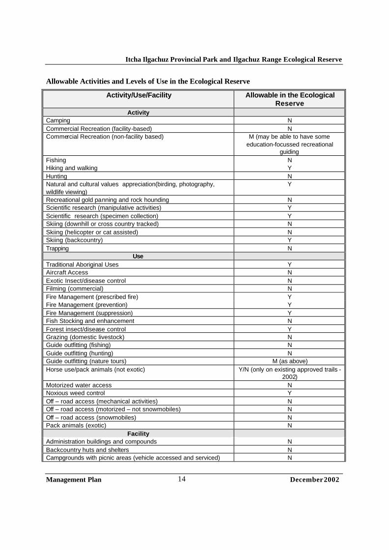
3.2 Ecological Reserve Objective
The primary objective of the ecological reserve is to preserve representative and special natural ecosystems, plant and animal species, features and phenomena. Scientific research and educational purposes are the principal uses of ecological reserves.
Description
Ilgachuz Range Ecological Reserve is located in the Blue Canyon Creek valley west of Carnlick Creek, and northwest of Pipe Organ Mountain. The ecological reserve is 2,714 hectares in size.
Key Strategies
• No hunting, trapping, grazing or other consumptive uses will be permitted in the ecological reserve • Permits will only be issued for scientific research and education activities in the ecological reserve,
consistent with the Ecological Reserve Act. • Continue to allow low impact, unassisted day use in the area • Allow horseback riders to continue to use the trail along the northern boundary of the reserve and
the old trail up Festuca Creek, which crosses a corner of the ecological reserve.
Itcha Ilgachuz Provincial Park and Ilgachuz Range Ecological Reserve
Management Plan December 2002
14
Allowable Activities and Levels of Use in the Ecological Reserve
Activity/Use/Facility Allowable in the Ecological Reserve
Activity Camping N Commercial Recreation (facility-based) N Commercial Recreation (non-facility based) M (may be able to have some
education-focussed recreational guiding
Fishing N Hiking and walking Y Hunting N Natural and cultural values appreciation(birding, photography, wildlife viewing)
Y
Recreational gold panning and rock hounding N Scientific research (manipulative activities) Y Scientific research (specimen collection) Y Skiing (downhill or cross country tracked) N Skiing (helicopter or cat assisted) N Skiing (backcountry) Y Trapping N
Use Traditional Aboriginal Uses Y Aircraft Access N Exotic Insect/disease control N Filming (commercial) N Fire Management (prescribed fire) Y Fire Management (prevention) Y Fire Management (suppression) Y Fish Stocking and enhancement N Forest insect/disease control Y Grazing (domestic livestock) N Guide outfitting (fishing) N Guide outfitting (hunting) N Guide outfitting (nature tours) M (as above) Horse use/pack animals (not exotic) Y/N (only on existing approved trails -
2002) Motorized water access N Noxious weed control Y Off – road access (mechanical activities) N Off – road access (motorized – not snowmobiles) N Off – road access (snowmobiles) N Pack animals (exotic) N
Facility Administration buildings and compounds N Backcountry huts and shelters N Campgrounds with picnic areas (vehicle accessed and serviced) N

Itcha Ilgachuz Provincial Park and Ilgachuz Range Ecological Reserve
Management Plan December 2002
15
Campgrounds (other) N Communication sites N Interpretation and information buildings N Roads and parking lots N Ski hills and snowplay areas N Lodges and other service accommodation N Trails (hiking, horses, cross –country skiing) Y/N (only existing approved trails -
2002) Utility corridors N Water control structures N
3.3 Wilderness Recreation Zone Objective
To protect a remote, undisturbed natural landscape and to provide backcountry recreation opportunities dependent on a pristine environment where air access may be permitted to designated sites.
Description
The Wilderness Recreation Zone covers all areas of the park outside the ecological reserve and the Natural Environment Zone. In the summer, the zone is 103,200 hectares, and in the winter, the zone is 86,864 hectares.
Key Zone Strategies
• The key value in this zone is the protection of year-round habitat for mountain caribou bighorn sheep and mountain goat.
• Recreational activities will be managed to ensure ecological integrity is unimpaired. • Hunting, trapping, fishing, grazing and non-motorized/non-mechanized public and commercial
recreation permitted in the zone. • Snowmobiling, mountain biking and ATV use not permitted in this zone. • Low frequency aircraft access permitted only in designated areas (see map for helicopter and fixed
wing air access areas).2
Allowable Activities and Levels of Use in the Wilderness Recreation Zone
Activity/Use/Facility Allowable in the Wilderness Recreation Zone
Activity Camping Y Commercial Recreation (facility-based) Y (non-permanent facilities) Commercial Recreation (non-facility based) Y Fishing Y Hiking and walking Y
2 Landing permitted anywhere in the park in emergency situations. See Access section for details.

Itcha Ilgachuz Provincial Park and Ilgachuz Range Ecological Reserve
Management Plan December 2002
16
Hunting Y Natural and cultural values appreciation(birding, photography, wildlife viewing)
Y
Recreational Gold panning and rock hounding N Scientific research (manipulative activities) Y Scientific research (specimen collection) Y Skiing (downhill or cross country tracked) N Skiing (helicopter or cat assisted) N Skiing (other) Y Trapping Y
Use Traditional Aboriginal Uses Y Aircraft Access Y (to designated sites only – see
access map) Exotic Insect/disease control Y Filming (commercial) Y Fire Management (prescribed fire) Y Fire Management (prevention) Y Fire Management (suppression) Y Fish Stocking and enhancement N Forest insect/disease control Y Grazing (domestic livestock) Y (existing AUMs only - 2002) Guide outfitting (fishing) Y Guide outfitting (hunting) Y Guide outfitting (nature tours) Y Horse use/pack animals (not exotic) Y Non-motorized water access Y Noxious weed control Y Off-road access (mechanical activities) N Off-road access (motorized – not snowmobiles) N Off –road access (snowmobiles) N Pack animals (exotic) Y/N (Llamas not permitted in
Ilgachuz Range) Facility
Administration buildings and compounds N Backcountry huts and shelters N Campgrounds with picnic areas (vehicle accessed and serviced) N Campgrounds (other) N Communication sites N (existing – 2002 only) Interpretation and information buildings N Roads and parking lots N Ski hills and snowplay areas N Lodges and other service accommodation N Trails (hiking, horses, cross –country skiing) Y (existing only - 2002) Utility corridors N Water control structures N

Itcha Ilgachuz Provincial Park and Ilgachuz Range Ecological Reserve
Management Plan December 2002
17
3.4 Natural Environment Zone (Winter) Objective
To protect scenic values and to provide for backcountry recreation opportunities in a largely undisturbed natural environment.
Description
The Natural Environment Zone (Winter) is in effect from December 15th until April 30th inclusive. It encompasses the southern slopes of the Ilgachuz Range south of Mt. Scot and Saddle Mountain as well as the southern slopes of the Itcha Range south of Goat Pass. In addition to these two polygons, the Natural Environment Zone (Winter) includes a number of trails and access corridors. The main corridors include the 66 cutline leading into the park, a corridor leading from Home Ranch to Anahim Lake, and a corridor leading up Christensen Creek through Holte Camp into the Ilgachuz Range. The size of the Natural Environment Zone (Winter) is 21,653 hectares.
Key Zone Strategies
• This winter zone has been established to permit the continuation of snowmobiling activities that existed at the time the park was created. See Access section for full details on the snowmobile access strategy.
• This zone has been designed to exclude areas of critical winter habitat for caribou (spring and winter range, as well as calving areas), mountain goats, bighorn sheep and other wildlife.
• Access for other motorized forms of winter recreation is permitted in this zone. This includes ski-plane access as well as a limited number of commercial helicopter trips for the purpose of dropping off and picking up winter backcountry recreationists.
• This zone may be subject to changes as more information about the habitat requirements of species in the park becomes available.
3.5 Natural Environment Zone (Summer)
Zone Objective
To protect scenic values and to provide for backcountry recreation opportunities in a largely undisturbed natural environment.
Zone Description
The Natural Environment Zone (Summer) is in effect from May 1st until December 14th. It encompasses a relatively small portion of the total park area around Itcha Lake and the access corridors (66 cutline) leading into Itcha Lake. The size of the Natural Environment Zone (Summer) is 5,316 hectares.
Key Zone Strategies
• This summer zone has been established to allow higher levels of recreational use associated with facilities and access points around Itcha Lake and on Itcha Lake itself.

Itcha Ilgachuz Provincial Park and Ilgachuz Range Ecological Reserve
Management Plan December 2002
18
• Access for ATVs will be permitted on a limited seasonal basis and will require a letter of permission from Environmental Stewardship Division. Aircraft will continue to be permitted to land on Itcha Lake on a recreational and commercial basis. Three small areas have been designated for recreational fixed wing aircraft access. These landing areas are shown on the attached zoning maps. Other forms of mechanized access will also be permitted in this zone subject to certain conditions. See Access and Recreation Sections for full details.
• The two cabins will continue to be allowed in this zone, and if destroyed, may be reconstructed using the same footprint and using non-native materials.
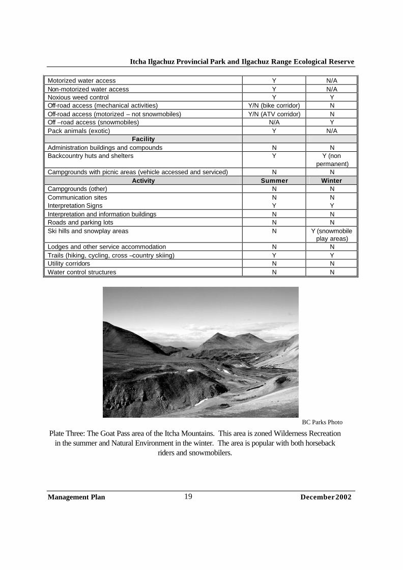
Allowable Activities and Levels of Use in the Natural Environment Zone
Activity/Use/Facility Allowable in the Natural Environment Zone
Activity Summer Winter Camping Y Y Commercial Recreation (facility-based) Y (temporary
camps) Y (temporary
camps) Commercial Recreation (non-facility based) Y Y Fishing Y Y Hiking and walking Y Y Hunting Y Y Natural and cultural values appreciation(birding, photography, wildlife viewing)
Y Y
Recreational Gold panning and rock hounding N N Scientific research (manipulative activities) Y Y Scientific research (specimen collection) Y Y Skiing (downhill or cross country tracked) N/A N Skiing (helicopter or cat assisted) N/A Y (helicopter
access only) Skiing (other) N/A Y Trapping Y Y
Use Traditional Aboriginal Uses Y Y Aircraft Access Y (designated area
only) Y
Exotic Insect/disease control Y Y Filming (commercial) Y Y Fire Management (prescribed fire) Y Y Fire Management (prevention) Y Y Fire Management (suppression) Y Y Fish Stocking and enhancement N N Forest insect/disease control Y Y Grazing (domestic livestock) Y Y Guide outfitting (fishing) Y Y Guide outfitting (hunting) Y Y Guide outfitting (nature tours) Y Y Horse use/pack animals (not exotic) Y Y
Itcha Ilgachuz Provincial Park and Ilgachuz Range Ecological Reserve
Management Plan December 2002
19
Motorized water access Y N/A Non-motorized water access Y N/A Noxious weed control Y Y Off-road access (mechanical activities) Y/N (bike corridor) N Off-road access (motorized – not snowmobiles) Y/N (ATV corridor) N Off –road access (snowmobiles) N/A Y Pack animals (exotic) Y N/A
Facility Administration buildings and compounds N N Backcountry huts and shelters Y Y (non
permanent) Campgrounds with picnic areas (vehicle accessed and serviced) N N
Activity Summer Winter Campgrounds (other) N N Communication sites N N Interpretation Signs Y Y Interpretation and information buildings N N Roads and parking lots N N Ski hills and snowplay areas N Y (snowmobile
play areas) Lodges and other service accommodation N N Trails (hiking, cycling, cross –country skiing) Y Y Utility corridors N N Water control structures N N
BC Parks Photo
Plate Three: The Goat Pass area of the Itcha Mountains. This area is zoned Wilderness Recreation in the summer and Natural Environment in the winter. The area is popular with both horseback
riders and snowmobilers.

Itcha Ilgachuz Provincial Park and Ilgachuz Range Ecological Reserve
Management Plan December 2002
20
4.0 Natural and Cultural Values Management 4.1 Land and Resource Tenures With the inclusion of Itcha Ilgachuz Park into the protected area system, commercial timber harvesting, mining, and hydroelectric development are no longer acceptable uses. These uses are incompatible with provincial park legislation and policies. However, both the CCLUP and the Park Act recognize that other activities that had valid permits, licenses and other authorizations when the park was created are allowed to continue. These uses include trapping, grazing and guiding (recreational, hunting and angling).
The accompanying table identifies traplines, guide outfitters and grazing tenures in the park. There are no land and resource tenures within Ilgachuz Range Ecological Reserve.
See “Tenures Map (Range)” and “Tenures Map” in Map Folio
Activity Tenure Holder Permit #
Trapping 0512T008 0512T009 0512T011 0512T012 0512T013 0512T018 0512T019 0512T020 0512T021 0512T022 0512T023
Grazing Karran, Ken and Leo Hermsen Cahoose, Dennis/Archie Friedrich and Doris Suk Roger Williams & Wanda Dorsey
072689, 072690, 072684 07658 CH1339 CH2115
Guide Outfitting
Sill, Frank Cahoose, Andy Squinas, Mack Bartlett, Larry Altherr, David Fraser, Stewart
#500305 #500301 #500306 #5000918 #500912 #500660

Itcha Ilgachuz Provincial Park and Ilgachuz Range Ecological Reserve
Management Plan December 2002
21
Mulvahill, Roy Mulvahill, William
#500262 #500263
Objectives • To manage tenures to meet the conservation role of the park and the obligation to established uses.
Strategies • Authorize, by park use permit, the continuation of pre-existing tenures and commercial activities
including trapping (with trapline cabins), guide outfitting and grazing. Allow the use of firearms and snowmobiles, within specific areas, for trapline management by the registered trapline holder and authorize this in permits. Permits should be issued only for those tenures that existed prior to October 1994.
• Work with Ministry of Forests to monitor logged blocks inside the park and to ensure they are free growing and roads are appropriately deactivated.3
• Work with Ministry of Forests on the management of grazing and the development of Range Use Plans.
• Require tenure holders to clean camps and remove structures that are dilapidated or no longer required.
• Tenure holders may improve or upgrade structures as long as they follow the same footprint as the existing structure and have the same use intent (e.g. old one story cabin can be replaced with a new one story cabin of the same dimensions, but not with a two story cabin.). Bonds may be required for improved structures to ensure they are not abandoned. Local materials from the site should not be used.
3 Deactivation as required in the Silvicultural Prescription that was approved at the time of harvesting.

Itcha Ilgachuz Provincial Park and Ilgachuz Range Ecological Reserve
Management Plan December 2002
22
4.2 Vegetation and Forest Health
Fire, disease, decay, windthrow and insect infestations are the fundamental disturbances that can be found in the forested ecosystems of Itcha Ilgachuz Park. These influences have combined with regional and local climatic conditions to create a mix of forested and non-forested plant communities in and around the park.
Natural processes such as disease and fire are generally allowed to continue within parks and protected areas in British Columbia. Fire, for example, has been suppressed across the Chilcotin Plateau for many decades. As a result, there are more areas of old and mature forest in the park (primarily in the northeast and southeast areas of the park) than would be present in this type of fire dominated landscape if fire was not suppressed.
However, despite the suppression of fire, Itcha Ilgachuz Park has a relatively diverse mosaic and distribution of vegetation and plant communities. This mosaic of vegetation, combined with the small size of the park, its non ecosystem-based boundary and the valuable commercial forests outside the park make Itcha Ilgachuz Park a low regional priority for large scale prescribed fire management or even allowing large natural fires to burn.
The other landscape level disturbance prevalent in the western Chilcotin is insect infestation. The mountain pine beetle, Douglas-fir bark beetle and spruce bark beetle all naturally occur in this landscape. However, the high elevation nature of the park and very cool climate combine to limit beetle activity in the park. Beetle management plans have been prepared indicating areas of the park which are at high, moderate and low risk to each species of bark beetle. These plans also show where beetles will be controlled and where they will be allowed to remain as a natural process.
Itcha Ilgachuz Provincial Park encompasses three separate biogeoclimatic zones.4 They are the Engelmann Spruce Subalpine Fir zone (ESSF), the Montane Spruce zone (MS) and the Alpine Tundra zone (AT).
Itcha Ilgachuz Park is the only area of the Cariboo where the ESSFxv sub-zone (very dry, very cold) can be found. It is located at relatively high elevations (1500 – 1800 m), with cool dry summers and cold high snowfall winters. Wetlands, avalanche tracks, and subalpine meadows are common features in this subzone.
The MSxv subzone (very dry, very cold) is characterized by cool, dry summers and cold, moderate snowfall winters. The sub-boreal white spruce – lodgepole pine and lodgepole pine – wetlands are the two habitat classes that dominate the MSxv in and around the park.
4 A Biogeoclimatic zone is defined as “a geographic area having similar patterns of energy flow, vegetation and soils as a result of a broadly homogeneous macro-climate.” The Biogeoclimatic Ecological Classification (BEC) system is a principal tool used to classify and describe ecosystems in British Columbia. There are 14 biogeoclimatic zones in the province. Zones are divided into subzones (98 in BC) which have a more uniform climate than zones and have unique plant communities.

Itcha Ilgachuz Provincial Park and Ilgachuz Range Ecological Reserve
Management Plan December 2002
23
Vegetated habitats dominated by sedge meadows, non-vegetated habitats and alpine meadows can all be found in the AT zone. The AT zone is typified by cool, wet summers and cold, high snowfall winters.
According to the British Columbia Conservation Data Center, there are several blue-listed plant species present in Itcha Ilgachuz Park or suspected to exist in the park. The list is not exhaustive, as no thorough vegetation inventory has been conducted for the park. The listed species should be considered only a starting point. They are:
Plant Species Status Milky Draba (Draba lactea) Blue listed Nutall’s Draba (Draba densifolia) Blue listed Coast Mountain Draba (Draba ruaxes) Blue listed Northern Jacob’s ladder (Polemonium boreale) Blue listed Elegant Jacob’s ladder (Polemonium elegans) Blue listed Dry-land sedge (Carex xerantica) Blue listed
The flats in the vicinity of Itcha Lake are an area of note in the park. This area supports a unique grassland dominated by Altai fescue and abundant lichens, especially Cetraria spp. and Stereocaulon ssp. While the Conservation Data Center does not list this species as endangered or threatened, it is a significant plant community because it is at the southern limit of its distribution. In addition, the heavy lichen component is a distinctive and unique feature in these grasslands, and has not been observed elsewhere in central and southern British Columbia. The presence of these grasslands in central British Columbia is of considerable interest to ecologists and biologists. Objectives • To maintain natural ecosystem diversity and a range of succession stages.
• To allow insect infestations in a manner that maintains the integrity of the natural conditions within the park while integrating with management and control actions on the broader ecosystem.
• To maintain natural plant and forest communities for their inherent value and their contribution to wildlife habitats, biodiversity and aesthetics.
• To protect rare, endangered and sensitive native plant communities.
• To manage for low impact scientific studies to improve the knowledge of park values and management activities.
Strategies • Integrate fire management with areas outside of park. Generally, all fires are subject to initial attack
in the park.
• Consider the introduction of prescribed burning in small areas of the park to address biodiversity and habitat issues, such as old growth requirements for caribou.

Itcha Ilgachuz Provincial Park and Ilgachuz Range Ecological Reserve
Management Plan December 2002
24
• Two insect management zones have been identified for the park – a “Management Zone” and a “No Management Zone.” In Management Zones, aerial and ground monitoring will be used in conjunction with beetle probes to determine infestations. Appropriate management tools may be used to control the infestation if it is determined to place park values or values of areas adjacent to the park at risk. Control methods for beetles will occur only as part of a broader plan for addressing beetle disturbance across the landscape.
• Control actions will only be undertaken if forest and/or vegetation loss is expected to be severe and detrimental to the ecosystem and/or the value of affected features within or adjacent to the protected area is high. Work closely with Ministry of Forests on control actions.
• In No Management Zones, allow natural processes to occur unimpeded. Other management options will be considered if infestations are considered a threat to other park resources or forests adjacent to the park.
• Encourage inventory and research into the significance of plant communities in the Ilgachuz Range Ecological Reserve, specifically focusing on vegetation unique to the area because of its volcanic origins.
• Conduct research into the forage carrying capacity of the meadows (see recreation section for details)
BC Parks Photo
Plate Four: Looking south up Carnlick Creek. The diverse meadows, creeks, forests and alpine areas of the park are clear in this photograph. A large esker can been seen in the foreground, a hint
to the glacial history of the Chilcotin Plateau. The approximate boundary of the Ilgachuz Range Ecological Reserve is indicated by the dotted white line.
Ilgachuz Range Ecological Reseve
Helicopter hiking drop-off point

Itcha Ilgachuz Provincial Park and Ilgachuz Range Ecological Reserve
Management Plan December 2002
25
4.3 Wildlife and Fish The cool and dry alpine and subalpine forests and meadows of Itcha Ilgachuz Park provide excellent habitat for a number of provincially and regionally significant wildlife species. In addition, the park contains the headwaters and feeder streams of several regionally and provincially important rivers, including the Dean, Chilcotin and Blackwater.
In terms of wildlife, the park may be best known for the Itcha Ilgachuz caribou herd. This population has been blue listed (considered vulnerable) provincially by the Conservation Data Center (CDC) and is listed as threatened nationally by the Committee On The Status of Endangered Wildlife In Canada (COSEWIC) as it falls within the Southern Mountains National Ecological Area. The status of fish and wildlife is tracked by the CDC provincially and by COSEWIC federally.
The Itcha Ilgachuz caribou herd is part of the northern ecotype of woodland caribou. This ecotype of woodland caribou feed primarily on terrestrial lichens during winter but will consume arboreal lichens. They are highly dependent upon old and mature forests to provide wintering habitat. While caribou utilize large tracts of habitat outside the park, the park provides critical summer and winter habitat as well as essential calving areas. Typically, caribou calve near ridge-tops in the alpine in late spring, spend early summer in the high alpine, and as the summer progresses, they move gradually lower, with the majority of the population spending the winter in mid elevation pine forests.
The Itcha Ilgachuz caribou are considered one of the healthiest caribou herds in southern British Columbia, and as a result, is one of the few herds that has an authorized hunt. The herd has increased from approximately 700 animals in the early 1980’s to approximately 2000 animals in 2001, with some of the highest densities and calf recruitment rates in the province.
In addition to the caribou, a number of other listed species exist in the park. A small herd (approximately ten) of the blue-listed California bighorn sheep live in the rugged valley to the north of Festuca Creek in the Ilgachuz Range. The origins of this small herd are unknown, although it is speculated they are related to the population that lives along the Chilcotin River to the east. This herd is the most northerly occurrence of California bighorn sheep in North America.
Grizzly bears and wolverine are the other blue-listed mammals that the park supports. It is conservatively estimated that 40 grizzly bears live within Management Unit 5-12, a large unit that includes the park. The park provides early season habitat for grizzly bears, who target alpine plants in the park. The lack of a vigorous berry crop or large fish populations in the park limits their late summer and fall use of the park however. Little is known about wolverine use or populations but the large colonies of hoary marmots that live in the rocky outcrops throughout the park likely provide much of their food supply.
There are two local populations of mountain goats in the park. One concentrates on the steep sidehills and scree slopes of Pipe Organ Mountain in the Ilgachuz Range, and the other can be found in the vicinity of Mount Downton in the Itcha Range. Both of these populations are growing relatively quickly, with the Pipe Organ population numbering about 50, and the Downton group containing about 10-15 animals.
Itcha Ilgachuz Provincial Park and Ilgachuz Range Ecological Reserve
Management Plan December 2002
26
The park also supports a widely distributed population of moose, and while the park is not critical for winter range, the wetlands provide important areas of calving and summer habitat throughout. Wolves and black bears are also common throughout the area.
Itcha Lake is utilized by the red-list American white pelicans as a loafing area.
The headwaters of 3 major Chilcotin River systems, the Blackwater River, the Chilcotin River and the Dean River start in Itcha Ilgachuz Park. All three of the rivers are exceptional sport fisheries with portions of all of them being classified waters. The high elevation portions of these river systems found within the park host populations of rainbow trout and bull trout. Itcha Lake and a number of unnamed lakes in the vicinity are worth specific mention because they contain populations of bull trout, some of which reach large size.
Fishing is not a main recreational draw to the park but is incidental to backpacking and horseback trips. A number of the guides licensed for recreational horse trips in the park also hold angle guide licenses.
Little is know about other fish species that inhabit park waters and is a future inventory requirement. DNA testing should also be conducted on bull trout populations. This testing would help to establish if the fish present are actually bull trout, or are the closely related Dolly Varden generally found in coastal streams.
Objectives • To manage for the habitat needs of all species by providing a range of natural habitats and functional
integrity between these habitats, both inside and adjacent to the park.
• To maintain and/or recover to optimal levels5 species and habitats at risk.6
• To maintain viable predator–prey relationships and natural behaviour patterns.
• To maintain distribution and abundance of wildlife species.
• To protect wildlife habitat features.7
• To maintain ungulate winter and spring ranges in a condition that will support populations during critical winter conditions.
• To minimize displacement of wildlife from preferred habitats.
• To prevent the introduction of exotic plant and animal species.
• To provide hunting opportunities for game species that support sustainable populations.
• To minimize the impacts and stress of recreational activities on wildlife populations and habitats.
• To contribute to the viability of provincial wildlife populations.
5 “Optimal” is a combination of historic levels and the area’s carrying capacity - this concept requires more research. 6 “At Risk” refers to species or habitats that are rare, endangered, sensitive or vulnerable (red and blue listed). 7 “Wildlife Habitat Features” are specific features of wildlife habitat that support specific wildlife or groups of wildlife such as mineral licks, nest trees, denning sites or nest sites etc.

Itcha Ilgachuz Provincial Park and Ilgachuz Range Ecological Reserve
Management Plan December 2002
27
• To provide a range of quality fishing experiences in the park and monitor angler effort and catch on selected waters.
• Increase the understanding of fish habitat and populations in and adjacent to the park through standardized fish inventory and assessment projects.
• To protect bull trout spawning and rearing habitat.
Strategies • Ensure long-term monitoring of wildlife populations inside the park and co-ordinate this monitoring
with areas outside and adjacent to the park.
• Manage human behaviour in order to minimize impacts to wildlife. Education, voluntary practices, interpretation and guidelines are all possible tools.
• First Nations traditional use of fish and wildlife will continue.
• Where compatible with critical habitat needs (i.e. caribou and moose) and other park objectives, maintain areas of old forest in the park, consistent with the Cariboo-Chilcotin Land Use Plan. Consult with Ministry of Forests to achieve, where possible, stand level Old Growth Management Areas (OGMAs) and CCLUP old growth targets. 8
• Identify and map wolf ranges and movement patterns.
• Increase knowledge relating to wolf foraging strategies as they relate to predator-prey ecosystems.
• Inventory distribution and abundance of wolverine populations and map connectivity corridors.
• Maintain 2 kilometre recreational non-use buffer from known or suspected wolverine denning sites from January to May.
• Maintain stands of old growth forest important to caribou winter needs while creating a mosaic of vegetation age classes.
• Schedule fixed wing and helicopter flights to avoid caribou calving and rutting times, as well as late winter. Use science where possible to determine times and locations.
• Limit aircraft altitudes to a minimum of 500 m over designated caribou habitats and develop operating procedure/flightlines to avoid disturbance of caribou.
• Transplanting caribou from the Itcha Ilgachuz herd to other areas in the province will only be considered if there are minimal impacts to local hunting opportunities, there is local consultation on the methodology and capture/transplant plan, there are no negative impacts on park values, and best animal care practices are utilized.
8 The Cariboo Chilcotin Land Use Plan makes the assumption that, on a landscape unit basis, many requirements for old growth can be met by assuming all the area inside of park is old. However, this assumption may contradict with the desire to recreate a more natural mosaic of age classes in the park through fire management (e.g. prescribed burns and less fire suppression). These homogenous old forests are also more susceptible to catastrophic fire and forest pest outbreaks.

Itcha Ilgachuz Provincial Park and Ilgachuz Range Ecological Reserve
Management Plan December 2002
28
• .Undertake research on: - caribou migration corridors and their location in relation to resource developments; - long term caribou population dynamics; - caribou predator-prey relationships (e.g. predation by bears, wolves and cougars); - carrying capacity and habitat suitability in the park for bighorn sheep and mountain goats; - DNA of bighorn sheep to ascertain the heritage and uniqueness of herd; - grizzly bear numbers, home ranges and population dynamics; -- DNA of bull trout and Dolly Varden to determine which species exist in the park.
• Avoid disturbance of mountain goat kidding areas between May 1 to July 15 and caribou calving areas between May 1 and June 30 by directing activity away from these areas.
• Avoid disturbance of designated mountain goat winter ranges between December 1 to April 30 and caribou wintering areas between December 15 – April 30 by directing activity away from these areas.
• Establish no-fly zones located 2000 meters horizontal and vertical from designated goat habitats. This zone may change based on new scientific information.
• Predators may be controlled in order to re-establish short term ecosystem balance, but only for red listed species.
• Prohibit the stocking or transplanting of fish into lakes and streams in the park.
• Utilize Resource Inventory Committee (RIC) standards for all inventory and monitoring within the park.
BC Parks Photograph Plate Five: Looking west across the network of meadows and trails near the northern boundary of the park. The ‘Kettle Cabin’ is located in the small clearing indicated in the photograph. The approximate
park boundary is indicated by the dotted line.
Kettle Cabin (aka “The Second Cabin’)
Trail to Itcha Cabin and Itcha Lake
Approximate park boundary
Itcha Ilgachuz Provincial Park and Ilgachuz Range Ecological Reserve
Management Plan December 2002
29
4.4 Cultural Heritage The area around Itcha Ilgachuz Park has played a key role in the history of the Chilcotin, for both the Carrier and Tsilhqot'in peoples and for settlers who moved into the area around the turn of the last century. The Southern Carrier and Tsilhqot'in Nation peoples have inhabited the area surrounding and within the park for centuries. Bands with traditional use in the area include the Ulkatcho, Kluskus, Nazko and Alexis Creek.
The Itcha and Ilgachuz Ranges were used by First Nations for hunting and trapping beaver, lynx, martin, coyote, caribou and moose. Many plant species were also gathered in the mountains. The Itcha and Ilgachuz Ranges, together with the Rainbow Range, were an excellent source of the mineral obsidian (volcanic glass). This highly valued commodity was traded by the Ulkatcho Carrier and Anahim Lake Ts’ilhqot’in with the Bella Coola and the Secwepemc in exchange for salmon and other items. Obsidian was traditionally collected during fall caribou hunts in the mountains and has been found at archaeological sites as far off as Alberta and Idaho.9
Little formal archaeology work has been completed, although there is one recorded archaeological site in the park (Borden #FfSg-1). Traditional use studies are currently being completed by the Ulkatcho and Alexis Creek First Nation, and will provide more information on use of the park.
Early in this century, Pan Phillips and Rich Hobson crossed between the Itcha and Ilgachuz mountains to develop the natural hay meadows just north of the park. This journey is documented in Hobson’s book Grass Beyond the Mountains. The Blackwater Wagon Road (aka Corkscrew-Pan trail or Blackwater Trail), which passes through the center of the park, was used to transport supplies and cattle from the Home Ranch and is considered a historic trail. The Home Ranch is located just north of the park boundary.
The Grease Trail, also known as the Alexander Mackenzie Heritage Trail, is located just north of the park boundary, was one of the main routes used by First Nations to trade oolichan oil for obsidian, furs and berries. Alexander Mackenzie used this route in the summer of 1793 to arrive at the Pacific Ocean. Mackenzie is credited as the first European to cross the North American continent.
Objectives • To protect and preserve archaeological values and resources within the park.
• To recognize the historic use of the area by First Nations, guide-outfitters, ranchers and local settlers through management.
• To educate park users regarding the importance and sensitivity of surface and subsurface remains.
• To improve relationships and communications with those First Nations with asserted traditional territories in the park.
9 Diana Alexander. 1997. A Cultural Heritage Overview of the Cariboo Forest Region.

Itcha Ilgachuz Provincial Park and Ilgachuz Range Ecological Reserve
Management Plan December 2002
30
• To increase archaeological, cultural heritage and historic knowledge relating to the park.
• To provide for the continuation of traditional aboriginal activities.
Strategies • Work with the four First Nation bands to incorporate Traditional Use Study information into park
management.
• Archaeological Impact Assessments are required for all “turf turning” work in the park.
• Acknowledge and document the source of place names, both Aboriginal and European.
• Work with other agencies, organizations, and universities to develop partnerships to increase knowledge of heritage values.
• Protect the integrity of gravesites and graveyards in the park.
• Undertake interpretation and/or investigation of First Nations’ heritage in the park only with the participation of First Nations.
BC Parks Photograph
Plate Six: Aerial photo of the Itcha Cabin and surrounding trails.
Itcha Cabin (aka “Old Cattleman’s Association Cabin ”)
Trail to Kettle Cabin (aka ‘The Second Cabin’)
Trail to Itcha Lake

Itcha Ilgachuz Provincial Park and Ilgachuz Range Ecological Reserve
Management Plan December 2002
31
4.5 Access and Adjacency Management Itcha Ilgachuz Park remains one of the most remote and difficult to access wilderness areas in the Cariboo-Chilcotin. No status or maintained roads currently enter the park or even lead close to the boundary. Park users must access the area by horse, foot, snowmobile in the winter, aircraft, or by a very limited ATV or mountain bike opportunity.
The most common way of accessing the Itcha side of the park is via the 66 or 57 kilometre seismic lines from the Michelle-Baezaeko Forest Service Road. The 66 km seismic line leads almost straight to Itcha Lake, providing access to the network of old horse trails in the park. Access to the east side of the park can also be gained off the end of the Chezacut (Thunder Mountain) Road, which leads to a small area of the park that was logged in the late 1980’s. From that point, the road accesses the 57 km seismic line, which leads farther into the Itcha Mountains. The Chezacut Road is gated approximately 40 kilometres from the park boundary.
The Ilgachuz Range is accessed primarily via an old wagon road leading up Christensen Creek from Clesspocket Ranch. This wagon trail leads directly into the alpine and subalpine around Mount Scot, eventually exiting the park via Carnlick Creek. A lesser known, but more direct route accesses the alpine around Tundra Lake via Rainbow Lake.
The other main access through the park is via the historic Blackwater Wagon Road (aka Corkscrew-Pan Trail or the Blackwater Trail), which bisects the middle of the park, connecting the Home Ranch on the Blackwater River, down the Corkscrew Creek drainage to Anahim Lake. Both the Itchas and Ilgachuz Ranges can be accessed from trails off this main wagon road.
Under the Park and Recreation Area Regulations, motorized activities, mechanized activities and the use of horses are all prohibited in parks unless they are authorized by a sign, other device or a park officer. A management plan can also authorize these activities. Aircraft access is allowed in designated areas only. This plan includes a snowmobile access and management strategy, and also includes conditional access for mountain bikes, ATV’s, fixed wing aircraft and helicopters. Details are described below. Horse use is described in section 5.0 - Recreation Opportunities and Facilities.
Objectives • Minimize the impact of adjacent development on the resources and recreational experiences within
the park.
• Communicate with other agencies and licensees concerning development activities and management in areas adjacent to the park.
• Ensure traditional use and access continues in accordance with the CCLUP.
• Minimize the impact of motorized access on park values.
Strategies
• No new roads or trails in the park.

Itcha Ilgachuz Provincial Park and Ilgachuz Range Ecological Reserve
Management Plan December 2002
32
• Work with adjacent licensees and land managers to ensure no new permanent roads lead to the park boundary.
• Floatplane access to Itcha Lake is confirmed.
• Three areas in the Wilderness Recreation Zone (Summer) have been designated as potential fixed-wing landing areas for recreational purposes only, from July 15 until October 1. See zoning map for designated areas. Pilots are to avoid wildlife and other park visitors. Pilots who choose to land in the these areas do so at their own risk, as Environmental Stewardship Division does not advocate the use of these areas or indicate that these are safe or even preferred areas to land.10 All other areas of the park are closed to fixed-wing aircraft, except in the case of an emergency (Mayday, Pan Pan or Precautionary landing circumstances), in which case pilots are free to land in any areas of the park for safety reasons. Williams Lake Flying Club will monitor their summer wheel plane landings and provide a yearly report to Environmental Stewardship Division. Other flying clubs will also be encouraged to provide a report of how and when they access the park.
• Fixed-wing aircraft on skis, as well as helicopters, are permitted to land in the Natural Environment Zone (Winter) for commercial or recreational purposes. Commercial use levels may be capped if impacts are demonstrated.
• A commercial helicopter opportunity will be made available for up to five (5) total drop-off and pick-up only trips to the designated landing areas in the Wilderness Recreation Zone. See zoning map for designated areas. This will be available from August 1 to August 30. Trails and wildlife areas are to be avoided in selecting flightlines. Hikers will be encouraged not to use the Christensen Creek trail due to potential displacement of cattle. Use levels will be adjusted if impacts occur. All other areas of the park are closed to helicopter access in the summer.
• An ATV11 access corridor is permitted on the 66 seismic line to Kettle Cabin. The corridor will be re-routed north of Itcha Lake (away from wet areas) into treed areas on higher dry ground. ATV’s must stay on the corridor, no “play-areas” permitted.
• The ATV corridor will be open from August 1 to August 30, with thirty (30) trips permitted during that time12. An additional six (6) trips will be allocated to the Itcha Cabin Society for the purpose of maintaining the cabins. Permits will be available on a first come, first served basis from Environmental Stewardship Division Regional office.
• Mountain bikes are only permitted to access the park on the ATV trail from the 66 seismic line to Kettle Cabin from August 1 to August 30. All other areas of the park are closed to mountain bikes. Use may be adjusted or permits required if impacts occur.
10 The Williams Lake Flying Club provided a map of these areas. These were historically used sites prior to the park being created. 11 For the purpose of this plan, an ATV is a four wheel, all terrain vehicle with a factory or stock exhaust system. Dirt bikes, 2 wheel motorized vehicles or vehicles with after-market (noisy) exhaust systems are not permitted. 12 The season may be adjusted depending on weather and ground conditions in order to minimize impacts to vegetation.

Itcha Ilgachuz Provincial Park and Ilgachuz Range Ecological Reserve
Management Plan December 2002
33
• Work with licensees and agencies to ensure any new resource developments near the park are sensitive to park values, are consistent with the recreational trails in the park and have minimal impact on wilderness experiences in the park.
Snowmobile Access and Management Strategy • Snowmobiling is only permitted between December 15 and April 30.
• Trails will be used as corridors to access designated snowmobile areas and all other areas are closed to snowmobiling.
• The trail via the "Green Roof Cabin" will be closed annually after February 15 and thereafter will only be used for emergency purposes (see map).
• The Blackwater Wagon Road (aka the Corkscrew-Pan Tail and the Blackwater Trail) is open from December 15-April 30. (see map).
• Where the 66 km seismic line forks, the South (Meadow Route) will be the main access to the cabins near Itcha Lake. Only when snow conditions make travelling through the Meadow Route impassible will the North/Itcha Lake trail be used (see map).
• Invoke a closure under the Wildlife Act for snowmobile access to Itcha Ilgachuz Park north and west of the locked gate at 59 km on the Chezacut (Thunder Mountain) Rd. This may be reviewed and removed if it is no longer warranted for protection of caribou.
See “Winter Recreation Map" and “Summer Recreation Map” in Map Folio
BC Parks Photograph
Plate Seven: Horseback riders accessing the park on the 57 km seismic line.

Itcha Ilgachuz Provincial Park and Ilgachuz Range Ecological Reserve
Management Plan December 2002
34
5.0 Recreation Opportunities Management Itcha Ilgachuz Park hosts a range of recreational opportunities that vary by season and area of the park. Topography, access and the presence of trails and areas to pasture horses are the largest factors that influence the use of the park. The following section describes the recreational vision (or “concept”) for the park. The main tools used to implement the recreational concept are the park zoning and the recreation and access objectives and strategies found in the appropriate sections.
The majority of the use occurs in July, August and September for summer activities and in February, March and April for winter activities. Horseback riding is the most common summer use of the park, with a significant population of caribou hunters using the park when the September caribou hunting season commences. Most hunters access the park by horseback or by floatplane to Itcha Lake. Hiking, biking and other forms of self-propelled activities are very limited by the difficult access and lack of infrastructure.
Snowmobiling may be the most popular use of the park at the present time. Snowmobilers access the high alpine of the Itcha and Ilgachuz Ranges in the winter and early spring primarily via the Blackwater Wagon Road trail and the 66 kilometre seismic line. The Itcha Cabin society, a not-for-profit volunteer society of snowmobilers, horseback riders and ATV riders maintain the two cabins near Itcha Lake. At the present time, there is negligible use of the park for other winter activities, such as skiing, skajoring13, dog sledding or snowshoeing, for the same reason that self-propelled summer activities are limited.
Recreation Concept The recreation concept for Itcha Ilgachuz Park is focused on maintaining the remote, wilderness nature of the park through limiting information, access and facilities and spatially and temporally separating recreational activities that may conflict. The main tools used to do this are the Zoning, Communication Strategy, and the Recreation and Access objectives and strategies.
Although a relatively new park in British Columbia’s protected area system, actual use of the park should change little from the status quo. No new trails will be constructed into or in the park, and no new facilities permitted. Signage will be minimal and limited to address safety or key management issues. The park will remain primarily a multi-day wilderness area. Visitors looking for a road accessible area, campgrounds or marked trailheads will be encouraged to use Ts’il?os or the Rainbow Range in Tweedsmuir Park. Motorized access will not be allowed in the park during the summer, the exceptions to this being the short ATV route to the Kettle Cabin, two commercial helicopter landing spots in the Ilgachuz Range, and several fixed wing landing areas in the Itcha Range and on Itcha Lake. Snowmobiles, helicopters and fixed wing aircraft will be permitted only in the Natural Environment Zone in the winter.
The Itcha cabins are envisioned as the main use node for the park, with expectations of “wilderness” being slightly lower in this area of the park.
13 Ski-touring, using a dog and harness.

Itcha Ilgachuz Provincial Park and Ilgachuz Range Ecological Reserve
Management Plan December 2002
35
New Commercial Recreation Opportunities One of the objectives of the Cariboo-Chilcotin Land-Use Plan is to provide opportunities for additional commercial recreation that is compatible with protected area values. However, the expansion of opportunities should not come at the expense of the general public’s ability to access and use protected areas or at the expense of the area’s conservation values. This becomes a concern especially where a resource, like pasture for horses or even “wilderness” can be in high demand. The CCLUP states that parks and protected areas:
…will be available, in principle and where appropriate, for commercial tourism and recreation. Development opportunities will be identified during area-specific management planning which will recognize the protection of the special natural values of each area and the provision for public non-commercial recreation [emphasis added]. In some circumstances, development opportunities may include “fixed roof” accommodation. (CCLUP 90 Day Implementation Report).
The challenge is to be able to identify these opportunities in such a way that, if existing operators were to use all their grandfathered rights and the public was also to use the park, the ecological and recreational carrying capacity of the park would not be exceeded. The plan identifies, in a general way, a number of new commercial recreation opportunities in the park. These include winter activities such as backcountry skiing and snowshoeing accessed by fixed wing or helicopter, or summer activities such as helicopter accessed hiking to a designated area, cultural tourism, hiking and wildlife viewing. The addition of new commercial opportunities in the park will be guided by decisions based on sound and relevant scientific information.
Commercial opportunities for new snowmobile tours, ATVs and mountain biking will not be permitted. New commercial horse use is discussed in the next section.
Research into Carrying Capacity of Meadows One of the issues that arose during the planning process was the carrying capacity for use of grass and grazing areas in the park. There are a limited number of meadows in the park that have access to streams or lakes. These areas are in high demand for both commercial and recreational horseback riders. Other demand for these areas comes from First Nations, range tenure holders, and wildlife. The short growing season in this high elevation park means that, in many cases, these areas can only be used once or twice annually, making them unavailable to subsequent users or to wildlife.
At the present time, there is little understanding or information on how productive these grasslands are and how much pasture is available to each of the users. Is there abundant pasture for all users, or is the level of existing use impacting wildlife, and is there sufficient forage for wildlife? This is a question that will need to be answered before any new permits for commercial horse use will be issued in the park.
Existing Recreation Uses Part of the rationale for completing a management plan for this park was to recognize existing commercial and private recreation and to acknowledge the potential for some expansion of commercial
Itcha Ilgachuz Provincial Park and Ilgachuz Range Ecological Reserve
Management Plan December 2002
36
tourism opportunities. Direction from the Cariboo-Chilcotin Land-Use Plan states that:
Dominant ecological values should be protected and that uses, such as recreation, cattle grazing, hunting, trapping and backcountry tourism, will be allowed. (CCLUP 90 Day Implementation Report)
Environmental Stewardship Division has interpreted this direction to mean that commercial and public recreation activities and levels of use that were taking place as of October 1994 will be accommodated in management and with a permit where appropriate. The challenge with this is that, while commercial operators can demonstrate their activities through records and receipts, few records are kept by public recreation groups. As a result, the following recreational strategies have attempted to recognize and accommodate existing levels of use. Section 4.5 Access and Adjacency, also contains sections which attempt to accommodate these uses so they are consistent with the conservation vision of the park.
The following table and accompanying map shows the commercial recreation (non-tenured)14 operators that have been recognized as operating in the park as of October 1994.
See “Commercial Recreation Map" in Map Folio
Activity Permit Holder Geographic Area Horseback tours and guided hiking
• Itcha Ilgachuz Mountain Outfitters (Roger Williams and Wanda Dorsey)
• Escott Bay Resort (Bill Van Es)
• Rainbow Mountain Outfitting (David Dorsey Jr. and Joyce Dorsey)
• Itcha Mountain Outfitters (Stewart Fraser)
• Trembling Pines Outfitting (Roy and Gwen Mulvahill)
• Larry Bartlett • Triple J Ranch (Martin Dillabough)
• Entire park • Christensen Creek, Ilgachuz Range and Carnlick Creek
• South half of the Itcha Range, Pan and Carnlick Creek
• Itcha Lake and area, Itcha Range • Northeast corner of Itcha Range, Chilcotin River
• Northern slopes of Ilgachuz Range, Pan and Shag Creeks
• Itcha Lake to Christensen Creek
Snowmobile tours • Itcha Ilgachuz Mountain • Trapping trails from private
14 Tenured activities include trapping, guide-outfitting and grazing. Permits are issued by Environmental Stewardship Division and do not give the holder rights to land, only the ability to undertake an activity in a certain area. Tenured activities are addressed in section 4.1.

Itcha Ilgachuz Provincial Park and Ilgachuz Range Ecological Reserve
Management Plan December 2002
37
Outfitters (Roger Williams and Wanda Dorsey
• Larry Bartlett
property and snowmobiles trails and play areas.
• Snowmobile trails and areas
Angle guiding
• Roger Williams
• Larry Bartlett
• Carnlick, Corkscrew, Downton. Shag Creeks, Itcha Lake, Chilcotin River Headwaters
• Regulator Lake
Objectives • To provide opportunities for high quality, low impact recreation activities with minimal impact on
wildlife, vegetation and other park values
• To enhance visitor awareness of wildlife populations and possible human-wildlife conflicts.
• To ensure recreation activities are managed and monitored for their potential impacts on natural and cultural heritage values, particularly on wildlife populations and vegetation.
• To provide opportunities for commercial recreation which are compatible with the park values.
• To ensure public access to the park is not pre-empted by commercial recreatio n activities.
• To issue park use permits for those activities that existed prior to October 1994.
Strategies • Allow public, non-mechanized recreational use throughout all of the zones and in the ecological
reserve.
• Ensure that all park information specifies the undeveloped nature of the backcountry so that conflicting expectations are avoided.
• Provide education to large groups of recreationists to minimize impacts and human-wildlife conflicts, and encourage smaller groups.
• No camping in the Ilgachuz Ecological Reserve.
• Horses are permitted throughout all zones in the park.
• Llamas and other exotic pack animals are not permitted in the Ilgachuz Range (west of the Blackwater Wagon Road) but are permitted in all zones in the Itcha Range. This may be reconsidered if new scientific data shows exotics have no impact on native species.
• Assess conditions and monitor the effects of horse use and regulate as necessary. Trails may be closed during certain conditions (extended periods of rain/snow, late thaws, etc.)
• Encourage all horse users to follow a Code of Ethics and to use weed-free pellets for large groups.

Itcha Ilgachuz Provincial Park and Ilgachuz Range Ecological Reserve
Management Plan December 2002
38
• Recognize hunting as an allowable activity in the park, with the exception of the Ilgachuz Range Ecological Reserve, where hunting is prohibited.
• Helicopter hiking is an acceptable commercial use only from the designated landing spots. This commercial opportunity and the conditions placed on it is outlined in section 4.5 Access and Adjacency.
• Backcountry skiing and snowboarding, cross country skiing, skajoring, dogsledding and snowshoeing are all allowed activities throughout all zones. Motorized access for these activities is only permitted in the Natural Environment Zone (winter).
• Dogs must be controlled at all times in order to minimize impacts on wildlife during the critical winter period.
• Types of acceptable commercial recreation in the park include backcountry skiing, snowboarding, hiking, dogsledding, wildlife viewing, snowshoeing, and cultural tourism. Additional horseback opportunities are subject to the carrying capacity study outlined above. Additional snowmobile tours will not be permitted, and ATV and mountain bike tours will not be permitted. Levels and areas of use will be adjusted if impacts are demonstrated.
• Consideration will be given to expansion or initiation of commercial opportunities providing they are in compliance with the objectives outlined in the plan. Commercial activities will generally not be allowed in the Ilgachuz Ecological Reserve.
• Snowmobiling is permitted in the Natural Environment (winter) zone. Conditions outlined in section 4.5 Access and Adjacency.
• Require permit holders to clean camps and remove structures that are dilapidated or no longer required.
BC Parks Photo
Plate Eight: Members of the Itcha Cabin Society after a work session. Left to right are Tyler Frank, Brandon Landrud, Fred Clements, Eric Frank, Perry Callies and Greg Landrud.

Itcha Ilgachuz Provincial Park and Ilgachuz Range Ecological Reserve
Management Plan December 2002
39
6.0 Communications Management of the information that visitors to Itcha Ilgachuz Park receive, both in the park and prior to their trip, provides an important opportunity to increase visitor enjoyment and improve the management and stewardship of the park. Information and its management can:
• Set visitor expectations and assist in planning recreational uses; • Promote user etiquette and minimize conflict between users; • Minimize impacts on wildlife, vegetation and other park values; • Create an awareness and appreciation of natural settings, cultural features and conservation
messages; and, • Build support for management efforts.
The wilderness nature of Itcha Ilgachuz Park and the desire to have a limited range of signage in the park creates challenges around providing information on how the park is managed. Increasingly, the World Wide Web will be one of the key tools to provide this information. The web, as well as “word of mouth” from user groups, commercial operators and not-for-profit “friends of” type societies, will be the main sources of management information in the park.
Interpretation and Management Messages A number of sections of this plan have outlined the general management concerns for the park. These concerns (in no particular order) include:
• Conservation and protection of listed (e.g. caribou, pelicans, grizzly bear, bighorn sheep, wolverine, bull trout, etc) and non-listed (goats, moose etc) species in the park;
• Managing human use to provide long-term wilderness recreation opportunities;
• Meeting the objectives of the Cariboo-Chilcotin Land-Use Plan that recommended the creation of the park;
• Balancing natural processes in the park with management (e.g. fire and forest health) in order to maintain a natural distribution of vegetation across the landscape; and,
• Increasing knowledge of natural processes, predator-prey ecosystems, and fish and wildlife habitats and populations (e.g. inventory and research).
Considering the above management concerns, the following messages should be integrated into any public information efforts around the park (e.g. the park’s website, information provided to permit holders and societies, volunteers etc):
1. User etiquette. This etiquette should stress appropriate behaviour around wildlife in order to avoid habituation, direct impacts and displacement from key habitats. As well, education should focus on etiquette around other park users, including use of and sharing of cabins, replacement of firewood used in cabins, noise in wilderness areas, pack-in/pack-out etc.

Itcha Ilgachuz Provincial Park and Ilgachuz Range Ecological Reserve
Management Plan December 2002
40
2. Managing expectations about access to the park and the level of facilities provided. It will be important to provide the rationale for the lack of management services provided.
3. Managing expectations of “wilderness.” Users need to understand that the park has a number of historically acknowledged uses, such as horseback riding, hunting, trapping, cattle grazing and snowmobiling. These uses are part of the park’s history and culture, and new users of the park should manage their expectations accordingly.
4. The importance of the park in providing habitat for listed species. This should include information the vulnerability of these species in a provincial context (e.g. the decline of caribou and grizzly bear populations across the province).
5. Environmental Stewardship Division is working with other agencies and stakeholders on managing insect infestations and fire in areas adjacent to commercial forests outside the park. Environmental Stewardship Division is working co-operatively and aggressively pursuing all options available under the Park Act to limit the impact of natural processes inside the park on resources outside the park.
6. Parks and ecological reserves serve different purposes, yet complement one another in providing a wide range of opportunities for people to experience and learn from the natural world.
Objectives • Ensure information (published and verbal) is consistent with the park’s visions, roles and the key
messages outlined above.
• To minimize the promotion of the park while providing accurate and appropriate information for park users.
• To work co-operatively with local and regional tourism agencies, permit holders and other agencies and user groups in communicating the key messages about park management.
Strategies • Use the BC Parks website as the main source of information for the park.
• Encourage visitors looking for formal trails and road access to use the Rainbow Range or other areas of the nearby Tweedsmuir or Ts’il?os Park.
• Work with tourism associations, chambers of commerce, or other agencies and groups which publish information in order to communicate the wilderness nature of the park and types of uses allowed.
• Liaise with various conservation organizations, naturalist clubs, industry organizations (e.g. CLMA), local government, land-use plan monitoring groups (e.g. Caribou Committee, Cariboo Communities Coalition) on a regular basis to discuss ongoing management issues.
• Develop a sign at the entrance to the park along the 66 cutline that outlines ATV, mountain bike and other user group restrictions. Highway signs will not be provided.

Itcha Ilgachuz Provincial Park and Ilgachuz Range Ecological Reserve
Management Plan December 2002
41
• Trails and routes will not be marked. Exceptions to this may include seasonal winter signs to mark safe snowmobile routes where safety is the primary issue, as well as providing limited trail marking along the Rainbow Lake trail.
• Work with user groups (e.g. Itcha Cabin Society, Williams Lake Flying Club, BC Floatplane Owners Association) and commercial permits holders to establish “Itcha Watch”, a self-managed group with the objective of park users taking a role in the management of the park as well as monitoring levels of use and compliance with park regulations.

Itcha Ilgachuz Provincial Park and Ilgachuz Range Ecological Reserve
Management Plan December 2002
42
4.0 Monitoring Monitoring the continuing status of the health of ecosystems, wildlife populations, and the levels and impacts of recreational use in the park is vital to ensuring the ecological and wilderness integrity of the park. As such, a proactive and well-planned monitoring strategy is a key to the guaranteeing the spirit and intent of this management plan is followed.
Monitoring vegetation, insects, recreational use, and wildlife populations is not solely the responsibility of Environmental Stewardship Division. Many other agencies and groups either play a central role at the present time or could be partners in monitoring. Examples of new partners may include Floatplane Associations and Flying Clubs, First Nations, commercial operators and permit holder, community groups, universities and colleges, naturalist clubs and paddling, hiking, skiing groups or even interested individuals.
Objectives • To monitor the distribution and population of umbrella species, keystone species and listed species
in the park.15
• To monitor the impact of recreational uses on wildlife and vegetation in the park.
• To monitor patterns, levels and trends of recreational use.
• Monitor the extent and instances of bark beetle activity in the park.
Strategies Recreational Monitoring
1. Photopoints16
Photopoints (e.g. Backcountry Recreation Impact Monitoring) can be established at key points on managed and unmanaged trails (e.g Blackwater Wagon Road) and campsites, focusing on the 66 seismic line and the areas around Itcha Lake and the Itcha cabins. Photopoints should also be established to monitor visual landscape objectives adjacent to the park. Photopoints should be updated once every five years.
2. Overflights
15 Keystone Species – Species that have a crucial role in supporting the integrity of the entire ecosystem and that by their effective disappearance from the system result (directly or indirectly) in the virtual disappearance of other species (e.g. salmon). Umbrella species -A species whose habitat encompasses the habitat needed by a large number of other species. Grizzly bears, for example, can be viewed as an umbrella species because of their broad ecological niche. 16 Photopoints are areas where photographs are consistently taken. They can be used to monitor and track and communicate visible changes over time.

Itcha Ilgachuz Provincial Park and Ilgachuz Range Ecological Reserve
Management Plan December 2002
43
Work with other agencies to monitor compliance with snowmoble, ATV and mountain bike access agreements.
3. Trail Counters
Consider using trail counters or cameras to determine human and wildlife use of key trails (e.g 66 seismic line or Blackwater Wagon Road) in the park.
4. Rangers/Park Watch/Itcha Watch
Consider using staff or other partners in monitoring use levels and patterns of use in the park. This may include increased Park Ranger patrols into the area or encouraging “Itcha Watch” similar to the Wilderness Watch program, to determine use patterns.
5. Surveys
User satisfaction surveys or self-administered surveys may be useful at the Itcha cabins determine use of areas, user conflicts, satisfaction levels and management issues.
6. Commercial Operators/Public
Work with, and encourage a more formal, but simple, program for commercial operators and clubs (e.g. Williams Lake Flying Club) to report on numbers and activities of other users they encounter.
Conservation Monitoring
1. Overflights
Work with other agencies to determine census areas in the park and regular (e.g 1-3 years) census intervals for monitoring caribou, goats, sheep, moose, bears and other species in the park.
2. Identify Keystone or Umbrella Species
Identify a number of keystone and umbrella species to focus monitoring on. These may include bull trout for fish, and grizzly bears and caribou for large mammals. Monitoring should focus on the long term population trends and habitat needs of these animals.
3. Forest Health Monitoring
Complete annual aerial survey of bark beetle populations.
4. Cameras
Consider using cameras to monitor bear and other wildlife populations.
5. Commercial Operators
Work with, and encourage a more formal, but simple, program for commercial operators to report on animals encountered and animal behavior observed. Commercial operators can play a key role in monitoring, enforcement and inventory. These roles need to be better defined and discussed.

Itcha Ilgachuz Provincial Park and Ilgachuz Range Ecological Reserve
Management Plan December 2002
44
Adaptive Management The concept of "learning by doing" or "adaptive management" has become widely accepted in resource management and environmental planning. Adaptive management is generally thought of as being flexible, encouraging public input, and uses extensive monitoring to look at the results of actions in order to adjust plans and try new approaches. Adaptive management essentially involves a three-stage process of planning, action, and monitoring.
For the purposes of the Itcha Ilgachuz Management Plan, adaptive management will be balanced with a need to provide long-term direction on management of the park.
The plan has a life of ten years after which a formal public review will be undertaken of the vision, purpose, roles and zoning. In the interim however, adaptive management will be applied to areas such as recreation management (user numbers and use levels) and wildlife management and vegetation management (e.g. fire and beetles). Strategies for recreation for example, are interim and may change over time. The plan should be able to adapt and use new guidelines as they are developed or as new science emerges.
Park managers will work to adjust strategies in response to new information collected through monitoring and public feedback (e.g. surveys). It is anticipated that the Advisory Groups will have an ongoing role in both the collection of data and in making recommendations on decision making and change management.
Role of the Advisory Groups Environmental Stewardship Division acknowledges the important role of the Advisory Groups in helping to determine the long-term vision for this park and providing the strategies of how the vision can be implemented.
The Advisory Groups (AG), which were formed through the management planning process, will continue to have a role in providing direction for the management of this park. The AGs will be invited to meet yearly to discuss ongoing implementation of the plan, information needs and results of monitoring.
Environmental Stewardship Division will keep a mailing list of AG members. In the interest of cost and efficiencies, members who are not participating may be deleted from the list over time. A letter asking if the person is still interested in receiving information will be sent prior to that person being removed from the list.
New members may be added to the AG lists.

Itcha Ilgachuz Provincial Park and Ilgachuz Range Ecological Reserve
Management Plan December 2002
45
8.0 Plan Implementation Implementation of strategies in this management plan depends upon the availability of staff and resources within Environmental Stewardship Division, other agencies with a management role, First Nations and the enthusiasm and support of the public. Approval of this management plan does not constitute automatic approval of funding for implementation or individual tasks.
Timeframe indicates when a strategy should be initiated. An asterix (*) means the strategy is ongoing. This section should be used by the Advisory Group or the pubic to monitor the effectiveness of plan implementation and should also be used as the primary tool by parks staff when completing Annual Management Plans (AMPs) for the park.
Land and Resource Tenures
• Authorize, by Park Use Permit, the continuation of pre-existing tenures including trapping (with trapline cabins), angle guiding, guide outfitting, horse tours, wildlife viewing and recreational guiding within the park. Allow the use of firearms and snowmobiles, within specific areas, for trapline management by the registered trapline holder and authorize this in permits. Permits should be issued only for those uses/activities that existed prior to October 1994.
• * Work with Ministry of Forests on the management of grazing and the development of Range Use Plans.
• * Require permit holders to clean camps and remove structures that are dilapidated or no longer required.
Vegetation and Forest Health
• * Work with Ministry of Forests to monitor logged blocks inside the park and to ensure they are free growing and roads are appropriately deactivated.
• * Complete annual aerial survey of bark beetle populations.
• Complete meadow forage carrying capacity research.
• Consider the introduction of prescribed burning in small areas of the park to address biodiversity and habitat issues, such as old growth requirements for caribou.
• Encourage inventory and research into the significance of plant communities in the Ilgachuz Range Ecological Reserve, specifically focusing on vegetation unique to the area because of its volcanic origins.
Wildlife and Fish
• Undertake research on: - caribou migration corridors and their location relative to adjacent resource developments; - long term caribou population dynamics; - caribou predator-prey relationships (e.g. predation by bears, wolves and cougars); - carrying capacity and habitat suitability in the park for bighorn sheep and mountain goats;

Itcha Ilgachuz Provincial Park and Ilgachuz Range Ecological Reserve
Management Plan December 2002
46
- DNA of bighorn sheep to ascertain the heritage and uniqueness of herd; - grizzly bear numbers, home ranges and population dynamics; - DNA of bull trout and Dolly Varden to determine which species exist in the park.
• Work with other agencies to determine census areas in the park and regular (e.g 1-3 years) census intervals for monitoring caribou, goats, sheep, moose, bears and other species in the park.
• Identify a number of keystone and umbrella species to focus monitoring on. These may include bull trout for fish, grizzly bears and caribou for large mammals, and pelicans for waterfowl. Monitoring should focus on the long-term population trends and habitat needs of these animals.
Cultural Heritage
• Work with the four First Nation bands to incorporate Traditional Use Study information into park management.
• Work with other agencies, organizations, and universities to develop partnerships to increase knowledge of heritage values.
Access and Adjacency Management
• * Work with licensees and agencies to ensure any new resource developments near the park are sensitive to park values, are consistent with the recreational trails in the park and have minimal impact on wilderness experiences in the park.
• * Work with licensees and agencies to ensure no new permanent access to the park is developed.
• Invoke a Wildlife Act closure of snowmobile access to Itcha Ilgachuz Park north and west of the locked gate at 59 km on the Chezacut (Thunder Mountain) Rd.
• Relocate an ATV access corridor to the Kettle Cabin. The corridor will be re-routed north of Itcha Lake (away from wet areas) into treed areas on higher dry ground.
Recreation Opportunities
• Make available a commercial helicopter opportunity for up to five (5) trips to the designated landing areas in the Wilderness Recreation Zone. See zoning map for designated area.
• Make available commercial recreation opportunities in the park, including backcountry skiing, snowboarding, hiking, dogsledding, wildlife viewing, snowshoeing, and cultural tourism. Additional horseback opportunities are subject to the carrying capacity study outlined in section 5.0 Outdoor Recreation Opportunities. Snowmobile, ATV and mountain bike tours will not be permitted. Levels and areas of use will be adjusted if impacts are demonstrated.
Itcha Ilgachuz Provincial Park and Ilgachuz Range Ecological Reserve
Management Plan December 2002
47
Communications
• Sign the Rainbow Lake trail to the Ilgachuz Mountains.
• * Ensure that all park information specifies the undeveloped nature of the backcountry so that conflicting expectations are avoided.
• * Use the BC Parks website as the main source of information for the park.
• * Encourage visitors looking for formal trails and road access to use the Rainbow Range or other areas of the nearby Tweedsmuir or Ts’il?os Park.
• * Work with tourism associations, chambers of commerce, or other agencies and groups which publish information to communicate the wilderness nature of the park and the types of activities allowed (e.g. ATV limitations).
• * Liase with various conservation organizations, naturalist clubs, industry organizations (e.g. CLMA), local governments, land-use plan monitoring groups (e.g. Cariboo Communities Coalition) on a regular basis to discuss ongoing management issues.
• Develop a sign at the entrance to the park along the 66 cutline that outlines ATV, mountain bike and other users groups restrictions.
Monitoring
• * Work with user groups (e.g. Itcha Cabin Society, Williams Lake Flying Club, BC Floatplane Owners Association) and commercial permit holders to establish “Itcha Watch”, a self-managed group with the objective of park users taking a role in the management of the park as well as monitoring levels of use and compliance with park regulations.
• Establish photopoints at key points on trails and at campsites, such as Blackwater Wagon Road, and at areas adjacent to important horse camps.
• * Work with other agencies to monitor compliance with snowmoble, ATV and mountain bike access agreements.
• Work with, and encourage a more formal, but simple, program for commercial operators to report on animals encountered and animal behavior observed.
• Assess conditions and monitor the effects of horse use and regulate as necessary.
• Consider using trail counters or cameras to determine human and wildlife use of key trails (e.g 66 seismic line or Blackwater Wagon Road) in the park.

Itcha Ilgachuz Provincial Park and Ilgachuz Range Ecological Reserve
Management Plan December 2002
48
List of Plates Cover photograph is a caribou with Itcha Lake in background. All photographs taken by Chris Hamilton unless otherwise noted.
Plate One: Riders enjoy the scenery around Pipe Organ Mountain in the Ilgachuz Mountains. Kris Andrews photograph…………………………………….. 9
Plate Two: Looking west towards the headwaters of Corkscrew Creek in the Ilgachuz Mountains. ………………………………………………………………… 11
Plate Three: The Goat Pass area of the Itcha Mountains. ………………………………… 18
Plate Four: Looking south up Carnlick Creek. ………………………………………….. 23
Plate Five: Looking west across the network of meadows and trails near the northern boundary of the park. …………………………………………….. 27
Plate Six: Aerial photo of Itcha Cabin and surrounding trails. …………………………… 29
Plate Seven: Horseback riders access the park on the 57 km seismic line……………….. 32
Plate Eight: Members of the Itcha Cabin Society outside the Itcha Cabin. Paula Call photograph…………………………………………………. 37

Itcha Ilgachuz Provincial Park and Ilgachuz Range Ecological Reserve
Management Plan December 2002
49
Appendix - CCLUP Rationale for Protection RATIONALE: Protection of this area is critical to the preservation of important caribou habitat. There are regionally and perhaps provincially significant recreation features that offer premium wilderness experiences in portions of the Itchas Range. Home for the most northerly population of bighorn sheep in North America. Comprises an intact large predator-prey ecosystem. It is an unroaded area of spectacular wilderness, mountains and alpine scenery. Used extensively during winter months by snowmobile groups from surrounding communities. The historic cattle route through the area appeals to summer trail rides by public and commercial recreation. Wildlife viewing of the caribou and bighorn sheep herds is very popular in this area. This area has been proposed for protection in a wide variety of land use planning processes, including the RPAT (Regional Protected Area Team) proposals. The majority of the area is currently Protected Areas Strategy Study Area. A significant portion is also identified as a Special Management Area in the Williams Lake Timber Supply Review. PRINCIPAL SELECTION CRITERIA: Critical habitat for caribou, California bighorn sheep, grizzly bear Unique alpine grassland wilderness with extensive wetlands High backcountry recreational values for hiking, camping, hunting, riding, Fishing, snowmobiling, and potential for ski-touring Identified as having significant natural, recreational or cultural values through Protected Areas Strategy gap analysis LAND STATUS/COMMERCIAL VALUES: Largely alpine or high elevation area in Quesnel and Williams Lake TSAs. 63% forested, comprising 0.8% of total volume in Quesnel TSA and 1.4% of total volume in Williams
Lake TSA Primarily low mineral potential. No existing mineral titles No private land FIRST NATIONS: Overlaps with areas of interest of Ulkatcho Band and Tsilhqot'in Nation