Embed Size (px)
Citation preview
http://vpo.au.aecomnet.com/projects/VSAB10234/6DraftDocs/6.1 Reports/Final Report V2/Portland Coastal Inundation Study Final Report v2 issue 2.docx Revision 2 - 7 July 2010 D
Appendix D
Geotechnical Investigation
Glenelg Shire Council
17 May 2010
Portland CoastalEngineering StudyGeotechnical Investigation

AECOMPortland Coastal Engineering Study
C:\Documents and Settings\collettm\Desktop\Glenelg\final report\AppendixD - Geotechnical Investigation\GeotechnicalInvestigation V2.docxRevision 1 - 17 May 2010
Portland Coastal Engineering StudyGeotechnical Investigation
Prepared for
Glenelg Shire Council
Prepared by
AECOM Australia Pty LtdLevel 9, 8 Exhibition Street, Melbourne VIC 3000, AustraliaT +61 3 9653 1234 F +61 3 9654 7117 www.aecom.comABN 20 093 846 925
17 May 2010
60148113 Geotechnical Investigation
© AECOM Australia Pty Ltd 2010
The information contained in this document produced by AECOM Australia Pty Ltd is solely for the use of the Client identified on the cover sheetfor the purpose for which it has been prepared and AECOM Australia Pty Ltd undertakes no duty to or accepts any responsibility to any third partywho may rely upon this document.
All rights reserved. No section or element of this document may be removed from this document, reproduced, electronically stored or transmittedin any form without the written permission of AECOM Australia Pty Ltd.

AECOMPortland Coastal Engineering Study
C:\Documents and Settings\collettm\Desktop\Glenelg\final report\AppendixD - Geotechnical Investigation\GeotechnicalInvestigation V2.docxRevision 1 - 17 May 2010
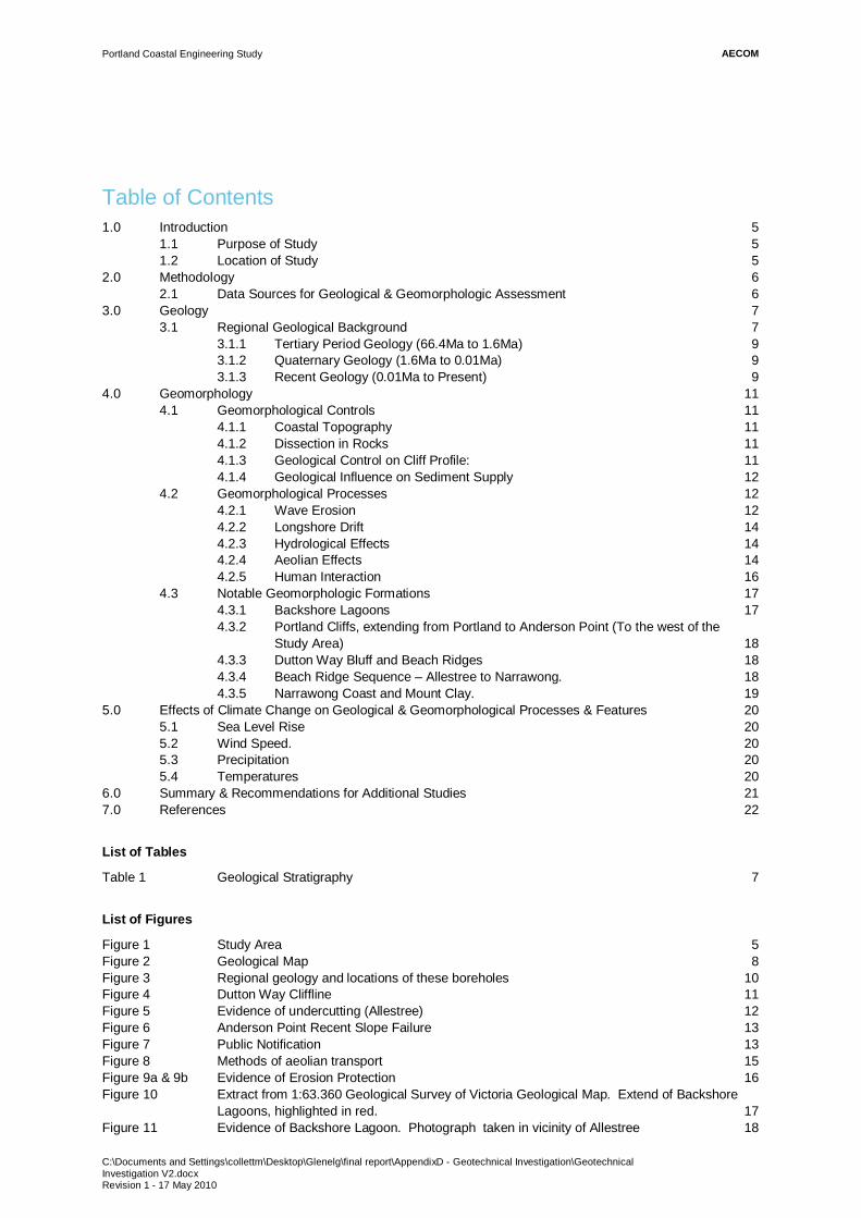
Table of Contents1.0 Introduction 5
1.1 Purpose of Study 51.2 Location of Study 5
2.0 Methodology 62.1 Data Sources for Geological & Geomorphologic Assessment 6
3.0 Geology 73.1 Regional Geological Background 7
3.1.1 Tertiary Period Geology (66.4Ma to 1.6Ma) 93.1.2 Quaternary Geology (1.6Ma to 0.01Ma) 93.1.3 Recent Geology (0.01Ma to Present) 9
4.0 Geomorphology 114.1 Geomorphological Controls 11
4.1.1 Coastal Topography 114.1.2 Dissection in Rocks 114.1.3 Geological Control on Cliff Profile: 114.1.4 Geological Influence on Sediment Supply 12
4.2 Geomorphological Processes 124.2.1 Wave Erosion 124.2.2 Longshore Drift 144.2.3 Hydrological Effects 144.2.4 Aeolian Effects 144.2.5 Human Interaction 16
4.3 Notable Geomorphologic Formations 174.3.1 Backshore Lagoons 174.3.2 Portland Cliffs, extending from Portland to Anderson Point (To the west of the
Study Area) 184.3.3 Dutton Way Bluff and Beach Ridges 184.3.4 Beach Ridge Sequence – Allestree to Narrawong. 184.3.5 Narrawong Coast and Mount Clay. 19
5.0 Effects of Climate Change on Geological & Geomorphological Processes & Features 205.1 Sea Level Rise 205.2 Wind Speed. 205.3 Precipitation 205.4 Temperatures 20
6.0 Summary & Recommendations for Additional Studies 217.0 References 22
List of Tables
Table 1 Geological Stratigraphy 7
List of Figures
Figure 1 Study Area 5Figure 2 Geological Map 8Figure 3 Regional geology and locations of these boreholes 10Figure 4 Dutton Way Cliffline 11Figure 5 Evidence of undercutting (Allestree) 12Figure 6 Anderson Point Recent Slope Failure 13Figure 7 Public Notification 13Figure 8 Methods of aeolian transport 15Figure 9a & 9b Evidence of Erosion Protection 16Figure 10 Extract from 1:63.360 Geological Survey of Victoria Geological Map. Extend of Backshore
Lagoons, highlighted in red. 17Figure 11 Evidence of Backshore Lagoon. Photograph taken in vicinity of Allestree 18
AECOMPortland Coastal Engineering Study
C:\Documents and Settings\collettm\Desktop\Glenelg\final report\AppendixD - Geotechnical Investigation\GeotechnicalInvestigation V2.docxRevision 1 - 17 May 2010 5
1.0 Introduction
1.1 Purpose of Study
The objective of this study is, to undertake a geological, geomorphologic and geotechnical engineeringassessment of the current conditions, which may affect the profile of the Glenelg Shire coastline, andconsequently affect the local communities and existing public and private infrastructure, with specific referencebetween Dutton Way and Narrawong, Victoria.
This section of the report is divided into three sections, an investigation into the regional geology, a review of thegeomorphologic processes affecting the study area and a summary of the significant geomorphological formationspresent between Dutton Way and Narrawong.
1.2 Location of Study
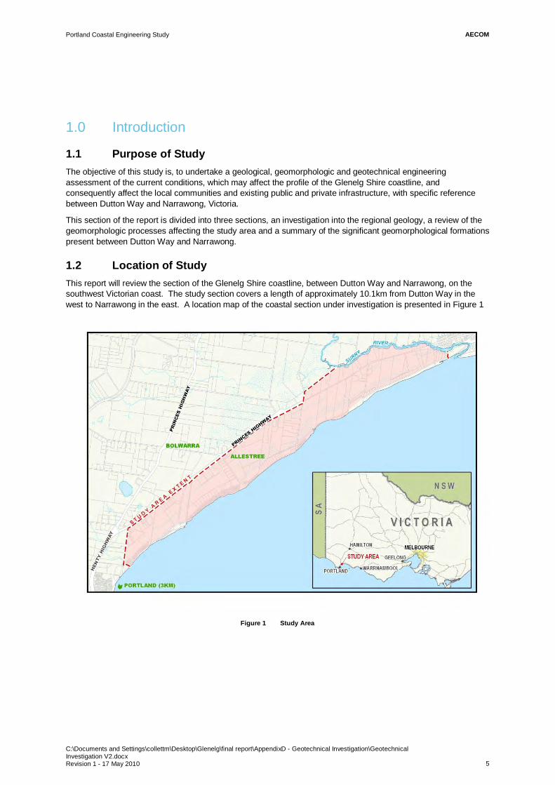
This report will review the section of the Glenelg Shire coastline, between Dutton Way and Narrawong, on thesouthwest Victorian coast. The study section covers a length of approximately 10.1km from Dutton Way in thewest to Narrawong in the east. A location map of the coastal section under investigation is presented in Figure 1
Figure 1 Study Area
AECOMPortland Coastal Engineering Study
C:\Documents and Settings\collettm\Desktop\Glenelg\final report\AppendixD - Geotechnical Investigation\GeotechnicalInvestigation V2.docxRevision 1 - 17 May 2010 6
2.0 Methodology
2.1 Data Sources for Geological & Geomorphologic Assessment
This report has been compiled using numerous resources, both issued formally by Glenelg Shire Council (GSC)and those publicly available. A summary of the bibliographic resources are outlined below:
Geological Review
Published geological maps, issued by the Geological Survey of Victoria.
Bibliographic literature.
Geological reports issued by third party organisations, as provided by GSC.
Aerial Photography; as provided by GSC.
Geomorphologic Assessment
Bibliographic literature.
Geological reports issued by third party organizations, provided by GSC.
Aerial Photography; as provided by Glenelg Shire council.
Site inspections by AECOM.
Within this review the following topics will be discussed and assessed:
Description of the site stratigraphy and geology.
Description of the geomorphologic features of the existing coastline.
Summary of the existing remediation measures currently in place.
Review of cliff stability.
Review of public assets potentially at risk.
Description as to the potential driving forces behind erosion and erosion of the Dutton Way to Narrawongcoastline.

AECOMPortland Coastal Engineering Study
C:\Documents and Settings\collettm\Desktop\Glenelg\final report\AppendixD - Geotechnical Investigation\GeotechnicalInvestigation V2.docxRevision 1 - 17 May 2010 7
3.0 Geology
3.1 Regional Geological Background
For the relevance of this study, all stratigraphy predating the Cenozoic Era (66.4 million years) has been omitted,as they have not affected the Glenelg Shire coastline, with respect to the geomorphologic processes or theerosional environments.
From a review of the publications and geological map sheets at varying scales (1:250,000 to 1:63,360) issued bythe Geological Survey of Victoria, the following information can be derived.
The Glenelg Shire coastline from Portland in the west to Narrawong in the east can be summarised as having thefollowing geological stratigraphy as shown in Table 1.
Table 1 Geological Stratigraphy
Period EpochAge(million years)
Formation NameFormationDescription
Recent 0.01 - Present - Aeolian deposits
Quaternary 1.6 – 0.01BridgewaterFormation
Poorly consolidatedcalcareous sand andsandstone
TertiaryPliocene 5.3 1.6
Newer VolcanicBasalts
Weathered basalt(basaltic clay)
Whalers BluffFormation
Sandy limestone withcalcarenite
Miocene 23.7 5.3 Portland LimestoneWell cemented, whitelimestone
A summarised geological map of the project area, is presented in Figure 2.

AECOMPortland Coastal Engineering Study
C:\Documents and Settings\collettm\Desktop\Glenelg\final report\AppendixD - Geotechnical Investigation\Geotechnical Investigation V2.docxRevision 1 - 17 May 2010
8
Figure 2 Geological Map

AECOMPortland Coastal Engineering Study
C:\Documents and Settings\collettm\Desktop\Glenelg\final report\AppendixD - Geotechnical Investigation\GeotechnicalInvestigation V2.docxRevision 1 - 17 May 2010 9
3.1.1 Tertiary Period Geology (66.4Ma to 1.6Ma)
The oldest stratum to be present in the Portland region is the Tertiary aged, Portland Limestone, formed in theMiddle Miocene age, approximately 18 million years ago. The limestone is white in colour and is locally soft andfriable. Previous reports have suggested that this unit can resist the effects of erosion and weathering as it hasformed near vertical cliffs in the region to the west of the study area between Portland and Dutton Way (Figure 3).Previous assessments of this lithology by Golder Associates in 2000 and 2005, have suggested that thelimestone’s are composed of over 96% calcium carbonate and has been noted to be very porous and prone toform caves, solution cavities and has enlarged joints. The formation of these erosional features is indicative of akarstic landscape.
During the Pliocene, 5.3Ma (million years ago), the Portland Limestones were subjected to continental erosionprocesses, during intermittent periods of glaciation. These processes have left the limestone with a pitted, etchedand scared surface.
Stratigraphically overlying the Portland Limestones are the sediments representing the Whalers Bluff Formation.This formation was deposited in the late Pliocene, approximately 4 million years ago. This unit is composed ofsandy limestone and calcarenite, with numerous beds of fine-grained material, which are referred to as theWerikoo, Maretimo and Crawford Members.
These fine-grained units are notably fossiliferous, and are found to have in filled the depressions in the PortlandLimestone, which were created from previous dissolution processes. At the time of deposition these clay unitsmay have been tens of metres thick, however due to erosional processes in the late Tertiary, they are currentlypresent in thicknesses of approximately 4m in the vicinity of Portland, however they decrease with distance in aneasterly direction terminating east of the Henty Highway and Princes Highway Junction.
Overlying the limestones and calcarenite of the Whalers Bluff Formation, a layer of basalt, identified as the NewerVolcanics. Following a review of the GSC supplied documents, radioactive dating testing of their age has beenprojected at 2.5 million years old.
The product of the volcanic eruptions consists of relatively flat-lying lava flows; however within the wider region ofGlenelg Shire, numerous small scoria cones, tuff rings, and maars that rise above the lava plain are present.
Following the formation of the Newer Volcanic basalts, erosion has had a significant effect on its currentmorphology. The upper sediments in the western Portland region are basaltic clays, which are indicative ofweathered basalts.
3.1.2 Quaternary Geology (1.6Ma to 0.01Ma)
Overlying the Whalers Bluff Formation throughout the region of study, in the east of the study area, theBridgewater Formation is present. The Bridgewater Formation is a poorly consolidated, yellow to pinkish brown,fine to coarse fossiliferous calcareous sand. Locally these unconsolidated sediments are capped by capcrete orcalcarenite. It is these units, which have formed Aeolian dunes and elongated beach ridges, which run in a subparallel direction to the current coastline from Dutton Way to Narrawong. Locally these beach ridges are weaklycemented, which form layers or more resistant material. Although in comparison these cemented layers are moreresistant to erosion, it should be noted that they are not expected to be able to withstand excessive storm surgesor the effects of sea level rise.
3.1.3 Recent Geology (0.01Ma to Present)
Between Dutton Way and Narrawong, sandy sediments are the material dominating the current backshore.These deposits are of an aeolian origin, and have been forming in the late Quaternary to Recent periods.
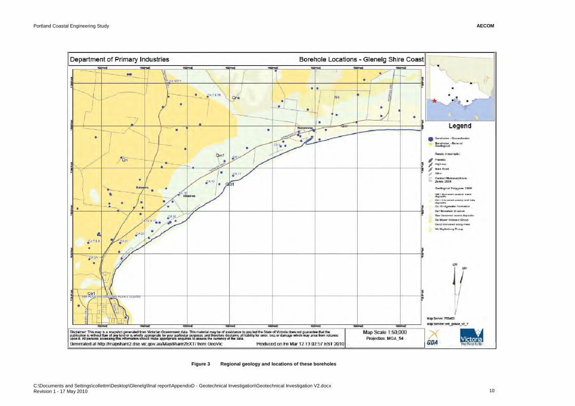
This is confirmed by the lithological descriptions from Rural Water Commission boreholes which are presentthroughout the study area. The regional geology and locations of these boreholes are presented in Figure 3,overleaf.
In order to produce accurate geological assessments and cross sections of the coastline, it is recommended thata field mapping exercise is performed.
AECOMPortland Coastal Engineering Study
C:\Documents and Settings\collettm\Desktop\Glenelg\final report\AppendixD - Geotechnical Investigation\Geotechnical Investigation V2.docxRevision 1 - 17 May 2010 10
Figure 3 Regional geology and locations of these boreholes
C:\Documents and Settings\collettm\Desktop\Glenelg\final report\AppendixD - Geotechnical Investigation\GeotechnicalInvestigation V2.docxRevision 1 - 17 May 2010 11
4.0 Geomorphology
4.1 Geomorphological Controls
The pattern of geological outcrops along the Glenelg Shire coast has a fundamental control on the nature of thecoastline. This is due to several factors, outlined below.
4.1.1 Coastal Topography
The underlying geology has a significant influence on the topography of the land, and the detailed outline of thecoast in large part reflects the relief of the intertidal zone.
Rocks that are susceptible to erosion tend to form bays and inlets, whereas erosion-resistant rocks formheadlands. Examples of this are the cliffs to the west of the study region between Portland and Dutton Way. Asoutlined in the previous section, Tertiary aged Portland Limestones underlie these cliffs, which locally are wellcemented, increasing their natural resistance to erosion. Where the geological strata are poorly cemented thematerial may have undergone localised dissolution processes, where the cement within the strata has beendissolved by the groundwater.
4.1.2 Dissection in Rocks
Where relatively erosion-resistant rocks have been deeply dissected by erosion, the coastal outline is complex; tothe west of the area of investigation, however where weaker rocks have been dissected, simpler headlands andbays may have been formed.
4.1.3 Geological Control on Cliff Profile:
Rocks of all strengths can be cut back by erosion to form cliffs; however weaker rocks generally fail more readily,forming cliffs with angles from 20º to 40º, in comparison to more erosion resistant rocks, which are more likely toform vertical or near-vertical cliffs. In the more resistant rocks, the bedding and jointing direction and anglescommonly influence cliff geometry, in both plan and profile. Cliffs with seaward dipping rocks are likely to fail asbasal erosion persists, leading to gentler slopes than on horizontal or landward dipping strata.
Where the cliffs have regressed landwards, the more erosion resistant limestone has been subjected to periods ofhigh-energy erosion and weathering. Over time this has forced the cliffs to slip and fail. In some cases, thelandslip has led to the exposure of the weaker clays of the Whalers Bluff Formation, which were noted to havebeen deposited within the depressions of the Tertiary Portland Limestones.
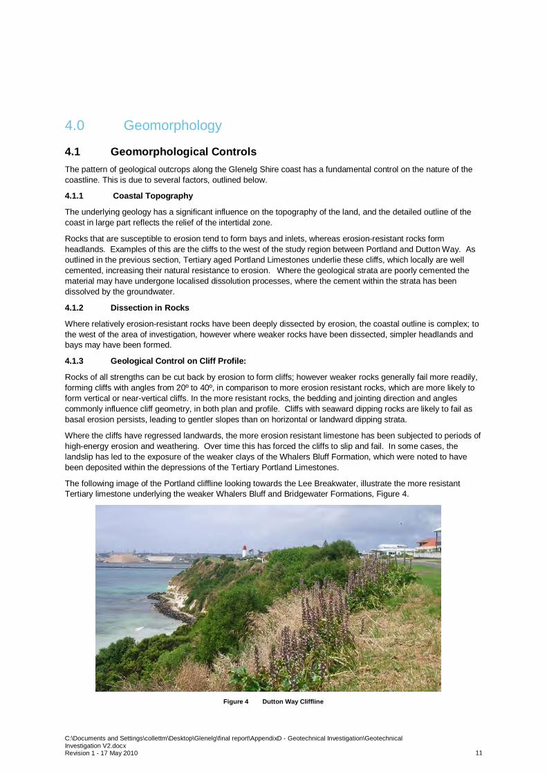
The following image of the Portland cliffline looking towards the Lee Breakwater, illustrate the more resistantTertiary limestone underlying the weaker Whalers Bluff and Bridgewater Formations, Figure 4.
Figure 4 Dutton Way Cliffline
C:\Documents and Settings\collettm\Desktop\Glenelg\final report\AppendixD - Geotechnical Investigation\GeotechnicalInvestigation V2.docxRevision 1 - 17 May 2010 12
4.1.4 Geological Influence on Sediment Supply
A further influence of geology on coastal geomorphology is in the provision of sediment, which can beincorporated into beaches.
Coarser sediment is still brought to the coast by rivers where gradients are steep and coarse-grained material isreadily transported by floods, in contrast predominantly muds, clays, silts and fine sands are transported throughthe rivers of lowland Victoria to the coastal region.
In areas with a gentle inland relief, it is the delivery of sediment from offshore as well as from retreating cliffs thathas provided most of the material for the local beaches.
4.2 Geomorphological Processes
A summary of the processes affecting the Glenelg Shire coastline are highlighted below. It should be noted thatfrom the bibliographical research and the site review, processes other than those described herein may be atwork; however from experience and local knowledge, the most likely effects have been discussed.
4.2.1 Wave Erosion
Wave erosion is the dominant force affecting the shape of coastlines. From reports made available from GSC,there is extensive evidence of wave erosion at the base of the cliffs from Portland in the west, along the foreshoreand backshore to Narrawong. To the west of the study area, along the cliff section of the coastline, from DuttonWay to Portland, there is evidence of undercutting of the near vertical cliffs. This undercutting can cause thecreation of isolated caves and open existing joints and fractures in the rock mass. This type of erosion can lead tothe cliff becoming unstable and potentially prone to landslips and toppling, which will cause human andenvironmental issues.
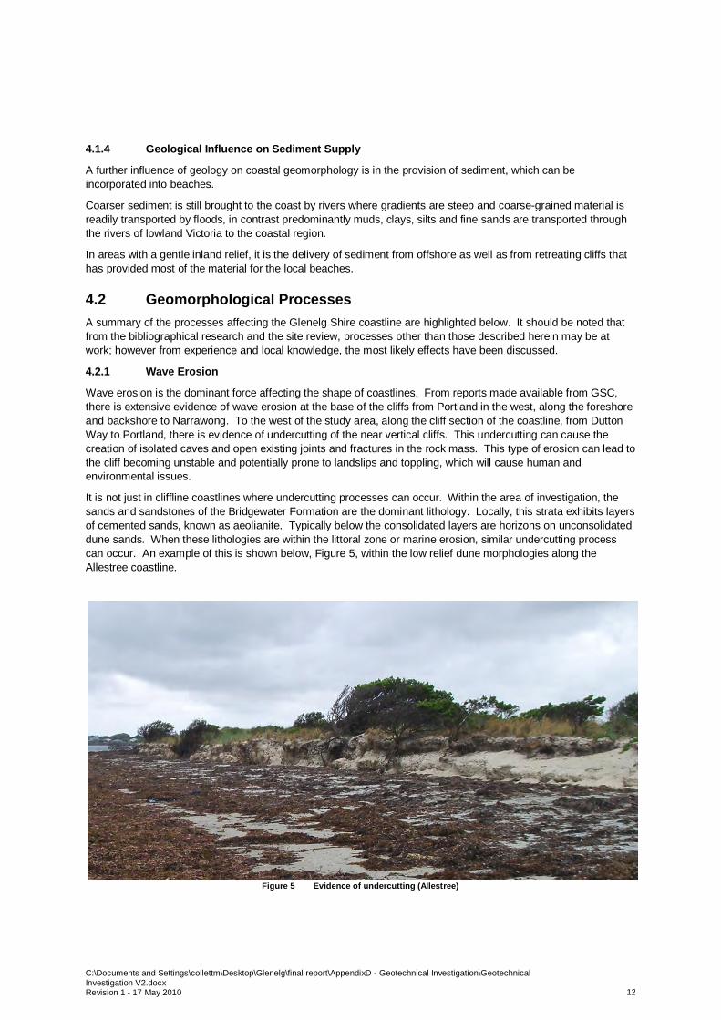
It is not just in cliffline coastlines where undercutting processes can occur. Within the area of investigation, thesands and sandstones of the Bridgewater Formation are the dominant lithology. Locally, this strata exhibits layersof cemented sands, known as aeolianite. Typically below the consolidated layers are horizons on unconsolidateddune sands. When these lithologies are within the littoral zone or marine erosion, similar undercutting processcan occur. An example of this is shown below, Figure 5, within the low relief dune morphologies along theAllestree coastline.
Figure 5 Evidence of undercutting (Allestree)
C:\Documents and Settings\collettm\Desktop\Glenelg\final report\AppendixD - Geotechnical Investigation\GeotechnicalInvestigation V2.docxRevision 1 - 17 May 2010 13
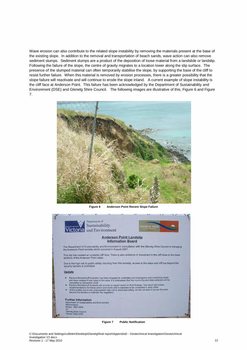
Wave erosion can also contribute to the related slope instability by removing the materials present at the base ofthe existing slope. In addition to the removal and transportation of beach sands, wave action can also removesediment slumps. Sediment slumps are a product of the deposition of loose material from a landslide or landslip.Following the failure of the slope, the centre of gravity migrates to a location lower along the slip surface. Thepresence of the slumped material can often temporarily stabilise the slope, by supporting the base of the cliff toresist further failure. When this material is removed by erosion processes, there is a greater possibility that theslope failure will reactivate and will continue to erode the slope inland. A current example of slope instability isthe cliff face at Anderson Point. This failure has been acknowledged by the Department of Sustainability andEnvironment (DSE) and Glenelg Shire Council. The following images are illustrative of this, Figure 6 and Figure7.
Figure 6 Anderson Point Recent Slope Failure
Figure 7 Public Notification
C:\Documents and Settings\collettm\Desktop\Glenelg\final report\AppendixD - Geotechnical Investigation\GeotechnicalInvestigation V2.docxRevision 1 - 17 May 2010 14
4.2.2 Longshore Drift
Longshore Drift is the movement of sediment in a direction parallel to the coastline.
From regional studies by local Council departments and third party organisations, the construction of the sheltereddeep water Port of Portland, and associated breakwaters, has had a significant effect on the long shore transportof material. Local reports have suggested that pre-construction of the port in the mid 1950’s, the Bay of Portlandwas an environment of deposition, as opposed to its current environment of erosion. As previously highlighted,the removal of beach sands can have a significant and direct impact on the increased rate of cliff erosion andcoastline regression.
In an attempt to reduce the sediment removal and associated coastal regression, the Port of Portland is believedto be undertaking the replenishment of the Bay of Portland beaches with the pumping of 50,000m3 of sandannually. According to local sources and documents, this has only been performed sporadically over the lastdecade. In order to limit the regression of the coastline, it is advised that beach replenishment activities areresumed to the specified rates as soon as feasibly possible.
4.2.3 Hydrological Effects
Slope stability, leading to coastal regression, can be greatly exacerbated by the uncontrolled presence of surfacerunoff and groundwater. From existing reports and the boreholes performed by Golder Associates, thegroundwater level is estimated to be between 10-20m above sea level, in the region to the west of Dutton Waytowards Portland. This elevated level may be attributed to the presence of a perched aquifer locatedstratigraphically above the impermeable clay members of the Whalers Bluff Formation. The perched watertablemay lead to the saturation of the sediments overlying the Tertiary fine grained marine sediments. The weatheredNewer Volcanic basaltic clays are notoriously sensitive, and can easily facilitate ground instability. Where thisscenario is present in close proximity to the existing exposed cliff face, there is great potential of slope instabilitypotentially leading to failure.
In addition to the effect of saturating sensitive soils, groundwater seepage and infiltration can have a negativeeffect on the underlying Portland Limestone. The flow of water through the limestone can also initiate dissolutionprocesses. Limestone dissolution is the process of dissolving the calcareous material into the groundwater. Thedissolution of material can lead to the formation of cavities, opened joints and the weakening of the internalstructure of the limestone. Should this process occur within the Portland Limestone, there is potential of slopefailure, caused by the inability of the limestone, to support the overburden cliff material.
Sources of groundwater seepage can be from surface run-off, natural or man-made drainage channels and fromthe irrigation of local agricultural land. The cliffs in the vicinity of Dutton Way are known to be fossiliferous, whichattracts “Fossil Hunters” The increase in pedestrians can lead to the creation of artificial drainage channels, due tothe removal of natural barriers, e.g. vegetation.
Cyclic wetting and drying processes from sea-spray or from periods of precipitation is a significant physicalweathering process. This process can lead to the weakening of materials and can cause sediment degradation,especially in regions of limited vegetation cover. The additional effect of sea-spray will have an effect on regionsin closer proximity to the coast. In turn, this can lead to the toppling of rock slopes due to the erosion and removalof sediment.
As the predominant geological features of the Dutton Way to Narrawong coastline are sand dunes, the presenceof a perched water table is unlikely, due to the expected porosity and permeability of the sands, with the naturalgroundwater level expecting to reflect the sea level. Any forms of sand dune instability and potential failure, islikely to originate from marine erosion processes as opposed to lithologies saturation from surface runoff.
4.2.4 Aeolian Effects
In addition to hydrological effects acting on the formation of the Glenelg Shire coastal geomorphology, aeolianinfluences are also in operation. Aeolian processes are processes which pertain to the activity of wind and cancontrol the removal, transportation and deposition of sand and other fine grained materials. In order for aeolianprocesses to affect mass sediment transport, a regular constant airflow is required. Due to exposed nature of theGlenelg coastline, there is potential for sufficient wind speeds to mobilise silt and sand particles. Wind velocitiesof 30ms-1 are required, which provide sufficient energy to mobilise material medium grained sands up to 0.5mm indiameter. Coarse grained material is only transported under stronger wind conditions.

C:\Documents and Settings\collettm\Desktop\Glenelg\final report\AppendixD - Geotechnical Investigation\GeotechnicalInvestigation V2.docxRevision 1 - 17 May 2010 15
The three forms of movement of sand particles by aeolian forces are creep (1), saltation (2) and suspension (3),illustrated in, Figure 8.
Figure 8 Methods of aeolian transport
Creep, is the movement of material along a path, where wind provides the transported particle with sufficientenergy to overcome frictional resistances. Saltation occurs when loose material is removed from a bed andcarried by the wind, prior to deposition. Suspension, generally affects finer particles. In order to move, theseparticles experience lift forces which are similar in magnitude to the weight of the particle. The particles arecarried in suspension until the wind velocity decreases.
The predominant geomorphological features within the Dutton Way to Narrawong region are sand ripples anddunes. The magnitude of the morphologies can range from 2-4m in wavelength and 10cm to 3m in height. Thedunes and ripples migrate predominantly by saltation. In order to facilitate dune migration, aeolian forcestransport sand up the windward side of the dune or ripple to the crest. Once the sand reaches the crest of thedune, it becomes unstable and can form grain falls or avalanches depending on the magnitude of the slope andquantity of material available for transport.
C:\Documents and Settings\collettm\Desktop\Glenelg\final report\AppendixD - Geotechnical Investigation\GeotechnicalInvestigation V2.docxRevision 1 - 17 May 2010 16
4.2.5 Human Interaction
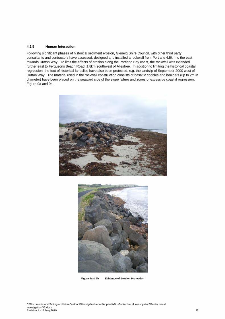
Following significant phases of historical sediment erosion, Glenelg Shire Council, with other third partyconsultants and contractors have assessed, designed and installed a rockwall from Portland 4.5km to the easttowards Dutton Way. To limit the effects of erosion along the Portland Bay coast, the rockwall was extendedfurther east to Fergusons Beach Road, 1.8km southwest of Allestree. In addition to limiting the historical coastalregression, the foot of historical landslips have also been protected, e.g. the landslip of September 2000 west ofDutton Way. The material used in the rockwall construction consists of basaltic cobbles and boulders (up to 2m indiameter) have been placed on the seaward side of the slope failure and zones of excessive coastal regression,Figure 9a and 9b.
Figure 9a & 9b Evidence of Erosion Protection
C:\Documents and Settings\collettm\Desktop\Glenelg\final report\AppendixD - Geotechnical Investigation\GeotechnicalInvestigation V2.docxRevision 1 - 17 May 2010 17
In locations where the rockwall has been installed, there has been a noticeable reduction in the rate of coastalrecession, due to the reduction of the wave energy. However, from stakeholder opinion, it has been reportedsince the installation of these coastal defence systems in the region of Portland and Dutton Way, there has beenadverse effect on locations further along the coast towards Allestree and Narrawong.
4.3 Notable Geomorphologic Formations
The following locations have been highlighted by the Department of Primary Industries (DPI), and the CoastalSpaces Landform Assessment Report, published by the Department of Sustainability and Environment, 2006, assites of geomorphologic interest on regional and local levels. A summary of the regions coastal geomorphologicfeatures and reasons of importance is stated below:
4.3.1 Backshore Lagoons
Backshore lagoons are small, shallow basins that have a minimal freshwater input. The water catchment zone forthese features is limited to the immediate surroundings. Often due to the lack of significant freshwater input andstrong tidal currents, the entrances to these coastal waterways are often temporarily closed. Similarly to the sanddunes, they are generally oriented parallel or sub-parallel to the coast, and develop on prograding coastalsequences formed from beach ridges and dunes.
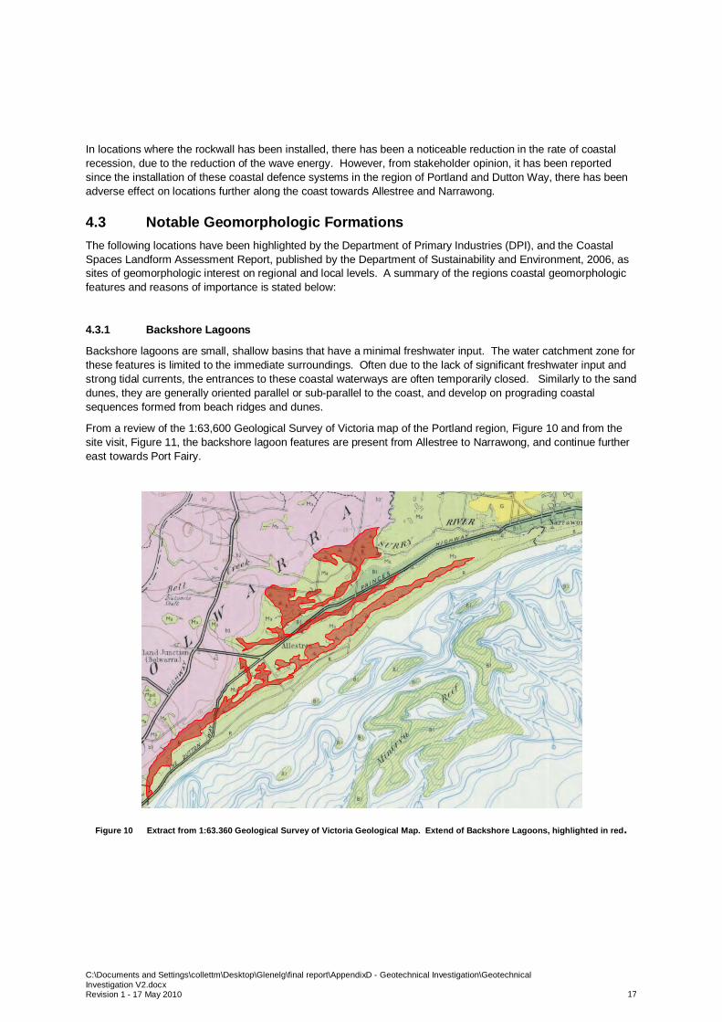
From a review of the 1:63,600 Geological Survey of Victoria map of the Portland region, Figure 10 and from thesite visit, Figure 11, the backshore lagoon features are present from Allestree to Narrawong, and continue furthereast towards Port Fairy.
Figure 10 Extract from 1:63.360 Geological Survey of Victoria Geological Map. Extend of Backshore Lagoons, highlighted in red.
C:\Documents and Settings\collettm\Desktop\Glenelg\final report\AppendixD - Geotechnical Investigation\GeotechnicalInvestigation V2.docxRevision 1 - 17 May 2010 18
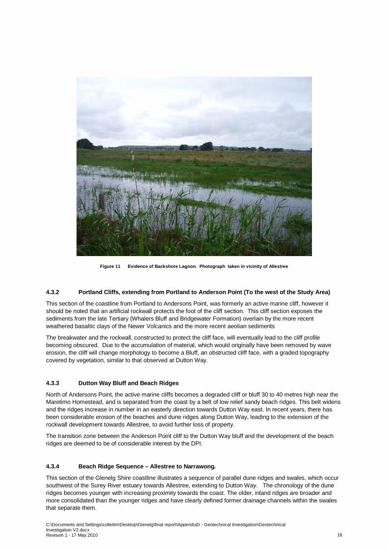
Figure 11 Evidence of Backshore Lagoon. Photograph taken in vicinity of Allestree
4.3.2 Portland Cliffs, extending from Portland to Anderson Point (To the west of the Study Area)
This section of the coastline from Portland to Andersons Point, was formerly an active marine cliff, however itshould be noted that an artificial rockwall protects the foot of the cliff section. This cliff section exposes thesediments from the late Tertiary (Whalers Bluff and Bridgewater Formation) overlain by the more recentweathered basaltic clays of the Newer Volcanics and the more recent aeolian sediments
The breakwater and the rockwall, constructed to protect the cliff face, will eventually lead to the cliff profilebecoming obscured. Due to the accumulation of material, which would originally have been removed by waveerosion, the cliff will change morphology to become a Bluff, an obstructed cliff face, with a graded topographycovered by vegetation, similar to that observed at Dutton Way.
4.3.3 Dutton Way Bluff and Beach Ridges
North of Andersons Point, the active marine cliffs becomes a degraded cliff or bluff 30 to 40 metres high near theMaretimo Homestead, and is separated from the coast by a belt of low relief sandy beach ridges. This belt widensand the ridges increase in number in an easterly direction towards Dutton Way east. In recent years, there hasbeen considerable erosion of the beaches and dune ridges along Dutton Way, leading to the extension of therockwall development towards Allestree, to avoid further loss of property.
The transition zone between the Anderson Point cliff to the Dutton Way bluff and the development of the beachridges are deemed to be of considerable interest by the DPI.
4.3.4 Beach Ridge Sequence – Allestree to Narrawong.
This section of the Glenelg Shire coastline illustrates a sequence of parallel dune ridges and swales, which occursouthwest of the Surey River estuary towards Allestree, extending to Dutton Way. The chronology of the duneridges becomes younger with increasing proximity towards the coast. The older, inland ridges are broader andmore consolidated than the younger ridges and have clearly defined former drainage channels within the swalesthat separate them.

C:\Documents and Settings\collettm\Desktop\Glenelg\final report\AppendixD - Geotechnical Investigation\GeotechnicalInvestigation V2.docxRevision 1 - 17 May 2010 19
4.3.5 Narrawong Coast and Mount Clay.
The Coastal Spaces Landscape Assessment Study prepared for DSE (September 2006) identifies and mapsindividual landscape characteristics in Victoria’s coastal regions, identifies significant landscapes and provides aframework to assist local government and other departments in managing development impacts within the coastalzones. The State Overview Report (September 2006) describes the Narrawong coast as having RegionalSignificance.
The report identified the regions as follows:
Mount Clay & Narrawong Coast:
Regionally Significant- Visually significant as a striking backdrop to the surrounding pastures and the flat plains of the
Narrawong Coast- Characterised by steep vegetated escarpments and natural forest contradicted with low dunes along
the coast- Valued by the community for its scenic views and dense forest on Mount Clay.
Based on the observations, studies and recommendations by the DPI and DSE, it is advised that the all measuresshould be taken to manage and mitigate erosional forces in order to maintain the presence of thegeomorphological features. Consideration of these features should also be taken into account should residential,commercial or industrial development be proposed.

C:\Documents and Settings\collettm\Desktop\Glenelg\final report\AppendixD - Geotechnical Investigation\GeotechnicalInvestigation V2.docxRevision 1 - 17 May 2010 20
5.0 Effects of Climate Change on Geological &Geomorphological Processes & Features
The study area under investigation is a naturally dynamic, high energy environment. Erosional and depositionalprocesses are ongoing but maybe affected by any climate change process.
Specific effects of climate change on the geological and geomorphological processes are difficult to predict, butexisting features may be impacted. It should be noted that the following discussion is not based on any detailedsite assessment, analytical models or references but on local engineering judgment. A summary of potentialeffects, consequences and potential mitigation techniques are highlighted below.
5.1 Sea Level Rise
Should the sea-level rise, in combination with any changes in precipitation, temperature or wind speed, thereis the potential to have a significant impact on the morphology of the coastline.
Removal of the protective barrier to the inland sand-dunes and cliffs may increase the potential for the dunesand cliffs to be subjected to increased erosion and weathering effects and may migrate inland untilequilibrium is reached between the various processes involved and the sediment supply or erosion.
5.2 Wind Speed.
Predominant geomorphological features which are estimated to be affected will be the sand dunes andridges, present between Dutton Way and Narrawong.
Any increase in the wind speed may lead to an increase in the rate of sediment transport and dunemigration. A decrease is estimated to reduce the rate of sediment transport.
Currently, the widest section of sand dune formation extends up to 40m inland from the coastline, in thevicinity directly to the southwest of the Surey River delta. Should wind speeds significantly change, there ispotential for the dunes migration patterns to change.
A potential method of mitigating any adverse effects of potentially changing wind speeds is to encourage thedevelopment of suitable, sustainable vegetation, as it will have the effect of anchoring and binding thesediment with the root structure, which will increase the dunes resistance to erosion and migration.
5.3 Precipitation
The level of saturation within a cliff, bluff or sand dune can have a significant control on its stability. It isrecommended to ensure all installed drainage paths and channels are in good condition and free fromobstructions.
By controlling and channeling any excess water away from the coastal morphologies, this can reduce thepotential risks of slope failure, slumps and coastal recession.
Where drainage channels cannot be installed or utilised, there is a potential risk that the excess surface run-off will flow through the coastal landscapes along a path of least resistance.
With a potential increase in the volume of surface run-off, these natural channels may enhance physical andchemical erosional processes.
Changes in rainfall patterns, would impact vegetation, which may have the effect of anchoring the soil,limiting the possibility of erosion and removal.
5.4 Temperatures
An increase in temperatures may exacerbate the potential for additional physical weathering processes tooccur, i.e. thermal expansion of materials.
An increase in development and tourism may lead to an increased volume of people visiting the beach andsurrounding area. Pedestrian movements, if uncontrolled, can have a significant effect on the dunemorphology.
There is a possibility that with increased visitor numbers, there is greater potential for dune erosion andfailure, as the visitors may not remain on designated pathways.
To potentially mitigate some of these erosional causes, should an increase in traffic be expected, sufficientvehicle and pedestrians pavements may be considered to increase the safety of both the public andenvironment.
C:\Documents and Settings\collettm\Desktop\Glenelg\final report\AppendixD - Geotechnical Investigation\GeotechnicalInvestigation V2.docxRevision 1 - 17 May 2010 21
6.0 Summary & Recommendations for Additional StudiesThere are many natural and artificial processes affecting the geomorphology of the Glenelg Shire coastlinebetween Dutton Way and Narrawong. Due to the exposed nature of the coastline from marine and aeolianprocesses, the region is subjected to many phases of erosion and deposition. Continual erosion, withoutprotective measures, will weaken the natural cliffline, which may induce phases of landslips. The continuallandslides and the removal of slump material will force the coastline to recede in an inland direction. In addition tothe potential cliff recession, the sand dune morphology in the vicinity of Allestree and Narrawong will continue tomigrate inland. It is how these natural processes are mitigated and managed along with the detailed assessmentof future developments, which will control the future of the coastline.
Should the Dutton Way to Narrawong coastline be subjected to development, it is recommended that a detailedgeological and geomorphological assessment is undertaken. This detailed review should include a minimum of ageological and geomorphological field mapping exercise, assessment of aerial photography, assessment ofstereogram imagery and the assessment of the coastal lithologies geotechnical parameters. It is alsorecommended that a slope stability assessment is undertaken in association with a risk assessment relating topotential slope failure.

C:\Documents and Settings\collettm\Desktop\Glenelg\final report\AppendixD - Geotechnical Investigation\GeotechnicalInvestigation V2.docxRevision 1 - 17 May 2010 22
7.0 ReferencesAerial Photography - Images supplied by Glenelg Shire Council
Department of Primary Industries Website (www.dpi.vic.gov.au)
Department of Sustainability & Environment (www.dse.vic.gov.au)
Golder Associates Pty Ltd. (August 2005) Dutton way Rock wall, Portland – Slope Stability Assessment
Golder Associates Pty Ltd. (August 2000) Geotechnical Survey – Portland Foreshore. (August 2000)
Foster, D.N (1991). Henty Bay Erosion. Report issued to Glenelg Shire Council
Beca Pty Ltd. (November 2007). Portland Bay Coastal Infrastructure Plan. Report Issued to Glenelg Shire Council
Parsons Brinkerhoff Pty Ltd. Portland Wade Street Slip Investigation, Monitoring and analysis of a Landslip.Report issued to Department of Sustainability and Environment.
Rosengren, N., Mallen, J. & Shepherd, T. (1981) An assessment of the geological / geomorphological significanceof Private land in the Shire of Portland. Issued to the Department of Sustainability and Environment
Department of Sustainability and Environment (2006). Coastal Spaces Landscape Assessment Study – StateOverview