Embed Size (px)
Citation preview

APPENDIX C
Geotechnical Investigation
AMEC Reference No. TP113039.6000 Page | i
GEOTECHNICAL INVESTIGATION
CLASS ENVIRONMENTAL ASSESSMENT OF CONLIN ROAD EAST
FROM SIMCOE STREET NORTH TO TOWNLINE ROAD NORTH
OSHAWA, ONTARIO
CONTRACT No. C2013-003
Submitted to:
The City of Oshawa
50 Centre Street South
Oshawa, Ontario, L1H 3Z7
Canada
Submitted by:
AMEC Environment & Infrastructure,
a Division of AMEC Americas Limited
104 Crockford Boulevard
Scarborough, Ontario, M1R 3C3
Canada
17 June 2014
TP113039.6000
The City of Oshawa
Geotechnical Investigation for Class EA of Conlin Road East
From Simcoe Street North to Townline Road North, Oshawa, Ontario
17 June 2014
AMEC Reference No. TP113039.6000 (i)
TABLE OF CONTENTS
1.0 INTRODUCTION.............................................................................................................................. 1 2.0 SITE AND PROJECT DESCRIPTION............................................................................................. 2 3.0 INVESTIGATION PROCEDURES................................................................................................... 2
3.1 Geotechnical Investigation .................................................................................. 2
3.2 Pavement Condition Survey ................................................................................ 6 4.0 SUB-SURFACE CONDITIONS ....................................................................................................... 8
4.1 Asphaltic Concrete .............................................................................................. 8
4.2 Fill Soils .............................................................................................................. 9
4.3 Clayey Silt ..........................................................................................................10
4.4 Sand/Silty Sand/Sandy Silt/Silt ...........................................................................11
4.5 Clayey Silt Till ....................................................................................................11
4.6 Sand/Silty Sand/Sandy Silt Till ...........................................................................11
4.7 Groundwater Conditions ....................................................................................12 5.0 DISCUSSION AND RECOMMENDATIONS ................................................................................. 14
5.1 Pavement Design Considerations ......................................................................14
5.1.1 Existing Pavement Structure ..................................................................14
5.1.2 Granular Base Equivalency (GBE) .........................................................15
5.1.3 Existing and Forecasted Traffic Data ......................................................16
5.1.4 Flexible Structural Pavement Design for Widening and Reconstruction ..17
5.1.5 Rehabilitation Strategies for Existing Pavement .....................................17 5.1.6 Construction Consideration ....................................................................18
5.2 Bridge Foundations ............................................................................................19
5.2.1 Shallow Foundation ................................................................................19
5.2.2 Deep Foundations ..................................................................................21
5.3 Culverts .............................................................................................................22
5.4 Road Embankment Widening.............................................................................23
5.5 Drainage ............................................................................................................24
5.6 Excavation and Dewatering ...............................................................................25 6.0 CLOSURE ...................................................................................................................................... 27 REPORT LIMITATIONS ............................................................................................................................. 28
The City of Oshawa
Geotechnical Investigation for Class EA of Conlin Road East
From Simcoe Street North to Townline Road North, Oshawa, Ontario
17 June 2014
AMEC Reference No. TP113039.6000 (ii)
FIGURES
Figure No. 1 Site Location Plan
Figure Nos. 2A to 2C Borehole Location Plan
RECORD OF BOREHOLES
Explanation of Borehole Logs
Record of Boreholes (BH1 to BH30)
APPENDICES
Appendix A: Laboratory Soil Test Results
Appendix B: Results of Pavement Condition Survey
The City of Oshawa
Geotechnical Investigation for Class EA of Conlin Road East
From Simcoe Street North to Townline Road North, Oshawa, Ontario
17 June 2014
AMEC Reference No. TP113039.6000 Page | 1
1.0 INTRODUCTION
AMEC Environment & Infrastructure, a Division of AMEC Americas Limited (“AMEC”) was
retained by the City of Oshawa, to conduct a geotechnical investigation for a section of Conlin
Road East from east of Simcoe Street North to Townline Road North in Oshawa, Ontario. The
investigation was required to provide geotechnical design information for completion of a
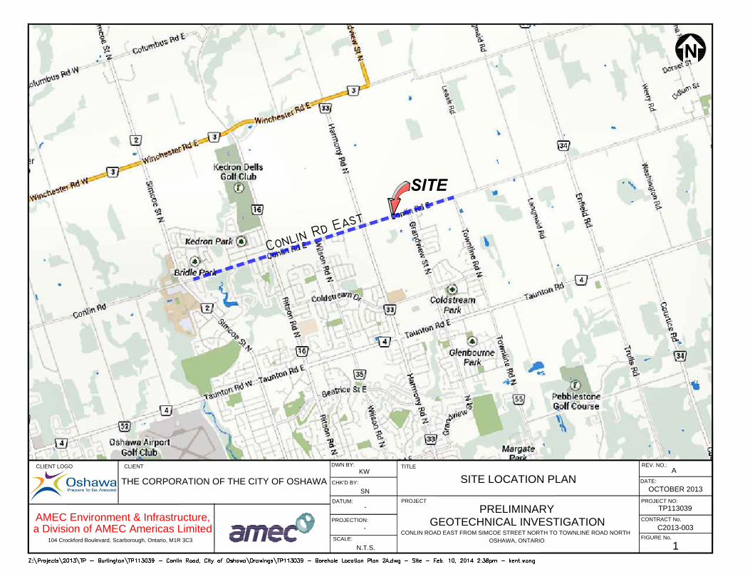
Class Environment Assessment for the improvements of Conlin Road East. The project limit
is shown on Figure No. 1.
The purpose of this geotechnical investigation was to obtain information on the subsurface
conditions along the Conlin Road East section by means of a limited number of boreholes, in-
situ tests and laboratory tests of soil samples. During the field work, the existing pavement
structure was measured in the boreholes. Based on AMEC’s interpretation of the data
obtained, recommendations are provided for possible road improvements which could include
rehabilitation / reconstruction and possible widening works of the investigated road section,
expansion of existing culverts, and installation of underground utilities.
This report contains the findings of AMEC’s geotechnical investigation, together with
recommendations and comments. These recommendations and comments are based on
factual information and are intended only for use by design engineers. The number of
boreholes may not be sufficient to determine all the factors that may affect construction
methods and costs. Subsurface and groundwater conditions between and beyond the
boreholes may differ from those encountered at the borehole locations, and conditions may
become apparent during construction, which could not be detected or anticipated at the time
of the site investigation. The anticipated construction conditions are also discussed, but only
to the extent that they may influence design decisions. Construction methods discussed,
however, express AMEC’s opinion only and are not intended to direct the contractors on how
to carry out the construction. Contractors should also be aware that the data and their
interpretation presented in this report may not be sufficient to assess all the factors that may
have an effect upon the construction.
The report is prepared with the condition that the design will be in accordance with all
applicable standards and codes, regulations of authorities having jurisdiction, and good
engineering practice. Further, the recommendations and opinions in this report are applicable
only to the proposed project as described above.
On-going liaison with AMEC during the final design and construction phase of the project is
recommended to confirm that the recommendations in this report are applicable and/or
correctly interpreted and implemented. Also, any queries concerning the geotechnical
aspects of the proposed project should be directed to AMEC for further elaboration and/or
clarification.
The City of Oshawa
Geotechnical Investigation for Class EA of Conlin Road East
From Simcoe Street North to Townline Road North, Oshawa, Ontario
17 June 2014
AMEC Reference No. TP113039.6000 Page | 2
2.0 SITE AND PROJECT DESCRIPTION
The investigated section of Conlin Road East is about 4.9 km long, extending from east of
Simcoe Street North to the east city limit at Townline Road North in the City of Oshawa as
shown in Figure No. 1.
Within the project limit, Conlin Road is an east / west oriented, two lane arterial road that
intersects five (5) major streets. The intersecting streets are Ritson Road North, Wilson Road
North, Harmony Road North, Grandview Street North and Townline Road North. This section
of Conlin Road contains crossings of two branches of Oshawa Creek (east of Bridle Drive and
Wilson Road North) and crossings of two branches of Harmony Creek (west of Grandview
Street North and west of Townline Road North). At the time of investigation, Conlin Road East
was paved with asphaltic concrete in the travel lanes. Sidewalks and concrete curbs were
present in the western part between Simcoe Street North and Ritson Road North.
Based on the information provided in the Request for Proposal, various levels of
improvements, which include rehabilitation / reconstruction and possible widening of the
existing road section, are planned throughout the length of this section of Conlin Road East.
3.0 INVESTIGATION PROCEDURES
3.1 Geotechnical Investigation
The fieldwork for geotechnical investigation was carried out from July 24 to 29, 2013, and
consisted of advancing a total of 30 boreholes. The depths of boreholes ranged from 2.7 m to
16.6 m below the existing grade. The approximate locations of the boreholes are presented in
Figure Nos. 2A, 2B and 2C.
Prior to commencing the drilling work, a site plan of Conlin Road section showing a total of 30
boreholes was submitted to the City of Oshawa (“the City”) for approval. The quantity and
locations of borehole were determined in accordance with the requirements in the City’s
Request for Proposal. Upon receipt of approval from the City on the submitted investigation
program, the borehole locations were established in the field by AMEC personnel.
The borehole details are given in Table 3.1.
The City of Oshawa
Geotechnical Investigation for Class EA of Conlin Road East
From Simcoe Street North to Townline Road North, Oshawa, Ontario
17 June 2014
AMEC Reference No. TP113039.6000 Page | 3
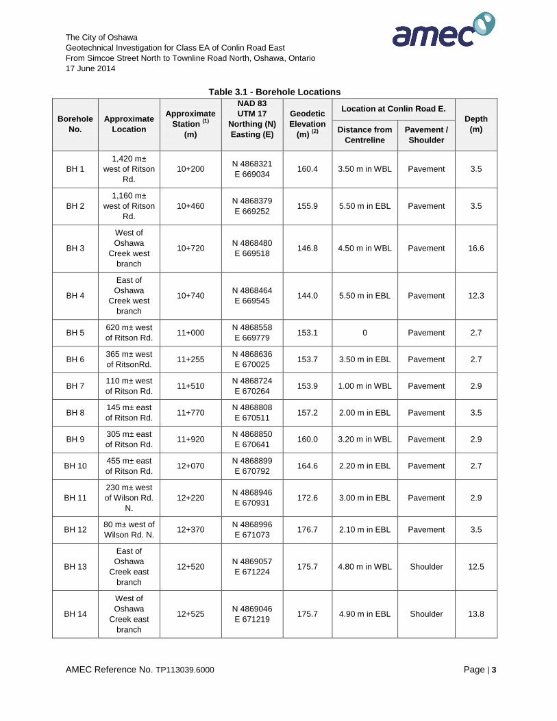
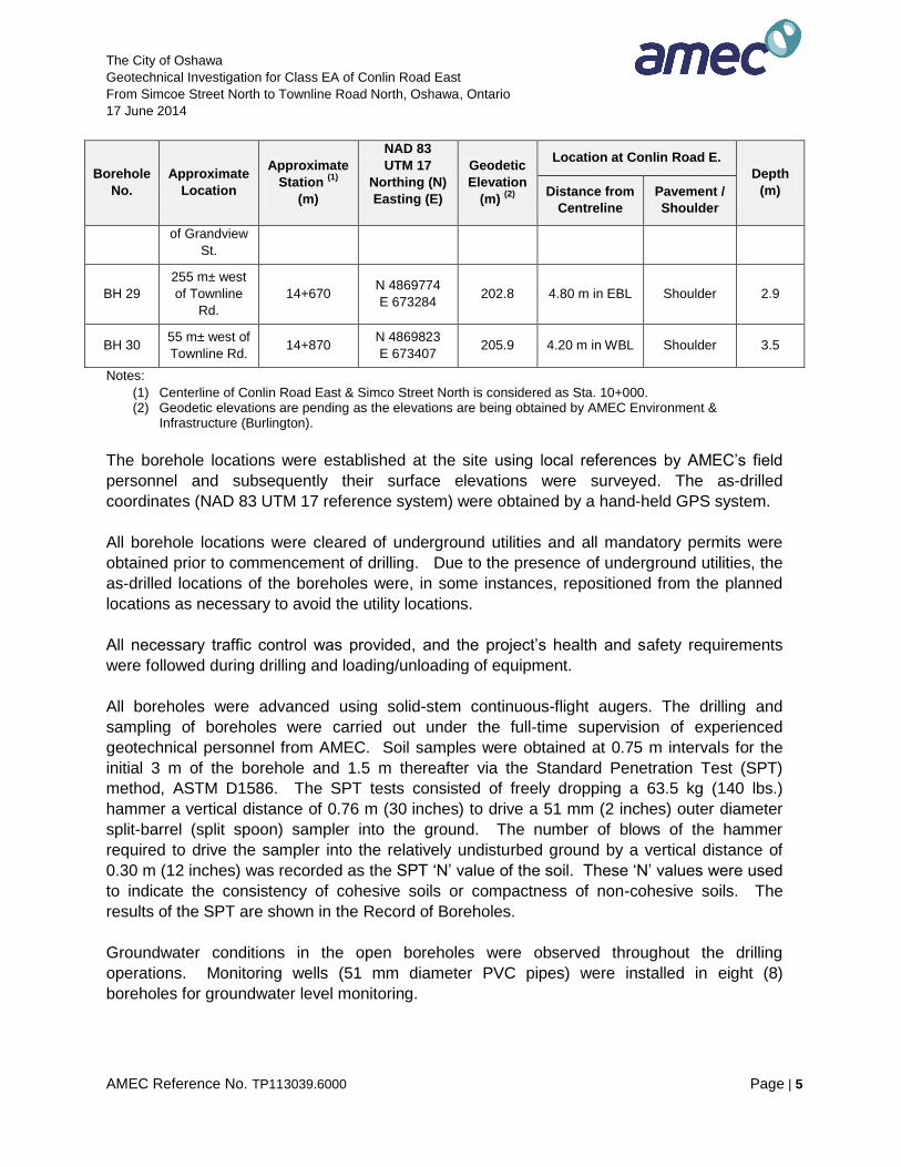
Table 3.1 - Borehole Locations
Borehole
No.
Approximate
Location
Approximate
Station (1)
(m)
NAD 83
UTM 17
Northing (N)
Easting (E)
Geodetic
Elevation
(m) (2)
Location at Conlin Road E.
Depth
(m) Distance from
Centreline
Pavement /
Shoulder
BH 1
1,420 m±
west of Ritson
Rd.
10+200 N 4868321
E 669034 160.4 3.50 m in WBL Pavement 3.5
BH 2
1,160 m±
west of Ritson
Rd.
10+460 N 4868379
E 669252 155.9 5.50 m in EBL Pavement 3.5
BH 3
West of
Oshawa
Creek west
branch
10+720 N 4868480
E 669518 146.8 4.50 m in WBL Pavement 16.6
BH 4
East of
Oshawa
Creek west
branch
10+740 N 4868464
E 669545 144.0 5.50 m in EBL Pavement 12.3
BH 5 620 m± west
of Ritson Rd. 11+000
N 4868558
E 669779 153.1 0 Pavement 2.7
BH 6 365 m± west
of RitsonRd. 11+255
N 4868636
E 670025 153.7 3.50 m in EBL Pavement 2.7
BH 7 110 m± west
of Ritson Rd. 11+510
N 4868724
E 670264 153.9 1.00 m in WBL Pavement 2.9
BH 8 145 m± east
of Ritson Rd. 11+770
N 4868808
E 670511 157.2 2.00 m in EBL Pavement 3.5
BH 9 305 m± east
of Ritson Rd. 11+920
N 4868850
E 670641 160.0 3.20 m in WBL Pavement 2.9
BH 10 455 m± east
of Ritson Rd. 12+070
N 4868899
E 670792 164.6 2.20 m in EBL Pavement 2.7
BH 11
230 m± west
of Wilson Rd.
N.
12+220 N 4868946
E 670931 172.6 3.00 m in EBL Pavement 2.9
BH 12 80 m± west of
Wilson Rd. N. 12+370
N 4868996
E 671073 176.7 2.10 m in EBL Pavement 3.5
BH 13
East of
Oshawa
Creek east
branch
12+520 N 4869057
E 671224 175.7 4.80 m in WBL Shoulder 12.5
BH 14
West of
Oshawa
Creek east
branch
12+525 N 4869046
E 671219 175.7 4.90 m in EBL Shoulder 13.8
The City of Oshawa
Geotechnical Investigation for Class EA of Conlin Road East
From Simcoe Street North to Townline Road North, Oshawa, Ontario
17 June 2014
AMEC Reference No. TP113039.6000 Page | 4
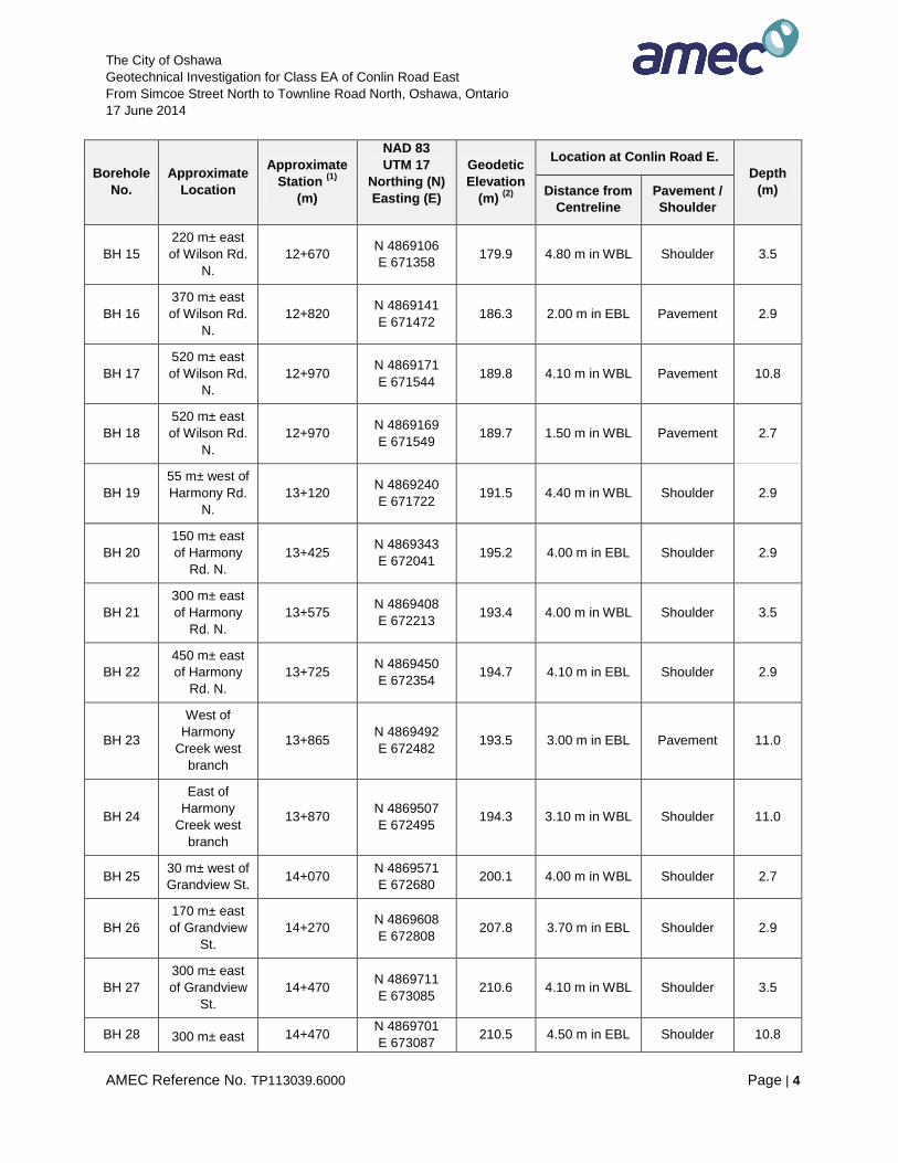
Borehole
No.
Approximate
Location
Approximate
Station (1)
(m)
NAD 83
UTM 17
Northing (N)
Easting (E)
Geodetic
Elevation
(m) (2)
Location at Conlin Road E.
Depth
(m) Distance from
Centreline
Pavement /
Shoulder
BH 15
220 m± east
of Wilson Rd.
N.
12+670 N 4869106
E 671358 179.9 4.80 m in WBL Shoulder 3.5
BH 16
370 m± east
of Wilson Rd.
N.
12+820 N 4869141
E 671472 186.3 2.00 m in EBL Pavement 2.9
BH 17
520 m± east
of Wilson Rd.
N.
12+970 N 4869171
E 671544 189.8 4.10 m in WBL Pavement 10.8
BH 18
520 m± east
of Wilson Rd.
N.
12+970 N 4869169
E 671549 189.7 1.50 m in WBL Pavement 2.7
BH 19
55 m± west of
Harmony Rd.
N.
13+120 N 4869240
E 671722 191.5 4.40 m in WBL Shoulder 2.9
BH 20
150 m± east
of Harmony
Rd. N.
13+425 N 4869343
E 672041 195.2 4.00 m in EBL Shoulder 2.9
BH 21
300 m± east
of Harmony
Rd. N.
13+575 N 4869408
E 672213 193.4 4.00 m in WBL Shoulder 3.5
BH 22
450 m± east
of Harmony
Rd. N.
13+725 N 4869450
E 672354 194.7 4.10 m in EBL Shoulder 2.9
BH 23
West of
Harmony
Creek west
branch
13+865 N 4869492
E 672482 193.5 3.00 m in EBL Pavement 11.0
BH 24
East of
Harmony
Creek west
branch
13+870 N 4869507
E 672495 194.3 3.10 m in WBL Shoulder 11.0
BH 25 30 m± west of
Grandview St. 14+070
N 4869571
E 672680 200.1 4.00 m in WBL Shoulder 2.7
BH 26
170 m± east
of Grandview
St.
14+270 N 4869608
E 672808 207.8 3.70 m in EBL Shoulder 2.9
BH 27
300 m± east
of Grandview
St.
14+470 N 4869711
E 673085 210.6 4.10 m in WBL Shoulder 3.5
BH 28 300 m± east 14+470 N 4869701
E 673087 210.5 4.50 m in EBL Shoulder 10.8
The City of Oshawa
Geotechnical Investigation for Class EA of Conlin Road East
From Simcoe Street North to Townline Road North, Oshawa, Ontario
17 June 2014
AMEC Reference No. TP113039.6000 Page | 5
Borehole
No.
Approximate
Location
Approximate
Station (1)
(m)
NAD 83
UTM 17
Northing (N)
Easting (E)
Geodetic
Elevation
(m) (2)
Location at Conlin Road E.
Depth
(m) Distance from
Centreline
Pavement /
Shoulder
of Grandview
St.
BH 29
255 m± west
of Townline
Rd.
14+670 N 4869774
E 673284 202.8 4.80 m in EBL Shoulder 2.9
BH 30 55 m± west of
Townline Rd. 14+870
N 4869823
E 673407 205.9 4.20 m in WBL Shoulder 3.5
Notes:
(1) Centerline of Conlin Road East & Simco Street North is considered as Sta. 10+000. (2) Geodetic elevations are pending as the elevations are being obtained by AMEC Environment &
Infrastructure (Burlington).
The borehole locations were established at the site using local references by AMEC’s field
personnel and subsequently their surface elevations were surveyed. The as-drilled
coordinates (NAD 83 UTM 17 reference system) were obtained by a hand-held GPS system.
All borehole locations were cleared of underground utilities and all mandatory permits were
obtained prior to commencement of drilling. Due to the presence of underground utilities, the
as-drilled locations of the boreholes were, in some instances, repositioned from the planned
locations as necessary to avoid the utility locations.
All necessary traffic control was provided, and the project’s health and safety requirements
were followed during drilling and loading/unloading of equipment.
All boreholes were advanced using solid-stem continuous-flight augers. The drilling and
sampling of boreholes were carried out under the full-time supervision of experienced
geotechnical personnel from AMEC. Soil samples were obtained at 0.75 m intervals for the
initial 3 m of the borehole and 1.5 m thereafter via the Standard Penetration Test (SPT)
method, ASTM D1586. The SPT tests consisted of freely dropping a 63.5 kg (140 lbs.)
hammer a vertical distance of 0.76 m (30 inches) to drive a 51 mm (2 inches) outer diameter
split-barrel (split spoon) sampler into the ground. The number of blows of the hammer
required to drive the sampler into the relatively undisturbed ground by a vertical distance of
0.30 m (12 inches) was recorded as the SPT ‘N’ value of the soil. These ‘N’ values were used
to indicate the consistency of cohesive soils or compactness of non-cohesive soils. The
results of the SPT are shown in the Record of Boreholes.
Groundwater conditions in the open boreholes were observed throughout the drilling
operations. Monitoring wells (51 mm diameter PVC pipes) were installed in eight (8)
boreholes for groundwater level monitoring.
The City of Oshawa
Geotechnical Investigation for Class EA of Conlin Road East
From Simcoe Street North to Townline Road North, Oshawa, Ontario
17 June 2014
AMEC Reference No. TP113039.6000 Page | 6
Upon completion of drilling, the twenty-two (22) boreholes without monitoring wells were
backfilled with bentonite, in accordance with the general requirements of Ministry of the
Environment Regulation 903, and the existing asphaltic concrete surface was repaired with
‘cold patch’.
Prior to backfilling or well installation, the free standing groundwater level was measured, if
present, in all boreholes. The measured groundwater levels are shown in the Record of
Boreholes.
Soil samples collected from boreholes were transported to AMEC’s Advanced Soil Laboratory
in Scarborough for further review and laboratory testing on selected samples (i.e., water
content determination, grain size analysis and Atterberg Limit test, where applicable). The
results of the in-situ and laboratory tests are presented on the corresponding Record of
Boreholes. The results of laboratory testing are provided in Appendix A.
Soil samples obtained during the geotechnical field drilling program were field screened for
evidence of environmental impact. The field screening activities included a visual inspection
of the soil samples and measuring the combustible organic vapor (COV) in the headspace of
the soil samples with a portable hydrocarbon measuring device (Gastechtor 1238ME).
Results of the field screening are shown in the Record of Boreholes.
3.2 Pavement Condition Survey
AMEC completed a visual pavement condition survey along the investigated sections of
Conlin Road East to identify areas of distress as well as their degree of severity. The
identification and classification of the pavement distresses were in accordance with the MTO’s
Manual for Condition Rating of Flexible Pavements (SP024), August 1980. For convenience,
the project area was divided in five sections as follows:
i) Section 1: Simcoe Street to Avalona Street (about 900 m);
ii) Section 2: Avalona Street to Ritson Road (about 725 m);
iii) Section 3: Ritson Road to Wilson Road (about 900 m);
iv) Section 4: Wilson Road to Harmony Road (about 750 m); and
v) Section 5: Harmony Road to Townline Road (about 1,650 m).
The findings of the pavement condition survey are summarized in Table 3.2. The Pavement
Condition Survey sheets are included in Appendix B. The pavement condition in some
section reflects its age and probable increase in traffic loading that has resulted in the
pavement condition progressively deteriorating with time.
The City of Oshawa
Geotechnical Investigation for Class EA of Conlin Road East
From Simcoe Street North to Townline Road North, Oshawa, Ontario
17 June 2014
AMEC Reference No. TP113039.6000 Page | 7
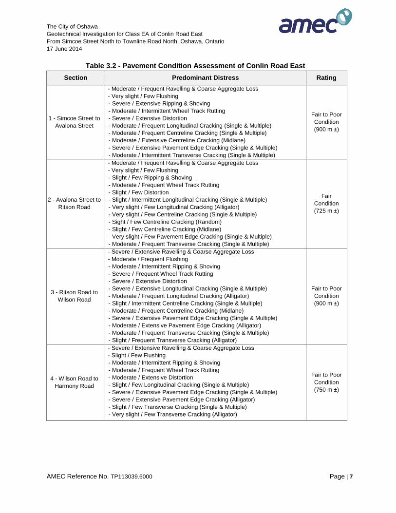
Table 3.2 - Pavement Condition Assessment of Conlin Road East
Section Predominant Distress Rating
1 - Simcoe Street to
Avalona Street
- Moderate / Frequent Ravelling & Coarse Aggregate Loss
- Very slight / Few Flushing
- Severe / Extensive Ripping & Shoving
- Moderate / Intermittent Wheel Track Rutting
- Severe / Extensive Distortion
- Moderate / Frequent Longitudinal Cracking (Single & Multiple)
- Moderate / Frequent Centreline Cracking (Single & Multiple)
- Moderate / Extensive Centreline Cracking (Midlane)
- Severe / Extensive Pavement Edge Cracking (Single & Multiple)
- Moderate / Intermittent Transverse Cracking (Single & Multiple)
Fair to Poor
Condition
(900 m ±)
2 - Avalona Street to
Ritson Road
- Moderate / Frequent Ravelling & Coarse Aggregate Loss
- Very slight / Few Flushing
- Slight / Few Ripping & Shoving
- Moderate / Frequent Wheel Track Rutting
- Slight / Few Distortion
- Slight / Intermittent Longitudinal Cracking (Single & Multiple)
- Very slight / Few Longitudinal Cracking (Alligator)
- Very slight / Few Centreline Cracking (Single & Multiple)
- Sight / Few Centreline Cracking (Random)
- Slight / Few Centreline Cracking (Midlane)
- Very slight / Few Pavement Edge Cracking (Single & Multiple)
- Moderate / Frequent Transverse Cracking (Single & Multiple)
Fair
Condition
(725 m ±)
3 - Ritson Road to
Wilson Road
- Severe / Extensive Ravelling & Coarse Aggregate Loss
- Moderate / Frequent Flushing
- Moderate / Intermittent Ripping & Shoving
- Severe / Frequent Wheel Track Rutting
- Severe / Extensive Distortion
- Severe / Extensive Longitudinal Cracking (Single & Multiple)
- Moderate / Frequent Longitudinal Cracking (Alligator)
- Slight / Intermittent Centreline Cracking (Single & Multiple)
- Moderate / Frequent Centreline Cracking (Midlane)
- Severe / Extensive Pavement Edge Cracking (Single & Multiple)
- Moderate / Extensive Pavement Edge Cracking (Alligator)
- Moderate / Frequent Transverse Cracking (Single & Multiple)
- Slight / Frequent Transverse Cracking (Alligator)
Fair to Poor
Condition
(900 m ±)
4 - Wilson Road to
Harmony Road
- Severe / Extensive Ravelling & Coarse Aggregate Loss
- Slight / Few Flushing
- Moderate / Intermittent Ripping & Shoving
- Moderate / Frequent Wheel Track Rutting
- Moderate / Extensive Distortion
- Slight / Few Longitudinal Cracking (Single & Multiple)
- Severe / Extensive Pavement Edge Cracking (Single & Multiple)
- Severe / Extensive Pavement Edge Cracking (Alligator)
- Slight / Few Transverse Cracking (Single & Multiple)
- Very slight / Few Transverse Cracking (Alligator)
Fair to Poor
Condition
(750 m ±)
The City of Oshawa
Geotechnical Investigation for Class EA of Conlin Road East
From Simcoe Street North to Townline Road North, Oshawa, Ontario
17 June 2014
AMEC Reference No. TP113039.6000 Page | 8
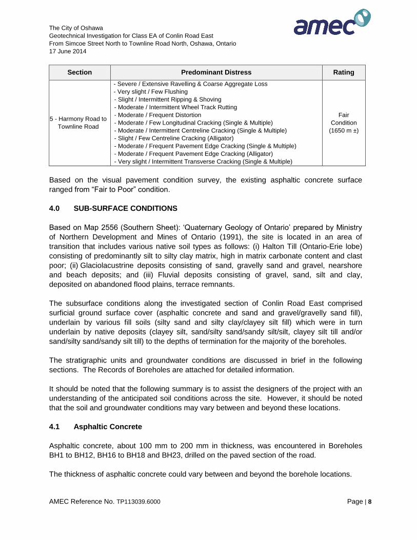
Section Predominant Distress Rating
5 - Harmony Road to
Townline Road
- Severe / Extensive Ravelling & Coarse Aggregate Loss
- Very slight / Few Flushing
- Slight / Intermittent Ripping & Shoving
- Moderate / Intermittent Wheel Track Rutting
- Moderate / Frequent Distortion
- Moderate / Few Longitudinal Cracking (Single & Multiple)
- Moderate / Intermittent Centreline Cracking (Single & Multiple)
- Slight / Few Centreline Cracking (Alligator)
- Moderate / Frequent Pavement Edge Cracking (Single & Multiple)
- Moderate / Frequent Pavement Edge Cracking (Alligator)
- Very slight / Intermittent Transverse Cracking (Single & Multiple)
Fair
Condition
(1650 m ±)
Based on the visual pavement condition survey, the existing asphaltic concrete surface
ranged from “Fair to Poor” condition.
4.0 SUB-SURFACE CONDITIONS
Based on Map 2556 (Southern Sheet): ‘Quaternary Geology of Ontario’ prepared by Ministry
of Northern Development and Mines of Ontario (1991), the site is located in an area of
transition that includes various native soil types as follows: (i) Halton Till (Ontario-Erie lobe)
consisting of predominantly silt to silty clay matrix, high in matrix carbonate content and clast
poor; (ii) Glaciolacustrine deposits consisting of sand, gravelly sand and gravel, nearshore
and beach deposits; and (iii) Fluvial deposits consisting of gravel, sand, silt and clay,
deposited on abandoned flood plains, terrace remnants.
The subsurface conditions along the investigated section of Conlin Road East comprised
surficial ground surface cover (asphaltic concrete and sand and gravel/gravelly sand fill),
underlain by various fill soils (silty sand and silty clay/clayey silt fill) which were in turn
underlain by native deposits (clayey silt, sand/silty sand/sandy silt/silt, clayey silt till and/or
sand/silty sand/sandy silt till) to the depths of termination for the majority of the boreholes.
The stratigraphic units and groundwater conditions are discussed in brief in the following
sections. The Records of Boreholes are attached for detailed information.
It should be noted that the following summary is to assist the designers of the project with an
understanding of the anticipated soil conditions across the site. However, it should be noted
that the soil and groundwater conditions may vary between and beyond these locations.
4.1 Asphaltic Concrete
Asphaltic concrete, about 100 mm to 200 mm in thickness, was encountered in Boreholes
BH1 to BH12, BH16 to BH18 and BH23, drilled on the paved section of the road.
The thickness of asphaltic concrete could vary between and beyond the borehole locations.
The City of Oshawa
Geotechnical Investigation for Class EA of Conlin Road East
From Simcoe Street North to Townline Road North, Oshawa, Ontario
17 June 2014
AMEC Reference No. TP113039.6000 Page | 9
4.2 Fill Soils
Fill soils comprising sand and gravel/gravelly sand, silty sand and/or silty clay/clayey silt were
encountered at different depths in all boreholes. It should be noted that the thickness and
conditions of the fill could vary significantly between and beyond the borehole locations.
Sand and Gravel/Gravelly Sand Fill
Sand and gravel/gravelly sand was encountered underlying the asphaltic concrete in BH1 to
BH12, BH16 to BH18, and BH23; at grade in Boreholes BH13 to BH15, BH19 to BH22 and
BH24 to BH30. The sand and gravel/gravelly sand fill extended to depths varying from about
0.5 m to 2.9 m below the existing ground surface.
The sand and gravel/gravelly sand fill were brown in color, and contained a trace to some silt
and trace cobbles. The SPT ‘N’ values of the sand and gravel/gravelly sand fill ranged widely
from 9 to 52 blows per 0.3 m. Higher SPT ‘N’ values might be due to the presence of cobbles.
The water content values measured in the sand and gravel/gravelly sand fill ranged from 1%
to 22%.
It should be noted that the thickness and the conditions of the sand and gravel/gravelly sand
fill could vary significantly between and beyond the borehole locations.
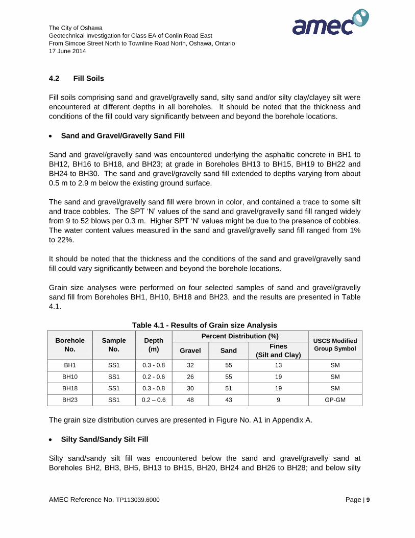
Grain size analyses were performed on four selected samples of sand and gravel/gravelly
sand fill from Boreholes BH1, BH10, BH18 and BH23, and the results are presented in Table
4.1.
Table 4.1 - Results of Grain size Analysis
Borehole
No.
Sample
No.
Depth
(m)
Percent Distribution (%) USCS Modified
Group Symbol Gravel Sand Fines
(Silt and Clay)
BH1 SS1 0.3 - 0.8 32 55 13 SM
BH10 SS1 0.2 - 0.6 26 55 19 SM
BH18 SS1 0.3 - 0.8 30 51 19 SM
BH23 SS1 0.2 – 0.6 48 43 9 GP-GM
The grain size distribution curves are presented in Figure No. A1 in Appendix A.
Silty Sand/Sandy Silt Fill
Silty sand/sandy silt fill was encountered below the sand and gravel/gravelly sand at
Boreholes BH2, BH3, BH5, BH13 to BH15, BH20, BH24 and BH26 to BH28; and below silty
The City of Oshawa
Geotechnical Investigation for Class EA of Conlin Road East
From Simcoe Street North to Townline Road North, Oshawa, Ontario
17 June 2014
AMEC Reference No. TP113039.6000 Page | 10
clay/clayey silt fill in Boreholes BH7 and BH23. The silty sand/sandy silt fill extended to
depths varying from about 1.1 m to 6.7 m below the existing ground surface.
The silty sand/sandy silt fill was brown and grey in colour and contained trace to some clay,
trace to some gravel and cobbles/boulders. Traces of organic matter were noted in Boreholes
BH2, BH7, BH26 and BH28. The SPT ‘N’ values of the silty sand/sandy silt fill ranged from 3
to greater than 50 blows per 0.3 m. High SPT ‘N’ values were possibly due to presence of
gravel/cobbles/boulders. The water contents measured in the silty sand/sandy silt fill ranged
from 5% to 17%.
Silty Clay/Clayey Silt Fill
Silty clay/clayey silt fill was encountered underlying the sand and gravel/gravelly sand fill in
Boreholes BH7, BH9, BH17 to BH19, BH21 to BH23 and BH29 to BH30; below the silty
sand/sandy silt fill in Boreholes BH2, BH3 and BH24. The silty clay/clayey silt fill soil
extended to depths ranging from about 0.9 m to 7.0 m below the existing ground surface.
The silty clay/clayey silt fill was brown and grey in colour, and contained traces of gravel,
some sand and cobbles/boulders. A trace of organic matter was noted in several boreholes
(BH3, BH7, BH9, BH19, BH21, BH23 and BH30). The SPT ‘N’ values of the silty clay/clayey
silt fill ranged from 4 to 15 blows per 0.3 m. The water contents measured in the silty
clay/clayey silt fill ranged from 8% to 28%.
4.3 Clayey Silt
Clayey silt was encountered below the fill soils in Boreholes BH1, BH3, BH6, BH8 and BH15.
The clayey silt extended to depths ranging from 2.9 m to 8.5 m below the existing grade.
The clayey silt was brown and grey in colour and contained trace to some sand and traces of
gravel. The SPT ‘N’ values of the clayey silt ranged from 10 to 29 blows per 0.3 m, indicating
a stiff to very stiff consistency. The water contents measured in the clayey silt ranged from
9% to 16%.
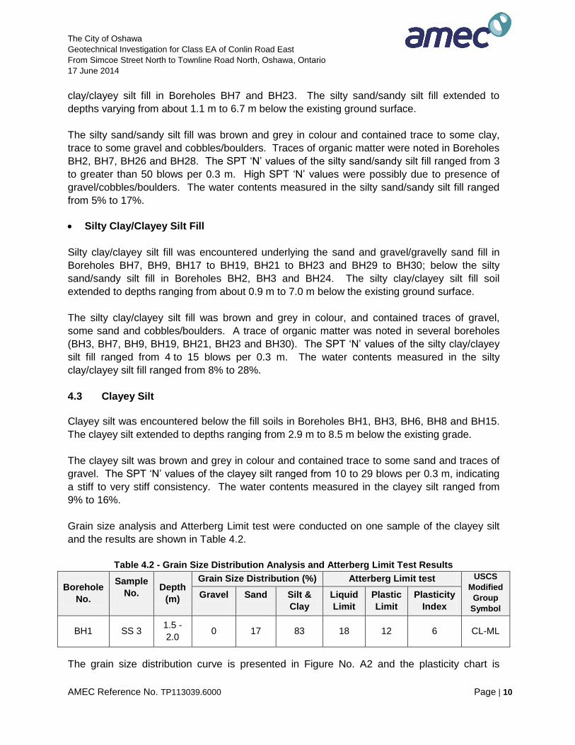
Grain size analysis and Atterberg Limit test were conducted on one sample of the clayey silt
and the results are shown in Table 4.2.
Table 4.2 - Grain Size Distribution Analysis and Atterberg Limit Test Results
Borehole
No.
Sample
No.
Depth
(m)
Grain Size Distribution (%) Atterberg Limit test USCS
Modified
Group
Symbol
Gravel
Sand
Silt &
Clay
Liquid
Limit
Plastic
Limit
Plasticity
Index
BH1 SS 3 1.5 -
2.0 0 17 83 18 12 6 CL-ML
The grain size distribution curve is presented in Figure No. A2 and the plasticity chart is
The City of Oshawa
Geotechnical Investigation for Class EA of Conlin Road East
From Simcoe Street North to Townline Road North, Oshawa, Ontario
17 June 2014
AMEC Reference No. TP113039.6000 Page | 11
presented in Figure No. A3 in Appendix A.
4.4 Sand/Silty Sand/Sandy Silt/Silt
Sand/silty sand/sandy silt/silt was encountered in Boreholes BH1 to BH4, BH9, BH12 to BH16
and BH23 to BH27. The sand/silty sand/sandy silt/silt extended to depths of 11.9 m and 15.8
m below the existing grade.
The sand/silty sand/sandy silt/silt was grey in colour and contained traces of clay, gravel and
cobbles/boulders. The SPT ‘N’ values of the sand/silty sand/sandy silt/silt ranged from 9 to
greater than 50 blows per 0.3 m, indicating a loose to very dense compactness condition. The
water contents measured in the silty sand/sandy silt/silt ranged from 7% to 20%.
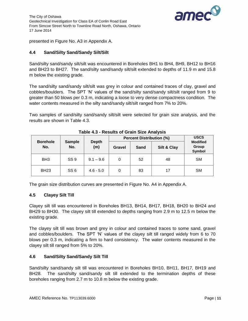
Two samples of sand/silty sand/sandy silt/silt were selected for grain size analysis, and the
results are shown in Table 4.3.
Table 4.3 - Results of Grain Size Analysis
Borehole
No.
Sample
No.
Depth
(m)
Percent Distribution (%) USCS
Modified
Group
Symbol Gravel Sand Silt & Clay
BH3 SS 9 9.1 – 9.6 0 52 48 SM
BH23 SS 6 4.6 - 5.0 0 83 17 SM
The grain size distribution curves are presented in Figure No. A4 in Appendix A.
4.5 Clayey Silt Till
Clayey silt till was encountered in Boreholes BH13, BH14, BH17, BH18, BH20 to BH24 and
BH29 to BH30. The clayey silt till extended to depths ranging from 2.9 m to 12.5 m below the
existing grade.
The clayey silt till was brown and grey in colour and contained traces to some sand, gravel
and cobbles/boulders. The SPT ‘N’ values of the clayey silt till ranged widely from 6 to 70
blows per 0.3 m, indicating a firm to hard consistency. The water contents measured in the
clayey silt till ranged from 5% to 20%.
4.6 Sand/Silty Sand/Sandy Silt Till
Sand/silty sand/sandy silt till was encountered in Boreholes BH10, BH11, BH17, BH19 and
BH28. The sand/silty sand/sandy silt till extended to the termination depths of these
boreholes ranging from 2.7 m to 10.8 m below the existing grade.
The City of Oshawa
Geotechnical Investigation for Class EA of Conlin Road East
From Simcoe Street North to Townline Road North, Oshawa, Ontario
17 June 2014
AMEC Reference No. TP113039.6000 Page | 12
The sand/silty sand/sandy silt till was brown and grey in colour and contained traces of clay,
gravel and cobbles/boulders. The SPT ‘N’ values of the sand/silty sand/sandy silt till ranged
from 24 to greater than 50 blows per 0.3 m, indicating a compact to very dense compactness
condition. The water contents measured in the sand/silty sand/sandy silt till ranged from 8%
to 9%.
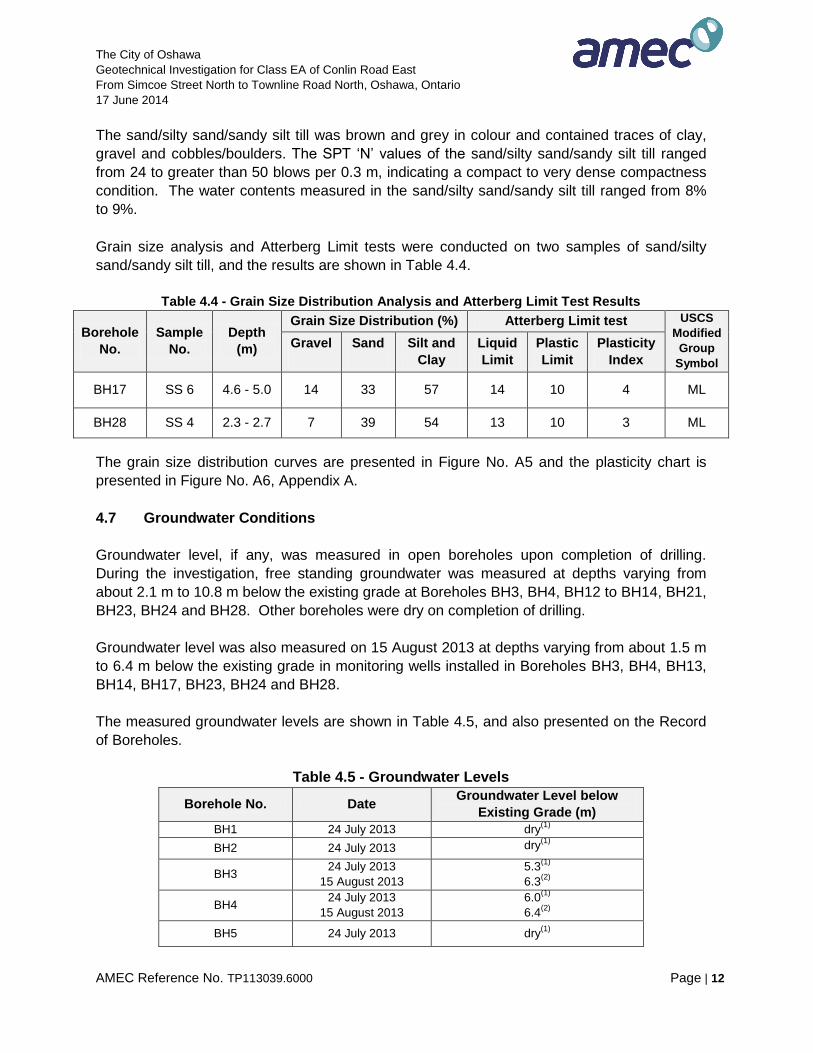
Grain size analysis and Atterberg Limit tests were conducted on two samples of sand/silty
sand/sandy silt till, and the results are shown in Table 4.4.
Table 4.4 - Grain Size Distribution Analysis and Atterberg Limit Test Results
Borehole
No.
Sample
No.
Depth
(m)
Grain Size Distribution (%) Atterberg Limit test USCS
Modified
Group
Symbol
Gravel
Sand
Silt and
Clay
Liquid
Limit
Plastic
Limit
Plasticity
Index
BH17 SS 6 4.6 - 5.0 14 33 57 14 10 4 ML
BH28 SS 4 2.3 - 2.7 7 39 54 13 10 3 ML
The grain size distribution curves are presented in Figure No. A5 and the plasticity chart is
presented in Figure No. A6, Appendix A.
4.7 Groundwater Conditions
Groundwater level, if any, was measured in open boreholes upon completion of drilling.
During the investigation, free standing groundwater was measured at depths varying from
about 2.1 m to 10.8 m below the existing grade at Boreholes BH3, BH4, BH12 to BH14, BH21,
BH23, BH24 and BH28. Other boreholes were dry on completion of drilling.
Groundwater level was also measured on 15 August 2013 at depths varying from about 1.5 m
to 6.4 m below the existing grade in monitoring wells installed in Boreholes BH3, BH4, BH13,
BH14, BH17, BH23, BH24 and BH28.
The measured groundwater levels are shown in Table 4.5, and also presented on the Record
of Boreholes.
Table 4.5 - Groundwater Levels
Borehole No. Date Groundwater Level below
Existing Grade (m)
BH1 24 July 2013 dry(1)
BH2 24 July 2013 dry(1)
BH3 24 July 2013
15 August 2013
5.3(1)
6.3(2)
BH4 24 July 2013
15 August 2013
6.0(1)
6.4(2)
BH5 24 July 2013 dry(1)
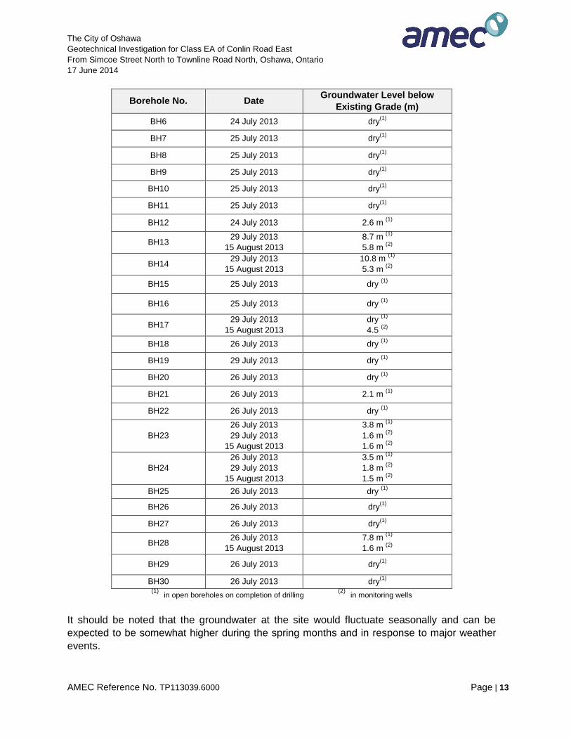
The City of Oshawa
Geotechnical Investigation for Class EA of Conlin Road East
From Simcoe Street North to Townline Road North, Oshawa, Ontario
17 June 2014
AMEC Reference No. TP113039.6000 Page | 13
Borehole No. Date Groundwater Level below
Existing Grade (m)
BH6 24 July 2013 dry(1)
BH7 25 July 2013 dry(1)
BH8 25 July 2013 dry(1)
BH9 25 July 2013 dry(1)
BH10 25 July 2013 dry(1)
BH11 25 July 2013 dry(1)
BH12 24 July 2013 2.6 m (1)
BH13 29 July 2013
15 August 2013
8.7 m (1)
5.8 m (2)
BH14 29 July 2013
15 August 2013
10.8 m (1)
5.3 m (2)
BH15 25 July 2013 dry (1)
BH16 25 July 2013 dry (1)
BH17 29 July 2013
15 August 2013
dry (1)
4.5 (2)
BH18 26 July 2013 dry (1)
BH19 29 July 2013 dry (1)
BH20 26 July 2013 dry (1)
BH21 26 July 2013 2.1 m (1)
BH22 26 July 2013 dry (1)
BH23
26 July 2013
29 July 2013
15 August 2013
3.8 m (1)
1.6 m (2)
1.6 m (2)
BH24
26 July 2013
29 July 2013
15 August 2013
3.5 m (1)
1.8 m (2)
1.5 m (2)
BH25 26 July 2013 dry (1)
BH26 26 July 2013 dry(1)
BH27 26 July 2013 dry(1)
BH28 26 July 2013
15 August 2013
7.8 m (1)
1.6 m (2)
BH29 26 July 2013 dry(1)
BH30 26 July 2013 dry(1)
(1)
in open boreholes on completion of drilling (2)
in monitoring wells
It should be noted that the groundwater at the site would fluctuate seasonally and can be
expected to be somewhat higher during the spring months and in response to major weather
events.
The City of Oshawa
Geotechnical Investigation for Class EA of Conlin Road East
From Simcoe Street North to Townline Road North, Oshawa, Ontario
17 June 2014
AMEC Reference No. TP113039.6000 Page | 14
5.0 DISCUSSION AND RECOMMENDATIONS
Based on the Request for Proposal (RFP), the investigation was required to provide
geotechnical information for Class Environmental Assessment and Preliminary Design for
improvements to Conlin Road East. The improvements would include rehabilitation /
reconstruction of the road and possible road widening.
The investigation results revealed that the subsurface soil conditions at the site comprised
different ground surface cover types (topsoil, asphaltic concrete and/or sand and
gravel/gravelly sand fill) underlain by various fill soils (silty sand/sandy silt and/or silty
clay/clayey silt). The fill soils were underlain by various native soils consisting of clayey silt,
silty sand/sandy silt/silt, clayey silt till and silty sand/sandy silt till.
At the time of writing this report, details of the proposed improvements were not available.
General discussion and recommendations are provided in the following sections. The
discussion and recommendations should be confirmed when the final road profile and cross-
sections are determined in the detail design phase. Additional geotechnical investigation may
be required for detail design.
5.1 Pavement Design Considerations
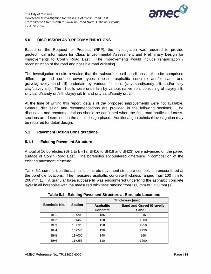
5.1.1 Existing Pavement Structure
A total of 16 boreholes (BH1 to BH12, BH16 to BH18 and BH23) were advanced on the paved
surface of Conlin Road East. The boreholes encountered difference in composition of the
existing pavement structure.
Table 5.1 summarizes the asphaltic concrete pavement structure composition encountered at
the borehole locations. The measured asphaltic concrete thickness ranged from 100 mm to
200 mm (±). A granular base/subbase fill was encountered underlying the asphaltic concrete
layer in all boreholes with the measured thickness ranging from 360 mm to 2750 mm (±).
Table 5.1 - Existing Pavement Structure at Borehole Locations
Borehole No. Station
Thickness (mm)
Asphaltic
Concrete
Sand and Gravel /Gravelly
Sand Fill
BH1 10+200 185 915
BH2 10+460 120 1280
BH3 10+720 150 1250
BH4 10+740 150 2750
BH5 11+000 140 360
BH6 11+255 110 1290
The City of Oshawa
Geotechnical Investigation for Class EA of Conlin Road East
From Simcoe Street North to Townline Road North, Oshawa, Ontario
17 June 2014
AMEC Reference No. TP113039.6000 Page | 15
Borehole No. Station
Thickness (mm)
Asphaltic
Concrete
Sand and Gravel /Gravelly
Sand Fill
BH7 11+510 150 550
BH8 11+770 120 1080
BH9 11+920 120 580
BH10 12+070 100 600
BH11 12+220 100 700
BH12 12+370 100 600
BH16 12+820 110 1290
BH17 12+970 200 500
BH18 12+970 100 700
BH23 13+865 150 550
The investigation results indicated, in general, compacted base/subbase (sand and
gravel/gravelly sand fill) for the existing road with SPT ‘N’ values ranging from 9 to 52 blows
per 0.3 m, i.e., a loose to very dense compactness.
The grain size analysis results conducted on four (4) selected representative samples of sand
and gravel/gravelly sand fill (Boreholes BH1, BH10, BH18 and BH23) generally complied with
the Granular “B”- Type I specifications (Figure No. A1 in Appendix A).
The investigation also revealed that silty clay/clayey silt or silty sand/sandy silt fill or native
soils (clayey silt or silty sand/sandy silt or clayey silt till or silty sand/sandy silt till) formed the
subgrade for the existing road. Considering the subgrade soils within the upper (about) 2 m
below the road surface, the existing fill soils would generally provide competent subgrade
support for rehabilitation / reconstruction as indicated by the N-values of over 15 blows per 0.3
m. Isolated weak zones were noted in Boreholes BH2, BH9, BH13, BH15, BH17, BH19 to
BH22, BH24 and BH29, about 1.5 to 2.0 m below the existing grade as indicated by SPT N-
values ranging from 5 to 15 blows per 0.3 m (loose to compact clayey / sandy soils).
5.1.2 Granular Base Equivalency (GBE)
To assess the existing pavement structure, the in-situ Granular Base Equivalency (GBE)
values were estimated from the borehole data using the following Equivalency Factors (based
on Table 3.5 of the MTO Pavement Design and Rehabilitation Manual):
erial Material Equivalency factor
Existing HL 1.25
Existing Granular Base/Sub-base/Concrete 0.625
For GBE calculation, total granular fill material thickness, measured in the boreholes, was
considered as the granular base/subbase. The existing average GBE is summarized in
The City of Oshawa
Geotechnical Investigation for Class EA of Conlin Road East
From Simcoe Street North to Townline Road North, Oshawa, Ontario
17 June 2014
AMEC Reference No. TP113039.6000 Page | 16
Table 5.2.
Table 5.2 - Existing Pavement Composition at Borehole Locations
Pavement
Condition
Length
m No. of Boreholes
Thickness (mm)
GBE (mm) HMA
Granular
Base/Subbase*
Section 1
Fair to poor 900
4 Boreholes (BH1 to
BH4)
@ MDL
Range (120-185)
Average 150 mm
Range (915-2,750)
Average 1,550 mm
Range (803-1,906)
Average 1,157 mm
Section 2
Fair 725
3 Boreholes (BH5 to
BH7)
@ MDL
Range (140-150)
Average 135 mm
Range (360-1,290)
Average 735 mm
Range (400-944)
Average 625 mm
Section 3
Fair to Poor 900
5 Boreholes (BH8 to
BH12)
@ MDL
Range (100-120)
Average 110 mm
Range (580-1,080)
Average 710 mm
Range (500-825)
Average 580 mm
Section 4
Fair to Poor 750
3 Boreholes (BH16 to
BH18)
@ MDL
Range (100-200)
Average 140 mm
Range (500-1,290)
Average 830 mm
Range (563-944)
Average 690 mm
4 Boreholes (BH13 to
BH15 & BH19)
@ SH
- 700 438
Section 5
Fair 1650
1 Borehole (BH23)
@ MDL 150 550 531
10 Boreholes (BH20 to
BH22 & BH24 to BH30)
@ SH
- Range (300-1,400)
Average 670 mm
Range (188-875)
Average 419 mm
* Combined thickness of existing Granular A and Granular B. MDL = Mid-Driving Lane SH = Shoulder
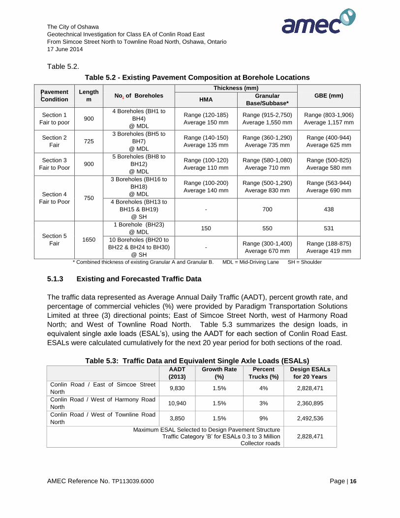
5.1.3 Existing and Forecasted Traffic Data
The traffic data represented as Average Annual Daily Traffic (AADT), percent growth rate, and
percentage of commercial vehicles (%) were provided by Paradigm Transportation Solutions
Limited at three (3) directional points; East of Simcoe Street North, west of Harmony Road
North; and West of Townline Road North. Table 5.3 summarizes the design loads, in
equivalent single axle loads (ESAL’s), using the AADT for each section of Conlin Road East.
ESALs were calculated cumulatively for the next 20 year period for both sections of the road.
Table 5.3: Traffic Data and Equivalent Single Axle Loads (ESALs)
AADT
(2013)
Growth Rate
(%)
Percent
Trucks (%)
Design ESALs
for 20 Years
Conlin Road / East of Simcoe Street
North 9,830 1.5% 4% 2,828,471
Conlin Road / West of Harmony Road
North 10,940 1.5% 3% 2,360,895
Conlin Road / West of Townline Road
North 3,850 1.5% 9% 2,492,536
Maximum ESAL Selected to Design Pavement Structure Traffic Category ‘B’ for ESALs 0.3 to 3 Million
Collector roads 2,828,471
The City of Oshawa
Geotechnical Investigation for Class EA of Conlin Road East
From Simcoe Street North to Townline Road North, Oshawa, Ontario
17 June 2014
AMEC Reference No. TP113039.6000 Page | 17
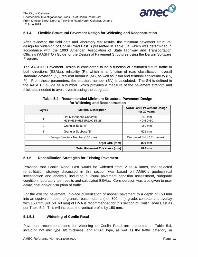
5.1.4 Flexible Structural Pavement Design for Widening and Reconstruction
After reviewing the field data and laboratory test results, the minimum pavement structural design for widening of Conlin Road East is presented in Table 5.4, which was determined in accordance with the 1993 American Association of State Highway and Transportation Officials (‘AASHTO’) Guide for the Design of Pavement Structures using the Darwin Software Program.
The AASHTO Pavement Design is considered to be a function of estimated future traffic in
both directions (ESALs), reliability (R), which is a function of road classification, overall
standard deviation (So), resilient modulus (Mr), as well as initial and terminal serviceability (Po,
Pt). From these parameters, the structure number (SN) is calculated. The SN is defined in
the AASHTO Guide as a number, which provides a measure of the pavement strength and
thickness needed to avoid overstressing the subgrade.
Table 5.4 - Recommended Minimum Structural Pavement Design for Widening and Reconstruction
Layers Material Description AASHTO’93 Pavement Design
for 20 years
1 Hot Mix Asphalt Concrete
HL3+HL8+HL8 (PGAC 58-28)
150 mm
40+50+60
2 Granular Base ‘A’ 150 mm
3 Granular Subbase ‘B’ 525 mm
Design Structure Number (130 mm) Calculated SN = 131 mm (ok).
Target GBE (mm) 800 mm
Total Pavement Thickness (mm) 825 mm
5.1.5 Rehabilitation Strategies for Existing Pavement
Provided that Conlin Road East would be widened from 2 to 4 lanes, the selected
rehabilitation strategy discussed in this section was based on AMEC’s geotechnical
investigation and analysis, including a visual pavement condition assessment, subgrade
condition, laboratory test results and calculated ESALs. Consideration was also given to user
delay, cost and/or disruption of traffic.
For the existing pavement, in-place pulverization of asphalt pavement to a depth of 150 mm
into an equivalent depth of granular base material (i.e., 300 mm), grade, compact and overlay
with 150 mm (40+50+60 mm) of HMA is recommended for this section of Conlin Road East as
per Table 5.4. This will increase the vertical profile by 150 mm.
5.1.5.1 Widening of Conlin Road
Pavement recommendations for widening of Conlin Road are presented in Table 5.4,
including hot mix type, lift thickness, and PGAC type, as well as the traffic category, in

The City of Oshawa
Geotechnical Investigation for Class EA of Conlin Road East
From Simcoe Street North to Townline Road North, Oshawa, Ontario
17 June 2014
AMEC Reference No. TP113039.6000 Page | 18
accordance with OPSS 1151. The granular thicknesses of the widening given in the table is a
minimum thickness and should match the adjacent existing pavement granular thickness to
promote positive lateral drainage. Also, the thicknesses can be increased depending on
grading requirements.
Full depth excavation, as required and commencing from the existing edge of pavement, will
be required in widening sections to accommodate the proposed design thickness. The
excavated granular materials from the shoulder in the rural sections can be re-used as fill
material for the widening/embankment, provided it is not contaminated. New Granular B
subbase can then be added and compacted, followed by new Granular A base material. Both
base and subbase can vary in thickness to match the adjacent existing pavement granular in
order to promote positive lateral drainage. The Granular A base course should be compacted,
and overlain with 2 lifts of HL 8 or SP19.0 mm binder course and 1 lift of HL 3 or SP12.5 FC2
surface course, as per Table 5.4. Installation of subdrain is recommended, if lateral drainage
of the existing subgrade is not possible.
5.1.6 Construction Consideration
The pavement design considers that construction will be carried out during the drier time of
the year and that the subgrade is stable. If the subgrade becomes excessively wet or rutted
during construction activities, additional sub-base material may be required. The need for
additional subbase material is best determined during construction. For the pavement to
function properly, provision must be made for water to drain out of the granular course.
All of the pavement elements should satisfy the relevant OPS specifications.
• Asphaltic Concrete
The asphaltic concrete should be hot-mixed, hot-laid. The placing, spreading and rolling
should be in accordance with Ontario Provincial Standard Specifications 310.
• Reuse of Existing Granular and Soil Fill
The existing sand and gravel/gravelly sand fill and various soil fills can be re-used as fill,
provided that they are not contaminated with cohesive soils and/or organic matter during
excavation. Such materials should be evaluated and monitored on site by a geotechnical
engineer.
Tested samples of existing sand and gravel/gravelly sand fill showed that the materials did not
meet the OPSS Granular A specifications (Figure No. A1). The samples marginally did not
meet OPSS Granular B Type I specifications. The existing sand and gravel/gravelly sand fill
and various soil fills can be used as fill, provided that they are not contaminated with cohesive
soils and/or organic matter during excavation. Such materials should be evaluated and
monitored on site by a geotechnical engineer.
The City of Oshawa
Geotechnical Investigation for Class EA of Conlin Road East
From Simcoe Street North to Townline Road North, Oshawa, Ontario
17 June 2014
AMEC Reference No. TP113039.6000 Page | 19
• Recycled Materials
The milled / reclaimed asphaltic concrete may be recycled and blended with granular soils to
be used on the shoulders during the new construction for widening.
• Compaction of Base and Subbase
In all areas, asphaltic concrete should be placed in maximum 50 mm lifts and compacted as
per OPSS 310 (using Maximum Relative Density, MRD), while the granular base and subbase
should be placed in 100 mm in loose lifts and compacted to at least 100% standard Proctor
maximum dry density.
5.2 Bridge Foundations
The existing Glover Bridge located over Oshawa Creek as shown in Figure No. 2A is a
concrete rigid frame structure with an asphalt wearing surface. The bridge superstructure is
supported on reinforced concrete abutments founded on steel tube piles filled with concrete.
Boreholes BH3 and BH4 were drilled on the opposite sides of the existing Glover Bridge at the
west branch of Oshawa Creek. The boreholes encountered fill soils extending to a depth of
about 7.0 m below the road surface. Stiff clayey silt and/or compact to very dense silty sand
was encountered below the fill soils.
5.2.1 Shallow Foundation
Based on the investigation results, the use of conventional spread / strip footings may be
considered for supporting the bridge widening. Footings could be founded within the native
clayey silt and/or silty sand. However, using shallow foundations could lead to significant
differential settlement between the new bridge structure supported by shallow foundations and
the existing bridge structure supported by steel tube piles.
The recommended footing depths, Geotechnical Reaction at Serviceability Limit State (SLS)
and factored Geotechnical Resistance at Ultimate Limit State (factored ULS) for spread
footings are given in Table 5.5 based on Boreholes BH3 and BH4.
For bridge widening, shallow foundations at a depth of more than 7.0 m adjacent to the
existing steel tube piles may not be practical for construction.
The City of Oshawa
Geotechnical Investigation for Class EA of Conlin Road East
From Simcoe Street North to Townline Road North, Oshawa, Ontario
17 June 2014
AMEC Reference No. TP113039.6000 Page | 20
Table 5.5 - Geotechnical Reaction (SLS) and Resistance (ULS)
Borehole
Number
Foundation
Soil Strata
Approximate Depth
below Existing
Grade (m)
Geotechnical
Reaction at SLS
(kPa)
Geotechnical
Resistance at
Factored ULS (1)
(kPa)
BH3
(West
abutment)
Stiff Clayey Silt 7.0 - 8.5 m () 125 180
Compact to very dense
Silty Sand
below 8.5 m () 200 300
BH4
(East
abutment)
Compact to very dense
Silty Sand below 7.0 m () 200 300
(1) A resistance factor of Φ = 0.5 has been applied to the values provided.
Both SLS and ULS values shown on Table 5.5 are applicable for a concentrically loaded
spread footing founded on the soil type indicated. The values provided are for initial sizing of
footings. Detail foundation analysis should be carried out to confirm the ULS / SLS values
together with foundation settlement.
The geotechnical horizontal resistance (against sliding) for spread footings should be
designed using a coefficient of friction between concrete and subgrade of 0.3 which includes a
resistance factor of 0.8.
The minimum footing sizes, footing thickness, excavations and other footing requirements
should be designed in accordance to the latest edition of the Canadian Highway Bridge
Design Code.
The design frost penetration for the general area is 1.2 m. Therefore, a permanent soil cover
of 1.2 m or its thermal equivalent is required for frost protection of foundations.
For footings designed and constructed in accordance with the above SLS values, total and
differential settlements should be less than 25 mm and 20 mm, respectively. Detailed
foundation analysis should be conducted for confirmation.
The new bridge footings will have to be protected against scour and erosion by providing rip-
rap, vegetative cover, or equivalent. Scour protection should be designed by an experienced
engineer.
The excavations and dewatering for the construction of the footings should follow the
procedures provided in Section 5.6. During construction, the groundwater level should be
lowered by a minimum of 1 m below the footing founding level. Excavation adjacent to the
existing steel tube piles should be carried out without disturbing the stability of the steel tube
piles.
The City of Oshawa
Geotechnical Investigation for Class EA of Conlin Road East
From Simcoe Street North to Townline Road North, Oshawa, Ontario
17 June 2014
AMEC Reference No. TP113039.6000 Page | 21
The footing subgrade should be inspected and evaluated by a geotechnical engineer prior to
concreting to confirm that the footings are founded on competent subgrade capable of
supporting the recommended design pressure.
5.2.2 Deep Foundations
According to the information provided by the City, the existing bridge is supported on
reinforced concrete abutments founded on 6.0 m to 10.5 m long steel tube piles.
Based on the soil conditions encountered in Boreholes BH3 and BH4 drilled approximately at
the potential locations of new abutments during this investigation, deep foundations, i.e., steel
‘H’ piles founded in dense to very dense silty sand may be capable for supporting the bridge
structure. The piles should be driven into the competent native soil / till strata. However,
driving H piles adjacent to the existing steel piles will likely disturb the existing bridge
foundations. Augered cast-in-place caissons should be considered if disturbance from pile
driving cannot be tolerated by the existing bridge structure.
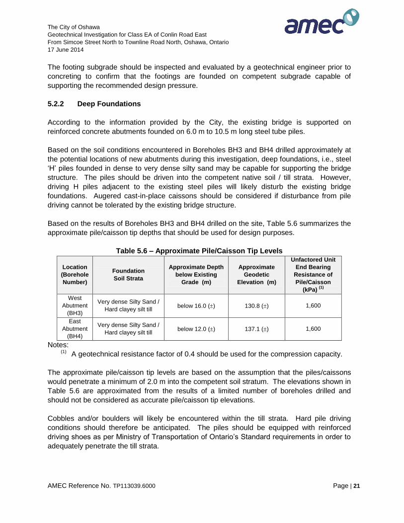
Based on the results of Boreholes BH3 and BH4 drilled on the site, Table 5.6 summarizes the
approximate pile/caisson tip depths that should be used for design purposes.
Table 5.6 – Approximate Pile/Caisson Tip Levels
Location
(Borehole
Number)
Foundation
Soil Strata
Approximate Depth
below Existing
Grade (m)
Approximate
Geodetic
Elevation (m)
Unfactored Unit
End Bearing
Resistance of
Pile/Caisson
(kPa) (1)
West
Abutment
(BH3)
Very dense Silty Sand /
Hard clayey silt till below 16.0 () 130.8 () 1,600
East
Abutment
(BH4)
Very dense Silty Sand /
Hard clayey silt till below 12.0 () 137.1 () 1,600
Notes: (1) A geotechnical resistance factor of 0.4 should be used for the compression capacity.
The approximate pile/caisson tip levels are based on the assumption that the piles/caissons
would penetrate a minimum of 2.0 m into the competent soil stratum. The elevations shown in
Table 5.6 are approximated from the results of a limited number of boreholes drilled and
should not be considered as accurate pile/caisson tip elevations.
Cobbles and/or boulders will likely be encountered within the till strata. Hard pile driving
conditions should therefore be anticipated. The piles should be equipped with reinforced
driving shoes as per Ministry of Transportation of Ontario’s Standard requirements in order to
adequately penetrate the till strata.
The City of Oshawa
Geotechnical Investigation for Class EA of Conlin Road East
From Simcoe Street North to Townline Road North, Oshawa, Ontario
17 June 2014
AMEC Reference No. TP113039.6000 Page | 22
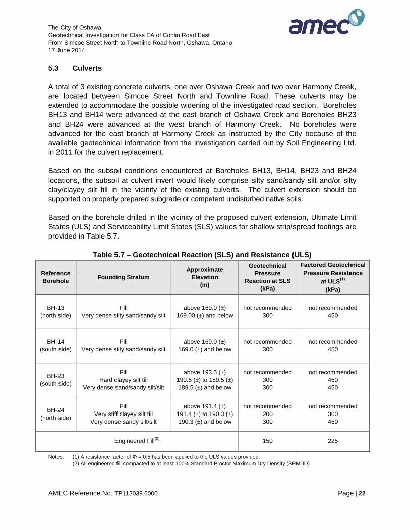
5.3 Culverts
A total of 3 existing concrete culverts, one over Oshawa Creek and two over Harmony Creek,
are located between Simcoe Street North and Townline Road. These culverts may be
extended to accommodate the possible widening of the investigated road section. Boreholes
BH13 and BH14 were advanced at the east branch of Oshawa Creek and Boreholes BH23
and BH24 were advanced at the west branch of Harmony Creek. No boreholes were
advanced for the east branch of Harmony Creek as instructed by the City because of the
available geotechnical information from the investigation carried out by Soil Engineering Ltd.
in 2011 for the culvert replacement.
Based on the subsoil conditions encountered at Boreholes BH13, BH14, BH23 and BH24
locations, the subsoil at culvert invert would likely comprise silty sand/sandy silt and/or silty
clay/clayey silt fill in the vicinity of the existing culverts. The culvert extension should be
supported on properly prepared subgrade or competent undisturbed native soils.
Based on the borehole drilled in the vicinity of the proposed culvert extension, Ultimate Limit
States (ULS) and Serviceability Limit States (SLS) values for shallow strip/spread footings are
provided in Table 5.7.
Table 5.7 – Geotechnical Reaction (SLS) and Resistance (ULS)
Reference
Borehole Founding Stratum
Approximate
Elevation
(m)
Geotechnical
Pressure
Reaction at SLS
(kPa)
Factored Geotechnical
Pressure Resistance
at ULS(1)
(kPa)
BH-13
(north side)
Fill
Very dense silty sand/sandy silt
above 169.0 (±)
169.00 (±) and below
not recommended
300
not recommended
450
BH-14
(south side)
Fill
Very dense silty sand/sandy silt
above 169.0 (±)
169.0 (±) and below
not recommended
300
not recommended
450
BH-23
(south side)
Fill
Hard clayey silt till
Very dense sand/sandy silt/silt
above 193.5 (±)
190.5 (±) to 189.5 (±)
189.5 (±) and below
not recommended
300
300
not recommended
450
450
BH-24
(north side)
Fill
Very stiff clayey silt till
Very dense sandy silt/silt
above 191.4 (±)
191.4 (±) to 190.3 (±)
190.3 (±) and below
not recommended
200
300
not recommended
300
450
Engineered Fill(2) 150 225
Notes: (1) A resistance factor of Φ = 0.5 has been applied to the ULS values provided.
(2) All engineered fill compacted to at least 100% Standard Proctor Maximum Dry Density (SPMDD).
The City of Oshawa
Geotechnical Investigation for Class EA of Conlin Road East
From Simcoe Street North to Townline Road North, Oshawa, Ontario
17 June 2014
AMEC Reference No. TP113039.6000 Page | 23
Both SLS and ULS values shown on Table 5.7 are applicable for a concentrically loaded
spread footing founded on the soil type indicated. Detailed foundation analysis should be
carried out to confirm the ULS / SLS values together with foundation settlement.
The new culvert footings will have to be protected against scour and erosion by providing rip-
rap, vegetative cover, or equivalent. Scour protection should be designed by an experienced
engineer.
The excavations and dewatering for the construction of the footings should follow the
procedures provided in Section 5.6. During construction, the groundwater level should be
lowered by a minimum of 1 m below the footing founding level.
The footing subgrade should be inspected and evaluated by a geotechnical engineer prior to
concreting to confirm that the footings are founded on competent subgrade capable of
supporting the recommended design pressure.
5.4 Road Embankment Widening
The proposed improvements of Conlin Road East include widening on both sides of the
existing road. It should be noted that there will be a minor widening on both sides of the road
at the west end as well as a full reconstruction with profile adjustment at the east end of this
section of the Conlin Road.
To prepare the subgrade for the road widening, the existing topsoil, vegetation any deleterious
material, soft/loose and other unsuitable soils should be stripped from the footprint area of the
road widening to a minimum depth of 0.3 m.
Based on the Record of Boreholes, the subgrade is likely to comprise various fill (sand and
gravel/gravelly sand/silty sand/sandy silt and/or silty clay/clayey silt) and/or native soils (clayey
silt and/or sand/silty sand/sandy silt/silt and/or clayey silt till and/or sand/silty sand/sandy silt
till). Isolated weak zones were encountered in Boreholes BH3, BH9, BH13, BH19, BH20,
BH23 and BH24 indicated by SPT N-values ranging from 3 blows to 13 blows per 0.3 m. If
the improved road is wider than the existing road, new fills may be constructed in areas,
where weak soils may be present. Subgrade stabilization using extra granular thickness or
engineered fill placement or similar would be required to protect the integrity of pavement
structure in the vicinity of these boreholes.
Embankment reconstruction, where implemented, should be constructed with in accordance
with OPSD 200.010 (Earth / Shale Grading, Undivided Rural) or OPSD 200.020 (Earth / Shale
Grading, Divided Rural), OPSS 206 (Construction Specification for Grading), and compacted
according to OPSS 501 (Construction Specification for Compacting). It should be noted that
all road embankments that are higher than 4.5 m (high fill) will require slope stability analysis.
The City of Oshawa
Geotechnical Investigation for Class EA of Conlin Road East
From Simcoe Street North to Townline Road North, Oshawa, Ontario
17 June 2014
AMEC Reference No. TP113039.6000 Page | 24
The embankment widening should be constructed with compacted fill at 2H:1V (or flatter) side
slopes. The construction should be carried out in accordance with OPSS 206 (Construction
Specification for Grading), and compacted according to OPSS 501 (Construction Specification
for Compacting). For widening the existing road embankment, the new fill should be
constructed with benching according to OPSD – 208.010 (Benching of Earth Slopes). The
additional slope to the existing slope should be properly benched into the existing slope and
the new fill should be properly compacted. The selection, placement and compaction of the fill
should be carried out under a geotechnical control program.
For subgrade preparation, all loose / soft fill soils / deleterious materials, if exposed, should be
removed from the area of the proposed roadways. The exposed subgrade should be proof-
rolled with a heavy sheep-foot roller to identify weak areas and / or inspected by a
geotechnical engineer. Any weak or excessively wet zones identified during proof-rolling
should be sub-excavated and replaced with compacted competent material to establish stable
and uniform conditions. Fill, if required for site grading in the widening areas, should be
placed as engineered fill to provide competent subgrade. Prior to placement of engineered fill,
the subgrade should be inspected and approved by a geotechnical engineer. The fill should
be placed in lifts not exceeding 200 mm, and each lift should be uniformly compacted to at
least 95% of the material’s Standard Proctor Maximum Dry Density (SPMDD), except for the
top 0.6 m which should be compacted to at least 98% of SPMDD.
Subgrade preparation should not be done in the winter. Drainage layers and / or subdrains
should be designed and installed to prevent any water accumulation under pavement surface
at all times. The final subgrade surface should be sloped at least 3% to drain towards the
subdrain system or drainage ditches as appropriate. Drainage requirements are also
discussed in Section 5.5.
It should be noted that roadway widening may also require slope stability analyses for all
slopes higher than 2 m. Additional geotechnical investigation is recommended for the areas
where the road is to be widened.
5.5 Drainage
The investigated Conlin Road East section consisted of, at the time of investigation, 2 lanes
with mixed urban and rural setting (curbs and gutter and / or drainage ditch).
Adequate drainage should be provided both laterally and longitudinally along the length of the
road section, as part of the road widening work.
If a rural cross-section is proposed, the base granulars should extend across the full width of
the roadway and should daylight in the ditches. If drainage through granular soils underneath
pavement is considered not sufficient, subdrains should be installed.
The City of Oshawa
Geotechnical Investigation for Class EA of Conlin Road East
From Simcoe Street North to Townline Road North, Oshawa, Ontario
17 June 2014
AMEC Reference No. TP113039.6000 Page | 25
Where an urban cross-section is proposed, a continuous subdrain system designed to freely
drain into catch basins will be required. The drainage system should consist of a 150 mm
diameter to be installed, below the roadbed level, along both sides to ensure effective
drainage in accordance with OPSD 216.021. The sub-drain pipes should be surrounded by
20 mm size clear stone drainage zone of minimum 150 mm thickness, which should have
non-woven geotextile with FOS of 75 - 150 μm, Class II wraparound to minimize infiltration of
fines in pipes which would reduce their effectiveness.
A minimum slope of 2% should be maintained across the paved sections to ensure proper
surface drainage.
Continuity of drainage through the granular road base and subbase layers should be
maintained between the existing and new pavement structures. In this regard, the granular
thickness for new pavement structure may have to be adjusted to match the granular fill
encountered under the existing pavement.
5.6 Excavation and Dewatering
All excavations should be carried out in accordance with the Ontario Health and Safety
Regulations. The soils to be excavated can be classified as follows:
Existing sand and gravel/gravelly sand fill Type 3
Existing silty clay/clayey silt fill Type 3
Existing silty sand/sandy silt fill Type 3
Stiff to very stiff clayey silt Type 2
Compact to very dense silty sand/sandy silt/silt Type 2
Stiff to very stiff clayey silt till Type 2
Compact to very dense silty sand/sandy silt till Type 2
Accordingly, a bank slope of 1H:1V is required in for excavations in Type 2 and Type 3 soils
accordance with the Ontario Health and Safety Regulations. For Type 2 soils, a 1.2 m high
vertical cut at the bottom of excavation may generally be constructed. However, a vertical cut
in sandy soils under groundwater table may not be stable and flatter slopes or temporary
shoring may be required. Near the ground surface, occasional 3H:1V slopes may be required
due to loose/soft surficial soils. If open cut cannot be carried out, a shoring system (e.g.
trench box) may be used to limit the extent of excavations, subject to engineering design and
approval.
For all temporary cut slopes / trenches, the stability of the temporary cut slopes / trenches will
have to be frequently monitored by the geotechnical engineer. If the cut slopes / trenches are
subject to erosion (e.g., due to rainfall, high groundwater flow, etc.), slope stabilization
measures (e.g., covering the slope / trench faces with plastic sheets, excavating flatter slope,
etc.) will have to be implemented. If open cut cannot be carried out, a properly designed
shoring system / trench box may be used to support the sides of excavations. The shoring
The City of Oshawa
Geotechnical Investigation for Class EA of Conlin Road East
From Simcoe Street North to Townline Road North, Oshawa, Ontario
17 June 2014
AMEC Reference No. TP113039.6000 Page | 26
system design should be carried out in accordance with the Canadian Foundation Engineering
Manual, 4th Edition.
Stockpiles of excavated materials should be kept at least 3.0 m from the edge of the
excavation to avoid slope instability, subject to confirmation by the geotechnical engineer.
Care should also be taken to avoid overloading of any underground services / structures by
stockpiles.
No major excavation difficulties are foreseen in the existing soils, but allowance should always
be made for boulders and cobbles possible present in subsurface soils. The terms describing
the compactness (loose, compact, dense, and very dense) or consistency (stiff, very stiff and
hard) of soil strata give an indication of the effort needed for excavation. It should be noted
that hard/very dense soils may require additional excavation effort / equipment (e.g. impact
hammer, excavation with rippers, etc.).
Based on groundwater level observations, a series of filtered sumps and pumps or well points
may be needed to dewater groundwater seepage from the sandy soils at Borehole BH1 to
BH5, BH7, BH9 to BH 16, BH19 and BH23 to BH25 locations. Water seepage in the silty
clay/clayey silt fill and/or clayey silt and/or clayey silt till should be manageable through gravity
drainage and/or a filtered sump and pump system. However, a significant seepage is
anticipated through the gravelly sand/sand and gravel fill, silty sand/sandy silt fill, silty
sand/sandy silt/silt and/or silty sand/sandy silt till deposits. Therefore, the use of a series of
temporary filtered sumps and pumps, and probably well points, may be required during
construction. Test pits should be excavated to evaluate the appropriate method of dewatering
prior to construction.
AMEC Reference No. TP113039.6000 Page | 28
AMEC Environment & Infrastructure,
a Division of AMEC Americas Limited
REPORT LIMITATIONS
The conclusions and recommendations given in this report are based on information determined
at the test hole locations. The information contained herein in no way reflects on the
environmental aspects of the project, unless otherwise stated. Subsurface and groundwater
conditions between and beyond the test holes may differ from those encountered at the test
hole locations, and conditions may become apparent during construction, which could not be
detected or anticipated at the time of the site investigation. It is recommended practice that the
Geotechnical Engineer be retained during the construction to confirm that the subsurface
conditions across the site do not deviate materially from those encountered in the test holes.
The design recommendations given in this report are applicable only to the project described in
the text, and then only if constructed substantially in accordance with the details stated in this
report. Since all details of the design may not be known, AMEC recommend that AMEC be
retained during the final design stage to verify that the design is consistent with AMEC
recommendations, and that assumptions made in AMEC analysis are valid.
The comments made in this report relating to potential construction problems and possible
methods of construction are intended only for the guidance of the designer. The number of test
holes may not be sufficient to determine all the factors that may affect construction methods and
costs. For example, the thickness of surficial topsoil or fill layers may vary markedly and
unpredictably. The contractors bidding on this project or undertaking the construction should,
therefore, make their own interpretation of the factual information presented and draw their own
conclusions as to how the subsurface conditions may affect their work. This work has been
undertaken in accordance with normally accepted geotechnical engineering practices. No other
warranty is expressed or implied.
The elevations mentioned in this report were obtained strictly for use by this office in the
geotechnical design of the project. They should not be used by any other party for any other
purpose.
Any use which a third party makes of this report, or any reliance on or decisions to be made
based on it, are the responsibility of such third parties. AMEC Environment & Infrastructure
accepts no responsibility for damages, if any, suffered by any third party as a result of decisions
made or actions based on this report.

FIGURES
a Division of AMEC Americas Limited
SITE LOCATION PLAN
OCTOBER 2013
FIGURE No.
TP113039
1
REV. NO.:
PROJECT NO:
DATE:
A
104 Crockford Boulevard, Scarborough, Ontario, M1R 3C3
N.T.S.
-
PROJECTION:
-
DATUM:
DWN BY:
CHK'D BY:
SCALE:
SN
KW
PROJECT
TITLECLIENTCLIENT LOGO
AMEC Environment & Infrastructure, CONTRACT No.
C2013-003
THE CORPORATION OF THE CITY OF OSHAWA
PRELIMINARY
GEOTECHNICAL INVESTIGATION
CONLIN ROAD EAST FROM SIMCOE STREET NORTH TO TOWNLINE ROAD NORTH
OSHAWA, ONTARIO
SITE
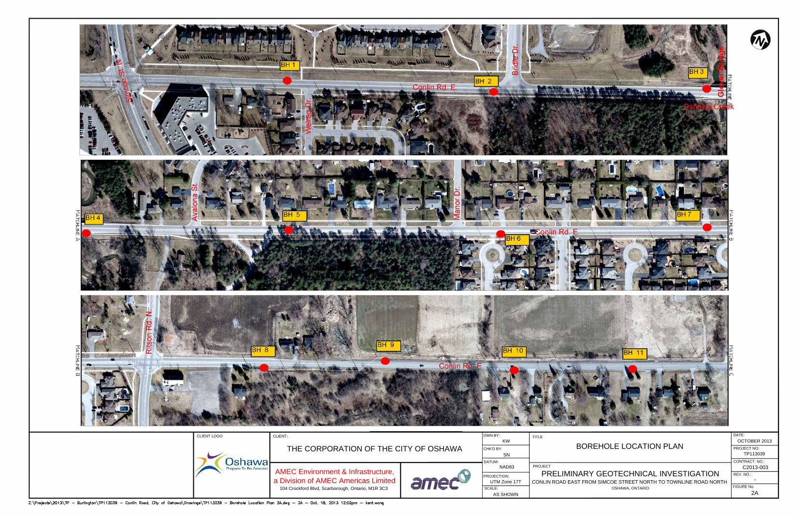
UTM Zone 17T
PROJECTION:
NAD83
DATUM:
BOREHOLE LOCATION PLAN
TITLE
PROJECT
CLIENT LOGO
FIGURE No.
104 Crockford Blvd, Scarborough, Ontario, M1R 3C3
AMEC Environment & Infrastructure,
a Division of AMEC Americas Limited
THE CORPORATION OF THE CITY OF OSHAWA
CONTRACT. NO.:
2A
PROJECT NO:
TP113039
C2013-003
CLIENT:
DWN BY:
CHK'D BY:
OCTOBER 2013
DATE:
SCALE:
SN
AS SHOWN
KW
PRELIMINARY GEOTECHNICAL INVESTIGATION
CONLIN ROAD EAST FROM SIMCOE STREET NORTH TO TOWNLINE ROAD NORTH
OSHAWA, ONTARIO
-
REV. NO.:
Glo
ve
r B
rid
ge
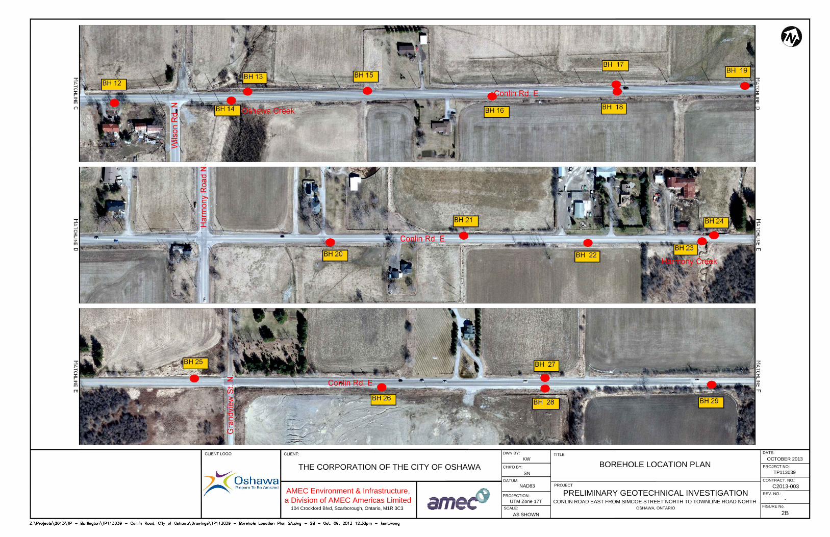
UTM Zone 17T
PROJECTION:
NAD83
DATUM:
BOREHOLE LOCATION PLAN
TITLE
PROJECT
CLIENT LOGO
FIGURE No.
104 Crockford Blvd, Scarborough, Ontario, M1R 3C3
AMEC Environment & Infrastructure,
a Division of AMEC Americas Limited
THE CORPORATION OF THE CITY OF OSHAWA
CONTRACT. NO.:
2B
PROJECT NO:
TP113039
C2013-003
CLIENT:
DWN BY:
CHK'D BY:
OCTOBER 2013
DATE:
SCALE:
SN
AS SHOWN
KW
PRELIMINARY GEOTECHNICAL INVESTIGATION
CONLIN ROAD EAST FROM SIMCOE STREET NORTH TO TOWNLINE ROAD NORTH
OSHAWA, ONTARIO
-
REV. NO.:
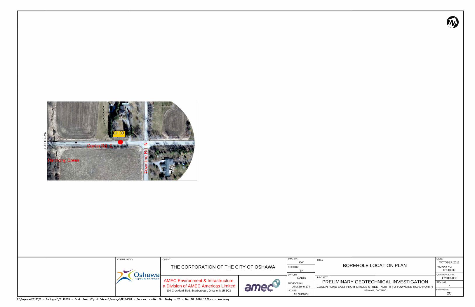
UTM Zone 17T
PROJECTION:
NAD83
DATUM:
BOREHOLE LOCATION PLAN
TITLE
PROJECT
CLIENT LOGO
FIGURE No.
104 Crockford Blvd, Scarborough, Ontario, M1R 3C3
AMEC Environment & Infrastructure,
a Division of AMEC Americas Limited
THE CORPORATION OF THE CITY OF OSHAWA
CONTRACT. NO.:
2C
PROJECT NO:
TP113039
C2013-003
CLIENT:
DWN BY:
CHK'D BY:
OCTOBER 2013
DATE:
SCALE:
SN
AS SHOWN
KW
PRELIMINARY GEOTECHNICAL INVESTIGATION
CONLIN ROAD EAST FROM SIMCOE STREET NORTH TO TOWNLINE ROAD NORTH
OSHAWA, ONTARIO
-
REV. NO.:

RECORD OF BOREHOLES
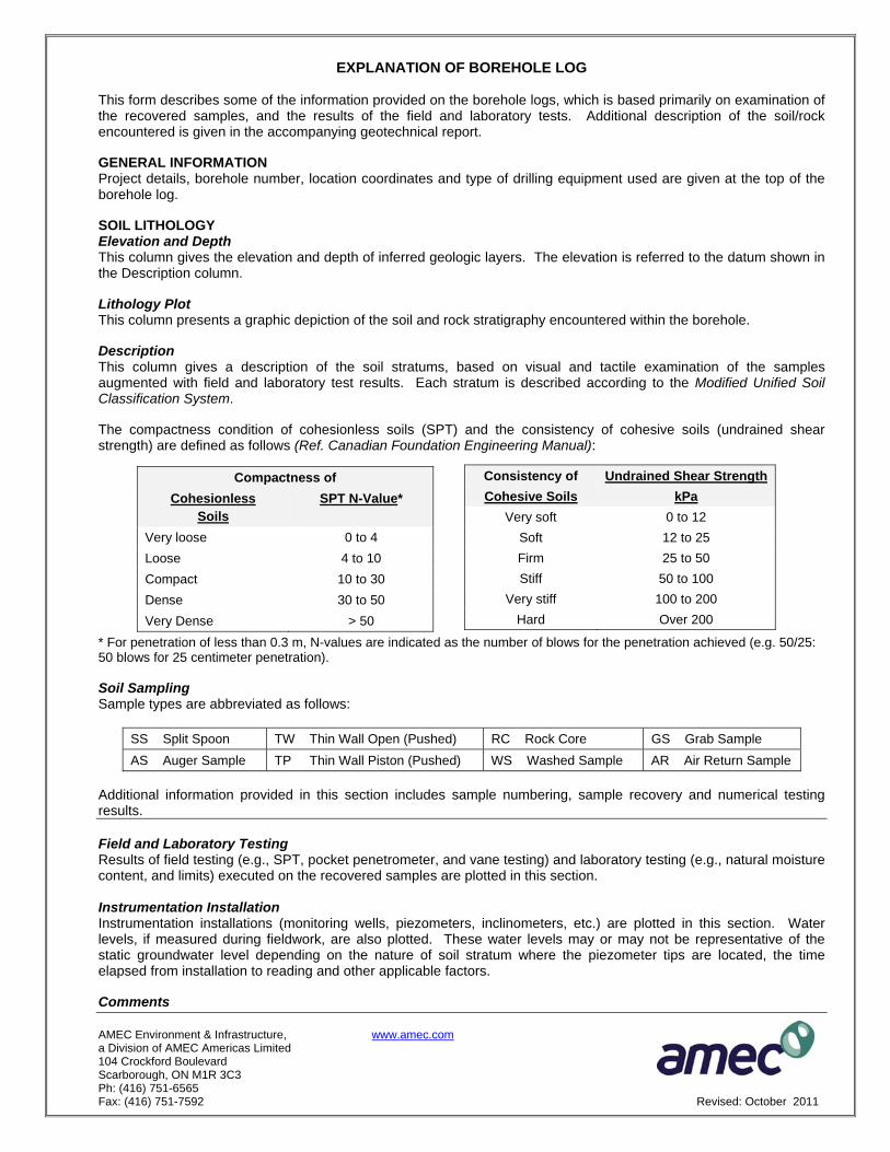
AMEC Environment & Infrastructure, www.amec.com a Division of AMEC Americas Limited 104 Crockford Boulevard Scarborough, ON M1R 3C3 Ph: (416) 751-6565 Fax: (416) 751-7592 Revised: October 2011
EXPLANATION OF BOREHOLE LOG This form describes some of the information provided on the borehole logs, which is based primarily on examination of the recovered samples, and the results of the field and laboratory tests. Additional description of the soil/rock encountered is given in the accompanying geotechnical report. GENERAL INFORMATION Project details, borehole number, location coordinates and type of drilling equipment used are given at the top of the borehole log. SOIL LITHOLOGY Elevation and Depth This column gives the elevation and depth of inferred geologic layers. The elevation is referred to the datum shown in the Description column. Lithology Plot This column presents a graphic depiction of the soil and rock stratigraphy encountered within the borehole. Description This column gives a description of the soil stratums, based on visual and tactile examination of the samples augmented with field and laboratory test results. Each stratum is described according to the Modified Unified Soil Classification System. The compactness condition of cohesionless soils (SPT) and the consistency of cohesive soils (undrained shear strength) are defined as follows (Ref. Canadian Foundation Engineering Manual):
* For penetration of less than 0.3 m, N-values are indicated as the number of blows for the penetration achieved (e.g. 50/25: 50 blows for 25 centimeter penetration). Soil Sampling Sample types are abbreviated as follows:
SS Split Spoon TW Thin Wall Open (Pushed) RC Rock Core GS Grab Sample AS Auger Sample TP Thin Wall Piston (Pushed) WS Washed Sample AR Air Return Sample
Additional information provided in this section includes sample numbering, sample recovery and numerical testing results. Field and Laboratory Testing Results of field testing (e.g., SPT, pocket penetrometer, and vane testing) and laboratory testing (e.g., natural moisture content, and limits) executed on the recovered samples are plotted in this section. Instrumentation Installation Instrumentation installations (monitoring wells, piezometers, inclinometers, etc.) are plotted in this section. Water levels, if measured during fieldwork, are also plotted. These water levels may or may not be representative of the static groundwater level depending on the nature of soil stratum where the piezometer tips are located, the time elapsed from installation to reading and other applicable factors. Comments
Compactness of Cohesionless
Soils SPT N-Value*
Very loose 0 to 4 Loose 4 to 10 Compact 10 to 30 Dense 30 to 50 Very Dense > 50
Consistency of Undrained Shear Strength Cohesive Soils kPa
Very soft 0 to 12 Soft 12 to 25 Firm 25 to 50 Stiff 50 to 100
Very stiff 100 to 200 Hard Over 200
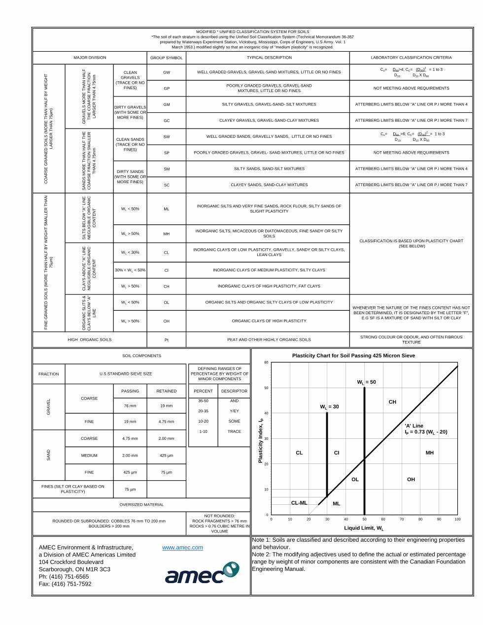
GROUP SYMBOL
GW
GP
GM
GC
SW
SP
SM
SC
WL < 50% ML
WL > 50% MH
WL < 30% CL
30% < WL < 50% CI
WL > 50% CH
WL < 50% OL
WL > 50% OH
Pt
FRACTION
PASSING RETAINED PERCENT DESCRIPTOR
76 mm 19 mm
FINE 19 mm 4.75 mm
COARSE 4.75 mm 2.00 mm
MEDIUM 2.00 mm 425 µm
FINE 425 µm 75 µm
75 µm
DEFINING RANGES OF
PERCENTAGE BY WEIGHT OF
MINOR COMPONENTS
U.S STANDARD SIEVE SIZE
35-50
20-35
10-20
1-10
SOIL COMPONENTS
MODIFIED * UNIFIED CLASSIFICATION SYSTEM FOR SOILS
*The soil of each stratum is described using the Unified Soil Classification System (Technical Memorandum 36-357
prepared by Waterways Experiment Station, Vicksburg, Mississippi, Corps of Engineers, U.S Army. Vol. 1
March 1953.) modified slightly so that an inorganic clay of "medium plasticity" is recognized.
MAJOR DIVISION TYPICAL DESCRIPTION LABORATORY CLASSIFICATION CRITERIA
CLA
YS
AB
OV
E "
A"
LIN
E
NE
GLIG
IBLE
OR
GA
NIC
CO
NT
EN
T
OR
GA
NIC
SLIT
S &
CLA
YS
BE
LO
W "
A"
LIN
E
CO
AR
SE
GR
AIN
ED
SO
ILS
(M
OR
E T
HA
N H
ALF
BY
WE
IGH
T
LA
RG
ER
TH
AN
75µ
m)
GR
AV
ELS
MO
RE
TH
AN
HA
LF
TH
E C
OA
RS
E F
RA
CT
ION
LA
RG
ER
TH
AN
4.7
5m
m
CLEAN
GRAVELS
(TRACE OR NO
FINES)
WELL GRADED GRAVELS, GRAVEL-SAND MIXTURES, LITTLE OR NO FINES
SA
ND
S M
OR
E T
HA
N H
ALF
TH
E
CO
AR
SE
FR
AC
TIO
N S
MA
LLE
R
TH
AN
4.7
5m
m
CLEAN SANDS
(TRACE OR NO
FINES)
WELL GRADED SANDS, GRAVELLY SANDS, LITTLE OR NO FINES
Cu= D60>4; CC= (D30)2
= 1 to 3
D10 D10 X D60
POORLY GRADED GRAVELS, GRAVEL-SAND
MIXTURES, LITTLE OR NO FINESNOT MEETING ABOVE REQUIREMENTS
DIRTY GRAVELS
(WITH SOME OR
MORE FINES)
SILTY GRAVELS, GRAVEL-SAND- SILT MIXTURES ATTERBERG LIMITS BELOW "A" LINE OR P.I MORE THAN 4
CLAYEY GRAVELS, GRAVEL-SAND-CLAY MIXTURES ATTERBERG LIMITS BELOW "A" LINE OR P.I MORE THAN 7
Cu= D60 >6; CC= (D30)2
= 1 to 3
D10 D10 X D60
POORLY GRADED GRAVELS, GRAVEL- SAND MIXTURES, LITTLE OR NO FINES NOT MEETING ABOVE REQUIREMENTS
DIRTY SANDS
(WITH SOME OR
MORE FINES)
SILTY SANDS, SAND-SILT MIXTURES ATTERBERG LIMITS BELOW "A" LINE OR P.I MORE THAN 4
CLAYEY SANDS, SAND-CLAY MIXTURES ATTERBERG LIMITS BELOW "A" LINE OR P.I MORE THAN 7
WHENEVER THE NATURE OF THE FINES CONTENT HAS NOT
BEEN DETERMINED, IT IS DESIGNATED BY THE LETTER "F",
E.G SF IS A MIXTURE OF SAND WITH SILT OR CLAYORGANIC CLAYS OF HIGH PLASTICITY
HIGH ORGANIC SOILS PEAT AND OTHER HIGHLY ORGANIC SOILSSTRONG COLOUR OR ODOUR, AND OFTEN FIBROUS
TEXTURE
FIN
E-G
RA
INE
D S
OIL
S (
MO
RE
TH
AN
HA
LF
BY
WE
IGH
T S
MA
LLE
R T
HA
N
75µ
m)
INORGANIC SILTS AND VERY FINE SANDS, ROCK FLOUR, SILTY SANDS OF
SLIGHT PLASTICITY
CLASSIFICATION IS BASED UPON PLASTICITY CHART
(SEE BELOW)
INORGANIC SILTS, MICACEOUS OR DIATOMACEOUS, FINE SANDY OR SILTY
SOILS
SIL
TS
BE
LO
W "
A"
LIN
E
NE
GLIG
IBLE
OR
GA
NIC
CO
NT
EN
T
INORGANIC CLAYS OF LOW PLASTICITY, GRAVELLY, SANDY OR SILTY CLAYS,
LEAN CLAYS
INORGANIC CLAYS OF MEDIUM PLASTICITY, SILTY CLAYS
INORGANIC CLAYS OF HIGH PLASTICITY, FAT CLAYS
ORGANIC SILTS AND ORGANIC SILTY CLAYS OF LOW PLASTICITY
AMEC Environment & Infrastructure, www.amec.com
a Division of AMEC Americas Limited
104 Crockford Boulevard
Scarborough, ON M1R 3C3
Ph: (416) 751-6565
Fax: (416) 751-7592
GR
AV
EL COARSE
SA
ND
FINES (SILT OR CLAY BASED ON
PLASTICITY)
ROUNDED OR SUBROUNDED: COBBLES 76 mm TO 200 mm
BOULDERS > 200 mm
OVERSIZED MATERIAL
AND
Y/EY
SOME
TRACE
NOT ROUNDED:
ROCK FRAGMENTS > 76 mm
ROCKS > 0.76 CUBIC METRE IN
VOLUME
Note 1: Soils are classified and described according to their engineering properties
and behaviour.
Note 2: The modifying adjectives used to define the actual or estimated percentage
range by weight of minor components are consistent with the Canadian Foundation
Engineering Manual.
WL = 30
WL = 50
CH
CL CI MH
OL OH
CL-ML ML
0
10
20
30
40
50
60
0 10 20 30 40 50 60 70 80 90 100
Pla
sti
cit
y In
de
x,
I P
Liquid Limit, WL
Plasticity Chart for Soil Passing 425 Micron Sieve
'A' Line IP = 0.73 (WL - 20)
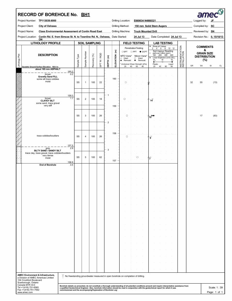
160.2
159.3
157.5
156.9
0.2
1.1
2.9
3.5
1
2
3
4
5
SS
SS
SS
SS
SS
about 185 mm ASPHALT
brownGravelly Sand FILL
some silt trace cobblesmoist
brownCLAYEY SILT
some sand, trace gravelvery stiff
trace cobbles/boulders
greySILTY SAND / SANDY SILT
trace clay, trace gravel, trace cobbles/bouldersvery dense
moist
End of Borehole
100
100
100
100
100
(13)
(83)
55
17
3222
18
26
26
62
Drilling Method:Project Client:
Project Name:
Project Location:
Drilling Machine:
150 mm Solid Stem Augers
Conlin Rd. E. from Simcoe St. N. to Townline Rd. N., Oshawa,ON
Truck Mounted Drill
0, 15/10/13Date Completed:
Reviewed by:
Revision No.:Date Started:
Class Environmental Assessment of Conlin Road East
SC
SN
City of Oshawa Compiled by:
24 Jul 13 24 Jul 13
SOIL SAMPLING
Sam
ple
Typ
e
Sam
ple
Num
ber
LITHOLOGY PROFILE FIELD TESTING
Rec
over
y (%
)
Lith
olog
y P
lot
LAB TESTINGCOMMENTS
&GRAIN SIZE
DISTRIBUTION(%)
SP
T 'N
' / R
QD
DCPT
* Undrained Shear Strength (kPa)
(m)
(m)
EL
EV
AT
IONDESCRIPTION
20 40 60 80
Intact
INS
TR
UM
EN
TA
TIO
NIN
ST
ALL
AT
ION
Remould
PenetrationTesting
DE
PT
H RemouldIntact
Nilcon Vane*MTO Vane*
Geodetic Ground Surface Elevation: 160.4 m
PPTSPT
20 40 60 80
2 4 6 8 10 12
Soil Vapour Reading
W WL
Rinse pH Values
parts per million (ppm)
Lower Explosive Limit (LEL)
PlasticCL
100 200 300 400
SISAGRLiquid
WP
a Division of AMEC Americas Limited104 Crockford BoulevardScarborough, OntarioCanada M1R 3C3Tel +1(416) 751-6565Fax +1(416) 751-7592www.amec.com
AMEC Environment & Infrastructure,
Logged by:Project Number: Drilling Location:TP113039.6000
160
159
158
157
1
2
3
E669034 N4868321
RECORD OF BOREHOLE No. BH1
Page: 1 of 1
JF
Scale: 1 : 39Borehole details as presented, do not constitute a thorough understanding of all potential conditions present and require interpretative assistance froma qualified Geotechnical Engineer. Also, borehole information should be read in conjunction with the geotechnical report for which it wascommissioned and the accompanying'Explanation of Borehole Log'.
2
14
10
9
7
No freestanding groundwater measured in open borehole on completion of drilling.
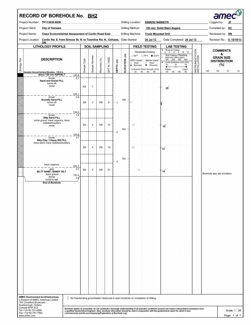
155.8
155.1
154.5
153.8
152.7
152.4
0.1
0.8
1.4
2.1
3.2
3.5
Borehole was wet at bottom.
1
2
3
4
5
AS
SS
SS
SS
SS
about 120 mm ASPHALT
brownSand and Gravel FILL
some siltmoist
brownGravelly Sand FILL
some siltmoist
brownSilty Sand FILL
some gravel, trace organics, tracecobbles/boulders
moist
brownSilty Clay / Clayey Silt FILL
trace sand, trace cobbles/boulders
trace organics
greySILTY SAND / SANDY SILT
trace graveldense
moist to wetEnd of Borehole
100
100
100
100
6
14
13
31
Drilling Method:Project Client:
Project Name:
Project Location:
Drilling Machine:
150 mm Solid Stem Augers
Conlin Rd. E. from Simcoe St. N. to Townline Rd. N., Oshawa,ON
Truck Mounted Drill
0, 15/10/13Date Completed:
Reviewed by:
Revision No.:Date Started:
Class Environmental Assessment of Conlin Road East
SC
SN
City of Oshawa Compiled by:
24 Jul 13 24 Jul 13
SOIL SAMPLING
Sam
ple
Typ
e
Sam
ple
Num
ber
LITHOLOGY PROFILE FIELD TESTING
Rec
over
y (%
)
Lith
olog
y P
lot
LAB TESTINGCOMMENTS
&GRAIN SIZE
DISTRIBUTION(%)
SP
T 'N
' / R
QD
DCPT
* Undrained Shear Strength (kPa)
(m)
(m)
EL
EV
AT
IONDESCRIPTION
20 40 60 80
Intact
INS
TR
UM
EN
TA
TIO
NIN
ST
ALL
AT
ION
Remould
PenetrationTesting
DE
PT
H RemouldIntact
Nilcon Vane*MTO Vane*
Geodetic Ground Surface Elevation: 155.9 m
PPTSPT
20 40 60 80
2 4 6 8 10 12
Soil Vapour Reading
W WL
Rinse pH Values
parts per million (ppm)
Lower Explosive Limit (LEL)
PlasticCL
100 200 300 400
SISAGRLiquid
WP
a Division of AMEC Americas Limited104 Crockford BoulevardScarborough, OntarioCanada M1R 3C3Tel +1(416) 751-6565Fax +1(416) 751-7592www.amec.com
AMEC Environment & Infrastructure,
Logged by:Project Number: Drilling Location:TP113039.6000
155
154
153
1
2
3
E669252 N4868379
RECORD OF BOREHOLE No. BH2
Page: 1 of 1
JF
Scale: 1 : 39Borehole details as presented, do not constitute a thorough understanding of all potential conditions present and require interpretative assistance froma qualified Geotechnical Engineer. Also, borehole information should be read in conjunction with the geotechnical report for which it wascommissioned and the accompanying'Explanation of Borehole Log'.
25
4
15
13
14
No freestanding groundwater measured in open borehole on completion of drilling.
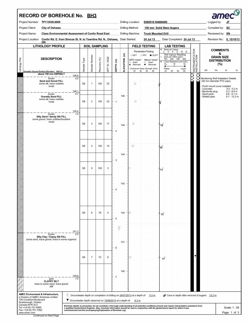
146.6
146.1
145.4
141.3
139.8
0.2
0.7
1.4
5.5
7.0
Monitoring Well Instalation Details (50 mm diameter PVC pipe)
- Flush mount cover installed- Concrete: 0.0 - 0.3 m- Bentonite plug: 0.3 - 8.8 m- Sand pack: 8.8 - 9.1 m- Slotted pipe: 9.1 - 12.3 m
1
2
3
4
5
6
7
SS
SS
SS
SS
SS
SS
SS
about 150 mm ASPHALT
brownSand and Gravel FILLsome silt, trace cobbles
moist
brownGravelly Sand FILL
some silt, trace cobblesmoist
brownSilty Sand / Sandy Silt FILL
some gravel, trace cobbles/bouldersmoist
brownSilty Clay / Clayey Silt FILL
some sand, trace gravel, trace to some organics
greyCLAYEY SILT
trace to some sand, trace gravelstiff
100
100
100
100
100
78
72
22
23
17
15
3
5
6
Drilling Method:Project Client:
Project Name:
Project Location:
Drilling Machine:
150 mm Solid Stem Augers
Conlin Rd. E. from Simcoe St. N. to Townline Rd. N., Oshawa,ON
Truck Mounted Drill
0, 15/10/13Date Completed:
Reviewed by:
Revision No.:Date Started:
Class Environmental Assessment of Conlin Road East
SC
SN
City of Oshawa Compiled by:
24 Jul 13 24 Jul 13
SOIL SAMPLING
Sam
ple
Typ
e
Sam
ple
Num
ber
LITHOLOGY PROFILE FIELD TESTING
Rec
over
y (%
)
Lith
olog
y P
lot
LAB TESTINGCOMMENTS
&GRAIN SIZE
DISTRIBUTION(%)
SP
T 'N
' / R
QD
DCPT
* Undrained Shear Strength (kPa)
(m)
(m)
EL
EV
AT
IONDESCRIPTION
20 40 60 80
Intact
INS
TR
UM
EN
TA
TIO
NIN
ST
ALL
AT
ION
Remould
PenetrationTesting
DE
PT
H RemouldIntact
Nilcon Vane*MTO Vane*
Geodetic Ground Surface Elevation: 146.8 m
PPTSPT
20 40 60 80
2 4 6 8 10 12
Soil Vapour Reading
W WL
Rinse pH Values
parts per million (ppm)
Lower Explosive Limit (LEL)
PlasticCL
100 200 300 400
SISAGRLiquid
WP
a Division of AMEC Americas Limited104 Crockford BoulevardScarborough, OntarioCanada M1R 3C3Tel +1(416) 751-6565Fax +1(416) 751-7592www.amec.com
AMEC Environment & Infrastructure,
Logged by:Project Number: Drilling Location:TP113039.6000
Continued on Next Page
146
145
144
143
142
141
140
1
2
3
4
5
6
7
E669518 N4868480
RECORD OF BOREHOLE No. BH3
Page: 1 of 3
JF
Scale: 1 : 39Borehole details as presented, do not constitute a thorough understanding of all potential conditions present and require interpretative assistance froma qualified Geotechnical Engineer. Also, borehole information should be read in conjunction with the geotechnical report for which it wascommissioned and the accompanying'Explanation of Borehole Log'.
2
5
12
10
11
13
17
Groundwater depth observed on 15/08/2013 at a depth of: 6.3 m.
Cave in depth after removal of augers: 12.2 m. Groundwater depth on completion of drilling on 24/07/2013 at a depth of: 5.3 m.
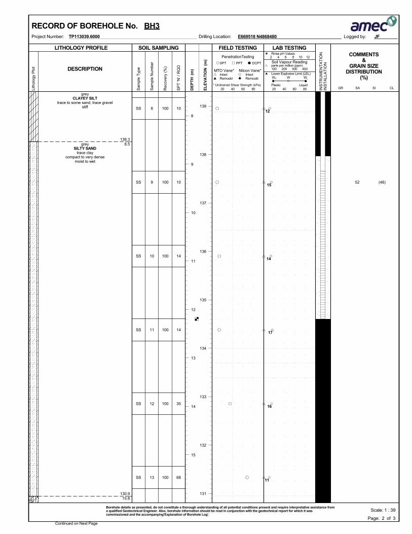
138.3
130.9
8.5
15.8
8
9
10
11
12
13
SS
SS
SS
SS
SS
SS
greyCLAYEY SILT
trace to some sand, trace gravelstiff
greySILTY SAND
trace claycompact to very dense
moist to wet
100
100
100
100
100
100
(48)52
10
10
14
14
35
68
SOIL SAMPLING
Sam
ple
Typ
e
Sam
ple
Num
ber
LITHOLOGY PROFILE FIELD TESTING
Rec
over
y (%
)
Lith
olog
y P
lot
LAB TESTINGCOMMENTS
&GRAIN SIZE
DISTRIBUTION(%)
SP
T 'N
' / R
QD
DCPT
* Undrained Shear Strength (kPa)
(m)
(m)
EL
EV
AT
IONDESCRIPTION
20 40 60 80
Intact
INS
TR
UM
EN
TA
TIO
NIN
ST
ALL
AT
ION
Remould
PenetrationTesting
DE
PT
H RemouldIntact
Nilcon Vane*MTO Vane*
PPTSPT
20 40 60 80
2 4 6 8 10 12
Soil Vapour Reading
W WL
Rinse pH Values
parts per million (ppm)
Lower Explosive Limit (LEL)
PlasticCL
100 200 300 400
SISAGRLiquid
WP
Logged by:Project Number: Drilling Location:TP113039.6000
Continued on Next Page
139
138
137
136
135
134
133
132
131
8
9
10
11
12
13
14
15
E669518 N4868480
RECORD OF BOREHOLE No. BH3
Page: 2 of 3
JF
Scale: 1 : 39Borehole details as presented, do not constitute a thorough understanding of all potential conditions present and require interpretative assistance froma qualified Geotechnical Engineer. Also, borehole information should be read in conjunction with the geotechnical report for which it wascommissioned and the accompanying'Explanation of Borehole Log'.
12
15
14
17
16
11
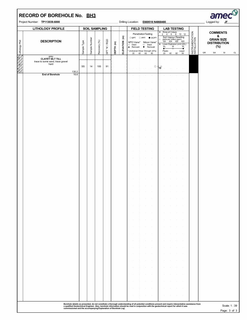
130.216.6
14SS
greyCLAYEY SILT TILL
trace to some sand, trace gravelhard
End of Borehole
100 91
SOIL SAMPLING
Sam
ple
Typ
e
Sam
ple
Num
ber
LITHOLOGY PROFILE FIELD TESTING
Rec
over
y (%
)
Lith
olog
y P
lot
LAB TESTINGCOMMENTS
&GRAIN SIZE
DISTRIBUTION(%)
SP
T 'N
' / R
QD
DCPT
* Undrained Shear Strength (kPa)
(m)
(m)
EL
EV
AT
IONDESCRIPTION
20 40 60 80
Intact
INS
TR
UM
EN
TA
TIO
NIN
ST
ALL
AT
ION
Remould
PenetrationTesting
DE
PT
H RemouldIntact
Nilcon Vane*MTO Vane*
PPTSPT
20 40 60 80
2 4 6 8 10 12
Soil Vapour Reading
W WL
Rinse pH Values
parts per million (ppm)
Lower Explosive Limit (LEL)
PlasticCL
100 200 300 400
SISAGRLiquid
WP
Logged by:Project Number: Drilling Location:TP113039.6000 E669518 N4868480
RECORD OF BOREHOLE No. BH3
Page: 3 of 3
JF
Scale: 1 : 39Borehole details as presented, do not constitute a thorough understanding of all potential conditions present and require interpretative assistance froma qualified Geotechnical Engineer. Also, borehole information should be read in conjunction with the geotechnical report for which it wascommissioned and the accompanying'Explanation of Borehole Log'.
10
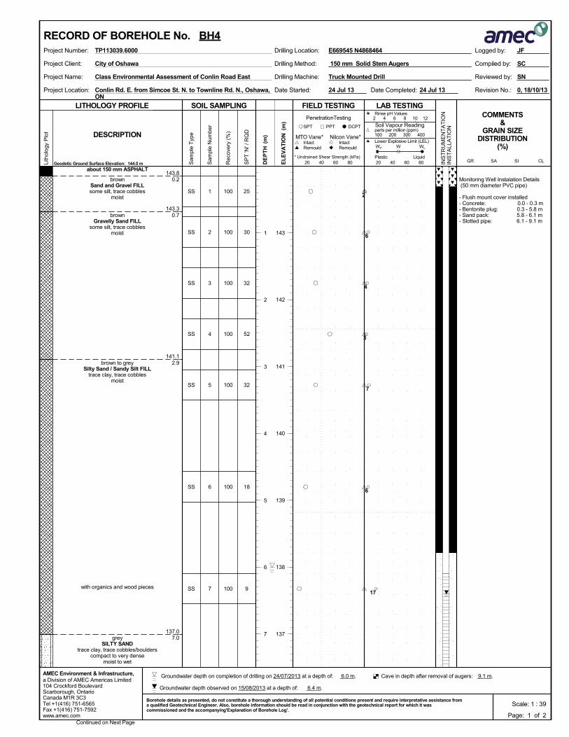
143.8
143.3
141.1
137.0
0.2
0.7
2.9
7.0
Monitoring Well Instalation Details (50 mm diameter PVC pipe)
- Flush mount cover installed- Concrete: 0.0 - 0.3 m- Bentonite plug: 0.3 - 5.8 m- Sand pack: 5.8 - 6.1 m- Slotted pipe: 6.1 - 9.1 m
1
2
3
4
5
6
7
SS
SS
SS
SS
SS
SS
SS
about 150 mm ASPHALT
brownSand and Gravel FILLsome silt, trace cobbles
moist
brownGravelly Sand FILL
some silt, trace cobblesmoist
brown to greySilty Sand / Sandy Silt FILL
trace clay, trace cobblesmoist
with organics and wood pieces
greySILTY SAND
trace clay, trace cobbles/boulderscompact to very dense
moist to wet
100
100
100
100
100
100
100
25
30
32
52
32
18
9
Drilling Method:Project Client:
Project Name:
Project Location:
Drilling Machine:
150 mm Solid Stem Augers
Conlin Rd. E. from Simcoe St. N. to Townline Rd. N., Oshawa,ON
Truck Mounted Drill
0, 18/10/13Date Completed:
Reviewed by:
Revision No.:Date Started:
Class Environmental Assessment of Conlin Road East
SC
SN
City of Oshawa Compiled by:
24 Jul 13 24 Jul 13
SOIL SAMPLING
Sam
ple
Typ
e
Sam
ple
Num
ber
LITHOLOGY PROFILE FIELD TESTING
Rec
over
y (%
)
Lith
olog
y P
lot
LAB TESTINGCOMMENTS
&GRAIN SIZE
DISTRIBUTION(%)
SP
T 'N
' / R
QD
DCPT
* Undrained Shear Strength (kPa)
(m)
(m)
EL
EV
AT
IONDESCRIPTION
20 40 60 80
Intact
INS
TR
UM
EN
TA
TIO
NIN
ST
ALL
AT
ION
Remould
PenetrationTesting
DE
PT
H RemouldIntact
Nilcon Vane*MTO Vane*
Geodetic Ground Surface Elevation: 144.0 m
PPTSPT
20 40 60 80
2 4 6 8 10 12
Soil Vapour Reading
W WL
Rinse pH Values
parts per million (ppm)
Lower Explosive Limit (LEL)
PlasticCL
100 200 300 400
SISAGRLiquid
WP
a Division of AMEC Americas Limited104 Crockford BoulevardScarborough, OntarioCanada M1R 3C3Tel +1(416) 751-6565Fax +1(416) 751-7592www.amec.com
AMEC Environment & Infrastructure,
Logged by:Project Number: Drilling Location:TP113039.6000
Continued on Next Page
143
142
141
140
139
138
137
1
2
3
4
5
6
7
E669545 N4868464
RECORD OF BOREHOLE No. BH4
Page: 1 of 2
JF
Scale: 1 : 39Borehole details as presented, do not constitute a thorough understanding of all potential conditions present and require interpretative assistance froma qualified Geotechnical Engineer. Also, borehole information should be read in conjunction with the geotechnical report for which it wascommissioned and the accompanying'Explanation of Borehole Log'.
2
6
4
3
7
6
17
Groundwater depth observed on 15/08/2013 at a depth of: 6.4 m.
Cave in depth after removal of augers: 9.1 m. Groundwater depth on completion of drilling on 24/07/2013 at a depth of: 6.0 m.
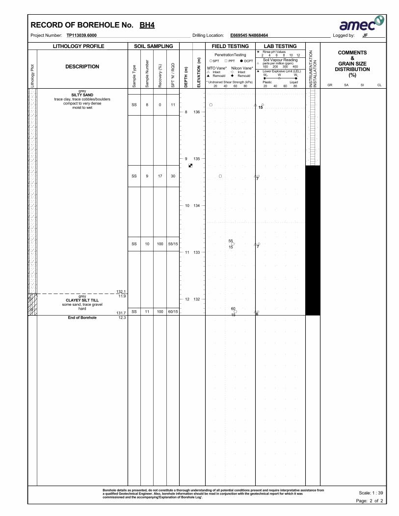
132.1
131.7
11.9
12.3
8
9
10
11
SS
SS
SS
SS
greySILTY SAND
trace clay, trace cobbles/boulderscompact to very dense
moist to wet
greyCLAYEY SILT TILL
some sand, trace gravelhard
End of Borehole
0
17
100
100
11
30
55/15
60/15
SOIL SAMPLING
Sam
ple
Typ
e
Sam
ple
Num
ber
LITHOLOGY PROFILE FIELD TESTING
Rec
over
y (%
)
Lith
olog
y P
lot
LAB TESTINGCOMMENTS
&GRAIN SIZE
DISTRIBUTION(%)
SP
T 'N
' / R
QD
DCPT
* Undrained Shear Strength (kPa)
(m)
(m)
EL
EV
AT
IONDESCRIPTION
20 40 60 80
Intact
INS
TR
UM
EN
TA
TIO
NIN
ST
ALL
AT
ION
Remould
PenetrationTesting
DE
PT
H RemouldIntact
Nilcon Vane*MTO Vane*
PPTSPT
20 40 60 80
2 4 6 8 10 12
Soil Vapour Reading
W WL
Rinse pH Values
parts per million (ppm)
Lower Explosive Limit (LEL)
PlasticCL
100 200 300 400
SISAGRLiquid
WP
Logged by:Project Number: Drilling Location:TP113039.6000
136
135
134
133
132
8
9
10
11
12
E669545 N4868464
RECORD OF BOREHOLE No. BH4
Page: 2 of 2
JF
Scale: 1 : 39Borehole details as presented, do not constitute a thorough understanding of all potential conditions present and require interpretative assistance froma qualified Geotechnical Engineer. Also, borehole information should be read in conjunction with the geotechnical report for which it wascommissioned and the accompanying'Explanation of Borehole Log'.
15
55
15
60
15
7
7
6
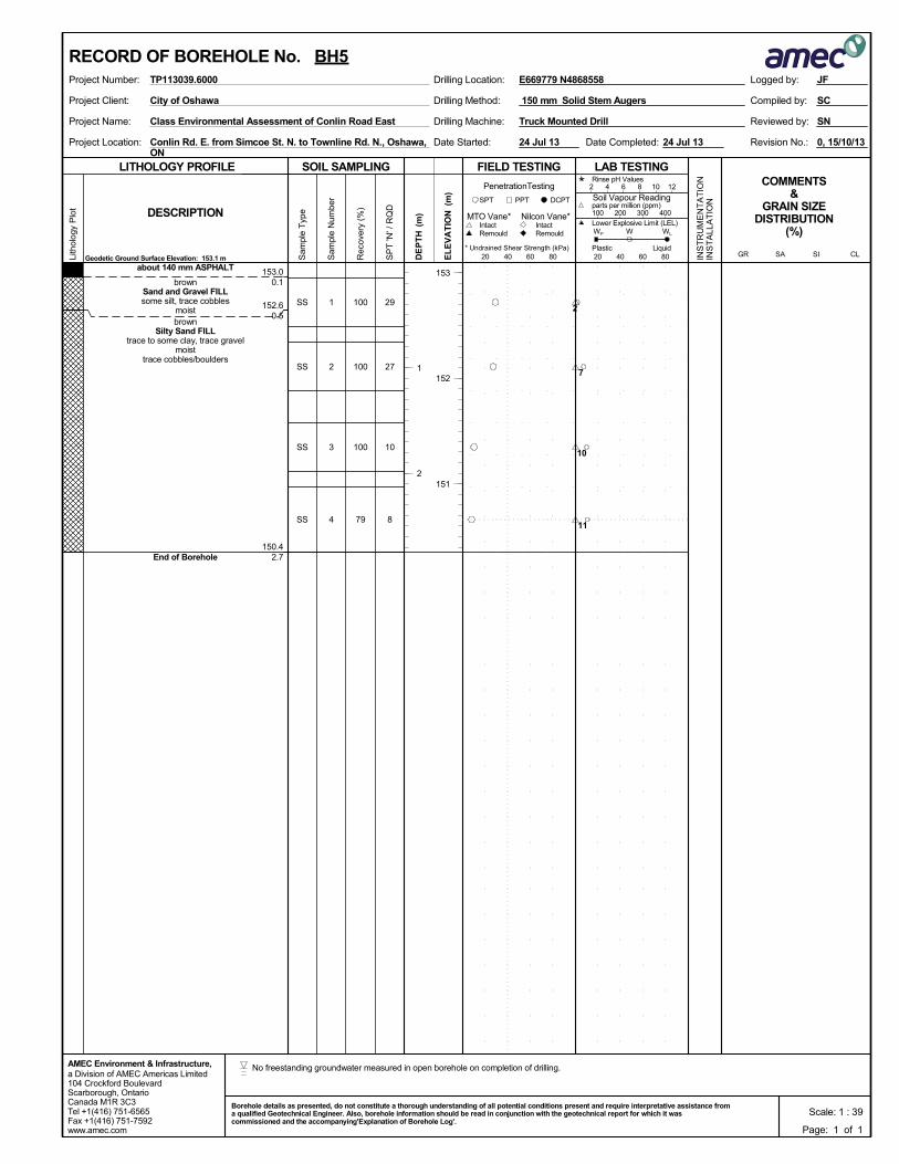
153.0
152.6
150.4
0.1
0.5
2.7
1
2
3
4
SS
SS
SS
SS
about 140 mm ASPHALT
brownSand and Gravel FILLsome silt, trace cobbles
moistbrown
Silty Sand FILLtrace to some clay, trace gravel
moisttrace cobbles/boulders
End of Borehole
100
100
100
79
29
27
10
8
Drilling Method:Project Client:
Project Name:
Project Location:
Drilling Machine:
150 mm Solid Stem Augers
Conlin Rd. E. from Simcoe St. N. to Townline Rd. N., Oshawa,ON
Truck Mounted Drill
0, 15/10/13Date Completed:
Reviewed by:
Revision No.:Date Started:
Class Environmental Assessment of Conlin Road East
SC
SN
City of Oshawa Compiled by:
24 Jul 13 24 Jul 13
SOIL SAMPLING
Sam
ple
Typ
e
Sam
ple
Num
ber
LITHOLOGY PROFILE FIELD TESTING
Rec
over
y (%
)
Lith
olog
y P
lot
LAB TESTINGCOMMENTS
&GRAIN SIZE
DISTRIBUTION(%)
SP
T 'N
' / R
QD
DCPT
* Undrained Shear Strength (kPa)
(m)
(m)
EL
EV
AT
IONDESCRIPTION
20 40 60 80
Intact
INS
TR
UM
EN
TA
TIO
NIN
ST
ALL
AT
ION
Remould
PenetrationTesting
DE
PT
H RemouldIntact
Nilcon Vane*MTO Vane*
Geodetic Ground Surface Elevation: 153.1 m
PPTSPT
20 40 60 80
2 4 6 8 10 12
Soil Vapour Reading
W WL
Rinse pH Values
parts per million (ppm)
Lower Explosive Limit (LEL)
PlasticCL
100 200 300 400
SISAGRLiquid
WP
a Division of AMEC Americas Limited104 Crockford BoulevardScarborough, OntarioCanada M1R 3C3Tel +1(416) 751-6565Fax +1(416) 751-7592www.amec.com
AMEC Environment & Infrastructure,
Logged by:Project Number: Drilling Location:TP113039.6000
153
152
151
1
2
E669779 N4868558
RECORD OF BOREHOLE No. BH5
Page: 1 of 1
JF
Scale: 1 : 39Borehole details as presented, do not constitute a thorough understanding of all potential conditions present and require interpretative assistance froma qualified Geotechnical Engineer. Also, borehole information should be read in conjunction with the geotechnical report for which it wascommissioned and the accompanying'Explanation of Borehole Log'.
2
7
10
11
No freestanding groundwater measured in open borehole on completion of drilling.
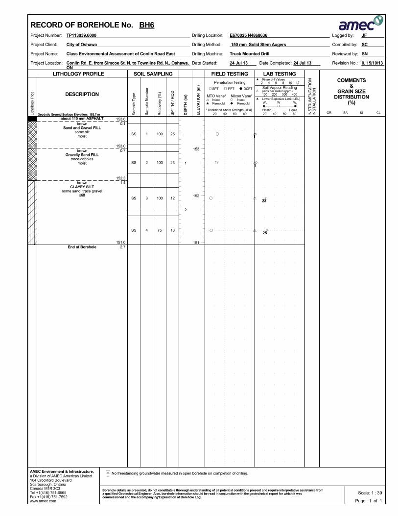
153.6
153.0
152.3
151.0
0.1
0.7
1.4
2.7
1
2
3
4
SS
SS
SS
SS
about 110 mm ASPHALTbrown
Sand and Gravel FILLsome silt
moist
brownGravelly Sand FILL
trace cobblesmoist
brownCLAYEY SILT
some sand, trace gravelstiff
End of Borehole
100
100
100
75
25
23
12
13
Drilling Method:Project Client:
Project Name:
Project Location:
Drilling Machine:
150 mm Solid Stem Augers
Conlin Rd. E. from Simcoe St. N. to Townline Rd. N., Oshawa,ON
Truck Mounted Drill
0, 15/10/13Date Completed:
Reviewed by:
Revision No.:Date Started:
Class Environmental Assessment of Conlin Road East
SC
SN
City of Oshawa Compiled by:
24 Jul 13 24 Jul 13
SOIL SAMPLING
Sam
ple
Typ
e
Sam
ple
Num
ber
LITHOLOGY PROFILE FIELD TESTING
Rec
over
y (%
)
Lith
olog
y P
lot
LAB TESTINGCOMMENTS
&GRAIN SIZE
DISTRIBUTION(%)
SP
T 'N
' / R
QD
DCPT
* Undrained Shear Strength (kPa)
(m)
(m)
EL
EV
AT
IONDESCRIPTION
20 40 60 80
Intact
INS
TR
UM
EN
TA
TIO
NIN
ST
ALL
AT
ION
Remould
PenetrationTesting
DE
PT
H RemouldIntact
Nilcon Vane*MTO Vane*
Geodetic Ground Surface Elevation: 153.7 m
PPTSPT
20 40 60 80
2 4 6 8 10 12
Soil Vapour Reading
W WL
Rinse pH Values
parts per million (ppm)
Lower Explosive Limit (LEL)
PlasticCL
100 200 300 400
SISAGRLiquid
WP
a Division of AMEC Americas Limited104 Crockford BoulevardScarborough, OntarioCanada M1R 3C3Tel +1(416) 751-6565Fax +1(416) 751-7592www.amec.com
AMEC Environment & Infrastructure,
Logged by:Project Number: Drilling Location:TP113039.6000
153
152
151
1
2
E670025 N4868636
RECORD OF BOREHOLE No. BH6
Page: 1 of 1
JF
Scale: 1 : 39Borehole details as presented, do not constitute a thorough understanding of all potential conditions present and require interpretative assistance froma qualified Geotechnical Engineer. Also, borehole information should be read in conjunction with the geotechnical report for which it wascommissioned and the accompanying'Explanation of Borehole Log'.
1
3
23
25
No freestanding groundwater measured in open borehole on completion of drilling.
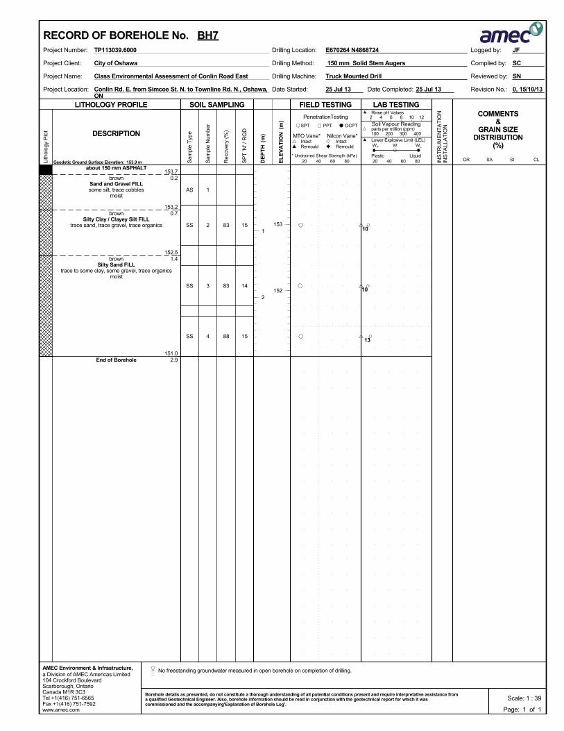
153.7
153.2
152.5
151.0
0.2
0.7
1.4
2.9
1
2
3
4
AS
SS
SS
SS
about 150 mm ASPHALT
brownSand and Gravel FILLsome silt, trace cobbles
moist
brownSilty Clay / Clayey Silt FILL
trace sand, trace gravel, trace organics
brownSilty Sand FILL
trace to some clay, some gravel, trace organicsmoist
End of Borehole
83
83
88
15
14
15
Drilling Method:Project Client:
Project Name:
Project Location:
Drilling Machine:
150 mm Solid Stem Augers
Conlin Rd. E. from Simcoe St. N. to Townline Rd. N., Oshawa,ON
Truck Mounted Drill
0, 15/10/13Date Completed:
Reviewed by:
Revision No.:Date Started:
Class Environmental Assessment of Conlin Road East
SC
SN
City of Oshawa Compiled by:
25 Jul 13 25 Jul 13
SOIL SAMPLING
Sam
ple
Typ
e
Sam
ple
Num
ber
LITHOLOGY PROFILE FIELD TESTING
Rec
over
y (%
)
Lith
olog
y P
lot
LAB TESTINGCOMMENTS
&GRAIN SIZE
DISTRIBUTION(%)
SP
T 'N
' / R
QD
DCPT
* Undrained Shear Strength (kPa)
(m)
(m)
EL
EV
AT
IONDESCRIPTION
20 40 60 80
Intact
INS
TR
UM
EN
TA
TIO
NIN
ST
ALL
AT
ION
Remould
PenetrationTesting
DE
PT
H RemouldIntact
Nilcon Vane*MTO Vane*
Geodetic Ground Surface Elevation: 153.9 m
PPTSPT
20 40 60 80
2 4 6 8 10 12
Soil Vapour Reading
W WL
Rinse pH Values
parts per million (ppm)
Lower Explosive Limit (LEL)
PlasticCL
100 200 300 400
SISAGRLiquid
WP
a Division of AMEC Americas Limited104 Crockford BoulevardScarborough, OntarioCanada M1R 3C3Tel +1(416) 751-6565Fax +1(416) 751-7592www.amec.com
AMEC Environment & Infrastructure,
Logged by:Project Number: Drilling Location:TP113039.6000
153
152
1
2
E670264 N4868724
RECORD OF BOREHOLE No. BH7
Page: 1 of 1
JF
Scale: 1 : 39Borehole details as presented, do not constitute a thorough understanding of all potential conditions present and require interpretative assistance froma qualified Geotechnical Engineer. Also, borehole information should be read in conjunction with the geotechnical report for which it wascommissioned and the accompanying'Explanation of Borehole Log'.
10
10
13
No freestanding groundwater measured in open borehole on completion of drilling.
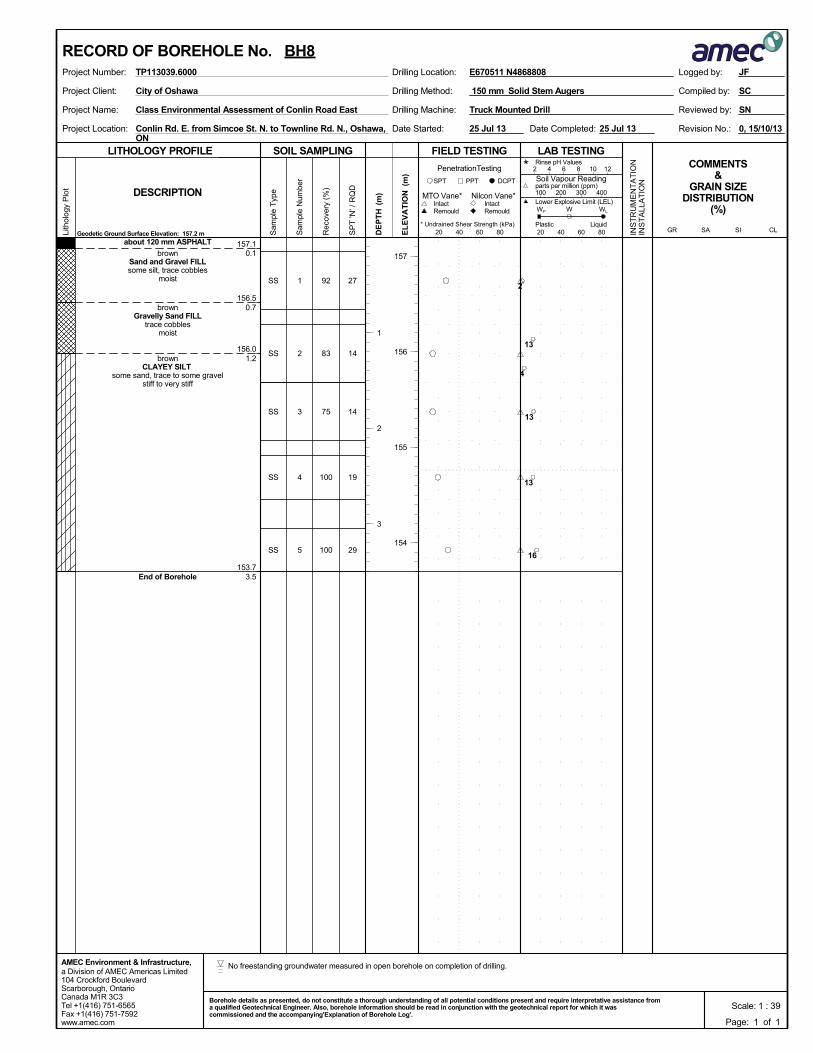
157.1
156.5
156.0
153.7
0.1
0.7
1.2
3.5
1
2
3
4
5
SS
SS
SS
SS
SS
about 120 mm ASPHALT
brownSand and Gravel FILLsome silt, trace cobbles
moist
brownGravelly Sand FILL
trace cobblesmoist
brownCLAYEY SILT
some sand, trace to some gravelstiff to very stiff
End of Borehole
92
83
75
100
100
27
14
14
19
29
Drilling Method:Project Client:
Project Name:
Project Location:
Drilling Machine:
150 mm Solid Stem Augers
Conlin Rd. E. from Simcoe St. N. to Townline Rd. N., Oshawa,ON
Truck Mounted Drill
0, 15/10/13Date Completed:
Reviewed by:
Revision No.:Date Started:
Class Environmental Assessment of Conlin Road East
SC
SN
City of Oshawa Compiled by:
25 Jul 13 25 Jul 13
SOIL SAMPLING
Sam
ple
Typ
e
Sam
ple
Num
ber
LITHOLOGY PROFILE FIELD TESTING
Rec
over
y (%
)
Lith
olog
y P
lot
LAB TESTINGCOMMENTS
&GRAIN SIZE
DISTRIBUTION(%)
SP
T 'N
' / R
QD
DCPT
* Undrained Shear Strength (kPa)
(m)
(m)
EL
EV
AT
IONDESCRIPTION
20 40 60 80
Intact
INS
TR
UM
EN
TA
TIO
NIN
ST
ALL
AT
ION
Remould
PenetrationTesting
DE
PT
H RemouldIntact
Nilcon Vane*MTO Vane*
Geodetic Ground Surface Elevation: 157.2 m
PPTSPT
20 40 60 80
2 4 6 8 10 12
Soil Vapour Reading
W WL
Rinse pH Values
parts per million (ppm)
Lower Explosive Limit (LEL)
PlasticCL
100 200 300 400
SISAGRLiquid
WP
a Division of AMEC Americas Limited104 Crockford BoulevardScarborough, OntarioCanada M1R 3C3Tel +1(416) 751-6565Fax +1(416) 751-7592www.amec.com
AMEC Environment & Infrastructure,
Logged by:Project Number: Drilling Location:TP113039.6000
157
156
155
154
1
2
3
E670511 N4868808
RECORD OF BOREHOLE No. BH8
Page: 1 of 1
JF
Scale: 1 : 39Borehole details as presented, do not constitute a thorough understanding of all potential conditions present and require interpretative assistance froma qualified Geotechnical Engineer. Also, borehole information should be read in conjunction with the geotechnical report for which it wascommissioned and the accompanying'Explanation of Borehole Log'.
2
13
4
13
13
16
No freestanding groundwater measured in open borehole on completion of drilling.
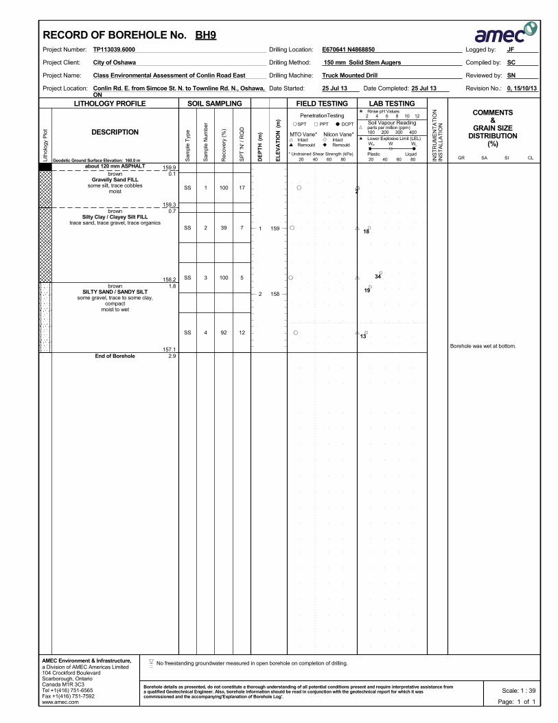
159.9
159.3
158.2
157.1
0.1
0.7
1.8
2.9
Borehole was wet at bottom.
1
2
3
4
SS
SS
SS
SS
about 120 mm ASPHALT
brownGravelly Sand FILL
some silt, trace cobblesmoist
brownSilty Clay / Clayey Silt FILL
trace sand, trace gravel, trace organics
brownSILTY SAND / SANDY SILT
some gravel, trace to some clay,compact
moist to wet
End of Borehole
100
39
100
92
17
7
5
12
Drilling Method:Project Client:
Project Name:
Project Location:
Drilling Machine:
150 mm Solid Stem Augers
Conlin Rd. E. from Simcoe St. N. to Townline Rd. N., Oshawa,ON
Truck Mounted Drill
0, 15/10/13Date Completed:
Reviewed by:
Revision No.:Date Started:
Class Environmental Assessment of Conlin Road East
SC
SN
City of Oshawa Compiled by:
25 Jul 13 25 Jul 13
SOIL SAMPLING
Sam
ple
Typ
e
Sam
ple
Num
ber
LITHOLOGY PROFILE FIELD TESTING
Rec
over
y (%
)
Lith
olog
y P
lot
LAB TESTINGCOMMENTS
&GRAIN SIZE
DISTRIBUTION(%)
SP
T 'N
' / R
QD
DCPT
* Undrained Shear Strength (kPa)
(m)
(m)
EL
EV
AT
IONDESCRIPTION
20 40 60 80
Intact
INS
TR
UM
EN
TA
TIO
NIN
ST
ALL
AT
ION
Remould
PenetrationTesting
DE
PT
H RemouldIntact
Nilcon Vane*MTO Vane*
Geodetic Ground Surface Elevation: 160.0 m
PPTSPT
20 40 60 80
2 4 6 8 10 12
Soil Vapour Reading
W WL
Rinse pH Values
parts per million (ppm)
Lower Explosive Limit (LEL)
PlasticCL
100 200 300 400
SISAGRLiquid
WP
a Division of AMEC Americas Limited104 Crockford BoulevardScarborough, OntarioCanada M1R 3C3Tel +1(416) 751-6565Fax +1(416) 751-7592www.amec.com
AMEC Environment & Infrastructure,
Logged by:Project Number: Drilling Location:TP113039.6000
159
158
1
2
E670641 N4868850
RECORD OF BOREHOLE No. BH9
Page: 1 of 1
JF
Scale: 1 : 39Borehole details as presented, do not constitute a thorough understanding of all potential conditions present and require interpretative assistance froma qualified Geotechnical Engineer. Also, borehole information should be read in conjunction with the geotechnical report for which it wascommissioned and the accompanying'Explanation of Borehole Log'.
2
18
34
19
13
No freestanding groundwater measured in open borehole on completion of drilling.
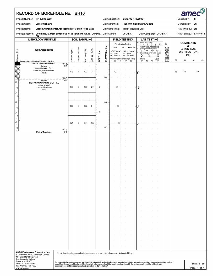
164.5
163.9
161.9
0.1
0.7
2.7
1
2
3
4
SS
SS
SS
SS
about 100 mm ASPHALTbrown
Gravelly Sand FILLsome silt, trace cobbles
moist
brownSILTY SAND / SANDY SILT TILL
some gravelcompact to dense
moist
End of Borehole
100
100
100
92
(19)552621
27
31
35
Drilling Method:Project Client:
Project Name:
Project Location:
Drilling Machine:
150 mm Solid Stem Augers
Conlin Rd. E. from Simcoe St. N. to Townline Rd. N., Oshawa,ON
Truck Mounted Drill
0, 15/10/13Date Completed:
Reviewed by:
Revision No.:Date Started:
Class Environmental Assessment of Conlin Road East
SC
SN
City of Oshawa Compiled by:
25 Jul 13 25 Jul 13
SOIL SAMPLING
Sam
ple
Typ
e
Sam
ple
Num
ber
LITHOLOGY PROFILE FIELD TESTING
Rec
over
y (%
)
Lith
olog
y P
lot
LAB TESTINGCOMMENTS
&GRAIN SIZE
DISTRIBUTION(%)
SP
T 'N
' / R
QD
DCPT
* Undrained Shear Strength (kPa)
(m)
(m)
EL
EV
AT
IONDESCRIPTION
20 40 60 80
Intact
INS
TR
UM
EN
TA
TIO
NIN
ST
ALL
AT
ION
Remould
PenetrationTesting
DE
PT
H RemouldIntact
Nilcon Vane*MTO Vane*
Geodetic Ground Surface Elevation: 164.6 m
PPTSPT
20 40 60 80
2 4 6 8 10 12
Soil Vapour Reading
W WL
Rinse pH Values
parts per million (ppm)
Lower Explosive Limit (LEL)
PlasticCL
100 200 300 400
SISAGRLiquid
WP
a Division of AMEC Americas Limited104 Crockford BoulevardScarborough, OntarioCanada M1R 3C3Tel +1(416) 751-6565Fax +1(416) 751-7592www.amec.com
AMEC Environment & Infrastructure,
Logged by:Project Number: Drilling Location:TP113039.6000
164
163
162
1
2
E670792 N4868899
RECORD OF BOREHOLE No. BH10
Page: 1 of 1
JF
Scale: 1 : 39Borehole details as presented, do not constitute a thorough understanding of all potential conditions present and require interpretative assistance froma qualified Geotechnical Engineer. Also, borehole information should be read in conjunction with the geotechnical report for which it wascommissioned and the accompanying'Explanation of Borehole Log'.
7
9
8
8
No freestanding groundwater measured in open borehole on completion of drilling.

172.5
171.8
169.7
0.1
0.8
2.9
1
2
3
4
SS
SS
SS
SS
about 100 mm ASPHALTbrown
Sand and Gravel FILLsome silt, trace cobbles
brownSILTY SAND / SANDY SILT TILL
trace clay, trace gravel, trace cobblesdense
moist to wet
End of Borehole
83
100
83
88
27
32
35
35
Drilling Method:Project Client:
Project Name:
Project Location:
Drilling Machine:
150 mm Solid Stem Augers
Conlin Rd. E. from Simcoe St. N. to Townline Rd. N., Oshawa,ON
Truck Mounted Drill
0, 15/10/13Date Completed:
Reviewed by:
Revision No.:Date Started:
Class Environmental Assessment of Conlin Road East
SC
SN
City of Oshawa Compiled by:
25 Jul 13 25 Jul 13
SOIL SAMPLING
Sam
ple
Typ
e
Sam
ple
Num
ber
LITHOLOGY PROFILE FIELD TESTING
Rec
over
y (%
)
Lith
olog
y P
lot
LAB TESTINGCOMMENTS
&GRAIN SIZE
DISTRIBUTION(%)
SP
T 'N
' / R
QD
DCPT
* Undrained Shear Strength (kPa)
(m)
(m)
EL
EV
AT
IONDESCRIPTION
20 40 60 80
Intact
INS
TR
UM
EN
TA
TIO
NIN
ST
ALL
AT
ION
Remould
PenetrationTesting
DE
PT
H RemouldIntact
Nilcon Vane*MTO Vane*
Geodetic Ground Surface Elevation: 172.6 m
PPTSPT
20 40 60 80
2 4 6 8 10 12
Soil Vapour Reading
W WL
Rinse pH Values
parts per million (ppm)
Lower Explosive Limit (LEL)
PlasticCL
100 200 300 400
SISAGRLiquid
WP
a Division of AMEC Americas Limited104 Crockford BoulevardScarborough, OntarioCanada M1R 3C3Tel +1(416) 751-6565Fax +1(416) 751-7592www.amec.com
AMEC Environment & Infrastructure,
Logged by:Project Number: Drilling Location:TP113039.6000
172
171
170
1
2
E670931 N4868946
RECORD OF BOREHOLE No. BH11
Page: 1 of 1
JF
Scale: 1 : 39Borehole details as presented, do not constitute a thorough understanding of all potential conditions present and require interpretative assistance froma qualified Geotechnical Engineer. Also, borehole information should be read in conjunction with the geotechnical report for which it wascommissioned and the accompanying'Explanation of Borehole Log'.
3
8
9
8
No freestanding groundwater measured in open borehole on completion of drilling.
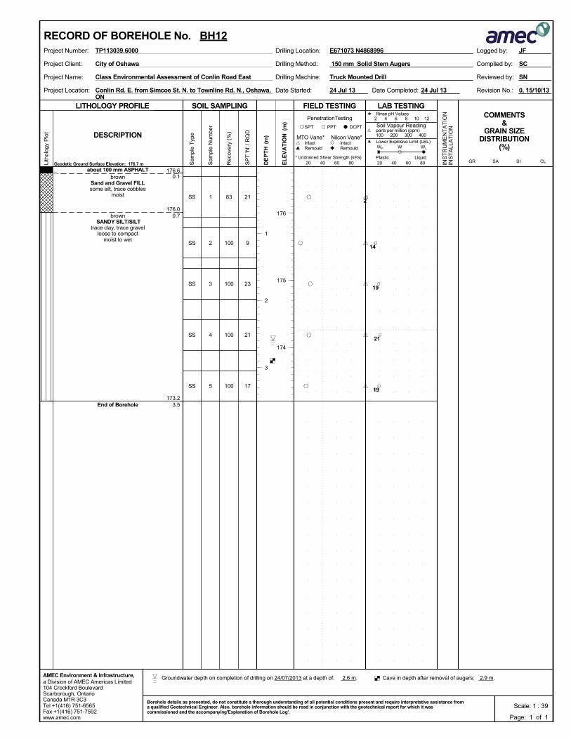
176.6
176.0
173.2
0.1
0.7
3.5
1
2
3
4
5
SS
SS
SS
SS
SS
about 100 mm ASPHALTbrown
Sand and Gravel FILLsome silt, trace cobbles
moist
brown SANDY SILT/SILT
trace clay, trace gravelloose to compact
moist to wet
End of Borehole
83
100
100
100
100
21
9
23
21
17
Drilling Method:Project Client:
Project Name:
Project Location:
Drilling Machine:
150 mm Solid Stem Augers
Conlin Rd. E. from Simcoe St. N. to Townline Rd. N., Oshawa,ON
Truck Mounted Drill
0, 15/10/13Date Completed:
Reviewed by:
Revision No.:Date Started:
Class Environmental Assessment of Conlin Road East
SC
SN
City of Oshawa Compiled by:
24 Jul 13 24 Jul 13
SOIL SAMPLING
Sam
ple
Typ
e
Sam
ple
Num
ber
LITHOLOGY PROFILE FIELD TESTING
Rec
over
y (%
)
Lith
olog
y P
lot
LAB TESTINGCOMMENTS
&GRAIN SIZE
DISTRIBUTION(%)
SP
T 'N
' / R
QD
DCPT
* Undrained Shear Strength (kPa)
(m)
(m)
EL
EV
AT
IONDESCRIPTION
20 40 60 80
Intact
INS
TR
UM
EN
TA
TIO
NIN
ST
ALL
AT
ION
Remould
PenetrationTesting
DE
PT
H RemouldIntact
Nilcon Vane*MTO Vane*
Geodetic Ground Surface Elevation: 176.7 m
PPTSPT
20 40 60 80
2 4 6 8 10 12
Soil Vapour Reading
W WL
Rinse pH Values
parts per million (ppm)
Lower Explosive Limit (LEL)
PlasticCL
100 200 300 400
SISAGRLiquid
WP
a Division of AMEC Americas Limited104 Crockford BoulevardScarborough, OntarioCanada M1R 3C3Tel +1(416) 751-6565Fax +1(416) 751-7592www.amec.com
AMEC Environment & Infrastructure,
Logged by:Project Number: Drilling Location:TP113039.6000
176
175
174
1
2
3
E671073 N4868996
RECORD OF BOREHOLE No. BH12
Page: 1 of 1
JF
Scale: 1 : 39Borehole details as presented, do not constitute a thorough understanding of all potential conditions present and require interpretative assistance froma qualified Geotechnical Engineer. Also, borehole information should be read in conjunction with the geotechnical report for which it wascommissioned and the accompanying'Explanation of Borehole Log'.
2
14
19
21
19
Cave in depth after removal of augers: 2.9 m. Groundwater depth on completion of drilling on 24/07/2013 at a depth of: 2.6 m.
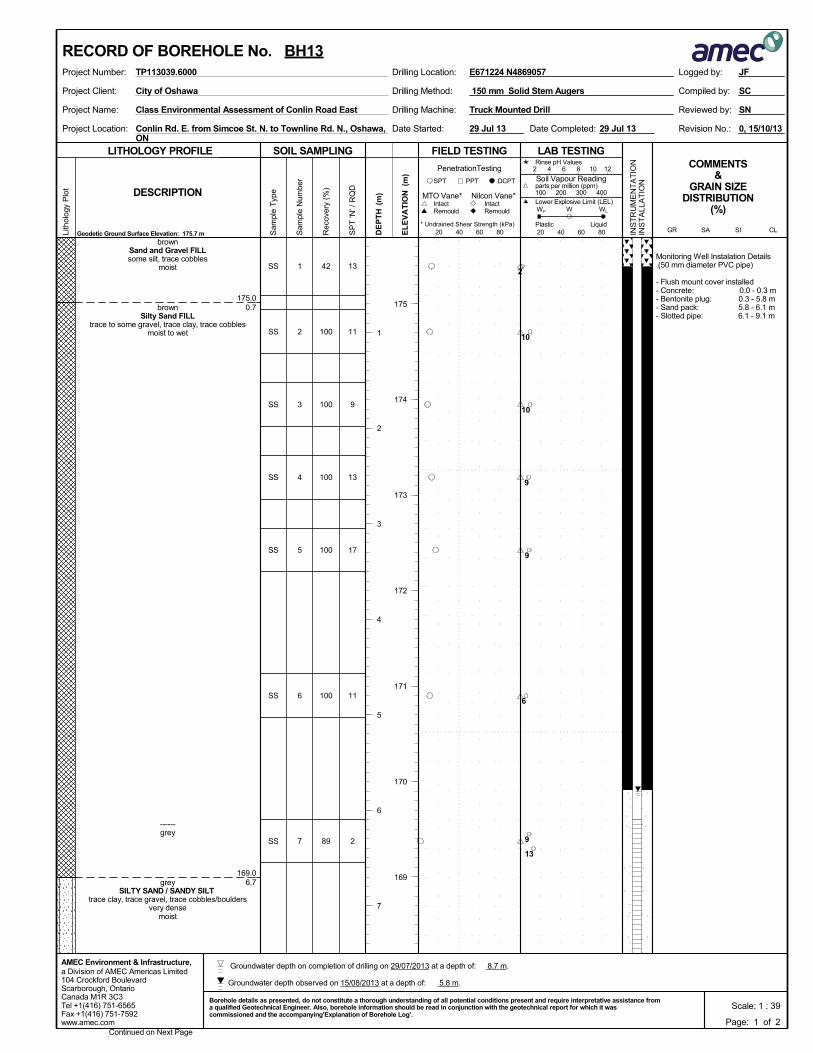
175.0
169.0
0.7
6.7
Monitoring Well Instalation Details (50 mm diameter PVC pipe)
- Flush mount cover installed- Concrete: 0.0 - 0.3 m- Bentonite plug: 0.3 - 5.8 m- Sand pack: 5.8 - 6.1 m- Slotted pipe: 6.1 - 9.1 m
1
2
3
4
5
6
7
SS
SS
SS
SS
SS
SS
SS
brownSand and Gravel FILLsome silt, trace cobbles
moist
brownSilty Sand FILL
trace to some gravel, trace clay, trace cobblesmoist to wet
------grey
greySILTY SAND / SANDY SILT
trace clay, trace gravel, trace cobbles/bouldersvery dense
moist
42
100
100
100
100
100
89
13
11
9
13
17
11
2
Drilling Method:Project Client:
Project Name:
Project Location:
Drilling Machine:
150 mm Solid Stem Augers
Conlin Rd. E. from Simcoe St. N. to Townline Rd. N., Oshawa,ON
Truck Mounted Drill
0, 15/10/13Date Completed:
Reviewed by:
Revision No.:Date Started:
Class Environmental Assessment of Conlin Road East
SC
SN
City of Oshawa Compiled by:
29 Jul 13 29 Jul 13
SOIL SAMPLING
Sam
ple
Typ
e
Sam
ple
Num
ber
LITHOLOGY PROFILE FIELD TESTING
Rec
over
y (%
)
Lith
olog
y P
lot
LAB TESTINGCOMMENTS
&GRAIN SIZE
DISTRIBUTION(%)
SP
T 'N
' / R
QD
DCPT
* Undrained Shear Strength (kPa)
(m)
(m)
EL
EV
AT
IONDESCRIPTION
20 40 60 80
Intact
INS
TR
UM
EN
TA
TIO
NIN
ST
ALL
AT
ION
Remould
PenetrationTesting
DE
PT
H RemouldIntact
Nilcon Vane*MTO Vane*
Geodetic Ground Surface Elevation: 175.7 m
PPTSPT
20 40 60 80
2 4 6 8 10 12
Soil Vapour Reading
W WL
Rinse pH Values
parts per million (ppm)
Lower Explosive Limit (LEL)
PlasticCL
100 200 300 400
SISAGRLiquid
WP
a Division of AMEC Americas Limited104 Crockford BoulevardScarborough, OntarioCanada M1R 3C3Tel +1(416) 751-6565Fax +1(416) 751-7592www.amec.com
AMEC Environment & Infrastructure,
Logged by:Project Number: Drilling Location:TP113039.6000
Continued on Next Page
175
174
173
172
171
170
169
1
2
3
4
5
6
7
E671224 N4869057
RECORD OF BOREHOLE No. BH13
Page: 1 of 2
JF
Scale: 1 : 39Borehole details as presented, do not constitute a thorough understanding of all potential conditions present and require interpretative assistance froma qualified Geotechnical Engineer. Also, borehole information should be read in conjunction with the geotechnical report for which it wascommissioned and the accompanying'Explanation of Borehole Log'.
2
10
10
9
9
6
9
13
Groundwater depth observed on 15/08/2013 at a depth of: 5.8 m.
Groundwater depth on completion of drilling on 29/07/2013 at a depth of: 8.7 m.
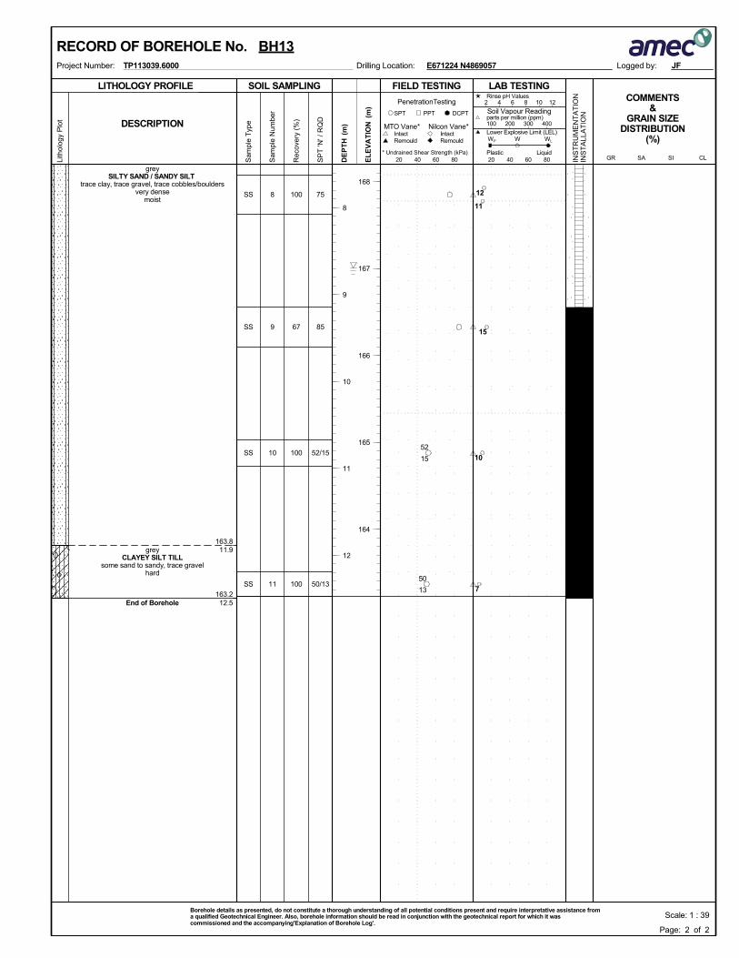
163.8
163.2
11.9
12.5
8
9
10
11
SS
SS
SS
SS
greySILTY SAND / SANDY SILT
trace clay, trace gravel, trace cobbles/bouldersvery dense
moist
greyCLAYEY SILT TILL
some sand to sandy, trace gravelhard
End of Borehole
100
67
100
100
75
85
52/15
50/13
SOIL SAMPLING
Sam
ple
Typ
e
Sam
ple
Num
ber
LITHOLOGY PROFILE FIELD TESTING
Rec
over
y (%
)
Lith
olog
y P
lot
LAB TESTINGCOMMENTS
&GRAIN SIZE
DISTRIBUTION(%)
SP
T 'N
' / R
QD
DCPT
* Undrained Shear Strength (kPa)
(m)
(m)
EL
EV
AT
IONDESCRIPTION
20 40 60 80
Intact
INS
TR
UM
EN
TA
TIO
NIN
ST
ALL
AT
ION
Remould
PenetrationTesting
DE
PT
H RemouldIntact
Nilcon Vane*MTO Vane*
PPTSPT
20 40 60 80
2 4 6 8 10 12
Soil Vapour Reading
W WL
Rinse pH Values
parts per million (ppm)
Lower Explosive Limit (LEL)
PlasticCL
100 200 300 400
SISAGRLiquid
WP
Logged by:Project Number: Drilling Location:TP113039.6000
168
167
166
165
164
8
9
10
11
12
E671224 N4869057
RECORD OF BOREHOLE No. BH13
Page: 2 of 2
JF
Scale: 1 : 39Borehole details as presented, do not constitute a thorough understanding of all potential conditions present and require interpretative assistance froma qualified Geotechnical Engineer. Also, borehole information should be read in conjunction with the geotechnical report for which it wascommissioned and the accompanying'Explanation of Borehole Log'.
15
52
13
50
12
11
15
10
7
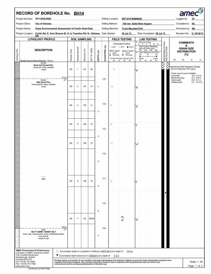
175.0
169.0
0.7
6.7
Monitoring Well Instalation Details (50 mm diameter PVC pipe)
- Flush mount cover installed- Concrete: 0.0 - 0.3 m- Bentonite plug: 0.3 - 8.8 m- Sand pack: 8.8 - 9.1 m- Slotted pipe: 9.1 - 12.3 m
1
2
3
4
5
6
7
SS
SS
SS
SS
SS
SS
SS
brownSand and Gravel FILLsome silt, trace cobbles
moist
brownSilty Sand FILL
some gravel, trace cobblesmoist
------grey
greySILTY SAND / SANDY SILT
trace clay, trace gravel, trace cobbles/bouldersvery densemoist to wet
63
89
100
100
100
100
35
20
13
9
10
12
10
56/28
Drilling Method:Project Client:
Project Name:
Project Location:
Drilling Machine:
150 mm Solid Stem Augers
Conlin Rd. E. from Simcoe St. N. to Townline Rd. N., Oshawa,ON
Truck Mounted Drill
0, 15/10/13Date Completed:
Reviewed by:
Revision No.:Date Started:
Class Environmental Assessment of Conlin Road East
SC
SN
City of Oshawa Compiled by:
29 Jul 13 29 Jul 13
SOIL SAMPLING
Sam
ple
Typ
e
Sam
ple
Num
ber
LITHOLOGY PROFILE FIELD TESTING
Rec
over
y (%
)
Lith
olog
y P
lot
LAB TESTINGCOMMENTS
&GRAIN SIZE
DISTRIBUTION(%)
SP
T 'N
' / R
QD
DCPT
* Undrained Shear Strength (kPa)
(m)
(m)
EL
EV
AT
IONDESCRIPTION
20 40 60 80
Intact
INS
TR
UM
EN
TA
TIO
NIN
ST
ALL
AT
ION
Remould
PenetrationTesting
DE
PT
H RemouldIntact
Nilcon Vane*MTO Vane*
Geodetic Ground Surface Elevation: 175.7 m
PPTSPT
20 40 60 80
2 4 6 8 10 12
Soil Vapour Reading
W WL
Rinse pH Values
parts per million (ppm)
Lower Explosive Limit (LEL)
PlasticCL
100 200 300 400
SISAGRLiquid
WP
a Division of AMEC Americas Limited104 Crockford BoulevardScarborough, OntarioCanada M1R 3C3Tel +1(416) 751-6565Fax +1(416) 751-7592www.amec.com
AMEC Environment & Infrastructure,
Logged by:Project Number: Drilling Location:TP113039.6000
Continued on Next Page
175
174
173
172
171
170
169
1
2
3
4
5
6
7
E671219 N4869046
RECORD OF BOREHOLE No. BH14
Page: 1 of 2
JF
Scale: 1 : 39Borehole details as presented, do not constitute a thorough understanding of all potential conditions present and require interpretative assistance froma qualified Geotechnical Engineer. Also, borehole information should be read in conjunction with the geotechnical report for which it wascommissioned and the accompanying'Explanation of Borehole Log'.
28
56
9
9
9
7
11
7
9
Groundwater depth observed on 15/08/2013 at a depth of: 5.3 m.
Groundwater depth on completion of drilling on 29/07/2013 at a depth of: 10.8 m.
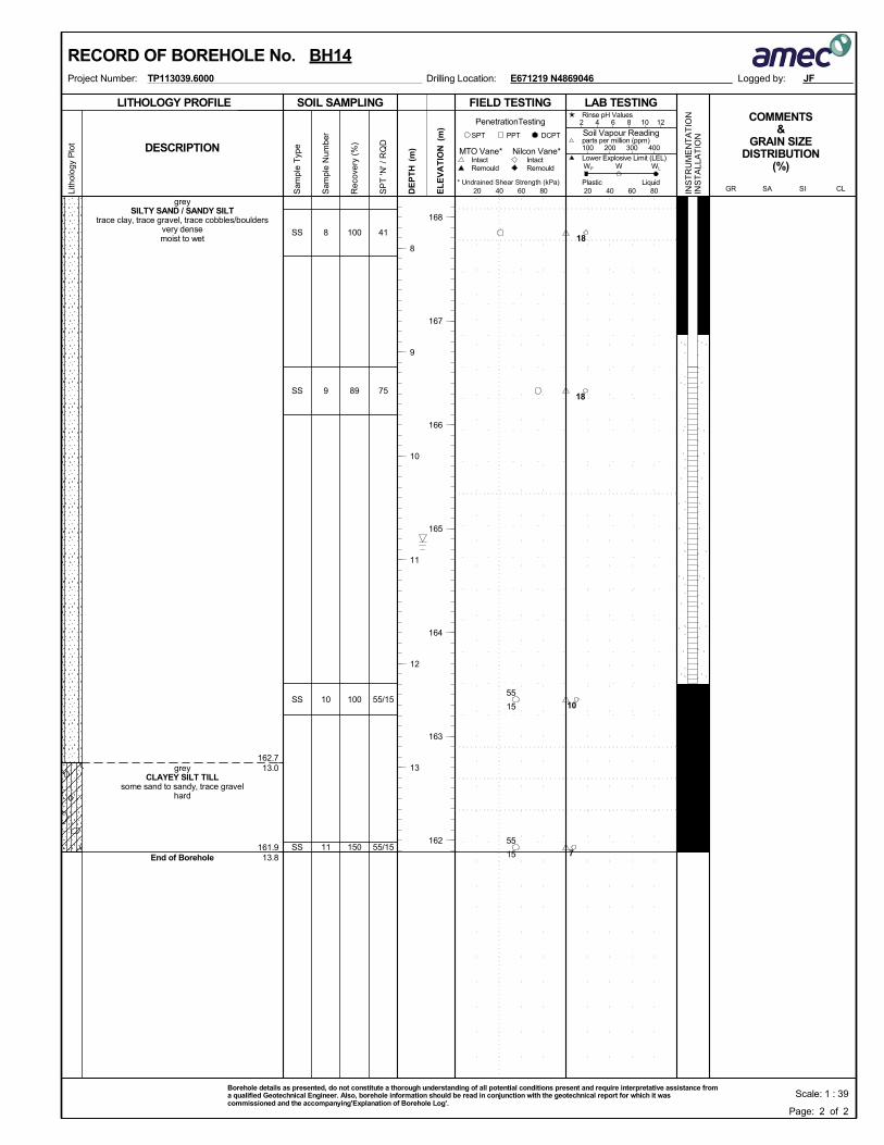
162.7
161.9
13.0
13.8
8
9
10
11
SS
SS
SS
SS
greySILTY SAND / SANDY SILT
trace clay, trace gravel, trace cobbles/bouldersvery densemoist to wet
greyCLAYEY SILT TILL
some sand to sandy, trace gravelhard
End of Borehole
100
89
100
150
41
75
55/15
55/15
SOIL SAMPLING
Sam
ple
Typ
e
Sam
ple
Num
ber
LITHOLOGY PROFILE FIELD TESTING
Rec
over
y (%
)
Lith
olog
y P
lot
LAB TESTINGCOMMENTS
&GRAIN SIZE
DISTRIBUTION(%)
SP
T 'N
' / R
QD
DCPT
* Undrained Shear Strength (kPa)
(m)
(m)
EL
EV
AT
IONDESCRIPTION
20 40 60 80
Intact
INS
TR
UM
EN
TA
TIO
NIN
ST
ALL
AT
ION
Remould
PenetrationTesting
DE
PT
H RemouldIntact
Nilcon Vane*MTO Vane*
PPTSPT
20 40 60 80
2 4 6 8 10 12
Soil Vapour Reading
W WL
Rinse pH Values
parts per million (ppm)
Lower Explosive Limit (LEL)
PlasticCL
100 200 300 400
SISAGRLiquid
WP
Logged by:Project Number: Drilling Location:TP113039.6000
168
167
166
165
164
163
162
8
9
10
11
12
13
E671219 N4869046
RECORD OF BOREHOLE No. BH14
Page: 2 of 2
JF
Scale: 1 : 39Borehole details as presented, do not constitute a thorough understanding of all potential conditions present and require interpretative assistance froma qualified Geotechnical Engineer. Also, borehole information should be read in conjunction with the geotechnical report for which it wascommissioned and the accompanying'Explanation of Borehole Log'.
15
55
15
55
18
18
10
7
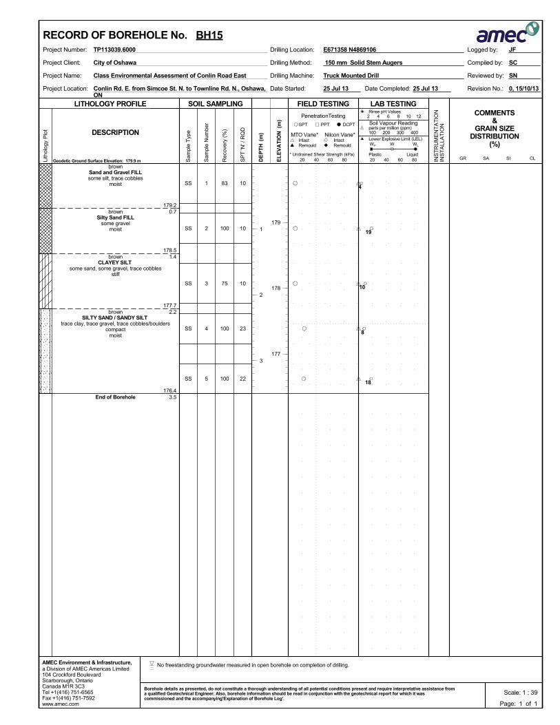
179.2
178.5
177.7
176.4
0.7
1.4
2.2
3.5
1
2
3
4
5
SS
SS
SS
SS
SS
brownSand and Gravel FILLsome silt, trace cobbles
moist
brownSilty Sand FILL
some gravelmoist
brownCLAYEY SILT
some sand, some gravel, trace cobblesstiff
brownSILTY SAND / SANDY SILT
trace clay, trace gravel, trace cobbles/boulderscompact
moist
End of Borehole
83
100
75
100
100
10
10
10
23
22
Drilling Method:Project Client:
Project Name:
Project Location:
Drilling Machine:
150 mm Solid Stem Augers
Conlin Rd. E. from Simcoe St. N. to Townline Rd. N., Oshawa,ON
Truck Mounted Drill
0, 15/10/13Date Completed:
Reviewed by:
Revision No.:Date Started:
Class Environmental Assessment of Conlin Road East
SC
SN
City of Oshawa Compiled by:
25 Jul 13 25 Jul 13
SOIL SAMPLING
Sam
ple
Typ
e
Sam
ple
Num
ber
LITHOLOGY PROFILE FIELD TESTING
Rec
over
y (%
)
Lith
olog
y P
lot
LAB TESTINGCOMMENTS
&GRAIN SIZE
DISTRIBUTION(%)
SP
T 'N
' / R
QD
DCPT
* Undrained Shear Strength (kPa)
(m)
(m)
EL
EV
AT
IONDESCRIPTION
20 40 60 80
Intact
INS
TR
UM
EN
TA
TIO
NIN
ST
ALL
AT
ION
Remould
PenetrationTesting
DE
PT
H RemouldIntact
Nilcon Vane*MTO Vane*
Geodetic Ground Surface Elevation: 179.9 m
PPTSPT
20 40 60 80
2 4 6 8 10 12
Soil Vapour Reading
W WL
Rinse pH Values
parts per million (ppm)
Lower Explosive Limit (LEL)
PlasticCL
100 200 300 400
SISAGRLiquid
WP
a Division of AMEC Americas Limited104 Crockford BoulevardScarborough, OntarioCanada M1R 3C3Tel +1(416) 751-6565Fax +1(416) 751-7592www.amec.com
AMEC Environment & Infrastructure,
Logged by:Project Number: Drilling Location:TP113039.6000
179
178
177
1
2
3
E671358 N4869106
RECORD OF BOREHOLE No. BH15
Page: 1 of 1
JF
Scale: 1 : 39Borehole details as presented, do not constitute a thorough understanding of all potential conditions present and require interpretative assistance froma qualified Geotechnical Engineer. Also, borehole information should be read in conjunction with the geotechnical report for which it wascommissioned and the accompanying'Explanation of Borehole Log'.
4
19
10
8
18
No freestanding groundwater measured in open borehole on completion of drilling.
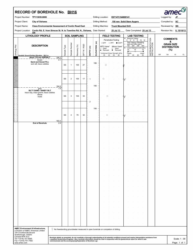
186.2
184.9
183.4
0.1
1.4
2.9
1
2
3
4
SS
SS
SS
SS
about 110 mm ASPHALTbrown
Sand and Gravel FILLsom silt, trace cobbles
greySILTY SAND / SANDY SILT
trace clay, trace gravel, trace cobblesdensemoist
End of Borehole
100
100
100
79
27
17
33
32
Drilling Method:Project Client:
Project Name:
Project Location:
Drilling Machine:
150 mm Solid Stem Augers
Conlin Rd. E. from Simcoe St. N. to Townline Rd. N., Oshawa,ON
Truck Mounted Drill
0, 15/10/13Date Completed:
Reviewed by:
Revision No.:Date Started:
Class Environmental Assessment of Conlin Road East
SC
SN
City of Oshawa Compiled by:
25 Jul 13 25 Jul 13
SOIL SAMPLING
Sam
ple
Typ
e
Sam
ple
Num
ber
LITHOLOGY PROFILE FIELD TESTING
Rec
over
y (%
)
Lith
olog
y P
lot
LAB TESTINGCOMMENTS
&GRAIN SIZE
DISTRIBUTION(%)
SP
T 'N
' / R
QD
DCPT
* Undrained Shear Strength (kPa)
(m)
(m)
EL
EV
AT
IONDESCRIPTION
20 40 60 80
Intact
INS
TR
UM
EN
TA
TIO
NIN
ST
ALL
AT
ION
Remould
PenetrationTesting
DE
PT
H RemouldIntact
Nilcon Vane*MTO Vane*
Geodetic Ground Surface Elevation: 186.3 m
PPTSPT
20 40 60 80
2 4 6 8 10 12
Soil Vapour Reading
W WL
Rinse pH Values
parts per million (ppm)
Lower Explosive Limit (LEL)
PlasticCL
100 200 300 400
SISAGRLiquid
WP
a Division of AMEC Americas Limited104 Crockford BoulevardScarborough, OntarioCanada M1R 3C3Tel +1(416) 751-6565Fax +1(416) 751-7592www.amec.com
AMEC Environment & Infrastructure,
Logged by:Project Number: Drilling Location:TP113039.6000
186
185
184
1
2
E671472 N4869141
RECORD OF BOREHOLE No. BH16
Page: 1 of 1
JF
Scale: 1 : 39Borehole details as presented, do not constitute a thorough understanding of all potential conditions present and require interpretative assistance froma qualified Geotechnical Engineer. Also, borehole information should be read in conjunction with the geotechnical report for which it wascommissioned and the accompanying'Explanation of Borehole Log'.
2
7
7
7
No freestanding groundwater measured in open borehole on completion of drilling.
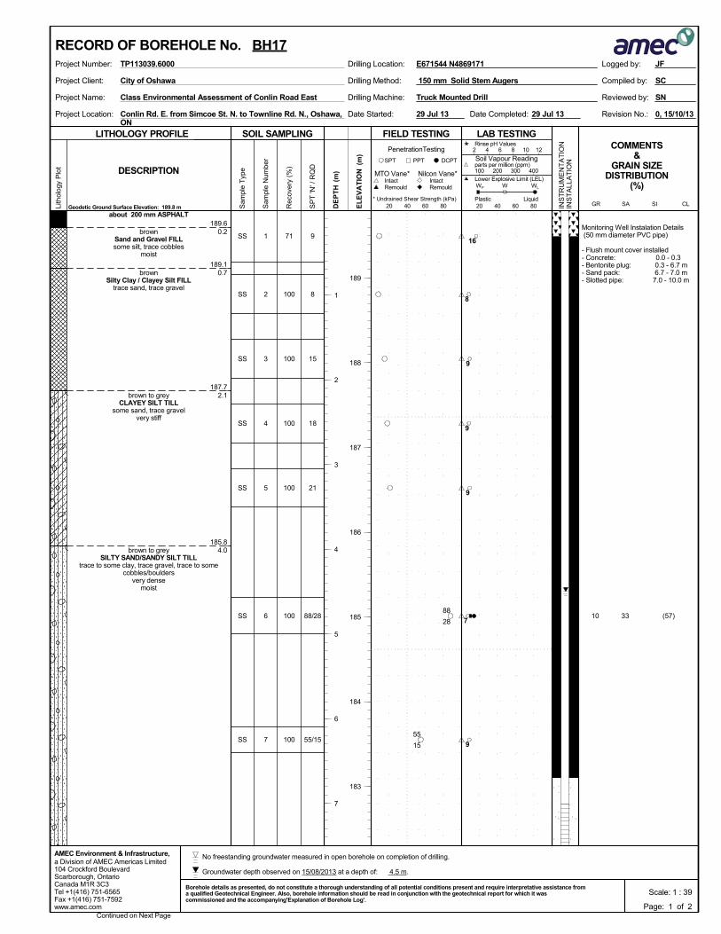
189.6
189.1
187.7
185.8
0.2
0.7
2.1
4.0
Monitoring Well Instalation Details (50 mm diameter PVC pipe)
- Flush mount cover installed- Concrete: 0.0 - 0.3- Bentonite plug: 0.3 - 6.7 m- Sand pack: 6.7 - 7.0 m- Slotted pipe: 7.0 - 10.0 m
1
2
3
4
5
6
7
SS
SS
SS
SS
SS
SS
SS
about 200 mm ASPHALT
brownSand and Gravel FILLsome silt, trace cobbles
moist
brownSilty Clay / Clayey Silt FILL
trace sand, trace gravel
brown to greyCLAYEY SILT TILL
some sand, trace gravelvery stiff
brown to greySILTY SAND/SANDY SILT TILL
trace to some clay, trace gravel, trace to somecobbles/boulders
very densemoist
71
100
100
100
100
100
100
(57)3310
9
8
15
18
21
88/28
55/15
Drilling Method:Project Client:
Project Name:
Project Location:
Drilling Machine:
150 mm Solid Stem Augers
Conlin Rd. E. from Simcoe St. N. to Townline Rd. N., Oshawa,ON
Truck Mounted Drill
0, 15/10/13Date Completed:
Reviewed by:
Revision No.:Date Started:
Class Environmental Assessment of Conlin Road East
SC
SN
City of Oshawa Compiled by:
29 Jul 13 29 Jul 13
SOIL SAMPLING
Sam
ple
Typ
e
Sam
ple
Num
ber
LITHOLOGY PROFILE FIELD TESTING
Rec
over
y (%
)
Lith
olog
y P
lot
LAB TESTINGCOMMENTS
&GRAIN SIZE
DISTRIBUTION(%)
SP
T 'N
' / R
QD
DCPT
* Undrained Shear Strength (kPa)
(m)
(m)
EL
EV
AT
IONDESCRIPTION
20 40 60 80
Intact
INS
TR
UM
EN
TA
TIO
NIN
ST
ALL
AT
ION
Remould
PenetrationTesting
DE
PT
H RemouldIntact
Nilcon Vane*MTO Vane*
Geodetic Ground Surface Elevation: 189.8 m
PPTSPT
20 40 60 80
2 4 6 8 10 12
Soil Vapour Reading
W WL
Rinse pH Values
parts per million (ppm)
Lower Explosive Limit (LEL)
PlasticCL
100 200 300 400
SISAGRLiquid
WP
a Division of AMEC Americas Limited104 Crockford BoulevardScarborough, OntarioCanada M1R 3C3Tel +1(416) 751-6565Fax +1(416) 751-7592www.amec.com
AMEC Environment & Infrastructure,
Logged by:Project Number: Drilling Location:TP113039.6000
Continued on Next Page
189
188
187
186
185
184
183
1
2
3
4
5
6
7
E671544 N4869171
RECORD OF BOREHOLE No. BH17
Page: 1 of 2
JF
Scale: 1 : 39Borehole details as presented, do not constitute a thorough understanding of all potential conditions present and require interpretative assistance froma qualified Geotechnical Engineer. Also, borehole information should be read in conjunction with the geotechnical report for which it wascommissioned and the accompanying'Explanation of Borehole Log'.
28
88
15
55
16
8
9
9
9
7
9
Groundwater depth observed on 15/08/2013 at a depth of: 4.5 m.
No freestanding groundwater measured in open borehole on completion of drilling.
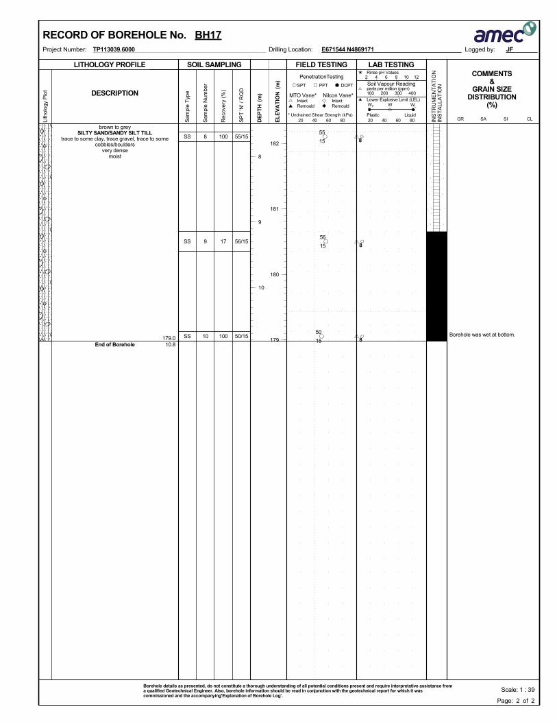
179.010.8
Borehole was wet at bottom.
8
9
10
SS
SS
SS
brown to greySILTY SAND/SANDY SILT TILL
trace to some clay, trace gravel, trace to somecobbles/boulders
very densemoist
End of Borehole
100
17
100
55/15
56/15
50/15
SOIL SAMPLING
Sam
ple
Typ
e
Sam
ple
Num
ber
LITHOLOGY PROFILE FIELD TESTING
Rec
over
y (%
)
Lith
olog
y P
lot
LAB TESTINGCOMMENTS
&GRAIN SIZE
DISTRIBUTION(%)
SP
T 'N
' / R
QD
DCPT
* Undrained Shear Strength (kPa)
(m)
(m)
EL
EV
AT
IONDESCRIPTION
20 40 60 80
Intact
INS
TR
UM
EN
TA
TIO
NIN
ST
ALL
AT
ION
Remould
PenetrationTesting
DE
PT
H RemouldIntact
Nilcon Vane*MTO Vane*
PPTSPT
20 40 60 80
2 4 6 8 10 12
Soil Vapour Reading
W WL
Rinse pH Values
parts per million (ppm)
Lower Explosive Limit (LEL)
PlasticCL
100 200 300 400
SISAGRLiquid
WP
Logged by:Project Number: Drilling Location:TP113039.6000
182
181
180
179
8
9
10
E671544 N4869171
RECORD OF BOREHOLE No. BH17
Page: 2 of 2
JF
Scale: 1 : 39Borehole details as presented, do not constitute a thorough understanding of all potential conditions present and require interpretative assistance froma qualified Geotechnical Engineer. Also, borehole information should be read in conjunction with the geotechnical report for which it wascommissioned and the accompanying'Explanation of Borehole Log'.
15
55
15
56
15
50
8
8
8
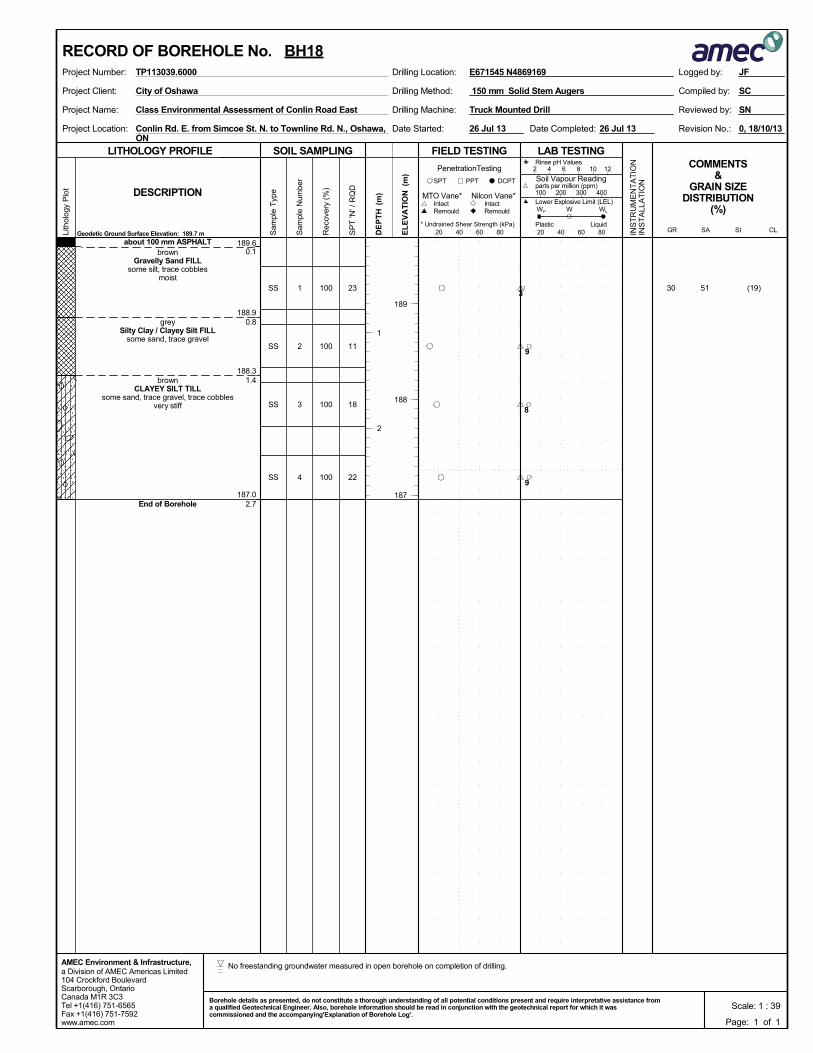
189.6
188.9
188.3
187.0
0.1
0.8
1.4
2.7
1
2
3
4
SS
SS
SS
SS
about 100 mm ASPHALTbrown
Gravelly Sand FILLsome silt, trace cobbles
moist
greySilty Clay / Clayey Silt FILL
some sand, trace gravel
brownCLAYEY SILT TILL
some sand, trace gravel, trace cobblesvery stiff
End of Borehole
100
100
100
100
(19)513023
11
18
22
Drilling Method:Project Client:
Project Name:
Project Location:
Drilling Machine:
150 mm Solid Stem Augers
Conlin Rd. E. from Simcoe St. N. to Townline Rd. N., Oshawa,ON
Truck Mounted Drill
0, 18/10/13Date Completed:
Reviewed by:
Revision No.:Date Started:
Class Environmental Assessment of Conlin Road East
SC
SN
City of Oshawa Compiled by:
26 Jul 13 26 Jul 13
SOIL SAMPLING
Sam
ple
Typ
e
Sam
ple
Num
ber
LITHOLOGY PROFILE FIELD TESTING
Rec
over
y (%
)
Lith
olog
y P
lot
LAB TESTINGCOMMENTS
&GRAIN SIZE
DISTRIBUTION(%)
SP
T 'N
' / R
QD
DCPT
* Undrained Shear Strength (kPa)
(m)
(m)
EL
EV
AT
IONDESCRIPTION
20 40 60 80
Intact
INS
TR
UM
EN
TA
TIO
NIN
ST
ALL
AT
ION
Remould
PenetrationTesting
DE
PT
H RemouldIntact
Nilcon Vane*MTO Vane*
Geodetic Ground Surface Elevation: 189.7 m
PPTSPT
20 40 60 80
2 4 6 8 10 12
Soil Vapour Reading
W WL
Rinse pH Values
parts per million (ppm)
Lower Explosive Limit (LEL)
PlasticCL
100 200 300 400
SISAGRLiquid
WP
a Division of AMEC Americas Limited104 Crockford BoulevardScarborough, OntarioCanada M1R 3C3Tel +1(416) 751-6565Fax +1(416) 751-7592www.amec.com
AMEC Environment & Infrastructure,
Logged by:Project Number: Drilling Location:TP113039.6000
189
188
187
1
2
E671545 N4869169
RECORD OF BOREHOLE No. BH18
Page: 1 of 1
JF
Scale: 1 : 39Borehole details as presented, do not constitute a thorough understanding of all potential conditions present and require interpretative assistance froma qualified Geotechnical Engineer. Also, borehole information should be read in conjunction with the geotechnical report for which it wascommissioned and the accompanying'Explanation of Borehole Log'.
3
9
8
9
No freestanding groundwater measured in open borehole on completion of drilling.
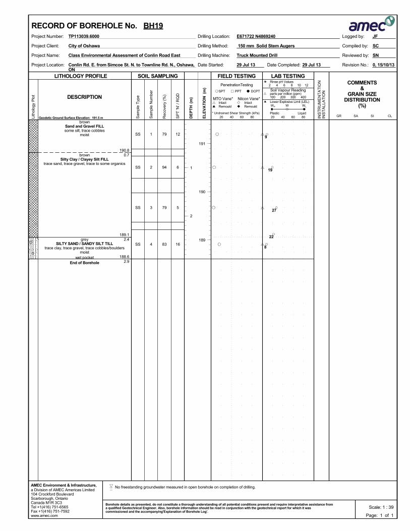
190.8
189.1
188.6
0.7
2.4
2.9
1
2
3
4
SS
SS
SS
SS
brownSand and Gravel FILLsome silt, trace cobbles
moist
brownSilty Clay / Clayey Silt FILL
trace sand, trace gravel, trace to some organics
greySILTY SAND / SANDY SILT TILL
trace clay, trace gravel, trace cobbles/bouldersmoist
wet pocketEnd of Borehole
79
94
79
83
12
6
5
16
Drilling Method:Project Client:
Project Name:
Project Location:
Drilling Machine:
150 mm Solid Stem Augers
Conlin Rd. E. from Simcoe St. N. to Townline Rd. N., Oshawa,ON
Truck Mounted Drill
0, 15/10/13Date Completed:
Reviewed by:
Revision No.:Date Started:
Class Environmental Assessment of Conlin Road East
SC
SN
City of Oshawa Compiled by:
29 Jul 13 29 Jul 13
SOIL SAMPLING
Sam
ple
Typ
e
Sam
ple
Num
ber
LITHOLOGY PROFILE FIELD TESTING
Rec
over
y (%
)
Lith
olog
y P
lot
LAB TESTINGCOMMENTS
&GRAIN SIZE
DISTRIBUTION(%)
SP
T 'N
' / R
QD
DCPT
* Undrained Shear Strength (kPa)
(m)
(m)
EL
EV
AT
IONDESCRIPTION
20 40 60 80
Intact
INS
TR
UM
EN
TA
TIO
NIN
ST
ALL
AT
ION
Remould
PenetrationTesting
DE
PT
H RemouldIntact
Nilcon Vane*MTO Vane*
Geodetic Ground Surface Elevation: 191.5 m
PPTSPT
20 40 60 80
2 4 6 8 10 12
Soil Vapour Reading
W WL
Rinse pH Values
parts per million (ppm)
Lower Explosive Limit (LEL)
PlasticCL
100 200 300 400
SISAGRLiquid
WP
a Division of AMEC Americas Limited104 Crockford BoulevardScarborough, OntarioCanada M1R 3C3Tel +1(416) 751-6565Fax +1(416) 751-7592www.amec.com
AMEC Environment & Infrastructure,
Logged by:Project Number: Drilling Location:TP113039.6000
191
190
189
1
2
E671722 N4869240
RECORD OF BOREHOLE No. BH19
Page: 1 of 1
JF
Scale: 1 : 39Borehole details as presented, do not constitute a thorough understanding of all potential conditions present and require interpretative assistance froma qualified Geotechnical Engineer. Also, borehole information should be read in conjunction with the geotechnical report for which it wascommissioned and the accompanying'Explanation of Borehole Log'.
9
19
27
22
8
No freestanding groundwater measured in open borehole on completion of drilling.
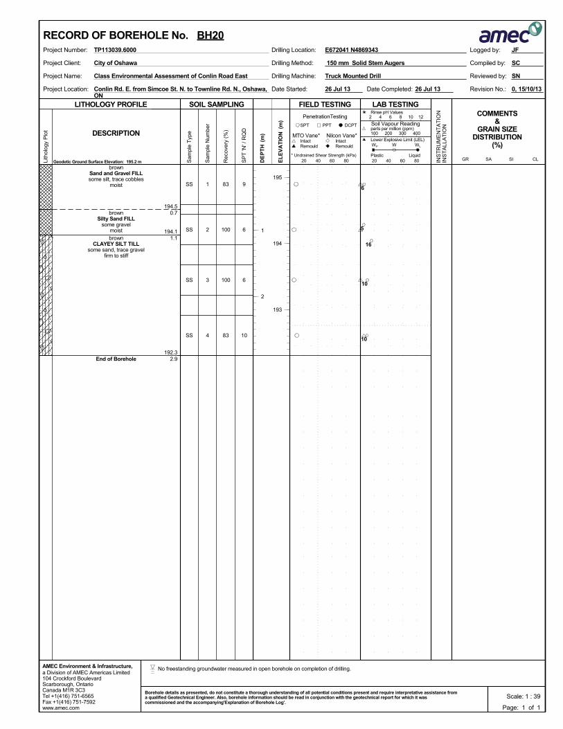
194.5
194.1
192.3
0.7
1.1
2.9
1
2
3
4
SS
SS
SS
SS
brownSand and Gravel FILLsome silt, trace cobbles
moist
brownSilty Sand FILL
some gravelmoist
brownCLAYEY SILT TILL
some sand, trace gravelfirm to stiff
End of Borehole
83
100
100
83
9
6
6
10
Drilling Method:Project Client:
Project Name:
Project Location:
Drilling Machine:
150 mm Solid Stem Augers
Conlin Rd. E. from Simcoe St. N. to Townline Rd. N., Oshawa,ON
Truck Mounted Drill
0, 15/10/13Date Completed:
Reviewed by:
Revision No.:Date Started:
Class Environmental Assessment of Conlin Road East
SC
SN
City of Oshawa Compiled by:
26 Jul 13 26 Jul 13
SOIL SAMPLING
Sam
ple
Typ
e
Sam
ple
Num
ber
LITHOLOGY PROFILE FIELD TESTING
Rec
over
y (%
)
Lith
olog
y P
lot
LAB TESTINGCOMMENTS
&GRAIN SIZE
DISTRIBUTION(%)
SP
T 'N
' / R
QD
DCPT
* Undrained Shear Strength (kPa)
(m)
(m)
EL
EV
AT
IONDESCRIPTION
20 40 60 80
Intact
INS
TR
UM
EN
TA
TIO
NIN
ST
ALL
AT
ION
Remould
PenetrationTesting
DE
PT
H RemouldIntact
Nilcon Vane*MTO Vane*
Geodetic Ground Surface Elevation: 195.2 m
PPTSPT
20 40 60 80
2 4 6 8 10 12
Soil Vapour Reading
W WL
Rinse pH Values
parts per million (ppm)
Lower Explosive Limit (LEL)
PlasticCL
100 200 300 400
SISAGRLiquid
WP
a Division of AMEC Americas Limited104 Crockford BoulevardScarborough, OntarioCanada M1R 3C3Tel +1(416) 751-6565Fax +1(416) 751-7592www.amec.com
AMEC Environment & Infrastructure,
Logged by:Project Number: Drilling Location:TP113039.6000
195
194
193
1
2
E672041 N4869343
RECORD OF BOREHOLE No. BH20
Page: 1 of 1
JF
Scale: 1 : 39Borehole details as presented, do not constitute a thorough understanding of all potential conditions present and require interpretative assistance froma qualified Geotechnical Engineer. Also, borehole information should be read in conjunction with the geotechnical report for which it wascommissioned and the accompanying'Explanation of Borehole Log'.
6
5
16
10
10
No freestanding groundwater measured in open borehole on completion of drilling.
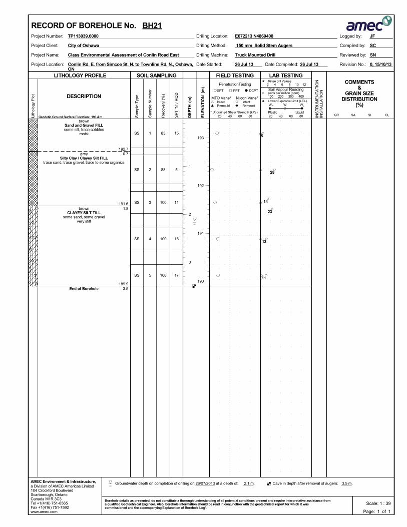
192.7
191.6
189.9
0.7
1.8
3.5
1
2
3
4
5
SS
SS
SS
SS
SS
brownSand and Gravel FILLsome silt, trace cobbles
moist
greySilty Clay / Clayey Silt FILL
trace sand, trace gravel, trace to some organics
brownCLAYEY SILT TILL
some sand, some gravelvery stiff
End of Borehole
83
88
100
100
100
15
5
11
16
17
Drilling Method:Project Client:
Project Name:
Project Location:
Drilling Machine:
150 mm Solid Stem Augers
Conlin Rd. E. from Simcoe St. N. to Townline Rd. N., Oshawa,ON
Truck Mounted Drill
0, 15/10/13Date Completed:
Reviewed by:
Revision No.:Date Started:
Class Environmental Assessment of Conlin Road East
SC
SN
City of Oshawa Compiled by:
26 Jul 13 26 Jul 13
SOIL SAMPLING
Sam
ple
Typ
e
Sam
ple
Num
ber
LITHOLOGY PROFILE FIELD TESTING
Rec
over
y (%
)
Lith
olog
y P
lot
LAB TESTINGCOMMENTS
&GRAIN SIZE
DISTRIBUTION(%)
SP
T 'N
' / R
QD
DCPT
* Undrained Shear Strength (kPa)
(m)
(m)
EL
EV
AT
IONDESCRIPTION
20 40 60 80
Intact
INS
TR
UM
EN
TA
TIO
NIN
ST
ALL
AT
ION
Remould
PenetrationTesting
DE
PT
H RemouldIntact
Nilcon Vane*MTO Vane*
Geodetic Ground Surface Elevation: 193.4 m
PPTSPT
20 40 60 80
2 4 6 8 10 12
Soil Vapour Reading
W WL
Rinse pH Values
parts per million (ppm)
Lower Explosive Limit (LEL)
PlasticCL
100 200 300 400
SISAGRLiquid
WP
a Division of AMEC Americas Limited104 Crockford BoulevardScarborough, OntarioCanada M1R 3C3Tel +1(416) 751-6565Fax +1(416) 751-7592www.amec.com
AMEC Environment & Infrastructure,
Logged by:Project Number: Drilling Location:TP113039.6000
193
192
191
190
1
2
3
E672213 N4869408
RECORD OF BOREHOLE No. BH21
Page: 1 of 1
JF
Scale: 1 : 39Borehole details as presented, do not constitute a thorough understanding of all potential conditions present and require interpretative assistance froma qualified Geotechnical Engineer. Also, borehole information should be read in conjunction with the geotechnical report for which it wascommissioned and the accompanying'Explanation of Borehole Log'.
5
28
14
23
12
11
Cave in depth after removal of augers: 3.5 m. Groundwater depth on completion of drilling on 26/07/2013 at a depth of: 2.1 m.
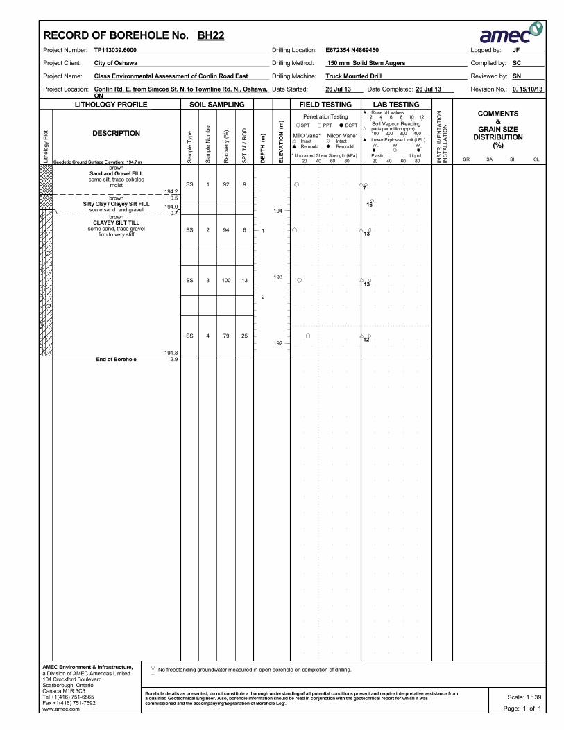
194.2
194.0
191.8
0.5
0.7
2.9
1
2
3
4
SS
SS
SS
SS
brownSand and Gravel FILLsome silt, trace cobbles
moist
brownSilty Clay / Clayey Silt FILL
some sand and gravelbrown
CLAYEY SILT TILLsome sand, trace gravel
firm to very stiff
End of Borehole
92
94
100
79
9
6
13
25
Drilling Method:Project Client:
Project Name:
Project Location:
Drilling Machine:
150 mm Solid Stem Augers
Conlin Rd. E. from Simcoe St. N. to Townline Rd. N., Oshawa,ON
Truck Mounted Drill
0, 15/10/13Date Completed:
Reviewed by:
Revision No.:Date Started:
Class Environmental Assessment of Conlin Road East
SC
SN
City of Oshawa Compiled by:
26 Jul 13 26 Jul 13
SOIL SAMPLING
Sam
ple
Typ
e
Sam
ple
Num
ber
LITHOLOGY PROFILE FIELD TESTING
Rec
over
y (%
)
Lith
olog
y P
lot
LAB TESTINGCOMMENTS
&GRAIN SIZE
DISTRIBUTION(%)
SP
T 'N
' / R
QD
DCPT
* Undrained Shear Strength (kPa)
(m)
(m)
EL
EV
AT
IONDESCRIPTION
20 40 60 80
Intact
INS
TR
UM
EN
TA
TIO
NIN
ST
ALL
AT
ION
Remould
PenetrationTesting
DE
PT
H RemouldIntact
Nilcon Vane*MTO Vane*
Geodetic Ground Surface Elevation: 194.7 m
PPTSPT
20 40 60 80
2 4 6 8 10 12
Soil Vapour Reading
W WL
Rinse pH Values
parts per million (ppm)
Lower Explosive Limit (LEL)
PlasticCL
100 200 300 400
SISAGRLiquid
WP
a Division of AMEC Americas Limited104 Crockford BoulevardScarborough, OntarioCanada M1R 3C3Tel +1(416) 751-6565Fax +1(416) 751-7592www.amec.com
AMEC Environment & Infrastructure,
Logged by:Project Number: Drilling Location:TP113039.6000
194
193
192
1
2
E672354 N4869450
RECORD OF BOREHOLE No. BH22
Page: 1 of 1
JF
Scale: 1 : 39Borehole details as presented, do not constitute a thorough understanding of all potential conditions present and require interpretative assistance froma qualified Geotechnical Engineer. Also, borehole information should be read in conjunction with the geotechnical report for which it wascommissioned and the accompanying'Explanation of Borehole Log'.
7
16
13
13
12
No freestanding groundwater measured in open borehole on completion of drilling.
193.3
192.8
191.3
190.5
189.5
0.2
0.7
2.2
3.0
4.0
Monitoring Well Instalation Details (50 mm diameter PVC pipe)
- Flush mount cover installed- Concrete: 0.0 - 0.3 m- Bentonite plug: 0.3 - 4.3 m- Sand pack: 4.3 - 4.6 m- Slotted pipe: 4.6 - 7.6 m
1
2
3
4
5
6
7
SS
SS
SS
SS
SS
SS
SS
about 150 mm ASPHALT
brownSand and Gravel FILLsome silt, trace cobbles
moist
brownSilty Clay / Clayey Silt FILL
trace sand, trace gravel, trace to some organics
brownSilty Sand FILL
some gravelmoist
greyCLAYEY SILT TILL
some sand, some gravel, trace cobbles/bouldershard
greySAND / SANDY SILT / SILTY SAND
trace gravel, trace to some cobbles/bouldersvery densemoist to wet
111
100
67
83
100
100
100
(9)
(17)
43
83
4819
6
4
27
70
82
87
Drilling Method:Project Client:
Project Name:
Project Location:
Drilling Machine:
150 mm Solid Stem Augers
Conlin Rd. E. from Simcoe St. N. to Townline Rd. N., Oshawa,ON
Truck Mounted Drill
0, 15/10/13Date Completed:
Reviewed by:
Revision No.:Date Started:
Class Environmental Assessment of Conlin Road East
SC
SN
City of Oshawa Compiled by:
26 Jul 13 26 Jul 13
SOIL SAMPLING
Sam
ple
Typ
e
Sam
ple
Num
ber
LITHOLOGY PROFILE FIELD TESTING
Rec
over
y (%
)
Lith
olog
y P
lot
LAB TESTINGCOMMENTS
&GRAIN SIZE
DISTRIBUTION(%)
SP
T 'N
' / R
QD
DCPT
* Undrained Shear Strength (kPa)
(m)
(m)
EL
EV
AT
IONDESCRIPTION
20 40 60 80
Intact
INS
TR
UM
EN
TA
TIO
NIN
ST
ALL
AT
ION
Remould
PenetrationTesting
DE
PT
H RemouldIntact
Nilcon Vane*MTO Vane*
Geodetic Ground Surface Elevation: 193.5 m
PPTSPT
20 40 60 80
2 4 6 8 10 12
Soil Vapour Reading
W WL
Rinse pH Values
parts per million (ppm)
Lower Explosive Limit (LEL)
PlasticCL
100 200 300 400
SISAGRLiquid
WP
a Division of AMEC Americas Limited104 Crockford BoulevardScarborough, OntarioCanada M1R 3C3Tel +1(416) 751-6565Fax +1(416) 751-7592www.amec.com
AMEC Environment & Infrastructure,
Logged by:Project Number: Drilling Location:TP113039.6000
Continued on Next Page
193
192
191
190
189
188
187
186
1
2
3
4
5
6
7
E672482 N4869492
RECORD OF BOREHOLE No. BH23
Page: 1 of 2
JF
Scale: 1 : 39Borehole details as presented, do not constitute a thorough understanding of all potential conditions present and require interpretative assistance froma qualified Geotechnical Engineer. Also, borehole information should be read in conjunction with the geotechnical report for which it wascommissioned and the accompanying'Explanation of Borehole Log'.
6
20
18
8
7
20
16
Groundwater depth observed on 15/08/2013 at a depth of: 1.6 m.
Groundwater depth on completion of drilling on 26/07/2013 at a depth of: 3.8 m.

182.511.0
8
9
10
SS
SS
SS
greySAND / SANDY SILT / SILTY SAND
trace gravel, trace to some cobbles/bouldersvery densemoist to wet
End of Borehole
100
100
100
55/15
55/15
50/15
SOIL SAMPLING
Sam
ple
Typ
e
Sam
ple
Num
ber
LITHOLOGY PROFILE FIELD TESTING
Rec
over
y (%
)
Lith
olog
y P
lot
LAB TESTINGCOMMENTS
&GRAIN SIZE
DISTRIBUTION(%)
SP
T 'N
' / R
QD
DCPT
* Undrained Shear Strength (kPa)
(m)
(m)
EL
EV
AT
IONDESCRIPTION
20 40 60 80
Intact
INS
TR
UM
EN
TA
TIO
NIN
ST
ALL
AT
ION
Remould
PenetrationTesting
DE
PT
H RemouldIntact
Nilcon Vane*MTO Vane*
PPTSPT
20 40 60 80
2 4 6 8 10 12
Soil Vapour Reading
W WL
Rinse pH Values
parts per million (ppm)
Lower Explosive Limit (LEL)
PlasticCL
100 200 300 400
SISAGRLiquid
WP
Logged by:Project Number: Drilling Location:TP113039.6000
185
184
183
8
9
10
E672482 N4869492
RECORD OF BOREHOLE No. BH23
Page: 2 of 2
JF
Scale: 1 : 39Borehole details as presented, do not constitute a thorough understanding of all potential conditions present and require interpretative assistance froma qualified Geotechnical Engineer. Also, borehole information should be read in conjunction with the geotechnical report for which it wascommissioned and the accompanying'Explanation of Borehole Log'.
15
55
15
55
15
50
15
12
14
193.7
193.1
191.4
190.3
0.6
1.2
2.9
4.0
Monitoring Well Instalation Details (50 mm diameter PVC pipe)
- Flush mount cover installed- Concrete: 0.0 - 0.3 m- Bentonite plug: 0.3 - 4.3 m- Sand pack: 4.3 - 4.6 m- Slotted pipe: 4.6 - 7.6 m
1
2
3
4
5
6
7
AS
SS
SS
SS
SS
SS
SS
brownSand and Gravel FILLsome silt, trace cobbles
moist
brownSilty Sand FILL
some gravel, trace cobblesmoist
greySilty Clay / Clayey Silt FILL
trace sand, trace gravel
greyCLAYEY SILT TILL
some sand, some gravelvery stiff
greySANDY SILT / SILT
trace clay, trace gravel, trace to somecobbles/boulders
very densemoist
83
0
100
100
100
100
9
4
9
25
69
80
Drilling Method:Project Client:
Project Name:
Project Location:
Drilling Machine:
150 mm Solid Stem Augers
Conlin Rd. E. from Simcoe St. N. to Townline Rd. N., Oshawa,ON
Truck Mounted Drill
0, 15/10/13Date Completed:
Reviewed by:
Revision No.:Date Started:
Class Environmental Assessment of Conlin Road East
SC
SN
City of Oshawa Compiled by:
26 Jul 13 26 Jul 13
SOIL SAMPLING
Sam
ple
Typ
e
Sam
ple
Num
ber
LITHOLOGY PROFILE FIELD TESTING
Rec
over
y (%
)
Lith
olog
y P
lot
LAB TESTINGCOMMENTS
&GRAIN SIZE
DISTRIBUTION(%)
SP
T 'N
' / R
QD
DCPT
* Undrained Shear Strength (kPa)
(m)
(m)
EL
EV
AT
IONDESCRIPTION
20 40 60 80
Intact
INS
TR
UM
EN
TA
TIO
NIN
ST
ALL
AT
ION
Remould
PenetrationTesting
DE
PT
H RemouldIntact
Nilcon Vane*MTO Vane*
Geodetic Ground Surface Elevation: 194.3 m
PPTSPT
20 40 60 80
2 4 6 8 10 12
Soil Vapour Reading
W WL
Rinse pH Values
parts per million (ppm)
Lower Explosive Limit (LEL)
PlasticCL
100 200 300 400
SISAGRLiquid
WP
a Division of AMEC Americas Limited104 Crockford BoulevardScarborough, OntarioCanada M1R 3C3Tel +1(416) 751-6565Fax +1(416) 751-7592www.amec.com
AMEC Environment & Infrastructure,
Logged by:Project Number: Drilling Location:TP113039.6000
Continued on Next Page
194
193
192
191
190
189
188
187
1
2
3
4
5
6
7
E672495 N4869507
RECORD OF BOREHOLE No. BH24
Page: 1 of 2
JF
Scale: 1 : 39Borehole details as presented, do not constitute a thorough understanding of all potential conditions present and require interpretative assistance froma qualified Geotechnical Engineer. Also, borehole information should be read in conjunction with the geotechnical report for which it wascommissioned and the accompanying'Explanation of Borehole Log'.
2
5
22
14
7
18
18
Groundwater depth observed on 15/08/2013 at a depth of: 1.5 m.
Groundwater depth on completion of drilling on 26/07/2013 at a depth of: 3.5 m.
183.311.0
8
9
10
SS
SS
SS
greySANDY SILT / SILT
trace clay, trace gravel, trace to somecobbles/boulders
very densemoist
End of Borehole
100
100
100
52/15
55/15
52/15
SOIL SAMPLING
Sam
ple
Typ
e
Sam
ple
Num
ber
LITHOLOGY PROFILE FIELD TESTING
Rec
over
y (%
)
Lith
olog
y P
lot
LAB TESTINGCOMMENTS
&GRAIN SIZE
DISTRIBUTION(%)
SP
T 'N
' / R
QD
DCPT
* Undrained Shear Strength (kPa)
(m)
(m)
EL
EV
AT
IONDESCRIPTION
20 40 60 80
Intact
INS
TR
UM
EN
TA
TIO
NIN
ST
ALL
AT
ION
Remould
PenetrationTesting
DE
PT
H RemouldIntact
Nilcon Vane*MTO Vane*
PPTSPT
20 40 60 80
2 4 6 8 10 12
Soil Vapour Reading
W WL
Rinse pH Values
parts per million (ppm)
Lower Explosive Limit (LEL)
PlasticCL
100 200 300 400
SISAGRLiquid
WP
Logged by:Project Number: Drilling Location:TP113039.6000
186
185
184
8
9
10
E672495 N4869507
RECORD OF BOREHOLE No. BH24
Page: 2 of 2
JF
Scale: 1 : 39Borehole details as presented, do not constitute a thorough understanding of all potential conditions present and require interpretative assistance froma qualified Geotechnical Engineer. Also, borehole information should be read in conjunction with the geotechnical report for which it wascommissioned and the accompanying'Explanation of Borehole Log'.
15
52
15
55
15
52
20
20
17
198.7
197.4
1.4
2.7
1
2
3
4
SS
SS
SS
SS
brownSand and Gravel FILL
some silt, trace cobbles, trace to some organicsmoist
brownSANDY SILT / SILTY SAND
trace clay, trace gravelcompact
moist to wet
End of Borehole
92
733
17
100
34
6
21
22
Drilling Method:Project Client:
Project Name:
Project Location:
Drilling Machine:
150 mm Solid Stem Augers
Conlin Rd. E. from Simcoe St. N. to Townline Rd. N., Oshawa,ON
Truck Mounted Drill
0, 15/10/13Date Completed:
Reviewed by:
Revision No.:Date Started:
Class Environmental Assessment of Conlin Road East
SC
SN
City of Oshawa Compiled by:
26 Jul 13 26 Jul 13
SOIL SAMPLING
Sam
ple
Typ
e
Sam
ple
Num
ber
LITHOLOGY PROFILE FIELD TESTING
Rec
over
y (%
)
Lith
olog
y P
lot
LAB TESTINGCOMMENTS
&GRAIN SIZE
DISTRIBUTION(%)
SP
T 'N
' / R
QD
DCPT
* Undrained Shear Strength (kPa)
(m)
(m)
EL
EV
AT
IONDESCRIPTION
20 40 60 80
Intact
INS
TR
UM
EN
TA
TIO
NIN
ST
ALL
AT
ION
Remould
PenetrationTesting
DE
PT
H RemouldIntact
Nilcon Vane*MTO Vane*
Geodetic Ground Surface Elevation: 200.1 m
PPTSPT
20 40 60 80
2 4 6 8 10 12
Soil Vapour Reading
W WL
Rinse pH Values
parts per million (ppm)
Lower Explosive Limit (LEL)
PlasticCL
100 200 300 400
SISAGRLiquid
WP
a Division of AMEC Americas Limited104 Crockford BoulevardScarborough, OntarioCanada M1R 3C3Tel +1(416) 751-6565Fax +1(416) 751-7592www.amec.com
AMEC Environment & Infrastructure,
Logged by:Project Number: Drilling Location:TP113039.6000
200
199
198
1
2
E672680 N4869571
RECORD OF BOREHOLE No. BH25
Page: 1 of 1
JF
Scale: 1 : 39Borehole details as presented, do not constitute a thorough understanding of all potential conditions present and require interpretative assistance froma qualified Geotechnical Engineer. Also, borehole information should be read in conjunction with the geotechnical report for which it wascommissioned and the accompanying'Explanation of Borehole Log'.
22
13
14
14
Cave in depth after removal of augers: 2.7 m. Groundwater depth on completion of drilling on 26/07/2013 at a depth of: 2.3 m.
207.3
206.4
204.9
0.5
1.4
2.9
1
2
3
4
SS
SS
SS
SS
brownSand and Gravel FILL
some siltmoist
dark greySilty Sand FILL
some gravel, with organicsmoist
greySANDY SILT
some clay, trace gravel, trace cobbles/bouldersdense to very dense
moist
End of Borehole
83
100
100
75
16
5
43
52
Drilling Method:Project Client:
Project Name:
Project Location:
Drilling Machine:
150 mm Solid Stem Augers
Conlin Rd. E. from Simcoe St. N. to Townline Rd. N., Oshawa,ON
Truck Mounted Drill
0, 15/10/13Date Completed:
Reviewed by:
Revision No.:Date Started:
Class Environmental Assessment of Conlin Road East
SC
SN
City of Oshawa Compiled by:
26 Jul 13 26 Jul 13
SOIL SAMPLING
Sam
ple
Typ
e
Sam
ple
Num
ber
LITHOLOGY PROFILE FIELD TESTING
Rec
over
y (%
)
Lith
olog
y P
lot
LAB TESTINGCOMMENTS
&GRAIN SIZE
DISTRIBUTION(%)
SP
T 'N
' / R
QD
DCPT
* Undrained Shear Strength (kPa)
(m)
(m)
EL
EV
AT
IONDESCRIPTION
20 40 60 80
Intact
INS
TR
UM
EN
TA
TIO
NIN
ST
ALL
AT
ION
Remould
PenetrationTesting
DE
PT
H RemouldIntact
Nilcon Vane*MTO Vane*
Geodetic Ground Surface Elevation: 207.8 m
PPTSPT
20 40 60 80
2 4 6 8 10 12
Soil Vapour Reading
W WL
Rinse pH Values
parts per million (ppm)
Lower Explosive Limit (LEL)
PlasticCL
100 200 300 400
SISAGRLiquid
WP
a Division of AMEC Americas Limited104 Crockford BoulevardScarborough, OntarioCanada M1R 3C3Tel +1(416) 751-6565Fax +1(416) 751-7592www.amec.com
AMEC Environment & Infrastructure,
Logged by:Project Number: Drilling Location:TP113039.6000
207
206
205
1
2
E672808 N4869608
RECORD OF BOREHOLE No. BH26
Page: 1 of 1
JF
Scale: 1 : 39Borehole details as presented, do not constitute a thorough understanding of all potential conditions present and require interpretative assistance froma qualified Geotechnical Engineer. Also, borehole information should be read in conjunction with the geotechnical report for which it wascommissioned and the accompanying'Explanation of Borehole Log'.
3
13
8
6
No freestanding groundwater measured in open borehole on completion of drilling.
210.0
209.5
207.1
0.6
1.1
3.5
1
2
3
4
5
SS
SS
SS
SS
SS
brownSand and Gravel FILLsome silt, trace cobbles
moist
brownSilty Sand FILL
some gravel, trace cobblesmoist
brownSANDY SILT
some clay, trace gravelloose to compact
moist
End of Borehole
83
94
100
100
100
16
6
15
21
23
Drilling Method:Project Client:
Project Name:
Project Location:
Drilling Machine:
150 mm Solid Stem Augers
Conlin Rd. E. from Simcoe St. N. to Townline Rd. N., Oshawa,ON
Truck Mounted Drill
0, 15/10/13Date Completed:
Reviewed by:
Revision No.:Date Started:
Class Environmental Assessment of Conlin Road East
SC
SN
City of Oshawa Compiled by:
26 Jul 13 26 Jul 13
SOIL SAMPLING
Sam
ple
Typ
e
Sam
ple
Num
ber
LITHOLOGY PROFILE FIELD TESTING
Rec
over
y (%
)
Lith
olog
y P
lot
LAB TESTINGCOMMENTS
&GRAIN SIZE
DISTRIBUTION(%)
SP
T 'N
' / R
QD
DCPT
* Undrained Shear Strength (kPa)
(m)
(m)
EL
EV
AT
IONDESCRIPTION
20 40 60 80
Intact
INS
TR
UM
EN
TA
TIO
NIN
ST
ALL
AT
ION
Remould
PenetrationTesting
DE
PT
H RemouldIntact
Nilcon Vane*MTO Vane*
Geodetic Ground Surface Elevation: 210.6 m
PPTSPT
20 40 60 80
2 4 6 8 10 12
Soil Vapour Reading
W WL
Rinse pH Values
parts per million (ppm)
Lower Explosive Limit (LEL)
PlasticCL
100 200 300 400
SISAGRLiquid
WP
a Division of AMEC Americas Limited104 Crockford BoulevardScarborough, OntarioCanada M1R 3C3Tel +1(416) 751-6565Fax +1(416) 751-7592www.amec.com
AMEC Environment & Infrastructure,
Logged by:Project Number: Drilling Location:TP113039.6000
210
209
208
1
2
3
E673085 N4869711
RECORD OF BOREHOLE No. BH27
Page: 1 of 1
JF
Scale: 1 : 39Borehole details as presented, do not constitute a thorough understanding of all potential conditions present and require interpretative assistance froma qualified Geotechnical Engineer. Also, borehole information should be read in conjunction with the geotechnical report for which it wascommissioned and the accompanying'Explanation of Borehole Log'.
5
12
8
9
8
No freestanding groundwater measured in open borehole on completion of drilling.
209.8
209.1
0.7
1.4
Monitoring Well Instalation Details (50 mm diameter PVC pipe)
- Flush mount cover installed- Concrete: 0.0 - 0.3 m- Bentonite plug: 0.3 - 6.3 m- Sand pack: 6.3 - 6.1 m- Slotted pipe: 6.1 - 9.1 m
1
2
3
4
5
6
7
AS
SS
SS
SS
SS
SS
SS
brownSand and Gravel FILL
some silt, trace cobbles/bouldersmoist
dark brownSilty Sand FILL
some clay and gravel, some organicsvery stiff
brownSAND / SANDY SILT / SILTY SAND TILL
some clay, trace gravel, trace cobbles/boulderscompact to very dense
moist
---------grey
------trace to some cobbles/boulders
79
83
100
100
100
100
(54)397
15
24
25
24
40
50/13
Drilling Method:Project Client:
Project Name:
Project Location:
Drilling Machine:
150 mm Solid Stem Augers
Conlin Rd. E. from Simcoe St. N. to Townline Rd. N., Oshawa,ON
Truck Mounted Drill
0, 15/10/13Date Completed:
Reviewed by:
Revision No.:Date Started:
Class Environmental Assessment of Conlin Road East
SC
SN
City of Oshawa Compiled by:
26 Jul 13 26 Jul 13
SOIL SAMPLING
Sam
ple
Typ
e
Sam
ple
Num
ber
LITHOLOGY PROFILE FIELD TESTING
Rec
over
y (%
)
Lith
olog
y P
lot
LAB TESTINGCOMMENTS
&GRAIN SIZE
DISTRIBUTION(%)
SP
T 'N
' / R
QD
DCPT
* Undrained Shear Strength (kPa)
(m)
(m)
EL
EV
AT
IONDESCRIPTION
20 40 60 80
Intact
INS
TR
UM
EN
TA
TIO
NIN
ST
ALL
AT
ION
Remould
PenetrationTesting
DE
PT
H RemouldIntact
Nilcon Vane*MTO Vane*
Geodetic Ground Surface Elevation: 210.5 m
PPTSPT
20 40 60 80
2 4 6 8 10 12
Soil Vapour Reading
W WL
Rinse pH Values
parts per million (ppm)
Lower Explosive Limit (LEL)
PlasticCL
100 200 300 400
SISAGRLiquid
WP
a Division of AMEC Americas Limited104 Crockford BoulevardScarborough, OntarioCanada M1R 3C3Tel +1(416) 751-6565Fax +1(416) 751-7592www.amec.com
AMEC Environment & Infrastructure,
Logged by:Project Number: Drilling Location:TP113039.6000
Continued on Next Page
210
209
208
207
206
205
204
203
1
2
3
4
5
6
7
E673087 N4869701
RECORD OF BOREHOLE No. BH28
Page: 1 of 2
JF
Scale: 1 : 39Borehole details as presented, do not constitute a thorough understanding of all potential conditions present and require interpretative assistance froma qualified Geotechnical Engineer. Also, borehole information should be read in conjunction with the geotechnical report for which it wascommissioned and the accompanying'Explanation of Borehole Log'.
13
50
22
10
8
8
9
5
8
Groundwater depth observed on 15/08/2013 at a depth of: 1.6 m.
Groundwater depth on completion of drilling on 26/07/2013 at a depth of: 7.8 m.
199.710.8
8
9
10
SS
SS
SS
brownSAND / SANDY SILT / SILTY SAND TILL
some clay, trace gravel, trace cobbles/boulderscompact to very dense
moist
End of Borehole
100
100
100
50/10
50/13
50/13
SOIL SAMPLING
Sam
ple
Typ
e
Sam
ple
Num
ber
LITHOLOGY PROFILE FIELD TESTING
Rec
over
y (%
)
Lith
olog
y P
lot
LAB TESTINGCOMMENTS
&GRAIN SIZE
DISTRIBUTION(%)
SP
T 'N
' / R
QD
DCPT
* Undrained Shear Strength (kPa)
(m)
(m)
EL
EV
AT
IONDESCRIPTION
20 40 60 80
Intact
INS
TR
UM
EN
TA
TIO
NIN
ST
ALL
AT
ION
Remould
PenetrationTesting
DE
PT
H RemouldIntact
Nilcon Vane*MTO Vane*
PPTSPT
20 40 60 80
2 4 6 8 10 12
Soil Vapour Reading
W WL
Rinse pH Values
parts per million (ppm)
Lower Explosive Limit (LEL)
PlasticCL
100 200 300 400
SISAGRLiquid
WP
Logged by:Project Number: Drilling Location:TP113039.6000
202
201
200
8
9
10
E673087 N4869701
RECORD OF BOREHOLE No. BH28
Page: 2 of 2
JF
Scale: 1 : 39Borehole details as presented, do not constitute a thorough understanding of all potential conditions present and require interpretative assistance froma qualified Geotechnical Engineer. Also, borehole information should be read in conjunction with the geotechnical report for which it wascommissioned and the accompanying'Explanation of Borehole Log'.
10
50
13
50
13
50
5
6
7

202.1
201.4
199.9
0.7
1.4
2.9
1
2
3
4
SS
SS
SS
SS
brownSand and Gravel FILLsome silt, trace cobbles
moist
brownSilty Clay / Clayey Silt FILL
trace to some sand, trace to some gravel
brownCLAYEY SILT TILL
some sand, some gravelstiff to very stiff
End of Borehole
83
78
100
79
9
6
10
18
Drilling Method:Project Client:
Project Name:
Project Location:
Drilling Machine:
150 mm Solid Stem Augers
Conlin Rd. E. from Simcoe St. N. to Townline Rd. N., Oshawa,ON
Truck Mounted Drill
0, 15/10/13Date Completed:
Reviewed by:
Revision No.:Date Started:
Class Environmental Assessment of Conlin Road East
SC
SN
City of Oshawa Compiled by:
26 Jul 13 26 Jul 13
SOIL SAMPLING
Sam
ple
Typ
e
Sam
ple
Num
ber
LITHOLOGY PROFILE FIELD TESTING
Rec
over
y (%
)
Lith
olog
y P
lot
LAB TESTINGCOMMENTS
&GRAIN SIZE
DISTRIBUTION(%)
SP
T 'N
' / R
QD
DCPT
* Undrained Shear Strength (kPa)
(m)
(m)
EL
EV
AT
IONDESCRIPTION
20 40 60 80
Intact
INS
TR
UM
EN
TA
TIO
NIN
ST
ALL
AT
ION
Remould
PenetrationTesting
DE
PT
H RemouldIntact
Nilcon Vane*MTO Vane*
Geodetic Ground Surface Elevation: 202.8 m
PPTSPT
20 40 60 80
2 4 6 8 10 12
Soil Vapour Reading
W WL
Rinse pH Values
parts per million (ppm)
Lower Explosive Limit (LEL)
PlasticCL
100 200 300 400
SISAGRLiquid
WP
a Division of AMEC Americas Limited104 Crockford BoulevardScarborough, OntarioCanada M1R 3C3Tel +1(416) 751-6565Fax +1(416) 751-7592www.amec.com
AMEC Environment & Infrastructure,
Logged by:Project Number: Drilling Location:TP113039.6000
202
201
200
1
2
E673284 N4869774
RECORD OF BOREHOLE No. BH29
Page: 1 of 1
JF
Scale: 1 : 39Borehole details as presented, do not constitute a thorough understanding of all potential conditions present and require interpretative assistance froma qualified Geotechnical Engineer. Also, borehole information should be read in conjunction with the geotechnical report for which it wascommissioned and the accompanying'Explanation of Borehole Log'.
5
10
14
20
No freestanding groundwater measured in open borehole on completion of drilling.
205.6
205.0
202.4
0.3
0.9
3.5
1
2
3
4
5
SS
SS
SS
SS
SS
brownSand and Gravel FILLsome silt, trace cobbles
moistbrown
Silty Clay / Clayey Silt FILLtrace sand, trace gravel, trace to some organics
brownCLAYEY SILT TILL
some sand, trace to some gravelvery stiff
End of Borehole
83
100
100
100
100
19
15
17
19
23
Drilling Method:Project Client:
Project Name:
Project Location:
Drilling Machine:
150 mm Solid Stem Augers
Conlin Rd. E. from Simcoe St. N. to Townline Rd. N., Oshawa,ON
Truck Mounted Drill
0, 15/10/13Date Completed:
Reviewed by:
Revision No.:Date Started:
Class Environmental Assessment of Conlin Road East
SC
SN
City of Oshawa Compiled by:
26 Jul 13 26 Jul 13
SOIL SAMPLING
Sam
ple
Typ
e
Sam
ple
Num
ber
LITHOLOGY PROFILE FIELD TESTING
Rec
over
y (%
)
Lith
olog
y P
lot
LAB TESTINGCOMMENTS
&GRAIN SIZE
DISTRIBUTION(%)
SP
T 'N
' / R
QD
DCPT
* Undrained Shear Strength (kPa)
(m)
(m)
EL
EV
AT
IONDESCRIPTION
20 40 60 80
Intact
INS
TR
UM
EN
TA
TIO
NIN
ST
ALL
AT
ION
Remould
PenetrationTesting
DE
PT
H RemouldIntact
Nilcon Vane*MTO Vane*
Geodetic Ground Surface Elevation: 205.9 m
PPTSPT
20 40 60 80
2 4 6 8 10 12
Soil Vapour Reading
W WL
Rinse pH Values
parts per million (ppm)
Lower Explosive Limit (LEL)
PlasticCL
100 200 300 400
SISAGRLiquid
WP
a Division of AMEC Americas Limited104 Crockford BoulevardScarborough, OntarioCanada M1R 3C3Tel +1(416) 751-6565Fax +1(416) 751-7592www.amec.com
AMEC Environment & Infrastructure,
Logged by:Project Number: Drilling Location:TP113039.6000
205
204
203
1
2
3
E673407 N4869823
RECORD OF BOREHOLE No. BH30
Page: 1 of 1
JF
Scale: 1 : 39Borehole details as presented, do not constitute a thorough understanding of all potential conditions present and require interpretative assistance froma qualified Geotechnical Engineer. Also, borehole information should be read in conjunction with the geotechnical report for which it wascommissioned and the accompanying'Explanation of Borehole Log'.
17
9
9
10
12
No freestanding groundwater measured in open borehole on completion of drilling.

APPENDIX A
LABORATORY TEST RESULTS
0
5
10
15
20
25
30
35
40
45
50
55
60
65
70
75
80
85
90
95
100
MINISTRY SIEVE DESIGNATION ( Imperial )
70
80
90
PE
RC
EN
T
RE
TA
INE
D
75.0mm
" 3"
100
1 2 3 4 5 10 20 30 40 50
GRAIN SIZE DISTRIBUTION
Sand and Gravel / Gravelly Sand
SAMPLE
12
53µm
"
PE
RC
EN
T
PA
SS
ING
0
10
20
30
40
50
75µm
106µm 425µm
600µm
850µm
2" 2
LEGEND
BH
122 3 4 5 10 " 3
4" 1" 11 21
GRAIN SIZE IN MICROMETERS
CLAY & SILTCLAY & SILTSAND
Fine Medium
UNIFIED SOIL CLASSIFICATION SYSTEM
1.18mm
2.00mm
2.36mm
4.75mm
9.5mm
13.2mm
19.0mm
26.5mm
37.5mm
53.0mm
63.0mm
60
Coarse
GRAVEL
Fine Coarse
SYMBOL
150µm
250µm
300µm
20 30 40 270
SS1
SS1
SS1
SS1
200 140 100 60 50 40 30 20 16 10 8 4 38"
BH1
BH10
BH18
BH23
Granular A LimitsOPSS 1010 Table 2
Granular B Type 1 LimitsOPSS 1010 Table 2
Class Environmental Assessment of Conlin Road East
Conlin Rd. E. from Simcoe St. N. to Townline Rd. N., Oshawa, ON
TP113039.6000 Figure No.: A 1
AM
EC
GR
AIN
SIZ
E -
OP
SS
1010
TP
1130
39.6
000.
GP
J O
NT
AR
IO M
OT
.GD
T
09/1
0/1
3
0
10
20
30
40
50
60
70
80
90
100
COBBLESIZE
COARSE MEDIUM FINE
3/8"
U.S.S. Sieve size, meshes/inch
3 10 16 301/2"
SAND
SILT and CLAY
FINE GRAINED
Size of openings, inches
6" 41/4"
1 0.1 0.01 0.001 0.0001100
40 50 60 1004" 2004
FINE
GRAVEL
COARSE
11/2" 1" 3/3" 8
PE
RC
EN
T F
INE
R T
HA
N
GRAIN SIZE, mm
100 10
KP
SB
GRAIN SIZE DISTRIBUTION
Date October 2013 Prep'd
Chkd.Project TP113039.6000
Class Environmental Assessment of Conlin Road East
FIGURE No. A2
Clayey Silt
SYMBOL BOREHOLE SAMPLE DEPTH (m) ELEVATION (m)
BH1 SS3 1.7 158.7
AM
EC
GR
AD
AT
ION
CU
RV
E T
P11
3039
.600
0.G
PJ
AM
EC
SC
AR
BO
RO
UG
H L
OG
20
09.G
DT
15
/10/
13
0
10
20
30
40
50
60
0 10 20 30 40 50 60 70 80
CICL MH
OHOL
ML
CL
CL-ML
ML
'A' LIN
E
CH
KP
SB
WL=50
WL=30
LIQUID LIMIT (LL)
PLA
ST
ICIT
Y IN
DE
X (
PI)
PI = 0.73 (L
L-20)
ATTERBERG LIMIT TEST RESULTS
Date October 2013 Prep'd
Chkd.Project TP113039.6000
Class Environmental Assessment of Conlin Road East
FIGURE No. A3
Clayey Silt
SYMBOL BOREHOLE SAMPLE LL PL PIDEPTH (m) ELEVATION (m)
BH1 SS3 1.7 18 12 6158.7
AM
EC
AT
TE
RB
ER
G L
IMIT
S T
P11
3039
.600
0.G
PJ
AM
EC
SC
AR
BO
RO
UG
H L
OG
200
9.G
DT
15/
10/1
3
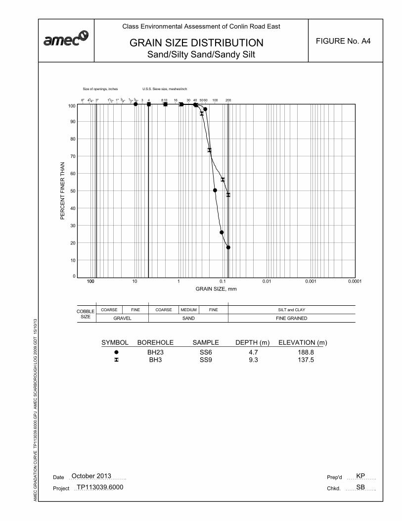
0
10
20
30
40
50
60
70
80
90
100
COBBLESIZE
COARSE MEDIUM FINE
3/8"
U.S.S. Sieve size, meshes/inch
3 10 16 301/2"
SAND
SILT and CLAY
FINE GRAINED
Size of openings, inches
6" 41/4"
1 0.1 0.01 0.001 0.0001100
40 50 60 1004" 2004
FINE
GRAVEL
COARSE
11/2" 1" 3/3" 8
PE
RC
EN
T F
INE
R T
HA
N
GRAIN SIZE, mm
100 10
KP
SB
GRAIN SIZE DISTRIBUTION
Date October 2013 Prep'd
Chkd.Project TP113039.6000
Class Environmental Assessment of Conlin Road East
FIGURE No. A4
Sand/Silty Sand/Sandy Silt
SYMBOL BOREHOLE SAMPLE DEPTH (m) ELEVATION (m)
BH23BH3
SS6SS9
4.79.3
188.8137.5
AM
EC
GR
AD
AT
ION
CU
RV
E T
P11
3039
.600
0.G
PJ
AM
EC
SC
AR
BO
RO
UG
H L
OG
20
09.G
DT
15
/10/
13
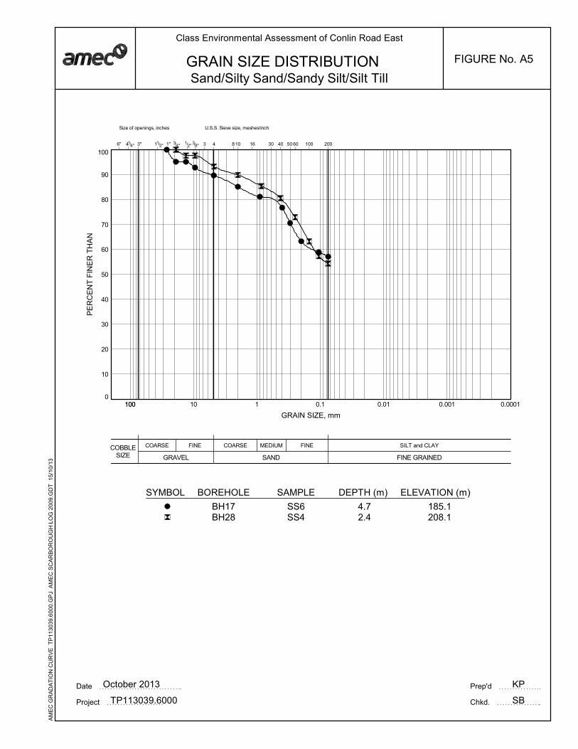
0
10
20
30
40
50
60
70
80
90
100
COBBLESIZE
COARSE MEDIUM FINE
3/8"
U.S.S. Sieve size, meshes/inch
3 10 16 301/2"
SAND
SILT and CLAY
FINE GRAINED
Size of openings, inches
6" 41/4"
1 0.1 0.01 0.001 0.0001100
40 50 60 1004" 2004
FINE
GRAVEL
COARSE
11/2" 1" 3/3" 8
PE
RC
EN
T F
INE
R T
HA
N
GRAIN SIZE, mm
100 10
KP
SB
GRAIN SIZE DISTRIBUTION
Date October 2013 Prep'd
Chkd.Project TP113039.6000
Class Environmental Assessment of Conlin Road East
FIGURE No. A5
Sand/Silty Sand/Sandy Silt/Silt Till
SYMBOL BOREHOLE SAMPLE DEPTH (m) ELEVATION (m)
BH17BH28
SS6SS4
4.72.4
185.1208.1
AM
EC
GR
AD
AT
ION
CU
RV
E T
P11
3039
.600
0.G
PJ
AM
EC
SC
AR
BO
RO
UG
H L
OG
20
09.G
DT
15
/10/
13
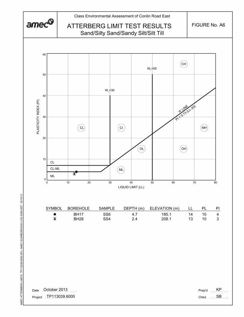
0
10
20
30
40
50
60
0 10 20 30 40 50 60 70 80
CICL MH
OHOL
ML
CL
CL-ML
ML
'A' LIN
E
CH
KP
SB
WL=50
WL=30
LIQUID LIMIT (LL)
PLA
ST
ICIT
Y IN
DE
X (
PI)
PI = 0.73 (L
L-20)
ATTERBERG LIMIT TEST RESULTS
Date October 2013 Prep'd
Chkd.Project TP113039.6000
Class Environmental Assessment of Conlin Road East
FIGURE No. A6
Sand/Silty Sand/Sandy Silt/Silt Till
SYMBOL BOREHOLE SAMPLE LL PL PIDEPTH (m) ELEVATION (m)
BH17BH28
SS6SS4
4.72.4
1413
1010
43
185.1208.1
AM
EC
AT
TE
RB
ER
G L
IMIT
S T
P11
3039
.600
0.G
PJ
AM
EC
SC
AR
BO
RO
UG
H L
OG
200
9.G
DT
15/
10/1
3

APPENDIX B
RESULTS OF PAVEMENT CONDITION SURVEY

The City of Oshawa Preliminary Geotechnical Investigation for Class EA of Conlin Road East From Simcoe Street North to Townline Road North, Oshawa, Ontario AMEC Reference Number: TP113039.6000 October 2013
Pavement Condition Survey
Section 1: Simcoe Street North / Avalona Street
Severity of Distress Density of Distress
Ve
ry S
ligh
t
Slig
ht
Mo
de
rate
Se
ve
re
Ve
ry S
eve
re
Fe
w
Inte
rmitte
nt
Fre
qu
en
t
Exte
nsiv
e
Th
rou
gh
ou
t
<10% 10-
20
%
20-
50
%
50-
80
%
80-
100
%
Pavement 1 2 3 4 5 1 2 3 4 5
Surface Defects
Ravelling & Coarse Aggregate Loss 1 √ √
Flushing 2 √ √
Surface Deformation
Rippling & Shoving 3 √ √
Wheel Track Rutting 4 √ √
Distortion 5 √ √
Cra
ck
ing
Longitudinal Wheel Track
Single & Multiple 6 √ √
Alligator 7
Centreline
Single & Multiple 8 √ √
Alligator 9
Random Cracking 10
Midlane Cracking 11 √ √
Pavement Edge
Single & Multiple 12 √ √
Alligator 13
Transverse
Single & Multiple 14 √ √
Alligator 15
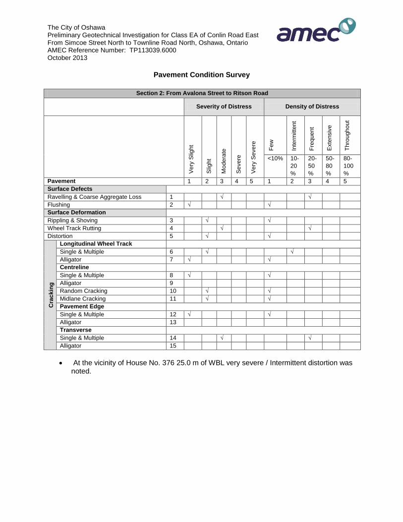
The City of Oshawa Preliminary Geotechnical Investigation for Class EA of Conlin Road East From Simcoe Street North to Townline Road North, Oshawa, Ontario AMEC Reference Number: TP113039.6000 October 2013
Pavement Condition Survey
Section 2: From Avalona Street to Ritson Road
Severity of Distress Density of Distress
Ve
ry S
ligh
t
Slig
ht
Mo
de
rate
Se
ve
re
Ve
ry S
eve
re
Fe
w
Inte
rmitte
nt
Fre
qu
en
t
Exte
nsiv
e
Th
rou
gh
ou
t
<10% 10-
20
%
20-
50
%
50-
80
%
80-
100
%
Pavement 1 2 3 4 5 1 2 3 4 5
Surface Defects
Ravelling & Coarse Aggregate Loss 1 √ √
Flushing 2 √ √
Surface Deformation
Rippling & Shoving 3 √ √
Wheel Track Rutting 4 √ √
Distortion 5 √ √
Cra
ck
ing
Longitudinal Wheel Track
Single & Multiple 6 √ √
Alligator 7 √ √
Centreline
Single & Multiple 8 √ √
Alligator 9
Random Cracking 10 √ √
Midlane Cracking 11 √ √
Pavement Edge
Single & Multiple 12 √ √
Alligator 13
Transverse
Single & Multiple 14 √ √
Alligator 15
At the vicinity of House No. 376 25.0 m of WBL very severe / Intermittent distortion was noted.
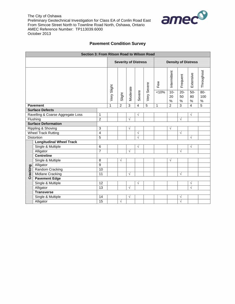
The City of Oshawa Preliminary Geotechnical Investigation for Class EA of Conlin Road East From Simcoe Street North to Townline Road North, Oshawa, Ontario AMEC Reference Number: TP113039.6000 October 2013
Pavement Condition Survey
Section 3: From Ritson Road to Wilson Road
Severity of Distress Density of Distress
Ve
ry S
ligh
t
Slig
ht
Mo
de
rate
Se
ve
re
Ve
ry S
eve
re
Fe
w
Inte
rmitte
nt
Fre
qu
en
t
Exte
nsiv
e
Th
rou
gh
ou
t
<10% 10-
20
%
20-
50
%
50-
80
%
80-
100
%
Pavement 1 2 3 4 5 1 2 3 4 5
Surface Defects
Ravelling & Coarse Aggregate Loss 1 √ √
Flushing 2 √ √
Surface Deformation
Rippling & Shoving 3 √ √
Wheel Track Rutting 4 √ √
Distortion 5 √ √
Cra
ck
ing
Longitudinal Wheel Track
Single & Multiple 6 √ √
Alligator 7 √ √
Centreline
Single & Multiple 8 √ √
Alligator 9
Random Cracking 10
Midlane Cracking 11 √ √
Pavement Edge
Single & Multiple 12 √ √
Alligator 13 √ √
Transverse
Single & Multiple 14 √ √
Alligator 15 √ √

The City of Oshawa Preliminary Geotechnical Investigation for Class EA of Conlin Road East From Simcoe Street North to Townline Road North, Oshawa, Ontario AMEC Reference Number: TP113039.6000 October 2013
Pavement Condition Survey
Section 4: From Wilson Road to Harmony Road
Severity of Distress Density of Distress
Ve
ry S
ligh
t
Slig
ht
Mo
de
rate
Se
ve
re
Ve
ry S
eve
re
Fe
w
Inte
rmitte
nt
Fre
qu
en
t
Exte
nsiv
e
Th
rou
gh
ou
t
<10% 10-
20
%
20-
50
%
50-
80
%
80-
100
%
Pavement 1 2 3 4 5 1 2 3 4 5
Surface Defects
Ravelling & Coarse Aggregate Loss 1 √ √
Flushing 2 √ √
Surface Deformation
Rippling & Shoving 3 √ √
Wheel Track Rutting 4 √ √
Distortion 5 √ √
Cra
ck
ing
Longitudinal Wheel Track
Single & Multiple 6 √ √
Alligator 7
Centreline
Single & Multiple 8
Alligator 9
Random Cracking 10
Midlane Cracking 11
Pavement Edge
Single & Multiple 12 √ √
Alligator 13 √ √
Transverse
Single & Multiple 14 √ √
Alligator 15 √ √

The City of Oshawa Preliminary Geotechnical Investigation for Class EA of Conlin Road East From Simcoe Street North to Townline Road North, Oshawa, Ontario AMEC Reference Number: TP113039.6000 October 2013
Pavement Condition Survey
Section 5: From Harmony Road to Townline Road
Severity of Distress Density of Distress
Ve
ry S
ligh
t
Slig
ht
Mo
de
rate
Se
ve
re
Ve
ry S
eve
re
Fe
w
Inte
rmitte
nt
Fre
qu
en
t
Exte
nsiv
e
Th
rou
gh
ou
t
<10% 10-
20
%
20-
50
%
50-
80
%
80-
100
%
Pavement 1 2 3 4 5 1 2 3 4 5
Surface Defects
Ravelling & Coarse Aggregate Loss 1 √ √
Flushing 2 √ √
Surface Deformation
Rippling & Shoving 3 √ √
Wheel Track Rutting 4 √ √
Distortion 5 √ √
Cra
ck
ing
Longitudinal Wheel Track
Single & Multiple 6 √
Alligator 7
Centreline
Single & Multiple 8 √ √
Alligator 9 √ √
Random Cracking 10
Midlane Cracking 11
Pavement Edge
Single & Multiple 12 √ √
Alligator 13 √ √
Transverse
Single & Multiple 14 √ √
Alligator 15

1
City Manager Approval
Third-Party Source
January 11, 2017
The City of Oshawa is committed to creating an accessible online experience by making web content available to everyone. The City makes it a priority to provide website documents in an accessible format, however the attached document is not accessible as the City is not the author of the document. If this information is required in an accessible format, please contact Service Oshawa; Telephone: 905-436-3311, or email: [email protected] or in person at City Hall, 50 Centre Street South, Oshawa.