Embed Size (px)
Citation preview

““GeografiGeografi ogog KKæærlighedrlighed””
Olaf Olaf ØØstensenstensenFormann ISO/TC 211 Formann ISO/TC 211 GeographicGeographic informationinformation//GeomaticsGeomatics
Statens kartverkStatens kartverk
StandardiseringsarbeidStandardiseringsarbeid somsomkunnskapsarenakunnskapsarena
Standard Standard NorgeNorge, 4. , 4. maimai 20062006

…… eller eller ““Over Over ÆÆvnevne”” II og og II II !!

InnholdInnhold
Norge digitaltNorge digitalt
GeografiGeografi
KomitKomitééenen og samarbeidog samarbeid
EU EU –– INSPIRE direktivetINSPIRE direktivet
Norgedigitalt

Utviklingen Utviklingen –– fra oldtid ...fra oldtid ...
BabylonBabylonsksk kartkart 2 300 2 300 f.Kr. (1930)f.Kr. (1930)byenbyen GaGa--SurSur (i dag Irak)(i dag Irak)
CatalCatal HyHyüükk, , byplan, byplan, 6 200 6 200 f.Kr.f.Kr.(funnet 1963) veggmaleri, ca. 2,7 m, (funnet 1963) veggmaleri, ca. 2,7 m, AnatoliaAnatolia, Tyrkia, Tyrkia
7.6 x 6.8 cm7.6 x 6.8 cm

PtolemaiosPtolemaios (90(90--168) 168) -- kart 1482kart 1482

ZhengZheng Hes kart Hes kart -- 1418 ?1418 ?

1827 N Ramm og G 1827 N Ramm og G MuntheMunthe

... til i dag !... til i dag !
Terrengmodell, New MexicoTerrengmodell, New MexicoSRTM (SRTM (Shuttle Radar Topography Shuttle Radar Topography MissionMission), Romferge, 12.02.2000), Romferge, 12.02.2000
JeffersonJefferson Memorial, Washington Memorial, Washington DC, fra DC, fra IkonosIkonos, 1 m oppl, 1 m oppløøsning, sning, oktober 1999oktober 1999

Verdien av offentlig informasjonVerdien av offentlig informasjon
COMMERCIAL EXPLOITATION OF EUROPE'S PUBLIC SECTOR INFORMATION, Pira International, 2000

Portalen Portalen –– geoNorge.nogeoNorge.no

geoPortalgeoPortal


KartinnsynKartinnsyn ……
OversiktOversikt1:50 000 1:50 000 1:5 0001:5 000DetaljerDetaljer


““GGåårdskart prdskart påå nettnett””
FyrlyktprisenFyrlyktprisen 20052005

bakgrunnskartbakgrunnskartfrafraKartverketKartverket
IdentifikasjonIdentifikasjon avav skip, skip, KystverketKystverketAutomatic Identification SystemAutomatic Identification System•• MMSI number MMSI number -- unique identification unique identification •• Navigation status (e.g. "at anchor" , "under way using engine") Navigation status (e.g. "at anchor" , "under way using engine") •• Rate of turn Rate of turn •• Speed over ground Speed over ground -- 1/10 knot resolution 1/10 knot resolution •• Position accuracy Position accuracy -- differential GPS or other differential GPS or other •• Longitude Longitude -- to 1/10000 minute and Latitude to 1/10000 minute and Latitude -- to 1/10000 minute to 1/10000 minute •• Course over ground Course over ground -- relative to true north to 1/10th degree relative to true north to 1/10th degree •• True Heading True Heading -- 0 to 359 degrees derived from gyro input 0 to 359 degrees derived from gyro input •• Time stamp Time stamp
signal signal frafra skipskip
KystverketsKystverkets stasjonstasjon
skipsposisjonskipsposisjonsomsom kartkart

ISO/TC 211 ISO/TC 211 GeographicGeographicinformationinformation//GeomaticsGeomatics
Formal Formal scopescope::Standardization in the field of digital geographic information.Standardization in the field of digital geographic information.
This work aims to establish a structured set of standards for inThis work aims to establish a structured set of standards for information formation concerning objects or phenomena that are directly or indirectly concerning objects or phenomena that are directly or indirectly associated associated
with a location relative to the Earth.with a location relative to the Earth.
These standards may specify, for geographic information, methodsThese standards may specify, for geographic information, methods, tools , tools and services for data management (including definition and descrand services for data management (including definition and description), iption), acquiring, processing, analyzing, accessing, presenting and tranacquiring, processing, analyzing, accessing, presenting and transferring sferring such data in digital/electronic form between different users, sysuch data in digital/electronic form between different users, systems and stems and
locations.locations.
The work shall link to appropriate standards for information tecThe work shall link to appropriate standards for information technology hnology and data where possible, and provide a framework for the developand data where possible, and provide a framework for the development of ment of
sectorsector--specific applications using geographic data.specific applications using geographic data.
www.isotc211.orgwww.isotc211.org

HvemHvem erer vi ? ...vi ? ...medlemsmedlems listelisteAktiveAktive medlemmermedlemmer (P(P--medlemmermedlemmer), 29 land), 29 land
AustraliaAustraliaAustriaAustriaBelgiumBelgiumCanadaCanadaChinaChinaCzech Rep.Czech Rep.DenmarkDenmarkEcuadorEcuadorFinlandFinlandGermanyGermany
ItalyItalyJapanJapanRepublic of KoreaRepublic of KoreaMalaysiaMalaysiaMoroccoMoroccoNetherlandsNetherlandsNew ZealandNew ZealandNorwayNorwayPortugalPortugalRussian FederationRussian Federation
Saudi ArabiaSaudi ArabiaSerbia and MontenegroSerbia and MontenegroSouth AfricaSouth AfricaSpainSpainSwedenSwedenSwitzerlandSwitzerlandThailandThailandUnited KingdomUnited KingdomUnited States of AmericaUnited States of America
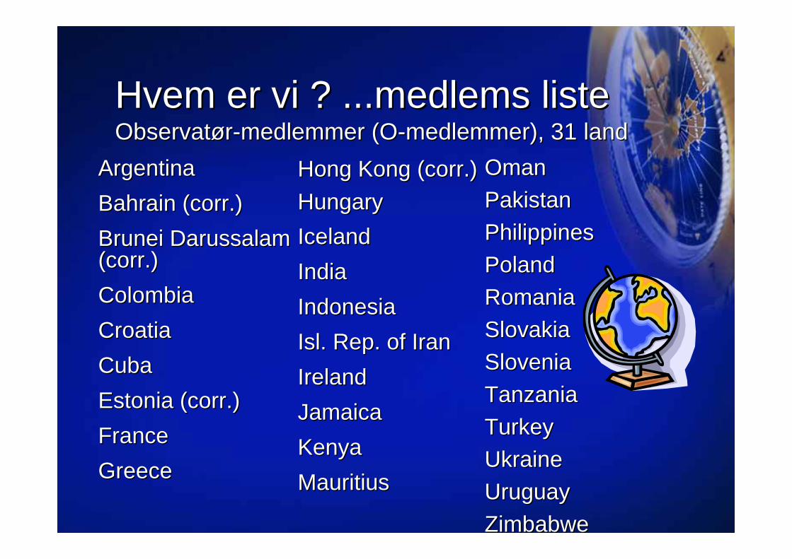
HvemHvem erer vi ? ...vi ? ...medlemsmedlems listelisteObservatObservatøørr--medlemmermedlemmer (O(O--medlemmermedlemmer), 31 land), 31 land
ArgentinaArgentinaBahrain (Bahrain (corrcorr.).)Brunei Darussalam Brunei Darussalam ((corrcorr.).)ColombiaColombiaCroatiaCroatiaCubaCubaEstonia (Estonia (corrcorr.).)FranceFranceGreeceGreece
Hong Kong (Hong Kong (corrcorr.).)HungaryHungaryIcelandIcelandIndiaIndiaIndonesiaIndonesiaIsl. Rep. of IranIsl. Rep. of IranIrelandIrelandJamaicaJamaicaKenyaKenyaMauritiusMauritius
OmanOmanPakistanPakistanPhilippinesPhilippinesPolandPolandRomaniaRomaniaSlovakiaSlovakiaSloveniaSloveniaTanzaniaTanzaniaTurkeyTurkeyUkraineUkraineUruguayUruguayZimbabweZimbabwe

ISO/TC 211 ISO/TC 211 –– samarbeidsamarbeid girgir styrkestyrke!!

EksterneEksterne liaisonliaison--organisasjonerorganisasjoner, , i)i)•• CEN/TC 287, Geographic informationCEN/TC 287, Geographic information•• CEOS, Committee on Earth Observation SatellitesCEOS, Committee on Earth Observation Satellites•• DGIWG, Digital Geographic Information Working GroupDGIWG, Digital Geographic Information Working Group•• OGP, International Association of Oil and Gas Producers OGP, International Association of Oil and Gas Producers •• FAO, Food and Agriculture Organization of the UNFAO, Food and Agriculture Organization of the UN•• FIG, International Federation of SurveyorsFIG, International Federation of Surveyors•• GSDI, Global Spatial Data InfrastructureGSDI, Global Spatial Data Infrastructure•• IAG, International Association of GeodesyIAG, International Association of Geodesy•• ICA, International Cartographic AssociationICA, International Cartographic Association•• ICAO, International Civil Aviation OrganizationICAO, International Civil Aviation Organization•• IEEE IEEE GeoscienceGeoscience and Remote Sensing Societyand Remote Sensing Society•• IHB, International Hydrographic Bureau IHB, International Hydrographic Bureau •• ISCGM, International Steering Committee for Global ISCGM, International Steering Committee for Global
MappingMapping•• ISPRS, International Society for ISPRS, International Society for PhotogrammetryPhotogrammetry and and
Remote SensingRemote Sensing

EksterneEksterne liaisonliaison--organisasjonerorganisasjoner, , ii)ii)
•• European Commission, JRC, Joint Research European Commission, JRC, Joint Research CentreCentre
•• EuroSDREuroSDR, European Spatial Data Research, European Spatial Data Research•• OGC, Open Geospatial Consortium, OGC, Open Geospatial Consortium,
IncorporatedIncorporated•• PC IDEA, Permanent Committee on Spatial PC IDEA, Permanent Committee on Spatial
Data Infrastructure for the Americas Data Infrastructure for the Americas •• PCGIAP, The Permanent Committee on PCGIAP, The Permanent Committee on
GIS Infrastructure for Asia and the PacificGIS Infrastructure for Asia and the Pacific•• SCAR, Scientific Committee on Antarctic SCAR, Scientific Committee on Antarctic
ResearchResearch•• UN ECE, UN Economic Commission for UN ECE, UN Economic Commission for
Europe, Statistical DivisionEurope, Statistical Division

SamarbeidsavtalerSamarbeidsavtaler-- et instrument for et instrument for fellesfelles interesserinteresser
EtablertEtablert mellommellom ISO/TC 211 ISO/TC 211 ogog•• OGC OGC •• DGIWGDGIWG•• IHO IHO •• FAO FAO •• ISO/TC 204ISO/TC 204•• ISO/IEC JTC 1 SC 24 ISO/IEC JTC 1 SC 24
AgreementAgreement

OGC og ISO/TC 211OGC og ISO/TC 211Industri standardisering og offisiell standardisering hIndustri standardisering og offisiell standardisering håånd i hnd i hååndnd
-- SamarbeidsavtaleSamarbeidsavtale
-- Gjensidig representasjonGjensidig representasjon
-- Joint Joint AdvisoryAdvisory GroupGroup –– JAG JAG –– for for ååsikre koordineringsikre koordinering
-- Felles arbeidsgrupperFelles arbeidsgrupper
-- Koordinerte prosedyrerKoordinerte prosedyrer

Spesielt viktig samarbeid nSpesielt viktig samarbeid nåå ……
EuropaEuropa-- EuropeanEuropean CommissionCommission, JRC, Joint , JRC, Joint
ResearchResearch CentreCentre-- CEN/TC 287CEN/TC 287
FNFN-- FAOFAO-- UN ECEUN ECE-- UN ECAUN ECA-- UNGEGNUNGEGN-- UNGIWGUNGIWG-- ogsogsåå ICAO ICAO ogog WMOWMO

JAGJAGAG AG StrategyStrategy
WG WG 6 6 Douglas Douglas OO’’BrienBrien
CanadaCanada
WG WG 77AntonyAntony CooperCooper
SouthSouth AfricaAfrica
WG WG 88Martin Martin Ford(actFord(act.).)
UKUK
WG WG 9 9 HiroshiHiroshi ImaiImai
JapanJapan
WG WG 44Morten BorrebMorten Borrebæækk
NorwayNorway
ISO/TC 211 organizationISO/TC 211 organization
Geospatial Geospatial servicesservices
ImageryImagery InformationInformationcommunitiescommunities
LocationLocationbasedbased
servicesservices
InformationInformationmanagementmanagement
AG AG OutreachOutreach
FGDPFGDP
ChairmanChairmanOlaf Olaf ØØstensenstensen
SecretarySecretaryBjBjøørnhild Srnhild Sææterterøøyy
NorwayNorwayTMGTMG
TF 211/204TF 211/204Andrew Jones
Tschango Kim
Chairman
Henry Tom, Hans Knoop
John Herring
Tschango KimPaul Smits
TF 211/SC 24TF 211/SC 24Charles Roswell
HMMGHMMGIain Greenway
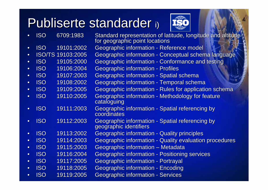
PublisertePubliserte standarderstandarder i)i)•• ISO ISO 6709:1983 6709:1983 Standard representation of latitude, longitude and altitude Standard representation of latitude, longitude and altitude
for geographic point locationsfor geographic point locations•• ISO ISO 19101:2002 19101:2002 Geographic information Geographic information -- Reference modelReference model•• ISO/TS 19103:2005 ISO/TS 19103:2005 Geographic information Geographic information -- Conceptual schema languageConceptual schema language•• ISO ISO 19105:2000 19105:2000 Geographic information Geographic information -- Conformance and testingConformance and testing•• ISO ISO 19106:2004 19106:2004 Geographic information Geographic information -- ProfilesProfiles•• ISO ISO 19107:2003 19107:2003 Geographic information Geographic information -- Spatial schemaSpatial schema•• ISO ISO 19108:2002 19108:2002 Geographic information Geographic information -- Temporal schemaTemporal schema•• ISO ISO 19109:2005 19109:2005 Geographic information Geographic information -- Rules for application schemaRules for application schema•• ISO ISO 19110:2005 19110:2005 Geographic information Geographic information -- Methodology for feature Methodology for feature
cataloguingcataloguing•• ISO ISO 19111:2003 19111:2003 Geographic information Geographic information -- Spatial referencing by Spatial referencing by
coordinatescoordinates•• ISO ISO 19112:2003 19112:2003 Geographic information Geographic information -- Spatial referencing by Spatial referencing by
geographic identifiersgeographic identifiers•• ISO ISO 19113:2002 19113:2002 Geographic information Geographic information -- Quality principlesQuality principles•• ISO ISO 19114:2003 19114:2003 Geographic information Geographic information -- Quality evaluation proceduresQuality evaluation procedures•• ISO ISO 19115:2003 19115:2003 Geographic information Geographic information –– MetadataMetadata•• ISO ISO 19116:2004 19116:2004 Geographic information Geographic information -- Positioning servicesPositioning services•• ISO ISO 19117:2005 19117:2005 Geographic information Geographic information -- PortrayalPortrayal•• ISO ISO 19118:2005 19118:2005 Geographic information Geographic information -- EncodingEncoding•• ISO ISO 19119:2005 19119:2005 Geographic information Geographic information -- ServicesServices

PublisertePubliserte standarderstandarder ii)ii)
•• ISO/TR ISO/TR 19120:2001 19120:2001 Geographic information Geographic information -- Functional standardsFunctional standards•• ISO/TR ISO/TR 19121:2000 19121:2000 Geographic information Geographic information -- Imagery and Imagery and griddedgridded datadata•• ISO/TR ISO/TR 19122:2004 19122:2004 Geographic information / Geographic information / GeomaticsGeomatics -- Qualification Qualification
and certification of personneland certification of personnel•• ISO ISO 19123:2005 19123:2005 Geographic information Geographic information -- Schema for coverage Schema for coverage
geometry and functionsgeometry and functions•• ISO/RS ISO/RS 19124 19124 Geographic information Geographic information -- Imagery and Imagery and griddedgridded data data
componentscomponents•• ISO ISO 1912519125--1:2004 Geographic information 1:2004 Geographic information -- Simple feature access Simple feature access --
Part 1: Common architecturePart 1: Common architecture•• ISO ISO 1912519125--2:2004 Geographic information 2:2004 Geographic information -- Simple feature access Simple feature access --
Part 2: SQL optionPart 2: SQL option•• ISO/TS ISO/TS 19127:2005 19127:2005 Geographic information Geographic information -- Geodetic codes and Geodetic codes and
parametersparameters•• ISO ISO 19128:200519128:2005 Geographic information Geographic information -- Web Map Server InterfaceWeb Map Server Interface
•• ISO ISO 19133 :200519133 :2005 Location based services tracking and navigationLocation based services tracking and navigation•• ISO ISO 19135 :200519135 :2005 Procedures for registration of geographic Procedures for registration of geographic
information itemsinformation items
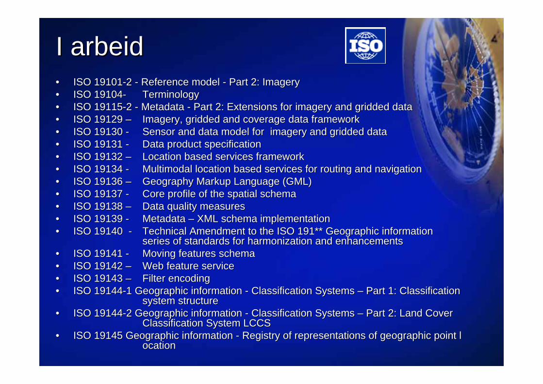
I I arbeidarbeid•• ISO 19101ISO 19101--2 2 -- Reference model Reference model -- Part 2: ImageryPart 2: Imagery•• ISO 19104ISO 19104-- TerminologyTerminology•• ISO 19115ISO 19115--2 2 -- Metadata Metadata -- Part 2: Extensions for imagery and Part 2: Extensions for imagery and griddedgridded datadata•• ISO 19129 ISO 19129 –– Imagery, Imagery, griddedgridded and coverage data frameworkand coverage data framework•• ISO 19130 ISO 19130 -- Sensor and data model for imagery and Sensor and data model for imagery and griddedgridded datadata•• ISO 19131 ISO 19131 -- Data product specificationData product specification•• ISO 19132 ISO 19132 –– Location based services frameworkLocation based services framework•• ISO 19134 ISO 19134 -- Multimodal location based services for routing and navigationMultimodal location based services for routing and navigation•• ISO 19136 ISO 19136 –– Geography Markup Language (GML)Geography Markup Language (GML)•• ISO 19137 ISO 19137 -- Core profile of the spatial schemaCore profile of the spatial schema•• ISO 19138 ISO 19138 –– Data quality measuresData quality measures•• ISO 19139 ISO 19139 -- Metadata Metadata –– XML schema implementation XML schema implementation •• ISO 19140 ISO 19140 -- Technical Amendment to the ISO 191** Geographic informationTechnical Amendment to the ISO 191** Geographic information
series of standards for harmonization and enhancementsseries of standards for harmonization and enhancements•• ISO 19141 ISO 19141 -- Moving features schemaMoving features schema•• ISO 19142 ISO 19142 –– Web feature serviceWeb feature service•• ISO 19143 ISO 19143 –– Filter encodingFilter encoding•• ISO 19144ISO 19144--1 Geographic information 1 Geographic information -- Classification Systems Classification Systems –– Part 1: Classification Part 1: Classification
system structure system structure •• ISO 19144ISO 19144--2 Geographic information 2 Geographic information -- Classification Systems Classification Systems –– Part 2: Land Cover Part 2: Land Cover
Classification System LCCSClassification System LCCS•• ISO 19145 Geographic information ISO 19145 Geographic information -- Registry of representations of geographic point lRegistry of representations of geographic point l
ocationocation

NorskeNorske standarderstandarder
NSNS--EN ISO 19101 Geografisk informasjon EN ISO 19101 Geografisk informasjon -- Referansemodell Referansemodell NSNS--EN ISO 19105 Geografisk informasjon EN ISO 19105 Geografisk informasjon -- Samsvar og prSamsvar og prøøvingvingNSNS--EN ISO 19107 Geografisk informasjon EN ISO 19107 Geografisk informasjon -- Modell for geometri og topologi Modell for geometri og topologi NSNS--EN ISO 19108 Geografisk informasjon EN ISO 19108 Geografisk informasjon -- Modell for tid Modell for tid NSNS--EN ISO 19111 Geografisk informasjon EN ISO 19111 Geografisk informasjon -- Modell for stedfesting ved hjelpModell for stedfesting ved hjelp
av koordinater av koordinater NSNS--EN ISO 19112 Geografisk informasjon EN ISO 19112 Geografisk informasjon -- Modell for stedfesting ved hjelpModell for stedfesting ved hjelp
av geografiske identifikatorer av geografiske identifikatorer NSNS--EN ISO 19113 Geografisk informasjon EN ISO 19113 Geografisk informasjon -- Prinsipper for spesifisering avPrinsipper for spesifisering av
kvalitet kvalitet NSNS--EN ISO 19114 Geografisk informasjon EN ISO 19114 Geografisk informasjon -- Prosedyrer for kvalitetsvurdering Prosedyrer for kvalitetsvurdering NSNS--EN ISO 19115 Geografisk informasjon EN ISO 19115 Geografisk informasjon –– MetadataMetadata
1. 1. aprilapril 20052005

««NorgeNorge digitaltdigitalt»»-- bidragbidrag tiltil detdet digitaledigitale sprangetspranget


FormidlingsFormidlings--tjenestentjenesten
DistributDistributøørerrer
KunderKunder
SamarbeidSamarbeid omom forvaltningforvaltning mellommellomparterparter med med NorgeNorge digitaltdigitalt avtaleavtale
ExtranettExtranett mellommellom partenepartene
InformasjonsformidlingInformasjonsformidling i i regiregi avav parteneparteneEksempelvisEksempelvis gratis gratis innsynslinnsynsløøsningersninger
KommunerVerdiVerdiøøkerekere
KunderKunder
KunderKunder
Norge digitalt
Fylker
Dataflyt i Dataflyt i ««Norge digitaltNorge digitalt»»

««Norge digitaltNorge digitalt»»
DEP.DEP.
Organisering – Nasjonalt
REFERANSEGRUPPE
REFERANSEGRUPPE
TEMADATAFORUM
TEMADATAFORUM
TEKNOLOGIFORUM
TEKNOLOGIFORUM
GEOVEKST FORUM
GEOVEKST FORUM
STORKOMM.GRUPPA
STORKOMM.GRUPPA ANDRE FORAANDRE FORA
PARTER I NORGE DIGITALT PARTER I NORGE DIGITALT
DEP.DEP.
NORGE DIGITALT SEKRETARIAT
(Statens kartverk)
NORGE DIGITALT SEKRETARIAT
(Statens kartverk)
NORGE DIGITALT RÅD
NORGE DIGITALT RÅDDEP.DEP. MILJØVERN
DEPARTEMENTET
MILJØVERNDEPARTEMENTET
STYRINGSDIALOG
PARTSAVTALER
REPRESENTASJON

Norge digitalt Norge digitalt Avtalestruktur og dokumentasjonAvtalestruktur og dokumentasjon
Partsavtale Prinsippdokument
PartsoversiktDatainnholdTeknologi
- rammeverk og krav
Beregning av andelsfinansiering
Finansieringsmodell
Vedlegg:Vedlegg:
Avtale NE - ND (SK)
Formidling tilmarkedet
www:
Partensdata og
tjenester
et fyrtårnsprosjekt for geodata på nett
geoPortal Aktivitet 1:
Rammeverk og infrastruktur
SLUTTRAPPORT2005-01-07
Kommuner
Fylker
Internett
Kommuner
Fylker
Internett
T e m a str u k tu r D a ta sett E ta t S ta tu s In fo rm a sjo n
N a tu r:
B io lo g iskm an g fo ld :
A rtsfo rek o m ster D N
P rio rite rte n a tu r typ er D N
V ern et n a tu r N atu rv ern o m råd er D N
V ern ep ro sess D N
V assd ra g v ern e t m o t k ra f tu tb yg g in g N V E
N a tu r -h yd ro lo g i
N ed b ø rfe lt N V E
N ed b ø rfe lt - R eg in e N V E
In n sjø N V E
D yb d ek ar t ( raste r) N V E
E lv en e ttv erk N V E
N a tu r - g eo lo g i B erg g ru n n N 5 0 /N 2 5 0 N G U
S tru k tu rgeo lo g i N 5 0 /N 2 5 0 N G U
Jo rd arte r - lø sm asser N G U
G ru s - p u k k N G U
M in era lsk e rås to ffe r N G U
G ru n n v an n sb rø n n er N G U
L a n d b ru k :
B o n ite tsk art N IJO S
Jo rd sm o n n - d yrk in gsk las ser N IJO S
B eite lag sk art (u tm ark sb e ite? ) N IJO S
FinansdepartementetStatistisk Sentralbyrå (SSB)FiskeridepartementetFiskeridirektoratetKystdirektoratet/ KystverketForsvarsdepartementetForsvarets Militærgeografiske tjeneste (FMGT)Justis og politidepartementetPolitidirektoratetDirektoratet for samfunnssikkerhet og beredskapHovedredningssentralenLandbruks og matdepartementetNorsk institutt for jord-og skogkartlegging (NIJOS)ReindriftsforvaltningenStatens landbruksforvaltning (SLF)MattilsynetJordskifteverketStatsskog SFMiljøverndepartementetStatens kartverk (SK)Statens forurensningstilsyn (SFT)Direktoratet for naturforvaltning (DN)Riksantikvaren (RA)Nærings- og handelsdepartementetBergvesenetNorges geologiske undersøkelser (NGU)Olje- og energidepartementetNorges vassdrags- og energidirektorat (NVE)SamferdselsdepartementetVegdirektoratet (Statens vegvesen)AvinorJernbaneverketUtdannings- og forskningsdepartementetHelse og omsorgsdepartementetKultur og kirkedepartementet (KKD)Kommunene FylkeskommuneneModerniseringsdepartementetEnergibedriftenes landsforening (EBL)Telenor Networks as
Styring/organisering
PartsoversiktDatainnholdTeknologi
- rammeverk og kravVISER TIL EN LANG REKKE
AV STANDARDENE

innholdinnhold
forvaltningforvaltning
brukeranvendelserbrukeranvendelser
Tjenester Tjenester –– data og metadatadata og metadata
sikkerhetsikkerhetautentiseringautentisering
katalogerkataloger

EuropeanEuropean Spatial Data InfrastructureSpatial Data Infrastructure
Catchments
Meteo data
Land Cover
5 cm/year
ITRF93
NNR-NUVEL1A
GI Institutional framework
GI technicalstandards
Spatial InformationServices
Fundamentaland thematic GI data sets
Spatial Data Infrastructure
GIS to manage Natura2000 sites
Different Different Policies and Policies and standardsstandards
Europe is moving 3cm/ year
Different Different sea levels sea levels in Europein Europe
Needs to create Needs to create europeaneuropeanspatial data setsspatial data sets eEuropeeEurope : : eGovernementeGovernement on lineon line
GI Institutional framework
GI technicalstandards
Spatial InformationServices
Fundamentaland thematic GI data sets
Spatial Data Infrastructure

Hva er INSPIRE?Hva er INSPIRE?•• Et program for Et program for åå etablere en harmonisert etablere en harmonisert
geografisk infrastruktur for Europageografisk infrastruktur for Europa•• Sentrale aktSentrale aktøører: DG rer: DG EnvironmentEnvironment, DG Joint , DG Joint
ResearchResearch CentreCentre, DG Eurostat, EEA, DG Eurostat, EEA•• Utgangspunkt: MisnUtgangspunkt: Misnøøye med hvor vanskelig det er ye med hvor vanskelig det er
åå skaffe til veie nasjonale data, enn si skaffe til veie nasjonale data, enn si harmoniserte harmoniserte panpan--europeiskeeuropeiske datadata
•• Et slikt grunnlag er avgjEt slikt grunnlag er avgjøørende for utforming og rende for utforming og oppfoppføølging av de europeiske politikkerlging av de europeiske politikker
•• Infrastrukturen skal bygge pInfrastrukturen skal bygge påå eksisterende eksisterende nasjonale infrastrukturer, og INSPIRE er ikke et nasjonale infrastrukturer, og INSPIRE er ikke et program for program for åå etablere nye data!etablere nye data!

StatusStatus•• Kommisjonens forslag framlagt sommeren Kommisjonens forslag framlagt sommeren
20042004•• EUEU--parlamentet og EUparlamentet og EU--rråådet har uttalt seg. det har uttalt seg.
divergens, spesielt mellom Kommisjonen divergens, spesielt mellom Kommisjonen og EUog EU--rråådet mht. rettigheterdet mht. rettigheter
•• Ny runde nNy runde nåå•• Kommisjonen er optimistisk mht. til Kommisjonen er optimistisk mht. til åå ha et ha et
direktiv vedtatt i ldirektiv vedtatt i løøpet av 2006pet av 2006•• Utkast til implementeringsregler skal Utkast til implementeringsregler skal
foreligge til 1.1.2007foreligge til 1.1.2007

ArtikelArtikel 18181. 1. MedlemsstaterneMedlemsstaterne opretteropretter og driver et og driver et netnet bestbeståående ende afaf fføølgende tjenester lgende tjenester for de for de geodatasgeodatasæætt og og --tjenester, som der er tjenester, som der er fremstilletfremstillet metadata for i metadata for i overensstemmelse med dette direktiv:overensstemmelse med dette direktiv:a) a) ssøøgetjenestergetjenester, der , der ggøørr det det muligtmuligt at at ssøøgege efterefter geodatasgeodatasæætt og og geodatatjenester geodatatjenester udud fra fra indholdetindholdet afaf de tilsvarende metadata og at fremvise de tilsvarende metadata og at fremvise indholdetindholdet afaf metadatametadatab) b) visningstjenestervisningstjenester, der som et minimum , der som et minimum ggøørr det det muligtmuligt at vise, navigere, at vise, navigere, zoome zoome indind og og udud, panorere eller , panorere eller overlejreoverlejre geodatasgeodatasæætt og at vise og at vise signaturforklaringer og relevant signaturforklaringer og relevant metadataindholdmetadataindholdc) c) downloadtjenesterdownloadtjenester, der , der ggøørr det det muligtmuligt at at nedtagenedtage kopier kopier afaf komplette komplette geodatasgeodatasæætt eller dele eller dele afaf ssåådanne sdanne sææt t d) d) transformationstjenestertransformationstjenester, der , der ggøørr det det muligtmuligt at transformere at transformere geodatasgeodatasæætte) e) tjenester for aktivering tjenester for aktivering afaf geodatatjenestergeodatatjenester, som , som ggøørr det det muligtmuligt at at igangsigangsæættette datatjenester.datatjenester.Disse tjenester skal vDisse tjenester skal væære lette at anvende og re lette at anvende og tilgtilgæængeligengelige via internettet eller via internettet eller andre egnede andre egnede telekommunikationsmidlertelekommunikationsmidler, som , som offentlighedenoffentligheden har adgang til.har adgang til.

DraftingDrafting teams teams -- forskrifterforskrifter
•• MetadataMetadata Per Ryghaug, NGUPer Ryghaug, NGU•• DataspesifikasjonerDataspesifikasjoner Arvid Lillethun, SKArvid Lillethun, SK•• NettverkstjenesterNettverkstjenester Olaf Olaf ØØstensen, SKstensen, SK•• Databruk og Databruk og ––gjenbrukgjenbruk Laila Aslesen, SKLaila Aslesen, SK•• Rapportering og overvRapportering og overvååkingking ingen fra Norgeingen fra Norge

INSPIRE INSPIRE tekniskteknisk arkitekturarkitektur
ClientsClients
MiddlewareMiddleware
ServersServersFeaturesFeaturesCoveragesCoverages
Metadata updateMetadata updateCatalogsCatalogs
GeoGeo--processingprocessingServicesServices
ContentContentRepositories Repositories
Other dataOther data
e.g., administrative,e.g., administrative,statistical, statistical, envenv. reporting. reporting
Distributed Geographic reference dataDistributed Geographic reference data
Service chaining:Service chaining:search, display, search, display,
access, eaccess, e--commerce,commerce,
……..
User applicationsUser applicationsEC, MS, national bodies, EC, MS, national bodies, citizenscitizens
DirectDirectdatadataaccessaccess
Access to transformedAccess to transformeddata, pictures, maps, reports, data, pictures, maps, reports,
multimulti--media contentmedia content
Metadata search and retrieval for Metadata search and retrieval for data and servicesdata and services
Internet webInternet web--browserbrowserGIS softwareGIS software
Management Inf. Management Inf. SystSyst..
Data contentData content

INSPIRE INSPIRE arkitekturarkitektur ogog standarderstandarder
ClientsClients
MiddlewareMiddleware
ServersServersISO 19103ISO 19103ISO 19107ISO 19107ISO 19108ISO 19108
ISO 19119ISO 19119ISO 19135ISO 19135
CatalogsCatalogs
DistributedDistributedContentContent
Repositories Repositories
ISO 19119ISO 19119ISO 19125ISO 19125ISO 19128ISO 19128ISO 19142/19143ISO 19142/19143
User applicationsUser applications
ISO 19136ISO 19136ISO 19142/19143ISO 19142/19143
ISO 19128 /WMSISO 19128 /WMSISO 19142/19143 WFS,ISO 19142/19143 WFS,OGC WCS, WTSOGC WCS, WTS
OGC Web Registry ServicesOGC Web Registry Services
ISO 19111ISO 19111ISO 19112ISO 19112ISO 19112ISO 19112
ISO 19118ISO 19118ISO 19121ISO 19121ISO 19123ISO 19123
ISO 19120ISO 19120ISO 19109ISO 19109
ISO 19103ISO 19103ISO 19109ISO 19109ISO 19110ISO 19110ISO 19115ISO 19115Dublin coreDublin coreISO 23950ISO 23950

OppsummeringOppsummering
•• NorgeNorge harhar tatttatt et et stortstort ansvaransvar for for standardiseringstandardiseringinneninnen geografiskgeografisk informasjoninformasjon
•• StorStor internasjonalinternasjonal deltakelsedeltakelse –– mange mange viktigeviktigeinteressenterinteressenter
•• PPåå geografiomrgeografiområådetdet erer standardiseringsarbeidetstandardiseringsarbeidetdrivendedrivende for den for den teknologisketeknologiske utviklingenutviklingen
•• StandardeneStandardene utvikletutviklet i ISO/TC 211 i ISO/TC 211 harhar ffååtttt en en sentralsentralplassplass i i politikkenpolitikken nasjonaltnasjonalt ogog internasjonaltinternasjonalt, , ogog erer nnååppåå veivei direktedirekte inn i inn i lovgivningenlovgivningen
•• Norske lNorske løøsninger basert psninger basert påå standarder vekker standarder vekker internasjonal oppsiktinternasjonal oppsikt

TakkTakk forforoppmerksomhetenoppmerksomheten !!
ISO/TC 211 ...ISO/TC 211 ...…… building the foundation of the geospatial building the foundation of the geospatial infrastructure, brick by brick ...infrastructure, brick by brick ...