Embed Size (px)
Citation preview
2008 BART Station Profile Study Station Profiles – Home Origin Maps
BART Marketing and Research Department
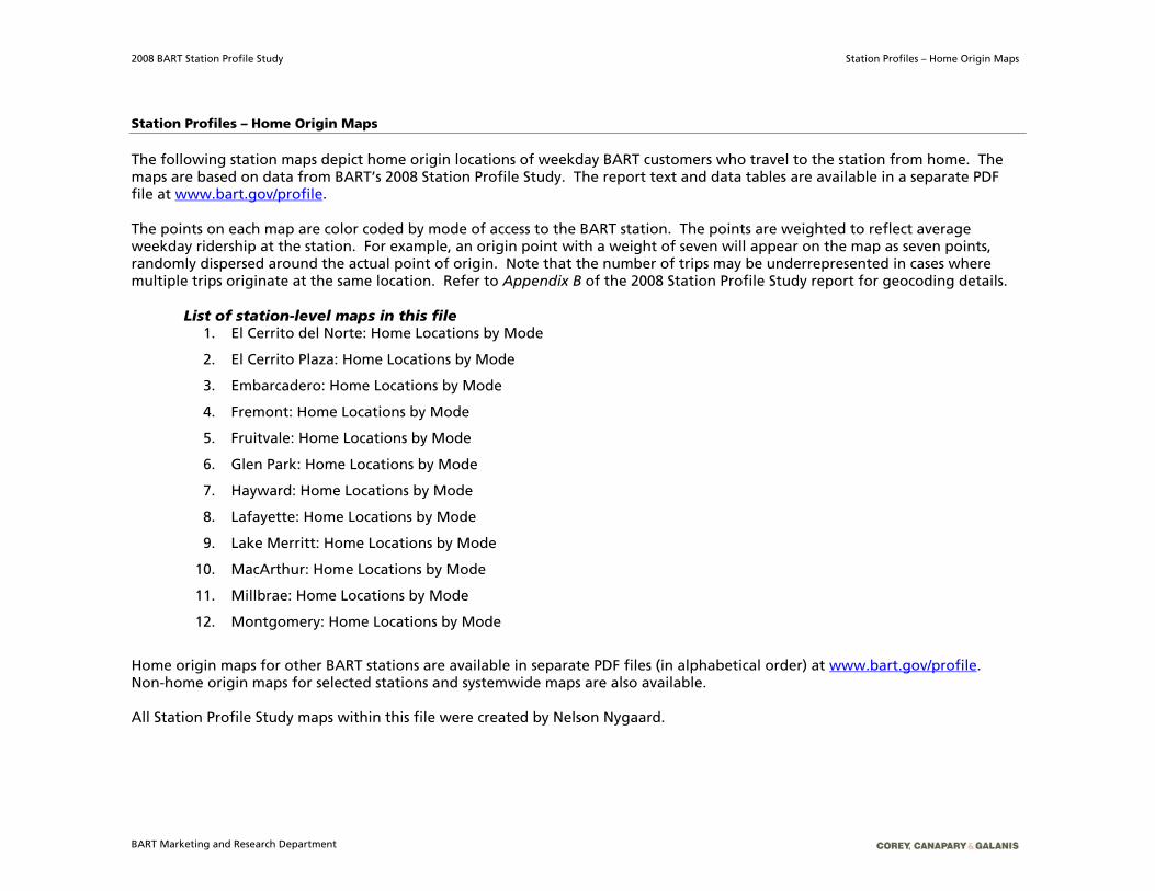
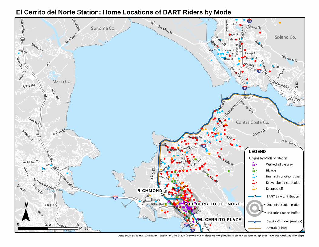
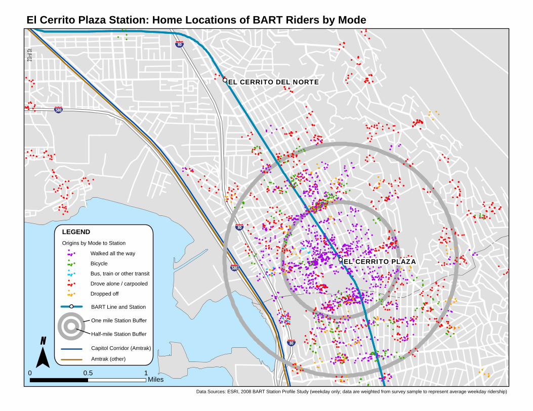
Station Profiles – Home Origin Maps The following station maps depict home origin locations of weekday BART customers who travel to the station from home. The maps are based on data from BART’s 2008 Station Profile Study. The report text and data tables are available in a separate PDF file at www.bart.gov/profile.
The points on each map are color coded by mode of access to the BART station. The points are weighted to reflect average weekday ridership at the station. For example, an origin point with a weight of seven will appear on the map as seven points, randomly dispersed around the actual point of origin. Note that the number of trips may be underrepresented in cases where multiple trips originate at the same location. Refer to Appendix B of the 2008 Station Profile Study report for geocoding details.
List of station-level maps in this file
1. El Cerrito del Norte: Home Locations by Mode
2. El Cerrito Plaza: Home Locations by Mode
3. Embarcadero: Home Locations by Mode
4. Fremont: Home Locations by Mode
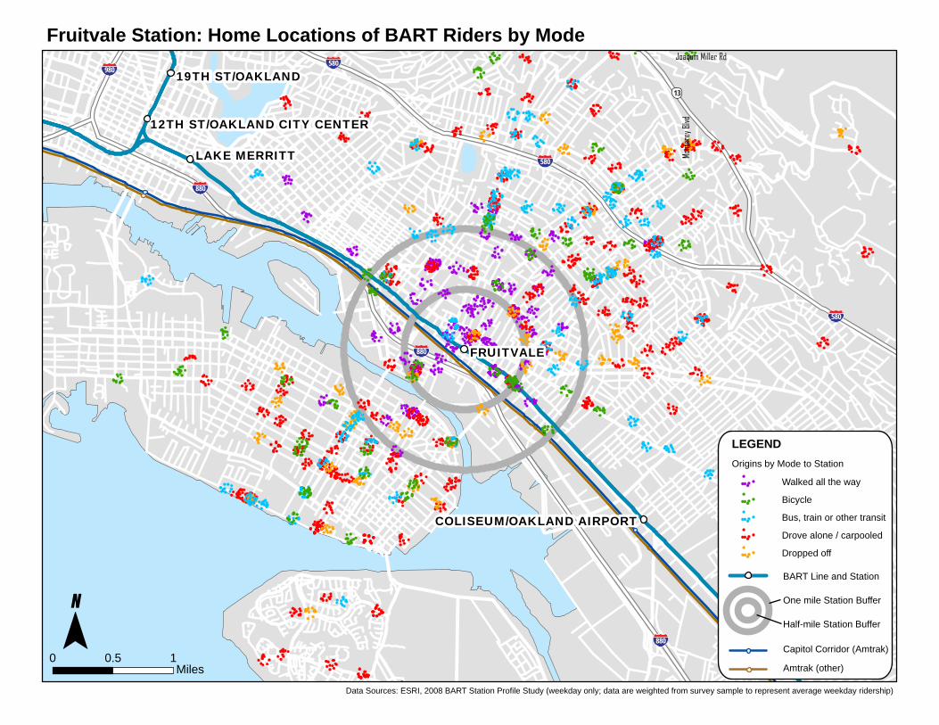
5. Fruitvale: Home Locations by Mode
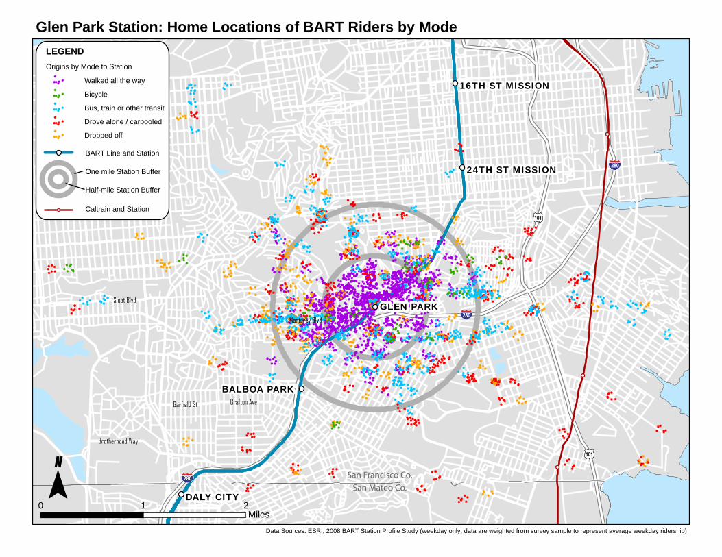
6. Glen Park: Home Locations by Mode
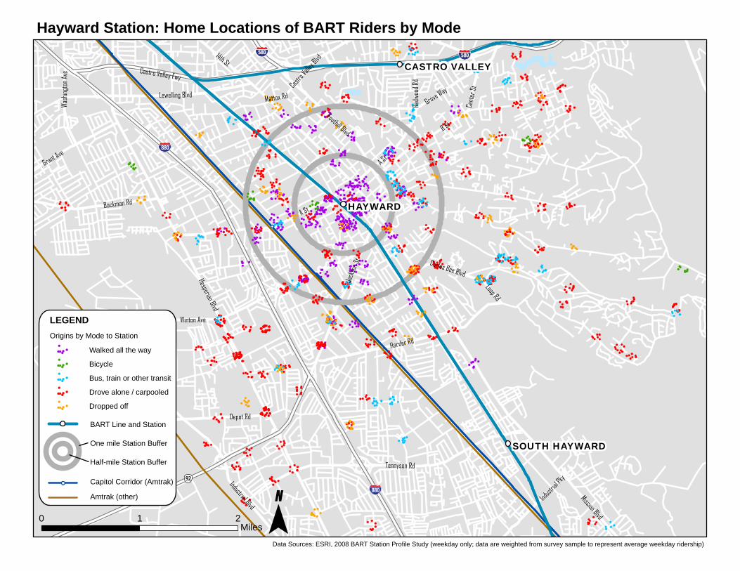
7. Hayward: Home Locations by Mode
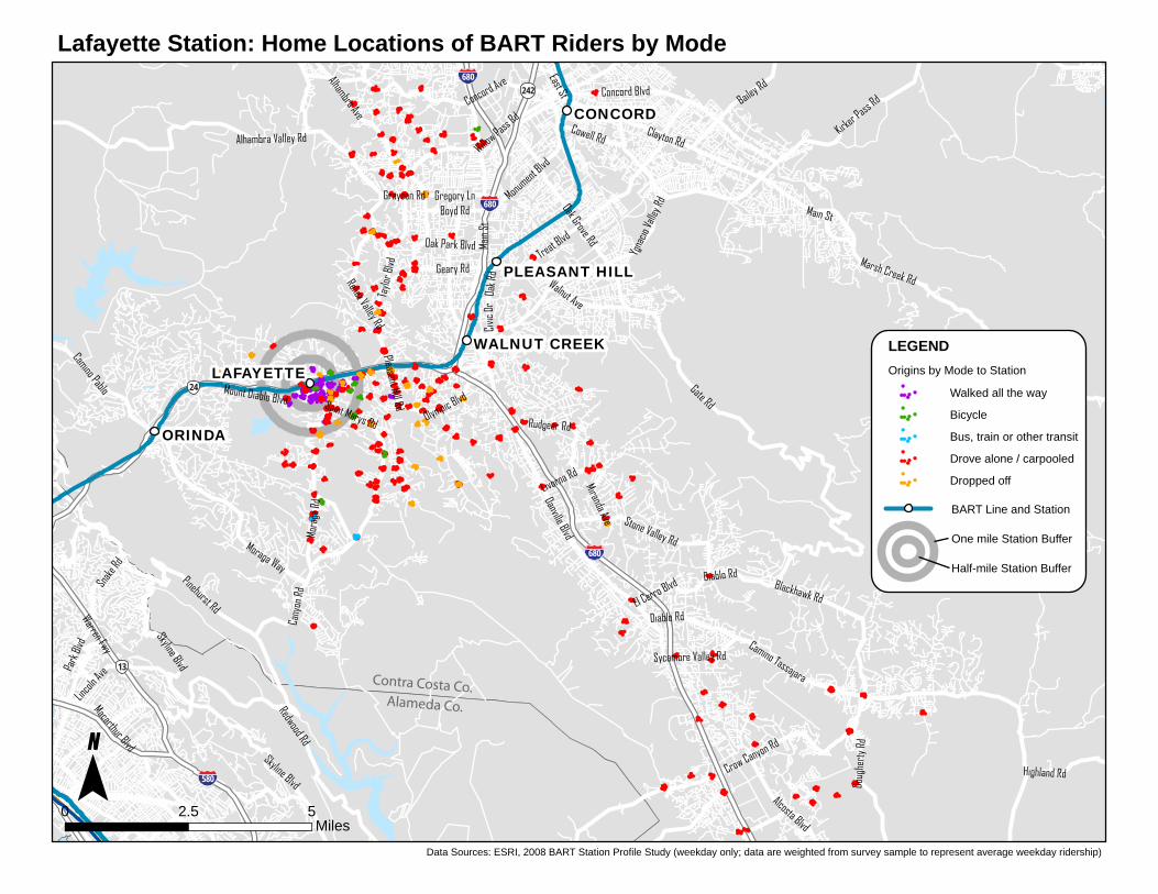
8. Lafayette: Home Locations by Mode
9. Lake Merritt: Home Locations by Mode
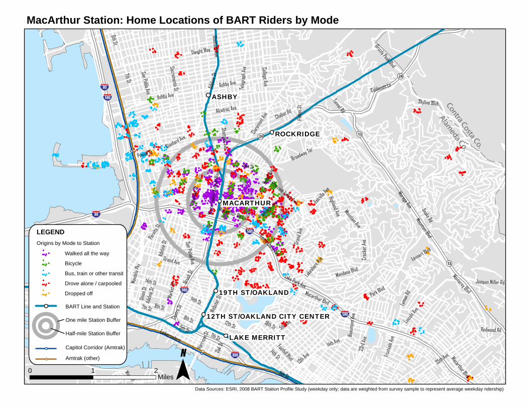
10. MacArthur: Home Locations by Mode
11. Millbrae: Home Locations by Mode
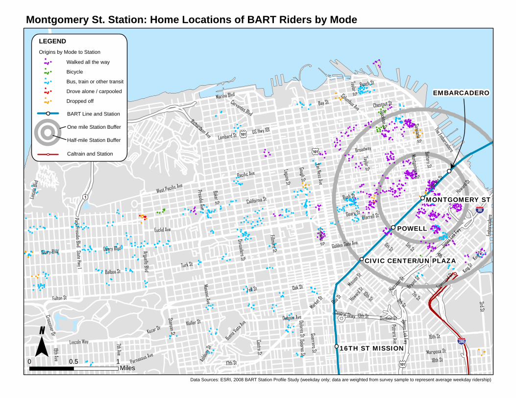
12. Montgomery: Home Locations by Mode
Home origin maps for other BART stations are available in separate PDF files (in alphabetical order) at www.bart.gov/profile. Non-home origin maps for selected stations and systemwide maps are also available. All Station Profile Study maps within this file were created by Nelson Nygaard.
San Pablo Ave
24
K St
Sears Point Rd
San Pablo Dam Rd
Sonoma Blvd
2nd S
t
23rd
St
San Pedro Rd
Military
4th St
Cutting Blvd
Benicia Rd
Carlson Blvd
D St
Broadway St
Barrett Ave
Olive Ave
5th Ave
3rd St
Pinole Valley Rd
Lake Herman Rd
Novato Blvd
Cummings Skwy
Tuolu
mne S
t
Redwood Hwy
Ohio Ave
Francisco Blvd
Hilltop Dr
Florida St
H St
Franklin Canyon Rd
Rose Dr
Appian Way
G St
Gian
t Rd
Redwood St
Georgia St
Eastsh
ore Fw
y
34th
St
Tiburon Blvd
Richmond Pky
Columbus Pky
Ascot Pky
Ignacio Blvd
Tennessee St
Lucas Valley Rd
Atherton Ave
Solano Ave
Lincoln Ave
Market Ave
20
Nave
Dr
Moeser Ln
Magnolia Ave
Sacramento St
Springs Rd
Atlas Rd
Fairg
roun
ds D
r
Sereno Dr
Lupine Rd
Maine St
Garra
rd Blv
d
Key
Willow Ave
Sir Francis Drake Blvd
Hasti
ngs D
r
John Muir Pky
Lakeville Hwy
Pomona St
Colusa Ave
Mariposa St
Shawn Dr
Blum
e Dr
Suns
et Pk
y
Tamalpais Dr
Wilson Ave
1st S
t
Glen Dr
13th
St
Shady LnMontecillo Rd
Rumrill Blvd
Manila Ave
Southampton Rd
Crown Rd
Red Hill Ave
San Mateo St
Hangar Ave
1st St
San P
ablo
Ave
24
Columbus Pky
3rd S
t
Sears Point Rd
37
RICHMOND
EL CERRITO PLAZA
EL CERRITO DEL NORTE
80
580
80
80
780
580
80
101
4
101
101
37
37
Marin Co.
Sonoma Co.
Solano Co.
Contra Costa Co.
El Cerrito del Norte Station: Home Locations of BART Riders by Mode
Data Sources: ESRI, 2008 BART Station Profile Study (weekday only; data are weighted from survey sample to represent average weekday ridership)
0 2.5 5Miles
BART Line and Station
One mile Station Buffer
Half-mile Station Buffer
Capitol Corridor (Amtrak)
Amtrak (other)
Walked all the way
Bicycle
Bus, train or other transit
Drove alone / carpooled
Dropped off
LEGENDOrigins by Mode to Station
Carlson Blvd
San Pablo Ave
Marin Ave
Solano Ave
Arlington Ave
Potrero Ave
Cutting Blvd
Moeser Ln
Richmond St
Arlington Blvd
yeK
Colusa Ave
37th St
Ohio Ave
Ashbury Ave
tS sitruC
Navellier St
Manila Ave
Fairmount Ave
39th St
Buchanan St
San Mateo St
Tehama Ave
Central Ave
Cleveland Ave
The Alameda
Ashbury Ave
Contra Costa Co.
Alameda Co.
El Cerrito Plaza Station: Home Locations of BART Riders by Mode
0
80
2d
tr
S3
EL CERRITO DEL NORTE
580
80LEGEND Origins by Mode to Station
Walked all the way EL CERRITO PLAZABicycle
580 Bus, train or other transit
Drove alone / carpooled
Dropped off
BART Line and Station
One mile Station Buffer
Half-mile Station Buffer 80
Capitol Corridor (Amtrak)
Amtrak (other)
0.5 1 Miles
Data Sources: ESRI, 2008 BART Station Profile Study (weekday only; data are weighted from survey sample to represent average weekday ridership)
California St
3rd St
Turk StGeary Blvd
16th St
Bush St
Fell St
Mission St
Oak St
Bay St
Gough St
Laguna St
Harriso
n St
Fulton St
7th St
Balboa St
4th St
Fillmore St
Franklin St
Lincoln Way
Taylor St
Van Ness Ave
Divisadero St
20th St
8th St
17th St
Golden Gate Ave
Pacific Ave
Castro St
6th St25th Ave
Geary St
The Embarcadero
Bryant S
t
10th St
Broadway
Marina Blvd
Dolores St
7th Ave
5th St
Judah St
Ofarrell StGuerrero St
Townse
nd St
1st St
Sansome St
Potrero Ave
Stanyan St
Masonic Ave
28th Ave
32nd Ave
Arguello Blvd
Duboce AveBaker St
Columbus Ave
Howard
St
Market S
t
Emba
rcad
ero
Euclid Ave
Waller St
San F
rancis
co-Oa
kland
Bay B
rg
Battery St
Sunset Blvd
Park Presidio Blvd
Presidio Blvd
Montgomery St
18th St
Division St
West Pacific Ave
Otis St
Lombard St
Beach St
Buena V
ista Av
e
Parnassus Ave
Stockton St
Ashb
ury S
t
Chestnut St
19th Ave
Taylor St
POWELL
EMBARCADERO
MONTGOMERY ST
16TH ST MISSION
CIVIC CENTER/UN PLAZA
280101
80
101
101
1
1
Embarcadero Station: Home Locations of BART Riders by Mode
Data Sources: ESRI, 2008 BART Station Profile Study (weekday only; data are weighted from survey sample to represent average weekday ridership)
0 1 2Miles
BART Line and Station
One mile Station Buffer
Half-mile Station Buffer
Caltrain and Station
Walked all the way
Bicycle
Bus, train or other transit
Drove alone / carpooled
Dropped off
LEGENDOrigins by Mode to Station
1st St
El Camino Real
Calaveras Rd
Central Expy
King Rd
Mission Blvd
Fremont Blvd
Foothill Expy
10th St
Middlefield Rd
Sierra Rd
Paseo Padre Pky
Story R
d
4th St
Wolfe
Rd
Homestead Rd
Capitol Ave
Willow Rd
White Rd
Alpine
Rd
Lafayette St
Evelyn Ave Lawr
ence
Expy
Hedding
St
Stevens Creek Blvd
Blacow Rd
Bayshore Fwy
Montague Expy
Mary
Ave
Page
Mill R
d
Fremont Ave
Park Ave
Taylor St
Julian St
Abel St
Mowr
y Ave
Piedmont Rd
Thor
nton A
ve
Alma St
Oakland Rd
Arastradero Rd
Math
ilda A
ve
Gran
t Rd
Kifer Rd
San T
omas
Expy
Louis Rd
Capitol Expy
Cherry St
Quimby Rd
Main
St
7th St
Fairo
aks A
ve
Steve
nson
Blvd
Bern
ardo
Ave
Grim
mer B
lvd
Waverley St
Mckee R
d
Alum
Rock
Ave
Mountain View Alviso RdKiely Blvd
Pruneridge Ave
Ruby Ave
Berryes
sa Rd
Elena Rd
Bay Rd
Coleman Ave
Tully Rd
Niles Blvd
Bowers Ave
Milpitas Blvd
Morrill Ave
Trimble
Rd
Deco
to Rd
Clayton Rd
Dumbar
ton Br
idge
Calaveras Blvd
Auto Mall Pky
Shor
eline
Blvd
El Mon
te Av
e
Guadalupe Pky
Mira
mont
e Ave
San A
nton
io Rd
Monroe St
Fremont Rd
Milpitas Alviso Rd
Sprin
ger R
d
5th A
ve
Remington Dr
San Carlos St Mclaughlin Ave
Santa
Cruz
Ave
Washington BlvdUn
ivers
ity A
ve
Mabury R
d
Jacklin Rd
Charleston Rd
Java Dr
Newark Blvd
Lundy Ave
Boyce RdRe
ngsto
rff Av
e
Bayfront Expy
Pulga
s Ave
Bayshore Rd
Ivy Dr
Junipero Serra BlvdGr
eat A
meric
a Pky
Castr
o St
Union City Blvd
Stell
ing R
d
Reed Ave
Pome
roy A
ve
Warm Springs BlvdJa
rvis A
ve
Bellomy St
Campus Dr
De A
nza B
lvd
Durham Rd
Channing Ave
Sand Hill R
dBl
aney
Ave
Toyon Ave
Oak G
rove
Ave
Laurel St
Gish Rd
Mars
h Rd
Isabe
lla Av
e
De La Cruz Blvd
Santa Clara St
Avy A
ve
Mars
h Rd
Felter Rd
Tully R
d
Bay Rd
Niles Blvd
Scot
t Blvd
FREMONT
84
85280
101
101
87
880
880
237
680
680
101
San Mateo Co.
Santa Clara Co.
Alameda Co.
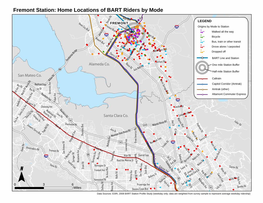
Fremont Station: Home Locations of BART Riders by Mode
Data Sources: ESRI, 2008 BART Station Profile Study (weekday only; data are weighted from survey sample to represent average weekday ridership)
0 3 6Miles
BART Line and Station
One mile Station Buffer
Half-mile Station Buffer
Caltrain
Amtrak (other)
Walked all the way
Bicycle
Bus, train or other transit
Drove alone / carpooled
Dropped off
LEGENDOrigins by Mode to Station
Capitol Corridor (Amtrak)
Altamont Commuter Express
Webs
ter S
t
14th St
Foothill Blvd
Macarthur Blvd
Otis Dr
Bancroft Ave
Pacific Ave Oakport St
High S
t
35th Ave
San Leandro St
7th St
98th Ave
13th Ave
Park Blvd
Park
St
Redwood Rd
14th Ave
5th St
Fruit
vale
Ave
Encinal Ave Doolittle Dr
66th Ave
Harr
ison S
t
73rd Ave
Central Ave
23rd
Ave
Skyline Blvd
Lincol
n Ave
Islan
d Dr
16th St
Coliseum Way
Mark
et S
t
Webs
ter St
Broa
dway
Brus
h St
Versa
illes A
ve
12th St
Embarcadero
Hege
nber
ger R
d
Sea View Pky
Grand Ave
Mecartney Rd
Oak S
t
Atlantic Ave
Santa Clara Ave Ha
rbor
Bay
Pky
Tiffin Rd
29th
Ave
18th St 5th Ave
Marina Dr
Kennedy St
Robert Davey Jr Kofman Pky
Ardle
y Ave
Beau
mont
Ave
14th St
23rd Ave
8th St
High St
7th St 8th St
Macarthur Blvd
Broa
dway
14th St
12th St
19TH ST/OAKLAND
12TH ST/OAKLAND CITY CENTER
One mile Station Buffer
Bus, train or other transit
Drove alone / carpooled
Fruitvale Station: Home Locations of BART Riders by ModeJoaquin Miller Rd
580 980
13
Mont
erey
Blvd
LAKE MERRITT 580
880
580
880 FRUITVALE
LEGEND Origins by Mode to Station
Walked all the way
Bicycle
COLISEUM/OAKLAND AIRPORT
Dropped off
BART Line and Station
Half-mile Station Buffer
880 Capitol Corridor (Amtrak)
0 0.5 1Amtrak (other)Miles
Data Sources: ESRI, 2008 BART Station Profile Study (weekday only; data are weighted from survey sample to represent average weekday ridership)
Miss
ion St
19th Ave
16th St
3rd St
Ocean Ave
Geneva Ave
Alemany Blvd
Castro St
Judah St
20th St Dolores St
Market S
t
Portola
Dr
28th Ave
San J
ose A
ve
Taraval St
Lincoln Way
Silver Ave
Vicente St
Guerrero St
17th St
Evans Ave
Harrison St
Cesar Chavez St
Vienn
a St
Bay Shore Blvd Felton St
Sunset Blvd
Van Ness Ave
Potrero Ave
Mansell St
7th Ave
Oakdale Ave
Noriega St
Clipper St
Sunnydale Ave
Ingall
s St
Duboce Ave
Lake
Mer
ced B
lvd
Persia Ave
Jerrold Ave
7th St
Cortland Ave
Bellevue Ave
30th St
Stanyan St
Waller St
Junip
ero S
erra
Blvd
Dwight St
M i r a
mar A
ve
Tolan
d St
University St
John Muir Dr
Winston Dr
Crescent Ave
San Bruno Ave
Kezar Dr
Palou Ave
Avalon Ave
Thornton Ave
Paul Ave
Quint
St
Parnassus Ave
Bosworth St
18th St
Masonic Ave
Laguna Honda Blvd
Dewey
Blvd
Pera
lta A
ve
Bays
hore
Blvd
Woodside Ave
Theresa St Elk
St
Westga
te Dr
Sa
nta C
lara A
ve
Guttenberg St
Gilman Ave
Buena V
ista Ave
Clare
mont
Blvd
Ashb
ury S
t
Mount Vernon Ave
Church St
Bay Shore Blvd Silver Ave
3rd S
t
San J
ose A
ve
BART Line and Station
Dropped off
Glen Park Station: Home Locations of BART Riders by Mode
LEGEND Origins by Mode to Station
Walked all the way 16TH ST MISSIONBicycle
Bus, train or other transit
Drove alone / carpooled
24TH ST MISSION 280 One mile Station Buffer
Half-mile Station Buffer
Caltrain and Station 101
Sloat Blvd GLEN PARK
280 Monterey Blvd
BALBOA PARK
Garfield St Grafton Ave
Brotherhood Way
101
San Francisco Co.280
San Mateo Co. DALY CITY
0 1 2 Miles
Data Sources: ESRI, 2008 BART Station Profile Study (weekday only; data are weighted from survey sample to represent average weekday ridership)
A StMission Blvd
Hesperian Blvd
B St
Jack
son S
t
Tennyson Rd
Grove Way
Winton Ave
Harder Rd
Foothill Blvd
Claw
iter R
d
Lewelling Blvd
Industrial Blvd
Castro Valley Fwy
Depot Rd
Bockman Rd
Grant Ave
14th StWa
shing
ton A
ve
Redw
ood R
d
Indust
rial Pk
y
Cent
er S
t
Carlos Bee Blvd
Castro
Valley
Blvd
Loop Rd
Mattox Rd
A St HAYWARD
SOUTH HAYWARD
CASTRO VALLEY580
880
92
880
580
Hayward Station: Home Locations of BART Riders by Mode
Data Sources: ESRI, 2008 BART Station Profile Study (weekday only; data are weighted from survey sample to represent average weekday ridership)
0 1 2Miles
BART Line and Station
One mile Station Buffer
Half-mile Station Buffer
Capitol Corridor (Amtrak)
Amtrak (other)
Walked all the way
Bicycle
Bus, train or other transit
Drove alone / carpooled
Dropped off
LEGENDOrigins by Mode to Station
Gate Rd
Clayton Rd
Main
St
Redwood Rd
Treat Blvd
Camino Tassajara
Crow Canyon Rd
Ygna
cio Va
lley R
d
Skyline Blvd
Mora
ga R
d
Marsh Creek Rd
Warren Fwy
Danville Blvd
Concord Blvd
Moraga Way
Taylo
r Blvd
Pleasant Hill Rd
Macarthur Blvd
Cowell Rd
Pinehurst Rd
Alhambra Valley RdKirke
r Pass R
d
Reliez Valley Rd
Bailey Rd
Oak Grove Rd
Willow Pass
Rd
Saint Marys Rd
Alhambra Ave
Blackhawk Rd
Diablo Rd
Stone Valley Rd
Mount Diablo Blvd
Doug
herty
Rd
Alcosta Blvd
Geary Rd
Olympic Blvd
Camino Pablo
Boyd RdMonu
ment Blvd
Cany
on R
d
Park
Blvd
Walnut Ave
Civic
Dr
Snake
Rd
Highland Rd
Concord Ave
Gregory Ln
Livorna Rd
Lincol
n Ave
Rudgear Rd
Oak R
d
East St
Oak Park Blvd
Grayson Rd
Miranda Ave
Sycamore Valley Rd
El Cerro Blvd
Main St
Diablo Rd
Skyline Blvd
ORINDA
CONCORD
LAFAYETTE
WALNUT CREEK
PLEASANT HILL
Contra Costa Co.Alameda Co.
242
680
24
580
13
680
680
Lafayette Station: Home Locations of BART Riders by Mode
Data Sources: ESRI, 2008 BART Station Profile Study (weekday only; data are weighted from survey sample to represent average weekday ridership)
0 2.5 5Miles
BART Line and Station
One mile Station Buffer
Half-mile Station Buffer
Walked all the way
Bicycle
Bus, train or other transit
Drove alone / carpooled
Dropped off
LEGENDOrigins by Mode to Station

14th St
Foothill Blvd
Park Blvd
Pacific Ave
Mark
et S
t
35th Ave
Broa
dway
7th St
13th Ave
High St
5th St
14th Ave
Warren Fwy
Gran
d Ave
Fruit
vale
Ave
Macarthur Blvd
Harr
ison S
t
Central Ave
Main
St
Adeli
ne S
t
Webs
ter St
23rd
Ave
San Pablo Ave
Teleg
raph
Ave
Brus
h St
Lincol
n Ave
Mand
ela Pk
y
Monterey Blvd
16th St
Encinal Ave
Park
St
Pera
lta St
Mandana Blvd
Embarcadero
Mountain Blvd
Bancroft Ave
12th St
Lakesh
ore Ave
Atlantic Ave
Otis Dr
Oak S
t
Leimert Blvd
Union
St
Castr
o St
Piedmont
Ave
Tiffin Rd
29th
Ave
Santa Clara Ave
Lyma
n Rd
Lake
side D
r
San Leandro St
18th St
1st Ave 5th Ave
Marina Dr
Middle Harbor Rd
Kennedy St
Croc
ker A
ve
19th Ave
42nd A
ve
Snake Rd
Dennison St
Ardle
y Ave
Mountain Ave
Beau
mont
Ave
Webs
ter St
Tube
11th St
Grand Ave
Webs
ter S
t
Lakesh
ore Av
e
8th St
Pera
lta St
8th St
14th St
8th St
12th St
14th St
High St
Macarthur Blvd
Macarthur Blvd
23rd Ave
7th St
Broa
dway
FRUITVALE
LAKE MERRITTWEST OAKLAND
12TH ST/OAKLAND CITY CENTER
19TH ST/OAKLAND
880
580
880
13
580880
980
880
Lake Merritt Station: Home Locations of BART Riders by Mode
Data Sources: ESRI, 2008 BART Station Profile Study (weekday only; data are weighted from survey sample to represent average weekday ridership)
0 0.5 1Miles
BART Line and Station
One mile Station Buffer
Half-mile Station Buffer
Capitol Corridor (Amtrak)
Amtrak (other)
Walked all the way
Bicycle
Bus, train or other transit
Drove alone / carpooled
Dropped off
LEGENDOrigins by Mode to Station
Broa
dway
San Pablo Ave
Teleg
raph
Ave
Park Blvd
Skyline Blvd
Mark
et S
t
14th St
7th St
Clare
mont A
ve
Dwight Way
College Ave
13th Ave
Broadway Ter
35th Ave
5th St
Alcatraz Ave
14th Ave
8th St
Gran
d Ave
Macarthur Blvd
Ashby Ave
Harr
ison S
t
Snake Rd
Moraga Ave
Monterey Blvd
Adeli
ne S
t
Tunnel Rd
Foothill Blvd
Webs
ter St
51st St
Brus
h St
Lincol
n Ave
Mand
ela Pk
y
23rd
Ave
Pera
lta St
Fruit
vale
Ave
Grizzly Peak Blvd
Shattuck Ave
Mandana Blvd
Embarcadero
Mountain Blvd
Maritim
e St
Middle Harbor Rd
Caldecott Ln
12th St
Powell St
Piedmont
Ave
Sacramento St
Marti
n Lut
her K
ing Jr
Way
6th St
Stanford Ave
Oak S
t
Leimert Blvd
Chabot Rd
Union
St
Castr
o St
Santa Clara Ave
Lyma
n Rd
Joaquin Miller Rd
18th St 5th Ave
Highland Ave
Croc
ker A
ve
Main St
Redwood Rd
Pleasant Valley Ave
Patto
n St
Mountain Ave
Beau
mont
Ave
Lake Park Ave
Estrel
la Ave
Mark
et S
t
Ashby Ave
Grand Ave
Adeli
ne St
14th St
7th St
14th St
Macarthur BlvdAdeli
ne S
t
Shattuck Ave
7th St
8th St
Pera
lta St
8th St
Macarthur Blvd
Lakesh
ore Av
e
San Pablo Ave
ROCKRIDGE
ASHBY
MACARTHUR
LAKE MERRITT
WEST OAKLAND
19TH ST/OAKLAND
12TH ST/OAKLAND CITY CENTER
24
80
580
880
980
80
580
880
580
13
13
24Contra Costa Co.
Alameda Co.
MacArthur Station: Home Locations of BART Riders by Mode
Data Sources: ESRI, 2008 BART Station Profile Study (weekday only; data are weighted from survey sample to represent average weekday ridership)
0 1 2Miles
BART Line and Station
One mile Station Buffer
Half-mile Station Buffer
Capitol Corridor (Amtrak)
Amtrak (other)
Walked all the way
Bicycle
Bus, train or other transit
Drove alone / carpooled
Dropped off
LEGENDOrigins by Mode to Station

El Camino Real
Bayshore Fwy
Canada Rd
Middlefield Rd
Skyline Blvd
Wood
side R
d
J Arthur Younger Fwy
Willow Rd
Central Expy
Alpine
Rd
Hillsdal
e Blvd
San Mateo Rd
Deco
to R
d
Alma St
Arastradero Rd
Sand Hill Rd
Thor
nton A
ve
Bay Rd
Ralston Ave
Evelyn Ave
Louis Rd
Edgewood Rd
Tunitas
Creek R
d
Elm St
Mission Blvd
Old County Rd
Portola Rd
Norfolk St
Page
Mill R
d
Delaware St
Waverley St
California Dr
Whipple Rd
Math
ilda A
ve
Foothill Expy
Union
City
Blvd
Main St
Dumbar
ton Br
idge
Fremont Blvd
Alameda De Las Pulgas
Shor
eline
Blvd
Industrial Pky
Grant St
Cherry St
Brittan
Ave
Crestview Dr
La H
onda
Rd
Rollins Rd
31st Ave
Poplar Ave
Spring St
Hayne
Rd
Westridge D
r
Selby
Ln
5th A
ve
Palm Ave
Ather
ton Av
e
Club Dr
San A
nton
io Rd
Stock
bridg
e Ave
Magnolia Ave
Fremont Rd
Santa
Cruz
Ave
Unive
rsity
Ave
Hudson St
Fairo
aks A
ve
Charleston Rd
Newark Blvd
Industrial Rd
Foster City Blvd
Valpa
raiso
Ave
Reng
storff
Ave
Bayfront Expy
3rd Ave
Pulga
s AveValota Rd
Ivy Dr
Trousdale Dr
Java Dr
Castr
o St
Marine Pky
Farm Hill Blvd
Crysta
l Spri
ngs Rd
Alvarado BlvdHillcrest Blvd
Jarvi
s Ave
Hallmark Dr
Camp
us D
r
Chateau
Dr
Palm
Dr
Dyer
St
42nd Ave
Beach Park Blvd
Chann
ing Av
e
Oak G
rove
Ave
Amphlett Blvd
Veterans Blvd
Laurel St
Ardenwood BlvdHil
lside
Dr
Cedar St
40th Ave
Lomita Ave
22nd Ave
Hillsborough Blvd
Mars
h Rd
Isabe
lla Av
e
Jenevein Ave
Wood
side D
r
Bunker Hill Dr
Holly St
Glendora Dr
Kehoe Ave
Shell Pky
Serra St
Larksp
ur Dr
Denis
e Dr
Polaris Ave
Canada Ln
Brittan Ave
3rd Ave
Unive
rsity
Ave
Mars
h Rd
Bay Rd
Skyline Blvd
Main St
Alma St
SAN FRANCISCO INT'L AIRPORT (SFO)
MILLBRAEUNION CITY
280
101
880
92
84
280
280
101
101
San Mateo Co.
Alameda Co.
Millbrae Station: Home Locations of BART Riders by Mode
Data Sources: ESRI, 2008 BART Station Profile Study (weekday only; data are weighted from survey sample to represent average weekday ridership)
0 2.5 5Miles
BART Line and Station
One mile Station Buffer
Half-mile Station Buffer
Caltrain and Station
Capitol Corridor (Amtrak)
Amtrak (other)
Walked all the way
Bicycle
Bus, train or other transit
Drove alone / carpooled
Dropped off
LEGENDOrigins by Mode to Station
Altamont Commuter Express
California St
Fulton St
Turk St
16th St
Bush St
Fell St
3rd St
Geary Blvd
Oak St
Bay St
US Hwy 101
Gough St
Laguna St
State Hwy 1
7th St
Market S
t
Harriso
n St
4th St
Fillmore St
Mission
St
Franklin St
Taylor St
Van Ness Ave
Linco
ln Blv
d
Divisadero StBalboa St
James Lick Fwy
8th St
17th St
Golden Gate Ave
Pacific Ave
6th St
Geary St
The Embarcadero
Bryant
St
10th St
Lincoln Way
Broadway
Marina Blvd
5th St
Ofarrell St
King S
t
Townse
nd St
1st St
Sansome St
Stanyan St
Masonic Ave
Arguello Blvd
Duboce Ave
Castro St
Baker St
13th St
Columbus Ave
Howard
St
Central Skwy
Emba
rcad
ero
Kezar Dr
Dolores St
Euclid Ave
Waller St
Guerrero St
7th Ave
Potrero Ave
Battery St
Park Presidio Blvd
Golden Gate Br
Richardson Ave
19th Ave
Montgomery St
Crossover Dr
18th St
Division St
West Pacific Ave
Otis St
Lombard St
Presidio Ave
Cervantes Blvd
Mariposa St
Beach St
Buena V
ista Av
e
Parnassus Ave
Stockton St
Ashb
ury S
t
Chestnut St
State Hwy 1
I 80 Kin
g St
Dolores St
James
Lick F
wy
Taylor St
Howard
St
Geary Blvd
Stat
e Hwy
1
Market S
t
POWELL
EMBARCADERO
MONTGOMERY ST
16TH ST MISSION
CIVIC CENTER/UN PLAZA
280
101
80
1
101
101
Montgomery St. Station: Home Locations of BART Riders by Mode
Data Sources: ESRI, 2008 BART Station Profile Study (weekday only; data are weighted from survey sample to represent average weekday ridership)
0 0.5 1Miles
BART Line and Station
One mile Station Buffer
Half-mile Station Buffer
Caltrain and Station
Walked all the way
Bicycle
Bus, train or other transit
Drove alone / carpooled
Dropped off
LEGENDOrigins by Mode to Station