Embed Size (px)
Citation preview

Hydrogeomorphic Evaluation ofEcosystem Restorationand Management Options for
ShiawasseeNational Wildlife Refuge
Prepared For:
U. S. Fish and Wildlife Service
Region 3
Greenbrier Wetland Services
Report 13-07
Mickey E. Heitmeyer
Cary M. Aloia
Eric M. Dunton
Brian J. Newman
Josh D. Eash
September 2013

HYDROGEOMORPHIC EVALUATION OF
ECOSYSTEM RESTORATION AND MANAGEMENT OPTIONS
FOR
SHIAWASSEE NATIONAL WILDLIFE REFUGE
Prepared For:
U. S. Fish and Wildlife ServiceRegion 3
Shiawassee National Wildlife RefugeSaginaw, MI 48601
By:
Mickey E. HeitmeyerGreenbrier Wetland Services
Rt. 2, Box 2735Advance, MO 63730
Cary M. AloiaWetland Dynamics
3393 E CR 9 SMonte Vista, CO 81144
Eric M. DuntonShiawassee National Wildlife Refuge
6975 Mower RoadSaginaw, MI 48601
and
Brian J. NewmanJosh D. Eash
U.S. Fish and Wildlife Service Region 3Water Resources Branch
Bloomington, MN 55437
September 2013
Greenbrier Wetland ServicesReport 13-07

ii
Suggested citation:
Heitmeyer, M. E., C. M. Aloia, E. M. Dunton, B.J. Newman, and J.D. Eash. 2013. Hydrogeomorphic evaluation of ecosystem restoration and manage-ment options for Shiawassee National Wildlife Ref-uge. Prepared for U. S. Fish and Wildlife Service, Region 3. Greenbrier Wetland Services Report 13-07, Blue Heron Conservation Design and Printing LLC, Bloomfield, MO.
Photo credits: Cary Aloia, www.GardnersGallery.com; Frank Nelson; Karen Kyle; USFWS Shiawassee NWR
Mickey E. Heitmeyer, PhD
Greenbrier Wetland Services
Route 2, Box 2735
Advance, MO 63730
www.GreenbrierWetland.com
Publication No. 13-07
This publication printed on recycled paper by

iii
CONTENTS
EXECUTIVE SUMMARY ..................................................................................... v
INTRODUCTION ................................................................................................ 1
THE HISTORICAL SHIAWASSEE FLATS ECOSYSTEM ................................. 5Geology and Geomorphology ...................................................................... 5Soils ......................................................................................................... 7Topography .................................................................................................. 9Climate and Hydrology .............................................................................. 12Plant and Animal Communities ................................................................. 20 Descriptions of Historical Vegetation Communities ....................... 20 HGM Relationships and Distribution of Presettlement Vegetation Communities ......................................... 29 Key Animal Species ........................................................................ 33
CHANGES TO THE SHIAWASSEE FLATS ECOSYSTEM.............................. 35Early Settlement ........................................................................................ 35Hydrological and Land Use Changes in the SF region ................................ 36Refuge Development and Management ...................................................... 39Potential Impacts of Climate Change ......................................................... 45
ECOSYSTEM RESTORATION AND MANAGEMENT OPTIONS .............. 47Recommendations for Ecosystem Restoration and Management ................ 48
MONITORING AND EVALUATION NEEDS................................................. 55Quantity and Quality of Water .................................................................. 55Restoring Natural Water Flow Patterns and Water Regimes ....................... 56Long-Term Changes in Vegetation and Animal Communities .................... 56

iv
ACKNOWLEDGEMENTS ................................................................................. 57
LITERATURE CITED ......................................................................................... 59
APPENDIX A ....................................................................................................... 64
1 CONTENTS, cont’ d.
Frank Nelson

v
Frank Nelson
This report provides a hydrogeomorphic (HGM) evalu-ation of ecosystem restoration and management options for Shiawassee National Wildlife Refuge (NWR). Shiawassee NWR was established in 1953 and currently contains 9,706 acres within the historical Shiawassee Flats (SF) wetland area located immediately upstream of where the Flint, Cass, Shiawassee and Tittabawassee Rivers converge to form the Saginaw River, five miles south of the city of Saginaw in the Lower Peninsula of Michigan. The SF region histori-cally contained a diverse complex of floodplain forest types, seasonal herbaceous and persistent emergent marshes, and wet prairie habitats along the merging rivers.
Most of the forest lands in the SF were cleared or cut-over by the late-1800s. In the early-1900s, extensive levees, river diversion channels, ditches, and water-control structures were built throughout the SF. The combined forest clearing, drainage, and agricultural developments gradually destroyed much of the native vegetation communities in the region. Shiawassee NWR was established as part of a cooperative agreement with the adjacent 9,758-acre Michigan Department of Conservation State Game Area to jointly protect and manage remaining wetlands in the SF and to provide floodways to help protect the city of Saginaw as part of the Saginaw Valley Flood Control Project. Lands on Shiawassee NWR subsequently were developed to create over 20 wetland and agricultural management units, which now include greentree reservoirs (GTR), moist-soil impoundments (MSU), remnant floodplain forest, and some agricultural fields. Poor water quality in SF rivers has continued to be a concern for Shiawassee NWR caused by contamination of water from municipalities, chemical companies, and agricul-tural runoff. All of the SF rivers have been listed as impaired by the Michigan Department of Environmental Quality.
A Comprehensive Conservation Plan (CCP) was prepared for Shiawassee NWR in 2001 to direct management of the
EXECUTIVE SUMMARY

vi
refuge over the subsequent 15-year period. Recent man-agement on the refuge has sought to implement CCP goals, but also has recognized constraints of water-control capabilities, water quality, and the need for more holistic system-based approaches to restoration and management. This HGM report helps identify options for future ecosystem restoration and management on Shiawassee NWR, with information appli-cable to similar conservation efforts for the larger SF region, with the following objectives:
1. Describe the pre-European settlement (hereafter Presettlement) ecosystem condition and ecological processes in the SF region.
2. Document changes in the Shiawassee NWR ecosystem from the Presettlement period with specific reference to alterations in hydrology, vegetation community structure and distribution, and resource availability to key fish and wildlife species.
3. Identify restoration and management options incorpo-rating ecological attributes needed to restore specific habitats and conditions within various locations in the Shiawassee NWR region.
The HGM evaluation is based on obtaining and analyzing historical and current information about: 1) geology and geomorphology, 2) soils, 3) topography and elevation, 4) hydrology, 5) aerial photographs and maps, 6) land cover and plant/animal communities, and 7) physical anthropogenic features.
The SF region has been shaped and influenced by the advance and retreat of many North American glaciers. Most recently, the Wisconsin-age glacier covered the region and when the Saginaw glacial “lobe” retreated about 14,000 years ago, a proglacial Lake Saginaw formed from the glacial meltwater and water drained to the southwest through the proglacial Grand River that connected what is now Lakes Huron and Michigan. The Port Huron glacial moraine system formed a ridge parallel to the current Saginaw Bay and the Lake Saginaw system deposited lacustrine sediments of thick sand and clay in the SF region. The SF river watersheds developed to drain a large area of the Lower Peninsula of Michigan and ultimately created the confluence setting where the Flint, Cass, Shiawassee, and Tittabawassee Rivers merged

vii
to form the Saginaw River that now drains into Saginaw Bay of Lake Huron.
Soils in the SF region reflect the historical glacial lake deposits and are mainly poorly drained clay and silt-clay types. About 48 distinct soil types are present on Shiawassee NWR; a majority of the area contains the Sloan-Zilwaukee-Misteguay soil-land association on floodplains adjacent to the Flint and Shiawassee Rivers. A LiDAR elevation survey of Saginaw County was flown in 2010 and digital elevation models and topographic contour maps were prepared for the refuge using the LiDAR and site-specific bathymetry surveys. These topographic maps identify distinct elevation gradients and former surface water flow pathways on the refuge including Ferguson Bayou, which likely was a former channel of the Flint River.
Historically, the SF received surface water inputs from the four major regional rivers and their tributaries along with local on-site precipitation. Flood waters from the rivers regularly inundated the SF in most years from late winter through spring. Flows and floods on the rivers varied among years with alternating periods of high vs. low yearly flows. Lake Huron water level dynamics also influence the hydrology of the SF. Historically, periods of high lake levels likely caused sustained inundation of low-lying areas in the SF even during periods of low river levels. During periods of moderate to high lake levels, a “drowned river-mouth” or freshwater estuary type environment occurred at the confluences of rivers in the SF and on Shiawassee NWR.
General Land Office (GLO) surveys in the SF during the early-1800s identified that the region contained a central large area of shrub-scrub (S/S)-emergent marsh surrounded by diverse black ash and mixed hardwood swamp forest. Areas of wet prairie were noted in some locations in the north part of the SF. A beech-sugar maple forest occupied the Cass River corridor and small areas along the lower Tittabawassee and Shiawassee Rivers. The S/S-emergent marsh area identified in the GLO surveys apparently describes a complex of S/S, emergent, and herbaceous wetlands. This complex of S/S and marsh occurred in a large C-shaped “Sump” in the central and north part of Shiawassee NWR west of Ferguson Bayou. This area would have been semipermanently to permanently
viii
flooded from river overbank flooding and backwater flood effects from Lake Huron. S/S vegetation bordered the emergent marshes along natural drainages that were semipermanently flooded and were adjacent to slightly higher elevation “swamp” forest communities. Seasonally flooded herbaceous marshes were adjacent to emergent marshes west of Ferguson Bayou and were shallowly inundated in spring following flood events and then dried during summer, which created exposed saturated soils where moist-soil species ger-minated and grew. West prairie areas seem to have occurred on higher elevation river tributary fan areas where seasonal or temporary sheetwater flooding occurred, probably most often by short duration overbank river flood events.
An HGM matrix of the relationships of the major plant communities to hydrogeomorphic attributes was prepared to expand the understanding of Presettlement vegetation community distribution provided by GLO surveys. This matrix was used to prepare a model map of potential distribution of Presettlement communities at Shiawassee NWR where 1-foot elevation contour data were available. Unfortunately, LiDAR data processed to a 1-foot contour level were only available for the refuge and not the entire SF region. Elevation and soils were especially useful predictors of historical vegetation distribution.
Animal communities historically present at Shiawassee NWR were dominated by species adapted to floodplain conditions and included numerous grassland and forest birds, waterbirds, mammals, and amphibians/reptiles. Over 1,000 species of plant and animals have been identified on Shiawassee NWR.
Information was obtained on contemporary: 1) physical features, 2) land use and management, 3) hydrology and water quality, 4) vegetation communities, and 5) fish and wildlife populations on Shiawassee NWR and the SF region. The report documents settlement patterns, hydrological and land use changes and refuge development and management. The major contemporary ecosystem changes in the SF region and on Shiawassee NWR have been: 1) alterations to distribution, chronology, and water flow and flooding regimes in local rivers and wetlands; 2) clearing or changes in species composition of forests; 3) conversion of large areas of cleared forests and tiled

ix
and drained wetlands to agricultural production; 4) a lack of overbank flood events on all rivers because of mainstem levees that prevent sediment transfer and deposition, flooding, and the formation of new floodplain topographic features; 5) con-tamination of rivers and surface waters along with extensive floodplain sedimentation in some locations; and 6) introduction of many invasive species of plants and animals.
A major challenge for future management of Shiawassee NWR will be to determine how to restore and emulate natural historical water regimes and surface water flow pathways. Past attempts to plan management of the refuge have largely been designed to accommodate refuge and adjacent agricultural operations and to provide annually consistent water conditions, which may or may not be consistent with objectives that seek to restore and emulate natural distribution, abundance, and processes of endemic commu-nities. Consequently, future management issues that affect timing, distribution, and movement of water on the NWR must consider how, and if, they are contributing to desired objectives of restoring native communities and floodplain hydrological processes.
Based on the hydrogeomorphic context of information obtained in this HGM study, future restoration and man-agement of Shiawassee NWR should consider the following goals:
1. Protect and restore the physical and hydrological character of the SF ecosystem.
2. Restore the natural topography, water regimes, and physical integrity of surface water flow patterns into and across Shiawassee NWR where possible.
3. Restore and maintain the diversity, composition, dis-tribution, and regenerating mechanisms of native veg-etation communities in relationship to topographic and geomorphic landscape position at Shiawassee NWR and the SF region.
For goal #1, regional river watershed land and water conser-vation actions that seem especially important include:
• Restore forested buffers along all river corridors.

x
• Restore floodplain wetlands, especially the expansive shrub-emergent wetland area identified on Fig. 27 of the report.
• Identify watershed areas that disproportionately con-tribute sediments and contaminants to SF rivers and target soil conservation-erosion reduction efforts along with water quality measures to these regions.
• Evaluate river levees and drainage systems to determine effects on regional hydraulic processes and conduct engineering evaluation for possible changes and enhanced connectivity of river-floodplain locations.
• Support contaminant containment and reduction programs for watershed communities and industries.
For goal #2, recommendations include:
• Construct carefully engineered spillways in select locations along river sections that bound Shiawassee NWR to allow high river flows, or backwater from high Lake Huron water levels, to enter, inundate, and then exit low elevation refuge lands, including the north –central sump area.
• Evaluate the potential to improve high water recon-nection between the Flint River and Ferguson Bayou.
• Construct spillways in the west and north levee system along Ferguson Bayou to allow high flows to move from the Bayou into the north-central sump area.
• Restore natural slough-topographic features in the Farm Field, Trinklein, and Pool 1A-Grefe Pool and remove or modify existing impoundment levees to create natural complexes of shrub-emergent-seasonal herbaceous wetlands that historically occurred in this area and to allow water to flow through these units during higher water stages or flood events.
• Restore natural topography including depressions, swales, and drainages in all MSU impoundments to create topographic heterogeneity and allow water movement between and among units during high flow-flood event periods.

xi
• Evaluate opportunities to create connectivity between the Spaulding Drain and GTR Pools 3 and 5 during high flow events.
• Restore natural channel integrity and remove flow obstructions in Ferguson Bayou.
• Evaluate opportunity for levee modification and spillways in the northeast MSU complex and Butch’s and Eagle Marsh to allow river flow across this area with the intention of restoring sheetwater flow condi-tions required for restoration of wet prairie habitats.
• Implement recommendations in the recent Water Resources Inventory and Assessment for Shiawassee NWR (Newman 2011) for water augmentation plans, wetland impoundment management, sediment settling pools at intake locations, and contaminant management considerations.
• Prepare an updated refuge water management plan that attempts to emulate seasonal and inter-annual dynamics of respective wetland impoundment areas based on HGM attributes and indicated desired resto-ration communities. For example, GTR areas should be in mixed hardwood floodplain forests, have short duration dormant season flooding, and include years with dry conditions for forest regeneration.
For goal #3, restoration and management of native com-munities in the SF and on Shiawassee NWR should consider efforts to:
• Restore/manage beech-sugar maple forests along the Cass River drainage corridor and higher elevations along the Shiawassee and Tittabawassee Rivers where overbank river flooding is less common, and diverse sandy and loam soils occur.
• Restore/manage black ash swamp forest on sandy soils that are seasonally flooded, sometimes for more prolonged periods during wet years.
• Restore/manage mixed hardwood swamp forest on clay and clay-loam soils adjacent to shrub-emergent wetland areas and on natural levees along the Flint, Shiawassee, and Tittabawassee Rivers where seasonal flooding from

xii
river overbank or backwater flooding occurs. Swamp sites in GTRs on Shiawassee NWR (Pools 3 and 5) should be managed for short duration dormant season flooding, drying in summer, and periodic consecutive years of no or little flooding.
• Restore integrated complexes of S/S, emergent, seasonal herbaceous and wet prairie habitats within the area identified as shrub swamp-emergent marsh by the GLO surveys. Ideally, restoration plans should be based on elevation and natural topography features, rather than artificial refuge impoundment boundaries. Conse-quently, all MSUs, wetland pools, and the Farm Field should be evaluated as an interconnected gradient of communities not constrained by unit levees or struc-tures, unless they are necessary to achieve desired seasonally dynamic water and disturbance regimes. In some cases, individual unit levees, ditches, roads, or water-control structures will need to be removed or modified to create larger interconnected mosaics of habitats. The following recommendation points emphasize the HGM attributes needed for each habitat.
• Restore S/S habitats in natural drainage areas that connect the low elevation SF sump area to adjacent swamp forests especially areas west and north adjacent to Ferguson Bayou.
• Restore/manage emergent wetland habitats in the lowest floodplain elevations where semipermanent water regimes can be managed. These wetlands will require periodic dry periods within the long-term pre-cipitation cycle to maintain diverse vegetation species composition and associated energy-nutrient cycling dynamics. The best locations for these habitats are the lowest elevations in Bremer, Leach, Gosen, Grefe and 1A pools.
• Restore/manage seasonal herbaceous wetlands in higher floodplain elevations where seasonal spring and fall flooding can occur, drying is possible during summer, and sites can be manipulated to sustain moist-soil species. Most existing MSUs and the Farm Field, where ongoing conversion from agricultural production to wetland habitat is occurring, seem appropriate sites for seasonal wetlands.

xiii
• Restore wet prairie on higher elevation floodplain and tributary fan sites where short duration overbank flooding occurs (or can be managed) in a sheetflow manner. These prairie sites will require periodic dis-turbance, preferably from fire, to maintain a grass/sedge dominated species assemblage. The northeast MSUs and Butch’s and Eagle Marsh areas on Shia-wassee NWR seem suitable for this wet prairie habitat. Also, areas south of the Flint River/Misteguay Drain corridor apparently formerly supported more extensive wet prairie communities and this area seems an appropriate location for prairie restoration if temporal sheetflow flooding can occur and fire/grazing can be used to maintain grasses and sedges. The area imme-diately south of the refuge along Curtis Road and north of the Misteguay Drain also may have historically supported prairie species at least during dry periods.
Future restoration and management of Shiawassee NWR, along with similar efforts throughout the SF, should include regular monitoring and directed studies to determine how ecosystem structure and function are changing, regardless of whether the restoration and management options identified in this report are undertaken. Important information needs include:
• 1-foot elevation contour maps for the entire SF region.
• Source and magnitude of river flows in relationship to man-made drain channels, pump stations and input structures, and potential levee spillway/breach locations.
• Long-term vegetation and animal responses to man-agement and restoration activities and altered water regimes.
• Regional quantity and quality of water including impacts of climate changes.
• Water quality and nutrient/energy flow characteristics of surface water, groundwater, and sediments and in relationship to water source and management of wetland impoundments.

xiv Heitmeyer, et al.
Cary Aloia

1
Saginaw
Zilwaukee
Frankenmuth
0 1 2 3 4 5 6Miles±
Shiawassee Flats BoundaryCities
Figure 1. General location of Shiawassee National Wildlife Refuge, Michigan.
Shiawassee National Wildlife Refuge (NWR) contains 9,706 acres within the historical “Shia-wassee Flats” (hereafter “SF”) wetland area located immediately upstream of where the Flint, Cass, Tit-tabawassee, and Shiawassee rivers converge to form the Saginaw River, five miles south of the city of Saginaw in the Lower Peninsula of Michigan (Fig. 1). Shiawassee NWR was established in 1953 under the Migratory Bird Treaty Act and the authorizing purpose of the refuge was primarily “… for use as inviolate sanctuary or for any other management purpose, for migratory birds” (U.S. Fish and Wildlife Service (USFWS) 2001a). The refuge also was estab-lished as part of a cooperative agreement with the Michigan Department of Conservation State Game Area (SGA; 9,758 acres, now known as the Shiawassee River State Game Area) to jointly manage the remaining wetlands within the SF region (Michigan Department of Natural Resources (MDNR) 1996, USFWS 2001a). These NWR and state lands also were intended to provide reservoir storage and floodways to help protect the city of Saginaw as part of the Saginaw Valley Flood Control Project (Nelson 1956, MDNR 1996, Lercel 2003). Shiawassee NWR lands were acquired by fee-title acquisition from private owners, lease of state lands, and a portion transferred by “Declaration of Taking.” Shi-awassee NWR currently has a ca. 7,000 acre expansion area, which if eventually acquired,
INTRODUCTION
would bring the combined state and federal conser-vation lands in the region to over 26,000 acres, or about 66% of the historical SF ecosystem (McDonald 2000, USFWS 2001a, Fig. 2). Currently, non-NWR or state lands in the SF region primarily are privately owned agricultural lands. Shiawassee NWR has been designated as an Audubon Important Bird Area as it is one of the largest managed wetland complexes in the state of Michigan for wetland, grassland, and waterfowl bird species (Soulliere et al. 2007).
Early accounts of the SF region describe “a maze of rivers” with vast sedge meadows and wild-rice producing marshes (USFWS 1964). Interpretation

2 Heitmeyer, et al.
0 1 2 3 4Miles±
Shiawassee Flats Boundary
Saginaw County Restoration Priority Rank1
2
3
Figure 2. Conservation and recreation lands in the Shiawassee Flats region showing potential wetland restoration areas (pro-vided by Michigan Department of Environmental Quality).
of General Land Office (GLO) survey notes from 1816-1856 describe most of Shiawassee NWR lands as shrub swamp-emergent marsh with black ash and mixed hardwood swamp along the converging rivers and small areas of wet prairie in a few northern locations (Albert and Comer 2008). A more upland type beech-sugar maple forest was present along the Cass River drainage corridor. Most of the forestland in the SF had been removed or was highly cutover by the late-1800s; some timber harvest continued spo-radically thereafter. Efforts were made to drain and farm much of the shrub and emergent wetland, along with wet prairies, in the SF region in the early-1900s including the development of extensive river levees, ditches, constructed river diversion drain channels, and water-control structures (see e.g., accounts of
specific land tracts acquired for Shiawassee NWR in Smoke 1952). The collective effects of past drainage, agricultural, and other land modification develop-ments gradually destroyed and degraded much of the native vegetation communities in SF region.
Throughout its history, management at Shia-wassee NWR has emphasized providing wetland habitats for breeding and migrating waterfowl coin-cident with the authorizing purpose of the refuge. After Shiawassee NWR was established, water man-agement on the new refuge lands initially remained relatively the same to allow former farmers with res-ervations on the refuge to continue farming under permittee agreements (Nelson 1956). The USFWS began construction of ditches, drain tiles, and pumping capabilities on the refuge in 1956 to support

3
0 0.5 1 1.5Miles±
Saginaw RiverBad RiverCass RiverFlint RiverMistequay CreekShiawassee RiverTittabawassee RiverShiawassee Flats BoundaryButch's MarshEagle MarshGrefe PoolHart MarshKaufmann
Moist Soil 1Moist Soil 2_W&EMoist soil 3Moist Soil 4Moist soil 5Moist Soil 6North MarshPool 1APool 2Pool 3Pool 5Trinklein 1N, 1C & 1S
Figure 3. 2010 aerial photograph of Shiawassee National Wildlife Refuge showing the location of management units and rivers.
HGM EVALUATION OF ECOSYSTEM MANAGEMENT OPTIONS FOR SHIAWASSEE NWR
farm production and to create and manage water levels in specific wetland impoundment units (Nelson 1956, USFWS 1964). Subsequent develop-ments created over 20 wetland and agricultural management units at Shiawassee NWR (USFWS 2001a). Agricultural lands on the refuge have been managed primarily for waterfowl foraging habitat and bottomland forests and the limited amount of grassland originally present on the refuge when it was established are managed for many diverse bird, mammal, and other species. By the mid-1970s some former agricultural lands were converted to moist-soil impoundment units (MSU) and Pools 3 and 5 were developed and managed as greentree reservoirs (GTRs) and for flood storage (Fig. 3). Management of most wetland and open areas has typically been more intensive as willows
and cottonwoods invaded many wetland and agri-cultural areas, cattails became monotypic stands in wetlands where more prolonged water regimes occurred, pumping was required to maintain desired water levels, floods frequently damaged levees and other water-control infrastructure, and invasive species such as purple loosestrife (Lythrum salicaria) expanded greatly.
Throughout the history of Shiawassee NWR, pollution from municipalities and chemical companies located near the locally converging rivers has been of concern (see information in Newman 2011, U.S. Environmental Protection Agency (EPA) 1995, 2013). As early as the 1950s, water quality monitoring on the refuge was conducted to determine the effects of pollution caused from discharges from the DOW Chemical

4 Heitmeyer, et al.
Karen Kyle
Company plant upstream from the refuge on the Tittabawassee River. Currently all of the rivers that converge on the refuge have been listed as impaired by the Michigan Department of Environ-mental Quality and will require a Total Maximum Daily Load plan due to unacceptable levels of con-taminants (Newman 2011).
A Comprehensive Conservation Plan (CCP) was prepared for the Shiawassee NWR in 2001(USFWS 2001a) and will be updated in the near future to identify future habitat and public use goals. Recent management of the refuge has sought to implement CCP goals, but also recog-nized constraints of water-control capabilities, water quality, and the need for more holistic system-based approaches to future restoration and management efforts. A Habitat Management Plan for Shiawassee NWR was initiated in 2012 and a proposed Ducks Unlimited, Inc. restoration project is scheduled to begin in Farm Unit 1 in 2013 (Buchanan et al. 2013).
This report provides a hydrogeomorphic (HGM) evaluation of the Shiawassee NWR region to help identify options for future ecosystem res-toration and management. The HGM evaluation also attempts to provide data and information about historical communities and their ecological processes, along with general recommendations for ecosystem restoration and management in the broader SF region, as it specifically relates to future management of Shiawassee NWR.
Recently, HGM has been used to evaluate ecosystem restoration and management options on many NWR’s throughout the U.S. (e.g., Heitmeyer et al. 2009; 2012a;b; Heitmeyer and Aloia 2013). These HGM evaluations obtain and analyze his-torical and current information about: 1) geology and geomorphology, 2) soils, 3) topography and elevation, 4) hydrology, 5) aerial photographs and maps, 6) land cover and plant/animal commu-nities, and 7) physical anthropogenic features of ecosystems (Heitmeyer 2007, Klimas et al. 2009, Theiling et al. 2012, Heitmeyer et al. 2013). HGM information provides a context to understand the physical and biological formation, features, and ecological processes of lands within a NWR and surrounding region. This historical assessment provides a foundation, or baseline condition, to determine what changes have occurred in the abiotic and biotic attributes of the ecosystem and how these changes have affected ecosystem structure and function. Ultimately, this information helps define
the capability of the area to provide key ecosystem functions and values and identifies options that can help to restore and sustain fundamental ecological processes and resources.
Objectives for this HGM evaluation of Shia-wassee NWR and the SF region are:
• Describe the pre-European settlement (here-after Presettlement) ecosystem condition and ecological processes in the SF region.
• Document changes in the Shiawassee NWR ecosystem from the Presettlement period with specific reference to alterations in hydrology, vegetation community structure and distri-bution, and resource availability to key fish and wildlife species.
• Identify restoration and management options incorporating ecological attributes needed to restore specific habitats and conditions within various locations on the Shiawassee NWR region.

5Figure 4. Location of the Michigan Basin (Westjohn and Weaver 1998).
GEoLoGy AND GEoMoRphoLoGy
A great shallow sea covered Michigan during the Paleozoic Era and deposits of sea salts formed alternating beds of salt, shale, and limestone up to 2,300 feet thick during the Silurian period (Karrow and Calkin 1985, see Appendix A for information on geo-logical time scales). The sea expanded and receded becoming more of a swamp over time with sand deposited over Mississippian limestone, coal, and shale beds (Fitting 1970). The Michigan Basin covered the Lower Peninsula of Michigan (Fig. 4) and was formed by continuous sub-sidence and faulting along the southeast trending arm of the Precambrian Mid-Conti-nental Rift system during the uplift of the Appalachian and Rocky Mountains (Fitting 1970; Larson and Schaetzl 2001). The Great Lakes region was most recently influenced by the advance and retreat of six glacia-tions occurring since 780,000 years before the present (BP). As the Laurentide ice sheet of the late Wisconsin period retreated and melted, glacial scouring formed six lakes as ice was channeled through preglacial bedrock
valleys (Larson and Schaetzl 2001). Bedrock that is resistant to scouring delineates a majority of the boundaries and floors of each of the Great Lakes. The Michigan Basin region is charac-terized by Paleozoic and younger rocks occurring
THE HISTORICALSHIAWASSEE FLATS ECOSYSTEM

6 Heitmeyer, et al.
0 0.5 1 1.5 2 2.5Miles±
BedrockName
Red BedsSaginaw FormationShiawassee Flats Boundary
Figure 5. Bedrock geology of the Shiawassee Flats region (from Far-rand and Bell 1982).
Figure 6. Glacial landforms and deposits in the Lower peninsula of Michigan (from Westjohn and Weaver 1998).
in concentric bands of increasing aged outcrops and subcrops overlain by Pleistocene glacial drift. The Saginaw Valley lies within the center of the Michigan Basin and is composed of the youngest aged rocks represented by the Saginaw Formation and Jurassic “red beds” (Lilienthal 1978; Fig. 5). The SF is specifically located in the Saginaw Lowlands part of the Saginaw Valley and is composed of basal-lodgement tills and lacustrine sediments deposited by proglacial lakes such as Lake Saginaw, which existed about 13,800 BP (Sommers 1977, Westjohn et al. 1994; Larson and Schaetzl 2001; Fig. 6). Consequently, a majority of the SF is characterized by lacustrine-derived clay and silt surfaces with portions of the Tittaba-wassee, Cass, and Saginaw river watershed also containing lacustrine sand and gravel surfaces (Fig. 7).
The surficial geomorphology of the SF region has been significantly influenced by the advance and retreat of many glaciers (Farrand and Bell 1982). As the Saginaw Lobe retreated the pro-glacial Lake Saginaw formed and water drained to the southwest through the proglacial Grand River connecting what is now Lake Huron with Lake Michigan (Fig. 8). The area was later influ-enced by the Port Huron glacial moraine system,

7
0 0.5 1 1.5 2Miles±
GeologyType
Dune sandEnd moraines of fine-textured tillLacustrine clay and siltLacustrine sand and gravelWaterShiawassee Flats Boundary
Figure 7. General geomorphic surfaces of the Shiawassee Flats region (from Farrand and Bell 1982).
Figure 8. proglacial Lake Saginaw and the location of gla-cial Grand River (from hoaglund et al. 2004).
HGM EVALUATION OF ECOSYSTEM MANAGEMENT OPTIONS FOR SHIAWASSEE NWR
which formed a ridge parallel to Saginaw Bay bounding the Tittabawassee and Cass rivers on their eastern sides (Figs. 6, 9; Leverett 1912). The surficial lacustrine deposits in the SF consist mostly of sands and clays increasing in thickness from the Saginaw Bay inland, and are up to 300 feet deep. This area is a Level IV Ecoregion known as the Saginaw Lake Plain (Omenerik 1994, 2005). Channels of sand intersect the clay deposits resulting from melt water streams that carried and deposited sand in shallow lakes that were present after the glaciers retreated (Comer et al. 1995). Most rivers now exist within these sand channels with relict sand dune features most common within the Shi-awassee River Basin (Figs. 6, 7, 9).
SoiLS
Soils in the SF region reflect the historical glacial lake plain deposits and are mainly poorly drained clay and silt-clay types (Iaquinta 1994). About 48 distinct soil types are present on Shia-wassee NWR (Fig. 10). A majority of Shiawassee NWR is comprised of the Sloan-Zilwaukee-Misteguay (SZM) soil-land association, which occupies floodplains immediately adjacent to the Flint and Shiawassee rivers. The SZM association is typically characterized by deep, dark textured soils that are commonly flooded in the spring and typically formed under mixed shrub, emergent, and forested wetland vegetation. The specific Zil-waukee-Misteguay complex soil type covers 46% of Shiawassee NWR. This soil complex contains silt-clay texture material on the surface and silty-clay to silty-clay loam at deeper soil strata; all of which are classified as “hydric” surfaces. The SZM complex consists primarily of silty-clay soils occupying the central and southern areas of the refuge. This soil occurs on nearly level areas of

8 Heitmeyer, et al.
Figure 9. Surficial geology of the Shiawassee Flats region (from Leverett 1912).
although they contain some sand and silt. Soil distribution across the refuge reflects movement of the active channels of four river basins (Fig. 11) and their tributaries across floodplains and the deposition and movement of sediments as floodwaters advance and recede (Iaquinta 1994). Based on SSURGO soil databases classifications, soils on Shiawassee are mostly poorly drained because of the lack of porosity in the upper soil layers (Fig. 12).
floodplains and typically has a high water table resulting from slow permeability and poorly drained soils. Other soil-land associations surround the SZM including the Pipestone-Granby-Wixom, Parkhill-Wixom, Pella-Frankenmuth, Pipestone-Wixom-Belleville, and Sloan-Ceresco types. The Sloan-Ceresco complex and Fluvaquents series are the other two most common soils on the refuge located near rivers and throughout the floodplain. These soils are dominated by loamy textures

9
0 0.5 1 1.5 2Miles±
SoilsSeries
Arkona sand, 0 to 4% slopesBelleville fine sandCapac loam, 0 to 3% slopesChesaning-Cohoctah complex, frequently floodedChesaning-Cohoctah complex, rarely floodedCorunna sandy loamCovert sand, 1 to 6% slopesFluvaquents, frequently floodedFrankenmuth very fine sandy loam, 0 to 4% slopesGagetown silt loam, 2 to 6% slopesGagetown silt loam, 6 to 12% slopes erodedGranby fine sandGranby sand, loamy substratumGrattan sand, 4 to 12% slopesLenawee silty clay loamLondo loam, 0 to 3% slopesPappan-Londo complex, 0 to 3% slopesParkhill loamParkhill-Capac coplex, 0 to 3% slopesParkhill-Wixom complex, 0 to 4$ slopesPella silt loamPella-Frankenmuth complex, 0 to 4% slopesPipestone sand, 0 to 3% slopes
Pipestone sand, loamy substratum, 0 to 3% slopesPoseyville loamy fine sand, 0 to 3% slopesRoundhead muckSanilac very fine sandy loam, 1 to 3% slopesShiawassee gravelly sandy loam, 0 to 3% slopesSloan silt loam, frequently floodedSloan silt loam, rarely floodedSloan-Ceresco complex, frequently floodedSloan-Ceresco complex, rarely floodedStrawn silt loam, 12 to 18% slopes, severely erodedStrawn silt loam, 2 to 6% slopes, erodedStrawn silt loam, 6 to 12% slopes, erodedTappan loamTappan-Londo-Poseyville complex, 0 to 3% slopesTappan-Poseyville complex, 0 to 3% slopesUdipsamments, undulatingUdorthens, loamy, nearly level to steepUrban landUrban land-Parkhill complex, 0 to 3% slopesUrban land-Tappan complex, 0 to 3% slopesWaterWixom sand, 0 to 4% slopesZilwaukee-Misteguay complex, frequently floodedZilwaukee-Misteguay complex, rarely floodedShiawassee Flats Boundary
Figure 10. Soil series in the Shiawassee Flat region (USDA soil datamart, SSURGo).
HGM EVALUATION OF ECOSYSTEM MANAGEMENT OPTIONS FOR SHIAWASSEE NWR
TopoGRAphy
The SF area is part of the Saginaw Lowland that varies between 547 and 695 feet above mean sea level (amsl). All elevation data presented in this report, unless otherwise noted, are NAVD 1988. An ortho-grade light detection and ranging (LiDAR) survey of Saginaw County was flown in April 2010. The USFWS received the raw data from Saginaw County and contracted with the U.S. Geological Survey (USGS) Upper Midwest Environmental Science Center to process the data. As part of the processing, locations with standing water at the time of the survey were hydro-flat-tened, which creates a smooth horizontal surface roughly indicative of the water surface elevation
at the time of the data collection. USGS provided the USFWS and Saginaw County with a Digital Elevation Model (DEM), hillshade, and a 4-foot contour shapefile for the entire county (Fig. 13a). The estimate of vertical accuracy for the countywide data set is + 1.49 feet (95% confidence level, calculated as 1.95xRMSE).
Because more accurate topographic data were desired for Shiawassee NWR, bathymetric surveys were conducted during fall 2012 in Pool 1a, Pool 2, MSU’s 1-7, North Marsh, Butch’s Marsh, and Eagle Marsh. Point data were collected every 16.4 feet throughout the units using a Trimble R8 RTK system (a TopCon GRS-1 was used in Pool 1a). Data were collected by mounting the GPS to a truck, ATV, and marshmaster and transects were

10 Heitmeyer, et al.
Figure 11. River drainage basins in the Shiawassee Flats region.
Figure 12. Drainage classes of soils present on Shiawassee National Wildlife Refuge (from Newman 2011).

11
0 1 2 3 4Miles ±
Shiawassee Flats Boundary
LiDAR DEMValue
High : 697.963
Low : 547.716
Figure 13. LiDAR topographic maps for: a) Shiawassee Flats, b) Shiawassee National Wildlife Refuge, and c) the Ferguson Bayou and Sump area.
A
HGM EVALUATION OF ECOSYSTEM MANAGEMENT OPTIONS FOR SHIAWASSEE NWR
covered on foot or with a canoe. No survey was conducted in Grefe Pool because of deep water and ice conditions.
The point file data from the bathymetry survey and the LAS data from the LiDAR survey were used to create a “Terrain” elevation model for the Shiawassee NWR acquisition boundary area. After the Terrain was created, a new DEM and hillshade were created for the acqui-sition boundary. Using the contours with barriers function (the barrier was the top of the levees within the current refuge boundary) in ArcMap 10.0, 1-foot contours were created for the refuge acquisition boundary area.
A trough of lower elevations forms a semi-circle pattern on the west side of Shiawassee
NWR along the Flint and Shiawassee Rivers on Zilwaukee-Misteguay soils, and a low elevation depressional “Sump” area is present within this elevation trough that extends from the current Farm Field east through the Bremer, Leach, and Gosen impoundment units (this combined area is also called the Trinklein Units) to Pool 1A and the Grefe Pool on Shiawassee NWR (Figs. 3, 13b). The topographic integrity of this sump is now bisected by the impoundment levees. NWR and SF eleva-tions rise from Ferguson Bayou to the east and at the margins of the SF Basin area (Fig. 13c)
During the last glaciations narrow moraines formed as the Saginaw lobe receded towards Saginaw Bay. This moraine deposition created ridges that confine movement of the channels

12 Heitmeyer, et al.
Figure 13, continued. LiDAR topographic maps for: a) Shiawassee Flats, b) Shiawassee National Wildlife Refuge, and c) the Ferguson Bayou and Sump area.
0 0.25 0.5 0.75Miles ±
Management Units
Shiawassee Flats Boundary
Shiawassee NWR Contour Barriers Smooth Line
LiDAR DEMValue
High : 633.6
Low : 574.75
B
of the Tittabawassee and Cass Rivers (Leverett 1912; Fig. 9). The historic floodplains of the Tit-tabawassee, Shiawassee, Flint, and Cass Rivers contain relict scour and deposition surfaces related to historic fluvial dynamics such as natural levees, abandoned channels, and oxbow lakes (as can be seen on older aerial photographs, Fig. 14). For example, the Ferguson Bayou drainage through the middle of Shiawassee NWR, including the East and West Branches of Crystal Bayou that merge to form Ferguson Bayou, likely was a former channel of the Flint River and became abandoned/discon-nected when some past event(s) caused the Flint River to move to the southwest and join the Shia-wassee River at the western border of the refuge (Fig. 15). The LiDAR maps also identify many
probable surface water pathways and patterns across Shiawassee NWR (Fig. 15).
CLiMATE AND hyDRoLoGy
The climate of the SF region is generally described as an alternating continental-semi-marine climate (Bedell and Van Til 1978, Eichenlaub et al. 1990). Regionally the Great Lakes are affected by air masses from three locations, the Gulf of Mexico, Canada, and Northern Pacific (Albert et al. 1986). The Great Lakes modify these air masses based mostly on temperature in relation to that of the lakes. Wide seasonal and annual variation in precipitation can occur throughout the

13
0 0.25 0.5Miles ±
Shiawassee Flats Boundary
Crystal Bayou
Saginaw River
Ferguson Bayou
Flint River
Shiawassee River
LiDAR DEMValue
High : 633.6
Low : 575.02
Figure 13, continued. LiDAR topographic maps for: a) Shiawassee Flats, b) Shiawassee National Wildlife Refuge, and c) the Ferguson Bayou and Sump area.
C
HGM EVALUATION OF ECOSYSTEM MANAGEMENT OPTIONS FOR SHIAWASSEE NWR
Lower Peninsula of Michigan. The SF is influenced by the adjacent Saginaw Bay and Lake Huron that helps create a high variability of local climate. The SF region typically receives a range of 30 to 35 inches of precipitation per year, including an annual average of 36 inches of snowfall (Table 1). About 50% of this precipitation occurs as rain from April through September (Fig. 16). The long-term trend of regional precipitation is gradually increasing with earlier spring peak runoff and increases in the fall (Newman 2011). Mean annual low and high temperatures are 24o and 68o Fahrenheit, respectively (Table 2). Temperature lows of 10o to 20o Fahrenheit can be expected each year (Fig. 17). Evapotranspiration (ET) is about 23 inches annually from May through October and averages
two to four inches per month during summer, which exceeds monthly precipitation at that time. The SF has an average growing season of about 157 days, from May through October. Prevailing winds usually are from the southwest, averaging 12 miles per hour in early spring.
Historically, the SF received surface water inputs from the four major rivers and tributaries within the Saginaw Valley, which drain approxi-mately 1/5 or 8,500 mi2, of the Lower Peninsula; this is the largest drainage area in Michigan (Fitting 1970, Fig. 18). The historic Shiawassee, Tittabawassee, Flint, and Cass Rivers along with the Bad River and Swan and Misteguay Creeks drain from all directions to meet on the SF and form the Saginaw River, which flows north to

14 Heitmeyer, et al.
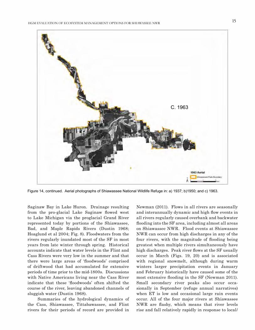
Figure 14. Aerial pho-tographs of Shiawas-see National Wildlife Refuge in: a) 1937; b)1950; and c) 1963.
A. 1937
B. 1950
15
Figure 14, continued. Aerial photographs of Shiawassee National Wildlife Refuge in: a) 1937; b)1950; and c) 1963.
C. 1963
HGM EVALUATION OF ECOSYSTEM MANAGEMENT OPTIONS FOR SHIAWASSEE NWR
Saginaw Bay in Lake Huron. Drainage resulting from the pro-glacial Lake Saginaw flowed west to Lake Michigan via the proglacial Grand River represented today by portions of the Shiawassee, Bad, and Maple Rapids Rivers (Dustin 1968; Hoaglund et al 2004; Fig. 8). Floodwaters from the rivers regularly inundated most of the SF in most years from late winter through spring. Historical accounts indicate that water levels in the Flint and Cass Rivers were very low in the summer and that there were large areas of ‘floodwoods’ comprised of driftwood that had accumulated for extensive periods of time prior to the mid-1800s. Discussions with Native Americans living near the Cass River indicate that these ‘floodwoods’ often shifted the course of the river, leaving abandoned channels of sluggish water (Dustin 1968).
Summaries of the hydrological dynamics of the Cass, Shiawassee, Tittabawassee, and Flint rivers for their periods of record are provided in
Newman (2011). Flows in all rivers are seasonally and interannually dynamic and high flow events in all rivers regularly caused overbank and backwater flooding into the SF area, including almost all areas on Shiawassee NWR. Flood events at Shiawassee NWR can occur from high discharges in any of the four rivers, with the magnitude of flooding being greatest when multiple rivers simultaneously have high discharges. Peak river flows at the SF usually occur in March (Figs. 19, 20) and is associated with regional snowmelt, although during warm winters larger precipitation events in January and February historically have caused some of the most extensive flooding in the SF (Newman 2011). Small secondary river peaks also occur occa-sionally in September (refuge annual narratives) when ET is low and occasional large rain events occur. All of the four major rivers at Shiawassee NWR are flashy, which means that river levels rise and fall relatively rapidly in response to local/

16 Heitmeyer, et al.
0 0.25 0.5 0.75Miles ±
Historic drainage patterns
Crystal Bayou
Saginaw River
Ferguson Bayou
Flint River
Mistequay Creek
Shiawassee River
Shiawassee Flats Boundary
Figure 15. Potential historical surface water flow patterns on Shiawassee National Wildlife Refuge shown on 1937 aerial photo-graph of the refuge area. pathways determined from combined contemporary LiDAR elevation/topography maps (see Fig. 13), features shown on the 1937 photograph, and information from unpublished refuge annual narratives.
regional precipitation and runoff events (Baker et al. 2004). The Cass River, which is an important source of water for Eagle Marsh, Butch’s Marsh, MSUs 3-5, and North Marsh, has 2.4 miles of river adjacent to the refuge and peak yearly dis-charges (that determine the extent of local flooding caused by this river) tend to occur at about 15-year intervals, alternating with dry periods (Fig. 19b). Data from 1945 to the present suggest gradually increasing flows in the Cass River over time (Fig. 19b). Flood frequency curves for the Cass River at Frankenmuth, MI indicate floods of > 3,000 cubic-feet/second (cfs) occur almost annually (Fig. 19c).
The Flint River, and the Spaulding Drain that now diverts a large part of Flint River flows north
through the refuge (Fig. 18), is a major source of water for many wetland units on Shiawassee NWR. The historical channel of the Flint River down-stream of the Spaulding Drain to its confluence with the Shiawassee River is known locally as the Misteguay Drain (Fig. 18). The historical Misteguay Creek joins the old Flint River channel just down-stream of where the Spaulding Drain connects and diverts former Flint River channel water. Yearly peak flows in the Flint River near Flint, MI indicate alternating periods of high vs. low yearly flows (Fig. 20b); patterns of alternating flows are less clear than for the Cass River. Flood flows of > 3,000 cfs occur about annually on the Flint River at the Flint and Fosters gauge stations, respectively

17
2
Climatographyof the United States
No. 201971-2000
U.S. Department of CommerceNational Oceanic & Atmospheric AdministrationNational Environmental Satellite, Data,and Information Service
National Climatic Data CenterFederal Building151 Patton AvenueAsheville, North Carolina 28801www.ncdc.noaa.gov
Station: SAGINAW TRI STATE AP, MI
Elevation: 660 Feet Lat: 43 32N Lon: 84 05WClimate Division: MI 7 NWS Call Sign: MBS
COOP ID: 207227
Precipitation (inches)
Precipitation Totals Mean Number of Days (3)
Precipitation Probabilities (1)
Probability that the monthly/annual precipitation will be equal to or less than theindicated amount
Means/Medians(1)
Extremes Daily PrecipitationMonthly/Annual Precipitation vs Probability Levels
These values were determined from the incomplete gamma distribution
Month Mean Med-ian
HighestDaily(2)
Year Day HighestMonthly(1)
Year LowestMonthly(1)
Year >=0.01
>=0.10
>=0.50
>=1.00 .05 .10 .20 .30 .40 .50 .60 .70 .80 .90 .95
Jan 1.77 1.56 1.92 1978 26 4.04 1998 .54 1981 11.4 4.9 .7 .2 .50 .67 .93 1.15 1.36 1.59 1.84 2.13 2.51 3.11 3.67
Feb 1.57 1.39 3.51 1997 21 6.10 1997 .39 1984 9.4 4.2 .5 .2 .28 .42 .65 .86 1.08 1.32 1.59 1.91 2.35 3.05 3.72
Mar 2.42 2.23 2.11 1948 19 6.69 1998 .31 1981 10.2 5.8 1.4 .3 .63 .86 1.21 1.52 1.83 2.15 2.50 2.92 3.47 4.34 5.15
Apr 2.82 2.78 2.87 1967 21 5.93 1991 1.13 1978 10.7 6.6 1.8 .4 1.09 1.35 1.73 2.03 2.33 2.62 2.95 3.32 3.80 4.52 5.19
May 2.89 2.82 3.14 1996 20 6.29 1996 .80 1988 9.4 5.9 2.1 .7 .80 1.08 1.49 1.85 2.21 2.58 2.99 3.48 4.11 5.10 6.03
Jun 3.06 3.24 2.98 1935 17 6.92 1996 .61 1988 9.0 6.0 1.9 .6 1.16 1.44 1.85 2.19 2.52 2.85 3.20 3.62 4.15 4.96 5.70
Jul 2.50 2.29 3.07 1928 27 5.31 1980 .45 1989 8.4 5.2 1.9 .6 .74 .97 1.33 1.64 1.94 2.25 2.59 3.00 3.52 4.34 5.11
Aug 3.38 3.12 3.73 1914 18 9.01 1975 .93 1982 9.2 6.0 2.4 .8 .91 1.23 1.72 2.15 2.57 3.01 3.50 4.08 4.84 6.02 7.12
Sep 3.95 3.50 5.51 1986 10 16.16 1986 .00 1979 10.0 6.4 2.7 1.1 .58 1.10 1.77 2.32 2.87 3.45 4.09 4.85 5.86 7.45 8.94
Oct 2.49 2.61 4.58 1954 3 5.57 1990 .46 1975 9.3 5.6 1.8 .3 .83 1.07 1.41 1.71 1.99 2.28 2.59 2.96 3.44 4.18 4.85
Nov 2.65 2.38 2.07 1990 5 6.31 1995 .51 1986 11.1 5.9 1.6 .6 .75 1.00 1.38 1.71 2.03 2.37 2.75 3.19 3.76 4.66 5.50
Dec 2.11 2.01 2.08 1962 6 5.33 1972 .55 1993 12.0 5.8 1.0 .3 .58 .78 1.08 1.35 1.61 1.88 2.18 2.54 3.00 3.73 4.41
Ann 31.61 31.62 5.51Sep
1986 10 16.16
Sep1986
.00Sep
1979120.1 68.3 19.8 6.1 24.01 25.52 27.43 28.86 30.13 31.34 32.59 33.96 35.62 37.99 40.03
+ Also occurred on an earlier date(s) (1) From the 1971-2000 Monthly Normals# Denotes amounts of a trace (2) Derived from station’s available digital record: 1898-2000@ Denotes mean number of days greater than 0 but less than .05 (3) Derived from 1971-2000 serially complete daily data** Statistics not computed because less than six years out of thirty had measurable precipitation Complete documentation available from:
www.ncdc.noaa.gov/oa/climate/normals/usnormals.html
086-B
3
Climatographyof the United States
No. 201971-2000
U.S. Department of CommerceNational Oceanic & Atmospheric AdministrationNational Environmental Satellite, Data,and Information Services
National Climatic Data CenterFederal Building151 Patton AvenueAsheville, North Carolina 28801www.ncdc.noaa.gov
Station: SAGINAW TRI STATE AP, MIElevation: 660 Feet Lat: 43 32N Lon: 84 05WClimate Division: MI 7 NWS Call Sign: MBS
COOP ID: 207227
Snow (inches)Snow Totals Mean Number of Days (1)
Means/Medians (1) Extremes (2)Snow Fall
>= ThresholdsSnow Depth
>= Thresholds
MonthSnowFall
Mean
SnowFall
Median
SnowDepthMean
SnowDepth
Median
HighestDailySnowFall
Year Day
HighestMonthly
SnowFall
Year
HighestDailySnowDepth
Year Day
HighestMonthly
MeanSnowDepth
Year 0.1 1.0 3.0 5.0 10.0 1 3 5 10
Jan 11.4 10.6 4 3 19.2 1978 26 30.3 1978 28+ 1978 29 15 1979 8.2 3.9 .9 .3 .1 21.7 15.7 9.3 2.5
Feb 8.1 7.5 4 2 9.3 1976 21 19.8 1985 21+ 1985 12 15 1978 5.9 3.0 .8 .2 .0 18.1 11.7 7.1 3.6
Mar 7.1 6.1 1 2 21.3 1973 17 21.7 1973 21 1973 18 4 1978 4.5 2.4 .7 .3 .1 8.8 4.5 2.6 .4
Apr 2.2 1.0 # 0 8.5 1975 2 14.4 1975 14+ 1975 4 2 1975 1.3 .8 .2 .1 .0 .9 .4 .2 .1
May .0 .0 # 0 .2 1994 1 .2 1994 0 0 0 # 1999 .0 .0 .0 .0 .0 .0 .0 .0 .0
Jun .0 .0 0 0 .0 0 0 .0 0 0 0 0 0 0 .0 .0 .0 .0 .0 .0 .0 .0 .0
Jul .0 .0 0 0 .0 0 0 .0 0 0 0 0 0 0 .0 .0 .0 .0 .0 .0 .0 .0 .0
Aug .0 .0 0 0 .0 0 0 .0 0 0 0 0 0 0 .0 .0 .0 .0 .0 .0 .0 .0 .0
Sep .0 .0 0 0 .0 0 0 .0 0 0 0 0 0 0 .0 .0 .0 .0 .0 .0 .0 .0 .0
Oct .2 .0 # 0 2.9 1997 27 2.9 1997 3 1997 27 # 1997 .1 .1 .0 .0 .0 @ @ .0 .0
Nov 3.9 2.1 # 0 9.5 1995 27 23.0 1995 11 1995 28 2 1995 2.8 1.4 .4 .1 .0 2.4 .9 .2 @
Dec 10.0 10.6 1 1 11.5 1971 30 21.9 1972 10+ 1973 21 4 1972 6.8 3.7 1.0 .3 @ 13.0 5.9 2.3 .1
Ann 42.9 37.9 N/A N/A 21.3 Mar 1973
17 30.3 Jan
1978 28+
Jan 1978
29 15+ Jan
1979 29.6 15.3 4.0 1.3 .2 64.9 39.1 21.7 6.7
+ Also occurred on an earlier date(s) #Denotes trace amounts (1) Derived from Snow Climatology and 1971-2000 daily data
@ Denotes mean number of days greater than 0 but less than .05 (2) Derived from 1971-2000 daily data
-9/-9.9 represents missing values Complete documentation available from:Annual statistics for Mean/Median snow depths are not appropriate www.ncdc.noaa.gov/oa/climate/normals/usnormals.html
086-C
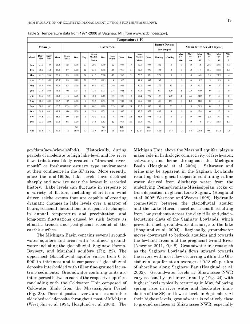
Table 1. precipitation data from 1971-2000 at Saginaw, Mi (from www.ncdc.noaa.gov).
HGM EVALUATION OF ECOSYSTEM MANAGEMENT OPTIONS FOR SHIAWASSEE NWR
(Fig. 20). About 0.04 miles of the Saginaw River, formed by the collective flows of the Shiawassee, Flint, Cass, and Tittabawassee Rivers, is adjacent to the refuge and is effectively the upstream end of the Saginaw Bay Area of Concern (Public Sector Consultants, Inc. 2002). Data from the Saginaw River at Saginaw, MI indicates a long-term trend of decreasing peak discharges (Newman 2011:22).
Lake Huron water level dynamics also influence the hydrology of the SF. Higher water levels in Saginaw Bay can influence the stage-dis-
charge relationship of river systems in the SF. The USGS annual water-data report for the Saginaw River at Saginaw notes that low flows are affected by seiche events (USGS 2011a), and a recent report from the University of Michigan states that Saginaw Bay seiche events can influence water levels as far upstream as St. Charles, MI (Buchanan et al. 2013). Although Great Lakes water level maximum and minimum monthly means have not differed by much more than about six feet over the past 150 years (Lofgren et al. 2002), there has been con-

18 Heitmeyer, et al.
0
1
2
3
4
5
6
7
8
Mon
thly
Pre
cipi
tatio
n (in
ches
)
All years from 1975 to 2009
Mean for 1975 to 2009
Jan MarFeb JunMayApr DecNovOctAug SepJul
Figure 16. Mean monthly precipitation at Shiawassee National Wildlife Refuge, 1975-2009 (from Newman 2011).
5.0
15.0
25.0
35.0
45.0
55.0
65.0
75.0
85.0
Mea
n M
onth
ly te
mpe
ratu
re (°
F)
All years from 1975 to 2009
Mean for 1975 to 2009
Jan MarFeb JunMayApr DecNovOctAug SepJul
Figure 17. Mean monthly temperature at Shiawassee National Wildlife Refuge, 1975-2009 (from Newman 2011).
siderable fluctuation within this stage range. The low-lying topography of the SF makes such fluc-tuations significant when considering the timing, frequency, depth, and duration of inundation along the regional rivers. Historically, periods of higher lake levels likely caused sustained inundation of low-lying in the SF even during periods of low river flows. NOAA gauge data shows the average
Lake Huron level from 1919 to 2013 to be 578.9 feet amsl, with monthly averages routinely surpassing 580 feet amsl and periodic lows near 576 feet amsl. Water level readings dating to 1860 (Fig. 21), along with paleoclimate reconstruction of lake levels suggest that the historical long-term average may have been substantially higher than water levels during the past 100 years (http://www.glerl.noaa.
19
Climatographyof the United States
No. 201971-2000
U.S. Department of CommerceNational Oceanic & Atmospheric AdministrationNational Environmental Satellite, Data,and Information Service
National Climatic Data CenterFederal Building151 Patton AvenueAsheville, North Carolina 28801www.ncdc.noaa.gov
Station: SAGINAW TRI STATE AP, MI
Elevation: 660 Feet Lat: 43 32N Lon: 84 05WClimate Division: MI 7 NWS Call Sign: MBS
COOP ID: 207227
Temperature ( F)
Mean (1) ExtremesDegree Days (1)
Base Temp 65Mean Number of Days (3)
Month DailyMax
DailyMin Mean Highest
Daily(2)Year Day
HighestMonth(1)
MeanYear Lowest
Daily(2)Year Day
LowestMonth(1)
MeanYear Heating Cooling
Max>=100
Max>= 90
Max>= 50
Max<= 32
Min<= 32
Min<= 0
Jan 27.9 14.9 21.4 62+ 1916 27 30.9 1990 -22 1994 19 12.1 1994 1352 0 .0 .0 .6 20.3 29.6 3.6
Feb 30.7 16.8 23.8 67 1930 22 33.4 1998 -23 1918 5 12.1 1979 1156 0 .0 .0 1.1 15.9 25.8 2.5
Mar 41.3 25.6 33.5 83 1910 24 41.5 2000 -12 1962 2 25.2 1978 979 0 .0 .0 6.8 6.6 23.9 .4
Apr 55.0 35.9 45.5 89 1899 29 52.7 1985 8 1923 1 41.3 1982 587 1 .0 .0 19.7 .5 10.3 .0
May 68.4 46.8 57.6 95 1919 31 64.6 1977 24+ 1903 1 50.2 1997 272 42 .0 .5 30.1 .0 .9 .0
Jun 77.5 56.0 66.8 104 1934 1 72.3 1971 33+ 1941 10 60.6 1982 68 120 .1 2.3 30.0 .0 .0 .0
Jul 81.9 60.4 71.2 111 1936 13 75.8 1988 40+ 1898 10 66.2 1992 10 200 .1 3.9 31.0 .0 .0 .0
Aug 78.9 58.5 68.7 103 1918 6 73.6 1995 37 1982 29 64.6 1992 40 155 .0 1.7 31.0 .0 .0 .0
Sep 70.9 50.5 60.7 100+ 1931 11 66.0 1998 27+ 1942 29 56.7 1993 155 26 .0 .5 29.9 .0 .2 .0
Oct 58.8 40.1 49.5 88+ 1900 4 58.1 1971 0 1905 5 43.7 1972 487 4 .0 .0 25.4 .0 5.2 .0
Nov 44.8 31.1 38.0 80 1950 1 45.9 1975 -3 1949 26 31.6 1995 812 0 .0 .0 9.6 2.8 17.8 @
Dec 33.0 20.9 27.0 66 1909 5 34.5 1982 -12 1914 26 16.3 1989 1181 0 .0 .0 1.6 14.0 28.4 1.1
Ann 55.8 38.1 47.0 111Jul
1936 13 75.8Jul
1988 -23Feb
1918 5 12.1+Jan
1994 7099 548 .2 8.9 216.8 60.1 142.1 7.6
+ Also occurred on an earlier date(s) (1) From the 1971-2000 Monthly Normals
@ Denotes mean number of days greater than 0 but less than .05 (2) Derived from station’s available digital record: 1898-2000
Complete documentation available from: www.ncdc.noaa.gov/oa/climate/normals/usnormals.html (3) Derived from 1971-2000 serially complete daily data
Issue Date: February 2004 086-A
Table 2. Temperature data from 1971-2000 at Saginaw, Mi (from www.ncdc.noaa.gov).
HGM EVALUATION OF ECOSYSTEM MANAGEMENT OPTIONS FOR SHIAWASSEE NWR
gov/data/now/wlevels/dbd/). Historically, during periods of moderate to high lake level and low river flow, tributaries likely created a “drowned river-mouth” or freshwater estuary type environment at their confluence in the SF area. More recently, since the mid-1990s, lake levels have declined sharply and now are near the lowest in recorded history. Lake levels can fluctuate in response to a variety of factors, including short-term wind driven seiche events that are capable of creating dramatic changes in lake levels over a matter of hours; seasonal fluctuations in response to changes in annual temperature and precipitation; and long-term fluctuations caused by such factors as climatic trends and post-glacial rebound of the earth’s surface.
The Michigan Basin contains several ground-water aquifers and areas with “confined” ground-water including the glaciofluvial, Saginaw, Parma-Bayport, and Marshall aquifers (Fig. 22). The uppermost Glaciofluvial aquifer varies from 0 to 900’ in thickness and is composed of glaciofluvial deposits interbedded with till or fine-grained lacus-trine sediments. Groundwater confining units are interspersed between each of the respective aquifers concluding with the Coldwater Unit composed of Coldwater Shale from the Mississippian Period (Fig. 23). These deposits cover Jurassic and other older bedrock deposits throughout most of Michigan (Westjohn et al 1994; Hoaglund et al 2004). The
Michigan Unit, above the Marshall aquifer, plays a major role in hydrologic connectivity of freshwater, saltwater, and brine throughout the Michigan Basin (Hoaglund et al 2004). Saltwater and brine may be apparent in the Saginaw Lowlands resulting from glacial deposits containing saline water derived from discharge water from the underlying Pennsylvanian-Mississippian rocks or from deposition in glacial Lake Saginaw (Hoaglund et al. 2002; Westjohn and Weaver 1998). Hydraulic connectivity between the glaciofluvial aquifer and the Lake Huron shoreline is small resulting from low gradients across the clay tills and glacio-lacustrine clays of the Saginaw Lowlands, which prevents much groundwater discharge to the lake (Hoaglund et al. 2004). Regionally, groundwater moves downward to bedrock aquifers and towards the lowland areas and the proglacial Grand River (Newman 2011, Fig. 8). Groundwater in areas such as the Saginaw Lowlands flows upward towards the rivers with most flow occurring within the Gla-ciofluvial aquifer at an average of 0.18 cfs per km of shoreline along Saginaw Bay (Hoaglund et al. 2002). Groundwater levels at Shiawassee NWR vary seasonally and inter-annually (Fig. 24) with highest levels typically occurring in May, following spring rises in river water and floodwater inun-dation of the SF, and lowest levels in September. At their highest levels, groundwater is relatively close to ground surfaces at Shiawassee NWR, especially

20 Heitmeyer, et al.
Figure 18. Location of major rivers and creeks in the Shiawassee Flats region.
0 1 2 3 4Miles±
Swan CreekSaginaw RiverShiawassee RiverBad RiverMistequay CreekFlint RiverCass RiverTittabawassee River
DEMElevation (ft)
567 - 590591 - 604605 - 623624 - 646647 - 689Shiawassee Flats Boundary
in low former depressional marsh and slough ele-vations. Interactions between ground and surface waters at SF are not well studied, but historically, some site-specific interchange likely occurred in the lowest elevations and from sloughs to the higher unconfined aquifer.
pLANT AND ANiMAL CoMMUNiTiES
Descriptions of historical Vegetation Communities
The Saginaw Valley and SF region lies within a transition zone between the Canadian and the Carolinean Biotic Provinces, which are dominated by Lake Forests and Oak-Hickory Forests, respec-
tively (Fitting 1970; Cleland 1966). The SF is within the area that is described as the Saginaw Bay Lake Plain subsection of the Southern Lower Michigan Regional Landscape Ecosystem (Albert et al. 1986, Omernik 1994, 2005). Historically, the Saginaw Bay watershed encompassed approxi-mately 700,000 acres of wetlands representing one of the largest wetland and wet prairie complexes in the Great Lakes region (Comer et al. 1993, Public Sector Consultants, Inc. (PSC) 2000).
An excellent summary of vegetation commu-nities present in Michigan, based on interpretation of GLO surveys from the early-1800s, provides geo-spatial information on the types and distribution of general habitats historically present in the SF in the Presettlement period (Albert and Comer 2008). These GLO-based maps indicate that the SF region

21
Figure 19. Mean monthly discharge (cfs) for the Cass River at Frankenmuth, Mi for various time periods 1935-2010 (from Newman 2011).
A
B
C
HGM EVALUATION OF ECOSYSTEM MANAGEMENT OPTIONS FOR SHIAWASSEE NWR
contained a central core of shrub swamp-emergent marsh sur-rounded by diverse black ash, and mixed hardwood swamp forest (Fig. 25). A few scattered small areas of wet prairie were mapped by GLO surveyors in the north part of the SF. The Titta-bawassee, Flint, Cass, Saginaw, and Shiawassee river corridors contained river/lake habitats. Small areas of white pine-mixed hardwood forest and oak-hickory forest were present on the upland margins of the SF and extensive areas of the floodplain-upland transitional forest type, beech-sugar maple forest, occupied the Cass River corridor and to a lesser degree areas along the lower Tittabawassee and Shia-wassee rivers (Fig. 24). Shia-wassee NWR lands contained a large C-shaped area of shrub swamp-emergent marsh along the Flint and Shiawassee rivers that graded to mostly mixed hardwood swamp east of the Ferguson Bayou drainage (Fig. 25). Two areas of wet prairie were present in the northeast part of the refuge and another wet prairie patch occurred off-refuge just north of Hart Marsh.
A map of Saginaw and Tuscola counties prepared in 1859 (Fig. 26) identifies general areas of “prairie” at the Shia-wassee-Flint and Shiawassee-Tittabawassee confluence areas along with mention of certain tree species in some areas. While this map does not identify specific outlines of vegetation types it offers general description of some habitats present in the SF region.
Descriptions of the Pre-settlement vegetation commu-nities in the SF and associated Great Lakes region are provided in Curtis (1959), Veatch (1959),

22 Heitmeyer, et al.
Figure 20. Flint River, near Flint, Mi: a) mean monthly discharge, 1933-2010; b) flood return interval, 1950-2010; and c) yearly peak streamflow, 1933-2010 (from Newman 2011).
A
B
C
Comer et al. (1993), Chapman (1984), Comer et al. (1995), Albert and Comer (2008), and Kost et al. (2010). Brief summaries of the major communities historically present in the SF and on Shia-wassee NWR are provided below.
The shrub swamp-emergent marsh category identified in GLO notes and maps (Fig. 25) apparently describes a complex of shrub, emergent, and herbaceous wetlands that is common in the Saginaw Lake plain (Albert and Comer 2008). The typical zonation of wetland plants in these mixed shrub-emergent wetlands is a gradation of species arrayed along elevation and hydrological gradients from deeper more per-manently flooded sites in lower elevations to sequentially higher elevations with semipermanent and seasonal flooding regimes. GLO surveyors provided little detail in their descriptions of the SF as to whether they were pre-dominantly “marsh” or “shrub” habitats. On Shiawassee NWR, the distribution of the GLO-mapped shrub swamp-emergent marsh is generally < 580 feet amsl (Fig. 27) and on Zilwaukee-Misteguay complex soils (Fig. 28). Historically, prior to mainstem levees on SF rivers, areas <580 feet would have been affected by Lake Huron water level fluctua-tions in most years.
The deeper, lower elevation areas of these shallow shrub-emergent marshes typically would have been flooded for extended periods, often year-round, during wet periods of the long-term precipitation cycle (see preceding Climate and Hydrology section). These more permanently flooded habitats likely contained interspersed open water (OW)-persistent emergent (PEM)-submergent

23
576.00
577.00
578.00
579.00
580.00
581.00
582.00
583.00
1860 1870 1880 1890 1900 1910 1920 1930 1940 1950 1960 1970 1980 1990 2000 2010
Lake
Level (feet, IGLD
)
Year
Lake Huron Annual Average Lake Levels 1860 ‐ 2012
Average Annual Lake Level (feet, IGLD)
Figure 21. Annual average Lake huron water levels, 1860-2012. Elevation data is international Great Lakes Datum. (from NoAA Great Lakes Environmental Research Laboratory, Great Lakes Water Level observations, http://www.glerl.noaa.gov/data/now/wlevels.html).
Figure 22. Landscape cross-section of aquifers underlying the Saginaw Bay region (from hoaglund et al. 2004).
HGM EVALUATION OF ECOSYSTEM MANAGEMENT OPTIONS FOR SHIAWASSEE NWR
aquatic vegetation (SAV) marsh communities, because shrub species could not have survived in more permanently flooded sites. The distribution of OW-PEM-SAV habitats undoubtedly was dynamic based on flooding regimes associated with the long-term precipitation/flooding patterns of the SF and Lake Huron water levels, but the deeper elevations, such as the “sump” area on Shiawassee NWR that is < 575 feet amsl may have supported this community consistently over time (Fig. 27). Long-term data on water levels in Lake Huron show that minimum monthly values for about the last 100 years seldom dropped below 576 feet amsl. If SF areas had unimpeded surface water con-nection to a river (i.e., Shiawassee, Cass, Tittabawassee, Flint) then elevations below about 576 to 577 feet would have been essentially permanently inundated. Current monitoring data collected on the Shiawassee River at Shiawassee NWR supports this conclusion as the river had a minimum stage of 576.4 during the drought of 2012 when Lake Huron water levels dropped to a monthly minimum of 576.25, which is the lowest lake level in nearly 50 years. Common PEM species in these marsh areas includes cattail (Typha spp.), bulrushes (Schoenoplectus spp.), and other persistent and non-per-sistent emergent species such as arrow arum (Peltandra virginica), giant burred (Sparganium eury-carpum), and arrowhead (Sagit-taria spp.). Floating plants such as fragrant water lily (Nymphacea odorata), yellow pond lily (Nuphar advena), American lotus (Nelumbo lutea), and duckweeds (e.g., Lemna minor) occur in deeper areas and these areas support diverse SAV including pondweeds (Potamo-

24 Heitmeyer, et al.
Figure 23. Stratigraphy of Michigan Basin aquifers and confining units (Westjohn and Weaver 1998).
geton spp.), coontail (Ceratophyllum demersum), water milfoil (Myriophyllum exalbescens), and bladderwort (Utricularia spp.) unless waters are highly turbid. Early explorers and pioneers in the SF area observed beds of wild rice (Zizania aquatic) in creek drainages flowing through Saginaw Bay marshes (Smoke 1952); so likely wild rice historically was present in the SF.
Shrub-scrub (S/S) vegetation likely bordered OW-PEM-SAV marshes in more semipermanently flooded elevations in the SF along natural drainage corridors and adjacent to mixed hardwood swamp forest areas based on GLO surveyor notes. S/S habitats typically occur in semipermanently flooded areas that have silt-clay soils and often are bordered by slightly higher elevation floodplain “swamp” forest habitats. Locations along drainages
in the SF would have had more consistent soil saturation and higher groundwater levels because of consistent stream/creek water, which would have provided water to shrub roots during dry periods. S/S habitats at the SF probably were dominated by buttonbush (Cephalanthus occidentalis) with mixed black willow (Salix nigra) and dogwood (Cornus spp.) also present. The inter-esting description of these S/S areas from Deputy GLO Surveyor William Brookfield in 1825 notes “to come this distance required long legs, short thighs, little head and no eyes through the willows, the rose briars and prickly ash” (Albert and Comer 2008:xiv).
Seasonally flooded elevations adjacent to OW-PEM-SAV marshes, but not immediately adjacent to drainages, in the SF likely contained bands or zones of seasonal herbaceous wetland (SHW) “moist-soil” plants that extended from the deeper semi-permanently flooded areas of marshes toward higher eleva-tions that were only seasonally flooded for short periods. These seasonally flooded areas would have become shallowly
inundated in spring following flood events on SF rivers and then dried during summer, which created exposed saturated soils where the moist-soil species germinated and grew. Some lower elevation moist soil areas may have become reflooded to shallow depths during fall and winter when rains increased, ET decreased, and occasional winter floods occurred (see the preceding Climate and Hydrology section). Common species in these herbaceous areas would have been grasses, sedges (Carex spp.), smartweed (Polygonum spp.), spikerush (Eleocharis spp.), and rushes (Juncus spp.) (See e.g., McEwan 1984). The locations of SHW areas likely varied depending on the long-term wet-dry precipitation and flooding cycle, but probably were in locations on the west

25
Figure 24. Groundwater levels for a site (USGS 434103083130301) near Shi-awassee National Wildlife Refuge, 1988-2011 (from Newman 2011).
HGM EVALUATION OF ECOSYSTEM MANAGEMENT OPTIONS FOR SHIAWASSEE NWR
and northeast sides of OW-PEM-SAV marshes on slightly higher “flat” flood-plain surfaces, next to natural levees along the Flint and Shiawassee rivers, and west of the abandoned Flint River channel corridor along Ferguson Bayou.
Historical accounts of Saginaw County also mention salt marshes along the Cass River that contained short salt-tolerant grasses and salt springs along the Tittabawassee River (Fox 1858). The GLO survey notes do not mention salt marshes in the SF, however, and given the large inputs of freshwater from the four rivers that merge at the SF, it seems unlikely that salt marsh com-munities existed in the SF or at Shia-wassee NWR.
The GLO surveys mapped wet prairie communities in three isolated areas in the north and northeast part of the SF (Fig. 25). At Shiawassee NWR, wet prairie was identified in what are now MSUs 3-5 and another prairie patch was located just north of Hart Marsh north of the Shiawassee River. Wet prairies are grass-dominated communities present on higher elevation floodplain areas that are sea-sonally or temporarily flooded by shallow sheetflow of water, often from short duration overbank river flood events. In the SF, wet prairies are dominated by blue-joint grass (Calamagrostis canadensis), prairie cordgrass (Spartina pectinata), and big bluestem (Andropogan gerardii) (Albert and Comer 2008). Wet prairie habitats often occur adjacent to seasonal herbaceous or PEM marshes on lake plain settings usually where relatively thin layers of sandy loam soils overlie dense sub-surface clay layers and cause surface water levels to fluctuate seasonally and over longer term periods, which prevent the establishment of S/S habitats (Albert et al. 1996). Extensive zones of lake plain “prairie” historically extended shoreward from marshes along the western shore of Saginaw Bay and were common along the Saginaw River (Comer et al. 1995). In some areas low beach ridges and sand dune ridges with poorly drained soils also supported a “savanna” type community within wet prairies; these higher elevations often contained scattered white oak (Quercus alba), bur oak (Quercus macro-carpa), and black oak (Quercus velutina).
The largest area of the GLO-mapped wet prairie on Shiawassee NWR is on Sloan-Ceresco complex, frequently flooded soils (Fig. 27) at ele-vations > 580 feet, near the confluence of the former Flint River (now Ferguson Bayou and the Spaulding Drain) with the Shiawassee River. This confluence area is a slightly higher elevation “tributary fan” site where coarser-texture river overbank sediments, including sand and sandy-loam materials, were deposited over former natural levee clay-type sediments. These confluence areas historically would have been overtopped and inundated for short periods during seasonal flood events. This confluence sand-clay stratigraphy, and higher elevation fan or terrace-type elevation setting resembles locations where wet prairie is present in other Upper Midwest river floodplain settings (e.g., see discussion in Heitmeyer 2010). Lake plain wet prairies were common along many areas of Lake Huron including the margins of Saginaw Bay (Albert et al. 1996, Albert and Comer 2008). It seems possible that some areas referred to as “shrub swamp - emergent marsh” habitats by the GLO surveys may have been dominated by been either SHW or wet prairie depending on when the GLO survey occurred in the alternating wet-dry long-term precipitation cycle and what surface water was present when the survey was conducted. For example, areas mapped as shrub swamp-emergent marsh in the south-central part of the SF near the historic Mistequay Creek-Flint

26 Heitmeyer, et al.
0 0.5 1 1.5 2 2.5 3Miles±
Landcover in 1800Covertype
BEECH-SUGAR MAPLE FORESTBLACK ASH SWAMPLAKE/RIVERMIXED CONIFER SWAMPMIXED HARDWOOD SWAMPOAK-HICKORY FORESTSHRUB SWAMP/EMERGENT MARSHWET PRAIRIEWHITE PINE-MIXED HARDWOOD FORESTShiawassee Flats Boundary
Figure 25. General landcover/habitat types present in the Shiawassee Flats region in the early-1800s, as interpreted from Gen-eral Land Office surveys (modified from Albert and Comer 2008).
River confluence area (Fig. 25) has soils, elevations, and a tributary fan setting similar to the Ferguson Bayou-Shiawassee River tributary fan area.
The area south of the Flint River north of Alicia, MI was known as the “Prairie Farm”, where former marsh and presumed wet prairie lands were drained for agricultural production (Grnak date unknown, Mahar 2009). Other local resident accounts suggest that a type of bottomland prairie or at the very least SHW with a component of prairie cordgrass and other grasses and sedges was present in this area (Anonymous 1881, Smoke 1952). And, the 1859 map of Saginaw and Tuscola counties (Fig. 26) indicates that “Prairie” was present near the confluence of the Flint and Shiawassee rivers and also north of the Shiawassee River near the confluence of the Shia-
wassee and Tittabawassee rivers. The 1859 map is general and the extent and type of prairie (maybe a prairie-wetland transitional area) is not known. The areas shown as prairie on the 1859 maps occurs at tributary fan areas similar to the wet prairie shown by the GLO maps in the current MSU 3-5 area and have silt loam soils (see also Table 3). The area north of the Shiawassee River and west of the Tit-tabawassee River rapidly grades to higher elevations and at least the area immediately at the confluence “point” is described as mixed hardwood forest by the GLO (Fig. 25) and older photographs also show it as heavily forested (Fig. 14). This confluence point area probably represents an area of frequent river channel migration with considerable movement of sediments and surface elevation, which would have

27
Figure 26. 1859 map of Saginaw and Tuscola counties, Michigan (author unknown, courtesy of hoyt public Library, Saginaw, Mi).
HGM EVALUATION OF ECOSYSTEM MANAGEMENT OPTIONS FOR SHIAWASSEE NWR
favored early succession forest species over prairie grassland establishment. Consequently, while some prairie appears to have historically been present at the western edge of this confluence setting, the east confluence point likely was historically forest.
Mixed hardwood swamp (forest) formerly dominated large expanses of the Saginaw Bay lake
plain (Comer et al. 1995, Dickman and Leefers 2004). This community type was mapped by GLO surveyors along Flint, Tittabawassee, and Shia-wassee river corridors and their basins surrounding the central shrub swamp-emergent marsh area of the SF (Fig. 25). Mixed hardwood swamp commu-nities contain diverse floodplain-type tree species

28 Heitmeyer, et al.
± 0 0.2 0.4 0.6Miles
Cover TypeBEECH-SUGAR MAPLE FOREST
LAKE/RIVER
MIXED HARDWOOD SWAMP
SHRUB SWAMP/EMERGENT MARSH
WET PRAIRIE
LiDAR 1' DEMElevation
High : 632.343
Low : 569.431
Management Impoundments
Shiawassee NWR Boundary
Figure 27. General Land Office landcover types (from Albert and Comer 2008) overlaid on one-foot LiDAR contour intervals on Shiawassee National Wildlife Refuge.
including silver maple (Acer saccharinum), sycamore (Platanus occidentalis), hackberry (Celtis occiden-talis), cottonwood (Populus deltoides), and boxelder (Acer negundo) along with scattered American elm (Ulmus Americana), black ash (Fraxinus nigra), bitternut hickory (Carya cordiformis), red oak (Quercus rubra), and swamp white oak (Quercus macrocarpa). Areas with mixed hardwood swamp forests usually occur along drainage floodplains in the SF where silt clay and clay soils are present, seasonal flooding occurs, soil groundwater levels are relatively high and provide consistent water for shallow tree root systems, and occasional dry surface soil periods in the long-term precipitation cycle, which allow times for forest regeneration.
Two isolated areas of black ash swamp were mapped along the Flint and Shiawassee rivers where they entered the SF; none were present on Shiawassee NWR (Fig. 25). Extensive areas of swamps dominated by black ash occur on sandy-type soils in the lake plain area of southern Michigan,
with especially large areas along the north shore of Saginaw Bay (Albert and Comer 2008). These black ash swamps usually contain both black and green ash (Fraxinus pennsylvanica) that can have buttressed trunk bases caused by annual seasonal or more prolonged flooding than in mixed hardwood swamp sites.
Beech-sugar maple forest, which represents a transitional forest type from true floodplains vs. uplands (Barnes and Wagner 1981, Dickman and Leefers 2004, Kost et al. 2010) occurs in large areas of the southern Lower Peninsula of Michigan and historically occupied a relatively wide band of the Cass River corridor and lower sections of the Tittabawassee and Shiawassee river reaches in the SF region (Fig. 24). These forests are character-istic of the moist, but well-drained, lake plains and moraine ridges with nutrient-rich soils that parallel Saginaw Bay (Albert et al. 1986, Figs. 5, 9). Forest species in the beech-sugar maple assemblage are diverse and include basswood (Tilia Americana),

29
0 1 2Miles±
Landcover in 1800Covertype
BEECH-SUGAR MAPLE FORESTLAKE/RIVERMIXED HARDWOOD SWAMPSHRUB SWAMP/EMERGENT MARSHWET PRAIRIE
SoilsSeries
Arkona sand, 0 to 4% slopesBelleville fine sandChesaning-Cohoctah complex, frequently floodedChesaning-Cohoctah complex, rarely floodedCorunna sandy loamCovert sand, 1 to 6% slopesFluvaquents, frequently floodedFrankenmuth very fine sandy loam, 0 to 4% slopesGagetown silt loam, 2 to 6% slopesGagetown silt loam, 6 to 12% slopes erodedGranby fine sandGrattan sand, 4 to 12% slopesLondo loam, 0 to 3% slopesPappan-Londo complex, 0 to 3% slopesParkhill loamParkhill-Wixom complex, 0 to 4$ slopesPella silt loamPella-Frankenmuth complex, 0 to 4% slopes
Pipestone sand, 0 to 3% slopesPipestone sand, loamy substratum, 0 to 3% slopesRoundhead muckSanilac very fine sandy loam, 1 to 3% slopesSloan silt loam, frequently floodedSloan silt loam, rarely floodedSloan-Ceresco complex, frequently floodedSloan-Ceresco complex, rarely floodedStrawn silt loam, 12 to 18% slopes, severely erodedStrawn silt loam, 2 to 6% slopes, erodedStrawn silt loam, 6 to 12% slopes, erodedTappan loamTappan-Londo-Poseyville complex, 0 to 3% slopesTappan-Poseyville complex, 0 to 3% slopesUdipsamments, undulatingUdorthens, loamy, nearly level to steepUrban landWaterWixom sand, 0 to 4% slopesZilwaukee-Misteguay complex, frequently floodedZilwaukee-Misteguay complex, rarely flooded
Figure 28. General Land Office landcover types (from Albert and Comer 2008) overlaid on soil types on Shiawassee National Wildlife Refuge.
HGM EVALUATION OF ECOSYSTEM MANAGEMENT OPTIONS FOR SHIAWASSEE NWR
red oak, white oak, American elm, shagbark hickory (Carya ovata), black walnut (Juglans nigra), and tulip poplar (Liriodendron tulipifera) along with the namesake beech (Fagus grandifolia) and sugar maple (Acer saccharum).
hGM Relationships and Distribution of presettlement Vegetation Communities
An HGM matrix of relationships of the major plant communities described above to hydrogeo-morphic attributes in the SF region was prepared (Table 3) to expand on the understanding of Preset-tlement vegetation community distribution maps provided by GLO surveys (Fig. 25). This HGM matrix was then used to prepare a model map of the potential distribution of Presettlement vegetation communities at Shiawassee NWR (Fig. 29). Unfor-
tunately, LiDAR data processed to a 1-foot contour level are only available for the refuge and not the entire SF region. Given the importance of even modest changes in elevation to hydrological regime and community distribution, detailed mapping of potential historical vegetation distribution for the entire SF was not possible. The HGM matrix of understanding, and prediction, of potential historic vegetation communities was developed using published literature, vegetation community reference sites, and state-of-the-art understanding of plant species relationships (i.e., botanical cor-relation) to geomorphology, soil, topography and elevation, SF river and Lake Huron hydrological regimes, and ecosystem disturbances (e.g., Curtis 1959, Chapman 1984, Comer et al. 1995, Dickman and Leefers 2004). These plant-abiotic correlations

30 Heitmeyer, et al.
Table 3. Hydrogeomorphic (HGM) matrix of historical distribution of major vegetation communities/habitat types in the Shiawassee Flats region in relationship to geomorphic surface, soils, topography, and hydrological regime. Relationships were determined from vegetation species distribution (Albert and Comer 2008); soil maps (Fig. 10); LiDAR maps (Fig. 13); surficial geology maps (Figs. 7, 9); region-specific hydrology and river flood frequency data (Newman 2011); and various botanical accounts and literature (e.g., Curtis 1959, Chapman 1984, Comer et al. 1993, 1995, Dickman and Leefers 2004, Albert et al. 1986, 1996, Albert and Comer 2008). Geomorphic Soil Elevation Hydrological Habitat typea surface type range regimeb
OW-riverine river channel riverbed varies P PEM-SAV lacustrine sump clay < 575 P-SP S/S lacustrine sump clay, and drainages silt-clay 576-580 SP SHW lacustrine flat silt-clay 580-583 SF Wet prairie tributary fan, high Floodplain terrace silt-loam >583 SF-sheet flow Mixed hardwood lacustrine floodplain silt-clay 590-600 SF-dormant swamp forest Black ash lacustrine floodplain sandy-silt 590-600 SF-dormant swamp forest Beech-sugar maple floodplain margins sandy-gravel >610 OS Oak-hickory upland variable >630 OS Savanna upland dunes dune sand >630 OS a OW – open water, PEM – persistent emergent marsh, SAV – submerged aquatic, S/S – shrub/scrub, SHW – seasonal herbaceous wetland. b P – permanent year-round, SP – semi-permanent, SF – seasonally flooded, SF-sheet flow – seasonally flooded from sheet-water flow (mostly short duration spring overbank river flow), SF-dormant – seasonally flooded mostly during the dormant season, OS – on site precipitation and ponding.
are in effect the basis of plant biogeography and physiography whereby information is sought on where plant species, and community assemblages, occur throughout the world relative to geology and geomorphic setting, soils, topographic and aspect position, and hydrology (e.g., Barbour and Billings 1991). The HGM matrix allows understanding of potential historic vegetation community distri-bution in the SF in an objective manner based on the botanical correlations that identify community type and distribution, juxtaposition, and “driving” ecological processes that created and sustained them. The predictions of type and historic dis-tribution of communities are only as good as the understanding and documentation of plant-abiotic relationships and the geospatial data for the abiotic variables for a location and period of interest, such as Presettlement period.
Fortunately, in the SF, the major vegetation communities that were present during the Pre-
settlement period are known and the botanical relationships of these communities with abiotic factors also are documented (see e.g. Comer et al. 1993, 1995; Albert and Comer 2008). The relatively robust vegetation community relationships in the SF enable a well-validated understanding of where historical major plant communities in the CRE were located relative to geomorphic setting, soils, and hydrological regime. Consequently, even though Presettlement hydrology data area not available for the region, the confirmed relationships of species to other abiotic variables provides strong inference as to what the historic hydrological regime was for various locations. The primary communities in the SF are OW- PEM-SAV marshes, SHW, wet prairie, S/S, and floodplain forest types. With the exception of SHW, these communities have rela-tively long generation cycles and their occurrence at sites indicates long-term response and adaptation to repeated inter-annual and seasonal patterns of
hydrology. If confidence is reached in understanding the position of a historic community type based on historic maps and botanical correlation with other abiotic variables including specific geomorphology, soils, and topography, then by default, the historic hydrological regime for a site also can be assumed. For example, if a historic site supported floodplain forest, then the site undoubtedly had (long-term average) short duration dormant season flooding within a > 2-year growing season flood frequency zone (e.g., see HGM matrix in Heitmeyer 2010).
The first step to prepare the Hydrogeomorphic matrix (Table 3) and map of potential historic communities for the SF (Fig. 29) was identifying the general distribution of major vegetation community/habitat types including shrub swamp-emergent marsh, wet prairie, mixed hardwood swamp, beech-sugar maple

31
± 0 0.2 0.4 0.6 0.8Miles
Cover TypeBeech-Sugar Maple Forest
Lake/River
Mixed Hardwood Swamp
Permanent Emergent Marsh
Seasonal Herbaceous Wetland
Shrub Swamp
Wet Prairie
LiDAR 1' DEMElevation
High : 633.07
Low : 569.434
Management Impoundments
Figure 29. potential distribution of vegetation community types present on Shiawassee National Wildlife Refuge in the early-1800s. Mapping of communities was based on relationships of communities to soils, topography, geomorphology, and hydrology provided in Table 3 and general community type maps provided in Albert and Comer (2008).
HGM EVALUATION OF ECOSYSTEM MANAGEMENT OPTIONS FOR SHIAWASSEE NWR
forest, and upland oak-hickory forest from GLO surveys (Fig. 25), and early settlement/naturalist accounts (e.g., Grnak unknown date, Anonymous 1881). The GLO map of the historic distribution of communities using the above collective information was then overlain on contemporary geomorphology (mostly lake plain deposits), elevation (Fig. 27), and soils (Fig. 28) maps. The most detailed and likely precise correlations between communities and elevation occur on Shiawassee NWR. Where a DEM and 1-foot contours were created from the additional analyses of processing the bathymetry survey point data and the LAS LiDAR data to create a new DEM and 1-foot contour data layers. Contours based on the DEM at the Saginaw County level could only be processed to 4-foot contours based on the accuracy and precision of the initial LiDAR survey. Furthermore, areas in the SF that had standing water during the LiDAR survey flight (e.g., managed wetland units on the Shiawassee
SGA) were hydro-flattened and no bathymetry survey data was available to refine the precision of topography information for these areas.
The general correspondence of Presettlement vegetation communities from the above map sources with contemporary abiotic geomorphology, soils, and topography layers was determined where possible. Using this first-step overlay of map infor-mation, relationships between communities and abiotic factors sometimes became clearly defined by one or two factors. For example, the lowest LiDAR map elevations < 570 feet amsl occur in the north-central part of Shiawassee NWR and likely were OW-PEM-SAV permanent to semiperma-nently flooded marshes. In other cases, however, it was necessary to use multiple abiotic variables to understand botanical relationships, for example the complex gradation of seasonal herbaceous marsh and wet prairie habitats that likely occurred south of the Flint River.

32 Heitmeyer, et al.
Despite some inherent limitations and biases with GLO survey notes on vegetation species, espe-cially the witness trees at the corner of section lines (Bourdo 1956, Hutchinson 1988, Nelson et al. 1998, Albert and Comer 2008), the broad distinction and maps of forest vs. non-forested herbaceous or shrub wetland created from the GLO surveys seems straightforward and definitive. Consequently, we accept the GLO maps identifying forest vs. non-forest community extent in the SF during the Pre-settlement period. Further, general basic differ-ences in forest communities from more upland drier zone species such as hickory and white oak vs. flood-plain wetter species such as willow, cottonwood, black ash, beech, and sugar maple seems to have been captured adequately by the GLO survey notes. Consequently, the GLO locations mapped as forest (combined types), shrub-emergent marsh, and wet prairie were used to begin preparing the potential historical vegetation distribution map.
The more difficult challenge of mapping potential Presettlement vegetation communities is segregating communities within the broad area called “shrub swamp-emergent marsh” in the GLO surveys, and in understanding the position and extent of wet prairie on the margins of this shrub-emergent wetland habitat. The basic distribution of shrub, herbaceous, and wet prairie wetland com-munities in the SF generally corresponds to the C-shaped configuration of Zilwaukee-Misteguay complex rarely flooded soil category (Figs. 10, 28), however the area east of Pools 3 and 5 also has this soil type, but was identified as mixed hardwood swamp by the GLO survey. The scattered wet prairie locations identified on the GLO map have mixed soil series, but all are on sandy- or silt-loam types and occur on slightly higher elevation areas that border the shrub swamp-emergent marsh areas. The GLO notes offer few hints as to the exact location of shrub vs. emergent or herbaceous plant species within the broader shrub swamp-emergent marsh category, however it appears both communities were present and likely were at least somewhat interspersed based on limited comments in the GLO notes.
Certain basic botanical associations and community attributes are useful to propose how these shrub-emergent communities along with wet prairies were interspersed and located in the SF. First, S/S species tend to occur along drainages where semipermanent surface flooding occurs during the growing season and soil groundwater
tables are consistently high throughout the year. Second, PEM and herbaceous wetland species typically are in floodplain depressions and flats where more strong seasonal and inter-annual dynamics of surface flooding occurs, which provides the drawdown substrates needed by plants for ger-mination. Further, these herbaceous-type wetlands require periodic, sometimes extended drying to recycle nutrients, decompose detrital litter, con-solidate sediments, and sustain community com-position. In contrast, S/S wetland cannot tolerate these more prolonged drying periods, and if this drying occurs, the site will shift to either more dry-site trees or grassland/wet prairie. Also, the gradation of plant species in herbaceous wetlands is tightly arrayed along elevation and flooding gradients in floodplain settings. Last, wet prairie communities require seasonal sheetwater flow across silt loam or event some sandy loam soil types that are underlain by restrictive clay layers. Wet prairies consequently typically occur in higher floodplain elevations where remnant Holocene terraces or tributary fans occur and that have short duration seasonal flooding. Historical tributary fans in the SF and Shiawassee NWR area include high elevation areas (Fig. 13) near the Flint-Shi-awassee, Shiawassee-Tittabawassee, and Ferguson Bayou (former channel of the Flint River)-Shia-wassee river confluence settings.
The above S/S, herbaceous, and wet prairie wetland attributes suggest that all types were present in the SF. Unfortunately, historical flood frequency information related to elevation in the SF is not available, but long-term data on Lake Huron water levels is available, which helps define historical minimum elevation levels where lake-SF water connectivity, and inundation, occurred (Fig. 21). The recent LiDAR data and maps for Shia-wassee NWR at a more refined one-foot contour interval (Figs. 13, 27) suggest some likely patterns of these communities based on elevation. First, the lowest elevations in the refuge, formerly mapped as wetland by the GLO, occur mostly in Pool 1A and Grefe Pool with apparent drainages leading into this sump from the east in the Trinklein Unit (Bremer, Leach, and Gosen pools and Farm Field 1, Fig. 15) and from south from the Ferguson Bayou drainage. These lower elevations undoubtedly flooded frequently given their locations next to the junction of the Shiawassee River and Ferguson Bayou, which would have created more permanent water regimes and likely supported OW-PEM-
33HGM EVALUATION OF ECOSYSTEM MANAGEMENT OPTIONS FOR SHIAWASSEE NWR
SAV in the deepest areas and S/S in the slough-type drainages into this area. Sites surrounding this sump grade to slightly higher elevations south and west in the Farm Field Unit south through MSU’s 1, 2, 6, 7 and more rapidly across Ferguson Bayou to the North Marsh and MSU’s 3-5. These areas on Shiawassee NWR would have represented the gradation of herbaceous and even wet prairie species as concentric bands or zones of SHW and prairie vegetation adjacent to the S/S and PEM communities. Also, some low natural narrow drainage areas that drained water from these wetlands to Ferguson Bayou likely contained S/S. If this scenario is correct, the area west and north of Ferguson Bayou would have supported the mix of shrub, herbaceous and wet prairie habitats that GLO surveyors encountered.
While the more refined DEM and 1-foot contour data are currently only available for the Shiawassee NWR acquisition boundary area, the relationships stated above can potentially explain, or predict, non-forested wetland community distri-bution in other SF areas. For example, areas with Zilwaukee-Misteguay complex rarely flooded soils south of the refuge likely contained some of the same distributional heterogeneity in community occurrence as was mapped for Shiawassee NWR. For example, areas along the Flint and Misteguay Rivers and the small local drainages into them probably have semipermanent flooding regimes, more annually consistent groundwater tables, and supported S/S. Areas with slightly higher eleva-tions such as at the Flint-Misteguay confluence tributary fan may have supported patches of wet prairie (e.g., Grnak, unknown date, Anonymous 1881). And, the other low flat areas within this region likely contained seasonal herbaceous marsh as a continuum with adjacent wet prairie and S/S habitats. A few low depressions in this flood-plain flat area also may have been flooded for more prolonged periods during wet periods of the long-term cycle and supported PEM communities during those times.
Assumptions about the historical hydrology dynamics in the SF are inherent in the above community distribution predictions. Future refinement of past flood frequency occurrence and various river stage-discharge relationships, along with more detailed soil mapping hopefully can refine understanding about timing, depth, and duration of flooding in the SF region and ultimately more precision and confidence in mapping more
precise distributions of historical communities. Also, it is recognized that the temporal and spatial distribution of communities undoubtedly changed over time in the SF depending on long-term inter-annual and likely interdecadal patterns of regional precipitation and their influence on flooding events and Lake Huron water levels. For example, the specific elevation zones defining OW-PEM-SAV vs. SHW vs. wet prairie undoubtedly shifted either up or down elevation gradient depending if the region was in a wet vs. dry part of long-term cycles.
Key Animal SpeciesAnimal communities historically present at
Shiawassee NWR probably were dominated by species adapted to floodplain conditions. These species included numerous grassland and forest birds, waterbirds, mammals, and amphibian/reptiles. Up to 2008, over 1,000 species have been identified on Shiawassee NWR including 27 fungi, 292 vascular plants, 311 invertebrates, 47 fish, 10 amphibians, 10 reptiles, 280 birds and 29 mammals (Kahl 2009). Lists of these species are provided in various publications (e.g., USFWS 2001a).
The strong seasonal and interannual dynamics of flood events and water regimes in the SF region caused the availability of many habitat types (e.g., wetlands) and resources (e.g., moist-soil seeds and invertebrates) to be highly variable among years. Most waterbirds and waterfowl probably used the historic wetlands present in the SF region mainly during fall and spring migration; these included trumpeter swan (Cygnus buccinators), Canada geese (Branta canadensis) especially the Southern James Bay population (Craven and Rusch 1983), mallard (Anas plathyrhnchos), great blue heron (Ardea Herodias), and sora rail (Porzana carolina) to name a few. Over 270 species of migratory birds have been observed on Shiawassee (Kahl 2009). Wood ducks commonly nested in SF forests (Boyer 1974) along with a host of Neotropical migrant songbirds, raptors, and many marsh and waterbirds nested in area wetlands. Forest and grassland bird species such as bobwhite quail (Colinus virginianus), and ruffed grouse (Bonasa umbellus) may have been present throughout the year depending on the extent of flooding in the area. Many aquatic and terrestrial mammals such as elk (Cervus canadensis), bison (Bison bison), white-tailed deer (Odocoileus virginianus), gray wolf (Canis lupus), muskrat (Ondratra zibethicus), beaver (Castor canadensis), and red fox (Vulpes

34 Heitmeyer, et al.
USFWS Refuge File
pool 1A looking East 1963
fulva) were prevalent (Cleland 1966). Amphibians and reptiles such as the northern leopard frog (Rana pipiens Schreber) and Blanding’s turtle (Emydoidea blandingii) also frequented wetland areas (USFWS 2001).
SF rivers and wetlands historically were highly important areas for Great Lakes Basin fishes. Wetlands in the SF provided critical spawning, nursery, and foraging habitat for many species such as northern pike (Esox lucius) and yellow perch (Perca flavescens) and the fluvial con-nection with Saginaw Bay provided spawning and feeding grounds for lake sturgeon (Acipenser flul-vescens), walleye (Sander vitreua) and gizzard shad (Dorosoma cepedianum) (USFWS 2001a). Nearly
50 species of fish from 17 taxonomic families have been documented on Shiawassee NWR in rivers and drains, Ferguson Bayou, MSUs, GTRs, and flooded agricultural fields.
Shiawassee NWR contains many state-listed threatened and endangered species including the threatened eastern fox snake, long-eared owl, osprey, and least bittern and the endangered short-eared owl, king rail, and peregrine falcon (USFWS 2013). Other species of special concern, such as black tern, common moorhen, and eastern mas-sasauga occur in the Saginaw River watershed (Lercel 2003).
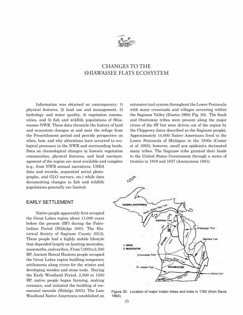
35
Figure 30. Location of major indian tribes and trails in 1760 (from Davis 1964).
Information was obtained on contemporary: 1) physical features, 2) land use and management, 3) hydrology and water quality, 4) vegetation commu-nities, and 5) fish and wildlife populations of Shia-wassee NWR. These data chronicle the history of land and ecosystem changes at and near the refuge from the Presettlement period and provide perspective on when, how, and why alterations have occurred to eco-logical processes in the NWR and surrounding lands. Data on chronological changes in historic vegetation communities, physical features, and land use/man-agement of the region are most available and complete (e.g., from NWR annual narratives, USDA data and records, sequential aerial photo-graphs, and GLO surveys, etc.) while data documenting changes in fish and wildlife populations generally are limited.
EARLy SETTLEMENT
Native people apparently first occupied the Great Lakes region about 11,000 years before the present (BP) during the Paleo-Indian Period (Hildalgo 2001, The His-torical Society of Saginaw County 2013). These people had a highly mobile lifestyle that depended largely on hunting mastodon, mammoths, and caribou. From 7,000 to 2,500 BP, Ancient Boreal Hunters people occupied the Great Lakes region building temporary settlements along rivers for the winter and developing wooden and stone tools. During the Early Woodland Period, 2,500 to 1300 BP, native people began farming, making ceramics, and initiated the building of cer-emonial mounds (Hidalgo 2001). The Late Woodland Native Americans established an
extensive trail system throughout the Lower Peninsula with many crossroads and villages occurring within the Saginaw Valley (Dustin 1968; Fig. 30). The Sauk and Onottoway tribes were present along the major rivers of the SF but were driven out of the region by the Chippewa (later described as the Saginaw people). Approximately 14,000 Native Americans lived in the Lower Peninsula of Michigan in the 1830s (Comer et al 1995); however, small pox epidemics decimated many tribes. The Saginaw tribe granted their lands to the United States Government through a series of treaties in 1819 and 1837 (Anonymous 1881).
CHANGES TO THESHIAWASSEE FLATS ECOSYSTEM

36 Heitmeyer, et al.
Native people in the SF region manipulated their land for domesticated crops, trails, and to maintain forest openings. Clearing and fire were used to varying degrees although the extent, frequency, and specific vegetation changes that occurred are not known. GLO surveys conducted in the early-1800’s document con-ditions at that time, which represent general changes in the land due to the Native American’s influence and early European establishments at Saginaw and Ashley (Comer et al 1995). Common crops grown by native people included corn, squash, and beans among others (Cleland 1966).
Father Jacques Marquette, a French missionary, first established missions in Sault Ste. Marie and Mich-ilimackinac, (Mackinaw) Michigan in 1668-69 where he taught and lived with native people (Anonymous 1881). European settlement in Michigan was slow until 1824 when the American Fur Company established itself in the Saginaw Valley. The earliest roads were surveyed along the Tittabawassee and Shiawassee Rivers in 1832 (Anonymous 1881), many of which were established on old trails. Timber harvesting began in the early-1800s with sawmills becoming active on most of the major rivers in the Saginaw Valley (Foehl and Hargreaves 1964). By the 1830s settlers were actively clearing rivers for transportation of sawn logs to Saginaw, which required dredging in some areas and the removal of large sandbars (Fox 1858). White and swamp white oak along with basswood was common in the area and of great value for shipbuilding. Sugar maple was not only used for timber but also provided large quantities of sugar. By the mid-1800s timber harvesting was the primary economic activity in the state (Fitting 1970) producing billions of board feet of white pine. Timber harvest in the SF region gradually declined in the late-1800s as most mature trees with commercial value were cut; by 1900 most of the mature stands of native forest had been cut-over (Grnak, date unknown). As timber harvesting diminished agri-culture became more important in the SF region in the early-1900s. Early European agriculture farmed open and cleared lands for corn and wheat production and native wet prairies lands often were hayed or used as grazing lands for livestock.
hyDRoLoGiCAL AND LAND USE ChANGES iN ThE SF REGioN
Many developments occurred in the SF region beginning in the late-1800s and early-1900s to levee, dredge, channelize, divert, and otherwise drain the
converging rivers primarily to increase opportunities for farming the SF Basin. Levees along the main channels of all four major rivers were built, with con-struction of specific levee sections occurring at various periods. Many initial levees were relatively low struc-tures that eventually were breached repeatedly by high flow events, which caused flood flows to spread across the area. Subsequently, larger and higher levees were constructed, which still today are subject to breaching in some specific locations such as the area near the confluence of the Flint (Misteguay Drain) and Shia-wassee rivers on the west side of Shiawassee NWR. Many small interior ditches, levees/dikes, and dams eventually were built in the SF, mostly from the 1930s to the 1960s (Fig. 31).
A specific account of developments in the nearly 10,000-acre area that includes the central part of the SF and Shiawassee NWR is provided in Mahar (2009). Ditching in the SF began in the late-1800s when a two-mile ditch was dug from the area appar-ently now in Shiawassee NWR to the Flint River by the Harlan Smith Company that established the precursor to the large “Prairie Farm” landholding to drain many of the wetlands for agricultural purposes (Mahar 2009). The Smith Company and then its suc-cessors constructed subsequent ditches, tiles, and other drainage structures in this area, including the Saginaw Realty Company that started extensive sugar beet production in area along with “wild hay” harvest. Carmen Smith purchased the nearly 10,000 acre tract from the Saginaw Realty Company and built a 20-foot high levee along the Saginaw and Shi-awassee rivers and then the Owosso Sugar Company created 36 miles of dike, up to 80 feet wide at the bottom, 40 feet high at the top and 20 feet high along SF rivers with the intent of draining and flood pro-tection for the region. At that time Prairie Farm was the largest sugar beet estate in the United States (Mahar 2009). Other industry in the area included coal and salt mining, which began in the 1890s and continued until 1950 (Mills 1918, Lercel 2003). By 1933, the faltering economy at the beginning of the Great Depression, coupled with regular floods and damage to river levees and ditches, collapsed the SF sugar beet industry. Joseph Cohn who started the “Sunshine Cooperative Farm Community” then purchased the former sugar beet lands in the SF. The vast network of SF ditches present by that time required constant maintenance because of levee and dike breaches, sedimentation, and woody debris deposition. By 1936, the Sunshine Cooperative failed and the property was sold to the U.S. Rural Reha-

37
Birch Run
Flint River
Swan Creek
Cass River
Sagina
w Rive
r
Marsh Creek
Silver Creek
Shia
was
see
Rive
rM
istequay Creek
Pine Run
Bear
Cre
ek
Beaver Creek
Pick
erel
Cre
ek
Lam
b C
reek
Deer
Cre
ek
Fairchild Creek
Bad River
Blum
field Creek
Potatoe Creek
Smith Drain
Wolf Creek
Shiawassee River
Flint River
Sagi
naw
Riv
erSw
an Creek
Flint River
Cass River
Fairc
hild C
reek
0 1 2 3 4Miles±
DrainsDamsWellsRiversShiawassee Flats Boundary
Figure 31. Rivers, drain channels, dams, and wells within the Shiawassee Flats region.
HGM EVALUATION OF ECOSYSTEM MANAGEMENT OPTIONS FOR SHIAWASSEE NWR
bilitation Corporation, which divided the former large Prairie Farm estate into over 200 small farms (Mahar 2009). Continued flooding and disrepair of drainage ditches caused neglect of the area and in 1945 a group of farmers purchased the region and 13 landowners took ownership of individual parcels of about 600 acres each. This “Prairie Co-Operative Farmers, Inc.” entity has operated farmlands in the region since.
The Spaulding Drain, a man-made drainage channel that diverts part of the Flint River north through Shiawassee NWR to the Shiawassee River, was constructed in the late-1920s (Reed 1927). This drain now carries a significant unknown portion of Flint River flows; sedimentation in the Flint River along with the original construction design of the Spaulding Drain influence flow/drain capacity. According to the Flint River Assessment (Leonardi
and Gruhn 2001), a total of 93 dams and water-control structures existed within the river basin by 2000, including four major dams; seven smaller dams and water-control structures are located within the lower reach of the Flint River watershed, mostly on Misteguay Creek. There are over 800 drains within the Flint River Basin with 90 occurring within the Lower reach. The Holloway Reservoir was con-structed in 1953 for potable water use and as flow augmentation for the Flint Wastewater Treatment Plant effluent. In 1963 a flood-control project was initiated which lined the Flint River streambed with concrete for a mile to increase flow through this reach and prevent flooding of the city of Flint (Leonardi and Gruhn 2001).
Eventual long-term changes in regional land use coupled with developments and drainage of SF rivers and wetlands led to altered flooding conditions

38 Heitmeyer, et al.
0 0.5 1 1.5 2 2.5 3Miles±
NLCDLandcover
Barren LandCultivated CropsDeciduous ForestDeveloped, High IntensityDeveloped, Low IntensityDeveloped, Medium IntensityDeveloped, Open SpaceEmergent Herbaceuous WetlandsEvergreen ForestHay/PastureHerbaceuousMixed ForestOpen WaterShrub/ScrubUnclassifiedWoody WetlandsShiawassee Flats Boundary
Figure 32. National land cover database habitat types present in the Shiawassee Flats region in the mid-2000s.
in the region (U.S. Army Corps of Engineers 1982). Levees and drainage projects effectively reduced or eliminated the capacity of SF wetlands to capture and attenuate flood flows and events (Newman 2011). In 1958, the U.S. Army Corps of Engineers developed the Saginaw Valley Flood Control Project to combat local flooding problems. Limited funding prevented much of the project from being constructed, but some developments such as the levee along the lower Flint River were built.
Immediately prior to establishment, cleared areas on Shiawassee NWR were predominantly utilized for croplands. Many agricultural lands contained subsurface drain tile systems used to facilitate draining, and pumps were utilized to help drawdown water levels and also to flood irrigate some areas. Upon acquisition of refuge lands, managers began upgrading ditches and water-control structures
to help facilitate water management. Reservations placed on refuge lands for previous owners to continue agricultural activities prevented major changes in water management. Water was routinely pumped out of croplands on an annual basis (refuge annual narratives). Refuge water-control infrastructure was continually impacted by floods, which breached levees and washed out water-control structures. In 1957 the Trinklein Dike was raised to 591 feet amsl and a pumping station was constructed for drainage purposes as part of the Saginaw Valley Flood Control Project (Project). A Final EIS was published for this Project in 1983 outlining details for the Offset Levee Plan (USFWS 2001a). As a result, an agreement with the refuge was made to designate Pools 1A, Grefe, 2, 3, and 5, Eagle and North marshes; and adjacent bottomland areas as flood storage. However, funding and political issues prevented any construction

39HGM EVALUATION OF ECOSYSTEM MANAGEMENT OPTIONS FOR SHIAWASSEE NWR
projects from moving forward. To move forward with projects, the Flint River Dike Board was established in the mid-1980s and initiated Phase I of the project including construction of 6,000 feet of dike along the east side of the Spaulding Drain which was completed in 1990. Other projects included renovation of 53,000 linear feet of the Flint River Control Dike in 2006 and construction of Phase III of the Spaulding Drain that included reworking of 5,700 linear feet of levee in 2009.
A recent Contaminant Assess ment Process (CAP) report (Mill sap 2010) documents the historical chemical contamination and current advisories for fish consumption that indicate serious surface water quality concerns in the SF region. In contrast, ground-water near Shiawassee NWR does not appear to be contaminated (Millsap 2010). Water quality entering Shiawassee NWR is influenced by contamination of the Tittabawassee River from chemicals originating from upstream Dow Chemical plants (Schrouder et al. 2009), wastewater treatment plants from the city of Flint via the Flint River (Newman 2011), changes in channel morphology of the Cass River that have caused high nutrient and arsenic levels (NRCS 2008), modifications to the mid-Shiawassee River Basin (Fongers 2010), heavy metals and chemical residue in the Saginaw River (Yun et al. 2008, Kannan et al. 2008), and drain water from surrounding agri-cultural areas (Millsap 2010, Newman 2011). In general, contamination of water entering Shiawassee NWR has been significant due to high levels of dioxin and furans delivered from the Tittabawassee River, detergents from the Flint River, and accumulation of PCB’s and cadmium. As a result of the 1986 flood, approximately 100 million gallons of untreated waste-water from the Dow Chemical Plant was discharged into the Tittabawassee River (EPA 2013). A recent study evaluated total phosphorous (TP) loading to the Saginaw Bay Basin suggested that 10% of TP is absorbed by Shiawassee NWR lands, which indicates wetland units on the refuge receive high levels of TP (DiMarchi et al. 2010, Cha et al. 2010).
All of the rivers that flow through the SF have been 303(d) listed by the Michigan Department of Environmental Quality (MDQ) according to guide-lines from the U.S. Environmental Protection Agency (EPA) for exceeding acceptable levels of contaminants such as mercury, PCBs, etc. These designations will require the development of a Total Maximum Daily Load (TMDL) plan by the MDEQ, requiring EPA approval. The TMDL plan will attempt to mitigate contaminants based on source and seek to attain
river designated use criteria. The Saginaw River and Bay area was identified as a ‘toxic hot spot’ and designated as a Great Lakes Area of Concern in 1987 (MDNR 1988). A restoration plan was developed in 2008 for this Area of Concern to try and help promote delisting of the area through the implementation of actions stated in the restoration plan (PSC 2008). As part of the Natural Resource Damage Assessment this watershed will be part of a 5-year monitoring plan in 2012 and 2017.
Detailed contemporary inventories of veg-etation species composition in SF forests, prairie, and wetlands are not available, but general landcover (Fig. 32) and 1980s NWI maps (Fig. 33) indicate the relative changes in community type and conversion to agriculture in the region. As previously mentioned, large areas of former shrub-emergent wetland and wet prairie have been converted to agricultural crop production along with some cleared forest, especially on higher elevations compared to Presettlement conditions (Fig. 29). Saginaw County lost 72% of forestland and 96% of wetlands from 1830 to the present (Buchanan et al. 2013). Further, several invasive plant species now are widely distributed in the SF, such as reed canary grass (Phalaris arundinacea), which has heavily infested former wet prairie and some MSUs along with levees. Phragmites also has spread throughout wetland units that have been managed for more prolonged flooding regimes (Havens et al. 2003). Other aggressive invasive plants now present include purple loosestrife, bull thistle (Cerium vulgare), and common buckthorn (Rhamnus cathartica). Zebra mussels (Dreissena polymorpha) and quagga mussels (D. rostriformis) have invaded the Saginaw River watershed (U.S. Geological Survey 2011) and have jeopardized native freshwater mussels and clams in the area (NRCS 2007).
REFUGE DEVELopMENT AND MANAGEMENT
Annual narratives for Shiawassee NWR chronicle the many water and habitat management issues on the refuge through 2009 (Table 4). Water management has changed over time from extensive cropland management to providing permanent water marshes, moist soil units, native grasslands, and bottomland hardwood forests. Repair of levees resulting from floods has dominated activities on the

40 Heitmeyer, et al.
Figure 33. National Wetland inventory wetland types for Shiawassee National Wildlife Refuge based on 1984 imagery (from Newman 2011).
refuge since establishment with several areas being taken out of intensive management and allowed to fluctuate with the river. Water management has sought to stabilize conditions to provide moist-soil management and emergent wetlands through the construction of straight-line ditches and levees. This management emphasis was fostered by the attraction of high numbers and densities of migrating dabbling ducks and geese to flooded wetlands adjacent to agri-cultural crops such as corn and sugar beets. Approxi-mately 3,500 acres of wetlands are managed annually (USFWS 2001a).
Shiawassee NWR currently contains 21 wetland management impoundments that are managed using water delivery infrastructure including six pumps, 28 water-control structures,
and 20 dikes (Fig. 34). Many of the water-control structures are culverts that are fitted with flap gates that allow water to flow in only one direction. Water level manipulations are often opportu-nistic depending on water levels in SF rivers, which affect the ability to gravity-flow of water into the refuge units and that determine pumping capability based on water depth at pumping locations. Shiawassee NWR currently has seven MSUs (Fig. 34), which typically are flooded in fall, remain flooded overwinter to spring, and then are drawn down in early summer to promote the growth of a variety of moist-soil plants species. Pools 3 and 5 at Shiawassee NWR are managed as GTRs to provide spring and fall migration habitat for waterfowl and other migratory birds in flooded forest areas. Detailed descriptions of water management units and respective water-control infrastructure for each unit on the refuge are provided in Newman (2011).
The Spaulding Drain and Flint River provide a large amount of water that is utilized for wetland management on the refuge, while flows in the Shiawassee River also influence refuge water level management and infrastructure.
Annual discharges range widely depending on the amount of regional precipitation and surface water runoff. The Fosters Flint River gauge shows annual mean flows during 1940-1984 and 1988-1992 (i.e., the years when data are available) have ranged from a low of 180 cfs to a high of 1,460 cfs. At the same time, instantaneous flows have ranged from a low of 27 cfs to a high of 19,000 cfs (http://wdr.water.usgs.gov/wy2011/pdfs/04149000.2011.pdf ). High flows generally occur in March and April with a minimum monthly mean of 219 cfs and a maximum of 4,963 cfs for these months, while low flows generally occur in July and August followed by an occasional smaller peak in September. Groundwater pumping within this basin usually

41
Year Unit Development Activities1953 Refuge established
Refuge Planted one-rod grass strips along field margins adjacent to major drainages to prevent further erosion of ditch banks and siltation
Sapak Tract East dike extended 1/4 mile to connect with south dike on Trinklein track
Farm fields Constructed 3/4 mile of waterways for surface drainage on the tracts
Trinklein Tract Excavated 1/2 mile of ditch and installed 5 culverts
Farm fields Installed drainage tiles on 136 ac at 8 - rod intervals
Started re-building riverside dike at station 41+65
1957 Sapak Tract Sapak bridge was repaired with the installation of two 30' pipe arch culverts
1958 Pool 1A, 1B, and White Marsh Built 72 nesting islands
Trinklein Tract Repaired over a mile of eroded dike and deepened existing borrow pit in eastern part
Pool 1 Installation of water-control structure completed
Pool 1B Completed south dike from spillway to south end of center dike
1961 Trinklein Tract A new dike along the south side was joined with the old one
1962 Crop unit 136 A new storm water pumping unit was installed such that tile water from 53 ac flows into the sump and is pumped out to the Birch Run drain
1963 Farm unit 121 Construction of south dike was completed to Nelson Rd.
Islands All islands were rebuilt and several new islands were pushed up
Farm fields 93 ac of cropland was tiled at 8 rod intervals
1965 Farm Unit 122 A drop inlet was installed at the se corner
1966 Pool 1 Repairs to damaged dike system were reparied including raising and rebuilding
Pool 3 Construction of new dike was started
Farm unit 9C Relocation of 600' of dike along north side
Pools 1 and 2 Repaird breaks in dikes due to flooding
Farm unit 2C A new dike was constructed along the south side of the unit
Farm unit 9D A new dike was constructed along the west side of the unit
1970 Pool 1 and 2 Construct 15,000' of dike, reconstruct 23,000' of existing dike, construction of one concrete water-control structure, 8 CMP's, 3 CMP outlet structures, and 3 emergency spillways
1971 Refuge Repaired breaks in dikes due to flooding
Farm units 9A and 9B Construction of 1/2 mile of dike along west side
Refuge Repaired breaks in dikes due to flooding
1973 Refuge Repaired breaks in dikes due to flooding
Farm Unit 1 Cleaned 6,000' of linear interior ditches and repaired south dike
Pools 1 and 2, Farm units 5 and 9E Repaired breaks in dikes due to flooding
Pools 3 and 5 Installed 2 36" CMP's and reshaped and increased height of west dike
1976 Spaulding Drain, Farm units 1 and 3 Repaired dikes
Units 3 and 4 A road was built around the future moist soil units near the Cass River
Refuge A road was established on the north edge of the refuge
1964
1959
1956
1955
Table 4. Chronological summary of water-control infrastructure and management activities on Shiawassee National Wildlife Refuge, 1953-2000 (taken from refuge annual narratives).
1967
1969
1977
1975
1972
Continued next page
HGM EVALUATION OF ECOSYSTEM MANAGEMENT OPTIONS FOR SHIAWASSEE NWR

42 Heitmeyer, et al.
Year Unit Development ActivitiesAlmy Tract 400 ac were converted to moist soil
Hart Tract Abandoned farming in this unit due to flooding
Unit 1B New islands built
Pool 1A Construction of new spillway on the north dike separating the pool from the Shiawassee River
Farm fields Exterior dike project phase I: Construct 2 1/4 mile of ditch, borrow, riprap, and gravelling to protect cropland from flooding to 25 year flood level
Farm fields Exterior dike project phase II: Additional 1 1/4 miles of ditch, 3 1/4 mile of dike rehabilitated
Pool 4 Construction of new spillway and stop log water-control structure
1981 Units 3 and 4 Spillway was elevated and riprapped
1982 Farm fields Completed about 5 miles of interior ditching and 1/2 mile of dikes
1983 Refuge Constructed one mile of new road between Houlihan and Evon
1985 Units 3 and 4 Constructed 1/2 mile cross dike
1986 Miller drain bridge Bridge was removed by high flood waters (provided access to Pool 4)
1988 Refuge Flint River Erosion Control Project Phase I and II: dike construction of a new 6,000' dike located along the east side of the Spaulding drain
Pools 1A and 1B New spillways constructed and 8,000' of exterior dike was rehabilitated
Refuge Constructed a 300' extension of the dike along Evon Rd to enhance a naturally occurring moist soil unit
1992 Pool 1A Repaired breaks in dikes due to flooding
1994 Farm fields Construction of a dike to separate acreage going into restoration from the rest of the field, tile mains were replaced with line stop log structures
MSU 2 Renovation of entire unit
Pool 2 Continuation of work
Trinklein Tract Creation of three new wetlands from the 241 ac taken out of agricultural production
1997 MSU 2 Construction of a dike to separate the unit into two different units with water-control structures incorporated
1998 Kaufman Tract Renovation of entire unit
MSU 3 and North Marsh Rehabilitation of 900' of dike and cross dike, construction of 2 spillways, installation of 2 36" screw gates, and installation of 30'' and 48" steel pipe, repair of MSU 3 pump
Refuge Old pump site along the Shiawassee River was removed and a tube installed to allow fish/water passage
MSU 3 and 4 Installation of 2 36" screw gates
Eagle Marsh Construction of a 30' spillway adjoining the Cass River to allow natural river fluctuation and fish passage
Pool 5 Renovation of 900' of east dike along the Spaulding Drain, installed a concrete water-control structure and 68' spillway
2003 Grefe Pool (pool 1B) Construction of new dike 1900' long set back from existing Spaulding Drain on east side of pool; former 2,400' dike was removed to original ground elevation
Leach/Chrcek tract 5 of the 60 ac taken out of agricultural production was restored to wetland habitat
Refuge A portion of a 52 ac field nw of the Houlihan Rd gate was converted from agriculture to native warm season grasses
2001
2000
2004
1991
1995
1979
1978
1977Table 4, continued.

43
Year Unit Development Activities2005 Kaufman Tract Repaired breaks in dikes by placing spillways and adding an agri-drain
along the east side (not sure when this occurred)
Trinklein Tract A one ac mitigation wetland was constructed as a result of the new dike construction in the Grefe pool
Sawatzki Tract 120 ac of the land was restored to native grasses and wildflowers
Flint River Control Dike Renovation of 53,000 linear feet; began to elevate and re-slope the dike
2007 North Marsh Consumers Power repaired a gas line running through the marsh
2009 Spaulding Drain Construction of the Spaulding Drain dike Phase III project: 5,700 linear feet reworked with borrow taken from the open field in Pool 5
2006
Table 4, continued.
HGM EVALUATION OF ECOSYSTEM MANAGEMENT OPTIONS FOR SHIAWASSEE NWR
occurs during the driest times of the year and has a large negative impact on the river.
The Shiawassee River USGS gauge station near Fergus includes records from 1940 - 2011 (some missing years) and indicates that peak flows occur most often in March and April with monthly mean discharge varying between a minimum of 140 cfs and a maximum of 2,564 cfs. However, peak spring discharge may occur February through May with smaller peaks in September and October in some years. Mean annual flows have ranged from 153 to 1,258 cfs with instantaneous values ranging from 27 cfs to 7,500 cfs. Numerous tributaries augment Shiawassee River flows prior to reaching Shiawassee NWR. Many of them coalesce into the Bad River, whose confluence with the Shiawassee River lies just upstream from the refuge boundary. Although the USGS gauge on the Bad River at Hemlock was only operated from 1948 to 1959, these data reflect the same spring flooding and late summer drying patterns as the Shiawassee River gauges. Recent stream gauge monitoring of the Shiawassee River adjacent to the refuge recorded extreme fluctuations in stage over a one-year period. Water levels in the river varied by almost 15 feet, ranging from a drought-induced low of about 577 feet amsl in the fall of 2012 to a high of about 590.5 feet amsl during the large flood in spring 2013 (Fig. 35). These fluctuations correlated with the exposure of large areas of mud flats during the low water period and conversely, the overtopping of levees and inundation of much of the SF region during the 2013 flood event.
USGS gauge data from the Cass River at Fran-kenmuth displays similar patterns to the Flint and Shi-awassee rivers for the period of 1909 to 2011, although the March and April monthly mean discharge range is slightly higher with a minimum of 179 cfs and a maximum of 4,943 cfs. Annual mean flow at this site
has ranged from 96.6 cfs to 1,063 cfs with a dramatic range in instantaneous extremes of approximately 2 cfs to 22,200 cfs. The Tittabawassee River is the largest tributary to the Shiawassee/Saginaw River in the SF region, but it rarely has a direct effect on refuge water level management. USGS gauge data from the Tittabawassee River at Midland depicts significantly higher flows than other SF tributary rivers, with peak flows of two to three times higher than in any of the other rivers during peak flows.
Spillways have been installed in many of the river levees along Shiawassee NWR in areas that have consistently been breached during flood periods. During high river flows, river water inundates adjacent wetland impoundments on the refuge and water levels fluctuate with river levels. These levee breach locations and flood flows promote fish movement into and out of refuge lands.
Other habitat management on Shiawassee NWR has included physical manipulation of veg-etation using timber harvest, agriculture, burning, mowing, disking, biological controls, and chemical treatments. Comparison of the early-1800s GLO survey to National Wetland Inventory maps of wetlands existing in the mid-1980s (Fig. 33) indicates that there has been an increase in open water, agri-culture, shrub swamp, rivers, and lakes throughout Saginaw County. Cover types in Saginaw County that existed in the SF area that have decreased or no longer exist include upland forest, black ash swamp, wet prairie (Lake plain prairie), and emergent marsh (Comer et al 1993). Currently, Shiawassee NWR contains the largest intact area of mixed-species bot-tomland hardwood forest (called mixed hardwood swamp in the GLO maps and notes) in the SF region (refuge annual narratives). Many areas dominated by clay soils, which formerly supported beech-sugar maple forests and other species such as swamp

44 Heitmeyer, et al.
Figure 34. Water management infrastructure and predominant flow direction on Shiawassee National Wildlife Refuge (from Newman 2011).
white oak, red ash, and American elm have been drained and converted to agricultural crops (Albert et al. 1986). Over time, agricultural use for various crops has diminished on the refuge but continues to dictate certain water management strategies that conflict with management for native species and habitats. Crop types include soybean, corn, barley/clover and winter wheat with rotations (USFWS 2001a). The development of wetland management infrastructure and the redistribution and timing of flooding has reduced the quality and health of hardwood forests, shrub wetlands, coastal prairies, and shifted communities toward cattail and invasive species. Control of invasive species including purple loosestrife, Phragmites, and reed canary grass has been conducted over time at various levels. Purple
loosestrife has been treated with chemical as well as biological controls that have successfully controlled most of this invasive weed. A variety of other treatment methods such as disking, mowing and burning have been used to control these invasive species and woody encroachment into wetland impoundments.
poTENTiAL iMpACTS oF CLiMATE ChANGE
The purpose of this HGM report is not to provide comprehensive analyses of potential climate change issues for the SF region. However, future changes in climate undoubtedly will affect regional watersheds and specifically the amount, timing, and distribution of water in the SF region. A recent “White Paper” on climate change adaptation plans for wetlands in Michigan (Christie and Bostwick 2012) identifies many important predictions and issues that wetland managers should be aware of to plan future restoration and management efforts. Generally, by the end of the century, climate change models predict the Great Lakes region will grow warmer and drier. These changes may cause rises in both winter and summer temper-atures, more extreme heat events
and periods, relatively constant precipitation levels but with more precipitation during winter, higher ET during summer, a longer growing season by up to 8-10 weeks, decreased winter ice cover, and an increase in the frequency of severe weather events including prolonged drought, flooding, and heat waves (Christie and Bostwick 2012:6). Specifically, climate model predictions for Lake Huron water levels are mixed. Rises in seasonal temperatures and summer ET may reduce local river and water runoff into the lake and lower it by up to 1.5 feet over the next century, although a drop of no more than two inches is predicted in the next two decades, based on a worst-case scenario (Hayhoe et al. 2010). However, under a lower emission scenario, water levels in the lake might actually increase because

45
Fig.35. Aerial photographs showing: a) exposed mud flats along the Shiawassee River during drought 2012 and b) extensive flooding on Shiawassee National Wildlife Refuge during spring 2013.
A
B
HGM EVALUATION OF ECOSYSTEM MANAGEMENT OPTIONS FOR SHIAWASSEE NWR

46 Heitmeyer, et al.
Cary Aloia
of increased precipitation in the Great Lakes region. Measures of historical water levels indicated increased water inputs to Saginaw Bay during fall and winter periods coupled with decreased spring inputs to the Bay and Lake Huron, especially after 1965 (Argyilan and Forman 2003). Currently, water levels are lower than in the early-1990s, although this may be caused by the time position in long-term cycles of wet vs. dry climate in the region (see earlier discussion of climate and hydrology patterns).
The mixed forecasts of climate change in the Great Lakes region does not indicate a clear pre-diction for future climate and water conditions in the
SF region, but generally suggests that the magnitude and timing of water inputs to the system may change. Specifically, if less snow and ice causes earlier, lower magnitude, stream flow in SF rivers, then con-sistent spring overbank flooding may be affected. Conversely, higher precipitation in summer and fall suggest that events capable of producing overbank flooding may shift from the spring to later in the year. And, all models suggest greater variability in weather patterns and increases in more extreme events such as periodic, somewhat erratic, flood vs. drought periods and single events.

47
Information obtained in this study was suffi-cient to conduct an HGM evaluation of historical and current ecological attributes of the SF and Shiawassee NWR ecosystem. The SF historically was a diverse and dynamic floodplain ecosystem at the confluence of four major rivers (Shiawassee, Flint, Cass, and Tit-tabawassee) that merged to form the Saginaw River, which flows into Saginaw Bay. Seasonal overbank and backwater flooding from these rivers regularly inundated the SF and Shiawassee NWR and created marked seasonal and interannual dynamics of flooding and drying regimes. These flood flows also created dynamic floodplain geomorphic surfaces and topographic features, along with depositing nutrient-rich sediments over the area and created a high degree of connectivity with Saginaw Bay and Lake Huron. Annual surface water inputs to the Shiawassee Flats region were dynamic and capable of producing high magnitude flood events in the spring and to a lesser degree during fall, depending on annual runoff throughout the Lower Peninsula of Michigan and local onsite precipitation. Lake Huron water levels were capable of inundating low-lying areas connected to the SF river systems and seiche events often backed water up through the Saginaw River and throughout the SF area for short periods of time.
The diverse confluence floodplain setting of the SF historically supported a diverse mixture of vegetation communities including mixed-hardwood, black ash, and shrub swamps juxtaposed to shrub-emergent marsh, SHW, and wet prairie on low flood-plain areas and next to higher elevation transitional beech-sugar maple forest along the Cass River and on margins of the SF (Fig. 29). Shallow wetlands at higher elevations in the SF dried by fall in most years. The low sump area on Shiawassee NWR along with abandoned channel sloughs and river channels
contained some permanent water, at least during wet years or periods of high Lake Huron levels Con-sequently, annual variation in river flows, summer rains, and hydrologic connectivity to Lake Huron likely caused significant annual variation in amount and distribution of flooded wetland area and corre-sponding PEM, SHW, wet prairie, and S/S wetland vegetation along with swamp forest communities in the floodplain.
The major contemporary ecosystem changes in the SF region and on Shiawassee NWR have been: 1) alterations to distribution, chronology, and water flow and flooding regimes in local rivers and wetlands; 2) clearing or changes in species composition of forests; 3) conversion of large areas of cleared forests and tiled and drained wetlands to agricultural production; 4) a lack of overbank events on all of the rivers that prevents sediment transfer and deposition, flooding, and the formation of new topographic features; 5) contamination of river and surface waters along with some floodplain sediments; and 6) introduction of many invasive species of plants and animals.
A critical overriding issue for Shiawassee NWR is the future ability of the refuge to obtain water from SF rivers to restore and manage native communities and their natural water regimes given constraints of the Saginaw Valley Flood Water Plan/Flint River Dike Board regulations; water quality issues related to the continued pollution of water flowing through the refuge from urban, commercial, and agricul-tural sources; and potential future continuation of farming programs on the refuge. A major challenge for future management of Shiawassee NWR will be to determine how to restore and emulate natural water regimes and water flow pathways on the refuge to assist efforts to restore and provide critical habitats and communities. Past attempts to plan management of the refuge have largely been designed
ECOSYSTEM RESTORATION AND MANAGEMENT OPTIONS

48 Heitmeyer, et al.
to accommodate refuge and adjacent agricultural operations and to provide annually consistent water conditions that may or may not have been consistent with objectives that seek to restore and emulate natural distribution, abundance, and processes of endemic communities. Consequently, future man-agement issues that affect timing, distribution, and movement of water on the NWR must consider how, and if, they are contributing to desired objectives of restoring native communities and their processes on the refuge. Additionally, future management and possible expansion of the refuge must seek to define the role of the refuge lands in a larger landscape-scale conservation and restoration strategy for the SF and Saginaw Valley region.
RECoMMENDATioNS FoR ECoSySTEM RESToRATioN AND MANAGEMENT
This hydrogeomorphic study is an attempt to evaluate restoration and management options that will protect, restore, and sustain natural ecosystem processes, functions, and values at Shiawassee NWR specifically, and more generally, within the larger SF ecosystem. The SF ecosystem histori-cally contained extensive and diverse wetland and bottomland forested communities that provided key resources to meet life history requirements of many wetland-dependent plant and animals in the Great Lakes region, an area that is comprised of increasingly destroyed, degraded, fragmented, and sometimes contaminated habitats (Great Lakes Restoration Initiative 2013). Despite the many artificial alterations to the ecological integrity and character of this important, opportunities exist to restore some natural vegetation community types if changes can be made to the natural river drainage and floodplain topography and infrastructure; hydrological flow pattern, timing and distribution of surface water; and management of wetland units and bottomland forests.
This study specifically provides information to support management of Shiawassee NWR under conditions of The National Wildlife Refuge System Improvement Act of 1996, as amended (16 USC 668dd-668ee). The National Wildlife Refuge Improvement Act of 1997 (Public Law 105-57) seeks to ensure that the biological integrity, diversity, and environmental health of the [eco] system [in which a refuge sets] are maintained (USFWS 1999, Meretsky et al. 2006). Administrative policy that guides NWR
goals for conserving “a diversity of fish, wildlife, and plants and their habitats” and conserving unique, rare, or declining ecosystems (601 FW 1) includes mandates for assessing a refuge’s importance across multiple spatial scales and recognizing that resto-ration of historical processes is critical to achieve goals (601 FW 3).
Most of the CCP’s completed for NWR’s to date have highlighted ecological restoration as a primary goal. However, limited information typically is provided in the CCPs on how restoration will be accomplished in the existing and often highly modified regional landscape. Historical conditions (those prior to substantial human-related changes to the landscape) are often selected as the benchmark condition (Meretsky et al. 2006), but restoration to these historical conditions may not be well under-stood, feasible, or cost-effective, thereby compro-mising success of restoration actions. General USFWS policy (601 FW 3), under the Improvement Act of 1997, directs managers to assess not only historic conditions, but also “opportunities and limi-tations to maintaining and restoring” such condi-tions. Furthermore, USFWS guidance documents for NWRs “favor management that restores or mimics natural ecosystem processes or functions to achieve refuge purpose(s)” (620 FW 1 and 601 FW 3, USFWS 2001a).
Given the above USFWS policies and mandates for management of NWR’s and the establishing goals for Shiawassee NWR, the basis for devel-oping recommendations for the refuge and the larger surrounding SF region is the HGM-approach used in this study. The HGM approach objectively seeks to understand: 1) how this ecosystem was created, 2) the fundamental physical and biological processes that historically “drove” and “sustained” the structure and functions of the system and its communities, and 3) what changes have occurred that have caused degradations and that might be reversed and restored to historical and functional conditions within a changing environment. This HGM approach also provides a basis to help future efforts evaluate the NWR within the context the larger SF and the Saginaw Lake Plain ecoregion.
The HGM evaluation process is not species-based, but rather seeks to identify options to restore and maintain system-based processes, com-munities, and resources that ultimately will help support local and regional populations of native species, both plant and animal, and other ecosystem functions, values, and services. Management of

49HGM EVALUATION OF ECOSYSTEM MANAGEMENT OPTIONS FOR SHIAWASSEE NWR
specific land parcels and refuge tracts should identify key resources used and needed by native species, and support special needs for species of concern. The development of specific management strategies for Shiawassee NWR requires an understanding of the historical context of the SF region relative to what communities naturally occurred there, the seasonal, annual, and inter-annual dynamics and thus avail-ability of community resources, and when and where (or if) species of concern actually were present on the tract and what resources they used.
Contemporary management also should be based on understanding the historical and current regional context of the site relative to how, or if, the site provided dynamic resources to species of concern. Refuge management should attempt to continue to provide key resources in naturally occurring times and distribution consistent with meeting life cycle requirements necessary to sustain native plant and animal populations. Consequently, recommenda-tions from the HGM evaluation in this study are system-based first, with the goal of sustaining the ecosystem. These system-based recommendations are based on the assumption that if the integrity of the system is maintained and/or restored, that key resources for species of concern can be provided. This approach is consistent with recent recommen-dations to manage the NWR system to improve the ecological integrity and biodiversity of landscapes in which they set (Fischman and Adamcik 2011).
All native habitats within Shiawassee NWR and the SF region should be protected, restored, and/or managed to: 1) provide resources used and required by native animal species and 2) increase the resiliency of the Great Lakes ecosystem to future changes (e.g., climate change) (USFWS 2011, Great Lakes Restoration Imitative 2013). Collaboration among agencies, landowners, and communities in the SF is essential to protect the critical hydrological processes that impact the region and to address predicted impacts of climate change. Regional and landscape scale collaboration with multiple partners and disciplines is highlighted in the USFWS climate change strategy (USFWS 2011) and climate change adaptation plans for Michigan (Christie and Bostwick 2012). Recommendations resulting from this HGM evaluation address potential management adaptation approaches (listed below) that have been identified as important to increase the resilience of ecosystems to respond to projected future climate changes. These management adaptations include reducing anthropogenic stresses, protecting key
ecosystem features, and restoring ecosystems that have been lost (Baron et al. 2008).
Based on the hydrogeomorphic context of infor-mation obtained and analyzed in this study, we believe that future restoration and management of Shiawassee NWR should consider the following goals:
1. Protect and restore the physical and hydro-logical character of the SF ecosystem.
2. Restore the natural topography, water regimes, and physical integrity of surface water flow patterns into and across Shiawassee NWR where possible.
3. Restore and maintain the diversity, compo-sition, distribution, and regenerating mecha-nisms of native vegetation communities in relationship to topographic and geomorphic landscape position at Shiawassee NWR and the SF region.
The following general recommendations are suggested to meet these ecosystem restoration and management goals.
Goal 1. Protect and restore the physical and hydrological character of the SF ecosystem.
The ecological character and productivity of the SF region, and Shiawassee NWR specific, is a product of the confluence setting of the Flint, Shia-wassee, Cass and Tittabawassee rivers in relation to Saginaw Bay and Lake Huron water levels. Conse-quently, land and water issues in each of these river watersheds ultimately influences seasonal and inter-annual dynamics of river flows, flood events, sediment and contaminant loads, and physical attributes that support native vegetation and animal communities. Various natural resource assessment studies have identified critical land and water issues in these river watersheds (e.g., MDNR 1988, Leonardi and Gruhn 2001, NRCS 2008, PSC 2008, Fongers 2010) and recommended actions to improve sediment, contaminant, and water quantity concerns. These recommended actions will require involvement and support from many agencies and groups including NRCS, EPA, Michigan Department of Environ-mental Quality, USFWS, local communities, regional industry, agricultural landowners, and others. Further, the Great Lakes Restoration Initiative was launched in 2010 to address long-standing problems and emerging threats to the Great Lakes ecosystem including Saginaw Bay and the SF region. A Great

50 Heitmeyer, et al.
Lakes Interagency Task Force was created to coor-dinate this work among 11 different departments and agencies and is headed by the administrator of the EPA. The Great Lakes Initiative contains five major focus areas: 1) toxic substances and areas of concern, 2) invasive species, 3) near-shore health and nonpoint source pollution, 4) habitat and wildlife protection and restoration, and 5) accountability, education, moni-toring, evaluation, communication and partnership (Great Lakes Restoration Initiative 2013). Obviously, lands with the SF that are under public conservation protection such as the Shiawassee SGA and Shia-wassee NWR are both important contributors to, and recipients of, watershed land and water conservation efforts. Further, this HGM report has identified the important abiotic and biotic attributes that histori-cally formed and sustained the SF ecosystem, and that must be considered when planning future res-toration and management options regionally, and specifically on Shiawassee NWR. As such, ecosystem restoration efforts in the SF and on Shiawassee NWR are critical to achieve broader ecosystem restoration goals for the Great Lakes region.
Regional river watershed land water conser-vation actions that seem especially important for the restoration and sustainability of the SF and Shia-wassee NWR include:
• Restore forested buffers along all river corridors.
• Restore floodplain wetlands, especially the expansive shrub-emergent wetland area identified on Figs. 27 and 29 for flood control, contaminant dissemination and filtration, sediment deposition, and plant and animal bio-diversity benefits.
• Identify watershed areas that disproportion-ately contribute sediments and contaminants to SF rivers and target soil conservation-erosion reduction efforts along with water quality measures to these regions.
• Evaluate all river levee and drainage systems to determine regional hydraulic influences and chronology, duration, and magnitude of flood events.
• Provide increased floodplain-river connectivity in at least some locations where native animal and plant communities will be beneficiaries.
• Reevaluate the network of river channelization and diversion drain systems to determine
rates of flow and diversion in each, along with impacts on downstream drain diversion lands.
• Implement and support sustainable land and water conservation practices on watershed agricultural and forested lands.
• Support contaminant containment and re duction programs for watershed communities and industries.
Goal 2. Restore the natural topography, water regimes, and physical integrity of surface water flow patterns into and across Shiawassee NWR where possible.
The primary ecological process, or driver, of the SF ecosystem was the highly pulsed seasonal discharge and overbank-backwater flooding events from the regional river confluence area. Snowmelt and increased precipitation in spring caused regional rivers to have increased flow, which annually caused at least some inundation of lower elevations in the SF Basin. In wetter years, this spring flooding was more prolonged and extensive, which apparently caused most, if not all of the SF to flood for variable periods. The lowest elevations in the SF, where shrub-emergent wetland communities historically occurred, likely flooded first, and for more extended periods each year, from headwater flooding of the Flint and Shiawassee rivers and periods of high water levels in Lake Huron. LiDAR data and maps (Fig. 13) suggest that prior to construction of the Spaulding Drain and later the Birch Run Outer Drain (Fig. 31), high flows in the Flint River appear to have caused overbank events that flowed down its historic channel, the Ferguson Bayou, into a north-central “sump” part of Shiawassee NWR now part of Pool 1A, and Bremer, Leach, Gosen, and Grefe Pools (Fig. 15). LiDAR data also suggest that overbank flows from the Shiawassee River probably flowed across the western MSUs on the refuge into this sump. Backwater flooding onto Shiawassee NWR into this sump and across tributary fans appears to have occurred upstream of the con-fluence of the Shiawassee, Tittabawassee and Cass rivers (Fig. 15). The lowest elevation of the Sump area and other areas connected to river systems at elevations < 576-577 feet likely historically were nearly permanently flooded due to Lake Huron water levels. Other small drainage pathways also appear to have occurred east of Ferguson Bayou, where water from higher elevations flowed to the bayou; these drainages now are cut off by the Spaulding and Birch Run Outer drains (Fig. 15). More generally, LiDAR
51HGM EVALUATION OF ECOSYSTEM MANAGEMENT OPTIONS FOR SHIAWASSEE NWR
contours (Fig. 13) and older aerial photographs (Fig. 14) indicate the complex network of drainage patterns into the SF region.
Collectively, the labyrinth network of drainages into the SF from the regional rivers and creeks, coupled with former abandoned river channels (e.g., Ferguson Bayou) and within-basin small drainages and sloughs created the “maze” of flowage and wetland areas that the first explorers and GLO surveyors encountered in the SF region. This “maze” of water drainages caused high connectivity of water flow and inter-spersion of habitats, which created the heterogeneous complex of communities and resources, largely deter-mined by elevation/topography. The general gradient of elevation and of communities ranged from low elevation semipermanently (in drier years) and per-manently flooded (during wet periods of the long-term precipitation cycle) shrub and emergent wetlands in the north-central sump area on Shiawassee NWR to higher elevations along the margins of the SF Basin where floodplain-type forests merged with upland forests. The connectivity of shrub-emergent marsh-seasonal herbaceous and wet prairie-floodplain forest enabled movement of water, nutrients, and sediments among the habitats along with providing corridors of movement for fish and other wetland-associated animal species.
Unfortunately, many structural developments such as roads, ditches, levees, dams, drain channels, and water-control structures now have altered natural topographic and water flow patterns and pathways, including the potential for floodplain-river connectivity, in the SF and at Shiawassee NWR. Some of these structures are large and unlikely to be removed or significantly modified, such as the Spaulding Drain and some mainstem levees along the Shiawassee River. Further, many of the interior structures on Shiawassee NWR were purpose-fully built to create MSU, GTR, and other wetland impoundments – and the constructed levees, dams, water-control structures, and pump stations on rivers now are the means for management activities on the refuge. Consequently, while many constraints exist to removing or modifying existing infrastructure in the SF and on Shiawassee NWR, certain opportu-nities seem present to restore natural topographic, water flow, and wetland water regime attributes. Modification, removal, or creation of topographic, water-control, drainage, and river-floodplain connec-tivity features in the SF and at Shiawassee NWR will require detailed site-specific engineering analyses based on desired conditions and management objec-
tives. This HGM study cannot provide the specific engineering analyses that will be needed for indi-vidual or coordinated restoration projects, but it does suggest the following general recommendations:
• Construct carefully engineered spillways in select locations along river sections that bound Shiawassee NWR to allow high river flows, or backwater from high Lake Huron water levels, to enter, inundate, and then exit low elevation refuge lands, including the north –central sump area.
• Evaluate the potential to encourage high water reconnection between the Flint River and Ferguson Bayou.
• Construct spillways in the west and north levee system along Ferguson Bayou to allow high flows to move from the Bayou into the north-central sump area.
• Restore natural slough-topographic features in the Farm Field, Trinklein, and Pool 1A-Grefe Pool and remove or modify existing impoundment levees to create natural complexes of shrub-emergent-SHW wetlands that historically occurred in this area and to allow water to flow through these units during higher water stages or flood events.
• Restore natural topography including depres-sions, swales, and drainages in all MSU impoundments to create topographic hetero-geneity and allow water movement between and among units during high flow-flood event periods.
• Evaluate opportunities to create connectivity between the Spaulding Drain and GTR Pools 3 and 5 during high flow events.
• Restore natural channel integrity and remove flow obstructions in Ferguson Bayou.
• Evaluate opportunity for levee modification and spillways in the northeast MSU complex and Butch’s and Eagle Marsh to allow river flow across this area with the intention of restoring sheetwater flow conditions required for restoration of wet prairie habitats.
• Implement recommendations in the recent WRIA (Newman 2011) for water augmentation plans, wetland impoundment management,

52 Heitmeyer, et al.
sediment settling pools at intake locations, and contaminant management considerations.
• Prepare an updated refuge water management plan that attempts to emulate seasonal and inter-annual dynamics of respective wetland impoundment areas based on HGM attributes and indicated desired restoration commu-nities. For example, GTR areas should be in mixed hardwood floodplain forests, have short duration dormant season flooding, and include years with dry conditions for forest regen-eration (e.g., Fredrickson and Batema 1982). Other specific management regimes are discussed in the following recommendation for specific community types.
Goal 3. Restore and maintain the diversity, com-position, distribution, and regenerating mechanisms of native vegetation commu-nities in relationship to topographic and geomorphic landscape position at Shia-wassee NWR and the SF region.
Eight major vegetation community types histor-ically were present in the SF region. These included: 1) a narrow band of true upland oak-hickory forest on the margins of the SF Basin, 2) a more upland type beech-sugar maple forest along the Cass River corridor and in some higher elevations north of the Shiawassee River and up the Tittabawassee River corridor; 3) mixed hardwood and 4) black ash swamp forest along the Flint, Shiawassee, and Tit-tabawassee river channels and in transition elevation areas that adjoined the SF low sump where 5) wet meadow; 6) S/S, 7) emergent, and 8) SHW habitats were present (Fig. 25). The GLO survey notes and maps clearly distinguish the forested types in the SF but lumped shrub-emergent-herbaceous habitats into a general “shrub swamp-emergent marsh” category. Also, it seems likely that considerable wet prairie vegetation assemblages may not have been separated from drier herbaceous wetland communities. Collec-tively, the interspersion of these eight diverse forest and wetland communities provided abundant and diverse resources used by many animal species in the SF, Saginaw Bay, and the larger Great Lakes regions.
The distribution of the major vegetation commu-nities in the SF historically was determined largely by proximity to the major rivers in the confluence area and the corresponding topography and elevation, which dictated type and distribution of soil sediments and timing, depth, and duration of seasonal flooding. Obviously, higher elevations on the margin of the SF
and on natural levees along the rivers were flooded less often and for shorter duration that lower flood-plain surfaces and former abandoned river channels such as Ferguson Bayou on Shiawassee NWR. These higher elevations were flooded during high river flow and flood events, but were dry most of the year and did not flood during dry periods of long-term precipitation cycles. These sites supported upland type forest. Sites closer to river channels and sloughs had both seasonal flooding in most years and more sustained ground-water tables, which enabled swamp forest tree species to survive. These “swamp-type” forests included diverse “mixed hardwood” and more uniform “black ash swamp” communities. The black ash swamp type was extensive on sand soil lake plains in the Saginaw Bay area, while mixed hardwood swamp typically occurred on poorly drained clay and clay loam soils. Both swamp forest types can tolerate frequent and sometimes seasonally prolonged flooding (up to 4-6 months) especially during the non-growing “dormant” season, but also require periodic dry conditions for tree seedlings to germinate and grow to heights that can withstand future flood events.
S/S habitats extended from swamp forest areas along drainage, creek, and slough channels and depressions where semipermanently flooding regimes and higher groundwater table levels occurred during the dry months of summer. The S/S habitats inter-graded with emergent wetlands in the center core “sumps” of the SF including areas west and north of Ferguson Bayou on Shiawassee NWR. Emergent marshes occurred on clay loam soils in low elevations that were flooded annually, and sometimes year round during wet periods of the long-term precipitation cycle. Emergent marshes graded to SHW communities as elevations increased, but that still had clay loam floodplain soils, and with seasonal flooding regimes. Both emergent and SHW assemblages flooded mainly from spring overbank flood events of SF rivers, partly or completely dried during summer, and then reflooded to some extent in fall and winter in years when fall rains and river rises occurred. The highest non-forested elevations adjacent to emergent and her-baceous marshes, usually on river tributary fans or old floodplain terraces, that received periodic short duration sheetwater flow and inundation supported wet prairie communities. These wet prairie commu-nities were located in sites with restrictive soil layers of clay, which prevented most trees from accessing groundwater during dry periods and allowed grass and sedge species to persist instead of trees. These higher elevation sites undoubtedly burned during

53HGM EVALUATION OF ECOSYSTEM MANAGEMENT OPTIONS FOR SHIAWASSEE NWR
dry periods of long-term precipitation cycles, which further sustained them. While no true “savanna” communities historically were recorded for the SF region, it is possible that some scattered trees, such as oaks, may have occurred in wet prairie locations.
The exact location of the various shrub and emergent-herbaceous-wet prairie wetland commu-nities in the SF region undoubtedly varied to some extent over time as river channels migrated, shifted, and silted in depending on sediment scouring and deposition following major flood events. Further, the position of these communities likely moved “up or down” elevation gradient during the alternating wet vs. dry periods. For example, during dry periods when little river flooding occurred the higher elevations that supported wet prairie and SHW probably moved down elevation to lower elevations and conversely during wet years when flooding was more prolonged and deeper, emergent communities probably moved to slightly higher elevations. Regardless, of the exact position of the individual wetland species, the general area of shrub-emergent wetland mapped from GLO surveys seems an acceptable zone of the array of these wetland communities.
The GLO (Fig. 25) and potential historical vegetation model map (Fig. 29) along with the HGM matrix of community relationships (Table 3) provide guidance for restoration and management of native communities within the general SF and more specific Shiawassee NWR locations. The DEM and 1-foot contour maps for the Shiawassee NWR acqui-sition boundary area (Fig. 13b) allow more precise definition of the distribution of emergent-SHW-wet prairie communities. As future refinement of LiDAR to one-foot contours occurs throughout the SF, more refined mapping of potential wetland distribution can occur also. Based on the above information future restoration and management of native communities in the SF and on Shiawassee NWR should consider:
• Restore/manage beech-sugar maple forests along the Cass River drainage corridor and higher elevations along the Shiawassee and Tittabawassee rivers where overbank river flooding is less common and diverse sandy and loam soils occur.
• Restore/manage black ash swamp forest on sandy soils that are seasonally flooded, sometimes for more prolonged periods during wet years.
• Restore/managed mixed hardwood swamp forest on clay and clay-loam soils adjacent to shrub-emergent wetland areas and on natural levees along the Flint, Shiawassee, and Titta-bawassee rivers where seasonal flooding from river overbank or backwater flooding occurs. Swamp sites in GTRs on Shiawassee NWR (Pools 3 and 5) should be managed for short duration dormant season flooding, drying in summer, and periodic consecutive years of no or little flooding.
• Restore integrated complexes of shrub, emergent, SHW, and wet prairie habitats within the area identified as shrub swamp-emergent marsh by the GLO surveys. Ideally, restoration plans should base restoration on elevation and natural topography features, rather than artificial refuge impoundment boundaries. Consequently, all MSUs, wetland pools, and the Farm Field should be evaluated as an interconnected gradient of communities not constrained by unit levees or structures, unless they are necessary to achieve desired seasonally dynamic water and disturbance regimes. In some cases, individual unit levees, ditches, roads, or water-control structures will need to be removed or modified to create larger interconnected mosaics of habitats. The following recommendation points emphasize the HGM attributes needed for each habitat.
• Restore S/S habitats in natural drainage areas that connect the low elevation SF sump area to adjacent swamp forests especially areas west and north adjacent to Ferguson Bayou.
• Restore/manage OW-PEM-SAV habitats in the lowest floodplain elevations where semi-permanent water regimes can be managed. These wetlands will require periodic dry periods within the long-term precipitation cycle to maintain diverse vegetation species composition and associated energy-nutrient cycling dynamics. The best locations for these habitats are the lowest elevations in Bremer, Leach, Gosen, Grefe and 1A pools. To achieve these conditions a passive water management strategy could be implemented where multiple existing wetland units are reconnected to each other, and to the Shiawassee River, at least to some elevation extent (i.e., with engineered inter-unit water flow at specific elevations)

54 Heitmeyer, et al.
1960 photos of Coopers hawk and jumping carp, taken from refuge files.
to allow for more natural inundation of units during high river flood events in spring and fall and then drying periods when river levels drop after high flow events. Reconnecting the SF/Shiawassee NWR floodplain and Sump area with rivers during high flow events seems ecologically desirable, to at least some extent, however considerable more hydro-logical analyses and evaluation is needed to determine potential areas of connectivity, elevation ranges of connection, potential for invasive species occurrence, and ultimate man-agement/disturbance that would be needed to restore and sustain native communities and their short- and long-term dynamics.
• Restore/manage SHW communities in higher floodplain elevations where seasonal spring and fall flooding can occur, drying is possible during summer, and sites can be manipulated to sustain moist-soil species. Most existing MSUs and the Farm Field where ongoing conversion from agricultural production to wetland habitat is occurring seem appropriate sites for SHW.
• Restore wet prairie on higher elevation flood-plain and tributary fan sites where short duration overbank flooding occurs (or can be managed) in a sheetflow manner. These
prairie sites will require periodic disturbance, preferably from fire, to maintain a grass/sedge dominated species assemblage. The northeast MSUs and Butch’s and Eagle Marsh areas on Shiawassee NWR seem suitable for this wet prairie habitat. Also, areas south of the Flint River/Misteguay Drain corridor appar-ently formerly supported more extensive wet prairie communities and this area seems an appropriate location for prairie restoration if temporal sheetflow flooding can occur and fire/grazing can be used to maintain grasses and sedges. The area immediately south of the refuge along Curtis Road and north of the Misteguay Drain also may have his-torically supported prairie species at least during dry periods. Some local residents and history suggest that prairie-type vegetation formerly occurred here, and further evalu-ation of potential prairie restoration in this area seems warranted. Achieving restoration of wet prairies and the processes that sustain them undoubtedly will require some redesign/modification of existing water management infrastructure and development of water management strategies to achieve seasonal sheetflow water regimes, coupled with periodic disturbance from fire or vegetation removal.

55
Future restoration and management of Shia-wassee NWR, along with similar efforts throughout the SF, should include regular monitoring and directed studies to determine how ecosystem structure and function are changing, regardless of whether the restoration and management options identified in this report are undertaken. Depending on the desired future state and degree of system restoration desired, very significant changes to physical form (i.e. levee and water-control infra-structure removal or modification), water movement (i.e., restoration of natural drainage pathways and topography and sheetwater flow across floodplains and tributary fans), and water regimes (i.e., annual flooding and drying dynamics in all wetland units) on the refuge and other SF areas could occur. Likely, if major changes in infrastructure and management are made, the changes likely will occur in gradual sequence over time as budgets, support, and resources are available. Each change should be accompanied by an active monitoring effort and in an adaptive management context. The adaptive management framework would: 1) predict responses to physical and biological attri-butes of the site/system (i.e., water flow patterns, vegetation and animal distribution and abundance, water regimes, etc.) relative to the management actions, and then 2) use follow-up monitoring to determine if the predicted response occurred, and what if any adjustments to the management and restoration activity is needed. Similarly, if little change in management or structure of Shiawassee NWR occurs, the same intensity of monitoring will be needed to determine if desired resource objec-tives and system states are being achieved and if they are either improving or degrading.
This report has identified many uncertainties in both system structure and function, and in man-
agement effects. These uncertainties include, but may not be limited to:
• Source and magnitude of river flows in relationship to man-made drain channels, pump stations and input structures, and potential spillway/breach locations on river and impoundment levees.
• Water quality and nutrient/energy flow characteristics of surface water, ground-water, and sediments and in relationship to water source and management of wetland impoundments.
• Long-term vegetation and animal responses to altered water regimes.
Additional information on each of these important uncertainties is needed; certain specific information is listed below:
QUANTiTy AND QUALiTy oF WATER
Contaminant and sediment loading in SF rivers and potential deposition, filtration, and biomagnifications in SF floodplains and impound-ments on Shiawassee NWR has been a continuing concern. The WRIA for Shiawassee NWR (Newman 2011) along with regional river assessments (e.g., Leonardi and Gruhn 2001 and many others) and recent assessments of conditions on Shiawassee NWR (Buchanan et al. 2013) have identified water quality problems and recommended specific studies and monitoring programs associated with surface water sources, groundwater movement and con-tamination, water management related to methyl-mercury remobilization, and dredge/spoil location and use.
MONITORINGAND EVALUATION NEEDS

56 Heitmeyer, et al.
Flood damage 1961, from refuge files
RESToRiNG NATURAL WATER FLoW pATTERNS AND WATER REGiMES
This report used available information on historic water inputs and movements of water into the SF ecosystem, and natural seasonal and annual dynamics of water regimes, to suggest many physical and water management changes to help restore topography, water flow, dynamic flooding and drying dynamics, and resources to support restoration and management of native vegetation and animal com-munities in the SF region, and specifically at Shia-wassee NWR. Most changes involve at least some restoration of natural water flow through natural drainage and movement channels and sheetflow corridors. The LiDAR topographic maps at a one-foot contour were extremely important to identify more subtle drainage pathways, floodplain depressions and sumps, and natural levees along slough and river channels. Efforts should be made to process and refine LiDAR data for the entire SF region and to determine potential drainage and water flow restora-tions. Future specific monitoring of water movement and management, regardless of the ultimate degree of change from the current state, should be conducted to:
• Further refine understanding of water movement and total water budgets for all management wetland units that incorporates spatially and temporally variable ET and surface water inputs.
• Document how water moves from various river overbank and backwater flooding events and the relative amounts of surface water infil-tration vs. runoff to lower elevation areas.
• Chronicle and evaluate water management for all refuge areas including sources, delivery mechanism and infrastructure used, extent and duration of flooding and drawdowns,
and relationships with non-refuge and non-wetland uses.
LoNG-TERM ChANGES iN VEGETATioN AND ANiMAL CoMMUNiTiES
To date, monitoring of plant and animal commu-nities and populations on Shiawassee NWR has been confined mostly to a few target species. This moni-toring has been very helpful in understanding biotic responses to certain management actions and system attributes and should be continued. Managers cannot monitor every plant and animal species, but certain species may be especially important because they are indicators of select community status, are species of concern, are introduced or invasive, and may be either increasing or decreasing over longer terms at unusual rates. New monitoring protocols and efforts are being advanced for plants and animals on NWRs and these can help direct future efforts (Paveglio and Taylor 2010). At Shiawassee NWR, some important survey and monitoring programs for plants and animals include:
• Distribution and composition of all major plant communities including expansion or contraction rates of introduced and invasive species.
• Responses of wet prairie and wetland habitats to changes in water movement and water regime management.
• Survival, growth, and regeneration of native forest species.
• Abundance, chronology of use, survival, and reproduction of key indicator species such as dabbling ducks, Southern James Bay popu-lation Canada geese, wading birds, frogs, and river fishes.

57
Coot nest 1961, taken from refuge files.
This study was administered by a contract between the USFWS and Greenbrier Wetland Services. Steve Kahl, Project Leader for Shiawassee NWR, was instrumental in securing funds for the project, organizing partner support and participation, and providing administrative and biological support and review for the project. Funding for the project was provided by Shiawassee NWR, The Nature Con-servancy (TNC), and Saginaw Bay Watershed Ini-tiative Network. The Friends of Shiawassee NWR organization administered the project and account funds. Doug Pearsall and Matt Herbert (TNC), Rob
Zbiciak and Chad Fizzell (Michigan Department of Environmental Quality), and Sean Blomquist (USFWS) attended planning and data meetings for the project and helped acquire many important data sets used in the final report. Vince Capeder, USFWS regional hydrological staff, assisted with collection of bathymetry data for Shiawassee NWR wetland units and analyses of hydrological information, along with providing important review of draft reports. Karen Kyle, Blue Heron Conservation Design and Printing LLC, helped format and prepare draft and final reports and edited and published the final report.
ACKNOWLEDGEMENTS

58 Heitmeyer, et al.
Frank Nelson
Cary Aloia

59
Anonymous. 1881. History of Saginaw county Michigan. Chas. C. Chapman & Co., Chicago.
Albert, D.A., S.R. Denton, and B.V. Barnes. 1986. Regional Landscape Ecosystems of Michigan. School of Natural Resources, The University of Michigan, Ann Arbor.
Albert, D.A., D.L. Cuthrell, D.A. Hyde, J.T. Legge, M.R. Penskar and M.L. Rabe. 1996. Sampling and management of lakeplain prairies in southern Lower Michigan. Michigan Natural Features Inventory Report No. 1996-02.
Albert, D.A. and P.J. Comer. 2008. Atlas of Early Michigan’s forests, grasslands, and wetlands: an interpretation of the 1816-1856 General Land Office surveys. Michigan State University Press, Lansing, MI.
Argyilan, E.P. and S.L. Forman. 2003. Lake level response to seasonal climatic variability in the Lake Michigan-Huron system from 1920 to 1995. Journal of Great Lakes Research 29:488-500.
Baker, D.B., P. Richards, T.L. Loftus and J.W. Kramer. 2004. A new flashiness index: characteristics and applications to Midwestern rivers and streams. Journal of the American Water Resources Association 40:503-522.
Barbour, M.G. and W.D. Billings, Editors. 2000. North American terrestrial vegetation. Second Edition. Cambridge University Press, Cambridge, United Kingdom.
Barnes, B.V. and W. Wagner. 1981. Michigan trees: a guide to the trees of the Great Lakes region. University of Michigan Press, Ann Arbor, MI.
Baron, J.S., S.H. Julius, J.W. West, L.A. Joyce, G. Blate, C.H. Peterson, M. Palmer, B.D. Deller, P. Kareiva, J.M. Scott and B.Griffin. 2008. Some guidelines for helping natural resources adapt to climate change. IHDP Update 2:46-52.
Bedell, D.J. and R. L. Van Til. 1979. Irrigation in Michigan. Water Management Division, Department of Natural Resources.
Bourdo, E.A., Jr. 1956. A review of the General Land Office Survey and its use in quantitative studies of former forests. Ecology 37:754-768.
Boyer, R.L. A survey of wood duck (Aix sponsa) nest sites and brood rearing habitat on the Shiawassee National Wildlife Refuge. M.S. Thesis, Central Michigan University, Mount Pleasant, MI.
Buchanan, J., S. Chorbajian, A. Dominguez, B. Hartleben, B. Knoppow, J. Miller, C.Schulze and C. Seiter. 2013. Restoring Shiawassee Flats – estuarine gateway to Saginaw Bay. M.S Thesis Project, Michigan State University, School of Natural Resources and Environment, Ann Arbor, MI.
Cha, Y., C.A. Stow, K.H. Reckhow, C. DeMarchi and T.H. Johengen. 2010. Phosphorus load estimation in the Saginaw River, MI using a Bayesian hierar-chical/multilevel model. Water Research 44:3270-3282.
Chapman, K.A. 1984. An ecological investigation of native grassland in southern Lower Michigan. M.S. Thesis, Western Michigan University, Kalamazoo, MI.
Christie, J. and P. Bostwick. 2012. Climate change adap-tation plan for coastal and inland wetlands in the state of Michigan. The Association of State Wetland Managers, Inc., Windham, ME.
Cleland, C.E. 1966. The Prehistoric Animal Ecology and Ethnozoology of the Upper Great Lakes Region. Anthropological Papers, Museum of Anthropology, University of Michigan, No. 29, Ann Arbor.
Comer, P.J., D.A. Albert, T. Leibfried, H. Wells, B. Hart, and M. Austin. 1993. Historical Wetlands of the Saginaw Bay Watershed. Report for Saginaw Bay Watershed Initiative, Office of Policy and Program Development, Michigan Department of Natural Resources, Lansing, MI.
Comer, P.J., D.A. Albert, H.A. Wells, B.L. Hart, J.B. Raab, D.L. Price, D.M. Kashian, R.A. Corner & D.W. Schuen. 1995. Michigan’s Native Landscape, as Interpreted from the General Land Office Surveys 1816-1856. Report to the U.S. E.P.A. Water
LITERATURE CITED

60 Heitmeyer, et al.
Division and the Wildlife Division, Michigan Department of Natural Resources. Michigan Natural Features Inventory, Lansing, MI.
Craven, S.R. and D.H. Rusch. 1983. Winter distribution and affinities of Canada geese marked on Hudson and James bays. Journal of Wildlife Management 47:307-310.
Curtis, J.T. 1959. The vegetation of Wisconsin: an ordi-nation of plant communities. University of Wisconsin Press, Madison, WI.
Davis, C.M. 1964. Readings in the geography of Michigan, Lansing, MI.
Dickman, D.I. and L.A. Leefers. 2004. The forests of Michigan. University of Michigan Press, Ann Arbor, MI.
DiMarchi, C., T. Wichum, T.H. Johengen and C.A. Stow. 2010. Uncertainty in phosphorus load estimation from a large watershed in the Great Lakes Basin. SimHydro 2010:Hydraulic modeling and uncer-tainty Sophia-Antipolis, June 2010.
Dustin, F. 1968. Saginaw Valley Archaeology. The Michigan Archaeologist, vol. 14, No. 1-2.
Eichenlaub, V.L., J.R. Harman, F.V. Nurnberger and J.J. Stolle. 1990. The climatic atlas of Michigan. University of Notre Dame Press, Norte Dame, IN.
Farrand, W.R. and D.L. Bell. Quaternary geology of Michigan. 1982. Department of Geological Sciences, University of Michigan, Geological Survey Division, Michigan Department of Environmental Quality, and Division of Geographic Information Services Unit, Resource Mapping and Aerial Photography, Michigan Department of Natural Resources.
Fischman, R.L. and R.S. Adamcik. 2011. Beyond trust species: the conservation potential of the National Wildlife Refuge System in the wake of climate change. Natural Resources Journal 51:1-33.
Fitting, J.E. 1970. The Archaeology of Michigan: A Guide to the Prehistory of the Great Lakes Region. American Museum of Natural History, The Natural History Press, Garden City, New York. Pp 7-33.
Foehl, H.M. and I.M. Hargreaves. 1964. The story of log-ging the white pine in the Saginaw Valley. Red Keg Press, Bay City, MI.
Fongers, D. 2010. Mid-Shiawassee River watershed hydro-logic study. Michigan Department of Natural Resources and Environment.
Fox, T. B. 1858. History of Saginaw County, From the Year 1819 down to Present time. East Saginaw, Enterprise Print.
Fredrickson, L.H. and D.L. Batema. 1982. Greentree reservoir management handbook. Wetland Management Series 1, Gaylord Memorial
Laboratory, University of Missouri-Columbia, Puxico, MO.
Great Lakes Restoration Initiative. 2013. Great Lakes Restoration. Available online at: http://great-lakesrestoration.us/.
Grnak, R.J. date unknown. From bottom land to national attention: Prairie Farm’s History. Unknown publication, accessed from Shiawassee National Wildlife Refuge historical files.
Havens, K.J., H. Berquist and W.I. Priest, III. 2003. Common reed grass, Phragmites australis, expan-sion into constructed wetlands: are we mortgaging our wetland future? Estuaries 26:417-422.
Hayhoe, K, J. VanDorn, T. Croley, N. Schlegal and D. Wuebbles. 2010. Regional climate change pro-jections for Chicago and the U.S. Great Lakes. Journal of Great Lakes Research 36:7-21.
Heitmeyer, M.E. 2007. Conserving lacustrine and palus-trine natural communities. Missouri Natural Areas Newsletter 4(1):3-5.
Heitmeyer, M.E. 2010. An evaluation of terrestrial eco-system restoration options for the Chippewa River Ecoregion of the Upper Mississippi River System. Greenbrier Wetland Services Report 10-06. Blue Heron Conservation Design and Printing LLC, Bloomfield, MO.
Heitmeyer, M.E., V.L. Fields, M.J. Artmann and L.H. Fredrickson. 2009. An evaluation of ecosystem restoration and management options for Benton Lake National Wildlife Refuge. Greenbrier Wetland Services Report No. 09-01. Blue Heron Conservation Design and Printing LLC, Bloomfield, MO.
Heitmeyer, M.E., R.L. Esser, J.D. Eash and B.J. Newman. 2012a. Hydrogeomorphic evaluation of ecosystem restoration and management options for Hamden Slough National Wildlife Refuge. Greenbrier Wetland Services Report No. 12-01. Blue Heron Conservation Design and Printing LLC, Bloomfield, MO.
Heitmeyer, M.E., R.A. Laubhan and M.J. Artmann. 2012b. Hydrogeomorphic evaluation of ecosystem restora-tion and management options for Quivira National Wildlife Refuge. Greenbrier Wetland Services Report No. 12-04. Blue Heron Conservation Design and Printing LLC, Bloomfield, MO.
Heitmeyer, M.E. and C.M. Aloia. 2013. Hydrogeomorphic evaluation of ecosystem restoration and manage-ment options for Erie National Wildlife Refuge. Greenbrier Wetland Services Report No. 13-03. Blue Heron Conservation Design and Printing LLC, Bloomfield, MO.
Heitmeyer, M.E., L.H. Fredrickson, M.K. Laubhan, F.A. Nelson, G.D. Pogue, D.L. Helmers and W. King. 2013. Wetland design and development. In J.

61HGM EVALUATION OF ECOSYSTEM MANAGEMENT OPTIONS FOR SHIAWASSEE NWR
Anderson and C. Davis, editors. Wetland tech-niques. Springer, New York (in press).
Hidalgo, H.G. 2001. The First Inhabitants of the Great Lakes Region in North America.
Hoaglund, J.R. III. G.C. Huffman, and N.G. Grannemann. 2002. Michigan Basin Regional Groundwater Flow Discharge to Three Great Lakes. Groundwater 40:390-406.
Hoaglund, J.R. III, J.J. Kolak, D.T. Long, and G.J. Larson. 2004. Analysis of modern and Pleistocene hydrologic exchange between Saginaw Bay (Lake Huron) and the Saginaw Lowlands area. Geological Society of America Bulletin 116:3-15.
Hutchinson, M.D. 1988. A guide to understanding, inter-preting, and using public land survey field notes in Illinois. Natural Areas Journal 8:245-255.
Iaquinta, J.L. 1994. Soil survey of Saginaw County, Michigan. U.S. Department of Agriculture, Soil Conservation Service in cooperation with Michigan Agricultural Experiment Station, Michigan Cooperative Extension Service and Michigan Technological University.
Kahl, S. 2009. Thirty-six species added to the “Shiawassee Ark.” Refuge Reporter: Happenings at Shiawassee National Wildlife Refuge 12(2).
Kannan, K., S.H. Yun, A. Ostaszewski, J.M. McCabe, D. Mackenzie-Taylor and A.B. Taylor. 2008. Dioxin like toxicity in the Saginaw River watershed: poly-chlorinated dibenzo-p-dioxins, dibenzofurans, and biphenyls in sediments and floodplain soils from the Saginaw and Shiawassee rivers and Saginaw Bay, Michigan, USA. Archives Environmental Contamination and Toxicology 54:9-19.
Karrow, P.F. and P.E. Calkin. 1985. Quaternary Evolution of the Great Lakes. Geological Association of Canada Special Paper 30.
Klimas, C., E. Murray, T. Foti, J. Pagan, M. Williamson and H. Langston. 2009. An ecosystem restoration model for the Mississippi Alluvial Valley based on geomorphology, soils, and hydrology. Wetlands 29:430-450
Kost, M.A., D.A. Albert, J.G. Cohen, B.S. Slaughter, R.K. Schillo, C.R. Weber and K.A. Chapman. 2007 (updated in 2010). Natural communi-ties of Michigan: classification and description. Michigan Natural Features Inventory. Prepared for Michigan Department of Natural Resources Wildlife Division and Forest, Mineral, and Fire Management Division. Lansing, MI.
Larson, G. and R. Schaetzl. 2001. Review: Origin and Evolution of the Great Lakes. Journal of. Great Lakes Research. 27:518-546.
Leonardi, J.M. and W.J. Gruhn. 2001. Flint River Assessment. Michigan Department of Natural
Resources, Fisheries Division Special Report, Number 27.
Lercel, B. 2003. Shiawassee River State Game Area Strategic Plan. Michigan Department of Natural Resources, Lansing, MI.
Leverett, F. 1912. Surface Geology and Agricultural con-ditions of the Southern Peninsula of Michigan. Michigan Geological and Biological Survey, Publication 9, Geological Series 7.
Lilienthal, R.T. 1978. Stratigraphic cross-sections of the Michigan Basin. Michigan Geological Survey Division, Report of Investigation 19-25.
Lofgren, B.M., F.H. Quinn, A.H. Clites, R.A. Assel, A.J. Eberhardt and C.L. Luukkonen. 2002. Evaluation of potential impacts on Great Lakes water resources based on climate scenarios of two GCMs. Journal of Great Lakes Research 28:537-554.
Mahar, T. 2009. Michigan’s Prairie Farm – agricultural-ists and conservationists working together.
McDonald, A.A. 2000. Assessing social-ecological feasibil-ity of land acquisition for refuge expansion. M.S. Thesis, Michigan State University, Lansing, MI.
McEwan, J.S. 1984. Management of a seasonally flooded impoundment in central Michigan for avian utili-zation. M.S. Thesis, Central Michigan University, Mount Pleasant, MI.
Meretsky, V.J., R.L. Fischman, J.R. Karr, D.M. Ashe, J.M. Scott, R.F. Noss and R.L. Schroeder. 2006. New directions in conservation for the National Wildlife Refuge System. Bioscience 56:135-143.
Michigan Department of Natural Resources. 1988. Michigan Department of Natural Resources reme-dial action plan for Saginaw River and Saginaw Bay area of concern. MDNR Surface Water Quality Division, Great Lakes and Environmental Assessment Section, Lansing, MI.
Michigan Department of Natural Resources. 1996. Shiawassee River State Game Area Master Plan. Lansing, MI.
Mills, J.C. 1918. History of Saginaw County, Volume I, Chapter XXII, Development of agriculture. Seemann and Peters, Saginaw, MI.
Millsap, S. 2010. Contaminant Assessment Process (CAP) Report: Shiawassee National Wildlife Refuge. Grosse Ille, MI.
Natural Resources Conservation Service. 2007. Native freshwater mussels. Fish and Wildlife Management Leaflet No. 46. U.S. Department of Agriculture, Natural Resources Conservation Service, Washington, DC.
Natural Resources Conservation Service. 2008. Cass River rapid watershed assessment. Accessed from

62 Heitmeyer, et al.
ftp://ftp-fc.sc.egov.usda.gov/MI/programs/RWA/CassRiverWatershed_RWA.pdf.
Nelson, H.K. 1956. Preliminary development plan for Shiawassee National Wildlife Refuge. U.S. Department of the Interior, Fish and Wildlife Service, Saginaw, MI.
Nelson, J.C., R.E. Sparks, L. DeHaan and L. Robinson. 1998. Presettlement and contemporary vegeta-tion patterns along two navigation reaches of the Upper Mississippi River. Pages 51-60 in T. D. Sisk, editor. Perspectives on the land use his-tory of North America: a context for understand-ing our changing environment. U.S. Geological Survey Biological Science Report USGS/BRD/BSR – 1998-0003.
Newman, B. 2011. Water Resource Inventory and Assessment (WRIA) Shiawassee National Wildlife Refuge. U.S. Fish and Wildlife Service, Bloomington, MN.
Omernik, J.M. 1995. Ecoregions – a framework for envi-ronmental management. Pages 49-62 in W.S. Davis and T.P. Simon, editors. Biological assess-ment and criteria-tools for water resource plan-ning and decision making. Lewis Publishers, Boca Raton, FL.
Omernik, J.M. 2004. Perspectives on the nature and definitions of ecological regions. Environmental Management 34, Supplement 1, 27-28.
Paveglio, F.L. and J.D. Taylor. 2010. Identifying refuge resources of concern and management priorities: a handbook. U.S. Department of the Interior, Fish and Wildlife Service, Washington, DC.
Public Sector Consultants, Inc.. 2000. Measures of Success: Addressing Environmental Impairments in the Saginaw River and Saginaw Bay. Lansing, MI.
Public Sector Consultants, Inc. 2002. Targeting envi-ronmental restoration in the Saginaw River/Bay area of concern (AOC)-2001 Remedial action plan update. Prepared for The Great Lakes Commission.
Public Sector Consultants, Inc. 2008. Saginaw River/Bay Area of Concern: Habitat Restoration Plan. Saginaw, MI.
Reed, B. 1927. Minutes of survey and specifications for the Spaulding Drain. Unknown publication, accessed in Shiawassee National Wildlife Refuge historical files.
Schrouder, K.S., R.N. Lockwood and J.P. Baker. 2009. Tittabawassee River assessment. Michigan Department of Natural Resources, Fisheries Special Report No. 52, Ann Arbor, MI.
Smoke, J.E. 1952. Preliminary detailed appraisal report of the Shiawassee Flats Project, Saginaw County, Michigan. U.S. Department of the Interior, Fish and Wildlife Service, Branch of Lands.
Sommers, L.M., editor. 1977. Atlas of Michigan. Michigan State University Press, Lansing, MI.
Soulliere, G.J., B.A. Potter, J.M. Coluccy, R.C. Gatti, C.L. Roy, D.R. Luukkonen, P.W. Brown and M.W. Eichholz. 2007. Upper Mississippi River and Great Lakes Region Joint Venture Waterfowl Habitat Conservation Strategy. U.S. Fish and Wildlife Service, Fort Snelling, MN.
The Historical Society of Saginaw County. 2013. Archaeology: archaeology of the Shiawassee National Wildlife Refuge. Available online at: http://www.castlemuseum.org/snwr.asp.
Theiling, C.H., E.A. Bettis, III and M.E. Heitmeyer. 2012. Hydro-geomorphic classification and potential vegetation mapping for Upper Mississippi River bottomland restoration. In T. Piacentini and E. Miccadei, Editors. Studies in Environmental and Applied Geomorphology, InTech, Rijeka, Croatia.
U.S. Army Corps of Engineers. 1982. Flood Control and Fish & Wildlife Management at Shiawassee Flats: Saginaw River, Michigan and Tributaries. Volumes. I of III, Main Report, Appendix E, Final EIS.
U.S. Environmental Protection Agency. 1995. Assessment of sediments in the Saginaw River Area of Concern. Prepared by Science Applications International Corporation, EPA Contract No. 68-D3-0030.
U.S. Environmental Protection Agency. 2013. Great Lakes Areas of Concern: Saginaw River and Bay. Available online at: http://epa.gov/glnpo/aoc/sagi-naw-river/index.html
U.S. Geological Survey. 2011a. Water-data report. 04157000 Saginaw River at Saginaw, MI. Available online at: http://wdr.water.usgs.gov/wy2011/pds/04157000.2011.pdf.
U.S. Geological Survey. 2011b. NAS – Nonindigenous aquatic species: zebra mussel and quagga mussel information resource page. Available online at: http://nas.er.usgs.gov/taxgroup/mollusks/zebra-mussel/.
U.S. Fish and Wildlife Service. 1964. Shiawassee National Wildlife Refuge Master Development Plan, U.S. Department of the Interior, Fish and Wildlife Service
U.S. Fish and Wildlife Service. 1999. Fulfilling the prom-ise: the National Wildlife Refuge System. U.S. Department of the Interior, Fish and Wildlife Service, Washington, DC.
U.S. Fish and Wildlife Service. 2001a. Shiawassee National Wildlife Refuge: Comprehensive Conservation Plan and Environmental Assessment. U.S. Fish and Wildlife Service, Saginaw, MI.
U.S. Fish and Wildlife Service. 2001b. Fish and Wildlife Refuge management manual, part 601, National
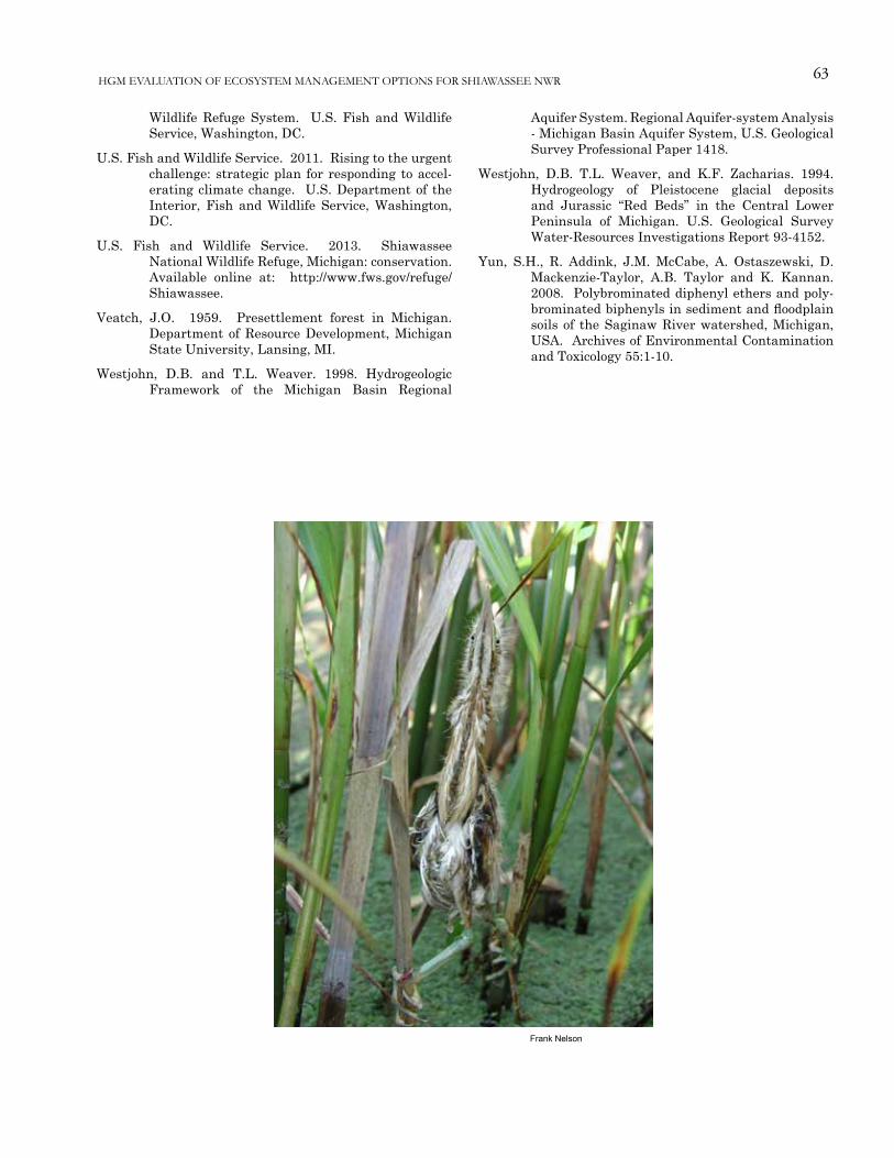
63
Frank Nelson
HGM EVALUATION OF ECOSYSTEM MANAGEMENT OPTIONS FOR SHIAWASSEE NWR
Wildlife Refuge System. U.S. Fish and Wildlife Service, Washington, DC.
U.S. Fish and Wildlife Service. 2011. Rising to the urgent challenge: strategic plan for responding to accel-erating climate change. U.S. Department of the Interior, Fish and Wildlife Service, Washington, DC.
U.S. Fish and Wildlife Service. 2013. Shiawassee National Wildlife Refuge, Michigan: conservation. Available online at: http://www.fws.gov/refuge/Shiawassee.
Veatch, J.O. 1959. Presettlement forest in Michigan. Department of Resource Development, Michigan State University, Lansing, MI.
Westjohn, D.B. and T.L. Weaver. 1998. Hydrogeologic Framework of the Michigan Basin Regional
Aquifer System. Regional Aquifer-system Analysis - Michigan Basin Aquifer System, U.S. Geological Survey Professional Paper 1418.
Westjohn, D.B. T.L. Weaver, and K.F. Zacharias. 1994. Hydrogeology of Pleistocene glacial deposits and Jurassic “Red Beds” in the Central Lower Peninsula of Michigan. U.S. Geological Survey Water-Resources Investigations Report 93-4152.
Yun, S.H., R. Addink, J.M. McCabe, A. Ostaszewski, D. Mackenzie-Taylor, A.B. Taylor and K. Kannan. 2008. Polybrominated diphenyl ethers and poly-brominated biphenyls in sediment and floodplain soils of the Saginaw River watershed, Michigan, USA. Archives of Environmental Contamination and Toxicology 55:1-10.

64 Heitmeyer, et al.
Appendix A. North American Glacial Episodes and General Geologic Time Scale.
![Download [2.96 MB]](https://img.dokumen.tips/doc/110x75/5873c7231a28ab29048c054c/download-296-mb.jpg)


![Download [1.24 MB]](https://img.dokumen.tips/doc/110x75/588869d21a28abc6518b5b6f/download-124-mb.jpg)