Embed Size (px)
Citation preview

气候科学尺度不匹配:全球模拟、局地尺度土地利用及高精度遥感观测BRIDGE THE SCALE GAP IN CLIMATE SCIENCE: GLOBAL CLIMATE MODELING, LOCAL LAND USE AND FINE-RESOLUTION REMOTE SENSING
李旭辉XUHUI LEE
耶鲁大学-南京信息工程大学大气环境中心

Collaborators
Yale University Natalie Schultz
Ron Smith
Lei Zhao 赵磊 (now at Princeton)
National Center for Atmospheric Research David Lawrence
Peter Lawrence
Keith Oleson
Nanjing University of Information, Science and Technology Chang Cao 曹畅 Shoudong Liu 刘寿东 Wei Xiao 肖薇 Mi Zhang 张弥

Collaborators
Yale University Natalie Schultz
Ron Smith
Lei Zhao 赵磊 (now at Princeton)
National Center for Atmospheric Research David Lawrence
Peter Lawrence
Keith Oleson
Nanjing University of Information, Science and Technology Chang Cao 曹畅 Shoudong Liu 刘寿东 Wei Xiao 肖薇 Mi Zhang 张弥

Components of an earth-system model
Land Atmosphere
Sea ice Ocean
Coupler
Fossil combustion
Land use change (deforestation, urbanization)
Agricultural intensification
Human activities
Earth-systemmodel

Model grid size versus local land use
100 km10
0 km

Model grid size versus local land use
5 km
Yale Myers Forest

Model grid size versus local land use
Yale Myers Forest

Model grid size versus local land use
10 km
City of New Haven

Model grid size versus local land use
City of New Haven

A-train satellite constellation
Source: NASA

MODIS satellite land products
Land cover classificationLand surface temperature(October 6, 2016)
1 km
1 km

Sentinel 2 satellite pair
Sioux Falls, SD, October 1, 2015
10 m
10 m

Remote sensing with drones
Goshen FarmLitchfield County Connecticut
5 cm
5cm

Oleson et al (2013) NCAR’s Technical Note
Modeling land grids as tiles or land units
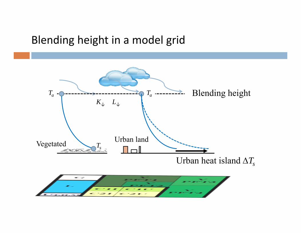
Blending heightTaK↓ L↓
Ts
Ta
Urban heat island Ts
Vegetated Urban land
Blending height in a model grid

Blending heightTaK↓ L↓
Ts
Ta
Deforestation signal Ts
Forest Open land
Blending height in a model grid

Vegetation in a model grid
Savanna
Mosaic

Deforestation effect using savanna-type land model
Schultz, Lee, Lawrence et al. (2016) J Geophysical Research – Atmospheres: doi 10.1002/2016JD025094

Deforestation effect using mosaic-type land model
Schultz, Lee, Lawrence et al. (2016) J Geophysical Research – Atmospheres: doi 10.1002/2016JD025094

Latitude (oN)25 35 45 55 65
Annu
al m
ean
diffe
renc
e
T (K
)
-2
-1
0
1 y = -0.070(±0.020) x + 2.6(±0.9)n = 37, R2 = 0.30, p < 0.005a
-10 20 50-2
0
Deforestation effect on surface air temperature (open land minus forest land)
Lee, Goulden, Hollinger et al. (2011) Nature 497: 384-387
0.070 0.020 2.6 0.9

N/S America
Asia
Zhang 张弥, Lee, Yu, et al. (2014) Environ Res Letters 9: 034002
Deforestation effect on surface air temperature (open land minus forest land)

Deforestation effect on land surface temperature
MODIS satellite observation
Mosaic-type land model
Savanna-type land model
Temperature difference (K)
Savanna-type land model
Mosaic-type land model
MODIS observation
Latit
ude

Night lights viewed from outer space
Global• Urban land fraction = 2.2%• Urban population = 51%• Urban C contribution = ~80%
USA• Urban land fraction = 2.6%• Urban population = 79%
Arizona / Sun Corridor• Urban land fraction = 0.34%• Urban population = ~88% of 6.6 million in 2013• Projected urban population = ~95% of ~19 million in 2050

Heat stress is perhaps the biggest climate threat to humans
Image source: Driscoll
Maximumskin temperature
35o
Cold environment
Hot environment

A typical urban heat island
Source: Oke

Urban heat island and land use in New Haven
Land use classesSurface temperatureJuly 4, 2010

Major causes of the urban heat island phenomenon
Source: Oke

Urban surface energy balance
SAHs QLEHQTLK 4)1(
Heat storage
Evaporation
Convection
Anthropogenic heat
Albedo

Theory on attribution of the urban heat island
AH
s
AHsn
AHsn
n
Qf
Qf
fQQRf
fQQRf
Rf
T
1
1
)()1(
)()1(
1
0
0
2*
20
1*
20
*0
Radiation
Convection
Evaporation
Storage
Anthropogenic heat
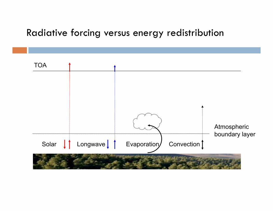
Radiative forcing versus energy redistribution
Solar Longwave
TOA
Evaporation
Atmospheric boundary layer
Convection

• at the local scale
Climate sensitivity
Intrinsic sensitivity
Apparent sensitivity
• 0.3 K per W m-2 at the global scale
• 0.2 K per W m-2 at the local scale
• and
• ~0.8 K per W m-2 at the global scale
AHsn
n
fQQR
fQQRf
Rf
T
)(
)()1(
1
*0
1*
20
*0
+ …

CLM‐modeled UHI versus UHI calculated from the surface
energy balance
AH
s
AHsn
AHsn
n
Qf
Qf
fQQRf
fQQRf
Rf
T
1
1
)()1(
)()1(
1
0
0
2*
20
1*
20
*0
Daytime
Nighttime

Sum of components – another formulation
Daytime
Nighttime
Albedo
day
day day
night night
night
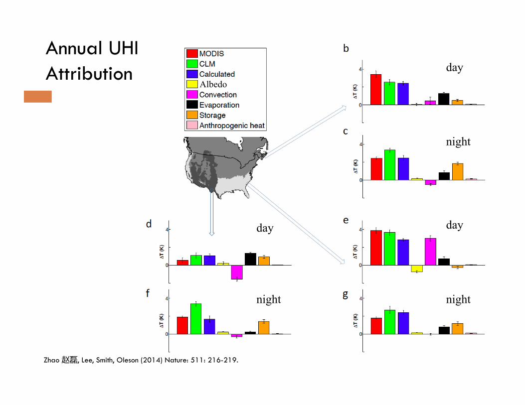
Zhao 赵磊, Lee, Smith, Oleson (2014) Nature: 511: 216-219.
Annual UHIAttribution
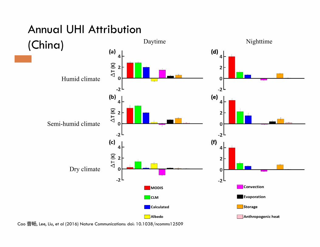
Annual UHI Attribution(China)
Cao 曹畅, Lee, Liu, et al (2016) Nature Communications: doi: 10.1038/ncomms12509
Daytime Nighttime
Dry climate
Humid climate
Semi-humid climate

White roof, green roof, solar roof, and street trees
Sources: www.ens‐newswire.com/ens/sep2008/2008‐09‐23‐01.html; http://aasid.parsons.edu/
White roof in California Green roof, Chicago City Hall
Street trees, NanjingSolar roof, Yale University

Re-engineering the urban landscape
Image data source: Sensefly.com; Animation credit: Chang Cao 曹畅