Embed Size (px)
Citation preview

International Petroleum News and Technology / www.ogjonline.com
Week of Oct. 6, 2008/US$10.00
Catalyst Report
Have oil futures traders driven up the market?Giant prospects lie in distal part of E. Mediterranean basin
Operators increase stakes in Marcellus shaleModified equation aids integrity management
E x p l o r a t i o n & D E v E l o p m E n tJames M. PeckDeep Seek Exploration Experts LLCHouston
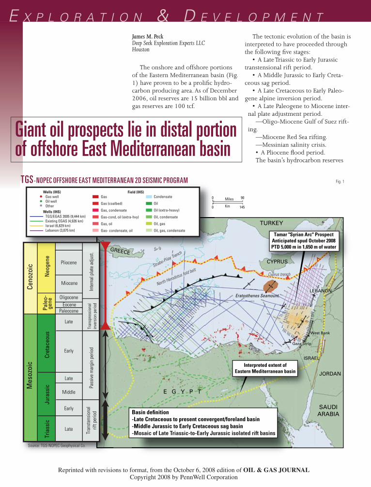
The onshore and offshore portions of the Eastern Mediterranean basin (Fig. 1) have proven to be a prolific hydro-carbon producing area. As of December 2006, oil reserves are 15 billion bbl and gas reserves are 100 tcf.
The tectonic evolution of the basin is interpreted to have proceeded through the following five stages:
• A Late Triassic to Early Jurassic transtensional rift period.
• A Middle Jurassic to Early Creta-ceous sag period.
• A Late Cretaceous to Early Paleo-gene alpine inversion period.
• A Late Paleogene to Miocene inter-nal plate adjustment period.
—Oligo-Miocene Gulf of Suez rift-ing.
—Miocene Red Sea rifting.—Messinian salinity crisis.• A Pliocene flood period.The basin’s hydrocarbon reserves
Giant oil prospects lie in distal portion of offshore East Mediterranean basin
Wells (IHS) Gas well Oil well OtherWells (IHS) TGS/EGAS 2005 (9,444 km) Existing EGAS (4,926 km) Israel (6,829 km) Lebanon (3,075 km)
Field (IHS) Gas
Gas (coalbed)
Gas, condensate
Gas-cond, oil (extra-hvy)
Gas, oil
Gas- condensate, oil
Cyprus trench
North Herodotus fold beltStrabo-Pilay Trench
Condensate
Oil
Oil (extra-heavy)
Oil, condensate
Oil, gas
Oil, gas, condensate
Basin definition-Late Cretaceous to present convergent/foreland basin-Middle Jurassic to Early Cretaceous sag basin-Mosaic of Late Triassic-to-Early Jurassic isolated rift basins
Interpreted extent ofEastern Mediterranean basin
GREECE
CYPRUS
TURKEY
JORDAN
LEBANON
ISRAEL
E G Y P T
SAUDI ARABIA
Gaza Strip
West Bank
Ceno
zoic
M
esoz
oic
Neo
gene
Pa
leo-
gene
Ju
rass
ic
Tria
ssic
Cr
etac
eous
Pliocene
Miocene
Oligocene Eocene
Paleocene
Late
Early
Late
Middle
Early
Late
Inte
rnal
pla
te a
djus
t.Tr
ansp
ress
iona
lin
vers
ion
perio
d Pa
ssiv
e m
argi
n pe
riod
Tran
sten
sion
alrif
t per
iod
1450
900 Miles
Km
Eratosthenes Seamount.
Tamar "Syrian Arc" ProspectAnticipated spud October 2008PTD 5,000 m in 1,650 m of water
z081
006O
GJx
pe0
1
Fullwide x 4
TGS-NOPEC OFFSHORE EAST MEDITERRANEAN 2D SEISMIC PROGRAM Fig. 1
Source: TGS-NOPEC Geophysical Co.
Reprinted with revisions to format, from the October 6, 2008 edition of OIL & GAS JOURNALCopyright 2008 by PennWell Corporation
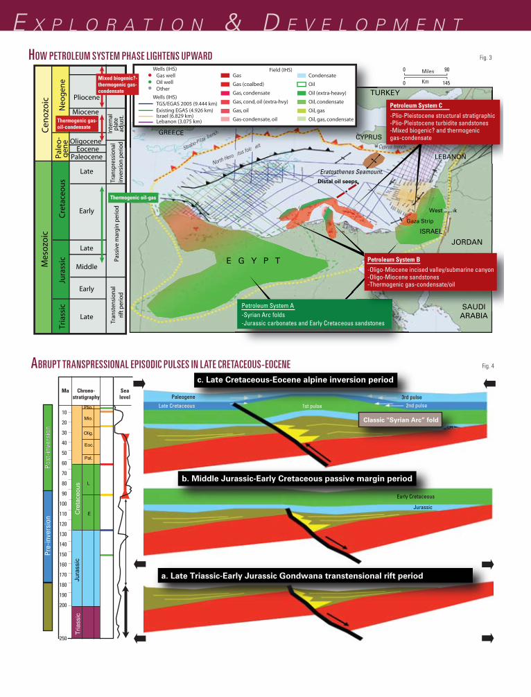
associated with these deep-seated, near vertical paleofaults that cut upward to the water bottom interface from the Mesozoic section through the entire Ce-nozoic section (inclusive of the Messin-ian Salt and overlying Plio-Pleistocene section (Fig. 3).
In spite of the impressive scale of the hydrocarbon reserves within the EMB, the distal portion of the basin remains underexplored.
Between 2001 and 2005, TGS-NOPEC Geophysical Co. acquired the nonexclusive Eastern Mediterranean basin 2D seismic database that consists of 19,256 km of new shoot 2D seismic data off Lebanon, Israel, and Egypt (Fig. 1). The company also reprocessed to merge with the new acquisition 4,526 km of existing EGAS offshore Egypt vintage seismic data (Fig. 1).
Importantly, the TGS-NOPEC East-ern Mediterranean basin 2D seismic database tied all preacquisition deep offshore wells (penetrated into the Mesozoic section). Those preacquisition
of hydrocarbons through the strati-graphic column include the following;
• There exists a distinct lightening-upward of the hydrocarbon phase from oil and gas in Petroleum System A to gas, oil, and condensate in Petro-leum System B to mainly very light gas (mainly methane) occasionally associ-ated with condensate (Fig. 3).
• With the historical shift in drilling from initial onshore and near offshore focus on Petroleum System A and Petro-leum System B, the EMB was perceived as an oil and oil/gas prone basin. With the large success of offshore Petroleum System C, the more distal portion of the EMB is generally regarded as gas-prone.
• All Plio-Pleistocene gas and gas/condensate discoveries are proximal to deep-seated, near vertical paleofaults that extend through the entire strati-graphic column.
• Importantly to the petroleum systems in the distal portion of the EMB, operators and service companies have reported water-bottom oil seeps
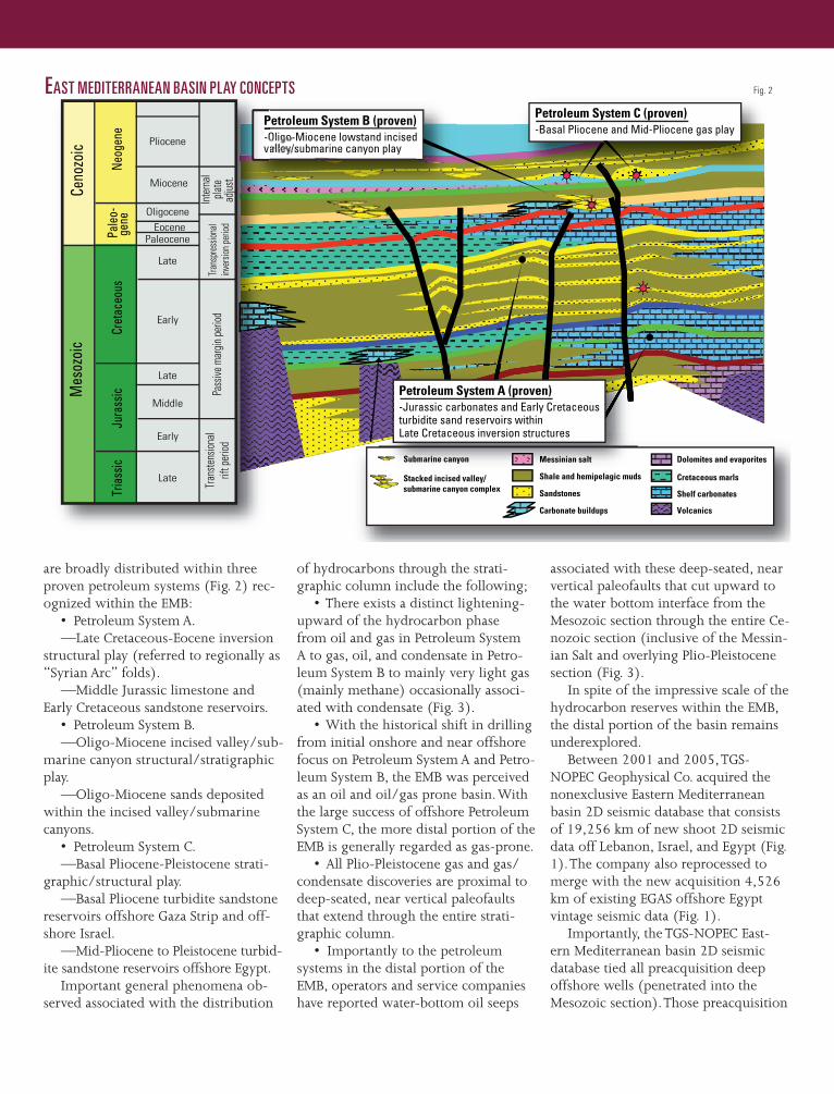
are broadly distributed within three proven petroleum systems (Fig. 2) rec-ognized within the EMB:
• Petroleum System A.—Late Cretaceous-Eocene inversion
structural play (referred to regionally as “Syrian Arc” folds).
—Middle Jurassic limestone and Early Cretaceous sandstone reservoirs.
• Petroleum System B.—Oligo-Miocene incised valley/sub-
marine canyon structural/stratigraphic play.
—Oligo-Miocene sands deposited within the incised valley/submarine canyons.
• Petroleum System C.—Basal Pliocene-Pleistocene strati-
graphic/structural play.—Basal Pliocene turbidite sandstone
reservoirs offshore Gaza Strip and off-shore Israel.
—Mid-Pliocene to Pleistocene turbid-ite sandstone reservoirs offshore Egypt.
Important general phenomena ob-served associated with the distribution
Petroleum System B (proven)-Oligo-Miocene lowstand incisedvalley/submarine canyon play
Petroleum System C (proven)-Basal Pliocene and Mid-Pliocene gas play
Submarine canyon
Stacked incised valley/submarine canyon complex
Messinian salt
Shale and hemipelagic muds
Sandstones
Carbonate buildups
Dolomites and evaporites
Cretaceous marls
Shelf carbonates
Volcanics
Submarine canyon Messinian salt
P-Ov
Ceno
zoic
M
esoz
oic
Neog
ene
Pale
o-ge
ne
Jura
ssic
Tr
iass
ic
Cret
aceo
us
Pliocene
Miocene
Oligocene Eocene
Paleocene
Late
Early
Late
Middle
Early
Late
Inter
nal
plate
adjus
t.Tr
ansp
ress
ional
inver
sion p
eriod
Pa
ssive
mar
gin pe
riod
Tran
stens
ional
rift p
eriod
Petroleum System A (proven)-Jurassic carbonates and Early Cretaceousturbidite sand reservoirs withinLate Cretaceous inversion structures
z081
006O
GJx
pe0
2
Fullwide x 3
EAST MEDITERRANEAN BASIN PLAY CONCEPTS Fig. 2
E x p l o r a t i o n & D E v E l o p m E n t
Cyprus trench
North Herodotus fold beltStrabo-Pilay TrenchGREECE CYPRUS
TURKEY
JORDAN
ISRAEL
E G Y P T
SAUDI ARABIA
Gaza Strip
West Bank
Distal oil seeps
1450
900 Miles
Km
Petroleum System A-Syrian Arc folds-Jurassic carbonates and Early Cretaceous sandstones
Petroleum System B
-Oligo-Miocene incised valley/submarine canyon-Oligo-Miocene sandstones-Thermogenic gas-condensate/oil
Petroleum System C
-Plio-Pleistocene structural stratigraphic-Plio-Pleistocene turbidite sandstones-Mixed biogenic? and thermogenicgas-condensate
LEBANON
Eratosthenes Seamount.
Cen
ozo
ic
Mes
ozo
ic
Neo
gen
e Pa
leo
-g
ene
Jura
ssic
Tr
iass
ic
Cre
tace
ou
s
Pliocene
Miocene
Oligocene Eocene
Paleocene
Late
Early
Late
Middle
Early
Late
Inte
rnal
plat
e ad
just
.Tr
ansp
ress
iona
lin
vers
ion
perio
d Pa
ssiv
e m
argi
n pe
riod
Tran
sten
sion
alrif
t per
iod
ld beltStrabo-Pilay TrenchGREGREECEECE CYPPRRUU
TTUTU
Wells (IHS) Gas well Oil well Other
Wells (IHS) TGS/EGAS 2005 (9.444 km) Existing EGAS (4.926 km) Israel (6.829 km) Lebanon (3.075 km)
Field (IHS) Gas
Gas (coalbed)
Gas, condensate
Gas, cond, oil (extra-hvy)
Gas, oil
Gas-condensate, oil
Condensate
Oil
Oil (extra-heavy)
Oil, condensate
Oil, gas
Oil, gas, condensate
Thermogenic oil-gas
Thermogenic gas-oil-condensate
Mixed biogenic?-thermogenic gas-condensate
z081
006O
GJx
pe0
3
Fullwide x 3
HOW PETROLEUM SYSTEM PHASE LIGHTENS UPWARD Fig. 3
10
20
30
40
50
60
70
80
90
100
110
120
130
140
150
160
170
180
190
200
250
Ma Chrono-stratigraphy
Sealevel
c. Late Cretaceous-Eocene alpine inversion period
b. Middle Jurassic-Early Cretaceous passive margin period
Classic "Syrian Arc” fold
Paleogene 3rd pulse 2nd pulse 1st pulse
Late Cretaceous
Early Cretaceous
Jurassic
Post
-inve
rsio
nPo
st-in
vers
ion
Pre-
inve
rsio
n
Cre
tace
ous
Jura
ssic
T
riass
ic
Plio.
Mio.
Olig.
Pal.
L
E
Eoc.
a. Late Triassic-Early Jurassic Gondwana transtensional rift period
z081
006O
GJx
pe0
4
Fullwide x 3
ABRUPT TRANSPRESSIONAL EPISODIC PULSES IN LATE CRETACEOUS-EOCENE Fig. 4
was uniquely accomplished by the fol-lowing methodology:
1. Unlike previous “drop-down” interpretational attempts to extrapolate horizons distally, Deep Seek interpreted the TGS-NOPEC Eastern Mediterranean 2D seismic database from “bottom up.”
2. Deep Seek Exploration con-strained the interpretation firmly within the basin’s known tectonic evolution framework.
3. The EMB Triassic-to-present stratigraphic section is punctuated by two major megatransgressive periods including the Middle-to-Late Jurassic period and the Senonian-to-Eocene period. On seismic lines through deep offshore control wells, the end of each of these megatransgressive periods are marked by two thick seismically transparent (implying homogeneous lithology) units dated in the control wells as 1) Late Jurassic and 2) Latest Cretaceous to Eocene. Therefore in the distal portion of the EMB, the deepest seismically transparent unit is dated Late Jurassic while the shallowest seismi-cally transparent unit is dated the Latest Cretaceous to Eocene.
Fig. 6 is the Deep Seek Exploration Experts’ “bottom-up” interpretation of the TGS-NOPEC line 2069-IS. The pre-Messinian salt interpretation was accomplished through the following “bottom-up” steps:
• Step 1: Identification of the Triassic-Early Jurassic rift ztage base/rift hori-zon (red).
—This horizon is identified by onlap of seismic events (synrift) onto subpar-allel obliquely inclined prerift seismic events. Over the distal portion of the EMB, confident identification of this horizon ranges from poor-good.
• Step 2: Identification of the base/Cretaceous horizon (blue).
—This horizon is identified by being directly above the deepest seismically transparent unit interpreted as a Late Ju-rassic section of homogeneous hemipe-lagic mudstone deposited within paleo-lows during the maximum extend of the Jurassic megatransgression.
• Step 3: Identification of Top/Albian horizon (yellow).
Miocene section over a thin, deeply buried Mesozoic section predict:
• Known onshore/proximally off-shore Early Cretaceous/Middle Jurassic source rocks are too thin, too deeply buried, and overmature to provide hy-drocarbons to the overlying sections.
• The Paleogene/Neogene section is thermally immature and only capable (if source rock potential exists) of gen-erating biogenic gas into the available Tertiary reservoirs.
Due to the above interpretational paradigm combined with the predomi-nance of light gas in the Plio-Pleisto-cene traps, the distal portion of the EMB is therefore regarded near universally as a gas (methane-dominated) province.
However, several unusual aspects of this prevailing interpretational distal EMB paradigm of a distal, thick Oligo-Miocene section over a thin, deeply buried Mesozoic section are as follows:
• The interpretational paradigm contrasts starkly with the known strati-graphic section in all the deep offshore wells of an overlying thin Oligo-Miocene section dominated by a thick Mesozoic section.
• The interpretational paradigm strongly implies a sudden, extreme Oligo-Miocene extensional tectonic phase as considerable accommodation space is required for the sudden 2-3 sec (TWT) expansion of the Oligo-Miocene section. This need for sudden expan-sion (and implied extension) again is in stark contrast with the known tectonic evolution that shows that the EMB was under continued compression from Late Cretaceous (initial collision of the north-ern Eurasian plate with the southern African/Arabian plates) to the present.
• Where a biogenic-gas generating petroleum system is predicted, water bottom oil seeps are reported in the dis-tal portion of the EMB associated with deep-seated, near vertical paleofaults.
Deep Seek Exploration Experts LLC interpreted all the TGS-NOPEC Eastern Mediterranean 2D seismic database off Lebanon, Israel, and Egypt.
From the proximal deep well control to the distal portion of the EMB, this Deep Seek Exploration interpretation
offshore deep wells are all relatively near the shoreline of Egypt and Israel.
As onshore in the Egyptian Western Desert and northern Sinai Peninsula and the Israeli coastal plain, these preacqui-sition offshore deep wells commonly targeted large inversion structures (Pe-troleum System A: “Syrian Arc” folds) that were “squeezed up” from paleo-lows during strong, abrupt transpres-sional episodic pulses during the Late Cretaceous-Eocene period (Fig. 4). The stratigraphic section penetrated in these offshore “Syrian Arc” wells consists of a thick Mesozoic section under a thin Pre-Messinian Tertiary section. Middle Jurassic limestone or Early Cretaceous sandstones reservoirs in these offshore “Syrian Arc” wells frequently exhibit oil and gas shows or tested oil generated from mature Middle Jurassic and Early Cretaceous source rocks.
With the exception of one well (the Total Mango-1 well drilled in 1985 off the Sinai Peninsula), all other pre-seismic acquisition, deep offshore wells are separated from the distal portion of the EMB by extreme structural (promi-nent structural ridge offshore Israel) or stratigraphic (deep incised valley/submarine canyon complexes offshore western Egypt) obstructions and, thus, these deep wells do not provide reliable extrapolation with confidence of well ties along seismic lines to the distal por-tion of the EMB.
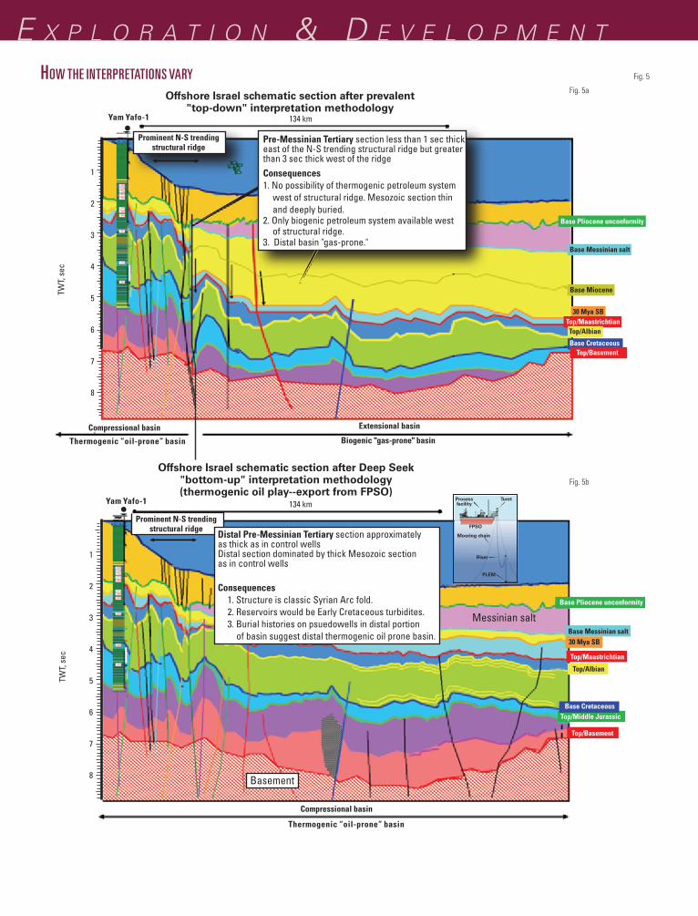
Previous attempts to extrapolate horizons along seismic lines tied to formation tops encountered in these proximal deep offshore wells to the distal portion of the EMB have been greatly influenced by these structural or stratigraphic obstructions. The prevail-ing interpretational paradigm has been to “drop down” along normal faults on the distal side of these obstructions. This “drop-down” interpretation has resulted in prevailing perspective that the distal portion of the EMB is widely interpreted to be dominated by a very thick Oligo-Miocene section (2-3 sec (TWT) thick) overlying a thin, deeply buried Mesozoic section (Fig. 5a).
Burial histories constructed on pseudowells utilizing the thick Oligo-
E x p l o r a t i o n & D E v E l o p m E n t
Pre-Messinian Tertiary section less than 1 sec thickeast of the N-S trending structural ridge but greaterthan 3 sec thick west of the ridgeConsequences1. No possibility of thermogenic petroleum system west of structural ridge. Mesozoic section thin and deeply buried.2. Only biogenic petroleum system available west of structural ridge.3. Distal basin "gas-prone."
1
2
3
4
5
6
7
8
TWT,
sec
TW
T, s
ec
1
2
3
4
5
6
7
8
Prominent N-S trendingstructural ridge
Prominent N-S trendingstructural ridge
Basement
Offshore Israel schematic section after prevalent"top-down" interpretation methodology
Extensional basinCompressional basinBiogenic "gas-prone" basinThermogenic “oil-prone” basin
Compressional basin
Thermogenic “oil-prone” basin
Yam Yafo-1
Yam Yafo-1
Offshore Israel schematic section after Deep Seek"bottom-up" interpretation methodology(thermogenic oil play--export from FPSO)
Processfacility
Turet
FPSO
Mooring chain
Riser
PLEM
Base Pliocene unconformity
Base Messinian salt
Base Miocene
30 Mya SB
Top/MaastrichtianTop/Albian
Base Cretaceous
Base Pliocene unconformity
Base Messinian salt
Messinian salt
Top/Middle Jurassic
30 Mya SB
Top/Maastrichtian
Top/Albian
Base Cretaceous
Top/Basement
134 km
134 km
Fig. 5a
Fig. 5b
Top/Basement
Distal Pre-Messinian Tertiary section approximatelyas thick as in control wellsDistal section dominated by thick Mesozoic sectionas in control wells
Consequences 1. Structure is classic Syrian Arc fold. 2. Reservoirs would be Early Cretaceous turbidites. 3. Burial histories on psuedowells in distal portion of basin suggest distal thermogenic oil prone basin.
z081
006O
GJx
pe0
5
Fullwide x Fulldeep
HOW THE INTERPRETATIONS VARY Fig. 5
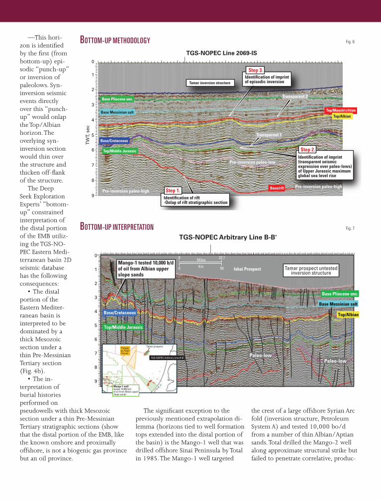
the crest of a large offshore Syrian Arc fold (inversion structure, Petroleum System A) and tested 10,000 bo/d from a number of thin Albian/Aptian sands. Total drilled the Mango-2 well along approximate structural strike but failed to penetrate correlative, produc-
The significant exception to the previously mentioned extrapolation di-lemma (horizons tied to well formation tops extended into the distal portion of the basin) is the Mango-1 well that was drilled offshore Sinai Peninsula by Total in 1985. The Mango-1 well targeted
—This hori-zon is identified by the first (from bottom-up) epi-sodic “punch-up” or inversion of paleolows. Syn-inversion seismic events directly over this “punch-up” would onlap the Top/Albian horizon. The overlying syn-inversion section would thin over the structure and thicken off-flank of the structure.
The Deep Seek Exploration Experts’ “bottom-up” constrained interpretation of the distal portion of the EMB utiliz-ing the TGS-NO-PEC Eastern Medi-terranean basin 2D seismic database has the following consequences:
• The distal portion of the Eastern Mediter-ranean basin is interpreted to be dominated by a thick Mesozoic section under a thin Pre-Messinian Tertiary section (Fig. 4b).
• The in-terpretation of burial histories performed on pseudowells with thick Mesozoic section under a thin Pre-Messinian Tertiary stratigraphic sections (show that the distal portion of the EMB, like the known onshore and proximally offshore, is not a biogenic gas province but an oil province.
0
1
2
3
4
5
6
7
8
9
TGS-NOPEC Line 2069-IS
Identification of rift-Onlap of rift stratigraphic section
Step 1.
Step 2.
Step 3.
Identification of imprint(transparent seismicexpression over paleo-lows)of Upper Jurassic maximumglobal sea level rise
Identification of imprintof episodic inversion
Transparent 2
Transparent 1
Pre-inversion paleo-high
Pre-inversion paleo-low
Pre-inversion paleo-high
Top/MaastrichtianTop/Albian
Base/rift
Top/Middle Jurassic
Base/Cretaceous
Base Messinian salt
Base Pliocene unc.
TW
T, s
ecTamar inversion structure
z081
006O
GJx
pe0
6
2.5 x 2.5
Fig. 6BOTTOM-UP METHODOLOGY
0 32.1
0 50
Top/Middle Jurassic
Base Pliocene unc.
Base Messinian salt
Top/Albian
Miles
Km
TGS-NOPEC Arbitrary Line B-B'
Mango-1 tested 10,000 b/dof oil from Albian upperslope sands
Mango-1 welltested 10,000 b/dof oil from Albian upperslope sands
Tamar prospect untestedinversion structure
Paleo-lowPaleo-low
TGS-NOPEC Arbitrary Line B-B'
Tamar prospect Pelagicex-YoadPermit
0
1
2
3
4
5
6
7
8
9
Base/Cretaceous
Ishai Prospect
z081
006O
GJx
pe0
7
2.5 x 2.5
Fig. 7BOTTOM-UP INTERPRETATION
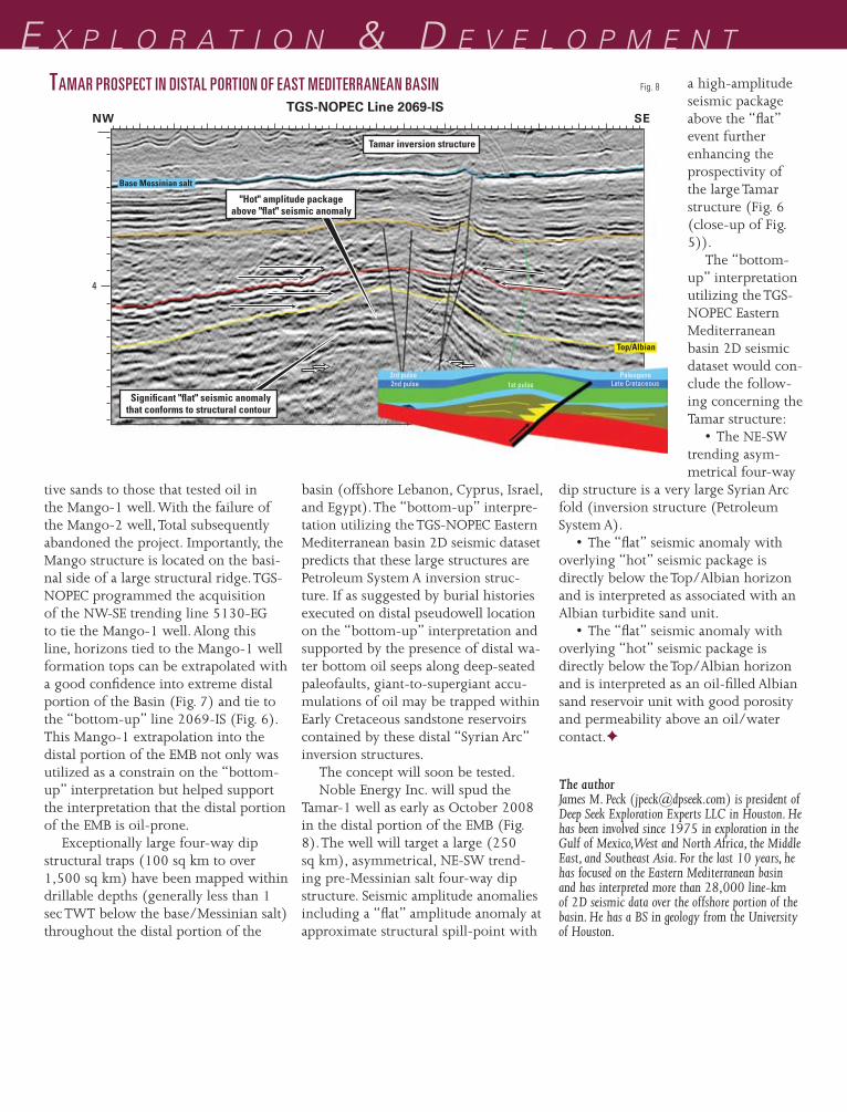
E x p l o r a t i o n & D E v E l o p m E n ta high-amplitude seismic package above the “flat” event further enhancing the prospectivity of the large Tamar structure (Fig. 6 (close-up of Fig. 5)).
The “bottom-up” interpretation utilizing the TGS-NOPEC Eastern Mediterranean basin 2D seismic dataset would con-clude the follow-ing concerning the Tamar structure:
• The NE-SW trending asym-metrical four-way
dip structure is a very large Syrian Arc fold (inversion structure (Petroleum System A).
• The “flat” seismic anomaly with overlying “hot” seismic package is directly below the Top/Albian horizon and is interpreted as associated with an Albian turbidite sand unit.
• The “flat” seismic anomaly with overlying “hot” seismic package is directly below the Top/Albian horizon and is interpreted as an oil-filled Albian sand reservoir unit with good porosity and permeability above an oil/water contact.✦
basin (offshore Lebanon, Cyprus, Israel, and Egypt). The “bottom-up” interpre-tation utilizing the TGS-NOPEC Eastern Mediterranean basin 2D seismic dataset predicts that these large structures are Petroleum System A inversion struc-ture. If as suggested by burial histories executed on distal pseudowell location on the “bottom-up” interpretation and supported by the presence of distal wa-ter bottom oil seeps along deep-seated paleofaults, giant-to-supergiant accu-mulations of oil may be trapped within Early Cretaceous sandstone reservoirs contained by these distal “Syrian Arc” inversion structures.
The concept will soon be tested.Noble Energy Inc. will spud the
Tamar-1 well as early as October 2008 in the distal portion of the EMB (Fig. 8). The well will target a large (250 sq km), asymmetrical, NE-SW trend-ing pre-Messinian salt four-way dip structure. Seismic amplitude anomalies including a “flat” amplitude anomaly at approximate structural spill-point with
tive sands to those that tested oil in the Mango-1 well. With the failure of the Mango-2 well, Total subsequently abandoned the project. Importantly, the Mango structure is located on the basi-nal side of a large structural ridge. TGS-NOPEC programmed the acquisition of the NW-SE trending line 5130-EG to tie the Mango-1 well. Along this line, horizons tied to the Mango-1 well formation tops can be extrapolated with a good confidence into extreme distal portion of the Basin (Fig. 7) and tie to the “bottom-up” line 2069-IS (Fig. 6). This Mango-1 extrapolation into the distal portion of the EMB not only was utilized as a constrain on the “bottom-up” interpretation but helped support the interpretation that the distal portion of the EMB is oil-prone.
Exceptionally large four-way dip structural traps (100 sq km to over 1,500 sq km) have been mapped within drillable depths (generally less than 1 sec TWT below the base/Messinian salt) throughout the distal portion of the
4
TGS-NOPEC Line 2069-ISNW SE
Significant "flat" seismic anomalythat conforms to structural contour
Tamar inversion structure
"Hot" amplitude packageabove "flat" seismic anomaly
Late Cretaceous
Base Messinian salt
Top/Albian
3rd pulse2nd pulse 1st pulse
Paleogene
z081
006O
GJx
pe0
8
2.5 x 2.5
Fig. 8TAMAR PROSPECT IN DISTAL PORTION OF EAST MEDITERRANEAN BASIN
The authorJames M. Peck ([email protected]) is president of Deep Seek Exploration Experts LLC in Houston. He has been involved since 1975 in exploration in the Gulf of Mexico, West and North Africa, the Middle East, and Southeast Asia. For the last 10 years, he has focused on the Eastern Mediterranean basin and has interpreted more than 28,000 line-km of 2D seismic data over the offshore portion of the basin. He has a BS in geology from the University of Houston.