Embed Size (px)
Citation preview

Indian Space Research Organisation Department of Space Government of India
Strengthening Regional Resilience with Geo-Information Programme on Trans-boundary Cooperation in South and South East Asia for geospatial information
January 18, 2018
SHANTANU BHATAWDEKAR
DIRECTOR, EARTH OBSERVATIONS SYSTEM
- Avenues and Requisites for Successful Collaboration -
• Data Availability & Value added services
• International Charter & Sentinel Asia
• CARTOSAT-1 DEM
• SAARC – Urban Sprawl / RS Applications
• ASEAN Facility
• Bhuvan Services
• In-situ Observation Network • SAARC STORM
• Capacity Building • Sri lanka/Myanmar Drought
• Geo-GLAM
• Geoportal Development
• BRICS
• CSSTEAP / ITEC
• South Asia Satellite
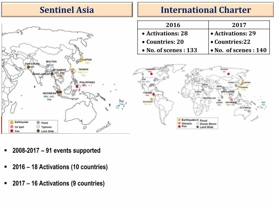
Sentinel Asia
2008-2017 – 91 events supported
2016 – 18 Activations (10 countries)
2017 – 16 Activations (9 countries)
International Charter
2016 2017
Activations: 28
Countries: 20
No. of scenes : 133
Activations: 29
Countries:22
No. of scenes : 140
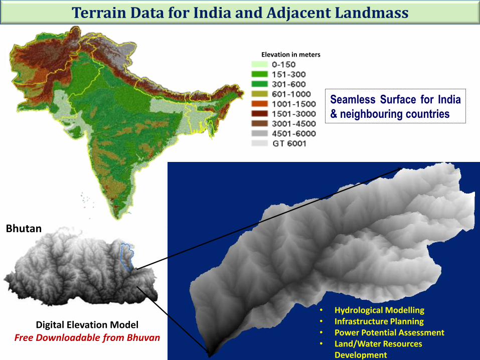
Seamless Surface for India
& neighbouring countries
Elevation in meters
Terrain Data for India and Adjacent Landmass
Digital Elevation Model Free Downloadable from Bhuvan
Hydrological Modelling Infrastructure Planning Power Potential Assessment Land/Water Resources Development ……
• Hydrological Modelling • Infrastructure Planning • Power Potential Assessment • Land/Water Resources
Development • ……
Bhutan
1991 2014
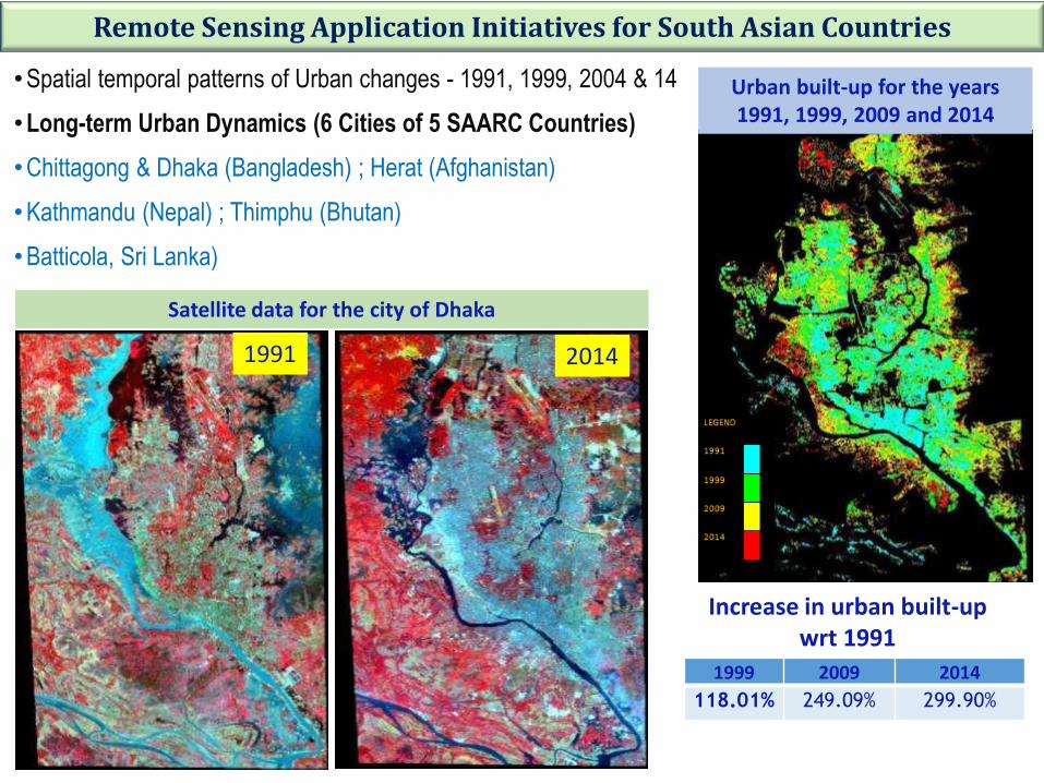
Satellite data for the city of Dhaka
Urban built-up for the years 1991, 1999, 2009 and 2014
1999 2009 2014
118.01% 249.09% 299.90%
Increase in urban built-up wrt 1991
•Spatial temporal patterns of Urban changes - 1991, 1999, 2004 & 14
•Long-term Urban Dynamics (6 Cities of 5 SAARC Countries)
•Chittagong & Dhaka (Bangladesh) ; Herat (Afghanistan)
•Kathmandu (Nepal) ; Thimphu (Bhutan)
•Batticola, Sri Lanka)
Remote Sensing Application Initiatives for South Asian Countries
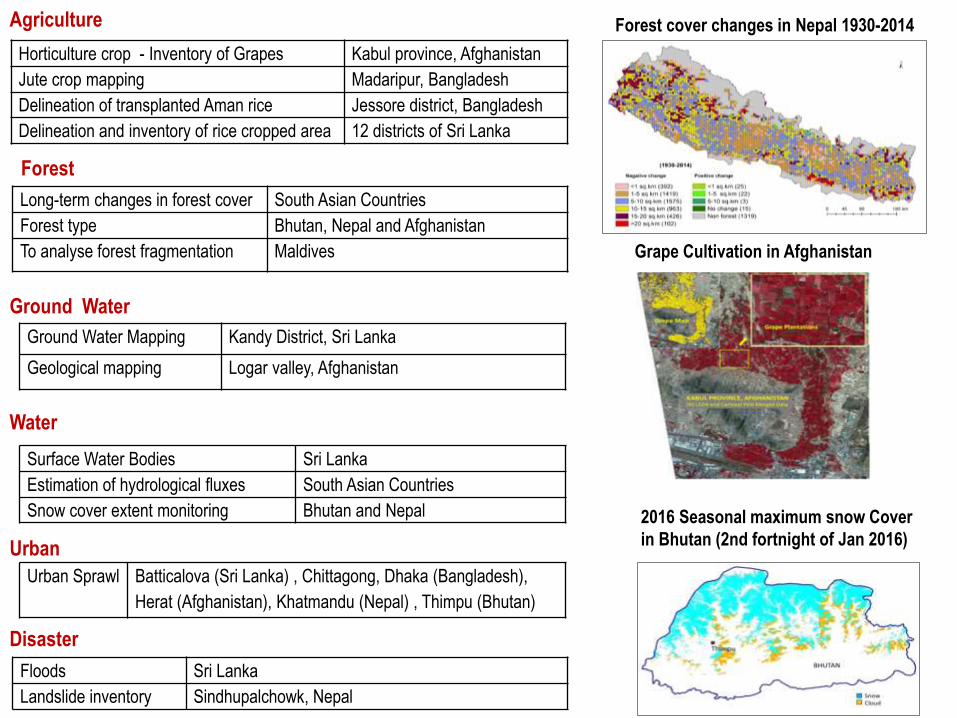
Horticulture crop - Inventory of Grapes Kabul province, Afghanistan
Jute crop mapping Madaripur, Bangladesh
Delineation of transplanted Aman rice Jessore district, Bangladesh
Delineation and inventory of rice cropped area 12 districts of Sri Lanka
Long-term changes in forest cover South Asian Countries
Forest type Bhutan, Nepal and Afghanistan
To analyse forest fragmentation Maldives
Ground Water Mapping Kandy District, Sri Lanka
Geological mapping Logar valley, Afghanistan
Surface Water Bodies Sri Lanka
Estimation of hydrological fluxes South Asian Countries
Snow cover extent monitoring Bhutan and Nepal
Urban Sprawl Batticalova (Sri Lanka) , Chittagong, Dhaka (Bangladesh),
Herat (Afghanistan), Khatmandu (Nepal) , Thimpu (Bhutan)
Floods Sri Lanka
Landslide inventory Sindhupalchowk, Nepal
Agriculture
Forest
Ground Water
Water
Urban
Disaster
Forest cover changes in Nepal 1930-2014
Grape Cultivation in Afghanistan
2016 Seasonal maximum snow Cover
in Bhutan (2nd fortnight of Jan 2016)
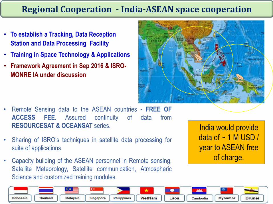
• To establish a Tracking, Data Reception
Station and Data Processing Facility
• Training in Space Technology & Applications
• Framework Agreement in Sep 2016 & ISRO-
MONRE IA under discussion
Regional Cooperation - India-ASEAN space cooperation
• Remote Sensing data to the ASEAN countries - FREE OF
ACCESS FEE. Assured continuity of data from
RESOURCESAT & OCEANSAT series.
• Sharing of ISRO’s techniques in satellite data processing for
suite of applications
• Capacity building of the ASEAN personnel in Remote sensing,
Satellite Meteorology, Satellite communication, Atmospheric
Science and customized training modules.
India would provide
data of ~ 1 M USD /
year to ASEAN free
of charge.
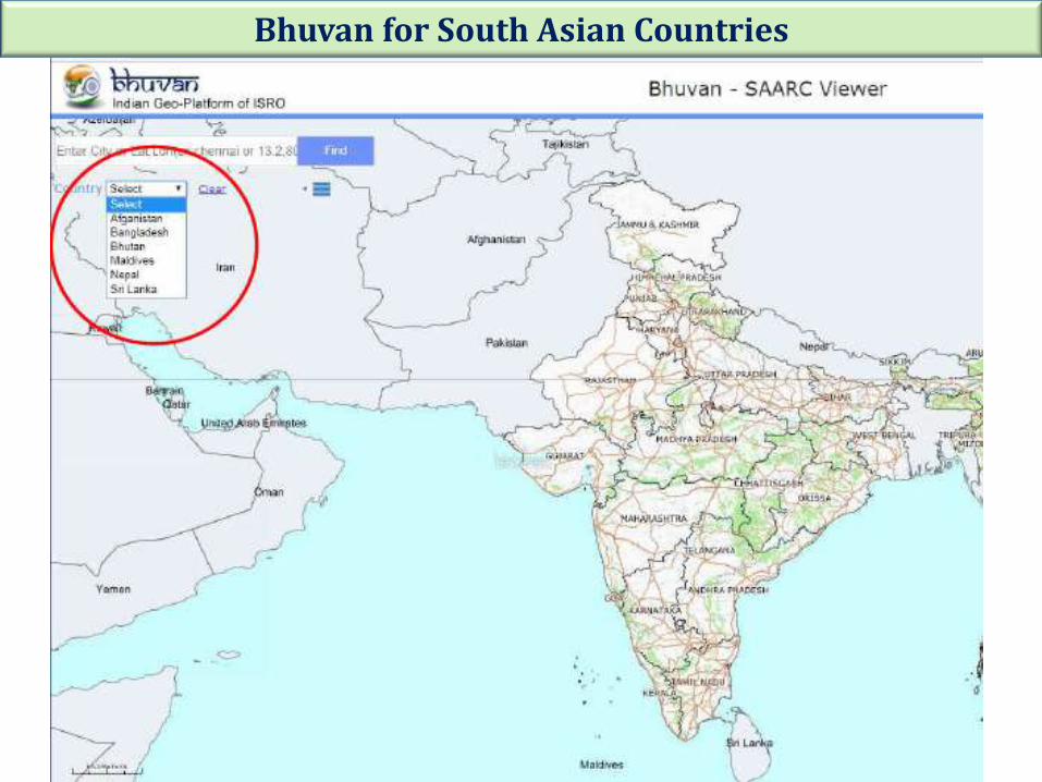
Bhuvan for South Asian Countries
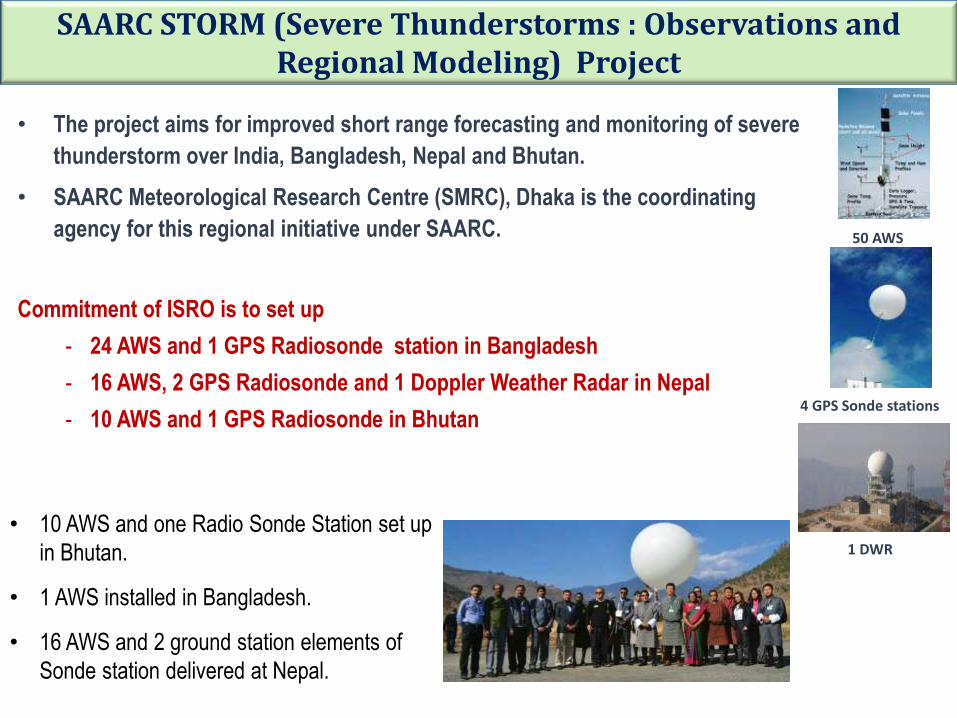
SAARC STORM (Severe Thunderstorms : Observations and Regional Modeling) Project
• The project aims for improved short range forecasting and monitoring of severe
thunderstorm over India, Bangladesh, Nepal and Bhutan.
• SAARC Meteorological Research Centre (SMRC), Dhaka is the coordinating
agency for this regional initiative under SAARC.
Commitment of ISRO is to set up
- 24 AWS and 1 GPS Radiosonde station in Bangladesh
- 16 AWS, 2 GPS Radiosonde and 1 Doppler Weather Radar in Nepal
- 10 AWS and 1 GPS Radiosonde in Bhutan
50 AWS
4 GPS Sonde stations
1 DWR
• 10 AWS and one Radio Sonde Station set up
in Bhutan.
• 1 AWS installed in Bangladesh.
• 16 AWS and 2 ground station elements of
Sonde station delivered at Nepal.
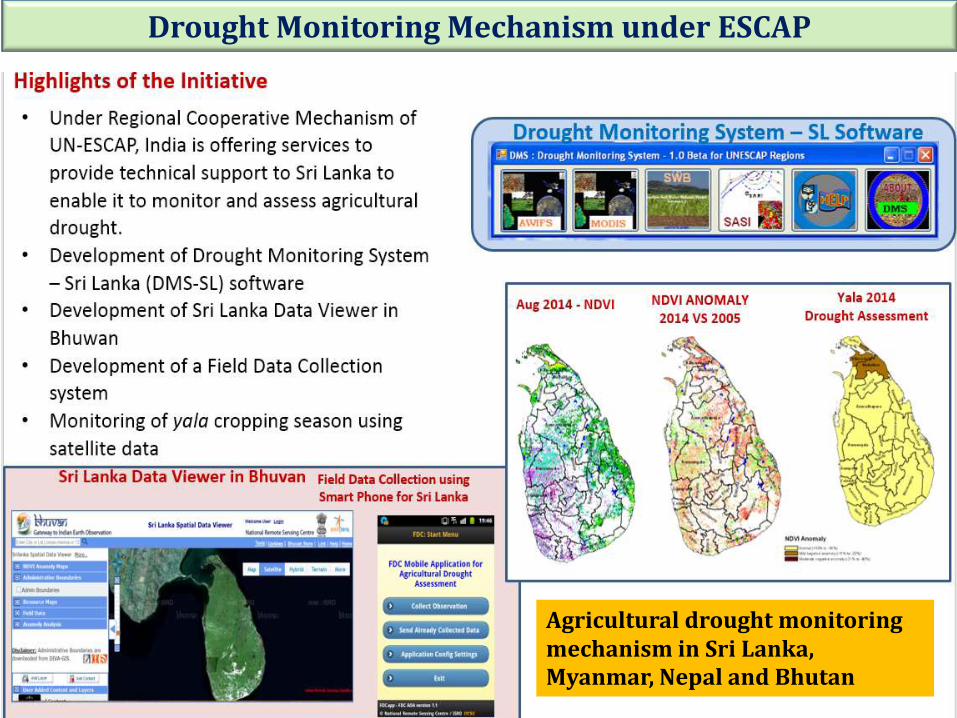
Drought Monitoring Mechanism under ESCAP
Agricultural drought monitoring mechanism in Sri Lanka, Myanmar, Nepal and Bhutan
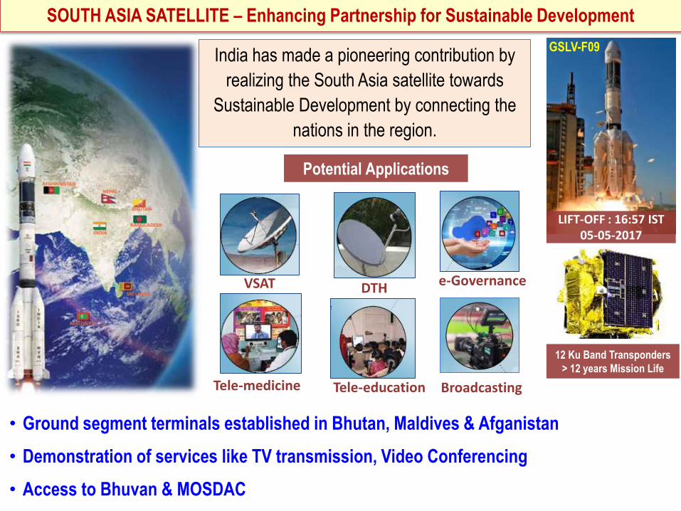
SOUTH ASIA SATELLITE – Enhancing Partnership for Sustainable Development
LIFT-OFF : 16:57 IST 05-05-2017
12 Ku Band Transponders
> 12 years Mission Life
GSLV-F09 India has made a pioneering contribution by
realizing the South Asia satellite towards
Sustainable Development by connecting the
nations in the region.
Potential Applications
VSAT
Tele-medicine Tele-education
DTH e-Governance
Broadcasting
• Ground segment terminals established in Bhutan, Maldives & Afganistan
• Demonstration of services like TV transmission, Video Conferencing
• Access to Bhuvan & MOSDAC
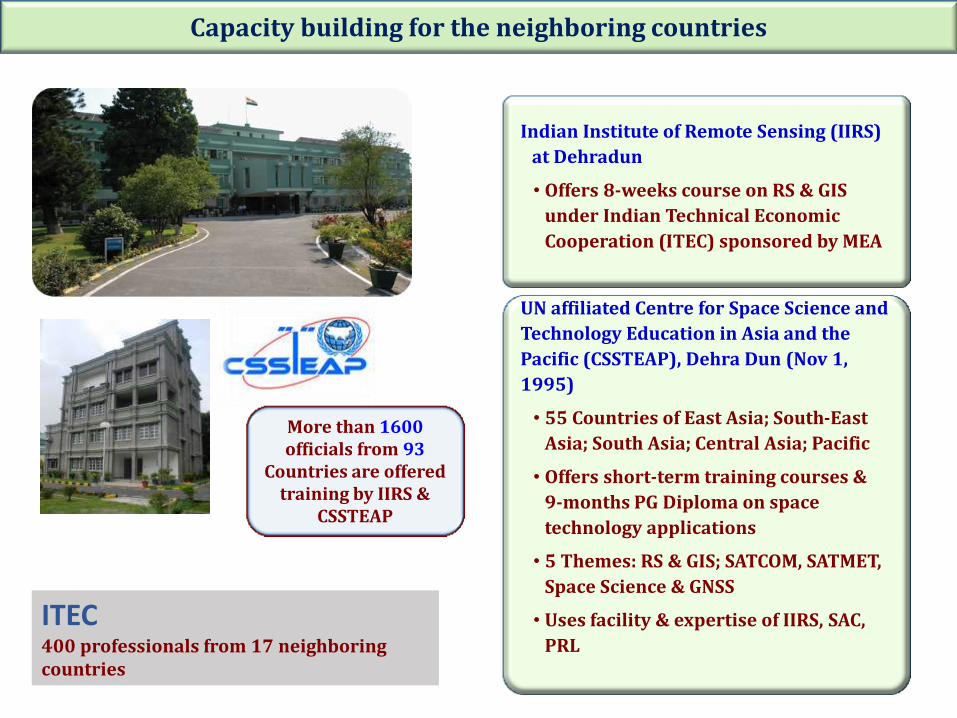
Capacity building for the neighboring countries
Indian Institute of Remote Sensing (IIRS)
at Dehradun
• Offers 8-weeks course on RS & GIS
under Indian Technical Economic
Cooperation (ITEC) sponsored by MEA
UN affiliated Centre for Space Science and
Technology Education in Asia and the
Pacific (CSSTEAP), Dehra Dun (Nov 1,
1995)
• 55 Countries of East Asia; South-East
Asia; South Asia; Central Asia; Pacific
• Offers short-term training courses &
9-months PG Diploma on space
technology applications
• 5 Themes: RS & GIS; SATCOM, SATMET,
Space Science & GNSS
• Uses facility & expertise of IIRS, SAC,
PRL
More than 1600 officials from 93
Countries are offered training by IIRS &
CSSTEAP
ITEC 400 professionals from 17 neighboring countries
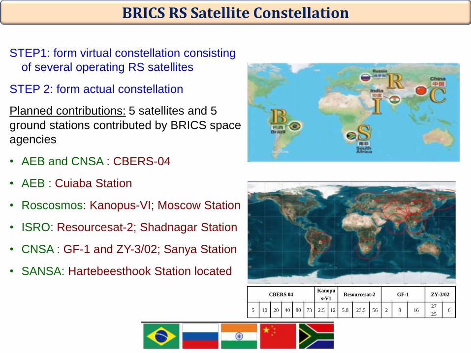
BRICS RS Satellite Constellation
STEP1: form virtual constellation consisting
of several operating RS satellites
STEP 2: form actual constellation
Planned contributions: 5 satellites and 5
ground stations contributed by BRICS space
agencies
• AEB and CNSA : CBERS-04
• AEB : Cuiaba Station
• Roscosmos: Kanopus-VI; Moscow Station
• ISRO: Resourcesat-2; Shadnagar Station
• CNSA : GF-1 and ZY-3/02; Sanya Station
• SANSA: Hartebeesthook Station located
CBERS 04 Kanopu
s-V1 Resourcesat-2 GF-1 ZY-3/02
5 10 20 40 80 73 2.5 12 5.8 23.5 56 2 8 16 2.7
2.5 6
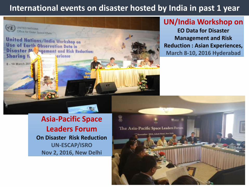
International events on disaster hosted by India in past 1 year
UN/India Workshop on EO Data for Disaster
Management and Risk Reduction : Asian Experiences, March 8-10, 2016 Hyderabad
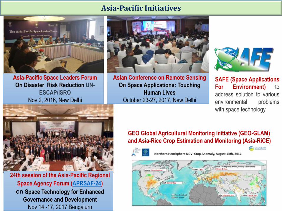
Asia-Pacific Space Leaders Forum
On Disaster Risk Reduction UN-ESCAP/ISRO
Nov 2, 2016, New Delhi
Asia-Pacific Space Leaders Forum
On Disaster Risk Reduction UN-
ESCAP/ISRO
Nov 2, 2016, New Delhi
Asian Conference on Remote Sensing
On Space Applications: Touching
Human Lives
October 23-27, 2017, New Delhi
SAFE (Space Applications
For Environment) to
address solution to various
environmental problems
with space technology
24th session of the Asia-Pacific Regional
Space Agency Forum (APRSAF-24) on Space Technology for Enhanced
Governance and Development
Nov 14 -17, 2017 Bengaluru
GEO Global Agricultural Monitoring initiative (GEO-GLAM)
and Asia-Rice Crop Estimation and Monitoring (Asia-RiCE)
Asia-Pacific Initiatives