Embed Size (px)
Citation preview
Traces of Prehistoric Human Impact on NaturalEnvironment in the Ner River Catchment (Central Poland)
Piotr Kittel, Jacek Błaszczyk, Błażej Muzolf, Łódź,Katarzyna Cywa, Agnieszka Wacnik, Zofia Tomczyńska, Kraków& Milena Obremska, Warszawa
Introduction
In the “Lodz region” (after TURKOWSKA
2006) in Central Poland, in the last fewyears there has been undertaken multi-disciplinary research on environment oftwo prehistoric settlement microregionsdated to the Bronze Age and Early IronAge. The main goal of research has beenthe recognition of traces of human impactto elements of natural environment pre-served in sediments, terrain relief andpalaeobotanical evidences.
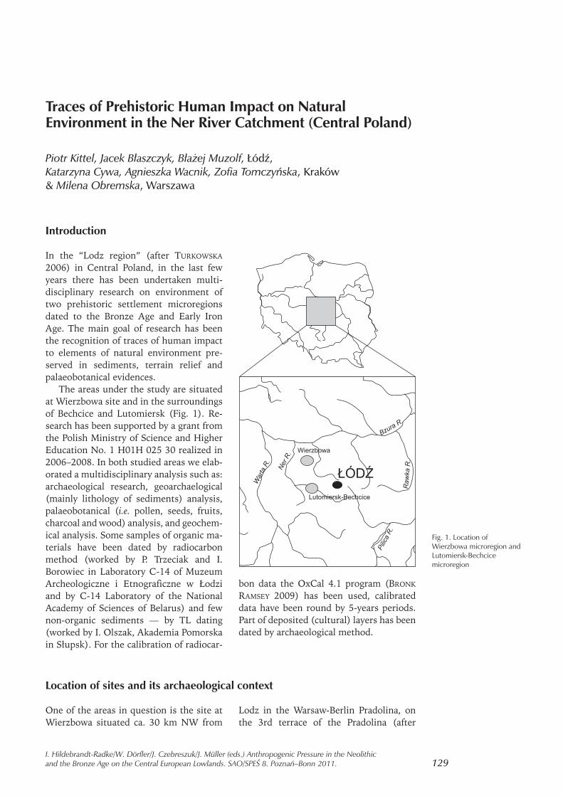
The areas under the study are situatedat Wierzbowa site and in the surroundingsof Bechcice and Lutomiersk (Fig. 1). Re-search has been supported by a grant fromthe Polish Ministry of Science and HigherEducation No. 1 H01H 025 30 realized in2006–2008. In both studied areas we elab-orated a multidisciplinary analysis such as:archaeological research, geoarchaelogical(mainly lithology of sediments) analysis,palaeobotanical (i.e. pollen, seeds, fruits,charcoal and wood) analysis, and geochem-ical analysis. Some samples of organic ma-terials have been dated by radiocarbonmethod (worked by P. Trzeciak and I.Borowiec in Laboratory C-14 of MuzeumArcheologiczne i Etnograficzne w Łodziand by C-14 Laboratory of the NationalAcademy of Sciences of Belarus) and fewnon-organic sediments — by TL dating(worked by I. Olszak, Akademia Pomorskain Słupsk). For the calibration of radiocar-
bon data the OxCal 4.1 program (BRONK
RAMSEY 2009) has been used, calibrateddata have been round by 5-years periods.Part of deposited (cultural) layers has beendated by archaeological method.
Location of sites and its archaeological context
One of the areas in question is the site atWierzbowa situated ca. 30 km NW from
Lodz in the Warsaw-Berlin Pradolina, onthe 3rd terrace of the Pradolina (after
129I. Hildebrandt-Radke/W. Dörfler/J. Czebreszuk/J. Müller (eds.) Anthropogenic Pressure in the Neolithicand the Bronze Age on the Central European Lowlands. SAO/SPEŚ 8. Poznań–Bonn 2011.
Fig. 1. Location ofWierzbowa microregion andLutomiersk-Bechcicemicroregion

KRAJEWSKI 1977A; KRAJEWSKI 1977B). Thesite is located in the Gnida River catch-ment, at the flat surface of plains and in thevalley of upper part of the Gnida River(KLATKOWA 1978; DUTKIEWICZ 1989,DUTKIEWICZ 1992), tributary of the NerRiver (Fig. 2). The surface of the plain is ac-cumulated mainly by morainic and fluvio-glacial sediments. This plain, as fragmentof above-mentioned 3rd terrace of the War-saw-Berlin Pradolina, has been formed inthe periglacial conditions during ColdWarta Stage (KRAJEWSKI 1977A). The mor-phology and geology of elements of theriver valley are due to the theory of Neo-pleistocenic evolution of valleys in the Lodzregion elaborated and described by TUR-
KOWSKA (1988, 1995, 1997, 1999, 2006).At Wierzbowa, it has been discovered
a widespread (ca. 30 ha) complex of prehis-toric sites, including: two cemeteries andrelicts of few settlements of groups of theTrzciniec, Lusatian, Pomeranian and Prze-worsk Cultures societies. During archaeo-
logical excavations undertaken on the largescale, in archaeological settlement complexat Wierzbowa site, have been uncoveredmore than two thousands archaeologicalobjects — i.e.: pits, posts-holes, relicts ofhuts, wells, concentration of hearths,relicts of ovens were uncovered. All exca-vated objects have been dated to the periodsince the Older Bronze Age to the Late Ro-man Period and they are representingrelicts of few phases of prehistoric occupa-tion of that area (unpublished archaeologi-cal research of J. BŁASZCZYK in 1980s–2000s).
Those prehistoric settlements were es-tablished in areas offering a high level ofgeodiversity of environment (a combina-tion of varied geosystems) and diversifiedof environmental zones. The main part ofthe site has been located on the gently in-clined valley slope and terrace accumulatedin the Plenivistulian. The area occupied bythe main part of settlement objects was ac-companying to the Late Vistulian and Ho-
130 P. Kittel, J. Błaszczyk, B. Muzolf, K. Cywa, A. Wacnik, Z. Tomczyńska & M. Obremska
Fig. 2. Geomorphologic mapof Wierzbowa microregion
1 – flat till plain (Wartian);2 – fluvioglacial erosional-
depositional plain (Wartian);3 – river terrace (Plenivistulian);
4 – valley floor (Late Vistulianand Holocene);
5 – dunes and aeolian sands;6 – denudational dry valleys;
7 – undrained depressions;8 – peat lands plains;
9 – location of archaeologicalsites, WIE sites in Wierzbowa
no 1, 2, 3, 4, 5, 6;10 – ranges of archaeological
sites;11 – geological cross-section line
(Fig. 3)
locene valley floor of the Gnida River. Theanalyzed settlements were situated ina very vicinity of swampy flood plains,partly occupied by peat bogs existing atleast as early as in the Atlantic Period.
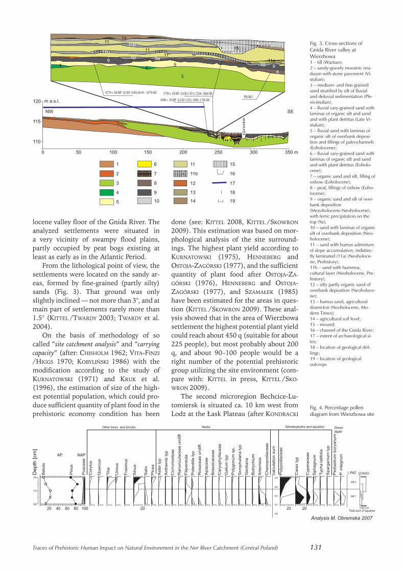
From the lithological point of view, thesettlements were located on the sandy ar-eas, formed by fine-grained (partly silty)sands (Fig. 3). That ground was onlyslightly inclined — not more than 3°, and atmain part of settlements rarely more than1.5° (KITTEL /TWARDY 2003; TWARDY et al.2004).
On the basis of methodology of socalled “site catchment analysis” and “carryingcapacity” (after: CHISHOLM 1962; VITA-FINZI
/HIGGS 1970; KOBYLIŃSKI 1986) with themodification according to the study ofKURNATOWSKI (1971) and KRUK et al.(1996), the estimation of size of the high-est potential population, which could pro-duce sufficient quantity of plant food in theprehistoric economy condition has been
done (see: KITTEL 2008, KITTEL /SKOWRON
2009). This estimation was based on mor-phological analysis of the site surround-ings. The highest plant yield according toKURNATOWSKI (1975), HENNEBERG andOSTOJA-ZAGÓRSKI (1977), and the sufficientquantity of plant food after OSTOJA-ZA-
GÓRSKI (1976), HENNEBERG and OSTOJA-ZAGÓRSKI (1977), and SZAMAŁEK (1985)have been estimated for the areas in ques-tion (KITTEL /SKOWRON 2009). These anal-ysis showed that in the area of Wierzbowasettlement the highest potential plant yieldcould reach about 450 q (suitable for about225 people), but most probably about 200q, and about 90–100 people would be aright number of the potential prehistoricgroup utilizing the site environment (com-pare with: KITTEL in press, KITTEL /SKO-
WRON 2009).The second microregion Bechcice-Lu-
tomiersk is situated ca. 10 km west fromLodz at the Łask Plateau (after KONDRACKI
Traces of Prehistoric Human Impact on Natural Environment in the Ner River Catchment (Central Poland) 131
Fig. 3. Cross-sections ofGnida River valley atWierzbowa1 – till (Wartian);2 – sandy-gravely morainic resi-duum with stone pavement (Vi-stulian);3 – medium- and fine-grainedsand stratified by silt of fluvialand deluvial sedimentation (Ple-nivistulian);4 – fluvial vary-grained sand withlaminas of organic silt and sandand with plant detritus (Late Vi-stulian);5 – fluvial sand with laminas oforganic silt of overbank deposi-tion and fillings of paleochannels(Eoholocene);6 – fluvial vary-grained sand withlaminas of organic silt and sandand with plant detritus (Eoholo-cene);7 – organic sand and silt, filling ofoxbow (Eoholocene);8 – peat, fillings of oxbow (Eoho-locene);9 – organic sand and silt of over-bank deposition(Mezoholocene-Neoholocene),with ferric precipitation on thetop (9a);10 – sand with laminas of organicsilt of overbank deposition (Neo-holocene);11 – sand with humus admixtureof slope accumulation, indistinc-tly laminated (11a) (Neoholoce-ne, Prehistory);11b – sand with hummus,cultural layer (Neoholocene, Pre-history);12 – silty partly organic sand ofoverbank deposition (Neoholoce-ne);13 – humus sand, agriculturaldiamicton (Neoholocene, Mo-dern Times);14 – agricultural soil level;15 – mound;16 – channel of the Gnida River;17 – extent of archaeological si-tes;18 – location of geological dril-lings;19 – location of geologicaloutcrops
Fig. 4. Percentage pollendiagram from Wierzbowa site

2002) and in the Ner River valley nearLutomiersk (tributary of Warta River). Inthis region we have focused our researchon the two archaeological sites and theirenvironment, which are Bechcice and Kolo-nia Bechcice sites. In this part of Ner Rivervalley, a dozen rich and important archaeo-logical sites have been discovered (see:JAŻDŻEWSKI 1951; JAŻDŻEWSKI 1952; ZĄBKIE-
WICZ-KOSZAŃSKA 1953; ZĄBKIEWICZ-KO-
SZAŃSKA 1956; ZĄBKIEWICZ-KOSZAŃSKA
1957; NADOLSKI et al. 1959; KMIECIŃSKI
1959; GARDAWSKI 1959; WIKLAK 1963, WIK-
LAK 1972, WIKLAK 1975; GĄSIOR 1975; KA-
SZEWSKI 1975; JADCZYK 1975; KASZEWSKA
1975; CHMIELOWSKA 1975; ZAWILSKI 1999;CZEPAS /OLĘDZKI 2003, CZEPAS/OLĘDZKI
2007; DZIUBEK /TWARDY 2007)The site at Bechcice discovered in the
1940s (WIKLAK 1963) has been establishedin the Ner River valley on the surface ofhigher fluvioglacial terrace formed bysandy gravelly sediments (Fig. 5). This sur-face is elevated more than seven metersabove the present-day flood plain.
The site at Bechcice is represented bythe relicts of settlement operating in theBronze Age and Early Iron Age. At Bechciceabout 60 objects dated to the prehistoricand the modern times (i.e. graves from 1stWorld War and pits connected with eco-nomic and productive activity of prehis-toric societies of the Lusatian Culture)have been uncovered. Numerous relictswere connected with bronze metallurgy
production — e.g. fragments of castingmoulds of bronze metallurgy, fragments ofbronze raw material and bronze produces(unpublished archaeological research ofB. Muzolf and P. Kittel in 2006). The re-search in the 1950’s reached similar results(WIKLAK 1963; KASZEWSKI 1975).
These results create a possibility to thereconstruction an activity of a bronze met-allurgy workshop on the site area. Relictsof posts represent probably the remains ofthe workshop ground-level constructions.This chronological phase is connected withoccurrence of settlement of the LusatianCulture societies dated to the 4th and 5thBronze Age Periods and probably to theEarly Iron Age (Hallstatt Period).
About 1 km west from site at Bechcicea new settlement at Kolonia Bechcice, site1 has been uncovered in 2007 (unpub-lished archaeological research of B. Muzolfand P. Kittel). In the 1950s and 1960s, therelicts of cemetery dated to the Late RomanPeriod were recognized at this site (KMIE-
CIŃSKI 1959, KASZEWSKA 1975). In 2007–2009 we have found at the site area 80 ar-chaeological objects: numerous pits andposts-holes of the relicts of settlements ofthe Trzciniec and Lusatian Cultures of theBronze Age and the Pomeranian Culturedated to the Early Iron Age. Most of pits arecorrelated with horizon of the Trzciniecand Lusatian Cultures of the 3rd and 4th
Bronze Age Periods. These pits are mainlycylindrical, dipped in the ground at several
132 P. Kittel, J. Błaszczyk, B. Muzolf, K. Cywa, A. Wacnik, Z. Tomczyńska & M. Obremska
Fig. 5. Geomorphologic mapof Ner River valley inLutomiersk-Bechcice
microregion1 – flat till plain (Wartian);
2 – highest terrace (Wartian);3 – high terrace (Plenivistulian);4 – low terrace (Late Vistulian)
and valley floor (Holocene);5 – dunes and eolian sands;
6 – denudational dry valleys;7 – large paleochannels (Late
Vistulian);8 – small paleochannels (Late
Vistulian, Holocene);9 – location of archaeologicalsites, BCH 1 site in Bechcice
no 1, KBH 1 site at KoloniaBechcice no 1;
10 – ranges of archaeologicalsites;
11 – geological cross-section line(Fig. 6);
12 – location of palaeobotanicalprofile

dozen centimeters and connected with ag-ricultural activity — they were used as stor-age-pits. The traces of destroyed cemeteryof the Przeworsk Culture from the Late Ro-man Period have been registered as well(unpublished archaeological research ofB. Muzolf and P. Kittel on 2007–2010).
A geological and geomorphological con-dition of the site location at KoloniaBechcice seems to be very interesting andsignificant (Fig. 5). Surface sediments onthe site are represented mainly by me-dium-grained and fine-grained sands with-out any admixture of organic matter. Thesite has been established on the isolatedfragment of high terrace of Ner River val-ley. Sediments forming terrace have beenaccumulated in the Plenivistulian. This factis documented by TL dating. From a mor-phological point of view fragments of an-cient high terrace were formed in the LateVistulian and that episode must be con-nected with an activity of large paleo-channels in the valley. The terrace rest atBechcice Kolonia site is isolated by paleo-channel in the eastern side and by floodplain with network of small paleochannelsin the southern and western side. East ofthe residual hillock, there occurs large pa-leochannel filled in bottom by gyttja andpeat. The accumulation of the paleo-channel filling was most probably initiatedin the Late Vistulian and it was continuingin the Holocene. It is documented by the
unpublished results of pollen analysisworked by M. Obremska and by 14-C data— 11020 ± 230 BP (IGSB-1381). South ofthe residual hillock, we have recognizedsediments of the Late Vistulian and Holo-cene valley floor with paleochannel fillingsdated to the 9020 ± 80 BP (LOD 1441).
The method of the estimation of thehighest potential population size showsthat in the area of Kolonia Bechcice settle-ments the highest potential plant yieldcould reach even 700 q, most probably —about 330–370 q, and the potential prehis-toric group consisted of about 160–190people.
In the Lutomiersk-Bechcice microre-gion we can observe a fact of a location of“metallurgic” site (or settlement), like atBechcice, on the ground of the Wartianhighest sandy-gravelly fluvioglacial terraceand sites connected mainly with agricul-tural activity, like at Kolonia Bechcice, onthe surface of the Plenivistulian high ter-race or on the isolated fragments of thatterrace (on the residual hillocks). Surfacesediments of the ground of this site are rep-resented mainly by medium-grained andfine-grained sands. The identified residualhillocks of plenivistulian terrace have notbeen recognized before and presented untilnow by geological and geomorphologicalpapers: BALIŃSKI (1992); TURKOWSKA (1988,2006, 2006a); TWARDY (2004, 2008);DZIUBEK and TWARDY (2007).
Lithologic and morphologic traces of the prehistoric human activityat the Wierzbowa site
In archaeological settlement complex atWierzbowa site, during the archaeologicalexcavations, two or, in the other parts ofthe site, three subfossil cultural layers wereuncovered (KITTEL/TWARDY 2003; TWARDY
et al. 2004; KITTEL et al. 2008). The culturallayers were deposited within the slopewash sediments accumulated on the valleyslope, close to the valley floor of the smallstream of the Gnida River (Fig. 3). Thecharacteristics of this slope wash sedi-ments (Fig. 3, sign. 11) seems to be parallelto the so called deluvial sands (TWARDY
2000, TWARDY 2008; see also: STOCHLAK
1978, STOCHLAK 1996, TEISSEYRE 1991,SMOLSKA 2005). Sand of slope cover atWierzbowa are typified by FOLK and WARD
(1957) co-efficients: mean size of grainsbetween 1.75 and 2.00 in Phi (i.e.0.25–0.28 mm), standard deviation —about 0.7–0.8 (i.e. moderately sorted) andskewness about 0 (i.e. symmetrical).About 50–60% of quartz-grain is repre-sented by round mat grains (RM) (afterCAILLEUX 1942, modified by MANIKOWSKA
1993). The characteristic of slope washsediments is very similar to the basic sedi-ments of the valley slope.
The recognized cultural layers havebeen developed within the slope washcover — distinguished by grey-brownishcolor and admixture of charcoal and nu-merous fragments of pottery (Fig. 3, sign.11a). The higher cultural layer (ca. 40–60
Traces of Prehistoric Human Impact on Natural Environment in the Ner River Catchment (Central Poland) 133

cm b.g.l.) has been dated by archaeologicalevidences to the La Tène and Roman Pe-riods, and the lower cultural layer (ca.60–90 cm b.g.l.) have been dated to theBronze Age and the Hallstatt Period. Thebeginning of accumulation of the lowercultural layer and whole slope sedimentscomplex had been estimated on ca. 3500BP (KITTEL /TWARDY 2003). It is docu-mented by archaeological records and byradiocarbon dating of organic silt (Fig. 3,sign. 9) of valley floor covered by describedslope sediments. Radiocarbon dating ofthose organic sediments (3490 ± 50 BPLOD 1182, 1880–1755 BC prob. 68,2%and 3750 ± 50 BP LOD 1451, 2275–2045BC prob. 68,2%) document the beginningof accumulation of whole slope wash sedi-ments complex and the lower cultural layersince ca. 1900–1750 BC. Parallel to the ra-diocarbon dating of the top of organic silt,the beginning time of the accumulation ofslope wash sediments cover has been docu-mented by archaeological factors as well.We discovered a very characteristic frag-ment of pottery of so-called “Lodz Phase”(after GARDAWSKI 1959) dated to the 3rd Pe-riod of the Bronze Age on the surface ofthis organic silt level and covered directlyby slope cover. Pottery of such kind is cor-related with the late horizon of theTrzciniec Culture dated to ca. 1500–1250BC (after MAKAROWICZ 2010). Some ar-chaeological objects of the classic horizonof the Trzciniec Culture have been coveredby described slope deluvial sands as well.
The basic sediments of the organic sandand silt are sands with laminas of organicsilt (Fig. 3, sign. 5) dated by radiocarbondating to 9270 ± 80 BP LOD 1450(8620–8350 BC, prob. 68,2%) and by peat(Fig. 3, sign. 8) dated by pollen analysis tothe Preboreal Period and the beginning ofthe Boreal Period (Fig. 4). In the latePreboreal Period, the accumulation basin(probably oxbow) has been filled by freshwater. This data shows some stabilization ofthe Gnida River fluvial environment in thelong period of the Holocene until prehis-toric human settlement activity in theWierzbowa region was initiated. The or-ganic silt (Fig. 3, sign. 9) represents sedi-ments of the Gnida River valley floor, whichoccur during a long period of the Holoceneuntil ca. 1900–1750 BC. This layer is rich inmacroscopic charcoal particles of Alnus sp.and a few burn fragments of Fraxinus excel-sior L. have been recognised as well (unpub-lished data worked by K. Cywa).
Any factors proving important changesin sedimentation processes of slope washsediments in prehistoric times have notbeen observed. We can state, that the de-scribed slope at Wierzbowa was remainingunder the prehistoric human impact al-most from the Middle (3rd) Bronze Age Pe-riod at least to the Late Roman Period. Si-multaneously, the oldest traces of humanactivity potentially existed on the valleyfloor surface in that time has been coveredby slope sediments under the question veryfast and they might be preserved very well.
Sedimentological and palaeobotanical traces of the prehistoric humanactivity at Bechcice site
On the area of the site at Bechcice the verythick cultural layer has been documented(Fig. 6, sign. 10). It is represented by brownat the top and dark grey at the bottom hu-mus sands with reach admixture of charcoaland numerous fragments of pottery andother artifacts. The thickness of whole layerranges 70 cm. The upper part is the result ofa deposition of colluvial sediments andprobably of earthwork origin as well. Thelower part is most probably connected withan activity of the prehistoric settlementwith bronze metallurgy workshop or work-shops in the (partly) deforested area result-ing from that metallurgic activity. In the
bordering level between sands and gravelsof the site ground and the cultural layer, anincrease of quantity coarse-grain fractionsresulted from an erosional origin of this ho-rizon can be observed.
Bellow the site, in its very close vicinity,a paleochannel of the Ner River or Ner’stributary has been recognized in the area ofthe present-day flood plain (Fig. 6, 7). Thefillings of the paleochannel have been takenunder the geoarchaeological and palaeo-botanical research (KITTEL et al. 2008).
The fillings of paleochannel discoveredin Bechcice have been recognized in thegeologic trench. The beginning of filling of
134 P. Kittel, J. Błaszczyk, B. Muzolf, K. Cywa, A. Wacnik, Z. Tomczyńska & M. Obremska
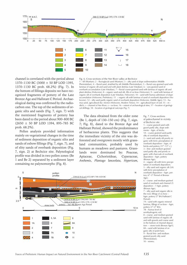
channel is correlated with the period about1370–1130 BC (3000 ± 50 BP LOD 1395,1370–1130 BC prob. 68.2%) (Fig. 7). Inthe bottom of fillings deposits we have rec-ognized fragments of pottery of the LateBronze Age and Hallstatt C Period. Archae-ological dating was confirmed by the radio-carbon one. The top of the sediments of or-ganic silts and sands (Fig. 7, sign. 7) withthe mentioned fragments of pottery hasbeen dated to the period about 900–800 BC(2650 ± 50 BP LOD 1394, 895–785 BCprob. 68.2%).
Pollen analysis provided informationmainly on vegetational changes in the timeof sediment deposition of organic silts andsands of oxbow fillings (Fig. 7, sign. 7), andof slity sands of overbank deposition (Fig.7, sign. 2) at Bechcice site. Palynologicalprofile was divided in two pollen zones (Be1 and Be 2) separated by a sediment layercontaining no palynomorphs (Fig. 8).
The data obtained from the older zone(Be 1, depth of 130–150 cm) (Fig. 7, sign.7; Fig. 8), dated to the Bronze Age andHallstatt Period, showed the predominanceof herbaceous plants. This suggests thatthe immediate vicinity of the site was de-forested and overgrown mostly with grass-land communities, probably used byhumans as meadows and pastures. Grass-lands were dominated by: Poaceae,Apiaceae, Cichorioideae, Cyperaceae,Anthemis, Plantago lanceolata, Hypericum,
Traces of Prehistoric Human Impact on Natural Environment in the Ner River Catchment (Central Poland) 135
Fig. 7. Cross-sectionsof paleochannel in vicinityof Bechcice site1 – coarse grained sand withgravel partly silty, slope sedi-ments – frgm. of bricks;1A – coarse grained sand partlysilty of overbank deposition;2 – sand and sandy silt poorly or-ganic with ferric precipitation ofoverbank deposition – frgm. ofbricks and pottery (11th–13th c.);3 – fine- and medium grainedsand partly silty and poorly or-ganic with charcoals of overbankdeposition – frgm. pottery(Bronze Age);4 – organic silt with ferric precipi-tation of overbank deposition;5 – silty sand and organic silt (5A)with ferric precipitation ofoverbank deposition – frgm. pot-tery (4th–5th Period of BronzeAge);6 – coarse- and medium grainedsand of overbank and channel (?)deposition – 1 frgm. pottery(Bronze Age);7 – silty sand and organic silts inthe roof, fillings of ox-bow –frgm. pottery (5th BA/Hallstatt CPeriod);7A – sand with organic-minerallaminas, fillings of ox-bow – frgm.pottery (3rd–4th BA);7B – humus level ofsemihydrogenic soil;8 – coarse- and medium grainedsand with laminas of organic siltand with gravels and coarse sandin the bottom of channel deposi-tion — stone tools (Bronze Age?);8A – sand with laminas of or-ganic silts of point bars;9 – fluvial fine- and mediumgrained poorly silty sand(Plenivistulian);10 – stones;
Fig. 6. Cross-sections of the Ner River valley at Bechcice1 – till (Wartian); 2 – fluvioglacial sand (Wartian); 3 – silty sand of slope sedimentation (MiddlePlenivistulian); 4 – fluvial sand, stratified by silt (Middle Plenivistulian); 5 – fluvial vary-grained sand withlaminas of organic silt and sand and with plant detritus (Late Vistulian); 6 – vary-grained sand ofoverbank accumulation (Late Vistulian); 7 – fluvial coarse-grained sand with laminas of organic silt andplant detritus (Holocene); 8 – organic sand and silt, fills of ox-bow (Holocene); 9 – sand with laminas oforganic silt of overbank deposition (Late Vistulian, Holocene); 10 – sand with humus admixture of slopeaccumulation (Holocene, Prehistory); 11 – organic silt with laminas of sand of overbank deposition (Ho-locene); 12 – silty sand partly organic sand of overbank deposition (Holocene, Middle Ages); 13 – hu-mus sand, agricultural dia- micton (Holocene, Modern Times); 14 – agricultural layer of soil; 15 – m –ditch, r – channel of Ner River, s – ox-bow; 16 – extent of archaeological sites; 17 – location of geologi-cal drillings; 18 – location of geological outcrops (Fig. 7)
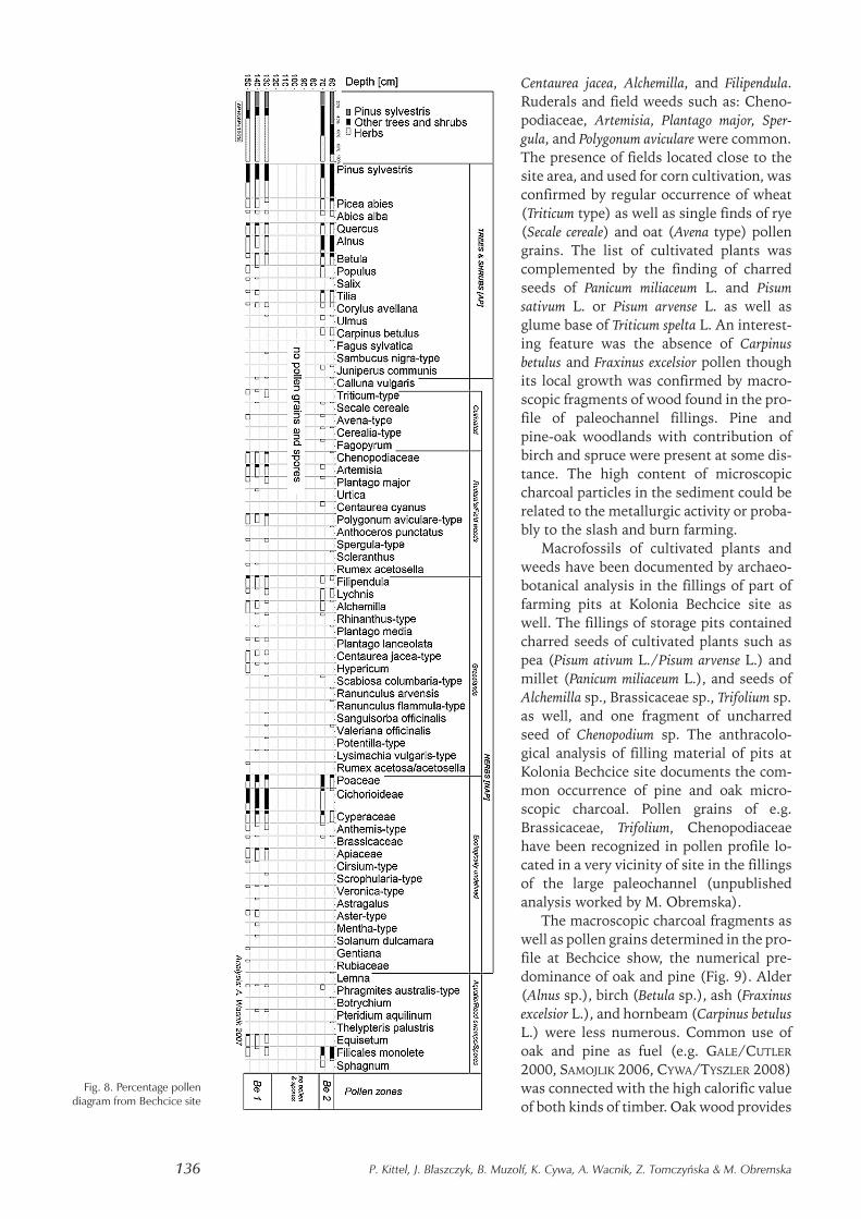
Centaurea jacea, Alchemilla, and Filipendula.Ruderals and field weeds such as: Cheno-podiaceae, Artemisia, Plantago major, Sper-gula, and Polygonum aviculare were common.The presence of fields located close to thesite area, and used for corn cultivation, wasconfirmed by regular occurrence of wheat(Triticum type) as well as single finds of rye(Secale cereale) and oat (Avena type) pollengrains. The list of cultivated plants wascomplemented by the finding of charredseeds of Panicum miliaceum L. and Pisumsativum L. or Pisum arvense L. as well asglume base of Triticum spelta L. An interest-ing feature was the absence of Carpinusbetulus and Fraxinus excelsior pollen thoughits local growth was confirmed by macro-scopic fragments of wood found in the pro-file of paleochannel fillings. Pine andpine-oak woodlands with contribution ofbirch and spruce were present at some dis-tance. The high content of microscopiccharcoal particles in the sediment could berelated to the metallurgic activity or proba-bly to the slash and burn farming.
Macrofossils of cultivated plants andweeds have been documented by archaeo-botanical analysis in the fillings of part offarming pits at Kolonia Bechcice site aswell. The fillings of storage pits containedcharred seeds of cultivated plants such aspea (Pisum ativum L./Pisum arvense L.) andmillet (Panicum miliaceum L.), and seeds ofAlchemilla sp., Brassicaceae sp., Trifolium sp.as well, and one fragment of uncharredseed of Chenopodium sp. The anthracolo-gical analysis of filling material of pits atKolonia Bechcice site documents the com-mon occurrence of pine and oak micro-scopic charcoal. Pollen grains of e.g.Brassicaceae, Trifolium, Chenopodiaceaehave been recognized in pollen profile lo-cated in a very vicinity of site in the fillingsof the large paleochannel (unpublishedanalysis worked by M. Obremska).
The macroscopic charcoal fragments aswell as pollen grains determined in the pro-file at Bechcice show, the numerical pre-dominance of oak and pine (Fig. 9). Alder(Alnus sp.), birch (Betula sp.), ash (Fraxinusexcelsior L.), and hornbeam (Carpinus betulusL.) were less numerous. Common use ofoak and pine as fuel (e.g. GALE/CUTLER
2000, SAMOJLIK 2006, CYWA/TYSZLER 2008)was connected with the high calorific valueof both kinds of timber. Oak wood provides
136 P. Kittel, J. Błaszczyk, B. Muzolf, K. Cywa, A. Wacnik, Z. Tomczyńska & M. Obremska
Fig. 8. Percentage pollendiagram from Bechcice site
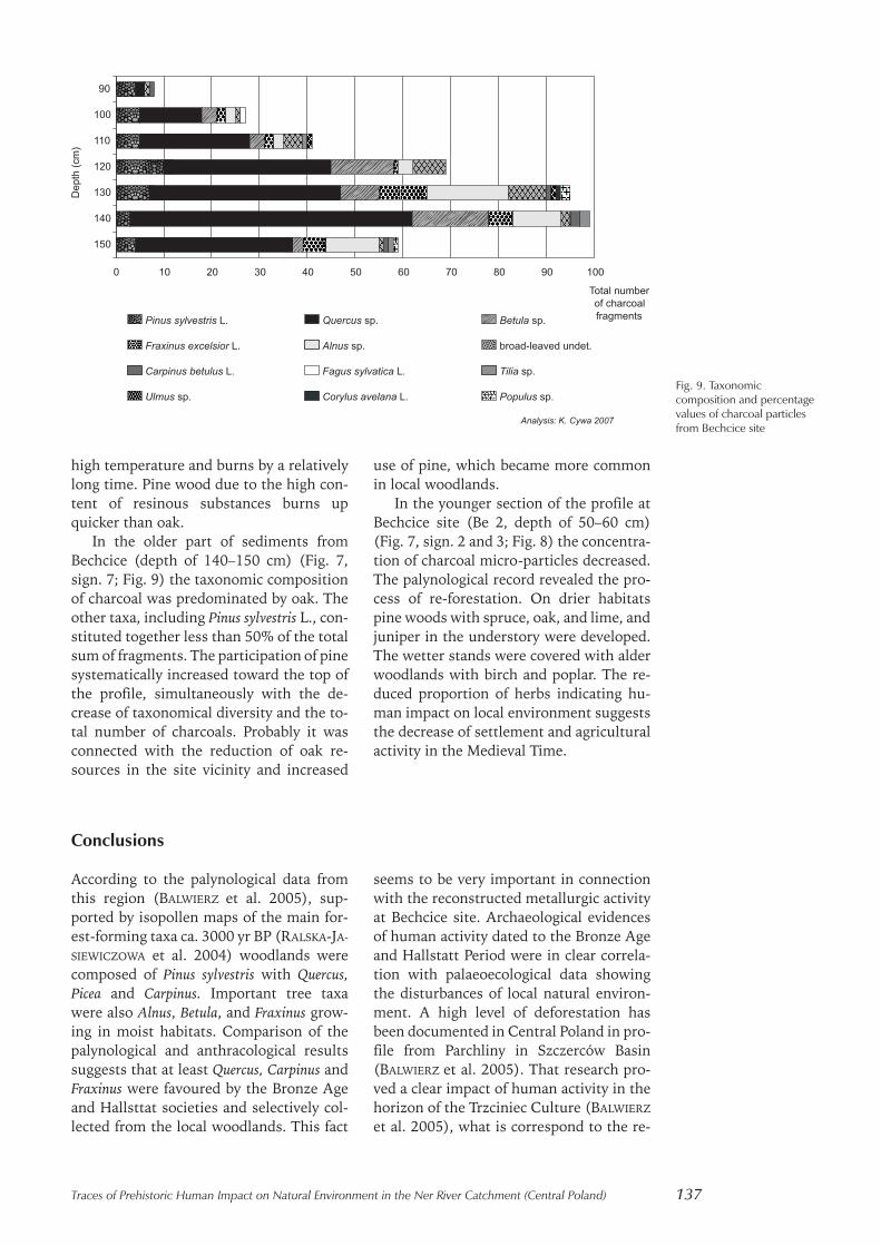
high temperature and burns by a relativelylong time. Pine wood due to the high con-tent of resinous substances burns upquicker than oak.
In the older part of sediments fromBechcice (depth of 140–150 cm) (Fig. 7,sign. 7; Fig. 9) the taxonomic compositionof charcoal was predominated by oak. Theother taxa, including Pinus sylvestris L., con-stituted together less than 50% of the totalsum of fragments. The participation of pinesystematically increased toward the top ofthe profile, simultaneously with the de-crease of taxonomical diversity and the to-tal number of charcoals. Probably it wasconnected with the reduction of oak re-sources in the site vicinity and increased
use of pine, which became more commonin local woodlands.
In the younger section of the profile atBechcice site (Be 2, depth of 50–60 cm)(Fig. 7, sign. 2 and 3; Fig. 8) the concentra-tion of charcoal micro-particles decreased.The palynological record revealed the pro-cess of re-forestation. On drier habitatspine woods with spruce, oak, and lime, andjuniper in the understory were developed.The wetter stands were covered with alderwoodlands with birch and poplar. The re-duced proportion of herbs indicating hu-man impact on local environment suggeststhe decrease of settlement and agriculturalactivity in the Medieval Time.
Conclusions
According to the palynological data fromthis region (BALWIERZ et al. 2005), sup-ported by isopollen maps of the main for-est-forming taxa ca. 3000 yr BP (RALSKA-JA-
SIEWICZOWA et al. 2004) woodlands werecomposed of Pinus sylvestris with Quercus,Picea and Carpinus. Important tree taxawere also Alnus, Betula, and Fraxinus grow-ing in moist habitats. Comparison of thepalynological and anthracological resultssuggests that at least Quercus, Carpinus andFraxinus were favoured by the Bronze Ageand Hallsttat societies and selectively col-lected from the local woodlands. This fact
seems to be very important in connectionwith the reconstructed metallurgic activityat Bechcice site. Archaeological evidencesof human activity dated to the Bronze Ageand Hallstatt Period were in clear correla-tion with palaeoecological data showingthe disturbances of local natural environ-ment. A high level of deforestation hasbeen documented in Central Poland in pro-file from Parchliny in Szczerców Basin(BALWIERZ et al. 2005). That research pro-ved a clear impact of human activity in thehorizon of the Trzciniec Culture (BALWIERZ
et al. 2005), what is correspond to the re-
Traces of Prehistoric Human Impact on Natural Environment in the Ner River Catchment (Central Poland) 137
Fig. 9. Taxonomiccomposition and percentagevalues of charcoal particlesfrom Bechcice site

sults of our research and to the reconstruc-tions of the Trzciniec Culture economy(see: MAKAROWICZ /MILECKA 1999; MAKA-
ROWICZ 2010; GÓRSKI et al. 2011).The fossil plant remains found at Bech-
cice site revealed the clearance of localwoodlands, dominance of grasslands, andexistence of farmland used for corn andpulses cultivation in that time period.Charcoal and wood particles found in sedi-ments were determined mostly as oak andpine. Birch, alder, ash and other taxa wereless represented.
In the area of both presented micro-regions some geomorphologic and geologicevidences of human impact on slope envi-ronment and on fluvial environment havebeen documented. The thick cultural layeron the area of intensive productive activityand very thick slope sediments on the areaof long-operating prehistoric settlementshave been recovered. Evidence of slope ac-cumulation on other sites in Lutomierskregion has been registered as well(GARDAWSKI 1959; WIKLAK 1963; GĄSIOR
1975; ZAWILSKI 1999; CZEPAS /OLĘDZKI
2003; CZEPAS /OLĘDZKI 2007: DZIUBEK /TWARDY 2007; TWARDY 2008, unpublishedKittel’s materials). The activity of slopeprocesses could be connected and partly ac-tivated by decrease of plant cover density.
It seems to be very important to under-line the fact of the location of settlementsconnected with farming activity (e.g.:Wierzbowa, Kolonia Bechcice) on theground formed by fine-grained sediments— mainly by sands and silty sands. And onthe other hand, the settlements connectedwith productive activity (Bechcice) havebeen established on the ground formed bycoarser sediments — mainly gravelly sand— and characterized by a higher groundwater table.
Presented evidence of human activityand human impact on environment ele-ments is one of the oldest in the Lodz re-gion traces documented by geoarchaeo-logical research (compare TWARDY et al.2004; TWARDY 2008; TWARDY /FORYSIAK
2011). Simultaneously registered by pa-laeobotanical studies micro- and macro-fossils of cultivated plants and weeds docu-mented the agricultural activity and theintensive human impact on natural plantcover as early as in the Bronze Age. Thearchaeobotanical research related to thisperiod of prehistory is very rare in this re-gion of Central Poland (WASYLIKOWA et al.2003; BALWIERZ et al. 2005) and should becontinued.
References
BALIŃSKI W. 1992, Szczegółowa Mapa Geo-logiczna Polski arkusz Lutomiersk, PIGWarszawa.
BALWIERZ Z./MAROSIK P./MUZOLF B./PAPIER-
NIK P./SICIŃSKI W. 2005, Osadnictwospołeczeństw rolniczych i zmiany środo-wiska naturalnego nad środkową Kra-sówką (Kotlina Szczercowska). Wstępnacharakterystyka. (Settlement by agricul-ture communities and changes in the na-tural environment in the middle Kra-sówka river valley (Szczerców Basin).Preliminary characteristics. In: WASYLI-
KOWA K./LITYŃSKA-ZAJĄC M./BIENIEK A.(eds.): Roślinne ślady człowieka. Botani-cal Guidebooks 28: 53–86.
BRONK RAMSEY C. 2009, Bayesian analysis ofradiocarbon dates, Radiocarbon, 51(1):337–360.
CAILLEUX A. 1942, Les actions eoliennesperiglaciares en Europe,Mem. Soc. Geol.de France, 46.
CHISHOLM M. 1962. Rural Settlement and LandUse. Chicago.
CHMIELOWSKA A. 1975, Osadnictwo w Polsceśrodkowej w okresie od połowy X do połowyXIII w., Prace i Materiały Muzeum Archeolo-gicznego i Etnograficznego w Łodzi, Seria Ar-cheologiczna, 22: 331–371.
CYWA K./TYSZLER L. 2008, The use of woodby the population of the Przeworsk andLusatian cultures based on charcoalanalysis from Konopnica (Central Po-land). In: DAMBLON F./COURT-PICON M.(ed.) 4th International Meeting ofAnthracology, Charcoal andmicrocharcoal: Continental and marinerecords, Brussels, 8–13.09.2008.Programme and abstracts: 54.
138 P. Kittel, J. Błaszczyk, B. Muzolf, K. Cywa, A. Wacnik, Z. Tomczyńska & M. Obremska
CZEPAS P./OLĘDZKI M. 2003, Wyniki badańratowniczych na osadzie ludności kultu-ry trzcinieckiej w Lutomiersku, woj.łódzkie na stanowisku Wrząca-Parcela 1,Łódzkie Sprawozdania Archeologiczne, 8:63–72.
CZEPAS P./OLĘDZKI M. 2007. Osada ludnościkultury trzcinieckiej w Lutomiersku, Woje-wództwo Łódzkie odkryta na stanowiskuWrząca-Parcela 1, Prace i Materiały Mu-zeum Archeologicznego i Etnograficzne-go w Łodzi, Seria Archeologiczna, 43(2004–2007): 63–72.
DUTKIEWICZ L. 1989, Szczegółowa MapaGeologiczna Polski w skali 1:50 000, ar-kusz Parzęczew (589). Państwowy Insty-tut Geologiczny, Warszawa.
DUTKIEWICZ L. 1992, Objaśnienia do Szcze-gółowej Mapy Geologicznej Polski wskali 1:50 000, arkusz Parzęczew (589).Państwowy Instytut Geologiczny, War-szawa.
DZIUBEK E./TWARDY J. 2007, Transformacjarzeźby wysokiego poziomu dolinnegoNeru wskutek wielowiekowego zasie-dlenia i gospodarki w świetle wykopali-skowych badań archeologicznych na sta-nowisku 21 w Lutomiersku iWrzącej-Parceli 1, In: SMOLSKA E./SZWARCZEWSKI P. (eds.): Zapis działalno-ści człowieka w środowisku przyrodni-czym, t. III, Warszawa: 31–37.
FOLK R./WARD W. 1957, Brazos River bar: astudy in the significance of grain size pa-rameters, Journal of Sedimentary Petrology,27, 1: 3–26.
GALE R./CUTLER D. 2000, Plants in archaeol-ogy: identification manual of vegetative plantmaterials used in Europe and the SouthernMediterranean to c.1500. Otley: WestburyPublishing and the Royal Botanic Gar-dens, Kew.
GARDAWSKI A. 1959, Plemiona kulturytrzcinieckiej w Polsce, Materiały Staro-żytne, 5: 7–189.
GĄSIOR I. 1975, Kultura trzciniecka na ob-szarze Polski Środkowej, Prace i Mate-riały Muzeum Archeologicznego i Etnogra-ficznego w Łodzi, Seria Archeologiczna, 22:101–121.
GÓRSKI J./WAWRUSIEWICZ A./MAKAROWICZ
P. 2011, Osady i cmentarzyska trzcinieckie-go kręgu kulturowego w Polesiu, woj. łódz-kie, stan. 1, Łódź.
HENNEBERG M./OSTOJA-ZAGÓRSKI J. 1977,Próba rekonstrukcji gospodarki miesz-
kańców halsztackich grodów typu bi-skupińskiego, Kwartalnik Historii KulturyMaterialnej, R. 25, 3: 319–340.
JADCZYK I. 1975, Kultura wschodniopomor-ska i kultura grobów kloszowych w Pol-sce Środkowej, Prace i Materiały MuzeumArcheologicznego i Etnograficznego w Łodzi,Seria Archeologiczna, 22: 167–194.
JAŻDŻEWSKI K. 1951, Cmentarzysko wczesno-średniowieczne w Lutomiersku pod Łodzią wświetle badań z r. 1949, Materiały Wcze-snośredniowieczne, t. I: 91–191.
JAŻDŻEWSKI K. 1952, Sprawozdanie z badańarcheologicznych na cmentarzyskuwczesnośredniowiecznym w Lutomier-sku w pow. łaskim (woj. łódzkie) w r.1950, Materiały Wczesnośredniowiecz-ne, t. II: 257–264.
KASZEWSKA E. 1975, Kultura przeworska wPolsce Środkowej, Prace i Materiały Mu-zeum Archeologicznego i Etnograficznego wŁodzi, Seria Archeologiczna, Nr 22:194–252.
KASZEWSKI Z. 1975, Kultura łużycka w Pol-sce środkowej. Prace i Materiały MuzeumArcheologicznego i Etnograficznego w Łodzi,Seria Archeologiczna, 22: 123–166.
KITTEL P. 2008, Geomorfologiczne cechy lo-kalizacji osadnictwa pradziejowego wmikroregionie leśnieńskim, In: WALEN-
TA K. (ed.): Leśno i mikroregion w póź-nej epoce brązu i wczesnej epoce żelaza,Zakład Archeologii Pomorza InstytutuArcheologii Uniwersytetu Łódzkiego,Muzeum Historyczno-Etnograficzne wChojnicach, Chojnice: 197–224.
KITTEL P. (in press), Geomorfologiczneuwarunkowania lokalizacji osadnictwaw rejonie stanowisk archeologicznychw Rawie Mazowieckiej. Kairos. Pracearcheologiczne Przedsiębiorstwa Ar-cheologiczno-Konserwatorskiego Ka-iros – Plus, t. 1.
KITTEL P./SKOWRON J. 2009, Geomorfolo-giczne uwarunkowania lokalizacji i roz-woju osadnictwa w rejonie Rawy Mazo-wieckiej (Polska środkowa) w okresierzymskim, Środowisko — Człowiek —Cywilizacja, tom 2: 147–154.
KITTEL P./TWARDY J. 2003, Wpływ pradzie-jowej aktywności ludzkiej na funkcjo-nowanie stoku w Wierzbowej (pradoli-na warszawsko-berlińska), In: WAGA J./KOCEL K. (eds.): Człowiek w środowi-sku przyrodniczym — zapis działalno-ści, Sosnowiec: 68–73.
Traces of Prehistoric Human Impact on Natural Environment in the Ner River Catchment (Central Poland) 139
KITTEL P./FORYSIAK J./BŁASZCZYK J./CYWA
K./WACNIK A./TOMCZYŃSKA Z./MUZOLF
B./OBREMSKA M. 2008, Przykłady od-działywań społeczności pradziejowychna środowisko naturalne w rejonie Be-chcic i Wierzbowej (Polska Środkowa),Landform Analysis, Vol. 9, 289–292.
KLATKOWA H. 1978, (1980), Mapa Geolo-giczna Polski 1:200 000, A — MapaUtworów Powierzchniowych (Mapapodstawowa 1:50 000), arkusz Parzę-czew (589). PIG, Warszawa.
KMIECIŃSKI J. 1959, Kurhan z późnego okre-su rzymskiego w miejscowości Bechci-ce-Biłgoraj, pow. Łask, Wiadomości Ar-cheologiczne, 24, s. 60–61.
KOBYLIŃSK Z. 1986, Koncepcja „terytoriumeksploatowanego przez osadę” w arche-ologii brytyjskiej i jej implikacje badaw-cze, Archeologia Polski, 31, z. 1, 7–30.
KONDRACKI J. 2002. Geografia regionalna Pol-ski, PWN, Warszawa.
KRAJEWSKI K. 1977A, Poziomy terasowe wpradolinie Warszawsko-Berlińskiejmiędzy Wartą a Wzgórzami Domanie-wickimi. Acta Univ. Lodz., Zesz. Nauk.UŁ, Nauki Mat.-Przyr., ser. II, 5, Łódź:99–108.
KRAJEWSKI K. 1977B, Późnoplejstoceńskie iholoceńskie procesy wydmotwórcze wpradolinie Warszawsko-Berlińskiej wwidłach Warty i Neru. Acta GeographicaLodziensia, 39, ŁTN, Łódź, 87 ss.
KRUK J./MILISAUSKAS S./ALEXANDROWICZ S./ŚNIESZKO Z. 1996, Osadnictwo i zmianyśrodowiska naturalnego wyżyn lessowych,Instytut Archeologii i Etnologii PAN,Kraków.
KURNATOWSKI S. 1971, Rozwój zaludnieniaWielkopolski we wczesnym średnio-wieczu i jego aspekty gospodarcze, Ar-cheologia Polski, 16: 465–482.
KURNATOWSKI S. 1975, Wczesnośrednio-wieczny przełom gospodarczy w Wiel-kopolsce oraz jego konsekwencje krajo-brazowe i demograficzne, ArcheologiaPolski, 20: 145–160.
MAKAROWICZ P. 2010, Trzciniecki krąg kul-turowy — wspólnota pograniczaWschodu i Zachodu Europy. Archaeolo-gia Bimaris Monografie, t. 3.
MAKAROWICZ P./MILECKA K. 1999. Societyand the Environment. A Case of EarlyBronze Age Settlements Complex fromRybiny, Cuiavia, Poland, ArchaeologiaPolona, vol. 37: 49–70.
MANIKOWSKA B. 1993, Mineralogy and abra-sion of sand grains due to Vistula (late Pleis-tocene) aeolian processes in Central Poland,Geologie en Mijnbouw, 72.
NADOLSKI A./ABRAMOWICZ A./POKLEWSKI
T. 1959, Cmentarzysko z XI w. w Lutomier-sku pod Łodzią, Łódź.
OSTOJA-ZAGÓRSKI J. 1976, Ze studiów nadzagadnieniem upadku grodów kulturyłużyckiej. Slavia Antiqua, 23: 39–73.
RALSKA-JASIEWICZOWA M./LATAŁOWA M./WASYLIKOWA K./TOBOLSKI K./MADEYSKA M./WRIGHT H.E./TURNER
CH. 2004, Late Glacial and Holocene his-tory of vegetation in Poland based onisopollen maps. W. Szafer Institute ofBotany, Polish Academy of Sciences,Kraków.
SAMOJLIK T. 2006, Najsłuszniejsze drzewo— historia sosny zwyczajnej (Pinus sy-lvestris L.) w Puszczy Białowieskiej dokońca XVIII stulecia. Rocznik Dendrolo-giczny. Vol. 54: 7–27.
SMOLSKA E. 2005, Znaczenie spłukiwania wmodelowaniu stoków młodoglacjalnych (naprzykładzie Pojezierza Suwalskiego).WGiSR UW, Warszawa.
STOCHLAK J. 1978, Struktury i teksturymłodoplejstoceńskich osadów delu-wialnych. Biuletyn Instytutu Geologii,306, IG, Warszawa: 115–174.
STOCHLAK J. 1996, Osady deluwialne nie-odłączny efekt procesu spłukiwania ipropozycja ich podziału. In: A. JÓZEFA-
CIUK (ed.): Ogólnopolskie SympozjumNaukowe „Ochrona agroekosystemówzagrożonych erozją”. Prace naukowecz. 2, Puławy: 111–132.
SZAMAŁEK K. 1985, Przemiany środowiskageograficznego w rejonie Kruszwicy naprzełomie epoki brązu i wczesnej epokiżelaza oraz ich wpływ na osadnictwo,Archeologia Polski, 29: 329–366.
TEISSEYRE A. 1991, The Deluvial (Slope-wash) System: A Proposal. Bulletin ofthe Polish Academy of Sciences, Earth Sci-ences, 39, 4, PAN, Warszawa: 381–388.
TURKOWSKA (KUYDOWICZ) K. 1975, Rzeczneprocesy peryglacjalne na tle morfogenezy do-liny Mrogi. Acta Geographica Lodziensia,36, ŁTN, Łódź, 122 ss.
TURKOWSKA K. 1988, Rozwój dolin rzecznychna Wyżynie Łódzkiej w późnym czwartorzę-dzie, Acta Geogr. Lodz., 57, ŁTN, Łódź,157 ss.
140 P. Kittel, J. Błaszczyk, B. Muzolf, K. Cywa, A. Wacnik, Z. Tomczyńska & M. Obremska
TURKOWSKA K. 1995, Recognation of val-leys evolution during the Pleisto-cene-Holocene transitions in non-glaci-ated region of Polish Lowland. BiuletynPeryglacjalny, 34, 209–227.
TURKOWSKA K. 1997, Stan wiedzy na tematrozwoju dolin ekstraglacjalnych na NiżuPolskim w okresie przejściowym plejsto-cen-holocen, Acta Universitatis Lodziensis,Folia Geographica Physica, 1: 67–87.
TURKOWSKA K. 1999, Kryteria oceny rolimorfogenezy peryglacjalnej w Polsceśrodkowej, Acta Geographica Lodziensia,76: 101–132.
TURKOWSKA K. 2006, Geomorfologia regionułódzkiego, Wydawnictwo UniwersytetuŁódzkiego, Łódź.
TURKOWSKA K. 2006A. Mapa Geomorfolo-giczna Regionu Łódzkiego, Łódź.
TWARDY J. 2000, Deluwia neoholoceńskie— przykłady z Wyżyny Łódzkiej, ActaGeogr. Lodz., 78, ŁTN, Łódź: 135–173.
TWARDY J. 2004, Odzwierciedlenie dyna-miki podłoża mezozoicznego w morfo-logii i budowie geologicznej dolinyNeru w okolicach Lutmierska (Wyso-czyzna Łaska), Prace Instytutu GeografiiAŚ w Kielcach, 13: 107–124.
TWARDY J. 2008, Transformacja rzeźby cen-tralnej części Polski środkowej w warunkachantropopresji. WUŁ, Łódź.
TWARDY J./FORYSIAK J. 2011, Charaktery-styka środowiska geograficznego oko-lic stanowiska archeologicznego Pole-sie 1 oraz neoholoceńskie zmiany jegobudowy geologicznej i rzeźby, In: GÓR-
SKI J./MAKAROWICZ P./WAWRUSIEWICZ
A. (eds.): Osady i cmentarzyska społeczno-ści trzcinieckiego kręgu kulturowego w Pole-siu, stanowisko 1, woj. łódzkie, Tom I.Tekst, Łódź: 227–250.
TWARDY J./FORYSIAK J./KITTEL P. 2004, Dy-namika procesów morfogenetycznychuruchomionych i zintensyfikowanychwskutek pradziejowej działalnościludzkiej w pradolinie warszawsko-ber-lińskiej, Acta Geographica Lodziensia, Nr88, Środowisko naturalne dorzecza
Warty i jego pradziejowa eksploatacja,85–117.
VITA-FINZI C./HIGGS E. 1970, PrehistoricEconomy in the Mount Carmel Area ofPalestine: Site Catchment Analysis,Proceedings of the Prehistory Society, t. 36:1–37.
WASYLIKOWA K.,/TOMCZYŃSKA Z.,/POLCYN
M.,/BIENIEK A. 2003, Użytkowanie roślinprzez ludność osady kultury łużyckiej, In:Ratownicze badania archeologiczne nastanowisku 6-7 w Kowalewicach, pow.Zgierz, woj. łódzkie, Via ArchaeologicaLodziensis, T. I, Łódź: 339–359.
WIKLAK H. 1963, Początki kultury łużyc-kiej w Polsce środkowej. Acta Archaeolo-gica Lodziensis, nr 12.
WIKLAK H. 1972, Późniejsze stadia rozwo-jowe środkowopolskiej grupy kulturyłużyckiej. Prace i Materiały Muzeum Ar-cheologicznego i Etnograficznego w Łodzi,Seria Archeologiczna, 19: 15–172.
WIKLAK H. 1975, Neolit w Polsce Środko-wej, Prace i Materiały Muzeum Archeolo-gicznego i Etnograficznego w Łodzi, SeriaArcheologiczna, Nr 22: 67–100.
ZAWILSKI P. 1999, Badania archeologicznena stanowiskach Lutomiersk-Koziówki3D oraz Wrząca-Parcela 1, gm. Luto-miersk, woj. łódzkie, przeprowadzonew 1999 r., Łódzkie Sprawozdania Arche-ologiczne, t. V: 103–116.
ZĄBKIEWICZ-KOSZAŃSKA A. 1953, Przyczyn-ki do poznania wielkiej Łodzi i powiatułódzkiego, Przegląd Archeologiczny, t. 9:296–308.
ZĄBKIEWICZ-KOSZAŃSKA A. 1956, Materiałyz cmentarzyska kultury łużyckiej w Lu-tomiersku-Wrzącej, pow. Łask. Część I(1940 r.), Prace i Materiały Muzeum Arche-ologicznego i Etnograficznego w Łodzi, SeriaArcheologiczna, 1: 51–60.
ZĄBKIEWICZ-KOSZAŃSKA A. 1957, Materiałyz cmentarzyska kultury łużyckiej w Lu-tomiersku-Wrzącej, pow. Łask. Część II(Dokończenie), Prace i Materiały MuzeumArcheologicznego i Etnograficznego w Łodzi,Seria Archeologiczna, 2: 13–25.
Traces of Prehistoric Human Impact on Natural Environment in the Ner River Catchment (Central Poland) 141


