Embed Size (px)
Citation preview
Review of Palaeobotany and Palynology 109 (2000) 205–218www.elsevier.nl/locate/revpalbo
Pollen diagrams and prehistoric fields: the case of Bronze AgeHaarlem, the Netherlands
C.C. Bakels *Faculty of Archaeology, Leiden University, P.O.Box 9515, 2300 RA Leiden, The Netherlands
Received 18 May 1999; accepted for publication 1 October 1999
Abstract
The excavation of a Bronze Age field surrounded by peat in the vicinity of the Dutch town of Haarlem affordeda good opportunity to study the pollen rain released by such prehistoric fields. Pollen analysis of a core obtainedfrom a peat deposit at a distance of 10 m from the field’s border revealed only a weak signal of a possible field. Theconclusion is that the presence of prehistoric fields is difficult to detect by means of pollen analysis alone. © 2000Elsevier Science B.V. All rights reserved.
Keywords: Bronze Age field; Holocene; Netherlands; pollen rain
1. Introduction released by the crops and weeds that becamepreserved in suitable sediments.
With the onset of agriculture people began to The relationship between a field and the pollencultivate plots of land, on a permanent or tempo- rain is the subject of the present paper. It is a well-rary basis, as gardens or as true fields. Such plots known fact that many food plants do not releaseultimately became integral aspects of the land- great quantities of pollen into the air. Some crops,scape. Some of the prehistoric plots are still recog- such as onions and cabbage, are harvested beforenisable in the present-day landscape, such as the they flower, others are pollinated by insects or are‘Celtic’ fields of northwestern Europe. In a few even autogamous. Even cereals, belonging to thevery rare cases old fields became buried beneath family of Gramineae which are generally goodyounger sediments. Although they are difficult to pollen shedders, do not always produce muchdetect, they are sometimes found and can then be airborne pollen. Indeed, the pollen of most of theexcavated just like prehistoric settlements. But Old World cereals, especially the wheats and bar-most fields have disappeared, as they have been leys grown in prehistoric times, remains trappedobliterated by subsequent land use, and the only between the glumes and is released only duringevidence of their former existence are the remains threshing (Robinson and Hubbard, 1977;of their products found in settlements or the pollen Willerding, 1986). A minor proportion falls
directly onto the field and only a very smallfraction is liberated into the wider pollen rain(Heim, 1970; Diot, 1992). Most field weeds pro-* Fax: +31-71-5272429.
E-mail address: [email protected] (C.C. Bakels) duce pollen which belongs to types produced, too,
0034-6667/00/$ - see front matter © 2000 Elsevier Science B.V. All rights reserved.PII: S0034-6667 ( 99 ) 00055-X
206 C.C. Bakels / Review of Palaeobotany and Palynology 109 (2000) 205–218
by the native flora. An interesting question, there- oldest coastal barriers became sandy ridges in thehinterland. The younger coastal formations ham-fore, is whether it is possible to locate prehistoric
fields via their pollen rains preserved in nearby pered the drainage of the hinterland, which conse-quently evolved into a freshwater marsh in whichpeat deposits.
Much work has been devoted to the correlation peat deposits were formed.During the Bronze Age the ridge with the fieldof pollen records with systems of land use [see, for
instance, the articles edited by Behre (1986) and was completely surrounded by peat. The peat layerwas thickest on the western side of the ridge. TheBrostrom et al. (1998)]. Most of this work deals
with the record of anthropogenic indicators narrow depression that separated the ridge from alarger ridge to the east was shallower (Fig. 3). Thethrough prehistoric and early historic periods, with
pollen deriving from unknown fields. Other work peat expanded and by ca. 700 BC it had entirelycovered both ridges.concerns systems as noted in historical sources or
systems still extant. The excavation of a Bronze The ridge remained unobserved until it wasdiscovered during surveys conducted in an areaAge field bordering a peat deposit gave us the rare
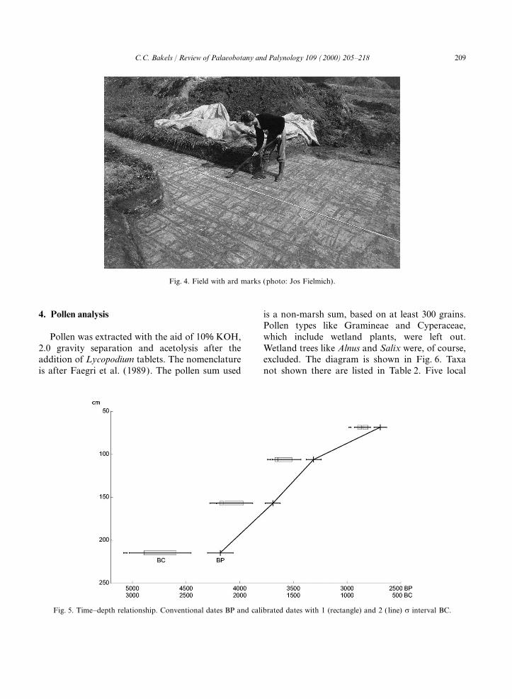
opportunity to investigate the pollen released by a scheduled for urban expansion. A rescue excava-tion carried out by the municipal archaeologicalknown prehistoric field.service of Haarlem revealed a field, or rather aseries of superimposed fields with ard marksextending across the entire ridge (Fig. 4)2. The site(Poldermans, 1987). The ard is a kind of plough.It makes furrows, but does not turn the soil. AtThe field under study was discovered in the
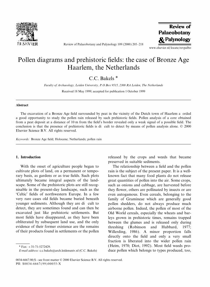
Netherlands, in the Zuiderpolder near the town of least three superimposed fields, separated by layersof blown sand from the ridge itself, were observedHaarlem (4°42∞E, 52°24∞N) (Figs. 1 and 2). It was
situated on one of the ridges which were formerly in the sections. In the last phase a ditch had beendug around the field, presumably for drainagelow coastal barriers bordering the North Sea. After
the Neolithic, the coast moved westwards and the because of the area becoming increasingly wetter.A few sherds showed that the fields dated fromthe Middle and Late Bronze Age, that is, frombetween 1500 and 800 BC (3300 to 2600 BP).
Investigations have shown that the peat to theeast of the ridge was trampled in the Bronze Age,which was unfortunate because in that period theprevailing winds were westerly, so the best placefor detecting pollen from the field would have beenon this eastern side. The peat to the west of theridge was undisturbed. A core was taken with aside-filling sampler at a distance of 10 m from theditch marking the limit of the last field.
3. Core stratigraphy
The lithostratigraphy was as follows:$ 0–25 cm [surface at 1.30 m below NAP (Normal
Amsterdam Level )] disturbed peat mixed withsand;Fig. 1. Map of The Netherlands; the inserted rectangle indicates
the area depicted in Fig. 2. $ 26–65 cm telmatic peat containing macro-
207C.C. Bakels / Review of Palaeobotany and Palynology 109 (2000) 205–218
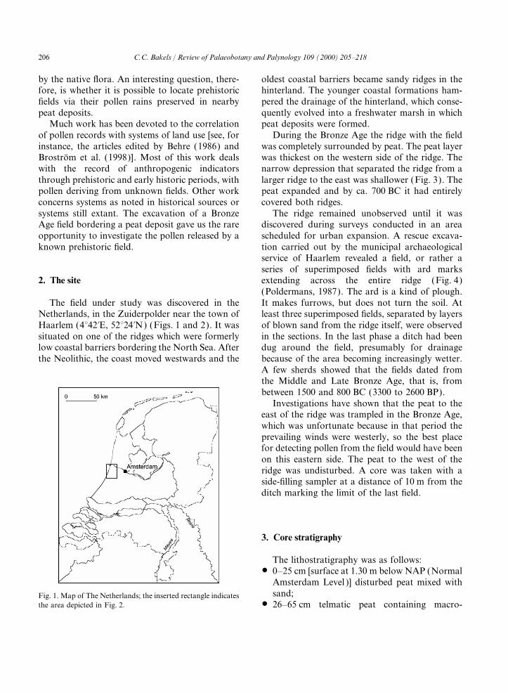
Fig. 2. Geological map of Haarlem and surroundings; the inserted rectangle indicates the area depicted in Fig. 3. Legend: 1, sand ofthe former coastal barriers; 2, peat deposits covered by sand; 3, peat deposits; 4, clay; a. location of the core Haarlem–Zuiderpolder;b, location of the core Schalkwijk. The heavy line indicates the eastern limit of mediaeval dune formation which covers at presentthe older coastal barrier landscape. Map after de Jong (1987).
remains of Eleocharis palustris, Hydrocotyle, Chara sp., Cladium mariscus and Menyanthestrifoliata;Ranunculus (Batrachium group), Scirpus sp. and
remains of freshwater sponges and water fleas; $ 83–101 cm the same peat only mixed with alittle sand and charcoal particles;$ 66–82 cm telmatic peat containing remains of
208 C.C. Bakels / Review of Palaeobotany and Palynology 109 (2000) 205–218
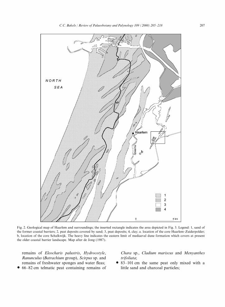
Fig. 3. Topographical map of the Zuiderpolder with its sandy ridges (shaded areas). The difference between the ridges depicted inFigs. 2 and 3 is due to the archaeological survey. The narrow western ridge revealed the field. The location of the core is indicatedby an open circle.
$ 102–155 cm telmatic peat containing remains of deposit at Schalkwijk, a site 2900 m further south-west, yielded a comparable date: 4200±60 BPCarex pseudocyperus, Chara sp., Cladium maris-
cus, Menyanthes trifoliata, Nymphaea alba, (GrN-10921) (de Jong 1987).Stratiotes aloides, fern sporangia, presumablyfrom Thelypteris palustris, remains of spongesand water fleas and around 115 and 155 cm Table 1
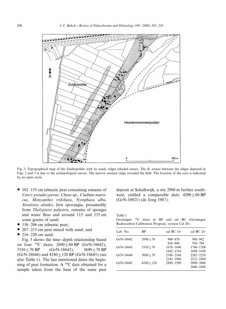
Groningen 14C dates in BP and cal BC (Groningensome grains of sand;Radiocarbon Calibration Program, version Cal 20)$ 156–206 cm telmatic peat;
$ 207–215 cm peat mixed with sand; and Lab. No. BP cal BC 1s cal BC 2s$ 216–220 cm sand.
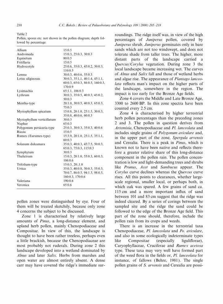
GrN-18642 2690±70 900–870 986–962Fig. 5 shows the time–depth relationship based856–804 936–784on four 14C dates: 2690±60 BP (GrN-18642),
GrN-18643 3310±70 1676–1648 1740–17083310±70 BP (GrN-18643), 3690±70 BP 1642–1516 1698–1430(GrN-18644) and 4180±120 BP (GrN-18645) (see GrN-18644 3690±70 2186–2168 2282–2218
2142–1966 2212–1884also Table 1). The last mentioned dates the begin-GrN-18645 4180±120 2890–2590 3090–3060ning of peat formation. A 14C date obtained for a
3040–2450sample taken from the base of the same peat
209C.C. Bakels / Review of Palaeobotany and Palynology 109 (2000) 205–218
Fig. 4. Field with ard marks (photo: Jos Fielmich).
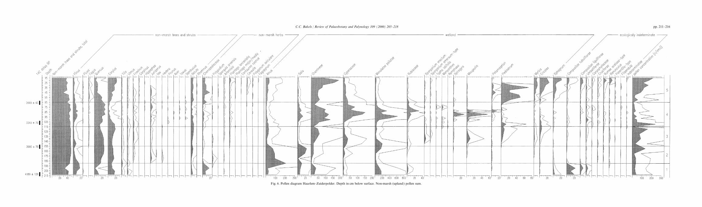
4. Pollen analysis is a non-marsh sum, based on at least 300 grains.Pollen types like Gramineae and Cyperaceae,which include wetland plants, were left out.Pollen was extracted with the aid of 10% KOH,
2.0 gravity separation and acetolysis after the Wetland trees like Alnus and Salix were, of course,excluded. The diagram is shown in Fig. 6. Taxaaddition of Lycopodium tablets. The nomenclature
is after Faegri et al. (1989). The pollen sum used not shown there are listed in Table 2. Five local
Fig. 5. Time–depth relationship. Conventional dates BP and calibrated dates with 1 (rectangle) and 2 ( line) s interval BC.
210 C.C. Bakels / Review of Palaeobotany and Palynology 109 (2000) 205–218
Table 2 roundings. The ridge itself was, in view of the highPollen, spores etc. not shown in the pollen diagram; depth fol- percentages of Juniperus pollen, covered bylowed by percentage
Juniperus shrub. Juniperus germinates only in baresands which are not too windswept, and does notAllium 15:0.5
Andromeda 15:0.3, 25:0.3, 30:0.3 tolerate shade from taller trees. The higher, moreEquisetum 80:0.5 distant parts of the landscape carried aFritillaria 15:0.5 Quercus/Corylus vegetation. During zone 3 theHydrocotyle 25:0.6, 35:0.3, 45:0.2, 50:0.3,
local landscape became increasing wet. The curves110:0.5of Alnus and Salix fall and those of wetland herbsLemna 30:0.3, 40:0.6, 55:0.3
Lotus uliginosus 30:0.3, 35:1,1, 40:1.4, 45:1.1, and algae rise. The appearance of Plantago lanceo-60:0.3, 65:0.3, 86:0.5, 160:0.3, lata reflects man’s impact on the higher parts of170:0.9 the landscape, somewhere in the region. The
Lysimachia 65:1.1, 106:0.3impact is too early for the Bronze Age fields.Lythrum 30:0.3, 35:0.5, 40:0.3, 45:0.2,
Zone 4 covers the Middle and Late Bronze Age,50:0.3Mentha-type 20:1.0, 30:0.5, 40:0.3, 65:0.3, 3300 to 2600 BP. In this zone spectra have been
75:0.3 counted every 2.5 cm.Myriophyllum spicatum 15:0.8, 20:1.0, 25:1.5, 30:0.3, Zone 4 is characterised by higher terrestrial
35:0.8, 40:0.6, 60:0.3herb pollen percentages than the preceding zonesMyriophyllum verticillatum 30:0.32 and 3. The pollen in question derives fromNuphar 65:0.3
Polygonum persicaria-type 25:0.3, 30:0.3, 35:0.3, 40:0.6 Artemisia, Chenopodiaceae and Pl. lanceolata andRiccia 15:0.5 includes single grains of Polygonum aviculare and,Rumex (Eurumex-type) 15:3.9, 20:1.0, 25:1.5, 35:1.1, in the upper part of the zone, Spergula arvensis
60:0.3and Cerealia. There is a peak in Pinus, which isSolanum dulcamara 35:0.3, 40:0.3, 45:7.5, 50:0.3,known not to have been native and reflects there-65:0.3, 75:0.3, 115:0.3
Symphytum 30:0.3 fore a greater relative share of this long-distanceThalictrum 15:0.3, 20:1.0, 55:0.3, 60:0.3, component in the pollen rain. The pollen concen-
106:0.6 tration is low and light-demanding trees and shrubsTrifolium-type 15:0.3, 20:,1.0
like Prunus, Acer and Sambucus appear. TheUrtica 35:0.3, 40:0.8, 50:0.3, 55:0.3,Corylus curve declines whereas the Quercus curve70:0.7, 86:0.5, 94:1.3, 98:0.5,
160:0.3, 170:0.6 rises. All this points to clearances, whether large-Valeriana 190:0.6 scale regional, smaller local, or perhaps both, inVeronica 65:0.6 which oak was spared. A few grains of sand ca.
115 cm and a more important influx of sandbetween 101 and 83 cm suggest that the ridge wasindeed cleared. By a series of corings between thepollen zones were distinguished by eye. Four of
them will be treated sketchily, because only zone sampled site and the ridge the sand could befollowed to the edge of the Bronze Age field. This4 concerns the subject to be discussed.
Zone 1 is characterised by relatively large part of the zone should, therefore, include thepollen rain from its crops and weeds.amounts of Pinus, a long-distance element, and
upland herb pollen, mainly Chenopodiaceae and There is an increase in the terrestrial taxaChenopodiaceae, Pl. lanceolata and Po. aviculare,Compositae. In view of this, the landscape is
thought to have been rather treeless, perhaps even and also in some ecologically indeterminate typeslike Compositae (especially liguliflorae),a little brackish, because the Chenopodiaceae are
most probably not ruderals. During zone 2 this Caryophyllaceae, Cruciferae and Rumex acetosatype. These taxa may very well have formed partlandscape developed into a wetland dominated by
Alnus and later Salix. Herbs from marshes and of the weed flora in the fields or, Pl. lanceolata forinstance, of fallows (Behre, 1981). The singleopen water are almost entirely absent. A dense
carr may have covered the ridge’s immediate sur- pollen grains of S. arvensis and Cerealia are possi-
pp. 211–216C.C. Bakels / Review of Palaeobotany and Palynology 109 (2000) 205–218
Fig. 6. Pollen diagram Haarlem–Zuiderpolder. Depth in cm below surface. Non-marsh (upland) pollen sum.
217C.C. Bakels / Review of Palaeobotany and Palynology 109 (2000) 205–218
bly not connected with the field. They were found lanceolata, which are terrestrial herbs commonlyassumed to be indicative of human influence, albeithigher up in the peat deposit and might have been
part of the wider pollen rain. not exclusively of fields because they may alsoindicate ruderal sites or pastureland. Less indica-Most components of the wetland flora show
maxima. Salix carr, reed and sedge vegetation tive is the pollen of the ecologically indifferentgroups of Compositae, Caryophyllaceae,grew near the ridge. Ferns (Monoletae), Rubiaceae
(Galium palustre) and Menyanthes trifoliata also Cruciferae and other herbs. This pollen would nothave predicted the presence of a Bronze Age field.formed part of the local marsh vegetation. The
percentages of Alnus are relatively low for alder in Evidence for the crop plants themselves is conspic-uously absent. The only Cerealia grain founda marsh environment, which implies that alder
carr was present at some distance. comes from the uppermost part of the zone, wherethe values of Chenopodiaceae, Pl. lanceolata andPronounced peaks of Potamogeton and the
remains of the algae Spirogyra and Mougeotia Pinus decline, the pollen concentration increasesand grains of sand are absent. The field is consid-appear at the time when sand blew into the peat.
Large amounts of pollen of plants indicative of ered to have already been abandoned by this time.Pollen indicating cultivation came from a moreshallow open water were also found in samples of
the soils of the fields themselves (Vermeeren, 1989) distant source.The decline in Corylus pollen percentages mayand these plants are thought to have made their
way onto the fields along with mud used to enrich represent the clearance which preceded the laying-out of the field. The same decline, but weaker, isthe soil (Bakels, 1997). Their presence in the
diagram may be explained by soil erosion. Their observable in a diagram obtained for Schalkwijk,a locality 2900 m further southwest and relativelyremains may well have been blown away into the
peat together with arable soil. Another possible far from the ridge under study, or, indeed, anydry ridge (Fig. 2) (de Jong, 1987). The strongerexplanation is, however, that the ridge’s immediate
surroundings were disturbed — perhaps by mud signal in the diagram discussed here suggests thatat least part of the decline may relate to the localdigging — to such an extent during the period of
cultivation that shallow pools temporarily clearance. The low pollen concentration and thehigh percentages of Pinus show that the land wasexpanded, in which water plants and algae thrived.
Zone 5 is of an entirely different nature. The deforested. The rise in Quercus is only relative.The tree might not have grown on the small ridgeQuercus curve falls and the Corylus curve rises
conspicuously. The herb pollen curves also rise, or was spared because of its acorns, valued asfood, and its excellent construction wood.indicating that the higher parts of the landscape
must have been fairly open. The Cerealia curve The signal of agriculture is weak, even at adistance of only 10 m from the Bronze Age field.(including Secale) is continuous. The presence of
Centaurea cyanus indicates that the uppermost The excavation showed that the agricultural layerswere well developed. Several plough horizons werepart of the peat was formed in the Middle Ages.
A grain of Fagopyrum, a typical late-medieval crop superimposed, indicating that even drifting sanddid not lead to abandonment of agriculture. Thereplant, was found at a depth of 20 cm, but this part
of the peat was disturbed. The wetland shows a are even indications of manuring. This was not anephemeral field. Why are the fields so elusive indevelopment towards a bog with Myrica, Ericales
and Sphagnum. the pollen record?Part of the problem might be the crops. As
remarked in the introduction, many food plants4. Discussion and conclusiondo not release great quantities of pollen. The typesof crops raised on the Haarlem field are notThe lower two thirds of pollen zone 4 are
contemporary with the excavated Middle and Late known. There is, however, an environmentallycomparable area further north were excavationsBronze Age fields. In these parts there is an
moderate increase in Chenopodiaceae and Pl. in Middle and Late Bronze Age settlements
218 C.C. Bakels / Review of Palaeobotany and Palynology 109 (2000) 205–218
revealed crop plants. These are Triticum dicoccum, Geological Service provided information on theSchalkwijk diagram and most enthusiastically dis-Hordeum vulgare (both naked and hulled) and
Linum usitatissimum (Buurman, 1988). They are cussed the results with the author. And, last butnot least, Susan Mellor revised the English text.poor pollen shedders. Nevertheless, more pollen
from weeds might be expected. There is no evidencefor any hedges which may have caught the pollenrain before it reached the peat. A belt of Salix Referencesbordering the ridge may have prevented the distri-bution of pollen, but this is unlikely as this belt Bakels, C.C., 1997. The beginnings of manuring in western
Europe. Antiquity 71, 442–445.did not prevent sand and charcoal particles beingBehre, K.-E., 1981. The interpretation of anthropogenic indica-blown onto the peat. Perhaps the signal would
tors in pollen diagrams. Pollen et Spores 23, 225–245.have been stronger if it had been measured to the Behre, K.-E (Ed.), 1986. Anthropogenic Indicators in Polleneast of the fields, but the prevailing westerlies did Diagrams. A.A. Balkema, Rotterdam.
Brostrom, A., Gaillard, M.-J., Ihse, M., Odgaard, B., 1998.however not prevent the much heavier sand grainsPollen–landscape relationships in modern analogues offrom settling to the west of the ridge.ancient cultural landscapes in southern Sweden — a firstTo conclude, it is perhaps only the erosion,step towards quantification of vegetation openness in the
indicated by the blown sand, that can be directly past. Vegetation History and Archaeobotany 7, 189–201.associated with a field, but even this is open to Buurman, J., 1988. Economy and environment in Bronze Age
West-Friesland, Noord-Holland (from wetland to wetland).discussion, because erosion could theoretically alsoIn: Murphy, P., French, C. (Eds.), The Exploitation of Wet-have been caused by other human activities result-lands, British Archaelogical Reports, British Series 186,ing in the exposure of soil, such as digging pits,267–292.
although the extent of the erosion would then Diot, M.-F., 1992. Etudes palynologiques de bles sauvages etperhaps not have been as great as that observed domestiques issus de cultures experimentales. In: Anderson,
P.C. (Ed.), Prehistoire de l’agriculture. Monographie duhere. Without the sand, the signal in the herbCRA 6. CNRS, Paris, pp. 107–111.pollen would perhaps be interpreted as a regional
Faegri, K., Kaland, P.E., Krzywinski, K., 1989. Textbook ofevent. The field at a distance of only 10 m fromPollen Analysis. IV edition, Wiley, Chichester.
the sampling site would not have been discovered Heim, J., 1970. Les relations entre les spectres polliniqueson the basis of pollen analysis alone. recents et la vegetation actuelle en Europe occidentale. Uni-
versite de Louvain, Louvain.de Jong, J., 1987. Enkele geologische gegevens verkregen uit
een bouwput in het Haarlemse stadsdeel Schalkwijk. Haar-lems Bodemonderzoek 21, 56–64.Acknowledgements
Poldermans, A., 1987. De Zuiderpolder, een voorlopig verslag.Haarlems Bodemonderzoek 21, 22–26.This paper could not have been written without
Robinson, M., Hubbard, N., 1977. The transport of pollen inthe help of Caroline Vermeeren and Marjolein the bracts of hulled cereals. Journal of Archaeological Sci-Alkemade, who counted the spectra. Maarten ence 4, 197–199.
Vermeeren, C., 1989. Botanisch onderzoek opgraving Zuider-Poldermans and Wim Bosman are gratefullypolder Rapport voor de gemeente Haarlem. Internal reportthanked for granting the author the possibility toInstituut voor Prehistorie, Leiden.take the core. The municipal authorities of
Willerding, U., 1986. Aussagen von Pollenanalyse und Makro-Haarlem financed the 14C analysis, which was restanalyse zur Fragen der fruhen Landnutzung. In: Behre,carried out by the Centre for Isotope Research in K.-E. (Ed.), Anthropogenic Indicators in Pollen Diagrams.
A.A. Balkema, Rotterdam, pp. 135–151.Groningen. Jan de Jong of the Dutch State