Embed Size (px)
Citation preview
The Via FlaminiaAuthor(s): T. Ashby and R. A. L. FellSource: The Journal of Roman Studies, Vol. 11 (1921), pp. 125-190Published by: Society for the Promotion of Roman StudiesStable URL: http://www.jstor.org/stable/295901 .
Accessed: 08/05/2014 19:43
Your use of the JSTOR archive indicates your acceptance of the Terms & Conditions of Use, available at .http://www.jstor.org/page/info/about/policies/terms.jsp
.JSTOR is a not-for-profit service that helps scholars, researchers, and students discover, use, and build upon a wide range ofcontent in a trusted digital archive. We use information technology and tools to increase productivity and facilitate new formsof scholarship. For more information about JSTOR, please contact [email protected].
.
Society for the Promotion of Roman Studies is collaborating with JSTOR to digitize, preserve and extendaccess to The Journal of Roman Studies.
http://www.jstor.org
This content downloaded from 169.229.32.137 on Thu, 8 May 2014 19:43:37 PMAll use subject to JSTOR Terms and Conditions
THE VIA FLAMINIA.1
By T. ASHBY, D.Litt. F.S.A. and R. A. L. FELL, M.A.
(Plates ix-xviii)
PREFACE.
The frequent use of the first person singular in the text of this article makes it necessary that we should explain how the work has been divided between us. Mr. Fell, who was resident for two years at the British School at Rome, first as Craven Student of the University of Cambridge, and then as Gilchrist Student of the Faculty of Archaeology, History and Letters, is responsible for Section A (The Via Flaminia in History), and Dr. Ashby for Section B (The Topography of the Via Flaminia from Rome to Narni). In Section C the description of the road from Narni to Forum Flaminii by Terni and Spoleto is the work of Dr. Ashby, while from Narni to Forum Flaminii by Bevagna it is the joint work of both writers: but the concluding portion of the road was studied and described by Mr. Fell alone. The whole article has, however, been carefully read by both of us.
The maps (figs. 8 and I4) are the work of the Editor of the 7ournal, Mr. Robert Gardner, to whom we are much indebted: and we also desire to acknowledge the help received from the Rev. Father Peter Paul Mackey, S.T.M., O.P., Hon. Associate of the Faculty of Archaeology, History and Letters of the British School at Rome, who has allowed us the use of several photographs (plates: x, no. i;
xi, no. 4; XII; XIII; XVI; figs. io and 12) and of Messrs. S. Rowland Pierce and E. W. Armstrong, Students of the Faculty of Archi- tecture of the British School at Rome (infra, p. 158).
A. THE VIA FLAMINIA IN HISTORY.
If the Via Appia was the ' queen of roads' to the Romans, the Via Flaminia was second to that only, and in some periods was more
The historical references to towns on the Via Flaminia are mainly gathered from Bormann's introductions in the C.I.L. ; also from articles in Pauly-Wissowa's Real-Encyclopadie, the Encyclo- paedia Britannica,and Nissen's ItaliscbeLandeskunde. Fuller information about the towns is to be found in these authorities. Inscriptions are quoted from vol. xi, part z, of the C.I.L. (unless otherwise stated), which contains the inscriptions of Umbria. Those
of Ariminum are in vol. xi, part i (Cisalpine Gaul and Etruria). This article makes no attempt to describe the numerous Roman remains (e.g. at Bevagna, Spoleto and Foligno) which are not connected with the Via Flaminia; a list of such remains (with a full bibliography) is given in the Elenco degli Edifici Monumentali della Provincia di Perugia (Rome 1914).
This content downloaded from 169.229.32.137 on Thu, 8 May 2014 19:43:37 PMAll use subject to JSTOR Terms and Conditions
I 26 THE VIA FLAMINIA.
important. Its antecedents can only be conjectured, but it follows natural routes to such an extent that large parts of it must have been long in use before it was established as a Roman highway. The Scheggia pass, for instance (which was the easiest way across the Apennines), and the successive valleys of the Burano, Candigliano, and Metaurus which lead from the heart of the mountains down to the Adriatic, formed the natural channel of intercourse between the Umbrian towns such as Iguvium close to the pass, and Ravenna and Ariminum on the coast, before these were submerged in the Gallic flood; while on the other side the Topino valley led down from near Nuceria (Nocera Umbra) to the broad plain of the Clitumnus. in which were the Umbrian towns of Mevania, Asisium, and others. We may therefore believe that here as elsewhere the Romans used, as far as possible, the work of their predecessors. It is probable that the earliest route from Rome towards Umbria was that of the Via Tiberina, which went up the right bank of the Tiber through the territory of Capena (the site of which is disputed) and by the ancient shrine of Feronia, 1 with perhaps a branch up the Treia valley to the Etruscan Falerii (Civitacastellana). There was doubtless some kind of crossing at Ocriculum, the earliest Umbrian town to enter into friendship with Rome (308 B.C.). When the shorter but more hilly road was made, which left the Tiber at Prima Porta and ran west of Soracte, crossing the Tiber near Ocriculum, we cannot say; perhaps it was built after the revolt of Falerii in 293 B.C. to improve com- munications with the new Latin colony of Narnia (299 B.C.). But it ran through the territory of Falerii, leaving the town on one side; so that it may have been subsequent to the destruction of Etruscan Falerii in 24I (Zonar. viii, i8), when half of its land was confiscated.
But however much of the northern highway was already in use, it owed its establishment as a permanent possession of the Roman state to Gaius Flaminius, with whose policy, and not with the military conquest of Umbria, which was completed at Sentinum in 295 B.C.,
it was intimately connected. It was he who as tribune in 232 B.C.
had carried in the face of strong senatorial opposition the proposal to distribute in small lots the land on the Adriatic coast from whith the Senones had been expelled fifty years before, and which (apart from the territories of Ariminum and Sena) had been open to any chance settler; and it was he who as consul in 223 first led a Roman army across the Po (also against the wish of the Senate, which attempted to recall him on the pretext of a flaw in his election2) and inflicted a severe defeat on the Insubres of Lombardy. His policy,
1 Perhaps near Nazzano where an early milestone was found, C.I.L. xi, 2, 66i6 (= i, 633) which Bormann ascribes to the Via Tiberina. Strabo (v, p. 225) puts Feronia vTrh T43 7 2WpaLKT(p 6pet.
For the ' Lucus Feroniae,' see Miss L. R. Taylor in 7.R.S. vol. x, 29 seq. (with map).
2 Plut. Marcellus, 4; Zonar. viii, zo; cf. Liv. xxi, 63.
This content downloaded from 169.229.32.137 on Thu, 8 May 2014 19:43:37 PMAll use subject to JSTOR Terms and Conditions
THE VIA FLANIINIA. 1 27
like that of other democratic leaders 1 at Rome, was one of expansion; we may well believe that he aimed at extending the Roman frontier to the Alps, its natural limit, and peopling the Po valley with citizen settlers. What Rome had conquered was to be used for the benefit of the mass of Roman citizens, and the distribution of 'the fertile2 ager Gallicus was a provision for the poor of the city. In this policy good communications were of the first importance; the outlying body of Roman citizens needed a safe and speedy means of access to and from the capital, while on purely military grounds it was vitally necessary to keep in touch with Ariminum both as a defence against Gallic inroads (as the wars of 238-6 and 225-2 had shown) 3 and as a starting-point for further conquests. The route chosen by Flaminius for his high road was the easiest way into Cisalpine Gaul, and ran mainly through Roman territory4; and the work of building the road with the necessary bridges or fords, cuttings and embankrnents, solid foundations and level surface, was taken in hand during the censorship of Flaminius in 220 B.C. 5
The existence of the road must have been of great advantage to the Romans in the second Punic War, when Cisalpine Gaul was generally assigned as a ' province ' to one of the praetors, who was stationed at Ariminum. During the next century, too, it must have hastened the spread of Roman speech and manners both among the Umbrian cities, uniting them all more closely to Rome, and also in Cisalpine Gaul: a road which was built for permanence, and therefore less liable to such natural accidents as heavy rains, floods, landslips, and the like, than the previous rough tracks, would materially lessen the time and trouble of a journey to the north, whether for purposes of war, administration or trade, thus bringing distant regions into the orbit of Rome. The upkeep of the main roads was normally part of the censors' duties, 6 but the post of curator of a special road appears in the late Republic: writing in 65 B.C. Cicero (ad Att. i, I, 2)
mentions Q. Minucius Thermus as a strong candidate for the consul- ship ' propterea quod curator est uiae Flaminiae.' It was probably by the same man that the Pons Minucius was built, the site of which is unknown. One of the earliest measures of Augustus was the restoration of the Italian roads, 7 which were suffering from neglect; and because of its military importance he himself took charge of the
1 Cf. T. Frank, Roman Imperialism, pp. 62-3. Flaminius was a political successor of Appius Claudius, the pioneer of Roman road-building.
2 7re0a3ca Kai 7r)p6opopov ooap (App. B. C. i, 89, 6); cf. Colum iii, 3, 2, on its fertility.
3 Ariminum in these wars: Polyb. ii, 21, 5; 23, 5. 4 On this see detached note at end. 5 Liv. Epit. xx: Strabo (v. 217) seems to be
mistaken in ascribing the Via Flaminia to C. Flarninius the younger who made the Bononia- Arretium road in 187 (Liv. xxxix, 2).
6 Liv. xli, 27, 5, records special activity of the
censors of 174 B.C. in building bridges and renewing the surface and substruction of roads. Cf. Plut. C. Gracch. 7, on the work of C. Gracchus in this respect.
7 Mon. Ancyr. iv, 19 ' refeci . . consul septimum [27 B.C.] uiam Flaminiam a(b urbe) Ari(minum et pontes in ea)omnes praeter Muluium et Minucium '; Suet. Aug. 30; Cass. Dio, liii. 22, Tr?e U 4Xawlavl CtsVTO 'eret3s7rep eKo-rpcre6oeev tv' caL'nfs 9keXXev ere,ueX s567. Coins referring to this in Cohen, Monnaies de l'Empire-Romain, i, pp. 94-5 (nos. 229-
235) and 142-3 (nos- 541-4).
This content downloaded from 169.229.32.137 on Thu, 8 May 2014 19:43:37 PMAll use subject to JSTOR Terms and Conditions
I28 THE VIA FLAMINIA.
Via Flaminia, entrusting the other roads to men who had won triumphs, to defray the cost of repairs out of the spoils they had gained in war. To commemorate this restoration, arches bearing the effigy of Augustus were erected at the two ends of the road-on the Mulvian bridge and at the entrance to Ariminum 1: a still more striking record survives in the bridge of Augustus at Narnia. Augustus also instituted the office of 'curator uiarum' which was held by ex-praetors 2; from about the time of Claudius we find curatores of particular roads,3 who in the second century A.D. often had charge of the local ' alimenta ' as well. The most notable improvement of the Via Flaminia was the construction of the tunnel in the Furlo pass by Vespasian; and other repairs were undertaken by Trajan (the bridge over the Metaurus, C.I.L. xi, 6622), by Hadrian (C.I.L. 66i9, 6620), and other emperors.
From the comparative easiness of its course, and perhaps, too, from the special attention with which it was kept up, the Via Flaminia was evidently a much-frequented road. Strabo (v, p. 227) mentions Forum Flamini, Nuceria, and Forum Semproni as Kca-OWaL &a' i-r-nv 08OwV 7wXvOVVObLEVaL, which implies a considerable stream of travellers needing food, lodging, and a change of horses; the Jerusalem Itinerary records ' civitates,' mansiones,' or ' mutationes' at an average interval of about ten miles. Even travellers from Spain to Rome sometimes came right across north Italy by the level Via Aemilia to Ariminum, and thence by the Flaminia, avoiding the already unhealthy Tuscan coast traversed by the Via Aurelia, and the difficult Apennine crossing between Bologna and Florence; such was the route taken by some travellers from Gades, who left at the baths5 of Vicarello, on the north side of the Lake of Bracciano (L. Sabatinus), four silver cups each inscribed with the itinerary from Gades to Rome. These cups, which are now to be seen in the Museo delle Terme at Rome, are an im- portant authority for the stations of the Via Flaminia and the distances between them; to judge from the coins found in the same warm springs of Vicarello, they are not much later than the time of Trajan, and therefore earlier than the other known itineraries. There are several indications of the speed which was possible on this road; for instance, the episode6 of the Pannonian mutiny in A.D. I4,
which began as soon as news of the death of Augustus (Aug. igth or not long before) reached the legions; then the news of the mutiny
1 Dio 1. c. 5ta TOUTO KacL eK6Ves avT(j. ef' a/'ioXwV Te T-r TOVr Ttfept5os -yeC/l'Tpa Kai ev 'Aptp,v
ewOL?'70r?0avP.
2 Dio, liv, 8, 4; Suet. Alug. 37, I.
3 C.I.L. xi, 1, 571 (under Nero): cf. Sen. Apocol. I ' Appiae uiae curator est ' ; perhaps Claudius as censor appointed curatores of particular roads. Cf. Pauly-Wissowa, R.-E. iv, pp. I78 1-3.
4 Tac. Hist. ii, 64, ' uitata- uiae Flaminiae celebritate.'
5 Perhaps to be identified with 'Aquae Apolli- nares,' Nissen, It. Land. ii, p. 353. The cups were found in 1852: the itineraries are given in C.I.L. xi, 3281-3284, and only vary slightly in spelling and numerals. Cf. Garrucci, Dissertazioni Archeologiche (Rome i866), i, pp. i6o ff.
6 I give the substance of Furneaux's note on Tac. Ann. i, i6, I.
This content downloaded from 169.229.32.137 on Thu, 8 May 2014 19:43:37 PMAll use subject to JSTOR Terms and Conditions
THE VIA FLAMINIA. I 29
came to Rome and Drusus arrived in Pannonia with an army before the eclipse which is calculated to have taken place on Sept. 26th. In A.D. 238 a messenger arrived at Rome with the news of the death of Maximin four days after leaving Ravennal -a distance of about 250 Roman miles. The relief on the Arch of Constantine,2 which represents the Via Flaminia as a woman resting on a wheel at the feet of Marcus Aurelius, well symbolizes the speed with which the emperors and their armies could traverse the great road to the north.
Originally built as a military highway, the Via Flaminia to a considerable extent determined the course of several campaigns in which opposing armies were based respectively on Rome and on some position in north-east Italy, such as Ariminum or Ravenna. In 49 B.C. Iguvium, commanding the Via Flaminia at its crossing of the Apennines, was held for Pompey by Minucius Thermus, but abandoned, and then occupied by Curio to keep the way open for Caesar,3 who, however, instead of marching straight to Rome, wvent along the coast (after securing Pisaurum, Fanum Fortunae, and Ancona) into Picenum, a region previously devoted to Pompey, and thence to Corfinium. The Via Flaminia was so much the recognized military highway to the north that the flood of the Tiber, which in the spring of A.D. 69 made the road impassable for twenty miles (Suet. Otho, 8), was taken as an omen of disaster for the expedition which Otho was preparing. 4 Later in the same year when the troops of Vespasian were invading Italy from the north-east, his opponents might to some extent have repaired the disaster of Cremona by holding the Apennines against him ; instead, they gave up one after another the key-positions of the Via Flaminia, allowing the Flavians to advance unhindered save by natural obstacles. Thus Valens sent ahead to hold Ariminum three cohorts which had come to his aid from Rome, and then, instead of following them, escaped to the western coast and took ship for Gaul; the garrison of Ariminum was soon cut off, helpless to prevent the Flavians from occupving the Adriatic coast. 5 The latter halted at Fanum Fortunae, expecting to find their way blocked, as it easily might have been at either the Furlo or the Scheggia pass; Vitellius did indeed raise a considerable force, strong enough to take the offensive, says Tacitus, if it had had a different commander, but this force, instead of crossing the mountains and attacking the enemy, waited inactive at Mevania, whence the emperor, weary of camp life, returned to Rome. 6 Part of the army in Umbria was removed to deal with the revolt of the fleet of
1 Hist. Aug. Maximinus, 25, 2. 2 Cf. P.B.S.R. iii, pl. xxiv, iv; E. Strong, Roman
Sculpture, p. 393, and plate xc, 4. 3 Caes. B. C. i, I2.
4 Tac. Hist. i, 86, 'id ipsum quod paranti expedi-
tionem Othoni campus Martius et uia Flaminia iter belli esset obstructum . . .in prodigium et omen imminentium cladium uertebatur.'
5 Tac. Hist. iii, 41-2.
6 Tac. Hist. iii, 55-6.
This content downloaded from 169.229.32.137 on Thu, 8 May 2014 19:43:37 PMAll use subject to JSTOR Terms and Conditions
I30 THE VIA FLAMINIA.
Misenum, while the rest was withdrawn to Narnia, allowing the Flavians to cross the snowy Apennine passes without opposition, to secure the flourishing towns of central Umbria, and to recuperate after the hardships of their march at Carsulae, only ten miles away on the Via Flaminia. A detachment at Interamna, and then the whole Vitellian army at Narnia, soon surrendered to the Flavians,l thus giving up the last stronghold which might have arrested the march on Rome, and it was only in the outskirts of the city that the Flavians met with armed resistance. Similar in some respects was the campaign of A.D. 3I2, when Constantine marched from Venetia along the Via Flaminia, and encountering the troops of Maxentius at Saxa Rubra drove them back to their final disaster at the Mulvian bridge. The road gave its name to one of the districts of Italy as early as the second century A.D. (Weiss in Pauly-Wissowa s.v.).
Still larger is the part played by the Via Flaminia in the Gothic and Lombard wars of the fifth and sixth centuries, as they swayed backwards and forwards between Rome and Ravenna, the respective bases of the imperial and the Gothic troops, and round the new Lombard capital of Spoletium. Along this road Ildiger and Martin hastened to the relief of Ariminum in 538, and on it the Goths met their crushing defeat in 552. 2 Throughout these wars the possession of the key-positions of the Flaminia-Narnia, Spoletium, Ariminum, and particularly Petra Pertusa (I1 Furlo)-is a factor of great significance. The road has maintained its importance throughout the Middle Ages3 and into modern times, and considerable portions of it, including many Roman bridges, are in use to-day.
Note on the territory through which the Via Flaminia ran.
Beloch (Der italische Bund, p. 57) has attempted to show that the Roman territory in Umbria reached in an unbroken strip along the Via Flaminia from the Nar up to the borders of the ager Gallicus. I think this conclusion needs some qualification. Narnia and Spoletium were Latin colonies, and, without doubt, some territory was annexed by Rome in the centre of Umbria, probably after the great battle of Sentinum in 295 B.C. ; for here Flaminius established his Forum, and we also hear of a ' praefectura ' at Fulginium4 (Foligno, close to Forum Flaminii), which must have been annexed before the Social War. Further, the ager Gallicus had been Roman territory since 283 B.c. But that these portions of Roman and Latin land
Ibid. 58-63. 2 On these campaigns see Hodgkin, Italy and Her
Invaders, vol. iv, chs. x and xxiv.
3 However, at some time during the early Middle Ages the most important approach to Rome from
the north came to be the ' Via Francesca,' which crossed the Apennines above Luni and led through Lucca, Siena and Acquapendente to Bolsena, there joining the Via Cassia. Cf. P.B.S.R. viii, IO9.
4 praefectura Fulginatium,' Cic. pro Vareno, fr. 4.
This content downloaded from 169.229.32.137 on Thu, 8 May 2014 19:43:37 PMAll use subject to JSTOR Terms and Conditions
THE VIA FLAMINIA. 13 1
were contiguous is less certain. It has been shown with strong probability by Beloch (op. cit. pp. 38 ff.) and Kubitschek (De Romana- rum tribuum origine ac propagatione, pp. 64 ff.) that the allied cities which revolted from Rome in the Social War were afterwards assigned to eight tribes only, in which, as Kubitschek shows (p. 70), no colony (with one doubtful exception) or civitas sine suffragio is known to have been enrolled. Among these tribes is the tribus Clustumina, to which belonged a considerable number of towns in western Umbria- Sestinum, Tifernum Metaurense and Tifernum Tiberinum, Iguvium, Arna, Vettona, Tuder, Carsulae, Ameria, Interamna, of which only the last-named lay to the east of the Via Flaminia. Iguvium we know to have been a civitas foederata in the time of Marius,1 and Tuder must have fought against Rome in the Social War, since it was given the citizenship by senatus consultum in 89 B.C. 2 Hence there is good ground for supposing that all the towns in the above list were allies until 90 B.C.
If this be so, we see at once that the Via Flaminia passed through allied territory at Carsulae3; and if it be objected that the muni- cipium of Carsulae may have been constituted under the empire, and that its territory may have been Roman already in 220 B.C., in any case it can hardly be doubted that the Vicus Martis Tudertium (C.I.L. xi, 2, p. 694; ' ad Martis ' in Itin. Anton.), through which the Via Flaminia passed, was always in the territory of Tuder, which we know to have been an ally till 89 B.C. Further, Mevania is not proved by its tribe (Aemilia) to have had the citizenship already in 90 B.C. ; it may equally well have been an ally then (but loyal to Rome), and, a fortiori, an ally in 220 B.C. Then beyond the patch of ager Romanus round Foligno, it is possible that at Tadinum (tr. Clustumina ?; C.I.L. p. 823) the road crossed allied territory, and I believe that the Apennine pass of Aesis (Scheggia) was in the territory of Iguvium-an ally till 90 B.C. At least, there is no evidence at all that the ager Romanus about Foligno extended some 40 miles further north till it touched the boundary of the ager Gallicus,4 wherever that may have been. The conclusion, therefore, that the Roman and Latin territory extended without a break along the Via Flaminia, which is put forward by Beloch and adopted also by Prof. Conway (Italic Dialects, i, p. 396), appears to be un- warranted.
I Cic. pro Balbo, 20, 47. 2 Sisenna, Book iv (containing events of 89 B.C.);
frag. I I9 in Peter, Hist. Rom. Reliquiae. 3 Possibly nearer Rome still, at Ocriculum, which
belonged to the tribuis Arnensis, one of the eight tribes referred to above.
4 As it is made to do in Beloch's map of the Ager Romanus (It. Bt4nd, end); which yet shows the Via Flaminia passing through allied territory at Interamna, in contradiction of Beloch's own argument.
This content downloaded from 169.229.32.137 on Thu, 8 May 2014 19:43:37 PMAll use subject to JSTOR Terms and Conditions
.e~~~~~~~~ ,
? e p M 8 X X1 0 0 '-.*- \H
Z 2 E . > o eD c E @ a , H ' r~~- 00 CIN
? ) 1n40a >-
> , a g ~~~~~~~~~~~~~~~~~~~~~~~~~~~~~~~~~~~~~~~~~~~~~~~~~~ ~~~~~~~~~~~~ | t~~~~~~~~~~~~~~~~~~~~1 ^~~~~~~~~~~~~~~4 O *
X~~~~~~~~~~~~~~~~O 00 N
Ev~~~~~~~~~~~~~~~~~~~~~~~~~~~~~~o C'sS
? *Y 2 t ._ Q~~~~~~~~~~~~~~~~~~~~~~~~~~~~~~~~~~~~~~~~~~~~~~~~~~~~~~~~- rsl W @ = Y <~~~~~~~~~~~~~~~~~~~~~~~~~~~~~~~~~~~~~~~~~~~~~~~~~~~~~.
O *S E X w Q ._~~~~~~~~~~~~~~~~~~~~~~~ Lr O z~~~~~~~~~~~~~~~0
D , * p _ a E . . .1, ,: ,, i~~~~~~~~~~~~~~~~~~~~~~~~~~~4z
._0 P4 X <?X
| F E_ a _; . > n ? F s E O > _> _ < : 8 E _ _ _~~~~~~~~t
Z X , H ? K X '- 't [ ? H?~~~~~~~~~~~~~~~~~~~~~t S e ? > _ ?~~~~~~~~~~~~~~~~~~~~~~~~~~~t S~~~~~~~~~~~~~~~~~~~~~~~t o Q5
O X ?.Y Z > .: S p U w~~~~~~~~~~~~~~~~~~~~~~~~t *~~~~~~~~~~~~~~~~~~~~~~; ( Oz
This content downloaded from 169.229.32.137 on Thu, 8 May 2014 19:43:37 PMAll use subject to JSTOR Terms and Conditions
-4- 00 =
0 00 1-4 r--, 0
00 00 ON C\ 8 "o 4- 03 03 0 x "o > PT.4 Ln 00 g
CIZ 'o C,3
4J
u C13 03 0 S.. PL,
> :41 - 4-4 CZ 0 U)
CZ q) OC) (01\ 00 00 00 00 4- 4-J 4-) 0-4 W 4-) 0
4, blo v
c, 0 4-)
P. 14. CZ v 4-)
4-J 0 4.1 0 CZ 0 4_) 4-1N C-j Cld X 0 C'3
4-) 4-) 4-J
4.1
ct C'S C13 4-) 4-)
4-) > 4-4 CZ U
CL4 CZ o 0 .- V) 4-) >1 0
IZ b.0 _C
4-1 4 CZ z
Q CZ C-,I 'o. o 0 4-) - - b-0 w 4-)
r. > 5 (Z)
CZ
4-)
14,1 %-. Z v C)
C'.) Pq L-4 Pr- 4-) co:) 4 v CZ V
IZ) CZ 0 4-1 u ch 0 (U
X 4.) 'I.. $- -I-, 4. > C) --l v sz u . - C's tko 0 0 t c-i (L) L)
(U 4C "S 0
cr, 4-J CZ 4-)
C's 0 Ln LO C> W
C'3 co C's C's 4.
4. 0 U CZ
4.)> w
C'S z
4) s-4 C,$ CZ PLI
0 X -Z m 4-J
r- 0
V)
CZ 0 CZ ..: 5 - w 0 Cq cn 4-J -
zt t., C) -4 .,-j -4 C's U) -4
C.J 4.j rl
u v 0 CZ u 0 g4 4-1 4-3
C's u 4.1
_j 4-J U r-i C) IZ;l 4-J
0 C'S 0 CTS (L) C,3 -C 4i
14 4-J C) 1-4 v a) t3
P.q C13 cl -q
0 cli s-, C% v (U 4-.)
4-) 4-; 4-; 4-1 C,3 0 Ol -C - 0
C's c-o -0 CL,
r (L) C,3 u u u 0 4-J
4-J
CZ CZ --4 C's C13
CZ CZ o 0
4-J > 4-' C,3
m :s cn C,, C'3 CZ U bn 0 J4
c', C) cn (U -1 C)
1-4 V
C; 4,-' CS CZ -v C'S w U CZ Z
U) C-z V C-4
U U 0
CZ ;L( 4-J >
-.4- 0 M .! (L) > 0 a U " co
14, 03 ct r. oo C! C, - ! =, "
CZ M ;z -E .4n -1. c. "s, E : .4 w r m z
C13 C, C' Z
-
-4 C'3 4) -n,
t 4;
C) - - o -5 C) N4
U .- U Cl
C'S 0 v
0 U ,, z -0 C13 C13
m
> , 0
a., 0 CZ o
4-1 4-J
0 4-1
-4 C', 0 c" fn-4 1 -1 > C13 4 J
CZ tz CZ C-4 C)
4-)
> C/) 0 4-1
C,3 4-) - v U o
0 t3 J Q X
00 4-) C) Cl
.;t c', x! C,., V C-4
0 4.1 0
4-) m
4Z U C: ct
cl 191. 11-!,
C) 0 ho 0 -cs cz C) U Q) q) U C! - =
cn + _---q - 4-J 00 U (U 21 CZ V 4-1 > . - $.
0 z CN U v
0 CZ CN ;,.. 03
cn 4-1
00 0
- -
Z C% C13 4-1
C13 m v 4-1
C', C's r- ct) CZ CZ 4.J
4-j C13 Cld o
t3 CZ 4-) t3
4-i C,;, 04 C, CZ t3 s., C'J llz -- 0 cn 3 4-J > 4-J
7: 4-) 0 b4 C,3 4-4 4-) z 10 =; 0 ,.,
1-4 v C's
ct Cld C's v X CZ 4-1
C's 0 0 4-J 4-J C13
(L) > CZ 0
C's C,3 cla 4-J 0 C) ct
>
cn $.-I .- 0
Cld 0 $-A
U) F- ::U 0 0
(U U 0 1-4 r, Cld -4 4)
"It m .. - 0 - .C4 -
This content downloaded from 169.229.32.137 on Thu, 8 May 2014 19:43:37 PMAll use subject to JSTOR Terms and Conditions
I34 THE VIA FLAMINIA.
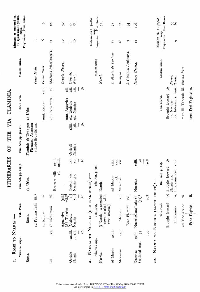
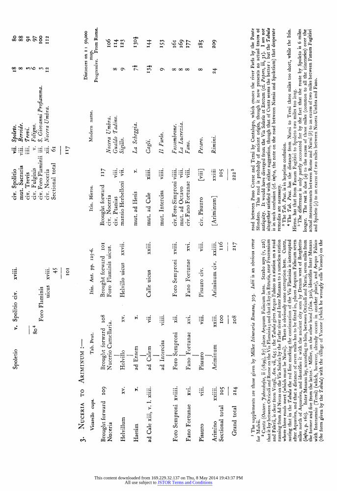
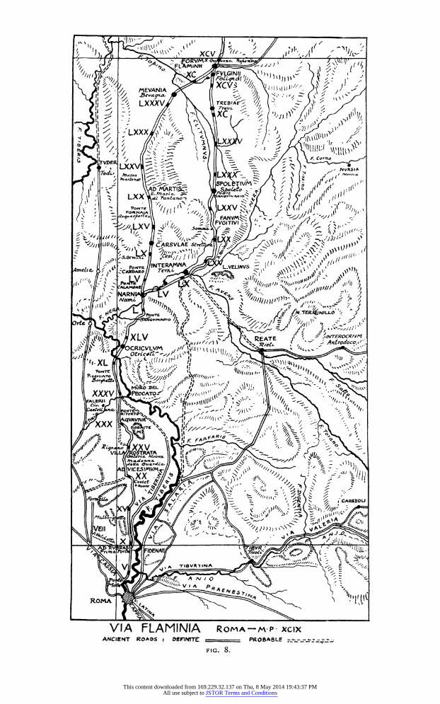
B.-THE TOPOGRAPHY OF THE VIA FLAMINIA FROM ROME TO NARNI.
The Via Flaminia started in a NNWX. direction from a gate of the Servian Wall on the east slope of the Capitol which has usually been identified as the Porta Ratumena, though later topographers prefer to see in it the Porta Fontinalis. 1 It turned slightly westward a little before reaching the tomb of Bibulus, 2 and passing another large tomb, the so-called tomb of the Claudii, the concrete core of which was recently removed in the formation of the open space in front of the monument to Victor Emmanuel, resumed its former direction. It then ran across the Campus Martius, which it divided into two unequal parts, and on to the Pons Mulvius, a distance of about three miles in a perfectlv straight line. For this reason, perhaps, burial on the Via Flaminia was apparently regarded as a special honour; the site of the tomb of Bibulus was granted honoris z'irtitisque caussa senatus consulto populique iUSSU. Sulla was buried beside it, Glaucia, the freedman of Atedius MVelior, had his tomb beyond the Pons Mulvius,3 and Juvenal alludes to splendid tombs on the Via Flaminia. The part within the Aurelian walls was known as the Via Lata from the fourth century A.D. onwards. The modern Corso coincides absolutely with the ancient line, and the two churches which flank it where it ends in the Piazza del Popolo both stand on ancient tombs. 5
We have seen that the date of the construction of the Via Flaminia iS 220 B.c. This straight piece of road may, however, be of earlier origin, belonging in that case to the original road to Veii.
It is perhaps better, however, to suppose that the crossing on the site of the Pons Mulvius 6 (the name has been corrupted into Ponte Molle) was not practicable until the bridge was built: and in that case we must maintain that the Via Clodia ran along the right bank of the Tiber from the Pons Sublicius upwards7: though no traces of sufficient antiquity to decide the question in the affirmative have ever been discovered.
It is worth mentioning here that before the construction of the
1 So Hulsen (Rhein. Mus. 1894, 41I). See Morpurgo in Bull. Cons. (i906), 209, sqq. who follows Hulsen in rejecting the usual identification with the Porta Ratumena, but proposes to place the Porta Fontinalis at the foot of the Caelian hill.
2 C.I.L. vi, 1319. Cf. Hulsen, Topographie, i, 3,
471. 3 Statius, Silvae, ii, I, I76 (Milvius agger; cf.
Martial, vi, 28, 29). The tomb of Paris, the famous pantomimus, was also on the Via Flaminia (Martial xi, 13).
4i, I70, experiar quid concedatur i'n illos quorum Flaminia tegitur cinis atque Latina. Cf. Hulsen, op. cit. 464,491.
5 Hulsen, op. cit. 462, sqq. Recent discoveries have, as he notes, disposed of Nibby's theory that the ancient road ran some way to the right of the modern (Analisi, iii, S8I).
6 Carta d'Italia (Istituto Geografico Militare) f. I50, iv, N.O. (Castel Giubileo, I: 25,000).
I The theory that the Via Clodia began as the original road to Veii (Anziani in Milanges, xxxii (I913), 206) has a good deal to recommend it. That the Via Triumphalis was the earlier of the two is most unlikely. See Anziani, op. cit. 240, who comes to the conclusion that the. Via Clodia dates from the end of the fourth centurv, that the Cassia belongs to the last half of the third, and the Aurelia to the first quarter of the second.
This content downloaded from 169.229.32.137 on Thu, 8 May 2014 19:43:37 PMAll use subject to JSTOR Terms and Conditions
XCV' A
EORVMS Ow, 2 0. *oyu -FLAMIN" Z
VLGI It
x MEVANIA Devayna, LXXXV TREBIA z_
rrevi' Q_ N
xc J
V
LXXx -A
lr J )sb
N, < F. Corno
LXXV tVVR51A 7 di, L
t SPOL IV
LX ro xv
/V ' acy,.4 FANVM
FVGiT[Vl xv Nk I 1, /" -
S x "J IJ J, N
CAP.SVLAE St,, ,if,
J NTERAMMA
%Lt Pow- L.VWNVS CA" 0 7-VILL i"
v
CALA140 A- P jp
NARN
14 lf!_TE4NILLO F"/z J
XLV Antrodoco -Z CRICVLVM
XL 'PONTIE
.BorjoA MEL 4,
XXXIV PLWCATO-f" /"
Fli I
Arr
lyoptT
xx
J IFA F. FA z
zzi.. Z I oI
VI. I 10
_S I MV14 VICF _4
1 x
CARS20LI z x
o A
x 4;" 3VR
TiSVRT#NA
Al
V A
Ok ROMA
VIA FLAMINIA ROMA-M-P- XCAX ANCIENT ROADS : OLtPINTTC ABLE
This content downloaded from 169.229.32.137 on Thu, 8 May 2014 19:43:37 PMAll use subject to JSTOR Terms and Conditions
I36 THE VIA FLAMINIA.
Via Flaminia, there was no permanent crossing of the Tiber above Rome for a very long way: and that even the bridge near Gallese station was 40 miles away (iijfra p. i6z). The importance of the situation of Rome at what was in early days the only crossing of the Tiber, so that she commanded the route from north to south, can, from the military and commercial point of view, hardly be overestimated.
The Porta Flaminia of the Aurelian wall (the modern Porta del Popolo) was widened in I877 and its towers (which had been rebuilt by Sixtus IV) removed. A number of sepulchral inscriptions of some interest were found to have been used in building them. 1
The road as far as Ponte Molle presents no special features of interest, and almost the only monuments discovered along its course are sepulchral. Tomassetti gives copious references to the publications in which they are described, and I shall not attempt to repeat them. The object of the present paper being to describe the whole course of the road from Rome to Rimini, I have as far as possible avoided overloading the first part with descriptions of monuments not immediately connected with the road. As he tells us (pp. 202, 2I0),
the recent widening of the road has led to the demolition of the only two tombs that remained above ground; they were, however, only concrete cores of no intrinsic interest, though important as topo- graphical landmarks. 2 Both were on the left, about I0o m. from the gate. The pavement of the road was found at 2-60 metres below the modern road, some 200 metres from the gate. 3 A tomb had been found some years before at the same depth, not far from Ponte Molle: and it seems clear that in ancient days the whole of this flat area must have been very subject to floods, especially as it has been proved that the river level has hardly risen three feet since the fall of the Empire. 4 Other tombs-one on the right, one on the left, then two on the right (one under the church of S. Andrea)-are noted by Piranesi. 5 It may be interesting to note that remains of a bathing establishment have been found on the river-bank near the gate.6 We hear of the villae near the bridge on both sides of the river in Cicero's account of the arrest of the envoys of the Allobroges who were implicated in the conspiracy of Catiline 7: and later it became a resort for immoral purposes, 8 frequented especially by Nero, who nearly lost his life in returning from a debauch there. 9
The Via Salaria vetus 1 0 must have debouched at the Ponte
I Hulsen, op. cit. 463; Tomassetti, Campagna Romana, iii (I9I3), 20I sqq. and reff.
2 Gatti in Bull. Com. I91I, I87; Mancini in Not. Scavi, 19II, 95.
3 Not. Scavi, I908, 35I. Bull. Com. I908, 283.
4 Lanciani, Ruins and Excavations, I5.
5 op. cit. in/ra. There is no ground for con- necting the inscriptions C.I.L. vi, 2083I, 27845, with these tombs. The last of them (no. 5), a
square concrete foundation, still exists close to the bridge.
6 Not. Scavi, I892, 50, 412. 7 In Catil. iii, 2. " Not. Scavi, I893, I96. 9 Tac. Ann. xiii, 47. Pons Muluius eo tempore
erat nocturnis celebris illecebris. The imperfect may indicate that it had gone out of fashion in Tacitus' own day.
P 0 p.B.S.R. iii, 9 seq.
This content downloaded from 169.229.32.137 on Thu, 8 May 2014 19:43:37 PMAll use subject to JSTOR Terms and Conditions
THE VIA FLAMINIA. 137
Molle, and is indeed shown as doing so in seventeenth and eighteenth- century maps. 1 Piranesi, however, is alone in supposing that it was the older Via Flaminia, and that it descended more or less in a straight line to an earlier bridge 750 metres upstream of the Ponte Molle: and, though he asserts it at great length, I know of no proper grounds for his theory except the existence of a mass of concrete, not more than 4 metres wide, believed to be the remains of the bridge.2 It is still visible near the right bank, but requires further examination.
The Pons Muluius is first mentioned by Livy3 in his account of the reception of the news of the victory of the Metaurus in 207 B.C. The character of the masonry employed in the original portion of the construction (attributed by Delbruick to the reconstruction of Io94 by M. Aemilius Scaurus) corresponds with other buildings of the same period: and it is quite possible that the first bridge was a wooden one, or else that it was completely removed when the bridge of 109 B.C. was built. It had four main arches, and a smaller one at each end, with a flood arch in each pier ; but it was much altered in the middle of the fifteenth century, under Martin V and Calixtus III. ' The approaches are well below the modern level. Some of the repairs are attributed by Delbriick to Maxentius. Augustus mentions it in the Monumentum AJncyranum as one of the two bridges which he found it unnecessary to restore: but an arch was erected in his honour upon it, bearing his statue, all traces of which have disappeared, though it is perhaps represented on some coins of i6 B.C. 6 After the battle of Saxa Rubra the troops of Maxentius fled over the bridge to the city, but the wooden beams gave way, and the emperor and many of his followers were drowned. The bridge had probably been widened, and there is no mention in our ancient authorities of more than one bridge, so that we cannot assume the existence of a temporary wooden structure. Seeck's theory that the battle itself occurred near the bridge has been disproved by Tobelmann.7
I Piranesi, Campo AMarzio (1762), p. 29, note c of the Italian text, and tav. i, ii, iii, xl. The last (plate ix) gives a view of the remains of this supposed earlier bridge. The site of it is close to the mediaeval tower (the Torretta), described by Tomassetti (pp. 238-9 and fig. 44), which Piranesi believes (wrongly) to have been erected to guard the bridge. Below it, on the river bank, he shows a columbarium. The pavement which he shows in tav. xxxviii is that of the Salaria Vetus.
Inasmuch as the Torretta comes at the point where the road begins to run NNE., he naturally believes that the line over the flat ground is the older one (supra, p. 134). See Pianta di Roma e del Campo Marzio (0778), nos. 683-4 of his works (the plates of which are preserved at the Regia Calco- grafia, Rome); no. 6oo in Focillon, Cat. Raisonni. For an ancient branch road to the right to the Acqua Acetosa running below Villa Glori, see Bull. Com. xxii (1894), 373. It was destroyed in I894, when
the cliffs known as the Sassi di S. Giuliano (from a small church) were quarried away.
2 The map of the course of the Tiber made by Chiesa and Gambarini (I744) and appended to their work, Delle cagioni e de' rimedi delle inondazioni del Tevere (Rome, 1746), shows no signs of it, though they took a section of the river at S. Giuliano. The plates of the map are still preserved at the Regia Calcografia (no. s52I).
3 XXVii, 5I, ad Muluium usque pontem continens agmen pervenit. Delbruck in his otherwise excellent account of the bridge (Hellenistische Bauten in Latium, i, 3 sqq.) attributes the passage to one of the lost books of Livy (li) which he has been the only person fortunate enough to discover.
4 ii, 70, where the date is wrongly given as i Io. s Cf. also Tomassetti, op. cit. 232 sqq. for the
mediaeval history of the bridge. 6 Cohen, MMd. impir. I: Augustus, 229, 23I-Z35. I inlra, p. 149-
This content downloaded from 169.229.32.137 on Thu, 8 May 2014 19:43:37 PMAll use subject to JSTOR Terms and Conditions
I38 THE VIA FLAMINIA.
The censors of 55-54 B.C. carried their delimitation of the Tiber bank as far upstream as Ponte Molle, and a cippus was found in situ just above it on the right bank in I8I9. It was built into a flight of tufa steps, of which eight were visible at the ordinary level of the river. 1 Another was found close to the bridge, and a third 3I m. downstream of it.
At the north end of Ponte Molle the Via Clodia (see Postscript) ascended the hill almost due north, while the ancient Via Flaminia continued to run along the flat ground between the hills and the Tiber. 2 Its course is now almost obliterated, and is marked by a few tombs. The first was on the right, about 40 paces from the bridge,3 but it now no longer exists.4
Another concrete core is to be seen in the fields to the SW. of the rifle range. 5 The remains of the road indicated on the military map here are no longer visible.
An interesting tomb was found in the tenuta of Tor di Quinto in I876, and has now been re-erected in the Villa Blanc on the Via Nomentana. It is a circular tomb faced with blocks of marble, with an elegant cornice.6 The road was two metres below the present level. Tomassetti also gives interesting particulars in regard to the important domusculta of S. Leucio, which was formed by Pope Hadrian I, but was abandoned about the tenth century. Remains of the church were visible in the seventeenth century. I
The Due Ponti of the modern road, which cross the Fosso dell' Acquatraversa and the Fosso della Crescenza just before their
1 C.I.L. vi, 3I540 a-c, and reff. Nibby, Schede, ii, 57, gives a sketch. The cippus was left in situ but has disappeared.
2 Holste, ad. Cluv. 527, 49; Tomassetti, 238. I know of no basis for Miller's assertion (Itineraria Romnana, 303) that the road originally ran over the hill, as the winding modern highroad does. If it did, it must have gone straighter.
3 Nibby, Analisi, ii, 588 ; Tomassetti, 239, who attributes to this part of the road the inscription, beariny, date A.D. I-5, of Arrius Alphius, freedman of Arria Fadilla, the mother of Antoninus Pius, who mentions that he had bought the site for a tomb Via Flaminia inter miliaria ii et iii euntibus ab urbe parte laeva (C.I.L. vi, 2I20=32398 a). But the mileage was reckoned from the gate of the Servian wall, so that the third milestone comes just before the bridge. That this must be an oversight is clear from his mentioning immediately below that the local name Tor di Quinto, which belongs to a mediaeval tower on an isolated rock on the left of the road, built on the concrete core of an ancient tomb, comes from its being at the fifth mile from this gate.
4Discoveries of remains of tombs in front of the electric power-station here are recorded in Not. Scavi, 1907, 86, and Bull. Coom. 1907, 226. On the hill above the electric power-station is the modern Villa Mazzanti (formerly Villa Catel) in the grounds of which are the remains of a reservoir, at the point
marked 55 on the staff map. There are seven pillars in brick, I-I9 by 0-90 metre and 2-37 metres apart, which are wrongly described by Gatti (Not. Scavi, i906, 249) as the remains of an aqueduct, whereas they are really the pillars dividing the two chambers of a reservoir, the rest of which has disappeared. Close by are remains of a supply-channel and of other reservoirs in opus reticulatum. * There was very likely a villa on the height to the N. which commands a splendid view of the Tiber: certainly a drain is to be seen running E. in the quarry below.
5 The exact site of the discovery of a relief of Apollo and Marsyas found beyond Ponte Molle, and seen by Ghezzi in the Albani collection in I724, is not known (mem. 68 apud Schreiber Sdcbs. Berichte, I892, I39). Three late, burials under tiles were found in I92I in making the bridge of the new railway connecting the Florence line with the Viterbo line (Not. Scavi, I92I, 52).
6 Not. Scavi, 1876, I2, z6, 44: a fragment of the inscription with the letter N was found and lost again ; a headless female statue and a fragmentary inscription (C.I.L. vi, 36267), which has nothing to do with the tomb, were also found. Cf. Boni in Arch. Storico dell Arte, ser. ii, vol. iii (I897), 54.
7 Cf. also Armellini Chiese (ed. 2), 849. The brick-stamp C.I.L. xv, II2i, a 2 (first century) is recorded as having been found near here.
This content downloaded from 169.229.32.137 on Thu, 8 May 2014 19:43:37 PMAll use subject to JSTOR Terms and Conditions
THE VIA FLAMINIA. 139
confluence, replace the single earlier bridge which crossed just below. It is shown as Ponte di Quinto in Volpaia's map," which, be it noted, does not show the modern road over the hill at all. On the right of the site of the bridge is a mound marking the remains of a tomb.
After Due Ponti2 we reach the beginning of the famous cliffs of Saxa Rubra, which still provide building material for the city of Rome. They run along on the left of the Via Flaminia for four miles or so, as far as Prima Porta. They form the edge of a plateau which is on a level with the Via Clodia, but with difficulty accessible and quite invisible from the Via Flaminia, and I propose not to treat of it now, but in dealing with the Via Clodia.
The first and most imposing of these cliffs rises on the north (left) bank of the Fosso di Acquatraversa (plate x, no. I). 3 The caves which are to be seen in the rocks have not the appearance of any great antiquity, though the rock-cut road (i 58 m. wide) to the W. looks sufficiently ancient to make it possible that they were originally tombs. They have in any case been used at a comparatively recent date for habitation. There is also a large low cave with the roof supported by pillars of rock, the age of which is uncertain. The nature' and purpose of these caves has been discussed recently4; but I think that Branden- burg is inclined to allow far too little for the continued activity of man in this district, and for the ease with which the comparatively soft tufa can be excavated.
The famous tomb of the Nasonii (not Nasones) was discovered in I674 in widening the road for the jubilee of I675. 5 Its paintings
1 La Campagna di Roma al tempo di Paolo iii: mappa . del I 547 di Euifrosino della V7olpaia, Rome, 1914, p. 73-
2 Between the two bridges a modern track diverges to the left-perhaps originally a diverticulum to the Via Cassia (Nibby, Schede, ii, 15).
3 Tomassetti, p. 250, fig. 49, gives an almost identical view. His contention that the post- station of Ad rubras was situated here will not square with the distances. For an unimportant sepulchral inscription from this neighbourhood, see Not. Scavi, I897, 388.
4 Cf. Brandenburg, Italische Untersuchungen, from Revue des btudes ethnographiques et sociologi- ques, Nov.-Dec. 1909, p. 2, fig. i (near Tor di Quinto).
5 Bellori, Pitture antiche del Sepolcro dei Nasonii, gave the first account of it, with illustrations after Pietro Sante Bartoli. See Michaelis in Yahrb. d. Inst. xxv (19io) IOI, sqq: Rodenwaldt in Rom. Mitt. xxxii (f917) I sqq, who gives a full biblio- graphy (to which, however, Canina, Veio, pl. 44, may be added). His statement that 'the tomb is spoken of as destroyed in archaeological literature '
would demonstrate great ignorance on the part of archaeologists: but it is an exaggeration.
Nibby, Schede, iii, 38, who visited the tomb in May, I825, notes that the paintings representing hunting scenes, the judgment of Paris, the rape of
Persephane, Pegasus drinking, and the rape of Europa were all visible in his time. Only the rape of Persephone is among the paintings removed to England and now in the British Museum, but it is interesting to know that the removal occurred between I825 and I866. The judgment of Paris and the rape of Europa can still be recognized in the tomb itself: but the Pegasus (Bartoli Tav. 20)
is partly destroyed. Besides the description given by Gatti (Not. Scavi,
I890, i89) it is mentioned by Tomassetti, Campagna Romana, i (I885) 43I, and with a reproduction of Bellori Tav. i in the subsequent work La Cam- pagna Romana antica mediaevale e moderna, iii, (1913) 242. I had pointed out before Rodenwaldt that Michaelis had forgotten that some of the paintings still exist in the British Museum (P.B.S.R. vii, (1914) 3). I do not know whether the state- ment (Eschinardi-Venuti, Agro Romano (1750),
I99) that the paintings once preserved in the Villa Altieri really came from another tomb at Grotta Rossa is correct or not. The fact that this tomb is not mentioned in the first edition (I696) cannot be an indication of its discovery between these two dates, as Bellori expressly says that three of the paintings (the subjects of which he names) went to the Villa Altieri (ed. i68o, p. I5; pl. xix, xxviii, xxxv): so there is probxibly a con- fusion in Eschinardi.
This content downloaded from 169.229.32.137 on Thu, 8 May 2014 19:43:37 PMAll use subject to JSTOR Terms and Conditions
140 THE VIA FLAMINIA.
have suffered considerably since then, and its facade, though its collapse has been attributed by Gatti to the action of the weather on the river gravel underlying the tufa on which it rested, has probably been destroyed by modern quarrying operations. The tomb is arranged for burials only. There are three large arcosolia on each side and one at the end, each of which has two niches for bodies. Round the walls is a row of cavities in the floor, two at the end and four at each side. These last were arranged to take at least three bodies superposed, the division between them being made by flat tiles held in a groove-a device frequently found in the later tombs of the necropolis of Ostia ; but they may have been added at a later date, as the plan of the tomb shows that it was originally paved with mosaic. The date is certainly not earlier than the time of the Antonines, to which Bellori assigns the inscription 1: but the paintings deserve further study.2
The Via Flaminia did not run at the foot of the cliffs as the modern road does, but kept further out in the flat ground. Opposite the new casale of Grottarossa are two tomb cores: on the left is a circular tomb with curved external niches (originally twelve in number) and a square internal chamber in the centre, with four rectangular niches. From one of these a passage with a barrel vault led westwards to the entrance. To the north of this a circular mound conceals the remains of another tomb; on the right is a large square tomb, originally faced with opus quadratum. The sepulchral chamber is barrel- vaulted, and contains three niches for sarcophagi and seven for statues or busts : it was entered from the west, i.e. from the side facing on the road, and not, as is often the case, from the back. It was decorated with stucco above and marble below, while the latter served for the decoration of the exterior. At the fifth mile the modern road begins to coincide with the ancient.
1 C..L. vi, 22882.
2 Taking Bellori's plates, and beginning on the left of the entrance, we may describe the state of the paintings as follows:-
(a) Left (south wall). First arcosolium (pl. ix). Two figures recognizable. Nothing preserved above-here was pl. xv (second scene on left in top row).
Second arcosolium (pl. x)-faint traces of two large figures. Above is the scene shown in pl. xvi, (recognizable), followed by that in pl. xvii (the left part is gone).
Third arcosolium (pl. xi)-unrecognizable. Above is the scene shown in pl. xviii (entirely gone).
P1. iv, which shows this wall (half pl. x and pl. xi below, and pl. xvi-xviii above) is reversed.
(b) Back wall (pl. iii).-Pl. v shows the scene in the arcosolium (recognizable): above on the left is pl. xx (Pegasus is recognizable), while on the right was pl. xix (Altieri).
(c) Right wall.-First arcosolium (from entrance) (pl. vi) unrecognizable. Above is pl. xiii and beyond (partly gone) is pl. xiv (recognizable).
Second arcosolium (pl. vii)-a few figures may be recognized.
The scene above it (pl. xii) is in London. Third arcosolium (pl. viii) unrecognizable. The other two Altieri fragments (pls. xxviii,
xxxv) (Michaelis p. i02, thinks they are pis. xiv, xv, but wrongly) and the rest of those in London (pls. xxxii, xxxiii) and some smaller pieces all come from the ceiling (shown as a whole in pl. xx, details in pls. xxii-xxv).
3 Both these tombs are described by Pococke (Brit. Mus. Add. MSS. 2298I, i6): in the second, in I894, a limekiln was found, full of fragments of marble statues, including eleven fine heads: a coin of Pius II shows that it probably dates from the jubilee of 1475 or I500, when the remains of the tombs were devastated to provide material for the repair of the roads (Lanciani, Storia degli Scavi, i, 28).
This content downloaded from 169.229.32.137 on Thu, 8 May 2014 19:43:37 PMAll use subject to JSTOR Terms and Conditions
THE VIA FLAMINIA. 14I
A little further on is the Osteria di Grottarossa,' behind which are some rock-cut tombs, now inhabited. Here a cutting, apparently belonging to an ancient road, about 3 metres wide, ascends to the upper level. At its lower end it cuts across an ancient drain, but originally it may have been at a higher level. According to Cingolani's map, it goes on eventually to join the so-called Via Veientana, the direct road to Veii from the fifth mile of the modern Via Cassia. After the Osteria there is a concrete tomb in two stories on the right of the modern road (point I8). The lower chamber is rectangular and has three arched niches with the traces of stucco decoration in octagons. The modern road now diverges once more to the left of the ancient, which kept in the flat. It had one tomb on the right and two on the left of it before the sixth modern mile, remains of which still exist. Just beyond the sixth mile there were, until iS years ago, the remains of a villa in opus reticulatum, with tufa quoins, on the hill on the left of the road, with a fine, well-preserved cistern2 con- sisting of passages i 65 by i metre cut in the tufa and lined with cement, with a shaft leading into them. (They are wrongly described as drains in Not. Scavi, I906, 250).
Another series, the floor of which was 350 metres above the crown of the vault of the first, was also found, measuring I 7o by o9go metres.3 They have now been entirely quarried away. Two large dolia were also found, belonging no doubt to the villa.
Beyond the quarry, just before the Due Case, is an isolated mediaeval tower on a knoll, which commands a fine view of the Valchetta (Cremera) valley, and almost seems to block it. 4 The east part of the western of the Due Case has a fifteenth century portico, and the west portion opus reticulatum, with stone quoins, the latter belonging no doubt to ancient tombs between which the road passed. 5
The bridge over the Valchetta just beyond, which was only
1 Bartoli records the discovery at Grottarossa in the time of Urbani VIII of a recumbent statue of a river god in black stone, which in his day was in the Papal Villa at Castelgandolfo (Mem. 149, ap. Fea, Misc. i, 269).
2 This cistern is referred to by Eschinardi (i696, 295) as an ancient prison ! The brick-stamp C.I.L. xv, 1369.8 (A.D. I64) which was noted by Fabretti as having been found in the building above it, must have belonged to a later restoration-if indeed I have identified the site correctly (Fabretti gives it as the fifth mile, by which he perhaps refers to the Villa at point 57 above the Osteria di Grotta- rossa where there are some drainage channels to be seen). In the recent quarrying operations C.I.L. xv, 2zii was found (probably Faustina minor).
3Cf. Not. Scavi, I906, 96, 250, 402: I 907, 5, 86, i I 5, 205; Bull. Com. 1907, 348. Some late burials under tiles were also found, with letters (supposed to refer to them) cut in the rock above them. A later report states that in the excavation
of a quarry (no doubt the same one) at Due Case a well was found, at the bottom of which were various fragments of sculptures in marble, including a statuette of Bacchus and fragments of a marble basin with the figure of a satyr in relief. A brick bearing the stamp C.I.L. xv, 8, was also found, and an unimportant sepulchral inscription. Tomassetti thinks that it was here that the lead-pipe bearing the inscription C.I.L. xv, 7699 (Avidienius), was found in 1878: but Lanciani says that the site was the hill which forms an angle between the left bank of the Cremera and the road: so that the reference should be to the ruins at point 4I, which show obvious traces of having been excavated not so very long ago (Not. Scavi, I 9 I 0, I 64, 245; I 9 I I,
256). 4 It is indeed here that the Fabii may have
fortified themselves (Tomassetti, 25I). 5 I saw a late burial here in I899, under tiles, one
of which bore the stamp C.i.L. xv, I268 (first century A.D.).
This content downloaded from 169.229.32.137 on Thu, 8 May 2014 19:43:37 PMAll use subject to JSTOR Terms and Conditions
142 THE VIA FLAMINIA.
recently superseded by a modern structure, has on the left-hand side the original travertine voussoirs of the southern arch and the spring of the northern; while on the right three courses and a voussoir of the tufa blocks of the south bridgehead are visible. The rest is in brickwork of uncertain date, in which ancient materials are used. 1
The width has been much diminished, being now only about three metres, and all the north side must have collapsed.
The stream, which is undoubtedly identical with the Cremera, is formed by the union of the two brooks which flow on each side of the site of Veii. It is generally supposed that a Roman road led up the valley: but there are no certain traces until we reach the Via Veientana, just below the acropolis of Veii.
350 metres to the N. of the bridge, in making the new road, a tomb was discovered I0 m. to the W. of the ancient road. 2 It was a chamber 5SI0 by 3y30 metres, with an entrance on the north 1730 m. wide: there was a niche on each side of the door o055 m. wide, and each of the other walls had a crypta (I suppose a niche or grotto is meant) 3 vaulted, and lined with white plaster, while the walls were cemented with hydraulic cement on the outside, and there was an opus spicatum pavement on top, edged with a rim of cement O.I2 m. wide. This was evidently intended to keep the interior of the tomb dry, as though it had been subject to flooding. A little to the S. of this tomb a cutting in the rock about 2 m. wide goes off to the W.
To the SW. of it, at point 41, are the ruins of a villa with arched substructions, and below them a cuniculus full of earth. To the E. are two rock-cut drains. The whole of the hill to the N., cul- minating in point 65, and now covered with woods, is full of long- abandoned quarries, which are in all probability of ancient date. They do not appear to have gone to any very great depth, and seem rather to have been intended to remove the cindery pozzolana of the upper strata than the tufa of the lower, which is exposed in the cliffs which rise immediately above the road. The ancient road has been eaten away by the river, and it is very possible that in ancient times the cliffs were quarried away to some extent (though it is curious that more was not done-except that the quality of the stone was inferior to that of Grotta Oscura) and the stone brought down by river. They were approached from the north, where the gradients are easy, as well as from the south: there is a dip on the east going sharply down to the river, but it seems almost too steep for a road. A few paces before reaching the Osteria della Celsa some blocks of
1 Tomassetti, p. 252, fig. 5I.
2 Not. Scavi, 1907, 115, 65I. 3 Under a cement pavement five tombs (a cassa)
were found with a fragment of the brick-stamp C.I.L. xv, 38I. Fourteen m. from it a rock-cut
tomb I3 27 by 3-55 metres was found, and close to it a small tomb also cut in the rock (I-oo by 0-42 by o50 im.) closed by tiles. Close by was found a fragment of a cornice and a fragmentary inscription (ibid. zo6, 284).
This content downloaded from 169.229.32.137 on Thu, 8 May 2014 19:43:37 PMAll use subject to JSTOR Terms and Conditions
THE VIA FLAMINIA. I43
travertine, which formed part of the base of a tomb, were found on the left of the road in 1830, at a depth of about 2 feet: they appeared to continue under the road, but were not apparently traced further (Atti del Camerlengato, Tit. iv, fasc. I494).
To the N. of this dip is the large tomb known as La Celsa, which takes its name, like the Osteria below it, from the Celsi family of Nepi, and not from its height. 1 It was a very lofty structure on a square base, with a circular drum on top of it, the internal diameter of which is about i8 metres. This space was no doubt filled with earth, and there are two radius walls each i zo m. thick, parallel to one another, but not in the same straight line: it is therefore possible that each went on to the full length so as to make a double diameter wall. The enclosing wall is i 8o m. thick, and is of concrete in bands from o070 to o-8o metre high: these bands may be taken to indicate the height of the facing courses of opus quadratum, which have entirely disappeared. There is a little mediaeval walling on the top of the enclosing wall at one point (but only one) : and I do not know whether or not to think that the tomb was ever used as a mediaeval stronghold. Below the tomb, above the road there is an arched substruction in concrete, which may be simply to support the steep hillside. At the Osteria della Celsa Tomassetti notes a fragment of fine ancient marble decoration.
In making a stable at a place called La Vignaccia, after La Celsa and shortly before reaching Prima Porta on the left of the road, some Etruscan chamber tombs were brought to light.2 They are almost the nearest to Rome, though some have recently been found on the Via Triumphalis, near S. Onofrio, opposite the new lunatic asylum. They were used for Christian burials in the fourth and fifth centurieS A.D.
The road turns NW. at the northern end of the cliffs of La Celsa. The ancient bridge of the Via Flaminia over the Fosso di Prima
Porta lay about 8o m. downstream of the mediaeval one, as was shown by the discovery of the pavement of the road and the embank- ment walls of the bridgehead on the right (south) bank of the stream. 3
Kromayer in his article on the Allia4 (p. 47) emphatically states that the Gauls cannot have advanced on Rome on the right bank of the Tiber except along the line of the later Via Cassia. ' For the road along the Tiber is almost a military impossibility. To the layman, who only looks at the map and thinks he sees here a wide river valley without obstacles, it seems easy. But any one who knows Italy is aware that the roads, like the towns and villages, avoid the river valleys and seek the heights wherever it is possible .
1 Tomassetti, x, 253: he corrects in a footnote his identification of it with the Trullo dei Boc- camazzi.
2 Borsari in Not. Scavi, I893, 517.
3 Borsari in Not. Scavi, I895, io6: ib. 32I refers to three late burials.
4 Drei Scblacbten in Sdchsische Abhandlungen (Leipzig, I92I) xxxiv, 5.
This content downloaded from 169.229.32.137 on Thu, 8 May 2014 19:43:37 PMAll use subject to JSTOR Terms and Conditions
144 THE VIA FLAMINIA.
Thus in this part of the Tiber valley a great through road has never been constructed either in ancient or in modern times, and even to-day there are long stretches in which there are no communications at all, or only mule-paths, footpaths and fieldroads. Only in the southernmost part of the valley, from Nazzano downwards, ;s it better: here a road runs along the valley near the Tiber. That in ancient times, especially in the period of which we are speaking, conditions were better, will not be seriously asserted. But supposing the Gauls did resolve to embark on such a route and did not fear the eternal and tiring up-and-down over the hills on the banks, where the bottom of the valley was inaccessible, and the consequent detours, in the neighbourhood of Borghetto they came to a point where they would have had a chance after their fatiguing journey to reach Rome with ease. This is the point where the later Via Flaminia crosses the Tiber, and where an easy natural line of communication over the hills is to be found, similar to that afforded by the Via Cassia. At the same time the Tiber valley becomes especially difficult at this point, because Soracte and its spurs come right down to the river, and considerablv increase the difficulties of communica- tion in the valley itself. Thus, even if the lower Tiber valley, in which the battle must have been fought, can be called relatively passable, the access from the north is still blocked and it thus forms a dead angle. For the Via Flaminia only reaches the river again at Prima Porta, and the battle cannot have been fought to the south of this point.' I have quoted this passage at length to show how little is known of the course of the Via Flaminia even nowadays. Kromayer has no idea of the difficulty presented by the Treia, when he talks of an easy natural line of communication (though of course any road is bound to cross it somewhere), nor is he aware of the real course of the road, nor of the exact point where the ancient Via Flaminia crossed the Tiber (see his map). I think too, as Mr. Fell has already maintained, and as I hope to show elsewhere in further detail, that the oldest route wvas along the Tiber valley, and that Kromayer has exaggerated the difficulties of such a journey. The misconception does not happen to affect the correctness of his main thesis, though he uses it as an argument. ' If, then, the Gauls cannot have used the good lines of communication on the right bank because it did not lead to the battlefield at all, and the route along the Tiber valley was so bad as to exclude its use, no supposition is left open to us but this, that they marched down the left bank of the river.'
Shortly after the bridge the Via Tiberina l diverges to the right up the valley of the Tiber, keeping to the east of Soracte. Some two miles along it, to the left, are the extensive tuf a quarries of Grotta
1 Carta d'Italia f. i44, iii, s.o. (Casale Marcigliana; i: 25,000).
This content downloaded from 169.229.32.137 on Thu, 8 May 2014 19:43:37 PMAll use subject to JSTOR Terms and Conditions
THE VIA FLAMINIA. I 45
Oscura. I shall not attempt to deal with this road on the present occasion (cf. supra, p. I26).
A number of marble blocks, once belonging to a fine circular mausoleum were found on the right of the road immediately after the bridge, though the concrete core of the tomb itself was not discovered. 1
The road now reaches the hamlet of Prima Porta, which occupies the site of the post-station of Ad Rubras, nine miles from the gate of the Servian wall. It takes its modern name from an ancient arch of brick-faced concrete, belonging perhaps to the fourth century A.D. one pier of which is still to be seen, built into the modern church near the house on the left of the road 2 (plate x, nos. 2 and 3). The road continues NW. for a short distance in order to pass through the gap between a small round hillock and the southernmost spur of the hilly country between the two roads, which is crowned by the villa of Livia, the consort of Augustus. Hence came the famous statue of Augustus in the Braccio Nuovo of the Vatican3; and a room decorated with an interesting painting representing a garden is still preserved. An inscription on a bronze tablet, found in I909 in the Tiber, in making a new bridge (the Ponte Vittorio Emanuele) just below the Pons Aelius (Ponte S. Angelo) is of great importance for the topography of the villa. It mentions three praetoria4 or main divisions- Fidenatium, Gallinarum albarum, and Rubrensium-of the imperial property. That it extended to the opposite bank of the Tiber, a-s far as Fidenae, 5 was previously unknown; whereas the locality known as ad Gallinas albas6 or Veientanum7 is to be identified with the villa above Primaporta. Rubrensium is by Vaglieri referred to Grottarossa: but this is not necessary. The post-station of ad Rubras was at the ninth mile from Rome, i.e. at Prima Porta itself, and the reference may be to the hill to the west, between the Fosso di Prima
1 Lanciani in Not. Scavi, 1879, I6, and Bull. Com. viii (i880), 49. C.I.L. xi, 3856.
2 Frothingham (A.j.A. xix (1915), I58) considers the Prima Porta arch to have marked a ten-mile territorial limit from the miliarium aureum, noting that Dio mentions it as the line beyond which Augustus ordered in A.D. 6 that all gladiators and slaves that were for sale should be expelled. It is at least as late as the Malborghetto arch, and has the same ribs of tiles in the intrados. The width of the pier is 2-50 metres. Nibby, in fact (Analisi, iii, 38), connects it with the visit of Honorius to Rome in 406 (Claudian, De Sexto Consulatu Honorii, 5o6), but without sufficient grounds. In his time a portion of the right-hand pier was visible. He says wrongly that in Nardini's time it was complete, and that Nardini calls it the arch of Augustus (Dissertazione sulle vie degli Antichi, in Nardini Ronsa Antica, ed. Nibby iv (I820), 64). As a fact the passage in Nardini (lib. i, cap. 8: i, 55, in the edition of 1820) gives no ground for supposing that it was any better preserved then than now. The holy-water basin of the little church is a sepulchral urn of
travertine, bearing the inscription C.I.L. xi, 3850 (Tomassetti, p. 259, fig. 53).
3 Cf. Studniczka in Rom. Mitt. xxv (I9IO),
27 sqq. It was intended to decorate a portico or terrace in front of the main facade, overlooking the Tiber.
4 Praetorium in the sense of an imperial (and later a non-imperial) country seat is first found in the time of Claudius (C.I.L. v, 5o5o) who published his edict on the citizenship of the Anauni Bails in praetorio (Vaglieri in Bull. Com. i9io, 14I, who gives an excellent commentary on the whole inscription, which is inscribed on a bronze tablet of the time of Trajan once affixed to a boat or a carriage, to prove its immunity, as imperial property, from any taxation.)
5 P.B.S.R. iii, I7. 6 Plin. N.H. xv, I37. Villa Caesarum fluvio
Tiberi imposita iuxta nonum lapidem Flaminia via, quae ob id (the famous prodigy of the white hens) vocatur ad Gallinas.
I Suet. Galba, i.
This content downloaded from 169.229.32.137 on Thu, 8 May 2014 19:43:37 PMAll use subject to JSTOR Terms and Conditions
I46 THE VIA FLAMINIA.
Porta and the Valchetta, a part of which bears the name of Riserva di Livia, which may have been traversed by an ancient road going towards Veji, though traces are extremely scanty. 1
The theory of Tomassetti2 that the original village of Fidenae was situated on the right bank of the river is not acceptable on other grounds: nor is it at all strengthened by this inscription. The scarcity of bridges across the Tiber has already been pointed out, and it has indeed continued until quite recent years (infra, p. I 36). But it is most probable that the river was, in ancient days as at present, crossed by frequent ferries. There is no reason to suppose that the Romans had failed to discover that a ferry-boat attached to a rope may be almost entirely propelled by the current, if properly steered: and it is therefore not unreasonable to suppose that the praetorium Fidenatium was connected with the other two praetoria by a ferry: indeed the bronze tablet which, as we have seen, was found in the Tiber, may have very well belonged to the actual ferry-boat. It is certainly likely that the three portions of Livia's estate were all linked up together (enclosed, as we should say at present, within one ring-fence), and were not simply isolated properties.
Ad Rubras (rupes) takes its name from the red tufa rocks3 which are prominent, as we have seen, all along the road. The place is mentioned by various ancient'authors-by Livy as the spot where the Veientines had placed their camp when attacking the Fabii (ii, 49), by Cicero as the halting-place of M. Antony before his entry into Rome (Phil. ii, 3I, 77), by Tacitus as that of the troops of Vespasian in their advance against Vitellius (Hist. iii, 79), and as the first place at which Septimius Severus encamped on his departure with his army from Rome (Hist. Jug. Sept. Sev. 8, 9).
Several of these passages show its strategic importance, and point to the fact that there must have been a good view towards Rome from the neighbourhood.
Martial (iv, 64) refers to it with Fidenae as one of the places which are seen from the Janiculum. In the middle ages the name was corrupted into Lubre (Tomassetti, 255).
At Prima Porta an ancient road diverges to the west and, after crossing the Valle Maricana, on the west of the Via Flaminia, ascends the hills known as the Monti del Gatto, and runs NNW. for a considerable distance, until all traces of it are completely lost, a little to the S. of Monte Musino.
From Prima Porta the Via Flaminia first runs NW. ascending under the cliffs on which the villa of Livia stands, and then turns almost due N. A cutting may be noticed to the E. of the modern road up
1 I shall not further attempt to anticipate the full description of the villa, which may be given on another occasion.
2 Op. cit Z73.
3 For the quarries, which are mentioned by Vitruvius (ii, 7) (Sunt aliae molles lapidicinae uti . . . Rubrae, Pallenses, Fidenates, etc.) cf. Tenney Frank in A.J.A. xxii (I9I8), i8i. Those of Grotta Oscura will be dealt with under the Via Tiberina.
This content downloaded from 169.229.32.137 on Thu, 8 May 2014 19:43:37 PMAll use subject to JSTOR Terms and Conditions
THE VIA FLAMINIA. 147
the first ascent: and to the W. of point 70 (the site of the modern cemetery of Prima Porta), paving-stones were preserved recently.1 Other traces are scanty, the modern road coinciding with the ancient for a long way-as far, in fact, as Rignano, 25 miles from Rome-but, before the construction of the electric tramline, and still more so in I825 when Nibby made an excursion along the road described in his MS. notes, now in my possession,2 remains of pavement were a good deal more abundant than on any other modern highroad.
9Y~~~~~~~~~~~~~~~~~~~~~~~~~~I
SAL.P.
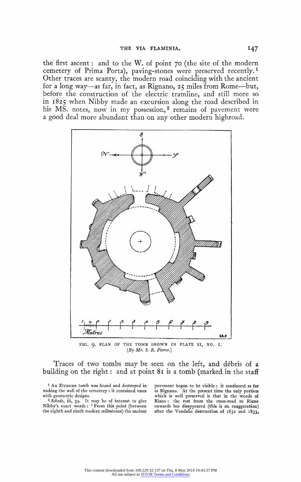
FIG. 9. PLAN OF THE TOMB SHOWN IN PLATE XI, NO. I.
(By Mr. S. R. Pierce.)
Traces of two tombs may be seen on the left, and debris of a building on the right: and at point 8I is a tomb (marked in the staff
1 An Etruscan tomb was found and destroyed in making the wall of the cemetery : it contained vases with geometric designs.
2. Schede, iii, 39. It may be of interest to give Nibby's exact words: 'From this point (between the eighth and ninth modern milestones) the ancient
pavement began to be visible it continued as far as Rignano. At the present time the only portion which is well preserved is that in the woods of Riano: the rest from the cross-road to Riano onwards has disappeared (this is an exaggeration) after the Vandalic destruction of I832 and I833,
This content downloaded from 169.229.32.137 on Thu, 8 May 2014 19:43:37 PMAll use subject to JSTOR Terms and Conditions
148 THE VIA FLAMINIA.
map) on the E. of the road, of concrete faced with opus reticulatum 1 it is circular, with I 7 niches outside, and, by a natural popular exaggeration of their number, is known as Centocelle (plate xi, no. I). 2
The circular3 interior (entrance on the E.) has a round opening in the roof and four square openings low down, one in each of its semi- circular niches, each of which corresponds to one of the points of the compass. 4
A little further on, on the W., at point 86 is a reservoir, and at point 92, on the E., the debris of a villa (?). 5
Half a mile further N. we get traces of pavement at two different points, E. and W. of the modern road. Near point IOI there is a modern osteria, and to the W. of this an ancient road descended through a cutting I45 feet long to the Fosso della Torraccia, finally passing through the tunnel in the rock known as Pietra Pertusa.6 The original measurements of this tunnel seem to have been 2-40 metres wide and 3 30 m. high: but the latter has been increased by the erosion of the soft tufa of the floor. At the W. end are three loculi (?) and on the S. side traces of an inscription, now obliterated. I Close to it is a large cave 28-80 m. long, 7-80 m. wide, 2-22 m. high: and a little to the N. a fountain cut in the rock 2 m. wide and I 40 m. high, supplied by a channel. On the hill to the W. is a mediaeval tower8 (the Torraccio), built in stripes of black and white stone: and in the valley to the N. of it is flat ground, which was probably marshy in Roman times: for E. of point 9I the stream is taken through a rock-cut channel. Nibby maintains that the road which passed through Pietra Pertusa ran on westwards to Veii: but I have not been able to trace it.
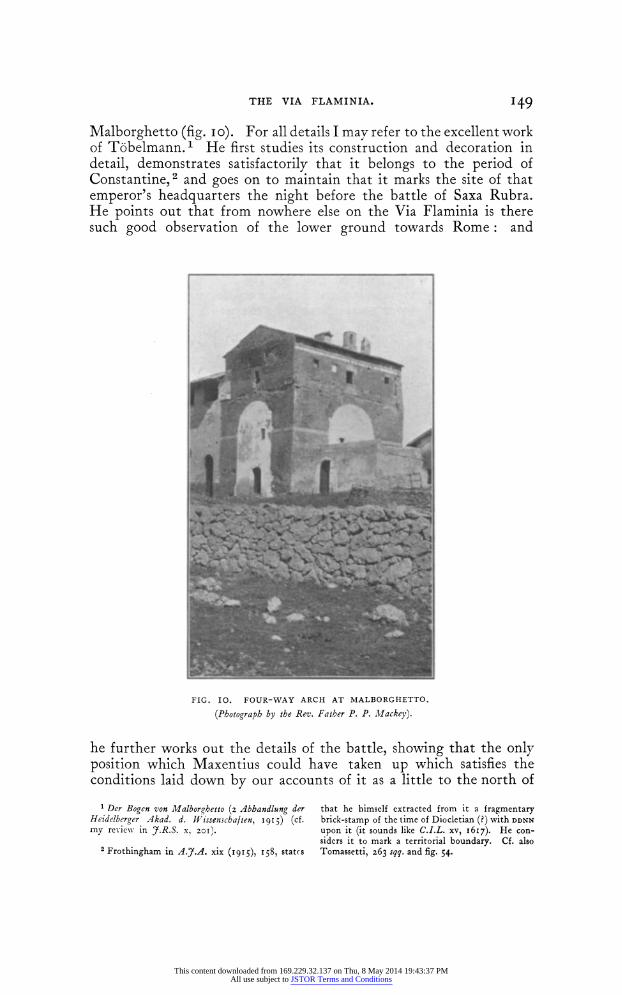
A mile further on there is pavement on the right of the modern road, leading straight to a four-way arch of concrete faced with brick-work, which is incorporated in the modern casale of
which is witnessed by the broken stones on the right and left. At first the pavement consisted of old stones relaid: but afterwards it was the actual ancient pavement, and the crepidines were often preserved as well.' An interesting light on this is thrown by certain document3 in Atti del Gamer- lengato, Tit. iv, fasc. 456. On June i6th, I842, the President of the Comarca asked that, in order to save expense in diverting it, the modern road might be allowed to run for 320 metres over the ancient pavement, which was to be covered with earth for a depth of one metre. This was some- where in the second ' tronco ' (the place is not exactly specified): and on Dec. 3 ISt, I846, a similar request was made for a part of the first ' tronco,' near the Macchia delle Quartarelle, before the Osteria di Rignano. The Archaeological Com- mission recommended, on May I4th, I847, that four well-preserved stretches of the length of 92,
IOO, 76, and 70 metres respectively, should be left uncovered: and this was done (p. i5i) although the erection of a column at each, stating that this
was the ancient Via Flaminia, was, though requested by the Cardinal Chamberlain, not carried out. The last document is an appeal from various landowners and ' negozianti di Campagna ' to the ' cittadino Ministro,' dated 22nd March, I849, that the ancient paving-stones might be removed and broken up as the road was so bad; they were, however, referred to the Presidenza della Comarca.
1 The cubes are small (007 m. square on an average) and the joints fine (o-oo8 to o-oi5).
2 Nibby, Analisi, i, 299. Tomassetti, iii, 49, 26o. 3 The plan (fig. 9) was drawn for me by Mr. S. R.
Pierce, Rome Scholar in Architecture at the British School at Rome.
4 A plan is given by Pirro Ligorio (Neap. lib. 49). Nibby (Sch. cit. ad fin) calls it a tomb.
6 Nibby, Analisi, i, 298 ; ii, 56i. Tomassetti, 26o. 7 I read ' COCTMAL' in letters about I2 cm.
high. 8 Nibby (Schede, iii, 40) notes two grottos (shrines
he calls them) below the hill opposite to the one on which the tower stands.
This content downloaded from 169.229.32.137 on Thu, 8 May 2014 19:43:37 PMAll use subject to JSTOR Terms and Conditions
THE VIA FLAMINIA. 149
Malborghetto (fig. io). For all details I may refer to the excellent work of T6belmann. 1 He first studies its construction and decoration in detail, demonstrates satisfactorily that it belongs to the period of Constantine,2 and goes on to maintain that it marks the site of that emperor's headquarters the night before the battle of Saxa Rubra. He points out that from nowhere else on the Via Flaminia is there such good observation of the lower ground towards Rome: and
4
FIG. IO. FOUR-WAY ARCH AT MALBORGHETTO.
(Photograph by the Rev. Father P. P. Mllackey).
he further works out the details of the battle, showing that the only position which Maxentius could have taken up which satisfies the conditions laid down by our accounts of it as a little to the north of
' Der Bogen von Malborghetto (2 Abbandlung der Heidelberger Akad. d. WVisseniscbaften, I9I5) (cf. my review in 7.R.S. x 201).
2 Frothingham in A.J.A. xix (1915), 158, states
that he himself extracted from it a fragmentary brick-stamp of the time of Diocletian (?) with DDNN
upon it (it sounds like C.I.L. xv, 1617). He con- siders it to mark a territorial boundary. Cf. also Tomassetti, 263 sqq. and fig. 54.
This content downloaded from 169.229.32.137 on Thu, 8 May 2014 19:43:37 PMAll use subject to JSTOR Terms and Conditions
I50 THE VIA FLAMINIA.
Prima Porta, between the Via Flaminia and the river. We know that the position was on ground adapted for cavalry, and that he had the Tiber in his rear. Trusting in superior numbers, and wishing to make it impossible for his troops to give way, he committed the one fatal error of neglecting to secure a possible line of retreat, so that a panic was bound to end in disaster. Moltke indeed selected a far better position on the hills to the north of the Valchetta, and no doubt had Maxentius chosen it, things might have gone very differently: but Toebelmann rightly insists that it could then in no sense have been said that he had the Tiber in his rear. Seeck's idea that Maxentius was caught in column on his way to Saxa Rubra will not agree with our sources, nor does the position seem strategi- cally possible.
In my review of T6belmann (7.R.S. x, 201) I omitted to notice that Maxentius appears to have made precisely the same error that was the cause of the defeat of the Romans at the Allia just over 700 years earlier. They, too, took up a position in which their retreat was not secured, though the rest of the course of the action was entirely different. At Saxa Rubra Constantine's cavalry attacked the right wing in the plain, and the praetorians (who probably held the Via Flaminia on Maxentius' left) were the only troops who stood their ground, and were cut down to a man. At the Allia, on the other hand, the weaker troops held the stronger position, on the right (I think Kromayer's recent demonstration that the battle occurred on the left bank is convincing-see his article Drei Schlachten aus dem griech.-rom. A1tertum in Sdchsische Abhandlungen xxxiv, 5 (1921) ii, Allia p. 28, sqq., summarized in Kromayer and Veith in Schlachtenatlas, Rom. Abt. Bl. i, text) and it was they who first gave ground and led to the general rout, in which the majority of the survivors were forced back against the river, and only saved themselves by swimming across it.
The side openings of the arch do not seem to correspond to the beginnings of branch roads going E. and W., as one might have supposed. Attempts to trace them have proved decidedly un- satisfactory.
Beyond Malborghetto Nibby notes traces of the ancient road to right and left,' but there is little to be seen at the present day until point 154, where there is (perhaps) a tomb on the W. edge of the modern road, and the bank of the ancient road to the E.; then at point I91 2 there is a cutting W. of the modern road; and there is more pavement E. of point 2I1, and the remains of a villa and pavement a little before point 2I0, to the E. of a prominent knoll on
1 Two miles N. of Malborghetto, at the fourteenth mile, he notes a deverticulum to the right (Schede, iii, 4I). The Osteria di Riano is I53 miles from Rome, so it would be about halfway to that point.
2 Carta d'Italia f. 144, iii, N.O. (Castelnuovo di Porto; i: 25,000).
This content downloaded from 169.229.32.137 on Thu, 8 May 2014 19:43:37 PMAll use subject to JSTOR Terms and Conditions
THE VIA FLAMINIA. I5I
the W. of the modern road. This last piece must be one of those- which it was decided to preserve in I847 (supra, p. I47, n. z). A. little to the W. are traces of a tomb.
About half-a-mile further is the Osteriola or Osteria di Riano. Near it, according to Nibby,1 traces of an ancient road coming to join the Via Flaminia, and sculptures belonging to a tomb. were found in the wood: he unluckily omits to say on which side of the road they were, so that it is uncertain whether the reference is to a road on the west (as is probable, cf. infra), or to the modern road which diverges SE. to the village of Riano and the Via Tiberina. 2
There is broken selce in the southern branch (the one now used by the modern road) while the branch from point 230 (now a mere path), passes through deep cuttings and is probably of ancient origin.
Near the sixteenth mile of the Via Flaminia, on the so-called Monte del Morto, a little before the Osteria di Riano, a Christian sarcophagus and some inscriptions (Tomassetti adds marbles and statues, but of little value) were found in I876-in isolation, and not associated with the ruins of any building. 3 The sarcophagus is said to have passed into the Boncompagni collection, but I know no more.. It is not mentioned in Schreiber's Villa Ludovisi nor in Paribeni's Guida del Museo Nazionale Romano.
Nibby notes paving at two or three places before Castelnuovo is reached, where it is now no longer visible.
Some 300 metres beyond point 230 there is paving on the right of the road, and opposite to it a rectangular concrete platform, faced with very rough opus reticulatum.
Three different paths lead down to the deep Fosso S. Antonino from the highroad besides that from the Osteriola, none of them demonstrably of ancient origin. There is a mound on the right, just opposite the first of these, which conceals the foundations, in concrete, of a lofty isolated building, probably a tomb-or else a mediaeval tower.
The valleys approach the Flaminia more closely on each side, but just before the Castelnuovo turning is reached that on the E. suddenly ceases, and gives the latter a narrow neck upon which to run.
We now reach the turning to Castelnuovo, which perhaps follows an ancient road. Tomassetti4 thinks that the caves before the village is reached, on its E. side, are Etruscan tombs. Castelnuovo itself occupies a hill between a small depression on the E. and the deep valley of the Fosso Chiarano on the W. It was of considerable importance in the Middle Ages. Whether it was an ancient site is unknown.
1 Schede, iii, 4I. 2 The monastery of the Cappuccini, on the
N. of this road, probably occupies an ancient site.
3 Bull. Crist. I876, 27 sqq. tav. iv-v. 4 Op. cit. 289, 295. To me they seem to have
been so modified that it is impossible to say for certain.
This content downloaded from 169.229.32.137 on Thu, 8 May 2014 19:43:37 PMAll use subject to JSTOR Terms and Conditions
152 THE VIA FLAMINIA.
An ancient road diverged from the Via Flaminia at the post- station of Castelnuovo di Porto, and ran down to the Via Tiberina at Ponte Storto.
It must have passed near the cemetery, and from there descends in a SE. direction, keeping to the NE. of the summit1 of the hill which lies E. of the village of Castelnuovo, to point 2I5 (NE. of S. Sebastiano) where its pavement may be seen in situ, and many loose paving-stones. The short branch path going due S. from point 2I5 prolongs the line (its E. margo may be seen in situ); while the path leading E. from S. Sebastiano, in the wall on the S. of which paving-stones may be seen,2 may be of ancient origin.
Further on in the Vigna Fivoli (formerly Menichelli; also known as Vigna Grande) (ust NW. of the house marked N. of the n
in Sebastiano) the pavement of our road may be seen in situ, running ESE., just inside the hedge to the N. of the path which runs E. from S. Sebastiano. To the N. is a cliff at the edge of the summit of a little hill: and here is a square vertical shaft, which leads down to some underground chambers, which appear to be cisterns 3: there are a very few bricks on the hill-top above, but more below the ' columbaria.' A little further along the cliff are two rock-cut chambers with small niches about 0o22 by 0o25 metre, like the 'columbaria' at Toscanella,4 Viterbo, and elsewhere. It is, however, important to notice that there are some similar niches in a certainly post-Roman dividing wall, a fact which seems to indicate that they are definitely not ' columbaria': and I imagine that they should rather be regarded as actual dove-cotes.
Tomassetti5 noted in his earlier work two fragments of a fine bas relief in the vineyard, one representing a player of the double flute and a warrior dealing a blow with his sword: the other, the lower part of a warrior with another resting. These have disappeared; but the inscription of Perellia 6 iS still there.
Outside and just beyond the vineyard 7 are some very large paving-stones (two measured I38 by o-8o and I3o by o095 metres respectively). The remainder of the course of the road may be dealt with on another occasion.
Various discoveries of antiquities made near Castelnuovo are enumerated by Tomassetti. 8 Pietro S. Bartoli 9 says ' At Castelnuovo
1 This is marked by the word DI in the map. I was told it was called Monte Funicolo.
2 The pavement of the ancient road came to light at Castelnuovo tram station in i9z3, on the north edge of the modern.
3 I suppose these are alluded to by Tomassetti, 289, as remains of Roman ' vaulted constructions almost entirely buried.' He also mentions the 'columbaria.'
4 Dennis, Cities and Cemeteries of Etruria, i, 484. 5 Campagna Romana (i886), i, 483 seq. 6 C.I.L. xi, 3992.
7 It is, of course, an error (p. 295) when he calls the Vigna Fivoli two kilometres beyond S. Sebas- tiano ; it is really about half a kilometre.
8 Near a ruin called Bamboccio, two miles from Castelnuovo, and thirteen from Rome, a small catacomb was excavated by Cardinal Flavio Chigi in the seventeenth century (Boldetti, Cimiteri, 577).
Some unimportant excavations made in I830 by Vescovali' are mentioned in Bull. Inst. I830, 247
1832, 4- 9 Mem. I5I in Fea, Misc. i, 259; Roma Antica
(I74I), 355-
This content downloaded from 169.229.32.137 on Thu, 8 May 2014 19:43:37 PMAll use subject to JSTOR Terms and Conditions
THE VIA FLAMINIA. I53
many statues, columns, and ancien-t monuments, as well as various bronze figures have been found; as happened in the time of Alexander VII, when one of the inhabitants, who conveyed to Rome a figure 4 palms (o-89 metre high), was put in prison, and the statue was taken from him. . .' The sundial now in the Museo dei Conservatori was found at Castelnuovo in I75I, and presented by Benedict XIV. 1
An inscription now preserved at Tor Pignattara shows that a statue of Tiberius was found in a well between the Via Flaminia and Castelnuovo on Ist Dec. I78I. Tomassetti conjectures that the statue may be now at Naples. 2
Guattani 3 describes and illustrates an Etruscan mirror with the myth of Marsyas found near Castelnuovo by Avvocato Miselli in I784.
The old posting inn on the Via Flaminia4 at the turning to Castelnuovo contains a few antiquities, enumerated by Tomassetti, and an interesting inscription relating to repairs to the road in i5 8o-Clarix Columna Anguillaria Viam Flaminiam ante deviam spinis et terra alte obrutam labore et impensa oppidanorum Castri novi purgatam aperuit, etc. 5 After leaving it, another deep valley develops on the E. of the road, while the Fosso di S. Antonino6 runs to the W. of it for nearly another 2 miles. From the Colle Posta onwards there was still a good deal of pavement in June I905, much of which has since been removed. NE. of point 286 is a concrete wall faced with opus reticulatum; and, nearly a mile further on, on the right, is a mediaeval castle on a hillock with the chapel of the Madonna della Guardia, which according to our measurements corresponds to the station of ad Vicesimum. 7
Just after the Madonna della Guardia is the tram station of Morlupo, where the modern road to Morlupo and Leprignano diverges. As far as the Casale Angelo Custode, a mile NE. of the former, it follows an ancient line, 8 but at that point the ancient road turned northwards to the site of Capena, which stood on the hill of Civitucola 4 miles NE. of the Madonna della Guardia. Here several inscriptions of the municipium Capenatium foederatum have been found. 9
1 Nuova Descrizione (i88z), App. p. xx. B.S.R. Catalogue, Giardino 4za.
2 R. Museo Borbonico, vol. ix, tav. xxv; Bernoulli, Rdm. Ikon. ii, I) 149, no. 22; Guida Illustrata, ioi5. The conjecture will not, however, hold, as the statue was already known in the sixteenth century, and illustrated by Cavalieri (P.B.S.R. ix, p. I45, no. 27)-
3 Mon. Ant. Ined. I785, I7. 4 See Treves, The Country of the Ring and the
Book, 45, 2I8. 5 Tomassetti, 293 ; cf. 2oo, 20i for further
interesting remarks as to the history of the road. 6 The chapel of that name is a modern ruin, and
so is the Casalaccio at point 267, over a mile N. of it. 7 Tomassetti, 296. 8 Lanciani in Not. Scavi, I878, z6o, who notes
that the road was known to eighteenth-century authors (Volpi, Vetus Latium, and Galletti, Capena), and believes that it left the Flaminia at the Romitello (but this would have given it an extra valley to cross). The pavement was actually found at the highest point of the hills between Morlupo and Leprignano, on the so-called Monte Candeletto, on the line of the modern road.
9 See my .article in Encycl. Brit. s.v. Capena.. I shall deal with this district more fully in discussing. the Via Tiberina.
This content downloaded from 169.229.32.137 on Thu, 8 May 2014 19:43:37 PMAll use subject to JSTOR Terms and Conditions
154 THE VIA FLAMINIA.
Returning to the highroad, we find that it soon turns westward almost at right angles in order to turn the head of the Fosso S. Antonino, now called the Valle Quercia, and keeps to the watershed between it and two other valleys to the north. There are still considerable traces of pavement and there were more before the tramway was made in I905. Just beyond the Romitello an ancient road diverged -to the SW. (it is marked in Ameti's map of the Patrimonio di S. Pietro as JVestigia riae) towards Campagnano: it is now followed by a modern one,1 in which the ancient pavement can still be recognised at various points, e.g. S. of point 354-at one place, indeed, its width can be measured as about 2-50 metres between the crepidines. To the N. of this divergence the highroad turns to run north once more. I saw, in June I905, pavement both in the modern road and above it to the E, and the brickwork of a tomb between them. It was, I think, only a short variation. There were considerable remains of pavement to the N. of this point both E. and W. of the modern road, which still follows the only possible line, the ridge between the streams on each side of it. Gell marks a reservoir on the left in his map rather over a mile after the Madonna della Guardia.
Five hundred yards N. of Ad Vicesimum lies I1 Muraccio (the ruin) on the right of the road just before it turns westward. It has been frequently excavated. Some marble fragments, including two heads, were found here in I906. Apparently there was a small temple in Republican times, inasmuch as some fragments of terra-cotta, including a fine relief of the first century B.C. with the Corybantes drowning the cries of the infant Zeus, came to light; remains of buildings, which were wrongly thought to be traces of the post-station of the Imperial period, and a Christian catacomb, have also been found. 2 Among the inscriptions found here we may note two large sepulchral Cippi3 belonging to members of the same family, M. Junius Rufus Pythion and M. Junius Saturnus: the former is des- cribed as a native of Aquae Sextiae (Aix en Provence) the latter as Rutaenus ex Aquitanica (the Rutaeni were a frontier tribe on the line between Aquitania and Gallia Narbonensis, but were assigned by Augustus to the former).
To the S. and E. of the Osteria Nuova (on the S. edge of the Poggio Mirteto sheet4) are mediaeval ruins; while to the N. of it on the same side Pasqui5 notes two groups of Roman ruins, one of them
I At the divergence is the tram-station of Magliano.
2 Paribeni in Not. Scavi, I9I3, 382; De Rossi in Bull. Crist. I883, II9; An. Inst. I883, 253.
3 C.I.L. xi, 3934; Not. Scavi, I9I8, I27. 4 Carta d'Italia f. I44, iv (I :50,000).
5 In the voluminous text attached to the Carta Archeologica dell' Etruria, for which he and Cozza made preliminary journeys in the early 'eighties. The map has unluckily never been completed nor
published. I was allowed to consult it in I9I8 by the late Prof. Angelo Colini, but only concerned myself with remains of the Roman period, for which it contains very valuable material. A portion of the first section of the Carta Archeologica d'Italia, dealing with the neighbourhood of Terracina and Monte Circeo, has just appeared, with accompanying text and illustrations by Sigg. Lugli and Gismondi: and if the work can be continued and completed in the same manner, it will form a worthy record of the ancient monuments of Italy.
This content downloaded from 169.229.32.137 on Thu, 8 May 2014 19:43:37 PMAll use subject to JSTOR Terms and Conditions
THE VIA FLAMINIA. I55
under the Casale. A little to the north, W. of point 242, I measured the width of the road as being 4f29 metres.
A little further on, E. of the d at Spedaletto, is a reservoir with three parallel chambers and other remains of a large villa, identified by Pasqui with the Villa Rostrata, which, according to Itin. AInt. was a post station 23 (or 24) miles from Rome. 1 The pavement continues to appear as far as Rignano Pasqui gives its width as 4-20 metres (I4 feet-the normal width of a Roman highroad)-and may be seen in a cutting E. of Monte delle Castagne. 2
That Rignano occupies an ancient site is considered certain by Gabrici and Giglioli3 owing to the discovery at Monte Casale and on the Colle della Croce of tombs of the eighth-third centuries B.C. The former site is not fixed for us, and neither can be found on the military map ; the latter is, we are told, a mile S. of Rignano (and is therefore also known as Miglio) close to the Via Flaminia, and presumably (but we are not told) on the east. This is another case of lack of exactitude in description. Scanty remains of a Roman building were found on the S. side of the Colle la Croce, and an iron pickaxe- head.
The modern village contains a good many Roman antiquities enumerated by Tomassetti. 4 We may add that Pietro Sante Bartoli (Val. Lat. 3I05, f. 5I) gives a drawing of a female figure which he describes as an Egyptian basalt statue at Rignano (Bull. Com. X (I882), 232) and that a marble sacrificial vase with reliefs repre- senting a Pan-like figure threatening a wolf, while another wolf devours a sheep, was also found here. We have here probably Silvanus represented as Faunus protector of the flocks: the inscription on the lip runs thus: [ . . . ] no sacrum Q. Caecilius Amatndus scrib(a) libr(arius) q(uaestorius) iii dec(uriarum) et . Tullius Q. f. Fal. Caecilius Armandus d. d. (Paribeni in Boll. d'Arte, vii (I9I3) I64).
To the E. of Rignano lies the church of S. Abbondio ed Abbondanzio which is reached by a diverticulum from the village. Some pavement was seen under the Arcaccio (the old E. gate of the village ?) in I8645 and there are some paving-stones near the church. This is built, Tomassetti6 thinks, on a wall of opus quadratum belonging to an ancient temple (?) and round it are traces of constructions which may have belonged to its precinct. In front of it are remains of a water reservoir and a curved grotto of large blocks
'Hence, Pasqui says, came the columns and sarcophagus now at the fountain of Rignano (Tomassetti, ii, 344, says the columns came from S. Abbondio), and many inscriptions. He notes a tomb opposite to it.
2 Pasqui notes some ' sepolcri a cassa ' in the cutting.
3 Not. Scavi, I912, 75; 1914) 265. The latter, however, seems to hedge in footnote 2 to p. z65, where, after having affirmed the identity in the text, the writer says ' from the inscriptions and
marbles found there, the ancient centre seems to have been to the E. of the miiodern village, where the church of S. Abbondio now stands.' Cf Taylor in 7.R.S. x, 34, who enumerates the various inscriptions found in and near Rignano, and con- jectures that it may occupy the site of Fescennium.
4 Tomassetti, 343 sqq.. Dennis, i, 133 (who argues that it occupies a Roman site from the Roman fragments which are to be seen in the village).
5 Gori, Ann. Inst. i864, II7. 6
op. cit. 344.
This content downloaded from 169.229.32.137 on Thu, 8 May 2014 19:43:37 PMAll use subject to JSTOR Terms and Conditions
I56 THE VIA FLAMINIA.
of tufa; the antiquity of the latter seemed to me, I must say, not absolutely certain. S. Abbondio may have been the site of the ancient Lucoferonia'- and was possibly that of a pagus.2 There are a number of architectural fragments and some inscriptions built into the church,3 which contains some eleventh century paintings, and has an elegant campanile of the twelfth or thirteenth century.
From S. Abbondio a road, according to Pasqui, runs back to the Via Flaminia, which it reached at the cemetery. Traces of it may be seen-(a) a cut along the ' scogliera delle vigne ' (b) a ruined tomb on the plateau (c) a cut near the catacombs (a section in the highroad)-but no pavement.
After Rignano it becomes more difficult to determine the course of the ancient road; beyond the Osteria di Stabia Kiepert marks it as following the modern road to Civita Castellana, and only indicates the direct line as doubtful ! But this is certainly wrong. 5
Holste (ad Cluver, 545, 2) has the following passage, ' Mirum sane non advertisse Cluverium ductum veterem viae Flaminiae patrum nostrorum memoria a Sixto V et Clemente VIII Pontificibus fuisse mutatum. Nam totus ille tractus ab Arignano ad Civitatem Castellanam, et inde Borghettum et ad Pontem Felicem recens est, neque ullum habet vestigium antiquitatis. Vetus autem Via Flaminia ab Ariniano deflectet sinistrorsum ad vetus oppidum Aquaevivae per collem editum, inde viam recentem secans Treiam transibat duobus m . p. sub civitate Castellana atque oppido Galese usque ad Pontem Augusti Tiberim': while Pasqui makes it leave the modern highroad at point 263 and follow the boundary between the Vigna Gaia and the Oliveto Sinibaldi, where he saw pavement, along the slope called Boschetto, then through a deep cutting to the NW. and then N. to the cemetery of Rignano. This cutting, however, seems to me to be a good deal too narrow for the Via Flaminia, as it is only about 2 50 metres wide.
From it, a little N. of the catacombs, a broad deep cutting descends in an easterly direction (while the cutting we have been following goes on a little further N. and loses itself on the hill-top N. of point 219).6 From this Pasqui takes it along a shelf on the E. bank of the Fosso Valerano and so, past point 263, back to the modern highroad W. of point 254.' In this last portion I could see no traces of it whatsoever.
Pasqui's other suggestions for alternative lines for the Via Flaminia
1 Bull. Inst. i864, I43 ; Nissen ii, 369, who wrongly takes the ancient road as far as Soracte.
2 C.I.L. xi, 393I. Bull. Inst. I883, z8z. The inscription was, however, found at the catacombs (see note 6).
3 Tumiati in L'Arte, I898, I3.
4The catacombs of SS. Abbundius and Abbun- dantius in the praedium Theodorae are half a mile
N. of the town, close to the modern cemetery (Bull.. Crist. i865, 24; ISSI, 120; 1898, 43).
5 The course of the Via Flaminia on the map in 7.R.S. cit. is copied from Kiepert, but does not even mark the direct line.
6 Pasqui says, however, that this lane (over Monte Acciano to Faleria) represents an ancient road.
' S. of point 254 I saw bricks loose belonging to some small building.
This content downloaded from 169.229.32.137 on Thu, 8 May 2014 19:43:37 PMAll use subject to JSTOR Terms and Conditions
THE VIA FLAMINIA. 157
cannot be dealt with here: I shall hope- to return to them on another occasion. There are no traces of antiquity along the modern road from Rignano to Osteria di Stabia: but I am not prepared to indicate any other probable course for the ancient road; and here, as before, it appears to have taken the only possible line between the deep valleys on either side. Mount Soracte is prominent on the left, and is easily accessible on this side.
From the Osteria di Stabia to the Monte dell'Osteriola, below which at the tram-station of Faleria the modern road from Faleria comes in,I Pasqui marks an absolutely straight line going NNW. and keeping, now E, now W, of the modern road, which winds considerably: apparently he saw cuttings, but no pavement,
The thirtieth mile of the road would, according to our measurements, fall about 500 metres to the south of the Monte dell'Osteriola; and here on a hill on the left of the road is a spring, still known locally as Aquaviva, where remains of ancient buildings have been found, though nothing is now visible above ground. 2
The post-station of Aquaviva is mentioned in Itin. Hierosol. as lying I2 miles beyond Ad Vicesimum and 12 from Ocriculum (Otricoli), the real distance being IO and I3 miles respectively: while in the Tabula Peutingerana the figure has fallenout.
On the Monte dell'Osteriola Pasqui noted a tomb at the so-called Ca'del Vescovo; but the hill is now occupied by the large modern villa of Comm. Alberto Trocchi, who has collected some antiquities. from the district, which he kindly allowed me to examine. A number of the inscriptions were brought from Rome, but three fragments of an inscription are said to have been found here.3 The letters, are hollow, so as to serve as the matrices for bronze letters, and vary in height from 8 (first line of first fragment) to 6 cm.
1. MmGELL PROC AVG
DEC VRI T PRAE
11. ALTINIANI VS VIXIT
iii. fRATRE SVO NDIVIDVV
ET I Pasqui believes this to represent in part an
alternative road from Rignano. 2 Holste (ad Cluver, 5ZS, 43) has, as so often,
already seen the truth. He places the divergence from the modern road a mile (really two) beyond the Osteria di Stabia, and notes 'large ruins of ancient buildings to tbe left of the junction and of the modern road, and a plentiful spring and a church called the Madonna d' Acquaviva.' A bishop of
Aquaviva [this ?] appeared at the Council of Rome in A.D. 487. Nibby (Delle Vie degli Antichi in Nardini, iv, 72) noted that the spring came out of an ancient wall, and that there were other ruins there. Cf. also Nissen ii, 367. Pasqui, too, had seen or heard of ruins there.
3 We were told that- some burials were found under the new chapel, and some inscriptions (but not apparently those now preserved at the house).
This content downloaded from 169.229.32.137 on Thu, 8 May 2014 19:43:37 PMAll use subject to JSTOR Terms and Conditions
158 THE VIA FLAMINIA.
They obviously belong to a sepulchral inscription, and may be restored as follows:
(i) M. Gell[io] . . . [p]roc(uratori) Aug(usti) . .. decuri[oni]... (2) . . altiniani . . us vixit (3) iu]re suo . .. i]ndividuum. I was also shown a lamp, with a crab on the front and the stamp
L CAE SAE (C.I.L. xv, 6350 c) and some red embossed ware and a piece of ' Samian,' all of which were said to have been found at Aquaviva.
To the NW. of the Monte dell'Osteriola I saw in I92i a small rectangular foundation of travertine blocks (about 3 550 by 250 m.) which had recently been excavated; it was orientated 20? E. of N. and thus gave the line of the road, which ran to the E. of it. Pasqui saw a cutting and some pavement nearly a mile further N., and some 500 m. to the N. a tomb-a mound covered with thick trees surrounded by a line of large travertine blocks, with traces of construction above. The blocks have been removed, I think, to a modern farmhouse: the tomb I did not find.
We then reach the Ponte Ritorto, which is 6-6o metres in length and 5 8o in width with a single arch 5-92 m. in span; the voussoirs are 0o50 m. wide and the springers o-6o m. high. There is a wall up- stream of it on the right bank to keep the stream from erosion. Further on is another tomb and then a small culvert, now modernised, close to which, Pasqui tells us, a number of lead syphons were discovered at various times. We then reach the mediaeval Torre Pastore, beyond which the Via Flaminia is followed by a countrv road in which some remains of paving are visible. There are more tombs on the W. of the road, including two tombs cut in the rock (' le grotte di Sciabada '), which I did not myself see. N. of the site of the 33rd mile are a reservoir and a tomb on the right. Pasqui indicates another tomb on the left, which is now no longer visible. Here the pavement is 4f60 m. wide.
The road now descends, and approaches one of the principal obstacles in the first portion of its course-the valley of the river Treia, which is subject to violent floods, one of which, only two years ago, carried away the modern bridge just below, Civita Castellana. The valley is about 1,300 yards wide, and the drop in level to the bottom is about 250 feet on the south, while the ascent on the north is some I50 feet. The difficulties were considerable, but have been very well dealt with: and the causeways and bridge by which the Roman engineers took the road across the valley form a splendid monument of their skill. The survey which Mr. Pierce and Mr. Armstrong have made (fig. i i) renders only a brief description necessary.
On the south side of the valley the road runs along the slope, being supported on the outer side by an embankment wall, the blocks of which have for the most part been removed. The road bed is oo90 m. thick, including the selce pavement blocks, and consists of large lumps of stone and earth. The width of the embankment is 8-20 m.
This content downloaded from 169.229.32.137 on Thu, 8 May 2014 19:43:37 PMAll use subject to JSTOR Terms and Conditions
Secr ON -L'' X-
LLA-~~~~~~~~~~~~~~~~~~~~~~~~~~~~~~~~~~~~~~~~~~~~~~~~~
7/~~~~~~~~~~~~~~'
/~~~~~F _ p- _ i ock-ctl TOMB. /--'s/ URdA SINK0 C, NIN oCK FA
< \ < } ~~~~~~~~~~~~~~~~~~~~~~~~~~~~~~~~~~~OK AXDE: SUrE OP W,
_ >< / r 0 \ \ | \ G
~~~~~~~~~~~~~~~~~~~~~~~~~BouLNDARy STN., MD
.. . i.iii........ - . _ .... - .ULEAVAD . VA P.IE. ; .
FjK1SiKC.' IAw I. CAUSKM!NY OF THE VIA TNIA ~~ C SM~~~~~~~ P00-O4rTbA4B~~~~~~JXZ Fm
FIG. 11. AUSEWAY O TE VIAZJFLAMINIA A
This content downloaded from 169.229.32.137 on Thu, 8 May 2014 19:43:37 PMAll use subject to JSTOR Terms and Conditions
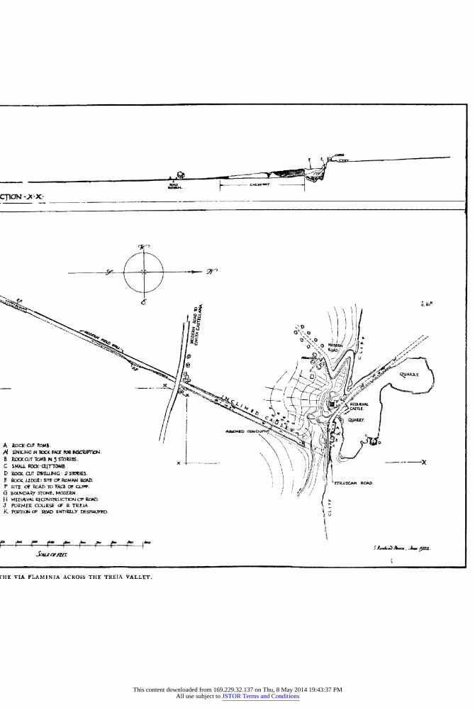
CTICT -' X-_-
A ~~~~~~~~~~~~~~A
X ~~~~~~~~~~~ C
A4%"D ID U I Du* 2
A ocx-cuT tOM. |'D
B RCKJT TOMB INS T OES - ______
C SMA.L PaOx-CLITbAiB 4 ' D Ro CJT Dr4LWNG: 2 SIvIES. f VOCKV LDGE: SFTE (DP WMAN RCl.
fTRSCAN ROAD- P sITE C* ROAM To FACE Of C'. |/ / T G BoLWDARy STCNL, 'CDEP.. / R MEDIAVAL PEGOISWUCTDN CT R4 AD. J FORMrR COUEISE' R - TUElA K PoRllat oP Ra4D ENTIREJY
msnErwrD1 U
[HE VIA FLAMINIA ACROSS THE TREIA VALLEY.
This content downloaded from 169.229.32.137 on Thu, 8 May 2014 19:43:37 PMAll use subject to JSTOR Terms and Conditions
THE VIA FLAMINIA. 159
and of the road itself 5 20 m. Shortly after the second turn the embankment is traversed by a culvert 3 o5 m. in span (the Voltarella) with nine voussoirs in the arch. The river has changed its course since Roman times, and has therefore carried away the greater part of the bridge, which must have been of considerable size.1 All that remains on the left bank is a pier with part of one arch; the width is only 4'50 m., the core is of concrete, and the four remaining voussoirs, which are each i 3o m. long and o6o high, have been mortared: so that I should be inclined to consider the whole as a mediaeval restoration. Close by is the mediaeval Torre di S. Giovanni; and just beyond, at H, is a small piece of undoubtedly mediaeval reconstruction, important, however, as giving the actual point at which the road turned from WNW. to NE. In the portion between this point and the modern road to Civita Castellana, Pasqui noticed two culverts, each I 30 m. in span, in which mortar is used2; I did not myself see them. After the modern road we come to the Muro del Peccato, an inclined causeway nearly 6oo feet in length, supported by walls of opus quadratum of tufa on each side. There are I9 courses at the highest point, each 0o59 m. in height (thus giving a total height of II 2i m.) composed of alternating headers (o55 m. wide) and stretchers (Ir90 m. long).
The courses are inclined to follow the upward slope, and the joints are not always vertical. A little mortar is used, but is not universal. The width at the top is Io050 m., and the space between the two walls is fitted with pieces of tufa and earth. At the point marked in the plan there was an arched conduit through the embankment.
At the upper end there is a sudden break, due no doubt to some convulsion of nature: the name of the embankment wall (Muro del Peccato, 'the wall of sin') probably refers to the fact that the builder was supposed to have sold his soul to the devil, or to some particular iniquity which was punished by the destruction of the roadway. Where the causeway should have reached the rock, we see, at a higher level, the cutting of a narrower Etruscan road descending from the E. which was cut across when the Via Flaminia was constructed.
The latter then turned W. and ran along a ledge of rock, on the N. side of which is a group of rock-cut tombs with arched niches for bodies (A-C on plan), the largest of which (A) has its roof supported by two pillars of natural rock. The road then bears N.W., and here a mediaeval castle was built on the brow of the cliff to guard the passage. To the N. of it is a group of quarries, in one of which (at D) is a rock-cut dwelling in two stories.
Despite the fact that it is visible from the main line to Florence (if one knows where to look) I must confess that my knowledge of the Muro del Peccato was derived from Pasqui's notes.
1 The site of the 34th milestone falls just S. of the river, which is fordable here in dry weather.
2 This he regards as a sign of later date; but he holds the same opinion (wrongly, I think) in regard to the Voltarella.
This content downloaded from 169.229.32.137 on Thu, 8 May 2014 19:43:37 PMAll use subject to JSTOR Terms and Conditions
i6o THE VIA FLAMINIA.
As far as I know the only author who has mentioned the Muro del Peccato in print (it is not indicated on the Staff Map) is Brandenburg.1 He describes the mediaeval castle as probably erected on the site of an ancient ' kaleh,' notices the existence of rock-cut steps, etc., and a large egg-shaped receptacle (like those of Troy) about 3 m. high and 2 m. in diameter, cut out of the solid rock. Opposite it is a wall of rock, artificially smoothed, in which is a niche, from the back wall of which projects a channel. This he gives in plan and section, but remarks that no hole is visible through which water could have flowed (fig. 23). He also draws another cutting which may be seen in the advanced portion of the castle, the object of which is equally uncertain (fig. 24). I did not succeed in finding either of these cuttings, but the egg-shaped receptacle seemed to me to be of mediaeval date, as far as I could judge.
Beyond the castle the Via Flaminia ascends to the plateau, known as Carcarasi. Here the pavement of the road is still visible, going due N., and is now followed by a modern farm-track. I measured the width over all (including the crepidines) as 8io m. Pasqui notes that the Papal Government had protected it by the construction of two low walls.
The numerous roads which are alluded to by Pasqui in his de- scriptions and notes accompanying the archaeological map of Etruria to the west of the Via Flaminia cannot be dealt with here. They would fall into the description of the territory of Falerii, which is far too complicated to be introduced into the present article, and belongs quite as much to the study of the Via Amerina, a branch of the Via Cassia. From the valley of the Treia, according to Pasqui, a deverticulum ran to join the Via Amerina, a little north of Orte, keeping on the hills above the Tiber valley: and of this too it will be better to treat on another occasion and to return to the Via Flaminia.
At the end of the plateau it crosses the modern highroad 2 From this point the embankment of the road may be seen descending towards the railway bridge, avoiding the later zig-zag.3 We now see the fine mediaeval castle of Borghetto. About a mile to the NW. is the Piano S. Silvestro, the site of an ancient village or town which Dennis identifies with'Fescennium.4 The piece of Etruscan walling which he accurately describes is still extant, though difficult to find; and Pasqui seems never to have seen it. In the middle of the level hill-top is a late Roman building: and the road to the
1 cp Cit. p. 2I. The change in the course of the road which the collapse of the bridge necessitated is attributed by Holste (supra p. I 57, n. z) to Sixtus V and Clement VIII. This inference is no doubt drawn from the inscriptions on the Ponte Felice, which attribute its commencement to the former in i589, and its completion to the latter in I603. But the former expressly states that the bridge was built. 'ut commeantes tracedonis molestia et. vectigali sublevaret'-in order to relieve travellers of the nuisance and expense of the ferry-
and I should be most disinclined to believe that the Muro del Peccato was still standing at so compara- tively recent a period. But see Holste's note quoted in the postcript on p. i9o infra.
2 Carta d'Italia, f. 137, ii (Orte; I: 5o,ooc). 3 This is less clear than in Pasqui's day; but
a trench which I saw in June I922 brought the actual pavement to light on the slope above the railway.
4 Cities and Cemeteries, i, I zz.
This content downloaded from 169.229.32.137 on Thu, 8 May 2014 19:43:37 PMAll use subject to JSTOR Terms and Conditions
THE VIA FLAMINIA. i6i
Via Amerina passes across it. Cuntz identifies the site with Aequum Faliscum (supra, I33 n. 2).
The bridge over the Rio Sorcello under the castle of Borghetto was, according to Pasqui, 1 ancient: but in the intervening 40 years it has lost all traces of antiquity. He then takes the Via Flaminia (wrongly) over the Ponte Felice, which is due to Sixtus V and has no traces of earlier work in it. He notes some paving-stones opposite the station of Civita Castellana, now, no doubt, removed for the construction of the modern road to Gallese, which follows more or less the ancient Via Flaminia. Here, near the remains of a tomb, a road went off, running first NW. and then WSW. to Corchiano: but this cannot be dealt with now.
On the E. side of the Gallese road we see the E. embankment wall of the Via Flaminia in opus quadratum of tufa. Some headers project horizontally (gomphi, Stat. Silvae iv, 3, 48). After about a kilometre from the station we reach an ancient bridge over the Rio Fratta, just E. of the railway; the arch is gone, but the right shoulder and the foundation of the left are preserved: there are two buttresses on each side on the W. of it. The width at the top is Ioio m. the parapet on the S. being Iv05 m. thick. The construction is of opus quadratum of tufa: on the S. of it there is, as we have seen, an embankment wall some I50 m. long: but on the N. there is no trace of the road for about 700 m. until the N. end of the railway cutting, where both its supporting walls are visible. Below the hill there is a concrete cistern (I 2 bv 4 m.) almost buried, and traces of other buildings while a little higher up is a tumulus I4 m. in diameter with a wall encircling it.
After the cutting ends, just before the next bridge, the Ponte Picchiato over the Rio Miccino, which lies W. of the railway (the embankment is 7g90 m. wide) we see the supporting wall of blocks of tufa 0-54 m. to 0-59 m. high and o-8o m. to i m. long. 2 The parapet is 0-40 thick, o65 high, and one block is v-io long. There are two higher posts 0o93 high, 0-55 wide, and 24-95 apart centre to centre. The bridge (plate xi, no. 2) has a span of I I 45 m. and is 8 m. wide, and well preserved.3 The voussoirs are I@IOm. deep. After it there are unimportant remains of a tomb; and considerable remains of a large rectangular building in concrete W. of the road just N. of the bridge have been laid bare and robbed for road metal, while the embankment walls of the road can still be seen, and tombs could be traced, so Pasqui says, for 500 m. along the road, a travertine sarcophagus being still visible.
1 Rel. Io. 2 I think this must be the piece of walling drawn
by Vespignani (op. cit. infra, civ, 3). 3 There is an offset of o-6o m. each side inside
the arch with grooves for sluices (?), o049 m. apart, O-IO m. wide, and o-og m. deep. There are 39 arch
stones in all, each 0o45 m. by o045 m. wide: the stretchers run to I'77 m. long, the headers 0o55 to o 63 mi.: there is considerable bossing. There is another offset below on the S. and both the offsets carry round the W. side of the bridgehead. The bridge is slightly on the skew.
This content downloaded from 169.229.32.137 on Thu, 8 May 2014 19:43:37 PMAll use subject to JSTOR Terms and Conditions
i6z THE VIA FLAMINIA.
From this point onwards to Orte there are no satisfactory traces, and Pasqui's assumption that a road ran along the valley to Orte (though he admits that it must have ascended by the Macchia di Ruffo and Baucche) is based on no evidence worthy the name. 1
The Via Flaminia, meanwhile, kept on the same straight line as before, crossing the railway at the Casello 72,877 (just S. of which its embankment walls may be seen) and then following a lane E. of Casale Gattucci, until it reaches the Rio Maggiore, the lower course of which is, on the staff map, called the Fosso di Rustica. In this stream i0o metres from the mouth is a mass of tufa concrete, 2
and close to the mouth are two others. Whether they have anything to do with the ancient bridge is doubtful, though quite possible, as Martinelli's map clearly shows that the ancient road crossed this tributary. The bridge, and the course of the road to Narni, and thence by the later route to Terni and Spoleto, are shown in the earliest engraved map of Sabina known, that of Giubilio Mauro, a doctor of Correse, engraved by Giovanni Maggi in I6I7, but certainly of earlier date. A copy of it is preserved in Holste's copy of Cluver's Italia Antiqua (Bibl. Vatic. Stamp. Barb. EEE, Vii, 23)
and another at the Galleria Corsini (Inv. 75928). The bridge is also mentioned by Alberti, Descrittione di tutta Italia, 72, I03 (alquanti piloni di smisurata grandezza). The remains of the bridge by which the road crossed the Tiber were seen by Agostino Martinelli in I673 3 who noticed remains that he could not altogether explain on the right bank, traces of a pillar in the middle of the stream, and a bridgehead of travertine blocks some 6-6o metres or more wide on the left bank.
A recent flood, however (subsequent to the making of the staff map in I897), has completely altered the course of the river, and the remains of the bridge are now hidden under its present left bank; and, owing to the abolition of the ferry near Gallese station, they are no longer accessible except from the Otricoli road on the left bank. 4
From the bridge the road ran straighi)across the flat ground, and then ascended the hills on the left (E.) banl, passing to the NW. of the rock crowned by the mediaeval Castello delle Formiche, 5 now a farmhouse. On the last part of the ascent it coincides with the modern highroad, 6
1 He mentions some loose paving-stones and a concrete drain a little above the divergence of the road to the Gallese ferry, some concrete on the Fosso Radigare near the railway, and some tiles and travertine sarcophagi near the Porto di S. Vito.
2 Here would fall the site of the 40th milestone.
3 Stato del Ponte Felice (Rome, I68z), 4 sqq. 9I sqq. Cf. Ameti's map of the Patrimonio di S. Pietro (I693) and that of Gambarini and Chiesa (supra, p. I37 n. z). Nissen, op. cit. ii, 408, conjectures that this was the Pons Minucius. Nibby (Diss. sulle vie degli antichi in Nardini, ed. Nibby iv (I8zo),
64) speaks of the remains as still extant, and known as the Pile d'Augusto.
4 The ruins marked in the map a little less than a kilometre to the E. of the ferry are those of a modem house. Gambarini and Chiesa mark a tower near the left bank of the river, and remains of the road some way further on in the flat ground.
? Carta d'Italia, f. I38, i (Magliano Sabino; I
50,000). 6 Just before reaching this, on the N. side of the
track which follows the ancient road, I saw, in June I922, some blocks of tufa from a tomb or tombs recently excavated.
This content downloaded from 169.229.32.137 on Thu, 8 May 2014 19:43:37 PMAll use subject to JSTOR Terms and Conditions
THE VIA FLAMINIA. I63
which, however, soon diverges to the right. The course of the ancient road is marked by a line of concrete tombs, the first of which, on the left side, is opposite the Castello: the next, on the right (S.), is a lofty structure, square below with a round internal chamber, and circular above; then comes a square one on the north, and then a group of five more solid cores, three on the S. and two on the N., I5 m. apart. The road appears to have passed to the right of the town of Ocriculum, which we now reach. The itineraries place it 44 miles from Rome (43 according to our measurements) and the Itin. Hieros. gives the distance from Aquaviva as iz miles (really 13).
The buildings which are still in existence on the site of the Roman town of Otricoli have never been adequately dealt with in print. The excavations of I775 were described by Guattani,2 who speaks of a fuller account which was to have been published by G. B. Visconti, but which never actually saw the light. Since that time the ruins seem to have been completely neglected by archaeologists.
The majority of the objects found were placed in the Vatican Museum. , The mosaic pavement from the octagonal hall of the thermae was laid down in the Sala Rotonda, which was not specially erected to receive it, 4 but happened by a fortunate chance to be in course of erection. There are a surprising number of Imperial statues
1 The position of these tombs in regard to the amphitheatre is quite wrongly indicated by Guattani (see below): and indeed his map leaves a good deal to be desired.
2 MIon. Ant. Ined. I784, passim; 1785, 95 sqq. A MS. copy of his various articles by Alexandro Faraglia is preserved at the municipality of Otricoli.
3 The sculptures found comprise the following: (a) Vatican, Belvedere 95 (female statue: Moscioni
phot. 20208); Animali 157 (relief with a country- man and a cow, resting at a wayside shrine); Galleria delle Statue, 268 (ideal female statue, from the thermae); Busti 291 (Septimius Severus) 301 (Julia Mamaea: Bernoulli, No. 4-probably the bust of Plautilla restored by Lisandroni, which is mentioned in a document of 1783, published in Bull. Com. xxvi (1898), 37), 352 (statue of a woman praying, wrongly called Livia, from the Basilica) 36I (Alexander Severus ?); Maschere 429 (torso of Aphrodite : the head is pronounced to be modern by Amelung (Sculpt. d. Vat. Museums, ii, 686), while Bernoulli (ii, 2,, I28 : Sabina, 3) accepts it hesitatingly as ancient); Chiaramonti 241 (goddess soothing a child); Croce Greca 565, 597 (two statues of Augustus from the Basilica : the first is that formerly supposed to represent Caligula (Bernoulli ii, I 29, No. I3, cf. 305, No. 3) which once stood in the Galleria della Statue as No. 262); 569 (Clio), 587 (Euterpe) both from the theatre; Sala Rotonda 539 (the famous Zeus, restored by Pierantoni), 55I (head of Claudius); Candelabri 31, 35 (two candelabra), 208 (a boy of the Julian gens, called Marcellus, from the apse of the Basilica).
(b) Louvre II26 (Youthful Commodus from the Campana collection; Bernoulli 3).
(c) Museo Torlonia 533 (the numbering is that of the illustrated catalogue, Monumenti Torlonia; Galba, noted by Bernoulli (ii, Z, p. 4) as 'probably modern' ; 592 (Mamaea (?)-the so-called Otacilia: cf. Bernoulli ii, 3, p. I39, and Mamaea
(?) No. 5). None of these corresponds with the statue of
Venus with the dove, which is said to have been found at Otricoli in or before 1783 (Bull. Com. cit.). There are no records of any later excavations on the site except for a request in i8z8 from a certain Apollonio Paterni, who asked for and obtained leave to search for treasure on his property, which was called the Osteriola, and lay outside the gate of the modern village. Whether he ever found anything is not recorded (Atti del Camerlengato, Tit. iv, fasc. 749). I may add that excavations were made at Otricoli by the Bolognese painter, G. F. Grimaldi, in the time of Innocent X; some Corinthian columns were found, and in lifting an architrave on the edge of the river bank a number of gold and silver coins were found, most of which fell into the river and could not be recovered (Bartoli mem. I54 in Fea, Misc. i, 272).
4 Nogara, Mosaici dei Palazzi Pontificii, pl. xxxix- xlvii, p. 2, sqq. He publishes a short MS. note of Visconti's in regard to the pavement, but nothing more of the latter's papers appears to exist. As to the mosaics in black and white, which now form the external zone of the large mosaic (Nogara, op. cit. pl. xlviii-lii and p. 24) there is some conflict of evidence as to whether they were found at Otricoli or at Scrofano. Inasmuch as it is certain that one of them (Ulysses lashed to the mast) came from Otricoli, we may suppose, with Nogara, that fragments from both sites were mixed up together.
This content downloaded from 169.229.32.137 on Thu, 8 May 2014 19:43:37 PMAll use subject to JSTOR Terms and Conditions
I64 THE VIA FLAMINIA.
and busts, and the town appears to have enjoyed the favour of the Emperors from Augustus onwards. Its sheltered site and beautiful situation on the low hills above the Tiber valley may account for its prosperity.
We may first visit the remains of the amphitheatre (3 on plan) which is built of concrete, faced with opus reticulatum with tufa quoins, and may therefore be attributed to the Augustan period. The general plan of it is clear, but the building is not well preserved.
Of the remaining buildings of the town, which are more or less well indicated in Guattani's plan, the central group is alone well preserved (Nos. 5, 9, io). To the S. of it are two more tombs, one a cylinder resting on a square, the top of which has been converted into a dovecot (like the one described supra, p. 152) and the other a rectangular tower-like mass of concrete, faced with opus reticulatum of tufa with stone quoins. The thermae (No. 5) are not very well preserved, but the octagonal room in which the great mosaic was found is still to be seen; a part of the dome is preserved, and there is an interesting raccord (as Rivoira calls it) between the octagon and the rectangular plan of the rest of the baths. The side of the octagon is about 5 m.
The thermae are constructed of concrete faced with brickwork of a not very early period.1 The building marked 9 in Guattani's plan2 is simply a huge series of vaulted chambers in concrete, faced with opus reticulatum with tufa quoins, on the side of a hill; on the top of the level platform which it supported no traces of buildings are now visible. Close to it is the theatre (io on plan) of which the outline can be distinguished from above, while, on approaching it, the passage under the seats and some substructions on the W. are found to be fairly well preserved; it is of similar construction to 9, and, like it, may be attributed to the Augustan period. 3 The Basilica (i5) on the other hand, has almost entirely disappeared; an Ionic capital in travertine, with abacus 60 cm. square, may still be seen here, and I noticed others of the same type elsewhere.
The large enclosure to the N. (22 on plan) is still preserved, and a house is built on the reservoir (23) adjoining it. Below these buildings, on the path down to the so-called Porto dell'Olio on the Tiber, there are some cisterns and shafts, cut by the modern path, which do not seem to be marked in Guattani's plan. To the W. on the hill-top Guattani indicates a building (i8) of which hardly an-ything is visible: but the extremity of the hill commands a fine view of the broad stream of the Tiber, looking up the vallev. Below this hill on the S. is the little chapel of S. Vittore (20), which has
1 The bricks average 30 mm. and the mortar- courses I7 mm. in thickness, while the bricks, which are irregularly broken pieces, average 17 cm. in length. There is a bonding course at the impost of the dome. I should assign the work to the late second or early third century after Christ.
2 Called 'a palace with a monumental fa,ade ' in the Elenco degli Edifizi Monumentali
- della
Provincia di Perugia, s.v. Otricoli. 3 The size of the cubes used in the opus reticulatum
varies slightly int all these buildings-7o to 8o mm. in No. 3, 55 to 65 in No. 9, 6o to 65 in No. io.
This content downloaded from 169.229.32.137 on Thu, 8 May 2014 19:43:37 PMAll use subject to JSTOR Terms and Conditions
THE VIA FLAMINIA. I65
been modernised, but still has an ancient epistyle of palmettes and tendrils; while in the building behind is a small mediaeval arcade. In one of the windows is a piece of cable pattern decoration of the eighth to tenth century, and in the steps leading up to the modern house is a marble block with a fragmentary inscription in good lettering. 1 S. Vittore lies on the N. edge of the valley in which the theatre lies, now traversed by a small stream. The hill to the S. of it, on the edge of the river, has crumbled away considerably; and it was probably the unstable character of the ground which led the Romans to place the city some way from the river-bank. The other buildings indicated in Guattani's plan are less well preserved, and it is hardly worth while to speak of them. A new survey of the site would probably be worth making, but not without a considerable amount of excavation.
From the Roman city the Via Flaminia must have ascended steeply; its line is more or less marked by a lane which reaches the highroad just before the modern town, which stands on a lofty hilltop. Just before reaching the town on the right, I noticed some paving-stones in a modern wall: and on the left of the entrance to it, under a tower, are some travertine blocks, probably from a tomb.
The modern town probably occupies the site of that of the Umbrian period,2 which entered into friendship with Rome as early as 308 B.C. A certain number of inscriptions-some of them published, some not-are preserved at the Municipality3: and I also saw C.I.L. xi, 40874 and two fine decorative fragments (from a tomb ?) in the Casa Squarti.
Between Otricoli and Narni5 the modern highroad6 follows the ancient line. The nature of the country justifies its winding course and makes it clear that there can have been little or no divergence,
63 cm.
cm r' I v fl T . F| (E or F) cm. -, !, -
The letters are 9 cm. high as far as preserved. The block is i8 cm. thick. There is also a small marble trough built into the house with the date 1475 and the letters MO . H . S . Two other unimportant inscriptions (C.I.L. xi, 4099, 41 I9) have been seen at S. Vittore.
2 So also Stefani in Not. Scavi, I909, 278: he noted traces of the city walls in opus quadratum. He also describes some tombs of the Umbrian period, and some Roman remains.
3 I noticed C.I.L. xi, 4082, 41 10; the rest have no doubt been copied by the late Prof. Eugen Bormann for the supplement to C.I.L. xi, and I only copied the following inscription in full.
()'L * F* AT ED I O QV a I E RE * CONLAT * LVDIS. DEDICA
4 In the crypt of the Collegiate church are the bodies of S. Medicus and 57 other saints brought from S. Vittore in I613 by order of Paul V. Here is a fragment of a marble frieze with palmettes and bucrania; and under the altar of the second chapel on the left is a sarcophagus with putti, garlands and masks. Built into the exterior of the church is a fine Medusa head in relief, sur- rounded by a garland: and close by are two altars in travertine, decorated with ox-heads and masks, from which hang garlands.
5 The whole of the left bank of the Nera, from Narni downwards, is rich in excellent mineral springs: and at Campo dell'Isola, about a kilo- metre upstream from the railway station of Nera Montoro, a small bathing tank of the second century A.D. was recently found (Giglioli in Not. Scavi, 1914, 2I9).
6 It was restored by Gregory XIII, as an inscrip- tion set up in I 577 at Narni shows (Ciacconius, Historiae Pontificum et Cardinalium, iv, 21).
This content downloaded from 169.229.32.137 on Thu, 8 May 2014 19:43:37 PMAll use subject to JSTOR Terms and Conditions
i66 THE VIA FLAMINIA.
though the line which keeps on the E. of the modern road from Casale Cuccagna (pt. I79) nearly as far as the cemetery of S. Biagio may be the ancient road.
The only definite trace of antiquity is the Ponte Sanguinario, both piers of which are preserved. There are I4 courses of fine opus quadratum in tufa, resting on a concrete foundation. The corbels are preserved at the spring of the arch, and there are also lower corbels for repairs.2 Vespignani3 shows an opus quadratum substruction wall ' on the Via Flaminia half a mile from Narni,' which I have not seen. The road certainly entered the town at the upper end,4 as the modern road does, commanding a splendid view of the deep gorge of the Nera. Alberti, in fact (Descrittione di tutta Italia, I03), saw and admired a cutting 30 feet high and I5 or more wide, no doubt obliterated by later widening.
C. TOPOGRAPHY OF THE VIA FLAMINIA FROM NARNIA -TO ARIMINUM.
Narni (anc. Narnia) was bound by its position to play a con- siderable part in military history. It stands upon a steep and isolated rock5 about 8oo feet above sea level, close above the narrow gorge of the Nera, which, owing to hills on either side, was the natural route (followed by the modern railway) between the Tiber valley and southern Umbria. The Romans in their advance into Umbria suffered a check here in 300 B.C., failing to take the town till the following year (Livy x, 9 and I0; Fast. Triumph. 299 B.C.); it then became a Latin colony, and the name was changed from Nequinum to Narnia. At the crisis of 207 B.C. the garrison of Rome was despatched to Narnia by order of the consul Nero to bar the advance of Hasdrubal on Rome. 6 Narnia was among the twelve Latin colonies which failed Rome in 209 B.C. (Livy, xxvii, 9, 7; xxix, I5, 5) and, at the request of its citizens, it received a fresh batch of colonists in I99 B.C. ' It was among the strongholds surrendered without a struggle by the troops of Vitellius in 69 A.D.,8 and came into prominence again in the campaigns of Belisarius. 9
From Narnia the original line of the Via Flaminia ran nearly due north through Carsulae to Mevania (Bevagna) and then turned in a north-easterly direction, while a later deviation went north-east to Interamna (Terni) and thence to Spoletium (Spoleto) rejoining the
1 Holste ad Cluv. 63I, 53; Vespignani op. cit. infra, pl. civ. i. Elenco degli edifizi monumentali Provincia di Perugia, 70 (noted as in part Roman).
2 Eroli, Ponte Rotto di Augusto, 55, 59, strangely enough takes the Flaminia further to the W., near Gualdo and Taizzano and so to I1 Testaccio (passing no doubt N. of Monte SS. Annunziata, to the E. of Taizzano) and attributes this bridge to the supposed Via Cassia (!)
3 Op. cit. infra, pl. civ, z. 4 Carta d'Italia, f. I38, iv (Terni; I: 50,ooo).
5 Livy, x, 9, 8 : locus erat arduus atque in parte praeceps . . nec vi nec munimento capi poterat. Procop. B. G. i, i6, 17: w6tp eX'6pcxp yLtorOx.
vo-7rp6o-o36 re Kct tXXXwes dpJxvares Xcptop. Martial. vii, 93, 2: ancipiti vix adeunda iugo.
6 Livy, Xxvii, 43. 7 Livy, XXXii, 2. Plutarch, T. Flam. I, says that
Flaminius acted as dpX&wP Ker ObKLOT-1s on this occasion.
8 Tac. Hist. iii, 58, 63. 9 Procop. B.G. ii ,6 I 7; ii, II ; iv, 33.
This content downloaded from 169.229.32.137 on Thu, 8 May 2014 19:43:37 PMAll use subject to JSTOR Terms and Conditions

THE VIA FLAMINIA. I67
main-line, which is about six miles shorter, at Forum Flaminii near Foligno. The priority of the shorter route was recogni'zed by Holste1 (p. 100 of his commentary on Cluver's Italia Antiqua) and restated by Bormann2; it is proved by Strabo (v, 2, IO, p. 227) and the itinerary on the cups found at Vicarello (C.I.L. xi, I, p. 496), and also by Tacitus.3 In addition, the inscription recording Hadrian's repairs to the road (C.I.L. xi, 2, 66I9) was found near Mass'a Martana on the more westerly route. There was doubtless a road of some kind to the Latin colony of Spoletium, and the narrative of the Gothic Wars (Procop. B.G. ii, ii-i8) shows that this later became the main line of the Via Flaminia. A description of the Via Flaminia (by Spoletium) is given in Hodgkin's Italy and her Invaders, vol. iv, pp. 258-266. The Antonine Itinerary (pp. I25, 3II) and the Peutinger Table (iv, v), which is here much confused, give both routes; the Jerusalem Itinerary (pp. 6I3-4) only the road by Spoletium.
It may be well to describe the latter first. The stations between Interamna4 and Spoletiiim are as follows:
Itin. Hierosol. Tab. Peut. Tribus Tabernis III m.p. Ad Tine Recine xi m.p. Fano Fugitivi x ,, Fano Fugitivi ii Spoleto vii ,, Spoletio v
Holste puts the former station at the hamlet of Castagna; and the latter at the top of the pass, where the chapel of S. Leonardo stood in his day. Measurements on the modern maps show that Tres Tabernae must come just below the hamlet of Colle Licino, over a mile short of Castagna: that Ad Tine Recine (or' Recina Confotina, so Guido) an apparently corrupt name, which Cluver interprets as Angustiae, must have been situated on the pass, at the watershed between the two streams, now known as the Tissino (according to Miller, Itineraria Romana, 314-I cannot find the name on the map) and the Tescino: that the Fanum Fugitivi (which Miller wrongly identifies with the Fanestris Fortuna of the Liber Coloniarum) was situated two miles to the N. of it; and that the distance thence to Spoletium was not more than five miles.
The road from Interamna to Spoletium must coincide with the modern highroad from Terni to Spoleto, though this presents no
'The passage is noteworthy, for it states that Urban viii desired to restore the old road, and sent architects and builders to study it, of whose measurements Holste made use-as also of an accurate map published by Frederico Cesi, duke of Acquasparta (founder of the Accademia dei Lincei). This is no doubt the map in Francesco Stelluti's Trattato del legno lossile minerale nuovamente scoperto (Rome I637): cf. Almagia, L' 'Italia' di G. A. Magini, 69. HIolste (p. 99) also uses his authority to correct the false statements of Cluver (p. 639,1. I)
in regard to the village of Casigliano, west of Ponte Fonnaia, which the latter identified, quite wrongly with Carsulae.
2 In a Latin note (Variae observationes de anti- quitate Romana) prefixed to the Indices Lectionum of Marburg, I883.
3 Hist. ii, 64: Vitellius . . (Dolabellam) vitata viae Flaminiae celebritate devertere Interamnam atque ibi interfici iussit.
4 In the Tabula Narnia is shown, but without a name: and there is a confusion between the Tiber and Nar, so that this road is made to stop dead at Spoletium, and the whole road is on the west (right) bank of the river, and, worst of all, to the west, and not to the east, of the original line of the Flaminia.
This content downloaded from 169.229.32.137 on Thu, 8 May 2014 19:43:37 PMAll use subject to JSTOR Terms and Conditions
i68 THE VIA FLAMINIA.
traces of antiquity. 1 It runs at first north-east, and then north, up the valley of the Tescino, the right bank of which it follows until it reaches the narrow ridge -almost a knife-edge-which forms the watershed, now crowned by the hamlet of Somma2 (669 metres above sea-level). A couple of miles south of Strettura is an inscription of Urban VITT which I did not copy, referring to a restoration of the road to Norcia and Visso, which in Holste's time (ad Cluv. p. 96) diverged here and ran over the ridge by Montefianco to the Nera valley: it is now a mere mountain track. Persichetti (quoted by me in Rom. Mitt. XXVii (I9I2), 229) had a theory that an ancient road ran from Terni to Spoleto along the Nera, which it crossed (from the left to the right bank) by a bridge between Papigno and the waterfalls, known as the Ponte del Toro, an arch of which was rediscovered in T8I93 on the left bank.
Lanzi, on the other hand, connects it with the pavement of a road which was found on the right bank of the river about a kilometre higher up-stream, near the site of the carbide factory close to the river which takes its name from the village of Collestatte : it was 5 metres wide, and was traced for a length of 50 m. 4 It lay about .5 m. from the river bank, and must have run up the Nera valley. He maintains, however, that it could not have passed (as the modern road does) on the level round the bottom of the Monte Pennarossa, which lies just opposite the famous. waterfalls, but must have climbed over it or gone round it. The natural difficulties are very con- siderable, but it seems hard to believe that the road would, in this case, have been taken into the Nera valley at all. It would seem much more practical to have followed the line of one of the two tracks which leave Terni on the east (one passing immediately to the north of the steelworks-Acciaierie-and the other a little to the north again) and meet at the church of S. Liberatore above the village of Collestatte, descending thence by the village to the valley. So that the presence of the bridge and the pavement seems to oblige us to conclude that the ancient road could and did in some way pass immediately opposite the falls.
From Somma there is a steep descent to Spoleto. The road ran through the town, coming out at the lower end of it.6 The
1 In the Regione S. Carlo, about two miles from Terni there is a circular reservoir of Roman date on the left of the road; I noticed a travertine press-bed near it, and brick debris lay scattered about.
2 Carta d'Italia, f. 138, i (Ferentillo ; I : 5o,ooo). 3 For a good photograph see Lanzi, Terni (Italia
Artistica, no. 55), P 97 i in Not. Scavi, I94, 66 sqq. the photograph is repeated, and the topography of the district discussed by the same writer, who notes cuttings on the path leading up to the bridge, Beyond the bridge, on the other hand the path is
modern. The bridge was also drawn by Vespignani (op. cit. pl. xcvi, I).
4 A Roman tile and a vase were found I-o5 metres beneath it.
5 Carta d'Italia, f. I3I, ii (Spoleto ; I : 5o,ooo). 6 The existence of a branch road from Spoletium
to Nursia (Norcia) is proved by Suet. Fesp. i, 3, 'locus ad sextum miliarium a Nursia Spoletium euntibus in monte summo appellatur Vespasiae, ubi Vespasiorum complura monumenta extant'; on which Holste (p. I I9) says 'uocatur etiamnunc Monte Vespio locus in territorio oppidi Cassiae . . in cuius summo uertice palatium fuisse existimant
This content downloaded from 169.229.32.137 on Thu, 8 May 2014 19:43:37 PMAll use subject to JSTOR Terms and Conditions
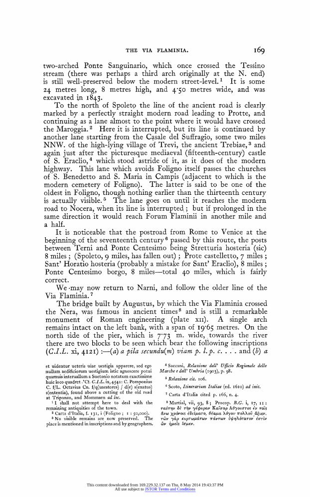
THE VIA FLAMINIA. I69
two-arched Ponte Sanguinario, which once crossed the Tessino stream (there was perhaps a third arch originally at the N. end) is still well-preserved below the modern street-level. 1 It is some 24 metres long, 8 metres high, and 4-50 metres wide, and was excavated in I843.
To the north of Spoleto the line of the ancient road is clearly marked by a perfectly straight modern road leading to Protte, and continuing as a lane almost to the point where it would have crossed the Maroggia. 2 Here it is interrupted, but its line is continued by another lane starting from the Casale del Suffragio, some two miles NNW. of the high-lying village of Trevi, the ancient Trebiae, 3 and again just after the picturesque mediaeval (fifteenth-century) castle of S. Eraclio, 4 which stood astride of it, as it does of the modern highway. This lane which avoids Foligno itself passes the churches of S. Benedetto and S. Maria in Campis (adjacent to which is the modern cemetery of Foligno). The latter is said to be one of the oldest in Foligno, though nothing earlier than the thirteenth century is actually visible.5 The lane goes on until it reaches the modern road to Nocera, when its line is interrupted.; but if prolonged in the same direction it would reach Forum Flaminii in another mile and a half.
It is noticeable that the postroad from Rome to Venice at the beginning of the seventeenth century6 passed by this route, the posts between Terni and Ponte Centesimo being Stretturia hosteria (sic) 8 miles; (Spoleto, 9 miles, has fallen out) ; Prote castelletto, 7 miles; Sant' Horatio hosteria (probably a mistake for Sant' Eraclio), 8 miles; Ponte Centesimo borgo, 8 miles-total 40 miles, which is fairly correct.
We-may now return to Narni, and follow the older line of the Via Flaminia.7
The bridge built by Augustus, by which the Via Flaminia crossed the Nera, was famous in ancient times8 and is still a remarkable monument of Roman engineering (plate xii). A single arch remains intact on the left bank, with a span of I9t65 metres. On the north side of the pier, which is 7-73 m. wide, towards the river there are two blocks to be seen which bear the following inscriptions (C.I.L. xi, 42I) :-(a) a pila secundu(m) viam p. I.p. c. . .. and (b) a
et uidentur ueteris uiae uestigia apparere, sed ego nullum aedificiorum uestigium istic agnoscere potui quamuis interuallum a Suetonio notatum exactissime huic loco quadret .'Cf. C.I.L. ix, 454I: C. Pomponius C. f/L. Octavius Cn. f/q(uaestores) / d(e) s(enatus) s(ententia), found above a cutting of the old road at Triponzo, and Mommsen ad loc.
1 I shall not attempt here to deal with the remaining antiquities of the town.
2 Carta d'Italia, f. I3I, i (Foligno; i : so,ooo). 3 No visible remains are now preserved. The
place is mentioned in inscriptions and by geographers.
4 Sacconi, Relazione dell' Ufficio Regionale delle Marche e dell' Umbria (I903), p. 98.
5 Relazione cit. io6.
6 Scoto, Itinerarium Italiae (ed. I6Io) ad init. 7 Carta d'Italia cited p. i66, n. 4.
8 Martial, vii, 93, 8 ; Procop. B.G. i, 17 II:
Ta6Yr? & T7JV -ye/vpav KcaoaLp A-yOVuTOS ev rOts &vW Xp6povs eae1JuaTo, W'a14a X&yov roXXov U&6tQV. rwv -yap KUpTW/JaTWV 7ra'Twv bn/aoX6Tarcrov eb-7v (DV 7e s E6o7Lev.
This content downloaded from 169.229.32.137 on Thu, 8 May 2014 19:43:37 PMAll use subject to JSTOR Terms and Conditions
170 THE VIA FLAMINIA.
pila . .. lo . .. Nar. p. 1. The pillar is evidently used as the starting- point for some measurements-in the first case along a road-but the meaning is far from clear.
The facing of the bridge is of blocks of limestone about two feet (59 to 62 cm.) in height, laid as headers and stretchers: the length of the former varies from I-5 to I 78 m. The projecting headers are noticeable, not only on the in'terior, but on the exterior of the piers.
There appear to have been four arches, 1 the whole bridge being built of travertine. Eroli (Notizie storiche del ponte rotto di Jugusto presso Narni (I900), p. 25) gives its length as I28-6 m. at the cornice of the piers and its greatest height as 30'02 m. It must have been one of the finest bridges in Italy when entire, and even now hardly has a rival in the country. A fairly early representation of it will be found in Blaeu's Novurm Italiae Theatrum (I663) i, 63 --(I724) ii, 68. Here there is one arch entire on each side, and 'the broken ends of two arclhes overhanging: the curve of these is such that there must have been a central pier, though no remains of it are known. It is probably taken from Braun and Hogenberg, Civitates Orbis Terrarumn, vol. vi. A lengthy correspondence in regard to repairs to the bridge will be found in Atti del Camerlengato, Tit. iv, fasc. 960 (now preserved in the Archivio di Stato in Rome). It begins in I828 and continues up to January i854; a total sum of i88i scudi (about f4oo) was spent on it. The first suggestion of the necessity of restoration was due to a remark made in I828
by the then Crown Prince of Prussia, expressing to his suite his surprise that nothing was done to preserve it from the ruin which threatened it. The remark was heard and understood by the Papal authorities who accompanied him, and the chief engineer reported on it to the Cardinal Chamberlain in I829. The matter was, how- ever, allowed to drop until I842, whhen the Commune of Narni took it up once more. Five hundred and fifty scudi had already been spent by I847, mostly in putting in new foundations for the arch on the left bank (cf. Eroli, -op. cit. 32). It has formed a subject for many painters and engravers: among the latter we may mention J. P. Hackert (I779) and Amici, while, of the former, Richard Wilson introduced it into a fine landscape now in the Johnson Collection at Washington (Jrt and Archaeology, x (I92o-2),, 97). Vespignani2 also measured and drew it.
I But Eroli (op. cit. pp. 34 et seq.) asserts, on the authority of an old manuscript, that the bridge collapsed about A.D. 800, was restored, and fell again in A.D. I053 ; also that one of the piers is different from the others, and maintains that the original bridge had three arches, with spans of I9-65, 32-I0 and 43-00 metres, and that this last was converted after 800 into two arches (I7 and i8 metres span) with a io metre pier between them. The pier between
the second and third (original) arches fell in I 885.
2 op. cit. infra. pl. xcviii. For recent repairs cf. Sacconi, Relazione dell' Ufficio regionale per le Marche e 1' Umbria (i903), p. I43 (with a drawing and two photographs of interest). The aqueduct is noted in Elenco, cit. p. 68, as being of the late empire and iS kilometres in length. Cf. also Guardabassi, op. cit. I3z. I have not seen it.
This content downloaded from 169.229.32.137 on Thu, 8 May 2014 19:43:37 PMAll use subject to JSTOR Terms and Conditions
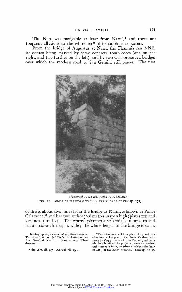
THE VIA FLAMINIA. 171
The Nera was navigable at least from Narni, 1 and there are frequent allusions to the whiteness2 of its sulphurous waters.
From the bridge of Augustus at Narni the Flaminia ran NNE, its course being marked by some concrete tomb-cores (one on the right, and two further on the left), and by two well-preserved bridges over which the modern road to San Gemini still passes. The first
(Photograph by the Rev. Father P. P. Mackey.)
FIG. I2. ANGLE OF PLATFORM WALL IN THE VILLAGE OF CESI (P. I72).
of these, about two miles from the bridge at Narni, is known as Ponte Calamone,3 and has two arches 3y46 metres in span high (plates xiii and xiv, nos. i and z). The central pier measures 3y66 m. in breadth and has a flood-arch I 44 m. wide; the whole length of the bridge is 40 m.
1 Strabo, v, p. 227: 7rXb?ors ov Ie-ydXose aKacIcbEoL.
Tac. Annals, iii, 9 : (of Piso's clandestine return from Syria) ab Narnia . . Nare ac mox Tiberi deuectus.
2 Virg. Aen. vii, 517; Martial, vii, 93, I.
3 Two elevations and two plans of it, and two elevations and a plan of the Ponte. Cardaro were made by Vespignani in I831 for Dodwell, and form pls. lxxx-lxxxii of the projected work on ancient architecture in Italy, the plates of which exist (only in MS.) in the Soane Museum. Eroli op. cit. 57.
This content downloaded from 169.229.32.137 on Thu, 8 May 2014 19:43:37 PMAll use subject to JSTOR Terms and Conditions
172 THE VIA FLAMINIA.
and its width (including parapets) 755 m. About I21 miles further on is Ponte Cardaro,1 a five arched bridge, 7-70 m. wide, over a broad torrent-bed (plate xi, no. 3 and xiv, nos. 2 and 3). The span of the arches varies from 9 m. in the middle to 350 m. at either end, the intermediate arches having a span oI 13-6"25 m. ; the two middle piers are about 3y60 m. broad and the exterior (which, of course, would encounter a less strong current and bear a smaller load) half a metre less. On the south bank of the torrent the masonry of the bridge is continued for over 30 m. supported on both sides with buttresses. 2 Drawings made by Vespignani of the Ponte Calamone and the Ponte Cardaro are reproduced on plate xiv. Shortly after Ponte Cardaro the line of the Via Flaminia appears to be shown by a disused track slightly to the right of the modern road; near the point of divergence, on the left, are the remains of a reservoir. Beyond the church of S. Bartolommeo the modern road bends to the left, but a rough path goes straight on in the direction of San Gemini; near the junction of the roads from Narni and Terni is a ruined structure (apparently a tomb) with a low barrel vault, in line with the path just mentioned. About two miles east of San Gemini is the town of Cesi on the slope of a spur of the Monte Torre Maggiore, 3 with a terrace wall in polygonal work. The acropolis lies above. The remains of polygonal walls in the village of Cesi and on the hill crowned by the chapel of S. Erasmo above are mentioned by Contelori and have been carefully studied by Dodwell and Vespignani. The latter, indeed, made careful drawings and plans of them, which are preserved in the Soane Museum.4 See also plate xv.
At the SW. angle of the village there are two walls of a platform. which form an angle, upon one corner block of which is a phallus. The blocks show a strongly horizontal tendency (fig. I2 and plate xi, no. 4). Under the church is a bit of rough walling about I5 m. long, of unhewn blocks. Under S. Onofrio, a small detached church to the NE, is another platform-wall, 5 not easily accessible. The small projecting terrace, about 5 m. square, is of fine, small, well-jointed, polygonal blocks; below is a footing of larger and rougher blocks: and the main wall is of similar material; and in great measure masked by later concrete.
1 The Ponte Cardaro is the subject of a picture by Richard Wilson formerly in the Orrock col- lection, and now in the Johnson collection at Washington (Beaumont Fletcher, Wilson in Makers of British Art Series, p. I 68-Art and Archaeology, x (1920-Z), p. Ioz.
2 To the left, close to Ponte Cardaro, are traces of a tomb. Vespignani (op. cit.) gives a drawing of a low round tomb in opus quadratum 'near Ponte Caldaro ' (Cardaro) on the string course of which is shown the inscription C.I.L. xi, 2, 4126-a sepulchral inscription in senarii ' ita candidatus, quod petit, fiat tuus / et ita perenne, scriptor !
opus hoc praeteri ! / hoc si impetro a te, felix vivas ! bene vale ! '
3 There is said to be a Roman Temple on the summit (Vespignani, op. cit. pl. xciii; Elenco, degli Edifizi Monumentali della Provincia di Perugia, 42).
4 Pls. xciv, xcv of the completed work; sketches nos. 264, 296, 300, 3I4-6. Cf. Dodwell inr Bull. Inst. i831, 195 ; Mem. Inst. i (i832), 77 sqq.. Lanzi, Terni, pp. 131 sqq. 142.
5 Contelori, op. cit. i9, notes that a part of it fell in I645.
This content downloaded from 169.229.32.137 on Thu, 8 May 2014 19:43:37 PMAll use subject to JSTOR Terms and Conditions
THE VIA FLAMINIA. 173
Some I,OOO feet above the village rises the hill of S. Erasmo, which takes its name from the small Romanesque chapel of that name, and which was crowned by the citadel of this ancient town. It is well shown in Vespignani's plan. (plate xv). We must note that the rectangular enclosure which he shows on the south is of finer work, being of smaller stones (inside it is a small piece of later walling of concrete) and that much use was made of the rock where it served the purpose of defence. On the NE. is a gate 2 30 metres wide, from which a path with four ramps descends, and on the NW. another 1l40 m. wide, with the beginning of a similar ramp.
Beyond San Gemini the road runs due north for about two miles; then the modern road turns north-west while the ancient road (marked by a track) continues in a straight line to the ruins of Carsulae, about 91- miles from Narni.
Carsulae is scarcely mentioned in literature; it appears among -the 7TOAXES a4[cac Xo'yv on the Via Flaminia in Strabo, v, p. 227,
but not as a station in the Itineraries. The Flavian army encamped there in A.D. 69 (Tac. Hist. iii, 6o). A colossal bust of Maecenas was, it is said, excavated there about I830, and is now in the Conservatori Museum at Rome1; it is believed to be modern. But from its ruins and its inscriptions (C.I.L. xi, 2, p. 665 ff.) Carsulae seems to have been a flourishing municipium. The only sign of later habitation is the derelict church of S. Damiano, on the right of the road, made up of ancient materials. On the left of the road, 50 yards before the church, are the remains of a concrete vault, perhaps a reservoir, and there is another large reservoir behind the church. The church has two ancient columns in its front wall, and nearly opposite is (as it seems) the base of a temple measuring 9-85 by 9-07 metres. A note by Bartoli in Carlo Fea, Miscellanea filologica critica e antiquaria (Rome I790), i, 272, records that ' si vede il portico di un bellissimo tempio corintio di grosse colonne ed intiero,' which may be the temple of which the base is visible to-day. On the right of the road, beyond the church, are traces of a small amphitheatre, and beyond this again a large reservoir formed of a number of small transverse vaults. To the left of the road is a modern house built into a building of brick and opus reticulatum. The chief feature of Carsulae to-day is the ancient arch, 2 (plate xvi), probably the north gate of the town, with the pavement of the road leading up to it for about IOO yards.
1 Room of the Gardens of Maecenas, 23. 2 'Arcus Traiani imperatoris insignis structurae
(Holste, ad Cluv, p. 629). For illustrations see Rossini, Archi Trionfali, tav. xv, xvi; Vespagnani, op. cit. pl. lxxxix. Its original size is not clear, for only the arch itself remains: the span is 3-60 metres. On each side a chase is cut for applied decorations, which have now disappeared. Excellent photo- graphs of S. Damiano, the large reservoir near the amphitheatre and the arch will be found in Lanzi op. cit. pp. 146, 47. Rossini (p. 3) says that the
arch has bases for statues outside, and chases for bronze ornaments, and that it was ascribed to Trajan on the ground of an alleged find of coins of Trajan in the masonry; but he regards the arch as Augustan. Bartoli (loc. cit.) mentions that in his own time a terra-cotta chest was unearthed at Carsulae full of ancient medals, most of which were melted down by a local priest to make bells; a few were left behind and sold and some of these were of Trajan. He does not say that the coins were found in or under the arch.
This content downloaded from 169.229.32.137 on Thu, 8 May 2014 19:43:37 PMAll use subject to JSTOR Terms and Conditions
174 THE VIA FLAMINIA.
(This is, I believe, the only extant pavement of the Via Flaminia in over I50 miles between Narni and Rimini.) There are also traces of a street running ESE. about I00 yards south-east of the arch. On the left of the road about 20 yards from the church is a large ruin with concrete vaults ; and further on the same side (50 vards from the arch) are scanty traces of what appears to have been an aqueduct" running at right angles to the road. From the arch, which is at the highest point of the site, the reason of the choice of it is apparent. It lies on a plateau with splendid observation all round, and the ground falling away except on the east. 2 According to B. Feliciangeli (Longobardi e Bizantini lungo la Via Flaminia nel secolo vi (Camerino I908), p. 20) a road diverged from near Carsulae and led across the hills past Macerino to Spoleto, and though now a mere track is still called ' via romana.' Just past the arch and on the left of the road is a wheel-tomb of six rays made of concrete faced with travertine. Rossini (op. cit. p. 3) speaks of several round and square monuments being excavated hiere about his time (I836).
The road now descends sharply and about two miles beyond Carsulae the modern road rejoins the ancient line, 3 and after another two miles there is an ancient bridge of two arches, somewhat to the right of the modern road, under the church of S. Giovanni, which is in part built of blocks from the bridge. The stream which is here crossed has evidently changed its course several times, as there is a mediaeval bridge still standing just beyond the church. The modern town of Acquasparta, 5 miles from Carsulae, is built on a hill to the left of the road; three inscriptions (C.I.L. xi, 2, 4567-8, 4578) are preserved in the courtyard of the Palazzo Cesi. About half a mile north of Acquasparta the line of the Via Flaminia is again preserved by a footpath (west of the modern road), which in rather over a mile leads to the imposing ruin known locally as Ponte Romano, or Ponte Fonnaia. 4 This bridge has only one arch, with a span of 3 40 metres; but it is remarkable for the elaborate outworks on both banks above and below it, and for its great width through, which (measured inside the arch) is 17 m. on the north side, and i950 m. on the south, thus giving a much wider road space than was usual: it is also peculiar in crossing the stream diagonally. One cannot help admiring the thoroughness of the Roman engineers in building so elaborate a bridge over what now seems an insignificant stream, though the outworks suggest that it once had to withstand a considerable current in flood-time. Soon after the bridge the road seems to have turned
I C.I.L. xi, 2, 4582, records the repair of an aqueduct at Carsulae by a seuir augustalis in honour of the quattuorvirate of his son.
2 Some discoveries made about 700 metres to the south at the mediaeval church of S. Giorgio, which is in part made up of ancient materials, are recorded by Giglioli in Not. Scavi, I9I3, 345 (remains of an ancient building, a sarcophagus, etc.).
3 Carta d'Italia, f. 13I, iii (Massa MIartaiia i I: 50,000).
4 It is described and a bad photograph of it is given (it is, as a fact, much hidden by foliage) by 0. A. Maturo, La Principessa Anna Corsini, etc. Perugia, 1912, p. 5I. We *did not see the letters C. F. which he noticed on some of the blocks, which he interprets C(aius) F(laminius) !
This content downloaded from 169.229.32.137 on Thu, 8 May 2014 19:43:37 PMAll use subject to JSTOR Terms and Conditions

THE VIA FLAMINIA. 175
eastwards, as there are traces of a small culvert beyond and to the right of Ponte Romano, and in a different line. 1 The direct line is rejoined by the modern road2 soon after the point where the new electric railway crosses it,3 but about a mile further the modern road again diverges to the east and returns to the ancient track at S. Maria di Pantano.
The station ad Martis which the Antonine Itinerary records as i8 (or in some MSS. 17) miles from Narnia, was placed by Holste (ad Cluv. p. 639) ' sub villa S. Faustini,' and the numeral corrected from xviii to xiv. But the inscriptions which refer to the Vicus Martis 'Tudertium (C.I.L. p. 694) were found in the neighbourhood of S. TMlaria di Pantano, which is nearly I8 miles in a direct line from Narni, so that the distance tallies with the Itinerary. According to Fiorelli (Not. Scavi, i888, p. 682) a branch road led from Ad Martis (S. Maria di Pantano) to Tuder (mod. Todi) where it would join the Via Amerina or rather the continuation of that road from Ameria to Perusia. 4 In the south side of the church of S. Maria (which has an early mediaeval apse) are about twelve feet of opus incertum with badly laid brick courses, and part of the north wall is also ancient, giving a rectangular building about 1050 metres across the front and 12 metres in depth, into which the church was built.
Built into the wall immediately adjoining the church is a sculptured stone, probably a funeral relief; as far as can be now discerned, the sculptures represent (from left to right) a man and a woman, then a tree, a man with his hand on the head of a child, and three men with spears and shields. The church is not in line with the present road, but with a track which diverges to the right immediately afterwards; presumably the Roman road ran along this line, east of the hill on which the modern town of Massa Martana lies. A ruin, marked on the map as I1 Mausoleo, east of the hamlet of Raggio, is in reality an unimportant ancient concrete foundation of uncertain purpose. Some pre-Roman tombs were recently discovered5 near Massa at S. Maria di Pace, and may show that there there was a primitive settlement on the hill of Massa, the inhabitants of which were compelled by the Romans to move down into the plain at Vicus Martis. This theory is advanced by Giglioli (in Not. Scavi, 1. c.); as other instances of the Roman policy of compelling a con- quered people to leave a hill-town and settle in the plain, he mentions Falerii (Zonar. viii, i8) and Carsulae, apparently regarding the latter as the successor under Roman rule of the old stronghold of Cesi.
1 The cross-section of Ponte Romano runs NE, that of the culvert nearly due east.
2 Between Ponte Fonnaia and Villa S. Faustina at Le Grotte are some Christian catacombs, the importance of which is mainly topographical (Sordini in Atti del 1I Congresso di Archeologia Cristiana (Rome, i90z), p. I09. He believes that
there was a branch road to Spoleto from Martana or Acquasparta).
3 Maturo, op. cit. p. 53, n. 3, describes a culvert over a small stream (to which, I think, the photo- graph on p. 48 should probably be referred) which was destroyed when the railway was made.
4 Tab. Peut. iv and v. - Not. Scavi, 1913, pp. i6i ff.
This content downloaded from 169.229.32.137 on Thu, 8 May 2014 19:43:37 PMAll use subject to JSTOR Terms and Conditions
I 76 THE VIA FLAMINIA.
For the whole of the sixteen miles between Massa Martana and Bevagna (the ancient Mevania, mentioned by Strabo and the older Itineraries as situated on the Via Flaminia), the course of the Roman road is extremely uncertain, and we know of no ancient remains which mark it, 1 except that the official Elenco dei Monumenti della Provincia di Perugia (p. 56) records the existence of a Roman bridge (Ponte del Diavolo) near Osteria del Bastardo, 2 about 8 miles from Massa, which shows that so far the modern road more or less coincides with it. We unfortunately failed to find it, but we received official assurance that it still exists a little way down-stream of the modern road, hidden by brushwood. All the bridges in present use along this piece of road are modern.3 The course of the road after the Osteria is difficult even to conjecture; the modern road makes a wide detour to the east to avoid the difficult country, while a track, which cuts off the angle of the modern road about i - miles north of the Osteria, and then diverges in the general direction of Bevagna past the isolated church of S. Maria delle Grazie, is extremely precipitous and winding owing to the numerous deep ravines which it crosses. It is hard to believe that this track preserves the line of the Via Flaminia; but the very broken country here may account for the abandonment of the original route by Mevania and the substitution of the route by Spoletium. Mevania is chiefly mentioned in literature in connexion with the famous white oxen of the Clitumnus valley,4 and has been claimed as the home of Propertius, who mentions its fogs. 5 Remains of the city walls and of other buildings exist, and a mosaic pavement from the thermae is still extant in the Casa Rossetti, Via Porta Guelfa. 6
From Mevania the course of the Via Flaminia is marked by the modern road to Foligno, and its name survives in the hamlet of Fiamenga, which lies on this road, and beyond which are two concrete tomb-cores (one of considerable size) to the left of the road. At the church of the Madonna della Fiamenga the Flaminia meets the road leading (as it probably did in Roman times) from Perugia by Assisi and Spello7 to Foligno. Foligno (ancient Fulginium) was not on the original Via Flaminia,8 which from Madonna della Fiamenga continued in a straight line, preserved by a by-road, on the left of which is a tomb, to Forum Flaminii (S. Giovanni in Fiorifiamma or
1 An inscription of Hadrian (C.I.L. 66I9) found at S. Giacomo near Massa records the restoration of the road with a new substruction in A.D. IZ4 (Not. Scavi, I888, p. 68I).
2 Carta d'Italia f. i3i, iv (Bevagna; i: 5o,ooo). 3 Two ruins marked on the Staff Map along its
course, the so-called Rottonaro a mile north of Massa Martana, and the ' ruderi' north of Ponte Ricurvo, are respectively mediaeval and modern.
4 Tauriferis ubi se Meuania campis / explicat Lucan i, 473; also Colum. iii) 8, Sil. vi, 647.
Prop. iv, Iv I23 see La Patria di Properzio
nell' antica Mevania (F. Alberti). More probably his birthplace was Asisium, see Huilsen in Pauly- Wissowa, s.v., and Lachmann on Prop. iv, Iv 25.
6 Elenco, cit. p. 35. 7 Cf. C.I.L. 5265 (the famous inscription of
Constantine from Spello): civitati . . . cui nunc Hispellum nomen est quamque Flaminiae uiae confinem adque continuam esse memoratis.
8 The Jerusalem Itinerary records the civptas Fulginis on the later Via Flaminia three miles before Forum Flaminii.
This content downloaded from 169.229.32.137 on Thu, 8 May 2014 19:43:37 PMAll use subject to JSTOR Terms and Conditions
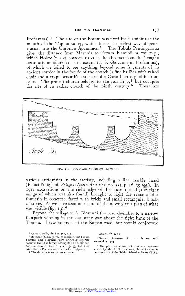
THE VIA FLAMINIA. 177
Profiamma). 1 The site of the Forum was fixed by Flaminius at the mouth of the Topino valley, which forms the easiest way of pene- tration into the Umbrian Apennines. 2 The Tabula Peutingeriana gives the distance from Mevania to Forum Flaminii as xvi m.p., which Holste (p. 92) corrects to VI 3; he also mentions the ' magna uetustatis monumenta' still extant (at S. Giovanni in Profiamma), of which we failed to see anything beyond some fragments of an ancient cornice in the facade of the church (a fine basilica with raised. choir and a crypt beneath) and part of a Corinthian capital in front of it. The present church belongs to the year I239,4 but occupies the site of an earlier church of the ninth century. 5 There are
FIG. I3. FOUNTAIN AT FORUM FLAMINII.
various antiquities in the sacristy, including a fine marble hand (Faloci Pulignani, Foligno (Italia Artistica, no. 35), p. I6, 39 sqq.). In I9II excavations on the right edge of the ancient road (the right margo of which was also found) brought to light the remains of a fountain in concrete, faced with bricks and small rectangular blocks of stone. As we have seen no record of them, we give a plan of what was visible (fig. I3).6
Beyond the village of S. Giovanni the road dwindles to a narrow footpath winding in and out some way above the right bank of the Topino. I saw no trace of the Roman road, but should conjecture
Carta d'Italia, cited p. I69, n. 2. 2 Bormann (C.I.L. p. 754-5) considers that Forum
Flaminii and Fulginiae were originally separate communities-the former having its own aedile and patronus civitatis (C.I.L. 52l7, 52I5), but that later Forum Flaminii was absorbed in Fulginiae.
3 The distance is nearer seven miles.
4Elenco, cit. p. 53.
6 Sacconi, Relazione, cit. 104. It was well restored in 1903.
6 The plan was drawn out from my measure- ments by Mr. F. 0. Lawrence, Rome Scholar in Architecture of the British School at Rome (T.A.).
This content downloaded from 169.229.32.137 on Thu, 8 May 2014 19:43:37 PMAll use subject to JSTOR Terms and Conditions
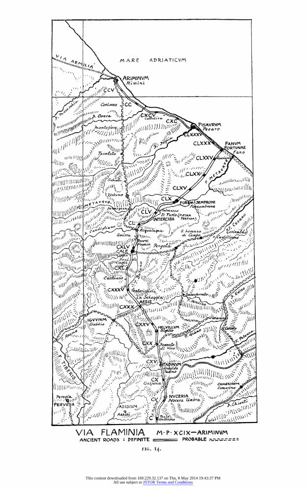
< 4e | \ ~~~M A R E ADR,IATICVM
1 4 s~~~~~Cna ~4 x
JJJI J11 1 D' })' Iit,1 1 pes a X V
1 115\lilil\l)l'! g4 [ ' i' ,,\" \ _ CLXX FANV!
ii; { r' C1)A"" 4':J/j% C"' V
:~~~~~~~~~~~~~~ jLAl
Psrr ,@#;\\_ ,x,,i;,;
J! N:ERCIA If, ~,y/5t
-14; ~ ~ ~ ~ ~ ~ I. 4
This content downloaded from 169.229.32.137 on Thu, 8 May 2014 19:43:37 PMAll use subject to JSTOR Terms and Conditions
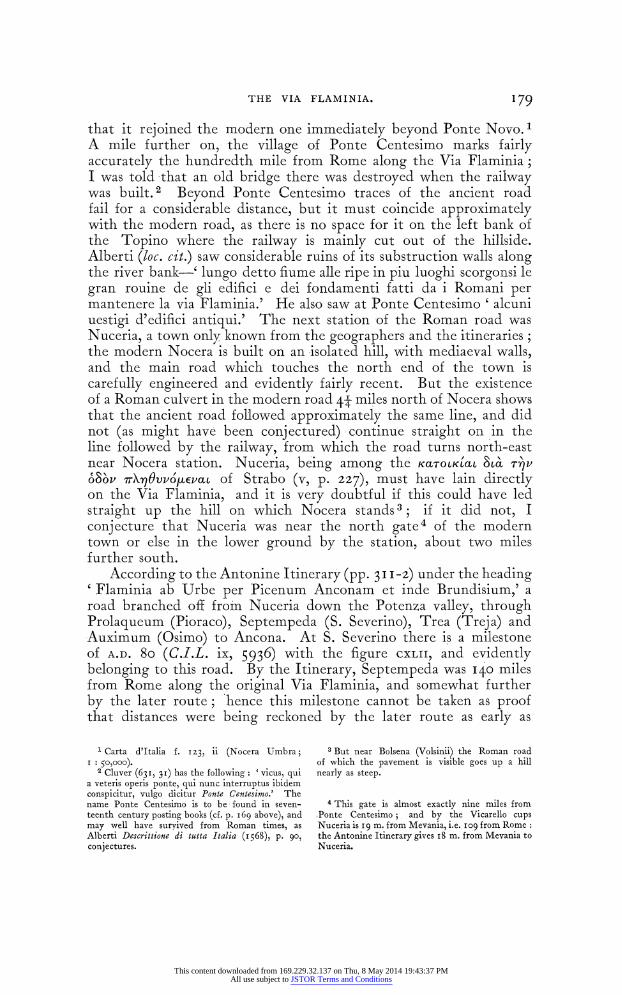
T HE VIA FLAMINIA. 179
that it rejoined the modern one immediately beyond Ponte Novo.1 A mile further on, the village of Ponte Centesimo marks fairly accurately the hundredth mile from Rome along the Via Flaminia; I was told that an old bridge there was destroyed when the railway was built. 2 Beyond Ponte Centesimo traces of the ancient road fail for a considerable distance, but it must coincide approximately with the modern road, as there is no space for it on the left bank of the Topino where the railway is mainly cut out of the hillside. Alberti (loc. cit.) saw considerable ruins of its substruction walls along the river bank-' lungo detto fiume alle ripe in piu luoghi scorgonsi le gran rouine de gli edifici e dei fondamenti fatti da i Romani per mantenere la via Flaminia.' He also saw at Ponte Centesimo ' alcuni uestigi d'edifici antiqui.' The next station of the Roman road was Nuceria, a town only known from the geographers and the itineraries; the modern Nocera is built on an isolated hill, with mediaeval walls, and the main road which touches the north end of the town is carefully engineered and evidently fairly recent. But the existence of a Roman culvert in the modern road 44- miles north of Nocera shows that the ancient road followed approximately the same line, and did not (as might have been conjectured) continue straight on in the line followed by the railway, from which the road turns north-east near Nocera station. Nuceria, being among the KacTOLKLa 8c a Tr7v
O80V VX)q0vvo4EvaLt of Strabo (v, p. 227), must have lain directly on the Via Flaminia, and it is very doubtful if this could have led straight up the hill on which Nocera stands 3; if it did not, I conjecture that Nuceria was near the north gate4 of the modern town or else in the lower ground by the station, about two miles further south.
According to the Antonine Itinerary (pp. 3 II-2) under the heading 'Flaminia ab Urbe per Picenum Anconam et inde Brundisium,' a road branched off from Nuceria down the Potenza valley, through Prolaqueum (Pioraco), Septempeda (S. Severino), Trea (Treja) and Auximum (Osimo) to Ancona. At S. Severino there is a milestone of A.D. 8o (C.I.L. ix, 5936) with the figure CXLII, and evidently belonging to this road. By the Itinerary, Septempeda was I40 miles from Rome along the original Via Flaminia, and somewhat further by the later route; hence this milestone cannot be taken as proof that distances were being reckoned by the later route as early as
Carta d'Italia f. IZ3, ii (Nocera Umbra; I 50,000).
2 Cluver (63I, 3i) has the following: 'vicus, qui a veteris operis ponte, qui nunc interruptus ibidem conspicitur, vulgo dicitur Ponte Centesimo.' The name Ponte Centesimo is to be found in seven- teenth century posting books (cf. p. i69 above), and may well have survived from Roman times, as Alberti Descrittione di tutta Italia (i 568), p. go, conjectures.
3 But near Bolsena (Volsinii) the Roman road of which the pavement is visible goes up a hill nearly as steep.
4 This gate is almost exactly nine miles from Ponte Centesimo; and by the Vicarello cups Nuceria is I9 m. from Mevania, i.e. IO9 from Rome: the Antonine Itinerary gives I8 m. from Mevania to Nuceria.
This content downloaded from 169.229.32.137 on Thu, 8 May 2014 19:43:37 PMAll use subject to JSTOR Terms and Conditions
ISO THE VIA FLAMINIA.
A.D. 8o. 1 This road was sometimes used by travellers returning from the East as an alternative to the commoner way by Brundisium; thus Piso in A.D. 20 crossed to Ancona, struck the Via Flaminia probably at Nuceria and followed it to Narnia, whence he proceeded by boat. 2 Leading to so important a town as Ancona (the harbour of which was restored by Trajan, C.I.L. ix, 5894), the road must have had considerable traffic. Bormann (C.I.L. xi, 2, p. 8i9) records traces of the road and a bridge and other buildings at Pioraco. There may also have been a branch from the Via Flaminia to Ancona from near Forum Flaminii: the Peutinger Table marks (without con- necting lines) Urbesaluia xii, Ricina xii (=Urbisaglia and the ruins of Helvia Recina, north and south of Macerata), Ausimo xiii (Auximum, Osimo), Ancona xii. Hence Miller (op. cit. p. 3I4)
supposes a road to have run from Forum Flaminii through Camerinum to Urbs Salvia and so on; it would join the road from Nuceria at Recina in the Potenza valley. Kromayer3 supposes Hannibal to have entered Picenum by this route after the battle of L. Trasimene; it would be the most natural way.
After Nocera the ancient and modern lines of the Via Flaminia again diverge at the village of Gaifana, 4 about 5 miles north of Nocera, the former being represented by a track leaving the high road on the left-hand side at the north end of the village. 5 On this track another culvert and some fragments of the substruction wall of the road have been noted, east of the railway, divided into two parts by the highroad; here lay the ancient Tadinum,6 usually identified with the Tayicvat of Procopius (B.G. iv, 29) famous for the defeat of the Goths and death of Totila in A.D. 552. The ' Tarsinater' who are among the enemies cursed in the Iguvine Tables are connected with the same place. Holste (p. 85) saw some ancient remains in the plain rather more than a mile west of the modern Gualdo Tadino7 and also mentions a church of ' S. Maria di Taino,' in the same locality. The site is now actively cultivated and nothing is to be seen but two wells and a quantity of brick debris. The Via Flaminia appears to rejoin the modern road about 3 miles north of Gualdo and to leave it again (on the right) soon afterwards at La Torre. The station of Helvillum seems to have been below the hill of Fossato di Vico,8 near which was found a dedicatory inscription (C.I.L. 580I) mentioning the
1 Mommsen C.I.L. I.c.) reckons 145 miles from Rome to 'Septempeda by Spoletium; but the Antonine Itinerary quoted above gives the route from Rome to Ancona by Mevania.
2 Tac. Ann. iii, 9. 3 Antike Scblacbtlelde, iii, p. I94 ff. On both
these roads cf. Nissen, I.L. ii, P. 388.
4 A cemetery of foss-tombs (7 -6 c, B.C. ; contents in the Museo delle Terme at Rome) has been found in the hills north-east of Gaifana (Stefani in Not. Scavi, 1918, pp. 103 ff.). Just before the diver-
gence are two ancient culverts (ibid. izi). Cf. fig. 4, p. 107-
5 Carta d'Italia f. 123, i (Gualdo Tadino; I 50,000).
6Tadinates occur in Pliny's list of Umbrian communities (N.H. iii, II 4), and a ' civitas Ptaniae eight miles from Nocera in Itin. Hieros, p. 614.
7 This stands on a hill whither the inhabitants of Tadinum migrated for safety on the fall of the empire or in the middle ages.
This agrees with the distance of fifteen miles from Nuceria to Helvillum given by the Itineraries.
This content downloaded from 169.229.32.137 on Thu, 8 May 2014 19:43:37 PMAll use subject to JSTOR Terms and Conditions
THE VIA FLAMINIA. I8I
' vicani He[lvillates].' The Antonine Itinerary (P. 316) under the heading ' ab Helvillo Anconam L' (sic) after Helvillum continues thus:-ad Calem xIIII; ad Pirum vIIII; Senagallia VIII; ad Aesim xii; Ancona viii. This is evidently an interpolation, as the only known station ' ad Calem ' in this region is Cagli on the Via Flaminia, at least 23 miles from Helvillum, and over 35 miles in a direct line from Sinigaglia. 0. Cuntz (in Jahres. Oesterr. Jrch. Inst. vii, p. 6o) plausibly suggests that the entry ' ad Calem xiiii' belongs to the Via Flaminia,1 and the next four entries to the Adriatic coast-road, on which the station ' ad Pirum' was 8 miles from the Metaurus. 2
North of Fossato 3 the ancient and modern roads appear to- coincide in the main. At Ponte Spiano 4 bevond Sigillo 5 there are traces of Roman work in the modern bridge; and near point 506 (marked ' Cartiere' on the staff-map) is a well-preserved Roman bridge, known locally as Ponte Etrusco, 6 with a single arch of about 4 metres span. The parapets are modern with a road-width of 9i metres between them. Further on, the road climbs steadily up past Costacciaro and Villa Coldecanali I (where the ancient road may have cut off the modern bend) and reaches the village of Scheggia just below the summit. Here must be placed the ' mutatio' of Aesis or ' ad Ensem,' 8 which was I4 miles from Cale (Cagli): this is roughly the distance from Scheggia to Cagli. This station is of course quite distinct from the ' ad Aesim' at the mouth of the river Aesis (Esino) between Sena Gallica and Ancona. 9 A little beyond Scheggia, near the Via Flaminia, was the temple of Jupiter Appenninus, 10 mentioned by Claudian in describing a journey along the Via Flaminia (Claud. de vi cons. Hon. 504-5) ; some remains of the temple have been found on M. Petrara, and also the dedicatory inscriptions C.I.L. 5803 (' Ioui Apenino') and 5804. Above ' ad. Ensem' the Tabula Peutingeriana marks ' Iouis penninus id e Agubio,' and the Ravenna geographer (iv, 33, p. 273) records a road from Aesis to Iguvium and thence to Perusia. Strabo (v, p. 227) mentions among the towns west of the Via Flaminia (after Ameria, Hispellum and Tuder)- IYJrovp, -X'4-tov ' iovro rw'v virEp/3oXJv rov opovs, where Cluver (Italia Antiqua, p. 626) corrects the name to 'Iyov'tov. The distance of Iguvium from the Scheggia pass is about 8 Roman miles, and the territory of the town may well have
1 The Vicarello cups and the Jerusalem Itinerary both make Cale fourteen miles from Aesis (Scheggia).
2 Tab. Peut. section iv. 3 For a Roman bridge near here see Elenco, cit.
p. 55-no particulars are given. Carta d'Italia f. I I 6, ii (Fabriano ; I: 50,ooo).
5Perhaps to be identified with the Suillum of Pliny, N.H. iii, I 14. Elenco, cit. I04.
6 Elenco, cit. 49. ' Carta d'Italia f. II6, iii (Gubbio; I : 5o,ooo). 8 The Vicarello cups and the Jerusalem Itinerary
give the name 'Haesis' : Peutinger (with the
wrong distance of seven miles to Cale) gives ' ad Ensem,' which Hodgkin adopts (Italy and her Invaders, iv, p. z6o). For a probable branch road from Aesis to the coast through Sentinum see Bormann in C.I.L. xi, 2, p. 999, and below, p. 184.
9 Itin. Anton. p. 3I6. 10 See Pauly-Wissowa, s.v. 'Appenninus ' z.
Another dedication to Jupiter Appenninus occurs- in C.l.L. viii, 796I (from Numidia), and references to the oracle in Hist. Aug. Claudius, 10, and Fir-mus, 3. On some remains probably of a road embank-- ment near the supposed site of the temple, cf. Not. Scavi, I877, p. IZO-2I.
This content downloaded from 169.229.32.137 on Thu, 8 May 2014 19:43:37 PMAll use subject to JSTOR Terms and Conditions
182 THE VIA FLAMINIA.
extended so far.-1 Its command of the pass may explain the early importance of Iguvium (shown by the famous Tables and the pre- Roman coins), and its reappearance as a fortress in the Gothic Wars, in which 'after its destruction by the Goths it was rebuilt by Narses. The Scheggia pass is much the lowest and easiest of the Appennine passes,2 and lies on the direct line from the plain of central Umbria (between Spoleto and Perugia) and from the Nar and lower Tiber valleys to the plains of the Adriatic coast (the ' ager Gallicus ') and the valley of the Po.
From the summit of the pass just beyond Scheggia the old road descends steeply for several miles ; the modern road, which is elaborately engineered with tunnels and numerous curves, lies to the east of it, and the two reunite at Pontericcioli 3 some 3 miles in a direct line from Scheggia. From the point where it enters the province of Pesaro (i.e. between Scheggia and Pontericcioli) the road was minutely described 4 in I 878 by a civil engineer named Montecchini, who, with an interest in antiquity not always found in his profession, has preserved a record of numerous remains of the road which have since disappeared. His work is naturally of great value to the modern investigator. He records (pp. I4-I5) some Roman remains in the Ponte Voragine (on the provincial boundary) and an ancient sup- porting wall a little beyond it with an inscription5 of Trajan which was broken in pieces by an ignorant government official. On the left of the road just before it enters. Pontericcioli there are about 35 metres of a supporting wall, with four buttresses in it ; it is over 5 metres high, and, like most of the Roman constructions in this neighbourhood, is built of large blocks (measuring over a metre in every direction) of the local conglomerate stone known as ' pietra grigna.' The road now runs for about I5 miles down the narrow valley of the Burano torrent, with mountains on either side. Beyond the village of Cantiano it enters the wild and desolate gorge of the Foci di Cagli, where it is mainly cut in the side of the steep cliff, and supported by walls on the side of the torrent. About 300 metres be- yond Cantiano was found a milestone of the Flaminia (C.J.L. 66zi)
DD . NN.C . FLA.
VAL . SEVERO . ET
/GAL . VAL . MA
XIMINO . NOBB.
M.P.
CXL
1 Pliny (N.H. XXiii, 95) mentions a plant " quod Iguuini circa Flaminiam uiam uendunt.'
2 Kromayer, Antike Scblacbtfelde, vol. iii, p. 437 n. gives its height as 58I metres (I,890 feet), nearly 500 feet lower than any other pass in the Appennines east of the meridian of Florence. The Via Valeria, for instance, crosses the chain between Carsoli and Tagliacozzo at a height of 3,800 feet.
3 Perhaps to be identified with the ' Luceoli' of Paulus Diaconus (Hist. Langobard, iv, 8), cf. Cluver, p. 6I8, 1. I6.
4 " La Strada Flaminia dall' Apennino all' Adriatico: memoria del Prof. Pierluigi Montecchini, Capo Ingegnere del Genio Civile ' (Pesaro i879).
GI CL. 5620: it really belongs to Hadrian.
This content downloaded from 169.229.32.137 on Thu, 8 May 2014 19:43:37 PMAll use subject to JSTOR Terms and Conditions
THE VIA FLAMINIA. I83
(Severus and Maximin were Caesars together A.D. 305-6). In the Foci was quarried the ' pietra grigna,' the geological formation of which is described by Montecchini (PP. 3 3-5). At Ponte Grosso, 1 so named from the huge blocks of which it is built, the road passes to the left bank of the Burano: this bridge is partly modern, but the two ancient arches2 remain, together with the left-hand parapet and vwails on either side at the further end of the bridge (plate xvii, no. I). Beyond Ponte Grosso are traces of ancient s-ubstructions, and in about half a mile the road returns to the right bank at Ponte Alto, a steeply- rising bridge (now disused) with a single wide and relatively modern arch, only the ends of the bridge being ancient. The road now crosses by a still more recent bridge a few yards further down stream. Not far beyond Ponte Alto, and still within the Foci di Cagli, the road crosses a tributary of the Burano at Ponte dei Ciclopi, a one-arched culvert with end-walls, and shortly afterwards emerges from the gorge just beyond the village of Le Foci. Not far from Cagli it once more crosses to the left bank of the Burano, where Montecchini records a bridge with two modern arches, but with ancient founda- tions, known as Ponte Taverna. I have not seen this bridge. Montecchini speaks of its bad construction, steepness, and narrowness as a reason for building a new one (op. cit. pp. 4I-5). He gives the -width of the arches as 4-80 and i62zo metres.
Near the junction of the Bosso and Burano torrents was the 'uicus' of Cale, now Cagli, occupying a low hill.3 It is only known from the road books (' Calle uicus,' ' ad Calem,' ' ad Cale') and from Servius, who preserves the true form of the name.4 In the neighbour- hood of Cagli there were found, in i878,5 a number of bronzes now in the Villa Giulia Museum at Rome. They are mainly statuettes of Mars, but the finest is a youthful hiead, which probably also represents Mars, as there are traces of a helmet. Some are of a very primitive type and perhaps of local manufacture, others appear to have been made in Etruria under Greek-influence in the latter half of the fifth century B.C. Cuntz (7ahresh. Oesterr. Jrch. Inst. vii, p. 6i ff.) and Montecchini (op. cit. p. 43) conjecture that a road branched eastwards from near Cagli through Pergola and down the Cesano valley, passing Suasa (between S. Lorenzo di Campo and Castelleone, where ancient remains have been found 6), and near Corinaldo, where there was found a milestone (C.I.L. 663I) giving the distance of I84 miles from Rome (which is approximately correct), to the coast a few miles north of Sena Gallica. The existence of this road may account for the
1 Carta d'Italia f. II6, iv (Cagli; I: 50,000).
2 According to Montecchini (p. 36) the arches are 7 m. wide, and the central pier 5-60 m. wide on the up-stream side and 7-45 m. on the other.
3 The road which skirts the base of the hill without entering the town is quite modern (Montecchini, P. 44)*
4 Serv. ad Aen. vii, 728, ' Cales civitas est Cam- paniae; nam- in Flaminia quae est Cale dicitur.'
? Not. Scavi, I878, pp. I I9 ff. ; Mochi, Storia di Cagli (I878), pp. 41 ff. They have been recently published and fully discussed by Bendinelli in Monumenti Antichi, xxvi (1920), pp. 221 ff., whose account of them I follow here.
6 Cluver, ltal. Ant. p. 6zo: Montecchini, loc. cit.
This content downloaded from 169.229.32.137 on Thu, 8 May 2014 19:43:37 PMAll use subject to JSTOR Terms and Conditions
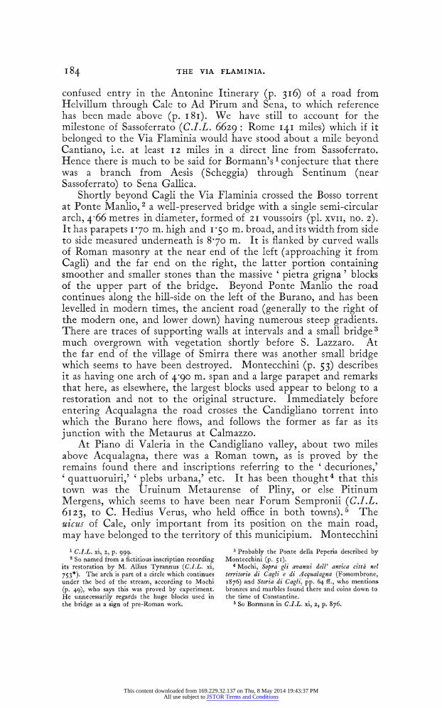
184 THE VIA FLAMINIA.
confused entry in the Antonine Itinerary (P. 3I6) of a road from Helvillum through Cale to Ad Pirum and Sena, to which reference has been made above (p. i 8i). We have still to account for the milestone of Sassoferrato (C.I.L. 6629: Rome 14I miles) which if it belonged to the Via Flaminia would have stood about a mile beyond Cantiano, i.e. at least 12 miles in a direct line from Sassoferrato. Hence there is much to be said for Bormann's 1 conjecture that there was a branch from Aesis (Scheggia) through Sentinum (near Sassoferrato) to Sena Gallica.
Shortly beyond Cagli the Via Flaminia crossed the Bosso torrent at Ponte Manlio, 2 a well-preserved bridge with a single semi-circular arclh, 4 66 metres in diameter, formed of 21 voussoirs (pl. XVII, no. 2).
It has parapets I170 m. high and i -0 m. broad, and its width from side to side measured underneath is 8-70 m. It is flanked by curv,ed walls of Roman masonry at the near end of the left (approaching it from Cagli) and the far end on the right, the latter portion containing smoother and smaller stones than the massive ' pietra grigna ' blocks of the upper part of the bridge. Beyond Ponte Manlio the road continues along the hill-side on the left of the Burano, and has been levelled in modern times, the ancient road (generally to the right of the modern one, and lower down) having numerous steep gradients. There are traces of supporting walls at intervals and a small bridge3 much overgrown with vegetation shortly before S. Lazzaro. At the far end of the village of Smirra there was another small bridge which seems to have been destroyed. Montecchini (p. 53) describes it as having one arch of 4-90 m. span and a large parapet and remarks that here, as elsewhere, the largest blocks used appear to belong to a restoration and not to the original structure. Immediately before entering Acqualagna the road crosses the Candigliano torrent into which the Burano here flows, and follows the former as far as its junction with the Metaurus at Calmazzo.
At Piano di Valeria in the Candigliano valley, about two miles above Acqualagna, there was a Roman town, as is proved by the remains found there and inscriptions referring to the ' decuriones,' 'quattuoruiri,' ' plebs urbana,' etc. It has been thought4 that this town was the Uruinum Metaurense of Pliny, or else Pitinum Mergens, which seems to have been near Forum Sempronii (C.I.L. 6123, to C. Hedius Verus, who held office in both towns).5 The uicus of Cale, only important from its position on the main road, may have belonged to the territory of this municipium. Montecchini
1 C.I.L. xi, 2, p. 999. 2 So named from a fictitious inscription recording
its restoration by M. Allius Tyrannus (C.G.L. xi, 753*). The arch is part of a circle which continues under the bed of the stream, according to Mochi (p. 49), who says this was proved by experiment. He unnecessarily regards the huge blocks used in the bridge as a sign of pre-Roman work.
3 Probably the Ponte della Peperia described by Montecchini (P. 5'I)
4 Mochi, Sopra gli avanzi dell' antica citta nel territorio di Cagli e di Acqualagna (Fossombrone, 1876) and Storia di Cagli, pp. 64 ff., who mentions bronzes and marbles found there and coins down to the time of Constantine.
5 So Bormann in C.I.L. xi, z, p. 876.
This content downloaded from 169.229.32.137 on Thu, 8 May 2014 19:43:37 PMAll use subject to JSTOR Terms and Conditions
THE VIA FLAMINIA. 185
(pp. 5 8-60) says that an ancient road must have branched off from the Flaminia at Acqualagna and gone up the left bank of the Candi- gliano to this unknown town, and thence (almost in a direct line due north) by Fermignano, Urbino, Schieti, Tavoleto, Montefiore and Coriano, to Rimini'; and that north of Fermignano this road is still in existence, with some traces of it to the south. He quotes, as evidence for the survival of this road, Ariosto (Orl. Fur. canto xliii, I47-9) who makes Rinaldo travel from Rimini by Montefiore and Urbino and reach the ' via dritta ' at Cagli. This road was probably followed by Belisarius on his march to relieve Rimini in 53 ; Procopius (B.G. ii, I7) tells us that after Urbs Salvia the Romans went through the mountains because of their numerical inferiority and encountered a Gothic force a day's journey from Rimini still in the mountains, and in rocky and broken country, and that the Goths outside Rimini expected them to arrive from the north. This clearly suggests a march through the hills round Urbino and San Marino, rather than down the Metaurus valley and along the coast. 2 The same road may have been taken by Narses in 552 to avoid Petra Pertusa, which was held by the Goths; such would be his shortest and most natural route. 3
Beyond Acqualagna the Via Flaminia follows a level course along the left bank of the Candigliano, and traces of its ancient culverts (Ponti del Casino and delle Case Nuove) and supporting walls are still extant in the modern road. At the Abbazia about z- miles from Acqualagna, the ancient bridge recorded by Montecchini (p. 63) appears to have been replaced by a new one. A mile further on4 the road and the torrent enter the celebrated Furlo pass, a natural cleft nearly a mile long between the two halves of a single mountain which reaches a height of 3,259 feet on the right-hand side (M. Paganuccio) and 2,960 feet on the left (M. Pietralata). The road is cut out of the solid rock about IOO feet above the narrow bed of the torrent, and is largely supported by substruction walls both ancient and modern; in one place there are about twelve ancient buttresses at short intervals. The cliffs are bare and precipitous on both sides, in places overhanging the road, and the scene is at once majestic and desolate. Near the northern end of the gorge. is the tunnel built by Vespasian in A.D. 76 or 775 with his inscription (C.I.L. 6io6) still extant above
1 The seventeenth-century post-road went this way, cf. Scoto, Itinerarium Italiae (I6io) init, who after Cantiano gives the following stations:- Equalenza borgo (i.e. Acqualagna), 8 m.; Urbino citta, 8 m. ; Foglia hosteria, 8 m.; Montefiore castello, 8 m.; Rimini citta, Io m. Scoto also (p. 246) mentions this road as a shorter way from Rimini to Rome than the Flaminia, and as joining the latter at Acqualagna.
2 Hodgkin (op. cit. iv, p. 282) admits the diffi- culties of the latter theory, which he yet adopts; his alternative, a detour by Arezzo, is impossible, as it would take many days.
3 Prof. Bury has assured me, on grounds of
Procopian usage, that the words of Procopius (B.G. iv, z8 fin.) 0'o6o -rs 4cXactvtas evgv&e abeb4evos ev apwo,repj 1et mean ' he travelled thence (i.e. from Rimini, as the context shows) leaving the Flaminian Way on his left.' They certainly do not suggest the view taken by Hodgkin (Italy and her Invaders, vol. iv, p. 629) that Narses went along the coast past Fano and then turned up the Cesano valley to Cagli.
4Carta d'Italia f. ii6, i (Pergola; I: 50,000).
5The titles given-trib. pot. vii and cos. viii-are inconsistent, see Bormann, ad loc. The making of the tunnel is also recorded by Aur. Vict. Epit. de Caes. ix, IO.
This content downloaded from 169.229.32.137 on Thu, 8 May 2014 19:43:37 PMAll use subject to JSTOR Terms and Conditions
i86 THE VIA FLAMINIA.
the further end (plate xviii, no. i). The tunnel is I26 feet long and over 17 feet high and broad, and is still in use-a remarkable achievement of engineering with the tools then available. Before Vespasian's tunnel was made the road appears to have been a steep and narrow track cut in the rock outside it, which is still visible ; but I did not discern the older and much shorter tunnel (at the south end of Vespasian's), which Mochi describes and illustrates (St. di Cagli, pp. 47 ff. and tav. iv); it was 4*45 metrcs high, 3 30 m. broad, and 8 m. long, and Mochi says it is concealed from the road by a wall. He regards it as pre-Roman, partly on the strength of Procopius, loc. cit. o' vacXac cJvOpwroo. The whole pass is accurately and vividly described by the eye-witness Procopius (B.G. ii, 1I, 10-14), who lays special stress on its precipitous nature and says that the cliffs on the left-hand side are so high that men standing on their summit ' appear like the smallest birds for size ' to those on the road below. So strong a natural position had an obvious strategical importance when the peace of Italy was disturbed; and an inscription 1 in honour of the emperor Julius Philippus and his family was put up in A.D. 246 by one Aurelius Munatianus and twenty men from the praetorian fleet of Ravenna, who were stationed there as a garrison against robbers. During the Gothic Wars there was a regular fort there completely commanding the Flaminian Way; it was garrisoned by the Goths in A.D. 538, and with some difficulty taken by the Romans who forced a way up the cliffs behind the fort and pelted the Goths out with rocks. 2 It was again held by Goths in the war of 552.3 The various names of the place-Intercisa (J tinn.), Petra Pertusa (Procop.), and Furlo (i.e. Forulus)-all allude to the tunnel.
On emerging from the tunnel the road begins to descend, still in its ancient track or not far removed from it: Montecchini (pp. 79-80) records a Roman culvert (5 6o m. wide) called Ponte delle Vignacce, not far outside the north end of the pass, and also some remains of pavement further on and above the level of the modern road. After a descent of iI miles from the end of the pass the road crosses the Metaurus river4 close to its junction with the Candigliano. The bridge5 (plate xviii, no. 2) has three arches, of which the two largest (about 11'30 m. across) have been rebuilt at some time in brickwork; only the arch nearest the right bank (4 m. wide), the piers and the flanking walls are Roman. Built into one of the parapets is a stone with an inscription,6 perhaps (but not certainly) recording the con-
I C.I.L. 6107: Not. Scavi, i886, pp. 225 ff. 411 ff. on this inscription and on a quantity of burnt corn and other provisions which were found under the road in the Furlo-perhaps destroyed when the Lombards burnt Petra Pertusa in 570
or 571. (Agnellus, Lib. Pontil. Eccl. Ravenn. 95.)
2Procop. B.G. ii, Ii.
3 id. iv, 28.
4 Carta d'Italia f. Io0, ii (Fossombrone a : 50,000, and Cartoceto, I : 25,000).
5 Illustrated in Vernarecci's Fossonmbrone, p. 71. 6 C.I.L. 6622 Imp. Caesar / diui Neruae f. /
Nerua Traianus / optimus Aug. Ger. / Dacicus tribunic / potest. xix. imp. xi / cos. vi. p. p. / faciun- dum / curauit. C.l.L. 6623 Aeterni impera/tores Diocle/tianus et Maxi/mianus Augus/ti et perpetui / Caesares / Constantius / et Maximia/nus pontem / Metauro ' was found in a bridge over the Metaurus between Calmazzo and Fossombrone (our pl. xviii, no. z, from Vernarecci, op. cit. p. 72) and cannot be ascribed with certainty to the Via Flaminia.
This content downloaded from 169.229.32.137 on Thu, 8 May 2014 19:43:37 PMAll use subject to JSTOR Terms and Conditions
THIE VIA FLANIINIA. 1 87
struction of this bridge by Trajan in A.D. I 15. At the further end of the bridge the road turned sharply to the right up a steep incline into the middle of the modern village of Calmazzo, which is now reached with a curve of easier gradient; the small bridge at the further end of the village contains some remains of Roman work. From Calmazzo to the coast the road runs along the left side of the gradually broadening Metaurus valley, and is in general only slightly removed from its ancient track. Rather over half a mile from Calmazzo is the modern Ponte Camillo (named after Cavour) which replaces an earlier bridge some way to the left nearer the head of the mountain gully which is here crossed. About three miles from Calmazzo the road reaches Fossombrone, a town of some size, 1 but the ancient Forum Sempronii from which it took its name was over a mile further down the valley in the neighbourhood of the church of S. Martino. Here have been found at various times reniains of streets and houses, some fragments of wall-paintings and mosaic floors, 2 of cornices and capitals, the head of a bearded Bacchus, 3 and other Roman relics; and Montecchini refers to some sculptured marbles of Byzantine style, whhich he saw there built into modern houses, as evidence that the town still existed on the old site down to the ninth century. I failed to see or hear of any traces of antiquity (beyond a dolium at a house on the railway near the church of San Martino), and they have probably been swept away by cultivation. It is not known when or why the old town was abandoned and the present Fossombrone was founded; and the identity of the Sempronius to whom the original foundation was due is equally uncertain. Nissen4 suggests that he may have been Gaius Gracchus, whom we know to have been con- cerned with the upkeep and construction of roads (Plut. C. Gracch. 7), and of whose activity in this district we have evidence in C.I.L. i, 583, an insctiption found near Fano.5 The town does not seem to have had much importance under the Republic and early Empire, except as a post-station 6; Strabo (v, p. 227) mentions it among the KaToLKLiaL &a' -rv o8ov vXr)qOvPOkEvaJ L kaXXov r) 8ta 7rOXLTL' (0oV 0 VO1rq7kta.
Between Fossombrone and Fano I have seen no traces of the Roman road, except an ancient substruction wall to the left of the modern road at Ponte degli Alberi, not far beyond S. Martino. I The ancient road is not likely to have been any considerable distance from the modern, which keeps closely to the foot of the hills on the left bank of the Metaurus, thus minimizing the risk of damage by flood.8 For a full discussion of the exact scene of the battle of 207 B.C. I must
1For its history see Vernarecci's Fossombrone. 2 Not. Scavi, I879, p. 230; I88o, p. 23. Furietti,
De Musivis, p. 6o, tav. vi (Rome, 1752), shows a fine mosaic floor from Forum Sempronii.
3 Not. Scavi, 1903, p. 175.
4o. cit. ii, p. 383. Montecchini (p. 94) suggests Sempronius Sophus, consul in 268 B.C., or Sem- pronius Tuditanus, consul in 240.
5 M. Terentius M. f. Varro Lucullus prcl pr.
terminos restituendos ex s.c. coerauit qua P. Licinius, Ap. Claudius C. Gracchus iii uir. a. d. a. i. statuerunt.
6 Cf. C.I.L. 6I36, on the gr-int of a burial ground to a collegium iumentariorurn.
I The disused bridge over the Barzotto just beyond Tavernelle (Montecchini, p. ioo) does not appear to be Roman work.
8 Carta d'Italia f. IfO, iii, N.O. (S. Costanzo I : 2 5,000).
This content downloaded from 169.229.32.137 on Thu, 8 May 2014 19:43:37 PMAll use subject to JSTOR Terms and Conditions
188 THE VIA FLAMINIA.
refer my readers to Kromayer (Antike Schlachtfelder, vol. iii, pp. 424 if. and map io) and De Sanctis (Storia dei Romani, vol. iii, pt. ii, pp. 562-7)7 the former after reviewing and discussing at length the chief previous theories concludes that the battle was on the right bank of the river near the village of S. Angelo, while De Sanctis puts it on the left bank at Monte Sterpeti, I9 kilometres from the coast. The question cannot be solved solely or even mainly on topographical grounds, the data of our authorities being very vague and scanty. Any answer -must be mainly based on the view taken of the general' strategical situation, 1 whether it is more probable that Hasdrubal was attempting to reach his brother in Umbria, according to plan, and -was overtaken by the Romans on the Via Flaminia, left' of the river; or that he was retiring into Gaul (which would expose Hannibal to considerable risk) and was caught on the right bank of the Metaurus. On topographical grounds no position above Fossombrone is accept- able because (i) Hasdrubal's night march could scarcely have taken him so far from the coast (Fossombrone is 26 km.), and (2) the valley above Fossombrone is too narrow for the deployment of the elephants or for Claudius' flanking manoeuvre. On the other hand, from La Lucrezia onwards towards the sea (a distance of only Io km.) the hills on the left do not give the impression of being so impregnable as to protect the undisciplined horde of drunken Gauls against the repeated attacks of Claudius ; and the distance between the river and -the hills is too wide2 for the battlefield. Our authorities clearly show that the Carthaginian left was on such strong ground that no Roman attack was possible there,3 while the right was level enough for the use of elephants and for the rapid turning movement of the Roman cavalry. Such a position is most naturally to be sought between the river and the hills on the left bank; though, not having explored the right bank, I am not prepared to assert that no such position can be found there.
In the lower Metaurus valley the course of the Via Flaminia is level and about 3 km. from the river. From the village of Rosciano, two miles from Fano, comes a milestone (C.I.L. 6626) with the distance ' a Roma CLXXVIII ' and a mutilated inscription of Valentinian and Valens. By the Vicarello cups Fano4 iS I82 m. from Rome. The road reaches the coast at Fanum Fortunae (Fano), i6 Roman miles from Forum Semproni, entering the town by the Arch of Augustus (plate xviI, no. 3), erected in A.D. 9-I0o 5and dedicated afresh to Constantine in the fourth century by a ' corrector Flaminiae et Piceni,' who apparently
1 Ancient historians disagreed in their view of Hasdrubal's aim: cf. &'tyvp crp6s JaXdras ace aXwp~rrat (Zonaras) and w- ci&X9c svueXOeZv e7retvy6kevos (Appian). Neither Polybius nor Livy expresses any lopinion on this point.
2 Polyb. xi, I5 2: 7ro5ctxas ep &a3PaXc xopi rijv
a'\v Po5auty . 3Polyb. xi, I) 5 (Claudius) : 7reptKepar 7TOVS
VUE7VixT7OS OVK E6ea6paTo ata T7aS wpoKetyLUEas
6vuoXwplas. Liv. xxvii, 48: ' dextra omnis acies [of the Romans] extra proelium eminens cessabat.'
4 Carta d'Italia f. i 10, iV, s.o. (Fano ; I : Z5000). 5 Inscription formerly on the arch: C.I.L.
62I8-9. Cf. too Rossini, Archi Trionfali tav. ix-xi, and Mancini, L'Arco di Augusto in Fano (Pesaro, i8z6).
This content downloaded from 169.229.32.137 on Thu, 8 May 2014 19:43:37 PMAll use subject to JSTOR Terms and Conditions
THE VIA FLAMINIA. I89
added a colonnade above which was almost entirely destroyed in the fifteenth century. Fanum Fortunae was made a colony by Augustus, who also built a wall round it (C.I.L. 6232, ' colonia Julia Fanestris; 'murum dedit ' in the inscription of the arch). Aurelian defeated the Alemanni ' iuxta amnem Metaurum et Fanum Fortunae,' 1 and we find a curator reipublicae of Pisaurum and Fanum bearing the title of 'p[rae]p[ositus] mur[is].' (C.I.L. 6309). At both towns the houses were burnt and the walls half destroyed by the Gothic king Vitiges. 2
All these events are indications of the high military importance of the junction of the Adriatic coast-road with the main road across the Appennines. The Temple of Fortune there, of which no traces are known, may have been an early trade-centre, like various other sanctuaries. Remains have been found in Fano of statues of members of the imperial family, 3 probably belonging to a temple of Augustus, such as was built in his life-time adjoining the basilica built and described byVitruvius (v, I, 6). Furietti (De Musivis, p. 6o) mentions a fine mosaic (in black and white) of Neptune borne by four sea-horses, which was found at Fano about I 750, and kept in the Palazzo Pubblico.
From Fanum Fortunae the Via Flaminia ran north-west along the coast, in the narrow strip between the hills and the sea occupied by the modern road and railway. After 8 miles4 it passed through Pisaurum (Pesaro), a citizen colony founded in I84 B.C. (Liv. xxxix, 44, io) and resettled with veterans by Antonius (Plut. M. Ant. 6o). The ' moribunda sedes Pisauri ' of Catullus 8i, 3, seems to refer to the decline of Pisaurum previous to the colonization by Antonius (Ellis, ad loc.). Beyond Pisaurum the road must have turned inland as the modern road does, 5 as the cliffs north of Pesaro drop sheer into the sea with no space for a road below them, and there is no sign that a road ever ran along their summit, which indeed is hardly possible. The road may have returned to the coast, as it does now, at Cattolica (i6 km. from Pesaro); some remembrance of it survives in the name of S. Lorenzo in Strada, a village IO km. further. The last known milestone of the Via Flaminia (C.I.L. 6635, with the figure ccxi) must have stood originally between this village and Rimini. Twenty- four miles from Pisaurum the road reaches its end at Ariminum (Rimini), entering the town by the arch (plate xviii, no. 3) erected by Senate and people to commemorate the restoration of the Italian roads by Augustus in 27 B.C.6 Parts of the original inscription (C.J.L. xi, i,
365) are still in position, including the words ' celeberrimeis Italiae uieis.' 7 Originally there was a statue of Augustus on this arch as on
I Aur. Vict. Epit. de Caes. 35, 2. 2 Procop. B.G. iii, I 32. 3 Not. Scavi, 1901, pp. 251 ff. 4 To a point on this tract, five miles from Fano,
belongs the milestone C.I.L. 6632 (from the reign of Constantius) with the figure CLXXXVII.
5 Shortly beyond Pisaurum would belong the milestone (C.I.L. 6633, from Fano, now lost) with the distance 'ab ur(be) Rom(a) cxcI.'
6 Rossini, op. cit. tav. xii-xiii. The arch bore medallions of Neptune and Mars on the south side, Jupiter and Venus on the north; and may be repre- sented on a coin of i6-1s B.C. Cohen i, p. 143 Eckhel, Doctr. Num. vi, p. Io6.
7 Various restorations are given in C.I.L. loc. cit. Mommen (Res gestae divi Aug. iv, 9) reads, 'u(ia Flamin)ia (et reliqueis) / celeberrimeis Italiae uiis consilio (eius populi) us(ibus redd)iteis.'
This content downloaded from 169.229.32.137 on Thu, 8 May 2014 19:43:37 PMAll use subject to JSTOR Terms and Conditions
g90 THE VIA FLAMINIA.
the similar arch which stood on the Pons Mulvius at Rome (Cassius Dio liii, 22) the latter monument has entirely disappeared, while at Ariminum the top of the arch has been restored in the Middle Ages. From its position at the south-eastern extremity of the north Italian plain, where the foot-hills of the Apennines approach the coast, Ariminum (founded as a Latin colony in 268 B.C.) was one of the keys of central Italy and became -the chief bulwark of Rome against the Gauls. In the Hannibalic War there were often two legions stationed at Ariminum as at Arretium (e.g. in 2I7, Polyb. iii, 77, 1-2, and in the latter years of the war), to guard the two chief approaches from the north, of which the easier was by Ariminum. 1 The town appears again as a place of importance in the various civil wars and still more in the Gothic wars, in which it was besieged by the Goths for several months in 538 (Procop. B.G. ii, 12); its strength was largely due to the broad river Ariminus2 (mod. Marecchia) which flows into the sea past the northern walls of the town. From its military im- portance Ariminum appears to have been specially favoured by the emperors3; Augustus increased the number of its colonists (' colon. Aug. Arimin,' C.I.L. 365), and began a fine five-arched bridge over the Ariminus, which was finished by Tiberius in A.D. 22,4 and is still in use (plate xvii, no. 4). This, however, belongs to the latter Via Aernilia and not to the Flaminia; the latter has its end in the forum where Caesar addressed his troops after crossing, the Rubicon,5 at a distance of 209q miles from Rome.
1 Strab. v, 226-7. PeXriwv ' ewr 'ApL4IPov (sc. 666s), Tac7retvo7cat -yap eVcvOca !Kav6Ws ra 6p-q.
2 Cf. Procop. iv, 28, on the difficulties of Narses in crossing the river.
3 Its streets re-laid by C. Caesar in A.D. I (C.I.L. xi, I, 356): other public works by Domitian and M. Aurelius, ibid. 368, 371 ; dedications to Antoninus Pius and Septimius Severus, ibid. 369,372.
4Trhe inscription on the bridge (C.I.L. 367) records it as given by both emperors.
5 Cassius Dio xli, 4, and the spurious inscription (C.I.L. xi, I* 34), still standing in Piazza Giulio Cesare, the old Forum.
6 Neither the I78th nor the 2I ith milestone of the Via Flaminia was found in situ: but it seems
uncertain whether we can suppose that each of them has been transported since ancient times from one side to the other of Fano and Rimini respectively. On the other hand, the differences between the distances given by the Vicarello cups and the itineraries and those obtained by our measurements cannot be due, it would seem, to slight errors throughout the latter, for they can be narrowed down to particular stretches of road. Of the 5 miles excess according to the Vicarello cups, i mile occurs between ad xx (or mor exactly Aquaviva) and Otricoli, 2 between Otricoli and Narni, and 2 between Cagli and Fossombrone, For similar difficulties in regard to the Via Traiana see P.B.S.R. viii, I47-8.
Postscript.-With reference to the Muro del Peccato (supra, p. i6o) Holste mentions, in his Ephemeris Itineris Oenipontani Anno Christi 1655 (a small MS. diary, now Barh. Lat. 2226) f. i I, his visit to this ruin. 'In itinere inter Burghettum et Civitatem (Castellanam) observavi accurate ductum veteris Flaminiae per vallem Tiviae fl. cuius admirandas substructiones murum peccati. vulgo appellant. Devertebat antiquus ex Lodienno ductu ad diversorium Stabiae (this is not quite accurate, see p. I57 supra) ubi de ill Flaminiae parte non frequentanda sanae consuetae edictum legitur (it is not now to be seen there). Pons Tiviae vetus uno paulo plus miliari sub Civitate Castellana fuit, quo loco nunc turris conspicitur.' The journey was made by Holste in order to receive Queen Christina's profession of faith at Innsbruck: and it is interesting to note that, while the Queen was making her triumphal entry into Rome, Holste was taking the opportunity for archaeological research.
Erratum.-The map on p. I35 wrongly marks the Via Cassia as running NW. from the N. end of the Ponte Molle. The Via Clodia is meant, as is stated on p. I38, 1. 7.
This content downloaded from 169.229.32.137 on Thu, 8 May 2014 19:43:37 PMAll use subject to JSTOR Terms and Conditions
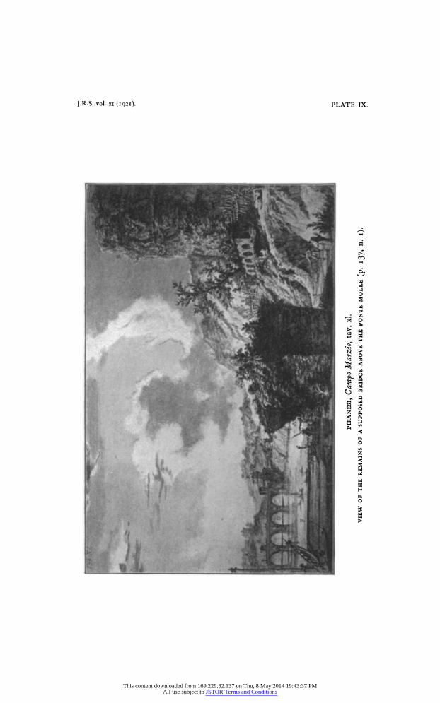
J.R.S. vol. xi (1921). PLATE IX.
1 ~~~~~~~~~~~~~~~~~~~~~~~~~~~~~~~~~~~n
~-0
HD-cn
This content downloaded from 169.229.32.137 on Thu, 8 May 2014 19:43:37 PMAll use subject to JSTOR Terms and Conditions
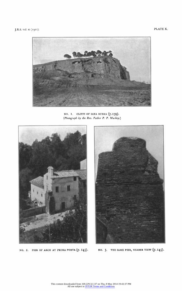
J.R.S. vol. XI (1921). PLATE X.
NO. I. CLIFFS OF SAXA RUBRA (p. I 39). (Photograph by the Rev. Father P. P. Mllackey.)
NO. 2. PIER OF ARCH AT PRIMA PORTA (p. I45). NO. 3. THE SAME PIER, NEARER VIEW (P. I45).
This content downloaded from 169.229.32.137 on Thu, 8 May 2014 19:43:37 PMAll use subject to JSTOR Terms and Conditions
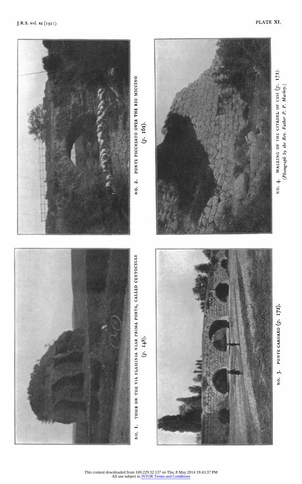
J.R.S. vol. XI (1921). PLATE XI.
0~~~~~~~~~~~~~
0~~~~~~~~~~~~~~~~~~
6 64 z ~~~~~~~~~~~~~z
100
z
10
U; 0
This content downloaded from 169.229.32.137 on Thu, 8 May 2014 19:43:37 PMAll use subject to JSTOR Terms and Conditions
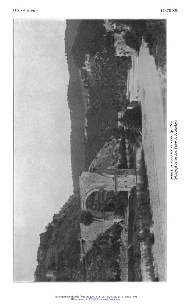
I.R.S. vol. xI (192T). PLATE XII.
A .~~~~~~~~~~t jI7~i x
Jl
This content downloaded from 169.229.32.137 on Thu, 8 May 2014 19:43:37 PMAll use subject to JSTOR Terms and Conditions
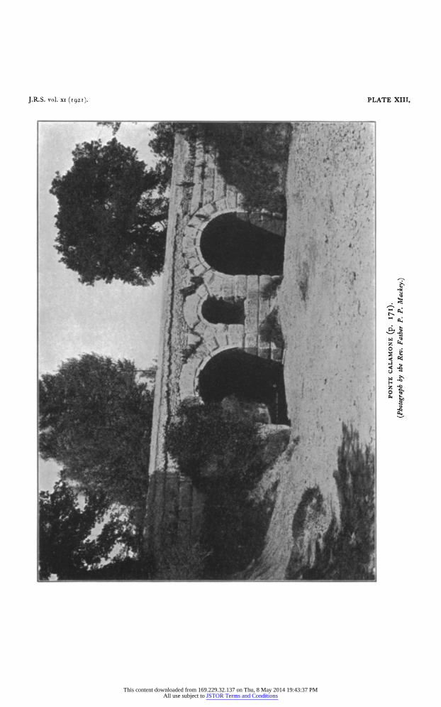
J.R.S. vol. xi (1921). PLATE XIII.
9,S~~~~~~~~~~~~~~~~~~~~~~~~~~~~~~~~~~~~~~~7
Z~ 4 .4.
This content downloaded from 169.229.32.137 on Thu, 8 May 2014 19:43:37 PMAll use subject to JSTOR Terms and Conditions
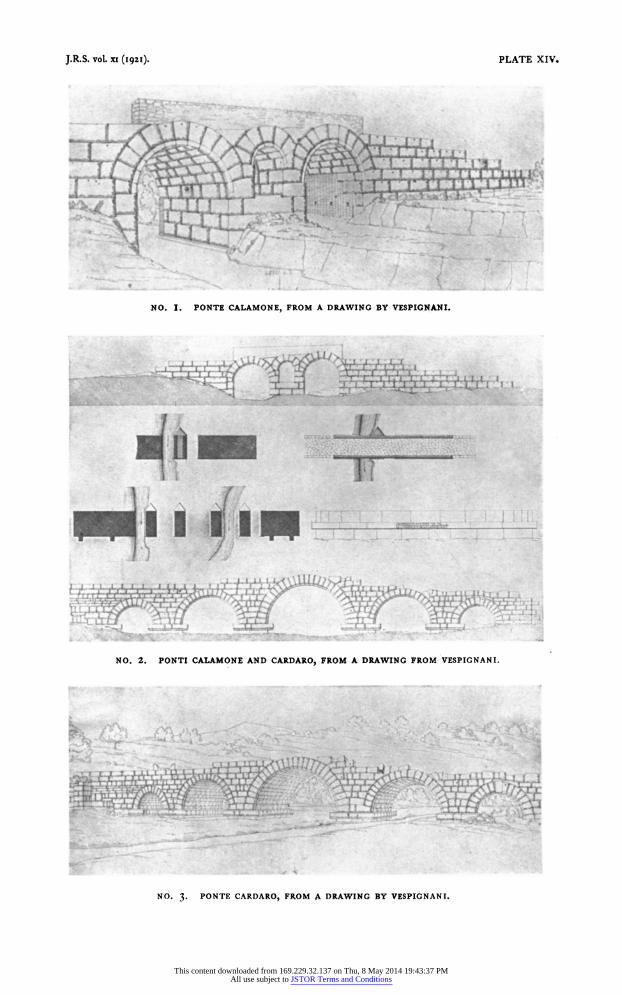
J.R.S. vol. xi (I92i). PLATE XIV.
_ / ; / _
NO. I. PONTE CALAMONE, FROM A DRAWING BY VESPIGNANI.
I,',t
NO. 2. PONTI CALAMONE AND CARDARO, FROM A DRAWING FROM VESPIGNANI.
NO 3 PONTF CARDARO, FROM A DRAWING BY VESPIGNANT
This content downloaded from 169.229.32.137 on Thu, 8 May 2014 19:43:37 PMAll use subject to JSTOR Terms and Conditions
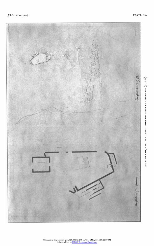
J.R.S. vol. XI (1921). PLATE XV.
d .: '. -,4 IS
(~~~~~~~7;~ ,r- IS k,,. fA,~ ~ ~~~~~~~~~
1~~~~~~~~~~~~~~~~~~~~~~~p
.,, - z I
. ~ ~ ~ ~ . . C . ..~~~~~~~~~~~1
00
-.A~~~~~~~~~~~~~1
: .; . , ' . be,, 0 - H~~~~~~~~~~~
t stM- ;09 > 0 E~~~~~~~~~~~~~~~~
tY *f ; ' . ~~~~~~~~~~~~~~~~~~~
This content downloaded from 169.229.32.137 on Thu, 8 May 2014 19:43:37 PMAll use subject to JSTOR Terms and Conditions
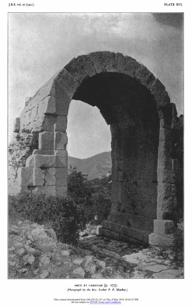
J.R. S. vol. XI (1 921I). PLATE XVI.
,^~~~~~~~~~~~~~~~~~~~~~~~~~~4
I~~~~~~~I
ARCH AT CARSIJLAE (p. I73).
(Photograph by the Rev. Father P. P. Mackey.)
This content downloaded from 169.229.32.137 on Thu, 8 May 2014 19:43:37 PMAll use subject to JSTOR Terms and Conditions
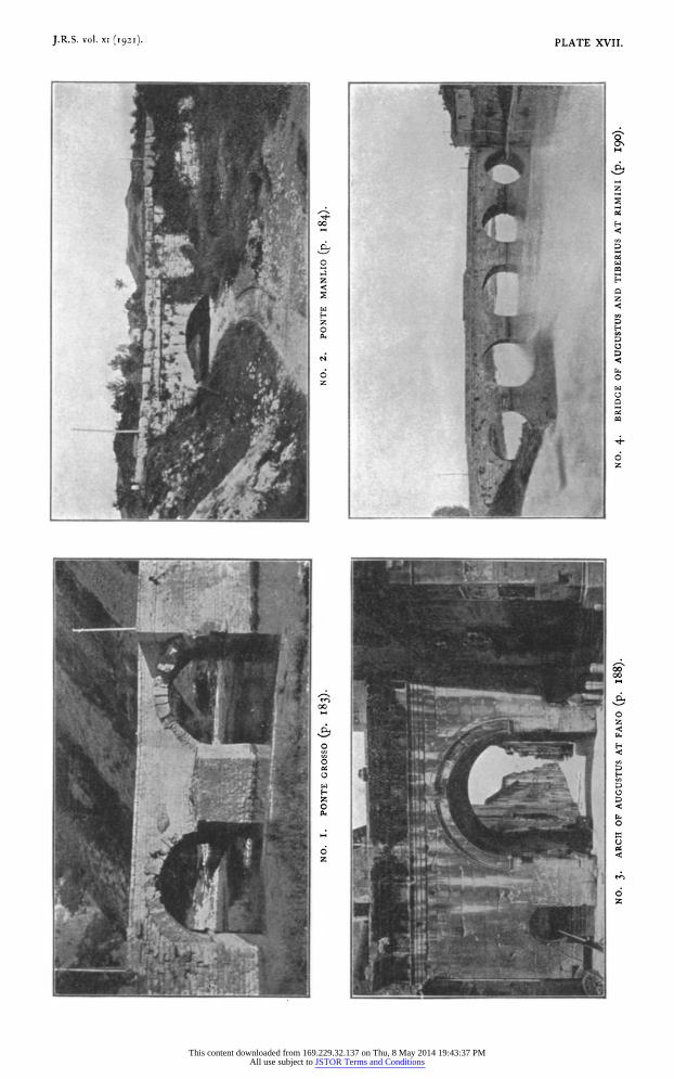
J.R.S. vol. XI (1921). PLATE XVII.
I -~~~~~~~~~~~~~~~~~~~~~~I
0~~~~~~~~~~~~ z~~~~~~~~~~~~~
0
*Ai _ | XX
z
This content downloaded from 169.229.32.137 on Thu, 8 May 2014 19:43:37 PMAll use subject to JSTOR Terms and Conditions
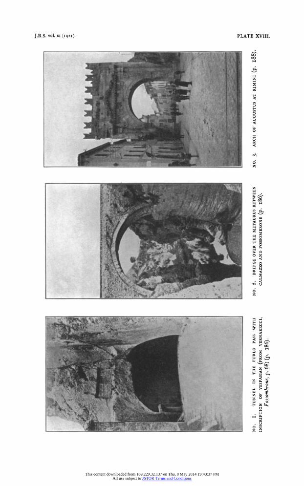
J.R.S. vol. xi (1921). PLATE XVIII.
cc 00
H
z
04
z
z
~~~~~~~~~~~~~ H vg
~~~~~~~~~~~~~~ H
.0
: =~~~~~~~~~~~~~~~~~~~~~~~~~~~~~~~~~~
P:~~~~~~~~~~~~~~~~~~~~~~~~~~~~~~~c
z ilW~~~~~~~~~~~~~~~~~~~~~~~~~~~
o t7
This content downloaded from 169.229.32.137 on Thu, 8 May 2014 19:43:37 PMAll use subject to JSTOR Terms and Conditions


