Embed Size (px)
Citation preview
Earth and Planetary Science Letters 288 (2009) 184–193
Contents lists available at ScienceDirect
Earth and Planetary Science Letters
j ourna l homepage: www.e lsev ie r.com/ locate /eps l
Spatial patterns and controls of soil chemical weathering rates along atransient hillslope
Kyungsoo Yoo a,b,⁎, Simon Marius Mudd c, Jonathan Sanderman d, Ronald Amundson e, Alex Blum f
a Dept. of Plant and Soil Sciences, University of Delaware, United Statesb Dept. of Geological Sciences, University of Delaware, United Statesc School of GeoSciences, University of Edinburgh, UKd CSIRO Land and Water, Australiae Division of Ecosystem Sciences, University of California at Berkeley, United Statesf United States Geological Survey, United States
⁎ Corresponding author. Dept. of Plant and Soil ScieUnited States.
E-mail addresses: [email protected] (K. Yoo), [email protected] (J. Sanderman), earthy@[email protected] (A. Blum).
0012-821X/$ – see front matter © 2009 Elsevier B.V. Adoi:10.1016/j.epsl.2009.09.021
a b s t r a c t
a r t i c l e i n f oArticle history:Received 2 June 2009Received in revised form 4 September 2009Accepted 8 September 2009Available online 13 October 2009
Editor: R.W. Carlson
Keywords:weatheringerosionsoil geochemistryhillslope processessediment transportchannel incision
Hillslopes have been intensively studied by both geomorphologists and soil scientists. Whereasgeomorphologists have focused on the physical soil production and transport on hillslopes, soil scientistshave been concerned with the topographic variation of soil geochemical properties. We combined thesediffering approaches and quantified soil chemical weathering rates along a grass covered hillslope in CoastalCalifornia. The hillslope is comprised of both erosional and depositional sections. In the upper erodingsection, soil production is balanced by physical erosion and chemical weathering. The hillslope thentransitions to a depositional slope where soil accumulates due to a historical reduction of channel incision atthe hillslope's base. Measurements of hillslope morphology and soil thickness were combined with theelemental composition of the soil and saprolite, and interpreted through a process-based model thataccounts for both chemical weathering and sediment transport. Chemical weathering of the minerals as theymoved downslope via sediment transport imparted spatial variation in the geochemical properties of thesoil. Inverse modeling of the field and laboratory data revealed that the long-term soil chemical weatheringrates peak at 5gm−2yr−1 at the downslope end of the eroding section and decrease to 1.5gm−2yr−1 withinthe depositional section. In the eroding section, soil chemical weathering rates appear to be primarilycontrolled by the rate of mineral supply via colluvial input from upslope. In the depositional slope,geochemical equilibrium between soil water and minerals appeared to limit the chemical weathering rate.Soil chemical weathering was responsible for removing 6% of the soil production in the eroding section and5% of colluvial influx in the depositional slope. These were among the lowest weathering rates reported foractively eroding watersheds, which was attributed to the parent material with low amount of weatherableminerals and intense coating of the primary minerals by secondary clay and iron oxides. We showed thatboth the morphologic disequilibrium of the hillslope and the spatial heterogeneity of soil properties are dueto spatial variations in the physical and chemical processes that removed mass from the soil.
nces, University of Delaware,
[email protected] (S.M. Mudd),erkeley.edu (R. Amundson),
ll rights reserved.
© 2009 Elsevier B.V. All rights reserved.
1. Introduction
Some of the major challenges in Earth science are to understandthe complex feedbacks between the tectonic and climatic forcings,geomorphic and geochemical processes, and morphological andgeochemical properties of landscapes. Unraveling this complex webhas far reaching implications. Tectonic uplift is considered to beintimately linked to enhanced silicate weathering, which affects thedrawdown of atmospheric CO2 (Raymo and Ruddiman, 1992; Berner,
1995). In this hypothesis, the ability of tectonic uplift to drawdownCO2 hinges on the rates of geochemical reactions taking place withineroding landscapes. In addition, mineral exposure by uplift anderosion is required for chemical weathering to proceed which iscrucial for releasing inorganic nutrients that help drive the biogeo-chemical cycles of the Earth (Porder et al., 2005, 2007).
Soilmantled hillslopes provide a convenient observational setting tounravel the complex mechanisms and feedbacks using a quantitative,process-based approach. Over the past century, two disciplinary groupshave studied soil mantled hillslopes from significantly differingperspectives, and the resultingdisciplinary gaphashindered integrationof the largely complementary approaches (Anderson et al., 2007;Humphreys and Wilkinson, 2007; Yoo and Mudd, 2008a). Gemorphol-ogists have focused largely on hillslope physical processes, revealingthat the surface horizons of soils are “conveyor belts” which transport
185K. Yoo et al. / Earth and Planetary Science Letters 288 (2009) 184–193
soil material downslope. Many feedbacks occur within this conveyorsystem.Any increase in channel incision at the base of a hillslope leads tosteeper gradients, which in turn accelerates the colluvial soil transport.The increased soil transport will propagate upslope, which in turncauses soil thinning (Furbish and Fagherazzi, 2001; Mudd and Furbish,2005). Soil thinning typically leads to increased soil production(Heimsath et al., 1997), which in turn replaces the thinning soil andthus the hillslope evolves toward a new steady state soil mantle and,over long time periods, morphology. Based on early analyses of theconvexity of hillslopes (Davis, 1892; Gilbert, 1909), the morphologicevolution of hillslopes has been considered the result of physical soilproduction and soil transport (Fernandes and Dietrich, 1997; Roeringet al., 1999;Dietrich et al., 2003).Only a few studies have recently begunto incorporate chemical weathering as a process that sculpts landscapesin non-karst terrain (eg., Anderson et al., 2002; Riebe et al., 2004; Muddand Furbish, 2004).
In contrast, the majority of soil scientists and geochemists havefocused on chemical processes in soils. To determine weatheringrates, chronosequences of soils (similar climate, parent material, biotabut differing ages) are studied. The mass loss via chemical weatheringin each soil can be determined using geochemical comparison of thesoil to its parent material (Brimhall and Dietrich, 1987). This mass losscan be converted into a chemical weathering rate by dividing it by thesoil age which is defined as the time since the cessation of eithererosion or deposition (Amundson, 2004; Yoo and Mudd, 2008b). Onhillslopes, however, soil age cannot be defined because erosioncontinues to rejuvenate the soil material. This necessitates analternative means of quantifying time within eroding soils. Anadditional but rarely studied complication is that a soil at a giventopographic position is made not only of material from the underlyingparent material, but is also comprised of material eroded fromupslope. Due to these complications there has been little progress indeciphering spatially variable rates of soil chemical weatheringwithinmorphologically dynamic landscapes. Indeed, the common descrip-tion of upland soils as “residual” reflects the historical neglect ofphysical transport by many soil scientists.
It is clear that both geochemical and geomorphic processes shapesoil mantled hillslopes simultaneously. The impact of topography-dependent chemical weathering on the morphologic evolution ofhillslopes has been theoretically explored (Mudd and Furbish, 2004),and studies of the topographic variation of soil geochemistry havebegun to consider the geomorphic setting of the soil (Nezat, et al.2004; Green et al., 2006; Mudd and Furbish, 2006; Yoo, et al. 2007)Two recent studies (Green, et al. 2006; Yoo, et al. 2007) combined amass balance of hillslope sediment and soil geochemistry, and foundsystematic variations in chemical weathering rates along hillslopetransects. Yoo et al. (2007) revealed a previously unexplored couplingbetween colluvial flux and chemical weathering rates, demonstratinghow topographic variation of chemical weathering rates drive thechemical weathering rates at the larger scale of watersheds (Yoo, et al.2007; Yoo and Mudd, 2008a).
This study expands on these recent studies in three ways. Previousmodels have been derived for steady state soil mantled slopes (Yooet al., 2007). Here, we include a new time-dependent mass balance toexamine a depositional hillslope. Second, we begin to elucidate themechanisms that control the topography-dependent soil chemicalweathering rates. Lastly, we extend previous studies’ focus on graniticlandscapes to hillslopes underlain by sedimentary sandstone.
2. Conceptual framework
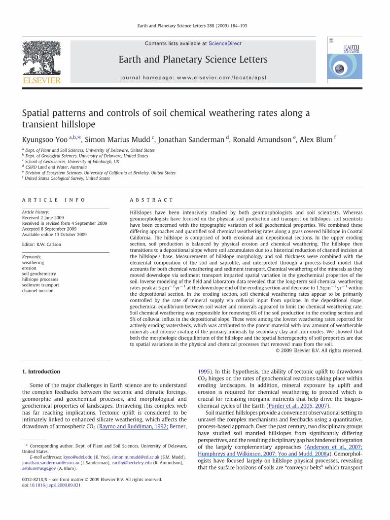
We have derived equations of mass conservation wherein the rateof mass loss due to chemical weathering from a soil is proportional totwo mineral supply rates: colluvial soil input from upslope and soilproduction from the underlying saprolite (Figs. 1 and 2). For a steadystate soil on a hillslope, the total chemical weathering rate (all
elements) and the chemical weathering rate of an individual element,j, can be represented in the following equations. For a detailedderivation of the mass balance equations, see Yoo and Mudd (2008a)and Yoo et al. (2007).
Wtotal = −∇ci;sci;s
⋅ðρsQ sÞ−ρη 1−ci;ηci;s
!P; ð1aÞ
and
Wj = 1−Ciη
Cis
Cjs
Cjη
!ðCjηρηPÞ +
∇Cis
Cis−
∇Cjs
Cjs
!⋅ðCjsρsQ̃ sÞ; ð1bÞ
whereW is the chemical weathering loss (negative) or gain (positive)rate [kgm−2yr−1], ρ is bulk density [kgm−3], P is the rate of soilproduction, defined as the lowering rate of the soil–saprolite interface[myr−1], Q̃ s is the volume of colluvium crossing a contour line of unitlength per time [m2yr−1], h is the soil thickness [m], the subscript srepresents colluvial soil, the subscript η represents the values of thesaprolite at its interface to the colluvial soil, and the gradients ofelemental concentrations (∇C) represent the rates that the concen-trations vary per unit length along the hillslope transect. The physicalflux of colluvial soil can be calculated by integrating the excess of soilproduction rate over chemical weathering rate in the upslope area:
jQ̃ s j x = ðPx−WxÞdx + αx j Q̃ s jx−dx; ð2Þ
Where αx is the ratio of the contour lengths (lx−Δx/lx in Fig. 1c).The value of αx is 1 on planar slope, b1 on horizontally divergentslope, and N1 on horizontally convergent slopes.
We calculated the soil production rate as a function of positionusing measurements of soil thickness and the relationship betweensoil thickness and soil production reported at this site by Heimsathet al. (1997). This information, as well as the elemental concentrationsin the colluvial soil and saprolite, was used in Eqs. (1a), (1b) and (2) tosimultaneously calculate the colluvial flux and the total weatheringrate of the soil and of its individual elements (Yoo et al., 2007). Thecalculations require an iterative technique: the total weathering ratewas first calculated using Eq. (1a) based on an arbitrary colluvial fluxrate, and the resulting chemical weathering rate was inserted intoEq. (2) in order to solve for the colluvial flux rates. This process wasrepeated until the changes in weathering and physical flux ratesbetween iterations became insignificant. This method does notrequire a specific mathematical form for the soil transport (e.g. aslope-dependent versus a soil thickness-slope product soil transportlaw as in Dietrich et al., 2003; Heimsath et al., 2005) because colluvialflux is, by definition, the integral of the soil produced upslope minusthe mass lost chemically upslope of a given point. Though this paperfocuses on chemical weathering, this iterative technique was alsoused to demonstrate the slope-depth dependency of colluvial flux(Yoo et al., 2007).
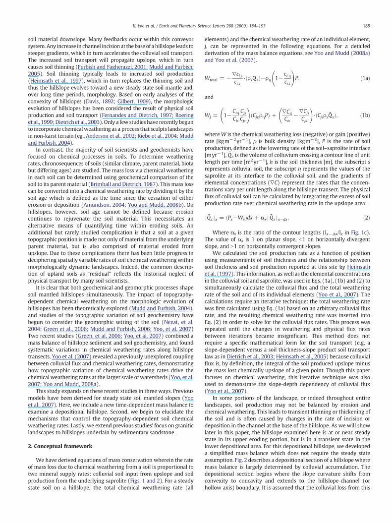
In some portions of the landscape, or indeed throughout entirelandscapes, soil production may not be balanced by erosion andchemical weathering. This leads to transient thinning or thickening ofthe soil and is often caused by changes in the rate of incision ordeposition in the channel at the base of the hillslope. As we will showlater in this paper, the hillslope examined here is at or near steadystate in its upper eroding portion, but is in a transient state in thelower depositional area. For this depositional hillslope, we developeda simplified mass balance which does not require the steady stateassumption. Fig. 2 describes a depositional section of a hillslope wheremass balance is largely determined by colluvial accumulation. Thedepositional section begins where the slope curvature shifts fromconvexity to concavity and extends to the hillslope-channel (orhollow axis) boundary. It is assumed that the colluvial loss from this
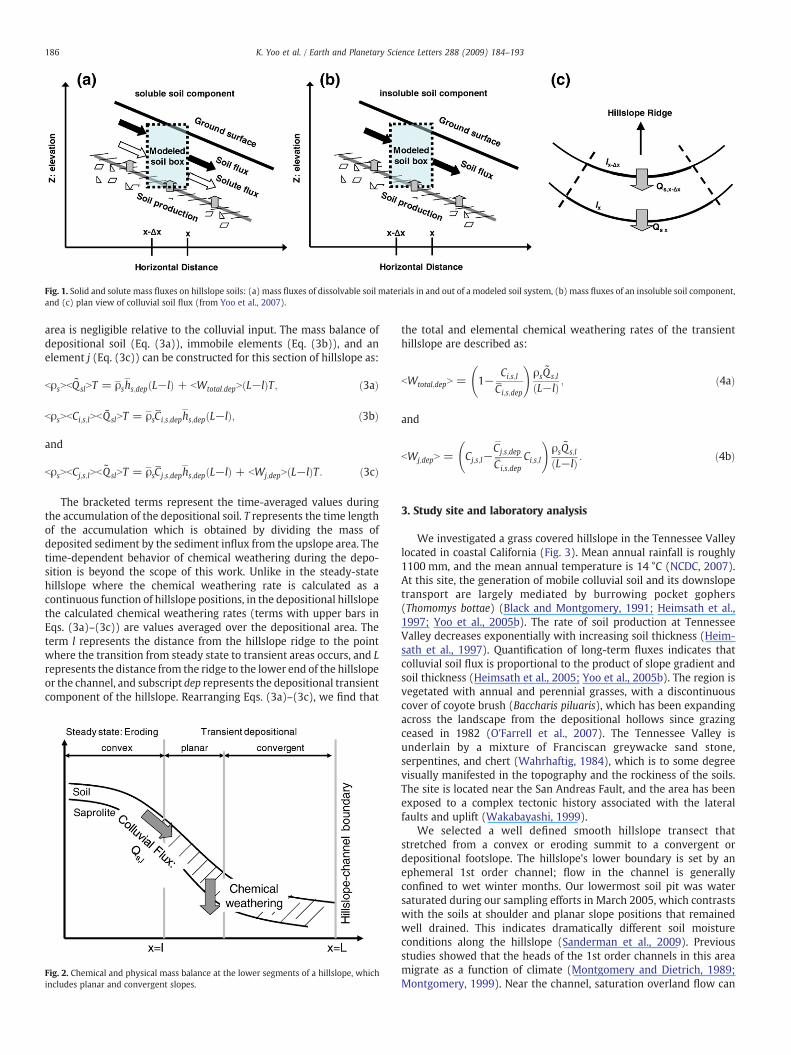
Fig. 1. Solid and solute mass fluxes on hillslope soils: (a) mass fluxes of dissolvable soil materials in and out of a modeled soil system, (b) mass fluxes of an insoluble soil component,and (c) plan view of colluvial soil flux (from Yoo et al., 2007).
186 K. Yoo et al. / Earth and Planetary Science Letters 288 (2009) 184–193
area is negligible relative to the colluvial input. The mass balance ofdepositional soil (Eq. (3a)), immobile elements (Eq. (3b)), and anelement j (Eq. (3c)) can be constructed for this section of hillslope as:
bρsNbQ̃ slNT = ρ̄sh̄s;depðL−lÞ + bWtotal:depNðL−lÞT; ð3aÞ
bρsNbCi;s;lNbQ̃ slNT = ρ̄sC̄i;s;deph̄s;depðL−lÞ; ð3bÞ
and
bρsNbCj;s;lNbQ̃ slNT = ρ̄sC̄j;s;deph̄s;depðL−lÞ + bWj;depNðL−lÞT : ð3cÞ
The bracketed terms represent the time-averaged values duringthe accumulation of the depositional soil. T represents the time lengthof the accumulation which is obtained by dividing the mass ofdeposited sediment by the sediment influx from the upslope area. Thetime-dependent behavior of chemical weathering during the depo-sition is beyond the scope of this work. Unlike in the steady-statehillslope where the chemical weathering rate is calculated as acontinuous function of hillslope positions, in the depositional hillslopethe calculated chemical weathering rates (terms with upper bars inEqs. (3a)–(3c)) are values averaged over the depositional area. Theterm l represents the distance from the hillslope ridge to the pointwhere the transition from steady state to transient areas occurs, and Lrepresents the distance from the ridge to the lower end of the hillslopeor the channel, and subscript dep represents the depositional transientcomponent of the hillslope. Rearranging Eqs. (3a)–(3c), we find that
Fig. 2. Chemical and physical mass balance at the lower segments of a hillslope, whichincludes planar and convergent slopes.
the total and elemental chemical weathering rates of the transienthillslope are described as:
bWtotal;depN = 1−Ci;s;l
C̄i;s;dep
!ρsQ̃ s;l
ðL−lÞ ; ð4aÞ
and
bWj;depN = Cj;s;l−C̄j;s;dep
C̄i;s;depCi;s;l
!ρsQ̃ s;l
ðL−lÞ : ð4bÞ
3. Study site and laboratory analysis
We investigated a grass covered hillslope in the Tennessee Valleylocated in coastal California (Fig. 3). Mean annual rainfall is roughly1100 mm, and the mean annual temperature is 14 °C (NCDC, 2007).At this site, the generation of mobile colluvial soil and its downslopetransport are largely mediated by burrowing pocket gophers(Thomomys bottae) (Black and Montgomery, 1991; Heimsath et al.,1997; Yoo et al., 2005b). The rate of soil production at TennesseeValley decreases exponentially with increasing soil thickness (Heim-sath et al., 1997). Quantification of long-term fluxes indicates thatcolluvial soil flux is proportional to the product of slope gradient andsoil thickness (Heimsath et al., 2005; Yoo et al., 2005b). The region isvegetated with annual and perennial grasses, with a discontinuouscover of coyote brush (Baccharis piluaris), which has been expandingacross the landscape from the depositional hollows since grazingceased in 1982 (O'Farrell et al., 2007). The Tennessee Valley isunderlain by a mixture of Franciscan greywacke sand stone,serpentines, and chert (Wahrhaftig, 1984), which is to some degreevisually manifested in the topography and the rockiness of the soils.The site is located near the San Andreas Fault, and the area has beenexposed to a complex tectonic history associated with the lateralfaults and uplift (Wakabayashi, 1999).
We selected a well defined smooth hillslope transect thatstretched from a convex or eroding summit to a convergent ordepositional footslope. The hillslope's lower boundary is set by anephemeral 1st order channel; flow in the channel is generallyconfined to wet winter months. Our lowermost soil pit was watersaturated during our sampling efforts in March 2005, which contrastswith the soils at shoulder and planar slope positions that remainedwell drained. This indicates dramatically different soil moistureconditions along the hillslope (Sanderman et al., 2009). Previousstudies showed that the heads of the 1st order channels in this areamigrate as a function of climate (Montgomery and Dietrich, 1989;Montgomery, 1999). Near the channel, saturation overland flow can
Fig. 3. Location of the study site.
187K. Yoo et al. / Earth and Planetary Science Letters 288 (2009) 184–193
develop during heavy rainfall (Montgomery and Dietrich, 1995) butoverland flow results in minimal erosion due to the resistance fromthe grass cover (Prosser et al., 1995; Prosser and Dietrich, 1995).Reneau et al. (1990) demonstrated that the episodic landslide eventsoccurring in unchanneled hollows were more common during thewet-to-dry climate transition in the early Holocene.
We defined soil as a physically mixed colluvial layer which iscomposed of A horizons at the site. Lack of physical disturbance andvisual signs of rock texture in the saprolite suggests that the saprolite hasbeen iso-volumetrically weathered. No data is available regarding thedepth to fresh bedrock and its geochemistry at the site. It is unlikely thatbedrock outcrops in the adjacent hillslopes, which probably survivedweathering due to their distinct weathering properties, represent thefresh bedrock of the studied hillslope. Fifteen locations were chosenalongawaterflow lineon thehillslope (Fig. 3).One location at the lowestend of the hillslope was augured due to the saturated conditionsmentioned earlier. At the remaining locations, soils were excavated to adepth that extended ∼30 cm beyond the boundary between soil andsaprolite. At nine of the fifteen locations soils were sampled forgeochemical analyses. Soil samples were collected in 5 to 15 cm depthintervals, with the highest density of samples taken near the surface.Because the physical breakdown of the saprolite is responsible for soilproduction, the saprolite samples used as parent material were takennear the soil–saprolite boundary. We sampled the four corners ofsaprolite exposed in soil pits that had basal areas of roughly ∼1 m2 andused their averaged elemental compositions to ascertain the localheterogeneity of the soil's parentmaterial. Ourfieldobservation suggeststhat the saprolite is derived from clay-rich sandstone and is at leastvisually homogenous within the studied transect. Furthermore, theabsence of weathering resistant rock outcrops supports the bedrockhomogeneity of the studied transect. Differential GPSwas used to createa topographic map of the site, and the locations of the sampling siteswere mapped with sub-meter accuracy.
The soil samples were oven dried and divided into fine (b2 mm)and coarse (N2 mm) fractions using a sieve. Approximately 10 gramsub samples were taken from both size fractions of the soil samplesusing a splitter. Each sub-sample was then pulverized in a tungstencarbide ring using the SPEX Shatter Box for five minutes. Saprolitesamples were not divided into different size fractions but wereotherwise treated identically to soil samples. Pulverized samples weresubmitted to ALS Chemex for chemical analyses, where samples werefirst fused with lithiummeta-borate prior to ICP-MS determination ofelemental chemistry. Elemental compositions of the two soil particlesize groups were combined with measured mass ratios of the fine andcoarse fractions to calculate the total soil concentrations.
To investigate the mineralogical composition of the soil andsaprolite, quantitative X-ray diffraction (XRD) analyseswere conductedfor fine and coarse fractions of soil and saprolite samples at an erodingand a depositional location within the studied hillslope. One gram ofsample was ground for 5 minutes in aMcCronemill with a ZnO internalstandard, then sieved and side packed in a randommount. XRD spectrawere collected on a Siemens D500 instrument from 5 to 65 degrees 2θ,with Cu Kα radiation, at 0.02° step, and a two second count time.Mineral concentrations were determined using the RockJock program(Eberl, 2003), which fits the observed sample spectra as the sum of thespectra frommeasuredmineral standards, with thefitted scaling factorsfor the standards reflecting the mineral abundances in the sample. Thedetails of sample preparation and RockJock calculations are described inEberl (2003). The accuracy and detection limits of the RockJocktechnique are difficult to quantify, and sample dependent. In general,the precision of an individual mineral abundance is about ±5% of thereported abundance. However, highly crystalline phases with littlechemical variability, such as quartz, have higher precisions, whilephases with highly variable chemistry and crystallinity, and mineralswith diagnostic peaks in inconvenient locations, such as biotite, mayhave greater uncertainties.
188 K. Yoo et al. / Earth and Planetary Science Letters 288 (2009) 184–193
4. Results and discussion
4.1. Geomorphic context
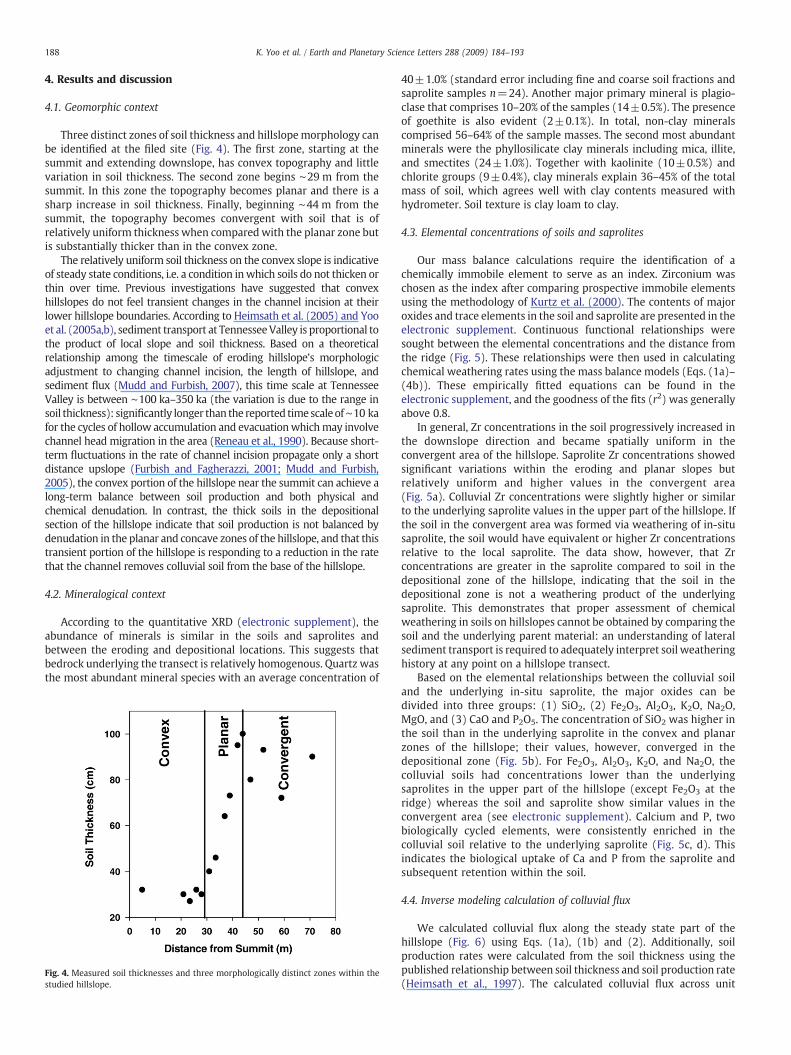
Three distinct zones of soil thickness and hillslopemorphology canbe identified at the filed site (Fig. 4). The first zone, starting at thesummit and extending downslope, has convex topography and littlevariation in soil thickness. The second zone begins ∼29 m from thesummit. In this zone the topography becomes planar and there is asharp increase in soil thickness. Finally, beginning ∼44 m from thesummit, the topography becomes convergent with soil that is ofrelatively uniform thickness when comparedwith the planar zone butis substantially thicker than in the convex zone.
The relatively uniform soil thickness on the convex slope is indicativeof steady state conditions, i.e. a condition inwhich soils do not thicken orthin over time. Previous investigations have suggested that convexhillslopes do not feel transient changes in the channel incision at theirlower hillslope boundaries. According to Heimsath et al. (2005) and Yooet al. (2005a,b), sediment transport at TennesseeValley is proportional tothe product of local slope and soil thickness. Based on a theoreticalrelationship among the timescale of eroding hillslope's morphologicadjustment to changing channel incision, the length of hillslope, andsediment flux (Mudd and Furbish, 2007), this time scale at TennesseeValley is between ∼100 ka–350 ka (the variation is due to the range insoil thickness): significantly longer than the reported timescaleof∼10 kafor the cycles of hollow accumulation and evacuationwhichmay involvechannel head migration in the area (Reneau et al., 1990). Because short-term fluctuations in the rate of channel incision propagate only a shortdistance upslope (Furbish and Fagherazzi, 2001; Mudd and Furbish,2005), the convex portion of the hillslope near the summit can achieve along-term balance between soil production and both physical andchemical denudation. In contrast, the thick soils in the depositionalsection of the hillslope indicate that soil production is not balanced bydenudation in the planar and concave zones of the hillslope, and that thistransient portion of the hillslope is responding to a reduction in the ratethat the channel removes colluvial soil from the base of the hillslope.
4.2. Mineralogical context
According to the quantitative XRD (electronic supplement), theabundance of minerals is similar in the soils and saprolites andbetween the eroding and depositional locations. This suggests thatbedrock underlying the transect is relatively homogenous. Quartz wasthe most abundant mineral species with an average concentration of
Fig. 4. Measured soil thicknesses and three morphologically distinct zones within thestudied hillslope.
40±1.0% (standard error including fine and coarse soil fractions andsaprolite samples n=24). Another major primary mineral is plagio-clase that comprises 10–20% of the samples (14±0.5%). The presenceof goethite is also evident (2±0.1%). In total, non-clay mineralscomprised 56–64% of the sample masses. The second most abundantminerals were the phyllosilicate clay minerals including mica, illite,and smectites (24±1.0%). Together with kaolinite (10±0.5%) andchlorite groups (9±0.4%), clay minerals explain 36–45% of the totalmass of soil, which agrees well with clay contents measured withhydrometer. Soil texture is clay loam to clay.
4.3. Elemental concentrations of soils and saprolites
Our mass balance calculations require the identification of achemically immobile element to serve as an index. Zirconium waschosen as the index after comparing prospective immobile elementsusing the methodology of Kurtz et al. (2000). The contents of majoroxides and trace elements in the soil and saprolite are presented in theelectronic supplement. Continuous functional relationships weresought between the elemental concentrations and the distance fromthe ridge (Fig. 5). These relationships were then used in calculatingchemical weathering rates using the mass balance models (Eqs. (1a)–(4b)). These empirically fitted equations can be found in theelectronic supplement, and the goodness of the fits (r2) was generallyabove 0.8.
In general, Zr concentrations in the soil progressively increased inthe downslope direction and became spatially uniform in theconvergent area of the hillslope. Saprolite Zr concentrations showedsignificant variations within the eroding and planar slopes butrelatively uniform and higher values in the convergent area(Fig. 5a). Colluvial Zr concentrations were slightly higher or similarto the underlying saprolite values in the upper part of the hillslope. Ifthe soil in the convergent area was formed via weathering of in-situsaprolite, the soil would have equivalent or higher Zr concentrationsrelative to the local saprolite. The data show, however, that Zrconcentrations are greater in the saprolite compared to soil in thedepositional zone of the hillslope, indicating that the soil in thedepositional zone is not a weathering product of the underlyingsaprolite. This demonstrates that proper assessment of chemicalweathering in soils on hillslopes cannot be obtained by comparing thesoil and the underlying parent material: an understanding of lateralsediment transport is required to adequately interpret soil weatheringhistory at any point on a hillslope transect.
Based on the elemental relationships between the colluvial soiland the underlying in-situ saprolite, the major oxides can bedivided into three groups: (1) SiO2, (2) Fe2O3, Al2O3, K2O, Na2O,MgO, and (3) CaO and P2O5. The concentration of SiO2 was higher inthe soil than in the underlying saprolite in the convex and planarzones of the hillslope; their values, however, converged in thedepositional zone (Fig. 5b). For Fe2O3, Al2O3, K2O, and Na2O, thecolluvial soils had concentrations lower than the underlyingsaprolites in the upper part of the hillslope (except Fe2O3 at theridge) whereas the soil and saprolite show similar values in theconvergent area (see electronic supplement). Calcium and P, twobiologically cycled elements, were consistently enriched in thecolluvial soil relative to the underlying saprolite (Fig. 5c, d). Thisindicates the biological uptake of Ca and P from the saprolite andsubsequent retention within the soil.
4.4. Inverse modeling calculation of colluvial flux
We calculated colluvial flux along the steady state part of thehillslope (Fig. 6) using Eqs. (1a), (1b) and (2). Additionally, soilproduction rates were calculated from the soil thickness using thepublished relationship between soil thickness and soil production rate(Heimsath et al., 1997). The calculated colluvial flux across unit
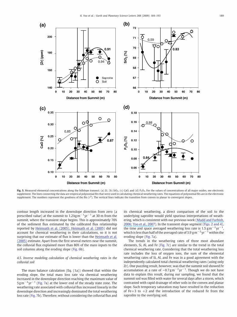
Fig. 5. Measured elemental concentrations along the hillslope transect. (a) Zr, (b) SiO2, (c) CaO, and (d) P2O5. For the values of concentrations of all major oxides, see electronicsupplement. The lines connecting the data are empirical polynomial fits that were used in calculating chemical weathering rates. The equations of polynomial fits are in the electronicsupplement. The numbers represent the goodness of the fits (r2). The vertical lines indicate the transition from convex to planar to convergent slopes.
189K. Yoo et al. / Earth and Planetary Science Letters 288 (2009) 184–193
contour length increased in the downslope direction from zero (aprescribed value) at the summit to 1.2kgm−1yr−1 at 30 m from thesummit, where the transient slope begins. This is approximately 70%of the sediment flux estimated by the calibrated flux relationshipreported by Heimsath et al. (2005). Heimsath et al. (2005) did notaccount for chemical weathering in their calculations, so it is notsurprising that our estimate of flux is lower than the Heimsath et al.(2005) estimate. Apart from the first several meters near the summit,the colluvial flux explained more than 80% of the mass inputs to thesoil columns along the eroding slope (Fig. 6b).
4.5. Inverse modeling calculation of chemical weathering rates in thecolluvial soil
The mass balance calculation (Eq. (1a)) showed that within theeroding slope, the total mass loss rate via chemical weatheringincreased in the downslope direction reaching the maximum value of5gm−2yr−1 (Fig. 7a) at the lower end of the steady state zone. Theweathering rate associated with colluvial flux increased linearly in thedownslope direction and increasingly dominated the total weatheringloss rate (Fig. 7b). Therefore,without considering the colluvialflux and
its chemical weathering, a direct comparison of the soil to theunderlying saprolite would yield spurious interpretations of weath-ering, which is consistent with our previous work (Mudd and Furbish,2006; Yoo et al., 2007). In the transient slope segment (Figs. 2 and 4),the time and space averaged weathering loss rate is 1.5 gm−2yr−1,which is less thanhalf of the averaged rate of 3.9 gm−2yr−1within theeroding slope (Fig. 7a).
The trends in the weathering rates of three most abundantelements, Si, Al, and Fe (Fig. 7c) are similar to the trend in the totalchemical weathering rate. Considering that the total weathering lossrate includes the loss of oxygen ions, the sum of the elementalweathering rates of Si, Al, and Fe was in a good agreement with theindependently calculated total chemical weathering rates (using onlyZr). One puzzling result, however, was that the summit soil showed Feaccumulation at a rate of ∼0.7gm−2yr−1. Though we do not havedata to explain this result, during our sampling, we found that thesummit soil was filled with water for several days after a storm, whichcontrasted with rapid drainage of other soils in the convex and planarslope. Such temporary saturation may have resulted in the reductionof Fe+3 to +2 and the introduction of the reduced Fe from thesaprolite to the overlying soil.
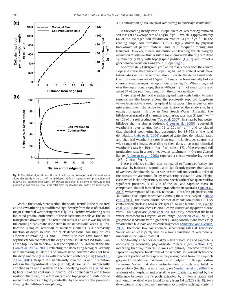
Fig. 6. Calculated physical mass fluxes of colluvial soil transport and soil productionalong the steady state part of the hillslope. (a) Mass inputs of soil production andcolluvial soil entering soils with 1 m2 surface area and (b) Relative percentage of soilproduction and colluvial flux in the total mass input to the soils with 1 m2 surface area.
190 K. Yoo et al. / Earth and Planetary Science Letters 288 (2009) 184–193
Within the steady state section, the spatial trends in the calculatedCa and Pweathering rates differed significantly from those of total andmajor elemental weathering rates (Fig. 7d). Positive weathering ratesindicated gradual enrichment of these elements in soils as the soil istransported downslope. The retention rates of Ca and P was higher inthe eroding steady state slope than in the depositional area (Fig. 7d).Because biological retention of nutrient elements is a decreasingfunction of depth in soils, the thick depositional soil may be lessefficient at retaining Ca and P. Previous studies have found thatorganic carbon contents of the depositional soil decreased from 3–4%at the top 0–5 cm to below 1% at the depth of ∼50–60 cm at the site(Yoo et al., 2005a, 2006), reflecting the decreasing biological activitywith increasing soil depth. The convex slope, however, does not havethe deep soil zone (Fig. 4) with low carbon contents (b1%) (Yoo et al.,2005a, 2006). Despite the significantly lowered Ca and P retentionrates in the depositional slope (Fig. 7d), its soil is still significantlyenriched in Ca and P relative to the underlying saprolite (Fig. 5g andh) because of the continuous influx of soil enriched in Ca and P fromupslope. Therefore, the retention rate and topographic distribution ofnutrient elements are tightly controlled by the geomorphic processesshaping the hillslope's morphology.
4.6. Contribution of soil chemical weathering to landscape denudation
In the eroding steady state hillslope, chemicalweathering removedsoil mass at an average rate of 3.8gm−2yr−1, which is approximately6% of the averaged soil production rate of 64gm−2yr−1. On theeroding slope, soil formation is thus largely driven by physicalbreakdown of parent material and its subsequent mixing andtransport. However, mineral dissolution and leaching, which is largelya function of colluvial flux, result in soil chemicalweathering rates thatsystematically vary with topographic position (Fig. 7) and impart ageochemical variation along the hillslope (Fig. 5).
Approximately 1200gm−1yr−1 of soilmass erodes from the convexslope and enters the transient slope (Fig. 6a). At this rate, it would havetaken ∼44 Kyrs for the sedimentation to create the depositional soils.Over this time span, about 1.5gm−2 of mass has been annually lost viachemicalweathering in the depositional area (Fig. 7a).When integratedover the depositional slope, this is ∼60gm−1yr−1 of mass loss rate orabout 5% of the sediment input from the convex upslope.
These rates of chemical weathering and their contribution to massremoval are the lowest among the previously reported long-termvalues from actively eroding upland landscapes. This is particularlyinteresting given the active tectonic history of the study site. In aeucalyptus-grass hillslope in New South Wales, Australia, thehillslope-averaged soil chemical weathering rate was 21gm−2yr−1
or 40% of the soil production (Yoo et al., 2007). In a nearby but wetterhillslope sharing similar bedrock, Green et al. (2006) reported Siweathering rates ranging from 12 to 20gm−2yr−1 and concludedthat chemical weathering had accounted for 35–55% of the totaldenudation. Riebe et al. (2004) compiled watershed denudation ratesand chemical weathering rates from granitic landscapes spanning awide range of climate. According to their data, an average chemicalweathering rate is ∼10gm−2yr−1 which is ∼17% of the averaged soilproduction rate. In a steep headwater catchment in Oregon CoastalRange, Anderson et al. (2002) reported a silicon weathering rate of10.7±7.1gm−2yr−1.
These previously studied sites, compared to Tennessee Valley, areunderlain by bedrock or saprolite with significantly greater abundancesof weatherable minerals. At our site, in both soil and saprolite, ∼40% ofthe masses are accounted for by weathering resistant quartz. Plagio-clase,which is the only primarymineral species other than quartzwith asignificant presence, is 10–20% of the soil and saprolite mass. Incomparison, the soil formed from granodiorite in Australia (Yoo et al.,2007) was composed of 23% of K-feldspar, ∼10% of Na-plagioclase, and4% biotite (Yoo, unpublished data). Among the sites surveyed in Riebeet al. (2004), the quartz diorite bedrock at Panola Mountain, GA, USAcontained plagioclase (32%), K-feldspar (21%), and biotite (13%) (Whiteet al., 2001), and Rio Icacos, Puerto Rico was underlain by quartz dioritewith ∼60% plagioclase (Riebe et al., 2003a). Lastly, bedrock at the headwater catchment in Oregon Coastal range (Anderson et al., 2002) isgreywacke sandstonewith significant (∼40%) contributions from easilyweatherable feldspars and volcanic fragments (Anderson and Dietrich,2001). Therefore, low soil chemical weathering rates at TennesseeValley are at least partly due to a low abundance of weatherableminerals in the parent material.
Additionally, at Tennessee Valley, ∼40% of both soil and saprolite isoccupied by secondary phyllosilicate minerals (see Section 4.2),indicating that clay minerals in soils are entirely inherited from thesaprolite via physical breakdown of the saprolite. It is also likely that thesignificant portion of the saprolite clay is originated from the clay-richgreywacke sandstone. Likewise, in an adjacent hillslope withinTennessee Valley that share virtually identical soils and hillslopemorphology (for the site information, see Sanderman et al., 2009), theamounts of amorphous and crystalline iron oxides (quantified by thedifference between the Fe pools extracted by dithionite citrate andammonium oxalate) were found to vary from 1.4 to 2.5% (Fig. 8). Soilsdeveloping on clay-free parentmaterials accumulate suchhigh contents
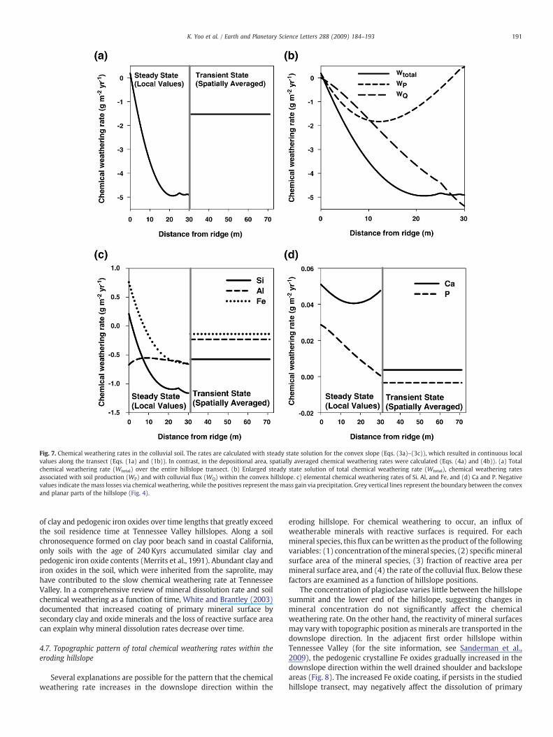
Fig. 7. Chemical weathering rates in the colluvial soil. The rates are calculated with steady state solution for the convex slope (Eqs. (3a)–(3c)), which resulted in continuous localvalues along the transect (Eqs. (1a) and (1b)). In contrast, in the depositional area, spatially averaged chemical weathering rates were calculated (Eqs. (4a) and (4b)). (a) Totalchemical weathering rate (Wtotal) over the entire hillslope transect. (b) Enlarged steady state solution of total chemical weathering rate (Wtotal), chemical weathering ratesassociated with soil production (WP) and with colluvial flux (WQ) within the convex hillslope. c) elemental chemical weathering rates of Si. Al, and Fe, and (d) Ca and P. Negativevalues indicate themass losses via chemical weathering, while the positives represent themass gain via precipitation. Grey vertical lines represent the boundary between the convexand planar parts of the hillslope (Fig. 4).
191K. Yoo et al. / Earth and Planetary Science Letters 288 (2009) 184–193
of clay and pedogenic iron oxides over time lengths that greatly exceedthe soil residence time at Tennessee Valley hillslopes. Along a soilchronosequence formed on clay poor beach sand in coastal California,only soils with the age of 240 Kyrs accumulated similar clay andpedogenic iron oxide contents (Merrits et al., 1991). Abundant clay andiron oxides in the soil, which were inherited from the saprolite, mayhave contributed to the slow chemical weathering rate at TennesseeValley. In a comprehensive review of mineral dissolution rate and soilchemical weathering as a function of time, White and Brantley (2003)documented that increased coating of primary mineral surface bysecondary clay and oxide minerals and the loss of reactive surface areacan explain why mineral dissolution rates decrease over time.
4.7. Topographic pattern of total chemical weathering rates within theeroding hillslope
Several explanations are possible for the pattern that the chemicalweathering rate increases in the downslope direction within the
eroding hillslope. For chemical weathering to occur, an influx ofweatherable minerals with reactive surfaces is required. For eachmineral species, this flux can bewritten as the product of the followingvariables: (1) concentrationof themineral species, (2) specificmineralsurface area of the mineral species, (3) fraction of reactive area permineral surface area, and (4) the rate of the colluvial flux. Below thesefactors are examined as a function of hillslope positions.
The concentration of plagioclase varies little between the hillslopesummit and the lower end of the hillslope, suggesting changes inmineral concentration do not significantly affect the chemicalweathering rate. On the other hand, the reactivity of mineral surfacesmay vary with topographic position as minerals are transported in thedownslope direction. In the adjacent first order hillslope withinTennessee Valley (for the site information, see Sanderman et al.,2009), the pedogenic crystalline Fe oxides gradually increased in thedownslope direction within the well drained shoulder and backslopeareas (Fig. 8). The increased Fe oxide coating, if persists in the studiedhillslope transect, may negatively affect the dissolution of primary
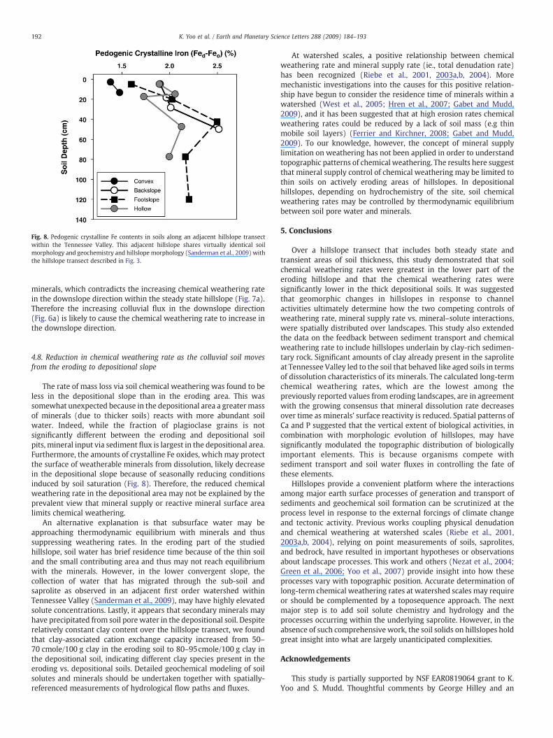
Fig. 8. Pedogenic crystalline Fe contents in soils along an adjacent hillslope transectwithin the Tennessee Valley. This adjacent hillslope shares virtually identical soilmorphology and geochemistry and hillslope morphology (Sanderman et al., 2009) withthe hillslope transect described in Fig. 3.
192 K. Yoo et al. / Earth and Planetary Science Letters 288 (2009) 184–193
minerals, which contradicts the increasing chemical weathering ratein the downslope direction within the steady state hillslope (Fig. 7a).Therefore the increasing colluvial flux in the downslope direction(Fig. 6a) is likely to cause the chemical weathering rate to increase inthe downslope direction.
4.8. Reduction in chemical weathering rate as the colluvial soil movesfrom the eroding to depositional slope
The rate of mass loss via soil chemical weathering was found to beless in the depositional slope than in the eroding area. This wassomewhat unexpected because in the depositional area a greatermassof minerals (due to thicker soils) reacts with more abundant soilwater. Indeed, while the fraction of plagioclase grains is notsignificantly different between the eroding and depositional soilpits, mineral input via sediment flux is largest in the depositional area.Furthermore, the amounts of crystalline Fe oxides, which may protectthe surface of weatherable minerals from dissolution, likely decreasein the depositional slope because of seasonally reducing conditionsinduced by soil saturation (Fig. 8). Therefore, the reduced chemicalweathering rate in the depositional area may not be explained by theprevalent view that mineral supply or reactive mineral surface arealimits chemical weathering.
An alternative explanation is that subsurface water may beapproaching thermodynamic equilibrium with minerals and thussuppressing weathering rates. In the eroding part of the studiedhillslope, soil water has brief residence time because of the thin soiland the small contributing area and thus may not reach equilibriumwith the minerals. However, in the lower convergent slope, thecollection of water that has migrated through the sub-soil andsaprolite as observed in an adjacent first order watershed withinTennessee Valley (Sanderman et al., 2009), may have highly elevatedsolute concentrations. Lastly, it appears that secondary minerals mayhave precipitated from soil pore water in the depositional soil. Despiterelatively constant clay content over the hillslope transect, we foundthat clay-associated cation exchange capacity increased from 50–70 cmole/100 g clay in the eroding soil to 80–95cmole/100 g clay inthe depositional soil, indicating different clay species present in theeroding vs. depositional soils. Detailed geochemical modeling of soilsolutes and minerals should be undertaken together with spatially-referenced measurements of hydrological flow paths and fluxes.
At watershed scales, a positive relationship between chemicalweathering rate and mineral supply rate (ie., total denudation rate)has been recognized (Riebe et al., 2001, 2003a,b, 2004). Moremechanistic investigations into the causes for this positive relation-ship have begun to consider the residence time of minerals within awatershed (West et al., 2005; Hren et al., 2007; Gabet and Mudd,2009), and it has been suggested that at high erosion rates chemicalweathering rates could be reduced by a lack of soil mass (e.g thinmobile soil layers) (Ferrier and Kirchner, 2008; Gabet and Mudd,2009). To our knowledge, however, the concept of mineral supplylimitation on weathering has not been applied in order to understandtopographic patterns of chemical weathering. The results here suggestthat mineral supply control of chemical weathering may be limited tothin soils on actively eroding areas of hillslopes. In depositionalhillslopes, depending on hydrochemistry of the site, soil chemicalweathering rates may be controlled by thermodynamic equilibriumbetween soil pore water and minerals.
5. Conclusions
Over a hillslope transect that includes both steady state andtransient areas of soil thickness, this study demonstrated that soilchemical weathering rates were greatest in the lower part of theeroding hillslope and that the chemical weathering rates weresignificantly lower in the thick depositional soils. It was suggestedthat geomorphic changes in hillslopes in response to channelactivities ultimately determine how the two competing controls ofweathering rate, mineral supply rate vs. mineral–solute interactions,were spatially distributed over landscapes. This study also extendedthe data on the feedback between sediment transport and chemicalweathering rate to include hillslopes underlain by clay-rich sedimen-tary rock. Significant amounts of clay already present in the saproliteat Tennessee Valley led to the soil that behaved like aged soils in termsof dissolution characteristics of its minerals. The calculated long-termchemical weathering rates, which are the lowest among thepreviously reported values from eroding landscapes, are in agreementwith the growing consensus that mineral dissolution rate decreasesover time as minerals’ surface reactivity is reduced. Spatial patterns ofCa and P suggested that the vertical extent of biological activities, incombination with morphologic evolution of hillslopes, may havesignificantly modulated the topographic distribution of biologicallyimportant elements. This is because organisms compete withsediment transport and soil water fluxes in controlling the fate ofthese elements.
Hillslopes provide a convenient platform where the interactionsamong major earth surface processes of generation and transport ofsediments and geochemical soil formation can be scrutinized at theprocess level in response to the external forcings of climate changeand tectonic activity. Previous works coupling physical denudationand chemical weathering at watershed scales (Riebe et al., 2001,2003a,b, 2004), relying on point measurements of soils, saprolites,and bedrock, have resulted in important hypotheses or observationsabout landscape processes. This work and others (Nezat et al., 2004;Green et al., 2006; Yoo et al., 2007) provide insight into how theseprocesses vary with topographic position. Accurate determination oflong-term chemical weathering rates at watershed scales may requireor should be complemented by a toposequence approach. The nextmajor step is to add soil solute chemistry and hydrology and theprocesses occurring within the underlying saprolite. However, in theabsence of such comprehensive work, the soil solids on hillslopes holdgreat insight into what are largely unanticipated complexities.
Acknowledgements
This study is partially supported by NSF EAR0819064 grant to K.Yoo and S. Mudd. Thoughtful comments by George Hilley and an
193K. Yoo et al. / Earth and Planetary Science Letters 288 (2009) 184–193
anonymous reviewer significantly improved this paper. The authorsthank Golden Gate National Recreation Area in National Park Servicefor their cooperation during the research.
Appendix A. Supplementary data
Supplementary data associated with this article can be found, inthe online version, at doi: 10.1016/j.epsl.2009.09.021.
References
Amundson, R., 2004. Soil formation. In: Holland, H.D., Turekian, K.K. (Eds.), Treatise onGeochemistry. Elsevier Science Ltd., Oxford, UK, pp. 1–35.
Anderson, S.P., Dietrich, W.E., 2001. Chemical weathering and runoff chemistry in asteep headwater catchment. Hydrol. Process. 15, 1791–1815.
Anderson, S.P., Dietrich, W.E., Brimhall, G.H., 2002. Weathering profiles, mass-balanceanalysis, and rates of solute loss: Linkages between weathering and erosion in asmall, steep catchment. GSA Bull. 114, 1143–1158.
Anderson, S.P., von Blanckenburg, F., White, A.F., 2007. Physical and chemical controlson the critical zone. Elements 3, 315–319.
Berner, R.A., 1995. Chemical weathering and its effect on atmospheric CO2 and climate.In: White, A.F., Brantley, S.L. (Eds.), Chemical weathering rates of silicate minerals.Mineralogical Society of America, Washington D.C., pp. 565–583.
Black, T.A., Montgomery, D.R., 1991. Sediment transport by burrowingmammals, MarinCounty, California. Earth Surf. Proc. Land. 16, 163–172.
Brimhall, G.H., Dietrich, W.E., 1987. Constitutive mass balance relations betweenchemical composition, volume, density, porosity, and strain in metasomatichydrochemical systems: results on weathering and pedogenesis. Geochim.Cosmochim. Acta 51, 567–587.
Davis, W.M., 1892. The convex profile of bad-land divides. Science 20, 245.Dietrich, W.E., Bellugi, D.G., Sklar, L.S., Stock, J.D., Heimsath, A.M., Roering, J.J., 2003.
Geomorphic transport laws for predicting landscape form and dynamics. In:Wilcock, P.R., Iverson, R.M. (Eds.), Predictions in Geomorphology. AmericanGeophysical Union, Washington D.C., pp. 103–132.
Eberl, D.D., 2003. User's Guide to Rockjock — a program for determining quantitativemineralogy from powder X-ray diffraction data. U.S. Geological Survey Open-FileReport, vol. 03–78. 46 pp.
Fernandes, N.F., Dietrich, W.E., 1997. Hillslope evolution by diffusive processes: thetimescale for equilibrium adjustments. Water Resour. Res. 33, 1307–1318.
Ferrier, K.L., Kirchner, J.W., 2008. Effects of physical erosion on chemical denudationrates: a numerical modeling study of soil-mantled hillslopes. Earth Planet. Sci. Lett.272, 591–599.
Furbish, D.J., Fagherazzi, S., 2001. Stability of creeping soil and implications for hillslopeevolution. Water Resour. Res. 37, 2607–2618.
Gabet, E.J., Mudd, S.M., 2009. A theoretical model coupling chemical weathering rateswith denudation rates. Geology 37, 151–154.
Gilbert, G.K., 1909. The convexity of hilltops. J. Geol. 17, 344–350.Green, E.G., Dietrich, W.E., Banfield, J.F., 2006. Quantification of chemical weathering
rates across an actively eroding hillslope. Earth Planet. Sci. Lett. 242, 159–169.Heimsath, A.M., Dietrich, W.E., Nishiizumi, K., Finkel, R.C., 1997. The soil production
function and landscape equilibrium. Nature 388, 358–361.Heimsath, A.M., Furbish, D.J., Dietrich, W.E., 2005. The illusion of diffusion: field
evidence for depth dependent sediment transport. Geology 33, 949–952.Hren, M.T., Hilley, G.E., Chamberlain, G.P., 2007. The relationship between tectonic
uplift and chemical weathering rates in the Washington cascades: field measure-ments and model predictions. Am. J. Sci. 307, 1041–1063.
Humphreys, G.S., Wilkinson, M.T., 2007. The soil production function: a brief historyand its rediscovery. Geoderma 139, 73–78.
Kurtz, A.C., Derry, L.A., Chadwick, O.A., Alfano, M.J., 2000. Refractory element mobility involcanic soils. Geology 28, 683–686.
Montgomery, D.R., 1999. Erosional processes at an abrupt channel head: implicationsfor channel entrenchment and discontinuous gully formation. In: Darby, S.E.,Simon, A. (Eds.), Incised river channels. John Wiley & Sons Ltd, pp. 247–276.
Montgomery, D.R., Dietrich, W.E., 1989. Source areas, drainage density, and channelinitiation. Water Resour. Res. 25, 1907–1918.
Montgomery, D.R., Dietrich, W.E., 1995. Hydrological processes in a low-gradientsource area. Water Resour. Res. 31, 1–10.
Mudd, S.M., Furbish, D.J., 2004. The Influence of chemical denudation on hillslopemorphology. J. Geophys. Res. -Earth Surf. 109, F02001. doi10.1029/2003JF000087.
Mudd, S.M., Furbish, D.J., 2005. Lateral migration of hillcrests in response to channelincision in soil-mantled landscapes. J. Geophys. Res. -Earth Surf. 110, F04026.doi10.1029/2005JF000313.
Mudd, S.M., Furbish, D.J., 2006. Using chemical tracers in hillslope soils to estimate theimportance of chemical denudation under conditions of downslope sedimenttransport. J. Geophys. Res. -Earth Surf. 111, F02021. doi10.1029/2005JF000343.
Mudd, S.M., Furbish, D.J., 2007. Responses of soil-mantled hillslopes to transientchannel incision rates. J. Geophys. Res. -Earth Surf. 112, F03S18. doi10.1029/2006JF000516.
NCDC, 2007. Climatic data summary for station #4500 Kentfield, CA. Cited 15 April2007. http://www.ncdc.noaa.gov/oa/ncdc.html.
Nezat, C.A., Blum, J.D., Klaue, A., Johnson, C.E., Siccama, T.G., 2004. Influence oflandscape positions and vegetation on long-term weathering rates at the HubbardBrook Experimental Forest, New Hampshire, USA. Geochim. Cosmochim. Acta 68,3065–3078.
O'Farrell, C.R., Heimsath, A.M., Kaste, J.M., 2007. Quantifying hillslope erosion rates andprocesses for a coastal California landscape over varying timescales. Earth Surf.Proc. Land. 32, 544–560.
Porder, S., Paytan, A., Vitousek, P.M., 2005. Erosion and landscape development affectplant nutrient status in the Hawaiian Islands. Oecologia 142, 440–449.
Porder, S., Vitousek, P.M., Chadwick, O.A., Chamberlain, C.P., Hilley, G.E., 2007. Uplift,erosion, and phosphorus limitation in terrestrial ecosystems. Ecosystems 10,158–170.
Prosser, I.P., Dietrich, W.E., 1995. Field experiments on erosion by overland flow andtheir implication for a digital terrain model of channel initiation. Water Resour. Res.31, 2867–2876.
Prosser, I.P., Dietrich, W.E., Stevenson, J., 1995. Flow resistance and sediment transportby concentrated overland flow in a grassland valley. Geomorphology 13, 71–86.
Raymo, M.E., Ruddiman, W.F., 1992. Tectonic forcing of late Cenozoic climate. Nature359, 117–122.
Reneau, S.L., Dietrich, W.E., Donahue, D.J., Jull, A.J.T., Rubin, M., 1990. Late Quaternaryhistory of colluvial deposition and erosion in hollows, central California CoastRange. Geol. Soc. Am. Bull. 102, 969–982.
Riebe, C.S., Kirchner, J.W., Granger, D.E., Finkel, R.C., 2001. Minimal climatic control onerosion rates in the Sierra Nevada, California. Geology 29, 447–450.
Riebe, C.S., Kirchner, J.W., Finkel, R.C., 2003a. Long-term rates of chemical weatheringand physical erosion from cosmogenic nuclides and geochemical mass balance.Geochim. Cosmochim. Acta 67, 4411–4427.
Riebe, C.S., Kirchner, J.W., Finkel, R.C., 2003b. Sharp decrease in long-term chemicalweathering rates along an altitudinal trasect. Earth Planet. Sci. Lett. 218, 421–434.
Riebe, C.S., Kirchner, J.W., Finkel, R.C., 2004. Erosional and climatic effects on long-termchemical weathering rates in granitic landscapes spanning diverse climate regimes.Earth Planet. Sci. Lett.
Roering, J.J., Kirchner, J.W., Dietrich, W.E., 1999. Evidence for nonlinear, diffusivesediment transport on hillslopes and implications for landscape morphology.Water Resour. Res. 35, 853–870.
Sanderman, J., Lohse, K.A., Baldock J.A., Amundson, R., 2009. Linking soils and streams:sources and chemistry of dissolved organic matter in a small coastal watershed.Water Resour. Res. 45, W03418. doi:10.1029/2008WR006977.
Wahrhaftig, C., 1984. Structure of the Marin Headlands block, California: a progressreport. Francisc. Geol. North. Calif. 43, 31–50.
Wakabayashi, J., 1999. Distribution of displacement on and evolution of a youngtransform fault system: the northern San Andreas fault system, California.Tectonics 18, 1245–1274.
West, A.J., Galy, A., Bickle, M., 2005. Tectonic and climatic controls on silicateweathering. Earth Planet. Sci. Lett. 235, 211–228.
White, A.F., Brantley, S., 2003. The effect of time on the weathering of silicate minerals:why do weathering rates differ in the laboratory and field? Chem. Geol. 202,479–506.
White, A.F., Bullen, T.D., Schulz, M.S., Blum, A.E., Huntington, T.G., Peters, N.E., 2001.Differential rates of feldspar weathering in granitic regoliths. Geochim. Cosmochim.Acta 65, 847–869.
Yoo, K., Mudd, S.M., 2008a. Toward process-based modeling of geochemical soilformation across diverse landforms: a new mathematical framework. Geoderma146, 248–260.
Yoo, K., Mudd, S.M., 2008b. Discrepancy between mineral residence time and soil age:implications for the interpretation of chemical weathering rates. Geology 36,35–38.
Yoo, K., Amundson, R., Heimsath, A.M., Dietrich,W.E., 2005a. Erosion of upland hillslopesoil organic carbon: coupling field measurements with a sediment transport model.Global Biogeochem. Cycles 19, GB3003. doi10.1029/2004GB002271.
Yoo, K., Amundson, R., Heimsath, A.M., Dietrich, W.E., 2005b. A process based modellinking pocket gopher (Thomomys Bottae) activity to sediment transport and soilthickness. Geology 33, 917–920.
Yoo, K., Amundson, R., Heimsaht, A.M., Dietrich, W.E., 2006. Spatial patterns of soilorganic carbon on hillslopes: integrating geomorphic processes and the biological Ccycle. Geoderma 130, 47–65.
Yoo, K., Amundson, R., Heimsath, A.M., Dietrich, W.E., Brimhall, G.H., 2007. Integrationof geochemical mass balance with sediment transport to calculate rates of soilchemical weathering and transport on hillslopes. J. Geophys. Res. -Earth Surf. 112,F02013. doi10.1029/2005JF000402.