Embed Size (px)
Citation preview

SCUPICOLONIA FLAVIA SCUPINORUM
The most signifi cant values of the cultural and natural heritage
Lence Jovanova
SCUPICOLONIA FLAVIA SCUPINORUM

This work has been publishedwith the financial support of theGovernment of the Republic of Macedonia


The most significant values of the cultural and natural heritage
SCUPICOLONIA FLAVIASCUPINORUM
Lence Jovanova
Skopje 2015

FOREWORD
MACEDONIAN CULTURAL AND NATURAL HERITAGE
Over the past 4.5 million years since the creation of Earth, the ancestor of the modern man, “the wise man - Homo sapiens”, appearing on the African continent 150,000 years before this day, quickly settled throughout the territories of the Middle East, Asia and Europe.
His cultural evolution is recorded in the Republic of Macedonia, as well.
While travelling through the prehistoric era of the Stone Age, the Bronze Age and the Iron Age, as well as the historical epochs of the Antiquity and the Middle Ages, man created civilizations on the soil of the Republic of Macedonia by introducing and using the natural resources. He established the magnificent kingdoms of the Agrianians, Paeonia, Pelagonia, Lyncestis, Macedonia, and the principalities of Deuriopus, Dessaretia and the Penestae.
The Roman Empire, Byzantine, the medieval states - all left a powerful civilizational imprint.
The belief in the natural phenomena, followed by the belief in the many gods, to finally worship our only God - all left indelible cultural traces.
All this enormous cultural and natural heritage of the Republic of Macedonia was subject of the capital project of the Government of the Republic of Macedonia, “Publications of the most significant values of the cultural and natural heritage,” carried out by the Cultural Heritage Protection Office.
130 monographs featuring the Archaeological Heritage, Sacral heritage, the Treasures of the churches and monasteries in Macedonia and the Natural heritage were created.
Macedonia - the high forest land in the heart of the Balkan Peninsula, as the name suggests, furrowed by the deep valleys of the Vardar tributaries and the river Drim, adorned with the blue - green waters of Lake Ohrid, Prespa and Dojran, with the proud giants Kozuv, Shar Mountain, Korab and Jablanica, Selecka Mountain and other mountain ranges, today lights 130 torches of its own, as well as the world’s, cultural and natural heritage; a legacy to preserve, use wisely and pass on to future generations of the Macedonian road to eternity.
Prof. Viktor Lilchikj Adams, Ph.D.
6

SCUPICOLONIA FLAVIA SCUPINORUM
SKOPJESCUPI - COLONIA FLAVIA SCUPINORUM
LocationThe Skopje Valley is a place where one civilization has replaced another for ten thousand years. During that unstoppable process where civilizations continuously created layers of history, the Roman civilization left deep traces. The history of Skopje in the Roman period is identified with that of the city of Scupi whose ruins are an archaeological testimony which persists in space and time.
7

Situated in an area torn between east and west - north and south, Scupi was a challenge for numerous invaders, well- intentioned travellers and traders. Whatever their reasons and mo-tives, they all saw possibilities and opportunities for life and survival on this area.Scupi is located in the central part of the Skopje Valley at a distance 5 km northwest of Skopje, near the village Zlokukjani, on the southwest slope of the hill Zajcev Rid, left of the mouth of the river Lepenec into Vardar. Regarding surface (44 ha), Scupi is the largest Roman city in the Republic of Macedonia, and, at the same time, the only one with a status of a Roman colony, which is the highest rank that a self-governing provincial Roman city could acquire.
HISTORY OF THE CITYBefore the arrival of the Romans
Archaeological finds indicate continuous life on the area of the future city of Scupi and the im-mediate surroundings in the Bronze and Iron Age - from the 12th to the 6th century BC.On the urban territory of Scupi on several locations (the Christian basilica, the City bath com-plex– Horreum, the cardo street, the South-eastern rampart), were discovered remains of ho-use materials and settlement fragmented pottery from the Bronze Age and the transitional pe-riod (Late Bronze - Early Iron Age). The finds point to a nearby settlement, whose exact location
8

has not been determined. Necropoli (cemetery) of the Late Bronze Age (12th -10th century BC) were discovered in the area of the northwest and southeast cemetery of the Roman city Scupi, while the Iron Age necropolis (7th-6th century BC) was discovered in the area of the Southeastern necropolis of Scupi. The ritual of burying and the findings can be linked with similar occurrences of that period in the Skopje region, and other regions in Macedonia, which is associated with the northern features of the Paionian ethnic element.The period of Early Antiquity is an archaeological gap (hiatus) of five centuries (5th- 1st century BC) lacking material evidence of developments in this area. According to historical sources, the Dardanians penetrate and populate the region of the Skopje Valley in the late 3rd cen-tury BC.Ancient sources provide little information about the settlements and building in the pre - Ro-man period in the Skopje Valley. There is little information from the archaeological explorations and findings because of the insufficient research conducted on this area.The terrain remains open to the assumption that on the highest plateau on the hill Zajcev Rid was located the pre- Roman oppidum, but there is no material evidence to support this assump-tion.
The arrival of the Romans (military junction)The beginnings of the Roman city can be associated with the invasion of the Roman legions to the north of the Roman province Macedonia, which is the cause for a more intensive presence and advance of Roman rule in the region of the central Balkans in the 1st century BC. This process was accelerated by the well- known Dardanian War (Bellum Dardanicum) of Gaius Scribonius Curio in 75-73 BC. Nevertheless, Dardania was finally defeated militarily and lost its independ-ence after the campaign of Marcus Licinius Crassus against the Bastarnae and Dacians in 29-28 BC and its fate is linked with the history of the future Roman province of Moesia as its integral part.The Roman aggression on this territory continued in the next forty years (27 BC - 15 AD) which is associated with the protection of the northern border of the province Macedonia from the frequent invasions of the barbarian tribes from the north. It is a well-known fact that in that period two legions, the Fifth Macedonian Legion (V Macedonica) and the Fourth Scythian Legion (IV Skythica), were relocated elsewhere in the area north of Macedonia. The assumption that the legion camp of one of the legions was located in Scupi, though historically possible, has no real archaeological or epigraphic evidence. The complicated issue of the location and status of the main agglomeration (legion camp or civilian settlement) in place of the future Scupi in the first half of the 1st century can be resolved only by research of the oldest and deepest archaeological layers.The intense colonization and urbanization occurred after the establishment of the province of Moesia in 15 AD, although there is no accurate data regarding events and processes of the strengthening of Roman rule in the newly conquered areas. However, one should not exclude the possibility that Scupi played an important role as the southernmost point in the defence of the province Macedonia, as well as a supportive base and a hub for the gathering, accommodation and supplying of the army, before the final transfer of the legions to the north, which occurred in 23 AD when Tacitus mentions the presence of two legions on the Danube.
9
The birth of the city (The establishment of the colony)
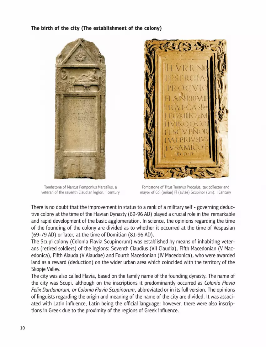
There is no doubt that the improvement in status to a rank of a military self - governing deduc-tive colony at the time of the Flavian Dynasty (69-96 AD) played a crucial role in the remarkable and rapid development of the basic agglomeration. In science, the opinions regarding the time of the founding of the colony are divided as to whether it occurred at the time of Vespasian (69-79 AD) or later, at the time of Domitian (81-96 AD).The Scupi colony (Colonia Flavia Scupinorum) was established by means of inhabiting veter-ans (retired soldiers) of the legions: Seventh Claudius (VII Claudia), Fifth Macedonian (V Mac-edonica), Fifth Alauda (V Alaudae) and Fourth Macedonian (IV Macedonica), who were awarded land as a reward (deduction) on the wider urban area which coincided with the territory of the Skopje Valley.The city was also called Flavia, based on the family name of the founding dynasty. The name of the city was Scupi, although on the inscriptions it predominantly occurred as Colonia Flavia Felix Dardanorum, or Colonia Flavia Scupinorum, abbreviated or in its full version. The opinions of linguists regarding the origin and meaning of the name of the city are divided. It was associ-ated with Latin influence, Latin being the official language; however, there were also inscrip-tions in Greek due to the proximity of the regions of Greek influence.
10

Imperial period (flourishment / develop-ment of the city) Scupi is the southernmost provincial capital of Upper Moesia (Moesiae Superior), and the city borders were identical to a section of the province borders. According to the Roman ge-ographer Ptolemy of the 2nd century, Scupi was the largest centre and the only colony in Dardania (the southern half of the province), along with the cities Naissus, Ulpiana and Aribantion.Scupi is located at the point of intersection of two major Balkan travel routes, one con-nects the Danube to the Aegean through the Morava - Vardar valley from north to south, and the other connects the Adriatic to the Black Sea from west to east. All this led to the transformation of the original settlement, in a short period of time, into a complex urban Roman city with all the civil and religious buildings that corresponded to the new oc-currences and circumstances. During the im-
11

perial period, the city progresses and develops profoundly, persisting as a significant adminis-trative, religious and transit centre of the province of Moesia Superior.Historical data for Scupi regarding the imperial period are scarce, but from the inscriptions we indirectly learn that on these lands stayed, or were passing by, the emperors Hadrian (121-125 AD), Septimius Severus with his son Caracalla (202 AD) and Philip the Arab (244 BC).From one inscription we learn that after a relatively quiet period of prosperity and well - being, at the time of Marcus Aurelius in 170 AD, Scupi was invaded during the advance of the Dacian tribe Costoboci toward the Aegean. This incident was probably the reason for building the first stone fortification in the city, by the model of most Roman cities in Moesia Inferior and Thrace.From the middle of the 3rd century to the end of Antiquity, epigraphic inscriptions are almost completely absent, so the development of the city, as well as the military and political occur-rences, can be traced from literary sources and archaeological findings. Based on the stratigra-phy and research of some of the buildings it can be inferred that the city endured disastrous occurrences in the late 3rd century, which can be associated with the invasion and devastation caused by the powerful military detachment of the Goths and Heruls that travelled through these lands in 268/269 AD. This date is, in fact, a turning point for the history and develop-ment of the city, after which begin constant invasions of the barbarian tribes from the north via the Danube border, which is no longer secure.
Late Antique period (new rise/ beginning of the fall)
12
After the administrative and military reforms of Diocletian in the late 3rd century and the founding of the province Dardania in early 4th century, Scupi again experiences a major eco-nomic and urban development i.e. becomes a major religious, cultural, economic and admin-istrative centre for the entire area. This fact was also confirmed on the world map of Castorius, on the basis of which the famous map Tabula Peutingeriana was composed later, where Scupi was presented with a vignette, thus signifying a major provincial city. These developments left indelible traces in Scupi primarily due to the increased architectural activity. The dynastic tur-moil, inner tension and barbarian invasions, characteristic of the tetrarchic period and the time of the ruling of the successors of Constantine I (Constantine II, Constans and Constantius II), and later Valens and Valentinian, had minor impact on the development and progress of Scupi. The rising progress was briefly interrupted during the late 4th century, which is gener-ally associated with the barbaric devastation of the Balkan provinces.The political, military and strategic importance of Scupi in the late 4th century was confirmed by two visits of Theodosius I in 379 and 388 AD, when he issued two royal decrees. Regarding the importance of Scupi at that period, the data found in the Notitia Dignitatum (census of the official, administrative and military ranks in the empire), is relevant. Here Scupi is mentioned as the headquarters of a military unit (pseudo commitatenses Scupenses), which was under the command of the chief military commander of the prefecture Illyricum (magister militum per Il-lyricum). This suggests that the city needed a solid defence, indicating that it could not es-cape the more frequent raids and looting of the barbarian tribes from the northeast. The Goths were predominant launching more devastating invasions in Moesia, Thrace, Dardania and Macedonia.In the next few decades, the region is faced with the awful devastation and ravaging attacks of the Huns. Although no evidence exists in historical documents or archaeological findings, the probability persists that Scupi was not spared during the fiercest invasions of the Huns in 447, when over 70 cities in Illyricum were devastated. In the second half of the 5th century the areas of Moesia, Thrace and Macedonia, and probably Scupi as well, are repeatedly devastated by the Ostrogoths. However, despite all the destruction and the great economic impoverishment, there was still strength for rebuilding, since in the Synecdemus by Hierocles, written in the 6th century which refers to the period at the end of 5th and the beginning of the 6th century, Scupi was marked as a metropolis of the province Dardania.In 518 AD Scupi was destroyed in an earthquake, which was recorded in the chronicle of Marcellinus Comes. He states that 24 cities in the region suffered in the earthquake, including the metropolis Scupi, although its residents had left the city earlier and had found a nearby shelter from the barbarian invasions. However, this was not the end of the unfortunate city that was on the crossroads of all barbarian invasions. The external factor that accelerated this process were the new constant penetrations of the Slavs, Kutrigurs and Avars that ravaged the Balkans throughout the 6th century. Although the attacks were mostly consisted of loot-ing, burning and destruction of the wealthy Roman cities including Scupi, the process of their stabilization and settlement gradually begins.
13

SOCIAL ORDERAs a military colony with a self- governing status and Italic civil law, Scupi followed a western model of administrative and social or-ganization. Accordingly, the population main-ly belonged to two categories: Roman citizens (cives Romani) with full Roman civil law and Peregrines - free local and immigrant popula-tion without Roman civil law. The citizens were inscribed in the tribe Quirina, which also included members of the founding Flavian dy-nasty.The city had a City Council (Ordo decurionum), whose members (decuriones) were elected in public elections from among the most promi-nent representatives of the city aristocracy. The election to perform an important civic duty was a matter of prestige and reputation for which there was no financial or other type of compensation. At the top of the hierarchi-cal ladder of the city government were two managers i.e. mayors (duumviri), who were elected from the city decuriones. Their man-date lasted one year. Every five years, were elected two magistrates (duumviri quinque-nalis), whose responsibilities consisted of doing inventory and collecting taxes from the residents of Scupi. Among the high officials were the aediles for a term of one year, who were responsible for conducting order, tran-quillity, hygiene in the city, food supplies, su-pervision of public buildings, etc. The control and management of the city finances and tax collection was in the hands of the questors. In addition to civilian functions, there were also holders of priestly functions - augur and pontifex. In the city also existed an associa-tion of priests - augustales, who were respon-sible for the maintenance and respect of the imperial cult. In Scupi also operated a six-member association of augustales (seviri Au-gustales) characteristic of the larger Roman cities, where the cult of the emperor was high-
14

ly respected. The augustales usually came from the richest free men, for whom the acceptance of this function was an opportunity for higher status and social progress within the local com-munity. Unlike similar religious or funeral associations that were privatized, the augustalic as-sociations had the character of state (public) institutions.
POPULATIONThe establishment of Roman rule caused ma-jor changes in all spheres in the life of the do-mestic population. The process of Romaniza-tion was most obvious through the adoption of the Latin language, Roman names, the be-lief in the Roman deities and cults, the prac-ticing of Roman customs and way of living. However, the Romanization was not of the same intensity in the city as on the outskirts of the wider city territory, which roughly co-incides with the boundaries of the Skopje Valley. On the other hand, the degree of Ro-manization did not mean simultaneous altera-tion of the ethnic composition of the popula-tion. The ethnic and social structure of the population changed only partially after the fall of the Skopje region under Roman rule.In the initial period the Romans strengthen their power, mainly by inhabiting Roman or Romanized population. The organized set-tling of veterans was predominant, who after the end of their military duty of 25 years, by way of deduction, in addition to financial re-wards, also received property in the region of the Skopje Valley. In addition to veterans, Ro-man merchants and craftsmen also had a spe-cial contribution to the rapid economic devel-opment of the city. Later, the process of Romanization was accelerated by granting civil law among members of the local aristoc-racy, who, in hoping to keep the privileges, power and influence in the area, were the first to embrace the changes and the lifestyle of the new rulers.Epigraphic evidence indicated an ethnically he te rogeneous composition of the population.
15

The veterans mostly originated from the areas of contemporary Italy, Dalmatia, Istria, France, Spain, Syria, while among the other Romanized immigrant population the most numerous were the Orientals of Asia Minor and the settlers from Macedonia, Thrace and the Aegean. By no means, the Romanized, indigenous population prevailed in the population structure and basi-cally had elements of the older Paionian existence with the inhabiting of Dardanians and Thra-cians at a later period. However, epigraphic monuments do not give quite a realistic picture of the composition of the population since they were mainly established by the Romanized pop-ulation which accepted the official Roman nomenclature. The free domestic population that predominated, lived mainly outside of the urban surroundings, on the inner areas of the re-gion, working in agriculture and animal breeding.Unlike the ethnic, the differentiation of the social structure of the population in Scupi is much more complex. The preserved names alone do not allow for making conclusions regarding the social status of the holders or the structure and size of certain categories of population. On top of the social pyramid were the members of the senator aristocracy and the holders of urban magistrates (high civilian and clerical functions), who were often elected from among the holders of Roman civil law, in particular, war veterans and the local aristocracy. The lower social category of citizens consisted of the numerous merchants, minor city officials, craftsmen and city plebs. To the lowest social category belonged the freed men and slaves of various rights and duties.
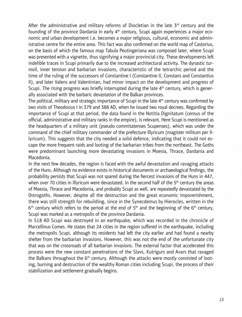
BELIEFSOf the beliefs of the inhabitants of this terri-tory in the Roman period we learn from epi-graphic (votive and burial) monuments, sculp-tures, votive reliefs, pedestals with inscriptions portraying or marking cults and deities that were respected. There existed beliefs in dei-ties of the so - called official Greco - Roman pantheon, Oriental beliefs (Asia Minor, Egypt), domestic, Thracian and syncretized deities.Most of the monuments regard deities of the official Roman pantheon: Jupiter alone or with other deities, Juno, Minerva, Hercules, Diana, Fortuna, Mercury, Venus, Bellona, the agrari-an triad of Caelus, Terra and Pontus, while of the gods of the Greek pantheon are presented only Apollo Nemesis, Demeter (Persephone) and Dionysos. Of the remaining provincial Ro-man deities were respected: Liber and Libera, Silvanus and Quadrivium. Epigraphically con-firmed were the cult of the Syrian goddess Dea Syria, originally worshiped under the
16
name Atargatis and the Egyptian god Serapis, who dies each year and is reborn. Certain local deities (Thracian, Dacian) were also wor-shiped in Scupi. Most of the monuments are relief votive plates dedicated to the Thracian horseman, and the worship of the cult of the so-called Danubian Riders is also confirmed.According to historical records, in addition to believers, in Scupi also existed temples of Hercules and Dea Syria.On the gravestones of Scupi the typical Roman dedication to the Manes gods (Diis Manibus) is predominant, thus confirming the belief i.e. identification of the dead as divine beings.
CHRISTIANITY IN SCUPI
In the Late Antique period Scupi was part of the Christian ecumenism as a powerful religious centre. In the 4th century it was acknowledged as the episcopal seat and a diocese since the Scupi bishop was superior to the other bishops of the province Dardania. It is uncertain whether Bishop Dacos, who participated in the Council of Nicaea in 325 AD as a Dardanian bishop, also administrated the area of Scupi. The first mention as an episcopal seat was at the council in
17

Serdica in 343 with Bishop Paregorius. Ursilius was known as a bishop from Scupi i.e. a Darda-nian Metropolitan judging from the letter addressed to the Emperor Leo I in 458 AD. The Scupi Metropolitan Johannus was a signatory to the letter addressed to the pope Gelasius in the year 494 from the Dardanian bishops. Later, from an ecclesiastical and legal aspect, Scupi will replace the newly established city Justiniana Prima, whose location has not yet been deter-mined.
ARCHAEOLOGICAL RESEARCH
J. G. Han was the first to associate the ancient name of Scupi with the name of contemporary Skopje in his travelogue from 1868. A turning point regarding the accurate identification and location of Scupi at the foot of Kale Zlokukjani is made by A. Evans in 1883.The interest in Scupi during the 19th and early 20th century was mainly expressed through historical and theoretical discussions for the location of Scupi or collecting data for the epi-graphic monuments. In this regard, particularly significant is the work of A. Von Premerstein and N. Vulic. Later, B. Dragojevic-Josifovska continues their work.The first incidental archaeological research in Scupi was conducted by K. Truhelka and R. Grujic in 1928/29. These excavations yielded a suburban villa with a thermal section, which is lo-
18

cated west, beyond the walls of Scupi and an early Christian basilica in the village of Bardovci.Planned archaeological research was first conducted by N. Vulic on the Theatre in Scupi in the period 1935-1937. Later, D. Randic-Miocevic continues by exploring the same building in 1959/60.Actual topographic studies of the site Scupi and the broader urban territory were conducted by I. Mikulcic in 1970. Due to the importance of the ancient city of Scupi for the study of the an-cient history and culture in these areas, the Museum of the City of Skopje commences a planned, detailed and systematic archaeological research in 1966 that has continued to this day with minor interruptions. Project leaders are M. Garasanin and D. Korakjevic. The main goal is the determining of the position, perimeter and urban structure of the city, the size of the urban areas, establishing of the chronologically different construction phases etc. From 1980 until 1996, with minor interruptions, D. Korakjevic independently manages the same project, and then from 2000 to the present managers of the project are L. Jovanova and M. Oncevska-Todorovska.During research were discovered parts of several buildings: a segment of the south-eastern rampart, parts of the street grid, a Civil basilica, two early Christian basilicas, two luxury town houses, two city baths, horreum (public grain warehouse), micro- dwelling complexes of the Late Antique period, a building with an apse and parts of buildings of an unspecified purpose.Outside of the enclosure wall on all four sides extended the urban necropoli (cemetery). The most researched is the South-eastern necropolis of the city, where a systematic and protec-tive archaeological research was carried out on many occasions. The first systematic research was supported and executed by I. Mikulcic in 1970/71. The main goal was to determine the eastern outskirts of the city (south-eastern city wall), the existence and scope of the necropolis and to determine the temporal and spatial distribution. On the area of this necropolis was conducted protective research in 1973-74 (D. Korakjevic), 1976. (M. Bilbija), 1982 (M. Ivanovski - Z. Vincic), 1994, 1996 and 1998 (D. Mihailova Kalamadeska and L. Jovanova) and in 2008-2012 (L. Jovanova). Around 5,200 graves that belong to the pre - Roman period, the Early Roman and the Late Antique period were discovered covering a time span from the Late Bronze Age to the 4th century.From 1990 to 2007 systematic archaeological research on the northwest necropolis was con-ducted, with interruptions, by L. Jovanova whereby 300 graves that belong to the pre - Roman, Late Roman and Early Roman period were discovered.
URBAN PLANNING AND ARCHITECTURE The topography of Scupi must be considered through the complementary and evolutionary stages throughout history when the city was formed, evolved and ceased to exist, starting from a main agglomeration into a thriving colony, through a state of a provincial metropolis, which after numerous destructions was gradually eliminated as a Late Antique village.The general urban characteristics, the technique and manner of building, the higher level of communal living (water, sanitation, public bathrooms, paved streets, underfloor heating, mo-saic covered floors, whitewashed and painted walls, glazed windows etc.) place Scupi at the highest point of the civilization ladder of the provincial Roman cities.
19

Due to insufficient research, it is very difficult to define the urban character of the city in the period of the founding of the colony until the end of the 3rd century. The most ancient, pre- Fla-vian period, the time before and after the founding of the colony until the end of the 1st
century, still remain obscure from an archaeological point of view. The inner structure of the early agglomeration, the centre of public life and the location of the main architectural com-plexes are completely unknown. The defining of the topography, stratigraphy, urban planning and construction phases of Scupi during the 2nd - 3rd century are in a similar state. The enclosure wall, sections of the road network, the contours of the Theatre, the latter phase of the great thermal complex, the late stages of both city houses and walls of several buildings of un-specified purpose are all enveloped in obscurity. In contrast, the situation regarding the Late Antique period is completely different. Several building complexes have been explored, thus, when we speak of the urban appearance of Scupi, it primarily relates to the appearance of the city in the Late Antique period.In order to address the problem of topography and urbanism in the city of Scupi, the position of the walls, the street network and the dimensions of the urban districts is of crucial impor-tance. Archaeological findings suggest two main urban phases. The city of Scupi was planned in advance according to Roman urban principles. Due to the configuration of the terrain the enclosure wall has a polygonal shape of an irregular quadrangle. Streets were placed in ac-cordance with an orthogonal system, parallel to the walls of the enclosure. It involves two main streets: cardo maximus and decumanus maximus, which intersect at a right angle, and
20

a network of smaller streets parallel to them (cardines and decumani), among whose inter-sections were located the urban quarters (insulae).Throughout most of the historical development (1st- 4th/5th century), despite all demolitions and renovations, the city will maintain its basic urban structure with the same set of streets, building complexes and architectural constructions (southwest/ northeast - northeast /south-west), where the size and content of the urban quarters changed in different time periods.The new military and historical circumstances, frequent internal and external turmoil, the great economic impoverishment, social stratification, religious unrest, numerous migrations and de-mographic changes that occurred in the 5th - 6th century led to changes in the development, appearance and urban structure of Scupi. During this period, the city was fortified by new solid walls, but the surface of the protected area was smaller compared to the previous stage; there was a variation from the older orthogonal urban concept, the type, content, as well as purpose of the buildings in Scupi. Still, despite the rebuilding, Scupi gradually transformed from a highly developed urban centre into a rural settlement due to the development of the above mentioned processes throughout the 6th century. The organized urban life finally disappeared in the late 6th century. This chrono-logical development and outcome of events in Scupi is confirmed by the collective findings of the coins, which ends with the coin of Mauricius Tiberius from 583/4 AD, which can serve as a terminus post quem non for the end of the development process and organized urban living in Scupi. After the demolition and definitive abandonment of the buildings from the final urban stage followed the process of their decomposition, fragmentation and disintegration, during the so-called post urban period that lasted until the early 7th century.
21

CITY RAMPART
The rampart enclosure takes the form of an irregular rectangle (738 x 590 m), with an area of 43/44 ha inside of the walls (intra muros). New results suggest that there were at least two major construction phases for protection of the city by means of defensive walls, probably with several sub-stages. There were two separate defensive lines, whose walls vary not only regarding the time of construction but also regarding position, direction of extending, structural ele-ments, perimeter, dimensions etc. According to current findings, the older phase should include the period since the founding of the colony to the late 4th/ middle of 5th century. At that time, the walls had more of a representative rather than a defensive role, whose main goal was to highlight the status and functions of the city as an administrative, economic, cultural and reli-gious centre. From the older fortification, thus far has been discovered a very small part of the south-western section. The masonry, the structure and the size (width 2.20 m) point to the imperial period. The period of construction of the first stone fortification in Scupi is arguable. The epigraphic data indicate that the first stone rampart was built in the late 2nd century, after the invasion of the Costoboci in 170 AD. The initial fortification from the 1st -2nd century, pro-vided it existed, was probably built of a clay-wood construction.In the second phase, which includes the period from the 5th - 6th century the city was fortified with new powerful walls, but the surface of the protected area was smaller compared to the previous stage. From the Late Antique fortification, thus far has only been discovered a very small part of the south-eastern section (width 3.60 m) - the onset of a semi-circular tower. This major effort is only part of the complete transformation and metamorphosis of the city of Scupi, which is manifested by changes in appearance and urban structure. In accordance with the new
22

standards and needs, the walls become the primary characteristic and an indicator of the de-fence capacity, as well as the military, strategic, social and economic significance of Scupi in the region and beyond. Such extensive and expensive interventions were part of the national strategy at that time for the protection of cities, infrastructure, resources and population in the inner zone of the eastern part of the Empire.
STREET GRIDIn line with the general urban structure, the streets were placed according to an orthogo-nal system, parallel to the walls of the enclo-sure (northwest / southeast - southwest / northeast). This involved two main streets: cardo maximus and decumanus maximus, which intersected at a right angle and a network of smaller streets parallel to them (cardines and decumani) among whose sections were urban quarters (insulae). Thus far, the following have been researched: a large section of the street cardo, the inter-sections on this street with two decumani and parts of two cardo streets and one decumanus.The most thoroughly researched is one street from the network of the streets cardo (north-east / southwest), 130 meters long, which connects the buildings on the east side of the north urban area (the Christian basilica com-plex/urban villa) with buildings from the cen-tral city area, set on both sides of the street (the Horreum complex / City bath on the west side and the complex Great thermal facility / Early Christian basilica with an atrium from the east). To the northeast the street extend-ed on the area west of the Theatre and the possible theatre square, and to the southwest on the assumed forum.The street which was 8.30 m wide, was paved with irregular massive stone slabs. To the left and the right of the street, separated by curbs, were the sidewalks with a width of 2.60 m on the east, and up to 3 m on the west side, to-talling a 14m width of the street. They were
The street Cardo Maximus (cardo maximus?): view from the south
23

paved with cobblestones of ground stone or river flint stones except in certain places, com-monly in front of the entrances to the buildings, where bricks were placed instead. Some sec-tions of the western sidewalk functioned as porticoes with a stylobate, which is associated with the function of the Horreum, and later with the City bath. While paving the street the natural slope of the terrain was preserved, which led to a complex system of drainage canals to solve the problem of storm water. Under the pavement passed the main drainage canal (sewer) for waste-water. On both sides of the street were built canals for draining the waste water from the build-ings of the main drainage canal. In the northern part of the street, under the pavement, was discovered a complex network of clay and lead pipes to supply clean water for the buildings along the street.
The track of this street was identical during all time periods, but the size, structure, technique of building and construction elements changed. There are indications that it was traced at the end of 1st and early 2nd century, but at that time it was probably not paved. The pavement, the sidewalks and the curbs were built later, probably in the late 3rd and early 4th century with sev-eral posterior interventions and adjustments, which can be dated up to the 6th century. The loca-tion, size, infrastructure and design elements are an indication for a possible identification as the main street cardo (cardo maximus?). Nevertheless, the final conclusion will be possible after the discovery of the forum, the city’s main gates and most of the road network.
24

The intersections of the cardo street (maximus?) with two of the cross streets (decumani) have been discovered, which determines the length of the quarters in the central city area to a total of 74 m. One decumanus (northwest / southeast), which cuts the street cardo north of the City bath, the Horreum and the Great Thermal Facility, according to the location and size (width 11.50 m) is identified as decumanus maximus (?). This street on the north side flanks the quar-ters where the above mentioned buildings were located, and its route directly connects to the main roads towards northwest and southeast which were used to enter the city from these direc-tions. At a distance of 74 m from the decumanus maximus (?) to the south the cardo inter-sects with another decumanus 6 m wide, whose track runs south beside the City bath, the Horreum and the Great Thermal Facility closing the quarters where the mentioned buildings were located to the south. The technology of building of these two streets is similar to that of the street cardo (pavements with stone slabs, stone curbs, built draining canals under the sidewalks that flow into the main sewer).West of the Civil Basilica was discovered another part of cardo street (4 m wide), which is at a distant of about 50 / 56m from the mentioned cardo (cardo maximus?). If its alignment pro-ceeds to the northeast, this street should enclose the quarter from the west where the Horreum and the City bath were located. Therefore, the dimensions of the city insula (east of cardo maximus?), which was enclosed by the aforementioned four adjacent streets, amounted to ap-proximately 74 x 50/56 m.On the area southeast of the Great Thermal Complex, in addition to the fence of the Home for the elderly, was discovered a small part of the pavement on another decumanus. The location of this street compared to other researched streets has not been established.In the eastern city area, northwest beside the domus, with length of about 30 meters, was discovered a street which belongs to the street network cardo according to the direction (northeast / southwest) and according to its location it should likely be determined as the first eastern cardo street (?). The street is about 5 meters wide, lined with side stone curbs and a pavement covered with gravel. Under the north-western half of the street passes a built canal for draining waste water from the surrounding buildings.
RESEARCHED BUILDINGSBUILDINGS IN THE CENTRAL CITY ZONEThis section of the urban city core regarding space and stratigraphy was most exhaustively re-searched. On the area to the east and west of the street cardo, for a long period of time, one above the other, were layered several buildings of different purpose. To the west of cardo street dominates the building of the City Bath from the late 4th-6th century, built over an older monu-mental building – the Horreum (granary - a public warehouse) from the late 3rd-4th century, which, lies above older buildings of unspecified purpose from Early Roman times (2nd – 3rd
century). Over the northwest section of the Horreum was discovered a building of an un-specified purpose with an apse which existed in the 6th century.On the area to the west of the street cardo were discovered two monumental representative buildings. The older building, identified as a Great thermal complex existed for a long period of time - from the 2nd to the 5th century. Later, in the 6th century, above the southern part of
25

the Great thermal complex was built a large Early Christian basilica with three apses in the eastern and an atrium in the western end.In the post urban period in the entire area, east and west of the cardo street, after the demoli-tion and abandonment of the buildings from the previous periods, buildings that belonged to the so- called micro dwelling complex were located, which exist by the end of 6th / early 7th century. On this space were also discovered movable findings typical of the Early Medieval period (9th-12th century).
BUILDINGS IN THE QUARTER WEST OF CARDO STREETGranary (Horreum - public warehouse for grain)
26
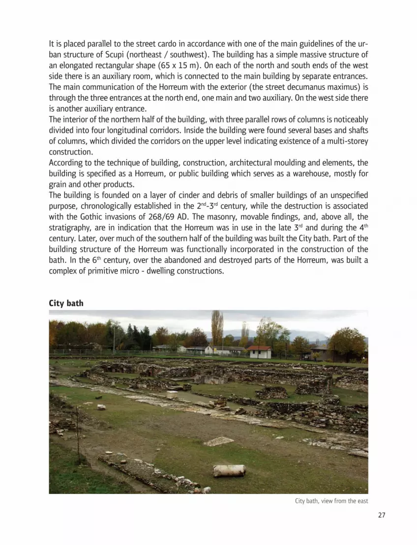
It is placed parallel to the street cardo in accordance with one of the main guidelines of the ur-ban structure of Scupi (northeast / southwest). The building has a simple massive structure of an elongated rectangular shape (65 x 15 m). On each of the north and south ends of the west side there is an auxiliary room, which is connected to the main building by separate entrances. The main communication of the Horreum with the exterior (the street decumanus maximus) is through the three entrances at the north end, one main and two auxiliary. On the west side there is another auxiliary entrance.The interior of the northern half of the building, with three parallel rows of columns is noticeably divided into four longitudinal corridors. Inside the building were found several bases and shafts of columns, which divided the corridors on the upper level indicating existence of a multi-storey construction.According to the technique of building, construction, architectural moulding and elements, the building is specified as a Horreum, or public building which serves as a warehouse, mostly for grain and other products.The building is founded on a layer of cinder and debris of smaller buildings of an unspecified purpose, chronologically established in the 2nd-3rd century, while the destruction is associated with the Gothic invasions of 268/69 AD. The masonry, movable findings, and, above all, the stratigraphy, are in indication that the Horreum was in use in the late 3rd and during the 4th
century. Later, over much of the southern half of the building was built the City bath. Part of the building structure of the Horreum was functionally incorporated in the construction of the bath. In the 6th century, over the abandoned and destroyed parts of the Horreum, was built a complex of primitive micro - dwelling constructions.
City bath
27

It is situated on west, parallel to the cardo street in a direction northeast / southwest. It has an elongated shape (41 x 13/9 m) with a simple plan of several interconnected rooms according to the purpose and extent of heating. The bath is divided into a cold northern and warm southern section, whereby the north is 4 meters wider than the south. Cold northern section - on the north end the first section is the frigidarium (the section for bathing with cold water) with a pool of cold water followed by the apodyterium (dressing room). The frigidarium and apodyterium are united into a single rectangular area with an entrance from the north side, in the first construction phase. At the southern end of the apo-dyterium there is a low wall (parapet) with indents for placing the clothing before bathing. The floor in the apodyterium is paved with stone slabs, while the frigidarium has a brick floor placed over a base of waterproof mortar.In south-western section of the frigidarium there is a pool of cold water. It is encircled by stone slabs reinforced by supporting walls on the exterior. On the west supporting wall were built six small pillars as foundations for the columns that carried the roof. In the pool, which is paved with brick, one entered from the south side by means of two stairways. The system of water supply has not been disclosed, but by means of a canal on the south side of the pool the water was transferred to the main drainage canal under the cardo street.Warm southern section - in the southern half of the building from north to south are the tepi-darium (a section for bathing with lukewarm water), laconium (section for sweating), caldarium (for bathing with hot water) and finally praefurnium (heating station). The walls of the building in the southern part are thicker and built more solidly. The entire south-ern part has a hypocaust system for underfloor heating, and there are indications for the exist-ence of wall heating, as well. The aim of the premises in the hot section of the bath is linked to their distance from the heating station. On the west wall there is an opening for ventilation. The floor of waterproof mortar was placed over a surface of bricks.At least two construction adjustments of the bath have been established, whereby certain
28

premises were reallocated, which is also linked to alterations of the supply and drainage of the water in the premises. During the final building development, the water in the bath was trans-ported from to the northwest side by means of a pipeline of ceramic tubuli.The bath was built over an older building - Horreum, whose sections were partly incorporated into the architectural structure of the bath. Thus, in the first construction phase of the bath, the area of the frigidarium beside the north facade wall of the Horreum was probably used as an atrium (courtyard), and as а wall of the bath were used the west and north facade walls of the Horreum. Through the entrance on the north wall of the frigidarium one entered the cold part of the bath. Later, north of the frigidarium was added a semi-circular chamber of an unspecified purpose which can be assumed to have served as an area for individual bathing. In addition, a new water supply from the north side was built, the northern entrance into the frigidarium was closed and two new entrances were opened, one toward cardo street and one auxiliary en-trance to the apodyterium from the west side. During the readjustments, the front area of the atrium was divided by two parallel walls, which connected the east and west facade wall, fitting into the building structure of the bath. The walls divide the northern entry zone of the Horreum, thus contradicting its purpose. Both walls have central entrances, connecting directly, of which the northern is the main entrance.The small size, lack of luxury equipment, the masonry and the movable findings indicate that the bath existed between the late 4th to the 6th century.
29

Building of an unspecified purpose with an apseThis building is located in the area northwest of the City bath and the Horreum. It lies partially over the northern auxiliary room of the horreum. The building is set in the direction southeast / northwest. It has an elongated rectangular shape (30 x 8.50 m) with a built-in apse on the east side, which is enclosed by a protective wall from the outside, while on the inside it is separated by a partition wall from the remaining space.An auxiliary entry on the south side was discovered, while the main entrance to the building should probably be expected to appear on the west end. The building has not been researched fully, due to which its purpose cannot be reliably determined, although there are enough in-dications regarding its public character. The architectural structure, the direction of extending and the movable finds (glass candle lamps and a candle lamp holder with a cross)- all point to a possible sacral purpose.The location, direction of extending, the masonry and the movable findings point to the last architectural stage of the urban period i.e. the 6th century.
BUILDINGS IN THE QUARTER EAST OF THE CARDO STREET
30

Great thermal complex This building, regarding its monumentality, structure and the complex and extravagant compo-sition was designated as a multi- purpose bath (thermal) complex which probably encompassed the entire quarter west of the cardo street (maximus?) i.e. south of decumanus (maximus?). The dimensions and construction phases of the building have not yet been determined, as it is still in the research stage. It is of elongated shape with several areas arranged lengthwise, inter-connected according to the purpose and extent of heating. There are indications that the south-ern part of the building was intended for hot bathing, while the northern and central parts were probably used for cold bathing and recreation. In the warm section, from south to north, was identified a caldarium with an apse-shaped room (pool) on the north side and two heating sta-tions. In the north section the following chambers have been researched: the apodyterium, corridor, inner courtyard (atrium) and parts of several chambers of unidentified purpose. The impressive rectangular apodyterium is connected to the cardo street via a semi-circular en-trance. To the east extends a nearby elongated corridor, directly connected to the main de-cumanus on the north, and to the central inner courtyard on the south.Within the building, placed in the centre, beside the cardo street, on a somewhat higher level is situated an impressive rectangular hall of an unspecified purpose with a semi-circular niche in the east end. The hall has no direct connection to other parts of the complex, and one can enter only through cardo street. In one of the later stages of rebuilding the entrance received an im-pressive appearance with a monumental stone staircase. The floor and the lower zone of the
31
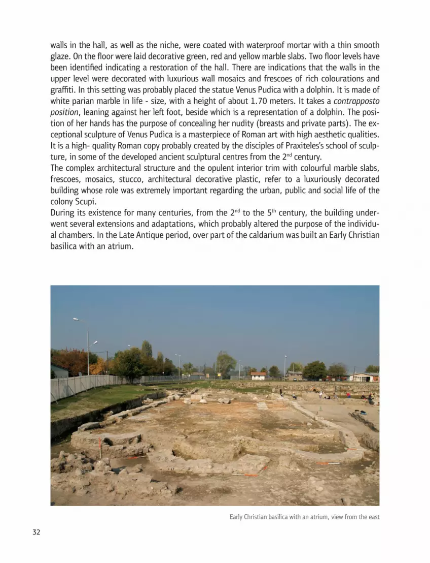
walls in the hall, as well as the niche, were coated with waterproof mortar with a thin smooth glaze. On the floor were laid decorative green, red and yellow marble slabs. Two floor levels have been identified indicating a restoration of the hall. There are indications that the walls in the upper level were decorated with luxurious wall mosaics and frescoes of rich colourations and graffiti. In this setting was probably placed the statue Venus Pudica with a dolphin. It is made of white parian marble in life - size, with a height of about 1.70 meters. It takes a contrapposto position, leaning against her left foot, beside which is a representation of a dolphin. The posi-tion of her hands has the purpose of concealing her nudity (breasts and private parts). The ex-ceptional sculpture of Venus Pudica is a masterpiece of Roman art with high aesthetic qualities. It is a high- quality Roman copy probably created by the disciples of Praxiteles’s school of sculp-ture, in some of the developed ancient sculptural centres from the 2nd century.The complex architectural structure and the opulent interior trim with colourful marble slabs, frescoes, mosaics, stucco, architectural decorative plastic, refer to a luxuriously decorated building whose role was extremely important regarding the urban, public and social life of the colony Scupi.During its existence for many centuries, from the 2nd to the 5th century, the building under-went several extensions and adaptations, which probably altered the purpose of the individu-al chambers. In the Late Antique period, over part of the caldarium was built an Early Christian basilica with an atrium.
32

Early Christian basilica with an atriumThe building is located in the downtown area over the southwest end of the Great thermal complex. It is set in an east-west direction, somewhat oriented to the south, due to the the adaptation to the urban structure of the city. The basilica has impressive monumental dimen-sions (53 x 16 m), which is an indication of the dominant position of the building in this part of the city in the 6th century.It is a three-naval basilica with a narthex, atrium and entrance halls (courtyard) on the west side and three apses on the east side.The basilica was connected to the outer space via the east sidewalk of the cardo street, where-from one entered an asymmetrical courtyard with two areas. Then, under a great arch one en-tered a spacious square atrium, where the narthex came from the east with a square annex- room from the outer- northern side. One enters the passage from the atrium to the narthex, in the side naves, through the stone thresholds which have grooves for the wooden doors. From the narthex through a triple arch (tribelon) one enters the central nave of the basilica. Laterally, the tribelon is flanked by cross-shaped pillars which also represent the beginning point of the colonnades which consist of five pillars that divide the naos into three parts. The pillars of the colonnades between the side naves and the central nave are placed on stone pedestals. At the east end the basilica ends in three apses, of which the central is three-sided on the outside, while the two lateral apses are semi-circular. On the inside, next to the northern wall of the atrium, are staircases leading to the upper floor, which indicates a two-story building with a gallery.The sides of the atrium were paved with ceramic tiles, while the middle part was probably open and served as a courtyard. The floor of the narthex and the naos was covered with waterproof mortar with a smooth thin glaze. The altar area was paved with stone slabs of different size. Regarding architectural decoration were preserved pillars of the tribelon depicting, in high re-lief, large Latin crosses exiting the Universe.According to the architectural structure and preserved elements of decoration, the basilica ex-isted during the 6th century.
Micro - dwelling buildings from the Late Antique period (east and west of the cardo street) Over the abandoned and destroyed parts of the Horreum, the City bath and the Great thermal complex, as well as on a broader area in the immediate vicinity of the buildings, were discov-ered remains of Late Antiquty micro - dwelling units. They are silent witnesses to the last remnants of organized life in Scupi, whereby we get a clear picture of what happened in the area of Scupi in the turbulent years at the end of Late Antiquity, during the late 6th century and even later in the early 7th century.The organization of the micro-dwelling complexes on both sides of the cardo street indicates a fragmentation and disintegration of the previous building structure into smaller trade units. Within the complexes were recorded several individual buildings, some of which have one, and others several special areas. The walls were built by means of the primitive dry-wall technique using unprocessed stones and broken bricks bound by mud, which often incorporated architec-tural elements (spolia), parts or whole walls from the older building periods. The masonry and
33

different floor levels of pressed earth point to at least two building phases followed by additions or adjustments to the space, which confirms not only the weak economic power of their owners but also the weak economic power of Scupi in that period.Nevertheless, the effective organization and rationalization of the space is evident through the fact that the individual buildings are structurally simple and interconnected. For the purpose of the premises within the individual buildings is difficult to speak in this phase of research. The movable findings found inside the buildings, refer to a residential use, with some additional features like processing of cereals and other food products, processing of metal objects and oth-ers.Southwest of the City bath and the Horreum were discovered parts of buildings i.e. several in-terconnected rooms, one of which has a brick floor and a small porch. The movable findings, of which pottery is the most abundant, as well as objects made of bone and metal, are character-istic of the period of the 9th -12th century. The findings chronologically coincide with findings from a waste pit dug into one of the areas on the northwest end of the micro-dwelling com-plex of the post urban period.
BILDINGS IN THE NORTHERN CITY AREAThis section has a dominant position over the city, since it lies on slope as well as at the foot of Zajcev Rid. Parts of the City villa, the Christian basilica and parts of two buildings of an un-specified purpose have been discovered. They were built at different height levels due to the natural configuration of the terrain, but also to the chronological difference. North of these buildings on the slope Zajcev Reed is Theatre, which dominates over the entire city.
34

Early Christian basilica with baptistery
The basilica is set in a direction southeast / northwest. It is three-naval with impressive dimen-sions (39 x 18 m); with a narthex on the west, an apse on the east and a baptistery on the south side. North of the exterior of the narthex was discovered a pastophoria (an area for the preparation of priests and honest gifts), whereby its counterpart was assumed to have existed on the south of the narthex, but was not saved due to the significant amount of damage. The northern pastophoria is set on a higher level and is connected with the narthex via three stone staircases. The connection of the basilica with the outer space toward cardo street was estab-lished via three entrances to the narthex, of which only the north is preserved. From the narthex to the central nave one enters by means of a staircase, through a portal with three openings, which are separated by rectangular pillars. The narthex was connected to the north and south nave via separate entrances. The naves are separated by colonnades of pillars set on rectangular bases. The columns in the upper structure were interconnected with double arches decorated with fresco decoration.The floor of the narthex and the northern pastophoria were paved with bricks. The floor of the basilica was covered with waterproof mortar with a smooth thin glaze, which is the basis for setting up a mosaic. The floor of the presbytery (space for the Priests’ Council) was built in the same technique, but placed on a higher level.
35

The construction of the basilica was preceded by levelling of the slope intended for construc-tion, after which a drainage system was installed for protection against flood on the section north of the basilica. The slope of the terrain allowed for terraced architectural structure of the building, with the lowering of the floor, from north to south. Thus, the floor of the northern pastophoria is located at the highest level, while the floors of the narthex, as well as the north, central and south nave are set at a somewhat lower level, with the floor of the baptistery being on the lowest level.On the southeast end of the south nave there is a partially built baptistery. Over the existing semi-circular area of the thermal part of the older City villa, which, at that time, was no longer in use, was built another apse (conch) to the east.According to the architectural structure and preserved decorative elements (marble capitals, bases and shafts from the pillars, rosettes, etc.), the basilica operated from the end of the 5th and during the 6th century. The basilica is built over two older buildings. One, which lies under the southeast section and the baptistery of the basilica is identified as a luxurious urban villa (Villa Urbana). The other building that allowed for the discovery of certain parts (walls, waterproof floor canal) in the narthex, presbytery, the central and south nave of the basilica was of an unspecified purpose. According to the location, direction of extending, manner of building and stratigraphy com-pared to the Christian basilica and City villa, it can be assumed that this was a posterior addi-tion to the City villa or an older phase of the basilica. The building was probably of a public character, and existed in the 4th century.
36

City villa - Domus (Villa Urbana)
It is partially located under the southeast end of the Christian basilica with a baptistery. It is set in a direction northwest / southeast. From this building have been discovered two large areas on the east side and a small private bathroom on the west side. The solemn character of the central room in the eastern part is determined by walls with frescoes, of which, unfortunately, only the lower zone has been preserved. The frieze is divided into square fields with borders of black stripes. In each of the fields, on a pale yellow and orange base, are painted geometric or-naments in different combinations (slanted, wavy, oval, circular, zigzag lines, stripes, spots, etc.) of multiple colours with greater intensity in order to imitate marble.In the west, thermal section of the villa were discovered parts of the caldarium (hot sec-tion), praefurnium (heating station) and tepi-darium (lukewarm section). The heating sta-tion is set between the caldarium and tepidariumot. The caldarium has an apse (conch) on the southwest side and floor (hy-pocaust) heating with circular pillars. In one part of tepidariumot, under the floor of the waterproof mortar is a canal of clay pipes (tu-buli) in two rows which served for floor heat-ing.According to the stratigraphic position, size, architectural structure and elements, espe-cially the decorative elements of the frescoes,
37

the construction of the villa is dated from the late 3rd to the late 4th / early 5th century. This dat-ing is confirmed by the movable archaeological findings, as well. It represents a luxurious city villa that belonged to a prominent wealthy citizen.The city villa lies partly over an older building from the imperial period of an unspecified purpose (probably an older phase of the villa). There are indications that parts of the unidentified build-ing, which is located west of the villa, under the northwest of the basilica, represent a posterior addition of the villa. Later, over the north-western part of the villa was built a Christian basilica, whereby parts of the villa were incorporated into the building structure of the basilica.
Theatre
It lies on the southwest slope of the hill Zajcev Rid, soaring and dominating over most of the city. The theatre is a magnificent and an exquisitely shaped building, one of the most representative buildings in the Roman city of Scupi. According to its impressive dimensions, this monumental architectural facility is the largest of the preserved Roman theatres on the territory of the Re-public of Macedonia. The main contours of the building have been uncovered: skene, the central space of the theatre building and the eastern part of the auditorium. In the construction of the auditorium the natural slope of the hill was utilized, while for the purpose of setting the orches-tra and the theatre building the ground was previously levelled.Through the theatre building (98 x 15 m) there are three corridors leading up to the orchestra, which has the shape of a partial semicircle, which is characteristic of the Roman theatres. The outer edge of the auditorium is 16 meters higher than the level of the orchestra, as was prob-ably the height of the stage building.
38

In the central part of the theatre building were discovered six smaller rooms that served as locker rooms or rooms for preparation of the artists. The facade of the skene has a semicircle niche above the main hall and two rectangular niches above the lateral corridors. The stage was two meters above the orchestra and was covered with multicolour marble slabs. The facade of the skene was extremely lavishly decorated with marble pillars on two floors, and capitals, bases, architraves, door frames, roof wreaths and other decorative architectural elements, with rich ornamentation, whose artistic and technical level of craftsmanship is at an extraordinary high level and does not falter compared to most artistic works from that time in other Roman capi-tals.Left and right of the skene are side wings (paraskenia) of the theatre building, which are pulled inside toward the orchestra and partly angled towards the auditorium, thus forming parodoi (entrances) as side pathways to the orchestra.The auditorium (cavea) lies on the natural slope, facing southwest. One pathway (diazoma) divides the audience into two parts. The seats of the lower section stood on a massive complex substructure of concentric semi-circular walls, interconnected by arches, which form four arched underground passageways. Via the fourth corridor one went out to several places, whereby two exits were discovered (vomitoria) in the lower part of the auditorium. The top half of the audi-torium lies over a construction of two concentric semi-circular walls, connected by 24 radial beams, each arched, which served as a base for the seats. The preserved items indicate that the theatrical performances took place in the orchestra. There has not been evidence, thus far, that in the theatre were organized gladiatorial performances.The architectural composition and the style of decorative elements indicate that the theatre was built during the reign of Hadrian (first half of the 2nd century). That conclusion is supported by the probable visit of Hadrian in Scupi between 121-125 AD.
39
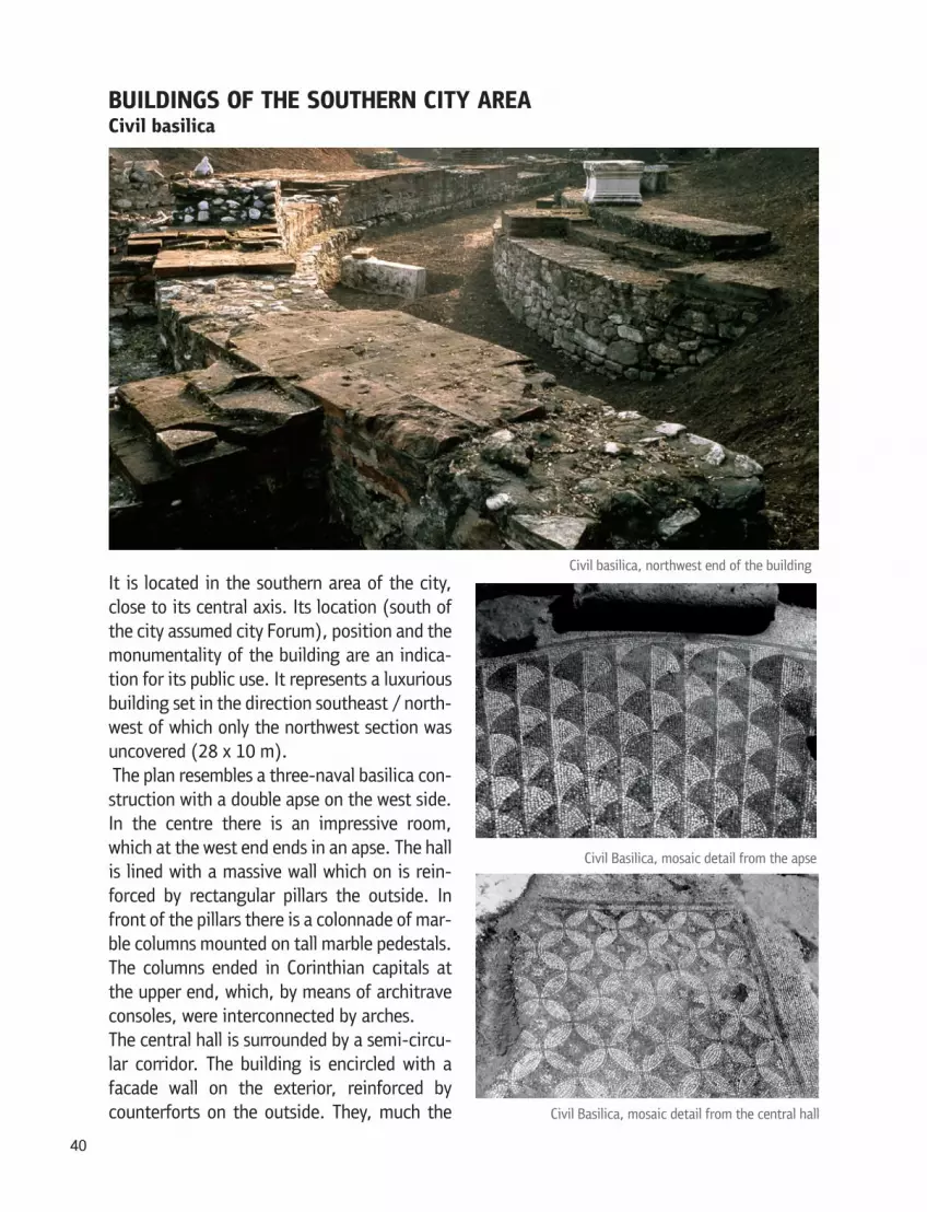
BUILDINGS OF THE SOUTHERN CITY AREA Civil basilica
It is located in the southern area of the city, close to its central axis. Its location (south of the city assumed city Forum), position and the monumentality of the building are an indica-tion for its public use. It represents a luxurious building set in the direction southeast / north-west of which only the northwest section was uncovered (28 x 10 m). The plan resembles a three-naval basilica con-struction with a double apse on the west side. In the centre there is an impressive room, which at the west end ends in an apse. The hall is lined with a massive wall which on is rein-forced by rectangular pillars the outside. In front of the pillars there is a colonnade of mar-ble columns mounted on tall marble pedestals. The columns ended in Corinthian capitals at the upper end, which, by means of architrave consoles, were interconnected by arches.The central hall is surrounded by a semi-circu-lar corridor. The building is encircled with a facade wall on the exterior, reinforced by counterforts on the outside. They, much the
40

same as the interior pillars of the arcade, acted as supports for discharging the pressure of the roof vault above the central hall and the semi-circular corridor around it.The central hall is decorated with a mosaic floor of high artistic value. It is executed in a simple geometric style with ornaments in two variants with a combination of black and white cubes. In the apse the ornamentation takes the form of two-coloured fish scales, while the mosaic in the central hall is depicted by means of an ornament of circular cut-outs forming a complex geo-metric combination of stylized flowers. The frieze of the main mosaic fields is simple, with black and white stripes positioned alternately. In addition to the internal architectural decoration of exceptional quality (capitals, columns, beams, cornices) and mosaic floors, the hall was probably also adorned with a wall mosaic, of which were found cubes of different size and color.Owing to its architectural features, the floor mosaic and the rich and lavish interior decoration, this building is among the most impressive public buildings of Roman Scupi. It has been identi-fied as Civil Basilica (Basilica Urbana), or town hall where all important administrative activities of the city where performed. It existed during the 4th century.The basilica was founded on the ruins of older buildings from the 2nd 3rd century. It has not been fully researched due to the modern irrigation canal over the middle part.
Building north of the Civil Basilica
On the north, parallel to the Civil Basilica, was discovered the southwest angle (34 x 6 m) of a larger building of an unspecified purpose. Parts of two walls and a floor of stone slabs was dis-covered. Most of the unexplored part of the building is under the modern barracks of the nursing home.Both buildings, the Civil Basilica and the building north of it, in addition to being attached to each other, are also connected by a common brick wall on the west side, which indicates to the same chronological background. According to the location and architectural design, it can be assumed that it was used for public residential purposes, associated in some way to the function of the Civil Basilica and the forum, which is assumed to be located north of them. It is dated in the 4th century.
41

BUILDINGS IN THE EASTERN CITY AREACity house - domus
The building is preserved in a rather dilapidated condition as a result of damage caused by nu-merous subsequent destructive processes and building interventions. Two building phases have been established, of which the newer has been explored more thoroughly. After the violent de-struction of the older phase in the late 3rd century, the domus was soon restored and extended.The northwest section of the newer phase of the domus with an elongated rectangular shape (40 x 15 m) , set in a direction northeast / southwest has been researched. It belongs to a larger building whose total size and architectural composition have not been determined. The size, the spatial arrangement, the furnishings and the decoration of the premises indicate a functional division of the structure into two sections of different purpose.The northeast, economic section of the house is characterizes by simplicity and symmetry of the premises. Three premises have been researched, whereby the central was divided crosswise into two smaller rooms, and of the side rooms fully unearthed is only the southwest. Eastward, all three rooms open to a porch, which leads to a large inner yard, lined with monolithic stone blocks and paved with stone slabs. The southern end of the porch is closed with a smaller room, which we assume had a counterpart on the northern end, as well.The southwest, more impressive part of the house has a central peristyle (inner courtyard framed by open covered porches with colonnades). The northern half of the peristyle has been
42

researched, around which are grouped several areas of different purpose. The courtyard was rimmed with a curb of stone blocks over which were placed the marble bases for the columns that carried the roof construction of the porches of the peristyle. The inner courtyard is covered with a waterproof surface, paved with stone slabs and bricks. To the north, in the centre of the peristyle is the main room (hall), which is believed to have been intended for reception. The hall at the lower level (under the floor) was divided into two halves by means of a partition wall, whereby the east had floor heating, indicating a different purpose of the space in the hall de-pending on the degree of warmth. In the ruins of the hall were found fragments of quality archi-tectural sculpture, wall and floor decoration (stucco relief, frescoes, colourful marble slabs), which is a proof for the luxuriously decorated room interior. The floor heating, lavish furnishings and the emphasized representative, solemn character are an indication of the uniqueness of the main hall, which suggests that it was probably intended for guest reception. Northwest and southeast of the central reception hall and the peristyle were found sections of several rooms of unspecified purpose.The masonry, the architectural plastic and the wall decoration have a distinct manner of execu-tion characteristic of the late 3rd and early 4th century. The building had a long - term use until the second half of the 4th century. After the violent demolition, over the ruins of the domus was erected a modest microdwelling complex with a similar architectural structure, but different masonry and purpose.Later, on the same space in the final stage of the Late Antique period (end of 4th – end of 6th
century) were identified and existed: a Late Antique defence wall with accompanying fortifica-tion elements and several buildings (building with an apse, public building with a portico, public building of unspecified purpose) whose structure and purpose were not defined since they are in the initial stage of research.
NECROPOLISESMuch the same as death is part of life, thus the city of the dead is an inseparable part of the city of the living. In Roman times, the cemetery (necropolises - cities of the dead), were always lo-cated outside of the settlements, at the exits or entrances to cities on both sides of the access roads. This rule is confirmed by the city cemeteries at Scupi. There are indications of the exist-ence of necropolis on all four sides of the city. Sections of the Southeast and Northwest city necropolis were researched more intensively, due to the fact that they were organized according to an urban plan and were located alongside the main road which entered the city from the east, connected to the city decumanus and continued west of the city.
Northwest necropolisThe dimensions and the borders of the necropolis have not been established yet. In the last twenty years only a small section of the cemetery (40 x 18 m) was subject to intensive archaeo-logical research, which is located approximately 120 meters from the northwest city defence wall. The northwest necropolis is a multi - layered site with several diverse cultural horizons re-garding content and chronology, starting from the Late Bronze Age to the Late Antique period (12th century BC- 6th century).
43

Of the Roman necropolis, thus far have been researched 300 graves. The organizational struc-ture, stratigraphy of the digging, typology, burial rituals and chronological background of the tombs indicate a continuous burial with short interruptions since mid - 2nd to the middle, and possibly by the end of the 4th century. The explored section of the older horizon of the cemetery is a small segment of the funerary core of a planned city necropolis located beside the north-west city defence wall. According to the content and level of preservation is the only such ex-ample, not only in Macedonia but also in the Balkans. Seven authentically preserved stone tombstones have been discovered, associated with specific tombs of bi-ritual burials.
Southeast necropolis
44

On this side of the city is located the biggest and probably the most attractive city necropolis, where, thus far, have been discovered about 5,200 graves. The east (1 km from the southeast rampart) and the south border (approximately 150 m south of the city wall) of the necropolis have been approximately determined. The northern border cannot be reliably determined, for the reason that the cemetery extends on the slope of the hill Zajcev Rid all the way to the north ridge. The necropolis was in use from the Late Bronze Age to the Early Middle Ages (12th cen-tury BC-12th century) with some interruptions.In the imperial period (mid-1st - middle of the 3rd century) was practiced the bi - ritual type of burial with cremation and inhumation. Cremation graves are predominant, although by the end of the 1st century appear graves of skeletal burials. Later, as a result of certain social, economic, sociological and ideological changes inhumation gradually becomes more domi-nant, experiencing complete domination in the late 3rd and the first half of the 4th century. The burial plots and the individual graves were placed in rows of almost identical orientation de-termined by the road that entered the city from the east.
45

References
Билбија М., 1978, Нови археолошки наоди од Скопје и околината, Maced. Acta Archaeol. 4, 131 – 133, Прилеп.Гарашанин М. - Кораќевиќ Д., 1979, Базиликата II во Скупи, Maced. Acta Archaeol. 5, 31 – 46, Прилеп. Гарашанин М. - Кораќевиќ Д., 1987, Археолошки ископувања во Скупи од 1978 - 1981, Maced. Acta Archaeol. 7 - 8, 79 – 96, Скопје.Грујиħ Р., 1935, Скопска Митрополија, Споменица православног храма Св. Богородице у Скопљу, 5 – 64, Скопље. Evans A., 1885, Antiquarian Reserches in Illuricum, Parts III - IV, Scupi, Skopia and Birthplace of Justinian, Archaeologia vol. 49,79 - 167, Westminster Ивановски М. – Винчиќ., Ж. 1988, Источна некропола 1982, Maced. Acta Archaeol. 9, 165 – 174, Скопје.IMS VI, 1982 (Dragojević Josifovska B.) Inscriptions de la Mésie Supérieure, Scupi et la région de Kumanovo, vol. VI, Beograd. Јованова Л., 1992, Скупи - Западна некропола, Maced. Acta Archaeol. 13, 191-199, Скопје.Јованова Л. - Михаилова Д., 1999, Скупи - Источна некропола 1994, Maced. Аcta Archaeol. 15, 203 – 248, Скопје.Jovanova L., 2002, The disposition of Scupi (Colonia Flavia Scupinorum) in relation to the ne-cropolises from 1st - 3rd centuries, in: The Roman and Late Roman City, 318 – 321, Sofia.Jovanova L., 2002(a), Colonia Flavia Scupinorum - Western necropolis grave forms and rituals, Histria Antiqua vol. 8, 193 – 207, Pula.Jovanova L., 2005, Scupi from the 1st to the 3rd century according to new archeologial und epi-grafic evidence – Römische Städte und Festungen an der Donau, Akten der Regionalen konfer-enz - 2003, Filozofski fakultet Beograd, 153 – 161, Beograd.Jovanova L., 2006, Colonia Flavia Scupinorum: Topography, disposition and structure of the city and its necropolises from the first to the third century AD, Homage to Milutin Garašanin, SASA Special Editions, 617 – 638, Belgrade.Jovanova L., 2006, New Data on the Citizens of Scupi and Their Beleifs, Folia Archaeologica Balcanica I, 313 - 324, Skopje. Јованова Л., 2008, Скупи - Colonia Flavia Scupinorum, Топографија и урбанистичка структура I - III век, Maced. acta Archaeol. 18, 197 – 222, Скопје.Јованова Л., 2008 (a), СКУПИ, Colonia Flavia Scupinorum (водич), Скопје. Jovanova L., 2016, Colonia Flavia Scupinorum – The world of the dead, (The 2nd International Symposium of Archaeology: MORTUI VIVOS DOCENT, Strumica, 03 – 06 nov. 2011), Strumica 2016 (in print)Јованова Л., 2012, Colonia Flavia Scupinorum – Градот на мртвите покрај градот на живите, Културен Живот 2012/3-4, 56 – 77, Скопје Јованова Л., 2015, Скупи – Сектор Југоисточен бедем, културна стратиграфија, 2008 – 2010 година, Maced. Аcta Archaeol. 21, Скопје 2015 (in print).Кораќевиќ Д., 1977, Состојбата на археолошките ископувања на Античко Скупи, Maced. Acta Archaeol. 3, 143 – 177, Прилеп.
46
Кораќевиќ Д., 1984, Античко Скупи (каталог за изложба), Скопје.Кораќевиќ Д., 1988, Археолошки истражувања во Скупи во 1982 г., Maced. Acta Archaeol. 9, 155 – 165, Скопје. Koraćević D., 1989, Urbanizam i arhitektura Skupa u svetlosti arheoloških iskopavanja, Lihnid 7, 101 -107, Ohrid.Кораќевиќ Д., 2002, СКУПИ, Градска територија, Скопје.Кузмановски И., 2010, Ѕидното сликарство од градската вила во Скупи, Maced. Acta Ar-chaeol. 19, 225 – 235, Скопје.Mikulčić I., 1971, Teritorija Skupa, Živa Antika XXI/2, 463 – 484, Skopje.Микулчиќ И., 1973(а), Местоположбата на античко Скопје, Историја X – 2, 262 – 267, Skop-je.Микулчиќ И., 1974, Доцноримски гробови од Скупи, Годишен зборник на Филозофскиот факултет во Скопје 26, 109 – 143, Скопје.Микулчиħ И., 1975, Раноримски скелетни гробови из Скупа, Старинар XXIV – XXV, 1973 - 1974, 89 – 102, Београд.Микулчиќ И., 1982, Скопје со околните тврдини, Скопје.Микулчиќ И., 1999, Антички градови во Македонија, Скопје.Mócsy A., 1970, Gesellschaft und Romanisation der römischen Provinz Moesia Superior, Buda-pest.Ончевска Тодоровска М., 2004, Доцноантичка грнчарија од Скупи (втора половина на IV – VI век), Скопје.Ончевска Тодоровска М., 2004, Остава на монети од Скупи, Македонско наследство 23, 29 – 42, Скопје.Oncevska Todorovska M., 2009, Thermal facility in Scupi, NI Institute for protection of the monuments of culture and Museum – Strumica, From the Symposium “Water, Life and Pleasure” in 2008, 75 – 84, Strumica.Ončevska Todorovska M., 2009(a), The Great Early Christian Basilica in Scupi and Early Christi-anity, Macedonian Heritage 34 – 35, Skopje.Ончевска Тодоровска М., 2011, Новата голема ранохристијанска базилика од Скупи, Maced. Acta Archaeol. 20, 365 – 379, Скопје.Ončevska Todorovska M., 2012, The statue of Venus Pudica from Scupi, Folia Archaeologica Balkanica II, 347 – 358, Skopje.Papazoglu F., 1969, Srednjebalkanska plemena plemena u predrimsko doba, Posebna izdanja Centara za balkanoloska istazivanja, Akadenija Nauka i Umetnosti Bosne i Hercegovine XXX, Sarajevo.Rendić Miočević, D., 1981, SCUPI Istraživanja rimskog teatra 1959 – 1961 godine, Antčki teatar na tlu Jugoslavija, 44 – 51. Novi Sad.Трухелка Ћ., 1929, Археолошке белешке из Јужне Србије, Гласник скопског научног друштва кнј. V – 2, 71 – 86, СкопљеВулиħ Н., 1961, Римско позориште код Скопља, Посебна издања САНУ књ. 39, 3 – 23, сл. 1 – 56, Београд. Vulić Н., 1981, Rimsko pozorište kod Skoplja, Antički teatar na tlu Jugoslavije, 37 – 43, Novi Sad
47


Published byCultural Heritage Protection OfficeMinistry of Culture of the Republic of Macedonia
For the publisherProf. Viktor Lilchikj Adams, Ph.D.
EditorKate Antevska
AuthorLence Jovanova
Translation from MacedonianDance Ristovska Kostadinova
PhotosStanimir Nedelkovski
Graphic design and printingPRINT PROJECT
Copies200
© Copyright
Ministry of Culture of the Republic of MacedoniaCultural Heritage Protection Office
CIP - Каталогизација во публикацијаНационална и универзитетска библиотека “Св. Климент Охридски”, Скопје 940:72(497.711)”.../5” JOVANOVA, Lence Scupi : colonia flavia scupinorum / Lence Jovanova ; [translation from Macedonian Dance Ristovska Kostadinova ; pfotos Stanimir Nedelkovski]. - Skopje : Cultural Heritage Protection Office, 2015. -50 стр. : илустр. ; 25 см Библиографија: стр. [46-47] ISBN 978-608-4549-19-2 а) Културно историски споменици - Антички градови - Скопје - ...-5в. б) СкупиCOBISS.MK-ID 99472394


