Embed Size (px)
Citation preview
Yerbilimleri, 30 (3), 169–180Hacettepe Üniversitesi Yerbilimleri Uygulama ve Araştırma Merkezi DergisiJournal of the Earth Sciences Application and Research Centre of Hacettepe University
Mineralogy of the Kraubath-type magnesite deposits of the Khuzdar area, Balochistan, Pakistan
Khuzdar Bölgesi (Belucistan, Pakistan)’ndeki Kraubath tipi manyezit yataklarının mineralojisi
Erum BASHIR, Shahid NASEEM, Shamim Ahmed SHEIKH, Maria KALEEM
Department of Geology, University of Karachi, Karachi 75270, PAKISTAN
Geliş (received) : 17 Ağustos (August) 2009 Kabul (accepted) : 17 Eylül (September) 2009
ABSTRACT Mineralogical studies of the magnesite deposits in the Khuzdar District, Balochistan, Pakistan were made using the X-ray diffraction (XRD) technique. These Kraubath-type magnesite deposits are hosted within serpentinized harzburgites, associated with Bela Ophiolite of Cretaceous age. The deposits occur as cryptocrystalline veins of stockwork-type, possessing botryoidal and bone habits. The ultramafic rocks of Bela Ophiolite were subjected to serpentinization. The hydrothermal fluids leached out Mg, Ca, Fe and other elements from the serpentinized rocks and finally carbonation of these ions resulted in the formation of their hydroxides and carbonates of different combinations to produce these de-posits. The XRD analysis of the ores revealed a high magnesite content in association with artinite, brucite, huntite, Fe-magnesite, dolomite, calcite and Mg-calcite. Initially, at low temperatures and low partial pressure from carbon dioxide (PCO2), metastable hydroxides and carbonates are formed, and these are gradually converted into a stable magnesite phase. The low abundance of allied minerals reflects the relatively high temperature conditions and PCO2 that convert metastable minerals into their stable magnesite phase. The study revealed an increasing temperature and PCO2 from brucite through artinite, hydromagnesite, huntite, and dolomite to magnesite. Principal component analysis (PCA) and correlation matrix analysis were also utilized to reveal the genetic affiliation that existed between these minerals.
Keywords: Balochistan, Khuzdar, Kraubath-type magnesite, mineralogy, Pakistan.
ÖZ
Khuzdar Bölgesi (Belucistan, Pakistan)’ndeki manyezit yataklarının mineralojisi X-ışınları kırınım tekniğiyle araştırıl-mıştır. Kraubath tipi bu manyezit yatakları, Kretase yaşlı Bela ofiyolitleriyle ilişkili serpantinleşmiş harzburjitler için-de yer almaktadır. Bu çökeller, kriptokristalin damarlar ve botriyodal ve kemiksi. özelliklere sahip ağsı yatak şeklin-de oluşmuşlardır. Bela ofiyolitik kayaçları serpantinleşmeye maruz kalmışlardır. Hidrotermal akışkanlarca taşınan Mg, Ca, Fe ve serpantinleşmiş kayalardan gelen diğer elementler ve sonuçta bu iyonların karbonatlaşması, bunların hid-roksitlerinin oluşumuyla ve farklı bileşimlerdeki karbonatların bu çökelleri oluşturmasıyla sonuçlanmıştır. Cevherle-rin X-ışınları kırınım analizleri; artinit, brusit, huntit, Fe-manyezit, dolomit, kalsit ve Mg-kalistle ilişkili yüksek manye-zit içeriğinin varlığını göstermektedir. İlk olarak, düşük sıcaklıkta ve düşük kısmi karbondioksit (PCO2) basıncı altın-da, tedricen duraylı manyezit fazına dönüşen yarı-duraylı hidroksitler ve karbonatlar oluşmuştur. Yabancı mineralle-rin azlığı, göreceli olarak yüksek sıcaklık koşullarına ve yarı-duraylı mineralleri manyezit fazına dönüştüren PCO2’ye işaret etmektedir. Bu çalışma, artan sıcaklığı ve arinit, hidromanyezit, huntit, dolomitten itibaren brusitten PCO2 artı-şını göstermiştir. Ayrıca asal bileşen analizi (PCA) ve korelasyon matriksi analizi bu mineraller arasında mevcut olan kökensel ilişknin araştırılmasıi için kullanılmıştır.
Anahtar Kelimeler: Belucistan, Khuzdar, Kraubath tipi manyezit, mineraloji, Pakistan.
E. BashirE-mail: [email protected]
INTRODUCTION
Regionally, the study area belongs to the ophi-olite thrust belt, which marks the boundary bet-ween the Indian and Eurasian plates. Along the ophiolite, sedimentary rocks of Jurassic to Ter-tiary age are also exposed on either side (Figure 1). The Bela Ophiolite is linked with the Alpine-Himalayan Mesozoic Belt, which stretches from the European Alps to the Himalayas. The Bela Ophiolite has characteristics of both a supra-subduction zone and mid-ocean ridge settings, and is also intruded by hotspot-derived mag-mas (Khan et al., 2007). Sheth (2008) also ve-rified the above assumption and showed oc-currences of rocks with affinities to Mid Ocea-nic Ridge Basalt (MORB), Ocean Island Basalt (OIB) and Island Arc Basalt (IAB) in the Bela Op-hiolite.
Magnesite deposits are formed by a number of processes (Pohl and Siegl, 1986; Schroll, 2002). Among them two genetic types are important, and the first type is known as the Veitsch type. These are replacement-type and strata-bound lensoid deposits, consisting of coarse crystal-line spar-magnesite hosted by marine plat-form sediments. The second type of deposit is cryptocrystalline and known as the Kraubath type. These deposits are much smaller and less frequent than the Veitsch-type. Bashir (2008) revealed that the magnesites of the study area are genetically affiliated with cryptocrystalline Kraubath type magnesite. They are commonly found in contact with or in close proximity to the serpentinized ultramafic rocks of the Alpi-ne ophiolites (Sasvári and Kondela, 2007; Gart-zos, 2004).
The obduction of the Bela Ophiolite over the continental margin of the Indian Plate creates a number of fractures and cracks in the host rock. The fracturing phenomenon facilitates water to initiate hydration of the ferromagnesi-an rocks, causing serpentinization. The serpen-tinized rocks release Mg, Ca, Fe etc. via dis-solution, leaching or other mineral-alteration re-actions. The released Mg ions may react with water molecules to form brucite. Subsequently, Mg along with Ca and Fe can react with dis-solved CO2 to precipitate different carbonate
minerals. The CO2-rich fluids were either deri-ved from decarbonation of deep-seated carbo-nates or decarboxylation of organic rich sedi-ments (Gartzos, 2004; Zedef et al., 2000).
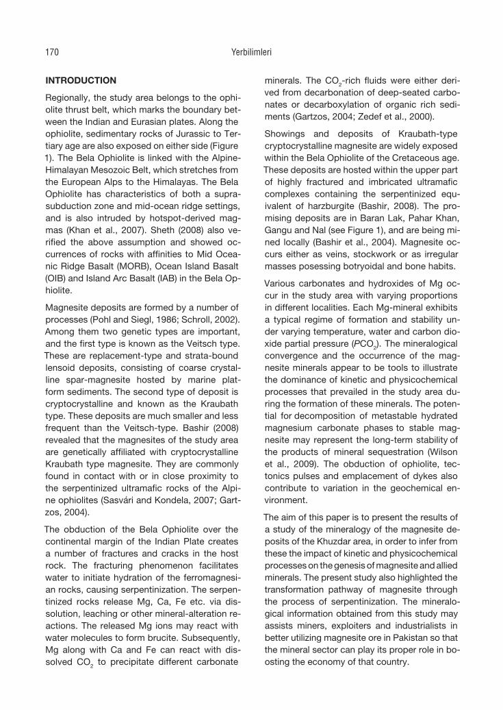
Showings and deposits of Kraubath-type cryptocrystalline magnesite are widely exposed within the Bela Ophiolite of the Cretaceous age. These deposits are hosted within the upper part of highly fractured and imbricated ultramafic complexes containing the serpentinized equ-ivalent of harzburgite (Bashir, 2008). The pro-mising deposits are in Baran Lak, Pahar Khan, Gangu and Nal (see Figure 1), and are being mi-ned locally (Bashir et al., 2004). Magnesite oc-curs either as veins, stockwork or as irregular masses posessing botryoidal and bone habits.
Various carbonates and hydroxides of Mg oc-cur in the study area with varying proportions in different localities. Each Mg-mineral exhibits a typical regime of formation and stability un-der varying temperature, water and carbon dio-xide partial pressure (PCO2). The mineralogical convergence and the occurrence of the mag-nesite minerals appear to be tools to illustrate the dominance of kinetic and physicochemical processes that prevailed in the study area du-ring the formation of these minerals. The poten-tial for decomposition of metastable hydrated magnesium carbonate phases to stable mag-nesite may represent the long-term stability of the products of mineral sequestration (Wilson et al., 2009). The obduction of ophio lite, tec-tonics pulses and emplacement of dykes also contribute to varia tion in the geochemical en-vironment.
The aim of this paper is to present the results of a study of the mineralogy of the magnesite de-posits of the Khuzdar area, in order to infer from these the impact of kinetic and physicochemical processes on the genesis of magnesite and allied minerals. The present study also highlighted the transformation pathway of magnesite through the process of serpentinization. The mineralo-gical information obtained from this study may assists miners, exploiters and industrialists in better utilizing magnesite ore in Pakistan so that the mineral sector can play its proper role in bo-osting the economy of that country.
Yerbilimleri170
ANALYTICAL METHODS
The samples of host rocks and magnesites were first crushed using a jaw crusher, and gro-und in a tema mill. The pulverized (-200 mesh) and moisture free samples were used for X-ray analysis. The analyses of magnesite samples were carried out using a Bruker AXS 5000 X-ray
diffractometer. Cu and K α radiation was used during the analysis. The diffractometer was operated at 40 KV and 30 Ma. Randomly orien-ted amounts of the samples were scanned from 10°-90° (2θ) with a step size of 0.05° (2θ). The scanning speed was one degree per second.
Figure 1. Simplified map of the Khuzdar area showing sampling sites. Şekil 1. Örnekleme noktalarını gösteren Khuzdar bölgesinin yalınlaştırılmış haritası.
Bashir et al. 171
RESULTS AND DISCUSSIONS
Brucite
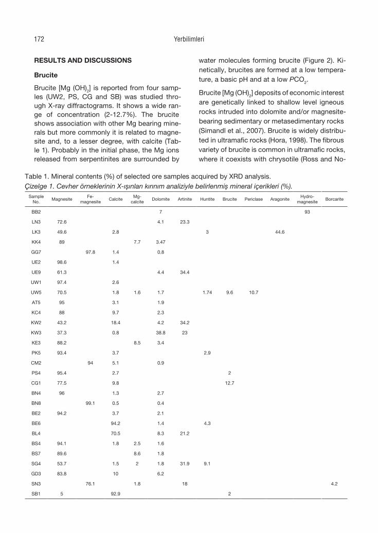
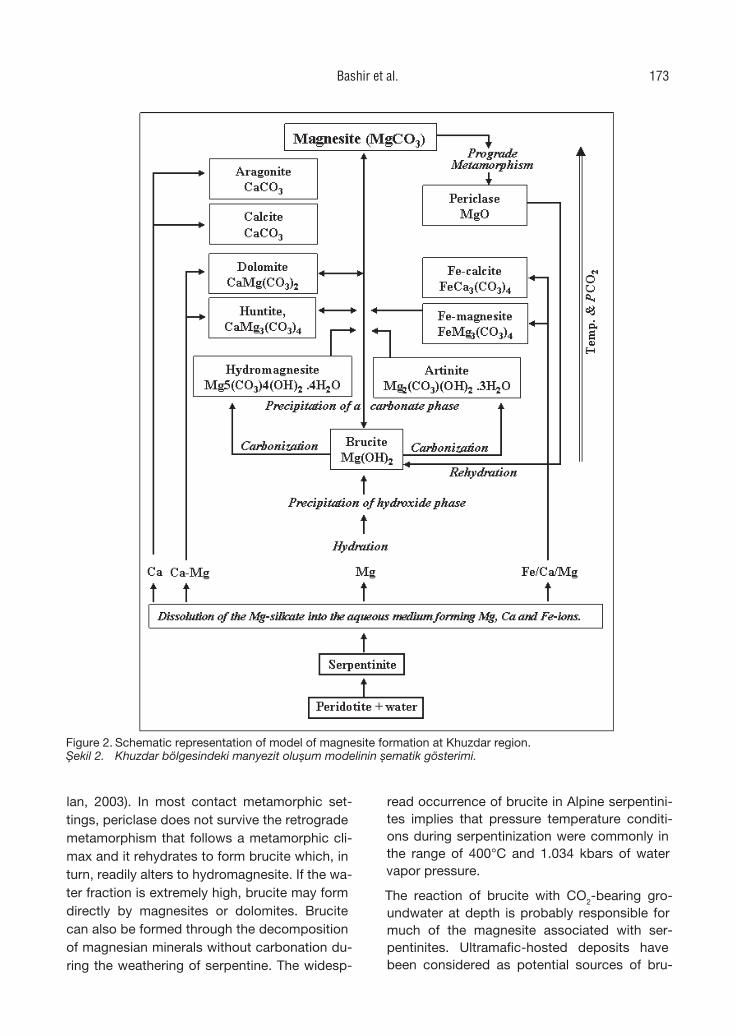
Brucite [Mg (OH)2] is reported from four samp-les (UW2, PS, CG and SB) was studied thro-ugh X-ray diffractograms. It shows a wide ran-ge of concentration (2-12.7%). The brucite shows association with other Mg bearing mine-rals but more commonly it is related to magne-site and, to a lesser degree, with calcite (Tab-le 1). Probably in the initial phase, the Mg ions released from serpentinites are surrounded by
water molecules forming brucite (Figure 2). Ki-netically, brucites are formed at a low tempera-ture, a basic pH and at a low PCO2.
Brucite [Mg (OH)2] deposits of economic interest are genetically linked to shallow level igneous rocks intruded into dolomite and/or magnesite-bearing sedimentary or metasedimentary rocks (Simandl et al., 2007). Brucite is widely distribu-ted in ultramafic rocks (Hora, 1998). The fibrous variety of brucite is common in ultramafic rocks, where it coexists with chrysotile (Ross and No-
Table 1. Mineral contents (%) of selected ore samples acquired by XRD analysis.Çizelge 1. Cevher örneklerinin X-ışınları kırınım analiziyle belirlenmiş mineral içerikleri (%).
Sample No.
MagnesiteFe-
magnesiteCalcite
Mg-calcite
Dolomite Artinite Huntite Brucite Periclase AragoniteHydro-
magnesiteBorcarite
BB2 7 93
LN3 72.6 4.1 23.3
LK3 49.6 2.8 3 44.6
KK4 89 7.7 3.47
GG7 97.8 1.4 0.8
UE2 98.6 1.4
UE9 61.3 4.4 34.4
UW1 97.4 2.6
UW5 70.5 1.8 1.6 1.7 1.74 9.6 10.7
AT5 95 3.1 1.9
KC4 88 9.7 2.3
KW2 43.2 18.4 4.2 34.2
KW3 37.3 0.8 38.8 23
KE3 88.2 8.5 3.4
PK5 93.4 3.7 2.9
CM2 94 5.1 0.9
PS4 95.4 2.7 2
CG1 77.5 9.8 12.7
BN4 96 1.3 2.7
BN8 99.1 0.5 0.4
BE2 94.2 3.7 2.1
BE6 94.2 1.4 4.3
BL4 70.5 8.3 21.2
BS4 94.1 1.8 2.5 1.6
BS7 89.6 8.6 1.8
SG4 53.7 1.5 2 1.8 31.9 9.1
GD3 83.8 10 6.2
SN3 76.1 1.8 18 4.2
SB1 5 92.9 2
Yerbilimleri172
lan, 2003). In most contact metamorphic set-tings, periclase does not survive the retrograde metamorphism that follows a metamorphic cli-max and it rehydrates to form brucite which, in turn, readily alters to hydromagnesite. If the wa-ter fraction is extremely high, brucite may form directly by magnesites or dolomites. Brucite can also be formed through the decomposition of magnesian minerals without carbonation du-ring the weathering of serpentine. The widesp-
read occurrence of brucite in Alpine serpentini-tes implies that pressure temperature conditi-ons during serpentinization were commonly in the range of 400°C and 1.034 kbars of water vapor pressure.
The reaction of brucite with CO2-bearing gro-undwater at depth is probably responsible for much of the magnesite associated with ser-pentinites. Ultramafic-hosted deposits have been considered as potential sources of bru-
Figure 2. Schematic representation of model of magnesite formation at Khuzdar region. Şekil 2. Khuzdar bölgesindeki manyezit oluşum modelinin şematik gösterimi.
Bashir et al. 173
cite (Liu et al., 2004). In the presence of wa-ter, brucite is a thermodynamically stable solid, until the PCO2 reaches 10-6.3 bar, above which anhydrous MgCO3 (magnesite) becomes stable (Lippmann, 1973), through various steps (see Figure 2).
Artinite
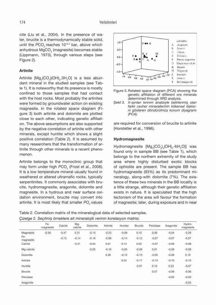
Artinite [Mg2(CO3)(OH)2.3H2O] is a less abun-dant mineral in the studied samples (see Tab-le 1). It is noteworthy that its presence is mostly confined to those samples that had contact with the host rocks. Most probably the artinites were formed by groundwater action on existing magnesite. In the rotated space diagram (Fi-gure 3) both artinite and dolomite are plotted close to each other, indicating genetic affiliati-on. The above assumptions are also supported by the negative correlation of artinite with other minerals, except huntite which shows a slight positive correlation (Table 2). It is assumed by many researchers that the transformation of ar-tinite through other minerals is a recent pheno-menon.
Artinite belongs to the monoclinic group that may form under high PCO2 (Frost et al., 2008). It is a low temperature mineral usually found in weathered or altered ultramafic rocks, typically serpentinites. It commonly associates with bru-cite, hydromagnesite, aragonite, dolomite and magnesite. In a hydrous and near surface oxi-dation environment, brucite may convert into artinite. It is most likely that smaller PO2 values
are required for conversion of brucite to artinite (Horstetler et al., 1996).
Hydromagnesite
Hydromagnesite [Mg5(CO3)4(OH)2·4(H2O)] was found only in sample BB (see Table 1), which belongs to the northern extremity of the study area where highly disturbed exotic blocks of ophiolite are present. The sample BB has hydromagnesite (93%) as its predominant mi-neralogy, along-with dolomite (7%). The exis-tence of these two minerals in the BB locality is a little strange, although their genetic affiliation exists in nature. It is speculated that the high tectonism of the area will favour the formation of magnesite; later, during exposure and in near
Table 2. Correlation matrix of the mineralogical data of selected samples.Çizelge 2. Seçilmiş örneklere ait mineralojik verinin korelasyon matrisi.
Fe-magnesite
CalciteMg-
calciteDolomite Artinite Huntite Brucite Periclase Aragonite
Hydro-magnesite
Magnesite -0.59 -0.47 0.31 -0.13 -0.23 -0.09 0.10 0.06 -0.04 -0.28Fe-magnesite
-0.15 -0.14 -0.16 -0.08 -0.14 -0.12 -0.07 -0.07 -0.07
Calcite -0.21 -0.04 0.01 0.14 0.02 -0.07 -0.06 -0.08
Mg-calcite -0.05 -0.16 -0.05 -0.09 0.01 -0.09 -0.09
Dolomite 0.36 -0.12 -0.13 -0.05 -0.09 0.10
Artinite 0.24 -0.17 -0.10 -0.10 -0.10
Huntite -0.01 0.10 0.23 -0.07
Brucite 0.57 -0.06 -0.06
Periclase -0.03 -0.03
Aragonite -0.03
Figure 3. Rotated space diagram (PCA) showing the genetic affiliation of different ore minerals determined through XRD analysis.
Şekil 3. X-ışınları kırınım analiziyle belirlenmiş olan farklı cevher minerallerinin kökensel ilişkisi-ni gösteren döndürülmüş konum diyagramı (PCA).
Yerbilimleri174
surface conditions, the magnesites of the area were hydrated to hydromagnesites. Calcium may have been introduced through groundwa-ter, forming minor dolomite, but this conversion is not simple and requires multiple steps under the influence of local tectonics. Therefore, PCA (see Figure 3) analysis explicates no genetic af-filiation between the two minerals. This state-ment is also strengthened by the weak correla-tion matrix (0.096).
Hydromagnesite occurs generally as encrus-tations and fracture fillings in altered ultrama-fic rocks and serpentinites, and in low tempe-rature, hydrothermally altered dolomitic xeno-liths and marble; it is also found as concreti-ons and in massive form. At low-temperatures, instead of magnesite, hydromagnesite is com-mon (Deelman, 2003). The brucite is destabili-zed in surface environments, and depending on the degree of weathering and ore type, it may be converted into hydromagnesite. Brucite is converted to hydromagnesite if the PCO2 is at least 10-6 bar (Horstetler et al., 1996). The al-teration of brucite into hydromagnesite or ar-tinite is restricted to the top 5m. Hydromagne-site undergoes an endothermic decomposition with H2O and CO2 releases in the temperature range of 200-550°C. Haurie et al. (2007) investi-gated the thermal behaviour of hydromagnesite under the influence of heating rate, sample size and environmental conditions. Hydromagnesi-te releases lattice water in the temperature ran-ge of 200-325°C, the dehydroxylation occurs in the range of 375-450°C and the decarbonation from 500 to 550°C (Sawada et al., 1979; Khan et al., 2001).
Dolomite
Dolomite [(CaMg)CO3] is found as the second most abundant mineral in the studied samples (see Table 1), with low concentrations (7-0.4%). From the distribution of Mg-bearing minerals in the study area it can be understood that the carbonation of brucite leads to the formation of artinite which, upon strong carbonation, is con-verted into stable carbonates. However, in the presence of Ca ions dolomite is formed. Pos-sibly, either groundwater or the chemistry of the host rock is responsible for the contribu-tion of Ca in the area. The moderate correla-
tion matrix of dolomite with artinite (see Tab-le 2) further supports the prevalence of mine-rals formed according to the above hypothesis, in the area. The PCA also reveals a close asso-ciation between dolomite and artinite (see Fi-gure 3). The sample KW2 has an exceptionally high dolomite content of (38.8%), demonstra-ting the impact of the host rock. In the Khushal (west) locality, the associated host rock conta-ins a relatively higher proportion of Ca (20.03%). Probably, the formation of dolomite is control-led by the initial Ca/Mg ratio of the host rock and also by other kinetic factors.
Huntite
Huntite [Mg3Ca(CO3)4] is reported from five samples of the study area (see Table 1). The abundance of huntite ranges from 9.1-1.74% with a mean of 4.21%. The concentration dec-reases from the south to the north of the study area. The huntite shows a moderate correlation with dolomite and aragonite (see Table 2). It is interesting that in the sample LK, where arago-nite is reported, the dolomite is not determined, and this may be due to thermodynamic factors. The study area indicates that huntite is precipi-tated earlier than dolomite.
Huntite crystallizes in a trigonal system and its structure is similar to that of dolomite. Hunti-te formations include different types of mine-rals such as hydromagnesite, magnesite, ara-gonite and dolomite (Kangal and Güney, 2006). Huntite can form at low temperature surface or near-surface conditions; either by direct preci-pitation from Mg-rich solutions or by interacti-on of Mg-rich water with precursor carbonates minerals (Dollase and Reeder, 1986). It also oc-curred as a coating in fissures of the weathered serpentinite immediately below the soil profile. Davies et al. (1977) have experimentally shown that huntite always precipitates before dolomi-te, depending upon an increase in CO3
2−con-centration. Huntite grows before dolomite be-cause its more open structure allows enhanced Mg dehydration (Lippmann, 1973).
Magnesite
Magnesite (MgCO3) is the major mineral of the Kraubath type of deposits. It commonly origina-
Bashir et al. 175
tes from the alteration of Mg-rich rocks during low grade metamorphism while they are in con-tact with carbonate-rich solutions. Magnesite occurs as veins in, and as an alteration product of, ultramafic rocks of ophiolite affinity, serpen-tine and other Mg-rich rock types in both con-tact and regional metamorphic terrain.
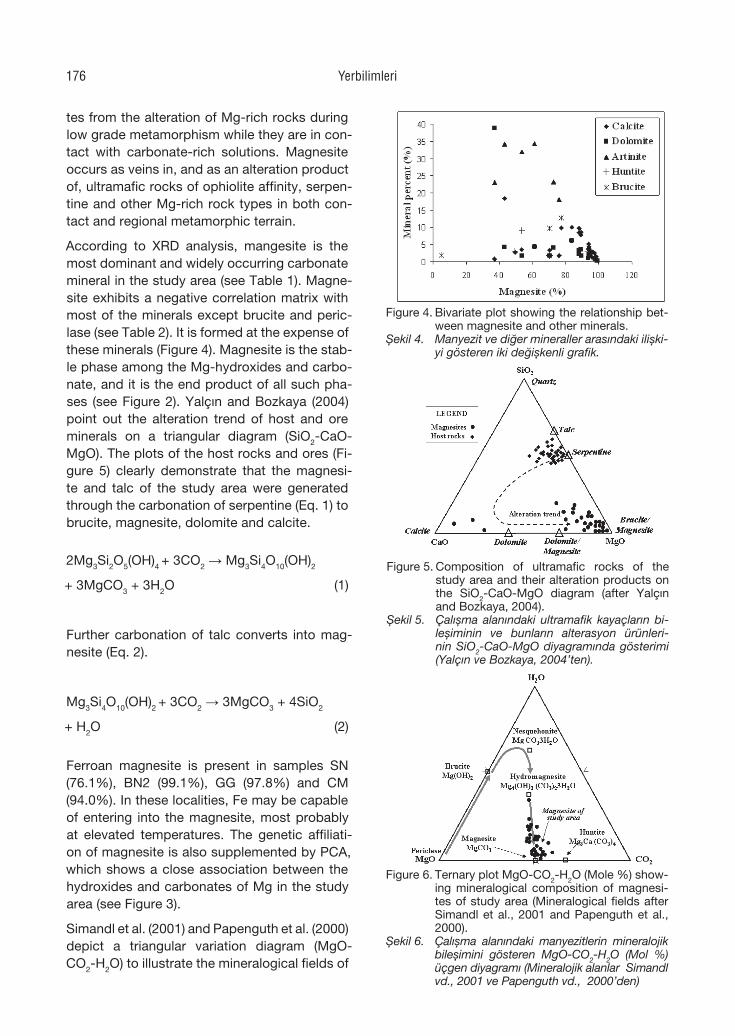
According to XRD analysis, mangesite is the most dominant and widely occurring carbonate mineral in the study area (see Table 1). Magne-site exhibits a negative correlation matrix with most of the minerals except brucite and peric-lase (see Table 2). It is formed at the expense of these minerals (Figure 4). Magnesite is the stab-le phase among the Mg-hydroxides and carbo-nate, and it is the end product of all such pha-ses (see Figure 2). Yalçın and Bozkaya (2004) point out the alteration trend of host and ore minerals on a triangular diagram (SiO2-CaO-MgO). The plots of the host rocks and ores (Fi-gure 5) clearly demonstrate that the magnesi-te and talc of the study area were generated through the carbonation of serpentine (Eq. 1) to brucite, magnesite, dolomite and calcite.
2Mg3Si2O5(OH)4 + 3CO2 → Mg3Si4O10(OH)2
+ 3MgCO3 + 3H2O (1)
Further carbonation of talc converts into mag-nesite (Eq. 2).
Mg3Si4O10(OH)2 + 3CO2 → 3MgCO3 + 4SiO2
+ H2O (2)
Ferroan magnesite is present in samples SN (76.1%), BN2 (99.1%), GG (97.8%) and CM (94.0%). In these localities, Fe may be capable of entering into the magnesite, most probably at elevated temperatures. The genetic affiliati-on of magnesite is also supplemented by PCA, which shows a close association between the hydroxides and carbonates of Mg in the study area (see Figure 3).
Simandl et al. (2001) and Papenguth et al. (2000) depict a triangular variation diagram (MgO-CO2-H2O) to illustrate the mineralogical fields of
Figure 5. Composition of ultramafic rocks of the study area and their alteration products on the SiO2-CaO-MgO diagram (after Yalçın and Bozkaya, 2004).
Şekil 5. Çalışma alanındaki ultramafik kayaçların bi-leşiminin ve bunların alterasyon ürünleri-nin SiO2-CaO-MgO diyagramında gösterimi (Yalçın ve Bozkaya, 2004’ten).
Figure 4. Bivariate plot showing the relationship bet-ween magnesite and other minerals.
Şekil 4. Manyezit ve diğer mineraller arasındaki ilişki-yi gösteren iki değişkenli grafik.
Figure 6. Ternary plot MgO-CO2-H2O (Mole %) show-ing mineralogical composition of magnesi-tes of study area (Mineralogical fields after Simandl et al., 2001 and Papenguth et al., 2000).
Şekil 6. Çalışma alanındaki manyezitlerin mineralojik bileşimini gösteren MgO-CO2-H2O (Mol %) üçgen diyagramı (Mineralojik alanlar Simandl vd., 2001 ve Papenguth vd., 2000’den)
Yerbilimleri176
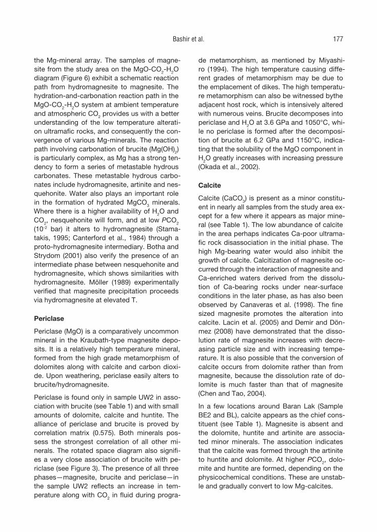
the Mg-mineral array. The samples of magne-site from the study area on the MgO-CO2-H2O diagram (Figure 6) exhibit a schematic reaction path from hydromagnesite to magnesite. The hydration-and-carbonation reaction path in the MgO-CO2-H2O system at ambient temperature and atmospheric CO2 provides us with a better understanding of the low temperature alterati-on ultramafic rocks, and consequently the con-vergence of various Mg-minerals. The reaction path involving carbonation of brucite (Mg(OH)2) is particularly complex, as Mg has a strong ten-dency to form a series of metastable hydrous carbonates. These metastable hydrous carbo-nates include hydromagnesite, artinite and nes-quehonite. Water also plays an important role in the formation of hydrated MgCO3 minerals. Where there is a higher availability of H2O and CO2, nesquehonite will form, and at low PCO2 (10-2 bar) it alters to hydromagnesite (Stama-takis, 1995; Canterford et al., 1984) through a proto-hydromagnesite intermediary. Botha and Strydom (2001) also verify the presence of an intermediate phase between nesquehonite and hydromagnesite, which shows similarities with hydromagnesite. Möller (1989) experimentally verified that magnesite precipitation proceeds via hydromagnesite at elevated T.
Periclase
Periclase (MgO) is a comparatively uncommon mineral in the Kraubath-type magnesite depo-sits. It is a relatively high temperature mineral, formed from the high grade metamorphism of dolomites along with calcite and carbon dioxi-de. Upon weathering, periclase easily alters to brucite/hydromagnesite.
Periclase is found only in sample UW2 in asso-ciation with brucite (see Table 1) and with small amounts of dolomite, calcite and huntite. The alliance of periclase and brucite is proved by correlation matrix (0.575). Both minerals pos-sess the strongest correlation of all other mi-nerals. The rotated space diagram also signifi-es a very close association of brucite with pe-riclase (see Figure 3). The presence of all three phases—magnesite, brucite and periclase—in the sample UW2 reflects an increase in tem-perature along with CO2 in fluid during progra-
de metamorphism, as mentioned by Miyashi-ro (1994). The high temperature causing diffe-rent grades of metamorphism may be due to the emplacement of dikes. The high temperatu-re metamorphism can also be witnessed bythe adjacent host rock, which is intensively altered with numerous veins. Brucite decomposes into periclase and H2O at 3.6 GPa and 1050°C, whi-le no periclase is formed after the decomposi-tion of brucite at 6.2 GPa and 1150°C, indica-ting that the solubility of the MgO component in H2O greatly increases with increasing pressure (Okada et al., 2002).
Calcite
Calcite (CaCO3) is present as a minor constitu-ent in nearly all samples from the study area ex-cept for a few where it appears as major mine-ral (see Table 1). The low abundance of calcite in the area perhaps indicates Ca-poor ultrama-fic rock disassociation in the initial phase. The high Mg-bearing water would also inhibit the growth of calcite. Calcitization of magnesite oc-curred through the interaction of magnesite and Ca-enriched waters derived from the dissolu-tion of Ca-bearing rocks under near-surface conditions in the later phase, as has also been observed by Canaveras et al. (1998). The fine sized magnesite promotes the alteration into calcite. Lacin et al. (2005) and Demir and Dön-mez (2008) have demonstrated that the disso-lution rate of magnesite increases with decre-asing particle size and with increasing tempe-rature. It is also possible that the conversion of calcite occurs from dolomite rather than from magnesite, because the dissolution rate of do-lomite is much faster than that of magnesite (Chen and Tao, 2004).
In a few locations around Baran Lak (Sample BE2 and BL), calcite appears as the chief cons-tituent (see Table 1). Magnesite is absent and the dolomite, huntite and artinite are associa-ted minor minerals. The association indicates that the calcite was formed through the artinite to huntite and dolomite. At higher PCO2, dolo-mite and huntite are formed, depending on the physicochemical conditions. These are unstab-le and gradually convert to low Mg-calcites.
Bashir et al. 177
Aragonite
Aragonite (CaCO3) is a polymorph of calcite. It does not occur commonly in the study area. It is possible that, in the Mg-rich water, calcite precipitation was inhibited by adsorption of Mg to the surface of incipient crystals, so aragonite precipitated instead; it later altered to the more stable calcite.
In the study area, it is only found in the Lukh lo-cality. The sample LK contains 44.6% arago-nite along with 49.6% magnesite. This implies that the magnesite of the area suffered calcifi-cation which removes Mg, and as a result ara-gonite is formed. The area is an enclave within the vast exposure of Nal Limestone of the Late Oligocene-Early Miocene age. Ca was probably introduced in the magnesite from the dissoluti-on of Nal limestone. In general, the crystallizati-on of aragonite is favoured by temperatures of 50-80°C and requires more pressure than cal-cite (Deer et al., 1992). It is metastable at room temperature-pressure and alters to calcite with the passage of time. This indicates that arago-nite is formed by an epigenetic process at the expense of magnesite. Furthermore, aragonite enables the inclusion of Mg ions in its structu-re because of the ionic difference between Ca (1.18Å) and Mg (0.72Å). A maximum of just 1 mole% MgCO3 can exist in aragonite, even up to 800°C; Mg does not enter significantly in ara-gonite structure. Magnesium is also less solub-le in aragonitic structure than in calcite.
CONCLUSIONS
The Kraubath-type magnesite deposits are wi-dely present in the Khuzdar District of Baloc-histan, Pakistan. The magnesite deposits of the study area possess a cryptocrystalline nature, a botryoidal/bone habit and are found as thick veins and stockwork in ultramafic rocks. The-se magnesite deposits are confined to the ult-ramafic segment of the Bela Ophiolite of Creta-ceous age. The host rocks are mostly serpenti-nized harzburgite, formed during intense altera-tion and low grade metamorphism.
The obduction of Bela Ophiolite over the conti-nental margin of the Indian Plate creates a num-ber of fractures and cracks in the host rock. The
fracturing phenomenon facilitates water to initi-ate hydration of the ferromagnesian rocks, cau-sing serpentinization. Magnesite was deposited in progressively opening fractures as CO2 was lost from the solutions when they approached the surface. The plots of the host rocks and mag-nesites on a SiO2-CaO-MgO diagram showed that the magnesite of the study area was genera-ted through the alteration of serpentine and talc.
Brucite is the first mineral formed through hydration of Mg ions. It is only stable at low temperatures, a basic pH and at a low PCO2. At higher partial pressure CO2 it will transform into either hydromagnesite or artinite. At ele-vated temperatures, hydromagnesite gradu-ally converts into magnesite. Calcium in the system may contribute through host rocks or may be supplied through meteoric water. In the presence of Ca ions, huntite starts to crystal-lize, and this happens with lower concentrati-ons of carbonate ions than are required for do-lomite. At elevated concentrations of carbonate ions, huntite is converted into dolomite, which is more stable. Magnesite is the most domi-nant and widely occurring carbonate mineral in the study area. The existence of a low abun-dance of allied minerals (dolomite, artinite, bru-cite, huntite and Fe-magnesite) indicates the-ir initial formations as hydroxides and carbona-tes. These metastable minerals can convert fi-nally into magnesite over time. The conversion is mainly controlled by the temperature, PCO2 and level of water saturation. The trend shows increasing temperatures and PCO2, from bruci-te, artinite, hydromagnesite, huntitite, dolomite to magnesite.
ACKNOWLEDGMENTS
The authors would like to thank Mr. Shabbir Ah-med Baloch of the Industrial Mineral Syndicate, Karachi for his enthusiasm and encouragement during the field work and for provision of logis-tic support. They also sincerely thank the inha-bitants and tribe chief of the area for their great hospitality and for allowing me to work in their tribal territory. The generous cooperation of Mr. Yousuf Khan of Centralized Science Laborato-ries, University of Karachi, for XRD analysis is also acknowledged with gratitude.
Yerbilimleri178
REFERENCES
Bashir, E., 2008. Geology and geochemistry of magnesite ore deposits of Khuzdar area, Balochistan. PhD Thesis, Univer-sity of Karachi, Karachi, Pakistan (un-published).
Bashir, E., Naseem, S., Naseem, S., Sheikh, S.A., and Shirin, K., 2004. Petrography, mineralogy and geochemistry of Baran Lak magnesite and associated rocks, Khuzdar, Balochistan, Pakistan. Geo-logical Bulletin University of Peshawar, 37, 155-166.
Botha, A., and Strydom, C.A., 2001. Preparati-on of a magnesium hydroxy carbonate from magnesium hydroxide. Hydrome-tallurgy, 62, 175-183.
Canaveras, J.C., Sanchez-Moral, S., Sanz-Rubio, E., and Hoyos, M., 1998. Meteo-ric calcitization of magnesite in Mioce-ne lacustrine deposits (Calatayud ba-sin, NE Spain). Sedimentary Geology, 119,183-194.
Canterford, J.H., Tsambourakis, G., and Lam-bert, B., 1984. Some observati-ons on the properties of dypingite, Mg5(CO3)4(OH)2·5H2O, and related mi-nerals. Mineralogical Magazine, 48, 437-442.
Chen, G., and Tao, D., 2004. Effect of soluti-on chemistry on floatability of magnesi-te and dolomite. International Journal of Mineral Processing, 74, 343-357.
Davies, P.J., Bubela, B., and Ferguson, J., 1977. Simulation of carbonate diagenetic pro-cesses: formation of dolomite, huntite and monohydrocalcite by the reactions between nesquehonite and brine. Che-mical Geology, 19, 187-214.
Deelman, J.C., 2003. Low-temperature forma-tion of dolomite and magnesite. Com-pact Disc Publications, Geology Series, Eindhoven.
Deer, W.R., Howie, R.A., and Zussman, J., 1992. An Introduction to the Rock-Forming Minerals. Longman, Essex, U.K.
Demir, F., and Dönmez, B., 2008. Optimization
of the dissolution of magnesite in citric acid solutions. International Journal of Mineral Processing, 87, 60-64.
Dollase, W.A., and Reeder, R.J., 1986. Crystal structure refinement of huntite, CaMg3(CO3)4, with X-ray powder data. American Mineralogist, 71, 163-166.
Frost, R.L., Bahfenne, S., Graham, J., and Mar-tens, W.N., 2008. Thermal stability of artinite, dypingite and brugnatellite—Implications for the geosequestration of green house gases. Thermochimica Acta, 475(1-2), 39-43.
Gartzos, E., 2004, Comparative stable isotopes study of the magnesite deposits of Gre-ece. Bulletin of the Geological Society of Greece, 36, 196-203.
Haurie, L., Fernandez, A.I., Velasco, J.I., Chi-menos, J.M., Lopez-Cuesta, J.M., and Espiell, F., 2007. Effects of milling on the thermal stability of synthetic hydro-magnesite. Materials Research Bulletin, 42(6), 1010-1018.
Hora, Z.D., 1998. Ultramafic-hosted chrysotile asbestos, in geological fieldwork 1997. British Columbia Ministry of Employ-ment and Investment, Paper 1998-1, pp. 24K-1 to 24K-4.
Horstetler, P.B., Coleman, R.G., and Evans, B.W., 1996. Brucite in alpine serpenti-nites. American Mineralogist, 51, 75-98.
Kangal, O., and Güney, A., 2006. A new industri-al mineral: Huntite and its recovery. Mi-nerals Engineering, 19, 376-378.
Khan, M., Kerr, A.C., and Mahmood, K., 2007, Formation and tectonic evolution of the Cretaceous–Jurassic Muslim Bagh op-hiolitic complex, Pakistan: Implications for the composite tectonic setting of ophiolites. Journal of Asian Earth Sci-ences, 31,112-127.
Khan, N., Dollimore, D., Alexander, K., and Wil-burn, F.W., 2001. The origin of the exot-hermic peak in the thermal decompo-sition of basic magnesium carbonate. Thermochimica Acta, 367, 321-333.
Laçin, O., Dönmez, B., and Demir, F., 2005. Dis-
Bashir et al. 179
solution kinetics of natural magnesite in acetic acid solutions. International Jo-urnal of Mineral Processing, 75, 91-99.
Lippmann, F., 1973. Sedimentary Carbonate Minerals. Springer-Verlag, New York.
Liu, K., Cheng, H., and Zhow, J., 2004. Investi-gation of brucite-fiber-reinforced conc-rete. Cement and Concrete Research, 34, 1981-1986.
Möller, P. (ed.), 1989. Magnesites. Monograph Ser. Mineral Deposits 28, Gebr. Bornt-rdger, Berlin-Stuttgart.
Miyashiro, A., 1994. Metamorphic Petrology. GRS Press.
Okada, T., Utsumi, W., Kaneko, H., Yamakata, M., and Shimomura, O., 2002. In-situ X-ray observations of the decompositi-on of brucite and the graphite-diamond conversion in aqueous fluid at high pressure and temperature. Physics and Chemistry of Minerals, 29, 439-445.
Papenguth, H.W., Krumhans, J.L., Bynum, R.V., Wang, Y., Kelly, J.W., Anderson, H.A., and Nowak, E.J., 2000. Status of re-search on magnesium oxide backfill. 23p.http://www.osti.gov/bridge/serv-lets/purl/760032-7sCKZ/webviewab-le/760032.pdf.
Pohl, W., and Siegl, W., 1986. Sediment-hosted magnesite deposits. In: K.H. Wolf (ed.), Handbook of Stratabound and Strati-form Ore Deposits, Elsevier, Amster-dam, 14, pp. 223-310.
Ross, M., and Nolan, R.P., 2003. History of as-bestos discovery and use and asbestos-related disease in context with the oc-currence of asbestos within ophiolite complexes. Geological Society of Ame-rica, Special Paper, 273, 447-470.
Sasvári, T., and Kondela, J., 2007. Demons-tration of Alpine structural phenome-na at the structure of magnesite depo-sit Jelšava - Dúbrava Massif. Metalugi-ja, 46(2), 117-122.
Sawada, Y., Yamaguchi, J., Sakurai, O., Ue-matsu, K., Mizutani, N., and Kato, M., 1979. Thermal decomposition of ba-
sic magnesium carbonates under high-pressure gas atmosphere. Thermochi-mica Acta, 32(1-2), 277-291.
Schroll, E., 2002. Genesis of magnesite depo-sits in the view of isotope geochemistry. Boletim Paranaense de Geociências, 50, 59-68.
Sheth, H.C., 2008, Do major oxide tectonic discrimination diagrams work? Evalu-ating new log-ratio and discriminant-analysis-based diagrams with Indian Ocean mafic volcanics and Asian ophi-olites. Terra Nova, 20, 229-236.
Simandl, G.J., Paradis, S., and Irvine, M., 2007. Brucite-the mineral of the future. Geos-cience Canada, 34(2), 57.
Simandl, G.J., Simandl, J., and Debreceni, A., 2001. Hydromagnesite-magnesite re-sources: potential flame retardant ma-terial. British Columbia Ministry of Energy and Mines, 327-336.
Stamatakis, M.G., 1995. Occurrence and gene-sis of huntite-hydromagnesite assemb-lages, Kozani basin, Greece-important new white fillers and extenders. Applied Earth Science, 104, B179-B210.
Wilson, S.A., Dipple, G.M., Power, I.M., Thom, J.M., Anderson, R.G., Raudsepp, M., Gabites, J.E., and Southam, G., 2009. Carbon dioxide fixation within mine wastes of ultramafic-hosted ore depo-sits: Examples from the Clinton Creek and Cassiar chrysotile deposits, Cana-da. Economic Geology, 104(1), 95-112.
Yalçın, H., and Bozkaya, Ö., 2004. Ultramafic-rock-hosted vein sepiolite occurrences in the Ankara Ophiolitic Melange, Cent-ral Anatolia, Turkey. Clays and Clay Mi-nerals, 52(2), 227-239.
Zedef, V., Russell, M.J., Fallick, A.E., and Hall, A.J., 2000. Genesis of vein stockwork and sedimentary magnesite and hydro-magnesite deposits in the ultrama-fic terranes of southwestern Turkey: A stable isotope study. Economic Geo-logy, 95, 429-446.
Yerbilimleri180
Yerbilimleri, 30 (3), 181–191Hacettepe Üniversitesi Yerbilimleri Uygulama ve Araştırma Merkezi DergisiJournal of the Earth Sciences Application and Research Centre of Hacettepe University
Karakaya Karmaşığı içerisindeki bazik volkanitlerin jeokimyasal özelliklerinin yeniden değerlendirilmesi
Geochemical characteristics of the basic volcanic rocks within the Karakaya Complex: A review
Kaan SAYIT, M. Cemal GÖNCÜOĞLU
Orta Doğu Teknik Üniversitesi, Jeoloji Mühendisliği Bölümü, 06531, ANKARA
Geliş (received) : 11 Haziran (June) 2009 Kabul (accepted) : 18 Eylül (September) 2009
ÖZ Biga Yarımadası’ndan Kuzeydoğu Anadolu’ya kadar uzanan kuşakta Sakarya Tektonik Birliği’nin Liyas öncesi te-melinde yer alan Karakaya Karmaşığı değişik türde volkanik kayalar içermektedir. Yaşları, çevre birimlerle ilişkileri ve genel jeokimyasal özellikleri farklı yazarlarca farklı biçimlerde yorumlanan bu volkanik kayalar ile ilgili olarak ya-yınlanmış ve yayınlanmamış veriler dikkate alınarak bir veri bankası oluşturulmuş ve bu veriler petrolojik olarak ye-niden değerlendirilmiştir. Duraylı elementlerin kullanıldığı ayırım diyagramlarında, Karakaya Karmaşığı içerisinde-ki volkanitler 3 farklı grup oluşturmaktadır. Bunlardan ilki belirgin olarak subalkali alana düşen bazaltlar, diğeri al-kalen alana düşen bazaltlar, üçüncü grup ise bu iki grup arasındaki geçişli alana düşen bazik kayalardır. Tektono-magmatik ayırım diyagramlarında Karakaya birimlerine ait bazik volkanik kayalar çoğunlukla levha içi bazalt alanın-da yer almakta iken, küçük bir kısım ise okyanus ortası sırt ve ada yayı bazaltları ile benzer özellikler sunmaktadır. Çok uzun yıllardır tartışılan Karakaya Karmaşığı jeolojik evriminin aydınlığa kavuşturulabilmesi için bu birim içinde yer alan volkanizmanın, yaşları iyi belirlenmiş bölümlerden başlanarak, nadir toprak elementlerinin ve izotopların kullanıldığı ayrıntılı jeokimyasal veriler esas alınarak araştırılması gerektiği düşünülmektedir.
Anahtar Kelimeler: Karakaya Karmaşığı, jeodinamik, jeokimya, volkanik kayalar.
ABSTRACT
The Karakaya Complex, which lies within the pre-Liassic basement of the Sakarya Composite Terrane extending on a belt from the Biga Peninsula to northeastern Anatolia, comprises various types of volcanic rocks whose ages, origins and geochemical features have been interpreted in different ways. The geochemical data acquired from the previous studies on these volcanic rocks are here re-evaluated in order to unravel the petrology and geochemistry of the Karakaya Complex. The tectonic discrimination diagrams based on the relatively immobile elements indicate that the volcanic rocks within the Karakaya Complex constitute three main groups. These are alkali basalts, sub-alkali basalts and transitional basalts between alkali and sub-alkali basalts. In the tectonomagmatic discrimination diagrams, these basic volcanic rocks display mostly a within-plate affinity, although a small portion reflects mid-oceanic ridge and island arc characteristics. In spite of the geodynamic interpretations that have been suggested so far, there is no consensus on the tectonic settings. This is mainly due to insufficient rare-earth element data and limited correlation. Thus a detailed geochemical discrimination and reliable geodynamic interpretation should be based on a better assessment of the ages of different volcanic rocks from different subunits of the Sakarya Com-posite Terrane and on more detailed geochemical data including rare earth elements and isotopes.
Keywords: Karakaya Complex, geochemistry, geodynamics, volcanic rocks.
K. SayıtE-posta: [email protected]
GİRİŞ
Anadolu’nun kuzeyini doğu-batı yönünde boy-lu boyuna kaplayan, güneyde Izmir-Ankara Sü-tur Kuşağı, kuzeyde ise İntrapontid Sütur Kuşa-ğı ile sınırlanmış tektonik birlik “Sakarya Zonu” (Okay, 1989) veya “Sakarya Kompozit Birli-ği” (Göncüoğlu vd., 1997) olarak adlandırılmıştır (Şekil 1). Bugünkü bütünlüğünü Alpin Orojenezi ile kazanmış olan Sakarya Kompozit Birliği’nin Jura öncesi temel birimleri, “Kimmeriyen oroje-nezi” olarak da bilinen Triyas sonu yaşlı bir dağ oluşumundan etkilenmiştir (Şengör vd., 1984). Paleotetis’in Erken Mesozoyik’de kapanması ile sonuçlanan bu orojenez, çeşitli kıtasal ve okya-nusal birimlerin yığışımına neden olmuştur (Te-keli, 1981). Jura yaşlı kayalar tarafından uyum-suz olarak üzerlenen, yoğun biçimde deforme olmuş ve kısmen metamorfizma geçirmiş bu oluşum “Karakaya Karmaşığı” olarak tanımlanır (Şengör vd., 1984).
Okay ve Göncüoğlu (2004) tarafından tartışıldı-ğı üzere, ’’Karakaya Karmaşığı’’ farklı araştırıcı-larca farklı biçimlerde tanımlanan ve yorumla-nan birden fazla yapısal birlik içermektedir. Bir-birleriyle tektonik ilişkili bu birimler, değişik ya-
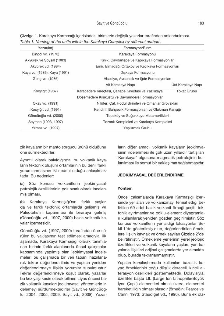
zarlarca değişik adlarla tanımlanmış olup, kısa bir özeti Çizelge 1’de verilmiştir.
Çizelge 1’de görülen farklılıklar bir yana, ön-cel çalışmalarda tüm araştırıcılar bu birimlerden herbirinin az ya da çok miktarda ve farklı de-recelerde metamorfizmaya mağruz kalmış ba-zik volkanik kayaları içerdiği konusunda görüş birliği içindedir. Ancak, söz konusu bazik volka-nik kayaların oluştukları ortamlar ve yaşları ko-nusunda yine bir görüş birliği bulunmamaktadır. Örneğin, “Karakaya Karmaşığı” içinde en yaygın olarak yüzeylenen bazik volkanik kayalar (Nilü-fer Volkanitleri) Okay (2000) tarafından Alt-Orta Triyas yaşlı bir okyanusal platonun ürünleri ola-rak değerlendirilirken, Genç (2004) bu okyanu-sal platoya ek olarak gelişen okyanus adalarının varlığından söz etmektedir. Öte yandan söz ko-nusu birimleri; Okay vd. (1991) adayayı-önü vol-kanizması, Pickett ve Robertson (1996) levha-içi ve okyanus sırtı bazaltı, Çapan ve Floyd (1985) ve Floyd (1993) okyanus adası ve okyanus sır-tı bazaltı olarak yorumlanmıştır. Göncüoğlu vd. (2000), Orta Sakarya’daki benzer metabazik ka-yaların Permiyen öncesi yaşlı ve yay-önü karak-terli olduğunu ifade ederken, Yalınız ve Göncü-oğlu (2002) Kozak Dağı doğusundaki metaba-
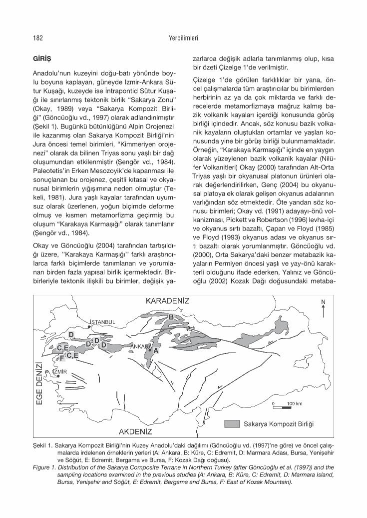
Şekil 1. Sakarya Kompozit Birliği’nin Kuzey Anadolu’daki dağılımı (Göncüoğlu vd. (1997)’ne göre) ve öncel çalış-malarda irdelenen örneklerin yerleri (A: Ankara, B: Küre, C: Edremit, D: Marmara Adası, Bursa, Yenişehir ve Söğüt, E: Edremit, Bergama ve Bursa, F: Kozak Dağı doğusu).
Figure 1. Distribution of the Sakarya Composite Terrane in Northern Turkey (after Göncüoğlu et al. (1997)) and the sampling locations examined in the previous studies (A: Ankara, B: Küre, C: Edremit, D: Marmara Island, Bursa, Yenişehir and Söğüt, E: Edremit, Bergama and Bursa, F: East of Kozak Mountain).
Yerbilimleri182
zik kayaların bir manto sorgucu ürünü olduğunu öne sürmektedirler.
Ayrıntılı olarak bakıldığında, bu volkanik kaya-ların tektonik oluşum ortamlarının bu denli farklı yorumlanmasının iki nedeni olduğu anlaşılmak-tadır. Bu nedenler:
(a) Söz konusu volkanitlerin jeokimyasal-petrolojik özelliklerinin çok sınırlı olarak incelen-miş olması,
(b) Karakaya Karmaşığı’nın farklı yaşlar-da ve farklı tektonik ortamlarda gelişmiş ve Paleotetis’in kapanması ile biraraya gelmiş (Göncüoğlu vd., 1997, 2000) bazik volkanik ka-yalar içermesidir.
Göncüoğlu vd. (1997, 2000) tarafından öne sü-rülen bu yaklaşımın test edilmesi amacıyla, ilk aşamada, Karakaya Karmaşığı olarak tanımla-nan birimin farklı alanlarında öncel çalışmalar kapsamında yapılmış olan jeokimyasal incele-meler, bu çalışmada bir veri tabanı hazırlana-rak tekrar değerlendirilmiş ve yapılan yeniden değerlendirmeye ilişkin yorumlar sunulmuştur. Tekrar değerlendirmeye koşut olarak, yazarlar bu kez yaşı kesin olarak bilinen Liyas öncesi ba-zik volkanik kayaları jeokimyasal yöntemlerle ir-delemeyi sürdürmektedirler (Sayıt ve Göncüoğ-lu, 2004, 2005, 2009; Sayıt vd., 2008). Yazar-
ların diğer amacı, volkanik kayaların jeokimya-sının irdelenmesi ile çok uzun yıllardır tartışılan
“Karakaya” olgusuna magmatik petrolojinin kul-lanılması ile somut bir yaklaşımın sağlanmasıdır.
JEOKİMYASAL DEĞERLENDİRME
Yöntem
Öncel çalışmalarda Karakaya Karmaşığı içeri-sinde yer alan ve volkanizmayı temsil ettiği be-lirtilen 69 adet bazik volkanit örneği çeşitli tek-tonik ayırtmanlar ve çoklu-element diyagramla-rı kullanılarak yeniden gözden geçirilmiştir. Söz konusu volkanitlerin yer aldığı lokasyonlar Şe-kil 1’de gösterilmiş olup, değerlendirilen örnek-lere ilişkin kaynak ve örnek sayıları Çizelge 2’de belirtilmiştir. Örnekleme yerlerinin yerel jeolojik özellikleri ve volkanik kayaların yaşları, yan ka-yalarla ilişkileri orijinal çalışmalarda yer almakta olup, burada tekrarlanmamıştır.
Yapılan karşılaştırmada kullanılan bazaltik ka-yaç örneklerinin çoğu düşük dereceli ikincil al-terasyon özellikleri göstermektedir. Dolayısıyla, özellikle başta LIL (Large Ion Lithophile/Büyük İyon Çaplı) elementleri olmak üzere, elementel hareketliliğin olması olasıdır (örneğin; Pearce ve Cann, 1973; Staudigel vd., 1996). Buna ek ola-
Çizelge 1. Karakaya Karmaşığı içerisindeki birimlerin değişik yazarlar tarafından adlandırılması.Table 1. Naming of the units within the Karakaya Complex by different authors.
Yazar(lar) Formasyon/Birim
Bingöl vd. (1973) Karakaya Formasyonu
Akyürek ve Soysal (1983) Kınık, Çavdartepe ve Kapıkaya Formasyonları
Akyürek vd. (1984) Emir, Elmadağ, Ortaköy ve Keçikaya Formasyonları
Kaya vd. (1986), Kaya (1991) Dışkaya Formasyonu
Genç vd. (1986) Abadiye, Avdancık ve Iğdır Formasyonları
Koçyiğit (1987)
Alt Karakaya Napı Üst Karakaya Napı
Karacadere Kireçtaşı, Çaltepe Kireçtaşı ve Yazılıkaya, Tokat Grubu
Döşemedere Kısıküstü ve Bayramdere Formasyonları
Okay vd. (1991) Nilüfer, Çal, Hodul Birimleri ve Orhanlar Grovakları
Koçyiğit vd. (1991) Kendirli, Bahçecik Formasyonları ve Olukman Karışığı
Göncüoğlu vd. (2000) Tepeköy ve Soğukkuyu Metamorfikleri
Seymen (1993, 1997) Tozanlı Kompleksi ve Karakaya Kompleksi
Yılmaz vd. (1997) Yeşilırmak Grubu
Sayıt ve Göncüoğlu 183
rak, ateşte kayıp değerlerinin (LOI) geniş bir ara-lıkta değişkenlik göstermesi de, alterasyona ve ikincil sulu mineraller ile karbonat fazlarının var-lığına işaret etmektedir.
Jeokimyasal Deneştirme
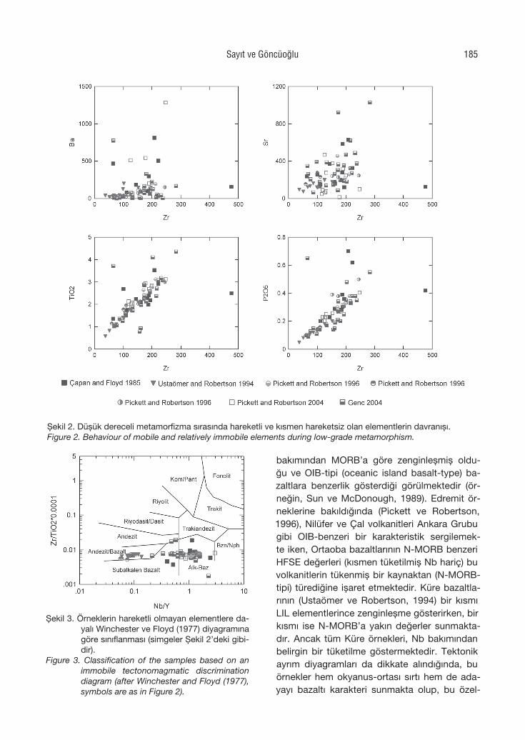
Derlenen analitik verilerde, ana oksitler de da-hil olmak üzere, LIL elementleri değerleri büyük ölçüde değişiklik göstermektedir. Bundan dola-yı, bu elementlerin kullanımı petrojenetik anlam-da güvenilir olmayacaktır. Bu durum göz önü-ne alındığında, jeokimyasal yorumlamalar dü-şük dereceli metamorfizma altında hareketli ol-mayan elementler (örneğin; Pearce ve Cann, 1973; Pearce, 1975) dikkate alınarak yapılmış-tır. Deneştirmede öncelikle yoğun denizaltı me-tamorfizmasının etkisini göstermek amacıyla, Zr fraksiyonlaşma indeksi kullanılarak ikili diyag-ramlar çizilmiştir (Şekil 2). Şekil 2’den görüldü-ğü gibi, alterasyon sırasında hareketli olan ele-mentler (örneğin; K, Sr, Ba, Rb) dağınık eğilim-ler vermekte iken, genelde hareketli olmayan elementler (örneğin; Ti, P) tipik doğrusal eğilim-ler sergilemektedir. Bu olgu, jeokimyasal değer-lendirmelerde yapılacak seçimin ne denli önem-li olduğuna da işaret etmektedir. Hareketli ol-mayan bu elementlere dayalı kayaç sınıflandır-ma diyagramı kullanıldığında (Winchester ve Floyd 1977), örneklerin alkalen ve çeşitli dere-cede sub-alkalen bazaltlar olmak üzere iki grup oluşturdukları gözlenir (Şekil 3).
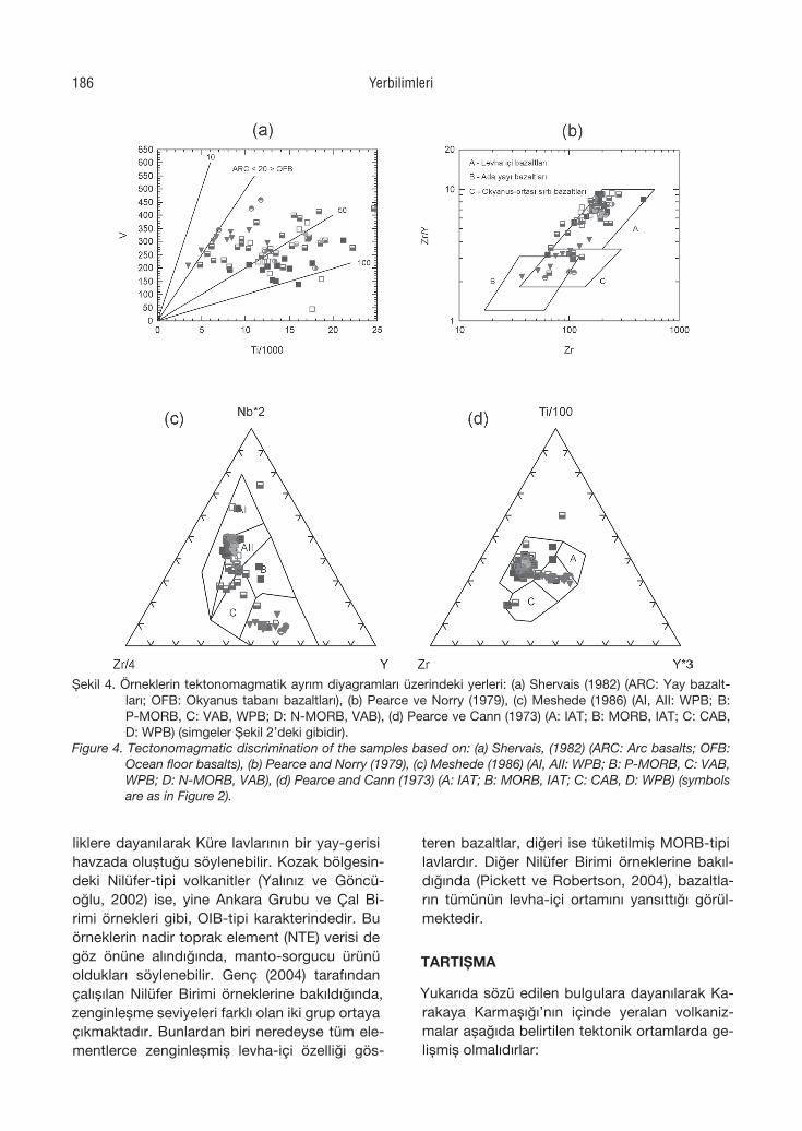
Ti-V tektonomagmatik ayrım diyagramına (Sher-vais, 1982) bakıldığında, örneklerin baskın ola-rak okyanus tabanı bazaltları (OFB) alanında toplandığı gözlenmektedir (Şekil 4a). Ayrıca, Küre lavlarının bu diyagramda hem yay (ARC), hem de okyanus tabanı bazaltları (OFB) alanı-na düşmeleri gözden kaçmamalıdır. Zr/Y-Y di-yagramında (Pearce ve Norry, 1979) örneklerin çoğu levha-içi bazaltı (WPB) alanına düşmekte iken, Küre bazaltları diğerlerinden farklı olarak levha-içi (WPB), okyanus- ortası sırtı (MORB) ve ada-yayı (IAB) bazaltları olmak üzere birçok alanla temsil edilmektedir (Şekil 4b). Nb-Zr-Y tektonik ayrım diyagramı (Meschede, 1986) in-celendiğinde, örneklerin yine benzer bir şekil-de WPB alanında toplandığı görülmektedir (Şe-kil 4c). Önceki diyagramlarda diğer örneklerden ayrılan Küre bazaltları ve yine farklı özellikler su-nan Ortaoba lavları burada bir kez daha ayrı-larak normal-MORB (N-MORB) ve volkanik-yay bazaltları (VAB) ile temsil edilen bölgeye düş-mektedir. Ti-Zr-Y diyagramı (Pearce ve Cann, 1973) önceki sonuçları destekler nitelikte olup, örnekler yine baskın olarak WPB alanına düş-mektedir (Şekil 4d). Ancak Küre ve Ortaoba ör-neklerinin bu diyagramda da farklı alanlarda toplanması, bu örneklerin diğerlerinden farklı bir tektonik ortamı yansıttığını düşündürmektedir.
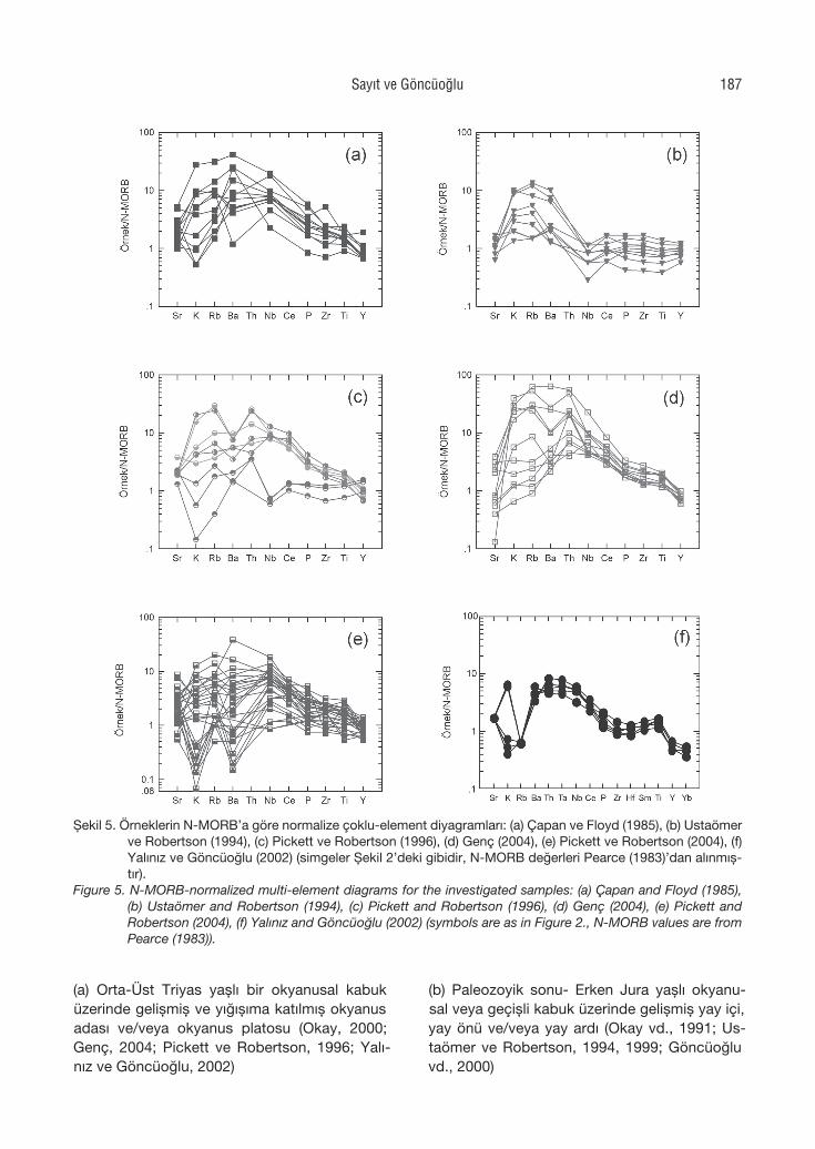
Çoklu-element diyagramları göz önüne alın-dığında (Şekil 5a-f), Ankara Grubu (Çapan ve Floyd, 1985) örneklerinin uyumsuz elementler
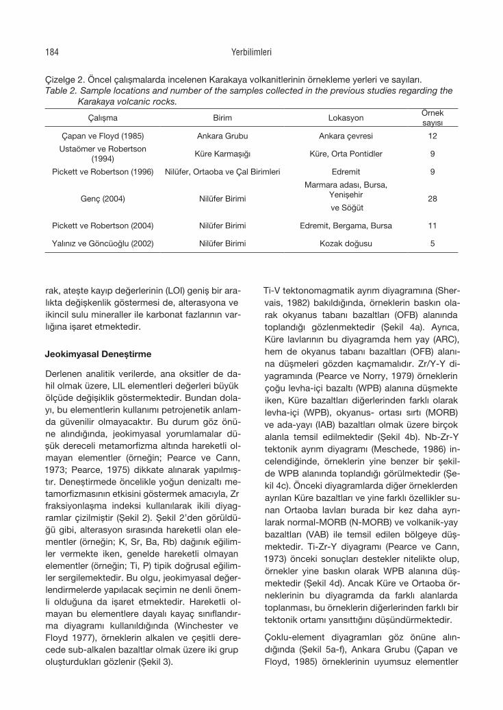
Çizelge 2. Öncel çalışmalarda incelenen Karakaya volkanitlerinin örnekleme yerleri ve sayıları.Table 2. Sample locations and number of the samples collected in the previous studies regarding the Karakaya volcanic rocks.
Çalışma Birim LokasyonÖrnek sayısı
Çapan ve Floyd (1985) Ankara Grubu Ankara çevresi 12
Ustaömer ve Robertson (1994)
Küre Karmaşığı Küre, Orta Pontidler 9
Pickett ve Robertson (1996) Nilüfer, Ortaoba ve Çal Birimleri Edremit 9
Genç (2004) Nilüfer Birimi
Marmara adası, Bursa, Yenişehir 28 ve Söğüt
Pickett ve Robertson (2004) Nilüfer Birimi Edremit, Bergama, Bursa 11
Yalınız ve Göncüoğlu (2002) Nilüfer Birimi Kozak doğusu 5
Yerbilimleri184
bakımından MORB’a göre zenginleşmiş oldu-ğu ve OIB-tipi (oceanic island basalt-type) ba-zaltlara benzerlik gösterdiği görülmektedir (ör-neğin, Sun ve McDonough, 1989). Edremit ör-neklerine bakıldığında (Pickett ve Robertson, 1996), Nilüfer ve Çal volkanitleri Ankara Grubu gibi OIB-benzeri bir karakteristik sergilemek-te iken, Ortaoba bazaltlarının N-MORB benzeri HFSE değerleri (kısmen tüketilmiş Nb hariç) bu volkanitlerin tükenmiş bir kaynaktan (N-MORB-tipi) türediğine işaret etmektedir. Küre bazaltla-rının (Ustaömer ve Robertson, 1994) bir kısmı LIL elementlerince zenginleşme gösterirken, bir kısmı ise N-MORB’a yakın değerler sunmakta-dır. Ancak tüm Küre örnekleri, Nb bakımından belirgin bir tüketilme göstermektedir. Tektonik ayrım diyagramları da dikkate alındığında, bu örnekler hem okyanus-ortası sırtı hem de ada-yayı bazaltı karakteri sunmakta olup, bu özel-
Şekil 2. Düşük dereceli metamorfizma sırasında hareketli ve kısmen hareketsiz olan elementlerin davranışı.Figure 2. Behaviour of mobile and relatively immobile elements during low-grade metamorphism.
Şekil 3. Örneklerin hareketli olmayan elementlere da-yalı Winchester ve Floyd (1977) diyagramına göre sınıflanması (simgeler Şekil 2’deki gibi-dir).
Figure 3. Classification of the samples based on an immobile tectonomagmatic discrimination diagram (after Winchester and Floyd (1977), symbols are as in Figure 2).
Sayıt ve Göncüoğlu 185
liklere dayanılarak Küre lavlarının bir yay-gerisi havzada oluştuğu söylenebilir. Kozak bölgesin-deki Nilüfer-tipi volkanitler (Yalınız ve Göncü-oğlu, 2002) ise, yine Ankara Grubu ve Çal Bi-rimi örnekleri gibi, OIB-tipi karakterindedir. Bu örneklerin nadir toprak element (NTE) verisi de göz önüne alındığında, manto-sorgucu ürünü oldukları söylenebilir. Genç (2004) tarafından çalışılan Nilüfer Birimi örneklerine bakıldığında, zenginleşme seviyeleri farklı olan iki grup ortaya çıkmaktadır. Bunlardan biri neredeyse tüm ele-mentlerce zenginleşmiş levha-içi özelliği gös-
teren bazaltlar, diğeri ise tüketilmiş MORB-tipi lavlardır. Diğer Nilüfer Birimi örneklerine bakıl-dığında (Pickett ve Robertson, 2004), bazaltla-rın tümünün levha-içi ortamını yansıttığı görül-mektedir.
TARTIŞMA
Yukarıda sözü edilen bulgulara dayanılarak Ka-rakaya Karmaşığı’nın içinde yeralan volkaniz-malar aşağıda belirtilen tektonik ortamlarda ge-lişmiş olmalıdırlar:
Şekil 4. Örneklerin tektonomagmatik ayrım diyagramları üzerindeki yerleri: (a) Shervais (1982) (ARC: Yay bazalt-ları; OFB: Okyanus tabanı bazaltları), (b) Pearce ve Norry (1979), (c) Meshede (1986) (AI, AII: WPB; B: P-MORB, C: VAB, WPB; D: N-MORB, VAB), (d) Pearce ve Cann (1973) (A: IAT; B: MORB, IAT; C: CAB, D: WPB) (simgeler Şekil 2’deki gibidir).
Figure 4. Tectonomagmatic discrimination of the samples based on: (a) Shervais, (1982) (ARC: Arc basalts; OFB: Ocean floor basalts), (b) Pearce and Norry (1979), (c) Meshede (1986) (AI, AII: WPB; B: P-MORB, C: VAB, WPB; D: N-MORB, VAB), (d) Pearce and Cann (1973) (A: IAT; B: MORB, IAT; C: CAB, D: WPB) (symbols are as in Figure 2).
Yerbilimleri186
(a) Orta-Üst Triyas yaşlı bir okyanusal kabuk üzerinde gelişmiş ve yığışıma katılmış okyanus adası ve/veya okyanus platosu (Okay, 2000; Genç, 2004; Pickett ve Robertson, 1996; Yalı-nız ve Göncüoğlu, 2002)
(b) Paleozoyik sonu- Erken Jura yaşlı okyanu-sal veya geçişli kabuk üzerinde gelişmiş yay içi, yay önü ve/veya yay ardı (Okay vd., 1991; Us-taömer ve Robertson, 1994, 1999; Göncüoğlu vd., 2000)
Şekil 5. Örneklerin N-MORB’a göre normalize çoklu-element diyagramları: (a) Çapan ve Floyd (1985), (b) Ustaömer ve Robertson (1994), (c) Pickett ve Robertson (1996), (d) Genç (2004), (e) Pickett ve Robertson (2004), (f) Yalınız ve Göncüoğlu (2002) (simgeler Şekil 2’deki gibidir, N-MORB değerleri Pearce (1983)’dan alınmış-tır).
Figure 5. N-MORB-normalized multi-element diagrams for the investigated samples: (a) Çapan and Floyd (1985), (b) Ustaömer and Robertson (1994), (c) Pickett and Robertson (1996), (d) Genç (2004), (e) Pickett and Robertson (2004), (f) Yalınız and Göncüoğlu (2002) (symbols are as in Figure 2., N-MORB values are from Pearce (1983)).
Sayıt ve Göncüoğlu 187
(c) Geç Triyas yaşlı Okyanus ortası sırt ( Pickett ve Robertson, 1996)
(d) Erken Triyas yaşlı rift (Genç ve Yılmaz, 1995; Yılmaz vd., 1997; Kozur vd., 2000)
(e) Geç Paleozoyik yaşlı yay (Göncüoglu vd., 2000).
Görüldüğü üzere, öne sürülen bu tektonik or-tamların herbiri jeodinamik yorumlamalar-da önemli farklılıkları beraberinde getirmekte-dir. Bu farklılıklarının en belirgin örneği, bu ko-nuda Genç (2004) tarafından yayınlanan çalış-mada görülmektedir. Genç (2004), bu çalışma-da da ele alınmış olan jeokimya verisini kulla-narak “Nilüfer Volkanitleri” olarak değerlendirdi-ği kayaların “levha içi”, okyanus adası” ve “ok-yanus tabanı” karakterli olduğunu vurgulamak-tadır. Jeokimyasal olarak ortaya çıkan bu farklı-lıklara rağmen Genç (2004), bu kayaların tümü-nün okyanusal plato ve okyanus adası kökenli olduğunu savlamaktadır. Böyle bir kabule daya-narak araştırmacı, Karakaya Karmaşığı içerisin-de yeralan volkanizmanın dalma-batma ile iliş-kili (okyanus içi yay, yay içi ve yayardı konum-ları) olamayacağı gibi, rift veya erken okyanusal kabuk kökenli de olamayacağını belirtmektedir.
Oysa Okay vd. (1991) tarafından “Nilüfer Volka-nitleri” olarak tanımlanan kayaların, Genç (2004) tarafından ele alınanlarla ne dereceye kadar öz-deş olduğu kuşkuludur. Örneğin, Pickett ve Ro-bertson (1996) tarafından “Ortaoba Volkaniti” olarak tanımlanan ve MORB karakteri bu araş-tırmada da vurgulanan kayalar Genç (2004) ta-rafından “Nilüfer Volkaniti”ne katılmıştır. Aynı şekilde, Ustaömer ve Robertson (1994, 1999) tarafından Orta Pontidler için verilen ve farklı je-okimyasal karakterlerler sunan çok sayıdaki vol-kanik kayadan sadece çok az bir bölümü (Kar-gı metamorfitleri) Genç (2004) tarafından değer-lendirmeye alınmıştır. Bu durumda, Karakaya Karmaşığı içinde yeralan volkanizmanın sade-ce bir bölümünün dikkate alınarak jeodinamik yoruma gidilmesi söz konusudur. Eğer yukarı-da sözü edilen ve bu çalışmada değerlendirilen Çapan ve Floyd (1985), Ustaömer ve Robert-son (1994), Yalınız ve Göncüoğlu (2002) ve Pic-kett ve Robertson (2004)’a ait veriler de dikkate alınmış olsa idi, tektonik ortam ile ilişkili olarak daha farklı görüşleri de tartışmak gerekebilirdi.
Bu nedenle Sayıt ve Göncüoğlu (2004) bu fark-lı volkanizma ürünlerinin herbirinin farklı yaş ve tektonik konumda oluşarak Karakaya Orojeni-nin kapanması ile biraraya gelmiş olabileceğini, dolayısıyla “Karakaya Karmaşığı” nın bir bütün olarak ele alınması gerektiğini savunmaktadırlar.
Bu farklı tektonik ortam ürünü magmatizmaların bir jeodinamik senaryo içinde doğru olarak de-ğerlendirilebilmesi için en önemli ölçüt olan yaş verisi eksiktir. Bu eksiklik giderilmedikçe, Kara-kaya Karmaşığı’nin gelişimi hakkında yorumla-maların farklılığının sürmesi doğaldır.
SONUÇLAR
Önceki çalışmalarda yeralan bazaltik volkanitle-rin jeokimyasal özellikleri yeniden değerlendiril-diğinde, Karakaya Karmaşığı’nin içinde birden fazla tektonik ortamın ürünü olan volkanik ka-yaların varlığı açık olarak ortaya çıkmaktadır. Bu tektonik ortamlar;
(a) Yay-gerisi havzası tipi volkanizma: Küre (B) volkanitleri,
(b) Levha-içi tipi volkanizma: Ankara (A), Çal (C, E), Nilüfer (C, E, F) ve Nilüfer D (bir kısmı) vol-kanitleri,
(c) Okyanus-ortası sırtı tipi volkanizma: Ortaoba (C, E), Nilüfer D (bir kısmı)
olarak genellenebilir.
Karakaya Karmaşığı’nın evriminin objektif olarak açıklanabilmesi için öncel çalışmalar zaman-yer süreci içerisinde ve bir bütün olarak incelenme-li, kesin olarak yaşı bilinen örnekler kullanılma-lı ve NTE ve izotop jeokimyası verileri dikkate alınmalıdır.
KATKI BELİRTME
Yazarlar yazının geliştirilmesindeki değerli katkı-ları için baş editör Prof. Dr. Reşat Ulusay’a, Prof. Dr. Timur Ustaömer’e ve adı belirtilmeyen hake-me teşekkür ederler. Bu çalışma kısmen ODTÜ BAP-2004-07-02-00-59 projesi tarafından des-teklenmiştir.
Yerbilimleri188
KAYNAKLAR
Akyürek, B. ve Soysal, Y., 1983. Biga Yarıma-dası güneyinin (Savaştepe-Kırkağaç-Bergama-Ayvalık) temel jeoloji özellik-leri. Maden Tetkik ve Arama Enstitüsü Dergisi, 95/96, 1-13.
Akyürek, B., Bilginer, E., Akbaş, B., Hepşen, N., Pehlivan, Ş., Sunu, O., Soysal, Y., Da-ğer, Z., Çatal, E., Sözeri, B., Yıldırım, H. ve Hakyemez, Y., 1984. Ankara-Elmadağ-Kalecik dolayının temel jeo-lojik özellikleri. Jeoloji Mühendisligi, 20, 31-46.
Bingöl, E., Akyürek, B. ve Korkmazer, B., 1973. Biga Yarımadası’nın jeolojisi ve Kara-kaya Formasyonu’nun bazı özellikleri. Cumhuriyetin 50. Yılı Yerbilimleri Kong-resi Bildiriler Kitabı, MTA Yayınları, s. 70-77.
Çapan, U.Z., and Floyd, P.A., 1985. Geochemi-cal and petrographic features of meta-basalts within units of Ankara melange, Turkey. Ofioliti, 10, 3-18.
Floyd, P.A., 1993. Geochemical discrimination and petrogenesis of alkalic basalt se-quences in part of the Ankara melange, central Turkey. Journal of the Geologi-cal Society of London, 150, 541-550.
Genç, Ş.C., 2004. A Triassic large igneous pro-vince in the Pontides, northern Turkey: geochemical data for its tectonic set-ting. Journal of Asian Earth Sciences, 22, 503-516.
Genç, Ş.C., and Yılmaz, Y., 1995. Evolution of the Triassic continental margin, nort-hwest Anatolia. Tectonophysics, 243, 193-207.
Genç, Ş., Selçuk, H., Cevher, F., Gözler, Z., Ka-raman, T., Bilgi, C. ve Akçören, F., 1986. İnegöl (Bursa) – Pazaryeri (Bilecik) ara-sının jeolojisi. MTA Rapor No: 7912 (ya-yımlanmamış).
Göncüoğlu, M.C., Dirik, K., and Kozlu, H., 1997. Pre-Alpine and Alpine Terranes in Tur-key: explanatory notes to the terrane map of Turkey. Annales Geologique de Pays Hellenique, 37, 515-536.
Göncüoğlu, M.C., Turhan, N., Şentürk, K., Öz-can, A., and Uysal, Ş., 2000. A geotra-verse across NW Turkey: tectonic units of the Central Sakarya region and the-ir tectonic evolution. In: E. Bozkurt, J. Winchester, and J.A. Piper (eds.), Tec-tonics and Magmatism in Turkey and the Surrounding Area, Geological Soci-ety, London, Special Publications 173, pp. 139-161.
Kaya, O., 1991. Stratigraphy of the Pre-Jurassic sedimentary rocks of the western parts of Turkey; type area study and tecto-nic considerations. type area study and tectonic considerations. Newsletter for Stratigraphy, 23, 123-140.
Kaya, O., Wiedmann, J., and Kozur, H., 1986. Preliminary report on the stratigraphy, age and structure of the so-called Late Paleozoic and/or Triassic “melange or
“suture zone complex” of northwestern and western Turkey. Yerbilimleri, 13, 1-16.
Koçyiğit, A., 1987. Tectono-stratigraphy of the Hasanoglan (Ankara) region: evolution of the Karakaya orogen. Yerbilimleri, 14, 269-293.
Koçyiğit, A., Kaymakçı, N., Rojay, B., Özcan, E., Dirik, K. ve Özçelik, Y., 1991. İnegöl-Bilecik-Bozüyük arasında kalan ala-nın jeolojik etüdü. Orta Doğu Teknik Üniversitesi-Türkiye Petrolleri Anonim Ortaklığı Projesi Raporu, Rapor No: 90-03-09-01-05 (yayımlanmamış).
Kozur, H., Aydın, M., Demir, O., Yakar, H., Gön-cüoğlu, M.C., and Kuru, F., 2000. New stratigraphic and palaeogeographic re-sults from the Palaeozoic and early Me-sozoic of the Middle Pontides (northern Turkey) in the Azdavay, Devrekani, Küre and İnebolu areas: Implications for the Carboniferous-Early Cretaceous ge-odynamic evolution and some related remarks to the Karakaya oceanic rift basin. Geologica Croatica, 53, 209-268.
Meschede, M., 1986. A method of discrimina-ting between different types of mid-ocean ridge basalts and continental
Sayıt ve Göncüoğlu 189

tholeiites with the Nb-Zr-Y diagram. Chemical Geology, 56, 207-218.
Okay, A.İ., 1989. Tectonic units and sutures in the Pontides, northern Turkey. In: A.M.C. Şengör (ed.), Tectonic Evoluti-on of the Tetyhan Region, Kluwer, pp. 109-115.
Okay, A.İ., 2000. Was the Late Triassic orogeny in Turkey caused by the collision of an oceanic plateau ? In: E. Bozkurt, J.A. Winchester, and J.A. Piper (eds.), Tec-tonics and Magmatism in Turkey and the Surrounding Area. Geological So-ciety, London Special Publications 173, pp. 139-161.
Okay, A.İ., and Göncüoğlu, M.C., 2004. The Ka-rakaya Complex: A review of data and concepts. Turkish Journal of Earth Sci-ences, 13, 77-95.
Okay, A.İ., Siyako, M., and Bürkan, B.A., 1991. Geology and tectonic evolution of the Biga Peninsula, northwest Turkey. Bul-letin of the İstanbul Technical Univer-sity, 44, 191-256.
Pearce, J.A., 1975. Basalt geochemistry used to investigate past tectonic environments on Cyprus. Tectonophysics, 25, 41-67.
Pearce, J.A., 1983. The role of sub-continental lithosphere in magma genesis at dest-ructive plate margins. In: C.J. Hawkes-worth, and M.J. Norry (eds), Continen-tal Basalts and Mantle Xenoliths, pp. 230-249.
Pearce, J.A., and Cann, J.R., 1973. Tectonic set-ting of basic volcanic rocks determined using trace element analysis. Earth and Planetary Science Letters, 19, 290-300.
Pearce, J.A., and Norry, M., 1979. Petrogene-tic implications of Ti, Zr, Y and Nb vari-ations in volcanic rocks. Contributions to Mineralogy and Petrology 69, 33-47.
Pickett, E.A., and Robertson, A.H.F., 1996. For-mation of the Late Paleozoic-Early Me-sozoic Karakaya complex and related ophiolites in northwestern Turkey by Palaeotethyan subduction-accretion. Journal of the Geological Society of London, 153, 995-1009.
Pickett, E.A., and Robertson, A.H.F., 2004. Sig-nificance of the volcanogenic Nilufer unit and related components of the Tri-assic Karakaya Complex for Tethyan Subduction/Accretion Processes in NW Turkey. Turkish Journal of Earth Scien-ces, 13, 97-143.
Sayıt, K. ve Göncüoğlu, M.C., 2004, Karakaya Volkanitlerinin jeokimyasal özellikleri-nin yeniden gözden geçirilmesi. 1. Jeo-kimya Sempozyumu, Bildiri Özleri, Bur-sa, s. 27.
Sayıt, K. ve Göncüoğlu, M.C., 2005, Kuzeyba-tı Türkiye’de Jura öncesi “Karakaya Kompleksi”ndeki volkanik kayaların je-okimyasal karakterlerinin karşılaştırıl-ması. 58. Jeoloji Kurultayı, Bildiri Özle-ri, Ankara, s. 245.
Sayıt, K., and Göncüoğlu, M.C., 2009. Geoche-mistry of mafic rocks of the Karakaya Complex, Turkey: Evidence for plume-involvement in the extensional oceanic regime during Middle-Late Triassic. In-ternational Journal of Earth Sciences, 98, 367-385.
Sayıt, K., Göncüoğlu, M.C., and Furman, T., 2008. E-MORB- and OIB-Type Meta-basalts From the Karakaya Complex: Trace Element Evidence for Melting Ac-ross the Spinel-Garnet Transition. Eos Transactions, AGU, 89(53), Fall Meeting Supplement., Abstract V43B-2163.
Seymen, İ., 1993. Mecitözü dolayının stratigrafik gelişimi. A. Suat Erk Jeolojisi Sempoz-yumu, Bildiriler Kitabı, Ankara, s.129-141.
Seymen, İ., 1997. Tokat Masifi tektonostratigra-fisinde yeni bulgular. Selçuk Üniversite-si 20. Yıl Jeoloji Sempozyumu Bildiriler Kitabı, s. 405-414.
Shervais, M., 1982. Ti-V plots and the petro-genesis of modern and ophiolitic lavas. Earth and Planetary Science Letters, 59, 101-118.
Staudigel, H., Plank, T., White, B., and Schminc-ke, H.U., 1996. Geochemical fluxes du-ring seafloor alteration of the basaltic upper oceanic crust: DSPS sites 417
Yerbilimleri190
and 418. Geophysical Monograph, 96, 19-38.
Sun, S., and McDonough, W.F., 1989. Chemi-cal and isotopic systematics of oceanic basalts: implications for mantle com-position and processes. In: A. D. Saun-ders, and M. J. Norry, (eds.), Magma-tism in the Ocean Basins, Geological Society, London, Special Publications 42, 313-345.
Şengör, A.M.C., Yılmaz, Y. and Sungurlu, O., 1984. Tectonics of the Mediterrane-an Cimmerides: nature and evolution of the western termination of Paleo-Tethys. In: J.E. Dixon, and A.H.F. Ro-bertson (eds.), The Geological Evoluti-on of the Eastern Mediteranean, Geolo-gical Society, London, Special Publica-tions 17, 77-112.
Tekeli, O., 1981. Subduction complex of pre-Jurassic age, northern Anatolia, Turkey. Geology, 9, 68-72.
Ustaömer, T. and Robertson, A.H.F., 1994. Late Paleozoic marginal basin and subduction-accretion: the Paleoteth-yan Küre Complex, Central Pontides, northern Turkey. Journal of the Geolo-gical Society, London, 151, 291-305.
Ustaömer, T., and Robertson, A.H.F., 1999. Ge-ochemical evidence used to test alter-native plate tectonic models for the pre-Upper Jurassic (Palaeotethyan) units in the Central Pontides, N. Turkey. Geolo-gical Journal, 34, 25-53.
Winchester, J.A., and Floyd, P.A., 1977. Geoc-hemical discrimination of different mag-ma series and their differentiation pro-ducts using immobile elements. Chemi-cal Geology, 20, 325-343.
Yalınız, M.K., and Göncüoglu, M.C. 2002. Ge-ochemistry and petrology of “Nilüfer-type” metabasic rocks of eastern Ko-zak Massif, NW Turkey. 1st Internati-onal Symposium of İstanbul Techni-cal University, The Faculty of Mines on Earth Sciences and Engineering, İstan-bul, Abstracts, p.158.
Yılmaz, Y., Serdar, H.S., Genç C., Yiğitbaş, E., Gürer Ö.F., Elmas, A., Yıldırım, M., Boz-cu, M., and Gürpınar, O., 1997. The Ge-ology and evolution of the Tokat Massif, South Central Pontides, Turkey. Inter-national Geology Review, 39, 365-382.
Sayıt ve Göncüoğlu 191

Yerbilimleri, 30 (3), 193–212Hacettepe Üniversitesi Yerbilimleri Uygulama ve Araştırma Merkezi DergisiJournal of the Earth Sciences Application and Research Centre of Hacettepe University
KB Anadolu’daki Karakaya Karmaşığı birimlerinin diyajenezi-düşük dereceli metamorfizması
Diagenesis and low grade metamorphism of Karakaya Complex units in the NW Anatolia
Sema TETİKER1, Hüseyin YALÇIN2, Ömer BOZKAYA2
1Cumhuriyet Üniversitesi, Fen Bilimleri Enstitüsü, 58140, SİVAS2Cumhuriyet Üniversitesi, Jeoloji Mühendisliği Bölümü, 58140, SİVAS
Geliş (received) : 16 Haziran (June) 2009 Kabul (accepted) : 18 Eylül (September) 2009
ÖZ Bu çalışmada, KB Anadolu’da Sakarya Kompozit Birliği içerisinde yer alan Paleotetis ile ilişkili Permo-Triyas yaş-lı Karakaya Karmaşığı’nın tanım ve oluşumuna, birimlerin diyajenetik-metamorfik özellikleri ortaya konularak katkı-da bulunulması amaçlanmıştır. KB Anadolu’da Alt Karakaya birimlerinden Nilüfer biriminin alt kesimi mavişist, üst kesimi ise yeşilsist fasiyesindeki kayaçları içermektedir. Kireçtaşı blokları içeren Üst Karakaya birimlerini psamit, pelit ve karbonat kayaçları ile volkanikler temsil etmektedir. KB Anadolu’da Alt Karakaya biriminde bolluk sırasına göre fillosilikat (illit, klorit, stilpnomelan, smektit, kaolinit, C-S, I-S, C-V), feldispat, kalsit, kuvars, dolomit, piroksen (ojit, Ti-ojit), amfibol (hornblend, glokofan, tremolit/aktinolit, antofillit), hematit, epidot ve götit; Üst Karakaya birim-lerinde kuvars, fillosilikat (illit, klorit, I-S, C-V, C-S, I-C, kaolinit, vermikülit, smektit), kalsit, dolomit, feldispat, epi-dot, ojit, hornblend, natrolit, hematit ve götit tanımlanmıştır. Nilüfer, Orhanlar ve Çal birimlerine ait trioktahedral şa-mozitik kloritler IIb; fenjitik bileşimli dioktahedral illitler 2M1+1M+1Md politipine sahiptir. Kübler indeksi (KI) ve Arkai indeksi (AI) verileri; Nilüfer biriminde düşük dereceli ankizon ve epizon, Hodul biriminde yüksek dereceli diyajenez, Orhanlar biriminde yüksek diyajenez-düşük dereceli ankizon, Çal biriminde ise düşük dereceli diyajenez derecesi-ne karşılık gelmektedir. İllitlerin b0 değerleri Alt Karakaya birimlerinde orta-yüksek ve Üst Karakaya birimlerinde ço-ğunlukla orta basınç fasiyes serisini göstermektedir. Dokusal özellikler, mineral birliktelikleri, kil / fillosilikat mineral dönüşümleri, tipik indeks mineraller ve fillosilikatların kristalkimyasal verilerine göre; Alt Karakaya birimleri yüksek basınç-düşük sıcaklık ile temsil edilen sıkışmalı, Üst Karakaya birimleri ise ısı akışının etkili olduğu genişlemeli bir havzayı yansıtan diyajenetik/metamorfik özelliklere sahiptir.
Anahtar Kelimeler: b0, illit kristalinite, kil mineralojisi, petrografi, XRD.
ABSTRACT
The aim of this study is contribute to discussions concerning the formation of the Paleotethyan Permo-Triassic Karakaya Complex by revealing the diagenetic-metamorphic properties of the units within the Sakarya Compo-site Terrane in Northwestern Anatolia. The Nilüfer unit from the Lower Karakaya unit is represented by rocks of blueschist in the lower parts and greenschist facies in the upper parts. The Upper Karakaya unit has limestone blocks, made up of psammite, pelite and carbonate rocks associated with volcanics. In NW Anatolia, various mi-nerals have been determined, in order of abundance, as phyllosilicates (illite, chlorite, stilpnomelane, smectite, kaolinite, C-S, I-S, C-V), feldspar, calcite, quartz, dolomite, pyroxene (augite, Ti-augite), amphibole (hornblende, glaucophane, tremolite/actinolite, anthophyllite), hematite, epidote and goethite in the Lower Karakaya unit, and quartz, phyllosilicates (illite, chlorite, I-S, C-V, C-S, I-C, kaolinite, vermiculite, smectite), calcite, dolomite, feldspar,
H. YalçınE-posta: [email protected]
GİRİŞ
Sakarya Kompozit Birliği (Göncüoğlu vd., 1997) içerisinde yer alan Jura-öncesi Paleotetis ile ilişkili birimlerden Karakaya Karmaşığı (Şen-gör vd., 1984) iki bölüme ayrılmaktadır (Teke-li, 1981). Bunlardan Alt Karakaya Karmaşığı, ya-pısal ve olasılıkla stratigrafik olarak altta yer al-makta olup, Paleozoyik sonu veya Triyas’ta ge-nellikle yeşilşist ve kısmen mavişist fasiyesin-de metamorfizma geçirmiş kayaçlar (Nilüfer bi-rimi) ile temsil edilmektedir (Okay ve Göncüoğ-lu, 2004). Üst Karakaya Karmaşığı ise, içinde çok sayıda Permo-Karbonifer yaşlı ortama ya-bancı kireçtaşı blokları içeren (Bailey ve McCal-lien, 1950, 1953; Erol, 1956), kuvvetlice defor-me olmuş Permiyen veya Triyas yaşlı dört se-riden (Hodul, Orhanlar ve Çal birimleri ile Akgöl formasyonu) oluşmaktadır (Okay ve Göncüoğ-lu, 2004).
KB Anadolu’daki inceleme alanı Bursa-Balıkesir bölgesinde yer almakta olup, Bursa-Demirtaş ve Orhaneli, Balıkesir-Havran, Orhanlar ve Çal olmak üzere 5 farklı alanı içermektedir. Bu al-anlar, 1:100.000 ölçekli Bursa H19 ve H22 ile Balıkesir I18 ve I19 paftalarındaki Karakaya Karmaşığı birimlerini kapsamaktadır. Sakarya Kompozit Birliği’nin kuzeyinde İntra-Pontid Kuşağı, güneyinde sırasıyla İzmir-Ankara Kuşağı ve Torid-Anatolid Platformu’na ait kaya-çlar bulunmaktadır.
Karakaya Karmaşığı ile ilgili çalışmalar Orta Pontidlerde de bulunmakla birlikte (Tetiker, 2009), evrimsel kuramlar Sakarya Kompozit Kıtası’nın batısından elde edilen jeolojik veriler
esas alınarak kurulmuştur (Bingöl vd., 1975; Te-keli, 1981; Şengör vd., 1984; Okay vd., 1990; Okay ve Göncüoğlu, 2004). Bu çalışmada ise, ince-iri taneli (meta-) klastik ve (meta-) volka-nik kayaçların diyajenetik-metamorfik özellikle-rini konu alan mineralojik (fillosilikat parajenezi, kristalinite, politipi, b
0 hücre mesafesi vb.) araş-tırmalar ile Karakaya Karmaşığı’nın ilgili birimle-rine kil/fillosilikat açısından bir yaklaşımda bu-lunulmuştur.
STRATİGRAFİ VE LİTOLOJİ
Bölgede yüzeyleyen kayaçların stratigrafik da-ğılımı incelendiğinde; metamorfik kayaç toplu-luklarından oluşan Kazdağ Grubu (Bingöl vd., 1975), metasedimanter Kalabak formasyonu (Krushensky vd., 1980), Çamlık Metagranodiyo-riti (Okay vd., 1990) ve Manyas Grubu (Okay vd., 1990) Permo-Triyas öncesi birimleri temsil et-mektedir. Karakaya Karmaşığı’nın Nilüfer birimi Kazdağ Grubu Metamorfitleri’ni tektonik olarak üzerlemektedir. Karakaya Karmaşığı’nın Hodul birimi Balıkesir-Havran kuzeydoğusunda stra-tigrafik olarak temeli temsil eden Çamlık Metag-ranodiyoriti üzerinde uyumsuzlukla yer almakta ve Jura-Orta Kretase yaşlı birimler olan Bayır-köy formasyonu (Altınlı, 1975); Bilecik Kireçta-şı (Granit ve Tintant, 1960) ve Vezirhan formas-yonu (Eroskay, 1965) tarafından uyumsuzluk-la örtülmektedir. Orta Sakarya bölgesinde ise, Üst Kretase yaşlı Gölpazarı Grubu (Altınlı, 1975; Saner, 1978) Vezirhan formasyonu üzerine gel-mektedir. Tüm bu istif Tersiyer yaşlı diğer birim-ler ile örtülmektedir (Şekil 1).
epidote, augite, hornblende, natrolite, hematite and goethite in the Upper Karakaya units. Trioctahedral chamozi-tic chlorites and phengitic dioctahedral illites have, respectively, IIb polytypes and 2M1+1M +1Md in the Nilüfer, Or-hanlar and Çal units. Kübler index (KI) and Arkai index (AI) data correspond to low-grade anchizone and epizone for the Nilüfer Unit, high grade diagenesis for the Hodul Unit, high grade diagenesis and low grade anchizone for the Orhanlar Unit, and low grade diagenesis for the Çal Unit. The b0 values of illites show as moderate to high for the Lower Karakaya units, but mostly as a moderate pressure facies series for the Upper Karakaya units. Accor-ding to the textural features, mineral associations, clay/phyllosilicate transformations, typical index minerals and crystallochemical data of phyllosilicates, the Lower Karakaya units were formed in high pressure/low temperature conditions in a compressional basin, whereas the Upper Karakaya units reflect the diagenetic/metamorphic cha-racteristics of an extensional basin dominated by low heat flow.
Keywords: b0, illite crystallinity, clay mineralogy, petrography, XRD.
Yerbilimleri194
KB Anadolu’da Alt Karakaya Karmaşığı’nı tem-sil eden Nilüfer birimi; foliasyonlu metapsa-mit (metakumtaşı), metapelit (sleyt, fillit, şist) ve metakarbonat (metakireçtaşı, metadolomit, mermer) seviyeleri ile bu kayaçlarla ardalanma-lı ve deforme olmuş yeşil, yer yer tabakalanma-lı ve kalın metabazik kayaçlardan (metavolkanik, metatüf) oluşmaktadır. Birim, Bursa-Orhaneli yöresinde incelenmiştir.
Üst Karakaya Karmaşığı birimlerinden Hodul bi-rimi; Balıkesir-Havran kuzeydoğusunda yapı-lan çalışmaya göre; metamorfik bir temel üze-rinde yer alan kumtaşı, şeyl, silttaşı; Bursa-Demirtaş yöresinde arkozik kumtaşları ile ara-katkılı (meta-) pelitik (çamurtaşı, şeyl, sleyt, silt-taşı) ve metakireçtaşı blokları içermektedir. Or-hanlar birimi; Balıkesir-Danışment yöresinde bi-rimin egemen litolojisini oluşturan kumtaşları
sarı-kahve ve yeşil renkli olup, bol miktarda me-tamorfik ve volkanik kayaç parçaları içermekte-dir. İkinci kesit yeri olan Bursa-Orhaneli yöresin-deki birim, metakireçtaşı blokları ve pelit (şeyl) arakatkıları içeren kumtaşlarından oluşmakta-dır. Balıkesir-Çal köyünde yüzeyleyen Çal biri-mi, olistostromal kireçtaşı blokları içeren spilitik bazalt ve kırıntılılardan (çamurtaşı, şeyl, kumta-şı) oluşmaktadır. Diğer bir inceleme alanı olan Bursa-Demirtaş yöresinde birimdeki volkanik kayaçlar genellikle spilitik türde olup, altere ag-lomera seviyeleri ile geçişlidir.
MALZEME VE YÖNTEM
İnceleme alanı olarak seçilen KB Anado-lu Bölgesi’ndeki arazi çalışmasında nokta-sal ve çoğunluğu ölçülü kesitler boyunca top-lam 116 adet örnek derlenmiş olup (Çizelge 1),
Şekil 1. (a) KB Anadolu’da Karakaya Karmaşığı birimlerinin yalınlaştırılmış jeolojik-jeotektonik haritası (MTA, 2002: 1/500 000 ölçekli Türkiye jeoloji haritasıdan düzenlenmiştir), (b) inceleme alanının yer bulduru ve örnekle-me haritası.
Figure 1. (a) Simplified geologic-geotectonic map of the Karakaya Complex units in the NW Anatolia (MTA, 2002: arranged from 1/500 000 scale of geological map of Turkey), (b) location and sampling map of study area.
Tetiker vd. 195
Cumhuriyet Üniversitesi Jeoloji Mühendisliği Bölümü’nde optik mikroskop ve X-ışınları kırı-nımı (XRD) çözümlemelerinden geçirilmiştir. Ka-yaçlarda tüm kayaç ve kil boyu bileşenler (< 2 mm) tanımlanmış ve yarı nicel yüzdeleri de dış standart yöntemi (Brindley, 1980) esas alınarak hesaplanmıştır (Yalçın ve Bozkaya, 2002).
Klorit, C-S, smektit ve illitlerin di- ve/veya triok-taedrik karakterlerinin belirlenmesinde d(060) yan-sıması yardımıyla b0-parametresi hesaplanmış-tır. Bu ölçüm, kuvarsın (211) piki (2q=59.982°, d=1.541Å) referans alınarak 2q=59-63° (±0.01°) kayıt aralığında ve 0.5°/dak. gonyometre hızı ile ölçülmüştür. R0-3 I-S minerallerindeki illit veya smektit oranı, Moore ve Reynolds (1997)’un değerlerinden itibaren hesaplanmıştır. İllitlerin d(060) yansıması yardımıyla oktaedrik kimyasal bileşimleri (Hunziker vd., 1986), b0-parametresi ile de basıncın illitlere etkisi (Sassi ve Scola-ri, 1974; Guidotti ve Sassi, 1986) belirlenmiştir. Kayıt aralığı 2q=59-63° (± 0.01°) olan bu ölçüm-lerde kuvarsın (211) piki (2q=59.97°, d=1.541 Å) referans alınmıştır. Kloritlerin kimyasal bile-şimlerinde d(005) piklerinden itibaren d(001) yan-sıma değerleri bulunarak tetrahedral Al miktarı saptanmıştır (Brindley, 1961). Oktahedral Fe2+ miktarı ise, Brown ve Brindley (1980) ile Chag-non ve Desjardins (1991)’un önerilerine göre elde edilmiştir. Politipi incelemeleri illit ve klorit minerallerinde yapılmış olup, yönlendirilmemiş plaketlerden itibaren uygulanan kayıt aralığı sı-rasıyla 2q=18-36° ve 31-52° arasındadır. Politi-pi belirlemelerinde Bailey (1988) tarafından öne-
rilen ayırtman pikler kullanılmıştır. İllitlerin 1M cv politipinin varlığı Drits vd. (1984) tarafından öne-rilen pikler yardımıyla belirlenmiştir. 2M1, 1M ve 1Md oranları Grathoff ve Moore (1996)’un pik alan (A) oranlarına göre belirlenmiştir. Pik alan-larının belirlenmesinde WINFIT programı kulla-nılmıştır (Bozkaya ve Yalçın, 2007).
İllit kristalinite ölçümünde 10-Å illit pikinin yarı yüksekliğindeki genişliği D°2q (Kübler indisi - KI: Kübler, 1968; Guggenheim vd., 2002) kullanıl-mıştır. WINFIT (Krumm, 1996) programı (http://xray.geol.uni-erlangen.de/html/software/soft.html) ile asimetrik pik çözümlemesi sonucu tek bir illit veya simetrik pik çözümlemesi sonu-cu iki illit (iyi kristalin illit-WCI ve zayıf kristalin illit-PCI) fazından itibaren hassas biçimde be-lirlenen pik genişliklerinin Kisch (1980) ve Warr ve Rice (1994) standartlarına göre kalibrasyo-nu yapılmıştır. Ankizonun alt ve üst limit sınır-ları Kisch standartları için 0.21° ve 0.37° D°2q (Kisch, 1980, 1990), CIS için 0.25° ve 0.42° D°2q (Warr ve Rice, 1994) olarak verilmiştir.
PETROGRAFİ
Nilüfer Birimi
Birimi temsil eden yaygın litolojilerden metavol-kanik kayaçlar; hipokristalin porfirik, hipokrista-lin mikrolitik porfirik, intersertal ve glomeropor-firik dokuludur. Açık renkli bileşenleri plajiyok-laz, koyu renkli bileşenleri ise klinopiroksen (ojit,
Çizelge 1. Karakaya Karmaşığı birimlerinden alınan kayaç örneklerinin GPS coğrafi koordinatları. Table 1. GPS geographic coordinates of rock samples taken from Karakaya Complex units.
Birim Yöre Başlangıç Bitiş
Nilüfer Bursa-Orhaneli 40º05’ K, 28º95’ D 40º05’ K, 28º96’ D
HodulBalıkesir-Havran 39º15’ K, 27º11’ D 39º17’ K, 27º10’ D
Bursa-Demirtaş 40º17’ K, 28º09’ D 40º16’ K, 28º07’ D
OrhanlarBalıkesir-Orhanlar 39º85’ K, 27º46’ D 39º84’ K, 27º45’ D
Bursa-Orhaneli 40º12’ K, 28º97’ D 40º04’ K, 28º90’ D
ÇalBalıkesir-Çal 40º04’ K, 27º09’ D 40º04’ K, 27º10’ D
Bursa-Demirtaş 40º18’ K, 28º09’ D 40º16’ K, 28º07’ D
Yerbilimleri196
Ti-ojit), klinoamfibol (tremolit/aktinolit, kersutit) ve Fe-oksit mineralleri oluşturmaktadır. Bu ka-yaçların hamurunda ince-taneli tremolit/aktino-lit, epidot, klorit, serizit ve stilpnomelan gibi çok düşük-düşük dereceli metamorfizmayı tem-sil eden mineraller ve yaygın olarak yönlü doku gelişmiştir. Mikrolitik porfirik dokulu kayaçlarda plajiyoklazlar mikrolitleri oluşturmaktadır. Bağ-layıcı malzemeyi çoğunlukla volkanik cam, fil-losilikat ve amfibol temsil etmektedir. Volkanik camda çoğunlukla killeşme (klorit), silisleşme, yer yer Fe-oksidasyonu ve karbonatlaşma (kal-sitleşme, dolomitleşme) gözlenmektedir. Fe-nokristallerden ojit ve pembe Ti-ojitler özşekil-li olup, yer yer kataklastik etkiler göstermekte-dir (Şekil 2a). Piroksenlerde, az olmakla birlik-te, uralitleşme gözlenmektedir. İnce taneli ku-vars ve epidot matriksde, kalsit ise gözenek ve çatlaklarda yer almaktadır. Mikrolitik hamur içe-risindeki amfibol fenokristalleri ise kahverengi kersutit olup, kenarlarından itibaren opasitleş-miş, dilinim izleri belirgin, özşekilli ve sekizgen görünümleri tipiktir (Şekil 2b). Meta-piroklastik kayaçlar vitroklastik dokuya sahip olup, fenok-ristalleri volkanojenik kökenli plajiyoklaz, ojit, biyotit, kuvars ve volkanik kayaç parçacıkla-rı oluşturmaktadır. Matrikste volkanik camdan itibaren silisleşme, epidotlaşma, muskovitleş-me ve kloritleşme gözlenmektedir. Ayrıca me-tamorfizma etkisiyle yer yer mikrolaminasyon-lar gelişmiştir.
Metapelitik kayaçlar; lepidoblastik ve nematob-lastik dokuya sahiptir. Sleyt ve buruşma dilinim-leri belirgin olarak gözlenmekte olup, yer yer ka-taklazma etkilerine de rastlanılmaktadır. Şistleri oluşturan ana bileşenler; örneklere göre kısmen farklılık sunmakla birlikte, kuvars, serizit/mus-kovit, plajiyoklaz, klorit, tremolit/aktinolit, glo-kofan, epidot, fillosilikat ve opak minerallerdir. Uzun prizmatik ve yer yer lifsel/iğnemsi görü-nümdeki tremolit/aktinolitler açık yeşil, ince ta-neli epidot mineralleri ise, limon sarısı renkleriy-le ayırt edilmektedir. Şistlerde {001} eksenine paralel yönlenmiş klorit levhaları ile c-ekseni yö-nünde dizilen kuvarsca zengin zonlar metamor-fik ayrımlaşmanın tipik verileridir. İri ve küçük prizmatik glokofanlar zonlu bir doku sergileye-rek kenarlarından itibaren tremolit/aktinolitlere dönüşmüştür (Şekil 3a). Glokofan içeren şistler-
de, dilinim düzlemlerini kesen ince uzun prizma-tik, sarı-kahve renkli post-tektonik stilpnome-lan mineralleri bulunmaktadır (Şekil 3b). Sleyt-lerin bileşenlerini bolluk sırasına göre, serizit/muskovit, plajiyoklaz ve kuvars temsil etmekte-dir. Bol miktarda hematit içermeleri de karak-
Şekil 2. Nilüfer birimi kayaçlarının optik mikroskop mikrofotoğrafları (tek nikol=tn): (a) zayıf ge-lişmiş kataklastik dokulu metabazaltlar-da bütünüyle kloritleşmiş-serizitleşmiş yön-lü dokulu hamur içerisinde pembe Ti-ojit fe-nokristalleri ve basınç gölgesinde gelişen post-tektonik kloritler, (b) andezitik metaba-zaltlarda serizitleşmiş hamur içerisinde ke-narları boyunca opasitleşmiş özşekilli kersu-titler (Ti-Aug=Titanojit, Krs=Kersutit).
Figure 2. Optical microscopy microphotograps of the Nilüfer unit rocks (open nicol=on): (a) pinc Ti-augite phenocrystals within the matrix with completely chloritized-sericitized ori-ented texture and post-tectonic chlorites developed in the pressure shadow from metabasalt with weak cataclastic texture, (b) euhedral kaersutites opacitized along with sides within the sericitized matrix of andesitic metabasalts (Ti-Aug=Titanaugite, Krs=Kaersutite).
Tetiker vd. 197
teristiktir. Bu kayaçların bağlayıcı malzemesini serizitleşmiş-kloritleşmiş fillosilikat matriks ve kalsit çimento oluşturmaktadır. İnce taneli sleyt-lerde mikrolaminasyon, mikroyönlenme ve bu-ruşma kıvrımları gibi metamorfik dokusal özel-liklerin yanı sıra, yaygın olarak post-metamorfik kalsit dolgulu damarlar da gelişmiştir (Şekil 3c). Fillitler; fibroblastik dokulu olup, buruşma kıv-rım ve dilimine sahiptir (Şekil 3d). Tane boyu-nun incelmesi dışında mineralojik bileşimi şist-lere benzemektedir. Ana bileşenler; kuvars, se-rizit/muskovit, plajiyoklaz, klorit, tremolit/akti-nolit, glokofan, klorit ve stilpnomelan; tali bile-şenler ise epidot ve opak minerallerdir. Amfi-boller tektonizmayla eşzamanlı (sin-tektonik) bir oluşumu yansıtacak biçimde, uzun eksenleri fo-liasyon düzlemlerine paralel yönlenmiştir.
Metakumtaşlarında bileşenleri başlıca kuvars, plajiyoklaz, ortoklaz, serizit/muskovit, biyotit, kalsit, kayaç parçaları ve opak mineraller oluş-turmaktadır. Blastopsamitik dokulu, kötü boy-lanmalı bu kayaçlarda mikroyönlenme ve fillosi-likatça zengin seviyelerde sleyt dilinimi gözlen-mektedir. Bağlayıcı malzemeyi büyük ölçüde fil-losilikat matriks ve daha az kalsit çimento oluş-turmaktadır. Bunlarda bazalt, kuvarsit ve şist kayaç parçalarına da rastlanılmıştır.
Metakarbonat kayaçlarında ilksel dokunun bü-yük ölçüde kaybolması (mikrosparitik /sparitik) ve çok düşük dereceli metamorfizma etkileri-nin (granoblastik doku ve fillosilikat yönlenme-si) gözlenmesi, ayrıca şist türü kayaçlara eşlik etmesi nedeniyle metakireçtaşı veya metado-lomitten ziyade mermer olarak adlandırılmıştır.
Şekil 3. Nilüfer birimi kayaçlarının optik mikroskop mikrofotoğrafları: (a) şistlerde glokofan-aktinolit dönüşümü, (b) şistlerde menekşe renkli glokofan ve post-tektonik stilpnomelan, (c) sleytlerde mikrokıvrımlanma ve mik-rokırıklar ile post-tektonik kalsit damarları (çift nikol: çn), (d) fibroblastik dokulu ve buruşma kıvrım ve dili-nimli fillitlerde glokofanlar (tn) (Tre/Ac=Tremolit/Aktinolit, Gln=Glokofan, Stp=Stilpnomelan).
Figure 3. Optical microscopy microphotograps of the Nilüfer unit rocks: (a) glaucophane-actinolite transformation in the schist, (b) violet colored glaucophane and post-tectonic stilpnomelane in the schists, (c) microfold-ings, microfractures and post-tectonic calcite veins in the slates (crossed nicol=cn), (d) glaucophanes in the phyllites with fibroblastic texture, crenulation foldings and cleavages (on) (Tre/Ac=Tremolite/Actino-lite, Gln=Glaucophane, Stp=Stilpnomelane).
Yerbilimleri198
Ortokemi kalsit veya dolomit, litoklast ve/veya metamorfik bileşenleri ise kuvars, muskovit ve opak mineraller temsil etmektedir.
Hodul Birimi
Bu birimin litik arkoz, subarkoz ve feldispatik li-tarenit olarak tanımlanan kumtaşları; genellik-le kötü-orta boylanmalı, orta-çok iri kum boyu, yer yer mikrokonglomeratik, köşeli ve yarı yu-varlak tanelerden oluşmaktadır. Yüksek matriks oranına (% 5-10) sahip, dokusal açıdan çoğun-lukla olgunlaşmamış olan bu kayaçlarda bile-şenler başlıca kuvars, feldispat (plajiyoklaz, or-toklaz ve ender mikroklin), serizit/muskovit, bi-yotit, epidot, opak mineral ve kayaç parçaları-dır. Ender gözlenen zirkon, apatit ve Fe-oksitler ise, tali bileşenleri oluşturmaktadır. Ana bileşen-lerden kuvars mineralleri (0.05-1.20 mm) polik-ristalin ve dalgalı sönmeli monokristalin, köşe-li ve yarı yuvarlak biçimde, kataklazma etkisiyle çoğunlukla parçalanmış bir görünüm sunmak-tadırlar. İpliksi ve şerit türü pertitik ortoklazlar-da serizitleşme ve karbonatlaşma yaygındır (Şe-kil 4a). Bazı ortoklazlarda Karlsbad ikizlenmesi, bazılarında ise içerisinde plajiyoklaz kapanımla-rı gözlenmiştir. Özşekilli-yarı özşekilli plajiyok-lazlarda ikiz lamellerinde bükülmelerin gözlen-mesi kataklazmayı işaret etmektedir. Bazı kum-taşlarında rastlanan mikroklin ise diğer feldis-patlara göre daha az bulunmaktadır (Şekil 4b). Mikalardan ince taneli uzun levhamsı muskovit-ler ve kahverenkli biyotitlerde yönlenme ve bü-külme gözlenmektedir. Kumtaşları içerisinde yer yer çakıl boyutuna ulaşan küresel ve elip-soyidal polikristalin kuvars, sleyt ve fillit yaygın, bazalt türü kayaç parçacıkları ender olarak göz-lenmektedir. Ayrıca grafik ve mirmekitik dokulu granitik kayaç parçaları bu birim için tipiktir. En-der olarak, küresel şekilli fosilli kireçtaşı parça-sına da rastlanılmıştır.
Sadece Balıkesir-Havran yöresinde gözlenen silttaşları; çoğunlukla iri silt tane boyunda olup, kuvars, plajiyoklaz, ortoklaz, serizit/muskovit, biyotit, kalsit, ender olarak apatit ve opak mine-rallerden oluşmuştur.
İlksel dokularının (sparitik, mikrosparitik ve mikri-tik) korunduğu, intraklast ve fosil kavkıları içeren yeniden kristallenmeye uğramış veya granoblas-
tik dokulu karbonat kayaçlarında (kristalize kireç-taşı ve metakireçtaşı) muskovit, biyotit ve kloritli zonlarca oluşturulan laminasyonlar oldukça belir-gindir. Gözeneklerde ince taneli kuvars oluşumla-rına ve breşik dokuya da rastlanılmaktadır.
Orhanlar Birimi
Psamitik dokulu, olgunlaşmamış, orta-kötü boy-lanmalı, ince-orta-yer yer çok iri kum boyundaki kumtaşlarında (grovak, feldispatik litarenit, volka-nik arenit) ana bileşenleri kuvars, plajiyoklaz, or-
Şekil 4. Hodul birimi kumtaşlarında optik mikroskop mikrofotoğrafları (çn): (a) pertit dokulu ve kısmen serizitleşmiş ve killeşmiş ortoklaz, (b) yarı yuvarlak-yarı köşeli mikroklin ve taneler-le keskin sınırlı serizit bağlayıcı (Or=Ortoklaz, Mic=Mikroklin, Qm=Monokristalin kuvars, Srz=Serizit).
Figure 4. Optical microscopy microphotograps of the Hodul unit sandstones (cn): (a) sericitized-argillitized ortoclase with perthitic texture, (b) subrounded-subangular microcline and sericitic groundmass with sharp boundary by grains (Or=Ortoclase, Mic=Microcline, Qm=Monocristaline quartz, Srz=Sericite).
Tetiker vd. 199
toklaz, serizit/muskovit, biyotit, kalsit; tali bileşen-leri ise opak mineral, zirkon, epidot, turmalin ve apatit temsil etmektedir. Bu kayaçlarda matriks, yönlenme ve bükülme gösteren klorit ve serizit-lerden oluşmaktadır. Çok az miktarda gözlenen kalsit, çimentonun yanı sıra, çatlaklarda da bulun-maktadır. Kuvarslar, birden fazla tanenin birlikte-lik oluşturduğu polikristalin ve yer yer dalgalı sön-me gösteren monokristalin türdedir. Plajiyoklaz-lardaki serizitleşme yer yer muskovit büyüklüğü-ne ulaşmaktadır (Şekil 5a). Kataklastik deformas-yon sonucu plajiyoklazların ikiz lamellerinde mik-ro kırıklar ve ötelenmeler yaygın olarak gelişmiş-tir. Ortoklazlarda pertitik, mirmekitik-grafik doku (Şekil 5b) ve Karlsbad ikizlenmesi gibi kristalog-rafik özellikler gözlenmiştir. Biyotitler ise, açık
sarı renkli olup, yönlenme ve bükülmeye sahiptir. Yer yer mikrolaminasyonun izlendiği bu kayaçlar-da prizmatik görünümde götitler gözlenmektedir (Şekil 5c). Kalsit, mavi girişim renkli klorit ve ender olarak epidotlar gözeneklerde yer alan diğer bile-şenlerdir. Kumtaşlarında plajiyoklaz mikrolitlerin-den oluşan bazalt (Şekil 5d), şist ve/veya fillit ve kuvarsit türü köşeli ve yarı yuvarlak kayaç parça-cıkları da gözlenmiştir.
Birimde ince-orta taneli, zayıf yönlenmeye sa-hip bir kayaç örneği silttaşı; yer yer mikrolami-nasyonların ve fillosilikat yönlenmelerinin göz-lendiği bir kayaç örneği ise, sleyt olarak tanım-lanmıştır. Fillosilikat matriks ve az miktarda kal-sit çimentolu bu kayaçlarda iğnemsi ve yumrulu götit mineralleri de gözlenmiştir.
Şekil 5. Orhanlar birimi kumtaşlarında optik mikroskop mikrofotoğrafları (çn): (a) yarı yuvarlak plajiyoklazlarda se-rizitleşme/muskovitleşme, (b) granitik kayaç parçacığında plajiyoklaz-ortoklaz sınırında mirmekitik-grafik doku, (c) prizmatik Fe-oksit mineralleri, (d) mikrolitlerden oluşan bazaltik kayaç parçası (Qm=Monokristalin kuvars, Ep=Epidot, Ms=Muskovit, Pl=Plajiyoklaz, Ort=Ortoklaz, Vkp=Volkanik kayaç parçacığı).
Figure 5. Optical microscopy microphotograps of the Orhanlar unit sandstones (cn): (a) sericitization/muscovitiza-tion in the subrounded plagioclases, (b) myrmekitic-graphic texture boundary of plagioclase-ortoclase in the granitic rock fragments, (c) prismatic Fe-oxide minerals, (d) basaltic rock fragment consisting of microlites (Qm=Monocristaline quartz, Ep=Epidote, Ms=Muscovite, Pl=Plagioclase, Ort=Ortoclase, Vkp=Volcanik rock fragment).
Yerbilimleri200
Çal Birimi
Spilitik bazaltları temsil eden ve mikrolaminas-yon ve yönlenmenin de yer yer gözlendiği volka-nik kayaçlar vitrofirik porfirik, vitrofirik-mikrolitik porfirik, amigdaloyidal ve yer yer glomeropor-firik dokuya sahiptir. Açık renkli bileşenleri pla-jiyoklaz, koyu renkli bileşenleri ise çoğunlukla bozuşmuş piroksen (ojit, Ti-Ojit) psöydomorfları oluşturmaktadır. Piroksen veya olivin (?) psöy-domorfları olarak düşünülen yarı-özşekilli mi-neraller, karbonatlaşma, serizitleşme ve/veya uralitleşme göstermektedir (Şekil 6a). Ojit ve Ti-ojitler çoğunlukla fenokristal, kısmen de ha-murda mikrolitleri temsil etmektedir. İri, prizma-tik ışınsal dizilimli Ti-ojit fenokristallerinin bazen
bir merkezden itibaren gelişmiş haç benzeri gö-rünümleri tipiktir (Şekil 6b). Plajiyoklaz mineral-leri, hamurda mikrolitik oluşumlarının yanı sıra, az da olsa, zonlu dokuya sahip fenokristalleri de bulunmaktadır. Plajiyoklazlarda serizitleşme ve karbonatlaşma yaygın olarak gözlenmekte-dir. Matriks bütünüyle volkanik camda gelişmiş tremolit/aktinolit, epidot, biyotit, klorit, C-S, si-lis ve hematit ile temsil edilmektedir.
Volkanik kayaçlar genellikle 0.2-2 mm çapında-ki küresel, elipsoidal ve yer yer birleşik amig-dallere sahiptir. Gözeneklerde, kalsit mineral-leri başta olmak üzere, klorit, levhamsı-ışınsal C-S, C-V, kalsedonik kuvars, epidot ve ışınsal natrolit bulunmaktadır (Şekil 6c, d). Kalsedo-nik kuvarslar bütünüyle amigdalleri doldurma-
Şekil 6. Çal birimi spilitik bazaltlarının optik mikroskop mikrofotoğrafları: (a) kalsit dolgulu olivin (?) psöydomorfla-rı (çn), (b) ışınsal dizilimli Ti-ojit fenokristalleri (tn), (c) amigdallerde C-S oluşumlarını çevreleyen kalsedo-nik kuvarslar (çn), (d) natrolit, klorit ve C-V dolgulu gözenekler (çn) (Ntr=Natrolit, Chl=Klorit, C-V=Klorit-vermikülit, Cal=Kalsit, C-S=Klorit-smektit, Qtz=Kuvars).
Figure 6. Optical microscopy microphotograps of the Çal unit spilitic basalts: (a) olivine pseudomorphs (?) with calcite filling (cn), (b) radiated Ti-augite phenocrsytals (on), (c) chalcedonic quartzs surrounding C-S occurrences in the amygdales (cn), (d) pores filled with natrolite, chlorite and C-V (cn) (Ntr=Natrolite, Chl=Chlorite, C-V=Chlorite-vermiculite, Cal=Calcite, C-S=Chlorite-smectite, Qtz=Quartz).
Tetiker vd. 201
sının yanı sıra, bazen C-S dolgulu amigdallerin dış çeperini kuşatmıştır. Yeşil renkli klorit, kah-verenkli biyotit ve C-S’in kalsit dolgulu amigdal-lerin çevresini sarar durumda bulunduğu görül-müştür. Epidot, matriksin yanı sıra, gözenekler-de de yer almaktadır. Matriks içerisinde yaygın olarak Fe-oksit mineralleri (özşekilli dörtgen he-matit, iğnemsi götit) gözlenmektedir.
Birimde ara seviyeler şeklinde gözlenen klastik kayaçlar (feldispatik grovak ve silttaşı) karbo-nat çimentolu ve fillosilikat (klorit ve serizit) bile-şimli matriks içerisinde başlıca kuvars, plajiyok-laz, ortoklaz, serizit/muskovit, klorit, mikrolitik dokulu volkanik kayaç parçacıkları, ender ola-rak zirkon ve opak minerallerinden oluşmakta-dır. Kötü boylanmaya sahip bu kayaçlarda yer yer mikrolaminasyon, kıvrımlanma ve yönlenme de görülmektedir.
Birimdeki karbonat kayaçları mikrosparitik ve sparitik çimentoya sahiptir. Karbonat mineral-leri sparitlerde yer yer özşekillidir. Gözenekler-de daha iri kalsit kristalleri bulunan bu kayaçla-rın klastik bileşenlerini muskovit ve kuvars oluş-turmaktadır. Dolomitik kireçtaşları ise, özşekil-li rombohedral dolomit kristallerinden oluşmak-ta ve yer yer zonlu doku özelliği sergilemektedir.
X-IŞINLARI ÇÖZÜMLEMELERİ
Nilüfer birimini temsil eden kayaçlarda XRD-TK bileşimini bolluk sırasına göre; feldispat, fillosili-kat (klorit, illit, C-S, smektit, kaolinit, stilpnome-lan, I-S ve C-V), kalsit ve kuvars, dolomit, pirok-sen (ojit), amfibol (hornblend, glokofan, tremolit/aktinolit, antofillit), hematit, epidot ve götit tem-sil etmektedir. Metavolkanik kayaçlarda en yay-gın fillosilikat parajenezleri illit+klorit+C-S/ C-V/I-S olup, sadece bir örnekte stilpnomelan bu birlikteliğe katılmaktadır. Fe-oksit (götit) içeren bozunmuş metavolkaniklerde illit+klorit birlikte-liğine kaolinit eşlik etmektedir. Smektit ise klorit +C-V ile birlikte bulunmaktadır. Sleytlerde fillosi-likat mineralojisini illit+klorit veya illit+klorit+C-V temsil etmektedir. Bir örnekte ise, kil fraksiyo-nunu tümüyle klorit oluşturmaktadır. Stilpno-melan ise klorit+ illit parajenezine eşlik etmek-te olup, 12.39 Å da ortaya çıkan (001) yansıma-sı ile ayırt edilmektedir (Şekil 7a).
Hodul birimini temsil eden kayaçlarda bolluk oranına göre; kuvars, fillosilikat (illit, klorit, kaoli-nit, smektit, I-S ve C-V), feldispat, kalsit ve götit mineralleri saptanmıştır. Birimde illit saf fraksi-yonları oluşturmaktadır (Şekil 7b). İllit+ kaolinit/I-S; klorit + C-V parajenezi yaygın olarak göz-lenmekte olup, C-V aratabakalısı illit mineraline de eşlik etmektedir. Bazı kayaçlarda illit + klorit + kaolinit + smektit ve illit + klorit + C-V paraje-nezi de gözlenmiştir. C-V karışık tabakalısına ait birinci dizi pikleri gözlenmemiştir. Normal ve gli-kollü çekimde (002) yüzeyine ait pik 14.21 Å’da ortaya çıkarken, bu yüzeye ait fırınlı pikin 11.91 Å’ da gözlenmesi bu mineralin kloritlerden ayırt edilmesini sağlamaktadır.
Orhanlar birimide mineral bollukları; kuvars, fel-dispat, fillosilikat (klorit, illit, kaolinit, C-S, C-V ve I-S), kalsit, dolomit, götit ve ender epidot şeklinde sıralanmaktadır. Feldispatik litarenitler-de illit+klorit parajenezi yaygın olarak gözlenir-ken, volkanik arenit örneğinde illit +klorit+ C-S birlikteliği ortaya çıkmaktadır (Şekil 7c). Kum-taşlarında ayrıca illit+klorit+C-S+I-S ve illit + klorit + C-V birlikteliği de saptanmıştır.
Çal biriminde bolluk oranına göre; kalsit, fillo-silikat (klorit, C-S, vermikülit, illit ve C-V, I-S ve I-C), kuvars, feldispat, hematit, dolomit, pirok-sen, amfibol, götit, hematit ve ender natrolit mi-neralleri saptanmıştır. Volkanojenik kayaçlarda illit, klorit, smektit, karışık tabakalı C-V ve C-S fillosilikatları temsil etmektedir. Bu kayaçlarda yaygın olarak illit + klorit + C-S veya C-V; daha az klorit + C-S ve klorit + smektit + C-S para-jenezleri gözlenmiştir. Bozunmuş volkanik ola-rak tanımlanan iki örnekte smektit ve C-S mi-nerallerine ait saf fraksiyonlar da belirlenmiştir. Smektit mineralinin (001) düzlemine ait normal piki 14.86 Å ve glikollü piki 16.63 Å gözlenir-ken, fırınlı piki 9.49 Å’a kadar düşmektedir. Yay-gın olarak gözlenen illit + klorit + C-S parajene-zine ait difraktogramlarda C-S mineralinin (002) yüzeyine ait glikollü (14.74 Å ) ve fırınlı (12.13 Å) pikleri ile klorit mineralinden ayırt edilmiştir. Kumtaşlarında illit + C-S, metasilttaşlarında il-lit + klorit + I-S, şeylerde illit + klorit + C-V, illit + C-S, illit + C-V ve vermikülit veya I-C parajene-zi gözlenmektedir. C-S; kumtaşı ve şeyl türü ka-yaçlarda saf kil fraksiyonlarını da oluşturmakta-dır (Şekil 7d).
Yerbilimleri202
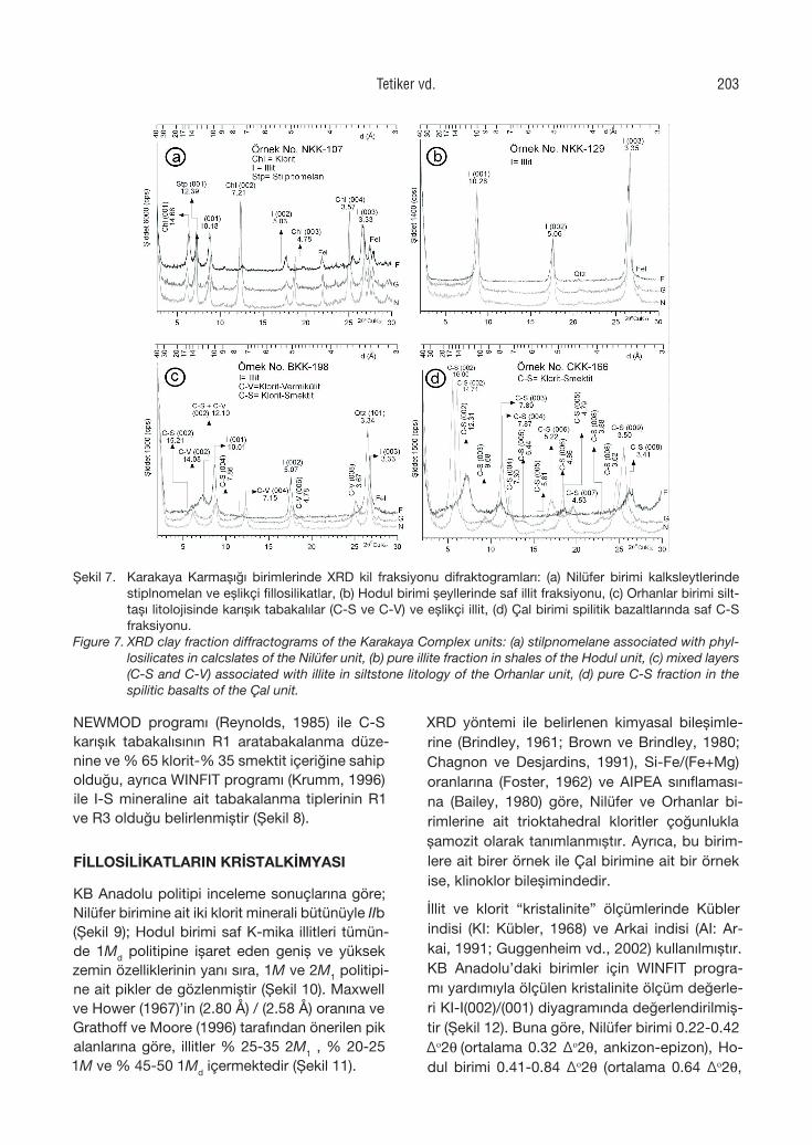
NEWMOD programı (Reynolds, 1985) ile C-S karışık tabakalısının R1 aratabakalanma düze-nine ve % 65 klorit-% 35 smektit içeriğine sahip olduğu, ayrıca WINFIT programı (Krumm, 1996) ile I-S mineraline ait tabakalanma tiplerinin R1 ve R3 olduğu belirlenmiştir (Şekil 8).
FİLLOSİLİKATLARIN KRİSTALKİMYASI
KB Anadolu politipi inceleme sonuçlarına göre; Nilüfer birimine ait iki klorit minerali bütünüyle IIb (Şekil 9); Hodul birimi saf K-mika illitleri tümün-de 1Md politipine işaret eden geniş ve yüksek zemin özelliklerinin yanı sıra, 1M ve 2M1 politipi-ne ait pikler de gözlenmiştir (Şekil 10). Maxwell ve Hower (1967)’in (2.80 Å) / (2.58 Å) oranına ve Grathoff ve Moore (1996) tarafından önerilen pik alanlarına göre, illitler % 25-35 2M1 , % 20-25 1M ve % 45-50 1Md içermektedir (Şekil 11).
XRD yöntemi ile belirlenen kimyasal bileşimle-rine (Brindley, 1961; Brown ve Brindley, 1980; Chagnon ve Desjardins, 1991), Si-Fe/(Fe+Mg) oranlarına (Foster, 1962) ve AIPEA sınıflaması-na (Bailey, 1980) göre, Nilüfer ve Orhanlar bi-rimlerine ait trioktahedral kloritler çoğunlukla şamozit olarak tanımlanmıştır. Ayrıca, bu birim-lere ait birer örnek ile Çal birimine ait bir örnek ise, klinoklor bileşimindedir.
İllit ve klorit “kristalinite” ölçümlerinde Kübler indisi (KI: Kübler, 1968) ve Arkai indisi (AI: Ar-kai, 1991; Guggenheim vd., 2002) kullanılmıştır. KB Anadolu’daki birimler için WINFIT progra-mı yardımıyla ölçülen kristalinite ölçüm değerle-ri KI-I(002)/(001) diyagramında değerlendirilmiş-tir (Şekil 12). Buna göre, Nilüfer birimi 0.22-0.42 Δo2q (ortalama 0.32 Δo2q, ankizon-epizon), Ho-dul birimi 0.41-0.84 Δo2q (ortalama 0.64 Δo2q,
Şekil 7. Karakaya Karmaşığı birimlerinde XRD kil fraksiyonu difraktogramları: (a) Nilüfer birimi kalksleytlerinde stiplnomelan ve eşlikçi fillosilikatlar, (b) Hodul birimi şeyllerinde saf illit fraksiyonu, (c) Orhanlar birimi silt-taşı litolojisinde karışık tabakalılar (C-S ve C-V) ve eşlikçi illit, (d) Çal birimi spilitik bazaltlarında saf C-S fraksiyonu.
Figure 7. XRD clay fraction diffractograms of the Karakaya Complex units: (a) stilpnomelane associated with phyl-losilicates in calcslates of the Nilüfer unit, (b) pure illite fraction in shales of the Hodul unit, (c) mixed layers (C-S and C-V) associated with illite in siltstone litology of the Orhanlar unit, (d) pure C-S fraction in the spilitic basalts of the Çal unit.
Tetiker vd. 203
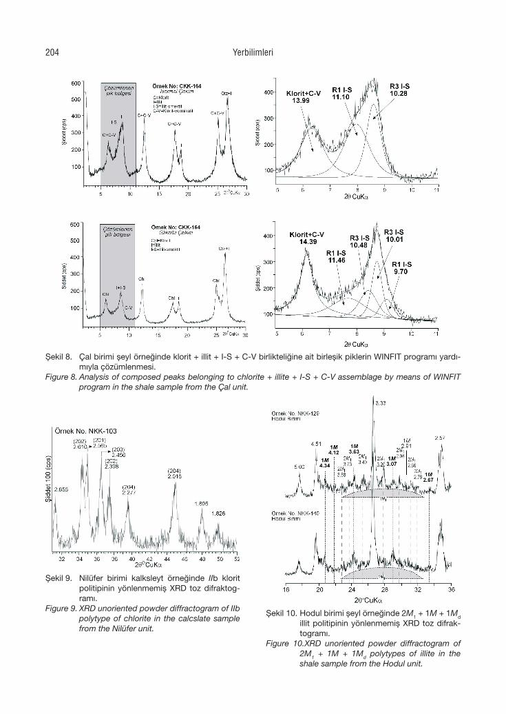
Şekil 8. Çal birimi şeyl örneğinde klorit + illit + I-S + C-V birlikteliğine ait birleşik piklerin WINFIT programı yardı-mıyla çözümlenmesi.
Figure 8. Analysis of composed peaks belonging to chlorite + illite + I-S + C-V assemblage by means of WINFIT program in the shale sample from the Çal unit.
Şekil 9. Nilüfer birimi kalksleyt örneğinde IIb klorit politipinin yönlenmemiş XRD toz difraktog-ramı.
Figure 9. XRD unoriented powder diffractogram of IIb polytype of chlorite in the calcslate sample from the Nilüfer unit.
Şekil 10. Hodul birimi şeyl örneğinde 2M1 + 1M + 1Md illit politipinin yönlenmemiş XRD toz difrak-togramı.
Figure 10.XRD unoriented powder diffractogram of 2M1 + 1M + 1Md polytypes of illite in the shale sample from the Hodul unit.
Yerbilimleri204
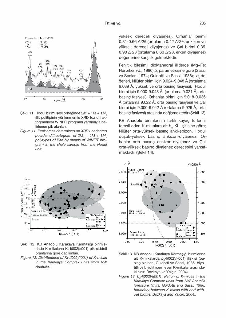
yüksek dereceli diyajenez), Orhanlar birimi 0.31-0.66 Δo2q (ortalama 0.42 Δo2q, ankizon ve yüksek dereceli diyajenez) ve Çal birimi 0.39-0.90 Δo2q (ortalama 0.60 Δo2q, erken diyajenez) değerlerine karşılık gelmektedir.
Fenjitik bileşimli dioktahedral illitlerde (Mg+Fe: Hunziker vd., 1986) b0 parametresine göre (Sassi ve Scolari, 1974; Guidotti ve Sassi, 1986); b0 de-ğerleri, Nilüfer birimi için 9.024-9.048 Å (ortalama 9.039 Å, yüksek ve orta basınç fasiyesi), Hodul birimi için 9.000-9.048 Å (ortalama 9.021 Å, orta basınç fasiyesi), Orhanlar birimi için 9.018-9.036 Å (ortalama 9.022 Å, orta basınç fasiyesi) ve Çal birimi için 9.000-9.042 Å (ortalama 9.029 Å, orta basınç fasiyesi) arasında değişmektedir (Şekil 13).
KB Anadolu birimlerinin farklı kayaç türlerini temsil eden K-mikalara ait b0-KI ilişkisine göre; Nilüfer orta-yüksek basınç anki-epizon, Hodul düşük-yüksek basınç ankizon-diyajenez, Or-hanlar orta basınç ankizon-diyajenez ve Çal orta-yüksek basınç diyajenez derecesini yansıt-maktadır (Şekil 14).
Şekil 11. Hodul birimi şeyl örneğinde 2M1+ 1M + 1Md illit politipinin yönlenmemiş XRD toz difrak-togramında WINFIT programı yardımıyla be-lirlenen pik alanları.
Figure 11. Peak areas determined on XRD unoriented powder diffractogram of 2M1 + 1M + 1Md polytypes of illite by means of WINFIT pro-gram in the shale sample from the Hodul unit.
Şekil 12. KB Anadolu Karakaya Karmaşığı birimle-rinde K-mikaların KI-I(002)/(001) pik şiddeti oranlarına göre dağılımları.
Figure 12. Distributions of KI-I(002)/(001) of K-micas in the Karakaya Complex units from NW Anatolia.
Şekil 13. KB Anadolu Karakaya Karmaşığı birimlerine ait K-mikalarda b0-I(002)/I(001) ilişkisi (ba-sınç sınırları: Guidotti ve Sassi, 1986; biyo-titli ve biyotit içermeyen K-mikalar arasında-ki sınır: Bozkaya ve Yalçın, 2004).
Figure 13. b0-I(002)/I(001) relation of K-micas in the Karakaya Complex units from NW Anatolia (pressure limits: Guidotti and Sassi, 1986; boundary between K-micas with and with-out biotite: Bozkaya and Yalçın, 2004).
Tetiker vd. 205
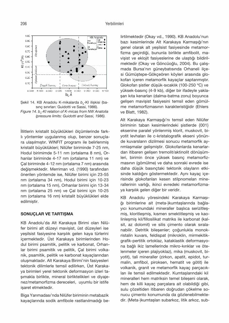
İllitlerin kristalit büyüklükleri ölçümlerinde fark-lı yöntemler uygulanmış olup, benzer sonuçla-ra ulaşılmıştır. WINFIT programı ile belirlenmiş kristalit büyüklükleri; Nilüfer biriminde 7-25 nm, Hodul birimimde 5-11 nm (ortalama 8 nm), Or-hanlar biriminde 4-17 nm (ortalama 11 nm) ve Çal biriminde 4-12 nm (ortalama 7 nm) arasında değişmektedir. Merriman vd. (1990) tarafından önerilen yöntemde ise, Nilüfer birimi için 23-55 nm (ortalama 34 nm), Hodul birimi için 10-23 nm (ortalama 15 nm), Orhanlar birimi için 13-34 nm (ortalama 25 nm) ve Çal birimi için 10-25 nm (ortalama 16 nm) kristalit büyüklükleri elde edilmiştir.
SONUÇLAR VE TARTIŞMA
KB Anadolu’da Alt Karakaya Birimi olan Nilü-fer birimi alt düzeyi mavişist, üst düzeyleri ise yeşilsist fasiyesine karşılık gelen kaya türlerini içermektedir. Üst Karakaya birimlerinden Ho-dul birimi psamitik, pelitik ve karbonat, Orhan-lar birimi psamitik ve pelitik, Çal birimi volka-nik, psamitik, pelitik ve karbonat kayaçlarından oluşmaktadır. Alt Karakaya Birimi’nin fasiyesleri tektonik dilimlerle temsil edilirken, Üst Karaka-ya birimleri yerel tektonik deformasyon izleri ta-şımakla birlikte, mineral birliktelikleri ve diyaje-nez/metamorfizma dereceleri, uyumlu bir istife işaret etmektedir.
Biga Yarımadası’nda Nilüfer biriminin metabazik kayaçlarında sodik amfibole rastlanılmadığı be-
lirtilmektedir (Okay vd., 1990). KB Anadolu’nun bazı kesimlerinde Alt Karakaya Karmaşığı’nın genel olarak alt yeşilsist fasiyesinde metamor-fizma geçirdiği, bununla birlikte amfibolit, ma-vişist ve eklojit fasiyeslerine de ulaştığı bildiril-mektedir (Okay ve Göncüoğlu, 2004). Bu çalış-mada Bursa’nın güneybatısında Orhaneli ilçe-si Gümüştepe-Gökçeören köyleri arasında glo-kofan içeren metamorfik kayaçlar saptanmıştır. Glokofan şistler düşük-sıcaklık (100-250 ºC) ve yüksek-basınç (4-9 kb), diğer bir ifadeyle yakla-şan kıta kenarları (dalma-batma zonu) boyunca gelişen mavişist fasiyesini temsil eden gömül-me metamorfizmasının karakteristiğidir (Ehlers ve Blatt, 1982).
Alt Karakaya Karmaşığı’nı temsil eden Nilüfer biriminin taban kesimlerindeki şistlerde {001} eksenine paralel yönlenmiş klorit, muskovit, bi-yotit levhaları ile c-kristalografik ekseni yönün-de kuvarsların dizilmesi sonucu metamorfik ay-rımlaşmalar gelişmiştir. Glokofanlarda kenarlar-dan itibaren gelişen tremolit/aktinolit dönüşüm-leri, birimin önce yüksek basınç metamorfiz-masının (gömülme) ve daha sonraki evrede ise daha düşük basınçtaki tektonik olayların etki-sinde kaldığını göstermektedir. Aynı kayaç içe-risinde glokofanları kesen stilpnomelan mine-rallerinin varlığı, ikinci evredeki metamorfizma-ya karşılık gelen diğer bir veridir.
KB Anadolu yöresindeki Karakaya Karmaşı-ğı birimlerine ait (meta-)kumtaşlarında bağla-yıcı konumundaki mineraller başlıca serizitleş-miş, kloritleşmiş, kısmen smektitleşmiş ve kao-linleşmiş kil/fillosilikat matriks ile karbonat (kal-sit, az dolomit) ve silis çimento olarak sırala-nabilir. Detritik bileşenler; çoğunlukla monok-ristalin kuvars, feldispat (mikroklin, mirmekitik-grafik-pertitik ortoklaz, kataklastik deformasyo-na bağlı ikiz lamellerinde mikro-kırıklar ve öte-lenmeler içeren plajiyoklaz), mika (muskovit, bi-yotit), tali mineraller (zirkon, apatit, epidot, tur-malin, amfibol, piroksen, hematit ve götit) ile volkanik, granit ve metamorfik kayaç parçacık-ları ile temsil edilmektedir. Kumtaşlarındaki kil mineralleri hem matriksin temel bileşeni olarak, hem de killi kayaç parçalara ait olabildiği gibi, sulu çözeltiden itibaren doğrudan çökelme so-nucu çimento konumunda da gözlenebilmekte-dir. (Meta-)kumtaşları subarkoz, litik arkoz, sub-
Şekil 14. KB Anadolu K-mikalarda b0-KI ilişkisi (ba-sınç sınırları: Guidotti ve Sassi, 1986).
Figure 14. b0-KI relation of K-micas from NW Anatolia (pressure limits: Guidotti and Sassi, 1986).
Yerbilimleri206
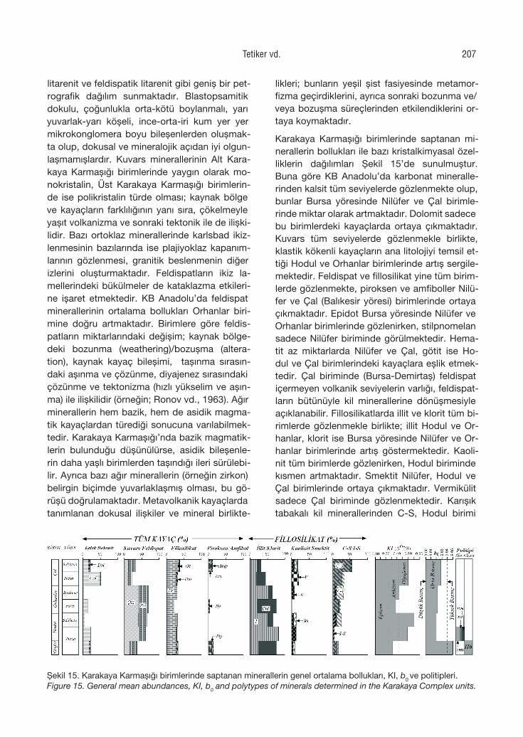
litarenit ve feldispatik litarenit gibi geniş bir pet-rografik dağılım sunmaktadır. Blastopsamitik dokulu, çoğunlukla orta-kötü boylanmalı, yarı yuvarlak-yarı köşeli, ince-orta-iri kum yer yer mikrokonglomera boyu bileşenlerden oluşmak-ta olup, dokusal ve mineralojik açıdan iyi olgun-laşmamışlardır. Kuvars minerallerinin Alt Kara-kaya Karmaşığı birimlerinde yaygın olarak mo-nokristalin, Üst Karakaya Karmaşığı birimlerin-de ise polikristalin türde olması; kaynak bölge ve kayaçların farklılığının yanı sıra, çökelmeyle yaşıt volkanizma ve sonraki tektonik ile de ilişki-lidir. Bazı ortoklaz minerallerinde karlsbad ikiz-lenmesinin bazılarında ise plajiyoklaz kapanım-larının gözlenmesi, granitik beslenmenin diğer izlerini oluşturmaktadır. Feldispatların ikiz la-mellerindeki bükülmeler de kataklazma etkileri-ne işaret etmektedir. KB Anadolu’da feldispat minerallerinin ortalama bollukları Orhanlar biri-mine doğru artmaktadır. Birimlere göre feldis-patların miktarlarındaki değişim; kaynak bölge-deki bozunma (weathering)/bozuşma (altera-tion), kaynak kayaç bileşimi, taşınma sırasın-daki aşınma ve çözünme, diyajenez sırasındaki çözünme ve tektonizma (hızlı yükselim ve aşın-ma) ile ilişkilidir (örneğin; Ronov vd., 1963). Ağır minerallerin hem bazik, hem de asidik magma-tik kayaçlardan türediği sonucuna varılabilmek-tedir. Karakaya Karmaşığı’nda bazik magmatik-lerin bulunduğu düşünülürse, asidik bileşenle-rin daha yaşlı birimlerden taşındığı ileri sürülebi-lir. Ayrıca bazı ağır minerallerin (örneğin zirkon) belirgin biçimde yuvarlaklaşmış olması, bu gö-rüşü doğrulamaktadır. Metavolkanik kayaçlarda tanımlanan dokusal ilişkiler ve mineral birlikte-
likleri; bunların yeşil şist fasiyesinde metamor-fizma geçirdiklerini, ayrıca sonraki bozunma ve/veya bozuşma süreçlerinden etkilendiklerini or-taya koymaktadır.
Karakaya Karmaşığı birimlerinde saptanan mi-nerallerin bollukları ile bazı kristalkimyasal özel-liklerin dağılımları Şekil 15’de sunulmuştur. Buna göre KB Anadolu’da karbonat mineralle-rinden kalsit tüm seviyelerde gözlenmekte olup, bunlar Bursa yöresinde Nilüfer ve Çal birimle-rinde miktar olarak artmaktadır. Dolomit sadece bu birimlerdeki kayaçlarda ortaya çıkmaktadır. Kuvars tüm seviyelerde gözlenmekle birlikte, klastik kökenli kayaçların ana litolojiyi temsil et-tiği Hodul ve Orhanlar birimlerinde artış sergile-mektedir. Feldispat ve fillosilikat yine tüm birim-lerde gözlenmekte, piroksen ve amfiboller Nilü-fer ve Çal (Balıkesir yöresi) birimlerinde ortaya çıkmaktadır. Epidot Bursa yöresinde Nilüfer ve Orhanlar birimlerinde gözlenirken, stilpnomelan sadece Nilüfer biriminde görülmektedir. Hema-tit az miktarlarda Nilüfer ve Çal, götit ise Ho-dul ve Çal birimlerindeki kayaçlara eşlik etmek-tedir. Çal biriminde (Bursa-Demirtaş) feldispat içermeyen volkanik seviyelerin varlığı, feldispat-ların bütünüyle kil minerallerine dönüşmesiyle açıklanabilir. Fillosilikatlarda illit ve klorit tüm bi-rimlerde gözlenmekle birlikte; illit Hodul ve Or-hanlar, klorit ise Bursa yöresinde Nilüfer ve Or-hanlar birimlerinde artış göstermektedir. Kaoli-nit tüm birimlerde gözlenirken, Hodul biriminde kısmen artmaktadır. Smektit Nilüfer, Hodul ve Çal birimlerinde ortaya çıkmaktadır. Vermikülit sadece Çal biriminde gözlenmektedir. Karışık tabakalı kil minerallerinden C-S, Hodul birimi
Şekil 15. Karakaya Karmaşığı birimlerinde saptanan minerallerin genel ortalama bollukları, KI, b0 ve politipleri.Figure 15. General mean abundances, KI, b0 and polytypes of minerals determined in the Karakaya Complex units.
Tetiker vd. 207
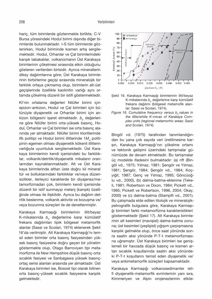
hariç, tüm birimlerde gözlenmekle birlikte, C-V Bursa yöresindeki Hodul birimi dışında diğer bi-rimlerde bulunmaktadır. I-S tüm birimlerde göz-lenirken, Hodul biriminde kısmen artış sergile-mektedir. Hodul, Orhanlar ve Çal birimlerindeki karışık tabakalılar, volkanizmanın Üst Karakaya birimlerinin çökelmesi sırasında etkin olduğunu gösteren verilerden birisidir. Ayrıca minerallerin dikey dağılımlarına göre; Üst Karakaya birimle-rinin birbirlerine geçişi sırasında mineralojik bir farklılık ortaya çıkmamış olup, birimlerin alt-üst geçişlerinde özellikle kaolinitin varlığı aynı or-tamda çökelmiş düzenli bir istifi göstermektedir.
KI’nin ortalama değerleri Nilüfer birimi için epizon-ankizon, Hodul ve Çal birimleri için bü-tünüyle diyajenetik ve Orhanlar birimi için an-kizon bölgesini işaret etmektedir. b0 değerleri-ne göre Nilüfer birimi orta-yüksek basınç, Ho-dul, Orhanlar ve Çal birimleri ise orta basınç ala-nında yer almaktadır. Nilüfer birimi kloritlerinde IIb politipi ve Hodul birimi illitlerinde 1Md politi-pinin egemen olması diyajenetik kökenli illitlerin varlığıyla uyumluluk sergilemektedir. Üst Kara-kaya birimlerinin kendi içerisindeki bu farklılık-lar, volkanik/detritik/diyajenetik mikaların oran-larından kaynaklanmaktadır. Alt ve Üst Kara-kaya birimlerinde alttan üste doğru kil mineral tür ve bolluklarındaki farklılıklar ve/veya düzen-sizlikler, ilerleyici karakterde bir diyajenez/me-tamorfizmadan çok, birimlerin kendi içerisinde düzenli bir istif sunmayıp melanj (karışık) özelli-ğinde olması ile ilişkilidir. Ayrıca bu dağılım det-ritik beslenme, volkanik aktivite ve bozuşma ve/veya bozunma süreçleri ile de denetlenmiştir.
Karakaya Karmaşığı birimlerinin illit/beyaz K-mikalarında b0 değerlerine karşı kümülatif frekans dağılımları tipik bölgesel metamorfik alanlar (Sassi ve Scolari, 1974) eklenerek Şekil 16’da verilmiştir. Alt Karakaya Karmaşığı’nı tem-sil eden birimler orta basınç fasiyesinden yük-sek basınç fasiyesine doğru geçen bir yönelim göstermekte olup, Otago Barroviyen tipi meta-morfizma ile New Hempshire düşük basınç-orta sıcaklık fasiyesi ve Sanbagawa yüksek basınç-ortaç serisi alanları arasında yer almaktadır. Üst Karakaya birimleri ise, Bosost tipi olarak bilinen orta basınç-yüksek sıcaklık fasiyesine karşılık gelmektedir.
Bingöl vd. (1975) tarafından tanımlandığın-dan bu yana çok sayıda veri üretilmesine kar-şın, Karakaya Karmaşığı’nın çökelme ortamı ve tektonik gelişimi üzerindeki tartışmalar gü-nümüzde de devam etmektedir. Bu tartışmalar üç modelde ifadesini bulmaktadır: (a) rift (Bin-göl vd., 1975; Yılmaz, 1981; Şengör ve Yılmaz, 1981; Şengör, 1984; Şengör vd., 1984; Koç-yiğit, 1987; Genç ve Yılmaz, 1995; Göncüoğ-lu vd., 2000), (b) dalma-batma-eklenme (Teke-li, 1981; Robertson ve Dixon, 1984; Pickett vd., 1995; Pickett ve Robertson, 1996, 2004; Okay, 2000) ve (c) dalma-batma (Stampfli vd., 2001). Bu çalışmada elde edilen litolojik ve mineralojik-petrografik bulgulara göre, Karakaya Karmaşı-ğı birimleri farklı metamorfizma karakteristikleri göstermektedir (Şekil 17). Alt Karakaya birimle-rinin alt kesimleri (mavişist) dalma-batma zonu-na; üst kesimleri (yeşilşist) yığışım çarpışmasına karşılık gelmekte olup, önce saat yönünde son-ra saatin aksi yönünde P-T-t metamorfizması-na uğramıştır. Üst Karakaya birimleri ise geniş-lemeli bir havzada düşük basınç ve kısmen ar-tan sıcaklık koşullarında saatin aksi yönünde-ki P-T-t koşullarını temsil eden diyajenetik ve/veya ankimetamorfik süreçleri kapsamaktadır.
Karakaya Karmaşığı volkanosedimanter isti-fi diyajenetik-metamorfik evrimlerinin yanı sıra, Kimmeriyen ve Alpin orojenezlerinin etkile-
Şekil 16. Karakaya Karmaşığı birimlerinin illit/beyaz K-mikalarında b0 değerlerine karşı kümülatif frekans dağılımı (bölgesel metamofik alan-lar: Sassi ve Scolari, 1974).
Figure 16. Cumulative frequency versus b0 values in the illite/white K-micas of Karakaya Com-plex units (regional metamorhic areas: Sassi and Scolari, 1974).
Yerbilimleri208
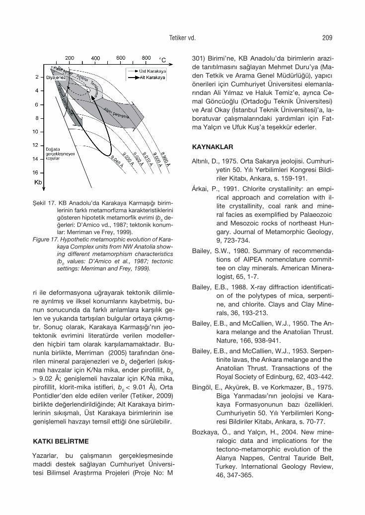
ri ile deformasyona uğrayarak tektonik dilimle-re ayrılmış ve ilksel konumlarını kaybetmiş, bu-nun sonucunda da farklı anlamlara karşılık ge-len ve yukarıda tartışılan bulgular ortaya çıkmış-tır. Sonuç olarak, Karakaya Karmaşığı’nın jeo-tektonik evrimini literatürde verilen modeller-den hiçbiri tam olarak karşılamamaktadır. Bu-nunla birlikte, Merriman (2005) tarafından öne-rilen mineral parajenezleri ve b0 değerleri (sıkış-malı havzalar için K/Na mika, ender pirofillit, b0
> 9.02 Å; genişlemeli havzalar için K/Na mika, pirofillit, klorit-mika istifleri, b0 < 9.01 Å), Orta Pontidler’den elde edilen veriler (Tetiker, 2009) birlikte değerlendirildiğinde; Alt Karakaya birim-lerinin sıkışmalı, Üst Karakaya birimlerinin ise genişlemeli havzayı temsil ettiği öne sürülebilir.
KATKI BELİRTME
Yazarlar, bu çalışmanın gerçekleşmesinde maddi destek sağlayan Cumhuriyet Üniversi-tesi Bilimsel Araştırma Projeleri (Proje No: M
301) Birimi’ne, KB Anadolu’da birimlerin arazi-de tanıtılmasını sağlayan Mehmet Duru’ya (Ma-den Tetkik ve Arama Genel Müdürlüğü), yapıcı önerileri için Cumhuriyet Üniversitesi elemanla-rından Ali Yılmaz ve Haluk Temiz’e, ayrıca Ce-mal Göncüoğlu (Ortadoğu Teknik Üniversitesi) ve Aral Okay (İstanbul Teknik Üniversitesi)’a, la-boratuvar çalışmalarındaki yardımları için Fat-ma Yalçın ve Ufuk Kuş’a teşekkür ederler.
KAYNAKLAR
Altınlı, D., 1975. Orta Sakarya jeolojisi. Cumhuri-yetin 50. Yılı Yerbilimleri Kongresi Bildi-riler Kitabı, Ankara, s. 159-191.
Árkai, P., 1991. Chlorite crystallinity: an empi-rical approach and correlation with il-lite crystallinity, coal rank and mine-ral facies as exemplified by Palaeozoic and Mesozoic rocks of northeast Hun-gary. Journal of Metamorphic Geology, 9, 723-734.
Bailey, S.W., 1980. Summary of recommenda-tions of AIPEA nomenclature commit-tee on clay minerals. American Minera-logist, 65, 1-7.
Bailey, E.B., 1988. X-ray diffraction identificati-on of the polytypes of mica, serpenti-ne, and chlorite. Clays and Clay Mine-rals, 36, 193-213.
Bailey, E.B., and McCallien, W.J., 1950. The An-kara melange and the Anatolian Thrust. Nature, 166, 938-941.
Bailey, E.B., and McCallien, W.J., 1953. Serpen-tinite lavas, the Ankara melange and the Anatolian Thrust. Transactions of the Royal Society of Edinburg, 62, 403-442.
Bingöl, E., Akyürek, B. ve Korkmazer, B., 1975. Biga Yarımadası’nın jeolojisi ve Kara-kaya Formasyonunun bazı özellikleri. Cumhuriyetin 50. Yılı Yerbilimleri Kong-resi Bildiriler Kitabı, Ankara, s. 70-77.
Bozkaya, Ö., and Yalçın, H., 2004. New mine-ralogic data and implications for the tectono-metamorphic evolution of the Alanya Nappes, Central Tauride Belt, Turkey. International Geology Review, 46, 347-365.
Şekil 17. KB Anadolu’da Karakaya Karmaşığı birim-lerinin farklı metamorfizma karakteristiklerini gösteren hipotetik metamorfik evrimi (b0 de-ğerleri: D’Amico vd., 1987; tektonik konum-lar: Merriman ve Frey, 1999).
Figure 17. Hypothetic metamorphic evolution of Kara-kaya Complex units from NW Anatolia show-ing different metamorphism characteristics (b0 values: D’Amico et al., 1987; tectonic settings: Merriman and Frey, 1999).
Tetiker vd. 209
Bozkaya, Ö. ve Yalçın, H., 2007. X-ışını difraktog-ramlarında kil minerallerinin karmaşık piklerinin çözümlenmesi: Türkiye’den örnekler. 13. Ulusal Kil Sempozyumu Bildiriler Kitabı, Isparta, s. 16-31.
Brindley, G.W., 1961. Chlorite minerals. In: The X-ray Identification and Crystal Structu-res of Clay Minerals. G. Brown (ed.), Mi-neralogical Society, London, pp. 242-296.
Brindley, G.W., 1980. Quantitative X-ray mineral analysis of clays. In: Crystal Structures of Clay Minerals and Their X-ray Iden-tification, G.W. Brindley, and G. Brown (eds.), Mineralogical Society, London, pp. 411-438.
Brown, G., and Brindley, G.W., 1980. X-ray diffraction procedures for clay mine-ral identification. In: Crystal Structures of Clay Minerals and Their X-ray Iden-tification. G.W. Brindley, and G. Brown (eds.), Mineralogical Society, London, pp. 305-360.
Chagnon, A., et Desjardins, M., 1991. Determi-nation de la composition de la chlori-te par difraction et möicroanalayse aux rayons X. Canadian Mineralogist, 29, 245-254.
D’Amico, C., Innocenti, C., e Sassi, F.P., 1987. Magmatismo e Metamorfismo. Unio-ne Tipografico Editrice Torinese, Tori-no, Italy.
Drits, V.A., Plançon, B., Sakharov, B.A., Besson, G., Tsipursky, S.I., and Tchoubar, C., 1984. Diffraction effects calculated for structural models of K-saturated mont-morillonite containing different types of defects. Clay Minerals, 19, 541-561.
Ehlers, E.G., and Blatt, H., 1982. Petrology: Ig-neous, Sedimentary and Metamorp-hic. W. H. Freeman and Company, San Francisco, USA.
Erol, O., 1956. Ankara güneydoğusundaki Elma Dağı ve çevresinin jeolojisi ve jeomorfo-lojisi üzerine bir araştırma. Maden Tet-kik Arama Dergisi, Seri D 9.
Eroskay, O., 1965. Paşalar Boğazı-Gölpazarı sahasının jeolojisi. İstanbul Üniversite-
si Fen Fakültesi Mecmuası, Seri B, 30, 133-170.
Foster, M.D., 1962. Interpretation of the compo-sition and a classification of the chlori-tes, U.S. Geological Survey Professio-nal Paper, 414-A, pp. 1-33.
Genç, Ş.C., and Yılmaz, Y., 1995. Evolution of the Triassic continental margin, Nort-hwest Anatolia. Tectonophysics, 243, 193-207.
Göncüoğlu, M.C., Dirik, K., and Kozlu, H., 1997. General chracteristics of pre-Alpine and Alpine Terranes in Turkey: Expla-natory notes to the terrane map of Tur-key. Annales Geologique de Pays Hel-lenique, 37, 515-536.
Göncüoğlu, M.C., Turhan, N., Şentürk, K., Öz-can, A., and Uysal, Ş., 2000. A geotra-vers across NW Turkey: tectonic units of the central Sakarya region and the-ir tectonic evolution. In: E. Bozkurt, J. Winchester, and J.A. Piper (eds.), Tec-tonics and Magmatism in Turkey and the Surrounding Area. Geological Soci-ety, London, Special Publications, 173, pp. 139-161.
Granit, Y., et Tintant, H., 1960. Observation pre-liminaires sur le Jurassic de la région de Bilecik (Turquie). C.R. Acar Science, 251, pp. 1801-1803.
Grathoff, G.H., and Moore, D.M., 1996. Illite polytype quantification using Wildfire© calculated X-ray diffraction patterns. Clays and Clay Minerals, 44, 835-842.
Guggenheim, S., Bain, D.C., Bergaya, F., Bri-gatty, M.F., Drits, A., Eberl, D.D., For-moso M.L.L., Galan, E., Merriman, R.J., Peacor, D.R., Stanjek, H., and Watana-be, T., 2002. Report of the AIPEA no-menclature committee for 2001: order, disorder and crystallinity in phyllosilica-tes and the use of the “Crystallinity In-dex”. Clay Minerals, 37, 389-393.
Guidotti, C.V., and Sassi, F.P., 1986. Classifica-tion and correlation of metamorphic fa-cies series by means of muscovite b
0 data from low-grade metapelites, Neues Jahrbuch für Mineralogie, 153, 363-380.
Yerbilimleri210
Hunziker, J.C., Frey, M., Clauer, N., Dallme-yer, R.D., Fredrichsen, H., Flehmig, W., Hochstrasser, K., Roggviler, P., and Schwander, H., 1986. The evoluti-on of illite to muscovite: Mineralogical and isotopic data from the Glarus Alps, Switzerland. Contributions to Minera-logy and Petrology, 92, 157-180.
Kisch, H.J., 1980. Illite crystallinity and coal rank associated with lowest-grade meta-morphism of the Taveyanne greywacke in the Helvetic zone of the Swiss Alps. Eclogae Geologicae Helvetiae, 73, 753-777.
Kisch, H.J., 1990. Calibration of the anchizone: a critical comparison of illite “crystalli-nity” scales used for definition. Journal of Metamorphic Geology, 8, 31-46.
Koçyiğit, A., 1987. Hasanoğlan (Ankara) yöresi-nin tektonostratigrafisi: Karakaya oro-jenik kuşağının evrimi. Yerbilimleri, 14, 269-293.
Krumm, S., 1996. WINFIT 1.2: version of No-vember 1996 (The Erlangen geological and mineralogical software collection) of WINFIT 1.0 : a public domain prog-ram for interactive profile-analysis un-der WINDOWS. XIII Conference on Clay Mineralogy and Petrology, Praha, 1994. Acta Universitatis Carolinae Geologica, 38, pp. 253-261.
Krushensky, R., Akçay, Y., and Karaege, E., 1980. Geology of the Karalar-Yeşiller area, Northwest Anatolia, Turkey. Geo-logical Survey, 1461, 1-72.
Kübler, B., 1968. Evaluation quantitative du métamorphisme par la cristallinité de l’illite. Bulletin-Centre de Recherches Pau-SNPA, 2, 385-397.
Maxwell, D.T., and Hower, J., 1967. High-grade diagenesis and low-grade metamorp-hism of illite in the Precambrian Belt Se-ries. American Mineralogist, 52, 843-857.
Merriman, R.J., 2005. Clay minerals and sedi-mentary basin history. European Jour-nal of Mineralogy, 17, 7-20.
Merriman, R.J., and Frey, M., 1999. Patterns of very low-grade metamorphism in meta-
pelitic rocks. In: M. Frey, and D. Robin-son (eds.), Low-Grade Metamorphism, Blackwell Science, pp. 61-107.
Merriman, R.J., Roberts, B., and Peacor, D.R., 1990. A transmission electron micros-copy study of white mica crystallite size distribution in a mudstone to slate tran-sitional sequence, North Wales, UK. Contributions to Mineralogy and Petro-logy, 106, 27-44.
Moore, D.M., and Reynolds, R.C., 1997. X-ray Diffraction and the Identification and Analysis of Clay Minerals. Oxford Uni-versity Press, New York.
MTA, 2002. 1:500 000 ölçekli Türkiye jeoloji ha-ritaları, İstanbul paftası. MTA Genel Mü-dürlüğü, Ankara.
Okay, A.İ., 2000. Was the Late Triassic orogeny in Turkey caused by the collision of an oceanic plateau. E. Bozkurt, J.A. Winc-hester, and J.D.A. Piper (eds.), Tecto-nics and Magmatism in Turkey and the Surrounding Area, Geological Society, London, Special Publications, 173, pp. 25-41.
Okay, A.İ., and Göncüoğlu, M.C., 2004. The Ka-rakaya Complex: A review of data and concepts. Turkish Journal of Earth Sci-ences, 13, 77-95.
Okay, A.İ., Siyako, M. ve Bürkan, K.A., 1990. Biga Yarımadası’nın jeolojisi ve tektonik evrimi. Türkiye Petrol Jeologları Derne-ği Bülteni, 2, 83-121.
Pickett, E.A., and Robertson, A.H.F., 1996. For-mation of the Late Palaeozoic-Early Mesozoic Karakaya Complex and rela-ted ophiolites in NW Turkey by palae-otethyan subduction-accretion. Journal of the Geological Society London, 153, 995-1009.
Pickett, E.A., and Robertson, A.H.F., 2004. Sig-nificance of the Triassic volcanogenic Nilüfer Unit for Paleotethys and the Ka-rakaya suture zone in NW Turkey. Tur-kish Journal of Earth Sciences, 13, 97-143.
Pickett, E.A., Robertson, A.H.F., and Dixon, J.E., 1995. The Karakaya Complex, NW
Tetiker vd. 211
Turkey: A Palaeo-Tethyan accretionary complex. In: A. Erler, T. Ercan, E. Bin-göl, and S. Örçen (eds.), Geology of the Black Sea Region, Mineral Research and Exploration, Ankara, Special Pub-lication, pp. 11-18.
Reynolds, R.C.Jr., 1985. NEWMOD A Com-puter Program for the calculation of one-dimensional diffraction patterns of mixed-layered clays. 8 Brook Rd. Ha-nover, N.H.
Robertson, A.H.F., and Dixon, J.E., 1984. Intro-duction: aspects of the geological evo-lution of the Eastern Mediterranean. In: J.E. Dixon, and A.H.F. Robertson (eds.), The Geological evolution of the Eastern Mediterranean, Geological Society of London, Special Publications, 17, pp. 1-74.
Ronov, A.B., Mikhailovskaya, M.S., and Solod-kova, I.I., 1963. Evolution of the che-mical and mineralogical composition of arenaceous rocks. In: Chemistry of the Earth’s Crust, Academy of Sciences of the U.S.S.R., The Israel Program for Scientific Translation, 1, pp. 212-262.
Saner, S., 1978. The depositional associati-ons of upper Cretaceous-Palaecene-Eocene times in central Sakarya and petroleum exploration possibilities. Proceedings of 4th Petroleum Cong-ress of Turkey, Ankara, pp. 95-115.
Sassi, F.P., and Scolari, A., 1974. The b0 value of the potassic white micas as a ba-rometric indicator in low-grade meta-morphism of pelitic schists. Contribu-tions to Mineralogy and Petrology, 45, 143-152.
Stampfli, G.M., Mosar, J., Faure, P., Pillevu-it, A., and Vannay, J.-C., 2001. Permo-Mesozoic evolution of the Western tethys realm: The Neotethys East Medi-terranean basin connection. In: P. Zieg-ler, W. Cavazza, A.H.F. Robertson, and A. Crasquin-Soleau (eds.), Peri-tethyan rift/wrench basins and passive mar-gins, Peri-Tethys Memoir 5. Mémoires du Musée National d’Histoire Naturelle, pp. 51-108.
Şengör, A.M.C., 1984. The Cimmeride Orogenic System and the Tectonics of Eurasia. Geological Society of America, Speci-al Paper, 195, Washington.
Şengör, A.M.C., and Yılmaz, Y., 1981. Tethyan evolution of Turkey, a plate tectonic approach. Tectonophysics, 75, 181-241.
Şengör, A.M.C., Yılmaz, Y., and Sungurlu, O., 1984. Tectonics of the Mediterrane-an Cimmerides: nature and evolution of the western termination of Paleo-Tethys. In: J.E. Dixon, and A.H.F. Ro-bertson (eds.), The Geological Evoluti-on of the Eastern Mediterranean, Geo-logical Society, London, Special Publi-cations, 17, pp. 77-112.
Tekeli, O., 1981. Subduction complex of pre-Jurassic age, Northern Anatolia, Turkey. Geology, 9, 68-72.
Tetiker, S., 2009. Batı-Orta Pontidler’deki (Balı-kesir, Bursa ve Tokat yöreleri) Karaka-ya Karmaşığı birimlerinin mineralojik-petrografik ve jeokimyasal incelenme-si. Doktora Tezi, Cumhuriyet Üniversi-tesi Fen Bilimleri Enstitüsü, Sivas (ya-yımlanmamış).
Warr, L.N., and Rice, A.H.N., 1994. Interlabora-tory standartization and calibration of clay mineral crystallinity and crystallite size data. Journal of Metamorphic Ge-ology, 12, 141-152.
Yalçın, H. ve Bozkaya, Ö., 2002. Hekimhan (Ma-latya) çevresindeki Üst Kretase yaş-lı volkaniklerin alterasyon mineralojisi ve jeokimyası: Denizsuyu-kayaç etkile-şimine bir örnek. Cumhuriyet Üniversi-tesi Mühendislik Fakültesi Dergisi Seri A-Yerbilimleri, 19, 81-98.
Yılmaz, A., 1981. Tokat ile Sivas arasındaki böl-gede bazı volkanitlerin petrokimyasal özellikleri. Türkiye Jeoloji Kurultayı Bül-teni, 24, 51-58.
Yerbilimleri212
Yerbilimleri, 30 (3), 213–233Hacettepe Üniversitesi Yerbilimleri Uygulama ve Araştırma Merkezi DergisiJournal of the Earth Sciences Application and Research Centre of Hacettepe University
Akveren Formasyonu’nun Kampaniyen-Maastrihtiyen planktonik foraminifer biyostratigrafisi (Bartın, Batı Karadeniz)
Campanian-Maastrichtian planktonic foraminifera biostratigraphy of the Akveren Formation (Bartın, Western Black Sea)
Caner KAYA ÖZER1, VediaTOKER2
1Bozok Üniversitesi Mühendislik-Mimarlık Fakültesi Jeoloji Mühendisliği Bölümü, Divanlı Yolu, YOZGAT2Adıyaman Üniversitesi, Fen Bilimleri Enstitüsü, ADIYAMAN
Geliş (received) : 07 Nisan (April) 2009 Kabul (accepted) : 25 Eylül (September) 2009
ÖZBu incelemede, Bartın ili KD’sunda Kirlik, Karainler, Doğaşı ve Yeşil Kambur civarında yüzeyleyen ve çalışma ala-nında geniş yayılım gösteren Akveren Formasyonu’nun Kampaniyen-Maastrihtiyen planktonik foraminifer biyostra-tigrafisi çalışılmıştır. Akveren Formasyonu’nda dört adet stratigrafik kesit ölçülmüş, 83 tortul kayaç örneğinin kap-sadığı 14 planktonik foraminifer cins ve 44 türü tanımlanmış olup, 7 planktonik foraminifera biyozonu saptanmış-tır. Alt Kampaniyen’de Globotruncanita elevata, Globotruncana ventricosa, Üst Kampaniyen’de Radotruncana cal-carata, Globotruncanella havanensis, Globotruncana aegyptiaca, Üst Kampaniyen’in üstü-Üst Maastrihtiyen’in alt seviyelerinde Gansserina gansseri ile Üst Maastrihtiyen’de Abathomphalus mayaroensis biyozonları tanımlanmıştır.
Anahtar Kelimeler: Akveren Formasyonu, Bartın, Kampaniyen, Maastrihtiyen, planktonik foraminifer.
ABSTRACT
In this research, the Campanian-Maastrichtian planktonic foraminifera biostratigraphy of the Akveren Formation, which is exposed over large areas in the Kirlik, Karainler, Doğaşı and Yeşil Kambur areas WE of Bartın, was stud-ied. Four stratigraphy sections in the Akveren Formation were measured. 14 planktonic foraminifera genera and 44 planktonic foraminifera species of 83 sedimentary samples were described and 7 planktonic biozones were determined. In the Lower Campanian Globotruncanita elevata, Globotruncana ventricosa was found, in the Upper Campanian Radotruncana calcarata, Globotruncanella havanensis and Globotruncana aegyptiaca were identified, and in the Uppermost Campanian-Lower Upper Maastrichian Gansserina gansseri within the Upper Maastrichtian Abathomphalus mayaroensis biozones were determined.
Keywords: Akveren Formation, Bartın, Campanian, Maastrichtian, planktonic foraminifer.
C. Kaya ÖzerE-posta: [email protected]
GİRİŞ
İnceleme alanı, Batı Karadeniz bölgesinde 1:25000 ölçekli Zonguldak E28-c2 paftasında, Bartın ili kuzeydoğusunda Kirlik, Karainler, Do-ğaşı ve Yeşil Kambur mevkilerinde yer almak-tadır (Şekil 1). Bölgede jeoloji, tektonik ve pet-rol potansiyelini belirlemek amacıyla yapılmış çalışmalar bulunmaktadır (Blumenthal, 1940; Badgley, 1959; Ketin ve Gümüş,1963; Akyol vd., 1974; Ergun, 1980; Saner, 1980; Gedik vd., 1983; Barka vd., 1983; Gedik ve Korkmaz, 1984; Aydın vd., 1986; Baş, 1986; Özçelik ve Çaptuğ, 1990; Akman, 1992; Tüysüz, 1993; Tu-noğlu, 1991,1994; Derman vd., 1995; Derman, 1996; Sunal ve Tüysüz, 2001; Bragin vd., 2001; Tüysüz, 2002; Derman, 2002; Tüysüz vd., 2004; Tunoğlu ve Ertekin, 2005). Yöre ve civarında ya-pılan paleontolojik çalışmalar ise sınırlı sayıda-dır (Dizer ve Meriç, 1981; Dobrucalı, 1985; Me-riç ve Şengüler, 1986; Sirel, 1991; Sarıca, 1993; Kırcı, 1998; Özkan-Altıner ve Özcan, 1999; Ay-dın, 2005; Güray, 2006; Şener, 2007).
Daha önceki çalışmalarda Akveren Formasyonu’nun yaşı Kampaniyen-Paleosen (Akman, 1992), Maastrihtiyen (Ketin ve Gümüş, 1963), Maastrihtiyen-Paleosen (Gedik ve Kork-maz, 1984) olarak belirtilmiştir. Bölgede geniş yayılım gösteren Akveren Formasyonu’nun yaşı Kaya-Özer (2009) tarafından ayrıntılı planktonik foraminifer ve nannoplankton biyostratigrafisi ile Kampaniyen-Selandiyen olarak belirlenmiş-tir. Bu çalışmada ise Akveren Formasyonu’nun Kampaniyen-Maastrihtiyen planktonik foramini-fer biyostratigrafisinin ayrıntılı olarak saptanma-sı amaçlanmıştır.
MALZEME VE YÖNTEM
Bartın ili yakın çevresinde Kazpınar ve Akve-ren Formasyon’larında yapılan incelemede dört adet stratigrafi kesiti ölçülmüş ve toplanan 83 örnek çalışma malzemesini oluşturmuştur. Ça-lışmanın amacına uygun olarak planktonik fora-minifer örnekleri, kireçtaşı gibi sert kayaçlardan ince kesit hazırlanarak, marn, kiltaşı gibi yumu-şak kayaçlarda ise yıkama yöntemiyle hazırlan-mıştır. 100 g marn veya kiltaşı örnekleri, %10 peroksitli derişik suyla ıslatılmış, bir gece bek-letildikten ve çözüldükten sonra 0.062-0.075-
0.125-0.250 meş aralığındaki elekler yardımıy-la yıkanmıştır. Her elekteki örnek numaralandı-rılmış beherlere konmuş ve oda sıcaklığında ku-rutulmuştur. Kuruyan örneklerdeki tane haldeki planktonik fosiller, binoküler mikroskop altında ve ince uçlu bir fırça yardımıyla ayıklanarak nu-maralandırılmış ve toplama slaytlarına konmuş-tur.
Planktonik foraminifer bollukları 100 g kuru ör-nekten elde edilen tane haldeki fosiller için, aynı türden %31-50 tür çok bol (A:Abundant), %11-30 tür bol (C:common), %6-10 tür birkaç (F:few) ve %1-5 tür nadir (R:rare) olarak değer-lendirilmiştir (Premoli-Silva vd., 2005). Plank-tonik foraminifer türlerinin görüntüleri taramalı elektron mikroskobunda (SEM) Türkiye Petrol-leri Anonim Ortaklığı (TPAO)’nda çekilmiştir.
BÖLGESEL JEOLOJİ
Bölgede, daha yaşlı birimler üzerine uyumsuz olarak Yemişliçay Üst Grubuna ait Kurucaşi-le ve Amasra grubu kayaçları gelir (Tüysüz vd., 2004). Volkanik etkinliğin de katıldığı karbonat-lı veya ince taneli kırıntılılardan meydana ge-len Kurucaşile grubu, Senomaniyen yaşlı (Yer-gök vd., 1987) Kalabaklar Formasyonu (Siyako vd.,1980) ile başlar. Fliş fasiyesinde kumtaşı-şeyl ardalanmasından oluşan birim üzerine vol-kanitler, volkanoklastik kumtaşı, mikroçakılta-şı, kiltaşı ve silttaşı ardalanması ile yer yer pe-lajik mikritik kireçtaşı, karbonatlı çamurtaşı, tüf ve aglomera arakatkıları içeren Turoniyen yaş-lı (Yergök vd., 1987; Tüysüz vd., 1997) Göl-dere Formasyonu (Akman, 1992) gelir. Bölge-de Göldere Formasyonu üzerine uyumlu ola-rak gelen Meydan Formasyonu (Akman, 1992) ise kumtaşı ve silttaşı ara seviyeli marn-kiltaşı ardalanımlı olup Koniasiyen-Geç Santoniyen (Tüysüz vd., 2004) yaşlıdır. Amasra grubu ka-yaçlar, alttaki birimler üzerine trangresif ola-rak gelen yeni bir çökel istifle başlar (Tüysüz vd., 2004). Geç Santoniyen-Kampaniyen döne-mini kapsayan bu zamanda pelajik kireçtaşla-rı, sonrasında ise volkanik ve piroklastikler ge-lişmiştir. Amasra grubu, sığ denizel kırıntılı bi-rim olan Geç Santoniyen yaşlı (Akman, 1992; Tüysüz vd., 1997) Kökyol Formasyonu (Şahin-türk ve Özçelik, 1983) veya bazen de yanal ge-
Yerbilimleri214
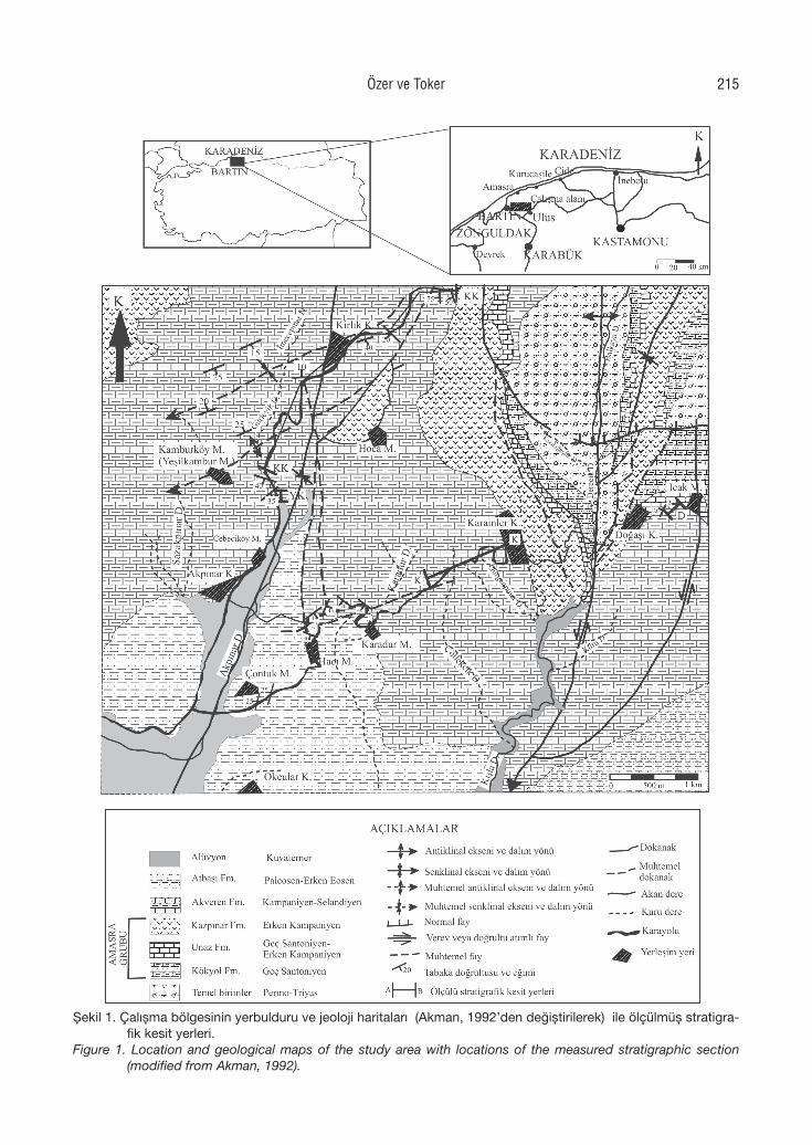
Şekil 1. Çalışma bölgesinin yerbulduru ve jeoloji haritaları (Akman, 1992’den değiştirilerek) ile ölçülmüş stratigra-fik kesit yerleri.
Figure 1. Location and geological maps of the study area with locations of the measured stratigraphic section (modified from Akman, 1992).
Özer ve Toker 215
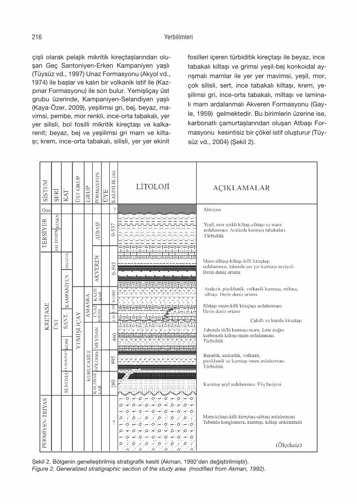
çişli olarak pelajik mikritik kireçtaşlarından olu-şan Geç Santoniyen-Erken Kampaniyen yaşlı (Tüysüz vd., 1997) Unaz Formasyonu (Akyol vd., 1974) ile başlar ve kalın bir volkanik istif ile (Kaz-pınar Formasyonu) ile son bulur. Yemişliçay üst grubu üzerinde, Kampaniyen-Selandiyen yaşlı (Kaya-Özer, 2009), yeşilimsi gri, bej, beyaz, ma-vimsi, pembe, mor renkli, ince-orta tabakalı, yer yer silisli, bol fosilli mikritik kireçtaşı ve kalka-renit; beyaz, bej ve yeşilimsi gri marn ve kilta-şı; krem, ince-orta tabakalı, silisli, yer yer ekinit
fosilleri içeren türbiditik kireçtaşı ile beyaz, ince tabakalı kiltaşı ve grimsi yeşil-bej konkoidal ay-rışmalı marnlar ile yer yer mavimsi, yeşil, mor, çok silisli, sert, ince tabakalı kiltaşı, krem, ye-şilimsi gri, ince-orta tabakalı, miltaşı ve lamina-lı marn ardalanmalı Akveren Formasyonu (Gay-le, 1959) gelmektedir. Bu birimlerin üzerine ise, karbonatlı çamurtaşlarından oluşan Atbaşı For-masyonu kesintisiz bir çökel istif oluşturur (Tüy-süz vd., 2004) (Şekil 2).
Şekil 2. Bölgenin genelleştirilmiş stratigrafik kesiti (Akman, 1992’den değiştirilmiştir).Figure 2. Generalized stratigraphic section of the study area (modified from Akman, 1992).
Yerbilimleri216
ÖLÇÜLÜ STRATİGRAFİ KESİTLERİ
Çalışma alanının planktonik foraminifer biyostratig-rafisini saptamak amacıyla Doğaşı, Kirlik, Karain-ler ve Yeşilkambur stratigrafi kesitleri ölçülmüştür.
Doğaşı Ölçülü Stratigrafi Kesiti
Doğaşı ölçülü stratigrafi kesiti Doğaşı köyünde, Akveren Formasyonu’nda ölçülmüştür. Başlan-gıç koordinatları X: 13.200; Y: 54.620; Z:290 m ve bitiş koordinatları X: 13.120; Y:54.570; Z:280 m olan kesit KD-GB yönünde alınmıştır. Alt se-viyelerde kumtaşı, kiltaşı, marn ardalanmalı bi-rim, üstte kiltaşı, marn ve killi kireçtaşı ardalan-malı olarak devam eder. Doğaşı ölçülü stratigra-fi kesitinin kalınlığı 33 m olarak ölçülmüş ve 12 örnek alınmıştır (Şekil 3). Alınan bu örneklerde 7 planktonik foraminifer cinsi ve 13 planktonik fo-raminifer türü belirlenmiş (Levha 1, Levha 2), Glo-botruncanita elevata ve Globotruncana ventrico-sa planktonik foraminifer zonları tanımlanmıştır (Çizelge 1). Litolojik veriler ve fosil içeriği, birimin derin deniz ortamında çökeldiğini göstermektedir.
Kirlik Ölçülü Stratigrafi Kesiti
Kirlik ölçülü stratigrafi kesitinin başlangıç koor-dinatları X: 15.349; Y: 52.145; Z:380 m ve bitiş koordinatları X: 14.975; Y:51.566; Z:330 m olup, Kazpınar ve Akveren Formasyon’larında KD-GB yönünde alınmıştır. Ölçülü kesit tabanda Kaz-pınar Formasyonu’na ait siyah, mor, ince kum-taşı ara seviyeli silttaşı, miltaşı ile grimsi-yeşil renkli volkanik kökenli üstte doğru konvulüt ve ince laminalı ince taneli kumtaşı ve miltaşı biri-minden oluşmaktadır. Üzerine ise uyumlu ola-rak Akveren Formasyonu gelir. Tabanda krem marn birimiyle başlayan formasyon üstte doğ-ru mor, yeşil mavi, krem, sarı laminalı marn, mil-taşı, yer yer silisli sert marn ve kiltaşı ile kireçta-şı ardalanmalı olarak devam eder. En üstte ye-şil, mor konkoidal ayrışmalı kireçtaşı ara seviye-li marn, kiltaşı ve miltaşı litolojisi ile derin deniz ortamında çökelmeyi göstermektedir. Kirlik ke-sitinin kalınlığı 390 m olarak ölçülmüş (bkz. Şekil 3) ve alınan 32 örnekte 13 planktonik foraminifer cinsi ile 26 türü belirlenmiş (Levha 1, Levha 2), Globotruncanita elevata, Globotruncana ventri-cosa, Radotruncana calcarata ve Globotrunca-
nella havanensis planktonik foraminifer zonları saptanmıştır (Çizelge 2).
Yeşil Kambur Ölçülü Stratigrafi Kesiti
Yeşil Kambur ölçülü stratigrafi kesiti X: 13.231; Y:50.311; Z: 330 m koordinatlarında başlar ve KB-GD yönünde alınan kesit X:13.168; Y:50. 324; Z:320 m koordinatlarında son bulur. Yeşil Kam-bur ölçülü stratigrafi kesiti yeşil ve mor, lamina-lı marnla ardalanmalı, ince tabakalı bej, türbidi-tik kireçtaşı litolojisi ile temsil edilmektedir. Ak-veren Formasyonu’nda ölçülen kesit 23 m kalın-lıkta olup, 10 örnek alınmıştır (bkz. Şekil 3). Bu örneklerde 11 planktonik foraminifer cinsi ve 26 türü belirlenmiş (Levha 1, Levha 2), Globotrunca-na aegyptiaca ve Gansserina gansseri planktonik foraminifer zonları tanımlanmıştır (Çizelge 3).
Karainler Ölçülü Stratigrafi Kesiti
Karainler ölçülü stratigrafi kesitinin başlangıç koordinatları X: 12. 700; Y: 52. 910; Z: 170 m ve bitiş koordinatları X: 11. 910; Y: 51. 385; Z: 220 m’dir. GGB yönünde alınan kesit, Akveren Formasyonu’nda ölçülmüştür. Mor ve yeşil, la-minalı, konkoidal ayrışmalı marn ve kiltaşı ar-dalanması ile başlayan istif üstte doğru krem, ince-orta tabakalı, türbiditik kireçtaşı araseviye-li mor ve yeşil marna geçiş gösterir. Daha üst-te kirli beyaz, gri, ince-orta tabakalı killi kireçtaşı ile gri, krem marn ardalanmasından oluşur. Üst-te pembe ve krem, ince-orta tabakalı killi kireç-taşı ve gri konkoidal ayrışmalı, laminalı marn ve en üstte beyaz ve bej, yer yer silisli, ince-orta tabakalı kireçtaşı, kiltaşı ve marn ardalanması ile son bulan Karainler stratigrafik kesiti 260 m kalınlıkta olup, 29 örnek derlenmiştir (bkz. Şe-kil 3). Bu örneklerden 14 planktonik foraminifer cinsi ve 37 türü (Levha 1, Levha 2) ile Radotrun-cana calcarata, Globotruncanella havanensis, Globotruncana aegyptiaca, Gansserina gans-seri ve Abathomphalus mayaroensis planktonik foraminifer zonları belirlenmiştir (Çizelge 4).
PLANKTONİK FORAMİNİFER BİYOSTRATİGRAFİSİ
Bartın bölgesinde tanımlanan planktonik fora-miniferle Kampaniyen-Maastrihtiyen zaman ara-lığında 7 planktonik foraminifer biyozonu sap-
Özer ve Toker 217
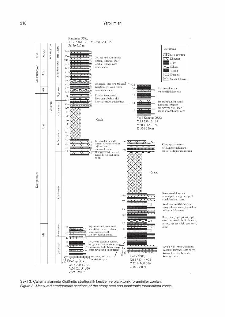
Şekil 3. Çalışma alanında ölçülmüş stratigrafik kesitler ve planktonik foraminifer zonları.Figure 3. Measured stratigraphic sections of the study area and planktonic foraminifera zones.
Yerbilimleri218
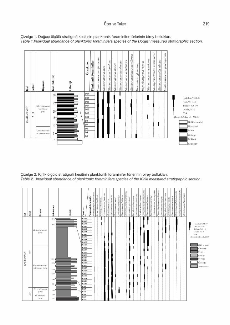
Çizelge 1. Doğaş ölçülü stratigrafi kesitinin planktonik foraminifer türlerinin birey bolluklar.
Table 1.Individual abundance of planktonic foraminifera species of the Dogasi measured stratigraphic section.
Kat
Ask
at
Biyo
zon
Kalın
lık (m
)
Örn
ek n
o.Pl
ankt
onik
fora
min
ifer
Con
tuso
trun
cana
forn
icat
a
Glo
botr
unca
na a
rca
Glo
botr
unca
na li
nnei
ana
Glo
botr
unca
na m
arie
i
Glo
botr
unca
nita
ele
vata
Glo
botr
unca
na b
ullo
ides
Glo
botr
unca
nita
stua
rtifo
rmis
Het
eroh
elix
glo
bulo
sa
Rugo
glob
iger
ina
rugo
sa
Glo
botr
unca
na v
entr
icos
a
Glo
bige
rine
lloid
es u
ltram
icru
s
Glo
botr
unca
nella
min
uta
Con
tuso
trun
cana
pat
ellif
orm
is
D19
D17 Çok bol, %31-50D15 Bol, %11-30D14 Birkaç, % 6-10D13 Nadir, %1-5D12 YokD11 (Premoli-Silva vd., 2005)D9D7D6D4D3
Lito
loji
Globotruncanita elevata zonu
KA
MPA
NİY
EN
ALT
Globotruncana ventricosa
zonu
0
5
10
15
20
25
30
Kumtaþý
Killi kireçtaþý
Kireçtaþý
Marn
Kiltaþý
Miltaþý
Çizelge 2. Kirlik ölçülü stratigrafi kesitinin planktonik foraminifer türlerinin birey bolluklar.
Table 2.Individual abundance of planktonic foraminifera species of the Kirlik measured stratigraphic section.
Kat
Ask
at
Biyo
zon
Kalın
lık (m
)
Örn
ek n
o.
Plan
kton
ik fo
ram
inife
rAr
chae
glob
iger
ina
cret
acea
Arch
aegl
obig
erin
a bl
owi
Pseu
dogu
embe
lina
sp.
Con
tuso
trun
cana
forn
icat
a
Glo
botr
unca
na a
rca
Glo
botr
unca
na li
nnei
ana
Glo
botr
unca
na m
arie
i
Glo
botr
unca
nita
ele
vata
Glo
botr
unca
na b
ullo
ides
Glo
botr
unca
nita
stua
rtifo
rmis
Het
eroh
elix
glo
bulo
sa
Rugo
glob
iger
ina
rugo
sa
Glo
botr
unca
na v
entr
icos
a
Pseu
dote
xtul
aria
ele
gans
Glo
bige
rine
lloid
es u
ltram
icru
s
Glo
botr
unca
nella
min
uta
Rado
trun
cana
cal
cara
ta
Con
tuso
trun
cana
pat
ellif
orm
is
Plan
oglo
bulin
a ac
ervu
linoi
des
Glo
botr
unca
na in
sign
is
Rugo
glob
iger
ina
rotu
ndat
a
Glo
botr
unca
na ro
zetta
Glo
botr
unca
nita
stua
rti
Glo
botr
unca
nella
hav
anen
sis
Plan
oglo
bulin
a m
ultic
amer
ata
Glo
botr
unca
na fa
lsos
tuar
ti
KK46KK45KK44 Çok bol, %31-50KK43 Bol, %11-30KK42 Birkaç, % 6-10KK41 Nadir, %1-5KK40 YokKK39 (Premoli-Silva vd., 2005)KK38KK37KK36KK35KK34KK32KK30KK29KK28KK27KK26KK25KK24KK23KK22KK21KK20KK13KK8KK7KK6KK4KK3KK2
KA
MPA
NİY
EN
ALT
ÜST
Lito
loji
G. elevata zonu
G. ventricosa zonu
Radotruncana calcarata zonu
G. havanensis zonu
10
50
30
80
100
130
150
180
200
360
390
Volkanik kayaç
Kumtaþý
Killi kireçtaþý
Kireçtaþý
Marn
Kiltaþý
Miltaþý
Çizelge 1. Doğaşı ölçülü stratigrafi kesitinin planktonik foraminifer türlerinin birey bollukları.Table 1.Individual abundance of planktonic foraminifera species of the Dogasi measured stratigraphic section.
Çizelge 2. Kirlik ölçülü stratigrafi kesitinin planktonik foraminifer türlerinin birey bollukları.Table 2. Individual abundance of planktonic foraminifera species of the Kirlik measured stratigraphic section.
Özer ve Toker 219
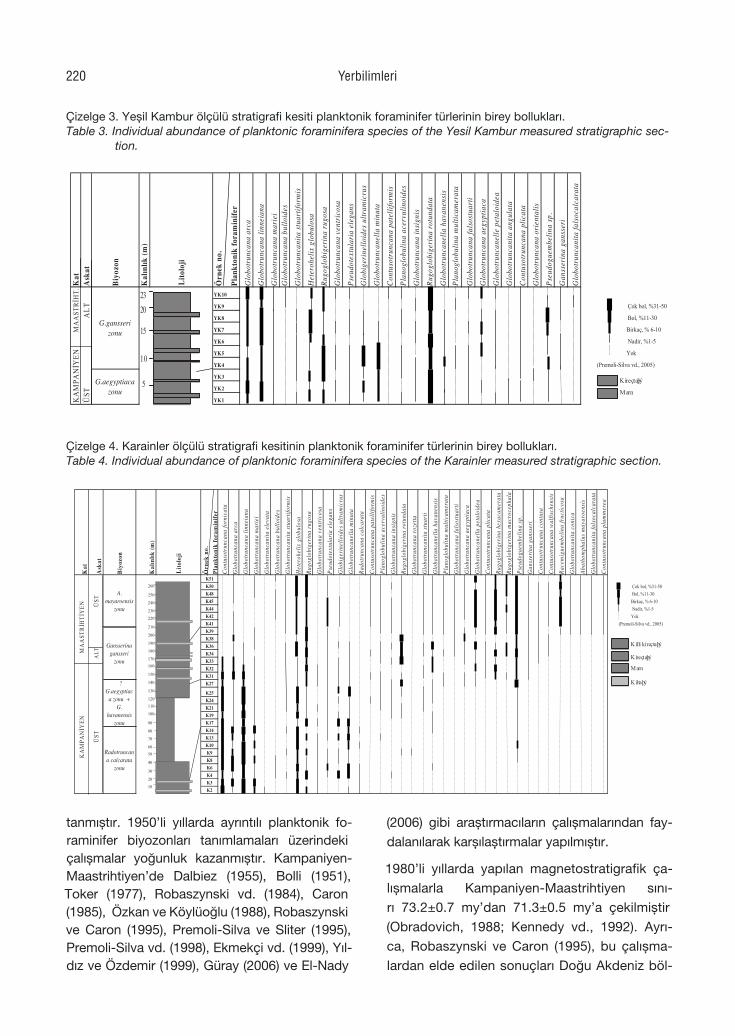
tanmıştır. 1950’li yıllarda ayrıntılı planktonik fo-raminifer biyozonları tanımlamaları üzerindeki çalışmalar yoğunluk kazanmıştır. Kampaniyen-Maastrihtiyen’de Dalbiez (1955), Bolli (1951), Toker (1977), Robaszynski vd. (1984), Caron (1985), Özkan ve Köylüoğlu (1988), Robaszynski ve Caron (1995), Premoli-Silva ve Sliter (1995), Premoli-Silva vd. (1998), Ekmekçi vd. (1999), Yıl-dız ve Özdemir (1999), Güray (2006) ve El-Nady
(2006) gibi araştırmacıların çalışmalarından fay-dalanılarak karşılaştırmalar yapılmıştır.
1980’li yıllarda yapılan magnetostratigrafik ça-lışmalarla Kampaniyen-Maastrihtiyen sını-rı 73.2±0.7 my’dan 71.3±0.5 my’a çekilmiştir (Obradovich, 1988; Kennedy vd., 1992). Ayrı-ca, Robaszynski ve Caron (1995), bu çalışma-lardan elde edilen sonuçları Doğu Akdeniz böl-
Çizelge 3. Yeşil Kambur ölçülü stratigrafi kesiti planktonik foraminifer türlerinin birey bolluklar.
Table 3. Individual abundance of planktonic foraminifera species of the Yesil Kambur measured stratigraphic section.
Kat
Ask
at
Biyo
zon
Kalın
lık (m
)
Örn
ek n
o.
Plan
kton
ik fo
ram
inife
rG
lobo
trun
cana
arc
a
Glo
botr
unca
na li
nnei
ana
Glo
botr
unca
na m
arie
iG
lobo
trun
cana
bul
loid
es
Glo
botr
unca
nita
stua
rtifo
rmis
Het
eroh
elix
glo
bulo
sa
Rugo
glob
iger
ina
rugo
sa
Glo
botr
unca
na v
entr
icos
a
Pseu
dote
xtul
aria
ele
gans
Glo
bige
rine
lloid
es u
ltram
icru
s
Glo
botr
unca
nella
min
uta
Con
tuso
trun
cana
pat
ellif
orm
is
Plan
oglo
bulin
a ac
ervu
linoi
des
Glo
botr
unca
na in
sign
is
Rugo
glob
iger
ina
rotu
ndat
a
Glo
botr
unca
nella
hav
anen
sis
Plan
oglo
bulin
a m
ultic
amer
ata
Glo
botr
unca
na fa
lsos
tuar
ti
Glo
botr
unca
na a
egyp
tiaca
Glo
botr
unca
nelle
pet
aloi
dea
Glo
botr
unca
nita
ang
ulat
a
Con
tuso
trun
cana
plic
ata
Glo
botr
unca
na o
rien
talis
Pseu
dogu
embe
lina
sp.
Gan
sser
ina
gans
seri
Glo
botr
unca
nita
fals
ocal
cara
ta
YK10
YK9 Çok bol, %31-50
YK8 Bol, %11-30
YK7 Birkaç, % 6-10
YK6 Nadir, %1-5
YK5 Yok
YK4 (Premoli-Silva vd., 2005)
YK3
YK2
YK1
G.gansseri zonu
G.aegyptiaca zonu
Lito
loji
MA
AST
RİH
T.K
AM
PANİY
ENA
LTÜ
ST
5
10
15
2023
Kireçtaþý
Marn
Çizelge 3. Yeşil Kambur ölçülü stratigrafi kesiti planktonik foraminifer türlerinin birey bollukları.Table 3. Individual abundance of planktonic foraminifera species of the Yesil Kambur measured stratigraphic sec-
tion.
Çizelge 4. Karainler ölçülü stratigrafi kesitinin planktonik foraminifer türlerinin birey bolluklar.
Table 4. Individual abundance of planktonic foraminifera species of the Karainler measured stratigraphic section.
Kat
Ask
at
Biyo
zon
Kalın
lık (m
)
Örn
ek n
o.Pl
ankt
onik
fora
min
ifer
Con
tuso
trun
cana
forn
icat
a
Glo
botr
unca
na a
rca
Glo
botr
unca
na li
nnei
ana
Glo
botr
unca
na m
arie
i
Glo
botr
unca
nita
ele
vata
Glo
botr
unca
na b
ullo
ides
Glo
botr
unca
nita
stua
rtifo
rmis
Het
eroh
elix
glo
bulo
sa
Rugo
glob
iger
ina
rugo
sa
Glo
botr
unca
na v
entr
icos
a
Pseu
dote
xtul
aria
ele
gans
Glo
bige
rine
lloid
es u
ltram
icru
s
Glo
botr
unca
nella
min
uta
Rado
trun
cana
cal
cara
ta
Con
tuso
trun
cana
pat
ellif
orm
is
Plan
oglo
bulin
a ac
ervu
linoi
des
Glo
botr
unca
na in
sign
is
Rugo
glob
iger
ina
rotu
ndat
a
Glo
botr
unca
na ro
zetta
Glo
botr
unca
nita
stua
rti
Glo
botr
unca
nella
hav
anen
sis
Plan
oglo
bulin
a m
ultic
amer
ata
Glo
botr
unca
na fa
lsos
tuar
ti
Glo
botr
unca
na a
egyp
tiaca
Glo
botr
unca
nella
pet
aloi
dea
Con
tuso
trun
cana
plic
ata
Rugo
glob
iger
ina
hexa
cam
erat
a
Rugo
glob
iger
ina
mac
roce
phal
a
Pseu
dogu
embe
lina
sp.
Gan
sser
ina
gans
seri
Con
tuso
trun
cana
con
tusa
Con
tuso
trun
cana
wal
fisch
ensi
s
Race
mig
uem
belin
a fr
uctic
osa
Glo
botr
unca
nita
con
ica
Abat
hom
phal
us m
ayar
oens
is
Glo
botr
unca
nita
fals
ocal
cara
ta
Con
tuso
trun
cana
plu
mm
erea
Çok bol, %31-50 Bol, %11-30Birkaç, % 6-10 Nadir, %1-5Yok
(Premoli-Silva vd., 2005)
K8
Lito
loji
K2K3K4K6
K24
K9K10K13K14K17K19K21
K25
K27K31K32K33K34K36K38
K44
K41K39
K42
K51K50K48K45
A.mayaroensis
zonu
Gansserina gansseri
zonu
? G.aegyptiac
a zonu + G.
havanensis zonu
Radotruncana calcarata
zonu
ÜST
ALTM
AA
STRİH
TİY
ENK
AM
PANİY
EN
ÜST
10
20
30
40
50
60
70
80
90
100
110
120
130
140
150
160170
180
190
200
210
220
230
240
250
260
Killi kireçtaþý
Kireçtaþý
Marn
Kiltaþý
Çizelge 4. Karainler ölçülü stratigrafi kesitinin planktonik foraminifer türlerinin birey bollukları.Table 4. Individual abundance of planktonic foraminifera species of the Karainler measured stratigraphic section.
Yerbilimleri220
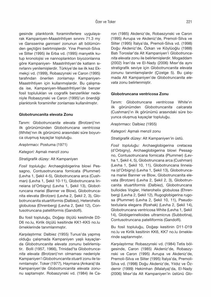
gesinde planktonik foraminiferlere uygulaya-rak Kampaniyen-Maastrihtiyen sınırını 71.3 my ve Gansserina gannseri zonunun alt bölümün-den geçtiğini belirtmişlerdir. Yine Premoli-Silva ve Sliter (1995) ile Erba vd. (1995) manyetik ku-tup kronolojisi ve nannoplankton biyozonlarına göre Kampaniyen- Maastrihtiyen’de katların sı-nırlarını yenilemişlerdir. Türkiye’de ise ilk kez Ek-mekçi vd. (1999), Robaszynski ve Caron (1995) tarafından önerilen zonlamayı Kampaniyen-Maastrihtiyen için kullanmışlardır. Bu çalışma-da ise, Kampaniyen-Maastrihtiyen’de benzer fosil toplulukları ve cografik benzerlikler nede-niyle Robaszynski ve Caron (1995)’un önerdiği planktonik foraminifer zonlaması kullanılmıştır.
Globotruncanita elevata Zonu
Tanım: Globotruncanita elevata (Brotzen)’nın ilk görünümünden Globotruncana ventricosa (White)’nın ilk görünümü arasındaki süre boyun-ca oluşmuş kayaçlar topluluğu.
Araştırmacı: Postuma (1971)
Kategori: Aşmalı menzil zonu
Stratigrafik düzey: Alt Kampaniyen
Fosil topluluğu: Archaeglobigerina blowi Pes-sagno, Contusotruncana fornicata (Plummer) (Levha 1, Şekil 4-5), Globotruncana arca (Cush-man) (Levha 1, Şekil 10-11), Globotruncana lin-neiana (d’Orbigny) (Levha 1, Şekil 13), Globot-runcana mariei (Banner ve Blow), Globotrunca-nita elevata (Brotzen) (Levha 2, Şekil 2, 3), Glo-botruncanita stuartiformis (Dalbiez), Heterohelix globulosa (Ehrenberg) (Levha 2, Şekil 12), Con-tusotruncana patelliformis (Gandolfi).
Bu fosil topluluğu, Doğaşı ölçülü kesitinde D3-D6 no.lu, Kirlik ölçülü kesitinde KK1-KK5 no.lu örneklerinde tanımlanmıştır.
Karşılaştırma: Dalbiez (1955) Tunus’da yapmış olduğu çalışmada Kampaniyen yaşlı kayaçlar-da Globotruncanita elevata zonunu belirlemiş-tir. Bolli (1957, 1966), Trinidad’ta Globotrunca-nita elevata (Brotzen)’nın olmaması nedeniyle Kampaniyen’i Globotruncanita stuarti zonu ile ta-nımlamıştır. Toker (1977), Haymana (Ankara)’da Kampaniyen’de Globotruncanita elevata zonu-nu saptamıştır. Robaszynski vd. (1984) ile Ca-
ron (1985) Akdeniz’de, Robaszynski ve Caron (1995) Avrupa ve Akdeniz’de, Premoli-Silva ve Sliter (1995) İtalya’da, Premoli-Silva vd. (1998) Doğu Akdeniz’de, Özkan ve Köylüoğlu (1988) Batı Toroslar’da Alt Kampaniyen’i Globotrunca-nita elevata zonu ile belirlemişlerdir. Mogaddam (2002) İran’da ve El-Nady (2006) Mısır’da aynı stratigrafik seviye için Globotruncanita elevata zonunu tanımlamışlardır (Çizelge 5). Bu çalış-mada Alt Kampaniyen’de Globotruncanita ele-vata zonu belirlenmiştir.
Globotruncana ventricosa Zonu
Tanım: Globotruncana ventricosa White’ın ilk görünümden Globotruncanita calcarata (Cushman)’ın ilk görünümü arasındaki süre bo-yunca oluşmuş kayaçlar topluluğu.
Araştırmacı: Dalbiez (1955)
Kategori: Aşmalı menzil zonu
Stratigrafik düzey: Alt Kampaniyen’in üstü.
Fosil topluluğu: Archaeglobigerina cretacea (d’Orbigny), Archaeglobigerina blowi Pessag-no, Contusotruncana fornicata (Plummer) (Lev-ha 1, Şekil 4, 5), Globotruncana arca (Cushman) (Levha 1, Şekil 10, 11), Globotruncana linneia-na (d’Orbigny) (Levha 1, Şekil 13), Globotrunca-na mariei Banner ve Blow, Globotruncanita ele-vata (Brotzen) (Levha 2, Şekil 2, 3), Globotrun-canita stuartiformis (Dalbiez), Globotruncana bulloides Vogler, Heterohelix globulosa (Ehren-berg) (Levha 2, Şekil 12), Rugoglobigerina rugo-sa (Plummer) (Levha 2, Şekil 10, 11), Pseudo-textularia elegans (Rzehak) (Levha 2, Şekil 14), Globotruncana ventricosa White (Levha 1, Şekil 14), Globigerinelloides ultramicrus (Subbotina), Contusotruncana patelliformis (Gandolfi).
Bu fosil topluluğu, Doğaşı kesitinin D11-D19 no.lu ve Kirlik kesitinin KK6, KK7 no.lu örnekle-rinde saptanmıştır.
Karşılaştırma: Robaszynski vd. (1984) Tetis böl-gesinde, Caron (1985) Akdeniz’de, Robaszy-nski ve Caron (1995) Avrupa ve Akdeniz’de, Premoli-Silva ve Sliter (1995) İtalya’da, Premoli-Silva vd. (1998) Doğu Akdeniz’de, Yıldız ve Öz-demir (1999) Hekimhan (Malatya)’da, El-Nady (2006) Mısır’da Alt Kampaniyen’in üstünü Glo-
Özer ve Toker 221
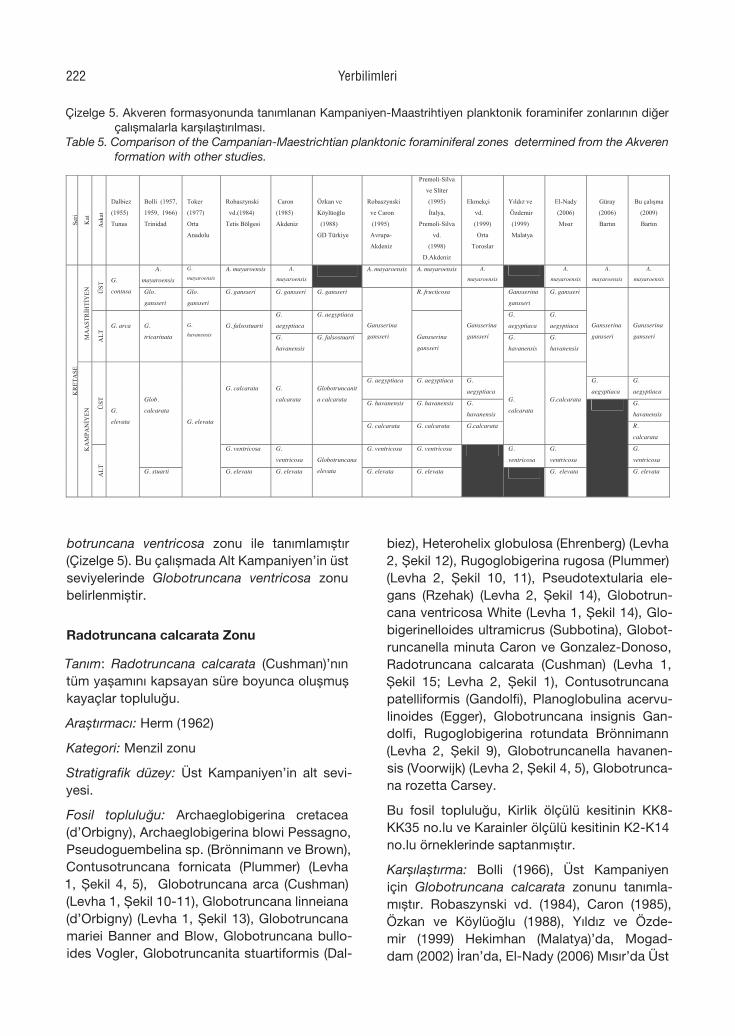
botruncana ventricosa zonu ile tanımlamıştır (Çizelge 5). Bu çalışmada Alt Kampaniyen’in üst seviyelerinde Globotruncana ventricosa zonu belirlenmiştir.
Radotruncana calcarata Zonu
Tanım: Radotruncana calcarata (Cushman)’nın tüm yaşamını kapsayan süre boyunca oluşmuş kayaçlar topluluğu.
Araştırmacı: Herm (1962)
Kategori: Menzil zonu
Stratigrafik düzey: Üst Kampaniyen’in alt sevi-yesi.
Fosil topluluğu: Archaeglobigerina cretacea (d’Orbigny), Archaeglobigerina blowi Pessagno, Pseudoguembelina sp. (Brönnimann ve Brown), Contusotruncana fornicata (Plummer) (Levha 1, Şekil 4, 5), Globotruncana arca (Cushman) (Levha 1, Şekil 10-11), Globotruncana linneiana (d’Orbigny) (Levha 1, Şekil 13), Globotruncana mariei Banner and Blow, Globotruncana bullo-ides Vogler, Globotruncanita stuartiformis (Dal-
biez), Heterohelix globulosa (Ehrenberg) (Levha 2, Şekil 12), Rugoglobigerina rugosa (Plummer) (Levha 2, Şekil 10, 11), Pseudotextularia ele-gans (Rzehak) (Levha 2, Şekil 14), Globotrun-cana ventricosa White (Levha 1, Şekil 14), Glo-bigerinelloides ultramicrus (Subbotina), Globot-runcanella minuta Caron ve Gonzalez-Donoso, Radotruncana calcarata (Cushman) (Levha 1, Şekil 15; Levha 2, Şekil 1), Contusotruncana patelliformis (Gandolfi), Planoglobulina acervu-linoides (Egger), Globotruncana insignis Gan-dolfi, Rugoglobigerina rotundata Brönnimann (Levha 2, Şekil 9), Globotruncanella havanen-sis (Voorwijk) (Levha 2, Şekil 4, 5), Globotrunca-na rozetta Carsey.
Bu fosil topluluğu, Kirlik ölçülü kesitinin KK8-KK35 no.lu ve Karainler ölçülü kesitinin K2-K14 no.lu örneklerinde saptanmıştır.
Karşılaştırma: Bolli (1966), Üst Kampaniyen için Globotruncana calcarata zonunu tanımla-mıştır. Robaszynski vd. (1984), Caron (1985), Özkan ve Köylüoğlu (1988), Yıldız ve Özde-mir (1999) Hekimhan (Malatya)’da, Mogad-dam (2002) İran’da, El-Nady (2006) Mısır’da Üst
Çizelge 5. Akveren formasyonunda tanmlanan Kampaniyen-Maastrihtiyen planktonik foraminifer zonlarnn diğer çalşmalarla karşlaştrlmas. Table 5.. Comparison of the Campanian-Maestrichtian planktonic foraminiferal zones determined from the Akveren formation with other studies.
Seri
Kat
Ask
at
Dalbiez
(1955)
Tunus
Bolli (1957,
1959, 1966)
Trinidad
Toker
(1977)
Orta
Anadolu
Robaszynski
vd.(1984)
Tetis Bölgesi
Caron
(1985)
Akdeniz
Özkan ve
Köylüoğlu
(1988)
GD Türkiye
Robaszynski
ve Caron
(1995)
Avrupa-
Akdeniz
Premoli-Silva
ve Sliter
(1995)
İtalya,
Premoli-Silva
vd.
(1998)
D.Akdeniz
Ekmekçi
vd.
(1999)
Orta
Toroslar
Yldz ve
Özdemir
(1999)
Malatya
El-Nady
(2006)
Msr
Güray
(2006)
Bartn
Bu çalşma
(2009)
Bartn
A.
mayaroensis
G.
mayaroensis A. mayaroensis A.
mayaroensis A. mayaroensis A. mayaroensis A.
mayaroensis
A.
mayaroensis
A.
mayaroensis
A.
mayaroensis
ÜST
G.
contusa Glo.
gansseri
Glo.
gansseri
G. gansseri G. gansseri G. gansseri R. fructicosa Gansserina
gansseri
G. gansseri
G.
aegyptiaca
G. aegyptiaca G.
aegyptiaca
G.
aegyptiaca
MA
AST
RİH
TİY
EN
ALT
G. arca G.
tricarinata
G.
havanensisG. falsostuarti
G.
havanensis
G. falsostuarti G.
havanensis
G.
havanensis
Gansserina
gansseri Gansserina
gansseri
Gansserina
gansseri
Gansserina
gansseri
Gansserina
gansseri
G. aegyptiaca G. aegyptiaca G.
aegyptiaca
G.
aegyptiaca
G.
aegyptiaca
G. havanensis G. havanensis G.
havanensis
G.
havanensis
ÜST
G. calcarata G.
calcarata
Globotruncanit
a calcarata
G. calcarata G. calcarata G.calcarata
G.
calcarata
G.calcarata
R.
calcarata
Glob.
calcarata
G. ventricosa G.
ventricosa
G. ventricosa G. ventricosa G.
ventricosa
G.
ventricosa
G.
ventricosa
KR
ETA
SE
KA
MPA
NİY
EN
ALT
G.
elevata
G. stuarti
G. elevata
G. elevata G. elevata
Globotruncana
elevata G. elevata G. elevata
G. elevata G. elevata
Çizelge 5. Akveren formasyonunda tanımlanan Kampaniyen-Maastrihtiyen planktonik foraminifer zonlarının diğer çalışmalarla karşılaştırılması.
Table 5. Comparison of the Campanian-Maestrichtian planktonic foraminiferal zones determined from the Akveren formation with other studies.
Yerbilimleri222
Kampaniyen için Globotruncanita calcarata zo-nunu kullanmışlardır. Robaszynski ve Caron (1995) Avrupa ve Akdeniz’de, Premoli-Silva ve Sliter (1995) İtalya’da, Premoli-Silva vd. (1998) Doğu Akdeniz’de, Ekmekçi vd. (1999) Orta Toroslar’da, Üst Kampaniyen’in alt bölümü için bu zonu belirlemişlerdir (bkz. Çizelge 5). Bu ça-lışmada, Üst Kampaniyen’in en altı bu zon ile saptanmıştır.
Globotruncanella havanensis Zonu
Tanım: Radotruncana calcarata (Cushman)’nın son görünümü ile Globotruncana aegytiaca (Nakkady)’nın ilk görünümü arasındaki süre bo-yunca oluşmuş kayaçlar topluluğu.
Araştırmacı: Caron (1978)
Kategori: Aşmalı menzil zonu
Stratigrafik düzey: Üst Kampaniyen’in orta ke-simi.
Fosil topluluğu: Pseudoguembelina sp. (Brön-nimann ve Brown), Contusotruncana fornicata (Plummer) (Levha 1, Şekil 4, 5), Globotrunca-na arca (Cushman) (Levha 1, Şekil 10, 11), Glo-botruncana linneiana (d’Orbigny) (Levha 1, Şe-kil 13), Globotruncana mariei Banner ve Blow, Globotruncana bulloides Vogler, Globotrunca-nita stuartiformis (Dalbiez), Heterohelix globu-losa (Ehrenberg) (Levha 2, Şekil 12), Rugoglobi-gerina rugosa (Plummer) (Levha 2, Şekil 10, 11), Pseudotextularia elegans (Rzehak) (Levha 2, Şekil 14), Globotruncana ventricosa White (Lev-ha 1, Şekil 14), Globigerinelloides ultramicrus (Subbotina), Globotruncanella minuta Caron ve Gonzalez-Donoso, Contusotruncana patellifor-mis (Gandolfi), Planoglobulina acervulinoides (Egger), Globotruncana insignis Gandolfi, Ru-goglobigerina rotundata Brönnimann (Levha 2, Şekil 9), Globotruncana rozetta Carsey, Globot-runcanita stuarti (de Lapparent), Globotrunca-nella havanensis (Voorwijk) (Levha 2, Şekil 4, 5), Planoglobulina multicamerata (De Klasz) (Lev-ha 2, Şekil 15), Globotruncana falsostuarti Sigal (Levha 1, Şekil 12).
Bu fosil topluluğu, Kirlik ölçülü kesitinin KK35-KK46 no.lu ve Karainler ölçülü kesitinin K17-K25 no.lu örneklerinde tanımlanmıştır.
Karşılaştırma: Globotruncanella havanen-sis Zonunu Robaszynski ve Caron (1995) Üst Kampaniyen’in orta düzeyi için kullanmıştır. Dalbiez (1955) Tunus’da Erken Maastrihtiyen yaşlı kayaçlarda Globotruncanella havanensis ile denk olan Globotruncana arca zonunu ta-nımlamıştır. Bolli (1957), Alt Maastrihtiyen için bu zona denk olarak Globotruncana tricarinata zonunu kullanmıştır. Toker (1977) Haymana böl-gesinde, Robaszynski vd. (1984), Caron (1985), Yıldız ve Özdemir (1999) Hekimhan (Malatya)’da, El-Nady (2006) Mısır’da Globotruncanella hava-nensis zonunu Alt Maastrihtiyen için kullanmış-lardır. Robaszynski ve Caron (1995), Premoli-Silva vd. (1998) Doğu Akdeniz’de, Ekmekçi vd. (1999) Orta Toroslar’da, Üst Kampaniyen’in orta seviyeleri için bu zonu saptamışlardır. Öz-kan ve Köylüoğlu (1988) Batı Toroslar’da Üst Kampaniyen için Globotruncana falsostuarti zo-nunu kullanmıştır (bkz. Çizelge 5). Bu çalışma-da, Üst Kampaniyen’in orta seviyelerinde bu zon belirlenmiştir.
Globotruncana aegyptiaca Zonu
Tanım: Globotruncana aegyptiaca Nakkady’nın ilk görünümünden Gansserina gansseri (Bolli)’nin ilk görünümü arasındaki süre boyun-ca oluşmuş kayaçlar topluluğudur.
Araştırmacı: Caron (1985)
Kategori: Aşmalı menzil zonu
Stratigrafik düzey: Üst Kampaniyen’in üst bölü-mü.
Fosil topluluğu: Contusotruncana fornicata (Plummer) (Levha 1, Şekil 4, 5), Globotrunca-na arca (Cushman) (Levha 1, Şekil 10, 11), Glo-botruncana linneiana (d’Orbigny) (Levha 1, Şe-kil 13), Globotruncana mariei Banner ve Blow, Globotruncanita stuartiformis (Dalbiez), Hete-rohelix globulosa (Ehrenberg) (Levha 2, Şekil 12), Rugoglobigerina rugosa (Plummer) (Levha 2, Şekil 10, 11), Globotruncana ventricosa Whi-te (Levha 1, Şekil 14), Pseudotextularia elegans (Rzehak) (Levha 2, Şekil 14), Globigerinelloides ultramicrus (Subbotina), Globotruncanella mi-nuta Caron ve Gonzalez-Donoso, Contusot-runcana patelliformis (Gandolfi), Planoglobuli-na acervulinoides (Egger), Globotruncana insig-
Özer ve Toker 223
nis Gandolfi, Rugoglobigerina rotundata Brön-nimann (Levha 2, Şekil 9), Globotruncanita stu-arti (de Lapparent), Globotruncanella havanen-sis (Voorwijk) (Levha 2, Şekil 4, 5), Planoglobuli-na multicamerata (De Klasz) (Levha 2, Şekil 15), Globotruncana falsostuarti Sigal (Levha 1, Şekil 12), Globotruncana aegyptiaca Nakkady (Lev-ha 1, Şekil 8, 9), Globotruncanella petaloidea (Gandolfi) (Levha 2, Şekil 6), Globotruncanita angulata Tilev, Contusotruncana plicata (Whi-te), Globotruncana orientalis El Naggar, Rugog-lobigerina hexacamerata Brönnimann (Levha 2, Şekil 7), Rugoglobigerina macrocephala Brön-nimann (Levha 2, Şekil 8), Pseudoguembelina sp. (Brönnimann ve Brown).
Bu fosil topluluğu, Yeşil Kambur ölçülü kesiti-nin YK1-YK7 no.lu ve Karainler ölçülü kesitinin K27-K31 no.lu örneklerinde saptanmıştır.
Karşılaştırma: İlk olarak Caron (1985) Alt Maastrihtiyen’in üst bölümü için bu zonu tanım-lamıştır. Robaszynski ve Caron (1995)’a göre bu zon Üst Kampaniyen’in orta-üst seviyesi-ni temsil etmektedir. Premoli-Silva vd. (1998) Doğu Akdeniz’de, Ekmekçi vd. (1999) Orta Toroslar’da Üst Kampaniyen’in orta-üst bölü-mü için bu zonu belirlemişlerdir. Özkan ve Köy-lüoğlu (1988) Batı Toroslar’da, Yıldız ve Öz-demir (1999) Hekimhan (Malatya)’da, El-Nady (2006) Mısır’da, bu zonu Alt Maastrihtiyen için kullanmışlardır. Güray (2006) Bartın’da Üst Kampaniyen’de bu zonu saptamıştır (bkz. Çi-zelge 5). Bu çalışmada, Üst Kampaniyen’in üst seviyelerinde bu zon tanımlanmıştır.
Gansserina gansseri Zonu
Tanım: Gansserina gansseri (Bolli)’nin ilk gö-rünümünden Abathomphalus mayaroensis (Bolli)’nin ilk görünümü arasındaki süre boyun-ca oluşmuş kayaçlar topluluğu.
Araştırmacı: Brönnimann (1952)
Kategori: Aşmalı menzil zonu
Stratigrafik düzey: En üst Kampaniyen-Üst Maastrihtiyen’in altı
Fosil topluluğu: Contusotruncana fornicata (Plummer) (Levha 1, Şekil 4, 5), Globotrunca-na arca (Cushman) (Levha 1, Şekil 10, 11), Glo-
botruncana linneiana (d’Orbigny) (Levha 1, Şe-kil 13), Globotruncana mariei Banner and Blow, Globotruncana bulloides Vogler, Globotrunca-nita stuartiformis (Dalbiez), Heterohelix globu-losa (Ehrenberg) (Levha 2, Şekil 12), Rugoglobi-gerina rugosa (Plummer) (Levha 2, Şekil 10, 11), Globotruncana ventricosa White (Levha 1, Şe-kil 14), Pseudotextularia elegans (Rzehak) (Lev-ha 2, Şekil 14), Globigerinelloides ultramicrus (Subbotina), Globotruncanella minuta Caron ve Gonzalez-Donoso, Contusotruncana patellifor-mis (Gandolfi), Planoglobulina acervulinoides (Egger), Globotruncana insignis Gandolfi, Ru-goglobigerina rotundata Brönnimann (Levha 2, Şekil 9), Globotruncanita stuarti (de Lapparent), Globotruncanella havanensis (Voorwijk) (Lev-ha 2, Şekil 4, 5), Planoglobulina multicamera-ta (De Klasz) (Levha 2, Şekil 15), Globotrunca-na falsostuarti Sigal (Levha 1, Şekil 12), Globot-runcana aegyptiaca Nakkady (Levha 1, Şekil 8, 9), Globotruncanella petaloidea (Gandolfi) (Lev-ha 2, Şekil 6), Contusotruncana plicata (White), Rugoglobigerina hexacamerata Brönnimann (Levha 2, Şekil 7), Rugoglobigerina macrocep-hala Brönnimann (Levha 2, Şekil 8), Pseudogu-embelina sp. (Brönnimann ve Brown), Gansse-rina gansseri (Bolli) (Levha 1, Şekil 6, 7), Glo-botruncanita falsocalcarata Kerdany ve Abdel-salam, Contusotruncana contusa (Cushman) (Levha 1, Şekil 3), Contusotruncana walfischen-sis (Todd), Racemiguembelina fructicosa (Eg-ger) (Levha 2, Şekil 13), Contusotruncana plum-merea (Gandolfi).
Bu fosil topluluğu, Yeşil kambur ölçülü kesiti-nin YK8-YK10 no.lu ve Karainler ölçülü kesiti-nin K34-K40 no.lu örneklerinde tanımlanmıştır.
Karşılaştırma: Dalbiez (1955), Tunus’da Orta-Geç Maastrihtiyen için Globotruncana contu-sa zonu’nu kullanmıştır. Daha sonra Bolli (1957, 1959), Toker (1977) Haymana (Ankara)’da, Ro-baszynski vd. (1983) Tetis bölgesinde, Caron (1985) Akdeniz’de, Özkan ve Köylüoğlu (1988) Batı Toroslar’da, Premoli Silva ve Sliter (1995) İtalya’da Orta Maastrihtiyen için bu zonu ta-nımlamışlardır. Robaszynski ve Caron (1995), Premoli-Silva vd. (1998) Doğu Akdeniz’de, Ekmekçi vd. (1999) Orta Toroslar’da, Güray (2006) Bartın’da, Üst Kampaniyen-Alt Maast-rihtiyen için Gansserina gansseri zonunu ta-
Yerbilimleri224
nımlamışlardır. Yıldız ve Özdemir (1999) Hekim-han (Malatya)’da, El-Nady (2006) Mısır’da, Üst Maastrihtiyen’de bu zonu saptamışlardır (bkz. Çizelge 5). Bu çalışmada Üst Kampaniyen’in üstü-Üst Maastrihtiyen için bu zon belirlenmiştir.
Abathomphalus mayaroensis Zonu
Tanım: Abathomphalus mayaroensis (Bolli)’nin yaşam aralığını kapsayan kayaçlar topluluğu.
Araştırmacı: Brönnimann (1952)
Kategori: Menzil zonu
Stratigrafik düzey: Üst Maastrihtiyen
Fosil topluluğu: Globotruncana arca (Cushman) (Levha 1, Şekil 10, 11), Globotruncana mariei Banner ve Blow, Globotruncana bulloides Vog-ler, Globotruncanita stuartiformis (Dalbiez), He-terohelix globulosa (Ehrenberg) (Levha 2, Şekil 12), Ruguglobigerina rugosa (Plummer) (Levha 2, Şekil 10, 11), Pseudotextularia elegans (Rze-hak) (Levha 2, Şekil 14), Globigerinelloides ult-ramicrus (Subbotina), Contusotruncana patelli-formis (Gandolfi), Planoglobulina acervulinoides (Egger), Globotruncana insignis Gandolfi, Ru-goglobigerina rotundata Brönnimann (Levha 2, Şekil 9), Globotruncanita stuarti (de Lapparent), Globotruncanella havanensis (Voorwijk) (Lev-ha 2, Şekil 4, 5), Planoglobulina multicamera-ta (De Klasz) (Levha 2, Şekil 15), Globotruncana falsostuarti Sigal (Levha 1, Şekil 12) Globotrun-cana aegyptiaca Nakkady (Levha 1, Şekil 8, 9), Globotruncanella petaloidea (Gandolfi) (Levha 2, Şekil 6), Contusotruncana plicata (White), Ru-goglobigerina hexacamerata Brönnimann (Lev-ha 2, Şekil 7), Rugoglobigerina macrocephala Brönnimann (Levha 2, Şekil 8), Pseudoguem-belina sp. (Brönnimann ve Brown), Gansserina gansseri (Bolli) (Levha 1, Şekil 6, 7), Contusot-runcana contusa (Cushman) (Levha 1, Şekil 3), Contusotruncana walfischensis (Todd), Race-miguembelina fructicosa (Egger) (Levha 2, Şe-kil 13), Abathomphalus mayaroensis (Bolli) (Lev-ha 1, Şekil 1, 2), Globotruncanita falsocalcara-ta Kerdany ve Abdelsalam, Contusotruncana plummerea (Gandolfi), Globotruncanita conica (White).
Bu fosil topluluğu, Karainler ölçülü kesitinin K41-K51 no.lu örneklerinde saptanmıştır.
Karşılaştırma: Bolli (1957, 1959) ve Toker (1977) Üst Maastrihtiyen’de Globotruncana mayaroen-sis zonunu tanımlamışlardır. Caron (1985), Öz-kan ve Köylüoğlu (1988), Premoli Silva ve Sliter (1995), Robaszynski ve Caron (1995), Ekmek-çi vd. (1999), El-Nady (2006) ve Güray (2006) Üst Maastrihtiyen’de bu zonu belirlemişlerdir. Premoli-silva vd. (1998) Doğu Akdeniz’de, Üst Maastrihtiyen’de Rosita contusa zonu ve Abat-homphalus mayaroensis zonunu saptamıştır (bkz. Çizelge 5).
SONUÇLAR
Bartın bölgesinde Kirlik, Karainler, Doğaşı ve Yeşil Kambur ölçülü stratigrafik kesitlerden alı-nan örneklerde 14 planktonik foraminifer cinsi ve 44 türü tanımlanmış olup, 7 planktonik fora-minifera biyozonu belirlenmiştir.
Akveren Formasyonu, genel olarak marn, kiltaşı, killi kireçtaşı ardalanmalı litolojisi ile derin deniz ortamında çökelmeyi ifade etmektedir. Ayrıntı-lı biyostratigrafi çalışması sonucunda Akveren Formasyonu’nun Alt Kampaniyen’den itibaren kesintisiz bir istif oluşturduğu anlaşılmaktadır. Alt Kampaniyen’de Globotruncanita elevata ve Globotruncana ventricosa, Üst Kampaniyen’de Radotruncana calcarata, Globotruncanella ha-vanensis, Globotruncana aegyptiaca ve Gans-serina gansseri ile Maastrihtiyen’de Gansserina gansseri ve Abathomphalus mayaroensis biyo-zonları saptanmıştır.
Önceki çalışmalarda Kampaniyen-Maastrihtiyen sınırı Radotruncana calcarata/ Globotruncanel-la havanensis sınırından geçirilmiştir. Yapılan magnetostratigrafik çalışmalara paralel olarak değişen Kampaniyen-Maastrihtiyen sınırı, bu çalışmada da Robaszynski ve Caron (1995)’un planktonik foraminiferlerde önerdiği şekilde kullanılmıştır.
KATKI BELİRTME
Yazarlar, bu araştırmanın yürütülmesinde FBT-06-24 no.lu proje ile maddi destek veren Er-ciyes Üniversitesi Bilimsel Araştırma Projeleri Birimi’ne teşekkürlerini sunarlar.
Özer ve Toker 225
KAYNAKLAR
Akman, Ü., 1992. Amasra-Arıt arasının jeolojisi. Doktora Tezi, Ankara Üniversitesi Fen Bilimleri Enstitüsü, Ankara (yayımlan-mamış).
Akyol, Z., Arpat, E., Erdoğan, B., Göğer, E., Gü-ner, Y., Şaroğlu, F., Şentürk, İ., Tütüncü, K. ve Uysal, Ş., 1974. 1/50.000 ölçek-li Türkiye Jeoloji Haritası Serisi, Zongul-dak E29 a, E29 b, E29 c, E29 d, Kasta-monu E30 a, E30 d. MTA Yayınları, An-kara.
Aydın, A., 2005. İzmit kuzeybatısı Geç Kretase-Paleojen nannoplankton biyostratigrafi-si. Yüksek Lisans Tezi, Ankara Üniversi-tesi Fen Bilimleri Enstitüsü, Ankara (ya-yımlanmamış).
Aydın, M., Şahintürk, Ö., Serdar, H.S., Özçelik, Y., Akarsu, İ., Üngör, A., Çokuğraş, R. ve Kasar, S., 1986. Ballıdağ-Çangaldağ (Kastamonu) arasındaki bölgenin jeolo-jisi. Türkiye Jeoloji Kurultayı Bülteni, 29 (2), 1-16.
Badgley, P.C., 1959. Sinop Havzasının petrol olanakları. Petrol İşleri Genel Müdürlü-ğü Arşivi, Ankara (yayımlanmamış).
Barka, A, Sütçü, Y. F., Tekin, F., Gedik, İ, Ka-rabıyıkoğlu, M., Saraç, G, Önal, Ö., Arel, E. ve Özdemir M., 1983. Sinop Yarımadası’nın jeolojisi ve tektonik ev-rimi. Türkiye Jeoloji Kurultayı 1983 Bül-teni, s.55.
Baş, H., 1986. Sinop volkanitlerinin petrolojisi ve jeokimyası. Türkiye Jeoloji Kurumu Bül-teni, 29 (1), 143-156.
Blumenthal, M.M., 1940. Gökırmak vadisi ile Karadeniz arasındaki Pontik silsileleri-nin jeolojisi hakkında rapor (Boyabat-Sinop). Maden Tetkik ve Arama Ensti-tüsü, Rapor No. 1067, Ankara (yayım-lanmamış).
Bolli, H. M., 1951. The genus Globotruncana in Trinidad, B. W. I., Journal of Paleonto-logy, 25 (2), 187-199.
Bolli, M.H., 1957. The genera Praeglobotrun-cana, Rotalipora, Globotruncana nad Abathomphalus in the Upper Cretaceo-
us of Trinidad. B.W.I. United States Na-tional Museum Bulletin, 215, 51-60.
Bolli, M.H., 1959. Planktonic foraminifera from the Cretaceous of Trinidad. B.W.I, Bul-letin of American Paleontology, 39 (179), 257–277.
Bolli, M. H., 1966. Zonation of Cretaceous to Pliocene marine sediments based on planktonic foraminifera. Boletin Infor-mativo Asociacion Venezolana de Geo-logia Mineria Petroleo, 9, 3-32.
Bragin, N., Bragina, L., Tunoğlu, C., and Tekin, U. K., 2001. The Cenomanian (Late Cre-taceous) Radiolarians from the Toma-lar Formation, Central Pontides, Nort-hern Turkey. Geologica Carpathica, 52 (6), 349-360.
Brönnimann, P., 1952. Trinidad Paleocene and Lower Eocene Globigerinidae. Bulletin of American Paleontology, 34, 1-34.
Caron, M., 1978. Cretaceous planktonic forami-nifers from DSDP Leg 40, southeastern Atlantic Ocean. Initial Reports of the Deep Sea Drilling Project, 40, Washing-ton, pp.78-651.
Caron, M., 1985. Cretaceous planktic forami-nifera. In: H.M. Bolli, J.B. Saunders, K. Perch-Nielsen (eds.), Plankton Stra-tigraphy, Cambridge University Press, Cambridge, pp.17-86.
Dalbiez, F., 1955. The genus Globotruncana in Tunisia. Micropaleontology, 1(2),161-171.
Derman, A.S., 1996. Batı Karadeniz’in Geç Jura paleocoğrafyası. Türkiye 11. Petrol Kongresi Bildirileri, s.75-80.
Derman, A. S., 2002. Karadeniz’in açılma istifle-ri. Türkiye Petrol Jeologları Derneği Bül-teni, 14 (1), 37 – 66.
Derman, A.S., Alişan, C. ve Özçelik, Y., 1995. Himmetpaşa Formation: new palynolo-gical age data and its significance. In: A. Erler, T. Ercan, E. Bingöl and S. Ör-çen (eds.), Proceedings of the symposi-um on Geology of the Black Sea Regi-on. Ankara, Turkey, pp.99-103.
Dizer, A. ve Meriç, E., 1981. Kuzeybatı
Yerbilimleri226
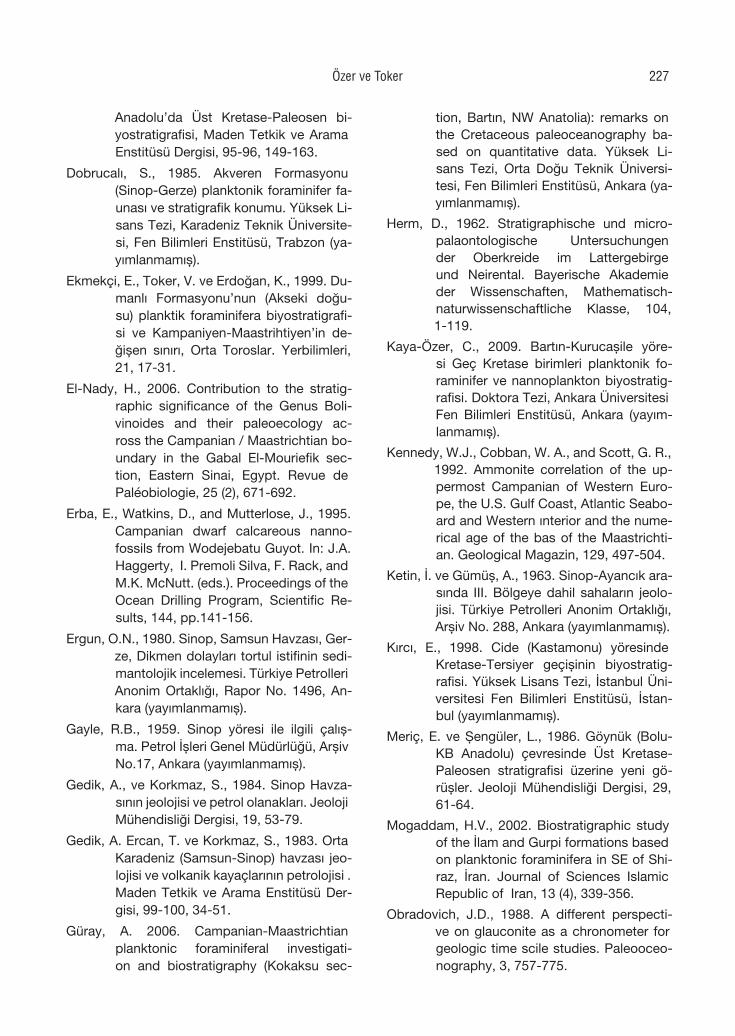
Anadolu’da Üst Kretase-Paleosen bi-yostratigrafisi, Maden Tetkik ve Arama Enstitüsü Dergisi, 95-96, 149-163.
Dobrucalı, S., 1985. Akveren Formasyonu (Sinop-Gerze) planktonik foraminifer fa-unası ve stratigrafik konumu. Yüksek Li-sans Tezi, Karadeniz Teknik Üniversite-si, Fen Bilimleri Enstitüsü, Trabzon (ya-yımlanmamış).
Ekmekçi, E., Toker, V. ve Erdoğan, K., 1999. Du-manlı Formasyonu’nun (Akseki doğu-su) planktik foraminifera biyostratigrafi-si ve Kampaniyen-Maastrihtiyen’in de-ğişen sınırı, Orta Toroslar. Yerbilimleri, 21, 17-31.
El-Nady, H., 2006. Contribution to the stratig-raphic significance of the Genus Boli-vinoides and their paleoecology ac-ross the Campanian / Maastrichtian bo-undary in the Gabal El-Mouriefik sec-tion, Eastern Sinai, Egypt. Revue de Paléobiologie, 25 (2), 671-692.
Erba, E., Watkins, D., and Mutterlose, J., 1995. Campanian dwarf calcareous nanno-fossils from Wodejebatu Guyot. In: J.A. Haggerty, I. Premoli Silva, F. Rack, and M.K. McNutt. (eds.). Proceedings of the Ocean Drilling Program, Scientific Re-sults, 144, pp.141-156.
Ergun, O.N., 1980. Sinop, Samsun Havzası, Ger-ze, Dikmen dolayları tortul istifinin sedi-mantolojik incelemesi. Türkiye Petrolleri Anonim Ortaklığı, Rapor No. 1496, An-kara (yayımlanmamış).
Gayle, R.B., 1959. Sinop yöresi ile ilgili çalış-ma. Petrol İşleri Genel Müdürlüğü, Arşiv No.17, Ankara (yayımlanmamış).
Gedik, A., ve Korkmaz, S., 1984. Sinop Havza-sının jeolojisi ve petrol olanakları. Jeoloji Mühendisliği Dergisi, 19, 53-79.
Gedik, A. Ercan, T. ve Korkmaz, S., 1983. Orta Karadeniz (Samsun-Sinop) havzası jeo-lojisi ve volkanik kayaçlarının petrolojisi . Maden Tetkik ve Arama Enstitüsü Der-gisi, 99-100, 34-51.
Güray, A. 2006. Campanian-Maastrichtian planktonic foraminiferal investigati-on and biostratigraphy (Kokaksu sec-
tion, Bartın, NW Anatolia): remarks on the Cretaceous paleoceanography ba-sed on quantitative data. Yüksek Li-sans Tezi, Orta Doğu Teknik Üniversi-tesi, Fen Bilimleri Enstitüsü, Ankara (ya-yımlanmamış).
Herm, D., 1962. Stratigraphische und micro-palaontologische Untersuchungen der Oberkreide im Lattergebirge und Neirental. Bayerische Akademie der Wissenschaften, Mathematisch-naturwissenschaftliche Klasse, 104, 1-119.
Kaya-Özer, C., 2009. Bartın-Kurucaşile yöre-si Geç Kretase birimleri planktonik fo-raminifer ve nannoplankton biyostratig-rafisi. Doktora Tezi, Ankara Üniversitesi Fen Bilimleri Enstitüsü, Ankara (yayım-lanmamış).
Kennedy, W.J., Cobban, W. A., and Scott, G. R., 1992. Ammonite correlation of the up-permost Campanian of Western Euro-pe, the U.S. Gulf Coast, Atlantic Seabo-ard and Western ınterior and the nume-rical age of the bas of the Maastrichti-an. Geological Magazin, 129, 497-504.
Ketin, İ. ve Gümüş, A., 1963. Sinop-Ayancık ara-sında III. Bölgeye dahil sahaların jeolo-jisi. Türkiye Petrolleri Anonim Ortaklığı, Arşiv No. 288, Ankara (yayımlanmamış).
Kırcı, E., 1998. Cide (Kastamonu) yöresinde Kretase-Tersiyer geçişinin biyostratig-rafisi. Yüksek Lisans Tezi, İstanbul Üni-versitesi Fen Bilimleri Enstitüsü, İstan-bul (yayımlanmamış).
Meriç, E. ve Şengüler, L., 1986. Göynük (Bolu- KB Anadolu) çevresinde Üst Kretase-Paleosen stratigrafisi üzerine yeni gö-rüşler. Jeoloji Mühendisliği Dergisi, 29, 61-64.
Mogaddam, H.V., 2002. Biostratigraphic study of the İlam and Gurpi formations based on planktonic foraminifera in SE of Shi-raz, İran. Journal of Sciences Islamic Republic of Iran, 13 (4), 339-356.
Obradovich, J.D., 1988. A different perspecti-ve on glauconite as a chronometer for geologic time scile studies. Paleooceo-nography, 3, 757-775.
Özer ve Toker 227
Özçelik, Y. ve Çaptuğ, A., 1990. Amasra doğusu-Cide arasında kalan alanda ya-pılan saha gözlemleri ve revizyon çalış-maları. Türkiye Petrolleri Anonim Ortak-lığı, Rapor No.2789, Ankara (yayımlan-mamış).
Özkan, S., and Köylüoğlu, M., 1988. Campanian-Maastrichtian planktonic foraminiferal biostratigraphy of the Beydağları Au-tochthonous Unit, Western Taurids. METU Journal of Pure and Applied Sci-ences, 21 (1-3), 377-388.
Özkan-Altıner, S., and Özcan, E., 1999. Upper Cretaceous planktonic foraminiferal bi-ostratigraphy from NW Turkey: calibra-tion of the stratigraphic ranges of larger benthonic foraminifera. Geological Jo-urnal, 34, 287-301.
Postuma, J.A., 1971. Manual of planktonic fora-minifera. Elsevier Publishing Co., Ams-terdam.
Premoli-Silva, I., and Sliter, W.V., 1995. Creta-ceous planktonic foraminiferal biostra-tigraphy and evolutionary trends from the Bottacioni section, Gubbio, Italy. Palaeontographia Italica, 82, 1-89.
Premoli-Silva, I., Spezzaferri, S., and D’Angelantonio, A., 1998. 30. Creta-ceous foraminiferal bio-isotope stratig-raphy of hole 967 and paleogene plank-tonic foraminiferal biostratigraphy of hole 966, Eastern Mediterranean: Ro-bertson, A.H.F., Emeis, K.-C., Richter, C., and Camerlenghi, A. (Eds.), Proce-edings of the Ocean Drilling Program, Scientific Results, 160, 377.
Premoli-Silva, I., Petrizzo, M.R., and Melloni, D., 2005. Data report; planktonic foramini-feral biostratigraphy across the Creta-ceous/Paleocene boundary at Shatsky Rise (ODP Leg 198, Northwest Pacific). In: T.J. Bralower, I. Premoli-Silva, and M.J. Malone, Proceedings of the Oce-an Drilling Program, Scientific Results, 198, pp.1-15.
Robaszynski, F., Caron M., Gonzalez Dono-so, J. M., and Wonders, A., 1984. At-las of Late Cretaceous globotruncanids.
Revue de Micropaleontology, 26 (3-4), 145-305.
Robaszynski, F., and Caron, M., 1995. Foraminife`res planctoniques du Cre´tace´: commentaire de la zonation Europe-Me´diterrane´e. Bulletin de la Socie´te´ Ge´ologique de France, 166, 681-692.
Saner, S., 1980. Batı Pontidlerin ve komşu hav-zaların oluşumlarının levha tektoniği ku-ramıyla açıklanması, Kuzeybatı Türkiye. Maden Tetkik ve Arama Enstitüsü Der-gisi, 93/94, 1-19.
Sarıca, N., 1993. Gökçeağaç (Kastamonu) yö-resinde Kretase/Tersiyer sınırının plank-tik foraminiferlerle biyostratigrafik ince-lemesi. Türkiye Jeoloji Kurultayı Bülte-ni, 8, 329-345.
Sirel, E., 1991. Cide Bölgesi (Kuzey Türkiye) Ma-astrihtiyende bulunan yeni bir foramini-fer cinsi: Cideina n.gen. Maden Tetkik ve Arama Enstitüsü Dergisi, 112, 149-154.
Siyako, M., Aksoy, Z., Bürkan, K.A. ve Demir O., 1980. Zonguldak dolayının jeolojisi ve hidrokarbon olanakları. Türkiye Petrol-leri Anonim Ortaklığı, Rapor No. 1536, Ankara (yayımlanmamış).
Sunal, G. ve Tüysüz, O., 2001. Batı Pontidler’de Tersiyer yaşlı çarpışma sonrası sıkışma-lı yapıların özellikleri. Türkiye Petrol Jeo-logları Derneği Bülteni, 13 (1), 1-26.
Şahintürk, O. ve Özçelik, Y., 1983. Zonguldak-Bartın-Amasra-Kurucaşile-Cide dolay-larının jeolojisi ve petrol ola nakları. Tür-kiye Petrolleri Anonim Ortaklığı, Rapor No. 1816, Ankara (yayımlanmamış).
Şener, S., 2007. Amasra yöresi (Batı Karade-niz) Üst Jura-Alt Kretase İnaltı kireçtaş-larının bentik foraminifer paleontolojisi, Yüksek Lisans Tezi, Ankara Üniversitesi Fen Bilimleri Enstitüsü, Ankara (yayım-lanmamış).
Toker, V., 1977. Haymana yöresinin (GB Anka-ra) planktonik foraminifera ve nannop-lanktonlarla biyostratigrafik incelenmesi. Doçentlik Tezi, Ankara Üniversitesi Fen Fakültesi (yayımlanmamış).
Yerbilimleri228
Tunoğlu, C., 1991. Orta Pontidler’de Devrekani Havzası’nın (Kastamonu kuzeyi) litost-ratigrafi birimleri. Suat Erk Jeoloji Sem-pozyumu Bildiriler Kitabı, s.183-191.
Tunoğlu, C., 1994. Devrekani Havzası (Kasta-monu kuzeyi) Üst Paleosen-Orta Eo-sen yaşlı karbonat istifinde mikrofasi-yes analizleri. Türkiye Jeoloji Kurultayı Bülteni, 37 (2), 43-51.
Tunoğlu, C., and Ertekin, İ.K., 2005. Ostraco-da and associate fossil groups from the Campanian-Paleocene Davutlar For-mation, Devrekani (Kastamonu), NW Turkey. 15th International Symposium on Ostracoda, Berlin, pp.121-122.
Tüysüz, O., 1993. Karadeniz’den Orta Anadolu’ya bir Jeotravers: Kuzey Neo-Tetisin Tek-tonik evrimi. Türkiye Petrol Jeologları Derneği Bülteni, 5 (1), 1-33.
Tüysüz, O., 2002. Upper Cretaceous red pela-gic limestones in the Pontides, northern Turkey and their significance on the ge-ological evolution of Black Sea. Inau-gural Workshop of IGCP 463, Ancona, Italy. Programme and Abstracts, p.30.
Tüysüz, O., Kırıcı, S. ve Sunal, G., 1997. Cide-Kurucaşile dolayının jeolojisi. Türkiye Petrolleri Anonim Ortaklığı, Rapor No. 3736, Ankara (yayımlanmamış).
Tüysüz, O., Aksay, A. ve Yiğitbaş, E,. 2004. Batı Karadeniz bölgesi litostratigrafi birimle-ri. Stratigrafi Komitesi Litostratigrafi Bi-rimleri Serisi-1, Maden Tetkik ve Arama Enstitüsü Yayınları. Ankara.
Yergök, A. F., Akman, Ü., İplikçi, E., Karabalık, N. N., Keskin, I., Mengi, H., Umut, M., Armağan, F., Erdoğan, K., Kaymakçı, H. ve Çetinkaya, A., 1987. Batı Karadeniz bölgesi’nin jeolojisi (I), Maden Tetkik ve Arama Enstitüsü, Rapor No. 8273, An-kara (yayımlanmamış).
Yıldız, A. ve Özdemir, Z., 1999. Biostratigrap-hic and isotopic data on the Çörek-lik member of the Hekimhan formation (Campanian-Maastrictian) of SE Turkey and their palaeoenvironmental signifi-cance. Cretaceous Research, 20, 107-117.
Özer ve Toker 229
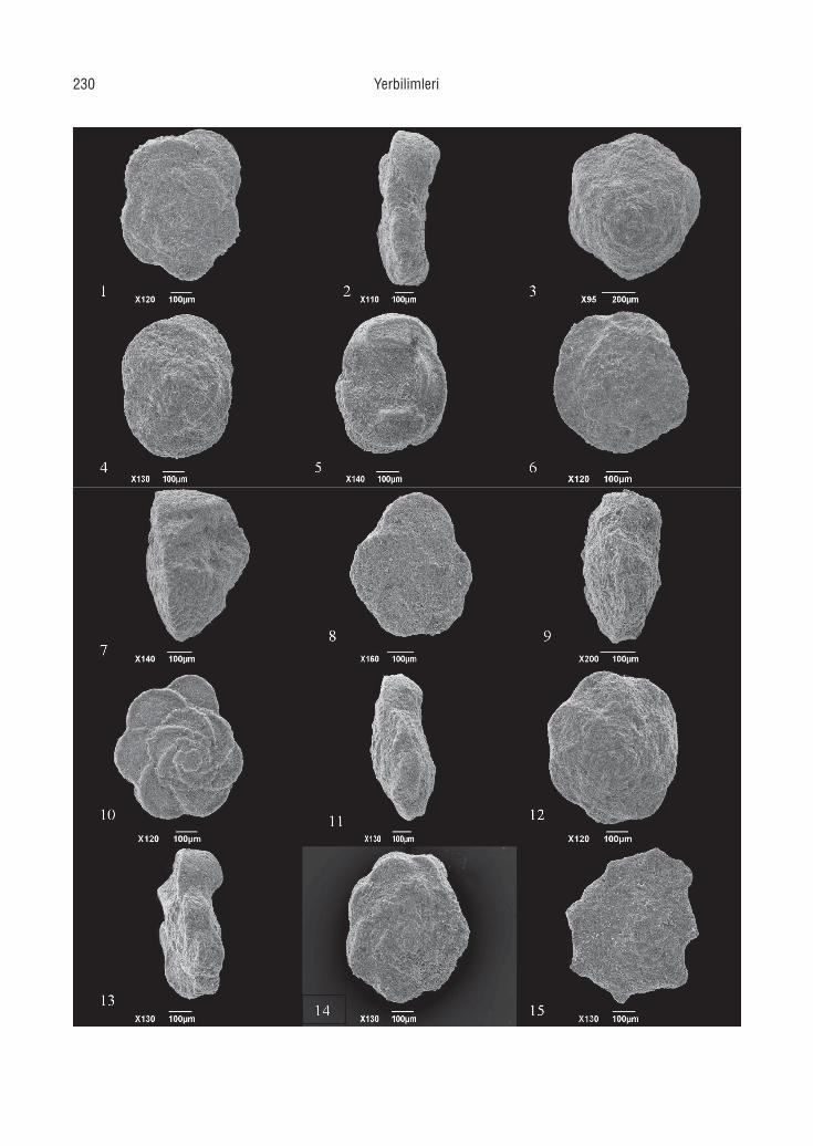
Yerbilimleri230
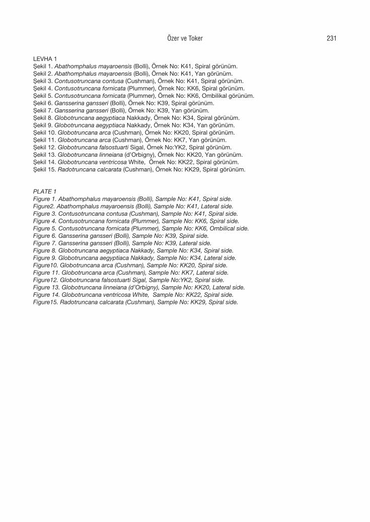
LEVHA 1Şekil 1. Abathomphalus mayaroensis (Bolli), Örnek No: K41, Spiral görünüm.Şekil 2. Abathomphalus mayaroensis (Bolli), Örnek No: K41, Yan görünüm.Şekil 3. Contusotruncana contusa (Cushman), Örnek No: K41, Spiral görünüm.Şekil 4. Contusotruncana fornicata (Plummer), Örnek No: KK6, Spiral görünüm.Şekil 5. Contusotruncana fornicata (Plummer), Örnek No: KK6, Ombilikal görünüm.Şekil 6. Gansserina gansseri (Bolli), Örnek No: K39, Spiral görünüm.Şekil 7. Gansserina gansseri (Bolli), Örnek No: K39, Yan görünüm.Şekil 8. Globotruncana aegyptiaca Nakkady, Örnek No: K34, Spiral görünüm.Şekil 9. Globotruncana aegyptiaca Nakkady, Örnek No: K34, Yan görünüm.Şekil 10. Globotruncana arca (Cushman), Örnek No: KK20, Spiral görünüm.Şekil 11. Globotruncana arca (Cushman), Örnek No: KK7, Yan görünüm.Şekil 12. Globotruncana falsostuarti Sigal, Örnek No:YK2, Spiral görünüm.Şekil 13. Globotruncana linneiana (d’Orbigny), Örnek No: KK20, Yan görünüm.Şekil 14. Globotruncana ventricosa White, Örnek No: KK22, Spiral görünüm.Şekil 15. Radotruncana calcarata (Cushman), Örnek No: KK29, Spiral görünüm.
PLATE 1Figure 1. Abathomphalus mayaroensis (Bolli), Sample No: K41, Spiral side.Figure2. Abathomphalus mayaroensis (Bolli), Sample No: K41, Lateral side.Figure 3. Contusotruncana contusa (Cushman), Sample No: K41, Spiral side.Figure 4. Contusotruncana fornicata (Plummer), Sample No: KK6, Spiral side.Figure 5. Contusotruncana fornicata (Plummer), Sample No: KK6, Ombilical side.Figure 6. Gansserina gansseri (Bolli), Sample No: K39, Spiral side.Figure 7. Gansserina gansseri (Bolli), Sample No: K39, Lateral side.Figure 8. Globotruncana aegyptiaca Nakkady, Sample No: K34, Spiral side.Figure 9. Globotruncana aegyptiaca Nakkady, Sample No: K34, Lateral side.Figure10. Globotruncana arca (Cushman), Sample No: KK20, Spiral side.Figure 11. Globotruncana arca (Cushman), Sample No: KK7, Lateral side.Figure12. Globotruncana falsostuarti Sigal, Sample No:YK2, Spiral side.Figure 13. Globotruncana linneiana (d’Orbigny), Sample No: KK20, Lateral side.Figure 14. Globotruncana ventricosa White, Sample No: KK22, Spiral side.Figure15. Radotruncana calcarata (Cushman), Sample No: KK29, Spiral side.
Özer ve Toker 231
Yerbilimleri232
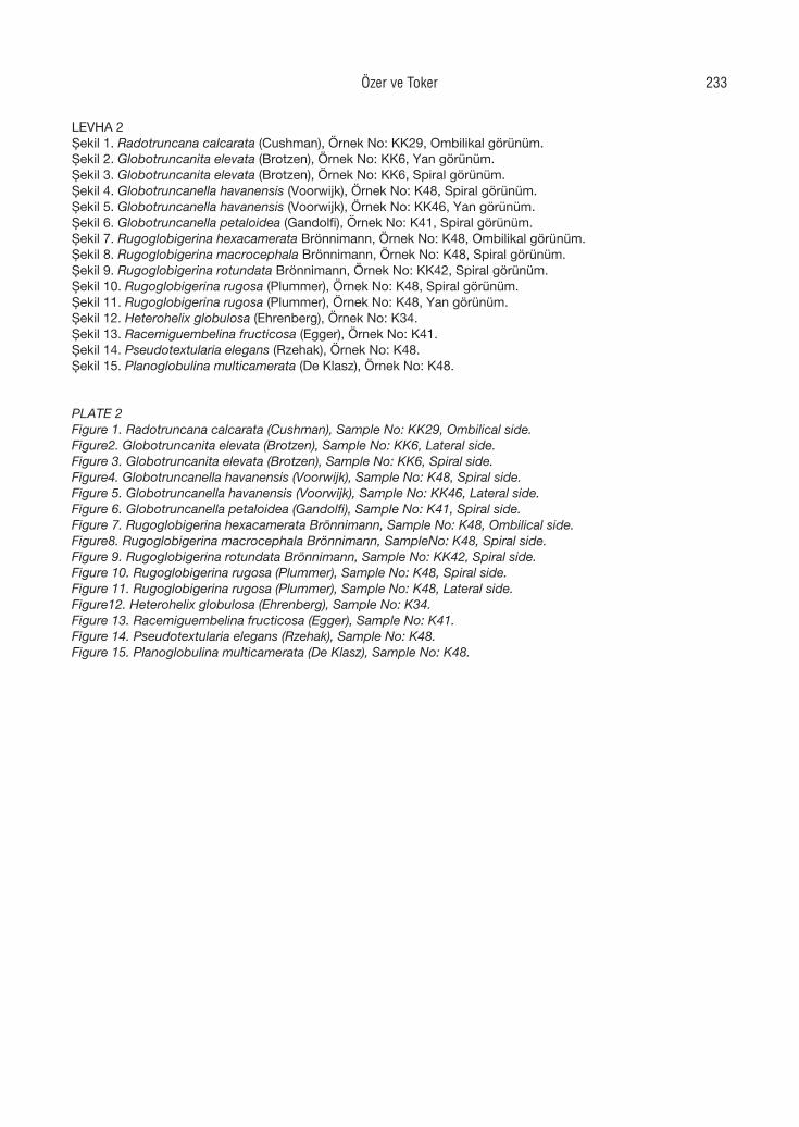
LEVHA 2Şekil 1. Radotruncana calcarata (Cushman), Örnek No: KK29, Ombilikal görünüm.Şekil 2. Globotruncanita elevata (Brotzen), Örnek No: KK6, Yan görünüm.Şekil 3. Globotruncanita elevata (Brotzen), Örnek No: KK6, Spiral görünüm.Şekil 4. Globotruncanella havanensis (Voorwijk), Örnek No: K48, Spiral görünüm.Şekil 5. Globotruncanella havanensis (Voorwijk), Örnek No: KK46, Yan görünüm.Şekil 6. Globotruncanella petaloidea (Gandolfi), Örnek No: K41, Spiral görünüm.Şekil 7. Rugoglobigerina hexacamerata Brönnimann, Örnek No: K48, Ombilikal görünüm.Şekil 8. Rugoglobigerina macrocephala Brönnimann, Örnek No: K48, Spiral görünüm.Şekil 9. Rugoglobigerina rotundata Brönnimann, Örnek No: KK42, Spiral görünüm.Şekil 10. Rugoglobigerina rugosa (Plummer), Örnek No: K48, Spiral görünüm.Şekil 11. Rugoglobigerina rugosa (Plummer), Örnek No: K48, Yan görünüm.Şekil 12. Heterohelix globulosa (Ehrenberg), Örnek No: K34.Şekil 13. Racemiguembelina fructicosa (Egger), Örnek No: K41.Şekil 14. Pseudotextularia elegans (Rzehak), Örnek No: K48.Şekil 15. Planoglobulina multicamerata (De Klasz), Örnek No: K48.
PLATE 2Figure 1. Radotruncana calcarata (Cushman), Sample No: KK29, Ombilical side.Figure2. Globotruncanita elevata (Brotzen), Sample No: KK6, Lateral side.Figure 3. Globotruncanita elevata (Brotzen), Sample No: KK6, Spiral side.Figure4. Globotruncanella havanensis (Voorwijk), Sample No: K48, Spiral side.Figure 5. Globotruncanella havanensis (Voorwijk), Sample No: KK46, Lateral side.Figure 6. Globotruncanella petaloidea (Gandolfi), Sample No: K41, Spiral side.Figure 7. Rugoglobigerina hexacamerata Brönnimann, Sample No: K48, Ombilical side.Figure8. Rugoglobigerina macrocephala Brönnimann, SampleNo: K48, Spiral side.Figure 9. Rugoglobigerina rotundata Brönnimann, Sample No: KK42, Spiral side.Figure 10. Rugoglobigerina rugosa (Plummer), Sample No: K48, Spiral side.Figure 11. Rugoglobigerina rugosa (Plummer), Sample No: K48, Lateral side.Figure12. Heterohelix globulosa (Ehrenberg), Sample No: K34.Figure 13. Racemiguembelina fructicosa (Egger), Sample No: K41.Figure 14. Pseudotextularia elegans (Rzehak), Sample No: K48.Figure 15. Planoglobulina multicamerata (De Klasz), Sample No: K48.
Özer ve Toker 233

Yerbilimleri, 30 (3), 235–257Hacettepe Üniversitesi Yerbilimleri Uygulama ve Araştırma Merkezi DergisiJournal of the Earth Sciences Application and Research Centre of Hacettepe University
The 2009 L’Aquila earthquake (Italy): Its characteristics and implications for earthquake science and earthquake engineering
L’Aquıla (İtalya) depreminin özellikleri ve deprem bilimi ve mühendisliği açısından önemi
1Ömer AYDAN, 2Halil KUMSAR, 3Selçuk TOPRAK
1Tokai University, Department of Marine Civil Engineering, Shizuoka, JAPAN2Pamukkale University, Department of Geological Engineering, Denizli, TURKEY3Pamukkale University, Department of Civil Engineering, Denizli, TURKEY
Geliş (received) : 12 Eylül (September) 2009 Kabul (accepted) : 14 Ekim (Octember) 2009
ABSTRACT
The 2009 L’Aquila earthquake that occurred in the Abruzzi region of Central Italy had a moment magnitude of 6.3. The earthquake caused the loss of 294 lives with casualties being particularly heavy in the old city of L’Aquila. The authors were able to investigate the damage caused by this earthquake soon after the event. The earthquake was caused by a normal fault and the heaviest damage was mainly on the hanging-wall side of the causative fault. This study describes the characteristics of this earthquake and its implications to earthquake science and earthquake engineering. Furthermore, the main causes of the heavy structural damage as well as the prediction of the earthqu-ake are discussed. A close inspection of prediction claims indicates that the prediction did not really satisfy the re-quirements for earthquake prediction. The causes of the heavy damage were low seismic resistance of structures and lack of implementation of modern seismic design code.
Keywords: Damage, L’Aquila earthquake, liquefaction, normal faulting, paleoseismology.
ÖZ
Moment büyüklüğü 6.3 olan L’Aquila depremi, İtalya’nın orta kesimindeki Abruzzi bölgesinde 6 Nisan 2009’da meydana gelmıştir. Deprem 294 kişinin yaşamını yitirmesine ve L’Aqulia kentinde ağır hasar meydana gelmesine neden olmuştur. Yazarlar, depremden hemen sonra depremin neden olduğu hasarı incelemişlerdir. Deprem normal bir faydan kaynaklanmış olup, özellikle fayın tavan bloğu üzerinde bulunan yerleşimlerde oldukça ağır hasarlara neden olmuştur. Bu çalışmada, L’aquila depreminin özellikleri ve deprem bilimi ve mühendisliğindeki önemi ile etkileri sunulmuştur. Bunun yanı sıra, yapılarda görülen ağır hasarlar ile bunların nedenleri sunulmuş ve tartışılmıştır. Ayrıca deprem tahmini yapıldığına ilişkin haberlerin doğruluğu bilimsel olarak incelenmiş ve bu öngörünün deprem tahmini için gerekli koşulları sağlamadığı görülmüştür. Gözlenen hasarlarının başlıca nedenleri, yapıların depreme karşı dirençlerinin düşük olması ve deprem yönetmeliklerinin uygulanmamış olmasıdır.
Anahtar Kelimeler: Hasar, L’Aquila depremi, sıvılaşma, normal faylanma, paleosismoloji.
Ö.AydanE-mail: [email protected]
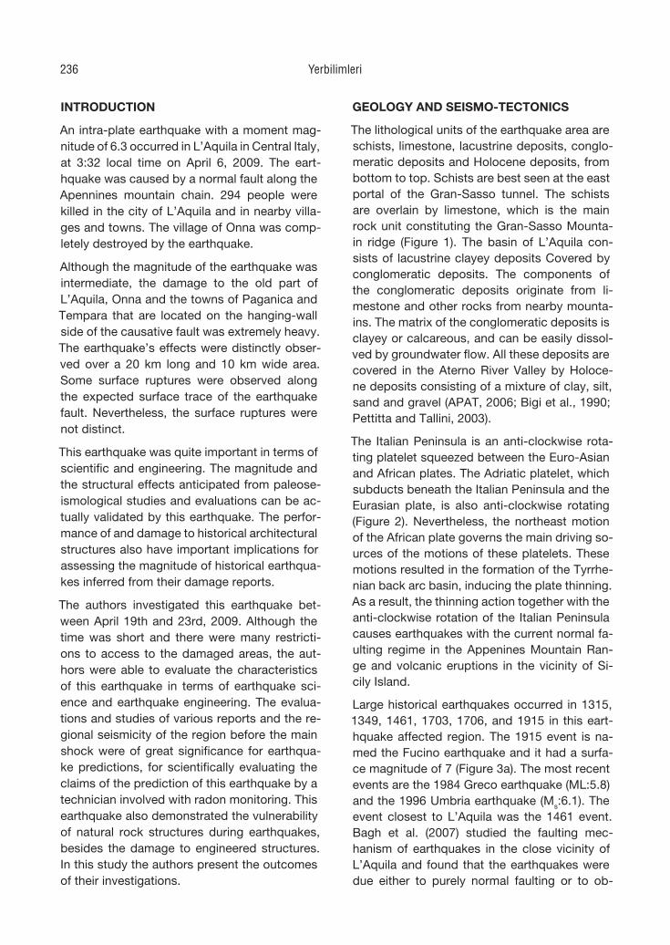
INTRODUCTION
An intra-plate earthquake with a moment mag-nitude of 6.3 occurred in L’Aquila in Central Italy, at 3:32 local time on April 6, 2009. The eart-hquake was caused by a normal fault along the Apennines mountain chain. 294 people were killed in the city of L’Aquila and in nearby villa-ges and towns. The village of Onna was comp-letely destroyed by the earthquake.
Although the magnitude of the earthquake was intermediate, the damage to the old part of L’Aquila, Onna and the towns of Paganica and Tempara that are located on the hanging-wall side of the causative fault was extremely heavy. The earthquake’s effects were distinctly obser-ved over a 20 km long and 10 km wide area. Some surface ruptures were observed along the expected surface trace of the earthquake fault. Nevertheless, the surface ruptures were not distinct.
This earthquake was quite important in terms of scientific and engineering. The magnitude and the structural effects anticipated from paleose-ismological studies and evaluations can be ac-tually validated by this earthquake. The perfor-mance of and damage to historical architectural structures also have important implications for assessing the magnitude of historical earthqua-kes inferred from their damage reports.
The authors investigated this earthquake bet-ween April 19th and 23rd, 2009. Although the time was short and there were many restricti-ons to access to the damaged areas, the aut-hors were able to evaluate the characteristics of this earthquake in terms of earthquake sci-ence and earthquake engineering. The evalua-tions and studies of various reports and the re-gional seismicity of the region before the main shock were of great significance for earthqua-ke predictions, for scientifically evaluating the claims of the prediction of this earthquake by a technician involved with radon monitoring. This earthquake also demonstrated the vulnerability of natural rock structures during earthquakes, besides the damage to engineered structures. In this study the authors present the outcomes of their investigations.
GEOLOGY AND SEISMO-TECTONICS
The lithological units of the earthquake area are schists, limestone, lacustrine deposits, conglo-meratic deposits and Holocene deposits, from bottom to top. Schists are best seen at the east portal of the Gran-Sasso tunnel. The schists are overlain by limestone, which is the main rock unit constituting the Gran-Sasso Mounta-in ridge (Figure 1). The basin of L’Aquila con-sists of lacustrine clayey deposits Covered by conglomeratic deposits. The components of the conglomeratic deposits originate from li-mestone and other rocks from nearby mounta-ins. The matrix of the conglomeratic deposits is clayey or calcareous, and can be easily dissol-ved by groundwater flow. All these deposits are covered in the Aterno River Valley by Holoce-ne deposits consisting of a mixture of clay, silt, sand and gravel (APAT, 2006; Bigi et al., 1990; Pettitta and Tallini, 2003).
The Italian Peninsula is an anti-clockwise rota-ting platelet squeezed between the Euro-Asian and African plates. The Adriatic platelet, which subducts beneath the Italian Peninsula and the Eurasian plate, is also anti-clockwise rotating (Figure 2). Nevertheless, the northeast motion of the African plate governs the main driving so-urces of the motions of these platelets. These motions resulted in the formation of the Tyrrhe-nian back arc basin, inducing the plate thinning. As a result, the thinning action together with the anti-clockwise rotation of the Italian Peninsula causes earthquakes with the current normal fa-ulting regime in the Appenines Mountain Ran-ge and volcanic eruptions in the vicinity of Si-cily Island.
Large historical earthquakes occurred in 1315, 1349, 1461, 1703, 1706, and 1915 in this eart-hquake affected region. The 1915 event is na-med the Fucino earthquake and it had a surfa-ce magnitude of 7 (Figure 3a). The most recent events are the 1984 Greco earthquake (ML:5.8) and the 1996 Umbria earthquake (Ms:6.1). The event closest to L’Aquila was the 1461 event. Bagh et al. (2007) studied the faulting mec-hanism of earthquakes in the close vicinity of L’Aquila and found that the earthquakes were due either to purely normal faulting or to ob-
Yerbilimleri236
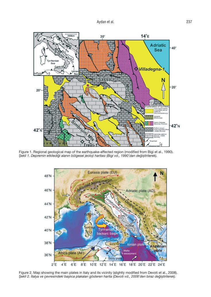
Figure 1
Figure 1
Figure 2
Figure 2. Map showing the main plates in Italy and its vicinity (slightly modified from Devoti et al., 2008).Şekil 2. İtalya ve çevresindeki başlıca plakaları gösteren harita (Devoti vd., 2008’den biraz değiştirilerek).
Figure 1. Regional geological map of the earthquake-affected region (modified from Bigi et al., 1990).Şekil 1. Depremin etkilediği alanın bölgesel jeoloji haritası (Bigi vd., 1990’dan değiştirilerek).
Aydan et al. 237
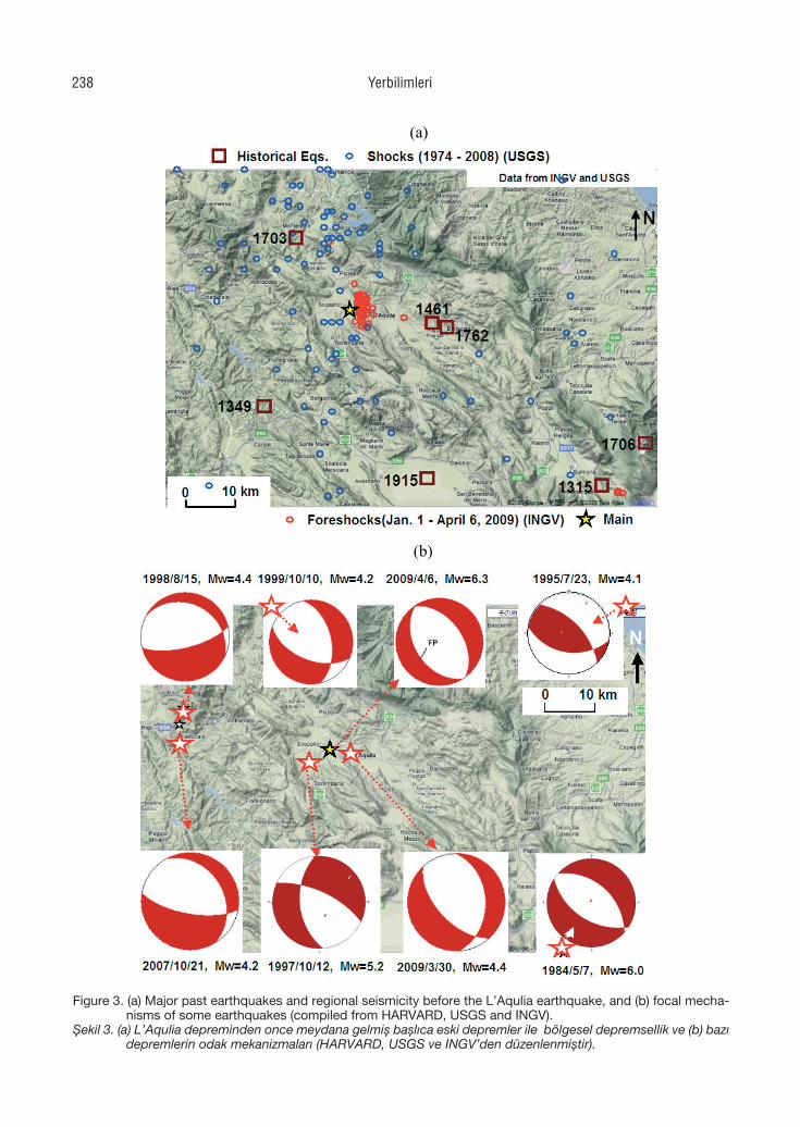
(a)
(b)
Figure 3 Figure 3. (a) Major past earthquakes and regional seismicity before the L’Aqulia earthquake, and (b) focal mecha-nisms of some earthquakes (compiled from HARVARD, USGS and INGV).
Şekil 3. (a) L’Aqulia depreminden once meydana gelmiş başlıca eski depremler ile bölgesel depremsellik ve (b) bazı depremlerin odak mekanizmaları (HARVARD, USGS ve INGV’den düzenlenmiştir).
Yerbilimleri238
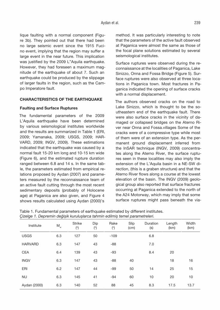
lique faulting with a normal component (Figu-re 3b). They pointed out that there had been no large seismic event since the 1915 Fuci-no event, implying that the region may suffer a large event in the near future. This implication was justified by the 2009 L”Aquila earthquake. However, they had foreseen a maximum mag-nitude of the earthquake of about 7. Such an earthquake could be produced by the slippage of larger faults in the region, such as the Cam-po Imperatore fault.
CHARACTERISTICS OF THE EARTHQUAKE
Faulting and Surface Ruptures
The fundamental parameters of the 2009 L’Aquila earthquake have been determined by various seismological institutes worldwide and the results are summarized in Table 1 (ERI, 2009; Yamanaka, 2009; USGS, 2009; HAR-VARD, 2009; INGV, 2009). These estimations indicated that the earthquake was caused by a normal fault 15-20 km long and 10-15 km wide (Figure 6), and the estimated rupture duration ranged between 6.8 and 14 s. In the same tab-le, the parameters estimated from empirical re-lations proposed by Aydan (2007) and parame-ters measured by the reconnaissance team of an active fault cutting through the most recent sedimentary deposits (probably of Holocene age) at Paganica are also given, and Figure 4 shows results calculated using Aydan (2000)’s
method. It was particularly interesting to note that the parameters of the active fault observed at Paganica were almost the same as those of the focal plane solutions estimated by several seismological institutes.
Surface ruptures were observed during the re-connaissance at the localities of Paganica, Lake Sinizzo, Onna and Fossa Bridge (Figure 5). Sur-face ruptures were also observed at three loca-tions in Paganica town. Most fractures in Pa-ganica indicated the opening of surface cracks with a normal displacement.
The authors observed cracks on the road to Lake Sinizzo, which is thought to be the so-utheastern end of the earthquake fault. There were also surface cracks in the vicinity of da-maged or collapsed bridges on the Aterno Ri-ver near Onna and Fossa.villages Some of the cracks were of a compressive type while most of them were of an extension type. As the per-manent ground displacement inferred from the InSAR technique (INGV, 2009) concentra-tes along the Aterno River, the surface ruptu-res seen in these localities may also imply the extension of the L’Aquila basin in a NE-SW di-rection, (this is a graben structure) and that the Aterno River flows along a course at the lowest elevation of the basin. The INGV (2009) geolo-gical group also reported that surface fractures occurring at Paganica extended to the north of the A24 Motorway, which may imply that some surface ruptures might pass beneath the via-
Table 1. Fundamental parameters of earthquake estimated by different institutes.Çizelge 1. Depremin değişik kuruluşlarca tahmin edilmiş temel parametreleri.
Institute Mw
Strike(o)
Dip(o)
Rake(o)
Slip(cm)
Duration(s)
Length(km)
Width(km)
USGS 6.3 127 50 -109 6.8
HARVARD 6.3 147 43 -88 7.0
CEA 6.4 139 43 -93 8.4 20
INGV 6.3 147 43 -88 40 18 16
ERI 6.2 147 44 -99 50 14 25 15
NU 6.3 145 41 -94 60 10 20 10
Aydan (2000) 6.3 140 52 88 45 8.3 17.5 13.7
Aydan et al. 239
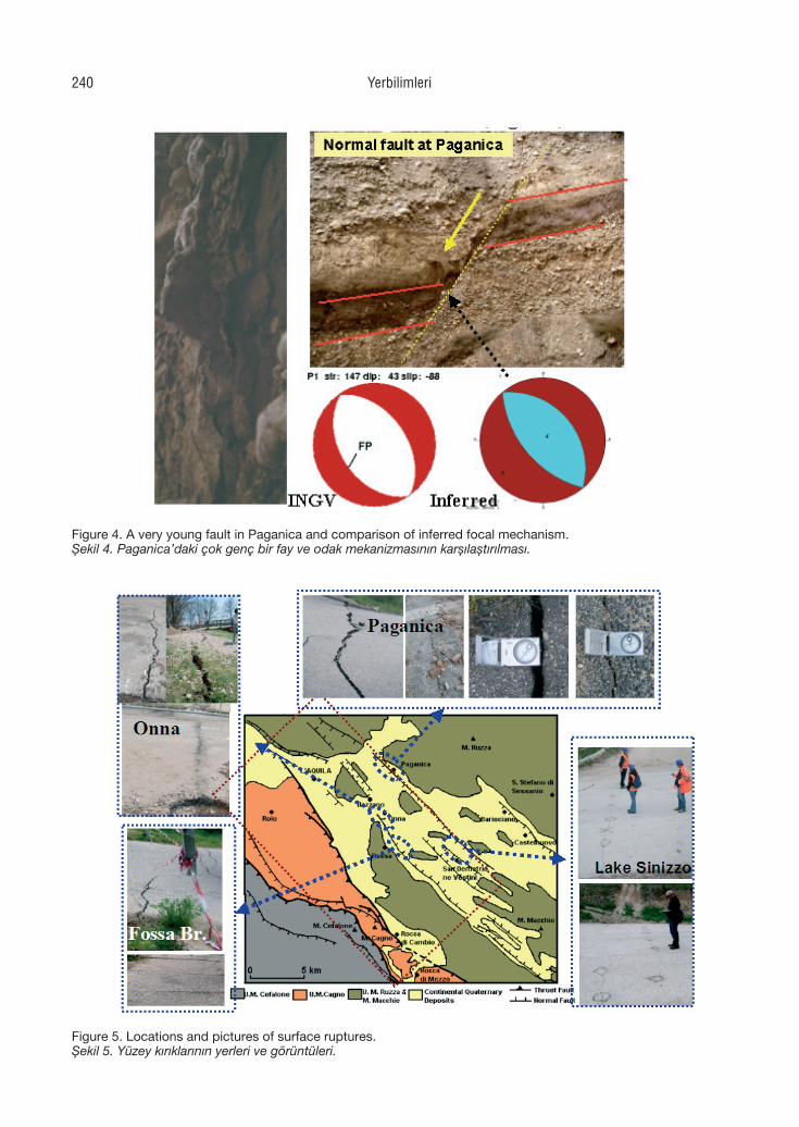
Figure 4
Figure 4. A very young fault in Paganica and comparison of inferred focal mechanism.Şekil 4. Paganica’daki çok genç bir fay ve odak mekanizmasının karşılaştırılması.
Figure 5
Figure 6
Figure 5. Locations and pictures of surface ruptures.Şekil 5. Yüzey kırıklarının yerleri ve görüntüleri.
Yerbilimleri240
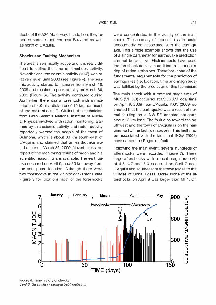
ducts of the A24 Motorway. In addition, they re-ported surface ruptures near Bazzano as well as north of L’Aquila.
Shocks and Faulting Mechanism
The area is seismically active and it is really dif-ficult to define the time of foreshock activity. Nevertheless, the seismic activity (M>3) was re-latively quiet until 2008 (see Figure 4). The seis-mic activity started to increase from March 10, 2009 and reached a peak activity on March 30, 2009 (Figure 6). The activity continued during April when there was a foreshock with a mag-nitude of 4.0 at a distance of 10 km northeast of the main shock. G. Giuliani, the technician from Gran Sasso’s National Institute of Nucle-ar Physics involved with radon monitoring, alar-med by this seismic activity and radon activity reportedly warned the people of the town of Sulmona, which is about 30 km south-east of L’Aquila, and claimed that an earthquake wo-uld occur on March 29, 2009. Nevertheless, no report of the monitoring results of radon and his scientific reasoning are available. The earthqu-ake occurred on April 6, and 30 km away from the anticipated location. Although there were two foreshocks in the vicinity of Sulmona (see Figure 3 for location) most of the foreshocks
were concentrated in the vicinity of the main shock. The anomaly of radon emission could undoubtedly be associated with the earthqu-ake. This simple example shows that the use of a single parameter for earthquake prediction can not be decisive. Giuliani could have used the foreshock activity in addition to the monito-ring of radon emissions. Therefore, none of the fundamental requirements for the prediction of earthquakes (i.e. location, time and magnitude) was fulfilled by the prediction of this technician.
The main shock with a moment magnitude of M6.3 (Ml=5.8) occurred at 03:33 AM local time on April 6, 2009 near L’Aquila. INGV (2009) es-timated that the earthquake was a result of nor-mal faulting on a NW-SE oriented structure about 15 km long. The fault dips toward the so-uthwest and the town of L’Aquila is on the han-ging wall of the fault just above it. This fault may be associated with the fault that INGV (2009) have named the Paganica fault.
Following the main event, several hundreds of aftershocks were recorded (Figure 7). Three large aftershocks with a local magnitude (Ml) of 4.8, 4.7 and 5.3 occurred on April 7 near L’Aquila and southeast of the town (close to the villages of Onna, Fossa, Ocre). None of the af-tershocks on April 8 was larger than Ml 4. On
Figure 5
Figure 6
Figure 6. Time history of shocks.Şekil 6. Sarsıntıların zamana bağlı değişimi.
Aydan et al. 241
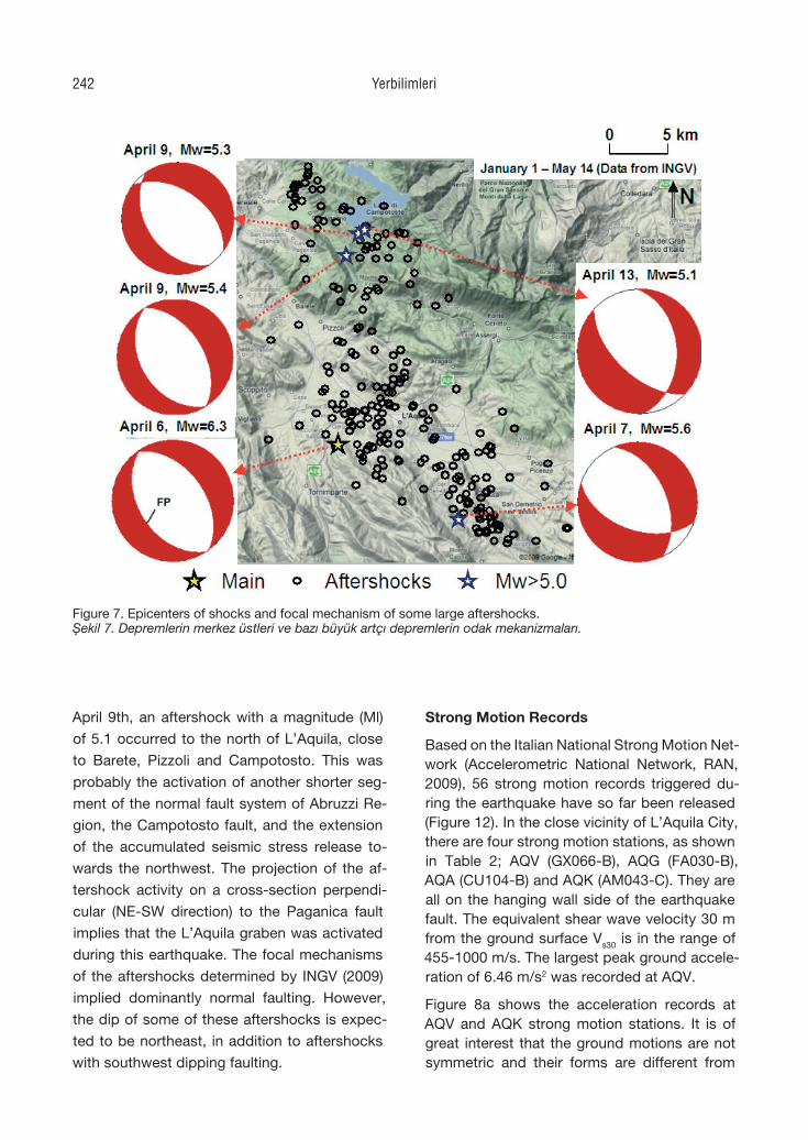
April 9th, an aftershock with a magnitude (Ml)
of 5.1 occurred to the north of L’Aquila, close
to Barete, Pizzoli and Campotosto. This was
probably the activation of another shorter seg-
ment of the normal fault system of Abruzzi Re-
gion, the Campotosto fault, and the extension
of the accumulated seismic stress release to-
wards the northwest. The projection of the af-
tershock activity on a cross-section perpendi-
cular (NE-SW direction) to the Paganica fault
implies that the L’Aquila graben was activated
during this earthquake. The focal mechanisms
of the aftershocks determined by INGV (2009)
implied dominantly normal faulting. However,
the dip of some of these aftershocks is expec-
ted to be northeast, in addition to aftershocks
with southwest dipping faulting.
Strong Motion Records
Based on the Italian National Strong Motion Net-work (Accelerometric National Network, RAN, 2009), 56 strong motion records triggered du-ring the earthquake have so far been released (Figure 12). In the close vicinity of L’Aquila City, there are four strong motion stations, as shown in Table 2; AQV (GX066-B), AQG (FA030-B), AQA (CU104-B) and AQK (AM043-C). They are all on the hanging wall side of the earthquake fault. The equivalent shear wave velocity 30 m from the ground surface Vs30 is in the range of 455-1000 m/s. The largest peak ground accele-ration of 6.46 m/s2 was recorded at AQV.
Figure 8a shows the acceleration records at AQV and AQK strong motion stations. It is of great interest that the ground motions are not symmetric and their forms are different from
Figure 7
Figure 7. Epicenters of shocks and focal mechanism of some large aftershocks.Şekil 7. Depremlerin merkez üstleri ve bazı büyük artçı depremlerin odak mekanizmaları.
Yerbilimleri242
each other although the epicentral distances and equivalent shear wave velocity (Vs30) of gro-und are almost the same. Although the deta-ils of the ground conditions at the stations are not available yet, the ground motion amplificati-on estimations based on the Vs30 approach may not be valid at all.
Figure 8b shows the acceleration records at GSA and GSG strong motion stations, which are reportedly founded on Eocene limestone, with a shear wave velocity of 1 km/s. The GSA station is at Assergi and the GSG station is lo-cated in an underground gallery. Although the epicentral distances and ground conditions are the same, the acceleration at ground surface is amplified to almost 15 times greater than that in the underground gallery.
The attenuation of maximum ground accelerati-on for two different models is shown in Figure 9. Figure 9 is a comparison of attenuation of maxi-mum ground acceleration as a function of hypo-central distance using the various attenuation relations (Aydan, 1997; Joyner and Boore, 1981; Fukushima et al., 1988). As seen from this figure, attenuation based on spherical symmetry can not estimate a wide range of observational data. The attenuation relation proposed by Aydan and Ohta (2006) (see also Aydan, 2007), which inclu-des a consideration of fault orientation and gro-und characteristics, provides better bounds for the observational data.
Figure 10 shows the acceleration spectra of selected stations in the vicinity of the epicen-ter. When the response spectra of records of
strong motion stations in the close vicinity of L’Aquila are compared with the design spect-ra designated by the EC8, the actual respon-se spectra exceed the designations within the period range of 0-0.4 s. The base ground ac-celeration is imaging to have ranged between 0.3-0.4 g in the of L’Aquila, in view of the gro-und motion records at AQK strong motion stati-on as well as the damage to structures.
Acceleration spectra of some selected strong motion stations (AQV, AQK, AQA, AQG, MTR, FMG, GSA, GSG) are shown in Figure 10. As expected, the spectral accelerations of vertical component are high for natural periods ranging between 0.05 s and 0.1 s. As for the horizontal component, the natural periods range between 0.05 s and 0.4 s. Nevertheless, very long peri-od components are particularly noted for AQG station, which is located over the bedrock of li-mestone and has previously been pointed out by Luca et al. (2005).
Permanent Ground Deformations
An attempt was made to estimate the permanent ground deformations from strong motion records using the EPS method proposed by Ohta and Aydan (2007a, 2007b). The most important as-pect of these methods is how to assign parame-ters for numerical integration. The record is divi-ded into three segments. Filtering is imposed in the first and third segments while the integration is directly applied to the second segment if the acceleration record does not drift. The duration of the second segment is directly based on the
Table 2. Information for the strong ground motion stations in the vicinity of L’Aquila.Çizelge 2. L’Aqulia çevresindeki kuvvetli yer hareketi kayıt istasyonlarına ait bilgiler.
Station nameStation code
Latitude Longitude Type of ground
Re (km)
Vs30 (m/s)
PGA(m/s2)
Aquil Park AQK 42.345 13.401 Conglomerate 5.6 455 3.66
V. F.Aterno AQV 42.377 13.337 Fluvial 5.8 475 6.46
Colle Grilli AQG 42.376 13.339 Limestone 4.3 1000 5.05
V&F Aterno AQA 42.345 13.401 Fluvial 4.8 475 4.78
Aydan et al. 243
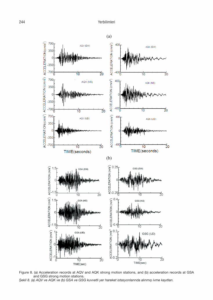
(a)
(b)
Figure 8 Figure 8. (a) Acceleration records at AQV and AQK strong motion stations, and (b) acceleration records at GSA and GSG strong motion stations.
Şekil 8. (a) AQV ve AQK ve (b) GSA ve GSG kuvvetli yer hareket istasyonlarında alınmış ivme kayıtları.
Yerbilimleri244
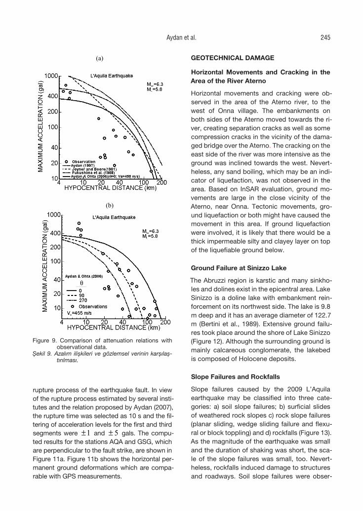
rupture process of the earthquake fault. In view of the rupture process estimated by several insti-tutes and the relation proposed by Aydan (2007), the rupture time was selected as 10 s and the fil-tering of acceleration levels for the first and third segments were 1± and 5± gals. The compu-ted results for the stations AQA and GSG, which are perpendicular to the fault strike, are shown in Figure 11a. Figure 11b shows the horizontal per-manent ground deformations which are compa-rable with GPS measurements.
GEOTECHNICAL DAMAGE
Horizontal Movements and Cracking in the Area of the River Aterno
Horizontal movements and cracking were ob-served in the area of the Aterno river, to the west of Onna village. The embankments on both sides of the Aterno moved towards the ri-ver, creating separation cracks as well as some compression cracks in the vicinity of the dama-ged bridge over the Aterno. The cracking on the east side of the river was more intensive as the ground was inclined towards the west. Nevert-heless, any sand boiling, which may be an indi-cator of liquefaction, was not observed in the area. Based on InSAR evaluation, ground mo-vements are large in the close vicinity of the Aterno, near Onna. Tectonic movements, gro-und liquefaction or both might have caused the movement in this area. If ground liquefaction were involved, it is likely that there would be a thick impermeable silty and clayey layer on top of the liquefiable ground below.
Ground Failure at Sinizzo Lake
The Abruzzi region is karstic and many sinkho-les and dolines exist in the epicentral area. Lake Sinizzo is a doline lake with embankment rein-forcement on its northwest side. The lake is 9.8 m deep and it has an average diameter of 122.7 m (Bertini et al., 1989). Extensive ground failu-res took place around the shore of Lake Sinizzo (Figure 12). Although the surrounding ground is mainly calcareous conglomerate, the lakebed is composed of Holocene deposits.
Slope Failures and Rockfalls
Slope failures caused by the 2009 L’Aquila earthquake may be classified into three cate-gories: a) soil slope failures; b) surficial slides of weathered rock slopes c) rock slope failures (planar sliding, wedge sliding failure and flexu-ral or block toppling) and d) rockfalls (Figure 13). As the magnitude of the earthquake was small and the duration of shaking was short, the sca-le of the slope failures was small, too. Nevert-heless, rockfalls induced damage to structures and roadways. Soil slope failures were obser-
(a)
(b)
Figure 9
Figure 9. Comparison of attenuation relations with observational data.
Şekil 9. Azalım ilişkileri ve gözlemsel verinin karşılaş-tırılması.
Aydan et al. 245
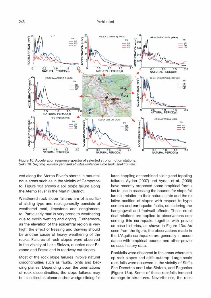
ved along the Aterno River’s shores in mountai-nous areas such as in the vicinity of Campotos-to. Figure 13a shows a soil slope failure along the Aterno River in the Martini District.
Weathered rock slope failures are of a surfici-al sliding type and rock generally consists of weathered marl, limestone and conglomera-te. Particularly marl is very prone to weathering due to cyclic wetting and drying. Furthermore, as the elevation of the epicentral region is very high, the effect of freezing and thawing should be another cause of heavy weathering of the rocks. Failures of rock slopes were observed in the vicinity of Lake Sinizzo, quarries near Ba-zanno and Fossa and in roadway cut slopes.
Most of the rock slope failures involve natural discontinuities such as faults, joints and bed-ding planes. Depending upon the orientations of rock discontinuities, the slope failures may be classified as planar and/or wedge sliding fai-
lures, toppling or combined sliding and toppling failures. Aydan (2007) and Aydan et al. (2009) have recently proposed some empirical formu-las to use in assessing the bounds for slope fai-lures in relation to their natural state and the re-lative position of slopes with respect to hypo-centers and earthquake faults, considering the hangingwall and footwall effects. These empi-rical relations are applied to observations con-cerning this earthquake together with previo-us case histories, as shown in Figure 13c. As seen from the figure, the observations made in the L’Aquila earthquake are generally in accor-dance with empirical bounds and other previo-us case history data.
Rockfalls were observed in the areas where ste-ep rock slopes and cliffs outcrop. Large scale rock falls were observed in the vicinity of Stiffe, San Demetrio and Lake Sinizzo, and Paganica (Figure 13b). Some of these rockfalls induced damage to structures. Nevertheless, the rock-
Figure 10
Figure 10. Acceleration response spectra of selected strong motion stations.Şekil 10. Seçilmiş kuvvetli yer hareketi istasyonlarının ivme tepki spektrumları.
Yerbilimleri246
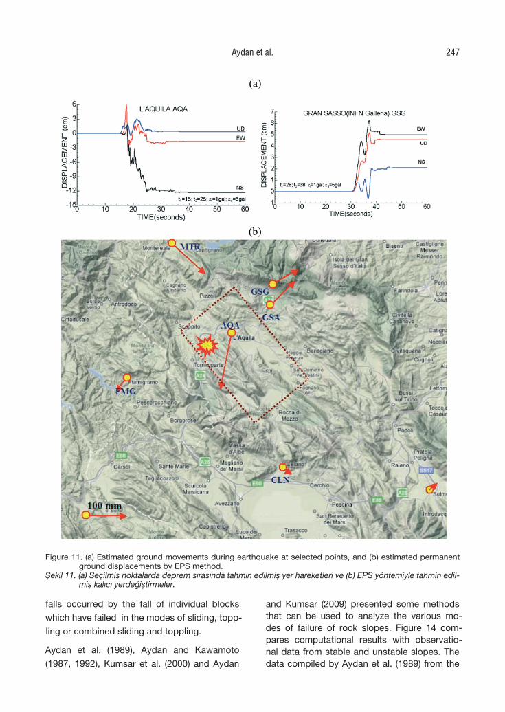
falls occurred by the fall of individual blocks
which have failed in the modes of sliding, topp-
ling or combined sliding and toppling.
Aydan et al. (1989), Aydan and Kawamoto
(1987, 1992), Kumsar et al. (2000) and Aydan
and Kumsar (2009) presented some methods that can be used to analyze the various mo-des of failure of rock slopes. Figure 14 com-pares computational results with observatio-nal data from stable and unstable slopes. The data compiled by Aydan et al. (1989) from the
(a)
(b)
Figure 11
Figure 11. (a) Estimated ground movements during earthquake at selected points, and (b) estimated permanent ground displacements by EPS method.
Şekil 11. (a) Seçilmiş noktalarda deprem sırasında tahmin edilmiş yer hareketleri ve (b) EPS yöntemiyle tahmin edil-miş kalıcı yerdeğiştirmeler.
Aydan et al. 247
natural rock slopes of the Apennine Mounta-ins are also plotted together, as the mountains of the region belong to the Apennine mountain ridge. The Apennines are composed of mainly limestone and other calcareous rocks of diffe-rent geologic ages. As a result, their stability is influenced by the orientation of bedding planes as well as normal faults. During the compilati-on of data, it was noted that when layers are thin, it seems that the slope angle for stability under natural conditions is drastically reduced. Furthermore, when layers dip into a slope, the natural stable slope angle tends to be almost equal to that of the bedding plane. As for layers dipping into the mountainside, the stable slo-pe angle is almost equal to, or greater than, the normal angle of the bedding planes. When it is greater than the normal angle of bedding plane, its value ranges from 5o to 35o. When the slope becomes higher, the stable slope angle tends to converge to that of the norm of the bedding plane. The repose angle of slope debris ranges between 30o and 40o. Figure 14 is considered as a guideline for local engineers when selec-ting the slope-cutting angle in the actual resto-ration of the failed slopes.
Sinkholes
The geology of L’Aquila city involves limesto-ne at its base, lacustrine clay and continental debris in the form of conglomerate and brec-cias and Holocene alluvial deposits from bot-tom to top. The L’Aquila breccia of Pleistoce-ne age is known to contain karstic caves. Kars-tic caves are geologically well-known to form along generally steep fault zones and fractures due to erosion and/or solution by groundwater (i.e. Aydan and Tokashiki, 2007; Tokashiki and Aydan, 2008). During reconnaissance, the aut-hors found two large karstic caves very close to the AQK strong motion station. The height of one of these caves is about 5 m. Along the same road one can easily notice the remnant of a karstic cave on a rock-slope cut. It seems that karstic caves are a well-known problem in L’Aquila. One can find reports of searches for potential karstic caves using various geoph-ysical methods (i..e Tallini et al., 2004a, 2004b). The 2009 L’Aquila earthquake caused two sink-
Figure 12
22 m
Figure 12. Views of the ground failure before and after the earthquake.
Şekil 12. Depremden önce ve sonra yüzeydeki yenil-meden görüntüler.
Yerbilimleri248
holes in L’Aquila (Figure 15a). One of the sink-holes was well publicized worldwide. The width of this sinkhole was about 10 m and its depth is not well-known. A car fell into this sinkho-le. The second sinkhole was about 50 m away and its size was slightly smaller. Its length and width were about 8 m and 7 m, respectively. The depth of the sinkhole was about 10 m. The layers between the roof and road level were breccia with calcareous cementation, breccia with clayey matrix and top soil from bottom to top. A side trench was excavated to a depth of 3 to 4 m from the ground surface on the south side of the sinkhole. Another sinkhole occurred in Castelnuovo, and it had a length and width
of 5 and 3 m with a depth of 5 m. The thickness of the roof of this sinkhole was about 1.5-2.5 m.
Ground Liquefaction and Lateral Spreading
Soil liquefaction is caused by generation of pore water pressure and it is often observed when the ground consists of fully saturated sandy soil. Alluvial deposits are geologically formed along the Aterno River in the epicentral area. During their investigations, the authors found sand boils along the Aterno in the area called Martini, which is just south of the hill on which the old city centre of L’Aquila is located. The ri-ver meanders in the area sandy deposits are li-
(a) (b)
(c)
Figure 13
Figure 13. (a) Soil slope failure at Martini district, (b) rockfall at Stiffe, and (c) comparison of data of L’Aquila earth-quake with empirical bounds (coherent slopes and disturbed slopes).
Şekil 13. (a) Martini bölgesinde bir zemin şevi duraysızlığı, (b) Stiffe’de kaya düşmesi ve (c) L’Aqulia depremi verisi-nin görgül ilişkilerle karşılaştırılması (sıkı şevler ve örselenmiş şevler).
Aydan et al. 249
kely to have resulted in the locations of the me-anders. In the Martini district, liquefaction crea-ted many NE-SW trending fractures parallel to the river embankment, as shown in Figure 15b. Sand boiling as thick as 150 mm was observed in various locations. The movement of ground was towards a SE direction. Boiled sand is al-most homogenous and its grain size distributi-on falls within the easily-liquefiable bounds ac-
cording to the classification issued by the Port and Harbour Research Institute of Japan (1997).
The ground liquefaction also induced lateral spreading. The sum of crack openings from the adjacent field towards the river embankment ranged between 250-350 mm. There were se-veral depot-like structures and bridges for ra-ilways and roadways in the area where soil li-quefaction was observed. However, there was
Figure 14
(a) (b)
Figure 15
Figure 14
(a) (b)
Figure 15
Figure 14. Comparison of observational data with computational results prom previous studies ( :ξ intermittency angle; k: horizontal seismic coefficient;φ : friction angle).
Şekil 14. Gözlemsel verinin önceki çalışmalarda elde edilmiş hesaplama sonuçlarıyla karşılaştırılması ( :ξ aralık açı-sı; k: yatay sisimik katsayı; φ : sürtünme açısı).
Figure 15. (a) A sinkhole in L’Aquila, and (b) liquefaction in Martini district.Şekil 15. (a) L’Aquila’da karstik bir çökme ve (b) Martini bölgesinde sıvılaşma.
Yerbilimleri250
no visible damage to the structures, probably because the foundations were resting on deep stiff soils.
Figure 16a compares the authors’ observations with the empirical bounds proposed by several researchers (Aydan et al., 1998; Aydan, 2007; Ambraseys, 1988; Kuribayashi and Tatsuoka, 1979) for the limit of ground liquefaction. The observations are within the limits of liquefiab-le ground. Since the data is quite limited now, new data may give more accurate results. An attempt was made to obtain data concerning
the ground deformation due to liquefaction-induced lateral spreading, using several met-hods. Aydan et al. (2008) proposed a new met-hod based on the maximum ground velocity obtained from the strong motion records. Figu-re 16b compares the estimation of ground de-formation for different layer thicknesses. The comparison with the observational data impli-es that the thickness of liquefied ground in the Martini district should range between 1.5 and 2 m. Additional comparison is based on the use of ground motion data in the close vicinity of the liquefaction site in the Martini district.
STRUCTURAL DAMAGE
Damage to Buildings
Masonry buildings can be grouped into two; specifically, residential buildings and cultural and historical masonry buildings (Figure 17a). Residential masonry buildings are generally two story buildings and in this area they were made of stone or brick, or a mixture of stone and brick. The mortar is mud or lime. Heavily damaged or collapsed buildings had almost no tie beams. Furthermore, the mortar of these bu-ildings was mud. The main cause of the collap-se or heavy damage to masonary buildings was out-of plane failure.
Cultural and historical buildings are of a larger scale and involve domes, towers and facades. The failure mechanism of these buildings is fun-damentally quite similar to that of ordinary ma-sonry buildings. The non-existence of tie be-ams make these buildings quite vulnerable to heavy damage or collapse. The dome of Santa Maria del Suffragio collapsed although wooden tie beams had been used. As the wooden tie beams were not continuous over the perimetry of the dome, the effect of the earthquake was disastrous. The masonary cylindrical tower at Stefano di Sessanio, which is about 20 km from the epicenter, had completely collapsed (Figu-re 17b). It was important to notice that another tower of almost same height and located at the foot of the same hill survived the earthquake. This may be related to a difference in the amp-lification characteristics of the top and the foot of the hill, as well as to the shape and shaking characteristics of the towers.
(a)
(b)
Figure 16
Figure 16. Comparison of observations with estima-tions from the method proposed by Aydan et al. (2008) based on maximum ground ve-locity.
Şekil 16. Gözlemlerin Aydan vd. (2008) tarafından önerilen yöntemden elde edilmiş tahminler-le karşılaştırılması.
Aydan et al. 251
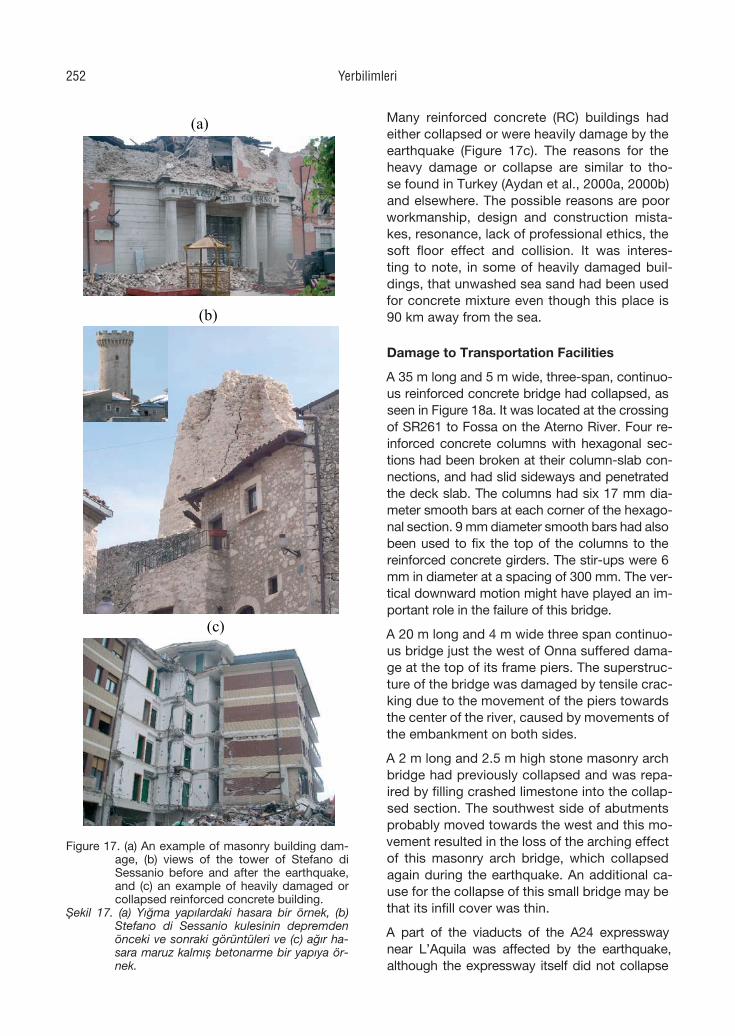
Many reinforced concrete (RC) buildings had either collapsed or were heavily damage by the earthquake (Figure 17c). The reasons for the heavy damage or collapse are similar to tho-se found in Turkey (Aydan et al., 2000a, 2000b) and elsewhere. The possible reasons are poor workmanship, design and construction mista-kes, resonance, lack of professional ethics, the soft floor effect and collision. It was interes-ting to note, in some of heavily damaged buil-dings, that unwashed sea sand had been used for concrete mixture even though this place is 90 km away from the sea.
Damage to Transportation Facilities
A 35 m long and 5 m wide, three-span, continuo-us reinforced concrete bridge had collapsed, as seen in Figure 18a. It was located at the crossing of SR261 to Fossa on the Aterno River. Four re-inforced concrete columns with hexagonal sec-tions had been broken at their column-slab con-nections, and had slid sideways and penetrated the deck slab. The columns had six 17 mm dia-meter smooth bars at each corner of the hexago-nal section. 9 mm diameter smooth bars had also been used to fix the top of the columns to the reinforced concrete girders. The stir-ups were 6 mm in diameter at a spacing of 300 mm. The ver-tical downward motion might have played an im-portant role in the failure of this bridge.
A 20 m long and 4 m wide three span continuo-us bridge just the west of Onna suffered dama-ge at the top of its frame piers. The superstruc-ture of the bridge was damaged by tensile crac-king due to the movement of the piers towards the center of the river, caused by movements of the embankment on both sides.
A 2 m long and 2.5 m high stone masonry arch bridge had previously collapsed and was repa-ired by filling crashed limestone into the collap-sed section. The southwest side of abutments probably moved towards the west and this mo-vement resulted in the loss of the arching effect of this masonry arch bridge, which collapsed again during the earthquake. An additional ca-use for the collapse of this small bridge may be that its infill cover was thin.
A part of the viaducts of the A24 expressway near L’Aquila was affected by the earthquake, although the expressway itself did not collapse
(a)
(b)
(c)
Figure 17
Figure 17. (a) An example of masonry building dam-age, (b) views of the tower of Stefano di Sessanio before and after the earthquake, and (c) an example of heavily damaged or collapsed reinforced concrete building.
Şekil 17. (a) Yığma yapılardaki hasara bir örnek, (b) Stefano di Sessanio kulesinin depremden önceki ve sonraki görüntüleri ve (c) ağır ha-sara maruz kalmış betonarme bir yapıya ör-nek.
Yerbilimleri252
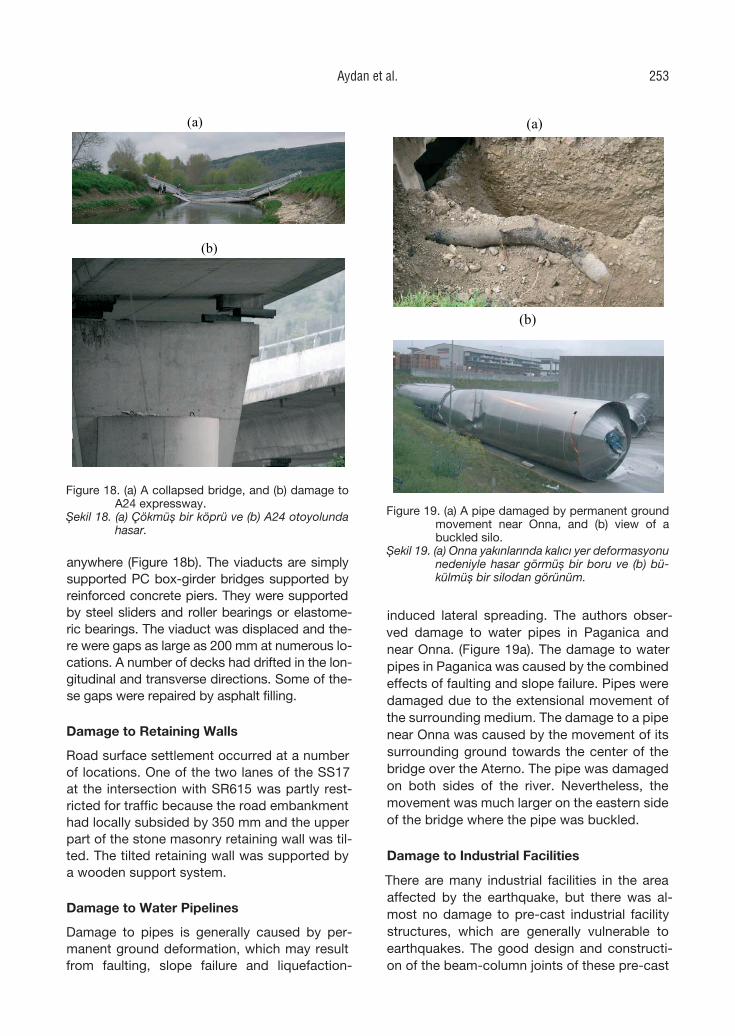
anywhere (Figure 18b). The viaducts are simply supported PC box-girder bridges supported by reinforced concrete piers. They were supported by steel sliders and roller bearings or elastome-ric bearings. The viaduct was displaced and the-re were gaps as large as 200 mm at numerous lo-cations. A number of decks had drifted in the lon-gitudinal and transverse directions. Some of the-se gaps were repaired by asphalt filling.
Damage to Retaining Walls
Road surface settlement occurred at a number of locations. One of the two lanes of the SS17 at the intersection with SR615 was partly rest-ricted for traffic because the road embankment had locally subsided by 350 mm and the upper part of the stone masonry retaining wall was til-ted. The tilted retaining wall was supported by a wooden support system.
Damage to Water Pipelines
Damage to pipes is generally caused by per-manent ground deformation, which may result from faulting, slope failure and liquefaction-
induced lateral spreading. The authors obser-ved damage to water pipes in Paganica and near Onna. (Figure 19a). The damage to water pipes in Paganica was caused by the combined effects of faulting and slope failure. Pipes were damaged due to the extensional movement of the surrounding medium. The damage to a pipe near Onna was caused by the movement of its surrounding ground towards the center of the bridge over the Aterno. The pipe was damaged on both sides of the river. Nevertheless, the movement was much larger on the eastern side of the bridge where the pipe was buckled.
Damage to Industrial Facilities
There are many industrial facilities in the area affected by the earthquake, but there was al-most no damage to pre-cast industrial facility structures, which are generally vulnerable to earthquakes. The good design and constructi-on of the beam-column joints of these pre-cast
Figure 19. (a) A pipe damaged by permanent ground movement near Onna, and (b) view of a buckled silo.
Şekil 19. (a) Onna yakınlarında kalıcı yer deformasyonu nedeniyle hasar görmüş bir boru ve (b) bü-külmüş bir silodan görünüm.
(a)
(b)
Figure 18
Figure 18. (a) A collapsed bridge, and (b) damage to A24 expressway.
Şekil 18. (a) Çökmüş bir köprü ve (b) A24 otoyolunda hasar.
(a)
(b)
Figure 19
Aydan et al. 253
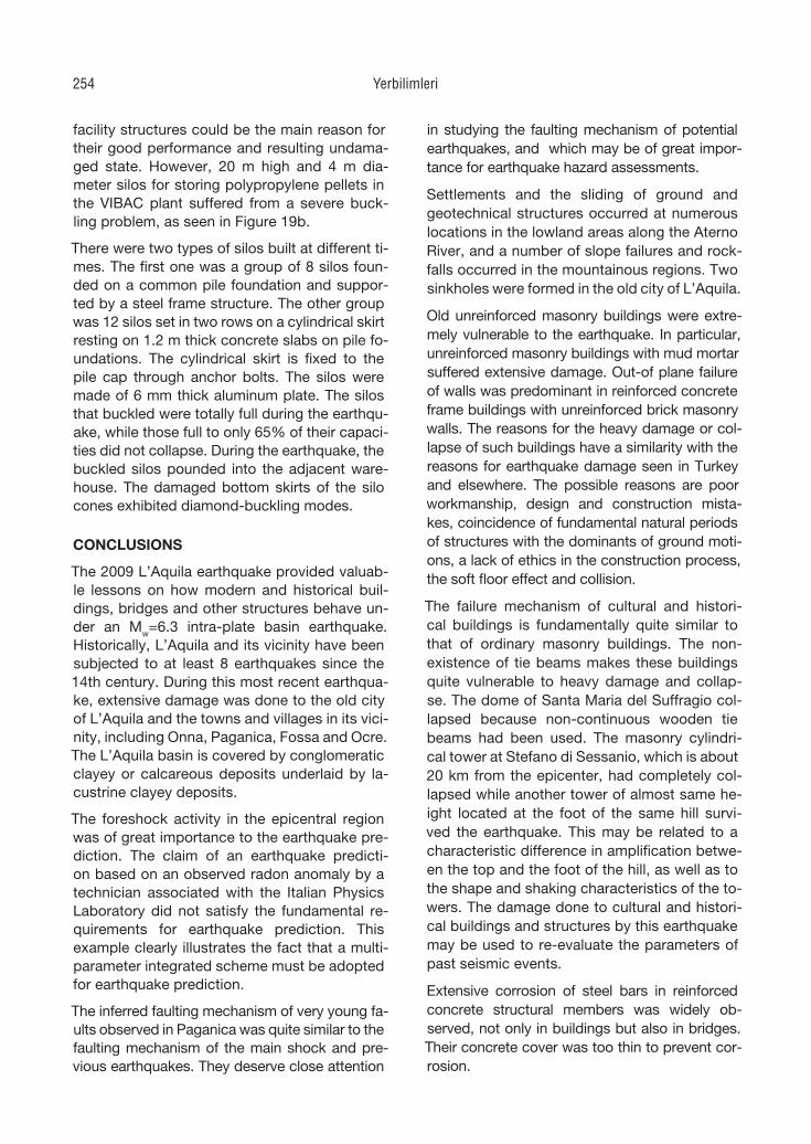
facility structures could be the main reason for their good performance and resulting undama-ged state. However, 20 m high and 4 m dia-meter silos for storing polypropylene pellets in the VIBAC plant suffered from a severe buck-ling problem, as seen in Figure 19b.
There were two types of silos built at different ti-mes. The first one was a group of 8 silos foun-ded on a common pile foundation and suppor-ted by a steel frame structure. The other group was 12 silos set in two rows on a cylindrical skirt resting on 1.2 m thick concrete slabs on pile fo-undations. The cylindrical skirt is fixed to the pile cap through anchor bolts. The silos were made of 6 mm thick aluminum plate. The silos that buckled were totally full during the earthqu-ake, while those full to only 65% of their capaci-ties did not collapse. During the earthquake, the buckled silos pounded into the adjacent ware-house. The damaged bottom skirts of the silo cones exhibited diamond-buckling modes.
CONCLUSIONS
The 2009 L’Aquila earthquake provided valuab-le lessons on how modern and historical buil-dings, bridges and other structures behave un-der an Mw=6.3 intra-plate basin earthquake. Historically, L’Aquila and its vicinity have been subjected to at least 8 earthquakes since the 14th century. During this most recent earthqua-ke, extensive damage was done to the old city of L’Aquila and the towns and villages in its vici-nity, including Onna, Paganica, Fossa and Ocre. The L’Aquila basin is covered by conglomeratic clayey or calcareous deposits underlaid by la-custrine clayey deposits.
The foreshock activity in the epicentral region was of great importance to the earthquake pre-diction. The claim of an earthquake predicti-on based on an observed radon anomaly by a technician associated with the Italian Physics Laboratory did not satisfy the fundamental re-quirements for earthquake prediction. This example clearly illustrates the fact that a multi-parameter integrated scheme must be adopted for earthquake prediction.
The inferred faulting mechanism of very young fa-ults observed in Paganica was quite similar to the faulting mechanism of the main shock and pre-vious earthquakes. They deserve close attention
in studying the faulting mechanism of potential earthquakes, and which may be of great impor-tance for earthquake hazard assessments.
Settlements and the sliding of ground and geotechnical structures occurred at numerous locations in the lowland areas along the Aterno River, and a number of slope failures and rock-falls occurred in the mountainous regions. Two sinkholes were formed in the old city of L’Aquila.
Old unreinforced masonry buildings were extre-mely vulnerable to the earthquake. In particular, unreinforced masonry buildings with mud mortar suffered extensive damage. Out-of plane failure of walls was predominant in reinforced concrete frame buildings with unreinforced brick masonry walls. The reasons for the heavy damage or col-lapse of such buildings have a similarity with the reasons for earthquake damage seen in Turkey and elsewhere. The possible reasons are poor workmanship, design and construction mista-kes, coincidence of fundamental natural periods of structures with the dominants of ground moti-ons, a lack of ethics in the construction process, the soft floor effect and collision.
The failure mechanism of cultural and histori-cal buildings is fundamentally quite similar to that of ordinary masonry buildings. The non-existence of tie beams makes these buildings quite vulnerable to heavy damage and collap-se. The dome of Santa Maria del Suffragio col-lapsed because non-continuous wooden tie beams had been used. The masonry cylindri-cal tower at Stefano di Sessanio, which is about 20 km from the epicenter, had completely col-lapsed while another tower of almost same he-ight located at the foot of the same hill survi-ved the earthquake. This may be related to a characteristic difference in amplification betwe-en the top and the foot of the hill, as well as to the shape and shaking characteristics of the to-wers. The damage done to cultural and histori-cal buildings and structures by this earthquake may be used to re-evaluate the parameters of past seismic events.
Extensive corrosion of steel bars in reinforced concrete structural members was widely ob-served, not only in buildings but also in bridges. Their concrete cover was too thin to prevent cor-rosion.
Yerbilimleri254
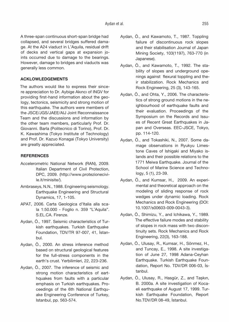
A three-span continuous short-span bridge had collapsed, and several bridges suffered dama-ge. At the A24 viaduct in L’Aquila, residual drift of decks and vertical gaps at expansion jo-ints occurred due to damage to the bearings. However, damage to bridges and viaducts was generally less common.
ACKLOWLEDGEMENTS
The authors would like to express their since-re appreciation to Dr. Aybige Akıncı of INGV for providing first-hand information about the geo-logy, tectonics, seismicity and strong motion of this earthquake. The authors were members of the JSCE/JGS/JAEE/AIJ Joint Reconnaissance Team and the discussions and information by the other team members, particularly Prof. Dr. Giovanni. Barla (Politecnico di Torino), Prof. Dr. K. Kawashima (Tokyo Institute of Technology) and Prof. Dr. Kazuo Konagai (Tokyo University) are greatly appreciated.
REFERENCES
Accelerometric National Network (RAN), 2009. Italian Department of Civil Protection, DPC, 2009. (http://www.protezionecivi-le.it/minisite/).
Ambraseys, N.N., 1988. Engineering seismology. Earthquake Engineering and Structural Dynamics, 17, 1-105.
APAT, 2006. Carta Geologica d’Italia alla sca-la 1:50.000 - Foglio n. 359 “L’Aquila”. S.EL.CA. Firenze.
Aydan, Ö., 1997. Seismic characteristics of Tur-kish earthquakes. Turkish Earthquake Foundation, TDV/TR 97-007, 41, İstan-bul.
Aydan, Ö., 2000. An stress inference method based on structural geological features for the full-stress components in the earth’s crust. Yerbilimleri, 22, 223-236.
Aydan, Ö., 2007. The inference of seismic and strong motion characteristics of eart-hquakes from faults with a particular emphasis on Turkish earthquakes. Pro-ceedings of the 6th National Earthqu-ake Engineering Conference of Turkey, Istanbul, pp. 563-574.
Aydan, Ö., and Kawamoto, T., 1987. Toppling failure of discontinuous rock slopes and their stabilisation Journal of Japan Mining Society, 103(1197), 763-770 (in Japanese).
Aydan, Ö., and Kawamoto, T., 1992. The sta-bility of slopes and underground ope-nings against flexural toppling and the-ir stabilization. Rock Mechanics and Rock Engineering, 25 (3), 143-165.
Aydan, Ö., and Ohta, Y., 2006. The characteris-tics of strong ground motions in the ne-ighbourhood of earthquake faults and their evaluation. Proceedings of the Symposium on the Records and Issu-es of Recent Great Earthquakes in Ja-pan and Overseas. EEC-JSCE, Tokyo, pp. 114-120.
Aydan, Ö., and Tokashiki, N., 2007. Some da-mage observations in Ryukyu Limes-tone Caves of Ishigaki and Miyako is-lands and their possible relations to the 1771 Meiwa Earthquake. Journal of the School of Marine Science and Techno-logy, 5 (1), 23-39.
Aydan, Ö., and Kumsar, H., 2009. An experi-mental and theoretical approach on the modeling of sliding response of rock wedges under dynamic loading. Rock Mechanics and Rock Engineering (DOI: 10.1007/s00603-009-0043-3).
Aydan, Ö., Shimizu, Y., and Ichikawa, Y., 1989. The effective failure modes and stability of slopes in rock mass with two discon-tinuity sets. Rock Mechanics and Rock Engineering, 22(3), 163-188.
Aydan, Ö., Ulusay, R., Kumsar, H., Sönmez, H., and Tuncay, E., 1998. A site investiga-tion of June 27, 1998 Adana-Ceyhan Earthquake. Turkish Earthquake Foun-dation, Report No. TDV/DR 006-03, İs-tanbul.
Aydan, Ö., Ulusay, R., Hasgür, Z., and Taşkın, B. 2000a. A site investigation of Koca-eli earthquake of August 17, 1999. Tur-kish Earthquake Foundation, Report No.TDV/DR 08-49, İstanbul.
Aydan et al. 255
Aydan, Ö., Ulusay, R., Kumsar, H., and Tuncay, E., 2000b. Site investigation and engi-neering evaluation of the Düzce-Bolu earthquake of November 12, 1999. Tur-kish Earthquake Foundation, Report No. TDV/DR 095-51, 307, İstanbul.
Aydan, Ö., Ulusay, R., and Atak, V.O., 2008. Evaluation of ground deformations in-duced by the 1999 Kocaeli earthquake (Turkey) at selected sites on shorelines. Environmental Geology, 54, 165-182.
Aydan, Ö., Ohta, S., and Hamada, M., 2009. Ge-otechnical evaluation of slope and gro-und failures during the 8 October 2005 Muzaffarabad Earthquake, Pakistan. Journal of Seismology (DOI:10.1007/s10950-008-9146-7).
Bagh, S., Chiaraluce, L., De Gori, P., Moretti, M., Govoni, A., Chiarabba, C., Di Bar-tolomeo, P., and Romanelli, M., 2007. Background seismicity in the Cent-ral Apennines of Italy: The Abruzzo re-gion case study. Tectonophysics, 444, 80-92.
Bertini, T., Bosi, C., and Galadini, F., 1989. La conca di Fossa-S. Demetrio dei Vestini. In: CNR, Centro di Studio per la Geolo-gia Tecnica, ENEA, P.A.S.: “Elementi di tettonica pliocenico-quaternaria ed indi-zi di sismicita olocenica nell’Appennino laziale-abruzzese”. Societa Geologica Italiana, L’Aquila, pp. 26-58.
Bigi, G., Cosentino, D., Parotto, M., Sartori, M., and Scandone, P., 1990. Structural mo-del of Italy and gravity map. CNR – Pro-getto Finalizzato Geodinamica, Qua-derni de “La Ricerca Scientifica” 114 (3).
EC8 (CEN, Eurocode 8), 1994. Design provisi-ons for earthquake resistance of struc-tures. European ENV 1998. Comite Eur-peen de Normalisation, Brussels.
Devoti, R., Riguzzi, F., Cuffaro, M., and Doglio-ni, C., 2008. New GPS costraints on the kinematics of the Appeninnes subduc-tion. Earth Planet Science Letter (doi: 10.1016/j.epsl.2008.06.031).
ERI, 2009. 2009 April 06 Central Italy Eart-hquake. Strong Motion Seismology
Group. http://taro.eri.u-tokyo.ac.jp/saigai/20090406eq/20090406.html.
Fukushima, Y., Tanaka, T., and Kataoka, S., 1988. A new attenuation relationship for peak ground acceleration derived from strong-motion accelerograms, Proce-edings of the 9th World Conference on Earthquake Engineering 2, Tokyo-Kyoto, Japan, pp. 343-348.
HARVARD, 2009.Source process. http://www.globalcmt.org/cgi-bin/globalcmt-cgi-bin/
INGV, 2009. Special page on L’Aquila earthqua-ke. http://www.ingv.it.
Kumsar, H., Aydan, Ö., and Ulusay, R., 2000. Dynamic and static stability of rock slo-pes against wedge failures. Rock Mec-hanics and Rock Engineering, 33 (1), 31-51.
Kuribayashi, E., and Tatsuoka, F., 1979. Brief review of soil liquefaction during eart-hquakes in Japan. Soils and Foundati-ons, 15 (4), 81-92.
Joyner, W.B., and Boore, D.M., 1981. Peak ho-rizontal acceleration and velocity from strong motion records from the 1979 Imperial Valley California Earthquake. Bullettin of Seismological Society of America, 71(6), 2011-2038.
Luca, de Luca, Marcucci, S., Milana, G.., and Sano, T., 2005. Evidence of low-frequency amplification in the city of L’Aquila, Central Italy, through a multi-disciplinary approach including strong- and weak-motion data, ambient noi-se, and numerical modeling. Bulletin of Seismological Society of America, 95, 1469 - 1481.
Ohta, Y., and Aydan, Ö., 2007a. Integration of ground displacement from acceleration records. Proceedings of the JSCE Eart-hquake Engineering Symposium, Tok-yo, pp. 1046-1051.
Ohta, Y., and Aydan, Ö., 2007b. An integrati-on technique for ground displacement from acceleration records and its app-lication to actual earthquake records. Journal of the School of Marine Scien-ce and Technology, 5 (2), 1-12.
Yerbilimleri256
Petitta, M., and Tallini, M., 2003. Groundwater resources and human impacts in a Qu-aternary intramontane basin (L’Aquila Plain, Central Italy). Water International, 28 (1), 57-69.
Port and Harbour Research Institute of Japan, 1997. Handbook on Liquefaction Re-mediation of Reclaimed Land. Balkema.
Tallini, M., Giamberardino, A., Ranalli, D., and Scozzafava, M., 2004a. GPR survey for investigation in building foundations. Proceedings of the 10th International Conference on Ground Penetrating Ra-dar; Delft, Netherlands, pp. 395-397.
Tallini, M., Ranalli, D., Scozzafava, M., and Ma-nocorda, G., 2004b. Testing a new low-frequency GPR antenna on karst envi-ronments of Central Italy. Proceedings of the 10th International Conference on Ground Penetrating Radar; Delft, Net-herlands, pp. 133-135.
Tokashiki, N., and Aydan, Ö., 2008. The stability assessment of natural rock structures in Ryukyu limestone. Proceedings of the 5th Asian Rock Mechanics Sympo-sium (ARMS5), Tehran, pp. 1515-1522.
USGS, 2009. Magnitude 6.3 – Central Italy. http://earthquake.usgs.gov/
Yamanaka, Y., 2009. Central Italy earthquake. Na-goya University Earthquake research Center. http://www.seis.nagoya-u.ac.jp/sanchu/Seismo_Note/2009/NGY15.html.
Aydan et al. 257

Yerbilimleri, 30 (3), 259–270Hacettepe Üniversitesi Yerbilimleri Uygulama ve Araştırma Merkezi DergisiJournal of the Earth Sciences Application and Research Centre of Hacettepe University
Stress concentration analysis between two neighboring circular holes under internal pressure of a non-explosive expansion material
Patlamayan-kabaran malzemenin içsel basıncı altındaki komşu dairesel iki delik arasındaki gerilme konsantrasyonunun analizi
Shobeir ARSHADNEJAD1, Kamran GOSHTASBI2, Jamshid AGHAZADEH3
1Department of Mining Engineering, Islamic Azad University, Science and Research Branch, Tehran, IRAN2Department of Mining Engineering, Tarbiat Modares University, Tehran, IRAN3Department of Mining and Metallurgical Engineering, AmirKabir University of Technology, Tehran, IRAN
Geliş (received) : 10 Eylül (September) 2009 Kabul (accepted) : 15 Ekim (October) 2009
ABSTRACT
Stress analysis for a rock medium is essential for determination of stress concentration between two neighbo-ring circular holes and prediction of fracture behavior. When two neighboring circular holes in a hard rock medi-um such as granite are loaded internally by the pressure of a Non-Explosive Expansion Material (NEEM), stress concentration occurs between the holes which then causes the rock to fracture. In this study, Finite Element (FE) analysis using a Phase2 computer code was employed to study the stress concentration between two neighboring circular holes under internal pressure induced by the NEEM. The effects of different hole diameters and spacings, rock properties and NEEM pressures were analyzed, and the data obtained from numerical analysis and statistical studies were then used to develop two models. These models were then modified by using the FE data and poly-nomial regression analysis. The developed statistical models were shown to be in a very good agreement with the FE analysis. Validation of the equations is only for the points located on the line passing through the centers of the holes in the elastic state. Hence, the developed models can be used with confidence to determine stress distribu-tion and concentration factors around two neighboring circular holes, which are excavated in a hard -brittle rock and loaded internally by the pressure induced from the NEEM.
Keywords: Finite element method, non-explosive quarry mining, statistical model, stress concentration.
ÖZ
Komşu konumlu iki dairesel delik arasındaki gerilme konsantrasyonunun tayini ve kırık davranışının tahmini için kaya ortamında gerilme analizi yapılması gereklidir. Granit gibi sert kaya ortamlarındaki komşu konumlu dairesel delikler Patlamayan-Kabaran Malzeme (PKB)’nin basıncıyla yüklendiklerinde, kayanın kırılmasına neden olan ger-ilme konsantrasyonları meydana gelir. Bu çalışmada, PKB’nin neden olduğu içsel basınç altındaki komşu kon-umlu iki dairesel delik arasındaki gerilme konsantrasyonunun araştırılması için Phase adlı bilgisayar programı kullanılarak Sonlu Elemanlar (SE) analizi yapılmış olup, bu analizlerde farklı delik çapları ve uzaklıkları, kaya özel-likleri ve PKB basınçları analiz edilmiştir. Sayısal çözümlemelerden ve istatistiksel analizlerden elde edilen veri iki modelin geliştirilmesi için kullanılmıştır. Daha sonra bu modeller SE ve polinomial regresyon analizleriyle modifiye
Sh. ArshadnejadE-mail: [email protected]
INTRODUCTION
One of the main methods in quarry mining, es-pecially in hard rocks, is the controlled fracture method that is carried out by the introduction of a slowly advancing crack using Non-Explosive Expansion Material (NEEM). The application of NEEM in hard rock quarry mining has recently been increased (Hayashi et al., 1994; Pal Roy, 2005; Arshadnejad, 2007). This method of rock breakage is without noise and vibrations and its operation, compared to the blasting method, is more controllable; it is very safe and easy and does not leave extra undesirable cracks in the rock block.
In this method, some circular holes of equal length, diameter and spacing (centre-to-centre distance) are drilled closely together in a rock block. The holes are then filled with the NEEM, which by its expansion will generate an incre-mental static load into the holes after about two to four hours (Goto et al., 1988; Zhongzhe et al., 1988; Jana, 1991; Hayashi et al., 1994; Pal Roy, 2005). If the spacing of the holes is suitab-le, it will create a crack between two neighbo-ring holes, and the rock will fracture along the high-stress concentration path between the ho-les. If the material of the medium is brittle, such as hard rocks (e. g. granite and quartzite), it will not yield and before failure no plastic behavi-our will be observed in the material (Hoek and Bieniawski, 1965; Lajtai, 1972; Lawn and Wils-haw, 1975; Ingraffea and Schmidt, 1978; Fo-well, 1995; Eberhardt et al., 1999; Orekhov and Zertsalov, 2001; Yağız, 2009). Thus, the mate-rial is considered to behave in a linear elastic mode until the onset of failure.
When there are two neighboring holes in a pla-te loaded internally, stress concentration will occur. The maximum elastic stresses (stress
concentration) have been examined by several methods, such as photoelastic analysis (Hoek and Bieniawski, 1963; Joussineau et al., 2003), direct strain measurement (Nesetova and Lajtai, 1973; Chong et al., 1987) and numerical mode-ling (Bazant, 1982; Yan, 2007). There are many empirical models for estimating stress concent-ration in different geometries, such as a circu-lar hole. Stress concentration factors due to uniform and axisymmetrical external pressu-re around a single circular hole were analyzed by Howland (1929), Forcht (1935), Lipson and Juvinall (1963). One of the first studies of pla-ne elasticity in bipolar coordinates in an infini-te plate with two circular holes was carried out by Jeffrey (1920). Howland (1935) investigated the stress distribution around an infinite row of equal sized circular holes spaced equally in an infinite elastic plate. The plate was subjected to a uniaxial stress field. Howland and Knight (1939) presented stress functions for problems involving equal sized circular holes. Ling (1948) developed a solution (in bipolar coordinates) for the stresses in a plate containing two equal cir-cular holes when the distances between them are variable. He considered three stress fields: uniaxial stress parallel, perpendicular to the line of centers and equal stresses in all directions (Gerçek, 2005). Haddon (1967), using the con-formal mapping and complex variable techni-ques, presented a solution for stresses around two unequal circular holes in an infinite plate. The plate was subjected to a uniaxial stress fi-eld with a variable inclination to the line of ho-les’ centers (Gerçek, 2005). Obert and Duvall (1967) studied the stress distribution around pillars (rock columns) between two parallel cir-cular excavations subjected to uniaxial comp-ressive external loading, by the photoelasticity method. Two empirical models were developed
edilmişlerdir. Geliştirilen istatistiksel modeler SE analiziyle çok iyi bir uyum göstermiştir. Eşitlikler, sadece elas-tik durumda deliklerin merkezinden geçen hattın üzeride yer alan noktalar için geçerlidir. Bu nedenle geliştirilen modeler, PKB’den kaynaklanan basınçla içsel olarak yüklenmiş ve sert kayada kazılmış komşu konumlu dairesel delikler çeveresindeki gerilme konsantrasyonu faktörlerinin ve gerilme dağılımının belirlenmesi için güvenilirlikle kullanılabilirler.
Anahtar Kelimeler: Sonlu elemanlar yöntemi, patlatmasız taş ocağı işletmeciliği, istatistiksel model, gerilme kon-santrasyonu.
Yerbilimleri260
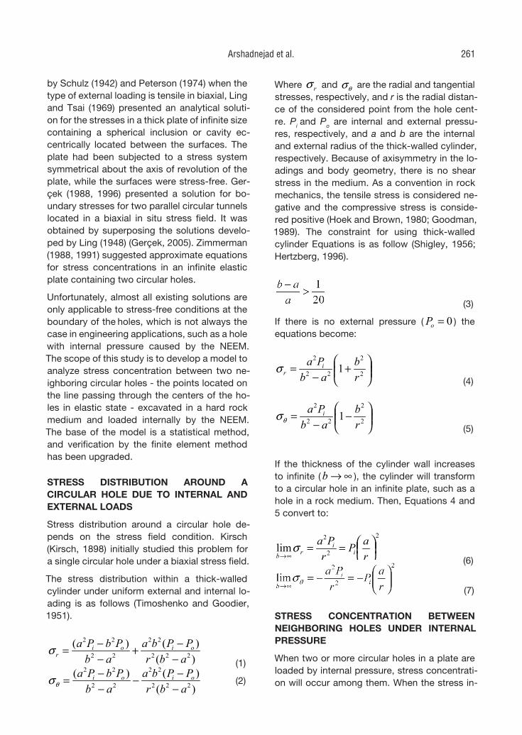
by Schulz (1942) and Peterson (1974) when the type of external loading is tensile in biaxial, Ling and Tsai (1969) presented an analytical soluti-on for the stresses in a thick plate of infinite size containing a spherical inclusion or cavity ec-centrically located between the surfaces. The plate had been subjected to a stress system symmetrical about the axis of revolution of the plate, while the surfaces were stress-free. Ger-çek (1988, 1996) presented a solution for bo-undary stresses for two parallel circular tunnels located in a biaxial in situ stress field. It was obtained by superposing the solutions develo-ped by Ling (1948) (Gerçek, 2005). Zimmerman (1988, 1991) suggested approximate equations for stress concentrations in an infinite elastic plate containing two circular holes.
Unfortunately, almost all existing solutions are
only applicable to stress-free conditions at the boundary of the holes, which is not always the case in engineering applications, such as a hole with internal pressure caused by the NEEM. The scope of this study is to develop a model to analyze stress concentration between two ne-ighboring circular holes - the points located on the line passing through the centers of the ho-les in elastic state - excavated in a hard rock medium and loaded internally by the NEEM. The base of the model is a statistical method, and verification by the finite element method has been upgraded.
STRESS DISTRIBUTION AROUND A CIRCULAR HOLE DUE TO INTERNAL AND EXTERNAL LOADS
Stress distribution around a circular hole de-pends on the stress field condition. Kirsch (Kirsch, 1898) initially studied this problem for a single circular hole under a biaxial stress field.
The stress distribution within a thick-walled cylinder under uniform external and internal lo-ading is as follows (Timoshenko and Goodier, 1951).
)()()(
222
22
22
22
abrPPba
abPbPa oioi
r −−+
−−=σ
(1)
)()()(
222
22
22
22
abrPPba
abPbPa oioi
−−−
−−=θσ (2)
Where rσ and θσ are the radial and tangential stresses, respectively, and r is the radial distan-ce of the considered point from the hole cent-re. Pi and Po are internal and external pressu-res, respectively, and a and b are the internal and external radius of the thick-walled cylinder, respectively. Because of axisymmetry in the lo-adings and body geometry, there is no shear stress in the medium. As a convention in rock mechanics, the tensile stress is considered ne-gative and the compressive stress is conside-red positive (Hoek and Brown, 1980; Goodman, 1989). The constraint for using thick-walled cylinder Equations is as follow (Shigley, 1956; Hertzberg, 1996).
(3)
If there is no external pressure ( 0=oP ) the equations become:
+
−= 2
2
22
2
1rb
abPa i
rσ (4)
−
−= 2
2
22
2
1rb
abPa i
θσ (5)
If the thickness of the cylinder wall increases to infinite ( ∞→b ), the cylinder will transform to a circular hole in an infinite plate, such as a hole in a rock medium. Then, Equations 4 and 5 convert to:
2
2
2
lim
==
∞→ raP
rPa
ii
rbσ
(6)
(7)
STRESS CONCENTRATION BETWEEN NEIGHBORING HOLES UNDER INTERNAL PRESSURE
When two or more circular holes in a plate are loaded by internal pressure, stress concentrati-on will occur among them. When the stress in-
Arshadnejad et al. 261
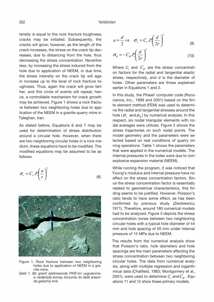
tensity is equal to the rock fracture toughness, cracks may be initiated. Subsequently, the cracks will grow; however, as the length of the crack increases, the stress on the crack tip dec-reases, due to distancing from the hole, thus decreasing the stress concentration. Neverthe-less, by increasing the stress induced from the hole due to application of NEEM, in due time, the stress intensity on the crack tip will aga-in increase up to the level of rock fracture to-ughness. Thus, again the crack will grow fart-her, and this circle of events will repeat; hen-ce, a controllable mechanism for crack growth may be achieved. Figure 1 shows a rock fractu-re between two neighboring holes due to app-lication of the NEEM in a granite quarry mine in Taleghan, Iran.
As stated before, Equations 6 and 7 may be used for determination of stress distribution around a circular hole. However, when there are two neighboring circular holes in a rock me-dium, these equations have to be modified. The modified equations may be assumed to be as follows.
2
.
=
raPC irrσ
(8)
2
2.
2
=⇒=
rdPCda irrσ
(9)
2
2.
−=
rdPC iθθσ
(10)
Where Cr and θC are the stress concentrati-on factors for the radial and tangential elastic stress, respectively, and d is the diameter of holes. Other parameters are those explained earlier in Equations 1 and 2.
In this study, the Phase2 computer code (Rocs-cience, Inc., 1999 and 2001) based on the fini-te element method (FEM) was used to determi-ne the radial and tangential stresses around the hole ( rσ and θσ ) by numerical analysis. In this respect, six nodal triangular elements with no-dal averages were utilized. Figure 2 shows the stress trajectories on such nodal points. The model geometry and the parameters were se-lected based on real conditions of quarry mi-ning operations. Table 1 shows the parameters that were applied in the numerical models. The internal pressures in the holes were due to non-explosive expansion material (NEEM).
While running the program, it was noticed that Young’s modulus and internal pressure have no effect on the stress concentration factors. Sin-ce the stress concentration factor is essentially related to geometrical characteristics, this fin-ding seems to be justified. However, Poisson’s ratio tends to have some effect, as has been confirmed by previous study (Zienkiewicz, 1971). Therefore, around 180 numerical models had to be analyzed. Figure 3 depicts the stress concentration zones between two neighboring circular holes with a typical hole diameter of 44 mm and hole spacing of 50 mm under internal pressure of 15 MPa due to NEEM.
The results from the numerical analysis show that Poisson’s ratio, hole diameters and hole spacings are the main parameters affecting the stress concentration between two neighboring circular holes. The data from numerical analy-sis, along with multiple regression and logarith-mical data (Chatfield, 1983; Montgomery et al., 2001), were used to determine Cr and θC . Equ-ations 11 and 12 show these primary models.
1
Figure 1.
Figure 2.
Figure 1. Rock fracture between two neighboring holes due to application of NEEM in a gra-nite mine.
Şekil 1. Bir granit işletmesinde PKB’nin uygulanma-sı nedeniyle komşu konumlu iki delik arasın-da gelişmiş kırık.
Yerbilimleri262
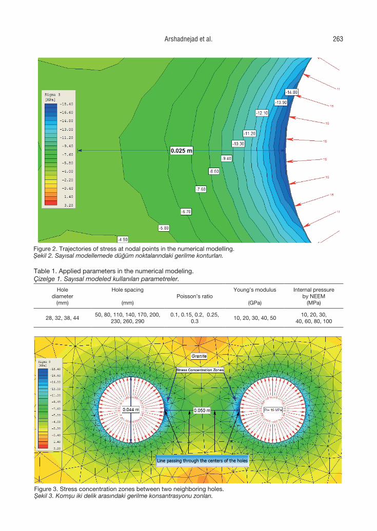
Table 1. Applied parameters in the numerical modeling.Çizelge 1. Sayısal modeled kullanılan parametreler.
Hole diameter
(mm)
Hole spacing
(mm)Poisson’s ratio
Young’s modulus
(GPa)
Internal pressureby NEEM
(MPa)
28, 32, 38, 4450, 80, 110, 140, 170, 200,
230, 260, 2900.1, 0.15, 0.2, 0.25,
0.310, 20, 30, 40, 50
10, 20, 30, 40, 60, 80, 100
1
Figure 1.
Figure 2.
Figure 2. Trajectories of stress at nodal points in the numerical modelling.Şekil 2. Sayısal modellemede düğüm noktalarındaki gerilme konturları.
2
Figure 3.
Figure 4.
Figure 3. Stress concentration zones between two neighboring holes.Şekil 3. Komşu iki delik arasındaki gerilme konsantrasyonu zonları.
Arshadnejad et al. 263
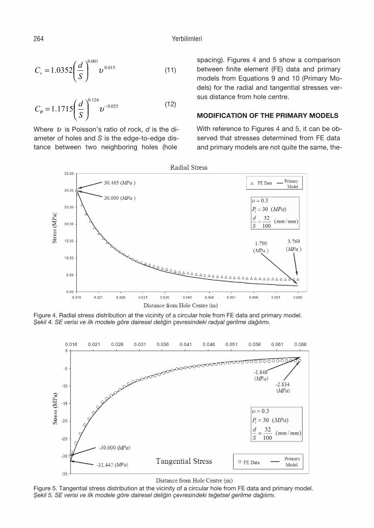
015.0001.0
0352.1 υ
=
SdCr
(11)
025.0124.0
1715.1 −
= υθ S
dC
(12)
Where υ is Poisson’s ratio of rock, d is the di-ameter of holes and S is the edge-to-edge dis-tance between two neighboring holes (hole
spacing). Figures 4 and 5 show a comparison between finite element (FE) data and primary models from Equations 9 and 10 (Primary Mo-dels) for the radial and tangential stresses ver-sus distance from hole centre.
MODIFICATION OF THE PRIMARY MODELS
With reference to Figures 4 and 5, it can be ob-served that stresses determined from FE data and primary models are not quite the same, the-
2
Figure 3.
Figure 4.
3
Figure 5.
Figure 6.
Figure 4. Radial stress distribution at the vicinity of a circular hole from FE data and primary model.Şekil 4. SE verisi ve ilk modele göre dairesel deliğin çevresindeki radyal gerilme dağılımı.
Figure 5. Tangential stress distribution at the vicinity of a circular hole from FE data and primary model.Şekil 5. SE verisi ve ilk modele göre dairesel deliğin çevresindeki teğetsel gerilme dağılımı.
Yerbilimleri264
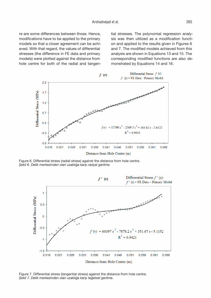
re are some differences between those. Hence, modifications have to be applied to the primary models so that a closer agreement can be achi-eved. With that regard, the values of differential stresses (the difference in FE data and primary models) were plotted against the distance from hole centre for both of the radial and tangen-
tial stresses. The polynomial regression analy-sis was then utilized as a modification functi-on and applied to the results given in Figures 6 and 7. The modified models achieved from this analysis are shown in Equations 13 and 15. The corresponding modified functions are also de-monstrated by Equations 14 and 16.
3
Figure 5.
Figure 6.
Figure 6. Differential stress (radial stress) against the distance from hole centre.Şekil 6. Delik merkezinden olan uzaklığa karşı radyal gerilme.
4
Figure 7.
Figure 8.
Figure 7. Differential stress (tangential stress) against the distance from hole centre.Şekil 7. Delik merkezinden olan uzaklığa karşı teğetsel gerilme.
Arshadnejad et al. 265
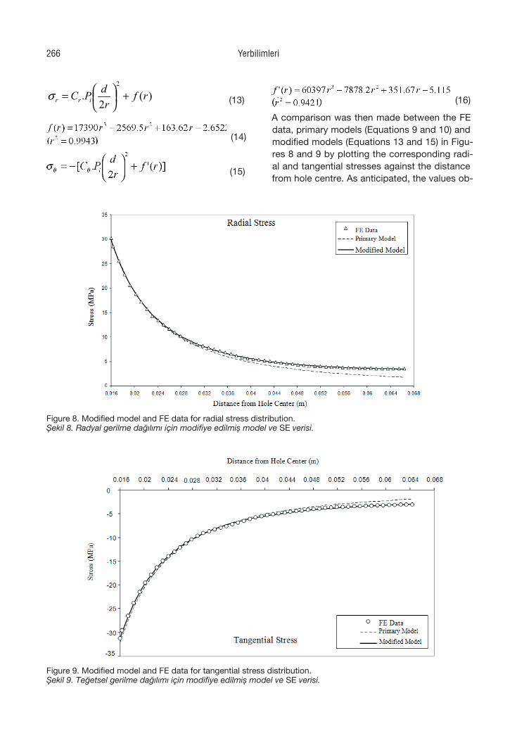
)(2
.2
rfr
dPC irr +
=σ (13)
(15)
(16)
A comparison was then made between the FE data, primary models (Equations 9 and 10) and modified models (Equations 13 and 15) in Figu-res 8 and 9 by plotting the corresponding radi-al and tangential stresses against the distance from hole centre. As anticipated, the values ob-
4
Figure 7.
Figure 8.
Figure 8. Modified model and FE data for radial stress distribution.Şekil 8. Radyal gerilme dağılımı için modifiye edilmiş model ve SE verisi.
5
Figure 9.
Figure 10.
Figure 9. Modified model and FE data for tangential stress distribution.Şekil 9. Teğetsel gerilme dağılımı için modifiye edilmiş model ve SE verisi.
(14)
Yerbilimleri266
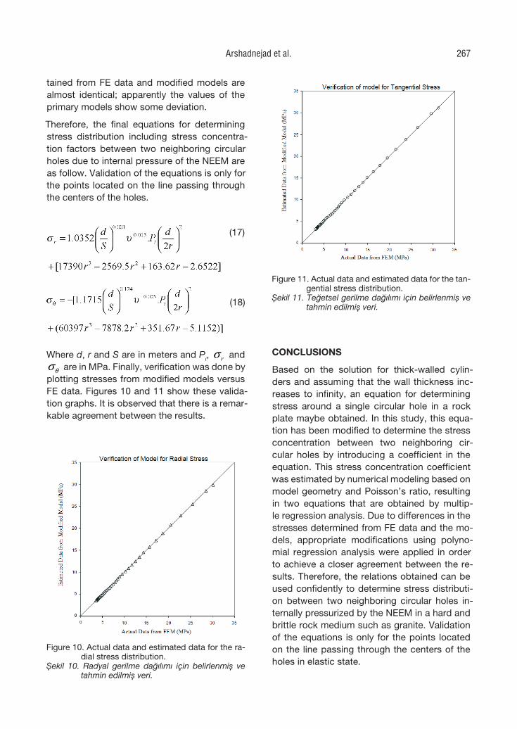
tained from FE data and modified models are almost identical; apparently the values of the primary models show some deviation.
Therefore, the final equations for determining stress distribution including stress concentra-tion factors between two neighboring circular holes due to internal pressure of the NEEM are as follow. Validation of the equations is only for the points located on the line passing through the centers of the holes.
(17)
(18)
Where d, r and S are in meters and Pi, rσ and
θσ are in MPa. Finally, verification was done by plotting stresses from modified models versus FE data. Figures 10 and 11 show these valida-tion graphs. It is observed that there is a remar-kable agreement between the results.
CONCLUSIONS
Based on the solution for thick-walled cylin-ders and assuming that the wall thickness inc-reases to infinity, an equation for determining stress around a single circular hole in a rock plate maybe obtained. In this study, this equa-tion has been modified to determine the stress concentration between two neighboring cir-cular holes by introducing a coefficient in the equation. This stress concentration coefficient was estimated by numerical modeling based on model geometry and Poisson’s ratio, resulting in two equations that are obtained by multip-le regression analysis. Due to differences in the stresses determined from FE data and the mo-dels, appropriate modifications using polyno-mial regression analysis were applied in order to achieve a closer agreement between the re-sults. Therefore, the relations obtained can be used confidently to determine stress distributi-on between two neighboring circular holes in-ternally pressurized by the NEEM in a hard and brittle rock medium such as granite. Validation of the equations is only for the points located on the line passing through the centers of the holes in elastic state.
5
Figure 9.
Figure 10.
Figure 10. Actual data and estimated data for the ra-dial stress distribution.
Şekil 10. Radyal gerilme dağılımı için belirlenmiş ve tahmin edilmiş veri. 6
Figure 11.
Figure 11. Actual data and estimated data for the tan-gential stress distribution.
Şekil 11. Teğetsel gerilme dağılımı için belirlenmiş ve tahmin edilmiş veri.
Arshadnejad et al. 267
REFERENCES
Arshadnejad, Sh., 2007. Application of stress analysis and fracture mechanics in controlled blasting for hard rock quarry mining. Proceedings of the 1st Sympo-sium of Dimension stone, Mahallat, Iran, pp. 10-39 (in Persian).
Bazant, Z. P., 1982. Crack band model for frac-ture and geomaterials. Proceedings of Numerical Methods in Geomechanics, Edmonton, pp. 1137-1152.
Chatfield, Ch., 1983. Statistics for Technology. 3th Edition, Chapman & Hall, Bristol.
Chong, K. P., Harkins, J. S., Kuruppu, D. M., and Leskinen, A. I. L., 1987. Strain rate dependent mechanical properties of western oil shale. Proceedings of 28th US Symposium on Rock Mechanics, pp. 157-164.
Eberhardt, E., Stimpson, B., and Stead, D., 1999. The influence of mineralogy on the initiation of microfractures in gra-nite. Proceedings of 9th International Congress on Rock Mechanics, Paris. G. Vouille and P. Berest (eds.), A.A. Balke-ma, Rotterdam, pp. 1007-1010.
Forcht, M. M., 1935. Factors of stress con-centration photoelastically determined. Transactions of ASME, Applied Mecha-nics, A-57/A-67.
Fowell, R. J., 1995. Suggested method for de-termining Mode I fracture toughness using crackedchevron notched Brazi-lian disc (CCNBD) specimens, ISRM Commission on Testing Methods. In-ternational Journal of Rock Mechanics and Mining Sciences, 32(1), 57-64.
Gerçek, H., 1988. Interaction of parallel tunnels or roadways. Madencilik, 27(1), 39-49 (in Turkish).
Gerçek, H., 1996. Special elastic solutions for underground openings. Milestones in Rock Engineering – The Bieniawski Ju-bilee Collection, Balkema, Rotterdam, pp. 275- 290.
Gerçek, H., 2005. Interaction between parallel underground openings, Proceedings of the 19th International Mining Congress
and Fair of Turkey, IMCEV2005, İzmir, Turkey, pp. 73-81.
Goodman, R. E., 1989. Introduction to Rock Mechanics. 2nd Edition, John Wiley & Sons, New York.
Goto, K., Kojima, K., and Watabe, K., 1988. The mechanism of expansive pressure and blow-out of static demolition agent. Proceedings of Conference of Demo-lition and Reuse of Concrete and Ma-sonry, Demolition Method and Practice (RILEM), Y. Kasai (ed.), Nihon Univer-sity, Japan, Vol. 1, pp. 116-125.
Haddon, A. W., 1967. Stresses in an infinite pla-te with two unequal circular holes. Qu-arterly Journal of Mechanics & Applied Mathematics, 20, 277-291.
Hayashi, H., Soeda, K., Hida, T., and Kanba-yashi, M., 1994. Non-explosive demo-lition agent in Japan. Proceedings of Conference of Demolition and Reuse of Concrete (RILEM), E. K. Lauritzen (ed.), London, pp. 231-241.
Hertzberg, R., W., 1996. Deformation and Frac-ture Mechanics of Engineering Materi-als. John Wiley & Jons, New York.
Hoek, E., and Bieniawski, Z.T., 1963. Applica-tion of the photoelastic coating techni-que to the study of the stress redistribu-tion associated with plastic flow around notches. South African Mechanical En-gineer, 12(8), 22-226.
Hoek, E., and Bieniawski, Z.T., 1965. Brittle rock fracture propagation in rock under compression. International Journal of Fracture Mechanics, 1(3), 137-155.
Hoek, E., and Brown, E. T., 1980. Underground Excavations in Rock. The Institution of Mining and Metallurgy, London.
Howland, R.C.J., 1929. On the stress in the ne-ighborhood of a circular hole in a strip under tension. Philosophy Transacti-on of Royal Society, London, (Series A), 229, 49-86.
Howland, R. C. J., 1935. Stresses in a plate containing an infinite row of holes. Phi-losophy Transaction of Royal Society, London, (Series A), 148, 471-491.
Yerbilimleri268
Howland, R. C. J., and Knight, R.C., 1939. Stress functions for a plate containing groups of circular holes. Philosophy Transaction of Royal Society (Series A), 238, 357-392.
Ingraffea, A. R., and Schmidt, R. A., 1978. Expe-rimental verification of a fracture mec-hanics model for tensile strength pre-diction of Indiana limestone. Procee-dings of 19th US Symposium on Rock Mechanics, pp. 247-253.
Jana, S., 1991. Non-explosive expanding agent – an aid for reducing environmental pol-lution in mines, Indian Mining and Engi-neering Journal, 1, 31-35.
Jeffrey, G. B., 1920. Plane stress and plane stra-in in bipolar coordinates. Transaction of Royal Society, (Series A), Vol. 221, pp. 265- 293.
Joussineau, Gh. D., Petit, J. P., and Gauthier, B. D. M., 2003. Photoelastic and nume-rical investigation of stress distributi-ons around fault models under biaxial compressive loading conditions. Tecto-nophysics, 363, 19-43.
Kirsch, G., 1898. Die theorie der elastizitat und die bedurfnisse der festigkeitslehre. Veit. Ver. Deut. Ing., 42, 797-807.
Lajtai, E. Z., 1972. Effect of tensile stress gradi-ent on brittle fracture initiation. Interna-tional Journal of Rock Mechanics and Mining Sciences, 9, 569-578.
Lawn, B. R., and Wilshaw, T. R., 1975. Fracture of Brittle Solids. Cambridge University Press, Cambridge, UK.
Ling, Ch. B., 1948. On stresses in a plate conta-ining two circular holes. Journal of App-lied Physics, 19, 77-82.
Ling, Ch. B., and Tsai, Ch. P., 1969. Stresses in a thick plate containing an eccent-ric spherical inclusion or cavity, Part I. Acta Mechanica, 7, 169-186.
Lipson, Ch., and Juvinall, R., 1963. Handbo-ok of Stress and Strength Design and Material Applications. The Macmillan Company, New York.
Montgomery, D. C., Runger, G. C., and Hubele, N. F., 2001. Engineering Statistics. Se-cond Edition, John Wiley & Sons, Inc.
Nesetova, V., and Lajtai, E. Z., 1973. Fracture from compressive stress concentrati-ons around elastic flaws. International Journal of Rock Mechanics and Mining Sciences, 10, 265-284.
Obert, L., and Duvall, W. I., 1967. Rock Mec-hanics and the Design of Structures in Rock. John Wiley & Sons, New York.
Orekhov, B. G., and Zertsalov, M. G., 2001. Fracture Mechanics of Engineering Structures and Rocks. A. A. Balkema, Rotterdam.
Pal Roy, P., 2005. Rock Blasting Effects and Operations. A. A. Balkema, Leiden, Netherlands.
Peterson, R. E., 1974. Stress Concentration De-sign Factors. John Wiley & Sons, Inc., New York.
Rocscience, Inc., 1999. Phase2 Verification ma-nual. Version 2.1.
Rocscience, Inc., 2001. Phase2 model program reference manual.
Schulz, K. J., 1942. On the state of stress in per-forated strips and plates. Proceedings of Netherlands Royal Academic Scien-ces, Vols. 45 to 48.
Shigley, J. E., 1956. Machine Design. McGraw-Hill, New York.
Timoshenko, S. P., and Goodier, J. N., 1951. Theory of elasticity. McGraw-Hill, New York.
Yağız, S., 2009. Assessment of brittleness using rock strength and density with punch penetration test. Tunnelling and Un-derground Space Technology, 24, 66-74.
Yan, X., 2007. Rectangular tensile sheet with single edge crack or edge half-circular-hole crack. Journal of Engineering Fai-lure Analysis, 14, 1406-1410.
Zhongzhe, J., Hong, L., and Wen, Zh., 1988. Splitting mechanism of rock and conc-rete under expansive pressure. Procee-dings of Conference of Demolition and
Arshadnejad et al. 269
Reuse of Concrete and Masonry, De-molition Method and Practice (RILEM), Y. Kasai (ed.), Nihon University, Japan, Vol. 1, pp. 141-148.
Zienkiewicz, O. C., 1971. The Finite Element Method in Engineering Science. 2nd Edition, McGraw-Hill, London.
Zimmerman, R. W., 1988. Stress concentrati-on around a pair of circular holes in a hydrostatically stressed elastic sheet. Journal of Applied Mechanics, 55, 487-488.
Zimmerman, R. W., 1991. Approximate expres-sions for stress concentrations in elas-tic solids containing multiple holes or inclusions. Recent Developments in Elasticity, Applied Mechanics Division, ASME, 124, 71-75.
Yerbilimleri270


