Embed Size (px)
Citation preview

FLOOD AND MEGAFLOOD PROCESSES AND DEPOSITS: RECENT AND ANCIENT EXAMPLES
IFAA01 9/12/08 4:26 PM Page i

IFAA01 9/12/08 4:26 PM Page ii

SPECIAL PUBLICATION NUMBER 32 OF THE
INTERNATIONAL ASSOCIATION OF SEDIMENTOLOGISTS
Flood and Megaflood Processes and Deposits:
Recent and Ancient Examples
EDITED BY
I. PETER MARTINI, VICTOR R. BAKER
AND GUILLERMINA GARZÓN
IFAA01 9/12/08 4:26 PM Page iii

© 2002 International Association of Sedimentologistsand published for them byBlackwell Science LtdEditorial Offices:Osney Mead, Oxford OX2 0EL25 John Street, London WC1N 2BS23 Ainslie Place, Edinburgh EH3 6AJ350 Main Street, Malden
MA 02148-5018, USA54 University Street, Carlton
Victoria 3053, Australia10, rue Casimir Delavigne
75006 Paris, France
Other Editorial Offices:Blackwell Wissenschafts-Verlag GmbHKurfürstendamm 5710707 Berlin, Germany
Blackwell Science KKMG Kodenmacho Building7–10 Kodenmacho NihombashiChuo-ku, Tokyo 104, Japan
Iowa State University PressA Blackwell Science Company2121 S. State AvenueAmes, Iowa 50014-8300, USA
The right of the Authors to beidentified as the Authors of this Workhas been asserted in accordancewith the Copyright, Designs andPatents Act 1988.
All rights reserved. No part ofthis publication may be reproduced,stored in a retrieval system, ortransmitted, in any form or by anymeans, electronic, mechanical,photocopying, recording or otherwise,except as permitted by the UKCopyright, Designs and Patents Act1988, without the prior permissionof the copyright owner.
First published 2002
Set by Graphicraft Limited, Hong KongPrinted and bound in Great Britainby MPG Books Ltd, Bodmin, Cornwall
The Blackwell Science logo is atrade mark of Blackwell Science Ltd,registered at the United KingdomTrade Marks Registry
distributors
Marston Book Services LtdPO Box 269Abingdon, Oxon OX14 4YN(Orders: Tel: 01235 465500
Fax: 01235 465555)
The AmericasBlackwell Publishingc/o AIDCPO Box 2050 Winter Sport LaneWilliston, VT 05495-0020(Orders: Tel: 800 216 2522
Fax: 802 864 7626)
AustraliaBlackwell Science Pty Ltd54 University StreetCarlton, Victoria 3053(Orders: Tel: 3 9347 0300
Fax: 3 9347 5001)
A catalogue record for this titleis available from the British Library
ISBN 0-632-06404-8
Library of CongressCataloging-in-Publication Data
Flood and megaflood processes and deposits:recent and ancient examples/edited by I. Peter Martini, Victor R. Baker & Guillermina Garzón.
p. cm. —(Special publication number 32 ofthe International Association of Sedimentologists)ISBN 0-632-06404-81. Floods. 2. Sedimentation and deposition.I. Martini, I. P. (Ireneo Peter), 1935– II. Baker, Victor R.III. Garzón, G. (Guillermina)IV. Special publication . . . of the International Association ofSedimentologists; no. 32.
GB1399 .F54 2001551.48′9adc21
2001035125
For further information onBlackwell Science, visit our website:www.blackwell-science.com
IFAA01 9/12/08 4:26 PM Page iv

Contents
vii Preface
Megafloods
3 High-energy megafloods: planetary settings and sedimentary dynamicsV.R. Baker
17 Late Quaternary catastrophic flooding in the Altai Mountains of south–central Siberia: a synoptic overview and an introduction to flood deposit sedimentologyP.A. Carling, A.D. Kirkbride, S. Parnachov, P.S. Borodavko and G.W. Berger
37 Great Holocene floods along Jökulsá á Fjöllum, north IcelandR.B. Waitt
Glacial outwash floods
55 November 1996 jökulhlaup on Skeibarársandur outwash plain, IcelandÁ. Snorrason, P. Jónsson, O. SigurBsson, S. Pálsson, S. Árnason , S. Víkingsson and I. Kaldal
67 The effects of glacier-outburst flood flow dynamics on ice-contact deposits: November 1996jökulhlaup, Skeibarársandur, IcelandA.J. Russell and Ó. Knudsen
85 Formation of ice-block obstacle marks during the November 1996 glacier-outburst flood( jökulhlaup), Skeibarársandur, southern IcelandH. Fay
99 A large-scale flood event in 1994 from the mid-Canterbury Plains, New Zealand, andimplications for ancient fluvial depositsG.H. Browne
Alluvial-fan floods
113 Alluvial-fan sedimentation from a glacial-outburst flood, Lone Pine, California, and contrastswith meteorological flood depositsT.C. Blair
v
IFAA01 9/12/08 4:26 PM Page v

141 Alluvial fans in the Italian Alps: sedimentary facies and processesA. Moscariello, L. Marchi, F. Maraga and G. Mortara
167 Analysis of terrestrial hyperconcentrated flows and their depositsM. Benvenuti and I.P. Martini
195 Catastrophic debris-flow deposits from an inferred landslide-dam failure, Eocene BergaFormation, eastern Pyrenees, SpainE. Saula, E.E. Mató and C. Puigdefàbregas
Alluvial valley floods
213 Coarse-grained flood bars formed at the confluence of two subarctic rivers affected byhydroelectric dams, Ontario, CanadaS.-J. Mosher and I.P. Martini
233 Comparison of the flood response of a braided and a meandering river, conditioned byanthropogenic and climatic changesG. Garzón and A. Alonso
251 Effects of land-use and precipitation changes on floodplain sedimentation in the nineteenth andtwentieth centuries (Geul River, The Netherlands)M.H. Stam
269 Use of remote sensing in monitoring river floods and their effects on the landscapeL. Halounová
Special cases
283 Sedimentary traces as indicator of temporary ice-marginal channels in the Westphalian Bight, GermanyJ. Herget
291 Outlet glaciers of the Pleistocene (LGM) south Tibetan ice sheet between Cho Oyu and ShishaPangma as potential sources of former megafloodsM. Kuhle
303 Index
vi Contents
IFAA01 9/12/08 4:26 PM Page vi

vii
This special publication consists of 17 papers, somedelivered at the homonymous symposium held duringthe IAS 15th International Sedimentological Con-gress in southern Spain in 1998, and others submittedspecifically for this publication. The goal of the sym-posium and of this publication is the understanding oflarge floods and their impact on the Earth’s surface.The major objectives are:1 to take a second look at what constitutes a megafloodthat the principle of uniformitarianism is at some lossto explain;2 try to determine what could happen in such largefloods by analysing those that occur in front ofglaciers, in alluvial-fans and in alluvial valleys.In so doing, the products of such floods are presentedin terms of sedimentary deposits, erosional featuresand damage to human activities. For convenience, the papers are included under the headings of (1)megafloods, (2) glacial outwash floods, (3) alluvial-fanfloods, (4) alluvial valley floods and (5) special cases.1 The megaflood section includes a general perspect-ive paper followed by two others dealing with theaccount and the effects of megafloods, one in Siberiawhere the record is primarily a sedimentary one con-sisting mainly of very large (100 m high) side-valleybars, and one in northern Iceland where the record isprimarily the downcutting of a deep narrow gorge.2 The glacial outwash floods section contains threepapers analysing the events and the deposits of the1996 large meltwater flood in southern Iceland insome detail. A similar event and related deposits havebeen recorded from the South Island of New Zealandand they are reported here in a fourth paper.3 Alluvial-fan floods are analysed in the third sec-tion, first in two papers dealing with recent cases in California and the Italian Alps: the events are described and the resulting depositional facies are presented. Two other papers dealing with ancientdeposits in Italy and Spain take the oppositeapproach: from analysis of depositional facies, thepossible flood and sedimentary gravity-flow eventshave been reconstructed. Both approaches—study ofthe recent and of the ancient—have intrinsic validityand also are valuable in assessing risk and hazards offloods and debris-flow-prone areas.4 The alluvial valley floods papers of the fourth section deal with a variety of subjects, ranging fromfloods induced by spills from a hydroelectric reservoir
Preface
in distal reaches of a subarctic river, to the effects ofchanging climate and human interference on rivers inSpain and The Netherlands. Another paper presents aremote sensing method for monitoring floods andtheir effect, utilizing images taken either during theflood itself and/or soon after.5 Finally the special cases section may at first appear abit odd for a sedimentological publication, because sedi-ments per se are not described. However, one paperdeals with potential reasons for a scanty sedimentaryrecord in an area where it ought to have been abund-ant. This is explained not so much by erosion but bythe uneven sedimentation of floods in ephemeral streamsthat may have developed in front of an unstablePleistocene glacier terminus in Germany. The secondpaper presents a good description of an area of theHimalayas in front of the Tibetan plateau where melt-water and monsoon-rain floods have occurred and arerecorded in some deposits, but, perhaps more novel,also where megafloods are likely to have occurred dur-ing deglaciation, and have eroded high-altitude regionsand covered the lower lands with thick deposits.
The editors would like to thank the many reviewers ofthe papers. In most cases, their efforts went beyond thenormal task of trying to improve the various contribu-tions. We thank the authors themselves who, most ofthe time, graciously accepted and responded positivelyto the criticisms of the reviewers and the picky editors.The final reading by Guy Plint helped considerably inremoving the last inconsistencies, particularly fromthe figures. This project has taken a long time to com-plete, some authors having their papers finalized in thefirst year, some last week. This, however, is the natureof special publications. We hope that this collection ofpapers serves not only as a record of what has beendone and thought, but also as a source of ideas on howand where to work to advance sedimentology and thefield of environmental science. There is indeed a greatpotential for sedimentological contribution to the safesettlement of troubled lands.
I.P. MARTINI
University of Guelph, CanadaV.R. BAKER
University of Arizona, USAG. GARZÓN
Univ. Complutense, Madrid, Spain
IFAA01 9/12/08 4:26 PM Page vii

IFAA01 9/12/08 4:26 PM Page viii

Megafloods
IFAC01 9/12/08 4:26 PM Page 1

IFAC01 9/12/08 4:26 PM Page 2

Geologists have long applied a pragmatic method ofstudying modern Earth processes and their effects forthe purpose of understanding unobservable past pro-cesses. Although this actualism serves as a most usefultool, it can be abused when enshrined as an epistemo-logical or substantive principle (Baker, 1998). Natureis not obligated to display uniformity of process suchthat the meagre time sample of the present will ade-quately represent the rare, great cataclysmic processesof the past. There is also a very practical reason tostudy evidence of the processes and effects of thegreatest ancient cataclysmic flood processes. Themodern record affords ample opportunities to studyfrequent, small-scale flood processes that can be sampled over relatively short time periods (Baker,1988). These processes are measured with instruments,samples taken, and generalizations made. However,
High-energy megafloods: planetary settings and sedimentary dynamics
V. R. BAKER
Department of Hydrology and Water Resources, University of Arizona, Tucson, AZ 85721– 0011, USA (Email: [email protected])
ABSTRACT
High-energy megafloods usually occur in relatively narrow and deep, confined reaches supplied by large vol-umes of water. Examples of planetary settings include modern and ancient glacial outburst floods (jökulh-laups) of Iceland, glacial lake spillways south of the Pleistocene Laurentide Ice Sheet, the ChanneledScabland of the north-western USA, mountain lake bursts from central Asia, spillways connectingPleistocene lake basins in Asia, and the immense outflow channels of Mars. The palaeohydraulic analyses ofall these floods indicate that they generate values of stream power per unit area (> 103 W m−2) and bed shearstress (> 103 N m−2) that are two orders of magnitude larger than are typical for floods on large alluvial riverssuch as the Amazon and Mississippi. Flood discharges can be comparable to flows in ocean currents, indic-ating important short-term roles in planetary water and sediment fluxes.
Significant sedimentary processes in the confined reaches for megafloods include streamlining (andrelated bar formation), scour around obstacles and giant current ripple (dune) formation. Sediment trans-port involves the entrainment of large boulders and phenomenally high loading of the flow with extremelycoarse suspended and wash load. The outflux of high-energy, sediment-charged megafloods from confinedcontinental settings to ocean basins results in hyperpycnal flows, and unusually powerful turbidity currents.These have been documented recently for the Pleistocene Missoula floods that formed the ChanneledScabland. They also were probably very important for the Martian outflow channel floods, which may haveexerted the primary trigger for climatic change during Mars’ geological history.
INTRODUCTION
3
cataclysmic processes occur with energy levels so greatthat instruments are destroyed, and sampling becomesimpossible. These more rare processes do, neverthe-less, determine much of the geological record (Ager,1993), and they may cause great damage to humanconstructions. Does one understand them solely byupward extrapolation from measurements made onprocesses of far lower intensity and smaller scale? Anysuch extrapolation can be hypothetical only; to be scientific, hypotheses must be tested. Because directtesting is impractical, actualism leads to a dilemma.
Fortunately, rare, great cataclysmic processes gen-erate long-lasting impacts on landscapes and sedi-ments. By analysing these impacts in physical terms,one can reconstruct the causative processes (Baker,1996a). The scale of the processes and the quality of the recorded indicators may be such as to afford
Spec. Publs int. Ass. Sediment. (2002) 32, 3–15
IFAC01 9/12/08 4:26 PM Page 3

4 V.R. Baker
considerable accuracy. One can compare the results toupward extrapolations from the small-scale measuredprocesses, thereby testing the process generalizations.
The above strategy is now being realized in the sci-entific study of cataclysmic megafloods. Rare, high-discharge floods in narrow, deep bedrock channelsgenerate remarkably high values of bed shear stressand stream power per unit area (Baker & Costa, 1987;Baker & Kochel, 1988; Baker & Kale, 1998). Whenapplied for sufficient duration (Costa & O’Connor,1995) these conditions contribute to spectacular workof erosion and sediment transport. In contrast, eventhe largest alluvial rivers, such as the Amazon, pro-duce stream power per unit area values of about 10 W m−2 and bed shear stress values of 10 N m−2 orless. The floods of interest in this paper generally will have power and stress values two or more orders ofmagnitude larger than those of floods in the Amazon,Mississippi, and similar large rivers. Thus, it is import-ant to recognize that high-energy megafloods com-prise a class of phenomena very different than theflooding described in much of the process literature.
PLANETARY SETTINGS
The largest known terrestrial floods are associatedwith glaciation (Baker, 1996b). These floods exertedmajor short-term influences on global fluxes of waterand sediment (Baker, 1994). Much of the evidence forthe past occurrences of such megafloods is erosional,developed from studies such as those in the ChanneledScabland and the north-western USA (Bretz, 1928;Bretz et al., 1956; Baker, 1973a,b). However, recentwork has tied the influence of megafloods to sedimen-tation in nearby marine basins. Also, evidence for thelargest known megafloods and their deposits has nowbeen documented for Mars. The following examplesillustrate the variety of high-energy megaflood settings.
Iceland
Iceland constitutes a largely volcanic plateau lying justsouth of the Arctic Circle on a broad rise of the NorthAtlantic sea floor between Greenland and Europe.Active volcanic rifts, extensions of the Mid-AtlanticRidge, bisect the island. These are flanked by largeshield volcanoes, several of which are capped by icesheets (‘jökull’ in Icelandic). Europe’s largest glacier,Vatnajökull, occurs in this setting near the south-eastcoast of the island. Like other Icelandic glaciers, it issubject to the episodic release of immense amounts of
stored water through catastrophic outburst floods.The 4–5 November 1996 outburst (‘jökulhlaup’ inIcelandic) was generated from meltwater stored at theGrimsvötn subglacial volcano. The outburst releasedabout 3.4 km3 water at a peak flow of 52 000 m3 s−1,which is typical for large jökulhlaups from this source(Gudmundsson et al., 1995). The Vatnajökull out-bursts move about 50 km beneath ice from Grimsvötnto surface at Skeibarársandur, where they produce an extensive complex of fan deposits (Russell andKnudsen, this volume, pp. 67–83) prior to entering theNorth Atlantic.
The largest historical jökulhlaup is that of 12 October1918, produced when about 0.5 km3 of magma sur-faced in the 10-km diameter Katla caldera of southcentral Iceland (Tómasson, 1996). Several cubic kilo-metres of water and ice were transported by the out-burst below Mydalsjökull, at a peak discharge ofabout 300 000 m3 s−1 (Tómasson, 1996). The sedimen-tology of the sandur deposits generated by this flood-ing is discussed by Maizels (1989, 1993), who estimatesthe Katla flood peak at 1.5 × 10⁶ m3 s−1 (Maizels,1995).
An extremely large palaeoflood was generated fromthe northern margin of Vatnajökull between 2500 and2000 yr ago, following Jökulsá á Fjöllum. Peaking at0.7 × 106 m3 s−1, this flood produced scabland-like fea-tures, including large gravel bars, giant current ripplesand huge water-transported boulders (Waitt, this vol-ume, pp. 37–51). Much larger floods may have beengenerated at full-glacial time, when extensive ice sheetscovered nearly all of Iceland. In the Iceland Basin ofthe sea floor, 500 km south of Iceland, a large submar-ine fan complex consists of turbidites rich in volcano-clastic glass shards derived from Iceland (HaraldurSigurdssen, personal communication, 2000). H.Sigurdssen (personal communication, 2000) interpretsthe turbidites to indicate jökulhlaup sources at least an order of magnitude more energetic than those oftoday.
North America
The late-glacial sedimentary environments of NorthAmerica were dominated by the influence of theLaurentide Ice Sheet. The weight of this great icedome produced topographic sags that filled with melt-water, especially along the southern ice-margin. Aswater levels rose in these marginal sags, the lakes over-spilled, and outburst floods eroded prominent spill-ways (Kehew & Teller, 1994). The spillways were partof a glacial drainage pattern that dominated the
IFAC01 9/12/08 4:26 PM Page 4

High-energy megafloods 5
Mississippi and St Lawrence outlets to the worldocean (Teller, 1990).
The mid-continent glacial meltwater spillways ofNorth America contain assemblages of landformsproduced by high-energy water flow (Kehew & Lord,1986). These landforms are recognized because of theextensive work done to document the effects of cata-clysmic flooding along the southern margins of theCordilleran Ice Sheet. Covering the Rocky Mountains,west of the Laurentide Ice Sheet, the Cordilleran IceSheet delivered meltwater into intermontane valleys.The largest lake thus formed was Glacial Lake Missoula(Fig. 1), in which about 2500 km3 water was impoundedbehind a lobe of the Cordilleran Ice Sheet (Pardee,1942). Failure of this ice dam, which impounded water600 m deep, produced the high-energy floodwater thateroded the scabland of eastern Washington State(Bretz, 1928, 1959; Baker & Nummedal, 1978; Baker,1981). The long controversy over the catastrophicflood origin of the Channeled Scabland region (Baker,1978a, 1981) illustrates the philosophical impedimentsto the geological study of high-energy megafloodsmentioned above in the introduction.
The late-glacial flooding from Lake Missoula delivered a peak flow of about 1 × 10⁷ m3 s−1 from theWallula Gap area (Fig. 1) to the lower Columbia Rivervalley below the Channeled Scabland (O’Connor &Baker, 1992). The floodwater had immense power(Benito, 1997) and was charged with coarse sedimentin suspension. The latter point is confirmed by theemplacement of 100–160 m of graded beds in a sub-marine rift valley 1000 km from the mouth of theColumbia River (Brunner et al., 1999; Zuffa et al.,2000). Long-distance transport of Missoula Floodsediments across the abyssal Pacific Ocean floor isindicated by the lithology of pebbles recovered fromthe Blanco Fracture Zone (Fig. 1) (Griggs et al., 1970).However, the data from Ocean Drilling Program sites1037 and 1038 provide clear evidence that sediment-charged Missoula floodwater entered the ocean closeto the heads of Astoria and Willapa Canyons on theAstoria Fan, when sea level was about 60–70 m belowpresent (Fig. 1) (Zuffa et al., 2000). The sedimentsseem to have been emplaced by hyperpycnal gravityflows (Mulder & Syvitski, 1995) which induced turbid-ity currents that reached the distant rift valley (Zuffaet al., 2000).
Central Asia
Various reconstructions of late Pleistocene Eurasianice sheets (Grosswald, 1980, 1998) envision spectacu-
lar damming of north-flowing Siberian rivers, withassociated spillovers and drainage diversions (Fig. 2).Alternative reconstructions (Velichko et al., 1989)involve less ponding and diversion, but incompletefield mapping and geochronology precludes a sci-entific preference for either of these alternatives.However, the Manych spillway, which connected thelate Pleistocene Caspian Sea to the Black Sea, showsevidence of late Pleistocene cataclysmic flooding,including streamlined hills, elongate depressions (nowlakes) and scabland erosion. Other spillway systemsconnected enlarged Pleistocene lakes in the basins ofthe modern Aral Sea, Ob River, and Yenisei River(Fig. 2).
A second type of megaflood association in centralAsia involves ice-dammed lakes that formed in themountain systems lying along the boundary betweenthe former Soviet Union, China and Mongolia.Examples include the late Pleistocene palaeofloods ofIssyk-kul (Grosswald et al., 1994), the Altai (Rudoy,1988; Baker et al., 1993; Rudoy & Baker, 1993; Carlinget al., this volume, pp. 17–35) and Tuva (Grosswald,1999).
Late-glacial floodwater from the Manych spillwayentered the basin of the modern Black Sea. There itjoined with meltwater discharges from the ice sheet innorthern Europe to create an immense freshwaterlake, the ‘New Euxine’ (Chepalyga, 1984). Accordingto one interpretation, the recession of the Eurasian icesheets redirected drainage westward along their south-ern margin, cutting off the south-flowing drainagetoward the Black Sea. Meltwater was directed towardthe modern North Sea. There, another spillway mayhave formed by floodwater breaching a chalk barrierat the site of the present Dover Strait in latePleistocene time (Smith, 1985).
There is considerable unresolved controversy con-cerning the timing of the southward-directed flowstoward the Black Sea and Mediterranean (Arkhipovet al., 1995) and the magnitude and extent of ice-sheet-related flooding (Grosswald, 1999). Moreover, there isa provocative scenario whereby the diversion of themeltwater away from the Black Sea led to evaporativelowering of the latter during the latest Pleistocene andearly Holocene, at the same time that the world oceanwas rising because of shrinking ice sheets (Ryan et al., 1997). According to this model, at 7.6 ka theMediterranean rose to a spill point from the Sea ofMarmara to cut the channel now known as theBosporus Strait. The resulting massive saltwater inun-dation of the New Euxine Basin displaced a sizeablehuman population, whose memories came to comprise
IFAC01 9/12/08 4:26 PM Page 5

Fig
. 1.
Gen
eral
ized
map
sho
win
g fe
atur
es r
elat
ed to
cat
acly
smic
late
Ple
isto
cene
floo
ding
in th
e no
rth-
wes
tern
USA
.
6 V.R. Baker
IFAC01 9/12/08 4:26 PM Page 6

High-energy megafloods 7
various flood stories of the Middle East, including theBiblical tale of Noah (Ryan & Pittman, 1998).
Mars
The largest known high-energy megafloods occurredon the planet Mars. The ancient floods of Mars areinferred from the study of the landform assemblagesassociated with large-scale complexes of fluid-erodedtroughs, including channel patterns, bedforms,streamlined uplands, grooves and scour marks (Fig. 3)(Baker, 1982; Mars Channel Working Group, 1983;Baker et al., 1992). The inferred flows emanated fromdiscrete collapse zones at the heads of the troughs,which are named ‘outflow channels’ to emphasize thisrelationship (Sharp & Malin, 1975). Because of simil-arities of the flow-related landforms to features in theChanneled Scabland, catastrophic flooding emergedas the leading hypothesis to explain the fluid-flowlandforms and the large-scale erosion of the troughs(Baker & Milton, 1974; Baker, 1978a, 1982).
The largest Martian outflow channels emanate from the Tharsis volcanic province and adjacent equat-
Fig. 2. Generalized map showing the extent of latePleistocene flood-related features of Asia. The stippled areashows a controversial interpretation of the maximumhypothesized extent of glaciation (Grosswald, 1998). The black arrows indicate areas of mountain megafloods;white arrows indicate spillway floods between glaciallyenlarged lakes (shaded), marginal ice drainage, and outlets of meltwater to the world oceans (darkest shading).
orial uplands (Fig. 4). Their immense discharges (seenext section) were directed toward the northern low-lands of the planet. The latter are hypothesized to haveconstituted a temporary ocean (Parker et al., 1989,1993) named ‘Oceanus Borealis’ (Baker et al., 1991).The relationship of channels to the ocean is consideredgenetic by Baker et al. (1991), who also inferred a con-nection to the global water cycle and climate changefor the planet.
PALAEOHYDRAULICS
Early attempts to estimate discharges for high-energymegafloods relied upon the Chezy and Manning equa-tions. Bretz (1925) made an estimate for Missoulaflooding on this basis. This was improved upon byslope-area procedures (Baker, 1973a). The most recentestimates use step-backwater modelling of energy-balanced water-surface profiles. This technique wasapplied to Bonneville flooding of the Snake River(Fig. 1) by Jarrett & Malde (1987) and by O’Connor(1993). O’Connor & Baker (1992) applied the methodto Missoula flooding, and Baker et al. (1993) applied itto the Altai megaflooding in Siberia.
Enough palaeodischarge data have now accumu-lated to compare many of the known megafloods.Using additional data on flow widths and depths, it isalso possible to compare other hydraulic variables.These include bed shear stress, τ
τ = ρgDS (1)
where ρ is the fluid density, g is the acceleration ofgravity, D is depth and S is slope. They also includestream power per unit area, ω
ω = ρgQS/W = τV (2)
where Q is discharge, W is width and V is mean flowvelocity. Of course, the hydraulic variables are alsorelated by continuity
Q = W D V (3)
where the variables are all defined as above. Finally,O’Connor (1993) found that high-energy megaflood-ing tended to erode channels such that mean flowvelocities did not exceed a critical Froude number of1.0, such that
V 2 < g D (4)
All of the above considerations, and published data,were used to construct Table 1, which approximatesmany of the high-energy megafloods in the various
IFAC01 9/12/08 4:26 PM Page 7

8 V.R. Baker
Fig. 3. Sketch map showing cataclysmic flood landforms associated with Kasei Vallis, Mars. Features indicating high-energyflows include grooved channel floors (CHg and lineations) in an overall anastomosing pattern (arrows), inner channel cataracts(IC), and streamlined hills (SH). Other features include heavily cratered uplands (HC), impact craters (C1, C2, C3), plateauuplands (PL), post-flood fans (F), terraces (T), chaotic terrain (CHT), aeolian wind streaks (A) and (B) probable depositionalbar. More detailed discussion of these relationships is found in Baker (1978a, 1982).
settings described above. Shown for comparison are oceanic flows, including the hypothesized earlyHolocene overflow of the Mediterranean into theBlack Sea through the Bosporus (Ryan et al., 1997)and the early Pliocene erosion of the Strait ofGibraltar. The latter terminated the Miocene ‘salinitycrisis’ of the Mediterranean Basin (Hsü et al., 1997).Note that megaflood velocities range from 10 to
Fig. 4. Relationship of Martian outflow channels (black) to cratered uplands and Tharsis volcanic province (heavyshading). The black arrows show flow directions ofcataclysmic discharges to the northern plains, whichtemporarily constituted the Oceanus Borealis (Baker et al.,1991). Inferred areas of deposition by turbidity current flowsare indicated by the stippled pattern.
IFAC01 9/12/08 4:26 PM Page 8

High-energy megafloods 9
100 m s−1 (Fig. 5); discharges range from 105 to 109 m3 s−1;bed shear stresses range from 103 to 105 N m−2; andpower per unit area ranges from 104 to 106 W m−2. Thelargest, most energetic floods were those of Mars.
MEGAFLOODS AND CLIMATE
The most powerful high-discharge currents in the oceanare the western boundary currents, which include theGulf Stream in the Atlantic, the Kuroshio in the
Fig. 5. Calculated mean flow velocities for peak Missoulaflood flows in the Channeled Scabland as a function ofdepth. The solid line shows the critical Froude number of1.0, and the dashed line shows the critical point for initiatingcavitation in the flow. See Baker (1973b) and O’Connor(1993) for more extensive discussion of these relationships.
Pacific, and the Agulhas in the Indian Ocean. Thesecurrents usually extend to depths of about 1 km, andthey are relatively narrow for oceanic currents, usuallyless than or equal to 100 km. The Florida Current, partof the Gulf Stream between Cuba and the Bahamas,achieves surface velocities of 1–3 m s−1 (Gross, 1987).Discharges of these currents range from 10 to 100 mil-lion m3 s−1 (Olson, 1992), which are comparable to thedischarges of many megafloods (Table 1).
The ocean currents are integral to Earth’s climate,distributing heat from equatorial latitudes poleward.The comparable magnitudes of megafloods emphas-izes their inferred role in climate change on Earth(Teller, 1990; Arkhipov et al., 1995) and on Mars (Bakeret al., 1991). Perhaps the most important mechanismfor abrupt climate change on Earth is the thermohal-ine circulation, which is driven by increasing salinityof surface water moving northward in the Atlantic(Broecker & Denton, 1989). As the North Atlanticwater becomes cold and dense, it sinks, driving deep,cold, salty water back to the Southern Ocean. Consti-tuting an immense ‘conveyor belt’, the thermohalinecirculation averages on the order of 15 × 106 m3 s−1
and may take several centuries to complete one globalcycle (Broecker, 2000). When the conveyor runsslowly, at low discharge, CO2 accumulates in the deepsea at the expense of the atmosphere, cooling Earthtoward a glacial state. At high discharge, however, thedeep ocean ventilates its CO2 to the atmosphere,increasing global temperatures by the resulting green-house warming. On Earth, these processes are hypo-thesized to amplify insulation changes induced bychanges in orbital parameters.
The immense Mars megaflood discharges (Table 1)transferred water and heat from the equatorial Tharsis
Table 1. Dimensions and hydraulics for representative high-energy megafloods compared with ocean currents and spillways.Published values and equations 1–4 were used to construct the table.
Bed shear Stream powerWidth Depth Velocity Discharge stress per unit area
Location (km) (m) (m s−1) (m3 s−1) (N m−2) (W m−2) Slope Reference
Missoula Flood(Rathdrum) 6 150 25 2 × 10⁷ 1 × 10⁴ 2 × 10⁵ 0.01 O’Connor & Baker (1992)
Altai Flooding (Chuja) 2.5 400 25 2 × 10⁷ 4 × 10⁴ 1 × 10⁶ 0.01 Baker et al. (1993)Jökulsá á Fjöllum 5–10 10 10* 7 × 105 – – – Waitt (this volume, pp. 37–51)Strait of Dover 20 50 13* 1 × 107 – – – Smith (1985)Gibraltar (Pliocene) 6 300 30* 5 × 107 – – – –Bosporus 1 100 6 6 × 10⁵ – – – Ryan et al. (1997)Gulf Stream 50–75 1000 1–3 1 × 10⁸ – – – Gross (1987)Mangala Vallis (Mars) 14 100 14 2 × 10⁷ 3 × 10³ 6 × 10⁴ 0.003 Komar (1979)Maja Vallis (Mars) 80 100 38 3 × 10⁸ 2 × 10⁴ 8 × 10⁵ 0.02 Baker (1982)Ares Vallis (Mars) 25 500–1000 25–100 5 × 10⁸ 1 × 10⁵ 3 × 10⁶ 0.02–0.0001 Komatsu & Baker (1997)Kasei Vallis (Mars) 80 400–1300 30–75 1–2 × 10⁹ 1 × 10⁵ 3 × 10⁶ 0.01 Robinson & Tanaka (1990)
*Determined from equation (3).
IFAC01 9/12/08 4:26 PM Page 9

10 V.R. Baker
volcanic province to Oceanus Borealis (Fig. 4). TheMartian floods can only have achieved their scalefrom an immense energy source. A huge release ofinternal planetary heat would seem to be the only poss-ible source of energy at the necessary scale (Baker et al., 1991). Water, and probably CO2, released by theheat influx, simultaneously generated Oceanus Borealisand a transient cool–wet climate on the otherwiseextremely cold–dry planetary surface. The H2O–CO2atmosphere could not have been stable, however. Itwould have quickly reacted with surface rocks, flush-ing bicarbonate-rich water into the permeable upperlithosphere. There the water and CO2 would betrapped for hundreds of millions of years until anotherimmense planetary heat release could again generate a new episode of megaflooding. This cyclic processprobably occurred several times over the 4.6 billionyear history of the planet (Baker et al., 1991).
SEDIMENTARY PROCESS OVERVIEW
Quantification of the flow mechanics for high-energymegafloods ultimately resolved a number of enigmasthat had troubled various antagonists in the early de-bates over the origin of the Channeled Scabland (Baker,1978a, 1981). Bretz’s (1928, 1959) interpretation of
massive bedrock erosion and gravel bar emplace-ment by catastrophic flooding could be seen as the natural physical consequence of cataclysmic flooding(Baker, 1973a,b). This section will consider some ofthe cataclysmic flood processes in the more generalcontext of planetary megafloods, particularly theirsedimentary effects.
Streamlining
Large-scale erosional remnants and depositional barsfor cataclysmic floods typically develop streamlinedforms. As discussed by Baker (1979, 1982) and Komar(1983, 1984), these features evolve toward an equilib-rium form that minimizes the resistance to the floodflow. Figure 6 shows how drag reduction is the processthat leads to this equilibrium form.
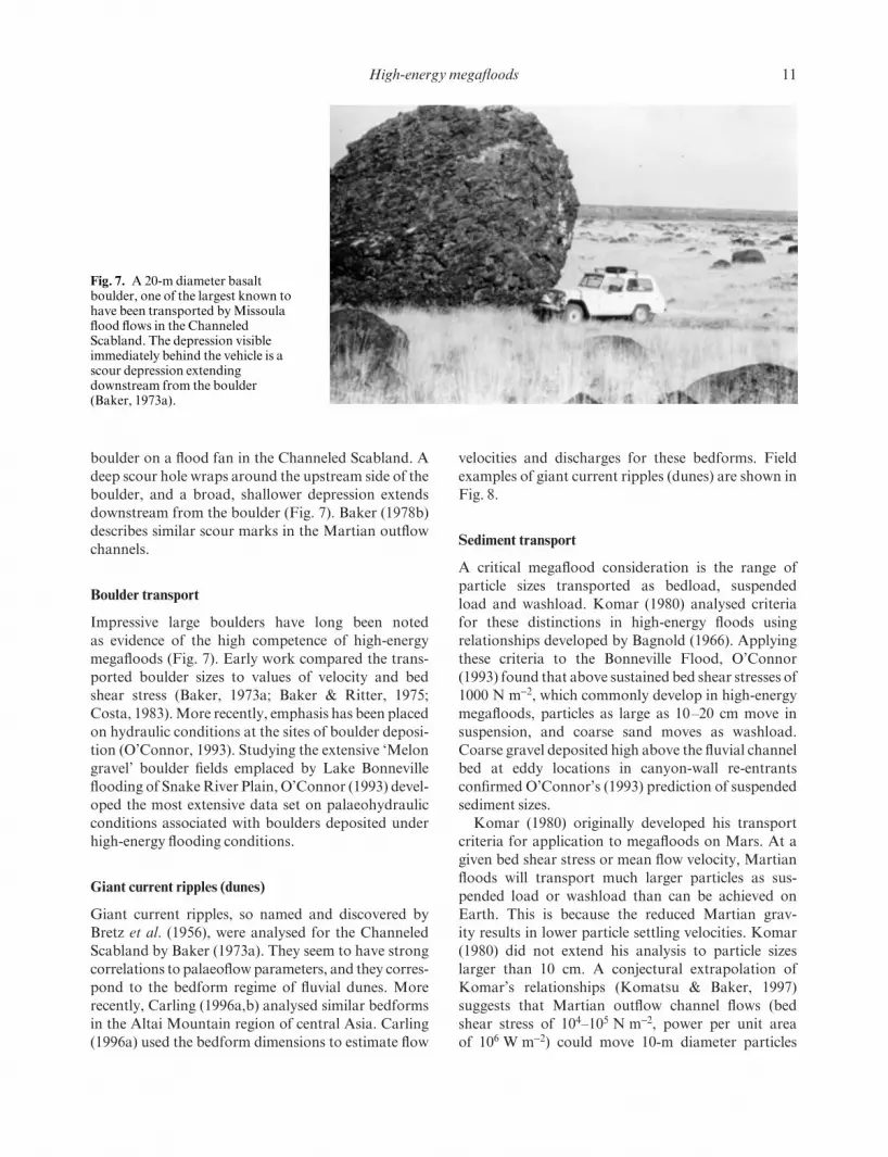
Scour marks
Scour marks develop around obstacles in cataclysmicflow fields. These are common in Icelandic jökulh-laups because immense blocks of glacial ice arestranded on the gravel plains (sandar) that occur at themouths of glaciers. The outburst floods scour depres-sions around these obstacles. Baker (1973a) describesa well-developed scour mark around a 20-m diameter
Fig. 6. Relationship of drag(indicated by a drag coefficient) toReynolds number (proportional toflow velocity) for various shaped flowobstacles. Note the drag reductionfor the elongate, streamlined shapewith a higher length-to-width ratio(l/w). Drag ultimately is reduced toskin friction, indicated by the frictiondrag coefficient (Cf) on a flat plate inlaminar or turbulent flow regimes.
IFAC01 9/12/08 4:26 PM Page 10
High-energy megafloods 11
boulder on a flood fan in the Channeled Scabland. Adeep scour hole wraps around the upstream side of theboulder, and a broad, shallower depression extendsdownstream from the boulder (Fig. 7). Baker (1978b)describes similar scour marks in the Martian outflowchannels.
Boulder transport
Impressive large boulders have long been noted as evidence of the high competence of high-energymegafloods (Fig. 7). Early work compared the trans-ported boulder sizes to values of velocity and bedshear stress (Baker, 1973a; Baker & Ritter, 1975;Costa, 1983). More recently, emphasis has been placedon hydraulic conditions at the sites of boulder deposi-tion (O’Connor, 1993). Studying the extensive ‘Melongravel’ boulder fields emplaced by Lake Bonnevilleflooding of Snake River Plain, O’Connor (1993) devel-oped the most extensive data set on palaeohydraulicconditions associated with boulders deposited underhigh-energy flooding conditions.
Giant current ripples (dunes)
Giant current ripples, so named and discovered byBretz et al. (1956), were analysed for the ChanneledScabland by Baker (1973a). They seem to have strongcorrelations to palaeoflow parameters, and they corres-pond to the bedform regime of fluvial dunes. Morerecently, Carling (1996a,b) analysed similar bedformsin the Altai Mountain region of central Asia. Carling(1996a) used the bedform dimensions to estimate flow
velocities and discharges for these bedforms. Fieldexamples of giant current ripples (dunes) are shown inFig. 8.
Sediment transport
A critical megaflood consideration is the range of particle sizes transported as bedload, suspended load and washload. Komar (1980) analysed criteriafor these distinctions in high-energy floods using relationships developed by Bagnold (1966). Applyingthese criteria to the Bonneville Flood, O’Connor(1993) found that above sustained bed shear stresses of1000 N m−2, which commonly develop in high-energymegafloods, particles as large as 10–20 cm move insuspension, and coarse sand moves as washload.Coarse gravel deposited high above the fluvial channelbed at eddy locations in canyon-wall re-entrantsconfirmed O’Connor’s (1993) prediction of suspendedsediment sizes.
Komar (1980) originally developed his transportcriteria for application to megafloods on Mars. At agiven bed shear stress or mean flow velocity, Martianfloods will transport much larger particles as sus-pended load or washload than can be achieved onEarth. This is because the reduced Martian grav-ity results in lower particle settling velocities. Komar(1980) did not extend his analysis to particle sizeslarger than 10 cm. A conjectural extrapolation ofKomar’s relationships (Komatsu & Baker, 1997) suggests that Martian outflow channel flows (bedshear stress of 104–105 N m−2, power per unit area of 106 W m−2) could move 10-m diameter particles
Fig. 7. A 20-m diameter basaltboulder, one of the largest known tohave been transported by Missoulaflood flows in the ChanneledScabland. The depression visibleimmediately behind the vehicle is ascour depression extendingdownstream from the boulder(Baker, 1973a).
IFAC01 9/12/08 4:26 PM Page 11

12 V.R. Baker
in suspension. Gravel of 10 mm size would move aswashload.
Submarine effects of megafloods
Komar (1979) developed a physical analogy betweenMartian outflow channels and the submarine channelsassociated with deep-sea turbidity currents. Velocitiesfor the latter on Earth are in the range of 10–20 m s−1
(Komar, 1969). Upon emanating from a deep-seachannel, terrestrial turbidity currents spread theirdeposits over immense areas of sea floor. The mobilityof the currents is enhanced by their low densities,1.1–1.2 g cm−3 (Komar, 1977), which imparts a verylow effective gravity. Combined with the lower abso-lute gravity on Mars, transport distances across theflat plains of Mars, such as in Oceanus Borealis, wouldbe greatly enhanced above terrestrial analogues.
Sediment-charged Martian floods from outflowchannels would have entered the ponded northernplains water body (Oceanus Borealis) as hyperpycnalflows, thereby creating a plane jet underflow (Moore,1966) and powerful turbidity currents. The northernplain contains a vast deposit covering 2.7 × 10⁷ km2,approximately one-sixth of the planet’s area (Parker etal., 1993). This unit has a remarkable topographicsmoothness (Head et al., 1998, 1999), which is consist-ent with the hypothesis of submarine emplacement by turbidity current flows. Alternatively, Jöns (1985) and Tanaka (1997) hypothesize subaerial mud ordebris flows for emplacing the deposit. However, these authors fail to account for the need to emplace the deposit over immense areas of flat terrain. Theextremely high mobility of turbidity current flows,
triggered by sediment-charged megafloods, seems toprovide the most reasonable physical mechanism toexplain this relationship.
The Astoria fan relationships for Missoula floodingshow that submarine effects need to be consideredmore broadly in regard to megafloods. Mutti et al.(1996) have already begun this investigation for tec-tonically active basins.
CONCLUSIONS
Although J Harlen Bretz once thought his discovery of cataclysmic flood effects in the Channeled Scablandto have been unique, it is now clear that high-energymegafloods are general phenomena of considerablegeological importance. They were associated with latePleistocene glacial ice margins in both North Amer-ica and Asia. They have modern manifestations inIceland, and their most spectacular effects occur onthe planet Mars. Yet, all these examples show similarit-ies of certain erosional and depositional features, aswell as similar ranges of flow velocities, bed shear stressand power per unit area.
The accumulating palaeohydraulic data now showthat these megafloods compare with the largest waterflows of the world ocean. Like ocean currents, theyprobably had important influences on global climate.For Mars, the megafloods are hypothesized to be theprincipal cause of climatic change on long, geologicaltime-scales.
Perhaps the most widespread and significant sedi-mentary effect of high-energy megafloods arises whensediment-charged flows emerge from confined con-
Fig. 8. Giant current ripples (dunes) emplaced by megafloods. (a) Ripple field of the Missoula flooding near Spirit Lake, Idaho.These gravel ripples have a spacing of 85 m and a height of 4 m (Baker, 1973a). Pine trees accentuate the ripple troughs. (b)Ripple field of the megaflood in the Kuray Basin of the Altai Mountain area, Siberia (Rudoy & Baker, 1993; Carling, 1996a,b).These dunes reach spacings of as much as 200 m and heights of 10–16 m (photograph by A. Rudoy).
(a) (b)
IFAC01 9/12/08 4:26 PM Page 12

High-energy megafloods 13
tinental valleys to enter adjacent ocean basins. Theresulting hyperpycnal flows and turbidity currentshave now been documented for the Missoula floodsthat carved the Channeled Scabland. Physical consid-erations and geomorphological relationships also sug-gest that similar processes occurred during an ancientepoch on Mars associated with the outflow channelsand Oceanus Borealis.
ACKNOWLEDGEMENTS
Thirty years of research on a topic leave too many col-leagues, students and collaborators to thank properly.Paul Komar, in particular, shared many ideas pertin-ent to this particular paper. Of course, the late ‘Doc’Bretz got it all started. This paper is ALPHA contribu-tion number 61.
REFERENCES
Ager, D.V. (1993) The Nature of the Stratigraphical Record.Wiley, Chichester.
Arkhipov, S.A., Ehlers, J., Johnson, R.G. & Wright, H.E.Jr (1995) Glacial drainage towards the Mediterraneanduring the Middle and Late Pleistocene. Boreas 24, 196–206.
Bagnold, R.A. (1966) An approach to the sediment trans-port problem from general physics. U.S. geol. Surv. Prof.Pap. 422-I, 1–37.
Baker, V.R. (1973a) Paleohydrology and sedimentology ofLake Missoula flooding in eastern Washington. Geol. Soc.Am. Spec. Pap. 144, 1–79.
Baker, V.R. (1973b) Erosional forms and processes for the catastrophic Pleistocene Missoula floods in easternWashington. In: Fluvial Geomorphology (Ed. Morisawa,M.), pp. 123–148. Publications in Geomorphology, StateUniversity of New York, Binghamton, NY.
Baker, V.R. (1978a) The Spokane Flood controversy andthe Martian outflow channels. Science 202, 1249–1256.
Baker, V.R. (1978b) A preliminary assessment of the fluiderosional processes that shaped the Martian outflow chan-nels. In: Proceedings of the 9th Lunar and Planetary ScienceConference, pp. 3205–3223. Lunar and Planetary Institute,Houston, TX.
Baker, V.R. (1979) Erosional processes in channelized waterflows on Mars. J. geophys. Res. 84, 7985–7993.
Baker, V.R. (1981) Catastrophic Flooding: the Origin of theChanneled Scabland. Dowden, Hutchinson and Ross,Stroudsburg, PA.
Baker, V.R. (1982) The Channels of Mars. University ofTexas Press, Austin, TX.
Baker, V.R. (1988) Cataclysmic processes in geomorpholo-gical systems. Z. Geomorph. Suppl. 67, 25–32.
Baker, V.R. (1994) Glacial to modern changes in global riverfluxes. In: Material Fluxes on the Surface of the Earth (Ed. National Research Council), pp. 86–98. NationalAcademy Press, Washington, DC.
Baker, V.R. (1996a) Discovering Earth’s future in its past:Palaeohydrology and global environmental change. In:Global Continental Changes: the Context of Palaeohydro-logy (Eds Branson, J., Brown, A.G. & Gregory, K.J.), Spec. Publ. geol. Soc. London, No. 115, pp. 73–83.Geological Society of London, Bath.
Baker, V.R. (1996b) Megafloods and glaciation. In: LateGlacial and Postglacial Environmental Changes (Ed.Martini, I.P.), pp. 98–108. Oxford University Press, NY.
Baker, V.R. (1998) Catastrophism and uniformitarianism:logical roots and current relevance. In: Lyell: the Past isthe Key to the Present (Eds Blundell, D.J. & Scott, A.C.),
Spec. Publ. geol. Soc. London, No. 143, pp. 171–182.Geological Society of London, Bath.
Baker, V.R. & Costa, J.C. (1987) Flood power. In: Cata-strophic Flooding (Eds Mayer, L. & Nash, P.), pp. 1–21.Allen and Unwin, London.
Baker, V.R. & Kale, V.S. (1998) The role of extreme floods in shaping bedrock channels. In: Rivers over Rock: Fluvial Processes in Bedrock Channels (Eds Tinkler, K.J. &Wohl, E.E.), pp. 153–165. Monograph 107, AmericanGeophysical Union, Washington, DC.
Baker, V.R. & Kochel, R.C. (1988) Flood sedimentation inbedrock fluvial systems. In: Flood Geomorphology (Eds Baker,V.R., Kochel, R.C. & Patton, P.C.), pp. 123–137. Wiley, NY.
Baker, V.R. & Milton, D.J. (1974) Erosion by catastrophicfloods on Mars and Earth. Icarus 23, 27–41.
Baker, V.R. & Nummedal, D. (1978) The Channeled Scabland.NASA Planetary Geology Program, Washington, DC.
Baker, V.R. & Ritter, D.F. (1975) Competence of rivers totransport coarse bedload. Geol. Soc. Am. Bull. 86, 975–978.
Baker, V.R., Strom, R.G., Gulick, V.C., Kargel, J.S.,Komatsu, G. & Kale, V.S. (1991) Ancient oceans, ice sheetsand the hydrological cycle on Mars. Nature 352, 589–594.
Baker, V.R., Carr, M.H., Gulick, V.C., Marley, M.S. &Williams, C.R. (1992) Channels and valley networks. In:Mars (Eds Kieffer, H.H., Jakosky, B. & Synder, C.), pp. 493–522. University of Arizona Press, Tucson.
Baker, V.R., Benito, G. & Rudoy, A.N. (1993) Paleo-hydrology of late Pleistocene superflooding: Altay Moun-tains, Siberia. Science 259, 348–350.
Benito, G. (1997) Energy expenditure and geomorphic workof the cataclysmic Missoula flooding in the ColumbiaGorge, U.S.A. Earth Surf. Process. Landf. 22, 457–472.
Bretz, J H. (1925) The Spokane Flood beyond the ChanneledScabland. J. Geol. 17 (97–115), 232–259.
Bretz, J H. (1928) The Channeled Scabland of easternWashington. Geograph. Rev. 18, 446–477.
Bretz, J H. (1959) Washington’s Channeled Scabland.Washington Div. Mines Geol. Bull. 45, 1–57.
Bretz, J H., Smith, H.T.U. & Neff, G.E. (1956) ChanneledScabland of Washington: New data and interpretations.Geol. Soc. Am. Bull. 67, 957–1049.
Broecker, W.S. (2000) Abrupt climate change: Causal con-straints provided by the paleoclimate record. Earth Sci.Rev. 51, 137–154.
Broecker, W.S. & Denton, G.H. (1989) The role of ocean-atmosphere reorganizations in glacial cycles. Geochim.Cosmochim. Acta 53, 2465–2501.
Brunner, C.A., Normark, W.R., Zuffa, G.G. & Serra, F.(1999) Deep-sea sedimentary record of the late Wisconsincataclysmic floods from the Columbia River. Geology 27,463–466.
IFAC01 9/12/08 4:26 PM Page 13

14 V.R. Baker
Carling, P.A. (1996a) A preliminary palaeohydraulic model applied to Late Quaternary gravel dunes: AltaiMountains, Siberia. In: Global Continental Changes: theContext of Palaeohydrology (Eds Branson, J., Brown, A.G.& Gregory, K.J.), Spec. Publ. geol. Soc. London, No. 115,pp. 165–179. Geological Society of London, Bath.
Carling, P.A. (1996b) Morphology, sedimentology andpalaeohydraulic significance of large gravel dunes: AltaiMountains, Siberia. Sedimentology 43, 647–664.
Carling, P.A., Kirkbride, A.D., Panachov, S., Borodavko,P.S. & Berger, G.W. (2002) Late glacial catastrophicflooding in the Altai Mountains of south-central Siberia: a synoptic overview and an introduction to flood depositsedimentology. In: Flood and Megaflood Processes andDeposits: Recent and Ancient Examples (Eds Martini, I.P., Baker, V.R. & Garzón, G.), Spec. Publ. int. Ass.Sediment., No. 32, pp. 17–35. Blackwell Science, Oxford.
Chepalyga, A.L. (1984) Inland sea basins. In: Late QuaternaryEnvironments of the Soviet Union (Ed. Velichko, A.A.), pp. 229–247. University of Minnesota Press, Minneapolis.
Costa, J.E. (1983) Paleohydraulic reconstruction of flash-flood peaks from boulder deposits in the Colorado FrontRange. Geol. Soc. Am. Bull. 94, 986–1004.
Costa, J.E. & O’Connor, J.E. (1995) Geomorphically effective floods. In: Natural and Anthropogenic Influencesin Fluvial Geomorphology (Eds Costa, J.E., Miller, A.J.,Potter, K.W. & Wilcock, P.R.), pp. 45–56. GeophysicalMonograph 89, American Geophysical Union, Washington,DC.
Griggs, G.B., Kulm, L.D., Waters, A.C. & Fowler, G.A.(1970) Deep-sea gravel from Cascadia Channel. J. Geol.78, 611–619.
Gross, M.G. (1987) Oceanography: a View of the Earth.Prentice Hall, New Jersey, 406 pp.
Grosswald, M.G. (1980) Late Weichselian ice sheet ofnorthern Eurasia. Quat. Res. 13, 1–32.
Grosswald, M.G. (1998) New approach to the ice agepalaeohydrology of northern Eurasia. In: Palaeohydrologyand Environmental Change (Eds Benito, G., Baker, V.R. &Gregory, K.J.), pp. 199–214. Wiley, Chichester.
Grosswald, M.G. (1999) Cataclysmic Megafloods in Eurasiaand the Polar Ice Sheets. Scientific World, Moscow. (InRussian.)
Grosswald, M.G., Kuhle, M. & Fastook, J.L. (1994)Wurm glaciation of Lake Issyk-kul area, Tian ShanMountains: a case study in the glacial history of centralAsia. Geojournal 33, 273–310.
Gudmundsson, M.T., Bjornsson, H. & Palsson, F. (1995)Changes in jökulhlaup sizes in Grimsvötn, Vatnajökull,Iceland, 1934–91, deduced from in-situ measurements ofsubglacial lake volume. J. Glaciol. 41, 263–272.
Head, J.W. III, Kreslavsky, M., Hiesinger, H., Ivanov,M., Pratt, S. & Seibert, N. (1998) Oceans in the past his-tory of Mars: Tests for their presence using Mars OrbiterLaser Altimeter (MOLA) data. Geophys. Res. Lett. 25,4401–4404.
Head, J.W., Hiesinger, H., Ivanov, M.A., Kreslavsky,M.A., Pratt, S. & Thomson, B.J. (1999) Possible ancientoceans on Mars: Orbiter laser altimeter data. Science 286,2134–2137.
Hsü, K.J., Garrison, R.E., Montadert, L., et al. (1977)History of the Mediterranean salinity crisis. Nature 267,399–403.
Jarrett, R.D. & Malde, H.E. (1987) Paleodischarge of thelate Pleistocene Bonneville Flood, Snake River, Idaho, com-puted from new evidence. Geol. Soc. Am. Bull. 99, 127–134.
Jöns, H.-P. (1985) Late sedimentation and late sediments inthe northern lowlands on Mars. In: Lunar and PlanetaryScience XVI, pp. 404–405. Lunar and Planetary Institute,Houston, TX.
Kehew, A.E. & Lord, M.L. (1986) Origin and large-scaleerosional features of glacial-lake spillways in the northernGreat Plains. Geol. Soc. Am. Bull. 97, 162–177.
Kehew, A.E. & Teller, J.T. (1994) History of late glacialrunoff along the southwestern margin of the LaurentideIce Sheet. Quat. Sci. Rev. 13, 859–877.
Komar, P.D. (1969) The channelized flow of turbidity cur-rents with application to Monterey deep-sea channel. J.geophys. Res. 74, 4544–4558.
Komar, P.D. (1977) Computer simulation of turbidity current flow and the study of deep-sea channels and fansedimentation. In: The Sea, Vol. 7 (Ed. Goldberg, D.), pp. 603–621. Wiley, New York.
Komar, P.D. (1979) Comparisons of the hydraulics of waterflows in Martian outflow channels with flows of similarscale on Earth. Icarus 37, 156–181.
Komar, P.D. (1980) Modes of sediment transport in channel-ized water flows with ramifications to the erosion of theMartian outflow channels. Icarus 42, 317–329.
Komar, P.D. (1983) Shapes of streamlined islands on Earthand Mars: experiments and analyses of the minimum-dragform. Geology 11, 651–654.
Komar, P.D. (1984) The lemniscate loop: comparisons withthe shapes of streamlined landforms. J. Geol. 92, 133–145.
Komatsu, G. & Baker, V.R. (1997) Paleohydrology andflood geomorphology of Ares Vallis, Mars. J. geophys.Res. 102, 4151–4160.
Maizels, J.K. (1989) Sedimentology, palaeoflow dynamicsand flood history of jökulhlaup deposits: palaeohydrologyof Holocene sediment sequences in southern Iceland san-dur deposits. J. sediment. Petrol. 59, 204–223.
Maizels, J.K. (1993) Lithofacies variations within san-dur deposits: the role of runoff regime, flow dynamics, and sediment supply characteristics. Sediment. Geol. 85,299–325.
Maizels, J.K. (1995) Sediments and landforms of modernproglacial terrestrial environments. In: Modern GlacialEnvironments (Ed. Menzies, J.), pp. 365–416. Butterworth-Heinemann, Oxford.
Mars Channel Working Group (1983) Channels and val-leys on Mars. Geol. Soc. Am. Bull. 95, 1035–1054.
Moore, D. (1966) Deltaic sedimentation. Earth Sci. Rev. 1,87–104.
Mulder, T. & Syvitski, P.M. (1995) Turbidity currents gen-erated at river mouths during exceptional discharges to theworld oceans. J. Geol. 103, 285–299.
Mutti, E., Davoli, G., Tinterri, R. & Zavala, C. (1996)The importance of ancient fluvio-deltaic systems dom-inated by catastrophic flooding in tectonically activebasins. Mem. Sci. Geol. 48, 233–291.
O’Connor, J.E. (1993) Hydrology, hydraulics and sedimenttransport of Pleistocene Lake Bonneville flooding on theSnake River, Idaho. Geol. Soc. Am. Spec. Pap. 274, 1–83.
O’Connor, J.E. & Baker, V.R. (1992) Magnitudes and im-plications of peak discharges from glacial Lake Missoula.Geol. Soc. Am. Bull. 104, 267–279.
IFAC01 9/12/08 4:26 PM Page 14

High-energy megafloods 15
Olson, D.B. (1992) Ocean circulation. In: Encyclopedia ofEarth System Science (Ed. Nierenberg, W.A.), pp. 367–382. Academic Press, San Diego.
Pardee, J.T. (1942) Unusual currents in glacial Lake Missoula,Montana. Geol. Soc. Am. Bull. 53, 1569–1600.
Parker, T.J., Saunders, R.S. & Schneeberger, D.M. (1989)Transitional morphology in the west Deuteronilus Men-sae region of Mars: implications for modification of thelowland/upland boundary. Icarus 82, 111–145.
Parker, T.J., Gorsline, R.S., Saunders, R.S., Pieri, D.C. & Schneeberger, D.M. (1993) Coastal geomorphology ofthe Martian northern plains. J. geophys. Res. 98, 11 061–11 078.
Robinson, M.S. & Tanaka, K.L. (1990) Magnitude of acatastrophic flood event at Kasei Vallis, Mars. Geology 18,902–905.
Rudoy, A.N. (1988) The regime of intermontane ice-dammedlakes of south Siberia. Data Glacial Research, Acad. Sci.,USSR 61, 36–42. (In Russian.)
Rudoy, A.N. & Baker, V.R. (1993) Sedimentary effects ofcataclysmic late Pleistocene glacial outburst flooding,Altay Mountains, Russia. Sediment. Geol. 85, 53–62.
Russell, A.J. & Knudsen, O. (2002) The effects of glacieroutburst flood flow dynamics on ice-contact deposits:November jökulhlaup, Skeibarársandur, Iceland. In: Floodand Megaflood Processes and Deposits: Recent and AncientExamples (Eds Martini, I.P., Baker, V.R. & Garzón, G.),Spec. Publ. int. Ass. Sediment., No. 32, pp. 67–83Blackwell Science, Oxford.
Ryan, W. & Pitman, W. (1998) Noah’s Flood: the NewScientific Discoveries about the Event that Changed History.Simon and Schuster, New York.
Ryan, W.B.F., Pitman, W.C. III & Major, C.O. (1997) Anabrupt drowning of the Black Sea shelf. Mar. Geol. 138,119–126.
Sharp, R.P. & Malin, M.C. (1975) Channels on Mars. Geol.Soc. Am. Bull. 86, 593–609.
Smith, A.J. (1985) A catastrophic origin for the palaeovalleysystem of the eastern English Channel. Mar. Geol. 64,65–75.
Tanaka, K.L. (1997) Sedimentary history and mass flowstructures of Chryse and Acidalia Planitia, Mars. J. geophys. Res. 102, 4131–4149.
Teller, J.T. (1990) Meltwater and precipitation runoff to the North Atlantic, Arctic, and Gulf of Mexico from theLaurentide ice sheet and adjacent regions during theYounger Dryas. Paleoceanography 5, 897–905.
Tómasson, H. (1996) The jökulhlaup from Katla in 1918.Ann. Glaciol. 22, 249–254.
Velichko, A.A., Isayesa, L.L., Oreshkin, D.B. & Faustova,M.A. (1989) The last glaciation of Eurasia. In: The ArcticSeas: Climatology, Oceanography, Geology, and Biology(Ed. Herman, Y.), pp. 729–758. Van Nostrand Reinhold,New York.
Waitt, R.B. (2001) Great Holocene floods along Jökulsá áFjöllum, north Iceland. In: Flood and Megaflood Processesand Deposits: Recent and Ancient Examples (Eds Martini,I.P., Baker, V.R. & Garzón, G.), Spec. Publ. int. Ass.Sediment., No. 32, pp. 37–51. Blackwell Science, Oxford.
Zuffa, G.G., Normack, W.R., Serra, F. & Brumer, C.A.(2000) Turbidite megabeds in an oceanic rift valley record-ing jökulhlaups of late Pleistocene glacial lakes of the west-ern United States. J. Geol. 108, 253–274.
IFAC01 9/12/08 4:26 PM Page 15

IFAC01 9/12/08 4:26 PM Page 16

Extensive catastrophic Pleistocene (46 ka to 13 ka)floods in south-central Siberia have been documentedrecently (Rudoy, 1988, 1990, 1998; Rudoy et al., 1989).These floods produced a suite of diluvial (‘great flood’)landforms, including large gravel dunes (Carling,1996a,b), giant bars and flood-scoured channelwayson a scale similar to that associated with the drainingof glacial Lake Missoula in North America (Baker,
Late Quaternary catastrophic flooding in the Altai Mountains of south–central Siberia:a synoptic overview and an introduction to flood deposit sedimentology
P. A. CARLING*, A. D. KIRKBRIDE†, S. PARNACHOV‡,P. S. BORODAVKO‡ and G. W. BERGER§
*Department of Geography, Highfield, University of Southampton, SO17 1BJ, UK (Email: [email protected]);
†Département de Géographie, CP 6128 Succ. Centre Ville, Montreal, Québec H3C 3J7, Canada;‡Department of Geology and Geography, Tomsk State University, 634050 Tomsk, Russia; and
§Quaternary Sciences Center, Desert Research Institute, 2215 Raggio Parkway, Reno, NV 89512–1095, USA
ABSTRACT
This paper provides an overview of the geography and palaeogeography of the Chuja (Chuya)–Katun river system in the Altai Mountains of south Siberia. In addition, an introduction to the sedimentology ofcatastrophic flood deposits is provided. Tracts of large gravel dunes and giant gravel bars in the Katun andChuja river valleys of south-central Siberia are testimony to episodes of catastrophic flooding that occurredowing to the sudden emptying of the ice-impounded glacial lake Kuray–Chuja primarily during the LatePleistocene (40 ka to 13 ka). Although today there are no substantial water bodies in the Kuray and Chujabasins, glaciolacustrine deposits attest to the former presence of large ice-proximal lakes, whereas multiplestrandlines at various elevations around the basin margins indicate former lake levels. Floods were of a scalesimilar to that recorded for glacial-lake Missoula in North America. A large flood down the main Chuja and Katun river valleys deposited huge quantities of coarse and fine gravels within back-flooded tributarymouths and other valley-side embayments. Today these deposits form giant bars that blanket the valleywalls and block each tributary entrance for a distance of over 70 km. While the bars were being deposited,the base of the main valley was infilled to a depth of 60–90 m by coarse-gravel traction deposits. In particu-lar coarse gravel bedload and hyperconcentrated-flow units prograded down-valley beneath flood watersseveral hundred metres deep. Locally, steeply cross-stratified units, each several decimetres thick attest tosteep bar-front progradation similar in style to a Gilbert-type delta.
During individual floods, fine gravel and coarse sand, mostly transported in suspension, was depositedby multiple flood pulses in the entrance to flooded tributaries. The resultant giant bars, up to 5 km long and120 m in height, temporarily impounded lakes in the tributaries, indicated by local small-scale limnicdeposits. Subsequently, tributary streams cut through the bars, draining the small lakes and incising thelacustrine deposits. Later floods down the main river valley again blocked the tributaries with flood gravelssuch that lakes reformed.
INTRODUCTION
17
1973; Baker & Bunker, 1985). The morphology andsedimentology of these landforms may be diagnosticof catastrophic floods, and thus detailed descriptionmay aid in the interpretation of other ancient land-scapes and stratigraphical successions. The sources of the Siberian floods were vast ice-dammed lakesimpounded within the intermontane basins of theAltai and Sayan mountains (Fig. 1). Evidence for
Spec. Publs int. Ass. Sediment. (2002) 32, 17–35
IFAC02 9/12/08 4:25 PM Page 17

18 P.A. Carling et al.
catastrophic floods has been noted within the head-water valleys of the rivers Ob and Yenisei. For exam-ple, the Chulym, Chulyshman, Bashkaus, Biya, Chuja(Chuya) and Katun river valleys, amongst others(Grosswald & Rudoy, 1996; Frechen & Yamskikh,1999), show evidence of superfloods, but only theChuja–Katun system has been studied in any detail.The River Chuja, a tributary of the Katun, was therouteway for several very large floods. Brief descrip-tions of these outburst floods, which emanated fromglacially dammed lakes in the Kuray and Chuja basins(Fig. 1), have been provided by Baker et al. (1993) andRudoy & Baker (1993). Baker et al. (1993) concludedthat there was one major Kuray–Chuja flood and anumber of minor floods; the peak flow of the largestwas apparently consistent with the sudden collapse ofan ice-barrier.
This paper provides a more detailed overview of the region and the palaeogeography, together with anintroduction to the sedimentology. Localities men-
Fig. 1. Location map of study area in southern Siberia. The Kuray (K) and Chuja (C) basins are shown in the headwater of theRiver Chuja.
tioned in the text are identified in three ways: by localplace name; by latitude and longitude (degrees, min-utes and decimal secondsadetermined using GPS) andby reference to kilometre road markers (e.g. km 672)that give the distance from Novosibirsk. This degreeof detail should help other scientific visitors find keylocalities. The primary objectives are to elucidate thedetail of the flood dynamics of the Kuray–Chujafloods, and to define the temporal and spatial sequenceof flooding.
PERSPECTIVE
The Altai mountains are part of an extensive, struc-turally complex succession of individual mountainranges in central Asia stretching from the Tien Shan inthe west to the Aldan range in the east. The AltaiMountains were up-thrust in the Eocene and earlyOligocene and the majority of the area has been
IFAC02 9/12/08 4:25 PM Page 18

tectonically active to some degree throughout theCenozoic (Tapponier & Molnar, 1979). As explainedbelow, it is the distinctive tectonic history that set thescene for Quaternary catastrophic floods. Major sub-parallel faults trending north-west to south-east inter-sect subsidiary faults that trend roughly east–west.Increased lateral shearing in the Cenozoic resulted inpronounced off-sets in the north–south fault align-ment (Nekhoroshev, 1966). The result is a series ofridges, such as the Kuray Range to the north and theNorth and South Chujski ranges to the south of thetectonic depressions of the Kuray and Chuja basins(Bogachkin, 1981) (Fig. 2). Vertical relative movementof the order of 2500 m took place, particularly duringthe Pliocene–Pleistocene transition, enhancing basindevelopment. Further motion occurred again at thebeginning of the Mid-Pleistocene and during the LatePleistocene. During the latter phase, however, uplift inthe Altai is believed to have been slight (Zyatkova,1977; Serebryanny, 1984) and largely occurred fol-lowing deglaciation (Nekhoroshev, 1966). Enclosedby north-west and east–west trending mountainchains, the depressions bounded by strike-slip faultsnow form spectacular enclosed intermontane basins.Sedimentation has resulted in up to 0.5 km ofNeogene and Quaternary sediment fill in the KurayBasin and over 1 km of fill in the Chuja Basin. The lat-ter exhibits, in the Chagan River valley (N50°3′15.4″;E88°25′58.78″), one of the most complete and im-portant sections of the Cenozoic within central Asia(Zykin & Kazanskii, 1995). Today these basins con-tain no significant water bodies and drainage is solelyto the north-west via the gorge of the Chuja River(Fig. 3). During the Pleistocene, however, large ice-dammed lakes filled the depressions, as witnessed bylacustrine deposits and palaeoshorelines (Figs 3 & 4).
Within the modern Altai massif, short alpineglaciers, totalling some 909 km2 in area, descend fromsmall ice-caps around the margins of the intermontanebasins of Kuray and Chuja (Fig. 2). Presently, mostAltai glaciers are fed by moisture from south-westerlyand north-westerly airstreams. However, during theQuaternary, a cold anticyclone developed over centralAsia such that the prevailing winds were from thenorth and north-east ( Velichko, 1984; Back & Strecker,1998). The global Quaternary cooling coupled withthe distinctive topography was important in control-ling associated glaciations. However, it is not clearhow many glacial cycles occurred in the Altai duringthe Pleistocene (Okishev, 1977). Local terminologyvaries but, in accord with the system adopted for other central Asian mountain glaciations, the Late
Pleistocene may be divided into four units (Archipov,1998). The oldest is the Kazantsevo interglacial (sub-stage 5e of the ocean isotope scale) which followed apre-150 ka glaciation: the Tazovo. Two Late Pleistoceneglacial phases followed: the Ermakovian (c. 100–50 ka)and the Sartan (c. 22–13 ka). These latter distinct cold periods were separated by the Karginian mega-interstadial, during which climate ameliorated abruptly(Back & Strecker, 1998) but was punctuated by fre-quent cold phases (Yamskikh et al., 1999). Togetherthese three younger periods form the Zyriankan glacia-tion that corresponds to the Würm (Weichselian) of western Europe. During maximum glaciation icedescended to around 1200 m altitude (Vardaniants,1938; Grosswald, 1998) such that ice-caps coveredboth mountains and intermontane basins, and thepiedmont to the north of the Altai (Grosswald, 1998).The maximum extent of glaciation is well delineatedby terminal moraines in the piedmont (Fig. 2). The climatic variability of the Karginian interstadial isseemingly complex; glaciation in the Altai Mountainsmay have been continuous, with ice retreating fromthe basin margins during the interstadial. AlthoughMid and Late Pleistocene ice surrounded the Kurayand Chuja basins, and glaciolacustrine sediment suitesdemonstrate that locally glaciers were proximal to thelake margins, nevertheless the basins remained ice-freethroughout much of the Late Pleistocene (Svitoch &Khorev, 1975). For example, during the final Sartancold stage, although persistent local ice-caps occurredat higher elevations (Okishev, 1977; Serebryanny, 1984),mountain valley glaciers descended only as far as thebasin margins (Fig. 2). During the Late Pleistocene,ice did not extend below 1750 m altitude in the ChujaBasin (Rudoy, 1998). The Sartan stadial maximumoccurred around 18 ka when coldest-month tempera-tures were about –30°C (10°C lower than present),warmest-month temperatures were about +10°C (4°C lower than present) and annual precipitation wasabout 200–300 mm (around 300 mm lower than pres-ent, Tarasov et al., 1999). The associated biome wasmainly tundra, but cold steppe and cold deciduousforest occurred locally (Tarasov et al., 1999). Fromthis stadial maximum, the retreat of valley glaciers waspunctuated by eight readvances. The sketchy glacialchronology for the Altai is in accord with that for theneighbouring Sayan Mountains and with the detailedchronology from the region around Lake Baikal to the east (Back & Strecker, 1998) and the Tien Shan tothe west (Grosswald et al., 1994). On this basis thecontinental-dominated climatic system for centralSiberia shows close similarity to that of west Siberia
Late Quaternary catastrophic flooding, Altai Mountains, Siberia 19
IFAC02 9/12/08 4:25 PM Page 19

20 P.A. Carling et al.
Fig. 2. Schematic palaeogeography of the Altai region during the Late Quaternary (after Rudoy, 1998). Approximate extent of ice-impounded lakes is based on strandline evidence and locations of glaciolacustrine sedimentary complexes. Maximumpotential highstands are constrained by the modern altitude of potential outflow channels (spillways) without any correctionfor tectonic adjustments. Features in the Katun, Chuja and upper Bashkaus valleys and in the Kuray and Chuja basins havebeen verified by the authors. Note: dunefield in the upper Bashkaus valley reported by Rudoy (1998) could not be located bythe authors and appears to be gullied terrain. Maximum extent of ice sheets during the Sartan is based on several Russianstudies modified by Rudoy (1998). The Kuray and Chuja basins were ice-free.
IFAC02 9/12/08 4:25 PM Page 20

Fig. 3. Map of study area showingkey locations and geomorphologicalfeatures.
Fig. 4. Long-profile showing altitude of key locations andgeomorphological features.
IFAC02 9/12/08 4:25 PM Page 21

22 P.A. Carling et al.
and Europe during the past 130 ka (Archipov, 1998;Frechen & Yamskikh, 1999).
Using a variety of geomorphological evidence,including remnants of moraines (Rudoy, 1998), Bakeret al. (1993) concluded that the Chuja gorge had been blocked periodically by ice-sheet lobes or largevalley-glaciers, which coalesced in the vicinity of theBelgebash, Chibitka and Mashej valleys (Figs 3 & 4).The substantial ice-barriers impeded the only drainageline exiting from the Kuray and Chuja basins, caus-ing the development of a temporal series of large ice-dammed lakes. Numerous wave-built strandlines testify to variation in the lake level and, being bestdeveloped on south and south-west basin margins,attest to the direction of the prevailing northerly windduring the Quaternary (Figs 3 & 5).
In the Chagan valley (Fig. 3), thermoluminescence(TL) dating of the most ancient glaciolacustrinemoraine complexes (N50°1′7.6″; E88°17′11.25″) indic-ates a Mid-Pleistocene age (380 ka to 266 ka). Morerecent glaciolacustrine deposits have been dated at 145ka and between 32 ka and 25 ka using 14C assay (Svitoch& Khorev, 1975); the latter deposits overlie morainedated at 58 ka. In addition, the presence of lacustrinedropstones at a number of locations (e.g. near Kokorya:
N49°56′49.69″; E89°4′15.97″) and strandlines on the58 ka moraine attest to the former presence of glaciallakes that were contemporaneous with, or post-date,some glaciolacustrine successions. Notwithstandingtectonic adjustments, strandlines at a range of eleva-tions show that lake levels fluctuated greatly, occa-sionally attaining depths of several hundred metres.The lowest strandlines (below about 1940 m altitude)in the Chuja Basin are faint, are developed on gently sloping terrain and are widely held to be LatePleistocene. Distinctive strandlines occur at higher elevations on the northern side of the basin and aremost prominent on ‘headlands’ along the southernmargin. Here recurved spits at several elevations show that longshore drift was universally from north-west to south-east along this southern shore (Fig. 6).The altitude and longshore gradient of a suite of Chuja strandlines have been surveyed below a trian-gulation point (c. 2137 m N49°48′; E88°56′) located in the south-east of the basin (Fig. 3). Seven distinctaccretionary strandlines range between c. 2105 m and1960 m, although locally the elevations are indicatedby notches cut in weak bedrock. Several pits dug in the strandlines together with two ground-penetratingradar (GPR) profiles (one shore parallel and one shore
Fig. 5. Aerial view of portion ofsouthern margin of the Kuray Basin.Tree-covered (bottom right) andtreeless ridges (bottom left at analtitude of around 1700–1800 m)represent local bedrock outcrops andglacial end-moraines of former valleyglaciers, which descended from theChujski Range to terminate aroundthe basin margins. The altitude of thebasin floor (top) is around 1500 m.The subparallel lines (centre andright at an altitude between 1550 and1650 m) are multiple strandlinesrepresenting fluctuations in the levelof glacial Lake Kuray. The easternextremity of the Kuray graveldunefield can be seen at the top left(Carling, 1996a). Scale: horizontaldistance is approximately 5.0 km.
IFAC02 9/12/08 4:25 PM Page 22