Embed Size (px)
Citation preview
April 30 – May 5, 2014
Fruita, Colorado&
Green River, Utah
Compiled byJim Kirkland, John Foster, ReBecca Hunt-Foster,
Gregory A. Liggett, and Kelli Trujillo
2Mid-Mesozoic: The Age of Dinosaurs in Transition
Partners
Mid-Mesozoic Logo and website by BJ Nicholls
3April 30–May 5, 2014
Welcome.................................................................................................................... 4
Schedule .................................................................................................................... 5
1. Dinosaur National Monument Field Trip .............................................................. 6
2. Grand Valley Field Trip—Morrison Formation .................................................... 9
3. Jurassic Symposium ............................................................................................ 18
4. Moab Area Field Trip .......................................................................................... 21
5. Green River and Hanksville Area Field Trip ...................................................... 28
6. Cretaceous Symposium ....................................................................................... 35
7. San Rafael Swell Area Field Trip ........................................................................ 39
8. Presentation Abstracts ......................................................................................... 45
Bibliography ........................................................................................................... 83
Index ....................................................................................................................... 87
Table of Contents
4Mid-Mesozoic: The Age of Dinosaurs in Transition
WelcomeThe field conference will involve
three day-trips to parts of the Colorado Plateau, and two days of lectures. The
Morrison Formation is world famous for its Upper Jurassic dinosaur fossils and is one of the most extensively studied dinosaur bearing units in the world. Very significant sites are known in eastern Utah (including the world famous Di-nosaur National Monument and Cleveland-Lloyd Quarry) and in western Colorado (the Fruita Paleontological Area and Mygatt-Moore Quarry). Given the extensive research given to these sites over the years this is one of the best understood areas of Upper Jurassic exposures anywhere in the world.
In contrast the overlying Early/Lower Cretaceous Ce-dar Mountain Formation spans roughly 35 million years, in comparison to the Morrison Formation’s 7 million years. The Cedar Mountain is approximately half the strati-graphic thickness, but represents about 5 times as much in geologic time. In comparison to essentially one major fauna in the Morrison, the Cedar Mountain contains up to 5 different distinct faunas. This means the Cedar Moun-tain may have more dinosaur species preserved within it than any other formation in the world.
These two formations are separated by an unconfor-mity, which is generally thought to be on the order of 25 million years. Research on the palynomorphs, ostracods, and charophytes, suggests a much shorter time interval between the Cedar Mountain and Morrison Formations.
The Upper Jurassic Morrison Formation and overly-
ing Lower Cretaceous Cedar Mountain Formation contain numerous quarries yielding vertebrate fossils in western Colorado and eastern Utah. Some of the most important include the Fruita Paleontological Area and the Mygatt-Moore Quarry in the Morrison, and the Dalton Wells and Gaston quarries in the Cedar Mountain.
The Colorado Plateau’s Morrison-Cedar Mountain dinosaurs are contributing critical information about an important period of time in the history of terrestrial life in the Northern Hemisphere. Globally, this was a time of changing climatic conditions and exceptionally high atmo-spheric carbon dioxide levels causing “supergreenhous-ing” (a world with no polar ice caps and a sluggish, poorly oxygenated ocean), major restructuring of biogeographic migration corridors, and a complete restructuring of plant communities with the origin and rapid rise to dominance of flowering plants. The Utah Geological Survey, the Mu-seum of Western Colorado, and researchers from a host of different institutions continue to discover and integrate new data from the Morrison and Cedar Mountain Forma-tion into an increasingly robust history of eastern Utah and western Colorado during the Late Jurassic and Early Cretaceous. The density of biostratigraphic, chronostrati-graphic, and paleoclimatic data make the Colorado Plateau a standard on which to resolve the geological and paleo-biological history of the mid- Mesozoic in the northern hemisphere. Continued new discoveries only serve to show that Colorado Plateau has the most complete mid-Mesozoic terrestrial record in the world, and that there is still a great deal to learn.
—Jim Kirkland, Symposium co-convener
Presentation and Meeting PoliciesAbstracts were reviewed by the Symposium conveners. Authors are responsible for the technical content of their
articles.Still photography, video and/or audio taping or any other electronic recording at the Symposium is strictly prohibited.
The symposium conveners reserve the right to engage professional photographers or audio/videotape professionals to archive sections of the meeting for dissemination online.
Please address any questions about program practices to the Symposium conveners: Jim Kirkland, John Foster or ReBecca Hunt-Foster.
Portions of this field trip guide are after Kirkland and Madsen, 2007, with additional sections by Tremaine and Williams, and Foster and Hunt-Foster.

5April 30–May 5, 2014
Schedule
Event/Function Tuesday, April 29, 2014
Wednesday, April 30, 2014
Thursday, May 1, 2014
Friday, May 2, 2014
Saturday, May 3, 2014
Sunday, May 4, 2014
Monday, May 5, 2014
Registration Desk
1-6 pm, Dinosaur Journey Museum, Fruita, Co
7:30 am - 7 pm, Dinosaur Journey Museum, Fruita, Co
7:30 am - 4:30 pm, Dinosaur Journey Museum, Fruita, Co
No onsite registration available
7:30 am - 4:30 pm, John Wesley Powell Museum, Green River, Ut
7:30 am - 4:30 pm, John Wesley Powell Museum, Green River, Ut
No onsite registration available
Field Trip Dinosaur National Monument and Vernal Field House Museum (optional, additional cost); Depart Dinosaur Journey Museum at 8:30 am
Late Jurassic of the Grand Valley; Depart Dinosaur Journey Museum at 8:30 am
Early Cretaceous of the Moab Area; Depart Dinosaur Journey Museum at 8:30 am
Late Jurassic - Early Cretaceous of the Green River-Hanksville Area; Depart John Wesley Powell Museum at 8:30 am
Late Jurassic - Early Cretaceous of the San Rafael Swell Area; Depart John Wesley Powell Museum at 8:30 am
Symposium 9 am - 4:30 pm, Jurassic Symposium, Dinosaur Journey Museum, Fruita, Co
9 am - 4:30 pm, Cretaceous Symposium, John Wesley Powell Museum, Green River, Ut
Poster Set-up 7:30 am - 9:30 am, Poster Session 1, Dinosaur Journey Museum, Fruita, Co
7:30 am - 9:30 am, Poster Session 2, John Wesley Powell Museum, Green River, Ut
Poster Reception
4:30 - 6:00 pm, Poster Session 1, Dinosaur Journey Museum, Fruita, Co
4:30 - 6:00 pm, Poster Session 2, John Wesley Powell Museum, Green River, Ut
Social Events 7:00 - 10:00 pm, Welcome Reception, Dinosaur Journey Museum, Fruita, Co
7:00 pm, Burgers and Beer Banquet, Ray’s Tavern, Green River, Ut
6Mid-Mesozoic: The Age of Dinosaurs in Transition
Tuesday, April 29thDINOSAUR NATIONAL MONUMENT
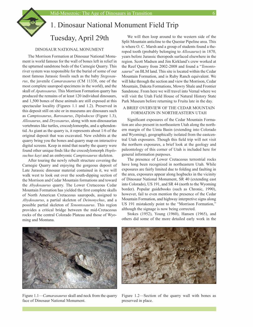
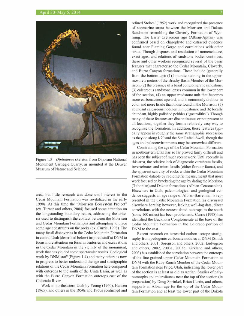
The Morrison Formation at Dinosaur National Monu-ment is world famous for the wall of bones left in relief in the upturned sandstone beds of the Carnegie Quarry. This river system was responsible for the burial of some of our most famous Jurassic fossils such as the baby Stegosau-rus, the juvenile Camarasaurus (CM 11338, one of the most complete sauropod specimens in the world), and the skull of Apatosaurus. This Morrison Formation quarry has produced the remains of at least 120 individual dinosaurs, and 1,500 bones of these animals are still exposed at this spectacular locality (Figures 1.1 and 1.2). Preserved in this deposit still on site or in museums are dinosaurs such as Camptosaurus, Barosaurus, Diplodocus (Figure 1.3), Allosaurus, and Dryosaurus, along with non-dinosaurian vertebrates like turtles, crocodylomorphs, and a sphendon-tid. As giant as the quarry is, it represents about 1/6 of the original deposit that was excavated. New exhibits at the quarry bring you the bones and quarry map on interactive digital screens. Keep in mind that nearby the quarry were found other unique finds like the crocodylomorph Hoplo-suchus kayi and an embryonic Camptosaurus skeleton.
After touring the newly rebuilt structure covering the Carnegie Quarry and enjoying the gorgeous deposit of Late Jurassic dinosaur material contained in it, we will walk west to look out over the south-dipping section of the Morrison and Cedar Mountain formations and toward the Abydosaurus quarry. The Lower Cretaceous Cedar Mountain Formation has yielded the first complete skulls of North American Cretaceous sauropods, assigned to Abydosaurus, a partial skeleton of Deinonychus, and a possible partial skeleton of Tenontosaurus. This region provides a critical bridge between the mid-Cretaceous rocks of the central Colorado Plateau and those of Wyo-ming and Montana.
1. Dinosaur National Monument Field TripWe will then loop around to the western side of the
Split Mountain anticline to the Questar Pipeline area. This is where O. C. Marsh and a group of students found a the-ropod tooth (probably belonging to Allosaurus) in 1870, years before Jurassic theropods surfaced elsewhere in the region. Scott Madsen and Jim Kirkland’s crew worked at the Reef Quarry from 2002-2008 and found a “Tenonto-saurus” on BLM land. This site is located within the Cedar Mountain Formation, and is Ruby Ranch equivalent. We will hike through the section and view the Morrison, Cedar Mountain, Dakota Formations, Mowry Shale and Frontier Sandstone. From here we will travel into Vernal where we will visit the Utah Field House of Natural History State Park Museum before returning to Fruita late in the day.
A BRIEF OVERVIEW OF THE CEDAR MOUNTAIN FORMATION IN NORTHEASTERN UTAH
Significant exposures of the Cedar Mountain Forma-tion are also present in northeastern Utah along the north-ern margin of the Uinta Basin (extending into Colorado and Wyoming), geographically isolated from the eastcen-tral Utah exposures. Though this field trip will not visit the northern exposures, a brief look at the geology and paleontology of this corner of Utah is included here for general information purposes.
The presence of Lower Cretaceous terrestrial rocks have long been recognized in northeastern Utah. While exposures are fairly limited due to folding and faulting in the area, exposures appear along hogbacks in the vicinity of Dinosaur National Monument, SR 40 (extending east into Colorado), US 191, and SR 44 (north to the Wyoming border). Popular guidebooks (such as Chronic, 1990), however, fail to even mention the presence of the Cedar Mountain Formation, and highway interpretive signs along US 191 mistakenly point to the “Morrison Formation,” although the signage is now being corrected.
Stokes (1952), Young (1960), Hansen (1965), and others did some of the more detailed early work in the
Figure 1.2—Section of the quarry wall with bones as preserved in place.
Figure 1.1—Camarasaurus skull and neck from the quarry face of Dinosaur National Monument.
7April 30–May 5, 2014
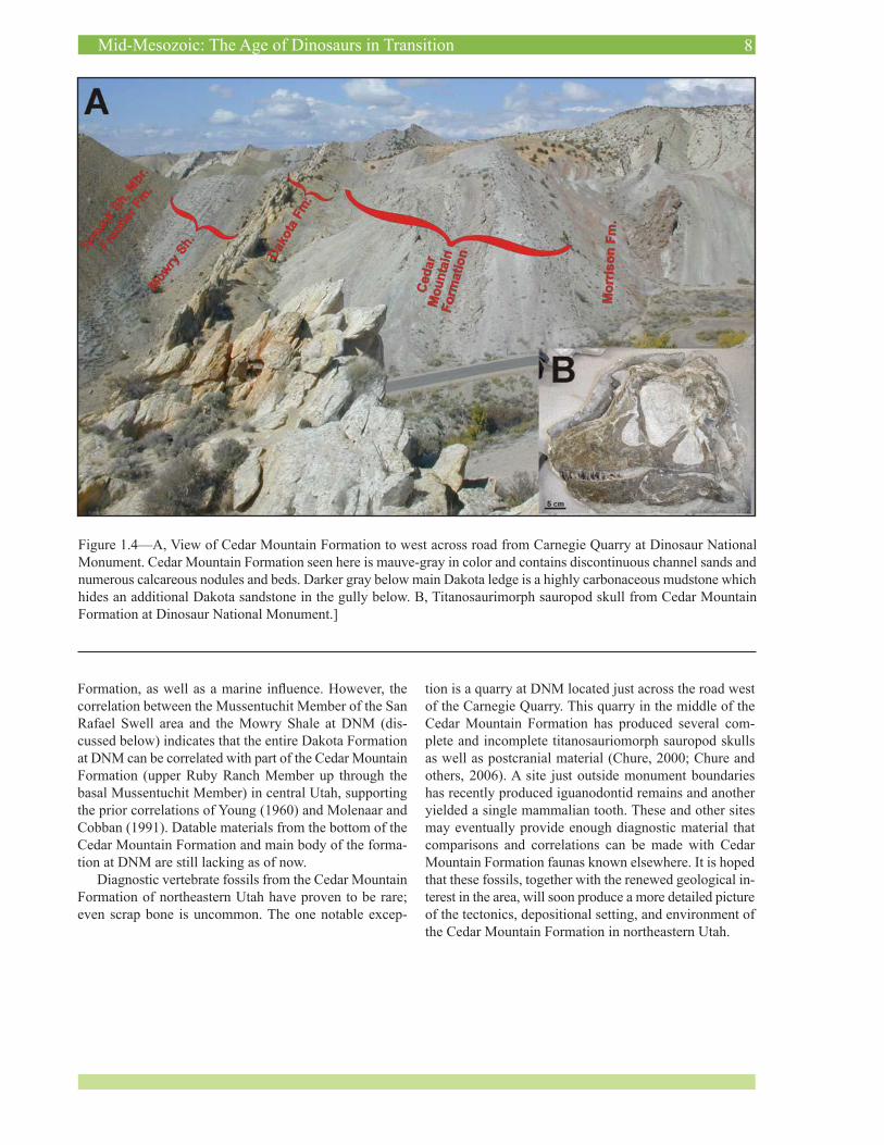
area, but little research was done until interest in the Cedar Mountain Formation was revitalized in the early 1990s. At this time the “Morrison Ecosystem Project” (ex. Turner and others, 2004) focused some attention on the longstanding boundary issues, addressing the crite-ria used to distinguish the contact between the Morrison and Cedar Mountain Formations and attempting to place some age constraints on the rocks (ex. Currie, 1998). The many fossil discoveries in the Cedar Mountain Formation in central Utah (described below) inspired staff at DNM to focus more attention on fossil inventories and excavations in the Cedar Mountain in the vicinity of the monument, work that has yielded some spectacular results. Geological work by DNM staff (Figure 1.4) and many others is now in progress to better understand the age and stratigraphic relations of the Cedar Mountain Formation here compared with outcrops to the south of the Uinta Basin, as well as with the Burro Canyon Formation outcrops east of the Colorado River.
Work in northeastern Utah by Young (1960), Hansen (1965), and others in the 1950s and 1960s confirmed and
refined Stokes’ (1952) work and recognized the presence of nonmarine strata between the Morrison and Dakota Sandstone resembling the Cloverly Formation of Wyo-ming. The Early Cretaceous age (Albian-Aptian) was confirmed based on charophyte and ostracod evidence found near Flaming Gorge and correlations with other strata. Though disputes and resolution of nomenclature, exact ages, and relations of sandstone bodies continues, these and other workers recognized several of the basic features that characterize the Cedar Mountain, Cloverly, and Burro Canyon formations. These include (generally from the bottom up): (1) limonite staining in the upper-most few meters of the Brushy Basin Member of the Mor-rison, (2) the presence of a basal conglomeratic sandstone, (3) calcareous sandstone lenses common in the lower part of the section, (4) an upper mudstone unit that becomes more carbonaceous upward, and is commonly drabber in color and more fissile than those found in the Morrison, (5) abundant calcareous nodules in mudstones, and (6) locally abundant, highly polished pebbles (“gastroliths”). Though many of these features are discontinuous or not present at all locations, together they form a relatively easy way to recognize the formation. In addition, these features typi-cally appear in roughly the same stratigraphic succession as they do along I-70 and the San Rafael Swell, though the ages and paleoenvironments may be somewhat different.
Constraining the age of the Cedar Mountain Formation in northeastern Utah has so far proved fairly difficult and has been the subject of much recent work. Until recently in this area, the relative lack of diagnostic vertebrate fossils, invertebrates and microfossils (either flora or fauna), and the apparent scarcity of rocks within the Cedar Mountain Formation datable by radiometric means, meant that most work focused on bracketing the age by dating the Morrison (Tithonian) and Dakota formations (Albian-Cenomanian). Elsewhere in Utah, paleontological and geological evi-dence suggests an age range of Albian-Barremian is rep-resented in the Cedar Mountain Formation (as discussed elsewhere herein); however, lacking well-log data, direct correlations with the nearest dated outcrops to the south (some 100 miles) has been problematic. Currie (1998) has identified the Buckhorn Conglomerate at the base of the Cedar Mountain Formation in the Colorado portion of DNM to the east.
Recent research on terrestrial carbon isotope stratig-raphy from pedogenic carbonate nodules at DNM (Smith and others, 2001; Sorenson and others, 2002; Ludvigson and others, 2002, 2003a, 2003b; Kirkland and others, 2003) has established the correlation between the outcrops of the fine grained upper Cedar Mountain Formation at DNM with the Ruby Ranch Member of the Cedar Moun-tain Formation near Price, Utah, indicating the lower part of the section is at least as old as Aptian. Studies of paly-nomorphs and microfaunas near the top of the section (in preparation) by Doug Sprinkel, Brian Currie, and others, supports an Albian age for the top of the Cedar Moun-tain Formation and at least the lower part of the Dakota
Figure 1.3—Diplodocus skeleton from Dinosaur National Monument Carnegie Quarry, as mounted at the Denver Museum of Nature and Science.
8Mid-Mesozoic: The Age of Dinosaurs in Transition
Figure 1.4—A, View of Cedar Mountain Formation to west across road from Carnegie Quarry at Dinosaur National Monument. Cedar Mountain Formation seen here is mauve-gray in color and contains discontinuous channel sands and numerous calcareous nodules and beds. Darker gray below main Dakota ledge is a highly carbonaceous mudstone which hides an additional Dakota sandstone in the gully below. B, Titanosaurimorph sauropod skull from Cedar Mountain Formation at Dinosaur National Monument.]
Formation, as well as a marine influence. However, the correlation between the Mussentuchit Member of the San Rafael Swell area and the Mowry Shale at DNM (dis-cussed below) indicates that the entire Dakota Formation at DNM can be correlated with part of the Cedar Mountain Formation (upper Ruby Ranch Member up through the basal Mussentuchit Member) in central Utah, supporting the prior correlations of Young (1960) and Molenaar and Cobban (1991). Datable materials from the bottom of the Cedar Mountain Formation and main body of the forma-tion at DNM are still lacking as of now.
Diagnostic vertebrate fossils from the Cedar Mountain Formation of northeastern Utah have proven to be rare; even scrap bone is uncommon. The one notable excep-
tion is a quarry at DNM located just across the road west of the Carnegie Quarry. This quarry in the middle of the Cedar Mountain Formation has produced several com-plete and incomplete titanosauriomorph sauropod skulls as well as postcranial material (Chure, 2000; Chure and others, 2006). A site just outside monument boundaries has recently produced iguanodontid remains and another yielded a single mammalian tooth. These and other sites may eventually provide enough diagnostic material that comparisons and correlations can be made with Cedar Mountain Formation faunas known elsewhere. It is hoped that these fossils, together with the renewed geological in-terest in the area, will soon produce a more detailed picture of the tectonics, depositional setting, and environment of the Cedar Mountain Formation in northeastern Utah.
9April 30–May 5, 2014
2. Grand Valley Field Trip—Morrison Formation
Wednesday, April 30
FRUITA-RABBIT VALLEY
Today, we will meet at Dinosaur Journey Museum, in Fruita, Colorado. This one-day field trip will visit various sites located in the BLM McInnis Canyons National Con-servation Area. Focusing on the Late Jurassic-age Morri-son Formation, trip leaders John Foster and Jim Kirkland
will tour you to both historic and current fossil quarries and outcrops.
FRUITA PALEONTOLOGICAL AREA
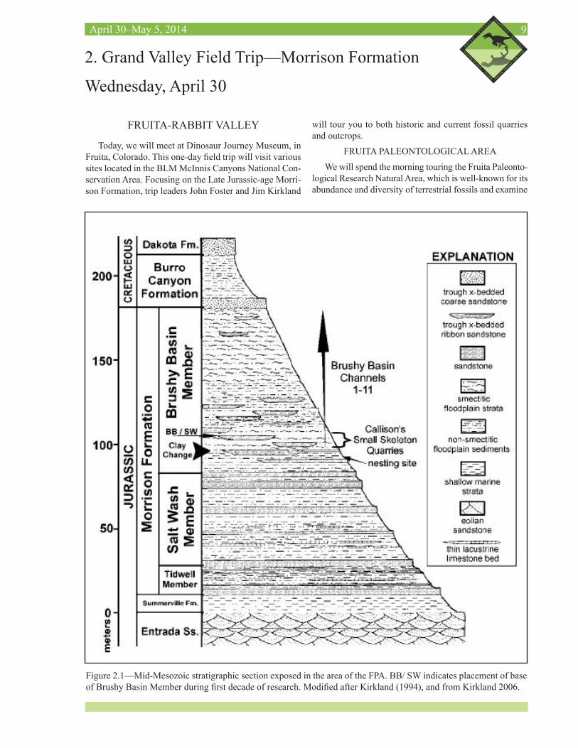
We will spend the morning touring the Fruita Paleonto-logical Research Natural Area, which is well-known for its abundance and diversity of terrestrial fossils and examine
Figure 2.1—Mid-Mesozoic stratigraphic section exposed in the area of the FPA. BB/ SW indicates placement of base of Brushy Basin Member during first decade of research. Modified after Kirkland (1994), and from Kirkland 2006.
10Mid-Mesozoic: The Age of Dinosaurs in Transition
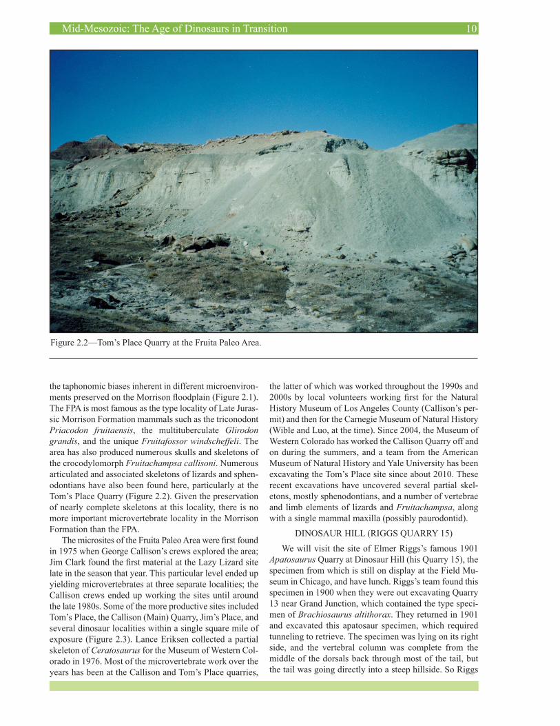
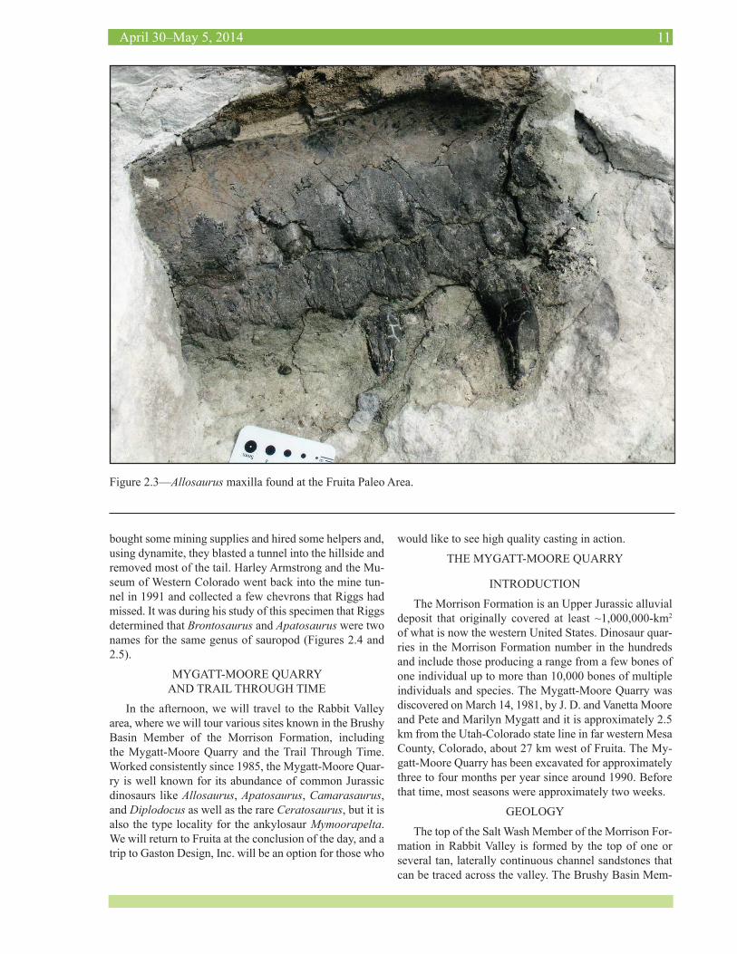
the taphonomic biases inherent in different microenviron-ments preserved on the Morrison floodplain (Figure 2.1). The FPA is most famous as the type locality of Late Juras-sic Morrison Formation mammals such as the triconodont Priacodon fruitaensis, the multituberculate Glirodon grandis, and the unique Fruitafossor windscheffeli. The area has also produced numerous skulls and skeletons of the crocodylomorph Fruitachampsa callisoni. Numerous articulated and associated skeletons of lizards and sphen-odontians have also been found here, particularly at the Tom’s Place Quarry (Figure 2.2). Given the preservation of nearly complete skeletons at this locality, there is no more important microvertebrate locality in the Morrison Formation than the FPA.
The microsites of the Fruita Paleo Area were first found in 1975 when George Callison’s crews explored the area; Jim Clark found the first material at the Lazy Lizard site late in the season that year. This particular level ended up yielding microvertebrates at three separate localities; the Callison crews ended up working the sites until around the late 1980s. Some of the more productive sites included Tom’s Place, the Callison (Main) Quarry, Jim’s Place, and several dinosaur localities within a single square mile of exposure (Figure 2.3). Lance Eriksen collected a partial skeleton of Ceratosaurus for the Museum of Western Col-orado in 1976. Most of the microvertebrate work over the years has been at the Callison and Tom’s Place quarries,
the latter of which was worked throughout the 1990s and 2000s by local volunteers working first for the Natural History Museum of Los Angeles County (Callison’s per-mit) and then for the Carnegie Museum of Natural History (Wible and Luo, at the time). Since 2004, the Museum of Western Colorado has worked the Callison Quarry off and on during the summers, and a team from the American Museum of Natural History and Yale University has been excavating the Tom’s Place site since about 2010. These recent excavations have uncovered several partial skel-etons, mostly sphenodontians, and a number of vertebrae and limb elements of lizards and Fruitachampsa, along with a single mammal maxilla (possibly paurodontid).
DINOSAUR HILL (RIGGS QUARRY 15)
We will visit the site of Elmer Riggs’s famous 1901 Apatosaurus Quarry at Dinosaur Hill (his Quarry 15), the specimen from which is still on display at the Field Mu-seum in Chicago, and have lunch. Riggs’s team found this specimen in 1900 when they were out excavating Quarry 13 near Grand Junction, which contained the type speci-men of Brachiosaurus altithorax. They returned in 1901 and excavated this apatosaur specimen, which required tunneling to retrieve. The specimen was lying on its right side, and the vertebral column was complete from the middle of the dorsals back through most of the tail, but the tail was going directly into a steep hillside. So Riggs
Figure 2.2—Tom’s Place Quarry at the Fruita Paleo Area.
11April 30–May 5, 2014
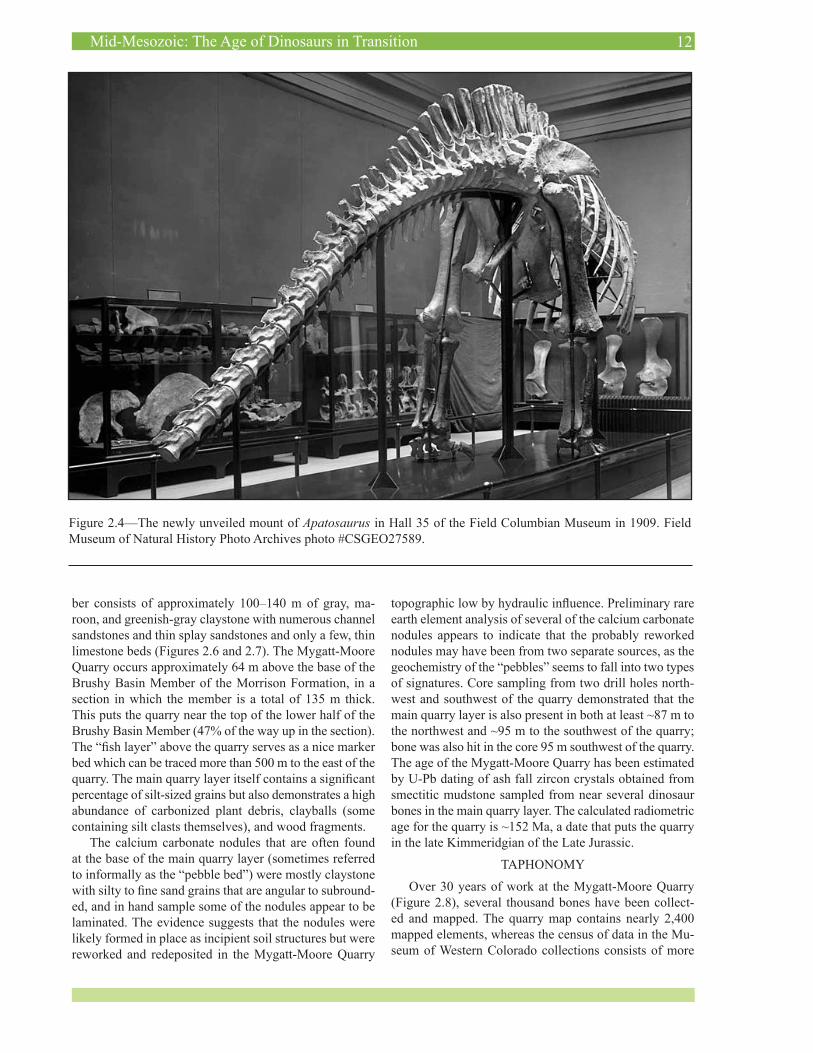
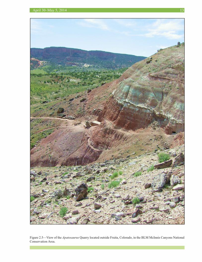
bought some mining supplies and hired some helpers and, using dynamite, they blasted a tunnel into the hillside and removed most of the tail. Harley Armstrong and the Mu-seum of Western Colorado went back into the mine tun-nel in 1991 and collected a few chevrons that Riggs had missed. It was during his study of this specimen that Riggs determined that Brontosaurus and Apatosaurus were two names for the same genus of sauropod (Figures 2.4 and 2.5).
MYGATT-MOORE QUARRY AND TRAIL THROUGH TIME
In the afternoon, we will travel to the Rabbit Valley area, where we will tour various sites known in the Brushy Basin Member of the Morrison Formation, including the Mygatt-Moore Quarry and the Trail Through Time. Worked consistently since 1985, the Mygatt-Moore Quar-ry is well known for its abundance of common Jurassic dinosaurs like Allosaurus, Apatosaurus, Camarasaurus, and Diplodocus as well as the rare Ceratosaurus, but it is also the type locality for the ankylosaur Mymoorapelta. We will return to Fruita at the conclusion of the day, and a trip to Gaston Design, Inc. will be an option for those who
would like to see high quality casting in action.
THE MYGATT-MOORE QUARRY
INTRODUCTION
The Morrison Formation is an Upper Jurassic alluvial deposit that originally covered at least ~1,000,000-km2 of what is now the western United States. Dinosaur quar-ries in the Morrison Formation number in the hundreds and include those producing a range from a few bones of one individual up to more than 10,000 bones of multiple individuals and species. The Mygatt-Moore Quarry was discovered on March 14, 1981, by J. D. and Vanetta Moore and Pete and Marilyn Mygatt and it is approximately 2.5 km from the Utah-Colorado state line in far western Mesa County, Colorado, about 27 km west of Fruita. The My-gatt-Moore Quarry has been excavated for approximately three to four months per year since around 1990. Before that time, most seasons were approximately two weeks.
GEOLOGY
The top of the Salt Wash Member of the Morrison For-mation in Rabbit Valley is formed by the top of one or several tan, laterally continuous channel sandstones that can be traced across the valley. The Brushy Basin Mem-
Figure 2.3—Allosaurus maxilla found at the Fruita Paleo Area.
12Mid-Mesozoic: The Age of Dinosaurs in Transition
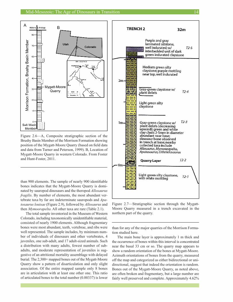
ber consists of approximately 100–140 m of gray, ma-roon, and greenish-gray claystone with numerous channel sandstones and thin splay sandstones and only a few, thin limestone beds (Figures 2.6 and 2.7). The Mygatt-Moore Quarry occurs approximately 64 m above the base of the Brushy Basin Member of the Morrison Formation, in a section in which the member is a total of 135 m thick. This puts the quarry near the top of the lower half of the Brushy Basin Member (47% of the way up in the section). The “fish layer” above the quarry serves as a nice marker bed which can be traced more than 500 m to the east of the quarry. The main quarry layer itself contains a significant percentage of silt-sized grains but also demonstrates a high abundance of carbonized plant debris, clayballs (some containing silt clasts themselves), and wood fragments.
The calcium carbonate nodules that are often found at the base of the main quarry layer (sometimes referred to informally as the “pebble bed”) were mostly claystone with silty to fine sand grains that are angular to subround-ed, and in hand sample some of the nodules appear to be laminated. The evidence suggests that the nodules were likely formed in place as incipient soil structures but were reworked and redeposited in the Mygatt-Moore Quarry
Figure 2.4—The newly unveiled mount of Apatosaurus in Hall 35 of the Field Columbian Museum in 1909. Field Museum of Natural History Photo Archives photo #CSGEO27589.
topographic low by hydraulic influence. Preliminary rare earth element analysis of several of the calcium carbonate nodules appears to indicate that the probably reworked nodules may have been from two separate sources, as the geochemistry of the “pebbles” seems to fall into two types of signatures. Core sampling from two drill holes north-west and southwest of the quarry demonstrated that the main quarry layer is also present in both at least ~87 m to the northwest and ~95 m to the southwest of the quarry; bone was also hit in the core 95 m southwest of the quarry. The age of the Mygatt-Moore Quarry has been estimated by U-Pb dating of ash fall zircon crystals obtained from smectitic mudstone sampled from near several dinosaur bones in the main quarry layer. The calculated radiometric age for the quarry is ~152 Ma, a date that puts the quarry in the late Kimmeridgian of the Late Jurassic.
TAPHONOMY
Over 30 years of work at the Mygatt-Moore Quarry (Figure 2.8), several thousand bones have been collect-ed and mapped. The quarry map contains nearly 2,400 mapped elements, whereas the census of data in the Mu-seum of Western Colorado collections consists of more
13April 30–May 5, 2014
Figure 2.5—View of the Apatosaurus Quarry located outside Fruita, Colorado, in the BLM McInnis Canyons National Conservation Area.
14Mid-Mesozoic: The Age of Dinosaurs in Transition
Figure 2.6—A, Composite stratigraphic section of the Brushy Basin Member of the Morrison Formation showing position of the Mygatt-Moore Quarry (based on field data and data from Turner and Peterson, 1999). B, Location of Mygatt-Moore Quarry in western Colorado. From Foster and Hunt-Foster, 2011.
Figure 2.7—Stratigraphic section through the Mygatt-Moore Quarry measured in a trench excavated in the northern part of the quarry.
than 900 elements. The sample of nearly 900 identifiable bones indicates that the Mygatt-Moore Quarry is domi-nated by sauropod dinosaurs and the theropod Allosaurus fragilis. By number of elements, the most abundant ver-tebrate taxa by far are indeterminate sauropods and Apa-tosaurus louisae (Figure 2.9), followed by Allosaurus and then Mymoorapelta. All other taxa are rare (Table 2.1).
The total sample inventoried in the Museum of Western Colorado, including taxonomically unidentifiable material, consisted of nearly 1900 elements. Although fragmentary bones were most abundant, teeth, vertebrae, and ribs were well represented. The sample includes, by minimum num-ber of individuals of dinosaurs and other vertebrates, 4 juveniles, one sub-adult, and 17 adult-sized animals. Such a distribution with many adults, fewest number of sub-adults, and moderate representation of juveniles is sug-gestive of an attritional mortality assemblage with delayed burial. The 2,300+ mapped bones out of the Mygatt-Moore Quarry show a pattern of disarticulation and only slight association. Of the entire mapped sample only 8 bones are in articulation with at least one other one. This ratio of articulated bones to the total number (0.00337) is lower
than for any of the major quarries of the Morrison Forma-tion studied here.
The main bone layer is approximately 1 m thick and the occurrence of bones within this interval is concentrated near the basal 33 cm or so. The quarry map appears to show a random orientation of the bones at Mygatt-Moore. Azimuth orientations of bones from the quarry, measured off the map and categorized as either bidirectional or uni-directional, suggest that indeed the orientation is random. Bones out of the Mygatt-Moore Quarry, as noted above, are often broken and fragmentary, but a large number are fairly well preserved and complete. Approximately 4.62%

15April 30–May 5, 2014
Figure 2.8—View of the Mygatt-Moore Quarry.
Figure 2.9—Scapula-coracoid of Apatosaurus as jacketed in the field at the Mygatt-Moore Quarry, September 2012.
of the bones out of the quarry have some indication of tooth marks, which is perhaps not surprising given the more than 400 teeth of theropods that have been found in the deposit.
DISCUSSION
The Mygatt-Moore Quarry main quarry layer (“bone layer”) may represent a near-perennial or ephemeral pond similar to a wooded, vernal pool, although there is a lack of direct evidence to confirm this. The unit geometry and the mudstone (with some silt) lithology indicate that it is not a channel and is likely some type of overbank deposit. The presence of many bone fragments (almost a “back-ground” of small, nearly rounded fragments), calcium carbonate “pebbles”, and small clay balls indicates that a significant portion of the material was washed in, probably during flooding of a nearby channel. The total lack of fish from the main quarry layer, the fact that not a single turtle element has ever been confirmed from the layer, and the extreme paucity of neosuchian material, all suggest that permanent water was probably not present at the site. The restriction of “prosobranch” gastropods to layers above and below the main quarry layer indicates that the quarry area was a locality of perennial water, but there is no direct evidence to indicatec this with certainty from the bone layer itself. That “conchostracans” are present just below the “fish layer” suggests that the area may have been an ephemeral water hole at times also, but again there is no direct evidence of these ephemeral pond inhabitants in the bone layer. Actinopterygian fish are restricted to the “fish layer” and indicate perennial water with certainty, but only well after dinosaur quarry deposition is over.
That the soil at the Mygatt-Moore Quarry was acidic is suggested by the abundance of plant material and carbon-ized plant fragments throughout the main quarry layer. The high degree of corrosion (or bone spalling and “rot”) in the quarry is also probably indicative of acidic conditions in the quarry mud at the time, although the effects of low pH on bones can be quite variable even between samples in the same soil. Preservation of dinosaur skin, not just as impressions in matrix, but more often as carbonization, suggests occasional dysoxia in the mud of the deposit, if not necessarily in any standing water that may have been present.
The presence of trampled bones suggests that living animals frequented the deposit area, stepping on bone al-ready in the mud during times of low (or no) water. The frequent presence of carnivores and abundant scavenging (and possible predation, although this is speculative) in the quarry area are indicated by the abundance of Allosaurus bones, the abundance of shed theropod teeth, and the mod-erate amount of tooth marks on bones. The extremely high rate of disarticulation compared with other large quarries in the Morrison Formation may also be in part due to scat-tering by scavenging theropods.
16Mid-Mesozoic: The Age of Dinosaurs in Transition
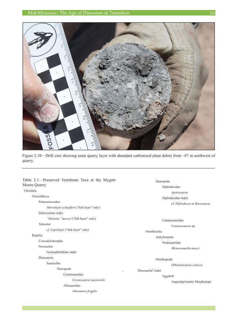
Figure 2.10—Drill core showing main quarry layer with abundant carbonized plant debris from ~87 m northwest of quarry.
Table 2.1—Preserved Vertebrate Taxa at the Mygatt-Moore Quarry
Chordata
Osteichthyes
Palaeoniscoidea
Morrolepis schaefferi (“fish layer” only)
Halecostomi indet.
“Hulettia” hawesi (“fish layer” only)
Teleostei
cf. Leptolepis (“fish layer” only)
Reptilia
Crocodylomorpha
Neosuchia
Goniopholididae indet.
Dinosauria
Saurischia
Theropoda
Ceratosauridae
Ceratosaurus nasicornis
Allosauridae
Allosaurus fragilis
Sauropoda
Diplodocidae
Apatosaurus
Diplodocidae indet.
cf. Diplodocus or Barosaurus
Camarasauridae
Camarasaurus sp.
Ornithischia
Ankylosauria
Nodosauridae
Mymoorapelta maysi
Ornithopoda
Othnielosaurus consors
. Dinosauria? indet
Eggshell
Angustiprismatic Morphotype
17April 30–May 5, 2014
COMPARISONS
Cleveland-Lloyd QuarryThe major quarry to which the Mygatt-Moore Quarry
compares most closely is the Cleveland-Lloyd Quarry in the Morrison Formation of the San Rafael Swell of eastern Utah. Similarities to the Mygatt-Moore Quarry include mudstone matrix, many disarticulated bones, highly mixed arrangement of the bones, many Allosaurus elements, and a relatively thin bone layer. Differences of Cleveland-Lloyd compared to Mygatt-Moore include the former’s: 1) lack of carbonized plant material in the mudstone; 2) higher degree of articulation; and 3) greater dominance by Allosaurus primarily (versus Allosaurus and Apatosaurus at Mygatt-Moore). The Cleveland-Lloyd Quarry lacks any Apatosaurus material, whereas the Mygatt-Moore Quarry has no elements clearly belonging to Stegosaurus; the rea-sons for these taxa being missing are unclear, as they are otherwise very common overall in the Morrison Forma-tion.
Howe QuarriesThe Howe Quarry and the Howe-Stephens Quarry are
large, multi-taxic sites in the Morrison Formation of north-ern Wyoming. Both differ from the Mygatt-Moore Quarry in that the matrix is a silty to slightly sandy mudstone with more direct evidence of fluvial influence. The Howe Quarry contains an abundance of non-apatosaur, diplodo-cid sauropod material relative to other taxa, and in this sense it is similar to Mygatt-Moore and Cleveland-Lloyd.
CONCLUSIONS
The Mygatt-Moore Quarry deposit began as a silty clay perennial water hole with at least viviparid gastropods liv-ing in it, but this environment quickly changed to an appar-ently acidic-soiled, dysoxic ephemeral or perhaps shallow,
perennial pond into which was washed, early in its history, a number of clay balls, calcium carbonate nodules, and rounded bone fragments, each from several sources. The area was surrounded by plants including horsetails, ferns, many types of conifers, plus ginkgoes, cycadophytes, rela-tives of quillworts and clubmosses, and the wet-adapted Czekanowskia. The Mygatt-Moore Quarry is Late Jurassic in age, about 152 million years old. Disarticulation at the Mygatt-Moore Quarry appears to be a result of scaveng-ing of carcasses by predators, trampling and churning of the bones in mud by living animals, and relatively long exposure before the bones were locked in the sediment and fully buried. The abundance of Allosaurus bones and teeth is almost certainly a result of a combination of environ-mental stresses on the animals (drought?) causing higher background mortality of the population and increase in the number of individuals in the area, probably drawn in to scavenge on carcasses of both herbivorous and carnivo-rous dinosaurs. The abundance of Apatosaurus appears to be from attritional mortality of a population of animals that frequented the area either year-round or seasonally. Nothing in the study suggested a clear reason for the rela-tive abundance of Mymoorapelta. It is possible that My-moorapelta simply preferred a diet of plants that occurred at the Mygatt-Moore Quarry area more so than other areas sampled in the Morrison Formation.
There appear to be two components to the bone de-posit, a group of mostly fragmented and almost rounded bones that were probably washed in early in the deposit’s history and a second group of more intact bones that were sourced from skeletons of animals that died near or at the pond deposit itself.
The quarry appears to be at least about 130 m by 140 m across, probably an oval shape, and the area may be as much as 18,200 m2 as currently known from excavations, trenches, and drill cores (Figure 2.10).
18Mid-Mesozoic: The Age of Dinosaurs in Transition
Time9:00 AM Breithaupt9:20 AM Armstrong9:40 AM Ghist10:00 AM Mossbrucker 10:20 AM BREAK10:40 AM Foster11:00 AM Hunt-Foster11:20 AM Woodruff11:40 AM Gee
LUNCH2:00 PM Apesteguía 2:20 PM Gee2:40 PM Doveton3:00 PM Loewen3:20 PM Trujillo3:40 PM Alcalá4:00 PM Li
3. Jurassic Symposium
Thursday, May 1, 2014
Dinosaur Journey Museum, Fruita, Colorado
Program at a Glance
19April 30–May 5, 2014
9:00 Breithaupt, B.h., Matthews, N.a. THE DAWN OF MID-MESOZOIC FAUNAL DIVER-SITY AND DOCUMENTATION TECHNIQUES FROM EARLY/MIDDLE JURASSIC ICHNOFOS-SILS IN BUREAU OF LAND MANAGEMENT NATIONAL LANDSCAPE CONSERVATION UNITS
9:20 arMstroNg, h. COLORADO’S WESTERN SLOPE FOSSILS: A PALEONTOLOGICAL AND HISTORICAL PERSPECTIVE ON FACT VERSUS FANTASY
9:40 ghist, J., siMMoNs, B., LockLey, M. ON THE TRAIL OF ARTHUR LAKES: THE REDIS-COVERY OF TWO LOST QUARRIES
10:00 MossBrucker, M.t., MaLLisoN, h., Bakker, r.t. PHOTOGRAMMETRIC ANALYSIS OF PROBABLE ADULT AND JUVENILE STEGOSAUR TRACKS
10:20 BREAK
10:40 Foster, J.r. FOSSIL VERTEBRATE DIVERSITY PATTERNS IN THE UPPER JURASSIC MORRISON FORMATION: HOW MUCH ARE WE REALLY SEEING?
11:00 huNt-Foster, r.h., Foster, J.r. TAPHONOMY AND PALEONTOLOGY OF THE MY-GATT-MOORE QUARRY, A LARGE DINOSAUR BONEBED IN THE MORRISON FORMATION, WESTERN COLORADO
11:20 woodruFF, d.c., FowLer, d. THE AFFECTS OF ONTOGENY IN REGARDS TO MOR-RISON SAUROPOD DIVERSITY
11:40 gee, c.t. SAUROPOD HERBIVORY AND THE JURASSIC FLORA
12:00 LUNCH
2:00 apesteguía, s., caLdweLL, M., NydaM, r., garBerogLio, F., paLci, a. SNAKES IN THE MORRISON FORMATION?
2:20 gee, c.t., dayvauLt, r.d., stockey, r.a., tidweLL, w.d. GREATER PALEOBIODIVER-SITY IN CONIFER SEED CONES IN THE LATE JURASSIC MORRISON FORMATION OF UTAH AND WYOMING
2:40 dovetoN, J. h., LudvigsoN, g.a., JoeckeL, r.M., pLatt, B.F. HERE BE DRAGONS: THE MORRISON FORMATION IN SUBSURFACE KANSAS
3:00 LoeweN, M.a., sertich, J.J.w. THE DINOSAUR ASSEMBLAGES OF THE MORRISON FORMATION: SNAPSHOTS OF A WORLD IN TRANSITION
3:20 truJiLLo, k.c., chaMBerLaiN, k.r., Foster, J.r., carraNo, M.t., BiLBey, s.a., car-peNter, k. THE MORRISON FORMATION U/PB DATING PROJECT
3:40 aLcaLá, L., coBos, a., royo-torres, r. IBERIAN DINOSAURS
4:00 Li, L., dodsoN, p. FUNCTIONAL SIGNIFICANCE OF VERTEBRAL COLUMN SIZE VARIATION IN SAUROPODS BASED ON THE ANATOMY OF THE GREAT BLUE HERON
THURSDAY, MAY 1, 2014JURASSIC SYMPOSIUMDINOSAUR JOURNEY MUSEUM, FRUITA, COModerators: John Foster and ReBecca Hunt-Foster
20Mid-Mesozoic: The Age of Dinosaurs in Transition
THURSDAY, MAY 1, 2014POSTER SESSION 1DINOSAUR JOURNEY MUSEUM, FRUITA, COAuthors must be present from 4:30 – 6 pm
Posters must be removed by 6:30 pm
1 MaidMeNt, s.c.r. LATITUDINAL BIODIVERSITY GRADIENTS IN DEEP TIME: AN INVESTIGATION USING THE FAUNA OF THE UPPER JURASSIC MORRISON FORMATION
2 hattori, s. TRANSITION OF THE PEDAL FUNCTION OCCURRED IN LATE JURASSIC THEROPODS
3 JoNes, M.e.h., Bever, g.s., Foster, J.r., evaNs, s.e., sertich, J.J.w., carraNo, M.t. A NEW LOOK AT RHYNCHOCEPHALIAN REPTILES FROM THE LATE JURASSIC MORRISON FORMATION
4 apesteguía, s. NEW APPROACHES TO THE SKULL OF EILENODON
5 McMuLLeN, s.k. CONTROLS ON THE STRATIGRAPHIC DISTRIBUTION OF NON-MARINE FOSSILS: A CASE STUDY IN THE UPPER JURASSIC MORRISON FORMATION, WESTERN USA
6 BeNNis-BottoMLey, M.B., gray, d.e., gee, c.t., spriNkeL, d.a., sroka, s.d. NEW EVIDENCE FOR A CONIFER FOREST IN THE BRUSHY BASIN MEMBER OF THE UPPER JURASSIC MORRISON FORMATION, NORTHEASTERN UTAH, USA
7 truJiLLo, k.c. USING X-RAY DIFFRACTION AND RADIOMETRIC AGES TO DEBUNK THE MYTH OF THE “CLAY CHANGE” IN THE UPPER JURASSIC MORRISON FORMATION, WESTERN INTERIOR, USA
8 BuckLey, L.g., Mccrea, r.t., LockLey, M.g. A REVIEW OF LATE JURASSIC - EARLY CRETACEOUS (TITHONIAN? – ALBIAN) AVIAN TRACES FROM WESTERN CANADA
9 aLcaLá, L., coBos , a., royo-torres, r., gascó, F., suñer, M., espíLez, e., MaMpeL, L., goNzáLez, a., verdú, J., pesquero, M.d. DINOSAURS OF THE JURASSIC-CRETACEOUS TRANSITION IN CENTRAL EASTERN SPAIN
10 coBos , a., LockLey, M.g., gascó, F., royo-torres, r., aLcaLá, L. A GLOBAL PER-SPECTIVE ON LATE JURASSIC-BERRIASIAN LARGE THEROPOD ICHNOTAXA FROM LAUR-ASIA
11 royo-torres, r., coBos , a., gascó, F., Mocho, p., ortega, F., aLcaLá, L. GEO-GRAPHIC AND STRATIGRAPHIC DISTRIBUTION OF THE SAUROPOD TURIASAURUS AND TURIASAURIA CLADE
12 kiNg, L. aNd Foster, J. TWO SMALL REPTILES FROM THE MYGATT-MOORE QUARRY IN THE MORRISON FORMATION (UPPER JURASSIC) OF WESTERN COLORADO
21April 30–May 5, 2014
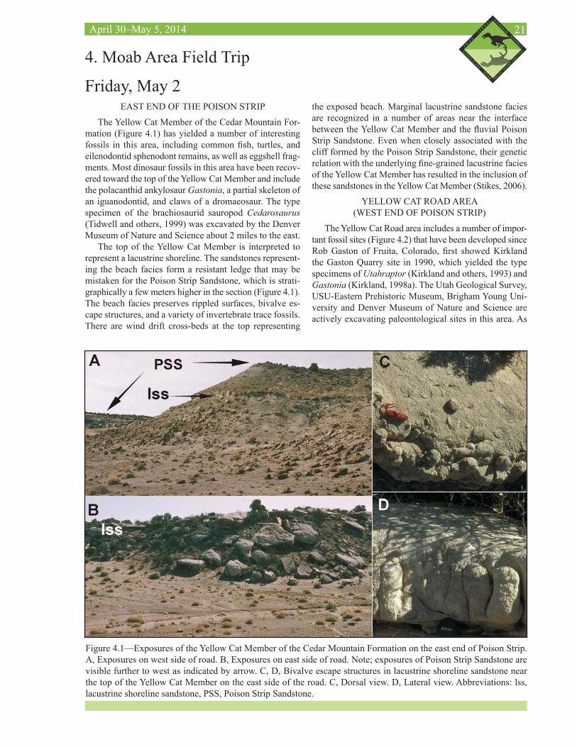
EAST END OF THE POISON STRIP
The Yellow Cat Member of the Cedar Mountain For-mation (Figure 4.1) has yielded a number of interesting fossils in this area, including common fish, turtles, and eilenodontid sphenodont remains, as well as eggshell frag-ments. Most dinosaur fossils in this area have been recov-ered toward the top of the Yellow Cat Member and include the polacanthid ankylosaur Gastonia, a partial skeleton of an iguanodontid, and claws of a dromaeosaur. The type specimen of the brachiosaurid sauropod Cedarosaurus (Tidwell and others, 1999) was excavated by the Denver Museum of Nature and Science about 2 miles to the east.
The top of the Yellow Cat Member is interpreted to represent a lacustrine shoreline. The sandstones represent-ing the beach facies form a resistant ledge that may be mistaken for the Poison Strip Sandstone, which is strati-graphically a few meters higher in the section (Figure 4.1). The beach facies preserves rippled surfaces, bivalve es-cape structures, and a variety of invertebrate trace fossils. There are wind drift cross-beds at the top representing
4. Moab Area Field Trip
Friday, May 2
Figure 4.1—Exposures of the Yellow Cat Member of the Cedar Mountain Formation on the east end of Poison Strip. A, Exposures on west side of road. B, Exposures on east side of road. Note; exposures of Poison Strip Sandstone are visible further to west as indicated by arrow. C, D, Bivalve escape structures in lacustrine shoreline sandstone near the top of the Yellow Cat Member on the east side of the road. C, Dorsal view. D, Lateral view. Abbreviations: lss, lacustrine shoreline sandstone, PSS, Poison Strip Sandstone.
the exposed beach. Marginal lacustrine sandstone facies are recognized in a number of areas near the interface between the Yellow Cat Member and the fluvial Poison Strip Sandstone. Even when closely associated with the cliff formed by the Poison Strip Sandstone, their genetic relation with the underlying fine-grained lacustrine facies of the Yellow Cat Member has resulted in the inclusion of these sandstones in the Yellow Cat Member (Stikes, 2006).
YELLOW CAT ROAD AREA (WEST END OF POISON STRIP)
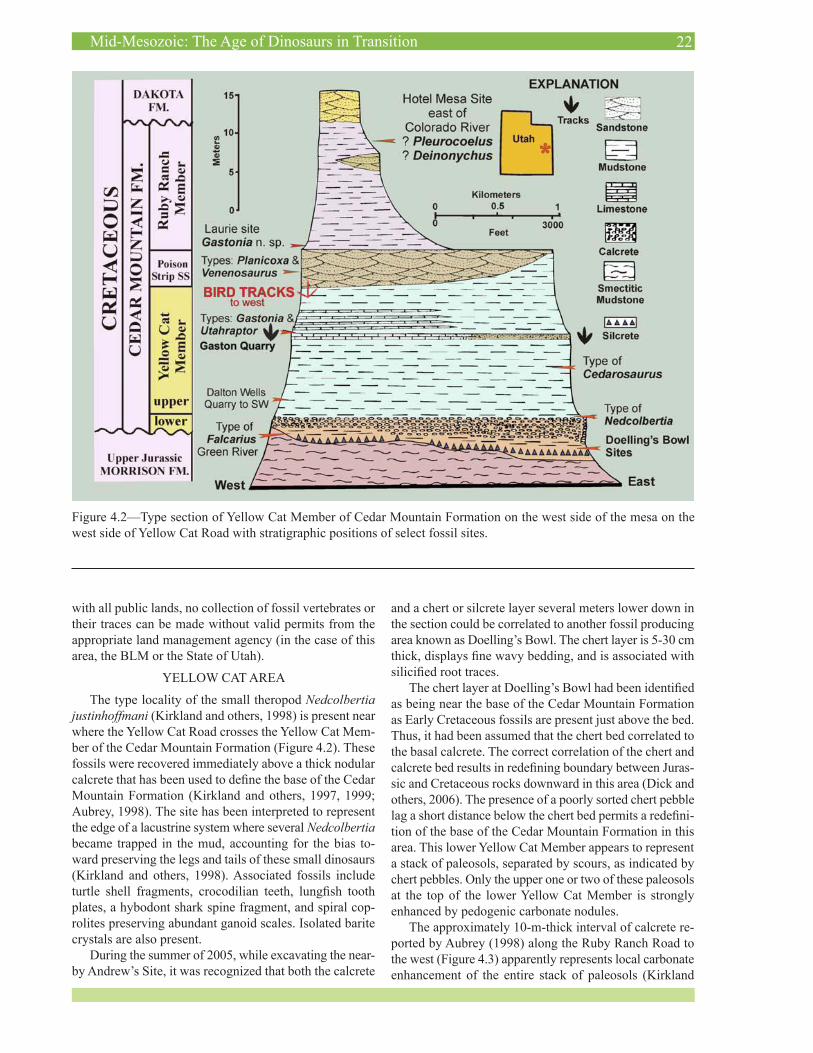
The Yellow Cat Road area includes a number of impor-tant fossil sites (Figure 4.2) that have been developed since Rob Gaston of Fruita, Colorado, first showed Kirkland the Gaston Quarry site in 1990, which yielded the type specimens of Utahraptor (Kirkland and others, 1993) and Gastonia (Kirkland, 1998a). The Utah Geological Survey, USU-Eastern Prehistoric Museum, Brigham Young Uni-versity and Denver Museum of Nature and Science are actively excavating paleontological sites in this area. As
22Mid-Mesozoic: The Age of Dinosaurs in Transition
Figure 4.2—Type section of Yellow Cat Member of Cedar Mountain Formation on the west side of the mesa on the west side of Yellow Cat Road with stratigraphic positions of select fossil sites.
with all public lands, no collection of fossil vertebrates or their traces can be made without valid permits from the appropriate land management agency (in the case of this area, the BLM or the State of Utah).
YELLOW CAT AREA
The type locality of the small theropod Nedcolbertia justinhoffmani (Kirkland and others, 1998) is present near where the Yellow Cat Road crosses the Yellow Cat Mem-ber of the Cedar Mountain Formation (Figure 4.2). These fossils were recovered immediately above a thick nodular calcrete that has been used to define the base of the Cedar Mountain Formation (Kirkland and others, 1997, 1999; Aubrey, 1998). The site has been interpreted to represent the edge of a lacustrine system where several Nedcolbertia became trapped in the mud, accounting for the bias to-ward preserving the legs and tails of these small dinosaurs (Kirkland and others, 1998). Associated fossils include turtle shell fragments, crocodilian teeth, lungfish tooth plates, a hybodont shark spine fragment, and spiral cop-rolites preserving abundant ganoid scales. Isolated barite crystals are also present.
During the summer of 2005, while excavating the near-by Andrew’s Site, it was recognized that both the calcrete
and a chert or silcrete layer several meters lower down in the section could be correlated to another fossil producing area known as Doelling’s Bowl. The chert layer is 5-30 cm thick, displays fine wavy bedding, and is associated with silicified root traces.
The chert layer at Doelling’s Bowl had been identified as being near the base of the Cedar Mountain Formation as Early Cretaceous fossils are present just above the bed. Thus, it had been assumed that the chert bed correlated to the basal calcrete. The correct correlation of the chert and calcrete bed results in redefining boundary between Juras-sic and Cretaceous rocks downward in this area (Dick and others, 2006). The presence of a poorly sorted chert pebble lag a short distance below the chert bed permits a redefini-tion of the base of the Cedar Mountain Formation in this area. This lower Yellow Cat Member appears to represent a stack of paleosols, separated by scours, as indicated by chert pebbles. Only the upper one or two of these paleosols at the top of the lower Yellow Cat Member is strongly enhanced by pedogenic carbonate nodules.
The approximately 10-m-thick interval of calcrete re-ported by Aubrey (1998) along the Ruby Ranch Road to the west (Figure 4.3) apparently represents local carbonate enhancement of the entire stack of paleosols (Kirkland
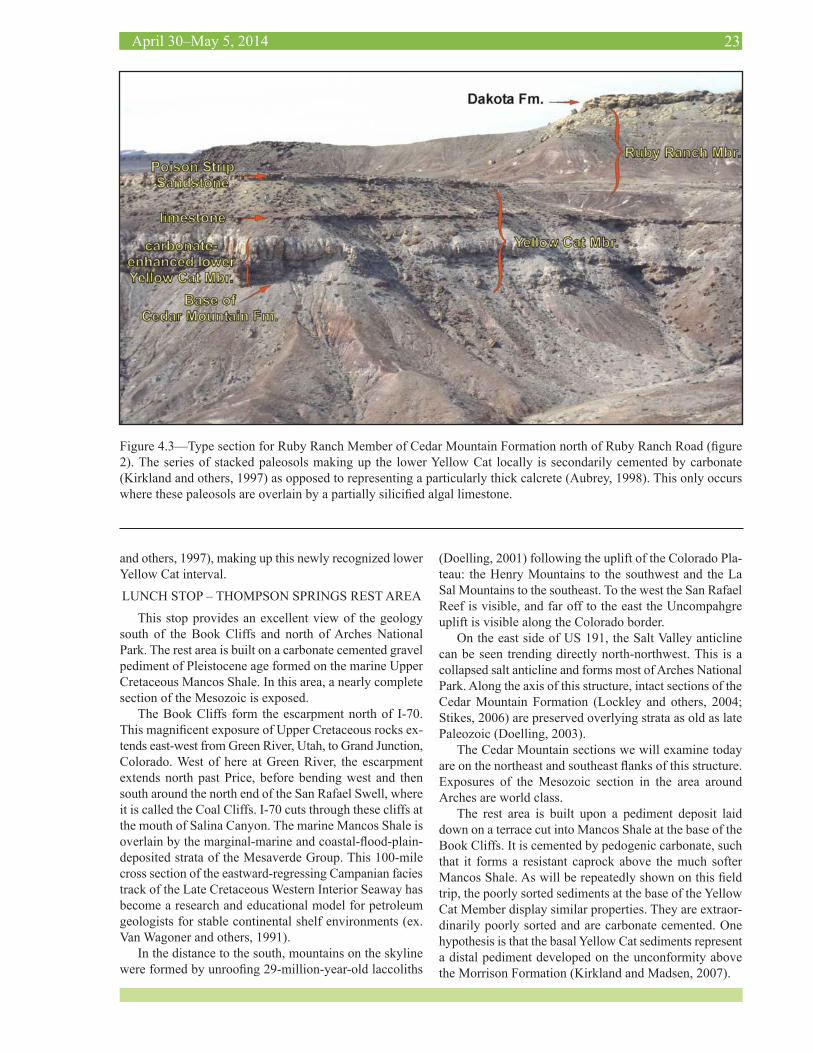
23April 30–May 5, 2014
Figure 4.3—Type section for Ruby Ranch Member of Cedar Mountain Formation north of Ruby Ranch Road (figure 2). The series of stacked paleosols making up the lower Yellow Cat locally is secondarily cemented by carbonate (Kirkland and others, 1997) as opposed to representing a particularly thick calcrete (Aubrey, 1998). This only occurs where these paleosols are overlain by a partially silicified algal limestone.
and others, 1997), making up this newly recognized lower Yellow Cat interval.
LUNCH STOP – THOMPSON SPRINGS REST AREA
This stop provides an excellent view of the geology south of the Book Cliffs and north of Arches National Park. The rest area is built on a carbonate cemented gravel pediment of Pleistocene age formed on the marine Upper Cretaceous Mancos Shale. In this area, a nearly complete section of the Mesozoic is exposed.
The Book Cliffs form the escarpment north of I-70. This magnificent exposure of Upper Cretaceous rocks ex-tends east-west from Green River, Utah, to Grand Junction, Colorado. West of here at Green River, the escarpment extends north past Price, before bending west and then south around the north end of the San Rafael Swell, where it is called the Coal Cliffs. I-70 cuts through these cliffs at the mouth of Salina Canyon. The marine Mancos Shale is overlain by the marginal-marine and coastal-flood-plain-deposited strata of the Mesaverde Group. This 100-mile cross section of the eastward-regressing Campanian facies track of the Late Cretaceous Western Interior Seaway has become a research and educational model for petroleum geologists for stable continental shelf environments (ex. Van Wagoner and others, 1991).
In the distance to the south, mountains on the skyline were formed by unroofing 29-million-year-old laccoliths
(Doelling, 2001) following the uplift of the Colorado Pla-teau: the Henry Mountains to the southwest and the La Sal Mountains to the southeast. To the west the San Rafael Reef is visible, and far off to the east the Uncompahgre uplift is visible along the Colorado border.
On the east side of US 191, the Salt Valley anticline can be seen trending directly north-northwest. This is a collapsed salt anticline and forms most of Arches National Park. Along the axis of this structure, intact sections of the Cedar Mountain Formation (Lockley and others, 2004; Stikes, 2006) are preserved overlying strata as old as late Paleozoic (Doelling, 2003).
The Cedar Mountain sections we will examine today are on the northeast and southeast flanks of this structure. Exposures of the Mesozoic section in the area around Arches are world class.
The rest area is built upon a pediment deposit laid down on a terrace cut into Mancos Shale at the base of the Book Cliffs. It is cemented by pedogenic carbonate, such that it forms a resistant caprock above the much softer Mancos Shale. As will be repeatedly shown on this field trip, the poorly sorted sediments at the base of the Yellow Cat Member display similar properties. They are extraor-dinarily poorly sorted and are carbonate cemented. One hypothesis is that the basal Yellow Cat sediments represent a distal pediment developed on the unconformity above the Morrison Formation (Kirkland and Madsen, 2007).
24Mid-Mesozoic: The Age of Dinosaurs in Transition
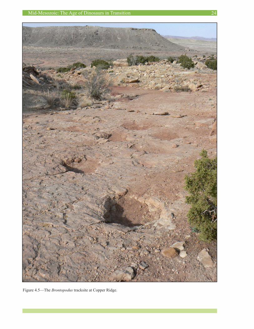
Figure 4.5—The Brontopodus tracksite at Copper Ridge.
25April 30–May 5, 2014
Perhaps the basal Yellow Cat Member strata are better compared to Holocene sediments deposited on the surface of the Great Plains of central North America rather than pediment deposits laid down near their source area (i.e. Book Cliffs).
COPPER RIDGE TRACKSITE
The Copper Ridge Tracksite preserves dinosaur foot-prints from near the top of the Salt Wash Member of the Morrison Formation. The tracks consist of a number of medium to large theropod footprints (which are un-named in the Morrison Formation), although the site is best known for the trackway of a large sauropod dinosaur (Brontopodus isp.) that made a nearly 90˚ right turn as it was walking (Figure 4.4). In addition, there is a trackway of an allosaur-sized theropod with a slightly limping gate just to the east of the turning sauropod trackway. All of the tracks at the site are made on a ripplemarked bedding plane of what was likely a sandbar during the Late Juras-sic.
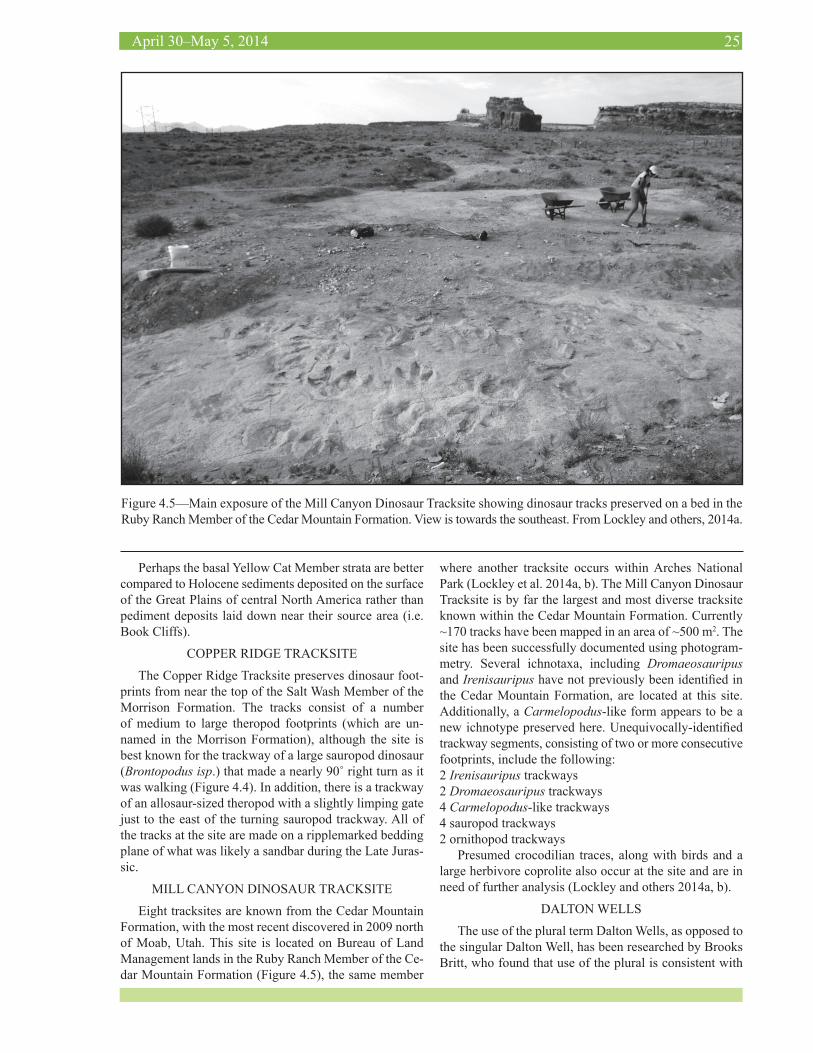
MILL CANYON DINOSAUR TRACKSITE
Eight tracksites are known from the Cedar Mountain Formation, with the most recent discovered in 2009 north of Moab, Utah. This site is located on Bureau of Land Management lands in the Ruby Ranch Member of the Ce-dar Mountain Formation (Figure 4.5), the same member
where another tracksite occurs within Arches National Park (Lockley et al. 2014a, b). The Mill Canyon Dinosaur Tracksite is by far the largest and most diverse tracksite known within the Cedar Mountain Formation. Currently ~170 tracks have been mapped in an area of ~500 m2. The site has been successfully documented using photogram-metry. Several ichnotaxa, including Dromaeosauripus and Irenisauripus have not previously been identified in the Cedar Mountain Formation, are located at this site. Additionally, a Carmelopodus-like form appears to be a new ichnotype preserved here. Unequivocally-identified trackway segments, consisting of two or more consecutive footprints, include the following:2 Irenisauripus trackways2 Dromaeosauripus trackways4 Carmelopodus-like trackways4 sauropod trackways2 ornithopod trackways
Presumed crocodilian traces, along with birds and a large herbivore coprolite also occur at the site and are in need of further analysis (Lockley and others 2014a, b).
DALTON WELLS
The use of the plural term Dalton Wells, as opposed to the singular Dalton Well, has been researched by Brooks Britt, who found that use of the plural is consistent with
Figure 4.5—Main exposure of the Mill Canyon Dinosaur Tracksite showing dinosaur tracks preserved on a bed in the Ruby Ranch Member of the Cedar Mountain Formation. View is towards the southeast. From Lockley and others, 2014a.
26Mid-Mesozoic: The Age of Dinosaurs in Transition
use by the Dalton family and the local community. The use of the singular on the Merrimac Butte 7 ½‘ quadran-gle is an error on the part of the U.S. Geological Survey (Eberth and others, 2006). During the 1930s, a Civilian Conservation Corps (CCC) camp was established here, known as CG-32, Dalton Wells Camp. The site was used during World War II as a Japanese internment camp. The concrete slabs and cottonwood trees are the last remnants of those days.
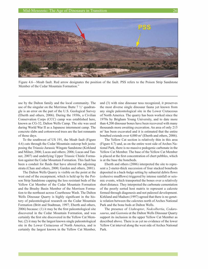
To the southwest of US 191, the Moab fault (Figure 4.6) cuts through the Cedar Mountain outcrop belt juxta-posing the Triassic-Jurassic Wingate Sandstone (Kirkland and Milner, 2006; Lucas and others; 2006; Lucas and Tan-ner, 2007) and underlying Upper Triassic Chinle Forma-tion against the Cedar Mountain Formation. This fault has been a conduit for fluids that have altered the adjoining strata (Chan and others, 2000; Garden and others, 2001).
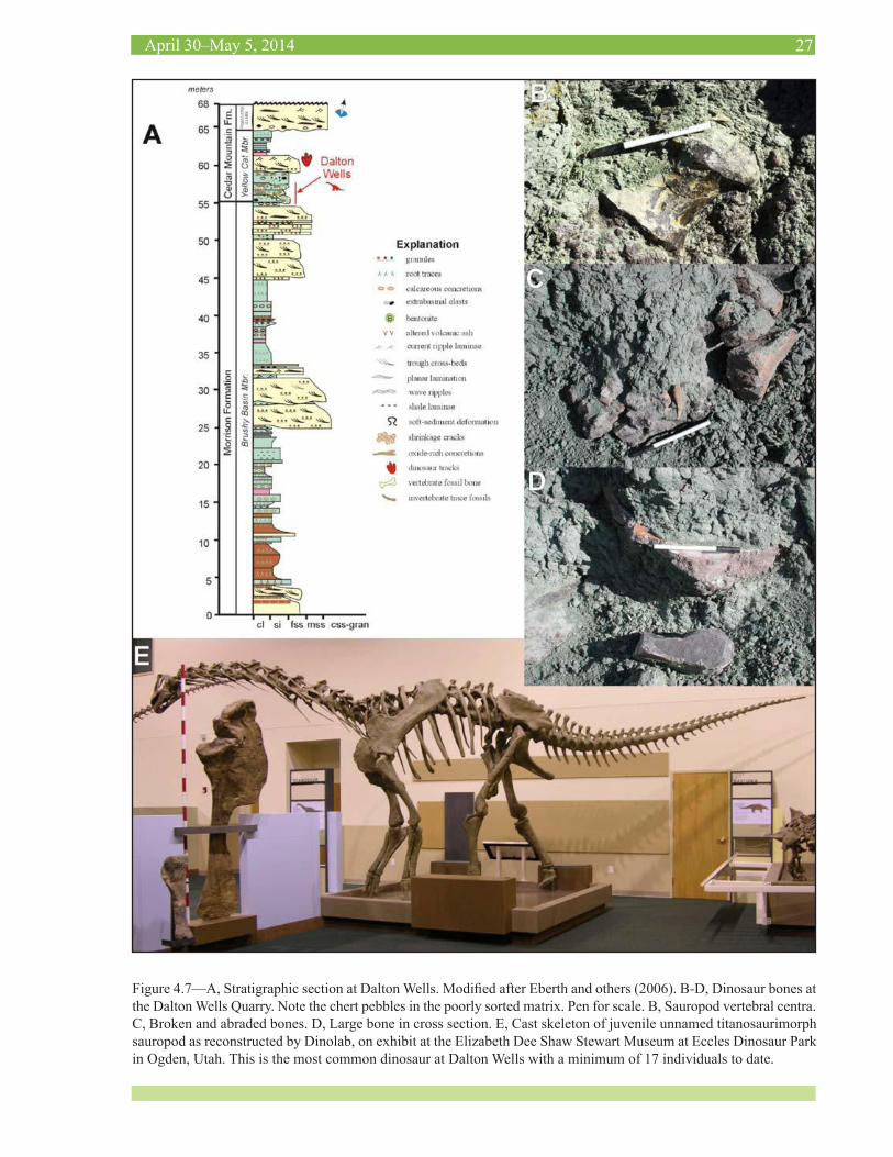
The Dalton Wells Quarry is visible on the point at the west end of the escarpment, which is held up by the Poi-son Strip Sandstone capping the less resistant beds of the Yellow Cat Member of the Cedar Mountain Formation and the Brushy Basin Member of the Morrison Forma-tion to the northeast across Courthouse Wash. The Dalton Wells Dinosaur Quarry is highly significant in the his-tory of paleontological research on the Cedar Mountain Formation (Britt and Stadtman, 1997; Eberth and others, 2006) because: (1) it may be the first paleontological site discovered in the Cedar Mountain Formation, and was certainly the first site discovered in the Yellow Cat Mem-ber, (2) it may be the largest known single paleontological site in the Lower Cretaceous of North America, and is certainly the largest known in the Yellow Cat Member,
and (3) with nine dinosaur taxa recognized, it preserves the most diverse single dinosaur fauna yet known from any single paleontological site in the Lower Cretaceous of North America. The quarry has been worked since the 1970s by Brigham Young University, and to date more than 4,200 dinosaur bones have been recovered with many thousands more awaiting excavation. An area of only 215 m2 has been excavated and it is estimated that the entire bonebed extends over 4,000 m2 (Eberth and others, 2006).
The Yellow Cat section is relatively thin in this area (Figure 4.7) and, as on the entire west side of Arches Na-tional Park, there is no massive pedogenic carbonate in the Yellow Cat Member. The base of the Yellow Cat Member is placed at the first concentration of chert pebbles, which is at the base the bonebeds.
Eberth and others (2006) interpreted the site to repre-sent a 2-meter-thick succession of four stacked bonebeds deposited in a back-bulge setting by subaerial debris flows (cohesive mudflows) triggered by intense rainfall or seis-mic events, which transported the bones over a relatively short distance. They interpreted the carbonate cementation of the poorly sorted host matrix to represent a calcrete formed through diagenesis and not paleosol development. Kirkland and Madsen (1997) agreed that there is no genet-ic relation between the calcretes north of Arches National Park and the bone beds at Dalton Wells.
The presence of Utahraptor, Nedcolbertia, Cedaro-saurus, and Gastonia at the Dalton Wells Dinosaur Quarry support its inclusion in the upper Yellow Cat Member as described above. There is as yet no evidence of the lower Yellow Cat interval along the west side of Arches National Park.
Figure 4.6—Moab fault. Red arrow designates the position of the fault. PSS refers to the Poison Strip Sandstone Member of the Cedar Mountain Formation.”
27April 30–May 5, 2014
Figure 4.7—A, Stratigraphic section at Dalton Wells. Modified after Eberth and others (2006). B-D, Dinosaur bones at the Dalton Wells Quarry. Note the chert pebbles in the poorly sorted matrix. Pen for scale. B, Sauropod vertebral centra. C, Broken and abraded bones. D, Large bone in cross section. E, Cast skeleton of juvenile unnamed titanosaurimorph sauropod as reconstructed by Dinolab, on exhibit at the Elizabeth Dee Shaw Stewart Museum at Eccles Dinosaur Park in Ogden, Utah. This is the most common dinosaur at Dalton Wells with a minimum of 17 individuals to date.

28Mid-Mesozoic: The Age of Dinosaurs in Transition
WHITE SANDS MISSILE LAUNCH AREA
The army has turned this locality over to the BLM, which keeps careful track of the area due to its heavy ATV use and scientific importance. In this area, the Yellow Cat Member of the Cedar Mountain Formation can be divided into upper and lower parts at a laterally continuous, cal-careous, dark-brown sandstone that may be capped locally by stromatolitic-looking mounds of carbonate (Figure 5.1). As with the rock interval northeast of Arches National Park, referred to as the lower Yellow Cat Member, the lower Yellow Cat in this area is characterized by common chert pebble lenses; however, paleosols are not nearly so well developed here and the chert pebbles tend to be larger. There are many important fossil sites being researched by the UGS in this area at the base of the Cedar Mountain Formation, with one site (Suarez Site, Figure 5.2) turned over to the CEU Prehistoric Museum for excavation.
The possible correlation of the caprock in the area of the White Sands Launch Facility with the calcrete to the east needs to be tested. The excavation of vertebrate re-mains at the newly discovered sites in both areas will pro-vide a biostratigraphic test of this correlation, as will pa-leomagnetic studies and acquiring more radiometric ages.
In 2005, while prospecting for fossil sites, UGS pa-leontologist Don DeBlieux found a relatively small area of less than 0.5 square mile that preserves about a dozen bone-bearing sites at several different stratigraphic hori-zons below the caprock identified at the Crystal Geyser Quarry. At least two bonebearing intervals can be traced for several hundreds of meters and incorporate several individual sites (Figure 5.3). The lowest interval is near
5. Green River and Hanksville Area Field Trip
Saturday, May 3the base of the lower Yellow Cat and consists mostly of broken sauropod bones in association with lenses of chert cobbles and carbonate mounds, which might represent spring deposits. Another zone of bonebeds is near the middle of the lower Yellow Cat, and is also associated with lenses of chert cobbles and broken bones, but in contrast to the lower interval, preserves skeletal associations of iguanodonts, sauropods, and ankylosaurs. This area has become known as Don’s Ridge.
The lower Yellow Cat, at 9.3 m thick, is more than four times thicker at Don’s Ridge than in the area around the Crystal Geyser Quarry and preserves much larger chert clasts than does the lower Yellow Cat in the Crystal Geyser area (Figure 5.4). The thickness of this interval makes it a prime candidate for paleomagnetic studies, which are be-ing conducted by Kate Ziegler and Linda Donohoo-Hurley at the University of New Mexico. The lower Yellow Cat includes several dark-brown beds, which include carbon-ate mounds that may represent spring deposits. These have been sampled and Troy Rasbury at the State University of New York at Stony Brook is testing them for U-Pb dat-ing. Marina and Celina Suarez have studied the carbonate petrology together with the geochemistry of the bones (Su-arez et al. 2007a, b). It is interesting that the lower Yellow Cat and, for that matter, the entire Yellow Cat Member itself pinches out a few miles further to the west.
Preliminarily, it is thought that that the lower Yellow Cat interval at Don’s Ridge represents a mixed-load river system developed on the unconformity at the base of the Cedar Mountain Formation. Additionally, the larger size of the chert clasts suggests that perhaps the lower Yellow
Figure 5.1—Cedar Mountain Formation in central portion of the White Sands Missile Range’s Utah Launch Facility. CM/MOR contact, contact between the Morrison Formation and the overlying Cedar Mountain Formation.
29April 30–May 5, 2014
Cat at Don’s Ridge has a genetic relation with the Buck-horn Conglomerate in its type area, which would suggest that the Buckhorn Conglomerate is older than the Poison Strip Sandstone. Research in the Don’s Ridge area is just beginning and promises to be very productive geologically and paleontologically.
LUNCH STOP – CRYSTAL GEYSER
Crystal Geyser is a cold-water CO2 geyser, at the site of an exploration well drilled in the 1930s. Basically, it is a giant seltzer bottle. It erupts about every 13-17 hours. Travertine is deposited as water flowing away from the geyser deacidifies with loss of CO2 and the calcium car-bonate comes out of solution. This will be our lunch stop before continuing.
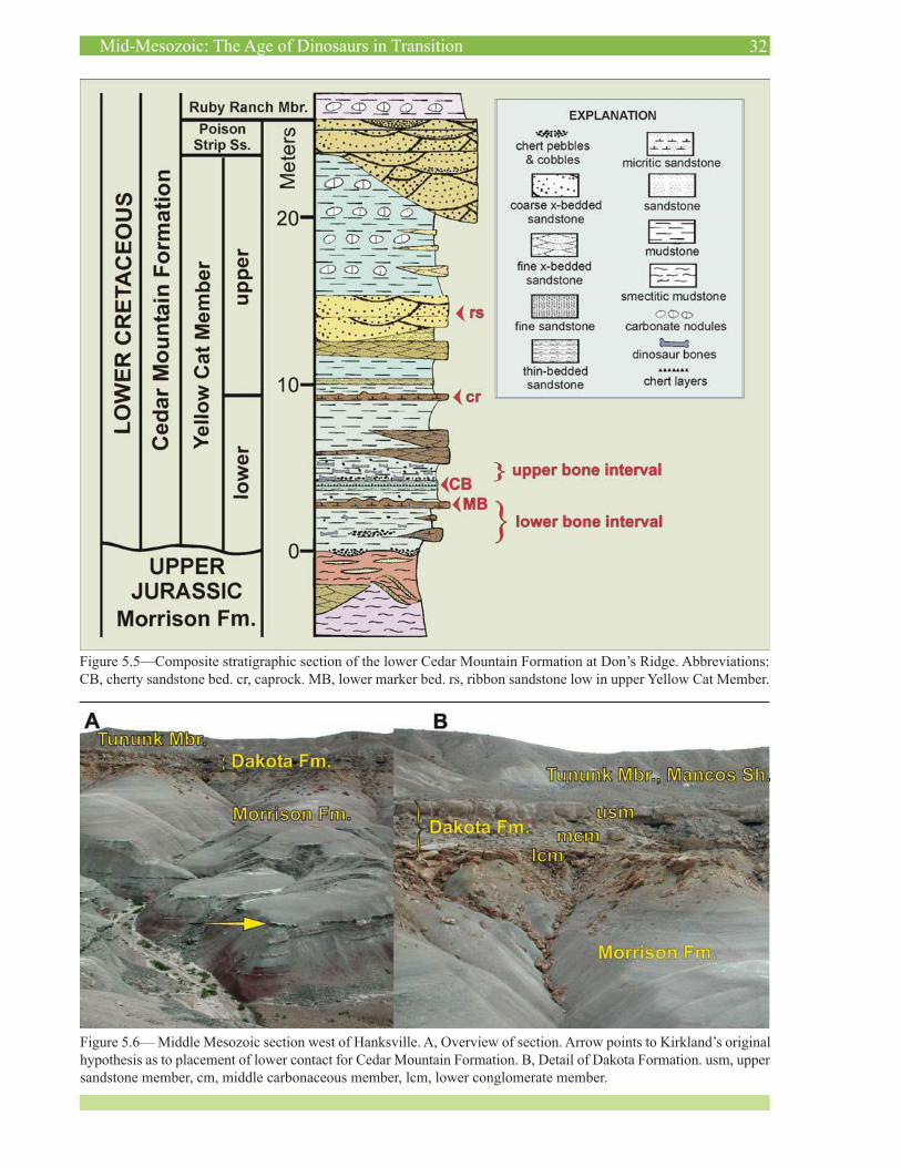
HANKSVILLE SECTION
This section was the subject of considerable debate between the authors. Here there is a well-developed Da-kota Formation section with a lower conglomerate unit, a middle carbonaceous interval, and an upper condensed transgressive sandstone sequence. This sequence is typi-cal of the Dakota Formation across much of the Colorado Plateau (Young, 1960; Kirkland, 1990, 1991). Kirkland supposed that the light-colored interval below the Dakota Formation (Figure 5.5) represents the Cedar Mountain
Formation as it does in most sections in the area, while Madsen considered this interval as representing the upper Morrison Formation, contending that there is no Cedar Mountain Formation present at this section.
During April 2005, the UGS Geologic Mapping Pro-gram organized a trip to define mapping units in the Cedar Mountain Formation for future mapping of 7½‘ quadran-gles. An ash was identified at this section a short distance below, and Bart Kowallis of Brigham Young University offered to date it. Kowallis and others (in press) found it dated as Late Jurassic, confirming that the Morrison Formation directly underlies the conglomerate at the base of the Dakota Formation (Figure 5.5), validating Scott Madsen’s hypothesis. However, they also proposed the conglomerate at the base of the Dakota Formation might represent the Buckhorn Conglomerate.
Although we prefer to see this conglomerate retained in the Dakota Formation, there is precedent for conglom-erates once considered to represent the base of the Da-kota Formation to be redefined as representing the Cedar Mountain Formation in southwestern Utah. Albian paly-nomorphs associated with the Dakota Formation’s basal conglomerate (Doelling and Davis, 1989) and overlying smectitic mudstone (Hylland, 2000, 2001) in the Creta-ceous outcrop belt east of Zion National Park has resulted in the basal Dakota Formation being mapped as Cedar Mountain Formation (ex. Hylland, 2000; Biek, in press; Biek and Hylland, in press). Hylland recognized a smec-titic interval similar to the Mussentuchit Member of the Cedar Mountain Formation in which we found a volcanic ash bed that yielded a 40Ar/39Ar age of 97.9 ± 0.5 Ma (Biek and others, 2003, p. 118). This age falls close to the basal Cenomanian date for the Mussentuchit Member discussed above (Cifelli and others, 1997). Titus and others (2005) dispute applying the name Cedar Mountain Formation to the basal Cretaceous in southern Utah. These strata are not contiguous with the Cedar Mountain Formation in its type area in central Utah, and the dominance of quartzite, chert, and limestone with petrified wood in the basal Cre-taceous conglomerates in southwestern Utah (Doelling and Davis, 1989) differs from the dominance of chert in Cedar Mountain conglomerates, indicating that these conglom-erates are derived from different source areas. Despite the lithologic and age similarities between the smectitic mudstone interval above the conglomerate and the Mus-sentuchit Member, we believe there is no valid reason to use the term Cedar Mountain Formation for portions of the Dakota Formation that are Early Cretaceous in southern Utah, although recognizing a Mussentuchit Member of the Dakota Formation is valid. The Dakota Formation is Early Cretaceous in its type area along the Missouri River in eastern Nebraska and as discussed above it is also Early Cretaceous in total in northeastern Utah.
Along this outcrop extending to the northwest, over the next 6 miles across the ford at Muddy Creek on the southwest side of the San Rafael Swell, a well-developed Cedar Mountain section is directly overlain unconform-
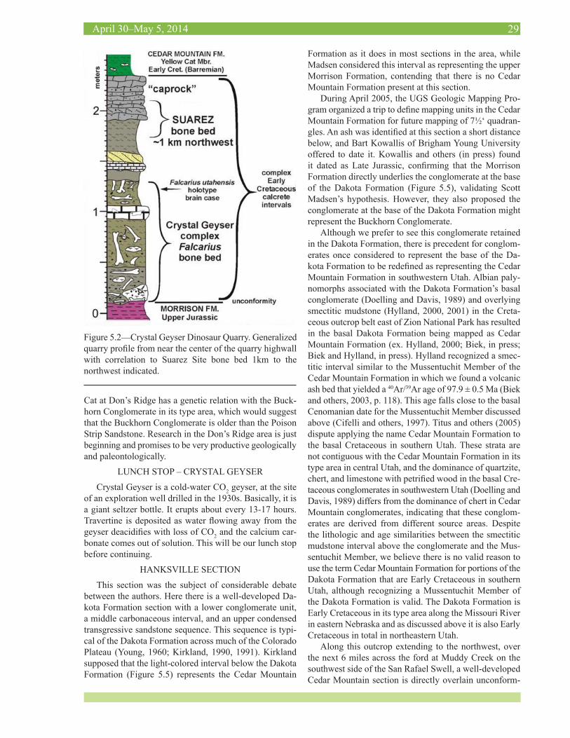
Figure 5.2—Crystal Geyser Dinosaur Quarry. Generalized quarry profile from near the center of the quarry highwall with correlation to Suarez Site bone bed 1km to the northwest indicated.
30Mid-Mesozoic: The Age of Dinosaurs in Transition
ably by the Tununk Shale Member of the Mancos Shale. Thus, the southeastern pinch out of the Cedar Mountain Formation is a short distance to the north of the outcrop. At the next stop, the Cedar Mountain section is much like that at Muddy Creek. The southeastern pinch out of the Cedar Mountain Formation in that area is south of Notom near the southern Wayne County line.
HANKSVILLE-BURPEE QUARRY
Though the Hanksville-Burpee quarry had been known as a fossil-producing site to locals for years, it was not excavated systematically until Burpee Museum of Natural History (Rockford, IL.) obtained an excavation permit in 2008. The museum conducts several weeks of field work at the site every summer, resulting in the removal of thou-sands of pounds of dinosaur material each year.
The Hanksville-Burpee quarry is situated in the Brushy Basin Member of the Morrison Formation. The drive lead-ing to the quarry also showcases the lower and middle members of the Morrison Formation: the Tidwell and Saltwash respectively, though these lower members are not present at the quarry itself. Topographically high out-crops directly adjacent to the quarry are unconformably overlain by the Dakota Formation. Outcrops in the dis-tance are composed of various members of the Mancos Formation. The Henry Mountains (laccoliths) are visible to the South. The quarry is currently comprised of two main outcrops, though the fossil-bearing stratum continues toward the northeast for up to a quarter of a mile, likely productive the entire distance. The paleoenvironment is in-terpreted as a braided stream based on cyclical deposition of fining upwards sandstone sequences interspersed with pebble conglomerates. The stream likely had a max depth of around three meters; unionid bivalves further bolster the interpretation of a freshwater environmental component. Petrified wood is also present at the quarry, with large downed petrified trees within a quarter-mile.
Elements of at least seven taxa (including Diplodocus, Apatosaurus, Camarasaurus, Barosaurus, Stegosaurus, and Ceratosaurus), some represented by multiple indi-viduals, have been excavated since 2008. Most material at Hanksville-Burpee is associated or disarticulated, but there are sequences of articulated vertebrae and articulated limbs present. No skulls of any taxa have been found, but isolated cranial elements such as a Camarasaurus dentary, a Ceratosaurus dentary, and an Allosaurus braincase have been removed. Diplodocid “dentures” (aligned teeth lack-ing any connection to other cranial elements) have been found as well. This suggests that other cranial material, and perhaps articulated skulls, could occur at the quarry.
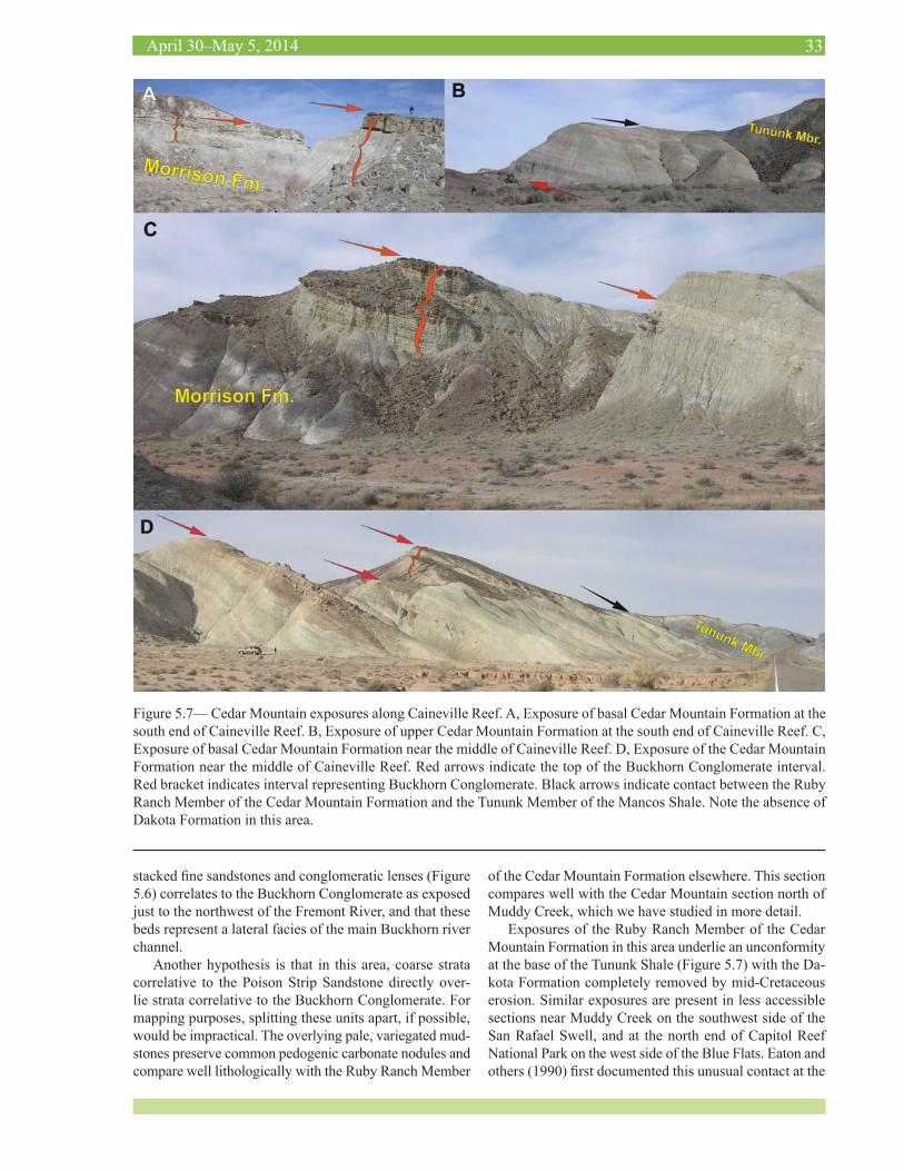
CAINEVILLE REEF
Exposures of the Cedar Mountain Formation in this area are of particular interest because of rapid facies changes relative to the basal Buckhorn Conglomerate and the upper contact at an unconformity at the base of the Tununk Shale.
Along Caineville Reef, well-developed conglomerate beds come and go such that UGS mapping of this stretch of outcrop has resulted in the documentation of a discontinu-ous Buckhorn Conglomerate. However, as can be seen in these outcrops (Figure 5.6), the basal conglomerate often occurs well above the unconformable contact at the base of the Cretaceous. Although the authors have not studied this area to the degree that we have other areas, we propose that the lower steep, light-colored interval consisting of
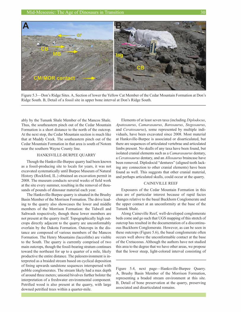
Figure 5.3—Don’s Ridge Sites. A, Section of lower the Yellow Cat Member of the Cedar Mountain Formation at Don’s Ridge South. B, Detail of a fossil site in upper bone interval at Don’s Ridge South.
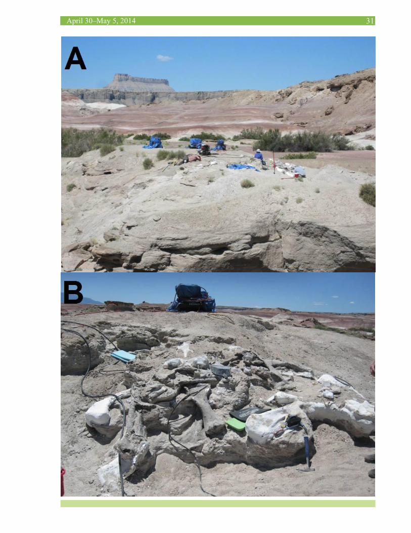
Figure 5.4, next page—Hanksville-Burpee Quarry. A, Brushy Basin Member of the Morrison Formation, representing a braded stream environment at this site. B, Detail of bone preservation at the quarry, preserving associated and disarticulated remains.
31April 30–May 5, 2014
32Mid-Mesozoic: The Age of Dinosaurs in Transition
Figure 5.5—Composite stratigraphic section of the lower Cedar Mountain Formation at Don’s Ridge. Abbreviations: CB, cherty sandstone bed. cr, caprock. MB, lower marker bed. rs, ribbon sandstone low in upper Yellow Cat Member.
Figure 5.6— Middle Mesozoic section west of Hanksville. A, Overview of section. Arrow points to Kirkland’s original hypothesis as to placement of lower contact for Cedar Mountain Formation. B, Detail of Dakota Formation. usm, upper sandstone member, cm, middle carbonaceous member, lcm, lower conglomerate member.
33April 30–May 5, 2014
Figure 5.7— Cedar Mountain exposures along Caineville Reef. A, Exposure of basal Cedar Mountain Formation at the south end of Caineville Reef. B, Exposure of upper Cedar Mountain Formation at the south end of Caineville Reef. C, Exposure of basal Cedar Mountain Formation near the middle of Caineville Reef. D, Exposure of the Cedar Mountain Formation near the middle of Caineville Reef. Red arrows indicate the top of the Buckhorn Conglomerate interval. Red bracket indicates interval representing Buckhorn Conglomerate. Black arrows indicate contact between the Ruby Ranch Member of the Cedar Mountain Formation and the Tununk Member of the Mancos Shale. Note the absence of Dakota Formation in this area.
stacked fine sandstones and conglomeratic lenses (Figure 5.6) correlates to the Buckhorn Conglomerate as exposed just to the northwest of the Fremont River, and that these beds represent a lateral facies of the main Buckhorn river channel.
Another hypothesis is that in this area, coarse strata correlative to the Poison Strip Sandstone directly over-lie strata correlative to the Buckhorn Conglomerate. For mapping purposes, splitting these units apart, if possible, would be impractical. The overlying pale, variegated mud-stones preserve common pedogenic carbonate nodules and compare well lithologically with the Ruby Ranch Member
of the Cedar Mountain Formation elsewhere. This section compares well with the Cedar Mountain section north of Muddy Creek, which we have studied in more detail.
Exposures of the Ruby Ranch Member of the Cedar Mountain Formation in this area underlie an unconformity at the base of the Tununk Shale (Figure 5.7) with the Da-kota Formation completely removed by mid-Cretaceous erosion. Similar exposures are present in less accessible sections near Muddy Creek on the southwest side of the San Rafael Swell, and at the north end of Capitol Reef National Park on the west side of the Blue Flats. Eaton and others (1990) first documented this unusual contact at the
34Mid-Mesozoic: The Age of Dinosaurs in Transition
top of the Cedar Mountain Formation on the west side of the San Rafael Swell near Ferron, Utah.
The basal Tununk Shale at all of these sites is distinc-tive. It consists of a chert pebble conglomerate in a matrix of marine shale with shells of the marine oyster Pycnodon-te newberryi, and at several sites, shark teeth. This con-glomeratic bed is in turn overlain by a few centimeters, or tens of centimeters of mudstone followed by a dense shell bed of Pycnodonte newberryi umbonata, a subspecies of Pycnodonte with a relatively smooth beak area that only occurs in the basal Turonian (Kirkland, 1996; Leckie and others, 1997). Within a meter of this Pycnodonte bed is the first thick (20-50 cm thick) volcanic ash (altered to bentonite) in the lower Turonian with 40Ar/39Ar ages by Obradovitch (1993) of 93.25 ± 0.55 Ma and by Kowallis and others (1995) of 93.46 ± 0.6 Ma. This important vol-canic ash bed can be traced across the Western Interior in all marine sections (Elder and Kirkland, 1985; Elder, 1988,
1989, 1991; Kirkland, 1991; Kennedy and others, 2000).Eaton and others (1990) proposed that the chert pebble
layer at the base of the Tununk was sourced from chert pebbles originally deposited in the Buckhorn Conglomer-ate. On examing the lower Dakota Formation at Hanks-ville, we now propose that the pebble source was more likely the basal conglomerate of the Dakota Formation. The important thing to note at these sections is that there is convincing evidence that during one of the most rapid global eustatic sea-level-rise events in the Phanerozoic, proximal to the active Cretaceous foreland basin, there was local uplift in central Utah that exceeded both sea-level rise and regional subsidence (Eaton and others, 1990). The distribution of facies at the base of the Tununk Shale needs to be mapped in detail across the San Rafael region to determine if this was simply a broadly developed fore-bulge or the reactivation of known Precambrian basement structures.
35April 30–May 5, 2014
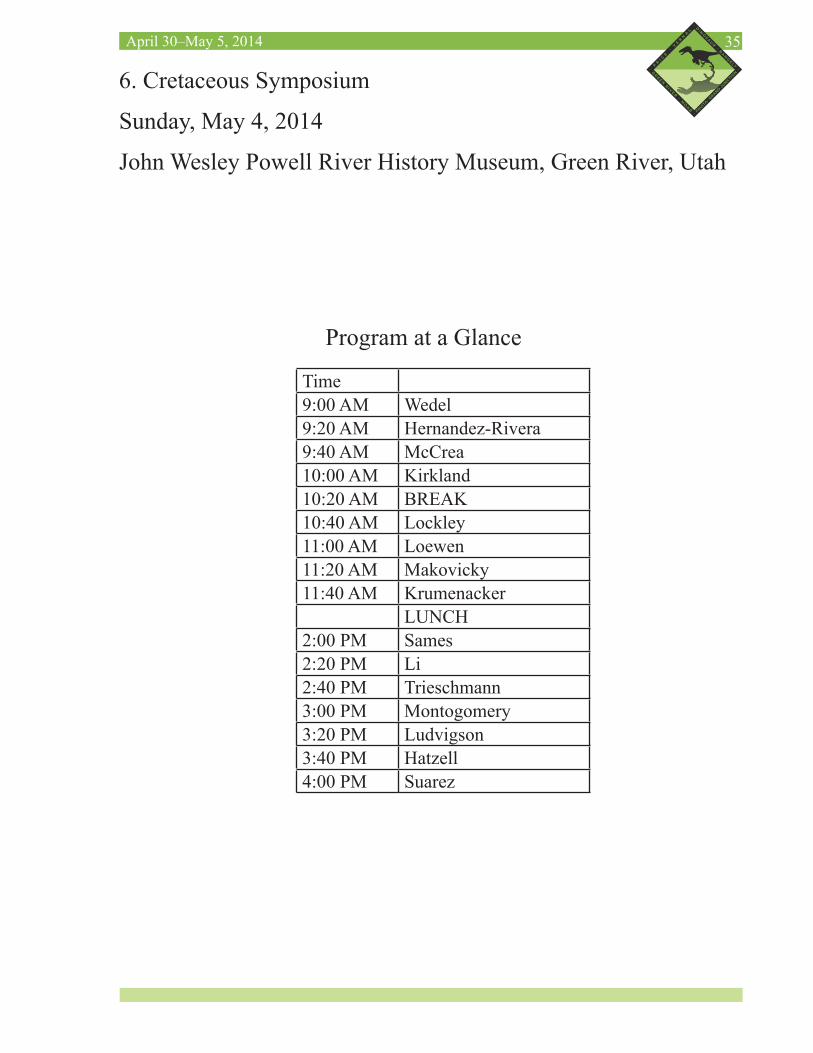
6. Cretaceous Symposium
Sunday, May 4, 2014
John Wesley Powell River History Museum, Green River, Utah
Time9:00 AM Wedel9:20 AM Hernandez-Rivera9:40 AM McCrea10:00 AM Kirkland10:20 AM BREAK10:40 AM Lockley11:00 AM Loewen11:20 AM Makovicky11:40 AM Krumenacker
LUNCH2:00 PM Sames2:20 PM Li2:40 PM Trieschmann3:00 PM Montogomery3:20 PM Ludvigson 3:40 PM Hatzell 4:00 PM Suarez
Program at a Glance
36Mid-Mesozoic: The Age of Dinosaurs in Transition
SUNDAY, MAY 4, 2014CRETACEOUS SYMPOSIUMJOHN WESLEY POWELL RIVER HISTORY MUSEUM, GREEN RIVER, UTAH
Moderators: John Foster and Jim Kirkland
9:00 wedeL, M.J., Naish, d. SAUROPOSEIDON AND KIN: GIANT TITANOSAURIFORMS FROM THE EARLY CRETACEOUS OF NORTH AMERICA AND EUROPE
9:20 herNaNdez-rivera, r. THE RECORD OF DINOSAURS FROM MEXICO
9:40 Mccrea, r.t., BuckLey, L.g. AN OVERVIEW OF THE TERRESTRIAL VERTEBRATE TRACK RECORD FROM THE LATE JURASSIC-EARLY CRETACEOUS (TITHONIAN-ALBIAN) OF WESTERN CANADA
10:00 kirkLaNd, J.i. THE NATURE OF THE JURASSIC/ CRETACEOUS (J/K) UNCONFORMITY AND THE EARLY CRETACEOUS OF EASTERN UTAH
10:20 BREAK
10:40 LockLey, M.g., gierLiNski, g.d., LiM, J.d., kiM, k.s., huNt-Foster, r.k., Foster, J.r., BuckLey, L.g., kirkLaNd, J.i., deBLieux, d.d. TETRAPOD TRACK SITES IN THE CEDAR MOUNTAIN FORMATION, (LOWER CRETACEOUS) OF EASTERN UTAH: AN UPDATE
11:00 LoeweN, M.a., kirkLaNd, J.i., you, h. ARMORED DINOSAUR EVOLUTION DURING THE MID-MESOZOIC
11:20 Makovicky, p.J. aNd zaNNo, L.e. NEW DICOVERIES ADD TO THE DIVERSITY OF THE MUSSENTUCHIT MEMBER (CEDAR MOUNTAIN FORMATION) DINOSAUR FAUNA
11:40 kruMeNacker, L.J., scoFieLd, g., siMoN, J., varricchio, d., wiLsoN, g.p. OUTCROP ENVY: PALEONTOLOGY AND TAPHONOMY OF THE WAYAN FORMATION, THE CENOMA-NIAN FOREDEEP DEPOSITS OF IDAHO
12:00 LUNCH
2:00 saMes, B., ciFeLLi, r.L., davis, B.d., schudack, M.e. DOWNSIZING THE LOWER CRE-TACEOUS HIATUS IN THE WESTERN INTERIOR FORELAND BASIN—A BIOSTRATIGRAPHIC PERSPECTIVE BASED ON MICROFOSSILS
2:20 Li, g. CLAM SHRIMP FAUNAS OF THE EARLY CRETACEOUS JEHOL BIOTA FROM NORTHERN CHINA
2:40 trieschMaNN, J.B., suarez, c.a., suarez, M.B., you, h.L, Li, d.q. STABLE ISOTOPIC ANALYSIS OF VERTEBRATE FOSSILS FROM THE EARLY CRETACEOUS HEKOU GROUP, GANSU PROVINCE CHINA
3:00 MoNtgoMery, e.h., saurez, M.B., gray, w., kirkLaNd, J.i., saurez, c.a., aL-suwaidi, a. CARBON ISOTOPE CHEMOSTRATIGRAPHY AND MINERALOGY IN LACUSTRINE STRATA FROM THE RUBY RANCH MEMBER, CEDAR MOUNTAIN FORMATION NEAR MOAB, UTAH
37April 30–May 5, 2014
3:20 LudvigsoN, g.a., JoeckeL, r.M., goNzáLez, L.a., Murphy, L.r., su-arez, c.a., stockLi, d.F. INTEGRATION OF δ13C CHEMOSTRATIGRAPHY AND U/Pb DATING OF EARLY CRETACEOUS TERRESTRIAL DEPOSITS OF THE CEDAR MOUNTAIN FORMATION IN UTAH
3:40 hatzeLL, g.a., suarez, c.a., suarez, M.B., aL-suwaidi, a., kirkLaNd, J.i. ORGANIC CARBON-ISOTOPE CHEMOSTRATIGRAPHY OF THE LOWER CRETACEOUS CEDAR MOUN-TAIN FORMATION, UTAH
4:00 suarez, M.B., saLazar-verdiN, J., suarez, c.a., aL-suwaidi, a., kirkLaNd, J.i. OR-GANIC CARBON ISOTOPE CHEMOSTRATIGRAPHY OF TWO LOCATIONS IN THE EARLY CRETACEOUS YELLOW CAT MEMBER OF THE CEDAR MOUNTAIN FORMATION NEAR MOAB, UTAH
SUNDAY, MAY 4, 2014POSTER SESSION 2JOHN WESLEY POWELL RIVER HISTORY MUSEUM, GREEN RIVER, UTAHAuthors must be present from 4:30 – 6 pmPosters must be removed by 6:30 pm
1 deBLieux , d., kirkLaNd, J.i., MadseN, s., huNt, g., toth, N. THE TAPHONOMY OF A MIRED SAUROPOD DINOSAUR AT DOELLING’S BOWL BONEBED IN THE EARLY CRETA-CEOUS CEDAR MOUNTAIN FORMATION, EASTERN UTAH
2 zaNNo, L.e., kirkLaNd, J.i., herzog, L. SECOND MASS-DEATH LOCALITY OF A BAS-AL THERIZINOSAUR FROM THE LOWER CRETACEOUS CEDAR MOUNTAIN FORMATION, EAST CENTRAL UTAH: A PROBABLE NEW TAXON
3 ikeda, t., saegusa, h., haNda, k. THE VERTEBRATE FOSSIL ASSEMBLAGES FROM THE LOWER CRETACEOUS SASAYAMA GROUP, HYOGO PREFECTURE, WESTERN HONSHU, JAPAN
4 aLcaLá, L., espíLez, e., MaMpeL, L., goNzáLez, a., ruBio, d., kirkLaNd, J.i., McdoN-aLd, a.t., BuscaLioNi, a.d., coBos, a., royo-torres, r. THE LOWER ALBIAN VERTEBRATE BONEBED AT ARIÑO (TERUEL, SPAIN)
5 herzog, L., zaNNo, L.e., Makovicky, p.J. NEW SOLEMYDID TURTLE SPECIMENS FROM THE UPPER CRETACEOUS MUSSENTUCHIT MEMBER OF THE CEDAR MOUNTAIN FORMATION
6 LockLey, M.g., kiM, J.y., xiNg, L., BuckLey, L.g., Mccrea, r.t., Matsukawa, M. EARLY CRETACEOUS BIRD TRACKS FROM EAST ASIA AND NORTH AMERICA: A REVIEW
7 LockLey, M.g., LiM, J.d., kiM, J.y., gierLiNski, g.d. MULTIPLE NEW TETRAPOD ICHNOFAUNAS FROM THE DAKOTA GROUP (‘MID’ CRETACEOUS) OF WESTERN COLO-RADO: A NEW CHAPTER IN THE DINOSAUR FREEWAY STORY
8 torNaBeNe, c., tiBert, N.e., kirkLaNd, J.L. THE PALEOENVIRONMENTAL SIGNIFI-CANCE OF NONMARINE OSTRACODES IN THE DINOSAUR BEARING CEDAR MOUNTAIN
38Mid-Mesozoic: The Age of Dinosaurs in Transition
FORMATION, UTAH, U.S.A.
9 ross, J.B., LudvigsoN, g.a., goNzáLez, L.a., waLker, J.d. STABLE ISO-TOPE PALEOHYDROLOGY OF PEDOGENIC CARBONATES IN THE WAYAN AND
BLACKLEAF FORMATIONS (MID-CRETACEOUS) OF IDAHO AND MONTANA
10 JoeckeL, r.M., LudvigsoN, g.a., suarez, c.a., kirkLaNd, J.i. PEDOSTRATIGRAPHY AND PRELIMINARY δ13C CHEMOSTRATIGRAPHY OF THE YELLOW CAT MEMBER (LOWER CRETACEOUS) OF THE CEDAR MOUNTAIN FORMATION, UTAH
11 suarez, M.B., MiLder, t.w., suarez, c.a., you, h.L., dodsoN, p., Li, d.q. STABLE CARBON ISOTOPE CHEMOSTRATIGRAPHY FROM CRETACEOUS STRATA OF THE YUJINGZI BASIN, GANSU PROVINCE, CHINA
12 you, h.L., carpeNter, k. A COMPARISON OF EARLY CRETACEOUS DINOSAURS FROM GANSU PROVINCE, CHINA, AND UTAH, UNITED STATES
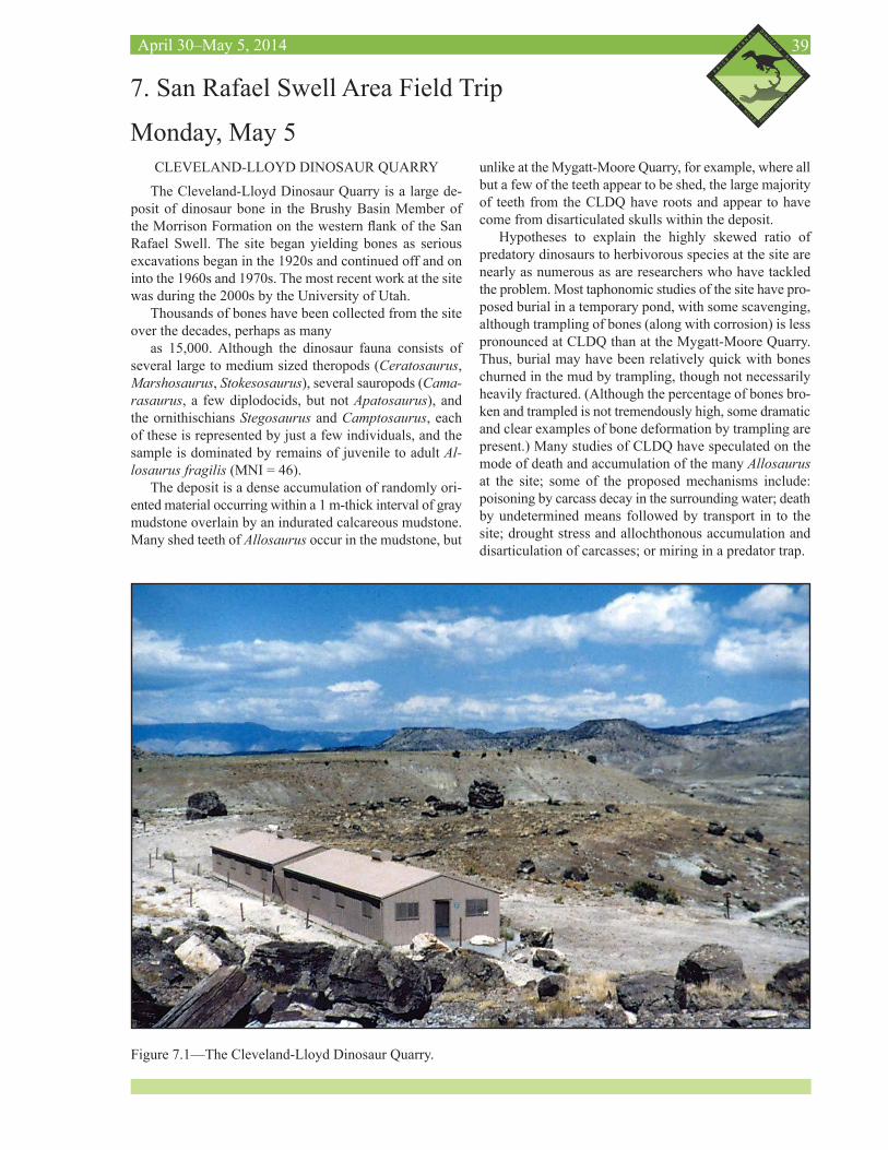
39April 30–May 5, 2014
CLEVELAND-LLOYD DINOSAUR QUARRY
The Cleveland-Lloyd Dinosaur Quarry is a large de-posit of dinosaur bone in the Brushy Basin Member of the Morrison Formation on the western flank of the San Rafael Swell. The site began yielding bones as serious excavations began in the 1920s and continued off and on into the 1960s and 1970s. The most recent work at the site was during the 2000s by the University of Utah.
Thousands of bones have been collected from the site over the decades, perhaps as many
as 15,000. Although the dinosaur fauna consists of several large to medium sized theropods (Ceratosaurus, Marshosaurus, Stokesosaurus), several sauropods (Cama-rasaurus, a few diplodocids, but not Apatosaurus), and the ornithischians Stegosaurus and Camptosaurus, each of these is represented by just a few individuals, and the sample is dominated by remains of juvenile to adult Al-losaurus fragilis (MNI = 46).
The deposit is a dense accumulation of randomly ori-ented material occurring within a 1 m-thick interval of gray mudstone overlain by an indurated calcareous mudstone. Many shed teeth of Allosaurus occur in the mudstone, but
7. San Rafael Swell Area Field Trip
Monday, May 5unlike at the Mygatt-Moore Quarry, for example, where all but a few of the teeth appear to be shed, the large majority of teeth from the CLDQ have roots and appear to have come from disarticulated skulls within the deposit.
Hypotheses to explain the highly skewed ratio of predatory dinosaurs to herbivorous species at the site are nearly as numerous as are researchers who have tackled the problem. Most taphonomic studies of the site have pro-posed burial in a temporary pond, with some scavenging, although trampling of bones (along with corrosion) is less pronounced at CLDQ than at the Mygatt-Moore Quarry. Thus, burial may have been relatively quick with bones churned in the mud by trampling, though not necessarily heavily fractured. (Although the percentage of bones bro-ken and trampled is not tremendously high, some dramatic and clear examples of bone deformation by trampling are present.) Many studies of CLDQ have speculated on the mode of death and accumulation of the many Allosaurus at the site; some of the proposed mechanisms include: poisoning by carcass decay in the surrounding water; death by undetermined means followed by transport in to the site; drought stress and allochthonous accumulation and disarticulation of carcasses; or miring in a predator trap.
Figure 7.1—The Cleveland-Lloyd Dinosaur Quarry.
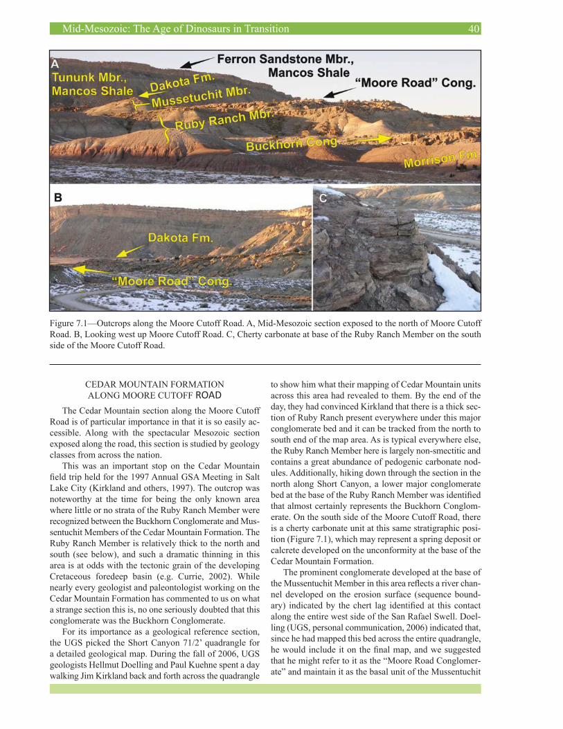
40Mid-Mesozoic: The Age of Dinosaurs in Transition
CEDAR MOUNTAIN FORMATION ALONG MOORE CUTOFF ROAD
The Cedar Mountain section along the Moore Cutoff Road is of particular importance in that it is so easily ac-cessible. Along with the spectacular Mesozoic section exposed along the road, this section is studied by geology classes from across the nation.
This was an important stop on the Cedar Mountain field trip held for the 1997 Annual GSA Meeting in Salt Lake City (Kirkland and others, 1997). The outcrop was noteworthy at the time for being the only known area where little or no strata of the Ruby Ranch Member were recognized between the Buckhorn Conglomerate and Mus-sentuchit Members of the Cedar Mountain Formation. The Ruby Ranch Member is relatively thick to the north and south (see below), and such a dramatic thinning in this area is at odds with the tectonic grain of the developing Cretaceous foredeep basin (e.g. Currie, 2002). While nearly every geologist and paleontologist working on the Cedar Mountain Formation has commented to us on what a strange section this is, no one seriously doubted that this conglomerate was the Buckhorn Conglomerate.
For its importance as a geological reference section, the UGS picked the Short Canyon 71/2’ quadrangle for a detailed geological map. During the fall of 2006, UGS geologists Hellmut Doelling and Paul Kuehne spent a day walking Jim Kirkland back and forth across the quadrangle
to show him what their mapping of Cedar Mountain units across this area had revealed to them. By the end of the day, they had convinced Kirkland that there is a thick sec-tion of Ruby Ranch present everywhere under this major conglomerate bed and it can be tracked from the north to south end of the map area. As is typical everywhere else, the Ruby Ranch Member here is largely non-smectitic and contains a great abundance of pedogenic carbonate nod-ules. Additionally, hiking down through the section in the north along Short Canyon, a lower major conglomerate bed at the base of the Ruby Ranch Member was identified that almost certainly represents the Buckhorn Conglom-erate. On the south side of the Moore Cutoff Road, there is a cherty carbonate unit at this same stratigraphic posi-tion (Figure 7.1), which may represent a spring deposit or calcrete developed on the unconformity at the base of the Cedar Mountain Formation.
The prominent conglomerate developed at the base of the Mussentuchit Member in this area reflects a river chan-nel developed on the erosion surface (sequence bound-ary) indicated by the chert lag identified at this contact along the entire west side of the San Rafael Swell. Doel-ling (UGS, personal communication, 2006) indicated that, since he had mapped this bed across the entire quadrangle, he would include it on the final map, and we suggested that he might refer to it as the “Moore Road Conglomer-ate” and maintain it as the basal unit of the Mussentuchit
Figure 7.1—Outcrops along the Moore Cutoff Road. A, Mid-Mesozoic section exposed to the north of Moore Cutoff Road. B, Looking west up Moore Cutoff Road. C, Cherty carbonate at base of the Ruby Ranch Member on the south side of the Moore Cutoff Road.
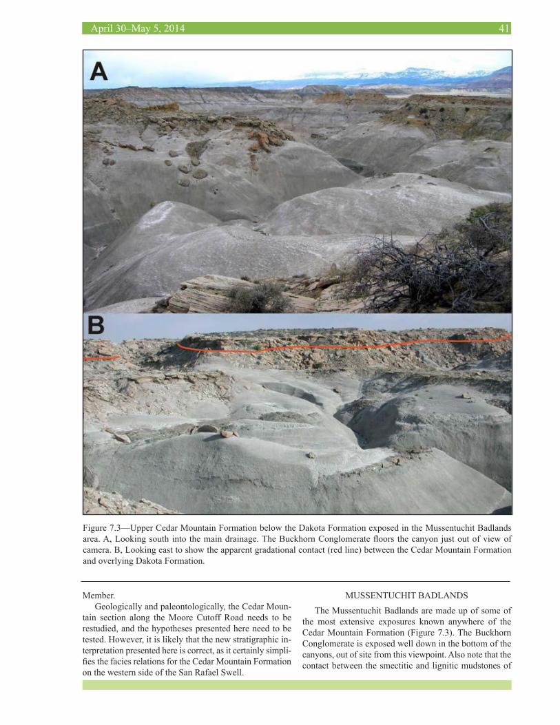
41April 30–May 5, 2014
Member.Geologically and paleontologically, the Cedar Moun-
tain section along the Moore Cutoff Road needs to be restudied, and the hypotheses presented here need to be tested. However, it is likely that the new stratigraphic in-terpretation presented here is correct, as it certainly simpli-fies the facies relations for the Cedar Mountain Formation on the western side of the San Rafael Swell.
MUSSENTUCHIT BADLANDS
The Mussentuchit Badlands are made up of some of the most extensive exposures known anywhere of the Cedar Mountain Formation (Figure 7.3). The Buckhorn Conglomerate is exposed well down in the bottom of the canyons, out of site from this viewpoint. Also note that the contact between the smectitic and lignitic mudstones of
Figure 7.3—Upper Cedar Mountain Formation below the Dakota Formation exposed in the Mussentuchit Badlands area. A, Looking south into the main drainage. The Buckhorn Conglomerate floors the canyon just out of view of camera. B, Looking east to show the apparent gradational contact (red line) between the Cedar Mountain Formation and overlying Dakota Formation.
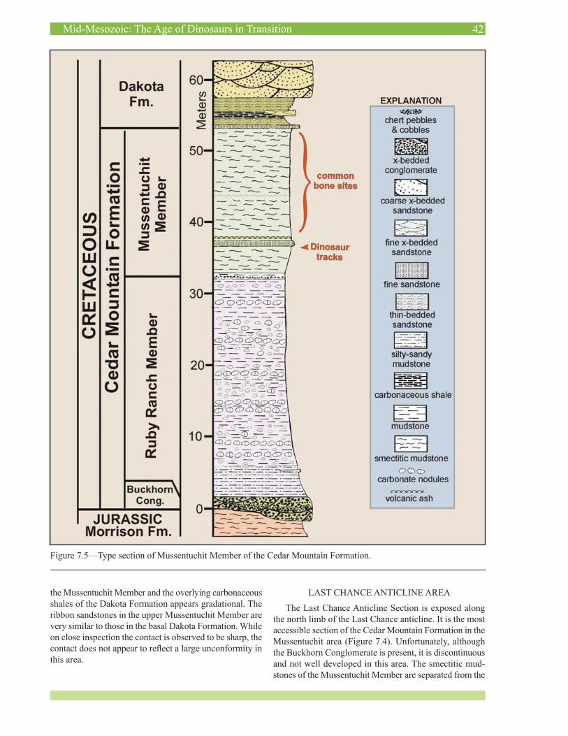
42Mid-Mesozoic: The Age of Dinosaurs in Transition
Figure 7.5—Type section of Mussentuchit Member of the Cedar Mountain Formation.
the Mussentuchit Member and the overlying carbonaceous shales of the Dakota Formation appears gradational. The ribbon sandstones in the upper Mussentuchit Member are very similar to those in the basal Dakota Formation. While on close inspection the contact is observed to be sharp, the contact does not appear to reflect a large unconformity in this area.
LAST CHANCE ANTICLINE AREA
The Last Chance Anticline Section is exposed along the north limb of the Last Chance anticline. It is the most accessible section of the Cedar Mountain Formation in the Mussentuchit area (Figure 7.4). Unfortunately, although the Buckhorn Conglomerate is present, it is discontinuous and not well developed in this area. The smectitic mud-stones of the Mussentuchit Member are separated from the
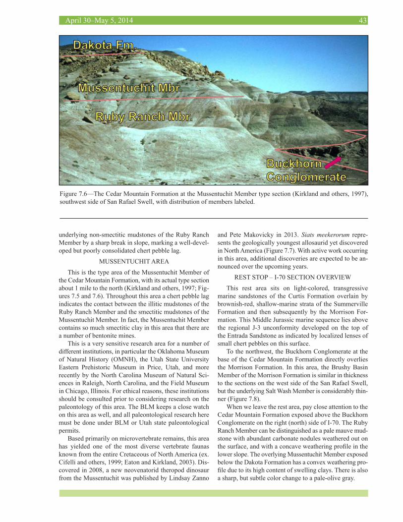
43April 30–May 5, 2014
Figure 7.6—The Cedar Mountain Formation at the Mussentuchit Member type section (Kirkland and others, 1997), southwest side of San Rafael Swell, with distribution of members labeled.
underlying non-smectitic mudstones of the Ruby Ranch Member by a sharp break in slope, marking a well-devel-oped but poorly consolidated chert pebble lag.
MUSSENTUCHIT AREA
This is the type area of the Mussentuchit Member of the Cedar Mountain Formation, with its actual type section about 1 mile to the north (Kirkland and others, 1997; Fig-ures 7.5 and 7.6). Throughout this area a chert pebble lag indicates the contact between the illitic mudstones of the Ruby Ranch Member and the smectitic mudstones of the Mussentuchit Member. In fact, the Mussentuchit Member contains so much smectitic clay in this area that there are a number of bentonite mines.
This is a very sensitive research area for a number of different institutions, in particular the Oklahoma Museum of Natural History (OMNH), the Utah State University Eastern Prehistoric Museum in Price, Utah, and more recently by the North Carolina Museum of Natural Sci-ences in Raleigh, North Carolina, and the Field Museum in Chicago, Illinois. For ethical reasons, these institutions should be consulted prior to considering research on the paleontology of this area. The BLM keeps a close watch on this area as well, and all paleontological research here must be done under BLM or Utah state paleontological permits.
Based primarily on microvertebrate remains, this area has yielded one of the most diverse vertebrate faunas known from the entire Cretaceous of North America (ex. Cifelli and others, 1999; Eaton and Kirkland, 2003). Dis-covered in 2008, a new neovenatorid theropod dinosaur from the Mussentuchit was published by Lindsay Zanno
and Pete Makovicky in 2013. Siats meekerorum repre-sents the geologically youngest allosaurid yet discovered in North America (Figure 7.7). With active work occurring in this area, additional discoveries are expected to be an-nounced over the upcoming years.
REST STOP – I-70 SECTION OVERVIEW
This rest area sits on light-colored, transgressive marine sandstones of the Curtis Formation overlain by brownish-red, shallow-marine strata of the Summerville Formation and then subsequently by the Morrison For-mation. This Middle Jurassic marine sequence lies above the regional J-3 unconformity developed on the top of the Entrada Sandstone as indicated by localized lenses of small chert pebbles on this surface.
To the northwest, the Buckhorn Conglomerate at the base of the Cedar Mountain Formation directly overlies the Morrison Formation. In this area, the Brushy Basin Member of the Morrison Formation is similar in thickness to the sections on the west side of the San Rafael Swell, but the underlying Salt Wash Member is considerably thin-ner (Figure 7.8).
When we leave the rest area, pay close attention to the Cedar Mountain Formation exposed above the Buckhorn Conglomerate on the right (north) side of I-70. The Ruby Ranch Member can be distinguished as a pale mauve mud-stone with abundant carbonate nodules weathered out on the surface, and with a concave weathering profile in the lower slope. The overlying Mussentuchit Member exposed below the Dakota Formation has a convex weathering pro-file due to its high content of swelling clays. There is also a sharp, but subtle color change to a pale-olive gray.
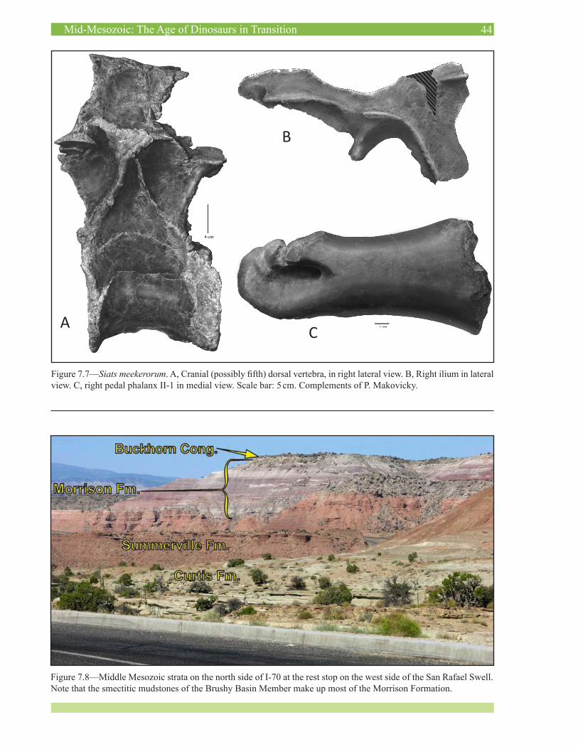
44Mid-Mesozoic: The Age of Dinosaurs in Transition
Figure 7.8—Middle Mesozoic strata on the north side of I-70 at the rest stop on the west side of the San Rafael Swell. Note that the smectitic mudstones of the Brushy Basin Member make up most of the Morrison Formation.
Figure 7.7—Siats meekerorum. A, Cranial (possibly fifth) dorsal vertebra, in right lateral view. B, Right ilium in lateral view. C, right pedal phalanx II-1 in medial view. Scale bar: 5 cm. Complements of P. Makovicky.
A
B
C
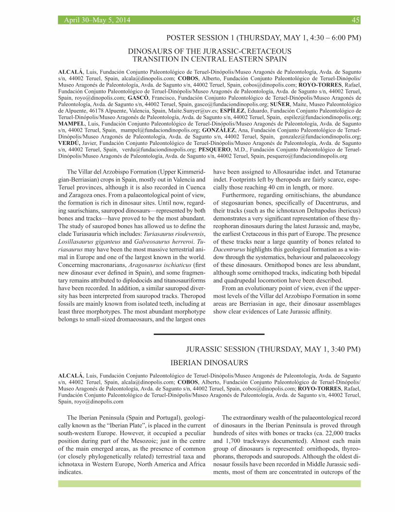
45April 30–May 5, 2014
POSTER SESSION 1 (THURSDAY, MAY 1, 4:30 – 6:00 PM)
DINOSAURS OF THE JURASSIC-CRETACEOUS TRANSITION IN CENTRAL EASTERN SPAIN
ALCALÁ, Luis, Fundación Conjunto Paleontológico de Teruel-Dinópolis/Museo Aragonés de Paleontología, Avda. de Sagunto s/n, 44002 Teruel, Spain, [email protected]; COBOS, Alberto, Fundación Conjunto Paleontológico de Teruel-Dinópolis/Museo Aragonés de Paleontología, Avda. de Sagunto s/n, 44002 Teruel, Spain, [email protected]; ROYO-TORRES, Rafael, Fundación Conjunto Paleontológico de Teruel-Dinópolis/Museo Aragonés de Paleontología, Avda. de Sagunto s/n, 44002 Teruel, Spain, [email protected]; GASCÓ, Francisco, Fundación Conjunto Paleontológico de Teruel-Dinópolis/Museo Aragonés de Paleontología, Avda. de Sagunto s/n, 44002 Teruel, Spain, [email protected]; SUÑER, Maite, Museo Paleontológico de Alpuente, 46178 Alpuente, Valencia, Spain, [email protected]; ESPÍLEZ, Eduardo, Fundación Conjunto Paleontológico de Teruel-Dinópolis/Museo Aragonés de Paleontología, Avda. de Sagunto s/n, 44002 Teruel, Spain, [email protected]; MAMPEL, Luis, Fundación Conjunto Paleontológico de Teruel-Dinópolis/Museo Aragonés de Paleontología, Avda. de Sagunto s/n, 44002 Teruel, Spain, [email protected]; GONZÁLEZ, Ana, Fundación Conjunto Paleontológico de Teruel-Dinópolis/Museo Aragonés de Paleontología, Avda. de Sagunto s/n, 44002 Teruel, Spain, [email protected]; VERDÚ, Javier, Fundación Conjunto Paleontológico de Teruel-Dinópolis/Museo Aragonés de Paleontología, Avda. de Sagunto s/n, 44002 Teruel, Spain, [email protected]; PESQUERO, M.D., Fundación Conjunto Paleontológico de Teruel-Dinópolis/Museo Aragonés de Paleontología, Avda. de Sagunto s/n, 44002 Teruel, Spain, [email protected]
The Villar del Arzobispo Formation (Upper Kimmerid-gian-Berriasian) crops in Spain, mostly out in Valencia and Teruel provinces, although it is also recorded in Cuenca and Zaragoza ones. From a palaeontological point of view, the formation is rich in dinosaur sites. Until now, regard-ing saurischians, sauropod dinosaurs—represented by both bones and tracks—have proved to be the most abundant. The study of sauropod bones has allowed us to define the clade Turiasauria which includes: Turiasaurus riodevensis, Losillasaurus giganteus and Galveosaurus herreroi. Tu-riasaurus may have been the most massive terrestrial ani-mal in Europe and one of the largest known in the world. Concerning macronarians, Aragosaurus ischiaticus (first new dinosaur ever defined in Spain), and some fragmen-tary remains attributed to diplodocids and titanosauriforms have been recorded. In addition, a similar sauropod diver-sity has been interpreted from sauropod tracks. Theropod fossils are mainly known from isolated teeth, including at least three morphotypes. The most abundant morphotype belongs to small-sized dromaeosaurs, and the largest ones
have been assigned to Allosauridae indet. and Tetanurae indet. Footprints left by theropods are fairly scarce, espe-cially those reaching 40 cm in length, or more.
Furthermore, regarding ornitischians, the abundance of stegosaurian bones, specifically of Dacentrurus, and their tracks (such as the ichnotaxon Deltapodus ibericus) demonstrates a very significant representation of these thy-reophoran dinosaurs during the latest Jurassic and, maybe, the earliest Cretaceous in this part of Europe. The presence of these tracks near a large quantity of bones related to Dacentrurus highlights this geological formation as a win-dow through the systematics, behaviour and palaeoecology of these dinosaurs. Ornithopod bones are less abundant, although some ornithopod tracks, indicating both bipedal and quadrupedal locomotion have been described.
From an evolutionary point of view, even if the upper-most levels of the Villar del Arzobispo Formation in some areas are Berriasian in age, their dinosaur assemblages show clear evidences of Late Jurassic affinity.
JURASSIC SESSION (THURSDAY, MAY 1, 3:40 PM)
IBERIAN DINOSAURSALCALÁ, Luis, Fundación Conjunto Paleontológico de Teruel-Dinópolis/Museo Aragonés de Paleontología, Avda. de Sagunto s/n, 44002 Teruel, Spain, [email protected]; COBOS, Alberto, Fundación Conjunto Paleontológico de Teruel-Dinópolis/Museo Aragonés de Paleontología, Avda. de Sagunto s/n, 44002 Teruel, Spain, [email protected]; ROYO-TORRES, Rafael, Fundación Conjunto Paleontológico de Teruel-Dinópolis/Museo Aragonés de Paleontología, Avda. de Sagunto s/n, 44002 Teruel, Spain, [email protected]
The Iberian Peninsula (Spain and Portugal), geologi-cally known as the “Iberian Plate”, is placed in the current south-western Europe. However, it occupied a peculiar position during part of the Mesozoic; just in the centre of the main emerged areas, as the presence of common (or closely phylogenetically related) terrestrial taxa and ichnotaxa in Western Europe, North America and Africa indicates.
The extraordinary wealth of the palaeontological record of dinosaurs in the Iberian Peninsula is proved through hundreds of sites with bones or tracks (ca. 22,000 tracks and 1,700 trackways documented). Almost each main group of dinosaurs is represented: ornithopods, thyreo-phorans, theropods and sauropods. Although the oldest di-nosaur fossils have been recorded in Middle Jurassic sedi-ments, most of them are concentrated in outcrops of the
46Mid-Mesozoic: The Age of Dinosaurs in Transition
Jurassic-Cretaceous transition (Kimmeridgian-Berriasian), the upper part of the Lower Cretaceous (Barremian-Albi-an) and the Upper Cretaceous (Campanian-Maastrichtian).
Saurischia is the most diverse group recorded in the Iberian Jurassic-Cretaceous (Kimmeridigian-Berriasian) transition. Non-neosauropod turiasaurians (Turiasaurus, Losillasaurus, Galveosaurus), and neosauropod diplodo-cids (Dinheirosaurus) and macronarians (Lourinhasaurus, Lusotitan, Aragosaurus) typify the sauropods. They were the trackmakers of both narrow and wide trackways, such as the wide-gauge Polyonyx ichnotaxon from the Portu-guese Middle Jurassic. The most complete theropod re-mains have been found in Portugal and were attributed to Allosaurus, Aviatyrannis, Ceratosaurus, Lourihnano-saurus and Torvosaurus. Anyway, the diversity of thero-pods in the Iberian Peninsula should be even larger as the great variability of teeth morphotypes identified points to. Regarding theropod tracks, a large morphotype, His-panosauripus, has been defined in Spain. Concerning the Ornithischia clade, ornithopod dinosaurs are represented by camptosaurids (Draconyx), dryosaurids and abundant tracks (e.g. Therangospodus oncalensis). Among thyreo-phorans, stegosaurians such as Stegosaurus and Dacen-trurus, as well as their tracks (Deltapodus ibericus), and ankylosaurs like Dracopelta can be highlighted.
The Barremian-Albian interval abounds in titanosau-riform sauropods (Tastavinsaurus) and rebbachisaurids (Demandasaurus). Ornithopod dinosaurs are represented by iguanodontians (Delapparentia, Iguanodon, Proa), “hypsilophodontids” (Gideonmantellia) and multiple tracks, whilst Polacanthus and the nodosaurid Europelta exemplify the thyreophorans. The most peculiar non-avian theropods are allosaurids, spinosaurids (e.g., Barynoyx), carcharodontosaurids (Concavenator) and the ornithomi-mosaur Pelecanimimus; in addition Concornis, Eoalula-vis, Iberomesornis and Noguerornis illustrate the avian theropods.
With reference to the Upper Cretaceous, the most typi-cal sauropods are titanosaurids (such as Lirainosaurus). Also, the hadrosaurians amongst ornithopods (Arenysau-rus, Blasisaurus, Koutalisaurus and Pararhabdodon), the maniraptors within theropods, and the thyreophoran Stru-thiosaurus are outstanding. In addition, thousands of sau-ropod, ornithopod and theropod tracks have been identified in outcrops close to the Cretaceous-Paleogene boundary.
The Iberian dinosaur fossil record allows us to decipher the European dinosaur assemblages and their succession over the last 100 million years of their existence.
POSTER SESSION 2 (SUNDAY, MAY 4, 4:30 – 6:00 PM)
THE LOWER ALBIAN VERTEBRATE BONEBED AT ARIÑO (TERUEL, SPAIN)ALCALÁ, Luis, Fundación Conjunto Paleontológico de Teruel-Dinópolis/Museo Aragonés de Paleontología, Avda. de Sagunto s/n, 44002 Teruel, Spain, [email protected]; ESPÍLEZ, Eduardo, Fundación Conjunto Paleontológico de Teruel-Dinópolis/Museo Aragonés de Paleontología, Avda. de Sagunto s/n, 44002 Teruel, Spain, [email protected]; MAMPEL, Luis, Fundación Conjunto Paleontológico de Teruel-Dinópolis/Museo Aragonés de Paleontología, Avda. de Sagunto s/n, 44002 Teruel, Spain, [email protected]; GONZÁLEZ, Ana, Fundación Conjunto Paleontológico de Teruel-Dinópolis/Museo Aragonés de Paleontología, Avda. de Sagunto s/n, 44002 Teruel, Spain, [email protected]; RUBIO, Diego, Sociedad Anónima Minera Catalano-Aragonesa (SAMCA). Carretera 18, 44547 Ariño, Spain, [email protected]; KIRKLAND, James I., Utah Geological Survey, 1594 West North Temple, Suite 3110, P.O. Box 146100, Salt Lake City, UT 84114-6100, USA, [email protected]; MCDONALD, Andrew T., Department of Earth and Environmental Science, University of Pennsylvania, Philadelphia, Pennsylvania, USA, [email protected]; BUSCALIONI, Ángela D., Departamento Biología, Paleontología. Universidad Autónoma de Madrid, Cantoblanco, 28049 Madrid, Spain, [email protected]; COBOS, Alberto, Fundación Conjunto Paleontológico de Teruel-Dinópolis/Museo Aragonés de Paleontología, Avda. de Sagunto s/n, 44002 Teruel, Spain, [email protected]; ROYO-TORRES, Rafael, Fundación Conjunto Paleontológico de Teruel-Dinópolis/Museo Aragonés de Paleontología, Avda. de Sagunto s/n, 44002 Teruel, Spain, [email protected]
Systematic palaeontological investigations carried out over the last few years in the open-pit Santa María (SAMCA Group) lignite mine near Ariño (Teruel, Spain) have revealed a vast fossiliferous horizon that contains numerous fossils of dinosaurs and other Mesozoic verte-brates, invertebrates, and plants. This bonebed is located at the base of the Lower Cretaceous Escucha Formation (whose age in the region ranges from Late Aptian to Al-bian), with the recovered fossils specifically indicating an Early Albian age for the Ariño site. As of January 2014, after prospecting 250,000 m2 of the layer where fossils are preserved, 108 vertebrate associations with more than
6,000 individual fossil bones have been mapped.Ten partial skeletons of the basal iguanodontian, Proa
valdearinnoensis, have been excavated. Proa is distin-guished mainly by its unique combination of characters and a single autapomorphy: the predentary comes to a point at its rostral margin, with divergent lateral process-es. In addition, four partial skeletons of the nodosaurid ankylosaur Europelta carbonensis have been excavated. Europelta is the most complete ankylosaur documented in Europe. Theropods are represented by a number of isolated teeth similar to those of Allosauroidea. Two new gonio-pholidid crocodilians have also been described: the longi-
47April 30–May 5, 2014
rostral species Hulkepholis plotos (considered as an active aquatic predator) and the species Anteophthalmosuchus escuchae, both of which constitute the most recent records of their clades in Europe. Many turtles and chondrichthyan and osteichthyan fishes have also been recorded, as well as plants (leaves, logs, amber, pollen, charophyte oogonia) and invertebrates (bivalves, gastropods). The Ariño bone-bed is the type locality of the ostracod species Rosacythere denticulata, Theriosynoecum escuchaensis, and Therio-synoecum arinnoensis. This limnic ostracod fauna in as-sociation with charophyte flora indicates that the lignitic mudstone hosting the bonebed below the lowest minable lignite was deposited along the margin of an alkaline lake proximal to the mostly brackish and deltaic environments documented in the Escucha Formation. It is likely that these Lower Cretaceous freshwater lakes served as sources of drinking water for the diverse dinosaur fauna living on the Iberian coastal plain during Lower Cretaceous times.
The Lower Cretaceous vertebrate assemblage at Ariño is allowing us to document the European continental Al-
bian fossil record. The near simultaneous first appearance of nodosaurids in both Europe and North America near the Aptian-Albian boundary, together with the documented separation of Nodosauridae into a North American Nodo-saurinae and a European Struthiosaurinae, indicates that nodosaurid origins must have preceded these records. Thus, these new data provide a revised date of, at latest, middle Aptian for the isolation of North America from Europe due to rising sea levels.
The new bonebed also represents a new scientific re-source used to promote local cultural park facilities and landscapes (Parque Cultural del Río Martín) in a rural re-gion whose economy is seriously affected by current and future financial instability related to the production of en-ergy in the European Union via coal power plants. In fact, representatives of Aragón Government and Dinópolis have recently announced the construction of a new Dinópolis “satellite” (i.e., a local museum linked with Dinópolis headquarters) in Ariño, scheduled to be open to the pub-lic next year.
POSTER SESSION 1 (THURSDAY, MAY 1, 4:30 – 6:00 PM)
NEW APPROACHES TO THE SKULL OF EILENODONAPESTEGUÍA, Sebastián, Fundación Azara. CEBBAD (CONICET) - Universidad Maimónides, Argentina, [email protected]
Eilenodontines are big, herbivorous rhynchocephalians from Late Jurassic to Late Cretaceous rocks of North and South America, belonging to the Morrison, Kootenai, and Candeleros Formations respectively. The group is included within Opisthodontia, and composed by three known gen-era: Eilenodon, Toxolophosaurus, and Priosphenodon, the two former (and older) from North America. However, only the last one is represented by complete skeletons. The presence of Priosphenodon in South America illustrates a wide distribution anterior to Mid-Jurassic times, and helps to clarify the Eilenodon anatomy. The materials housed at the LACM and collected by George Callison parties dur-ing the late 70’s and mid 80’s, though mostly disarticulat-ed, include important cranial and postcranial material that provide clue aspects to understand the anatomical traits of this largely unknown Morrison sphenodontid. Eilenodon is a large form (skull larger than 100 mm), with a massive and profusely ornamented periorbital region (prefrontals and postfrontals, and, at less degree, in frontal (as visible in 115735, a preserved anterior part of the frontal with a slightly concave roof and ornamented lateral border), and probably postorbital, jugal, and cuspidal region of the ascendant process of the maxilla). It also bears a sigmoid contact between prefrontal and nasal (115735), and den-tary with ornamented labial side in a dendritic pattern. All these features related to the strong peramorphic trend of the clade. From the two preserved maxilla, 120742 shows a ventral margin anteriorly edentulous and a den-
tition much wider than long and relatively packed, but striae are subtle. Several palatines were preserved. The anterior region is triangle-shaped as in Priosphenodon but taller, suggesting a shorter and more compact skull than in the Patagonian taxon. The dentition is character-istic and compact as in the maxilla. It widens posteriorly (120519) and rostrally and dorsally shows the profuse, parallel vascularization (115735), as in P. avelasi. Lower jaw is particularly robust. The articular bone bears a wide, heart-shaped glenoid cavity (115735), and the retroarticu-lar process is very short and dorsoventrally curved. The coronoid bone is low and out of line respect to the dental line. The dentary is tall and thick, with its posterior process reaching the posterior end of the glenoid cavity. It bears a low coronoid process (as in all Opisthodontia), and a completely edentate symphysial region. The tooth row is sigmoid, laterallly curving at mid jaw and straightening toward the mandibular symphysis; juvenile dental genera-tions are absent (peramorphical). Additional mandibulary teeth are twice wider than long, closely packed, with low and rounded crowns (lower to 1/5 of the jaw height below them in unworn posterior teeth). They are not leaf-shaped, as in Priosphenodon, but grape-seed shaped, and highly asymmetrical lateromedially (115733). Mandibulary teeth bear a wide concave area on the posterior side, interrupted by numerous ridges, typically six, plus sometimes a cen-tral one; teeth bear two flanges, being the anterolateral more developed than the anteromedial one. Though no
48Mid-Mesozoic: The Age of Dinosaurs in Transition
JURASSIC SESSION (THURSDAY, MAY 1, 2:00 PM)
SNAKES IN THE MORRISON FORMATION?APESTEGUÍA, Sebastián, Fundación Azara. CEBBAD (CONICET) - Universidad Maimónides, Argentina, [email protected]; CALDWELL, Michael, Department of Biological Sciences, & Department of Earth and Atmospheric Sciences, University of Alberta, Edmonton, Alberta T6G2E9, Canada; NYDAM, Randall, Department of Anatomy, Midwestern University, Glendale, Arizona, 85308; GARBEROGLIO, Fernando, Fundación Azara. CEBBAD (CONICET) - Universidad Maimónides, Argentina; PALCI, Alessandro, Department of Biological Sciences, & Department of Earth and Atmospheric Sciences, University of Alberta, Edmonton, Alberta T6G2E9, Canada
The currently oldest known snake fossils are isolat-ed vertebrae from sediments in North Africa and North America dated as Albian to Cenomanian. The origin of the clade Ophidia is broadly considered having occurred during the Jurassic, but fossil evidence supporting this hypothesis has remained elusive. Here we report on frag-mentary vertebral remains (LACM 120472) from the Fruita locality 4684, Morrison Formation, Mesa County, Colorado, U.S.A. (Upper Jurassic; Kimmeridgian), that we recognize as belonging to an Upper Jurassic ophidian. The specimen preserves three vertebrae, two of which are articulated, and one isolated vertebra, with four additional fragments the identity of which remain inconclusive. The two articulated vertebrae, exposed in dorsal view, exhibit a wide neural arch with a very low neural spine framed by prominent arcual ridges on each side and above the interzygantral ridge. The isolated vertebra possesses a low neural spine forming a low crest on the dorsal surface
that disappears anteriorly at the zygosphenal platform. The zygosphenes are thick and well developed, as in all fossil and modern snakes. The zygosphenal facets are separated from the zygapophyseal facets by a non-articular area, and the zygosphenal tectum has a festooned anterior margin in dorsal view. The condyles and cotyles are circular, and both are offset from the ventral margins of the centrum. In ventral view, the centrum is strongly rectangular in outline, with a squared margin immediately anterior to the condyle. Parazygantral foramina are present on each side of neural arch, recessed in fossae lateral to the zy-gantra. These vertebrae show critical similarities to much younger Mesozoic snakes such as Coniophis, Dinilysia, Najash, Pachyrhachis, Simoliophis, etc., and to all extant snakes, making certain the identification of these vertebrae as those of an Upper Jurassic snake, and thus extending the fossil record of snakes by 45 million years, from the uppermost Albian, to the Upper Kimmeridgian.
JURASSIC SESSION (THURSDAY, MAY 1, 9:20 AM)
COLORADO’S WESTERN SLOPE FOSSILS: A PALEONTOLOGICAL AND HISTORICAL PERSPECTIVE ON FACT VERSUS FANTASYARMSTRONG, Harley J., Bureau of Land Management, Colorado State Office, [email protected]
This is an account of early paleontology fieldwork in Western Colorado, mostly in the Jurassic Morrison Forma-tion, but with observations of other paleontological work that brought scientific and popular notice to the fossil finds of the area. Some local fossils, found in prehistory, were used culturally and became artifacts as well as fossils. Many years later, historic exploration, homesteading and railroad activity brought notice and reporting of large dino-saur bones and other finds. Fossils were first scientifically collected on the Western Slope about 1865, with dinosaur
bones, often being large, were more and more found as the area continued to be settled in the late 1800’s and early 1900’s. Perhaps most notable at the time were the 1900 and 1901 Elmer S. Riggs expeditions from the Chicago “Field-Columbian Museum of Natural History” (now the FMNH) to collect large dinosaurs near Grand Junction and Fruita, Colorado. Since then, many scientific fossil finds of global interest have continued to be made and highlighted in museums and other collections.
complete skulls of Eilenodon were recovered yet, the as-sociated fragments, allied to its much larger size, allow a clear identifying of Eilenodon from any other Morrison rhynchocephalian. The presence of a sharp beak in Eilen-
odon is highly possible, since was present in not neces-sarily related large, herbivorous rhynchocephalians from continental ecosystems since at least Late Triassic times.
49April 30–May 5, 2014
POSTER SESSION 1 (THURSDAY, MAY 1, 4:30 – 6:00 PM)
NEW EVIDENCE FOR A CONIFER FOREST IN THE BRUSHY BASIN MEMBER OF THE UPPER JURASSIC MORRISON FORMATION, NORTHEASTERN UTAH, USA
BENNIS-BOTTOMLEY, Mary Beth, Utah Field House of Natural History State Park Museum, 496 E. Main, Vernal, UT 84078, [email protected]; GRAY, Dale E., Utah Field House of Natural History State Park Museum, 496 E. Main, Vernal, UT 84078, [email protected]; GEE, Carole T., Steinmann Institute of Geology, Mineralogy, and Paleontology, Division of Paleontology, University of Bonn, Nussallee 8, 53115 Bonn, Germany, [email protected]; SPRINKEL, Douglas A., Utah Geological Survey, PO Box 146100 Salt Lake City, UT 84114, [email protected]; SROKA, Steven D., Utah Field House of Natural History State Park Museum, 496 E. Main, Vernal, UT 84078, [email protected]
The Morrison Formation is well known for its paleon-tologic resources that characterize life in the Late Jurassic of the Western Interior of the United States, and the out-crop belt of Morrison in the northeastern part of the Uinta Basin and southeastern flank of the Uinta Mountains is particularly rich in dinosaurian and non-dinosaurian fau-nas as well as floras. The recent discovery of several well-preserved, relatively intact, permineralized logs at several locations in Rainbow Draw, north of Split Mountain, and at one location in the Miners Draw area, south of Blue Mountain, both near Dinosaur National Monument (Utah), has provided an opportunity to study the fossil wood and the related stratigraphy and sedimentology.
The Morrison Formation in northeastern Utah consists of four members; in ascending order they are the Windy Hill, Tidwell, Salt Wash, and Brushy Basin Members. The Brushy Basin Member can be subdivided further into low-er and upper units. The lower Brushy Basin is dominated by sandstone and siltstone whereas the upper Brushy Ba-sin is dominated by mudstone. All logs were found in the lower Brushy Basin Member.
Nine fossil wood sites in Rainbow Draw have been documented so far, and the logs all occur in the same stratigraphic interval approximately 55 to 90 feet (17 to 27 m) above the base of the lower Brushy Basin Member. The unit containing the logs is about 35 feet thick (11 m) and consists of fine- to very fine grained sandstone and siltstone. The sandstone is well sorted and friable with indistinct bedding and sedimentary features. The logs are siliceous and some have a coaly interior, and they range in exposed length from 3 to 36 feet (1 to 11 m). One fos-sil wood site containing a single log is documented in the Miners Draw area. The log is about 250 feet (75 m) above the base of the lower Brushy Basin Member within a silty
sandstone unit that is 14 feet (4 m) thick. Although this log is stratigraphically higher in the lower Brushy Basin Member, the unit is lithologically similar to the Rainbow Draw log-bearing unit. This single log is siliceous and its exposed length is about 20 feet (6 m). The logs in both areas are oriented approximately east-west.
Using an equation to determine tree height based on Young’s modulus for, and the specific weight of, modern conifer wood and the maximum preserved radius of three fossil logs, we calculate that the minimum height of these Late Jurassic trees was between 74 and 92 feet (22 and 28 m). Preliminary analysis of the fossil wood indicates that all three trees were conifers and pertain to the same taxon, Araucarioxylon hoodii Tidwell and Medlyn 1993, a species that was originally described from Mt. Ellen in the Henry Mountains of southern Utah. This taxonomic determination is based on the biseriate, alternate arrange-ment of the circular bordered pits in the tracheids, arau-carioid crossfield pitting, and the presence of abundant resin plugs in the radial and axial systems. True growth rings are absent, indicating equable conditions and a lack of seasonality. Some wood samples show irregularly oc-curring, short-term interruptions in growth that may have been caused by intermittent flooding in the local area of that individual tree.
Based on the abundance of large fossil logs and wood in the same stratigraphic interval in Rainbow Draw, we hypothesize that the area was covered by stands of moder-ately large trees with Araucarioxylon wood. The evidence suggests that some of the trees grew in environments such as low-energy river margins, which experience occasional short term flooding, while others grew in floodplain habi-tats with a low occurrence of dramatic changes related to water availability.
JURASSIC SESSION (THURSDAY, MAY 1, 9:00 AM)
THE DAWN OF MID-MESOZOIC FAUNAL DIVERSITY AND DOCUMENTATION TECHNIQUES FROM EARLY/MIDDLE JURASSIC ICHNOFOSSILS IN BUREAU OF
LAND MANAGEMENT NATIONAL LANDSCAPE CONSERVATION UNITSBREITHAUPT, Brent H., Bureau of Land Management - Wyoming State Office, Cheyenne, WY 82003, [email protected]; MATTHEWS, Neffra A., Bureau of Land Management - National Operations Center, Denver, CO 80227, [email protected]
The history of paleontological discoveries from Middle Mesozoic rock units in Western North America dates back to the 1850s. With over 150 years’ worth of intensive study
(especially on the Morrison Formation), it is not surprising that these formations and the fossils they contain are some of the best known anywhere. The dinosaur faunas, in par-
50Mid-Mesozoic: The Age of Dinosaurs in Transition
ticular, are world famous and exhibits on these beasts (e.g., Diplodocus carnegii) can be seen in museums around the world. Prior to the time of this rich diversity of animal and plant life in North America, a more arid environment existed that was less hospitable for terrestrial life and the preservation of body fossils. However, these Early-Middle Jurassic formations contain abundant trace fossils, which represent interesting preservational and behavioral fea-tures of a diverse fauna. These unique remnants of life provide valuable insights into the radiation and diversity of organisms at the end of the Jurassic and beginning of the Cretaceous. As such, they provide important clues on the dawn of Mid-Mesozoic life in North America. Fortunately, many of these tracksites are within special management units on Federal public lands administered by the Bureau of Land Management (BLM). BLM has a mandate to pre-serve and protect paleontological resources within these areas of the National System of Public Lands utilizing scientific principles and expertise for current and future generations of scientists and the members of the public.
The BLM administers some 245 million acres of federally-owned surface lands; primarily located in 12 western states, including Alaska. Among these lands, are 27 million acres set aside as the National Landscape Conservation System (NLCS) including National Monu-ments, National Conservation Areas, Wilderness Areas, and other areas of special designation. In 2009, the Om-nibus Public Lands Management Act formally established the BLM-administered NLCS and enacted Paleontological Resources Preservation legislation (PRPA). NLCS lands offer spectacular landscapes, which the agency manages for conservation purposes under its multiple-use mission. These wild and often remote places provide opportuni-
ties for scientific research, recreation, and a wide range of other uses; as well as being recognized as significant con-tributors to the science of paleontology. The BLM takes an active approach in the management of paleontological resources (including plant, animal and trace fossils) by coordinating and promoting external research partnerships, as well as developing and using cutting edge technologies (e.g., GIS, GPS, UAS, and photogrammetry) to document them. Three important NLCS areas with Early-Middle Jurassic tracksites where BLM advances in ichnologi-cal documentation and management were put into prac-tice are: a) Vermilion Cliffs National Monument and the Paria Canyon-Vermilion Cliffs Wilderness, AZ and UT, b) Grand Staircase-Escalante National Monument, UT, and c) Red Rock Canyon National Conservation Area, NV. To preserve the value of the unique paleontological resources at these sites, current digital documentation methodologies were combined with traditional ichnology research. Pho-togrammetry incorporated with Geographic Information Systems assisted in the location, documentation, moni-toring, and management of the paleontological resources. Three-dimensional image datasets created from digital photography provide a permanent digital record of fossil tracks, and is a non-destructive method to obtain 3D data for assessment. As a result, valuable insights and inter-pretations were made from these data, providing an ideal opportunity for the successful synergy of management, science, technology, interpretation, and recreation within these NLCS units. Interestingly, the dawn of Middle Me-sozoic biotic diversity is associated with the dawn of pa-leontological digital data capture, providing an intriguing interaction of science and technology.
POSTER SESSION 1 (THURSDAY, MAY 1, 4:30 – 6:00 PM)
A REVIEW OF LATE JURASSIC - EARLY CRETACEOUS (TITHONIAN? – ALBIAN) AVIAN TRACES FROM WESTERN CANADA
BUCKLEY, Lisa G., Peace Region Palaeontology Research Centre, Box 1540,Tumbler Ridge, British Columbia, V0C 2W0 Canada, [email protected]; MCCREA, Richard T., Peace Region Palaeontology Research Centre, Box 1540,Tumbler Ridge, British Columbia, V0C 2W0 Canada, [email protected]; LOCKLEY, Martin G., Dinosaur Trackers Research Group, University of Colorado Denver, CO 80217, [email protected]
There are few avian ichnotaxa formally described from the Early Cretaceous of western Canada to date. This is in contrast to the high diversity and specimen density of Early Cretaceous avian ichnotaxa known from Korea and China. The diversity of avian ichnotaxa in the Early Creta-ceous of western Canada is greater than it appears as there are several novel avian ichnotaxa from the Early Creta-ceous (Berriasian – Albian) from northwestern Alberta and northeastern British Columbia that are currently being de-scribed. This includes specimens from the Mist Mountain Formation (Tithonian? - Valanginian) and Minnes Group
(Berriasian-Valanginian), Gates Formation (Albian) and the Boulder Creek Formation (middle – upper Albian).
Tracks tentatively identified as cf. Limiavipes curriei and a new avian trace from the Mist Mountain Formation (Tithonian? – Valanginian) of southeastern British Colum-bia, as well as recent discoveries of tracks from Minnes Group (Berriasian – Valanginian) deposits in northeastern British Columbia reveal possible avian tracks may be the oldest bird tracks from North America. Tracks tentatively identified as cf. Limiavipes curriei are also found in these earliest Cretaceous deposits. While no avian ichnites are
51April 30–May 5, 2014
yet known from the Gorman Creek Formation (Berriasian – Valanginian), the Gething Formation contains Aquati-lavipes swiboldae and Limiavipes curriei. The Gladstone Formation of Alberta (Aptian – Albian) is contemporane-ous with the Gething Formation of British Columbia and also contains A. swiboldae prints.
The Gates Formation (Albian) of northwestern Alberta contains the highest diversity of avian ichnites for western Canada. While L. curriei is well known (and described) from the Gates Formation, several novel track types from both small shorebirds and large wading birds await de-
scription, and significantly increase the avian ichnodi-versity of this formation. The Boulder Creek Formation (middle – upper Albian) contains one novel avian track type, which is also the first report of ichnites from this formation.
Once these new track types are described, more de-tailed comparisons can be made between Early Creta-ceous avian track diversity of western Canada and that of China and Korea, as well as provide a more comprehen-sive framework to track patterns of avian ichnodiversity through the earliest to latest Early Cretaceous.
POSTER SESSION 1 (THURSDAY, MAY 1, 4:30 – 6:00 PM)
A GLOBAL PERSPECTIVE ON LATE JURASSIC-BERRIASIAN LARGE THEROPOD ICHNOTAXA FROM LAURASIA
COBOS, Alberto, Fundación Conjunto Paleontológico de Teruel-Dinópolis/Museo Aragonés de Paleontología, Avda. de Sagunto s/n, 44002 Teruel, Spain, [email protected]; LOCKLEY, Martin, University of Colorado-Denver, CB 172, Denver Co 80217-3364 [email protected]; GASCÓ, Francisco, Fundación Conjunto Paleontológico de Teruel-Dinópolis/Museo Aragonés de Paleontología, Avda. de Sagunto s/n, 44002 Teruel, Spain, [email protected]; ROYO-TORRES, Rafael, Fundación Conjunto Paleontológico de Teruel-Dinópolis/Museo Aragonés de Paleontología, Avda. de Sagunto s/n, 44002 Teruel, Spain, [email protected]; ALCALÁ, Luis, Fundación Conjunto Paleontológico de Teruel-Dinópolis/Museo Aragonés de Paleontología, Avda. de Sagunto s/n, 44002 Teruel, Spain, [email protected]
A global analysis of the main Late Jurassic-Berriasian large theropod ichnotaxa from Laurasia allow us differen-tiate two clear groups. Group 1 is composed of Buecke-burgichnus, Hispanosauripus and Megalosauripus. It is characterised by their narrow digits, a relatively short digit III in relation to the total length of the track, a v-shaped heel which extends the alignment and divarication of digits II and IV posteriorly, and notable elongation with maximum width at the distal-most part of its digits II and IV. Group 2 is composed of some Spanish morphotypes with an age range from Kimmeridgian to Berriasian and is distinguished from Group 1 by having wider digits, a digit III proportionally longer in relation to the total track length, a rounded u-shaped heel and a track length close to the maximum width (which occurs at several points in the anterior half of the track).
It is important to note that in Group 1 the overall elon-gation of the track is the result of two factors: the occur-rence of a clear heel trace and the greater anterior projec-tion of digit III, creating a stronger mesaxony and a more acute anterior triangle. Both features accentuate the mid line and give the tracks a diamond shape. In contrast, the tracks in Group 2 are relatively wide with weaker me-saxony, and wider transverse, or less elongate, heel. This suggests that the Group 2 trackmakers may have been
somewhat more digitigrade than those represented in the Group 1 tracks. It has been suggested that the polarity between small, elongate or narrow non avian theropod tracks and much larger and wider morphotypes is a recur-rent, intrinsic or morphodynamic pattern that also occurs in avian theropod clades and other tridactyl trackmaking dinosaurs such as ornithopods. It is partly for this reason, and also because the Spanish tracks are well-preserved showing details of pad impressions and recurrent relatively wide foot length/foot width ratios, that the morphology is diagnostic of a previously unnamed morphotype. Such po-larities, or differences in theropod track morphology help differentiate what may otherwise appear to be a morpho-logical continuum. Recognizing such differences may also help differentiate probable trackmakers, and even infer differences in foot-limb length ratios.
All these patterns lead to the conclusion that at least two main groups of theropod tracks are registered from the latest Jurassic through the Berriasian in Europe and prob-ably North America and Asia. This fact agrees with the body fossil record, from these ages, of two main groups of large-sized tetanurans: Allosauridae and Megalosauri-dae. This suggests that the two different patterns or track morphotypes could have been produced by members of these clades.
52Mid-Mesozoic: The Age of Dinosaurs in Transition
POSTER SESSION 2 (SUNDAY, MAY 4, 4:30 – 6:00 PM)
THE TAPHONOMY OF A MIRED SAUROPOD DINOSAUR AT DOELLING’S BOWL BONEBED IN THE EARLY CRETACEOUS
CEDAR MOUNTAIN FORMATION, EASTERN UTAHDEBLIEUX, Don, Utah Geological Survey, 1594 W. North Temple, Salt Lake City, UT 84114, [email protected]; KIRKLAND, Jim, Utah Geological Survey, 1594 W. North Temple, Salt Lake City, UT 84114, [email protected]; MADSEN, Scott, Utah Geological Survey, 1594 W. North Temple, Salt Lake City, UT 84114, [email protected]; HUNT, Gary, Salt Lake City, UT 84116; TOTH, Natalie, Natural History Museum of Utah, 301 Wakara Way, Salt Lake City, UT 84108, [email protected]
The Utah Geological Survey has been excavating the Doelling’s Bowl bonebed (DBBB) in east-central Utah annually since 2005. The bones are found near the base of the lower Yellow Cat Member of the Early Cretaceous (? Barremian) Cedar Mountain Formation. DBBB is a mul-titaxic bonebed that crops out in an area of low relief and is estimated to cover an area of over 5,000 m2. Over 1,500 individual vertebrate bones have been excavated, mapped, and collected to date from several excavation areas total-ing 140 m2. The most common fossils are those of iquan-odontid dinosaurs, including many elements belonging to juvenile animals. Polacanthid ankylosaurs are present with abundant osteoderms (plates, spines, etc.) in addi-tion to an articulated pelvis, vertebrae, limb, and cranial elements, including a dentary and a diagnostic braincase. Less common are fossils of theropod dinosaurs, including the holotype of the small dromaeosaur Yurgovuchia doel-lingi, crocodyliforms, and turtles (oldest Naomichelys). The bones are found in a green-gray sandy mudstone with thin layers of silcrete (algal mats?) and sparse silicified horizontal root casts along with abundant dispersed chert pebbles.
In 2010, a partially articulated sauropod dinosaur was discovered eroding out of an arroyo in an area of the bone-bed dubbed Gary’s Island. Numerous skeletal elements of an individual sauropod have been recovered, including an articulated hind leg preserving a femur, tibia, fibula, and pedal elements. An articulated partial forelimb was recov-ered preserving a radius, ulna, and manus. Many axial elements have been collected from every region of the ver-tebral column, including two articulated series of caudal
vertebrae. Numerous disarticulated cranial elements have been recovered, including a partial braincase, squamosal, quadrate, dentaries, angular, and surangular.
The articulated forelimb and hindlimb extend through the sediment at an angle below the level of the majority of the skeleton, suggesting that the animal became mired in soft sediment and died in place. After decomposition, many of the elements of the skeleton were scattered over an area of roughly 10 m2. Several large shed theropod teeth have been found in association with the sauropod skeleton, but no evidence of tooth marks have yet been identified on any of the bones from this part of the quarry. There is minor plastic deformation of many of the bones that, along with sedimentological evidence, suggest that the area was waterlogged. The undersides of the recovered bones show more degradation than the upper surfaces, possibly as a result of bacterial and fungal induced rotting of the wet lower bone surface. In addition to the bones of the mired individual, elements from at least one other individual are present, as indicated by the recovery of three femora and dentaries of differing size, but the majority of bones appear to belong to the single mired individual.
An additional bone-bearing surface preserving multiple elements of a large iguanodont has been identified over 10 cm below the feet of the sauropod. More of this surface remains to be excavated but these bones are notable for their much better state of preservation. The sauropod ex-cavation is essentially finished and almost every element of the skeleton has been recovered, making this the most complete sauropod known from the Lower Cretaceous of North America.
JURASSIC SESSION (THURSDAY, MAY 1, 2:40 PM)
HERE BE DRAGONS: THE MORRISON FORMATION IN SUBSURFACE KANSASDOVETON, J. H., Kansas Geological Survey, University of Kansas, Lawrence, KS 66047 [email protected]; LUDVIGSON, G. A., Kansas Geological Survey, University of Kansas, Lawrence, KS 66047, [email protected]; JOECKEL, R.M., Conservation and Survey Division, School of Natural Resources, Department of Earth and Atmospheric Sciences, and State Museum, University of Nebraska-Lincoln, Lincoln, NE 68583-0996, [email protected]; PLATT, B.F., Department of Geology and Geological Engineering, University of Mississippi, University, MS 38677 [email protected]
The extension of the Morrison Formation into western Kansas is confined entirely to the subsurface and the east-ern subcrop is probably close to the basin margin. Almost all information is restricted to drill-cuttings and limited log suites. Drill-cuttings show the Morrison Formation in Kan-
sas to be composed of green and variegated shales, pink chalcedonic chert, chalky limestone, very fine-grained sandstones, anhydrite and gypsum. Sandstones also appear at the eastern subcrop margin with dispersal trends to the northwest where they are associated with anhydrite, and
53April 30–May 5, 2014
flanked by localized occurrences of limestone. Electrofa-cies from nuclear wireline logs are readily matched with distinctive lithologies that can be used for stratigraphic and sedimentologic interpretation. Particularly intriguing is the lacustrine limestone facies which typically contains sig-nificant uranium concentrations reflected in anomalously high gamma-ray log readings. The Morrison Formation was completely cored in the Amoco #1 Rebecca Bounds well (ARB) in Greeley County where the limestone with the greatest uranium enrichment is a silty peloidal pack-stone with birdseye structures (1,502 depth interval). The bulk uranium concentration (13.6 ppm) of this unit, as well as higher uranium concentrations in birdseye nodules doc-umented by autoradiography, will likely be sufficient for an absolute age date estimate through U/Pb dating in prog-ress. A small bone in a paleosol claystone below (1,523’ depth interval in ARB core) marks the only documented
occurrence of a Jurassic tetrapod in Kansas. Carbonate δ13C and δ18O and organic carbon δ13C chemostratigraphic profiles from the 1,496’ to 1,632’ depth intervals display a systematic chemostratigraphic structure that is closely analogous to profiles that Platt previously assembled from an exposed outcrop section from the Morrison Formation near Ticaboo, Utah. On the basis of similarities in che-mostratigraphic features, we suggest that the Morrison Formation section from the ARB core correlates to the lacustrine and fluvial Tidwell and basal Salt Wash Mem-bers at Ticaboo. Similarities between the Ticaboo organic δ13C profile and marine δ13C data from the Late Jurassic Kimmeridge Clay suggest that the interval of interest may correlate to the Aulocostephanus eudoxus ammonite zone (153.0–151.6 Ma); U/Pb dating results will enable us to test this hypothesis.
JURASSIC SESSION (THURSDAY, MAY 1, 10:40 AM)
FOSSIL VERTEBRATE DIVERSITY PATTERNS IN THE UPPER JURASSIC MORRISON FORMATION: HOW MUCH ARE WE REALLY SEEING?
FOSTER, John R., Museum of Western Colorado, P.O. Box 20,000, Grand Junction, CO 81502
Comparing diversity between sites in the Morrison Formation is difficult because many sites must be sum-marized using minimum number of individuals; only a few may be measured by number of identified specimens. Because most diversity indices require a minimum sample size of at least 100 datum points (MNI or NIS) only a few quarries meet the requirements for comparison. This study compared diversity samples for eight quarries in the Morrison Formation, from a range of stratigraphic levels, geographic areas, and paleoenvironmental settings, to test whether any patterns were apparent. The eight sites with N equal to or greater than 100 were: Carnegie Quarry at Dinosaur National Monument; Rainbow Park at Dinosaur National Monument (94 and 96 combined); the Small Quarry, Garden Park; Fruita Paleontological Area (Tom’s Place and Callison Quarry combined); Reed’s Quarry 9 at Como Bluff; Ninemile Hill, Flat Top Anticline; Little Houston Quarry, Black Hills; and Mile 175, Black Hills. The sample included a total of nearly 2,100 specimens, with 65 fossil vertebrate species represented. The indi-vidual sites contained between 100 and 875 specimens each (MNI or NIS, depending on site) and between 14 and 44 of the vertebrate species each. Approximately 46% of the species represented in the total sample are present at only one site among the eight studied here, although most of those are known from at least one other locality in the Morrison elsewhere. On the other hand, approximately 21% of the taxa occur at at least five of the eight locali-ties; among these taxa are fish, lungfish, salamanders, the turtles Glyptops and Dinochelys, the sphenodontian Opis-
thias, several of the common dinosaurs, and docodontid and dryolestid mammals. Goniopholididae and the thero-pod Allosaurus are present at all eight localities. Compari-son of the eight site diversities, considering total diversity and relative abundances and measured by Shannon’s en-tropy converted to effective richness (equivalent species diversity if all taxa were equally abundant), shows a wide range of Seff from 4 up to 14. The fact that the effective richness values do not clearly correlate with geographic area, stratigraphic zone, lithofacies, or sample size sug-gests something else is influencing the diversities dem-onstrated by each quarry. That the effective richness does correlate to some degree with raw species diversity may indicate that the latter is still the largest factor influencing the diversity indices. As an example, Quarry 9 contains nearly twice the raw diversity of the next most diverse sites (Rainbow Park and the Fruita Paleo Area). This lack of correlation with abiotic factors, and the seeming cor-relation with raw species diversity (seemingly regardless of relative abundance) might suggest that the vagaries of taphonomic and other preservational conditions are still controlling what taxa we see at particular sites more than are the paleoecological factors that should have been af-fecting species distributions. If this is the case, we may only be seeing the ecological “tip of the iceberg” in terms of Morrison Formation vertebrate diversity, especially among microvertebrates, at even our richest quarries in this unit (except perhaps at Quarry 9). We might conclude from this that there are many more taxa in the Morrison that have yet to be found.
54Mid-Mesozoic: The Age of Dinosaurs in Transition
JURASSIC SESSION (THURSDAY, MAY 1, 11:40 AM)
SAUROPOD HERBIVORY AND THE JURASSIC FLORAGEE, Carole T., Steinmann Institute of Geology, Mineralogy, and Paleontology, Division of Paleontology, University of Bonn, Nussallee 8, 53115 Bonn, Germany, [email protected]
Plant-herbivore relationships are relatively easy to dis-cern in living organisms, but are much harder to recognize between organisms in the fossil record, especially if one or both groups have gone extinct. In the case of herbivory in sauropod dinosaurs, the selection or preference of cer-tain plant groups as fodder by the sauropod dinosaurs has been a puzzling and sometimes contentious issue. From a botanical perspective, it seems that the thick-cuticled conifers, toxic cycads, and low-biomass ferns would have offered little in terms of palatable, sustaining fodder to the Mesozoic sauropod dinosaurs yet we know that giant sauropods existed and must have thrived on these plant groups. Given the experimental results published by Hum-mel and colleagues in 2008, which compared digestibility
of the nearest living relatives of these plant groups, the Mesozoic flora as potential sauropod food plants can be looked at in a new light. In this talk, the pre-angiosperm Mesozoic flora will be analyzed in regard to these results, as well as to growth habit and preferred habitats of the nearest living plant relatives, the use of these plant groups by modern herbivores, and the accessibility of these fossil plants to sauropods based on the fossil record. Each plant group is then comparatively evaluated as an accessible, de-pendable, plentiful, renewable, and nutritious food source for sauropods. Based on these criteria, the best food plants would have been Equisetum, Araucaria, the now-extinct conifer family Cheirolepidiaceae, Ginkgo, and other co-nifers; the worst would have been cycads and some ferns.
JURASSIC SESSION (THURSDAY, MAY 1, 2:20 PM)
GREATER PALEOBIODIVERSITY IN CONIFER SEED CONES IN THE LATE JURASSIC MORRISON FORMATION OF UTAH AND WYOMING
GEE, Carole T., Steinmann Institute of Geology, Mineralogy, and Paleontology, Division of Paleontology, University of Bonn, Nussallee 8, 53115 Bonn, Germany, [email protected]; DAYVAULT, Richard D., S.M. Stoller Corporation, Grand Junction, Colorado 94025, [email protected]; STOCKEY, Ruth A., Department of Botany and Plant Pathology, 2082 Cordley Hall, Oregon State University, Corvallis, Oregon 97331, [email protected]; TIDWELL, William D., Museum of Paleontology, Brigham Young University, 1683 North Canyon Road, Provo, Utah 84604, [email protected]
Although fossil conifer wood, leaves, and pollen have been described from the Late Jurassic Morrison Formation of the Western Interior of North America for many de-cades, conifer seed cones were known only from examples with poor or nonexistent internal structure. Recently, over 60 silicified seed cones with preserved internal anatomy were amassed from 11 localities in northeastern and south-ern Utah and are now under paleobotanical study. Here we present previously undescribed silicified cones from Utah and compare them to one another in size, gross morphol-ogy, and internal construction. The fossil material is sorted into five new morphotypes of seed cone. The use of mi-croCT integrated with 3D reconstruction has elucidated the internal anatomy and construction of the silicified cones nondestructively and has facilitated assignment of the cone morphotypes to the family level. Morphotype 1 pertains to Araucariaceae, Morphotype 2 mostly likely to Pinaceae, and Morphotype 5 to Cheirolepidiaceae. The familial af-finity of Morphotypes 3 and 4 cannot be determined at
this time. Comparative size analysis based on volume calculations shows that Morphotypes 2, 3, 4, and 5 are extremely small, smaller than other Mesozoic araucarian seed cones and that Morphotype 1 falls within the range of small fossil araucarian cones. If Araucaria delevoryasii Gee, which was described from north-central Wyoming by Gee and Tidwell in 2010, is included, there are now six new morphotypes of seed cones representing at least three conifer families in the Morrison Formation of Utah and Wyoming. Because many conifers past and present are arborescent and form forests, the fossil cones suggest that species-diverse conifer forests or woodlands were a major type of vegetation in the Morrison Formation dur-ing the Late Jurassic. The forested nature of the Morrison flora is confirmed by a concurrent investigation of large fossil conifer logs from the Vernal area in northeastern Utah, as well as by previous studies on fossil wood from southeastern Utah.
55April 30–May 5, 2014
JURASSIC SESSION (THURSDAY, MAY 1, 9:40 AM)
ON THE TRAIL OF ARTHUR LAKES: THE REDISCOVERY OF TWO LOST QUARRIESGHIST, John, 2980 W Long Dr. #D, Littleton, CO 80120, [email protected]; SIMMONS, Beth, Earth & Atmospheric Sciences, CB 22, Metropolitan State University, P.O. Box 173362, Denver, CO 80217-3362; LOCKLEY, Martin, University of Colorado-Denver, CB 172, Denver Co 80217-3364 [email protected]
In March of 1877, Professor Arthur Lakes of Golden and H. C. Beckwith, United States Navy, while exploring the Jurassic-Cretaceous hogback or ‘ridge’ that bounds the Golden Road near Morrison, Colorado, discovered the fossil bone of a gigantic reptile. During the next few years, more than a dozen excavations (“quarries”) were made along the hogback between present day Morrison and I-70 revealing bones of the first Stegosaurus, Apato-saurus, Diplodocus, and Allosaurus, along with numer-ous other species of reptiles and plants. During the last 130 plus years, erosion, landslides, and vegetation have obscured the locations of these quarries and consequently the precise locations of the type localities for several of the world’s most famous dinosaurs have been forgotten or lost. Nonetheless, thanks to Lakes’ early work the area, now known as Dinosaur Ridge, is world famous.
During the summer of 2009, efforts were made to re-discover these “lost quarries” whose locations have eluded other investigators for many years. Although Lakes de-scribed the excavations and the bones removed from them in considerable detail in his diaries and letters to O.C. Marsh, the precise locations for these quarries were re-corded ambiguously with no boundary line on his sketch map made in 1879 that defined the north end of the line of quarries. Utilizing that sketch, Lakes’ diaries, letters, and letters to Marsh from Benjmain Mudge, an old USGS photograph, and standard field techniques, the location of Quarry #1 was identified in September of 2009, and con-
firmed by the presence of tool (drilling) marks. During the spring of 2010, a detailed survey and investigation was undertaken at this location and surrounding areas of Dino-saur Ridge to fully document this historic paleontological site. From this investigation, important new information has been gathered on this the type locality of Atlantosau-rus montanus Marsh, vital for integrating the geological, paleontological and historical record of this classic site.
Twenty-five years after his 1877 bone discoveries, in 1902, Arthur Lakes and an “oil and gas man” were analyz-ing a ranch south of Colorado Springs near the El Paso/Fremont County line, for oil potential, when they discov-ered a series of tracks imbedded in a dropped-down block of Dakota sandstone in a tributary of Turkey Creek. Ar-ticles in the Colorado Springs Gazette in March and April of 1902 vividly described these tracks and their excava-tion. The articles, rediscovered in 2009, explained how a pair of ornithopod dinosaur tracks of previously unknown provenance were imbedded in the lawn at Colorado Col-lege in Colorado Springs. In the winter of 2011-2012 the dinosaur tracks quarry, complete with 35 drill marks was rediscovered at a remote location on the Fort Carson mil-itary reserve. This discovery puts Arthur Lakes, one of Colorado’s most eminent early geologists, at the forefront of dinosaur science—both in skeletal discoveries and in ichnofossils. He correctly attributed the tracks to ornitho-pods and discussed their possible relation to birds.
POSTER SESSION 1 (THURSDAY, MAY 1, 4:30 – 6:00 PM)
TRANSITION OF THE PEDAL FUNCTION OCCURRED IN LATE JURASSIC THEROPODS
HATTORI, Soki, Graduate School of Science, The University of Tokyo, Japan, [email protected]
Theropod dinosaurs including birds have four pedal digits, and some of them acquired grasping function, which is generally considered as relevant to arboreality and hunting ability. Although a reversed pedal digit I of birds clearly indicates their grasping ability, functional diversity of the pes of non-avian theropods possessing a non-reversed digit I has not been fully explored. To clarify pedal functions in non-avian theropods, both articulated and disarticulated fossil specimens were observed in this study.
In three articulated specimens of Velociraptor (Drom-aeosauridae), the attachment site of metatarsal I on meta-tarsal II varying from the medial to the plantar sides, with
the direction of extension/flexion of the digit I correspond-ingly varying from dorsoventral to mediolateral directions of the pes. However, relative position of the proximal end of the metatarsal I is very similar among these specimens. In addition, similar conditions of the metatarsal I articula-tion were also observed in several troodontid specimens.
These observations on deinonychosaurs lead to a hy-pothesis that the various positions of the metatarsal I in these articulated specimens are due to the mobility of the metatarsal I with only its proximal end fixed to the me-dioplantar margin of metatarsal II. Therefore, the direction of the extension/flexion of the digit one could be changed between dorsoventral and mediolateral directions. Such
56Mid-Mesozoic: The Age of Dinosaurs in Transition
CRETACEOUS SESSION (SUNDAY, MAY 4, 3:40 PM)
ORGANIC CARBON-ISOTOPE CHEMOSTRATIGRAPHY OF THE LOWER CRETACEOUS CEDAR MOUNTAIN FORMATION, UTAH
HATZELL, Garrett A., Department of Geosciences, University of Arkansas, Ozark Hall, Fayetteville, AR 72701, [email protected]; SUAREZ, Celina, Department of Geosciences, University of Arkansas, 213 Ozark Hall, Fayetteville, AR 72701, [email protected]; SUAREZ, Marina B., Department of Geological Sciences, University of Texas, San Antonio, 1 UTSA Circle, San Antonio, TX 78249, [email protected]; AL-SUWAIDI, Aisha, Petroleum Geoscience Department, Petroleum Institute, P.O. Box 2533, Abu Dhabi, United Arab Emirates, [email protected]; KIRKLAND, James, Utah Geological Survey, 1594 West North Temple, P.O. Box 146100, Salt Lake City, UT 84114, [email protected]
Paleosols and lacustrine sediments of the Yellow Cat Member (YCM), Cedar Mountain Formation, East-Cen-tral Utah were collected at the “Lake Madsen” section and analyzed for bulk organic carbon isotopes (δ13Corg). Samples were powdered and then decarbonated using a 0.5M solution of HCl until reaction was completed. Sam-ples were then rinsed to neutrality, dried, and recrushed. Samples were analyzed on an elemental analyzer attached to a delta Plus isotope ratio mass spectrometer. The re-sults were used to construct a C-isotope curve that can then be correlated with global C-isotope records of similar age. The YCM is thought to span the Barremian to Aptian based on dinosaur faunal assemblages. Correlation with distinct isotope excursions such as those associated with the Selli Event or OAE 1a would allow insight into the behavior of the terrestrial climate in response to oceanic anoxia events and C-cycle perturbations during Aptian-Albian time. Data ranges between a minimum of -28.49‰ and a maximum of -21.43‰ with an average of -25.00‰ (VPDB) and shows several distinctive isotope excursions.
At least three distinct negative excursions and one large positive excursion occur from 7.5 m above the Morrison Formation to the base of the Poison Strip Sandstone. These data indicate the lower Aptian carbon isotope excursions C3 to C7 occur at the top of the Yellow Cat Member, there-fore documenting a terrestrial manifestation of CIE associ-ated with OAE1a–Selli Event. This suggests the age of the majority of the Yellow Cat Member is Barremian to lower Aptian. The Lake Madsen section studied encompasses the Barremian-Aptian boundary at the top of the Member ~25cm below the base of the Poison Strip Sandstone. Im-plications for paleoclimate suggest this interval of time within the CMF may have experienced perturbations to the carbon cycle causing periods of global warming as-sociated with increased amounts of greenhouse gases (C3 CIE) and subsequent draw down of CO2 due to increased organic matter burial and therefore global cooling (C4 to C7). Further isotopic analysis of vertebrate fossils will determine if these excursions are correlated to changes in paleoenvironment, paleoclimate and paleoecology.
condition is also seen in extant birds, thus the mobility of the metatarsal I might be a synapomorphy of paravian theropods the oldest member of which is known from the Late Jurassic.
Additionally, the morphology of disarticulated pedal skeletons supports this hypothesis. In non-paravian the-ropods, the lateroplantar surface of metatarsal I forms a concave articular facet which fits to the medial aspect of metatarsal II. However, the lateroplantar surface of the metatarsal I in deinonychosaurs is slightly convex, and only the proximal end of the metatarsal I bears a trace of cartilaginous articular surface to the metatarsal II as that of extant birds. However, the metatarsal I fossa, the articular
surface to the metatarsal I on the medioplantar side of the metatarsal II, is not recognized in deinonychosaurs. This observation suggests that the fixing of the proximal end of the metatarsal I in deinonychosaurs is not as tight as that of extant birds in which the digit I bears their weight during their terrestrial or arboreal locomotion.
In conclusion, the morphological transition of the pedal digit I from non-paravians to paravians suggests that Late Jurassic primitive paravians might have acquired the prim-itive grasping function, which would have presumably been exalted to subsequent acquisition of the arboreality in derived paravians.
57April 30–May 5, 2014
CRETACEOUS SESSION (SUNDAY, MAY 4, 9:20 AM)
THE RECORD OF DINOSAURS FROM MEXICO HERNANDEZ-RIVERA, Rene, Departamento de Paleontologia, Instituto de Geología, Universidad Nacional Autonoma de Mexico, Ciudad Universitaria, Coyoacan, México, D.F., C.P. 04510, Mexico, [email protected]
The objective of this work is make a chronology of di-nosaur discoveries in Mexico and especially to present the new genera and species described for our country in the last years. Among these are description of the hadrosaurs Huehuecanauhtlus tiquichensisi, Velafrons coahuilensis and Latirhinus uistalani, of the ceratopid Coahuilacera-tops magnacuerna, and the redefining of Magnapaulia laticaudus. With regard to fossil footprints is intended to recount the states where they were found, highlighting the
status of preservation, abundance and diversity in the lo-calities “Las Aguilas” in Coahuila and Esqueda in Sonora.
The stratigraphic range of these Mexican localities is Middle Jurassic through Upper Cretaceous.
The conclusion is that Mexico is a country with amaz-ing record of dinosaurs and across the northern there is a belt of Cretaceous terrestrial outcrops comparable to that spanning western US and Canada
POSTER SESSION 2 (SUNDAY, MAY 4, 4:30 – 6:00 PM)
NEW SOLEMYDID TURTLE SPECIMENS FROM THE UPPER CRETACEOUS MUSSENTUCHIT MEMBER OF THE CEDAR MOUNTAIN FORMATION
HERZOG, Lisa, North Carolina Museum of Natural Sciences, & Department of Biological Sciences, North Carolina State University, Campus Box 7614, Raleigh, NC 27695, [email protected]; ZANNO, Lindsay E., North Carolina Museum of Natural Sciences, 121 W Jones Street, Raleigh, NC 27603 & Department of Biological Sciences, North Carolina State University, Campus Box 7617, Raleigh, NC 27695, [email protected]; MAKOVICKY, Peter J., Science & Education, The Field Museum, 1400 S Lake Shore Drive, Chicago IL, 60605, [email protected]
Solemydidae is a phylogenetically contentious clade of turtles that inhabited the Late Jurassic through Late Creta-ceous of Europe and Cretaceous North America. Members of the clade are united by a histologically diagnostic and easily recognizable shell surface texture characterized by a series of raised, diminutive tubercles. Although solemydid remains have been collected in Europe since the mid-19th century, their presence in North America was only recently recognized when the fairly common western taxon Naomi-chelys speciosa was assigned to this group.
The holotype specimen of N. speciosa (AMNH 6136) was collected during a Barnum Brown expedition in 1904 and first described by Oliver P. Hay in 1908 within a large volume describing over 200 species of fossil turtles of North America. AMNH 6136 is highly fragmentary, consisting only of an isolated section of entoplastron ap-proximately 85 x 78mm in size. In the century since, more than 30 specimens have been referred to Naomichelys. However, only one specimen containing diagnostic skull and postcranial skeletal elements (FMNH PR273) has been recovered. FMNH PR273 was collected in 1952 from the Antlers Formation of Texas and although it is nearly complete, it has not yet been formally described. The remaining known material is fragmentary and largely unidentifiable, with the exception of the distinctive tuber-cle patterned shell. Current research suggests this pattern permits assignment only to Solemydidae gen. et sp. indet. and we follow that assignment here.
Solemydids are widespread in the western part of North America and have been reported from a chro-
nostratigraphic and geographic interval comparable to that encompassed by multiple species on the European continent. The holotype of Naomichelys (AMNH 6136) was originally reported to derive from the Upper Jurassic Morrison Formation of Montana. However, subsequent re-analysis of the site demonstrates that the specimen was ac-tually collected in the Lower Cretaceous (Aptian) Koote-nai Formation; therefore, solemydid remains are currently restricted to Cretaceous strata in North America. To date, the clade is known from sediments as old as the Aptian (~120Ma) and as young as the Campanian (~70Ma) and from a large portion of the North American continent in-cluding: Canada (i.e., Alberta, British Columbia); and the United States (i.e., Montana, New Mexico, Texas, Utah, Missouri, Wyoming, Nevada, Oklahoma, and Maryland).
Here we report discovery of a new, large-bodied sole-mydid specimen (>70 cm long) from the Upper Creta-ceous (Cenomanian) Mussentuchit Member of the Cedar Mountain Formation, which crops out in central Utah. The specimen preserves portions of the carapace, plas-tron, and appendicular elements. Clusters of conical os-teoderms 1-2 cm in size are also preserved, supporting previous paleoecological interpretations of terrestriality for the clade. Solemydid remains are commonly encoun-tered in the Mussentuchit; however, to our knowledge, significant skeletal material is rare. The new specimen and other materials being recovered from the Mussentuchit fauna will help elucidate the biodiversity of solemydids inhabiting North America during the Late Cretaceous and their paleoecological significance.
58Mid-Mesozoic: The Age of Dinosaurs in Transition
JURASSIC SESSION (THURSDAY, MAY 1, 11:00 AM)
TAPHONOMY AND PALEONTOLOGY OF THE MYGATT-MOORE QUARRY, A LARGE DINOSAUR BONEBED IN THE MORRISON FORMATION, WESTERN COLORADO
HUNT-FOSTER, ReBecca K., 82 East Dogwood, Moab, Utah 84532, [email protected]; FOSTER, John R., Museum of Moab, 118 East Center Street, Moab, UT 84532
The Mygatt-Moore Quarry is a deposit of several thou-sand dinosaur bones in the Brushy Basin Member of the Morrison Formation in western Colorado. The site has been worked for nearly 30 years and many specimens have been collected. This study gathered data about the quarry from many sources to investigate the origins of the deposit. The Mygatt-Moore Quarry appears to be an attritional, delayed-burial deposit of a relatively restricted diversity of dinosaurs, with few other non-dinosaurian taxa, that accumulated in a pond deposit in an overbank setting. The entire excavated quarry is currently at approximately 550 m2. More than 2,300 mapped bones occur in a layer ap-proximately 1 m thick, and more than 58% of observed bones are in the lower 33 cm of the deposit. Drill cores indicate that the extent of the deposit runs 80–100 m west and southwest and may cover at least a total of 4,100 m2. Clay clasts, rare rock fragments, and abundant calcium carbonate nodules at the base of the deposit were washed in, and REE analysis indicates that the nodules may have originated from two sources. A U/Pb date, calculated from zircons identified in a mudstone sample collected from the bone layer, gave an age of 152.18 Ma +/-0.29 Ma, making the quarry approximately the same age as Reed’s Quarry 9 at Como Bluff. Plants identified from the site include abundant Equisetum and conifer wood, plus Isoetaceae, Czekanowskia, Ginkgo, ferns such as Coniopteris, and conifers such as Brachyphyllum. The gastropod Vivipa-rus reesidei has been identified at the base of the deposit. Vertebrate fossils include several small, indeterminate rep-tiles, a goniopholidid crocodylomorph, and the dinosaurs Ceratosaurus, Allosaurus, Apatosaurus, Camarasaurus, Mymoorapelta, Othnielosaurus, and an indeterminate diplodocine (cf. Diplodocus or Barosaurus). The bone layer is dominated by skeletal remains of Allosaurus and Apatosaurus, with other dinosaur taxa much more rare. The MNI is 22, and the sample is mostly adults, with several juveniles and one sub-adult. Shed theropod teeth are very abundant (N = 419), and 97.6% of identifiable teeth belong to Allosaurus (only 9 have been positively attributed to Ceratosaurus). Most of the sample consists
of teeth, vertebrae, ribs, and fragments; cranial and other elements are less abundant but are not unusually so—ob-served abundances are close to expected values based on numbers in a single skeleton. Voorhies group analysis suggests that identifiable material is semi-autochthonous and is neither winnowed nor transported in to the area. Material at the site is almost universally disarticulated. The rate of articulation ( 0.337%) is the lowest among eight major quarries of the Morrison Formation that were analyzed; only Cleveland-Lloyd was close (1.98%). Ta-phonomic modifications include trampling breaks, abun-dant corrosion, and tooth marks; degrees of weathering and abrasion were low. Bones from the site seem to have had two main sources: the better preserved, identifiable elements seem to have been from the local area and were semi-autochthonous, whereas a “background” component of small, rounded bone fragments in densities up to 100/m3 were allochthonous and probably transported in to the site some distance. Most of these small fragments are about 5 cubic centimeters in volume, with a mean of 6.78 cc and a maximum in the excavated test meter of 45+ cc. Histologi-cal samples of representative bones indicate that preserva-tion of osteons ranges from moderate (micro-fractured) to pristine even among the allochthonous bone fragment component of the quarry, suggesting that these elements may derive from multiple sources as well. Rose diagrams plotting the azimuths of 508 long bones show no preferred orientation to the material. Preservation of abundant plant material throughout the bone layer indicates that acidic soil conditions were common at the time; preservation of at least five patches of carbonized dinosaur skin and skin impressions suggests the possibility of dyoxic con-ditions in the soil as well. The Cleveland-Lloyd Quarry, otherwise a close correlate of the Mygatt-Moore Quarry, demonstrates significant differences upon close inspec-tion. Large quarries in fine-grained facies in the Morrison Formation possess a very different preservation mode and profile from those in coarser sediments, which suggests that more may be learned in the future from study of large quarries in mudstones.
59April 30–May 5, 2014
POSTER SESSION 2 (SUNDAY, MAY 4, 4:30 – 6:00 PM)
THE VERTEBRATE FOSSIL ASSEMBLAGES FROM THE LOWER CRETACEOUS SASAYAMA GROUP, HYOGO PREFECTURE, WESTERN HONSHU, JAPAN
IKEDA, Tadahiro, Division of Natural History, Museum of Nature and Human Activities, yoigaoka 6, Sanda, Hyogo, Japan 669-1546, and Institute of Natural and Environmental Science, University of Hyogo, Yayoigaoka 6, Sanda, Hyogo, Japan 669-1546, [email protected]; SAEGUSA, Haruo, Division of Natural History, Museum of Nature and Human Activities, yoigaoka 6, Sanda, Hyogo, Japan 669-1546, and Institute of Natural and Environmental Science, University of Hyogo, Yayoigaoka 6, Sanda, Hyogo, Japan 669-1546, [email protected]; HANDA, Kumiko, Tadahiro, Divisi on of Natural History, Museum of Nature and Human Activities, yoigaoka 6, Sanda, Hyogo, Japan 669-1546, [email protected]
The Sasayama Group is exposed in the eastern part of Hyogo Prefecture, western Honshu, Japan. The group is divided into two unnamed lower and upper formations based on lithological characters. Of these formations, the former is composed mainly of conglomerate, sandstone, and mudstone intercalating several tuff beds which yield zircon fission track ages of ca 112.1 ± 0.4 Ma., and abun-dant vertebrate remains have been found from the lower formation in four localities, i.e., at Kamitaki in Tamba City, and at Miyada, Oyama, and Nishikosa in Sasayama City. Although four localities are in mutual stratgraphic and geographic proximities, the sedimentologic features of these are divergent from each other. Moreover, each fossil assemblage from these has shown significantly differences in faunal composition.
In 2006, a partial skeleton of a sauropod was found from the red mudstone of lower formation of the Sasayama group on the bank of the Sasayama River at Kamitaki in Tamba City, and major fossil excavations had been conducted in this locality from 2007-2012. As results of these excavations, numerous vertebrate fossils including a partial skeleton of a sauropod, shed teeth of basal had-rosauroid ornithopod, ankylosaurs, basal tyrannosauroid, therizinosauroid and other theropod, fragmentary elements of lizards, and hundreds of anuran bones were collected from the formation in this locality. Of these fossils, our research in progress suggests that sauropod fossils are as-signed to undescribed taxon of a basal titanosauriforms, and anuran fossils include some nearly complete skeletal fossils of undescribed archaeobatrachians.
In 2007, additional microvertebrate fossil assemblage was found in the red mudstone of the lower formation of the Group, which is located at Miyada in Sasayama City. The assemblage is dominated by fragmental cranial and postcranial elements, besides some mandibles of eutherian
mammals, and cranial elements of basal neoceratopsians. Of these, the mammalian mandibles have been referred to a new taxon named as Sasayamamylos kawaii, and some fragmental dentaries of lizard fossils contains at least three taxa of scincomorpham lizards and a new taxon of the genus Pachygenys (P. adachii).
The black mudstone of the lower formation of the Group is exposed on the left bank of Sasayama River at Oyama in Sasayama City, and abundant freshwater mol-lusk and charophyte fossils were commonly reported from the mudstone in this locality. In 2008, besides these re-mains, a theropod teeth and unidentified vertebrate bones were collected from the mudstone.
In addition to these fossil assemblages, in 2010, an articulated partial skeleton of a troodontid, disarticulated bones of a basal neoceratopsian, and a fragmentary post-cranial element of a lizard were founded from some float of arenaceous rock of the lower formation in a public park, which is located at Nishikosa in Sasayama City. Although the accurate stratigraphic level of the float is still unclear, a core sample containing an unknown vertebrate, which was collected in this locality, indicates that a fossiliferous bone bed lies under the ground in the park.
As described above, abundant vertebrate fossils con-sisting of various taxa have been discovered from the low-er formation of the Sasayama Group. Although taxonomic research on these fossils is in progress, our preliminary results suggest that vertebrate fossils from the Sasayama Group include several undescribed taxa of dinosaurs, liz-ards and frogs, except for previously described taxa (S. kawaii and P. adachii). Further investigations of these fos-sils will contribute to clarifying the taxonomical diversity of each taxon, and lead to a better understanding of evo-lutional and paleobiogeographic histories of these taxa.
60Mid-Mesozoic: The Age of Dinosaurs in Transition
POSTER SESSION 2 (SUNDAY, MAY 4, 4:30 – 6:00 PM)
PEDOSTRATIGRAPHY AND PRELIMINARY δ13C CHEMOSTRATIGRAPHY OF THE YELLOW CAT MEMBER (LOWER CRETACEOUS)
OF THE CEDAR MOUNTAIN FORMATION, UTAHJOECKEL, R.Matt, Conservation and Survey Division, School of Natural Resources, Department of Earth and Atmospheric Sciences, and State Museum, University of Nebraska-Lincoln, Nebraska 68583-0996, [email protected]; LUDVIGSON, Greg A., Kansas Geological Survey, University of Kansas, Lawrence, Kansas 66047, [email protected]; KIRKLAND, Jim I., Utah Geological Survey, 1594 West North Temple, P.O. Box 146100, Salt Lake City, UT 84114-6100. [email protected]; SUAREZ, Celina A., Department of Geosciences, University of Arkansas, Fayetteville, Arkansas 72701. [email protected]
Vertic paleosols in the Yellow Cat Member (YCM) at Poison Strip, Utah are exceptionally well-exposed and they exhibit many features that provide important infor-mation about their development and sedimentary context. Furthermore, this 18.3 m-thick paleosol-bearing interval (between the Morrison Formation and the Poison Strip Sandstone) has been characterized with a preliminary deci-meter-scale organic-carbon stable isotope profile, through which δ13C values range from -28.9 to -25.2‰ VPDB. In the context of the correlated δ13C chemostratigraphy of the Cedar Mountain Formation overall, these values suggest a Barremian age, chiefly because they precede stratigraphically higher excursions attributable to the well-documented oceanic anoxic event OAE 1a.
The YCM in the study area is dominated by massive, reddish claystones to muddy very fine sandstones with pervasive pedogenic fabrics. These overbank sediments contain deep (as much as 450 cm), organized sets of very large pedogenic slickensides forming 3 to 7 m-wide “bowls” between “peaks” of intersecting slickensides. Deep (> 1m) sandstone- and carbonate-filled cracks within paleosols, brecciated mudstone infillings of sheared zones between very large slickensides, soft-sediment deforma-tions in sandstones underlying or adjacent to paleosols, and breached sandstone beds below paleosol-bearing intervals are evidence for seasonal wetting and drying, deep cracking, and recurrent pedoturbation on Early Cre-taceous floodplains. Indeed, there is abundant evidence for varying degrees of pedogenic homogenization in at least 3-4 alluvial stories in the upper YCM. Faintly discern-ible channel forms and wings (massive fine sandstone), for example, appear very rarely as partially amalgamated lateral equivalents of paleosol-bearing mudrocks, indicat-ing that restricted channel and splay sediments underwent pedogenesis as well as overbank fines. The uppermost continuous alluvial story of the YCM in the study area is particularly notable because it exhibits evidence for very
deep pedogenesis (likely in multiple phases) and marked lateral changes in ancient pedogenic processes, horizona-tion, and texture. Very large nodules of palustrine carbon-ate in this stratigraphic interval are remnants of beds that underwent dismemberment and secondary shearing along pedogenic slickensides during a terminal phase of pedo-genesis that followed chemical sedimentation in shallow bodies of standing water episodically isolated from inputs of clastic sediment. The basal Poison Strip Sandstone is incised more than 2 m into the upper YCM and many of these large nodules were reworked into the sandstone. Ancient vertic microrelief atop YCM probably helped to determine the local configuration of the contact.
Broad, thin lenses consisting of interbedded fine sand-stones (laminated, rippled, bioturbated, or massive) and thin beds of weakly fissile shale appear within the suc-cession of paleosol-bearing strata. These lenses appear at the bases of paleosol-bearing mudrocks and most of them display abrupt lateral termini that curve upward by at least one bed-thickness above the horizontal part of the lens. They generally follow the trends of upward-curving very large slickensides in overlying paleosols, into which they penetrate, indicating that soft-sediment deformation occurred at shallow depths because of soil thrusting. We apply the informal term “turnup” to such termini, and we interpret the lenses themselves to be channel-splay de-posits.
During YCM times in the study area, net rates of fluvial aggradation must have been slow enough to allow wide-spread and deep pedogenesis in channel and splay sands and overbank muds. There was a late stage of palustrine carbonate deposition, which was followed by a terminal stage of pedogenesis that obscured much of the original context, although not the petrographic fabric, of those car-bonates. Barremian climates were, in the least, seasonal in terms of rainfall, and there is no evidence for either consistently wet or truly arid conditions.
61April 30–May 5, 2014
POSTER SESSION 1 (THURSDAY, MAY 1, 4:30 – 6:00 PM)
A NEW LOOK AT RHYNCHOCEPHALIAN REPTILES FROM THE LATE JURASSIC MORRISON FORMATION
JONES, Marc E.H., School of Earth and Environmental Sciences, The University of Adelaide, 5005, Australia, [email protected] and Research Department of Cell and Developmental Biology, Anatomy Building, UCL, University College London, Gower Street, London, WCIE 6BT, UK, [email protected]; BEVER, Gabe S., New York Institute of Technology, College of Osteopathic Medicine, Old Westbury, NY 11568, USA [email protected] and Division of Paleontology, American Museum of Natural, History, New York, NY 10024; FOSTER, John R., Museum of Moab, 118 East Center Street, Moab, UT 84532; EVANS, Susan E., School of Earth and Environmental Sciences, The University of Adelaide, 5005, Australia; SERTICH, Joseph J. W., Denver Museum of Nature and Science, 2001 Colorado Blvd, Denver, Colorado, 80205, USA, [email protected]; CARRANO, Matthew T., Department of Paleobiology, National Museum of Natural History, Smithsonian Institution, Washington, DC, 20560, USA, [email protected]
Rhynchocephalians were widespread and ecologi-cally important for much of the Mesozoic. Their success is associated with diversification in body size and shape, and a tendency towards complex dentitions and enhanced oral food processing. The group originated in the Early to Middle Triassic and was globally distributed by the Late Triassic. By the Late Jurassic they appear absent from Asia but diverse elsewhere. During the Cretaceous the group disappeared from Laurasia and, eventually, from almost all of Gondwana. The reasons for this decline remain poorly understood. Whether and how it relates to the radiation of derived mammals and squamates is unclear.
Three of the 40+ recognized species of rhynchocepha-lians are known from the Morrison Formation of USA: Eilenodon robustus, Opisthias rarus, and Theretairus antiquus. All three remain poorly known. Eilenodon was based on skull material from the Fruita Paleontological Area. The description focused on the partial dentaries al-though other elements such as the articular are known. The robust build of the relatively large jaws, and the medially expanded teeth with thickened, extensively worn, enamel have lead to interpretations of herbivory. Further Eilen-odon material has been recorded from Green Acres (Gar-den Park), Bitter Creek Canyon (eastern Utah), Dry Mesa Quarry, and Uravan, Colorado. Opisthias was originally named from Quarry 9, Como Bluff in 1910, and was the first fossil rhynchocephalian discovered outside Europe. Again the description was based on skull elements but only the dentary has been well described. The dentition is suggestive of a broadly carnivorous and insectivorous diet as found in the extant New Zealand tuatara (Sphenodon). Historically, Opisthias was considered morphologically similar to Sphenodon, or to the European Jurassic Ho-moeosaurus. However, the moderately deep dentaries and relatively wide dentary teeth have led to placement as a stem-eilenodontine. Further referable material is reported from other Morrison localities (e.g. Dinosaur National Monument, Utah; Fruita Paleo Area, Colorado; Black
Hills, Wyoming), and from the Late Jurassic of Portugal and Early Cretaceous of England and South Africa. How-ever, the characters currently used to identify Opisthias could be homoplastic or diagnose a more inclusive clade. Theretairus antiquus is based on a small partial dentary, also from Quarry 9, preserved in lateral view. It may rep-resent a juvenile of Opisthias.
We examined a wide range of material from the Mor-rison Formation, including the holotype specimens men-tioned above and a new associated skull and skeleton from Fox Mesa, Wyoming. Some specimens, including a large unworn Eilenodon tooth from Green Acres, Colorado, were subjected to microCT.
The Morrison Formation documents a greater mor-phological diversity of rhynchocephalians than previ-ously appreciated. How this diversity relates to taxonomy remains confounded by the rarity of associated material coupled with potential problems of ontogenetic variation. Sphenodon growth series demonstrate extensive varia-tion in anterior successional tooth number and size, the size of the posterior-most teeth, and dorsoventral height of the dentary. Careful preparation and MicroCT and has revealed that the medial aspect of Theretairus shares fea-tures with Opisthias and Sphenodon. However, a definitive interpretation of its maturity requires growth series for other Morrison taxa. We also provide a new reconstruc-tion of the Eilenodon dentition that tentatively includes a caniniform tooth. Moreover, the complex external ridges and crests of the dentary teeth are shown to be reflected in the internal anatomy. In its size, build, and dentition, the new associated skeleton, is consistent with referral to Opisthias. The well-preserved manus makes a significant contribution to phylogenetic analyses that are otherwise dominated by dental and cranial characters. A better un-derstanding of the Morrison rhynchocephalians will ben-efit our understanding of both Mesozoic ecosystems and lepidosaurian history.
62Mid-Mesozoic: The Age of Dinosaurs in Transition
POSTER SESSION 1 (THURSDAY, MAY 1, 4:30 – 6:00 PM)
TWO SMALL REPTILES FROM THE MYGATT-MOORE QUARRY IN THE MORRISON FORMATION (UPPER JURASSIC) OF WESTERN COLORADO
KING, Lorin R., Western Nebraska Community College, 1601 East 27th St., Scottsbluff, NE 69361; FOSTER, John R., Museum of Moab, 118 East Center Street, Moab, UT 84532
The Mygatt-Moore Quarry is a large deposit of mostly dinosaur material in the middle Brushy Basin Member of the Morrison Formation in far western Colorado. Although the paleofauna is dominated by dinosaurs, especially Allo-saurus and Apatosaurus, a very few fragmentary remains of non-dinosaurian vertebrates have been found over the 30 years of digging at the site.
The first small reptilian elements reported here were found in 2005 in a soft green mudstone immediately be-low the main bone layer. These associated elements (some of the only associated material known from the site) in-clude three vertebrae, a fragmentary limb bone, a girdle bone, and several small fragments. The vertebrae mea-sure 7–9mm long and 4–7mm in diameter; the centra have wide neural canals and laterally widely spaced pedicels with detached neural arches and exposed sutures. The girdle bone, possibly a scapula, is 30mm long and has a somewhat blade-like shaft and a preserved “glenoid”. The
limb bone is preserved in several elements, approximately 42mm long total, and appears hollow to some degree. The material suggests either a relatively large sphenodontian or possibly a turtle; in the latter case, the girdle bone would be an ilium, not a scapula.
The second reptilian is a single, tiny conical tooth, ap-proximately 2mm tall. This specimen was found by scre-enwashing the matrix in a jacket containing a juvenile sauropod femur. The tooth has slightly wrinkled enamel on the lingual surface and is slightly laterally compressed just at the tip, though it is mostly conical. The tooth seems larger than most lizard specimens from the Morrison For-mation, and it is not obviously of crocodylomorph affin-ity; it is possible that it is an embryonic sauropod tooth. Despite a near total lack of crocodylomorph material out of the quarry, these specimens show that rare small ver-tebrates out of the site include a very small reptile (tooth) and a moderately small, indeterminate reptile.
CRETACEOUS SESSION (SUNDAY, MAY 4, 10:00 AM)
THE NATURE OF THE JURASSIC/ CRETACEOUS (J/K) UNCONFORMITY AND THE EARLY CRETACEOUS OF EASTERN UTAH
KIRKLAND, James I., Utah Geological Survey, PO Box 146100, Salt Lake City, UT 84114-6100
The unconformity truncating the Upper Jurassic Mor-rison Formation is one of the most prolonged and lateral extensive depositional breaks in the entire Mesozoic Sys-tem of western North America. The youngest age for the Morrison Formation is 149.92 Ma, near the middle of the Tithonian, and the oldest age for the overlying Cedar Mountain Formation is a maximum detrital zircon age for the upper Yellow Cat Member (uYC) of about 124 Ma, or basal Aptian. Thus, there is a time interval of close to 25 million years from near the end of the Jurassic until near the middle of the Early Cretaceous where no radiometric dates of any kind are available. A bench-forming, multi-tiered calcrete has been used in defining the J/K boundary and the base of the Yellow Cat Member in eastern Utah. However, over the years the J/K boundary has been iden-tified progressively lower in Utah's Mesozoic section to the first strata above smectitic Morrison facies preserv-ing common matrix supported or grain-supported chert pebbles derived from the underlying Jurassic strata. at the base of an interval of stacked paleosols defining an infor-mal lower Yellow Cat interval (lYC) below the marker calcrete.
Above the calcrete, the uYC preserves a dinosaur fauna
represented by the polacanthine ankylosaur Gastonia, the iguanodont Hippodraco, the theropods Utahraptor and Nedcolbertia, a basal macronarian sauropod, and the bra-chiosaur Cedarosaurus. The discovery of a distinct lYC fauna below a medial “caprock” near Green River, Utah, characterized by a giant polacanthine, the basal therizino-saur Falcarius, a primitive troodont Geminiraptor, and the large basal iguanodont Iguanocolossus, suggests the pres-ence of a dinosaur fauna older than the Gastonia fauna. The correlation of this “caprock” with the calcrete cannot be proven. Forty miles east, a second Lower Cretaceous dinosaur fauna is preserved below the calcrete in the Doel-ling’s Bowl Bonebed (DB). The occurrence of this new lYC dinosaur fauna raises the possibility of testing the hypothesis that the calcrete, although not representing the J/K unconformity, at a minimum represents evolutionary time as dinosaur taxa turned over fairly rapidly, on the order of every one to two million years.
Specimens in four different dinosaur clades that oc-cur both above and below the calcrete were examined to see if the same species of dinosaur in any lineage was found above or below the marker calcrete. The small dromaeosaur, Yurgovichia, has proven to be closely re-
63April 30–May 5, 2014
lated phylogenetically with the much larger Utahraptor. The polacathine ankylosaurs at DB represent a new taxon based on comparisons with the braincases of the Jurassic Gargoyleosaurus and Mymoorapelta, and the 10 known braincases of Gastonia. The new taxon is morphologically intermediate in sharing the medial ridge and rugose ba-situbera of Gargoyleosaurus and Mymoorapelta and the highly elongate basipterygoid processes of Gastonia. The DB iguanodont fossils include many dentaries that lack the distinct shelf of Hippodraco. Additionally, the delto-pectoral angulation of the humeri are not nearly as well developed as in Hippodraco and most other iguanodontian ornithopods. A basal macronarian sauropod skeleton that had been mired in DB lacks the divided cervical ribs pres-ent in a closely related basal macronarian sauropod found with an uYC fauna at the Dalton Wells Quarry north of Moab, Utah. Therefore, it can be established that neither the DB or lYC faunas near Green River have any taxa in common with each other or the uYC fauna.
Following a period of regional erosion at the begin-ning of the Cretaceous, deposition began in isolated local depositional centers separated by intervals of no deposi-
tion and soil formation. The stacked paleosols and discrete dinosaur faunas suggest that the lYC interval might pre-serve much of the Neocomian record. The regional dis-conformity represented by the median Yellow Cat calcrete records the onset of the Sevier orogeny and the initiation of its rain shadow near the beginning of the Aptian. The extensive lacustrine systems of the uYC in the northern Paradox Basin region may record local subsidence due to salt tectonics. The overlying Poison Strip Member marks an Aptian interval of reduced accommodation in the area. In turn, more regionally extensive deposition of the Ruby Ranch Member of the Cedar Mountain Formation thickens to the west, recording the delayed onset of a foredeep basin in response to the Sevier uplift during the late Aptian into the Albian. The base of the Upper Cretaceous is marked by another westward-thickening wedge of strata containing the first occurrence of “sugary” quartzite pebbles in the conglomerates at the base of the Mussentuchit Member of the Cedar Mountain Formation in the western San Rafael Swell region and at the base of the Dakota Formation in the Arches National Park region.
CRETACEOUS SESSION (SUNDAY, MAY 4, 11:40 AM)
OUTCROP ENVY: PALEONTOLOGY AND TAPHONOMY OF THE WAYAN FORMATION, THE CENOMANIAN FOREDEEP DEPOSITS OF IDAHO
KRUMENACKER, L.J., Department of Earth Sciences, Montana State University, PO Box 173480, Bozeman, MT, 59717-3480, [email protected]; SCOFIELD, Garrett, Pineville, Oregon, [email protected]; SIMON, Jade, Department of Earth Sciences, Montana State University, PO Box 173480, Bozeman, MT, 59717-3480, [email protected]; VARRICCHIO, Dave , Department of Earth Sciences, Montana State University, PO Box 173480, Bozeman, MT, 59717-3480, [email protected]; WILSON, Gregory P., Department of Biology, University of Washington, 24 Kincaid Hall, Seattle, WA, 98195-1800, [email protected]
Despite a paucity of outcrops, the latest Albian to Cenomanian-age Wayan Formation of southeastern Ida-ho is beginning to produce a taxonomically diverse but fragmentary fossil assemblage. Deposition of the Wayan occurred at the toe of the Sevier Highlands in uplands subjected to a distinct monsoonal climate, as indicated by well-developed paleosols and abundant calcareous nodules. Wayan fossils are broadly similar in taxonomic composition to equivalent formations such as the Mus-sentuchit Member of the Cedar Mountain Formation, but taxonomic resolution is limited by the incompleteness of fossils recovered. The Idaho assemblage is most similar to the coeval Vaughn Member of the Blackleaf Formation of western Montana.
The Wayan is heavily dominated by partial to near complete skeletons of Oryctodromeus, a small orodromine ornithopod. Almost all associated skeletal elements known from the Wayan are referable to Oryctodromeus. Other vertebrates are known mostly from eggshell, isolated teeth, and fragmentary skeletal elements. Isolated teeth and bones indicate a moderately diverse group of large and small theropods, including dromaeosaurs, an uncertain
small theropod form, a tyrannosaurid, and a larger (tooth crowns with an average 3 cm in height) possibly piscivo-rous theropod. Additionally, a large egg (greater than 35 cm in length), partial eggs, and eggshell of the oogenus Macroelongatoolithus suggest the presence of a large ovi-raptorid. Ornithischians are represented by fragmentary teeth and bones and include an iguanodont, a hadrosau-rid, and ankylosaurs. Crocodylians include small forms as well as either a large goniopholid or Deinosuchus-like crocodylian. Turtles and fish are known as well. Mam-mals include cimolodontan and non-cimolodontan multi-tuberculates, a eutriconodont, and a metatherian. A limited flora consists of short-leaved conifers and ferns such as Gleichenia and Anemia. Unionid bivalves and freshwater gastropods are rare occurrences in the Wayan.
Taphonomic modes of the Wayan are distinct. In-situ Oryctodromeus typically occur in pedogenically over-printed sediments as fully articulated skeletal portions, or articulated strings of vertebrae and articulated limbs and pedes with other associated elements. One specimen con-sists of remains of three individuals of varying size as rep-resented by articulated pedes. These remains exhibit little
64Mid-Mesozoic: The Age of Dinosaurs in Transition
appreciable pre-burial taphonomic modification and sug-gest little disturbance and/or quick burial of the remains. These same pedogenic sediments have produced very rare and fragmentary skeletal remains of larger vertebrates that exhibit higher degrees of taphonomic modification. In con-trast, most non-Oryctodromeus and non-egg/eggshell fos-sils are known from high-energy coarse-grained clayball lag deposits. The fossils occur mostly as isolated teeth and
bones that exhibit a wide range of taphonomic modifica-tion. These channel deposits represent allochthonous chan-nel assemblages with greater time averaging than the au-tochthonous Oryctodromeus assemblages recovered from the pedogenic overbank deposits. The typical taphonomic mode of Oryctodromeus specimens may be indicative of burial in unrecognized burrows.
CRETACEOUS SESSION (SUNDAY, MAY 4, 2:20 PM)
CLAM SHRIMP FAUNAS OF THE EARLY CRETACEOUS JEHOL BIOTA FROM NORTHERN CHINA
LI, Gang, State Key Laboratory of Palaeobiology and Stratigraphy, Nanjing Institute of Geology and Palaeontology, Chinese Academy of Sciences, Nanjing 210008, PR China; E-mail: [email protected]
The well-known Early Cretaceous Jehol Biota has been regarded as having three developmental stages, based on its changing fossil content. The earliest biota contains a high diversity Nestoria-Keratestheria clam shrimp fauna, which consists of a total of eight genera in three families: Palaeolimnadiidae (Jibeilimnadia), Nestoriidae (Kerates-theria, Magumbonia, Nestoria, Pseudograpta, Sentesthe-ria), and Eosestheriidae (Abrestheria, Yanjiestheria). It has been recovered in geographically small areas from the Hauterivian Dabeigou Formation of northern Hebei, and coeval sedimentary successions in Inner Mongolia, and the eastern Transbaikal region of Russia.
The middle and late Jehol biotas contain an Eoses-theria fauna, which is widely distributed in north China, Mongolia and the Transbaikal region, in the drainage sys-tem of the ancient Heilongjiang River, and in several scat-tered basins in southern Jilin, in the northern foothills of the Dabie Mountains in Henan and Anhui, and in Mengyin of Shandong.
In Eosestheria the carapace is normally 10–20 mm long and evenly ornamented with a medium-sized to coarse reticulation (diameter of lumina between 0.02 and 0.2 mm) on dorsal and/or anteroventral parts of the cara-pace; this changes gradually to radial lirae (fewer than 40 lirae within a width of 1 mm) on the ventral and/or posteroventral parts. Yanjiestheria and Eosestheria are the dominant components of the low diversity clam shrimp assemblage in the First Member of the Dadianzi Forma-tion in northern Hebei, with low numbers of Abrestheria in association.
By the beginning of deposition of the Second Member of the Dadianzi Formation a new genus, Diestheria had been derived from Eosestheria by adding a transversely enlarged, superimposing reticulation to the upper part of each lirae-bearing growth band in the ventral and/or pos-
teroventral part of the carapace. Hence, the Eosestheria fauna at this level comprises four genera (Abrestheria, Eosestheria, Yanjiestheria and Diestheria) in two families.
The Eosestheria fauna began a further radiation phase from the commencement of deposition of the Third Mem-ber of the Dadianzi Formation in northern Hebei and the Jianshangou Beds at the base of the Yixian Formation in western Liaoning. The clam shrimp assemblage in the Jianshangou beds is dominated by Eosestheria and Diestheria, with Eosestheriopsis a subordinate compo-nent; Cratostracus? and Yanjiestheria? are rare. The most common species are Diestheria jeholensis, Eosestheria lingyuanensis, E. ovata, E. sihetunensis, and Eosesthe-riopsis gujialingensis. The rare forms are Yanjiestheria? beipiaoensis and Cratostracus? cheni.
The clam shrimp assemblage in the Dakangpu Beds of the Yixian Formation is dominated by Diestheria, with Eosestheria being rare. The common species are D. longinqua and D. yixianensis. By contrast, the clam shrimp assemblage in the Jingangshan Beds consists only of Eosestheria, with E. jingangshanensis, E. aff. midden-dorfii and E. persculpta being common. In addition to Eosestheria and Diestheria in northern Hebei, there are small orthestheriids, i.e. Fengninggrapta in the Xiguayuan Formation, the growth bands of which are sculptured with irregular radial lirae that branch upwards or downwards.
The Eosestheria assemblage of the Jiufotang Forma-tion is still dominated by Eosestheria and Diestheria, but some new taxa appear in the coeval Chijinpu Formation of the Gansu-Hexi corridor. These are Gansulimnadia of the family Perilimnadiidae, and the eosestheriids Allestheria and Yumenestheria. The most common species in the as-semblage are Eosestheria fuxiensis, E. jiufotangensis and E. subrotunda.
65April 30–May 5, 2014
JURASSIC SESSION (THURSDAY, MAY 1, 4:00 PM)
FUNCTIONAL SIGNIFICANCE OF VERTEBRAL COLUMN SIZE VARIATION IN SAUROPODS BASED ON THE ANATOMY OF THE GREAT BLUE HERON
LI, Liguo, University of Pennsylvania, School of Arts and Sciences, Philadelphia, PA and China University of Geosciences (Beijing), [email protected]; DODSON, Peter, University of Pennsylvania, School of Arts and Sciences, Philadelphia, PA, [email protected]
In recent years research on long-necked sauropods have particularly focused on neck orientation and the biomechanics of locomotion as well as on pneumaticity related to the respiratory system. Few studies, however, encompass the entire vertebral column including cervical, dorsal, sacral and caudal regions. In this study vertebral centrum lengths are collected for 13 sauropods including well-preserved Mamenchisaurus, Apatosaurus and Di-craeosaurus. The centrum length plots show interesting size variation among selected sauropods and indicate a
consistent pattern of vertebral size variation for the entire vertebral column. The shared similar pattern of sauropods sheds new light on the reconstruction of sauropods. This study also strengthens the potential for estimating vertebral position in disarticulated or incomplete vertebrae in some sauropod skeletons. The long-necked Great Blue Heron (Ardea herodias) develops elongated vertebrae and bears the longest cervical VI as a transitional vertebra to form the z-shaped pose, which gives a clue to the functional significance of variation of vertebral size of sauropods.
CRETACEOUS SESSION (SUNDAY, MAY 4, 10:40 AM)
TETRAPOD TRACK SITES IN THE CEDAR MOUNTAIN FORMATION, (LOWER CRETACEOUS) OF EASTERN UTAH: AN UPDATE
LOCKLEY, Martin G., Dinosaur Trackers Research Group, CB 172, University of Colorado at Denver, PO Box 173364, Denver, Colorado 80217-3364; GIERLINSKI, Gerard D., JuraPark, ul. Sandomierska 4, 27-400 Ostrowiec Świętokrzyski, Poland, & Moab Giants, PO Box 573, Moab, Utah 84532; LIM , Jong-Deock, Natural Heritage Center, National Research Institute of Cultural Heritage, 927 Yudeng-ro, Seo-gu, Daejon, 302-834, Korea; KIM, Kyung Soo, Department of Science Education, Chinju National University of Education, Jinju, Kyungnam, 660-756, Korea; HUNT-FOSTER, ReBecca, Canyon Country District Office, Bureau of Land Management, 82 East Dogwood, Moab, Utah 84532; FOSTER, John R., Museum of Moab, 118 East Center Street, Moab, UT 84532; BUCKLEY, Lisa G., Peace Region Palaeontology Research Centre, P.O. Box 1540, Tumbler Ridge, British Columbia V0C 2W0, Canada; KIRKLAND, James I., Utah Geological Survey, P.O. Box 146100, Salt Lake City, Utah 84114; DEBLIEUX, Don D., Utah Geological Survey, P.O. Box 146100, Salt Lake City, Utah 84114.
Since the 1990s eight tetrapod tracks sites have been reported in the Cedar Mountain Formation of eastern Utah. The most important of these are the three most recently de-scribed: a saurischian (theropod and sauropod) dominated site in the Ruby Ranch Member, in Arches National Park, the diverse the Mill Canyon Dinosaur Tracksite (MCDT), also in the Ruby Ranch Member, near Moab Airport which yields a diverse dinosaurian ichnofauna with theropod as well as sauropod and ornithopod tracks, and the Stikes Quarry site with avian and non-avian theropod tracks in the Poison Strip Member.
The Arches National Park site reveals a lower layer with unnamed theropod tracks and an upper layer with sau-ropod trackways. Isolated tracks of possible dromaeosaur and anykylosaur affinity were also reported. The MCDT site has been partially excavated by hand to reveal a di-verse vertebrate ichnofauna with a minimum diversity of as many as 10 tetrapod ichnotaxa including three distinct theropod tracks morphotypes identified as Irenesauripus, a Dromaeosaurpus-like form and an un-named ichnite. Poorly preserved bird tracks and probable crocodylian traces have also been identified. Sauropod tracks include Brontopodus and another morphotype of probable titano-
saurid affinity. Ornithopod tracks resemble Caririchnium. Footprint density and preservation quality varies across the MCDT site which consists of an irregular undulating surface consisting of a siliceous (chert) substrate with both true tracks and undertracks. Manus-only sauropod track-ways segments are proven to be undertracks transmitted to the main surface from a higher level. Currently there are plans to further excavate the MCDT and develop it as a Bureau of Land Management (BLM) interpretative site.
The Stikes Quarry tracksite is dominated by the tracks of more than 130 bird (avian theropod) footprints rep-resenting at least 40 trackways preserved on five fallen blocks representing two track levels within the Poison Strip Member. Two slabs also reveal three relatively small non-avian theropod tracks (footprint length ~12 cm). The bird tracks average about 4 cm long and 5 cm wide and are attributed to the ichnogenus Aquatilavipes, which is mor-phologically similar to the tracks of modern shorebirds. The ichnogenus is also known from broadly coeval ichno-faunas from South Dakota and Canada. The identification is confirmed by detailed comparative analysis of available Aquatilavipes samples using bivariate and multivariate analyses. This is the first report of bird tracks from the
66Mid-Mesozoic: The Age of Dinosaurs in Transition
Cedar Mountain Formation and the first evidence of birds from the unit. The ichnofauna is therefore quite unique in comparison with others from this same formation.
Preliminary studies of ichnofaunas from the overly-
ing Dakota Sandstone in this region indicate that they are significantly different from these aforementioned Cedar Mountain ichnofaunas.
POSTER SESSION 2 (SUNDAY, MAY 4, 4:30 – 6:00 PM)
EARLY CRETACEOUS BIRD TRACKS FROM EAST ASIA AND NORTH AMERICA: A REVIEW
LOCKLEY, Martin G., Dinosaur Trackers Research Group, CB 172, University of Colorado at Denver, PO Box 173364, Denver, Colorado 80217-3364; KIM, Kyung Soo, Department of Science Education, Chinju National University of Education, Jinju, Kyungnam, 660-756, Korea; XING, Lida, School of the Earth Sciences and Resources, China University of Geosciences, Beijing 100083, China; BUCKLEY, Lisa G., Peace Region Palaeontology Research Centre, P.O. Box 1540, Tumbler Ridge, British Columbia V0C 2W0, Canada; MCCREA, Richard T., Peace Region Palaeontology Research Centre, P.O. Box 1540, Tumbler Ridge, British Columbia V0C 2W0, Canada; MATSUKAWA, Masaki, Department of Environmental Sciences, Tokyo Gakugei University, Koganei, Tokyo 184-8501, Japan
Despite doubtful claims to the contrary there are few (if any) Mesozoic bird tracks known from below the Ju-rassic-Cretaceous Boundary. Between 1931 and 2013, 23 Cretaceous type ichnospecies were formally named and assigned to 17 ichnogenera. All but 3 of these ichnospe-cies were reported from East Asia and North America as follows: 8 types ichnospecies from 3 formations in Ko-rea, (Koreanaornis hamanensis, Jindongornipes kimi, Hwangsanipes choughi, Uhangriichnus chuni, Ignotor-nis yangi, I. gajinesis, Goseongornipes markjonesi, and Gyeongsangornipes lockleyi), with Aquatilavipes isp. also recognized: 7 type ichnospecies from 5 formations in China (Koreanaornis sinensis, Shandongornipes muxiai, Pullornipes aureus, Koreanornis dodsoni, Moguiornipes robusta, Tatarornipes chabuensis, Dongyangornipes si-nensis), with Goseongornipes isp. and Aquatilavipes isp. also recognized: 4 avian ichnospecies from 4 formations in North America (Ignotornis mcconnelli, Aquatilavipes swiboldae, Sarjeantopodus semipalmatus and Limiavipes curriei), with Koreanaornis isp. also recognized. The ma-jority of these ichnospecies are Early Cretaceous in age, and most, especially in Asia, occur in deposits devoid of skeletal remains. Three Argentinian ichnospecies are ex-cluded from the present discussion.
Morphologically the above-named ichnotaxa fall into four general categories: tridactyl tracks without hallux, tetradactyl tracks with reverse hallux, tetradactyl tracks with partial web, tetradactyl tracks with full web and zy-godactyl tracks. All but the latter category, represented by Shandongornipes, which is convergent with modern
roadrunner track morphology are morphologically con-vergent with modern shorebird or waterbird (duck) tracks. Only two ichnogenera, Koreanaornis and Aquatilavipes have a geographically wide distribution, and have been recognized in Korea, China, and North America, with the latter ichnogenus also reported from Japan (as a new ichnospecies, A. izumiensis). Ignotornis is represented by three ichnospecies from North America and Korea, includ-ing one (I. gajinensis) with footprints and feeding traces indistinguishable from those of modern spoonbills.
Korean bird tracks are extraordinarily abundant and typically occur at multiple levels in fine-grained, dark (organic), lacustrine sediments. Chinese bird tracks are more typically associated with fluvio-lacustrine red beds, and North American occurrences are associated with both fluvio-lacustrine and coastal plain systems. Most ichnotaxa of Cretaceous bird tracks are small (length ~2.5 - 7.5 cm) and are best-preserved in fine grained sediment, which may make their distribution and preservation facies-con-trolled. Nevertheless, current evidence suggests that avian ichnofaunas from the Early Cretaceous of eastern Asia are remarkably diverse, and that known tracksite density is higher there than from North America or elsewhere. This supports the inference of a significant evolutionary radiation of shorebird analogs during the Early Cretaceous. Despite a lack of corroborating evidence from body fos-sils, the convergence in morphology between Cretaceous and modern tracks is remarkable and frequently noted in the literature.
67April 30–May 5, 2014
POSTER SESSION 2 (SUNDAY, MAY 4, 4:30 – 6:00 PM)
MULTIPLE NEW TETRAPOD ICHNOFAUNAS FROM THE DAKOTA GROUP (‘MID’ CRETACEOUS) OF WESTERN COLORADO:
A NEW CHAPTER IN THE DINOSAUR FREEWAY STORY LOCKLEY, Martin G., Dinosaur Trackers Research Group, CB 172, University of Colorado at Denver, PO Box 173364, Denver, Colorado 80217-3364; LIM , Jong-Deock, Natural Heritage Center, National Research Institute of Cultural Heritage, 927 Yudeng-ro, Seo-gu, Daejon, 302-834, Korea; KIM, Kyung Soo, Department of Science Education, Chinju National University of Education, Jinju, Kyungnam, 660-756, Korea; GIERLINSKI, Gerard D., JuraPark, ul. Sandomierska 4, 27-400 Ostrowiec Świętokrzyski, Poland, & Moab Giants, PO Box 573, Moab, Utah 84532
Historically the Albian Cenomanian depositional sys-tems of the Dakota Group in the Western Interior have been intensively studied due to their proven oil and gas re-serves. In the 1970s studies of the invertebrate ichnofaunas proved useful in understanding the sedimentary geology. Since the mid-1980s, however, growing interest in dino-saur tracks and other aspects of tetrapod ichnology, has developed largely independent of previous exploration-related studies. Nevertheless, such studies have played an integral part in conservation and resource management pertaining to state parks, national natural landmarks and other protected areas. This ichnological work has shown that the Dakota Group is extraordinarily rich in tracksites, especially on the “eastern slope” extending from the Den-ver metropolitan area to northeastern New Mexico and parts of Kansas, where more than 80 tetrapod tracksites have been recorded. The well-documented tetrapod ichno-faunas are dominated by tracks of ornithopods (Caririch-nium), ornithomimosaurians (Magnoavipes) and croco-dylians (Hatcherichnus), with a lesser number attributed to birds, pterosaurs, ankylosaurs and turtles. Collectively these track-bearing units are mostly confined to the ag-gradational, transgressive systems tract deposits known as Sequence 3, but they are known to paleontologists as the “Dinosaur Freeway.”
Recent studies (2010-present) on the Western Slope of Colorado, ~300 km west of the westernmost portions of the eastern slope “Dinosaur Freeway” reveal at least ~ 40 additional sites with different ichnofaunas. This western
ichnofauna is dominated by tracks of ankylosaurs (Tetra-podosaurus) and swim tracks of crocodylians (Hatcheri-chnus) and pterosaurs (Pteraichnus). Ornithopod tracks (Caririchnium) also occur but are less common. Theropod track morphotypes (including cf. Irenesauripus), possible carcharodontosaurid tracks, differ from Magnoavipes. The western slope facies is coal-rich with a high proportion of deep tracks, many with slide and skin traces. Swim tracks are also very abundant.
The western slope sample, already referred to as a “Bo-nanza of new tetrapod tracksites,” proves that large regions with distinctive ichnofaunas remain unexplored. These studies provide further evidence of the extensiveness of track-rich Dakota Groups facies associated with the dia-chronous, westward migration of the coastal plain of the Western Interior Seaway. Precise correlation between the eastern and western slope track beds would potentially connect the two terrains across the Rocky Mountain divide and link two dinosaur freeways into a much larger ichno-logical province. The tetrapod ichnofauna of the Dakota Group is one of most intensively studied, documented and collected, with ~ 450 track specimens in Colorado museums including about 100 from the western slope. Fortuitously, many of the areas where the new studies of western tracksites are being conducted, have recently been designated as National Conservation Areas by the Bureau of Land Management which has partnered with the present authors in facilitating these scientific investigations and conservation efforts.
CRETACEOUS SESSION (SUNDAY, MAY 4, 11:00 AM)
ARMORED DINOSAUR EVOLUTION DURING THE MID-MESOZOICLOEWEN, Mark A., Dept. of Geology and Geophysics & Natural History Museum of Utah, University of Utah, Salt Lake City, Utah,: [email protected]; KIRKLAND, James I.,Utah Geological Survey, Salt Lake City, Utah 84114-6100, [email protected]; HAILU, You, Institute of Vertebrate Paleontology and Paleoanthropology, Chinese Academy of Sciences, 142 Xizhimenwai Street, Beijing 100044, P.R.China, [email protected]
Europe, North America, and Asia have significant records of Jurassic ankylosaurs. A novel phylogenetic analysis recovers several basal ankylosaurians from Asia and Gondwana as more basal than nested ankylosaurians including ankylosaurs and nodosaurs. We recover Scelei-dosaurus as the most basal ankylosaurian. World wide, ankylosaurian material is scrappy during the Jurassic; however, the Morrison Formation has currently produced
the only Upper Jurassic material that is phylogenetically useful. We recover the Late Jurassic taxa Mymoorapelta and Gargoyleosaurus as members of a distinct monophy-letic clade Polacanthidae, which share significant char-acters with Lower Cretaceous taxa from Laurasia. Our analysis recovers polacanthids as a distinct clade basal to the split between ankylosaurids and nodosaurids. Of par-ticular importance, the Late Jurassic polacanthid taxa share
68Mid-Mesozoic: The Age of Dinosaurs in Transition
characters with the Cretaceous taxon Gastonia including: a triangular skull in which the quadratojugal lies medial to the jugal and does not support a suborbital horn (a com-parable jugal has recently been assigned to the European taxon Polacanthus), a unique scapular morphology with a folded over acromion process, and a true pelvic shield consisting of fused osteoderms. The presence of “splates”, rimmed osteoderms, grooved shoulder spines and upright thoracic spines is restricted to some polacanthids. Polacan-thids share a mosaic of characters with both nodosaurids and ankylosaurids, but nodosaurids and ankylosaurids have skulls that are distinct from polacanthids.
Lacking a good ancestral taxon after Scelidosaurus, it is thought that the origins of polacanthids may well lie in the poorly known Middle and Upper Jurassic ankylo-saurs of Eurasia. In Asia, the basal Aptian ankylosaurine Liaoningosaurus appears to be linked with the primitive and somewhat younger ankylosaurians from the southern hemisphere including Minmi and Antarctopelta. In North
America and in Europe polacanthids are replaced by no-dosaurids during the Aptian, although all European nodo-saurids are members of a distinct clade Struthiosaurinae, relative to North American taxa Nodosaurinae.
Stegosaurs, the dominant thyreophorans in the Upper Jurassic worldwide, disappear at the end of the Jurassic (with the exception of Wuerhosaurus in Asia of pre Aptian Early Cretaceous age). Everywhere else, stegosaurs are replaced by polacanthids by the Early Cretaceous. Sub-sequently, polacanthids are replaced in Europe and North America by nodosaurids toward the end of the Early Cre-taceous. The polacanthids appear to survive into the early part of the Late Cretaceous in China (Zhejiangosaurus and Dongyangopelta), about the same time that shamosau-rine grade ankylosaurids diversify, developing specialized skulls and distinctive tail clubs. At some point during the Campanian ankylosaurids likely entered North America from Asia.
JURASSIC SESSION (THURSDAY, MAY 1, 3:00 PM)
THE DINOSAUR ASSEMBLAGES OF THE MORRISON FORMATION: SNAPSHOTS OF A WORLD IN TRANSITION
LOEWEN, Mark A., Department of Geology and Geophysics and Natural History Museum of Utah, 301 Wakara Way, Salt Lake City, UT, [email protected]; SERTICH, Joseph J. W., Department of Earth Sciences, Denver Museum of Nature & Science, 2001 Colorado Blvd, Denver, CO 80205, [email protected]
The world famous upper Jurassic Morrison Formation of western North America has been the focus of field-work and scientific inquiry for over 155 years and has produced many of the most iconic dinosaurs in the popular lexicon. Among these quintessential taxa are Allosaurus, Stegosaurus, Apatosaurus, Diplodocus, Ceratosaurus and Brachiosaurus though these taxa only comprise a small fraction of the known macrovertebrate assemblage of the Morrison Formation. Recent updates to the geochronol-ogy, stratigraphy, and alpha taxonomy have illuminated at least two distinct time-separated, transitional faunas within the formation, each with faunal components representing either the first or last members of their group.
The earliest vertebrate assemblage of the Morrison Formation from the upper Oxfordian Tidwell Member of Utah is poorly known, but includes Dystropheus, the earliest possible diplodocid known from North America. The first well understood assemblage comes from the Salt Wash Member, spanning from 157.3 to 152.8 Ma, placing it in the Kimmeridgian Stage. This fauna includes a new species of Allosaurus, an early apatosaurine and Haploc-anthosaurus, the stegosaur Hesperosaurus, and the anky-losaur Gargoyleosaurus.
The overlying Brushy Basin Member assemblage is by far the best known. It dates from 152.8 to 150.2 Ma, thus representing the latest Kimmeridgian through lower Ti-thonian. The Brushy Basin assemblage includes the large theropods Allosaurus fragilis, Torvosaurus, and Cerato-
saurus. Mid-sized theropods include Marshosaurus and Stokesosaurus, and small theropods include Coelurus, Or-nitholestes and Tanycolagreus. The sauropod assemblage consists of Apatosaurus, Barosaurus, Brachiosaurus, Camarasaurus, Haplocanthosaurus, and Diplodocus. Or-nithischian taxa include the heterodontosaurid Fruitadens, Stegosaurus, the ankylosaur Mymoorapelta, the “hypsilo-phodontid” Othnielosaurus, and the iguanodontians Dryo-saurus and Camptosaurus.
The uppermost Morrison Formation of Montana has produced the sauropod Suuwassea whereas the uppermost Morrison Formation of Oklahoma has produced the the-ropod Saurophaganax. Both are distinct from taxa in the Brushy Basin assemblage, though it is unclear if these units are time-equivalent.
A marker separating the Salt Wash from the overly-ing Brushy Basin assemblage is the infamous clay change from non-smectitic to volcanogenic smectitic mudstone. Identified by early work by Turner and Peterson, this clay change is laterally equivalent to discontinuities in Wyo-ming characterized by paleosol complexes representing a hiatus in sedimentation. This paleosol complex has been identified throughout the Colorado Platteau by Demko and others.
It is now possible to re-assess the evolutionary relation-ships of taxa in Morrison vertebrate assemblages utilizing recently published phylogenetic analyses. The theropod assemblages of the Morrison include the last occurrence
69April 30–May 5, 2014
of ceratosaurians in Ceratosaurus, the last occurrence of megalosauroids in North America in Torvosaurus and Marshosaurus; Torvosaurus is also the last Laurasian megalosaurid. They also include the first North American allosauroids in Allosaurus spp., and Saurophaganax; the first North American tyrannosauroid in Stokesosaurus; and the basal coelurosaurians Coelurus, Ornitholestes, and Tanycolagreus. Allosauroids, and coelurosaurs including tryannosauroids are the primary theropod clades known from the overlying faunas of the Lower Cretaceous Cedar Mountain Formation. Although the Morrison assemblage is dominated by the predominantly Jurassic clade Di-plodocoidea, including forms such as Apatosaurus, Baro-saurus, Diplodocus, Haplocanthosaurus, and Suuwassea, the fauna also includes the macronarians Camarasaurus and Brachiosaurus. Sauropods from the later Cedar Moun-tain faunas are currently restricted entirely to macronarians including brachiosaurids and titanosaurians.
Among ornithischians, Fruitadens represents the last occurrence of heterodontosaurids in North America, al-though they are present in the Early Cretaceous of Eu-
rope. Hesperosaurus and Stegosaurus represent one of the last occurrences of stegosauria in Laurasia (the stego-saur Wuerhosaurus persists into the Early Cretaceous of China). Gargoyleosaurus and Mymoorapelta represent the first occurrences worldwide of polacanthid ankylosaurians, which dominate the Cedar Mountain Formation and other Early Cretaceous Laurasian assemblages. Although Oth-nielosaurus is nested among Jurassic forms basal to the main radiation of Cretaceous small ornithopods (thesce-losaurids), Dryosaurus and Camptosaurus are very close relatives of the iguanodontians that radiated during the Early Cretaceous.
Overall the dinosaur fauna of the Morrison Forma-tion preserves the great diversification of theropod lin-eages during the Jurassic, with both quintessential Jurassic forms and early relatives of the major Cretaceous theropod clades of Laurasia. It records some of the last diplodocoid sauropods and stegosaurs, but also the origins of the mac-ronarian sauropod, ankylosaurian and iguanadontian radia-tion that replace them in the Early Cretaceous of Laurasia.
CRETACEOUS SESSION (SUNDAY, MAY 4, 3:20 PM)
INTEGRATION OF δ13C CHEMOSTRATIGRAPHY AND U/PB DATING OF EARLY CRETACEOUS TERRESTRIAL DEPOSITS OF THE CEDAR MOUNTAIN FORMATION IN UTAH
LUDVIGSON, G.A., Kansas Geological Survey, University of Kansas, Lawrence, Kansas 66047, [email protected]; JOECKEL, R. Matt, Conservation and Survey Division, School of Natural Resources, Department of Earth and Atmospheric Sciences, and State Museum, University of Nebraska-Lincoln, Nebraska 68583-0996, [email protected]; GONZÁLEZ, Luis A., Department of Geology, University of Kansas, Lawrence, Kansas 66047, [email protected]; MURPHY, Laura R., Kansas Geological Survey, University of Kansas, Lawrence, Kansas 66047; SUAREZ, Celina A., STOCKLI, Daniel F., Jackson School of Geosciences, University of Texas-Austin, Austin, Texas 78712, [email protected]
Early Cretaceous marine carbon isotope excursions (CIEs) can be traced into fully terrestrial strata with high chronostratigraphic fidelity because of the tight temporal coupling of 13C/12C ratios between global carbon pools. The globally synchronous expression of CIEs is attribut-able to the very short mixing time of the atmosphere, the nearly instantaneous δ13C equilibration of atmospheric CO2 with dissolved marine carbonate at the sea surface, and the simultaneous capture of the δ13C values of atmo-spheric CO2 by land plants. Correlated terrestrial records of Cretaceous CIEs have been documented in Asia, Eu-rope, North America, and South America.
Our research on the Cedar Mountain Formation (CMF) of eastern Utah is yielding well-documented records of Barremian-Albian CIEs (first published in Ludvigson et al., 2010, Journal of Sedimentary Research 80:955-974). Chemostratigraphic records of Early Cretaceous terres-trial CIEs have been derived from both organic δ13C and carbonate δ13C, and the coordinated δ18O data from terres-trial carbonates provide unique insights on linked paleocli-matic impacts on land. Aptian-Albian positive CIEs very generally related to the Early Cretaceous marine Oceanic
Anoxic Events OAE 1a (early Aptian) and OAE 1b (lat-est Aptian-early Albian) exist in stacked paleosols of the Ruby Ranch Member of the CMF. Carbon isotope profiles from stacked paleosols in the upper Yellow Cat Member of the CMF are analogous to published Barremian marine δ13C chemostratigraphic profiles. An outstanding problem regarding the chemostratigraphy of the CMF, however, is the chronostratigraphy and potential diachroneity of the Poison Strip Sandstone Member. This unit may contain the elusive terrestrial record of the early Aptian C3 nega-tive CIE, which Jahren et al. (2005, Earth and Planetary Science Letters 236:691-704) postulated to be the result of a short-lived submarine methane hydrate dissociation event. Clearly, the Poison Strip Sandstone records a major paleoclimatic event in the foreland basin, as shown by major changes in carbonate δ18O values, suggesting rapid meltdown of Alpine snowfields in the headwaters of flu-vial catchment areas. Nevertheless, exposed sections of the CMF seldom capture geologic time spans long enough to easily develop non-unique chronostratigraphic interpre-tations, making independent geochronologic calibration essential.
70Mid-Mesozoic: The Age of Dinosaurs in Transition
The sampling of volcanogenic zircons from mudstone paleosols for rapid U-Pb dating by LA-ICP-MS is a proven means for the chronostratigraphic calibration of terrestri-al strata. Moreover, recent advances in Early Cretaceous terrestrial biostratigraphy, δ13C chemostratigraphy, and
techniques for U-Pb dating of sedimentary units promise improvements in chronostratigraphic synthesis. Therefore, we propose a coordination of these independent techniques in new team research efforts.
POSTER SESSION 1 (THURSDAY, MAY 1, 4:30 – 6:00 PM)
LATITUDINAL BIODIVERSITY GRADIENTS IN DEEP TIME: AN INVESTIGATION USING THE FAUNA OF THE UPPER JURASSIC MORRISON FORMATION
MAIDMENT, Susannah C. R., Department of Earth Science and Engineering, Imperial College, South Kensington Campus, London, SW7 2AZ, United Kingdom, [email protected]
Biodiversity is the variety of life on Earth. One of the most striking features of biodiversity is that if you were to walk from the equator to the North Pole, you would observe the number of species steadily decreasing. This is the latitudinal biodiversity gradient, and although it has been recognised for over a century, there is no consensus about when it arose or why it exists. Studies have found little evidence for the latitudinal biodiversity gradient on land prior to about 60 million years ago. Were patterns of biodiversity on Earth fundamentally different before this time? This study examines this question by focusing on dinosaur fossils in the Morrison Formation. The Morrison outcrops from Montana to New Mexico, covering around 10 degrees of latitude, and was deposited over a time pe-
riod of around 10 million years. The Formation therefore offers a unique opportunity to examine faunal changes with latitude and through time. I aim to use terrestrial se-quence stratigraphy and magnetostratigraphy to correlate the Morrison Formation in the Colorado Front Ranges, Montana, and New Mexico with better known exposures on the Colorado Plateau, and attempt to divide the Mor-rison Formation into a series of sequences. A GIS database containing outcrop and dinosaur occurrence data will be compiled and paleogeographic maps for each sequence will be built. Dinosaur occurrences can then be mapped accurately with respect to time and faunal changes with latitude and environment can be examined.
CRETACEOUS SESSION (SUNDAY, MAY 4, 11:20 AM)
NEW DISCOVERIES ADD TO THE DIVERSITY OF THE MUSSENTUCHIT MEMBER (CEDAR MOUNTAIN FORMATION) DINOSAUR FAUNA
MAKOVICKY, Peter J., Science & Education, The Field Museum, 1400 S Lake Shore Drive, Chicago IL, 60605, [email protected]; ZANNO, Lindsay E., North Carolina Museum of Natural Sciences, 121 W Jones Street, Raleigh, NC 27603, [email protected]
The Albian-Cenomanian Mussentuchit Member of the Cedar Mountain Formation is exposed on the western side of the San Rafael Swell, Utah, and is known to pro-duce a diverse tetrapod fauna. However, until recently, the dinosaur fauna of this rock unit remained poorly known and only a single dinosaur species named—the basal had-rosauroid Eolambia. Reassignment of several sites from the underlying Ruby Ranch Member to the Mussentuchit Member has since added three unique species of armored dinosaur to the known diversity. Evidence of other dino-saur clades had been recovered, but was insufficient to allow confident assignment at generic and specific levels.
The Field Museum has conducted fieldwork in the Mussentuchit Member exposures in Emery County, UT since 2008, and jointly with the North Carolina Museum of Natural Sciences since 2012. These expeditions have led to the discovery of a number of new dinosaurs, including three new theropod taxa and a new ornithopod, as well as the remains of several juvenile and adult Eolambia.
To date, theropod diversity is represented by the recent-ly described neovenatorid Siats meekerorum, a new taxon of oviraptorosaurian, and a putative tyrannosauroid. Siats is known from two partial specimens comprising much of the axial column, pelvis, and hind limb. The new neove-natorid is the first record of this clade in North America and only the second carcharodontosaurian known from the continent. It also marks the youngest occurrence of Allosauria in North America. Estimated to weigh between 3 and 4.5 tons, Siats was likely the dominant predator in the Mussentuchit ecosystem.
An associated skeleton of a second large theropod dis-covered in 2012 represents a giant oviraptorosaurian. With a tibial length of 95 cm, it is second only to the Chinese oviratorosaur Gigantoraptor in size. Besides the tibia, the specimen comprises a pubis, femur, and vertebrae from the middle and distal sections of the tail. Almost all recovered elements exhibit synapomorphies of Oviraptorosauria. The midcaudal vertebra is pneumatic, and a series of four distal
71April 30–May 5, 2014
caudals form a pygostyle-like structure. The tibia has a low and rounded cnemial crest typical of oviraptorsaurs. Previ-ous evidence of oviraptorosaurs was restricted to eggshells referred to the ootaxon Macroelongatoolithus carlylensis tentatively assigned to this clade. A concentration of Mac-roelongatoolithus eggshell in situ was discovered a few hundred meters away from, and at the same stratigraphic level as the skeleton, and together with size consideration renders it likely that our new taxon is the parent of Mac-roelongatoolithus carlylensis.
A fragmentary hind limb collected in 2012 comprises a femoral shaft, partial tibia, partial second metatarsal, and two pedal phalanges. The specimen derives from a gracile species estimated to be about 1 meter at the hip. The pres-
ence of an arctometatarsalian pes, shallow lateral collateral ligament pit, and laterally splayed and dorsally expanded distal condyle, emarginated by an extensor groove sug-gests referral to Tyrannosauroidea.
A partial skeleton (>70 bones) of a juvenile ornithopod discovered during the 2013 season represents a new taxon that differs from Eolambia in several traits, including hav-ing low, wide tooth crowns with large denticles, pointed manual and pedal phalanges, and keeled, platycoelous neck vertebrae. The completeness of this find will permit detailed comparisons to other ornithopods from e.g., the Cloverly and Antlers Formations, which in turn will in-form our understanding of the biogeographic affinities and faunal composition of the Mussentuchit dinosaur fauna.
CRETACEOUS SESSION (SUNDAY, MAY 4, 9:40 AM)
AN OVERVIEW OF THE TERRESTRIAL VERTEBRATE TRACK RECORD FROM THE LATE JURASSIC-EARLY CRETACEOUS (TITHONIAN-ALBIAN) OF WESTERN CANADA MCCREA, Richard T., Peace Region Palaeontology Research Centre; Box 1540; Tumbler Ridge, British Columbia; Canada; V0C 2W0, [email protected]; BUCKLEY, Lisa G., Peace Region Palaeontology Research Centre; Box 1540; Tumbler Ridge, British Columbia; Canada; V0C 2W0, [email protected]
The first fossil vertebrate tracks described from west-ern Canada in the 1920’s were from the Lower Cretaceous (Aptian-Albian) Gething Formation of the Peace River Canyon of northeastern British Columbia, and have con-tinued to be researched to the present. Conversely, there have been relatively fewer scientific reports of the ichno-fauna of a number of track-bearing formations from the latest Jurassic and Early Cretaceous in western Canada and so are not as well known to the general palaeontological community, but ongoing research is slowly changing this picture.
We now know that the record of fossil vertebrate tracks of western Canada is reasonably complete from the upper-most Jurassic to the Paleocene, as tracks have been found in nearly every terrestrial deposit that has been investi-gated for vertebrate ichnofossils. Fossil tracks fill a nearly 65 million year gap of terrestrial vertebrate occurrences and distributions left by the incomplete skeletal record, which in western Canada records a comparatively small amount of time of the Mesozoic (confined mainly to the late Campanian-Maastrichtian).
Without this record of tracks we would understand very little about the types of vertebrates that existed from the Latest Jurassic to the end of the Early Cretaceous in west-ern Canada. Although a great deal of research remains on the study of the vertebrate ichnology of western Canada, general patterns of ichnofaunal turnover are observed. For example, the ichnofauna of the Mist Mountain Formation (Tithonian-Berriasian) of southeastern British Columbia contains the first record of sauropod tracks from Canada (Brontopodus ichnosp.), as well as the tracks of large orni-thopods (cf. Iguanodontipus), large theropods (cf. Megalo-
sauripus) and the tracks of small quadrupedal ornithopods (Neoanomoepus perigrinatus), among others.
The slightly younger formations of the Minnes Group (Berriasian-Valanginian) of northeastern British Columbia have most of the ichnofaunal elements found in the Mist Mountain Formation, including a very recently discov-ered record of sauropod dinosaurs which greatly extend-ed the northward range of sauropods in North America. The Minnes Group possesses tracks of large and small ornithopods (Neoanomoepus), and large theropods (cf. Megalosauripus), but also contains the earliest record of ankylosaur tracks (cf. Tetrapodosaurus) which are nearly twice the size of those described for this ichnogenus from the younger sediments of the Gething Formation.
The Gething Formation (Aptian-Albian) of north-eastern British Columbia has no reported occurrences of sauropod prints. Large quadrupedal ornithopod tracks are dominant, but are different from Iguanodontipus and were described as Amblydactylus. No tracks of small quadru-pedal ornithopods have yet been found from the study of numerous tracksites. Ankylosaur tracks (Tetrapodosaurus borealis) were first described from this formation back in the 1930’s, although they are a minor component of the ichnofauna. Large theropod tracks are present in abun-dance, but are different in character from those found in the older formations and were described as Irenesauri-pus. The Gates Formation (Albian) of northeastern British Columbia and northwestern Alberta does not possess the tracks of sauropods, or large or small ornithopods. Anky-losaur tracks (T. borealis) are overwhelmingly dominant though the tracks of large theropods (Irenesauripus) also occur.
72Mid-Mesozoic: The Age of Dinosaurs in Transition
There are likely palaeoenvironmental factors that can explain the occurrence or lack of occurrence of certain track types between one formation and another; however some of these formations (i.e. Gething Formation) con-
tains a remarkably diverse record of depositional environ-ments and the absence of a track type (i.e. Brontopodus) may actually be due to the absence of the track-maker in the region.
POSTER SESSION 1 (THURSDAY, MAY 1, 4:30 – 6:00 PM)
CONTROLS ON THE STRATIGRAPHIC DISTRIBUTION OF NON-MARINE FOSSILS: A CASE STUDY IN THE UPPER JURASSIC MORRISON FORMATION, WESTERN USA
MCMULLEN, Sharon K., University of Wisconsin-Madison Geoscience Department, [email protected]
Stratigraphic architecture is known to influence the spatiotemporal distribution and quality of fossil preserva-tion in shallow marine settings. The extent to which strati-graphic architecture influences distribution and preserva-tion of fossils in non-marine settings is less well known. This study combines stratigraphic analyses of a large foreland basin alluvial system with paleontological and taphonomic data to determine relative importance of rate of accommodation space formation, base level change, sediment supply, fluvial geomorphology and architectur-al element preservation in governing fossil preservation. Fossil occurrences include invertebrates, vertebrates, and plant material and are analyzed at both the outcrop and basin scale.
The non-marine Upper Jurassic Morrison Formation is well-exposed in the western United States, has been well-studied sedimentologically, stratigraphically and paleonto-logically. It is renowned for well-preserved and abundant vertebrates. The Morrison Formation also contains a dis-tinctive trend of increasing fossil abundance through time. Along the Colorado Plateau three stratigraphic members were deposited over approximately 10 m.y. of deposition: the Tidwell, Salt Wash, and Brushy Basin. In the Paleo-biology Database, the Tidwell, contains one fossil occur-
rence, the middle member, Salt Wash, contains 25 fossil occurrences, and the uppermost member, Brushy Basin, has 140 recorded fossil collections. Anecdotal evidence suggests that this trend of increasing fossil occurrences upsection is reproduced throughout the Morrison Forma-tion, including areas where the Morrison is informally divided into a lower and upper member (pers. comm. D. Lovelace, 2013).
Seven stratigraphic sections were measured and de-scribed from the Morrison Formation: four along the Colo-rado Plateau in southwestern Colorado and southeastern Utah and three in north-central Wyoming. Sites targeted areas near or at known vertebrate fossil localities with the exception of one site on the Colorado Plateau that has been prospected with little to no success. This latter locality is meant to act as a possible explanation for the lack of fossils in some areas to help understand spatial distribu-tion of fossils. These data are combined with previously published stratigraphic sections and fossil data from the Paleobiology database to characterize large-scale tempo-ral and spatial changes in fossil distribution in an alluvial setting. Additional stratigraphic sections will be measured and described for this study as needed.
CRETACEOUS SESSION (SUNDAY, MAY 4, 3:00 PM)
CARBON ISOTOPE CHEMOSTRATIGRAPHY AND MINERALOGY IN LACUSTRINE STRATA FROM THE RUBY RANCH MEMBER,
CEDAR MOUNTAIN FORMATION NEAR MOAB, UTAHMONTGOMERY, Elizabeth H., Geological Sciences, University of Texas at San Antonio, One UTSA Circle, San Antonio, TX 78249, [email protected]; SUAREZ, Marina, Dept. of Geological Sciences, U. of Texas, San Antonio, 1 UTSA Circle, San Antonio, TX 78249, [email protected]; GRAY, Walt, University of Texas at San Antonio, One UTSA Circle, San Antonio, TX 78249, [email protected]; KIRKLAND, James I., Utah Geological Survey, 1594 West North Temple, Suite 3110, P.O. Box 146100, Salt Lake City, UT 84114-6100, [email protected]; SUAREZ, Celina, Department of Geosciences, University of Arkansas, 113 Ozark Hall, Fayetteville, AR 72701, [email protected]; AL-SUWAIDI, Aisha, Petroleum Geoscience Department, Petroleum Institute, PO BOX 2533, Abu Dhabi, 000000, United Arab Emirates, [email protected]
The Cedar Mountain Formation (CMF) represents the earliest deposition of terrestrial Cretaceous strata in the United States and records significant changes in biota and climate. This includes the transition from European-affiliated faunas, to endemic and then Asian-affiliated faunas (Kirkland and Madsen, 2007) as well as the onset
of greenhouse conditions. Understanding these changes requires improved time constraints as well as improved paleoproxies. The goal of this project is to establish a δ13C chemostratigraphic record of the “Lake Carpenter” lacustrine sequence in the Ruby Ranch Member of the CMF near Moab, UT. In addition we hope to constrain
73April 30–May 5, 2014
the Mill Canyon Tracksite to the appropriate stratigraphic position within the Lake Carpenter section to improve the estimated age of the tracksite.
The Lake Carpenter section was sampled from four trenches at 25 cm increments for lithologic description and carbon isotope chemostratigraphy. Mineralogy was determined through powdered X-ray diffractometry using a Scintag XDS 2000 XRD. Samples analyzed for δ13C of sedimentary organic carbon were prepared by powdering, decarbonating with 0.5 M HCl at 60 °C, and re-homog-enizing the decarbonated sample. Isotopic analyses were completed on a Costech Elemental Analyzer by combus-tion at 1,000°C. Resulting CO2 was analyzed on a Delta +XP continuous flow mass spectrometer.
Silicate mineralogy consists of clays and quartz. Car-bonate mineralogy fluctuates between calcite, high Mg calcite, and dolomite. High Mg calcite and dolomite likely
indicate arid conditions. The tracksite mineralogy is a si-liceous limestone, which is in agreement with resistant beds within the first 5 meters from the base of the sampled Lake Carpenter section. The δ13Corg values from the Lake Carpenter section range from -32.3 ‰ (VPDB) to -22.6‰ (VPDB). The δ13Corg of the tracksite is 25.0‰ (VPDB), which is within the range of the 0.25 m and 1.5 m segment and 4 m and 6 m segment from the base of the section. The results of the chemostratigraphy constrained by detrital zircons from 2m and 5m above the base of the section con-strains the Lake Carpenter sequence to the carbon isotope segments C9 to C11 (Bralower et al., 1999), which span the Late Aptian to Early Albian. This is also supported by previous lithostratigraphic and chemostratigraphic work within the CMF that correlates with these carbon isotope segments.
JURASSIC SESSION (THURSDAY, MAY 1, 10:00 AM)
PHOTOGRAMMETRIC ANALYSIS OF PROBABLE ADULT AND JUVENILE STEGOSAUR TRACKS
MOSSBRUCKER, Matthew T., Morrison Natural History Museum, 501 Colorado 8 / PO Box 564, Morrison, CO 80465, [email protected]; MALLISON, Heinrich, Museum für Naturkunde - Leibniz Institute for Research on Evolution and Biodiversity at the Humboldt University Berlin, Invalidenstrasse 43, 10115 Berlin, Germany, [email protected]; BAKKER, Robert T., Department of Paleontology, Houston Museum of Natural Science, 5555 Hermann Park Drive, Houston, TX 77030-1799, [email protected]
The Upper Jurassic Morrison Formation outcrops at Morrison, Colorado (Denver Basin, U.S.A.) preserve an early glimpse into the classic North American fauna of the Late Jurassic. Between 1877 and 1879, Arthur Lakes col-lected for O. C. Marsh on the ridge northeast of the small town of Morrison, where he recovered the type specimens of Apatosaurus, Stegosaurus and Diplosaurus. Difficult collecting conditions and new opportunities at Como Bluff, Wyoming relocated Lakes before a thorough survey could be conducted.
Starting in 2005, specimens were again recovered from the site where Lakes collected the holotypic Stegosaurus, a quarry in fluvial sandstone dubbed Saurian 5 / Quarry 5. Ex situ fossiliferous boulders were removed from the now roadside site and relocated to the Morrison Natural History Museum. During inventory, several tracks were
indentified. The most common ichnotype range from 37 mm to 320 mm across, are tridactyl, slightly wider than deep, with short, wide impressions of digits that are ter-minally truncated bluntly – particularly the impression of the medial digit.
These traces are interpreted as stegosaur pedal tracks and demonstrate unique anatomy amongst contemporary dinosaurs. This assertion is supported by high-resolution 3D modeling via photogrammetry which suggests that all tracks were made by taxa with highly similar pedal mor-phology. The consistency in shape across all sizes and the shape match to the pedal skeleton of Stegosaurus—the only identifiable stegosaur from this bed—suggest that the tiny tracks are the first record of infant stegosaurs within the context of their habitat.
74Mid-Mesozoic: The Age of Dinosaurs in Transition
Stable isotopic paleohydrologic data have been pub-lished on pedogenic carbonates from a number of mid-Cretaceous (Albian-Cenomanian) paleosol locales in the North American Western Interior Basin. Over the range of 40°N to 50°N paleolatitude, nearly all of the included paleosols contain pedogenic siderite (FeCO3), indicative of terrestrial paleoenvironments with strongly positive precipitation-evaporation balances. Local exceptions occur along a north-south trending fairway on the immediately leeward side of the Sevier Orogen, where calcic paleo-sols containing pedogenic calcite (CaCO3) are indicative of terrestrial paleoenvironments with negative precipita-tion-evaporation balances, preserving a record of an oro-graphic rain shadow. Calcretes paleosols in the Wayan and Blackleaf formations are the subject of this study, with a goal of producing carbonate component δ13C and δ18O datasets to permit paleohydrologic interpretations that can be contrasted with paleosol datasets from elsewhere in the Cretaceous North American foreland basin.
Three steeply-dipping stratigraphic sections from the Wayan Formation (cumulative thickness of 50 m) were measured and sampled from the Caribou Basin in Bonn-eville County, Idaho. The Wayan sections are probably a structurally intact profile, consisting of 4 to 5 meter-thick intervals of stacked meter-scale mudstone paleosols, separated by meter-scale sandstone-siltstone beds. Four steeply-dipping stratigraphic sections from the Blackleaf Formation (cumulative thickness 33 m) were measured and sampled near Lima in Beaverhead County, Montana. These sections in the Blackleaf are structurally compli-cated to the extent that stratigraphic relationships between
them are not clear.In order to constrain chronostratigraphic relationships
among all sampled sections in both units, 11 paleosol B-horizons with well-developed soil structure were sampled for volcanogenic zircons, to be analyzed for U/Pb dates by LA-ICP-MS at the Isotope Geochemistry Laboratory at the University of Kansas. In addition, intact measured sections from both units were sampled for organic car-bon isotope profiles at sampling frequencies of 50 cm (171 total samples). The organic carbon fractions of these samples are being analyzed for δ13C values at the Keck Paleoenvironmental and Environmental Stable Isotope Laboratory (KPESIL) at the University of Kansas. These organic carbon isotope profiles might eventually prove to be useful for correlating paleosol sections into the global Cretaceous C-isotope stratigraphy, as in Ludvigson et al. (2010, Journal of Sedimentary Research 80:955-974).
Pedogenic carbonate nodules from 12 paleosol hori-zons from the Wayan and Blackleaf formations are being prepared for petrographic evaluation and microsampling of calcite components for δ13C and δ18O analyses to in-terpret stable isotope paleohydrology. The two major sci-entific questions to be addressed are: (1) Do pedogenic calcites from these units produce estimates of groundwater δ18O values that are similar to those from pedogenic sider-ites from the same paleolatitudes?; and (2) Will diagenetic trends from calcite components in these pedogenic car-bonates permit quantitative evaluation of the evaporation deficit in the orographic rain shadow of the Cretaceous North American foreland basin?
POSTER SESSION 2 (SUNDAY, MAY 4, 4:30 – 6:00 PM)
STABLE ISOTOPE PALEOHYDROLOGY OF PEDOGENIC CARBONATES IN THE WAYAN AND BLACKLEAF FORMATIONS
(MID-CRETACEOUS) OF IDAHO AND MONTANAROSS, J.B., Department of Geology, University of Kansas, Lawrence, Kansas 66045, [email protected]; LUDVIGSON, Greg A., Kansas Geological Survey, University of Kansas, Lawrence, Kansas 66047, [email protected]; GONZÁLEZ, Luis A., Department of Geology, University of Kansas, Lawrence, Kansas 66045, [email protected]; WALKER, J.D., Department of Geology, University of Kansas, Lawrence, Kansas 66045, [email protected]
POSTER SESSION 1 (THURSDAY, MAY 1, 4:30 – 6:00 PM)
GEOGRAPHIC AND STRATIGRAPHIC DISTRIBUTION OF THE SAUROPOD TURIASAURUS AND TURIASAURIA CLADE
ROYO-TORRES, Rafael, Fundación Conjunto Paleontológico de Teruel-Dinópolis/Museo Aragonés de Paleontología, Avda. de Sagunto s/n, 44002 Teruel, Spain, [email protected]; COBOS, Alberto, Fundación Conjunto Paleontológico de Teruel-Dinópolis/Museo Aragonés de Paleontología, Avda. de Sagunto s/n, 44002 Teruel, Spain, [email protected]; GASCÓ, Francisco, Fundación Conjunto Paleontológico de Teruel-Dinópolis/Museo Aragonés de Paleontología, Avda. de Sagunto s/n, 44002 Teruel, Spain, [email protected]; MOCHO, Pedro, Unidad de Paleontología, Universidad Autónoma de Madrid, Darwin 2, 28049 Madrid, Spain, [email protected] and Laboratório de Paleontologia e Paleoecologia, Sociedade de História Natural, Polígono Industrial do Alto do Ameal, Pav. H02 e H06, 2565-641, Torres Vedras, Portugal; ORTEGA, Francisco, Laboratório de Paleontologia e Paleoecologia, Sociedade de História Natural, Polígono Industrial do Alto do Ameal, Pav. H02 e H06, 2565-641, Torres Vedras, Portugal and Grupo de Biología Evolutiva, Facultad de Ciencias, UNED. Senda del Rey 9, 28040 Madrid, Spain, [email protected]; ALCALÁ, Luis, Fundación Conjunto Paleontológico de Teruel-Dinópolis/Museo Aragonés de Paleontología, Avda. de Sagunto s/n, 44002 Teruel, Spain, [email protected]
75April 30–May 5, 2014
Turiasauria clade represents a distinct group of non-neosauropods with a wide geographic distribution across Europe and probably Africa during the Middle-Late Juras-sic. This clade is known thanks to the study of the sauro-pod dinosaur Turiasaurus riodevensis Royo-Torres, Cobos & Alcalá, 2006. It was discovered in 2003 in Riodeva, (Teruel province, South of Iberian Range, Spain). Tu-riasaurus is defined by the representative cranial and postcranial remains found in its type-locality: skull, man-dible, eight teeth, six cervical vertebrae with ribs, four dorsal vertebrae, eight dorsal ribs, the sacrum, two distal caudal vertebrae, a proximal fragment of the left scapula, a left sternal, a complete left forelimb, fragments of ilium and ischium, a left pubis, a distal fragment of the left fe-mur, a proximal and a distal fragments of the left tibia, a left fibula, two astragali and a pes. In addition, Riodeva area has yielded 3 other specimens of turiasaur sauropods. From one of them, the San Lorenzo specimen, there are cranial and postcranial remains, which are currently being studied. All the sites with turiasaur remains are placed in the Villar del Arzobispo Formation (dated Upper Kimmer-idgian-Berriasian).
Aside from the specimens of Riodeva, we tentatively assign materials from other localities to Turiasauria clade. Phylogenetic analyses support the attribution to Turiasau-ria of three sauropods: one from the Middle Jurassic of Beni Mellal (Moroco), Atlasaurus imelakei, and two spe-cies from the Upper Jurassic of Spain, Galveosaurus her-reroi from Galve (Teruel) and Losillasaurus giganteus from Losilla (Valencia).
Besides these taxa, and according to some synapo-
morphies, different specimens have been considered like potential turiasaurs. Turiasaurus possess characteristic ‘heart’-shaped teeth in labial profile with their apex la-biolingually compressed, and with an asymmetrical shape produced by a concave distal margin near the apex even when unworn. This type of teeth allows the inclusion in Turiasauria of the Middle Jurassic of England tooth re-ferred to Cardiodon, the Middle Jurassic of Peterborough (England) teeth assigned to “Cetiosauriscus leedsi”, four teeth from the Upper Jurassic of Aylesbury (England) as-signed previously to “Hoplosaurus” and “Pelorosaurus”, some teeth from the Upper Jurassic of Asturias (Spain), and the teeth assigned to “Neosodon” in France. In Por-tugal, more than 26 Oxfordian-Tithonian teeth have been included in Turiasauria. Some of them are associated to an articulated forelimb and chevrons from the Lourinha Formation of Portugal. In Africa in addition to Atlasau-rus, some of the postcranial material from Tendaguru beds (Kimmeridgian-Tithonian) in Tanzania has also been re-ferred to Turiasauria, i.e. the caudal series of the specimen MB.R. 2091.1-30 and the right manus MB.R. 2093.1-12 (Museum für Naturkunde in Berlin).
Thus, at present, Turiasauria is proposed as a distinct clade of sauropods that diverged, prior to the Middle Juras-sic, from the lineage leading to neosauropods and which spread across Europe and Africa during the Late Jurassic. Turiasaurus represents a very large sauropod (over 25 m in length), suggesting that gigantic body sizes were achieved not only by neosauropod clades, such as Diplodocidae and Titanosauriformes, but also by non-neosauropods.
CRETACEOUS SESSION (SUNDAY, MAY 4, 2:00 PM)
DOWNSIZING THE LOWER CRETACEOUS HIATUS IN THE WESTERN INTERIOR FORELAND BASIN
—A BIOSTRATIGRAPHIC PERSPECTIVE BASED ON MICROFOSSILSSAMES, Benjamin, Universität Wien, Department of Geodynamics and Sedimentology, and Institute for Palaeontologie, Geozentrum, Althanstrasse 14, 1090 Wien, Austria, [email protected]; CIFELLI, Richard L., Sam Noble Oklahoma Museum of Natural History, 2401 Chautauqua Avenue, Norman, OK 73072, [email protected]; DAVIS, Brian, Department of Anatomical Sciences and Neurobiology, University of Louisville School of Medicine, 511 S Floyd St, Louisville, Kentucky 40202, [email protected]; SCHUDACK, Michael E., Freie Universität Berlin, Institut für Geologische Wissenschaften, Fachrichtung Paläontologie, Malteserstr. 74-100, 12249 Berlin, Germany, [email protected]
The timespan represented by the hiatus separating non-marine Upper Jurassic (Morrison and Kootenay forma-tions) and unconformably overlying Lower Cretaceous deposits throughout the North American Western Interior (foreland) Basin (WIB) remains strongly controversial. Most chronostratigraphic publications of the past 7 de-cades have assigned respective Lower Cretaceous units to the Barremian–lower Albian, and the few available geo-chronologic data are consistent with these correlations. This would imply a hiatus of some 17–35 Ma based on absolute minimum ages of the Morrison (~150–147 Ma) and absolute ages of Barremian to Albian stage boundar-ies. Revised and integrated supraregional (inter-basinal to
global) biostratigraphy based on calcareous microfossils (Ostracoda and Charophyta), as well as new data from early mammals, challenge these views.
Recent progress in the revision of relevant North-American Early Cretaceous non-marine ostracods (Sames 2011, Micropaleontology 57:289–465) facilitates their supraregional (inter-basinal and - continental) biostrati-graphic application. Essential to a broader, supraregional biostratigraphic application of non-marine ostracods and charophytes is an appreciation of the fact that many in-cluded groups are not restricted to individual waterbod-ies or smaller geographic regions in their distribution and dispersal.
76Mid-Mesozoic: The Age of Dinosaurs in Transition
Biostratigraphic results based on supraregional ostra-cod and charophyte correlations (Sames et al. 2010, Earth Sci. Rev. 101:207–224; Martín-Closas et al. 2013, Creta-ceous Res. 46:11–23) strongly suggest that the lower parts of the Lakota (South Dakota) and Cedar Mountain (Utah) formations are considerably older and are of late Berria-sian–early Valanginian (~142–138 Ma) age. These age es-timates are supported by mammals from the lower Lakota, which are generally of Purbeck (Berriasian) aspect (Cifelli et al. 2014, Acta Pal. Pol. in press). In some parts of the WIB, then, the time interval represented by the hiatus is 10 Ma or under, substantially less than previous estimates.
These results affect a broad range of geologic and pa-leontologic studies relating to the basin’s structural and
chronostratigraphic framework, including the fossil and sedimentary record as well as temporal relationships be-tween the geologic processes of the basin and their con-trolling factors. The assumption that non-marine Lower Cretaceous units of the WIB are not older than Barremian or Aptian (and that the Morrison/Kootenay formations are not younger than Tithonian) remains widespread in the literature, and a regional (“synchronous”) Berriasian to Barremian unconformity in the WIB is rarely questioned. However, the chronostratigraphic framework and geochro-nologic ages of the WIB remain in conflict—as it is the case with different chronostratigraphic data. Previously given ages are partially challenged anew based on bio-stratigraphic evidence.
POSTER SESSION 2 (SUNDAY, MAY 4, 4:30 – 6:00 PM)
STABLE CARBON ISOTOPE CHEMOSTRATIGRAPHY FROM CRETACEOUS STRATA OF THE YUJINGZI BASIN, GANSU PROVINCE, CHINA
SUAREZ, Marina B., Department of Geological Sciences, University of Texas at San Antonio, One UTSA Circle, San Antonio, TX 78249, [email protected]; MILDER, Tim W., Department of Geological Sciences, The University of Texas at San Antonio, One UTSA Circle, San Antonio, TX, 78249, [email protected]; SUAREZ, Celina A., Department of Geosciences, Ozark Hall, rm 216, Fayetteville, AR, 72701, [email protected]; YOU, Hai-Lu, Key Laboratory of Vertebrate Evolution and Human Origins of Chinese Academy of Sciences, Institute of Vertebrate Paleontology and Paleoanthropology, Chinese Academy of Sciences, 142 Xizhimenwai Street, Beijing 100044, China, [email protected]; DODSON, Peter, School of Veterinary Medicine, The University of Pennsylvania, 3800 Spruce St., Philadelphia, PA 19104, [email protected]; LI, Da-Qing, Gansu Geological Museum, Lanzhou, Gansu 730050, China, [email protected]
Over the past decade, many significant paleontological finds have been unearthed from formations in Central Asia including northwestern China. As large areas of this region suffer from poor age-constraint, it is necessary to develop a stronger stratigraphic framework with which to contex-tualize the wealth of new paleontological data available. This study defines carbon isotopic signatures for samples from the Xinminpu Group of the Yujingzi Basin in Gansu Province of China, with the aim of correlating these strata to the well-defined global marine carbon isotope record, and thus more tightly constraining the age of this section. Samples were collected from the fluviolacustrine strata of the Xinminpu Group, at intervals of 25-100cm over a measured distance of 320 meters. 550 samples were decar-bonated and analyzed for their carbon isotopic composi-
tion of sedimentary organic matter using IRMS. Sample ranges from -28.02‰ to -20.90‰ vs V-PDB. The section is correlated on the basis of a δ13Corg increase (magnitude 7.12‰). The base of the section exhibits stratigraphic car-bon isotope variation consistent with that observed for the Upper Barremian by some authors, while the variations within the middle and upper segments of the section are consistent with global carbon isotopic variations C3-C7 based on marine carbon isotope records. This constrains the Xinminpu Group strata within the Yujingzi Basin to the latest Barremian through Early Aptian Stages (125-113 Ma), with specific segments from the middle and upper parts of the section correlated to the Selli Equivalent, as-sociated with Ocean Anoxic Event 1a.
CRETACEOUS SESSION (SUNDAY, MAY 4, 4:00 PM)
ORGANIC CARBON ISOTOPE CHEMOSTRATIGRAPHY OF TWO LOCATIONS IN THE EARLY CRETACEOUS YELLOW CAT MEMBER
OF THE CEDAR MOUNTAIN FORMATION NEAR MOAB, UTAHSUAREZ, Marina B., Department of Geological Sciences, University of Texas at San Antonio, One UTSA Circle, San Antonio, TX 78249, [email protected]; SALAZAR-VERDIN, José, Geological Sciences, University of Texas at San Antonio, One UTSA Circle, San Antonio, TX 78249, [email protected]; SUAREZ, Celina A., Department of Geosciences, Ozark Hall, rm 216, Fayetteville, AR, 72701, [email protected]; AL-SUWAIDI, Aisha, Petroleum Geoscience Department, Petroleum Institute, PO BOX 2533, Abu Dhabi, 000000, United Arab Emirates, [email protected]; KIRKLAND, James I., Utah Geological Survey, 1594 West North Temple, Suite 3110, P.O. Box 146100, Salt Lake City, UT 84114-6100, [email protected].
77April 30–May 5, 2014
The age of the Yellow Cat Member (YCM), the lowest member of the Cedar Mountain Formation (CMF), has been an important question to resolve in the understand-ing of the Jurassic to Cretaceous transition in the United States. The CMF represents the earliest deposition of ter-restrial Cretaceous strata in the continental United States and records significant changes in biota and climate. The extent of the unconformity with the underlying Jurassic Morrison Formation has been in a state of nearly con-stant revision. Many suggest the YCM extends from the Barremian to the Aptian (Britt et al, 2007; Ludvigson et al., 2010.); however differing opinions suggest the YCM could be as old as Late Berriasian to Valanginian (Sames et al., 2010). The goal of this project is to establish a δ13C chemostratigraphic record of sedimentary organic car-bon from two localities near significant fossil sites. By comparing to better constrained carbon isotope curves of the marine record, we hope to provide a test of the above hypotheses.
Samples from the two locations (“Doelling’s Bowl” and “Near Andrew’s Site”; DB and NAS, respectively) were collected at a resolution of every 25 cm. Samples
were prepared by powdering, decarbonating with 3 M HCl at 60 °C, and re-homogenizing the decarbonated sample. Isotopic analyses were completed on a Costech Elemental Analyzer by combustion at 1,000°C. Resulting CO2 was analyzed on a Delta +XP continuous flow mass spectrom-eter and reported relative to V-PDB.
For DB, values range from -25.7 to -29‰ and for NAS values range from -24.3 to -28.8‰. The DB chemostrati-graphic profile oscillates through the section and shows a general decreasing trend for the first 15 m, followed by a gradual increase in carbon isotopic composition over the remaining ~30 m. The NAS section oscillates in a manner that appears almost cyclic over a 15 m section. The two sections are correlated lithologically based on the first ap-pearance of a significant nodular limestone horizon. The chemostratigraphic trends lack a recognizable positive or negative excursion, but the general decrease and then in-crease in δ13C values in the DB section suggests the section represents carbon isotope trends similar to those of the Late Barremian to Early Aptian (segments B7, B8, A1 and A2 of Wissler et al., 2003).
POSTER SESSION 2 (SUNDAY, MAY 4, 4:30 – 6:00 PM)
THE PALEOENVIRONMENTAL SIGNIFICANCE OF NONMARINE OSTRACODES IN THE DINOSAUR BEARING CEDAR MOUNTAIN FORMATION, UTAH, U.S.A.
TORNABENE, Chiara, [email protected]; TIBERT, Neil E., [email protected]; KIRKLAND, James I., Utah Geological Survey, 1594 West North Temple, Suite 3110, P.O. Box 146100, Salt Lake City, UT 84114-6100, [email protected].
The Lower Cretaceous Cedar Mountain Formation contains one of the world richest concentrations of di-nosaur taxa and is therefore of considerable scientific importance to understand the evolution of terrestrial en-vironments following the breakup of Pangaea. Paleoenvi-ronmental and age determinations for these deposits re-main works in progress. This study offers further insight using aquatic bivalved crustaceans (Ostracoda) to improve the depositional models developed for the Yellow Cat and Ruby Ranch Members.
Samples collected from the Cedar Mountain Forma-tion (n=31) yielded two primary ostracode assemblages that are taxonomically similar to other Lower Cretaceous deposits in North America. The lower lacustrine unit in the upper Yellow Cat Member on the northeast side of Arches National Park (ARCH) contains an ostracode assemblage that comprises an association of smooth, thinly calcified carapaces of Cypridea, Mongolianella, and Candona that bear close taxonomic similarities to species described from the northern plains and southern Alberta, Canada. An over-lying lacustrine unit in the upper Ruby Ranch Member on the west side of ARCH contains an ostracode assemblage
that includes an association of Theriosynoecum, Cypridea, and Pattersoncypris that are distinctively more ornate than those recovered from the Yellow Cat Member.
The Cedar Mountain ostracode associations are com-parable to those Barremian-Albian deposits reported from Central Alberta and Montana (Blairmore Gp & Kootenai Fm). Paleoenvironmental inferences can be formulated on the basis of the ostracode ornamentation and the known paleoecological tolerances of extant lineages. The associa-tion of the thinly calcified, smooth species of Candona and Mongolianella indicate that the Yellow Cat Member was an expansive lacustrine system best suited for shal-low burrowing organisms. The association of calcified, ornate carapaces in the Ruby Ranch Member includes representatives of the Limnocytheridae (e.g., Theriosyn-oecum) indicating that the waters were likely alkaline in a hydrologically open lacustrine system. The distribution of the ostracode assemblages along the western front of the rising Cordillera in North America may reflect, in part, environmentally cued polymorphism during initial flood-ing of the Cretaceous Western Interior Sea.
78Mid-Mesozoic: The Age of Dinosaurs in Transition
CRETACEOUS SESSION (SUNDAY, MAY 4, 2:40 PM)
STABLE ISOTOPIC ANALYSIS OF VERTEBRATE FOSSILS FROM THE EARLY CRETACEOUS HEKOU GROUP, GANSU PROVINCE CHINA
TRIESCHMANN, John B., SUAREZ, Celina A., Department of Geosciences, Ozark Hall, room 216, Fayetteville, AR, 72701, [email protected]; SUAREZ, Marina B., Department of Geological Sciences, University of Texas at San Antonio, One UTSA Circle, San Antonio, TX 78249, [email protected]; YOU, Hailu Institute of Vertebrate Paleontology and Paleoanthropology, Chinese Academy of Sciences, 142 Xizhimenwai Street, Beijing 100044, P.R.China, [email protected]; LI, Da-Qing (Gansu Geological Museum) [email protected]
By analyzing stable isotopes of carbon and oxygen from vertebrate fossils, terrestrial climate and environment will be constrained for the early Cretaceous (Valangin-ian-Albian) Hekou Group from Gansu Province, China. Contemporaneous turtle shell and a crocodilian tooth re-covered from the group provide a data set that can be com-pared to Lanzhousaurus data. If isotopic values of turtle shell and crocodilian tooth match those of L. magnidens, it implies the water in which the turtle and crocodilian lived in was the same as the primary source of L. magnidens’ drinking water. Tooth enamel from L. magnidens will be analyzed for δ18Op, δ18Oco3, and δ13Cco3 to calculate δ13C of diet. These δ13C values will then be used to infer esti-mated mean annual precipitation (MAP). Drinking water source will be determined from δ18Op. Turtle shell and crocodilian tooth δ18O concentrations will be analyzed to determine the oxygen isotopic composition of meteoric water (δ18Ow). Calculated δ18Ow from the crocodile and turtle samples will be used in conjunction with measured fish δ18Op to give the mean annual water temperature of the body of water these animals lived in. We also sampled soil carbonates to determine temperature at which they formed using clumped isotope paleothermometry. The average δ13Cco3 and δ18Oco3 values for the Lanzhousau-rus second dentary tooth are -6.06±0.35‰ VPDB and 24.32±1.24‰ VSMOW, respectively. Phosphate δ18O av-
erages for the second dentary and second maxillary tooth are 19.89±1.64‰ and 21.10±1.15‰, respectively. Addi-tional carbonate analyses of the second maxillary tooth will be conducted to test the consistency of the carbonate data. Crocodilian tooth δ18Op = 12.3±0.2‰ VSMOW, while the turtle shell δ18Op = 13.0±0.4‰, and the fish scale δ18Op = 16.0±1.1‰. Calculated δ18Ow values using crocodile and turtle δ18Op yield meteoric water values from -8.9‰ (crocodile) to -9.2‰ (turtle). Inclusion of δ18Op-fish re-sults in a calculated water temperature ranging between 4.1 to 5.2± 2.6°C. Such cold water could indicate sampled fish were bottom-dwellers or that digenetic alteration has occurred. Using δ13Cco3, estimated δ13Catm = -5.8‰ and a paleoaltitude of 25°N, average MAP was 295.7 mm/year, consistent with an arid/semi-arid environment. Calculated Lanzhousaurus ingested water assuming 50% humidity is -9.2‰ similar to that of meteoric water calculated from turtles and crocodiles. The preliminary clumped isotope analyses of the soil carbonates suggests a temperature of about 35°C. The clumped isotope paleothermometer in soil carbonates does tend to be biased toward summer-time temperatures so we may be documenting details of the paleoenvironment that have previously been unknown.
This study will contribute toward a better understand-ing of the paleoenvironment, paleoecology, and paleocli-mate of the early Cretaceous mid-latitude of Asia.
POSTER SESSION 1 (THURSDAY, MAY 1, 4:30 – 6:00 PM)
USING X-RAY DIFFRACTION AND RADIOMETRIC AGES TO DEBUNK THE MYTH OF THE “CLAY CHANGE” IN THE
UPPER JURASSIC MORRISON FORMATION, WESTERN INTERIOR, USATRUJILLO, Kelli C., University of Wyoming Geological Museum, Laramie WY 82071, [email protected]
The Upper Jurassic Morrison Formation is a wide-spread terrestrial rock unit that crops out across several states in the western U.S. It is a well-studied formation, and it has yielded fossils of many types that are exhibited in museums throughout the world.
Because of these important fossils, much work has been done to attempt correlation of fossil localities across the depositional area of the Morrison Formation. Lithostratigraphic correlation across the formation is dif-ficult, however, as there are no laterally continuous hori-zons to use for correlation across long distances. The main method that has been used employs a supposed vertical
change in clay minerals. This “clay change” horizon is thought to be the result of an increase in volcanic activity, with a resulting increase in volcanic ash in the formation. The ash would have been altered to smectitic clay minerals including bentonite that swell when wet. It was thought that this change from predominantly non-swelling clays to predominantly swelling clays could be seen in outcrop and used as a temporally correlative horizon similar to an ash bed.
Although the existence of this “clay change” horizon was never proven by x-ray diffraction or any other method, it has been used as a main datum for several correlation
79April 30–May 5, 2014
JURASSIC SESSION (THURSDAY, MAY 1, 3:20 PM)
THE MORRISON FORMATION U/PB DATING PROJECTTRUJILLO, Kelli C., University of Wyoming Geological Museum, [email protected]; CHAMBERLAIN, Kevin R., Dept. of Geology and Geophysics, University of Wyoming, [email protected]; FOSTER, John R., Museum of Moab, 118 East Center Street, Moab, UT 84532; CARRANO, Matthew T., Department of Paleobiology, Smithsonian Institution, [email protected]; BILBEY, Sue Ann, Uinta Paleontological Associates, Inc., [email protected]; CARPENTER, Kenneth, Prehistoric Museum, Utah State University-Eastern, [email protected].
The Upper Jurassic Morrison Formation of the western interior of North America is one of the most prolific fossil-bearing rock units in the world, and it has been studied in detail across its depositional area. Long-distance cor-relations of the formation are difficult, however, due to the inherent variability of terrestrial systems, the lack of biostratigraphically useful fossils, and the lack of defini-tive marker horizons. Radiometric dating has the potential to help overcome these issues and to aid in correlations across the formation.
This project focuses on dating individual vertebrate fossil quarries in the Morrison Formation in order to place them into temporal context. The resulting ages can then be used to create a radiometrically based stratigraphic framework for the formation as a whole. Many research-ers from various institutions and governmental agencies have already contributed matrix from their quarries as well as funding to support the dating of their individual sites.
studies including a detailed long-term correlation project that included most known dinosaur localities. Many re-searchers have used these studies over the past 15 years to attempt to place their fossil localities into temporal context.
When the idea of this “clay change” is discussed in the context of clay mineralogy, however, it becomes clear that is does not add up. Clay minerals are easily change-able with additions and substitutions of various ions from pore and ground waters. If there was a contemporaneous influx of ash over the region that was uniformly altered to smectitic clay, it does not stand to reason that this one spe-cific change would be preserved unaltered for 150 million years in so many places. It is more likely that there were many different ashfalls across the region, and each of these ashfalls could have been altered to swelling clays and re-mained that way, or later altered to other clays. These ash-falls could also have been preserved in some areas and not in others. As a result, assuming temporal equivalence for the stratigraphically lowest level where smectitic clay is visually observed in a section is not logical.
And, in fact, published data demonstrates that the clay mineralogy of the Morrison Formation is highly variable, both laterally and vertically, and that a discrete horizon of
change from non-swelling to swelling clays does not occur in most places. Most sections where X-ray diffraction was done show many changes—from swelling smectitic clays to non-swelling illitic clays and back again, to kaolinite and other clays, and even to zeolites such as clinoptilolite that formed from reactions with alkaline and/or saline pore waters. These data also suggest that direct field observa-tions used to identify clay mineralogy are not reliable; X-ray diffraction or other objective techniques should be used for compositional determinations.
Finally, new U/Pb radiometric ages along with reca-librated legacy 40Ar/39Ar ages are adding more data for correlations across the Morrison Formation. These ages demonstrate that some horizons assumed to be temporally equivalent based on the “clay change” are not so, and other horizons assumed to be non-equivalent based on the “clay change” are in fact correlative.
Correlations within terrestrial rock units such as the Morrison Formation are difficult. Even so, they should be based on data such as radiometric ages, or confined to local areas where lithostratigraphic correlation can confi-dently be used. Use of the “clay change” for correlations, while convenient, is discouraged as it does not stand up to scientific scrutiny in any part of the Morrison Formation.
As a result of this ongoing project, new U/Pb ages from geographically diverse vertebrate fossil localities in the Morrison Formation have been produced. Newer tech-niques such as chemical abrasion (CA-TIMS) and ultra-low Pb lab blanks are allowing the University of Wyoming Geochronology Lab to date single, small, ashfall zircons with greater precision and accuracy. These crystals often have such a low level of radiogenic lead that only methods utilizing an ultra-low blank can produce robust data.
Several U/Pb ages from geographically widespread fossil localities in the Morrison Formation are now avail-able, and they are being used to test previously published correlations of fossil-bearing localities. These ages, along with legacy 40Ar/39Ar ages (recently recalculated due to the recalibration of the Fish Canyon Tuff sanidine standard to the astronomical timescale), are allowing better long-distance correlations than previously were available.
80Mid-Mesozoic: The Age of Dinosaurs in Transition
CRETACEOUS SESSION (SUNDAY, MAY 4, 9:00 AM)
SAUROPOSEIDON AND KIN: GIANT TITANOSAURIFORMS FROM THE EARLY CRETACEOUS OF NORTH AMERICA AND EUROPE
WEDEL, Mathew J., Western University of Health Sciences, Pomona, CA, [email protected]; NAISH, Darren, University of Southampton, Southampton, UK, [email protected]
Sauroposeidon is a giant titanosauriform from the Ear-ly Cretaceous of North America. The holotype is OMNH 53062, a series of four articulated cervical vertebrae from the Antlers Formation (Aptian-Albian) of Oklahoma. Ac-cording to recent analyses, Paluxysaurus from the Twin Mountain Formation of Texas is the sister taxon of OMNH 53062 and may be a junior synonym of Sauroposeidon. Titanosauriform material from the Cloverly Formation of Wyoming may also pertain to Paluxysaurus/Sauroposei-don. The proposed synonymy is based on referred material of both taxa, however, so it is not as secure as it might be.
MIWG.7306 is a cervical vertebra of a large titanosau-riform from the Wessex Formation (Barremian) of the Isle of Wight. The specimen shares several derived characters with the holotype of Sauroposeidon: an elongate cervical centrum, expanded lateral pneumatic fossae, and large, plate-like posterior centroparapophyseal laminae. In all of these characters, the morphology of MIWG.7306 is intermediate between Brachiosaurus and Giraffatitan on one hand, and Sauroposeidon on the other. MIWG.7306 also shares several previously unreported features of its internal morphology with Sauroposeidon: reduced lateral chambers (“pleurocoels”), camellate internal structure, ‘inflated’ laminae filled with pneumatic chambers rather than solid bone, and a high Air Space Proportion (ASP). ASPs for Sauroposeidon, MIWG.7306, and other isolated vertebrae from the Wessex Formation are all between 0.74 and 0.89, meaning that air spaces occupied 74-89% of the volume of the vertebrae in life. The vertebrae of these animals were therefore lighter than those of brachiosaurids (ASPs between 0.65 and 0.75) and other sauropods (aver-age ASPs less than 0.65).
Sauroposeidon and MIWG.7306 were originally re-ferred to Brachiosauridae. However, most recent phylo-genetic analyses find Sauroposeidon to be a basal som-
phospondyl, whether Paluxysaurus and the Cloverly material are included or not. Given the large number of characters it shares with Sauroposeidon, MIWG.7306 is probably a basal somphospondyl as well. But genuine brachiosaurids also persisted and possibly even radiated in the Early Cretaceous of North America; these include Abydosaurus, Cedarosaurus, Venenosaurus, and possi-bly an as-yet-undescribed Cloverly form. The vertebrae of Abydosaurus have conservative proportions and solid laminae and the bony floor of the centrum is relatively thick. In these characters, Abydosaurus is more similar to Brachiosaurus and Giraffatitan than to Sauroposeidon or MIWG.7306. So not all Early Cretaceous titanosauriforms were alike, and whatever selective pressures led Sauro-poseidon and MIWG.7306 to evolve longer and lighter necks, they didn't prevent Giraffatitan-like brachiosaurs such as Abydosaurus and Cedarosaurus from persisting well into the Cretaceous.
The evolutionary dynamics of sauropods in the North American mid-Mesozoic are still mysterious. In the Morri-son Formation, sauropods as a whole are both diverse and abundant, but Camarasaurus and an efflorescence of di-plodocoids account for most of that abundance and diver-sity, and titanosauriforms, represented by Brachiosaurus, are comparatively scarce. During the Early Cretaceous, North American titanosauriforms seem to have radiated, possibly to fill some of the ecospace vacated by the region-al extinction of basal macronarians (Camarasaurus) and diplodocoids. However, despite a flood of new discoveries in the past two decades, sauropods still do not seem to have been particularly abundant in the Early Cretaceous of North America, in contrast to sauropod-dominated faunas of the Morrison and of other continents during the Early Cretaceous.
81April 30–May 5, 2014
JURASSIC SESSION (THURSDAY, MAY 1, 11:20 AM)
THE AFFECTS OF ONTOGENY IN REGARDS TO MORRISON SAUROPOD DIVERSITYWOODRUFF, D. Cary, Museum of the Rockies and Montana State University, Bozeman, MT, [email protected]; FOWLER, Denver, Museum of the Rockies and Montana State University, Bozeman, MT
Due to the absence of recognizable ontogenetic mor-phologies (i.e. horns and frills) within Sauropodomorpha, the majority of sauropod ontogenetic studies rely solely on histologic characteristics. However the high rate of secondary bone remodeling exhibited within sauropods largely obscures typical histological markers (i.e. Lines of Arrested Growth—LAGs). Traditionally the most use-ful way to assess sauropod ontogeny was via a ranking system relying on characteristics in bone microstructure to denote relative maturational statuses (Histologic On-togenetic Stage—HOS). Recently sauropod cranial and post-cranial ontogenetic morphologies have been recog-nized, and these skeletal features coupled with histologic data (in an updated method called the Sauropod Index of Growth) indicate that sauropods, like other dinosaurs, underwent radical ontogenetic change. The implications of ontogeny are manifold and importantly include an al-teration in recognized biodiversity and species richness. Such examples are the Morrison diplodocidae "Suuwassea emilieae" and "Kaatedocus siberi". Both represent sauro-pod taxa that are relatively small statured (approximately two-thirds the size of Diplodocus carnegii [CM 84] and
Apatosaurus louisae [CM 3018]), with symplesiomorphic characters, and recognized immature characteristics (in-cluding degree of neural spine bifurcation, presence of post-parietal foramen, and histologic indicators - LAG count and HOS). The combination of this inclusive data suggests that the unique character states of "Suuwassea" and "Kaatedocus" instead reflect ontogenetic characters, and these individuals subsequently ontogenetic morphs of the Morrison genera Apatosaurus and Diplodocus respec-tively. If the supportive lines of ontogenetic information are indeed correct, then the previous Morrison sauropod assemblage is simultaneously stricken of two genera and species. Continued ontogenetic investigations could reveal additional morphs, furthering an ensuing biodiversity de-cline. In subsequent examinations, the consideration of on-togeny and stratigraphy should be paramount, particularly in regards to small statured specimens and those exhibit-ing symplesiomorphic characters. The questionably high Morrison sauropod assemblage could indeed be a genuine artifact, however until further explored, the implications of ontogeny and anagenesis might likewise create or ma-nipulate this apparent richness.
POSTER SESSION 2 (SUNDAY, MAY 4, 4:30 – 6:00 PM)
A COMPARISON OF EARLY CRETACEOUS DINOSAURS FROM GANSU PROVINCE, CHINA, AND UTAH, UNITED STATES
YOU, Hai-Lu Institute of Vertebrate Paleontology and Paleoanthropology, Chinese Academy of Sciences, 142 Xizhimenwai Street, Beijing 100044, P.R.China, [email protected]; CARPENTER, Kenneth, Prehistoric Museum, Utah State University Eastern, 155 East Main Street, Price, Utah 84501, [email protected]
Work during the past two decades in Gansu Province, China, and in Utah, United States, reveal taxonomically highly diverse Early Cretaceous dinosaur faunas that now rival or exceed those of the Wealden Group of England. Several higher order taxa shared by the two countries sug-gest that the Asiamerican faunal exchange occurred much earlier than previously thought.
There are three Early Cretaceous dinosaur faunas in northern China: the Valanginian Hekou Fauna, the Barre-mian-early Aptian Jehol Fauna, and the Late Aptian-early Albian Mazongshan Fauna. In Utah, there are at least two faunas, possibly three: the Yellow Cat Fauna, questionably a Ruby Ranch Fauna, and a Mussentuchit Fauna.
Comparing these dinosaur faunas of Gansu and Utah shows that: 1) The Hekou Fauna is closely related to the Yellow Cat Fauna. Both contain polacanthine ankylosaurs (Taohelong and Gastonia) and non-hadrosauriform styra-costernans (Lanzhousaurus, Planicoxa, Hippodraco, and Iguanacolossus). 2) The Mazongshan Fauna is similar to the late Mussentuchit Dinosaur Fauna (the Mussentuchit
Member) as indicated by the close relationship of Jin-tasaurus and Eolambia. However, more basal hadrosau-roids also exist in the Mazongshan fauna (Equijubus and Xuwulong). Eolambia may be more derived than Jintasau-rus and closely related to the North America early Late Cretaceous Protohadros. The latter scenario is reasonable because the age of Eolambia is close to the Early/Late Cretaceous boundary, while the age of the Mazongshan Zhonggou Formation is probably early Albian. 3) An inter-mediate Jehol-like Fauna, characterized by psittacosaurs, has not been found in Utah. In China, the Jehol Dinosaur Fauna is more closed related to the Mazongshan Dino-saur Fauna, than to the Hekou Dinosaur Fauna because the former two faunas share the presence of basal neoc-eratopsians (represented by Liaoceratops in Jehol Fauna) and basal hadrosauroids (represented by Jinzhousaurus in Jehol). This indicates that the Jehol Fauna may be the cradle for some groups, such as the neoceratopsians and hadrosauroids.
82Mid-Mesozoic: The Age of Dinosaurs in Transition
POSTER SESSION 2 (SUNDAY, MAY 4, 4:30 – 6:00 PM)
SECOND MASS-DEATH LOCALITY OF A BASAL THERIZINOSAUR FROM THE LOWER CRETACEOUS CEDAR MOUNTAIN FORMATION,
EAST CENTRAL UTAH: A PROBABLE NEW TAXONZANNO, Lindsay E., North Carolina Museum of Natural Sciences, 121 W Jones Street, Raleigh, NC 27603, Department of Biological Sciences, North Carolina State University, Campus Box 7617, Raleigh, NC 27695, [email protected]; KIRKLAND, James I., Utah Geological Survey, 1594 W. North Temple, Suite 3110, Salt Lake City, UT 84114, [email protected]; HERZOG, Lisa, North Carolina Museum of Natural Sciences, 121 W Jones Street, Raleigh, NC 27603, Department of Biological Sciences, North Carolina State University, Campus Box 7614, Raleigh, NC 27695, [email protected]
In 1999, a team of researchers from the Utah Geologi-cal Survey and the University of Utah began excavations at the Crystal Geyser Quarry (CGQ), a rare mass death site in the Lower Cretaceous Yellow Cat Member of the Cedar Mountain Formation, east central Utah. To date, the CGQ is notable for representing one of the largest assemblages of a single species of maniraptoran dinosaur known world-wide, and entombs the copious, disarticulated remains of the primitive therizinosaur Falcarius utahensis, initially described in 2005.
Just a few years later, Celina Suarez and Marina Su-arez, then graduate students studying the stratigraphy and taphonomy of the CGQ, stumbled upon a second local-ity with abundant remains approximately 0.5 miles to the northwest, known as the Suarez Site. Excavations at this site were spearheaded by the College of Eastern Utah’s Prehistoric Museum and resulted in the collection of hun-dreds of elements of a basal therizinosaur, representing a minimum number of individuals (MNI) of 25 based on femoral count. The therizinosaur material was tentatively assigned to Falcarius utahensis pending thorough study. An isolated partial maxilla from this locality was described in 2010 as Geminiraptor suarezarum, and considered a troodontid.
Comparison between F. utahensis and therizinosaur elements from the Suarez Site is complicated by the extensive amount of material being prepared from both localities, together with the disarticulated nature of the remains, preservation of an ontogenetic sequence, and expected individual variation. Nonetheless, preliminary examination of the Suarez therizinosaur indicates that it may represent a more robust morphotype and that certain elements are discernable from the variability observed in F. utahensis. In particular the more prominent develop-
ment of the altiliac condition of the ilium, large distal boot of the pubis measuring more than half the pubic length; and marked ventral displacement of the mandibular con-dyle of the quadrate appear distinct.
Variability in these features cannot readily be attrib-uted to ontogenetic sampling as the upper range in femo-ral length for both assemblages is near equivalent (400 mm), as is the general distribution with nearly all femora falling within the range of 250-400 mm. Moreover, ordi-nary least-squares regressions of femoral length against transverse width of the proximal and distal aspects of the femur suggest that gross femoral proportions from the Su-arez Site fall within the range of variation observed in F. utahensis. Therefore, morphotypic variability between the two assemblages does not appear to be consistent across the entire skeleton, lending support to a hypothesis that observed differences in the Suarez therizinosaur skeleton are of taxonomic rather than ontogenetic significance.
Although gross femoral proportions appear similar between sites, possible heterochronic variation has yet to be tested. With this in mind we have begun histological sampling of the more than two-dozen femora preserved at the Suarez Site as well as newly excavated F. utahensis femora from the CGQ collected by the North Carolina Museum of Natural Sciences (NCMNS) during renewed annual excavation of the site.
Resumed excavation at the CGQ by the NCMNS has produced previously unknown cranial elements of F. uta-hensis, including fused parietals. This combined with cra-nial elements from the Suarez Site including a complete postorbital, frontal, quadrate, possible lacrimal, and other as of yet unidentified cranial fragments, will yield new information of phylogenetic interest.
83April 30–May 5, 2014
BibliographyAubrey, W.M., 1998, A newly discovered, widespread
fluvial facies and unconformity marking the Upper Jurassic/Lower Cretaceous boundary, Colorado Plateau, in Carpenter, K., Chure, D., and Kirkland, J.I., editors, The Upper Jurassic Morrison Formation - An interdisciplinary study, Part I: Modern Geology, v. 22, p. 209-233.
Biek, R.F., 2007, Geological map of the Kolob Reservoir quadrangle, Washington and Iron Counties, Utah: Utah Geological Survey Map 220, 2 plates, scale 1:24,000.
Biek, R.F., and Hylland, M.D., 2007, Geological map of the Cogswell Point quadrangle, Washington and Iron Counties, Utah: Utah Geological Survey Map 221, 2 plates, scale 1:24,000.
Biek, R.F., Willis, G.C., Hylland, M.D., and Doelling, H.H., 2003, Geology of Zion National Park, Utah, in Sprinkel, D.A., Chidsey, T.C. Jr., and Anderson, P.B., editors, Geology of Utah’s parks and monuments: Utah Geological Association Publication 28, (second edition), p. 107-137.
Britt, B.B., and Stadtman, K.L., 1997, Dalton Wells quarry, in Currie, P.J., and Padian, K., editors, Encyclopedia of Dinosaurs: San Diego, Academic Press, p. 165-166.
Chan, M.A., Parry, W.T., and Bowman, J.R., 2000, Diagenetic hematite and manganese oxides and fault-related fluid flow in Jurassic sandstones, southeastern Utah: American Association of Petroleum Geologists Bulletin, v. 84, p. 1281-1310.
Chronic, H., 1990, Roadside geology of Utah: Missoula, Montana, Mountain Press Publishing Company, 325 p.
Chure, D.J., 2000, A new sauropod with well preserved skull from the Cedar Mountain Fm. (Cretaceous) of Dinosaur National Monument, UT [abs.]: Journal of Vertebrate Paleontology, v. 21, supplement to no. 3, 40A.
Chure, D., Britt, B., and Greenhalgh, B., 2006, A new titanosauriform sauropod with abundant skull material from the Cedar Mountain Formation, Dinosaur National Monument [abs.]: Journal of Vertebrate Paleontology, v. 26, supplement to no. 3, p. 50A.
Cifelli, R.L., Kirkland, J.I., Weil, A., Deinos, A.R., Kowallis, B.J., 1997, High precision 40Ar/39Ar geochronology and the advent of North America’s Late Cretaceous terrestrial fauna: Proceedings National Academy of Science USA, v. 94, p. 11163-11167.
Cifelli, R.L., Nydam, R.L., Gardner, J.D., Weil, A., Eaton, J.G., Kirkland, J.I., and Madsen, S.K., 1999, Medial Cretaceous vertebrates from the Cedar Mountain Formation, Emery County, the Mussentuchit local fauna, in Gillette, D., editor, Vertebrate paleontology in Utah: Utah Geological Survey Miscellaneous Publication 99-1, p. 219-242.
Currie, B.S., 1998, Upper Jurassic–Lower Cretaceous Morrison and Cedar Mountain Formations, NE Utah
—NW Colorado—Relationships between nonmarine deposition and early Cordilleran foreland–basin development: Journal of Sedimentary Geology, v. 68, p. 632-652.
––– 2002, Structural configuration of the Early Cretaceous Cordilleran foreland basin system and Sevier thrust belt, Utah and Colorado: The Journal of Geology, v. 110, p. 697-718.
Dick, K.C., Kirkland, J.I., Terry, D.O. Jr., and Grandstaff, D.E., 2006, The Jurassic/Cretaceous interval east of the San Rafael Swell, Grand County, Utah [abs.]: Geological Society of America Abstracts with Programs, v. 38, no. 2, p. 76.
Doelling, H.H., 2001, Geological map of the Moab and eastern part of the San Rafael Desert 30’ x 60’ quadrangles, Grand County, Utah and Mesa County, Colorado: Utah Geological Survey Map 180, scale 1:100,000.
––– 2003, Geology of Arches National Park, in Sprinkel, D.A., Chidsey, T.C., Jr., and Anderson, P.B., editors, Geology of Utah’s parks and monuments: Utah Geological Association Publication 28, p. 11-36.
Doelling, H.H., and Davis, F.D., 1989, The geology of Kane County, Utah—geology, mineral resources, geological hazards: Utah Geological and Mineral Survey Bulletin 124, 192 p. 10 plates, map scale 1:100,000.
Eaton, J. G., Kirkland, J. I., and Kauffman, E. G., 1990, Evidence and dating of mid-Cretaceous tectonic activity in the San Rafael Swell, Emery County, Utah: Rocky Mountain Geologist, v. 27, p. 39-45.
Eaton, J.G., and Kirkland, J.I., 2003, Nonmarine Cretaceous vertebrates of the Western Interior Basin, in Harries, P.J., editor, High-resolution approaches in stratigraphic paleontology: Boston, Kluwer Academic Publishers, Topics in Geobiology, v. 21, p. 263-313.
Eberth, D.A., Britt, B.B., Scheetz, R., Stadtman, K.L., and Brinkman, D.B., 2006, Dalton Wells – geology and significance of debris-flow-hosted dinosaur bonebeds in the Cedar Mountain Formation (Lower Cretaceous) of eastern Utah, USA: Paleogeography, Paleoclimatology, Paleoecology, v. 236, p. 217-245.
Elder, W.P., 1988, Geometry of Upper Cretaceous bentonite beds; implications about volcanic source areas and paleowind patterns, western interior, United States: Geology, v. 16, p. 835-838.
––– 1989, Molluscan extinction patterns across the Cenomanian–Turonian stage boundary in the western interior of the United States: Paleobiology, v. 15, p. 299-320.
––– 1991, Molluscan paleoecology and sedimentation patterns of the Cenomanian–Turonian extinction interval in the southern Colorado Plateau region, in Nations, J. D., and Eaton, J. G., editors, Stratigraphy,
84Mid-Mesozoic: The Age of Dinosaurs in Transition
depositional environments, and sedimentary tectonics of the southwestern margin Cretaceous Western Interior Seaway: Geological Society of America, Special Paper 260, p. 113-137.
Elder, W.P., and Kirkland, J.I., 1985, Stratigraphy and depositional environments of the Bridge Creek Limestone Member of the Greenhorn Limestone at Rock Canyon anticline near Pueblo, Colorado, in Pratt, L.M., Kauffman, E.G., and Zelt, F.B., editors, Fine-grained deposits and biofacies of the Cretaceous Western Interior Seaway—evidence of cyclic sedimentary processes: Society of Economic Paleontologists and Mineralogists Field Trip Guidebook No. 4, 1985 Midyear Meeting, Golden, Colorado, p. 122-134.
Garden, I.R., Guscott, S.C., Burley, S.D., Foxford, K.A., Walsh, J.J., and Marshall, J., 2001, An exhumed palaeo-hydrocarbon migration fairway in a faulted carrier system, Entrada Sandstone of SE Utah, USA: Geofluids, v. 1, 195-213.
Hansen, W.R., 1965, Geology of the Flaming Gorge area, Utah–Colorado–Wyoming: U.S. Geological Survey Professional Paper 490, 196 p.
Hylland, M.D., 2000, Interim geological map of the Clear Creek Mountain quadrangle, Kane County, Utah: Utah Geological Survey Open-File Report 371, 12 p., 1 plate, scale 1:24,000.
––– 2001, Suggested revisions to lithostratigraphic boundaries of the Upper Dakota Formation on the Kolob Terrace, southwest Utah, in Erskine, M.C., Faulds, J.E., Bartley, J.M., and Rowley, P.D. editors, The geological transition, High Plateaus to Great Basin—A symposium and field guide, The Mackin Volume [abs.]: Utah Geological Association Publication 30 and Pacific Section of American Association of Petroleum Geologists Publication GB-78, p. 424-425.
Kennedy, W.J., Walaszczyk, I., and Cobban, W.A., 2000, Pueblo, Colorado, USA, candidate global boundary stratotype section and point for the base of the Turonian stage of the Cretaceous, and for the base of the Middle Turonian substage, with a revision of the Inoceramidae (Bivalvia): Acta Geologica Polonica, v. 50, p. 295-334.
Kirkland, J.I., 1990, Paleontology and paleoenvironments of the Middle Cretaceous (late Cenomanian–middle Turonian) Greenhorn Cyclothem at Black Mesa, Northeastern Arizona: Boulder, University of Colorado, Ph. D. dissertation,1320 p.
––– 1991, Lithostratigraphic and biostratigraphic framework for the Mancos Shale (late Cenomanian to middle Turonian) at Black Mesa, northeastern Arizona, in Nations, J. D., and Eaton, J. G., editors, Stratigraphy, depositional environments, and sedimentary tectonics of the southwestern margin Cretaceous Western Interior Seaway: Geological
Society of America Special Paper 260, p. 85-111.–––1996, Paleontology of the Greenhorn Cyclothem
(Cretaceous: late Cenomanian to middle Turonian) at Black Mesa, northeastern Arizona: New Mexico Museum of Natural History and Science Bulletin, v. 9, 131 p., 50 plates.
––– 1998, A polacanthid ankylosaur from the Early Cretaceous of eastern Utah, in Lucas, S.G., Kirkland, J.I., and Estep, J.W., editors, Lower to Middle Cretaceous non-marine Cretaceous faunas: New Mexico Museum of Natural History and Science Bulletin 14, p. 271-281.
Kirkland, J.I., Burge, D., and Gaston, R., 1993, A large dromaeosaurid (Theropoda) from the Lower Cretaceous of Eastern Utah: Hunteria, v. 2, no. 10, 16 p.
Kirkland, J.I., Britt, B.B., Burge, D.L., Carpenter, K., Cifelli, R., DeCourten, F., Eaton, J., Hasiotis, S., and Lawton, T., 1997, Lower to middle Cretaceous dinosaur faunas of the central Colorado Plateau—A key to understanding 35 million years of tectonics, sedimentology, evolution, and biogeography: Brigham Young University Geology Studies, v. 42, Part II, p. 69-103.
Kirkland, J.I., Britt, B.B., Whittle, C.H., Madsen, S.K., and Burge, D.L., 1998b, A small coelurosaurian theropod from the Yellow Cat Member of the Cedar Mountain Formation (Lower Cretaceous, Barremian) of eastern Utah, in Lucas, S.G., Kirkland, J.I., and Estep, J.W., editors, Lower to Middle Cretaceous non-marine Cretaceous faunas: New Mexico Museum of Natural History and Science Bulletin 14, p. 239-248.
Kirkland, J.I., Cifelli, R., Britt, B.B., Burge, D.L., DeCourten, F., Eaton, J., and Parrish, J.M., 1999, Distribution of vertebrate faunas in the Cedar Mountain Formation, east-central Utah, in Gillette, D., editor, Vertebrate paleontology in Utah: Utah Geological Survey Miscellaneous Publication 99-1, p. 201-217.
Kirkland, J.I., Ludvigson, G.A., González, L.A., Joeckel, R.M., and Madsen, S.K., 2003, Correlating Early Cretaceous dinosaur sites using stratigraphic trends in 13C from pedogenic carbonates—An example from the Cedar Mountain Formation in Utah [abs.]: Journal of Vertebrate Paleontology, v. 23, supplement to no. 3, 67A.
Kirkland, J.I., and Milner, A.R.C., 2006, The Moenave Formation at the St. George Dinosaur Discovery Site at Johnson Farm, St. George, southwestern Utah, in Harris, J.D., Lucas, S.G., Spielmann, J.A., Lockley, M.G., Milner, A.R.C., and Kirkland, J.I., editors, The Triassic-Jurassic terrestrial transition: New Mexico Museum of Natural History and Science Bulletin, v. 37, p. 289-309.
Kirkland, J.I., and Madsen, S.K., 2007, The lower Cretaceous Cedar Mountain Formation, Easten Utah: The view up an always interesting learning curve:
85April 30–May 5, 2014
2007 Geological Society of America Rocky Mountain Section Annual Meeting Field Trip Guide, St. George, Utah, 108 p.
Kowallis, B.J., Christiansen, E.H., Deino, A.L., Kunk, M.J., and Heaman, L.M., 1995, Age of the Cenomanian–Turonian boundary in the western interior of the United States: Cretaceous Research, v. 16, p. 109-129.
Kowallis, B.J., Britt, B.B., Greenhalgh, B.W., and Sprinkel, D.A., 2007, New U-Pb zircon ages from an ash bed in the Brushy Basin Member of the Morrison Formation near Hanksville, Utah, in Willis, G.C., Hylland, M.D., Clark, D.L., and Chidsey, T.C., Jr., editors, Utah Geological Association, Publication 36, p. 75-80.
Leckie, R. M., Kirkland, J. I., and Elder, W.P., 1997, Stratigraphic framework and correlation of a principle reference section of the Mancos Shale (Upper Cretaceous), Mesa Verde, Colorado, in Anderson, O.J., Kues, B.S., and Lucas, S.G., editors, Mesozoic geology and paleontology of the Four-Corners region: New Mexico Geological Society 1997 Guidebook, p. 163-216.
Lockley, M. G., White, D., Kirkland, J., and Santucci, V., 2004, Dinosaur tracks from the Cedar Mountain Formation (Lower Cretaceous), Arches National Park, Utah: Ichnos, v. 11, p. 285-293.
Lockley, M.G., Gierlinski, G.D., Houck, K., Lim, J.D., Kim, K.S., Kim, D.Y., Kim, T.H., Kang, S.H., Hunt-Foster, R.K., Li, R., Chesser, C. Gay, R., Dubick, Z., Cart, K., Wright, C., 2014a, New Excavation at the Mill Canyon Dinosaur Tracksite (Cedar Mountain Formation, Lower Cretaceous) of Eastern Utah: in Lockley. M.G. and Lucas, S.G., editors, Fossil footprints of western North America: New Mexico Museum of Natural History and Science Bulletin 62, p. 287-300.
Lockley, M.G., Gierlinski, G.D., Dubick, Z., Breithaupt, B.H., and Matthews, N.A., 2014b, A new dinosaur tracksite in the Cedar Mountain Formation (Cretaceous) of Eastern Utah: in Lockley. M.G. and Lucas, S.G., editors, Fossil footprints of western North America: New Mexico Museum of Natural History and Science Bulletin 62.
Lucas, S.G., Lockley, M.G., Hunt, A.P., and Tanner, L.H., 2006, Biostratigraphic significance of tetrapod footprints from the Triassic-Jurassic Wingate Sandstone on the Colorado Plateau, in Harris, J.D., Lucas, S.G., Spielmann, J.A., Lockley, M.G., Milner, A.R/C., and Kirkland, J.I., editors, The Triassic–Jurassic terrestrial transition: New Mexico Museum of Natural History and Science Bulletin 37, p. 109-117.
Lucas, S.G., and Tanner, L.H., 2007, Tetrapod biostratigraphy and biochronology of the Triassic-Jurassic transition on the southern Colorado Plateau, USA: Paleogeography, Paleoclimatology, Paleoecology, v. 244, p. 242-256.
Ludvigson, G.A., González, L.A., Kirkland, J.I., and Joeckel, R.M., 2002, The terrestrial stable isotopic record of Aptian-Albian OAE1b in palustrine carbonates of the Cedar Mountain Formation, Utah —Implications for continental paleohydrology [abs.]: Program Abstracts, International Workshop on Cretaceous Climate and Ocean Dynamics, Florissant, CO, July 14-18, 2002, p. 54.
Ludvigson, G.A., González, L.A., Kirkland, J.I., and Joeckel, R.M., 2003a, Terrestrial carbonate records of the carbon isotope excursions associated with mid-Cretaceous (Aptian-Albian) oceanic anoxic events [abs.]: Geological Society of America Abstracts with Programs, v. 35, no. 7, p. 289.
––– 2003b, A mid-Cretaceous record of carbon isotope excursions in palustrine carbonates of the Cedar Mountain Formation of Utah—marine-terrestrial correlations of Aptian-Albian oceanic anoxic events 1a, 1b, and 1d [abs.]: The 3rd International Limnogeology Congress, March 29-April 2, Tucson, Arizona, Abstract Volume, p. 169.
Molenaar, C.M., and Cobban, W.A., 1991, Middle Cretaceous stratigraphy on the south and east sides of the Uinta Basin, northeastern Utah and northwestern Colorado: U.S. Geological Survey Bulletin 1787-P, p. P1-P34.
Smith, E.A., Ludvigson, G.A., Joeckel, R.M., Kirkland, J.I., Carpenter, S.J., González, L.A., and Madsen, S.K., 2001, Reconnaissance carbon isotopic chemostratigraphy of pedogenic-palustrine carbonates in the Early Cretaceous Cedar Mountain Formation, San Rafael Swell, eastern Utah [abs.]: Geological Society of America Abstracts with Programs, v. 33, no. 6, p. A445.
Sorensen, A.C., Ludvigson, G.A., González, L.A., Carpenter, S.J., Joeckel, R.M., and Kirkland, J.I., 2002, Petrography and diagenesis of palustrine carbonate beds in the Early Cretaceous Cedar Mountain Formation, eastern Utah [abs.]: Geological Society of America Abstracts with Programs, v. 34, no. 6, p.17-18.
Stikes, M.W., 2006, Fluvial facies and architecture of the Poison Strip Sandstone, Lower Cretaceous Cedar Mountain Formation, Grand County, Utah: Utah Geological Survey Miscellaneous Publication 06-2, 84 p., CD-ROM.
Stokes, W.L., 1952, Lower Cretaceous in Colorado Plateau: American Association of Petroleum Geologists Bulletin, v. 36, p. 1766-1776.
Suarez, M.B., Suarez, C.A., Kirkland, J.I., Gonzalas, L.A., Grandstaff, D.E., and Terry, D.O, 2007, Sedimentology, stratigraphy, and depositional environment of the Crystal Geyser dinosaur quarry, east-central Utah: Palaios.
Suarez, C.A., Suarez. M.B., Terry, D.O. Jr., and
86Mid-Mesozoic: The Age of Dinosaurs in Transition
Grandstaff, D.E., 2007, Rare earth element geochemistry and taphonomy of the Early Cretaceous Crystal Geyser dinosaur quarry, east-central Utah: Palaios.
Tidwell, V.C., Carpenter, K., and Brooks, W., 1999, New sauropod from the Lower Cretaceous of Utah, USA: Oryctos, v. 2, p. 21-37.
Titus, A.L., Powell, J.D., Roberts, E.M., Sampson, S.D., Pollack, S.L., Kirkland. J.I., and Albright, B.L., 2005, Late Cretaceous stratigraphy, depositional environments, and macrovertebrate paleontology of the Kaiparowits Plateau, Grand Staircase-Escalante National Monument, Utah, in Pederson, J., and Dehler, C.M., editors, Interior western United States: Geological Society of America Field Guide 6, p. 101-128.
Turner, C.E., Peterson, F., and Dunagan, S.P. 2004, Preface—Reconstruction of the extinct ecosystem of the Upper Jurassic Morrison Formation: Sedimentary Geology, v. 167, p. 111-113.
Van Wagoner, J.C., Nummedal, D., Jones C.R., Taylor, D.R., Jennette, D.C., and Riley, G.W., 1991, Sequence stratigraphy applications to shelf sandstone reservoirs—outcrop to subsurface examples: American Association of Petroleum Geologists, AAPG Field Conference, September 21-31, 1991, Tulsa Oklahoma, variously paginated.
Young, R.G., 1960, Dakota Group of Colorado Plateau: American Association of Petroleum Geologists Bulletin, v. 44, p. 158-194.
Zanno, L.E., and Makovicky, P.J., 2013, Neovenatorid theropods are apex predators in the Late Cretaceous of North America: Nature Communications 4:2827, doi: 10.1038/ncomms3827.
87April 30–May 5, 2014
IndexAAlcalá, Luis 45, 46, 51, 74Al-Suwaidi, Aisha 56, 72, 76Apesteguía, Sebastián 47, 48Armstrong, Harley J. 48
BBakker, Robert T. 73Bennis-Bottomley, Mary Beth 49Bever, Gabe S. 61Bilbey, Sue Ann 79Breithaupt, Brent H. 49Buckley, Lisa G. 50, 65, 66, 71Buscalioni, Ángela D. 46
CCaldwell, Michael 48Carpenter, Kenneth 79, 81Carrano, Matthew T. 61, 79Chamberlain, Kevin R. 79Cifelli, Richard L. 75Cobos, Alberto 45, 46, 51, 74
DDavis, Brian 75Davvault, Richard D. 54Deblieux, Don D. 52, 65Dodson, Peter 65, 76Doveton, J. H. 52
EEspílez, Eduardo 45, 46Evans, Susan E. 61
FFoster, John R. 57, 58, 61, 62, 65, 79Fowler, Denver 81
GGarberoglio, Fernando 48Gascó, Francisco 45, 51Gee, Carole T. 49, 54Ghist, John 55Gierlinski, Gerard D. 65, 67González, Ana 45, 46González, Luis A. 69, 74Gray, Dale E. 49Gray, Walt 72
HHailu, You 67Handa, Kumiko 59Hattori, Soki 55Hatzell, Garrett A. 56Hernandez-Rivera, Rene 57Herzog, Lisa 57, 82Hunt-Foster, ReBecca K. 58, 65Hunt, Gary 52
IIkeda, Tadahiro 59
JJoeckel, R. M. 52Joeckel, R. Matt 60, 69Jones, Marc E. H. 61
KKim, Kyung Soo 65, 66, 67King, Lorin R. 62Kirkland, James I. 46, 52, 56, 60, 62, 65, 67, 72, 76, 77,
82Krumenacker, L. J. 63
LLi, Da-Qing 76, 78Li, Gang 64Li, Liguo 65Lim, Jong-Deock 65, 67Lockley, Martin G. 50, 51, 55, 65, 66, 67Loewen, Mark A. 67, 68Ludvigson, G. A. 52, 69Ludvigson, Greg A. 60, 74
MMadsen, Scott 52Maidment, Susannah, C. R. 70Makovicky, Peter J. 57, 70Mallison, Heinrich 73Mampel, Luis 45, 46Matsukawa, Masaki 66Matthews, Neffra A. 49McCrea, Richard T. 50, 66, 71McDonald, Andrew T. 46McMullen, Sharon K. 72Milder, Tim W. 76Mitigation Paleontology. See MitigationMocho, Pedro 74Montgomery, Elizabeth H. 72Mossbrucker, Matthew T. 73Murphy, Laura R. 69
88Mid-Mesozoic: The Age of Dinosaurs in Transition
NNaish, Darren 80
OOrtega, Francisco 74
PPalci, Alessandro 48Pesquero, M. D. 45Platt, B. F. 52
RRoss, J. B. 74Royo-Torres, Rafael 45, 46, 51, 74Rubio, Diego 46
SSaegusa, Haruo 59Salazar-Verdin, José 76Sames, Benjamin 75Schudack, Michael E. 75Scofield, Garrett 63Sertich, Joseph J. W. 61, 68Simmons, Beth 55Simon, Jade 63Sprinkel, Douglas A. 49Sroka, Steven D. 49Stockey, Ruth A. 54Stockli, Daniel F. 69Suarez, Celina A. 56, 60, 69, 72, 76, 78Suarez, Marina B. 56, 72, 76, 78Suñer, Maite 45
TTibert, Neil E. 77Tidwell, William D. 54Tornabene, Chiara 77Toth, Natalie 52Trieschmann, John B. 78Trujillo, Kelli 78, 79
VVarricchio, Dave 63Verdú, Javier 45
WWalker, J. D. 74Wedel, Mathew J. 80Wilson, Gregory P. 63Woodruff, D. Cary 81
XXing, Lida 66
YYou, Hai-Lu 76, 78, 81
ZZanno, Lindsay E. 57, 70, 82