Embed Size (px)
Citation preview
Ž .Geomorphology 31 1999 325–335
Hydrologic processes and geomorphic constraints on urbanizationof alluvial fan slopes
A.P. Schick a,), T. Grodek a, M.G. Wolman b
a Department of Geography, Hebrew UniÕersity, 91905 Jerusalem, Israelb Department of Geography and EnÕironmental Engineering, Johns Hopkins UniÕersity, Baltimore, MD 21218, USA
Received 15 April 1997; received in revised form 18 June 1997; accepted 20 July 1997
Abstract
The natural array of processes conveying water and sediment from arid mountain catchments, through alluvial fans, intothe base level below is affected by human intervention to an extent unknown until a few years ago. Previously permeable fanterrain has now been replaced by paved impermeable surfaces whose drainage becomes problematic. This problem isintensified with the growth of the town and its building density, particularly vis a vis the smaller catchments. The highsediment yields, with typically predominant bed material components that are supplied by steep catchments, create situationsdifficult to manage in terms of effective economical and environmentally sensitive criteria. Within the context of the generalinadequacy of structural attempts to fully control the floods emanating onto an alluvial fan, a case can be made forexercising the option of local, low-key engineering intervention in protecting fan settlements. Several aspects of theconsiderations involved are illustrated by examples from the town of Eilat, Southern Negev Desert, Israel, a dynamicallydeveloping international tourist resort. q 1999 Elsevier Science B.V. All rights reserved.
Keywords: arid environments; urban geomorphology; flooding; planning
1. Introduction
Mountain margins in deserts are invariablyrimmed by an assemblage of large and small alluvial
Žfans with intervening alluvial slopes Bull, 1977;.Rachocki, 1981 . This transition from montane ter-
rains to intermontane depressions has been a pre-ferred locus of human settlement, however sparse inthe world’s deserts, since the dawn of history. Today
) Corresponding author. Fax: q972-2-5881442.Ž .E-mail address: [email protected] A.P. Schick .
many of the larger desert cities blossom on or astridealluvial fans. Roads and railways connecting thesecities tend to run for long distances along mountainmargins and have to cross large and small ephemeral
Ž .channels Schick, 1974 . Runways of airports serv-ing these cities are sited on the flatter terrain as closeas possible downslope. Thus, the natural array ofprocesses conveying water and sediment from thearid mountain catchment into the baselevel below isaffected by human intervention to an extent un-
Ž .known until a few years ago French, 1987 .Alluvial fans in deserts are composed of predomi-
nantly clastic materials deposited by infrequent but
0169-555Xr99r$ - see front matter q 1999 Elsevier Science B.V. All rights reserved.Ž .PII: S0169-555X 99 00085-9
( )A.P. Schick et al.rGeomorphology 31 1999 325–335326
occasionally very powerful floods originating in theŽ .mountain catchment Graf, 1988 . They are shaped
by complex processes and affected by climatic, tec-Žtonic, and other factors Bull, 1991; Blair and
McPherson, 1994; National Research Council, USA,.1996 . In most fans, the widening of the channel,
often associated with bifurcation through avulsion,conveys the water–sediment mixture to all parts ofthe fan surface, though the return time to a givenpoint varies, but may exceed many decades. Due tothe disproportionately high effect of extreme magni-tude–low frequency flood events which characterizedeserts, the recovery time from a big event may bevery long.
Prior to development, a substantial part of thefloodwater volume reaching the fan infiltrates be-tween the apex and the fan toe. Direct rain falling onthe fan proper was of marginal consequence, buturban development has changed all this. The previ-ously permeable fan terrain has now been replaced,to a varying but often considerable proportion, byimpermeable surfaces such as roofs, roads, and park-ing lots. The drainage of these urban areas, thoughoperating during only short and infrequent events,becomes a problem. The problem is insignificant insmall localities with dispersed housing and on fanswhose area is small relative to the catchment; itgrows in importance along with the growth of thetown and its building density, leading to a substantialincrease of its paved areas.
An alluvial fan town extending over a few squarekilometres, even if fully developed, may have only amarginal effect on a flood emanating from a large
Ž 2 .catchment )500 km . In such a case, the protec-tion of the town from the channel flood will be byfar the main concern. The smaller the catchment inrelation to the urban area, the more important urbandrainage will be.
The sediment problem is of a cardinal importancein the context of urbanized alluvial fans and fanslopes. Steep arid mountain catchments yield sedi-ment concentrations for the total flow volume of5–15=104 mgrl, most of it in bed material sizes.The town itself and its associated transportation net-work have to contend with these large volumes andsizes. Furthermore, the introduction of protectivedevices such as check dams and drainage diversionsresult in a change in the sediment–water proportion,
which, in turn, has an impact on the surfaces affectedby the flow further downstream. Urban runoff tendsto be sediment-free, but the arid, vegetation-freeenvironment provides ample opportunity for it toreclaim its proper load, not at source but ratherfurther downstream. Large scale stormflow convey-ors, wider and deeper than the original natural allu-vial fan distributary braid have several impacts. Theyprovide near-complete protection but enhance in-channel sedimentation; require continuous mainte-nance and strict zoning enforcement; exact a highcost of unproductive land appropriation; and evokecontroversy over aesthetics and the environment.
This paper confronts the question of how thenatural processes on and around an alluvial fan arealtered by urbanization. Further, we try to point outhow some geomorphic principles applied to the ur-ban alluvial fan situation might help provide betterengineering solutions to prospective and resultingproblems.
2. Main study area
The venue of most of the observations on whichŽthis paper is based is the hyperarid mean annual
.rainfall 30 mm western margin of the Southern’Arava Valley, Israel. The ’Arava Valley is a link ofthe Syrian–African Rift extending from the DeadSea in the north to the Gulf of ’Aqaba in the south.In its southernmost part, the 10-km wide ’Arava
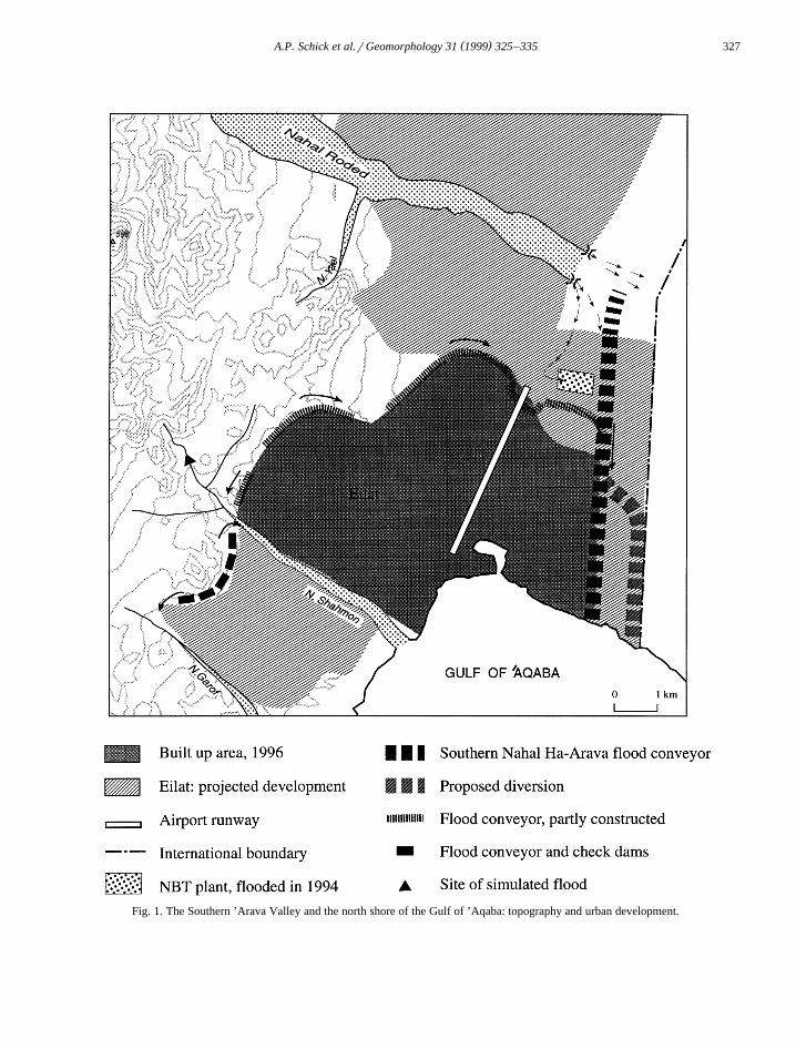
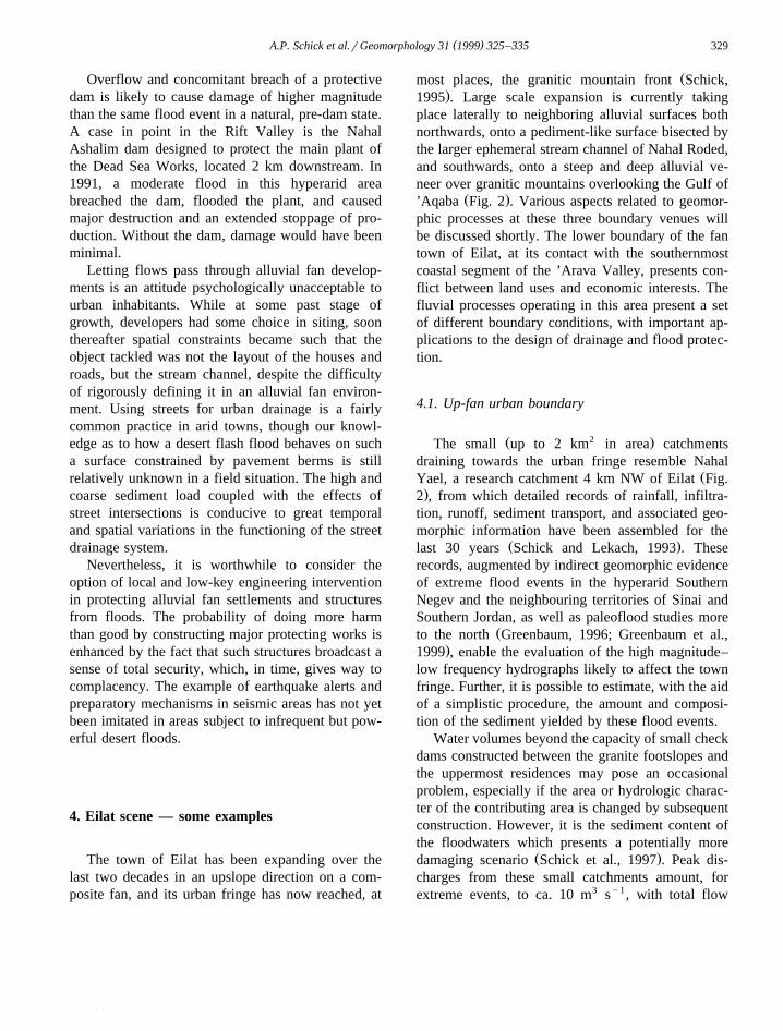
Ž .Valley Fig. 1 , is bordered by steep mountain frontswhich rise to elevations of 800 m.a.s.l. to the westand 2000 m.a.s.l. to the east. The towns of ’Aqabaand Eilat, located astride the Israel–Jordan border onthe shores of the Gulf, provide an opportunity toinvestigate the interplay between physiographic con-straints, engineering intervention, and geomorphicprocesses in this extremely arid environment. Whilethe town of ’Aqaba is dominated by the large allu-
Ž .vial fan of Wadi Yutm Fig. 1 , the town of Eilat islocated on an alluvial fan slope created by coalescingfans draining areas of up to a few square km each,with a few somewhat larger ephemeral streams af-fecting areas to the north and south where the townis currently spreading. We will focus here on Eilat,and most of the type cases cited below will be takenfrom Eilat and its environs.
( )A.P. Schick et al.rGeomorphology 31 1999 325–335 327
Fig. 1. The Southern ’Arava Valley and the north shore of the Gulf of ’Aqaba: topography and urban development.
( )A.P. Schick et al.rGeomorphology 31 1999 325–335328
3. Nature of the problem
ŽAssume a desert town occupies a fraction e.g.,.one-third of the area of an alluvial fan fed by a high
relief catchment 10 times the size of the fan. Clearly,the locality has been experiencing the effects offloods since its establishment — a small one everyfew years, more rarely a large one, and perhaps atruly ‘catastrophic’ flood once in a few decades.Initial adaptation either by accepting the loss or bybetter siting away from the preferred floodpaths asperceived, usually gives way, as the town expands,to a more activist attitude leading to attempts to‘control’ the flooding. Generally, the tools of ‘con-trol’ are the dam, the ditch, and the embankment.These tools may be used in an attempt to isolate thetown completely from flows from the outside, eitherby some form of watershed management, bydamming upstream of the fan apex, or by isolatingthe built-up area from the rest of the fan by a seriesof embankments and ditches. A geomorphic evalua-tion of these two alternatives follows.
Encircling the upslope urban boundary of an allu-vial fan town by a series of embankments and ditchesis designed to divert the floodwaters laterally aroundthe town. It requires a dependable estimate of themaximum probable flood, both in terms of peakdischarge and in terms of total flow, total sedimentyield, and sediment composition. The former is
Žneeded to ascertain the floodway geometry cross-.section and slope , while the latter is needed to
estimate the amount of deposition to be expected atthe junction of the incoming natural channels intothe protecting floodway. The angle at this junction isoften such that much of the bed material transportedby the floodwaters is deposited, raises the bed eleva-tion, and tends to diminish the floodway cross-sec-tion to the point of complete obstruction.
In its upslope parts, an encircling floodway tendsto parallel the natural contours of the fan; hence, itslongitudinal slope is much smaller than that of theoriginal, natural channel. Therefore, considerable cutand fill work is required in order to provide thenecessary slope, incurring considerable cost in land
Ž .andror paving to decrease roughness . Furtherdownstream, the encircling floodway flow directionbecomes more orthogonal to the fan contours, butthere is additional water and sediment input from
neighbouring channels, thus increasing the probabil-ity of obstruction and subsequent ‘jumpout’ of thefloodwaters in the direction of the protected town.
Roads crossing the encircling floodway viabridges, as well as by dipping into the bottom of thefloodway, tend to be a weak link in the protectivesystem. In the first case, the cross-section under thebridge, even if sufficient at first, tends to accumulaterefuse and become smaller in time. In the secondcase, ‘improving’ the descent into the crossing actu-ally provides a better opportunity for the floodwatersto escape from the floodway. In general, mainte-nance of floodways in desert towns proves to bequite difficult to accomplish, especially over yearswithout appreciable flows, so that as a rule, the bigflood should be reckoned to tackle the protectivesystem at a state much below its design capacity.
Catchments upstream of desert towns, especiallyrocky and high relief ones, are not easily given tocontrol by areal measures such as terracing andvegetation stripes because of the arid climate. Theonly viable option seems to be to dam the streamchannel at its outlet from the mountains andror itstributaries at preferred sites further upstream. Thefirst problem encountered when considering this so-lution is the very steep channel slope of the smaller
Žcatchments generally 0.05–0.10 for catchments2 .0.5–5 km in area , which dictates high structures if
the capacity is designed to take care of the maximumprobable flood volume. Sediment accumulated insuch structures not only decreases the capacity overthe years, but also causes the reservoir bottom, espe-cially near the dam, to be less and less permeable,thus increasing the risk of overflow. For all of thesereasons, structures capable of absorbing the excep-tional flash flood are required to be huge, the conse-quent environmental drawbacks result in justificationfor the protection of highly valuable and selectivesites only. They do not provide an acceptable solu-tion in most urban situations.
The required capacity of the protective dammedreservoirs is a cardinal point. In addition to theconstraints of decreasing infiltration and accumulat-ing sediment, man-made changes in the catchmentmust also be considered. Housing development or amajor road built through the dammed catchment maysubstantially alter the hydrogeomorphic parametersused to estimate the size of the required structure.
( )A.P. Schick et al.rGeomorphology 31 1999 325–335 329
Overflow and concomitant breach of a protectivedam is likely to cause damage of higher magnitudethan the same flood event in a natural, pre-dam state.A case in point in the Rift Valley is the NahalAshalim dam designed to protect the main plant ofthe Dead Sea Works, located 2 km downstream. In1991, a moderate flood in this hyperarid areabreached the dam, flooded the plant, and causedmajor destruction and an extended stoppage of pro-duction. Without the dam, damage would have beenminimal.
Letting flows pass through alluvial fan develop-ments is an attitude psychologically unacceptable tourban inhabitants. While at some past stage ofgrowth, developers had some choice in siting, soonthereafter spatial constraints became such that theobject tackled was not the layout of the houses androads, but the stream channel, despite the difficultyof rigorously defining it in an alluvial fan environ-ment. Using streets for urban drainage is a fairlycommon practice in arid towns, though our knowl-edge as to how a desert flash flood behaves on sucha surface constrained by pavement berms is stillrelatively unknown in a field situation. The high andcoarse sediment load coupled with the effects ofstreet intersections is conducive to great temporaland spatial variations in the functioning of the streetdrainage system.
Nevertheless, it is worthwhile to consider theoption of local and low-key engineering interventionin protecting alluvial fan settlements and structuresfrom floods. The probability of doing more harmthan good by constructing major protecting works isenhanced by the fact that such structures broadcast asense of total security, which, in time, gives way tocomplacency. The example of earthquake alerts andpreparatory mechanisms in seismic areas has not yetbeen imitated in areas subject to infrequent but pow-erful desert floods.
4. Eilat scene — some examples
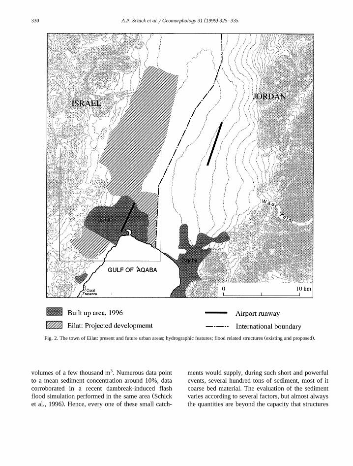
The town of Eilat has been expanding over thelast two decades in an upslope direction on a com-posite fan, and its urban fringe has now reached, at
Žmost places, the granitic mountain front Schick,.1995 . Large scale expansion is currently taking
place laterally to neighboring alluvial surfaces bothnorthwards, onto a pediment-like surface bisected bythe larger ephemeral stream channel of Nahal Roded,and southwards, onto a steep and deep alluvial ve-neer over granitic mountains overlooking the Gulf of
Ž .’Aqaba Fig. 2 . Various aspects related to geomor-phic processes at these three boundary venues willbe discussed shortly. The lower boundary of the fantown of Eilat, at its contact with the southernmostcoastal segment of the ’Arava Valley, presents con-flict between land uses and economic interests. Thefluvial processes operating in this area present a setof different boundary conditions, with important ap-plications to the design of drainage and flood protec-tion.
4.1. Up-fan urban boundary
Ž 2 .The small up to 2 km in area catchmentsdraining towards the urban fringe resemble Nahal
ŽYael, a research catchment 4 km NW of Eilat Fig..2 , from which detailed records of rainfall, infiltra-
tion, runoff, sediment transport, and associated geo-morphic information have been assembled for the
Ž .last 30 years Schick and Lekach, 1993 . Theserecords, augmented by indirect geomorphic evidenceof extreme flood events in the hyperarid SouthernNegev and the neighbouring territories of Sinai andSouthern Jordan, as well as paleoflood studies more
Žto the north Greenbaum, 1996; Greenbaum et al.,.1999 , enable the evaluation of the high magnitude–
low frequency hydrographs likely to affect the townfringe. Further, it is possible to estimate, with the aidof a simplistic procedure, the amount and composi-tion of the sediment yielded by these flood events.
Water volumes beyond the capacity of small checkdams constructed between the granite footslopes andthe uppermost residences may pose an occasionalproblem, especially if the area or hydrologic charac-ter of the contributing area is changed by subsequentconstruction. However, it is the sediment content ofthe floodwaters which presents a potentially more
Ž .damaging scenario Schick et al., 1997 . Peak dis-charges from these small catchments amount, forextreme events, to ca. 10 m3 sy1, with total flow
( )A.P. Schick et al.rGeomorphology 31 1999 325–335330
Ž .Fig. 2. The town of Eilat: present and future urban areas; hydrographic features; flood related structures existing and proposed .
volumes of a few thousand m3. Numerous data pointto a mean sediment concentration around 10%, datacorroborated in a recent dambreak-induced flash
Žflood simulation performed in the same area Schick.et al., 1996 . Hence, every one of these small catch-
ments would supply, during such short and powerfulevents, several hundred tons of sediment, most of itcoarse bed material. The evaluation of the sedimentvaries according to several factors, but almost alwaysthe quantities are beyond the capacity that structures
( )A.P. Schick et al.rGeomorphology 31 1999 325–335 331
such as the circumferential floodways are designedto handle. Large inlets, large scale earthmoving worksto maintain slope, unrealistically wide floodways,and paved stretches of the banks and bed are some ofthe techniques at the disposal of engineers to sur-mount these problems. All of these are expensive,though, and all require careful maintenance over thelong years between big floods.
A preferable method is based upon a record ofhydrologic measurements and associated geomorphicresearch done over the years in the region, primarily
Ž .in the Nahal Yael catchment Schick, 1988 . Incontrast to most methods employed in the engineer-ing profession, which are based on sophisticatedmodels predicting peak discharges or flood volumesfed by few and poor data, we employ a simplisticmodel fully supported by a wide array of relevantdata. We rely on extensive infiltration tests on avariety of terrains, which enable an evaluation ofseveral factors: a finely distributed runoff productionrate; rainfall-correlated runoff hydrographs for catch-ments 0.05–0.5 km2 in area; channel bed infiltrationrates both from ponded water and during an artifi-cially controlled flood; a substantial body of sus-pended sediment samples from desert floodwaters;direct and indirect evaluations of bedload transport;and detailed analyses of the reservoir sedimentationaccumulated in behind the Nahal Yael dam over thelast 18 years.
The simplistic procedure estimates the volumes ofbedload transported by various flood events, whichwe consider the key factor in the adaptation to andprotection from desert floods in this environment.The volume of sediment — both bed material andsuspended sediment — will necessarily depositsomewhere en route, i.e., from the up-fan townboundary to the erosional baselevel below it. Whilenearly all the bed material will be deposited in somecheck dam or floodway conveyor, obstructing thelatter if the volume is sufficiently great relative tothe cross-section, the suspended fraction will tend tocontinue with the floodwaters to intermediate orterminal baselevels. The ponds of the Nature BetaTechnologies plant on the lower margins of the Eilat
Ž .alluvial fan slope below is an illustration of theformer. A massive blanketing of the coral populationalong the Eilat Nature Reserve coast — perhaps withirreversible ecological damage — to be expected as
a result of any high magnitude–low frequency eventin Nahal Garof or Nahal Shahmon, is an illustrationof the latter.
4.2. Lateral urban fringes
The southern additions to the urban area currentlyunder construction are built on land created by thecomplete restructuring of the terrain surface of a4-km2 area of steep, dissected alluvial fan slopes.The drainage is designed to close off the incomingflow from the mountain front by a series of checkdams, small reservoirs, and flood conveyors to oneof the two larger lateral stream channels — NahalShahmon and Nahal Garof — which, according tothe plan, will be ‘regulated’. The internal drainagewill be sewered and piped towards these regulatedcollectors. Due to the high density projected for thedevelopment, the runoff will be high but practicallysediment-free, unless a big flood event occurs beforeconstruction is finished. However, any drainagemishap at any point within the protective devicesupslope may result in the injection of sediment-ladenfloodwaters into the drainage system and its subse-quent clogging and disruption, which will potentiallylead to the breakdown of the entire system.
The two main stream channels drain steeply to-wards the Eilat coast, with the port of Eilat and othermajor installations at their mouths. Although partlyprotected from flood damage by various local de-vices, these installations are at risk in case the fragilesystem contingent upon the new development breaksdown. Furthermore, this southern coast of the townis the venue of the Coral Nature Reserve — thenorthernmost coral colony in the world. The detri-mental effect of a major sediment-laden flash flood,fueled by the large construction and developmentproject upstream, may be long lasting. Previously,due to natural infiltration in the terrain and channelbeds, only a few flows reached the Gulf, probablywith only a small fraction of the sediment loadoriginally carried by these flows when exiting themountains.
4.3. Fan slope toe
The bottom parts of alluvial fans and slopes in thedesert environment are the terminus of all flows that
( )A.P. Schick et al.rGeomorphology 31 1999 325–335332
make it through the intermediate sinks of infiltrationand, possibly, check dams and retarding basins. Priorto construction, the inherent structure of the alluvialfan dictates a degree of indeterminacy as to whereexactly the next flood will exit the fan, and in howmany loci. Construction, even with many flood con-trol devices, tends to increase this indeterminacy.Eilat may be a typical example to illustrate this. Theairport runway — the lifeline of this internationalresort — runs for 3 km along the toe of the fanslope, parallel to its contours, at an elevation just afew meters above the nearby sea level. The maindownslope directed streets of Eilat, originally de-signed also as floodways, are actually aimed at therunway. A protecting ditch functions only for smallflows, which also use some drainage tunnels underthe runway. The latter are almost certain to be filledby sediment during a big event.
The flows are perforce directed to the narrow landisthmus between the southern tip of the runway andthe northwestern head of the Gulf of ’Aqaba, astrategic 150 m stretch of land which accommodatesall traffic between the central business area of thetown and its main hotel and recreation area. Finesediment deposited on the road traversing this stretchis a common occurrence, even from small floods thatleave whatever bed material they may have trans-ported from further upstream.
On a much larger scale, deposition of fines causedthe main damage resulting from the 2 November1994 flood in Nahal Roded. This relatively smallflood was generated by an isolated rain cell whichcovered only a small, upstream part of the catch-ment. The flow that exited the mountains was furtherattenuated by filling extensive gravel quarrying holescovering much of the wide braided channel bed.These holes trapped all the bed material and much ofthe fines. Still, though the peak discharge on the fanwas only 40 m3 sy1, the flow had enough energy tocarry towards the southern sector of the fan, a dis-tance of 2 km, enough suspended material to fill thealgae ponds of Nature Beta Technologies with ca.
3 Ž .40,000 m of sediment Fig. 2 . The diversion of theflow into the plant was the result of unrelated con-struction activities upstream of the flow path: thebreach of a diversion built in conjunction with someroadwork and the construction of an elevated landingground for migrating birds. By the same token, it
may be regarded as a normal reaction of an alluvialfan which, over time, distributes its flow patternsmore or less equally over all of its sectors. Thisgeomorphic indeterminacy tends to persist, irrespec-tive of engineering efforts to subjugate it.
Another facet of the fan toe flooding problem isexemplified by the relation between the Eilat fanslope and Nahal Ha-Arava. Nahal Ha-Arava drainstowards the Gulf of ’Aqaba several catchments ofthe Southern Negev Mountains, extending ca. 50 kmto the north of Eilat. However, its effective drainagearea is, to some extent, indeterminate, as some of theflows are abstracted by two of the playa depressionswithin the rift valley. The effective integration of theentire hydrographic network ascribed to Nahal Ha-Arava is a moot point, except perhaps for the verylargest events. Still, Nahal Ha-Arava has been knownto transmit large discharges, and over the years, itschannel has been ‘regulated’ by widening, streamlin-ing, and creating embankments to protect the Eilathotel area located on its western side. With increas-ing pressure on the land spurred by the boom intourism, plans are under consideration to divert theNahal Ha-Arava channel-cum-floodway several hun-dred meters to the west, to coincide with the Israel–Jordan border. Thereby, the contiguity of the hotelarea will be achieved, but the design presents manyoptions, some strongly constrained by geomorphicfeatures and processes.
The design must consider the input, conveyance,and sediment deposition of floods from three differ-ent sources: local urban drainage, including whatevercomes from the urban alluvial fan slope; the flow ofNahal Ha-Arava; and the impact of floods in thelarge catchment of Wadi Yutm, coming from the
Žmountains of southern Jordan in the east Wolman,.1996 . Flood events from each of these may be
isolated, any two may be active at one time, or allthree may be active simultaneously. The time lagbetween rainfall of these three sources must be con-sidered: for the first it may be an hour less; for thesecond, several hours; and for a Wadi Yutm flood, aday or two. A scenario is possible wherein a flood inNahal Ha-Arava will disrupt its channel and protec-tive devices to such an extent that a large floodcoming from the same synoptic system from WadiYutm will cover the entire open space between’Aqaba and Eilat.
( )A.P. Schick et al.rGeomorphology 31 1999 325–335 333
Flood attenuation in Nahal Ha-Arava might beachieved by having a retaining embankment only onone side of the channel and letting the high dis-charges temporarily spread over the other side. Di-verting the channel to the international boundaryprobably precludes this option, as the envisagedeconomic development of the region will affect’Aqaba as well, and using extensive areas of itswestern margins for floodwater spreading hardlyseems acceptable.
Another consideration related to baselevel con-cerns the substantial tidal differences, augmented bysoutherlies often associated with the Red Sea Trough— a synoptic configuration known to be associatedwith most of the high magnitude storms in the regionŽ .Sharon and Kutiel, 1986 . It may well be that thefloodwaters in the Nahal Ha-AravarGulf of ’Aqabainflow area will be flowing towards a baselevel 1 to2 m higher than the mean sea level, with seriousconsequences for the entire low-lying flat area, in-cluding a dramatic increase of the level of groundwa-ter. Plans underway to extend the Eilat coastline byconstructing one or more additional sealevel‘‘lagoons’’ would bring a more easily accessiblebaselevel closer to the pathways of some of theanticipated flows, a possibility which requires eitherthe acceptance of sedimentation of these recreationallagoons or the construction of massive protectivedevices to prevent the flows from accessing them.
5. ’Aqaba — some observations
The town of ’Aqaba, symmetrically located oppo-Ž .site Eilat at the NE corner of the Gulf Fig. 1 and
somewhat larger in population, presents interestingparallels as well as contrasts to the flooding prob-lems of Eilat as outlined above. The northern part ofthe town is directly affected by the large Wadi Yutm,described below. The central part of the town, in-cluding the port and the main hotel area, occupiesalluvial fan terrain at the outlet of three catchments 6to 10 km2 in size each. The divides of these catch-ments have elevations around 1000 m.a.s.l. on peaks
Ž .ca. 6 km east of the coastline Fig. 1 . The highrelief of the bare granite provides the background forextremely destructive flooding in the downstream
urbanized strip squeezed between the mountain frontand the coast.
Similar to Eilat, but with a larger damage poten-tial due to larger catchments and higher relief, possi-ble engineering solutions are hampered by existingurban and transportation structures. Besides the ur-ban center, which in places leaves little room forfloodway dimensions adequate to convey high mag-nitude–low frequency flash floods, the effects of arailway line built on an elevated embankment skirt-ing the town along its upslope margins play a role.Although drainage openings through this embank-ment are provided, the possible flooding scenarios oflarge sediment-laden floods cum debris flows rush-
Ž .ing down the steep slope 0.06–010 mountain chan-nels are difficult to predict.
The large fan of Wadi Yutm, with its apex locatedat an elevation of 200 m.a.s.l. 8 km north of the towncenter, is without parallel on the western side of theSouthern ’Arava. The southernmost sector of this fandirects its distributaries towards the town. Theseendanger directly a quarter of unplanned, temporarydwellings for which new and safer sites are pro-jected. The 1966 storm, known as the Ma’an flood,was centered north of the Yutm catchment, andyielded in Wadi Yutm several peaks, one of whichreached a discharge of 500 m3 sy1, with reportedfloat velocities of 6 m sy1 and surges up to 12 my1
Ž .Schick, 1971 . The steep overall slope of the fanŽ .0.075 provides opportunities for floodwaters toreach any point along the 8 km circumference of thefan sector, and together with the smaller fan adjoin-ing to the north, creates a flooding hazard to the
Ž .’Aqaba airport with its 3-km long runway Fig. 1 .Much of the fan area between the airport and thenorthern suburbs of ’Aqaba is occupied by a free
Ž .customs zone, whose 2 km long N–S compoundmust likewise be protected from floods. This leavesonly two ‘‘openings’’ several hundred meters wideeach for a natural and relatively safe outlet for futurefloods.
Long dikes and embankments are needed to directfloodwaters emanating from the Yutm away fromnew development quarters constructed beyond thefan toe in the flat ’Arava terrain, which are alreadyclose to the coastal playa located astride the interna-tional border. Both ’Aqaba and Eilat regard thesecoastal saline tracts as valuable for future develop-
( )A.P. Schick et al.rGeomorphology 31 1999 325–335334
ment, particularly for tourist facilities. Hence, along-range and mutually coordinated view in theirflood control planning must be exercised. In at leastthree recorded events — two in the 1940s and one inthe 1960s — extensive flooding of the playa lasting
Ž .a number of days was reported Schick, 1971 .In ’Aqaba as well as in Eilat, underground
stormwater sewers have been recently built or arebeing planned in some developments. While in’Aqaba this has been done on a moderately slopingterrain, in Eilat such a drainage system is about to bebuilt on a steep alluvial fan slope development.Though the non-paved contributing area to both sys-
Ž .tem is not large if protective devices do not fail , thenatural affinity of floodwaters to sediment in aridenvironments is likely to cause clogging of inletsrelatively frequently.
Assuming that ’Aqaba, similarly to Eilat, willspread to the north in the near future, the floodinghazard from the bajada extending along the south-eastern margins of the ’Arava must be consideredbefore such a development takes place. This bajadacomprises many adjoining steep alluvial fans ofvarying sizes and forms, with Wadi Muhtadi, 40 kmnorth of ’Aqaba, large enough to locally raise thelevel of the rift valley to form the playa of Yotvata.The surface of the fans is covered in varying propor-tions with a light gray tone, indicating currentlyactive, mostly spreading out channels. Between thosethere are tan colored areas, suggesting no flooding in
Ž .the recent ;100 years past, and darkly coloredareas composed of patinated pavement which seemto have stayed free of flooding for at least severalhundred years. Occasionally, grey streaks on thedark surfaces testify to ‘overbank’ flows which di-verged from one of the channels during high flow,but did not result in full avulsion. Despite similaritiesof environmental conditions, each fan shows a highdegree of individuality in shape and structure.
The fans extending to the north of ’Aqaba, liketheir counterparts in the west, are partly covered byAcacia trees. These are concentrated in marked pref-erence in certain segments and generally avoid thedark, desert varnish areas. The dependence of theacacia in this environment on surface waters has
Žbeen recently established BenDavid-Novak and.Schick, 1997 . This is a valuable tool in evaluating
flooding probabilities within each fan.
6. Conclusions
The projected development of the arid Southern’Arava requires a detailed, science-based evaluationof the flooding hazard prior to major construction,whose optimal siting is of cardinal importance. Thebuilt-up areas on the fans, which are the only viableterrain types available, are bound to appreciablyaffect the flooding hazard further downstream. Theevaluation of the hazard is not just a matter ofrainfallrrunoff frequencies and catchment areas. Amuch more sophisticated approach, involving theapplication of diverse hydrologic, sedimentologic,geomorphic, and historical procedures to each andevery fan separately, can greatly improve the effi-ciency of the necessary engineering solutions to theflooding problem.
It is important to note that in both ’Aqaba andEilat, the pristine waters of the Gulf of ’Aqabarepresent an enormously valuable resource. Merehastening of sediment-laden floodwaters may not bean appropriate resolution of the potential flood prob-lem in this setting.
Acknowledgements
This study was done within the framework ofresearch grant No. 12-090 of the United States–IsraelBiNational Science Foundation. The assistance ofauthorities dealing with the flooding problem both inEilat and in ’Aqaba and of Yehouda Enzel, QinghongHuang, Jens Lange and Judith Lekach is gratefullyacknowledged.
References
BenDavid-Novak, H., Schick, A.P., 1997. The Response of Aca-cia Tree Populations on Small Alluvial Fans to Changes in theHydrological Regime: Southern Negev Desert, Israel. Catena29, 341–351.
Blair, T.C., McPherson, J.G., 1994. Alluvial fan processes andŽ .forms. In: Abrahams, A.D., Parsons, A.J. Eds. , Geomorphol-
ogy of Desert Environments. Chapman & Hall, London, pp.354–402.
Bull, W.B., 1977. The alluvial fan environment. Prog. Phys.Geogr. 1, 222–270.
Bull, W.B., 1991. Geomorphic Responses to Climate Change.Oxford Univ. Press, Oxford.
French, R.H., 1987. Hydraulic processes on alluvial fans. Devel-opments in Water Science 31.
( )A.P. Schick et al.rGeomorphology 31 1999 325–335 335
Graf, W.L., 1988. Fluvial Processes in Dryland Rivers. Springer,Berlin.
Greenbaum, N., 1996. Paleofloods in the Large Ephemeral StreamSystems of the Negev. PhD Thesis, Hebrew Univ., Jerusalem.
Greenbaum, N., Margalit, A., Schick, A.P., Sharon, D., Baker,V.R., 1999. Reconstruction of a high magnitude rainstorm-flood in Nahal Zin — a large hyperarid catchment in theNegev Desert, Israel. Hydrological Processes 12, 1–23.
National Research Council, USA, 1996. Alluvial Fan Flooding.National Academy Press, Washington, DC.
Rachocki, A., 1981. Alluvial Fans: An Attempt at an EmpiricalApproach. Wiley, New York.
Schick, A.P., 1971. A desert flood: physical characteristics, effectson man, geomorphic significance, human adaptation. JerusalemStudies in Geography 2, 91–155.
Schick, A.P., 1974. Alluvial fans and desert roads — a problem inapplied geomorphology. Abh. Akad. Wiss. Goettingen,Math.–Phys. Kl., III Folge 29, 418–425.
Schick, A.P., 1988. Hydrologic aspects of floods in hyperaridŽ .environments. In: Baker, V.R. Ed. , Flood Geomorphology.
Wiley, New York, pp. 189–203.Schick, A.P. 1995. Fluvial processes on an urbanizing alluvial fan:
Ž .Eilat, Israel. In: Costa, J. Ed. , Natural and AnthropogenicInfluences in Fluvial Geomorphology. Geophys. Monogr. 89,pp. 209–218.
Schick, A.P., Lekach, J. 1993. An evaluation of two ten-yearsediment budgets, Nahal Yael, Israel. Phys. Geog. 14, 225–238.
Schick, A.P., Lekach, J., Grodek, T., Lange, J., Leibundgut, C.,1996. An artificial flash flood in a small arid stream channel,Eilat Mountains, Israel. Suppl. to EOS, F259, Nov. 12, 1996.
Schick, A.P., Grodek, T., Lekach, J., 1997. Sediment managementand flood protection of desert towns: effects of small catch-
Ž .ments. In: Walling, D.E., Probst, J.-L. eds. , Human Impacton Erosion and Sedimentation. Int. Assoc. Hydr. Sci. Publ.245, pp. 183–189.
Sharon, D., Kutiel, H., 1986. The distribution of rainfall intensityin Israel, its regional and seasonal variations, and its climato-logical evaluation. J. Climatol. 6, 277–291.
Wolman, M.G., 1996, Some considerations in selection of thedesign of floodwater drainage for the expanding developmentof the Eilat foreshore. Technical Report submitted to the EilatForeshore Development Company, Israel, May 1996.