Embed Size (px)
Citation preview

APPENDICES
661 Bear Valley Parkway EIR March 2017
Appendix L-3 Additional Phase I ESA (April 2016)

APPENDICES
661 Bear Valley Parkway EIR March 2017
This page intentionally left blank

PHASE I ENVIRONMENTAL SITE ASSESSMENT
661 Bear Valley Parkway Escondido, California 92025
April 19, 2016
Prepared for:
Spieth & Wohlford Inc. PO Box 5005
Rancho Santa Fe, California 92067
Prepared by:
Vinje & Middleton Engineering, Inc. 2450 Auto Park Way
Escondido, California 92029


Phase I Environmental Site Assessment April 19, 2016 661 Bear Valley Parkway, Escondido, California
TABLE OF CONTENTS
1.0 EXECUTIVE SUMMARY ................................................................................................................. 1 1.1 SUMMARY AND FINDINGS .................................................................................................................... 1 1.2 CONCLUSIONS .................................................................................................................................... 2
2.0 INTRODUCTION .............................................................................................................................. 3 2.1 PURPOSE ........................................................................................................................................... 3 2.2 DETAILED SCOPE OF SERVICES .......................................................................................................... 4 2.3 SIGNIFICANT ASSUMPTIONS ................................................................................................................ 5 2.4 LIMITATIONS AND EXCEPTIONS ............................................................................................................ 5 2.5 SPECIAL TERMS AND CONDITIONS ....................................................................................................... 6 2.6 USER RELIANCE ................................................................................................................................. 6
3.0 SITE DESCRIPTION ........................................................................................................................ 7 3.1 LOCATION AND LEGAL DESCRIPTION .................................................................................................... 7 3.2 SITE AND VICINITY GENERAL CHARACTERISTICS .................................................................................. 7 3.3 CURRENT USE OF THE SITE ................................................................................................................ 7 3.4 DESCRIPTION OF STRUCTURES, ROADS, OTHER IMPROVEMENTS ON THE SITE ...................................... 7 3.5 CURRENT USES OF THE ADJOINING PROPERTIES ................................................................................. 7
4.0 USER PROVIDED INFORMATION ................................................................................................. 8 4.1 TITLE RECORDS ................................................................................................................................. 8 4.2 ENVIRONMENTAL LIENS OR ACTIVITY AND USE LIMITATIONS ................................................................. 8 4.3 SPECIALIZED KNOWLEDGE .................................................................................................................. 8 4.4 COMMONLY KNOWN OR REASONABLY ASCERTAINABLE INFORMATION ................................................... 8 4.5 VALUATION REDUCTION FOR ENVIRONMENTAL ISSUES ......................................................................... 8 4.6 OWNER, PROPERTY MANAGER, AND OCCUPANT INFORMATION ............................................................. 8 4.7 REASON FOR PERFORMING PHASE I ESA ............................................................................................ 8 4.8 OTHER ............................................................................................................................................... 8
5.0 RECORDS REVIEW ...................................................................................................................... 11 5.1 STANDARD ENVIRONMENTAL RECORD SOURCES ............................................................................... 11 5.2 ADDITIONAL ENVIRONMENTAL RECORD SOURCES .............................................................................. 14 5.3 PHYSICAL SETTING SOURCES ........................................................................................................... 15 5.3.1 TOPOGRAPHY AND HYDROLOGY ........................................................................................................ 15 5.3.2 GEOLOGY ........................................................................................................................................ 15 5.3.3 HYDROGEOLOGY .............................................................................................................................. 16 5.4 HISTORICAL USE INFORMATION ON THE SUBJECT SITE ....................................................................... 16 5.4.1 STATE OF CALIFORNIA DIVISION OF OIL AND GAS RECORDS ............................................................... 16 5.5 HISTORICAL USE INFORMATION ON ADJOINING PROPERTIES ............................................................... 16 5.5.1 STATE OF CALIFORNIA DIVISION OF OIL AND GAS RECORDS ............................................................... 17
6.0 SITE RECONNAISSANCE ............................................................................................................ 18 6.1 METHODOLOGY AND LIMITING CONDITIONS ........................................................................................ 18 6.2 GENERAL SITE SETTING ................................................................................................................... 18 6.3 SITE OBSERVATIONS ........................................................................................................................ 18
Phase I Environmental Site Assessment April 19, 2016 661 Bear Valley Parkway, Escondido, California
7.0 INTERVIEW INFORMATION ......................................................................................................... 20 7.1. INTERVIEW WITH OWNER .................................................................................................................. 20 7.2 INTERVIEW WITH SITE MANAGER ...................................................................................................... 20 7.3 INTERVIEWS WITH OCCUPANTS ......................................................................................................... 20 7.4 INTERVIEW WITH LOCAL GOVERNMENT OFFICIAL ............................................................................... 20 7.5 INTERVIEW WITH OTHERS ................................................................................................................. 20
8.0 FINDINGS, OPINION AND CONCLUSIONS ................................................................................ 21
9.0 DEVIATIONS AND DATA GAPS .................................................................................................. 22
10.0 ADDITIONAL SERVICES .............................................................................................................. 23
11.0 REFERENCES ............................................................................................................................... 24
12.0 SIGNATURES AND QUALIFICATIONS OF ENVIRONMENTAL PROFESSIONALS ................ 25
13.0 APPENDICES 13.1 VICINITY MAP AND TOPOGRAPHIC MAP 13.2 SITE PLAN 13.3 SITE PHOTOGRAPHS 13.4 REGULATORY DATABASE REPORT 13.5 HISTORICAL RESOURCES

Phase I Environmental Site Assessment April 19, 2016 661 Bear Valley Parkway, Escondido, California
1
1.0 Executive Summary
1.1 Summary and Findings
At the request of the Spieth and Wohlford Inc., Vinje & Middleton Engineering, Inc. (VM) conducted a Phase I Environmental Site Assessment (ESA) in conformance with the scope and limitations of American Society for Testing and Materials (ASTM) Practice E 1527-13 and 40 Code of Federal Regulations (CFR) Part 312, of the property located at 661 Bear Valley Parkway in Escondido, San Diego County, California (hereinafter referred to as “the Site”). The 42.12-acre Site is situated to the east of Bear Valley Parkway, west of Choya Canyon Road, and north of Valley Grove Lane, and is further identified by County of San Diego Assessor's Parcel Numbers (APNs) 237-131-01-00 and -02-00. The Site is currently developed with a single-family home and a detached garage surrounded by vacant land. The Site building was reportedly constructed in 1946. Access to the Site is provided by Bear Valley Parkway to the west. The Site is located in an area of Escondido generally comprised of residential land uses. During our Site reconnaissance, a qualified VM representative walked portions of the Site and walked accessible roadways and pedestrian walkways surrounding the Site to identify recognized environmental conditions that may affect the subject Site. No significant environmental concerns were noted during the Site reconnaissance. Historical resources reviewed during the preparation of this Phase I ESA included aerial photographs, topographic maps, sanborn fire insurance maps, and city directories. An interview with the Site owner representative was also conducted to evaluate the historical uses of the subject Site and nearby properties. According to the interview and the historical resources reviewed, no significant environmental concerns were revealed in connection with the Site. Adjoining and nearby properties have historically been mostly vacant land dating back to the late 1970s. The surrounding area was more fully developed with the current residential structures beginning in the early 1980s. VM reviewed standard regulatory record sources which included Federal, State and local environmental databases provided by Environmental Data Resources (EDR) for information pertaining to documented and/or suspected releases of regulated hazardous substances and/or petroleum products within specified search distances. The Site is not listed on the standard ASTM regulatory databases. The Site is referenced as Spieth and Wohlford Inc. on the non-ASTM HAZNET and San Diego Co. HMMD databases. The Site is listed on the HAZNET database for the generation of an aqueous solution with total organic residues less than 10 percent. The Site is listed on the San Diego Co. HMMD database with an inactive regulatory status. There are no spills or releases referenced for the Site. Several properties in the Site vicinity also appear on various regulatory databases, but are not considered to be significant concerns to the Site. A summary of prior environmental assessments (Phase I and II ESA) and a soil removal action of lead impacted soil (undocumented fill material) are described in Section 4.8 of this report. No further assessment or mitigation at the Site is recommended.

Phase I Environmental Site Assessment April 19, 2016 661 Bear Valley Parkway, Escondido, California
2
1.2 Conclusions
This Phase I ESA has revealed no evidence of recognized environmental conditions in connection with the Site. Additional environmental investigation at the Site is not warranted at this time. This summary is provided for convenience and should not be substituted for review of the full report, including all attachments as provided herein.
Phase I Environmental Site Assessment April 19, 2016 661 Bear Valley Parkway, Escondido, California
3
2.0 Introduction
2.1 Purpose
The purpose of this Phase I ESA is to provide a professional opinion on the presence of recognized environmental conditions and other suspect environmental conditions in connection with the Site, as they existed on the date of the site inspection, and to recommend whether further investigation is required. ASTM Standard Practice E 1527-13, Standard Practice for Environmental Site Assessments: Phase I Environmental Site Assessment Process, specifies minimum requirements for conducting an ESA of a parcel of commercial real estate with respect to the range of contaminants pertinent to the scope of the Comprehensive Environmental Response, Compensation and Liability Act (CERCLA), as well as petroleum products. As such, this ESA is intended to satisfy one of the threshold criteria for satisfying the landowner liability protections to CERCLA liability assuming compliance with other elements of the defense. In other words, this ESA represents one of the practices that constitute “all appropriate inquiry” into the previous ownership and uses of the property consistent with good commercial or customary practice, as defined in 42 USC Section 9601(35)(B) and 40 CFR Part 312. The goal of the process is to identify recognized environmental conditions, which are defined by the Practice as “the presence or likely presence of any hazardous substances or petroleum products in, on, or at a property: 1) due to any release to the environment; 2) under conditions indicative of a release to the environment; or 3) under conditions that pose a material threat of a future release to the environment. The term recognized environmental condition includes hazardous substances or petroleum products even under conditions in compliance with laws. In addition, the term also included historical recognized environmental conditions and controlled recognized environmental conditions. A historical recognized environmental condition is defined by the Practice as “a past release of hazardous substances or petroleum products that has occurred in connection with a property and has been addressed to the satisfaction of the applicable regulatory authority or meeting unrestricted use criteria established by a regulatory authority, without subjecting the property to any required controls (for example, property use restrictions, activity and use limitations, institutional controls, or engineering controls).” A controlled recognized environmental condition is defined by the Practice as “a recognized environmental condition resulting from a past release of hazardous substances or petroleum products that has been addressed to the satisfaction of the applicable regulatory authority (for example, as evidenced by the issuance of a no further action letter or equivalent, or meeting risk-based criteria established by regulatory authority), with hazardous substances or petroleum products allowed to remain in place subject to the implementation of required controls (for example, property use restrictions, activity and use limitations, institutional controls, or engineering controls).” The term recognized environmental condition is not intended to include de minimis conditions that generally do not present a material risk of harm to public health or the environment and that generally would not be the subject of an enforcement action if brought to the attention of appropriate governmental agencies. The term "environment" is defined in CERCLA 42 USC 9601(8) as "(A) the navigable waters, the water of the contiguous zone, and the ocean waters of which the natural resources are under the exclusive management authority of the United States under the Magnuson-Stevens Fishery conservation and Management Act, and (B) any other surface water, ground water, drinking water supply, land surface or subsurface strata, or ambient air within the United States or under the jurisdiction of the United States.

Phase I Environmental Site Assessment April 19, 2016 661 Bear Valley Parkway, Escondido, California
4
The term “release” means any spilling, leaking, pumping, pouring, emitting, emptying, discharging, injecting, escaping, leaching, dumping, or disposing into the environment (including the abandonment or discarding of barrels, containers, and other closed receptacles containing any hazardous substance or pollutant or contaminant), but excludes (A) any release which results in exposure to persons solely within a workplace, with respect to a claim which such persons may assert against the employer of such persons, (B) emissions from the engine exhaust of a motor vehicle, rolling stock, aircraft, vessel, or pipeline pumping station engine, (C) release of source, byproduct, or special nuclear material from a nuclear incident, as those terms are defined in the Atomic Energy Act of 1954 [42 U.S.C. 2011 et seq.], if such release is subject to requirements with respect to financial protection established by the Nuclear Regulatory Commission under section 170 of such Act [42 U.S.C. 2210], or, for the purposes of 42 USC 9604 or any other response action, any release of source byproduct, or special nuclear material from any processing site designated under section 7912(a)(1) or 7942(a) of this title, and (D) the normal application of fertilizer.
2.2 Detailed Scope of Services
The Phase I ESA was conducted in accordance with generally accepted Phase I industry standards using ASTM Standard Practice E 1527-13, 40 CFR Part 312 and VM’s Agreement by and between VM and the client. The following services were provided for this assessment:
A search for environmental liens recorded against the Site.
An evaluation of standard environmental record sources contained within Federal, State and local environmental databases within specific search distances.
An evaluation of additional environmental record sources obtained from local regulatory departments/agencies including the County of San Diego Department of Environmental Health (DEH).
A qualitative evaluation of the physical characteristics of the Site through a review of
published topographic, geologic, and hydrogeologic maps; published groundwater data; and area observations to characterize surface water flow in the Site area.
An evaluation of past Site and adjacent/nearby property uses through a review of historical resources including aerial photographs, topographic maps and city directories.
A physical inspection of the Site (interior and exterior) conducted to search for conditions indicative of potential environmental concerns including underground storage tanks (USTs), aboveground storage tanks (ASTs), associated tank piping; stained soil or pavement, equipment that may contain or have historically contained polychlorinated biphenyls (PCBs), and other potential environmental concerns as defined in the ASTM-2013 standard.
A physical assessment of indications of past uses and visual observations of adjacent and surrounding properties (from curbside or public spaces) to assess potential impacts to the Site.
Interviews completed with the client, the Site owner(s) and local regulatory officials.

Phase I Environmental Site Assessment April 19, 2016 661 Bear Valley Parkway, Escondido, California
5
The preparation of this report, which includes the findings of the assessment, our opinion (i.e., conclusions) regarding their respective levels of significance, and recommendations, as appropriate.
2.3 Significant Assumptions
This Phase I ESA was conducted in accordance with ASTM guidelines and the terms and conditions of the aforementioned Agreement between VM and the client. No other warranty, express or implied, is made by VM. VM’s evaluations, analyses, and opinions should not be taken as representations regarding subsurface conditions or the actual value of the Site. Subsurface conditions may differ from the conditions implied by the surficial observations and the data resources reviewed, and can only be reliably evaluated through intrusive techniques. Documentation and data provided by the client, designated representatives of the client, other interested third parties, or from the public domain, and referred to in the preparation of this assessment, are assumed to be complete and correct and have been used and referenced with the understanding that VM assumes no responsibility or liability for their accuracy. VM’s conclusions are based upon such information and documentation and on our observations of Site conditions, as they existed on the date of the site inspection. Because Site conditions may change significantly over a short period of time and additional data may become available, data reported and conclusions drawn in this report are limited to current conditions and should be considered less reliable with passing time.
2.4 Limitations and Exceptions
Reasonable efforts have been made during this assessment to uncover evidence of USTs, ASTs, ancillary equipment associated with such tanks, and other subsurface structures. “Reasonable efforts” are limited to information gained from visual observation of unobstructed areas, recorded database information held in public record, and available information gathered from interviews. Such methods may not identify subsurface equipment that may have been hidden from view due to paving, construction or debris pile storage, or incorrect information from sources. This investigation was not an environmental compliance audit. While some observations and discussion in this report may address conditions and/or operations that may be regulated, the regulatory compliance of those conditions and/or operations is outside the scope of this investigation. Nothing in this report constitutes a legal opinion or legal advice. For information regarding specific individual or organizational liability, VM recommends consultation with independent legal counsel. According to 40 CFR Part 312, Standards and Practices for All Appropriate Inquiry: Final Rule, CERCLA liability rests with the owner or operator of a property and not with an environmental professional hired by the prospective landowner and who is not involved with the ownership or operation of the property. This report meets the requirements set forth in 40 CFR Part 312 Standards and Practices for All Appropriate Inquiries; Final Rule. However, in order to qualify for certain landowner liability protections under CERCLA, “Bona Fide Prospective Purchasers, Contiguous Property Owners, and/or Innocent Landowners” must meet additional requirements of CERCLA (42 U.S.C. 9601 (35)(B)). This ESA does not address non-scope ASTM considerations including asbestos containing materials, radon, lead-based paint, lead in drinking water, wetlands, protected environments and

Phase I Environmental Site Assessment April 19, 2016 661 Bear Valley Parkway, Escondido, California
6
habitat, industrial hygiene concerns, indoor air quality (unrelated to releases of hazardous substances or petroleum products into the environment) and high voltage power lines.
2.5 Special Terms and Conditions
No special terms and conditions between VM pertinent to the findings of this ESA or methodology used to complete this assessment are noted. In addition, VM does not have a financial interest in the Site.
2.6 User Reliance
This report was prepared for the sole and exclusive use of the client and its financing partners for this project and is not for the use or benefit of, nor may it be relied upon by, any other person or entity for any purpose without the advance written consent of VM and the client. VM makes no representation to any third party except that it has used the degree of care and skill ordinarily exercised by a reasonable prudent environmental professional in the same community and in the same time frame given the same or similar facts and circumstances. No other use or disclosure is intended or authorized by VM. In the preparation of this ESA, VM has used the degree of care and skill ordinarily exercised by a reasonably prudent environmental professional in the same community and in the same time frame given the same or similar facts and circumstances. No other warranties are made, express or implied.
Phase I Environmental Site Assessment April 19, 2016 661 Bear Valley Parkway, Escondido, California
7
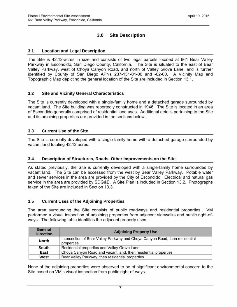
3.0 Site Description
3.1 Location and Legal Description
The Site is 42.12-acres in size and consists of two legal parcels located at 661 Bear Valley Parkway in Escondido, San Diego County, California. The Site is situated to the east of Bear Valley Parkway, west of Choya Canyon Road, and north of Valley Grove Lane, and is further identified by County of San Diego APNs 237-131-01-00 and -02-00. A Vicinity Map and Topographic Map depicting the general location of the Site are included in Section 13.1.
3.2 Site and Vicinity General Characteristics
The Site is currently developed with a single-family home and a detached garage surrounded by vacant land. The Site building was reportedly constructed in 1946. The Site is located in an area of Escondido generally comprised of residential land uses. Additional details pertaining to the Site and its adjoining properties are provided in the sections below.
3.3 Current Use of the Site
The Site is currently developed with a single-family home with a detached garage surrounded by vacant land totaling 42.12 acres.
3.4 Description of Structures, Roads, Other Improvements on the Site
As stated previously, the Site is currently developed with a single-family home surrounded by vacant land. The Site can be accessed from the west by Bear Valley Parkway. Potable water and sewer services in the area are provided by the City of Escondido. Electrical and natural gas service in the area are provided by SDG&E. A Site Plan is included in Section 13.2. Photographs taken of the Site are included in Section 13.3.
3.5 Current Uses of the Adjoining Properties
The area surrounding the Site consists of public roadways and residential properties. VM performed a visual inspection of adjoining properties from adjacent sidewalks and public right-of-ways. The following table identifies the adjacent property uses:
General Direction Adjoining Property Use
North Intersection of Bear Valley Parkway and Choya Canyon Road, then residential properties
South Residential properties and Valley Grove Lane East Choya Canyon Road and vacant land, then residential properties West Bear Valley Parkway, then residential properties
None of the adjoining properties were observed to be of significant environmental concern to the Site based on VM’s visual inspection from public right-of-ways.
Phase I Environmental Site Assessment April 19, 2016 661 Bear Valley Parkway, Escondido, California
8
4.0 User Provided Information
4.1 Title Records
No environmentally related liens, deed restrictions or activity and use limitations pertaining to the Site were noted during research completed with the County of San Diego Tax Assessor and a review of a title report pertaining to the Site provided by the client. In addition, the client is unaware of such encumbrances recorded against the Site.
4.2 Environmental Liens or Activity and Use Limitations
The client reportedly has no knowledge of any environmental related liens or activity and use limitations (i.e. engineering or institutional controls) that are related to potential environmental issues at the Site.
4.3 Specialized Knowledge
The client is unaware of specialized knowledge pertinent to potential recognized environmental conditions at the Site.
4.4 Commonly Known or Reasonably Ascertainable Information
The client is unaware of commonly known or reasonably ascertainable information pertinent to potential recognized environmental conditions at the Site.
4.5 Valuation Reduction for Environmental Issues
As of the date of this report, the client reportedly has no information pertaining to the estimated fair market value of the property that might indicate that significant contamination exists.
4.6 Owner, Property Manager, and Occupant Information
The Site is currently vested in the Spieth and Wohlford Inc. This entity is also considered the Site manager. The Site is currently developed with a single-family home surrounded by vacant land.
4.7 Reason for Performing Phase I ESA
VM, as an independent consultancy, has been retained to conduct this Phase I ESA to identify environmental issues that may be present and to comply with 40 CFR Part 312.
4.8 Other
The client provided AEC with multiple environmental reports pertaining to the Site which is summarized below.

Phase I Environmental Site Assessment April 19, 2016 661 Bear Valley Parkway, Escondido, California
9
Phase I Environmental Site Assessment, 661 Bear Valley Parkway, Escondido, California, Assessor’s Parcel Numbers 237-131-01 & -02, prepared by Vinje & Middleton Engineering, dated February 14, 2013. Due to the historical use of the property for agricultural purposes, a Phase II ESA was recommended. Limited Phase II Environmental Site Assessment, 661 Bear Valley Parkway, Escondido, California, Assessor’s Parcel Numbers 237-131-01 & -02, prepared by Vinje & Middleton Engineering, dated May 24, 2013. Due to the Site’s historical uses as a potential mine near the turn of the 20th century and as a citrus and avocado grove between the years 1947 and 1998, a limited Phase II Site Assessment was conducted by VM. Soil sampling and analysis was conducted during the Phase II ESA of the overall 42 acre Site (28 sample locations). Organochlorine pesticides (OCPs) were the primary target analytes of potential concern and were not detected at or above the analytical laboratory reporting limits. In addition, what were considered to be minor concentrations of the metals arsenic and/or mercury were detected in three soil samples. In addition, minor concentrations of petroleum hydrocarbons were detected in two soil samples. The concentrations of such constituents were below actionable levels relative to a proposed residential land use. As such, no additional assessment was recommended. In addition, no mitigation of Site soils was recommended. Report of Soil Removal Action, 661 Bear Valley Road, Escondido, California, prepared by Vinje & Middleton Engineering, dated July 21, 2015. As a result of a project approval related comment from the City of Escondido regarding apparent undocumented fill soils along the northeastern edge of the Site, VM collected soil samples from this area. A summary of the work completed is as follows:
On April 9, 2015, an initial two soil borings were advanced using a hand auger (identified as B1 and B2) to a depth of eighteen inches below existing grades in an area of debris laden fill material at the Site. VM field personnel placed the soil samples in to analytical laboratory provided four ounce glass jars. Soil samples were then placed on ice at the time of collection and during delivery to the analytical laboratory. The samples were analyzed for total petroleum hydrocarbons (TPH) in the gasoline, diesel and oil ranges by United States Environmental Agency (EPA) test Method 8015B by Baseline On-Site Analysis, a State-certified environmental laboratory located in Huntington Beach, California. The samples were also analyzed for OCPs by United States EPA test Method 8081A, Title 22 Metals by United States EPA test methods 6010B/7000CAM, and SVOCs by United States EPA test method 8270C by American Environmental Testing Laboratory Inc., a State-certified environmental laboratory located in Burbank, California.
On May 7, 2015, an additional fifteen soil borings (identified as B3 through B17) were
advanced by hand auger to depths of eighteen inches below existing grades and sampled. The fifteen soil samples were analyzed for total lead by United States EPA test method 6010B.
Based on the results of the sampling events described above, an area of lead impacted
soil was delineated (approximately 15-feet long x 5-feet wide) and removed from the face of the slope of fill material on June 12, 2015. The material was then stockpiled on-Site pending waste characterization. Upon removal, four confirmation soil samples identified

Phase I Environmental Site Assessment April 19, 2016 661 Bear Valley Parkway, Escondido, California
10
as B18 through B21 were obtained from the soil removal action area and analyzed for total lead. Four stockpile soil samples identified as S1 through S4 were obtained and analyzed for total lead, soluble lead, TPH and/or Title 22 Metals.
The stockpiled material was covered with plastic sheeting pending removal from the Site.
A total of 15.73 tons (approximately 10 cubic yards) of lead impacted soil was transported to Philadelphia Recycling Mine in Mira Loma, California on July 6, 2015 for disposal as a non-hazardous waste.
Conclusions and recommendations of the report were as follows:
The soil sampling and analysis completed at the Site allowed VM to delineate an area of impacted soil containing lead that was subsequently removed from the Site.
A total of 15.73 tons (approximately 10 cubic yards) of lead impacted soil was transported
to Philadelphia Recycling Mine in Mira Loma, California on July 6, 2015 for disposal as a non-hazardous waste.
Confirmation soil samples revealed total lead concentrations below the residential
screening level.
No other contaminants of concern were identified at the Site.
No further assessment or soil removal actions at the Site are considered to be warranted.

Phase I Environmental Site Assessment April 19, 2016 661 Bear Valley Parkway, Escondido, California
11
5.0 Records Review
5.1 Standard Environmental Record Sources
VM reviewed Federal and State environmental databases provided by Environmental Data Resources, Inc. (EDR) of Shelton, Connecticut for information pertaining to documented and/or suspected releases of regulated hazardous substances and/or petroleum products within specified search distances. A copy of the EDR report is included in Section 13.4. VM also reviewed unmappable sites listed in the environmental database report by cross-referencing addresses and site names. Unmappable sites are sites that cannot be plotted with confidence, but can be located by zip code or city name. In general, a site cannot be mapped because of inaccurate or missing location information in the record provided by the regulatory agency. Any unmappable sites that VM identifies within the specified search radii were evaluated as part of the preparation of this report. The following Federal databases related to potential on-site and off-site sources of contamination were reviewed and interpreted by VM:
Federal Databases Search Distance From Site
National Priorities List (NPL) One mile Delisted NPL One mile
Comprehensive Environmental Response, Compensation and Liability Information System (CERCLIS) One-half mile
CERCLIS No Further Remedial Action Planned (NFRAP) One-half mile Resource Conservation and Recovery Act (RCRA) CORRACTS
Hazardous Waste Treatment, Storage and Disposal (TSD) Facilities
One mile
Resource Conservation and Recovery Act (RCRA) NON-CORRACTS Hazardous Waste TSD Facilities One-half mile
RCRA Hazardous Waste Generators (RCRA GEN) One-eighth mile Emergency Response Notification System (ERNS) One-eighth mile
Facility Index Systems (FINDS) One-eighth mile Federal Institutional/Engineering Control Registries (IC/EC) One-half mile
The following State/local databases related to potential on-site and off-site sources of contamination were also searched and reviewed:
State/Local Databases Search Distance From
Site State Equivalent NPL and CERCLIS (RESPONSE and Envirostor) One mile
State Voluntary Cleanup Sites (VCP) One-half mile State/Local Brownfield Sites and Institutional/Engineering Control
Registries One-half mile
Inactive, Active, and/or Permitted Solid Waste/Landfill Facilities (SWL) One-half mile
Leaking Underground Storage Tanks (LUST) One-half mile Spills, Leaks, Investigations and cleanup (SLIC) One-half mile
Registered Underground and Aboveground Storage Tanks (UST/AST) One-eighth mile
San Diego County DEH Site Assessment and Mitigation (SAM) One-half mile

Phase I Environmental Site Assessment April 19, 2016 661 Bear Valley Parkway, Escondido, California
12
Descriptions/sources of each of the above referenced regulatory databases and the dates these databases were last updated by the applicable regulatory agencies are included in the EDR report. Subject Site The Site is not listed on any of the standard databases searched by EDR. Adjoining and Nearby Properties One listing was identified in the standard regulatory databases mapped within a one-mile of the subject Site. The following table presents a summary of the listed property and an opinion regarding the potential impact to the Site.
Listed Property and
Address Database(s)
Mapped Distance
and Direction From Site
Details Significant Concern To Site?
Brotherton Plaza
2250 S Escondido Boulevard
ENVIROSTOR 0.721-mile WSW
Referenced with a “Refer: 1248 Local Agency” status as of March 2001. No
As shown in the table above, the property mapped within a one-mile radius of the Site is not considered to be of significant environmental concern to the Site. This opinion is based on several factors including the nature of the regulatory database listing, distance of the off-Site listed property from the Site, orientation of the listed property relative to the Site, interpreted direction of groundwater flow, and/or regulatory case status information for the property as described in the database. Non-ASTM Database Reviews Below is a list of non-ASTM databases searched by EDR and reviewed by VM during the preparation of this assessment. The descriptions of each database and their data release frequency are included in the EDR report, included in Section 13.4. Local Brownfield Lists US BROWNFIELDS - A Listing of Brownfields Sites Local Lists of Landfill / Solid Waste Disposal Sites DEBRIS REGION 9 - Torres Martinez Reservation Illegal Dump Site Locations ODI - Open Dump Inventory WMUDS/SWAT - Waste Management Unit Database SWRCY - Recycler Database HAULERS - Registered Waste Tire Haulers Listing Local Lists of Hazardous Waste / Contaminated Sites US CDL - Clandestine Drug Labs HIST Cal-Sites - Historical Calsites Database

Phase I Environmental Site Assessment April 19, 2016 661 Bear Valley Parkway, Escondido, California
13
SCH - School Property Evaluation Program Toxic Pits - Toxic Pits Cleanup Act Sites CDL - Clandestine Drug Labs US HIST CDL - National Clandestine Laboratory Register San Diego Co. HMMD Local Lists of Registered Storage Tanks SWEEPS UST – SWEEPS UST Listing HIST UST – Hazardous Substance Storage Container Database CA FID UST – Facility Inventory Database Local Land Records LIENS 2 - CERCLA Lien Information LIENS - Environmental Liens Listing DEED - Deed Restriction Listing Records of Emergency Release Reports HMIRS - Hazardous Materials Information Reporting System CHMIRS - California Hazardous Material Incident Report System LDS - Land Disposal Sites Listing MCS - Military Cleanup Sites Listing SPILLS 90 – SPILLS 90 data from FirstSearch Other Ascertainable Records RCRA-NonGen - RCRA - Non Generators DOT OPS - Incident and Accident Data DOD - Department of Defense Sites FUDS - Formerly Used Defense Sites CONSENT - Superfund (CERCLA) Consent Decrees ROD - Records Of Decision UMTRA - Uranium Mill Tailings Sites MINES - Mines Master Index File TRIS - Toxic Chemical Release Inventory System TSCA - Toxic Substances Control Act FTTS – FIFRA/TSCA Tracking System – FIFRA (Federal Insecticide, Fungicide, & Rodenticide Act)/TSCA (Toxic Substances Control Act) HIST FTTS - FIFRA/TSCA Tracking System Administrative Case Listing SSTS - Section 7 Tracking Systems ICIS - Integrated Compliance Information System PADS - PCB Activity Database System MLTS - Material Licensing Tracking System RADINFO - Radiation Information Database FINDS - Facility Index System/Facility Registry System RAATS - RCRA Administrative Action Tracking System RMP - Risk Management Plans CA BOND EXP. PLAN - Bond Expenditure Plan UIC - UIC Listing NPDES - NPDES Permits Listing Cortese - "Cortese" Hazardous Waste & Substances Sites List HIST CORTESE - Hazardous Waste & Substance Site List CUPA Listings - CUPA Resources List Notify 65 - Proposition 65 Records

Phase I Environmental Site Assessment April 19, 2016 661 Bear Valley Parkway, Escondido, California
14
DRYCLEANERS - Cleaner Facilities WIP - Well Investigation Program Case List ENF - Enforcement Action List HAZNET - Facility and Manifest Data EMI - Emissions Inventory Data INDIAN RESERV - Indian Reservations SCRD DRYCLEANERS - State Coalition for Remediation of Drycleaners Listing MWMP - Medical Waste Management Program Listing COAL ASDH DOE – Sleam Electric Plan Operation Data Listing COAL ASH EPA – Coal Combustion Residues Surface Impoundments List HWT - Registered Hazardous Waste Transporter Database HWP - Envirostor Permitted Facilities List FINANCIAL ASSURANCE - Financial Assurance Information Listing LEAD SMELTERS - Lead Smelter Sites 2020 COR ACTION - 2020 Corrective Action Program List US AIRS - Aerometric Information Retrieval System Facility Subsystem PRP - Potentially Responsible Parties WDS - Waste Discharge System EPA WATCH LIST - EPA WATCH LIST US FIN ASSUR - Financial Assurance Information PCB TRANSFORMER - PCB Transformer Registration Database PROC - Certified Processors Database FUSRAP - Formerly Utilized Sites Remedial Action Program US MINES – Mines Master Index File PEST LIC – Pesticide Regulation Licenses Listing WASTEWATER PITS – Oil Wastewater Pits Listing ECHO – Enforcement and Compliance History Information FUELS PROGRAM – EPA Fuels Program Registered Listing The Site is referenced as Spieth and Wohlford Inc. on the non-ASTM HAZNET and San Diego Co. HMMD databases. The Site is listed on the HAZNET database for the generation of an aqueous solution with total organic residues less than 10 percent. The Site is listed on the San Diego Co. HMMD database with an inactive regulatory status. There are no spills or releases referenced for the Site. One off-Site property mapped within one-eighth mile of the Site is listed on the CHMIRS non-ASTM regulatory databases searched by EDR. This non-ASTM database listing is not expected to have adversely impacted the Site. This opinion is based on several factors including the nature of the regulatory database listing, distance of the off-Site listed property from the Site, orientation of the listed property relative to the Site, interpreted direction of groundwater flow and/or regulatory case status information for the property as described in the database.
5.2 Additional Environmental Record Sources
State Water Resources Control Board (SWRCB) VM searched the California State Water Resources Control Board (SWRCB) maintained Geotracker database for information regarding past or present environmental regulatory cases and/or hazardous material releases in connection with the Site or its adjacent and nearby properties. No environmental regulatory or release cases for the Site were identified in the Geotracker database search. Information included in the SWRCB Geotracker database regarding

Phase I Environmental Site Assessment April 19, 2016 661 Bear Valley Parkway, Escondido, California
15
the nearby properties is consistent with the information found in the EDR regulatory database report. San Diego County Department of Environmental Health (DEH) San Diego County DEH records were searched for the Site. Records pertaining to the Site were not found in DEH files. No other records searches with local or State regulatory agencies were deemed warranted.
5.3 Physical Setting Sources
The following physical setting sources were reviewed to provide information about the topographic, hydrologic, geologic and/or hydrogeologic characteristics of the Site.
5.3.1 Topography and Hydrology
USGS Topographic Quadrangle The Site is depicted on the 2015 USGS topographic map for the Escondido, California 7.5 minute quadrangle, which ranges in elevation of approximately 570 to 650 feet above mean sea level. No features of environmental concern are noted on the map.
Hydrology/Storm Water Management The Site slopes to the southwest towards an unnamed creek. The Site does not appear to receive significant drainage from off-Site properties.
5.3.2 Geology
The Site lies within the coastal section of the Peninsular Ranges Geomorphic Province; one of 11 physiographic provinces in California recognized by defining features based on geology, faults, topography, and climate. The Peninsular Ranges Province is dominated by a series of northwest-oriented mountain ranges extending from the Baja California peninsula in the south to the Transverse Ranges in the north. The series of mountain ranges are separated by northwest trending valleys, subparallel to faults branching from the San Andreas Fault System. Igneous, metamorphic, and sedimentary rocks are all found within the Peninsular Ranges Province. Plutonic (igneous) rocks of the Peninsular Ranges batholith are predominant throughout much of the Province. The batholithic rocks were emplaced during Cretaceous-age orogenic events, and uplifted into the present mountain ranges during the late Tertiary and Quaternary. The coastal section of the Province is underlain by a thick sequence of marine- and terrestrial-derived sedimentary rock units that unconformably overlie basement rocks. Nearly flat marine terraces lie at different elevations throughout the coastal section of the Province as a result of sea floor erosion during marine standstills and subsequent Quaternary faulting and uplift. According to geologic map sources, the Site is underlain at depth by old paralic deposits that is mostly poorly sorted, moderately permeable, reddish-brown, interfingered strandline, beach, estuarine and colluvial deposits composed of siltstone, sandstone and conglomerate (CGS 2010). The Site, as is all of Southern California, is an active seismic area. However, no faults appear to be mapped across the Site.

Phase I Environmental Site Assessment April 19, 2016 661 Bear Valley Parkway, Escondido, California
16
5.3.3 Hydrogeology
The Site is situated within the Hodges Hydrologic Area of the San Dieguito Hydrologic Unit. Groundwater in the Hodges Hydrologic Area has existing beneficial use designations for municipal, agricultural, and industrial supply purposes. Static groundwater beneath the Site is likely present at a depth of greater than 20 feet below the ground surface with an estimated flow direction toward the southwest.
5.4 Historical Use Information on the Subject Site
VM reviewed several historical sources (as described in the following sections) to develop a history of the previous uses of the Site, in order to help identify the likelihood of past uses having led to recognized environmental conditions in connection with the Site. Copies of historical resources are included in Section 13.5. Aerial Photographs VM reviewed historical aerial photographs from the years 1947, 1953, 1964, 1968, 1980, 1989, 1995, 2002, 2009 and 2012 via online resources. In the aerial photographs from 1947 through 1989, the Site appears to be developed as a citrus and avocado grove and with the single-family home. In the photographs from 1995 through 2012, the Site appears to be in its current configuration as a residence and vacant land. Topographic Maps VM reviewed historical topographic maps from the years 1893, 1897, 1901, 1906, 1921, 1929, 1937, 1946, 1949, 1958, 1963, 1970, 1971, 1988 and 2001 via online resources. The Site is depicted with a structure on the northern portion on the topographic maps from 1949 through 2001. Historic Fire Insurance Maps VM requested Sanborn maps from EDR for the Site. EDR indicated that the area is unmapped and Sanborn map coverage is not available for the Site. City Directories VM reviewed city directories from 1971 to 2006 provided by EDR. The Site is listed as residential properties (i.e. personal names) in all of the directories.
5.4.1 State of California Division of Oil and Gas Records
According to online resources provided by the California Department of Conservation, Division of Oil, Gas and Geothermal Resources, there are no oil, gas or geothermal wells located on the Site.
5.5 Historical Use Information on Adjoining Properties
VM also reviewed several historical sources (as described in the following sections) to develop a history of the previous uses of adjoining properties and the surrounding area, in order to help identify the likelihood of past uses having led to recognized environmental conditions in connection with the Site.

Phase I Environmental Site Assessment April 19, 2016 661 Bear Valley Parkway, Escondido, California
17
Aerial Photographs As stated previously, VM reviewed historical aerial photographs from the years 1947, 1953, 1964, 1968, 1980, 1989, 1995, 2002, 2009 and 2012 via online resources. In the aerial photographs from 1947 to 1968, the surrounding area is comprised of mostly citrus and avocado groves. Residential properties begin to develop in the 1980 aerial photograph. Bear Valley Parkway is shown in its current configuration in the 1980 aerial photograph. The adjacent properties appear in their current configurations in the 2002 through the 2012 aerial photographs. Topographic Maps VM reviewed historical topographic maps from the years 1893, 1897, 1901, 1906, 1921, 1929, 1937, 1946, 1949, 1958, 1963, 1970, 1971, 1988 and 2001 via online resources. The surrounding area is depicted as vacant and undeveloped on the maps reviewed from 1893 to 1963. The surrounding area is depicted with scattered structures on the maps reviewed from 1970 to 2001. Bear Valley Parkway is in its current configuration on the maps reviewed from 1978 to 2001. The surrounding area is shaded red (indicating urban development) on the map reviewed from 2000. Historic Fire Insurance Maps VM requested Sanborn maps from EDR for the Site. EDR indicated that the area was unmapped and did not have Sanborn map coverage. City Directories VM reviewed city directories from 1971 to 2013 provided by EDR. The adjoining properties are listed as residential properties in all directories reviewed.
5.5.1 State of California Division of Oil and Gas Records
According to online resources provided by the California Department of Conservation, Division of Oil, Gas and Geothermal Resources, there are no oil, gas or geothermal wells located on adjoining properties of the Site.
Phase I Environmental Site Assessment April 19, 2016 661 Bear Valley Parkway, Escondido, California
18
6.0 Site Reconnaissance The objective of the Site reconnaissance was to obtain information indicating the likelihood of recognized environmental conditions in connection with the Site. The reconnaissance was conducted on April 15, 2016 by VM. VM was unaccompanied during the Site reconnaissance.
6.1 Methodology and Limiting Conditions
The Site reconnaissance consisted of inspecting the Site and walking accessible roads surrounding the Site. VM was not granted access into the single-family home and the detached garage. The lack of access to such structures does not alter VM’s conclusions and recommendations regarding the Site. As stated previously, a Site Plan is included in Section 13.2. Photographs of the Site were taken to document existing Site conditions and several are included and described in Section 13.3.
6.2 General Site Setting
As stated previously, the Site is currently developed with a single-family home and a detached garage surrounded by vacant land. The Site is located in an area of Escondido generally comprised of residential land uses.
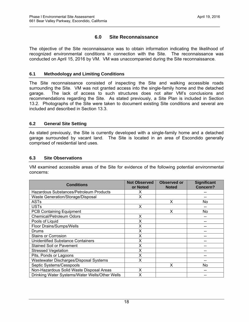
6.3 Site Observations
VM examined accessible areas of the Site for evidence of the following potential environmental concerns:
Conditions Not Observed or Noted
Observed or Noted
Significant Concern?
Hazardous Substances/Petroleum Products X -- Waste Generation/Storage/Disposal X -- ASTs X No USTs X -- PCB Containing Equipment X No Chemical/Petroleum Odors X -- Pools of Liquid X -- Floor Drains/Sumps/Wells X -- Drums X -- Stains or Corrosion X -- Unidentified Substance Containers X -- Stained Soil or Pavement X -- Stressed Vegetation X -- Pits, Ponds or Lagoons X -- Wastewater Discharges/Disposal Systems X -- Septic Systems/Cesspools X No Non-Hazardous Solid Waste Disposal Areas X -- Drinking Water Systems/Water Wells/Other Wells X --
Phase I Environmental Site Assessment April 19, 2016 661 Bear Valley Parkway, Escondido, California
19
The noted items in the table above are discussed below. ASTs A 250-gallon propane AST was observed adjacent to the on-Site residence. The AST appeared to be in fair condition with no evidence of a release. PCB Containing Equipment A pole mounted electrical transformer was noted on the northern portion area adjacent to the driveway. The transformer is utility owned (SDG&E) and is not labeled with respect to PCB content. There were no indications of releases from the transformer. Septic Systems/Cesspools The on-Site residence is likely serviced by a septic system.

Phase I Environmental Site Assessment April 19, 2016 661 Bear Valley Parkway, Escondido, California
20
7.0 Interview Information
7.1. Interview With Owner
As stated previously, the Site is currently vested in Spieth and Wohlford Inc. The Site owner is unaware of significant environmental concerns in connection with the Site.
7.2 Interview With Site Manager
The Site owner is also considered to be the Site Manager. Please refer to Section 7.1 above.
7.3 Interviews With Occupants
No interviews with occupants were conducted as a part of this assessment. The lack of an interview with Site occupants does not alter AEC’s conclusions and recommendations regarding the Site.
7.4 Interview With Local Government Official
During the preparation of this assessment, multiple governmental agency representatives were interviewed regarding the availability of public records pertaining to the Site.
7.5 Interview With Others
No other interviews were conducted as a part of this assessment.

Phase I Environmental Site Assessment April 19, 2016 661 Bear Valley Parkway, Escondido, California
21
8.0 Findings, Opinion and Conclusions VM has performed a Phase I Environmental Site Assessment, in conformance with the scope and limitations of ASTM Practice E 1527-13 and 40 CFR Part 312 of the property located at 661 Bear Valley Parkway in Escondido, California (County of San Diego APNs 237-131-01-00 and -02-00). Any exceptions to, or deletions from, this practice are described in Section 9.0 of this report. This assessment has revealed no evidence of recognized environmental conditions in connection with the Site. Additional environmental investigation at the Site is not considered to be warranted at this time.
Phase I Environmental Site Assessment April 19, 2016 661 Bear Valley Parkway, Escondido, California
22
9.0 Deviations and Data Gaps No deviations or significant data gaps as defined in the ASTM-2013 standard were noted during the preparation of this assessment.

Phase I Environmental Site Assessment April 19, 2016 661 Bear Valley Parkway, Escondido, California
23
10.0 Additional Services No additional services were completed by VM during the preparation of this assessment.

Phase I Environmental Site Assessment April 19, 2016 661 Bear Valley Parkway, Escondido, California
24
11.0 References “All Appropriate Inquiry” as necessary to satisfy the defenses available under 42 U.S.C. §§ 9607(b)(3), 9607(r)(1), and 9607(q), relying on definitions provided at 42 U.S.C. §§ 9601(35)(B); and as further explained in 40 CFR §§ 312.1 – 312.31. ASTM International, "Standard Practice for Environmental Site Assessments: Phase I Environmental Site Assessment Process," ASTM Designation E 1527-13, Published November 2013. California Geological Survey, 2010 Geologic Map of California, Compilation by: Jennings, Charles W.; California State Water Resources Control Board, GeoTracker online database: http://www.geotracker.swrcb.ca.gov; California State Water Resources Control Board, Water Quality Control Plan for the San Diego Basin (9), San Diego, California, Published 1994; Environmental Data Resources Services, City Directories Report Dated April 15, 2016; Environmental Data Resources Services, Regulatory Database Report Dated April 14, 2016; Environmental Data Resources Services, Sanborn Report Dated April 14, 2016; NETROnline, Historical aerial photographs; State of California Department of Conservation, Division of Oil and Gas and Geothermal Resources: http://www.consrv.ca.gov/DOG/maps/index_map.htm; USGS topographic map, Escondido, California Quadrangle, 2015.

25
13.0 Appendices

13.1 Vicinity Map and Topographic Map

Vicinity Map661 Bear Valley Parkway
Escondido, California
Vinje & Middleton Engineering, Inc.2450 Auto Park Way
Escondido, California 92029
SITE
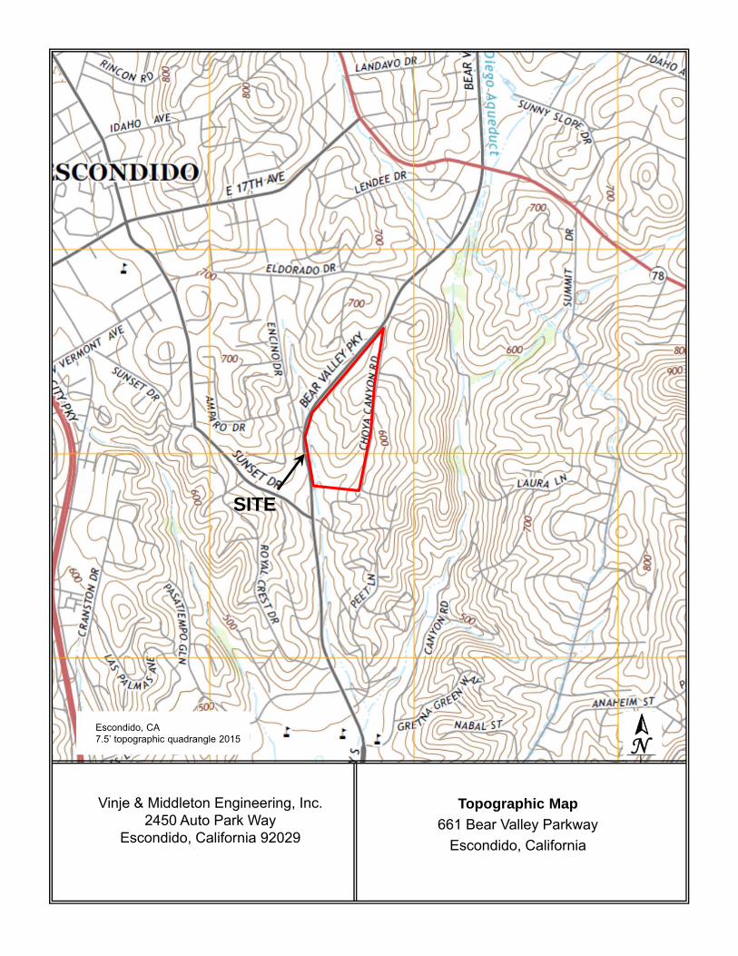
Topographic Map661 Bear Valley Parkway
Escondido, California
Vinje & Middleton Engineering, Inc.2450 Auto Park Way
Escondido, California 92029
Escondido, CA7.5’ topographic quadrangle 2015 N
SITE

13.2 Site Plan

Site Plan661 Bear Valley Parkway
Escondido, California
Vinje & Middleton Engineering, Inc.2450 Auto Park Way
Escondido, California 92029
SITE
Residential
Residential
Residential
Residential

13.3 Site Photographs
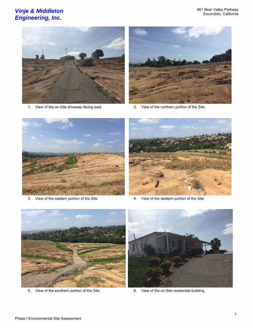
Vinje & Middleton Engineering, Inc.
661 Bear Valley Parkway Escondido, California
1 Phase I Environmental Site Assessment
1. View of the on-Site driveway facing east. 2. View of the northern portion of the Site.
3. View of the eastern portion of the Site. 4. View of the western portion of the Site.
5. View of the southern portion of the Site. 6. View of the on-Site residential building.

Vinje & Middleton Engineering, Inc.
661 Bear Valley Parkway Escondido, California
2 Phase I Environmental Site Assessment
7. View of the on-Site detached garage. 8. View of Bear Valley Parkway and western adjacent properties.
9. View of the eastern adjacent property.
10. View of the AST located adjacent to the single-family home.
11. View of the pole-mounted transformer located adjacent to Bear Valley Parkway
12. View of a drainage line located adjacent to the driveway.

13.4 Regulatory Database Report

FORM-NULL-GON
tropeR™paMsuidaRRDEehT
6 Armstrong Road, 4th floorShelton, CT 06484Toll Free: 800.352.0050www.edrnet.com
Bear Valley661 Bear Valley ParkwayEscondido, CA 92025
Inquiry Number: 4592434.1sApril 14, 2016

SECTION PAGE
Executive Summary ES1
Overview Map 2
Detail Map 3
Map Findings Summary 4
Map Findings 8
Orphan Summary 12
Government Records Searched/Data Currency Tracking GR-1
GEOCHECK ADDENDUM
GeoCheck - Not Requested
TC4592434.1s Page 1
Thank you for your business.Please contact EDR at 1-800-352-0050
with any questions or comments.
Disclaimer - Copyright and Trademark Notice
This Report contains certain information obtained from a variety of public and other sources reasonably available to Environmental DataResources, Inc. It cannot be concluded from this Report that coverage information for the target and surrounding properties does not exist fromother sources. NO WARRANTY EXPRESSED OR IMPLIED, IS MADE WHATSOEVER IN CONNECTION WITH THIS REPORT. ENVIRONMENTALDATA RESOURCES, INC. SPECIFICALLY DISCLAIMS THE MAKING OF ANY SUCH WARRANTIES, INCLUDING WITHOUT LIMITATION,MERCHANTABILITY OR FITNESS FOR A PARTICULAR USE OR PURPOSE. ALL RISK IS ASSUMED BY THE USER. IN NO EVENT SHALLENVIRONMENTAL DATA RESOURCES, INC. BE LIABLE TO ANYONE, WHETHER ARISING OUT OF ERRORS OR OMISSIONS, NEGLIGENCE,ACCIDENT OR ANY OTHER CAUSE, FOR ANY LOSS OF DAMAGE, INCLUDING, WITHOUT LIMITATION, SPECIAL, INCIDENTAL,CONSEQUENTIAL, OR EXEMPLARY DAMAGES. ANY LIABILITY ON THE PART OF ENVIRONMENTAL DATA RESOURCES, INC. IS STRICTLYLIMITED TO A REFUND OF THE AMOUNT PAID FOR THIS REPORT. Purchaser accepts this Report "AS IS". Any analyses, estimates, ratings,environmental risk levels or risk codes provided in this Report are provided for illustrative purposes only, and are not intended to provide, norshould they be interpreted as providing any facts regarding, or prediction or forecast of, any environmental risk for any property. Only a Phase IEnvironmental Site Assessment performed by an environmental professional can provide information regarding the environmental risk for anyproperty. Additionally, the information provided in this Report is not to be construed as legal advice.
Copyright 2016 by Environmental Data Resources, Inc. All rights reserved. Reproduction in any media or format, in wholeor in part, of any report or map of Environmental Data Resources, Inc., or its affiliates, is prohibited without prior written permission.
EDR and its logos (including Sanborn and Sanborn Map) are trademarks of Environmental Data Resources, Inc. or its affiliates. All othertrademarks used herein are the property of their respective owners.
TABLE OF CONTENTS

EXECUTIVE SUMMARY
TC4592434.1s EXECUTIVE SUMMARY 1
A search of available environmental records was conducted by Environmental Data Resources, Inc (EDR).The report was designed to assist parties seeking to meet the search requirements of EPA’s Standardsand Practices for All Appropriate Inquiries (40 CFR Part 312), the ASTM Standard Practice forEnvironmental Site Assessments (E 1527-13) or custom requirements developed for the evaluation ofenvironmental risk associated with a parcel of real estate.
TARGET PROPERTY INFORMATION
ADDRESS
661 BEAR VALLEY PARKWAYESCONDIDO, CA 92025
COORDINATES
33.0991060 - 33˚ 5’ 56.78’’Latitude (North): 117.0570110 - 117˚ 3’ 25.23’’Longitude (West): Zone 11Universal Tranverse Mercator: 494680.1UTM X (Meters): 3662084.0UTM Y (Meters): 660 ft. above sea levelElevation:
USGS TOPOGRAPHIC MAP ASSOCIATED WITH TARGET PROPERTY
5641298 ESCONDIDO, CATarget Property Map:2012Version Date:
AERIAL PHOTOGRAPHY IN THIS REPORT
20120519, 20120510Portions of Photo from:USDASource:

4592434.1s Page 2
5 BROTHERTON PLAZA 2250 S ESCONDIDO BL ENVIROSTOR Lower 3805, 0.721, WSW
4 INTERCAL EQUITIES 2021 GINNY LANE RGA LUST Higher 2528, 0.479, WNW
3 AMPARO DRIVE & ENCIN CHMIRS Lower 453, 0.086, West
A2 SPIETH & WOHLFORD IN 661 BEAR VALLEY PY San Diego Co. HMMD TP
A1 SPIETH AND WOHLFORD 661 BEAR VALLEY PKWY HAZNET TP
MAPPED SITES SUMMARY
Target Property Address:661 BEAR VALLEY PARKWAYESCONDIDO, CA 92025
Click on Map ID to see full detail.
MAP RELATIVE DIST (ft. & mi.)ID DATABASE ACRONYMS ELEVATION DIRECTIONSITE NAME ADDRESS

EXECUTIVE SUMMARY
TC4592434.1s EXECUTIVE SUMMARY 3
TARGET PROPERTY SEARCH RESULTS
The target property was identified in the following records. For more information on thisproperty see page 8 of the attached EDR Radius Map report:
EPA IDDatabase(s)Site
SPIETH AND WOHLFORD 661 BEAR VALLEY PKWYESCONDIDO, CA 92025
N/AHAZNETGEPAID: CAC001482952
SPIETH & WOHLFORD IN661 BEAR VALLEY PYESCONDIDO, CA 92025
N/ASan Diego Co. HMMDFacility ID: 199458
DATABASES WITH NO MAPPED SITES
No mapped sites were found in EDR’s search of available ("reasonably ascertainable ") governmentrecords either on the target property or within the search radius around the target property for thefollowing databases:
STANDARD ENVIRONMENTAL RECORDS
Federal NPL site list
NPL National Priority ListProposed NPL Proposed National Priority List SitesNPL LIENS Federal Superfund Liens
Federal Delisted NPL site list
Delisted NPL National Priority List Deletions
Federal CERCLIS list
FEDERAL FACILITY Federal Facility Site Information listingSEMS Superfund Enterprise Management System
Federal CERCLIS NFRAP site list
SEMS-ARCHIVE Superfund Enterprise Management System Archive
Federal RCRA CORRACTS facilities list
CORRACTS Corrective Action Report
Federal RCRA non-CORRACTS TSD facilities list
RCRA-TSDF RCRA - Treatment, Storage and Disposal

EXECUTIVE SUMMARY
TC4592434.1s EXECUTIVE SUMMARY 4
Federal RCRA generators list
RCRA-LQG RCRA - Large Quantity GeneratorsRCRA-SQG RCRA - Small Quantity GeneratorsRCRA-CESQG RCRA - Conditionally Exempt Small Quantity Generator
Federal institutional controls / engineering controls registries
LUCIS Land Use Control Information SystemUS ENG CONTROLS Engineering Controls Sites ListUS INST CONTROL Sites with Institutional Controls
Federal ERNS list
ERNS Emergency Response Notification System
State- and tribal - equivalent NPL
RESPONSE State Response Sites
State and tribal landfill and/or solid waste disposal site lists
SWF/LF Solid Waste Information System
State and tribal leaking storage tank lists
LUST Geotracker’s Leaking Underground Fuel Tank ReportSAN DIEGO CO. SAM Environmental Case ListingINDIAN LUST Leaking Underground Storage Tanks on Indian LandSLIC Statewide SLIC Cases
State and tribal registered storage tank lists
FEMA UST Underground Storage Tank ListingUST Active UST FacilitiesAST Aboveground Petroleum Storage Tank FacilitiesINDIAN UST Underground Storage Tanks on Indian Land
State and tribal voluntary cleanup sites
VCP Voluntary Cleanup Program PropertiesINDIAN VCP Voluntary Cleanup Priority Listing
State and tribal Brownfields sites
BROWNFIELDS Considered Brownfieds Sites Listing
ADDITIONAL ENVIRONMENTAL RECORDS
Local Brownfield lists
US BROWNFIELDS A Listing of Brownfields Sites
Local Lists of Landfill / Solid Waste Disposal Sites
WMUDS/SWAT Waste Management Unit Database

EXECUTIVE SUMMARY
TC4592434.1s EXECUTIVE SUMMARY 5
SWRCY Recycler DatabaseHAULERS Registered Waste Tire Haulers ListingODI Open Dump InventoryDEBRIS REGION 9 Torres Martinez Reservation Illegal Dump Site Locations
Local Lists of Hazardous waste / Contaminated Sites
US HIST CDL Delisted National Clandestine Laboratory RegisterHIST Cal-Sites Historical Calsites DatabaseSCH School Property Evaluation ProgramCDL Clandestine Drug LabsToxic Pits Toxic Pits Cleanup Act SitesUS CDL National Clandestine Laboratory Register
Local Lists of Registered Storage Tanks
SWEEPS UST SWEEPS UST ListingHIST UST Hazardous Substance Storage Container DatabaseCA FID UST Facility Inventory Database
Local Land Records
LIENS Environmental Liens ListingLIENS 2 CERCLA Lien InformationDEED Deed Restriction Listing
Records of Emergency Release Reports
HMIRS Hazardous Materials Information Reporting SystemLDS Land Disposal Sites ListingMCS Military Cleanup Sites ListingSPILLS 90 SPILLS 90 data from FirstSearch
Other Ascertainable Records
RCRA NonGen / NLR RCRA - Non Generators / No Longer RegulatedFUDS Formerly Used Defense SitesDOD Department of Defense SitesSCRD DRYCLEANERS State Coalition for Remediation of Drycleaners ListingUS FIN ASSUR Financial Assurance InformationEPA WATCH LIST EPA WATCH LIST2020 COR ACTION 2020 Corrective Action Program ListTSCA Toxic Substances Control ActTRIS Toxic Chemical Release Inventory SystemSSTS Section 7 Tracking SystemsROD Records Of DecisionRMP Risk Management PlansRAATS RCRA Administrative Action Tracking SystemPRP Potentially Responsible PartiesPADS PCB Activity Database SystemICIS Integrated Compliance Information SystemFTTS FIFRA/ TSCA Tracking System - FIFRA (Federal Insecticide, Fungicide, & Rodenticide Act)/TSCA (Toxic Substances Control Act)MLTS Material Licensing Tracking SystemCOAL ASH DOE Steam-Electric Plant Operation Data

EXECUTIVE SUMMARY
TC4592434.1s EXECUTIVE SUMMARY 6
COAL ASH EPA Coal Combustion Residues Surface Impoundments ListPCB TRANSFORMER PCB Transformer Registration DatabaseRADINFO Radiation Information DatabaseHIST FTTS FIFRA/TSCA Tracking System Administrative Case ListingDOT OPS Incident and Accident DataCONSENT Superfund (CERCLA) Consent DecreesINDIAN RESERV Indian ReservationsFUSRAP Formerly Utilized Sites Remedial Action ProgramUMTRA Uranium Mill Tailings SitesLEAD SMELTERS Lead Smelter SitesUS AIRS Aerometric Information Retrieval System Facility SubsystemUS MINES Mines Master Index FileFINDS Facility Index System/Facility Registry SystemCA BOND EXP. PLAN Bond Expenditure PlanCortese "Cortese" Hazardous Waste & Substances Sites ListCUPA Listings CUPA Resources ListDRYCLEANERS Cleaner FacilitiesEMI Emissions Inventory DataENF Enforcement Action ListingFinancial Assurance Financial Assurance Information ListingHIST CORTESE Hazardous Waste & Substance Site ListHWP EnviroStor Permitted Facilities ListingHWT Registered Hazardous Waste Transporter DatabaseMINES Mines Site Location ListingMWMP Medical Waste Management Program ListingNPDES NPDES Permits ListingPEST LIC Pesticide Regulation Licenses ListingPROC Certified Processors DatabaseNotify 65 Proposition 65 RecordsUIC UIC ListingWASTEWATER PITS Oil Wastewater Pits ListingWDS Waste Discharge SystemWIP Well Investigation Program Case ListFUELS PROGRAM EPA Fuels Program Registered ListingECHO Enforcement & Compliance History Information
EDR RECOVERED GOVERNMENT ARCHIVES
Exclusive Recovered Govt. Archives
RGA LF Recovered Government Archive Solid Waste Facilities List
SURROUNDING SITES: SEARCH RESULTS
Surrounding sites were identified in the following databases.
Elevations have been determined from the USGS Digital Elevation Model and should be evaluated ona relative (not an absolute) basis. Relative elevation information between sites of close proximityshould be field verified. Sites with an elevation equal to or higher than the target property have beendifferentiated below from sites with an elevation lower than the target property.Page numbers and map identification numbers refer to the EDR Radius Map report where detaileddata on individual sites can be reviewed.
Sites listed in bold italics are in multiple databases.
Unmappable (orphan) sites are not considered in the foregoing analysis.
EXECUTIVE SUMMARY
TC4592434.1s EXECUTIVE SUMMARY 7
STANDARD ENVIRONMENTAL RECORDS
State- and tribal - equivalent CERCLIS
ENVIROSTOR: The Department of Toxic Substances Control’s (DTSC’s) Site Mitigation and BrownfieldsReuse Program’s (SMBRP’s) EnviroStor database identifes sites that have known contamination or sites for whichthere may be reasons to investigate further. The database includes the following site types: FederalSuperfund sites (National Priorities List (NPL)); State Response, including Military Facilities and StateSuperfund; Voluntary Cleanup; and School sites. EnviroStor provides similar information to the informationthat was available in CalSites, and provides additional site information, including, but not limited to,identification of formerly-contaminated properties that have been released for reuse, properties whereenvironmental deed restrictions have been recorded to prevent inappropriate land uses, and riskcharacterization information that is used to assess potential impacts to public health and the environment atcontaminated sites.
A review of the ENVIROSTOR list, as provided by EDR, and dated 02/01/2016 has revealed that there is 1 ENVIROSTOR site within approximately 1 mile of the target property.
PageMap IDDirection / Distance Address Lower Elevation ____________________ ________ ___________________ _____ _____
BROTHERTON PLAZA 2250 S ESCONDIDO BL WSW 1/2 - 1 (0.721 mi.) 5 10Facility Id: 37000025Status: Refer: 1248 Local Agency
ADDITIONAL ENVIRONMENTAL RECORDS
Records of Emergency Release Reports
CHMIRS: The California Hazardous Material Incident Report System contains information on reportedhazardous material incidents, i.e., accidental releases or spills. The source is the California Office ofEmergency Services.
A review of the CHMIRS list, as provided by EDR, and dated 12/16/2015 has revealed that there is 1 CHMIRS site within approximately 0.125 miles of the target property.
PageMap IDDirection / Distance Address Lower Elevation ____________________ ________ ___________________ _____ _____
Not reported AMPARO DRIVE & ENCIN W 0 - 1/8 (0.086 mi.) 3 9OES Incident Number: 3-6258
EDR RECOVERED GOVERNMENT ARCHIVES
Exclusive Recovered Govt. Archives
RGA LUST: The EDR Recovered Government Archive Leaking Underground Storage Tank database provides alist of LUST incidents derived from historical databases and includes many records that no longer appear incurrent government lists. Compiled from Records formerly available from the State Water Resources ControlBoard in California.
A review of the RGA LUST list, as provided by EDR, has revealed that there is 1 RGA LUST site within

EXECUTIVE SUMMARY
TC4592434.1s EXECUTIVE SUMMARY 8
approximately 0.5 miles of the target property.
PageMap IDDirection / Distance Address Equal/Higher Elevation ____________________ ________ ___________________ _____ _____
INTERCAL EQUITIES 2021 GINNY LANE WNW 1/4 - 1/2 (0.479 mi.) 4 10
EXECUTIVE SUMMARY
TC4592434.1s EXECUTIVE SUMMARY 9
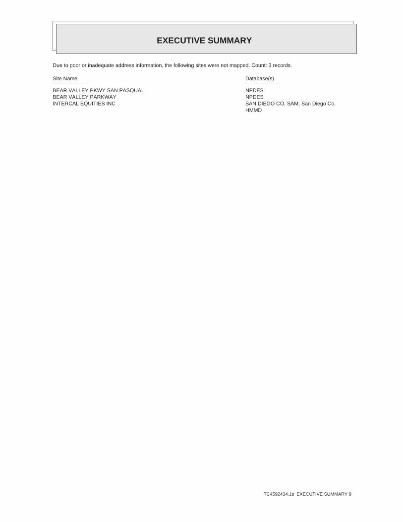
Due to poor or inadequate address information, the following sites were not mapped. Count: 3 records.
Site Name Database(s)____________ ____________
BEAR VALLEY PKWY SAN PASQUAL NPDESBEAR VALLEY PARKWAY NPDESINTERCAL EQUITIES INC SAN DIEGO CO. SAM, San Diego Co.
HMMD

EDR Inc.EDR Inc.EDR Inc.EDR Inc.EDR Inc.EDR Inc.EDR Inc.EDR Inc.EDR Inc.EDR Inc.EDR Inc.EDR Inc.EDR Inc.EDR Inc.EDR Inc.EDR Inc.EDR Inc.EDR Inc.EDR Inc.EDR Inc.EDR Inc.EDR Inc.EDR Inc.EDR Inc.EDR Inc.EDR Inc.EDR Inc.EDR Inc.EDR Inc.EDR Inc.EDR Inc.EDR Inc.EDR Inc.EDR Inc.EDR Inc.EDR Inc.EDR Inc.EDR Inc.EDR Inc.EDR Inc.
6 0 kV

EDR Inc.EDR Inc.EDR Inc.EDR Inc.EDR Inc.EDR Inc.EDR Inc.EDR Inc.EDR Inc.EDR Inc.EDR Inc.EDR Inc.EDR Inc.EDR Inc.EDR Inc.EDR Inc.EDR Inc.EDR Inc.EDR Inc.EDR Inc.EDR Inc.EDR Inc.EDR Inc.EDR Inc.EDR Inc.EDR Inc.EDR Inc.EDR Inc.EDR Inc.EDR Inc.EDR Inc.EDR Inc.EDR Inc.EDR Inc.EDR Inc.EDR Inc.EDR Inc.EDR Inc.EDR Inc.EDR Inc.

MAP FINDINGS SUMMARY
SearchTargetDistance Total
Database Property(Miles) < 1/8 1/8 - 1/4 1/4 - 1/2 1/2 - 1 > 1 Plotted
STANDARD ENVIRONMENTAL RECORDS
Federal NPL site list
0 NR 0 0 0 0 1.000NPL 0 NR 0 0 0 0 1.000Proposed NPL 0 NR NR NR NR NR TPNPL LIENS
Federal Delisted NPL site list
0 NR 0 0 0 0 1.000Delisted NPL
Federal CERCLIS list
0 NR NR NR NR NR TPFEDERAL FACILITY 0 NR NR 0 0 0 0.500SEMS
Federal CERCLIS NFRAP site list
0 NR NR 0 0 0 0.500SEMS-ARCHIVE
Federal RCRA CORRACTS facilities list
0 NR 0 0 0 0 1.000CORRACTS
Federal RCRA non-CORRACTS TSD facilities list
0 NR NR 0 0 0 0.500RCRA-TSDF
Federal RCRA generators list
0 NR NR NR NR 0 0.125RCRA-LQG 0 NR NR NR NR 0 0.125RCRA-SQG 0 NR NR NR NR 0 0.125RCRA-CESQG
Federal institutional controls /engineering controls registries
0 NR NR NR NR NR TPLUCIS 0 NR NR 0 0 0 0.500US ENG CONTROLS 0 NR NR 0 0 0 0.500US INST CONTROL
Federal ERNS list
0 NR NR NR NR 0 0.125ERNS
State- and tribal - equivalent NPL
0 NR 0 0 0 0 1.000RESPONSE
State- and tribal - equivalent CERCLIS
1 NR 1 0 0 0 1.000ENVIROSTOR
State and tribal landfill and/orsolid waste disposal site lists
0 NR NR 0 0 0 0.500SWF/LF
State and tribal leaking storage tank lists
0 NR NR 0 0 0 0.500LUST
TC4592434.1s Page 4
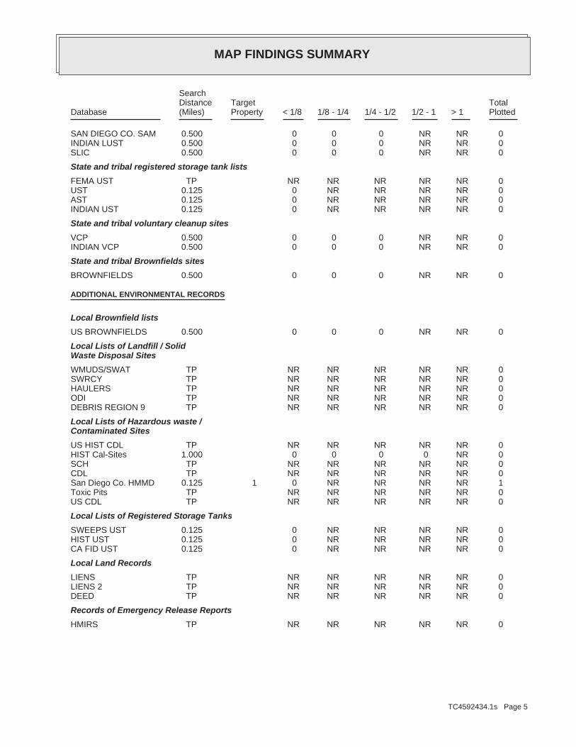
MAP FINDINGS SUMMARY
SearchTargetDistance Total
Database Property(Miles) < 1/8 1/8 - 1/4 1/4 - 1/2 1/2 - 1 > 1 Plotted
0 NR NR 0 0 0 0.500SAN DIEGO CO. SAM 0 NR NR 0 0 0 0.500INDIAN LUST 0 NR NR 0 0 0 0.500SLIC
State and tribal registered storage tank lists
0 NR NR NR NR NR TPFEMA UST 0 NR NR NR NR 0 0.125UST 0 NR NR NR NR 0 0.125AST 0 NR NR NR NR 0 0.125INDIAN UST
State and tribal voluntary cleanup sites
0 NR NR 0 0 0 0.500VCP 0 NR NR 0 0 0 0.500INDIAN VCP
State and tribal Brownfields sites
0 NR NR 0 0 0 0.500BROWNFIELDS
ADDITIONAL ENVIRONMENTAL RECORDS
Local Brownfield lists
0 NR NR 0 0 0 0.500US BROWNFIELDS
Local Lists of Landfill / SolidWaste Disposal Sites
0 NR NR NR NR NR TPWMUDS/SWAT 0 NR NR NR NR NR TPSWRCY 0 NR NR NR NR NR TPHAULERS 0 NR NR NR NR NR TPODI 0 NR NR NR NR NR TPDEBRIS REGION 9
Local Lists of Hazardous waste /Contaminated Sites
0 NR NR NR NR NR TPUS HIST CDL 0 NR 0 0 0 0 1.000HIST Cal-Sites 0 NR NR NR NR NR TPSCH 0 NR NR NR NR NR TPCDL 1 NR NR NR NR 0 0.125 1San Diego Co. HMMD 0 NR NR NR NR NR TPToxic Pits 0 NR NR NR NR NR TPUS CDL
Local Lists of Registered Storage Tanks
0 NR NR NR NR 0 0.125SWEEPS UST 0 NR NR NR NR 0 0.125HIST UST 0 NR NR NR NR 0 0.125CA FID UST
Local Land Records
0 NR NR NR NR NR TPLIENS 0 NR NR NR NR NR TPLIENS 2 0 NR NR NR NR NR TPDEED
Records of Emergency Release Reports
0 NR NR NR NR NR TPHMIRS
TC4592434.1s Page 5

MAP FINDINGS SUMMARY
SearchTargetDistance Total
Database Property(Miles) < 1/8 1/8 - 1/4 1/4 - 1/2 1/2 - 1 > 1 Plotted
1 NR NR NR NR 1 0.125CHMIRS 0 NR NR NR NR NR TPLDS 0 NR NR NR NR NR TPMCS 0 NR NR 0 0 0 0.500SPILLS 90
Other Ascertainable Records
0 NR NR NR NR 0 0.125RCRA NonGen / NLR 0 NR NR NR NR NR TPFUDS 0 NR NR NR NR NR TPDOD 0 NR NR NR NR NR TPSCRD DRYCLEANERS 0 NR NR NR NR NR TPUS FIN ASSUR 0 NR NR NR NR NR TPEPA WATCH LIST 0 NR NR NR 0 0 0.2502020 COR ACTION 0 NR NR NR NR NR TPTSCA 0 NR NR NR NR NR TPTRIS 0 NR NR NR NR NR TPSSTS 0 NR NR NR NR NR TPROD 0 NR NR NR NR NR TPRMP 0 NR NR NR NR NR TPRAATS 0 NR NR NR NR NR TPPRP 0 NR NR NR NR NR TPPADS 0 NR NR NR NR NR TPICIS 0 NR NR NR NR NR TPFTTS 0 NR NR NR NR NR TPMLTS 0 NR NR NR NR NR TPCOAL ASH DOE 0 NR NR NR NR NR TPCOAL ASH EPA 0 NR NR NR NR NR TPPCB TRANSFORMER 0 NR NR NR NR NR TPRADINFO 0 NR NR NR NR NR TPHIST FTTS 0 NR NR NR NR NR TPDOT OPS 0 NR 0 0 0 0 1.000CONSENT 0 NR 0 0 0 0 1.000INDIAN RESERV 0 NR 0 0 0 0 1.000FUSRAP 0 NR NR NR NR NR TPUMTRA 0 NR NR NR NR NR TPLEAD SMELTERS 0 NR NR NR NR NR TPUS AIRS 0 NR NR NR NR NR TPUS MINES 0 NR NR NR NR NR TPFINDS 0 NR NR NR NR NR TPCA BOND EXP. PLAN 0 NR NR NR NR NR TPCortese 0 NR NR NR NR 0 0.125CUPA Listings 0 NR NR NR NR NR TPDRYCLEANERS 0 NR NR NR NR NR TPEMI 0 NR NR NR NR NR TPENF 0 NR NR NR NR NR TPFinancial Assurance 1 NR NR NR NR NR TP 1HAZNET 0 NR NR NR NR NR TPHIST CORTESE 0 NR NR NR NR NR TPHWP 0 NR NR NR NR NR TPHWT 0 NR NR NR NR NR TPMINES 0 NR NR NR NR NR TPMWMP
TC4592434.1s Page 6

MAP FINDINGS SUMMARY
SearchTargetDistance Total
Database Property(Miles) < 1/8 1/8 - 1/4 1/4 - 1/2 1/2 - 1 > 1 Plotted
0 NR NR NR NR NR TPNPDES 0 NR NR NR NR NR TPPEST LIC 0 NR NR NR NR NR TPPROC 0 NR NR NR NR NR TPNotify 65 0 NR NR NR NR NR TPUIC 0 NR NR 0 0 0 0.500WASTEWATER PITS 0 NR NR NR NR NR TPWDS 0 NR NR NR NR NR TPWIP 0 NR NR NR 0 0 0.250FUELS PROGRAM 0 NR NR NR NR NR TPECHO
EDR RECOVERED GOVERNMENT ARCHIVES
Exclusive Recovered Govt. Archives
0 NR NR 0 0 0 0.500RGA LF 1 NR NR 1 0 0 0.500RGA LUST
5 0 1 1 0 1 2- Totals --
NOTES:
TP = Target Property
NR = Not Requested at this Search Distance
Sites may be listed in more than one database
TC4592434.1s Page 7

MAP FINDINGSMap IDDirection
EDR ID NumberDistanceEPA ID NumberDatabase(s)SiteElevation
San DiegoFacility County: RecyclerMethod Decode: Aqueous solution with total organic residues less than 10 percentCat Decode: 4.1700Tons: RecyclerDisposal Method: Aqueous solution with total organic residues less than 10 percentWaste Category: Not reportedTSD County: CAT080025711TSD EPA ID: Not reportedGen County: ESCONDIDO, CA 920270000Mailing City,St,Zip: 3355 EAST VALLEY PKWY.Mailing Address: Not reportedMailing Name: 7607455255Telephone: BURNET F WOHLFORDContact: CAC001482952GEPAID: 1998Year: S112894788envid:
HAZNET:
Site 1 of 2 in cluster A
Actual:660 ft.
Property ESCONDIDO, CA 92025Target 661 BEAR VALLEY PKWY. N/AA1 HAZNETSPIETH AND WOHLFORD INC. S112894788
Not reportedGenerate Medical Waste: Not reportedTreat Haz Waste: Not reportedGenerate Haz Waste: Not reportedSubject To APSA: Not reportedOwn Or Operate UST: Not reportedHandle Regulated Hazmat: Not reportedUST Owner: 92025-6701Facility Zip: CAFacility State: ESCONDIDOFacility City: 661 BEAR VALLEY PYFacility Address: SPIETH & WOHLFORD INCFacility Owner: 06/04/1993Permit Expiration: INACPermit Status: 06/04/1993Last HMMD Inspection: 237-131-01-00APN: Not reportedEPA Id Number: 6HKAGBusiness Type: 199458Facility Id:
SAN DIEGO CO. HMMD:
Site 2 of 2 in cluster A
Actual:660 ft.
Property ESCONDIDO, CA 92025Target 661 BEAR VALLEY PY N/AA2 San Diego Co. HMMDSPIETH & WOHLFORD INC S104761447
TC4592434.1s Page 8

MAP FINDINGSMap IDDirection
EDR ID NumberDistanceEPA ID NumberDatabase(s)SiteElevation
Not reportedSubstance #3: Not reportedSubstance #2: 0Unknown: 0.000000Gallons: Natural GasSubstance: Not reportedE Date: RoadSite Type: YesContained: Not reportedAmount: San Diego County Health Services Dept.Admin Agency: 12/4/200312:00:00 AMIncident Date: Escondido FDAgency: 2003Year: Not reportedDate/Time: Not reportedOther: Not reportedMeasure: Not reportedType: Not reportedWhat Happened: Not reportedContainment: Reporting PartyCleanup By: Not reportedSpill Site: Not reportedWaterway: Not reportedWaterway Involved: Not reportedFacility Telephone: Not reportedReport Date: Not reportedReporting Officer Name/ID: Not reportedCompany Name: Not reportedCA DOT PUC/ICC Number: Not reportedVehicle Id Number: Not reportedVehicle State: Not reportedVehicle License Number: Not reportedVehicle Make/year: Not reportedOthers Number Of Fatalities: Not reportedOthers Number Of Injuries: Not reportedOthers Number Of Decontaminated: Not reportedResponding Agency Personel # Of Fatalities: Not reportedResponding Agency Personel # Of Injuries: Not reportedResp Agncy Personel # Of Decontaminated: Not reportedMore Than Two Substances Involved?: Not reportedProperty Management: Not reportedEstimated Temperature: Not reportedSurrounding Area: Not reportedTime Completed: Not reportedTime Notified: Not reportedAgency Incident Number: Not reportedAgency Id Number: Not reportedProperty Use: Not reportedDate Completed: Not reportedOES Time: Not reportedOES Date: 12/04/2003OES notification: 3-6258OES Incident Number:
CHMIRS:
453 ft.0.086 mi.
Relative:Lower
Actual:597 ft.
< 1/8 ESCONDIDO, CA West AMPARO DRIVE & ENCINO DRIVE N/A3 CHMIRS S106398381
TC4592434.1s Page 9

MAP FINDINGSMap IDDirection
EDR ID NumberDistanceEPA ID NumberDatabase(s)SiteElevation
hole in the main. release for approximately an hour at about a 3’ Construction backhoe struck a gas main, causing aDescription: Not reportedComments: Not reportedFatals: Not reportedInjuries: Not reportedEvacs: Not reported#3 Vessel >= 300 Tons: Not reported#2 Vessel >= 300 Tons: Not reported#1 Vessel >= 300 Tons: Not reported#3 Pipeline: Not reported#2 Pipeline: Not reported#1 Pipeline: 0Number of Fatalities: 0Number of Injuries: 0Evacuations:
(Continued) S106398381
1992 INTERCAL EQUITIES 2021 GINNY LANERGA LUST:
2528 ft.0.479 mi.
Relative:Higher
Actual:725 ft.
1/4-1/2 ESCONDIDO, CA WNW 2021 GINNY LANE N/A4 RGA LUSTINTERCAL EQUITIES S114635386
NONE SPECIFIEDPast Use: NONE SPECIFIEDAPN: -117.0711Longitude: 33.09456Latitude: Not ApplicableFunding: NONE SPECIFIEDSite Mgmt Req: NORestricted Use: Not reportedSpecial Program: 38Senate: 75Assembly: Cleanup CypressDivision Branch: Referred - Not AssignedSupervisor: Not reportedProgram Manager: NONE SPECIFIEDLead Agency: NONE SPECIFIEDRegulatory Agencies: NONPL: Not reportedAcres: EvaluationSite Type Detailed: EvaluationSite Type: Not reportedSite Code: 03/07/2001Status Date: Refer: 1248 Local AgencyStatus: 37000025Facility ID:
ENVIROSTOR:
3805 ft.0.721 mi.
Relative:Lower
Actual:613 ft.
1/2-1 ESCONDIDO, CA 92025WSW 2250 S ESCONDIDO BL N/A5 ENVIROSTORBROTHERTON PLAZA S106065979
TC4592434.1s Page 10

MAP FINDINGSMap IDDirection
EDR ID NumberDistanceEPA ID NumberDatabase(s)SiteElevation
Not reportedSchedule Revised Date: Not reportedSchedule Due Date: Not reportedSchedule Document Type: Not reportedSchedule Sub Area Name: Not reportedSchedule Area Name: Not reportedFuture Due Date: Not reportedFuture Document Type: Not reportedFuture Sub Area Name: Not reportedFuture Area Name:
SB 1248 San Diego CountyComments: 03/07/2001Completed Date: SB 1248 NotificationCompleted Document Type: Not reportedCompleted Sub Area Name: PROJECT WIDECompleted Area Name:
Completed Info:
Envirostor ID NumberAlias Type: 37000025Alias Name: GeoTracker Global IDAlias Type: T0608141457Alias Name: NONE SPECIFIEDPotential Description: NONE SPECIFIEDConfirmed COC: NONE SPECIFIEDPotential COC:
BROTHERTON PLAZA (Continued) S106065979
TC4592434.1s Page 11

OR
PH
AN
SU
MM
AR
Y
City
ED
R ID
Site
Nam
eS
ite A
ddre
ssZ
ipD
atab
ase(
s)
Cou
nt: 3
rec
ords
.
ES
CO
ND
IDO
S11
7695
550
BE
AR
VA
LLE
Y P
KW
Y S
AN
PA
SQ
UA
LB
EA
R V
ALL
EY
PK
WY
SA
N P
AS
QU
AL
9202
5N
PD
ES
ES
CO
ND
IDO
S11
7347
741
BE
AR
VA
LLE
Y P
AR
KW
AY
BE
AR
VA
LLE
Y P
AR
KW
AY
AN
D S
R78
9202
7N
PD
ES
ES
CO
ND
IDO
S10
4750
573
INT
ER
CA
L E
QU
ITIE
S IN
C20
21 H
ELE
N W
Y92
025
SA
N D
IEG
O C
O. S
AM
, San
Die
go C
o.H
MM
D
TC
4592
434.
1s
Pag
e 12

To maintain currency of the following federal and state databases, EDR contacts the appropriate governmental agencyon a monthly or quarterly basis, as required.
Number of Days to Update: Provides confirmation that EDR is reporting records that have been updated within 90 daysfrom the date the government agency made the information available to the public.
STANDARD ENVIRONMENTAL RECORDS
Federal NPL site list
NPL: National Priority ListNational Priorities List (Superfund). The NPL is a subset of CERCLIS and identifies over 1,200 sites for prioritycleanup under the Superfund Program. NPL sites may encompass relatively large areas. As such, EDR provides polygoncoverage for over 1,000 NPL site boundaries produced by EPA’s Environmental Photographic Interpretation Center(EPIC) and regional EPA offices.
Date of Government Version: 10/30/2015Date Data Arrived at EDR: 11/07/2015Date Made Active in Reports: 01/04/2016Number of Days to Update: 58
Source: EPATelephone: N/ALast EDR Contact: 04/05/2016Next Scheduled EDR Contact: 04/18/2016Data Release Frequency: Quarterly
NPL Site Boundaries
Sources:
EPA’s Environmental Photographic Interpretation Center (EPIC)Telephone: 202-564-7333
EPA Region 1 EPA Region 6Telephone 617-918-1143 Telephone: 214-655-6659
EPA Region 3 EPA Region 7Telephone 215-814-5418 Telephone: 913-551-7247
EPA Region 4 EPA Region 8Telephone 404-562-8033 Telephone: 303-312-6774
EPA Region 5 EPA Region 9Telephone 312-886-6686 Telephone: 415-947-4246
EPA Region 10Telephone 206-553-8665
Proposed NPL: Proposed National Priority List SitesA site that has been proposed for listing on the National Priorities List through the issuance of a proposed rulein the Federal Register. EPA then accepts public comments on the site, responds to the comments, and places onthe NPL those sites that continue to meet the requirements for listing.
Date of Government Version: 10/30/2015Date Data Arrived at EDR: 11/07/2015Date Made Active in Reports: 01/04/2016Number of Days to Update: 58
Source: EPATelephone: N/ALast EDR Contact: 04/05/2016Next Scheduled EDR Contact: 04/18/2016Data Release Frequency: Quarterly
NPL LIENS: Federal Superfund LiensFederal Superfund Liens. Under the authority granted the USEPA by CERCLA of 1980, the USEPA has the authorityto file liens against real property in order to recover remedial action expenditures or when the property ownerreceived notification of potential liability. USEPA compiles a listing of filed notices of Superfund Liens.
Date of Government Version: 10/15/1991Date Data Arrived at EDR: 02/02/1994Date Made Active in Reports: 03/30/1994Number of Days to Update: 56
Source: EPATelephone: 202-564-4267Last EDR Contact: 08/15/2011Next Scheduled EDR Contact: 11/28/2011Data Release Frequency: No Update Planned
TC4592434.1s Page GR-1
GOVERNMENT RECORDS SEARCHED / DATA CURRENCY TRACKING
Federal Delisted NPL site list
Delisted NPL: National Priority List DeletionsThe National Oil and Hazardous Substances Pollution Contingency Plan (NCP) establishes the criteria that theEPA uses to delete sites from the NPL. In accordance with 40 CFR 300.425.(e), sites may be deleted from theNPL where no further response is appropriate.
Date of Government Version: 10/30/2015Date Data Arrived at EDR: 11/07/2015Date Made Active in Reports: 01/04/2016Number of Days to Update: 58
Source: EPATelephone: N/ALast EDR Contact: 04/05/2016Next Scheduled EDR Contact: 04/18/2016Data Release Frequency: Quarterly
Federal CERCLIS list
FEDERAL FACILITY: Federal Facility Site Information listingA listing of National Priority List (NPL) and Base Realignment and Closure (BRAC) sites found in the ComprehensiveEnvironmental Response, Compensation and Liability Information System (CERCLIS) Database where EPA Federal FacilitiesRestoration and Reuse Office is involved in cleanup activities.
Date of Government Version: 03/26/2015Date Data Arrived at EDR: 04/08/2015Date Made Active in Reports: 06/11/2015Number of Days to Update: 64
Source: Environmental Protection AgencyTelephone: 703-603-8704Last EDR Contact: 04/08/2016Next Scheduled EDR Contact: 07/18/2016Data Release Frequency: Varies
SEMS: Superfund Enterprise Management SystemSEMS (Superfund Enterprise Management System) tracks hazardous waste sites, potentially hazardous waste sites,and remedial activities performed in support of EPA’s Superfund Program across the United States. The list wasformerly know as CERCLIS, renamed to SEMS by the EPA in 2015. The list contains data on potentially hazardouswaste sites that have been reported to the USEPA by states, municipalities, private companies and private persons,pursuant to Section 103 of the Comprehensive Environmental Response, Compensation, and Liability Act (CERCLA).This dataset also contains sites which are either proposed to or on the National Priorities List (NPL) and thesites which are in the screening and assessment phase for possible inclusion on the NPL.
Date of Government Version: 01/11/2016Date Data Arrived at EDR: 01/22/2016Date Made Active in Reports: 03/18/2016Number of Days to Update: 56
Source: EPATelephone: 800-424-9346Last EDR Contact: 04/05/2016Next Scheduled EDR Contact: 06/06/2016Data Release Frequency: Quarterly
Federal CERCLIS NFRAP site list
SEMS-ARCHIVE: Superfund Enterprise Management System Archive
TC4592434.1s Page GR-2
GOVERNMENT RECORDS SEARCHED / DATA CURRENCY TRACKING
SEMS-ARCHIVE (Superfund Enterprise Management System Archive) tracks sites that have no further interest underthe Federal Superfund Program based on available information. The list was formerly known as the CERCLIS-NFRAP,renamed to SEMS ARCHIVE by the EPA in 2015. EPA may perform a minimal level of assessment work at a site whileit is archived if site conditions change and/or new information becomes available. Archived sites have been removedand archived from the inventory of SEMS sites. Archived status indicates that, to the best of EPA’s knowledge,assessment at a site has been completed and that EPA has determined no further steps will be taken to list thesite on the National Priorities List (NPL), unless information indicates this decision was not appropriate orother considerations require a recommendation for listing at a later time. The decision does not necessarily meanthat there is no hazard associated with a given site; it only means that. based upon available information, thelocation is not judged to be potential NPL site.
Date of Government Version: 01/11/2016Date Data Arrived at EDR: 01/22/2016Date Made Active in Reports: 03/18/2016Number of Days to Update: 56
Source: EPATelephone: 800-424-9346Last EDR Contact: 04/05/2016Next Scheduled EDR Contact: 06/06/2016Data Release Frequency: Quarterly
Federal RCRA CORRACTS facilities list
CORRACTS: Corrective Action ReportCORRACTS identifies hazardous waste handlers with RCRA corrective action activity.
Date of Government Version: 12/09/2015Date Data Arrived at EDR: 03/02/2016Date Made Active in Reports: 04/05/2016Number of Days to Update: 34
Source: EPATelephone: 800-424-9346Last EDR Contact: 03/30/2016Next Scheduled EDR Contact: 07/11/2016Data Release Frequency: Quarterly
Federal RCRA non-CORRACTS TSD facilities list
RCRA-TSDF: RCRA - Treatment, Storage and DisposalRCRAInfo is EPA’s comprehensive information system, providing access to data supporting the Resource Conservationand Recovery Act (RCRA) of 1976 and the Hazardous and Solid Waste Amendments (HSWA) of 1984. The databaseincludes selective information on sites which generate, transport, store, treat and/or dispose of hazardous wasteas defined by the Resource Conservation and Recovery Act (RCRA). Transporters are individuals or entities thatmove hazardous waste from the generator offsite to a facility that can recycle, treat, store, or dispose of thewaste. TSDFs treat, store, or dispose of the waste.
Date of Government Version: 12/09/2015Date Data Arrived at EDR: 03/02/2016Date Made Active in Reports: 04/05/2016Number of Days to Update: 34
Source: Environmental Protection AgencyTelephone: (415) 495-8895Last EDR Contact: 03/30/2016Next Scheduled EDR Contact: 07/11/2016Data Release Frequency: Quarterly
Federal RCRA generators list
RCRA-LQG: RCRA - Large Quantity GeneratorsRCRAInfo is EPA’s comprehensive information system, providing access to data supporting the Resource Conservationand Recovery Act (RCRA) of 1976 and the Hazardous and Solid Waste Amendments (HSWA) of 1984. The databaseincludes selective information on sites which generate, transport, store, treat and/or dispose of hazardous wasteas defined by the Resource Conservation and Recovery Act (RCRA). Large quantity generators (LQGs) generateover 1,000 kilograms (kg) of hazardous waste, or over 1 kg of acutely hazardous waste per month.
Date of Government Version: 12/09/2015Date Data Arrived at EDR: 03/02/2016Date Made Active in Reports: 04/05/2016Number of Days to Update: 34
Source: Environmental Protection AgencyTelephone: (415) 495-8895Last EDR Contact: 03/30/2016Next Scheduled EDR Contact: 07/11/2016Data Release Frequency: Quarterly
TC4592434.1s Page GR-3
GOVERNMENT RECORDS SEARCHED / DATA CURRENCY TRACKING

RCRA-SQG: RCRA - Small Quantity GeneratorsRCRAInfo is EPA’s comprehensive information system, providing access to data supporting the Resource Conservationand Recovery Act (RCRA) of 1976 and the Hazardous and Solid Waste Amendments (HSWA) of 1984. The databaseincludes selective information on sites which generate, transport, store, treat and/or dispose of hazardous wasteas defined by the Resource Conservation and Recovery Act (RCRA). Small quantity generators (SQGs) generatebetween 100 kg and 1,000 kg of hazardous waste per month.
Date of Government Version: 12/09/2015Date Data Arrived at EDR: 03/02/2016Date Made Active in Reports: 04/05/2016Number of Days to Update: 34
Source: Environmental Protection AgencyTelephone: (415) 495-8895Last EDR Contact: 03/30/2016Next Scheduled EDR Contact: 07/11/2016Data Release Frequency: Quarterly
RCRA-CESQG: RCRA - Conditionally Exempt Small Quantity GeneratorsRCRAInfo is EPA’s comprehensive information system, providing access to data supporting the Resource Conservationand Recovery Act (RCRA) of 1976 and the Hazardous and Solid Waste Amendments (HSWA) of 1984. The databaseincludes selective information on sites which generate, transport, store, treat and/or dispose of hazardous wasteas defined by the Resource Conservation and Recovery Act (RCRA). Conditionally exempt small quantity generators(CESQGs) generate less than 100 kg of hazardous waste, or less than 1 kg of acutely hazardous waste per month.
Date of Government Version: 12/09/2015Date Data Arrived at EDR: 03/02/2016Date Made Active in Reports: 04/05/2016Number of Days to Update: 34
Source: Environmental Protection AgencyTelephone: (415) 495-8895Last EDR Contact: 03/30/2016Next Scheduled EDR Contact: 07/11/2016Data Release Frequency: Varies
Federal institutional controls / engineering controls registries
LUCIS: Land Use Control Information SystemLUCIS contains records of land use control information pertaining to the former Navy Base Realignment and Closureproperties.
Date of Government Version: 05/28/2015Date Data Arrived at EDR: 05/29/2015Date Made Active in Reports: 06/11/2015Number of Days to Update: 13
Source: Department of the NavyTelephone: 843-820-7326Last EDR Contact: 02/16/2016Next Scheduled EDR Contact: 05/30/2016Data Release Frequency: Varies
US ENG CONTROLS: Engineering Controls Sites ListA listing of sites with engineering controls in place. Engineering controls include various forms of caps, buildingfoundations, liners, and treatment methods to create pathway elimination for regulated substances to enter environmentalmedia or effect human health.
Date of Government Version: 09/10/2015Date Data Arrived at EDR: 09/11/2015Date Made Active in Reports: 11/03/2015Number of Days to Update: 53
Source: Environmental Protection AgencyTelephone: 703-603-0695Last EDR Contact: 02/29/2016Next Scheduled EDR Contact: 06/13/2016Data Release Frequency: Varies
US INST CONTROL: Sites with Institutional ControlsA listing of sites with institutional controls in place. Institutional controls include administrative measures,such as groundwater use restrictions, construction restrictions, property use restrictions, and post remediationcare requirements intended to prevent exposure to contaminants remaining on site. Deed restrictions are generallyrequired as part of the institutional controls.
Date of Government Version: 09/10/2015Date Data Arrived at EDR: 09/11/2015Date Made Active in Reports: 11/03/2015Number of Days to Update: 53
Source: Environmental Protection AgencyTelephone: 703-603-0695Last EDR Contact: 02/29/2016Next Scheduled EDR Contact: 06/13/2016Data Release Frequency: Varies
TC4592434.1s Page GR-4
GOVERNMENT RECORDS SEARCHED / DATA CURRENCY TRACKING
Federal ERNS list
ERNS: Emergency Response Notification SystemEmergency Response Notification System. ERNS records and stores information on reported releases of oil and hazardoussubstances.
Date of Government Version: 06/22/2015Date Data Arrived at EDR: 06/26/2015Date Made Active in Reports: 09/16/2015Number of Days to Update: 82
Source: National Response Center, United States Coast GuardTelephone: 202-267-2180Last EDR Contact: 03/30/2016Next Scheduled EDR Contact: 07/11/2016Data Release Frequency: Annually
State- and tribal - equivalent NPL
RESPONSE: State Response SitesIdentifies confirmed release sites where DTSC is involved in remediation, either in a lead or oversight capacity.These confirmed release sites are generally high-priority and high potential risk.
Date of Government Version: 02/01/2016Date Data Arrived at EDR: 02/03/2016Date Made Active in Reports: 03/22/2016Number of Days to Update: 48
Source: Department of Toxic Substances ControlTelephone: 916-323-3400Last EDR Contact: 02/03/2016Next Scheduled EDR Contact: 05/16/2016Data Release Frequency: Quarterly
State- and tribal - equivalent CERCLIS
ENVIROSTOR: EnviroStor DatabaseThe Department of Toxic Substances Control’s (DTSC’s) Site Mitigation and Brownfields Reuse Program’s (SMBRP’s)EnviroStor database identifes sites that have known contamination or sites for which there may be reasons to investigatefurther. The database includes the following site types: Federal Superfund sites (National Priorities List (NPL));State Response, including Military Facilities and State Superfund; Voluntary Cleanup; and School sites. EnviroStorprovides similar information to the information that was available in CalSites, and provides additional site information,including, but not limited to, identification of formerly-contaminated properties that have been released forreuse, properties where environmental deed restrictions have been recorded to prevent inappropriate land uses,and risk characterization information that is used to assess potential impacts to public health and the environmentat contaminated sites.
Date of Government Version: 02/01/2016Date Data Arrived at EDR: 02/03/2016Date Made Active in Reports: 03/22/2016Number of Days to Update: 48
Source: Department of Toxic Substances ControlTelephone: 916-323-3400Last EDR Contact: 02/03/2016Next Scheduled EDR Contact: 05/16/2016Data Release Frequency: Quarterly
State and tribal landfill and/or solid waste disposal site lists
SWF/LF (SWIS): Solid Waste Information SystemActive, Closed and Inactive Landfills. SWF/LF records typically contain an inve ntory of solid waste disposalfacilities or landfills. These may be active or i nactive facilities or open dumps that failed to meet RCRA Section4004 criteria for solid waste landfills or disposal sites.
Date of Government Version: 02/15/2016Date Data Arrived at EDR: 02/17/2016Date Made Active in Reports: 04/01/2016Number of Days to Update: 44
Source: Department of Resources Recycling and RecoveryTelephone: 916-341-6320Last EDR Contact: 02/17/2016Next Scheduled EDR Contact: 05/30/2016Data Release Frequency: Quarterly
State and tribal leaking storage tank lists
TC4592434.1s Page GR-5
GOVERNMENT RECORDS SEARCHED / DATA CURRENCY TRACKING

LUST REG 3: Leaking Underground Storage Tank DatabaseLeaking Underground Storage Tank locations. Monterey, San Benito, San Luis Obispo, Santa Barbara, Santa Cruz counties.
Date of Government Version: 05/19/2003Date Data Arrived at EDR: 05/19/2003Date Made Active in Reports: 06/02/2003Number of Days to Update: 14
Source: California Regional Water Quality Control Board Central Coast Region (3)Telephone: 805-542-4786Last EDR Contact: 07/18/2011Next Scheduled EDR Contact: 10/31/2011Data Release Frequency: No Update Planned
LUST REG 2: Fuel Leak ListLeaking Underground Storage Tank locations. Alameda, Contra Costa, Marin, Napa, San Francisco, San Mateo, SantaClara, Solano, Sonoma counties.
Date of Government Version: 09/30/2004Date Data Arrived at EDR: 10/20/2004Date Made Active in Reports: 11/19/2004Number of Days to Update: 30
Source: California Regional Water Quality Control Board San Francisco Bay Region (2)Telephone: 510-622-2433Last EDR Contact: 09/19/2011Next Scheduled EDR Contact: 01/02/2012Data Release Frequency: Quarterly
LUST REG 1: Active Toxic Site InvestigationDel Norte, Humboldt, Lake, Mendocino, Modoc, Siskiyou, Sonoma, Trinity counties. For more current information,please refer to the State Water Resources Control Board’s LUST database.
Date of Government Version: 02/01/2001Date Data Arrived at EDR: 02/28/2001Date Made Active in Reports: 03/29/2001Number of Days to Update: 29
Source: California Regional Water Quality Control Board North Coast (1)Telephone: 707-570-3769Last EDR Contact: 08/01/2011Next Scheduled EDR Contact: 11/14/2011Data Release Frequency: No Update Planned
LUST: Geotracker’s Leaking Underground Fuel Tank ReportLeaking Underground Storage Tank Incident Reports. LUST records contain an inventory of reported leaking undergroundstorage tank incidents. Not all states maintain these records, and the information stored varies by state. Formore information on a particular leaking underground storage tank sites, please contact the appropriate regulatoryagency.
Date of Government Version: 12/14/2015Date Data Arrived at EDR: 12/14/2015Date Made Active in Reports: 02/08/2016Number of Days to Update: 56
Source: State Water Resources Control BoardTelephone: see region listLast EDR Contact: 03/16/2016Next Scheduled EDR Contact: 06/27/2016Data Release Frequency: Quarterly
LUST REG 4: Underground Storage Tank Leak ListLos Angeles, Ventura counties. For more current information, please refer to the State Water Resources ControlBoard’s LUST database.
Date of Government Version: 09/07/2004Date Data Arrived at EDR: 09/07/2004Date Made Active in Reports: 10/12/2004Number of Days to Update: 35
Source: California Regional Water Quality Control Board Los Angeles Region (4)Telephone: 213-576-6710Last EDR Contact: 09/06/2011Next Scheduled EDR Contact: 12/19/2011Data Release Frequency: No Update Planned
LUST REG 6V: Leaking Underground Storage Tank Case ListingLeaking Underground Storage Tank locations. Inyo, Kern, Los Angeles, Mono, San Bernardino counties.
Date of Government Version: 06/07/2005Date Data Arrived at EDR: 06/07/2005Date Made Active in Reports: 06/29/2005Number of Days to Update: 22
Source: California Regional Water Quality Control Board Victorville Branch Office (6)Telephone: 760-241-7365Last EDR Contact: 09/12/2011Next Scheduled EDR Contact: 12/26/2011Data Release Frequency: No Update Planned
TC4592434.1s Page GR-6
GOVERNMENT RECORDS SEARCHED / DATA CURRENCY TRACKING

LUST REG 6L: Leaking Underground Storage Tank Case ListingFor more current information, please refer to the State Water Resources Control Board’s LUST database.
Date of Government Version: 09/09/2003Date Data Arrived at EDR: 09/10/2003Date Made Active in Reports: 10/07/2003Number of Days to Update: 27
Source: California Regional Water Quality Control Board Lahontan Region (6)Telephone: 530-542-5572Last EDR Contact: 09/12/2011Next Scheduled EDR Contact: 12/26/2011Data Release Frequency: No Update Planned
LUST REG 9: Leaking Underground Storage Tank ReportOrange, Riverside, San Diego counties. For more current information, please refer to the State Water ResourcesControl Board’s LUST database.
Date of Government Version: 03/01/2001Date Data Arrived at EDR: 04/23/2001Date Made Active in Reports: 05/21/2001Number of Days to Update: 28
Source: California Regional Water Quality Control Board San Diego Region (9)Telephone: 858-637-5595Last EDR Contact: 09/26/2011Next Scheduled EDR Contact: 01/09/2012Data Release Frequency: No Update Planned
LUST REG 8: Leaking Underground Storage TanksCalifornia Regional Water Quality Control Board Santa Ana Region (8). For more current information, please referto the State Water Resources Control Board’s LUST database.
Date of Government Version: 02/14/2005Date Data Arrived at EDR: 02/15/2005Date Made Active in Reports: 03/28/2005Number of Days to Update: 41
Source: California Regional Water Quality Control Board Santa Ana Region (8)Telephone: 909-782-4496Last EDR Contact: 08/15/2011Next Scheduled EDR Contact: 11/28/2011Data Release Frequency: Varies
LUST REG 7: Leaking Underground Storage Tank Case ListingLeaking Underground Storage Tank locations. Imperial, Riverside, San Diego, Santa Barbara counties.
Date of Government Version: 02/26/2004Date Data Arrived at EDR: 02/26/2004Date Made Active in Reports: 03/24/2004Number of Days to Update: 27
Source: California Regional Water Quality Control Board Colorado River Basin Region (7)Telephone: 760-776-8943Last EDR Contact: 08/01/2011Next Scheduled EDR Contact: 11/14/2011Data Release Frequency: No Update Planned
LUST REG 5: Leaking Underground Storage Tank DatabaseLeaking Underground Storage Tank locations. Alameda, Alpine, Amador, Butte, Colusa, Contra Costa, Calveras, ElDorado, Fresno, Glenn, Kern, Kings, Lake, Lassen, Madera, Mariposa, Merced, Modoc, Napa, Nevada, Placer, Plumas,Sacramento, San Joaquin, Shasta, Solano, Stanislaus, Sutter, Tehama, Tulare, Tuolumne, Yolo, Yuba counties.
Date of Government Version: 07/01/2008Date Data Arrived at EDR: 07/22/2008Date Made Active in Reports: 07/31/2008Number of Days to Update: 9
Source: California Regional Water Quality Control Board Central Valley Region (5)Telephone: 916-464-4834Last EDR Contact: 07/01/2011Next Scheduled EDR Contact: 10/17/2011Data Release Frequency: No Update Planned
INDIAN LUST R10: Leaking Underground Storage Tanks on Indian LandLUSTs on Indian land in Alaska, Idaho, Oregon and Washington.
Date of Government Version: 01/07/2016Date Data Arrived at EDR: 01/08/2016Date Made Active in Reports: 02/18/2016Number of Days to Update: 41
Source: EPA Region 10Telephone: 206-553-2857Last EDR Contact: 01/25/2016Next Scheduled EDR Contact: 05/09/2016Data Release Frequency: Quarterly
INDIAN LUST R9: Leaking Underground Storage Tanks on Indian LandLUSTs on Indian land in Arizona, California, New Mexico and Nevada
TC4592434.1s Page GR-7
GOVERNMENT RECORDS SEARCHED / DATA CURRENCY TRACKING

Date of Government Version: 01/08/2015Date Data Arrived at EDR: 01/08/2015Date Made Active in Reports: 02/09/2015Number of Days to Update: 32
Source: Environmental Protection AgencyTelephone: 415-972-3372Last EDR Contact: 01/27/2016Next Scheduled EDR Contact: 05/09/2016Data Release Frequency: Quarterly
INDIAN LUST R8: Leaking Underground Storage Tanks on Indian LandLUSTs on Indian land in Colorado, Montana, North Dakota, South Dakota, Utah and Wyoming.
Date of Government Version: 10/13/2015Date Data Arrived at EDR: 10/23/2015Date Made Active in Reports: 02/18/2016Number of Days to Update: 118
Source: EPA Region 8Telephone: 303-312-6271Last EDR Contact: 01/25/2016Next Scheduled EDR Contact: 05/09/2016Data Release Frequency: Quarterly
INDIAN LUST R7: Leaking Underground Storage Tanks on Indian LandLUSTs on Indian land in Iowa, Kansas, and Nebraska
Date of Government Version: 03/30/2015Date Data Arrived at EDR: 04/28/2015Date Made Active in Reports: 06/22/2015Number of Days to Update: 55
Source: EPA Region 7Telephone: 913-551-7003Last EDR Contact: 01/25/2016Next Scheduled EDR Contact: 05/09/2016Data Release Frequency: Varies
INDIAN LUST R6: Leaking Underground Storage Tanks on Indian LandLUSTs on Indian land in New Mexico and Oklahoma.
Date of Government Version: 08/20/2015Date Data Arrived at EDR: 10/30/2015Date Made Active in Reports: 02/18/2016Number of Days to Update: 111
Source: EPA Region 6Telephone: 214-665-6597Last EDR Contact: 01/25/2016Next Scheduled EDR Contact: 05/09/2016Data Release Frequency: Varies
INDIAN LUST R4: Leaking Underground Storage Tanks on Indian LandLUSTs on Indian land in Florida, Mississippi and North Carolina.
Date of Government Version: 11/24/2015Date Data Arrived at EDR: 12/01/2015Date Made Active in Reports: 01/04/2016Number of Days to Update: 34
Source: EPA Region 4Telephone: 404-562-8677Last EDR Contact: 01/25/2016Next Scheduled EDR Contact: 05/09/2016Data Release Frequency: Semi-Annually
INDIAN LUST R1: Leaking Underground Storage Tanks on Indian LandA listing of leaking underground storage tank locations on Indian Land.
Date of Government Version: 10/27/2015Date Data Arrived at EDR: 10/29/2015Date Made Active in Reports: 01/04/2016Number of Days to Update: 67
Source: EPA Region 1Telephone: 617-918-1313Last EDR Contact: 02/22/2016Next Scheduled EDR Contact: 05/09/2016Data Release Frequency: Varies
INDIAN LUST R5: Leaking Underground Storage Tanks on Indian LandLeaking underground storage tanks located on Indian Land in Michigan, Minnesota and Wisconsin.
Date of Government Version: 11/04/2015Date Data Arrived at EDR: 11/13/2015Date Made Active in Reports: 01/04/2016Number of Days to Update: 52
Source: EPA, Region 5Telephone: 312-886-7439Last EDR Contact: 01/25/2016Next Scheduled EDR Contact: 05/09/2016Data Release Frequency: Varies
TC4592434.1s Page GR-8
GOVERNMENT RECORDS SEARCHED / DATA CURRENCY TRACKING

SLIC: Statewide SLIC CasesThe SLIC (Spills, Leaks, Investigations and Cleanup) program is designed to protect and restore water qualityfrom spills, leaks, and similar discharges.
Date of Government Version: 12/14/2015Date Data Arrived at EDR: 12/14/2015Date Made Active in Reports: 02/08/2016Number of Days to Update: 56
Source: State Water Resources Control BoardTelephone: 866-480-1028Last EDR Contact: 03/16/2016Next Scheduled EDR Contact: 06/27/2016Data Release Frequency: Varies
SLIC REG 1: Active Toxic Site InvestigationsThe SLIC (Spills, Leaks, Investigations and Cleanup) program is designed to protect and restore water qualityfrom spills, leaks, and similar discharges.
Date of Government Version: 04/03/2003Date Data Arrived at EDR: 04/07/2003Date Made Active in Reports: 04/25/2003Number of Days to Update: 18
Source: California Regional Water Quality Control Board, North Coast Region (1)Telephone: 707-576-2220Last EDR Contact: 08/01/2011Next Scheduled EDR Contact: 11/14/2011Data Release Frequency: No Update Planned
SLIC REG 2: Spills, Leaks, Investigation & Cleanup Cost Recovery ListingThe SLIC (Spills, Leaks, Investigations and Cleanup) program is designed to protect and restore water qualityfrom spills, leaks, and similar discharges.
Date of Government Version: 09/30/2004Date Data Arrived at EDR: 10/20/2004Date Made Active in Reports: 11/19/2004Number of Days to Update: 30
Source: Regional Water Quality Control Board San Francisco Bay Region (2)Telephone: 510-286-0457Last EDR Contact: 09/19/2011Next Scheduled EDR Contact: 01/02/2012Data Release Frequency: Quarterly
SLIC REG 3: Spills, Leaks, Investigation & Cleanup Cost Recovery ListingThe SLIC (Spills, Leaks, Investigations and Cleanup) program is designed to protect and restore water qualityfrom spills, leaks, and similar discharges.
Date of Government Version: 05/18/2006Date Data Arrived at EDR: 05/18/2006Date Made Active in Reports: 06/15/2006Number of Days to Update: 28
Source: California Regional Water Quality Control Board Central Coast Region (3)Telephone: 805-549-3147Last EDR Contact: 07/18/2011Next Scheduled EDR Contact: 10/31/2011Data Release Frequency: Semi-Annually
SLIC REG 4: Spills, Leaks, Investigation & Cleanup Cost Recovery ListingThe SLIC (Spills, Leaks, Investigations and Cleanup) program is designed to protect and restore water qualityfrom spills, leaks, and similar discharges.
Date of Government Version: 11/17/2004Date Data Arrived at EDR: 11/18/2004Date Made Active in Reports: 01/04/2005Number of Days to Update: 47
Source: Region Water Quality Control Board Los Angeles Region (4)Telephone: 213-576-6600Last EDR Contact: 07/01/2011Next Scheduled EDR Contact: 10/17/2011Data Release Frequency: Varies
SLIC REG 5: Spills, Leaks, Investigation & Cleanup Cost Recovery ListingThe SLIC (Spills, Leaks, Investigations and Cleanup) program is designed to protect and restore water qualityfrom spills, leaks, and similar discharges.
Date of Government Version: 04/01/2005Date Data Arrived at EDR: 04/05/2005Date Made Active in Reports: 04/21/2005Number of Days to Update: 16
Source: Regional Water Quality Control Board Central Valley Region (5)Telephone: 916-464-3291Last EDR Contact: 09/12/2011Next Scheduled EDR Contact: 12/26/2011Data Release Frequency: Semi-Annually
TC4592434.1s Page GR-9
GOVERNMENT RECORDS SEARCHED / DATA CURRENCY TRACKING

SLIC REG 6V: Spills, Leaks, Investigation & Cleanup Cost Recovery ListingThe SLIC (Spills, Leaks, Investigations and Cleanup) program is designed to protect and restore water qualityfrom spills, leaks, and similar discharges.
Date of Government Version: 05/24/2005Date Data Arrived at EDR: 05/25/2005Date Made Active in Reports: 06/16/2005Number of Days to Update: 22
Source: Regional Water Quality Control Board, Victorville BranchTelephone: 619-241-6583Last EDR Contact: 08/15/2011Next Scheduled EDR Contact: 11/28/2011Data Release Frequency: Semi-Annually
SLIC REG 6L: SLIC SitesThe SLIC (Spills, Leaks, Investigations and Cleanup) program is designed to protect and restore water qualityfrom spills, leaks, and similar discharges.
Date of Government Version: 09/07/2004Date Data Arrived at EDR: 09/07/2004Date Made Active in Reports: 10/12/2004Number of Days to Update: 35
Source: California Regional Water Quality Control Board, Lahontan RegionTelephone: 530-542-5574Last EDR Contact: 08/15/2011Next Scheduled EDR Contact: 11/28/2011Data Release Frequency: No Update Planned
SLIC REG 7: SLIC ListThe SLIC (Spills, Leaks, Investigations and Cleanup) program is designed to protect and restore water qualityfrom spills, leaks, and similar discharges.
Date of Government Version: 11/24/2004Date Data Arrived at EDR: 11/29/2004Date Made Active in Reports: 01/04/2005Number of Days to Update: 36
Source: California Regional Quality Control Board, Colorado River Basin RegionTelephone: 760-346-7491Last EDR Contact: 08/01/2011Next Scheduled EDR Contact: 11/14/2011Data Release Frequency: No Update Planned
SLIC REG 8: Spills, Leaks, Investigation & Cleanup Cost Recovery ListingThe SLIC (Spills, Leaks, Investigations and Cleanup) program is designed to protect and restore water qualityfrom spills, leaks, and similar discharges.
Date of Government Version: 04/03/2008Date Data Arrived at EDR: 04/03/2008Date Made Active in Reports: 04/14/2008Number of Days to Update: 11
Source: California Region Water Quality Control Board Santa Ana Region (8)Telephone: 951-782-3298Last EDR Contact: 09/12/2011Next Scheduled EDR Contact: 12/26/2011Data Release Frequency: Semi-Annually
SLIC REG 9: Spills, Leaks, Investigation & Cleanup Cost Recovery ListingThe SLIC (Spills, Leaks, Investigations and Cleanup) program is designed to protect and restore water qualityfrom spills, leaks, and similar discharges.
Date of Government Version: 09/10/2007Date Data Arrived at EDR: 09/11/2007Date Made Active in Reports: 09/28/2007Number of Days to Update: 17
Source: California Regional Water Quality Control Board San Diego Region (9)Telephone: 858-467-2980Last EDR Contact: 08/08/2011Next Scheduled EDR Contact: 11/21/2011Data Release Frequency: Annually
State and tribal registered storage tank lists
FEMA UST: Underground Storage Tank ListingA listing of all FEMA owned underground storage tanks.
Date of Government Version: 01/01/2010Date Data Arrived at EDR: 02/16/2010Date Made Active in Reports: 04/12/2010Number of Days to Update: 55
Source: FEMATelephone: 202-646-5797Last EDR Contact: 04/11/2016Next Scheduled EDR Contact: 07/25/2016Data Release Frequency: Varies
TC4592434.1s Page GR-10
GOVERNMENT RECORDS SEARCHED / DATA CURRENCY TRACKING
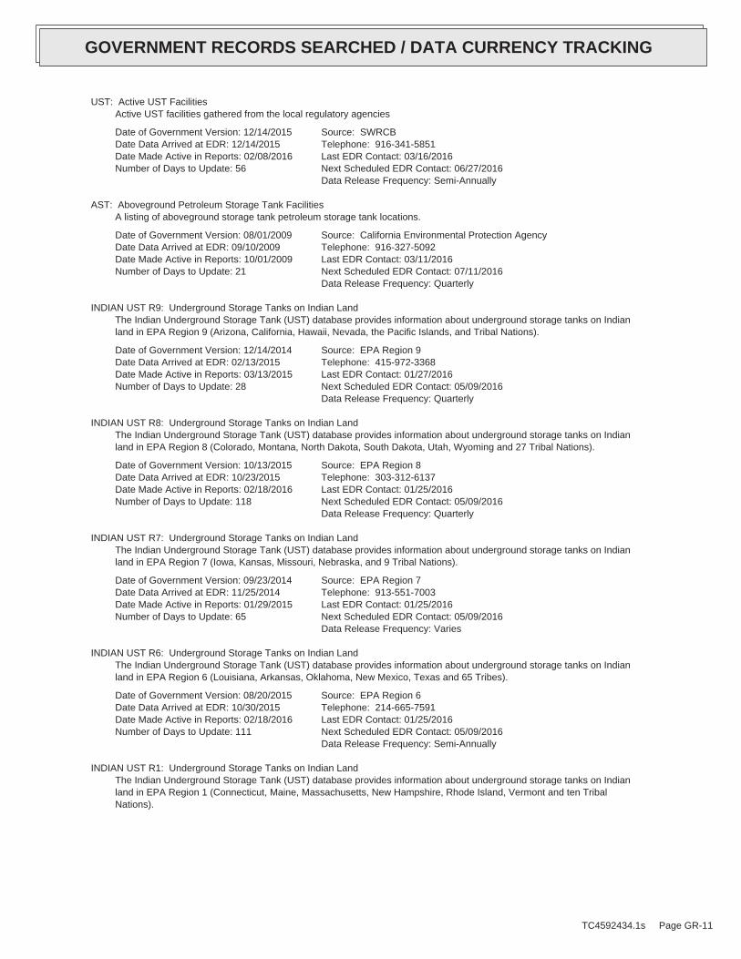
UST: Active UST FacilitiesActive UST facilities gathered from the local regulatory agencies
Date of Government Version: 12/14/2015Date Data Arrived at EDR: 12/14/2015Date Made Active in Reports: 02/08/2016Number of Days to Update: 56
Source: SWRCBTelephone: 916-341-5851Last EDR Contact: 03/16/2016Next Scheduled EDR Contact: 06/27/2016Data Release Frequency: Semi-Annually
AST: Aboveground Petroleum Storage Tank FacilitiesA listing of aboveground storage tank petroleum storage tank locations.
Date of Government Version: 08/01/2009Date Data Arrived at EDR: 09/10/2009Date Made Active in Reports: 10/01/2009Number of Days to Update: 21
Source: California Environmental Protection AgencyTelephone: 916-327-5092Last EDR Contact: 03/11/2016Next Scheduled EDR Contact: 07/11/2016Data Release Frequency: Quarterly
INDIAN UST R9: Underground Storage Tanks on Indian LandThe Indian Underground Storage Tank (UST) database provides information about underground storage tanks on Indianland in EPA Region 9 (Arizona, California, Hawaii, Nevada, the Pacific Islands, and Tribal Nations).
Date of Government Version: 12/14/2014Date Data Arrived at EDR: 02/13/2015Date Made Active in Reports: 03/13/2015Number of Days to Update: 28
Source: EPA Region 9Telephone: 415-972-3368Last EDR Contact: 01/27/2016Next Scheduled EDR Contact: 05/09/2016Data Release Frequency: Quarterly
INDIAN UST R8: Underground Storage Tanks on Indian LandThe Indian Underground Storage Tank (UST) database provides information about underground storage tanks on Indianland in EPA Region 8 (Colorado, Montana, North Dakota, South Dakota, Utah, Wyoming and 27 Tribal Nations).
Date of Government Version: 10/13/2015Date Data Arrived at EDR: 10/23/2015Date Made Active in Reports: 02/18/2016Number of Days to Update: 118
Source: EPA Region 8Telephone: 303-312-6137Last EDR Contact: 01/25/2016Next Scheduled EDR Contact: 05/09/2016Data Release Frequency: Quarterly
INDIAN UST R7: Underground Storage Tanks on Indian LandThe Indian Underground Storage Tank (UST) database provides information about underground storage tanks on Indianland in EPA Region 7 (Iowa, Kansas, Missouri, Nebraska, and 9 Tribal Nations).
Date of Government Version: 09/23/2014Date Data Arrived at EDR: 11/25/2014Date Made Active in Reports: 01/29/2015Number of Days to Update: 65
Source: EPA Region 7Telephone: 913-551-7003Last EDR Contact: 01/25/2016Next Scheduled EDR Contact: 05/09/2016Data Release Frequency: Varies
INDIAN UST R6: Underground Storage Tanks on Indian LandThe Indian Underground Storage Tank (UST) database provides information about underground storage tanks on Indianland in EPA Region 6 (Louisiana, Arkansas, Oklahoma, New Mexico, Texas and 65 Tribes).
Date of Government Version: 08/20/2015Date Data Arrived at EDR: 10/30/2015Date Made Active in Reports: 02/18/2016Number of Days to Update: 111
Source: EPA Region 6Telephone: 214-665-7591Last EDR Contact: 01/25/2016Next Scheduled EDR Contact: 05/09/2016Data Release Frequency: Semi-Annually
INDIAN UST R1: Underground Storage Tanks on Indian LandThe Indian Underground Storage Tank (UST) database provides information about underground storage tanks on Indianland in EPA Region 1 (Connecticut, Maine, Massachusetts, New Hampshire, Rhode Island, Vermont and ten TribalNations).
TC4592434.1s Page GR-11
GOVERNMENT RECORDS SEARCHED / DATA CURRENCY TRACKING

Date of Government Version: 10/20/2015Date Data Arrived at EDR: 10/29/2015Date Made Active in Reports: 01/04/2016Number of Days to Update: 67
Source: EPA, Region 1Telephone: 617-918-1313Last EDR Contact: 02/22/2016Next Scheduled EDR Contact: 05/09/2016Data Release Frequency: Varies
INDIAN UST R4: Underground Storage Tanks on Indian LandThe Indian Underground Storage Tank (UST) database provides information about underground storage tanks on Indianland in EPA Region 4 (Alabama, Florida, Georgia, Kentucky, Mississippi, North Carolina, South Carolina, Tennesseeand Tribal Nations)
Date of Government Version: 11/24/2015Date Data Arrived at EDR: 12/01/2015Date Made Active in Reports: 01/04/2016Number of Days to Update: 34
Source: EPA Region 4Telephone: 404-562-9424Last EDR Contact: 01/25/2016Next Scheduled EDR Contact: 05/09/2016Data Release Frequency: Semi-Annually
INDIAN UST R5: Underground Storage Tanks on Indian LandThe Indian Underground Storage Tank (UST) database provides information about underground storage tanks on Indianland in EPA Region 5 (Michigan, Minnesota and Wisconsin and Tribal Nations).
Date of Government Version: 11/05/2015Date Data Arrived at EDR: 11/13/2015Date Made Active in Reports: 01/04/2016Number of Days to Update: 52
Source: EPA Region 5Telephone: 312-886-6136Last EDR Contact: 01/25/2016Next Scheduled EDR Contact: 05/09/2016Data Release Frequency: Varies
INDIAN UST R10: Underground Storage Tanks on Indian LandThe Indian Underground Storage Tank (UST) database provides information about underground storage tanks on Indianland in EPA Region 10 (Alaska, Idaho, Oregon, Washington, and Tribal Nations).
Date of Government Version: 01/07/2016Date Data Arrived at EDR: 01/08/2016Date Made Active in Reports: 02/18/2016Number of Days to Update: 41
Source: EPA Region 10Telephone: 206-553-2857Last EDR Contact: 01/25/2016Next Scheduled EDR Contact: 05/09/2016Data Release Frequency: Quarterly
State and tribal voluntary cleanup sites
VCP: Voluntary Cleanup Program PropertiesContains low threat level properties with either confirmed or unconfirmed releases and the project proponentshave request that DTSC oversee investigation and/or cleanup activities and have agreed to provide coverage forDTSC’s costs.
Date of Government Version: 02/01/2016Date Data Arrived at EDR: 02/03/2016Date Made Active in Reports: 03/22/2016Number of Days to Update: 48
Source: Department of Toxic Substances ControlTelephone: 916-323-3400Last EDR Contact: 02/03/2016Next Scheduled EDR Contact: 05/16/2016Data Release Frequency: Quarterly
INDIAN VCP R7: Voluntary Cleanup Priority LisitngA listing of voluntary cleanup priority sites located on Indian Land located in Region 7.
Date of Government Version: 03/20/2008Date Data Arrived at EDR: 04/22/2008Date Made Active in Reports: 05/19/2008Number of Days to Update: 27
Source: EPA, Region 7Telephone: 913-551-7365Last EDR Contact: 04/20/2009Next Scheduled EDR Contact: 07/20/2009Data Release Frequency: Varies
TC4592434.1s Page GR-12
GOVERNMENT RECORDS SEARCHED / DATA CURRENCY TRACKING

INDIAN VCP R1: Voluntary Cleanup Priority ListingA listing of voluntary cleanup priority sites located on Indian Land located in Region 1.
Date of Government Version: 07/27/2015Date Data Arrived at EDR: 09/29/2015Date Made Active in Reports: 02/18/2016Number of Days to Update: 142
Source: EPA, Region 1Telephone: 617-918-1102Last EDR Contact: 04/01/2016Next Scheduled EDR Contact: 07/11/2016Data Release Frequency: Varies
State and tribal Brownfields sites
BROWNFIELDS: Considered Brownfieds Sites ListingA listing of sites the SWRCB considers to be Brownfields since these are sites have come to them through the MOAProcess.
Date of Government Version: 12/04/2015Date Data Arrived at EDR: 12/08/2015Date Made Active in Reports: 01/21/2016Number of Days to Update: 44
Source: State Water Resources Control BoardTelephone: 916-323-7905Last EDR Contact: 03/07/2016Next Scheduled EDR Contact: 06/20/2016Data Release Frequency: Varies
ADDITIONAL ENVIRONMENTAL RECORDS
Local Brownfield lists
US BROWNFIELDS: A Listing of Brownfields SitesBrownfields are real property, the expansion, redevelopment, or reuse of which may be complicated by the presenceor potential presence of a hazardous substance, pollutant, or contaminant. Cleaning up and reinvesting in theseproperties takes development pressures off of undeveloped, open land, and both improves and protects the environment.Assessment, Cleanup and Redevelopment Exchange System (ACRES) stores information reported by EPA Brownfieldsgrant recipients on brownfields properties assessed or cleaned up with grant funding as well as information onTargeted Brownfields Assessments performed by EPA Regions. A listing of ACRES Brownfield sites is obtained fromCleanups in My Community. Cleanups in My Community provides information on Brownfields properties for which informationis reported back to EPA, as well as areas served by Brownfields grant programs.
Date of Government Version: 12/22/2015Date Data Arrived at EDR: 12/23/2015Date Made Active in Reports: 02/18/2016Number of Days to Update: 57
Source: Environmental Protection AgencyTelephone: 202-566-2777Last EDR Contact: 03/22/2016Next Scheduled EDR Contact: 07/04/2016Data Release Frequency: Semi-Annually
Local Lists of Landfill / Solid Waste Disposal Sites
WMUDS/SWAT: Waste Management Unit DatabaseWaste Management Unit Database System. WMUDS is used by the State Water Resources Control Board staff and theRegional Water Quality Control Boards for program tracking and inventory of waste management units. WMUDS is composedof the following databases: Facility Information, Scheduled Inspections Information, Waste Management Unit Information,SWAT Program Information, SWAT Report Summary Information, SWAT Report Summary Data, Chapter 15 (formerly Subchapter15) Information, Chapter 15 Monitoring Parameters, TPCA Program Information, RCRA Program Information, ClosureInformation, and Interested Parties Information.
Date of Government Version: 04/01/2000Date Data Arrived at EDR: 04/10/2000Date Made Active in Reports: 05/10/2000Number of Days to Update: 30
Source: State Water Resources Control BoardTelephone: 916-227-4448Last EDR Contact: 02/08/2016Next Scheduled EDR Contact: 05/23/2016Data Release Frequency: No Update Planned
SWRCY: Recycler DatabaseA listing of recycling facilities in California.
TC4592434.1s Page GR-13
GOVERNMENT RECORDS SEARCHED / DATA CURRENCY TRACKING

Date of Government Version: 12/14/2015Date Data Arrived at EDR: 12/17/2015Date Made Active in Reports: 02/08/2016Number of Days to Update: 53
Source: Department of ConservationTelephone: 916-323-3836Last EDR Contact: 03/16/2016Next Scheduled EDR Contact: 06/27/2016Data Release Frequency: Quarterly
HAULERS: Registered Waste Tire Haulers ListingA listing of registered waste tire haulers.
Date of Government Version: 11/23/2015Date Data Arrived at EDR: 11/24/2015Date Made Active in Reports: 01/21/2016Number of Days to Update: 58
Source: Integrated Waste Management BoardTelephone: 916-341-6422Last EDR Contact: 02/14/2016Next Scheduled EDR Contact: 05/30/2016Data Release Frequency: Varies
DEBRIS REGION 9: Torres Martinez Reservation Illegal Dump Site LocationsA listing of illegal dump sites location on the Torres Martinez Indian Reservation located in eastern RiversideCounty and northern Imperial County, California.
Date of Government Version: 01/12/2009Date Data Arrived at EDR: 05/07/2009Date Made Active in Reports: 09/21/2009Number of Days to Update: 137
Source: EPA, Region 9Telephone: 415-947-4219Last EDR Contact: 01/25/2016Next Scheduled EDR Contact: 05/09/2016Data Release Frequency: No Update Planned
ODI: Open Dump InventoryAn open dump is defined as a disposal facility that does not comply with one or more of the Part 257 or Part 258Subtitle D Criteria.
Date of Government Version: 06/30/1985Date Data Arrived at EDR: 08/09/2004Date Made Active in Reports: 09/17/2004Number of Days to Update: 39
Source: Environmental Protection AgencyTelephone: 800-424-9346Last EDR Contact: 06/09/2004Next Scheduled EDR Contact: N/AData Release Frequency: No Update Planned
Local Lists of Hazardous waste / Contaminated Sites
US HIST CDL: National Clandestine Laboratory RegisterA listing of clandestine drug lab locations that have been removed from the DEAs National Clandestine LaboratoryRegister.
Date of Government Version: 09/17/2015Date Data Arrived at EDR: 12/04/2015Date Made Active in Reports: 02/18/2016Number of Days to Update: 76
Source: Drug Enforcement AdministrationTelephone: 202-307-1000Last EDR Contact: 03/01/2016Next Scheduled EDR Contact: 06/13/2016Data Release Frequency: No Update Planned
HIST CAL-SITES: Calsites DatabaseThe Calsites database contains potential or confirmed hazardous substance release properties. In 1996, CaliforniaEPA reevaluated and significantly reduced the number of sites in the Calsites database. No longer updated by thestate agency. It has been replaced by ENVIROSTOR.
Date of Government Version: 08/08/2005Date Data Arrived at EDR: 08/03/2006Date Made Active in Reports: 08/24/2006Number of Days to Update: 21
Source: Department of Toxic Substance ControlTelephone: 916-323-3400Last EDR Contact: 02/23/2009Next Scheduled EDR Contact: 05/25/2009Data Release Frequency: No Update Planned
SCH: School Property Evaluation ProgramThis category contains proposed and existing school sites that are being evaluated by DTSC for possible hazardousmaterials contamination. In some cases, these properties may be listed in the CalSites category depending on thelevel of threat to public health and safety or the environment they pose.
TC4592434.1s Page GR-14
GOVERNMENT RECORDS SEARCHED / DATA CURRENCY TRACKING

Date of Government Version: 02/01/2016Date Data Arrived at EDR: 02/03/2016Date Made Active in Reports: 03/22/2016Number of Days to Update: 48
Source: Department of Toxic Substances ControlTelephone: 916-323-3400Last EDR Contact: 02/03/2016Next Scheduled EDR Contact: 05/16/2016Data Release Frequency: Quarterly
CDL: Clandestine Drug LabsA listing of drug lab locations. Listing of a location in this database does not indicate that any illegal druglab materials were or were not present there, and does not constitute a determination that the location eitherrequires or does not require additional cleanup work.
Date of Government Version: 09/30/2015Date Data Arrived at EDR: 01/19/2016Date Made Active in Reports: 03/22/2016Number of Days to Update: 63
Source: Department of Toxic Substances ControlTelephone: 916-255-6504Last EDR Contact: 04/11/2016Next Scheduled EDR Contact: 07/25/2016Data Release Frequency: Varies
TOXIC PITS: Toxic Pits Cleanup Act SitesToxic PITS Cleanup Act Sites. TOXIC PITS identifies sites suspected of containing hazardous substances where cleanuphas not yet been completed.
Date of Government Version: 07/01/1995Date Data Arrived at EDR: 08/30/1995Date Made Active in Reports: 09/26/1995Number of Days to Update: 27
Source: State Water Resources Control BoardTelephone: 916-227-4364Last EDR Contact: 01/26/2009Next Scheduled EDR Contact: 04/27/2009Data Release Frequency: No Update Planned
US CDL: Clandestine Drug LabsA listing of clandestine drug lab locations. The U.S. Department of Justice ("the Department") provides thisweb site as a public service. It contains addresses of some locations where law enforcement agencies reportedthey found chemicals or other items that indicated the presence of either clandestine drug laboratories or dumpsites.In most cases, the source of the entries is not the Department, and the Department has not verified the entryand does not guarantee its accuracy. Members of the public must verify the accuracy of all entries by, for example,contacting local law enforcement and local health departments.
Date of Government Version: 09/17/2015Date Data Arrived at EDR: 12/04/2015Date Made Active in Reports: 02/18/2016Number of Days to Update: 76
Source: Drug Enforcement AdministrationTelephone: 202-307-1000Last EDR Contact: 03/01/2016Next Scheduled EDR Contact: 06/13/2016Data Release Frequency: Quarterly
Local Lists of Registered Storage Tanks
SWEEPS UST: SWEEPS UST ListingStatewide Environmental Evaluation and Planning System. This underground storage tank listing was updated andmaintained by a company contacted by the SWRCB in the early 1990’s. The listing is no longer updated or maintained.The local agency is the contact for more information on a site on the SWEEPS list.
Date of Government Version: 06/01/1994Date Data Arrived at EDR: 07/07/2005Date Made Active in Reports: 08/11/2005Number of Days to Update: 35
Source: State Water Resources Control BoardTelephone: N/ALast EDR Contact: 06/03/2005Next Scheduled EDR Contact: N/AData Release Frequency: No Update Planned
UST MENDOCINO: Mendocino County UST DatabaseA listing of underground storage tank locations in Mendocino County.
Date of Government Version: 11/25/2015Date Data Arrived at EDR: 12/01/2015Date Made Active in Reports: 12/17/2015Number of Days to Update: 16
Source: Department of Public HealthTelephone: 707-463-4466Last EDR Contact: 03/28/2016Next Scheduled EDR Contact: 06/13/2016Data Release Frequency: Annually
TC4592434.1s Page GR-15
GOVERNMENT RECORDS SEARCHED / DATA CURRENCY TRACKING

HIST UST: Hazardous Substance Storage Container DatabaseThe Hazardous Substance Storage Container Database is a historical listing of UST sites. Refer to local/countysource for current data.
Date of Government Version: 10/15/1990Date Data Arrived at EDR: 01/25/1991Date Made Active in Reports: 02/12/1991Number of Days to Update: 18
Source: State Water Resources Control BoardTelephone: 916-341-5851Last EDR Contact: 07/26/2001Next Scheduled EDR Contact: N/AData Release Frequency: No Update Planned
CA FID UST: Facility Inventory DatabaseThe Facility Inventory Database (FID) contains a historical listing of active and inactive underground storagetank locations from the State Water Resource Control Board. Refer to local/county source for current data.
Date of Government Version: 10/31/1994Date Data Arrived at EDR: 09/05/1995Date Made Active in Reports: 09/29/1995Number of Days to Update: 24
Source: California Environmental Protection AgencyTelephone: 916-341-5851Last EDR Contact: 12/28/1998Next Scheduled EDR Contact: N/AData Release Frequency: No Update Planned
Local Land Records
LIENS: Environmental Liens ListingA listing of property locations with environmental liens for California where DTSC is a lien holder.
Date of Government Version: 12/17/2015Date Data Arrived at EDR: 12/22/2015Date Made Active in Reports: 02/08/2016Number of Days to Update: 48
Source: Department of Toxic Substances ControlTelephone: 916-323-3400Last EDR Contact: 03/07/2016Next Scheduled EDR Contact: 06/20/2016Data Release Frequency: Varies
LIENS 2: CERCLA Lien InformationA Federal CERCLA (’Superfund’) lien can exist by operation of law at any site or property at which EPA has spentSuperfund monies. These monies are spent to investigate and address releases and threatened releases of contamination.CERCLIS provides information as to the identity of these sites and properties.
Date of Government Version: 02/18/2014Date Data Arrived at EDR: 03/18/2014Date Made Active in Reports: 04/24/2014Number of Days to Update: 37
Source: Environmental Protection AgencyTelephone: 202-564-6023Last EDR Contact: 03/11/2016Next Scheduled EDR Contact: 05/09/2016Data Release Frequency: Varies
DEED: Deed Restriction ListingSite Mitigation and Brownfields Reuse Program Facility Sites with Deed Restrictions & Hazardous Waste ManagementProgram Facility Sites with Deed / Land Use Restriction. The DTSC Site Mitigation and Brownfields Reuse Program(SMBRP) list includes sites cleaned up under the program’s oversight and generally does not include currentor former hazardous waste facilities that required a hazardous waste facility permit. The list represents deedrestrictions that are active. Some sites have multiple deed restrictions. The DTSC Hazardous Waste ManagementProgram (HWMP) has developed a list of current or former hazardous waste facilities that have a recorded landuse restriction at the local county recorder’s office. The land use restrictions on this list were required bythe DTSC HWMP as a result of the presence of hazardous substances that remain on site after the facility (orpart of the facility) has been closed or cleaned up. The types of land use restriction include deed notice, deedrestriction, or a land use restriction that binds current and future owners.
Date of Government Version: 12/07/2015Date Data Arrived at EDR: 12/08/2015Date Made Active in Reports: 01/21/2016Number of Days to Update: 44
Source: DTSC and SWRCBTelephone: 916-323-3400Last EDR Contact: 03/08/2016Next Scheduled EDR Contact: 06/20/2016Data Release Frequency: Semi-Annually
Records of Emergency Release Reports
TC4592434.1s Page GR-16
GOVERNMENT RECORDS SEARCHED / DATA CURRENCY TRACKING
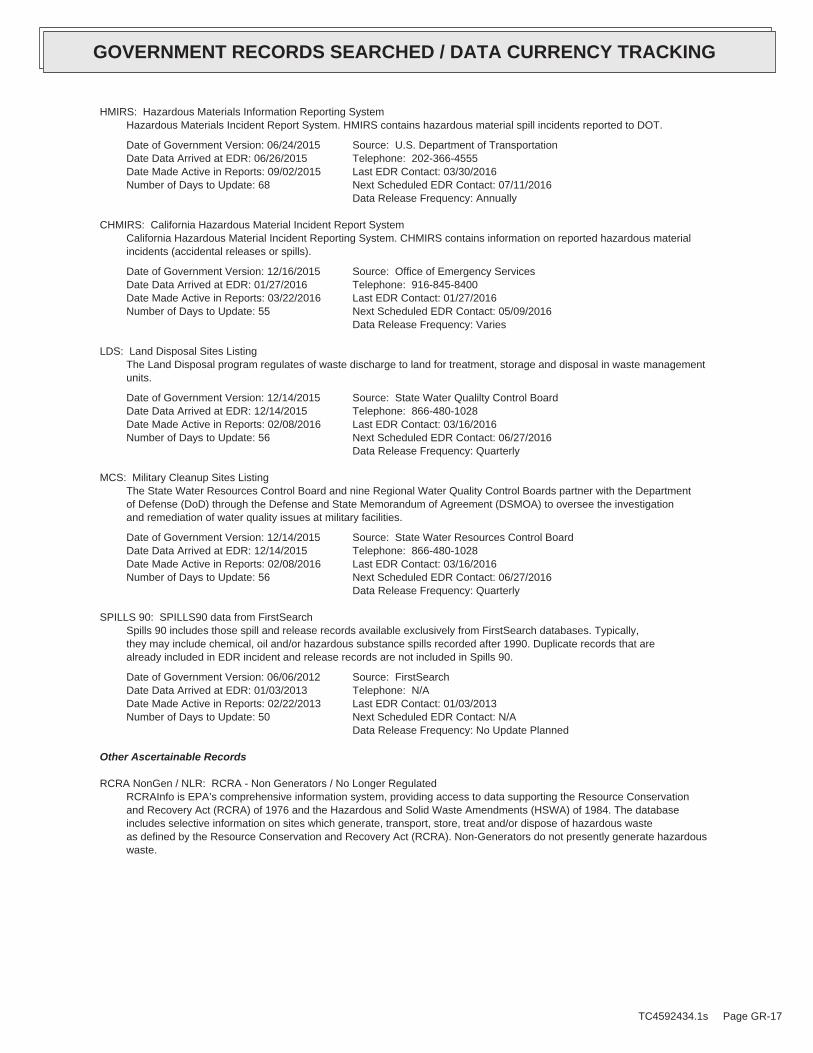
HMIRS: Hazardous Materials Information Reporting SystemHazardous Materials Incident Report System. HMIRS contains hazardous material spill incidents reported to DOT.
Date of Government Version: 06/24/2015Date Data Arrived at EDR: 06/26/2015Date Made Active in Reports: 09/02/2015Number of Days to Update: 68
Source: U.S. Department of TransportationTelephone: 202-366-4555Last EDR Contact: 03/30/2016Next Scheduled EDR Contact: 07/11/2016Data Release Frequency: Annually
CHMIRS: California Hazardous Material Incident Report SystemCalifornia Hazardous Material Incident Reporting System. CHMIRS contains information on reported hazardous materialincidents (accidental releases or spills).
Date of Government Version: 12/16/2015Date Data Arrived at EDR: 01/27/2016Date Made Active in Reports: 03/22/2016Number of Days to Update: 55
Source: Office of Emergency ServicesTelephone: 916-845-8400Last EDR Contact: 01/27/2016Next Scheduled EDR Contact: 05/09/2016Data Release Frequency: Varies
LDS: Land Disposal Sites ListingThe Land Disposal program regulates of waste discharge to land for treatment, storage and disposal in waste managementunits.
Date of Government Version: 12/14/2015Date Data Arrived at EDR: 12/14/2015Date Made Active in Reports: 02/08/2016Number of Days to Update: 56
Source: State Water Qualilty Control BoardTelephone: 866-480-1028Last EDR Contact: 03/16/2016Next Scheduled EDR Contact: 06/27/2016Data Release Frequency: Quarterly
MCS: Military Cleanup Sites ListingThe State Water Resources Control Board and nine Regional Water Quality Control Boards partner with the Departmentof Defense (DoD) through the Defense and State Memorandum of Agreement (DSMOA) to oversee the investigationand remediation of water quality issues at military facilities.
Date of Government Version: 12/14/2015Date Data Arrived at EDR: 12/14/2015Date Made Active in Reports: 02/08/2016Number of Days to Update: 56
Source: State Water Resources Control BoardTelephone: 866-480-1028Last EDR Contact: 03/16/2016Next Scheduled EDR Contact: 06/27/2016Data Release Frequency: Quarterly
SPILLS 90: SPILLS90 data from FirstSearchSpills 90 includes those spill and release records available exclusively from FirstSearch databases. Typically,they may include chemical, oil and/or hazardous substance spills recorded after 1990. Duplicate records that arealready included in EDR incident and release records are not included in Spills 90.
Date of Government Version: 06/06/2012Date Data Arrived at EDR: 01/03/2013Date Made Active in Reports: 02/22/2013Number of Days to Update: 50
Source: FirstSearchTelephone: N/ALast EDR Contact: 01/03/2013Next Scheduled EDR Contact: N/AData Release Frequency: No Update Planned
Other Ascertainable Records
RCRA NonGen / NLR: RCRA - Non Generators / No Longer RegulatedRCRAInfo is EPA’s comprehensive information system, providing access to data supporting the Resource Conservationand Recovery Act (RCRA) of 1976 and the Hazardous and Solid Waste Amendments (HSWA) of 1984. The databaseincludes selective information on sites which generate, transport, store, treat and/or dispose of hazardous wasteas defined by the Resource Conservation and Recovery Act (RCRA). Non-Generators do not presently generate hazardouswaste.
TC4592434.1s Page GR-17
GOVERNMENT RECORDS SEARCHED / DATA CURRENCY TRACKING

Date of Government Version: 12/09/2015Date Data Arrived at EDR: 03/02/2016Date Made Active in Reports: 04/05/2016Number of Days to Update: 34
Source: Environmental Protection AgencyTelephone: (415) 495-8895Last EDR Contact: 03/30/2016Next Scheduled EDR Contact: 07/11/2016Data Release Frequency: Varies
FUDS: Formerly Used Defense SitesThe listing includes locations of Formerly Used Defense Sites properties where the US Army Corps of Engineersis actively working or will take necessary cleanup actions.
Date of Government Version: 01/31/2015Date Data Arrived at EDR: 07/08/2015Date Made Active in Reports: 10/13/2015Number of Days to Update: 97
Source: U.S. Army Corps of EngineersTelephone: 202-528-4285Last EDR Contact: 03/11/2016Next Scheduled EDR Contact: 06/20/2016Data Release Frequency: Varies
DOD: Department of Defense SitesThis data set consists of federally owned or administered lands, administered by the Department of Defense, thathave any area equal to or greater than 640 acres of the United States, Puerto Rico, and the U.S. Virgin Islands.
Date of Government Version: 12/31/2005Date Data Arrived at EDR: 11/10/2006Date Made Active in Reports: 01/11/2007Number of Days to Update: 62
Source: USGSTelephone: 888-275-8747Last EDR Contact: 01/15/2016Next Scheduled EDR Contact: 04/25/2016Data Release Frequency: Semi-Annually
FEDLAND: Federal and Indian LandsFederally and Indian administrated lands of the United States. Lands included are administrated by: Army Corpsof Engineers, Bureau of Reclamation, National Wild and Scenic River, National Wildlife Refuge, Public Domain Land,Wilderness, Wilderness Study Area, Wildlife Management Area, Bureau of Indian Affairs, Bureau of Land Management,Department of Justice, Forest Service, Fish and Wildlife Service, National Park Service.
Date of Government Version: 12/31/2005Date Data Arrived at EDR: 02/06/2006Date Made Active in Reports: 01/11/2007Number of Days to Update: 339
Source: U.S. Geological SurveyTelephone: 888-275-8747Last EDR Contact: 01/15/2016Next Scheduled EDR Contact: 04/25/2016Data Release Frequency: N/A
SCRD DRYCLEANERS: State Coalition for Remediation of Drycleaners ListingThe State Coalition for Remediation of Drycleaners was established in 1998, with support from the U.S. EPA Officeof Superfund Remediation and Technology Innovation. It is comprised of representatives of states with establisheddrycleaner remediation programs. Currently the member states are Alabama, Connecticut, Florida, Illinois, Kansas,Minnesota, Missouri, North Carolina, Oregon, South Carolina, Tennessee, Texas, and Wisconsin.
Date of Government Version: 03/07/2011Date Data Arrived at EDR: 03/09/2011Date Made Active in Reports: 05/02/2011Number of Days to Update: 54
Source: Environmental Protection AgencyTelephone: 615-532-8599Last EDR Contact: 02/19/2016Next Scheduled EDR Contact: 05/30/2016Data Release Frequency: Varies
US FIN ASSUR: Financial Assurance InformationAll owners and operators of facilities that treat, store, or dispose of hazardous waste are required to provideproof that they will have sufficient funds to pay for the clean up, closure, and post-closure care of their facilities.
Date of Government Version: 09/01/2015Date Data Arrived at EDR: 09/03/2015Date Made Active in Reports: 11/03/2015Number of Days to Update: 61
Source: Environmental Protection AgencyTelephone: 202-566-1917Last EDR Contact: 02/16/2016Next Scheduled EDR Contact: 05/30/2016Data Release Frequency: Quarterly
TC4592434.1s Page GR-18
GOVERNMENT RECORDS SEARCHED / DATA CURRENCY TRACKING

EPA WATCH LIST: EPA WATCH LISTEPA maintains a "Watch List" to facilitate dialogue between EPA, state and local environmental agencies on enforcementmatters relating to facilities with alleged violations identified as either significant or high priority. Beingon the Watch List does not mean that the facility has actually violated the law only that an investigation byEPA or a state or local environmental agency has led those organizations to allege that an unproven violationhas in fact occurred. Being on the Watch List does not represent a higher level of concern regarding the allegedviolations that were detected, but instead indicates cases requiring additional dialogue between EPA, state andlocal agencies - primarily because of the length of time the alleged violation has gone unaddressed or unresolved.
Date of Government Version: 08/30/2013Date Data Arrived at EDR: 03/21/2014Date Made Active in Reports: 06/17/2014Number of Days to Update: 88
Source: Environmental Protection AgencyTelephone: 617-520-3000Last EDR Contact: 02/09/2016Next Scheduled EDR Contact: 05/23/2016Data Release Frequency: Quarterly
2020 COR ACTION: 2020 Corrective Action Program ListThe EPA has set ambitious goals for the RCRA Corrective Action program by creating the 2020 Corrective ActionUniverse. This RCRA cleanup baseline includes facilities expected to need corrective action. The 2020 universecontains a wide variety of sites. Some properties are heavily contaminated while others were contaminated buthave since been cleaned up. Still others have not been fully investigated yet, and may require little or no remediation.Inclusion in the 2020 Universe does not necessarily imply failure on the part of a facility to meet its RCRA obligations.
Date of Government Version: 04/22/2013Date Data Arrived at EDR: 03/03/2015Date Made Active in Reports: 03/09/2015Number of Days to Update: 6
Source: Environmental Protection AgencyTelephone: 703-308-4044Last EDR Contact: 02/12/2016Next Scheduled EDR Contact: 05/23/2016Data Release Frequency: Varies
TSCA: Toxic Substances Control ActToxic Substances Control Act. TSCA identifies manufacturers and importers of chemical substances included on theTSCA Chemical Substance Inventory list. It includes data on the production volume of these substances by plantsite.
Date of Government Version: 12/31/2012Date Data Arrived at EDR: 01/15/2015Date Made Active in Reports: 01/29/2015Number of Days to Update: 14
Source: EPATelephone: 202-260-5521Last EDR Contact: 03/24/2016Next Scheduled EDR Contact: 07/04/2016Data Release Frequency: Every 4 Years
TRIS: Toxic Chemical Release Inventory SystemToxic Release Inventory System. TRIS identifies facilities which release toxic chemicals to the air, water andland in reportable quantities under SARA Title III Section 313.
Date of Government Version: 12/31/2014Date Data Arrived at EDR: 11/24/2015Date Made Active in Reports: 04/05/2016Number of Days to Update: 133
Source: EPATelephone: 202-566-0250Last EDR Contact: 02/24/2016Next Scheduled EDR Contact: 06/06/2016Data Release Frequency: Annually
SSTS: Section 7 Tracking SystemsSection 7 of the Federal Insecticide, Fungicide and Rodenticide Act, as amended (92 Stat. 829) requires allregistered pesticide-producing establishments to submit a report to the Environmental Protection Agency by March1st each year. Each establishment must report the types and amounts of pesticides, active ingredients and devicesbeing produced, and those having been produced and sold or distributed in the past year.
Date of Government Version: 12/31/2009Date Data Arrived at EDR: 12/10/2010Date Made Active in Reports: 02/25/2011Number of Days to Update: 77
Source: EPATelephone: 202-564-4203Last EDR Contact: 01/25/2016Next Scheduled EDR Contact: 05/09/2016Data Release Frequency: Annually
TC4592434.1s Page GR-19
GOVERNMENT RECORDS SEARCHED / DATA CURRENCY TRACKING

ROD: Records Of DecisionRecord of Decision. ROD documents mandate a permanent remedy at an NPL (Superfund) site containing technicaland health information to aid in the cleanup.
Date of Government Version: 11/25/2013Date Data Arrived at EDR: 12/12/2013Date Made Active in Reports: 02/24/2014Number of Days to Update: 74
Source: EPATelephone: 703-416-0223Last EDR Contact: 03/08/2016Next Scheduled EDR Contact: 06/20/2016Data Release Frequency: Annually
RMP: Risk Management PlansWhen Congress passed the Clean Air Act Amendments of 1990, it required EPA to publish regulations and guidancefor chemical accident prevention at facilities using extremely hazardous substances. The Risk Management ProgramRule (RMP Rule) was written to implement Section 112(r) of these amendments. The rule, which built upon existingindustry codes and standards, requires companies of all sizes that use certain flammable and toxic substancesto develop a Risk Management Program, which includes a(n): Hazard assessment that details the potential effectsof an accidental release, an accident history of the last five years, and an evaluation of worst-case and alternativeaccidental releases; Prevention program that includes safety precautions and maintenance, monitoring, and employeetraining measures; and Emergency response program that spells out emergency health care, employee training measuresand procedures for informing the public and response agencies (e.g the fire department) should an accident occur.
Date of Government Version: 08/01/2015Date Data Arrived at EDR: 08/26/2015Date Made Active in Reports: 11/03/2015Number of Days to Update: 69
Source: Environmental Protection AgencyTelephone: 202-564-8600Last EDR Contact: 01/25/2016Next Scheduled EDR Contact: 05/09/2016Data Release Frequency: Varies
RAATS: RCRA Administrative Action Tracking SystemRCRA Administration Action Tracking System. RAATS contains records based on enforcement actions issued under RCRApertaining to major violators and includes administrative and civil actions brought by the EPA. For administrationactions after September 30, 1995, data entry in the RAATS database was discontinued. EPA will retain a copy ofthe database for historical records. It was necessary to terminate RAATS because a decrease in agency resourcesmade it impossible to continue to update the information contained in the database.
Date of Government Version: 04/17/1995Date Data Arrived at EDR: 07/03/1995Date Made Active in Reports: 08/07/1995Number of Days to Update: 35
Source: EPATelephone: 202-564-4104Last EDR Contact: 06/02/2008Next Scheduled EDR Contact: 09/01/2008Data Release Frequency: No Update Planned
PRP: Potentially Responsible PartiesA listing of verified Potentially Responsible Parties
Date of Government Version: 10/25/2013Date Data Arrived at EDR: 10/17/2014Date Made Active in Reports: 10/20/2014Number of Days to Update: 3
Source: EPATelephone: 202-564-6023Last EDR Contact: 02/12/2016Next Scheduled EDR Contact: 05/23/2016Data Release Frequency: Quarterly
PADS: PCB Activity Database SystemPCB Activity Database. PADS Identifies generators, transporters, commercial storers and/or brokers and disposersof PCB’s who are required to notify the EPA of such activities.
Date of Government Version: 07/01/2014Date Data Arrived at EDR: 10/15/2014Date Made Active in Reports: 11/17/2014Number of Days to Update: 33
Source: EPATelephone: 202-566-0500Last EDR Contact: 04/12/2016Next Scheduled EDR Contact: 07/25/2016Data Release Frequency: Annually
TC4592434.1s Page GR-20
GOVERNMENT RECORDS SEARCHED / DATA CURRENCY TRACKING
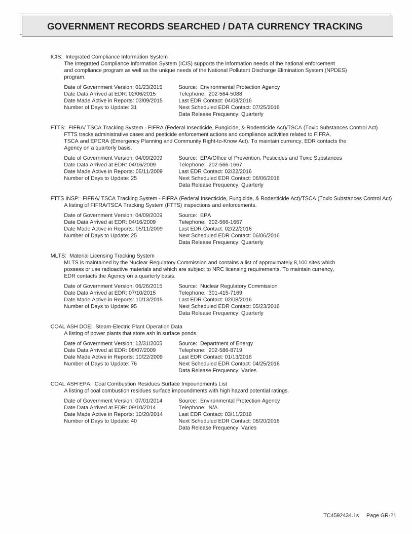
ICIS: Integrated Compliance Information SystemThe Integrated Compliance Information System (ICIS) supports the information needs of the national enforcementand compliance program as well as the unique needs of the National Pollutant Discharge Elimination System (NPDES)program.
Date of Government Version: 01/23/2015Date Data Arrived at EDR: 02/06/2015Date Made Active in Reports: 03/09/2015Number of Days to Update: 31
Source: Environmental Protection AgencyTelephone: 202-564-5088Last EDR Contact: 04/08/2016Next Scheduled EDR Contact: 07/25/2016Data Release Frequency: Quarterly
FTTS: FIFRA/ TSCA Tracking System - FIFRA (Federal Insecticide, Fungicide, & Rodenticide Act)/TSCA (Toxic Substances Control Act)FTTS tracks administrative cases and pesticide enforcement actions and compliance activities related to FIFRA,TSCA and EPCRA (Emergency Planning and Community Right-to-Know Act). To maintain currency, EDR contacts theAgency on a quarterly basis.
Date of Government Version: 04/09/2009Date Data Arrived at EDR: 04/16/2009Date Made Active in Reports: 05/11/2009Number of Days to Update: 25
Source: EPA/Office of Prevention, Pesticides and Toxic SubstancesTelephone: 202-566-1667Last EDR Contact: 02/22/2016Next Scheduled EDR Contact: 06/06/2016Data Release Frequency: Quarterly
FTTS INSP: FIFRA/ TSCA Tracking System - FIFRA (Federal Insecticide, Fungicide, & Rodenticide Act)/TSCA (Toxic Substances Control Act)A listing of FIFRA/TSCA Tracking System (FTTS) inspections and enforcements.
Date of Government Version: 04/09/2009Date Data Arrived at EDR: 04/16/2009Date Made Active in Reports: 05/11/2009Number of Days to Update: 25
Source: EPATelephone: 202-566-1667Last EDR Contact: 02/22/2016Next Scheduled EDR Contact: 06/06/2016Data Release Frequency: Quarterly
MLTS: Material Licensing Tracking SystemMLTS is maintained by the Nuclear Regulatory Commission and contains a list of approximately 8,100 sites whichpossess or use radioactive materials and which are subject to NRC licensing requirements. To maintain currency,EDR contacts the Agency on a quarterly basis.
Date of Government Version: 06/26/2015Date Data Arrived at EDR: 07/10/2015Date Made Active in Reports: 10/13/2015Number of Days to Update: 95
Source: Nuclear Regulatory CommissionTelephone: 301-415-7169Last EDR Contact: 02/08/2016Next Scheduled EDR Contact: 05/23/2016Data Release Frequency: Quarterly
COAL ASH DOE: Steam-Electric Plant Operation DataA listing of power plants that store ash in surface ponds.
Date of Government Version: 12/31/2005Date Data Arrived at EDR: 08/07/2009Date Made Active in Reports: 10/22/2009Number of Days to Update: 76
Source: Department of EnergyTelephone: 202-586-8719Last EDR Contact: 01/13/2016Next Scheduled EDR Contact: 04/25/2016Data Release Frequency: Varies
COAL ASH EPA: Coal Combustion Residues Surface Impoundments ListA listing of coal combustion residues surface impoundments with high hazard potential ratings.
Date of Government Version: 07/01/2014Date Data Arrived at EDR: 09/10/2014Date Made Active in Reports: 10/20/2014Number of Days to Update: 40
Source: Environmental Protection AgencyTelephone: N/ALast EDR Contact: 03/11/2016Next Scheduled EDR Contact: 06/20/2016Data Release Frequency: Varies
TC4592434.1s Page GR-21
GOVERNMENT RECORDS SEARCHED / DATA CURRENCY TRACKING

PCB TRANSFORMER: PCB Transformer Registration DatabaseThe database of PCB transformer registrations that includes all PCB registration submittals.
Date of Government Version: 02/01/2011Date Data Arrived at EDR: 10/19/2011Date Made Active in Reports: 01/10/2012Number of Days to Update: 83
Source: Environmental Protection AgencyTelephone: 202-566-0517Last EDR Contact: 01/29/2016Next Scheduled EDR Contact: 05/09/2016Data Release Frequency: Varies
RADINFO: Radiation Information DatabaseThe Radiation Information Database (RADINFO) contains information about facilities that are regulated by U.S.Environmental Protection Agency (EPA) regulations for radiation and radioactivity.
Date of Government Version: 07/07/2015Date Data Arrived at EDR: 07/09/2015Date Made Active in Reports: 09/16/2015Number of Days to Update: 69
Source: Environmental Protection AgencyTelephone: 202-343-9775Last EDR Contact: 04/08/2016Next Scheduled EDR Contact: 07/18/2016Data Release Frequency: Quarterly
HIST FTTS: FIFRA/TSCA Tracking System Administrative Case ListingA complete administrative case listing from the FIFRA/TSCA Tracking System (FTTS) for all ten EPA regions. Theinformation was obtained from the National Compliance Database (NCDB). NCDB supports the implementation of FIFRA(Federal Insecticide, Fungicide, and Rodenticide Act) and TSCA (Toxic Substances Control Act). Some EPA regionsare now closing out records. Because of that, and the fact that some EPA regions are not providing EPA Headquarterswith updated records, it was decided to create a HIST FTTS database. It included records that may not be includedin the newer FTTS database updates. This database is no longer updated.
Date of Government Version: 10/19/2006Date Data Arrived at EDR: 03/01/2007Date Made Active in Reports: 04/10/2007Number of Days to Update: 40
Source: Environmental Protection AgencyTelephone: 202-564-2501Last EDR Contact: 12/17/2007Next Scheduled EDR Contact: 03/17/2008Data Release Frequency: No Update Planned
HIST FTTS INSP: FIFRA/TSCA Tracking System Inspection & Enforcement Case ListingA complete inspection and enforcement case listing from the FIFRA/TSCA Tracking System (FTTS) for all ten EPAregions. The information was obtained from the National Compliance Database (NCDB). NCDB supports the implementationof FIFRA (Federal Insecticide, Fungicide, and Rodenticide Act) and TSCA (Toxic Substances Control Act). SomeEPA regions are now closing out records. Because of that, and the fact that some EPA regions are not providingEPA Headquarters with updated records, it was decided to create a HIST FTTS database. It included records thatmay not be included in the newer FTTS database updates. This database is no longer updated.
Date of Government Version: 10/19/2006Date Data Arrived at EDR: 03/01/2007Date Made Active in Reports: 04/10/2007Number of Days to Update: 40
Source: Environmental Protection AgencyTelephone: 202-564-2501Last EDR Contact: 12/17/2008Next Scheduled EDR Contact: 03/17/2008Data Release Frequency: No Update Planned
DOT OPS: Incident and Accident DataDepartment of Transporation, Office of Pipeline Safety Incident and Accident data.
Date of Government Version: 07/31/2012Date Data Arrived at EDR: 08/07/2012Date Made Active in Reports: 09/18/2012Number of Days to Update: 42
Source: Department of Transporation, Office of Pipeline SafetyTelephone: 202-366-4595Last EDR Contact: 02/03/2016Next Scheduled EDR Contact: 05/16/2016Data Release Frequency: Varies
CONSENT: Superfund (CERCLA) Consent DecreesMajor legal settlements that establish responsibility and standards for cleanup at NPL (Superfund) sites. Releasedperiodically by United States District Courts after settlement by parties to litigation matters.
TC4592434.1s Page GR-22
GOVERNMENT RECORDS SEARCHED / DATA CURRENCY TRACKING
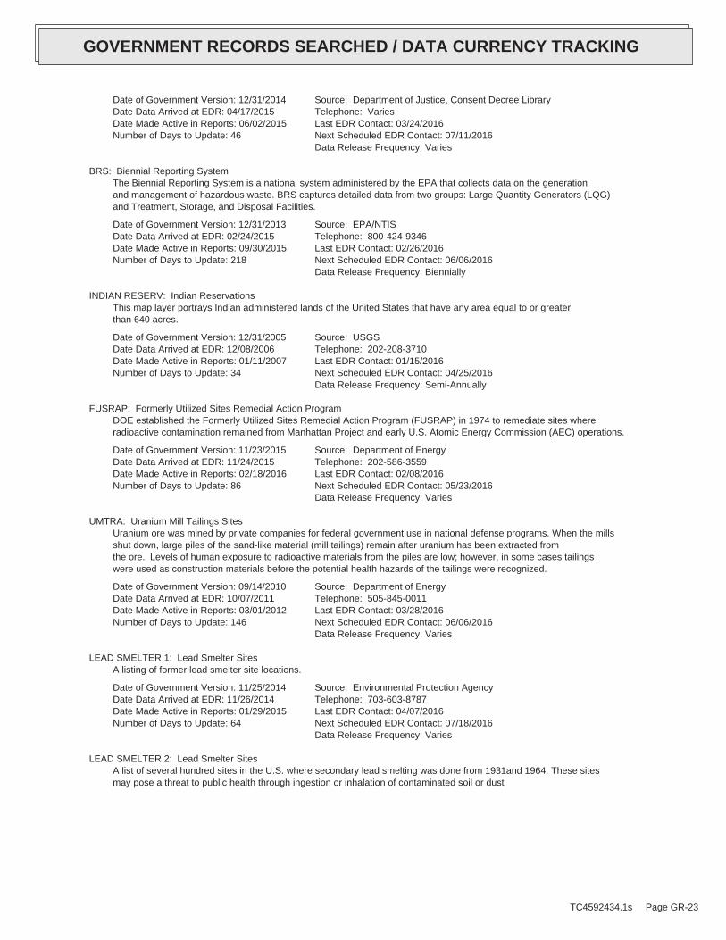
Date of Government Version: 12/31/2014Date Data Arrived at EDR: 04/17/2015Date Made Active in Reports: 06/02/2015Number of Days to Update: 46
Source: Department of Justice, Consent Decree LibraryTelephone: VariesLast EDR Contact: 03/24/2016Next Scheduled EDR Contact: 07/11/2016Data Release Frequency: Varies
BRS: Biennial Reporting SystemThe Biennial Reporting System is a national system administered by the EPA that collects data on the generationand management of hazardous waste. BRS captures detailed data from two groups: Large Quantity Generators (LQG)and Treatment, Storage, and Disposal Facilities.
Date of Government Version: 12/31/2013Date Data Arrived at EDR: 02/24/2015Date Made Active in Reports: 09/30/2015Number of Days to Update: 218
Source: EPA/NTISTelephone: 800-424-9346Last EDR Contact: 02/26/2016Next Scheduled EDR Contact: 06/06/2016Data Release Frequency: Biennially
INDIAN RESERV: Indian ReservationsThis map layer portrays Indian administered lands of the United States that have any area equal to or greaterthan 640 acres.
Date of Government Version: 12/31/2005Date Data Arrived at EDR: 12/08/2006Date Made Active in Reports: 01/11/2007Number of Days to Update: 34
Source: USGSTelephone: 202-208-3710Last EDR Contact: 01/15/2016Next Scheduled EDR Contact: 04/25/2016Data Release Frequency: Semi-Annually
FUSRAP: Formerly Utilized Sites Remedial Action ProgramDOE established the Formerly Utilized Sites Remedial Action Program (FUSRAP) in 1974 to remediate sites whereradioactive contamination remained from Manhattan Project and early U.S. Atomic Energy Commission (AEC) operations.
Date of Government Version: 11/23/2015Date Data Arrived at EDR: 11/24/2015Date Made Active in Reports: 02/18/2016Number of Days to Update: 86
Source: Department of EnergyTelephone: 202-586-3559Last EDR Contact: 02/08/2016Next Scheduled EDR Contact: 05/23/2016Data Release Frequency: Varies
UMTRA: Uranium Mill Tailings SitesUranium ore was mined by private companies for federal government use in national defense programs. When the millsshut down, large piles of the sand-like material (mill tailings) remain after uranium has been extracted fromthe ore. Levels of human exposure to radioactive materials from the piles are low; however, in some cases tailingswere used as construction materials before the potential health hazards of the tailings were recognized.
Date of Government Version: 09/14/2010Date Data Arrived at EDR: 10/07/2011Date Made Active in Reports: 03/01/2012Number of Days to Update: 146
Source: Department of EnergyTelephone: 505-845-0011Last EDR Contact: 03/28/2016Next Scheduled EDR Contact: 06/06/2016Data Release Frequency: Varies
LEAD SMELTER 1: Lead Smelter SitesA listing of former lead smelter site locations.
Date of Government Version: 11/25/2014Date Data Arrived at EDR: 11/26/2014Date Made Active in Reports: 01/29/2015Number of Days to Update: 64
Source: Environmental Protection AgencyTelephone: 703-603-8787Last EDR Contact: 04/07/2016Next Scheduled EDR Contact: 07/18/2016Data Release Frequency: Varies
LEAD SMELTER 2: Lead Smelter SitesA list of several hundred sites in the U.S. where secondary lead smelting was done from 1931and 1964. These sitesmay pose a threat to public health through ingestion or inhalation of contaminated soil or dust
TC4592434.1s Page GR-23
GOVERNMENT RECORDS SEARCHED / DATA CURRENCY TRACKING
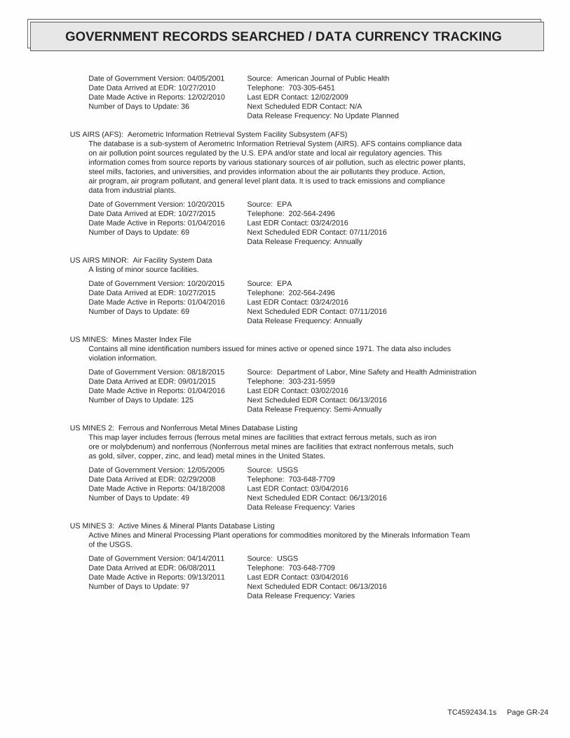
Date of Government Version: 04/05/2001Date Data Arrived at EDR: 10/27/2010Date Made Active in Reports: 12/02/2010Number of Days to Update: 36
Source: American Journal of Public HealthTelephone: 703-305-6451Last EDR Contact: 12/02/2009Next Scheduled EDR Contact: N/AData Release Frequency: No Update Planned
US AIRS (AFS): Aerometric Information Retrieval System Facility Subsystem (AFS)The database is a sub-system of Aerometric Information Retrieval System (AIRS). AFS contains compliance dataon air pollution point sources regulated by the U.S. EPA and/or state and local air regulatory agencies. Thisinformation comes from source reports by various stationary sources of air pollution, such as electric power plants,steel mills, factories, and universities, and provides information about the air pollutants they produce. Action,air program, air program pollutant, and general level plant data. It is used to track emissions and compliancedata from industrial plants.
Date of Government Version: 10/20/2015Date Data Arrived at EDR: 10/27/2015Date Made Active in Reports: 01/04/2016Number of Days to Update: 69
Source: EPATelephone: 202-564-2496Last EDR Contact: 03/24/2016Next Scheduled EDR Contact: 07/11/2016Data Release Frequency: Annually
US AIRS MINOR: Air Facility System DataA listing of minor source facilities.
Date of Government Version: 10/20/2015Date Data Arrived at EDR: 10/27/2015Date Made Active in Reports: 01/04/2016Number of Days to Update: 69
Source: EPATelephone: 202-564-2496Last EDR Contact: 03/24/2016Next Scheduled EDR Contact: 07/11/2016Data Release Frequency: Annually
US MINES: Mines Master Index FileContains all mine identification numbers issued for mines active or opened since 1971. The data also includesviolation information.
Date of Government Version: 08/18/2015Date Data Arrived at EDR: 09/01/2015Date Made Active in Reports: 01/04/2016Number of Days to Update: 125
Source: Department of Labor, Mine Safety and Health AdministrationTelephone: 303-231-5959Last EDR Contact: 03/02/2016Next Scheduled EDR Contact: 06/13/2016Data Release Frequency: Semi-Annually
US MINES 2: Ferrous and Nonferrous Metal Mines Database ListingThis map layer includes ferrous (ferrous metal mines are facilities that extract ferrous metals, such as ironore or molybdenum) and nonferrous (Nonferrous metal mines are facilities that extract nonferrous metals, suchas gold, silver, copper, zinc, and lead) metal mines in the United States.
Date of Government Version: 12/05/2005Date Data Arrived at EDR: 02/29/2008Date Made Active in Reports: 04/18/2008Number of Days to Update: 49
Source: USGSTelephone: 703-648-7709Last EDR Contact: 03/04/2016Next Scheduled EDR Contact: 06/13/2016Data Release Frequency: Varies
US MINES 3: Active Mines & Mineral Plants Database ListingActive Mines and Mineral Processing Plant operations for commodities monitored by the Minerals Information Teamof the USGS.
Date of Government Version: 04/14/2011Date Data Arrived at EDR: 06/08/2011Date Made Active in Reports: 09/13/2011Number of Days to Update: 97
Source: USGSTelephone: 703-648-7709Last EDR Contact: 03/04/2016Next Scheduled EDR Contact: 06/13/2016Data Release Frequency: Varies
TC4592434.1s Page GR-24
GOVERNMENT RECORDS SEARCHED / DATA CURRENCY TRACKING

FINDS: Facility Index System/Facility Registry SystemFacility Index System. FINDS contains both facility information and ’pointers’ to other sources that contain moredetail. EDR includes the following FINDS databases in this report: PCS (Permit Compliance System), AIRS (AerometricInformation Retrieval System), DOCKET (Enforcement Docket used to manage and track information on civil judicialenforcement cases for all environmental statutes), FURS (Federal Underground Injection Control), C-DOCKET (CriminalDocket System used to track criminal enforcement actions for all environmental statutes), FFIS (Federal FacilitiesInformation System), STATE (State Environmental Laws and Statutes), and PADS (PCB Activity Data System).
Date of Government Version: 07/20/2015Date Data Arrived at EDR: 09/09/2015Date Made Active in Reports: 11/03/2015Number of Days to Update: 55
Source: EPATelephone: (415) 947-8000Last EDR Contact: 03/08/2016Next Scheduled EDR Contact: 06/20/2016Data Release Frequency: Quarterly
CA BOND EXP. PLAN: Bond Expenditure PlanDepartment of Health Services developed a site-specific expenditure plan as the basis for an appropriation ofHazardous Substance Cleanup Bond Act funds. It is not updated.
Date of Government Version: 01/01/1989Date Data Arrived at EDR: 07/27/1994Date Made Active in Reports: 08/02/1994Number of Days to Update: 6
Source: Department of Health ServicesTelephone: 916-255-2118Last EDR Contact: 05/31/1994Next Scheduled EDR Contact: N/AData Release Frequency: No Update Planned
CORTESE: "Cortese" Hazardous Waste & Substances Sites ListThe sites for the list are designated by the State Water Resource Control Board (LUST), the Integrated WasteBoard (SWF/LS), and the Department of Toxic Substances Control (Cal-Sites).
Date of Government Version: 12/28/2015Date Data Arrived at EDR: 12/29/2015Date Made Active in Reports: 01/21/2016Number of Days to Update: 23
Source: CAL EPA/Office of Emergency InformationTelephone: 916-323-3400Last EDR Contact: 03/30/2016Next Scheduled EDR Contact: 07/11/2016Data Release Frequency: Quarterly
DRYCLEANERS: Cleaner FacilitiesA list of drycleaner related facilities that have EPA ID numbers. These are facilities with certain SIC codes:power laundries, family and commercial; garment pressing and cleaner’s agents; linen supply; coin-operated laundriesand cleaning; drycleaning plants, except rugs; carpet and upholster cleaning; industrial launderers; laundry andgarment services.
Date of Government Version: 02/08/2016Date Data Arrived at EDR: 02/24/2016Date Made Active in Reports: 04/01/2016Number of Days to Update: 37
Source: Department of Toxic Substance ControlTelephone: 916-327-4498Last EDR Contact: 02/05/2016Next Scheduled EDR Contact: 06/20/2016Data Release Frequency: Annually
EMI: Emissions Inventory DataToxics and criteria pollutant emissions data collected by the ARB and local air pollution agencies.
Date of Government Version: 12/31/2013Date Data Arrived at EDR: 09/25/2015Date Made Active in Reports: 11/05/2015Number of Days to Update: 41
Source: California Air Resources BoardTelephone: 916-322-2990Last EDR Contact: 03/22/2016Next Scheduled EDR Contact: 07/04/2016Data Release Frequency: Varies
ENF: Enforcement Action ListingA listing of Water Board Enforcement Actions. Formal is everything except Oral/Verbal Communication, Notice ofViolation, Expedited Payment Letter, and Staff Enforcement Letter.
TC4592434.1s Page GR-25
GOVERNMENT RECORDS SEARCHED / DATA CURRENCY TRACKING

Date of Government Version: 01/26/2016Date Data Arrived at EDR: 01/29/2016Date Made Active in Reports: 03/22/2016Number of Days to Update: 53
Source: State Water Resoruces Control BoardTelephone: 916-445-9379Last EDR Contact: 01/25/2016Next Scheduled EDR Contact: 05/09/2016Data Release Frequency: Varies
Financial Assurance 1: Financial Assurance Information ListingFinancial Assurance information
Date of Government Version: 01/28/2016Date Data Arrived at EDR: 01/29/2016Date Made Active in Reports: 03/22/2016Number of Days to Update: 53
Source: Department of Toxic Substances ControlTelephone: 916-255-3628Last EDR Contact: 01/25/2016Next Scheduled EDR Contact: 05/09/2016Data Release Frequency: Varies
Financial Assurance 2: Financial Assurance Information ListingA listing of financial assurance information for solid waste facilities. Financial assurance is intended to ensurethat resources are available to pay for the cost of closure, post-closure care, and corrective measures if theowner or operator of a regulated facility is unable or unwilling to pay.
Date of Government Version: 02/17/2016Date Data Arrived at EDR: 02/23/2016Date Made Active in Reports: 04/01/2016Number of Days to Update: 38
Source: California Integrated Waste Management BoardTelephone: 916-341-6066Last EDR Contact: 02/16/2016Next Scheduled EDR Contact: 05/30/2016Data Release Frequency: Varies
HAZNET: Facility and Manifest DataFacility and Manifest Data. The data is extracted from the copies of hazardous waste manifests received each yearby the DTSC. The annual volume of manifests is typically 700,000 - 1,000,000 annually, representing approximately350,000 - 500,000 shipments. Data are from the manifests submitted without correction, and therefore many containsome invalid values for data elements such as generator ID, TSD ID, waste category, and disposal method. Thisdatabase begins with calendar year 1993.
Date of Government Version: 12/31/2014Date Data Arrived at EDR: 10/14/2015Date Made Active in Reports: 12/11/2015Number of Days to Update: 58
Source: California Environmental Protection AgencyTelephone: 916-255-1136Last EDR Contact: 01/11/2016Next Scheduled EDR Contact: 04/25/2016Data Release Frequency: Annually
HIST CORTESE: Hazardous Waste & Substance Site ListThe sites for the list are designated by the State Water Resource Control Board [LUST], the Integrated Waste Board[SWF/LS], and the Department of Toxic Substances Control [CALSITES]. This listing is no longer updated by thestate agency.
Date of Government Version: 04/01/2001Date Data Arrived at EDR: 01/22/2009Date Made Active in Reports: 04/08/2009Number of Days to Update: 76
Source: Department of Toxic Substances ControlTelephone: 916-323-3400Last EDR Contact: 01/22/2009Next Scheduled EDR Contact: N/AData Release Frequency: No Update Planned
HWP: EnviroStor Permitted Facilities ListingDetailed information on permitted hazardous waste facilities and corrective action ("cleanups") tracked in EnviroStor.
Date of Government Version: 02/22/2016Date Data Arrived at EDR: 02/24/2016Date Made Active in Reports: 04/01/2016Number of Days to Update: 37
Source: Department of Toxic Substances ControlTelephone: 916-323-3400Last EDR Contact: 02/24/2016Next Scheduled EDR Contact: 06/06/2016Data Release Frequency: Quarterly
TC4592434.1s Page GR-26
GOVERNMENT RECORDS SEARCHED / DATA CURRENCY TRACKING
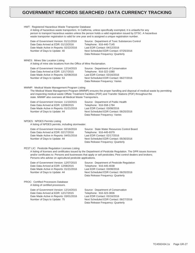
HWT: Registered Hazardous Waste Transporter DatabaseA listing of hazardous waste transporters. In California, unless specifically exempted, it is unlawful for anyperson to transport hazardous wastes unless the person holds a valid registration issued by DTSC. A hazardouswaste transporter registration is valid for one year and is assigned a unique registration number.
Date of Government Version: 01/11/2016Date Data Arrived at EDR: 01/13/2016Date Made Active in Reports: 02/22/2016Number of Days to Update: 40
Source: Department of Toxic Substances ControlTelephone: 916-440-7145Last EDR Contact: 04/12/2016Next Scheduled EDR Contact: 07/25/2016Data Release Frequency: Quarterly
MINES: Mines Site Location ListingA listing of mine site locations from the Office of Mine Reclamation.
Date of Government Version: 12/14/2015Date Data Arrived at EDR: 12/17/2015Date Made Active in Reports: 02/08/2016Number of Days to Update: 53
Source: Department of ConservationTelephone: 916-322-1080Last EDR Contact: 03/16/2016Next Scheduled EDR Contact: 06/27/2016Data Release Frequency: Varies
MWMP: Medical Waste Management Program ListingThe Medical Waste Management Program (MWMP) ensures the proper handling and disposal of medical waste by permittingand inspecting medical waste Offsite Treatment Facilities (PDF) and Transfer Stations (PDF) throughout thestate. MWMP also oversees all Medical Waste Transporters.
Date of Government Version: 11/10/2015Date Data Arrived at EDR: 12/08/2015Date Made Active in Reports: 01/21/2016Number of Days to Update: 44
Source: Department of Public HealthTelephone: 916-558-1784Last EDR Contact: 03/08/2016Next Scheduled EDR Contact: 06/20/2016Data Release Frequency: Varies
NPDES: NPDES Permits ListingA listing of NPDES permits, including stormwater.
Date of Government Version: 02/16/2016Date Data Arrived at EDR: 02/17/2016Date Made Active in Reports: 04/01/2016Number of Days to Update: 44
Source: State Water Resources Control BoardTelephone: 916-445-9379Last EDR Contact: 02/17/2016Next Scheduled EDR Contact: 05/30/2016Data Release Frequency: Quarterly
PEST LIC: Pesticide Regulation Licenses ListingA listing of licenses and certificates issued by the Department of Pesticide Regulation. The DPR issues licensesand/or certificates to: Persons and businesses that apply or sell pesticides; Pest control dealers and brokers;Persons who advise on agricultural pesticide applications.
Date of Government Version: 12/07/2015Date Data Arrived at EDR: 12/08/2015Date Made Active in Reports: 01/21/2016Number of Days to Update: 44
Source: Department of Pesticide RegulationTelephone: 916-445-4038Last EDR Contact: 03/08/2016Next Scheduled EDR Contact: 06/20/2016Data Release Frequency: Quarterly
PROC: Certified Processors DatabaseA listing of certified processors.
Date of Government Version: 12/14/2015Date Data Arrived at EDR: 12/17/2015Date Made Active in Reports: 03/01/2016Number of Days to Update: 75
Source: Department of ConservationTelephone: 916-323-3836Last EDR Contact: 03/16/2016Next Scheduled EDR Contact: 06/27/2016Data Release Frequency: Quarterly
TC4592434.1s Page GR-27
GOVERNMENT RECORDS SEARCHED / DATA CURRENCY TRACKING

NOTIFY 65: Proposition 65 RecordsListings of all Proposition 65 incidents reported to counties by the State Water Resources Control Board and theRegional Water Quality Control Board. This database is no longer updated by the reporting agency.
Date of Government Version: 09/10/2015Date Data Arrived at EDR: 01/05/2016Date Made Active in Reports: 02/12/2016Number of Days to Update: 38
Source: State Water Resources Control BoardTelephone: 916-445-3846Last EDR Contact: 04/04/2016Next Scheduled EDR Contact: 07/04/2016Data Release Frequency: No Update Planned
UIC: UIC ListingA listing of wells identified as underground injection wells, in the California Oil and Gas Wells database.
Date of Government Version: 07/23/2015Date Data Arrived at EDR: 09/15/2015Date Made Active in Reports: 10/13/2015Number of Days to Update: 28
Source: Deaprtment of ConservationTelephone: 916-445-2408Last EDR Contact: 03/16/2016Next Scheduled EDR Contact: 06/27/2016Data Release Frequency: Varies
WASTEWATER PITS: Oil Wastewater Pits ListingWater officials discovered that oil producers have been dumping chemical-laden wastewater into hundreds of unlinedpits that are operating without proper permits. Inspections completed by the Central Valley Regional Water QualityControl Board revealed the existence of previously unidentified waste sites. The water board?s review found thatmore than one-third of the region?s active disposal pits are operating without permission.
Date of Government Version: 04/15/2015Date Data Arrived at EDR: 04/17/2015Date Made Active in Reports: 06/23/2015Number of Days to Update: 67
Source: RWQCB, Central Valley RegionTelephone: 559-445-5577Last EDR Contact: 01/15/2016Next Scheduled EDR Contact: 04/25/2016Data Release Frequency: Varies
WDS: Waste Discharge SystemSites which have been issued waste discharge requirements.
Date of Government Version: 06/19/2007Date Data Arrived at EDR: 06/20/2007Date Made Active in Reports: 06/29/2007Number of Days to Update: 9
Source: State Water Resources Control BoardTelephone: 916-341-5227Last EDR Contact: 02/19/2016Next Scheduled EDR Contact: 06/16/2016Data Release Frequency: Quarterly
WIP: Well Investigation Program Case ListWell Investigation Program case in the San Gabriel and San Fernando Valley area.
Date of Government Version: 07/03/2009Date Data Arrived at EDR: 07/21/2009Date Made Active in Reports: 08/03/2009Number of Days to Update: 13
Source: Los Angeles Water Quality Control BoardTelephone: 213-576-6726Last EDR Contact: 03/28/2016Next Scheduled EDR Contact: 07/11/2016Data Release Frequency: Varies
ECHO: Enforcement & Compliance History InformationECHO provides integrated compliance and enforcement information for about 800,000 regulated facilities nationwide.
Date of Government Version: 09/20/2015Date Data Arrived at EDR: 09/23/2015Date Made Active in Reports: 01/04/2016Number of Days to Update: 103
Source: Environmental Protection AgencyTelephone: 202-564-2280Last EDR Contact: 03/23/2016Next Scheduled EDR Contact: 07/04/2016Data Release Frequency: Quarterly
FUELS PROGRAM: EPA Fuels Program Registered ListingThis listing includes facilities that are registered under the Part 80 (Code of Federal Regulations) EPA FuelsPrograms. All companies now are required to submit new and updated registrations.
TC4592434.1s Page GR-28
GOVERNMENT RECORDS SEARCHED / DATA CURRENCY TRACKING

Date of Government Version: 11/23/2015Date Data Arrived at EDR: 11/24/2015Date Made Active in Reports: 02/18/2016Number of Days to Update: 86
Source: EPATelephone: 800-385-6164Last EDR Contact: 02/24/2016Next Scheduled EDR Contact: 06/06/2016Data Release Frequency: Quarterly
EDR RECOVERED GOVERNMENT ARCHIVES
Exclusive Recovered Govt. Archives
RGA LF: Recovered Government Archive Solid Waste Facilities ListThe EDR Recovered Government Archive Landfill database provides a list of landfills derived from historical databasesand includes many records that no longer appear in current government lists. Compiled from Records formerly availablefrom the Department of Resources Recycling and Recovery in California.
Date of Government Version: N/ADate Data Arrived at EDR: 07/01/2013Date Made Active in Reports: 01/13/2014Number of Days to Update: 196
Source: Department of Resources Recycling and RecoveryTelephone: N/ALast EDR Contact: 06/01/2012Next Scheduled EDR Contact: N/AData Release Frequency: Varies
RGA LUST: Recovered Government Archive Leaking Underground Storage TankThe EDR Recovered Government Archive Leaking Underground Storage Tank database provides a list of LUST incidentsderived from historical databases and includes many records that no longer appear in current government lists.Compiled from Records formerly available from the State Water Resources Control Board in California.
Date of Government Version: N/ADate Data Arrived at EDR: 07/01/2013Date Made Active in Reports: 12/30/2013Number of Days to Update: 182
Source: State Water Resources Control BoardTelephone: N/ALast EDR Contact: 06/01/2012Next Scheduled EDR Contact: N/AData Release Frequency: Varies
COUNTY RECORDS
ALAMEDA COUNTY:
Contaminated SitesA listing of contaminated sites overseen by the Toxic Release Program (oil and groundwater contamination fromchemical releases and spills) and the Leaking Underground Storage Tank Program (soil and ground water contaminationfrom leaking petroleum USTs).
Date of Government Version: 01/11/2016Date Data Arrived at EDR: 01/12/2016Date Made Active in Reports: 02/22/2016Number of Days to Update: 41
Source: Alameda County Environmental Health ServicesTelephone: 510-567-6700Last EDR Contact: 04/11/2016Next Scheduled EDR Contact: 07/25/2016Data Release Frequency: Semi-Annually
Underground TanksUnderground storage tank sites located in Alameda county.
Date of Government Version: 01/11/2016Date Data Arrived at EDR: 01/14/2016Date Made Active in Reports: 03/01/2016Number of Days to Update: 47
Source: Alameda County Environmental Health ServicesTelephone: 510-567-6700Last EDR Contact: 04/11/2016Next Scheduled EDR Contact: 07/25/2016Data Release Frequency: Semi-Annually
AMADOR COUNTY:
TC4592434.1s Page GR-29
GOVERNMENT RECORDS SEARCHED / DATA CURRENCY TRACKING
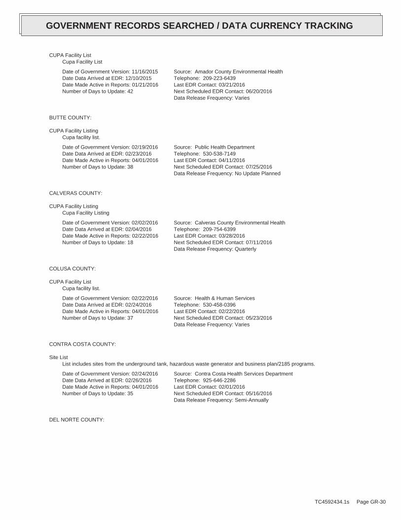
CUPA Facility ListCupa Facility List
Date of Government Version: 11/16/2015Date Data Arrived at EDR: 12/10/2015Date Made Active in Reports: 01/21/2016Number of Days to Update: 42
Source: Amador County Environmental HealthTelephone: 209-223-6439Last EDR Contact: 03/21/2016Next Scheduled EDR Contact: 06/20/2016Data Release Frequency: Varies
BUTTE COUNTY:
CUPA Facility ListingCupa facility list.
Date of Government Version: 02/19/2016Date Data Arrived at EDR: 02/23/2016Date Made Active in Reports: 04/01/2016Number of Days to Update: 38
Source: Public Health DepartmentTelephone: 530-538-7149Last EDR Contact: 04/11/2016Next Scheduled EDR Contact: 07/25/2016Data Release Frequency: No Update Planned
CALVERAS COUNTY:
CUPA Facility ListingCupa Facility Listing
Date of Government Version: 02/02/2016Date Data Arrived at EDR: 02/04/2016Date Made Active in Reports: 02/22/2016Number of Days to Update: 18
Source: Calveras County Environmental HealthTelephone: 209-754-6399Last EDR Contact: 03/28/2016Next Scheduled EDR Contact: 07/11/2016Data Release Frequency: Quarterly
COLUSA COUNTY:
CUPA Facility ListCupa facility list.
Date of Government Version: 02/22/2016Date Data Arrived at EDR: 02/24/2016Date Made Active in Reports: 04/01/2016Number of Days to Update: 37
Source: Health & Human ServicesTelephone: 530-458-0396Last EDR Contact: 02/22/2016Next Scheduled EDR Contact: 05/23/2016Data Release Frequency: Varies
CONTRA COSTA COUNTY:
Site ListList includes sites from the underground tank, hazardous waste generator and business plan/2185 programs.
Date of Government Version: 02/24/2016Date Data Arrived at EDR: 02/26/2016Date Made Active in Reports: 04/01/2016Number of Days to Update: 35
Source: Contra Costa Health Services DepartmentTelephone: 925-646-2286Last EDR Contact: 02/01/2016Next Scheduled EDR Contact: 05/16/2016Data Release Frequency: Semi-Annually
DEL NORTE COUNTY:
TC4592434.1s Page GR-30
GOVERNMENT RECORDS SEARCHED / DATA CURRENCY TRACKING

CUPA Facility ListCupa Facility list
Date of Government Version: 01/22/2016Date Data Arrived at EDR: 02/05/2016Date Made Active in Reports: 03/07/2016Number of Days to Update: 31
Source: Del Norte County Environmental Health DivisionTelephone: 707-465-0426Last EDR Contact: 02/01/2016Next Scheduled EDR Contact: 05/16/2016Data Release Frequency: Varies
EL DORADO COUNTY:
CUPA Facility ListCUPA facility list.
Date of Government Version: 02/22/2016Date Data Arrived at EDR: 02/24/2016Date Made Active in Reports: 04/01/2016Number of Days to Update: 37
Source: El Dorado County Environmental Management DepartmentTelephone: 530-621-6623Last EDR Contact: 02/01/2016Next Scheduled EDR Contact: 05/16/2016Data Release Frequency: Varies
FRESNO COUNTY:
CUPA Resources ListCertified Unified Program Agency. CUPA’s are responsible for implementing a unified hazardous materials and hazardouswaste management regulatory program. The agency provides oversight of businesses that deal with hazardous materials,operate underground storage tanks or aboveground storage tanks.
Date of Government Version: 01/05/2016Date Data Arrived at EDR: 01/08/2016Date Made Active in Reports: 02/22/2016Number of Days to Update: 45
Source: Dept. of Community HealthTelephone: 559-445-3271Last EDR Contact: 04/04/2016Next Scheduled EDR Contact: 07/18/2016Data Release Frequency: Semi-Annually
HUMBOLDT COUNTY:
CUPA Facility ListCUPA facility list.
Date of Government Version: 12/02/2015Date Data Arrived at EDR: 12/04/2015Date Made Active in Reports: 01/21/2016Number of Days to Update: 48
Source: Humboldt County Environmental HealthTelephone: N/ALast EDR Contact: 02/22/2016Next Scheduled EDR Contact: 06/06/2016Data Release Frequency: Varies
IMPERIAL COUNTY:
CUPA Facility ListCupa facility list.
Date of Government Version: 01/25/2016Date Data Arrived at EDR: 01/27/2016Date Made Active in Reports: 02/22/2016Number of Days to Update: 26
Source: San Diego Border Field OfficeTelephone: 760-339-2777Last EDR Contact: 01/25/2016Next Scheduled EDR Contact: 05/09/2016Data Release Frequency: Varies
INYO COUNTY:
TC4592434.1s Page GR-31
GOVERNMENT RECORDS SEARCHED / DATA CURRENCY TRACKING

CUPA Facility ListCupa facility list.
Date of Government Version: 09/10/2013Date Data Arrived at EDR: 09/11/2013Date Made Active in Reports: 10/14/2013Number of Days to Update: 33
Source: Inyo County Environmental Health ServicesTelephone: 760-878-0238Last EDR Contact: 02/22/2016Next Scheduled EDR Contact: 06/06/2016Data Release Frequency: Varies
KERN COUNTY:
Underground Storage Tank Sites & Tank ListingKern County Sites and Tanks Listing.
Date of Government Version: 05/19/2015Date Data Arrived at EDR: 06/18/2015Date Made Active in Reports: 07/22/2015Number of Days to Update: 34
Source: Kern County Environment Health Services DepartmentTelephone: 661-862-8700Last EDR Contact: 02/22/2016Next Scheduled EDR Contact: 05/23/2016Data Release Frequency: Quarterly
KINGS COUNTY:
CUPA Facility ListA listing of sites included in the county’s Certified Unified Program Agency database. California’s Secretaryfor Environmental Protection established the unified hazardous materials and hazardous waste regulatory programas required by chapter 6.11 of the California Health and Safety Code. The Unified Program consolidates the administration,permits, inspections, and enforcement activities.
Date of Government Version: 02/23/2016Date Data Arrived at EDR: 02/25/2016Date Made Active in Reports: 04/01/2016Number of Days to Update: 36
Source: Kings County Department of Public HealthTelephone: 559-584-1411Last EDR Contact: 02/22/2016Next Scheduled EDR Contact: 06/06/2016Data Release Frequency: Varies
LAKE COUNTY:
CUPA Facility ListCupa facility list
Date of Government Version: 02/09/2016Date Data Arrived at EDR: 02/12/2016Date Made Active in Reports: 04/01/2016Number of Days to Update: 49
Source: Lake County Environmental HealthTelephone: 707-263-1164Last EDR Contact: 01/19/2016Next Scheduled EDR Contact: 05/02/2016Data Release Frequency: Varies
LOS ANGELES COUNTY:
San Gabriel Valley Areas of ConcernSan Gabriel Valley areas where VOC contamination is at or above the MCL as designated by region 9 EPA office.
Date of Government Version: 03/30/2009Date Data Arrived at EDR: 03/31/2009Date Made Active in Reports: 10/23/2009Number of Days to Update: 206
Source: EPA Region 9Telephone: 415-972-3178Last EDR Contact: 03/21/2016Next Scheduled EDR Contact: 07/04/2016Data Release Frequency: No Update Planned
TC4592434.1s Page GR-32
GOVERNMENT RECORDS SEARCHED / DATA CURRENCY TRACKING
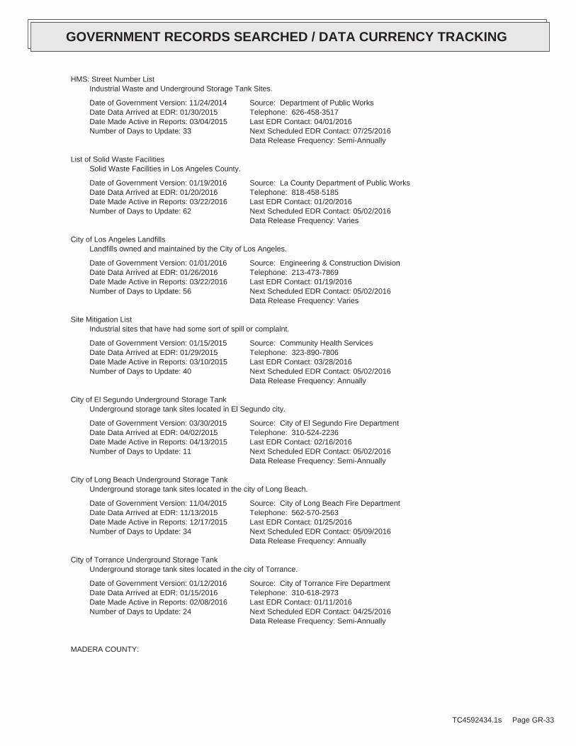
HMS: Street Number ListIndustrial Waste and Underground Storage Tank Sites.
Date of Government Version: 11/24/2014Date Data Arrived at EDR: 01/30/2015Date Made Active in Reports: 03/04/2015Number of Days to Update: 33
Source: Department of Public WorksTelephone: 626-458-3517Last EDR Contact: 04/01/2016Next Scheduled EDR Contact: 07/25/2016Data Release Frequency: Semi-Annually
List of Solid Waste FacilitiesSolid Waste Facilities in Los Angeles County.
Date of Government Version: 01/19/2016Date Data Arrived at EDR: 01/20/2016Date Made Active in Reports: 03/22/2016Number of Days to Update: 62
Source: La County Department of Public WorksTelephone: 818-458-5185Last EDR Contact: 01/20/2016Next Scheduled EDR Contact: 05/02/2016Data Release Frequency: Varies
City of Los Angeles LandfillsLandfills owned and maintained by the City of Los Angeles.
Date of Government Version: 01/01/2016Date Data Arrived at EDR: 01/26/2016Date Made Active in Reports: 03/22/2016Number of Days to Update: 56
Source: Engineering & Construction DivisionTelephone: 213-473-7869Last EDR Contact: 01/19/2016Next Scheduled EDR Contact: 05/02/2016Data Release Frequency: Varies
Site Mitigation ListIndustrial sites that have had some sort of spill or complaint.
Date of Government Version: 01/15/2015Date Data Arrived at EDR: 01/29/2015Date Made Active in Reports: 03/10/2015Number of Days to Update: 40
Source: Community Health ServicesTelephone: 323-890-7806Last EDR Contact: 03/28/2016Next Scheduled EDR Contact: 05/02/2016Data Release Frequency: Annually
City of El Segundo Underground Storage TankUnderground storage tank sites located in El Segundo city.
Date of Government Version: 03/30/2015Date Data Arrived at EDR: 04/02/2015Date Made Active in Reports: 04/13/2015Number of Days to Update: 11
Source: City of El Segundo Fire DepartmentTelephone: 310-524-2236Last EDR Contact: 02/16/2016Next Scheduled EDR Contact: 05/02/2016Data Release Frequency: Semi-Annually
City of Long Beach Underground Storage TankUnderground storage tank sites located in the city of Long Beach.
Date of Government Version: 11/04/2015Date Data Arrived at EDR: 11/13/2015Date Made Active in Reports: 12/17/2015Number of Days to Update: 34
Source: City of Long Beach Fire DepartmentTelephone: 562-570-2563Last EDR Contact: 01/25/2016Next Scheduled EDR Contact: 05/09/2016Data Release Frequency: Annually
City of Torrance Underground Storage TankUnderground storage tank sites located in the city of Torrance.
Date of Government Version: 01/12/2016Date Data Arrived at EDR: 01/15/2016Date Made Active in Reports: 02/08/2016Number of Days to Update: 24
Source: City of Torrance Fire DepartmentTelephone: 310-618-2973Last EDR Contact: 01/11/2016Next Scheduled EDR Contact: 04/25/2016Data Release Frequency: Semi-Annually
MADERA COUNTY:
TC4592434.1s Page GR-33
GOVERNMENT RECORDS SEARCHED / DATA CURRENCY TRACKING
CUPA Facility ListA listing of sites included in the county’s Certified Unified Program Agency database. California’s Secretaryfor Environmental Protection established the unified hazardous materials and hazardous waste regulatory programas required by chapter 6.11 of the California Health and Safety Code. The Unified Program consolidates the administration,permits, inspections, and enforcement activities.
Date of Government Version: 12/11/2015Date Data Arrived at EDR: 12/14/2015Date Made Active in Reports: 03/07/2016Number of Days to Update: 84
Source: Madera County Environmental HealthTelephone: 559-675-7823Last EDR Contact: 02/22/2016Next Scheduled EDR Contact: 06/06/2016Data Release Frequency: Varies
MARIN COUNTY:
Underground Storage Tank SitesCurrently permitted USTs in Marin County.
Date of Government Version: 10/05/2015Date Data Arrived at EDR: 10/08/2015Date Made Active in Reports: 10/15/2015Number of Days to Update: 7
Source: Public Works Department Waste ManagementTelephone: 415-499-6647Last EDR Contact: 04/04/2016Next Scheduled EDR Contact: 07/18/2016Data Release Frequency: Semi-Annually
MERCED COUNTY:
CUPA Facility ListCUPA facility list.
Date of Government Version: 12/14/2015Date Data Arrived at EDR: 12/18/2015Date Made Active in Reports: 01/21/2016Number of Days to Update: 34
Source: Merced County Environmental HealthTelephone: 209-381-1094Last EDR Contact: 02/22/2016Next Scheduled EDR Contact: 06/06/2016Data Release Frequency: Varies
MONO COUNTY:
CUPA Facility ListCUPA Facility List
Date of Government Version: 11/24/2015Date Data Arrived at EDR: 12/01/2015Date Made Active in Reports: 01/21/2016Number of Days to Update: 51
Source: Mono County Health DepartmentTelephone: 760-932-5580Last EDR Contact: 02/29/2016Next Scheduled EDR Contact: 06/13/2016Data Release Frequency: Varies
MONTEREY COUNTY:
CUPA Facility ListingCUPA Program listing from the Environmental Health Division.
Date of Government Version: 12/10/2015Date Data Arrived at EDR: 12/14/2015Date Made Active in Reports: 02/12/2016Number of Days to Update: 60
Source: Monterey County Health DepartmentTelephone: 831-796-1297Last EDR Contact: 02/22/2016Next Scheduled EDR Contact: 06/06/2016Data Release Frequency: Varies
NAPA COUNTY:
TC4592434.1s Page GR-34
GOVERNMENT RECORDS SEARCHED / DATA CURRENCY TRACKING

Sites With Reported ContaminationA listing of leaking underground storage tank sites located in Napa county.
Date of Government Version: 12/05/2011Date Data Arrived at EDR: 12/06/2011Date Made Active in Reports: 02/07/2012Number of Days to Update: 63
Source: Napa County Department of Environmental ManagementTelephone: 707-253-4269Last EDR Contact: 02/29/2016Next Scheduled EDR Contact: 06/13/2016Data Release Frequency: No Update Planned
Closed and Operating Underground Storage Tank SitesUnderground storage tank sites located in Napa county.
Date of Government Version: 01/15/2008Date Data Arrived at EDR: 01/16/2008Date Made Active in Reports: 02/08/2008Number of Days to Update: 23
Source: Napa County Department of Environmental ManagementTelephone: 707-253-4269Last EDR Contact: 02/29/2016Next Scheduled EDR Contact: 06/13/2016Data Release Frequency: No Update Planned
NEVADA COUNTY:
CUPA Facility ListCUPA facility list.
Date of Government Version: 01/27/2016Date Data Arrived at EDR: 02/04/2016Date Made Active in Reports: 02/22/2016Number of Days to Update: 18
Source: Community Development AgencyTelephone: 530-265-1467Last EDR Contact: 02/01/2016Next Scheduled EDR Contact: 05/16/2016Data Release Frequency: Varies
ORANGE COUNTY:
List of Industrial Site CleanupsPetroleum and non-petroleum spills.
Date of Government Version: 02/01/2016Date Data Arrived at EDR: 02/12/2016Date Made Active in Reports: 04/01/2016Number of Days to Update: 49
Source: Health Care AgencyTelephone: 714-834-3446Last EDR Contact: 02/09/2016Next Scheduled EDR Contact: 05/23/2016Data Release Frequency: Annually
List of Underground Storage Tank CleanupsOrange County Underground Storage Tank Cleanups (LUST).
Date of Government Version: 02/01/2016Date Data Arrived at EDR: 02/12/2016Date Made Active in Reports: 04/01/2016Number of Days to Update: 49
Source: Health Care AgencyTelephone: 714-834-3446Last EDR Contact: 02/09/2016Next Scheduled EDR Contact: 05/23/2016Data Release Frequency: Quarterly
List of Underground Storage Tank FacilitiesOrange County Underground Storage Tank Facilities (UST).
Date of Government Version: 02/01/2016Date Data Arrived at EDR: 02/10/2016Date Made Active in Reports: 04/01/2016Number of Days to Update: 51
Source: Health Care AgencyTelephone: 714-834-3446Last EDR Contact: 02/10/2016Next Scheduled EDR Contact: 05/23/2016Data Release Frequency: Quarterly
PLACER COUNTY:
TC4592434.1s Page GR-35
GOVERNMENT RECORDS SEARCHED / DATA CURRENCY TRACKING

Master List of FacilitiesList includes aboveground tanks, underground tanks and cleanup sites.
Date of Government Version: 12/09/2015Date Data Arrived at EDR: 12/11/2015Date Made Active in Reports: 01/21/2016Number of Days to Update: 41
Source: Placer County Health and Human ServicesTelephone: 530-745-2363Last EDR Contact: 03/07/2016Next Scheduled EDR Contact: 06/20/2016Data Release Frequency: Semi-Annually
RIVERSIDE COUNTY:
Listing of Underground Tank Cleanup SitesRiverside County Underground Storage Tank Cleanup Sites (LUST).
Date of Government Version: 01/20/2016Date Data Arrived at EDR: 01/22/2016Date Made Active in Reports: 03/22/2016Number of Days to Update: 60
Source: Department of Environmental HealthTelephone: 951-358-5055Last EDR Contact: 03/21/2016Next Scheduled EDR Contact: 07/04/2016Data Release Frequency: Quarterly
Underground Storage Tank Tank ListUnderground storage tank sites located in Riverside county.
Date of Government Version: 01/20/2016Date Data Arrived at EDR: 01/22/2016Date Made Active in Reports: 03/22/2016Number of Days to Update: 60
Source: Department of Environmental HealthTelephone: 951-358-5055Last EDR Contact: 03/21/2016Next Scheduled EDR Contact: 07/04/2016Data Release Frequency: Quarterly
SACRAMENTO COUNTY:
Toxic Site Clean-Up ListList of sites where unauthorized releases of potentially hazardous materials have occurred.
Date of Government Version: 11/02/2015Date Data Arrived at EDR: 01/05/2016Date Made Active in Reports: 02/12/2016Number of Days to Update: 38
Source: Sacramento County Environmental ManagementTelephone: 916-875-8406Last EDR Contact: 04/06/2016Next Scheduled EDR Contact: 07/18/2016Data Release Frequency: Quarterly
Master Hazardous Materials Facility ListAny business that has hazardous materials on site - hazardous material storage sites, underground storage tanks,waste generators.
Date of Government Version: 11/02/2015Date Data Arrived at EDR: 01/05/2016Date Made Active in Reports: 02/12/2016Number of Days to Update: 38
Source: Sacramento County Environmental ManagementTelephone: 916-875-8406Last EDR Contact: 04/06/2016Next Scheduled EDR Contact: 07/18/2016Data Release Frequency: Quarterly
SAN BERNARDINO COUNTY:
Hazardous Material PermitsThis listing includes underground storage tanks, medical waste handlers/generators, hazardous materials handlers,hazardous waste generators, and waste oil generators/handlers.
TC4592434.1s Page GR-36
GOVERNMENT RECORDS SEARCHED / DATA CURRENCY TRACKING

Date of Government Version: 12/14/2015Date Data Arrived at EDR: 12/18/2015Date Made Active in Reports: 02/08/2016Number of Days to Update: 52
Source: San Bernardino County Fire Department Hazardous Materials DivisionTelephone: 909-387-3041Last EDR Contact: 02/08/2016Next Scheduled EDR Contact: 05/23/2016Data Release Frequency: Quarterly
SAN DIEGO COUNTY:
Hazardous Materials Management Division DatabaseThe database includes: HE58 - This report contains the business name, site address, business phone number, establishment’H’ permit number, type of permit, and the business status. HE17 - In addition to providing the same informationprovided in the HE58 listing, HE17 provides inspection dates, violations received by the establishment, hazardouswaste generated, the quantity, method of storage, treatment/disposal of waste and the hauler, and informationon underground storage tanks. Unauthorized Release List - Includes a summary of environmental contamination casesin San Diego County (underground tank cases, non-tank cases, groundwater contamination, and soil contaminationare included.)
Date of Government Version: 09/23/2013Date Data Arrived at EDR: 09/24/2013Date Made Active in Reports: 10/17/2013Number of Days to Update: 23
Source: Hazardous Materials Management DivisionTelephone: 619-338-2268Last EDR Contact: 03/07/2016Next Scheduled EDR Contact: 06/20/2016Data Release Frequency: Quarterly
Solid Waste FacilitiesSan Diego County Solid Waste Facilities.
Date of Government Version: 10/31/2015Date Data Arrived at EDR: 11/07/2015Date Made Active in Reports: 01/04/2016Number of Days to Update: 58
Source: Department of Health ServicesTelephone: 619-338-2209Last EDR Contact: 01/25/2016Next Scheduled EDR Contact: 05/09/2016Data Release Frequency: Varies
Environmental Case ListingThe listing contains all underground tank release cases and projects pertaining to properties contaminated withhazardous substances that are actively under review by the Site Assessment and Mitigation Program.
Date of Government Version: 03/23/2010Date Data Arrived at EDR: 06/15/2010Date Made Active in Reports: 07/09/2010Number of Days to Update: 24
Source: San Diego County Department of Environmental HealthTelephone: 619-338-2371Last EDR Contact: 03/03/2016Next Scheduled EDR Contact: 06/20/2016Data Release Frequency: No Update Planned
SAN FRANCISCO COUNTY:
Local Oversite FacilitiesA listing of leaking underground storage tank sites located in San Francisco county.
Date of Government Version: 09/19/2008Date Data Arrived at EDR: 09/19/2008Date Made Active in Reports: 09/29/2008Number of Days to Update: 10
Source: Department Of Public Health San Francisco CountyTelephone: 415-252-3920Last EDR Contact: 02/08/2016Next Scheduled EDR Contact: 05/23/2016Data Release Frequency: Quarterly
Underground Storage Tank InformationUnderground storage tank sites located in San Francisco county.
Date of Government Version: 11/29/2010Date Data Arrived at EDR: 03/10/2011Date Made Active in Reports: 03/15/2011Number of Days to Update: 5
Source: Department of Public HealthTelephone: 415-252-3920Last EDR Contact: 02/08/2016Next Scheduled EDR Contact: 05/23/2016Data Release Frequency: Quarterly
SAN JOAQUIN COUNTY:
TC4592434.1s Page GR-37
GOVERNMENT RECORDS SEARCHED / DATA CURRENCY TRACKING

San Joaquin Co. USTA listing of underground storage tank locations in San Joaquin county.
Date of Government Version: 12/18/2015Date Data Arrived at EDR: 12/22/2015Date Made Active in Reports: 02/08/2016Number of Days to Update: 48
Source: Environmental Health DepartmentTelephone: N/ALast EDR Contact: 04/04/2016Next Scheduled EDR Contact: 07/04/2016Data Release Frequency: Semi-Annually
SAN LUIS OBISPO COUNTY:
CUPA Facility ListCupa Facility List.
Date of Government Version: 02/22/2016Date Data Arrived at EDR: 02/24/2016Date Made Active in Reports: 04/01/2016Number of Days to Update: 37
Source: San Luis Obispo County Public Health DepartmentTelephone: 805-781-5596Last EDR Contact: 02/22/2016Next Scheduled EDR Contact: 06/21/2016Data Release Frequency: Varies
SAN MATEO COUNTY:
Business InventoryList includes Hazardous Materials Business Plan, hazardous waste generators, and underground storage tanks.
Date of Government Version: 10/14/2015Date Data Arrived at EDR: 10/15/2015Date Made Active in Reports: 11/16/2015Number of Days to Update: 32
Source: San Mateo County Environmental Health Services DivisionTelephone: 650-363-1921Last EDR Contact: 03/28/2016Next Scheduled EDR Contact: 06/27/2016Data Release Frequency: Annually
Fuel Leak ListA listing of leaking underground storage tank sites located in San Mateo county.
Date of Government Version: 12/14/2015Date Data Arrived at EDR: 12/17/2015Date Made Active in Reports: 02/08/2016Number of Days to Update: 53
Source: San Mateo County Environmental Health Services DivisionTelephone: 650-363-1921Last EDR Contact: 03/14/2016Next Scheduled EDR Contact: 06/27/2016Data Release Frequency: Semi-Annually
SANTA BARBARA COUNTY:
CUPA Facility ListingCUPA Program Listing from the Environmental Health Services division.
Date of Government Version: 09/08/2011Date Data Arrived at EDR: 09/09/2011Date Made Active in Reports: 10/07/2011Number of Days to Update: 28
Source: Santa Barbara County Public Health DepartmentTelephone: 805-686-8167Last EDR Contact: 02/22/2016Next Scheduled EDR Contact: 06/06/2016Data Release Frequency: Varies
SANTA CLARA COUNTY:
Cupa Facility ListCupa facility list
TC4592434.1s Page GR-38
GOVERNMENT RECORDS SEARCHED / DATA CURRENCY TRACKING
Date of Government Version: 11/18/2015Date Data Arrived at EDR: 11/24/2015Date Made Active in Reports: 12/11/2015Number of Days to Update: 17
Source: Department of Environmental HealthTelephone: 408-918-1973Last EDR Contact: 02/22/2016Next Scheduled EDR Contact: 06/06/2016Data Release Frequency: Varies
HIST LUST - Fuel Leak Site Activity ReportA listing of open and closed leaking underground storage tanks. This listing is no longer updated by the county.Leaking underground storage tanks are now handled by the Department of Environmental Health.
Date of Government Version: 03/29/2005Date Data Arrived at EDR: 03/30/2005Date Made Active in Reports: 04/21/2005Number of Days to Update: 22
Source: Santa Clara Valley Water DistrictTelephone: 408-265-2600Last EDR Contact: 03/23/2009Next Scheduled EDR Contact: 06/22/2009Data Release Frequency: No Update Planned
LOP ListingA listing of leaking underground storage tanks located in Santa Clara county.
Date of Government Version: 03/03/2014Date Data Arrived at EDR: 03/05/2014Date Made Active in Reports: 03/18/2014Number of Days to Update: 13
Source: Department of Environmental HealthTelephone: 408-918-3417Last EDR Contact: 02/29/2016Next Scheduled EDR Contact: 06/13/2016Data Release Frequency: Annually
Hazardous Material FacilitiesHazardous material facilities, including underground storage tank sites.
Date of Government Version: 02/05/2016Date Data Arrived at EDR: 02/10/2016Date Made Active in Reports: 04/01/2016Number of Days to Update: 51
Source: City of San Jose Fire DepartmentTelephone: 408-535-7694Last EDR Contact: 02/08/2016Next Scheduled EDR Contact: 05/23/2016Data Release Frequency: Annually
SANTA CRUZ COUNTY:
CUPA Facility ListCUPA facility listing.
Date of Government Version: 11/18/2015Date Data Arrived at EDR: 11/23/2015Date Made Active in Reports: 12/11/2015Number of Days to Update: 18
Source: Santa Cruz County Environmental HealthTelephone: 831-464-2761Last EDR Contact: 02/22/2016Next Scheduled EDR Contact: 06/06/2016Data Release Frequency: Varies
SHASTA COUNTY:
CUPA Facility ListCupa Facility List.
Date of Government Version: 12/09/2015Date Data Arrived at EDR: 12/10/2015Date Made Active in Reports: 01/21/2016Number of Days to Update: 42
Source: Shasta County Department of Resource ManagementTelephone: 530-225-5789Last EDR Contact: 02/22/2016Next Scheduled EDR Contact: 06/06/2016Data Release Frequency: Varies
SOLANO COUNTY:
TC4592434.1s Page GR-39
GOVERNMENT RECORDS SEARCHED / DATA CURRENCY TRACKING

Leaking Underground Storage TanksA listing of leaking underground storage tank sites located in Solano county.
Date of Government Version: 10/30/2015Date Data Arrived at EDR: 12/14/2015Date Made Active in Reports: 02/08/2016Number of Days to Update: 56
Source: Solano County Department of Environmental ManagementTelephone: 707-784-6770Last EDR Contact: 03/14/2016Next Scheduled EDR Contact: 06/27/2016Data Release Frequency: Quarterly
Underground Storage TanksUnderground storage tank sites located in Solano county.
Date of Government Version: 10/30/2015Date Data Arrived at EDR: 12/14/2015Date Made Active in Reports: 02/08/2016Number of Days to Update: 56
Source: Solano County Department of Environmental ManagementTelephone: 707-784-6770Last EDR Contact: 03/14/2016Next Scheduled EDR Contact: 06/27/2016Data Release Frequency: Quarterly
SONOMA COUNTY:
Cupa Facility ListCupa Facility list
Date of Government Version: 01/11/2016Date Data Arrived at EDR: 01/14/2016Date Made Active in Reports: 02/22/2016Number of Days to Update: 39
Source: County of Sonoma Fire & Emergency Services DepartmentTelephone: 707-565-1174Last EDR Contact: 03/28/2016Next Scheduled EDR Contact: 07/11/2016Data Release Frequency: Varies
Leaking Underground Storage Tank SitesA listing of leaking underground storage tank sites located in Sonoma county.
Date of Government Version: 01/05/2016Date Data Arrived at EDR: 01/07/2016Date Made Active in Reports: 02/08/2016Number of Days to Update: 32
Source: Department of Health ServicesTelephone: 707-565-6565Last EDR Contact: 03/28/2016Next Scheduled EDR Contact: 07/11/2016Data Release Frequency: Quarterly
SUTTER COUNTY:
Underground Storage TanksUnderground storage tank sites located in Sutter county.
Date of Government Version: 12/07/2015Date Data Arrived at EDR: 12/08/2015Date Made Active in Reports: 12/17/2015Number of Days to Update: 9
Source: Sutter County Department of AgricultureTelephone: 530-822-7500Last EDR Contact: 03/07/2016Next Scheduled EDR Contact: 06/20/2016Data Release Frequency: Semi-Annually
TUOLUMNE COUNTY:
CUPA Facility ListCupa facility list
Date of Government Version: 10/29/2015Date Data Arrived at EDR: 10/30/2015Date Made Active in Reports: 12/11/2015Number of Days to Update: 42
Source: Divison of Environmental HealthTelephone: 209-533-5633Last EDR Contact: 03/04/2016Next Scheduled EDR Contact: 05/09/2016Data Release Frequency: Varies
VENTURA COUNTY:
TC4592434.1s Page GR-40
GOVERNMENT RECORDS SEARCHED / DATA CURRENCY TRACKING
Business Plan, Hazardous Waste Producers, and Operating Underground TanksThe BWT list indicates by site address whether the Environmental Health Division has Business Plan (B), WasteProducer (W), and/or Underground Tank (T) information.
Date of Government Version: 12/28/2015Date Data Arrived at EDR: 01/29/2016Date Made Active in Reports: 03/22/2016Number of Days to Update: 53
Source: Ventura County Environmental Health DivisionTelephone: 805-654-2813Last EDR Contact: 01/25/2016Next Scheduled EDR Contact: 05/09/2016Data Release Frequency: Quarterly
Inventory of Illegal Abandoned and Inactive SitesVentura County Inventory of Closed, Illegal Abandoned, and Inactive Sites.
Date of Government Version: 12/01/2011Date Data Arrived at EDR: 12/01/2011Date Made Active in Reports: 01/19/2012Number of Days to Update: 49
Source: Environmental Health DivisionTelephone: 805-654-2813Last EDR Contact: 04/04/2016Next Scheduled EDR Contact: 07/18/2016Data Release Frequency: Annually
Listing of Underground Tank Cleanup SitesVentura County Underground Storage Tank Cleanup Sites (LUST).
Date of Government Version: 05/29/2008Date Data Arrived at EDR: 06/24/2008Date Made Active in Reports: 07/31/2008Number of Days to Update: 37
Source: Environmental Health DivisionTelephone: 805-654-2813Last EDR Contact: 02/14/2016Next Scheduled EDR Contact: 05/30/2016Data Release Frequency: Quarterly
Medical Waste Program ListTo protect public health and safety and the environment from potential exposure to disease causing agents, theEnvironmental Health Division Medical Waste Program regulates the generation, handling, storage, treatment anddisposal of medical waste throughout the County.
Date of Government Version: 12/28/2015Date Data Arrived at EDR: 01/29/2016Date Made Active in Reports: 03/22/2016Number of Days to Update: 53
Source: Ventura County Resource Management AgencyTelephone: 805-654-2813Last EDR Contact: 01/25/2016Next Scheduled EDR Contact: 05/09/2016Data Release Frequency: Quarterly
Underground Tank Closed Sites ListVentura County Operating Underground Storage Tank Sites (UST)/Underground Tank Closed Sites List.
Date of Government Version: 11/30/2015Date Data Arrived at EDR: 12/17/2015Date Made Active in Reports: 02/08/2016Number of Days to Update: 53
Source: Environmental Health DivisionTelephone: 805-654-2813Last EDR Contact: 03/17/2016Next Scheduled EDR Contact: 06/27/2016Data Release Frequency: Quarterly
YOLO COUNTY:
Underground Storage Tank Comprehensive Facility ReportUnderground storage tank sites located in Yolo county.
Date of Government Version: 02/01/2016Date Data Arrived at EDR: 02/05/2016Date Made Active in Reports: 03/22/2016Number of Days to Update: 46
Source: Yolo County Department of HealthTelephone: 530-666-8646Last EDR Contact: 04/04/2016Next Scheduled EDR Contact: 07/18/2016Data Release Frequency: Annually
YUBA COUNTY:
TC4592434.1s Page GR-41
GOVERNMENT RECORDS SEARCHED / DATA CURRENCY TRACKING

CUPA Facility ListCUPA facility listing for Yuba County.
Date of Government Version: 02/01/2016Date Data Arrived at EDR: 02/05/2016Date Made Active in Reports: 02/22/2016Number of Days to Update: 17
Source: Yuba County Environmental Health DepartmentTelephone: 530-749-7523Last EDR Contact: 02/01/2016Next Scheduled EDR Contact: 05/16/2016Data Release Frequency: Varies
OTHER DATABASE(S)
Depending on the geographic area covered by this report, the data provided in these specialty databases may or may not becomplete. For example, the existence of wetlands information data in a specific report does not mean that all wetlands in thearea covered by the report are included. Moreover, the absence of any reported wetlands information does not necessarilymean that wetlands do not exist in the area covered by the report.
CT MANIFEST: Hazardous Waste Manifest DataFacility and manifest data. Manifest is a document that lists and tracks hazardous waste from the generator throughtransporters to a tsd facility.
Date of Government Version: 07/30/2013Date Data Arrived at EDR: 08/19/2013Date Made Active in Reports: 10/03/2013Number of Days to Update: 45
Source: Department of Energy & Environmental ProtectionTelephone: 860-424-3375Last EDR Contact: 02/18/2016Next Scheduled EDR Contact: 05/30/2016Data Release Frequency: No Update Planned
NJ MANIFEST: Manifest InformationHazardous waste manifest information.
Date of Government Version: 12/31/2013Date Data Arrived at EDR: 07/17/2015Date Made Active in Reports: 08/12/2015Number of Days to Update: 26
Source: Department of Environmental ProtectionTelephone: N/ALast EDR Contact: 04/12/2016Next Scheduled EDR Contact: 07/25/2016Data Release Frequency: Annually
NY MANIFEST: Facility and Manifest DataManifest is a document that lists and tracks hazardous waste from the generator through transporters to a TSDfacility.
Date of Government Version: 02/01/2016Date Data Arrived at EDR: 02/03/2016Date Made Active in Reports: 03/22/2016Number of Days to Update: 48
Source: Department of Environmental ConservationTelephone: 518-402-8651Last EDR Contact: 02/03/2016Next Scheduled EDR Contact: 05/16/2016Data Release Frequency: Annually
PA MANIFEST: Manifest InformationHazardous waste manifest information.
Date of Government Version: 12/31/2014Date Data Arrived at EDR: 07/24/2015Date Made Active in Reports: 08/18/2015Number of Days to Update: 25
Source: Department of Environmental ProtectionTelephone: 717-783-8990Last EDR Contact: 01/19/2016Next Scheduled EDR Contact: 05/02/2016Data Release Frequency: Annually
RI MANIFEST: Manifest informationHazardous waste manifest information
Date of Government Version: 12/31/2013Date Data Arrived at EDR: 06/19/2015Date Made Active in Reports: 07/15/2015Number of Days to Update: 26
Source: Department of Environmental ManagementTelephone: 401-222-2797Last EDR Contact: 03/21/2016Next Scheduled EDR Contact: 06/06/2016Data Release Frequency: Annually
TC4592434.1s Page GR-42
GOVERNMENT RECORDS SEARCHED / DATA CURRENCY TRACKING

WI MANIFEST: Manifest InformationHazardous waste manifest information.
Date of Government Version: 12/31/2014Date Data Arrived at EDR: 03/19/2015Date Made Active in Reports: 04/07/2015Number of Days to Update: 19
Source: Department of Natural ResourcesTelephone: N/ALast EDR Contact: 03/14/2016Next Scheduled EDR Contact: 06/27/2016Data Release Frequency: Annually
Oil/Gas PipelinesSource: PennWell CorporationPetroleum Bundle (Crude Oil, Refined Products, Petrochemicals, Gas Liquids (LPG/NGL), and SpecialtyGases (Miscellaneous)) N = Natural Gas Bundle (Natural Gas, Gas Liquids (LPG/NGL), and Specialty Gases(Miscellaneous)). This map includes information copyrighted by PennWell Corporation. This informationis provided on a best effort basis and PennWell Corporation does not guarantee its accuracy nor warrantits fitness for any particular purpose. Such information has been reprinted with the permission of PennWell.
Electric Power Transmission Line DataSource: PennWell CorporationThis map includes information copyrighted by PennWell Corporation. This information is provided on a besteffort basis and PennWell Corporation does not guarantee its accuracy nor warrant its fitness for anyparticular purpose. Such information has been reprinted with the permission of PennWell.
Sensitive Receptors: There are individuals deemed sensitive receptors due to their fragile immune systems and special sensitivityto environmental discharges. These sensitive receptors typically include the elderly, the sick, and children. While the location of allsensitive receptors cannot be determined, EDR indicates those buildings and facilities - schools, daycares, hospitals, medical centers,and nursing homes - where individuals who are sensitive receptors are likely to be located.
AHA Hospitals:Source: American Hospital Association, Inc.Telephone: 312-280-5991The database includes a listing of hospitals based on the American Hospital Association’s annual survey of hospitals.
Medical Centers: Provider of Services ListingSource: Centers for Medicare & Medicaid ServicesTelephone: 410-786-3000A listing of hospitals with Medicare provider number, produced by Centers of Medicare & Medicaid Services,a federal agency within the U.S. Department of Health and Human Services.
Nursing HomesSource: National Institutes of HealthTelephone: 301-594-6248Information on Medicare and Medicaid certified nursing homes in the United States.
Public SchoolsSource: National Center for Education StatisticsTelephone: 202-502-7300The National Center for Education Statistics’ primary database on elementaryand secondary public education in the United States. It is a comprehensive, annual, national statisticaldatabase of all public elementary and secondary schools and school districts, which contains data that arecomparable across all states.
Private SchoolsSource: National Center for Education StatisticsTelephone: 202-502-7300The National Center for Education Statistics’ primary database on private school locations in the United States.
Daycare Centers: Licensed FacilitiesSource: Department of Social ServicesTelephone: 916-657-4041
Flood Zone Data: This data, available in select counties across the country, was obtained by EDR in 2003 & 2011 from the FederalEmergency Management Agency (FEMA). Data depicts 100-year and 500-year flood zones as defined by FEMA.
NWI: National Wetlands Inventory. This data, available in select counties across the country, was obtained by EDRin 2002, 2005 and 2010 from the U.S. Fish and Wildlife Service.
State Wetlands Data: Wetland InventorySource: Department of Fish & GameTelephone: 916-445-0411
TC4592434.1s Page GR-43
GOVERNMENT RECORDS SEARCHED / DATA CURRENCY TRACKING

Current USGS 7.5 Minute Topographic MapSource: U.S. Geological Survey
STREET AND ADDRESS INFORMATION
© 2015 TomTom North America, Inc. All rights reserved. This material is proprietary and the subject of copyright protectionand other intellectual property rights owned by or licensed to Tele Atlas North America, Inc. The use of this material is subjectto the terms of a license agreement. You will be held liable for any unauthorized copying or disclosure of this material.
TC4592434.1s Page GR-44
GOVERNMENT RECORDS SEARCHED / DATA CURRENCY TRACKING

13.5 Historical Resources

Map Report
Results:
Disclaimer - Copyright and Trademark Notice
EDR and its logos (including Sanborn and Sanborn Map) are trademarks of Environmental Data Resources, Inc. or its affiliates. All other trademarks used hereinare the property of their respective owners.
page
The Sanborn Library includes more than 1.2 millionfire insurance maps from Sanborn, Bromley, Perris &Browne, Hopkins, Barlow and others which trackhistorical property usage in approximately 12,000American cities and towns. Collections searched:
Library of Congress
University Publications of America
EDR Private Collection
The Sanborn Library LLC Since 1866™
Limited Permission To Make Copies
Sanborn® Library search results
Certification #
Client Name:
PO #
Project
04/14/16
Bear Valley Advantage Env. Consultants LLC661 Bear Valley Parkway 145 Vallecitos De OroEscondido, CA 92025 San Marcos, CA 92069
4592434.2 Natalie Norberg
The Sanborn Library has been searched by EDR and maps covering the target property location as provided by Advantage Env.Consultants LLC were identified for the years listed below. The Sanborn Library is the largest, most complete collection of fire insurancemaps. The collection includes maps from Sanborn, Bromley, Perris & Browne, Hopkins, Barlow, and others. Only Environmental DataResources Inc. (EDR) is authorized to grant rights for commercial reproduction of maps by the Sanborn Library LLC, the copyright holder forthe collection. Results can be authenticated by visiting www.edrnet.com/sanborn.
The Sanborn Library is continually enhanced with newly identified map archives. This report accesses all maps in the collection as of theday this report was generated.
B63C-41B4-9D09
NA
16-109SD
UNMAPPED PROPERTY
This report certifies that the complete holdings of the Sanborn Library,LLC collection have been searched based on client supplied targetproperty information, and fire insurance maps covering the target propertywere not found.
Certification #: B63C-41B4-9D09
Advantage Env. Consultants LLC (the client) is permitted to make up to FIVE photocopies of this Sanborn Map transmittal and each fire insurance map accompanyingthis report solely for the limited use of its customer. No one other than the client is authorized to make copies. Upon request made directly to an EDR AccountExecutive, the client may be permitted to make a limited number of additional photocopies. This permission is conditioned upon compliance by the client, its customerand their agents with EDR's copyright policy; a copy of which is available upon request.
This Report contains certain information obtained from a variety of public and other sources reasonably available to Environmental Data Resources, Inc. It cannotbe concluded from this Report that coverage information for the target and surrounding properties does not exist from other sources. NO WARRANTYEXPRESSED OR IMPLIED, IS MADE WHATSOEVER IN CONNECTION WITH THIS REPORT. ENVIRONMENTAL DATA RESOURCES, INC. SPECIFICALLYDISCLAIMS THE MAKING OF ANY SUCH WARRANTIES, INCLUDING WITHOUT LIMITATION, MERCHANTABILITY OR FITNESS FOR A PARTICULAR USEOR PURPOSE. ALL RISK IS ASSUMED BY THE USER. IN NO EVENT SHALL ENVIRONMENTAL DATA RESOURCES, INC. BE LIABLE TO ANYONE,WHETHER ARISING OUT OF ERRORS OR OMISSIONS, NEGLIGENCE, ACCIDENT OR ANY OTHER CAUSE, FOR ANY LOSS OF DAMAGE, INCLUDING,WITHOUT LIMITATION, SPECIAL, INCIDENTAL, CONSEQUENTIAL, OR EXEMPLARY DAMAGES. ANY LIABILITY ON THE PART OF ENVIRONMENTALDATA RESOURCES, INC. IS STRICTLY LIMITED TO A REFUND OF THE AMOUNT PAID FOR THIS REPORT. Purchaser accepts this Report "AS IS". Anyanalyses, estimates, ratings, environmental risk levels or risk codes provided in this Report are provided for illustrative purposes only, and are not intended toprovide, nor should they be interpreted as providing any facts regarding, or prediction or forecast of, any environmental risk for any property. Only a Phase IEnvironmental Site Assessment performed by an environmental professional can provide information regarding the environmental risk for any property.Additionally, the information provided in this Report is not to be construed as legal advice.
Copyright 2016 by Environmental Data Resources, Inc. All rights reserved. Reproduction in any media or format, in whole or in part, of any report or map ofEnvironmental Data Resources, Inc., or its affiliates, is prohibited without prior written permission.
4592434 2 2
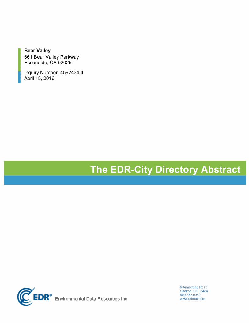
Bear Valley661 Bear Valley ParkwayEscondido, CA 92025
Inquiry Number: 4592434.4April 15, 2016
The EDR-City Directory Abstract
6 Armstrong RoadShelton, CT 06484800.352.0050www.edrnet.comEnvironmental Data Resources IncEnvironmental Data Resources IncEnvironmental Data Resources IncEnvironmental Data Resources Inc
TABLE OF CONTENTS
SECTION
Executive Summary
Findings
City Directory Images
Thank you for your business. Please contact EDR at 1-800-352-0050
with any questions or comments.
Disclaimer - Copyright and Trademark NoticeThis Report contains certain information obtained from a variety of public and other sources reasonably available to Environmental Data Resources, Inc. It cannot be concluded from this Report that coverage information for the target and surrounding properties does not exist from other sources. NO WARRANTY EXPRESSED OR IMPLIED, IS MADE WHATSOEVER IN CONNECTION WITH THIS REPORT. ENVIRONMENTAL DATA RESOURCES, INC. SPECIFICALLY DISCLAIMS THE MAKING OF ANY SUCH WARRANTIES, INCLUDING WITHOUT LIMITATION, MERCHANTABILITY OR FITNESS FOR A PARTICULAR USE OR PURPOSE. ALL RISK IS ASSUMED BY THE USER. IN NO EVENT SHALL ENVIRONMENTAL DATA RESOURCES, INC. BE LIABLE TO ANYONE, WHETHER ARISING OUT OF ERRORS OR OMISSIONS, NEGLIGENCE, ACCIDENT OR ANY OTHER CAUSE, FOR ANY LOSS OR DAMAGE, INCLUDING, WITHOUT LIMITATION, SPECIAL, INCIDENTAL, CONSEQUENTIAL, OR EXEMPLARY DAMAGES. ANY LIABILITY ON THE PART OF ENVIRONMENTAL DATA RESOURCES, INC. IS STRICTLY LIMITED TO A REFUND OF THE AMOUNT PAID FOR THIS REPORT. Purchaser accepts this Report "AS IS". Any analyses, estimates, ratings, environmental risk levels or risk codes provided in this Report are provided for illustrative purposes only, and are not intended to provide, nor should they be interpreted as providing any facts regarding, or prediction orforecast of, any environmental risk for any property. Only a Phase I Environmental Site Assessment performed by an environmental professional can provide information regarding the environmental risk for any property. Additionally, the information provided in this Report is not to be construed as legal advice.
Copyright 2016 by Environmental Data Resources, Inc. All rights reserved. Reproduction in any media or format, in whole or in part, of any report or map of Environmental Data Resources, Inc. or its affiliates is prohibited without prior written permission.
EDR and its logos (including Sanborn and Sanborn Map) are trademarks of Environmental Data Resources, Inc. or its affiliates. All other trademarks used herein are the property of their respective owners.

EXECUTIVE SUMMARY
DESCRIPTION
Environmental Data Resources, Inc.’s (EDR) City Directory Abstract is a screening tool designed to assist environmental professionals in evaluating potential liability on a target property resulting from past activities. EDR’s City Directory Abstract includes a search and abstract of available city directory data. For each address, the directory lists the name of the corresponding occupant at five year intervals.
Business directories including city, cross reference and telephone directories were reviewed, if available, at approximately five year intervals for the years spanning 1903 through 2013. This report compiles information gathered in this review by geocoding the latitude and longitude of properties identified and gathering information about properties within 660 feet of the target property.
A summary of the information obtained is provided in the text of this report.
RECORD SOURCES
EDR is licensed to reproduce certain City Directory works. Reproduction of City Directories without permission of the publisher may be a violation of copyright.
RESEARCH SUMMARY
The following research sources were consulted in the preparation of this report. An "X" indicates where information was identified in the source and provided in this report.
Source TPYear Adjoining Text Abstract Source Image
2013 Cole Information Services - - - -
2008 Cole Information Services - - - -
2006 Haines Company, Inc. - X X X
Haines Company, Inc. X X X X
2000 Haines Company, Inc. - X X -
Haines Company, Inc. X X X -
1995 PACIFIC BELL WHITE PAGES - X X -
1992 PACIFIC BELL WHITE PAGES - X X -
1991 PACIFIC BELL WHITE PAGES - X X -
PACIFIC BELL WHITE PAGES X X X -
1989 Pacific Bell - X X -
1985 PACIFIC BELL WHITE PAGES - X X -
1984 R. L. Polk & Co. - - - -
1980 Pacific Telephone - - - -
1976 Luskey Brothers & Co., Inc. - - - -
4592434- 4 Page 1

EXECUTIVE SUMMARY
Source TPYear Adjoining Text Abstract Source Image
1975 R. L. Polk Co. - - - -
1971 Community Directory Co. - X X -
Community Directory Co. X X X -
1970 John M. Ducy - - - -
1966 R. L. Polk Co. - - - -
1965 Luskey Brothers Co., Inc. - - - -
1962 Community Directory Co. - - - -
1961 R. L. Polk & Co. - - - -
1960 The Pacific Telephone Telegraph Co. - - - -
1956 R. L. Polk & Co. - - - -
1955 The Pacific Telephone & Telegraph Co. - - - -
1952 R. L. Polk Co. of California - - - -
1950 The Pacific Telephone Telegraph Co. - - - -
1948 San Diego Directory Co. - - - -
1945 San Diego Directory Co. - - - -
1943 San Diego Directory Co. - - - -
1940 San Diego Directory Co. - - - -
1938 San Diego Directory Co. - - - -
1933 San Diego Directory Co. - - - -
1927 San Diego Directory Co. - - - -
1921 San Diego Directory Co. Inc. - - - -
1907 San Diego Directory Co. - - - -
1903 San Diego Directory Co. - - - -
4592434- 4 Page 2
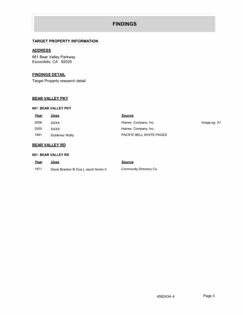
FINDINGS
TARGET PROPERTY INFORMATION
ADDRESS661 Bear Valley ParkwayEscondido, CA 92025
FINDINGS DETAILTarget Property research detail.
BEAR VALLEY PKY
661 BEAR VALLEY PKY
Year Uses Source
2006 XXXX Haines Company, Inc. Image pg. A1
2000 XXXX Haines Company, Inc.
1991 Gutierrez Wally PACIFIC BELL WHITE PAGES
BEAR VALLEY RD
661 BEAR VALLEY RD
Year Uses Source
1971 Davis Braxton B Ova L ranch formn h Community Directory Co.
4592434- 4 Page 3

FINDINGS
ADJOINING PROPERTY DETAIL
The following Adjoining Property addresses were researched for this report. Detailed findings are provided for each address.
BEAR VALLEY PKY
666 BEAR VALLEY PKY
Year Uses Source
2000 XXXX Haines Company, Inc.
1995 Botta R .. .................... .... PACIFIC BELL WHITE PAGES
Botshekan Hedayatulah PACIFIC BELL WHITE PAGES
Boltte Michael J MD UCS O Medical Center
PACIFIC BELL WHITE PAGES
1991 Botshekan Hedayatulah PACIFIC BELL WHITE PAGES
1985 BOTSHEKAN HEDAYATULAH PACIFIC BELL WHITE PAGES
CHOYA CANYON RD
2204 CHOYA CANYON RD
Year Uses Source
2000 SUECHTING Egon Haines Company, Inc.
1971 Hitney Gene C h Community Directory Co.
2271 CHOYA CANYON RD
Year Uses Source
2006 PEASE Carter D Haines Company, Inc. Image pg. A2
2000 PEASE Carter D Haines Company, Inc.
1992 Snodgrass Clayton W Cdr US N Ret PACIFIC BELL WHITE PAGES
1991 Snodgrass Clayton W Cdr US N Ret PACIFIC BELL WHITE PAGES
1989 Snodgrass Clayton W Cdr USN Ret Pacific Bell
1985 SNODGRASS CLAYTON W CDR USN RET
PACIFIC BELL WHITE PAGES
4592434- 4 Page 4

FINDINGS
TARGET PROPERTY: ADDRESS NOT IDENTIFIED IN RESEARCH SOURCE
The following Target Property addresses were researched for this report, and the addresses were not identified in the research source.
Address Researched Address Not Identified in Research Source661 Bear Valley Parkway 2013, 2008, 1995, 1992, 1989, 1985, 1984, 1980, 1976, 1975, 1970, 1966, 1965,
1962, 1961, 1960, 1956, 1955, 1952, 1950, 1948, 1945, 1943, 1940, 1938, 1933, 1927, 1921, 1907, 1903
ADJOINING PROPERTY: ADDRESSES NOT IDENTIFIED IN RESEARCH SOURCE
The following Adjoining Property addresses were researched for this report, and the addresses were not identified in research source.
Address Researched Address Not Identified in Research Source2204 CHOYA CANYON RD 2013, 2008, 2006, 1995, 1992, 1991, 1989, 1985, 1984, 1980, 1976, 1975, 1970,
1966, 1965, 1962, 1961, 1960, 1956, 1955, 1952, 1950, 1948, 1945, 1943, 1940, 1938, 1933, 1927, 1921, 1907, 1903
2271 CHOYA CANYON RD 2013, 2008, 1995, 1984, 1980, 1976, 1975, 1971, 1970, 1966, 1965, 1962, 1961, 1960, 1956, 1955, 1952, 1950, 1948, 1945, 1943, 1940, 1938, 1933, 1927, 1921, 1907, 1903
666 BEAR VALLEY PKY 2013, 2008, 2006, 1992, 1989, 1984, 1980, 1976, 1975, 1971, 1970, 1966, 1965, 1962, 1961, 1960, 1956, 1955, 1952, 1950, 1948, 1945, 1943, 1940, 1938, 1933, 1927, 1921, 1907, 1903


![ESA/SCC 3702/001 [OBSOLETE] - ESCIES](https://img.dokumen.tips/doc/110x75/633eaf29cd16ac117908a147/esascc-3702001-obsolete-escies.jpg)