Embed Size (px)
Citation preview
Abstract Volume of
The Fifth World Landslide Forum
02 – 06 November 2021 Kyoto International Conference Center, Kyoto, Japan
Organized by
The International Consortium on Landslides (ICL), Global Promotion Committee of International Programme on Landslides (IPL-GPC), Kyoto University (KU), Japan Landslide
Society (JLS), Japanese Geotechnical Society (JGS), Japan Society for Natural Disaster Science (JSNDS), and Japan Association for Slope Disaster Management (JASDiM)

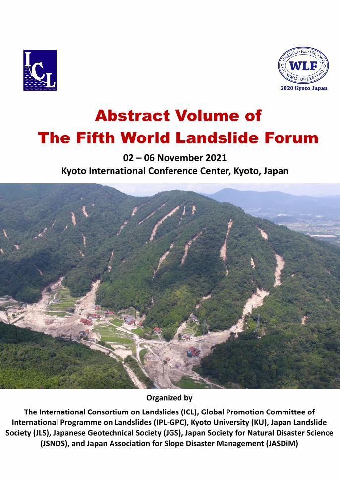
Picture on the cover page Landslides in Hiroshima, Japan after the heavy rainfall in July 2018 (The International Consortium on Landslides. All Rights Reserved).
Abstract Volume of
The Fifth World Landslide Forum
02 – 06 November 2021 Kyoto International Conference Center, Kyoto, Japan
Organized by The International Consortium on Landslides (ICL), Global Promotion
Committee of International Programme on Landslides (IPL-GPC), Kyoto University (KU), Japan Landslide Society (JLS), Japanese Geotechnical Society
(JGS), Japan Society for Natural Disaster Science (JSNDS), and Japan Association for Slope Disaster Management (JASDiM)

Published by: The International Consortium on Landslides
Contents
Forum Lectures and Forum Speeches
On the Prediction of Landslides and Their Consequences
Fausto Guzzetti
2
Design Recommendations for Single and Dual Debris Flow Barriers with
and Without Basal Clearance
Charles Wang Wai Ng, Clarence Edward Choi, Haiming Liu, Sunil Poudyal,
and Julian Shun Hang Kwan
3
The Rockfall Failure Hazard Assessment: Summary and New Advances
Michel Jaboyedoff, Mariam Ben Hammouda, Marc-Henri Derron, Antoine
Guérin, Didier Hantz, and François Noel
4
Progress and Lessons Learned from Responses to Landslide Disasters
Brian D. Collins, Mark E. Reid, Jeffrey A. Coe, Jason W. Kean, Rex L. Baum,
Randall W. Jibson, Jonathan W. Godt, Stephen L. Slaughter, and Greg M. Stock
5
Behind-the-Scenes in Mitigation of Landslides and Other Geohazards in
Low Income Countries—in Memory of Hiroshi Fukuoka
Claudio Margottini
6
Recent Advances in the Methods of Slope Stability and Deformation
Analyses
Beena Ajmera, Binod Tiwari
7
Theme 1 Sendai Landslide Partnerships and Kyoto Landslide Commitment
Kyoto 2020 Commitment for Global Promotion of Understanding and
Reducing Landslide Disaster Risk
Kyoji Sassa, Peter T. Bobrowsky, Kaoru Takara,, and Badaoui Rouhban
9
International Consortium on Landslides (ICL): Proposing and Host 10
Organization of SLP2015-2025 and KLC2020
Kyoji Sassa, Peter T. Bobrowsky, Kaoru Takara
The ICL Journal Landslides—16 Years of Capacity Development for
Landslide Risk Reduction
Matjaž Mikoš, Kyoji Sassa, and Željko Arbanas
11
UNITWIN-UNESCO/KU/ICL Landslide, Earthquake and Water-related
Disaster Risk Management for Society and the Environment Cooperation
Programme
Kyoji Sassa, Ryosuke Uzuoka, and Kaoru Takara
13
International Programme on Landslides (IPL): A Programme of the ICL
for Landslide Disaster Risk Reduction
Qunli Han,, Kyoji Sassa, and Matjaž Mikoš,
14
Central Asia—Rockslides’ and Rock Avalanches’ Treasury and Workbook
Alexander Strom and Kanatbek Abdrakhmatov
15
Results of Recent Monitoring Activities on Landslide Umka, Belgrade,
Serbia—IPL181
Biljana Abolmasov, Uroš Đurić, Jovan Popović, Marko Pejić, Mileva
Samardžić Petrović, and Nenad Brodić
16
Landslides in Weathered Flysch: From Activation to Deposition (WCoE
2017–2020)
Matjaž Mikoš, Nejc Bezak, Janko Logar, Matej Maček, Ana Petkovšek, Dušan
Petrovič, and Jošt Sodnik,
17
Report of the Croatian WCoE 2017–2020: From Landslide Mapping to
Risk Assessment
Snježana Mihalić Arbanas, Sanja Bernat Gazibara, Petra Jagodnik, Marin
Sečanj, Vedran Jagodnik, Martin Krkač, and Željko Arbanas
18
Advanced Technologies for Landslides (WCoE 2017–2020)
Nicola Casagli, Veronica Tofani, Filippo Catani, Sandro Moretti, Riccardo
19
Fanti, Giovanni Gigli, Silvia Bianchini, and Federico Raspini
Complex Geomorphological and Engineering Geological Research of
Landslides with Adverse Societal Impacts
Vít Vilímek, Jan Klimeš, Josef Stemberk, Jan Burda, Petr Kycl, and Jan Blahůt
20
Report of the IPL-219, IPL-220 and Croatian WCoE 2017–2020: From
Landslide Investigation to Landslide Prediction and Stabilization
Željko Arbanas, Josip Peranić, Martin Krkač, Vedran Jagodnik, Petra Jagodnik,
and Snježana Mihalić Arbanas
21
Ichi-Nichi-mae (The Day before the Disaster) Project for Landslide
Awareness and Risk Communication
Satoru NISHIKAWA
22
Landslides in Greece and related legislation: difficulties and potential
improvements
Eleftheria Poyiadji
23
Emerging Issues and Innovative Strategies for Landslides Risk
Management
Surya Parkash
24
The root causes of landslide vulnerability in Bangladesh
Bayes Ahmed
25
Hydrated halloysite: the pesky stuff responsible for a cascade of landslides
triggered by the 2018 Iburi earthquake, Japan
Fawu Wang, Shuai Zhang, Ran Li, Rong Zhou, Andreas Auer, Hiroto Ohira,
Zili Dai & Tetsuya Inui
26
Impact of multi-hazard interactions on risk assessment
Bastian van den Bout
27
Numerical Simulation for Tsunami Generation Due to a Landslide
Taro Kakinuma
28
Dealing with Mass Flow-Induced Tsunamis at Stromboli Volcano:
Monitoring Strategies Through Multi-Platform Remote Sensing
Federico Di Traglia, Teresa Nolesini, and Nicola Casagli
29
Tsunami Disaster caused by the 1923 Great Kanto Earthquake and the
Importance of Submarine Landslides
Kazuki Murata, Shinji Sassa, Tomohiro Takagawa
30
Post-event Field Surveys of the 2018 Tsunamis in Palu Bay and Sunda
Strait
Wahyu Widiyanto, Shih-Chun Hsiao, and Sanidhya Nika Purnomo
31
Three-dimensional Simulation on the Rockslide and Mudslide Generated
Tsunamis
Tso-Ren Wu, Thi-Hong-Nhi Vuong, Chun-Wei Lin, Chun-Yu Wang, and
Chia-Ren Chu
32
Submarine landslide study in a drum centrifuge
Junji Miyamoto
33
Sendai voluntary commitments: landslide stakeholders and the
all-of-society approach enhanced by UNDRR
Yuki Matsuoka , Erick Gonzales Rocha
34
Contribution of the collaborative effort of the Czech WCoE to landslide
risk reduction at the Machupicchu, Peru
Vít Vilímek, Jan Klimeš, Ruth Verónica Ttito Mamani, José Bastante
Abuhadba, Fernando Astete Victoria & Piedad Zoraida Champi Monterroso
35
Landslides at UNESCO-Designated Sites
Irina Pavlova, Soichiro Yasukawa, Aurélien Dousseron, and Vincent Jomelli
36
Traditional Knowledge and Local Expertise in Landslide Risk Mitigation
of World Heritages Sites
Claudio Margottini,, Daniele Spizzichino
37
Integrating Kinematic Analysis and Infrared Thermography for Instability
Processes Assessment in the Rupestrian Monastery Complex of David
Gareja (Georgia)
William Frodella, Daniele Spizzichino, Giovanni Gigli, Mikheil Elashvili,
Claudio Margottini, Alberto Villa, Paolo Frattini, Giovanni Crosta, Nicola
Casagli
38
Shallow Landslide Susceptibility Assessment in the High City of
Antananarivo (Madagascar)
William Frodella, Daniele Spizzichino, Andrea Ciampalini, Rosi Ascanio,
Claudio Margottini, Nicola Casagli
39
Thermo-Mechanical Cliff Stability at Tomb KV42 in the Valley of the
Kings, Egypt
Rodrigo Alcaíno-Olivares, Matthew A. Perras, Martin Ziegler, Kerry Leith
40
Collaboration in MHEWS Through an Integrated Way: The Great Efforts
Contributed by Multi-stakeholder Partnership at National, Regional and
International Levels
Xu Tang, Kyoji Sassa, Guy P. Brasseur, Johannes Cullmann, Zheqing Fang
42
Resilient Watershed Management: Landscape Approach to Climate
Change and Disaster Risk Reduction
Yuka Makino, Thomas Hofer, Mustapha Azdad, Faizul Bari
44
Integrating DRR into the Conservation and Management Mechanisms of
the Internationally Designated Sites—View of IRDR
Qunli Han, Fang Lian
46
Landslide Hazard and Risk Assessment for Civil Protection Early
Response
Giuseppe Esposito, Olga Petrucci
47
Size Matters: The Impact of Small, Medium and Large Landslide Disasters
Irasema Alcántara-Ayala
48
Practices of Public Participation Early Warning System for Geological
Hazards in China
Shengnan Wu, Yu Lei, Pihua Yin, Peng Cui, Zhengtao Zhang
49
Landslide geometry and activity in Villa de la Independencia (Bolivia)
revealed by InSAR and seismic noise measurements
Chuang Song, Chen Yu, Zhenhong Li,, Veronica Pazzi, Matteo Del Soldato,
Abel Cruz & Stefano Utili
51
Early Warning Systems in Italy: State-of-the-Art and Future Trends
Emanuele Intrieri, Giulia Dotta, Federico Raspini, Ascanio Rosi, Samuele
Segoni, Nicola Casagli
52
Community-Based Landslide Risk Management in Contrasting Social
Environments, Cases from the Czech Republic
Jan Klimeš, Ping Lu
53
Refinement Progresses on Freeway Slope Maintenance After a Huge
Landslide Disaster
Wen-I. Wu, Tsai-Ming Yu, Chia-Yun Wei, Lee-Ping Shi, San-Shyan Lin, Jen
Cheng Liao
54
Landslide Exposure Community-Based Mapping: A First Encounter in a
Small Rural Locality of Mexico
Ricardo J. Garnica-Peña, Gerardo Cardón-Idelfonso, Irasema Alcántara-Ayala
55
Co-Producing Data and Decision Support Tools to Reduce Landslide Risk
in the Humid Tropics
Elizabeth A. Holcombe, Rose Hen-Jones, Paul J. Vardanega, Mair E. W.
Beesley, Charlotte E. L. Gilder, Elisa Bozzolan
56
ICT-Based Landslide Disaster Simulation Drill: Road to Achieve 2030
Global Commitment
Mohamad Fazli Sardi,, Ahmad Fairuz Mohd Yusof, Khamarrul Azahari Razak,
Rudzidatul Akmam Dziyauddin, Siti Hajar Othman, and Munirah Zulkaple
58
A Preliminary Work of Safety Potential Analysis Model for Anchors Used
on Freeway Slopes
Sao-Jeng Chao, Chia-Yun Wei, Han-Sheng Liu, Chien-Hua Kao, Hao Yang,
Cheng-Yu Huang
59
Initial Experiences of Community Involvement in an Early Warning
System in Informal Settlements in Medellín, Colombia
Tamara Breuninger, Carolina Garcia-Londoño, Moritz Gamperl, Kurosch Thuro
60
Capacity Building and Community Preparedness Towards Landslide
Disaster in Pagerharjo Village, Kulon Progo Regency of Yogyakarta,
Indonesia
Hendy Setiawan, Endah Retnaningrum, Thema Arrisaldi, and Wahyu Wilopo
61
Characterization and hydrological analysis of the Guarumales deep-seated
landslide in the tropical Ecuadorian Andes
Alexandra Urgilez, Jessica Robles, Mark Bakker, Pablo Guzman, Thom
Bogaard
62
On the importance of geological data for landslide risk reduction in
Slovenia
Mateja Jemec Auflič, Jernej Jež, Tina Peternel, Mitja Janža, Petra Jamšek Rupnik,
Jure Atanackov
63
SATREPS project for Sri Lanka with regard to “Development of early
warning technology of Rain-induced Rapid and Long-travelling
Landslides”
Kazuo Konagai, Asiri Karunawardena and Kyoji Sassa
64
Technology development of reliable rainfall prediction in mountain regions
of Sri Lanka
Ryo Onishi, Dmitry Kolomenskiy , Joe Hirai
65
Strategy for monitoring creeping movements of unstable soil masses
triggered by heavy rain at pilot sites in tropical forested mountain
66
Shiho Asano
Porewater pressure build-up of slopes subjected to different rainfall
conditions by centrifuge modelling
Sanchitha Jayakody, Ryosuke Uzuoka and Kyohei Ueda
67
Early warning system against rainfall-induced landslide in Sri Lanka
Imaya Ariyarathna, E.J.M.P.H.Jayasundara, K.P.G.W.Senadheera,
H.A.G.Jayathissa, Katsuo Sasahara
68
Strengthening non-structural measures for Landslide Risk Reduction in
Sri Lanka – Achievement in Project SABO
Toru Koike, Gamini Jayathissa
69
Role of Disaster Management Center on Landslide Risk Management
Major General Sudantha Ranasinghe and Anoja Senevirathne
70
Theme 2 From Mapping to Hazard and Risk Zonation
Landslides across the USA: occurrence, susceptibility, and data limitations
Benjamin B. Mirus, Eric S. Jones, Rex L. Baum, Jonathan W. Godt, Stephen
Slaughter,, Matthew M. Crawford, Jeremy Lancaster, Thomas Stanley,, Dalia B.
Kirschbaum, William J. Burns, Robert G. Schmitt, Kassandra O. Lindse8y &
Kevin M. McCoy,
72
Landslide Recognition and Mapping for Slope Disaster Risk Reduction and
Management
Toyohiko Miyagi
74
New Landslide Inventory Map of the Sudetes Mountains (South-Western
Poland)
Rafał Sikora, Tomasz Wojciechowski
75
Gullies as Landforms for Landslide Initiation—Examples from the
Dubračina River Basin (Croatia)
Kamila Pawluszek-Filipiak, Andrzej Borkowski
76
Can Repeat LiDAR Surveys Locate Future Massive Landslides?
Mio Kasai
77
Developing Recognition and Simple Mapping by UAV/SfM for Local
Resident in Mountainous Area in Vietnam—A Case Study in Po Xi Ngai
Community, Laocai Province
Nguyen Kim Thanh,, Toyohiko Miyagi, Shinobu Isurugi, Dinh Van Tien, Le
Hong Luong, Do Ngoc Ha
78
Landslide Activity Classification Based on Sentinel-1 Satellite Radar
Interferometry Data
Vladimir Greif, Jaroslav Busa, Martin Mala
79
Damming Predisposition of River Networks: A Mapping Methodology
Carlo Tacconi Stefanelli, Nicola Casagli, Filippo Catani
80
Maximum Likelihood Classification method for detection of
litho-geomorphological units in the Vipava Valley, SW Slovenia
Timotej Verbovšek, Tomislav Popit
81
Landslides Triggered by the September 6th 2018 Hokkaido Eastern Iburi
Earthquake ‐Topographic and Geologic GIS‐LP Analyses
Hiromitsu Yamagishi, Junko Iwahashi, and Fumiaki Yamazaki
82
Landslides Along Halong-Vandon Expressway in Quang Ninh Province,
Vietnam
Pham Van Tien, Le Hong Luong, Le Minh Nhat, Nguyen Kim Thanh, Phuong
Van Cuong
83
Roughness analysis of the fossil landslides surface in the Vipava Valley, SW
Slovenia
Tomislav Popit, Boštjan Rožič, Andrej Šmuc, Andrej Novak, Timotej
Verbovšek
84
Mapping landslides at a nationwide scale using InSAR: the Norwegian 86
Ground Motion Service
John Dehls, Marie Bredal, Reginald Hermanns, Martina Böhme, Ivanna Penna,
Pierrick Nicolet, François Noël, José Pullarello, Yngvar Larsen, Jakob Grahn,
Daniel Stødle & Petar Marinkovic
The Effective Surveyed Area. Uncertainty reduction in field work based
landslide inventories
Txomin Bornaetxea, Ivan Marchesini
87
Use of InSAR at multiple spatial and temporal scales to reveal landsliding
mechanisms
William H. Schulz
88
Landslide susceptibility assessment in complex geological settings:
sensitivity to geological information and insights on its parameterization
Samuele Segoni, Giulio Pappafico, Tania Luti & Filippo Catani
89
An expert‐based Landslide susceptibility assessment on city scale level
with limited data-an example from Kuala Lumpur City
Christian Arnhardt, Nikhil Nedumpallile Vasu, Ng Tham Fatt, Elanni Affandi,
Vanessa Banks, Andrew Marchant, Joy Jacqueline Pereira, Helen Reeves
91
Landslide Susceptibility Mapping by Interpretation of Aerial Photographs,
AHP and Precise DEM
Hiroshi Yagi, Kazunori Hayashi, Go Sato
92
New Data on Geological Conditions of Landslide Activity on Vorobyovy
Gory (Moscow, Russia)
Olga Barykina, Oleg Zerkal, Igor Averin, Eugene Samarin
93
Impact of Agricultural Management in Vineyards to Landslides
Susceptibility in Italian Apennines
Massimiliano Bordoni, Alberto Vercesi, Michael Maerker, Valerio Vivaldi,
Claudia Meisina
94
Landslide Susceptibility in Two Secondary Rivers of La Ciénega 95
Watershed, Nevado de Toluca Volcano, Mexico
Sandra García Reyes, Gabriel Legorreta Paulin, Rutilio Castro Miguel,
Fernando Aceves Quesada
An Ordinal Scale Weighting Approach for Susceptibility Mapping Around
Tehri Dam, Uttarakhand, India
Naorem Sarju Singh, Sharad Kumar Gupta,Chandra Shekhar Dubey, Dericks P.
Shukla
96
Potential Analysis of Deep-Seated Landslides Caused by Typhoon Morakot
Using Slope Unit
Meei-Ling Lin, Jian-Fang Wang, Yen-Cheng Chen, Te-Wei Chen
97
Landslide Susceptibility Assessment Using Binary Logistic Regression in
Northern Philippines
Dymphna Nolasco-Javier, Lalit Kumar
98
Landslide Hazard Mapping of Penang Island Malaysia Based on
Multilayer Perceptron Approach
Ilyas A. Huqqani, Lea Tien Tay, Junita Mohamad-Saleh
99
Landslide Susceptibility Mapping Based on the Deep Belief Network: A
Case Study in Sichuan Province, China
Wei-Dong Wang, Zhuolei He, Zheng Han, Yange Li
100
A Comparative Study of Deep Learning and Conventional Neural Network
for Evaluating Landslide Susceptibility Using Landslide Initiation Zones
Jie Dou, Ali P. Yunus, Abdelaziz Merghadi, Xie-kang Wang, Hiromitsu
Yamagishi
101
Landslide Susceptibility Assessment by Ensemble-Based Machine Learning
Models
Mariano Di Napoli, Giuseppe Bausilio, Andrea Cevasco, Pierluigi Confuorto,
Andrea Mandarino, Domenico Calcaterra
102
Overcoming Data Scarcity Related Issues for Landslide Susceptibility 103
Modeling with Machine Learning
Anika Braun, Katrin Dohmen, Hans-Balder Havenith, Tomas
Fernandez-Steeger
Practical Accounting for Uncertainties in Data-Driven Landslide
Susceptibility Models. Examples from the Lanzhou Case Study
AJewgenij Torizin, Michael Fuchs, Dirk Kuhn, Dirk Balzer, Lichao Wang
104
Assessment of Shallow Landslides Susceptibility Using SHALSTAB and
SINMAP at Serra Do Mar, Brazil
Victor Carvalho Cabral,, Fábio Augusto Gomes Vieira Reis
105
Regional Slope Stability Analysis in Landslide Hazard Assessment Context,
North Macedonia Example
Miloš Marjanović, Biljana Abolmasov, Igor Peshevski, James Reeves, Irena
Georgievska
106
Evaluation of Secondary Landslide Susceptibility for the Rescue Activity
Using LiDAR UAV Data
Shoji Doshida
107
Methodology for Landslides Assessment Causing River Channel
Obstructions and the Consequent Water Shortage in Rural Communities
Johnny Alexander Vega,, César Augusto Hidalgo,
108
Landslide susceptibility assessment in a tropical scares-data region of the
Colombian Andes
Edier Aristizábal, Diana Ruiz-Vásquez
109
Concerns Over Reliable Earthquake-Induced Landslide Hazard
Assessment: Developing Sophisticated Geotechnical Databases and 3D
Landslide Inventories
Shahram Nasiri, Annie Lau, Lutz Gross, Nazanin Nourifard
110
Modeling of Landslide Susceptibility in a Part of Abay Basin,
Northwestern Ethiopia based on Bivariate and Multivariate Statistical
111
Methods
Azemeraw Wubalem
Theoretical Framework for Estimating the Annual Probability of
Occurrence of Landslides
Farrokh Nadim
112
Multi-scale Landslide Hazard Assessment using Remote Sensing Data
Dalia Kirschbaum, Thomas Stanley, Pukar Amatya, Robert Emberson, Sana
Khan, Eli Orland, Nishan Biswas
113
Global debris flow susceptibility, current and future impact, based on
climate and urbanization trends
Laurie Kurilla
115
Evaluating the Terrain Susceptibility to Mass Movements
Paola Reichenbach, Mauro Rossi
116
Data-driven Modelling of the Spatio-Temporal Probability of Occurrence
of Shallow Landslides with the Integration of Satellite Data
Bordoni M, Vivaldi V, Brocca L, Ciabatta L, Meisina C
117
Introducing the climate component into landslide susceptibility mapping
Corrado Camera, Greta Bajni, Irene Corno, Mattia Raffa, Stefania Stevenazzi,
Tiziana Apuani
118
The role of climatic predictors for non-stationary rockfall susceptibility
modelling
Greta Bajni, Corrado Camera, Tiziana Apuani
119
Probabilistic modeling of rockfall source areas
Mauro Rossi, Roberto Sarro, Paola Reichenbach, Rosa María Mateos
120
Introducing Land Surface Temperature in Susceptibility Modeling
Marco Loche, Gianvito Scaringi
121
Dynamic Landslide Hazard Assessment by Matrix Combination of Soil 122
Water Index and Landslide Susceptibility Map
Song Eu, Kidae Kim, Changwoo Lee, Jun-Pyo Seo, Choong Shik Woo
Landslide Size Distribution Characteristics of Cretaceous and Eocene
Flysch Assemblages in the Western Black Sea Region of Turkey
Aykut Akgun, Tolga Gorum, Hakan A. Nefeslioglu
123
A Statistical Exploratory Analysis of Inventoried Slide-Type Movements
for South Tyrol (Italy)
Stefan Steger, Volkmar Mair, Christian Kofler,, Massimiliano Pittore, Marc
Zebisch, Stefan Schneiderbauer,
124
Assessing Landslide Volume for Landform Hazard Zoning Purposes
Gabriel Legorreta Paulin, Lilia Arana-Salinas, Rutilio Castro Miguel,
Jean-François Yves Pierre Parrot, Trevor A. Contreras
125
Empirical Relationships to Estimate the Probability of Runout Exceedance
for Various Landslide Types
Marc-André Brideau, Saskia de Vilder, Chris Massey, Andrew Mitchell, Scott
McDougall, Jordan Aaron
126
Rapid Sensitivity Analysis for Reducing Uncertainty in Landslide Hazard
Assessments
Rex L. Baum
127
Applying Debris Flow Simulation for Detailed Hazard and Risk Mapping
Kana Nakatani, Yuji Hasegawa, Yoshifumi Satofuka
128
Debris-Flow Peak Discharge Calculation Model Based on Erosion Zoning
Xudong Hu,, Kaiheng Hu, Jinbo Tang, Xiaopeng Zhang,, Yanji Li,, Chaohua
Wu,
129
Rainfall-Induced Lahar Occurrences Shortly After Eruptions and Its
Initiation Processes in Japan
Takashi Koi, Yasuhiro Fujisawa, Nobuo Anyoji
130
Spatiotemporal Assessment of Geological Hazard Safety Along Railway
Engineering Using a Novel Method: A Case Study of the Sichuan-Tibet
Railway, China
Jiaying Li, Wei-Dong Wang
131
Slope Stability and Landslide Hazard in Volubilis Archaeological Site
(Morocco)
Mohamed Rouai, Abdelilah Dekayir, Khaoula Qarqori
132
Landslide Timing in a Changing Tropical Environment: the North
Tanganyika-Kivu Rift region, Africa
Olivier Dewitte, Axel Deijns, Arthur Depicker, Antoine Dille, Violet
Kanyiginya, Désiré Kubwimana, Jean-Claude Maki Mateso, Toussaint
Mugaruka Bibentyo
133
Slope Hazard and Risk Mapping Project (PBRC)—An Overview of
Disaster Risk Reduction Initiative
Zamri Ramli, Ferdaus Ahmad
135
Risk-Informed Land Use Planning for Landslide Disaster Risk Reduction:
A Case Study of Cameron Highlands, Pahang, Malaysia
Mohd Farid Abdul Kadir, Khamarrul Azahari Razak, Ferdaus Ahmad, Dzul
Khaimi Khailani
137
Landslides in Steep-Slope Agricultural Landscapes
Paolo Tarolli, Anton Pijl, Sara Cucchiaro,
139
From Satellite Images to Field Survey: A Complete Scheme of Landslide
InSAR Monitoring
Matteo Del Soldato, Lorenzo Solari, Davide Festa, Pierluigi Confuorto, Silvia
Bianchini, Nicola Casagli
140
Slope Disaster Risk Reduction Map as a Communication Tool for
Community Based DRR in Japan and Vietnam
Toyohiko Miyagi, Nguyen Kim Thanh,, Dinh Van Tien, Le Hong Luong,,
141
Quang Van Viet
People Vulnerability to Landslide: Risky Behaviours and Dangerous
Conditions by Gender and Age
Paola Salvati, Mauro Rossi, Cinzia Bianchi, Fausto Guzzetti
142
Using Mixed-Methods to Understand Community Vulnerability to Debris
Flows in Montecito, CA
Erica Akemi Goto, Summer Gray, Edward Keller, Keith C. Clarke
143
Innovation in Analysis and Forecasting of Vulnerability to Slow-Moving
Landslides
Dario Peduto, Gianfranco Nicodemo, Nicoletta Nappo, Giovanni Gullà
144
On the Use of UAVs for Landslide Exposure of Households: La Gloria
Neighbourhood, Teziutlán, Puebla
Ricardo J. Garnica-Peña, Galdino García-Marroquin, Irasema Alcántara-Ayala
145
Site-Specific Risk Assessment of Buildings Exposed to Rock Fall in
India—a Case Study
Aditi Singh, Debi P. Kanungo, Pravin Kr. Singh
146
The Advanced Method for Detecting Geotechnical Risks of Landslide
Failures by Surveying Historical Surface Deformation and Underground
Water
Michio Ishigaki
147
Quantitative analysis of the consequences induced by slow-moving
landslides to a road network in southern Italy
Settimio Ferlisi, Antonio Marchese, Dario Peduto
148
Landslide Scenario in North Eastern Region of India and Associated
Challenges
Kuntala Bhusan, P L N Raju
149
Population vulnerability assessment and its effect in landslide risk mapping 150
– The case of Angra dos Reis, Rio de Janeiro, Brazil
Marcos Barreto de Mendonca, Dennis Rodrigues Silva
Theme 3 Monitoring and Early Warning
Defining Kinematic and Evolutive Features of Earth Flows Using
Integrated Monitoring and Low-Cost Sensors
Paola Revellino, Luigi Guerriero, Giuseppe Ruzza, Francesco M. Guadagno
152
Monitoring of Thermoelastic Wave Within a Rock Mass Coupling
Information from IR Camera and Crack Meters: A 24-Hour Experiment
on “Branická Skála” Rock in Prague, Czechia
Ondřej Racek,, Jan Blahůt, Filip Hartvich
153
Field testing innovative differential geospatial and photogrammetric
monitoring of a slow-moving landslide, south-central British Columbia,
Canada
HUNTLEY, Drew ROTHERAM-CLARKE, Roger MACLEOD, Robert
COCKING, Jamel JOSEPH, and Peter BOBROWSKY
154
The Role of Measure of Deep-Seated Displacements in the Monitoring
Networks on Large-Scale Landslide
Paolo Allasia, Marco Baldo, Francesco Faccini, Danilo Godone, Davide Notti,
Flavio Poggi
155
LiDAR and UAV SfM for landslide monitoring
Mihai Niculita
156
Recent Developments in Photomonitoring
Mazzanti P.
157
Geophysical Monitoring of Landslides: State-of-the Art and Recent
Advances
Denis Jongmans, Sylvain Fiolleau, Gregory Bièvre
158
Recent Advances in High Spatial Resolution Geophysical Monitoring of 159

Moisture-Induced Landslides
Jim Whiteley, Arnaud Watlet, Sebastian Uhlemann, Philip Meldrum, Paul
Wilkinson, Jonathan Chambers
Characteristic Analysis of the Nayong Rock Avalanche Based on the
Seismic Signal
Hao Luo, Aiguo Xing, Kaiping Jin, Shimin Xu, Yu Zhuang
160
Rockfall detection, localization, and early warning using micro-seismic
monitoring
Liang Feng, Veronica Pazzi, Emanuele Intrieri, Giovanni Gigli
161
Electrical Resistivity Tomography (ERT) Based Investigation of Two
Landslides in Guizhou, China
Yu Zhuang, Aiguo Xing
162
Vibration of Piled Rocks—Which Rock Can Be Removed?
Kiminori Araiba, Shoji Doshida
163
Multiinstrumental Monitoring Network Slopenet - New Advances
Filip Hartvich, Petr Tábořík, Jan Blahůt, Josef Stemberk, Jan Klimeš, Jan
Balek, Ondřej Racek
164
Slope Instabilities Analysis and Monitoring of Aizawl Landslide, Mizoram,
Northeast India
Laldinpuia
165
Debris Flow Detection Using a Video Camera
Ko-Fei Liu, Ting-Iu Kuo, Shih-Chao Wei, 166
Comparison Between PS and SBAS InSAR Techniques in Monitoring
Shallow Landslides
Xue Chen, Giulia Tessari, Massimo Fabris, Vladimiro Achilli, Mario Floris
167
Towards managing debris channel risks to infrastructure: understanding
debris processes using remotely sensed data.
David A. Bonneau, D. Jean Hutchinson, Scott McDougall
168
Remote sensing monitoring of landslides along highway in Guozigou
Valley, China
Ying Liu, Anming Bao, Junli Li, Xiaobing Yan
169
Sentinel-1 landslides detection: the Granada coast
Anna Barra, Cristina Reyes-Carmona, Rosa María Mateos, Jorge Pedro Galve,
Roberto Tomás, Gerardo Herrera, Marta Bejar, José Miguel Azañon, José
Navarroy, Roberto Sarro, Oriol Monserrat
170
Landslide Dynamic Deformation Monitoring with Sequential Least
Squares Based SAR/InSAR techniques
Chaoying Zhao, Baohang Wang, Hengyi Chen, Liquan Chen
171
Definition and First Application of a Probabilistic Warning Model for
Rainfall-Induced Landslides
Gaetano Pecoraro, Michele Calvello
172
Establishment of an Integrated Landslide Early Warning and Monitoring
System in Populated Areas
Nikolaos Depountis, Nikolaos Sabatakakis, Katerina Kavoura, Konstantinos
Nikolakopoulos, Panagiotis Elias, George Drakatos
173
An Integrated WebGIS System for Shallow Landslide Hazard Early
Warning
Nguyen Duc Ha,, Le Quoc Hung, Takahiro Sayama, Kyoji Sassa, Kaoru Takara,
Khang Dang,
174
The Value of Soil Wetness Measurements for Regional Landslide Early
Warning Systems
Manfred Stähli, Adrian Wicki
175
Technical Concepts for an Early Warning System for Rainfall Induced
Landslides in Informal Settlements
John Singer, Kurosch Thuro, Moritz Gamperl, Tamara Breuninger, Bettina
Menschik
176
Development of Landslide Early Warning System Based on the
Satellite-Derived Rainfall Threshold in Indonesia
Agus Setyo Muntohar, Olga Mavrouli, Victor G. Jetten, Cees J. van Westen,
Rokhmat Hidayat
177
Presenting Some Successful Cases of Regional Landslides Early Warning
Systems in China
Qiang Xu, Dalei Peng, Xuanmei Fan, Xing Zhu, Chaoyang He
178
Towards an Early Warning System for Instable Slopes in Georgia: The
Large Tskneti-Akhaldaba-Landslide
Klaus-Peter Keilig,, Markus Bauer, Peter Neumann, Kurosch Thuro
179
An EWS of Landslide and Slope Failure by MEMS Tilting Sensor Array
Lin Wang, Makoto Fukuhara, Taro Uchimura, Gallage Chaminda, Tharindu
Abeykoon
180
Standards for the performance assessment of territorial landslide early
warning systems
Luca Piciullo, Davide Tiranti, Gaetano Pecoraro, Jose Mauricio Cepeda &
Michele Calvello
181
Application and verification of a multivariate real-time early warning
method for rainfall-induced landslides: implication for evolution of
landslide-generated debris flows
Zongji Yang, Liyong Wang,, Jianping Qiao, Taro Uchimura & Lin Wang
182
LandAware: a new international network on Landslide Early Warning
Systems
M. Calvello1, G. Devoli, K. Freeborough, S. L. Gariano, F. Guzzetti, D.
Kirschbaum, H. Nakaya, J. Robbins & M. Stähli
183
The Development of TDR-integrated landslide Early Warning System
Chih-Chung Chung, Ji-Hao Jian
185
What Hydrological Information Should We Include in Landslide Hazard
Assessment and Early Warning Systems?
Bogaard, T.A.
187
Global Standard for Landslide Early Warning System
Teuku Faisal Fathani, Wahyu Wilopo
188
Need for Information Disclosure of Landslide Early Warning Systems
Masashi Sekiguchi
189
Regional Approaches in Forecasting Rainfall-Induced Landslides
Maria Teresa Brunetti, Massimo Melillo, Stefano Luigi Gariano, Luca Ciabatta,
Luca Brocca, Silvia Peruccacci
190
Seven Years of Landslide Forecasting in Norway—Strengths and
Limitations
Graziella Devoli, Hervé Colleuille, Monica Sund, Jaran Wasrud
191
Probabilistic modelling of uncertainties in physically based landslide
susceptibility assessment
Hyuck-Jin Park, Jung-Hyun Lee, In-tak Hwang, Yu-Ra Park, Omar
Althuwaynee
192
Characterization of Hillslope Deposits for Physically-Based Landslide
Forecasting Models
Veronica Tofani, Gabriele Bicocchi, Elena Benedetta Masi, Carlo Tacconi
Stefanelli, Guglielmo Rossi, Filippo Catani
193
Landslide precipitation thresholds in Rwanda
Judith Uwihirwe,, Markus Hrachowitz & Thom A. Bogaard
194
Methodology for developing a preliminary hydrological threshold for
rainfall‐induced landslides in Kuala Lumpur city, Malaysia
Nikhil Nedumpallile Vasu, Christian Arnhardt, Muhammad Firdaus Ammar
Abdullah, Ng Tham Fatt, Vanessa Banks, Helen Reeves, Joy Jacqueline Pereira,
195
Elanni Affandi
Development of a Rainfall-Induced Landslide Forecast Tool for New
Zealand
Brenda Rosser, Chris Massey, Biljana Lukovic, Sally Dellow, Matt Hill
196
Influence of Intervals Measuring Surface Displacement on Time Prediction
of Slope Failure Using Fukuzono Method
Naoki Iwata, Katsuo Sasahara
197
Velocity and Acceleration of Surface Displacement in Sandy Model Slope
with Various Slope Conditions
Katsuo Sasahara
198
Comparison of Moving-Average, Lazy, and Information Gain Methods for
Predicting Weekly Slope-Movements: A Case-Study in Chamoli, India
Praveen Kumar, Priyanka Sihag, Ankush Pathania, Pratik Chaturvedi, K. V.
Uday, Varun Dutt
199
New Insights into the Spatiotemporal Precursory Failure Dynamics of the
2017 Xinmo Landslide and Its Surrounds
Antoinette Tordesillas, Shuo Zhou, Federico Di Traglia, Emanuele Intrieri
201
A comparative study of random forests and multiple linear regression in
the prediction of landslide velocity
Martin Krkač, Sanja Bernat Gazibara, Željko Arbanas, Marin Sečanj, Snježana
Mihalić Arbanas
202
Machine Learning: Potential for Deep‐Seated Landslide Nowcasting
Adriaan van Natijne, Roderik Lindenbergh and Thom Bogaard
203
Prediction of Failure Time based on Velocity and Acceleration of Surface
Displacement in Sandy Model
Imaya Ariyarathna, Katsuo Sasahara
204
Theme 4 Testing, Modeling and Risk Assessment
Application of magnetic tracking system in laboratory-scale rock
avalanche model tests
Rolando P Orense
206
A simple physically-based distributed translational landslide model
Yanto, Sumiyanto, and Arwan Apriyono
207
Centrifuge Modelling of Slope Failure due to Groundwater during
Excavation
Nobutaka Hiraoka, Naotaka Kikkawa, and Kazuya Itoh
208
Experimental Studies on the Effect of Vegetation Density to Change
Underground Seepage Rate and Stability of Slopes
Binod Tiwari
209
Laboratory Simulations of Submarine Landslide Failure Mechanisms
Jonathan M. Carey, Joshu J. Mountjoy, Gareth J. Crutchley, Barbara Lyndsell,
David N. Petley
210
Basal Stresses of Debris Flow in Instrumented Flume
Dongri Song
211
Landslide Growth: Collisions and Contractile Skins
Pengjia SONG, Clarence Edward CHOI
212
Innovative Use of Thermo-Active Pile Row in Unsaturated Soil Slopes
Leung, A. K., Vitali, D.
213
Numerical Modelling for Slope Stabilizations in Modern Geotechnical
Practice
Daniel Pradel
214
A Coupled Discrete Element and Depth-Averaged Model for Flow-Like
Landslide Simulations
Xiaoli Su, Xilin Xia, and Qiuhua Liang
215
Advanced Methods for Simulating Complex Landslides
Martin Mergili and Shiva P. Pudasaini
216
Preliminary results from the SMART-SED basin scale sediment yield
model
Federico Gatti, Luca Bonaventura, Alessandra Menafoglio, Monica Papini and
Laura Longoni
217
Hazard assessment of a rainfall-induced deep-seated landslide in Hakha
city, Myanmar
Khang Dang, Doan Huy Loi, Kyoji Sassa, Do Minh Duc, Nguyen Duc Ha
218
Landslide Hazard Zoning Based on the Integrated Simulation Model
(LS-Rapid)
Doan Huy Loi, Kyoji Sassa, Khang Dang, and Hong Le Luong
219
Numerical Simulation of a Creeping Landslide Case in Japan
Akihiko Wakai, Deepak Raj Bhat, Kenta Kotani and Soichiro Osawa
220
Numerical Simulation of Debris Flows after Ash Fall at Mt. Fuji
Takashi Kitazume, Takahiro Abe, and Satoshi Goto
221
On the Progression of Slope Failures Using Inverse Velocity of Surface
Movements in an Undercut Slope Model
Thirapong Pipatpongsa, Krit Aroonwattanaskul, and Kun Fang
222
Rainfall Boundary Condition in a Multiphase Material Point Method
Mario Martinelli, Wei-Lin Lee, Chjeng-Lun Shieh, and Sabatino Cuomo
223
Reproduction of Sedimentation State During Rock Slope Failure Using the
Simplified DEM Model
Hitoshi Nakase and Yukio Nakata
224
An extreme May 2018 debris flood case study in northern Slovenia:
analysis, modelling, and mitigation
Nejc Bezak, Jernej Jež, Jošt Sodnik, Mateja Jemec Auflič & Matjaž Mikoš
225
Numerical modeling of dynamic process and risk prediction of recent
catastrophe landslides
Chaojun Ouyang
226
Sensitivity Analysis of DEM Parameters in Granular Flow Simulations
Shuji Moriguchi, Daiki Watanabe, Kenjiro Terada
227
Recent Developments in the Evaluation and Application of Residual and
Fully Softened Shear Strengths for the Stability Analyses of Landslides
Binod Tiwari and Beena Ajmera
228
Shearing Rate Effect on Residual Strength of Typical Clay Soils in Ring
Shear Test
Deepak Raj Bhat
229
Simple Shear Tests for Unsaturated Soils
Mariagiovanna Moscariello and Sabatino Cuomo
230
Simplest Methods of Determining Dynamic Soil Properties for Use in
Co-seismic Hazard Analysis
Beena Ajmera and Binod Tiwari
231
New Understanding of the Initiation of Daguangbao Landslide Triggered
by the 2008 Wenchuan Earthquake (Ms=8.0)
Shenghua Cui , Xiangjun Pei, Runqiu Huang, Gonghui Wang, Qingwen Yang
232
Residual-state Ring Shear Creep Tests on Clayey Materials and
Development of Creep Failure Model
Netra Prakash Bhandary
233
Challenges in Evaluating Shear-Rate Effects in Soils
Gianvito Scaringi, Jakub Roháč, Jose Duque, Marco Loche
234
Monotonic and Cyclic Behaviour of Tephra Layer Landslide at Takanodai
from the 2016 Kumamoto Earthquake
Satoshi Goto, Kento Okada
235
Slope Stability Assessment of Weak and Weathered Rocks with BQ System
Timur Ersöz, Merve Özköse, and Tamer Topal
236
Soil Databases to Assist Slope Stability Assessments in the Eastern
Caribbean
Paul J. Vardanega, Elizabeth A. Holcombe, Myrto Savva, Casey J. Shepheard,
Rose Hen-Jones, and Flavia De Luca
237
Failure mechanism of a flow-like landslide triggered by the 2018 Western
Shimane Earthquake
Ran Li, Fawu Wang & Shuai Zhang
238
The Mt Gamalama Instability Level in Generating Landslide-Induced
Tsunami in Ternate Island, Indonesia
Saaduddin, Jurgen Neuberg, Mark E. Thomas, and Jon Hill
239
Seepage and deformation of unsaturated slope during post-earthquake
rainfall
Jiawei Xu, Ryosuke Uzuoka, Kyohei Ueda
240
3D analysis of settlement and stability of the open-cast coal mine landfill:
Bílina mine case
Jan Jerman, Tomáš Kadlíček, David Mašín, Jan Najser, Václav Hájek
241
Engineering Risk Mitigation for Landslide Hazard Chains: The Baige
Landslides on the Jinsha River in 2018
Limin M. Zhang, Jian He, and Te Xiao
242
Engineering Geological Investigation and Slope Stability Analysis for
Landslide Hazard Assessment in Indian Himalayas
Shantanu Sarkar and Koushik Pandit
243
First Consideration about Post 2017 Wildfire Erosion Response and Debris
Flow in Susa Valley (NW Italy)
Damiano Vacha, Giuseppe Mandrone, Matteo Garbarino, and Donato Morresi
244
Identification of Sliding Surface and Crack Pattern in the Soil Creep, Case
Study: Unika Soegijapranata Campus, Semarang, Central Java, Indonesia
Wahyu Wilopo, Hendy Setiawan, Doni Prakasa Eka Putra, and Teuku Faisal
Fathani
245
Preliminary Result of Real-Time Landslide Monitoring in the Case of the
Hinterland of Koroška Bela, NW Slovenia
Tina Peternel, Ela Šegina, Matija Zupan, Mateja Jemec Auflič, and Jernej Jež
246
Quantitative Risk Analysis of Earthquake-Induced Landslides
Saskia de Vilder, Chris Massey, Tony Taig, Biljana Lukovic, Garth Archibald,
and Regine Morgenstern
247
Role of Remote Sensing Technology in Landslide Risk Management of
Hong Kong
Julian S. H. Kwan, W. K. Leung, and Clarence E. Choi
248
Risk assessment of submerged rock mass in reservoir area
Luqi Wang, Yueping Yin, Bolin Huang, Zhenwei Dai, Zhihua Zhang
249
Prediction the Global Factor of Safety in Soil-Nailed Slope by A Simplified
Method
Panyabot Kaothon , Kean Thai Chhun, Chan-Young Yune
250
On the Scale Effect of the Catchment Landslide Susceptibility with
Consideration of Climate Change
Keh-Jian Shou, Chia-Yu Hu
251
Fragmental rockfalls and the analysis of risk
Jordi Corominas, Gerard Matas, Roger Ruiz-Carulla, Nieves Lantada, Albert
Prades
252
Satellite Soil Moisture for Estimating Landslide Hazard
Ratih Indri Hapsari, Ayisya Cindy Harifa, Dandung Novianto, Ratna Ika Putri
253
Shaking table tests of small scaled slope models 254
Holger Pankrath, David Mora, Eliana Jiménez, Alexander Knut, Friedemann
Sandig
Theme 5: Catastrophic Landslides and Frontiers of Landslide Science
Study on the Phenomena of Liquefaction Induced Massive Landslides in 28
September 2018 Palu-Donggala Earthquake
Paulus P. Rahardjo
256
The Krasnogorsk Landslide (Northern Caucasus): Its Evolution and
Modern Activity
Igor K. Fomenko, Oleg V. Zerkal, Alexander Strom, Daria Shubina, Ludmila
Musaeva
257
Slope Deformation caused Jure Landslide 2014 Along Sun Koshi in Lesser
Nepal Himalaya and Effect of Gorkha Earthquake 2015
H. Yagi, G. Sato, H. P. Sato, D. Higaki, V. Dangol, and S. C. Amatya
258
Pressure Head Dynamics on a Natural Slope in Eastern Iburi Struck by the
2018 Hokkaido Earthquake
Toshiya Aoki, Shin’ya Katsura, Takahiko Yoshino, Takashi Koi, Yasutaka
Tanaka, and Takashi Yamada
259
New insights on recent and active large rock slides in the Andean
paraglacial environments of central Chile
Sergio A Sepulveda, Marisol Lara, Javiera Carrasco, Christian Tobar, Valeria
Rivillo, Felipe Ochoa
260
Earthquake-Triggered Landslides and Slope-Seismic Waves Interaction
Inferring Induced Displacements
Salvatore Martino, Celine Bourdeau, Josè Delgado, and Luca Lenti
261
Rockfall/Rockslide Hazard, Lake Expansion and Dead-Ice Melting
Assessment: Lake Imja, Nepal
Tomas Kroczek and Vit Vilimek
262
Formation of the 2018 Bureya Landslide, Far East of Russia
Oleg V. Zerkal, Aleksey N. Makhinov, Alexander Strom, Vladimir I. Kim,
Michael E. Kharitonov, and Igor K. Fomenko
263
Landslide Dam Hazards: Assessing Their Formation, Failure Modes,
Longevity and Downstream Impacts
Regine Morgenstern, Chris Massey, Brenda Rosser, and Garth Archibald
264
The Sedimentology and Internal Structure of Landslide
Dams—Implications for Internal Erosion and Piping Failure: A Review
Chukwueloka A. U. Okeke
265
Investigation, characterization and monitoring of deep-seated landslides in
the surroundings of large dam reservoirs
Christian Zangerl, Christine Fey
266
March 2019 flood impact on the stability of Ambal salt ridge in the
Gotvand dam reservoir, Southern Iran
Arash Barjasteh
267
Rock Avalanches: Basic Characteristics and Classification Criteria
Alexander Strom
268
An Interdisciplinary Assessment of a Coal-Mining-Induced Catastrophic
Landslide (Czech Republic)
Jan Burda, Vít Vilímek
269
Could Glacial Retreat-Related Landslides Trigger Volcanic Eruptions?
Insights from Mount Meager, British Columbia
Gioachino Roberti, Brent Ward, Benjamin van Wyk de Vries, Nicolas Le
Corvec, Swetha Venugopal, Glyn Williams-Jones, John J. Clague, Pierre Friele,
Giacomo Falorni, Geidy Baldeon, Luigi Perotti, Marco Giardino, and Brian
Menounos
270
Structural and Dynamic Numerical Models of Rockslides in the 271
Carpathians and the Alps
Emilie Lemaire, Anne-Sophie Mreyen, and Hans-Balder Havenith
Quantitative Investigation of a Mass Rock Creep Deforming Slope
Through A-Din SAR and Geomorphometry
Michele Delchiaro, Emanuele Mele, Marta Della Seta, Salvatore Martino, Paolo
Mazzanti, and Carlo Esposito
272
Deformational Features of Deep-Seated Gravitational Slope Deformation
of Slate Slopes in the Central Range, Taiwan
Ching-Ying Tsou, Masahiro Chigira, Yu-Chung Hsieh, Mien-Ming Chen, and
Tai-Chieh He
273
Bathymetric Analyses of Submarine Landslides on the Jan Mayen Ridge,
Norwegian–Greenland Sea
Kiichiro Kawamura and Jan Sverre Laberg
274
Forkastningsfjellet Rock Slide, Spitsbergen: State of Activity in a Changing
Climate
Dirk Kuhn, Reginald L. Hermanns, Jewgenij Torizin, Michael Fuchs, Tim
Redfield, Raymond Eilertsen, and Dirk Balzer
275
Catastrophic Landslides in Indian Sector of Himalaya
Vinod K. Sharma
276
Landslides that caused fatalities in Canada from 1771‐2019
Andrée Blais‐Stevens
277
Basal Liquefaction from Rapid Landsliding: The 2014 Deadly Oso
Landslide (USA)
Mark E. Reid, Brian D. Collins
278
The evaluation of Deep-seated catastrophic landslides (DCLs) on Kii
Peninsula 2011 by means of the historical deformation)
Toshimi Mizuno
279
Catastrophic landslide and subsequent tsunamis in North-Patagonian
District, Chile
Violchen Sepulveda
280
The massive February 17, 2006, Leyte, Philippines, rockslide
Marte Gutierrez
281
Giant landslides in the foreland of Patagonian Andes: effects of
deglaciation and drawdown of glacial lakes
Tomáš Pánek, Elisabeth Schönfeldt, Michal Břežný, Diego Winocur, Oliver
Korup
282
Enhancing Preparedness Against Impact of Climate Change on Slope
Safety in Hong Kong
K. K. S. Ho, H. W. Sun, E. J. Lam, and F. L. C. Lo
283
Climate Change and Surface Deformation Characteristics in Degradation
Area of Permafrost in Lesser Khingan Mountain, China
Wei Shan, Chengcheng Zhang, Ying Guo, Monan Shan, Xujing Zeng, and
Chunjiao Wang
284
Climate Change Impact Evaluation on the Water Balance of the Koroška
Bela Area, NW Slovenia
Nejc Bezak, Tina Peternel, Anže Medved, and Matjaž Mikoš
285
Characteristics and Causes of the Debris Flow in Shelong Gully, China
Qiang Zou, Peng Cui, Hu Jiang, Yanguo Liu, Cong Li, Sheng Hu, and Bin Zhou
286
Extreme Rainfall Induced Landslide Susceptibility Assessment Using
Autoencoder Combined with Random Forest
Kounghoon Nam and Fawu Wang
287
Rainfall-induced landslides and debris flows in Mengdong town, Yunnan
province, China
Hongjuan Yang, Taiqiang Yang, Shaojie Zhang, Fuhu Zhao, Kaiheng Hu,
288
Yuhong Jiang
Landslide triggered by rainfall and Land use change: A case study of
Laptap Landslide, Arunachal Pradesh, India
Swapna Acharjee
289
Relationships between antecedent rainfall and volume of
earthquake-induced landslides in historical era of Japan
Komatsubara Taku
290
Looking for a Temperature Control on Slope Stability
Gianvito Scaringi, Marco Loche
291
Bellwether sites for evaluating changes in landslide frequency and
magnitude in cryospheric mountainous terrain: a call for systematic,
long-term observations to decipher the impact of climate change
Jeffrey A. Coe
292
MPM Modelling of Buildings Impacted by Landslides
Sabatino Cuomo, Angela Di Perna, and Mario Martinelli
293
Accelerating Landslide Hazard at Kandersteg, Swiss Alps; Combining 28
Years of Satellite InSAR and Single Campaign Terrestrial Radar Data
Rafael Caduff , Tazio Strozzi, Nils Hählen, and Jörg Häberle
294
Identification Old Landslides in Permafrost Degradation Area in Northeast
China by Difference Distribution of Surface Trees
Ying Guo, Wei Shan, Zhichao Xu, Chunjiao Wang, and Shuanglin Wang
295
A Landform Evolution Model for the Mannen Area in Romsdal Valley,
Norway
Paula Hilger, Reginald L. Hermanns, and Bernd Etzelmüller
296
Multimethodological Study of Non-linear Strain Effects Induced by
Thermal Stresses on Jointed Rock Masses
Guglielmo Grechi and Salvatore Martino
297
Economizing Soil Nailing Design by Drainage Improvement - Case History
at Ginigathhena
S. O. A. D. Mihira Lakruwan and S. A. S. Kulathilaka
298
Large and Small Scale Multi-Sensors Remote Sensing for Landslide
Characterisation and Monitoring
Carlo Tacconi Stefanelli, Teresa Gracchi, Guglielmo Rossi, and Sandro Moretti
299
Modeling Landslide Volumes: A Case Study in Whatcom County,
Washington, USA
Gabriel Legorreta Paulin, Trevor A. Contreras, Katherine A. Mickelson, Kara E.
Jacobacci, William Gallin
300
Geosynthetic Reinforced Soil Structures for Slope Stabilization and
Landslide Rehabilitation in Asia
Pietro Rimoldi, Matteo Lelli, Pietro Pezzano, and Fabrizia Trovato
301
Mobility characteristics in loess landslide over erodible bed: insights from
sandbox experiments
Wen-Chieh Cheng, Zhao Duan
302
Different dynamics of permafrost degradation-induced landslides revealed
by molards
Costanza Morino, Susan Conway, Kristian Svennevig, Axel Noblet, Antoine
Lucas, Meven Philippe
303
Recent Development of the Mechanically Stabilized Earth Walls with
Geosynthetic Strap Reinforcements
Yoshinori Otani, Akihiko Wakai, Naoki Shimura, Taisuke Watanabe
304
Japanese case histories on use of geosynthetics in reconstructing failed
slopes
Junichi Koseki
305
A spatiotemporal object-oriented data model for landslides (LOOM) 306
Mario Valiante, Domenico Guida, Marta Della Seta & Francesca Bozzano
Emergency mitigation measures of a dip slope slide with uplifted toe
caused by heavy rain in Chichibu, East Japan
Motohiro Ito, Joe Okazaki, Ryo Fujimoto, Daisuke Higaki, Yoshihiro Miyazaki
307
Influence of geology and geological structures in triggering landslides:
Bangladesh perspective
Reshad Md. Ekram Ali
308
3D landslide models in VR
Hans-Balder Havenith
309
Theme 6: Specific Topics in Landslide Science and Applications
Recent Earthquakes that Hit Areas Covered and/or Underlain by
Pyroclastic Matters and Their Impacts on Lifelines
Kazuo Konagai, Alex K. Tang, and John M. Eidinger
311
Lessons Learned - Landslide Induced Lifelines Disasters from Past
Earthquakess
Alex K. Tang
312
Risk Assessment of Structural Damage for Rock Collision due to
Earthquake-Induced Landslide
Susumu Nakamura
313
Seismic Performance of Buried Pipelines Against Large Ground
Deformation of Strike-Slip Faults
Farzad Talebi and Junji Kiyono
314
Impact on Infrastructure by 2015 Gorkha Earthquake Induced Landslides
Vishnu Dangol, Dinesh Pathak, and Samjwal Ratna Bajracharya
315
Reconstruction Strategies for Mw 7.8 Earthquake-Induced
Landslide-Affected Settlements in Nepal
Tara Nidhi Bhattarai, Dhruba Prasad Sharma, and Lekh Prasad Bhatta
316
Relationship between Arias Intensity and the Earthquake-Induced
Displacements of Slopes
Ching Hung, Chih-Hsuan Liu, and Hsuan-Ho Wang
317
Controls on Landslide Size: Insights from Field Survey Data
Haijun Qiu, Yifei Cui, Dongdong Yang, Sheng Hu, Yanqian Pei, and Shuyue Ma
318
Geologic and Hydrologic Investigations on Slope Failures Triggered by
Extreme Rainfall on Izu Oshima Island, Japan
Ikuo Towhata, Takeshi Akima, Satoshi Goto, Shigeru Goto, Junya Tanaka, and
Shogo Aoyama
319
Investigation of Internal Erosion of Wide Grading Loose Soil—A
Micromechanics-Based Study
Yifei Cui, Yanzhou Yin, Chaoxu Guo
320
Experimental Study on the Formation and Propagation of Debris Flows
Triggered by Glacial Lake Outburst Floods
Huayong Chen, Peng Cui, Xiaoqing Chen, and Jiangang Chen
321
Quantitative Analysis of Landslide Processes Based on Seismic Signals - A
New Method for Monitoring and Early Warning of Landslide Hazards
Yan Yan, Yifei Cui, Shuyao Yin, and Xin Tian
322
Water Exfiltration from Bedrock: A Drastic Landslide Triggering
Mechanism
Amin Askarinejad and Sarah M. Springman
323
High-Resolution Point-Cloud for Landslides in the 21st Century: From
Data Acquisition to New Processing Concepts
C. Gomez, T. Allouis, C. Lissak, N. Hotta, Y. Shinohara, D. S. Hadmoko, V.
Vilimek, P. Wassmer, F. Lavigne, A. Setiawan, J. Sartohadi, A. Saputra, and T.
Rahardianto
324
Automatized Dissemination of Landslide Monitoring Bulletins for Early 325
Warning Applications
Daniele Giordan, Aleksandra Wrzesniak, Paolo Allasia, and Davide Bertolo
Detecting Change of Patterns in Landslide Displacements Using Machine
Learning, an Example Application
Giacomo Titti, Matteo Mantovani, and Giulia Bossi
326
Predicting Rainfall Induced Slope Stability Using Random Forest
Regression and Synthetic Data
Elahe Jamalinia, Faraz S. Tehrani, Susan C. Steele-Dunne, and Philip J. Vardon
327
Hybrid Analytics of Rainfall Infiltration with Physics-informed Neural
Networks
Ivan Depina, Saket Jain, Emir Ahmet Oguz
328
Loess Stratigraphy and Loess Landslides in the Chinese Loess Plateau
Tonglu Li, Mumtaz Haider, Wei Shen, and Ping Li
329
Mapping, Hazard and Consequence Analyses for Unstable Rock Slopes in
Norway
Reginald L. Hermanns, Thierry Oppikofer, Martina Böhme, Ivanna M. Penna,
Pierrick Nicolet, and Marie Bredal
330
Landscape Formation and Large Rock Slope Instabilities in Manndalen,
Northern Norway
Martina Böhme, Reginald L. Hermanns, and Tom R. Lauknes
331
Landslides after Wildfire: Initiation, Magnitude, and Mobility
Francis K. Rengers, Luke A. McGuire, Nina S. Oakley, Jason W. Kean, Dennis
M. Staley & Hui Tang
332
Disaster Risk Assessment of the Silk Road
Peng Cui, Qiang Zou, Yu Lei, Zhengtao Zhang, and Shengnan Wu
333
Rehabilitation of Gully-Dominant Hill Slopes by Using Low-Cost Measures
- A Case Study in Nepal
334
Daisuke Higaki, Kishor Kumar Karki, Naoto Koiwa, Mio Takahashi, and Sohan
Kumar Ghimire
Site Suitability Analysis for Nature-Based Landslide Risk Mitigation
G. A. Chinthaka Ganepola, Udeni Priyantha Nawagamuwa, Anurudda Kumara
Karunarathna, Senaka Basnayake, Lilanka Kankanamge, and Dhanushka
Jayathilake
335
Biogeomorphic feedbacks between plants and mass movement processes in
periglacial environments
Jana Eichel
336
Classification of Cryogenic Landslides and Related Phenomena (by
Example of the Territory of Russia)
Oleg V. Zerkal and Alexander L. Strom
337
Relation Between Horizontal Direction of Crustal Deformation Surveyed
on the Control Points and Area Ratio of the Slope Failures Triggered by the
2016 Kumamoto Earthquake (Mj 7.3)
Hiroshi P. Sato and Hiroshi Une
338
Precursor of large rockslides and its application on landslide early
detection
Weile Li, Weiwei Zhan, Huiyan Lu, Qiang Xu, Dong Wang, Runqiu Huang
339
Report on a landslide in Kyotango city, Kyoto prefecture
Michiyo Nakashima 340
Three-dimensional shape of mountainous landslide and the ground
deformation caused by snow melting - Jin’nosuke‐dani landslide, Mount
Hakusan,Central Japan
Yasunori Katsume, Yutaka Shimizu, Takumi Abe, Yasuko Okajima, Kazue
Fujita
341
Measuring colloidal forces between clay microparticles with optical
tweezers
342
Yu Zhao, Jingzhi Wu, Liangbo Hu, Yu Jiang
Contribution of geotechnical engineering to climate change and IPCC
Kazuya Yasuhara
343
Urgent Issues and New Suggestions for Geo-disaster Prevention in Japan
Motoyuki Suzuki, Kyoko Kagohara, Kazuyuki Sakaguchi, Hiroaki Matsugi, and
Satoru Kataoka
344
Lessons from Recent Geo-Disasters in Hokkaido Under Heavy Rainfall
Tatsuya Ishikawa
345
Lessons from Geo-Disasters Caused by Heavy Rainfall in Recent Years in
Kyushu Island, Japan
Noriyuki Yasufuku and Adel Alowiasy
346
Lessons from Recent Geo-Disasters in Hokkaido Under Earthquake
Shima Kawamura
347
Lessons from Recent Earthquake-induced Geodisaster in Kyushu
Kiyonobu Kasama, Zentaro Furukawa, Noriyuki Yasufuku
348
Starting International Joint Research for Landslide Disaster Risk
Reduction: The Use of Japanese Warning Technology in Sri Lanka
Considering the Social Differences
Kumiko Fujita
349
Support for Disaster Victims and Reconstruction Town Planning after the
Large-Scale Landslide Disaster
Yuichi Yamashita
350
Towards a probabilistic performance-based methodology for the
vulnerability assessment of buildings subjected to seismically induced
landslides
Stavroula Fotopoulou
351
Slope Behavior Improvement of Partially-Saturated Pyroclastic in Data 352
Scarse Regions
Jose A. Chavez, Mauricio E. Vasquez
Geotechnical Investigation for Landslide Stabilization Works in
Narayanghat-Mugling Road, Central Nepal
Vishnu Dangol, Tuk Lal Adhikari, Achyuta Nanda Bhandary, and Ishwor Dahal
353
Applying over ten years of experience in debris flow barriers to examples
in South Africa and India for permanent protection
Christophe Balg, Nobuhito Nishimura
354
Development of Engineering Techniques for Exploring Land Creep
Susceptible Zones in South Korea
Jin Ho Lee, Bo Sung Seo, Haun Tak Yong, Kwang Youn Lee, Hyun Seok Bae,
So Hyeon Park, Min Jeng Kang, Jung Il Seo
355
Stability analysis for cut-slope collapse by earthquake
Namgyun Kim, Jaehwan Kwak, Man-IL Kim
356
Quantitative Evaluation of Erosion Control Dam on Sediment Trapping
Efficiency with a Simulation Approach
Sangjun IM, Song EU, Chang-Woo LEE
357
Japan Landslide Society Sessions (Session 6.E1-6E5)
JICA’s Support in Sediment Disaster Risk Reduction
Haruki Ogasa
359
Preliminary Report of Simple Hazard Mapping Methods for Slope
Stability in Tegucigalpa, Honduras
Kiyoharu Hirota, Maynor Ruiz, Takeshi Kuwano
360
AHP Method Applied to Landslide Susceptibility Mapping in pilot sites of
Tegucigalpa, 2016
Lidia Elizabeth Torres Bernhard, Elias Garcia-Urquia
361
Coupling Antecedent Rainfall and Intensity‐Duration Thresholds for 362
Landslide Occurrence in Tegucigalpa, Honduras, 2010
Elias Garcia-Urquia, Lidia Torres-Bernhard
Slope Disaster and Countermeasures in Honduras
Takeshi Kuwano, Takashi Hara, Hotaka Aoki, Kiyoharu Hirota, Koichi
Hasegawa, Kosuke Uzawa
363
Introduction of Preventive Measures in the Road Infrastructure
Development of Tajikistan, in cooperation with a JICA Technical Project
Masanori Tozawa, Hussein Yuldashev, Umedjon Shomirov, Ainiddin
Boimurodzoda, Bekhruiz Shomirov
364
Technical Cooperation Project by JICA: Landslide Adviser for Mauritius
Tomoharu Iwasaki Mukteshwar Gobin
365
Structural and non-structural countermeasures against landslides
implemented in Mauritius with the assistance of the Government of Japan
Mukteshwar Gobin, Tomoharu Iwasaki, Noriyuki Yasufuku, Ryohei Ishikura
366
Risk Estimation and Cost-Benefit Analysis of Road Geohazard Risk
Reduction by comprehensive assessment for seismic and non-seismic
hazards
Mikihiro MORI
367
Rockfall and Landslides Events and its Study in Los Chorros Segment of
the CA01 Route, El Salvador
Alonso Armando Alfaro Navarrete
368
Landslide Disaster Management and Capacity Development for Roadside
Slope Risk Reduction in Bhutan
Tempa Thinley
369
Rockfall Protection on road in Bhutan
Takashi Hara
370
Application on Slope Stabilization method aimed an Environment and 371
Landscape Conservation
Naoto Iwasa, Daizo Tsutsumi, Shiro Ohmi, Tempa Thinley, Dowchu Drukpa
Generating Landslide Hazard Map on 2015 Nepal Earthquake, and
Subsequent Training Activity
Kaoru Nakazato, Satoru Shibata
372
A case study of low-cost measures against landslides by river bank erosion
in Nepal
Daisuke Higaki
373
Road Slope Disaster Countermeasures in Sri Lanka
Yoji Kasahara, Yuji Yashiro, Yoshio Kashiwai
374
Identification of Debris Flow Hazards in Sri Lanka
Pucai Yang, T. Nishikawa, H.H Hemasinghe, H.A.G. Jayathissa
375
Technical transfer for Landslide investigation and monitoring at central
Asia Kyrgyz republic
Hiroshi OGAWA
376
Landslide interpretation based on precise visualization method using high
resolution geospatial data
Toko Takayama Hasi Bateer, Takahiro Yoshida
377
Use of UAV‐SfM point cloud for emergency response to landslide
disasters
Wataru Takeshita, Hiroyuki Sugimoto, Yoshiki Wada
378
Large Landslide Dam in Hidakahoronai, Hokkaido
Tomoya Hayakawa, Ryuku Shimizu, Keisuke Teraguchi
379
Development of methods to assess the annual expected loss of earthquake‐
induced landslides
Senro Kuraoka, Yuichi Nakashima, Hirokazu Furuki, Masahiro Chigira
380
Effect of S‐Wave Velocity Structure of the Ground on Occurrence of 381
Strain in Landslide‐prone Slopes during an Earthquake: A Case Study of
Landslide along the Yamagata - Suifu Line, Induced by the 2011 off the
Pacific coast of Tohoku Earthquake
Nobuyuki Shibasaki, Ryota Ooya, Shunsuke Mitsuzuka, Tamiaki Fujiwara,
Tadashi Hatakeyama, Kunimori Komiya
Relationship between water quality and ground condition in
earthquake-induced landslide areas
Wataru Sagara, Hideaki Marui
382
Prediction of groundwater level fluctuation in deep-seated landslide area
using genetic algorithm
Yoshinori Ito
383
Relationship between Bamboo Rhizome and Surface Failure
Akihiro Miyagi, Iwao Miyoshi
384
Small and simple water drainage drilling method for landslide disaster
prevention
Kazunori Hayashi, Daisuke Sato
385
Performance Verification of sediment capture by Flexible Barrier
Yoshitsugu Kimura, Hiroyuki Umezawa, Risa Tanbe, Peihong ZHU
386
The Geofiber Method‐Protecting slopes with Environment‐conscious
continuous fiber reinforced Soil‐
Masayuki Ujihara, Ryouichi Fukagawa
387
Case Studies of Installation of Measuring Instruments on Overseas
Landslide Countermeasures and Their Problems: Examples of Sri Lanka
and Honduras
Hiroaki KOJIMA
388
Disaster risk coverage of TV media for citizens
Yusuke Koyama
389
Creating an archive of landslide interpretation using the human eye via an
eye-tracking system
Go SATO
390
Microseism and Vibration Sensor Array Monitoring System
Lin Wang, Shangning Tao, Zhijun Tang, Takemine Yamada, Kentaro Kasamatsu
391
Process of Preparing Community Disaster Management Plan: Case Study
of Communities on Ichinichi-Mae Project and CDMP that Have
Experienced Recent Disaster
Noriko Ohnuma, Akio Sato, Saika Shimizu
392
Extraction of Subjects for Regional Disaster Risk Reduction by Teaching
Materials Simulating Evacuation Behaviors
Kiyomi Nakamura
393
An easy way to learning rainfall-induced landslides and its prevention
using analog modeling
Shunitsu Fujii
394
The Workshop Program of Disaster Prevention Learning for Primary
School Children and Junior High School Students
Akihiko Tadokoro, Misako Yamamoto, Masahito Matsuoka , Yosuke
Hamaguchi
395
Approaches and Actions for Information Dissemination and Education for
Disaster Resilience in the Chubu Branch of Japan Landslide Society
Kouichi Ikebe
396
Collaboration of the City of Yokohama and the JAGE's chartered
engineers for geotechnical evaluation consultation with local residents
Takemine Yamada, Hideo Tachibana, Takao Kishida, Mitsuru Narita, Yoshikazu
Hattori and Yuta Wada
397
International Comparison of the Classification of Soils and Rocks for 398
Determining the Stable Cut Slope Angles
Yuuichi Ueno
Technical terms of Structure for Slope Protection
Naoto Iwasa
399
International differences in methods for calculating the deterrent effect of
ground anchor and soil nailing
Mitsuya ENOKIDA
400
Vegetation Methods Based on the Japanese Standard Cut Slope in Bhutan
Kiyoharu Hirota, Gyelthsen Wangdi, Kengo Ohashi, Tomoharu Iwasaki
401
Definition of Technical Terms for Landslide Disaster Management
Daisuke Higaki
402
Role of forestry conservation for landslide prevention
Shiho Asano
403
Outline of measures for sediment disaster by Sabo Department of MLIT,
Japan
NAGANO Masakazu
404
Introduction of Construction Information Modeling / Management in the
Yui Landslide Countermeasures
Masaru Touhei, Nakamoto Aritomo, Tomoya Matsuda, Shunsuke Matsubara
405
Mitigation works for the Aruse I-3 block landslide in Miyoshi, Tokushima,
Japan
Teruyoshi TAKAHARA
406
Efforts and results of mountain area conservation by Forestry conservancy
projects
Yuki Yamana,Kojiro Shiraki
407
Examples of recent landslide countermeasures by conservancy projects
Kojiro Shiraki, Yuki Yamana
408
Agriculture and landslides in Japan
Mayuko Shida
409
National Project for Landslide Prevention in the Takase Area
Tooru Sato
410
World Tsunami Awareness Day Special Event
Numerical simulation of landslide-generated waves during the 11 October
2018 Baige landslide at the Jinsha River
Yu-xiang Hu, Zhi-you Yu & Jia-wen Zhou
412
On the landslide tsunami uncertainty and hazard
Finn Løvholt, Sylfest Glimsdal & Carl B. Harbitz
413
Analysis and modeling of a landslide-induced tsunami-like wave across the
Truong river in Quang Nam province, Vietnam
Do Minh Duc, Dang Quang Khang, Dao Minh Duc, Do Minh Ngoc, Dinh Thi
Quynh, Dang Thi Thuy, Nguyen Khac Hoang Giang, Pham Van Tien& Nguyen
Huu Ha
414
Tsunami from the San Andrés Landslide on El Hierro, Canary Islands:
First Attempt Using Simple Scenario
Jan Blahůt, Byron Quan Luna
415
The Link between Upper-Slope Submarine Landslides and Mass Transport
Deposits in the Hadal Trenchs
Kazuko Usami, Ken Ikehara, Toshiya Kanamatsu, Arata Kioka, Tobias
Schwestermann, Michael Strasser
416
Review of Submarine Landslide-induced Tsunamis: The importance of
cascading mechanisms and multi-phased physics
Shinji Sassa
417
Dealing with Mass Flow-Induced Tsunamis at Stromboli Volcano:
Monitoring Strategies Through Multi-Platform Remote Sensing
418
Federico Di Traglia, Teresa Nolesini, and Nicola Casagli
Simulation of Tsunami Waves Induced by Coastal and Submarine
Landslides in Japan
Doan Huy Loi, Kyoji Sassa, Khang Dang, Toyohiko Miyagi
419
The Impact of Climate Change on Landslide Hazard and Risk
Luciano Picarelli, Suzanne Lacasse, and Ken K. S. H
420
SATREPS Project for Sri Lanka with Regard to “Development of Early
Warning Technology of Rain-Induced Rapid and Long-Travelling
Landslides”
Kazuo Konagai, Asiri Karunawardena, Kyoji Sassa
421
The Continuing Underestimated Tsunami Hazard from Submarine
Landslides
David R. Tappin, Stephan T. Grilli
422
December 11, 2018 Landslide and 90-m Icy Tsunami in the Bureya Water
Reservoir
Viacheslav Gusiakov and Alexey Makhinov
423
Thematic issue papers
Regional landslide susceptibility following the 2016 Kumamoto earthquake
using back-calculated geomaterial strength parameters
Masahiro Shinoda, Yoshihisa Miyata, Ushio Kurokawa & Kenichi Kondo
425
Experimental investigation on the formation process of landslide dams and
a criterion of river blockage
Ting-kai Nian, Hao Wu, Dong-yang Li, Wei Zhao, Kaoru Takara & De-feng
Zheng
426
The Hooskanaden Landslide: historic and recent surge behavior of an
active earthflow on the Oregon Coast
Stefano Alberti, Andrew Senogles, Kara Kingen, Adam Booth, Pete Castro, Jill
427
DeKoekkoek, Kira Glover-Cutter, Curran Mohney, Michael Olsen & Ben
Leshchinsky
Recent rainfall - and excavation-induced bedding rockslide occurring on 22
October 2018 along the Jian-En expressway, Hubei, China
Haibing Yu, Changdong Li, Jia-Qing Zhou, Wenqiang Chen, Jingjing Long,
Xutao Wang & Tao Peng
428
Dendrogeomorphology of landslides: principles, results and perspectives
Karel Šilhán
429
Characterization of displacement and internal structure of landslides from
multitemporal UAV and ERT imaging
Guruh Samodra, Muhammad Fauzan Ramadhan, Junun Sartohadi, Muhammad
Anggri Setiawan, Nugroho Christanto & Adhera Sukmawijaya
430
Characterization of displacement and internal structure of landslides from
multitemporal UAV and ERT imaging
Sudesh Kumar Wadhawan, Balmukund Singh & Maneesha Vinodini Ramesh
431
Ultimate lateral pressures exerted on buried pipelines by the initiation of
submarine landslides
Weiyuan Zhang & Amin Askarinejad
432
Successful disaster management of the July 2020 Shaziba landslide
triggered by heavy rainfall in Mazhe Village, Enshi City, Hubei Province,
China
Kun Song, Fawu Wang, Qingjun Zuo, Bolin Huang, Wuwei Mao & Hu Zheng
433
Landslide risk management in Hong Kong
Raymond W. M. Cheung
434
E-Poster
Dendrogeomorphic dating vs. low-magnitude landsliding
Andrea Fabiánová
436
Understanding Complex Slope Deformation through Tree-Ring Analyses:
Case from the Vsetínské Vrchy Mts (Outer Western Carpathians, Czech
Republic)
Václav Škarpich, Karel Šilhán, Radek Tichavský, Andrea Fabiánová,
Vladimír Chalupa, Olga Chalupová, Radim Tolasz
437
Avalanching of variously shaped DEM-particles
Dominik Krengel, Hans-Georg Matuttis
438
Landslides induced by heavy rains in July 2018 in Shikoku Island, Japan
Makoto Inomoto, Kazuyuki Okano, Ittetsu Sata, Atsushi Okamoto, Kazuki
Matsushita, Teruyoshi Takahara
439
The study of rainfall-induced landslide dynamic warning system and
innovative landslide investigation
Ching-Fang Lee, Chun-Yuan Liu, Chuen-Ming Huang, Chun-Chi Chi
440
Sediment dynamics monitoring at the Osawa Failure of Mt. Fuji
Naoki Nishimura, Tomoaki Eguchi, Nobuhiro Usuki, Atsushi Okamoto,
Hirokazu Muramatsu, Ryo Tanaka
441
Variation of Performances of Horizontal Drains and Slope Stability with
Perforation Arrangement and Envelope Permeability
S. O. A. D. Mihira Lakruwan, Hiromu Oikawa, Akiyoshi Kamura, Motoki
Kazama
442
Shaking table test on gentle slope failure induced by the 2018 Hokkaido
Eastern Iburi Earthquake
Genya Takenaka, Takashi Yamada
443
Landslide distribution and its geological background in mountainous areas
of northern Vietnam
Shinro Abe, Satoshi Suzuki, Nguyen Huu Thang, Kazunori Hayashi
444
Method for observing the pore water pressure at the slip surface by 445
repurposing a broken borehole inclinometer
Hiroomi Nakazato
Features and measurement example of “Pipe Inclinometer” underground
displacement measurement technology using gravitational acceleration
sensor
Jun Takiguchi, Chiharu Ohshima, Yuki Megumi, Shintaro Kanamaru, Noboru
Hayashida
446
Shear band formation observed in a rainfall-induced landslide in a flume
experiment on weathered granite sand
Ngoc Ha Do, Satoshi Goto, Hirotaka Ochiai, Shiho Asano, Huy Loi Doan, Junji
Yoshida
447
Relationships between antecedent rainfall and volume of
earthquake-induced landslides in historical era in Japan
Taku Komatsubara
448
Repair and Regeneration Technology of Load Cell
Masashi Sekiguchi
449
A Study on the Bedload Transport Characteristics of Damaged Forest
Watershed in the Republic of Korea
Junpyo Seo, Choongshik Woo, Kihwan Lee, Song Eu, Changwoo Lee
450

Forum Lectures and Forum Speeches
-1-
WLF5 – Forum Lectures and Forum Speeches
The Fifth World Landslide Forum Abstracts WLF5, Kyoto, 2021
On the Prediction of Landslides and Their Consequences
Fausto Guzzetti
Consiglio Nazionale delle Ricerche, Istituto di Ricerca per la Protezione Idrogeologica, Via Della Madonna
Alta 126, 06128 Perugia, Italy
Civil Protection Department, Office of the Prime Minister, Via Vitorchiano 2, 00189 Rome, Italy
The general assumptions and the most popular methods used to assess landslide hazard and for risk evaluation
have not changed significantly in recent decades. Some of these assumptions have conceptual weakness, and
the methods have revealed limitations. In this work, I deal with populations of landslides i.e. numerous
landslides caused in an area by a single trigger (e.g. a rainstorm, an earthquake, a rapid snowmelt event), or by
multiple events in a short or long period. Following an introduction on what we need to predict to assess
landslide hazard and risk, I introduce the strategies and the main methods currently used to detect and map
landslides, to predict populations of landslides in space and time, and to anticipate the numerosity and size
characteristics of the expected landslides. For landslide detection and mapping, I consider traditional methods
based on the visual interpretation of aerial photographs, and modern approaches that exploit the visual,
semi-automatic or automatic analysis of remotely sensed images. For landslide spatial prediction, I discuss the
results of a global review of statistical, classification-based methods for landslide susceptibility assessment.
For the temporal prediction, leveraging on a global analysis of geographical landslide forecasting and early
warning systems, I discuss short term forecast capabilities and their limitations. Next, I discuss long term
landslide projections considering the impact of climate variations on landslide projections. For landslide
numerosity and size characteristics, I discuss existing statistics of landslide area and volume obtained from
large populations of event-triggered landslides. This is followed by an analysis of the landslide consequences,
with emphasis on a spatial-temporal model of societal landslide risk in Italy. I end offering recommendations
on what I think we should do to make significant progress in our collective ability to predict the hazard posed
by populations of landslides, and to mitigate their risk.
Keywords: Prediction, Maps, Susceptibility, Hazard, Model, Consequences, Risk
The abstract is from the book “K. Sassa et al. (eds.), Understanding and Reducing Landslide Disaster Risk,
Volume 1 Sendai Landslide Partnerships and Kyoto Landslide Commitment, pp 3-32”
-2-
WLF5 – Forum Lectures and Forum Speeches
The Fifth World Landslide Forum Abstracts WLF5, Kyoto, 2021
Design Recommendations for Single and Dual Debris Flow Barriers with and Without Basal Clearance
Charles Wang Wai Ng1, Clarence Edward Choi2, Haiming Liu1, Sunil Poudyal1, and Julian Shun Hang Kwan3 1Department of Civil and Environmental Engineering, The Hong Kong University of Science and Technology,
Hong Kong SAR, China (C. W. W. Ng: [email protected], H. Liu: [email protected], S. Poudyal:
[email protected]) 2Department of Civil Engineering, The University of Hong Kong, Hong Kong SAR, China 3Civil Engineering and Development Department, Geotechnical Engineering Office, Hong Kong SAR, China
Debris flows pose threats to sustainable development in many countries worldwide, including China, Japan,
Switzerland and USA. To mitigate these flows, rigid and flexible barriers are commonly installed along the
predicted flow paths. To arrest large volumes of debris flow, several barriers may be installed in series to
create a cascading effect to progressively decelerate and retain the debris. Barriers may even be designed with
a basal clearance to allow small discharges to pass underneath the barrier to reduce the peak impact force.
Despite the importance of barriers as life-saving assets, their design remains essentially empirical because of
the highly heterogeneous and scale-dependent nature of debris flow. These features of debris flow have
hindered an understanding of their fundamental impact mechanisms, thereby hampering the development of
scientific design guidelines to enable robust and cost-effective barriers. This forum paper presents a collection
of physical experiments modelling the impact mechanisms of the two extreme cases of water and dry granular
flows, and two-phase debris flows against single and dual rigid barriers, and a single flexible barrier.
Furthermore, the effects of a basal clearance on the impact dynamics of dry granular flow against a single rigid
barrier are examined. Experiments were conducted at two different scales, including 5 m-long and 28 m-long
flumes. Based on the observed impact mechanisms and measured data, a newly developed analytical
framework for designing multiple rigid barriers was evaluated. Recommendations and procedures are provided
for the design of single and multiple rigid barriers with and without a basal clearance.
Keywords: Debris flow, Impact, Rigid barrier, Flexible barrier, Multiple barriers, Physical modeling, Basal
clearance
The abstract is from the book “K. Sassa et al. (eds.), Understanding and Reducing Landslide Disaster Risk,
Volume 1 Sendai Landslide Partnerships and Kyoto Landslide Commitment, pp 33-53”
-3-
WLF5 – Forum Lectures and Forum Speeches
The Fifth World Landslide Forum Abstracts WLF5, Kyoto, 2021
The Rockfall Failure Hazard Assessment: Summary and New Advances Michel Jaboyedoff1, Mariam Ben Hammouda2, Marc-Henri Derron2, Antoine Guérin2, Didier Hantz3, and
François Noel2 1Institute of Earth Sciences, University of Lausanne, Institute of Earth Sciences, Risk-Group, GEOPOLIS,
1015 Lausanne, Switzerland ([email protected]) 2University of Lausanne, Institute of Earth Sciences, Risk-Group, GEOPOLIS, 1015 Lausanne, Switzerland
(M. Ben Hammouda: [email protected], M.H. Derron: [email protected], A.
Guérin: [email protected], F. Noel: [email protected]) 3Université Grenoble Alpes—ISTerre, 38400 Saint Martin D’Hère, France
The estimation of rockfall hazards is usually based only on hazards related to rockfall propagation. The
rockfall failure hazard is not currently well defined, and only a few studies have truly addressed this topic. The
basics of slope stability assessment are reviewed. Here, we propose a summary of the standard methods used
to assess susceptibility to rock mass failure, mainly based on techniques from the mining industry or tunneling.
Most of them are qualitative. Many susceptibility scales have been described. Due to computer power and the
high-resolution topography in real 3D, topography analysis and standard kinematic tests have been adapted
and improved to obtain rockfall susceptibility. Hazard assessments based on the power law are one of the best
and only ways to obtain a real assessment of rockfall hazard failure; however, they present some drawbacks
that must be solved. The most promising avenues of research for rockfall failure hazards are linked to rock
mass strength degradation, which is currently observed using high-resolution 3D monitoring of cyclic
deformations with hysteresis. These are the resulting movements caused by groundwater circulations, thermal
cycles, earthquakes, rainfall, etc. In conclusion, the rockfall hazard will be improved by better understanding
these processes in addition to the chemical weathering effect.
Keywords: Rockfall, Failure, Hazard, Degrading factor, Susceptibility
The abstract is from the book “K. Sassa et al. (eds.), Understanding and Reducing Landslide Disaster Risk,
Volume 1 Sendai Landslide Partnerships and Kyoto Landslide Commitment, pp 55-83”
-4-
WLF5 – Forum Lectures and Forum Speeches
The Fifth World Landslide Forum Abstracts WLF5, Kyoto, 2021
Progress and Lessons Learned from Responses to Landslide Disasters Brian D. Collins1, Mark E. Reid2, Jeffrey A. Coe3, Jason W. Kean3, Rex L. Baum3, Randall W. Jibson4,
Jonathan W. Godt, Stephen L. Slaughter5, and Greg M. Stock6 1U.S. Geological Survey, Landslide Hazards Program, Geology, Minerals, Energy, and Geophysics Science
Center, P.O. Box 158 Moffett Field, CA 94035, USA 2U.S. Geological Survey, Landslide Hazards Program, Volcano Science Center, Moffett Field, CA 94035, USA 3U.S. Geological Survey, Natural Hazards Mission Area, Earthquake Hazards Program, Golden, CO 80401, USA 4U.S. Geological Survey, Earthquake Hazards Program, Geologic Hazards Science Center, Golden, CO 80401,
USA 5U.S. Geological Survey, Natural Hazards Mission Area, Landslide Hazards Program, Golden, CO 80401, USA 6National Park Service, Yosemite National Park, El Portal, CA 95318, USA
Landslides have the incredible power to transform landscapes and also, tragically, to cause disastrous societal
impacts. Whereas the mechanics and effects of many landslide disasters have been analyzed in detail, the
means by which landslide experts respond to these events has garnered much less attention. Herein, we
evaluate nine landslide response case histories conducted by the U.S. Geological Survey over the past two
decades and summarize the event history, the response conducted, and the lessons learned from each event.
We group the responses into three categories—providing event context from past events, addressing ongoing
hazards, and acquiring data for the future—and present the nine case studies accordingly. We also summarize
the progress in landslide response that has been made over the past two decades, including insights and
advancements on the preparation for such events, the use of new technologies, and the importance of clear
communication between all parties during disasters. We believe that exchanging and sharing experiences such
as these will promote more clear and successful approaches for responses to landslide disasters in the future.
Keywords: Landslide, Disaster, Response, Catastrophic
The abstract is from the book “K. Sassa et al. (eds.), Understanding and Reducing Landslide Disaster Risk,
Volume 1 Sendai Landslide Partnerships and Kyoto Landslide Commitment, pp 85-111”
-5-
WLF5 – Forum Lectures and Forum Speeches
The Fifth World Landslide Forum Abstracts WLF5, Kyoto, 2021
Behind-the-Scenes in Mitigation of Landslides and Other Geohazards in Low Income Countries—in Memory of Hiroshi Fukuoka Claudio Margottini 1Embassy of Italy in Egypt, Cairo, Egypt ([email protected]) 2UNESCO Chair for Prevention and Sustainable Management of Geo-Hydrological Hazards, Florence
University, Florence, Italy
Landslide science and geohazard mitigation in low income countries requires strong planning, but mainly a
fundamental day by day management of what is behind-the-scenes. This is relevant since unexpected problems
can appear anytime, and in the interim, most of the mitigation measures require a strong interconnection with
local communities. This is a problem since it requires flexibility and capacity of adaptation to unpredictable
matters. On the other hand, it is a great opportunity since it shifts our way of working from the traditional
approach we study in University, to something that is more social, historical and anthropologically oriented. In
this view, to work in low income countries does not require solving only the problem, but also helps the local
community to understand how to do it. This means transferring scientific knowledge into the investigation
phase (IP), as well as deeply collaborating in the mitigation phase (MP). More specifically, recovering and
empowering local knowledge very often based on coherence between environment/heritage conservation, local
materials, local climate, recovering and empowering traditional restoration techniques based on long term
experience, as well as adapting to local socio-economy. Only with this approach is it possible to work in many
countries of the world, they may be poor in science, but very rich in history and dignity. That’s why
humbleness and competence should guide any interventions. This article is dedicated to Hiroshi Fukuoka. He
had clear concepts in mind in relation to this topic. Fukuoka operated to not only to make his high level of
knowledge available, but he also offered cooperation and friendship, joining deep knowledge with immense
social acceptance of his studies.
Keywords: Landslide, Geohazards, Mitigation, Behind-the-scenes, Low income countries
The abstract is from the book “K. Sassa et al. (eds.), Understanding and Reducing Landslide Disaster Risk,
Volume 1 Sendai Landslide Partnerships and Kyoto Landslide Commitment, pp 113-130”
-6-
WLF5 – Forum Lectures and Forum Speeches
The Fifth World Landslide Forum Abstracts WLF5, Kyoto, 2021
Recent Advances in the Methods of Slope Stability and Deformation Analyses Beena Ajmera1, Binod Tiwari2 1Department of Civil and Environmental Engineering, North Dakota State University, Fargo, USA
([email protected]) 2Department of Civil and Environmental Engineering, Office of the Research and Sponsored Projects
California State University, Fullerton, Fullerton, USA
Landslides are among one of the most devastating natural disasters affecting millions of people, causing tens
of thousands of deaths and resulting in millions to billions of dollars of damage annually. Examination of
historical data suggests an increase in the number of slope failures along with an increase in the two major
triggers—an increase in the number of significant earthquakes and wetter than average annual precipitations.
These trends highlight the continued need to improve landslide science and understanding. This paper presents
a summary of the recent advances in knowledge pertinent to the methods of slope stability and deformation
analyses starting with the state of practice as detailed by Prof. J. Michael Duncan in 1996. Specifically, the
paper focuses on the improvements to the computational and graphical capabilities with the widespread use
and availabilities of computers, the ability to perform macro level stability analysis for regions, the advent of
probabilistic slope stability analyses, developments in slope stability analyses of unsaturated slopes, and new
methods to perform deformation analyses. Several case studies highlighting these advances are also included.
Keywords: Slope stability, Macro level stability analyses, Probabilistic slope stability, Unsaturated slopes
Deformation analyses, Back-analyses
The abstract is from the book “K. Sassa et al. (eds.), Understanding and Reducing Landslide Disaster Risk,
Volume 1 Sendai Landslide Partnerships and Kyoto Landslide Commitment, pp 81-108”
-7-

Theme 1 Sendai Landslide Partnerships and Kyoto Landslide Commitment
-8-
WLF5 –Sendai Landslide Partnerships, Kyoto Landslide Commitment, and International Programme on Landslides S1.1
The Fifth World Landslide Forum Abstracts WLF5, Kyoto, 2021
Kyoto 2020 Commitment for Global Promotion of Understanding and Reducing Landslide Disaster Risk
Kyoji Sassa1, Peter T. Bobrowsky1,2, Kaoru Takara1,3, and Badaoui Rouhban1 1International Consortium on Landslides (ICL), Kyoto, Japan (K. Sassa: [email protected], B. Rouhban:
[email protected]) 2Geological Survey of Canada, Sidney, Canada ([email protected]) 3Kyoto University, Kyoto, Japan ([email protected])
The Sendai Landslide Partnerships 2015–2025 was proposed and adopted as a voluntary commitment to the
Sendai Framework for Disaster Risk Reduction. The Partnerships was signed by 22 global stakeholders
committing to contribute to landslide disaster risk reduction. Under the Partnerships, ICL published a full color
open access book “ISDR-ICL Sendai Partnerships 2015– 2025” as Vol. 1 of Advancing Culture of Living with
Landslides and two volumes of ISDR-ICL Interactive Landslide Teaching Tools. The Partnerships is effective
for the promotion of landslide disaster risk reduction. However, it will be phased out by 2025. Landslide
disaster risk reduction will remain a key necessity and become even more important after 2025 due to climate
change and urban development. ICL and the partners of the Sendai Landslide Partnerships wish to develop this
initiative further to 2025, 2030 and even beyond. Therefore, the Kyoto 2020 Commitment for Global
Promotion of Understanding and Reducing Landslide Disaster Risk (KLC2020) was developed. Partners of
KLC2020 are called upon to attend the meeting of the joint signatories and the declaration of the launching of
KLC 2020 in November 2020.
Keywords: Sendai landslide partnerships, Sendai framework for disaster risk reduction, Sustainable
development goals, Paris climate agreement, Interactive teaching tools
The abstract is from the book “K. Sassa et al. (eds.), Understanding and Reducing Landslide Disaster Risk,
Volume 1 Sendai Landslide Partnerships and Kyoto Landslide Commitment, pp 145-153”
-9-
WLF5 –Sendai Landslide Partnerships, Kyoto Landslide Commitment, and International Programme on Landslides S1.1
The Fifth World Landslide Forum Abstracts WLF5, Kyoto, 2021
International Consortium on Landslides (ICL): Proposing and Host Organization of SLP2015-2025 and KLC2020
Kyoji Sassa1, Peter T. Bobrowsky1, Kaoru Takara1 1International Consortium on Landslides (ICL), Kyoto, Japan ([email protected])
The International Consortium on Landslides (ICL) was founded at the UNESCO-Kyoto University joint
Symposium in January 2002. The ICL also decided to create the International Programme on Landslide (IPL)
and a new international journal Landslides in the foundation meeting in 2002. The ICL was registered as a
legal body under Japanese law in 2002 as a non-profit scientific organization. The ICL proposed the 2006
Tokyo Action Plan and exchanged a MoU to each of seven global stakeholders (ICL Supporting Organizations,
ISO). Together with ISO, the ICL founded the triennial World Landslide Forum (WLF) in 2008, and in 2015
proposed the Sendai Landslide Partnerships 2015–2025. Based on partnerships, ICL and ISO are organizing
the Fifth World Landslide Forum (WLF5) and will launch the Kyoto 2020 Commitment for Global Promotion
of Understanding and Reducing Landslide Disaster Risk (KLC2020) on 5 November 2020.
Keywords: Sendai landslide partnerships (SLP), Kyoto landslide commitment (KLC), International programme
on landsides (IPL)
The abstract is from the book “K. Sassa et al. (eds.), Understanding and Reducing Landslide Disaster Risk,
Volume 1 Sendai Landslide Partnerships and Kyoto Landslide Commitment, pp 155-161”
-10-
WLF5 –Sendai Landslide Partnerships, Kyoto Landslide Commitment, and International Programme on Landslides S1.1
The Fifth World Landslide Forum Abstracts WLF5, Kyoto, 2021
The ICL Journal Landslides—16 Years of Capacity Development for Landslide Risk Reduction
Matjaž Mikoš1, Kyoji Sassa2, and Željko Arbanas3 1Faculty of Civil and Geodetic Engineering, University of Ljubljana, Jamova c. 2, 1000 Ljubljana, Slovenia
([email protected]) 2International Consortium on Landslides (ICL), Kyoto, Japan ([email protected]) 3Faculty of Civil Engineering, University of Rijeka, Radmile Matejčić 3, 51000 Rijeka, Croatia
Capacity building and capacity development for landslide risk reduction is an important pillar of the
International Consortium on Landslides, Kyoto, Japan. This non-governmental organization with close to 100
full members, associates and supporters was established in 2001, and among many activities in this first two
decades we may raise the latest overreaching one, namely the Sendai Partnerships 2015–2025 as the free
commitment to Sendai Framework on Disaster Risk Reduction 2015– 2030. The Kyoto Commitment 2020 to
be discussed and accepted at 5th World Landslide Forum in Kyoto in November 2020, again stresses the
importance for the ICL to raise awareness and enhance preparedness for landslide disasters as the ICL efforts
for capacity building and capacity development in this field. The ICL stimulates landslide research that has to
support capacity building for landslide risk reduction. Springer Nature publishes the journal Landslides:
Journal of the International Consortium on Landslides since 2004. Being examined in the past by different
authors from bibliometric and editorial point of view, this review paper focuses on the journal’s 16 years of
achievements (2004– 2019). In these 16 years, 1313 papers were published on 16,286 pages, written by 5534
authors and with more than 1.1 million downloads and nearly 25,000 citations as in early 2020. The
bibliometric analysis of Landslides and its comparison with a few selected similar journals of high reputation,
among them Engineering Geology and Bulletin of Engineering Geology and the Environment, confirmed high
rankings of Landslides in the research categories of geological & geotechnical engineering and engineering
geology. Strong and weak points are discussed from the bibliometric point of view, stressing the need for
higher internationality of co-authorship of published articles in order to be true international journal.
Continuous publishing and the move to a monthly journal in 2018 has further increase journal's h-index and
-11-
WLF5 –Sendai Landslide Partnerships, Kyoto Landslide Commitment, and International Programme on Landslides S1.1
cited half-life of citations, but further editorial efforts should be directed to attract excellent review papers and
focused technical notes to increase cites per paper and the number of Highly Cited papers. Until 2020,
Landslides is the foremost journal in the field of landslide disaster risk reduction, and the top young
international journal in the fields of geotechnical engineering and engineering geology.
Keywords: Capacity development, Citation analysis, Education, International collaboration, Journal metrics,
Scientometric analysis
The abstract is from the book “K. Sassa et al. (eds.), Understanding and Reducing Landslide Disaster Risk,
Volume 1 Sendai Landslide Partnerships and Kyoto Landslide Commitment, pp 163-177”
-12-
WLF5 –Sendai Landslide Partnerships, Kyoto Landslide Commitment, and International Programme on Landslides S1.1
The Fifth World Landslide Forum Abstracts WLF5, Kyoto, 2021
UNITWIN-UNESCO/KU/ICL Landslide, Earthquake and Water-related Disaster Risk Management for Society and the Environment Cooperation Programme
Kyoji Sassa1, Ryosuke Uzuoka2, and Kaoru Takara3 1International Consortium on Landslides, Kyoto, Japan ([email protected]) 2Disaster Prevention Research Institute, Kyoto University, Kyoto, Japan ([email protected]) 3Graduate School of Advanced Integrated Studies in Human Survivability, Kyoto University, Kyoto, Japan
UNITWIN is the abbreviation for the university twinning and networking scheme. This UNESCO programme
was established in 1992. During ICL foundation meeting in January 2002, participants from UNESCO advised
to link the planned International Programme on Landslides (IPL) to one of UNESCO Programme for the
promotion and the authorization. Then, ICL applied for UNITWIN programme to UNESCO soon after the
foundation of ICL in 2002. UNITWIN-UNESCO/KU/ICL Landslides Mitigation for Society and the
Environment Cooperation Programme was established in 2003 at Kyoto University, Kyoto, Japan. In 2010, the
UNITWIN-UNESCO/KU/ICL Cooperation Programme was extended to “Landslide and Water-Related
Disaster Risk Management” to deal with rainfall-induced landslides on slopes, as well as flood, sediment and
debris flows in river systems. In 2019 the UNITWIN-UNESCO/KU/ICL UNITWIN Cooperation Programme
was further extended to Landslide, Earthquake and Water-related Disaster Risk Management for Society and
the Environment Cooperation Programme. This paper describes its progress and the activities of capacity
development including the list of students and post-doctoral researchers within this programme.
Keywords: UNESCO, UNITWIN, International Programme on Landsides (IPL), International Consortium on
Landslides (ICL), Kyoto University
The abstract is from the book “K. Sassa et al. (eds.), Understanding and Reducing Landslide Disaster Risk,
Volume 1 Sendai Landslide Partnerships and Kyoto Landslide Commitment, pp 179-185”
-13-
WLF5 –Sendai Landslide Partnerships, Kyoto Landslide Commitment, and International Programme on Landslides S1.1
The Fifth World Landslide Forum Abstracts WLF5, Kyoto, 2021
International Programme on Landslides (IPL): A Programme of the ICL for Landslide Disaster Risk Reduction
Qunli Han1,2, Kyoji Sassa1, and Matjaž Mikoš1,3 1GPC/IPL, International Consortium on Landslides, Kyoto, Japan ([email protected]) 2IRDR-IPO, Beijing, China ([email protected]) 3University of Ljubljana, Ljubljana, Slovenia ([email protected])
A new international scientific programme on Landslides was a major agenda in the foundation meeting of the
International Consortium on Landslides in January 2002. The foundation of the International Programme on
Landslides (IPL) was agreed at the first meeting of the Board of Representatives of the ICL at UNESCO in
November 2002. This initial stage of IPL had coordinating projects proposed by the ICL and member projects
proposed by each ICL member. The first IPL project was publication of International Journal of Landslides.
The current second stage of IPL was defined by the 2006 Tokyo Action Programme on Landslides as an
international programme managed by the IPL Global Promotion Committee consisting of ICL and ICL
supporting organizations. The second stage of IPL includes IPL Projects conducted by ICL member
organizations, the triannual World Landslide Forums and the World Centres of Excellence on Landslide Risk
Reduction (WCoE). This paper describes those activities and presents the list of WCoE since 2008 and the list
of IPL projects both in the initial stage of IPL projects (2002–2008) an in the second stage of IPL projects
(2008–present).
Keywords: Sendai landslide partnerships 2015–2025 (SLP), Kyoto landslide commitment 2020 (KLC),
International programme on landslides (IPL), IPL projects, World center of excellence (WCoE)
The abstract is from the book “K. Sassa et al. (eds.), Understanding and Reducing Landslide Disaster Risk,
Volume 1 Sendai Landslide Partnerships and Kyoto Landslide Commitment, pp 187-203”
-14-
WLF5 –Sendai Landslide Partnerships, Kyoto Landslide Commitment, and International Programme on Landslides S1.1
The Fifth World Landslide Forum Abstracts WLF5, Kyoto, 2021
Central Asia—Rockslides’ and Rock Avalanches’ Treasury and Workbook
Alexander Strom1 and Kanatbek Abdrakhmatov2 1Geodynamics Research Center, LCC, 3rd Novomikhailovsky passage, 9, Moscow, 125008, Russia
([email protected]) 2Institute of Seismology, National Academy of Science of Kyrgyz Republic, Asanbay 52/1, Bishkek,
Kyrgyzstan ([email protected])
More than 1000 large-scale rockslides, rock avalanches and DSGSDs exceeding ca. 1 million cubic meters in
volume have been identified in the Central Asia region embracing the Pamir, Tien Shan, and Dzungaria
mountain systems that belong to six states—Afghanistan, China, Kazakhstan, Kyrgyzstan, Tajikistan and
Uzbekistan. Most of the catastrophic slope failures are prehistoric and quantitative parameters (area of the
deposits, total area affected, volume, runout, height drop, etc.) of about 60% of them have been measured.
Arid climate and lack of forestation provide preservation of landforms created by such slope failures of various
types and good expressiveness of outcrops eroded in the landslide deposits. The case studies from this region
are very didactic and the Kokomeren River basin in Central Tien Shan was selected for a 2 weeks long field
training course—the Kokomeren Summer School on Rockslides and Related Phenomena that has been running
annually since 2006.
Keywords: Central Asia, Rockslide, Rock avalanche, Field training, Pamir, Tien Shan, Dzungaria
The abstract is from the book “K. Sassa et al. (eds.), Understanding and Reducing Landslide Disaster Risk,
Volume 1 Sendai Landslide Partnerships and Kyoto Landslide Commitment, pp 215-223”
-15-
WLF5 –Sendai Landslide Partnerships, Kyoto Landslide Commitment, and International Programme on Landslides S1.1
The Fifth World Landslide Forum Abstracts WLF5, Kyoto, 2021
Results of Recent Monitoring Activities on Landslide Umka, Belgrade, Serbia—IPL181
Biljana Abolmasov1, Uroš Đurić, Jovan Popović2, Marko Pejić2, Mileva Samardžić Petrović2, and Nenad
Brodić2 1Faculty of Mining and Geology, University of Belgrade, Đusina 7, 11000 Belgrade, Serbia
([email protected]) 2Faculty of Civil Engineering, University of Belgrade, Bul Kralja Aleksandra 84, 11000 Belgrade, Serbia (U.
Đurić: [email protected], J. Popović: [email protected], M. Pejić: [email protected], M. Samardžić
Petrović: [email protected], N. Brodić: [email protected])
Results of recent monitoring activities conducted from 2014 to 2019 are presented in the paper as a part of IPL
181 Project progress report. Recent monitoring activities are concentrated on several landslide monitoring
techniques— automated GNSS monitoring system measurements, geodetic benchmark survey monitoring,
UAV imaging, processing and analysis, and PSInSAR data processing and analysis. Results of all monitoring
activities were analysed and used for cross-correlation and for verification of monitoring results obtained from
different techniques. Displacement rates from GNSS measurements indicate that object point UmkaGNSS2
has moved 0.30 m towards the North and 0.50 m towards the West, while the vertical displacement was
approximately 0.15 m for the 2014–2018 time span. Similar range of GNSS displacement rates were found in
previously published results from monitoring activities realized from 2010–2014. PSInSAR data analysis also
showed good correlation between nearest PS points and GNSS point for the same period of monitoring.
Results from UAV and geodetic benchmarks survey showed very good correlation in displacement vectors’
direction. According to the analyzed data it could be concluded that all monitoring results are in compliance
with previous research results and confirm that the Umka is slow to very slow moving landslide with cyclic
acceleration and deceleration phases.
Keywords: Landslide, Monitoring, GNSS, Geodetic survey benchmarks, UAV images, PSInSAR
The abstract is from the book “K. Sassa et al. (eds.), Understanding and Reducing Landslide Disaster Risk,
Volume 1 Sendai Landslide Partnerships and Kyoto Landslide Commitment, pp 225-234”
-16-
WLF5 –Sendai Landslide Partnerships, Kyoto Landslide Commitment, and International Programme on Landslides S1.1
The Fifth World Landslide Forum Abstracts
WLF5, Kyoto, 2021
Landslides in Weathered Flysch: From Activation to Deposition (WCoE 2017–2020)
Matjaž Mikoš1, Nejc Bezak1, Janko Logar1, Matej Maček1, Ana Petkovšek1, Dušan Petrovič1, and Jošt
Sodnik1,2 1Faculty of Civil and Geodetic Engineering, University of Ljubljana, Jamova c. 2, 1000 Ljubljana, Slovenia (M.
Mikoš: [email protected], N. Bezak: [email protected], J. Logar: [email protected], M. Maček:
[email protected], A. Petkovšek: [email protected], D. Petrovič: [email protected], J. Sodnik:
[email protected]; [email protected]) 2TEMPOS, Environmental Civil Engineering Ltd., Tehnološki park 21, 1000 Ljubljana, Slovenia ([email protected];
The Faculty of Civil and Geodetic Engineering of the University of Ljubljana (UL FGG), Slovenia, Europe,
was voted in 2017 at the 4th World Landslide Forum in Ljubljana, Slovenia to be one of the 20 new World
Centres of Excellence (WCoE) in Landslide Disaster Reduction for the period 2017–2020. This successful
nomination followed the periods 2008–2011, 2011–2014, and 2014–2017 in which UL FGG successfully
fulfilled the role as one of the WCoEs. We can divide the activities of the WCoE at UL FGG into international
and national research activities. The international ones consisted of the ICL related activities, the international
cooperation, the European research activities, and the bilateral cooperation. The national ones consisted of the
national projects and the national research program “Water Science and Technology, and Geotechnics”. In the
paper, the before mentioned activities of the WCoE at UL FGG are elaborated into more detail, with a short
list of top publications to show the dissemination and capacity building efforts.
Keywords: Capacity building, Debris flows, Flysch, Laboratory experiments, Landslides, Slovenia, WCoE
The abstract is from the book “K. Sassa et al. (eds.), Understanding and Reducing Landslide Disaster Risk,
Volume 1 Sendai Landslide Partnerships and Kyoto Landslide Commitment, pp 235-240”
-17-
WLF5 –Sendai Landslide Partnerships, Kyoto Landslide Commitment, and International Programme on Landslides S1.1
The Fifth World Landslide Forum Abstracts WLF5, Kyoto, 2021
Report of the Croatian WCoE 2017–2020: From Landslide Mapping to Risk Assessment
Snježana Mihalić Arbanas1, Sanja Bernat Gazibara1, Petra Jagodnik2, Marin Sečanj1, Vedran Jagodnik2, Martin
Krkač1, and Željko Arbanas2 1Faculty of Mining, Geology and Petroleum Engineering, University of Zagreb, Pierottijeva 6, 10000 Zagreb,
Croatia (S. Mihalić Arbanas: [email protected], S. Bernat Gazibara: [email protected], M. Sečanj:
[email protected], M. Krkač: [email protected])
2Faculty of Civil Engineering, University of Rijeka, Radmile Matejčić 3, 51000 Rijeka, Croatia (P. Jagodnik:
[email protected], V. Jagodnik: [email protected], Ž. Arbanas:
In this paper scientific activities of the Croatian Landslide Group (CLG), World Centre of Excellence on
Landslide Risk Reduction (WCoE) of the International Consortium on Landslides (ICL) for the period 2017
2020, are shortly described. The results of scientific research are presented through the fields of landslide
science related to landslide identification and mapping as well as landslide hazard and risk assessment. It is
concluded that the resulting landslide inventory maps in detailed scale as well as landslide susceptibility and
risk maps in large and small scale, provide necessary information for landslide risk management in Croatia at
local and national level. Besides application of scientific results in Croatia, the general objectives of the ICL
WCoE are reached by contributing to landslide risk reduction.
Keywords: Landslide maps, Landslide inventory, Susceptibility assessment, Risk assessment, Dinarides,
Pannonian basin
The abstract is from the book “K. Sassa et al. (eds.), Understanding and Reducing Landslide Disaster Risk,
Volume 1 Sendai Landslide Partnerships and Kyoto Landslide Commitment, pp 241-250”
-18-
WLF5 –Sendai Landslide Partnerships, Kyoto Landslide Commitment, and International Programme on Landslides S1.1
The Fifth World Landslide Forum Abstracts WLF5, Kyoto, 2021
Advanced Technologies for Landslides (WCoE 2017–2020)
Nicola Casagli, Veronica Tofani, Filippo Catani, Sandro Moretti, Riccardo Fanti, Giovanni Gigli, Silvia
Bianchini, and Federico Raspini
Department of Earth Sciences, University of Florence, Via la Pira 4, 50121 Florence, Italy (N. Casagli:
[email protected], V. Tofani: [email protected], F. Catani: [email protected], S. Moretti:
[email protected], R. Fanti: [email protected], G. Gigli: [email protected], S. Bianchini:
[email protected], F. Raspini: [email protected])
The UNESCO Chair on Prevention and Sustainable Management of Geo-Hydrological Hazards, Department
of earth Sciences, University of Florence has been a member of the International Consortium on Landslides
(ICL) since 2002 and was designated as one of World Centres of Excellence (WCoE) for Landslide Risk
Reduction four times for 2008–2011, 2011–2014, 2014–2017 and 2017–2020 with a project entitled
“Advanced technologies for Landslides”. In this paper we describe the activities carried out by the UNESCO
Chair as a member of ICL and as WCoE and its contribution to the risk reduction policies promoted by the
2020 Kyoto Commitment.
Keywords: Italy, Landslides, Monitoring, Remote sensing, Risk reduction, Kyoto commitment
The abstract is from the book “K. Sassa et al. (eds.), Understanding and Reducing Landslide Disaster Risk,
Volume 1 Sendai Landslide Partnerships and Kyoto Landslide Commitment, pp 259-265”
-19-
WLF5 –Sendai Landslide Partnerships, Kyoto Landslide Commitment, and International Programme on Landslides S1.1
The Fifth World Landslide Forum Abstracts WLF5, Kyoto, 2021
Complex Geomorphological and Engineering Geological Research of Landslides with Adverse Societal Impacts
Vít Vilímek1, Jan Klimeš2, Josef Stemberk2, Jan Burda2, Petr Kycl4, and Jan Blahůt3 1Faculty of Science, Department of Physical Geography and Geoecology, Charles University, Albertov 6,
Prague 2, 128 43, Czech Republic ([email protected]) 2Institute of Rock Structure and Mechanics, The Czech Academy of Sciences, V Holešovičkách 41, Prague,
18209, Czech Republic (J. Klimeš: [email protected], J. Stemberk: [email protected], J. Blahůt:
[email protected]) 3Brown Coal Research Institute, tř. Budovatelů 2830/3, 43401 Most, Czech Republic ([email protected]) 4Czech Geological Survey, Klárov 3, Prague, 11821, Czech Republic ([email protected])
The Czech World Centre of Excellence (WCoE) on Landslide Risk Reduction 2017–2020 entitled as
“Complex geomorphological and engineering geological research of landslides combined with assessment of
adverse societal impacts” included research, education and awareness of landslide risks. Originally, the only
participants were Charles University and the Czech Academy of Sciences; however, in the last two years we
were joined by another two Czech institutions (Brown Coal Research Institute and Czech Geological Survey),
strengthening possible impact of the work performed within the scope of the International Consortium on
Landslides. In terms of landslide research, we focused on various topics, i.e. national landslide susceptibility
zonation, paleogeomorphological landslide research, rainfall triggering mechanism, a database of giant
landslides, landslide dam analysis, glacial lake outburst floods, merging satellite-based landslide inventory
data with on-site geomorphological investigations, and landslide susceptibility modelling. We performed our
activities both at home and abroad. During the period starting from 2017, we performed various activities
aimed at increasing the awareness of the general public as well as experts involved in landslide risk reduction.
Student graduation works was performed in the framework of the WCoE at all levels (Bachelor’s, Master’s
and Doctoral). In addition, we contributed to the overall ICL/IPL activities by performing editorial work,
reviews and evaluations for the journal Landslides, book publications and IPL projects, as well as the WCoE.
Keywords: Landslide risk reduction, World centre of excellence, Capacity building, Community participation
The abstract is from the book “K. Sassa et al. (eds.), Understanding and Reducing Landslide Disaster Risk,
Volume 1 Sendai Landslide Partnerships and Kyoto Landslide Commitment, pp 275-280”
-20-
WLF5 –Sendai Landslide Partnerships, Kyoto Landslide Commitment, and International Programme on Landslides S1.1
The Fifth World Landslide Forum Abstracts WLF5, Kyoto, 2021
Report of the IPL-219, IPL-220 and Croatian WCoE 2017–2020: From Landslide Investigation to Landslide Prediction and Stabilization
Željko Arbanas1, Josip Peranić1, Martin Krkač2, Vedran Jagodnik1, Petra Jagodnik1, and Snježana Mihalić
Arbanas2 1Faculty of Civil Engineering, University of Rijeka, 51000 Rijeka, Croatia (Ž. Arbanas:
[email protected], J. Peranić: [email protected], V. Jagodnik:
[email protected], P. Jagodnik: [email protected]) 2Faculty of Mining, Geology and Petroleum Engineering, University of Zagreb, 10000 Zagreb, Croatia (M.
Krkač: [email protected], S. Mihalić Arbanas: [email protected])
In this paper we described a part of scientific activities of the Croatian Landslide Group (CLG), World Centre
of Excellence (WCoE) on Landslide Risk Reduction of the International Consortium on Landslide (ICL) for
the period 2017–2020 including activities of IPL Projects IPL-2019 Rockfall Hazard Identification and
Rockfall Protection in The Coastal Zone of Croatia and IPL-220 Kostanjek Landslide Monitoring Project
(Zagreb, Croatia). The results of these scientific activities are presented through the fields of landslide science:
landslide investigation and testing, landslide monitoring, landslide modelling and landslide stabilization and
remedial measures. The manuscript presents the major results achieved in previously listed fields in the frame
of Croatian Landslide Group WCoE activities and two IPL Projects
Keywords: Landslide investigation, Laboratory testing, Monitoring, Landslide modelling, Landslide
stabilization
The abstract is from the book “K. Sassa et al. (eds.), Understanding and Reducing Landslide Disaster Risk,
Volume 1 Sendai Landslide Partnerships and Kyoto Landslide Commitment, pp 281-291”
-21-
WLF5 –Sendai Landslide Partnerships, Kyoto Landslide Commitment, and International Programme on Landslides S1.1
The Fifth World Landslide Forum Abstracts WLF5, Kyoto, 2021
Ichi-Nichi-mae (The Day before the Disaster) Project for Landslide Awareness and Risk Communication Satoru NISHIKAWA (1) (1) Disaster Mitigation Research Center, Nagoya University, Furo-cho, Chikusa-ku, Nagoya 464-8601 JAPAN
Raising public awareness against disasters is one of the main pillars of disaster reduction policy in Japan.
Numerous educational materials have been developed to raise public awareness on disasters. However, it has
been often the case that these materials are not seriously accepted by adults and have not led to preventive
action. To address this issue, a new program; ‘Ichi-Nichi-Mae (the Day before the Disaster) Project’ for
Disaster Awareness was initiated by the author in the Cabinet Office of Japan in 2005. This program interviews
people who have been seriously affected by a major disaster, by posing the question ‘What would you do if
you were back the day before the disaster?’ and edits the most impressive personal stories which give clues for
future preventive action. The interviews cover a wide variety of adults who experienced disasters, from
housewives to small business owners, large enterprise employees and public servants who worked on site to
cope with a disaster. Wide varieties of disasters are covered. These episodes are compiled and have been used
for disaster awareness seminars and have proven to be effective, since the real episodes experienced by
individuals are true to life and in many cases bear sincere lessons learnt, generates empathy, and make
participants feel that it may happen to them. To date, more than 800 episodes are stored in the Cabinet Office
Disaster Management Website. http://www.bousai.go.jp/kyoiku/keigen/ichinitimae/index.html
12 episodes of landslides, 3 induced by earthquake, 9 induced by heavy rainfall, are available on this website.
In Japan, after a landslide with casualties, scientific investigation is done to identify the causes and mechanism,
however eyewitness evidence was not systematically collected. These episodes told by survivors of landslides
bear live lessons for reducing human losses by landslides. Some episodes indicate, how the survivors sensed
the initial signs of landslides. Others indicate, how the survivors escaped by prior recognition of safe routes.
Keywords: Public awareness, Personal experience, Storytelling, Psychology, Reduction of human loss
The abstract is from the One-Page Abstract of The Fifth World Landslide Forum, pp 2
-22-
WLF5 –Sendai Landslide Partnerships, Kyoto Landslide Commitment, and International Programme on Landslides S1.1
The Fifth World Landslide Forum Abstracts WLF5, Kyoto, 2021
Landslides in Greece and related legislation: difficulties and potential improvements Eleftheria Poyiadji
Hellenic Survey of Geology and Mineral Exploration (HSGME), 1, Spirou Loui str., Acharnes, Greece
Landslides in Greece is the second in impact on socioeconomic cost geohazard after earthquakes. According to
HSGME records for a three-year period (2015-2017), the total number of damaging landslides were more than
319, while for the same period, 9 fatal landslides caused 5 deaths and 7 injuries.
Legislation related to the mitigation of impacts due to geohazards (among them of landslides) on large
engineering works such as highways, dams and buildings of high importance (hospitals, schools) is of great
quality and follow the European standards. It is worth mentioning that aforementioned legislation started to be
improved exponentially after 1995, when a major landslide (Malakasa) occurred in a close distance to Athens,
the capital of Greece, that destroyed completely a section of the main railway of the country, as well as a part
of the major highway, causing great transportation problems.
Moreover, there is national legislation that introduces geohazard assessment into urban planning; “Geological
housing suitability studies” were first introduced in 1998 and have been amended in 2007. The scope of
aforementioned studies, is to assess geo-problems in relation to built environment and the definition of areas
that need conservation and protection such as geological resources or facilities linked with high
geo-environmental risks. The studies result in (1) zonation of urban areas with respect to their suitability for
housing, (2) description of the required conditions or the necessary measures, for soil improvement or other
required protective measures (engineering works, special type of foundation, permission for construction of
certain types of buildings) in order to achieve safety in regions that are been characterised as suitable under
certain conditions, (3) if needed, description of additional investigations, (4) vulnerability of infrastructures
and large engineering works – relevant mitigation measures.
Finally, a national system exists for the financial compensation of people suffered from landslides but
procedures are very slow and problematic. There is a need for further development of appropriate legislation
for Urban management, for rural road network as well as of the compensation system.
Keywords: legislation, landslides, urban planning, large engineering works
The abstract is from the One-Page Abstract of The Fifth World Landslide Forum, pp 3
-23-
WLF5 –Sendai Landslide Partnerships, Kyoto Landslide Commitment, and International Programme on Landslides S1.1
The Fifth World Landslide Forum Abstracts WLF5, Kyoto, 2021
Emerging Issues and Innovative Strategies for Landslides Risk Management Surya Parkash (1) (1)National Institute of Disaster Management, Delhi, INDIA ([email protected], [email protected])
Landslides have adversely affected development and demography of the hilly terrain due to sudden and
widespread disasters, particularly in developing countries like India, Nepal and Pakistan. These landslides are
often triggered due to rainfall, river erosion, seismic and artificial vibrations, drainage changes, deforestation,
mining, unscientific and unplanned development or construction activities. It involves several different types
of issues that emerge as a challenge in the process of landslides risk reduction and enhancement of resilience.
Such emerging issues include sustainable development and climate change adaptation besides the impacts on
local population, economy, environment, infrastructure and resources. The casualties in terms of loss of human
lives and the cost of recovery from the landslide disasters could not be contained or controlled well despite all
endeavours to reduce the incidences and impacts of landslides through implementation of various structural
and non-structural measures. Hence, it has been felt that innovative strategies for landslide risk management
are the dire need of the present time and the same has been worked out through a national level task force by
the National Disaster Management Authority in India. The formulation of national and local strategies for
disaster risk reduction and resilience has also been emphasized under 5th target in the Sendai Framework for
Disaster Risk Reduction. The strategies focus on landslides database, inventory, mapping, monitoring,
prevention, mitigation, preparedness, early warning, alert and communication as well as efficient response,
recovery and redevelopment. It also highlights the need for training and capacity enhancement on landslides
risk management using state of art technology along with traditional, locally time tested indigenous techniques
for slope stabilization. It also focuses on networking, linkage and coordination amongst different stakeholders.
The paper will present the national strategy for landslide management in India.
Keywords: Landslides, Strategies, Issues, Management, Innovation
The abstract is from the One-Page Abstract of The Fifth World Landslide Forum, pp 4
-24-
WLF5 –Sendai Landslide Partnerships, Kyoto Landslide Commitment, and International Programme on Landslides S1.1
The Fifth World Landslide Forum Abstracts WLF5, Kyoto, 2021
The root causes of landslide vulnerability in Bangladesh BAYES AHMED1 1University College London (UCL) ([email protected])
Communities living in the Chittagong Hill Districts (CHD) of Bangladesh recurrently observe landslide
disasters during the monsoon season (June–September). CHD is primarily dominated by three distinct groups
of hill communities, namely, urbanized hill (Bengali), indigenous tribal, and stateless Rohingya refugees.
Landslide vulnerability amongst them is complex and varies between physical, social, economic,
environmental, institutional, and cultural dimensions. This study aims to understand the driving forces of
landslide disasters in the region by emphasizing human factors. Data from the three contrasting communities
were collected through participatory workshops, in-depth interviews, and fieldwork observation. The
participants were local people and landslide experts who were purposefully selected from five case study
communities in the CHD. They ranked different socio-economic problems, identified causes of landslides, and
proposed landslide mitigation action plans. Results suggest that the urbanized Bengali and Rohingya refugee
communities are highly vulnerable to landslides. The urbanized hill communities largely deal with poverty,
social injustice, lack of planning regulations, and illegal hill cutting issues, whereas the Rohingya refugees’
predominant constraints are linked to the ongoing genocide and state-sponsored violence in Myanmar
hindering their sustainable repatriation, and their protracted living conditions in Bangladesh. The indigenous
tribal communities are comparatively resilient to landslides due to their unique history, traditional knowledge,
cultural heritage, and lifestyle. Landslides in the CHD should be characterized as socio-natural hazards since
the components of landslide disasters are profoundly intertwined with the culture–conflict–corruption nexus.
Keywords: Landslides; Culture; Rohingya; Indigenous people; Conflict
The abstract is from the One-Page Abstract of The Fifth World Landslide Forum, pp 5
-25-
WLF5 –Sendai Landslide Partnerships, Kyoto Landslide Commitment, and International Programme on Landslides S1.1
The Fifth World Landslide Forum Abstracts WLF5, Kyoto, 2021
Hydrated halloysite: the pesky stuff responsible for a cascade of landslides triggered by the 2018 Iburi earthquake, Japan
Fawu Wang1, Shuai Zhang2, Ran Li2, Rong Zhou3, Andreas Auer3, Hiroto Ohira3, Zili Dai4 & Tetsuya Inui5 1College of Civil Engineering, Tongji University, Shanghai, 20092, China 2Institute of Geomechanics, Chinese Academy of Geological Sciences, Beijing, 100081, China (S. Zhang:
[email protected]) 2Key Laboratory of Neotectonic Movement and Geohazard, Beijing, 100081, China 3Department of Earth Science, Shimane University, Matsue, Shimane 690-8504, Japan 4Department of Civil Engineering, Shanghai University, Shanghai, 200444, China 5Board of Education, Atsuma Town, Iburi, Hokkaido 095-1601, Japan
Coseismic landslides generated by strong earthquakes can substantially increase the devastation imposed on
society and humanity, especially when such seismic events occur in unconsolidated pyroclastic fall deposits
that are prone to destabilization. The catastrophic 2018 Hokkaido Eastern Iburi Earthquake triggered
thousands of shallow liquefied landslides in pyroclastic fall deposits, 1 day after the passage of Typhoon Jebi.
The landslides were highly mobile and had long runouts. We here report novel findings pertaining to
distinctive properties of the widely distributed, weathered Plinian Ta-d tephra deposit from Tarumae volcano,
and their impact on the spatial clustering of the Iburi landslides. Distribution of the landslides is positively
correlated with the dispersal of Ta-d. Liquefaction occurred in the weathered Ta-d pumice, despite the absence
of unconfined groundwater. The Ta-d pumice also has lower soil strength than other local pumice units. The
volumetric soil moisture content of weathered Ta-d pumice is very high (>90%) and exceeds other soil layers,
regardless of precipitation variation. The presence of hydrated halloysite was confirmed by X-ray diffraction.
The halloysite enhances the shaking-triggered liquefaction, because it maintains weathered Ta-d pumice in a
highly saturated and exceedingly loose state, even in the absence of unconfined groundwater. This is
inconsistent with the traditional concept of liquefaction that generally occurs in sandy soils below the
groundwater level.
Keywords: Iburi earthquake-triggered landslides, Liquefaction, Ta-d pumice, Hydrated halloysite
The abstract is from the Landslides journal “Landslides 18, 2869–2880 (2021)”.
-26-
WLF5 – Landslides at UNESCO designates sites and contribution from WMO, FAO, IRDR S1.3
The Fifth World Landslide Forum Abstracts WLF5, Kyoto, 2021
Impact of multi-hazard interaction on risk assessment B. van den Bout (1) (1) University of Twente, Enschede, The Netherlands ([email protected])
Multi-hazard process chains are complex event involving multiple hazardous processes. Common examples
are co-seismic landslides and simultaneous triggering of flash floods and landslides due to extreme
precipitation. Due to the complexity, and lack of reliable modelling methods, relatively little is understood
about the impact of multi-hazard interactions on risk assessment. We present an integrated multi-hazard
analysis of impact from tropial cyclones on Dominica. Through general extreme value analysis, design storms
with return periods between 1 and 100 years were produced. Using the LISEM model, hydrology, flash floods,
slope stability, slope failure and landslide/debris flow runout were simulated for each potential event. The
model was calibrated with high accuracy on the impacts of the 2017 Hurricane Maria. The results provide
counter-intuitive insights into how multi-hazard interactions influence events. In a significant number of cases,
increased trigger intensity does not equate to increased impact, or surface hazard intensity. For tropical
cyclones in particular, insurance rules or policy-related documents can be based on the return period of the
triggering event (e.g. hurricane peak wind velocity). Secondly, many types of interactions shaped the dynamics
of the simulated events, as well as the impact from real events on Dominica. Dilution of mass movements
increases runout, and additional drag leads to a very strong increase in deposition near urbanized areas.
Investigation of physical processes in such situations should strongly consider the relevance of these
interactions. Finally, the simulation ensemble highlights the spread in model outcomes due to intrinsic
uncertainties. While these are significant due to complexity of the model, they are insignificant compared to
the errors made in traditional approaches where hazards are considered in isolation. While this is partly due to
the high intensity of the triggering events on Dominica, it provides evidence that the recent developments in
integrated multi-hazard models have reached a discussion phase of applicability.
Keywords: Landslides, debris flows, flooding, multi-hazard
-27-
WLF5 – Landslides at UNESCO designates sites and contribution from WMO, FAO, IRDR S1.3
The Fifth World Landslide Forum Abstracts WLF5, Kyoto, 2021
Numerical Simulation for Tsunami Generation Due to a Landslide
Taro Kakinuma
Graduate School of Science and Engineering, Kagoshima University, 1-21-40 Korimoto, Kagoshima,
890-0065, Japan ([email protected])
Tsunamis generated by falling rigid bodies, or a falling fluid, have been numerically simulated using the MPS
model, in the vertical two dimensions. The tsunami height, immediately after the large circles enter the water,
does not depend much on the offshore still water depth, while the tsunami-height reduction is suppressed,
when the offshore still water depth is shallower. Conversely, the tsunami height, immediately after the small
circles enter the water, increases as the offshore still water depth is shallower. Both the tsunami height,
immediately after the falling bodies enter the water, and the reduction rate of tsunami height, are larger for the
large circles than for the small circles. Furthermore, in the cases where the falling bodies include both the large
and small circles, the reduction rate of the water level near the wave source is larger, when the large circles are
also stacked on the offshore side at the initial condition. The tsunami height of the first wave, immediately
after the rigid masses enter the water, is almost the same regardless of the rigid-mass shape. The tsunami
height of the second wave is larger than that of the first wave in the cases of the right-angled isosceles triangles
and the right triangles. The reduction rate of tsunami height for the rigid masses is larger than that for the
circles. When the falling body is any of the three rigid masses, a tsunami component traveling toward the shore
and running up the slope is confirmed. When the slope is milder underwater, the tsunami height due to the
falling fluid is larger than that for the uniform-slope case.
Keywords: Tsunami, Landslide, Rigid body, MPS method
The abstract is from the book “K. Sassa et al. (eds.), Understanding and Reducing Landslide Disaster Risk,
Volume 1 Sendai Landslide Partnerships and Kyoto Landslide Commitment, pp 389-395”
-28-
WLF5 – Landslides at UNESCO designates sites and contribution from WMO, FAO, IRDR S1.3
The Fifth World Landslide Forum Abstracts WLF5, Kyoto, 2021
Dealing with Mass Flow-Induced Tsunamis at Stromboli Volcano: Monitoring Strategies Through Multi-Platform Remote Sensing
Federico Di Traglia1, Teresa Nolesini2, and Nicola Casagli1 1Dipartimento di Scienze Della Terra, Università Degli Studi di Firenze, Via La Pira 4, 50121 Firenze, Italy (F.
Di Traglia: [email protected], N. Casagli: [email protected]) 2Centro Per La Protezione Civile, Università Degli Studi di Firenze, Piazza San Marco 4, 50121 Firenze, Italy
Volcano landslides or explosions-induced mass flows constitute an important trigger of tsunamis. Even if
landslide-induced tsunamis can produce more local impacts comparable earthquake-induced tsunamis, large
volume failure of volcanic edifice may cause tsunamis with widespread effects. Considering this, successful
strategies for volcano slope instability detection must involve the integration of different methodologies for
mapping, monitoring, and automated approaches for early warning, integrating field-based studies,
geomorphological mapping, remote sensing data, geophysical and geochemical investigations, and/or
numerical modelling. In this contribution, the applications of different remote sensing techniques products for
the identification, mapping, and forecasting mass movements in the island of Stromboli are presented. The
integration of space-borne and ground-based Synthetic Aperture Radar displacement data with the analysis of
(topographic- and SAR amplitude images based) change detection allowed the identification the evolution of
the slope instability phenomena and the geomorphological processes affecting the Stromboli unstable slopes.
Ground based SAR devices are the key-instruments for the operational approach to mitigating landslide risks,
being used to monitor the slope instability and to detect the inflation/deflation of the crater area. It is crucial to
emphasize the importance of smart integration of space borne-derived hazard information with
permanent-sited, operational monitoring by GBIn- SAR devices to detect areas impacted by mass wasting and
volcanic activity.
Keywords: Volcano slope instability, Landslide-induced tsunami, InSAR, GBInSAR, Topographic change
detection, SAR amplitude, Stromboli
The abstract is from the book “K. Sassa et al. (eds.), Understanding and Reducing Landslide Disaster Risk,
Volume 1 Sendai Landslide Partnerships and Kyoto Landslide Commitment, pp 397-404”.
-29-
WLF5 – Landslides at UNESCO designates sites and contribution from WMO, FAO, IRDR S1.3
The Fifth World Landslide Forum Abstracts
WLF5, Kyoto, 2021
Tsunami Disaster caused by the 1923 Great Kanto Earthquake and the Importance of Submarine Landslides
Kazuki Murata, Shinji Sassa, Tomohiro Takagawa
Port and Airport Research Institute, National Institute of Maritime, Port and Aviation Technology, Yokosuka,
Japan ([email protected])
The present study reverified the tsunamis caused by the 1923 Great Kanto earthquake using a high‐resolution
seafloor topography. The tsunami heights calculated by a fault model agreed with the observed tsunami
heights at certain areas inside Tokyo Bay and the southern part of the Boso Peninsula, however, are found to
have a large discrepancy with the observed tsunami heights particularly in coastal areas of Sagami Bay and the
eastern part of the Izu Peninsula despite the improvement of the calculation accuracy over previous studies.
We confirmed that the bathymetric changes which were observed before and after the 1923 Great Kanto
Earthquake corresponded to the submarine valleys of Sagami Bay, based on the analysis and comparison with
the current submarine topographic data. The results of the analysis of the bathymetric changes and associated
seafloor ground dynamics of Sagami bay and Tokyo bay mouth demonstrate that submarine sediments were
deposited at the foot of submarine scarps, and significantly outflowed on gentle slopes. The mechanism of the
1923 Great Kanto earthquake tsunami event is therefore considered to be closely linked to the earthquake
induced submarine landslides. Tsunami simulations and their verifications considering the seafloor ground
dynamics and submarine landslides revealed in this study are described as a subject of future study.
The abstract is from the E-Proceedings of The Fifth World Landslide Forum, pp 280-285
-30-
WLF5 – Landslides at UNESCO designates sites and contribution from WMO, FAO, IRDR S1.3
The Fifth World Landslide Forum Abstracts WLF5, Kyoto, 2021
Post-event Field Surveys of the 2018 Tsunamis in Palu Bay and Sunda Strait Wahyu Widiyanto (1), Shih-Chun Hsiao (2), and Sanidhya Nika Purnomo (3) (1) Department of Civil Engineering, Universitas Jenderal Soedirman, Jl. Mayjen Sungkono Km 5 Purbalingga,
Indonesia ([email protected]) (2) Department of Hydraulic and Ocean Engineering, National Cheng Kung University, University Road No. 1
Tainan, Taiwan ([email protected]) (3) Department of Civil Engineering, Universitas Jenderal Soedirman, Jl. Mayjen Sungkono Km 5 Purbalingga,
Indonesia ([email protected])
Two tsunamis that occurred at the end of 2018 in Indonesia provide important data and lessons in tsunami
disaster mitigation. The first incident was the Palu/Sulawesi tsunami that occurred on September 28, 2018
while the second was the Sunda Strait tsunami that occurred on December 22, 2018. Both the tsunamis were
generated by landslides, in which case Palu's landslide was triggered by the Mw 7.5 earthquake and in the case
of the Sunda Strait by marine volcanic activity. A team which has members from Indonesia and Taiwan
conducted two field surveys to measure the run-up height and inundation distance as well as the level of
damage in the disaster area. The survey results have been published, but considering that there were several
other teams that conducted surveys and also publications for the events in Palu and the Sunda Strait, it is
deemed necessary to compile data from each survey team. This abstract informs the compilation of run-up and
inundation data on the Palu and Sunda Strait tsunamis. In addition, our team also has a large number of photos
and videos that have not been analyzed yet. Therefore, we also provide analysis in the form of a description of
the damage to buildings that are very close to the shoreline by comparing the photos and videos with images
from Google Street View and Google Earth. From them, it is recommended to stakeholders, especially in
Indonesia, to enforce regulations regarding buildings in coastal areas and coastlines in order to reduce
casualties when a tsunami occurs. In addition, a very large number of semi-permanent buildings around the
coastline needs serious attention and strict regulation to achieve better spatial planning because these buildings
are very weak and prone to tsunamis.
Keywords: tsunami, field survey, run-up, inundation, landslide, damage, mitigation, semi-permanent buildings
The abstract is from the One-Page Abstract of The Fifth World Landslide Forum, pp 6
-31-
WLF5 – Landslides at UNESCO designates sites and contribution from WMO, FAO, IRDR S1.3
The Fifth World Landslide Forum Abstracts WLF5, Kyoto, 2021
Three-dimensional Simulation on the Rockslide and Mudslide Generated Tsunamis Tso-Ren Wu (1), Thi-Hong-Nhi Vuong (1), Chun-Wei Lin (1), Chun-Yu Wang (2), and Chia-Ren Chu (2) (1) Graduate Institute of Hydrological and Oceanic Sciences, National Central University, Taoyuan, Taiwan
(T.S. Wu : [email protected]) (2) Department of Civil Engineering, National Central University, Taoyuan, Taiwan
This study incorporates the Bingham and bi-viscosity rheology model with the Navier–Stokes solver to
simulate the tsunamis excited by slump-type landslides. The change between un-yield and yield phases of the
slump material is controlled by the yield stress and yield strain rate in Bingham and bi-viscosity models,
respectively. The volume-of-fluid method is used to track the interfaces between three materials: air, water, and
soil. The model is validated by the laboratory data of the benchmark landslide tsunami problem and the survey
data of the failure of the gypsum tailings dam in East Texas in 1966. A series of rheological properties analyses
is performed to identify the parameter sensitivity to the tsunami generation. The results show that the yield
stress plays a more important role than the yield viscosity in terms of the slump kinematics and tsunami
generation. Moreover, the scale effect is investigated under the criterion of Froude number similarity and
Bingham number similarity. With the same Froude number and Bingham number, the result from the
laboratory scale can be applied to the field scale. If the slump material collected in the field is used in the
laboratory experiments, only the result of the maximum wave height can be used, and significant errors in
slump shape and moving velocities are expected.
Keywords: landslide tsunamis; slumps tsunami; Bingham model; bi-viscosity model; tailings dam; mudslide;
Navier–Stokes; scale effect; Bingham number; Froude number
The abstract is from the One-Page Abstract of The Fifth World Landslide Forum, pp 7
-32-
WLF5 – Landslides at UNESCO designates sites and contribution from WMO, FAO, IRDR S1.3
The Fifth World Landslide Forum Abstracts WLF5, Kyoto, 2021
Submarine landslide study in a drum centrifuge Junji Miyamoto
Technical Research Institute, Naruo, Toyo Construction, 1-25-1, Naruohama, Nishinomiya, Hyogo, 663-8142,
Japan (e-mail: [email protected])
Submarine gravity flow of seafloor soil deposit is an increasingly important subject for research in relation to
the stability of the offshore wind power facility and foundations of offshore structures as well as its devastating
consequence on tsunami generation. The behaviour of gravity flow is mainly governed by the gravity acting on
the sediment. Usual flume tests under 1g condition cannot reproduce in-situ gravity flows due to a much
smaller mass of the sediment than a proto-type one. The centrifuge model testing technique is a realistic means
of reproducing a submarine gravity flow.
I present the application of a drum type centrifuge model testing apparatus to the study of subaqueous
gravity flow. In the drum-centrifuge, the water channel rotates with a steady high angular velocity so that the
centrifugal acceleration Ng could act on the channel. Under a given centrifugal acceleration, a scaled model
can be used to generate the stress conditions equivalent to the prototype scale. Furthermore, the drum-type
centrifuge does not have side walls of the channel, which is a problem in a beam-type centrifuge model, so that
long-distance flows could be observed.
The subaqueous gravity current of dense slurry composed mainly of clay and silt, observed in the centrifuge
experiments, will be presented. A range of centrifuge experiments with varying water contents of the slurry
was performed under a centrifugal acceleration of 50 gravities. The critical water content at which the type of
gravitational flow transits from a mass movement to a gravity current was found. Furthermore, liquefaction or
fluidization induced-gravity flow composed of sand and silt will also be presented. Here, dissipation of excess
pore pressures is important for a distance of gravity flow.
Keywords: centrifuge modelling, gravity flow, slurry, liquefaction, fluidization
The abstract is from the One-Page Abstract of The Fifth World Landslide Forum, pp 8
-33-
WLF5 – Landslides at UNESCO designates sites and contribution from WMO, FAO, IRDR S1.3
The Fifth World Landslide Forum Abstracts
WLF5, Kyoto, 2021
Sendai voluntary commitments: landslide stakeholders and the all-of-society approach enhanced by UNDRR
Yuki Matsuoka , Erick Gonzales Rocha
UNDRR Office in Japan, DRI-East 5F, 1-5-2 Wakinohama-Kaigan-dori, Chuo-ku, Hyogo, Kobe-City,
651-0073, Japan (Y. Matsuoka: [email protected], E. Gonzales Rocha: [email protected])
The resilience of communities and nations is a necessary condition for sustainable development. Building
resilience, however, is not always a straightforward process and requires joint efforts, an all-of-society
approach. Thus, the commitment, goodwill, knowledge, experience, and resources of all stakeholders
contributing to disaster risk reduction (DRR) are crucial. In UNDRR’s Sendai Framework Voluntary
Commitments online platform, the work of all stakeholders can be showcased and tracked. Using novel data
from this platform, this article presents descriptive information about the types of commitments made by
stakeholders working on landslides. Results suggest that landslide is the third most covered hazard.
Commitments working on this hazard have a more balanced distribution of global, regional, and local actions
as compared with the whole sample. Also, landslide commitments tend to display higher levels of
collaboration (as measured by the number of organizations involved) and longer duration (a commitment will
last 7.6 years on average). Common issues being addressed include capacity development, risk management,
and community-based DRR. When looking at specific regions and countries, there are opportunities for
increased partnerships and effectiveness in topics such as knowledge sharing and technology solutions. The
systemic nature of risks is increasingly apparent, and this article may stimulate further studies analyzing
complexity and the joint action of all stakeholders committed to accelerate the implementation of the Sendai
Framework.
Keywords: Stakeholders, Landslide, All-of society, Commitments
The abstract is from the Landslides journal “Landslides 17, 2253–2269 (2020)”.
-34-
WLF5 – Landslides at UNESCO designates sites and contribution from WMO, FAO, IRDR S1.3
The Fifth World Landslide Forum Abstracts
WLF5, Kyoto, 2021
Contribution of the collaborative effort of the Czech WCoE to landslide risk reduction at the Machupicchu, Peru
Vít Vilímek1, Jan Klimeš2, Ruth Verónica Ttito Mamani3, José Bastante Abuhadba3, Fernando Astete Victoria3
& Piedad Zoraida Champi Monterroso3
1Charles University, Albertov 6, 128 00, Prague 2, Czech Republic ([email protected]) 2The Czech Academy of Sciences, Institute of Rock Structure and Mechanics, V Holešovičkách 41, 182 09,
Prague 8, Czech Republic 3Parque Arqueológico Nacional de Machupicchu - Dirección Desconcentrada de Cultura de Cusco - Ministerio
de Cultura, Palacio Inka del Kusikancha, Calle Maruri 340, Cusco, Peru
The paper presents the long-term collaboration of the Czech research group organized under the World Centre
of Excellence with Peruvian experts from the National Archaeological Park of Machupicchu (Parque
Arqueológico Nacional de Machupicchu). The collaboration monitored potentially dangerous slope
movements at the archaeological site. This was achieved with the installation of an environmentally friendly
network of dilatometric instruments, taking into consideration the strict requirements for site protection and
the provision of long-term, reliable results. The 17-year-long monitoring (not continuous) identified no major
hazard to the archaeological site which used to support decision of site managers to limit the entrance of
tourists to the Intiwatana hill since 2019. Historical photographs of Czech travellers (from 1949, 1950, 1954,
and 1961) were shared with Peruvian experts, who compared them with the oldest photos from the explorer
Hiram Bingham and the most recent situation. The photographs were used to document the historical
development of selected structures inside Machupicchu as well as landslide occurrences on the surrounding
slopes. We think this is a good example of a successful collaboration in the adoption of a robust and reliable
monitoring approach into the regular practices of the site mangers.
Keywords: Landslides, Risk reduction, Master plans, Movement monitoring, Machupicchu, Photo monitoring,
Peru
The abstract is from the Landslides journal “Landslides 17, 2683–2688 (2020)”.
-35-
WLF5 – Landslides at UNESCO designates sites and contribution from WMO, FAO, IRDR S1.3
The Fifth World Landslide Forum Abstracts
WLF5, Kyoto, 2021
Landslides at UNESCO-Designated Sites
Irina Pavlova1, Soichiro Yasukawa1, Aurélien Dousseron2, and Vincent Jomelli2 1UNESCO, Natural Science Sector, Paris, France (I. Pavlova: [email protected], S. Yasukawa:
[email protected]) 2Laboratory of Physical Geography, CNRS, Meudon, France (A. Dousseron: [email protected],
V. Jomelli: [email protected])
UNESCO-designated sites (World Heritage sites, Biosphere Reserves and UNESCO Global Geoparks)
promote sustainable development, and focus on the protection of natural and cultural heritage or the
conservation and sustainable use of biodiversity and geological resources. More than 2000
UNESCO-designated sites may be partly or entirely exposed to various natural hazards, including landslides,
with potential impacts on the communities living in or near the sites, and on their livelihoods. Because of their
high cultural and symbolic value, the impact of the loss or damage of a UNESCO-designated site can resonate
across the world. In the domain of landslides risk reduction, UNESCO cooperates with International
Consortium on Landslides to evaluate landslide risks and regional at local levels and promote good practices in
landslide risk management.
Keywords: UNESCO designated sites, Landslides, Global exposure assessment, Natural heritage, Cultural
heritage
The abstract is from the book “K. Sassa et al. (eds.), Understanding and Reducing Landslide Disaster Risk,
Volume 1 Sendai Landslide Partnerships and Kyoto Landslide Commitment, pp 413-419.
-36-
WLF5 – Landslides at UNESCO designates sites and contribution from WMO, FAO, IRDR S1.3
The Fifth World Landslide Forum Abstracts
WLF5, Kyoto, 2021
Traditional Knowledge and Local Expertise in Landslide Risk Mitigation of World Heritages Sites Claudio Margottini1,2, Daniele Spizzichino3 1Embassy of Italy in Egypt, Cairo, Egypt ([email protected]) 2UNESCO Chair for Prevention and Sustainable Management of Geo-Hydrological Hazards, Florence
University, Florence, Italy 3Institute for Environmental Protection and Research (ISPRA), Via V. Brancati 48, 00144 Roma, Italy
Landslide mitigation in UNESCO and other heritage sites requires an approach that safeguards the site. This
approach is put in place in order to avoid any modifications of the original status in terms of authenticity and
integrity. To do so, any mitigation project has to provide effective solutions—very often innovative—to be
combined with original architecture and environment. The harmonisation of advanced solutions with historical
heritage then requires a mitigation project (sometimes pioneering), with a design that minimises the impact of
new intervention. This possibly will aid in recovering traditional materials and/or solutions or the re-use of
original construction techniques. In low income Countries, the usage of original construction techniques
ensures maintenance by local workers, hence enhancing sustainability. The present research investigates 10
UNESCO and other heritage sites affected by landslides, in an attempt to understand whether traditional
techniques and local expertise may play a role in mitigating the expected damage and, at the same time,
maintaining the original authenticity and integrity of the site. The investigation demonstrates that the
mitigation of landslide risk through traditional techniques can help in the preservation of the integrity and
authenticity of the heritage site, enhancing local job opportunities and ensuring long term maintenance. A
similar result can also be achieved when making recourse to modern low impact measures (e.g. Nature-Based
Solutions). Evidently, it is not always possible to apply the cumulative body of knowledge, know-how,
practices and representations maintained and developed by peoples with extended histories, to all typologies of
mass movements. The best focus is found in the application to shallow landslide phenomena, with limited
involved volumes.
Keywords: UNESCO world heritage site, Landslide, Mitigation, Traditional knowledge, Local expertise
The abstract is from the book “K. Sassa et al. (eds.), Understanding and Reducing Landslide Disaster Risk,
Volume 1 Sendai Landslide Partnerships and Kyoto Landslide Commitment, pp 421-448.
-37-
WLF5 – Landslides at UNESCO designates sites and contribution from WMO, FAO, IRDR S1.3
The Fifth World Landslide Forum Abstracts
WLF5, Kyoto, 2021
Integrating Kinematic Analysis and Infrared Thermography for Instability Processes Assessment in the Rupestrian Monastery Complex of David Gareja (Georgia)
William Frodella1, Daniele Spizzichino2, Giovanni Gigli1, Mikheil Elashvili3, Claudio Margottini1, Alberto
Villa4, Paolo Frattini4, Giovanni Crosta4, Nicola Casagli1 1UNESCO Chair on Prevention and Sustainable Management of Geo-Hydrological Hazards of the University
of Florence, Largo Fermi 1, 50142 Florence, Italy ([email protected]) 2ISPRA, Via V. Brancati 48, 00144 Rome, Italy 3Faculty of Natural Sciences and Engineering, Ilia State University, Kakutsa Ave 3/5, Tblisi, Georgia 4University of Milano-Bicocca, Piazza dell’Ateneo Nuovo, 1, 20126 Milan, Italy
The present paper describes the recent support activities implemented during the fall of 2018 in the David
Gareja monastery complex area (South-eastern Georgia). During last decades, the growing cultural interest in
the Georgian rock hewn monasteries founded in the sixth century has been constantly accompanied by
conservation and management problems, due mainly to weathering and rocks collapses. In order to verify
instability processes affecting the several monasteries in the area, detailed topographic surveys (Terrestrial
Laser Scanner—TLS and Unmanned Aerial Vehicle-based Digital Photogrammetry—UAV DP) were
performed jointly with Infrared Thermographic (IRT) analysis, geological and geomorphological field surveys.
Geo-structural analysis was implemented in order to analyse the landslide types and processes, while
kinematic analyses were performed in order to define the most frequent instability mechanism affecting the
sites. IRT revealed thermal anomalies potentially connected to erosion, weathering and instability. The
outcomes of the performed analyses highlighted that geo-structural setting, joint and stress released promotes
rock instability processes in all the David Gareja monastery complex, representing a starting point for the
implementation of a preliminary master plan based on low impact mitigation measures and monitoring
systems.
Keywords: Cultural heritage, Landslides, Kinematic analysis, Infrared thermography
The abstract is from the book “K. Sassa et al. (eds.), Understanding and Reducing Landslide Disaster Risk,
Volume 1 Sendai Landslide Partnerships and Kyoto Landslide Commitment, pp 457-463.
-38-
WLF5 – Landslides at UNESCO designates sites and contribution from WMO, FAO, IRDR S1.3
The Fifth World Landslide Forum Abstracts
WLF5, Kyoto, 2021
Shallow Landslide Susceptibility Assessment in the High City of Antananarivo (Madagascar)
William Frodella1, Daniele Spizzichino2, Andrea Ciampalini3, Rosi Ascanio1, Claudio Margottini1, Nicola
Casagli1 1UNESCO Chair on Prevention and Sustainable Management of Geo-Hydrological Hazards of the University
of Florence, Largo Fermi 1, 50142 Florence, Italy ([email protected]) 2ISPRA, Via V. Brancati 48, 00144 Rome, Italy 3Earth Sciences Department, University of Pisa, Via Santa Maria, 53, 56126 Pisa, PI, Italy
The urban area of Antananarivo hosts the most important built Cultural Heritage sites, recently inscribed in the
UNESCO World Heritage tentative list: the High City of Antananarivo, built on top of the Analamanga hill
and encompassing the Rova royal complex together with several important Churches and Cathedrals. During
the first months of 2015 the city was severely affected by geo-hydrological hazards due to heavy cyclonic rain,
resulting in flooding in the Ikopa river plain area and widespread shallow landslides along the Analamanga hill
slopes. This event caused thousands of evacuees and casualties, showing the vulnerability of the site to
geo-hydrological hazards. Field data and remote sensing data interpretation were combined in order to produce
a detailed geological-geomorphological map in order to understand the processes acting in the Analamanga
hill area. With the aim of analyzing the landslide-prone areas with respect to the High City Cultural Heritage
and structures a shallow landslide susceptibility map was also created. The obtained maps will provide
management-planning tools to be used as a first step towards a risk reduction strategy in the High City
UNESCO Core Zone and the surrounding Buffer Zone.
Keywords: Geomorphological mapping, GIS, Remote sensing, Cultural heritage, Landslides
The abstract is from the book “K. Sassa et al. (eds.), Understanding and Reducing Landslide Disaster Risk,
Volume 1 Sendai Landslide Partnerships and Kyoto Landslide Commitment, pp 465-470.
-39-
WLF5 – Landslides at UNESCO designates sites and contribution from WMO, FAO, IRDR S1.3
The Fifth World Landslide Forum Abstracts
WLF5, Kyoto, 2021
Thermo-Mechanical Cliff Stability at Tomb KV42 in the Valley of the Kings, Egypt
Rodrigo Alcaíno-Olivares1, Matthew A. Perras2, Martin Ziegler3, Kerry Leith4 1Department of Civil Engineering, York University, 4700 Keele St, Toronto, M3J 1PR, Canada
([email protected]) 2Department of Civil Engineering, York University, Toronto, M3J 1PR, Canada ([email protected]) 3Department of Earth Science, Swiss Federal Institute of Technology Zurich—ETH, 8006 Zurich, Switzerland
([email protected]) 4Swiss Federal Institute of Technology Zurich—ETH, Zurich, Switzerland ([email protected])
The Valley of the Kings (or Kings’ Valley, KV) in Egypt is surrounded by tall, subvertical cliffs of marl and
limestones which are close to archaeological sites and visitor pathways. A previous analysis of the slope above
the tomb KV42 entrance suggested that vertical rock discontinuities (i.e., tectonic joints and a lateral tension
cracks) have a large impact on the stability of the cliff. The site at KV42 is being monitored with a weather
station, a crack meter and a seismometer. Preliminary data analysis of temperature cycles suggests a
correlation with cyclic crack aperture changes of a prominent tension crack in the cliff above KV42. Weather
data from April 2018 to present helped in understanding the environmental conditions of the site. During a
field campaign in April 2019, an infrared sensor was installed to systematically capture thermal infrared
images of the slope above KV42. The thermal response of the rock slope measured by this sensor was used in
correlation with the environmental conditions and the geomechanical response of tension crack. The in-situ
data were used in this study to develop a thermo-mechanical numerical model in FLAC®, by inputting the
thermal boundary conditions and geometry of the rock column, and to differentiate gravitational and thermally
induced stress acting in the rock mass. Results showed that peak total displacements values are delayed with
respect to peak values of rock temperatures, similar to the observations made in real measurements. The
modelled rock temperatures are higher than the measured data by 3% in warm months and by 68% in cooler
periods. The total displacement trend is similar to the measured data, however, the model underestimates the
peak displacement by 0.2 mm, which is 34% lower than the measured data. The research forms the basis of an
-40-

WLF5 – Landslides at UNESCO designates sites and contribution from WMO, FAO, IRDR S1.3
approach to incorporate weather conditions into long-term stability modelling of rock masses.
Keywords: Environmental monitoring, Thermo-mechanical modelling , Infrared thermographic survey
The abstract is from the book “K. Sassa et al. (eds.), Understanding and Reducing Landslide Disaster Risk,
Volume 1 Sendai Landslide Partnerships and Kyoto Landslide Commitment, pp 471-478.
-41-
WLF5 – Landslides at UNESCO designates sites and contribution from WMO, FAO, IRDR S1.3
The Fifth World Landslide Forum Abstracts
WLF5, Kyoto, 2021
Collaboration in MHEWS Through an Integrated Way: The Great Efforts Contributed by Multi-stakeholder Partnership at National, Regional and International Levels
Xu Tang1, Kyoji Sassa2, Guy P. Brasseur3, Johannes Cullmann4, Zheqing Fang5 1Department of Atmospheric and Oceanic Sciences, Fudan University, 200433 Shanghai, China
([email protected]) 1ISC/UNDRR Integrated Research on Disaster Risk, International Programme Office, 100094 Beijing, China 2International Consortium on Landslides, Kyoto, 606-8226, Japan ([email protected]) 3Max Planck Institute for Meteorology in Hamburg, 20146 Hamburg, Germany
([email protected]) 3National Center for Atmospheric Research in Boulder, PO Box 3000, Boulder, CO 80307-3000, USA 4WMO Water, Ice and Snow Coordination, World Meteorological Organization, CH-1211 Geneva,
Switzerland ([email protected]) 5School of Atmospheric Sciences, Nanjing University, 210023 Nanjing, China ([email protected])
In recent years, great progress has been made in the development of knowledge and practices related to the
multi-hazard early warnings and in strengthening the related multi-stakeholder partnership. Global initiatives
are gaining momentum to improve multi-hazard early warning systems (MHEWS) and so boost the resilience
of the most vulnerable countries to extreme weather/water /geological, environment and health-related events
and its impacts to the sustainability of social and economic development. However, understanding its
interconnectivity and interoperability and developing impact-based and risk-informed methodologies in its
integration in the all relevant hazard aspects are still needed to be strengthened. This article presents an
overview of advances and challenges in multi-stakeholder partnership for improving MHEWS in an integrated
way in order to better achieve the Target-G of the Sendai Framework on DRR, Paris Agreement on Climate
Change and SDGs. We focus on major international cooperation and partnerships on MHEWS and its
applications, but not limited to, the International Multi-Hazard Early Warning System Network (IN-MHEWS),
Climate Risk and Early Warning Systems (CREWS), Regional Integrated MHEWS in Africa and Asia
-42-
WLF5 – Landslides at UNESCO designates sites and contribution from WMO, FAO, IRDR S1.3
(RIMES); and many specific MHEWSs interfaces, such as Global Disaster Alerting Coordination System
(GDACS), Global Multi-hazard Alert System (GMAS), MeteoAlarm/Alert Systems, All Risk Integrated
System TOwards Trans-boundary hoListic Early-warning—European Natural Hazards Scientific Partnership
(ARISTOTLE-ENHSP), etc. as well as relevant multi-stakeholder partnership platforms to connect related
MHEWS with its application networks between international organizations, governments, non-governmental
organizations (NGOs), private sectors at regional and national levels, such as United Nations Disaster
Assessment and Coordination (UNDAC), Global Water Partnership(GWP), Environment and Humanitarian
Action (EHA) Network, Global network on Monitoring, Analysis, and Prediction of Air Quality (MAP-AQ),
Public Health Emergency Operations Centre Network (EOC-NET), Humanitarian Networks and Partnerships
Week (HNPW), and Forecast-based Financing mechanism and programme (FbF) etc. The further actions to
facilitate UN Member States for improving its capacity in MHEWS partnership at national and local levels
through strengthening multi-stakeholder partnership at international and regional levels are discussed and
recommended in the conclusion and discussion.
Keywords: Impact-based forecasting and integrated risk management, Interactivity, Interoperability
Multi-hazard early warning systems, Multi-stakeholder partnerships governance, Risk interconnectivity,
Public and private partnership (PPP), And public and public partnership (PUP)
The abstract is from the book “K. Sassa et al. (eds.), Understanding and Reducing Landslide Disaster Risk,
Volume 1 Sendai Landslide Partnerships and Kyoto Landslide Commitment, pp 479-497.
-43-
WLF5 – Landslides at UNESCO designates sites and contribution from WMO, FAO, IRDR S1.3
The Fifth World Landslide Forum Abstracts
WLF5, Kyoto, 2021
Resilient Watershed Management: Landscape Approach to Climate Change and Disaster Risk Reduction
Yuka Makino1, Thomas Hofer2, Mustapha Azdad3, Faizul Bari4 1FAO Forestry Department, Rome, Italy ([email protected]) 2FAO Regional Office of Asia and the Pacific, Bangkok, Thailand ([email protected]) 3FAO Office in Maroc, Rabat, Maroc ([email protected]) 4FAO Office in Pakistan, Islamabad, Pakistan ([email protected])
Resilient Watershed Management differs from traditional approaches in that it incorporates climate change and
natural disaster risk into the overall watershed management planning process. Underpinning these two
attributes is its use of a landscape approach to natural resource management and risk mitigation, which factors
in all aspects of land use and societal needs, from the highest snow mountains, to the middle hills, to the
coastal plains. Most importantly, the umbrella under which all three concepts fall is the sustainable
development of a watershed’s inhabitants. Resilient Watershed Management also incorporates an integration
of the physical and social sciences as fundamental to its operations, from the first analysis of stakeholder
vulnerabilities to the baseline data required for the most meaningful monitoring and evaluation plan. The use
of local knowledge within the planning process is also stressed. Case studies from FAO projects in Morocco
and Pakistan provide evidence of the benefits of this approach. In both cases, the investment and objectives
addressed land degradation while engaging the local communities and income generation. In Morocco, the
project’s objective was combating soil erosion and reducing the risk of flooding in overgrazed and eroded area.
The investments included the improvement of irrigation systems, apple orchards, promoting
income-generation activities, and enhancing the capacity of local institutions. In Pakistan, landslide
stabilization was conducted through integrated and participatory watershed management. Activities included
bioengineering and soil conservation measures, capacity development of stakeholders, strengthening natural
resource management-based enterprises, and the improvement of local livelihoods. In both cases, the
involvement of governmental institutions was key in ensuring the follow-up and replication of the projects in
similarly affected areas. It is through adaptive management, the integration of key stakeholders and institutions,
-44-

WLF5 – Landslides at UNESCO designates sites and contribution from WMO, FAO, IRDR S1.3
and the recognition of the landscape as the unit of action, that these communities successfully enhanced their
risk management.
Keywords: Resilience, Watershed, Risk, Landscape, Integrated management
The abstract is from the book “K. Sassa et al. (eds.), Understanding and Reducing Landslide Disaster Risk,
Volume 1 Sendai Landslide Partnerships and Kyoto Landslide Commitment, pp 499-506.
-45-
WLF5 – Landslides at UNESCO designates sites and contribution from WMO, FAO, IRDR S1.3
The Fifth World Landslide Forum Abstracts
WLF5, Kyoto, 2021
Integrating DRR into the Conservation and Management Mechanisms of the Internationally Designated Sites—View of IRDR
Qunli Han1, Fang Lian1 1IRDR International Programme Office, B705, Dengzhuangnan Rd., Beijing, 100094, China (Q. Han:
[email protected], F. Lian: [email protected])
Internationally designate sites (IDAs) refers to Biosphere Reserves (BR), World Heritage (WH) properties and
Global Geoparks designed by UNESCO for global conservation of biological, cultural and geological
diversities and sustainable use. The relevance of DRR in IDAs has been seen increasing due to the concern
over climate change impacts and earthquake, landslides and volcano eruptions in recent years. What at stake
are firstly about the conservation values of IDAs. It is also about safety of people, both living near IDAs and
visitors, as most IDAs are also important tourism destinations. IDAs are thus highly relevant to SFDRR
Priorities and Sustainable Development Targets. WLF4 in 2017 provided an important occasion to underscore
landslide disaster risks in IDAs and the needs for ICL’s global support to IDAs. Given disaster response in
practice remains more a common approach in IDAs, 2018 Huangshan Dialogue, co-sponsored by
UNESCO-HIST and IRDR, produced an initial set of recommendations for improvement. For better
integration of DRR in IDAs practices, one needs also to look into the statutory instruments used in IDAs. In
parallel, greater effort is required to further develop an international DRR initiative for IDAs, in order to
facilitate research cooperation, data and knowledge sharing, multi-early warning and fast assessment, access to
expertise and capacity building. All these are of interest of IRDR in pursuing a new partnership with UNESCO,
ICL and others in its planned new DRR research agenda for 2030.
Keywords: Internationally designate sites, Disaster risk reduction, Partnership, IRDR, UNESCO, ICL
The abstract is from the book “K. Sassa et al. (eds.), Understanding and Reducing Landslide Disaster Risk,
Volume 1 Sendai Landslide Partnerships and Kyoto Landslide Commitment, pp 507-512.
-46-
WLF5 – Landslides at UNESCO designates sites and contribution from WMO, FAO, IRDR S1.3
The Fifth World Landslide Forum Abstracts
WLF5, Kyoto, 2021
Landslide Hazard and Risk Assessment for Civil Protection Early Response
Giuseppe Esposito1, Olga Petrucci1 1National Research Council, Research Institute for Geo-Hydrological Protection (CNR-IRPI), Via Cavour 4/6,
87036 Rende, CS, Italy (G. Esposito: [email protected], O. Petrucci: [email protected])
This paper presents a series of severe landslide disasters occurred in Italy, during which the local scientific
community supported civil protection authorities in the management of the emergency responses. Depending
on the event characteristics, scientific support focused on landslide mapping, damage assessment, monitoring,
early warning, and designing of countermeasures. Relevant studies, published after the disasters and describing
these activities, highlight that, in case of major events, the scientific community can provide a significant
support in decision-making processes and intervention strategies, by means of multi-disciplinary skills,
experience and resources. The Italian example of cooperation between the scientific community and civil
protection authorities here described highlights as a knowledge transfer from theoretical frameworks to
practical applications can optimize the disaster response operations. Even if this study focuses on the Italian
situation, it may represents a starting point to evaluate the real contribution provided by landslide experts in
disaster responses worldwide, for understanding weaknesses and strengths. In many countries, in fact, local
authorities are not able to provide timely and effective responses also because of a lacking or insufficient
support of scientists.
Keywords: Landslide disaster, Emergency response, Scientific support, Italy
The abstract is from the book “K. Sassa et al. (eds.), Understanding and Reducing Landslide Disaster Risk,
Volume 1 Sendai Landslide Partnerships and Kyoto Landslide Commitment, pp 513-518.
-47-
WLF5 – Landslides at UNESCO designates sites and contribution from WMO, FAO, IRDR S1.3
The Fifth World Landslide Forum Abstracts
WLF5, Kyoto, 2021
Size Matters: The Impact of Small, Medium and Large Landslide Disasters
Irasema Alcántara-Ayala
Institute of Geography, National Autonomous University of Mexico (UNAM), 04510 Mexico City, Mexico
Owing to the nature of landslide triggering mechanisms, lack of realistic documentation on the impact of
landslide disasters at global, national and subnational scales has existed for many years. Data from two sources
was used to examine the discrepancies about the impact of landslide disasters by considering both, high
magnitude-low frequency and high frequency-low magnitude events. Analysis of this landslide disaster data
for thirteen countries (Argentina, Bolivia, Chile, Colombia, Costa Rica, Ecuador, Guatemala, Mexico, Nepal,
Nicaragua, Perú, Sri Lanka, and Venezuela) revealed larger differences than those previously reported.
Variation among number of landslide disasters between databases was expressed in three orders of magnitude,
whereas number of human losses differed in two orders of magnitude, and people affected in one.
Keywords: Landslides, Disasters, Database, Impact, DesInventar, EM-DAT
The abstract is from the book “K. Sassa et al. (eds.), Understanding and Reducing Landslide Disaster Risk,
Volume 1 Sendai Landslide Partnerships and Kyoto Landslide Commitment, pp 519-525.
-48-
WLF5 – Landslides at UNESCO designates sites and contribution from WMO, FAO, IRDR S1.3
The Fifth World Landslide Forum Abstracts
WLF5, Kyoto, 2021
Practices of Public Participation Early Warning System for Geological Hazards in China
Shengnan Wu1, Yu Lei2, Pihua Yin3, Peng Cui1, Zhengtao Zhang1 1Institute of Geographic Sciences and Natural Resources Research, Chinese Academy of Sciences, Beijing,
100101, China (S. Wu: [email protected], P. Cui: [email protected], Z. Zhang: [email protected]) 2Institute of Mountain Hazards and Environment, Chinese Academy of Sciences, Chengdu, 610041, China
([email protected]) 3Liangshan Prefecture Geological Environmental Center, Liangshan, 615000, China ([email protected])
Early warning systems (EWSs) are the essential tools for disaster risk reduction and have been implemented in
practices all around the world. The Chinese government, in consideration of its physical and social condition,
developed the Public Participation Monitoring and Warning (PPMW) System as an affordable solution to
reduce disaster risk. Governments steer the whole system, and residents are trained on how to identify, monitor,
and escape from hazards to establish a PPMW network for early warning and emergency response. This
system has been implemented in practice for more than twenty years and proved its efficiency, especially in
terms of disaster mortality reduction in China. This article introduced its function and took Liangshan
Prefecture to explain how the PPWM was set up and operated during the “719” Boli Landslide in 2018 at the
community level to avoid casualties. The PPWM is one of the practices of the Chinese government to engage
the public in disaster risk reduction, which can be an excellent experience to share with other less developed
and populated countries facing similar disaster situations as China.
Keywords: Early warning, Public participation, Geological hazard, China
The abstract is from the book “K. Sassa et al. (eds.), Understanding and Reducing Landslide Disaster Risk,
Volume 1 Sendai Landslide Partnerships and Kyoto Landslide Commitment, pp 527-533
-49-
WLF5 – Landslides at UNESCO designates sites and contribution from WMO, FAO, IRDR S1.3
The Fifth World Landslide Forum Abstracts
WLF5, Kyoto, 2021
Landslide geometry and activity in Villa de la Independencia (Bolivia) revealed by InSAR and seismic noise measurements
Chuang Song, Chen Yu, Zhenhong Li1,23, Veronica Pazzi4, Matteo Del Soldato4, Abel Cruz 5& Stefano Utili1 1School of Engineering, Newcastle University, Newcastle upon Tyne, NE1 7RU, UK (C. Song:
[email protected], C. Yu: [email protected], Z. Li: [email protected], S. Utili:
[email protected]) 2College of Geological Engineering and Geomatics, Chang’an University, 710054, China 3Key Laboratory of Western China’s Mineral Resources and Geological Engineering, Ministry of Education,
Xi’an, 710054, China 4Department of Earth Sciences, University of Firenze, 50121, Florence, Italy (V. Pazzi : :
[email protected], M. Del Soldato: [email protected]) 5Universidad Mayor de San Simon, Avenida Ballivian Esquina Reza 591, Cochabamba, Bolivia (e-mail:
Interferometric Synthetic Aperture Radar (InSAR) enables detailed investigation of surface landslide
movements, but it cannot provide information about subsurface structures. In this work, InSAR measurements
were integrated with seismic noise in situ measurements to analyse both the surface and subsurface
characteristics of a complex slow-moving landslide exhibiting multiple failure surfaces. The landslide body
involves a town of around 6000 inhabitants, Villa de la Independencia (Bolivia), where extensive damages to
buildings have been observed. To investigate the spatial-temporal characteristics of the landslide motion,
Sentinel-1 displacement time series from October 2014 to December 2019 were produced. A new geometric
inversion method is proposed to determine the best-fit sliding direction and inclination of the landslide. Our
results indicate that the landslide is featured by a compound movement where three different blocks slide. This
is further evidenced by seismic noise measurements which identified that the different dynamic characteristics
of the three sub-blocks were possibly due to the different properties of shallow and deep slip surfaces.
Determination of the slip surface depths allows for estimating the overall landslide volume (9.18 ꞏ 107 m3).
Furthermore, Sentinel-1 time series show that the landslide movements manifest substantial accelerations in
-50-

WLF5 – Landslides at UNESCO designates sites and contribution from WMO, FAO, IRDR S1.3
early 2018 and 2019, coinciding with increased precipitations in the late rainy season which are identified as
the most likely triggers of the observed accelerations. This study showcases the potential of integrating InSAR
and seismic noise techniques to understand the landslide mechanism from ground to subsurface.
Keywords: Compound landslide, InSAR, H/V method, Landslide triggers, Bolivia
The abstract is from the Landslides journal “Landslides 18, 2721–2737 (2021)”
-51-
WLF5 –Education and Capacity Development for Risk Management and Risk Governance S1.4
The Fifth World Landslide Forum Abstracts
WLF5, Kyoto, 2021
Early Warning Systems in Italy: State-of-the-Art and Future Trends
Emanuele Intrieri, Giulia Dotta, Federico Raspini, Ascanio Rosi, Samuele Segoni, Nicola Casagli
Department of Earth Science, Università degli Studi di Firenze, via G. La Pira 4, 50121 Firenze, Italy (E.
Intrieri: [email protected], G. Dott: [email protected], F. Raspini: [email protected], A.
Rosi: [email protected], S. Segoni: [email protected], N. Casagli: [email protected])
Landslide risk in Italy is one of the highest worldwide. The strategy to face this problem largely relies on early
warning systems. A national early warning system based on weather forecast is regulated by a national law,
although each of the twenty regions composing Italy has a high degree of autonomy. For example, in
Emilia-Romagna Region, rainfall data are statistically analysed and multiple values of standard deviation are
used to define warning thresholds. On the other hand, a correct risk communication toward the population
using appropriate means and content is necessary to make the warnings effective. Recently, a new possibility
for regional scale, displacement-based early warning systems came to existence and is here presented.
Keywords: Early warning systems, Landslides, Sentinel-1, Rainfall thresholds, Risk communication
The abstract is from the book “K. Sassa et al. (eds.), Understanding and Reducing Landslide Disaster Risk,
Volume 1 Sendai Landslide Partnerships and Kyoto Landslide Commitment, pp 537-543
-52-
WLF5 –Education and Capacity Development for Risk Management and Risk Governance S1.4
The Fifth World Landslide Forum Abstracts
WLF5, Kyoto, 2021
Community-Based Landslide Risk Management in Contrasting Social Environments, Cases from the Czech Republic
Jan Klimeš1, Ping Lu2 1Institute of Rock Structure and Mechanics, The Czech Academy of Sciences, V Holešovičkách 41, 18209
Prague, Czech Republic ([email protected]) 2College of Surveying and Geo-Informatics, Tongji University, Shanghai, 200092, China
The contribution presents four cases illustrating advantages as well as flaws of community-based LDRR
approaches under various environmental and social conditions. It shows that the individualization along with
preferred competing interests (e.g. housing development) negatively affect LDRR at the community level.
Nevertheless, even under unfavourable community conditions, its individual members may still effectively
protect their interests involving the local state administrations into mitigation landslide risk, which they
perceived as high. LDRR on the community level could be further hindered by legal fragmentation and
institutional diversification, which could prevent implementation of desired mitigation measures due to
unavailability of funds or missing definition of responsibilities. Nevertheless communities can overcome even
such institutional obstacle, although it requires much larger collaboration involving other external actors (e.g.
non-governmental organizations).
Keywords: Community, Landslide risk reduction, Citizen science
The abstract is from the book “K. Sassa et al. (eds.), Understanding and Reducing Landslide Disaster Risk,
Volume 1 Sendai Landslide Partnerships and Kyoto Landslide Commitment, pp 545-549
-53-
WLF5 –Education and Capacity Development for Risk Management and Risk Governance S1.4
The Fifth World Landslide Forum Abstracts
WLF5, Kyoto, 2021
Refinement Progresses on Freeway Slope Maintenance After a Huge Landslide Disaster
Wen-I. Wu1, Tsai-Ming Yu1, Chia-Yun Wei1, Lee-Ping Shi2, San-Shyan Lin3, Jen Cheng Liao2 1Freeway Bureau, No. 70, Banshanya, Liming Village, Taishan Dist., New Taipei City, 24303, Taiwan (W.-I.
Wu: [email protected], T.-M. Yu: [email protected], C.-Y. Wei: [email protected]) 2Taiwan Construction Research Institute, 11F, No. 190, Sec. 2 Zhongxing Rd., Xindian Dist., New Taipei City,
23146, Taiwan (L.-P. Shi: [email protected], J. C. Liao: [email protected]) 3Department of Harbour and River Engineering, National Taiwan Ocean University, No. 2, Pei-Ning Rd.,
Keelung, 20224, Taiwan ([email protected])
After a huge landslide disaster, the maintenance refinement progresses on freeway such as emergency
treatment, manual revision, establishment of management system and overall inspection are emphasized. The
completely blocked traffic was opened after 55 days ongoing excavation and construction. The slope
maintenance manual was totally revised based on the actual operation action. There are patrolling, periodical
and special inspections. Some of the slope and the anchor inspection results are shown in the paper. All of
grade A or B slopes have been upgraded to at least grade C (no obvious signs of instability) by the
reinforcement method.The system is composed by lifecycle-based maintenance and management system, slope
inspection operation system, slope information sharing platform and slope action management platform. All of
the inspection and monitoring data are stored in the system. The data management time can be saved more
than 30% and the inspection efficiency can increase about 50% by using the system. The freeway slopes are
safeguarded from the results of overall inspection and restoration. The slope sorting results can help to control
the maintenance sequence and budget planning.
Keywords: Slope maintenance management, Slope safety, Management system, Overall inspection
The abstract is from the book “K. Sassa et al. (eds.), Understanding and Reducing Landslide Disaster Risk,
Volume 1 Sendai Landslide Partnerships and Kyoto Landslide Commitment, pp 551-558
-54-
WLF5 –Education and Capacity Development for Risk Management and Risk Governance S1.4
The Fifth World Landslide Forum Abstracts
WLF5, Kyoto, 2021
Landslide Exposure Community-Based Mapping: A First Encounter in a Small Rural Locality of Mexico
Ricardo J. Garnica-Peña1, Gerardo Cardón-Idelfonso2, Irasema Alcántara-Ayala1 1Institute of Geography, National Autonomous University of Mexico (UNAM), 04510 Mexico City, Mexico
(R. J. Garnica-Peña:[email protected], I. Alcántara-Ayala: [email protected]) 2Faculty of Philosophy and Letters, National Autonomous University of Mexico (UNAM), 04510 Mexico City,
Mexico ([email protected])
This research aimed to analyse the exposure of households and other buildings to landslides by means of
community-based mapping in Huehueymico, a small rural locality of 884 inhabitants located in Teziutlán,
Puebla, Mexico. Despite the severe impact of the disaster of October 1999 associated with rainfall induced
landslides, there has been a lack of interest of local authorities to promote landslide disaster risk preparedness
in rural isolated areas. Under such account, it is suggested that community-based mapping can be regarded as a
very valuable alternative to enhance disaster risk education as a first encounter between residents and landslide
disaster risk awareness. The methodology undertaken comprised the use of an unmanned aerial vehicle (UAV),
in order to generate high resolution base maps, field evaluation of the conditions and state of conservation of
the buildings, and a couple of workshops directed to undertake the community-based mapping. Results
regarding the landslide exposure community-based map are presented in this investigation.
Keywords: Community-based mapping, Landslide exposure, Disaster risk, Uavs
The abstract is from the book “K. Sassa et al. (eds.), Understanding and Reducing Landslide Disaster Risk,
Volume 1 Sendai Landslide Partnerships and Kyoto Landslide Commitment, pp 559-566
-55-
WLF5 –Education and Capacity Development for Risk Management and Risk Governance S1.4
The Fifth World Landslide Forum Abstracts
WLF5, Kyoto, 2021
Co-Producing Data and Decision Support Tools to Reduce Landslide Risk in the Humid Tropics
Elizabeth A. Holcombe1, Rose Hen-Jones1, Paul J. Vardanega1, Mair E. W. Beesley2, Charlotte E. L. Gilder1,
Elisa Bozzolan1 1Department of Civil Engineering, University of Bristol, Queen’s Building, University Walk, Bristol, BS8 1TR,
U.K. ([email protected]) 2Formerly Affiliated to Department of Civil Engineering, University of Bristol, Queen’s Building, University
Walk, Bristol, BS8 1TR, U.K.
Rainfall-triggered landslides are increasing in the humid tropics, and Small Island Developing States are
disproportionately affected. Frequent shallow slides in hillside cuttings along roads and in communities hinder
sustainable development. Larger, less frequent storms cause hundreds of landslides that block lifeline roads,
impede disaster response and reverse economic growth. Top-down Disaster Risk Reduction (DRR) policies
and approaches aiming to transfer conventional landslide assessment science and engineering practices are not
always suitable in these data- and resource-limited contexts. This paper recognises the emergence of
co-production approaches as part of the resilience paradigm response to DRR science-policy-practice gaps. We
present a case study from Saint Lucia, Eastern Caribbean, in which government engineers and policymakers
have partnered with the authors to co-produce landslide hazard assessment data and prototype decision support
tools to strengthen landslide hazard management along lifeline roads.
Keywords: Rainfall-triggered landslides, Small Island Developing States (SIDS), Knowledge co-production,
Lifeline roads, Geotechnical data, Stochastic slope stability modelling
The abstract is from the book “K. Sassa et al. (eds.), Understanding and Reducing Landslide Disaster Risk,
Volume 1 Sendai Landslide Partnerships and Kyoto Landslide Commitment, pp 567-573
-56-
WLF5 –Education and Capacity Development for Risk Management and Risk Governance S1.4
The Fifth World Landslide Forum Abstracts
WLF5, Kyoto, 2021
ICT-Based Landslide Disaster Simulation Drill: Road to Achieve 2030 Global Commitment
Mohamad Fazli Sardi1,2, Ahmad Fairuz Mohd Yusof3, Khamarrul Azahari Razak4, Rudzidatul Akmam
Dziyauddin1, Siti Hajar Othman5, and Munirah Zulkaple6 1IUTM Razak Faculty of Technology and Informatics, Universiti Teknologi Malaysia (UTM), 54100 UTM
Kuala Lumpur, Malaysia (M. F. Sardi: [email protected]; [email protected], K.
A. Razak: [email protected], R. A. Dziyauddin: [email protected]) 2Malaysia Civil Defence Force, Prime Minister’s Department, Jalan Padang Tembak, 50556 Kuala Lumpur,
Malaysia 3Selangor Disaster Management Unit, Selangor State Secretary Office, 7th Floor, Sultan Salahuddin Abdul
Aziz Shah Building, 40503 Shah Alam, Selangor, Malaysia 4Disaster Preparedness and Prevention Center, Malaysia-Japan International Institute of Technology (MJIIT),
University Teknologi Malaysia (UTM), 54100 UTM Kuala Lumpur, Malaysia 5Department of Computer Science, Faculty of Engineering, Universiti Teknologi Malaysia (UTM), 81310
Johor Bahru, Johor, Malaysia ([email protected]) 6Prime Minister’s Department, National Disaster Management Agency (NADMA) Malaysia, Block D, Pusat
Pentadbiran Kerajaan, Putrajaya, Malaysia ([email protected])
Information and Communication Technology (ICT) is an important driver for socio-economic innovation, and
a promising tool for better managing future risk in a changing climate. ICT technology has been widely
applied to support disaster management cycles (prevention/mitigation, preparedness, response, and
recovery/rehabilitation). This paper presents a new approach based on inclusion of multi-stakeholders in
strengthening community-based disaster risk reduction (DRR) in the urbanized region. We developed a
functional framework to promote an ICT driven bottom-up DRR approach and increase coping with resilience
capacity of vulnerable communities. This study was carried out based on the landslide that occurred on 28
November 2016 at Taman Idaman (Serendah, Selangor) with a potential effected 83,000 residents in the
vicinity. We designed and implemented a disaster management training scheme based on a simulation drill
-57-
WLF5 –Education and Capacity Development for Risk Management and Risk Governance S1.4
involving multi-stakeholders in the most urbanized state in Malaysia. The training scheme was established
based on the metamodel based geospatial multi-disaster prototype system, which was later tested in the Full
Scale Exercise (FSX) simulation drill. Remarkably the FSX drill was the first recorded landslide disaster
simulation drill carried out at a district level characterized by ICT-Geospatial data in Malaysia. It was
successfully organized with aims not only to improve the efficiency of the rescue effort, but also to enhance
the community’s participation in disseminating early warnings and to utilize an ICT enabler for building
disaster resilient communities. We depicted 10 critical factors to design a landslide disaster simulation drill for
supporting a local DRR resilience strategy. As a conclusion, an ICT-based landslide disaster simulation drill
has potential to be up-scaled and replicated by empowering community knowledge, building capacity of local
champions and promoting digital inclusivity towards assessing disaster risk and building resilient societies, in
line with the 2030 global commitment in DRR.
Keywords: Disaster risk management, Landslide, ICT, Simulation dril,l Community-based disaster risk
reduction
The abstract is from the book “K. Sassa et al. (eds.), Understanding and Reducing Landslide Disaster Risk,
Volume 1 Sendai Landslide Partnerships and Kyoto Landslide Commitment, pp 583-589
-58-
WLF5 –Education and Capacity Development for Risk Management and Risk Governance S1.4
The Fifth World Landslide Forum Abstracts
WLF5, Kyoto, 2021
A Preliminary Work of Safety Potential Analysis Model for Anchors Used on Freeway Slopes
Sao-Jeng Chao1, Chia-Yun Wei2, Han-Sheng Liu3, Chien-Hua Kao3, Hao Yang1, Cheng-Yu Huang1 1National Ilan University, No.1, Sec. 1, Shennong Rd, Yilan, 260, Taiwan (S.-J. Chao: [email protected], H.
Yang: [email protected], C.-Y. Huang: [email protected]) 2National Freeway Bureau, Toucheng, Taiwan ([email protected]) 3Taiwan Construction Research Institute, Taipei, Taiwan (H.-S. Liu: [email protected], C.-H. Kao:
In Taiwan, the landforms are mainly dominated by mountains and hills. Thus, countless road sections of the
freeways are impossible to avoid the state-of-the-practice problems such as slope cutting. In order to stabilize
the freeway slope, ground anchor technique is often employed to improve the stability of cut slope. With the
increasing service time of ground anchors, their performance on the freeway slopes is highly required to be
assessed. There were many disasters on freeway anchored slopes in recent years, so ground anchor inspection
has also received attention to a great extent. This paper introduces the concept of safety potential analysis and
then utilizes the proposed model for an anchored slope. Specifically, the proposed safety potential analysis
collects plain map, historical slope inspections, monitoring data, ground anchor inspections and maintenance
practices, as well as further use the geographic information system to establish the proposed model. Finally,
this paper provides the predicted result from safety potential analysis and suggests the dangerous area of the
studied anchored slope to the government authorities for immediately response purpose.
Keywords: Anchor, Slope, Freeway, Safety potential analysis, Geographic information system
The abstract is from the book “K. Sassa et al. (eds.), Understanding and Reducing Landslide Disaster Risk,
Volume 1 Sendai Landslide Partnerships and Kyoto Landslide Commitment, pp 591-596
-59-
WLF5 –Education and Capacity Development for Risk Management and Risk Governance S1.4
The Fifth World Landslide Forum Abstracts
WLF5, Kyoto, 2021
Initial Experiences of Community Involvement in an Early Warning System in Informal Settlements in Medellín, Colombia
Tamara Breuninger1, Carolina Garcia-Londoño2, Moritz Gamperl1, Kurosch Thuro1 1Chair of Engineering Geology, Technical University of Munich, Arcisstr. 21, 80333 Munich, Germany (T.
Breuninger: [email protected], M. Gamperl: [email protected], K. Thuro: [email protected])
2Geological Society of Colombia, President of Antioquia Chapter, Medellín, Colombia ([email protected])
The project Inform@Risk is developing a landslide early warning system in the informal neighbourhood or
barrio Bello Oriente in the city of Medellín, Colombia. Settlements in an already unstable slope increase its
instability even more due to several anthropogenic interventions. Since every step in the risk cycle includes
human factors, this early warning system must be developed in accordance with and with the full involvement
of the residents of the informal settlement. To achieve acceptance and even help from the population they need
to be educated about the hazards and about the different aspects of a landslide and a warning system. In the
project this education is carried out in several workshops, where the residents are informed, and community
walks, in which they apply their new knowledge in the field. This cooperation will continue with the assistance
of the residents in the field work and in integrating the early warning system into the barrio.
Keywords: Early warning system, Community participation, Informal settlements, Medellín (Colombia)
The abstract is from the book “K. Sassa et al. (eds.), Understanding and Reducing Landslide Disaster Risk,
Volume 1 Sendai Landslide Partnerships and Kyoto Landslide Commitment, pp 597-602
-60-
WLF5 –Education and Capacity Development for Risk Management and Risk Governance S1.4
The Fifth World Landslide Forum Abstracts
WLF5, Kyoto, 2021
Capacity Building and Community Preparedness Towards Landslide Disaster in Pagerharjo Village, Kulon Progo Regency of Yogyakarta, Indonesia
Hendy Setiawan1, Endah Retnaningrum2, Thema Arrisaldi1, and Wahyu Wilopo1
Faculty of Engineering, Department of Geological Engineering, Universitas Gadjah Mada, Jl. Grafika No. 2,
Kampus UGM, Yogyakarta, 55281, Indonesia (H. Setiawan: [email protected], T. Arrisaldi:
[email protected], W. Wilopo: [email protected])
Faculty of Biology, Universitas Gadjah Mada, Jl. Teknika Selatan, Sekip Utara, Yogyakarta, 55281, Indonesia
In developing countries, promoting disaster knowledge for disaster mitigation and disaster risk reduction is at
best when initiated from a local scale. The bottom-up approach in the landslide disaster management program
in Indonesia could catch common awareness of the community for their living neighbourhood. Despite diverse
characteristics of the communities, community-based mitigation may effective and often achieving capacity
building and community preparedness towards disasters. Landslide disaster mitigation activities have been
conducted in Pagerharjo Village, Samigaluh District, Kulon Progo Regency of Yogyakarta Province,
Indonesia from April to October 2019. The activities are strongly involved in community participation in risk
assessment, disseminating knowledge, establishing a task force team for disaster preparedness and emergency
response, monitoring potential landslide disasters, as well as creating evacuation maps and standard operating
procedures for evacuation. The main goals of these mitigation activities are well achieved: (1) locations of
potential landslides in the village are identified; (2) capacity and preparedness of the community in Pagerharjo
Village towards landslide disaster are successfully built through creating a simple risk and evacuation route
map; (3) community participation in monitoring of slope mass movement is increased; (4) disaster mitigation
knowledge to the community is well promoted, and (5) awareness of the importance of reforestation and slope
protection of the area in Pagerharjo Village has become highly concerned.
Keywords: Landslide, Community participation, Preparedness and response team, Evacuation route map,
Yogyakarta
The abstract is from the book “K. Sassa et al. (eds.), Understanding and Reducing Landslide Disaster Risk,
Volume 1 Sendai Landslide Partnerships and Kyoto Landslide Commitment, pp 603-610
-61-
WLF5 –Education and Capacity Development for Risk Management and Risk Governance S1.4
The Fifth World Landslide Forum Abstracts
WLF5, Kyoto, 2021
Characterization and hydrological analysis of the Guarumales deep-seated landslide in the tropical Ecuadorian Andes
Alexandra Urgilez1, Jessica Robles2, Mark Bakker1, Pablo Guzman2, Thom Bogaard1 1Delft University of Technology, Delft,Netherlands ([email protected]) 2Corporación eléctrica del Ecuador CELEC-EP, Cuenca, Ecuador
The potential for landslides along the high sloped hills of the Eastern Andes chain provides challenges in
planning and hazard mitigation especially in areas with hydropower dams and reservoirs. The objective of this
study is to characterize, understand, and quantify the possible driving mechanisms underlying the Guarumales
landslide located near the “Paute Integral” hydroelectric complex in Ecuador. Special attention is paid to the
role of predisposing conditions and possible triggering factors such as rainfall and subsequent groundwater
fluctuations, which may influence slope acceleration. We collected geological information from 12 cores, and
data on surficial displacement, precipitation, evaporation, groundwater levels, and slope drainage. The
geological interpretation of the landslide was revised based on the new drillings. Displacement data was
collected using total station equipment with 6 and 5 seconds of precision. We performed a time-series analysis
of measured groundwater levels and drainage data using transfer functions. The geology shows a locally
complex system of colluvium deposits overlying a schist bedrock, reaching up to 100 m. Displacement rates
are nearly constant over 18 years. Accuracy and time resolution of displacement data was too small to identify
possible acceleration or deceleration in response to hydro-meteorological forcing. Groundwater and slope
drainage showed a lagged response to rainfall. Finally, a conceptual model of the Guarumales landslide was
developed, which may help to understand the other landslides in the area.
The abstract is from the E-Proceedings of World Landslide Forum 5, Kyoto, Japan, pp 273-279
-62-
WLF5 –Education and Capacity Development for Risk Management and Risk Governance S1.4
The Fifth World Landslide Forum Abstracts WLF5, Kyoto, 2021
On the importance of geological data for landslide risk reduction in Slovenia Mateja Jemec Auflič (1), Jernej Jež (1), Tina Peternel (1), Mitja Janža (1), Petra Jamšek Rupnik (1), Jure Atanackov (1) (1) Geological Survey of Slovenia, Dimičeva ulica 14, 1000 Ljubljana, Slovenia, [email protected]
This study highlights the importance of geological data for landslide risk reduction in Slovenia. By using
geological data at different scales and integrating them into landslide susceptibility models, we present a
multiscale approach that can serve as an effective tool for risk reduction. Effective landslide risk reduction
approaches consist of developing methods to identify landslide-prone areas and/or developing risk reduction
approaches to mitigate landslide impacts in these areas. Landslide hazard, vulnerability, and risk classification
must be at the core of any landslide management decision and, indeed, in any land use planning process on
potentially landslide-prone lands. To date, most landslide hazard models have been based on geologic data
obtained through field mapping, drilling, or outcrops, with the accuracy of these data dependent on the quality
of the field investigation. Certain parameters must be considered when mapping geology, geologic landforms,
and structures, with detail, accuracy, and precision being the most important. Similar multistep steps are
required for drilling, sampling, testing, and extracting information from boreholes, which are one of the most
important sources of information about subsurface geology and structure. Based on studies of archival data,
boreholes are first plotted on maps and then located in the field by field inspection with the consent of the
landowners. Boreholes provide a direct picture of the rock and soil components at depth. Boreholes also
provide information on the depth of the underground water table, variations of different layers and their
permeability, and the mineralogical and chemical composition of the rocks and their properties in terms of
strength, landslide area, etc. The results of geological maps and boreholes are usually compiled and interpreted
together with other advanced geodetic and geophysical techniques for landslide monitoring and
spatio-temporal prediction of landslides to identify areas where landslides occur.
Keywords: landslides, geological data, mapping, monitoring, hazard
The abstract is from the One-Page Abstract of The Fifth World Landslide Forum, pp 9
-63-
WLF5 – SATREPS – Rain-induced Rapid and Long Travelling landslides S1.5
The Fifth World Landslide Forum Abstracts WLF5, Kyoto, 2021
SATREPS project for Sri Lanka with regard to “Development of early warning technology of Rain-induced Rapid and Long-travelling Landslides” Kazuo Konagai (1), Asiri Karunawardena (2) and Kyoji Sassa (3) (1) International Consortium on Landslides, Kyoto, Japan ([email protected]) (2) National Building Research Organisation, Colombo, Sri Lanka ([email protected]) (3) International Consortium on Landslides, Kyoto, Japan ([email protected])
Influenced by the recent global climate change, extreme rainfall events have become more frequent worldwide
and resultant hydro-meteorological hazards are creating more deaths and devastations. One of the most
remarkable disasters of rain-induced rapid long-travelling landslides (RRLL) in Sri Lanka took place at
Aranayake, 70 km east of Colombo in 2016 (JICA Survey Team 2016). The fluidized landslide mass ran over
an about 2 km distance claiming the lives of 125 people. This tragic event has thus highlighted the importance
of rational and scientific early warning and disaster management mechanisms even more than ever because the
presence of these hidden unstable soil masses, as well as their run-out distances are very difficult to predict in
advance, and once they start sliding, it is almost impossible to stop them. Both the National Building Research
Organisation, Sri Lanka (NBRO) and the International Consortium on Landslides (ICL) have jointly compiled
a research proposal within the framework of SATREPS, standing for “Science and Technology Research
Partnership for Sustainable Development,” a Japanese government program that promotes international joint
research, and the 5-years SATREPS project for Sri Lanka with regard to “Development of early warning
technology of Rain-induced Rapid and Long-travelling Landslides (Project RRLL)” has officially launched in
2020 in the wake of the COVID-19 pandemic. Though COVID-19 cases are yet soaring worldwide, we have
implemented a greater part of our original plans remotely and smoothly thanks to the great bits of helps from
officers in charge at JICA and JST. This article reports on the outline of the project including its goals, current
development progress of individual technologies for the early warning system, etc.
Keywords: rain-induced rapid long-travelling landslide, SATREPS, early warning, Sri Lanka
The abstract is from the One-Page Abstract of The Fifth World Landslide Forum, pp 10
-64-
WLF5 – SATREPS – Rain-induced Rapid and Long Travelling landslides S1.5
The Fifth World Landslide Forum Abstracts WLF5, Kyoto, 2021
Technology development of reliable rainfall prediction in mountain regions of Sri Lanka Ryo Onishi (1), Dmitry Kolomenskiy(2) , Joe Hirai(3) (1) Global Scientific Information and Computing Center, Tokyo Institute of Technology, 2-12-1 Ookayama,
Meguro-ku, Tokyo 152-8550, Japan, [email protected] (2) Center for Design, Manufacturing and Materials, Skolkovo Institute of Science and Technology, Bolshoy
Bolshoi blvd. 30, bld. 1, Moscow 121205, Russia, [email protected] (3) Department of Mechanical Engineering, Tokyo Institute of Technology, 2-12-1 Ookayama, Meguro-ku,
Tokyo 152-8550 Japan, [email protected]
We develop a reliable rainfall prediction system to be incorporated with an early-warning system for rapid and
long travelling landslides in Sri Lanka. The southwest region of Sri Lanka, where the south-western monsoon
brings heavy rain between May to September, is our target region. We use a non-hydrostatic
atmosphere-ocean-land coupled model named the Multi-Scale Simulator for the Geoenvironment (MSSG)
(e.g., Takahashi, K. et al., 2007, 2013; Onishi, R, and Takahashi, K., 2012). We have implemented a new cloud
microphysical parameterization that can consider the effect of atmospheric turbulence on rainfall generation
processes (Seifert, A, and Onishi, R., 2016), which enables us to consider the impact of boundary layer
turbulence on orographic precipitation (i.e, mountain rainfalls). We have confirmed that our prediction system
can reproduce the heavy rainfall that induced the Aranayake landslide of May 2016 in Sri Lanka. We have also
implemented the super-resolution prediction system (Onishi, R. et al., 2019), which utilizes the
super-resolution mapping technology based on the deep convolutional neural network. We have shown that our
system can produce rainfall predictions at the spatial resolution of 500m for the coming 24 hours within one
hour at an ordinary workstation.
Keywords: numerical weather prediction, orographic precipitation, turbulent cloud, super resolution
The abstract is from the One-Page Abstract of The Fifth World Landslide Forum, pp 11
-65-
WLF5 – SATREPS – Rain-induced Rapid and Long Travelling landslides S1.5
The Fifth World Landslide Forum Abstracts WLF5, Kyoto, 2021
Strategy for monitoring creeping movements of unstable soil masses triggered by heavy rain at pilot sites in tropical forested mountain Shiho Asano (1) (1) Forestry and Forest Products Research Institute, 1 Matsunosato, Tsukuba, Ibaraki 305-8687, Japan
The mountainous district in Sri Lanka is located in the tropical rain region, and many landslides triggered by
heavy rains have occurred frequently. Especially, rain-induced rapid and long-travelling landslides can cause
serious damage to regions. It is therefore necessary to clarify the landslide mechanism and develop the risk
prediction technology for damage reduction. The soil water and groundwater condition have a great influence
on the activity of high liquidity landslides. Therefore, it is important to clarify the groundwater characteristics
of landslide-prone slopes in tropical rain forests under heavy rains. In this study, the observation system was
designed to study the hydrological processes and landslide mechanisms. In this presentation, we introduce the
overall plan of observation. The study sites are Athweltota and Aranayake in Sri Lanka. A monitoring system
will be installed on the remaining soil masses immediately by the collapsed slope. In particular, the infiltration
process will be a focus of observation during heavy rain seasons. Observation items are general weather,
rainfall in the forest, soil moisture, groundwater level, surface displacement, and underground displacement.
Forests have special environmental conditions such as rainfall interception in the canopy, forest soil which has
high water retention and permeability, and root system in the underground soil layer. Therefore, it is necessary
to consider the rainfall infiltration processes different from those on the bare slopes. We conducted a
preliminary study on the effect of forests on heavy rain infiltration on slopes, which can trigger landslides.
Rainfall and soil moisture on the surface on the forest slope were observed in the heavy rainfall region of
Japan. Changes in soil moisture during rainfall were compared before and after deforestation. It is clarified that
the surface soil becomes dry before a rain, and that soil moisture content increases sharply during rainfall
without rainfall interception after deforestation. In the future, we will examine the relationship between the
infiltration of heavy rainfall on the forest slopes of tropical rainforests and landslides, referring to the
preliminary study.
Keywords: landslide, groundwater, monitoring, tropical rain, Sri Lanka
The abstract is from the One-Page Abstract of The Fifth World Landslide Forum, pp 12
-66-
WLF5 – SATREPS – Rain-induced Rapid and Long Travelling landslides S1.5
The Fifth World Landslide Forum Abstracts WLF5, Kyoto, 2021
Porewater pressure build-up of slopes subjected to different rainfall conditions by centrifuge modelling Sanchitha Jayakody (1), Ryosuke Uzuoka (2) and Kyohei Ueda(3) (1) Department of Civil and Earth Resource Engineering, Kyoto University, Japan
([email protected]) (2) Disaster Prevention Research Institute, Kyoto University, Japan ([email protected]) (3) Disaster Prevention Research Institute, Kyoto University, Japan ([email protected])
The occurrence of landslides possesses a high degree of unpredictability by nature since it involves many
factors. Out of many, rainfall holds as the main triggering factor which causes landslides in particularly, natural
slopes in countries all over the world. In general, landslide early warning systems use the combination of
rainfall duration and rainfall intensity as two fundamental parameters to develop empirical relationships. These
predictions show that high intensity – low duration rainfall to low intensity – high duration rainfall have the
potentiality to trigger a landslide. In this study, an attempt has made to quantitatively demonstrate the behavior
of soil slopes under four different rainfall intensities varying from high intensity to low intensity, trying to
keep the same cumulative rainfall for all the cases. Geotechnical centrifuge modelling technique is used to
conduct the experiments using an inflight rainfall simulator. Four identical slopes with shallow depth to
bedrock are subjected to different rainfall conditions to discuss the effect of rainfall intensity, cumulative
rainfall, and rainfall continuity to change porewater pressure variation during each case.
Keywords: landslides, slopes, rainfall infiltration, centrifuge modelling
The abstract is from the One-Page Abstract of The Fifth World Landslide Forum, pp 13
-67-
WLF5 – SATREPS – Rain-induced Rapid and Long Travelling landslides S1.5
The Fifth World Landslide Forum Abstracts WLF5, Kyoto, 2021
Early warning system against rainfall-induced landslide in Sri Lanka
Imaya Ariyarathna (1), E.J.M.P.H.Jayasundara(2), K.P.G.W.Senadheera(2), H.A.G.Jayathissa(2), Katsuo Sasahara (3)
(1) The United Graduate School of Agricultural Sciences, Ehime University, Japan ([email protected]) (2) National Building Research Organisation, Colombo, Sri Lanka (3)Kochi University, 2-5-1, Akebonocho, Kochi, 780-8520, Japan ([email protected])
Landslide Early Warning System (EWS) plays a major role as a non-structural risk reduction method on
rainfall-induced landslides and slope failures in Sri Lanka. In this regard, National Building Research
Organisation (NBRO) is the authorized body for issuing landslide EW in the country. Warnings are based on
predefined rainfall threshold limits and issued on a regional scale under three levels namely watch, alert, and
evacuation respectively at 75 mm/day, 100 mm/day, and 150 mm/day or 75 mm/hours. The NBRO’s
automated rain gauges network comprising of 325 automated rain gauges established in the landslide-prone
areas of the country is used to obtain real-time rainfall data based on which the early warnings are issued.
Landslide Hazard Zonation Maps (LHZM) and site-specific landslide investigations that were already
completed by NBRO are also important tools to identify the places needing to give special attention during the
issuance of early warnings. Although the formal EW message is disseminated from the top national level up to
the grass-roots level, the devasting landslide incidents that took place in the country in the recent past has
taught that the warnings are not always relayed efficiently to vulnerable communities and often get neglected
by the communities due to the generalized nature of the warning.
Therefore, as a practical solution to save more lives in line with four priorities of Sendai Framework for
Disaster Risk Reduction 2015-2030, NBRO started implementing site-specific instrumentation based EW
systems and the Community-Based Landslide Early Warning (CBLEW) approach for the identified landslide
vulnerable communities in the country from 2016 onwards. The CBLEW approach is aiming to empower the
communities and establish systematic preparedness plans for timely self-evacuation of communities in case of
a landslide event. In this course, the communities are educated on preparedness and self-decision making
based upon the rainfall data which could be obtained by manual rain gauges distributed in the village. However,
fatal landslides/slope failures that keep happening in the county keeps reminding us about the existing need for
a more sophisticated early warning system that is not limited to a generalized regional scale one, which
consists of a balanced combination of each phase such as designing, monitoring, forecasting, and education.
Keywords: rainfall-induced landslide, rainfall threshold, early warning, community-based, Sri Lanka
The abstract is from the One-Page Abstract of The Fifth World Landslide Forum, pp 14
-68-
WLF5 – SATREPS – Rain-induced Rapid and Long Travelling landslides S1.5
The Fifth World Landslide Forum Abstracts WLF5, Kyoto, 2021
Strengthening non-structural measures for Landslide Risk Reduction in Sri Lanka – Achievement in Project SABO - Toru Koike (1), Gamini Jayathissa (2) (1) Earth System Science Co., Ltd., 1-3-1, Shinjuku, Shinjuku-ku, Tokyo, Japan (2) National Building Research Organisation, 99/1, Jawattha Road, Colombo 05, Sri Lanka
Landslide is one of the most serious natural disasters in Sri Lanka. In the central and southwestern
mountainous areas, landslides frequently occur in the monsoon period because of the fragile geology and steep
topography. In addition, increasing exposure to the hazards due to rapid reclamation and development has been
raising landslide disaster risks in urban and rural areas. National Building Research Organisation (NBRO)
under the Ministry of Defense is the responsible agency for implementing landslide risk reduction measures
both structural and non-structural in Sri Lanka. Based on the request from the Sri Lankan government in
2018, Japan International Cooperation Agency (JICA) launched a technical cooperation project, “Project for
Capacity Strengthening on Development of Non-structural Measures for Landslide Risk Reduction (Project
SABO)” aiming at 1) strengthening capacity on landslide hazard mapping and risk assessment, 2) improving
landslide early warning system and 3) implementing land use regulation to prevent inappropriate reclamation
and development in mountainous areas. In the project, the “Sediment Disaster Prevention Act” in Japan has
been introduced to apply the landslide hazard zoning methods and the land use regulation/development
standards in Sri Lanka. During the implementation of the project, however, a lot of adjustments were needed
to apply those in Sri Lanka because of the different natural and social conditions, and legislation systems in
both countries. Based on the series of discussions and trial and error approaches, finally, the methods, criteria,
and risk-based land-use regulations have been compromised, and the comprehensive Sediment Disaster Risk
Reduction Plans (SDRRPs) were developed in the selected pilot sites in cooperation with relevant stakeholders
such as Disaster Management Center, Urban Development Authority, and Local Authorities.
Keywords: SABO, landslide, non-structural measures, JICA, Sri Lanka
The abstract is from the One-Page Abstract of The Fifth World Landslide Forum, pp 15
-69-
WLF5 – SATREPS – Rain-induced Rapid and Long Travelling landslides S1.5
The Fifth World Landslide Forum Abstracts WLF5, Kyoto, 2021
Role of Disaster Management Center on Landslide Risk Management Major General Sudantha Ranasinghe (1) and Anoja Senevirathne(2) (1) Disaster Management Center, Colombo, Sri Lanka ([email protected]) (2) Disaster Management Center, Colombo, Sri Lanka ([email protected])
Impacts of extensive and intensive types of disasters have been identified as one of the serious threats to
sustainable development in Sri Lanka. Frequent disasters of the country are associated with hydro
meteorological-related hazards such as floods, droughts, landslides, high winds, etc. As per the DesInventra
data published by the Disaster Management Center (DMC) and all other data available, the highest number of
deaths and economic loss have been recorded under landslides. DMC, being the mandated organization, for
guiding, facilitating, coordinating, and implementing disaster risk management to ensure safer Sri Lanka while
facilitating to achieve the sustainable development goals, landslide risk management has been identified as one
prime area that needs to be addressed holistically and urgently.
DMC has taken milestone steps on landslide risk management addressing the four priority areas of Sendai
Framework for Disaster Risk Reduction (SFDRR), together with the National Building Research Organization
(NBRO), which has been identified as technical agency for landslide monitoring and mitigation. Landslide risk
management has been included into National Disaster Management Plan (NDMP) and National Emergency
Operation Plan (NEOP) as one of the major strategic area and has taken initiatives to mainstream landslide risk
reduction into development sectors such as road construction, housing development and tourism development etc.
Complementing with technical guidance, the information provided by the NBRO on landslide monitoring and
warning, DMC has initiated numerous programmers at the community level enabling the public to obtained
information on landslide risk, disseminate early warning messages to the vulnerable communities, enhance
capacities and capabilities of vulnerable communities on community-level landslide monitoring using manual
rain gauges and observing changes in the surrounding environments with the support of the national and local
level stakeholders. Analysis of the achievement of landslide risk management of the country, strengthening
landslide risk governance to manage landslide risk, and investing landslide risk for resilience have been
identified as areas to be reinforced in the future to achieve resilience in 2030.
Keywords: Landslide, Disaster Risk Reduction, Sri Lanka
The abstract is from the One-Page Abstract of The Fifth World Landslide Forum, pp 16
-70-

Theme 2 From Mapping to Hazard and Risk Zonation
-71-
WLF5 – Landslide recognition and mapping S2.1
The Fifth World Landslide Forum Abstracts
WLF5, Kyoto, 2021
Landslides across the USA: occurrence, susceptibility, and data limitations
Benjamin B. Mirus1, Eric S. Jones1, Rex L. Baum1, Jonathan W. Godt1, Stephen Slaughter1,2, Matthew M.
Crawford3, Jeremy Lancaster4, Thomas Stanley5,6, Dalia B. Kirschbaum5, William J. Burns7, Robert G.
Schmitt1, Kassandra O. Lindse8y & Kevin M. McCoy8,9 1Geologic Hazards Science Center, United States Geological Survey, Golden, CO, USA (: [email protected]) 2Washington Geological Survey, Olympia, WA, USA 3Kentucky Geological Survey, Lexington, KY, USA 4California Geological Survey, Sacramento, CA, USA 5Hydrologic Sciences Laboratory, NASA Goddard Space Flight Center, Greenbelt, MD, USA 6Universities Space Research Association/GESTAR, Columbia, MD, USA 7Oregon Department of Geology and Mineral Industries, Portland, OR, USA 8Colorado Geological Survey, Golden, CO, USA 9BGC Engineering, Golden, CO, USA
Detailed information about landslide occurrence is the foundation for advancing process understanding,
susceptibility mapping, and risk reduction. Despite the recent revolution in digital elevation data and remote
sensing technologies, landslide mapping remains resource intensive. Consequently, a modern, comprehensive
map of landslide occurrence across the United States (USA) has not been compiled. As a first step toward this
goal, we present a national-scale compilation of existing, publicly available landslide inventories. This
geodatabase can be downloaded in its entirety or viewed through an online, searchable map, with
parsimonious attributes and direct links to the contributing sources with additional details. The mapped spatial
pattern and concentration of landslides are consistent with prior characterization of susceptibility within the
conterminous USA, with some notable exceptions on the West Coast. Although the database is evolving and
known to be incomplete in many regions, it confirms that landslides do occur across the country, thus
highlighting the importance of our national-scale assessment. The map illustrates regions where high-quality
mapping has occurred and, in contrast, where additional resources could improve confidence in landslide
characterization. For example, borders between states and other jurisdictions are quite apparent, indicating the
-72-
WLF5 – Landslide recognition and mapping S2.1
variation in approaches to data collection by different agencies and disparity between the resources dedicated
to landslide characterization. Further investigations are needed to better assess susceptibility and to determine
whether regions with high relief and steep topography, but without mapped landslides, require further
landslide inventory mapping. Overall, this map provides a new resource for accessing information about
known landslides across the USA.
Keywords Landslide mapping, Inventories, Susceptibility, Incidence, National map, United States
The abstract is from the Landslides journal “Landslides 17, 2271–2285 (2020)”.
-73-
WLF5 – Landslide recognition and mapping S2.1
The Fifth World Landslide Forum Abstracts
WLF5, Kyoto, 2021
Landslide Recognition and Mapping for Slope Disaster Risk Reduction and Management
Toyohiko Miyagi
Advantechnology Co. Ltd., 1-4-8 Kakyoin Aobaku, Sendai, 980-0013, Japan
Understanding of landslide phenomena and mapping has advanced technically, as have the tools and related
theory. The change began during the international decade for Natural Disaster Reduction launched by the
United Nations in 1990. The utmost importance of these issues worldwide has clarified business solutions for
disaster prevention by the United Nations World Conference on Disaster Reduction in 2015. Here, an
improved understanding of landslide recognition and mapping serve as fundamental ways to both reduce and
prevents disasters. Naturally for engineers and researchers, recognition and mapping must benefit in both
capacities. However, a question remains as to the ability for everyone to understand the results, such as with a
map. Whenever a disaster occurs, disaster victims claim due to “not understand that a disaster could occur
here”. During such times, engineers, clients, and local residents must aim to increase the understanding and
use of maps for slope disaster risk reduction (SLOPE DRR). This keynote lecture introduces examples in
connection with the circumstances of understanding and mapping.
Keywords: Landslide mapping, Risk evaluation, Sensing tool, Site prediction, Slope DRR
The abstract is from the book “F. Guzzetti et al. (eds.), Understanding and Reducing Landslide Disaster Risk,
Volume 2 From Mapping to Hazard and Risk Zonation, pp 9-31
-74-
WLF5 – Landslide recognition and mapping S2.1
The Fifth World Landslide Forum Abstracts
WLF5, Kyoto, 2021
New Landslide Inventory Map of the Sudetes Mountains (South-Western Poland)
Rafał Sikora1, Tomasz Wojciechowski1 1Polish Geological Institute—National Research Institute, Geohazards CenterCracowPoland (R. Sikora:
[email protected], T. Wojciechowski: [email protected])
The paper presents the new landslide inventory map in the Sudetes Mountains (NE part of Bohemian Massif)
in south-western Poland. The inventory is based on the remote sensing method—analysis of the digital
elevation model (from LiDAR data) and topographic maps. The information from published papers, geological
maps and field works were also used. The results contain a characterization of the study area by the number of
landslides and index of landslide occurrence for each mesoregion. Moreover, a preliminary analysis of
landslide distribution in relation to the geology and major tectonic zones of the Sudetes was made.
Keywords: Landslide, LiDAR, Lower, Silesia, Bohemian, Massif
The abstract is from the book “F. Guzzetti et al. (eds.), Understanding and Reducing Landslide Disaster Risk,
Volume 2 From Mapping to Hazard and Risk Zonation, pp 59-65
-75-
WLF5 – Landslide recognition and mapping S2.1
The Fifth World Landslide Forum Abstracts
WLF5, Kyoto, 2021
Gullies as Landforms for Landslide Initiation—Examples from the Dubračina River Basin (Croatia)
Kamila Pawluszek-Filipiak, Andrzej Borkowski
Institute of Geodesy and Geoinformatics, Wroclaw University of Environmental and Life Sciences, ul.
Grunwaldzka 53, 50-357 Wrocław, Poland (K. Pawluszek-Filipiak: [email protected],
A. Borkowski: [email protected])
One of the remedies for reducing the negative effects of landslide activity is landslide mapping. Landslide
detection, carried out by using historical data analysis, stereoscopic photo interpretation and/or field works, is
expensive, time-consuming and requires expert knowledge and experience. Automatic approaches for
landslide detection can provide benefits such as increased efficiency and reduced costs and time. Many
attempts have been made to automate the process of landslide identification but the key information for this
process is provided by the high-resolution Digital Elevation Model (DEM) delivered from Airborne Laser
Scanning (ALS) data. Having considered this, the objective of this study is to utilise the Object-Oriented
Approach (OOA) and DEM for the detection of landslides. In this study, we use the results archived from
Pawluszek et al. (ISPRS Int J Geo-Inf 8:321, 2019). The challenges and opportunities of automatic approaches
are discussed, based on an investigation conducted in an area heavily affected by landslides. The study area is
located close to Rożnów Lake, in Poland and stands out by various land uses. The automatic detection results
achieved (OA = 85% and K = 0.6) indicate that there is a huge potential in automatic approaches. However,
these approaches face difficulties in landslide detection due to the smoothing of typical landslide features. This
situation appears for old landslides and landslides located in areas of active agricultural treatments. Besides the
fuzzy delineation of the landslide extent, landslide amalgamation in the OOA results can be observed. Thus,
automatic approaches still need to be developed and improved. At the current stage of the development,
automatic approaches cannot replace validation based on field reconnaissance but can support an interpreter in
their work.
Keywords: Gully erosion, Historical landslide inventory, Historical gully inventory, LiDAR derivatives, Visual
interpretation, Dubračina River Basin, Vinodol Valley
The abstract is from the book “F. Guzzetti et al. (eds.), Understanding and Reducing Landslide Disaster Risk,
Volume 2 From Mapping to Hazard and Risk Zonation, pp 75-80
-76-
WLF5 – Landslide recognition and mapping S2.1
The Fifth World Landslide Forum Abstracts WLF5, Kyoto, 2021
Can Repeat LiDAR Surveys Locate Future Massive Landslides?
Mio Kasai
Faculty of Agriculture, Hokkaido University, Kita-9 Nishi-9 Kita-ku, Sapporo, 060-8589, Japan
This study examined a topographic indicator of a massive landslide that occurred in 2011 in the Kii Peninsula,
Japan. Assuming that the slope was deforming slowly based on surface roughening before the event, a
roughness filter, the standard deviation of the slope angle for 3 3 cells on a 1 m digital elevation model (DEM),
was used as a measure of change in the ground surface and calculated using light detection and ranging
(LiDAR) data for 2006 and 2010. The images produced from the survey data showed that a major crack had
already developed between a wide ridge and a lower undulating patch on the slope that subsequently became
the head of the slide. The cells in which the standard deviation increased by 0.39–2.32 between the surveys
formed a group of ripple-like features clustered in the area. The results indicate that repeat LiDAR surveys can
help identify slopes in imminent danger of sliding based on the location of progressive surface roughening.
Keywords: Gully erosion, Historical landslide inventory, Historical gully inventory, LiDAR derivatives, Visual
interpretation, Dubračina River Basin, Vinodol Valley
The abstract is from the book “F. Guzzetti et al. (eds.), Understanding and Reducing Landslide Disaster Risk,
Volume 2 From Mapping to Hazard and Risk Zonation, pp 81-85
-77-
WLF5 – Landslide recognition and mapping S2.1
The Fifth World Landslide Forum Abstracts
WLF5, Kyoto, 2021
Developing Recognition and Simple Mapping by UAV/SfM for Local Resident in Mountainous Area in Vietnam—A Case Study in Po Xi Ngai Community, Laocai Province
Nguyen Kim Thanh1,2, Toyohiko Miyagi4, Shinobu Isurugi3, Dinh Van Tien1, Le Hong Luong1, Do Ngoc Ha5 1Institute of Transport Science and Technology, 1252 Lang Street, Lang Thuong, Dong Da, Ha Noi, Vietnam
(N. K. Thanh: [email protected], D. Van Tien: [email protected], L. H. Luong:
[email protected]) 2Ph.D. Student, Tohoku Gakuin University, Sendai, Japan 3Tohoku Gakuin University, Sendai, Japan ([email protected]) 4Advantechnolog Co. Ltd., 1-4-8 Kakyoin Abaku, Sendai, 980-0013, Japan
([email protected]) 5University of Yamanashi, 4-4-37 Takeda, Kofu-shi, 400-8510, Yamanashi-ken, Japan
Laocai is one of the provinces of northwestern Vietnam that is at high risk of landslide. Typical natural
features of this area are hilly terrain, complex geology, and tropical monsoon climate with large annual
average precipitation. People of ethnic minorities in the area up to now still affected by natural disasters. They
desperately need appropriate tools for identifying and responding to this disaster. This study is a test fand
quick landslide inventory map-making based on the application of modern technologies such as UAV/SfM to
the building up of landslide identification and distribution maps in combination with checking and revising by
site survey with the participation of local people for an area of Po Xi Ngai village, Lao Cai province. By
recognizing the landslides on 3D images of the area in conjunction with the fieldwork checking, this method is
expected to give local people the knowledge of landslide identification to develop the prevention and
mitigation strategies by their capacity.
Keywords: Landslide, Simple mapping, UAV/SfM, Local resident, Mountainous area, Vietnam
The abstract is from the book “F. Guzzetti et al. (eds.), Understanding and Reducing Landslide Disaster Risk,
Volume 2 From Mapping to Hazard and Risk Zonation, pp 103-109
-78-
WLF5 – Landslide recognition and mapping S2.1
The Fifth World Landslide Forum Abstracts
WLF5, Kyoto, 2021
Landslide Activity Classification Based on Sentinel-1 Satellite Radar Interferometry Data
Vladimir Greif, Jaroslav Busa, Martin Mala
Faculty of Natural Sciences, Department of Engineering Geology, Comenius University in Bratislava,
Ilkovicova 6, Bratislava, 84215, Slovakia (V. Greif: V. Greif: [email protected], J. Busa:
[email protected], M. Mala: [email protected])
Kosice basin located in the Eastern part of Slovakia heavily affected by landslides was studied using radar data
from Sentinel-1A satellite. Existing landslide inventory activity map was reassessed using processed data from
Sentinel-1A radar mission acquired between December 2014 and May 2017. PS InSAR technique was used for
generation of landslide displacement permanent scatterers inside the landslide area, where average LOS
velocity was applied for assessment of landslide activity in the form of thematic map. Using alternative
method a LOS deformation velocity vectors were transformed into the slope direction generated from DEM
resulting in kSLOPE velocity data used for alternative classification map. This was possible thanks to
availability of radar data from both acquisitions (ascending and descending) on the studied AOI. Comparison
of both methods showed increase in number of landslides classified as active on behalf on medium active class
when kSLOPE transformed data were used, resulting in more comprehensive activity classification map. The
transformation of velocity vector vLOS must be, however, used with caution, due to variable sensitivity of
radar data in different directions with regard to the satellite path.
Keywords: Sentinel-1A, Landslide activity, Monitoring, Radar interferometry, Kosice basin
The abstract is from the book “F. Guzzetti et al. (eds.), Understanding and Reducing Landslide Disaster Risk,
Volume 2 From Mapping to Hazard and Risk Zonation, pp 111-118
-79-
WLF5 – Landslide recognition and mapping S2.1
The Fifth World Landslide Forum Abstracts
WLF5, Kyoto, 2021
Damming Predisposition of River Networks: A Mapping Methodology
Carlo Tacconi Stefanelli, Nicola Casagli, Filippo Catani
Department of Earth Sciences, University of Florence, Via La Pira 4, 50121 Firenze, Italy (C. T. Stefanelli:
[email protected], N. Casagli: [email protected], F. Catani: [email protected])
Landslide dams may collapse within few hours/days after their formation resulting in destructive flooding
wave. Due to the limited time available since their formation, forecasting tools able to assess the damming
susceptibility over large areas are more advisable for prevention and setting up mitigation measures. A
semi-automated GIS-based methodology is proposed in this work to map the spatial damming predisposition
over large areas, to analyse consequence and risk scenarios. The procedure is based on a morphological index
that use a statistical correlation between morphometric parameters to spatially assess the chance of a river
obstruction through the reactivation of an existing landslide. This damming mechanism were tested on the
Arno River basin (9116 km2) in Italy, where about 30,000 landslides are mapped. The highest mountain ridges
in the Eastern part of the area resulted as the most susceptible to damming in the basin. The concentration of
the historical landslide dams endorses the results for this basin.
Keywords: Landslide dams, Susceptibility, Natural hazards, GIS
The abstract is from the book “F. Guzzetti et al. (eds.), Understanding and Reducing Landslide Disaster Risk,
Volume 2 From Mapping to Hazard and Risk Zonation, pp 127-132
-80-
WLF5 – Landslide recognition and mapping S2.1
The Fifth World Landslide Forum Abstracts
WLF5, Kyoto, 2021
Maximum Likelihood Classification method for detection of litho-geomorphological units in the Vipava Valley, SW Slovenia Timotej Verbovšek, Tomislav Popit
University of Ljubljana, Faculty of Natural Sciences and Engineering, Ljubljana, Slovenia
Various types of mass movements occur in a geologically and geomorphologically diverse setting in the
Vipava Valley (SW Slovenia). These comprise various types of landslides, creep, and Quaternary slope
deposits of carbonate blocks and recent scree deposits. In the valley, Mesozoic carbonate are overthrusted on
Paleogene flysch (alternations of mostly sandstones and marlstones), resulting in steep slopes and mass
movements. Our study is based on the automatic supervised maximum likelihood classification of various
lithogeomorphological units including slope deposits, alluvial deposits, steep carbonate cliffs, flysch, two
carbonate plateaus, and Quaternary deposits. Several polygons were used for training and consequently the
method was applied to automatically classify the complete study area into the above mentioned six litho
geomorphological units. For input layers, we used data for elevation, slope, terrain ruggedness index (TRI),
and curvature. Results show that the method is generally suitable for classification of the litho geomorfological
units including slope deposits. Comparison with a more detailed map, comprising mapped various mass
movements indicates that the method correctly predicts high Trnovo plateau carbonates, steep carbonate slopes,
translational carbonate blocks, and fossil rock avalanche deposits and alluvial deposits, but however is not able
to clearly distinguish between flysch and more recent slope deposits of gravel and breccia due to their similar
elevation, TRI, and slope values. The Slano blato mudflow and Stogovce landslide are not recognized.
Therefore, this automatic classification can be carefully used to create a general guidance map of general
occurrences of litho‐geomorphological units including slope deposits before the field mapping, with the aim
of delineation of slope deposits so they can be further studied in detail later in the field. Nevertheless, such a
map cannot be used as a direct substitute map for the geological and geomorphological map obtained in the
field due to impossibility in distinguishing among the units with the same properties.
The abstract is from the E-Proceedings of World Landslide Forum 5, Kyoto, Japan, pp 307-216
-81-
WLF5 – Landslide recognition and mapping S2.1
The Fifth World Landslide Forum Abstracts
WLF5, Kyoto, 2021
Landslides Triggered by the September 6th 2018 Hokkaido Eastern Iburi Earthquake Topographic and Geologic GIS LP Analyses
Hiromitsu Yamagishi1, Junko Iwahashi2, and Fumiaki Yamazaki 3 1Shin Engineering Consultant ([email protected]) 2Geospatial Information Authority, Japan 3Kashika Vision
An intensive earthquake (M6.7) on September 6th 2018 triggered total more than 10,000 landslides in the
Eastern Iburi area, Hokkaido, Japan. The landslides claimed 36 lives on the foot of the slopes. We interpreted
the landslides using Ortho Image by Geospatial Information Authority(GIA), Japan and Chibouzu (CBZ)
developed by Shin Engineering Co. Ltd., and classified three types of the landslides: 1) Spoon Type(S),
2)Planar Type(P) and 3) Jisuberi Type(J). And then, we analyzed them using GIS the relationship between the
landslide frequency, and the topography and geology composed of volcanic pumice/ash fall deposits and
underlain by Miocene sandstone and mudstones. As the results, we revealed that the elevation of the landslide
area ranges from 100‐200m, the slope gradients for the landslides show peaks at 20o‐30o before the
earthquake, however, it shifted to 25o ‐35o after the earthquake, and that most of the shallow landslides (S
and P Type) in the northwest area, occurred from the air fall pumice/ash deposits derived from Tarumai
Volcano (ca: 9,000 yBP) and Eniwa Volcano (ca: 20,000 yBP) and we found that the deep‐seated landslides
(J Type) occurred as dip‐slipping along the stratum dipping of the Miocene formations in the southeast areas.
Namely, this shows the same tendency as the old landslide distribution. In addition, we now attempt to
establish a simulation model of the large‐scale landslide using high resolution LP Scanner.
The abstract is from the E-Proceedings of World Landslide Forum 5, Kyoto, Japan, pp 317-326
-82-
WLF5 – Landslide recognition and mapping S2.1
The Fifth World Landslide Forum Abstracts
WLF5, Kyoto, 2021
Landslides Along Halong-Vandon Expressway in Quang Ninh Province, Vietnam
Pham Van Tien1, Le Hong Luong1, Le Minh Nhat2, Nguyen Kim Thanh1, Phuong Van Cuong3 1Institute of Transport Science and Technology, Hanoi, Vietnam (P. Van Tien: [email protected], L. H.
Luong: [email protected], N. K. Thanh: [email protected]) 2Viet Nam Disaster Management Authority, Ministry of Agriculture and Rural Development, Hanoi, Vietnam
([email protected]) 3Vietnam Japan Engineering Consultants Co., Ltd. (VJEC), Hanoi, Vietnam ([email protected])
This paper presents a preliminary study on landslides along Halong-Vandon expressway in Quang Ninh
province, Vietnam through detailed site surveys, soil testing and analysis of collected data including geology,
geomorphology, rainfall and project documents. The results show that landslides occurred at 44 locations from
June to August in the 2017 and 2018 rainy seasons. Shallow debris slides were dominant on cut slopes along
the expressway, accounting for 35 cases. Rainfall with moderate to high intensity in a short period was the
landslide triggering factor while slope cutting for road construction was the main preparatory factor of the
landslides. A detailed rainfall analysis presented that the cumulative event rainfall of 3 days ago was likely
sufficient to saturate the soils and forming a landslide. In addition, the improper geological investigation and
calculation of safety factors played a significant contributing factor, which has become a critical issue in the
Halong-Vandon expressway project. These findings highly agreed with those examined in a selected landslide
case at the Km 27 + 950 location.
Keywords: Landslides, Characteristics, Mechanism, Cut slopes, Rainfall, Halong-Vandon
The abstract is from the book “F. Guzzetti et al. (eds.), Understanding and Reducing Landslide Disaster Risk,
Volume 2 From Mapping to Hazard and Risk Zonation, pp 133-139
-83-
WLF5 – Landslide recognition and mapping S2.1
The Fifth World Landslide Forum Abstracts WLF5, Kyoto, 2021
Roughness analysis of the fossil landslides surface in the Vipava Valley, SW Slovenia Tomislav Popit (1), Boštjan Rožič (1), Andrej Šmuc (1), Andrej Novak (1) Timotej Verbovšek (1) (1) University of Ljubljana, Faculty of Natural Sciences and Engineering, Department of Geology, Slovenia
The aim of the study is to analyse the geomorphological characteristics of sedimentary bodies of Podrta gora and
Gradiška gmajna fossil landslides and some smaller gravitational bodies Stara baba, Veliki strel, Klapačiše and
Zagriža, where we have roughly identified two main types of movement: structurally conditioned movement and
movement originating from gravitational slope processes. In addition to material properties, the level of surface
roughness also depends on the depositional processes of the slope deposit. These were formed by complex
sedimentary events and are intertwined in the geological past. Geomorphometric analysis revealed some specific
features concerning the structure. The most distinctive geomorphological element is the downward gravitational
movement of the huge carbonate block along the Predjama fault, located in the hinterland of the fossil landslides,
and the high intensity of the slope processes of the Podrta gora and Gradiška gmajna landslides in this area. The
results suggest that the whole area could be a part of a large deep-seated landslide of a carbonate massif along the
old fault structures.
Keywords: fossil landslide, geomorphology, geological setting, deep-seated landslide
The abstract is from the One-Page Abstract of The Fifth World Landslide Forum, pp 18
-84-
WLF5 – Landslide recognition and mapping S2.1
The Fifth World Landslide Forum Abstracts WLF5, Kyoto, 2021
Mapping landslides at a nationwide scale using InSAR: the Norwegian Ground Motion Service John Dehls(1), Marie Bredal(1), Reginald Hermanns(1), Martina Böhme(1), Ivanna Penna(1), Pierrick
Nicolet(1), François Noël(1), José Pullarello(1), Yngvar Larsen(2), Jakob Grahn(2), Daniel
Stødle(2) & Petar Marinkovic(3) (1) Geological Survey of Norway, Trondheim, Norway ([email protected]) (2) Norwegian Research Centre (NORCE), Tromsø, Norway (3) PPO.labs, Den Haag, Netherlands
Large rock avalanches represent one of the most significant risks to lives and infrastructure in Norway.
Catastrophic failures of unstable rock slopes have occurred several times in the last century in Norway, with
fatal consequences. Therefore, the Government of Norway aims to systematically map and classify all unstable
slopes in Norway for their hazard and risk. With over 300,000 km2 of sparsely populated, mountainous
landscape, earth observation plays a crucial role in this task.
Between 2009 and 2018, the Geological Survey of Norway (NGU) systematically acquired Radarsat-2 images
over the most landslide-prone areas of the country. Using InSAR software developed by NORCE, NGU
processed these data to produce regional ground motion datasets. These proved invaluable for identifying
unstable slopes. Nonetheless, these datasets had limitations. For example, with Radarsat-2’s 24-day repeat
cycle, at most 5 or 6 snow-free images could be acquired for any given area each year. And even though we
acquired over 800 scenes each year, only select areas of the country could be prioritised. Fortunately, these
problems were soon to be solved by the Copernicus Sentinel-1 satellites.
In 2016, NGU, the Norwegian Space Agency and the Norwegian Water and Energy Directorate set about
developing the Norwegian Ground Motion Service (InSAR Norway). Operated by NGU, the service runs on a
high-performance computing cluster (HPCC) using software developed by NORCE and PPO.labs. By
processing over 4000 Sentinel-1 images per year, velocities for over 5 billion measurement points are provided,
with complete deformation time series. Launched in November 2018, the service provides government,
industry, scientists, and the general public with a consistent free and open InSAR based ground motion data
source. The data are publicly available in a web browser interface, with tools for simple data analysis and
-85-
WLF5 – Landslide recognition and mapping S2.1
download.
Ground motion maps are used to identify moving slopes, which are then assessed to determine the primary
process driving the movement. Since the release of the first national dataset, over 100 new unstable rock
slopes have been identified. During the hazard and risk classification stage, movement rates are fed into a
semi-quantitative assessment process. Thanks to the high latitude of Norway and the wide satellite ground
track, most points on the ground are covered by between four and six independent datasets. These can be
combined for interesting sites to estimate two-dimensional displacement vectors, given the appropriate local
constraints on movement direction. These, combined with extensive field investigation, are used to determine
possible failure scenarios and assign hazard and risk values to each.
InSAR also plays a role within our permanent monitoring of medium- and high-risk unstable mountain slopes.
Such unstable slopes are equipped with snow protected corner reflector (CR) networks. Currently, over 20
slopes are monitored throughout the year, with displacement data being updated biweekly.
Keywords: InSAR, Landslide, Copernicus, Sentinel-1
The abstract is from the One-Page Abstract of The Fifth World Landslide Forum, pp 19
-86-
WLF5 – Landslide recognition and mapping S2.1
The Fifth World Landslide Forum Abstracts WLF5, Kyoto, 2021
The Effective Surveyed Area. Uncertainty reduction in field work based landslide inventories
Txomin Bornaetxea (1), Ivan Marchesini (2) (1) Department of Geology, University of the Basque Country (UPV/EHU), Leioa, Spain
([email protected]) (2) Research Institute for Geo-Hydrological Protection (IRPI), Italian National Research Council (CNR),
Perugia, Italy ([email protected])
Geomorphological field mapping is a conventional method used to prepare landslide inventories; however, the
approach is typically hampered by the accessibility and visibility during the field campaigns along the study
area. This results in a non-homogeneous survey of the territory, which lead to uncertainties respect to the area
that was actually observed and mapped. To date, landslide absence has been typically assumed in
non-surveyed regions and this assumption can have relevant effects in all the derivative products such as
landslide susceptibility models. In order to overcome such methodological uncertainty we present the new
release of r.survey.py, an open source GIS tool that allows the delineation of the portion of the area that was
actually surveyed (or which can be surveyed in the future), also called the Effective Surveyed Area (ESA).
Defining the ESA by means of the simple viewshed area respect to the paths traveled during the field-mapping
is not enough; ESA is the area in which an object (a landslide) of a given area is considered visible, and hence
mappable. So, having more accurate information about the real observed area can help to manage field-based
landslide information avoiding uncertain assumptions. This communication shows the details about the usage
of r.survey.py and proposes an approach for the optimal selection of the parameters controlling the ESA
delineation. The method was tested in Gipuzkoa Province (Basque Country), north of the Iberian Peninsula,
where digital elevation models of different ground resolution were available and a field-based landslide survey
was performed.
Keywords: landslide inventory, field-based data, landslide susceptibility model, effective surveyed area
The abstract is from the One-Page Abstract of The Fifth World Landslide Forum, pp 21
-87-
WLF5 – Landslide recognition and mapping S2.1
The Fifth World Landslide Forum Abstracts WLF5, Kyoto, 2021
Use of InSAR at multiple spatial and temporal scales to reveal landsliding mechanisms William H. Schulz (1) (1) United States Geological Survey, Denver, Colorado, USA ([email protected])
Interferometric synthetic aperture radar (InSAR) on terrestrial, aerial, and satellite platforms often provides
spatially extensive landslide kinematic data. The persistent Slumgullion landslide in Colorado, USA has been
studied for more than a century, and recent studies have benefited from InSAR measurements from these 3
platforms. Results illustrate utility of InSAR for landslide studies. InSAR provides only line-of-sight
displacement data, and while satellite-based InSAR generally provides near-weekly data, the line of sight may
not relate well to slide movement. Some satellites may be tasked more frequently, however, with look angles
aligned with slide movement. Such tasked and untasked satellite-based studies revealed Slumgullion’s general
kinematics and seasonal changes in speed likely caused by pore-water pressure variation. Aerial-based studies
of the slide involved multiple flight paths to provide three-dimensional displacement data with higher spatial
and temporal resolution than satellite studies. Aerial studies well-revealed the slide’s 11 primary kinematic
elements, their internal speed consistency, and abrupt landslide and element boundaries suggestive of
displacement along faults. Aerial studies also revealed seasonal differences in relative element speeds likely
resulting from variable timing of pore-pressure change, and variable sensitivity of landslide elements to
precipitation, possibly due to slide depth variation. Terrestrial InSAR provides the greatest temporal resolution
(minutes) and can be aligned with slide movement, but shadowing by topography and vegetation can hinder
spatial coverage. At Slumgullion, terrestrial studies revealed hourly upslope and downslope propagation of
sub-mm movements and that in-phase movement of all elements resulted in faster overall slide movement.
Results suggest that minor pore-pressure change along shallow parts of lateral slide boundaries instigated
speed change, and that rapid movement caused strengthening of landslide boundaries and consequent
deceleration. Hence, InSAR can rapidly characterize landslide kinematics and assist studies of landsliding
mechanisms, with the InSAR platform largely determining the data utility.
Keywords: InSAR, Slumgullion, landslide, kinematics, landslide mechanisms
The abstract is from the One-Page Abstract of The Fifth World Landslide Forum, pp 22
-88-
WLF5 – Landslide hazard assessment and zonation – susceptibility modelling S2.2
The Fifth World Landslide Forum Abstracts
WLF5, Kyoto, 2021
Landslide susceptibility assessment in complex geological settings: sensitivity to geological information and insights on its parameterization
Samuele Segoni1, Giulio Pappafico2, Tania Luti1 & Filippo Catani1 1Department of Earth Sciences, University of Firenze, Florence, Italy ([email protected]) 2Department of Pure and Applied Sciences, University of Urbino, Urbino, Italy
The literature about landslide susceptibility mapping is rich of works focusing on improving or comparing the
algorithms used for the modeling, but to our knowledge, a sensitivity analysis on the use of geological
information has never been performed, and a standard method to input geological maps into susceptibility
assessments has never been established. This point is crucial, especially when working on wide and complex
areas, in which a detailed geological map needs to be reclassified according to more general criteria. In a study
area in Italy, we tested different configurations of a random forest–based landslide susceptibility model,
accounting for geological information with the use of lithologic, chronologic, structural, paleogeographic, and
genetic units. Different susceptibility maps were obtained, and a validation procedure based on AUC (area
under receiver-operator characteristic curve) and OOBE (out of bag error) allowed us to get to some
conclusions that could be of help for in future landslide susceptibility assessments. Different parameters can be
derived from a detailed geological map by aggregating the mapped elements into broader units, and the results
of the susceptibility assessment are very sensitive to these geology-derived parameters; thus, it is of paramount
importance to understand properly the nature and the meaning of the information provided by geology-related
maps before using them in susceptibility assessment. Regarding the model configurations making use of only
one parameter, the best results were obtained using the genetic approach, while lithology, which is commonly
used in the current literature, was ranked only second. However, in our case study, the best prediction was
obtained when all the geological parameters were used together. Geological maps provide a very complex and
multifaceted information; in wide and complex area, this information cannot be represented by a single
parameter: more geology-based parameters can perform better than one, because each of them can account for
specific features connected to landslide predisposition.
Keywords: Susceptibility, Random forest, Comparison, Sensitivity, Geology, Lithology
The abstract is from the Landslides journal “Landslides 17, 2443–2453 (2020)”.
-89-
WLF5 – Landslide hazard assessment and zonation – susceptibility modelling S2.2
The Fifth World Landslide Forum Abstracts
WLF5, Kyoto, 2021
An expert‐based Landslide susceptibility assessment on city scale level with limited data-an example from Kuala Lumpur City
Christian Arnhardt1, Nikhil Nedumpallile Vasu1, Ng Tham Fatt2, Elanni Affandi2, Vanessa Banks1, Andrew
Marchant1, Joy Jacqueline Pereira3, Helen Reeves1 1British Geological Survey (BGS), Keyworth, United Kingdom ([email protected]) 2University of Malaya (UM), Department of Geology, Kuala Lumpur, Malaysia 3Universiti Kebangsaan Malaysia (UKM), SEADPRI, Selangor, Malaysia
Kuala Lumpur City suffers from frequent landslides, but many of them are related to human activity and
human construction works. A literature review showed that most reported landslides occur in cut slopes, road
embankments, highways and other man‐made slopes. Also many landslides are associated with ex‐mining
activities and hillside or hill slope development. In the frame of the international project “Disaster Resilient
Cities ‐ Forecasting Local Level Climate Extremes and Physical Hazards for Kuala Lumpur”, funded by
MIGHT (Malaysia) and InnovateUK, a consortium of 10 Malaysian and 6 UK partners, a landslide
susceptibility map was developed for Kuala Lumpur. To achieve this, landslide inventories and numerous
thematic maps were provided by the Malaysian project partners. Considerable inherent uncertainty in the data
provision, pertaining to inconsistency in data capture and spatial resolution in both the landslide point data
and,.. the distribution of superficial deposits, weathering grade and composition of the bedrock material,
alluvial deposits, material in the ex‐mining areas and distribution artificial soils for KL city was identified at
an early stage in the project . Two different approaches to susceptibility mapping were trialled.Colleagues
from the University of Malaya tested a bivariate statistical analysis, as described by Brabb (1972) and Van
Westen (1994). After workshop and roundtable discussions with project partners and Malaysian experts, it was
decided to include 7 different factors in the analysis, which include Distance to Road, NDVI, Surface Material,
distance to lineament, Elevation, slope gradient and roughness. These factors were classified, combined with
part of the landslide inventory data and weighted to produce the final susceptibility map. Finally the map was
validated by using the other part of the landslide inventory data. British Geological Survey (BGS)
colleagues focuses more on the potential causal factors, with subsequent use of the landslide
inventory to check whether the defined areas of susceptibility show landslides. This methodology
-90-
WLF5 – Landslide hazard assessment and zonation – susceptibility modelling S2.2
aligns with parts the BGS GeoSure methodology, a deterministic / heuristic approach, where
different aspects are weighted and factored according to their potential impact on landslide
susceptibility. The main principle behind this approach is the development of an expert based
method, that allows the Malaysian experts to adapt and change according to their knowledge and
expertise, but also to update the map, when changes occur (like changes in morphology, land use
etc.). The available landslide records were not used to develop the models, but were used for
comparison and checking. The procedure involved dividing the landslide susceptibility work into
three blocks, considering morphometric, anthropogenic and lithological attributes. For the
morphometric analysis only the high resolution DTM was used and thus the data uncertainty is very
low. The analysis around anthropogenic attributes includes factors like land use and land use
change, distance to roads and land disturbance and has a higher degree of uncertainty due to the
available information. In contrast to this, the geology/ lithology analysis contains numerous
assumptions and speculations as no spatial near surface information for KL were available. Thus,
this analysis include a higher degree of uncertainties. For each attribute, a susceptibility map was
created by using an index matrix based on an expert based weighting. In a final step, these maps
were all combined into one final susceptibility map. The outputs of the two different susceptibility
methodologies were compared and analysed. The statistical approach provided a more
"conservative" result, i.e. it shows a bigger area of high and very high susceptible areas and smaller
areas of low susceptible areas. For the visualisation, BGS developed a viewer where the different
susceptibility maps, together with other hazards, like atmospheric, karst and flood hazard are shown.
This viewer is just an exemplar and will be accessible via the BGS website in the future
The abstract is from the E-Proceedings of World Landslide Forum 5, Kyoto, Japan, pp 327-336
-91-
WLF5 – Landslide hazard assessment and zonation – susceptibility modelling S2.2
The Fifth World Landslide Forum Abstracts
WLF5, Kyoto, 2021
Landslide Susceptibility Mapping by Interpretation of Aerial Photographs, AHP and Precise DEM
Hiroshi Yagi, Kazunori Hayashi, Go Sato 1Yamagata University, Kojirakawa, 990-8560, Yamagata, Japan ([email protected]) 2Okuyama Boring Co.,Ltd., Yokote, 013-0046, Japan ([email protected]) 3Teikyo Heisei University, Nakano, Tokyo, 170-8445, Japan ([email protected])
Aerial photo interpretation which make us realize the nature of landforms is strong tool to detect landslide
prone area, even though precise DEM becomes to be available. Combination of above two methods is
important to prepare landslide susceptibility map (LSM). Scale of landslide susceptibility map (LSM) varies
according to the objectives of the projects. Landslide inventory of small scale is useful for nation wide
planning. While AHP method is suitable for LSM of middle scale, 1/20,000–1/50,000 by aerial photo
interpretation to nominate landslide susceptible area. Landslide susceptibility mapping of large scale for
implementation of landslide prevention work or installation of observation equipment requires ground truth
and comprehensive evaluation combined with AHP. Bell-Shape Index provide us the convenient criteria to
evaluate landslide susceptibility in high relief mountain region, assessing overburdened mountain profile in
high relief area.
Keywords: Landslide susceptibility mapping, Aerial photo interpretation, AHP, Precise DEM, Bell-shape index
The abstract is from the book “F. Guzzetti et al. (eds.), Understanding and Reducing Landslide Disaster Risk,
Volume 2 From Mapping to Hazard and Risk Zonation, pp 33-56
-92-
WLF5 – Landslide hazard assessment and zonation – susceptibility modelling S2.2
The Fifth World Landslide Forum Abstracts
WLF5, Kyoto, 2021
New Data on Geological Conditions of Landslide Activity on Vorobyovy Gory (Moscow, Russia)
Olga Barykina1, Oleg Zerkal1, Igor Averin2, Eugene Samarin1 1Lomonosov Moscow State University, Moscow, 119991, Russia (O. Barykina: [email protected], O.
Zerkal: [email protected], E. Samarin: [email protected]) 2Engineering Geology” LTD. Company, Moscow, 121351, Russia ([email protected])
Landslides developing on the high slope of the Vorobyovy Gory in the right side of the Moskva River valley
form one of the largest landslide massifs in Moscow (Russia). Based on the newly obtained data it was
detected: firstly, the territory involved in landslide processes on the Vorobyovy Gory is characterized by much
larger values, both in area and in depth, than it was previously assumed. In the head part, where the
displacement zone is located at depths of 80–100 m, the deformations, confined to the lower part of the
Jurassic deposits, have a block character. Secondly, we can speak of a combined mechanism for the
development of a large-scale landslide massif “Vorobyovy Gory”, which includes plastic flow with the
formation of a ridge compression, collapse with tipping, block displacement and other types of deformations.
Also it is possible to distinguish both primary and secondary displacements. According to correlation of
Callovian-Oxfordian deposits the new sliding surface position is detected.
Keywords: Largest landslide, Sliding surface, Combined mechanism of displacements
The abstract is from the book “F. Guzzetti et al. (eds.), Understanding and Reducing Landslide Disaster Risk,
Volume 2 From Mapping to Hazard and Risk Zonation, pp 143-148
-93-
WLF5 – Landslide hazard assessment and zonation – susceptibility modelling S2.2
The Fifth World Landslide Forum Abstracts
WLF5, Kyoto, 2021
Impact of Agricultural Management in Vineyards to Landslides Susceptibility in Italian Apennines
Massimiliano Bordoni1, Alberto Vercesi2, Michael Maerker1, Valerio Vivaldi1, Claudia Meisina1 1Department of Earth and Environmental Sciences, University of Pavia, Via Ferrata 1, 27100 Pavia, Italy (M.
Bordoni: [email protected], M. Maerker: [email protected], V. Vivaldi:
[email protected], C. Meisina: [email protected]) 2Department of Sustainable Crop Production, Università Cattolica del Sacro Cuore, Via Emilia Parmense, 84,
29122 Piacenza, Italy ([email protected])
Cultivation of grapevines in sloping soils is very widespread all over the world, representing also a
fundamental branch of the local economy of several hilly zones. Vineyards can be managed in different ways
especially in the inter-rows. These management practices may influence deeply soil properties and grapevine
root development. Therefore, this work aims to analyze the effects of different agronomical practices of
inter-rows on soil properties, grapevine root systems and proneness towards shallow landslides. We focused on
traditional agricultural techniques of tillage and permanent grass cover as well as the alternation of these two
practices between adjacent inter-rows. The research was conducted in several test-sites of the Oltrepò Pavese,
one of the most important Italian zones for wine production in northern Italian Apennines. Among the
examined soil properties, soil hydraulic conductivity was the most influenced one by different soil
management practices. Regarding the features of the grapevine root system, vineyards with alternation
management of inter-rows had the highest root density and the strongest root reinforcement. As a consequence,
slopes with medium steepness were unstable if inter-rows of vineyards were tilled, while vineyards with
permanent grass cover or alternation in the inter rows promoted the stability of slopes with higher steepness.
The results of this study yielded important information to establish land use managements acting as mitigation
measures for shallow landslides susceptibility.
Keywords: Vineyard, Soil, Root, Shallow landslides, Failure probability, Land management
The abstract is from the book “F. Guzzetti et al. (eds.), Understanding and Reducing Landslide Disaster Risk,
Volume 2 From Mapping to Hazard and Risk Zonation, pp 149-156
-94-
WLF5 – Landslide hazard assessment and zonation – susceptibility modelling S2.2
The Fifth World Landslide Forum Abstracts
WLF5, Kyoto, 2021
Landslide Susceptibility in Two Secondary Rivers of La Ciénega Watershed, Nevado de Toluca Volcano, Mexico
Sandra García Reyes1, Gabriel Legorreta Paulin2, Rutilio Castro Miguel3, Fernando Aceves Quesada1 1Facultad de Filosofía Y Letras, Universidad Nacional Autónoma de México, Ciudad Universitaria, 04510
Ciudad de México, México (S. G. Reyes: [email protected], F. A. Quesada:
[email protected]) 2Instituto de Geografía, Universidad Nacional Autónoma de México, Circuito Exterior, Ciudad Universitaria,
04510 Coyoacán, Ciudad de México, México ([email protected]) 3Posgrado en Geografía, Universidad Nacional Autónoma de México, Ciudad Universitaria, 04510 Ciudad de
México, México ([email protected])
Unstable areas along first-order tributary rivers and meander bends developed in volcanic poorly consolidated
materials such as lahars, pyroclastic flows, and pumice fall deposits are common in Mexico. The present
research is based on studies of the stream system of La Ciénega watershed on the eastern flank of Nevado de
Toluca volcano, Mexico. The watershed is prone to landslides due to its climatic, topographic,
geomorphologic, and geologic conditions that predispose the study area to episodic landslides and debris flows.
Landslide volcanoclastic sediments are dragged by the streams and torrents during the rainy season and create
a hazardous situation for people living along the stream system. Our work is focused on two secondary rivers
located ian the southern portion of La Ciénega watershed. In both tributaries, a detailed landslide inventory
and a geomorphological map were carried out to determine the landslide susceptibility by landforms. The
results show that debris slides are the most frequent processes along the two secondary rivers, and three
landforms out of fourteen have the highest landslide susceptibility. In these landforms, factors such as steep
slopes, geological faults, and hillslope morphology influence the abundance and distribution of landslides.
Keywords: GIS, Landslide inventory map, Landslide susceptibility, Landforms, Nevado de toluca volcano
The abstract is from the book “F. Guzzetti et al. (eds.), Understanding and Reducing Landslide Disaster Risk,
Volume 2 From Mapping to Hazard and Risk Zonation, pp 157-162
-95-
WLF5 – Landslide hazard assessment and zonation – susceptibility modelling S2.2
The Fifth World Landslide Forum Abstracts
WLF5, Kyoto, 2021
An Ordinal Scale Weighting Approach for Susceptibility Mapping Around Tehri Dam, Uttarakhand, India
Naorem Sarju Singh1, Sharad Kumar Gupta2,Chandra Shekhar Dubey1, Dericks P. Shukla2 1Department of Geology, Delhi, 110007, India (N. S. Singh: [email protected], C. S. Dubey:
[email protected]) 2School of Engineering, Indian Institute of Technology Mandi,
Mandi, 175005, India (S. K. Gupta: [email protected], D. P. Shukla: [email protected])
The landslides are natural hazards, which cause damage to both property and life every year, especially in the
Himalayas. Detailed studies of landslide susceptible areas are instrumental in getting fast and safe mitigation
actions and doing future planning for any construction work. The study area lies under the Lesser Himalaya in
the Tehri-Garhwal region of Uttarakhand, India. This area consists of weak and unstable lithology, highly
fragile rocks due to the complicated tectonic settings; consequently, landslide movement is a common
phenomenon in the area. We have used several landslide controlling factors such as slope, lithology, thrust
buffers, relative relief, land use land cover, lineaments, and stream buffer in order to generate a susceptibility
map. We have prepared these parameters from geological (structural and lithological) maps, Landsat TM, and
ASTER GDEM data and field investigation data. We have integrated the data based on the ordinal scale
weightage rating technique to generate the landslide susceptibility index (LSI) values. The LSI frequency
distribution is divided into five zones (i.e., very low, low, moderate, high, and very high susceptibility) based
on the geometric interval as well as the standard deviation to enhance the classes with minimal frequency.
These zones account for 3.30%, 20.88%, 47.99%, 41.13%, and 1.83% of total area respectively. Furthermore,
the final susceptibility map is validated using the field data of landslide occurrences, which depicts that more
than 50% of landslides occur in very high and high zones. These zones lie in the north-eastern side of the Tehri
reservoir, which is traversed by North Almora Thrust (NAT), while just 16% of landslides have fallen in low
and very low susceptible zones.
Keywords: Landslide susceptibility zonation (LSZ), Ordinal weighting scheme, Garhwal himalaya, Landslides
The abstract is from the book “F. Guzzetti et al. (eds.), Understanding and Reducing Landslide Disaster Risk,
Volume 2 From Mapping to Hazard and Risk Zonation, pp 163-172
-96-
WLF5 – Landslide hazard assessment and zonation – susceptibility modelling S2.2
The Fifth World Landslide Forum Abstracts
WLF5, Kyoto, 2021
Potential Analysis of Deep-Seated Landslides Caused by Typhoon Morakot Using Slope Unit
Meei-Ling Lin, Jian-Fang Wang, Yen-Cheng Chen, Te-Wei Chen
Department of Civil Engineering, National Taiwan University, Taipei, 106, Taiwan (M.-L. Lin:
[email protected], J.-F. Wang: [email protected],Y.-C. Chen: [email protected], T.-W.
Chen: [email protected])
Taiwan is prone to landslide hazard due to fragile geological conditions, frequent earthquakes, and heavy
rainfall in the monsoon seasons. The severe rainfall often caused deep-seated landslides. This study utilized
the slope unit and discriminant analysis to assess the deep-seated landslide potential in four sub-basins in the
Namasia area, Kaoshiung City. The deep-seated landslides were mapped using LiDAR data and aerial photos
of the study area. Delineation method of the slope unit was developed, and the resulting slope units consisted
well with boundaries of deep-seated landslides. Typically, one deep-seated landslide enclosed one to few slope
units. The assessment model was constructed using discriminant analysis on two sub-basins, C and D, with
slope angle, aspect, height, and area as causal factors. The model was validated and provided good accuracy
for the fitting and validation data. The model was then adopted to assess the landslide potential and moderate
results were obtained. Differences in property distributions among sub-basins and choice of factors could
cause some discrepancy in assessment results. The potential maps of the study were developed accordingly,
and good to moderate results were obtained.
Keywords: Deep-seated landslide, Potential analysis, Slope-unit, Discriminant function
The abstract is from the book “F. Guzzetti et al. (eds.), Understanding and Reducing Landslide Disaster Risk,
Volume 2 From Mapping to Hazard and Risk Zonation, pp 173-183
-97-
WLF5 – Landslide hazard assessment and zonation – susceptibility modelling S2.2
The Fifth World Landslide Forum Abstracts
WLF5, Kyoto, 2021
Landslide Susceptibility Assessment Using Binary Logistic Regression in Northern Philippines
Dymphna Nolasco-Javier1, Lalit Kumar2 1College of Science, University of the Philippines Baguio, Governor Pack Road, 2600 Baguio City,
Philippines ([email protected]) 2School of Environmental and Rural Science, University of New England, Armidale, NSW 2351, Australia
In a landslide prone area in mountainous northern Philippines, landslide susceptibility using binary logistic
regression was investigated. Landslide data were randomly divided into training and validation sets using 80%
and 20% proportions, respectively. A detailed logistic regression procedure was applied and presented herein.
Nine landslide conditioning factors were used. Based on the coefficients obtained, the most influential factors
were NDVI followed by land use/land cover, slope aspect, lithology and slope angle. Distance to lineament,
distance to road, plan and profile curvature showed no influence in the model generated. Training and
validation accuracy were good, amounting to 91% and 86%, respectively. Using training data, 80%, 11%, 5%,
2% and 2% of the landslides were associated with the very high, high, moderate, low and very low
susceptibility classes, respectively. Using validation data, the proportions were 82%, 10%, 5%, 3% and 0%,
respectively. The strong influence of NDVI affirms its major role in modelling landslide susceptibility. It
supports the strong potential of revegetation of precarious slopes in complementing ongoing structural slope
stabilization and rehabilitation measures.
Keywords: Landslide susceptibility, Binary logistic regression, Landslide, Philippines
The abstract is from the book “F. Guzzetti et al. (eds.), Understanding and Reducing Landslide Disaster Risk,
Volume 2 From Mapping to Hazard and Risk Zonation, pp 185-191
-98-
WLF5 – Landslide hazard assessment and zonation – susceptibility modelling S2.2
The Fifth World Landslide Forum Abstracts
WLF5, Kyoto, 2021
Landslide Hazard Mapping of Penang Island Malaysia Based on Multilayer Perceptron Approach
Ilyas A. Huqqani, Lea Tien Tay, Junita Mohamad-Saleh
School of Electrical and Electronic Engineering, Universiti Sains Malaysia, 14300 Nibong Tebal, Penang,
Malaysia (I. A. Huqqani: [email protected] , L. T. Tay: [email protected], J. Mohamad-Saleh:
Landslide is one of the natural disasters in Malaysia. It causes property damages, infrastructure destruction,
injuries and causalities. Landslide hazard mapping is one of the efforts to identify the landslide prone areas
with the purpose of reducing the risk of landslide hazards. In this paper, landslide hazard map of the study area,
Penang Island Malaysia, is produced using artificial neural network model. Penang Island dataset is collected
and its data samples are used to train the artificial neural networks. This study deals with the hidden layer of
ANNs. The number of hidden neurons in hidden layer is one of the important parameters of the neural network.
Although the hidden layer is not interacted with the external environment but it has tremendous influence on
the final output. The different number of hidden neurons of artificial neural networks applied on landslide data
produce landslide hazard maps with distinct accuracies and computation time. Finally, Receiver of
Characteristics curve is applied on whole Penang Island dataset to validate the accuracy and effectiveness of
trained artificial neural model.
Keywords: Landslide hazard map, Artificial neural network, Multilayer perceptron, Receiver of characteristics
The abstract is from the book “F. Guzzetti et al. (eds.), Understanding and Reducing Landslide Disaster Risk,
Volume 2 From Mapping to Hazard and Risk Zonation, pp 193-199
-99-
WLF5 – Landslide hazard assessment and zonation – susceptibility modelling S2.2
The Fifth World Landslide Forum Abstracts
WLF5, Kyoto, 2021
Landslide Susceptibility Mapping Based on the Deep Belief Network: A Case Study in Sichuan Province, China
Wei-Dong Wang, Zhuolei He, Zheng Han, Yange Li
School of Civil Engineering, Central South University, Shaoshan South Road 22, Changsha, 410075, China
(W.-D. Wang: [email protected], Z. He: [email protected], Z. Han: [email protected], Y. Li:
Landslides dataset of Sichuan Province in China, containing 1551 historical individual landslides, is a result of
two teams’ effort in the past few years, based on which landslide susceptibility can be mapped. Considering
complex internal relations among the triggering factors, logistic regression (LR) and shallow neural networks,
such as back propagation neural network (BPNN), are often limited. In this paper, we make a straightforward
development that the deep belief network (DBN) based on deep learning technology is introduced to map the
regional landslide susceptibility. Seven key factors with respect to geomorphology, geology, and hydrology
are considered, and a DBN model containing three pre-trained layers of Restricted Boltzmann Machines
(RBM) by stochastic gradient descent (SGD) method is configured to obtain the landslide susceptibility. In the
receive operator characteristic (ROC) analysis, comparing DBN with LR and BPNN shows that DBN has a
better prediction precision, with lower false alarm rate and fake alarm rate. This research will contribute to a
better-performance model for regional-scale landslide susceptibility mapping, in particular at the area where
triggering factors show complex relation and relative independence.
Keywords: Landslide, Susceptibility mapping, Deep learning, Deep belief network, Sichuan area
The abstract is from the book “F. Guzzetti et al. (eds.), Understanding and Reducing Landslide Disaster Risk,
Volume 2 From Mapping to Hazard and Risk Zonation, pp 201-213
-100-
WLF5 – Landslide hazard assessment and zonation – susceptibility modelling S2.2
The Fifth World Landslide Forum Abstracts
WLF5, Kyoto, 2021
A Comparative Study of Deep Learning and Conventional Neural Network for Evaluating Landslide Susceptibility Using Landslide Initiation Zones
Jie Dou1, Ali P. Yunus2, Abdelaziz Merghadi3, Xie-kang Wang4, Hiromitsu Yamagishi5 1Department of Civil and Environmental Engineering, Nagaoka University of Technology, 1603-1
Kami-Tomioka, Nagaoka, Niigata, 940-2188, Japan ([email protected]) 2State Key Laboratory of Geo-Hazard Prevention and Geo-Environment Protection, Chengdu University of
Technology, Chengdu, China ([email protected]) 3Research Laboratory of Sedimentary Environment, Mineral and Water Resources of Eastern Algeria, Larbi
Tébessi University, Tebessa, Algeria ([email protected]) 4State Key Laboratory of Hydraulics and Mountain River Engineering, College of Water Resource and
Hydropower, Sichuan University, Chengdu, 610065, People’s Republic of China ([email protected]) 5Hokkaido Research Center of Geology, Hokkaido, Japan ([email protected])
Considerable efforts have achieved to comprehend where seismically triggered landslides may occur because
they are a disastrous hazard with an extraordinarily risk component in tectonically active mountainous areas.
The objectives of this research are to investigate and compare two advanced artificial intelligence models (AI),
i.e., artificial neural network (ANN) and deep learning (DL) techniques to evaluate susceptible zones using
landslide initiation zone polygons (i.e., scarp areas). For this, a comprehensive landslide inventory map
comprising of the representative of the landslide scarp, which is constructed using high resolution aerial
photographs and Lidar digital elevation models (Lidar DEM) for the 2018 Hokkaido earthquake-affected sites.
Afterward, 11 causative factors were prepared, including seismic, topographic, and hydrological factors. Our
results show that DL has better predictive performance than the traditional ANN obtained model. Furthermore,
the importance of factor ranks indicates that topography has played the leading role in the landslide
occurrences. The DL model shows a promising way for rapid response in the field of landslide hazard
mitigation.
Keywords: Deep learning, Scarp, Landslide susceptibility, Artificial intelligence, Lidar DEM
The abstract is from the book “F. Guzzetti et al. (eds.), Understanding and Reducing Landslide Disaster Risk,
Volume 2 From Mapping to Hazard and Risk Zonation, pp 215-223
-101-
WLF5 – Landslide hazard assessment and zonation – susceptibility modelling S2.2
The Fifth World Landslide Forum Abstracts
WLF5, Kyoto, 2021
Landslide Susceptibility Assessment by Ensemble-Based Machine Learning Models
Mariano Di Napoli1, Giuseppe Bausilio2, Andrea Cevasco1, Pierluigi Confuorto2, Andrea Mandarino1,
Domenico Calcaterra2
1Department of Earth, Environmental and Life Sciences, University of Genova, Corso Europa 26, Genoa, Italy 2Department of Earth Sciences, Environment and Resources, Federico II University of Napoli, Via Cinthia 21,
Naples, Italy ([email protected])
Slope failures are among the most hazardous natural disasters, causing severe damage to public and private
properties. Casualties owing to landslides have been growing in many areas of the world, especially since the
increase of climate changes and precipitations. To this, decision-makers need trustworthy information that may
be employed to decide the spatial solution plans to protect people. Statistical landslide susceptibility mapping
is facing a constant evolution, especially since the introduction of Machine Learning algorithms (ML). A new
methodology is here presented, based on the ensemble of Artificial Neural Network, Generalized Boosting
Model and Maximum Entropy ML algorithms. Such an approach has been used in Cinque Terre National Park
(Northern Italy), severely affected over the years by landslides, following precipitation events, causing
extensive damage in a World Heritage Site. Nine predisposing factors were selected and assessed according to
the knowledge of the territory, including slope angle, aspect angle, planform curvature, profile curvature,
distance to roads, distance to streams, agricultural terraces state of activity, land use and geological
information, whilst a database made of ca. 400 landslides was used as input. Four different Ensemble
techniques were applied, after the averaging of 150 stand-alone methods, each one providing validation scores
such as ROC/AUC curve. Therefore, the results obtained through Ensemble modeling showed improved
values, confirming the reliability and the suitability of the proposed approach for decision-makers in land
management at local and regional scales.
Keywords: Landslide, Machine learning, Cinque terre, Susceptibility, Spatial distribution model, Ensemble
model
The abstract is from the book “F. Guzzetti et al. (eds.), Understanding and Reducing Landslide Disaster Risk,
Volume 2 From Mapping to Hazard and Risk Zonation, pp 225-231
-102-
WLF5 – Landslide hazard assessment and zonation – susceptibility modelling S2.2
The Fifth World Landslide Forum Abstracts
WLF5, Kyoto, 2021
Overcoming Data Scarcity Related Issues for Landslide Susceptibility Modeling with Machine Learning
Anika Braun1, Katrin Dohmen1, Hans-Balder Havenith2, Tomas Fernandez-Steeger1 1Engineering Geology Department, Institute of Applied Geosciences, Technische Universität Berlin,
Ernst-Reuter-Platz 1, 10587 Berlin, Germany ([email protected]) 2Department of Geology, Georisks and Environment, University of Liège, Liège, Belgium
Landslide susceptibility maps can be a useful tool to support holistic urban planning in mountainous
environments. Data-driven methods for landslide susceptibility modeling work well even in data scarce areas,
and there is an increasing relevance of machine learning methods that help analyze efficiently large and
complex datasets. In this contribution we present some of our study examples to show how data quality,
quantity, complexity, and preparation can have major effects on the outcomes of landslide susceptibility
modeling. The aforementioned aspects are too often neglected in spite of their relevance, both in data scarce,
but also data rich areas. We also use these examples to discuss the way we evaluate landslide susceptibility
models, as the spatial performance of landslide susceptibility maps often differs from the mathematical
performance. We finally discuss the necessity of standards for input data, modeling results and result
communication to improve the usability of landslide susceptibility models in urban planning.
Keywords: Landslide susceptibility, Data quality, Machine learning
The abstract is from the book “F. Guzzetti et al. (eds.), Understanding and Reducing Landslide Disaster Risk,
Volume 2 From Mapping to Hazard and Risk Zonation, pp 241-247
-103-
WLF5 – Landslide hazard assessment and zonation – susceptibility modelling S2.2
The Fifth World Landslide Forum Abstracts
WLF5, Kyoto, 2021
Practical Accounting for Uncertainties in Data-Driven Landslide Susceptibility Models. Examples from the Lanzhou Case Study
AJewgenij Torizin1, Michael Fuchs1, Dirk Kuhn, Dirk Balzer1, Lichao Wang2 1Federal Institute for Geosciences and Natural Resources (BGR), Hannover, 30655, Germany (J. Torizin:
[email protected], M. Fuchs: [email protected], D. Kuhn: [email protected], D. Balzer:
[email protected]) 2China Institute of Geo-Environment Monitoring (CIGEM), Beijing, 100081, China ([email protected])
Modeling of a complex environment is inevitably associated with uncertainties arising from the model design
or data errors. In the uncertainty assessment, the bias (related to accuracy) and the random error (related to
precision) are distinguished. Recent reviews of case studies, which used data-driven methods for landslide
susceptibility assessment (LSA), indicate a general lack of appropriate evaluation of uncertainties. In this
paper, we discuss practical techniques to account for uncertainties in LSA, relying majorly on the examples
from the project “Landslide Hazard and Risk Assessment for Lanzhou” (LHARA).
Keywords: Uncertainty, Random subsampling, Landslides, Data-driven, Susceptibility
The abstract is from the book “F. Guzzetti et al. (eds.), Understanding and Reducing Landslide Disaster Risk,
Volume 2 From Mapping to Hazard and Risk Zonation, pp 249-255
-104-
WLF5 – Landslide hazard assessment and zonation – susceptibility modelling S2.2
The Fifth World Landslide Forum Abstracts
WLF5, Kyoto, 2021
Assessment of Shallow Landslides Susceptibility Using SHALSTAB and SINMAP at Serra Do Mar, Brazil
Victor Carvalho Cabral1,2, Fábio Augusto Gomes Vieira Reis1 1Applied Geology Department, São Paulo State University (UNESP), Av. 24A 1515, Rio Claro, 13506-752,
Brazil ([email protected]) 2Center for Applied Geosciences, Eberhard Karls Universität Tübingen, Hölderlinstr. 12, Tübingen, Germany
The Serra do Mar mountain range in Brazil is highly susceptible to shallow landslides initiation, due to its
relief and high rainfall index. The aim of this study is the application and comparative performance analysis of
SHALSTAB and SINMAP in the landslide susceptibility assessment of the Perequê watershed at the Serra do
Mar escarpments. The application of physically based models is an objective method used in landslide
susceptibility to predict slope failure under different geotechnical scenarios, supporting hazard assessment
studies. Model calibration is based on the landslide scars inventory of the 1985 and 1994 events, while
topographic parameters are DEM sourced and geotechnical parameters obtained from soil samples. Using
performance classifiers based on a contingency table to assess model performance, the results indicate that
SHALSTAB is the best-fit model at the chosen scale due to higher accuracy and higher concentration of scars
in unstable areas (>62%). SINMAP was less accurate, also exhibiting higher false positive results and lower
density of landslides scars in unstable areas. For future studies, the compartmentalization of the study area
according to geology is suggested as an improvement in the representativeness of modeling results.
Keywords: Shallow landslides, SHALSTAB, SINMAP, Performance assessment, Serra do mar
The abstract is from the book “F. Guzzetti et al. (eds.), Understanding and Reducing Landslide Disaster Risk,
Volume 2 From Mapping to Hazard and Risk Zonation, pp 257-265
-105-
WLF5 – Landslide hazard assessment and zonation – susceptibility modelling S2.2
The Fifth World Landslide Forum Abstracts
WLF5, Kyoto, 2021
Regional Slope Stability Analysis in Landslide Hazard Assessment Context, North Macedonia Example
Miloš Marjanović1, Biljana Abolmasov1, Igor Peshevski2, James Reeves3, Irena Georgievska3
1Faculty of Mining and Geology, University of Belgrade, Đušina 7, 11000 Belgrade, Serbia (M. Marjanović:
[email protected], B. Abolmasov: [email protected]) 2Faculty of Civil Engineering, Ss. Cyril and Methodius University, Bul. Partizanski odredi 24, Skopje, 1000,
Macedonia ([email protected]) 3IMC Worldwide Ltd, Road Redhill, London, R1 1LG, Surrey, UK (J. Reeves:
[email protected], I. Georgievska: [email protected])
This paper is representing a successful application and comparison of heuristic and deterministic landslide
hazard assessment modelling. The advantages of deterministic model, which quantify hazard more plainly and
more transparently, are herein emphasized, as they are usually better accepted by potential end users, i.e.,
decision makers. However, applying deterministic model on large scale is always challenging due to data
shortage and uncertainty. Presented example appears to be applicable in road management, i.e. assessment of
landslide hazard exposure of the road network. The case study involved Polog region in North Macedonia,
modeled for two types of landslides by two different models. The first included shallow translational sliding
mechanism and implementation of SINMAP model, while the second included flow mechanism and
implementation of RAMMS model. Both models resulted in concurrent map products, suitable for further use
in road network decision making. The latter was identified particularly useful when it can be back analyzed on
the basis of recent real flow example with sufficient documentation, such as examples from Polog region in
2015 when massive failures occurred following rainstorm and flooding. In comparison to conventional
heuristic map which was created in previous research for the same area, the new maps were more difficult to
parameterize, with sufficient certainty, so back analysis is a very useful convenience of this particular case
study. In conclusion, regional scale deterministic landslide assessment is desirable tool for standard
applications in planing and decision making, but it is also recommendable to use it in combination with
expert-driven heuristic outputs.
Keywords: Landslide hazard, SINMAP, Regional scale, North Macedonia
The abstract is from the book “F. Guzzetti et al. (eds.), Understanding and Reducing Landslide Disaster Risk,
Volume 2 From Mapping to Hazard and Risk Zonation, pp 267-273
-106-
WLF5 – Landslide hazard assessment and zonation – susceptibility modelling S2.2
The Fifth World Landslide Forum Abstracts
WLF5, Kyoto, 2021
Evaluation of Secondary Landslide Susceptibility for the Rescue Activity Using LiDAR UAV Data
Shoji Doshida
National Research Institute of Fire and Disaster, Chofu, 182-8508, Tokyo, Japan ([email protected])
On April 11th, 2018, a large-scale landslide occurred in Yabakei Town, Nakatsu City, Oita Prefecture, Japan
(Yabakei landslide). The characteristic of the Yabakei landslide is that occurred without any special causes
such as rainfall and earthquakes. In this research, we analyzed the LiDAR UAV data (Nakanihon Air Service
Co., LTD.) measured immediately after the Yabakei landslide, and considered the evaluation of secondary
landslide susceptibility during the rescue activities. And I considered the cause of the time lag landslide which
occurred without any special causes based on the features of Yabakei landslide. I thought that the main cause
was groundwater.
Keywords: Secondary landslide susceptibility, The time lag landslide, Rescue activity, LiDAR UAV
The abstract is from the book “F. Guzzetti et al. (eds.), Understanding and Reducing Landslide Disaster Risk,
Volume 2 From Mapping to Hazard and Risk Zonation, pp 283-287
-107-
WLF5 – Landslide hazard assessment and zonation – susceptibility modelling S2.2
The Fifth World Landslide Forum Abstracts
WLF5, Kyoto, 2021
Methodology for Landslides Assessment Causing River Channel Obstructions and the Consequent Water Shortage in Rural Communities
Johnny Alexander Vega1,2, César Augusto Hidalgo1,2 1Civil Engineering Program, School of Engineering, Universidad de Medellin, Medellin, Colombia (J. A.
Vega: [email protected] , C. A. Hidalgo: [email protected]) 2Civil Engineering Program, Faculty of Engineering, Universidad de Medellin, Medellin, Colombia
Landslides are considered one of the natural hazards that cause the most significant losses worldwide. In
countries like Colombia, landslides events cause the highest number of deaths and economic losses and are
related to river flooding caused by landslides in basins. This paper presents a methodology to assess the
associated risk with landslides in water supply basins. The hazard is assessed considering probabilistic
methods that include the effects of rainfall and earthquakes. Furthermore, this study assesses the probability
that a sliding mass reaches riverbeds forming a natural landslide deposit known as landslide dam (LD),
calculating the probability of obstructions in its channel. Besides, damage degree (DD) or vulnerability is
assessed using damage curves based on the obstruction height of the stream channel. This methodology is
based on probability methods, such as the first order second moment method (FOSM) and the point estimate
method (PEM). As study case, this methodology was applied in the La Liboriana River basin, in the southwest
of Colombia, where morphodynamic and hydrometeorological conditions have generated several natural
disasters that have left dead, injured and damage to the infrastructure. The model results show a high
coincidence of affected areas with landslides according to the inventory of events in the study zone, with areas
of high probability of failure predicted by the proposed model, indicating its coherence to identify areas to be
studied with more detail.
Keywords: Landslide, Landslide dam, River channel obstruction, Water shortage
The abstract is from the book “F. Guzzetti et al. (eds.), Understanding and Reducing Landslide Disaster Risk,
Volume 2 From Mapping to Hazard and Risk Zonation, pp 289-295
-108-
WLF5 – Landslide hazard assessment and zonation – susceptibility modelling S2.2
The Fifth World Landslide Forum Abstracts WLF5, Kyoto, 2021
Landslide susceptibility assessment in a tropical scares-data region of the Colombian Andes Edier Aristizábal(1) Diana Ruiz-Vásquez(2), (1)Departamento de Geociencias y Medio Ambiente, Universidad Nacional de Colombia
([email protected] (2) Department of Geology, EAFIT University
Landslides triggered by rainfall are one of the most frequent causes of natural disasters in tropical and
mountainous countries such as Colombia. However, landslide susceptibility assessments are often limited due
to the scarcity of reliable observations and available information, particularly in remote high-mountain regions.
Although Colombia has a tropical and mountainous terrain dominated by landslide prone regions, it has little
available data for landslide susceptibility assessments. This study presents the application of a logistic
regression model to assess landslide susceptibility in the Liboriana catchment. The basin is composed of a
tropical inaccessible terrain in the northern Colombian Andes where, on May 18th, 2015, more than 40
landslides and a subsequent flash flood and debris flow killed 104 inhabitants. The applied approach is based
on free access remote sensing tools used to determine and complete the missing landslide causative factors. To
select key factors related to landslide occurrences, the prediction and success performances of the
susceptibility maps for each combination of landslide causative factors were estimated using Receiver
Operating Characteristics (ROC). The results show that only three factors produced the best prediction
accuracy. All the factors were obtained using free remote sensing tools, indicating that they can provide
adequate information to achieve a successful initial approach for landslide susceptibility assessments in
complex terrains such as the study area. However, ancient shallow landslides are not included in the landslide
inventories, which reduces the prediction capacity of the statistical models to shallow landslides triggered by
rainfall
Keywords: Scarce data region; remote sensing; logistic regression; landslide susceptibility; tropical and
complex terrains
The abstract is from the One-Page Abstract of The Fifth World Landslide Forum, pp 23
-109-
WLF5 – Landslide hazard assessment and zonation – susceptibility modelling S2.2
The Fifth World Landslide Forum Abstracts WLF5, Kyoto, 2021
Concerns Over Reliable Earthquake-Induced Landslide Hazard
Assessment: Developing Sophisticated Geotechnical Databases and 3D
Landslide Inventories
Shahram Nasiri1, Annie Lau1, Lutz Gross1, Nazanin Nourifard2
1School of Earth and Environmental Sciences, University of Queensland, Australia ( [email protected] ) 2Western Australian School of Mines, Curtin University, Australia ( [email protected] )
Despite recent advances in earthquake-triggered hazard evaluation, there is still a disparity between probability
models and their derived maps, and actual events. Hence, as a strong earthquake drives slope failure event,
professionals need to reassess their hazard zonation models in the affected region.
This paper scrutinises the reliability of geological datasets and landslide inventories used in hazard zonation
models. The data has traditionally been presented in conventional geological maps and implemented in
numerical form by geotechnical engineers. The study is carried out in an earthquake-prone mountainous region
of Central Alborz, Iran; a popular tourist destination. The research utilises a newly designed GIS workflow, 3D
satellite imagery, re-derived landslide inventories and geotechnical test results from inside the landslides to
integrate and update existing datasets. The updated geotechnical database shows the relative depreciation of
shear strength in old and existing landslide zones.
The resulting seismic landslide hazard assessment reveals an increase in the number of extracted landslides
and their subsequent volume of the displaced material, compared to existing assessment for the same region.
This evidence confirms our belief that inventory databases should be updated with modern 3D imagery, and
that geotechnical sampling arrays should be designed in areas proximate to the existing landslide and the
surface of rupture zones.
Keywords: earthquake-induced landslide, Central Alborz Mountains
The abstract is from the One-Page Abstract of The Fifth World Landslide Forum, pp 24
-110-
WLF5 – Landslide hazard assessment and zonation – susceptibility modelling S2.2
The Fifth World Landslide Forum Abstracts WLF5, Kyoto, 2021
Modeling of Landslide Susceptibility in a Part of Abay Basin, Northwestern Ethiopia based on Bivariate and Multivariate Statistical Methods
Azemeraw Wubalem
University of Gondar (uog.edu.et), Ethiopia, [email protected]
The study area in northwestern Ethiopia is one among the foremost landslide-prone regions, which is
characterized by frequent high landslide occurrences. Preparing a landslide susceptibility mapping is vital to
manage the landslide hazard and reduce loss of lives and damages of properties. Geographic information
system (GIS)-based frequency ratio (FR), information value (IV), certainty factor (CF), and logistic regression
(LR) methods were applied. The landslide inventory map is ready from historical records and Google Earth
imagery interpretation. Thus, 717 landslides were mapped, of which 502 (70%) landslides were used to build
landslide susceptibility models, and the remaining 215 (30%) landslides were used to model validation. Eleven
factors like lithology, land use/cover, distance to drainage, distance to lineament, normalized difference
vegetation index, drainage density, rainfall, soil type, slope, aspect, and curvature were evaluated and their
relationship with landslide occurrence was analyzed using the GIS tool. Then, landslide susceptibility maps of
the study area are categorized into very low, low, moderate, high and very high susceptibility classes. The four
models were validated by the world under the curve (AUC) and landslide density. The results for the AUC are
93.9% for the CF model, which is best than 93.2% using IV, 92.7% using the FR model, and 87.9% using the
LR model. Moreover, the statistical significance test between the models was performed using LR analysis by
SPSS software. The result showed that the LR and CF models have higher statistical significance than the FR
and IV methods. Although all statistical models indicated higher prediction accuracy, supported their statistical
significance analysis result (Table 5), the CF model for regional land use planning, landslide hazard mitigation
and prevention purposes comparatively better follows the LR model.
Keywords: landslide, susceptibility, geographic information system, certainty factor, frequency ratio,
information value, logistic regression, Ethiopia
The abstract is from the One-Page Abstract of The Fifth World Landslide Forum, pp 25
-111-
WLF5 – Landslide hazard assessment and zonation – susceptibility modelling S2.2
The Fifth World Landslide Forum Abstracts WLF5, Kyoto, 2021
Theoretical Framework for Estimating the Annual Probability of Occurrence of Landslides Farrokh Nadim (1) (1) Norwegian Geotechnical Institute, Sognsveien 72, Oslo, Norway ([email protected])
Risk assessment of constructed facilities and infrastructure exposed to landslides requires an estimation of the
occurrence probability of a slide event during a reference time period, for example the annual probability of a
residential building being impacted by a mass gravity flow. The paper describes the procedures developed in
recent landslide risk assessment studies for the estimation of the temporal probability in two situations: 1)
When there is a clear trigger for initiating the slide, and 2) When there is evidence of slide activity, but no
obvious trigger for slide initiation. In the first situation, the assessment of temporal probability requires a
probabilistic description of the frequency and intensity of the trigger(s) releasing the slide and a probabilistic
model for calculating the response of the slope to the trigger. Using these models, the probability of a mass
gravity flow impacting the installation(s) should then be computed for all relevant scenarios and return periods
in order to derive the annual or lifetime probability. However, analyzing all possible scenarios and return
periods is time-consuming and impractical. The paper presents a simplified procedure and demonstrates its
application through a case study for earthquake-triggered landslides. In the second situation, where it is
difficult to identify the trigger(s) initiating the slide, one must rely on the identification and dating of recent (in
the geological sense) slide events in the area and/or database of regional slide events. The dating results and
other relevant geological evidence are then integrated into a Bayesian framework to establish the annual
probability of slope instability.
The paper presents the theoretical framework and example calculations for both situations. The example
calculations are from recent offshore geohazards studies and they will demonstrate the application of the
methods presented in the paper.
The abstract is from the One-Page Abstract of The Fifth World Landslide Forum, pp 26
-112-
WLF5 – Landslide hazard assessment and zonation – susceptibility modelling S2.2
The Fifth World Landslide Forum Abstracts WLF5, Kyoto, 2021
Multi-scale Landslide Hazard Assessment using Remote Sensing Data Dalia Kirschbaum (1), Thomas Stanley (2,1), Pukar Amatya(2,1) Robert Emberson(2,1), Sana Khan (3,1), Eli Orland (2,1), Nishan Biswas(2,1) (1) NASA Goddard Space Flight Center, Hydrological Sciences Laboratory, Greenbelt, Maryland, USA
Country ([email protected]) (2) Universities Space Research Association, Columbia, MD, USA ([email protected],
[email protected], [email protected], [email protected], [email protected]) (3) Earth System Science Interdisciplinary Center, University of Maryland, College Park, Maryland, USA
The global coverage and temporal frequency provided by satellites offers a unique opportunity to evaluate
landslide hazards at a variety of spatial scales from more localized landslide mapping to global situational
awareness. These data can be particularly impactful in remote areas where extreme rainfall coupled with
complex terrain drives widespread hydrometeorological hazards that can result in cascading impacts. Defining
when and where satellite-derived data and model products are relevant is largely contingent on the
spatiotemporal sampling, the hazard characteristics and the needs from the research or applications
community.
The Landslide Hazard Assessment for Situational Awareness (LHASA) model leverages satellite precipitation,
soil moisture, and snow information along with more static variables including topography and lithology to
provide near real-time assessment of potential rainfall-triggered landslide hazards around the world. The
newest version of this model, Version 2.0, uses machine learning techniques with a range of landslide
inventory data to better relate the contributing variables to observed landslide processes throughout the world.
In order to provide more advanced information on landslide hazards, a precipitation forecast product has also
been incorporated within this framework. Additional exacerbating factors for rainfall-triggered landslides,
including recent burned areas and earthquakes, are also being incorporated into the LHASA suite of tools to
better characterize the underlying drivers of landslide hazard. Finally, within areas of higher hazard, landslide
exposure is estimated based on population and road networks. The LHASA model and its components are open
source and the model results and suite of information is being provided routinely at
-113-
WLF5 – Landslide hazard assessment and zonation – susceptibility modelling S2.2
https://landslides.nasa.gov/viewer. Results of the new LHASA Version 2 modeling framework suggest
improved performance relative to the previous version of this model. The LHASA framework is also being
implemented in the Mekong Region as well as being tested over High Mountain Asia. In this presentation we
present the LHASA modeling framework and provide examples for how satellite data is being applied to map
and model landslide hazard and exposure processes with the goal of supporting landslide hazard response,
mitigation and planning.
Keywords: remote sensing, landslide hazard assessment, exposure analysis
The abstract is from the One-Page Abstract of The Fifth World Landslide Forum, pp 27
-114-
WLF5 – Landslide hazard assessment and zonation – susceptibility modelling S2.2
The Fifth World Landslide Forum Abstracts WLF5, Kyoto, 2021
Global debris flow susceptibility, current and future impact, based on climate and urbanization trends
Laurie Kurilla
University of Torino ([email protected])
Debris flows, and landslides in general, are worldwide catastrophic phenomena. Fatal landslides are most
prevalent in densely occupied urban centers, so as world population and urbanization grow in magnitude and
geographic coverage, we realize the need to extend our focus, research, and modeling to a continental and global
scale at present and projected into the future.
Climate and aridity may experience major changes in magnitude and geographic extent in the future. These
changes may impact soils (thickness, type, composition), landforms, landcover and other environmental factors
which influence the potential for debris flows.
In this study historical events are modeled with environmental factors to determine those with the highest
significance to debris flow events, globally. These factors are used to define areas globally with the highest
debris flow potential and susceptibility today and projected into the future. Based on projected climate and
urbanization trends worldwide, a spatial analysis is developed of the future societal vulnerability impact,
intersections of high debris flow susceptibility and urbanization.
Keywords: Landslide, susceptibility zonation, climate change
The abstract is from the One-Page Abstract of The Fifth World Landslide Forum, pp 29
-115-
WLF5 – Landslide hazard assessment and zonation – susceptibility modelling S2.2
The Fifth World Landslide Forum Abstracts WLF5, Kyoto, 2021
Evaluating the Terrain Susceptibility to Mass Movements
Paola Reichenbach (1), Mauro Rossi(2) (1) CNR-IRPI, via Madonna Alta 126, 06128 Perugia, Italy, [email protected] (2) CNR-IRPI, via Madonna Alta 126, 06128 Perugia, Italy, [email protected]
The variability of landslide phenomena in terms of types, velocity and size makes it difficult to establish a
unique methodology for the definition of landslide susceptibility and different approaches are proposed in the
literature for the prediction of landslide occurrence. In addition, the extent of the study area and the
characteristics of the available data may influence the selection of the susceptibility models. For these reasons,
landslide susceptibility studies described in the literature use different modelling approaches adopting a variety
of mapping units and thematic information. In this chapter, we first use a database of 565 articles from a recent
systematic review of the literature to illustrate and describe a synthesis of relevant information on landslide
susceptibility modelling and terrain zonation. We then present examples of susceptibility zonation prepared at
four different scales: (i) continental (Europe), (ii) national (Italy), (iii) sub-national (Umbria Region, Italy), and
(iv) catchment scale (Collazzone area, Italy), using different data types and resolutions, different mapping
units, and various statistically-based modelling approaches. We use these four examples to provide our
reflections on proprieties of the geo-environmental data and on the main characteristics of the modelling
approaches at different scale. We conclude with few steps that could become a starting point for the discussion
and definition of a standard for statistically-based landslide susceptibility methods and zonation.
Keywords: Landslide, susceptibility zonation, statistical model
The abstract is from the One-Page Abstract of The Fifth World Landslide Forum, pp 30
-116-
WLF5 – Landslide hazard assessment and zonation – susceptibility modelling S2.2
The Fifth World Landslide Forum Abstracts WLF5, Kyoto, 2021
Data-driven Modelling of the Spatio-Temporal Probability of Occurrence of Shallow Landslides with the Integration of Satellite Data Bordoni M(1), Vivaldi V(1), Brocca L(2), Ciabatta L(2), Meisina C(1) (1)Department of Earth and Environmental Sciences, University of Pavia, Via Ferrata 1, 27100, Pavia, Italy
([email protected]; [email protected]; [email protected]) (2) Research Institute for Geo-Hydrological Protection, National Research Council, Via della Madonna Alta
126, 06128, Perugia, Italy ([email protected]; [email protected])
Rainfall-induced shallow landslides affect buildings, roads, facilities, cultivations, causing several damages
and loss of human lives. It is necessary assessing the most prone zones in a territory where these phenomena
could occur and the triggering conditions of these events. The spatial and temporal probability of occurrence of
these phenomena is generally estimated through physically-based models, that quantify the hydrological and
the mechanical responses of the slopes according to particular rainfall scenarios. Whereas, they are limited to
be applied in a reliable way in little catchments, where geotechnical and hydrological characteristics of the
materials are homogeneous. Data-driven methods could constraint these, when the predisposing factors are
combined with triggering factors of shallow landslides to allow these methods to estimate also the probability
of occurrence and, then, the hazard. This work presents the implementation of a data-driven model able to
assses the spatio-temporal probability of occurrence of shallow landslides in large areas by means of a
data-driven model. The models are based on Multivariate Adaptive Regression Technique (MARS), that links
geomorphological, hydrological, geological and land use predisposing factors to triggering factors of shallow
failures. These triggering factors correspond to soil saturation degree and rainfall amounts, which are available
thanks to satellite measures (ASCAT and GPM). The methodological approach is testing in different
catchments of Oltrepò Pavese hilly area (northern Italy), that is representative of Italian Apeninnes
environment. This work was made in the frame of the project ANDROMEDA, funded by Fondazione Cariplo.
Keywords: Shallow landslides; Data-driven model; Remote sensing; Rainfall; Soil moisture
The abstract is from the One-Page Abstract of The Fifth World Landslide Forum, pp 31
-117-
WLF5 – Landslide hazard assessment and zonation – susceptibility modelling S2.2
The Fifth World Landslide Forum Abstracts WLF5, Kyoto, 2021
Introducing the climate component into landslide susceptibility mapping Corrado Camera (1), Greta Bajni (1), Irene Corno (1), Mattia Raffa (1), Stefania Stevenazzi (1), Tiziana Apuani (1) (1) Dipartimento di Scienze della Terra ‘A. Desio’ – Università degli Studi di Milano, Via Mangiagalli 34 –
20133 Milan, Italy ([email protected])
Intense rainfall and snowmelt are commonly recognized predisposing and triggering factors for shallow
landslides. Due to climate change, their frequency and magnitude could vary, thus modifying soils response.
Therefore, their inclusion in planning tools becomes fundamental. The aim of our study was to derive a
susceptibility model adaptable to climate changes, through the inclusion of the above-mentioned climate
factors. We selected the territory of the Mont-Emilius and Mont-Cervin Mountain Communities (Aosta Valley,
northern Italy) as study area. To define the summary variables, we investigated the relationships between
landslide occurrences and meteorological events (reference period 1991-2020), firstly recognized on
ground-station data and following (ongoing activity) on gridded data. For landslide susceptibility mapping, we
set up a Generalized Additive Model to evaluate both the variables statistical significance and physical
plausibility. We optimized a model including classical predictors (relief, geology, land use) and climate
variables. We validated the optimized model through a k-fold cross-validation and evaluated the performance
through contingency tables and area under the receiver operating characteristic curve (AUROC). Also, we
investigated variable importance through the decrease in explained variance. The climate variables that
resulted statistically and physically significant are the effective annual number of rainfall events with
intensity-duration characteristics above a defined threshold (EATean) and the average number of snow melting
events occurring in a hydrological year (MEn), derived from snow water equivalent data. In the optimized
model, together they accounted for 5% of the model deviance. The inclusion in the susceptibility model of
EATean and MEn brought to an increase of the true positive rate and AUROC of 2.4% and 0.8%, respectively.
Also, it caused a transition of susceptibility class in 11.0% of the modelling area. The k-fold validation
confirmed the statistical and physical significance of the meteorological variables in 74% (EATean) and 93%
(MEn) of the fitted models. Our findings stress the utility of these variables in improving the performance of
susceptibility models and making them adaptable to climate changes.
Keywords: intense rainfall, snowmelt, snow water equivalent, generalized additive models, Alps
The abstract is from the One-Page Abstract of The Fifth World Landslide Forum, pp 32
-118-
WLF5 – Landslide hazard assessment and zonation – susceptibility modelling S2.2
The Fifth World Landslide Forum Abstracts WLF5, Kyoto, 2021
The role of climatic predictors for non-stationary rockfall susceptibility modelling Greta Bajni (1), Corrado Camera (1), Tiziana Apuani (1)
(1) Dipartimento di Scienze della Terra ‘A. Desio’ – Università degli Studi di Milano, Via Mangiagalli 34 –
20133 Milan, Italy ([email protected])
The overarching goal of the study was to develop a rockfall susceptibility model that included the climate
component. The territory of the Mont-Emilius and Mont-Cervin Mountain Communities (Aosta Valley,
northern Italy) was selected as study area. The first part of the study was organized as follows: (i)
identification of climate indices related to rockfall occurrence, namely EWI, effective water inputs (including
rainfall and snow melting), WD, wet-dry episodes and FT, freeze-thaw cycles using ground-station data
(reference period 1990-2018); (ii) definition of empirical critical thresholds for each climate index; (iii)
calculation of the mean annual threshold exceedance for each index, both for station data, with a consequent
regionalization, and for gridded data of P and T (hourly resolution). The second part of the study comprised: (i)
the evaluation of a visibility mask to reduce the rockfall inventory bias; (ii) the set-up of a rockfall
susceptibility model by means of Generalized Additive Models, including both topographic, climatic (in the
form of threshold exceedance frequency, alternatively using station and gridded derived predictors) and
additional snow-related predictors (from a SWE weekly gridded dataset); (iii) the validation of the optimized
model through a k-fold cross-validation and the evaluation of its performance in terms of area under the
receiver operating characteristic curve (AUROC); (iv) the investigation of variable importance through the
decrease in explained deviance (mDD%) and analysis of their physical significance in the model. The key
results were: (i) the use of climate predictors (both station-derived and gridded-derived) resulted in an
improvement of the model performance (AUROC up to 3%) in comparison to the topographic-only model; (ii)
the climate predictors with the strongest physical significance were EWI and WD, with a mDD% varying from
5% to 10% each; (iii) the effect of FT was masked by elevation. Our findings demonstrated that the inclusion
of climate processes as non-stationary predictors (i.e., considering climate change) could be a valuable
approach to derive rockfall susceptibility future scenarios.
Keywords: Rockfalls, Generalized additive models, effective water inputs, freeze-thaw cycles, wet-dry
episodes.
The abstract is from the One-Page Abstract of The Fifth World Landslide Forum, pp 33
-119-
WLF5 – Landslide hazard assessment and zonation – susceptibility modelling S2.2
The Fifth World Landslide Forum Abstracts WLF5, Kyoto, 2021
Probabilistic modeling of rockfall source areas Mauro Rossi (1), Roberto Sarro (2) Paola Reichenbach (3), Rosa María Mateos (4) (1) Istituto di Ricerca per la Protezione Idrogeologica, Consiglio Nazionale delle Ricerche, Via Madonna Alta
126, 06128 Perugia, Italy ([email protected]) (2) Geological Survey of Spain, Ríos Rosas 23, 28003, Madrid, Spain ([email protected]) (4) Istituto di Ricerca per la Protezione Idrogeologica, Consiglio Nazionale delle Ricerche, Via Madonna Alta
126, 06128 Perugia, Italy ([email protected]) (4) Geological Survey of Spain. Urb. Alcázar del Genil. Edificio Zulema, bajos, 18010 Granada, Spain
Rockfalls are the most frequent and dangerous instability phenomena in mountainous areas, causing high
economic and social damages. Rockfalls are triggered by complex instability mechanisms and the source areas
are controlled by environmental factors like geology, the presence of discontinuities and slope angle. Modeling
rockfall phenomena is complex and requires diversified input including parameters controlling the boulders
trajectories and the source areas identification. In the Canary Islands, the steep topography and the geological
complexity influence the activation of slope dynamics and the occurrence of slope failures. In particular,
rockfalls are very common and they represent a major threat to society, costing lives, disrupting infrastructures
and destroying livelihoods. In 2011 the volcanic crisis in El Hierro Island triggered numerous rockfalls that
affected the road network causing a great social alarm. After the recent event, we have attempted to identify
rockfall source areas using different approaches including probabilistic modeling. The probabilistic approach
applies a combination of multiple statistical models and requires a map of the observed source areas as
dependent variable and a set of thematic information as independent variables (e.g., morphometric parameters
derived from DTM, lithological information that considers the mechanical behavior of the rocks). For the
purpose, we have identified various scenarios selecting different training and validation zones and evaluating
for each scenario the associated errors. The maps resulting from the models, provide for the whole El Hierro
Island, the probability of a pixel being a source area and can be used as input for the rockfall modeling.
Keywords: Rockfall, Source area, Probabilistic approach, Statistical models, Susceptibility
The abstract is from the One-Page Abstract of The Fifth World Landslide Forum, pp 34
-120-
WLF5 – Landslide hazard assessment and zonation – susceptibility modelling S2.2
The Fifth World Landslide Forum Abstracts
WLF5, Kyoto, 2021
Introducing Land Surface Temperature in Susceptibility Modeling Marco Loche (1), Gianvito Scaringi (1) (1) Institute of Hydrogeology, Engineering Geology and Applied Geophysics, Faculty of Science, Charles
University, Prague, Czech Republic ([email protected], [email protected])
The effect of climate change on slope stability patterns and trends has been the object of extensive research.
Susceptibility modeling is a first step to understand the spatial distribution of landslides on the basis of
geomorphic, tectonic, hydro-climatic, geotechnical, and other factors. Temperature-related variables have often
been excluded from modeling – even in studies accounting for climate change – in favor of better recognized
controls, summarized by precipitation-related and vegetation-related variables. In other words, temperature has
only been considered to exert an indirect control thus far, at least in temperate climates. On the other hand,
numerous experiments as well as field data demonstrate that temperature plays a major (and direct) role in
many soil and rock hydro-mechanical processes and properties. Changes in these properties (e.g., stiffness,
viscosity, void ratio, permeability), in turn, can condition the stability of slopes. Here, we present two case
studies: (i) a field experiment in which locally-measured trends of Land Surface Temperature (LST) were
related the strength of a rock outcrop; and (ii) a catchment-wide study in which the role of LST was evaluated
through a slope unit-based susceptibility modeling of an area undergoing a rapid evolution of landslide activity
in a post-seismic context. We demonstrate that, in both cases, LST plays a significant role, and argue for its
inclusion in modeling approaches, also with the aim of better relating field variables with the underlying
thermo-hydro-mechanical processes controlling slope stability.
Keywords: landslide, susceptibility, climate change, temperature, LST
The abstract is from the One-Page Abstract of The Fifth World Landslide Forum, pp 35
-121-

WLF5 – Landslide hazard assessment and zonation – susceptibility modelling S2.2
The Fifth World Landslide Forum Abstracts WLF5, Kyoto, 2021
Dynamic Landslide Hazard Assessment by Matrix Combination of Soil Water Index and Landslide Susceptibility Map
Song Eu (1), Kidae Kim (2), Changwoo Lee (1), Jun-Pyo Seo (1), Choong Shik Woo (1) (1) National Institute of Forest Science, 57 Hoegi-ro, Dongdaemun-gu, Seoul, Republic of Korea
(Song Eu: [email protected]; Changwoo Lee: [email protected]; Jun-Pyo Seo: [email protected];
Choong Shik Woo: [email protected]) (2) Kangwon National University, 1 Kangwondaehak-gil, Chuncheon-si, Gangwon-do, Republic of Korea
(Kidae Kim: [email protected])
To effective management of landslide hazard, both of direct and indirect factors inducing landslide should be
considered. In Korea, landslide early warning system based on soil water index (SWI) and landslide
susceptibility map (LSM) are used as hazard map considering direct and indirect factors, respectively. Recently,
the necessity of dynamic landslide hazard assessment by coupling them is emphasized because of the increase
of extreme storm event, such as a long rainy season in 2020. In this study, we used several matrixes to
combine SWI and LSM, and these matrixes were applied to the 2017 landslide occurred in Cheonan-si to
assess its dynamic hazard. As the result, the dynamic landslide hazard map based on matrix combination
showed higher accuracy then static landslide susceptibility map. Moreover, because SWI are provided based
on 1-hour rainfall prediction, dynamic hazard of landslide in near future can be estimated. This result implies
that matrix combination of SWI and LSM can be used for the efficient landslide disaster prevention during
rainy season.
Keywords: landslide susceptibility map, early warning system, soil water index, matrix approach
The abstract is from the One-Page Abstract of The Fifth World Landslide Forum, pp 36
-122-
WLF5 – Landslide hazard assessment and zonation – temporal and size modelling S2.3
The Fifth World Landslide Forum Abstracts
WLF5, Kyoto, 2021
Landslide Size Distribution Characteristics of Cretaceous and Eocene Flysch Assemblages in the Western Black Sea Region of Turkey
Aykut Akgun1, Tolga Gorum2, Hakan A. Nefeslioglu3 1Geological Engineering Department, Karadeniz Technical University, Trabzon,
Turkey([email protected]) 2Eurasia Institute of Earth Sciences, Istanbul Technical University, Istanbul, Turkey ([email protected]) 3Department of Geological Engineering, Hacettepe University, Ankara, Turkey ([email protected])
The main purpose of the study is to determine the general characteristics of the landslide sizes observed in
Cretaceous and Eocene aged flysch assemblages at the Western Black Sea region of Turkey by using
magnitude and frequency relations. For this purpose, the magnitude and frequency relations were investigated
by considering power-law scaling characteristics of the geological formations. The probability distributions
were also examined by considering Double Pareto and Inverse Gamma distribution models. According to the
power-law relations, the rollover effects were observed at 0.047 and 0.048 km2, and the fractal dimensions of
the distributions were obtained as 1.97 and 1.41 for Cretaceous and Eocene flysch assemblages,
respectively. Considering the probability distributions, the best-fits were acquired from the models Double
Pareto with three parameters estimated by maximum likelihood estimation for Cretaceous flysch and Kernel
density estimation for Eocene flysch. When we compared these results with the results of a study carried out in
the same flysch but in another sub-catchment, it is concluded that rollover effects and fractal dimensions may
not be generalized, that means, the parameters may differ site to site depending on not only spatial resolution
but also morphological, climatic, and anthropogenic features of the region in concern, and conversely,
landslide size distributions fit Double Pareto distribution models in general.
Keywords: Cretaceous flysch, Eocene flysch, Landslide size distributions, Western Black Sea region of Turkey
The abstract is from the book “F. Guzzetti et al. (eds.), Understanding and Reducing Landslide Disaster Risk,
Volume 2 From Mapping to Hazard and Risk Zonation, pp 299-303
-123-
WLF5 – Landslide hazard assessment and zonation – temporal and size modelling S2.3
The Fifth World Landslide Forum Abstracts
WLF5, Kyoto, 2021
A Statistical Exploratory Analysis of Inventoried Slide-Type Movements for South Tyrol (Italy)
Stefan Steger1, Volkmar Mair2, Christian Kofler1,3, Massimiliano Pittore1, Marc Zebisch1, Stefan Schneiderbauer1,4
1Institute for Earth Observation, Eurac Research, Viale Druso 1, 39100 Bolzano, Italy ([email protected],
C. Kofler: [email protected]; [email protected], M. Pittore:
[email protected], M. Zebisch: [email protected], S. Schneiderbauer:
[email protected]; [email protected]) 2Office for Geology and Building Materials Testing, Autonomous Province of Bolzano-South Tyrol, 39053
Cardano, Italy ([email protected]) 3Faculty of Science and Technology, Free University of Bozen-Bolzano, 39100 Bozen-Bolzano, Italy 4GLOMOS Program, United Nations University, Institute for Environment and Human Security, Bonn, Germany
Landslides of the slide-type movement represent common damaging phenomena in the Italian province of
South Tyrol. Up to January 2019, the landslide inventory of the province lists 1928 accurately mapped
landslides that required intervention by e.g. the local road service or the provincial geological survey. Thus,
this landslide data set mainly includes events that caused damage. The aim of this contribution was to
investigate and critically interpret statistical associations between the inventoried slide-type movements and a
variety of spatial environmental variables. The assessment of conditional frequencies and the discriminatory
power of single variables revealed conditions that are typically present at landslide mapping locations, e.g.
topography, land cover, rock types, and proximity to infrastructure. A critical interpretation of the statistical
results highlighted the need to consider the landslide data origin (i.e. background information) in order to
avoid misleading statements and wrong inferences. The findings of the here presented work show that the
availability of detailed landslide information does not always ensure that valid process-related conclusions can
be drawn from subsequent statistical analyses (e.g. identification of important landslide controls). Despite
considerable methodical advancements in the field of statistical data analysis and machine learning, we
conclude that the principle ‘correlation does not necessarily imply (geomorphic) causation’ remains of
particular relevance when exploiting available landslide information.
Keywords: Landslide inventory, South Tyrol, Exploratory data analysis, IFFI, Sampling bias, Susceptibility
The abstract is from the book “F. Guzzetti et al. (eds.), Understanding and Reducing Landslide Disaster Risk,
Volume 2 From Mapping to Hazard and Risk Zonation, pp 305-311
-124-
WLF5 – Landslide hazard assessment and zonation – temporal and size modelling S2.3
The Fifth World Landslide Forum Abstracts
WLF5, Kyoto, 2021
Assessing Landslide Volume for Landform Hazard Zoning Purposes
Gabriel Legorreta Paulin1, Lilia Arana-Salinas2, Rutilio Castro Miguel3, Jean-François Yves Pierre Parrot4,
Trevor A. Contreras5 1 Instituto de Geografía, Universidad Nacional Autónoma de México, Circuito Exterior, Ciudad Universitaria,
04510 Coyoacán, Ciudad de México, México ([email protected]) 2 Universidad Autónoma de la Ciudad de México, Av. La Corona 320, Col. Loma la Palma, Del. Gustavo A.
Madero, 07160 Ciudad de México, México ([email protected]) 3 Posgrado en Geografía, Universidad Nacional Autónoma de México, Ciudad Universitaria, 04510 Ciudad de
México, México ([email protected]) 4Laboratorio de Análisis Geoespacial, Universidad Nacional Autónoma de México, Circuito Exterior, Ciudad 5Universitaria, 04510 Coyoacán, Ciudad de México, México ([email protected])
T. A. Contreras Washington State Department of Natural Resources, Washington Geological Survey, Olympia,
WA, USA ([email protected])
We model the relationship between surface area and volume of landslides caused by rain, together with a
geomorphologic analysis of 15 landforms to characterize slope instability. The use of this method allows a
better understanding of the landslide susceptibility along homogeneous units. The analysis is supported by
Geographic Information Systems (GIS) to create a comprehensive method for landslide volume estimation for
each landform. This approach is applied to the Río Chiquito-Barranca del Muerto watershed on the south flank
of Pico de Orizaba volcano, Mexico. The watershed is prone to gravitational processes because highly
weathered volcanic and sedimentary deposits that are affected by extreme seasonal precipitation and
deforestation. In the area, more 600 landslides have been mapped and grouped into the landform units.
Representative landslides in the watershed were measured in detail with differential GPS and a drone to
establish an empirical relationship between landslide area and volume. This relationship expressed as a power
law is used to estimate the potential contribution of material delivered from each volcanic and sedimentary
landform.
Keywords: GIS, Landslide inventory map, Landslide volume, Drone, Power law
The abstract is from the book “F. Guzzetti et al. (eds.), Understanding and Reducing Landslide Disaster Risk,
Volume 2 From Mapping to Hazard and Risk Zonation, pp 313-319
-125-
WLF5 – Landslide hazard assessment and zonation – temporal and size modelling S2.3
The Fifth World Landslide Forum Abstracts
WLF5, Kyoto, 2021
Empirical Relationships to Estimate the Probability of Runout Exceedance for Various Landslide Types
Marc-André Brideau1, Saskia de Vilder1, Chris Massey1, Andrew Mitchell2, Scott McDougall2, Jordan Aaron3 1GNS Science, 1 Fairway Drive, Lower Hutt, 5010, New Zealand (M.-A. Brideau: [email protected], S.
de Vilder: [email protected], C. Massey: [email protected]) 2Department of Earth, University of British Columbia, Ocean and Atmospheric Sciences, Vancouver, V6T
1Z4, Canada (A. Mitchell: [email protected], S.McDougall: [email protected]) 3Department of Earth Sciences, ETH Zürich, 8092 Zürich, Switzerland ([email protected])
Estimating the potential runout distance of a landslide and it associated impacted area is an important
component of landslide hazard and risk analysis. This can be done using empirical; or physics-based runout
analysis methods. The current study uses the empirical method by compiling previously published
international examples of landslide runout and unpublished New Zealand landslides triggered by recent
earthquakes and rainstorm events. The results are presented in a series of ΔH/L versus volume plots for
different landslide types, substrate (glacier versus unglaciated), and triggers (earthquake versus rainfall). The
plots contain superimposed probability of runout exceedance lines. The results from this study provide
landslide researchers and practitioners simple tools to conduct a forward-looking empirical-probabilistic
runout analysis for debris avalanches, debris flows, and rock avalanches. The methodology presented is
appropriate for a regional-level assessment or scoping-level site-specific assessment to identify areas
warranting more detailed work. Applications and limitations of empirical-probabilistic runout methods are also
discussed.
Keywords: Runout, Travel distance, Probability of runout exceedance
The abstract is from the book “F. Guzzetti et al. (eds.), Understanding and Reducing Landslide Disaster Risk,
Volume 2 From Mapping to Hazard and Risk Zonation, pp 321-327
-126-
WLF5 – Landslide hazard assessment and zonation – temporal and size modelling S2.3
The Fifth World Landslide Forum Abstracts
WLF5, Kyoto, 2021
Rapid Sensitivity Analysis for Reducing Uncertainty in Landslide Hazard Assessments
Rex L. Baum
Geologic Hazards Science Center, U.S. Geological Survey, M.S. 966, Box 25046 Denver, CO 80225-0046,
USA ([email protected])
One of the challenges in assessing temporal and spatial aspects of landslide hazard using process-based models
is estimating model input parameters, especially in areas where limited measurements of soil and rock
properties are available. In an effort to simplify and streamline parameter estimation, development of a simple,
rapid approach to sensitivity analysis relies on field measurements of landslide characteristics, especially slope
and depth. This method is demonstrated for a case study in Puerto Rico where widespread destruction resulted
from tens of thousands of debris flows induced by Hurricanes Irma and María in Puerto Rico in 2017. The
approach can be applied to estimation of shear strength as well as hydrologic parameters that control
infiltration and flow of water in the subsurface and ultimately the timing of landslides resulting from heavy
rainfall. Results narrow the possible range of cohesion and friction parameters as well as hydraulic
conductivity and other soil water parameters by counting the fraction of field observations that can be
explained by each combination of parameters. For cases studied in Puerto Rico, the method identified
combinations of cohesion and friction values that explain more than 80–90% of observed landslide source
areas.
Keywords: Hazard assessment, Debris flows, Puerto rico, Sensitivity analysis
The abstract is from the book “F. Guzzetti et al. (eds.), Understanding and Reducing Landslide Disaster Risk,
Volume 2 From Mapping to Hazard and Risk Zonation, pp 329-335
-127-
WLF5 – Landslide hazard assessment and zonation – temporal and size modelling S2.3
The Fifth World Landslide Forum Abstracts
WLF5, Kyoto, 2021
Applying Debris Flow Simulation for Detailed Hazard and Risk Mapping
Kana Nakatani1, Yuji Hasegawa2, Yoshifumi Satofuka3
1School of Agriculture, Kyoto University, Kitashirakawa, Oiwake-cho, Sakyo-ku, Kyoto, 6068502, Japan
([email protected]) 2School of Integrated Arts and Sciences, Hiroshima University, Kagami-yama 1-7-1, Higashi-Hiroshima,
7398521, Japan ([email protected]) 3Department of Civil Engineering, Ritsumeikan University, Noji-higashi 1-1-1, Kusatu, 5258577, Japan
For houses situated in mountainous regions, evacuation routes during sediment disasters are limited. Thus, in
the event of heavy rainfall, it may be difficult for inhabitants to evacuate from disaster areas. Therefore, it is
important to understand the risk distribution before debris flow disasters in order to determine safe evacuation
planning. Debris flow simulations are useful for the determination of hazard and risk mapping. When
considering debris flow behavior and conducting debris flow simulations, there are two critical factors with
respect to the debris flow flooding and deposition processes, namely, the scale of debris flow and landform
conditions. The focus of this study was on various resolution digital elevation model (DEM) landform data in
Japan. Simulations were performed for a residential area in Hiroshima, which was subject to debris flow
events in 2014. Based on a comparison of the simulation results obtained using DEM data with a mesh
resolution of 5 m, as sourced from the Geospatial Information Authority of Japan, and the results using
high-resolution light detection and ranging (LiDAR) DEM data, the houses can be considered to describe the
influence area and high risk region situated near the valley exit, in addition to locally dangerous areas and
movement of debris flows on roads. To achieve a detailed hazard and risk mapping and determine safe
evacuation routes and shelters, the application of high-resolution LiDAR DEM data and consideration of
houses is critical.
Keywords: Debris flow, Simulation, Hazard and risk mapping, Digital elevation model (DEM)
The abstract is from the book “F. Guzzetti et al. (eds.), Understanding and Reducing Landslide Disaster Risk,
Volume 2 From Mapping to Hazard and Risk Zonation, pp 337-343
-128-
WLF5 – Landslide hazard assessment and zonation – temporal and size modelling S2.3
The Fifth World Landslide Forum Abstracts
WLF5, Kyoto, 2021
Debris-Flow Peak Discharge Calculation Model Based on Erosion Zoning
Xudong Hu1,2, Kaiheng Hu1, Jinbo Tang1, Xiaopeng Zhang1,3, Yanji Li1,3, Chaohua Wu1,3 1Institute of Mountain Hazards and Environment, Chinese Academy of Sciences, Chengdu, 610041, China (X.
Hu: [email protected], [email protected], J. Tang: [email protected], X. Zhang: [email protected],
Y. Li: [email protected], C. Wu: [email protected]) 2College of Civil Engineering and Architecture, China Three Gorges University, Hubei Yichang, 443002,
China 3University of Chinese Academy of Sciences, Beijing, 100049, China
Earthquakes trigger large numbers of landslides that provide abundant material for rainfall-induced debris
flows and hence increase the frequency and magnitude of post-quake debris flows. A physically-based model
incorporating a quantitative function of how much landslide deposit transforms into debris flows is developed
to calculate debris-flow peak discharge by dividing a catchment into non-erosion, hydraulic erosion, and
gravitational erosion zones. The model was implemented with a distributed hydrological computation program,
and applied to Qipan catchment that was strongly influenced by the 2008 Wenchuan earthquake and where the
debris flow peak discharge in 2013 was more than 10 times that before the earthquake. Remote sensing images
and digital elevation model (DEM) data were used to obtain the spatial distribution of the earthquake-induced
landslides. In situ tests were conducted to measure the hydrological parameters of the landslides. Comparisons
of field survey and simulation results were carried out to verify the model validity. At 14 cross-sections, the
peak discharge errors range from 3 to 20%. Moreover, the error of the inundation area is 2.1%, which suggests
that the model is highly applicable to hazard mapping.
Keywords: Debris flow, Peak discharge, Earthquake-induced landslides, Distributed hydrological computation
The abstract is from the book “F. Guzzetti et al. (eds.), Understanding and Reducing Landslide Disaster Risk,
Volume 2 From Mapping to Hazard and Risk Zonation, pp 345-352
-129-
WLF5 – Landslide hazard assessment and zonation – temporal and size modelling S2.3
The Fifth World Landslide Forum Abstracts
WLF5, Kyoto, 2021
Rainfall-Induced Lahar Occurrences Shortly After Eruptions and Its Initiation Processes in Japan
Takashi Koi1, Yasuhiro Fujisawa2, Nobuo Anyoji3
1Centre for Natural Hazards Research, Hokkaido University, Kita 9, Nishi 9, Kita-ku, Sappro, Hokkaido,
0608589, Japan ([email protected]) 2Sabo and Landslide Technical Center, 2-7-5, Hirakawa-cho, Chiyoda, Tokyo, 1020093, Japan
([email protected]) 3Sabo and Landslide Technical Center, 2-7-5, Hirakawa-cho, Chiyoda, Tokyo, 1020093, Japan
This study examined the eruption magnitude and timing of lahar occurrences in recent eruptions in Japan. The
volcanic deposition status and rainfall in time series were investigated for lahar frequent occurrences shortly
after the eruption. The purpose of this study was to clarify the lahar initiation process and characteristics
triggering rainfall during periods of approximately one month from the main eruption. Of the nine eruptions in
Japan in recent years, lahars frequently occurred due to airborne tephra shortly after the eruption in three cases:
the Usu 1977 eruption, Unzen 1990 eruption, and Miyakejima 2000 eruption. For each eruption case, the
eruption transition and the occurrence/non-occurrence of lahar are summarized. The primary lahar was
initiated in the range of 11–26 mm of hourly rainfall, i.e. “triggered rainfall”. After the primary lahar,
subsequent lahars were generated with smaller rainfall of less than 10 mm per hour due to the accumulation of
volcanic falls and changes in the hydrological regime associated with the preceding rainfall. The existence of
“triggered rainfall” is due to the change of unstable sediment that produce initiation conditions. Furthermore,
compared to debris flows generated by factors outside the volcanic eruption, the rainfall related to lahar in
relatively short durations or at a lower rainfall intensity is also characterized.
Keywords: Lahar, Debris flow, Rainfall intensity, Volcanic falls, Volcanic hazards, Disaster mitigation, Japan
The abstract is from the book “F. Guzzetti et al. (eds.), Understanding and Reducing Landslide Disaster Risk,
Volume 2 From Mapping to Hazard and Risk Zonation, pp 359-364
-130-
WLF5 – Landslide hazard assessment and zonation – temporal and size modelling S2.3
The Fifth World Landslide Forum Abstracts
WLF5, Kyoto, 2021
Spatiotemporal Assessment of Geological Hazard Safety Along Railway Engineering Using a Novel Method: A Case Study of the Sichuan-Tibet Railway, China
Jiaying Li, Wei-Dong Wang
School of Civil Engineering, Central South University, 68 Shaoshan Road, Changsha, 410075, Hunan, China
(W.-D. Wang: [email protected], J. Li: [email protected] )
The Sichuan-Tibet Railway in China is the significance for the long-term development of “The Belt and Road”.
However, railway engineering reshapes the landscape it passes through and consequently influences the
geological hazard safety. Because of a paucity of previous studies involving this factor, in the present paper,
we make a novel development in our previous study that a novel index system, notably from the
spatiotemporal aspect. Meanwhile, the effect of railway construction is proposed for geological hazard
assessment. Different from regional or site assessment, the concept of the line element is introduced, and the
geological hazard safety along Sichuan-Tibet Railway is comprehensively evaluated using matter-element
extension model (MEEM), gray correlation model (GCM), and support vector machine (SVM). Meanwhile,
the receiver operating characteristic curve (ROC) analysis demonstrates that the method performs better than
the method without considering the construction factor or temporal factor. The finding highlights that the
construction factor and temporal factor play an essential role in the assessment of geological hazard safety
along the railway.
Keywords: Geological hazard, Sichuan-tibet railway, Safety assessment, Construction factor, Spatiotemporal
factor
The abstract is from the book “F. Guzzetti et al. (eds.), Understanding and Reducing Landslide Disaster Risk,
Volume 2 From Mapping to Hazard and Risk Zonation, pp 365-371
-131-
WLF5 – Landslide hazard assessment and zonation – temporal and size modelling S2.3
The Fifth World Landslide Forum Abstracts
WLF5, Kyoto, 2021
Slope Stability and Landslide Hazard in Volubilis Archaeological Site (Morocco)
Mohamed Rouai1, Abdelilah Dekayir1, Khaoula Qarqori2 1Faculty of Sciences of Meknes, Earth Sciences Department, Moulay Ismail University, Geotech team,
50000Meknes, Morocco (M. Rouai: [email protected], A. Dekayir: [email protected] ) 2Faculty of Sciences and Techniques, Moulay Ismail University, 52000 Errachidia, Morocco
Volubilis is the most important and famous Roman archaeological site in Morocco. Despite it represents the
well preserved archaeological city in Morocco, the site shows a serious marks of soil instability affecting some
ancient buildings and mosaics. From geological point of view, Volubilis is located mainly on Miocene marls at
mid slope of Zerhoune hill. A field study showed obvious geotechnical instability consisting meanly of a
superficial gravitational creep. This landslide phenomenon affects here and there the precious Roman mosaics,
and threatens to ruin ancient house walls, especially in northern city. Spatial statistics have led to describe and
quantify the inclination of walls as instability index of soil movement, and to map vulnerable zones. The
Miocene marls mineralogical composition, determined by X-Ray Diffraction analysis show that the clay
fraction is dominated by the Smectite mineral which has high swelling potential. In order to realize an
advanced diagnosis of soil instability, geotechnical characterization of Miocene marls has been conducted to
assess their mechanical behaviour as expansive soils.
Keywords: Slope stability, Landslide hazard, Geotechnical behavior, Volubilis Morocco
The abstract is from the book “F. Guzzetti et al. (eds.), Understanding and Reducing Landslide Disaster Risk,
Volume 2 From Mapping to Hazard and Risk Zonation, pp 373-381
-132-
WLF5 – Landslide hazard assessment and zonation – temporal and size modelling S2.3
The Fifth World Landslide Forum Abstracts WLF5, Kyoto, 2021
Landslide Timing in a Changing Tropical Environment: the North Tanganyika-Kivu Rift region, Africa Olivier Dewitte (1), Axel Deijns (1,2), Arthur Depicker (3), Antoine Dille (1), Violet Kanyiginya (1,4,5), Désiré
Kubwimana (6,7), Jean-Claude Maki Mateso (8,9), Toussaint Mugaruka Bibentyo (1,10,11) (1) Department of Earth Sciences, Royal Museum for Central Africa, Tervuren, Belgium
([email protected], [email protected], [email protected],
[email protected], [email protected]) (2) Department of Hydrology and Hydraulic Engineering, Vrije Universiteit Brussel, Brussels, Belgium (3) Department of Earth and Environmental Sciences, KU Leuven, Leuven, Belgium
([email protected]) (4) Department of Geography, Vrije Universiteit Brussel, Brussels, Belgium (5) Mbarara University of Science and Technology, Department of Environment and Livelihoods Support
Systems, Mbarara, Uganda (6) Department of Earth Sciences, University of Burundi, Bujumbura, Burundi ([email protected]) (7) Department of Earth Sciences, Mohammed V University, Rabat, Morocco (8) Department of Geophysics, Centre de Recherche en Sciences Naturelles, Lwiro, DR Congo
([email protected]) (9) Earth and Life Institute, Université catholique de Louvain, Louvain-la-Neuve, Belgium (10) Department of Geology, Université Officielle de Bukavu, Bukavu, DR Congo (11) Department of Geology, Ghent University, Ghent, Belgium
Understanding when landslides occur and how they evolve is fundamental to grasp the dynamics of the
landscapes and anticipate the dangers they can offer up. However, knowledge on the timing of the landslides
remains overlooked in large parts of the world. This is particularly the case in regions where infrastructures are
weak or absent and data scarcity is common. Many populated regions of the tropics stand out as such places,
despite being affected by high and increasing landslide impacts. There, persistent cloud cover, rapid natural
vegetation regeneration, cultivation practices and deep weathering further challenge the harvest of timing
information. We present key findings on the characterisation of the timing of the landslides in the North
-133-
WLF5 – Landslide hazard assessment and zonation – temporal and size modelling S2.3
Tanganyika-Kivu Rift region in Africa, a changing tropical environment lacking baseline studies where
population density is high and on the rise. From an inventory of more than 15000 landslides with various
timing accuracy (from daily to thousands of years), we identify causes and triggers of the slope instabilities in
a context of important human-induced landscape changes. The interaction between uplift associated with the
continental rifting in the region and fluvial incision, deforestation, and urban growth are key elements that are
considered in our analysis. This is achieved through a holistic approach that combines field work, optical and
SAR/InSAR satellite remote sensing, time-series analysis, UAS image acquisition, historical photograph
processing, citizen science and geomorphic marker understanding.
Keywords: landslide inventory, causes and triggers, environmental change, hazard assessment, remote sensing
The abstract is from the One-Page Abstract of The Fifth World Landslide Forum, pp 37
-134-
WLF5 – Landslide Data and Information for Disaster Mitigation S2.4
The Fifth World Landslide Forum Abstracts
WLF5, Kyoto, 2021
Slope Hazard and Risk Mapping Project (PBRC)—An Overview of Disaster Risk Reduction Initiative
Zamri Ramli1, Ferdaus Ahmad2 1Department of Mineral and Geoscience Malaysia, Aras 9, Menara PjH, No. 2, Jalan Tun Abdul Razak, Presint
2, 62100 Putrajaya, Malaysia ([email protected] ) 2Technical Services Division, Department of Mineral and Geoscience Malaysia, Jalan Sultan Azlan Shah,
31400 Ipoh, Perak, Malaysia ([email protected])
Extreme climate, rapid urbanisation, and environmental degradation substantially increase our exposure and
vulnerability to natural hazards and disaster risk in a developing tropical country. Therefore, it is crucial to
address the issues and possible solutions related to the natural hazards in an objective and quantitative manner.
The Slope Hazard and Risk Mapping Project (Projek Penghasilan Peta Bahaya dan Risiko Cerun, PBRC) is the
first Malaysia initiative that tackles the issues of area-based landslide hazard and risk with the use of
multi-sensory Light Detection and Ranging (LiDAR) technology, supported by many expertise and
disciplinary partners. This project is one of the action plans formulated under the National Slope Master Plan
(NSMP) 2009–2023 to reduce risk and build the resilience of nations and communities to disasters. It involves
comprehensive methodology framework and operational needs driven by modern and advanced geospatial
technology. The model has been formulated and evaluated with the complexity of risk scenarios in this
knowledge driven project. Slope instability problems in the urban, mountainous, and tectonic landscapes are
considered, and their spatial information is crucial for regional landslide assessment. This project established
standard procedures with optimal parameterisation for susceptibility, hazard, and risk assessment in the
selected regions. It also put forth the critical and practical framework, ranging from updating landslide
inventory to mitigating landslide risk as an attempt to support the establishment of a comprehensive disaster
risk management in Malaysia. The PBRC project is a great example of producing hazard and risk maps that
follow international standards and meet the need of multi- sectoral agencies. It is a practical and
evidence-based guidance to support implementation, ensure engagement by stakeholders, and strengthen
-135-
WLF5 – Landslide Data and Information for Disaster Mitigation S2.4
accountability in disaster risk reduction. The developed methods can be used to assess tropical landslide
geomorphology in an objective, reproducible, and quantitative manner.
Keywords: Disaster risk reduction, Slope hazard and risk mapping, LiDAR
The abstract is from the book “F. Guzzetti et al. (eds.), Understanding and Reducing Landslide Disaster Risk,
Volume 2 From Mapping to Hazard and Risk Zonation, pp 385-392
-136-
WLF5 – Landslide Data and Information for Disaster Mitigation S2.4
The Fifth World Landslide Forum Abstracts
WLF5, Kyoto, 2021
Risk-Informed Land Use Planning for Landslide Disaster Risk Reduction: A Case Study of Cameron Highlands, Pahang, Malaysia
Mohd Farid Abdul Kadir1, Khamarrul Azahari Razak2, Ferdaus Ahmad1, Dzul Khaimi Khailani3
1Department of Mineral and Geoscience Malaysia, Technical Service Division, 31400 Ipoh, Malaysia (M. F. A.
Kadir: [email protected], F. Ahmad: [email protected])
2Razak Faculty of Technology and Informatics & Disaster Preparedness and Prevention Center (DPPC),
Malaysia-Japan International Institute of Technology (MJIIT), Universiti Teknologi Malaysia, 54100 Kuala
Lumpur, Malaysia ([email protected])
3Federal Department of Town and Country Planning Malaysia, Wisma Tun Sambanthan, 50000 Kuala Lumpur,
Malaysia ([email protected])
The 2030 Agenda for Sustainable Development Goals (SDG) has recognized the urgent need to reduce the risk
of disasters in a changing climate. With complexity and interaction of human, economic and political systems,
risk becomes increasingly systemic. Therefore, it requires concerted and urgent effort to reduce it in an
integrated way. This paper describes a new insight into risk-informed development planning in Cameron
Highlands (Pahang, Malaysia), the most populated and economically developed mountainous area in Malaysia.
We compiled landslide inventories dated since 1961 coupling with the historical records, and national
landslide hazard risk mapping project resulted in 1842 landslides. We found that several landslide hotspots
contain more than 10 landslides/km2. Most of the study area was marked as very high to high hazard (38.96%).
The GIS-based spatio-temporal assessment indicated about 10.0% and 0.4% of land use changes for the period
2003–2015 and 2015–2018, respectively. Spatial analysis of landslide hazard indicated a positive correlation
with land use changes. This study review of 100-year trends in land use changes (1930–1960, 1960–2003,
2003–2015, 2015–2030) indicates that anthropogenic activities dominantly affected by physical development
and agriculture activity contributed significantly towards environmental degradation in a populated highland
area. Since the urbanization rate in Malaysia is expected to increase up to 85% with 46.1 million people in
2040, integration of Disaster Risk Reduction (DRR) and resilience is critical in all sectors. As a conclusion,
-137-
WLF5 – Landslide Data and Information for Disaster Mitigation S2.4
this research provides a significant input for developing local DRR and resilience strategies, as one of seven
global targets of the Sendai Framework for Disaster Risk Reduction 2015–2030.
Keywords: Landslide inventory, LiDAR technology, Hazard assessment, Land use changes, Risk-informed
sustainable development
The abstract is from the book “F. Guzzetti et al. (eds.), Understanding and Reducing Landslide Disaster Risk,
Volume 2 From Mapping to Hazard and Risk Zonation, pp 393-403
-138-
WLF5 – Landslide Data and Information for Disaster Mitigation S2.4
The Fifth World Landslide Forum Abstracts
WLF5, Kyoto, 2021
Landslides in Steep-Slope Agricultural Landscapes
Paolo Tarolli1, Anton Pijl1, Sara Cucchiaro1,2 1Department of Land, Environment, Agriculture and Forestry, University of Padova, viale dell’Università 16,
35020 Agripolis Legnaro, PD, Italy (P. Tarolli: [email protected]) 2Department of Agricultural, Food, Enviromental and Animal Sciences, Università of Udine, via delle Scienze
206, 33100 Udine, Italy
Agricultural landscapes cover a significant part of the Earth. In floodplains, we can find large areas dedicated
to intensive agriculture. However, also on hills and mountains, agricultural activity can be relevant from the
socio-economic point of view. Nowadays, such areas are increasingly under threat because of global
environmental changes. Widespread growing rainfall aggressiveness due to climate change, in addition to land
abandonment, lack of structural maintenance, and in some cases unsuitable agronomic practices are exposing
steep-slope agricultural landscapes to increased hazard of landslides. A suitable hazard assessment and
zonation of these phenomena would help better management of such agricultural landscapes. The purpose of
this article is to provide an overview of this relevant problem focusing on (i) the contribution of remote
sensing technologies (e.g., LiDAR and UAV photogrammetry) in mapping the investigated processes, and (ii)
discussing advances and limitations of susceptibility modelling.
Keywords: Landslide, Remote sensing, Modelling, Landscape, Agriculture
The abstract is from the book “F. Guzzetti et al. (eds.), Understanding and Reducing Landslide Disaster Risk,
Volume 2 From Mapping to Hazard and Risk Zonation, pp 405-410
-139-
WLF5 – Landslide Data and Information for Disaster Mitigation S2.4
The Fifth World Landslide Forum Abstracts
WLF5, Kyoto, 2021
From Satellite Images to Field Survey: A Complete Scheme of Landslide InSAR Monitoring
Matteo Del Soldato1, Lorenzo Solari2, Davide Festa1, Pierluigi Confuorto1, Silvia Bianchini1, Nicola Casagli1 1Earth Science Department, University of Florence, Via G. La Pira 4, 50121 Firenze, Italy (D. S. Matteo:
[email protected], D. Festa: [email protected], P. Confuorto: [email protected], S.
Bianchini: [email protected], N.Casagli: [email protected]) 2Centre Tecnològic de Telecomunicacions de Catalunya (CTTC), Division of Geomatics. Av. Gauss 7, 08860
Castelldefels, Spain ([email protected])
The free availability of Sentinel-1 satellite radar images, combined with the wide-area coverage, the huge
benefits-cost ratio, the short revisiting time and the non-invasiveness allows a continuous monitoring of
ground displacements. In Italy, Sentinel-1-based continuous monitoring activities are operating in three
regions and a possible chain for a practical use of satellite images for local authorities and civil protection
operators is presented. A continuous monitoring is set up through the systematic collection of imagery and the
repeated processing of each new pair acquired. The Persistent Scatterers (PS) resulting from such chain are
subsequently analyzed by means of a data-mining algorithm for highlighting the points with relevant trend
variations in the time series. In this way, a huge amount of data and wide areas may be monitored and
temporal changes due to various phenomena could be assessed in a short time. The highlighted points, taking
advantage of the surrounding PS data, are thus interpreted and classified according to a list of possible causes
(e.g. accelerations of landslide or subsidence phenomena). The most relevant cases are notified to local
authorities as potential active hazardous phenomena to be verified by means of field survey. A supporting
scheme for the operative chain is here proposed and two case studies are presented. This operating workflow is
intended to represent a standard procedure which could be applied on a national scale, aiming at the real-time
monitoring of hazardous scenarios, and may be used as a guide for civil protection procedures for the risk
reduction in large areas.
Keywords: Sentinel-1, InSAR, Monitoring, Landslides, Preliminary risk assessment, Field survey
The abstract is from the book “F. Guzzetti et al. (eds.), Understanding and Reducing Landslide Disaster Risk,
Volume 2 From Mapping to Hazard and Risk Zonation, pp 411-418
-140-
WLF5 – Landslide Data and Information for Disaster Mitigation S2.4
The Fifth World Landslide Forum Abstracts
WLF5, Kyoto, 2021
Slope Disaster Risk Reduction Map as a Communication Tool for Community Based DRR in Japan and Vietnam
Toyohiko Miyagi1, Nguyen Kim Thanh2,3, Dinh Van Tien2, Le Hong Luong1,2, Quang Van Viet4 1Advantechnology Co. Ltd., 1-4-8 Kakyoin Aobaku, Sendai, 980-0013, Japan (T. Miyagi:
[email protected], L. H. Luong: [email protected]) 2Institute of Transport Science and Technology, 1252 Lang Street, Lang Thuong, Dong Da, Ha Noi, Vietnam
(N. K. Thanh: [email protected], D. V. Tien: [email protected]) 3Tohoku Gakuin University, Sendai, Japan 4Department for Agriculture and Rural Development (DARD), Lao Cai, Vietnam
The need to reduce the damage of local residents who are direct victims of natural disasters has long been
pointed out. In recent years, disasters of an unexpectedly large scale occur frequently, and it is not possible to
protect local communities and human lives simply by taking disaster prevention measures. In order to mitigate
disasters, it is necessary to build voluntary disaster mitigation measures by residents. However, local residents
have not accurately acknowledged and understood disaster risks existing in the region. Through this report, we
have discussed the significance of the process of creating a communication base DRR map jointly by the
community and engineers in order to realize “local residents’ understanding of regional disaster risks".
Specifically, we have introduced how a slope disaster risk map should be, the flexibility and ease of acquiring
necessary data in the present age, the actual work progress and results, etc., using examples from Japan and
Vietnam.
Keywords: Landslide mapping, Slope DRR, Local resident, Communication base mapping, Japan, Vietnam
The abstract is from the book “F. Guzzetti et al. (eds.), Understanding and Reducing Landslide Disaster Risk,
Volume 2 From Mapping to Hazard and Risk Zonation, pp 419-423
-141-
WLF5 – Landslide Vulnerability of People, Communities and the Built Environment S2.5
The Fifth World Landslide Forum Abstracts
WLF5, Kyoto, 2021
People Vulnerability to Landslide: Risky Behaviours and Dangerous Conditions by Gender and Age
Paola Salvati, Mauro Rossi, Cinzia Bianchi, Fausto Guzzetti
Istituto di Ricerca per la Protezione Idrogeologica (CNR-IRPI), Consiglio Nazionale delle Ricerche, via
Madonna Alta 126, 06128 Perugia, Italy (P. Salvati: [email protected])
Landslides are frequent and destructive geo-hydrological events that cause harm to people every year
worldwide. We used a catalogue on 1039 landslide fatalities, occurred in Italy in the 50-year period 1970–
2019, to determine the dependence of the fatalities on gender, age and circumstance of death. The updated
version of the Italian landslide fatalities catalogue includes information on the exact time of the occurrence of
the fatal landslide events and the circumstances of death. Possible relations between time of the day and
fatalities occurrence are analysed. Males landslides fatalities occurred frequently outdoor, along roads mainly
involving drivers or passengers travelling in vehicles, indicating a specific dangerous death contingence
preferentially occurring in daylight. Conversely, female landslide fatalities occurred more frequently indoor.
To consider the demographic and socio-cultural changes over time, we performed a temporal analysis splitting
the catalogue into three overlapping subsets 30-year each. In the three time periods, we estimated the expected
fatalities by gender and age, using national census data and a multinomial distribution. Such estimates were
compared with the observed landslide fatalities distribution. We identified the age categories over or under
represented when the observed fatalities were respectively higher or lower than the modelled expected deaths.
The analysis shows that for all the periods landslide male fatalities compared to the female ones are
significantly higher than those expected by census data, indicating both a diverse propensity towards the risk
taking and a different degree of exposure between males and females.
Keywords: Loss of life, Landslide fatalities, Landslide mortality, Statistical approach, Gender and age analysis
The abstract is from the book “F. Guzzetti et al. (eds.), Understanding and Reducing Landslide Disaster Risk,
Volume 2 From Mapping to Hazard and Risk Zonation, pp 427-434
-142-
WLF5 – Landslide Vulnerability of People, Communities and the Built Environment S2.5
The Fifth World Landslide Forum Abstracts
WLF5, Kyoto, 2021
Using Mixed-Methods to Understand Community Vulnerability to Debris Flows in Montecito, CA
Erica Akemi Goto1, Summer Gray2, Edward Keller3, Keith C. Clarke4 1Department of Geography, UCSB, Ellison Hall, Santa Barbara, 93106, USA ([email protected]) 2UCSB, Environmental Studies, Santa Barbara, 93106, USA ([email protected]) 3UCSB, Earth Science, Santa Barbara, 93106, USA ([email protected]) 4Department of Geography, UCSB, Santa Barbara, 93106, USA ([email protected])
More communities around the world are living in hazard-prone areas. These communities are susceptible to
natural hazards and negative impacts, which can be mitigated by adopting Disaster Risk Reduction measures
that take into account an assessment of vulnerability. However, vulnerability studies can be limited and often
do not take a spatio-temporal approach. In this study, we applied a spatio-temporal approach to the case of
Montecito, CA, in order to better understand the variables that make a community vulnerable and to identify
those who are the most vulnerable. In 2018, Montecito was heavily impacted by debris-flows resulting in
material and human losses. Our results showed that informal workers, residents of voluntary evacuation areas,
and renters were most vulnerable, and the main aspect that contributed to their vulnerability was a lack of
understanding of debris-flow risk. Moreover, local authorities failed to use historical data to communicate and
educate the community before the event to reduce the overall community vulnerability and rebuilding process
is changing the community vulnerability.
Keywords: Montecito, Debris-flows, Vulnerability, Mixed-methods, Spatio-temporal
The abstract is from the book “F. Guzzetti et al. (eds.), Understanding and Reducing Landslide Disaster Risk,
Volume 2 From Mapping to Hazard and Risk Zonation, pp 435-440
-143-
WLF5 – Landslide Vulnerability of People, Communities and the Built Environment S2.5
The Fifth World Landslide Forum Abstracts
WLF5, Kyoto, 2021
Innovation in Analysis and Forecasting of Vulnerability to Slow-Moving Landslides
Dario Peduto1, Gianfranco Nicodemo1, Nicoletta Nappo2, Giovanni Gullà3 1Department of Civil Engineering, University of Salerno, Via Giovanni Paolo II, 132, 84084 Fisciano (SA),
Italy (D. Peduto: [email protected], G. Nicodemo: [email protected]) 2Department of Science and High Technology, University of Insubria, Varese, Italy ([email protected]) 3Research Institute for Geo-Hydrological Protection, National Research Council of Italy (IRPI—CNR), Rende,
CS, Italy ([email protected])
The analysis of consequence induced by landslides to the built environment is a key step in the landslide risk
management process. For this purpose, a thorough knowledge of both the landslide mechanisms and the
behaviour/characteristics of the exposed elements turn out to be crucial. Currently, scientists and technicians
have access to unprecedented big data sources that provide a variety of useful information on
landslide-affected areas. With reference to slow-moving landslides, this paper presents some case studies of an
ongoing research aimed at defining and testing original procedures pursuing the exploitation of innovative
monitoring/surveying techniques for the analysis and forecasting of vulnerability of buildings and roads.
Keywords: Slow-moving landslides, Vulnerability, Damage, Remote sensing, DInSAR
The abstract is from the book “F. Guzzetti et al. (eds.), Understanding and Reducing Landslide Disaster Risk,
Volume 2 From Mapping to Hazard and Risk Zonation, pp 441-446
-144-
WLF5 – Landslide Vulnerability of People, Communities and the Built Environment S2.5
The Fifth World Landslide Forum Abstracts
WLF5, Kyoto, 2021
On the Use of UAVs for Landslide Exposure of Households: La Gloria Neighbourhood, Teziutlán, Puebla
Ricardo J. Garnica-Peña1, Galdino García-Marroquin2, Irasema Alcántara-Ayala1 1National Autonomous University of Mexico (UNAM), Institute of Geography, Mexico City, 04510, Mexico
(R. J. Garnica-Peña: [email protected], I. Alcántara-Ayala: [email protected]) 2Faculty of Philosophy and Letters, National Autonomous University of Mexico (UNAM), Mexico City,
04510, Mexico ([email protected])
Owing to landslide susceptibility of pyroclastic deposits, coupled with high vulnerability and exposure, the
Sierra Norte de Puebla region, in Mexico, is characterised by significant levels of landslide disaster risk. This
study aimed at evaluating landslide exposure of households in La Gloria neighbourhood, Teziutlán, Puebla, an
area that was severely affected by the disaster of October 1999. The methodological approach comprised three
stages: (1) definition of the parameters used for developing the landslide exposure index; (2) aerial survey
using a drone; and, (3) elaboration of the landslide exposure map. According to the produced landslide
exposure map, 57% of the households are in areas of high level of exposure, whereas 32 and 11% are in
moderate and low exposure zones, correspondingly.
Keywords: Landslide, Exposure, UAV, Households, Disaster risk, Teziutlán
The abstract is from the book “F. Guzzetti et al. (eds.), Understanding and Reducing Landslide Disaster Risk,
Volume 2 From Mapping to Hazard and Risk Zonation, pp 457-466
-145-
WLF5 – Landslide Vulnerability of People, Communities and the Built Environment S2.5
The Fifth World Landslide Forum Abstracts
WLF5, Kyoto, 2021
Site-Specific Risk Assessment of Buildings Exposed to Rock Fall in India—a Case Study
Aditi Singh1, Debi P. Kanungo2, Pravin Kr. Singh3 1Department of Civil Engineering, Sarala Birla University, Ranchi, 835103, Jharkhand, India
([email protected]) 2Geotechnical Engineering Division, CSIR—Central Building Research Institute (CBRI), Roorkee, 247667,
Uttarakhand, India ([email protected]) 3Department of Mechanical Engineering, AMITY University, Ranchi, 834001, Jharkhand, India
Rock falls are the most common type of fast- moving landslide where rock fragments fall (bounces or slides or
rolls) freely from a cliff face having little or no shear displacement, thereby posing serious threat to life and
infrastructure. In order to prevent these accidental happenings, assessment of site-specific risk becomes
essential. The specific risk (RS) is useful in assessing risk due to site-specific landslide in a particular area at a
particular intensity. In the present study, landslide risk (rock fall risk in this case) has been assessed spatially
as a function of physical vulnerability (PV) and proximity (Prox) of the buildings from site-specific rock fall
zone and drainage channels associated with them by using a semi-quantitative approach in a GIS platform. The
site-specific risk exposed to rock falls has further been classified into three classes to determine the severity of
risk level as low, medium and high. These site-specific risk classes will be useful in taking appropriate
protection measures such as bolts, nets, removal of unstable blocks, simple light fences, buttress walls. The
proposed methodology has been presented as a case study in a rock fall prone region of Chamoli District,
Garhwal Himalayas of India.
Keywords: Rock fall, Site-Specific risk, Physical vulnerability
The abstract is from the book “F. Guzzetti et al. (eds.), Understanding and Reducing Landslide Disaster Risk,
Volume 2 From Mapping to Hazard and Risk Zonation, pp 475-482
-146-
WLF5 – Landslide Vulnerability of People, Communities and the Built Environment S2.5
The Fifth World Landslide Forum Abstracts
WLF5, Kyoto, 2021
The Advanced Method for Detecting Geotechnical Risks of Landslide Failures by Surveying Historical Surface Deformation and Underground Water
Michio Ishigaki
OYO corporation, Saitama, Japan
On April 11th 2018, a landslide failure occurred suddenly at Yabakei town, Oita, Japan without any rainfall or
earthquakes. To carry out an experimental trial for forecasting such a sudden disaster, we applied the
SqueeSARTM time series analysis to detect historical surface movements in Yabakei and searched spring
water in moving areas by using a thermography camera on a drone. As a result, surface water flows were
found in the most of moving areas by thermographic observation. Also, we confirmed spring water in the all
moving areas by the optical survey. This means that the integration of SqueeSARTM and thermographic
observation is a powerful means to extract dangerous areas where a sudden landslide failure would occur even
if there are no clear predictive phenomenons. For detecting geotechnical risks, it is important to focus on both
historical surface deformations and underground water.
The abstract is from the E-Proceedings of The Fifth World Landslide Forum, pp 337-346
-147-
WLF5 – Landslide Vulnerability of People, Communities and the Built Environment S2.5
The Fifth World Landslide Forum Abstracts WLF5, Kyoto, 2021
Quantitative analysis of the consequences induced by slow-moving landslides to a road network in southern Italy Settimio Ferlisi (1), Antonio Marchese (1), Dario Peduto (1) (1) Department of Civil Engineering, University of Salerno, via Giovanni Paolo II n. 132, Fisciano (SA), Italy
([email protected], [email protected], [email protected])
This abstract synthetizes the results of a research aimed at estimating – on a quantitative basis and at large
scale – the consequences associated with direct damages induced by slow-moving landslides to a road network.
The applicability of the newly conceived procedure, rigorously framed in the risk theory, is tested with
reference to a case study of the Campania Region (southern Italy) for which the slow-moving landslide
inventory, the graph of the road network (divided into primary and secondary), remote sensing data and
multi-temporal information on the damage severity level are available. The obtained results are expressed in
terms of repair costs, over given periods, of the primary road network considering that it is already damaged.
The Monte Carlo probabilistic method is then applied to both the primary and secondary networks (no damage
data are available for the latter) to identify the road sections that primarily require risk mitigation measures
(this is of particular concern for decision-makers) or for which the severity level of the most likely damage is
such as to determine the greatest increases in travel time (this is of particular concern for road users). Finally,
the main outcomes are discussed, highlighting the original and innovative aspects of the work done, the
positive impacts on the decision-making processes (e.g., in selecting the most adequate intervention categories
and their scheduling), the future developments (including applications at detailed scale for the correct design
of interventions).
Keywords: slow-moving landslide, road, consequence, Monte Carlo method
The abstract is from the One-Page Abstract of The Fifth World Landslide Forum, pp 39
-148-
WLF5 – Landslide Vulnerability of People, Communities and the Built Environment S2.5
The Fifth World Landslide Forum Abstracts WLF5, Kyoto, 2021
Landslide Scenario in North Eastern Region of India and Associated Challenges Kuntala Bhusan (1)*, P L N Raju (1) (1)North Eastern Space Applications Centre, Govt of India, Dept of Space, India
North Eastern Region (NER) of India consists of 8 states, namely, Arunachal Pradesh, Assam, Manipur,
Meghalaya, Mizoram, Nagaland, Sikkim and Tripura. Almost entire NER is susceptible to landslides except
the plain areas of Assam, Manipur and Tripura. Physiographically NER is a part of Extra-Peninsula of India
and of geologically recent origin, having exposed rocks from Archaean to Quaternary ages. These diverse
geological settings make the terrain susceptible for landslides. While, intense and/or prolonged monsoonal
rainfall and seismic activities are the landslide trigger. Anthropogenic factors have a role in accelerating the
issue. Moreover, NER is one of the most seismically active regions in the world.
Mostly deep-seated landslides are responsible for disrupting transportation network for longer duration while
shallow slides are common in urban areas affecting settlements. Further, the cost of landslide damage keeps on
increasing drastically as the pace of urbanization intensifies on the geologically sensitive slopes. Decadal
population growth in a range from 12.36% to 27.82% is observed in NER from 2001 to 2011 (Census 2011)
and it is increasing. Moreover, frequent disruption of connectivity along road corridors and railway tracks for
longer spells causes shortages in supply of essential commodities other than inconvenience to travelers.
Siltation of rivers, as well as damming of rivers causing impoundment of water and subsequent dam burst also
pose indirect threat to the society. In 2020, post monsoon, total 52 casualties are reported from different parts
of NER. Although the dimension of landslides is small, fatality rate and loss of property is high in urban
areas.
However, efforts are being made by various organizations/ institutes to prepare large-scale susceptibility maps,
followed by vulnerability and risk assessment, estimation of rainfall threshold for early warning apart from site
specific studies to help concerned disaster management authorities.
Keywords: Landslides, Earthquakes, Rainfall, Geology, NER India
The abstract is from the One-Page Abstract of The Fifth World Landslide Forum, pp 40
-149-
WLF5 – Landslide Vulnerability of People, Communities and the Built Environment S2.5
The Fifth World Landslide Forum Abstracts WLF5, Kyoto, 2021
Population vulnerability assessment and its effect in landslide risk mapping – The case of Angra dos Reis, Rio de Janeiro, Brazil Marcos Barreto de Mendonca (1), Dennis Rodrigues Silva (2) (1) Federal University of Rio de Janeiro, Rio de Janeiro, Brazil ([email protected]) (2) Brazilian Institute of Geography and Statistics, Rio de Janeiro, Brazil ([email protected])
Landslide risk results from the combination of three components: hazard, the exposed population and their
vulnerabilities. Vulnerability is related to community conditions that render it susceptible to the damaging
effects. Therefore, landslide risk mapping must not only focus on the physical aspects of the landslide (hazard),
but also on vulnerability among exposed populations to the potential process, practice not commonly followed,
which may compromise the efficiency of disaster risk management policies. This work presents a method to
evaluate vulnerability, combine it with hazard and exposure to define the risk degree and to assess the effect of
including vulnerability in comparison with the method which does not consider this risk component. The
method was applied to the municipality of Angra dos Reis in Rio de Janeiro State, Brazil. The data for
evaluation of each risk component sourced from the census information and hazard mapping. The method
includes procedures for spatial compatibilization of the three components, definition of values for each one
and how they are combined. The results indicated that vulnerability has a significant influence on risk
estimation in the study area – 60% of risk sectors had their ratings altered after consideration of this
component, corresponding to 58% of the total area mapped, in which 43% of the population lives.
Keywords:, risk mapping, vulnerability, GIS, census, risk zonation
The abstract is from the One-Page Abstract of The Fifth World Landslide Forum, pp 41
-150-

Theme 3 Monitoring and Early Warning
-151-
WLF5 – Landslide monitoring and geophysical surveys S3.1
The Fifth World Landslide Forum Abstracts
WLF5, Kyoto, 2021
Defining Kinematic and Evolutive Features of Earth Flows Using Integrated Monitoring and Low-Cost Sensors
Paola Revellino1, Luigi Guerriero2, Giuseppe Ruzza1, Francesco M. Guadagno1 1Department of Sciences and Technologies, University of Sannio, via de’ Sanctis, 82100 Benevento, Italy (P.
Revellino: [email protected], G. Ruzza: [email protected], F. M. Guadagno:
[email protected]) 2Department of Earth, Environment and Resources Sciences, Federico II University of Naples, Naples, Italy
Mid to long-term monitoring of earth flow displacements is essential for the understanding of their kinematic
features, process dynamic and evolution, and designing of mitigation measures. This paper summarizes
methods, results, and interpretations of monitoring activities carried out between 2006 and 2020 at three earth
flow sites in southern Italy characterised by structurally and lithologically complex slopes: (1) the Montaguto,
(2) the Mount Pizzuto, and (3) the Pietrafitta landslides. By integrating traditional monitoring techniques and
specifically developed low-cost sensors, kinematic and evolutive features of the three earth flows were
analyses allowing detailed reconstruction of the relationship among basal-slip surface geometry, deformation
styles and pattern, geomorphic structures, movement velocity and sediment discharge during ordinary and
extraordinary movements. Final results highlight that earth flows are composed of distinct kinematic zones
with characteristic longitudinal velocity profiles. Velocity variation along a kinematic zone, which is
controlled by the basal and lateral geometry of the slip surface, is consistent with the distribution of structures
on the ground surface of the flows, reflecting stretching and shortening of material during movement. Seasonal
movements characterized by alternation between relatively slow persistent movement and acceleration are
induced by material recharge passing through each kinematic zone and depends from this amount. Finally, it is
empathised the use of low-cost sensors for displacement monitoring associated with traditional
instrumentations, which give the advantage to obtain multiple stations distributed over large areas and reduce
the cost of expensive monitoring campaigns.
Keywords: Earth flow, Kinematic, Displacement, Evolution, Monitoring, Low-cost sensors
The abstract is from the book “N. Casagli et al. (eds.), Understanding and Reducing Landslide Disaster Risk,
Volume 3 Monitoring and Early Warning, pp 25-40
-152-
WLF5 – Landslide monitoring and geophysical surveys S3.1
The Fifth World Landslide Forum Abstracts
WLF5, Kyoto, 2021
Monitoring of Thermoelastic Wave Within a Rock Mass Coupling Information from IR Camera and Crack Meters: A 24-Hour Experiment on “Branická Skála” Rock in Prague, Czechia
Ondřej Racek1,2, Jan Blahůt1, Filip Hartvich1 1The Czech Academy of Sciences, Institute of Rock Structure and Mechanics, V Holešovičkách 94/41, 18209
Prague, Czechia (J. Blahůt: [email protected], O. Racek: [email protected], F. Hartvich:
[email protected]) 2Charles University in Prague, Faculty of Science, Department of Physical Geography and Geoecology,
Albertov 6, 12843 Prague, Czechia
Results from a 24-hour time-lapse IR camera monitoring experimental study performed on a rock mass in the
city of Prague are presented. The thermal images were processed and analysed. Acquired temperatures were
coupled with information from crack meters monitoring of an unstable block. It has been shown that it is
feasible to directly observe the thermoelastic wave on the monitored block. Correlations of movements with
monitored temperatures showed that the rock surface temperature is not the only variable that influences
thermally-induced movements. The movements are probably controlled more by the overall air/rock mass
temperature rather than maximum and minimum peaks. However, for better understanding of this phenomena,
we suggest monitoring for a longer period including measurement of temperatures inside the rock mass.
Keywords: Thermoelastic wave, Rock mass monitoring, IR camera, Crack meters, Branická skála, Czechia
The abstract is from the book “N. Casagli et al. (eds.), Understanding and Reducing Landslide Disaster Risk,
Volume 3 Monitoring and Early Warning, pp 41-48
-153-
WLF5 – Landslide monitoring and geophysical surveys S3.1
The Fifth World Landslide Forum Abstracts WLF5, Kyoto, 2021
Field testing innovative differential geospatial and photogrammetric monitoring of a slow-moving landslide, south-central British Columbia, Canada David HUNTLEY1*, Drew ROTHERAM-CLARKE1, Roger MACLEOD2, Robert COCKING1, Jamel
JOSEPH1, and Peter BOBROWSKY2#
1 Geological Survey of Canada, 1500-605 Robson Street, Vancouver, British Columbia,V6B 5J3, Canada
2 Geological Survey of Canada, 9860 West Saanich Road, Sidney, British Columbia, V8L 4B2, Canada
* Corresponding author
# Emeritus scientist
We present a novel approach to continuously monitor very slow-moving translational landslides in
mountainous terrain using conventional and experimental differential global navigation satellite system
(d-GNSS) technologies. Field testing undertaken at Ripley Landslide, near Ashcroft in south-central British
Columbia, Canada, demonstrates the applicability of new geospatial technologies to monitoring ground control
points (GCPs) and railway infrastructure on a landslide with small and slow annual displacements (<10 cm/yr).
A radio-frequency “mobile” d-GNSS network, satellite interferometric synthetic aperture radar (InSAR) and
unmanned aerial vehicle (UAV) photogrammetry all record increased landslide activity and ground
displacement in late winter and early spring. During this interval, river and groundwater levels are at their
lowest levels, while ground saturation rapidly increases in response to the thawing of surficial earth materials,
and the infiltration of snowmelt and runoff occurs by way of deep-penetrating tension cracks at the head scarp
and across the main slide body. Our research provides vital information for government agencies, national
railway companies, and other stakeholders to understand geohazard risk, predict landslide movement, improve
the safety, security, and resilience of Canada's transportation infrastructure; and reduce risks to the economy,
environment, natural resources, and public safety.
The abstract is from the One-Page Abstract of The Fifth World Landslide Forum, pp 43
-154-
WLF5 – Landslide monitoring and geophysical surveys S3.1
The Fifth World Landslide Forum Abstracts
WLF5, Kyoto, 2021
The Role of Measure of Deep-Seated Displacements in the Monitoring Networks on Large-Scale Landslide
Paolo Allasia1, Marco Baldo1, Francesco Faccini2, Danilo Godone1, Davide Notti1, Flavio Poggi3 1IRPI-CNR, Strada delle Cacce 73, 10135 Torino, Italy (P. Allasia: [email protected], M. Baldo:
[email protected], D. Godone: [email protected], D. Notti: [email protected]) 2University of Genova DISTAV, 16132 Genova, Italy ([email protected]) 3Liguria Region Department, 16121 Genova, Italy ([email protected])
The aim of this research is to obtain a hydro-geomorphological and geotechnical model of the Arzeno and
Prato di Reppia large scale landslide for the geo-hydrological risk management. Arzeno and Reppia are typical
rural villages built in historical times at about 600 m a.s.l. near the main watershed, in the Entella river
catchment (Ligurian Apennine): this is a very common situation in the Ligurian hinterland, where large
landslides represent about 15% of the territory. For decades, there have been reports of slope instability
phenomena in the villages of Arzeno and Prato di Reppia, which are outlined by several indirect kinematic
indicators (mainly damage on buildings and infrastructures). In order to improve the comprehension of the
landslide kinematic and the consequences on buildings and infrastructures, in 2017, a drill survey was carried
out: one inclinometer case with robotized system and one piezometer with pressure transducer for continuous
measurement have been installed in Arzeno. One inclinometer case and one piezometer case have been
installed in Prato di Reppia village. The monitoring activities show a complex situation for the studied
large-scale landslide: an evolution of the slope instabilities in several compartments with different kinematics
and hydrogeological set-up is recognized, as well as a good convergence between satellite, GPS and
inclinometric monitoring data.
Keywords: Deep-seated ground deformations, Monitoring network, InSAR
The abstract is from the book “N. Casagli et al. (eds.), Understanding and Reducing Landslide Disaster Risk,
Volume 3 Monitoring and Early Warning, pp 49-57
-155-
WLF5 – Landslide monitoring and geophysical surveys S3.1
The Fifth World Landslide Forum Abstracts WLF5, Kyoto, 2021
LiDAR and UAV SfM for landslide monitoring Mihai Niculita (1) (1) Department of Geography, Faculty of Geography and Geology, Alexandru Ioan Cuza University of Iasi,
Carol I, 20A, Romania ([email protected])
Landslides are natural processes, widespread across landforms and climatic zones, that are controlled by river
incision or sea level fluctuations. While landslides are shaping the earth surface and have their role across the
geospheres of the Earth System, in relation to humans and societies, landslides are natural hazards (although
there also cases when landslides were beneficial to human society), that pose risks to life and infrastructures.
Through land surface changes and induced climatic changes, humans also act as drivers of landslides,
especially along roads. The study of the characteristics and dynamics of landslides, both in the past and
nowadays is important for their forecast. LiDAR topography is one of the main sources of information about
the spread and for the mapping of landslides at hillslope and regional scale. For site specific studies Structure
from Motion of UAV acquired images represents a game changer in topography acquisition for landslide
studies due to low-cost and the rapidity of surveying. While these technologies were proven for reconnaissance
studies, the future achievements should focus on monitoring approaches, both technological or algorithmic.
The monitoring can be performed pre-event, during the event, but is also important for the post-event period.
Technologic achievements are related to the development of new systems that can provide automatic solutions
to topographic acquiistion. Algorithmic achievements are related to algorithm building/testing for semi or fully
automatic landslide recognition, point cloud generation, point cloud or DEM matching for change detection.
Machine learning algorithms are provisioned to be game-changers in the field of landslide recognition from
high-resolution topography.
Keywords: landslides, LiDAR, UAV, Structure from Motion, Digital Elevation Model
The abstract is from the One-Page Abstract of The Fifth World Landslide Forum, pp 44
-156-
WLF5 – Landslide monitoring and geophysical surveys S3.1
The Fifth World Landslide Forum Abstracts WLF5, Kyoto, 2021
Recent Developments in Photomonitoring Mazzanti P. (1,2)
(1) Department of Earth Sciences and CERI Research Center, “Sapienza” University of Rome, P.le Aldo Moro
n.5, 00185, Rome, Italy ([email protected]) (2) NHAZCA S.r.l., start-up “Sapienza” University of Rome, Via V. Bachelet n.12, 00185, Rome, Italy
The use of photos is today a common practice for landslide mapping and monitoring. Aerial pictures have been
used for geomorphological and landslide mapping since the ’30s and dates back to the ‘60s the first application
of time-lapse topography for multitemporal landslide characterization. From ‘80s are also available the first
scientific papers showing the application of ground based time-lapse photography for continuous monitoring
of landslides. However, an incredible revolution has been achieved with the advent of digital photography in
the late ’80s early ’90s, the first high resolution (sub-metric) satellite missions in late ’90s and early 2000s and
more recently the fast growth of UAV (Unmanned Aerial Vehicle) allowing for repeated flights. This large
availability of images, supported by increased power computation, has let image processing discipline to
become relevant also in landslide mapping and monitoring science. Today, multi-temporal scenes collected at
different times over the same area can be processed taking advantage of techniques such as Change Detection
(CD), Image Segmentation (IS), Image Classification (IC) and Motion Estimation based, for instance, on
Digital Image Correlation (DIC) and Optical Flow (OF) algorithms, thus allowing the monitoring of changes
and displacements at sub-pixel detail. Furthermore, different kind of images can be used ranging from the
traditional Optical images to InfraRed and Microwaves derived images (e.g. Synthetic Aperture Radar (SAR)
images). Recent studies are also demonstrating the capability of these techniques to measure displacements up
to 1/100 pixel precision and to provide time series of displacement if long stacks of images are used.
Photomonitoring approached based on Digital Image Correlation and, even more, Optical Flows algorithms
are not affected by aliasing and phase ambiguity issues for large displacements, thus being complementary to
Interferometric SAR techniques.
Keywords: landslides, displacement, digital image correlation, satellite, UAV
The abstract is from the One-Page Abstract of The Fifth World Landslide Forum, pp 45
-157-

WLF5 – Landslide monitoring and geophysical surveys S3.1
The Fifth World Landslide Forum Abstracts
WLF5, Kyoto, 2021
Geophysical Monitoring of Landslides: State-of-the Art and Recent Advances
Denis Jongmans, Sylvain Fiolleau, Gregory Bièvre
ISTerre, Univ. Grenoble Alpes, CNRS, IRD, 38000 Grenoble, France (D. Jongmans:
[email protected], S. Fiolleau: [email protected], G. Bièvre:
Geophysical monitoring of landslides has developed strongly in recent years with the use of electrical
resistivity imaging on the one hand, and the application of techniques based on continuous seismic recordings
on the other hand. The paper resituates these developments within the general framework of the application of
geophysical methods to landslides and focus on the definition of relevant geophysical parameters that can be
precursors to activation or reactivation phases. Four recent case studies from the literature illustrate the
potential and limitations of geophysics for landslide monitoring. Development prospects, especially for
integration into early warning systems, are discussed.
Keywords: Geophysics, Monitoring, Early warning, Resistivity, Seismic
The abstract is from the book “N. Casagli et al. (eds.), Understanding and Reducing Landslide Disaster Risk,
Volume 3 Monitoring and Early Warning, pp 75-84
-158-
WLF5 – Landslide monitoring and geophysical surveys S3.1
The Fifth World Landslide Forum Abstracts
WLF5, Kyoto, 2021
Recent Advances in High Spatial Resolution Geophysical Monitoring of Moisture-Induced Landslides
Jim Whiteley1, Arnaud Watlet1, Sebastian Uhlemann2, Philip Meldrum1, Paul Wilkinson1, Jonathan Chambers1 1Geophysical Tomography, British Geological Survey, Nottingham, NG12 5GG, United Kingdom (J.
Whiteley: [email protected]) 2Energy Geosciences Division, Lawrence Berkeley National Laboratory, Cyclotron Road, Berkeley, CA 94720,
United States
Time-lapse geophysical methods are increasingly used to monitor unstable slopes prone to hydrological
destabilisation. Geophysical methods are well suited to this purpose due to the high spatiotemporal resolutions
at which monitoring data can be acquired. In particular, geoelectrical and seismic approaches are shown to be
particularly beneficial for identifying variations in landslide systems at high spatial resolutions. The integrated
use of these approaches, which are sensitive to closely inter-related hydrogeological features and processes
driving moisture-induced slope instabilities, can reveal the evolving properties of subsurface materials as they
move toward failure. Here, we highlight recent advances in high spatial resolution geophysical monitoring
with examples from the Hollin Hill Landslide Observatory, a slow-moving, clay-rich, moisture–induced
landslide located in North Yorkshire, UK. We present the details of different high spatial resolution
geophysical monitoring arrays deployed at the site, including electrical resistivity, seismic refraction,
self-potential, and passive seismic, and consider their relative benefits and weaknesses. Focusing on electrical
resistivity and seismic refraction monitoring data, we demonstrate how the integrated analysis of time-lapse
data can be used to better understand the key hydrogeological features and processes leading to slope failure.
Keywords: Geophysics, Monitoring, Early-warning, Geoelectric, Resistivity, Seismic, Refraction
The abstract is from the book “N. Casagli et al. (eds.), Understanding and Reducing Landslide Disaster Risk,
Volume 3 Monitoring and Early Warning, pp 93-98
-159-
WLF5 – Landslide monitoring and geophysical surveys S3.1
The Fifth World Landslide Forum Abstracts
WLF5, Kyoto, 2021
Characteristic Analysis of the Nayong Rock Avalanche Based on the Seismic Signal
Hao Luo, Aiguo Xing, Kaiping Jin, Shimin Xu, Yu Zhuang
Department of Civil Engineering, Shanghai Jiao Tong University, Shanghai, 200240, China (e-mail:
[email protected], H. Luo: [email protected], K. Jin: [email protected], S. Xu :
[email protected] , Y. Zhuang: [email protected])
A rock avalanche that destroyed 23 houses and killed 35 people occurred on 28 August 2017, Nayong, SW
China. Combined with the dynamic parameters from seismic signal inversion, a discrete element model,
MatDEM was used to determine the kinematic behaviour of the rock avalanche. By comparing the velocity
evolution process of numerical simulation with that of seismic signal inversion, we are able to find the best
fitting parameters. The dynamic process obtained by modelling was compared with the frequency distribution
spectrum of the nearest seismometer, showing that the dynamic process is in good agreement with those
parameters inverted from seismic signals. The simulation results show that the movement process lasted for
nearly 40 s, with a maximum speed of 40 m/s. The selected models and parameters contribute to explain the
dynamic processes of similar rock avalanche more accurately and are of considerable significance to the
hazard prediction in karst area.
Keywords: Rock avalanche dynamics, Avalanche seismology, Time-series analysis, Discrete element method,
Model calibration
The abstract is from the book “N. Casagli et al. (eds.), Understanding and Reducing Landslide Disaster Risk,
Volume 3 Monitoring and Early Warning, pp 99-107
-160-
WLF5 – Landslide monitoring and geophysical surveys S3.1
The Fifth World Landslide Forum Abstracts WLF5, Kyoto, 2021
Rockfall detection, localization, and early warning using micro-seismic monitoring Liang Feng(1), Veronica Pazzi(1), Emanuele Intrieri(1), Giovanni Gigli(1) (1)University of the Florence, Department of Earth Sciences, Via G. La Pira 4, 50121 Florence, Italy,
Rockfall risk is usually characterized with high velocity, lack of noticeable forerunners, abrupt collapse,
complex mechanism, and high frequency of occurrence. It has a relatively high potential vulnerability against
people and communication routes and difficult in prediction. Based on a rock slope monitoring case study
(Torgiovannetto, in central Italy) and an artificial released rockfall test, this study proposes a framework of
rockfall early warning using micro-seismic monitoring that includes rockfall detection, classification, and
localization. In that framework, STA/LTA was suggested for seismic detection considering the stable
processing and good performance, but the methods of waveform template matching and cross-correlation are
still good future approaches when the template waveform is found. A three-step classifier was introduced to
integrate and classify seismic events from all components into a ‘final’ detected event type that represent
that monitored by the network. Seismic polarization was priory suggested for localization taken the advantage
of automatic process, compares to the method of arrival times, even though the seismic wave phases (P wave
and S wave) are not completely understand and more studies are needed to validate seismic polarization.
Arrival times, in fact, is more reliable than seismic polarization if the accuracy in the arrival times picking is
improved or more stations are employed. Based on the studies of Voight, Fukuzono and Amitrano, a seismic
quantity of accumulated energy of rockfall was proposed for rockfall early warning. With this framework, the
rockfall occurrence frequency in the monitoring period was ex-posted, and the slope rockfall susceptible area
was extracted by localizing all the rockfalls detected in the monitoring period. Moreover, a seismic quantity,
the accumulated energy of rockfalls, was defined to perform rockfall (both rock mass fall and rock avalanche)
early warning. The presented seismic monitoring framework provides a new route on rockfall monitoring,
covering the shortages of displacement monitoring in subsurface and abrupt collapse. Knowing the time and
location of a failure could be helpful for transportation line emergency organization, such as activate traffic
lights and close roads.
Keywords: Rockfall detection, seismic monitoring, rockfall classification, rockfall localization, early warning
system
The abstract is from the One-Page Abstract of The Fifth World Landslide Forum, pp 46
-161-
WLF5 – Landslide monitoring and geophysical surveys S3.1
The Fifth World Landslide Forum Abstracts
WLF5, Kyoto, 2021
Electrical Resistivity Tomography (ERT) Based Investigation of Two Landslides in Guizhou, China
Yu Zhuang, Aiguo Xing
Department of Civil Engineering, Shanghai Jiao Tong University, Shanghai, 200240, China (A. Xing:
[email protected], Y. Zhuange: [email protected])
On 28th June 2010 and 23th July 2019, two long runout landslides occurred in the Guizhou province,
Southwest China. These two catastrophic events have a runout distance > 1 km and an estimated maximum
velocity > 40 m/s and caused mass casualties in the local area. To investigate the spatial distribution of
deposits and better understand the local geological settings of these two landslides, geophysical surveys,
including electrical resistivity tomography (ERT) and borehole tests were carried out in this study. The ERT
results of the Guanling landslide are roughly consistent with the borehole data, indicating the validity of
inversion images. Also, due to the surface and underground river channels, the lithological boundaries of the
Shuicheng landslide determined through ERT was not very pronounced. Nevertheless, the location of river
channels and deposit characteristics investigated in situ are in rough agreement with the inversion results of
ERT. It is expected that the results from the ERT survey are beneficial for the mechanism analysis of these two
long runout landslides and proposing more appropriate actions for the landslide mitigation activities.
Keywords: Electrical resistivity tomography, Borehole, Guanling landslide, Shuicheng landslide, Subsurface
investigation
The abstract is from the book “N. Casagli et al. (eds.), Understanding and Reducing Landslide Disaster Risk,
Volume 3 Monitoring and Early Warning, pp 109-116
-162-
WLF5 – Landslide monitoring and geophysical surveys S3.1
The Fifth World Landslide Forum Abstracts
WLF5, Kyoto, 2021
Vibration of Piled Rocks—Which Rock Can Be Removed?
Kiminori Araiba, Shoji Doshida
National Research Institute of Fire and Disaster, Chofru, Tokyo, 182-8508, Japan (K. Araiba: [email protected],
S. Doshida: [email protected])
To identify rocks which can be taken from rock-mound without disturbing stability of other rocks, vibration
characteristics of rocks in mound were investigated by measuring vibration of each rock in an artificial mound.
A mound of sand stone rocks of randomly-shaped, length 30–40 cm was constructed on the ground and was
subjected by artificial vibration. The vibration of rock on the top (“free rock”) and that of a rock supporting the
top rock (“supporting rock”) were measured. Their characteristics showed that the dominant frequency was
different; 40–50 Hz for the free rock and 50–60 Hz for the supporting rock. After changing the free rock to a
supporting rock by means of leaning another rock on it, the dominant frequency became to 50 and 60 Hz. It is
considered that waves of frequency range of 40–50 were amplified in the free rock in test conditions of this
paper. According to these findings, the authors discussed about possibility of identify free rocks from
supporting rocks by vibration characteristics.
Keywords: Vibration, Microtremor, Test Rescue, Rock mound
The abstract is from the book “N. Casagli et al. (eds.), Understanding and Reducing Landslide Disaster Risk,
Volume 3 Monitoring and Early Warning, pp 117-121
-163-
WLF5 – Landslide monitoring and geophysical surveys S3.1
The Fifth World Landslide Forum Abstracts
WLF5, Kyoto, 2021
Multiinstrumental Monitoring Network Slopenet - New Advances Filip Hartvich (1), Petr Tábořík (1), Jan Blahůt (1), Josef Stemberk (1), Jan Klimeš (1), Jan Balek (1), Ondřej Racek (1) (1) Institute of Rock Structure and Mechanics, Czech Academy of Sciences, V Holešovičkách 41, Prague, 182
09, Czech Republic ([email protected])
In 1980ies, the department of engineering geology began to build a monitoring network for observation of
movements of selected landslides. Since that time, the network has developed into a multiinstrumental,
wide-spread system for overall observation of landslides, monitoring not only movements, but also climatic,
underground and hydrologic conditions related to the slope activity: the Slopenet. Currently, the network
consists of 15 sites across the Czech Republic, and includes various types of landslide sites, unstable rock
monitoring sites as well as rock faces disintegration sites. The instrumentation differs depending on the
character of the site, observed process(es) types and purpose of the monitoring. Traditionally, most of the sites
are instrumented with the TM-71, a highly precise 3D crack gauge developed at the department. Aside from that,
the movements are observed by various dilatometers, steel tape extensometers, geodetic surveying and levelling.
During the recent years, Slopenet monitoring network was upgraded by installation of innovative, often
automatized, monitoring devices measuring activity of slope processes, climatic parameters, hydrological
conditions and soil changes, aiming to collect more thorough data on the slope processes preconditioning and
triggering events. The new development of the TM-71 device lead to designing an automatized version, where
a specialized computer controls the data collection, storage and transmitting. Further, the new equipment
includes a multiparametric column combining piezometric and inclinometer readings (CSG), automatic RC
TL-ERT across distal part of a complex landslide (GF Instruments), or automatic stations with soil, water and
air sensors. The rockfall sites are monitored with crack gauges (Geko) and temperature sensors (EMS) set in
insulated chambers along a 3 m borehole and combined with IR surveying. The newest contribution to the
network is the development of custom, low-cost phase GNSS devices for slow displacement measurements.
The Slopenet network combines the advantages of long-time monitoring with the advantages of new types
of data from innovative, sometimes custom-developed methods. This not only brings some interesting results,
such as observation of propagation of landslide activity and its linking with preconditioning of the
environment, but also allows testing and improving of the newly developed monitoring designs.
Keywords: landslide monitoring, TL-ERT, inclinometry, 3D monitoring, Cereniste, Central Europe
The abstract is from the One-Page Abstract of The Fifth World Landslide Forum, pp 47
-164-
WLF5 – Landslide monitoring and geophysical surveys S3.1
The Fifth World Landslide Forum Abstracts WLF5, Kyoto, 2021
Slope Instabilities Analysis and Monitoring of Aizawl Landslide, Mizoram, Northeast India Laldinpuia
Mizoram University, Pachhunga University College campus, Aizawl, India ([email protected])
The geotechnical investigations and monitoring of landslides are carried out at Zuangtui locality, Aizawl to
assess the instability of the slope and rate of movement. Geologically, the study area belongs to the Middle
Bhuban Formation of Surma Group (Lower Miocene to Quaternary), the main rock type is argillaceous shale.
The study area experienced a rotational type of movement from 1987, affected road subsidence, damage of
buildings, and electric power station. Representative rock samples are analyzed and studied using XRD (X-ray
Diffraction) to know the exact geochemical nature. Observed clay minerals, montmorillonite and kaolinite may
play roles for subsidence. The rate of movement is regularly monitored using a borehole extensometer, crack
meter and total station. It shows that slight movement, but no related to rainfall during the monitoring period.
A deterministic method, the Limit Equilibrium Method (LEM) employed for finding factors of safety to
propose proper mitigation measures. The observed factor of safety is 1.5 to 1.6 based on Fellenius, Bishop's
Simplified, Janbu's simplified, Spencer's and GLE/ Morgenstern methods. Reducing driving forces by proper
surface and sub-surface drainage system with benching, strengthening check dam, and reinforced concrete
cement retaining wall for increasing resisting force are suggested.
Keywords: Aizawl, Borehole extensometer, Crackmeter, LEM, XRD, Zuangtui
The abstract is from the One-Page Abstract of The Fifth World Landslide Forum, pp 48
-165-
WLF5 – Landslide monitoring and geophysical surveys S3.1
The Fifth World Landslide Forum Abstracts
WLF5, Kyoto, 2021
Debris Flow Detection Using a Video Camera
Ko-Fei Liu1, Ting-Iu Kuo1, Shih-Chao Wei1,2 1Department of Civil Engineering, National Taiwan University, No. 1, Sec. 4 Roosevelt Road, Taipei, 10617,
Taiwan (K.-F. Liu: [email protected], T.-I. Kuo: [email protected], S.-C. Wei: [email protected]) 2Water Hazard Mitigation Center, Water Resources Agency, Ministry of Economic Affairs, Taichung, Taiwan
The early warning of natural hazards is an important issue that was raised by the 2015 Sendai Framework for
Disaster Risk Reduction. However, early warning systems need complimentary monitoring systems that
themselves may be combined with automatic identification and prediction systems. For debris flows, once a
disaster has been confirmed to have occurred in an upstream area, early warning of the hazard further
downstream may be predicted with relatively good accuracy in time and space. In this study, we use video
cameras to identify the arrival times of debris flows using a simple average grey-level method. We show that
this method can automatically detect the arrival of debris flow events. This method is tested with both real
events video and indoor experiments during the night with moonlight only illumination. All tests have an error
of less than 1.3 s. The method is fast and therefore ideal for real-time monitoring and warning.
Keywords: Debris flow, Camera, Monitoring
The abstract is from the book “N. Casagli et al. (eds.), Understanding and Reducing Landslide Disaster Risk,
Volume 3 Monitoring and Early Warning, pp 141-147
-166-
WLF5 – Landslide monitoring and geophysical surveys S3.1
The Fifth World Landslide Forum Abstracts
WLF5, Kyoto, 2021
Comparison Between PS and SBAS InSAR Techniques in Monitoring Shallow Landslides
Xue Chen1, Giulia Tessari2, Massimo Fabris3, Vladimiro Achilli3, Mario Floris1 1Department of Geosciences, University of Padua, via G. Gradenigo 6, 35131 Padova, Italy (X. Chen:
[email protected], M. Floris: [email protected]) 2sarmap SA, Via Stazione 52, 6987 Caslano, Switzerland ([email protected]) 3Department of Civil, Environmental and Architectural Engineering, University of Padua, via G. Marzolo 9,
35131 Padova, Italy (M. Fabris: [email protected], V. Achilli: [email protected])
The main aim of this study is to compare the two commonly used multi-temporal interferometric synthetic
aperture radar (InSAR) techniques, i.e. permanent scatterers (PS) and small baseline subset (SBAS), in
monitoring shallow landslides. PS and SBAS techniques have been applied to ascending and descending
Sentinel-1 SAR data to measure the rate of surface deformation and the displacement time series in the
Rovegliana area (NE Italian pre-Alps) from 2014 to 2019. As expected, PS results cover only urban areas,
while those obtained by SBAS cover up to the 85% of the investigated area. Velocity maps obtained by the
two techniques show that some sectors of the investigated slope are affected by active shallow landslides
which threaten the stability of buildings, walls and road network. The comparison between ascending and
descending velocity maps along the satellite line of sight reveals the presence of a horizontal component in the
east–west direction which is consistent with the landslide kinematic. The analysis of the displacement time
series shows that, in the case of linear deformation trends, PS and SBAS results are similar, whereas, in the
case of high oscillations and non-linear behavior, SBAS technique can provide a better estimation of the
displacements. Besides, SBAS provides smoother and less noisy displacement time series. However, both the
techniques showed their high capability in monitoring the evolution of the landslides, which is crucial for the
implementation of effective risk prevention and mitigation strategies. To deep investigate the differences
between the two techniques, other geomatic methodologies, based on global navigation satellite system and
terrestrial laser scanning, should be used.
Keywords: DInSAR techniques, PS, SBAS, Sentinel-1, Shallow landslides, Pre-alps, Italy
The abstract is from the book “N. Casagli et al. (eds.), Understanding and Reducing Landslide Disaster Risk,
Volume 3 Monitoring and Early Warning, pp 155-161
-167-
WLF5 – Landslide monitoring and geophysical surveys S3.1
The Fifth World Landslide Forum Abstracts WLF5, Kyoto, 2021
Towards managing debris channel risks to infrastructure: understanding debris processes using remotely sensed data.
David A. Bonneau (1), D. Jean Hutchinson (1), Scott McDougall (2) (1) Department of Geological Sciences and Geological Engineering – Queen’s University, Kingston, ON,
Canada, ([email protected]) ([email protected]) (2) Department of Earth, Ocean, and Atmospheric Sciences – University of British Columbia, Vancouver, BC,
Canada ([email protected])
In mountainous environments around the world, the transfer of debris from catchments by hydrogeomorphic
processes is a common occurrence. These gravity-driven transport processes, which range from debris floods
to debris avalanches, have an impact on landscape evolution and present a natural hazard to human settlements
and industrial facilities. Of particular concern are debris flows, which are defined as a rapid movement of a
saturated, poorly sorted mixture of clastic and organic materials in a steep channel. Long runout distances and
poor temporal predictability make debris flows one of the most destructive and dangerous natural hazards.
The most significant contributor to debris-flow occurrence is a supply of readily erodible material, often
created by rockfalls and landslides. The spatial distribution and total volume of storage are also critical factors
controlling the initiation location, predominant flow type, and termination location of debris-flow surges.
Therefore, there is a current need to be able to systematically incorporate the processes and timeframe that
recharge debris to the channel into monitoring and characterization of debris flow hazards.
In this work, the authors present the terrestrial laser scanning (TLS) data that has been collected in the White
Canyon, British Columbia, Canada. The TLS dataset spans almost a seven-year study period collected at
monthly to quarterly intervals, providing the basis for analysis of debris transfer processes occurring on the
slope. Rockfall activity has been linked to in-channel stored sediment volumes to characterize the channel
recharge processes on this active slope. The overall goal of this work is to gain a better understanding of debris
channel recharge processes, in order to advance the practices of natural slope mitigation planning and ongoing
control, to protect the safety of the workers and integrity of infrastructure.
Keywords: TLS, debris flow, point clouds
The abstract is from the One-Page Abstract of The Fifth World Landslide Forum, pp 49
-168-
WLF5 – Landslide monitoring and geophysical surveys S3.1
The Fifth World Landslide Forum Abstracts
WLF5, Kyoto, 2021
Remote sensing monitoring of landslides along highway in Guozigou Valley, China Ying Liu(1,2,3,4), Anming Bao(1,2,3,4), Junli Li(1,2,3,4), Xiaobing Yan(5) (1) State Key Laboratory of Desert and Oasis Ecology, Xinjiang Institute of Ecology and Geography, Chinese
Academy of Sciences, Urumqi 830011, China ([email protected]); (2) Research Center for Ecology and Environment of Central Asia, Chinese Academy of Sciences, Urumqi
830011, China; (3) Key Laboratory of GIS & RS Application Xinjiang Uygur Autonomous Region, Urumqi 830011, China; (4) University of Chinese Academy of Sciences, Beijing 100049, China; (5)Transport Department of Xinjiang Uygur Autonomous Region, Urumqi 830000, China ([email protected])
The highway in Guozigou Valley plays very important role in Xinjiang, China and even in Central Asia,
especially under the strategy of the Belt and Road. It is the corridor of energy, material, economic and cultural
exchange, etc., between Yili and other countries of China and Central Asia. But, due to climate change in
recent years and its own special environment geological conditions, landslide, collapse, debris flows and other
geological disasters are frequently occurred along the highway, and which cause great damages to peoples' life
and properties. In this study, two period China’s GF-2 HD satellite data (GF-2, GF represents GaoFen,
meaning “high resolution” in Chinese) were used to monitor the geological disasters along the G30 highway of
Guoziguo Valley. GF-2 is the first China’s civil optical remote sensing satellite with the resolution of being
superior to 1 m which is researched and developed by China independently. The remote sensing processing
software ENVI5.2 was used to process the data. The roadside landslide, road collapse, roadbed broken and
debris flows on road along the G30 highway in Guozigou Valley due to the heavy rain on May 10, 2016 were
identified through GF-2 data. There were three places of road-fall, eight places of debris flows and two places
of landslides along the around 35 km distance of highway after the heavy rain. The area of road damaged by
those geological disasters were calculated. The GF-2 data meet the data requirements for monitoring highway
geological hazards and it presents all the disasters along the road clearly and accurately. This kind of high
spatial resolution satellite data can monitor highway geological disasters and provide reference data and
guidance for highway maintenance.
Keywords: Highway Geological disaster, GF-2, ENVI 5.2, Guozigou, Debris flow, Road Collapse, Landslide
The abstract is from the One-Page Abstract of The Fifth World Landslide Forum, pp 50
-169-
WLF5 – Landslide monitoring and geophysical surveys S3.1
The Fifth World Landslide Forum Abstracts WLF5, Kyoto, 2021
Sentinel-1 landslides detection: the Granada coast Anna Barra(1), Cristina Reyes-Carmona(2), Rosa María Mateos(2), Jorge Pedro Galve(3), Roberto Tomás(4),
Gerardo Herrera(2), Marta Bejar(2), José Miguel Azañon(3), José Navarroy(1), Roberto Sarro(2), Oriol Monserrat(1)
(1) Centre Tecnològic de Telecomunicacions de Catalunya (CTTC), Geomatics Division, Avinguda Carl
Friedrich Gauss 7, 08860, Castelldefels, Spain ([email protected], [email protected], [email protected]) (2) Geohazards InSAR laboratory and Modelling group (InSARlab), Geoscience Research Department,
Geological Survey of Spain (IGME), Alenza 1, 28003 Madrid, Spain ([email protected], [email protected],
[email protected], [email protected] , [email protected]) (3) Departamento de Geodinámica, Universidad de Granada, Avda. del Hospicio, s/n, 18010 Granada, Spain
([email protected], [email protected]) (4) Departamento de Ingeniería Civil. Universidad de Alicante, Alicante, Spain ([email protected])
The new European round Motion Service (Copernicus) opens a new perspective in the use of Satellite
Synthetic Aperture Radar Interferometry (InSAR) products. Moreover, the start-up of new constellations with
systematic acquisition policies and free data access like Sentinel-1, is increasing the interest in these
techniques. In this context, not only the scientific community, but also the administrations and the authorities
will deal more and more with InSAR displacement maps. Considering the huge amount of information, and the
difficulties of analysis and interpretation, it is necessary to go towards semi-automatic tools and methodology
to improve the operational use of this maps by users involved in territorial and risk management. Here we
propose a set of tools and methodologies to detect and classify Active Deformation Areas, and to map the
potential damages to anthropic elements, based on the differential displacement. We present the results
achieved in the coast of Granada, which is strongly affected by slope instabilities. The methodology is applied
at a regional scale and allows to go to a detailed local scale of analysis. The presented results have been
achieved within the framework of the Riskcoast Project (financed by the Interreg Sudoe Program through the
European Regional Development Fund (ERDF)).
Keywords: Sentinel-1, Active Deformation Areas, Landslides, InSAR
The abstract is from the One-Page Abstract of The Fifth World Landslide Forum, pp 51
-170-
WLF5 – Landslide monitoring and geophysical surveys S3.1
The Fifth World Landslide Forum Abstracts WLF5, Kyoto, 2021
Landslide Dynamic Deformation Monitoring with Sequential Least Squares Based SAR/InSAR techniques Chaoying Zhao (1), Baohang Wang (1) , Hengyi Chen (1) , Liquan Chen (1) (1) School of Geological Engineering and Geomatics, Chang’an University, No.126, Yanta road, Xi’an 710054,
China ([email protected]).
The catastrophic landslide disasters occur frequently in Karst mountainous regions, Yunnan-Guizhou Plateau,
China due to vulnerable geological environment and underground mining activities. Therefore, the
deformation monitoring of the potential unstable slopes is critical to the research on their failure mechanism
and early warning. For this purpose, we take two mining sites with different deformation characteristics in
Guizhou Province to retrieve and monitor their surface deformation by using synthetic aperture radar (SAR)
offset tracking method and SAR interferometry techniques. In two sites, both two dimensional deformation
time series are estimated by fusing ascending and descending SAR datasets. Meanwhile, to update the surface
deformation dynamically, the sequential least squares norm is applied based on the small baseline SAR pairs.
Finally, the triggering factors and failure modes of two landslides are discussed. For the first case, the
Zongling landslide, a mining-induced and with small-gradient deformation landslide, is studied. We firstly
retrieve the two dimensional deformation time series in east-west and vertical directions by fusing L-band
ALOS/PALSAR-2 C-band Sentinel-1A/B with different tracks from May 2017 to December 2019. Then the
spatiotemporal characteristics are uncovered and explained in terms of local topography, stratum and rainfall.
For the second case, the Jianshanying landslide, a mining-induced and with large-gradient deformation
landslide, is studied. The two dimensional surface deformation time series from 2017 to 2020 is firstly
estimated by combining ascending and descending ALOS/PALSAR-2 imagery based on sequential complex
least squares norm. Then, the spatiotemporal characteristics of this landslide is analyzed in terms of local
topography, rainfall and underground mining. Finally, we conceptualize the landslide failure mode for the
Jianshanying landslide.
Keywords: SAR interferometry, SAR offset tracking, two dimensional deformation, sequential least squares
norm, mining-induced landslides
The abstract is from the One-Page Abstract of The Fifth World Landslide Forum, pp 52
-171-
WLF5 – Landslide early warning systems S3.3
The Fifth World Landslide Forum Abstracts
WLF5, Kyoto, 2021
Definition and First Application of a Probabilistic Warning Model for Rainfall-Induced Landslides
Gaetano Pecoraro, Michele Calvello
Department of Civil Engineering (DICIV), University of Salerno, Via Giovanni Paolo II, 132, 84084 Fisciano,
(SA), Italy (G. Pecoraro: [email protected], M. Calvello: [email protected])
A methodology for the definition and the performance assessment of a probabilistic warning model for
rainfall-induced landslides is proposed and tested in a study area in northern in Italy. To this aim, a database of
513 landslides triggered by rainfall in the period 2010–2018 and satellite-based rainfall data are used. It is
worth mentioning that both landslide records and rainfall measurements used for this study are open-access
datasets available online. The methodology developed herein can be summarized into several successive steps.
First, an automated algorithm is applied for reconstructing the rainfall conditions responsible for the
documented landslides in the area of analysis, as well as the rainfall conditions that did not result in any
landslide. Then, the conditional probabilities of landslide occurrence are calculated using a two-dimensional
Bayesian analysis, differentiating between single landslide events (SLE) and areal landslide events (ALE).
Subsequently, several thresholds at different conditional probabilities are evaluated, and different
combinations are selected for the activation of two warning levels. For each rainfall combination, the issuing
of warning levels is computed by comparing the conditional probability of landslide occurrence with the
pre-defined warning level thresholds. Finally, the optimal thresholds combination to be employed, i.e. the one
providing the best model performance in terms of success and error indicators, is selected using performance
indicators derived from a 3 by 3 contingency table.
Keywords: Landslide, Rainfall, Early warning, Probabilistic analysis, TRMM, Franeitalia
The abstract is from the book “N. Casagli et al. (eds.), Understanding and Reducing Landslide Disaster Risk,
Volume 3 Monitoring and Early Warning, pp 181-187
-172-
WLF5 – Landslide early warning systems S3.3
The Fifth World Landslide Forum Abstracts
WLF5, Kyoto, 2021
Establishment of an Integrated Landslide Early Warning and Monitoring System in Populated Areas
Nikolaos Depountis1, Nikolaos Sabatakakis1, Katerina Kavoura1, Konstantinos Nikolakopoulos1, Panagiotis
Elias2, George Drakatos3 1Department of Geology, University of Patras, 26504 Patras, Greece (N. Depountis: [email protected],
K. Kavoura: [email protected]) 2Institute for Space Applications and Remote Sensing, National Observatory of Athens, Athens, Greece
([email protected]) 3Geodynamic Institute, National Observatory of Athens, Lofos Nymfon, Thission, 11810 Athens, Greece
In this work a complete permanent system of timely landslide warning and monitoring in Greece is presented.
This system is the first that is designed for a densely residential and mountainous environment. Since 1960’s
several instability phenomena have been recorded in one of the most traditional settlements in Greece,
Metsovo, Region of Epirus. The last major landslide event occured in 2010–2011, and lead to serious damages
on the construction and infrastructure within the settlement. The wider geological regime consists of
Olonos-Pindos formations with the main appearance of the flysch one of the most critical landslide prone
geological formations in Greece. The combinational use of dynamic geotechnical and satellite research
methods is discussed as part of this study. In addition, one of the main goals of this investigation is to combine
long term monitoring of the parameters connected to the landslide activity with the observation of the landslide
kinematics in real time for the planning and realization of a Landslide Early Warning System (LEWS) in
Greece.
Keywords: Greece, Real-time, Monitoring, Landslide early warning systems (LEWS)
The abstract is from the book “N. Casagli et al. (eds.), Understanding and Reducing Landslide Disaster Risk,
Volume 3 Monitoring and Early Warning, pp 189-194
-173-
WLF5 – Landslide early warning systems S3.3
The Fifth World Landslide Forum Abstracts
WLF5, Kyoto, 2021
An Integrated WebGIS System for Shallow Landslide Hazard Early Warning
Nguyen Duc Ha1,2, Le Quoc Hung3, Takahiro Sayama4, Kyoji Sassa5, Kaoru Takara6, Khang Dang5,7 1Graduate School of Engineering, Kyoto University, Kyoto, Japan ([email protected]) 2Vietnam Institute of Geosciences and Mineral Resources, MONRE, Hanoi, Vietnam 3General Department of Geology and Minerals of Vietnam, MONRE, Hanoi, Vietnam ([email protected]) 4Disaster Prevention Research Institute, Kyoto University, Kyoto, Japan ([email protected]) 5International Consortium On Landslides, Kyoto, Japan (S. Sassa: [email protected], K. Dang:
[email protected]) 6Graduate School of Advanced Integrated Studies in Human Survivability, Kyoto University, Kyoto, Japan
([email protected]) 7VNU University of Science, Vietnam National University, Hanoi, Vietnam
The landslides are considered as one of the most dangerous natural disasters and can cause catastrophic
influence on society. Therefore, improving the effectiveness of landslide early warning systems is an urgent
requirement. The heavy and/or prolonged rainfall is the main factor that has triggered most of the landslide
events. In this study, we propose the integration of a geotechnical model—LS-RAPID and a hydrological
model—RRI in a WebGIS system to enhance the accuracy and efficiency of shallow landslide hazard early
warning for a small basin in Ha Long City, Vietnam. LS-RAPID model is applied to determine potential
landslide hazard areas and RRI model is employed to identify subsurface water levels. The system utilized
real-time rainfall data from an automatic weather station and forecasted rainfall data from the GFS server as
input data for the RRI model running inside the WebGIS server. By combining simulated results from
LS-RAPID and RRI models, the integrated WebGIS system allows predicting the occurrence of landslide
hazard in both location and time. With the ability to deliver highly accurate results in a short time, the system
can be very helpful for the authorities at all levels in making early landslide hazard warnings that mitigate
disasters in mountainous areas.
Keywords: WebGIS, Landslide hazard, Subsurface water, LS-RAPID model, RRI model, IDV
The abstract is from the book “N. Casagli et al. (eds.), Understanding and Reducing Landslide Disaster Risk,
Volume 3 Monitoring and Early Warning, pp 195-202
-174-
WLF5 – Landslide early warning systems S3.3
The Fifth World Landslide Forum Abstracts
WLF5, Kyoto, 2021
The Value of Soil Wetness Measurements for Regional Landslide Early Warning Systems
Manfred Stähli, Adrian Wicki
Swiss Federal Research Institute WSL, Mountain Hydrology and Mass Movements, Zürcherstrasse 111, 8903
Birmensdorf, Switzerland (M. Stähli: [email protected])
Current regional landslide Early Warning Systems (LEWS) are typically based on rainfall data and rarely use
soil wetness information in spite of the direct relationship between soil wetness and landslide triggering. This
is partly due to the limited availability of soil moisture measurement networks and the lack of experience in
interpreting such data. Here we show how soil wetness measurements could be exploited for LEWS in a region
(or country) with variable topography and soil composition. In particular, we highlight the relevance of (steep)
topography for the soil wetness observations and its significance for the interpretation in regard to landslide
criticality. To this end, a field study has been set up and is currently running in a landslide-susceptible region
of central Switzerland (Emmental) where different soil wetness measurement methods are compared on a flat
and a steep meadow site. First results suggest that in spite of noticeable topographical effects on soil drying
and wetting the informative value of these data for LEWS is not very different for sloped and flat locations.
Based on these findings and a comprehensive analysis of the co-occurrence between soil wetness indicators
and shallow landslides across Switzerland we attribute soil wetness measurements a significant value for
landslide early warning and encourage a wider incorporation of such data in existing warning systems.
Keywords: Soil moisture, Landslide early warning, Monitoring systems
The abstract is from the book “N. Casagli et al. (eds.), Understanding and Reducing Landslide Disaster Risk,
Volume 3 Monitoring and Early Warning, pp 203-208
-175-
WLF5 – Landslide early warning systems S3.3
The Fifth World Landslide Forum Abstracts
WLF5, Kyoto, 2021
Technical Concepts for an Early Warning System for Rainfall Induced Landslides in Informal Settlements
John Singer1, Kurosch Thuro2, Moritz Gamperl2, Tamara Breuninger2, Bettina Menschik2 1AlpGeorisk, Einsteinstr. 10, 85716 Unterschleissheim, Germany ([email protected]) 2Chair of Engineering Geology, Technical University of Munich, Arcisstr. 21, 80333 Munich, Germany (K.
Thuro: [email protected])
In developing and emerging countries informal settlements often develop uncontrollably around major cities.
In mountainous regions these low-income settlements frequently are situated in areas subject to high landslide
risk. An intermediate solution to reduce landslide risk for the inhabitants is the installation of a landslide early
warning system. The Infom@Risk project is developing a socially integrated cost-effective landslide early
warning system, that specifically addresses the complex spatial and social conditions of informal settlements.
This paper discusses some of the technical concepts implemented in the planned early warning system, such as
a low-cost LoRa wireless geosensor network, the measuring system “Continuous Shear Monitor” and the
methods to be used in data analysis.
Keywords: Landslide early warning system, Geosensor network, Continuous shear monitor, Informal
settlement
The abstract is from the book “N. Casagli et al. (eds.), Understanding and Reducing Landslide Disaster Risk,
Volume 3 Monitoring and Early Warning, pp 209-215
-176-
WLF5 – Landslide early warning systems S3.3
The Fifth World Landslide Forum Abstracts
WLF5, Kyoto, 2021
Development of Landslide Early Warning System Based on the Satellite-Derived Rainfall Threshold in Indonesia
Agus Setyo Muntohar1, Olga Mavrouli2, Victor G. Jetten2, Cees J. van Westen2, Rokhmat Hidayat3 1Department of Civil Engineering, Universitas Muhammadiyah Yogyakarta, Jl. Brawijaya Tamantirto, Bantul,
D.I. Yogyakarta 55183, Indonesia ([email protected]) 2Geoinformation Science and Earth Observation (ITC), University of Twente, Hengelosestraat 99, Enschede,
7514 AE, Netherlands (O. Mavrouli: [email protected], V. G. Jetten: [email protected], C. J. van
Westen: [email protected]) 3Ministry of Public Works and Housing, Balai SABO, Water Resources Research Centre, Jl. Sabo No. 1,
Maguwoharjo, Sleman, Daerah Istimewa Yogyakarta 55282, Indonesia ([email protected])
Landslide is a common natural disaster occurring in Indonesia during the rainy season from November to
February. Attempts have been made to develop an early warning system based on the rainfall derived from
satellite observation. It is essential to verify the accuracy level of the rainfall threshold in predicting the
occurrence of rainfall, causing landslides and non-landslides to model the lower limit that can be used as an
early warning device of the landslides. In this analysis, modelling was carried out with an empirical
(intensity—duration/ID) approach using 220 data of rainfall that triggered landslide with satellite-based
TRMM in Indonesia territory. The intensity and duration of antecedent rainfall were utilized in rainfall
threshold modelling. The rainfall threshold was validated with ROC analysis. This method used seven
statistics indices and ROC curve to determine the accuracy rate of the rainfall threshold. The results showed
empirical equation I = 7.83D 0.328 within the interval time 2–18 days. The results of the analysis of the ROC
on the rainfall threshold indicate that the model has a good accuracy rate and can be used in an early warning
system of landslide even though it still has a fairly high error rate.
Keywords: Rainfall, TRMM, Threshold, Warning system
The abstract is from the book “N. Casagli et al. (eds.), Understanding and Reducing Landslide Disaster Risk,
Volume 3 Monitoring and Early Warning, pp 227-235
-177-
WLF5 – Landslide early warning systems S3.3
The Fifth World Landslide Forum Abstracts
WLF5, Kyoto, 2021
Presenting Some Successful Cases of Regional Landslides Early Warning Systems in China
Qiang Xu1, Dalei Peng2, Xuanmei Fan1, Xing Zhu1, Chaoyang He1 1State Key Laboratory of Geohazard Prevention and Geoenvironment Protection, Chengdu University of
Technology, Chengdu, 610059, Sichuan, China (Q. Xu: [email protected], X. Fan: [email protected], X.
Zhu: [email protected], C. He: [email protected]) 2Faculty of Science and Technology, Technological and Higher Education Institute of Hong Kong, Tsing Yi,
Hong Kong, China ([email protected])
The early warning of landslides is crucial for risk management and reduction. However, it is challenging due
to the complex nature of landslide behaviours and failure mechanisms. Generally, landslides undergo a certain
period of evolution from deformation to failure, and own obvious three-stage deformation phases of creep
slope failure. Most of landslides own obvious sudden characteristics, such as rockslide, avalanche, and loess
flowslide, which are object of this study. In this paper, an early warning systems for regional landslides and a
comprehensive warning model are established, taking into account deformation rate threshold and the
improved tangent angle as the early warning parameters. A four-level early warning criterion is proposed.
Once the early warning parameters exceeded default thresholds, relevant local authorities and scientists could
immediately receive the warning information released by the 3D WebGIS-based platform. It is the 11 times
our early warning system successfully forecasted landslides in four different regions since its implementation
in 2017. Here, we present three typical cases of successful early warning from these three different regions and
timely evacuation in advance. It could take a reference and applicable for other cases globally.
Keywords: Slope monitoring, Early warning system, Real-time, Successful early warning
The abstract is from the book “N. Casagli et al. (eds.), Understanding and Reducing Landslide Disaster Risk,
Volume 3 Monitoring and Early Warning, pp 279-286
-178-
WLF5 – Landslide early warning systems S3.3
The Fifth World Landslide Forum Abstracts
WLF5, Kyoto, 2021
Towards an Early Warning System for Instable Slopes in Georgia: The Large Tskneti-Akhaldaba-Landslide
Klaus-Peter Keilig1,2, Markus Bauer2, Peter Neumann2, Kurosch Thuro1 1Technical University of Munich, 80333 Munich, Germany (K.-P. Keilig: [email protected]) 2Baugeologisches Büro Bauer GmbH, 80807 Munich, Germany
In June 2015 a flash flood caused by a failure of a natural dam originated by a hazardous debris flow in the
Vere valley hit Georgias capital Tbilisi. 23 persons lost their lives and property damages were USD 24 mio.
Along with the planning of the reconstruction of two destroyed roads an early warning system shall be
developed an implemented for the safe use of the new roads. Therefore, some detailed geological
investigations were carried out or are still in progress. This includes detailed engineering-geological mapping,
hazard and risk mapping, geophysical measurements as well as planning and execution of exploration
boreholes. Furthermore, a setup of a multi-sensor network was designed and is already installed in large parts.
First data is providing some evidence of geological, hydrogeological and geotechnical setting in the Tskneti
region as well as the occurring deformation. Further monitoring combined with numerical modelling will
ultimately lead to the implementation of an early warning system, which is the main goal of this research. This
paper tries to give an idea of the general geomorphological and geological setting as well as the occurring
processes. It shows, the setup of the monitoring system and how it already delivers safety relevant data.
Keywords: Early warning system, Rock slide, Geomorphology, Monitoring network
The abstract is from the book “N. Casagli et al. (eds.), Understanding and Reducing Landslide Disaster Risk,
Volume 3 Monitoring and Early Warning, pp 287-293
-179-
WLF5 – Landslide early warning systems S3.3
The Fifth World Landslide Forum Abstracts
WLF5, Kyoto, 2021
An EWS of Landslide and Slope Failure by MEMS Tilting Sensor Array
Lin Wang1, Makoto Fukuhara1, Taro Uchimura2, Gallage Chaminda3, Tharindu Abeykoon3 1Chuo Kaihatsu Corporation, Technology Center, Tokyo, 169-8612, Japan (L. Wang: [email protected], M.
Fukuhara: [email protected]) 2Geotechnical and Geosphere Research Group, Saitama University, Saitama, 338-8570, Japan
([email protected]) 3Science and Engineering Faculty, Queensland University of Technology, Brisbane, QLD 4001, Australia (G.
Chaminda: [email protected], T. Abeykoon: [email protected])
A low-cost and simple method of monitoring rainfall-induced landslides is proposed, with the intention of
developing an early-warning system (Uchimura et al. 2015). Surface tilt angles of a slope are monitored using
this method, which incorporates a Micro Electro Mechanical Systems (MEMS) tilt sensor and a volumetric
water content sensor. In several case studies, the system detected distinct tilt behaviour in the slope in
pre-failure stages. Based on these behaviours and a conservative approach, it is proposed that a precaution for
slope failure be issued at a tilting rate of 0.01°/h, and warning of slope failure issued at a rate of 0.1°/h. The
development of this system can occur at a significantly reduced cost compared with current and comparable
monitoring methods, which such as extensometer or borehole inclinometers. Increasing the number of installed
sensors, thus increasing the accuracy of the early warning thresholds and predictions, so that given the cost
reduction, slopes can be monitored at many points, resulting in detailed observation of slope behaviours, but
the potentially large number of monitoring points for each slope does induce a financial restriction. Therefore,
the selection of sensor positions needs to be carefully considered for an effective early warning system. These
case studies will henceforth be helpful in determining the installation of the sensor array of early warning
system.
Keywords: Landslide, Slope failure, Early warning, MEMS tilting sensor
The abstract is from the book “N. Casagli et al. (eds.), Understanding and Reducing Landslide Disaster Risk,
Volume 3 Monitoring and Early Warning, pp 295-305
-180-
WLF5 – Landslide early warning systems S3.3
The Fifth World Landslide Forum Abstracts
WLF5, Kyoto, 2021
Standards for the performance assessment of territorial landslide early warning systems
Luca Piciullo1, Davide Tiranti2, Gaetano Pecoraro3, Jose Mauricio Cepeda1 & Michele Calvello3 1Norwegian Geotechnical Institute, Oslo, Norway (L. Piciullo: [email protected]) 2Department of Natural and Environmental Risks, Regional Agency for Environmental Protection of Piemonte,
Turin, Italy 3Department of Civil Engineering, University of Salerno, Fisciano, Italy
Landslide early warning systems (LEWS) can be categorized into two groups: territorial and local systems.
Territorial landslide early warning systems (Te-LEWS) deal with the occurrence of several landslides in wide
areas: at municipal/regional/national scale. The aim of such systems is to forecast the increased probability of
landslide occurrence in a given warning zone. The performance evaluation of such systems is often overlooked,
and a standardized procedure is still missing. This paper describes a new Excel user-friendly tool for the
application of the EDuMaP method, originally proposed by (Calvello and Piciullo 2016). A description of
indicators used for the performance evaluation of different Te-LEWS is provided, and the most useful ones
have been selected and implemented into the tool. The EDuMaP tool has been used for the performance
evaluation of the “SMART” warning model operating in Piemonte region, Italy. The analysis highlights the
warning zones with the highest performance and the ones that need threshold refinement. A comparison of the
performance of the SMART model with other models operating in different Te-LEWS has also been carried
out, highlighting critical issues and positive aspects. Lastly, the SMART performance has been evaluated with
both the EDuMaP and a standard 2 × 2 contingency table for comparison purposes. The result highlights that
the latter approach can lead to an imprecise and not detailed assessment of the warning model, because it
cannot differentiate among the levels of warning and the variable number of landslides that may occur in a
time interval.
Keywords: Landslide early warning systems, Rainfall thresholds, Performance, Duration matrix, Statistical
indicators, Landslides, Territoria
The abstract is from the Landslides journal “Landslides 17, 2533–2546 (2020)”.
-181-
WLF5 – Landslide early warning systems S3.3
The Fifth World Landslide Forum Abstracts
WLF5, Kyoto, 2021
Application and verification of a multivariate real-time early warning method for rainfall-induced landslides: implication for evolution of landslide-generated debris flows
Zongji Yang1, Liyong Wang1,2, Jianping Qiao1, Taro Uchimura3 & Lin Wang4 1Key Laboratory of Mountain Hazards and Surface Process, Institute of Mountain Hazards and Environment,
Chinese Academy of Sciences, Chengdu, 610041, Sichuan, China (Z. Yang: [email protected]) 2University of Chinese Academy of Sciences, Beijing, 100049, China 3Department of Civil & Environmental Engineering, Saitama University, Saitama, 338-8570, Japan 4Chuo Kaihatsu Corporation, Shinjuku-ku, Tokyo, 169-8612, Japan
Landslide early warning systems (LEWS) can be categorized into two groups: territorial and local systems.
Territorial landslide early warning systems (Te-LEWS) deal with the occurrence of several landslides in wide
areas: at municipal/regional/national scale. The aim of such systems is to forecast the increased probability of
landslide occurrence in a given warning zone. The performance evaluation of such systems is often overlooked,
and a standardized procedure is still missing. This paper describes a new Excel user-friendly tool for the
application of the EDuMaP method, originally proposed by (Calvello and Piciullo 2016). A description of
indicators used for the performance evaluation of different Te-LEWS is provided, and the most useful ones
have been selected and implemented into the tool. The EDuMaP tool has been used for the performance
evaluation of the “SMART” warning model operating in Piemonte region, Italy. The analysis highlights the
warning zones with the highest performance and the ones that need threshold refinement. A comparison of the
performance of the SMART model with other models operating in different Te-LEWS has also been carried
out, highlighting critical issues and positive aspects. Lastly, the SMART performance has been evaluated with
both the EDuMaP and a standard 2 × 2 contingency table for comparison purposes. The result highlights that
the latter approach can lead to an imprecise and not detailed assessment of the warning model, because it
cannot differentiate among the levels of warning and the variable number of landslides that may occur in a
time interval.
Keywords: Landslide early warning systems, Rainfall thresholds, Performance, Duration matrix, Statistical
indicators, Landslides, Territoria
The abstract is from the Landslides journal “Landslides 17, 2409–2419 (2020)”.
-182-
WLF5 – Landslide early warning systems S3.3
The Fifth World Landslide Forum Abstracts
WLF5, Kyoto, 2021
LandAware: a new international network on Landslide Early Warning Systems
M. Calvello1, G. Devoli2, K. Freeborough3, S. L. Gariano4, F. Guzzetti5, D. Kirschbaum6, H. Nakaya7, J.
Robbins8 & M. Stähli9
1University of Salerno, Fisciano, Italy (Z. Yang: [email protected]) 2Norwegian Water Resources and Energy Directorate, Oslo, Norway 3British Geological Survey, Nottingham, UK 4Research Institute for Geo-Hydrological Protection of the Italian National Research Council, Perugia, Italy 5National Civil Protection Department, Roma, Italy 6National Aeronautics and Space Administration, Washington, DC, USA 7NILIM - Ministry of Land, Infrastructure, Transport and Tourism, Tsukuba City, Japan 8Met Office, Exeter, UK 9Swiss Federal Institute for Forest, Snow and Landscape Research, Birmensdorf, Switzerland
Early Warning Systems (EWS) are important non-structural mitigation measures designed and used to avoid
and/or minimize the impact posed by hazards on humans. They are often a cost-effective mitigation measure to
adopt, and sometimes they are the only suitable option to manage the risk posed by natural hazards (Glade and
Nadim 2014). UNISDR (2009) defines EWSs as a “set of capacities needed to generate and disseminate timely
and meaningful warning information to enable individuals, communities and organizations threatened by a
hazard to act appropriately and in sufficient time to reduce the possibility of harm or loss.” Landslide Early
Warning Systems (LEWS) are specifically designed to monitor, forecast, and analyze conditions that could
trigger one or more landslides, at a scale (local, regional, national, global) defined by system managers. The
aim is, as for any EWS, saving human lives by issuing timely warnings and/or initiating other appropriate
landslide risk mitigation actions. The design, implementation, management, and validation of LEWS are topics
that are drawing increasing attention in the scientific and technical literature (e.g., Intrieri et al. 2013; Stähli et
al. 2015; Fathani et al. 2016; Sättele et al. 2016; Calvello 2017; Piciullo et al. 2018; Pecoraro et al. 2019;
Guzzetti et al. 2020), highlighting several theoretical and practical complexities.
-183-
WLF5 – Landslide early warning systems S3.3
Many recent international initiatives have been highlighting the importance of EWSs for disaster risk reduction
purposes. The European Climate Adaptation Platform (http://climate-adapt.eea.europa.eu/) states “Early
warning systems can enhance the preparedness of decision-makers and private individuals for climate-related
natural hazards and their readiness to harness favourable weather conditions.” Goal no. 13 “Take urgent action
to combat climate change and its impacts” of UN Agenda 2030 for sustainable development
(http://sustainabledevelopment.un.org/post2015/transformingourworld) includes “Improve education,
awareness-raising and human and institutional capacity on climate change mitigation, adaptation, impact
reduction and early warning.” One of the seven global targets of the Sendai Framework for Disaster Risk
Reduction 2015–2030 (UNISDR 2015) is “substantially increase the availability of and access to multi-hazard
early warning systems and disaster risk information and assessments to the people by 2030.” Concerning
landslides, the important role played by LEWSs has been highlighted by the ISDR-ICL Sendai Partnership
2015–2025 (https://wlf5.iplhq.org/isdr-icl-sendai-partnerships-2015-2025/) and, more recently, by the Kyoto
2020 Commitment for Global Promotion of Understanding and Reducing Landslide Disaster Risk KLC2020
(Sassa 2019; Sassa 2020), in particular within the priority action no. 1 “People centered early warning,” and
the priority action no. 3 “Technologies for monitoring, testing & early warning.”
The abstract is from the Landslides journal “Landslides 17, 2699–2702 (2020)”.
-184-
WLF5 – Landslide early warning systems S3.3
The Fifth World Landslide Forum Abstracts WLF5, Kyoto, 2021
The Development of TDR-integrated landslide Early Warning System Chih-Chung Chung (1), Ji-Hao Jian (2) (Time New Roman, Font size 10) (1)National Central University, No. 300, Zhongda Rd., Zhongli District, Taoyuan City 320317, Taiwan
([email protected]) (2)National Central University, No. 300, Zhongda Rd., Zhongli District, Taoyuan City 320317, Taiwan
The automatic monitoring systems are gradually concerned for disaster prevention in Taiwan recently. Time
Domain Reflectometry (TDR) is one of the valuable techniques for landslide monitoring. It is a passive-based
monitoring method that provides multi-functions, such as water level, bridge scour, landslide, and suspended
sediment concentration (SSC), based on a single TDR device via a multiplexer. In addition, the Real-Time
Kinematic (RTK) based single-frequency GNSS sensor can provide the center-meter resolution capability for
the surface displacement and direction of the landslide. Thus, this study tends to integrate the low-cost
monitoring device with single-frequency GNSS and tri-axis accelerometer for surface displacement
monitoring, and the TDR for sub-surface monitoring. Consequently, the proposed monitoring system can
provide diverse monitoring data at the field-side and have three redundant thresholds for early warning of the
landslide. Furthermore, the Open Geospatial Consortium (OGC) provided SensorThings API, a standardized
definition for the sensor description, observed position, and observed feature. Because it is based on JSON and
Restful protocols, the content of SensorThings API is lighter and more flexible than Sensor Observation
Service (SOS). Besides, it realizes data interoperable way by providing web service. Thus, this study further
improved the middleware between SOS and the existing TDR monitoring platform by providing TDR
heterogeneity data interoperability via SensorThings API.
Keywords: Time Domain Reflectometry (TDR), landslide, Early Warning System
The abstract is from the One-Page Abstract of The Fifth World Landslide Forum, pp 53
-185-
WLF5 – Landslide early warning systems S3.3
The Fifth World Landslide Forum Abstracts WLF5, Kyoto, 2021
What Hydrological Information Should We Include in Landslide Hazard Assessment and Early Warning Systems? Bogaard, T.A.
Department Water Management, Faculty of Civil Engineering and Geosciences, Delft University of
Technology, Delft, The Netherlands. (e-mail: [email protected])
Landslides are irregularly occurring natural hazard causing extensive direct and indirect damage, economic
disruption and loss of life and affecting the most vulnerable groups in society above average. Naturally
induced landslides are characteristically triggered by pore pressure rise due to earthquakes and precipitation
events. Although (co-)seismic landslides are often disastrous, the assessment of landslides and their Early
Warning Systems (EWS) merely focus on precipitation induced landslides on a regional scale.
The precipitation triggered landslides are geomorphological processes which are intertwined with the
hydrological system. On a given slope, it is the highly non-linear interplay between precipitation and snow
melt infiltration, water storage at various depths and dynamic subsurface drainage that determines whether a
slope destabilizes or not. This dynamic hydrology of filling-storing-draining, in combination with the
geotechnical boundary conditions of the slope (slope geometry and material strength parameters) steers the
timing of the potential landslide initiation.
Historically the focus on regional landslide EWS has been on shallow landslides and debris flows using
statistical (empirical) methods. The shallow landslides are known to be strongly linked to major precipitation
or snow melt events. In such cases, the time scale of the landslide trigger is very close to the time scale of the
meteorological event. This has led to the successful development of meteorological thresholds, in various
forms, to predict landslide initiation at the regional scale. Concurrently, it has been recognized that not every
major precipitation event triggers a landslide highlighting the importance of pre-event conditions. These
so-called antecedent wetness conditions, or hydrological causes, essentially prolong the time scale of setting a
slope to fail. Pragmatically, this could be incorporated in the regional landslide threshold by defining seasonal
meteorological thresholds or approximated using antecedent precipitation information. Still, the
meteorological thresholds suffer from too high rates of false alarms reducing the systems reliability.
Defining hydrometeorological thresholds to incorporate both cause (long time scale) and trigger (short-time
-186-
WLF5 – Landslide early warning systems S3.3
scale) has been cumbersome due to the limited access of measured hydrological information, i.e. time series of
stored subsurface water. However, in recent time, the data availability has grown exponentially, especially
remotely sensed information but also in-situ data, accelerating the development of hydrometeorological
thresholds for regional landslide EWS. The scientific opening that is unfolding is that it is not the absolute
water storage that is most essential but the relative, so time series. This can be time series of in-situ measured
soil water content or regional groundwater levels, but also remotely assessed and partly modelled soil water
storage. Interestingly, regional rainfall runoff models can give valuable time series on antecedent subsurface
hydrological conditions constraining landslide initiation thresholds. This not only improves EWS thresholds
for shallow landslides and debris flows, but in combination with e.g. remotely sensed surface displacement,
allows developing regional EWS for deep-seated, reactivating slope deformations as well. These thresholds
can be empirically of using deep-learning mathematical techniques. Results of using hydrometeorological
thresholds are promising and indicate more stable, reliable, landslide EWS.
Keywords: Landslide hydrology, Early Warning Systems; Hydrometeorological thresholds
The abstract is from the One-Page Abstract of The Fifth World Landslide Forum, pp 54
-187-
WLF5 – Landslide early warning systems S3.3
The Fifth World Landslide Forum Abstracts WLF5, Kyoto, 2021
Global Standard for Landslide Early Warning System Teuku Faisal Fathani (1), Wahyu Wilopo (2) (1) Department of Civil and Environmental Engineering, Universitas Gadjah Mada, Jl. Grafika No 2
Yogyakarta 55281, Indonesia ([email protected]) (2) Department of Geological Engineering, Universitas Gadjah Mada, Jl. Grafika No 2 Yogyakarta 55281,
Indonesia ([email protected])
Landslides occur in different topographic and geologic settings and cause great socio-economic losses. This
research describes the current progress of a mitigation effort in terms of the implementation of a monitoring
and warning system against landslide disasters. An adaptive and sustained landslide early warning system
(LEWS) has been implemented in several prone areas in Indonesia and Myanmar, including the establishment
of collaboration among the authorities, universities, private sectors, and communities. In order to guarantee the
effectiveness of LEWS, the developed system should be simple to operate and appropriately installed in the
most suitable sites, incorporating technical and social approaches. The implementation of early warning
systems is in line with the Sendai Framework for Disaster Risk Reduction (SFDRR) 2015-2030. One of the
four priorities of the Sendai Framework for Action emphasizes the improvement of preparedness in response
to a disaster by carrying out a simple, low-cost early warning system and improving its dissemination. A new
standard for community-based landslide early warning systems has been promoted to the International
Organization for Standardization (ISO) by Universitas Gadjah Mada, in corporation with the Indonesian
Standardization Agency (BSN) and the National Disaster Management Agency (BNPB). This standard has
been published as ISO 22327:2018. The standard serves to empower individuals and communities who are
vulnerable to landslides to act in sufficient time in appropriate ways to reduce the possibility of injuries, loss of
life and damage to property and the environment. Recently, a global standard for multi-disasters early warning
system has been published as ISO 22328-1:2020. Further action is to promote the other EWS standards for
flood, tsunami, volcanic eruption, and other disasters.
Keywords: landslide vulnerability, multi-hazards, community-based, socio-technical approach
The abstract is from the One-Page Abstract of The Fifth World Landslide Forum, pp 56
-188-
WLF5 – Landslide early warning systems S3.3
The Fifth World Landslide Forum Abstracts WLF5, Kyoto, 2021
Need for Information Disclosure of Landslide Early Warning Systems Masashi Sekiguchi (1), (1) Central Nippon Highway Engineering Nagoya Company Limited, 1-8-11 Nishiki Naka-ku Nagoya
460-0003, Japan ([email protected])
Slope disasters such as landslides often occur in rural areas, and the same is true for expressways in Japan.
After the landslide occurs, we vary surveys and field observations using measuring instruments to analyze the
mechanism and determine the effectiveness of countermeasures. We also construct and operate the landslide
early warning system to ensure the safety of local residents and public infrastructures. These are paid by the
public sector, including the national and local governments.
The landslide early warning system is an automated system that monitors various types of data from measuring
instruments in real time and issues warnings when thresholds are exceeded, and is managed and operated by
the administrator ( the expressway administrator for disasters on expressway project land ).
Since the system is managed and operated by ID and PASSWORD, the stakeholders such us the local residents
and users of the public infrastructures (the general nation) cannot access information such as various
measurement data.
However, There are many cases where the functions of the early warning system have been reinforced, such as
when local residents, rather than management engineers, are able to discover in detail and at an early stage the
mechanism of landslide occurrence and peculiar deformation that cannot be grasped by monitoring. By
opening the measurement data, active involvement from local residents can be expected, and it is also
guaranteed that a better the landslide early warning system can be operated.
In recent years, an increasing number of local governments have been using disaster information from social
networking services (SNS) sent out by local residents as a tool for understanding the detailed situation. Rather
than keeping disaster information only in the hands of public sector, proactive disclosure and sharing of
various information with local residents will lead to a more effective landslide early warning system.
Keywords: information disclosure, sharing and collaboration with local residents
The abstract is from the One-Page Abstract of The Fifth World Landslide Forum, pp 57
-189-
WLF5 – Landslide early warning systems S3.3
The Fifth World Landslide Forum Abstracts
WLF5, Kyoto, 2021
Regional Approaches in Forecasting Rainfall-Induced Landslides
Maria Teresa Brunetti, Massimo Melillo, Stefano Luigi Gariano, Luca Ciabatta, Luca Brocca, Silvia
Peruccacci
Italian National Research Council, Research Institute for the Geo-Hydrological Protection, Via della Madonna
Alta 126, 06128 Perugia, Italy (M. T. Brunetti: [email protected], M. Melillo:
[email protected], S. L. Gariano: [email protected], L. Ciabatta:
[email protected], L. Brocca: [email protected], S. Peruccacci: [email protected])
Hydrogeological hazards now exacerbated by the ongoing climate change pose serious challenges for the
safety of the population worldwide. Among the others, the landslide risk can be mitigated by setting up
efficient and reliable early warning systems. To date, rainfall thresholds are one of the most used tools to
forecast the possible occurrence of rainfall-induced failures in large regions. In Italy a dense rain gauge
network with hourly or sub-hourly temporal resolution is available. However, in some developing countries,
where ground measurements are still absent or are available at coarser (daily) temporal resolution,
satellite-based rainfall estimates could be a vital alternative. For this purpose, the reliability of rainfall
thresholds defined using both satellite (SB) and ground-based (GB) data and with hourly or daily temporal
resolution is assessed in a study area comprising the Abruzzo, Marche and Umbria regions (AMU), central
Italy. The comparison between the performance of the different products allows to test their capability in
eventually can GB rainfall measurements are gathered at hourly time steps (OBS-H) from a national network
and aggregated on a daily scale (OBS-D); SB rainfall estimates are retrieved from the Climate Prediction
Center Morphing Technique (CMORPH, hourly resolution), and from the SM2RASC product, based on the
application of SM2RAIN algorithm to ASCAT (Advanced SCATterometer) soil moisture product (daily
resolution). Results show that thresholds defined with GB rainfall data perform better than those obtained
using SB estimates regardless of the temporal resolution. CMORPH and SM2RASC thresholds are still able to
predict landslide occurrence although with a high number of false predictions.
Keywords: Landslides, Rainfall thresholds, Rain gauges, Satellites
The abstract is from the book “N. Casagli et al. (eds.), Understanding and Reducing Landslide Disaster Risk,
Volume 3 Monitoring and Early Warning, pp 251-256
-190-
WLF5 – Landslide early warning systems S3.3
The Fifth World Landslide Forum Abstracts
WLF5, Kyoto, 2021
Seven Years of Landslide Forecasting in Norway—Strengths and Limitations
Graziella Devoli, Hervé Colleuille, Monica Sund, Jaran Wasrud
Norwegian Water Resources and Energy Directorate, Middelthuns gate 29, Oslo, 0368, Norway (G. Devoli:
[email protected], H. Colleuille: [email protected], M. Sund: [email protected], J. Wasrud: [email protected])
The experiences acquired by the Norwegian Landslide Forecasting and Warning Service during the first 7
years of operation are herein presented. We summarize the warnings sent in the period 2013–2019 and we
present the evaluation of the warning performance and discuss some of the main strengths and limitations of
the service. In our opinion, of imperative importance to the success is: A national political will, the assignation
of the landslide service to an existing well consolidated flood warning service and a strong collaboration
across public agencies and a multidisciplinary approach. The existence of a national landslide database and of
an operational distributed hydrological model, was essential for the rapid establishment of relationships
between landslides events and hydro-meteorological conditions. A strong development of IT-tools and
expansion of the meteorological and hydrological network was also crucial. Yet there are still several
challenges and limitations, such as an insufficient process-understanding of rainfall- and snowmelt-induced
landslides. The verification of landslide occurrence is also a difficult and tedious task. Finally, another
challenging task is the prediction of landslides triggered by local intense rainshowers during summer, and
rapid snowmelt events during winter, due to the limitations that exist in the models and thresholds currently in
use.
Keywords: Rainfall- and snowmelt-induced landslides, Forecasting and warning services, Early warning
systems, Debris avalanches, Debris flows
The abstract is from the book “N. Casagli et al. (eds.), Understanding and Reducing Landslide Disaster Risk,
Volume 3 Monitoring and Early Warning, pp 257-264
-191-
WLF5 – Landslide early warning systems S3.3
The Fifth World Landslide Forum Abstracts WLF5, Kyoto, 2021
Probabilistic modelling of uncertainties in physically based landslide susceptibility assessment Hyuck-Jin Park, Jung-Hyun Lee, In-tak Hwang, Yu-Ra Park, Omar Althuwaynee
Dept. of Geoinformation Engineering, Sejong University, 209 Neungdong Ro, Gwangjin-Gu, Seoul, Republic
of Korea ([email protected])
Physically based model has been widely used because of their higher predictive capability and its capacity to
reproduce the physical process governing landslide occurrence. However, physically based model requires
sufficient and accurate information of input parameters to calculate an accurate landslide susceptibility.
Therefore, the quality and quantity of information for the input parameters have been the main concerns in
physically based model, especially for regional area. This is because such data have imperfections or variable
quality. In addition, the input parameters used in the physically based approach should be obtained from wide
study area, likely with limited sampling. Consequently, uncertainties are inevitably involved in the physically
based model analysis. Uncertainty in model parameter evaluation has been recognized as an important cause of
mismatch between simulated and observed distributions of landslide occurrence. Therefore, when performing
susceptibility analysis with physically based models, uncertainties in ground conditions must be taken into
account. In this study, two different analyses (Monte Carlo simulation and fuzzy point estimate method) were
used to deal properly with uncertainties involved in physically based model analysis. The analysis methods
were used to evaluate susceptibility to rainfall induced shallow landslide for a regional study area, which has
experienced a large amount of landslide occurrence. Then the analysis results were compared with landslide
inventory to evaluate the performance of the approaches.
Keywords: physically based model, uncertainty, Monte Carlo simulation, fuzzy point estimate method,
landslide susceptibility
The abstract is from the One-Page Abstract of The Fifth World Landslide Forum, pp 58
-192-
WLF5 – Forecasting models and time predictions of landslides S3.4
The Fifth World Landslide Forum Abstracts
WLF5, Kyoto, 2021
Characterization of Hillslope Deposits for Physically-Based Landslide Forecasting Models
Veronica Tofani1, Gabriele Bicocchi2, Elena Benedetta Masi3, Carlo Tacconi Stefanelli3, Guglielmo Rossi4,
Filippo Catani1 1Department of Earth Sciences, University of Florence, Via La Pira 4, 50121 Florence, Italy (V. Tofani:
[email protected], F. Catani: [email protected]) 2Department of Earth Sciences, University of Florence and Institute of Geosciences and Earth Resources, CNR
– National Research Council of Italy, Via G. La Pira 4, 50121 Florence, Italy ([email protected]) 3Department of Earth Sciences, University of Florence, Largo Enrico Fermi 2, 50125 Florence, Italy (E. B.
Masi: [email protected], C. T. Stefanelli: [email protected]) 4Civil Protection Centre, University of Florence, Largo Enrico Fermi 2, 50125 Florence, Italy
Physically-based models employed for landslide forecasting are extremely sensitive to the use of geological
information and a standard, universally accepted method to input maps containing information of geological
interest into the models still has never been established. In this study, we used the information contained in a
geo-database aimed to characterize the geotechnical and hydrological parameters of the hillslopes deposits in
Tuscany, to find out how to organize and group the measurements to spatially create classes that mirror the
distribution of the various types of bedrock lithology. Despite the deposits analysed are mainly consisting of
well sorted silty sands, statistical analyses carried out on geotechnical and hydrological parameters highlighted
that it is not possible to define a typical range of values with relation to the main mapped lithologies, because
soil characteristics are not simply dependent on the bedrock typology from which the deposits originated.
Instead, the analysis of the relationship of soil parameters with morphometric parameters (slope angle, profile
curvature, planar curvature) shows that the highest correlation between the soil grain size class type (USCS
classification) and morphometric attributes is with slope curvature, both profile and planar.
Keywords: Soil geotechnics, Physically based modelling, Landslides, Tuscany
The abstract is from the book “N. Casagli et al. (eds.), Understanding and Reducing Landslide Disaster Risk,
Volume 3 Monitoring and Early Warning, pp 265-272
-193-
WLF5 – Forecasting models and time predictions of landslides S3.4
The Fifth World Landslide Forum Abstracts
WLF5, Kyoto, 2021
Landslide precipitation thresholds in Rwanda
Judith Uwihirwe1,2, Markus Hrachowitz1 & Thom A. Bogaard1 1Section Water Resources, Department of Water Management, Faculty of Civil Engineering and Geosciences,
Delft University of Technology, PO Box 50482600 GA, Delft, The Netherlands (M. Hrachowitz:
[email protected], T. A. Bogaard: [email protected]) 2Department of Irrigation and Drainage, School of Agricultural Engineering, College of Agriculture Animal
Sciences and Veterinary Medicine, University of Rwanda, PO Box 210, Musanze, Rwanda
([email protected], [email protected])
Regional empirical-statistical thresholds indicating the precipitation conditions initiating landslides are of
crucial importance for landslide early warning system development. The objectives of this research were to use
landslide and precipitation data in an empirical-statistical approach to (1) identify precipitation-related
variables with the highest explanatory power for landslide occurrence and (2) define both trigger and
trigger-cause based thresholds for landslides in Rwanda, Central-East Africa. Receiver operating
characteristics (ROC) and area under the curve (AUC) metrics were used to test the suitability of a suite of
precipitation-related explanatory variables. A Bayesian probabilistic approach, maximum true skill statistics
and the minimum radial distance were used to determine the most informative threshold levels above which
landslide are high likely to occur. The results indicated that the event precipitation volumes E, cumulative
1-day rainfall (RD1) that coincide with the day of landslide occurrence and 10-day antecedent precipitation are
variables with the highest discriminatory power to distinguish landslide from no landslide conditions. The
highest landslide prediction capability in terms of true positive alarms was obtained from single rainfall
variables based on trigger-based thresholds. However, that predictive capability was constrained by the high
rate of false positive alarms and thus the elevated probability to neglect the contribution of additional causal
factors that lead to the occurrence of landslides and which can partly be accounted for by the antecedent
precipitation indices. Further combination of different variables into trigger-cause pairs and the use of suitable
thresholds in bilinear format improved the prediction capacity of the real trigger-based thresholds.
Keywords: Landslide, Precipitation thresholds, Trigger-based thresholds, Trigger-cause-based thresholds
The abstract is from the Landslides journal “Landslides 17, 2469–2481 (2020)”.
-194-
WLF5 – Landslide early warning systems S3.3
The Fifth World Landslide Forum Abstracts
WLF5, Kyoto, 2021
Methodology for developing a preliminary hydrological threshold for rainfall induced landslides in Kuala Lumpur city, Malaysia
Nikhil Nedumpallile Vasu1, Christian Arnhardt1, Muhammad Firdaus Ammar Abdullah2, Ng Tham Fatt3,
Vanessa Banks1, Helen Reeves1, Joy Jacqueline Pereira4, Elanni Affandi3 1British Geological Survey (BGS), Keyworth, United Kingdom (N.N. Vasu: [email protected]) 2Malaysian Meteorological Department 3University of Malaya (UM), Department of Geology, Kuala Lumpur,Malaysia 4Universiti Kebangsaan Malaysia (UKM), SEADPRI, Selangor, Malaysia
Regional empirical-statistical thresholds indicating the precipitation conditions initiating landslides are of
crucial importance for landslide early warning system development. The objectives of this research were to use
landslide and precipitation data in an empirical-statistical approach to (1) identify precipitation-related
variables with the highest explanatory power for landslide occurrence and (2) define both trigger and
trigger-cause based thresholds for landslides in Rwanda, Central-East Africa. Receiver operating
characteristics (ROC) and area under the curve (AUC) metrics were used to test the suitability of a suite of
precipitation-related explanatory variables. A Bayesian probabilistic approach, maximum true skill statistics
and the minimum radial distance were used to determine the most informative threshold levels above which
landslide are high likely to occur. The results indicated that the event precipitation volumes E, cumulative
1-day rainfall (RD1) that coincide with the day of landslide occurrence and 10-day antecedent precipitation are
variables with the highest discriminatory power to distinguish landslide from no landslide conditions. The
highest landslide prediction capability in terms of true positive alarms was obtained from single rainfall
variables based on trigger-based thresholds. However, that predictive capability was constrained by the high
rate of false positive alarms and thus the elevated probability to neglect the contribution of additional causal
factors that lead to the occurrence of landslides and which can partly be accounted for by the antecedent
precipitation indices. Further combination of different variables into trigger-cause pairs and the use of suitable
thresholds in bilinear format improved the prediction capacity of the real trigger-based thresholds.
The abstract is from the E-Proceedings of The Fifth World Landslide Forum, pp 370-378
-195-
WLF5 – Landslide early warning systems S3.3
The Fifth World Landslide Forum Abstracts
WLF5, Kyoto, 2021
Development of a Rainfall-Induced Landslide Forecast Tool for New Zealand
Brenda Rosser, Chris Massey, Biljana Lukovic, Sally Dellow, Matt Hill
GNS Science, 1 Fairway Drive, Avalon, Lower Hutt, 5010, New Zealand (B.Rosser: [email protected], C.
Massey: [email protected], B. Lukovic: [email protected], S. Dellow: [email protected], M. Hill:
Landslides kill 2–3 people per annum in New Zealand and cost the country on average NZ$200–300 million
dollars per annum. The majority of landslides (90%) in New Zealand are triggered by rainfall and often
involve thousands to tens of thousands of landslides being triggered by a single event that can extend over
areas up to 20,000 km2. Steep hillslopes (>26°) occupy over 60% of the New Zealand landmass, and much of
this (5%) is classified as highly erodible land at risk of severe mass-movement erosion. To reduce the risk
associated with landslides it is important to be able to predict where and when they might occur. To this end
we are developing a landslide forecast tool for the National GeoHazards Monitoring Centre that will be used to
forecast and warn the public of possible damaging rainfall-induced landslide events. We used logistic
regression to investigate the influence of landslide triggering variables on landslide occurrence on a dataset of
20 recent and historic landslide-triggering rainfall events. From this we developed relationships to predict the
probable spatial distribution of landslides triggered from a given forecast rainfall event.
Keywords: Rainfall induced landslide, Forecast tool, New Zealand, Threshold, Landslide modelling
The abstract is from the book “N. Casagli et al. (eds.), Understanding and Reducing Landslide Disaster Risk,
Volume 3 Monitoring and Early Warning, pp 273-277
-196-
WLF5 – Landslide early warning systems S3.3
The Fifth World Landslide Forum Abstracts
WLF5, Kyoto, 2021
Influence of Intervals Measuring Surface Displacement on Time Prediction of Slope Failure Using Fukuzono Method
Naoki Iwata1, Katsuo Sasahara2 1Chuden Engineering Consultants Co. Ltd., Nuclear Project Department, Hiroshima, 7348510, Japan
([email protected]) 2Kochi University, Natural Science Cluster, Kochi, 7808520, Japan ([email protected])
Time-prediction methods based on monitoring the displacement of a slope are effective for the prevention of
sediment-related disasters. Several models have been proposed to predict the failure time of a slope based on
the creep theory of soil, which describes the accelerating surface displacements that precede slope failure.
Fukuzono’s method has been widely adopted in practice. This method can only be applied to the period when
the surface displacement accelerates. However, the observed surface displacement appears to increase
monotonically, slightly repeating the increase and decrease. These results decrease the accuracy of the
predicted failure time. Thinning out the observed data is effective for minimising the influence of fluctuations.
In this study, we predicted the failure time of a sandy model slope under artificial rainfall using four methods
based on Fukuzono’s model, compared the prediction accuracy of each method and examined the influence of
measurement intervals on the predicted failure time using extracted data at different measurement intervals.
The results showed that the variation of the extracted data group decreases and the prediction accuracy of the
failure time improves if the measurement interval increases. Moreover, when the failure time of a slope is
predicted using statistical methods, the accuracy of the prediction is further improved.
Keywords: Monitoring, Slope failure, Surface displacement, Time prediction, Fukuzono’s model, Measurement
interval, Prediction accuracy
The abstract is from the book “N. Casagli et al. (eds.), Understanding and Reducing Landslide Disaster Risk,
Volume 3 Monitoring and Early Warning, pp 307-313
-197-
WLF5 – Landslide early warning systems S3.3
The Fifth World Landslide Forum Abstracts
WLF5, Kyoto, 2021
Velocity and Acceleration of Surface Displacement in Sandy Model Slope with Various Slope Conditions
Katsuo Sasahara
Kochi University, Natural Science Cluster, Kochi, 7808520, Japan ([email protected])
Measurement of surface displacement was implemented in three model slope test cases under constant
intensity of artificial rainfall with different initial water content or slope inclination. The aim was to examine
the relationship between velocity and acceleration of the increase in the surface displacement, which is the
basis for predicting the failure time of a slope (Fukuzono T (1985) A New Method for Predicting the Failure
Time of a Slope. In Proceedings of the IVth International Conference and Field Workshop on Landslides,
Tokyo, Japan, pp 145–150.). The velocity and acceleration were derived from actual measured surface
displacements. The relationship between the velocity and acceleration of the increase in the surface
displacement was unique at different locations on the slope and with different pore pressure loading
mechanisms (under unsaturated conditions or increased groundwater levels). The relationship was also unique
under different slope inclination. This suggests the possibility of deriving the relationship by indoor shear tests
with the same soil of actual slopes before monitoring of displacement on the slope, for predicting the failure
time of the slope.
Keywords: Monitoring, Surface displacement, Model slope, Slope angle, Water content
The abstract is from the book “N. Casagli et al. (eds.), Understanding and Reducing Landslide Disaster Risk,
Volume 3 Monitoring and Early Warning, pp 315-320
-198-
WLF5 – Landslide early warning systems S3.3
The Fifth World Landslide Forum Abstracts
WLF5, Kyoto, 2021
Comparison of Moving-Average, Lazy, and Information Gain Methods for Predicting Weekly Slope-Movements: A Case-Study in Chamoli, India
Praveen Kumar1, Priyanka Sihag1, Ankush Pathania1, Pratik Chaturvedi2, K. V. Uday3, Varun Dutt1 1Applied Cognitive Science Laboratory, Indian Institute of Technology Mandi, Mandi-175075 Suran, India
(P. Kumar: [email protected], P. Sihag: [email protected], A. Pathania:
[email protected], V. Dutt: [email protected]) 2Defence Research and Development Organization (DRDO), Defence Terrain Research Laboratory, 110054
New Delhi, India ([email protected]) 3Geohazard Studies Laboratory, Indian Institute of Technology Mandi, Mandi-175075 Medford, India
Landslide incidence is common in hilly areas. In particular, Tangni in Uttrakhand state between Pipalkoti and
Joshimath has experienced a number of landslide incidents in the recent past. Thus, it is important to forecast
slope-movements and associated landslide events in advance of their occurrence to avoid the associated risk. A
recent approach to predicting slope-movements is by using machine-learning techniques. In machine-learning
literature, moving-average methods (Seasonal Autoregressive Integrated Moving Average (SARIMA) model
and Autoregressive (AR) model), Lazy methods (Instance-based-k (IBk) and Locally Weighted Learning
(LWL)) and information-gain methods (REPTree and M5P) have been proposed. However, a comparison of
these methods for real-world slope-movements has not been explored. The primary objective of this paper is to
compare SARIMA, AR, LWL, IBk, REPTree and M5P methods in their ability to predict soil-movements
recorded at the Tangni landslide in Chamoli, India. Time-series data about slope-movements from five-sensors
placed on the Tangni landslide hill were collected daily over a 78-week period from July 2012 to July 2014.
Different model parameters were calibrated to the training data (first 62-weeks) and then made to forecast the
test data (the last 16-weeks). Results revealed that the moving-average models (SARIMA and AR) performed
better compared to the lazy and information-gain methods during both training and test. Specifically, the
SARIMA model possessed the smallest error compared to other models in test data. We discuss the
implications of using moving-average methods in predicting slope-movements at real-world landslide
-199-

WLF5 – Landslide early warning systems S3.3
locations.
Keywords: SARIMA, Instance-based, Locally weighted learning, M5P, REPTree, Tangni landslide
The abstract is from the book “N. Casagli et al. (eds.), Understanding and Reducing Landslide Disaster Risk,
Volume 3 Monitoring and Early Warning, pp 321-330
-200-
WLF5 – Landslide early warning systems S3.3
The Fifth World Landslide Forum Abstracts
WLF5, Kyoto, 2021
New Insights into the Spatiotemporal Precursory Failure Dynamics of the 2017 Xinmo Landslide and Its Surrounds
Antoinette Tordesillas1, Shuo Zhou1, Federico Di Traglia2, Emanuele Intrieri2 1School of Mathematics and Statistics, University of Melbourne, VIC 3010, Parkville, Australia (A.
Tordesillas: [email protected]) 2Department of Earth Sciences, University of Florence, 50121 Florence, Italy
Sentinel-1 data on the kinematics of the 2017 Xinmo landslide and its surrounds are studied to understand the
precursory failure dynamics of a large region with a historical predisposition to landslides. We perform a
systematic spatiotemporal analysis over a period of two years to identify high-risk regions and discriminate
between their precursory failure dynamics. We found the 2017 Xinmo landslide source to exhibit a unique
kinematic signature which can be distinguished, almost a year in advance, from those of other sites of
instabilities. Findings pave the way for the development of a new framework that exploits these differences in
the dynamics of motions to accurately predict the location and size of a catastrophic landslide, and distinguish
it from false alarms and/or smaller land slips early in the pre-failure regime.
Keywords: Sentinel-1, Kinematics, Clustering, Precursory failure dynamics, Spatiotemporal
The abstract is from the book “N. Casagli et al. (eds.), Understanding and Reducing Landslide Disaster Risk,
Volume 3 Monitoring and Early Warning, pp 331-338
-201-
WLF5 – Landslide early warning systems S3.3
The Fifth World Landslide Forum Abstracts
WLF5, Kyoto, 2021
A comparative study of random forests and multiple linear regression in the prediction of landslide velocity
Martin Krkač1, Sanja Bernat Gazibara1, Željko Arbanas2, Marin Sečanj1, Snježana Mihalić Arbanas1 1Faculty of Mining, Geology and Petroleum Engineering, University of Zagreb, Pierottijeva 6, 10000, Zagreb,
Croatia 2Faculty of Civil Engineering, University of Rijeka, Radmile Matejčić 3, 51000, Rijeka, Croatia
The monitoring of landslides has a practical application for the prevention of hazards, especially in the case of
large deep-seated landslides. Monitoring data are necessary to understand the relationships between movement
and triggers, to predict movement, and to establish an early warning system. This paper compares two
phenomenological models for the prediction of the movement of the Kostanjek landslide, the largest landslide
in the Republic of Croatia. The prediction models are based on a 4-year monitoring data series of landslide
movement, groundwater level, and precipitation. The presented models for landslide movement prediction are
divided into the model for the prediction of groundwater level from precipitation data and the model for the
prediction of landslide velocity from groundwater level data. The statistical techniques used for prediction are
multiple linear regression and random forests. For the prediction of groundwater level, 75 variables calculated
from precipitation and evapotranspiration data were used, while for the prediction of landslide movement, 10
variables calculated from groundwater level data were used. The prediction results were mutually compared by
k-fold cross-validation. The root mean square error analyses of k-fold cross-validation showed that the results
obtained from random forests are just slightly better than those from multiple linear regression, in both, the
groundwater level and the landslide velocity models, proofing that multiple linear regression has a potential for
prediction of landslide movement.
Keywords: Landslide monitoring, Groundwater level prediction, Landslide movement prediction, Random
Forests, Multiple linear regression
The abstract is from the Landslides journal “Landslides 17, 2515–2521 (2020)”.
-202-
WLF5 – Landslide early warning systems S3.3
The Fifth World Landslide Forum Abstracts
WLF5, Kyoto, 2021
Machine Learning: Potential for Deep‐Seated Landslide Nowcasting
Adriaan van Natijne1, Roderik Lindenbergh1 and Thom Bogaard2 1Department of Geoscience and Remote Sensing, Delft University of Technology, The Netherlands. (A.V.
Natijne: [email protected]) 2Department of Water Management, Delft University of Technology, The Netherlands
Nowcasting and early warning systems for landslide hazards have been implemented mostly at the slope or
catchment scale. These systems are often difficult to implement at regional scale or in remote areas. Machine
Learning and satellite remote sensing products offer new opportunities for both local and regional monitoring
and nowcasting of deep‐seated landslide deformation and associated processes. Here, we list the key
variables of the landslide process and link them to satellite remote sensing products, as well as the available
machine learning algorithms. Furthermore, we discuss both the challenges for the integration in an early
warning system, and the risks and opportunities arising from the limited physical constraints in machine
learning. This shows that data products and algorithms are available, and that machine learning technology is
ready to be tested for regional landslide nowcasting applications.
The abstract is from the E-Proceedings of The Fifth World Landslide Forum, pp 379-384
-203-
WLF5 – Landslide early warning systems S3.3
The Fifth World Landslide Forum Abstracts WLF5, Kyoto, 2021
Prediction of Failure Time based on Velocity and Acceleration of Surface Displacement in Sandy Model Imaya Ariyarathna (1), Katsuo Sasahara (2) (1) The United Graduate School of Agricultural Sciences, Ehime University, 3-5-7, Tarumi, Matsuyama, Ehime
790-8566, Japan ([email protected]) (2) Kochi Universit, 2-5-1, Akebonocho, Kochi, 780-8520, Japan ([email protected])
Measurement of surface displacement (SD) plays a major role for predicting failure time of landslides
triggered by rainfall and it was the basis, which can be used to predict the failure time of a slope (Fukuzono,
1985). To study this concept, small scaled-indoor slope models of sandy materials were tested under simulated
rainfall with constant discharge to observe the behavior of SD. Five cases of experiment were conducted by
changing the conditions of the model, such as rainfall intensity, slope inclination, and void ratio. Then, the
relationship between velocity and acceleration of SD were examined for each case. Accordingly, failure time
was predicted using two different methods considering the behavior of the slope just before the failure. First
method is the original method of Fukuzon’s inverse-velocity (INV method), which used the inverse number of
velocity and the increment of ones at two different times. Second one is a new method based on velocity and
acceleration (VAA method), carried out using the logarithmic acceleration and logarithmic velocity values for
linear regression analysis.
The relationship between velocity and acceleration of SD shows unique behavior under different stresses and
stress loading conditions of the same soil. This fact shows that the early warning system for rainfall induced
landslides can be well established by using the relationship of velocity and acceleration of SD.
The analysis results reveal that, by VAA method it can acquire more accurate failure time than the INV method
because of the results obtained from INV method were greatly affected by the individual velocity values, while
the variation of the velocity gave less influence on the relationship between the velocity and acceleration
method.
Keywords: Surface displacement, prediction of failure time of rainfall induced landslide, Fukuzono’s
inverse-velocity method, velocity and acceleration based least square method
The abstract is from the One-Page Abstract of The Fifth World Landslide Forum, pp 58
-204-

Theme 4 Testing, Modeling and Risk Assessment
-205-
WLF5 – Recent Development in Physical Modeling of Landslides S4.1
The Fifth World Landslide Forum Abstracts WLF5, Kyoto, 2021
Application of Magnetic Tracking System in Laboratory-Scale Rock Avalanche Model Tests Xiaoyu Chen (1) and Rolando P. Orense (1) (1) Department of Civil and Environmental Engineering, University of Auckland, Auckland, 1142, New
Zealand ([email protected])
Many researchers have been investigating the mechanism of rock avalanches in the laboratory using flume
tests, where dry rigid blocks are released on an inclined chute and the motion of the blocks are monitored
using video cameras supplemented by image-based processing technique. In this paper, a recently developed
sensing technique, which consists of permanent magnets as trackers and magne-tometers as receivers, is used
to examine the behaviour of the blocks as they propagate downslope. For this purpose, a permanent magnet,
whose density, shape and surface characteristics are adjusted to be similar to the other blocks, is incorporated
into the pile of blocks at specific locations. Since a permanent magnet generates static magnetic field, its flux
density is detected by the magnetometers positioned appropriately adjacent to the flume. From the readings
obtained, the magnet’s location and orientation at any given time is determined using an optimisation
algorithm. For various combinations of pile height, block volume and surface inclination, the displacements
and orientations of the permanent magnet, representing one of the blocks undergoing movement, are
monitored from which kinematic quantities are captured to highlight the behaviour of the blocks as they flow
down the chute. For comparison purposes, the movement of the blocks were also monitored by video camera.
The results obtained using the magnetic tracking system coincide very well with those monitored using image
analysis from video camera. These highlight the capability of the proposed magnetic tracking system in
capturing key kinematic quantities during the downslope motion of the blocks, including translations and
rotations.
Keywords: Rock avalanche, laboratory experiment, magnetic tracking system
-206-
WLF5 – Recent Development in Physical Modeling of Landslides S4.1
The Fifth World Landslide Forum Abstracts WLF5, Kyoto, 2021
A Simple Physically-Based Distributed Translational Landslide Model Yanto, Sumiyanto (1), and Arwan Apriyono (1) (1) Civil Engineering Department, Jenderal Soedirman University, Purwokerto, Indonesia
Detailed landslide susceptibility mapping (LSM) requires a skillful landslide model. Considering that
translational landslide is the most type of landslides occurred in the world, a well-behaved translational model
is sought. This study presents a simple physically-based distributed translational landslide model. In this model,
the incident of landslide is detected from the value of factor of safety (FoS) which computed based on
Mohr-Coulomb failure criterion. In here, FoS is calculated as the ratio of shear strength and shear stress. The
lower the FoS, the higher the possibility of a landslide to occur. The model input data consists of soil cohesion
c (kg/cm2), soil specific weight γ (g/cm3), depth of surface of rupture (m), slope of surface of rupture β
(degree) and friction angle φ (degree). Application of the model was performed in Sirampog and Kandang
Serang, two subdistricts in Western Central Java that underwent the most frequent landslides in the region.
Model validation was conducted by comparing the values of FoS of unsaturated and saturated soils and
identifying FoS in the sites where landslide events recorded. Several goodness of fit indices to measure the
model performance are accuracy (ACC), success index (SI), average index (AI) and distance to perfect
classification (D2PC). Under unsaturated condition, the result shows that the number of grids having FoS less
than 1 are 0% and 0.6% for Sirampog and Kandang Serang respectively, indicating no landslide occurrence.
When the soil gets saturated, 17.6% and 36% of area have FoS less than 1 for Sirampog and Kandang Serang
respectively. This shows that the landslide occurred in this region is rainfall-induced landslide. Overall, the
model shows a good performance with ACC, SI, AI, D2PC values are 0.82, 0.58, 0.54, 0 and 0.64, 0.49, 0.49,
0 for Sirampog and Kandang Serang respectively.
Keywords: translation landslide, physical model, factor of safety, landslide susceptibility map
-207-
WLF5 – Recent Development in Physical Modeling of Landslides S4.1
The Fifth World Landslide Forum Abstracts WLF5, Kyoto, 2021
Centrifuge Modelling of Slope Failure Due to Groundwater during Excavation Nobutaka Hiraoka (1), Naotaka Kikkawa(1), and Kazuya Itoh (2) (1) Construction Safety Research Group, National Institute of Occupational Safety and Health Japan, Tokyo,
Japan ([email protected]) (2) Department of Urban and Civil Engineering, Tokyo City University, Tokyo, Japan ([email protected])
In order to prevent occupational accidents during slope excavation work, it is important to include slope
stability in all aspects of construction design. In slope excavation work, the two major factors are the
excavation height and the gradient, both of which are prescribed by some guidelines and laws. However,
accidents often occur during slope excavation work, even with the required safety gradient, because existing
guidelines fail to consider the effects of water. In this study, the stability of a slope with rising groundwater
was examined for different excavation slopes. The results show that the slope was stable in the absence of
water, but it collapsed when the groundwater rose. We also propose a method for predicting landslides using
slope movement measurements. The method uses the standard deviation from past measured values to detect
data abnormalities on current measurements. Predictions obtained by this method were classified under
advisory, warning, or emergency warning based on the deviation rate between the moving average and
standard deviation of past data. It was observed that slope failure can be reliably predicted using this method.
Keywords: Slope failure, Groundwater, Centrifuge modelling, Excavation work, Prediction of collapse
-208-
WLF5 – Recent Development in Physical Modeling of Landslides S4.1
The Fifth World Landslide Forum Abstracts WLF5, Kyoto, 2021
Experimental Studies on the Effect of Vegetation Density to Change Underground Seepage Rate and Stability of Slopes Binod Tiwari
Office of Research and Sponsored Projects, California State University, Fullerton, 1121 N. State College Blvd.,
Fullerton, CA 92831, USA ([email protected])
Vegetation plays in an important role in the amount of surface runoff or infiltration after a rainfall event,
specifically on slopes. High infiltration or seepage reduce shearing resistance of soil through the reduction in
matric suction of partially saturated slopes, ultimately causing slope instability. On the other hand, low
infiltration increases surface runoff and velocity of surface flow, which ultimately causes soil erosion. In this
study, three different slopes were prepared using fine sand, specifically at the same dry density and geometry,
but with three different vegetation cover densities. The slopes were instrumented with tensiometers at different
depths. The slopes were subjected to a rainfall event with an intensity of 30 mm/h and advancement of the
wetting front of the seepage water and soil matric suction were recorded with time duration after the rainfall.
The experimental result shows that up to certain threshold vegetation cover density, amount of surface flow
increases causing soil erosion. For the vegetation density above that threshold, vegetation covers intercept the
rainwater and the intercepted water is gradually passed to ground. Moreover, vegetation cover will ease the
flow of surface runoff water. These actions, on the other hand, increase the seepage velocity. As such, less
dense vegetation cover triggers more rainfall induced soil erosion and denser vegetation cover increases the
instability associated with rotational or translational slides.
Keywords: Rainfall induced landslides, vegetation cover, soil erosion, suction, translational slides
-209-
WLF5 – Recent Development in Physical Modeling of Landslides S4.1
The Fifth World Landslide Forum Abstracts WLF5, Kyoto, 2021
Laboratory Simulations of Submarine Landslide Failure Mechanisms Jonathan M. Carey (1), Joshu J. Mountjoy (2), Gareth J. Crutchley (3), Barbara Lyndsell (1), David N. Petley (4) (1) GNS Science, 1 Fairway Drive Avalon, Lower Hutt, New Zealand ([email protected]) (2) National Institute of Water and Atmospheric Research, Wellington, New Zealand
([email protected]) (3) GEOMAR Helmholtz Centre for Ocean Research, Kiel, Germany ([email protected]) (4) Department of Geography, University of Sheffield, Sheffield, UK ([email protected])
Submarine slopes are subject to a variety of failure styles, ranging from large, long runout landslides to both
shallow and deep-seated landslides with limited down-slope displacements. The upper continental slope off the
east coast of the North Island of New Zealand, hosts numerous landslides which vary in size, volume and
runout characteristics. The region is located on an active subduction zone experiencing regular earthquakes
and is close to the base of gas hydrate stability. Consequently, both seismic loading during earthquakes and
over-pressure in the slope from the migration of free gas may be plausible movement mechanisms for both
shallow and deep landslides but their potential behaviour during earthquakes and in response to elevated pore
fluid pressures remains poorly constrained. We conducted a series of experiments in a Dynamic Back Pressure
Shearbox on sediments recovered from the Hikurangi subduction margin to simulate the complex stress
conditions in submarine landslides and explore their potential movement mechanisms in response to elevated
pore fluid pressures and seismic loading. Our experiments successfully simulated a range of landslide
behaviour that advances our understanding of the variety of landslide types observed on active continental
margins. The movement behaviours observed provide credible mechanisms to explain how some submarine
landslides may be subject to episodic movement without undergoing catastrophic failure as a result of over
pressuring by free gas and seismic loading during earthquakes.
Keywords: Submarine landslides, Movement mechanisms, Advanced shear testing
-210-
WLF5 – Recent Development in Physical Modeling of Landslides S4.1
The Fifth World Landslide Forum Abstracts WLF5, Kyoto, 2021
Basal Stresses of Debris Flow in Instrumented Flume Dongri Song (1) (1) Institute of Mountain Hazards and Environment, Chinese Academy of Sciences, Chengdu, China
The solid-liquid coupling makes the debris flow distinct from other geophysical fluids such as debris
avalanche and debris flood. Due to the complexity of the solid-liquid interaction of debris flow, current
research of debris-flow mobility mainly focuses on dense debris flows (volumetric solid concentration ~ 0.6).
However, few study has focuses on the physical processes in the transition from dense to dilute debris flows
(solid concentration ~ 0.4). The objectives of this study are to explore the effects of change in solid
concentration on basal stresses and debris-flow mobility. Taking the debris-flow solid concentration and fluid
viscosity as variables, a series of well-instrumented flume experiments are carried out. Experimental results
show that the high mobility of debris flow is closely related to the state of liquefaction. Based on the calculated
and measured shear stresses, it is apparent that the shear resistance of dense debris flow is dominated by the
friction between particles, while the shear resistance of dilute debris flow partly comes from viscous drag. The
rheological model that characterizes the shear resistance of dense debris flows is insufficient to describe the
rheological behavior of dilute flows. Models considering the interaction between particles (friction and
collision) and the viscosity of fluid phase are warranted.
Keywords: debris flow, basal stress, mobility, pore fluid pressure, Coulomb friction
-211-
WLF5 – Recent Development in Physical Modeling of Landslides S4.1
The Fifth World Landslide Forum Abstracts WLF5, Kyoto, 2021
Landslide Growth: Collisions and Contractile Skins Pengjia SONG (1), Clarence Edward CHOI (2) (1) Department of Civil Engineering, The University of Hong Kong, Pok Fu Lam Road, Hong Kong SAR,
China. ([email protected]) (2) Department of Civil Engineering, The University of Hong Kong, Pok Fu Lam Road, Hong Kong SAR,
China. ([email protected])
The growth of the momentum of a landslide and its destructive potential depends on the rate of entrainment of
the soil bed along the flow path. The bed fails when the applied external stresses exceed the strength of the bed
material. The bulk of existing literature assumes that the external stresses is predominantly frictional in nature
and that the bed strength can be comprehensively characterized by assuming saturated soil mechanics.
However, field observations hint at the important role of collisional stresses in driving the process of soil bed
entrainment. Furthermore, soil beds are rarely saturated when landslides occur. This means that the soil
strength is strongly influenced by capillary stresses or matric suction in the soil. To consider both the effects of
collisions generated in the flow and unsaturated bed strength, a new scaling parameter Ncollision is proposed.
Physical experiments were conducted using a flume that is 2 m in length to model the entrainment of
unsaturated soil beds by collision-dominated gravel flows. The experimental results were used to evaluate the
proposed scaling parameter Ncollision and reveal a positive and linear correlation between the entrainment rate
and the Ncollision. Experimental results show that without considering collisions, entrainment volumes would be
underestimated. More importantly, without considering unsaturated soil mechanics, entrainment volumes
would be underestimated at low bed volumetric water contents (~ 10%). Taken together, findings hint at the
significance of the effects of soil-atmospheric interaction on landslide growth and the need for novel analytical
and numerical methods that can simulate the effects of collisions generated at the flow-bed interface.
Keywords: landslide, entrainment, collisional stresses, capillary stresses, physical modelling
-212-
WLF5 – Recent Development in Physical Modeling of Landslides S4.1
The Fifth World Landslide Forum Abstracts WLF5, Kyoto, 2021
Innovative Use of Thermo-Active Pile Row in Unsaturated Soil Slopes Leung, A. K.(1), Vitali, D.(2) (1) The Hong Kong University of Science and Technology, Clear Water Bay, Hong Kong SAR, China
([email protected]) (2) Whole Life Consultants Ltd, Dundee, UK ([email protected])
Installing a row of discretely-spaced piles at the mid-height of slope has been a common method for slope
stabilisation. An innovative approach is proposed to modify the reinforced concrete (RC) piles to be the
thermo-active piles for solar energy storage and geothermal energy extraction. Solar heat can be collected in
heat absorbing fluids circulated in pipes underneath the pavement, and the collected heat can be pumped to the
piles for storage. Shallow geothermal energy may be extracted by the energy piles for road surface de-icing.
This innovation has brought up some new and challenging research questions. Pile heating and cooling induce
phase change between water liquid and vapour and liquid-vapour-heat transport in unsaturated soils, both of
which affect the thermohydromechanical soil properties and soil-pile interaction. This presentation will
illustrate new technological and equipment development and their uses to study non-isothermal unsaturated
soil behaviour and soil-pile interaction, including (1) Temperature-controllable soil column apparatus, to
measure temperature-dependent soil water retention curve and permeability function; (2) Small-scale model
RC for centrifuge testing, which is a thermally-enhanced plaster-based material that can realistically reproduce
the thermomechanical properties of RC at prototype; (3) New and robust centrifuge-mounted heating-cooling
system, for circulating water of different temperature from/into multiple model RC energy piles during
centrifuge flight; and (4) New large-scale direct shear box, for measuring the shearing behaviour of reinforced
soils in centrifuge. Realistic stress and suction regimes can be recreated inflight, which is highly suitable for
revealing underlying mechanisms of soil-structure interaction and stress transfer upon translational soil slip
under realistic stress conditions that would not otherwise be possible in lab condition. The presentation will
provide new data and understandings of how pile heating/cooling would affect the soil moisture transport
mechanism and its effects on heat transfer efficiency in terms of energy storage/extraction and the
thermomechanical soil-energy pile interaction upon soil translational movement.
Keywords: Thermo-active pile row, Slope stabilisation, Unsaturated Soils, Centrifuge modelling
-213-
WLF5 – Recent Development in Numerical Modeling of Landslides S4.2
The Fifth World Landslide Forum Abstracts WLF5, Kyoto, 2021
Numerical Modelling for Slope Stabilizations in Modern Geotechnical Practice Daniel Pradel
Department of Civil, Environmental and Geodetic Engineering, the Ohio State University, Columbus, OH
43210, USA ([email protected])
Until recently geomechanical numerical modelling of slopes and landslides was mostly performed for
academic research purposes and for the engineering design of high earth embankments. In recent years, the use
of Finite Element and Finite Difference modelling packages has become commonplace, and allowed complex
analyses to be performed by practicing engineers in firms of all sizes. Although these software packages have
widespread use in geotechnical engineering, there are two applications that are particularly well-suited for
slope stability and landslide modelling. The first one, is the analysis of slope repairs and landslide
stabilizations that combine multiple structural elements (e.g., several rows of piles with tiebacks). The second
is the seismic performance of slopes, e.g., designs where dynamic amplification and permanent seismic
displacements are a major concern. This paper presents recent advancements for the practical design of slopes,
the advantages for designers of performing geomechanical modelling, and provides guidelines for their use in
modern slope engineering and landslide stabilization practice.
Keywords: Landslide, Slope Stability, Geomechanical Modelling, Finite Element Method, Finite Difference
Method, Stabilizing Piles, Tieback, Landslide Stabilization, Seismic Slope Movement
-214-
WLF5 – Recent Development in Numerical Modeling of Landslides S4.2
The Fifth World Landslide Forum Abstracts WLF5, Kyoto, 2021
A Coupled Discrete Element and Depth-Averaged Model for Flow-Like Landslide Simulations Xiaoli Su, Xilin Xia, and Qiuhua Liang
School of Architecture, Building and Civil Engineering, Loughborough University, Loughborough, UK
([email protected], [email protected])
Flow-like landslides commonly happen in mountainous areas and may cause economic and human life losses
in the impacted areas. Computer modelling has become an effective tool for landslide risk assessment and
reduction. Models based on discrete element method (DEM) have been widely used for landslide prediction;
however, this method is computationally too demanding for large-scale applications. Depth-averaged models
(DAMs) have been widely reported for simulating run-out and deposition flow-like landslides over large
spatial domains due to its relatively higher computational efficiency. To combine the advantages of both types
of modelling approaches, this work introduces a novel landslide model developed by coupling a DEM model
with DAM for simulation of flow-like landslides, in which the DEM is employed in the landslide initiation
area to better simulate the failure mechanism of slope, and the DAM is adopted in the landslide runout and
deposition phase, where the landslide has developed into flow-like landslide with fluid-like behaviour. Finally,
the new coupled model is validated against an experimental test case. Satisfactory results have been obtained,
demonstrating that the coupled model is able to accurately capture the detailed dynamics of flow-like
landslides.
Keywords: coupled model, discrete element method, depth-averaged model, flow-like landslide, granular
collapse
-215-
WLF5 – Recent Development in Numerical Modeling of Landslides S4.2
The Fifth World Landslide Forum Abstracts WLF5, Kyoto, 2021
Advanced Methods for Simulating Complex Landslides Martin Mergili (1, 2) and Shiva P. Pudasaini (3) (1) Cascade - Mountain Processes and Mountain Hazards, Institute of Geography and Regional Science,
University of Graz, Heinrichstraße 36, 8010 Graz, Austria ([email protected]) (2) Institute of Applied Geology, University of Natural Resources and Life Sciences (BOKU),
Peter-Jordan-Straße 82, 1190 Vienna, Austria (3) Geophysics Section, Institute of Geosciences, University of Bonn, Meckenheimer Allee 176, 53115 Bonn,
Germany ([email protected])
Anticipation of complex cascading landslides, important to inform risk management, requires the use of
advanced modelling approaches. Such approaches have become increasingly available during the last decade,
and have been successfully applied for the back-calculation of well-documented test cases. These
back-calculations have helped to identify the needs for further research in terms of making reliable predictive
simulations possible. This paper summarizes the key challenges in doing so as well as the resulting ongoing
and planned model enhancements. Thereby, the focus is put on the propagation and interaction of flow
processes. The main challenges are related to the understanding of the physical processes, the numerical
implementation, and model parameterization. Some important needs for enhancement are the better
representation of (1) landslide-reservoir interactions and (2) entrainment, deposition, and stopping; (3) an
improved numerical scheme; (4) consideration of “slow motion”; (5) interfaces to fall models; (6) guiding
parameter sets; and (7) the dynamic adaptation of key parameters to flow dynamics. Further important issues,
which are not the focus of this work, are landslide triggering and release as well as the communication of
uncertain model results.
Keywords: Cascading landslide processes, Multi-phase mass flows, Numerical simulation, R.avaflow
-216-
WLF5 – Recent Development in Numerical Modeling of Landslides S4.2
The Fifth World Landslide Forum Abstracts WLF5, Kyoto, 2021
Preliminary results from the SMART-SED basin scale sediment yield model Federico Gatti, Luca Bonaventura, Alessandra Menafoglio, Monica Papini and Laura Longoni
MOX-Department of Mathematics, Politecnico Di Milano, Piazza Leonardo da Vinci, 32, 20133 Milano, Italy
([email protected], [email protected])
In this work we describe a first version of the simulation tool developed within the SMART-SED project. The
two main components of the SMART-SED model consist in a data preprocessing tool and in a robust
numerical solver, which does not require a priori identification of river beds and other surface run-off areas,
thus being especially useful to provide accurate input data to more localized landslide and debris-flow models.
Furthermore, a geostatistical tool is available to downscale SoilGrids particle size fractions (psf) data to a
given resolution. The psf data is employed also within the SCS-CN method, used to model the infiltration
process. The results of a complete numerical simulation are reported and possible future developments of the
model are discussed.
Keywords: Sediment yield modelling, geostatistical kriging, semi-implicit finite volume method, 2D shallow
water equations
-217-
WLF5 – Recent Development in Numerical Modeling of Landslides S4.2
The Fifth World Landslide Forum Abstracts WLF5, Kyoto, 2021
Hazard assessment of a rainfall-induced deep-seated landslide in Hakha city, Myanmar Khang Dang (1, 2), Doan Huy Loi (1), Kyoji Sassa (1), Do Minh Duc (2), Nguyen Duc Ha (3) (1) International Consortium on Landslides, Kyoto, Japan ([email protected]) (2) VNU University of Science, Vietnam National University, Hanoi, Vietnam (3) Vietnam Institute of Geosciences and Mineral Resources (VIGMR), MONRE, Hanoi, Vietnam
One of the most disastrous landslide events happened in Myanmar was Chin state landslides due to abnormal
heavy rainfall in July 2015. The landslides destroyed and damaged nearly 3,000 buildings and killed 5 people.
In particular, a deep-seated landslide occurred at Mt. Rung, Hakha city on 27 July 2015 was a serious event in
the history of the Chin state with about 500 m wide and 1,000 m long. On the day of the landslide occurrence,
an intense rainfall of 180 mm fell within a short time span in the Hakha area. This research aims to assess the
potential rainfall-induced landslides of the remained body on the slope of July 2015 landside based on
assumed pore pressure ratio (ru), soil parameters from the ring-shear tests and computer simulation. In the
simulation, pore pressure ratio ru was gradually increased from 0 (no groundwater) to 0.5 (groundwater table at
ground surface) to simulate two potential cases of rainfall-induced landslides with the depths of 30 m and 60 m.
The landslides started when pore pressure ratio reached 0.35 and 0.39 which are corresponding to the
groundwater level height equal to 71 % and 80 % of the total thickness of the sliding layers. The volumes and
velocities as well as the affected areas of the landslides were also calculated. The method would provide an
assessment of landslide hazard triggered by rainfall and the result would be of great help for the authorities in
the management of slope disasters.
Keywords: 2015 Hakha Landslides, Rainfall-induced landslide, Ring-shear apparatus, LS-RAPID, landslide
risk assessment
-218-
WLF5 – Recent Development in Numerical Modeling of Landslides S4.2
The Fifth World Landslide Forum Abstracts WLF5, Kyoto, 2021
Landslide Hazard Zoning Based on the Integrated Simulation Model (LS-Rapid) Doan Huy Loi (1), Kyoji Sassa (1), Khang Dang (1, 2), and Hong Le Luong (3) (1) International Consortium on Landslides, Kyoto, Japan ([email protected]) (2) VNU University of Science, Vietnam National University, Hanoi, Vietnam (3) Institute of Transport Science and Technology, Hanoi, Vietnam
Urbanization has been related to natural disasters such as landslides and debris flows that can cause fatality,
destruction of infrastructure and environmental impacts. From 19 to 20 August, 2014, heavy rainfall occurred
in Hiroshima city causing many landslides and debris flows. This disaster killed 74 people, 255 houses
damaged and a total of 4,576 houses were affected reported by the Ministry of Land, Infrastructure, Transport,
and Tourism of Japan (MLIT). The cumulative rainfall from 8:30 PM of August 19 until 04:30 AM of August
20 reached 248 mm at Miiri rain gauge station in Hiroshima. This is the main reason caused the Hiroshima
disasters. Although intense rainfall in the short time was the trigger, urbanization into the foot of steep
mountain slope lead to increase the loss of life. This paper presents the adverse effects of urbanization on basis
of site investigation and multi-temporal satellite images and estimate hazard zoning causing by a potential
landslide using the ring shear tests and integrated simulation model.
Keywords: Hiroshima disaster, Urbanization, Ring shear test, Integrated simulation mode, Land-use change
-219-
WLF5 – Recent Development in Numerical Modeling of Landslides S4.2
The Fifth World Landslide Forum Abstracts WLF5, Kyoto, 2021
Numerical Simulation of a Creeping Landslide Case in Japan Akihiko Wakai (1), Deepak Raj Bhat (2), Kenta Kotani (1) and Soichiro Osawa (1) (1) Gunma University, Tenjin-cho 1-5-1, Kiryu, 376-8515, Japan ([email protected]) (2) Okuyama Boring Co. Ltd., Yokote, Akita, 013-0046, Japan ([email protected])
Creeping landslides are one of the major natural disasters in mountainous regions. Therefore, study of the
creeping behavior of a landslide and associated Geotechnical issues are important. This study has addressed
and evaluated the creeping behaviour of the Tomuro landslide Gunma, Japan induced by snow melt water
using the 2D-FEM based elasto-viscoplastic constitutive model as a case study. Two new control constitutive
parameters were incorporated in the numerical model for the first time to better understand the creeping
behaviour of a landslide. Such control constitutive parameters were estimated based on the relation between
the total factor of safety, calculated by the various Limit Equilibrium Methods such as Ordinary Method of
Slice (Fellenius 1936) (case I), Bishop’s Method (1955) (case II), Janbu's Simplified Method (1973) (case III),
and Finite Element Method (case IV), and the field monitoring displacement rate of the Tomuro landslide. In
addition, the snowfall precipitation was also considered during the calculation of total factor of safety using
both limit equilibrium methods and finite element method. Others required material parameters for landslide
simulation were calculated based on the field investigation and laboratory tests of the collected blocked
samples. First, the predicted and measured time histories of horizontal displacement of the Tomuro landslide
was compared for the validity of the proposed numerical model and found in good agreements with each other.
Then, the simulation results of deformation pattern and shear strain pattern were presented and discussed.
Finally, the possible failure mechanism along the slip surface of a landslide induced by snow melt water was
discussed.
Keywords: Numerical simulation, snow melt water, creeping behaviour, Tomuro landslide
-220-
WLF5 – Recent Development in Numerical Modeling of Landslides S4.2
The Fifth World Landslide Forum Abstracts WLF5, Kyoto, 2021
Numerical Simulation of Debris Flows after Ash Fall at Mt. Fuji Takashi Kitazume (1), Takahiro Abe (2), and Satoshi Goto (3)
(1) Civil Engineering Division, Tokyo Electric Power Services Co., Ltd., 9F KDX Toyosu Grandsquare 1-7-12,
Shinonome, Koto-ku, Tokyo 135-0062, Japan ([email protected])
(2) UNIC Co., Ltd., Numerical Analysis Division, 3-5-18, Komaba, Meguro-ku, Tokyo 153-0041, Japan
(3) Department of Civil Engineering, University of Yamanashi, Takeda 4-3-11, Kofu, Yamanashi 400-8511,
Japan ([email protected])
Mt. Fuji is the largest polygenetic volcano in the Japanese archipelago. Its last eruption was Hoei in 1707.
Since it has been dormant for over 300 years, not only people live near Mt. Fuji, but the area supports many
economic activities in Japan. Because volcanic eruptions are accompanied by sediment movements, debris
flow occurs due to heavy rainfall after ash fall, snow-melting volcanic mud flow, etc. Debris flow occurs
frequently and intensively when ash has accumulated. Herein we simulate debris flows caused by rainfall after
an eruption with ash fall using a method that combines Cellular Automaton (CA) and Multi Agent (MA)
Systems. The CA/MA method can realize high-speed calculations because large-scale simultaneous equations
do not need to be solved and the results can be easily imaged. Although local rules must be set experimentally
and calibrated, the CA/MA method can easily reflect knowledge and experiences of experts such as geologists,
geomorphologists, and geotechnical engineers.
Keywords: Mt. Fuji, Debris flow, Numerical simulation, Cellular automaton, Multi agent system
-221-
WLF5 – Recent Development in Numerical Modeling of Landslides S4.2
The Fifth World Landslide Forum Abstracts WLF5, Kyoto, 2021
On the Progression of Slope Failures Using Inverse Velocity of Surface Movements in an Undercut Slope Model Thirapong Pipatpongsa (1), Krit Aroonwattanaskul (2), and Kun Fang (3)
(1) Department of Urban Management, Kyoto University, C1-2-236, Katsura Campus, Kyoto, 15-8540, Japan
(2) Penta-Ocean Construction Co., Ltd., 2-2-8, Koraku, Bunkyo-ku, 112-8576, Tokyo, Japan
(3) Faculty of Engineering, China University of Geosciences, No. 388 Lumo Road, Wuhan, 430074, China
The undercutting method applied together with the cut-and-fill technique has been realized through open-pit
coal mining. To predict the time of slope failure, a method of forecasting slope failure time by the inverse
velocity of slope surface proposed by Fukuzono (1985 in A new method for predicting the failure time of a
slope. Japan Landslide Society, Japan, pp. 145–150) is employed in practice. However, the characteristics of
slope movements in undercut slopes are different from those of typical slopes due to arch action across the pit;
therefore, more investigations are required to examine whether this method can be effectively used to predict
the failure time for an undercut slope. In this study, the undercut slope failure prediction technique following
this approach was examined via geotechnical centrifuge modelling. The movement distributions of the slope
surface were recorded by a high-speed VDO camera and analysed by the image processing software. This
study confirms that the inverse of the average surface velocity is qualitatively valid for a centrifuge model of
undercut slope.
Keywords: Physical model, Monitoring, Undercut slope
-222-
WLF5 – Recent Development in Numerical Modeling of Landslides S4.2
The Fifth World Landslide Forum Abstracts WLF5, Kyoto, 2021
Rainfall Boundary Condition in a Multiphase Material Point Method Mario Martinelli (1), Wei-Lin Lee (2), Chjeng-Lun Shieh (2), and Sabatino Cuomo (3)
(1) Deltares, P.O. Box 177 2600 MH Delft, The Netherlands ([email protected])
(2) Department of Hydraulic and Ocean Engineering, National Cheng Kung University, n.1, University Road,
Tainan City, 701, Taiwan ([email protected])
(3) Department of Civil Engineering, University of Salerno, 84084 Fisciano, Italy ([email protected])
The Material Point Method (MPM) is an emerging computational tool to simulate the complex dynamic
process of rainfall-induced landslide. In this field, hydraulic boundary conditions play an important role. In
recent researches, the average relative velocity of pore water with respect to the solid skeleton is considered as
Darcy’s velocity usually. Hence, rainfall intensity (mm/h) can be assigned to the node of the mesh as a velocity
boundary directly. However, the evolution of true velocities of liquid and solid phases has missed so far in the
investigation of the landslide process. In order to keep the information of true velocities in the simulation, this
paper provided a new solution to estimate the true velocity of the liquid phase at the node of the boundary
layer and has been implemented a coupled hydro-mechanical model using MPM. The validation of such
implementation was achieved by simulating a 1D infiltration problem and comparing with the MPM results
with those obtained through the commercial software PLAXIS. With the help of this newly implemented
boundary condition, rainfall-induced landslides can be better investigated using MPM.
Keywords: Material point method, Boundary condition, Rainfall, Landslide
-223-
WLF5 – Recent Development in Numerical Modeling of Landslides S4.2
The Fifth World Landslide Forum Abstracts WLF5, Kyoto, 2021
Reproduction of Sedimentation State During Rock Slope Failure Using the Simplified DEM Model Hitoshi Nakase (1) and Yukio Nakata (2)
(1) Tokyo Electric Power Services Co. Ltd, Gland Square KDX Toyosu (9f), Shinonome 1-7-12, Koto-ku,
135-0062, Tokyo, Japan ([email protected])
(2) Yamaguchi University, Tokiwadai 2-16-1, Ube City, 755-8611, Yamaguchi, Japan
Safety estimations of nuclear facilities must assess the risk of earthquakes stronger than that assumed in the
original design. We propose a simple model using the discrete element method to evaluate the traveling
distance of a collapsed rock mass when slope collapse occurs. We introduce a new parameter, rotational
friction, to evaluate the reach distance and the accumulation state of collapsed soil. We also present the range
value of rotational friction and its evaluation method.
Keywords: Rotational friction, Repose angle, Numerical simulation, Validation
-224-
WLF5 – Recent Development in Numerical Modeling of Landslides S4.2
The Fifth World Landslide Forum Abstracts WLF5, Kyoto, 2021
An extreme May 2018 debris flood case study in northern Slovenia: analysis, modelling, and mitigation Nejc Bezak (1), Jernej Jež (2), Jošt Sodnik (1, 3), Mateja Jemec Auflič (2) & Matjaž Mikoš (1) (1) Faculty of Civil and Geodetic Engineering, University of Ljubljana, Jamova cesta 2, Ljubljana, Slovenia
([email protected]) (2) Geological Survey of Slovenia, Dimičeva ulica, 14, Ljubljana, Slovenia (3) Tempos, Environmental Civil Engineering Ltd, Tehnološki park, 21, Ljubljana, Slovenia
Debris floods can cause large economic damage and endanger human lives. This paper presents an extreme
May 2018 debris flood that occurred in northern Slovenia near the Krvavec ski resort and caused large
economic damage. The debris flood was initiated by an extreme rainfall event with a return period of over 50
years. There were large differences in the measured rainfall amounts using different equipment. The estimated
volume of the debris material during the event was 4000 m3/km2 for the Brezovški graben. In order to mitigate
the risk due to future debris flood and debris flow events, a check is planned to be constructed. The part of the
design process is presented in this paper. Additionally, RAMMS model was used to validate the empirical
equations that were used in the process of the check dam stability design. The model was calibrated using
information about the deposition area. Two adjacent torrents were modelled, and we were not able to find a
common RAMMS parameter set that would yield adequate simulation performance in both cases.
Keywords: Debris floods, Hyperconcentrated flows, Slovenia, RAMMS, Numerical modelling, Mitigation
measures
-225-
WLF5 – Recent Development in Numerical Modeling of Landslides S4.2
The Fifth World Landslide Forum Abstracts WLF5, Kyoto, 2021
Numerical modeling of dynamic process and risk prediction of recent catastrophe landslides Chaojun Ouyang(1) (1) Institute of Mountain Hazards and Environment, Chinese Academy of Science. #.9, Block 4, Renminnanlu
Road, Chengdu,China ([email protected])
The prediction the runout of landslides is a huge challenge. Comprehensive analysis of the previous occurred
landslides is helpful for revealing the related mechanism. Here we will analyse the recent catastrophe
landslides and simulate the dynamic process by numerical modeling software Massflow. Massflow is
developed and based on the depth-integrated continuum and solved by second-order MacCormack-TVD finite
difference method. Shared code and friendly GUI are provided for researchers and engineers. Based the
framework, we have done several insightful simulations of real landslides and debris flows. We will introduce
the basic of the software, the mechanism and how to simulate the real landslides, such as the 2015 Guangming
village landslide in Shenzhen, the 2017 Su village landslide in Lishui, the 2017 Xinmo Landslide in Maoxian,
the 2018 Baige Landslide along the Jinsha River, etc..
Keywords: Landslide; Abandoned soil; Mobility; MacCormack-TVD; Discrete element method; Numerical
modeling
-226-
WLF5 – Recent Development in Numerical Modeling of Landslides S4.2
The Fifth World Landslide Forum Abstracts WLF5, Kyoto, 2021
Sensitivity Analysis of DEM Parameters in Granular Flow Simulations Shuji Moriguchi(1), Daiki Watanabe(2), Kenjiro Terada(3) (1) International Research Institute of Disaster Science, Tohoku University, Aramaki Aza-Aoba 468-1, Aoba-ku,
Sendai, JAPAN, [email protected] (2) Department of civil and environmental engineering, Tohoku University, Aramaki Aza-Aoba 468-1, Aoba-ku,
Sendai, JAPAN, [email protected] (3) Department of civil and environmental engineering, Tohoku University, Aramaki Aza-Aoba 468-1, Aoba-ku,
Sendai, JAPAN, [email protected]
This study presents a sensitivity analysis of granular flow simulations using the Discrete Element Method
(DEM). A series of granular flow simulation are performed under the different combination of the input
parameters, such as the spring coefficient, the damping coefficient, the restitution coefficient, and the friction
coefficient. When we consider multiple parameters in sensitivity analysis, required number of calculation cases
become large. To overcome this problem, the Latin Hypercube Sampling (LHS) is employed to adequately
fulfill the parameter space. After the results of granular flow simulations are obtained, indexes related to the
traveling distance are defined and surrogate models of the indexes are constructed based on the simulated
results. Because the surrogate models are represented as simple mathematical functions, those computational
cost is quite smaller than that of DEM simulation. It is therefore possible to perform effective sensitivity
analysis using surrogate models. The Monte Carlo Simulation (MCS) is then carried out with quantified
density distributions of input parameters. Finally, based on the results obtained in MCS, the contribution rate
of each input parameter is quantified by checking the standard deviation of outputted distributions. According
to the obtained results, the basal friction angle is the most important parameter for traveling distance of main
sedimented part. Furthermore, the results indicate both the basal friction and the restitution coefficient has high
contribution rate for the traveling distance of the front part.
Keywords: granular flow, DEM, sensitivity analysis
-227-
WLF5 – Recent Development in Soil and Rock Testing Techniques, Application and Analysis Methods S4.3
The Fifth World Landslide Forum Abstracts WLF5, Kyoto, 2021
Recent Developments in the Evaluation and Application of Residual and Fully Softened Shear Strengths for the Stability Analyses of Landslides Binod Tiwari (1) and Beena Ajmera (2) (1) California State University, Fullerton, Office of Research and Sponsored Projects, 1121 N. State College
Blvd., Fullerton, CA 92831, USA ([email protected]) (2) Department of Civil and Environmental Engineering, North Dakota State University, Fargo, ND 58078,
USA ([email protected])
Shear strength is an essential component of slope stability analyses and necessary for the design of landslide
repair and prevention works. This paper provides an in-depth review of the shear strength of soil pertinent to
landslide analysis—fully softened shear strength and the residual shear strength of soils. Methods currently
used in practice to measures the fully softened and residual shear strengths are summarized along with their
advantages and disadvantages. Specifically, this paper will present details regarding the methods used to
measure these shearing resistances, such as direct shear, ring shear, triaxial compression and direct simple
shear tests to measure the fully softened shear strength and the use of direct shear, ring shear and triaxial
compression tests to obtain the residual shear strengths. Pertinent information and discussions are provided
regarding the interpretation of the shear envelopes developed from these testing methods focusing on the use
of linear and non-linear (or curved) failure envelopes along with the interpretation of the strengths in terms of
the secant friction angles. The various forms of curved linear envelopes presented in the literature are
discussed. The paper also includes details of several commonly used correlations to estimate both the fully
softened and residual shear strengths. Recommendations by the authors on the use, measurement and
interpretation of both the fully softened and residual shear strengths are also included.
Keywords: Residual shear strength, Fully softened shear strength, Direct shear, Simple shear ring shear,
Triaxial shear, Mineralogy, Pore fluid chemistry, Shearing rate
-228-
WLF5 – Recent Development in Soil and Rock Testing Techniques, Application and Analysis Methods S4.3
The Fifth World Landslide Forum Abstracts WLF5, Kyoto, 2021
Shearing Rate Effect on Residual Strength of Typical Clay Soils in Ring Shear Test Deepak Raj Bhat
Engineering Department, Okuyama Boring Co. Ltd, Yokote, Akita 013-0046, Japan
This paper presents the effect of shear rates on residual strength of four typical clay soils having high to low
plasticity in its soil natures. The shear rates were fixed in a range of 0.073–0.586 mm/min. A series of tests
were performed by means of ring shear apparatus. The effect of shear rates on residual strength of the high
plasticity soils, medium plasticity soils and low plasticity soils were compared. The results showed that hardly
increases in the strength from the residual-state of shear after the shear rate of 0.233 mm/min.
Keywords: Residual strength, Rate effect, Clay soils, Ring shear test
-229-
WLF5 – Recent Development in Soil and Rock Testing Techniques, Application and Analysis Methods S4.3
The Fifth World Landslide Forum Abstracts WLF5, Kyoto, 2021
Simple Shear Tests for Unsaturated Soils Mariagiovanna Moscariello (1) and Sabatino Cuomo (1) (1) Department of Civil Engineering, University of Salerno, 84084 Fisciano, Italy ([email protected])
Rainfall-induced landslides in Southern Italy often affect the pyroclastic soils produced by the past explosive
activity of Vesuvius volcano. Along hilly zones these soils are mostly unsaturated and characterized by a
metastable structure, which can experience static liquefaction upon shearing. Several authors studied the
mechanical behaviour and the wetting-induced collapse through triaxial tests and direct shear tests. Here, a
new series of tests is performed - on remolded specimens - through the Suction Controlled Simple Shear
apparatus, which is particularly suitable to reproduce the in-situ stress-strain hillslope conditions and the
strain/stress paths induced by rainfall during the failure and post-failure mechanisms. The results are discussed
in terms of shear strain, axial strain and saturation degree.
Keywords: Suction, Failure, Deformation, Wetting, Mechanisms
-230-
WLF5 – Recent Development in Soil and Rock Testing Techniques, Application and Analysis Methods S4.3
The Fifth World Landslide Forum Abstracts WLF5, Kyoto, 2021
Simplest Methods of Determining Dynamic Soil Properties for Use in Co-seismic Hazard Analysis Beena Ajmera (1) and Binod Tiwari (2) (1) Department of Civil and Environmental Engineering, North Dakota State University, CIE Building Room
201Q, NDSU Dept. 2470, PO Box 6050 Fargo, ND 58108, USA ([email protected]) (2) Office of Research and Sponsored Projects, California State University, Fullerton, 1121 N. State College
Blvd., Fullerton, CA 92831, USA ([email protected])
The loss of shear strength in a soil subjected to cyclic loading resulting from a reduction in the effective stress
is known as cyclic mobility. Although the occurrence of cyclic mobility can have disastrous consequences
including the loss of lives due to landslides and structural failure as well as substantial damages, quantitative
evaluation of strength loss as a result of cyclic loading is not well described in the literature. In this study,
eighteen laboratory prepared mineral mixtures composed of powdered montmorillonite and kaolinite clay
minerals mixed with ground quartz are used to perform static and cyclic simple shear tests to establish the
degradation in undrained shear strength that results from cyclic loading. The results are used to establish a
relationship between the normalized undrained strength ratio and the post-cyclic effective stress ratio. This
relationship is then used to examine the expected reduction in undrained shear strength and corresponding
factor of safety against landslide at a post-earthquake landslide site in the Lokanthali region of Nepal after the
2015 Gorkha earthquake. The estimates from the proposed relationship are within 10% of the measured values.
Keywords: Seismic slope stability analysis, Dynamic soil properties, Earthquake induced landslides
-231-
WLF5 – Recent Development in Soil and Rock Testing Techniques, Application and Analysis Methods S4.3
The Fifth World Landslide Forum Abstracts WLF5, Kyoto, 2021
New Understanding of the Initiation of Daguangbao Landslide Triggered by the 2008 Wenchuan Earthquake (Ms=8.0) Shenghua Cui (1, 2), Xiangjun Pei(1), Runqiu Huang(1), Gonghui Wang(2), Qingwen Yang(1) (1) State Key Laboratory of Geohazard Prevention and Geoenvironment Protection, Chengdu University of
Technology, Chengdu, 610059, China (2) Disaster Prevention Research Institute, Kyoto University, Uji, Kyoto 6110011, Japan
Daguangbao (DGB) landslide involving a volume of about 1.2×10⁹ m3 was the largest landslide triggered by
the 2008 Wenchuan earthquake. An exposed slip surface was observed with a length of 1.8 km along the main
sliding direction and an area of 0.3 km2. The rock mass under the sliding surface suffered not only historical
tectonic fragmentation but also earthquake-induced fragmentation. Our work confirmed that the shear failure
of the DGB landslide was triggered in a bedding fault with a maximum thickness of 5 m and a depth of 400 m
in the slope. Besides, the bedding fault was the groundwater channel in the slope with saturated rock mass.
Then, a series of shaking table tests were conducted to simulate the slope model of the DGB landslide. The
results revealed that the deformation between the weak layer (to represented the bedding fault) and its upper
hard layer (to represented the carbonate strata mainly composing the landslide body) was discordant during
vibration. This discordant deformation response (DDR) can result in significant stress amplification in the
weak layer. With this study, we proposed that a large pre-existing discontinuity within a slope may be the basis
for initiating a large landslide during the earthquake. The Wenchuan earthquake-induced rock fragmentation
within the large pre-existing discontinuity of the DGB landslide might be ascribed to the DDR of the bedding
fault. Furthermore, the response characteristics of the model have been simulated by a fluid-solid coupling
algorithm in the FLAC3D program. The excess pore water pressure featured with instant amplification and
cumulative growth in the saturated water weak layer was observed. We proposed that the DDR-induced rock
dynamic damage and rapid drop of effective inside stress caused by excess pore water pressure in the bedding
during the strong earthquake gave rise to the sudden failure of the DGB landslide.
Keywords: Wenchuan earthquake, Daguangbao landslide, bedding fault, rock damage, FLAC3D
-232-
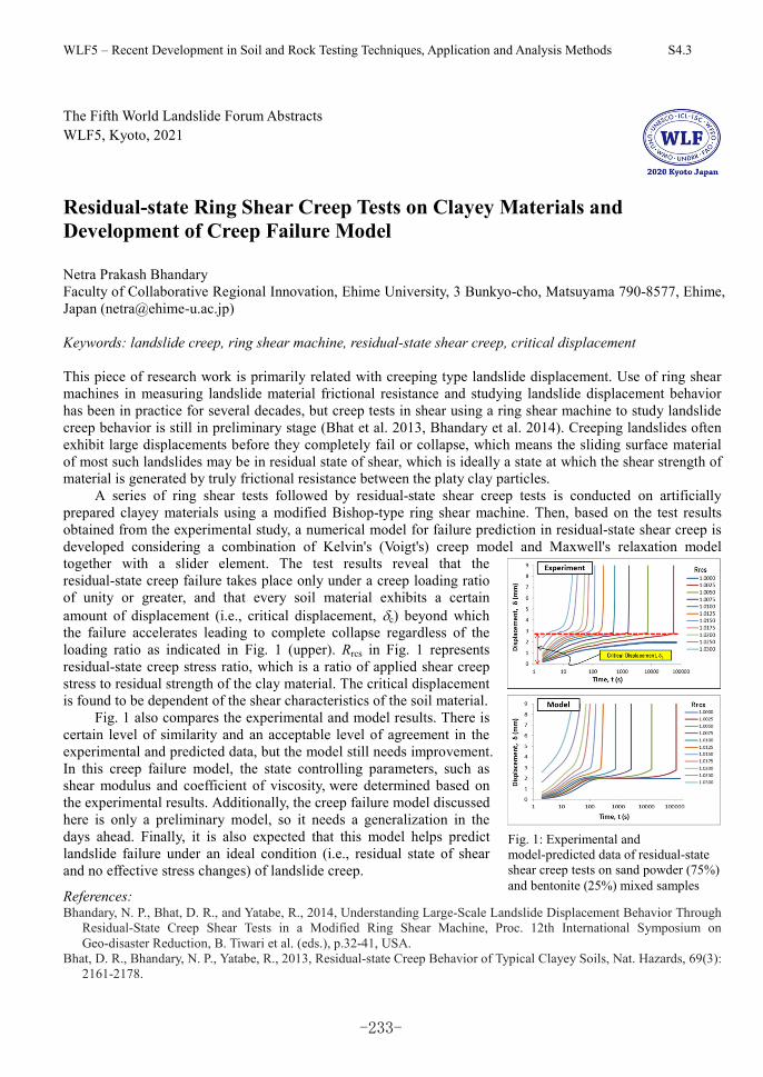
WLF5 – Recent Development in Soil and Rock Testing Techniques, Application and Analysis Methods S4.3
The Fifth World Landslide Forum Abstracts WLF5, Kyoto, 2021
Residual-state Ring Shear Creep Tests on Clayey Materials and Development of Creep Failure Model Netra Prakash Bhandary Faculty of Collaborative Regional Innovation, Ehime University, 3 Bunkyo-cho, Matsuyama 790-8577, Ehime, Japan ([email protected]) Keywords: landslide creep, ring shear machine, residual-state shear creep, critical displacement This piece of research work is primarily related with creeping type landslide displacement. Use of ring shear machines in measuring landslide material frictional resistance and studying landslide displacement behavior has been in practice for several decades, but creep tests in shear using a ring shear machine to study landslide creep behavior is still in preliminary stage (Bhat et al. 2013, Bhandary et al. 2014). Creeping landslides often exhibit large displacements before they completely fail or collapse, which means the sliding surface material of most such landslides may be in residual state of shear, which is ideally a state at which the shear strength of material is generated by truly frictional resistance between the platy clay particles.
A series of ring shear tests followed by residual-state shear creep tests is conducted on artificially prepared clayey materials using a modified Bishop-type ring shear machine. Then, based on the test results obtained from the experimental study, a numerical model for failure prediction in residual-state shear creep is developed considering a combination of Kelvin's (Voigt's) creep model and Maxwell's relaxation model together with a slider element. The test results reveal that the residual-state creep failure takes place only under a creep loading ratio of unity or greater, and that every soil material exhibits a certain amount of displacement (i.e., critical displacement, c) beyond which the failure accelerates leading to complete collapse regardless of the loading ratio as indicated in Fig. 1 (upper). Rrcs in Fig. 1 represents residual-state creep stress ratio, which is a ratio of applied shear creep stress to residual strength of the clay material. The critical displacement is found to be dependent of the shear characteristics of the soil material.
Fig. 1 also compares the experimental and model results. There is certain level of similarity and an acceptable level of agreement in the experimental and predicted data, but the model still needs improvement. In this creep failure model, the state controlling parameters, such as shear modulus and coefficient of viscosity, were determined based on the experimental results. Additionally, the creep failure model discussed here is only a preliminary model, so it needs a generalization in the days ahead. Finally, it is also expected that this model helps predict landslide failure under an ideal condition (i.e., residual state of shear and no effective stress changes) of landslide creep.
References: Bhandary, N. P., Bhat, D. R., and Yatabe, R., 2014, Understanding Large-Scale Landslide Displacement Behavior Through
Residual-State Creep Shear Tests in a Modified Ring Shear Machine, Proc. 12th International Symposium on Geo-disaster Reduction, B. Tiwari et al. (eds.), p.32-41, USA.
Bhat, D. R., Bhandary, N. P., Yatabe, R., 2013, Residual-state Creep Behavior of Typical Clayey Soils, Nat. Hazards, 69(3): 2161-2178.
Fig. 1: Experimental and model-predicted data of residual-state shear creep tests on sand powder (75%) and bentonite (25%) mixed samples
-233-
WLF5 – Recent Development in Soil and Rock Testing Techniques, Application and Analysis Methods S4.3
The Fifth World Landslide Forum Abstracts WLF5, Kyoto, 2021
Challenges in Evaluating Shear-Rate Effects in Soils Gianvito Scaringi (1), Jakub Roháč (1), Jose Duque (1), Marco Loche (1) (1) Institute of Hydrogeology, Engineering Geology and Applied Geophysics, Faculty of Science, Charles
University, Prague, Czech Republic ([email protected], [email protected],
[email protected], [email protected])
Some landslides move imperceptibly for years, while others rush downslope within seconds, destroying
everything they encounter. The frictional resistance at the base of the sliding mass can control these behaviors.
Generally, this resistance decreases to a minimum value as the material breaks down and is sheared. However,
this value also depends on the shear velocity. Shear rate-dependent frictional resistance has indeed been
recorded in many soils. We verify some expected trends from the literature using kaolin- and bentonite-sand
mixtures, which we test in a classic fashion using a ring-shear apparatus under confining stresses
representative of landslide shear zones. We evaluate the residual shear strength carefully, accounting for – and
trying to minimize – experimental uncertainties. We observe velocity strengthening in clay-rich mixtures, and
both strengthening and weakening in soils with smaller proportions of clays, with the largest weakening in
mixtures containing ~30% of clay minerals. However, upon statistical analysis, we conclude that many of
these trends are insignificant or inconsistent, especially under low confining stress. We suggest that
shear-rate-dependent formulations in landslide runout models should be used cautiously, and only if supported
by strong evidence, accounting for inherent uncertainties in soil testing and soil heterogeneity.
Keywords: residual shear strength, shear-rate effect, velocity weakening, statistical analysis, landslide
-234-
WLF5 – Recent Development in Soil and Rock Testing Techniques, Application and Analysis Methods S4.3
The Fifth World Landslide Forum Abstracts WLF5, Kyoto, 2021
Monotonic and Cyclic Behaviour of Tephra Layer Landslide at Takanodai from the 2016 Kumamoto Earthquake Satoshi Goto (1), Kento Okada (2) (1) Department of Civil and Environmental Engineering, University of Yamanashi, Takeda 4-3-11, Kofu,
Yamanashi 400-8511, Japan ([email protected]) (2) Graduate School of Civil and Environmental Engineering, University of Yamanashi, Takeda 4-3-11, Kofu,
Yamanashi 400-8511, Japan ([email protected])
The 2016 Kumamoto earthquakes, Japan, caused a large numbers of slope failures, especially a large—scale
flow—type landslide was induced in the area near the Aso Volcanological Laboratory of Kyoto University in
Takanodai, Minamiaso Village Kumamoto, Japan. From the field observation, sliding surface was the tephra
layer of Kusasenrigahama fallen pumice (Kpfa) which was deposited by the volcanic activity (around 30,000
years ago, Miyabuchi et al. in VSJ 48(2):195–214, 2003). This tephra layer (Kpfa) was a key soil to
understand the mechanism of this large-scale flow-type landslide, then some soils from this tephra layer were
retrieved from the sliding surface in the field. This study is focused on the physical properties, monotonic and
cyclic direct shear behaviour for the tephra layer (Kpfa) to understand the mechanism of this landslide during
earthquake. Constant vertical stress and constant volume cyclic direct shear tests were performed to study the
cyclic behaviour of the tephra layer (Kpfa). From the constant vertical stress test, strain hardening behaviour
was observed. From the constant vertical stress test, shear displacement increased largely during cyclic loading,
despite the tephra layer being in an unsaturated state, which were similar to the behaviour of saturated sand
during liquefaction. In the future, this research will be developed considering the study of particle breakage on
Kpfa.
Keywords: Monotonic and cyclic shear behavior, Tephra layer landslide, Kumamoto earthquake, Shear
strength
-235-
WLF5 – Recent Advancements in the Methods of Slope Stability and Deformation Analyses S4.4
The Fifth World Landslide Forum Abstracts WLF5, Kyoto, 2021
Slope Stability Assessment of Weak and Weathered Rocks with BQ System Timur Ersöz(1), Merve Özköse(2), and Tamer Topal(1) (1) Department of Geological Engineering, Middle East Technical University, 06800 Ankara, Turkey
([email protected]) (2) Koza Gold Corporation, 06370 Ankara, Turkey ([email protected])
Rock slopes can be affected by weathering and human activities. Depending on the type of the rock, the impact
of weathering and excavation can change. This leads some strength reductions and consequently some stability
problems. Limit equilibrium analyses are widely used to assess slope stability but empirical methods are also
very useful and quick. Basic quality (BQ) system is very popular method which is developed in China to
assess slope stability of the rock slopes. Generally it leans on strength and rock soundness/GSI to determine
slope stability. In this study, rock slope stabilities were assessed with limit equilibrium method and BQ system.
55 cut slopes located in Western Black Sea Region of Turkey were used to evaluate the stability conditions. 39
of the cut slopes are located in flysch deposits consisting mudstones and sandstone/limestone alternations.
Other rock types are granite, basalt, andesite, granodiorite, serpentinite and tuff. According to the field
observations, degree of weathering of most of the cut slopes are moderate (38), and the rest are slightly (10)
and highly (7). Uniaxial compressive strength, point load strength index and Schmidt hammer tests were
applied to find strength values. According to the tests, most of the rocks are in the category of weak and
medium strong (5–50 MPa) throughout the study area. The field observations revealed that all cut slopes are
stable except surficial failures due to weathering and excavation. According to limit equilibrium analyses, all
cut slopes are stable, but only surficial failures were observed due to degradation which is completely coherent
with the field observations. However, BQ System revealed that most of the results are not coherent with the
field observations and limit equilibrium results. It is concluded that rocks stronger than 50 MPa can be
assessed properly by BQ System in the study area.
Keywords: BQ system, Excavation, Flysch, Rock strength, Slope stability, Weathering
-236-
WLF5 – Recent Advancements in the Methods of Slope Stability and Deformation Analyses S4.4
The Fifth World Landslide Forum Abstracts WLF5, Kyoto, 2021
Soil Databases to Assist Slope Stability Assessments in the Eastern Caribbean Paul J. Vardanega(1), Elizabeth A. Holcombe(1), Myrto Savva(2), Casey J. Shepheard(3), Rose Hen-Jones(1), and
Flavia De Luca (1) (1) Department of Civil Engineering, University of Bristol, Queen’s Building, University Walk, Bristol, BS8
1TR, UK ([email protected]) (2) Formerly affiliated to Department of Civil Engineering, University of Bristol, Queen’s Building, University
Walk, Bristol, BS8 1TR, UK (3) Department of Engineering, University of Cambridge, Trumpington Street, Cambridge, CB2 1PZ, UK
Rainfall-triggered landslides are an ‘everyday risk’ to Small Island States, such as Saint Lucia in the Caribbean,
and have the potential to destroy or damage buildings and disrupt lifelines such as roads and pipelines. To
better evaluate these landslide hazards, efforts have been made to develop decision-support tools linking
rainfall scenarios to stability for different types of road cut slope. Many thousands of stochastic simulations
can be performed using a combined hydrology and slope stability model (CHASM) which requires inputs of
slope cross-sectional geometry, soil and hydrological parameters which allows representative rainfall-triggered
landslide scenarios to be produced. To use CHASM for this purpose the statistical variation of the relevant
geotechnical properties such as friction angle needs to be assessed. This paper presents the analysis of an
updated database for Saint Lucian soils that has been compiled using data supplied by the Government of Saint
Lucia Ministry of Infrastructure, Port Services and Transport. The Coefficient of Variation values of the key
soil mechanics parameters are reported and previously developed transformation models for estimating
effective friction angle are updated. The Weibull statistical distribution is shown to be the best fit to the friction
angle data.
Keywords: Coefficient of variation, Soil database, Soil variability, Transformation models, Statistical
distributions, Tropical soils
-237-
WLF5 – Recent Advancements in the Methods of Slope Stability and Deformation Analyses S4.4
The Fifth World Landslide Forum Abstracts WLF5, Kyoto, 2021
Failure mechanism of a flow-like landslide triggered by the 2018 Western Shimane Earthquake Ran Li (1), Fawu Wang (1) & Shuai Zhang (1) (1) Department of Earth Science, Shimane University, 1060 Nishikawatsu-cho, Matsue, Shimane 690-8504,
Japan ([email protected])
The flow-like Kataragai landslide triggered by the 2018 Western Shimane Earthquake occurred in a gentle
slope out of the area which suffered from the most intense ground motion. The geotechnical and hydrological
conditions are considered as the primary factors for the landslide occurrence. It is confirmed through the field
survey that the Kataragai landslide occurred in a refilled slope composed of medium sand with gravel, and
several small ponds scattered on the refilled slope with perennial water. The existence of downslope seepage
flow was validated by self-potential tests and the seepage flows at the center of the crown near the pond are
more noticeable. A weak layer with low dry density and fine-particle content was confirmed through hardness
tests and penetration tests. The triaxial tests indicate that the anti-liquefaction strengths of the soils in the
Kataragai landslide are relatively low on the whole, while the weak layer is the lowest. The erosion of fine
content in soil due to seepage flow is responsible for the formation of the weak layer. Based on the soil
property and hydrologic condition, the initiation and motion mechanisms of the Kataragai landslide were
discussed as well.
Keywords: 2018 Western Shimane Earthquake, Flow-like slide, Seepage, Liquefaction
-238-
WLF5 – Recent Advancements in the Methods of Slope Stability and Deformation Analyses S4.4
The Fifth World Landslide Forum Abstracts WLF5, Kyoto, 2021
The Mt Gamalama Instability Level in Generating Landslide-Induced Tsunami in Ternate Island, Indonesia Saaduddin(1, 2), Jurgen Neuberg(1), Mark E. Thomas(1), and Jon Hill (3) (1) School of Earth and Environment, University of Leeds, Leeds, LS2 9JT, UK ([email protected];
[email protected]) (2) Department of Geophysics, Faculty of Mathematics and Natural Sciences, Hasanuddin University, Makassar,
90245, Indonesia (3) Department of Environment and Geography, University of York, Heslington, York, YO10 5NG, UK
Mt Gamalama is a volcanic island which has a history of tsunamigenic volcanic eruptions with known events
in 1608, 1840, and 1871, where tsunami generation is suspected due to landslides or sector collapse of the
steep flanks entering the Molucca Sea threatening the coastal population and infrastructure. The potential
landslides were investigated by applying a limit equilibrium method and the generalized Hoek–Brown failure
criteria. This resulted in a so-called factor of safety (FoS) which describes the Mt Gamalama slope stability
level. The critical FoS values ranging from 1.945 to 3.361 have been obtained for the four sections of the Mt
Gamalama edifice the north, south, west, and east sides and are considered in a relatively stable condition.
These values hold for a static condition only under gravity and in the absence of any volcanic activity. The
application of so-called seismic loads kh of 0.103, and 0.155, 0.457, and 0.685, and magma pressures of 2–17
MPa due to vertical and tilted dyke intrusion decreases FoS values (FoS < 1.000) in all sections. We show that
these additional factors destabilize the Mt Gamalama slopes and even lead to failure.
Keywords: Mt gamalama, Instability, Landslides, Tsunami
-239-
WLF5 – Recent Advancements in the Methods of Slope Stability and Deformation Analyses S4.4
The Fifth World Landslide Forum Abstracts WLF5, Kyoto, 2021
Seepage and deformation of unsaturated slope during post-earthquake rainfall Jiawei Xu (1), Ryosuke Uzuoka (2), Kyohei Ueda (3) (1) Kyoto University, Gokasho Uji, Japan ([email protected]) (2) Kyoto University, Gokasho Uji, Japan ([email protected]) (3) Kyoto University, Gokasho Uji, Japan ([email protected])
This study sets out with the aims of evaluating the effect of earthquake on the seepage and deformation of
slopes to the rainfall after earthquake and examining the impact of different factors such earthquake intensity
and rainfall intensity on the response of slopes subject to rainfall. It was found from the experiments that,
shaking-induced cracks on the slope were near its shoulder and the existence of cracks greatly affected slope
behavior during the following rainfall, and the rainfall-induced landslide was affected by both rainfall intensity
and previous-shaking intensity. The effect of preferential flow due to the presence of cracks was more evident
when the slope was under rainfall with a greater intensity and the landslide features and deformation patterns
could be largely different due to different rainfall intensities. Heavy rainfall greatly accelerated the failure of
the slope with shaking-induced cracks, resulting in a rapid and massive landslide, whereas light rainfall might
cause a different landslide pattern but the landslide kinematics would be similar to the slope under rainfall
without shaking. In addition, experiments on slopes subjected to shaking with different intensities but the same
rainfall revealed that, for the slopes containing shaking-induced cracks, even though being subjected to the
same rainfall, their deformation could vary significantly in magnitude, thus the previous-shaking event was
important in evaluating the slope behavior during rainfall. The velocity of rainfall-caused landslide could be
greatly influenced by the prior shaking event alone. Despite a low intensity, the rainfall could still lead to an
instant landslide once the slope has encountered more intense antecedent shaking.
Keywords: keyword1, keyword2, keyword3, keyword4, keyword5
-240-
WLF5 – Recent Advancements in the Methods of Slope Stability and Deformation Analyses S4.4
The Fifth World Landslide Forum Abstracts WLF5, Kyoto, 2021
3D analysis of settlement and stability of the open-cast coal mine landfill: Bílina mine case Jan Jerman (1), Tomáš Kadlíček (1), David Mašín (1), Jan Najser (1), Václav Hájek (2) (1) Institute of Hydrogeology, Engineering Geology and Applied Geophysics, Faculty of Science, Charles
University, Prague, Czech Republic ([email protected], [email protected],
[email protected], [email protected]) (2) GeoTec GS a.s.,Chmelová 2920/6, 106 00 Praha 10 ([email protected])
Bílina open-cast coal mine lies in North Bohemia region in the Czech Republic and its approximate
dimensions are 6x4 km with the depth of over 200 m. The overburden is transported into an internal landfill of
up to 200 m in height. The deposited material consists of a lumpy heavily overconsolidated clay. The soil is
loosely dispersed on the surface of the landfill without compaction, forming an inhomogeneous
double-porosity material with a porosity up to 70% and lump size of the order of magnitude 0.1 to 1 m. Due to
its own weight and weather conditions, the lumps slowly disintegrate, filling the intergranular space with
slurry soil. Eventually, the slurry soil between the original lumps controls the overall mechanical response and
the material behaves analogous to the reconstituted soil, although lumpy structure remains clear even in old
landfill. In this talk, we present 2D and 3D settlement and stability analysis of the Bílina landfill. For the
numerical analysis hypoplastic constitutive model for clays is adopted allowing to predict such features as soil
non-linearity, stiffness dependency on the OCR and loading direction and critical state. Hypoplastic model is
calibrated on the reconstituted soil samples as well as on the model material prepared from the reduced
granulometry curve to account for lumpy structure. The validation of the constitutive model calibration is done
in 2D via landfill settlement analysis – the predicted settlement is evaluated against in situ measured
settlements of 5 pre-installed 5x5m steel plates. Then, 3D numerical analysis is performed to assess evolution
of landfill settlement during its construction, simulating individual phases of soil deposition. Eventually,
recently developed strength reduction method for hypoplasticity is employed together with stabilizing surface
layer method in the 3D stability analysis to quantify factor of safety for basal landfill slope failure.
Keywords: landfill, slope stability, settlement, hypoplasticity, three-dimensional
-241-
WLF5 – Recent Development in Disaster Risk Assessment S4.5
The Fifth World Landslide Forum Abstracts WLF5, Kyoto, 2021
Engineering Risk Mitigation for Landslide Hazard Chains: The Baige Landslides on the Jinsha River in 2018 Limin M. Zhang (1), Jian He (1), and Te Xiao (1) (1) Department of Civil and Environmental Engineering, The Hong Kong University of Science and
Technology, Kowloon, Hong Kong, 999077, China ([email protected])
On 10 October and 3 November 2018, two large landslides occurred at Baige on the Qinghai-Tibet Plateau,
and completely blocked the Jinsha River. Accordingly two landslide dams formed and breached sequentially,
with the breaching of the 3 Nov. dam generating a flood larger than the 10,000-year return period flood over a
river reach of approximately 400 km, endangering the serial cascade dams and towns along the river. These
were two typical large-scale hazard chains originated by landslides. This paper presents a five-phase protocol
to manage the risks of landslide hazard chains, which includes definitions, multi-hazard assessment, exposure
assessment, multi-vulnerability assessment, and multi-risk assessment. The protocol is illustrated in the case of
the Jinsha River landslide hazard chains. How the hazard chains developed in space and time are introduced.
The major engineering measures for mitigating short-term and longer-term risks are described, including the
use of a 15 m deep diversion channel to reduce the dam failure flow rate and flow quantity, removal of two
cofferdams along the river to avoid flood amplification effects, flood regulation using six reservoirs over 630
km downstream, load relief at the crest of the instable slope to increase its stability, and removal of part of the
residual landslide barrier to minimize future landslide dam risks. Finally, several scientific topics are suggested
for further study.
Keywords: Hazard chain, Landslide, Landslide dam, Dam breaching, Multi-hazard risk management, Jinsha
River
-242-
WLF5 – Recent Development in Disaster Risk Assessment S4.5
The Fifth World Landslide Forum Abstracts WLF5, Kyoto, 2021
Engineering Geological Investigation and Slope Stability Analysis for Landslide Hazard Assessment in Indian Himalayas Shantanu Sarkar (1) and Koushik Pandit (1) (1) Geotechnical Engineering Group, CSIR—Central Building Research Institute, Roorkee, 247667,
Uttarakhand, India ([email protected])
The Indian Himalaya is very prone to landslides due to its complex geology and tectonic set-up along with
high intensity rainfall and aggravated slope conditions as a result of anthropogenic activities. Landslide hazard
assessment is very essential before any hill development construction activity begins. Engineering geological
investigation forms the primary basis for any slope stability assessment leading to plan for any construction so
that landslide occurrences are minimized. Engineering geological data for rock slope stability assessment can
be very easily collected from the field. These data can be used for rock mass characterization and classification
such as Geological Strength Index (GSI), Rock Mass Rating (RMR) and Slope Mass Rating (SMR). The paper
describes these rock mass classification techniques and presents some field examples. The paper also presents
application of these techniques to derive some relevant geotechnical parameters for numerical analysis to
determine the stability of slopes in terms of factor of safety.
Keywords: Engineering geology, Landslide, Slope stability, Rock mass classification
-243-
WLF5 – Recent Development in Disaster Risk Assessment S4.5
The Fifth World Landslide Forum Abstracts WLF5, Kyoto, 2021
First Consideration about Post 2017 Wildfire Erosion Response and Debris Flow in Susa Valley (NW Italy) Damiano Vacha(1), Giuseppe Mandrone(1), Matteo Garbarino(2), and Donato Morresi(2) (1) Earth Sciences Department, University of Turin, Via Valperga Caluso 35, 10135 Turin, Italy
([email protected]) (2) Department of Agricultural, Forest and Food Sciences (DISAFA), University of Turin, Largo Paolo Braccini
2, 10095 Grugliasco (TO), Italy
This paper contains the first results of an ongoing research dealing with post-fire mass movements in Italy.
Although the attention of the scientific community is increasing worldwide, very few geo-hydrological
processes occurring in burned areas are reported for Italy. As the probability of occurrence and magnitude of
wildfires is expected to increase in the future because of climate change, more efforts should be made to
deepen knowledge on interacting disturbances. Here, we present a case study regarding the erosional response
after fire recurrence in a watershed located in NW Italy, where multiple flow processes occurred after six
months since the last wildfire, as a consequence of different rainstorms. It contains a description of the
geological and geomorphological background, the burn severity assessment together with the analysis of the
triggering rainfalls and the outline of the main geomorphic effects that affected people and lifelines.
Keywords: Wildfire, Debris flow, Erosion, Fire severity, Susa, Valley - N-W Italy
-244-
WLF5 – Recent Development in Disaster Risk Assessment S4.5
The Fifth World Landslide Forum Abstracts WLF5, Kyoto, 2021
Identification of Sliding Surface and Crack Pattern in the Soil Creep, Case Study: Unika Soegijapranata Campus, Semarang, Central Java, Indonesia Wahyu Wilopo(1,2), Hendy Setiawan(1), Doni Prakasa Eka Putra(1), and Teuku Faisal Fathani (1) (1) Department of Geological Engineering, Faculty of Engineering, Universitas Gadjah Mada, Kampus UGM,
Jl. Grafika No. 2, Yogyakarta, 55281, Indonesia ([email protected]) (2) Center for Disaster Mitigation and Technological Innovation (GAMA-InaTEK), Universitas Gadjah Mada,
Yogyakarta, Indonesia
The development of a sports hall in the Unika Soegijapranata Campus in Central Java is constrained by
geological conditions. At the time of land preparation, a crack appears on the fence of the sports hall
foundation that was predicted as a sign that they have a soil creep. This condition has threatened the
implementation of such development. Therefore, it is necessary to know the subsurface conditions, especially
the sliding surface location and pattern of the existing cracks in the ground. This information is beneficial to
avoid soil creep risk. In order to support the information, both the geological survey and seismic refraction
were conducted in this location. According to the survey, it is found that the sliding surface was identified as
volcanic breccia with the depth from 5 m up to 20 m. There are many faults found based on the seismic data,
and many cracks appear on the surface, which suspected as the creep crown. Some areas of the sports hall are
located in the soil creep crown. According to the drilling data and geo-electrical survey, the sliding surface
location of the soil creep was identified within volcanic breccia layers. It is recommended to shift the planned
location of the sports hall in order to avoid or minimize the soil creep risk.
Keywords: Seismic refraction, Geological survey, Crack structure and pattern, Soil creep
-245-
WLF5 – Recent Development in Disaster Risk Assessment S4.5
The Fifth World Landslide Forum Abstracts WLF5, Kyoto, 2021
Preliminary Result of Real-Time Landslide Monitoring in the Case of the Hinterland of Koroška Bela, NW Slovenia Tina Peternel, Ela Šegina, Matija Zupan, Mateja Jemec Auflič, and Jernej Jež
Geological Survey of Slovenia, Dimičeva ulica 14, 1000 Ljubljana, Slovenia ([email protected])
Landslides are a common and widespread phenomenon in Slovenia, as they are in most European countries.
Because we cannot avoid the risk of landslides and must live with it, it is important to understand and predict
landslide dynamics. Research on landslide dynamics forms the basis of landslide hazard prevention and serves
as a basic requirement for the development of prediction models and for defining prevention and mitigation
measures. The principal aim of this study is to form a basis to predict real-time dynamics of landslides that
have been posing a direct threat to settlement Koroška Bela (with approximately 2200 inhabitants) for
centuries. Prediction modelling is based on monitoring and recognition of displacement triggering mechanisms
and their interactions. The study area is located above the settlement of Koroška Bela (NW Slovenia,
Karavanke) which exhibits a number of deep-seated landslides (the Urbas and Čikla landslides) in weathered
siltstone and claystone.
Keywords: Real-time monitoring, Landslide, Koroška Bela, Slovenia
-246-
WLF5 – Recent Development in Disaster Risk Assessment S4.5
The Fifth World Landslide Forum Abstracts WLF5, Kyoto, 2021
Quantitative Risk Analysis of Earthquake-Induced Landslides Saskia de Vilder(1), Chris Massey(1), Tony Taig(2), Biljana Lukovic(1), Garth Archibald(1), and Regine
Morgenstern(1) (1) GNS Science, 1 Fairway Drive, Avalon, Lower Hutt, 5010, New Zealand ([email protected]) (2) TTAC Ltd., 10 The Avenue, Marston, CW9 6EU, Chesire, UK ([email protected])
Quantitative risk analysis is valuable tool in risk management, yet the calculation of risk is often hampered by
a lack of quality spatial input data, particularly landslide event inventories. These event inventories provide
information to determine the number, size and spatial location of landslides triggered by discrete events such
rainfall or earthquakes. This paper presents an approach whereby we use historical New Zealand
earthquake-induced landslide inventories to estimate the landslide hazard for the Franz Josef and Fox glacier
valleys, West Coast, South Island, New Zealand, as no pre-existing complete earthquake-induced landslide
inventories exist for this area of New Zealand. We outline a methodology for the calculation of
earthquake-induced landslide magnitude-frequency relationships from the 2016 Mw 7.8 Kaikōura earthquake,
the 1968 Mw 7.1 Inangahua earthquake, and the 1929 Mw 7.8 Murchison earthquake to determine the
probability of a given volume of landslide occurring for different levels of ground shaking.
Keywords: Earthquake-induced landslides, Magnitude-frequency analysis, Quantitative risk analysis
-247-
WLF5 – Recent Development in Disaster Risk Assessment S4.5
The Fifth World Landslide Forum Abstracts WLF5, Kyoto, 2021
Role of Remote Sensing Technology in Landslide Risk Management of Hong Kong Julian S. H. Kwan(1), W. K. Leung(1), and Clarence E. Choi(2) (1) Geotechnical Engineering Office, Civil Engineering and Development Department, Hong Kong SAR, China
([email protected]) (2) Department of Civil Engineering, The University of Hong Kong, Hong Kong SAR, China ([email protected])
Natural terrain covers over 60% of the land area of Hong Kong. With the close proximity of developments to
hillsides and high annual rainfall, Hong Kong is under a constant threat from natural terrain landslides. Over
the past years, the Geotechnical Engineering Office (GEO) of the Civil Engineering and Development
Department of the Hong Kong Special Administrative Region Government has applied state-of-the-art remote
sensing techniques, for example, laser scanning, photogrammetry and interferometric synthetic aperture radar,
in landslide risk management. These include landslide hazard identification and monitoring, post-landslide
responses and residual risk management, design of landslide prevention and mitigation measures etc. This
paper discusses the advantages of remote sensing technology and their applications to enhance the slope safety
of Hong Kong. Pilot studies applying machine learning on identification of geological features from aerial
imageries and further studies being/to be conducted are also covered.
Keywords: Remote sensing, Natural terrain, Slope safety management, Machine learning
-248-
WLF5 – Recent Development in Disaster Risk Assessment S4.5
The Fifth World Landslide Forum Abstracts WLF5, Kyoto, 2021
Risk assessment of submerged rock mass in reservoir area Luqi Wang(1), Yueping Yin(2), Bolin Huang(3), Zhenwei Dai(4), Zhihua Zhang(5) (1) China University of Geosciences, Wuhan, China ([email protected]) (2) China Institute of Geological Environment Monitoring, Beijing, China (3) China Three Gorges University, Yichang, China (4) Wuhan Centre of China Geological Survey, Wuhan, China (5) No.208 Hydrogeology and Engineering Geology Team of Chongqing Bureau of Geology and Minerals
Exploration, Chongqing, China
A new analysis method was proposed to study the damage evolution process of the dangerous rock masses on
the reservoir bank. This method involves the generalization of a mechanical model, the derivation of the
constitutive damage model based on laboratory results, iterative damage calculations, and the refinement of the
factor of safety methodology based on the reservoir water level. Through this new method, we can
continuously track the mechanical state of a dangerous rock mass and quantify the relationship between the
changing water level and the potential failure of the rock mass. By using this method to analyze
Jianchuandong Dangerous Rock Mass (JDRM), it can be found that the theoretical pressure data and the
observed pressure data were consistent with one another, and both exhibited nonlinear progressive
deformation; this agreement shows that our new modeling technique is both valid and robust. As of December
2018, our calculations indicate that the JDRM will be in a critical state of instability after two dry‐wet cycles.
According to the parameters obtained by the prediction model, the dynamic collapse analysis of JDRM is
carried out. The collapse of JDRM is similar to that of the Zhenziyan collapse, which not only proves the
effectiveness of parameter selection but also expands this analysis method’s capabilities.
-249-
WLF5 – Recent Development in Disaster Risk Assessment S4-5
The Fifth World Landslide Forum Abstracts WLF5, Kyoto, 2021
Prediction the Global Factor of Safety in Soil-Nailed Slope by A Simplified Method Panyabot Kaothon (1), Kean Thai Chhun (2), Chan-Young Yune (3) (1) Graduate Student, Dept. of Civil Engineering, Gangneung-Wonju National University, Gangneung 25457,
Republic of Korea ([email protected]) (2) Ph.D. Candidate, Dept. of Civil Engineering, Gangneung-Wonju National University, Gangneung 210-702,
Republic of Korea ([email protected]) (3) Professor, Dept. of Civil Engineering, Gangneung-Wonju National University, Gangneung 210-702,
Republic of Korea ([email protected])
Reinforcement of slopes using soil nailing can effectively improve slope stability, and it has been widely used
for cutting slopes. At the present time, there is no derived formula having an adequate accuracy for a tentative
design without complex and detailed numerical analysis on the stability of soil nail structure. Based on the
finite element analysis, a new simplified method has been established which can consider the effect of nail
spacing, nail inclination, nail head size and slope angle. With the aid of master curve approach, the contour
curve charts of global factor of safety were drawn to facilitate engineering application and to acquire optimal
design parameters of soil nailing. Parametric study for various soil-nailed slopes has been conducted based on
finite element simulations. Statistical analysis between the rigorous numerical analysis and developed formula
for the global factor of safety showed that 0.7282 of the coefficient of determination was achieved. Therefore,
the new simplified method can be an appropriate tool to estimate the global factor of safety of soil-nailed slope.
However, the further analysis in various types of soils is also needed to improve this derived formula in the
future.
Keywords: Finite element analysis, Master curve, Simplified method, Parametric study, Global factor of safety.
-250-
WLF5 – Recent Development in Disaster Risk Assessment S4.5
The Fifth World Landslide Forum Abstracts WLF5, Kyoto, 2021
On the Scale Effect of the Catchment Landslide Susceptibility with Consideration of Climate Change Keh-Jian Shou(1), Chia-Yu Hu(2)
(1)National Chung-Hsing University, Dept. of Civil Engineering, Taiwan ([email protected]) (2)National Chung-Hsing University, Dept. of Civil Engineering, Taiwan ([email protected])
Due to the impact of climate change, the increasing frequency of extreme rainfall events, with concentrated
and intensive rainfalls, commonly cause landslide hazard in the mountain areas of Taiwan. Although the
extraordinary rainfall behavior is critical for the geohazard, it is significantly affected by the topography, the
route of typhoon, etc. Therefore, the predicted rainfall could be quite different in different catchment, which
also suggests the scale effect on the predicted rainfall. This study employs rainfall frequency analysis together
with the atmospheric general circulation model (AGCM) downscaling estimation to understand the temporal
rainfall trends, distributions, and intensities in the adopted study area in Central Taiwan. To investigate the
scale effect, three catchments in Central Taiwan, i.e. Ta-Chia River, Wu River, and Chuoshui River were
adopted as the study area. For a better prediction of rainfall, the rainfall behavior was analyzed in different
scales. To assess the hazard of the landslides, logistic regression methods and supporting vector machines
method were applied, in which the control factors were analyzed and discussed. The results of predictive
analysis can be applied for risk prevention and management in the study area.
Keywords: scale effect, landslide susceptibility, climate change, catchment scale, rainfall induced landslide
-251-
WLF5 – Recent Development in Disaster Risk Assessment S4.5
The Fifth World Landslide Forum Abstracts WLF5, Kyoto, 2021
Fragmental rockfalls and the analysis of risk Jordi Corominas (1), Gerard Matas (1), Roger Ruiz-Carulla (1), Nieves Lantada (1), Albert Prades (1) (1) Department of Civil and Environmental Engineering, Universitat Politècnica de Catalunya-BarcelonaTech,
Jordi Girona 1-3, D-2 Building, 08034 Barcelona, Spain. E-mail: [email protected]
Fragmentation is a phenomenon frequently observed in rockfalls although it is rarely considered in risk
analysis. Ignoring it can result in both over- and under-estimation of risk due to its contrasting effects, which
we briefly summarize in what follows. The quantitative evaluation of risk requires determining the probability
(or frequency) of rockfall occurrence, the probability of reach, and the exposure or temporal spatial probability
of the element at risk (Hantz et al. 2021). Fragmentation reduces the size and increases the number of blocks
that propagate down the slope. For this reason, the assessment of the probability of reach must be adapted to
the fact that more blocks can reach a given location than those initially detached from the cliff. The new
fragments generated follow independent trajectories, often diverging significantly from that of the unbroken
blocks, which increase the impact probability on the exposed elements. Moreover, the width of the affected
area varies with distance. When the moving fragments do not form a continuous front, it is necessary to adapt
the exposure taking into account the space actually occupied by the blocks (Corominas et al. 2019).
Observations from real-scale tests suggest that, contrary to what is commonly assumed, blocks that fragment
bounce faster and show higher coefficients of restitution. Nevertheless, on long slopes, the roughness of the
ground affects mainly the small fragments, which reduces the distances traveled and the impact energies. This
facilitates the capture of the blocks by the protection structures but, on the other hand, the occurrence of
multiple impacts introduces uncertainty in their performance. Finally, when impacts generating fragmentation
occur near the protective structures, the bullet effect and the greater rebound angles of the fragments must be
taken into account.
Hantz, D., Corominas, J., Crosta, G.B., Jaboyedoff, M. 2021. Definitions and Concepts for Quantitative
Rockfall Hazard and Risk Analysis. Geosciences 2021, 11(4), 158; doi:10.3390/geosciences11040158
Corominas, J.; Matas, G.; Ruiz-Carulla, R. 2019. Quantitative analysis of risk from fragmental rockfalls.
Landslides, 16: 5–21. https://doi.org/10.1007/s10346-018-1087-9
Keywords: rockfall, fragmentation, exposure, hazard, risk
-252-
WLF5 – Recent Development in Disaster Risk Assessment S4.5
The Fifth World Landslide Forum Abstracts WLF5, Kyoto, 2021
Satellite Soil Moisture for Estimating Landslide Hazard Ratih Indri Hapsari(1), Ayisya Cindy Harifa(2), Dandung Novianto(2), Ratna Ika Putri(4) (1) State Polytechnic of Malang, Department of Civil Engineering, Jl. Soekarno Hatta 9, Malang 65141,
Indonesia ([email protected]) (2) State Polytechnic of Malang, Department of Civil Engineering, Jl. Soekarno Hatta 9, Malang 65141,
Indonesia ([email protected]@polinema.ac.id) (3) State Polytechnic of Malang, Department of Civil Engineering, Jl. Soekarno Hatta 9, Malang 65141,
Indonesia ([email protected]) (4) State Polytechnic of Malang, Department of Electronics Engineering, Jl. Soekarno Hatta 9, Malang 65141,
Indonesia ([email protected])
Continuous monitoring of soil water content profile is necessary to assess the likelihood of landslide. Remote
sensing offers observation of soil water content that are difficult by in-situ inspections in spatially and
temporally varying condition. This study aims to construct a landslide prediction system that combines satellite
observation, soil testing and modeling. Simulations were carried out using hydrological models and soil
stability index to evaluate the association between soil water content, rainfall, and landslides. Soil Moisture
and Ocean Salinity (SMOS) from European Space Agency's Earth Explorer satellite images are downscaled to
a local scale using soil humidity derived from hydrological model as independent variable. The factor of safety
in the slope stability analysis is modeled to estimate the landslide hazard. By comparing the soil moisture
estimation with in-situ measurement, the reliability of the system was proven. For estimating the landslide
events, the evaluation is also conducted by applying the model to five landslide location in upper Brantas river
basin. This early warning system for the landslide can give a more accurate prediction for the soil movement
induced by rainfall.
Keywords: landslide, soil water content, hydrological model, downscaling, safety factor
-253-
WLF5 – Recent Development in Disaster Risk Assessment S4.5
The Fifth World Landslide Forum Abstracts WLF5, Kyoto, 2021
Shaking table tests of small scaled slope models Holger Pankrath (1, 2), David Mora (1), Eliana Jiménez (1), Alexander Knut (2), Friedemann Sandig (2) (1) National Polytechnic University (EPN), Quito, Ecuador (2) Leipzig University of Applied Sciences – Germany ([email protected])
Simulations of geotechnical problems with cyclic or dynamic loads such as those caused by earthquakes are still the subject of research worldwide. There is often a lack of reliable measurement data for validating the simulations. Model tests can provide important insights and measurement data for the derivation and validation of theoretical approaches and simulations. As part of a smaller research project at the National Polytechnic University (EPN) in Quito Ecuador in collaboration with the researchers of the Leipzig University of Applied Sciences, small-scale model tests with a one-dimensional shaking table are being developed. The project aims to contribute to the stability assessment of slope systems under the effects of earthquakes. The main aim of the tests was to record the behavior of a regional soil and later the interaction with buildings on models and to obtain reliable measurement data for later validation of calculations and simulations. The method of digital image correlation (DIC) was used to record ground movements and deformations. In the contribution, the main development steps for setting up the experiments and for using the DIC method are explained. In addition, the first results for the evaluation of ground movements and deformations on a model slope are presented.
Keywords: slope stability assessment, benchmark test, digital image correlation, earthquake loading
-254-

Theme 5 Catastrophic Landslides and Frontiers of Landslide Science
-255-
WLF5 – Landslides and Earthquakes S5.1
The Fifth World Landslide Forum Abstracts WLF5, Kyoto, 2021
Study on the Phenomena of Liquefaction Induced Massive Landslides in 28 September 2018 Palu-Donggala Earthquake Paulus P. Rahardjo (1) (1) Department of Civil Engineering, Universitas Katolik Parahyangan, Bandung, 40141, Indonesia
Liquefaction Induced Mass Landslide in Palu Donggala Earthquake on 28 September 2018 was one of the rare and biggest event on these types of landslides in the world. The phenomena was the most complete occurrence since all mechanism of liquefaction and liquefaction induced landslides were represented. On these particular event, the author has conducted study on the liquefaction mechanism based on field observation including running drone in several areas, conducting soil investigations, work on analysis and collect as much as data from local people. This paper discusses Liquefaction Mechanism in these unique and spectacular sites (mainly in four areas: Balaroa, Petobo, Jono Oge and Sibalaya) because the earthquake seems to trigger liquefaction by multidirectional vibration and of particular interest is because the earthquake are near faults with shallow earthquake focus of about 10 km below the city. The extraordinary distance of liquefaction flow and lateral spreading is one of unique phenomena which is believed to be caused by the existence of initial artesian pressure and significant vertical acceleration causing the soil loosing contact stress. Layers of sands and clays or silts might have caused significant force to the liquefied sands and flow laterally. Instead of surface phenomena, the main objectives of this paper is also to discuss the results of CPTu tests conducted for analysis and fact findings on liquefaction phenomena. Each data of CPTu yields liquefaction potential index which is used to characterize the severity of ground damage and discuss mitigation and risk reduction in the future.
Keywords: Liquefaction, Lateral spreading, Liquefaction induced landslides, Liquefaction potential index
-256-
WLF5 – Landslides and Earthquakes S5.1
The Fifth World Landslide Forum Abstracts WLF5, Kyoto, 2021
The Krasnogorsk Landslide (Northern Caucasus): Its Evolution and Modern Activity Igor K. Fomenko (1), Oleg V. Zerkal (2), Alexander Strom (3), Daria Shubina (1), Ludmila Musaeva (4) (1) Ordzhonikidze Russian State Geological Prospecting University, Moscow, 117997, Russia
([email protected]) (2) Moscow State University, Moscow, 119991, Russia ([email protected]) (3) Geodynamics Research Center LLC, Moscow, 125008, Russia ([email protected]) (4) JSC Mosoblhydroproject, Moscow District, Dedovsk, 143532, Russia ([email protected])
This article describes large landslide on the left-bank slope of the Kuban River Valley, Northern Caucasus, Russia. Its evolution along with the conditions of its triggering and activation are described. Landslide that took place in 2016 was just is a partial reactivation of a much larger ancient landslide. While modern landslide was triggered by the climatic factors, slope stability assessment allows assumption that formation of the ancient landslide could be induced by seismic activity.
Keywords: Slope stability, Landslide hazard assessment, Seismically induced landslides, Northern Caucasus
-257-
WLF5 – Landslides and Earthquakes S5.1
The Fifth World Landslide Forum Abstracts WLF5, Kyoto, 2021
Slope Deformation caused Jure Landslide 2014 Along Sun Koshi in Lesser Nepal Himalaya and Effect of Gorkha Earthquake 2015 H. Yagi (1), G. Sato (2), H. P. Sato (3), D. Higaki (4,5), V. Dangol (6), and S. C. Amatya (7) (1) Yamagata University, Kojirakawa, Yamagata 990-8560, Japan ([email protected]) (2) Teikyo Heisei University, Nakano, Tokyo, 170-8445, Japan ([email protected]) (3) College of Humanities & Sciences, Nihon University, Sakura-josui, Tokyo, 156-8550, Japan
([email protected]) (4) Hirosaki University (Formerly), Hirosaki, Japan ([email protected]) (5) Nippon Koei Co., Ltd., Chiyodaku, Tokyo, 102-0083, Japan (6) Tri-Chandra Campus, Tribvan University (formerly), Kathmandu, Nepal ([email protected]) (7) Department of Water Induced Disaster Management (Formerly), Lalitpur, Nepal ([email protected])
Although there is no commonly accepted methodology for evaluation of deep-seated landslide susceptibility, the progress on remote sensing technology such as aerial photos, satellite images, precise DEM and InSAR data have made it easier to detect ground movement at time interval and cost-effective. Combining these techniques and ground truth, the authors attempt to understand the nature of Jure landslide in Nepal that occurred due to heavy rain in August 2014. They have also studied the effect of Nepal Gorkha earthquake on the Jure landslide. Gravitational deformation, so-called “rock creep” has proceeded for long time forming thick weathering layer at the Jure landslide site. Small and shallow deformations have occurred in and around the site since a decade or before. However, significant enlargement of the landslide due to the earthquake in 2015 was not detected by InSAR because the quake occurred at the end of dry season.
Keywords: Gravitational creep, Deep weathering, Optical satellite image, Nepal gorkha earthquake 2015,
InSAR
-258-
WLF5 – Landslides and Earthquakes S5.1
The Fifth World Landslide Forum Abstracts WLF5, Kyoto, 2021
Pressure Head Dynamics on a Natural Slope in Eastern Iburi Struck by the 2018 Hokkaido Earthquake Toshiya Aoki(1), Shin’ya Katsura(2), Takahiko Yoshino(1), Takashi Koi(3), Yasutaka Tanaka(3), and Takashi
Yamada (2) (1) Graduate School of Agriculture, Hokkaido University, Kita 9, Nishi 9, Kita-Ku, Sapporo, 0608589, Japan
([email protected]) (2) Research Faculty of Agriculture, Hokkaido University, Sapporo, 0608589, Japan
([email protected]) (3) Center for Natural Hazards Research, Hokkaido University, Sapporo, 0608589, Japan
The 2018 Hokkaido Eastern Iburi Earthquake triggered numerous shallow landslides on slopes covered with thick pyroclastic fall deposits. These shallow landslides tended to occur on concave rather than convex slopes and their slip surfaces were very wet, indicating that water played an important role in landslide initiation. As a first step toward clarifying the role of water in these landslides, we used tensiometers to monitor pressure head dynamics on a natural hillside covered with thick pyroclastic deposits that remained in place throughout the earthquake. We found that on concave slopes, the lower part of the pyroclastic fall deposits throughout the weathered basement complex (sedimentary rock) were always wet. Notably, the interface between the pyroclastic fall deposits and weathered basement complex, which forms a potential slip surface for earthquake-induced landslides, was always at or near saturation. On convex slopes, the weathered basement complex was never saturated and showed greater pressure head fluctuation. We infer that the pyroclastic fall deposits over the basement complex tend to weather more easily and are more susceptible to intense ground motion on concave than on convex slopes and the landslide slip surface was saturated at the timing of the earthquake on concave slopes. We conclude that these factors contributed to the larger number of shallow landslides initiated on concave slopes.
Keywords: 2018 hokkaido eastern iburi earthquake, Pyroclastic fall deposits, Pressure head, Shallow
landslides
-259-
WLF5 – Landslides and Earthquakes S5.1
The Fifth World Landslide Forum Abstracts WLF5, Kyoto, 2021
New insights on recent and active large rock slides in the Andean paraglacial environments of central Chile
Sergio A Sepulveda(1,2,3), Marisol Lara(2), Javiera Carrasco(2), Christian Tobar(1), Valeria Rivillo(2), Felipe
Ochoa(2)
(1) Instituto de Ciencias de la Ingenieria, Universidad de O'Higgins, Rancagua, Chile([email protected]) (2) Facultad de Ciencias Fisicas y Matematicas, Universidad de Chile, Santiago, Chile (3) Faculty of Science, Simon Fraser University, Burnaby B.C., Canada ([email protected])
Large volume rock slides are common geomorphological features in glacial valleys of the central Andes. At
the latitude of the Chilean capital city of Santiago (33°S), several deposits are found in the tributaries of the
Maipo river basin. The origin of these landslides is not clear, but the present-day activity of some slope
failures at high altitudes plus the lack of large landslide evidences from the 2010 megathrust earthquake
suggest an important role of stress state changing conditions and progressive failure, possibly combined with
rapid snowmelt or local seismic triggers. In 1987 a large rock slide in the Parraguirre creek derived into a
catastrophic rock avalanche and debris flow, with dozens of fatalities. In 2018 a new developing landslide was
detected in the nearby Yerba Loca valley, posing a new threat to the communities. We present advances in the
monitoring of the active Yerba Loca landslide using satellite image analyses and InSAR techniques and
numerical modelling of the Parraguirre landslide. The analysis of Yerba Loca shows that the movement
gradually started several years prior to the 2018 failure, and that after the main event deformation continues in
some areas around the landslide, which is corroborated with field observations of propagating tension cracks.
Preliminary results of the models of Parraguirre landslide show that the influence of the previous glacier on the
slope stress-state would have led to rock damage in the final failure zone, while failure could have been
favoured by rapid snowmelt as trigger. The studies show that previously glaciated valleys may still be subject
to paraglacial conditions that may lead to the development of new rock slides, which can evolve into large
rock avalanches, debris flows or river dams, with high potential risks to communities and infrastructure
downstream the valleys. FONDECYT project 1201360.
Keywords: rock slope failure, paraglacial conditions, Andes, Chile
-260-
WLF5 – Landslides and Earthquakes S5.1
The Fifth World Landslide Forum Abstracts WLF5, Kyoto, 2021
Earthquake-Triggered Landslides and Slope-Seismic Waves Interaction Inferring Induced Displacements
Salvatore Martino(1), Celine Bourdeau(2), Josè Delgado(3), and Luca Lenti(2)
(1) University of Rome “Sapienza” – Earth Science Department and Research Centre for Geological Risk
(CERI), P.le a. Moro 5, 00185 Rome, Italy ([email protected]) (2) Institut Français des Sciences et Technologies des Transports, de l’Aménagement et des Réseaux
(IFSTTAR), GERS-SRO, Univ Gustave Eiffel, 77447 Marne-la-vallée, France ([email protected]) (3) Dpt. Ciencias de la Tierra y del Medio Ambiente, Universidad de Alicante, Ap. Correos 99, 03080 Alicante,
Spain ([email protected])
Earthquake-induced landslide mass mobility is a topic of particular relevance for the analysis of earthquake
induced ground effects scenarios. The landslide masses already existing on the slopes interact with the seismic
waves that propagate from the bedrock, giving rise to effects of amplification of the seismic motion at specific
frequencies connected to their geometry and their dynamic properties. The quantification of the
earthquake-induced displacements expected in landslide masses through numerical models under dynamic
conditions highlights how, especially for medium-low energy levels of the seismic input, the displacements
thus obtained are generally higher than those computed by conventional approaches (e.g. Newmark method
applied to the hypothesis of rigid or deformable block and related semiempirical relations). A series of case
studies has also proved that the geometry of significantly dislodged landslide masses (i.e. segmented into
kinematically distinct portions, namely “blocks”) due to their geomorphological evolution over time,
significantly controls the seismic-induced displacements obtained by numerical models. In particular, the
results highlight that the maximum displacements computed through the numerical models do not correspond
to seismic inputs whose characteristic periods coincide to those of the resonance or of the length of the
landslide mass but are more directly connected to the smaller dimensions of the individual blocks in which the
landslide mass is segmented.
Keywords: Earthquake-induced landslides, Earthquake-induced displacements, Numerical modeling
-261-
WLF5 – Landslide Dams and Outburst Floods S5.2
The Fifth World Landslide Forum Abstracts WLF5, Kyoto, 2021
Rockfall/Rockslide Hazard, Lake Expansion and Dead-Ice Melting Assessment: Lake Imja, Nepal
Tomas Kroczek(1) and Vit Vilimek(2)
(1) Department of Physical Geography and Geoecology, Faculty of Science, Charles University, Prague, Czech
Republic ([email protected])
The current global climate change is accelerating many natural processes that can lead to the rupture of dams
of glacial lakes. One of these lakes is Lake Imja in the Khumbu area of Nepal. Three factors that influence the
stability of the moraine dam were selected for analysis in this work—rockfalls/rockslides, growth of the lake
area and melting of dead ice in the frontal moraine. The results of this study show that there is currently no risk
of rockslide into the lake, which, however, may change due to the accelerating growth of the lake in the near
future. The development of temperatures is also observed, where the increase in the last two decades is
particularly striking. Crucial for the stability of the moraine dam is now the melting of dead ice at its core, as
new thermokarst lakes are forming on the moraine surface, and a leak through the moraine in its southwestern
part has also been discovered.
Keywords: GLOF, Rockfall, Glacial lake, Imja, Sagarmatha, Nepal
-262-
WLF5 – Landslide Dams and Outburst Floods S5.2
The Fifth World Landslide Forum Abstracts WLF5, Kyoto, 2021
Formation of the 2018 Bureya Landslide, Far East of Russia
Oleg V. Zerkal(1), Aleksey N. Makhinov(2), Alexander Strom(3), Vladimir I. Kim(2), Michael E. Kharitonov(4),
and Igor K. Fomenko (5)
(1) Moscow State University, Moscow, 119991, Russia ([email protected]) (2) Institute of Water and Ecological Problems, Far Eastern Branch of Russian Academy of Sciences,
Khabarovsk, 680000, Russia ([email protected]) (3) Geodynamics Research Center LLC, Moscow, 125008, Russia ([email protected]) (4) Independent Researcher, Talakan, 676730, Russia ([email protected])
(5) Ordzhonikidze Russian State Geological Prospecting University, Moscow, 117997, Russia
The Bureya landslide was formed on December 11, 2018 in the Bureya River valley in the Far East of Russia.
It affected metamorphic rocks of the Upper Proterozoic age. The peculiarity of this rock slope failure was that
it occurred in winter when air temperature dropped from ca. 3 °C to 37 °C. Landslide had complex structure
and was formed in several stages with variable displacement mechanism. The first stage of main displacement
can be classified as wedge failure transformed into rock avalanche more than 700 m long (measured from the
slope foot) that moved with velocity up to 25–26 m/s. Landslide collapsed into reservoir and formed the splash
wave up to 60 m high that washed out the taiga forest on the opposite slope of the valley. During the second
stage that followed the first one in few seconds, large block of rock (260 × 280 m) slid down from the eastern
part of the headscarp and formed rock avalanche up to 860 m long. The mean velocity of its motion was ~23–
25 m/s, while the maximal one in its front could reach ~60 m/s. During the last stage several smaller secondary
slides occurred on the slopes of the main landslide body and within the main headscarp. The total volume of
the affected rocks can be estimated as 25 million m3, up to 12 million m3 of which were displaced during the
first stage, up to 11.8 million m3—during the second stage and up to 1.2 million m3—during the secondary
landslides formation. The Bureya landslide formed the natural dam more than 70 m high and up to 550 m wide
that split the reservoir into two parts, so that special measures had to be undertaken to restore normal water
flow.
Keywords: Large-scale slope deformations, Rock avalanche, Multistage development, Landslide dam
-263-
WLF5 – Landslide Dams and Outburst Floods S5.2
The Fifth World Landslide Forum Abstracts WLF5, Kyoto, 2021
Landslide Dam Hazards: Assessing Their Formation, Failure Modes, Longevity and Downstream Impacts
Regine Morgenstern(1), Chris Massey(1), Brenda Rosser(1), and Garth Archibald(1)
(1) GNS Science, 1 Fairway Drive, Avalon, Lower Hutt, 5010, New Zealand ([email protected])
In the last few decades, >200 new natural (mainly landslide) dams have formed in New Zealand. Several of
these dams, such as the: 1996/97 Mount Ruapehu tephra dam (formed by volcanic eruption); 2007 Young
River landslide dam; largest ten landslide dams associated with the 2016 Kaikōura Earthquake; and 2019
Kaiwhata landslide dam, have been studied in detail to better understand their: (a) formation mechanisms; (b)
material properties; (c) failure modes; and (d) downstream impacts. This paper outlines a method to assess the
longevity and downstream impacts of landslide dams, post-formation, by adopting a combination of field
techniques, forecast models and expert judgement based on the performance of past landslide dams,
immediately post-event. To do this we use the following steps: (1) carry out initial breach and inundation
modelling using existing information—done prior to visiting the site; (2) detailed, high-resolution topographic
surveys of the dam and downstream area; (3) site-specific investigations to measure key parameters such as the
volume and geometry of the dam and lake, and the particle size distribution of the dam materials; (4) dam
breach modelling using empirical methods to identify dam failure scenarios; (5) numerical flood/debris
inundation modelling to determine area of impact; and (6) overlaying dam failure and debris inundation
scenario models on asset maps to identify people, buildings and other infrastructure that are potentially at risk.
This study summarises the method for assessing the likelihood of dam failure and the potential downstream
consequences, using the Hapuku River and Kaiwhata dams as case studies.
Keywords: Landslide dam, Dam outburst flood, Kaikōura earthquake, Kaiwhata landslide, Rapid response
-264-
WLF5 – Landslide Dams and Outburst Floods S5.2
The Fifth World Landslide Forum Abstracts WLF5, Kyoto, 2021
The Sedimentology and Internal Structure of Landslide Dams—Implications for Internal Erosion and Piping Failure: A Review
Chukwueloka A. U. Okeke(1)
(1) Department of Civil Engineering, College of Engineering, Covenant University, P.M.B 1023 Ota, Ogun
State, Nigeria ([email protected])
Detailed information on the internal structure and sedimentological characteristics of landslide dams is
important for natural dam hazard assessment studies. The materials composing landslide dams play a
significant role in determining their overall longevity and stability. This, on the other hand, is linked to their
source stratigraphy and the degree of fragmentation and pulverization undergone by the materials during their
transport and emplacement history. Overall, the time of failure of landslide dams and the magnitude of the
outburst flood depend on the internal characteristics of the impoundment, such as the grain size distribution,
grain shape, degree of consolidation, presence of subsurface discontinuities, erodibility, and clay percentage.
The evolution of internal erosion and piping in landslide dams has been ascribed to the relationship between
the internal structure of the dam and the discharge rate through the impoundment. This paper presents a
systematic review of the influence of the internal structure and sedimentological characteristics of landslide
dams on the piping failure of natural river blockages. The paper highlights the processes of emplacement of
landslide dams, the internal modification of the sediment during transport, the different facies assemblages and
their role in the evolution of internal erosion and piping. Results obtained from the microtremor (MTM) chain
array survey gave a better understanding of the evolutionary history of landslide dams. Furthermore,
preliminary results obtained from laboratory experiments gave credence to the notion that the longevity and
stability of landslide dams formed by translational mass movements are higher than those formed by rock
avalanche processes.
Keywords: Landslide dam, Sedimentology, Internal structure, Seepage, Piping, Internal erosion
-265-
WLF5 – Landslide Dams and Outburst Floods S5.2
The Fifth World Landslide Forum Abstracts WLF5, Kyoto, 2021
Investigation, characterization and monitoring of deep-seated landslides in the surroundings of large dam reservoirs
Christian Zangerl, Christine Fey (1,2)
(1) University of Natural Resources and Life Sciences, Vienna, Institute of Applied Geology, Peter
Jordan-Strasse 82, 1190 Vienna, Austria, ([email protected], [email protected]) (2) TIWAG AG- Tyrolean Hydropower, Eduard-Wallnofer-Platz 2, 6020 Innsbruck, Austria
In mountainous regions, deep-seated landslides, comprising volumes of millions of cubic metres, are often
encountered. If active or reactivated over longer periods of time, slowly moving landslides can adversely
affect infrastructure such as high- and railway lines, reservoir dams, pressure pipes, pipelines, and settlements
due to differential and localised displacements of the ground surface and subsurface. A high danger potential is
given when deep-seated landslides fail in a rapid manner characterised by very high sliding velocities, and/or
when they develop into long run-out rock avalanches.
This contribution presents an overview of the experience gained from the application of different in-situ
investigation, characterisation and monitoring methods on deep-seated landslides in the surroundings of large
dam reservoirs. The aim is to increase process understanding, improve engineering geological models and
provide new fundamentals for slope stability analyses and hazard assessments. Various surface and
sub-surface in-situ investigation methods comprising i) detailed geological mapping, ii) drilling supplemented
by core and geophysical logging, as well as hydraulic testing, iii) excavation of investigation drifts, and iv)
geophysical exploration were applied at different case studies. The utility of these data in terms of hazard
assessment was evaluated. Point- and line wise as well as area-based deformation monitoring methods are
discussed using selected case studies. Special emphasis is placed on major improvements from remote sensing
methods for investigation and monitoring such as airborne and terrestrial laser scanning, photogrammetry and
radar interferometry to measure slope displacements, analyse terrain geomorphology and geological structures,
and use the results for geological mapping and geometrical model design. Concluding, the challenge and need
for a comprehensive process-based synthesis of the different types of investigation and monitoring data to
obtain the greatest insight and benefit for hazard assessment is discussed.
Keywords: deep-seated landslides, in-situ investigation, monitoring, dam reservoirs
-266-
WLF5 – Landslide Dams and Outburst Floods S5.2
The Fifth World Landslide Forum Abstracts WLF5, Kyoto, 2021
March 2019 flood impact on the stability of Ambal salt ridge in the Gotvand dam reservoir, Southern Iran
Arash Barjasteh (1)
(1) Khuzestan Water & Power Authority (KWPA), Division for Dam Development and Operation, Ahvaz,
61335-137, Iran ([email protected])
Ambal salt ridge is a unique exposure of salt piercement in the reservoir of Gotvand dam in the southwest of
Iran. It is composed of Gachsaran Formation of Oilgo-Miocene Age with dominant salt, gypsum and marly
layers. This structurally controlled piercement is a accompanied by subsidence and sliding of highly soluble
layers into the dam reservoir. The region is affected by neotectonic activity in such a way that the Ambal ridge
is aligned with an N-S basement lineament. Based on a four years field observation and monitoring, a gradual
and continuous sliding is occurring that is intensified by ground water circulation through evaporite karstic
sinkholes and fracture systems. The subsidence and sliding of the Gachsaran evaporitic layers were
significantly increased after a severe flash flooding in March 2019. Flooding increased the reservoir water
level to exceed the maximum normal operation elevation (234 masl) up to an elevation of about 236 masl. The
water level rising caused filling and saturation of the existing sinkholes in the salt ridge that facilitated and
prompted development of land sliding. The situation was expected to be more critical if a moderate to high
earthquake would happen as the dam region laid in an active tectonic zone that is the Zagros Active Fold Belt.
Land subsidence and sliding was facilitated by high fracturing due to proximity to two known and important
active faults namely, Lahbari and Pir-Ahmad thrust faults. Finally, based on the Newmark method, slide
potential of the largest landslide body on the western ank of the Ambal ridge was calculated considering
geotechnical parameters obtained from core drilling and regarding to partial saturation of the salt body during
March, 2019 flooding of Karun River.
Keywords: Gotvand dam, Landslide, Ambal salt, Slope stability
-267-
WLF5 – Catastrophic large-scale landslides in mountainous regions S5.3
The Fifth World Landslide Forum Abstracts WLF5, Kyoto, 2021
Rock Avalanches: Basic Characteristics and Classification Criteria
Alexander Strom (1)
(1) Geodynamics Research Center LCC., 3rd Novomikhailovsky passage, 9, Moscow, 125008, Russia
Rock avalanches represent the specific type of flow-like landslides—dry granular flows—that pose major
threat to population in mountainous regions and in the adjacent plains. Being extremely mobile, they can affect
areas up to dozens of square kilometers, extending sometimes for more than 10 km from the feet of the
collapsing slopes. The internal structure of their deposits is characterized by intensive fragmentation of inner
parts overlain by much coarser carapace. Such internal structure is typical of the vast majority of large-scale
rock slope failures, both long runout and forming compact blockages in narrow river valleys. Therefore, all of
them should be classified as rock avalanches, rather than as rock slides. Three additional classification criteria
closely related to rock avalanche mobility and allowing more strict definition of a particular rock avalanche are
discussed, i.e. the confinement conditions, debris distribution along the rock avalanche path, and directivity of
debris motion. Besides providing information on debris motion mechanism(s), these characteristics
predetermine the assessment of the exposure of elements at risk that might be affected by rock avalanche. It is
demonstrated that transformation from the block slide to granular flow depends somehow on the morphology
of the transition-deposition zone and on the mechanical properties of the basal surface, but is independent from
the type and mechanical properties of the host rocks.
Keywords: Rock avalanche, Rock slide, Classification, Fragmentation, Internal structure
-268-
WLF5 – Catastrophic large-scale landslides in mountainous regions S5.3
The Fifth World Landslide Forum Abstracts WLF5, Kyoto, 2021
An Interdisciplinary Assessment of a Coal-Mining-Induced Catastrophic Landslide (Czech Republic)
Jan Burda (1), Vít Vilímek (2)
(1) Department of Geotechnics and Hydrogeology, Brown Coal Research Institute, Tř. Budovatelů 2830/3,
Most, 434 01, Czech Republic ([email protected]) (2) Department of Physical Geography and Geoecology, Charles University, Albertov 6, Prague, 128 43, Czech
Republic ([email protected])
The results are summarised of the correlation between long-term geotechnical monitoring, geological and
geophysical surveys, finite element method modelling and their geomorphological interpretation in the area of
North Bohemia affected by coal mining for more than 100 years. An underground mining-induced catastrophic
landslide occurred in 1952 and had direct impacts on the local municipality, this still active and complex
landslide has been well described since a detailed monitoring network was installed in the 1980s. Unique deep
rock-mass monitoring is based on precise geodetical measurement in an exploration gallery from 1980.
Several different types of deep-seated and near-surface landslide processes with different dynamics were
identified during four decades of interdisciplinary monitoring, FEM modelling, ERT profiling and numerous
other surveys. Landslide processes are influenced by anthropogenic activities in varying degrees, but climate
factors have played the main triggering role in the recent past.
Keywords: Complex landslide, Mining-induced landslide, Monitoring, ERT, FEM, Czech republic
-269-
WLF5 – Catastrophic large-scale landslides in mountainous regions S5.3
The Fifth World Landslide Forum Abstracts WLF5, Kyoto, 2021
Could Glacial Retreat-Related Landslides Trigger Volcanic Eruptions? Insights from Mount Meager, British Columbia
Gioachino Roberti(1), Brent Ward(2), Benjamin van Wyk de Vries(3), Nicolas Le Corvec(4), Swetha
Venugopal(2,3), Glyn Williams-Jones, John J. Clague(2), Pierre Friele(5), Giacomo Falorni(6), Geidy Baldeon(6),
Luigi Perotti(7), Marco Giardino(7), and Brian Menounos (8)
(1) Minerva Intelligence, 850WHastings St#301, Vancouver, BC, Canada ([email protected]) (2) Earth Sciences Department, Simon Fraser University, Burnaby, BC, Canada (3) CNRS, IRD, OPGC, Laboratoire Magmas et Volcans, Université Clermont Auvergne, Aubiere Cedex, France (4) 111 rue Jules Ferry, 33200 Bordeaux, France (5) Cordilleran Geoscience, Squamish, BC, Canada (6) TRE-ALTAMIRA Inc., Vancouver, BC, Canada (7) Earth Sciences Department, GeoSitLab - GIS and Geomatics Laboratory, University of Torino, Torino, Italy (8) Geography Program and Natural Resources and Environmental Studies Institute, University of Northern
British Columbia, Prince George, BC, Canada
Mount Meager, a glacier-clad volcanic complex in British Columbia, Canada, is known for its large landslides,
as well as a major eruption about 2360 years ago. In 2010, after decades of glacier retreat, the south flank of
Mount Meager collapsed, generating a huge (53 Mm3) landslide. In 2016, fumaroles formed ice caves in one
of the glaciers on the complex. This glacier is bordered by a large unstable slope presently moving about 3.5
cm per month. If this slope were to fail, a long-runout debris avalanche would reach the floor of the Lillooet
River valley, with possible destructive effects on downstream infrastructure. The unloading of the volcanic
edifice from an abrupt failure would also have unknown effects on the magmatic plumbing system. From
geochemical, geophysical, and petrological data, we infer the presence of a magmatic chamber at 3–16 km
depth. Based on numerical model simulations carried out to constrain the stress change, the failure would
affect the stress field to depths of up to ~6 km, with changes in effective stress of up to ~4 MPa. The change in
effective stress following such a landslide might destabilize the magmatic chamber and trigger an eruption.
This result also suggests that a previously documented major flank collapse may have had a role in the 2360
cal yr BP eruption.
Keywords: Volcanic landslide, Stress changes, Eruption trigger, FEM, InSAR
-270-
WLF5 – Catastrophic large-scale landslides in mountainous regions S5.3
The Fifth World Landslide Forum Abstracts WLF5, Kyoto, 2021
Structural and Dynamic Numerical Models of Rockslides in the Carpathians and the Alps
Emilie Lemaire(1), Anne-Sophie Mreyen(1), and Hans-Balder Havenith(1)
(1) Department of Geology, Georisks and Environment, Liège University, Liège, Belgium
The stability of rock slopes is often guided by the structural geology of the rocks composing the slope. In this
work, we analyse the influence of structural characteristics, and of their seismic response, on large and
deep-seated rock slope failure development. The study is focused on the Tamins and Fernpass rockslides in the
Alps and on the Balta and Eagles Lake rockslides in the southeastern Carpathians. These case studies are
compared with catastrophic rock slope failures with ascertained or very likely seismic origin in the Tien Shan
Mountains. The main goal is to identify features allowing to identify seismically induced deformation modes
based on the source zone rock structures. We will present examples of classical anti-dip slope and along-strike
rock structures that hint at a possible/partial seismic origin, but we will also consider a series of mixed
structural types, which are more difficult to be interpreted. This morpho-structural study is supported by
distinct element numerical modelling results showing that seismic shaking typically induces deeper seated
deformation in initially ‘stable’ rock slopes. In addition, for failures partially triggered by dynamic shaking,
these studies can help identify the contribution of the seismic factor to slope movements. The identification of
the partial seismic origin on the basis of the dynamic response of rock structures can be particularly interesting
for case histories in less seismically active mountain regions (in comparison with the Andes, Tien Shan,
Pamirs), such as in the Alps and the Carpathian Mountains.
Keywords: Deep-seated failure, Bedding and joint orientation, Seismic deformation, Structural analysis, Discrete element modelling
-271-
WLF5 – Catastrophic large-scale landslides in mountainous regions S5.3
The Fifth World Landslide Forum Abstracts WLF5, Kyoto, 2021
Quantitative Investigation of a Mass Rock Creep Deforming Slope Through A-Din SAR and Geomorphometry
Michele Delchiaro(1), Emanuele Mele(1), Marta Della Seta(1), Salvatore Martino(1), Paolo Mazzanti(1), and Carlo
Esposito(1)
(1) Department of Earth Sciences, Sapienza University of Rome, Piazzale Aldo Moro 5, 00185 Rome, Italy
A Deep-Seated Gravitational Slope Deformation (DSGSD) affects the SE slope of the Siah-kuh anticline in its
SE periclinal tip in the Ilam region (Zagros Mts., Iran), almost 30 km south of the Seymareh Landslide, which
represents the largest landslide on Earth surface. The DSGDS is driven by a Mass Rock Creep (MRC) process
and involves an area of about 8 km2. The evolution of such a gravity-induced process is strictly related to the
evolution of the of Dowairij River drainage system. River incision originated a stress release at the bottom of
the slope which likely caused the initiation of the deformational process. The present study is part of a broader
International Programme on Landslide project (Project IPL-237) focused on the role of time-dependent rock
mass deformations and landscape evolution rates as predisposing factors for massive rock slope failures. In
this regard, the preliminary results of an ongoing research are here presented focusing on the assessment of the
present-day landscaping processes. Specifically, a geomorphological survey was carried out in this area firstly
through the analysis and interpretation of remote data (Google Earth satellite optical images), which led to the
first detection of possible gravity-induced landforms, such as evidence of bulging and lateral release within the
deforming slope of the Siah-kuh fold-related ridge. To confirm and quantify the existence of ground
displacement due to a MRC process, InSAR techniques were performed for the Siah-kuh slope and
surrounding areas by processing 279 satellite Sentinel-1 (A and B) radar images of the ascending and
descending orbit spanning from 06 October 2014 to 31 March 2019. Moreover, a quantitative morphometric
evaluation was also performed through a morphometric index suitable for predicting the catchment-scale
suspended sediment yield on the deformation area produced by the Dowairij River system. We derived the
erosion rate of the drainage network responsible for the valley engraving which allows to estimate a starting
time for MRC in the order of 101 ka. The comparison between the valley erosion rate and the slope strain rate
reveals a difference of almost one order of magnitude allowing to assume that the gravity induced process,
identified from remote and field geomorphological survey, evolves faster and originates landforms which can
be preserved by the drainage system of the Dowairij River.
Keywords: Mass Rock Creep, SAR interferometry, Tu index, Zagros Mts
-272-
WLF5 – Catastrophic large-scale landslides in mountainous regions S5.3
The Fifth World Landslide Forum Abstracts WLF5, Kyoto, 2021
Deformational Features of Deep-Seated Gravitational Slope Deformation of Slate Slopes in the Central Range, Taiwan
Ching-Ying Tsou(1), Masahiro Chigira(2), Yu-Chung Hsieh(3), Mien-Ming Chen(3), and Tai-Chieh He (4)
(1) Faculty of Agriculture and Life Science, Hirosaki University, 3 Bunkyo-cho, Hirosaki, Aomori, 036-8561,
Japan ([email protected]) (2) Disaster Prevention Research Institute, Kyoto University, Gokasho, Uji, Kyoto, 611-0011, Japan
([email protected]) (3) Ministry of Economic Affairs, Central Geological Survey, No. 2, Lane 109, Huaxin Street, Zhonghe District,
New Taipei City, 235, Taiwan ([email protected]) (4) Department of Earth Science, National Cheng Kung University, No. 1, University Rd., Tainan, 701, Taiwan
Catastrophic landslides are reported to be related to large amounts of unstable rocks preceded by deep-seated
gravitational slope deformation (DGSD), where the slopes are underlain by Eocene to Miocene slate in the
Central Range of Taiwan. To understand basic geological causes of the slope processes, the study was
conducted in the Cifeng, Lixing, and Maliguan areas along the Lixing Industrial Road where many DGSDs
threat important infrastructures and villages directly. Geological survey suggests that the beds beneath the
slopes are mainly slate interlayered with thin metamorphosed sandstone. The slate along the river beds
displays a distinct slaty cleavage which strikes NE–SW and dips 60–80° to the SE, but was observed to have
gravitationally deformed to form buckling and toppling folds. DGSDs on overdip cataclinal and anaclinal
slopes are subjected to buckling and toppling, respectively. Some of DGSDs of both types have led to
deep-seated rockslides. Besides, sites with potential of future catastrophic landslides may be geomorphically
identified at undercut slopes that have small head scarps upslope.
Keywords: Deep-seated gravitational slope deformation, Catastrophic landslide, Slaty cleavage, Toppling, Buckling
-273-
WLF5 – Catastrophic large-scale landslides in mountainous regions S5.3
The Fifth World Landslide Forum Abstracts WLF5, Kyoto, 2021
Bathymetric Analyses of Submarine Landslides on the Jan Mayen Ridge, Norwegian–Greenland Sea
Kiichiro Kawamura(1) and Jan Sverre Laberg(2)
(1) Graduate School of Sciences and Technology for Innovation, Yamaguchi University, 1677-1 Yoshida,
Yamaguchi, 753-8512, Japan ([email protected]) (2) Department of Geosciences, UiT The Arctic University of Norway, N-9037 Tromsø, Norway
This paper considers the formation of submarine landslides on the Jan Mayen Ridge. A large submarine
landslide, about 50 km wide, 40 km long and 500 m deep, has developed into an amphitheatre-shaped
depression with subsequent retrogressive sliding along bedding planes to form secondary and tertiary landslide
scars. This retrogressive process proceeded via small slope failures that generated erosive, confined turbidity
currents. Consequently, long channels developed downslope of the secondary and tertiary landslide scars.
Other small landslides are located on the deep-sea terraces at the foot of the southeast ridge. Internal normal
faults on the terrace have generated an irregular bathymetry with many superimposed landslides. These small
landslides formed on areas of relatively steep seafloor and are triggered by normal faulting.
Keywords: Retrogressive slide, Sliding from normal faulting, Channels, Turbidity currents, Norwegian sea
-274-
WLF5 – Catastrophic large-scale landslides in mountainous regions S5.3
The Fifth World Landslide Forum Abstracts WLF5, Kyoto, 2021
Forkastningsfjellet Rock Slide, Spitsbergen: State of Activity in a Changing Climate
Dirk Kuhn(1), Reginald L. Hermanns(2), Jewgenij Torizin(1), Michael Fuchs(1), Tim Redfield(2), Raymond
Eilertsen(2), and Dirk Balzer(1)
(1) Federal Institute for Geosciences and Natural Resources, Stilleweg 2, 30655 Hannover, Germany
([email protected]) (2) Geological Survey of Norway, Torgarden, 6315 N–7491 Trondheim, Norway
The coastal ridge of Forkastningsfjellet comprises a ~100 million m3 rock rotational slide, which occurred in
the hangingwall of a listric, northwest-dipping slide surface, probably in postglacial times. Active mass
wasting and seacliff erosion, mainly controlled by the inherent discontinuities of the fractured and tilted rock
masses, currently take place along the steep slopes of the coastal tilt blocks. A catastrophic reactivation of such
slide blocks as very rapid rock slide could have severe consequences for the surrounding coastal regions and
for Longyearbyen, the capital of Spitsbergen, which is situated nearby. This paper introduces the present
knowledge about the rock slide and describes the current multidisciplinary investigation program that is
conducted to better understand the nature and state of activity of the rock slide. The investigation is necessary
to improve the hazard assessment of Forkastningsfjellet rock slide, which also serves as a showcase for the
impact of climate change on landslide activity in the Longyearbyen region.
Keywords: Forkastningsfjellet rock slide, Spitsbergen, Natural hazard, Climate change
-275-
WLF5 – Catastrophic large-scale landslides in mountainous regions S5.3
The Fifth World Landslide Forum Abstracts WLF5, Kyoto, 2021
Catastrophic Landslides in Indian Sector of Himalaya
Vinod K. Sharma (1)
(1) Engineering Geologist, Water Resource Department, Government of Bihar, Bihar Vikas Mission, Room
No.14, Block-A, Jalsansadhan Bhawan, Anisabad, Patna, 800002, India ([email protected])
The Himalayan geo-environment has been experiencing slope instability hazards of catastrophic dimensions in
historical past. Large rocks and debris avalanche have been recognized largely in higher domains in
easternmost extremity covering Sikkim and Arunachal and Northwest Himalaya encompassing Kumaun,
Garhwal, Himachal, Jammu and Kashmir and Ladakh Himalayas. These domains have witnessed societal and
morphological impacts due to such extreme events. The catastrophic landslides are mainly triggered by
earthquakes and climate change related intense rainfall, cloudbursts, Glacial Lake outburst Floods (GLOF) etc.
in different sectors of Himalaya. These cataclysmic events are caused by various proportions of geological,
geomorphologic and geotechnical characteristics of slopes, relief and tectonic conditions including
anthropogenic activities. Each of the recorded landslides differs greatly in their causes, triggering agents,
run-out distances and impacts. A case study of recent catastrophic landslide in Garhwal Himalaya has been
presented. The paper highlights importance of the historical records of catastrophic landslides and attendant
changes in terrain morphology to plan for strategy for sustainable regional development.
Keywords: Catastrophic landslides, Himalaya, Cataclysmic events
-276-
WLF5 – Catastrophic large-scale landslides in mountainous regions S5.3
The Fifth World Landslide Forum Abstracts WLF5, Kyoto, 2021
Landslides that caused fatalities in Canada from 1771‐2019
Andrée Blais‐Stevens (1)
(1) Geological Survey of Canada, Ottawa, Canada (andree.lais‐[email protected])
A revised compilation of historical fatal landslide events revealed that at least 785 people perished in Canada
from 1771‐2019. No event was reported in 2019. British Columbia (BC) experienced the highest number of
fatalities at 355 (45%) and Québec (QC), the 2nd highest, at 239 (30%). These fatalities mainly reflect
development within the landslide prone mountainous terrain in BC, and sensitive glaciomarine clay areas in
QC. The mountains of Alberta have witnessed one event (73 fatalities; 9%). In Newfoundland and Labrador
(NL), rockfall from rugged terrain are the main reason for 103 fatalities (13%). Fatalities only occurred in two
other provinces and one territory: Ontario, 13 fatalities (2%), and 1 fatality (0.1%) in New Brunswick and the
Northwest Territories. The lack of fatalities elsewhere is likely related to fewer landslide events and low
density of population and development. The greatest number of landslides and fatalities occurred during the
1880s to 1920s, when major infrastructure corridors were developed, but landslide hazards were poorly
understood. The most common months for fatal landslide events were September to January. In coastal BC,
this reflects the occurrence of debris flows triggered along steep channels by high intensity rainfall events
during the fall and winter months. In the St. Lawrence Lowlands, spring and fall months are the most common
for fatal landslides in sensitive clays. The worst Canadian landslide disaster occurred in the mountains in 1903
at Frank, Alberta, where 73 people perished from a rock avalanche that buried a mining town. In QC, 35
historical landslides caused 239 fatalities; 24 of these fatal events occurred from landslides in sensitive clays.
Since 2003, the Québec Ministry of Transportation developed regional landslide susceptibility maps to help
mitigate landslides. Moreover, since the 1770s, understanding of landslides and their potential triggers has led
to several mitigation measures and thus, fewer fatalities per decade and per event.
Keywords:
-277-
WLF5 – Catastrophic large-scale landslides in mountainous regions S5.3
The Fifth World Landslide Forum Abstracts WLF5, Kyoto, 2021
Basal Liquefaction from Rapid Landsliding: The 2014 Deadly Oso Landslide (USA)
Mark E. Reid(1), Brian D. Collins (1)
(1) U.S. Geological Survey, Landslide Hazards Program, Moffett Field, CA, USA ([email protected])
Rapid landslides that travel long distances can devastate large areas, greatly increasing hazard and risk. In
debris flows and flow slides, pervasive liquefaction can dramatically boost mobility, but liquefaction’s effects
on more coherent landsliding can be difficult to assess. On 22 March 2014, the Oso landslide in Washington,
USA failed rapidly and swept more than 1 km across a flat alluvial valley, killing 43 people as it travelled. Our
extensive field investigations revealed clear and abundant evidence for liquefaction of the alluvium beneath
the landslide. We mapped more than 350 sand boils that emanated from alluvium underlying the
debris-avalanche hummock field; the hummocks themselves were not liquefied and contained intact layered
glacial sediments and upright vegetation rafted across the valley floor. Based on extensive laboratory testing of
field samples and numerical modeling, we found that several mechanisms likely contributed to liquefaction of
the underlying alluvium, including rapid undrained loading, shearing of loose contractive sediment, and
cyclical loading from ground shaking. Here, we further explore the potential for a rapidly moving landslide
mass to liquefy underlying sediments. We use a fully coupled poro‐elastic numerical model with parameters
determined from laboratory tests of the alluvium beneath the Oso landslide. Given a landslide speed of 10 m/s
estimated from seismic records, our modeling demonstrates that rapid loading induces transiently elevated
pore‐fluid pressures nearly equal to the vertical load from the overriding landslide. These transient pore
pressures are capable of liquefying the in situ alluvium, reducing its shear strength, and enhancing mobility.
Sensitivity analyses indicate that the potential for liquefaction is strongly modulated by landslide speed and the
hydraulic conductivity of the underlying alluvium. With slower speeds and/or greater alluvial hydraulic
conductivity, pore pressures from loading dissipate before reaching liquefaction levels. Specific combinations
of both landslide speed and hydraulic conductivity promote basal liquefaction.
Keywords:
-278-
WLF5 – Catastrophic large-scale landslides in mountainous regions S5.3
The Fifth World Landslide Forum Abstracts WLF5, Kyoto, 2021
The evaluation of Deep-seated catastrophic landslides (DCLs) on Kii Peninsula 2011 by means of the historical deformation)
Toshimi Mizuno (1)
(1) OYO corporation, Saitama Japan ([email protected])
The heavy rain induced by Typhoon Talas in 2011 caused deep‐seated catastrophic landslides on Kii Peninsula in the central part of Japan. Several areas experienced higher rainfall amounts and precipitation of 1,322 mm or more occurred in mm of rain was recorded at this site over the storm’s duration. Geologically, the Kii Peninsula consists mainly of an accretionary complex in the Shimanto Belt, which generally has a north‐east‐south‐west strike and a north‐westward. The accretionary complex consists of foliated mudstone, sandstone, acid tuff, chert, and greenstone, and contains a small amount of Miocene granite and sedimentary rocks [Chigira et al ., 2013]1). Nara Pre. Published DCLs map2) in 2015. The total volume of DCLs 2011 was 100million cubic‐m, the height of DCLs was 92.2m – 609.5m, the angle of DCLs is 24.2 degree – 45.1 degree. As shown slide4, specific Occurrence site of almost DCLs does not exist on paleosurface4). Recent deep‐seated catastrophic landslides have occurred on slopes with the slope breaks or newly incised slopes below the breaks (L2)5). Recently, InSAR technology can be applied monitoring in mm6), 7). SqueeSAR™ has been carried out on the distribution area of DCLs in Kii peninsula (Slide5, 828 square km). ALOS (L‐band, 6m*6m) were analyzed before TALAS and SENTINEL8)(C‐band, 5m*20m) were analyzed after TALAS. Vertical and E‐W deformation were decomposed by using Ascending and Descending images. Time series of deformation of LOS direction on the surroundings of Kawabri thrust (by Chigira3)) before TALAS is shown Slide8. The crown of Akatani DCL was subsiding about 10mm – 20mm before TALAS as CODE No. B815KOK, B87FRTJ and ATOP6S0 in Slide 8. The crown of Kwarabi DCL was subsiding about 15mm as CODE No. ASLEKKW before TALAS. The foot of Nagatonotani DCL is up‐thrust about 10mm as CODE No. BEQLZTD before TALAS. The middle head and foot of Nigoridani DCL was up‐thrust about 20mm as CODE No. BIX8NP5 and BJFP3FQ. And The top of Shimizu (Ui) was subsiding about 50 mm before TALAS as CODE No. BCPDP35 and BD49J76. Time series of deformation LOS direction on the surroundings of Kwarabi thrust after TALAS is shown Slide 10. The tip of Kawarabi and Nigoridani is being up thrust about 10mm – 20mm after TALAS as CODE No. PTBRMS3, Q6KNU88 and Q5XFXN7. The foot of Akatani, Kawarabi, Nagatonotani and Nigoridani is subsiding about 20mm – 50mm after TALAS as the deformation of Descending direction. The deformation of LOS direction on DCLs after TALAS using SENTINEL is constant not effected precipitation. The vertical and E‐W deformation contour before TALAS was shown Slide 11 and 12. Mountain peak is subsiding along N‐S parallel line. DCLs distributed along up‐thrust area N‐S parallel line on the surroundings of Kawarabi thrust. Almost DCLs on the surroundings of Kawarabi thrust was deforming to West direction cause of slope inclination. It is important that W‐E deformation have been effected by tectonic motion of Kii peninsula.
-279-
WLF5 – Catastrophic large-scale landslides in mountainous regions S5.3
The Fifth World Landslide Forum Abstracts WLF5, Kyoto, 2021
Catastrophic landslide and subsequent tsunamis in North-Patagonian District, Chile Violchen Sepulveda (1) (1) Servicio Nacional de Geologia y Mineria, La Paz 406 Puerto Varas, Chile
Landslides occur frequently in Norpatagonian Andes due to susceptible geomorphology and geological
features and recurrent trigger events of heavy rainfall and earthquakes. Some of these landslides are
tsunamigenic when hit lakes or fiords, which in turn, have caused disasters by impacting communities. This
work present three events, contrast them and discusses the conditioning and triggering factors and impacts.
The first case, May 1960 earthquake (Valdivia, Chile, Mw 9.5) induced countless disasters in populated areas,
among them Rupanco Lake area. Here the soils and volcanic sediments layers were saturated by 2 days of
heavy rainfall, later, during the earthquake hundreds of debris avalanches were triggered, traveled 1,000 m
through slopes over 40 degrees at a speed about 30 km/h, impacted the NW Rupanco Lake corner and a at
least 12 m wave high raise. This caused the complete destruction of Las Gaviotas settlement. The second case,
in February 1965, in Yate volcano, after 15 days rainfall, a mass of rock and ice of ~6.1-10><106 m3 detached
from 2,000 m s.n.m. and transformed in a debris flow, moving 40 m s-1 velocity in the upper part, travelled
7,500 m and descended 1,490 m in the SW flank, and the wavemarker of estimated volume 9±3 >106 m3
impacts Cabrera Lake causing a tsunami with an estimated amplitude of 25 m and a run-up of ~60 m at the
west end of the lake. This event caused 27 fatalities. The third event, in April 2007, a crustal earthquake (Mw.
6.2), related to Liquine-Ofqui Fault Zone activity triggered several landslides, in granitic rocks, that travelled
about 1,000 m with velocity 15-50 ms-1, and impacted Aysen fjord, caused a tsunami with wave 5-10 m high
and runout about 300 m. This caused destruction of salmon farms and 10 fatalities.
There are other events without historical record, characterizable through the sedimentary record, for example
in the Puelo area. We are looking for other places where tsunamigenic events of such magnitude could occur
through landslide inventory, fieldwork, and image analyze and mapping.
Keywords: landslide and tsunami, norpatagonian landslide
-280-
WLF5 – Catastrophic large-scale landslides in mountainous regions S5.3
The Fifth World Landslide Forum Abstracts WLF5, Kyoto, 2021
The massive February 17, 2006, Leyte, Philippines, rockslide Marte Gutierrez (1) (1) Colorado School of Mines, USA ([email protected])
The results of a field reconnaissance and computer modeling study of the February 17, 2006 rockslide which
occurred in Guinsaugon, Southern Leyte, Philippines are presented. The rockslide created a large scarp on the
800-m high Mt. Canabag and involved a large amount of debris consisting of mud and boulders. The debris
flow resulted from the slide had a volume of about 25 million m3 and completely inundated the village of
Guinsaugon located at the foot of Mt. Canabag. The rockslide occurred between 10:30 and 10:45 AM on
February 17, 2006. It involved the movement of an extremely large piece of rock, and the scarp created by the
slide is about 600 m high, 200 m at its deepest part and possibly about 600 m wide at its base. Prior to the slide,
there was an overhanging rock formation at the location of scarp, as identified in pre-slide topographic maps
and old photographs of the area. The debris completely inundated the village of Guinsaugon located at the foot
of Mt. Canabag. In the aftermath of the slide, at least 1,328 persons were reported to have been killed.
Numerous houses and buildings, including an elementary school with about 300 students and teachers in
attendance, were completely buried. The field reconnaissance used LIDAR to establish the geometry of the
scarp created by the slide, and to obtain data on fracturing at the side. Three-dimensional distinct element
modeling (DEM) was used to determine the cause of the triggering of the slide and the subsequent
long-running flow of the debris materials. Different loading mechanisms were tested in the simulations, and
the results were compared with accounts made by slide survivors and observations made during post-slide
reconnaissance surveys of the rockslide site.
Keywords: rockslide, debris flow, LIDAR, reconnaissance, distinct element modeling, triggering mechanisms
-281-
WLF5 – Catastrophic large-scale landslides in mountainous regions S5.3
The Fifth World Landslide Forum Abstracts WLF5, Kyoto, 2021
Giant landslides in the foreland of Patagonian Andes: effects of deglaciation and drawdown of glacial lakes Tomáš Pánek(1), Elisabeth Schönfeldt (2), Michal Břežný(1), Diego Winocur(2), Oliver Korup(2) (1) University of Ostrava, Czech Republic ([email protected]) (2) Universidad de Buenos Aires, Argentina (3) University of Potsdam, Germany
Giant catastrophic landslides (>108 m3) dot the formerly glaciated mountain forelands of the eastern
Patagonian Andes. From geomorphic mapping, sedimentological logs and radiocarbon dating, we infer the
emplacement kinematics and approximate timing of giant landslides in moraines and other glacial deposits in
the Lago Pueyrredón valley (LPV), Argentina. For the first time, we report in detail examples of giant low‐
gradient landslides with hummocky lobes derived from unconsolidated glacial deposits and weak bedrock. We
find that at least 4.5 km3 of debris and weak bedrock were mobilized by slope failures in an area of ~500 km2
since the Last Glacial Maximum (LGM; ~25–18 ka). Nearly 90% of this landslide volume originated along the
shores of, or as subaqueous failures in, a postglacial moraine‐dammed meltwater lake. The larger landslides
(>1 km3) detached from moraines fringing the lake, whereas other landslides displaced glacial and lake
deposits in a river gorge that was cut upon drainage of the glacial lake. Sequences of till, glaciofluvial and
glaciolacustrine deposits overlying weak Early Miocene marlstone are mostly conducive to major landslides in
the LPV. Cross‐cutting relationships indicate that largest landslides in the area originated during rapid glacial
lake‐level drops. It suggests that giant catastrophic landslides in the glacier forelands of Patagonia can result
from layered weak rocks, changes in meltwater‐lake levels, and possibly as a consequence of strong
earthquakes linked to rapid post‐glacial rebound following the retreat of the Patagonian Ice Sheet (PIS).
Keywords:
-282-
WLF5 – Landslides triggered by extreme rainfall and other effects of climate change S5.4
The Fifth World Landslide Forum Abstracts WLF5, Kyoto, 2021
Enhancing Preparedness Against Impact of Climate Change on Slope Safety in Hong Kong K. K. S. Ho(1), H. W. Sun(2), E. J. Lam(2), and F. L. C. Lo (2) (1) Geotechnical Engineering Office, Civil Engineering and Development Department, The Government of the
Hong Kong SAR, Civil Engineering and Development Building, 101 Princess Margaret Road, Hong Kong,
China ([email protected]) (2) Geotechnical Engineering Office, Civil Engineering and Development Department, The Government of the
Hong Kong SAR, Hong Kong, China ([email protected])
Over the past 40 years, a comprehensive slope safety system has been developed and implemented by the
Geotechnical Engineering Office (GEO) to manage the landslide risk in Hong Kong to a reasonably low level.
However, extreme rainfall events due to the effect of climate change could bring about widespread and
large-scale landslides. Therefore, the GEO has made concerted efforts to enhance our preparedness for
extreme landslide events. This paper highlights the holistic, multi-pronged approach adopted to manage the
landslide risk associated with climate change.
Keywords: Landslide, Slope safety system, Extreme rainfall event, Rain-induced landslide, Emergency
preparedness and response, Risk management
-283-
WLF5 – Landslides triggered by extreme rainfall and other effects of climate change S5.4
The Fifth World Landslide Forum Abstracts WLF5, Kyoto, 2021
Climate Change and Surface Deformation Characteristics in Degradation Area of Permafrost in Lesser Khingan Mountain, China Wei Shan(1), Chengcheng Zhang(1), Ying Guo(1), Monan Shan(1), Xujing Zeng(1), and Chunjiao Wang (1) (1) Northeast Forestry University, Harbin, Heilongjiang, 150040, China ([email protected])
Over the past 100 years, the process of global climate change has accelerated, and the air temperature has also
appeared an increasing trend in the high latitude permafrost area of northeast of China, the permafrost
degradation which dramatically changed the environmental geological conditions,resulting in the change of
landform and the increase of geological disasters.However, there are few research results about this area. In
this paper, we take the road area of Bei'an-Heihe highway crossing the Lesser Khingan Mountain as the study
area. Using a total of 18 ALOS/PALSARSAR images, through the SBAS-InSAR technique to draw the
surface deformation map of the study area from July 2007 to December 2010, combined with the local
meteorological data and the permafrost distribution map in the study area obtained by our research group, the
relationship between distribution characteristics of permafrost, permafrost degradation, and surface
deformation were analyzed. The results show that the annual average deformation rate of surface in the study
area is ± 70 mm/year, the surface deformation is closely related to the permafrost distribution, and the
distribution law is consistent.Climate warming is the main factor leading to the permafrost degradation. In the
context of continued warming and accelerating degradation of permafrost, we will face landslides, ground
surface subsidence or more ecological and engineering problems, threaten the safety of local engineering
structures. The results reveal the law of the permafrost degradation process under the background of climate
warming, and provide a reference for future research.
Keywords: climate change, Permafrost degradation, Permafrost distribution, Surface deformation,
SBAS-InSAR
-284-
WLF5 – Landslides triggered by extreme rainfall and other effects of climate change S5.4
The Fifth World Landslide Forum Abstracts WLF5, Kyoto, 2021
Climate Change Impact Evaluation on the Water Balance of the Koroška Bela Area, NW Slovenia Nejc Bezak(1), Tina Peternel(2), Anže Medved(3), and Matjaž Mikoš (1) (1) Faculty of Civil and Geodetic Engineering, University of Ljubljana, Jamova Cesta 2, 1000 Ljubljana,
Slovenia ([email protected]) (2) Geological Survey of Slovenia, Dimičeva Ulica 14, 1000 Ljubljana, Slovenia ([email protected]) (3) Slovenian Environment Agency, Vojkova 1b, 1000 Ljubljana, Slovenia ([email protected])
Climate change is expected to affect the elements of the hydrological cycle, which are also related to the
landslides and debris flows triggering mechanics. In the scope of this contribution, we evaluated climate
change impact on the water balance components in the hinterland of the Koroška Bela (NW Slovenia), which
is one of the endangered settlements in Slovenia. For this purpose, we focused on the representative
concentration pathway (RCP) RCP4.5 scenario, which can be described as a midway scenario. Lumped
conceptual hydrological model was used in order to model the relationship between the hydrological cycle
elements. Moreover, climate change impact on the intensity-duration-frequency (IDF) curves was also
estimated. The results indicate that total rainfall as well as effective rainfall could increase in the future.
Mainly due to air temperature increase, we could see an evapotranspiration increase in the future. Moreover,
hydrological model results indicate a possible surface runoff increase from the Bela stream catchment.
However, these changes are mostly in the range of the 5% with the exception of the air temperature data where
difference between future and past is larger. Furthermore, subsurface water storage included in the model
indicates that only slight changes in the wetness of the catchment might be expected. Additionally, climate
change could also affect the extreme rainfall characteristics, which can be seen as a change in the IDF curves.
However, these changes are relatively small.
Keywords: Climate change, Water balance, Rainfall, Runoff, Koroška bela, Landslides
-285-
WLF5 – Landslides triggered by extreme rainfall and other effects of climate change S5.4
The Fifth World Landslide Forum Abstracts WLF5, Kyoto, 2021
Characteristics and Causes of the Debris Flow in Shelong Gully, China Qiang Zou(1,2), Peng Cui(2,3), Hu Jiang(3), Yanguo Liu(4), Cong Li(1), Sheng Hu(5), and Bin Zhou (1,6) (1) Key Laboratory of Mountain Hazards and Earth Surface Process, Institute of Mountain Hazards and
Environment (IMHE), Chinese Academy of Sciences (CAS), Chengdu, 610041, China
([email protected]) (2) The Centre for Excellence in Tibetan Plateau Earth Sciences (CETES), Chinese Academy of Sciences
(CAS) of the Beijing, Beijing, 100101, China (3) Institute of Geographic Sciences and Natural Resources Research, Chinese Academy of Sciences, Beijing,
100101, China (4) School of Environment and Resource, Southwest University of Science and Technology, Mianyang, 621010,
China (5) Shaanxi Key Laboratory of Earth Surface System and Environmental Carrying Capacity, Northwest
University, Xi’an, 710127, China (6) University of Chinese Academy of Sciences, Beijing, China
A rainfall-induced debris flow disaster occurred in Shelong Gully on the 22th June, 2019. More than 26,300
m2 of farmland and 14 houses were buried and transportation and power supply broke down in the worst
catastrophe in the history of Shelong area. To investigate this disaster, a detailed interpretation was carried out
using (Unmanned Aerial Vehicle) UAV-based images. Analysis of disaster characteristics based on images
and field survey revealed that the disaster could be identified as a consequence of compound mountain hazards
including mass movements and mountain torrent in Shelong Gully. Moreover, the dynamic process of debris
flow was analysed by using the finite difference method. Its dynamic characteristics indicated that the structure
of debris materials changed during the movement process of debris flow. The results reveal that the loose
materials, steep terrain condition and abundant rainfall are the main causal factors of this disaster event. This
research on the analysis of hazard formation conditions and dynamic process for debris flows is of guiding
significance to the formulation of disaster risk assessment and disaster mitigation plans.
Keywords: Debris flow, Dynamic process, Hazard formation, Disaster risk reduction, Rainfall
-286-
WLF5 – Landslides triggered by extreme rainfall and other effects of climate change S5.4
The Fifth World Landslide Forum Abstracts WLF5, Kyoto, 2021
Extreme Rainfall Induced Landslide Susceptibility Assessment Using Autoencoder Combined with Random Forest Kounghoon Nam (1) and Fawu Wang (1) (1) College of Civil Engineering, Tongji University, Shanghai, China ([email protected],
The purpose of this study is to evaluate Autoencoder-based landslide susceptibility areas triggered by extreme
rainfall in Shimane Prefecture, Japan. Deep learning methods can take advantage of the high-level
representation and reconstruction of information from landslide-affecting factors. In this paper, a novel deep
learning-based algorithm that combine classifiers of both deep learning and machine learning is proposed for
landslide susceptibility assessment. A stacked autoencoder (StAE) and a sparse autoencoder (SpAE) both
consist of an input layer for raw data, hidden layer for feature extraction, and output layer for classification and
prediction. As a study case, Oda City and Gotsu City in Shimane Prefecture, southwestern Japan, were used
for susceptibility assessment and prediction of landslides triggered by extreme rainfall. The prediction
performance was compared by analyzing real landslide and non-landslide data. The prediction performance of
random forest (RF) was evaluated as better than that of a support vector machine (SVM) in traditional machine
learning, so RF was combined with both StAE and SpAE. The results show that the prediction ratio of the
combined classifiers was 93.2% for StAE combined with RF model and 92.5% for SpAE combined with RF
model, which were higher than those of the SVM (87.4%), RF (89.7%), StAE (84.2%), and SpAE (88.2%).
This study provides an example of combined classifiers giving a better predictive ratio than a single classifier.
The asymmetric and unsupervised autoencoder combined with RF can exploit optimal non-linear features from
landslide-affecting factors successfully, outperforms some conventional machine learning methods, and is
promising for landslide susceptibility assessment.
Keywords: Autoencoder, Support vector machine, Random forest, Landslide susceptibility, Deep learning
-287-
WLF5 – Landslides triggered by extreme rainfall and other effects of climate change S5.4
The Fifth World Landslide Forum Abstracts WLF5, Kyoto, 2021
Rainfall-induced landslides and debris flows in Mengdong town, Yunnan province, China
Hongjuan Yang (1)(2), Taiqiang Yang (2)(3), Shaojie Zhang (2), Fuhu Zhao (4), Kaiheng Hu (2), Yuhong Jiang (2)
(1) Key Laboratory of Mountain Hazards and Earth Surface Process, Chinese Academy of Sciences, Chengdu
610041, China ([email protected])
(2) Institute of Mountain Hazards and Environment, Chinese Academy of Sciences, Chengdu 610041, China (3) University of Chinese Academy of Sciences, Beijing, 100049, China (4) Chongqing Meteorological Observatory, Chongqing, 401147, China
On 2 September 2018, an intense rainstorm swept Mengdong town in Yunnan province of China, inducing a
serious landslide and debris flow disaster with 10 deaths and 11 missing. Image interpretation, field survey,
and slope stability analysis were used to examine the characteristics and initiation mechanism of this hazard. A
total of 1774 landslide scars were identified, the area of which occupied 8.26% of the study region. Due to the
spatial inhomogeneity of precipitation, these scars mainly concentrated along valleys in the lower part of the
study area. Besides, well-forested hillslopes were more prone to landslides, indicating the limited role of trees
in stabilizing slopes in extreme rainfall evens. The initiation of landslides is mainly attributed to the weak
cohesion of the saturated clayey sand beneath the root zone, where the tensile resistance of roots was absent.
Additionally, 288 landslide scars were situated adjacent to roads, demonstrating that the road construction
activity had intensified the landslide disaster. Owing to the relatively low mobility of landslides, a
considerable portion of landslide debris deposited on the valley floor in smaller watersheds (< 6.03 hm2),
while the remaining portion entered high-order channels. In these channels, where stream power was relatively
large, the woody debris and soil carried by landslides were entrained by streamflow, and debris flows were
formed. Moreover, the magnitude of debris flow was amplified by the vertical and lateral erosion of the stream
channel.
Keywords: shallow landslide, debris flow, initiation mechanism, spatial distribution, forested slope, stream
power
-288-
WLF5 – Landslides triggered by extreme rainfall and other effects of climate change S5.4
The Fifth World Landslide Forum Abstracts WLF5, Kyoto, 2021
Landslide triggered by rainfall and Land use change: A case study of Laptap Landslide, Arunachal Pradesh, India
Swapna Acharjee(1) (1) Scientist, State Remote Sensing Application Centre, Department of Science and Technology, Itanagar,
Arunachal Pradesh, India ([email protected])
Landslides occur every year in Arunachal Pradesh, however, human and financial losses generated by a
landslide event vary considerably with the location of the landslide and its intensity. The state receives 64% of
annual rainfall during southwest monsoon (June-September;IMD Records1989-2018). In the tectonically
active eastern Himalayas, landslide triggering is closely linked to the stability of the hill slopes. The Laptap
settlement falls in the high landslide hazard zone (Landslide Hazard Zonation map of Arunachal Pradesh, 2008
and Global Landslide Susceptibility Map, 2019). The Laptap landslide occurred on 11th July 2017 at around
2.30 pm killing 14 people from a particular clan. Eight of them were adult female and others are children(aged
2-18 years). It was a high intensity debris flow consisting of boulders and huge lump of wet soil material that
ran over the highway and buried five houses, fish pond and a portion of the agricultural field located within the
run-out path of the landslide. The area has undergone significant Land use/Landcover changes mainly due to
conversion of the open mixed forest to orange plantation (1962-2017) and widening of road for the
construction of highway. The affected slope facet is steep, facing S-SE. The rdNDVI (loss) range is around
-15.25% to -34.91% in the six months pre-and post landslide event window (HazMapper). In March 2017
pre-event worldview imagery the earth cutting is visible at the toe of the affected slope facet. From 30 June to
11 July 2021, 245 mm rainfall was recorded and highest rainfall of 61.4 mm was on 10th July, a day before the
fatal event. The antecedent rainfall made favorable hydrological condition of soil saturation, reduction in
cohesive strength and degradation of slope stability due to a weak exposed base of the facet. The incident
established the importance of hazard resilient planning, slope stability analysis and inter-departmental
cooperation for land use development. The Laptap case also suggests that the capacity development to prepare,
respond and recover from hazard risk should be inclusive. Awareness about the high landslide susceptible
hotspot areas before arrival of monsoon is imperative to improve disaster resilience.
Keywords: Laptap Landslide, landuse change, rainfall
-289-
WLF5 – Landslides triggered by extreme rainfall and other effects of climate change S5.4
The Fifth World Landslide Forum Abstracts WLF5, Kyoto, 2021
Relationships between antecedent rainfall and volume of earthquake-induced landslides in historical era of Japan Komatsubara Taku (1) (1) Geological Survey of Japan, AIST, Higashi, 1-1-1-7, Tsukuba, Ibaraki, Japan, ([email protected])
Dellow and Hancox (2006)1) indicated strong influence of rainfall on earthquake-induced landslides. The
author also confirmed closely relationships between antecedent rainfall, snow piles and the volume of the
earthquake-induced landslides in Japanese historical examples.
The author examined 17 inland (intra-plate) shallow large (M≧6.8) earthquakes since latest 19th century.
Precipitation in 10 to 30 days prior to the earthquake at the nearest meteorological observation station were
gathered from the homepage of Japan Meteorological Agency (www.data.jma.go.jp/obd/stat/etrn/index).
Historical earthquakes’ documents (e.g. Earthquake Research Institute, 19812)), volumes of landslide debris of
the largest ones in each event were after the Japan Landslide Society (2012)3)
There is a close relationship on antecedent rainfall and the volume of the earthquake-induced landslides, and
somewhat semi-log correlation is also recognizable. This means groundwater is a major factor in
earthquake-induced landslides formation. And this suggests the necessity of meteorological data for early
seizing of earthquake disaster. This study is a preliminary one, much more examples are needed, especially
from different climatic regions. It may contribute to mitigate earthquake disaster that draining prior to
earthquake in mountain region, however, we need more research on the influence on ecosystem by draining
and behavior of groundwater during the earthquake-induced landslides.
References 1) Proc. of New Zealand Geotec. Soc. 2006 Symposium on “Earthquakes and Urban Development” 355-368. 2) ERI ed. (1981) Historical documents on earthquakes in Japan Vol. 1. Tokyo Univ. Press, 213p (in Japanese).
3) JLS ed. (2012) Earthquake-induced Landslides. Japan Landslide Society, 302p (in Japanese).
Keywords: earthquake-induced landslide, historical disaster, antecedent rainfall, landslide mass, Japanese
islands
-290-
WLF5 – Landslides triggered by extreme rainfall and other effects of climate change S5.4
The Fifth World Landslide Forum Abstracts WLF5, Kyoto, 2021
Looking for a Temperature Control on Slope Stability Gianvito Scaringi (1), Marco Loche (1) (1) Institute of Hydrogeology, Engineering Geology and Applied Geophysics, Faculty of Science, Charles
University, Prague, Czech Republic ([email protected], [email protected])
Climate change is influencing our society in many ways. Frequent and intense storms, prolonged draughts,
heatwaves, wildfires, and changes in land use play a major role in defining the frequency and patterns of
landslides, and hence the risk they pose to people, infrastructures, and ecosystems. The short-term behavior of
slopes under climatic forcing is typically studied via hydrological-hydraulic-mechanical approaches.
Susceptibility and hazard models usually focus on established triggers and controls, such as rainfall, seismic
shaking, morphology, and lithology. Yet, they neglect the possible role of thermal variables in directly
controlling the slope mechanics. By doing so, they disregard thermo-hydro-mechanical processes, which are
instead, well recognized in other engineering geological contexts. Temperature exerts a control on the strength
of rock exposures, particularly in seasonally cold climates, whereas evidence of its role in defining soil
strength is scarcer. Coupled thermo-hydro-mechanical processes in soils and rocks are highly complex and, at
times, counterintuitive. They are well studied in high-pressure and high-temperature conditions, such as in
seismic faults and slip zones of large and fast landslides. They are also considered in the design of specific
engineering infrastructures, such as underground radioactive waste repositories and heat exchangers. However,
laboratory experiments show that most hydro-mechanical properties of geomaterials depend on temperature
significantly, also in ranges that are typical in shallow soils in temperate climates. In our research, we
hypothesize that temperature fluctuations and trends, propagating from the surface to the subsurface, may exert
a direct effect on the stability of soil slopes and the kinematics of landslides. Here, we review
temperature-dependent processes potentially relevant to slope stability, and discuss their complexity. We show
results of laboratory experiments and catchment-scale studies, and discuss a research path to fill knowledge
gaps across the scales, arguing for the beneficial effect of accounting for temperature-related variables into
hazard assessments under climate scenarios.
Keywords: landslide, slope stability, climate change, temperature, THM coupling
-291-
WLF5 – Landslides triggered by extreme rainfall and other effects of climate change S5.4
The Fifth World Landslide Forum Abstracts WLF5, Kyoto, 2021
Bellwether sites for evaluating changes in landslide frequency and magnitude in cryospheric mountainous terrain: a call for systematic, long-term observations to decipher the impact of climate change Jeffrey A. Coe (1) (1) U. S. Geological Survey, Denver Federal Center, MS 966, Denver, CO 80225, USA ([email protected])
Permafrost and glaciers are being degraded by the warming effects of climate change. The impact that this
degradation has on slope stability in mountainous terrain is the subject of ongoing research efforts. The
relatively new availability of high-resolution ( 10 m) imagery with worldwide coverage and short ( 30 days)
repeat acquisition times, as well as the emerging field of environmental seismology, presents opportunities for
making remote, systematic observations of landslides in cryospheric mountainous terrain. I reviewed the
literature and evaluated landslide activity in existing imagery to select five ~ 5000-km2 sites where long-term,
systematic observations could take place. The five proposed sites are the northern and eastern flanks of the
Northern Patagonia Ice Field, the Western European Alps, the eastern Karakoram Range in the Himalayan
Mountains, the Southern Alps of New Zealand, and the Fairweather Range in Southeast Alaska. Systematic
observations of landslide occurrence, triggers, size, and travel distance at these sites, especially if coupled with
observations from in situ instrumental monitoring, could lead to a better understanding of changes in slope
stability induced by climate change. The suggested sites are not meant to be absolute and unalterable. Rather,
they are intended as a starting point and discussion starter for new work in this expanding landslide research
frontier.
Keywords: Climate change, Landslide, Rock avalanche, Rock fall, Debris flow, Frequency, Magnitude,
Mobility, Hazard, Permafrost, Glacial retreat, Air temperature, Satellite imagery, Landsat, Sentinel, NISAR,
Seismology, Monitoring
-292-
WLF5 – Frontiers of landslide science S5.5
The Fifth World Landslide Forum Abstracts WLF5, Kyoto, 2021
MPM Modelling of Buildings Impacted by Landslides Sabatino Cuomo(1), Angela Di Perna(1), and Mario Martinelli (2) (1) Department of Civil Engineering, University of Salerno, Fisciano, 84084, Italy ([email protected]) (2) Deltares, P.O. Box 177 2600 MH Delft, The Netherlands ([email protected])
The paper discusses the topic of dynamic impact of fast-moving flow-like landslides against structures such as
masonry walls and buildings. A set of numerical simulations is developed through the Material Point Method
(MPM) to investigate the landslide-structure interaction. First, some experimental results available in the
literature for masonry walls made of clay bricks and mortar joints are simulated in 2D and 3D conditions
appropriately reproducing the overall stiffness, resistance and displacement of the wall in out-of-plane loading,
until plastic hinges are formed and complete collapse occurs. In these cases, a known external pressure is
applied to the wall. Then, realistic flow-like landslide scenarios are considered for analysing the impact on
reinforced concrete buildings with unreinforced masonry infilled walls. Particularly, the impacting mass is
modelled as a frictional material composed of a solid skeleton saturated with water. MPM simulations are
developed in 2D conditions, focusing the attention on the failure of non-structural elements and damage to the
different floors. MPM simulations are varied again over a range of properties to assess the role of key
parameters, among impact velocity, volume, and soil properties such as unit weight and internal friction angle.
The potential of a unitary approach for simulating the fast propagation of a saturated soil and the stress-strain
response of a structural element is discussed.
Keywords: MPM, Displacement, Interaction, Failure, Building, Out-of-plane
-293-

WLF5 – Frontiers of landslide science S5.5
The Fifth World Landslide Forum Abstracts WLF5, Kyoto, 2021
Accelerating Landslide Hazard at Kandersteg, Swiss Alps; Combining 28 Years of Satellite InSAR and Single Campaign Terrestrial Radar Data Rafael Caduff (1), Tazio Strozzi(1), Nils Hählen(2), and Jörg Häberle (2) (1) Gamma Remote Sensing AG, Worbstrasse 225, 3073 Gümligen, Switzerland ([email protected]) (2) Amt für Wald Und Naturgefahren AWN, Abteilung Naturgefahren, Schloss 2, 3800 Interlaken, Switzerland
In summer 2018, in an area above lake Oeschinen in Kandersteg (Bernese Alps, Switzerland), significant
terrain changes with indication of fast ground movements were observed. The NW dipping rock and debris
slope named “Bim Spitze Stei” had been known to be under constant movement before. However, the rapid
acceleration from a maximum volume prone to failure of about 20 mm3 prompted the authorities to undertake a
thorough analysis of the situation and analyse primary (rock avalanche) and secondary (floods and
debris-flows out of the rock avalanche debris) hazard processes and the risk they pose to the nearby Village of
Kandersteg. A first assessment of the most recent Sentinel-1 satellite InSAR data confirmed rapid ground
movement in the order of several mm/d up to cm/d and a rapid acceleration of the west-flank of “Bim Spitze
Stei” landslide from initially 7 mm/d to few cm/d within 2 weeks in July 2018. In addition, different sectors
with different kinematics could be identified by interpretation of single interferograms. In a second step, an
archive analysis of historical InSAR data reaching back to 1991 clearly showed that an acceleration trend from
initially sub-stable conditions up to several m/a. Finally, based on the findings from the satellite InSAR
analysis, a survey campaign with a terrestrial radar interferometer was performed in order to define the current
state and location of the potentially outcropping glide plane in the west-flank. The successful campaign led to
the observation of the presence of two active glide planes with the lowermost encompassing the maximum
estimated volume of the mass in movement thus helping for the definition of potential failure scenarios thus
helping in the selection of enhanced monitoring systems and increasing the preparedness for the runout-areas.
Keywords: Landslide hazard assessment, Landslide acceleration, Satellite InSAR, Terrestrial radar
interferometry, Glide plane detection
-294-
WLF5 – Frontiers of landslide science S5.5
The Fifth World Landslide Forum Abstracts WLF5, Kyoto, 2021
Identification Old Landslides in Permafrost Degradation Area in Northeast China by Difference Distribution of Surface Trees Ying Guo(1), Wei Shan(1), Zhichao Xu(1), Chunjiao Wang(1), and Shuanglin Wang (1) (1) Institute of Cold Regions Science and Engineering, Northeast Forestry University, Harbin, 150040
Heilongjiang, China ([email protected])
With the development of global warming, the permafrost in Northeast China, which is located in the south
margin of permafrost area in Eurasia, has gradually degenerated, resulting in an increased incidence of
landslides. At present, research on the occurrence mechanism, movement process characteristics and evolution
trend of landslides in permafrost area, is limited and lacking in detail. It is difficult to identify landslides that
have cured within the last hundred years as movements have been relatively small during this time period. In
addition, the lack of written records, the unusual geological environment and landforms and the surface
coverage, as well as the landslide mechanisms mean that accurate identification is difficult using existing
technology. In this paper, Beian-Heihe expressway, which is located in the permafrost degradation area of
Northeast China, is selected as the research area. Field investigation, 3D modeling of UAV image, high-density
electrical survey, geological drilling and other methods are used to study the distribution of new and old
landslides in the area. The study found that the distribution of tree populations at the boundary of the old
landslide and some parts on the landslide body was significantly different from the distribution of tree
populations outside the landslide body. In combination with tree core sampling, with the help of the relevant
theories and methods of dendrochronology, Statistical analysis of tree species distribution and tree ring
differences was used to estimate the occurrence time of old landslides. Combined with the previous research
results, the relationship between the movement process of landslides and the degradation of permafrost in the
study area is analyzed. This method can effectively realize the positioning and model reconstruction of old
landslides in a short time scale, which will have important theoretical and practical significance for the early
warning and treatment of landslides in permafrost degradation area.
Keywords: Eurasia permafrost, Climate change, Old landslides, Trees population, Tree ring
-295-
WLF5 – Frontiers of landslide science S5.5
The Fifth World Landslide Forum Abstracts WLF5, Kyoto, 2021
A Landform Evolution Model for the Mannen Area in Romsdal Valley, Norway Paula Hilger(1), Reginald L. Hermanns(2,3), and Bernd Etzelmüller (4) (1) Department for Environmental Sciences, Western Norway University of Applied Sciences, Sogndal, Norway
([email protected]) (2) Geohazards and Earth observation, Geological Survey of Norway, Trondheim, Norway
([email protected]) (3) Department of Geoscience and Petroleum, Norwegian University of Science and Technology, Trondheim,
Norway (4) Department of Geosciences, University of Oslo, Oslo, Norway ([email protected])
The Quaternary geology of western Norway’s landscape is the result of glacial and post-glacial sedimentation
and erosional processes, a significant sea-level drop and high rock-slope failure activity. All these processes
are represented within a small valley section below the Mannen rock-slope instability in Romsdal valley,
western Norway. Here, exposure ages, Quaternary geological mapping and geophysical investigations permit
the development of a paraglacial landscape evolution model. The model contextualises at least six catastrophic
rock-slope failure events within the overall sequence of fjord-valley infilling following deglaciation. A
transition from a wide basin-like valley into a strongly confined valley section led to the build-up of more than
40 m thick stratified drift, which was at least partly deposited within a marine environment. The morphology
of these sediments features two distinct erosional levels, which are interpreted to be connected to tidal currents
during post-glacial sea-level drop. The landform evolution model illustrates the importance of catastrophic
rock-slope failures and the impact of strong tidal currents on the typical sediment fill in narrow, high-relief
fjord valleys.
Keywords: Fjord-valley fill, Catastrophic rock-slope failures, 10Be dating, Quaternary geology, Paraglacial
landscape evolution
-296-
WLF5 – Frontiers of landslide science S5.5
The Fifth World Landslide Forum Abstracts WLF5, Kyoto, 2021
Multimethodological Study of Non-linear Strain Effects Induced by Thermal Stresses on Jointed Rock Masses Guglielmo Grechi(1) and Salvatore Martino (1) (1) Department of Earth Sciences, University of Rome La Sapienza, Rome, Italy
A multimethodological method based on environmental, stress–strain, microseismic, and ambient seismic
noise monitoring is here presented, with a view to identifying non-linearity of thermally-induced deformation
of jointed rock masses at different dimensional scales. Rock masses experience non-negligible deformation
cycles due to the continuous fluctuations of their surficial temperatures. However, the interpretation of such
strain effects, in terms of the ratio between elastic and inelastic percentages, is still debated. In particular, the
relation between microseismic emissions, considered as primary indicators of crack-growth related energy
release, and resonant frequencies fluctuations of rock structures, witnesses of the thermally-induced effect at
the macro- or structure-scale, have not been yet studied within a coupled framework. The combination of
different approaches able to investigate the behavior of rock masses from micro- to macro-scale, then from
fracture-scale to joint-isolated rock blocks up to rock structures, could provide new insights and perspectives
on the effects related to shallow thermal stresses fluctuations. This paper presents the preliminary outcomes
from two case studies, the Acuto experimental test-site (Italy) and the Wied Il-Miela sea arch (Malta), where
multiparametric monitoring surveys were conducted and are still ongoing, aiming at the assessment of the
cause-to-effect relation between near-surface thermal stresses and induced strains. Data analysis was carried
out following different approaches, with a particular emphasis on the Acuto test-site dataset recorded so far,
allowing to establish a well-constrained correlation among temperature fluctuations and rock mass
deformation both at the daily and seasonal scale.
Keywords: Multiparametric monitoring, Thermal stress, Rock masses
-297-
WLF5 – Frontiers of landslide science S5.5
The Fifth World Landslide Forum Abstracts WLF5, Kyoto, 2021
Economizing Soil Nailing Design by Drainage Improvement - Case History at Ginigathhena S. O. A. D. Mihira Lakruwan(1,2) and S. A. S. Kulathilaka (3) (1) Graduate School of Engineering, Tohoku University, Sendai, Japan ([email protected];
samarasekara.okandapala.arachchige.don.mihira.lakruwan.q8@dc.tohoku.ac.jp) (2) National Building Research Organisation, Colombo, Sri Lanka (3) Department of Civil Engineering, University of Moratuwa, Moratuwa, Sri Lanka
As a tropical country which faces two monsoons with heavy precipitation, rainfall is identified as the major
triggering factor for landslides in Sri Lanka. Reactivation of ancient landslides is a major challenge faced by
the engineers in infrastructure development in the hilly terrain of the country. An ancient landslide at Bridge
No. 48/2 in Avissawella—Hatton—Nuwaraeliya road was reactivated by excavation at the toe for the proposed
widening of the bridge. This propagated further by the extensive rainfall that occurred subsequently. The site is
a sloping ground with undulating topography towards upper slope in the form of a valley formed by an ancient
landslide. Mitigation of the landslide was done to accommodate the widening of the bridge and to minimize
the risk of further activation by rainfall. Mitigation measures adopted were drainage improvement, slope
modification and soil reinforcement. Soil nailing was used as the reinforcement technique. Surface and
subsurface drainage improvement was used for economizing the nailing design. This study presents how the
nailing design was optimized by using different drainage arrangements. GeoStudio SEEP/W and SLOPE/W
software were used for seepage and slope stability analyses, respectively.
Keywords: Drainage, Landslide, Slope stability, Soil nailing, Rainfall
-298-
WLF5 – Frontiers of landslide science S5.5
The Fifth World Landslide Forum Abstracts WLF5, Kyoto, 2021
Large and Small Scale Multi-Sensors Remote Sensing for Landslide Characterisation and Monitoring Carlo Tacconi Stefanelli(1), Teresa Gracchi(1), Guglielmo Rossi(1), and Sandro Moretti(1) (1) Earth Sciences Department, University of Florence, Via La Pira 4, 50121 Firenze, Italy
In the last years, the use of Unmanned Aerial Vehicles (UAVs) has developed rapidly across several field of
earth sciences application, including landslides characterisation and monitoring, therefore providing a strong
support for hazard and risk management activities especially with the introduction and advances in the
miniaturization of traditional and new generation sensors. The flexibility, low cost, easy operability, and
rapidness of intervention in emergency situation gives to these instruments, a strong potential in opening up a
vast new area of opportunities in remote sensing for observation, measuring, mapping, monitoring, and
management in various landslide environment. Unless initially only air photography was the main application
for UAVs, recently new sensors, both passive and active, are being increasingly used. This paper, through
some case studies on landslide investigations, aims at giving an overview on several sensors and techniques
using UAVs platform addressed to landslide detection, characterization and monitoring.
Keywords: Remote sensing, Drone, Landslide
-299-
WLF5 – Frontiers of landslide science S5.5
The Fifth World Landslide Forum Abstracts WLF5, Kyoto, 2021
Modeling Landslide Volumes: A Case Study in Whatcom County, Washington, USA Gabriel Legorreta Paulin(1), Trevor A. Contreras(2), Katherine A. Mickelson(2), Kara E. Jacobacci(2), William
Gallin(2) (1) Instituto de Geografía, Universidad Nacional Autónoma de México, Circuito Exterior, Ciudad Universitaria,
Coyoacán, 04510 Ciudad de México, México ([email protected]) (2) Washington Geological Survey, Washington State Department of Natural Resources, Olympia, WA, USA
In mountainous terrains, landslides and their deposits form a major natural hazard for human settlements and
economic activities. The characterization and analysis of landslide volumes is important to understanding their
behaviors and the effects of their potential propagation distances. The Washington Geological Survey (WGS)
created a new protocol to map landslides with consistent data in Washington State using Light Detection and
Ranging (LiDAR). The protocol uses the surface area and the average depth of landslides to estimate their
initial volumes. The aim of this paper is to present the ongoing research project from the Institute of
Geography at the National Autonomous University of Mexico (UNAM) and WGS to estimate sediment
production and distribution by taking full advantage of LiDAR and standardized landslide volume calculation
in a Geographic Information System (GIS). We develop two landslide volume models by using Python scripts.
These models are a systematic methodology for modeling volume of shallow and deep-seated landslides. The
methodology and its implementation in the GIS-based technology is presented and discussed.
Keywords: GIS, Landslide inventory map, Landslide volume, Washington state
-300-
WLF5 – Frontiers of landslide science S5.5
The Fifth World Landslide Forum Abstracts WLF5, Kyoto, 2021
Geosynthetic Reinforced Soil Structures for Slope Stabilization and Landslide Rehabilitation in Asia Pietro Rimoldi(1), Matteo Lelli(2), Pietro Pezzano(3), and Fabrizia Trovato (3) (1) Consultant, Milan, 20121, Italy ([email protected]) (2) PT Maccaferri Indonesia, Jakarta, 12310, Indonesia ([email protected]) (3) Officine Maccaferri Spa, Zola Predosa, 40069, Italy ([email protected])
The paper presents successful experiences using geosynthetic reinforced soil structures for slope stabilization
and landslide rehabilitation in Myanmar, Indonesia, and Japan. In all the presented cases, reinforced soil
structures, combining high strength uniaxial geogrids and metallic gabion units provided with integrated
reinforcing tails, were built. The first project highlights the challenges faced in the design and construction of a
reinforced soil structure built to rehabilitate the collapsed portion of a national road in Myanmar. The second
case study focuses on the application of reinforced soil structures for the reconstruction of road slope failures
in Indonesia. The last case study describes the technical solution selected to stabilize a 14 m high slope for the
Harima Expressway embankment located in Hyogo prefecture, Japan.
Keywords: Reinforced soil structures, Slope failure, Landslide remediation
-301-
WLF5 – Frontiers of landslide science S5.5
The Fifth World Landslide Forum Abstracts WLF5, Kyoto, 2021
Mobility characteristics in loess landslide over erodible bed: insights from sandbox experiments Wen-Chieh Cheng(1), Zhao Duan (2) (1) Xi'an University of Architecture and Technology, 13, Yanta Road, Xi'an 710055, Shaanxi, China
([email protected]) (2) Xi'an University of Science and Technology, 58, Yanta Road, Xi'an 710054, Shaanxi, China
Due to the high susceptibility to hydraulic erosion and the wetting-induced collapse character of the loess, the
Chinese Loess Plateau has been considered as a landslide-prone area in NW China. Given that the interactions
of loess deposit and terrace sediment have been under-explored in the literature, this lack of research has
caused difficulty in loess landslide prevention and mitigation. This study presented a total of 40 loess
landslides in the South Jingyang Platform where 4 out of the loess landslides are subjected to a detailed
investigation with a focus on the geomorphology character and the internal structure. Further, the sandbox
experiments were responsible for distinguishing three domains representing varying degrees of interaction
between the loess deposit and the terrace sediment, namely push forwards domain, shear up/out domain, and
original terrace sediment domain. The push forwards domain can be characterised as an area containing
thoroughly the loess deposit with most significant surface upheaval. The shear up/out domain can be
recognised with remarkable evidence of interactions. The original terrace sediment can be considered as an
area that is not completely disturbed by the interactions. Moreover, the field investigation and the sandbox
experiment all witnessed the terrace sediment shearing upwards. More than that, the former also witnessed the
occurrence of shear liquefaction which is the greatest contributor to the trigger of high speed, long runout loess
flowslides in the study area. These phenomena were further interpreted from perspectives of the velocity of
loess deposit movement and the apparent friction angle. The findings of this study reveal the interactive
mechanism between the loess deposit and the terrace sediment and guide countermeasures against loess
flowslides.
Keywords: South Jingyang Platform, loess, terrace sediment, flowslide, sandbox experiment
-302-
WLF5 – Frontiers of landslide science S5.5
The Fifth World Landslide Forum Abstracts WLF5, Kyoto, 2021
Different dynamics of permafrost degradation-induced landslides revealed by molards Costanza Morino (1), Susan Conway (2), Kristian Svennevig (3), Axel Noblet (2), Antoine Lucas (4), Meven
Philippe (2) (1) CNRS UMR5204 Laboratoire Environnements Dynamiques et Territoires De La Montagne, Université
Savoie Mont Blanc, Le Bourget-du-Lac, France ([email protected]) (2) CNRS UMR6112 Laboratoire de Planétologie et Géodynamique, Université de Nantes, Nantes, France (3) Geological Survey of Denmark and Greenland, Copenhagen, Denmark (4) CNRS UMR7154, Institut de physique du globe de Paris, Université de Paris, Paris, France
This study explores the possibility to use the landform called “molards” to characterize different landslide
processes in terrains affected by permafrost degradation. Molards are cones of loose debris that result from
thawing of blocks of ice-rich sediments mobilised by a landslide in periglacial environments. Molards cannot
form without ground ice, which cements the source material, allowing it to behave like solid during transport.
Once the ground ice has thawed, its cementing action is lost, inducing collapse of the material into molards
(Morino et al., 2019). In this study, we show that molards can be a landform directly revealing landslide
processes in terrains under different permafrost conditions, from continuous to discontinuous. We apply
quantitative terrain analysis using high-resolution DEMs to describe and quantify the morphometric
characteristics of molard examples that reveal different types of gravitational mass movements, from free fall
to rock avalanche, from debris flow to rotational slide. We also report on the morphometry of landslides
characterised by molards that we have identified and analysed from remote sensing at several locations around
the globe. This study highlights the need for a better understanding of molard formation, evolution,
morphology, longevity, and their environmental settings, and we emphasise that they can be used as a
geomorphological tool to understand climate change and landslide hazard in cold environments.
Acknowledgements:
This study is funded by the Agence Nationale de la Recherche, project ANR-19-CE01-0010 PERMOLARDS
Keywords: molards, landslide processes, permafrost, ground ice, morphometry
-303-
WLF5 – Frontiers of landslide science S5.5
The Fifth World Landslide Forum Abstracts WLF5, Kyoto, 2021
Recent Development of the Mechanically Stabilized Earth Walls with Geosynthetic Strap Reinforcements Yoshinori Otani (1), Akihiko Wakai (2) , Naoki Shimura(3) , Taisuke Watanabe (4) (1) Hirose Hokyodo & Co.,ltd. , 4-1-13 Toyo Koto-ku Tokyo, Japan ([email protected]) (2) Gunma University, 1-5-1 Tenjin-cho Kiryu City, Gunma, Japan ([email protected]) (3) Hirose Hokyodo & Co.,ltd. , 4-1-13 Toyo Koto-ku Tokyo, Japan ([email protected]) (4) Jishin Kougaku Kenkyusho,Inc, 4-27-2 yothuya Shinjuku-ku Tokyo Japan ([email protected])
Soil reinforcement has lately many applications for stabilization in a slope. Since the Mechanically Stabilized
Earth (MSE) Walls utilizing geosynthetic strap reinforcement was also developed in the same way as
application with a conventional steel strip reinforcement, it have been used successfully for 15 years by
effectiveness of material characteristics in all over the world. The MSE Walls with a gosynthetic strap
reinforcement was developed after the MSE Walls with a steel strip reinforcement, has many applications
under the severe corrosion environmental condition for a material characteristics of gosynthetic reinforcement.
Various projects have been working on the establishment of optimized design methodologies for a
geosynthetic strap reinforcement. For design by the all public design code of the MSE Walls with a steel strip
reinforcement with much experience of construction works in the past, the numerical analysis by lab testing,
field measurement of walls and dynamic centrifugal model experiment for earthquake resistance were carried
out to investigate the application properties. The studies provide the information about the influence of
difference of the rigidity of strip reinforcement on a stability of the structure; that is, an established statistical
analysis of accumulation data by the field measurement of walls, the laboratory testing and a numerical
analysis by the model experiment for the design optimization in the current state.
Keywords: Mechanically Stabilized Earth Walls, Geosynthetic strap, Earthquake-Resistance
-304-
WLF5 – Frontiers of landslide science S5.5
The Fifth World Landslide Forum Abstracts WLF5, Kyoto, 2021
Japanese case histories on use of geosynthetics in reconstructing failed slopes
Junichi Koseki (1)
(1) Department of Civil Engineering, the University of Tokyo, 7-3-1 Hongo, Bunkyo-ku, Tokyo 113-8656,
Japan ([email protected])
In Japan, severe damage to slopes and earth structures was induced by frequent heavy rains and large
earthquakes. In their reconstruction works, geosynthetic-reinforcements were used to improve the performance
against future similar events. If needed, such reinforcements were combined with other reinforcement/
improvement methods. As an example, a set of case histories on railway slopes in east Aso area, Kumamoto
prefecture, Japan, is reported, where geosynthetic-reinforced slopes performed well against heavy rain and
large earthquake events. Another set of case histories in Japan is also briefly reported on combined use of
geosynthetic-reinforcement with other reinforcement/improvement methods.
Keywords: case history, geosynthetics, reinforced slope, heavy rain, large earthquake
-305-
WLF5 – Frontiers of landslide science S5.5
The Fifth World Landslide Forum Abstracts WLF5, Kyoto, 2021
A spatiotemporal object-oriented data model for landslides (LOOM)
Mario Valiante(1,2), Domenico Guida(2,3), Marta Della Seta(1) & Francesca Bozzano (1)
(1) Department of Earth Science, Sapienza University of Rome, Rome, Italy ([email protected])
(2) C.U.G.RI. (Interuniversity Centre for the Prediction and Prevention of Major Risks), Salerno University,
Fisciano, Italy
(3) Department of Civil Engineering, University of Salerno, Fisciano, Italy
LOOM (landslide object-oriented model) is here presented as a data structure for landslide inventories based
on the object-oriented paradigm. It aims at the effective storage, in a single dataset, of the complex spatial and
temporal relations between landslides recorded and mapped in an area and at their manipulation. Spatial
relations are handled through a hierarchical classification based on topological rules and two levels of
aggregation are defined: (i) landslide complexes, grouping spatially connected landslides of the same type, and
(ii) landslide systems, merging landslides of any type sharing a spatial connection. For the aggregation
procedure, a minimal functional interaction between landslide objects has been defined as a spatial overlap
between objects. Temporal characterization of landslides is achieved by assigning to each object an exact date
or a time range for its occurrence, integrating both the time frame and the event-based approaches. The sum of
spatial integrity and temporal characterization ensures the storage of vertical relations between landslides, so
that the superimposition of events can be easily retrieved querying the temporal dataset. The here proposed
methodology for landslides inventorying has been tested on selected case studies in the Cilento UNESCO
Global Geopark (Italy). We demonstrate that the proposed LOOM model avoids data fragmentation or
redundancy and topological inconsistency between the digital data and the real-world features. This
application revealed to be powerful for the reconstruction of the gravity-induced deformation history of
hillslopes, thus for the prediction of their evolution.
Keywords: Object-oriented, Landslide system, Landslide complex, Landslide object
-306-
WLF5 – Frontiers of landslide science S5.5
The Fifth World Landslide Forum Abstracts WLF5, Kyoto, 2021
Emergency mitigation measures of a dip slope slide with uplifted toe caused by heavy rain in Chichibu, East Japan
Motohiro Ito(1), Joe Okazaki(1), Ryo Fujimoto(1), Daisuke Higaki(1), Yoshihiro Miyazaki(2)
(1) Nippon Koei Co., Ltd., 5-4 Kojimachi, Chiyoda-ku, Tokyo, Japan ([email protected]) (2) Public Buildings and Parks Office, Department of City Development, Saitama Prefecture ,1-147-3
Akagichyo, Kumagaya City, Saitama, Japan ([email protected])
Due to the extreme heavy rain caused by the 2019 East Japan Typhoon (2019/10/12; 511 mm/day), a
large-scale landslide occurred in Chichibu City, Saitama Prefecture, East Japan. The maximum length and
width of the landslide were 250 m and 350 m, respectively. It was a translational slide with a dip of 15 degrees
arising in Miocene well-bedded mudstone layers. Upheaval of the landslide toe naturally dammed up a torrent
with a width of 280 m and formed a pond with a length of 120 m, width of 15 m, and depth of 10 m. Because
the overflow started due to rainfall, the risk of debris flow has become an urgent concern. As emergency
measures, two countermeasures were taken. The first countermeasure was a monitoring system to observe
landslide and damming, which consists of ground extensometer, water level gauge in the pond, surveillance
camera, and debris flow wire sensors. The second countermeasure was an emergency drainage work, which
bypasses the water flowing from the upstream river to the downstream of the landslide by pumps with a
relative height of 60 m and an extension of 210 m. This drainage work eliminated the pond and reduced the
risk of landslide dam burst. While it was in operation, a temporary drainage channel using a pipeline with a
length of 500 m to prevent erosion of the landslide dam and a temporary concrete block Sabo dam with a
height of 3.5 m that captures runoff sediment and driftwoods were constructed. These temporary measures
ensured the safety until the remedial countermeasure works are completed. These two countermeasures
reduced the risk of unstable large-scale landslide and damming temporarily, and provided time for the precise
design and construction of safe and reliable remedial countermeasures. These measures will promote the
landslide stabilization and make the lives of downstream residents safer.
Key words: Mitigation measure, dip slope slide, landslide dam, drainage channel, concrete block Sabo dam
-307-
WLF5 – Frontiers of landslide science S5.5
The Fifth World Landslide Forum Abstracts WLF5, Kyoto, 2021
Influence of geology and geological structures in triggering landslides: Bangladesh perspective
Reshad Md. Ekram Ali (1)
(1) Formerly Geological Survey of Bangladesh ([email protected])
Bangladesh is mostly a flat country but eastern territory of the country, covering about 20% of the area, is hilly.
The hilly areas are in Chattogram, Chattogram Hill Tracts (CHT) and eastern Sylhet areas of the country.
These areas are frequently affected by landslides induced by rainfall and accelerated by human activities. In
many cases, landslides are deadly and happen in densely populated areas. Study shows that landslides are also
linked to nature of the geological materials and presence of different types of sedimentary structures
(syndepositional and post depositional) and their orientations. Rocks/sediments types, age of rocks and degree
of weathering are important characteristics of the geological materials related to landslides. Rocks are
weathered under excess rainfall and temperature under tropical climates. Important syndepositional structures
are bedding planes, laminations, fissures, cleavages, fissility, etc. Post depositional structures are fractures,
joints, faults, fold, etc. weaken the rocks due to tectonic activities. Landslides have been investigated in the
field to know their dimensions, geological materials involved and types of sedimentary structures. Along with
the physical verification samples are taken in the laboratory for geotechnical analysis to validate possible
findings. It has been found that rock are sandstone, siltstone, shale and their admixture mainly. Sandstone is
more susceptible to landslides due to higher degree of weathering. Age of the rocks is related to compactness
of the materials. Older rocks are more compacted than the younger rocks. Younger Dupi Tila and Tipam
formations are less compact and more susceptible to landslides than older Bokabil and Bhuban formations.
Degree of weathering also governs landslides, more weathering added landslides. Density of weak zones like
joints, fractures, bedding planes, etc reduce the strength of rocks and its favorable orientations strongly
influence landslides. Even the rocks are compacted and old but the presence of weak zones make it susceptible
to landslides. Rocks of Bokabil and Bhuban formations are older and compacted less susceptible to landslides
but fissile shale of these formations is very much prone to landslides. Considering susceptibility, Dupi Tila
Formation is more susceptible to landslides due to its sandy nature, deep weathering and younger age.
Attention should be taken adequately on these geological factors during construction of structures as well as in
preventing/mitigating landslides to save lives and properties of the area.
Key words: Landslides; geology; tectonics; sedimentary structures; fissile shale.
-308-
WLF5 – Frontiers of landslide science S5.5
The Fifth World Landslide Forum Abstracts WLF5, Kyoto, 2021
3D landslide models in VR Hans-Balder Havenith
Department of Geology, Georisks and Environment, Liège University, Liège, Belgium
The present paper describes the elaboration of 3D surface and geological models generated for a series of
landslide sites, zones marked by large incipient slope failures, or those presenting structural characteristics of
an ancient giant mass movement. For both, surface and geological models, high-resolution satellite or drone
imagery was draped on the digital elevation model constructed from the same imagery or using Radar or
LiDAR data. The geological models further include geophysical data, supported by differential GPS
measurements, complemented by georeferenced geological and tectonic maps and related geological sections.
The soft layer thickness information and borehole data are typically represented in terms of logs inside the
model. For several sites also slope stability analyses were performed, either in 2D or in 3D. Inputs for those
analyses were directly extracted from the 3D geomodels, outputs were again represented in the models.
Some of those models, such as the one produced for the right-bank slopes of the Rogun Dam construction site
can be quite complex and we clearly could notice that an immersive analysis using VR technology helps
understand their internal structure and perform a better slope stability analysis. Still these analyses have their
limits, as a study in Virtual Reality is purely individual (at present time, the visiting researcher is separated
from the rest of the World). Therefore, we suggest that a real advancement can only be achieved if the
technological developments go along with a stronger collaboration between scientists from the various
geo-domains, who could also be immersed in the same virtual model (~collaborative VR).
Keywords: Landslide dynamics, Geomodel, 3D analysis, Immersion, Collaboration
-309-

Theme 6 Specific Topics in Landslide Science and Applications
-310-
WLF5 – Impact of large ground deformations near seismic faults on critically important civil-infrastructures S6.1
The Fifth World Landslide Forum Abstracts WLF5, Kyoto, 2021
Recent Earthquakes that Hit Areas Covered and/or Underlain by Pyroclastic Matters and Their Impacts on Lifelines
Kazuo Konagai(1), Alex K. Tang(2), and John M. Eidinger (3)
(1) University of Tokyo, 1-21-4-517 Wakaba, Shinjuku, Tokyo 160-0011, Japan ([email protected]) (2) L&T Consultant, 2591 Pollard Drive, Mississauga, Ontario L5C3G9, Canada ([email protected]) (3) G&E Engineering System Inc., P.O. Box 3592 Olympic Valley, CA 96146-3592, USA
Two major earthquakes highlighted in this review article are the 2016 Kumamoto Earthquakes and the 2018
Hokkaido Eastern-Iburi Earthquake. These two events that hit the southern and northern Japanese islands
known as Kyushu and Hokkaido, respectively, have one thing in common from geological and geotechnical
viewpoint; the quake-hit areas are covered and/or underlain by volcanic matters. These volcanic matters such
as pumice and volcanic ash have crushable nature that can cause large ground deformations, thus resulting in
significant service interruption of lifelines and hindering quick recovery of the quake-hit areas. The
phenomena to be discussed in this article include a never-seen-before ground subsidence that occurred on a
flood plain west of Mt. Aso in Kyushu, and multiple landslides in Hokkaido with the total area of the exposed
bare earth reaching 13.4 km2; the largest area that we’ve ever recorded since the Meiji era. The observed
geometric features of the multiple landslide masses have a striking resemblance to those in a past event; the
fact thus inspires a feeling of hope that this resemblance will allow for quick estimation of runout distances of
these landslide masses with a simple empirical equation.
Keywords: Earthquake-induced landslides, Volcanic matters, Lifelines, Ground subsidence
-311-
WLF5 – Impact of large ground deformations near seismic faults on critically important civil-infrastructures S6.1
The Fifth World Landslide Forum Abstracts WLF5, Kyoto, 2021
Lessons Learned - Landslide Induced Lifelines Disasters from Past Earthquakess
Alex K. Tang (1)
(1) L&T Consultant, 2591 Pollard Drive, Mississauga, Ontario L5C3G9, Canada ([email protected])
Lifelines sustain significant service interruption in medium to large magnitude earthquakes from landslides.
There were many examples of long duration service interruptions and recovery to normalcy due to landslide
disasters other than earthquake induced, for example heavy rainstorm. This paper intended to bring a focus on
landslide impact to lifelines. The attempt is to reinforce the need to encourage more research in order to
develop tools to protect lifelines from losses—direct and indirect losses. The cases discussed in this paper
were significant earthquake events and rainstorms from 2007 to 2018. The lifelines to be discussed in this
paper are telecommunication and transportation. The inherent spatial characteristics of these networks render
many segments exposing to landslides, rock falls and mud flows. The paper will not discuss methods of
prevention but will identify lesson learned from good geotech engineering.
Keywords: Lifelines, Telecommunication, Transportation, Research
-312-
WLF5 – Impact of large ground deformations near seismic faults on critically important civil-infrastructures S6.1
The Fifth World Landslide Forum Abstracts WLF5, Kyoto, 2021
Risk Assessment of Structural Damage for Rock Collision due to Earthquake-Induced Landslide Susumu Nakamura (1)
(1) College of Engineering Nihon University, Nakagawara 1 Tokusada Tamura Koriyama Fukushima Pref.,
Japan ([email protected])
Either earth collapses or rock collapses due to recent earthquakes caused human damage, as well as the
damage to social infrastructure facilities, such as the collapse of the Aso bridge caused by the 2016 Kumamoto
earthquake. As for the rock protection facilities such as a rock shade, the design methods based on the past
studies about the evaluation of the influence of the impact force on the facilities are described in the falling
rock manual and the road earthwork guidelines. On the other hand, the Japan Society of Civil Engineers and
Architecture Institute of Japan indicated the ideas to evaluate the influence of the impact action on social
infrastructure facilities by the sand and the falling rock, but the ideas have not been systematized as the
standard like Eurocode 2. Because the method by using dynamic response analysis can utilize without
depending on the characteristics of the action, it is useful for the safety evaluation of the important social
infrastructure facilities including nuclear power plants.
The objective of this paper is to establish the evaluation method of damage risk for the impact action against
the important social infrastructure facilities caused by the rock falling and the rock collapse. As a result of the
past experiments about rock rolling and free fall of rocks, the time history of the impact force of a rock mass,
which is necessary for dynamic response analyses of a structural member, in other words, modeling of impact
action is modeled. Moreover, the evaluation of the fragility characteristics is carried out.
Keywords: impact action, experiment, rock, momentum, fragility curve
-313-
WLF5 – Impact of large ground deformations near seismic faults on critically important civil-infrastructures S6.1
The Fifth World Landslide Forum Abstracts WLF5, Kyoto, 2021
Seismic Performance of Buried Pipelines Against Large Ground Deformation of Strike-Slip Faults Farzad Talebi (1) and Junji Kiyono (1)
(1) Graduate School of Engineering, Kyoto University, Katsura Campus, Kyoto, 615-8530, Japan
The response of a pipeline buried in soft soil and hard soil subjected to movement of strike-slip fault at a 90°
crossing with and without axial soil–pipe interaction was evaluated. The results of a FEM-based model were
compared with those of an existing analytical solution based on the “beam on elastic foundation” theory. The
results show that the effect of axial soil–pipe interaction was negligible in soft soil but had a slight effect in
hard soil. When the axial soil–pipe interaction is taken into account for the hard soil cases, the bending
moment, shear forces and compression stresses of the buried pipeline decrease, and the axial force response of
the pipeline increases. For a buried pipeline subjected to movement of a 90° strike-slip fault, the bending
moment response was predominantly in the stress field, which indicates that if the 90° strike-slip fault moves,
the pipeline is most susceptible to buckling damage.
Keywords: Buried pipeline, Strike-slip fault, FEM analysis, Soil-pipe interaction, Oil and gas pipelines
-314-
WLF5 – Impact of large ground deformations near seismic faults on critically important civil-infrastructures S6.1
The Fifth World Landslide Forum Abstracts WLF5, Kyoto, 2021
Impact on Infrastructure by 2015 Gorkha Earthquake Induced Landslides Vishnu Dangol(1), Dinesh Pathak(1, 2), and Samjwal Ratna Bajracharya(1)
(1) Nepal Landslide Society, Kathmandu, Nepal ([email protected]) (2) Central Department of Geology, Tribhuvan University, Kathmandu, Nepal
The 7.8 (Mw) magnitude Gorkha Earthquake of 25 April, 2015 and the four subsequent aftershocks greater
than magnitude of 6.0 induced numerous landslides and other instabilities. The Earthquake caused over 8,790
casualties and 22,300 injuries. It had affected 31 districts of the western, central and eastern regions of Nepal,
among which seriously impacted 17 districts had been studied. The earthquake had impact to many sectors, i.e.
social, productive, infrastructure and other cross‐cutting sectors. The destruction was widespread covering
residential and government buildings, heritage sites, schools and health posts, rural roads, bridges, water
supply systems, agricultural land, trekking routes and hydropower plants. The strong tremors and continuous
aftershocks have resulted in other secondary impacts other than landslides as cracking of the land surface,
drying of some water sources, shifting of the springs, changes in the groundwater hydrology and water quality.
The assessment of damages to infrastructure is based on the GIS based spatial analysis of high resolution
Remote Sensing data such as satellite imagery of pre and post‐earthquake scenario, Google Earth maps and
other digital platforms. In addition, data provided by MoHA on the DRR portal have been incorporated in the
inventory list. Field visits were made to some locations in the study districts for verification of the identified
infrastructural damages. This paper briefly describes the damages to road, bridge, hydropower, buildings, and
irrigation canal due to the Gorkha earthquake‐induced landslides. It tries to provide comprehensive damage
assessment of the locations, dimensions of the infrastructures by the earthquake‐induced landslides and
analyses the relationship between the landslides with slope gradient, geology, and land use pattern of the study
area.
-315-
WLF5 – Impact of large ground deformations near seismic faults on critically important civil-infrastructures S6.1
The Fifth World Landslide Forum Abstracts WLF5, Kyoto, 2021
Reconstruction Strategies for Mw 7.8 Earthquake-Induced Landslide-Affected Settlements in Nepal Tara Nidhi Bhattarai(1), Dhruba Prasad Sharma(2), and Lekh Prasad Bhatta(2)
(1) Department of Geology, Tribhuvan University, Kathmandu, 44600, Nepal ([email protected]) (2) Government of Nepal, National Reconstruction Authority, Kathmandu, 44600, Nepal
Nepal was rocked by Mw 7.8 earthquake on April 25, 2015 which damaged lives and physical infrastructures
worth millions of dollars. The mainshock and its subsequent aftershocks also triggered thousands of landslides
which, at several locations, killed people, damaged highways and public buildings, and destroyed hundreds of
settlements severely. Consequently, the government decided to move the landslide-affected villages first to
temporary shelters and then relocate to safer sites. As a means of implementing the decision, the National
Reconstruction Authority (NRA) devised strategies which include, among others, conducting geological
engineering investigation to confirm the state of geo-hazard in each of the reported earthquake-induced
landslide affected settlements. Accordingly, 283 settlements were decided to move to safer sites, whereas
another 320 settlements were recommended to start reconstruction only after applying control measures to
landslides existed in and around the settlements. Several difficulties were also faced during the relocation of
those 283 vulnerable settlements (4598 households). But these were resolved by revisiting the vulnerable sites
and collecting science-based data by a team of experts and also holding several rounds of professional
dialogues with the stakeholders. Finally, after 4 years of rigorous works, majorities of the landslide-affected
families have already been well managed as each of them is now having an earthquake-resistant residence
constructed in safer locations. Remaining 434 households are being managed with the aim of completing all
the administrative processes by the end of June 2020.
Keywords: Gorkha, Earthquake, Landslide, Reconstruction, Strategy
-316-
WLF5 – Impact of large ground deformations near seismic faults on critically important civil-infrastructures S6.1
The Fifth World Landslide Forum Abstracts WLF5, Kyoto, 2021
Relationship between Arias Intensity and the Earthquake-Induced Displacements of Slopes Ching Hung (1), Chih-Hsuan Liu (1), and Hsuan-Ho Wang (1)
(1) Department of Civil Engineering, National Cheng Kung University, No.1, University Road, Tainan City,
701, Taiwan ([email protected])
Earthquake-induced landslides have a direct impact on human society. In order to evaluate and mitigate the
damage associated slope failure, a well understanding of displacements of slopes induced by earthquakes is
pivotal. Acknowledging both the energy-based Arias Intensity as a reliable intensity measure to describe the
severity of the earthquake and the finite element analysis as a practical and effective method to conduct
seismic hazard analyses. This study is focused on the relationship between the Arias Intensity and the
earthquake-induced displacements of slopes. Twenty near-field motions from the 1999 Chi-Chi earthquake
and the 1979 Imperial earthquake were scaled to peak acceleration of 70, 100, and 200 gals and applied to the
simple models with slope angles of 20°, 30°, and 45°. It was found that the range of the Arias Intensity has
effects on the relationships between Arias Intensity and the normalized earthquake-induced slope
displacements while the angles of the slopes for the three simple landslide models show a trivial influence on
the relationships between Arias Intensity and the normalized earthquake-induced slope displacement, which
may be due to the same material properties.
Keywords: Earthquake-induced landslide, Arias intensity, Finite element analysis, Seismic hazard, Empirical
relationships
-317-

WLF5 – Recent Progress in the Landslide Initiating Science S6.2
The Fifth World Landslide Forum Abstracts WLF5, Kyoto, 2021
Controls on Landslide Size: Insights from Field Survey Data Haijun Qiu(1), Yifei Cui(2), Dongdong Yang(1), Sheng Hu(1), Yanqian Pei(1), and Shuyue Ma (1)
(1) College of Urban and Environmental Sciences, Northwest University, Xi’an, 710127, China
([email protected]) (2) State Key Laboratory of Hydroscience and Engineering, Tsinghua University, Beijing, 10084, China
Proper characterization of landslide size distribution is very important for estimating the landslide risk,
quantifying the integrated effects of erosion and sediment yield, and determining the magnitude of landslide
events. This paper quantitatively addresses the effects of topographic condition and landslide types on
landslide size distributions. A detailed landslide inventory based on field work is developed. The landslide
spatial distributions are then clustered. There exist some clustered centres in the study area. Statistical analysis
showed that the large and very large landslides play an important role in determining the total landslides area
in current study area. The double pareto and inverse gamma functions can well fit with the landslide
probability distribution and can quantitatively reveal the maximum probability and rollover effect. The
probability density of landslide size empirically agrees well with a simple power law relationship above a
certain size threshold. Below this size, there exists a rollover effect. The local topographic conditions and
landslide type play an important role in landslide size. About 33% of landslides occurred within a slope
gradient between 30°–40°. The landslide size decreases with increasing slope gradient, and more frequent
small landslides occur on larger slope gradients. About 80% of landslides occurred within a slope height less
than 100 m. The landslide frequency decreased sharply with increasing slope height. The local slope height
can limit the landslide size. The landslide size increases as slope height increases, and relationship of which
can be well fitted by using a power law form. The peak of landslide probability density increases with
increasing slope height. Moreover, the landslide size is also controlled by the landslide types and slope
morphology. About 62% of the total landslides are retrogressive landslides. Most landslides concentrate on
convex slopes. The lowest percentage of landslides occurred on a concave slope. This suggest that the convex
slopes are preferentially susceptible to landslides. The probability densities of landslide size are influenced by
the landslide types and slope morphology. Many thrust-type landslides were small landslides. More frequent
small landslides occur on planar slope. The study here provides a reliable method for landslide hazard
mapping.
Keywords: Landslides, Size distribution, Field survey, Topography
-318-
WLF5 – Recent Progress in the Landslide Initiating Science S6.2
The Fifth World Landslide Forum Abstracts WLF5, Kyoto, 2021
Geologic and Hydrologic Investigations on Slope Failures Triggered by Extreme Rainfall on Izu Oshima Island, Japan Ikuo Towhata(1), Takeshi Akima(2), Satoshi Goto(3), Shigeru Goto(4), Junya Tanaka(2), and Shogo Aoyama (5)
(1) Kanto Gakuin University, Yokohama, Japan ([email protected]) (2) Fudo Tetra Corporation, Tokyo, Japan ([email protected]) (3) Yamanashi University, Kofu, Japan ([email protected]) (4) Waseda University, Tokyo, Japan ([email protected]) (5) Kiso-Jiban Consultans, Tsukuba, Japan ([email protected])
A volcanic slope on Izu Oshima Island in Japan experienced a significant rainfall-induced landslide disaster in
October, 2013. Because this slope had been stable for centuries, a special investigation was carried out on the
cause. Because of its volcanic origin, the failed slope consisted of layers of ash, sand and lava. While the
investigation concerned many disciplines, this paper addresses the post-disaster geotechnical studies. The
emphasis was put on the reason why some parts of the slope “did not” fail because the post-disaster
construction of infrastructures in the affected area relied on the future stability of the affected mountain slope.
In line with this, another focus was on the geohydrological characteristics in the underlying lava layer. We
concluded that the lava layer is pervious and allows drainage of infiltrated rain water and that, only during
extremely heavy rain, slope failures are triggered in subsurface “valleys” that are carved in lava bedrock. For
seven years after the disaster, the remaining parts of the slope have been stable.
Keywords: Rainfall-induced landslide, Volcanic slope, Lava, Seepage, Restoration
-319-
WLF5 – Recent Progress in the Landslide Initiating Science S6.2
The Fifth World Landslide Forum Abstracts WLF5, Kyoto, 2021
Investigation of Internal Erosion of Wide Grading Loose Soil—A Micromechanics-Based Study Yifei Cui (1), Yanzhou Yin (2,3), Chaoxu Guo (4)
(1) State Key Laboratory of Hydroscience and Engineering, Tsinghua University, Beijing, 100084, China
([email protected]) (2) Key Laboratory of Mountain Surface Process and Hazards/Institute of Mountain Hazards and Environment,
Chinese Academy of Sciences, Chengdu, 610041, China ([email protected]) (3) University of Chinese Academy of Sciences, Beijing, 100049, China (4) Fujian Academy of Building Research, Fujian Key Laboratory of Green Building Technology, Fuzhou,
350025, China ([email protected])
The Wenchuan earthquake (Mw 8.0) on May 12, 2008 led to abundant loose landslide deposits in the
southwestern mountainous areas of China. Field observations reveal that this loose soil is ideal source material
for debris flows and landslides several years after the earthquake, particularly when mobilized by rainfall. An
important slope failure mechanism is rainfall infiltration-induced fines migration within soil slopes. Previous
studies of fine particle migration in soil mainly focused on seepage experiments, mid-scale flume tests with
rainfall as a boundary condition, and other macro-scale methods. However, these methods have not been able
to directly obtain parameters of pore structures, velocity of fine particles, and pore pressure inside soil samples
which could be used to quantify the internal erosion process. In this study, the characteristics of wide-grading
loose soils (WGLS) pore structure are analyzed quantitatively with serial tomography which uses scanning
electron microscopy. The results of statistical analysis of pore size distribution are also presented. Compared
with traditional silty soil with bimodal pore size distributions, WGLS corresponds to a second peak with much
larger diameter particles. Numerical simulation using the Lattice Boltzmann method (LBM) coupled with the
Discrete Element Method (DEM) is used to investigate the jamming probability of fine particle migration
through three different samples during seepage. Simulation results indicate that jamming is most prevalent in
samples with smaller pores that are dominated by bimodal pore size distributions, which agrees with previous
analytical solutions.
Keywords: Shallow failure, Wide-grading loose soil, Micropore structure, LBM-DEM coupling, Fine particle
migration
-320-
WLF5 – Recent Progress in the Landslide Initiating Science S6.2
The Fifth World Landslide Forum Abstracts WLF5, Kyoto, 2021
Experimental Study on the Formation and Propagation of Debris Flows Triggered by Glacial Lake Outburst Floods Huayong Chen(1,2,3), Peng Cui(1,2,3), Xiaoqing Chen(1,2,3), and Jiangang Chen (1,2,3)
(1) Key Laboratory of Mountain Hazards and Earth Surface Process, Chinese Academy of Sciences, Institute of
Mountain Hazards and Environment, Chengdu, 610041, China ([email protected]) (2) University of Chinese Academy of Sciences, Beijing, 100049, China (3) CAS Center for Excellence in Tibetan Plateau Earth Sciences, Chinese Academy of Sciences (CAS), Beijing,
100101, China
In high mountainous areas, debris flows can be triggered by snowmelt, excessive rainfalls, glacier lake
outburst floods (GLOFs) or multiple factors combined. Debris flows often pose significant threats to human
life and property. In this study, experiments were conducted to investigate the surge waves triggered by glacier
avalanches, failure process, GLOFs, debris flow formation and propagation. Additionally, by considering the
effect of debris flow scale enlargement, the relationship between the scale enlargement parameter k and the
flow density were deduced. The results indicated that the successive surge waves triggered by glacier
avalanches have a great effect on the failure of moraine dams. The flow density increased in the flow direction.
The maximum flow density in the experiment was approximately 1.49 g/cm3. The discharge of debris flow at
the outlet reached 0.095 m3/s and the experimental discharge measured at the outlet was approximately 0.1
m3/s. The error between the calculated peak discharge and the experimental one was approximately 5.26%.
The results presented in this paper can provide information for another kind of debris flows triggered by
GLOFs in high mountainous areas.
Keywords: Debris flows, GLOFs, Moraine dam, Discharge, Scale enlargement
-321-
WLF5 – Recent Progress in the Landslide Initiating Science S6.2
The Fifth World Landslide Forum Abstracts WLF5, Kyoto, 2021
Quantitative Analysis of Landslide Processes Based on Seismic Signals - A New Method for Monitoring and Early Warning of Landslide Hazards Yan Yan(1), Yifei Cui(2), Shuyao Yin(3), and Xin Tian (4)
(1) Key Laboratory of High-Speed Railway Engineering, School of Civil Engineering, Southwest Jiaotong
University, No. 111, North 1st Section of Second Ring Road, Jinniu District, Chengdu, 610031, China
([email protected]) (2) State Key Laboratory of Hydroscience and Engineering, Tsinghua University, Beijing, 100084, China
([email protected]) (3) Key Laboratory of High-Speed Railway Engineering, School of Civil Engineering, Southwest Jiaotong
University, Chengdu, 610031, China ([email protected]) (4) Institute of Geophysics, Earthquake Administration China, Beijing, 100081, China ([email protected])
Effective monitoring and early warning methods can greatly reduce the threat of sudden landslide damage to
lives and property in mountainous areas. Seismic monitoring is a newly developing remote monitoring method
that can make up for the shortage of on-site data obtained from traditional methods. This review article
summarizes the authors’ recent developments involving the combination of band-pass filter, empirical mode
decomposition, and fast and short-time Fourier transform methods to deduce event sequences of actual
landslides. Two case studies of landslides in Xinmo and Shuicheng, China are used to follow the methodology
development. Through seismic signal processing, seismic signals caused by the two landslides are extracted
and successfully denoised, and the time-frequency characteristics of the seismic signal in each stage are
analyzed in detail. The results show good correspondence between each seismic signal stage caused by the
landslide and the field investigations. This further demonstrates the feasibility of applying monitoring and
early warning methods based on seismic signals.
Keywords: Seismic signal, Monitoring and early warning, Signal extraction and identification, Landslides
process
-322-
WLF5 – Recent Progress in the Landslide Initiating Science S6.2
The Fifth World Landslide Forum Abstracts WLF5, Kyoto, 2021
Water Exfiltration from Bedrock: A Drastic Landslide Triggering Mechanism Amin Askarinejad(1) and Sarah M. Springman (2)
(1) Faculty of Civil Engineering and Geosciences, TU Delft, 2600 GA Delft, PO-box 5048 Delft, The
Netherlands ([email protected]) (2) IGT, ETH Zurich, Stefano-Franscini-Platz 5, 8093 Zurich, Switzerland ([email protected])
Landslides triggered through hydraulic perturbations are initiated by a decrease in the effective stresses, and
hence the mobilised shear strength of the soil, as a result of the increase in the pore water pressure. This may
occur either due to rain infiltration or to exfiltration of water from the bedrock into the slope. Although
numerous investigations have been conducted to study the first triggering mechanism (rain infiltration), less
attention has been devoted to the latter (exfiltration of water from the bedrock). This paper presents the results
of a full-scale landslide triggering experiment, which has been carried out on a natural slope in Northern
Switzerland, with emphasis on the observations and measurements regarding exfiltration of water from the
bedrock. A series of centrifuge tests was also performed to study the effect of the hydro-geological interactions
of the bedrock with the overlying soil mantle on the stability of the slope. Moreover, the behaviour of the
full-scale test slope prior to the failure induced by the artificial rainfall event, and/or water exfiltration from
the bedrock, was investigated using coupled hydro-mechanical numerical methods. The results of both
physical and numerical modelling confirm the importance of the exfiltration from bedrock in triggering of
landslides.
Keywords: Water exfiltration from bedrock, Landslides, Geotechnical physical modelling, Hydro-mechanical
coupled analysis
-323-
WLF5 – Earth Observation and Machine Learning S6.3
The Fifth World Landslide Forum Abstracts WLF5, Kyoto, 2021
High-Resolution Point-Cloud for Landslides in the 21st Century: From Data Acquisition to New Processing Concepts C. Gomez(1,2), T. Allouis(3), C. Lissak(4), N. Hotta(5), Y. Shinohara(6), D. S. Hadmoko(2), V. Vilimek(7), P.
Wassmer(8), F. Lavigne(8), A. Setiawan(2), J. Sartohadi(9), A. Saputra(10), and T. Rahardianto (11) (1) Graduate School of Maritime Sciences, Laboratory of Sediment Hazards and Disaster Risk, Kobe
University, Kobe City, Japan ([email protected]) (2) Faculty of Geography, Gadjah Mada University, Yogyakarta, Indonesia (3) Yellow-Scan, Montpellier, France (4) Department of Geography, Caen University, Caen, France (5) Graduate School of Agricultural and Life Sciences, University of Tokyo, Tokyo, Japan (6) Department of Forest Environmental Sciences Miyazaki, University of Miyazaki, Miyazaki, Japan (7) Department of Geography, Charles University, Prague, Czech Republic (8) Geography Department and CNRS LGP Laboratory, Sorbonne University, Paris, France (9) Faculty of Agriculture, Gadjah Mada University, Yogyakarta, Indonesia (10) Faculty of Geography, University Muhammadiyah Surakarta, Surakarta, Indonesia (11) Department of Geography, University of Canterbury, Christchurch, New Zealand
The economic downturn at the start of the 21st Century combined with the rise of new economies have helped
propelling the need for cheaper, rapid and yet accurate data acquisition methods, including point-cloud
producing technologies. As population is ageing in countries like Japan or Taiwan, and as climate change is
bound to increase the frequency and number of landslides (at least until sediment stocks are depleted), the
need of rapid and low-manpower data acquisition and processing has become increasingly essential. It is
within this framework that the present contribution aims (1) to present research on present technologies for
landslide monitoring, as well as emerging systems, and (2) to propose “new” ideas for point-cloud processing
and data usage without having to grid or interpolate data. The authors thus use a variety of field locations
around the pacific and in France using as a method ALS (Airborne Laser Scanning), TLS (Terrestrial Laser
Scanning) and SfM-MVS (Structure from Motion—Multiple View Stereophotogrammetry). Then the authors
present recent advances in landslide monitoring technology with the YellowScan UAV-ALS. As the resulting
mounting amount of data presents constrains to the data processing steps, the authors also present ideas to
progress processing: (1) developing a point-cloud signature to avoid gridding, and (2) a conceptual algorithm
to process the point-clouds as vectors between a machine and a reflective object, recording the free space and
the objects. In this way catastrophic landslides can be characterized from the signature of the data and the
distribution of fill and voids without going through the traditional analysis on a Cartesian grid. The authors
have worked on those techniques to provide fast and accurate data for landslides hazards and disaster risk.
-324-
WLF5 – Earth Observation and Machine Learning S6.3
The Fifth World Landslide Forum Abstracts WLF5, Kyoto, 2021
Automatized Dissemination of Landslide Monitoring Bulletins for Early Warning Applications Daniele Giordan(1), Aleksandra Wrzesniak(1), Paolo Allasia(1), and Davide Bertolo (2) (1) National Research Council, Research Institute for Geo-Hydrological Protection, Strada Delle Cacce 73,
Turin, 10135, Italy ([email protected]) (2) Geological Survey of Aosta Valley Region, Loc. Amérique 33, Quart, 11020, Italy
Complex landslides are often monitored by multi-instrumental networks. These networks can be coupled with
early warning systems that could reduce human, economic and environmental losses. The large amount of data
provided by landslides monitoring networks can create issues related to the data management and processing.
The use of different monitoring instruments can create problem in data interoperability and in the definition of
multi-source landslide activity maps. In particular during emergencies, when monitoring data are a crucial
element to support decision makers and to inform the population about the evolution of the slope instability,
the communication of monitoring results should be managed using a dedicated communication strategy. In this
paper, we present the developed communication strategy based on the use of a dedicated single page bulletin.
This bulletin has been developed and tested during the Mont de La Saxe rockslide emergency and it has
supported the landslide management team to inform the population about the evolution of the slope instability.
Keywords: Landslide monitoring, Early warning, Monitoring results dissemination, Risk management
-325-
WLF5 – Earth Observation and Machine Learning S6.3
The Fifth World Landslide Forum Abstracts WLF5, Kyoto, 2021
Detecting Change of Patterns in Landslide Displacements Using Machine Learning, an Example Application Giacomo Titti (1,2), Matteo Mantovani (2), and Giulia Bossi (2)
(1) DICAM-UNIBO, Department of Civil, Chemical, Environmental and Materials Engineering, Alma Mater
Studiorum University of Bologna, Viale Risorgimento 2, 40136 Bologna, Italy ([email protected]) (2) IRPI-CNR, Research Institute for Geo-Hydrological Protection, National Research Council, C.so Stati Uniti,
4, 35127 Padua, Italy ([email protected])
Machine learning and signal processing can support the definition of landslide alert/alarm systems based on
monitoring data. The possibility to rely on a straightforward and automatic procedure to identify hazardous
situations could be very useful for risk management and decision makers. In this work, we propose a
hierarchical clustering algorithm to identify changes of pattern in the displacements of monitored landslides.
Our test site is a large, active Deep-seated Gravitational Slope Deformation (DGSD) in which secondary
movements provide sediment for debris flows that threaten downstream settlements. An Automated Total
Station (ATS) has been installed in 2012 to measure the three-dimensional displacements of several
benchmarks distributed on the source area and to trigger alarms if superficial movements potentially leading to
collapses are detected. Results show that the procedure allows to group benchmarks with similar displacement
patterns. The unsupervised definition of homogenous areas from a kinematic viewpoint supports an unbiased
geomorphological characterization of the large landslide. Moreover, the method allows to trigger alert
warnings if some monitored points change displacement pattern. The identification of possible hazardous
situation is performed without imposing fixed and arbitrary thresholds and without calibration. The
recognition of areas with new types of activity supports the definition of the sediment volumes available for
transport for the next debris flow event and assists the definition of reliable risk scenarios.
Keywords: Machine learning, Hierarchical clustering, Automated total station, Landslide monitoring, Rotolon
-326-
WLF5 – Earth Observation and Machine Learning S6.3
The Fifth World Landslide Forum Abstracts WLF5, Kyoto, 2021
Predicting Rainfall Induced Slope Stability Using Random Forest Regression and Synthetic Data Elahe Jamalinia (1), Faraz S. Tehrani(2), Susan C. Steele-Dunne(1), and Philip J. Vardon (1)
(1) Faculty of Civil Engineering and Geoscience, Delft University of Technology, Stevinweg 1, Delft, 2600,
The Netherlands ([email protected]) (2) Geo Department, Deltares, Delft, 2600, The Netherlands ([email protected])
Water fluxes in slopes are affected by climatic conditions and vegetation cover, which influence the effective
stress and stability. The vegetation cover is the intermediate layer between the atmosphere and the slope
surface that alter water balance in the slope through evapotranspiration and leaf interception. This paper
studies the data-driven approach for predicting the macro stability of an example grass-covered dike based on
actual data and also synthetic data provided by numerical modelling. Two numerical models are integrated in
this study. The water balance in the root zone is simulated through a crop model, whereas the
hydro-mechanical and safety analysis of the example dike is done using a two-dimensional Finite Element
model. The considered period for these analyses is 10 years (3650 daily instances) which will be used to
generate a time-series dataset for a secondary dike in the Netherlands. The features included in the dataset are
parameters that (i) have a meaningful relationship with the dike Factor of safety (FoS), and (ii) can be
observed using satellite remote sensing. The output dataset is used to train a Random Forest regressor as a
supervised Machine Learning (ML) algorithm. The results of this proof-of-concept study indicate a strong
correlation between the numerically estimated FoS and the ML-predicted one. Therefore, it can be suggested
that the utilized parameters can be used in a data-driven predictive tool to identify vulnerable zones along a
dike without a need for running expensive numerical simulations.
Keywords: Slope stability, Vegetation, Machine learning
-327-
WLF5 – Earth Observation and Machine Learning S6.3
The Fifth World Landslide Forum Abstracts WLF5, Kyoto, 2021
Hybrid Analytics of Rainfall Infiltration with Physics-informed Neural Networks
Ivan Depina (1,2), Saket Jain (3), Emir Ahmet Oguz (3) (1) SINTEF, Department of Rock and Soil Mechanics, S.P. Andersens vei 3, 7033 Trondheim, Norway
([email protected]) (2) Faculty of Civil Engineering, Architecture, and Geodesy, University of Split, Matice hrvatske 15, 21000
Split, Croatia (3) Norwegian University of Science and Technology, Department of Civil and Environmental Engineering,
Høgskoleringen 7A, 7491 Trondheim
Predicting rainfall-induced landslides relies on the capacity to model the coupled hydro-mechanical processes
that control the stability of slopes. Among these processes, modelling of water infiltration in response to storm
or rapid snowmelt events is often challenging due to nonlinearities associated with water infiltration in
partially saturated conditions. This paper investigates the application of hybrid analytics to the problem of
water infiltration in partially saturated soil. Hybrid analytics is a computational approach where physics-based
and data-driven (e.g., machine learning) models are being combined in one modelling framework. This study
features the application of the Physics-Informed Neural Network (PINN) method to the water infiltration
model, modeled with the Richards partial differential equation. The results of the study demonstrate that PINN
can capture the nonlinearity of the Richards equations and providing reasonable results. Once the PINN is
trained it can provide solutions under lower computational cost than conventional approaches, thus providing a
basis for the implementation of computationally demanding problems such as parametric studies, inverse
analyses, or solutions for real-time monitoring of rainfall-induced landslides.
Keywords: rainfall, landslide, hybrid, neural network, physics-informed
-328-
WLF5 – General Landslide Studies S6.4
The Fifth World Landslide Forum Abstracts WLF5, Kyoto, 2021
Loess Stratigraphy and Loess Landslides in the Chinese Loess Plateau
Tonglu Li (1,2), Mumtaz Haider (1), Wei Shen (3), and Ping Li (1,2) (1) Department of Geological Engineering, Chang’an University, Xi’an, 710054, Shaanxi, China
([email protected]) (2) Water Cycle and Geological Environment Observation and Research Station for the Chinese Loess Plateau,
Ministry of Education, Zhengning, Gansu, 745399, China (3) Dipartimento di Scienze Biologiche, Geologiche e Ambientali, Università di Bologna, 67-40126, Bologna,
Italy ([email protected])
Chinese Loess is a dust deposit brought by wind from North-West desert. In the past four decades, the age and
the strata of the loess stratigraphy were well defined by dating and correlating with deep sea core isotopic
curves. A standard loess stratigraphic profile and the correlation among the different areas are introduced, and
typical river terrace with loess deposit is also illustrated. Loess has a loose texture and is sensitive to water,
which makes it susceptible to failure during rain or engineering activities. Landslides on the Chinese Loess
Plateau are the most common and widespread geological hazard, which results in human deaths and severe
injuries. Moreover, it damages infrastructures such as road, tunnels, bridges, railway tracks and engulfs
agricultural land every year. Based on the failure modes and motion characters, the loess slope failure can be
classified into two main types, shallow slide, and deep-seated landslide. The shallow failure can be further
divided into two types of small collapse and shallow flow slide; while the deep-seated failure can be divided
into the four types of rapid long run-out slide, rapid flow slide, slow creep slide and quick slump slide. The
mechanism of the landslide movement is controlled by the moisture state on the failure surface and the moving
path. Based on the Sassa’s motion simulation model, the modified models for simulating the catastrophic long
run-out loess landslides are proposed which consider the effects of curved moving path, frontal plowing, bed
entrainment on the running distance and coverage area of the sliding materials.
Keywords: Loess Stratigraphy, The chinese loess plateau, Landslide, Run-out, Simulation, Failure mechanism
-329-
WLF5 – General Landslide Studies S6.4
The Fifth World Landslide Forum Abstracts WLF5, Kyoto, 2021
Mapping, Hazard and Consequence Analyses for Unstable Rock Slopes in Norway
Reginald L. Hermanns(1), Thierry Oppikofer (1), Martina Böhme (1), Ivanna M. Penna (1), Pierrick Nicolet (1),
and Marie Bredal (1) (1) Geological Survey of Norway, Geohazard and Earth Observation Team, Leiv Eirikssons vei 39, 7491
Trondheim, Norway ([email protected])
Systematic mapping for unstable rock slopes that can cause catastrophic failures has been carried out in
Norway for 15 years. In this time a systematic mapping approach was developed that includes a hazard and a
consequence analysis. The first weighs morphological signs of rock slope deformation, structurally based
stability considerations, the state of slope activity and past events to come up with a hazard score. The second
includes the analysis of the volume, the potential run-out area and if applicable the assessment of related
displacement waves in case that the failure hits a water body or the assessment of the landslide dam in case
that the failure would dam a valley. The goal of the consequence assessment is to assess the potential loss of
life for possible failure scenarios. The hazard and consequence analyses are used by the Norwegian Water and
energy Directorate to define high risk sites and for hazard zoning in relation to the Norwegian building codes.
So far, 523 unstable rock slopes have been found, of which 110 were hazard and risk classified. 48 of the
slopes have hazard zones that restrict building activities and 7 sites have been defined as high risk sites that are
today under continuous surveillance.
Keywords: Rock slope failure, Displacement wave, Landslide dam, Risk matrix, Mapping approach
-330-
WLF5 – General Landslide Studies S6.4
The Fifth World Landslide Forum Abstracts WLF5, Kyoto, 2021
Landscape Formation and Large Rock Slope Instabilities in Manndalen, Northern Norway
Martina Böhme (1), Reginald L. Hermanns (1), and Tom R. Lauknes (2) (1) Geological Survey of Norway, P.O.Box 6315 7491 Torgarden, Trondheim, Norway
([email protected]) (2) NORCE Norwegian Research Centre, Siva Innovasjonssenter, Sykehusvn 21, 9019 Tromsø, Norway
Manndalen valley in northern Norway has a high density of unstable rock slopes. Geomorphological
characteristics, geological structures and slope activity have been mapped for all 10 rock slope instabilities.
Foliation is sub-horizontal and joints almost vertical throughout the entire valley, leading to the conclusion that
geological structures do not allow for an easy kinematic failure process. However Interferometric Synthetic
Aperture Radar (InSAR) data from the TerraSAR-X satellite indicate that six of the sites are displacing with
average rates in between 3 and 26 mm/yr. The most active unstable rock slope in Manndalen is Gamanjunni-3,
showing displacements of locally up to 5 cm/yr and clearly developed limits of the displacing rock mass. Two
rock avalanche deposits have been dated to 10.6 ± 0.6 ka and 4.1 ± 0.3 ka BP. This revealed a frequency of
~5000 years for rock avalanches in Manndalen in post glacial time, supporting earlier conclusions that the
Gamanjunni-3 site is prone for a failure in close future.
Keywords: Terrestrial cosmogenic nuclides dating, InSAR, Landslide, Rock avalanche
-331-
WLF5 – General Landslide Studies S6.4
The Fifth World Landslide Forum Abstracts WLF5, Kyoto, 2021
Landslides after Wildfire: Initiation, Magnitude, and Mobility
Francis K. Rengers(1), Luke A. McGuire (2), Nina S. Oakley (3), Jason W. Kean(1), Dennis M. Staley (1) & Hui
Tang (4) (1) Landslide Hazards Program, Geologic Hazards Science Center, U.S. Geological Survey, Golden, CO 80401,
USA ([email protected]) (2) Department of Geosciences, University of Arizona, Tucson, AZ 85721, USA (3) Center for Western Weather and Water Extremes, Scripps Institution of Oceanography, University of
California, San Diego, San Diego, CA 92037, USA (4) German Research Centre for Geosciences, Helmholtz Center, 14473, Potsdam, Germany
In the semiarid Southwestern USA, wildfires are commonly followed by runoff-generated debris flows
because wildfires remove vegetation and ground cover, which reduces soil infiltration capacity and increases
soil erodibility. At a study site in Southern California, we initially observed runoff-generated debris flows in
the first year following fire. However, at the same site three years after the fire, the mass-wasting response to a
long-duration rainstorm with high rainfall intensity peaks was shallow landsliding rather than runoff-generated
debris flows. Moreover, the same storm caused landslides on unburned hillslopes as well as on slopes burned 5
years prior to the storm and areas burned by successive wildfires, 10 years and 3 years before the rainstorm.
The landslide density was the highest on the hillslopes that had burned 3 years beforehand, and the hillslopes
burned 5 years prior to the storm had low landslide densities, similar to unburned areas. We also found that
reburning (i.e., two wildfires within the past 10 years) had little influence on landslide density. Our results
indicate that landscape susceptibility to shallow landslides might return to that of unburned conditions after as
little as 5 years of vegetation recovery. Moreover, most of the landslide activity was on steep, equatorial-facing
slopes that receive higher solar radiation and had slower rates of vegetation regrowth, which further implicates
vegetation as a controlling factor on post-fire landslide susceptibility. Finally, the total volume of sediment
mobilized by the year 3 landslides was much smaller than the year 1 runoff-generated debris flows, and the
landslides were orders of magnitude less mobile than the runoff-generated debris flows.
Keywords: Landslide, Wildfire, Geomorphology
-332-
WLF5 – General Landslide Studies S6.4
The Fifth World Landslide Forum Abstracts WLF5, Kyoto, 2021
Disaster Risk Assessment of the Silk Road
Peng Cui (1,2), Qiang Zou (2,3), Yu Lei (3), Zhengtao Zhang (1), and Shengnan Wu (1) (1) Institute of Geographic Sciences and Natural Resources Research, Chinese Academy of Sciences, Beijing,
100101, China ([email protected]) (2) The Centre for Excellence in Tibetan Plateau Earth Sciences (CETES) of the Chinese Academy of Sciences
(CAS), University of Chinese Academy of Sciences, Beijing, China (3) Key Laboratory of Mountain Hazards and Earth Surface Process/Institute of Mountain Hazards and
Environment (IMHE), Chinese Academy of Sciences, Chengdu, 610041, China ([email protected])
Disasters Risks, generated by the interaction of complex human and natural systems, are more significant,
more complicated, and more difficult to foresee. Silk Road spans Asia, Europe, and Africa, involving more
than 140 countries and nearly 66% of the world population. Relevant studies show that the countries along the
Silk Road area suffered from the most frequent natural hazards and the most severe losses in the world. In
order to promote social and economic development in Silk Road areas, it is urgent to carry out comprehensive
research on disaster risk and disaster reduction. This compels new conceptual and analytical approaches to
improve understanding of disaster risk at different scales. This paper presents the Silk Road disaster risk
assessment at four scales, which could serve a different purpose. It is a robust response to one of the prioritized
areas of Sendai Framework on Disaster Risk Reduction for people to understand disaster risk better.
Keywords: Silk road, Disaster, Risk assessment, Sendai framework, Disaster risk reduction
-333-
WLF5 – General Landslide Studies S6.4
The Fifth World Landslide Forum Abstracts WLF5, Kyoto, 2021
Rehabilitation of Gully-Dominant Hill Slopes by Using Low-Cost Measures - A Case Study in Nepal
Daisuke Higaki (1), Kishor Kumar Karki (2), Naoto Koiwa (3), Mio Takahashi (4), and Sohan Kumar Ghimire (5) (1) Land Infrastructure Development Operations, Nippon Koei Co. Ltd, Tokyo, 102-8539, Japan
([email protected]) (2) Former: Department of Water Induced Disaster Management, Ministry of Irrigation, Kathmandu, Nepal
([email protected]) (3) Hirosaki University, Hirosaki, 036-8560, Japan ([email protected]) (4) Hirosaki Gakuin University, Hirosaki, 036-8577, Japan ([email protected]) (5) UK Flood Risk, London, DA1 2NL, UK ([email protected])
A study was carried out to find out the effectiveness of low-cost measures for the rehabilitation of
gully-dominant hill slopes of the river terraces in the Central Nepal. The main process of gully development on
these hill slopes involved crack formation in the laterite soil in dry season and subsequent soil block failure at
gully heads followed by incising bed erosion. In order to stabilize these gullies and rehabilitate the hill slopes,
low cost measures were adopted which mainly comprised gabion check dams and bamboo plantation. Some
other measures such as catch drains and grass plantation were also implemented. As a collective result of these
measures, gully erosion rates were minimized and also the gully-dominant slopes were rehabilitated as evident
by increasing forest cover. Such low-cost measures were found effective for controlling gully erosion as well
as for promoting land resource recovery.
Keywords: Gully erosion, laterite, Slope failure, Bamboo, Gabion check dam, Nepal
-334-
WLF5 – General Landslide Studies S6.4
The Fifth World Landslide Forum Abstracts WLF5, Kyoto, 2021
Site Suitability Analysis for Nature-Based Landslide Risk Mitigation
G. A. Chinthaka Ganepola (1), Udeni Priyantha Nawagamuwa (3), Anurudda Kumara Karunarathna (4), Senaka
Basnayake (2), Lilanka Kankanamge (5), and Dhanushka Jayathilake (6) (1) Climate Resilience Department, Asian Disaster Preparedness Center (Sri Lanka Country Office), Bangkok,
10400, Thailand ([email protected]) (2) Climate Resilience Department, Asian Disaster Preparedness Center, Bangkok, 10400, Thailand
([email protected]) (3) Department of Civil Engineering, University of Moratuwa, Moratuwa, 10400, Sri Lanka ([email protected]) (4) Department of Agricultural Engineering, University of Peradeniya, Peradeniya, 20400, Sri Lanka
([email protected]) (5) Geotechnical Engineering Division, National Building Research Organization, Colombo - 05, Colombo, Sri
Lanka ([email protected]) (6) Human Settlements Planning and Training Division, National Building Research Organization, Colombo -
05, Colombo, Sri Lanka ([email protected])
Nature-based landslide risk mitigation involves use of vegetation in mitigating slope instabilities and has
become popular in Asian countries such as Philippines, Malaysia, Hong Kong, Nepal, India and Thailand.
They are considered as cost effective, environmental friendly and sustainable solutions for landslide risk
mitigation. However, not all unstable sites, with landslide risks can be mitigated with nature-based techniques.
The failure mechanism and the level of risk must be studied in detail before implementing such solutions.
Hence, there is a need for a site selection process in order to select the most appropriate sites for applying
nature-based techniques. In this study, five factors were selected in determining the level of appropriateness of
vegetation in slope stabilization. Relative importance (weightage) of each individual factor towards
applicability of nature-based techniques were determined using the Analytic Hierarchy Process (AHP). Site
characteristics can be evaluated against the five factors and can be given marks on a scale of 4 which is
multiplied by corresponding weightage of factors. The results of the multiplication are added to arrive at the
final score for a particular site. This score can then be used to conclude the level of appropriateness of
nature-based techniques at site-specific level. The proposed site selection process can be applied as a tool to
rank candidate sites and decide on suitable landslide risk mitigation solutions.
Keywords: Nature-based, Vegetation, Landslides, Site suitability
-335-
WLF5 – General Landslide Studies S6.4
The Fifth World Landslide Forum Abstracts WLF5, Kyoto, 2021
Biogeomorphic feedbacks between plants and mass movement processes in periglacial environments
Jana Eichel (1) (1) Department of Physical Geography, Utrecht University, The Netherlands ([email protected])
Freeze‐thaw processes affect slow and rapid mass movements in periglacial environments, such as creep,
solifluction, retrogressive thaw slumps and active layer detachments. Through specific growth forms, root and
leaf properties, plants survive depite ground movement, cold and heat stress. Mass movement magnitude and
frequency, as well as plant species composition and distribution, are changing with rising temperatures,
thawing permafrost and changing precipitation and snow cover. Feedbacks between plants and mass
movement processes are likely a key factor to understand current and future changes in periglacial landscapes
and ecosystems. Based on research in alpine periglacial environments, this contribution will provide first
answers to the following questions: (1) Under which conditions can feedbacks between plant and mass
movement processes occur? (2) How do plants influence periglacial mass movement processes; and (3) Which
role do plant-mass movement feedbacks play for periglacial landform, landscape and ecosystem development?
Presented results show how feedbacks between ecosystem engineer plants and low magnitude mass
movements influence periglacial landform, landscape and ecosystem development and demonstrate that more
research on biogeomorphic feedbacks is needed to understand environmental change in cold regions.
-336-
WLF5 – General Landslide Studies S6.4
The Fifth World Landslide Forum Abstracts WLF5, Kyoto, 2021
Classification of Cryogenic Landslides and Related Phenomena (by Example of the Territory of Russia)
Oleg V. Zerkal (1) and Alexander L. Strom (2) (1) Geological Department, Lomonosov Moscow State University, Moscow, 119991, Russia ([email protected]) (2) Geodynamics Research Center LLC, 3rd Novomikhailovsky passage 9, Moscow, 125008, Russia
Large part of Russian territory (more than 60%) is located within permafrost zone. Cryogenic landslides and
related phenomena in the permafrost zone are quite specific and include some types of slope processes that are
absent in “warm” regions (e.g. block fields, very thin earth flows with diurnal cycle of activity, etc.). However,
common types of landslides in the permafrost zone also have some specific peculiarities. The classification of
cryogenic landslides and related phenomena is proposed. Compiling this classification, we considered both
seven types of the frozen (permafrost) soil and six well-known landslide types. Role of the permafrost surface
in the formation of the sliding surface was considered too, as well as the thermodynamic instability of the
permafrost when temperature changes from positive to negative and vise-versa, which is a specific factor of
slopes instability typical of the permafrost zone. Peculiarities of various types of the cryogenic landslides
evolution and related phenomena at the territory of Russian Federation are described.
Keywords: Permafrost, Cryogenic landslides, Classification
-337-
WLF5 – General Landslide Studies S6.4
The Fifth World Landslide Forum Abstracts WLF5, Kyoto, 2021
Relation Between Horizontal Direction of Crustal Deformation Surveyed on the Control Points and Area Ratio of the Slope Failures Triggered by the 2016 Kumamoto Earthquake (Mj 7.3)
Hiroshi P. Sato (1) and Hiroshi Une (2) (1) College of Humanities and Sciences, Nihon University, 3-25-40 Sakurajosui, Setagawa Ward, Tokyo,
156-0045, Japan ([email protected]) (2) Former Geospatial Information Authority of Japan, 1 Kitasato, Tsukuba, 305-0811, Japan
The 2016 Kumamoto earthquake (Mj 7.3) induced more than 3000 slope failures along the dextral strike-slip
epicentral fault, as well as along steep slopes on the caldera wall and the central cones in the caldera. We
investigated dominant slope aspect (orientation bias) of the slope failures triggered by the earthquake using
horizontal direction and amount of the crustal deformation surveyed by Geospatial Information Authority of
Japan. Consequently, we observed that the dominant slope aspect of the failure was correlated with the
direction of the crustal deformation in terms of the common component of the direction; i.e., both the
dominant slope aspect and deformation direction have an E component along the NW(N) and NW(S) sides and
a W component along the SE side of the fault line. This correlation was confirmed at the distances of 2000 and
4000 m from the fault line, but not at the distance of 6000 m. It is thought that the dominant inertial force of
the faulting directly affected the slopes and triggered failures near the fault. The peak of the slope failure area
ratio was 2.2–3.5% at the distance of 2000 m, where the amount of the crustal deformation was 0.6–0.9 m
along the NW(N) and NW(S) sides of the fault line. However, along the SE side, the peak of the slope failure
area ratio was 5.8% at the distance of 6000 m, where the amount of crustal deformation was 0.5–0.6 m.
Minimal crustal deformation might induce more failures on the central cones, because the slope is covered
with loose pyroclastic deposits, which are susceptible to deformation due to the earthquake.
Keywords: Kumamoto, Slope, Failure, Aspect, Earthquake, Control point, Orientation bias
-338-
WLF5 – General Landslide Studies S6.4
The Fifth World Landslide Forum Abstracts WLF5, Kyoto, 2021
Precursor of large rockslides and its application on landslide early detection Weile Li (1), Weiwei Zhan (1,2) , Huiyan Lu (1) , Qiang Xu (1) , Dong Wang (3) , Runqiu Huang (1) (1) State Key Laboratory of Geohazard Prevention and Geoenvironment Protection, Chengdu University of
Technology, Chengdu 610059, China ([email protected]) (2) Department of Civil and Environment Engineering, Tufts University, Medford, MA 02155, USA (3) China Railway Eryuan Engineering Group Co. Ltd., Chengdu 610031, China
Rockslides initiated from slope units with a high elevation and good vegetation coverage are challenging to
detect early. This study used multi-temporal optical remote sensing (ORS) images to track the deformation
characteristics and examine potential geomorphologic precursors of five large-scale rockslides in China. The
image interpretation results were combined with available pre-sliding slope displacement data derived from
synthetic aperture radar (SAR) or field monitoring to study the temporal variations of geomorphologic features
along with slope deformation. The results suggest that all surveyed landslides had cracks near their future
crowns before the sliding and increasing rockfall activities within the landslide source area as geomorphologic
precursors. These precursors could be observed years or decades before the failure, which provides sufficient
time for the landslide early detection in practice. The geological structure plays a vital role in the landslide
early detection utilizing the geomorphologic precursors from ORS. For rockslides on dip slopes, the crown
cracks and rockfalls do not vary significantly with time. The rockslides on anti-dip or magmatic rock slopes
usually initiate after the crown cracks are connected. The rockfall area ratio, defined as the accumulated area
of rockfalls within the landslide source area over the landslide source area, typically ranged from 0.33 to 0.92
before the catastrophic slope failure. Given the broad availability of ORS data in recent years, this study could
shed light on the ORS-based landslide early detection.
Keywords: rockslide, precursor, remote sensing, temporal evolution, early detection
-339-
WLF5 – General Landslide Studies S6.4
The Fifth World Landslide Forum Abstracts WLF5, Kyoto, 2021
Report on a landslide in Kyotango city, Kyoto prefecture Michiyo Nakashima (1) (1) Nippon Koei Co., Ltd., Nishitenma 1-2-5, Osaka City, Osaka Prefecture, Japan ([email protected])
This study describes field observations and mitigation measures implemented in order to stabilize a landslide
with multiple slope directions inferred from field investigation. The landslide, located in Kyotango city in
northern Kyoto Prefecture, Japan, was caused by an increase in groundwater runoff from snowmelt and rainfall.
Field investigations revealed a linear depression at the top of the landslide, and the direction of movement
could generally be inferred from this surface deformation. In addition, near the bottom of the landslide, there
was a surface failure whose direction matched the dip of the ground. However, estimates of the direction of the
landslide based on these features were not consistent. In order to clarify the true direction of movement of this
landslide, we conducted a physical survey of the area using an inclinometer. Specifically, we surveyed the dip
of a borehole that was located at the center of the landslide and determined that the current landslide direction
was intermediate between the directions estimated based on the two main features of the landslide. This
current direction was consistent with the shape of the contour of the slip surface in three dimensions. Based on
these findings, we propose that the mechanism for this landslide was as follows: First, the landslide formed a
linear depression on the slope. Subsequent surface failure removed the bottom part of the landslide mass. This
changed the stress distribution of the landslide, resulting in a change in the direction of sediment movement.
To design robust landslide mitigation measures, we set the main survey line along the present direction of
movement and analyzed the stability of the landslide. These landslide mitigation measures included earth
removal, improving horizontal drainage, sinking a drainage well, and pile work. After implementing these
modifications, effective groundwater control was achieved and no new deformation or landslide activity has
been observed at the site of the landslide to date.
Keywords: direction of movement, field observations, inclinometer, mechanisms, mitigation measures
-340-
WLF5 – General Landslide Studies S6.4
The Fifth World Landslide Forum Abstracts WLF5, Kyoto, 2021
Three-dimensional shape of mountainous landslide and the ground deformation caused by snow melting - Jin’nosuke‐dani landslide, Mount Hakusan,Central Japan Yasunori Katsume (1), Yutaka Shimizu (1), Takumi Abe(1), Yasuko Okajima (2), Kazue Fujita (2) (1) OYO CORPORATION, Tokyo, Japan ([email protected]) (2) Kanazawa Office of River and National Highway, Ishikawa, Japan
Mount Hakusan Jin’nosuke‐dani landslide, (Japan) consists of multiple landslide blocks. The largest block
among them, “Chuukan‐one” Block, is a large‐scale mountain landslide that represents Japan with an
extension of 1,200 m, width of 400 m, and maximum slip surface depth of 150 m. The annual displacement of
the landslide reaches 20 cm, and the subsurface displacement data confirmed so far confirm the periodicity of
repeated fluctuations and stoppages on an annual basis. The three‐dimensional structure of the landslide
revealed from the borehole data and the deformation data of the underground structure that have been
implemented so far is shown. In addition, based on the continuous data of underground displacement recorded
over 10 years and the groundwater observation data, the variation situation of the mountain landslide will be
discussed from the relation with the groundwater supply by snowmelt in the snowy mountainous area.
-341-
WLF5 – General Landslide Studies S6.4
The Fifth World Landslide Forum Abstracts WLF5, Kyoto, 2021
Measuring colloidal forces between clay microparticles with optical tweezers Yu Zhao (1), Jingzhi Wu (2), Liangbo Hu (3), Yu Jiang (1) (1) Key Laboratory of Mountain Hazards and Surface Processes, Institute of Mountain Hazards and
Environment, Chinese Academy of Sciences ([email protected]) (2) School of Information and Communication Engineering, North University of China (3) Department of Civil and Environmental Engineering, University of Toledo
The interaction forces between clay micro‐particles play an important role in the macroscopic strength
behavior of clayey soils. Optical tweezers were used in the present study to explore the interaction between
clay micro‐particles. This technology uses a highly focused laser beam to manipulate small objects and can
also be used as a force transducer for the measurement of forces on the order of pico‐Newtons (pN).
Polystyrene beads were first used to measure the surface interactions between polystyrene beads and clay
particles for accurate calibration of the system because of their perfectly spherical shape and optical
homogeneity, and were successful in obtaining force measurements within the range of 20 pN. Subsequently
the interactive force was measured when a small clay particle was moved along the surface of a large clay
particle. The force measured varies as the interaction of clay surfaces may evolve along their relative motion,
leading to force measurements up to 40~80 pN. The present study shows a promising potential of optical
tweezers in exploring the complex micro‐scale phenomena in clay minerals.
-342-
WLF5 – The Japanese Geotechnical Society Session S6.5
The Fifth World Landslide Forum Abstracts WLF5, Kyoto, 2021
Contribution of geotechnical engineering to climate change and IPCC Kazuya Yasuhara (1) (1) Global and Local Environment Co‐creation Institute (GLEC), Ibaraki University, Ibaraki, Japan
Many aspects of climate change‐associated natural disasters have been reviewed by the IPCC, as indicated in
the recent report AR5 published in 2014. Unfortunately, geo‐disasters have scarcely been described. Even the
terms of landslide and land subsidence, which are popular and important in geotechnical practice, have not
appeared, although water‐associated disasters such as sediment disasters, debris flow, inundation, and
flooding were described. Some certain reasons exist for this situation. Through experience as a review editor
of AR5 (2010–2014), scientists who have served most as authors and reviewers of earlier IPCC reports are less
aware of the existence of geotechnical engineering as an academic field in engineering. Another important
reason is that sediment disasters caused by movement of soil–water mixtures are regarded as water disasters in
which sediments are regarded as fluid. Consequently, no principles of solid mechanics or geotechnical
engineering are described in past reports or in their references since the first AR of IPCC was published in
1990. As described herein, based on a review of recent activities in Asia, North America, and Europe related to
climate change‐associated issues in geotechnical engineering practices, the authors strongly emphasize the
following as fundamentally important.
1) Researchers must develop multi‐phase flow mechanics to solve climate change‐triggered issues in the
field.
2) Engineers and researchers must formulate measures against compound disasters in which two climate‐
change‐associated factors or a climate‐change‐associated event coincides with a nonassociated event,
producing an extreme event.
3) The International Society of Soils Mechanics and Geotechnical engineering (ISSMGE) must integrate
knowledge and experiences in geo‐disasters and geo‐environments through study and practice closely
related to climate change, for engineers and researchers to contribute to the coming IPCC activities and
reports.
-343-
WLF5 – The Japanese Geotechnical Society Session S6.5
The Fifth World Landslide Forum Abstracts WLF5, Kyoto, 2021
Urgent Issues and New Suggestions for Geo-disaster Prevention in Japan Motoyuki Suzuki (1), Kyoko Kagohara (2), Kazuyuki Sakaguchi (3), Hiroaki Matsugi (4), and Satoru Kataoka (5) (1) Graduate School of Sciences and Technology for Innovation, Yamaguchi University, Ube, 7558611, Japan
([email protected]) (2) Faculty of Education, Yamaguchi University, Yamaguchi, 7538513, Japan ([email protected]) (3) Public Works Research Center, Institute of Technology, Tsukuba, 3002624, Japan ([email protected]) (4) Fukken Co., Ltd., Hiroshima, 7320052, Japan ([email protected]) (5) Eight-Japan Engineering Consultants Inc., Osaka, 532-0011, Japan ([email protected])
Following the devastating damage caused by the heavy rains in western Japan in 2018, the Japan Geotechnical
Society compiled and published recommendations for future disasters. This report introduces an outline of the
recommendation on slope disasters. In particular, the recommendation emphasises the need for measures to
evacuate residents from dangerous places before a disaster occurs. For this purpose, it is noted that it is
important to identify potentially dangerous places and their characteristics in the long term based on past
disaster information and to inform the residents of the identified areas. As a pioneering effort to achieve this
recommendation, this paper describes the results of research conducted in Yamaguchi, Hiroshima, Tokyo, and
Kumamoto in Japan, to clarify the frequency of the occurrence of debris flows and its utilisation measures. The
main result is that debris flows occur once every few hundred years in weathered granite areas, whereas
volcanic ash areas experience even more frequent debris flows than granite areas.
Keywords: Debris flow, Occurrence frequency, Risk assessment, Disaster history
-344-
WLF5 – The Japanese Geotechnical Society Session S6.5
The Fifth World Landslide Forum Abstracts WLF5, Kyoto, 2021
Lessons from Recent Geo-Disasters in Hokkaido Under Heavy Rainfall Tatsuya Ishikawa (1) (1) Hokkaido University, Kita13 Nishi8, Kita-ku, Sapporo, 0608628, Hokkaido, Japan
In the Japanese archipelago, four typhoons continuously hit during mid to late August 2016, which led to
significant damage in wide areas of Hokkaido. Considering the social importance of this heavy
rainfall-induced geo-disaster, the Japanese Geotechnical Society (JGS) organized “JGS Survey Team for
Geotechnical Disasters in Hokkaido, Japan Induced by Heavy Rainfall on August, 2016,” comprising experts
from both industry and academia of the Hokkaido branch of the JGS. The aim of the survey team was to
investigate the phenomena and factors contributing to disaster prevention/mitigation from both short- and mid-
to long-term perspectives and provide academic advice to related organizations. This study summarizes the site
investigation of a disaster-stricken area along the National Highway Route 274 around the Nissho Pass, as well
as the endogenous and exogenous factors for slope failures caused by this historical heavy rainfall.
Keywords: Heavy rainfall, Geo-disaster, Climate change
-345-

WLF5 – The Japanese Geotechnical Society Session S6.5
The Fifth World Landslide Forum Abstracts WLF5, Kyoto, 2021
Lessons from Geo-Disasters Caused by Heavy Rainfall in Recent Years in Kyushu Island, Japan Noriyuki Yasufuku (1) and Adel Alowiasy (1) (1) Graduate School of Engineering, Kyushu University, Fukuoka, 8190395, Japan
Recently, heavy rainfall events have induced several geo-disasters, floods, sediments, and debris flow at
different regions around Japan which in turn have caused severe damage to life and properties. According to
several reports from the intergovernmental panel on climate change and other research institutes, the localized
torrential rainfall events frequency is expected to increase. Under such circumstances of the anticipated
climate change, the increase in the geo-disasters inducing forces such as rainfalls, the deterioration of the
social infrastructure, and the decline in the overall geo-disasters prevention capabilities as a result of the
changes in social structure due to the reduction in the working power were considered in this study. By
carefully comparing and analysing the situation of the repeated geo-disasters and reflecting the obtained results
to the geo-disasters mitigation and prevention practice in Kyushu, Japan, developing innovative system and
techniques that integrate the academic disciplines, in collaboration with the local residents and government is
now strongly needed.
Keywords: Geo-disasters prevention and mitigation, Torrential rainfall, Sediments and debris flow
-346-
WLF5 – The Japanese Geotechnical Society Session S6.5
The Fifth World Landslide Forum Abstracts WLF5, Kyoto, 2021
Lessons from Recent Geo-Disasters in Hokkaido Under Earthquake Shima Kawamura (1) (1) Muroran Institute of Technology, 27-1 Mizumoto-cho, Muroran, 0508585, Hokkaido, Japan
The 2018 Hokkaido Eastern Iburi Earthquake caused a large amount of slope failures and landslides over a
wide area. In particular, the enormous damage due to slope failures was centered in Atsuma and Abira town
which are to the north of the epicenter. In Atsuma town, a seismic intensity (Japan Meteorological Agency) of
seven has been observed for the first time in Hokkaido, Japan. The geology in this region was mainly formed
from three kinds of pyroclastic fall deposits (fa) erupted from Tarumae volcano, Eniwa volcano, and Shikotsu
Caldera. Especially, the serious damage was generated in these tephra stratus. In addition, a large scale slide of
rock slopes composed of mudstone also occurred in the Hidaka-Horonai river basin in Horonai district in
Atsuma town, and its debris flowed into the river and caused the blockage of the river channel. This paper
summarizes earthquake-induced damages on natural slopes and mechanical properties of Tarumae pyroclastic
fall deposits.
Keywords: The 2018 Hokkaido Iburi eastern earthquake, Slope failure, Pyroclastic fall deposits
-347-
WLF5 – The Japanese Geotechnical Society Session S6.5
The Fifth World Landslide Forum Abstracts WLF5, Kyoto, 2021
Lessons from Recent Earthquake-induced Geodisaster in Kyushu Kiyonobu Kasama (1), Zentaro Furukawa (2), Noriyuki Yasufuku (2) (1) Tokyo Institute of Technology, Tokyo, Japan ([email protected]) (2) Kyushu University, Fukuoka, Japan
This study presents the physical properties of pumice fall deposits sampled at Takanodai area, Minami‐Aso
village, Kumamoto Prefecture in JAPAN, where long travelling slope failures took place by the main shock
from the 2016 Kumamoto earthquake. A series of box shear tests under various conditions such as constant
stress, constant volume and cyclic shear has been carried out for undisturbed samples of pumice fall deposits
to evaluate shear strength properties and seismic behaviors. Finally, the slope stability analysis and the soil
runout analysis for Takanodai area are couducted. The main conclusions are as follows: (1) The single particle
crushing strength of pumice fall deposit ranges from 0.1 kPa to 3.82 MPa. The single particle crushing strength
of pumice fall deposit is one order smaller than that of carbonate sand, well‐known crushable sand, and two
orders smaller than that of Toyoura sand, which is a typical silica sand. (2) The cohesion and internal friction
angle of pumice fall deposit under constant‐volume condition are 61.1 kPa and 30.8 o for peak strength and
46.8 kPa and 50.3 o for the residual strength respectively. (3) From a series of cyclic box shear test, shear
stress and vertical stress gradually decrease due to cyclic shearing under constant volume irrespective of
undisturbed/disturbed and 1.0/0.5 mm cyclic‐shearing. Finally, stress path with cyclic loading under
constant‐volume condition for pumice fall deposit shows cyclic mobility similar to the behavior of liquefied
soil. (4) The seismic stability of pumice fall deposit layer shows rapid decreases because of the strength
reduction induced by the soil particle crushing while pumice fall deposit layer has enough stability under
normal condition. (5) From the result of the soil runout analysis, the strength reduction of pumice fall deposit
under earthquake loading is considered to be one of the factors to cause long runout landslide observed at
Takanodai.
-348-
WLF5 – The Japanese Geotechnical Society Session S6.5
The Fifth World Landslide Forum Abstracts WLF5, Kyoto, 2021
Starting International Joint Research for Landslide Disaster Risk Reduction: The Use of Japanese Warning Technology in Sri Lanka Considering the Social Differences Kumiko Fujita (1) (1) International Consortium on Landslides, Kyoto, Japan ([email protected])
After the series of landslide occurrence in the mid‐1980s, landslides have become a major natural hazard
frequently occurred in Sri Lanka. As a result, many measures against landslide disasters have been developed
especially by National Building Research Organization (NBRO), which is the key organization for landslide
disaster risk reduction. The foreign landslide technologies have been also encouraged to be transferred. Japan
has a long history of landslide disaster risk reduction and have developed many technologies. This research
focuses on the Rain‐induced Rapid and Long‐travelling Landslides (RRLLs), which is a common landslide
in Japan and Sri Lanka. The selected technology to be transferred is warning and evacuation based on the
rainfall forecasting data. When the foreign technologies are transferred, recognizing the social differences in
each country is also important, in addition to the availability of mastering the technology itself. Since a
technology is developed based on the ability of engineers and social background of each country, sometimes
the technology is not suitable for other countries’ social background even engineers have the ability to master
the technology.
In this research, the landslide measures in each country are reviewed, especially focusing on the hazard map,
since the hazard map is the base of warning and evacuation. Then the difference of social background for the
use of hazard map is reviewed. Based on the result of these literature review, a necessary survey is proposed.
-349-
WLF5 – The Japanese Geotechnical Society Session S6.5
The Fifth World Landslide Forum Abstracts WLF5, Kyoto, 2021
Support for Disaster Victims and Reconstruction Town Planning after the Large-Scale Landslide Disaster Yuichi Yamashita (1) (1) Technico Co., Ltd.
The Institution of Professional Engineers of Cyugoku Headquarters,Japan
Japan is hit by large-scale disasters almost every year. So far, we have implemented disaster prevention
education for elementary schools, junior high schools, and the elderly, and have endeavored to improve
regional disaster prevention capabilities. In the Hiroshima area, large-scale landslides occurred in August 2014
and July 2018, causing large-scale damage such as many deaths, housing damage, and suspension of social
infrastructure. Immediately after the disaster in July 2018, we provided support for accepting disaster
volunteer centers (July to August) and disaster consultation activities from Hiroshima City and Hiroshima
Prefecture (August to November) in collaboration with experts. These support activities helped the victims of
the disaster to secure a safe life in the future.
At Ohara Heights in Kumano Town, Hiroshima Prefecture, the "Ohara Heights Reconstruction Association"
was established (October 2018) with the aim of working to realize a housing complex where people can live
with peace of mind in the future. This reconstruction group conducted a questionnaire survey and summarized
what they are having trouble with now, what they hope for in the future, and their opinions and requests for the
administration. As a result, there is a high need to prepare for the next year's heavy rain, and we planned five
study sessions on disaster prevention. The first time, I explained the cause of the disaster and future
countermeasures. The second time, I explained how to evacuate with caution, how to create an evacuation map,
and the procedure. The third time, the residents walked around the disaster prevention town in the morning,
confirmed the dangerous places and evacuation routes, and created an evacuation map in the afternoon. The
fourth time, we confirmed the evacuation map created by the residents and proposed and explained the
sediment-related disaster warning and evacuation manual. The fifth time, an evacuation drill was conducted
using an evacuation map. By holding these five study sessions, we were ready for the rainy season one year
after the disaster. It is thought that this has improved the evacuation procedure during heavy rains and the
disaster prevention capabilities of the residents. After that, disaster countermeasure facilities such as sabo dams
were completed, but we would like to continue to support the protection of safe and secure lives.
-350-
WLF5 – Landslide Remediation and Mitigation Studies S6.6
The Fifth World Landslide Forum Abstracts WLF5, Kyoto, 2021
Towards a probabilistic performance-based methodology for the vulnerability assessment of buildings subjected to seismically induced landslides Stavroula Fotopoulou (1) (1) Aristotle University, Department of Civil Engineering, Laboratory of Soil Mechanics, Foundations and
Geotechnical Earthquake Engineering, Thessaloniki, Greece ([email protected])
The present work intends to provide the basis for the probabilistic assessment of the vulnerability of buildings
in case of seismically induced landslides aiming to provide a significant step towards a better understanding
and quantification of structural seismically induced landslide risk. The proposed approach combines the
seismic hazard analysis with the displacement hazard analysis and the fragility analysis of the structure. First, a
probabilistic seismic hazard curve for the selected intensity measure(s) is derived together with the associated
information for magnitude and magnitude/distance disaggregation based on a traditional probabilistic seismic
hazard analysis (PSHA). Then, a displacement hazard curve is obtained based on the associated seismic hazard
analysis results and appropriate scalar or vector models to predict the seismically induced slope displacements.
The final result is a damage hazard curve describing the annual rate of exceedance of different damage limit
states of the structure. Various sources of uncertainty are taken into account including the inherent (aleatory)
uncertainty in the seismic and displacement hazard, the structural demand, the definition of damage limit states
as well as in the structure’s capacity. Epistemic uncertainties and their quantification are considered through a
logic tree approach to derive a weighted mean and different fractiles damage hazard curves. A sensitivity
analysis is also suggested to identify the most influential logic tree parameters. The proposed approach is
illustrated to a hypothetical site exposed to seismically induced landslide hazard where a low-rise RC building
is assumed to be located next to the slope’s crest. The importance of the yield coefficients and displacement
predictive models to the slope’s performance, structural response, and vulnerability are highlighted.
Keywords: vulnerability assessment, displacement predictive models, seismically induced landslides, building
structures, uncertainties
-351-
WLF5 – Landslide Remediation and Mitigation Studies S6.6
The Fifth World Landslide Forum Abstracts WLF5, Kyoto, 2021
Slope Behavior Improvement of Partially-Saturated Pyroclastic in Data Scarse Regions Jose A. Chavez (1), Mauricio E. Vasquez (1) (1) Oficina de Planificación del Área Metropolitana de San Salvador, El Salvador ([email protected])
Field monitoring and non‐structural mitigation proposal are presented for an unsaturated volcanic pyroclastic
of the Metropolitan Area of San Salvador. The pyroclastic is constantly affected by intense erosion, mass
movements, collapse and liquefaction. Most of the slopes are almost vertical and temporally stable, but will
collapse when wetted or during seismic events. It was observed that in its nature state some slopes with tilted
surface avoid the infiltration. This allow that most of the time the slopes in this condition are dry and the safety
factor is high. In order to propose a non‐structural mitigation since 2016 an experimental field started with
slopes with different coverage and inclination. TMS3 devices were installed for monitoring temperature and
moisture. This device uses electromagnetic waves to obtain moisture content. Angles on the top of the slopes
varied from 3° to 20° and canalization was used to divert the rainwater outside. For the face of the slopes it
was chosen angles of 90°, 60° and 45°. For protection of the slopes it was used grass, vetiver, lime combined
with the pyroclastic and capillary barrier (double layers of intercalated layer of pyroclastic and gravel). The
slopes that presented the best behavior had 20° on top of the slope and 90° on the face of slope with a capillary
barrier losing humidity relatively quickly. It was observed the importance of the location, sun, vegetation,
topography, protection, inclination, slope, percentage of humidity and rainy season with the behavior and
stability of the slopes. The influence on humidity was observed due to the proximity of the trees and shrubs to
the slopes (shade and roots), defining areas with higher humidity and a decrease in temperature.
-352-
WLF5 – Landslide Remediation and Mitigation Studies S6.6
The Fifth World Landslide Forum Abstracts WLF5, Kyoto, 2021
Geotechnical Investigation for Landslide Stabilization Works in Narayanghat-Mugling Road, Central Nepal Vishnu Dangol (1), Tuk Lal Adhikari (1), Achyuta Nanda Bhandary (1), and Ishwor Dahal (1) (1) Nepal Landslide Society, Kathmandu, Nepal ([email protected])
The 36‐km Narayanghat‐Mugling road section is considered as one of the most vital road links of Nepal as
it connects the country’s southern, eastern and western parts with tourist-hub Pokhara and Kathmandu, the
capital city of Nepal. The road is being upgraded into two lanes while meeting the criteria for Asian standards.
The hills have been slashed during the widening process, leading to increased occurrences and risks of
landslides in the area. Due to weak and disturbed geological condition, a number of slope instabilities were
encountered. Some new slope failures (11 sites) have occurred during the monsoon season of 2019. These
instabilities needed to be treated to achieve a reasonable stability so that the highway can be operated as all‐
weather road with no interruption during the forthcoming monsoon season. Thus, it was essential to carry out
topographic and geological mapping, geotechnical investigations, slope stability analysis and design of
protection measures for improving the slope stability and for assisting in supervision of construction of
mitigation measures during implementation. This presentation briefly describes the geotechnical investigations
and analyses carried out for detail designing of landslide stabilization works in the Narayanghat‐Mugling
Road.
-353-
WLF5 – Landslide Remediation and Mitigation Studies S6.6
The Fifth World Landslide Forum Abstracts WLF5, Kyoto, 2021
Applying over ten years of experience in debris flow barriers to examples in South Africa and India for permanent protection Christophe Balg (1), Nobuhito Nishimura (2) (1) Geobrugg AG, Romanshorn, Switzerland ([email protected]) (2) Geobrugg Japan K.K, Chiba, Japan
Flexible ring net barriers against debris flow have been installed worldwide over more than a decade. Debris
flow barriers are intended on one hand to retain the debris and let the water pass. On the other hand, they can
be used for erosion control by correcting the inclination of the riverbed, thus slowing the following debris
flows down. An increasing number of projects (over 50 in Switzerland and more than 100 worldwide)
highlight the economic and environmental benefit of this solution. Special applications to retain very large
volumes with single barriers have been successfully engineered for projects in Switzerland, Canada and Japan.
This article illustrates the development of the standard debris flow barriers explained by 1:1 field test as well
as finite element simulation. The existence of a European Assessment Document is highlighted, which leads to
a CE Marking if all criteria are fulfilled. This CE marking can also be relevant for other regions except Europe
as it allows the comparison of different products in regard to their capacity. Suggestions on the installation of
this type of debris flow protection is briefly discussed as well as concrete examples. Technical and economic
advantages as well as technical and environmental challenges will be discussed for two recent project sites in
South Africa and India.
-354-
WLF5 – Korean Session in Theme 6 S6.KS
The Fifth World Landslide Forum Abstracts WLF5, Kyoto, 2021
Development of Engineering Techniques for Exploring Land Creep Susceptible Zones in South Korea Jin Ho Lee (1), Bo Sung Seo (1), Haun Tak Yong (1), Kwang Youn Lee (1), Hyun Seok Bae (1), So Hyeon Park (1),
Min Jeng Kang (1), Jung Il Seo (2) (1) Korea Association of Soil and Water Conservation, 150, Osongsaengmyeong 3-ro, Osong-eup,
Heungdeok-gu, Cheongju-si, Chungcheongbuk-do 28165, Republic of Korea ([email protected]) (2) Department of Forest Science, Kongju National University, 54, Daehak-ro, Yesan-eup, Yesan-gun,
Chungcheongnam-do 32439, Republic of Korea ([email protected])
In South Korea, 35 land creeps are officially reported and managed. Although it may be a small number
compared to the frequency of shallow landslides or debris flows, the land creep is also well known for causing
large-scale casualties and property damage in mountainous areas within urban areas. Korea’s public interest
and social consensus on the risk of such land creep has grown since the two largest earthquakes (2016
Gyeongju Earthquake w/ ML 5.8 and 2017 Pohang Earthquake w/ ML 5.4) caused unprecedented disasters. In
this study, we developed an algorithm for exploring potential land creep susceptible zones throughout the
Korean Peninsula. We first extracted 189,585 zones with elevation changes of more than 5.0 m over the past
10 years, based on the GIS technique using DEMs and contours extracted from a digital topographic map
(1:5,000). We then conducted an AHP analysis to determine the weights of the factors involved in land creeps.
At this step, we performed pairwise comparisons by categorizing all factors into natural- and artificial-factor
groups, based on several previous studies that identified the cause of land creeps in Korea. The results showed
that the AHP weights of the natural-factor group (including bedrock type, slope angle, soil depth, and distance
from a fracture zone) and artificial-factor group (including distance from the development site) were 0.321 and
0.679, respectively, indicating that consideration of the possibility of land creeps is essential for artificial
development activities in mountainous areas. Our findings could be contributing to the prioritization of field
investigations and the establishment of criteria for risk assessment with the aim of developing systematic
management and response technologies in Korea’s land creep susceptible zones.
Keywords: Land creep, susceptible zone, Digital topographic map, Digital elevation model, AHP analysis
-355-
WLF5 – Korean Session in Theme 6 S6.KS
The Fifth World Landslide Forum Abstracts WLF5, Kyoto, 2021
Stability analysis for cut-slope collapse by earthquake Namgyun Kim (1), Jaehwan Kwak (1), Man-IL Kim (2) (1) Forest Engineering Research Institute, 1800 Dongsuro Daeduk-gu Daejeon, Korea ([email protected]) (2) Forest Engineering Research Institute, 1800 Dongsuro Daeduk-gu Daejeon, Korea ([email protected])
A magnitude 5.4 earthquake occurred in Heunghae-eup, Pohang, South Korea on November 15, 2017. The
earthquake caused 45 injuries and 165 private properties damage. This earthquake also caused ground disasters
such as land creep, slope failure, and landslides in various parts of Pohang. A slope stability analysis was
performed by selecting a representative area from among the potential collapse areas. The selected area has
tensile cracks with a width of about 1 to 1.2 m, groundwater was flowing out causing surface soil erosion. In
order to quantitatively measure these pieces of information, geology and topography characteristics were
investigated with various survey techniques such as surface geological survey, drilling survey, groundwater
level measurement, electrical resistivity survey. As a result of slope stability analysis for four sections using
the surveyed information, all were considered as dangerous. In addition, it was determined that there is a
possibility of a collapse in the rainy season. Therefore, it is suggested that appropriate countermeasures are
needed to prevent potential collapse.
Keywords: soil creep, stability analysis, earthquake
-356-
WLF5 – Korean Session in Theme 6 S6.KS
The Fifth World Landslide Forum Abstracts WLF5, Kyoto, 2021
Quantitative Evaluation of Erosion Control Dam on Sediment Trapping Efficiency with a Simulation Approach Sangjun IM (1), Song EU (2), Chang-Woo LEE (2) (1) Department of Agriculture, Forestry and Bioresources, Seoul National University, 1 Gwanak-ro, Gwanak-gu,
Seoul, Korea ([email protected]) (2) Division of Forest Fire and Landslide, Department of Forest Environment and Conservation, National
Institute of Forest Science, 57 Hoegi-ro, Dongdaemun-gu, Seoul, Korea ([email protected];
Debris flows are extremely dangerous hazard events in mountain torrents over the world. It is known as the
rapid downslope movement of slope materials that may include a combination of loose soil, rock, organic
matter, and water, all of which are mobilized and transported as a slurry state along steep waterways. An
erosion control dam has been known as the effective measure to retain and capture the moving sediment flow,
and then to control sediment-related disasters in Korea, as well as other countries. The extend of its capacity is
usually related to debris flow characteristics, location and the dimension of the dam. In this study, sediment
trapping efficiency was numerically examined by using a debris flow simulation model, the KANOKO-type
model. A simple numerical model was developed to predict flow characteristics along with a steep stream
configuration and further validated against the debris flow event that occurred in the year 2011, Seoul, Korea.
The effects of dams on debris flow movement and its retention capacity were quantitatively studied, regarding
the number of dams, dam sizes and dam locations, and geomorphological characteristics of mountain torrents.
The simulation results provided the spatial and temporal patterns of sediment deposition by erosion control
dams. The study showed that a series of dams that were installed along the torrent seems to be effective for
preventing mitigating debris flow hazards in steep, small torrents of Korea. This study can help to guide and
plan the optimal allocation of erosion control dams.
Keywords: debris flow, Erosion Control dam, Debris Flow Simulation Model, Sediment Trapping Efficiency
-357-

Japan Landslide Society Sessions (Session 6.E1-6E5)
-358-
WLF5 – International Cooperation in Landslide Disaster/Risk Reduction (Japan) S6.E1
The Fifth World Landslide Forum Abstracts WLF5, Kyoto, 2021
JICA’s Support in Sediment Disaster Risk Reduction Haruki Ogasa (1) (1) Japan International Cooperation Agency, Tokyo, Japan ([email protected])
JICA’s cooperation on disaster risk reduction is fully aligned with 4 priority actions of the Sendai Framework
for Disaster Risk Reduction. Its cooperation on sediment disaster risk reduction is implemented under this
policy. As good example of JICA’s cooperation under the Sendai Framework, 3 projects on sediment disaster
risk reduction are summarized. These projects are implemented respectively in Sri Lanka, Brazil and Honduras.
The first project “Project for capacity strengthening on Development of Non-Structural Measures for
Landslide Risk Reduction” is implemented in Sri Lanka. The Project focuses on non-structural measures such
as development of risk and hazard mapping, establishment of early warning system and incorporation of these
risk information into the land use plan. The second project “Project for Strengthening National Strategy of
Integrated Natural Disaster Risk Management”is implemented in Brazil. This project also focuses on non‐
structural measures against sediment disaster. These projects are aligned with the Priority Action 1 and 2. The
last project example “Project for Control and Mitigation of Slope Disasters in the Central District in Republic
of Honduras” is implemented in Honduras. This project implements not only non‐structural measures but
also structural measures against sediment disaster as pilot. Therefore it contributes Priority Action 3 as well as
Priority Action 1 and 2. JICA continues its cooperation on sediment disaster risk reduction under the Sendai
Framework.
-359-
WLF5 – International Cooperation in Landslide Disaster/Risk Reduction (Japan) S6.E1
The Fifth World Landslide Forum Abstracts WLF5, Kyoto, 2021
Preliminary Report of Simple Hazard Mapping Methods for Slope Stability in Tegucigalpa, Honduras Kiyoharu Hirota (1), Maynor Ruiz (2), Takeshi Kuwano (1) (1) Kokusai Kogyo Co., Ltd., Tokyo, Japan ([email protected]) (2) Universidad National de Autónoma de Honduras, Tegucigalpa, Honduras
This report describes simple hazard mapping methods for screening the condition of target slopes, to assist
engineers without expertise in sediment‐related disasters. The methods create simple hazard maps to
understand the state of slope stability at study sites. We are preparing to create a hazard map and a risk map for
the target slopes of Tegucigalpa, the capital of Honduras under the JICA Project, “Project for Control and
Mitigation of Slope Disasters in the Central District”. Tegucigalpa extends along a basin with a diameter of 10
kilometers, and landslides frequently occur around the basin, especially in the northern slope. In general, to
create a hazard map requires a high degree of expertise in slope stability. On the other hand, we think it is also
necessary to have a method to roughly grasp the stability of the slope without any specialized knowledge.
Therefore, we develop a simple mapping method, which allows the non‐specialized engineers to create a
hazard map. As a first stage of this simple mapping method, it is essential to understand the overview of a
hazard area through the process of the following activities: 1) Understanding the geology of the target area; 2)
Classification of the stability of slopes; 3) Creation of survey sheets for each slope classification to easily
evaluate their slope stability; 4) Creation of a landslide hazard map; 5) Creation of a landslide risk map. As the
next stage, a detailed survey will be carried out and a plan of countermeasure construction may be done at each
site if necessary. In this report we present the activities of 1) ~ 3) above; however, 4) ~ 5) are not explained in
detail as these are activities to be included in the near future. In 3), the survey sheets list “topographical
factors”, “geological factors",“hydrological factors”, and "the existence of countermeasures" as basic
categories. Going forward, when creating a survey sheet, it is essential to select and change the items on the
sheets according to the conditions of each target slope. We expect that this simple hazard mapping method can
be applied to areas other than Tegucigalpa by selecting the most suitable items for each target site.
Note: In this report, the slope collapse phenomenon in the hazard and risk maps are regarded as "Landslide" and "Slope
failure/Rock fall”.
-360-
WLF5 – International Cooperation in Landslide Disaster/Risk Reduction (Japan) S6.E1
The Fifth World Landslide Forum Abstracts WLF5, Kyoto, 2021
AHP Method Applied to Landslide Susceptibility Mapping in pilot sites of Tegucigalpa, 2016 Lidia Elizabeth Torres Bernhard (1), Elias Garcia-Urquia (2) (1) Earth Sciences Honduran Institute, National Autonomous University of Honduras
([email protected]) (2) Scientific, Humanistic and Technological Research Office, National Autonomous University of Honduras,
Tegucigalpa, Honduras
Since 2012, the Instituto Hondureño de Ciencias de la Tierra (IHCIT) form the Faculty of Sciences of the
Universidad Nacional Autonoma de Honduras (UNAH), in its task to provide inputs with scientific value that
become tools and instruments for decision‐making in favor of disaster risk reduction; establishes the first
direct contact with the Japanese International Cooperation Agency‐JICA. In 2013, after strengthening
relations between both institutions through the management of scholarships to improve the capacities of IHCIT
professors / researchers, the execution of an action plan to strengthen the local capacities of two sites operated
by JICA at that time to landslide control in Tegucigalpa: El Berrinche and El Reparto, with the IHCIT in
charge of generating community strengthening at both sites through a Community Based Disaster Risk
Management (CBDRM) Program. The good results of this synergy gave way to the signing of a new Project
between IHCIT‐UNAH and JICA, this time aimed to strengthen research capabilities in landslides under the
Project entitled: “Assistance for Strengthening and Capacity‐building of Professional Techniques for the
Control and Mitigation of Landslide in Tegucigalpa Metropolitan Area”, from which through training by
Japanese experts, Honduran specialists learned new techniques for evaluating susceptibility to landslides,
including the Analytic Hierarchy Process (AHP) applied to landslide evaluation, widely used in Japan and
applied for the first time in Honduras. The present work summarizes the methodology and the results obtained
in two pilot sites operated through the aforementioned Project.
-361-
WLF5 – International Cooperation in Landslide Disaster/Risk Reduction (Japan) S6.E1
The Fifth World Landslide Forum Abstracts WLF5, Kyoto, 2021
Coupling Antecedent Rainfall and Intensity‐Duration Thresholds for
Landslide Occurrence in Tegucigalpa, Honduras, 2010 Elias Garcia-Urquia (1), Lidia Torres-Bernhard (2) (1) Scientific, Humanistic and Technological Research Office, National Autonomous University of Honduras,
Tegucigalpa, Honduras ([email protected]) (2) Earth Sciences Honduran Institute, National Autonomous University of Honduras
Rainfall‐induced landslides occur on a yearly basis in Tegucigalpa, the capital city of Honduras. Every year,
during the rainy season, thousands of inhabitants are at risk of suffering the negative consequences of
landslides. For this reason, rainfall thresholds for landslide occurrence based on antecedent rainfall have been
established for the city in previous studies. In this paper, the coupling of these antecedent rainfall thresholds
and intensity‐duration thresholds for the triggering rainfall is analyzed. The year 2010 was chosen, since it
exhibits the highest annual rainfall amount recorded in the last 15 years. The landslide database was
constructed upon the information on landslide occurrence during 2010 derived from digital press archives from
online newspapers, the Desinventar database and a few available technical reports. Hourly rainfall data from
the National Autonomous University of Honduras (UNAH) meteorological station was used to construct the
intensity‐duration threshold for the triggering rainfall. A total of 56 landslides occurring on 23 landslide days
were reported for 2010. The evaluation of the antecedent rainfall thresholds alone showed that 12 landslide
days were correctly predicted and 32 false alarms took place. However, it was determined that when landslide
occurrence is predicted using the coupling of both thresholds, two new missed alarms are produced while the
number of false alarms is significantly reduced to 22 (i.e. a 31 % decrease). The coupling of rainfall thresholds
presented herein is an important alternative to enhance the prediction of rainfall‐induced landslides in the
city and may contribute to the effectiveness of the city’s early warning system.
Keywords: Landslide early warning system, confusion matrix, press archives, rainfall frequency contour lines,
Desinventar online database
-362-
WLF5 – International Cooperation in Landslide Disaster/Risk Reduction (Japan) S6.E1
The Fifth World Landslide Forum Abstracts WLF5, Kyoto, 2021
Slope Disaster and Countermeasures in Honduras Takeshi Kuwano(1), Takashi Hara(2), Hotaka Aoki(3), Kiyoharu Hirota(1), Koichi Hasegawa(2), Kosuke Uzawa(1) (1) Kokusai Kogyo Co., Ltd., Tokyo, Japan ([email protected]) (2) Oyo International Cooperation, Tokyo, Japan (3) Japan Conservation Engineers & Co.,Ltd., Tokyo, Japan
Tegucigalpa, the capital city of the Republic of Honduras is located in a valley, 800 to 1,000 meters above sea
level and surrounded by mountains. In recent years, landslides and slope failures caused by urban development
in the hill areas have increasingly occurred especially during the rainy season (May to October), which has led
to serious damage to urban life. With Hurricane Mitch in 1998 resulting in over 1,000 deaths and missing, it is
said that the‘Slope Disaster Risk Reduction’ is an urgent task for the Central District of Honduras.
With the aim of reducing risk occurred through disasters, the authors have been implementing investigation
and analysis for the slope disasters, and design and construction of countermeasures with the Alcaldía
Municipal del Distrito Central (AMDC), Comité Permanente de Contingencias (COPECO), and Universidad
Nacional Autónoma de Honduras (UNAH) serving as counterpart in Honduras, financed by Japan International
Cooperation Agency (JICA).
In this paper, the procedures and results of 4 components, which are 1) investigation and analysis, 2)
construction of structural countermeasures, 3) hazard mapping and risk mapping and 4) proposal of land use
regulation, are elaborated.
On the 4 components, the authors prepare the manuals and the Action Plan, and implements
seminars/workshops/conferences/training in Japan to transfer the technology and the knowledges to AMDC,
COPECO and UNAH.
-363-
WLF5 – International Cooperation in Landslide Disaster/Risk Reduction (Japan) S6.E1
The Fifth World Landslide Forum Abstracts WLF5, Kyoto, 2021
Introduction of Preventive Measures in the Road Infrastructure Development of Tajikistan, in cooperation with a JICA Technical Project Masanori Tozawa(1), Hussein Yuldashev(2), Umedjon Shomirov(2), Ainiddin Boimurodzoda(2), Bekhruiz
Shomirov(2) (1) Kokusai Kougyo Co., Ltd., Japan ([email protected]) (2) Local staffs for coordinating project progress
An important road transport hub for connecting the countries of Central Asia, the landlocked Tajikistan1) is
surrounded by high mountains such as those of the Pamir Mountain range. Since gaining independence from
the Soviet Union in 1991, Tajikistan has sought to boost economic growth through the transportation of
agricultural products, making road transport the lifeblood of the Tajikistan economy. However, the country has
suffered incessantly from natural disasters - including landslides, debris flows and rockfalls during the snow
melting season. A technical cooperation project2) funded by JICA has contributed to capacity enhancement in
road infrastructure investment in Tajikistan by introducing a preventive measure for roads as pilot work -
which includes training and protection work against rock‐falls, failure of road slopes and debris‐flows
with the aim of establishing the idea of implementing such a measure to strengthen the road networks, in
contrast to reactive measures in road maintenance. Four pilot cases were implemented in 2018‐2019 to
demonstrate this concept to engineers in Tajikistan’ s Ministry of Transport3). Following these, the
institutionalization of the preventive measure was promoted by explaining cost‐benefit analysis in road
infrastructure development in the seminars and pilot studies held during the project planning. The project was
conducted as a joint venture with CTI Engineering International Co. Ltd., Kokusai Kogyo Co. Ltd., and OYO
International Co. Ltd. of Japan, and local staff and Mr. Tabrez Tohirov (Design Engineer) in Tajikistan. Their
contributions are highly appreciated.
1) Tajikistan Wikipedia, https://en.wikipedia.org/wiki/Tajikistan
2) JICA Technical Project, https://www.jica.go.jp/oda/project/1600245/index.html,
3) Ministry of Transport in Tajikistan, https://www.mintrans.tj/en
-364-
WLF5 – International Cooperation in Landslide Disaster/Risk Reduction (Japan) S6.E1
The Fifth World Landslide Forum Abstracts WLF5, Kyoto, 2021
Technical Cooperation Project by JICA: Landslide Adviser for Mauritius Tomoharu Iwasaki (1) Mukteshwar Gobin (2) (1) Kokusai Kogyo Co. Ltd., Tokyo, Japan ([email protected]) (2) Kyushu University, Fukuoka, Japan
Mauritius is a small volcanic island located in the Indian Ocean, endangered by climate change. In particular,
slope disasters are becoming an increasingly serious issue due to tourism and land development in slope areas.
Although the Government of Mauritius wishes to formulate plans, understand risks and implement measures
on scientific and technical grounds, it has not yet found a fundamental solution due to the lack of experts and
engineers. The most serious landslide disaster in recent years was the 1986 La Butte landslide, with 1500
houses and a school sustaining damage. In response to this, landslide countermeasures were undertaken in
1998 at La Butte as urgent cooperation by the Japan International Cooperation Agency (JICA).
Against this background, the Government of Mauritius requested technical assistance from the Government of
Japan, and the implementation of JICA Technical Cooperation Projects were approved. JICA implemented the
‘Project of Landslide Management in the Republic of Mauritius’ from May 2012 to July 2015 as a part of
climate change adaptation and disaster mitigation program for Small Island Developing States. The next
project, 'Landslide Adviser for Mauritius', was implemented as a successor project from January 2016 to
March 2018.
This paper provides details about the series of technical cooperation projects in Mauritius by the Government
of Japan.
-365-
WLF5 – International Cooperation in Landslide Disaster/Risk Reduction (Japan) S6.E1
The Fifth World Landslide Forum Abstracts WLF5, Kyoto, 2021
Structural and non-structural countermeasures against landslides implemented in Mauritius with the assistance of the Government of Japan Mukteshwar Gobin (1), Tomoharu Iwasaki (2), Noriyuki Yasufuku (1), Ryohei Ishikura (1) (1) Kyushu University, Fukuoka, Japan ([email protected]) (2) Disaster Risk Reduction Group, Kokusai Kogyo Co., Ltd, Tokyo, Japan
Mauritius is a small volcanic island located in the Indian Ocean. As member of the Small Island Developing
States (SIDS) - defined as “a distinct group of developing countries facing specific social, economic and
environmental vulnerabilities” by the United Nations – Mauritius is particularly at risk to the vagaries of
climate change. The scarcity of land available for construction, led to more development being carried out on
sloping sites which are intrinsically more at risk to landslides and slope failures. During extreme precipitation
regimes, some sites suffered damages as a result of ground movement. In 1986, a landslide occurred at La
Butte, which caused damage to 1500 houses and disruption in the water distribution network. To stabilise the
landslide at La Butte, the Government of Mauritius sought the assistance of the Government of Japan.
Subsequently, extensive monitoring exercise was carried out and restraint works were implemented as part of
the official development assistance by the Japan International Cooperation Agency (JICA). In the mid-2000s,
other places were affected by ground slope stability problems which were also triggered by heavy rainfall and
new technical projects were carried out. Besides control works, emphasis was also laid on non‐structural
countermeasures. These included disaster education to the most vulnerable groups, setting up of early warning
systems, proposal for hazard zonation maps and improvement of weather forecasting facilities. This paper
provides the details of the countermeasures against landslides implemented in Mauritius with the assistance of
the Government of Japan.
-366-
WLF5 – International Cooperation in Landslide Disaster/Risk Reduction (Japan) S6.E1
The Fifth World Landslide Forum Abstracts WLF5, Kyoto, 2021
Risk Estimation and Cost-Benefit Analysis of Road Geohazard Risk Reduction by comprehensive assessment for seismic and non-seismic hazards Mikihiro MORI (1) (1) Nippon Koei Co., Ltd, 5-4 Kojimachi Chiyoda-ku Tokyo, Japan ([email protected])
In road geohazard risk reduction, amid tight financial conditions under COVID-19, the importance is increased
to identify an appropriate risk-reduction target (safety level of occurrence probability) to achieve the target to
maximize the risk reduction effect and further investment efficiency.
JICA Technical cooperation project for the Project for Capacity Development of the Department of Climate
Change Adaptation and Strategic Risk Management (DACGER) for Strengthening of Public Infrastructure
Phase II (Namely Project GENSAI as the official name in El Salvador Government and the regional
government of Central America) aims to reduce the geohazard risk of road infrastructure.
Project GENSAI developed spreadsheet tools for risk estimation and optimization of risk reduction investment
through cost-effectiveness analysis for a roadside slope, a road location crossing watercourse, a bridge.
Spreadsheets tools are composing 1) probability rating checklists of a risk site, 2) loss estimation of a probable
extent of a road damage event of a risk site, 3) risk estimation as potential annual loss of a risk site, 4)
cost-effectiveness analysis of a countermeasure alternative.
The tools evaluate the safety degree of probability (SDP) of road geohazards for seismic and non-seismic
events. Risk reduction measures effective for seismic and non-seismic geohazard risks can show cost-benefit
effectiveness than only for seismic or hydrological risk analysis respectively.
In most cases, cost-effective viability is difficult for targeting a significant extent geohazard of low probability
events. Therefore, it is necessary to consider preventing severe damage such as the collapse of bridges and
allowing some deformation. It is also essential to consider the restoration of structures after damage.
Keywords: risk estimation, cost-benefit analysis, Geohazard, Risk Reduction, hazard
-367-
WLF5 – International Cooperation in Landslide Disaster/Risk Reduction (Japan) S6.E1
The Fifth World Landslide Forum Abstracts WLF5, Kyoto, 2021
Rockfall and Landslides Events and its Study in Los Chorros Segment of the CA01 Route, El Salvador Alonso Armando Alfaro Navarrete (1) (1) Ministerio de Obras Públicas y de Transporte, km 5.5 Alameda Manuel Enrique Araujo, San Salvador, El
Salvador ([email protected])
Locating on a mobile belt and dominant Cenozoic volcanic geology, slope materials in the Salvadorian territory
are prone to collapsing or sliding. The 18KM- 20 KM section of CA01 Route (Pan American Highway) in the
Colon Municipality, in the Western Area of Metropolitan San Salvador (AMSS), is the most prone to rockfall or
rock mass collapse in the El Salvador road network with steep topography and fragile geology. The 2 km section
is winding road alignment and five lanes with around 53000 vehicles per day. A car driver lost his life in the
rockfall incident in April 2017. The rockfall was induced by seismic, destroyed the rockfall protection barrier,
and collided with a car.
The hard lava slope at-risk section is a maximum height of 30 meters from the roadway level and steeper than 70
degrees. Reddish and soft pyroclastic rock underlays the hard lava. The soft rock is a maximum 8 m thickness at
the roadway level. The soft rock is relatively erodible than the hard rock overlaying. Therefore, the hard lava is
somewhat overhanging at the boundary, which causes the rock mass collapse prone situation of the hard lava.
The author conducted a rock collapsing simulation after observing discontinuities of rock slope using drone aero
photos. The simulation result showed rock collapse blocks the five lanes of carriageways entirely in an extensive
scenario. Ministry of Public Works and Transport conducted the shotcrete on the soft rock to protect further
erosion, wire-mesh netting with rock bolts for the hard lava slopes, and high-energy absorbing rockfall barriers.
A rock slope collapse blocked the whole lanes of a secondary priority road portion on the risk management
where the government had not applied the countermeasures in April 2019. Again, the government discussed
fundamental solutions. Finally, the government discarded constructing rockfall protection sheds considering the
cost-efficiency and possible traffic disturbance. And the government decided to shift the road alignment to keep
distance from the lava slope with a viaduct. The viaduct is six lanes to secure the heavy traffic. We are now
discussing the geohazards risk and traffic safety on the new viaduct and traffic redundancy utilizing existing
road alignment.
Keywords: rockfall, countermeasures, cost-efficiency, traffic redundancy
-368-
WLF5 – International Cooperation in Landslide Disaster/Risk Reduction (Japan) S6.E1
The Fifth World Landslide Forum Abstracts WLF5, Kyoto, 2021
Landslide Disaster Management and Capacity Development for Roadside Slope Risk Reduction in Bhutan Tempa Thinley (1) (1) Department of Roads, Ministery of Works & Human Settlement, Royal Government of Bhutan, Thimphu,
Bhutan ([email protected])
Bhutan as a part of Himalayan region, landslides have been prominent and devastating natural disasters. The rain
induced slope failure over geologically fragile slope is the most common geo-environment hazard in Bhutan.
The landslide mostly happens in rainy season during the month of June to September. This is a direct correlation
between the amount of rainfall and the incidence of landslides. The damage caused by landslides are
catastrophic causing significant loss of lives, damage to infrastructure and loss of agricultural land. The most
direct impact of landslide in Bhutan is on road infrastructures. Roads being constructed on mountainous rugged
terrain, the road slopes are highly vulnerable to climate change impact. Providing climate resilient road features
and effective road management are major challenges for the Department of Roads (DoR) in Bhutan. The
mandates of DoR is to construct and maintain safe, reliable and excellent network of climate‐resilient road
infrastructure in the country to improve quality of life for our population through improved access to
socio-economic facilities like market, health and education. However, constraint resources like technical
expertise and limited budget, providing climate resilient road is a major challenge. The people of Japan through
JICA has been providing Technical Assistance to develop technical capacity for Bhutanese counterpart to
address challenges. In this project, JICA expert team provide hands on training to engineers of DoR starting
from planning to execution of countermeasures on the ground. At the end of technical cooperation project for
mitigation of road slope disasters in Bhutan, the department will be fully equipped to handle the challenges
independently.
-369-
WLF5 – International Cooperation in Landslide Disaster/Risk Reduction (Japan) S6.E1
The Fifth World Landslide Forum Abstracts WLF5, Kyoto, 2021
Rockfall Protection on road in Bhutan Takashi Hara (1) (1) OYO International Corporation, Tokyo, Japan ([email protected])
A technical cooperation project for road slope disaster management is being implemented in the Kingdom of
Bhutan. Rockfall prevention is one of the components of this project. Bhutan is located in the mountainous
region of the Himalayas, and due to its steep topography, roads are the main means of transportation and
distribution in the country. This road is a mountain road that runs through the foot area of the Himalayas. Slope
disasters occur frequently every year on roads, which has a great impact on road users. Slope disasters are
particularly susceptible to the climate change. In response of the situation, a trial construction for rockfall
countermeasures is being carried out in collaboration with the Department of Road (DoR) as a road authority of
the Bhutan. Roads in Bhutan often suffer rockfalls regardless of their size, which has a large impact on road
traffic. On the other hand, due to topographical constraints, it is difficult to approach the source of rockfall on the
road slope, and there is almost no space to install a protection structure for rockfall countermeasures. Due to this
situation, many rockfall countermeasures have not been implemented in Bhutan until now. In this project, from
the viewpoint of sustainability in Bhutan, a protection work for rockfall, which is not difficult to construct and
using materials and equipment which are relatively easy to procure locally was examined. The model site of the
trial construction for rockfall protection work was selected a slope with high risk based on the results of site
inspection of road slopes conducted in advance, and to which the rockfall protection work can be applied. As a
result, the site in Chendebji in Trongsa region was selected as a trial construction model site for rock fall
countermeasures. Considering the local conditions and requests from DoR, a rockfall protection wall by the
reinforced earth method using Geogrid, which has been used in DoR in the past was decided.
-370-
WLF5 – International Cooperation in Landslide Disaster/Risk Reduction (Japan) S6.E1
The Fifth World Landslide Forum Abstracts WLF5, Kyoto, 2021
Application on Slope Stabilization method aimed an Environment and Landscape Conservation Naoto Iwasa (1), Daizo Tsutsumi (2), Shiro Ohmi (3), Tempa Thinley (4), Dowchu Drukpa (5) (1) Nippon Steel Metal Products Co.,Ltd. (niwasa@ns‐kenzai.co.jp) (2) Mie Univ. (3) Disaster Prevention Research Institute, Kyoto Univ. (4) Department of Roads of Bhutan (5) Department of Geology and Mines of Bhutan
In recent years, heavy rainfall caused by climates change has caused many damages in sediment disasters and
floods all over the world. In Bhutan, where the development of social capital is in consideration of both
development and conservation of nature, road development is being actively promoted, but slope failures often
occur due to the topography, geology, and weather conditions. On the cut slopes and natural slopes due to the
widening of the road at an altitude of about 3,000m, we installed a natural slope reinforcement method to protect
the environment and landscape and stabilize the slopes. As a result of the monitoring survey, the vegetation
mat's heat‐retaining effect and topsoil outflow prevention effect suppress weathering associated with freezing
and thawing, and reinforcement with steel bars prevents the movement of unstable soil blocks. It was clarified
that the restoration is in progress, and it was found that it can be applied even under the geographical and
geoclimatic conditions of Bhutan.
-371-
WLF5 – International Cooperation in Landslide Disaster/Risk Reduction (Japan) S6.E1
The Fifth World Landslide Forum Abstracts WLF5, Kyoto, 2021
Generating Landslide Hazard Map on 2015 Nepal Earthquake, and Subsequent Training Activity Kaoru Nakazato (1), Satoru Shibata (1) (1) Pacific Consultants CO.,LTD.
2015 Nepal Earthquake was a gigantic one of M 7.8 that occurred on the 25th of April 2015 in the central part of
Nepal. This earthquake caused a countless number of houses and slope collapses, killed more than 8,000 people.
Through this presentation, we will report how we generated the hazard maps and provided them to the Nepal
Government, as members of the project on Rehabilitation and Recovery from Nepal Earthquake (JICA).
Additionally, two TOT (Training of trainers) workshops held in Kathmandu will be reported. The first seminar
aimed at government engineers to utilize them for their public works. The second seminar targeted local
engineers to generate hazard maps on their own. This paper will show our effort against the 2015 Nepal
earthquake with the following aspects.
Disaster damage study by utilizing satellite images
Hazard map generating policy as easy to generate and use for Nepalese engineers.
Interpretation of satellite image by comparison with site investigation.
Hazard map generating method by using the quantification method.
Hazard map display format aiming easy understanding for residents
Technology transfer of how to utilize our providing hazard maps and how to generate new hazard maps of
other districts.
-372-
WLF5 – International Cooperation in Landslide Disaster/Risk Reduction (Japan) S6.E1
The Fifth World Landslide Forum Abstracts WLF5, Kyoto, 2021
A case study of low-cost measures against landslides by river bank erosion in Nepal Daisuke Higaki (1) (1) Nippon Koei Co. Ltd., Tokyo, Japan ([email protected])
Since glaciated valleys with moraine and fluvio‐glacial deposits are often prone to landslides, a village called
Tukuche in Mustang District in the High Himalaya region of Nepal has faced repeated occurrences of the slow‐
moving landslide in such deposits. Though the houses mostly stand on the fluvial terrace consisting of gravelly
deposits, the area where landslides occur consists of boulder clay deposits of glacial origin in the late
Quarternary (Iwata, 1984). As riverbank erosion and subsequent retrogressive landslides were considered to be
the present geomorphic processes based on the interview to villagers, combined measures for river stream
control and stabilization of a landslide body were adopted in 1997‐98 under the Grass‐roots Grant of the
Embassy of Japan. The adopted measures were gabion spurs to reduce the energy of stream erosion by
Kaligandaki River and sand /silt sedimentation in the downstream side of the spur, which was expected to
increase the stability of the landslide body. Gabion retaining walls with wooden piles were also adopted to
protect the landslide head scarps. Though minor maintenance works were required, gentle slopes of the repeated
landslides have been stabilized and used for pasture land until 2018. The results reveal that low‐cost measures
for stabilization of slow‐moving landslides with shallow slip surface could be planned and designed taking
present and past geomorphic processes into account and be implemented by the villagers using locally available
materials for developing countries.
-373-
WLF5 – International Cooperation in Landslide Disaster/Risk Reduction (Japan) S6.E1
The Fifth World Landslide Forum Abstracts WLF5, Kyoto, 2021
Road Slope Disaster Countermeasures in Sri Lanka Yoji Kasahara (1), Yuji Yashiro (2), Yoshio Kashiwai (3) (1) Japan Conservation Engineers & Co.,LTD. ([email protected]) (2) Japan Conservation Engineers & Co.,LTD. (3) Oriental Consultants Global
Sri Lanka has maintained impressive economic growth in recent years, and its road network has played a crucial
role in this country's socioeconomic uplift. However, its economy has been hampered by natural disasters, such
as floods and landslide disasters due to its geographical, geological, and climate conditions. Primarily, a
substantial area in the hilly terrains of Sri Lanka is known as the landslide‐prone area, and approximately 38%
of the total population of the country is living there. On the other hand, the Sri Lankan Government has set a goal
of protecting the road network from such disasters, and in particular, strengthening its slope disaster
management capacity in the mountainous and hilly regions most vulnerable to slope disaster. Under these
circumstances, in March 2013, Japanese ODA Loan Agreement for "Landslide Disaster Protection Project of the
National Road Network (LDPP)" was signed and carried out countermeasure construction on slopes on major
national roads having a high risk of landslide with the Road Development Authority (RDA) and the National
Building Research Organization (NBRO). Three types of disasters were mitigated through this project, such as
landslide, slope failure, and rockfall. At the same time, capacity development programs were organized for RDA,
NBRO, local consultants and contractors for landslide countermeasures, and it covers all stages of the
countermeasures from the investigation, detailed design and supervision of construction. This paper describes
the outline of the activities of the LDPP project and indicates some issues throughout the project.
-374-
WLF5 – International Cooperation in Landslide Disaster/Risk Reduction (Japan) S6.E1
The Fifth World Landslide Forum Abstracts WLF5, Kyoto, 2021
Identification of Debris Flow Hazards in Sri Lanka Pucai Yang (1), T. Nishikawa (1), H.H Hemasinghe (2), H.A.G. Jayathissa (3) (1) JICA expert of Project for Capacity Strengthening on Development of Non‐structural Measures for
Landslide Risk Reduction (SABO Project), Nippon Koei Co., Ltd., Japan (a4741@n‐koei.co.jp) (2) Scientist, National Building Research Organisation, Sri Lanka (3) Acting Director, National Building Research Organization, Sri Lanka
Debris flows are common types of fast‐moving landslides in the central highlands of Sri Lanka. They usually
start on steep hillsides as shallow slope failures during intense rainfalls, then fast flow down hills and/or into
channels, and finally spread widely on gently sloping lands. Such fast‐moving debris flows, because of their
fast-moving velocity and long-travelling distance, generally claim many lives in addition to damage on
residential houses and infrastructures especially along their flow paths and within their deposition zones. Even
small debris flows have the high potential to cause damage to property and loss of life. One single event like the
Aranayake debris flow of 2016 killed 145 people and destroyed more than 100 houses. It is thus essential to
identify and predict debris flow prone site or stream in order to manage the loss of life and property damage risks
from future debris flows. As part of a technical cooperation project between JICA and NBRO - Project for
Capacity Strengthening on Development of Non‐structural Measures for Landslide Risk Reduction (SABO
Project), an inventory survey of recent debris flow disasters was conducted to identify and clarify their actual
occurrence conditions and damage situations, and thereby to develop an empirical topographical model for the
identification of debris flow prone areas in Sri Lanka. The empirical model defines and characterize the
topographical features of debris flows including three zones - initiation (or source) zone, flow path, and
deposition zone, and can be used to predict areas prone to debris flow and associated affected area.
-375-
WLF5 – International Cooperation in Landslide Disaster/Risk Reduction (Japan) S6.E1
The Fifth World Landslide Forum Abstracts WLF5, Kyoto, 2021
Technical transfer for Landslide investigation and monitoring at central Asia Kyrgyz republic Hiroshi OGAWA (1) (1) Nippon Koei Co., Ltd, 5-4 Kojimachi Chiyoda-ku Tokyo, Japan ([email protected])
The Kyrgyz Republic is a mountainous country and this range is about 900km east to the west located north of
the Tian-Shan range. Geological status is east-west geological divisions due to the geological tectonic
movements that occurred from the Carboniferous to Jurassic, and these are cut by the right strike-slip active
fault (Talas-Fergana fault) extending that was active in the Neogene. Many earthquakes had occurred along
this fault at central to the southern area of Kyrgyz, and it is the reason for many slope failures. The IPCC
estimates that these areas will have increased rainfall intensity in the future. Therefore, the risks of slope
disasters will continue to increase with this estimation.
Japan International Cooperation Agency has started a project of international road improvement at central to a
southern area since 2017. A task of technical transfer of road disaster prevention has been added to the project
because of many latent non-collapsed portions and estimated impact of climate change in the future.
The personalities of the Kyrgyz engineers who worked together with us are described below. Many persons
have a strong interest in new technologies and an emphasis on field experiences. They are suitable for site
reconnaissance because they have excellent observing sense for slope status and they have physical strength on
a steep slope. The target of technology transfer was the staff of the Ministry of Transport, Architecture,
Construction and Communications as counterparts, but they were busy with management. Therefore, the
technology of landslide investigation was transferred to the staff of the subordinate organizations of the
Ministry. Based on their understanding of the purpose and mechanism, materials and equipment that could be
procured locally were found and sustainable methods in Kyrgyz were found by the project.
As a result, local staff could obtain the capacity of monitoring the slope status and judgement of risks each
rainfall even at the periods of Japanese engineer absences. This technology transfer is assessed as a sustainable
status because monitoring equipment and drilling machine have been used effectively still now. On the other
hand, there is a problem that technical transferred key man is easy to Job-change to other country because of
Kyrgyz salary level is lower than other country. Disaster prevention technology is important for basic skills for
national development. Securing a working place for each country will be necessary where the engineers can
continue activities for sustainable basic technical skills and development of original skills at each country.
Keywords: technical transfer, road disaster prevention, landslide investigation, sustainable basic skills
-376-
WLF5 – Introduction of landslide mitigation measures of Japan S6.E2
The Fifth World Landslide Forum Abstracts WLF5, Kyoto, 2021
Landslide interpretation based on precise visualization method using high resolution geospatial data
Toko Takayama (1), Hasi Bateer (1), Takahiro Yoshida (1) (1) Asia Air Survey Co.Ltd., Kanagawa, Japan ([email protected])
In Japan, where people's houses and infrastructure are concentrated in a narrow and steep land, many
landslides and debris flows occur every year. In particular, there has been an increase in damage due to disaster
factors that exist on the slope under trees, which is hard to find by field surveys. It is expected that geospatial
data such as satellite images, aerial photographs, and topographical data will be utilized in order to efficiently
and quantitatively evaluate these hazardous areas without leaking them. The authors have been working on
disaster prevention and mitigation using topographic data obtained by aerial laser surveying. This paper
introduces challenge cases such as micro landform interpretation and landform analysis for grasping disaster
factors by visualization of landform data.
-377-
WLF5 – Introduction of landslide mitigation measures of Japan S6.E2
The Fifth World Landslide Forum Abstracts WLF5, Kyoto, 2021
Use of UAV‐SfM point cloud for emergency response to landslide
disasters
Wataru Takeshita (1), Hiroyuki Sugimoto (1), Yoshiki Wada (1) (1) Public Works Research Institute, Ibaraki, Japan ([email protected])
When a landslide disaster occurs, investigations and measurements are carried out to establish a warning and
evacuation system and implement emergency measures. In this case, it is important to understand the overall
picture of landslide disaster based on the three‐dimensional location of the landslide topography and its
deformation, and to consider countermeasures. The point cloud obtained by UAV‐SfM can be used for this
purpose. The point cloud helps us to understand the overall picture of the disaster because it can represent the
shape and color of the terrain and objects in a three‐dimensional manner. The landslide model with point
cloud is a "virtual landslide" that enables us to investigate the landslide situation from any viewpoint. It is
important to share information with related organizations in disaster response. Sharing the landslide model will
help us to understand the situation more quickly, and if we share the landslide model through web conference
system, we can discuss with related organizations and get technical support from experts. In this paper, we
report the results of the study on the use of UAV‐SFM point cloud data for landslide disaster response.
-378-
WLF5 – Introduction of landslide mitigation measures of Japan S6.E2
The Fifth World Landslide Forum Abstracts WLF5, Kyoto, 2021
Large Landslide Dam in Hidakahoronai, Hokkaido
Tomoya Hayakawa (1), Ryuku Shimizu (1), Keisuke Teraguchi (1) (1) Nippon Koei co., ltd, Japan (a5514@n‐koei.co.jp)
Causing by the 2018 Hokkaido Iburi Tobu Earthquake, many sediment‐related disasters occurred, resulting in
enormous damage. Most of them were the shallow landslides, but the Landslide Dam at Hidakahoronai River
is a large‐scale landslide movement. In this study, we carried out field surveys immediately after the disaster,
outcrop surveys and boring surveys of the landslide to understand the structure of the moving mass and the slip
surface of the landslide, and the runoff ratio was estimated based on the observation of changes in water level.
Looking at the location of the landslide dam, the ridge on the right bank moved to the south, resulting in river
channel blockage. Based on the LP data measured on September 11 to 12, the scale of the landslide dam is
estimated about 52 m in relative height difference from the original riverbed in the blockage, about 800m in
length, and 350m of the displacement. Around the front of the landslide, it piled up on the slope of the left
bank and accumulated, and it is crushed. On the other hand, most of the landslide is not crushed on the outcrop,
and large landslide masses are deposited in the topography before moving. Looking at the boring core (BV-2),
the thickness of the crush zone of the assumed slip surface is about 17 cm, which is relatively thin, and the
upper moving mass is not crushed. These observations suggest that a rock mass landslide was moved for 350
m without being crushed. In addition, the change in water level showed that the runoff rate was relatively low
at 18‐30% in the Hidakahoronai River, and that the runoff tended to increase with each successive rainfall
immediately after the earthquake. This rate is clearly lower than the landslide dam caused by the 2011 Kii
region, which is the characteristics of the landslide dam caused by the earthquake.
-379-
WLF5 – Introduction of landslide mitigation measures of Japan S6.E2
The Fifth World Landslide Forum Abstracts WLF5, Kyoto, 2021
Development of methods to assess the annual expected loss of
earthquake‐induced landslides
Senro Kuraoka (1), Yuichi Nakashima (1), Hirokazu Furuki (1), Masahiro Chigira (2) (1) Research and developement center, Nippon Koei, Co., Ltd. (a4982@n‐koei.co.jp) (2) Fukada Geological Institute
Reducing the risk of earthquake‐ induced landslides (EIL) is an ongoing challenging issue. While
methodologies to map the susceptibility of EIL in a wide region have been applied, the methods to reduce the
risks are yet to be developed. The risk herein is defined as the product of probability of the failure and the
magnitude of the loss which will be expressed in terms of cost. There are two major prevention measures of
risk reduction: (1) reduce the exposures to the hazardous areas, (2) implement countermeasures for a pre‐
identified landslide if the potential loss is evaluated as unacceptable. There are no guideline or procedures,
however, to design countermeasures such that a certain factor of safety (FS) is retained, taking into account the
duration and amplication effects of the seismic waves. As an alternative to targeting a specific FS, we are
studying a design concept to lower the expected annual loss (EL), which is the product of probability of failure
and economic losses. A case study of landslides, that were induced by 1949 earthquake in Imaichi city, Japan
was performed. Failure of a landslide, including the water pressure, was simulated by dynamic FEA(Finite
Element Analysis) to find the limiting PGA (LPGA) that induces the failure. Subsequently, FEA was
performed with reduced water level by 2 m, simulating the drainage work. The LPGA has become higher and
EL has become lower than those in the case with original water level, since higher the LPGA the lower the
exceedance probability.
-380-
WLF5 – Introduction of landslide mitigation measures of Japan S6.E2
The Fifth World Landslide Forum Abstracts WLF5, Kyoto, 2021
Effect of S‐Wave Velocity Structure of the Ground on Occurrence of
Strain in Landslide‐prone Slopes during an Earthquake: A Case Study
of Landslide along the Yamagata - Suifu Line, Induced by the 2011 off the
Pacific coast of Tohoku Earthquake
Nobuyuki Shibasaki (1), Ryota Ooya(1) , Shunsuke Mitsuzuka(1), Tamiaki Fujiwara(1), Tadashi Hatakeyama(2),
Kunimori Komiya (3) (1) NIPPON KOEI CO., LTD. 5‐4, Koujimachi , Chiyida‐ku, Tokyo 102‐8539 Japan ([email protected]) (2) San Geology Co., Ltd. (3) HITEC Inc.
In recent years, landslides due to the seismic waves (earthquake‐induced landslides) have caused significant
damages to residential area. In order to reduce the damage caused by earthquake‐induced landslide, it is
important to identify the location and scale of such landslides prior to the occurrence. However, many
geological features have remained unclarified, such as the mechanism of earthquake‐induced landslides and
the depth of their slip surfaces. This is because there have been few cases of studying the slip surface depth of
the earthquake‐induced landslides and the dynamic characteristics of landslide‐prone slopes. This study
attempts to investigate the earthquake‐induced landslide on the Yamagata-Suifu line, where the strain is
observed due to the aftershock of the 2011 off the Pacific coast of Tohoku Earthquake, to conduct the linear
seismic response analysis based on the core samples and the PS logging survey in 2018, and to evaluate the
possible slip surface by core samples observation and the effect of S‐wave velocity structure of ground on the
strain in landslide‐prone slope during earthquake.
-381-
WLF5 – Introduction of landslide mitigation measures of Japan S6.E2
The Fifth World Landslide Forum Abstracts WLF5, Kyoto, 2021
Relationship between water quality and ground condition in earthquake-induced landslide areas
Wataru Sagara (1), Hideaki Marui (2) (1) Department of Slope Conservation, Sabo and Landslide Technical Center, Japan ([email protected]) (2) Professor Emeritus, Niigata University, Japan
The behavior of groundwater is an essential factor affecting the stability of landslides. Water quality
investigation is effective to detect distribution and flow pass of groundwater in landslide areas. Ground
condition in a landslide area is closely reflected in its water quality. The authors have been paying attention to
the water quality of groundwater in landslide areas as a possible index to indicate activity of each individual
landslide area. In 2004, a lot of landslides were induced in the mountain watershed of Imo‐River by the
Mid‐Niigata Prefecture Earthquake. Those landslides can be classified into two movement categories,
namely large displacement type and small displacement type. The authors have investigated the water quality
in landslides of both categories. Especially electrical conductivity (EC) and ion concentration were measured
in landslides. In addition, automatic measurement of electrical conductivity has been carried out in a targeted
landslide. In general, water quality in landslides of large displacement type showed higher total ion
concentration in comparison with the water quality of the small displacement type landslide in the same
geological formation. It is suggested that the large displacement type landslide shows higher weathering
activity than the small displacement type landslide. Furthermore, the results of automatic measurement of the
electrical conductivity in the targeted landslide area shows that the EC value of the large displacement block is
much higher than the EC value of the small displacement block in the same targeted landslide area. Both
measured EC values show strong fluctuations corresponding to snow melt and rainfall. However, as general
tendencies, the EC value of the large displacement block shows gradual decreasing, whereas the EC value of
the small displacement block shows constant staying. It is suggested that the landslide mass of the large
displacement block was highly disturbed and showed higher weathering potential just after its occurrence and
showed gradual decreasing of weathering potential with the passage of time. To analyze spatial distribution
and temporal variation of the water quality, especially electrical conductivity and ion concentration, in
landslides areas could be useful for evaluation of susceptibility of landslide occurrences.
-382-
WLF5 – Introduction of landslide mitigation measures of Japan S6.E2
The Fifth World Landslide Forum Abstracts WLF5, Kyoto, 2021
Prediction of groundwater level fluctuation in deep-seated landslide area using genetic algorithm
Yoshinori Ito (1) (1) KOWA Co., Ltd., Japan (ys‐[email protected])
Deep-seated landslide is the phenomenon that generally comes into action by the influence of groundwater. It
is common understanding that deep‐seated landslides occur mostly during periods of snowmelt and intensive
rainfall. An increase of groundwater level due to snowmelt and intensive rainfall is considered to be one of the
most essential triggering factors of deep-seated landslides. It is important to predict groundwater level
fluctuation with sufficient precision to evaluate the stability of deep‐seated landslide and further to evaluate
effectivity of countermeasures for deep‐seated landslide stabilization. In Japan, it is customary to use the
observation groundwater level to evaluate the stability of deep-seated landslide and to evaluate the effectivity
of countermeasures for deep-seated landslide stabilization. The author thinks it is appropriate itself performing
these evaluations using the observed data. However, it is problem that these evaluations depend on the weather
condition of the observation term. Therefore, the author thought that quantitative evaluation was necessary.
Specifically, the author carried out the prediction of the groundwater level fluctuations and the stability
analysis of the deep‐seated landslide block using the predicted groundwater level. As a result, coefficient of
correlation between the observed data and the predicted data shows high value of 0.90. Difference between the
observed groundwater level and the calculated groundwater level in the period of highest groundwater level
ranges only from 0.19 to 0.22 m. The author thinks that prediction of groundwater level fluctuation is effective
when quantitatively evaluate the stability of deep‐seated landslide and the effectivity of countermeasures for
deep‐seated landslide stabilization. It is clarified that the proposed method using genetic algorithm can
predict groundwater level fluctuation with sufficient precision if continuous observation data of groundwater
level is observed.
-383-
WLF5 – Introduction of landslide mitigation measures of Japan S6.E2
The Fifth World Landslide Forum Abstracts WLF5, Kyoto, 2021
Relationship between Bamboo Rhizome and Surface Failure
Akihiro Miyagi (1), Iwao Miyoshi (2) (1) Sabo & Landslide Technical Center, Tokyo, Japan ([email protected]) (2) Kyoto Prefectural University, Kyoto, Japan
Recently, there has been concern about the occurrence of slope failure due to the expansion of bamboo forests
on steep slopes. However, few studies have examined the relationship between the expansion of bamboo
forests and slope stability and the mechanical slope stabilization effect of the rhizome of bamboo. The
expansion of bamboo forests onto topographical conditions that may be conducive to slope failure is unclear.
In this study, we clarify the slope inclination, the factors related to the occurrence of slope failures such as
topographical irregularities and watershed areas, and the relationship with the expansion tendency of bamboo
forest. In addition, we report a method for evaluating the risk of slope failure due to the expansion of bamboo
forest using the index of geomorphic driving force (Okumura and Nakagawa, 1988). This study was conducted
at Moso Bamboo Forest in the city of Miyazu, Kyoto Prefecture. Using a digital elevation model acquired by
aerial laser survey, topographic conditions such as slope inclination and index of geomorphic driving force
were analyzed using ArcGIS. In addition, to understand the expansion tendency of bamboo forests, a
distribution map was created using aerial photographs. Using the index of geomorphic driving force, an index
threshold for risk of slope failure was determined fromKazunori Hayashi
points of slope failure that occurred in the past. The percentage of slope failure risk area in bamboo forests, as
assessed by the index of geomorphic driving force, has increased in recent years. The slopes with risk of slope
failure were extracted. As the bamboo forest expanded, it tended to spread to dangerous slopes.
-384-
WLF5 – Introduction of landslide mitigation measures of Japan S6.E2
The Fifth World Landslide Forum Abstracts WLF5, Kyoto, 2021
Small and simple water drainage drilling method for landslide disaster prevention
Kazunori Hayashi (1), Daisuke Sato (2) (1) Okuyama Boring Co., Ltd., Akita, Japan ([email protected]) (2) NEXCO‐Maintenance Tohoku Co., Ltd., Sendai, Japan
A new groundwater drainage method by using a small and simple equipment; SWDmethod, are suggested for
landslide disaster prevention. Landslide disasters are frequently occurring due to heavy rainfalls associated
with global climate change. Groundwater drainage works are one of the preventive or emergency
countermeasures for landslide disasters. However, the cost of water drainage works by using a conventional
drilling machine is relatively high because it tends to require large scale additional works and transportation of
heavy equipment. SWD‐method enables to effective groundwater drainage at low cost in case of difficult
place to transport a conventional drilling machine or urgent situations.
We have experiences of effective constructions of drainage works as an emergency measures of landslide sites
and preventive measures for landslides along the road. About 30m long water drainage hole can be constructed
by using SWD‐method at clayey soil and/or soft rock slopes in short term. On the other hand, it is not applied
to slopes in hard rocks and/or low‐cohesion sand layers. The detail of characteristics, workflow, availability
and application examples of SWD‐method will be introduced in this presentation.
-385-
WLF5 – Introduction of landslide mitigation measures of Japan S6.E2
The Fifth World Landslide Forum Abstracts WLF5, Kyoto, 2021
Performance Verification of sediment capture by Flexible Barrier
Yoshitsugu Kimura (1), Hiroyuki Umezawa (1), Risa Tanbe (1), Peihong ZHU (1) (1) Toa Grout Kogyo Co.LTD., Tokyo, Japan ([email protected])
After the Sediment‐related Disaster Prevention Law was enacted on May 1st 2001, the design method for
mitigation works in steep slope failure hazard area has been clearly defined and formally announced for public
use. The design requirements are shown below.
(1) A barrier is required to withstand the design impact force
(2) A barrier is required to withstand the retained sediment pressure at the back of the barrier.
(3) A barrier is required to be able to retain a volume of debris as determined by the slope profile higher than
the design debris volume
In recent years, sediment‐related disasters have been occurring frequently in various places. Although
voluntary evacuation is being emphasized, countermeasures by structures which can be adopt to upper terms
are still important. We have developed a new type of protective barrier, which is compact and flexible, as one
of the effective sediment capture works. This flexible protective barrier has been installed in various locations
since its first installation in 2011 and has captured debris at some of the installation sites. In this report, we will
introduce examples of these debris capture cases and pick one of the examples as a sample into detailed
analysis. In the detailed analysis, the validity of the existing design method was verified with reference to the
slope condition after debris capture situation. The items to be verified were (1) amount of sediment captured
and (2) acting force on the components. As a result, the existing design method is confirmed to be reasonable
and safe.
Key words: Flexible barrier, debris capture, performance verification
-386-
WLF5 – Introduction of landslide mitigation measures of Japan S6.E2
The Fifth World Landslide Forum Abstracts WLF5, Kyoto, 2021
The Geofiber Method‐Protecting slopes with Environment‐conscious
continuous fiber reinforced Soil‐
Masayuki Ujihara (1), Ryouichi Fukagawa (2) (1) Toa Grout Kogyo Co.LTD., Tokyo, Japan ([email protected])
The Geofiber Method is a hybrid method for slope protection, combining continuous fiber reinforcement effect
with surface vegetation effect. This method can prevent erosion and weathering of the slope surfaces. The
Geofiber Method is also used as the restraining method that allows plants to grow when combined with a slope
stabilization method, e.g., soil nailing. Continuous fiber reinforced soil is made by homogeneously mixing
continuous polyester fibers into sandy soil, where the friction between sand particles and continuous fibers
creates pseudo-cohesion, resulting in high flexibility and good erosion resistance. The continuous fiber
reinforced soil work is carried out by spraying. The fibers are shot with a dedicated machine to be mixed with
sandy soil at a constant angle to the slope. The Geofiber Method is applied to cut or naturalize slopes in order
to protect the slope surface, and to create vegetation and green landscape. This method has been applying at
Japan and steadily becoming popular in Hong Kong and South Korea.
The Geofiber Method can also be employed in protection of historical and/or cultural sites where concrete
structures are not desirable. Recently in Japan, slope disaster often occurs due to heavy rainfall. As a result,
damage of important cultural properties including temples, castles and others are increasing enormously.
Slopes surrounding important cultural properties that constitute "historical landscape" has been maintained for
a long time as cultural assets buildings. Therefore, when collapsed slopes in the vicinity of important cultural
properties are recovered, it is very important to consider not only "slope stability" but also "preservation of
historical landscape". In this report, the examples of the recovered slopes using the Geofiber Method in the
world heritage Kiyomizu-dera Temple, that has recently experienced the slope collapses sometimes due to
heavy rainfall are demonstrated.
-387-
WLF5 – Introduction of landslide mitigation measures of Japan S6.E2
The Fifth World Landslide Forum Abstracts WLF5, Kyoto, 2021
Case Studies of Installation of Measuring Instruments on Overseas
Landslide Countermeasures and Their Problems: Examples of Sri
Lanka and Honduras
Hiroaki KOJIMA (1) (1) Osasi Technos Inc. ([email protected])
In recent years, the climate of the world is changing drastically. Large number of slope disasters have been
recognized not only Japan but also other countries and many human lives have been lost. In order to improve
this situation, implementation of structural hardware countermeasures are effective. On the other hand, there is
no specialist in designing countermeasures and no budget in many developing countries in the actual situation.
Furthermore, the current speed of climate change exceeds the speed at which such hardware measures can be
taken. Under such circumstances, slope monitoring systems are quite effective for protecting human lives of
local residents. We are trying to spread our remote monitoring system for landslide to those countries now.
However, the system it was developed suitable for Japanese situation cannot be applied directly, because the
natural and social environment of each country are quite different from Japanese it. In this presentation, we
introduce case studies of application of our landslide monitoring system at Sri Lanka and Honduras in JICA
project, and suggest the point of view when applying it to these developing countries.
-388-
WLF5 – Introduction of landslide mitigation measures of Japan S6.E2
The Fifth World Landslide Forum Abstracts WLF5, Kyoto, 2021
Disaster risk coverage of TV media for citizens
Yusuke Koyama (1) (1) NHK (Japan Broadcasting Corporation), Tokyo, Japan ([email protected])
In 2019, Japan's public broadcaster, NHK, joined with scientists and citizens to create a real landslide
television show. With the recent increase in heavy rainfall disasters, it is increasingly important to share
information about disaster prevention with everyone. By connecting the power of scientists, government and
citizens, with the television media acting as a hub, it has become a hopeful initiative to spread disaster
prevention information in a fun way. As one of such efforts of NHK, we created a TV show in which a
landslide experiment in an actual slope was done by scientists. The scientific aspects of this experiment are
reported in Ochiai, et. al, (2020) in WLF5. In the TV show, we showed not only footage of the artificial
landslide, but also processes from its preparation to the data analysis by the scientists. We made the following
attempts in its production:
To hire comedians for facilitators to attract people’s attention
To include children in the show to make into a family‐oriented program
To involve scientists to ensure correctness
To make dramatic story of experiment by focusing unpredictable behavior of soil
We believe that this show has inspired the public to take an interest in preventing landslide disasters.
-389-
WLF5 – Introduction of landslide mitigation measures of Japan S6.E2
The Fifth World Landslide Forum Abstracts WLF5, Kyoto, 2021
Creating an archive of landslide interpretation using the human eye via an eye-tracking system Go SATO (1) 1) Graduate school of Environmental Informations, 4-21-2, Nakano, Tokyo, Japan ([email protected])
Landslide distribution maps are helpful for disaster prevention planning in mountainous areas. Aerial laser
scanning, which can produce detailed landform maps using a high-precision digital elevation model, was
recently carried out over a wide area. Complex geomorphological interpretation work is carried out using such
topographic maps. As geomorphological interpretation tools rapidly become more advanced,
geomorphological interpretation technology reaches a turning point. However, while there are continual
improvements in geomorphological interpretation hardware, issues such as the aging of veteran specialist
software users are becoming a problem. Therefore, to overcome this, it is necessary to develop a method to
transfer veterans’ knowledge of interpretation methods to young people and further cultivate human resources
with advanced interpretation abilities. This study tried to visualize the process of the latter based on veterans’
interpretations that were collected using an eye-tracking technique. Results showed that veterans first
confirmed the outline of landslides and then looked along the boundary of landslide bodies. This presentation
will introduce the results of the eye-tracking technique.
Keywords: geomorphological interpretation, airborne laser scanning, technical transfer, veterans’ knowledge
-390-
WLF5 – Introduction of landslide mitigation measures of Japan S6.E2
The Fifth World Landslide Forum Abstracts WLF5, Kyoto, 2021
Microseism and Vibration Sensor Array Monitoring System Lin Wang (1), Shangning Tao (1) , Zhijun Tang (1), Takemine Yamada (2) , Kentaro Kasamatsu (2) (1) Chuo Kaihatsu Corporation, Shinjuku-Ku, Tokyo, Japan ([email protected]) (2) Kajima Technical Research Institute, Chofu-Shi, Tokyo, Japan ([email protected])
Many research activities have been carried out based on the methods for determining and analyzing ground
types and velocity structures by utilizing microtremors and seismic motions so far. Furthermore, a method to
estimate the velocity structure from the horizontal and vertical spectral ratios of seismic observation records at
one point on the ground surface based on the diffuse-field theory for plane waves was proposed as a past study
using seismic motion. In addition to the above existing methods, the multipoint measurement technology
proposed by the authors can be used to evaluate the geo-ground characteristics in the local area, therefore,
microtremor and seismic motion observation of the geo-ground are applied as an effective mean. The authors
have developed a real-time monitoring system that is small in size, power-saving, low-cost unit embedded with
1D accelerometer and 3D MEMS accelerometer (microtremor / seismic motion), and have been checking its
field performance since 2019. In the microtremor measurement, comparing the Fourier amplitude spectrum
results obtained by the new type of a 1D accelerometer with the conventional microtremor sensor at the same
place, almost the same results were obtained. The field observation results of the MJ 6.9 earthquake in Miyagi
prefecture that occurred on March 20, 2021, will be introduced as an example. It was confirmed that
comparing the observation result of the embedded 3D MEMS accelerometer with the result of the
conventional seismometer, it is possible and comparable to measure both the waveform and Fourier amplitude
spectrum characteristics in a wide band by using the 3D MEMS accelerometer, which is comparable to the
seismometer. Sensor units were set up at multiple points on the field slope, and observations were continued
for two years. Furthermore, as a result of verifying the embedded accelerometer’s accuracy, it was found that it
can withstand long-term measurement with an accuracy comparable to that of a seismometer as described
above. Based on the above results, it is considered that multi-point and reliable seismic technology and the use
of the results will lead to the strengthening of disaster response capabilities when tackling ground disasters that
are generally uncertain and difficult to predict.
Keywords: microtremor, seismic motion, geo-ground monitoring, multi-point measurement
-391-
WLF5 – Activities of Landslide-prevention engineers to enhance local capacity for disaster reduction in Japan S6.E3
The Fifth World Landslide Forum Abstracts WLF5, Kyoto, 2021
Process of Preparing Community Disaster Management Plan: Case Study of Communities on Ichinichi-Mae Project and CDMP that Have Experienced Recent Disaster Noriko Ohnuma (1), Akio Sato (1), Saika Shimizu (1) (1) Japan Conservaion Engineers & Co., Ltd., Japan ([email protected])
Based on lessons learned from the 2018 Flood and the Typhoon Hagibis 2019, it is more important than ever
for communities to build Community Disaster Management Plan (CDMP). It encourages local communities to
improve their own disaster management capabilities in a spirit of self help and mutual help, to prepare for
increasingly intensified and expanded disasters by heavy rain through the climate change. "Its characteristic is
flexibility and CDMPs require the following 3 processes; understanding the disaster risks in that community,
selecting the problems based on the characteristics of the community and discussing the countermeasures.
Remarkably, one of the most important process is to understand the exposed risks and vulnerabilities in that
community. It motivates for preparing the plan and accelerates to find out possible problems related with
various residents. However, in the most of the existing plans, there are some descriptions of hazard map,
estimation of damage and the record of past disasters, provided by local government, and it is uncertain what
measures were decided to implement to solve the problems clarified as a result of the risk assessment. Now, in
the communities that had been affected by recent disasters, it is effective to share the own experiences of
various residents because they can discuss the practical measures to some specific problems in case of
unexpected disasters. Additionally, for the other communities which have not experienced any disasters, that
could be a valuable resource to prepare for their CDMP. The recordings and the archives of disasters in a
community such as chronology, oral histories, photos, etc. are one of the effective methods to prevent the loss
of recollection as a part of community history, but it would not assist a preparation directly for unexpected
disasters. In those disaster archives it is not indicated how we can find out the countermeasures based on the
risk assessment in that community. In this report, we discuss how local residents include experiences of recent
disasters into the process of preparing CDMPs effectively through the collaboration of “Ichinichi‐mae
Project”and CDMPs’ model project of the Cabinet Office of Japanese Government.
-392-
WLF5 – Activities of Landslide-prevention engineers to enhance local capacity for disaster reduction in Japan S6.E3
The Fifth World Landslide Forum Abstracts WLF5, Kyoto, 2021
Extraction of Subjects for Regional Disaster Risk Reduction by Teaching Materials Simulating Evacuation Behaviors Kiyomi Nakamura (1) (1) Japan Conservation Engineers & Co., Ltd. ([email protected])
Since the Great East Japan Earthquake, Japan’s disaster prevention has been striving not only for protection by
structural measures but also for disaster risk reduction by non‐structural measures. It is the local community
that is expected to bear the disaster risk reduction. In other words, it is expected that the local community will
clarify the issues in the disaster response in the regional area, think about how to solve the issues, and put them
into practice. Therefore, the government has also presented various guidelines to local community. The
government provided guidelines shows a general response manual, which is convenient. On the other hand, it
is also diversified local communities that have issues which cannot be dealt with by the leveled contents.
Although the guideline can show the direction of the measures, it has the side that it is difficult to make
effective disaster risk reduction measures for diverse local communities. “EVAG: evacuation activity game”, a
teaching materials simulating evacuation behaviors, was developed to gain awareness of this issue. In this
report, from the characteristics of teaching material and the result of the utilization on workshop, clarify the
effectiveness of extracting the issues of regional disaster risk reduction in various societies by utilizing the
teaching material.
-393-
WLF5 – Activities of Landslide-prevention engineers to enhance local capacity for disaster reduction in Japan S6.E3
The Fifth World Landslide Forum Abstracts WLF5, Kyoto, 2021
An easy way to learning rainfall-induced landslides and its prevention using analog modeling Shunitsu Fujii (1) (1) Fujii Consulting & Associates, Japan (shun@fujii‐kiso.co.jp)
Reliable transport infrastructure is one of the backbones of a prosperous socio-economy, and it should be safe
from natural disasters. If a natural disaster blocks road, it will have a severe impact on social life. Hence,
sustainable development of transport infrastructures is particularly important. For the construction of the
sustainable transport infrastructures, engineers protect roads from natural disasters and consider the following
processes: Investigate the possibility of landslides (ground surface survey); Examine the landslide scale and
explore the subsurface conditions (boreholes and geological mapping); Evaluate the amount of decreasing
safety factor (stability analysis); Selection and design of landslide prevention methods. These processes are
performed by slope engineers, and it is not transmitted to the general audience. Furthermore, slope failures are
often rapid phenomena. They occur apparently without warning leading to a significant lack of understanding
for the general audience. Therefore, in order to convey slope engineering to the general audience in an
easy-to-understand manner, we have developed various analog modeling using familiar materials to explain an
easy way to learn about disasters and their prevention for the general audience. In this paper, we convey the
following:
1) Analog modeling for the cause of landslide (rainfall‐induced landslide),
2) Analog modeling of landslide countermeasures
a. Groundwater drainage (drainage borehole)
b. Embankment
c. Steel pipe/ steel pile wall
d. Ground anchoring
3) Investigation method for landslide
4) We are conducting several activities to convey the cause of landslides and its prevention to the general
audiences.
These models will help understanding our knowledge of rainfall‐induced disasters, and disaster prevention
awareness will be expected to rise. In this presentation, we will introduce the model teaching materials and
examples using analog modeling that are useful for disaster learning for the general audience.
-394-
WLF5 – Activities of Landslide-prevention engineers to enhance local capacity for disaster reduction in Japan S6.E3
The Fifth World Landslide Forum Abstracts WLF5, Kyoto, 2021
The Workshop Program of Disaster Prevention Learning for Primary School Children and Junior High School Students Akihiko Tadokoro (1), Misako Yamamoto (1), Masahito Matsuoka (2), Yosuke Hamaguchi (3) (1) Shikoku Geotechnical Consultants Association, Kochi Branch ([email protected]) (2) Disaster prevention education adviser (3) Kochi Prefecture Sabo Volunteer Association Vice Chairman
In Kochi Prefecture, 86% of the prefecture area occupies a mountainous area, and there are about 18,000
sediment‐related danger areas. In addition, the average annual rainfall is 2,500 mm, and the land conditions
are such that sediment‐related disasters are likely to occur. In addition, natural disasters from typhoons and
heavy rains have become more frequent and severe.Consequently, the people of the prefecture have become
more aware of sediment‐related disasters. Under such circumstances, Shikoku Geotechnical Consultants
Association, Kochi Branch is working to support disaster prevention learning at elementary and junior high
schools in the mountains as a corporate group engaged in sediment disaster prevention projects in Kochi
Prefecture. The main activity is to support children's field work and data organization for the creation of
“disaster prevention map”. This paper, along with the support activities undertaken so far, we will introduce
examples of how these activities have contributed to the improvement of local disaster preparedness.
-395-
WLF5 – Activities of Landslide-prevention engineers to enhance local capacity for disaster reduction in Japan S6.E3
The Fifth World Landslide Forum Abstracts WLF5, Kyoto, 2021
Approaches and Actions for Information Dissemination and Education for Disaster Resilience in the Chubu Branch of Japan Landslide Society Kouichi Ikebe (1) (1) Secretary of the Chubu Branch of the Japan Landslide Society, Nagano, Japan
The Chubu branch of Japan Landslide Society covers seven prefectures in the central Japan. Large-scale
sediment disasters in the Chubu region are recorded mainly during the rainy season and heavy rainfall caused
by typhoons on the Pacific side, and many disasters caused by snow melting and earthquakes have been
recorded on the Sea of Japan side. A lot of researches have been made efforts for exploration on the historical
disaster records, therefore case histories of disasters which should be passed down to next generation gradually
came to be known. This paper briefly introduces the approaches and actions of disaster resilience education of
the Chubu branch as follows:
- Collection and issuing of local disaster history and folklore on annual reports of the branch;
- A play on management and utilization of Tenryu River performed by the elementary school pupils for
buildup of local disaster management system.
- Study visit to landslide sites such as Sabo Field Museum in Komagane.
- To establish a registration system of voluntary experts to make education against disasters.
- Training for future leaders in Chubu branch after the Great East Japan Earthquake.
Furthermore, a new event “the landslide site festival at Obasute” is planned with the aim of spreading
knowledge of landslide phenomena as well as awareness of disaster risk management. Main contents of the
event will be 1) Lectures on protection of agricultural lands, landslide prevention, and water of terraced paddy
fields, 2) Trekking with guides to know the relationship of landslide and history of terraced paddy fields, and
3) Experience of local foods as rice made in landslide site. The event will offer an opportunity to develop
understanding of landslides based on a concept of “landslide & tourism”.
-396-
WLF5 – Activities of Landslide-prevention engineers to enhance local capacity for disaster reduction in Japan S6.E3
The Fifth World Landslide Forum Abstracts WLF5, Kyoto, 2021
Collaboration of the City of Yokohama and the JAGE's chartered engineers for geotechnical evaluation consultation with local residents Takemine Yamada (1), Hideo Tachibana (1), Takao Kishida (1), Mitsuru Narita (2), Yoshikazu Hattori (2) and Yuta
Wada (2) (1) The Japanese Professional Engineers Society for Geotechnical Evaluation, 1-3-17-405, Kaiduka,
Kawasaki-ku, Kawasaki, Kanagawa, Japan ([email protected]) (2) The City of Yokohama, 6-50-10 Hon-cho, Naka-ku, Yokohama, Japan ([email protected])
Yokohama is well known as a hilly city with a lot of occurrences of landslides in Japan. Improvement of slope
instability in Yokohama is recently in progress due to a unique support system to subsidize a part of the
payment for landslide prevention works of the city residents by Housing and Architecture Bureau, the City of
Yokohama from 2006. There were about 30 cases subsidized in 2020. On the other hand, dozens of landslides
a year on average have occurred in recent years due to increased rainfall caused by climate change.
Consequently, we are not only promoting a policy to reduce the damage caused by landslides but also
considering new measures by utilizing "self-help, mutual assistance, and public help".
Given the background above, the Japanese Professional Engineers Society for Geotechnical Evaluation (JPSE),
in which geotechnical engineers chartered by the Japanese Association for Geotechnical Evaluation (JAGE)
who are interested in residential land disaster prevention belong to, signed an agreement with the City of
Yokohama in October 2020. Since then, the city of Yokohama has started a system to introduce the JPSE
Kanagawa branch to the citizens who want to receive a geotechnical evaluation consultation. As a result, the
number of consultations at JPSE-Kanagawa in the second half of the fiscal year reached 43, which
corresponded to more than 80 a year. Eighty-five percent of the consultations were for evaluations of natural
cliffs and retaining walls, with the proportion of those divided equally between two slope types. Hereafter,
based on a mission statement "Yokohama Declaration" by an NPO "Blue Earth" and JPSE-Kanagawa,
collaborating with local governments, the JAGE’s chartered engineers in Kanagawa will contribute to
disaster-resistant community development by providing consultation service for local residents.
Keywords: City of Yokohama, geotechnical engineers, collaboration, geotechnical evaluation, landslide
-397-
WLF5 – Challenges in international unification of slope disaster prevention technologies S6.E4
The Fifth World Landslide Forum Abstracts WLF5, Kyoto, 2021
International Comparison of the Classification of Soils and Rocks for Determining the Stable Cut Slope Angles Yuuichi Ueno (1) (1) Nittoc Construction Co., Ltd, 3-10-6 Higashi-nihombashi, Chuo-ku, Tokyo, Japan
We compared the classification methods of soils and rocks for determining the stable cut slope angles in each
country. Soil classifications on soil slopes are all based on the determination of grain size and compaction state
of soils through visual observation and tactile sensation, and the stable cut slope angles are attained from these
classifications. In Japan, the workability of construction is also used for soil classification: clay if it is easy to
adhere to the bucket with many voids, sand if it is difficult to form a heap in the bucket. A similar
classification method can be found in India. Rock classifications on rock slopes are often based on the rock
type, the degree of weathering and fracturing. The stable cut slope angles of rock slopes are attained from
these rock classifications except in Japan and India. In Japan, we classify rocks based on the workability of
construction: hard rock if blasting is required, soft rock if ripper excavation is possible without blasting. In
many cases in Japan, it is necessary to decide the stable cut slope angles immediately without the judgment of
a geologist on the exposed bedrock faces at the site of excavation, where many types of rock and varieties of
rock mass characteristics exist. Therefore, we use the classification of rocks based on the workability of the
construction. When setting the stable cut slope angles, if it is difficult to classify the soil and the rocks of
slopes by visual observation, we propose a method of the classification of soils and rocks based on the
workability of the construction while checking the exposed rock mass and the degree of weathering and
fracturing.
Keywords: classification of soils and rocks, stable cut slope angle, workability of construction
-398-
WLF5 – Challenges in international unification of slope disaster prevention technologies S6.E4
The Fifth World Landslide Forum Abstracts WLF5, Kyoto, 2021
Technical terms of Structure for Slope Protection Naoto Iwasa (1)
(1) Fujii consulting & associates. 1349, Higashi-Tsudacho, Matsue city, Shimane Pref., Japan
Recently, there are many disasters in the world. Especially disasters will influence the lives of the people in
poor countries. Meanwhile, Japan is located in a very dangerous area on the earth due to volcanoes,
earthquakes, rainy seasons, Typhoons, and so on. So, there are many protection and mitigation methods and
products against disasters in Japan. However, there are some protection methods that are widely used and
highly effective in Japan but are not widely known overseas. Some of the same protection methods have
different design details.
For example, a very popular method for the protection of slope failure is the concrete frame that was
developed 50yaers ago and used only in Japan. The purpose of the concrete frame is to protect slopes from
erosion, weathering, and small failure of slope surfaces. However, the author thinks the popular method will be
shotcrete in another country for the same purpose as the concrete frame. What is the difference between each
method? Shotcrete is used against erosion and weathering, but the concrete frame can also be used against
small slope failure.
There are many kinds of mitigation measures against slope failures in Japan, however, it is thought the
knowledge of the protection method for slope failure has not been understood by the engineer of other
countries, and the situation of the protection techniques in other countries is similar for the engineers in Japan.
The author will introduce some of the main techniques for slope protection in the world comparing the
protection methods of Japan with those of other countries.
Keywords: Slope protection, Shotcrete, Erosion, Weathering, Concrete frame
-399-

WLF5 – Challenges in international unification of slope disaster prevention technologies S6.E4
The Fifth World Landslide Forum Abstracts WLF5, Kyoto, 2021
International differences in methods for calculating the deterrent effect of ground anchor and soil nailing Mitsuya ENOKIDA (1) (1) Japan Conservation Engineers & Co., Ltd., 2-12-11 Kitaurawa, Urawa-ku, Saitama 330-0074, Japan
The basic definition of the stability analysis of the limit equilibrium method used to calculate the required
deterrent force for anchor, etc. is as follows. The value (S/F) obtained by dividing the shear strength(S) of the
slip surface by the safety factor (F) corresponds to the shear force(T) acting on the slip surface (S/F=T).
Naturally, since strength and force are different physical quantities, they cannot be added or subtracted directly.
In Europe and the United States, anchors, bolts, nails, etc. are collectively referred to as anchors. There is an
idea to classify the active anchor that gives prestress and the passive anchor that does not give prestress
because of the difference in the deterrent mechanism. The classic design method for active anchors is to divide
the anchor force into the normal force and the tangential force on the slip surface, as in Hobst & Zajic (1983).
The effect of increasing the shear strength of the slip surface by the normal force is the clamping effect RS. The
effect of directly suppressing by the tangential force is the straining effect of RT. Conceptually expressed as
F=(∑S+RS)/(∑T-RT). Looking at the treatises published in recent international journals, etc., the treatment of
this detention effect RT in the stability analysis formula is not unified. In recent literature on passive anchors,
there are both ways to subtract the detention effect from the denominator and to add it to the numerator. In
SLOPE/W of Geo-SLOPE of the United States, which is used in some recent documents, anchor force, etc. is
given as a concentrated load in the casting direction. The software employs a method to analyze the force
balance within a slice. In SLOPE of GeoStru of Italy, the deterrent power of the active anchor and the passive
anchor is expressed as design strength. The horizontal component is defined as anchor strength Rj, and
different handling methods are adopted for active anchor and passive anchor. In this way, there are various
calculation methods for the deterrent effect in international journals, etc., and they are not unified.
Keywords: Limit equilibrium method, Slope stability analysis, detention effect, Scalar and vector addition
-400-
WLF5 – Challenges in international unification of slope disaster prevention technologies S6.E4
The Fifth World Landslide Forum Abstracts WLF5, Kyoto, 2021
Vegetation Methods Based on the Japanese Standard Cut Slope in Bhutan Kiyoharu Hirota (1), Gyelthsen Wangdi (2), Kengo Ohashi (3), Tomoharu Iwasaki (4) (1) Kokusai Kogyo Co., Ltd., 2 Rokubancho, Chiyoda-ku, Tokyo 102-0085, Japan ([email protected]) (2) Department of Road, Bhutan, Lebeysa, Bhutan ([email protected]) (3) Earth System Science Co., Ltd., 1-23, Shinjuku 1-chome, Shinjuku-ku, Tokyo, Japan ([email protected]) (4) Kokusai Kogyo Co., Ltd., 2 Rokubancho, Chiyoda-ku, Tokyo, Japan ([email protected])
This paper describes the vegetation methods for preventing erosion of cut slopes conducted by the JICA
project in Bhutan. According to the soil classification of Japanese standards, the surface soil corresponds to
"ordinary soil", so the target slope of vegetation at the project site in Bhutan is cut at a slope of 45 . Vegetation
works were selected with appropriate seeds and vegetation methods on the slope by two steps. One is to do a
germination test. The other is to select seeds for the vegetation works.
In the first work of bioengineering, germination tests were conducted on three materials: (1) Paspalum atratum,
(2) Brachiaria ruziziensis (Ruzi grass), and (3) Mixed seeds (Lolium multiflorum-Italian ryegrass 30%, and
Dactylus glomerata-Cock’s foot 70%). Since the germination status was good in all three, the following
vegetation types were used as test works. Type A: Sowing seeds in rows on the slope (upper: P. atratum, lower:
B. ruziziensis). Type B: Sowing seeds all over the slope (upper: P. atratum, lower: B. ruziziensis). Type C:
Transplanting seedlings with covering the slope (Mixed seeds).
All three types, A, B, and C, are placed on the wooden boards horizontally at intervals of 1 meter above and
below the slope for spill prevention of soils. Type C is the so-called stripping method, in which the surface soil
is stripped at the germination test site before planting.
Observations of vegetation works are currently underway, but the following has been revealed:
1. Type A has a dry surface on the slope, so there is little vegetation spread from the sowed rows.
2. Type B has a covered surface on the slope with sowing seeds. The vegetation is in good condition.
3. Type C stripping method was originally a method to prevent surface erosion of embankment work, but it
was found that good vegetation can be maintained even on a cut slope like this time.
4. The cut slope remains stable with a gradient based on the Japanese standards.
Keywords: cut slope, vegetation, the soil classification, Japanese standards, Bhutan
-401-
WLF5 – Challenges in international unification of slope disaster prevention technologies S6.E4
The Fifth World Landslide Forum Abstracts WLF5, Kyoto, 2021
Definition of Technical Terms for Landslide Disaster Management Daisuke Higaki (1) (1) Nippon Koei, Co. Ltd., 5-4 Kojimachi, Chiyoda-ku, Tokyo, Japan, ([email protected])
Appropriate English terminology is difficult to be found for several technical terms commonly used in the field
of landslide disaster management in Japan. The use and the meaning of terminology or a concept may vary
from one country to another due to the difference in language, culture, practice and several other factors which
may impact scientific and technological research and development.
A set of the slopes formed by a deep-seated slide consisting of a head scrap or depletion and a landslide body
is usually defined in Japan. This is called “Jisuberi Chikei” (landslide topography) which often indicates
susceptible slopes of landslide reactivation. However, an equivalent English term is hardly found. The
micro-topography of a slope formed by deep-seated slides is often mapped for the planning of landslide
mitigation measures. Micro-topography of a landslide body indicates different features such as landslide
activeness, inactiveness, fracture condition and rock structure. These features are very useful for the planning
and implementation of appropriate mitigation measures for the landslide. Despite this, micro-topographical
survey and investigation of the landslide topography are generally not on the priority for the disaster
management program in many countries. Slope failures with rapid movement (“Hokai” in Japanese) and
slow-movement slides (“Jisuberi” in Japanese ) may require different remedial measures for the protection of
detachment slopes from further slope failure and for the stabilization of the landslide body respectively.
Countermeasures against slope failures and slow-movement slides by the governments are implemented under
the different laws in Japan. These two phenomena seem to be similar to those of disrupted landslides and
coherent landslides in the classification of earthquake-induced landslides by Keefer (1984). In this session,
nomenclature and definition of commonly used terms in landslide disaster management in Japan are one of the
important issues to discuss.
Key words Landslide, technical term, nomenclature, slope failure, micro-topography
-402-
WLF5 – Challenges in international unification of slope disaster prevention technologies S6.E4
The Fifth World Landslide Forum Abstracts WLF5, Kyoto, 2021
Role of forestry conservation for landslide prevention Shiho Asano (1) (1) Forestry and Forest Products Research Institute, 1 Matsunosato, Tsukuba, Ibaraki 305-8687, Japan
Forests are distributed over a wide area in the mountains in Japan. Forests provide various goods and services
such as ecosystem service, conservation, and formation of human living environment in addition to timber
production. In order to enhance the function of forests that preserve the human living environment, a
“protection forest” system had been created to manage and maintain forests. There are various types of
protection forests such as windbreaks forests and health recreation forests. In particular, landslide prevention
forests and watershed protection forests are important for human living and cover widely in Japan. In this
presentation, we have organized research examples in Japan and an understanding of mountain restoration
measures regarding the role of forests in reducing landslide damage.
Vegetation-covered slopes, including forests, reduce soil erosion and mass movement such as a landslide. In
particular, forests are highly effective against soil erosion and significantly reduce sediment runoff. The effects
of forests are the fixation of soil particles on the ground surface by roots, the covering of topsoil by fallen
leaves and branches, and the reduction of surface flow by the formation of a highly permeable soil layer. As a
result, the soil layer is easily maintained even on steep slopes. Forests are effective in reducing the risk of mass
movements such as landslides. The toot system of the tree reinforces the shear strength of the soil layer and
reduces the risk of landslides. It is highly effective in forests with a well-developed tree root. The distribution
density of the root system is higher near the ground surface and smaller on the deeper side. The effect of the
root system is small in the deep underground and slip surfaces of landslides are often seen deeper than the root
system distribution. Therefore, it is necessary to understand that the landslide prevention by forest function is
limited. Sediment outflow due to soil erosion often occurs on slopes without vegetation cover. In Japan today,
bare slopes are mainly seen on landslides and artificial slopes such as cuts and embankments slope with civil
engineering works. In disaster prevention work on these bare slopes, it is necessary to utilize the function of
vegetation and forests in order to reduce soil erosion after the countermeasure work.
Keywords: landslide, erosion, forest, protection forest
-403-
WLF5 – Countermeasures conducted by the Japanese government against landslide disasters S6.E5
The Fifth World Landslide Forum Abstracts WLF5, Kyoto, 2021
Outline of measures for sediment disaster by Sabo Department of MLIT, Japan
NAGANO Masakazu (1) (1) Ministry of Land, Infrastructure, Transport and Tourism, 2-1-3 Kasumigaseki, Chiyoda-ku, Tokyo, Japan
Japan is prone to volcanic eruptions and earthquakes, as well as long rains and heavy rains caused by typhoons.
Japan is also prone to disasters due to its fragile geology. In recent years, the number of sediment disasters in
Japan is increasing, and climate change is thought to be the cause. In order to protect human lives and property
from sediment disasters, it is important to build landslide prevention facilities such as a sabo dam. On the other
hand, public works expenditure in Japan has been decreasing year by year, which is about 65% compared to 20
years ago. In order to carry out erosion control projects efficiently within a limited budget, we will promote the
spread of remote-controlled unmanned construction technology nationwide in line with the future spread of 5G.
In accordance with the Landslide Disaster Prevention Act, sediment disaster risk areas “Yellow zones” and
special sediment disaster risk areas “Red zones” are designated to establish warning evacuation systems and to
restrict development activities. Since the enactment of the law, the designation of zones has been steadily
promoted, and as of the end of March 2021, approximately 660,000 areas have been designated as yellow
zones and 550,000 areas as red zones. In addition, as part of our efforts to communicate the real-time changes
in the risk of sediment disasters, when the risk of a sediment disaster increases, we issue a sediment disaster
alert. We will continue to protect human lives from sediment disasters by combining hardware and software
measures.
Keywords: sediment disaster, sabo dam, sediment disaster risk area, evacuation, sediment disaster alert
-404-
WLF5 – Countermeasures conducted by the Japanese government against landslide disasters S6.E5
The Fifth World Landslide Forum Abstracts WLF5, Kyoto, 2021
Introduction of Construction Information Modeling / Management in the Yui Landslide Countermeasures Masaru Touhei (1), Nakamoto Aritomo (1), Tomoya Matsuda (1), Shunsuke Matsubara (1)
(1) Mount Fuji Sabo Office, MLIT (Ministry of Land, Infrastructure, Transportation and Tourism), 1100
Misonodaira, Fujinomiya City, Shizuoka Pref., 418-0004, Japan ([email protected])
We have some concerns that Japan will not be able to respond to natural disasters due to a shortage of civil
engineers resulting from the population decline, but we believe that improving productivity will enable us to
maintain social capital development. Ministry of Land, Infrastructure, Transport and Tourism (MLIT) will
improve the productivity of the entire construction production system by introducing the full utilization of ICT
(Information and Communication Technology) to construction sites so that it will become an attractive
construction site. We call it "i-Construction". In this context, CIM (Construction Information Modeling /
Management) is being introduced with the aim of further accelerating the efficiency and sophistication of this
series of construction production systems. The introduction guideline (draft plan) was formulated in March
2017 for those involved in public works (owners and contractors) to introduce and utilize CMI smoothly, and it
would have been used for landslide projects. The specialized landslide edition (draft plan) was revised in
March 2021. It hasn’t been long since the guidelines were formulated and only a few cases have been reported.
This article is a report of the Yui landslide countermeasure project utilizing CIM conducted by the Fuji Sabo
Office. In conducting the landslide countermeasure project, the basis of survey results was clarified by
constructing a geology/soil model with CIM. The groundwater level reduction effect was also visually grasped
by creating a 3D model. The geological structure of the landslide was clarified with CIM, which was
impossible with the conventional methods, and the information about the determination of the slip surface and
the evaluation of the landslide countermeasure effect was quickly shared with those involved. This has
improved productivity. In order to expand such pioneering efforts nationwide, PDCA should be implemented
and further evolved toward the introduction of CIM in the landslide countermeasure works.
Keywords: CIM, Yui, Landslide, Countermeasures
-405-
WLF5 – Countermeasures conducted by the Japanese government against landslide disasters S6.E5
The Fifth World Landslide Forum Abstracts WLF5, Kyoto, 2021
Mitigation works for the Aruse I-3 block landslide in Miyoshi, Tokushima, Japan Teruyoshi TAKAHARA (1) (1) Shikoku Mountainous Region Sabo Office, MLIT (Ministry of Land, Infrastructure, Transportation and
Tourism), 68-1 Ikawacho Nishiikawa, Miyoshi-city, Tokushima Prefecture, Japan
This paper reports the planning and design of mitigations work for the Aruse I-3 block landslide, conducted by
Shikoku Mountainous Region Sabo Office, MLIT. A large sub-block landslide in the Aruse landslide hazard
designated area, begun to move after the heavy rainfall storm in July 2018. This landslide can obstruct
streamflow, and emergency countermeasures by drainage landslide mitigation methods have been carried out.
Because the possible cause of landslide movement is the rising of groundwater level. Deep wells with drainage
pumps (Deep well method) were constructed at the upper outward of the landslide mass to remove water
flowing into, and multiple horizontal drill holes were constructed to drain rapidly the groundwater from the
landslide mass. Then lowering of groundwater level was observed in some observation wells, but the landslide
still moved with heavy rain. To stabilize the landslide mass, additional drainage tunnels have been planned at
the lower outside of the landslide mass to drain infiltrated water effectively. Other than those drainage works,
various advanced landslide mitigation works are planned for the future.
Keywords: Aruse landslide, Emergency Countermeasures, Deep well method, Horizontal boring works,
Permanent Countermeasures
-406-
WLF5 – Countermeasures conducted by the Japanese government against landslide disasters S6.E5
The Fifth World Landslide Forum Abstracts WLF5, Kyoto, 2021
Efforts and results of mountain area conservation by Forestry conservancy projects
Yuki Yamana (1),Kojiro Shiraki (1) (1) Forestry Conservation Division, Forestry Agency, MAFF, Kasumigaseki, Chiyoda-ku, 1-2-1, Tokyo, Japan,
Forests constitute about 70% of Japan’s national land and are characterized by steep terrain and fragile
geological conditions. Moreover, concentrations of heavy rain during the rainy and typhoon seasons and
frequent earthquakes cause many forest area disasters across the country every year. The Forestry Agency of
Japan has been taking forestry conservation measures, specifically, two major countermeasures consisting of
the regulation of forestry-related activities under the Protection Forest System outlined in the Forest Act, and
preventive and restorative measures taken through the placement of structures via civil engineering
construction projects through forest conservation works, called “CHISAN,” so as to protect the lives and
properties of the public and ensure regional safety and security.
The agency’s forest conservation efforts consist of stream works, which are intended to prevent erosion of
banks and riverbeds and the outflow of earth and sands through the construction of check dams and other civil
engineering structures, as well as hillside works, which are intended to reduce hillside slope gradients and
disperse downflows of surface water through installation of structures such as retaining walls and through
planting based on landslide characteristics for the purpose of recovering vegetation. Moreover, landslide
prevention works provided to locations where landslides have occurred or are likely to occur consist of the
following two types: control work, intended to mitigate landslide-causing factors by draining underground
water, and restraining work, intended to directly stop soil movement. These measures enhance the water
resource conservation function of forests and stabilize mountainside soils.
Recent examples in which the forest conservation works proved effective include the heavy rain in
Kuma-mura (Kuma village), Kuma District, Kumamoto Prefecture in July last year, where driftwood and other
debris flowed down a mountain stream but were captured by a check dam. Another example was heavy rain
that fell on the Inadani Region, Nagano Prefecture that caused a far smaller number of forest disasters despite
the higher amount of precipitation than that in the torrential rain disaster in 1961 thanks to such conservation
works. These examples prove the effectiveness of long-term forest creation and conservation measures.
The agency of Japan will endeavor further to enhance the disaster-prevention functions in forests, promote
projects for ensuring regional safety and security, and promote public relations and public-awareness-raising
by publicly explaining forest conservation works through various means, including this presentation.
Keywords: forestry conservation, MAFF
-407-
WLF5 – Countermeasures conducted by the Japanese government against landslide disasters S6.E5
The Fifth World Landslide Forum Abstracts WLF5, Kyoto, 2021
Examples of recent landslide countermeasures by conservancy projects
Kojiro Shiraki (1),Yuki Yamana (1) (1) Forestry Conservation Division, Forestry Agency, MAFF, Kasumigaseki, Chiyoda-ku, 1-2-1, Tokyo, Japan
At the Iwaigawa River, which is 36 km in total length and runs through Ichinoseki City, Iwate Prefecture,
Typhoon Kathleen in 1947 and Typhoon Ione in 1948 caused large-scale landslides and slope failures. As a
result, large amounts of earth and sand flowed into the river and seriously damaged the downstream urban area.
In order to recover the disaster-affected mountain region, the Forestry Agency of Japan launched a forest
conservation project under its direct control in private forests in the Iwaigawa River District in 1949 and
instigated forest conservation measures centering on stream work such as check dam constructions. The
project was completed in 1955. However, in 1969, due to the re-emergence of landslide activity in the region
bringing increased probability for disaster – and in response to strong requests from Iwate Prefecture and
Ichinoseki City – the agency once again launched a landslide prevention project under its direct control. The
agency carried out the project systematically and as planned, so its effectiveness was adequately proven even
in the face of the Iwate-Miyagi Nairiku Earthquake (M 7.2) in 2008 with almost no slope failure observed after
the earthquake at locations targeted by the project. However, since many landslides occurred at adjacent
locations not covered the project, the target range was expanded to include additional measures.
Measures taken in the Iwaigawa River District included control work for removing or reducing factors that
may cause landslides, such as underground water drainage work (1,873-meter drainage tunnel work, the
construction of 131 catchment wells, boring 3,455-meter culverts, etc.) and surface water drainage work, as
well as restraining work for direct prevention of landslides by with structures (i.e., driving 408 piles and
inserting 200 anchors). In addition, sites, where landslides took place, were provided with various measures
including hillside retention efforts such as vegetation (seeding and planting) work to prevent soil loss.
The past projects spanning nearly a half-century have resulted in increased safety with no observable landslide
activity. In 2017, the Tohoku Regional Forest Office of the Forestry Agency of Japan set up an exploratory
committee consisting of landslide experts along with the deputy Mayor of Ichinoseki City and officials from
Iwate prefecture to review past work approaches. The decision was made to terminate the projects at the end of
March 2019.
In recent years, mountain disasters due to earthquakes or concentrated heavy rains have intensified, increasing
the necessity of forest conservation projects for the recovery of damaged mountains and mountain streams.
The agency of Japan will continue cooperation with local governments, such as Iwate Prefecture and Iwate
City, and research institutions such as FFPRI to ensure regional and national safety and security.
Keywords: Landslide, MAFF, Iwai River, Tohoku Regional Forest Office
-408-
WLF5 – Countermeasures conducted by the Japanese government against landslide disasters S6.E5
The Fifth World Landslide Forum Abstracts WLF5, Kyoto, 2021
Agriculture and landslides in Japan Mayuko Shida (1)
(1) Rural Infrastructure Department, Rural Development Bureau, Ministry of Agriculture, Forestry and
Fisheries, 1-2-1, Kasumigaseki, Chiyoda-ku, Tokyo, Japan ([email protected])
Landslide areas are distributed throughout the hilly and mountainous areas of Japan due to the steep
topography and a large amount of precipitation. However, the distribution map shows several particularly
dense landslide zones. The relatively flat areas in these zones have been used as paddy fields, dry fields, and
settlements.
These areas have been known as landslide-prone areas through years of experience of people who live there.
They have lived there paying attention to signs of landslides such as cracks on paddy fields and muddy river
water. Abandoned fields have been increasing due to a significant decline of the power of community caused
by population decreasing and aging. Accordingly, landslides have occurred in these fields more often recently.
Prevention of landslide disasters is important in hilly and mountainous areas not only to protect people’s lives
by reducing damages of landslides but also to utilize the lands sustainable including soil, water, and landscape
conservation. Rural Infrastructure Department of Ministry of Agriculture, Forestry and Fisheries, therefore,
have developed agricultural lands and agricultural infrastructures for living and cultivating in these areas, and
national or local government have promoted countermeasures against landslides on agricultural lands. From
August 2016, moreover, a political goal, which aims to maintain and enhance irrigation facilities strategically,
has been established in order to make rural areas and agricultural activities resilient, and improving the service
life of landslide-preventive facilities have been promoted.
As for these countermeasures against landslides on agricultural lands, it is necessary to consider regional
characteristics and to protect the lands by maintaining these areas based on a viewpoint of risk management in
order to conserve multifunctional roles of hilly and mountainous areas such as the conservation of the
environment and natural resources.
Keywords: Landslide, Agriculture, Abandoned field, Land protection
-409-
WLF5 – Countermeasures conducted by the Japanese government against landslide disasters S6.E5
The Fifth World Landslide Forum Abstracts WLF5, Kyoto, 2021
National Project for Landslide Prevention in the Takase Area Tooru Sato (1) (1) Rural Development Department, Kyusyu Regional Office, Ministry of Agriculture, Forestry and Fisheries,
2-10-1 Kasuga, Western district, Kumamoto city, Kumamoto, Japan ([email protected])
The Ministry of Agriculture, Forestry and Fisheries (MAFF), the Government of Japan has directly executed
the landslide prevention measures at 11 large-scale landslide areas in Japan. This presentation introduces a
case of national projects for landslide prevention measures in the Takase area, which was completed in March
2019.
The Takase area is located in the northwestern part of Kochi Prefecture, Southwest Japan. The main
agricultural product is green tea. The Odo dam, which is right below the Takase area, is the major agricultural
water source for the leading facility horticulture. Once a landslide occurs there, a large amount of debris would
flow into the reservoir. This would consequently cause damage to the farmland of 2,400 ha due to lack of
water.
The Takase area is located in a landslide zone of fractured rocks associated with low-angle thrust faults. The
annual precipitation in the area is about 2,600 mm on average and amounts to 5,000 mm in a highly rainy year.
In addition, because many slope deformations such as continuous opening cracks and steps occurred in the
area during the heavy rainfall in July 1999, a boring survey and movement monitoring were carried out. The
survey results indicated that the Takase landslide area was roughly divided into four landslide blocks,
including a large-scale landslide block. Accordingly, the MAFF decided to implement landslide prevention
measures under its direct control. The largest landslide block (D block) was about 850 m long, 420 m wide,
and 80 m deep. A maximum displacement of 10.3 mm/day was recorded during the observation period of the
heavy rainfall in September 2004 (monthly precipitation 1,701 mm).
The landslide prevention project in the Takase area was carried out for 15 years. As landslide prevention
measures for the D block, four drainage tunnels with a total length of 1,789 m were constructed to lower the
current groundwater level by 13 m, thereby satisfying the planned safety factor and stabilizing the landslide. A
total of 521 drainage borings was installed from these tunnels with a total length of 30,330 m. A total amount
of about 10,000 m3/day of groundwater was drained from the four drainage tunnels during heavy rainfall.
Following the completion of all drainage tunnels in the D block, the planned safety factor was satisfied even
during heavy rainfall. The displacement at slip surface measured by the borehole inclinometers was less than 6
mm/year, and also not more than 2 mm/month continuously for 2 months. From these observations and
stability analysis results, the D block was judged to meet the criteria of the landslide prevention measure
completion.
Keywords: Large-scale landslide, agriculture, land conservation, drainage tunnel
-410-

World Tsunami Awareness Day Special Event
-411-
WLF5 – World Tsunami Awareness Day Special Event WTAD
The Fifth World Landslide Forum Abstracts WLF5, Kyoto, 2021
Numerical simulation of landslide-generated waves during the 11 October 2018 Baige landslide at the Jinsha River
Yu-xiang Hu (1), Zhi-you Yu (2) & Jia-wen Zhou (1,3) (1) State Key Laboratory of Hydraulics and Mountain River Engineering, Sichuan University, Chengdu,
610065, People’s Republic of China (2) Sichuan Institute of Water Resources and Hydropower Survey and Design, Chengdu, 610072, People’s
Republic of China (3) College of Water Resource and Hydropower, Sichuan University, Chengdu, 610065, People’s Republic of
China ([email protected])
Landslides at river embankments can block watercourses, imperiling the safety of vessels and downstream
hydropower stations. The Baige landslide, which occurred on 11th October 2018, is taken as an example to
study the landslide motion and landslide-generated wave evolutions. The elasto-viscoplastic and
renormalization group (RNG) turbulence models are employed in the FLOW3D software, treating the motion
of the Baige landslide as a viscous flow. Numerical results show that the maximum velocity of the slide was
approximately 75 m/s when entering the Jinsha River. Further, the waves triggered by massive debris
avalanches at three different locations are investigated. The maximum velocity of the landslide-generated wave
and the maximum run-up in the Jinsha River reached 45 m/s and 53.9 m, respectively, on the slide axis. The
maximum run-up terrain elevation of the wave was 3039.7 m. The simulation results are basically consistent
with the actual field observations and fit well with high-speed flow-like landslides. In this case, the displaced
water was dominant due to the significant volume of the failure mass and the shallow watercourse of the
Jinsha River. The run-down waves located on the source region axis contribute to the rise of water level
downstream and upstream. The results from this case study serve as a practical inspiration for research on
disaster processes.
Keywords: Baige landslide, Mass movement, Landslide-generated wave, FLOW3D
-412-
WLF5 – World Tsunami Awareness Day Special Event WTAD
The Fifth World Landslide Forum Abstracts WLF5, Kyoto, 2021
On the landslide tsunami uncertainty and hazard
Finn Løvholt (1), Sylfest Glimsdal (1) & Carl B. Harbitz (1) (1) Sognsveien 72, 0855, Oslo, Norway
Landslides are the second most frequent tsunami source worldwide. However, their complex and diverse
nature of origin combined with their infrequent event records make prognostic modelling challenging. In this
paper, we present a probabilistic framework for analysing uncertainties emerging from the landslide source
process. This probabilistic framework employs event trees and is used to conduct tsunami uncertainty analysis
as well as probabilistic tsunami hazard analysis (PTHA). An example study is presented for the Lyngen fjord
in Norway. This application uses a mix of empirical landslide data combined with expert judgement to come
up with probability maps for tsunami inundation. Based on this study, it is concluded that the present landslide
tsunami hazard analysis is largely driven by epistemic uncertainties. These epistemic uncertainties can be
incorporated in the probabilistic framework. Conducting a literature analysis, we further show examples of
how landslide and tsunami data can be used to better constrain landslide uncertainties, combined with
statistical and numerical analysis methods. We discuss how these methods, combined with the probabilistic
framework, can be used to improve landslide tsunami hazard analysis in the future.
Keywords: Tsunamis, Uncertainty, Landslide dynamics, Hazard analysis, PTHA
-413-
WLF5 – World Tsunami Awareness Day Special Event WTAD
The Fifth World Landslide Forum Abstracts WLF5, Kyoto, 2021
Analysis and modeling of a landslide-induced tsunami-like wave across the Truong river in Quang Nam province, Vietnam
Do Minh Duc (1), Dang Quang Khang (1,2), Dao Minh Duc (3), Do Minh Ngoc(4), Dinh Thi Quynh (4), Dang Thi
Thuy (1,4), Nguyen Khac Hoang Giang (5), Pham Van Tien (6)& Nguyen Huu Ha (7) (1) VNU University of Science, Vietnam National University, 334 Nguyen Trai, Thanh Xuan, Hanoi, Vietnam
([email protected]) (2) International Consortium on Landslides, Kyoto, Japan (3) Institute of Geological Sciences, 84 Chua Lang, Dong Da, Hanoi, Vietnam (4) Institute of Geotechnology and Environment, Tran Cung, Cau Giay, Hanoi, Vietnam (5) Hanoi University of Natural Resources and Environment, 41A Phu Dien, Bac Tu Liem, Hanoi, Vietnam (6) Institute of Transport Science and Technology, 1252 Lang, Dong Da, Hanoi, Vietnam (7) Department of Science and Technology, 208 Dien Hong, Quy Nhon, Binh Dinh, Vietnam
Landslide-induced waves are one of the most disastrous hazards that can post a great threat to human lives and
properties. At about 4:00 pm, 5 November 2017, a landslide-induced tsunami-like wave suddenly occurred
across the Truong river in Bac Tra My District, Quang Nam province, Vietnam. The water wave destroyed six
houses at the opposite bank and caused one person dead and three others injured. This study seeks to
investigate the initiation mechanism and process of the landslide and its impulse wave. First, we examined
landslide characteristics through site investigations, unmanned aerial vehicle (UAV) surveys, and laboratory
testing with a series of standard geotechnical tests on collected soil samples. Then, the initiation and motion of
the rainfall-induced landslides were reproduced by the integrated landslide simulation model (LS-RAPID).
Finally, a combined computer simulation of the landslide motion and its impulse wave was performed by using
a landslide-induced tsunami simulation model (LS-Tsunami). In which, output data from the LS-RAPID was
used as input parameters for LS-Tsunami. The analysis shows that the rainfall with very high intensity in a
short-time period was the triggering factor of the landslide, which is common factor in the study area. The 12-,
24-, and 48-h accumulative precipitation prior to the landslide recorded to 530, 760, and 950 mm, respectively.
In addition, the rainfall trigger presented a typical pattern of rainstorm events in a long duration. Simulation
results show that the impulse wave was generated by the landslide mass rapidly entering the river, crossing the
river, and directly causing the disastrous damage to the resident area opposite site of the fail slope. The
landslide moved down at a maximum speed of 16.4 m/s when its body approached the water surface and
generated a maximum wave height of 5 m. There is good agreement between the observed geomorphic
evidences and water traces on the site and simulation results of the landslide and its impulse wave. The paper
provides a good case study on the understanding of the mechanism and dynamic process of the whole event
that significantly contribute to potential landslide hazard assessment and future disaster mitigation in the area.
Keywords: Landslide dynamics, Impulse wave, Heavy rainfall, LS-RAPID, LS-Tsunami
-414-
WLF5 – World Tsunami Awareness Day Special Event WTAD
The Fifth World Landslide Forum Abstracts WLF5, Kyoto, 2021
Tsunami from the San Andrés Landslide on El Hierro, Canary Islands: First Attempt Using Simple Scenario
Jan Blahůt (1), Byron Quan Luna (2) (1) The Czech Academy of Sciences, Institute of Rock Structure and Mechanics, V Holešovičkách 94/41,
Prague, 18209, Czechia, Czech Republic ([email protected]) (2) DNV GL, Digital Technology Center, Veritasveien 1, Høvik, 1363, Norway ([email protected])
This paper presents the first attempt to model a tsunami genesis and propagation from an incipient volcano
slope failure termed San Andrés Landslide located on the El Hierro Island, Canary Islands, Spain. A rather
conservative landslide scenario compared to other studies is proposed. The scenario comprises a subaerial
failure of a block more than 2.5 km long and 7.5 km wide with volume of almost 6 km3. The initial wave from
this landslide reaches 80 m and its propagation through Atlantic Ocean has been modelled using DELFT 3D
model. Results show that even a conservative scenario can have very severe consequences, especially in the
adjacent islands. High to moderate waves are expected to affect also European SW and African NW coasts. As
in any tsunami simulation however, the maximum slide speed is crucial for generating a tsunami wave. For
that reason, future attempts should focus on more accurate landslide dynamic modelling to obtain realistic
behaviour of the sliding mass to assess possible tsunami scenarios.
Keywords: Volcanic flank collapse, Tsunami modelling, Hazard scenario, San andrés landslide, El hierro,
Canary islands
-415-
WLF5 – World Tsunami Awareness Day Special Event WTAD
The Fifth World Landslide Forum Abstracts WLF5, Kyoto, 2021
The Link between Upper-Slope Submarine Landslides and Mass Transport Deposits in the Hadal Trenchs
Kazuko Usami (1,2), Ken Ikehara (1), Toshiya Kanamatsu (3), Arata Kioka (4), Tobias Schwestermann (5), Michael
Strasser (5)
(1) National Institute of Advanced Industrial Science and Technology, Geological Survey of Japan, Tsukuba
Central 7, 1-1-1 Higashi, Tsukuba, 305-8567, Japan ([email protected]) (2) Energy Consulting Department, Safety and Environmental Analysis Unit, Japan NUS Co. Ltd,
Nishi-Shinjuku Prime Square 5F, 7-5-25 Nishi-Shinjuku, Shinjuku-Ku, Tokyo, 160-0023, Japan (3) Japan Agency for Marine-Earth Science and Technology, Research Institute of Marine Geodynamics, 2-15
Natsushima-Cho, Yokosuka, 237-0061, Japan ([email protected]) (4) Department of Earth Resources Engineering, Kyushu University, 744 Motooka, Nishi-Ku, Fukuoka,
819-0395, Japan ([email protected]) (5) University of Innsbruck, Institute of Geology, Innrain 52f, Innsbruck, 6020, Austria
Sediment gravity flow is a density current that moves down a slope due to the gravitational force. Submarine
landslides are a trigger mechanism for sediment gravity flows, and the movement of a large amount of
sediment mass has the potential for generating tsunami. An oceanic trench is a terminal depression in the hadal
environment that receives mass transport deposits (MTDs) from the slope. Thick, acoustically transparent
layers were found in small basins along the northern Japan Trench. Sediment cores obtained from these basins
were composed of thick, homogeneous mud, suggesting the presence of distal MTDs. Radiocarbon dates
obtained using bulk organic carbon from the sediment indicated that these MTDs were formed around 2000
years ago and were correlated with each other. Benthic foraminiferal assemblages in the MTDs contained
upper-slope species. There are many submarine landslides distributed along the upper slope of the Hidaka
Trough; thus, the upper slope of this trough is important not only as a sediment source but also as a source of
carbon for the Japan Trench, which is an effective sink of organic carbon. However, the exact locations of the
submarine landslide on the upper slope have not yet been determined. Furthermore, from the geohazard point
of view, the upper slope is an area of large sediment movements, which should be considered in the context of
tsunami hazard mitigation.
Keywords: Submarine landslide, Mass transport deposit, Foraminifera, Japan Trench
-416-
WLF5 – World Tsunami Awareness Day Special Event WTAD
The Fifth World Landslide Forum Abstracts WLF5, Kyoto, 2021
Review of Submarine Landslide-induced Tsunamis: The importance of cascading mechanisms and multi-phased physics Shinji Sassa (1) (1) Port and Airport Research Institute, National Institute of Maritime, Port and Aviation Technology, National
Research and Development Agency, 3-1-1 Nagase, Yokosuka, 239-0826, Japan ([email protected])
The Fifth World Landslide Forum and Thematic Issue of the Journal Landslides contributed a total of twelve
relevant papers for the landslide-induced tsunamis session and the World Tsunami Awareness Day Special
Event. Some latest advances are concisely reviewed. The topics range from numerical modelling and analysis
of landslide-generated waves in rivers, to tsunami uncertainty due to landslide dynamics, using statistics to
understand submarine landslide processes and hazard, tsunami from submarine landslides on islands,
Simulation of tsunami waves induced by coastal and submarine landslides, tsunami generation by volcanic
flank collapse, underestimated tsunami hazard from submarine landslides, landslide-induced icy tsunami in
reservoir, tsunami early warning system, and tsunami disaster caused by earthquake-induced submarine
landslides.
Recent research advances on liquefied gravity flows and their consequences are also concisely summarized,
with emphasis on the coastal and submarine landslides-induced tsunamis. The review of large-scale coastal
mass movements worldwide highlights the importance of such liquefied sediment flows on tsunami generation.
The dynamics of liquefied gravity flows is characterized by the multi-phased physics involving the phase
change process in which the transitory fluid-like particulate sediment reestablishes a grain-supported
framework during flowage. The integration of fluid dynamics and soil mechanics approaches is indispensable
for a rational prediction of the relevant concurrent phenomena. The cascading mechanisms behind the 2018
Indonesia Sulawesi earthquake and tsunami disasters may facilitate a better understanding of the richness of
the physics involved and promote multidisciplinary studies for disaster prevention and mitigation.
Keywords: Submarine Landslide, Earthquake, Tsunami, Liquefaction, Cascading Mechanisms
-417-
WLF5 – World Tsunami Awareness Day Special Event WTAD
The Fifth World Landslide Forum Abstracts WLF5, Kyoto, 2021
Dealing with Mass Flow-Induced Tsunamis at Stromboli Volcano: Monitoring Strategies Through Multi-Platform Remote Sensing Federico Di Traglia (1), Teresa Nolesini (2), and Nicola Casagli (1) (1) Dipartimento di Scienze Della Terra, Università Degli Studi di Firenze, Via La Pira 4, 50121 Firenze, Italy
([email protected]) (2) Centro Per La Protezione Civile, Università Degli Studi di Firenze, Piazza San Marco 4, 50121 Firenze,
Italy ([email protected])
Volcano landslides or explosions-induced mass flows constitute an important trigger of tsunamis. Even if
landslide-induced tsunamis can produce more local impacts comparable earthquake-induced tsunamis, large
volume failure of volcanic edifice may cause tsunamis with widespread effects. Considering this, successful
strategies for volcano slope instability detection must involve the integration of different methodologies for
mapping, monitoring, and automated approaches for early warning, integrating field-based studies,
geomorphological mapping, remote sensing data, geophysical and geochemical investigations, and/or
numerical modelling. In this contribution, the applications of different remote sensing techniques products for
the identification, mapping, and forecasting mass movements in the island of Stromboli are presented. The
integration of space-borne and ground-based Synthetic Aperture Radar displacement data with the analysis of
(topographic- and SAR amplitude images based) change detection allowed the identification the evolution of
the slope instability phenomena and the geomorphological processes affecting the Stromboli unstable slopes.
Ground based SAR devices are the key-instruments for the operational approach to mitigating landslide risks,
being used to monitor the slope instability and to detect the inflation/deflation of the crater area.It is crucial to
emphasize the importance of smart integration of space borne-derived hazard information with
permanent-sited, operational monitoring by GBInSAR devices to detect areas impacted by mass wasting and
volcanic activity.
Keywords: Volcano slope instability, Landslide-induced tsunami, InSAR, GBInSAR, Topographic change
detection, SAR amplitude, Stromboli
-418-
WLF5 – World Tsunami Awareness Day Special Event WTAD
The Fifth World Landslide Forum Abstracts WLF5, Kyoto, 2021
Simulation of Tsunami Waves Induced by Coastal and Submarine Landslides in Japan Doan Huy Loi (1,2), Kyoji Sassa (1), Khang Dang (1,3), Toyohiko Miyagi (4) (1) International Consortium on Landslides, Kyoto, Japan ([email protected]) (2) Graduate School of Engineering, Kyoto University, Kyoto, Japan (3) University of Science, Vietnam National University, Hanoi, Vietnam (4) Advantechnology Co. Ltd., 1-4-8 Kakyoin Aobaku, Sendai, 980-0013, Japan
Members of the International Consortium on Landslides (ICL) together with Kyoto University have developed the undrained dynamic-loading ring-shear apparatus (UD-RSA) and the integrated simulation model (LS-Rapid) for the evaluation of the initiation and motion of landslides using landslide dynamic parameters for landslide hazard assessment. In order to develop the landslide-induced tsunami hazard assessment technology based on underwater landslide motion simulated by UD-RSA and LS-Rapid, a new landslide induced tsunami model (LS-Tsunami) has been developed. It is verified using the world’s largest well-documented landslide induced-tsunami disaster with 15,153 deaths in Unzen, Nagasaki, Japan in 1972. The LS-Tsunami simulation results agreed with the observations in the historical records. The study of the hypothetical Senoumi (stone flower sea) submarine landside in Suruga Bay, Japan based on the UD-RSA testing of the sample (volcanic ash) cored from 200 m deep under the sea floor (by the International Ocean Discovery Program-IODP) was implemented. As there is no historical record and the date has not yet been identified, this submarine landslide is called “hypothetical.” The initiation and motion of the landslide was simulated by LS-Rapid. LS-Tsunami model was applied to the Senoumi submarine landslide and used to estimate the tsunami height at the excavation site along Ota River in Shizuoka Prefecture where three layers of tsunami deposits have been found by Fujiwara et al. (Quat Sci Rev, 2019). LS-Tsunami analysis presented that tsunami wave caused by the Senoumi submarine landslide had an inundation depth of around 1.5 m (3.5 m tsunami height above sea level) at the excavation site. In 2009, a Mw 6.4 Suruga Bay earthquake occurred triggering a small submarine landslide within the Senoumi area. The submarine landslide induced a tsunami (Baba et al. in Advances in Natural and Technological Hazards Research. Springer, pp 485–494, 2012). Using LS-Rapid and LS-Tsunami, three conditions for triggering the tsunami wave were considered: (1) caused by fault motion only, (2) caused by landslide motion only, and (3) wave caused by both landslide motion and fault motion. Each mode was compared to monitored tidal wave forms along Suruga Bay. LS-Tsunami simulation result agreed with the monitored results including a very big tsunami wave monitored by the Yaizu tidal gauge. Application of LS-Tsunami for three cases in Japan: the 1792 Unzen coastal landslide, the Senoumi submarine landslide, and the 2009 Suruga Bay submarine landslide has proved the precision and reliability in both the maximum tsunami height and time variation of the tsunami wave. Accordingly, this technology is applied to hazard assessment for the potential retrogressive landslides of the Senoumi landslide in Suruga bay which are likely triggered by earthquakes along the Nankai Trough in the future. The result showed 20–50 m inundation depths of Tsunami in Yaizu city. Keywords: LS-tsunami, Suruga Bay, Ring shear test, Unzen–Mayuyama megaslide, Submarine landslide
-419-
WLF5 – World Tsunami Awareness Day Special Event WTAD
The Fifth World Landslide Forum Abstracts WLF5, Kyoto, 2021
The Impact of Climate Change on Landslide Hazard and Risk Luciano Picarelli (1), Suzanne Lacasse (2), and Ken K. S. Ho (3) (1) Chair, Joint Technical Committee Natural Slopes and Landslides, 80131 Napoli, Italy
([email protected]) (2) Norwegian Geotechnical Institute, Oslo, Norway ([email protected]) (3) Geotechnical Engineering Office, Civil Engineering and Development Department, The Government of the
Hong Kong SAR, Hong Kong, China ([email protected])
The gradual increase in temperature recorded all over the world over the past fifty years and the more frequent
occurrence of extreme weather events demonstrate that climate change no longer is just an idea born in the
mind of some crazy scientists, but is a reality and a challenge that mankind needs to manage within the next
few years. Climate change can have severe consequences for mankind, including the increase of
geo-hydrological hazards. In some areas of the world landslide risk will grow significantly, even potentially
adopting new forms, which the landslide profession and the exposed population community need to be
prepared. Unfortunately, in spite of the commitment and the efforts of many mindful scientists, who are well
aware of the potential risk increase, the response of stakeholders and politicians is still too slow. This paper
describes the effects of climate change on landslide susceptibility, hazard and risk, summarizes the state of
slope safety preparedness around the world and proposes steps for enhanced landslide risk management.
Keywords: Climate change, Extreme weather events, Snowmelt, Landslide hazard, Risk mitigation
-420-
WLF5 – World Tsunami Awareness Day Special Event WTAD
The Fifth World Landslide Forum Abstracts WLF5, Kyoto, 2021
SATREPS Project for Sri Lanka with Regard to “Development of Early Warning Technology of Rain-Induced Rapid and Long-Travelling Landslides” Kazuo Konagai (1), Asiri Karunawardena (2), Kyoji Sassa (1) (1) International Consortium on Landslides, Kyoto 606-8226, Japan ([email protected]) (2) Ministry of Defence, National Building Research Organization, Colombo 05, Sri Lanka
Influenced by the recent global climate change, extreme rainfall events have become more frequent worldwide
and resultant hydro-meteorological hazards are creating more deaths and devastations. One of the most
remarkable disasters of rain-induced rapid long-travelling landslides (RRLL) in Sri Lanka took place at
Aranayake, 70 km east of Colombo in 2016 (JICA Survey Team 2016) (JICA Survey Team in Survey results of
Aranayake Disaster, 2016). The fluidized landslide mass ran over an about 2 km distance claiming the lives of
125 people. This tragic event has thus highlighted the importance of sophisticated early warning and disaster
management mechanism even more than ever, because the presence of these hidden unstable soil masses as
well as their run-out distances are very difficult to predict, and once they start sliding, it is almost impossible to
stop them. Both the National Building Research Organisation, Sri Lanka (NBRO) and the International
Consortium on Landslides (ICL) have jointly compiled a research proposal within the framework of SATREPS,
standing for “Science and Technology Research Partnership for Sustainable Development,” a Japanese
government program that promotes international joint researches, and it passed the final round of selection on
May 16, 2019. Thus, the new 5-years SATREPS project for Sri Lanka with regard to “Development of early
warning technology of Rain-induced Rapid and Long-travelling Landslides (Project RRLL)”, starts in 2020.
This article reports on the outline of the project including its goals, plans of plots for developing individual
technologies for the early warning system, etc.
Keywords: Rain-induced rapid long-travelling landslide, SATREPS, Sri Lanka, Early warning
-421-
WLF5 – World Tsunami Awareness Day Special Event WTAD
The Fifth World Landslide Forum Abstracts WLF5, Kyoto, 2021
The Continuing Underestimated Tsunami Hazard from Submarine Landslides David R. Tappin (1), Stephan T. Grilli (2) (1) British Geological Survey, Nottingham, NG12 5GG, UK ([email protected]) (2) University of Rhode Island, Narragansett, RI 02882, USA ([email protected])
Tsunamis generated by submarine landslides are, relatively, a recently identified hazard, which resulted from
the Papua New Guinea event of 1998, when 2200 people died. Recognition of the tsunami hazard from
submarine landslides has been possible mainly because of the recent development of advanced technology,
such as multibeam echosounders, now available to image the seabed to high resolution. In addition, the
architecture of submarine landslides developed from the marine mapping has been the basis for new numerical
models of tsunami generation from seabed sediment movement. Tsunamis, post-dating PNG, where an
earthquake mechanism was not realistic, have been considered in this recent context, and new relationships
identified. These relationships have been particularly with strike-slip and large magnitude (great) earthquakes,
as well as with small magnitude earthquake events where a dual mechanism (earthquake and landslide) is most
likely. As a result, submarine landslide tsunamis are now recognised from all geological environments; passive,
convergent and strike-slip margins as well as volcanoes. Despite these new advances in understanding,
however, recognition of the hazard from submarine landslide tsunamis is still limited.
Keywords: Submarine landslide Tsunami Hazard Earthquake
-422-
WLF5 – World Tsunami Awareness Day Special Event WTAD
The Fifth World Landslide Forum Abstracts WLF5, Kyoto, 2021
December 11, 2018 Landslide and 90-m Icy Tsunami in the Bureya Water Reservoir Viacheslav Gusiakov (1) and Alexey Makhinov (2) (1) Siberian Division, Institute of Computational Mathematics and Mathematical Geophysics, Russian
Academy of Sciences, Novosibirsk, Russia ([email protected]) (2) Institute of Water and Ecological Problems, Far East Division, Russian Academy of Sciences, Khabarovsk,
Russia ([email protected])
On December 11, 2018, a large (with an estimated volume up to 25 million cubic meters) landslide occurred in
the middle part of the Bureya water reservoir (Russian Far East). The landslide has completely blocked the
river bed and prevented the replenishment of the Bureya HPP reservoir from a large part of its catchment area.
In the deep (down to 70 m) reservoir, the landslide generated a destructive tsunami-like wave whose impact on
the shore was emphasized by a thick (up to 20 cm) ice cover. The maximum run-up that was reached at the
point 2.8 km away from the landslide on the right bank of the Sredniy Sandar river which flows into the
reservoir just against the landslide, turned out to be equal to 90 m. The maximum penetration of the wave
along the Srendiy Sandar valley was 3.75 km, the water stopped at an altitude of 78 m above the initial water
level leaving a pile of tree trunks up to 2 m in height. The maximum run-up reached on the gentle slope of the
right (northern) bank, faced directly to the landslide, was up to 62 m, with an inundation distance up to 650 m
from the water edge. All the trees and soil cover in this area were completely removed. The height of the
mound of broken trees left at the inundation limit in this area reached 5 m. The run-ups on the left (southern)
slopes, at a distance of up to one kilometer from the landslide, were within 35–45 m in upstream direction, and
within 25–35 m in the downstream direction. Field surveys found that the actual run-ups were by 5–10
(sometimes up to 15) meters higher than the trim line of complete forest and soil destruction visible in air
photos and satellite images of the affected area.
Keywords: Tsunami, Landslide, Run-up, Inundation, HPP water reservoir, Tsunami hazard
-423-

Thematic Issue Papers
-424-
WLF5 – Thematic issue “Sendai Landslide Partnerships 2015-2025” / “Kyoto Landslide Commitment 2020”
The Fifth World Landslide Forum Abstracts WLF5, Kyoto, 2021
Regional landslide susceptibility following the 2016 Kumamoto earthquake using back-calculated geomaterial strength parameters Masahiro Shinoda (1), Yoshihisa Miyata (1), Ushio Kurokawa (2) & Kenichi Kondo (3) (1) National Defense Academy, 1-10-20, Hashirimizu, Yokosuka-shi, Kanagawa 239-8686, Japan
([email protected]) (2) Forestry and Forest Products Research Institute, 4-11-16, Kurokami, Chuo-ku, Kumamoto-shi, Kumamoto
860-0862, Japan (3) Asia Air Survey Co., Ltd, 29F, OAP Tower, 1-8-30, Tenmabashi, Kita-ku, Osaka, 530-6029, Japan
The 2016 Kumamoto earthquake first occurred on April 14, 2016 with magnitude 6.5 in Kumamoto, Japan as a
foreshock. Subsequently, after 28 h, an even larger earthquake occurred with magnitude 7.3 as the main shock
on April 16, 2016. These earthquakes were caused by two active faults: the Futagawa and Hinagu faults. This
paper proposes a landslide susceptibility calculation method that considers the geomaterial strength reduction
from peak to residual state and ground motion directivity. Although there is a lack of information regarding the
strength parameters of geomaterials in the slopes, a parametric analysis with various strength parameters of
friction angle and cohesion was carried out. To simulate the actual landslides triggered by the 2016 Kumamoto
earthquake, the best combination of friction angle and cohesion in each lithology was optimized by a proposed
weighted prediction rate. Based on the calculated permanent seismic displacement, a landslide susceptibility
map was produced to show the degree of susceptibility over a wide area comprising 100 km2. The proposed
regional landslide susceptibility map will be valuable for estimating the locations of possible slope failures and
the extent of damage, as well as for planning field reconnaissance and preventing secondary disasters
immediately after earthquakes.
Keywords: Slope stability, Strength reduction, Earthquake-induced landslide, Landslide susceptibility,
Permanent seismic displacement, Newmark method
-425-
WLF5 – Thematic issue “Sendai Landslide Partnerships 2015-2025” / “Kyoto Landslide Commitment 2020”
The Fifth World Landslide Forum Abstracts WLF5, Kyoto, 2021
Experimental investigation on the formation process of landslide dams and a criterion of river blockage Ting-kai Nian (1), Hao Wu (1,2), Dong-yang Li (1), Wei Zhao (1), Kaoru Takara (2) & De-feng Zheng (3) (1) School of Civil Engineering and State Key Laboratory of Coastal and Offshore Engineering, Dalian
University of Technology (DUT), No. 2 Linggong Road, High-tech Zone, Dalian, 116024, China
([email protected]) (2) Graduate School of Advanced Integrated Studies in Human Survivability, Kyoto University, 1
Nakaadachi-cho, Yoshida, Sakyo-ku, Kyoto, 606-8306, Japan ([email protected]) (3) School of Geography, Liaoning Normal University, Dalian, 116029, Liaoning, China
River blocking caused by landslide dams is a common geological disaster in mountainous regions worldwide,
threatening the safety of human lives and infrastructure. However, studies on the formation process of
landslide dams and the criteria of river blockage are still at an early stage. This paper built a laboratory-scale
experimental apparatus for simulating the formation and evolution process of landslide dams, and then carried
out a total of 29 experiments. It analyzed the common evolution stages of river blocking, including landslides,
dam formation, and dam breaching in detail. Then, we investigated the influences of the landslide volume, the
landslide discharge, and the water flow rate on a criterion and the time length of river blockage. The
experimental results suggest that the formation condition of a landslide dam is related to the ratio of the
landslide discharge to the water flow rate. Based on this understanding, we proposed a dimensionless River
Blockage Criterion (RBC) to judge the formation of landslide dams. The criterion indicates that when RBC
> 1.5, a landslide dam may form; otherwise, a landslide dam may not form. Additionally, the time length of
river blockage was found to be related to the landslide volume and the water flow rate. Subsequently, we
proposed a model for predicting the time length of river blockage and verified it by the 29 experimental results.
The Baige River-blocking event, which occurred on the Jinsha River, China, in 2018, was used as a case study
to further verify the RBC and the proposed model. The results show that the proposed RBC agreed well with
reality, and the percentage difference between the calculated and the actual time length of river blockage was
11%. The findings of this study could contribute to the early warning and emergency response of
river-blocking disasters.
Keywords: Landslide dam, River blocking, River Blockage Criterion (RBC), Experimental modeling, Evolution
process
-426-
WLF5 – Thematic issue “Sendai Landslide Partnerships 2015-2025” / “Kyoto Landslide Commitment 2020”
The Fifth World Landslide Forum Abstracts WLF5, Kyoto, 2021
The Hooskanaden Landslide: historic and recent surge behavior of an active earthflow on the Oregon Coast Stefano Alberti, Andrew Senogles, Kara Kingen, Adam Booth, Pete Castro, Jill DeKoekkoek, Kira
Glover-Cutter, Curran Mohney, Michael Olsen & Ben Leshchinsky (3) (1) School of Civil Engineering and State Key Laboratory of Coastal and Offshore Engineering, Dalian
University of Technology (DUT), No. 2 Linggong Road, High-tech Zone, Dalian, 116024, China
([email protected]) (2) Graduate School of Advanced Integrated Studies in Human Survivability, Kyoto University, 1
Nakaadachi-cho, Yoshida, Sakyo-ku, Kyoto, 606-8306, Japan ([email protected]) (3) School of Geography, Liaoning Normal University, Dalian, 116029, Liaoning, China
This paper presents an analysis of the Hooskanaden Landslide, an earthflow, which experienced a dramatic
surge event beginning on February 24, 2019, closing US Highway 101 near mile point 343.5 for nearly 2
weeks. This ~ 1 km long surge event resulted in horizontal displacements of up to 45 m and uplift of 6 m at the
toe located on a gravel beach adjacent to the Pacific Ocean. The Hooskanaden Landslide, likely active since
the eighteenth century, exhibits regular activity with a recurrence interval of major surge events of
approximately every 20 years, transitioning from slow to relatively rapid velocities. During the 2019 event,
maximum displacement rates of approximately 60 cm/h were observed, slowly decreasing to 15 cm/h for a
sustained period of approximately 2 weeks before the eventual return to baseline conditions (< 0.02 cm/h).
Keywords: Landslide, Earthflow, Surge, Landslide activity
-427-
WLF5 – Thematic issue “Sendai Landslide Partnerships 2015-2025” / “Kyoto Landslide Commitment 2020”
The Fifth World Landslide Forum Abstracts WLF5, Kyoto, 2021
Recent rainfall - and excavation-induced bedding rockslide occurring on 22 October 2018 along the Jian-En expressway, Hubei, China Haibing Yu (1), Changdong Li (1), Jia-Qing Zhou (1), Wenqiang Chen (1), Jingjing Long (1), Xutao Wang (2) & Tao
Peng (3) (1) Faculty of Engineering, China University of Geosciences, Wuhan, 430074, China
([email protected]) (2) Wuhan Gudidingxing Engineering Technology Limited Company, Wuhan, 430000, Hubei, China (3) Hubei Key Laboratory for Heavy Rain Monitoring and Warning Research, Institute of Heavy Rain, China
Meteorological Administration, Wuhan, 430205, Hubei, China
On 22 October 2018, at 17:20 (UTC+8), a bedding rockslide occurred on the right bank of the Jian-En
expressway in Jianshi County, Hubei Province, Central China. Fortunately, a systematic displacement
monitoring network provided an early warning. Thus, no casualties were caused by the rockslide, although two
transport vehicles and three houses were damaged. To deduce the triggering factors and failure mechanism of
the bedding rockslide, the geological characteristics, hydrogeological characteristics, slope excavation scheme,
and rainfall data statistics were systematically investigated based upon field investigations, UAV photography,
geological drilling, and laboratory tests. It was found that the bedding characteristics, presence of
well-developed joints, and properties of the weak interlayers were the internal factors inducing the rockslide.
The free face in front of the slope, the weak interlayer with low shear strength, and the through-going joint that
formed the back boundary of slope constituted the boundary of the rockslide. The combined effects of
improper slope excavation and concentrated rainfall were external factors that directly triggered the rockslide.
The well-developed joints provided an effective infiltration channel for rainwater, and continuous rainfall
deteriorated the shear strength of the weak interlayer ultimately causing the rockslide.
Keywords: Bedding rockslide, Failure mechanism, Triggering factor, Boundary condition, Displacement
monitoring, Rainfall, Slope excavation
-428-
WLF5 – Thematic issue “Sendai Landslide Partnerships 2015-2025” / “Kyoto Landslide Commitment 2020”
The Fifth World Landslide Forum Abstracts WLF5, Kyoto, 2021
Dendrogeomorphology of landslides: principles, results and perspectives Karel Šilhán (1) (1) Department of Biology, Faculty of Science, University of Hradec Králové, Rokitanského 62, Hradec
Kralove, Czechia ([email protected])
Landslides are dangerous and destructive geomorphic processes that cause annual damage to human
infrastructure or even loss of life. As recovery is very costly, knowledge of past landslide activities, a detailed
analysis of triggers and prediction of future landslide development are important. Dendrogeomorphic
(tree-ring-based) dating is the best solution of chronological data obtaining in forested areas, where trees
annually produce increment rings. A moving landslide mass affects trees that grow on its surface. Trees
respond to this influence in different ways that are recordable and subsequently visible in tree ring series. Thus,
tree rings represent an ideal natural archive of past landslide behaviour. Depending on the tree species, the
length of a landslide chronology can be several centuries with sub-annual resolution. Although
dendrogeomorphic approaches have some limitations, provided data are unique because they represent insight
into the past without the need for long-term monitoring. Nevertheless, trees as landslide archives are suitable
for medium-magnitude events because excessively small movements can be disregarded and catastrophic
movements destroy trees. This review introduces details regarding tree-landslide interactions, provides a
historical overview of applied methods, presents and assesses methodical approaches and summarises basic
advantages and contributions to the knowledge of landslide chronology, spatial behaviour and triggers. Finally,
limitations, the potential for subsequent research directions and calls for future fundamental studies in new
world regions are presented.
Keywords: Dendrogeomorphology, Landslide, Spatio-temporal reconstruction, Limitations, Outlook
-429-
WLF5 – Thematic issue “Sendai Landslide Partnerships 2015-2025” / “Kyoto Landslide Commitment 2020”
The Fifth World Landslide Forum Abstracts WLF5, Kyoto, 2021
Characterization of displacement and internal structure of landslides from multitemporal UAV and ERT imaging Guruh Samodra (1), Muhammad Fauzan Ramadhan (2), Junun Sartohadi (3), Muhammad Anggri Setiawan (1),
Nugroho Christanto (1) & Adhera Sukmawijaya (3) (1) Department of Environmental Geography, Faculty of Geography, Universitas Gadjah Mada, Yogyakarta,
Indonesia ([email protected]) (2) Environmental Geography Study Program, Faculty of Geography, Universitas Gadjah Mada, Yogyakarta,
Indonesia (3) Department of Soil Science, Faculty of Agriculture, Universitas Gadjah Mada, Yogyakarta, Indonesia
Preliminary knowledge of the surface movement and internal structure of a landslide is essential to improve
the understanding of landslide behavior as an initial step to develop suitable mitigation measures. This paper
characterizes displacement and internal structure of landslides using multitemporal unmanned aerial vehicles
(UAV) and electrical resistivity tomography (ERT) imaging. Multitemporal orthophotos, digital elevation
model (DEM) profile lines, DEMs of difference (DoD), and ERT images allowed us to measure the landslide
morphometry and areal changes, detect the trend of surface displacement, calculate the surface movement rate
and direction, characterize the spatial variability in surface movement rates, and relate spatial variation in
displacement to the internal structure of the landslide. The Kalisari Landslide experienced retrogressive
movement where the scarp of landslide moved backward 38 m from 2015 to 2019. The surface movement
ranged from 0.7 to 8.1 m with the direction mostly to the northeast. The depletion and accumulation ranged
from 0.1 to 5 m, with the most active change located northwest of the landslide. The variability in movement
was influenced by the spatial variability in the subsurface material inferred from the ERT images, i.e., surface
material, clay, weathered breccias (possibly altered), and breccias. The interpretation from multitemporal UAV
and ERT images indicates that the Kalisari Landslide has a nonhomogeneous multiple retrogressive behavior
with a curved slip surface located at the clay layer.
Keywords: Displacement, Internal structure, Rotational, Multitemporal UAV, ERT
-430-
WLF5 – Thematic issue “Sendai Landslide Partnerships 2015-2025” / “Kyoto Landslide Commitment 2020”
The Fifth World Landslide Forum Abstracts WLF5, Kyoto, 2021
Characterization of displacement and internal structure of landslides from multitemporal UAV and ERT imaging Sudesh Kumar Wadhawan (1), Balmukund Singh (1) & Maneesha Vinodini Ramesh (1) (1) Amrita Center for Wireless Networks & Applications (Amrita WNA), Amrita School of Engineering, Amrita
Vishwa Vidyapeetham, Amritapuri, India ([email protected])
Several landslides and floods were triggered by unprecedented, incessant heavy monsoon rainfall from 4
August 2019 to 8 August 2019, along the northern slopes, at Kavalappara, in the Malappuram district and
Puthumala, in the Wayanad district of Kerala, India. The geological and geomorphological field settings were
analyzed within the sub-basin wide catchment areas, for a preliminary evaluation of the causative factors of
the landslides. This paper provides insights into the causative factors of landslides, together with suggestions
on appropriate land use planning and deployment of real-time flood and landslide monitoring systems, besides
building an adaptable community resilience model in high landslide-prone areas. The structurally disturbed
weakened bedrocks and generally incompetent residual alteration products, exacerbated by nonchalant human
interventions, reduction of cohesive strength, on super-saturation of underlying earth material, were inferred to
be the primary causes of major landslides, triggered during 5 days of excessively heavy rainfall (400% over
the normal average). Additionally, massive toe erosion was observed by streams gushing with course clastic
sediments and debris. The destructive nature of such multi-hazards was evoked by unscientific modifications
of slopes, mismanagement of water drainage, unplanned residential developments, across the channel courses
and within active floodplain of rivers, and lack of early warning schemes for landslide.
Keywords: Landslides, Floods, Multi-hazard, Chaliyar River basin, Kerala
-431-
WLF5 – Thematic issue “Sendai Landslide Partnerships 2015-2025” / “Kyoto Landslide Commitment 2020”
The Fifth World Landslide Forum Abstracts WLF5, Kyoto, 2021
Ultimate lateral pressures exerted on buried pipelines by the initiation of submarine landslides Weiyuan Zhang (1) & Amin Askarinejad (1) (1) Faculty of Civil Engineering and Geosciences, TU Delft, Delft, The Netherlands ([email protected])
Submarine slope instabilities are considered one of the major threats for offshore buried pipelines. This paper
presents a novel method to evaluate the ultimate pressure acting on a buried pipeline during the liquefaction of
an inclined seabed. Small-scale model tests with pipes buried at three different embedment ratios have been
conducted at an enhanced centrifugal acceleration condition. A high-speed, high-resolution imaging system
was developed to quantify the soil displacement field of the soil body and to visualize the development of the
liquefied zone. The measured lateral pressures were compared with the hybrid approach proposed for the
landslide–pipeline interaction in clay-rich material by Randolph and White (2012) and Sahdi et al. (2014). The
hybrid approach is proved to be able to predict later pressures induced by the movement of (partially) liquefied
sand on buried pipelines. It is found that the fluid inertia (fluid dynamics) component plays an important role
when the non-Newtonian Reynolds number >~2 or the shear strain rate > 4.5 × 10 2 sec 1.
Keywords: Underwater infrastructure, Submarine landslides, Liquefaction, Soil–pipeline interaction, Pipelines,
Image analysis
-432-
WLF5 – Thematic issue “Sendai Landslide Partnerships 2015-2025” / “Kyoto Landslide Commitment 2020”
The Fifth World Landslide Forum Abstracts WLF5, Kyoto, 2021
Successful disaster management of the July 2020 Shaziba landslide triggered by heavy rainfall in Mazhe Village, Enshi City, Hubei Province, China Kun Song (1,2), Fawu Wang (3,4), Qingjun Zuo (1), Bolin Huang (2), Wuwei Mao (3,4) & Hu Zheng (3,4) (1) National Field Observation and Research Station of Landslides in Three Gorges Reservoir Area of Yangtze
River, China Three Gorges University, Yichang, 443002, China (2) Key Laboratory of Geological Hazards on Three Gorges Reservoir Area (China Three Gorges University),
Ministry of Education, Yichang, 443002, China (3) Department of Geotechnical Engineering, College of Civil Engineering, Tongji University, Shanghai,
200092, China (4) Key Laboratory of Geotechnical and Underground Engineering (Tongji University), Ministry of Education,
Shanghai, 200092, China ([email protected])
From June to July 2020, southern China suffered from continuous rainfalls far heavier than those of previous
years (Wei et al. 2020). The heavy rains resulted in natural disasters such as floods and landslides in many
places. According to the monitoring data supplied by the Hubei Provincial Bureau of Hydrology and Water
Resources, between 8 June and 19 July 2020 (the so-called Plum Rain Season), the average rainfall in this
period reached 692 mm in Hubei Province, which is 2.45 times that of the same period in the last 10 years
(282 mm)-the heaviest rainfall recorded in this region since 1961. Enshi City, located in the southwest region
of Hubei Province, also experienced extremely heavy rainfall (Fig. 1a). The accumulated rainfall from 8 June
to 19 July 2020 was 823.8 mm, and the maximum daily rainfall was 81.9 mm (17 July 2020). The accumulated
rainfall from 16 July to 18 July was 165.5 mm overall (Fig. 1b). These heavy rainfalls have increased the risk
of landslides in Hubei Province. The largest to occur as a result was the Shaziba landslide in Mazhe Village,
Enshi City. The landslide is located at the upper reaches of the Qingjiang River, a tributary of the Yangtze
River, with coordinates of 30.36° N and 109.30° E (Fig. 2).
-433-
WLF5 – Thematic issue “Sendai Landslide Partnerships 2015-2025” / “Kyoto Landslide Commitment 2020”
The Fifth World Landslide Forum Abstracts WLF5, Kyoto, 2021
Landslide risk management in Hong Kong Raymond W. M. Cheung (1) (1) Geotechnical Engineering Office, Civil Engineering and Development Department, Hong Kong SAR
Government, Hong Kong, China ([email protected])
The combination of dense urban development, hilly terrain, and intense seasonal rainfall has caused acute
landslide problems in Hong Kong, which are manifested by a death toll of over 470 people since the late 1940s.
Tackling landslide problems in an urban setting, in particular under the effect of climate change, calls for a
development and implementation of a holistic risk management strategy. It entails the use of engineering and
non-engineering approaches, involving policy, legislative, administrative, innovation, technical, educational,
community-based, and emergency-preparedness provisions. In this paper, these two approaches are showcased
by the slope safety system that has been developed and promulgated in managing landslide risk for building
Hong Kong as a world-class smart city.
Keywords: Landslide risk, slope safety, climate change, innovation, technology, extreme rainfall
-434-

E-Poster
-435-
WLF5 - E-Poster
The Fifth World Landslide Forum Abstracts WLF5, Kyoto, 2021
Dendrogeomorphic dating vs. low-magnitude landsliding
Andrea Fabiánová (1) (1) University of Ostrava
Landsliding is a major natural hazard; therefore, understanding its activity is an important objective worldwide.
For the investigation of the current landslide events, dendrogeomorphic methods are commonly used as they
allow quite a precise dating of individual events. Nevertheless, there is still a question of whether
dendrogeomorphic methods can successfully work for landslides with low-magnitude movements. To
determine their usability and shortcomings, four commonly used dendrogeomorphologic approaches were put
to the test: Approach I is based on the detection of abrupt growth suppression; Approach II is focused on the
determination of compression wood; and Approaches III and IV that work with eccentric increments. For the
detection of landslide events itself, It index thresholds and spatial statistics were used. In total, 329 individuals
Picea abies (L.) Karst. growing on a seemingly dormant landslide in the Outer Western Carpathians were
sampled and processed. Overall, obtained landslide chronologies varied considerably although the same trees
were used, which allowed pinpointing of the main limitations of each approach. Approach I showed a high
sensitivity to water shortages, causing false noise signals. Approach II was not sensitive enough to
low-magnitude movements. In contrast, Approaches III and IV recorded many possible landslide events, but
most of the events were just noise signals induced by creep movements (and non-geomorphological
influences). These conditions made it impossible to filter the real landslide events based on It index thresholds;
however, as a substitute, spatial statistics combined with a detailed analysis of real landslide morphology were
successfully used. Last but not least, a sensitivity of trees to record possible landslide movements in various
stages of their lives was analysed for each approach. Except for Approach IV, all approaches showed high
variability in changing sensitivity during a tree’s life; thus, during a certain period of the tree’s growth,
landslide events can hardly be detected. All things considered, findings in our study are crucial for the strategy
of the dendrogeomorphic sampling conducted on landslides with low-magnitude movements.
-436-
WLF5 - E-Poster
The Fifth World Landslide Forum Abstracts WLF5, Kyoto, 2021
Understanding Complex Slope Deformation through Tree-Ring Analyses: Case from the Vsetínské Vrchy Mts (Outer Western Carpathians, Czech Republic)
Václav Škarpich, Karel Šilhán, Radek Tichavský, Andrea Fabiánová,
Vladimír Chalupa, Olga Chalupová, Radim Tolasz (1) Department of Physical Geography and Geoecology, University of Ostrava, Czechia (2) Climate Change Department, Czech Hydrometeorological Institute, Czechia
Dendrogeomorphic methods are frequently used for the analysis of past landslide behaviour and have become
the standard approach used to date landslide activity. Unfortunately, many questions related to the application
of tree-rings to landslide analysis remain unsolved. This study points to the significance of dividing a large
complex slope deformation area into homogenous zones to obtain as much relevant chronological data as
possible and to help with a more precise landslide hazard assessment. The multidisciplinary approach included
geophysical measurement and geomorphic mapping. The clay mineral content in weathered slope sediments
was analysed to verify the presence of expanding minerals contributing to slope instability. Furthermore, 713
samples from 271 trees and 18 tree roots were analysed to create event chronologies for each zone. The results
provided evidence about the different behaviours of each zone. The intensity of tree responses to slope
movement significantly changed even within one isolated zone. Chronological data were used to identify
landslide triggers using rainfall characteristics and indices for climate variability and extremes. The results
suggested a significant contribution of spring rainfall to landslide activity. In addition, shallow landslides
movement was dependent on above-average rainfall characteristics compared to the movement of deep-seated
blocks. Tree-ring-based chronologies of individual zones were used to characterise the general concept of
complex slope deformation development.
-437-
WLF5 - E-Poster
The Fifth World Landslide Forum Abstracts WLF5, Kyoto, 2021
Avalanching of variously shaped DEM-particles
Dominik Krengel, Hans-Georg Matuttis (1) Yokohama National University, University of Electro-Communications
In the majority of particle simulation methods, round particles still do-minate, while in granular materials, as
in the case of landslides, the par-ticles are angular or even non-convex. In this research, we compare the
characteristics of avalanches in a rotating drum to under-stand how the particle shape influences the
characteristics of avalanching (and there-fore landslides) in a mechanical quasi-equilibrium.
``All things being equal'', we find in particular a higher angle of marginal stability for non-convex particles,
even if the angle of repose is the same.
-438-
WLF5 - E-Poster
The Fifth World Landslide Forum Abstracts WLF5, Kyoto, 2021
Landslides induced by heavy rains in July 2018 in Shikoku Island, Japan
Makoto Inomoto (1), Kazuyuki Okano (1), Ittetsu Sata (1), Atsushi Okamoto (1), Kazuki Matsushita (2), Teruyoshi
Takahara (2) (1) Asia Air Survey. Co,. Ltd. (2) Shikoku Mountains Sabo Office (MLIT)
The heavy rains in July 2018 caused landslides and sediment disasters in various parts of Shikoku island.
River basins in Otoyo and Motoyama towns, Kochi Prefecture (hereinafter, Area A, where maximum hourly
rainfall of nearby rain gauge was 111mm/h and the cumulative rainfall was 1,790mm) and around Ozu and
Uwajima cities, Ehime Prefecture (hereinafter, Area B, where maximum hourly rainfall was 91mm/h and
cumulative rainfall was 701mm), landslides, debris flows and slope failures occurred simultaneously.
Based on the airborne LiDAR data in the Area A and B before and after the heavy rainfalls, characteristics of
landslides, especially focusing on the collapsed area, have been analyzed.
-439-
WLF5 - E-Poster
The Fifth World Landslide Forum Abstracts WLF5, Kyoto, 2021
The study of rainfall-induced landslide dynamic warning system and innovative landslide investigation
Ching-Fang Lee (1), Chun-Yuan Liu (1), Chuen-Ming Huang (1), Chun-Chi Chi (2) (1) Disaster Prevention Technology Research Center, Sinotech Engineering Consultants, INC., Taiwan (2) Central Geological Survey, MOEA, Taiwan
For this reason, government agencies commit to improving the efficiency of disaster mitigation in recent years.
Based on results from the previous project, this project aims to improve the rainfall threshold and
susceptibility of rainfall-induced landslide, update environmental geological maps and establish multiple-stage
remote sensing landslide survey approach for disaster mitigation during rainfall period. Furthermore, the
analysis of the project will contribute to upgrading the national-wide environmental geologic map and provide
competent authority to make decisions reducing the geo-hazard risk.
There are 78 rock slides were interpreted from 16 1/25,000 frames in high mountain and average area is 14.2
ha. The environmental geological map updated through historical landslide inventories from CGS and the
susceptibility of different landslide type were classified. There are 30 cases of landslide were collected and 11
landslides had surveyed in the field. Region landslide rainfall threshold were updated through landslide
analyzed investigation. The layout of the environmental geological database had prepared for publish in the
future.
-440-
WLF5 - E-Poster
The Fifth World Landslide Forum Abstracts WLF5, Kyoto, 2021
Sediment dynamics monitoring at the Osawa Failure of Mt. Fuji
Naoki Nishimura (1), Tomoaki Eguchi (1), Nobuhiro Usuki (1), Atsushi Okamoto (1), Hirokazu Muramatsu (2),
Ryo Tanaka (2) (1) Asia Air Survey. Co,. Ltd. (2) Fuji Sabo Office (MLIT)
The Osawa Failure is one of the largest collapse sites in Japan; its dimension is about 2,000m in length, its
maximum width is 500m, and its maximum depth is 150m. It is located on the upper western slope of Mt. Fuji,
the highest mountain (3,776m) in Japan. At the Osawa Failure, an average of 110,000m3 collapse occurs
annually, and the sediment deposited on the streambed causes debris flows and slush avalanches. During the
debris flow that occurred on 21 March, 2021, about 470,000m3 (provisional value) sediment was captured in
the alluvial fan (sand pocket) constructed downstream the Osawa Failure. Since its opening in 1970, the Fuji
Sabo Office has been conducting aerial photogrammetry and field surveys to monitor the sediment dynamics at
the Osawa Failure. In recent years, with the development of aerial surveying technology, monitoring has been
carried out using various observation methods such as airborne LiDAR. This paper reports the results of
various measurements and discusses the mechanisms of collapse and sediment dynamics.
-441-
WLF5 - E-Poster
The Fifth World Landslide Forum Abstracts WLF5, Kyoto, 2021
Variation of Performances of Horizontal Drains and Slope Stability with Perforation Arrangement and Envelope Permeability
S. O. A. D. Mihira Lakruwan, Hiromu Oikawa, Akiyoshi Kamura, Motoki Kazama (1) Tohoku University, Sendai, Japan
Horizontal Drains (HDs) are widely used for drainage management in slopes to enhance the stability. Entrance
resistance (α) which is depend on the perforation arrangement (PA) and envelope permeability (EP), plays a
vital role in the performance of HDs. However, HDs are treated as ideal drains without entrance resistance in
the current design practice. Therefore, this study was done to emphasize the importance of the α on the design
and performance of HDs. A numerical model, which was validated with a sand tank model was used to find the
αs of HDs having two common PAs with similar perforation area; Circular Holes (CH) and Longitudinal Slots
(LS), which are wrapped with an envelope having relative permeabilities (kr ) from 1 to 100. The α of CH was
smaller than that of LS and α reduces with the increasing kr. Then stability analysis was done as a case-study to
find the factor of safety (FS) of a hypothetical slope subjected to constant rainfalls with relative intensities (n)
of 0.1 and 0.3. Stability analysis showed that FS of the slope was substantially higher in CH than LS. When
the kr is increased, the FS was increased in both PAs and difference between FSs was reduced. This was only
significant when n is 0.3. These results highlight the importance of selecting a suitable PA and EP for HDs,
especially for the slopes with high n values.
-442-
WLF5 - E-Poster
The Fifth World Landslide Forum Abstracts WLF5, Kyoto, 2021
Shaking table test on gentle slope failure induced by the 2018 Hokkaido Eastern Iburi Earthquake
Genya Takenaka, Takashi Yamada (1) Graduate School of Agriculture, Hokkaido University
The 2018 Hokkaido Eastern Iburi earthquake induced many failures even on gentle slopes. It is reported that
most of these are surface failures, and the slip surface is composed of the pyroclastic fall layers that contain a
lot of water ¹ . In the Towa district of Atsuma Town, Eniwa-a pyroclastic falls (En-a) which was erupted from
Eniwa Volcano about 20,000 years ago was exposed on a slope where failure on gentle slopes was prominent.
Field investigations and soil tests showed that this En-a was a slip surface. Therefore, shaking table tests using
seismic waveforms and slope stability analysis on En-a were conducted. When the cohesion and internal
friction angle are 12.3 and 6.73, respectively, the safety factor shows 0.853 at the maximum acceleration.
-443-
WLF5 - E-Poster
The Fifth World Landslide Forum Abstracts WLF5, Kyoto, 2021
Landslide distribution and its geological background in mountainous areas of northern Vietnam
Shinro Abe, Satoshi Suzuki, Nguyen Huu Thang, Kazunori Hayashi (1) Okuyama Boring Co., Ltd.
In the mountainous areas of northern Vietnam, many landslides occur every year during the rainy season and
typhoon season. In order to reduce the risk of future landslide disasters in Vietnam, the State-funded Landslide
Project (SFLP) was launched in 2012, mainly for landslide mapping and risk assessment. As a result, many
data, including about 20,000 landslides and their locations and scale, etc., have been collected and reported
(Hung et al.2017). These data are expected to be analyzed in various ways in the future.
The purpose of this study is to clarify the geology, distribution shape, and movement type of landslides in
northern Vietnam based on these SFLP data and our own field survey.
-444-
WLF5 - E-Poster
The Fifth World Landslide Forum Abstracts WLF5, Kyoto, 2021
Method for observing the pore water pressure at the slip surface by repurposing a broken borehole inclinometer
Hiroomi Nakazato (1) Institute for Rural Engineering, NARO
For evaluating the stability of a landslide, observation of the pore water pressure at the slip surface is
extremely important. However, the pore water pressure at the slip surface is rarely observed. Because the cost
is high in this case, the first borehole is made as all screens and in many cases water level observation is
accomplished. Moreover, the position of the slip surface sometimes cannot be determined accurately from core
observations.
Typically, the slip surface position and displacement are observed by a borehole inclinometer in an active
landslide. If the borehole inclinometer suffers some degree of damage, the observation ends, and the borehole
is abandoned. In this research, we propose a technique for observing the pore water pressure at the slip surface
by repurposing the damaged part into a strainer.
-445-
WLF5 - E-Poster
The Fifth World Landslide Forum Abstracts WLF5, Kyoto, 2021
Features and measurement example of “Pipe Inclinometer” underground displacement measurement technology using gravitational acceleration sensor
Jun Takiguchi (1), Chiharu Ohshima (1), Yuki Megumi (1), Shintaro Kanamaru (1), Noboru Hayashida (1) (1) Meiji Consultant Co., Ltd., Japan
In slope surveys for landslides, underground measurement provides important information on slip surface
depth and displacement. In recent years, gravitational acceleration sensors using MEMS technology started to
be used in underground displacement measurement methods. Herein we will introduce a Pipe Inclinometer that
use gravitational acceleration sensors for underground displacement measurement.
-446-
WLF5 - E-Poster
The Fifth World Landslide Forum Abstracts WLF5, Kyoto, 2021
Shear band formation observed in a rainfall-induced landslide in a flume experiment on weathered granite sand
Ngoc Ha Do (1), Satoshi Goto (1), Hirotaka Ochiai (2), Shiho Asano (3), Huy Loi Doan (4), Junji Yoshida (1) (1) University of Yamanashi (2) Japan Forest Technology Association (3) Forestry and Forest Products Research Institute (4) Kyoto University
In landslides, determining the position of the failure surface is very important. The failure surface formation is
related to the shear band formation in the slope. It is very difficult to observe shear band formation in the
underground of the sliding mass. Many laboratory experiments have been performed to simulate and record
shear band formation. Common methods are direct shear tests (Nitka and Grabowski 2021), triaxial tests
(Desrues and Chambon 2002), plane strain tests (Alshibli and Sture 2000; Kwak et al. 2020), ring shear tests
(Sadrekarimi and Olson 2010), and sandbox experiments (Wolf et al. 2002). These tests are all small size and
using an external force to produce deformation in an orientation direction. In this study, we used a large-scale
flume experiment with an artificial rainfall. To the best of our knowledge, this is the largest scale experiment
ever conducted to calculate the shear band. The soil covering the slope is a weathered granite sand from Hai
Van mountain landslide, Central Vietnam. Markers’ movement with the soil mass were videotaped. From the
movement of markers over time, shear strain was calculated. The maximum shear strain contour has been
plotted in time increments. During the last 247 seconds before the rapid landslide occurred, a shear band was
formed and detected from the maximum shear strain contour.
-447-
WLF5 - E-Poster
The Fifth World Landslide Forum Abstracts WLF5, Kyoto, 2021
Relationships between antecedent rainfall and volume of earthquake-induced landslides in historical era in Japan
Taku Komatsubara (1) (1) Geological Survey of Japan, AIST
Dellow and Hancox (2006) indicated strong influence of rainfall on earthquake-induced landslides. The author
also confirmed closely relationships between antecedent rainfall, snow piles and the volume of the
earthquake-induced landslides in Japanese historical examples.
-448-
WLF5 - E-Poster
The Fifth World Landslide Forum Abstracts WLF5, Kyoto, 2021
Repair and Regeneration Technology of Load Cell
Masashi Sekiguchi (1) (1) Central Nippon Highway Engineering Nagoya Co.,Ltd.
Strain gauge load cells are the typically used type for anchor of highway in Japan. In recent years, there has
been an increase in the number of cases where strain gauge load cells installed to manage anchor tension have
failed due to aging or lightning strikes. Replacing a malfunctioning load cell required a great deal of labor and
expense, including temporary removal of tension and the need for extensive equipment.
For this reason, three companies (West Nippon Expressway Engineering Chugoku Co.,Ltd. & Toyoko Elmes
Co.,Ltd. & Central Nippon Highway Engineering Nagoya Co.,Ltd.) have jointly researched and developed the
strain gauge replacement technology (a technology to easily and cheaply repair and regenerate strain gauge
load cells while maintaining the anchor tension).
Based on the results of various tests, the strain gauge replacement technology has the same performance as the
product (high accuracy and long-term stability) and can be easily repaired and reproduced.
-449-
WLF5 - E-Poster
The Fifth World Landslide Forum Abstracts WLF5, Kyoto, 2021
A Study on the Bedload Transport Characteristics of Damaged Forest Watershed in the Republic of Korea
Junpyo Seo*, Choongshik Woo, Kihwan Lee, Song Eu, Changwoo Lee (*) National Institute of Forest Science, Republic of Korea ([email protected])
In Korea, forest fires occur every spring, and landslides occur in the rainy summer. The occurrence of forest
fires and slope failure areas increases the risk of soil erosion. Importantly, heavy rainfall could inflict
secondary damage such as soil erosion in forests already damaged by forest fire in the springtime. Erosion
control works are carried out to rehabilitate damaged forests. Most works are the construction of structures and
vegetation planting. Long-term monitoring for the identification of sediment discharge characteristics in such
areas is needed in order to determine the scale of emergency rehabilitation and to establish long-term
restoration plans. This study is the result of basic research for the quantitative calculation of sediment
discharge and its characteristics that.
In this study, we analyze the rainfall characteristics that initiate bedload transport in areas damaged by forest
fires, slope failures, and unaffected forested watersheds. We also aimed to identify the effects of forest fire and
slope failure damage on the rainfall threshold of bedload transport.
-450-