Embed Size (px)
Citation preview
ORI GIN AL PA PER
A generalized geo-hazard warning system
J. K. Ghosh • D. Bhattacharya • N. K. Samadhiya • P. Boccardo
Received: 30 March 2011 / Accepted: 10 July 2012 / Published online: 21 July 2012� Springer Science+Business Media B.V. 2012
Abstract An automated geo-hazard warning system is the need of the hour. It is inte-
gration of automation in hazard evaluation and warning communication. The primary
objective of this paper is to explain a geo-hazard warning system based on Internet-resident
concept and available cellular mobile infrastructure that makes use of geo-spatial data. The
functionality of the system is modular in architecture having input, understanding, expert,
output and warning modules. Thus, the system provides flexibility in integration between
different types of hazard evaluation and communication systems leading to a generalized
hazard warning system. The developed system has been validated for landslide hazard in
Indian conditions. It has been realized through utilization of landslide causative factors,
rainfall forecast from NASA’s TRMM (Tropical Rainfall Measuring Mission) and
knowledge base of landslide hazard intensity map and invokes the warning as warranted.
The system evaluated hazard commensurate with expert evaluation within 5–6 % vari-
ability, and the warning message permeability has been found to be virtually instantaneous,
with a maximum time lag recorded as 50 s, minimum of 10 s. So it could be concluded that
a novel and stand-alone system for dynamic hazard warning has been developed and
implemented. Such a handy system could be very useful in a densely populated country
where people are unaware of the impending hazard.
J. K. Ghosh (&) � N. K. SamadhiyaCivil Engineering Department, Institute of Technology Roorkee, Roorkee,Uttarakhand 247667, Indiae-mail: [email protected]; [email protected]
N. K. Samadhiyae-mail: [email protected]
D. BhattacharyaCenter for Infrastructure, Sustainable Transportation & Urban Planning(CiSTUP),Indian Institute of Science (IISc), Bangalore 560012, Indiae-mail: [email protected]
P. BoccardoThe Politecnico di Torino, Turin, Italye-mail: [email protected]
123
Nat Hazards (2012) 64:1273–1289DOI 10.1007/s11069-012-0296-0
Keywords Warning system � Cellular communication � Automated system �Knowledge base � Geo-hazard � Geo-spatial data
1 Introduction
1.1 Introduction
Landmass on earth, the dwelling place of human beings, is prone to several natural
disasters such as floods, cyclones, landslides, earthquake and forest fire. These disasters
cause loss of lives and properties, both natural and man-made. The major tools available to
counteract the risks associated with hazards are land-use controls, engineered protection
works and construction standards, disaster response plans, emergency warning systems,
etc. Warning system is the line of protection after engineering solutions have been applied
to reduce the occurrence of an event. People at risk can be made aware of any impending
disaster through warning system. These systems are economically rational only when a risk
becomes an actual event and when having inadequate or no warning systems is unac-
ceptable (Sorensen 2000; Mileti and Sorensen 1990). The number of people who need to be
warned varies across events. For most events, only a few dozen persons need warning.
However, some events affect population of substantial size. Furthermore, a warning event
is often unique, and in some regions, warnings are more commonplace. Warning com-
munication systems are used to disseminate information about risk as well as safety
(Sorensen and Mileti 1987; Sorensen 2000; Mileti and Sorensen 1988).
Existing hazard warning systems are expensive, site-specific and require elaborate
administration procedures. They are designed using elaborate network of site monitoring
devices, towers and even positioning instruments (Wenling et al. 2007). Different groups
of experts are required at the sites to administer the instruments. The alarm usually is
handled by the experts who then notify authorities (Wattegama 2007). This restricts the use
of such systems. It would be worthwhile to implement popular technologies for the
designing of a geo-hazard warning communication system, so that people, in as large a
number as possible, are able to receive information on time.
Existing early warning systems are based on intensive dedicated infrastructure
(Montanari et al. 2007; Avasthy et al. 2006; Bhandari 2006) and proclamation through
telephone, fax, television, radio, etc., but not through SMS (Pries et al. 2006). One of the
major drawbacks of the existing systems is that they have been developed for site-specific
hazards. And most of these are authoritative warning systems (Waidyanatha et al. 2007a, b,
c, d) and cannot disseminate automated warning to the affected people.
A system capable of disseminating adequate and timely warning to the public is of great
value (Bhandari 2007). The architecture of a warning system needs to be automated as well
as generalized enough that can be used for any hazard and setup requirement should be
minimum (Wenling et al. 2007; Nayak and Zlatanova 2007). Further, a warning system
using prevalent technology based on popular usage helps to proclaim warning quickly and
easily. Thus, it is prudent to look for a system that could be developed with available
infrastructure, instruments and setups and reaches affected people on time (Enck et al.
2005). The ever increasing number of mobile phone subscriptions around the world
facilitates the prospect of reaching more than 75 % of population on an average in a given
locality, more so via short message service (SMS), a mobile phone service (Cioca et al.
2008). Moreover, mobile communication infrastructure, being airborne, is ubiquitous, and
1274 Nat Hazards (2012) 64:1273–1289
123
a local disaster cannot shut its communication totally. Finally, a warning communication
system that can be easily integrated to any hazard evaluation system will really help to
augment the existing hazard communication capability.
The concept of an automated hazard warning system addresses many complex issues
related to geo-hazard mitigation (Bhattacharya and Ghosh 2009). Such a system can be
centrally coordinated and can run multiple tasks simultaneously and repeatedly, thereby
emulating multiple expert groups (Dow and Cutter 1998). Typically, many expert groups and
agencies cooperate in response to an emergency, and communication with the public is one
aspect of the response that must be coordinated among the groups. It is very difficult to keep
groups and agencies under a single/central control. The content of warning messages may
originate with different responding agencies, but it is important that messages to the public are
consistent with one another and their dissemination coordinated to achieve the best effect.
Inconsistent messages would lose credibility; too many messages lead to losing affectivity;
too few messages would have inadequate impact (McGinley et al. 2006). In large, rapidly
emerging emergency events, coordination between responding, supporting and managing
agencies requires a high level of overhead, and maintaining this effort in the context of an
emergency can be problematic (Standing and Jackson 2007; Stockdale et al. 2006). Hence, to
address these challenging issues, the development of an automated warning system is needed.
The need for a reliable, coordinated approach to disseminating information originating
from diverse hazard management agencies has led emergency professionals and incident
inquiries to call for a centralized entity with this responsibility for public warnings
(McGinley et al. 2006; Zlatanova and Dilo 2010). The very reason for the existence of so
many channels is that none of them is suitable for every situation. One medium that might
fit best under a certain set of circumstances might be of little use under another. Hence, it is
necessary to maintain multitasking and centralized control, which could be well imparted
through an expertly designed warning system.
Warning systems are complex in nature because of involvement of many specialties and
organizations—science (government and private), engineering, technology, government,
news media, public, etc. (Sorensen 2000; Sorensen and Mileti 1987; Mileti and Sorensen
1988; Xu and Zlatanova 2007). The mitigation of hazards due to flood, hurricane, tornado,
tsunami, landslide, etc., has required research efforts toward hazard prediction (Altan et al.
2010; Gruntfest and Huber 1989; Dow and Cutter 1998; Sorensen 2000; Zlatanova 2009,
2010) as well as warning dissemination (Rogers and Sorensen 1988; Mileti et al. 1992; Perry
1979; Perry et al. 1982; Quarantelli 1984; Liu et al. 1996; Mileti and Sorensen 1988, 1990).
There have been separate systems for warning hazard as well as for assessment of
hazard, but their integration has been problematic. Hazard warning has been researched by
information technology experts and hazard assessment by geo-engineers (Li et al. 2007;
Nayak and Zlatanova 2007, 2008; Ramasamy et al. 2006), but the case studies remain
confined to the respective domains (United Nations 2010; Samarajiva 2005). This leaves
incompleteness as far as the safety of end-user is concerned. A warning system with the
ability to receive information from external source could be a solution to the problem. The
information could be the output of another system, viz., hazard assessment system. This
requires development of warning communication system having functionality to associate
with external information.
Thus, a hazard warning system consists of an input subsystem, a processing subsystem and
a warning subsystem (Mileti and Sorensen 1990). The mutual interactions among the different
subsystems, through predefined rules, make the system feasible and workable. Mileti and
Sorensen (1990) in their seminal work have summarized the advancements in hazard warning
systems over the past few decades. They described the components of a generalized hazard
Nat Hazards (2012) 64:1273–1289 1275
123
warning system, their broad functionalities and an overview of the interactive monitoring and
responses. The structure is valid generally and can be improved upon by focusing on the
respective subsystems. The need of the hour is the integration of the subsystems for hazard
evaluation and warning dissemination (Sorensen 2000; United Nations 2010).
Hence, a communication system to warn against such hazards needs to be developed. It
needs to aim to be independent, fast and pervasive. It has to be designed to be a generalized
system that could be deployed for any geo-hazard across any region. The system should be
modular in structure consisting of functional units and get activated once it is fed with
threat level and geo-locations. The existing cellular network better be utilized for dis-
seminating hazard information as short messages.
1.2 Objective
With the background, the objective of this paper is to explain the development of an
automated geo-hazard warning system. The challenges associated with the development of
a geo-hazard warning communication system are the following:
1. Development of a geo-hazard evaluation system.
2. Designing of popular usage-based warning communication system using prevalent
technologies.
3. Integration of hazard evaluation system with the warning communication system.
4. Development of methodology for automated working of the integrated system.
1.3 Proposed strategy
The major requirement toward development of a warning system is to integrate a hazard
evaluation system with a warning communication system. The integration requires an
introduction to a common platform. One possible solution could be a system capable of
inculcating information regarding the possibility of hazard and using available commu-
nication infrastructure to notify the same to the public. The communication of warning to
the end-users may be achieved by communicating through the existing cellular network
infrastructure. One of the good practices of system design is to keep it modular and
compartmentalize the tasks according to the modules. There has to be transmission of data
between modules in a system for which well-defined prior mutual agreements are required
among the modules.
2 Proposed system
The challenges that come with such an endeavor are multifarious in nature. As the
intention of development is individuals to get notification directly of the hazard in time, the
necessities are that the system needs to be designed to do basic functions of evaluation,
receiving, processing, storing and transferring of data. These broad functionalities could be
provided by the combined working of the information and communication technologies in
the framework of geo-spatial technology (Backhaus and Beuleb 2005; Carrara et al. 2004;
Gomarasca 2007; Kang et al. 2007). In this section, the overall architectural framework of
the system has been described and put together the modules, the interconnectivity among
the modules inside the system and the system requirements.
1276 Nat Hazards (2012) 64:1273–1289
123
2.1 Architecture
The system has been designed as an integration of two broad divisions: hazard evaluation and
warning proclamation. The hazard evaluation has been implemented through several mod-
ules and sub-modules. The prototype system presently functions in the domain of a geo-
hazard called landslide. The knowledge base (KB) for landslide hazard pertains to the Indian
Standard Code (IS 14496 1998), and the expert module has been architected to be gen-
eralized enough to hold any geo-hazard KB. A KB understanding system for landslide has
been adopted to generate the landslide susceptibility zonation (LSZ) map. The modules carry
out automatic extraction of information about causative factors from thematic maps. The
methodology is based on the development of a knowledge-based system having expertise of
Indian Standard Code (IS 14496 1998) in its KB. It implements extraction (based on legend
matching) of information about causative factors from their scanned thematic maps as inputs;
conducts pixel-based reclassification (compatible to the KB) of the input geomorphologic
maps; forecasts rainfall from the Tropical Rainfall Measuring Mission (TRMM) data (Hong
et al. 2007); addresses expert knowledge as rules (qualitative approach); evaluates the
intensity of hazard on the ratings of causative factors (deterministic method); and finally
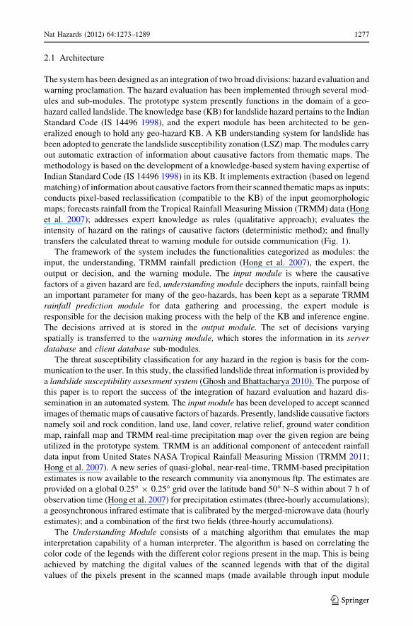
transfers the calculated threat to warning module for outside communication (Fig. 1).
The framework of the system includes the functionalities categorized as modules: the
input, the understanding, TRMM rainfall prediction (Hong et al. 2007), the expert, the
output or decision, and the warning module. The input module is where the causative
factors of a given hazard are fed, understanding module deciphers the inputs, rainfall being
an important parameter for many of the geo-hazards, has been kept as a separate TRMM
rainfall prediction module for data gathering and processing, the expert module is
responsible for the decision making process with the help of the KB and inference engine.
The decisions arrived at is stored in the output module. The set of decisions varying
spatially is transferred to the warning module, which stores the information in its serverdatabase and client database sub-modules.
The threat susceptibility classification for any hazard in the region is basis for the com-
munication to the user. In this study, the classified landslide threat information is provided by
a landslide susceptibility assessment system (Ghosh and Bhattacharya 2010). The purpose of
this paper is to report the success of the integration of hazard evaluation and hazard dis-
semination in an automated system. The input module has been developed to accept scanned
images of thematic maps of causative factors of hazards. Presently, landslide causative factors
namely soil and rock condition, land use, land cover, relative relief, ground water condition
map, rainfall map and TRMM real-time precipitation map over the given region are being
utilized in the prototype system. TRMM is an additional component of antecedent rainfall
data input from United States NASA Tropical Rainfall Measuring Mission (TRMM 2011;
Hong et al. 2007). A new series of quasi-global, near-real-time, TRMM-based precipitation
estimates is now available to the research community via anonymous ftp. The estimates are
provided on a global 0.25� 9 0.25� grid over the latitude band 50� N–S within about 7 h of
observation time (Hong et al. 2007) for precipitation estimates (three-hourly accumulations);
a geosynchronous infrared estimate that is calibrated by the merged-microwave data (hourly
estimates); and a combination of the first two fields (three-hourly accumulations).
The Understanding Module consists of a matching algorithm that emulates the map
interpretation capability of a human interpreter. The algorithm is based on correlating the
color code of the legends with the different color regions present in the map. This is being
achieved by matching the digital values of the scanned legends with that of the digital
values of the pixels present in the scanned maps (made available through input module
Nat Hazards (2012) 64:1273–1289 1277
123
(Fig. 1)). This leads to understanding of the digital maps to correlate the information with
the next functional module, that is, the expert module having knowledge base (KB).
The KB incorporated in the system is derived from the inventory prepared by the Indian
Standard Code (IS 14496 1998). The six causative factors with their sub-factors and ratings
(Ghosh and Bhattacharya 2010) are stored in the Knowledge module. The KB has been
represented in the system by an object-oriented KRS (Bhattacharya and Ghosh 2008). In
the example considered, the input of each factor was searched and matched in the instance
of the KB, and a hazard rating (LHEF) was determined in the inference module.
The inference scheme picks up the facts from the input images and applies searching
and matching logic to fire a rule. The searching and matching in this case is of the string
derived from the legend with the strings in the KB to come up with a match (Bhattacharya
and Ghosh 2008). As soon as a match is found, the hazard rating of that factor is put in a
variable, from the KB. This is repeated for all the causative factors, and their ratings are
stored in variables. The estimated hazard is calculated based on hazard-causing factors and
hence determines the landslide susceptibility in that pixel region into one of the three broad
categories low, medium or high (Ghosh and Bhattacharya 2008).
Fig. 1 Architecture of proposed system
1278 Nat Hazards (2012) 64:1273–1289
123
The output module stores the decision for each pixel as a function of the degree of threat for
the region represented in that pixel. The success of classification results is detailed in the paper
(Ghosh and Bhattacharya 2010). The hazard class associated with each pixel was assigned first,
and then an output array was prepared for the image pixel-by-pixel. For each pixel, a hazard
class (high, moderate or low) was assigned. The extended example is explained in (Ghosh and
Bhattacharya 2010). A separate class was kept for unclassified pixels. The x,y location
parameters are also stored. For each pixel and its associated threat perception, an appropriate
message is stored which would be accessed by the communication module to be sent to users
moving into the region if threat perception is high. The location details from the x,y coordinates
are useful here. Message is sent even if threat is low to bring in confidence to the user.
The validity of the system output has been established by comparing its performance
with those reported by other experts. From the validation studies, it has been found that the
proposed system provided output commensurate with that provided by experts (Ghosh and
Bhattacharya 2010).
Once the hazard output is achieved, now it is the turn of the warning module to send the
correct messages. The warning module holds the network coverage details and the location of
service towers/base stations in its database sub-module. It also has the display-related con-
figuration for a friendly GUI (graphical user interface) environment for the operator which is
the web application housed in web-content handler sub-module. This application is a JAVA
program and has the logic of notifying the appropriate trigger. The level of hazard determines
the trigger to be generated. There are separate ranges for mild, moderate and high hazard
triggers. The trigger sub-module initiates the trigger and calls the communication sub-module.
The data pertaining to a geo-hazard warning system consists of spatial, instructive as
well as communicative details. Spatial details such as latitude and longitude, instructive
details such as guidelines for an emergency, and communicative details contain whom to
send the warning to. Accordingly, the database module has been developed to contain the
geo-referenced locations of hazard prone area, the threat levels in that area as communi-
cated by hazard evaluation system through the communication module, and the mobile
numbers of the registered users. Essentially, it acts as the storehouse of the system, and the
design grants access to the other modules as and when its data are required.
As soon as the system gets fed with classified hazard information (geo-location and levels
of threat), database module parses the dataset and stores as server and client database sub-
modules separately. The data are organized sequentially and indexed according to the exact
ground location. The mobile numbers in that zone are registered separately. The web-content
handler module is designed to utilize the data from the database module. It encapsulates the
data and ensures that the parameters reach the communication module for launching the
message dissemination utility. It creates the GUI of the system using HTML and controls the
web (Internet) application data transmission applying HTTP. Data transmission security has
been ensured by using the HTTP-Secured, which provides a secure channel between the
client station and the system residing on the server. It also controls the display-related
configuration of the web (Internet) application creating a GUI environment for the operator.
The primary task incorporated in the trigger module is to check the condition of threat
present at a location, from the evaluated hazard information. Accordingly, whether the
condition turns out to be severe or otherwise, appropriate message dissemination trigger is
raised. It is interfaced to the web-content-handler to be able to accept the encapsulated
information packet, read the threat message for that geo-location and extract the hazard
level for that particular geo-location. On the basis of the level of threat, it incorporates the
frequency of message in the packet and then passes the upgraded packet to the commu-
nication module (Bhattacharya et al. 2011).
Nat Hazards (2012) 64:1273–1289 1279
123
The communication module contains the design to receive information packets from the
trigger module. On receiving a packet, the mobile numbers and the associated threat
message are extracted by the communication module. It then opens the SMS sending utility
and fills the mobile numbers as well as the threat message in the vacant fields in the body
of SMS utility. After that, it communicates the data from Internet to mobile network
through appropriate gateway. Through the mobile network, it broadcasts the SMSs to all
registered mobile users present in the threat-prone and/or affected area.
2.2 Hardware
2.2.1 For hazard evaluation
The processor and main memory requirements are modest, with anything greater than
500 MHz and 512 MB memory being sufficient. Processing time depends on the size of
the input images, in which for six images of 1,000 9 1,000 pixels, the output required
5 min on a 1.6 GHz processor and 512 MB memory.
2.2.2 For warning dissemination
The system design and architecture has been implemented to be web-based. Since it is designed
to have interfaces with external events such as hazard evaluation system, local servers, the
Internet and the warning communication server, commensurate hardware allocation has been
provided. It has been operating on a general purpose computer with Windows operating system
having 4 GB RAM and 250 GB secondary storage with Internet connectivity. Further, Web
browser (Firefox, Internet explorer[5.5, Netscape) with HTML and HTTP compliance has
been used to meet the proposed objectives. The programming environment has been JAVA
J2EE, and the database has been handled using DBMS language MySQL 5.x.
2.3 Software
2.3.1 Hazard evaluation
The system was developed with an open-source code. The language of programming used
was JAVA.
2.3.2 Warning dissemination
In the Java 2 Platform, Standard Edition (J2SE) having version of compiler JDK 1.5.0.03,
it has been possible to get Java Advanced Imaging (JAI) libraries that help in recognizing
as well as manipulating different image formats. The connectivity with the KB has been
provided by developing a Java Database Connectivity—Open Database Connectivity
(JDBC—ODBC) bridge—with the help of JDBC-ODBC driver provided in the JDK.
3 Working of the system
3.1 Hazard evaluation and warning dissemination
A database consisting of geo-location-based geo-hazard threat levels and its associated
registered mobile numbers are prerequisites. The working of the developed system has
1280 Nat Hazards (2012) 64:1273–1289
123
been tested on a landslide-prone area. The threat susceptibility classification for any hazard
in the region is the basis for the communication to the user. In this study, the classified
landslide threat information is provided by a landslide susceptibility assessment system(Ghosh and Bhattacharya 2010). Communication of hazard has been achieved using
existing cellular network infrastructure available in the locality. The approach requires the
data to be processed only at one terminal as well as having no need of executing any other
separate application for every mobile phone, and the functionality is coded in the warning
system itself. Once the data from the evaluation system get fed into the communication
system, the warning messages get communicated automatically.
The hazard data were provided along with the registered mobile subscribers’ data to the
communication module of the system through an external_event system-call. The com-
munication module forwards the system-call to database module to create the full database
tables out of the hazard information and subscriber list.
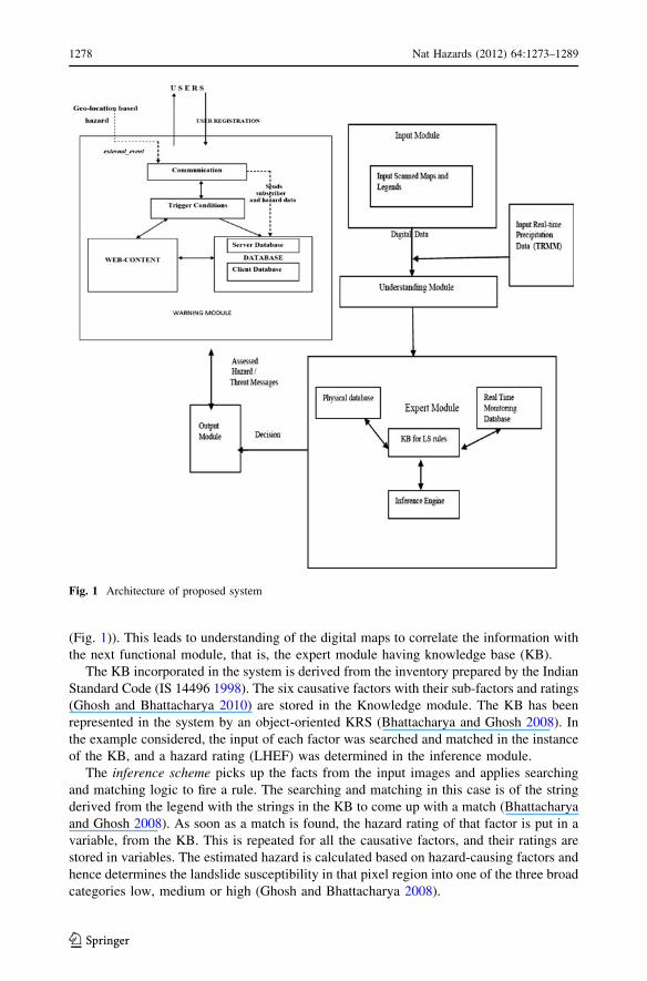
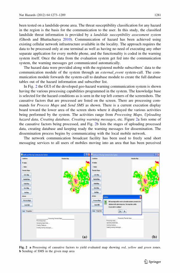
In Fig. 2 the GUI of the developed geo-hazard warning communication system is shown
having the various processing capabilities programmed in the system. The knowledge base
is selected for the hazard conditions as is seen in the top left corners of the screenshots. The
causative factors that are processed are listed on the screen. There are processing com-
mands for Process Maps and Send SMS as shown. There is a current execution display
board toward the lower area of the screen shots where it displayed the various activities
being performed by the system. The activities range from Processing Maps, Uploadinghazard data, Creating database, Creating warning messages, etc. Figure 2a lists some of
the causative factors being processed, and Fig. 2b lists the stages of uploading processed
data, creating database and keeping ready the warning messages for dissemination. The
dissemination process begins by communicating with the local mobile network.
The network communication broadcast facility has been used to freely send short
messaging services to all users of mobiles moving into an area that has been perceived
Fig. 2 a Processing of causative factors to yield evaluated map showing red, yellow and green zones.b Sending of SMS in the given map area
Nat Hazards (2012) 64:1273–1289 1281
123
threat prone. Alternatively, a user can communicate his location and request the update of
threat perception through a service called General Packet Radio Service (GPRS) on
mobile. The output image obtained from output module is analyzed mathematically with
the Base Station’s database and the BTSs which either itself or whose range lies in the
danger zones are marked. The output database about the warning message is updated, and
the information sent to the server and the warning module is invoked. All the processing
steps are repeated again and again, at regular interval of time as desired (Ghosh et al.
2009).
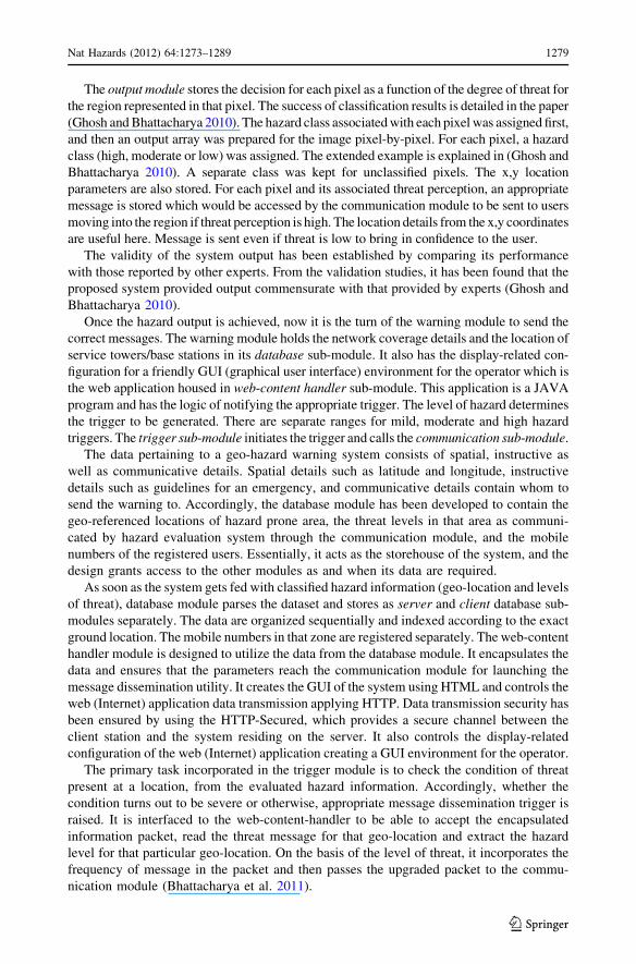
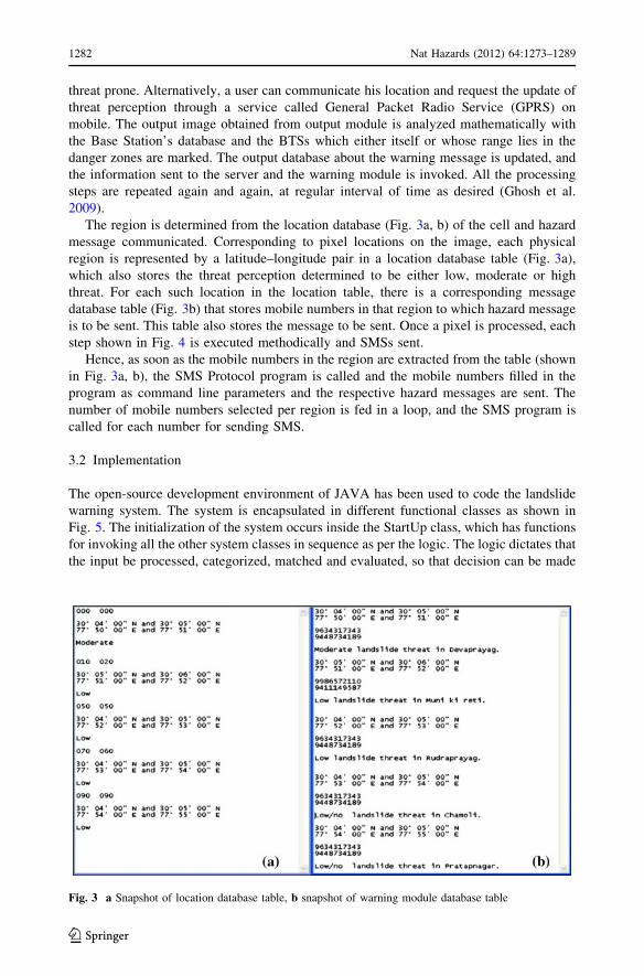
The region is determined from the location database (Fig. 3a, b) of the cell and hazard
message communicated. Corresponding to pixel locations on the image, each physical
region is represented by a latitude–longitude pair in a location database table (Fig. 3a),
which also stores the threat perception determined to be either low, moderate or high
threat. For each such location in the location table, there is a corresponding message
database table (Fig. 3b) that stores mobile numbers in that region to which hazard message
is to be sent. This table also stores the message to be sent. Once a pixel is processed, each
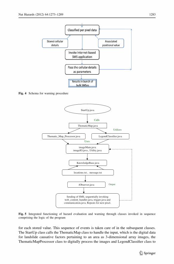
step shown in Fig. 4 is executed methodically and SMSs sent.
Hence, as soon as the mobile numbers in the region are extracted from the table (shown
in Fig. 3a, b), the SMS Protocol program is called and the mobile numbers filled in the
program as command line parameters and the respective hazard messages are sent. The
number of mobile numbers selected per region is fed in a loop, and the SMS program is
called for each number for sending SMS.
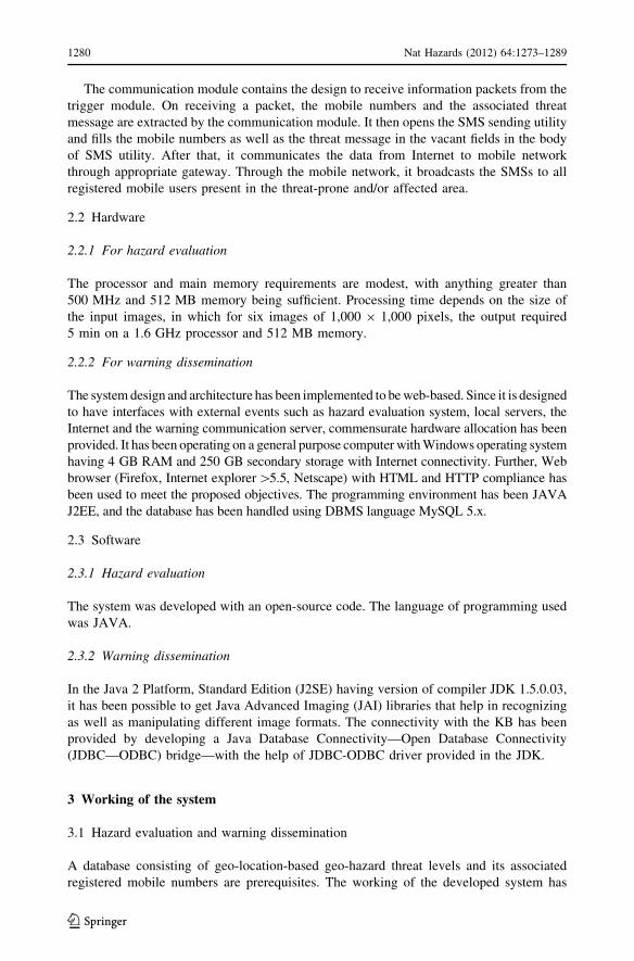
3.2 Implementation
The open-source development environment of JAVA has been used to code the landslide
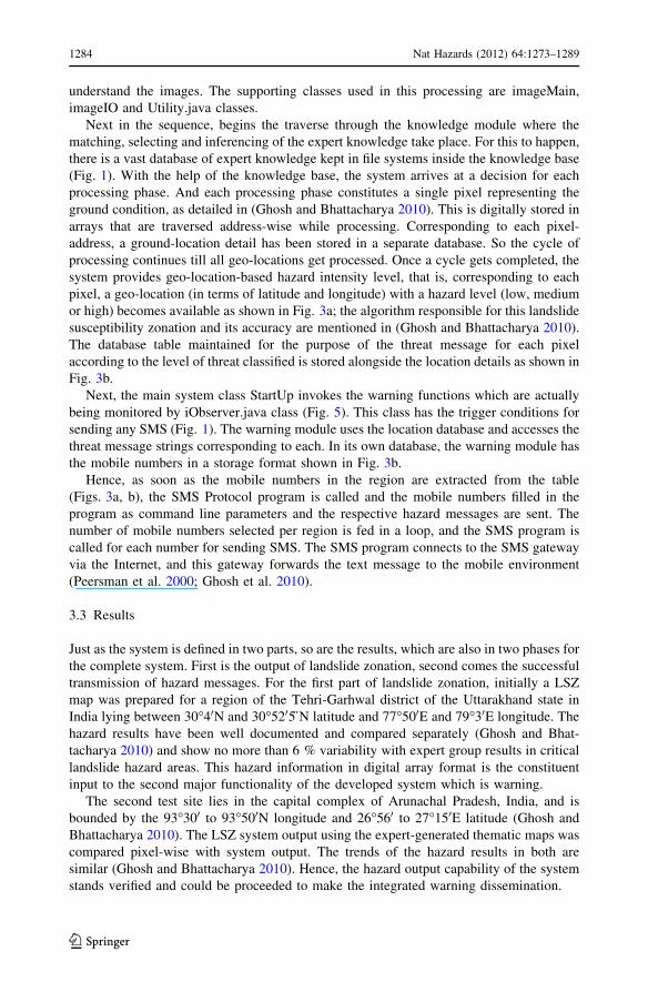
warning system. The system is encapsulated in different functional classes as shown in
Fig. 5. The initialization of the system occurs inside the StartUp class, which has functions
for invoking all the other system classes in sequence as per the logic. The logic dictates that
the input be processed, categorized, matched and evaluated, so that decision can be made
Fig. 3 a Snapshot of location database table, b snapshot of warning module database table
1282 Nat Hazards (2012) 64:1273–1289
123
for each stored value. This sequence of events is taken care of in the subsequent classes.
The StartUp class calls the ThematicMap class to handle the input, which is the digital data
for landslide causative factors pertaining to an area as 3-dimensional array images, the
ThematicMapProcessor class to digitally process the images and LegendClassifier class to
Fig. 4 Schema for warning procedure
Uses
StartUp.java
ThematicMap.java
Thematic_Map_Processor.java LegendClassifier.java
imageMain.java imageIO.java , Utility.java
KnowledgeBase.java
locations.txt , message.txt
iObserver.java
Sending of SMS, sequentially invoking web_content_handler.java, trigger.java and communication.java. Repeats for next pixel.
Calls
Utilizes
Output
Fig. 5 Integrated functioning of hazard evaluation and warning through classes invoked in sequencecomprising the logic of the program
Nat Hazards (2012) 64:1273–1289 1283
123
understand the images. The supporting classes used in this processing are imageMain,
imageIO and Utility.java classes.
Next in the sequence, begins the traverse through the knowledge module where the
matching, selecting and inferencing of the expert knowledge take place. For this to happen,
there is a vast database of expert knowledge kept in file systems inside the knowledge base
(Fig. 1). With the help of the knowledge base, the system arrives at a decision for each
processing phase. And each processing phase constitutes a single pixel representing the
ground condition, as detailed in (Ghosh and Bhattacharya 2010). This is digitally stored in
arrays that are traversed address-wise while processing. Corresponding to each pixel-
address, a ground-location detail has been stored in a separate database. So the cycle of
processing continues till all geo-locations get processed. Once a cycle gets completed, the
system provides geo-location-based hazard intensity level, that is, corresponding to each
pixel, a geo-location (in terms of latitude and longitude) with a hazard level (low, medium
or high) becomes available as shown in Fig. 3a; the algorithm responsible for this landslide
susceptibility zonation and its accuracy are mentioned in (Ghosh and Bhattacharya 2010).
The database table maintained for the purpose of the threat message for each pixel
according to the level of threat classified is stored alongside the location details as shown in
Fig. 3b.
Next, the main system class StartUp invokes the warning functions which are actually
being monitored by iObserver.java class (Fig. 5). This class has the trigger conditions for
sending any SMS (Fig. 1). The warning module uses the location database and accesses the
threat message strings corresponding to each. In its own database, the warning module has
the mobile numbers in a storage format shown in Fig. 3b.
Hence, as soon as the mobile numbers in the region are extracted from the table
(Figs. 3a, b), the SMS Protocol program is called and the mobile numbers filled in the
program as command line parameters and the respective hazard messages are sent. The
number of mobile numbers selected per region is fed in a loop, and the SMS program is
called for each number for sending SMS. The SMS program connects to the SMS gateway
via the Internet, and this gateway forwards the text message to the mobile environment
(Peersman et al. 2000; Ghosh et al. 2010).
3.3 Results
Just as the system is defined in two parts, so are the results, which are also in two phases for
the complete system. First is the output of landslide zonation, second comes the successful
transmission of hazard messages. For the first part of landslide zonation, initially a LSZ
map was prepared for a region of the Tehri-Garhwal district of the Uttarakhand state in
India lying between 30�40N and 30�5205}N latitude and 77�500E and 79�30E longitude. The
hazard results have been well documented and compared separately (Ghosh and Bhat-
tacharya 2010) and show no more than 6 % variability with expert group results in critical
landslide hazard areas. This hazard information in digital array format is the constituent
input to the second major functionality of the developed system which is warning.
The second test site lies in the capital complex of Arunachal Pradesh, India, and is
bounded by the 93�300 to 93�500N longitude and 26�560 to 27�150E latitude (Ghosh and
Bhattacharya 2010). The LSZ system output using the expert-generated thematic maps was
compared pixel-wise with system output. The trends of the hazard results in both are
similar (Ghosh and Bhattacharya 2010). Hence, the hazard output capability of the system
stands verified and could be proceeded to make the integrated warning dissemination.
1284 Nat Hazards (2012) 64:1273–1289
123
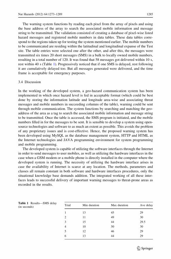
The warning system functions by reading each pixel from the array of pixels and using
the base address of the array to search the associated mobile information and message
string to be transmitted. The validation consisted of creating a database of pixel-wise listed
hazard messages and registered mobile numbers in data tables. These data tables corre-
spond to the regions taken up for testing the system mentioned earlier. The mobile numbers
to be communicated are residing within the latitudinal and longitudinal expanse of the Test
site. The table entries were selected one after the other, and after this, the messages were
transmitted six times 20 short messages (SMS) in a bulk to locally owned mobile numbers,
resulting in a total number of 120. It was found that 58 messages got delivered within 10 s,
rest within 40 s (Table 1). Progressively noticed that if one SMS is delayed, rest following
it are cumulatively delayed too. But all messages generated were delivered, and the time
frame is acceptable for emergency purposes.
3.4 Discussion
In the working of the developed system, a geo-hazard communication system has been
implemented in which once hazard level is fed in acceptable format (which could be best
done by storing the information latitude and longitude area-wise and associating threat
messages and mobile numbers in succeeding columns of the table), warning could be sent
through mobile communication. The system functions by searching and matching the geo-
address of the area as a tag to search the associated mobile information and message string
to be transmitted. Once the table is accessed, the SMS program is initiated, and the mobile
numbers filled in for the messages to be sent. It is sensible to develop a system using open-
source technologies and software to as much an extent as possible. This avoids the problem
of any proprietary issues and is cost-effective. Hence, the proposed warning system has
been developed using MySQL as the database management system, HTTP and HTML as
the Internet technologies and JAVA programming environment for system programming
and mobile programming.
The developed system is capable of utilizing the software interfaces through the Internet
in order to send messages to user mobiles, as well as utilizing the hardware interfaces in the
case when a GSM modem or a mobile phone is directly installed in the computer where the
developed system is running. The necessity of utilizing the hardware interface arises in
case the availability of Internet is scarce at any location. The methods, parameters and
classes all remain constant in both software and hardware interfaces procedures, only the
situational knowledge base demands addition. The integrated working of all these inter-
faces leads to successful delivery of important warning messages to threat-prone areas as
recorded in the results.
Table 1 Results—SMS delay(in seconds)
Trial Min duration Max duration Ave delay
1 13 45 29
2 11 49 30
3 15 44 29.5
4 10 50 30
5 12 46 29
6 13 44 29
Nat Hazards (2012) 64:1273–1289 1285
123
4 Conclusion
A geo-hazard warning system has been developed, which accepts hazard level from hazard
evaluation system, and warning gets disseminated through mobile communication. The
system works by searching and matching based on geo-address of the area as a tag, for
associated mobile information and warning messages to get transmitted. The reliability of
the system has been tested, and the critical threat messages have all been delivered. So it
can be summarized that a novel and stand-alone system for dynamic hazard warning
communication has been developed and implemented. Thus, cellular or mobile phone, a
gadget used by common man, is the best proposition to effectively warn people individ-
ually and to propagate hazard messages to users in large regions ubiquitously.
The warning system presented in this research work provides a reliable and effective
solution employing information and communication technology in the framework of geo-
spatial technology, which is complementary to existing traditional warning systems. The
proposed warning system increases the chances that registered users might receive the
warning on time. The development of a popular usage-based warning communication
system through integration of prevalent technologies has been achieved. The integration of
the hazard warning unit with the hazard evaluation unit has been feasible through the
design of an intersystem method call. The results of sending SMS showed that the com-
munication module is capable of dispatching real-time warning messages about geo-haz-
ards on time and to registered numbers.
The scope for improvement could be in many directions. Technologically seen, inte-
gration with sensors and other geotechnical instruments of geo-hazard monitoring could be
included in the generalized framework of the input module itself. The problem of network
congestion may also be a bottleneck, for which faster algorithms need to be implemented.
Demographically, it is important that provision is made for well-defined instructions to the
recipients for safe areas, contacts of hazard support agencies in the message, registration of
mobile numbers beforehand for only those interested in receiving the alerts and interaction
ability with the recipients and that the delivery of instructional messages may have the
effect of out-of-order receipts at the consumer end. From the social point, the local lan-
guage may pose a challenge in understanding of messages since English is hardly the
language in many threat-prone areas.
References
Altan O, Backhaus R, Boccardo P, Zlatanova S (2010) Geoinformation for disaster and risk management—best practices and examples. Published July 2nd 2010 by the joint board of geospatial informationsocieties (JBGIS) and the United Nations Office for Outer Space Affairs (UNOOSA), p 142. http://www.un-spider.org/about/portfolio/publications/jbgis-unoosa-booklet
Avasthy RK, Singh B, Sivakumar R (eds) (2006) Landslides: perception and initiatives of DST. IndianSociety of Engineering Geology, Department of Science and Technology, Government of India,Lucknow
Backhaus R, Beuleb B (2005) Efficiency evaluation of satellite data products in environmental policy. SpacePolicy Els 21(3):173–183. http://linkinghub.elsevier.com/retrieve/pii/S0265964605000482
Bhandari RK (2006) Disaster management in India, a new awakening. J Disas Dev 1(1):1–26Bhandari RK (2007) The Indian landslide scenario, strategic issues and action plans. J Disas Dev 1(2):
155–168Bhattacharya D, Ghosh JK (2008) Evaluation of knowledge representation schemes as a prerequisite toward
development of a knowledge-based system. ASCE J Comp Civ Eng 22(6):348–359. cedb.asce.org/cgi/WWWdisplay.cgi?167914
1286 Nat Hazards (2012) 64:1273–1289
123
Bhattacharya D, Ghosh JK (2009) An automated system for assessment of landslide vulnerability onhabitation of Tehri-Garhwal, Uttarakhand. In: Proceedings of national seminar on research activities indisaster mitigation for housing in India. Apr 2009, IIT Roorkee, Centre of Excellence in DisasterMitigation and Management (CoEDMM), pp 1–6
Bhattacharya D, Ghosh JK, Boccardo P, Samadhiya NK (2011) Wireless hazard communication system.J Syst Inf Technol 13(4) (under publication—Oct. issue)
Carrara P, Fortunati L, Fresta G, Gomarasca M, Bonati LP, Poggioli D (2004) A methodological approach tothe development of applications in a SDI environment. In: 7th AGILE conference on geographicinformation science. Heraklion, Greece, pp 743–746. http://plone.itc.nl/agile_old/conference/greece2004/papers/P-02_Carrara.pdf
Cioca M, Cioca LI, Buraga SC (2008) SMS disaster alert system programming. In: Proceedings of 2nd IEEEinternational conference on digital ecosystems and technologies, vol 1, no 1. Phitsanulok Thailand,pp 260–264
Dow K, Cutter S (1998) Crying wolf: repeat responses to hurricane evacuation orders. Coast Manag26:237–252
Enck W, Traynor P, McDaniel P, Porta TL (2005) Exploiting open functionality in SMS-capable cellularnetworks. In: Proceedings of the 12th ACM conference on computer and communications security, vol1. New York, NY, pp 393–404
Ghosh JK, Bhattacharya D (2008) Landslide hazard automated zonation (LHAZ) system. In: 12th Inter-national conference of international association for computer methods and advances in geomechanics(IACMAG), Goa, India, IACMAG. Available online at: www.civil.iitb.ac.in/*dns/IACMAG08/pdfs/G07.pdf
Ghosh JK, Bhattacharya D (2010) A knowledge based landslide susceptibility zonation system. Am Soc CivEng J Comp Civ Eng 24(4):325–334. doi:10.1061/(ASCE)CP.1943-5487.0000034
Ghosh JK, Bhattacharya D, Samadhiya NK (2009) GEOWARNS: a system to warn geo-deformation failure.In: Proceedings of FIG working week 2009 surveyors key role in accelerated development, vol 1, no 1.Eilat, Israel, pp 1–12. Available at: http://www.fig.net/pub/fig2009/papers/ts04b/ts04b_ghosh_bhattacharya_samadhiya_3435.pdf
Ghosh JK, Bhattacharya D, Boccardo P, Samadhiya NK (2010) A landslide hazard warning system. In:ISPRS technical commission symposium VIII, Kyoto, Japan, pp 1–10. isprs.org/proceedings/XXXVIII/part8/headline/TS-23/W01OE3_20100304002241.pdf
Gomarasca M (ed) (2007) GeoInformation in Europe. Millpress, The Netherlands. ISBN 9789059660618Gruntfest E, Huber C (1989) Status report on flood warning systems in the United States. Environ Manag
13(3):279–286Hong Y, Adler R, Huffman G (2007) An experimental global prediction system for rainfall-triggered
landslides using satellite remote sensing and geospatial datasets. IEEE Trans Geosci Remote Sens45(6):1671–1680
IS 14496, [Part 2] (1998) Indian standard preparation of landslide hazard zonation maps in mountainousterrains guidelines. Part 2 macro-zonation. Bureau of Indian Standard, New Delhi, pp 1–19
Kang Z, Zhang Z, Zhang J, Zlatanova S (2007) Rapidly realizing 3D visualization for urban street based onmulti-source data integration. In: Geomatics solutions for disaster management, Lecture Notesin Geoinformation and Cartography. Springer, Berlin, pp 149–163. www.gdmc.nl/zlatanova/thesis/html/refer/ps/ZK_etal_2007.pdf
Li J, Zlatanova S, Fabbri AG (2007) Geomatics solutions for disaster management. Springer, Berlin, p 444.ISBN 103-540-72106-1
Liu S, Quenemoen L, Maliday J, Moji E, Sinks T, Mendlein J (1996) Assessment of a severe-weatherwarning system and disaster preparedness, Calhoun County, Alabama, 1994. Am J Public Health86(1):87–89
McGinley M, Bennet D, Turk A (2006) Design criteria for public emergency warning systems. In: Pro-ceedings of the 3rd international ISCRAM conference, Newark, NJ. Available at: www.iscram.org/dmdocuments/S2_T1_4_McGinley_etal.pdf
Mileti D, Sorensen J (1988) Planning and implementing warning systems. In: Lystad M (ed) Mental healthcare in mass emergencies: theory and practice, brunner/mazel psychological stress series, New York,pp 321–345
Mileti D, Sorensen J (1990) Communication of emergency public warnings. ORNL-6609, Oak RidgeNational Laboratory, Oak Ridge, Tenn. http://emc.ornl.gov/EMCWeb/EMC/PDF/CommunicationFinal.pdf
Mileti D, Sorensen J, O’Brien J (1992) Towards an explanation of mass care shelter use in evacuations. Int JMass Emerg Disast 10(1):25–42
Nat Hazards (2012) 64:1273–1289 1287
123
Montanari M, Mehrotra S, Venkatasubramanian N (2007) Architecture for an automatic customized warningsystem. In: IEEE conference on intelligence and security informatics, vol 1, no 1. New Brunswick, NJ,pp 32–39
Nayak S, Zlatanova S (2007) Remote sensing and GIS in disaster monitoring. Sec Gi4DM Symp GIM Int21(1):38–39
Nayak S, Zlatanova S (eds) (2008) Remote sensing and GIS technologies for monitoring and prediction ofdisasters. Springer, Berlin, p 270
Peersman G, Griffiths P, Spear H, Cvetkovic S, Smythe C (2000) A tutorial overview of the short messageservice within GSM. IEEE Comput Control Eng J 11(2):79–89. http://ieeexplore.ieee.org/xpls/abs_all.jsp?arnumber=850843
Perry R (1979) Evacuation decision-making in natural disasters. Mass Emergencies, pp 25–38 (4th March)Perry R, Lindell M, Greene M (1982) Threat perception and pubic response to volcano hazard. J Soc
Psychol 116:199–204Pries R, Hobfeld T, Gia PT (2006) On the suitability of the short message service for emergency warning
systems. In: Proceedings of IEEE 63rd vehicular technology conference, vol 2. Melbourne, Australia,pp 991–995
Quarantelli E (1984) Perceptions and reactions to emergency warnings of sudden hazards. Ekestics 309(Nov–Dec), pp 511–515
Ramasamy SM, Kumanan CJ, Sivakumar R, Singh B (eds) (2006) Geomatics in Tsunami. New IndiaPublishing Agency, New Delhi, p 244
Rogers G, Sorensen J (1988) Diffusion of emergency warnings. Environ Prof 10:281–294Samarajiva R (2005) Mobilizing information and communications technologies for effective disaster
warning: lessons from the 2004 tsunami. New Media Soc 7(6):731–747Sorensen JH (2000) Hazard warning systems: review of 20 years of progress. Nat Haz Rev 1(2):119–125Sorensen J, Mileti D (1987) Decision making uncertainties in emergency warning system organizations.
Int J Mass Emerg Disast 5(1):33–61. http://www.training.fema.gov/EMIWeb/downloads/IJEMS/ARTICLES/Decision%20Making%20Uncertainties%20in%20Emergency%20Warning%20System%20Or.pdf
Standing C, Jackson P (2007) An approach to sustainability for information systems. J Syst Inform Technol9(2):167–176
Stockdale R, Standing C, Love PED (2006) Propagation of a parsimonious framework for evaluatinginformation systems in construction. Autom Construct 15(6):729–736
TRMM (2011) NASA website of real-time precipitation from tropical rainfall measuring mission.trmm.gsfc.nasa.gov/trmm_rain/Events/big_global_accumlation.gif
United Nations (2010) Global survey of early warning system, an assessment of gaps and opportunitiestowards building a comprehensive global early warning system for all natural hazards. Available at:http://www.unisdr.org/ppew/info-resources/ewc3/Global-Survey-of-Early-Warning-Systems.pdf.Accessed on 15 June 2010
Waidyanatha N, Gow G, Anderson P (2007a) Community-based hazard warnings in rural Sri Lanka:performance of alerting and notification in a last-mile message relay. In: Proceedings IEEE 1stinternational WRECOM2007 conference and exhibition, Rome, Italy. http://papers.ssrn.com/sol3/papers.cfm?abstract_id=1572329
Waidyanatha N, Dias D, Purasinghe H (2007b) Challenges of optimizing common alerting protocol for SMSbased GSM devices in Last-mile hazard warnings in Sri Lanka. In: Proceedings of the 1st internationalNGMAST conference and exhibition Cardiff, Wales. lirneasia.net/wp-content/uploads/2007/08/challenges-of-optimizing-cap-on-sms-over-gsm-in-sri-lankangmast2007-v-01.pdf
Waidyanatha N, Rangarajan S, Gow G, Anderson P (2007c) Last-mile hazard warning system in Sri Lanka:performance of WorldSpace addressable satellite radios for emergency alerts. In: Proceedings 10thinternational wireless personal multimedia communications, vol 1, no 1. Jaipur, India, pp 233–237.http://idl-bnc.idrc.ca/dspace/bitstream/10625/42341/1/129766.pdf
Waidyanatha N, Gow G, Anderson P (2007d) Hazard warnings in Sri Lanka: challenges of internetworkingwith common alerting protocol. In: 4th International ISCRAM conference, vol. 1, no 1. Delft, theNetherlands, pp 281–293
Wattegama C (2007) ICT for disaster management. Available at: www.apdip.net/publications/iespprimers/eprimer-dm.pdf. Accessed on 15 April 2008
Wenling X, Xiuwan C, Gang Z (2007) Early warning monitoring and management of disasters. In: IEEEinternational geoscience and remote sensing symposium, IGARSS, Barcelona, pp 2996–2999
Xu W, Zlatanova S (2007) Ontologies for disaster management. In: Geomatics solutions for disastermanagement, Lecture Notes in Geoinformation and Cartography. Springer, Berlin, pp 185–200.http://www.gdmc.nl/zlatanova/thesis/html/refer/ps/WX_SZ_2007.pdf
1288 Nat Hazards (2012) 64:1273–1289
123

Zlatanova S (2009) Geoinformation for disaster management. GIM Int 23/7. ISPRS column. http://www.gim-international.com/issues/articles/id1391-Geoinformation_for_Disaster_Manage-ment.html
Zlatanova S (2010) Formal modeling of tasks to support search of geo-information in emergency response.In: Das A (ed) International symposium climate change & disaster management. GIS DevelopmentPvt. Ltd., Noida, pp 26–36. http://www.gdmc.nl/publications/2010/Geo-information_emergency_response.pdf
Zlatanova S, Dilo A (2010) A data model for operational and situational information in emergency response:the Dutch case. In: Proceedings of Gi4DM conference on geomatics for district managementFeb, Torino, p 4. www.gdmc.nl/publications/2010/Operational_situational_information_emergency.pdf
Nat Hazards (2012) 64:1273–1289 1289
123


![Geo Journal Visser fulltext[1]](https://img.dokumen.tips/doc/110x75/631af720d43f4e176304ae4b/geo-journal-visser-fulltext1.jpg)


