INTERIM FACTUAL
AVIATION SAFETY INVESTIGATION REPORT
200501977
Fairchild Industries
Metro 23
07 May 2005
Page 1
1 INTERIM FACTUAL INFORMATION
1.1 History of the flight
On 7 May 2005, a Fairchild Metroliner SA227-DC, registered VH-TFU, with two pilots and 13
passengers, was being operated under the instrument flight rules (IFR) on a scheduled passenger
service from Bamaga to Cairns via Lockhart River, Qld. The crew was flying the third of four
sectors scheduled for the day. They commenced duty in Cairns, departing at about 0830 Eastern
Standard Time for Bamaga with an intermediate stop at Lockhart River.
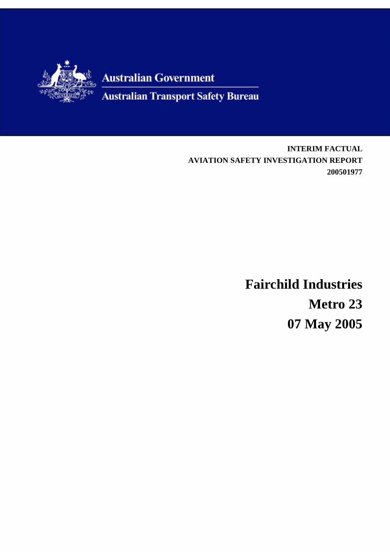
Figure 1: Similar Fairchild Metroliner
The aircraft was refuelled in Bamaga. The copilot reported departure to Brisbane Air Traffic
Control (ATC) at 1111. At 1136 he advised ATC that they were on descent passing 9,000 ft with an
estimated time of arrival at Lockhart River of 1139.
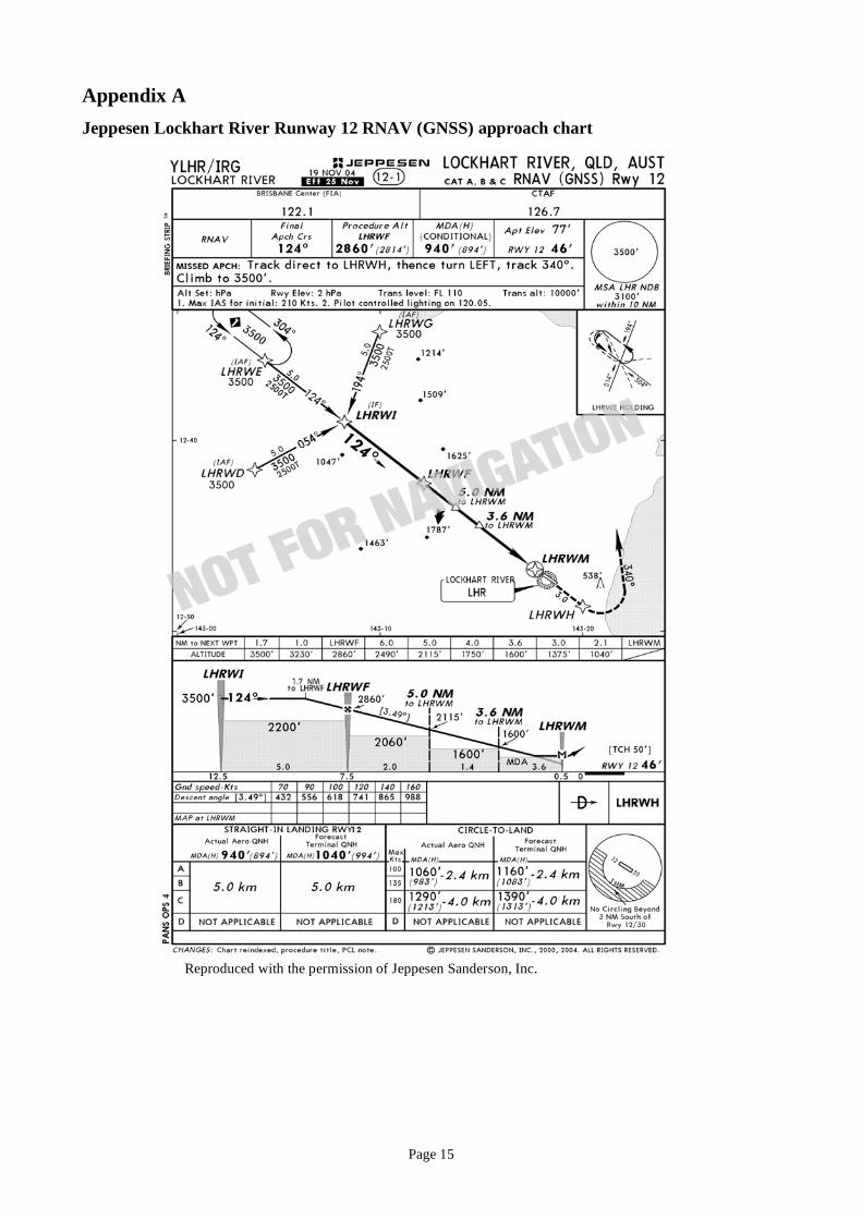
The crew subsequently reported to ATC that they were conducting the Lockhart River Runway 12
RNAV (GNSS)1 approach. At 1140, they reported on the Lockhart River common traffic advisory
frequency (CTAF) passing waypoint ‘Whisky Golf’ (LHRWG) tracking for ‘Whisky India’
(LHRWI). The waypoint LHRWI was located 12 NM2 prior to the missed approach point of the
Lockhart River Runway 12 RNAV (GNSS) approach. (Appendix A)
About thirty seconds later, following a request from a pilot in another aircraft in the Lockhart River
area, the copilot reported the weather conditions as ‘fairly dismal about 900 ft clearance'.
At 1158, when the crew had not reported having landed at the Lockhart River aerodrome, ATC
declared an uncertainty phase3. When attempts to contact the aircraft failed, a search was
commenced.
At 1625, the burnt wreckage of the aircraft was located in the Iron Range National Park on the
north-western slope of ‘South Pap’, a heavily timbered ridge, approximately 11 km north-west of
the Lockhart River aerodrome at an elevation of 1,210 ft. The deceleration forces and the severe
impact damage resulted in all occupants being fatally injured. The aircraft was destroyed by the
impact forces and an intense, fuel-fed, post-impact fire.
1
RNAV (GNSS): Area navigation global navigation satellite system – A method of navigation that permits aircraft
operations on any desired course within the coverage of station referenced navigation signals or within the limits of
self contained system capability.
2 NM: A nautical mile is 1.852 kilometres
3 Uncertainty phase: Situation where uncertainty exists as to the safety of an aircraft and its occupants.
Page 2
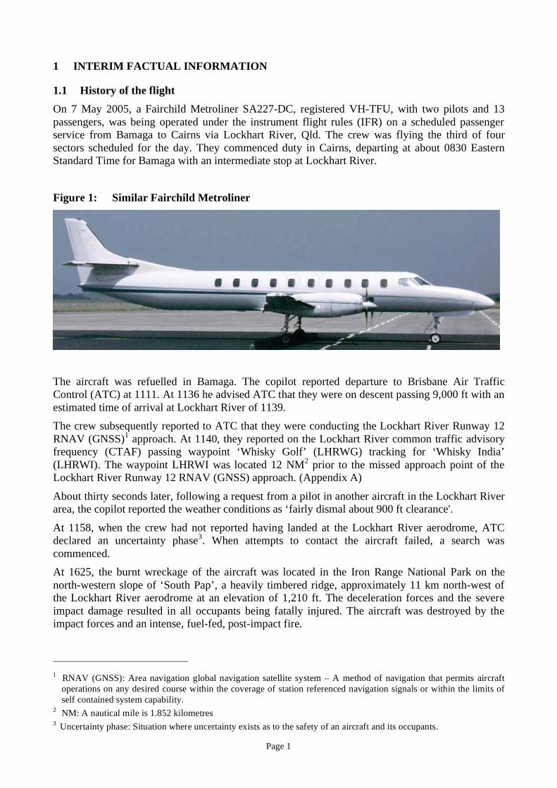
The aircraft had entered the forest canopy at a descent angle of between 3 and 5 degrees. The
accident site was located on the published Lockhart River runway 12 RNAV (GNSS) final approach
track. At that point in the approach, the minimum obstacle clearance altitude was 2,060 ft AMSL4.
Figure 2: Accident site and Lockhart River aerodrome
1.2 Personnel information
1.2.1 Pilot in command
At the time of the accident the pilot in command (PIC) had logged a total of 6,071 hours flying
experience, of which 3,248 hours were on the Metroliner aircraft type.5 He held an air transport
pilot (aeroplane) licence issued by the Civil Aviation Safety Authority (CASA), which included an
4
AMSL: Above mean sea level
5 The pilot in command’s log book entries were complete up to 16 April 2005, hours flown since that date were derived
from aircraft flight logs and flight data recorder information.
Lockhart River
Runway 12
Accident Site
South Pap
Page 3
endorsement for command on Metro 3 aircraft (covering all SA227 aircraft types). In addition, he
held a command multi-engine instrument rating, which included an approval to conduct RNAV
(GNSS) approaches. The PIC’s initial command multi-engine instrument rating was issued on 13
November 1993; an approval to conduct RNAV (GNSS) approaches was added on 3 January 2003.
The pilot’s first flight with the operator as PIC occurred on 19 February 2001. He had passed a
company flight proficiency base check and command multi-engine instrument rating renewal on 28
February 2005.
The pilot’s logbook indicated that he had:
• operated as PIC on Metroliner aircraft into Lockhart River on twenty four occasions prior to
the accident flight
• completed 16 RNAV (GNSS) approaches at various locations between 3 January 2003 and
16 April 2005 (the date of the last log book entry)
• carried out one Runway 12 RNAV (GNSS) approach at Lockhart River, on 27 September
2002
• logged 8.4 hours flight time under instrument meteorological conditions within the
preceding 90 days
• carried out three RNAV (GNSS) type approaches within the preceding 90 days
• completed one NDB type approach within the preceding 90 days.
Prior to commencing duty on the day of the accident the PIC was rostered free of duty for 19 hours
and 7 minutes. He had returned from a period of 7 days leave, 3 days before the accident flight.
During that 3 day period he had completed 9 hours and 40 minutes of flight time and 12 hours 20
minutes of duty time. The pilot’s colleagues reported that he was “quite fit” and was “relaxed due to
just having finished a holiday”.
1.2.2 Copilot
The copilot had logged a total of 655 hours flying experience, of which 150 hours were as copilot
on the Metroliner aircraft type.6 He was qualified to perform the duties of copilot on the Metroliner
aircraft and although he held a Command Instrument rating, it did not include approval to conduct
RNAV (GNSS) approaches. His initial command multi-engine instrument rating was issued on 19
March 2004. The rating was renewed on 3 April 2005. The copilot’s log book indicated that he had
not completed any RNAV (GNSS) type approaches.
The company operations manual included the following requirements that related to the use of GPS
for Non Precision Approaches (GPS/NPA)7, such as the Lockhart River RNAV (GNSS) Runway 12
approach:
Flight crew are to:
• hold endorsements for GPS Primary means navigation and GPS/NPA
• have been assessed as proficient
• meet the GPS recency requirements.
The copilot passed a company flight proficiency base check with the operator on 22 December
2004; he commenced operational duties with the operator on 28 February 2005. His logbook
6
The copilot’s log book entries were complete up to 5 May 2005; hours flown since that date were derived from
aircraft flight logs and flight data recorder information. 7
The terminology GPS/NPA (or global positioning system /non-precision approach) was used in the company’s
operator’s manual, but has been superseded by the term RNAV (GNSS). The term RNAV (GNSS) will be used
hereafter.
Page 4
indicated that he had operated as a crew member into Lockhart River on three occasions before the
accident flight. The first occasion was on 13 April 2005.
Prior to commencing duty on the day of the accident, the copilot was rostered free of duty for 19
hours and 7 minutes. The day of the accident was his fifth consecutive duty day, prior to which he
had been rostered free of duty for 4 days. During that 5-day period he had completed 19 hours and
32 minutes of flight time and 26 hours and 26 minutes of duty time. The pilot’s family and
colleagues reported that he was fit. They also reported that he had competed in a triathlon the
weekend before the accident.
1.3 Aircraft information
Civil Aviation Order (CAO) 82.3 states in part that aircraft in which more than nine passenger seats
may be fitted must be provided with a minimum flight crew of two pilots.
The Metroliner was not fitted with an autopilot, nor was an autopilot required by regulation.
The actual gross weight or load distribution of the aircraft at the time of impact could not be
determined as no load sheet could be located.
The aircraft, serial number DC-818 B, was manufactured in December 1992. The aircraft’s
Flight/Maintenance Log dated 6 May 2005 (the day prior to the accident) indicated that the aircraft
had completed 26,875.5 hours and 28,527 cycles. Based on the times and cycles recorded by the
flight data recorder (FDR)8, the aircraft had logged 26,877.7 hours and 28,529 cycles. Scheduled
maintenance was due at 26,932.0 hours and 28,565 cycles.
1.3.1 Ground Proximity Warning System
The aircraft was fitted with a Honeywell International Inc. (Honeywell) Ground Proximity Warning
System (GPWS) MK VI. The GPWS was designed to provide warnings when certain conditions
that threatened the safety of flight were encountered. One such warning was designed to alert the
crew when an excessive terrain closure rate exists. When there is an excessive terrain closure rate
situation, the GPWS generates a caution message “terrain terrain”, and if the magnitude of the
terrain closure rate is high enough, an aural “pull up” message is heard and the red GPWS warning
light will illuminate. The generation of these warnings is influenced by the position of the landing
gear and flap, as well as the position of the flap over-ride switch.
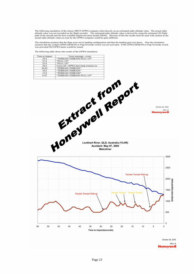
Data derived from the FDR was analysed by Honeywell to determine if the conditions, which would
cause the GPWS computer to generate an excessive terrain closure rate alert should have been
satisfied in the period preceding the collision with terrain.
Honeywell engineers determined that the flight profile of the Metroliner was such that the GPWS
unit fitted to the aircraft should have generated a number of warnings of the terrain closure rate. The
Honeywell assessment relied heavily on an estimation of radio altitude, because radio altitude was
not one of the parameters recorded by the FDR. Honeywell determined that from approximately 29
seconds before impact, the terrain closure rate was such as to normally generate both warning “pull
up” and caution “terrain terrain” messages. (See Appendix C for a Honeywell chart depicting the
warnings that would be generated by the system if operating normally.)
The investigation has not been able to determine if the GPWS unit functioned as designed. (See 1.8
regarding the lack of cockpit voice recorder (CVR9) data.)
8 A flight data recorder is a device for automatically recording information on aircraft operation, colloquially referred
to as a “black box”. 9 A cockpit voice recorder is a device for automatically recording all crew radio and inter-crew communications, plus
background sounds and is also like the FDR, colloquially referred to as a “black box”.
Page 5
1.4 Meteorology
The Bureau of Meteorology (BoM) issued the following Terminal Area Forecast (TAF) for
Lockhart River aerodrome at 0416 on 7 May 2005. This TAF was available to the crew of the
Metroliner prior to departure from Cairns.
TAF YLHR 061816Z 2008 12014KT 9999 - SHRA SCT030
T 24 26 28 28 Q 1011 1013 1013 1011
TAF Interpretation
Terminal Area Forecast for Lockhart River Aerodrome, issued on 7 May 2005 at 0416 local time,
with a validity period from 0600 to 1800 local time. Wind 120 degrees true at 14 knots; Visibility
10 km or greater; Light rain showers; Cloud, three to four eighths sky coverage, with a cloud base
of 3,000 ft above aerodrome elevation.
Temperature and QNH (altimeter barometric setting required for the approach) at the
commencement of the validity period, 0600 will be 24 degrees C and 1011 hectopascals (hPa); at
0900 will be 26 degrees C and 1013 hPa; at 1200 will be 28 degrees C and 1013 hPa; at 1500 will
be 28 degrees C and 1011 hPa.
The BoM issued the following amended TAF at 0922 on 7 May 2005.
TAF AMD YLHR 062321Z 2308 13015G25KT 9999 – SHRA FEW010 BKN025
TEMPO 2302 4000 SHRA BKN010
INTER 0208 4000 SHRA BKN010
T 25 27 27 25 Q 1013 1012 1011 1012
Amended TAF Interpretation
Terminal Area Forecast amended for Lockhart River Aerodrome, issued on 7 May 2005 at 0921
local time, with a validity period from 0900 to 1800 local time. Wind 130 degrees True at 15 knots,
gusting to 25 knots; Visibility 10 km or greater; Light rain showers; Cloud of one to two eighths
coverage with a base of 1,000 ft and five to seven eighths coverage with a base of 2,500 ft above
aerodrome elevation.
Temporarily between 0900 and 1200, conditions will be visibility 4,000 m in moderate rain
showers; and cloud cover broken10
with a base of 1,000 ft above aerodrome elevation.
Intermittently between 1200 and 1800, conditions will be visibility 4000 metres in moderate rain
showers, cloud broken coverage with a cloud base of 1,000 ft above aerodrome elevation.
Temperature and QNH at the commencement of the validity period ie, 0900 will be 25 degrees C
and 1013 hPa; at 1200 will be 27 degrees C and 1012 hPa; at 1500 will be 27 degrees C and 1011
hPa; at 1800 will be 25 degrees C and 1012 hPa.
10
Broken: 5 to 7 eighths of the sky obscured by cloud.
Page 6
At 0932, Brisbane ATC advised the crew of the Metroliner:
Tango foxtrot uniform…hazard alert for you. An amended aerodrome forecast has just
come out on Lockhart River. It now has a tempo period from two three zero zero till zero
two zero zero. Visibility four thousand metres, moderate rain, cloud broken one thousand,
and it also shows wind gusts in the main body of the TAF. Wind one three zero degrees,
one five, gusting two five knots.11
The crew acknowledged and requested the QNH. The controller advised that the QNH from 2300
UTC was 1013 hPa.
The BoM Automatic Weather Station (AWS) located at the Lockhart River aerodrome was
configured to record data at 10 minute intervals. It recorded wind, temperature and rainfall data. In
the period from 1140 until 1150, which encompasses the estimated time at which the Metroliner
collided with the terrain, the AWS recorded the following:
Average wind direction 136 degrees; Average wind speed 9kt, Maximum wind speed 14 kt;
Air temperature from 24.6°C to 26.0 degrees C and QNH 1013.1 hPa.
Observations were made at the aerodrome at 0900; 1200 and 1500 on the day of the accident. The
1200 synoptic observation was recorded as:
Temperature 25.4 degrees C; Dew Point12
temperature 23.5 degrees C; Mean Sea Level Pressure
1012.8 hPa; Wind from the South East at 8 knots; Rainfall 0.4mm; Present weather, rain within past
hour; Past weather, moderate intermittent rain.
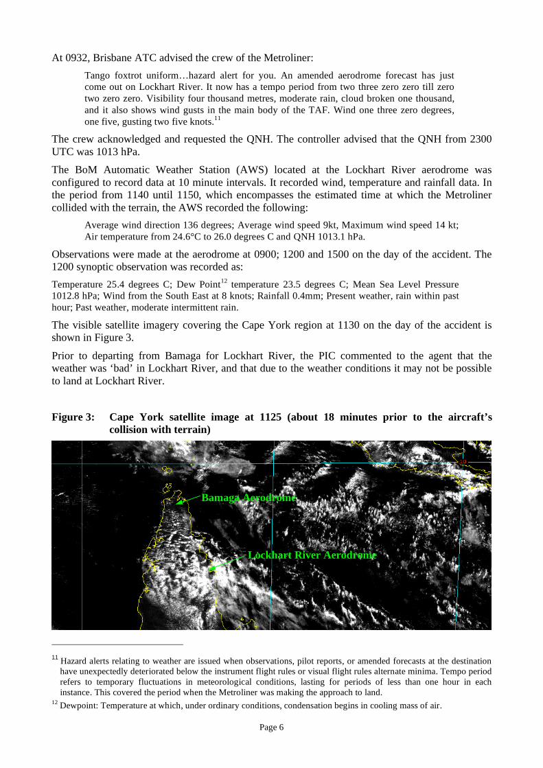
The visible satellite imagery covering the Cape York region at 1130 on the day of the accident is
shown in Figure 3.
Prior to departing from Bamaga for Lockhart River, the PIC commented to the agent that the
weather was ‘bad’ in Lockhart River, and that due to the weather conditions it may not be possible
to land at Lockhart River.
Figure 3: Cape York satellite image at 1125 (about 18 minutes prior to the aircraft’s
collision with terrain)
11
Hazard alerts relating to weather are issued when observations, pilot reports, or amended forecasts at the destination
have unexpectedly deteriorated below the instrument flight rules or visual flight rules alternate minima. Tempo period
refers to temporary fluctuations in meteorological conditions, lasting for periods of less than one hour in each
instance. This covered the period when the Metroliner was making the approach to land.
12 Dewpoint: Temperature at which, under ordinary conditions, condensation begins in cooling mass of air.
Lockhart River Aerodrome
Bamaga Aerodrome
Page 7
Based on the 0900 observer’s report, the AWS recordings between 1100 and 1200 and the visible
satellite image of 1125, the BoM estimated that the weather conditions in the Lockhart River area at
the time of the accident were overcast, with broken low cloud, with a cloud base between 500 ft and
1,000 ft above mean sea level (AMSL). The wind was from the south east at between 10 and 15
knots, with occasional squally rain showers and intermittent drizzle. Those general conditions were
confirmed by persons at Lockhart River.
1.5 Aids to Navigation
1.5.1 Global Navigation Satellite System
The term Global Navigation Satellite System (GNSS) has recently been adopted by ICAO to
describe the constellation of satellites that is capable of providing accurate position information to
appropriately equipped aircraft. GNSS navigation and position determination is based on measuring
the distance from the receiver to satellites. By measuring the distance to four satellites, the system is
able to establish three coordinates of a user’s position: latitude, longitude, and altitude, as well as
GNSS time.
The global positioning system (GPS) was originally developed by the United States Department of
Defence to meet military requirements, and has been adapted for civilian use. In 1992, the US
Federal Aviation Administration (FAA) issued performance standards for GPS receivers in the form
of Technical Standard Order13
C129 (TSO C129). The issuing of this TSO allowed manufacturers
to build satellite receivers for use as supplementary navigation aids for aircraft. The Metroliner was
fitted with a Garmin ‘GPS 155XL’ GNSS navigation unit. That unit, when installed appropriately,
was certified to TSO C129.
In Australia, CASA is the organisation responsible for promulgating the criteria for using GNSS.
Civil Aviation Advisory Publications (CAAP) are issued by CASA and although advisory only,
they detail the CASA preferred method for complying with the Civil Aviation Regulations. CAAP
179A-1(0) Guidelines for Navigation using GNSS issued on December 2002 included the following
information:
Human factors issues for the appropriate use of GNSS involve the user having an awareness
of the equipment limitations of design, controls, displays and software logic in order to avoid
making errors that could lead to undesired aircraft states or accidents. These errors include
entry of information into the machine, interpretation of information from the machine,
inadequate cross-checking from alternative sources and inappropriate decision-making based
on GNSS output.
The Lockhart River Runway 12 RNAV (GNSS) approach procedure referenced satellites to locate
the position of the aircraft relative to the published approach waypoints.
Factors for a crew to consider when using GNSS to conduct a non-precision approach such as the
Lockhart River 12 RNAV approach were provided in the company operations manual. This
guidance included the following:
Activation of the GPS NPA will cancel the active flight plan and tracking guidance will be
to the Initial Approach Fix selected.
Note: Distance information will be to the next position in the approach not the destination.
The pilot of an aircraft engaged on an unrelated search and rescue mission approximately 200 NM
east of Lockhart River aerodrome reported a ‘RAIM14
failure’ between 1120 and 1150 which lasted
for between 10 and 50 seconds. There were no difficulties reported in the Lockhart River area at the
13
Establishes quality control for avionics and other equipment. 14
RAIM: Receiver autonomous integrity monitoring. Can be related to receiving unit or GNSS.
Page 8
time the Metroliner was conducting the approach. The operational status of the Garmin ‘GPS
155XL’ unit fitted to the aircraft could not be determined.
1.5.2 Non-directional beacon
A non-directional beacon (NDB) was located at the Lockhart River aerodrome. Airservices
Australia published an approach procedure for the Lockhart River aerodrome that utilised the NDB
to facilitate descent during periods of poor visibility. No reports were received to indicate any
failure or malfunction of the NDB at Lockhart River on the day of the occurrence.
1.6 Communications
Recordings of the radio communications from the aircraft during the latter stages of the flight from
Bamaga to Lockhart River were identified as having been made by the copilot. It was normal
company practice that the pilot not flying assumed responsibility for radio transmissions during
flight.
1.7 Aerodrome information
The bearing and distance of the runway 12 threshold from the impact site was 123.5 degrees
Magnetic and 10.75 kilometres. The aerodrome elevation was 77 ft.
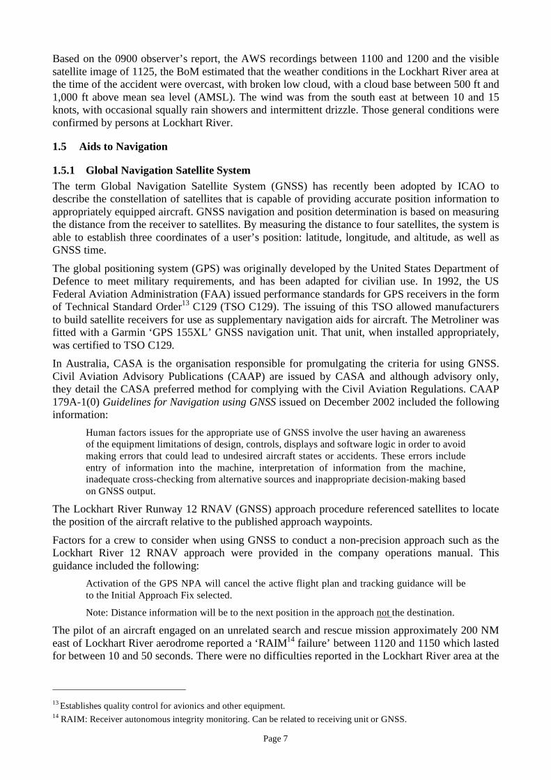
1.8 Flight recorders
The aircraft’s CVR and FDR (see figures 4 and 5) were examined at the Australian Transport Safety
Bureau (ATSB) laboratory.
Figure 4: FDR (foreground) and CVR recovered from VH-TFU
Under direct ATSB supervision the FDR memory board was transported to the manufacturer’s
authorised repair facility where, in accordance with the manufacturer’s instructions, the data was
downloaded using a standard data retrieval unit. The downloaded file was decompressed using the
manufacturer’s readout support equipment software.
Page 9
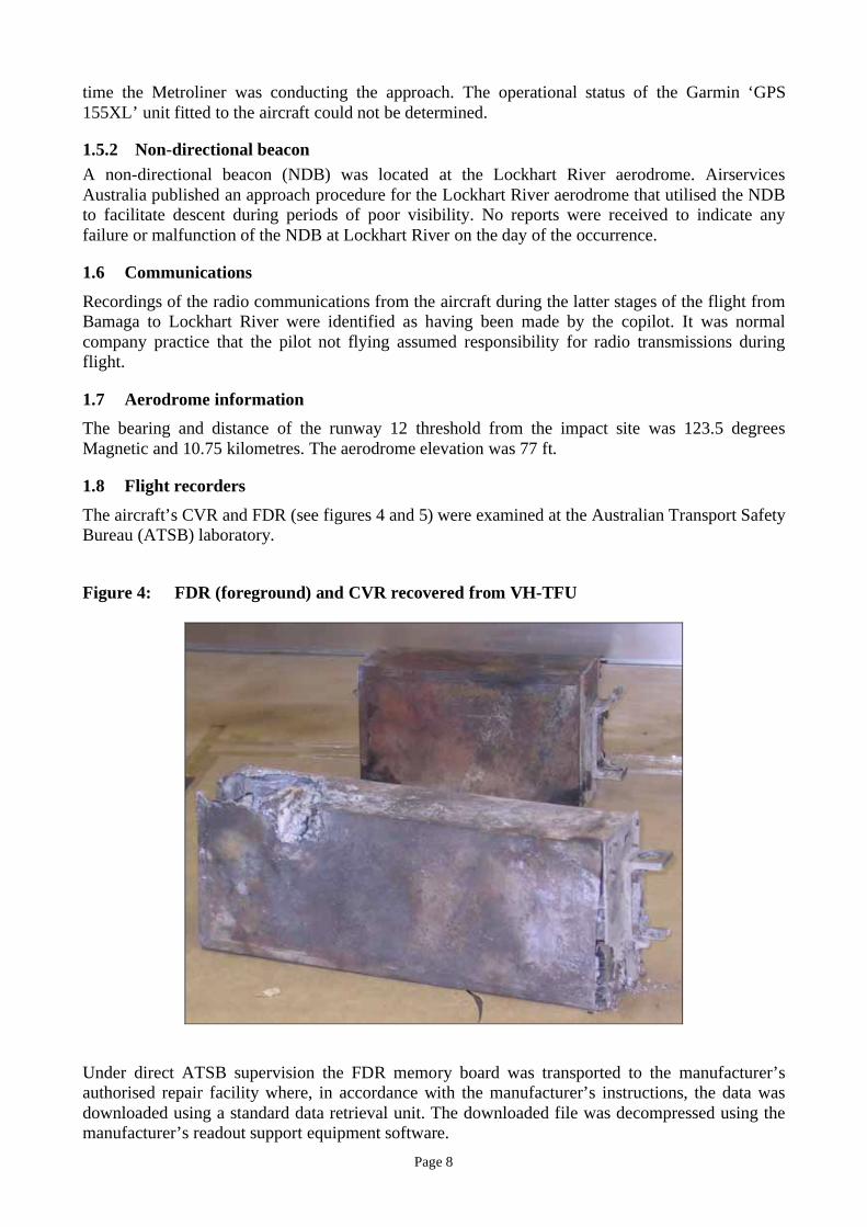
Figure 5: Example of undamaged FDR
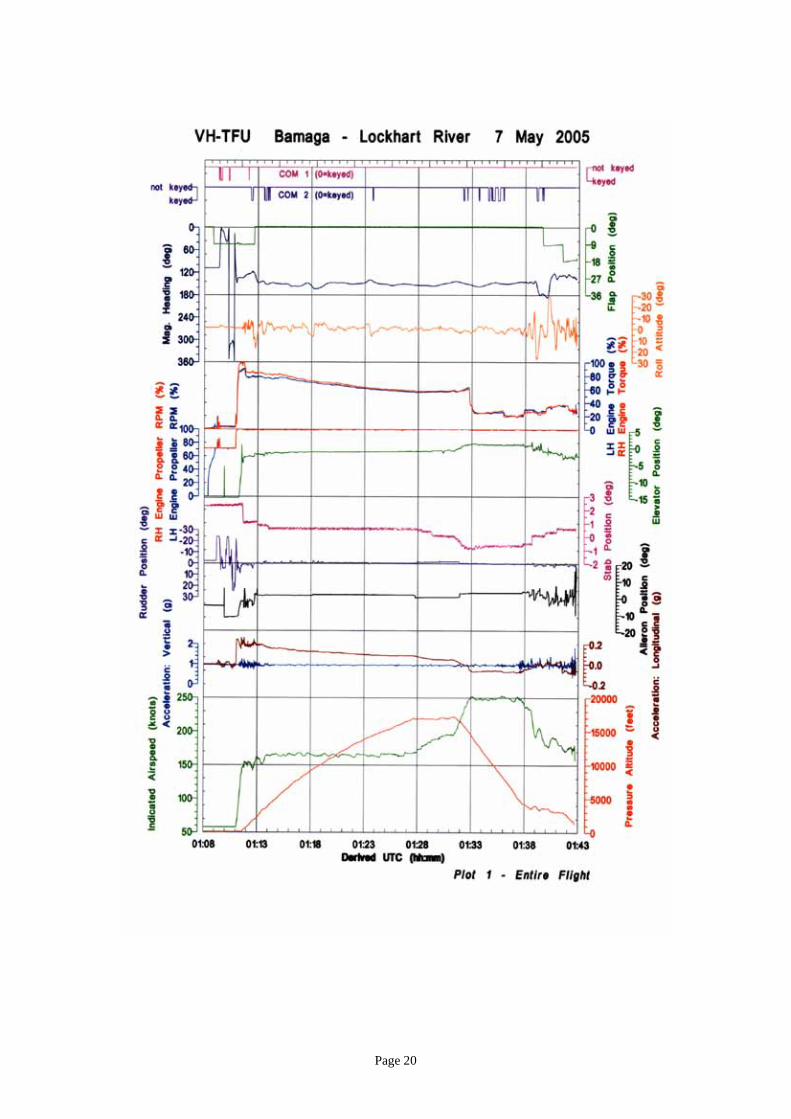
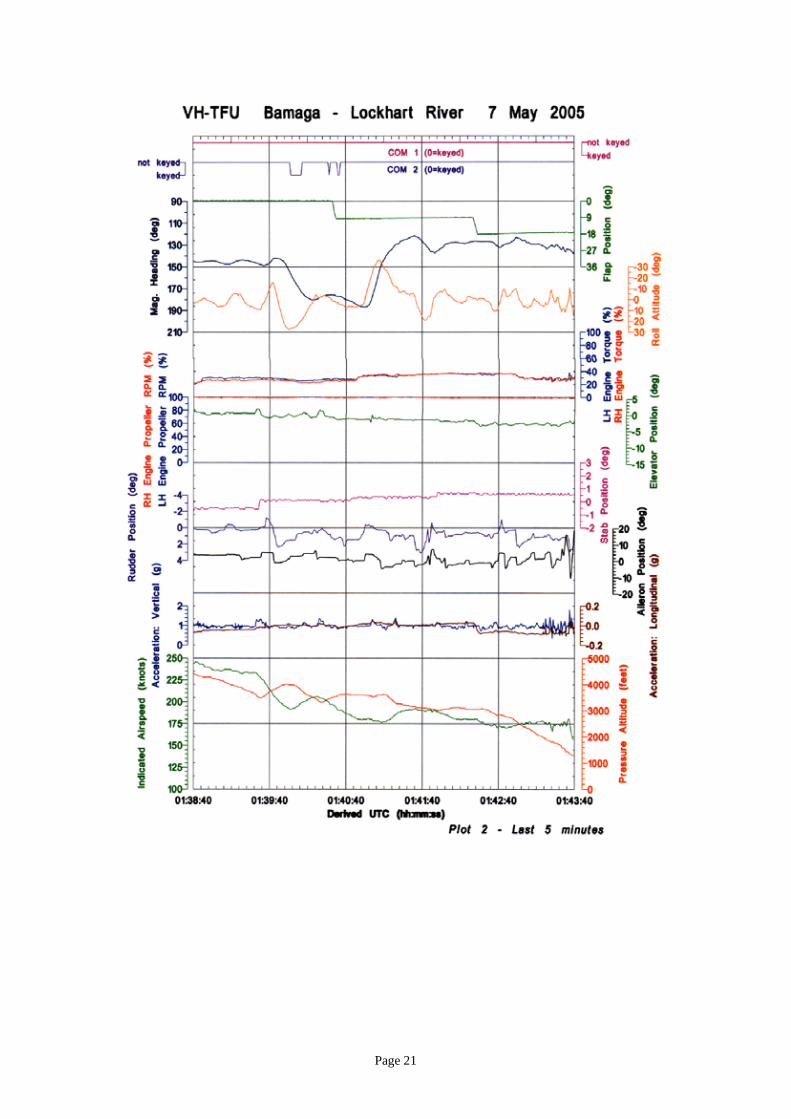
The FDR contained approximately 100 hours of data, including data relating to the entire accident
flight. The analysis of the data provided valuable information about the aircraft flight profile
leading up to the accident (see Appendix B for details).
FDR data indicated that both engines were delivering between 30% and 35% torque at a propeller
RPM of between 98.1% and 100.7%. After passing waypoint LHRWI, the aircraft descent rate was
greater than required to achieve the recommended descent profile for the published approach
procedure. The aircraft descended at an average rate of 1,600 ft/min15
, with some turbulence
evident, over the 50 seconds prior to the impact. Indicated airspeed (IAS) averaged 174 kts16
over
this period. When the recording ceased the flaps were at the 18° position.
15
Pressure altitude data derived from the FDR is accurate to ±100 ft below 3,000 ft 16
Calculated airspeed data derived from the FDR is accurate to ±15 kts above 150 kts
Page 10
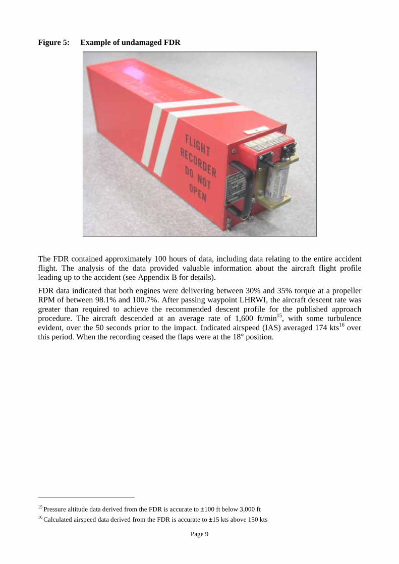
Figure 6: Approach profile (in red) derived from FDR data overlayed on the
Airservices Australia published approach chart
Figure 6 shows an Airservices Australia Runway 12 RNAV (GNSS) instrument approach chart for
Lockhart River overlayed with the FDR derived flight profile of the Metroliner. It is apparent that
the crew was accurately tracking after the waypoint LHRWG. Some excursions from the
recommended vertical profile can be seen after passing LHRWG. After passing waypoint LHRWF,
the aircraft descended below the segment minimum safe altitude of 2060 ft.
Analysis of the 30 minute CVR tape indicated that it contained a mixture of electrical pulses and
fragments of conversations, some identified from previous flights. The ATSB’s flight recorder
investigators determined that data from the CVR could not be recovered using current technology.
Additional technical advice was sought from the US National Transportation Safety Board and the
UK Air Accidents Investigation Branch. Recorder specialists from both organisations verified that
recovery of useable data was not possible.
Page 11
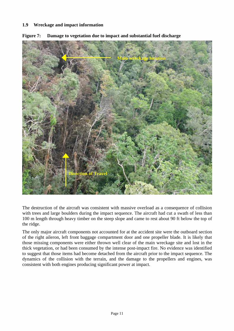
1.9 Wreckage and impact information
Figure 7: Damage to vegetation due to impact and substantial fuel discharge
The destruction of the aircraft was consistent with massive overload as a consequence of collision
with trees and large boulders during the impact sequence. The aircraft had cut a swath of less than
100 m length through heavy timber on the steep slope and came to rest about 90 ft below the top of
the ridge.
The only major aircraft components not accounted for at the accident site were the outboard section
of the right aileron, left front baggage compartment door and one propeller blade. It is likely that
those missing components were either thrown well clear of the main wreckage site and lost in the
thick vegetation, or had been consumed by the intense post-impact fire. No evidence was identified
to suggest that those items had become detached from the aircraft prior to the impact sequence. The
dynamics of the collision with the terrain, and the damage to the propellers and engines, was
consistent with both engines producing significant power at impact.
Direction of Travel
Main wreckage location
Page 12
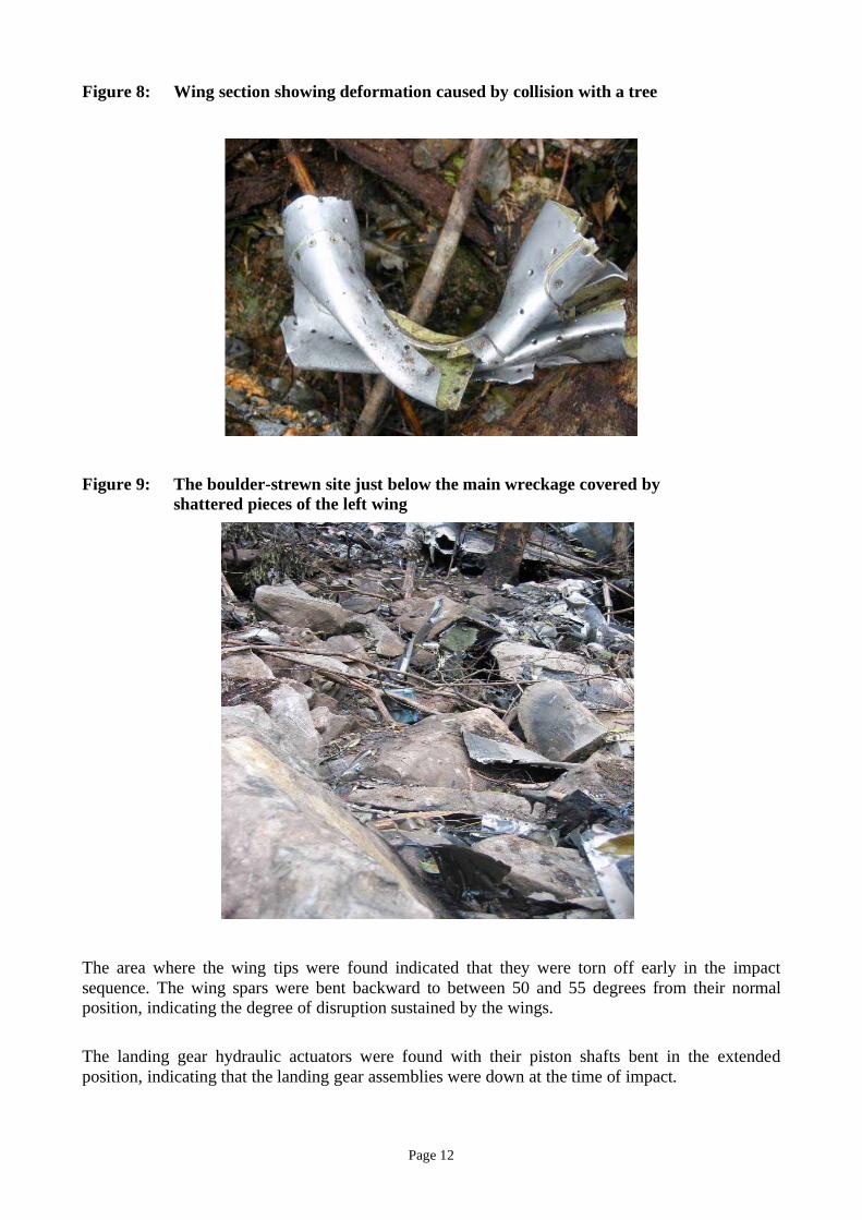
Figure 8: Wing section showing deformation caused by collision with a tree
Figure 9: The boulder-strewn site just below the main wreckage covered by
shattered pieces of the left wing
The area where the wing tips were found indicated that they were torn off early in the impact
sequence. The wing spars were bent backward to between 50 and 55 degrees from their normal
position, indicating the degree of disruption sustained by the wings.
The landing gear hydraulic actuators were found with their piston shafts bent in the extended
position, indicating that the landing gear assemblies were down at the time of impact.
Page 13
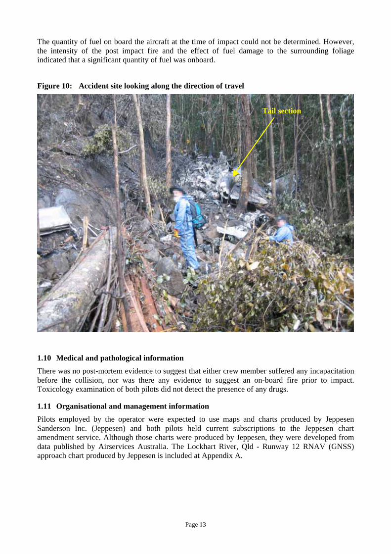
The quantity of fuel on board the aircraft at the time of impact could not be determined. However,
the intensity of the post impact fire and the effect of fuel damage to the surrounding foliage
indicated that a significant quantity of fuel was onboard.
Figure 10: Accident site looking along the direction of travel
1.10 Medical and pathological information
There was no post-mortem evidence to suggest that either crew member suffered any incapacitation
before the collision, nor was there any evidence to suggest an on-board fire prior to impact.
Toxicology examination of both pilots did not detect the presence of any drugs.
1.11 Organisational and management information
Pilots employed by the operator were expected to use maps and charts produced by Jeppesen
Sanderson Inc. (Jeppesen) and both pilots held current subscriptions to the Jeppesen chart
amendment service. Although those charts were produced by Jeppesen, they were developed from
data published by Airservices Australia. The Lockhart River, Qld - Runway 12 RNAV (GNSS)
approach chart produced by Jeppesen is included at Appendix A.
Tail section
Page 14
The company operations manual included the following statement:
The PIC shall:
• ensure that a load sheet is completed prior to departure of the aircraft on each stage
of every flight
• ensure the load sheet is carried in the aircraft and that a copy is retained on the
ground at the aerodrome of departure.
No load sheet relating to the accident flight could be located at Bamaga. Current and former
employees of the operator reported that it was not routine practice for the load sheet to be left at
Bamaga.
The company operations manual included the following statements:
All new company pilots shall complete the Human Factors Management (HFM) induction
course…within 6 months of joining the company; and
All company pilots shall complete a recurrent HFM course…every 15 months.
Human factors management courses are designed to teach flight crew the non-technical skills
essential for operating in a multi-pilot team in a complex time-critical environment. No record
could be located to indicate that the PIC had completed the Human Factors Management Induction
Course or any Human Factors Management recurrent training course since appointment.
Documents from the company that refuelled the Metroliner prior to departure from Bamaga
indicated that 800 litres of Jet A-1 fuel was supplied to the aircraft.
The continuing investigation is examining and analysing operational, airworthiness and regulatory
issues.
Page 15
Appendix A
Jeppesen Lockhart River Runway 12 RNAV (GNSS) approach chart
Reproduced with the permission of Jeppesen Sanderson, Inc.
Page 16
Appendix B
Flight Data Recorder Details
Data from the flight data recorder (FDR) fitted to VH-TFU on 7 May 2005 was successfully
recovered. The recovered data included the accident flight and 59 previous flights giving a total
recording duration of 100 hours 2 minutes and 16 seconds.
Examination of the data showed that the following parameters were serviceable during the accident
flight:
• Pressure Altitude
• Indicated Airspeed
• Magnetic Heading
• Roll Attitude
• Horizontal Stabiliser Position
• Flap Position
• Elevator Position
• Rudder Position
• Aileron Position
• Right Engine Propeller percentage RPM
• Left Engine Propeller percentage RPM
• Right Engine Torque
• Left Engine Torque
• Vertical Acceleration
• Longitudinal Acceleration
• Microphone Keying - Pilot
• Microphone Keying – Copilot.
Examination of the data showed that the Pitch Attitude parameter had not been correctly recorded
during the accident flight or any of the previous flights recorded by the FDR.
Timing correlation
Co-ordinated universal time (UTC) was not recorded by the FDR; however the FDR did record
elapsed time, which began when power was applied to the recorder. When power was removed and
later re-applied, this counter was automatically reset to zero.
UTC was matched with the recorded FDR elapsed time17
by correlating microphone keying with the
UTC time stamp from the ATC air/ground voice recording. Using this technique the radio
transmission from VH-TFU (“Brisbane centre tango foxtrot uniform”) which was recorded on the
ground at 0114:29 UTC was correlated with the FDR microphone keying parameter at an elapsed
time of 1281 seconds.
Results
The F1000 model FDR compresses the flight data before it is recorded and as a result the recording
duration exceeds the minimum requirement of retaining the most recent 25 hours. In this case 100
hours 2 minutes and 16 seconds of data was recorded, covering the accident flight and 59 previous
flights. The oldest data recorded was from the cruise and descent portion of the Lockhart River to
Cairns flight on 13 April 2005.
17
FDR does not have a time referenced input. It records elapsed time in seconds.
Page 17
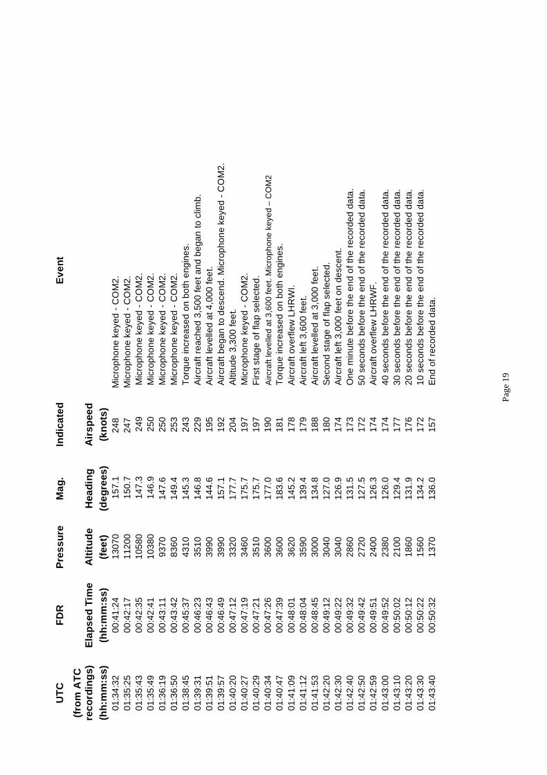
Flights that landed at the Lockhart River aerodrome (YLHR) are tabulated below:
Flight Sequence:
(before accident
flight)
Sector: Date: Landing Runway:
2 YBCS-YLHR 7 May 12
9 YBCS-YLHR 4 May 12
17 YBAM-YLHR 30 April 12
19 YBCS-YLHR 30 April 12
28 YBAM-YLHR 27 April 12
30 YBCS-YLHR 27 April 12
34 YBCS-YLHR 25 April 12
36 YBAM-YLHR 23 April 12
50 YBCS-YLHR 20 April 12
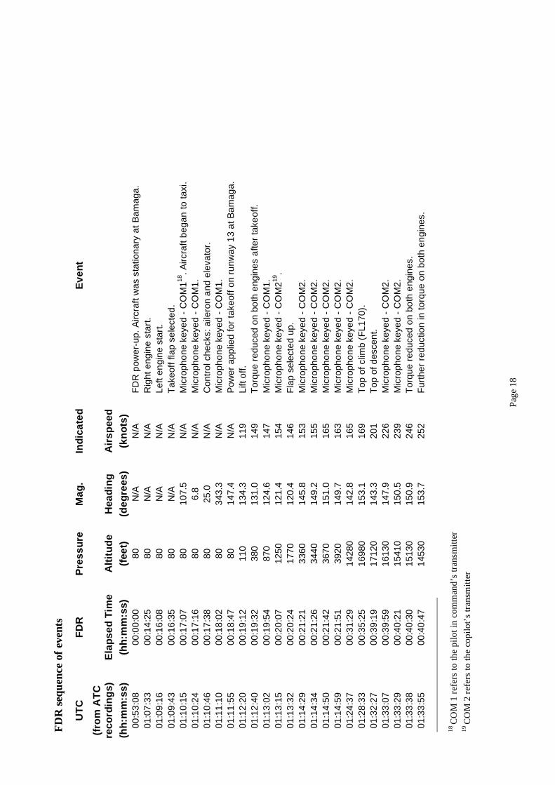
The accident flight was examined in detail. The FDR sequence of events for the accident flight and
plots showing parameters for both the entire flight and the final five minutes (in greater detail) are
shown below.
Parameter accuracies
The accuracy of the corrected IAS values was:
IAS Accuracy
60 kts to 150 kts ± 10 kts
> 150kts ± 15 kts
The accuracy of the corrected altitude values was:
Altitude Accuracy
3,000 feet ± 100 feet
18,000 feet ± 300 feet
22,000 feet ± 400 feet
A reasonableness check of magnetic heading was performed by examining recorded magnetic
heading during takeoff and landing versus known magnetic heading obtained from the Airservices
Australia publication En Route Supplement Australia.
Location Runway
Directions
Landing Takeoff
(7 May 2005) (ºM) (ºM) (ºM)
Cairns 149/329 150.0 151.6
Lockhart River 119/299 119.9 120.8
Bamaga 131/311 129.2 133.3
The recorded headings were obtained at times when the IAS was between 80 and 100 kts. The
comparison showed that recorded magnetic heading agreed with documented magnetic heading
within an accuracy of ± 5º.
P
age
18
FD
R s
equ
ence
of
even
ts
UT
C
FD
R
Pres
su
re
Ma
g.
Ind
ica
te
d
Ev
en
t
(fro
m A
TC
rec
ord
ing
s)
Ela
ps
ed
Tim
e
Alt
itu
de
Hea
din
g
Air
sp
ee
d
(h
h:m
m:ss)
(h
h:m
m:ss)
(fee
t)
(d
eg
re
es)
(k
no
ts
)
00
:53
:08
0
0:0
0:0
0
80
N
/A
N/A
F
DR
po
we
r-u
p.
Air
cra
ft w
as s
tatio
na
ry a
t B
am
ag
a.
01
:07
:33
0
0:1
4:2
5
80
N
/A
N/A
R
igh
t e
ng
ine
sta
rt.
01
:09
:16
0
0:1
6:0
8
80
N
/A
N/A
L
eft
en
gin
e s
tart.
01
:09
:43
0
0:1
6:3
5
80
N
/A
N/A
T
ake
off
fla
p s
ele
cte
d.
01
:10
:15
0
0:1
7:0
7
80
1
07
.5
N/A
M
icro
ph
on
e k
eye
d -
CO
M1
18.
Air
cra
ft b
eg
an
to
ta
xi.
01
:10
:24
0
0:1
7:1
6
80
6
.8
N/A
M
icro
ph
on
e k
eye
d -
CO
M1
.
01
:10
:46
0
0:1
7:3
8
80
2
5.0
N
/A
Co
ntr
ol ch
ecks:
aile
ron
an
d e
leva
tor.
01
:11
:10
0
0:1
8:0
2
80
3
43
.3
N/A
M
icro
ph
on
e k
eye
d -
CO
M1
.
01
:11
:55
0
0:1
8:4
7
80
1
47
.4
N/A
P
ow
er a
pp
lie
d fo
r t
ake
off
on
ru
nw
ay 1
3 a
t B
am
ag
a.
01
:12
:20
0
0:1
9:1
2
11
0
13
4.3
1
19
L
ift o
ff.
01
:12
:40
0
0:1
9:3
2
38
0
13
1.0
1
49
T
orq
ue
re
du
ce
d o
n b
oth
en
gin
es a
fte
r ta
ke
off
.
01
:13
:02
0
0:1
9:5
4
87
0
12
4.6
1
47
M
icro
ph
on
e k
eye
d -
CO
M1
.
01
:13
:15
0
0:2
0:0
7
12
50
1
21
.4
15
4
Mic
rop
ho
ne
ke
ye
d -
CO
M2
19.
01
:13
:32
0
0:2
0:2
4
17
70
1
20
.4
14
6
Fla
p s
ele
cte
d u
p.
01
:14
:29
0
0:2
1:2
1
33
60
1
45
.8
15
3
Mic
rop
ho
ne
ke
ye
d -
CO
M2
.
01
:14
:34
0
0:2
1:2
6
34
40
1
49
.2
15
5
Mic
rop
ho
ne
ke
ye
d -
CO
M2
.
01
:14
:50
0
0:2
1:4
2
36
70
1
51
.0
16
5
Mic
rop
ho
ne
ke
ye
d -
CO
M2
.
01
:14
:59
0
0:2
1:5
1
39
20
1
49
.7
16
3
Mic
rop
ho
ne
ke
ye
d -
CO
M2
.
01
:24
:37
0
0:3
1:2
9
14
28
0
14
2.8
1
65
M
icro
ph
on
e k
eye
d -
CO
M2
.
01
:28
:33
0
0:3
5:2
5
16
98
0
15
3.1
1
69
T
op
of
clim
b (
FL
17
0).
01
:32
:27
0
0:3
9:1
9
17
12
0
14
3.3
2
01
T
op
of
de
sce
nt.
01
:33
:07
0
0:3
9:5
9
16
13
0
14
7.9
2
26
M
icro
ph
on
e k
eye
d -
CO
M2
.
01
:33
:29
0
0:4
0:2
1
15
41
0
15
0.5
2
39
M
icro
ph
on
e k
eye
d -
CO
M2
.
01
:33
:38
0
0:4
0:3
0
15
13
0
15
0.9
2
46
T
orq
ue
re
du
ce
d o
n b
oth
en
gin
es.
01
:33
:55
0
0:4
0:4
7
14
53
0
15
3.7
2
52
F
urt
he
r r
ed
uctio
n in
to
rqu
e o
n b
oth
en
gin
es.
18 C
OM
1 r
efer
s to
th
e p
ilo
t in
co
mm
and
’s t
ran
smit
ter
19 C
OM
2 r
efer
s to
th
e c
op
ilo
t’s
tran
smit
ter
P
age
19
UT
C
FD
R
Pres
su
re
Ma
g.
Ind
ica
te
d
Ev
en
t
(fro
m A
TC
rec
ord
ing
s)
Ela
ps
ed
Tim
e
Alt
itu
de
Hea
din
g
Air
sp
ee
d
(h
h:m
m:ss)
(h
h:m
m:ss)
(fee
t)
(d
eg
re
es)
(k
no
ts
)
01
:34
:32
0
0:4
1:2
4
13
07
0
15
7.1
2
48
M
icro
ph
on
e k
eye
d -
CO
M2
.
01
:35
:25
0
0:4
2:1
7
11
20
0
15
0.7
2
47
M
icro
ph
on
e k
eye
d -
CO
M2
.
01
:35
:43
0
0:4
2:3
5
10
58
0
14
7.3
2
49
M
icro
ph
on
e k
eye
d -
CO
M2
.
01
:35
:49
0
0:4
2:4
1
10
38
0
14
6.9
2
50
M
icro
ph
on
e k
eye
d -
CO
M2
.
01
:36
:19
0
0:4
3:1
1
93
70
1
47
.6
25
0
Mic
rop
ho
ne
ke
ye
d -
CO
M2
.
01
:36
:50
0
0:4
3:4
2
83
60
1
49
.4
25
3
Mic
rop
ho
ne
ke
ye
d -
CO
M2
.
01
:38
:45
0
0:4
5:3
7
43
10
1
45
.3
24
3
To
rqu
e in
cre
ase
d o
n b
oth
en
gin
es.
01
:39
:31
0
0:4
6:2
3
35
10
1
46
.8
22
9
Air
cra
ft r
ea
ch
ed
3,5
00
fe
et
an
d b
eg
an
to
clim
b.
01
:39
:51
0
0:4
6:4
3
39
90
1
44
.6
19
5
Air
cra
ft le
ve
lle
d a
t 4
,00
0 fe
et.
01
:39
:57
0
0:4
6:4
9
39
90
1
57
.1
19
2
Air
cra
ft b
eg
an
to
de
sce
nd
. M
icro
ph
on
e k
eye
d -
CO
M2
.
01
:40
:20
0
0:4
7:1
2
33
20
1
77
.7
20
4
Altitu
de
3,3
00
fe
et.
01
:40
:27
0
0:4
7:1
9
34
60
1
75
.7
19
7
Mic
rop
ho
ne
ke
ye
d -
CO
M2
.
01
:40
:29
0
0:4
7:2
1
35
10
1
75
.7
19
7
Fir
st
sta
ge
of
fla
p s
ele
cte
d.
01
:40
:34
0
0:4
7:2
6
36
00
1
77
.0
19
0
Aircra
ft le
ve
lle
d a
t 3
,60
0 fe
et.
Mic
rop
ho
ne
ke
ye
d –
CO
M2
01
:40
:47
0
0:4
7:3
9
36
00
1
83
.6
18
1
To
rqu
e in
cre
ase
d o
n b
oth
en
gin
es.
01
:41
:09
0
0:4
8:0
1
36
20
1
45
.2
17
8
Air
cra
ft o
ve
rfle
w L
HR
WI.
01
:41
:12
0
0:4
8:0
4
35
90
1
39
.4
17
9
Air
cra
ft le
ft 3
,60
0 f
ee
t.
01
:41
:53
0
0:4
8:4
5
30
00
1
34
.8
18
8
Air
cra
ft le
ve
lle
d a
t 3
,00
0 fe
et.
01
:42
:20
0
0:4
9:1
2
30
40
1
27
.0
18
0
Se
co
nd
sta
ge
of
fla
p s
ele
cte
d.
01
:42
:30
0
0:4
9:2
2
30
40
1
26
.9
17
4
Air
cra
ft le
ft 3
,00
0 f
ee
t o
n d
esce
nt.
01
:42
:40
0
0:4
9:3
2
28
60
1
31
.5
17
3
On
e m
inu
te b
efo
re th
e e
nd
of
the
re
co
rde
d d
ata
.
01
:42
:50
0
0:4
9:4
2
27
20
1
27
.5
17
2
50
se
co
nd
s b
efo
re t
he
en
d o
f th
e r
eco
rde
d d
ata
.
01
:42
:59
0
0:4
9:5
1
24
00
1
26
.3
17
4
Air
cra
ft o
ve
rfle
w L
HR
WF
.
01
:43
:00
0
0:4
9:5
2
23
80
1
26
.0
17
4
40
se
co
nd
s b
efo
re t
he
en
d o
f th
e r
eco
rde
d d
ata
.
01
:43
:10
0
0:5
0:0
2
21
00
1
29
.4
17
7
30
se
co
nd
s b
efo
re t
he
en
d o
f th
e r
eco
rde
d d
ata
.
01
:43
:20
0
0:5
0:1
2
18
60
1
31
.9
17
6
20
se
co
nd
s b
efo
re t
he
en
d o
f th
e r
eco
rde
d d
ata
.
01
:43
:30
0
0:5
0:2
2
15
60
1
34
.2
17
2
10
se
co
nd
s b
efo
re t
he
en
d o
f th
e r
eco
rde
d d
ata
.
01
:43
:40
0
0:5
0:3
2
13
70
1
36
.0
15
7
En
d o
f re
co
rde
d d
ata
.
Page 20
Page 21
Page 22
Appendix C
Honeywell GPWS MK-VI Simulation
Page 23
Recommended